archaeological report madagascar 2010 · archaeological report madagascar 2010 research on 17th and...
TRANSCRIPT

ArchaeologicalReportMadagascar2010
Researchon17thand18thCenturyPirateShipwrecksatIlôtMadame,Sainte-Marie
©Copyright2017CenterforHistoricShipwreckPreservation

Archaeology Report Madagascar Saint Marie 2010
2
Table of Contents 1 Introduction ..................................................................................................................3 2 Historical Background..................................................................................................3 3 Archaeological Survey ..................................................................................................8
3.1 Geographical analysis .............................................................................................8 3.2 Sonar survey .........................................................................................................10
4 Archaeological Research of the ‘Fiery Dragon’.........................................................11 4.1 Strategy.................................................................................................................11 4.2 Results ..................................................................................................................13
5 Archaeological Research of the ‘Channel wreck’......................................................22 5.1 Strategy.................................................................................................................22 5.2 Results ..................................................................................................................23
6 Land survey ................................................................................................................25 7 Artefact administration ..............................................................................................26 8 Next steps ....................................................................................................................28 9 References ...................................................................................................................29
List of Figures Figure 1 Pirate ship chasing its prize (unknown artist) ............................................................5 Figure 2 Map with survey areas in the harbour and Pirate Bay area ........................................8 Figure 3 Historical map of 1847 projected over Google Earth satellite image .........................9 Figure 4 Humminbird 1197c side imaging sonar and example of recorded sonar image........10 Figure 5 Chart with Fiery Dragon photomosaic and plotted measurement grid .....................11 Figure 6 Sketch of the Fiery Dragon wreck site as seen from South to North .......................12 Figure 7 Photomosaic of the excavation grid projected in ArcGis .........................................13 Figure 8 Chart with Fiery Dragon excavation sections and plotted hull parts........................14 Figure 9 Artefact overview per section .................................................................................15 Figure 10 Two chinese porcelain cups (artefacts MAD.2010.FD.A000003 and 4) ................17 Figure 11 Examples of Phoenix motif...................................................................................18 Figure 12 Three Chinese white porcelain figurines ...............................................................19 Figure 13 Wood carved statue of a female ............................................................................21 Figure 14 Stone carved statue of a female.............................................................................21 Figure 15 Ivory piece inscribed ‘INRI’ .................................................................................21 Figure 16 ArcGis chart ‘channel wreck’ zoomed in on hull section S002..............................22 Figure 17 Schematic topside view of the found cannon at ‘channel wreck’ site.....................23 Figure 18 Intact wine bottle ..................................................................................................24 Figure 19 Porcelain shards of the ‘channel wreck’ ................................................................24 Figure 20 Lead gaming piece marked ‘X'..............................................................................25 Figure 21 Screenshot artefact administration ........................................................................26 Figure 22 Example photographs MAD2010_1107_SMS138_13 and _14..............................27
List of Tables Table 1 Overview of artefacts Fiery Dragon grouped by material category...........................15 Table 2 Overview of artefacts ’channel wreck’ by material category ...................................24

Archaeology Report Madagascar Saint Marie 2010
3
1 Introduction From the beginning of October until mid November of 2010 a team of researchers from Provincetown, Massachusetts USA, undertook a survey and excavation project under the direction of underwater explorer Barry Clifford in the harbour area at Ilôt Madame on the island of Sainte-Marie, Madagascar. This archaeological report summarizes the research results and reflects the work performed during this six-week period. During previous expeditions conducted in 2000, underwater archaeological teams led by Mr. Clifford discovered a number of 17th and 18th century pirate shipwreck sites. One of these wrecks was initially thought to be Adventure Galley, commanded by the infamous pirate William Kidd, but a small site excavation revealed artefacts of a later date than the time of sinking in 1698. Further historical research suggested a ship known to have been lost in the immediate vicinity in 1721, which was a likelier candidate given the location and spectrum of artefacts, and the wreck site was accordingly tentatively identified as the Fiery Dragon of Captain William Condon (also known as “Christopher Condent”) (de Bry 2006:106). The primary goal of the 2010 expedition was to further investigate this wreck site in order to obtain more evidence on the nature of the wreck, confirm its identity, and the possibility that its debris field might overlap one or more times immediately on top of adjacent wrecks. At least seven - and as many as ten - shipwrecks or scuttles occurred in the vicinity of the harbour of Ilôt Madame at Saint Marie during the “Golden Age of Piracy,” therefore, the expedition of 2010 also focused on conducting a high-tech geophysical remote sensing survey of the harbour area in an attempt to locate submerged cultural resources.
2 Historical Background The island of Sainte-Marie of Madagascar was discovered by Arab seafarers in the 12th century and subsequently, in the 16th century, by Europeans. It lays between 26 and 30 kilometres to the east of the Great Red Island, and is some 70 kilometres long with a width that varies between one to six kilometres. It is a tropical paradise, sparsely populated, and it is on this island that pirates made their home between 1650 and 1725, using Sainte-Marie as a base from which to launch raids on Portuguese vessels and ships of the East India companies of England, France and Holland, and the richly laden Indian Mogul ships that sailed between India, Mocha, and Jeddah, the port of the Holy City of Mecca. Madagascar had become a choice destination for English and other European merchants because slaves were cheaper than on the African continent and there was a great demand on the part of the natives for firearms as well as for all sorts of western merchandises. Sainte-Marie, on the other hand, became a base for pirates for a variety of reasons. It was the place of choice to water ships and take on supplies after having crossed the Cape of Good Hope and the perfect spot to wait out the monsoon winds (Rogozinski, 2000: 55). Sainte-Marie offered an excellent anchorage with a naturally protected bay, and a small island at the entrance of this bay made up for a perfect natural harbour and careening spot - Careening was the process of leaning a ship on its sides, alternatively, on a gently sloping beach, in order to clean, repair, and caulk the hull. This was especially necessary in warm sub-tropical and tropical waters where wood from the hull was often attacked and eaten by teredo worms (Teredidae eulamellibranchiata). This worm-like creature, actually a bivalve mollusk, uses its greatly reduced shell to bore tunnels into wood. In the age of wooden sailing ships, it was a tremendous problem that often led to sinking.

Archaeology Report Madagascar Saint Marie 2010
4
The strategic location of the island made it an ideal location from which to launch raids on ships sailing back to Europe, loaded with rich cargoes of gold, precious stones, Chinese blue-on-white export porcelain, silk, spices and drugs from India and the Far East. As early as the 1660s merchants from England were making the long and perilous journey to Madagascar and in 1675 a ship from Boston came to trade with the Malagasy natives. Pirates were not far behind, arriving in the region about 1684 (Ritchie, 1986: 83). Piracy had become a major problem in the Caribbean and, tired of being attacked and robbed by those lawless people of the seas, the European colonial powers had decided to not only better protect themselves, but to aggressively and mercilessly hunt down pirates. The Spanish treasure fleets became increasingly larger, better armed, better protected and, as a result, suffered fewer losses. No such organized fleets sailed the Indian Ocean, leaving poorly protected ships at the mercy of roving marauders. Surely, piracy had been practiced in this part of the world for centuries, but the uncertainties of tropical weather patterns, the fury of typhoons, and the treacherous crossing of the Cape of Good Hope were of much graver concern to seafarers than isolated acts of piracy. The establishment of European/American pirate companies in the 1680s introduced a new element of danger that would have a devastating economic impact on the region. Because the vast majority of pirates were English, Indian and Chinese authorities felt that all pirates were English, and whenever a ship was attacked and taken those authorities retaliated by closing down the counters of the English East India Company, putting the personnel under house arrest, and even sometimes imprisoning them. Until given monetary reparation for their losses by the English Crown, those counters would remain closed, resulting in heavy financial losses. William Condon and the Fiery Dragon William Condon, also known as Christopher Condent, John Condon, Congdon, Connor, and Condell (Ken Kinkor, June 23, 2000; personal communication), is said to have been a native of Plymouth, England. As the Caribbean became too dangerous for those sea marauders, Condon, along with other pirates, migrated to the safer, and often more lucrative Indian Ocean. The career of Condon and his pirate crew sheds light upon the origin of the Fiery
Dragon, where it was built, when it was captured the circumstances under which it was destroyed at Saint Marie and thus also what can be expected to have remained aboard the shipwreck. Therefore the following chain of events is reconstructed, based on different historical sources, given the absence of satisfactory secondary-source accounts. Further archival research is still underway. Around April or May 1718 Condon took over twenty vessels of the salt fleet at the Cape Verde island of Maio, and also a former Dutch privateer at St. Jago, after a short fight in which the Dutch captain was killed. Condon renamed the Dutch ship Flying Dragon and made it his flagship, leaving his old sloop to a mate (GHP: 582). The original name of the Dutch ship is not given in this account. One possibility is that she was an outward bound Dutch East Indiaman called the Meiboom taken at one of the Cape Verde islands. This 36-gun vessel was converted to a pirate vessel, most of the crew joined the pirates, and six of her cannon were a short time later transferred to a captured English ship near the African coast and the Meiboom was then renamed de Zeebloem (DNA: 1.05.01.02.104 ff.58a-58b). Another possibility is that Flying Dragon was a Dutch West India Company frigate named Kroonprins van Pruijssen taken together with several English ships near Cape Verde islands. Some cannon were transferred to this frigate along with all three hundred men, after which they continued their journey, leaving some Dutch sailors an old English ship (Paesie 2008:
Archaeology Report Madagascar Saint Marie 2010
5
66). Condon thereafter raided the coast of Brazil, the Azores and the Guinea coast from June to September 1718 taking a number of Portuguese, English and Dutch vessels. Sometime in 1719, The pirates then attacked Compagnies Welvaren, a Dutch West Indiaman frigate, and the English ship Fame at Luengo Bay on the southwest coast of Africa (GHP: 583). Fame
deliberately ran herself aground to avoid capture, but the marauders took the Dutchman, and renamed her Fiery Dragon, fitting her out with forty cannon, 20 brass swivel guns, and even three man-portable coehorne mortars that could lob exploding shells onto the decks of opposing ships. With 320 men and small arms for twice that number, she was as well manned as she was well-armed.
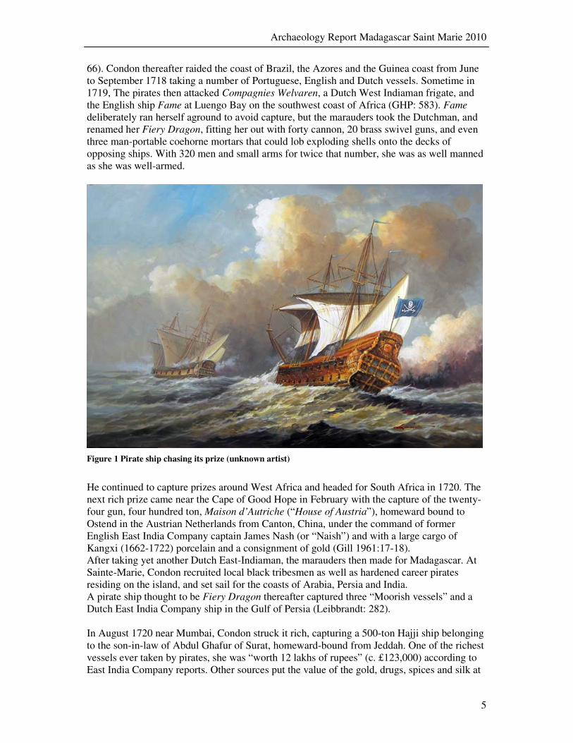
Figure 1 Pirate ship chasing its prize (unknown artist)
He continued to capture prizes around West Africa and headed for South Africa in 1720. The next rich prize came near the Cape of Good Hope in February with the capture of the twenty-four gun, four hundred ton, Maison d’Autriche (“House of Austria”), homeward bound to Ostend in the Austrian Netherlands from Canton, China, under the command of former English East India Company captain James Nash (or “Naish”) and with a large cargo of Kangxi (1662-1722) porcelain and a consignment of gold (Gill 1961:17-18). After taking yet another Dutch East-Indiaman, the marauders then made for Madagascar. At Sainte-Marie, Condon recruited local black tribesmen as well as hardened career pirates residing on the island, and set sail for the coasts of Arabia, Persia and India. A pirate ship thought to be Fiery Dragon thereafter captured three “Moorish vessels” and a Dutch East India Company ship in the Gulf of Persia (Leibbrandt: 282). In August 1720 near Mumbai, Condon struck it rich, capturing a 500-ton Hajji ship belonging to the son-in-law of Abdul Ghafur of Surat, homeward-bound from Jeddah. One of the richest vessels ever taken by pirates, she was “worth 12 lakhs of rupees” (c. £123,000) according to East India Company reports. Other sources put the value of the gold, drugs, spices and silk at
Archaeology Report Madagascar Saint Marie 2010
6
£150,000. There were also diamonds, rubies and emeralds reported aboard, and her owners demanded restitution from the East India Company in the amount of twenty lakhs of rupees, or c. £205,000. (IOR: 218-219, Rogozinski 2000: 208, Downing IOR: 239-241). Once the Indian ship had been fully looted, Condon and his crew returned to the safety and idyllic life of Sainte-Marie Island. They sold stolen goods such as silk and spices to crooked merchants in exchange for liquor, gunpowder and other supplies (CO: 77/16 ff.291-296). While Condon and his crew divided the rich booty and celebrated their good luck, the Crooker, a type of English vessel called a snow, sailed into the small harbour to take on water. Perhaps inebriated and with a bit too much celebrating under their belt, the crew of he Fiery Dragon boarded the Crooker and seized its supply of alcoholic beverages. Condon ended up compensating the master of the Crooker, Captain Baker, for the spirits taken by his exuberant crew, and engaged in a most civilized, if not friendly, conversation during which course Baker revealed that the French governor of Bourbon, present-day Reunion Island, was offering a pardon to any pirate giving up his trade. A royal decree had given the island a legitimate right to pardon pirates and even encourage them to settle on the island, with the only requirement that they either turn over or destroy their ship, turn over their weapons and ammunition, and in return for a small fee each man would be allowed to bring in one Negro slave, and settle on the island to lead a righteous and honest life. Condon was very interested in this offer, especially after having taken such a rich prize and knowing that he would be allowed to keep his ill-gotten fortune. He asked Captain Baker to return to Bourbon and inquire as to the validity of this pardon offer. Condon was not unknown to Governor Joseph Beauvollier de Courchant who was more than happy to see this menace off the water and under control, and quickly agreed to a general pardon for Condon and his men. In February 1721 Condon and thirty-two of his crew left Sainte-Marie for Bourbon Island, destroying the Fiery Dragon as she lay at anchor just before departing. However, it is not clear what truly transpired, and it is quite possible that there was disagreement amongst the 135 crewmembers as to whether to accept the pardon and retire to Bourbon or continue their piratical activities, and that a scuffle broke out, resulting in inadvertently premature burning of the Fiery Dragon. (CO: 77/16 ff.291-296). Such a scenario would explain why so much cultural material remained on the ship. When an English squadron called port at Sainte-Marie’s the following year, Captain Clement Downing reported finding “the Ruins of several Ships and their Cargoes piled up in great Heaps, consisting of the richest Spices and Drugs.” Condon distinguished himself while on Bourbon Island, acting as a negotiator for the governor of the island when pirates under John Taylor and “La Buze” took over a disabled Portuguese ship, the Nostra Senhora de Cabo, which had sought refuge on the island after weathering a devastating storm, taking the viceroy of Portuguese India hostage. Condon managed to persuade the pirates to release the viceroy, thus gaining the governor’s respect and friendship. In 1722, after marrying the governor’s sister-in-law, Condon sailed for France in November 1722 and settled down in the port city of Saint-Malo, on the Normandy coast, where he became a successful and respectable businessman and ship owner (GHP: 584). While the name of William Kidd became synonymous with the word pirate, his career was short and he was one of the less successful pirates who roamed the Indian Ocean, while Condon, relatively unknown, the second most successful scoundrel that ever lived, committed one of the largest robberies in history, and got away with murder.
Archaeology Report Madagascar Saint Marie 2010
7
The Mocha Frigate and Great Mahomet In the course of several years’ robberies throughout the Indian Ocean, the pirates of The
Mocha Frigate (40 guns, Robert Culliford) and Soldado (20 guns, Richard “Dirk” Chivers) had captured Chinese, English, French, Indian, Japanese, Malayan, Persian, Portuguese, and Siamese vessels. These not only included rich Hajji ships, but also early “China Traders” with Kangxi and other Qing Dynasty porcelain.1 On September 23, 1698, a Turkish-owned 600-ton Hajji ship known as Great Mahomet (in Turkish: “Yüce Muhammetc2) was, as part of her pilgrimage to Mecca, homeward bound to Surat, India, from the port of Jeddah on the coast of Arabia, when she was attacked north of Mumbai by two European pirate vessels under the command of Robert Culliford (The Mocha
Frigate, 40 guns), and Richard “Dirk” Chivers (Soldado, 20 guns). The sea-battle that followed was unusually violent. At least twenty pirates were killed, while over three hundred of the passengers and crew of the pilgrim ship died, according to Ibrahim Khan, one of the owners of the vessel who was then aboard. Another owner, Hussein Hamedan, declared that the pirates had tortured Indian merchants to reveal the hiding places of their treasure. As was often the case for important Hajji ships returning to India from pilgrimage to Mecca, Great Mahomet was immensely rich. In addition to the £130,000 (today $65 million) in gold, Great Mahomet was also carrying personal possessions, devotional objects, religious souvenirs, and other baggage of approximately six hundred Hajj pilgrims of a wide range of social strata, in addition to such cargo and commodities from the Arabian Peninsula, such as coffee, spices and drugs. By the time the pirates had captured the Indian ship, the Soldado had become completely unseaworthy, so the two ships took their prize to the coast, released the Indian captives, and proceeded to share their ill-gotten booty; according to some testimonies each man of the two crews, some 250 in all, received a share worth £700 to £800, or about £375,000, in gold, jewels and other valuables. As soon as that was done, the crew of the Soldado transferred their cannon and some of their men to Great Mahomet, re-named her The New Soldado, put her under the command of Richard “Dirk” Chivers, and then sunk their own vessel (Rogozinski 2000:141). Some sixty women were kept aboard the pirate ship as captives to be taken to the pirate base at Ile Sainte-Marie, while the rest of the Muslim crew and passengers were put aboard the ship’s boats to make for shore as best they could. After attacking several other ships off the coast of India, the pirate flotilla arrived at the harbour of Ile Sainte-Marie on January 29, 1699.
Shortly after their arrival, the pirates were surprised by the approach of a powerful Royal Navy squadron that had set sail from England on a pirate-hunting expedition under the command of Commodore Thomas Warren. Great Mahomet and the Mocha Frigate were hurriedly sunk by the pirates across the entrance to the bottle-necked harbor in order to block entrance by the naval squadron.
1 Detailed secondary-source accounts of the careers of the pirates of Mocha and Great Mahomet are to be found in Pirates of the Eastern Seas (1618-1723) A Lurid Page of History. Charles Grey.1971 Kennikat Press reprint of 1933 edition (pp.131-149 & pp.168-175); Honor Among Thieves: Captain Kidd, Henry Every, and the Pirate Democracy in the Indian Ocean. Jan Rogozinski. Stackpole Books Mechanicsburg PA 2000 (pp.98-109, 141-149); The Pirate Hunter: The True Story of Captain Kidd. Richard Zacks Hyperion Books 2002. (pp. 41-57, 161-189, 196-198). 2 As verified by Professor Aydin Ucar of Akdeniz Universitesi in Antalya, Turkey. In historical sources the Great Mahomet would have been known mostly by this name.

Archaeology Report Madagascar Saint Marie 2010
8
3 Archaeological Survey Before starting to locate shipwrecks using non-intrusive methods, such as towing a side scan sonar behind a small motorboat, it is important to first define a survey area in order to be able to plan a systematic and feasible research. Determining the exact survey area at Sainte-Marie was performed during the first expedition week by combining historical sources, maps and accurate geographical images. Using photographs of maps and charts of the 17th and 18th century found in French archives, and projecting them on top of satellite images using Google Earth software, it became easier to predict where shipwrecks would most likely be found and how to delimit the survey area.
3.1 Geographical analysis
The harbour of Ilôt Madame (originally named île au Cayes, from the Spanish “cayo” or “rock,” the islet was renamed Ilôt Madame in 1820 in honour the French king’s daughter) and Pirate Bay are both likely to hold several shipwrecks of the ‘Golden Age of Piracy’. To locate the remains of these vestiges by performing non-intrusive, non-destructive survey methods it is important to limit the survey area as much as possible although the harbour and bay by themselves are not extremely large. The harbour area, roughly delimited by drawing an imaginary latitude line between the tip of Ilôt Madame and Sainte-Marie Island proper, is about eight hectares of which only four hectares are deeper than two metres and surveyable. Pirate Bay is about forty-two hectares of which only twenty-two hectares are surveyable.
Figure 2 Map with survey areas in the harbour and Pirate Bay area
Today a modern causeway, constructed during WWII, separates the harbour and bay. The western part of this causeway is built on top of the so-called ‘bottleneck’ of the channel east of Ilôt Madame into the bay. When a detailed map by lieutenants Laurent and Cornette de Venancourt created in 1847 is projected over the satellite image it becomes immediately clear
Pirate Bay survey area
Ilôt Madame harbour survey area

Archaeology Report Madagascar Saint Marie 2010
9
where the bottleneck is located and why this causeway was built exactly here later on3. This was the narrowest entry point into Pirate Bay, only forty meters across and six to eight metres deep. Apart from showing detailed geographical features and man-made structures, such as buildings and fortifications, the map is also surprisingly accurate for bathymetry. Dotted lines and crosses, indicating reefs or rocky areas, point out to relatively shallow areas. Another reason for marking these shallow areas on the map may also indicate submerged obstructions such as shipwrecks. Plotting the exact location of the shipwreck tentatively identified as the Fiery Dragon sunk in the harbour area in 1721 shows that indeed one of the sets of cross marks matches up with this wreck site. The fact also that the map is easily projected without much distortion over the current satellite image using present landmarks indicates that mid 19th century French cartographers were very much capable of creating detailed and reliable maps that are still of use today.
Figure 3 Historical map of 1847 projected over Google Earth satellite image
3 Map located at the Centre des Archives d’Outre-Mer, Aix-en-Provence, France, FM DFC XVII/28PFA/156

Archaeology Report Madagascar Saint Marie 2010
10
3.2 Sonar survey
Ilôt Madame harbour area was surveyed during two days, using a boat with a Humminbird 1197c side imaging sonar. During survey individual sonar images were recorded together with their GPS positions. The survey was performed by running the boat parallel tracks with a few metres interval. Scanning the harbour area in several directions resulted in a set of points of interest where subsequent visual underwater inspection was conducted by diving on these locations. A 19th-century shipwreck was found with some remaining structure protruding above the sediment. As the harbour area bottom is covered with a layer of fine silt and sand most shipwreck remains are covered and cannot be seen by the sonar. But piles of ballast stones only slightly higher than the surrounding area can be detected with the help of the side scan sonar, indicating buried wrecks below them.
Figure 4 Humminbird 1197c side imaging sonar and example of recorded sonar image
One target located a short distance to the southeast of the Fiery Dragon site turned out to be just such an area with a visible ballast deposit. As the ballast deposit itself could be 17th of 18th-century by first estimate, a heavy anchor chain lying across it is of a more recent period. Plotting the GPS position on Google Earth and projecting it over the historical map of 1847, it became clear that this site is located exactly in the middle of the inner channel and a little to the North of the bottleneck, thus contemporaneously effectively blocking entrance to the bay. The location of this ballast pile is consistent with the historical record of the Mocha Frigate and the Great Mahomet being hastily scuttled in the channel. An initial visual dive inspection of the area of the ballast deposit did not lead to the recovery of any datable artefacts and it was decided by the team to further archaeologically investigate this site during the course of the expedition. It was not possible to survey the bay area because no facilities were present to launch an engine powered boat. The bay is blocked by a causeway without any lock chamber or passable bridge. One promising location in the bay was determined on the historical map first and then located by using landmarks on Ilôt Madame. Since that particular site is neither deep nor far from the islet’s eastern shore, it was surveyed by two team members snorkelling and free diving on it. A ballast pile was found, consisting of rounded river rocks, but no artefacts were observed. This effectively demonstrated the accuracy and usability of the 1847 historical map as a historically reliable source.

Archaeology Report Madagascar Saint Marie 2010
11
4 Archaeological Research of the ‘Fiery Dragon’
4.1 Strategy
The 2010 investigation of the remains of the shipwreck tentatively identified as the Fiery
Dragon focussed on several historical and archaeological questions. The first goal was to find further evidence to confirm 2000 expedition findings that this shipwreck does represent the Fiery Dragon. To be able to accomplish this it was important to collect diagnostic artefacts in order to determine a terminus ante quem and verify that it did not indicate a date posterior to 1721. It was decided to survey the ballast mound intensively and record and recover any artefacts for identification and reliable dating. This was also a rescue archaeology operation as the chance of unauthorised diving in the harbour area increased as soon as the expedition team was present and at work.
Figure 5 Chart with Fiery Dragon photomosaic and plotted measurement grid
Small test units were set up in and around the ballast mound in order to get a better understanding of the spatial relationship between artefacts and categories of artefacts and to expose more of the remaining hull structure. Apart from these intensified surveys, a more detailed excavation was undertaken in order to expose part of the hull elements and to understand the orientation of the wreck, how much of it is still extant and, if possible, the nationality of the ship by studying the method used for hull construction. Already in 2000 an excavation was conducted at the southeast side of the ballast mound and it was deemed logical to continue working there4.
4 See de Bry 2000.2 for further details on the excavation in 2000 on this wreck site

Archaeology Report Madagascar Saint Marie 2010
12
A basic measurement system was put in place by defining control points around the site, making use of still present stakes put down in 2000. Each control point from A up to F was marked visibly by an attached floater hovering two to three metres above the control point. This makes navigation underwater easier especially when taking into consideration the prevailing low visibility close to the bottom from stirred up silt. Control point “A” was secured to a cannon south of the ballast mound that does not appear to be associated with the wreck site, but provides a solid and fixed point underwater. Enough distances between the control points were carefully measured and copied into the ArcGis software to obtain an accurate overview of the measurement system. The photo mosaic created in 2000 was used in both Google Earth and ArcGis software as a base map on top of which the measurement system could be projected. After setting up the basic measurement system a rigid 2 x 2 m PVC grid was constructed and secured underwater to the southeast sloping side of the ballast mound. It was not possible to exactly pinpoint the location where the excavation of 2000 took place because the previous team had reburied the site by putting back the ballast stones from where they had been moved in order to protect the wreck from being looted. As it turned out, during the course of two weeks of underwater excavation the grid was only one metre west of the 2000 test area. Besides the grid, all other sections where artefacts were collected for analysis and dating were carefully mapped in order to establish individual location and section. Special finds were accurately measured in situ to control points in order to record their position in ArcGis. The grid area was excavated almost completely using a Venturi underwater dredging system and by hand, exposing futtocks, planking and spaces between them. Because of the fact that the excavation was on the side of the ballast mound, the outside end was exposed easily, but moving into the ballast mound created a thread of collapsing sides as the hull slopes downwards and the excavation depth increases to one and a half metres (see Figure 6). Having ballast rocks on top required careful planning for extending the excavation area, removing stones when needed.
Figure 6 Sketch of the Fiery Dragon wreck site as seen from South to North
Extending the grid southward and westward was aimed at getting closer to the keelson because this might provide additional clues as to the basic construction of the ship and the place the ship was built. As historical accounts identify the Fiery Dragon as a former Dutch East Indiaman, it is vital to understand the differences between shipbuilding techniques of the major shipbuilding countries of Europe like England, France and Holland, and trying to recognise specific features of the remaining hull structure. Starting hull analysis from the keelson is the best way to find out how the ship was built and what framing technique was employed.
Archaeology Report Madagascar Saint Marie 2010
13
4.2 Results
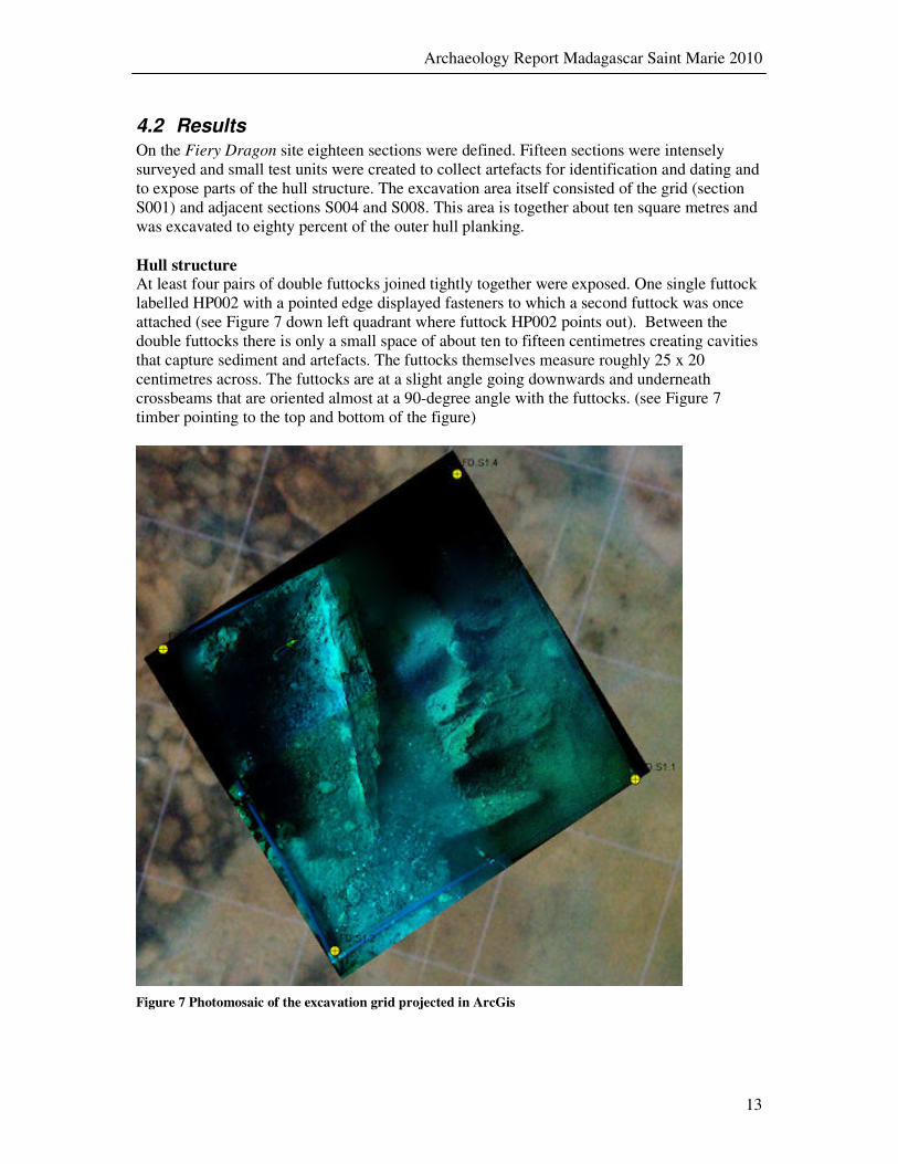
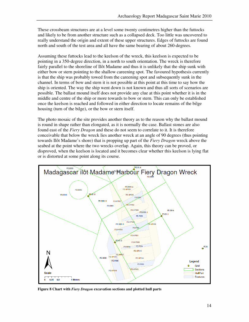
On the Fiery Dragon site eighteen sections were defined. Fifteen sections were intensely surveyed and small test units were created to collect artefacts for identification and dating and to expose parts of the hull structure. The excavation area itself consisted of the grid (section S001) and adjacent sections S004 and S008. This area is together about ten square metres and was excavated to eighty percent of the outer hull planking. Hull structure At least four pairs of double futtocks joined tightly together were exposed. One single futtock labelled HP002 with a pointed edge displayed fasteners to which a second futtock was once attached (see Figure 7 down left quadrant where futtock HP002 points out). Between the double futtocks there is only a small space of about ten to fifteen centimetres creating cavities that capture sediment and artefacts. The futtocks themselves measure roughly 25 x 20 centimetres across. The futtocks are at a slight angle going downwards and underneath crossbeams that are oriented almost at a 90-degree angle with the futtocks. (see Figure 7 timber pointing to the top and bottom of the figure)
Figure 7 Photomosaic of the excavation grid projected in ArcGis
Archaeology Report Madagascar Saint Marie 2010
14
These crossbeam structures are at a level some twenty centimetres higher than the futtocks and likely to be from another structure such as a collapsed deck. Too little was uncovered to really understand the origin and extent of these upper structures. Edges of futtocks are found north and south of the test area and all have the same bearing of about 260-degrees. Assuming these futtocks lead to the keelson of the wreck, this keelson is expected to be pointing in a 350-degree direction, in a north to south orientation. The wreck is therefore fairly parallel to the shoreline of Ilôt Madame and thus it is unlikely that the ship sunk with either bow or stern pointing to the shallow careening spot. The favoured hypothesis currently is that the ship was probably towed from the careening spot and subsequently sunk in the channel. In terms of bow and stern it is not possible at this point at this time to say how the ship is oriented. The way the ship went down is not known and thus all sorts of scenarios are possible. The ballast mound itself does not provide any clue at this point whether it is in the middle and centre of the ship or more towards to bow or stern. This can only be established once the keelson is reached and followed in either direction to locate remains of the bilge housing (turn of the bilge), or the bow or stern itself. The photo mosaic of the site provides another theory as to the reason why the ballast mound is round in shape rather than elongated, as it is normally the case. Ballast stones are also found east of the Fiery Dragon and these do not seem to correlate to it. It is therefore conceivable that below the wreck lies another wreck at an angle of 90 degrees (thus pointing towards Ilôt Madame’s shore) that is propping up part of the Fiery Dragon wreck above the seabed at the point where the two wrecks overlap. Again, this theory can be proved, or disproved, when the keelson is located and it becomes clear whether this keelson is lying flat or is distorted at some point along its course.
Figure 8 Chart with Fiery Dragon excavation sections and plotted hull parts
Archaeology Report Madagascar Saint Marie 2010
15
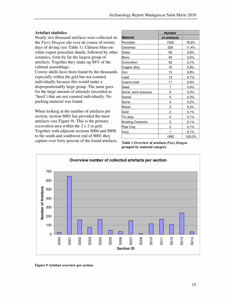
Artefact statistics Nearly two thousand artefacts were collected on the Fiery Dragon site over de course of twenty days of diving (see Table 1). Chinese blue-on-white export porcelain shards, followed by other ceramics, form by far the largest group of artefacts. Together they make up 88% of the cultural assemblage. Cowrie shells have been found by the thousands especially within the grid but not counted individually because this would make a disproportionably large group. The same goes for the large amount of almonds (recorded as ‘Seed’) that are not counted individually. No packing material was found. When looking at the number of artefacts per section, section S001 has provided the most artefacts (see Figure 9). This is the primary excavation area within the 2 x 2 m grid. Together with adjacent sections S004 and S008 to the south and southwest end of S001 they capture over forty percent of the found artefacts.
Number
Material of artefacts
Porcelain 1526 76,6%
Ceramics 228 11,4%
Glass 58 2,9%
Bone 49 2,5%
Concretion 42 2,1%
Copper alloy 16 0,8%
Iron 15 0,8%
Lead 13 0,7%
Cowrie shell 11 0,6%
Seed 7 0,4%
Stone, semi-precious 6 0,3%
Dental 5 0,3%
Stone 4 0,2%
Wood 3 0,2%
Gold 2 0,1%
Tin alloy 2 0,1%
Building Ceramics 2 0,1%
Pipe Clay 2 0,1%
Ivory 1 0,1%
1992 100,0%
Table 1 Overview of artefacts Fiery Dragon
grouped by material category
Overview number of collected artefacts per section
0
100
200
300
400
500
600
700
S0
00
S0
01
S0
02
S0
03
S0
04
S0
05
S0
06
S0
07
S0
08
S0
10
S0
11
S0
12
S0
13
S0
14
Section ID
Nu
mb
er
of
Art
efa
cts
Figure 9 Artefact overview per section
Archaeology Report Madagascar Saint Marie 2010
16
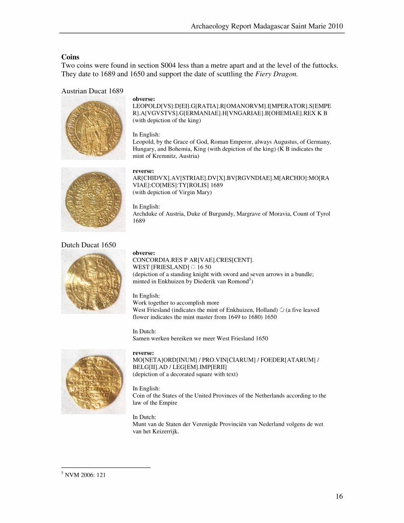
Coins Two coins were found in section S004 less than a metre apart and at the level of the futtocks. They date to 1689 and 1650 and support the date of scuttling the Fiery Dragon. Austrian Ducat 1689
obverse: LEOPOLD[VS]:D[EI].G[RATIA].R[OMANORVM].I[MPERATOR].S[EMPER].A[VGVSTVS].G[ERMANIAE].H[VNGARIAE].B[OHEMIAE].REX K B (with depiction of the king) In English: Leopold, by the Grace of God, Roman Emperor, always Augustus, of Germany, Hungary, and Bohemia, King (with depiction of the king) (K B indicates the mint of Kremnitz, Austria)
reverse: AR[CHIDVX].AV[STRIAE].DV[X].BV[RGVNDIAE].M[ARCHIO]:MO[RAVIAE]:CO[MES]:TY[ROLIS] 1689 (with depiction of Virgin Mary) In English: Archduke of Austria, Duke of Burgundy, Margrave of Moravia, Count of Tyrol 1689
Dutch Ducat 1650
obverse: CONCORDIA.RES P AR[VAE].CRES[CENT]. WEST [FRIESLAND] 16 50 (depiction of a standing knight with sword and seven arrows in a bundle; minted in Enkhuizen by Diederik van Romond5) In English: Work together to accomplish more West Friesland (indicates the mint of Enkhuizen, Holland) (a five leaved flower indicates the mint master from 1649 to 1680) 1650 In Dutch: Samen werken bereiken we meer West Friesland 1650
reverse: MO[NETA]ORD[INUM] / PRO.VIN[CIARUM] / FOEDER[ATARUM] / BELG[II].AD / LEG[EM].IMP[ERII] (depiction of a decorated square with text) In English: Coin of the States of the United Provinces of the Netherlands according to the law of the Empire In Dutch: Munt van de Staten der Verenigde Provinciën van Nederland volgens de wet van het Keizerrijk.
5 NVM 2006: 121

Archaeology Report Madagascar Saint Marie 2010
17
Chinese porcelain The porcelain cups and ware fragments found in situ on the wreck site tentatively identified as the Fiery Dragon are extremely varied in styles as well as vessel types, and suggest provenience from more than one ship taken as prize and haphazardly loaded crates. Fragments from platters, plates, bowls, cups, and lids are scattered across the site, and seem to be more numerous on the east portion of the wreck. Some vessels have lobed rims others scalloped. The most common decorations are flower and vegetal motifs, while a few display landscape scenes with pagodas (houses) and bodies of water. Fewer have animals, usually birds, such as the double headed phoenix, and none depict human figures. Some geometric designs were also incorporated on some ware fragments, mixed with floral and vegetal motifs. Careful examination of some of the fragments revealed traces of “ghost” patterns left by polychrome paint that had been applied over the glaze following the firing process. The over glaze enamel paint did not resist long-term immersion in seawater, but the ghost image it left allows for the possibility of sketching the patterns and visualizing what the vessels looked like prior to salt water immersion.
Figure 10 Two chinese porcelain cups (artefacts MAD.2010.FD.A000003 and 4)
All the fragments and two intact cups appear to have been fired in the kilns of Jingdezhen, in the province of Jiangxi, in southern China during the Kangxi period (1662-1722). The shape of the foot, the decorative patterns, and the high quality of the porcelain dictate this. Stoneware had been produced in Jingdezhen since the 10th-century, but the city made its reputation thanks to the introduction of qingbai, a white porcelain with a blue glaze that adheres to it perfectly and requires only a single firing. During the Song Dynasty (960-1279), potters from Jingdezhen began to exploit a new deposit called gaoling, thirty kilometres northeast of the city, which provided exceptionally fine clay, thus making the city’s fortune. This refractory clay is feldspar formed of silica and alumina originating from the decomposition of an eruptive crystalline rock. In order to use this material in the manufacture of porcelain, it must be mixed with a substance known as baidunzi, which has the same structure as gaoling but is less decomposed. Once pulverized, the resulting mixture is made into small blocks and placed in pits to decompose over a period of several years. At the end of
Archaeology Report Madagascar Saint Marie 2010
18
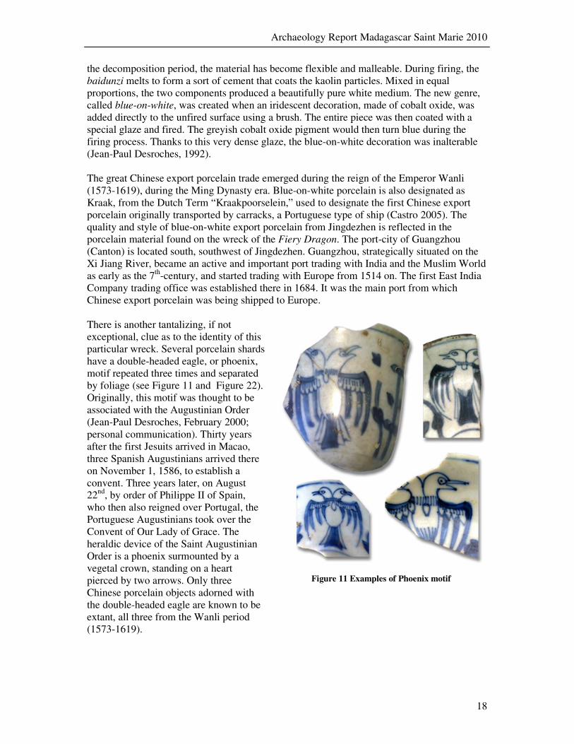
the decomposition period, the material has become flexible and malleable. During firing, the baidunzi melts to form a sort of cement that coats the kaolin particles. Mixed in equal proportions, the two components produced a beautifully pure white medium. The new genre, called blue-on-white, was created when an iridescent decoration, made of cobalt oxide, was added directly to the unfired surface using a brush. The entire piece was then coated with a special glaze and fired. The greyish cobalt oxide pigment would then turn blue during the firing process. Thanks to this very dense glaze, the blue-on-white decoration was inalterable (Jean-Paul Desroches, 1992). The great Chinese export porcelain trade emerged during the reign of the Emperor Wanli (1573-1619), during the Ming Dynasty era. Blue-on-white porcelain is also designated as Kraak, from the Dutch Term “Kraakpoorselein,” used to designate the first Chinese export porcelain originally transported by carracks, a Portuguese type of ship (Castro 2005). The quality and style of blue-on-white export porcelain from Jingdezhen is reflected in the porcelain material found on the wreck of the Fiery Dragon. The port-city of Guangzhou (Canton) is located south, southwest of Jingdezhen. Guangzhou, strategically situated on the Xi Jiang River, became an active and important port trading with India and the Muslim World as early as the 7th-century, and started trading with Europe from 1514 on. The first East India Company trading office was established there in 1684. It was the main port from which Chinese export porcelain was being shipped to Europe. There is another tantalizing, if not exceptional, clue as to the identity of this particular wreck. Several porcelain shards have a double-headed eagle, or phoenix, motif repeated three times and separated by foliage (see Figure 11 and Figure 22). Originally, this motif was thought to be associated with the Augustinian Order (Jean-Paul Desroches, February 2000; personal communication). Thirty years after the first Jesuits arrived in Macao, three Spanish Augustinians arrived there on November 1, 1586, to establish a convent. Three years later, on August 22nd, by order of Philippe II of Spain, who then also reigned over Portugal, the Portuguese Augustinians took over the Convent of Our Lady of Grace. The heraldic device of the Saint Augustinian Order is a phoenix surmounted by a vegetal crown, standing on a heart pierced by two arrows. Only three Chinese porcelain objects adorned with the double-headed eagle are known to be extant, all three from the Wanli period (1573-1619).
Figure 11 Examples of Phoenix motif

Archaeology Report Madagascar Saint Marie 2010
19
The presence of this porcelain on Sainte-Marie Island is surprising because such items were thought to have been manufactured exclusively for the Macao market. On the other hand, the fact that we are dealing with a pirate ship could explain why the ship’s cargo would not be typical of that of an East Indiaman, i.e. a commercial European ship trading with India and the Far East. There may be another explanation for this decoration. The coat of arms of the Hapsburg Dynasty was a crowned phoenix with a coat of arms on its chest, and it is quite conceivable that those porcelain fragments represent a special order for the Hapsburg market rather the Macao one, and that this order was originally aboard a ship seized by the Fiery
Dragon, such as, for example, the Maison d’Autriche. Two small moulded figurines, made of plain white porcelain, and the fragmentary lower portion and the base of a third one were found during the excavation of the Fiery Dragon. The smaller of the two whole or partially complete figurines represents a small person or a child, apparently a female, wearing a buttoned coat and holding a pet, possibly a cat, in her right arm; she is standing next to a tree trunk against which a bouquet of flower is resting. This particular piece was manufactured from a single mould. The piece is about 5.2 centimetres high and the maximum pedestal diameter is 3.5 centimetres. The larger piece appears to have been shaped from two pieces moulded separately, with the figurine itself appearing to have been glued to the pedestal with barbotine, although this cannot be confirmed until the figure undergoes a careful cleaning process (Evelyne Jay Guyot de Saint Michel 1999:136, 138). This particular piece depicts a smiling oriental man, most likely Chinese, wearing a dome-shape hat. He appears to be sitting, although encrustation makes it difficult to determine this with any degree of certainty, his head tilted to his right and he is looking to his left. He is holding an object on what appears to be a tray; his hands and portions of the pedestal are broken and missing. The piece is about 8 centimetres high and the maximum pedestal diameter is 4.8 centimetres. The third fragmentary figurine consists of the feet and part of the lower legs of a central figure. What appears to be the remnants of two small feet are seen at the left side of the central figure, while a Fu dog is seen sitting next to the right foot of the central figure. The piece is about 1.5 centimetres high and the maximum pedestal diameter is 5.4 centimetres.
Figure 12 Three Chinese white porcelain figurines

Archaeology Report Madagascar Saint Marie 2010
20
Shells Large quantities of cowries (shells) were found on the wreck of the Fiery Dragon, many cemented to the ribs of the ship. A number of the cowries have been identified as Cypraea
chinensis (Indo-Pacific), Cypraea walkeri (Seychelles Island, and the Maldives Islands), Cypraea helvola (Indo-Pacific), Cypraea gracilis (Indian Ocean), Cypraea erosa (Indo-Pacific), Cypraea arabica Indo-Pacific), Cypraea lynx (Indian, west and central Pacific Oceans), and Cypraea talpa (Indian and central Pacific Oceans). Other species have yet to be identified, but the above-mentioned cowries were found to be the most numerous. The Fiery
Dragon is known to have had a large quantity of cowries on board, as, undoubtedly, did other pirate ships in Sainte-Marie. Cowries were widely used in the region to trade as well as to purchase slaves with.
Other organic Material Wood used in the construction of the Fiery Dragon has been tentatively identified in situ as Quercus spp., European white oak, most probably robur or petraea. This wood, found on numerous wrecks, played a major role in European commerce and warfare and was the most commonly used wood throughout the history of seafaring (J. Richard Steffy, 1994). It is slightly lighter than Quercus alba, American white oak. Two types of seeds found on the lowest level of the Fiery Dragon test unit have been tentatively identified as cf. Prunus sp., and Myristica fragrans, nutmeg. The latter one, the spice nutmeg, consists of the seed of the Myristica fragrans, a tropical, dioecious evergreen tree native to the Moluccas, or Spice Islands, of Indonesia, and may have come from the large mogul ship taken near Mumbai on August 18, 1720. This spice was much appreciated and in demand in Europe. A French Royal Ordinance dated September 9, 1726, directed French ship captains to bring back to France a variety of exotic plants, fruits, and spices whenever possible (de Bry 2006:127). Nutmeg was part of the extensive list given to sea captains sailing to the Americas, Africa, and the Orient. Cf. Prunus sp., is from the Rosaceae family belonging to the genus Prunus, and closely resembles cf. Prunus dulcis, the almond. The seeds examined do not appear to have the exterior pericarp shell present that would greatly aid in identification as it contains the diagnostic pitting around the shell surface, but seems to represent the middle mesocarp shell that encircles the kernel, or the almond. This however also looks much like that of the apricot Prunus armeniac, also called the Chinese almond (Donna Rhule, 5 January 2011; personal communication).
Archaeology Report Madagascar Saint Marie 2010
21
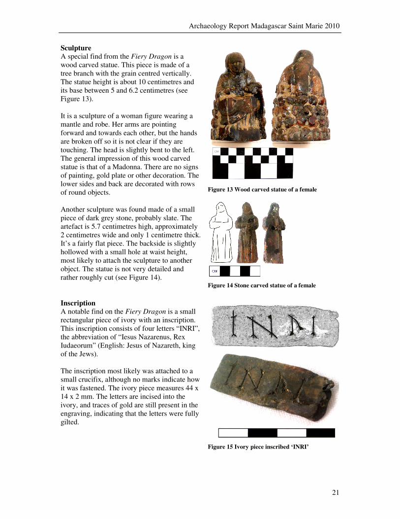
Sculpture A special find from the Fiery Dragon is a wood carved statue. This piece is made of a tree branch with the grain centred vertically. The statue height is about 10 centimetres and its base between 5 and 6.2 centimetres (see Figure 13). It is a sculpture of a woman figure wearing a mantle and robe. Her arms are pointing forward and towards each other, but the hands are broken off so it is not clear if they are touching. The head is slightly bent to the left. The general impression of this wood carved statue is that of a Madonna. There are no signs of painting, gold plate or other decoration. The lower sides and back are decorated with rows of round objects.
Figure 13 Wood carved statue of a female
Another sculpture was found made of a small piece of dark grey stone, probably slate. The artefact is 5.7 centimetres high, approximately 2 centimetres wide and only 1 centimetre thick. It’s a fairly flat piece. The backside is slightly hollowed with a small hole at waist height, most likely to attach the sculpture to another object. The statue is not very detailed and rather roughly cut (see Figure 14).
Figure 14 Stone carved statue of a female
Inscription A notable find on the Fiery Dragon is a small rectangular piece of ivory with an inscription. This inscription consists of four letters “INRI”, the abbreviation of “Iesus Nazarenus, Rex Iudaeorum” (English: Jesus of Nazareth, king of the Jews). The inscription most likely was attached to a small crucifix, although no marks indicate how it was fastened. The ivory piece measures 44 x 14 x 2 mm. The letters are incised into the ivory, and traces of gold are still present in the engraving, indicating that the letters were fully gilted.
Figure 15 Ivory piece inscribed ‘INRI’

Archaeology Report Madagascar Saint Marie 2010
22
5 Archaeological Research of the ‘Channel wreck’
5.1 Strategy
After the discovery of the ballast mound in the channel, surveys were conducted in order to get an initial idea of the size and orientation of the site. The distribution of ballast rocks pointed to an almost east to west orientation of the assumed wreck. A basic measurement system was established under water, consisting of two control points connected by a straight base line. The line started at the chain in the centre of the ballast area and ended at a well-secured and stable piece of wood sticking out of the bottom some 11.5 metres west of the starting point. Distances between the control points and points A and F of the Fiery Dragon
site were carefully measured and copied into the ArcGis software to get an accurate overview of the measurement system and spatial relationship to the Fiery Dragon site.
Figure 16 ArcGis chart ‘channel wreck’ zoomed in on hull section S002
Initially no hull structure was visible and hardly any artefacts were visible. The next stage in the survey was to scan the bottom with metal detectors in order to locate any large objects like cannon and cannonballs. As this wreck site could be either the Mocha Frigate or the New
Soldado (formerly known as the Great Mahomet) that were purposely wrecked in an hurried fashion, part of the cargo and a substantial amount of ordnance could be expected, absent of subsequent salvage. Metal detector survey indeed indicated a number of hot spots and one was chosen as section S001 to further excavate. Using a water jet to blow overburden of about thirty centimetres of sand and silt away, a large iron cannon was located together with a concretion of cannonballs and glass objects, including an intact bottle and several large fragments of green glass. Only a few porcelain shards were found around the site.
Archaeology Report Madagascar Saint Marie 2010
23
Based on the size and shape of the cannon, the bottle, and decoration of the porcelain shards the site can tentatively be placed within the second half of the 17th-century. This tentative dating fits well with the reported scuttling of both above-mentioned ships in 1699. Moving ballast rocks aside along the base line a test unit of about 3 x 3.5 metres was created (section S002). Excavation revealed part of the inner structure of a hull, although few datable artefacts.
Site Significance As has been evidenced from the Whydah wreck site (1717), vessels employed as “maritime predators” carried a broader cross-cultural selection of artefacts than did their merchant or naval counterparts. The archaeological and historical significance of the site therefore cannot be taken lightly or underestimated. For example, in addition to valuables in the form of gold coins and jewellery left behind by pirates that were under extreme pressure to sink their ships to block the entrance to the bay at the “Bottle Neck,” it is virtually certain that some Islamic objects that would be of enormous significance today were left behind by the pirates who most likely had no interest in them. The Islamic objects that the archaeological team is expecting to encounter on the wreck of the Great Mahomet, in particular, could represent the most unique and significant religious assemblage from the Holy Cities of Mecca and Medina ever found within the context of a shipwreck. Similarly, the known career of The Mocha
Frigate in the eastern Bay of Bengal and Indonesian waters establishes a reasonable expectation of encountering, for example, extremely rare South East Asian artefacts.
5.2 Results
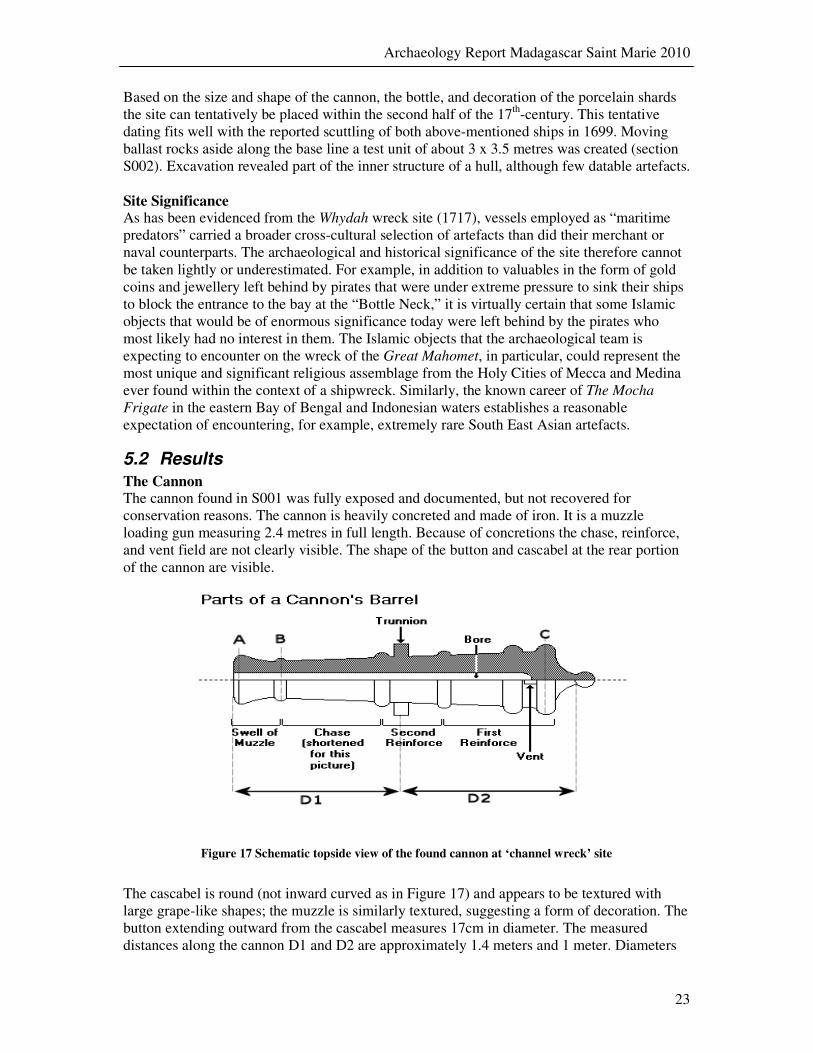
The Cannon The cannon found in S001 was fully exposed and documented, but not recovered for conservation reasons. The cannon is heavily concreted and made of iron. It is a muzzle loading gun measuring 2.4 metres in full length. Because of concretions the chase, reinforce, and vent field are not clearly visible. The shape of the button and cascabel at the rear portion of the cannon are visible.
Figure 17 Schematic topside view of the found cannon at ‘channel wreck’ site
The cascabel is round (not inward curved as in Figure 17) and appears to be textured with large grape-like shapes; the muzzle is similarly textured, suggesting a form of decoration. The button extending outward from the cascabel measures 17cm in diameter. The measured distances along the cannon D1 and D2 are approximately 1.4 meters and 1 meter. Diameters

Archaeology Report Madagascar Saint Marie 2010
24
at points A, B and C are subsequently 30, 26 and 45 centimetres. Note that all measurements taken are influenced by the fact that the cannon is concreted and so actual dimensions of the cannon can vary. The diameter of the trunnions on each side is about 16 centimetre and the trunnions are placed closer to the lower portion of the cannon. The cannon was lifted using airbags in order to shift it aside. Lift bags with a total capacity of over 2,150 kilograms were needed to lift the cannon. It was not possible to measure the bore because of concretion. Based on the preliminary weight and length of the cannon, it is likely that the cannon is a 6-pounder. Placement of the trunnions at the lower portion of the cannon instead of the centre line suggests a dating of the 2nd half of the 17th-century. In the original design of cast cannon, the normal position of the trunnion was just forward of the point of balance of the gun, so as to give some degree of breech preponderance, and was originally probably merely a crosspiece lashed beneath the piece. This theory is supported by the fact that as a general rule the older the gun, the lower is the centre line of the trunnions (Caruana 1994:5).
Artefact categories Sixty-nine artefacts were found and recovered from this site (see Table 2). The relatively great number of 27 glass artefacts is due to the fact that several pieces belong to the same glass vessel. At least four individual specimens of bottles were found; two with a round bottom, one square (gin case bottle), and one fully intact bottle with an oval bottom (see Figure 18). This oval shaped bottle can be dated to the second half of the 17th century6. Besides the bottles, a piece of a drinking glass was found and a small piece of what appears to be window glass. A number of concretions were also found. Some concretions contain iron cannonballs, obviously recognized by the shape and size. Other concretions have unknown contents pending post-recovery conservation and analysis.
Figure 18 Intact wine bottle
Figure 19 Porcelain shards of the ‘channel wreck’
Table 2 Overview of artefacts
’channel wreck’ by material
category
Material Number
of artefacts
Glass 27
Concretion 15
Ceramics 8
Lead 7
Porcelain 7
Bone 1
Iron 1
Stone 1
Tin alloy 1
Copper alloy 1
6 See http://www.museumoflondon.org.uk/ceramics/pages/object.asp?obj_id=530371
Archaeology Report Madagascar Saint Marie 2010
25
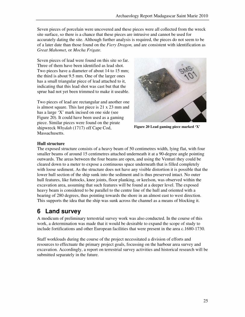
Seven pieces of porcelain were uncovered and these pieces were all collected from the wreck site surface, so there is a chance that these pieces are intrusive and cannot be used for accurately dating the site. Although further analysis is required, the pieces do not seem to be of a later date than those found on the Fiery Dragon, and are consistent with identification as Great Mahomet, or Mocha Frigate. Seven pieces of lead were found on this site so far. Three of them have been identified as lead shot. Two pieces have a diameter of about 14 to 15 mm; the third is about 9.5 mm. One of the larger ones has a small triangular piece of lead attached to it, indicating that this lead shot was cast but that the sprue had not yet been trimmed to make it useable. Two pieces of lead are rectangular and another one is almost square. This last piece is 21 x 23 mm and has a large ‘X’ mark incised on one side (see Figure 20). It could have been used as a gaming piece. Similar pieces were found on the pirate shipwreck Whydah (1717) off Cape Cod, Massachusetts.
Figure 20 Lead gaming piece marked ‘X'
Hull structure The exposed structure consists of a heavy beam of 50 centimetres width, lying flat, with four smaller beams of around 15 centimetres attached underneath it at a 90-degree angle pointing outwards. The areas between the four beams are open, and using the Venturi they could be cleared down to a meter to expose a continuous space underneath that is filled completely with loose sediment. As the structure does not have any visible distortion it is possible that the lower hull section of the ship sunk into the sediment and is thus preserved intact. No outer hull features, like futtocks, knee joints, floor planking, or keelson, was observed within the excavation area, assuming that such features will be found at a deeper level. The exposed heavy beam is considered to be parallel to the centre line of the hull and oriented with a bearing of 280 degrees, thus pointing towards the shore in an almost east to west direction. This supports the idea that the ship was sunk across the channel as a means of blocking it.
6 Land survey A modicum of preliminary terrestrial survey work was also conducted. In the course of this work, a determination was made that it would be desirable to expand the scope of study to include fortifications and other European facilities that were present in the area c.1680-1730. Staff workloads during the course of the project necessitated a division of efforts and resources to effectuate the primary project goals, focussing on the harbour area survey and excavation. Accordingly, a report on terrestrial survey activities and historical research will be submitted separately in the future.

Archaeology Report Madagascar Saint Marie 2010
26
7 Artefact administration For this project an artefact administration was created using MS Access, a standard end user database system. This administration holds information about the grid, measurements, and recovery areas, artefacts and where they are stored after recording. This was done to ensure that a complete overview of artefacts was recorded and statistical and spatial analysis is possible later on in combination with the GIS system. Also the link to artefact photographs is recorded in the administration, so pictures of each artefact are easily found in the catalogue folder. Basic data recording Before recording artefacts, it is vital to enter location data in order to accurately document where the artefact was found. Control points and measurements between them are recorded to recreate the measurement system in GIS or underwater if needed. After that sections are defined and recorded. These are areas surveyed or excavated and present underwater and/or in the GIS system. The 2 x 2 m grid itself is, for example, defined as section MAD.2010.FD.S001 meaning ‘Madagascar 2010 expedition Fiery Dragon site section 001’. Nineteen sections were defined using this procedure, of which seven are part of the excavation area and the remaining twelve are survey areas. Hull parts and features are areas within sections that are clearly identifiable such as wooden beams, futtocks, knee joints, and spaces in between them, cavities etc. These are areas that act as catch-basins for artefacts. It is important to identify these areas as most artefacts are collected by feature, measuring each artefact individually being too labour intensive. Only specials finds are measured and mapped precisely.
Figure 21 Screenshot artefact administration
Archaeology Report Madagascar Saint Marie 2010
27
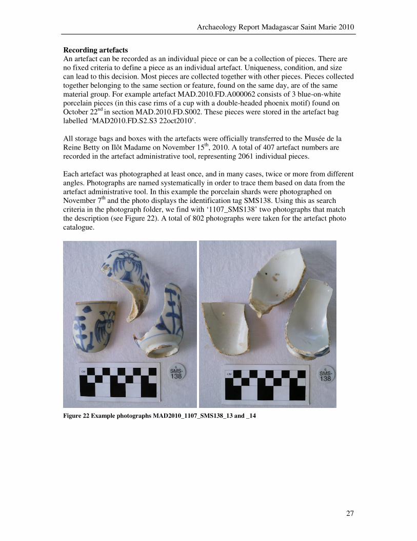
Recording artefacts An artefact can be recorded as an individual piece or can be a collection of pieces. There are no fixed criteria to define a piece as an individual artefact. Uniqueness, condition, and size can lead to this decision. Most pieces are collected together with other pieces. Pieces collected together belonging to the same section or feature, found on the same day, are of the same material group. For example artefact MAD.2010.FD.A000062 consists of 3 blue-on-white porcelain pieces (in this case rims of a cup with a double-headed phoenix motif) found on October 22nd in section MAD.2010.FD.S002. These pieces were stored in the artefact bag labelled ‘MAD2010.FD.S2.S3 22oct2010’. All storage bags and boxes with the artefacts were officially transferred to the Musée de la Reine Betty on Ilôt Madame on November 15th, 2010. A total of 407 artefact numbers are recorded in the artefact administrative tool, representing 2061 individual pieces. Each artefact was photographed at least once, and in many cases, twice or more from different angles. Photographs are named systematically in order to trace them based on data from the artefact administrative tool. In this example the porcelain shards were photographed on November 7th and the photo displays the identification tag SMS138. Using this as search criteria in the photograph folder, we find with ‘1107_SMS138’ two photographs that match the description (see Figure 22). A total of 802 photographs were taken for the artefact photo catalogue.
Figure 22 Example photographs MAD2010_1107_SMS138_13 and _14

Archaeology Report Madagascar Saint Marie 2010
28
8 Next steps The 2010 expedition has contributed to the exposure of only a small part of the wreck of the Fiery Dragon and in order to understand the architecture and origin of the ship, the way it came to rest on floor of the natural harbour of Saint Marie, the cargo, and objects that remain, further research is needed. Future expeditions will focus on the continued excavation of the Fiery Dragon. First aim is to expose part of the hull including the keelson and other parts of the hull. The ‘channel site’ still needs to yield additional clues as to its origin date and other factors that might determine whether it is the Mocha Frigate or the Great Mahomet. Only a minute part of the wreck site was investigated and a large-scale excavation is to be conducted in order to expose a cross section of the hull. A bigger survey of the area should reveal the extent of the site. Apart from these two wreck sites others are still to be found and mapped. At least five other shipwrecks from the ‘Golden Age of Piracy’ period are likely to be present in the harbour area and in vicinity of the careening spot off Ilôt Madame. In order to locate and record these wrecks a more extensive systematic survey is to be undertaken to map the entire harbour area as well as part of Pirate Bay. Based on the excavation and survey results in terms of number of artefacts found in 2010 it can be expected that subsequent expeditions will yield an exponentially greater amount of material culture. This requires careful planning and organisation of conservation work. The local museum at Ilôt Madame is neither equipped nor organised at this time to conserve artefacts of an organic nature such as wood and bone. Future expeditions will therefore focus on development and improvement of the local museum as a place to secure, conserve and exhibit material culture from submerged environments. This will benefit both the local community as well as the expedition team. A refurbished museum housing a permanent exhibition on pirates of Madagascar will prove a major tourist attraction that will lead to both a positive and significant contribution to the local economy as well as to the knowledge of the cultural history of Sainte-Marie and Madagascar in general. It provides the unique opportunity to house and curate this cultural heritage and provide an educational tool within reach of the actual wreck sites. Having a permanent research base set up at the museum ensures that the process of excavation and conservation of artefacts can be made more effective and efficient. It also can lead to empowerment of local researchers and to build up capacity on research and conservation. Expedition leader Barry Clifford envisions a multi-year project at Sainte-Marie in order to achieve the above mentioned goals of researching the pirate wrecks and improving the museum. With the excellent collaboration of the authorities of Madagascar and the local community at Sainte-Marie Island, this project will be successful in recovering and preserving important cultural heritage for future generations.
Archaeology Report Madagascar Saint Marie 2010
29
9 References Bibliography
De Bry, J., Christopher Condent’s Fiery Dragon: Investigating an Early 18th
-Century
Pirate Shipwreck off the Coast of Madagascar, in X Marks the Spot: The Archaeology of Piracy, edited by Russell K. Skowronek and Charles R. Ewen, University Press of Florida, Gainesville 2006. (de Bry 2006.1)
De Bry, J., Test excavation of The Adventure Galley & Fiery Dragon Wreck Sites
Saint-Marie Island, Madagascar, October-November 2000 (Florida 2000) (de Bry 2000.2)
Defoe, Daniel, A General History of the Pyrates [first published in 1724 in London] edited by Manuel Schonhorn, Dover Publications, Mineola, New York 1972.
Caruana, Adrian B, The History of English Sea Ordnance 1523-1715, The Age of
Evolution, Volume I, (Rotherfield 1994) Castro, F.V., The Pepper Wreck. A Portuguese Indiaman at the Mouth of the Tagus
River, Texas A&M University Press, College Station 2005 Clifford, B.C., Plan for Archaeological Exploration & Survey, Ile Ste. Marie,
Republic of Madagascar (First Phase) (Massachusetts 2010) Desroches, J.P., in: Du Tage à la Mer de Chine. Exhibition Catalogue, Musée
National des Arts Asiatiques-Guimet, Paris 1992. Foster, W. (ed), A History of the Indian Wars by Clement Downing (London 1924)
(Downing) Gill, C., Merchants and Mariners of the 18th Century (London 1961) Guyot de Saint Michel, E.J., in: Griffin on the Route of an Indiaman (London 1999) Leibbrandt, H.C.V., Precis of the Archives of the Cape of Good Hope: Journal 1699-
1732 (Capetown 1896) Paesie, R., Lorredrayen op Africa (Amsterdam 2008) Purmer, D., Wiel, A.H.N. van der, Handboek van de Nederlandsche Provinciale
Muntslag 1573 – 1806, Deel I, NVM 2006. Ritchie, Robert C., Captain Kidd and the War against the Pirates, Harvard University
Press, Cambridge, Massachusetts 1986. Rogozinski, J., Honor Among Thieves: Captain Kidd, Henry Every & the Pirate
Democracy in the Indian Ocean, Stackpole Books, Mechanicsburg, Pennsylvania 2000.
Archives Dutch National Archives, the Hague, Netherlands (DNA) Colonial Office Papers, Public Record Office, Kew, United Kingdom (CO) India Office Records, Public Record Office, Kew, United Kingdom (IOR) Centre des Archives d’Outre-Mer, Aix-en-Provence, France (CAOM)