archaeological report - kilsheelan, co. tipperary (ireland)
DESCRIPTION
The excavations at Kilsheelan, Co. Tipperary uncovered three areas of pits. The pits in two areas (Areas 2 and 3) were isolated and did not contain notable artefacts or environmental evidence. However, at Area 1 there were several pit clusters and artefacts and radiocarbon dates indicated occupation (probably intermittent rather than permanent) during the Early Neolithic.TRANSCRIPT

Issue 13 [ISSN 2009-2237]
Archaeological Excavation Report
05E1391 - Kilsheelan, Co. Tipperary
Early Neolithic pits
Eachtra Journal

The Forge,Innishannon, Co. Cork.Tel.: 021 470 16 16Fax: 021 470 16 28E-mail: [email protected] Site: www.eachtra.ie
Contact details:
March 2007
Written by:
Client:
Archaeological Excavation Report,Poulakerry, Kilsheelan and Cloghcarrigeen East,Kilsheelan,Clonmel, Co. Tipperary
Jeremiah, Patrick and Mauri Harrington of Binchy & Co., 7 Dr. Croke Place, Clonmel, Co. Tipperary
04/117
05E1391
Julianna O’Donoghue
Mick Drum
Planning Register No.:
Licence No.:
Licensee:

http://eachtra.ie/index.php/journal/05E1391-kilsheelan-co-tipperary/
05E1391 - Kilsheelan,Clonmel, Co. TipperaryISSUE 13: Eachtra JoUrnal - ISSn 2009-2237
iii
Copyright Notice: Please note that all original information contained within this report, including all original drawings, photographs, text and all other printed matter deemed to be the writer’s, remains the property of the writer and Eachtra Archaeological Projects and so may not be reproduced or used in any form without the written consent of the writer or Eachtra Archaeological Projects.
Table of Contents
1 Introduction .....................................................................................................................1
2 Archaeological and historical background .........................................................................1
3 Recent archaeological work excavations in the Kilsheelan and south Tipperary area ........2
4 Site Location and Topography ..........................................................................................3
5 Methodology ....................................................................................................................3
6 Description of the excavation ............................................................................................4
6.1 Area 1 ........................................................................................................................4
6.2 Area 2 ........................................................................................................................6
6.3 Area 3 ........................................................................................................................6
7 Specialist Reports .............................................................................................................7
7.1 Radiocarbon results ....................................................................................................7
7.2 Lithics Assemblage (see Appendix 5) ..........................................................................7
7.3 Ceramics (see Appendix 4) .........................................................................................7
7.4 Plant remains assemblage (see Appendix 3) .................................................................7
8 Discussion ........................................................................................................................8
8.1 Area 1 ........................................................................................................................8
8.2 Area 2 ........................................................................................................................8
8.3 Area 3 ........................................................................................................................8
9 Conclusion ........................................................................................................................9
10 Bibliography ....................................................................................................................10
10.1 Websites ....................................................................................................................11
10 Figures .............................................................................................................................12
11 Plates ...............................................................................................................................18
12 Appendices ......................................................................................................................20
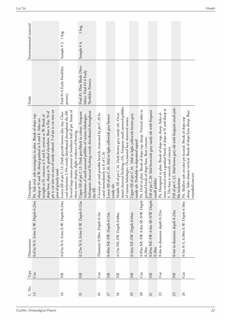
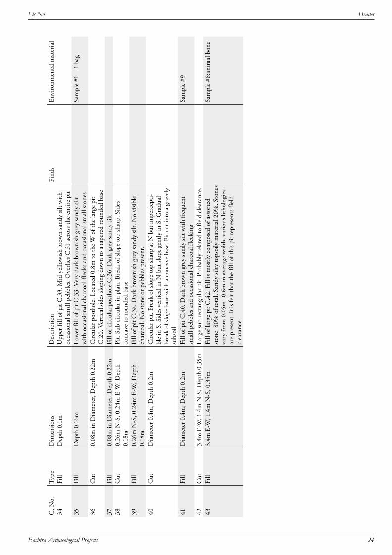
12.1 Appendix 1: Context Register ...................................................................................21
12.2 Appendix 2: Finds Register .......................................................................................25
12.3 Appendix 3: Charred plant remains from Kilsheelan, Co. Tipperary ........................26
12.4 Appendix 4: Pottery Remains Assemblage Report .....................................................31
12.5 Appendix 5: Lithics Finds ........................................................................................34

http://eachtra.ie/index.php/journal/05E1391-kilsheelan-co-tipperary/
05E1391 - Kilsheelan,Clonmel, Co. TipperaryISSUE 13: Eachtra JoUrnal - ISSn 2009-2237
iv
List of FiguresFigure 1: Extract from Discovery Series Map Sheet 75 with site location indicated ..............................12
Figure 2: Extract from 1907 6-inch Ordnance Survey Map Sheet TI084 with site location indicated ...13
Figure 3: Kilsheelan Zone of Archaeological Potential Map from The Urban Archaeological Survey of County Tipperary South Riding, Part 2 ...............................................................................................14
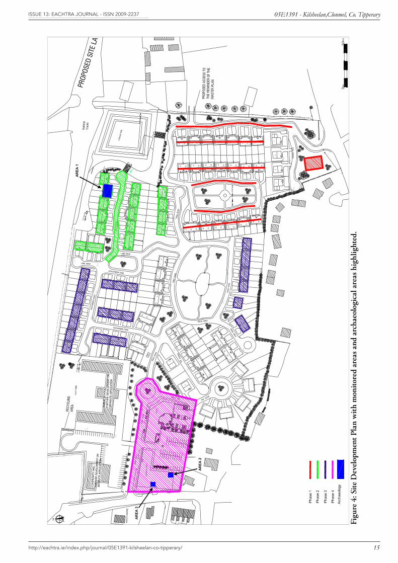
Figure 4: Site Development Plan with monitored areas and archaeological areas highlighted. ...............15
Figure 5: Post-excavation plan Area 1....................................................................................................16
Figure 6: Sections of pits in Area 1 .......................................................................................................17
List of PlatesPlate 1: View of pits in Area 1 from NNE .............................................................................................18
Plate 2: View of sherds of Neolithic pottery in pit C.30 ........................................................................18
Plate 3: View of pits C13, C16, C20 and C22 and stakehole C36 from E .............................................19
Plate 4: View of pit C44 in Area 3 ........................................................................................................19

http://eachtra.ie/index.php/journal/05E1391-kilsheelan-co-tipperary/
05E1391 - Kilsheelan,Clonmel, Co. TipperaryISSUE 13: Eachtra JoUrnal - ISSn 2009-2237
1
1 IntroductionThe excavation took place in the townlands of Poolakerry, Killsheelan and Cloghcarrigeen nears Kilsheelan village, South Riding, Co Tipperary (Figures 1 and 2) in January 2006 by Eachtra Ar-chaeological Projects under Licence No. 05E1391.
The developers Jeremiah, Patrick and Mauri Harrington of Binchy & Co., 7 Dr. Croke Place, Clonmel, Co. Tipperary, have permission to construct 167 houses and ancillary structures. These will consist of 6 number 2-storey 4 bedroom detached houses, 118 No. 2-storey 3 bedroom semi-detached houses, 11 number blocks of 3 number 2-storey 3 bedroom terraced town-houses, 10 number 3 bedroom semi-detached bungalows, single storey crèche of 672 m² and a 2 storey stand alone commercial centre of 2063 m , a crèche, commercial centre, entrance roads and green areas at Poulakerry, Kilsheelan and Cloghcarrigeen East townlands, Clonmel, Co. Tipperary (under the current planning application, Planning Register number 04/117) (figure 4). A public school and community centre, on the develop-ment site, will be filed under a separate planning application. Also included in the development will be a retention pond, roads and ancillary site works at Poulakerry, Kilsheelan, & Cloghcarrigeen East, Clonmel, Co. Tipperary.
The development site is quite large; the entire site measures c. 10 hectares. There will be entrance and exit roads to the R706, the Regional Road to Fethard, to the east of the site, and an entrance onto the N25 at the south of the site. The village of Kilsheelan has a population of approximately 500 (www.southtippcoco.ie ), this development will considerably change the character and size of the village.
Kilsheelan village is listed as a Record of Monuments and Places (RMP) site, number TI084-002. Some of the development site is located within the zone of archaeological potential for the village. Condition 54 (a) of the Grant of Planning for Planning Register number 04/117 states that The appli-cant/ developer is required to engage the services of a suitably qualified archaeologist to monitor all ground-works and topsoil stripping associated with the development….
Four phases of archaeological monitoring of topsoil removal have been undertaken by Eachtra Ar-chaeological Projects to date (Doolan 2006) (Figure 4). The archaeological features recorded in Area 1 during monitoring of phase 2 ground works and those recorded in Areas 2 and 3 during monitoring of phase 3 ground works were excavated under licence 05E1391 and are the subject of this report.
2 Archaeological and historical backgroundEtymologically Kilsheelan means ‘St. Selanus’ Church (from Cill tSioláin), Cloghcarrigeen means ‘Stone of the little rock’ (from Clogh Carraigín) and Poulakerry means ‘Hole of the Cauldron’ (from Poll a Coire) (from the Ordnance Survey Name books 1840, 290-294).
Kilsheelan village is listed as an RMP site (TI084-002). Part of the southern extent of the develop-ment site is located within the zone of archaeological potential for the village (figure 3). There are two

http://eachtra.ie/index.php/journal/05E1391-kilsheelan-co-tipperary/
05E1391 - Kilsheelan,Clonmel, Co. TipperaryISSUE 13: Eachtra JoUrnal - ISSn 2009-2237
2
archaeological monuments in Kilsheelan village, an Anglo-Norman motte and a medieval church and graveyard.
The manor of Kilsheelan was granted to the de Burghs in the late twelfth century, this is likely be the date of the motte (Farrelly and FitzPatrick 1993, 120). The motte, 6 m in height, is located in the centre of the village, 100 m southwest of the development site, and has been turned into a grotto. A motte is a type of monument which consists of a circular-in-plan, flat topped man-made mound of earth. A wooden castle, for the lord of the manor, would have been built on the top of the mound and surrounded by a fence. A second wooden palisade (fence) was built enclosing the motte with a quantity of flat ground around the base of the mound. The area enclosed by the wooden fence was called the ‘Bailey’. A ditch was excavated around the palisade surrounding the Bailey; this is more than likely where the earth to build the motte mound came from. Motte and Bailey castles were built by the An-glo-Normans; they date to the late twelfth century. There are no above-ground remains of the Bailey around the Kilsheelan motte. The motte has been altered in recent times by the addition of a shrine to our lady cut into its northern face.
Kilsheelan Church and graveyard, which probably serviced the inhabitants of the motte, are located south of N25, approximately 100 m south of the development site. The church is twelfth century in date but many features are not original, the decorated Romanesque doorway in the north wall, was more than likely originally in the west wall (ibid.). Kilsheelan is named after this church, and it was dedicated to St. Selanus or ‘Sillian, who was either the Abbot of Bangor or a saint honoured in the Irish martyrologies’ (ibid. and Ordnance Survey Namebooks 1840, 290-294). A seventeenth century graveslab is located inside the church.
3 Recent archaeological work excavations in the Kilsheelan and south Tipper-ary areaTo date few Neolithic sites have been excavated in Co Tipperary. Four are listed in the www.excava-tions.ie website. All of these sites are located in the north and west of the county. Three of these sites are burial or ritual sites and bear little resemblance to the features described in this report. The fourth site consisted of a number of agricultural ditches and gullies, again of a different character to the find-ings from this excavation.
A number of prehistoric sites were excavated along the route of the N8 Cashel bypass in 2003. Several prehistoric structures were identified (pers. comm.. Joanne Hughes). The majority of these sites were dated to the Bronze Age although a few artefacts and structures provisionally dated to the Neolithic period were identified. A flint knife and several scrapers of probable Neolithic date were found in as-sociation with a structure.
Several sites were recently excavated by Headland Archaeology along the route of the N25 Waterford bypass in the townland of Granny. Here two Neolithic houses located near the banks of the river Suir,

http://eachtra.ie/index.php/journal/05E1391-kilsheelan-co-tipperary/
05E1391 - Kilsheelan,Clonmel, Co. TipperaryISSUE 13: Eachtra JoUrnal - ISSn 2009-2237
3
were excavated by Joanne Hughes, (pers. comm.). The distance from the site under discussion here at Kilsheelan to the Neolithic houses at Granny townland is approx 30 km downriver. The river Suir has served as a major thoroughfare (transportation conduit) for traffic in all periods in the past and in the heavily forested landscape of the Early Neolithic the river would have represented a relatively easy way of travelling in the landscape.
4 Site Location and Topography
National Grid Co-ordinates 22887 12339County Tipperary, S.R.Barony Iffa and Offa EastParish KilsheelanTownlands Poulakerry, Kilsheelan, & Cloghcarrigeen East
The site is located on the north side of the N25 in Kilsheelan village in southeast County Tipperary (Figures 1 and 2). Clonmel is located 7 km to the west and Carrick-on-Suir is 10 km to the east. The foothills of the Comeragh Mountains are located 1 km to the south of Kilsheelan village. The River Suir, which forms the county boundary with County Waterford, flows through the village, south of the N25. The development site is located between 20 and 30 m OD. The Waterford to Limerick Junc-tion railway line runs from east to west to the immediate north of the site.
The field boundaries consist of walls and hedges with bushes and trees. All of the field boundaries sur-rounding the development site will be replaced. The site is a Greenfield site and no structures will be demolished during the development. An area of young deciduous forestry in the northeast of the site was removed during Phase 1 ground works.
The site is reasonably level, with a slight upward slope from the southeast to the northwest. It is bound-ed to the south by the N25, to the north by the railway line, by a field and the R706, the Regional Road to Fethard, to the east. Kilsheelan Church and Graveyard is located 100 m to the south of the development site. The motte in the centre of the village is 100 m southwest of the development site.
5 MethodologyThe archaeology identified during Phases 2 and 3 ground disturbance works in was excavated in three separate areas (Areas 1-3; Figure 4). The archaeology in Area 1 was characterised by pits clustered within an area measuring 10m N-S by 10m east-west. The archaeology in Areas 2 and 3 was charac-terised by isolated pits. A grid was established in the areas of excavation and the area within each was cleaned by hand to locate and identify all archaeological features. Each identified feature was exca-vated, planned, photographed and recorded, with every fill and cut being assigned a context number. Charcoal and soil samples were taken from appropriate fills where necessary.

http://eachtra.ie/index.php/journal/05E1391-kilsheelan-co-tipperary/
05E1391 - Kilsheelan,Clonmel, Co. TipperaryISSUE 13: Eachtra JoUrnal - ISSn 2009-2237
4
6 Description of the excavation
6.1 Area 1This area measured 10m north-south by 10m east-west and the archaeology in Area 1 comprised 16 cut features (Figure 5 and 6). The majority of these features cut the subsoil and they consisted of 15 shallow pits and a single stakehole (Plate 1). The pits varied in shape from circular and sub-circular to oval. Their lengths ranged from 0.26-1.18 m, widths from 0.26-0.93 and depths from 0.18-0.3 m. Early Neolithic (4000-3600 BC) pottery was recorded within the fills of some of the pits. There was no evidence for associated structures and the features are interpreted as a number of pits which prob-ably represent an area of early prehistoric outdoor activity. The plan of Area 1 indicated that there were three clusters of pits and it was possible to group the closely-spaced features into a north central, a western and an eastern group. The groups are based on their spatial location and do not imply dif-ferences in function or contemporaneity.
6.1.1 North central features
Seven pits (C.9, C.13, C.16, C.20, C.22, C.24 and C.26) and a single stakehole (C.36) were located to the north and centre of Area 1. These pits were all broadly circular or sub-circular in plan. All of these pits were quite shallow (maximum depth of 0.3 m) and none displayed evidence of in situ burning. Five of the pits cut the subsoil and were isolated (C.9, C.13, C.22, C.24 and C.26). Another pit (C.16) also cut the subsoil but was cut in turn by pit C.20. This is the only direct stratigraphic relationship between cut features in this area of the site. Deposition within these pits does not appear to be com-plicated and most features contained a single fill, although two and three fills were recorded in pits C.13 and C.16 respectively. The fills were a mixture of silty sands and clays (see Appendix 1 for a full description of all the fills and cuts). Some of the fills included charcoal and fragments of heat-shattered stone which may indicate that the pits were refuse pits.
Pit C.13 was located roughly in the centre of this group. It was sub-oval in plan and it measured 0.67 m in length, 0.6 m in width and it was 0.24 m deep. It contained two fills (C.14 and C.15), both of which contained charcoal. There were also pottery fragments in both fills, with a mixture of different vessels: fragments from Vessel 1 and 2 were found in the lower fill (C.15) while fragments from Vessels 2 and 6 were found in the upper fill (C.14). All of the pottery was dated as Early Neolithic types (Ap-pendix 4), with Vessels 1 and 2 identified as Early Neolithic carinated bowls and Vessel 6 identified as an Early Neolithic cup. Both fills of this pit contained a similar suite of plant remains including hazel nut shell fragments and wheat grains (Appendix 3). One of the fills of this pit (C.15) also contained a flint artefact (05E1391:15:1) which was a burnt flint blade with evidence for retouching (Appendix 5). Some of the stones within C.14 appeared to have been heat-shattered, but there is no evidence for in situ burning.
Four of the other pits (C.16, C.20, C.22 and C.24) were located c. 0.3 m to the north and east (Plate 3). Pit C.22 was the most unusual of these as it was a six-sided pit. It measured 0.4 m in diameter and was 0.22 m deep. Six slight, concave facets were recorded on the edges of the pit; these may indicate

http://eachtra.ie/index.php/journal/05E1391-kilsheelan-co-tipperary/
05E1391 - Kilsheelan,Clonmel, Co. TipperaryISSUE 13: Eachtra JoUrnal - ISSn 2009-2237
5
that a ‘spade’ like tool was used to dig the pit. The base of the pit was smooth and concave. None of the other features displayed this hexagonal morphology or had any indication of tool marks, but the subsoil was very sandy and therefore preservation of these facets was unusual.
Tool marks were also found during excavations at two of the barrows (numbered 54 and 61) at Mitch-elstowndown West. In these cases the width of the tool blade was approximately 0.12 m and the exca-vators suggested that the tool was similar to a mattock, as the soil appeared to have been dragged with the blade as it was used (Daly and Grogan 1992, 47, 56).
The remaining three pits (C.16, C.20 and C.24) were more common forms, ranging from circular to oval in shape. Pit C.16 was circular in plan and it was interpreted as a possible hearth. It measured 0.58 m in diameter and it was 0.2 m deep and it contained three fills (C.17, C.18 and C.19) which contained occasional heat-shattered stone. This pit was cut by pit C.20 which was oval in plan and measured 0.85 m by 0.8 m and contained a single, pebbly deposit (C.21) which was 0.28 m deep. C.24 was a shallow sub-circular pit that measured 0.5 m in length, 0.38 m in width and 0.18 m deep and it was filled by a single deposit (C.25) of grey silty sand.
Two pits (C.26 and C.9) were isolated from this group and the stakehole C.36 was located 1.5 m to the northwest. Pit C.26 was located 0.74 m to the south of the main group of pits. It was a sub-oval pit that was aligned east-west. It was 0.93 m long, 0.72 m wide and 0.2 m deep. It was filled by C.27, a silty clay with small amounts of charcoal flecking and some charred seeds that included hazel nut shell fragments and the remains of indeterminate cereals. Pit C.09 was 2.1 m to the west of the main group of pits and it was a sub-circular pit with sides that were steep at the east and slightly concave at the west. It was aligned east –west and it was 0.52 m long, 0.48 m wide and 0.3 m deep. It was filled by a single deposit, C.10, a loosely compacted mid-dark brown silty sand.
6.1.2 Western features.
Located c. 3.5m to the west of the north central group was an arc of pits, not very densely grouped. Three (C.3, C.7 and C.11) were oval in plan and two (C.1 and C.28) were circular. The oval pits ranged between 1.2m-0.6m in length and did not exceed 0.2m in depth. The circular pits were on average 0.38m in diameter. No artefacts were included in the fills.
Pit C.3 was a shallow, oval pit that measured 0.65 m in length, 0.4 m in width and 0.18 m deep. It contained a single fill (C.4). Pit C.7 was also oval in plan, measuring 0.8 m in length and 0.5 m in width and quite shallow (0.18 m deep). It was contained a single fill (C.8). C.11 was an oval pit that was 0.75 m long, 0.4 m in width and 0.2 m deep with one fill (C.12). C.1 was a circular pit that was cut into the sandy subsoil. It was c. 0.4 m in diameter and 0.27 m in depth and filled by a deposit of loosely compacted brown silty sand (C.2). C.28 was sub-circular in plan 0.44 m, 0.4m wide and 0.21 m deep with a single fill (C.29).
http://eachtra.ie/index.php/journal/05E1391-kilsheelan-co-tipperary/
05E1391 - Kilsheelan,Clonmel, Co. TipperaryISSUE 13: Eachtra JoUrnal - ISSn 2009-2237
6
6.1.3 Eastern features
Three pits (C.30, C.33 and C.38) were located c. 3m to the east of the north central group. All were oval-sub circular in plan and were located 0.22m-0.9m apart.
Pit C.30 was 0.75 m long, 0.63 m wide and 0.23 m deep. It had two fills; the upper most fill was C.31 and the lower fill was C.32. Deposit C.31 was 0.12 m thick. It was a light grey silty clay with several large stones that were situated mostly around the edges of the pit and they may originally have formed part of a heat-absorbing lining for the pit. The lower fill, C.32 was 0.11 m thick and it was a loosely compacted silty clay, dark grey in colour, which included several flecks and chunks of charcoal. Both of these deposits contained sherds of Early Neolithic carinated bowls; parts of four vessels in all (Vessels 2, 3, 4 and 5: see Appendix 4). These were finds numbers 05E1391:31:2&4 and 05E1391:32:4-14. Two of the sherds from this pit were from the same vessel as some of the sherds from the pit C.13 (Vessel 2). This indicates that, despite the spatial distance between the pits in the north central area and those in eastern part of the site.
Pit C.33 was sub-circular in plan and it was 0.6 m in diameter and was 0.26 m deep. It contained two deposits (C.34 and C.35), both sandy silts with occasional charcoal flecks. The lower fill (C.35) also contained fragments of hazel nut shell fragments and indeterminate cereal grains (Appendix 3). Pit C.38 was sub-circular in plan, c. 0.25 m in diameter, 0.18 m deep and it contained a single fill (C.39) which had no visible inclusions.
6.2 Area 2A single pit, C.40, was recorded in Area 2, c. 340 m to the east of Area 1. It measured 0.4 m in di-ameter by 0.2 m in depth and it contained a single deposit (C.41) of grey sandy silt with occasional charcoal flecks and a small quantity of charred cereal fragments and a weed seed (Appendix 3).
6.3 Area 3A single feature (C.42) was recorded in Area 3, c. 300 m to the east of Area 1 and 35 m to the northeast of Area 2. It was a large pit, aligned north-south, which measured 3.4 m in length, 1.4 m in width and 0.35 m deep (Plate 4). The fill of the pit (C.43) included 80% large and medium stones and two animal bones. The state of preservation of the bone and the stone fill indicate that the feature was modern and it was probably associated with field clearance.

http://eachtra.ie/index.php/journal/05E1391-kilsheelan-co-tipperary/
05E1391 - Kilsheelan,Clonmel, Co. TipperaryISSUE 13: Eachtra JoUrnal - ISSn 2009-2237
7
7 Specialist Reports
7.1 Radiocarbon resultsRadiocarbon dates were obtained from Queen’s University Belfast. The dates were taken from char-coal found within two different pit fills. Both indicated that the activity at the site dated to the Early Neolithic. This agrees with the dates suggested as a result of artefact retrieval at the site; ceramic finds were identified as Early Neolithic and the lithic assemblage was derived from polished mudstone axes which also indicated Neolithic activity.
Lab code Context Sample Radiocarbon age 2 sigma calibrationUB-6960 15 4 4900+/- 41 BP Cal BC 3769-3638UB-6961 14 2 4841+/-39 BP Cal BC 3703-3527
7.2 Lithics Assemblage (see Appendix 5)The lithic assemblage consisted of seven pieces and was examined by Farina Sternke (Appendix 5). Four flint and mudstone blades, two flint and limestone flakes and a flint scraper were identified. The lithics were recovered from the fills of pits C.13 and C.30 in Area 1. Both the flake and blade 05E1391:32:1and 2 derive from polished mudstone axes. The assemblage can be dated to the Neolithic period due to the presence of two lithics which clearly derive from polished stone axes. The fractured nature of some of the flints would support the hypothesis that some of the pits were refuse pits.
7.3 Ceramics (see Appendix 4)Several dozen sherds of pottery were recovered from seven contexts and these were examined by Helen Roche (Appendix 4). All of the pottery was identified as Early Neolithic. Five different vessels of Early Neolithic carinated bowls were found in C.15, C.31 and C.32. One vessel was identified as an Early Neolithic cup, this was discovered in C.14.
7.4 Plant remains assemblage (see Appendix 3)The plant remains were examined by Penny Johnston (Appendix 3). Six samples were taken from the archaeological features. Small quantities of charred cereals (in particular emmer wheat) and hazelnut shell fragments were found in four contexts (C.13, C.26, C.30 and C.40). All were taken from the pits excavated in Areas 1 and 2.

http://eachtra.ie/index.php/journal/05E1391-kilsheelan-co-tipperary/
05E1391 - Kilsheelan,Clonmel, Co. TipperaryISSUE 13: Eachtra JoUrnal - ISSn 2009-2237
8
8 Discussion
8.1 Area 1The features in Area 1 were found on a gentle, south-facing slope and they dated to the Early Neo-lithic (c. 4000-3600 BC). The pits probably represented an area of outdoor activity but it is difficult to determine how this area related to a settlement site and how closely it was located to it. Two scenarios are possible: either that the main settlement was located close by or that the site was occupied for only a short space of time.
Scenario one is that this site was situated close to a settlement site; e.g. to the north outside the area of the development. Recent excavations at Corbally, Co Kildare where several Neolithic houses were identified have shown that open air hearths were used which were located at a short distance (c. 15m) away from the house itself (Purcell 2002). Similarly, a group of pits and stakeholes were recorded c. 5m to the east of a Neolithic house in Cloghers, Co. Kerry (Kiely 2003, 184). At a Neolithic house exca-vated at Kishoge, Co. Dublin there were several external pits around the house, some of which were probably contemporary with use of the house in the Early Neolithic (O’Donovan 2003-2004).
Scenario two is that the features identified represent an isolated site, used for a specialised activity and occupied only for a short time. This site may represent the remains of a frequently used stopover for people travelling along the River Suir. A pair of Neolithic houses was recently excavated by 30 km downstream near the estuary of the river at Granny townland, Co. Waterford (Hughes 2005). It is also possible that the features represent a campsite near the river used during the exploitation of season-ally available resources e.g. eel and salmon runs and autumnal nut crops from hazel woodland. The features and associated artefacts and radiocarbon dating from Area 1 constitute firm evidence that an Early Neolithic farming community had a presence in this part of South Co. Tipperary, in the upper reaches of the River Suir.
8.2 Area 2The feature in this area appears to be an isolated pit. In the absence of any diagnostic artefacts it is impossible to ascribe it a date or function. It does not appear to have functioned as a hearth, despite the presence of charcoal in the fill, as there is no in situ oxidation of the pit sides. The pit is very similar in terms of fill and morphology to several of the pits in Area 1. This feature was located near the eastern edge of the development site and may represent either an isolated feature related to the features in Area 1 or it may be part of a larger complex of features located beyond the boundaries of the development site.
8.3 Area 3The feature in this area appears to be isolated. It is dissimilar in terms of morphology, fill and finds to the excavated features in Areas 1 and 2. The well preserved nature of the bones found indicates that this feature is relatively recent in date. The stony fill could be interpreted as field clearance, where a hollow or dip in the ground was backfilled with loose stone lying around the field.

http://eachtra.ie/index.php/journal/05E1391-kilsheelan-co-tipperary/
05E1391 - Kilsheelan,Clonmel, Co. TipperaryISSUE 13: Eachtra JoUrnal - ISSn 2009-2237
9
9 ConclusionThe excavations at Kilsheelan, Co. Tipperary uncovered three areas of pits. The pits in two areas (Areas 2 and 3) were isolated and did not contain notable artefacts or environmental evidence. However, at Area 1 there were several pit clusters and artefacts and radiocarbon dates indicated occupation (prob-ably intermittent rather than permanent) during the Early Neolithic.

http://eachtra.ie/index.php/journal/05E1391-kilsheelan-co-tipperary/
05E1391 - Kilsheelan,Clonmel, Co. TipperaryISSUE 13: Eachtra JoUrnal - ISSn 2009-2237
10
10 BibliographyCase, H. J. (1961). Irish Neolithic Pottery: distribution and sequence in PPS 27, 174-233.
Connolly, M (1999). Discovering the Neolithic in County Kerry: a passage tomb at Ballycarty, Bray: Wordwell.
Cooney G. (2002) Landscapes of the Irish Neolithic, Routledge.
Cooney G and Grogan E. (1994) Irish prehistory a social perspective, Wordwell.
Daly, A. and Grogan, E. (1992) Excavation of Four Barrows in Mitchelstowndown West, Knocklong, County Limerick. Discovery Programme Reports 1 pp. Royal Irish Academy.
Farrelly, J and O’Brien, C (2002) Archaeological Inventory of County Tipperary. Vol 1, North Tipperary, The Stationery Office, Dublin.
Farrelly, J. and FitzPatrick, L. 1993. The Urban Archaeological Survey of County Tipperary South Riding, Part 1. Unpublished Office of Public Works report.
Grogan, E. (1996). Neolithic Houses in Ireland in Darvill, T. and Thomas, J. (eds.) Neolithic Houses in Northwest Europe and Beyond, 41-60, Oxbow Monograph 57: Oxbow Books.
Grogan E. (2002) Neolithic houses in Ireland: a broader perspective in Antiquity 76.
Hughes, J. 2005. Two Neolithic structures in Granny townland, County Kilkenny, pp. 25-35 in O’Sullivan, J. and Stanley, M. (eds.) Recent Archaeological Discoveries on National Road Schemes 2004. Dublin, NRA.
Kiely J. (2003) A Neolithic House at Cloghers, Co. Kerry in Armit, I., Murphy, E., Nelis, E., and Simpson, D. (eds.) Neolithic Settlement in Ireland and Western Britain, 182-187, Oxbow Books.
Kiely, J. (Unpublished) Cloghers, Co. Kerry, Licence no. 00E0065. Unpublished excavation report for Eachtra Archaeological Projects.
O’Donovan, E. (2003-2004) A Neolithic house at Kishoge, Co. Dublin, pp.1-28 Journal of Irish Archaeology XII and XIII.
Ordnance Survey Ireland 1840 Ordnance Survey Namebooks Tipperary, Killeary to Kiltegan.
Purcell A. (2002) Excavation of three Neolithic houses at Corbally, Kilcullen, Co Kildare, Journal of Irish Archaeology Vol XI 31-75.
Sheridan, A. (1995). Irish Neolithic Pottery: the story in 1995 in I. Kinnes and G. Vardell (eds.) Unbaked Urns of Rudely Shape, 3-21, Oxford: Oxbow

http://eachtra.ie/index.php/journal/05E1391-kilsheelan-co-tipperary/
05E1391 - Kilsheelan,Clonmel, Co. TipperaryISSUE 13: Eachtra JoUrnal - ISSn 2009-2237
11
Simpson, D.D.A. (1993) The Neolithic Settlement Site at Ballygalley, Co. Antrim in Grogan, E. and Mount C. (eds.) Annus Archaeologiae 37-44, OPW: Dublin.
10.1 Websiteswww.southtippcoco.ie

http://eachtra.ie/index.php/journal/05E1391-kilsheelan-co-tipperary/
05E1391 - Kilsheelan,Clonmel, Co. TipperaryISSUE 13: Eachtra JoUrnal - ISSn 2009-2237
12
10 Figures
Figure 1: Extract from Discovery Series Map Sheet 75 with site location indicated

http://eachtra.ie/index.php/journal/05E1391-kilsheelan-co-tipperary/
05E1391 - Kilsheelan,Clonmel, Co. TipperaryISSUE 13: Eachtra JoUrnal - ISSn 2009-2237
13
Figure 2: Extract from 1907 6-inch Ordnance Survey Map Sheet TI084 with site location indicated

http://eachtra.ie/index.php/journal/05E1391-kilsheelan-co-tipperary/
05E1391 - Kilsheelan,Clonmel, Co. TipperaryISSUE 13: Eachtra JoUrnal - ISSn 2009-2237
14
Figu
re 3
: Kils
heel
an Z
one
of A
rcha
eolo
gica
l Pot
enti
al M
ap fr
om Th
e U
rban
Arc
haeo
logi
cal S
urve
y of
Cou
nty
Tip
pera
ry S
outh
Rid
ing,
Par
t 2
http://eachtra.ie/index.php/journal/05E1391-kilsheelan-co-tipperary/
05E1391 - Kilsheelan,Clonmel, Co. TipperaryISSUE 13: Eachtra JoUrnal - ISSn 2009-2237
15
Figu
re 4
: Site
Dev
elop
men
t Pla
n w
ith
mon
itore
d ar
eas
and
arch
aeol
ogic
al a
reas
hig
hlig
hted
.

0m2m
C.3
3
C.3
0
C.3
8
C.2
0
C.1
6
C.2
2
C.2
4
C.1
3
C.3
6
C.9
C.2
6
C.7
C.1
C.3 C.1
1
C.2
8
E 1
00N
93
E 1
00N
100
CD
N
M
P
O
I
J
AB
KL
Q
R
FE
H
G
http://eachtra.ie/index.php/journal/05E1391-kilsheelan-co-tipperary/
05E1391 - Kilsheelan,Clonmel, Co. TipperaryISSUE 13: Eachtra JoUrnal - ISSn 2009-2237
16
Figu
re 5
: Pos
t-ex
cava
tion
pla
n A
rea
1

34
35 33
A B
South East facing section
C D
0403
South facing section
E F
West facing section
02
01
GH
13
14 15
South west facing section
Ij
27
26
South west facing section
K L
31
32 30
overcut
21
20
18
17
16
19
M N
North facing section
9
North east facing section
7
South West facing section
South facing section
OP
Q R
0 2m
http://eachtra.ie/index.php/journal/05E1391-kilsheelan-co-tipperary/
05E1391 - Kilsheelan,Clonmel, Co. TipperaryISSUE 13: Eachtra JoUrnal - ISSn 2009-2237
17
Figure 6: Sections of pits in Area 1

http://eachtra.ie/index.php/journal/05E1391-kilsheelan-co-tipperary/
05E1391 - Kilsheelan,Clonmel, Co. TipperaryISSUE 13: Eachtra JoUrnal - ISSn 2009-2237
18
11 Plates
Plate 1: View of pits in Area 1 from NNE
Plate 2: View of sherds of Neolithic pottery in pit C.30

http://eachtra.ie/index.php/journal/05E1391-kilsheelan-co-tipperary/
05E1391 - Kilsheelan,Clonmel, Co. TipperaryISSUE 13: Eachtra JoUrnal - ISSn 2009-2237
19
Plate 3: View of pits C13, C16, C20 and C22 and stakehole C36 from E
Plate 4: View of pit C44 in Area 3

http://eachtra.ie/index.php/journal/05E1391-kilsheelan-co-tipperary/
05E1391 - Kilsheelan,Clonmel, Co. TipperaryISSUE 13: Eachtra JoUrnal - ISSn 2009-2237
20
12 Appendices
12.1 Appendix 1: Context Register12.2 Appendix 2: Finds Register12.3 Appendix 3: Charred plant remains from Kilsheelan, Co. Tipperary12.4 Appendix 4: Pottery Remains Assemblage Report12.5 Appendix 5: Lithics Finds

Eachtra Archaeological Projects
HeaderLic No.
21
C. N
o.Ty
peD
imen
sions
Des
crip
tion
Find
sEn
viro
nmen
tal m
ater
ial
1C
ut0.
41m
N-S
, 0.3
2m E
-W, D
epth
0.
27m
Circ
ular
pit.
Cut
into
sand
y su
bsoi
l. Br
eak
of sl
ope
top
shar
p,
sides
stra
ight
and
nea
r ver
tical
. Bre
ak o
f slo
pe b
ase
shar
p,
base
flat
to sl
ight
ly c
onca
ve.
2Fi
ll0.
41m
N-S
, 0.3
2m E
-W, D
epth
0.
27m
Sing
le fi
ll of
pit
C.1
Loo
sely
com
pact
ed m
id-d
ark
brow
n sil
ty
sand
. Inf
requ
ent i
nclu
sions
of s
mal
l-med
ium
ang
ular
ston
es
of v
ario
us li
thol
ogie
s. N
o vi
sible
cha
rcoa
l inc
lusio
ns.
Sam
ple
# 6
3C
ut0.
65m
N-S
, 0.4
m E
-W, D
epth
0.1
8mC
ut o
f sha
llow
ova
l pit.
Bre
ak o
f slo
pe to
p gr
adua
l. Si
des c
on-
cave
with
an
impe
rcep
tible
bre
ak o
f slo
pe b
ase
to a
con
cave
ba
se. B
ase
slope
s slig
htly
from
nor
th to
sout
h (u
pslo
pe to
do
wns
lope
)4
Fill
0.65
m N
-S, 0
.4m
E-W
, Dep
th 0
.18m
Sing
le fi
ll of
pit
C.0
3. D
ark
grey
bro
wn
silty
cla
y sa
nd. A
l-m
ost d
evoi
d of
incl
usio
ns.
5To
psoi
l0.
12-0
.2m
Loos
ely
com
pact
ed d
ark
brow
n sil
ty c
lay
Find
#1-
2: F
lint s
crap
er &
bl
ade,
Neo
lithi
c6
Subs
oil
Ligh
t-mid
ora
ngey
bro
wn
sand
. Pat
ches
of g
rave
l mix
ed
with
sand
wer
e ap
pare
nt a
nd th
ese
beca
me
mor
e pr
eval
ent i
n ea
ster
n pa
rt o
f the
site
7C
ut0.
8m N
E-SW
, 0.5
m E
-W, D
epth
0.
18m
Pit.
Ova
l in
plan
and
qui
te sh
allo
w. B
reak
of s
lope
top
grad
ual.
Side
s con
cave
to c
onca
ve b
ase
8Fi
ll0.
8m N
E-SW
, 0.5
m E
-W, D
epth
0.
18m
Fill
of p
it C
.7. M
id b
row
n sa
ndy
silt.
Occ
asio
nal i
nclu
sions
of
smal
l peb
bles
9C
ut0.
52m
E-W
, 0.4
8m N
-S, D
epth
0.3
mSu
b ci
rcul
ar p
it. .
Brea
k of
slop
e to
p sh
arp.
Sid
es st
eep
at
E, sl
ight
ly c
onca
ve a
t W. B
reak
of s
lope
bas
e, g
radu
al. B
ase
sligh
tly c
onca
ve10
Fill
0.52
m E
-W, 0
.48m
N-S
, Dep
th 0
.3m
Fill
of p
it C
.9. L
oose
ly c
ompa
cted
mid
-dar
k br
own
silty
sand
. In
freq
uent
incl
usio
ns o
f sm
all-m
ediu
m a
ngul
ar st
ones
of
vario
us li
thol
ogie
s. N
o vi
sible
cha
rcoa
l inc
lusio
ns11
Cut
0.75
m N
W-S
E, 0
.4m
. Dep
th
Pit.
Ova
l in
plan
. Loc
ated
in S
E co
rner
of s
ite. B
reak
of s
lope
to
p, G
radu
al. S
ides
con
cave
to c
onca
ve b
ase.
Bas
e slo
pes
gent
ly fr
om N
to S
.12
Fill
0.75
m N
W-S
E, 0
.4m
. Dep
th
Fill
of p
it C
.11.
Dar
k gr
ey sa
ndy
silt.
Incl
uded
infr
eque
nt
char
coal
flec
ks
12.1
A
ppen
dix
1: C
onte
xt R
egis
ter
Eachtra Archaeological Projects
HeaderLic No.
22
C. N
o.Ty
peD
imen
sions
Des
crip
tion
Find
sEn
viro
nmen
tal m
ater
ial
13C
ut0.
67m
N-S
. 0.6
m E
-W. D
epth
0.2
4mPi
t. Su
b ov
al- s
ub re
ctan
gula
r in
plan
. Bre
ak o
f slo
pe to
p,
shar
p at
N a
nd W
, sha
rp-g
radu
al a
t S a
nd E
. Sid
es a
re
stra
ight
at N
, con
cave
at S
and
E, o
verc
ut a
t W. B
reak
of
slope
bas
e, sh
arp
at N
, gra
dual
else
whe
re. B
ase
is fla
t. N
of
pit i
s cut
into
an
area
of s
andy
subs
oil.
S of
pit
is cu
t int
o an
ar
ea o
f gra
vely
sand
.14
Fill
0.67
m N
-S. 0
.6m
E-W
. Dep
th 0
.24m
Low
er fi
ll of
pit
C.1
3. D
ark
grey
ish b
row
n sil
ty c
lay.
Cha
r-co
al in
clus
ions
2-5
% e
venl
y di
strib
uted
thro
ugho
ut th
e fil
l. Se
vera
l lar
ge st
ones
pre
sent
in S
outh
ern
half
of p
it. S
ome
of
thes
e sto
nes d
ispla
y sli
ght e
vide
nce
of h
eatin
g.
Find
#1-
6 Ea
rly N
eolit
hic
pott
ery.
Sam
ple
# 2.
1 b
ag
15Fi
ll0.
27m
N-S
, 0.6
m E
-W. D
epth
0.1
2mU
pper
fill
of p
it C
.13.
Dar
k gr
ey/b
lack
in c
olou
r. Fr
eque
nt
incl
usio
ns o
f sm
all a
ssor
ted
pebb
les o
f var
ious
lith
olog
ies.
Infr
eque
nt c
harc
oal f
leck
ing
even
ly d
istrib
uted
thro
ugho
ut
the
fill.
Find
#1:
Flin
t Bla
de (N
eo-
lithi
c). F
ind
#2-6
Ear
ly
Neo
lithi
c Po
tter
y.
Sam
ple
# 4,
1 b
ag
16C
utD
iam
eter
0.5
8m. D
epth
0.2
mC
ircul
ar p
it an
d po
ssib
le h
eart
h, tr
unca
ted
by p
it C
.20
lo-
cate
d im
med
iate
ly to
E o
f C.1
617
Fill
0.49
m N
E-SW
. Dep
th 0
.12m
Low
er fi
ll of
pit
C.1
6. M
id to
ligh
t yel
low
ish g
rey
brow
n sa
ndy
silt.
18Fi
ll0.
17m
NE-
SW. D
epth
0.0
8m.
Mid
dle
fill o
f pit
C.1
6. D
ark
brow
n gr
ey sa
ndy
silt.
Occ
a-sio
nal c
harc
oal f
leck
ing
<1%
. Fre
quen
t sm
all a
ssor
ted
pebb
les
of v
ario
us li
thol
ogie
s. O
ccas
iona
l hea
t sha
tter
ed st
ones
.19
Fill
0.16
m N
E-SW
. Dep
th 0
.04m
Upp
er fi
ll of
pit
C.1
6. M
id to
ligh
t yel
low
ish b
row
n gr
ey
sand
y sil
t. Pr
obab
ly re
-dep
osite
d to
psoi
l20
Cut
0.85
m N
E-SW
, 0.8
m S
E-N
W. D
epth
0.
28m
Pit.
Ova
l in
plan
. Bre
ak o
f slo
pe to
p, sh
arp.
Ver
tical
side
s to
grad
ual b
reak
of s
lope
bas
e. B
ase
conc
ave.
21Fi
ll0.
85m
NE-
SW, 0
.8m
SE-
NW
. Dep
th
0.28
mFi
ll of
pit
C.2
0. M
id b
row
nish
gre
y sa
ndy
silt w
ith fr
eque
nt
smal
l peb
bles
22C
ut0.
4m in
dia
met
er, d
epth
0.2
2mPi
t. H
exag
onal
in p
lan.
Bre
ak o
f slo
pe to
p, sh
arp.
Sid
es a
l-m
ost v
ertic
al w
ith a
gra
dual
bre
ak o
f slo
pe a
t N a
nd sh
arp
at
S. T
he b
ase
is sm
ooth
and
con
cave
23Fi
ll0.
4m in
dia
met
er, d
epth
0.2
2mFi
ll of
pit
C.2
2. M
id b
row
n gr
ey si
lt w
ith fr
eque
nt sm
all p
eb-
ble
incl
usio
ns24
Cut
0.5m
N-S
, 0.3
8m E
-W. D
epth
0.1
8mPi
t. Sh
allo
w su
b ci
rcul
ar p
it lo
cate
d. B
reak
of s
lope
top
shar
p. S
ides
alm
ost v
ertic
al. B
reak
of s
lope
bas
e sh
arp.
Bas
e ro
unde
d/co
ncav
e

Eachtra Archaeological Projects
HeaderLic No.
23
C. N
o.Ty
peD
imen
sions
Des
crip
tion
Find
sEn
viro
nmen
tal m
ater
ial
25Fi
ll0.
5m N
-S, 0
.38m
E-W
. Dep
th 0
.18m
Fill
of p
it C
.24.
Dar
k gr
ey si
lty c
lay
sand
. Inc
lusio
ns o
f sm
all
asso
rted
peb
bles
of v
ario
us li
thol
ogie
s <5%
. No
visib
le in
clu-
sions
of c
harc
oal
26C
ut0.
93m
E-W
, 0.7
2m N
-S, D
epth
0.2
mPi
t, su
b ov
al in
pla
n.27
Fill
0.93
m E
-W, 0
.72m
N-S
, Dep
th 0
.2m
Fill
of p
it C
.26.
Mid
gre
yish
pin
kish
bro
wn.
Sof
t silt
y cl
ay.
Mod
erat
e ch
arco
al fl
ecki
ng, m
oder
ate
med
ium
sub
angu
lar
pebb
les.
Sam
ple
#7
1 b
ag
28C
ut0.
44m
E-W
, 0.4
m N
-S, D
epth
0.2
1mSu
b ci
rcul
ar in
pla
n. B
reak
of s
lope
top
shar
p ar
ound
ent
ire
circ
umfe
renc
e of
pit.
Sid
es v
ertic
al a
t W, s
teep
and
stra
ight
el
sew
here
. Bre
ak o
f slo
pe b
ase,
Sha
rp a
t W S
harp
-gra
dual
el
sew
here
. Bas
e fla
t with
a sl
ight
slop
e fr
om N
-S, (
upslo
pe-
dow
nslo
pe).
S sid
e of
pit
is cu
t int
o a
patc
h of
gra
vely
sand
.29
Fill
0.44
m E
-W, 0
.4m
N-S
, Dep
th 0
.21m
Fill
of p
it C
.28.
Dar
k gr
ey si
lt. In
clus
ions
of i
nfre
quen
t sm
all-m
ediu
m st
ones
<5%
. No
visib
le c
harc
oal.
Sim
ilar t
o th
e fil
ls of
pits
C.1
and
C.9
loca
ted
to th
e N
and
W o
f thi
s fe
atur
e30
Cut
0.75
mE-
W. 0
.63m
N-S
. Dep
th
0.23
mC
ut in
to a
n ar
ea o
f san
dy su
bsoi
l whi
ch is
ove
rlain
by
a th
in
depo
sit (0
.05-
0.1m
) of g
rave
l. Br
eak
of sl
ope
top,
shar
p.
Side
s, ve
rtic
al a
nd st
raig
ht a
t S a
nd E
. Ver
tical
with
bre
ak o
f slo
pe h
alf w
ay d
own
sides
cha
ngin
g to
slig
htly
con
cave
. Bre
ak
of sl
ope
base
, sha
rp a
t S a
nd E
, gra
dual
to im
perc
eptib
le a
t N
and
W. B
ase
cut i
nto
soft
sand
subs
oil.
31Fi
ll0.
75m
E-W
. 0.6
3m N
-S. D
epth
0.
12m
Upp
erm
ost f
ill o
f pit
C.3
0. Y
ello
wish
, bro
wni
sh g
rey.
Seve
ral
larg
e sto
nes
5-10
% th
ese
wer
e sit
uate
d m
ostly
aro
und
the
edge
s of t
he p
it an
d m
ay h
ave
serv
ed a
refr
acto
ry fu
nctio
n.
Som
e sm
all p
atch
es o
f pos
sible
oxi
dize
d cl
ay a
lso lo
cate
d ar
ound
the
edge
s of t
he p
it bu
t at <
2%. M
oder
ate
smal
l as-
sort
ed p
ebbl
es e
venl
y di
strib
uted
thro
ugho
ut fi
ll.
Find
#2&
4: E
arly
Neo
lithi
c Po
tter
y. Fi
nd #
1: L
imes
tone
Fl
ake
(Neo
lithi
c)
Sam
ple
# 3
1 b
ag
32Fi
ll0.
68m
E-W
, 0.5
8m N
-S. D
epth
0.
11m
Low
er fi
ll of
pit
C.3
0. D
ark
grey
in c
olou
r. So
ft lo
osel
y co
m-
pact
ed si
lty c
lay.
Incl
usio
ns o
f cha
rcoa
l pre
sent
in th
e fo
rm o
f fle
cks a
nd sm
all c
hunk
s up
to 5
mm
in d
iam
eter
. Ran
dom
ly
dist
ribut
ed th
roug
hout
fill
<2%
. Con
tain
s inf
requ
ent s
mal
l as
sort
ed p
ebbl
es <
1 %
.
Find
s #1-
3: M
udsto
ne F
lake
/Bl
ades
. Fin
d #4
-14
Early
N
eolit
hic
pott
ery.
Sam
ple
# 5
33C
ut0.
6m D
iam
eter
, Dep
th 0
.26m
Sub
circ
ular
in p
lan.
Bre
ak o
f slo
pe to
p, S
harp
. Ver
tical
side
s w
ith a
shar
p Br
eak
of sl
ope
base
. The
bas
e is
smoo
th a
nd
sligh
tly c
onca
ve
Eachtra Archaeological Projects
HeaderLic No.
24
C. N
o.Ty
peD
imen
sions
Des
crip
tion
Find
sEn
viro
nmen
tal m
ater
ial
34Fi
llD
epth
0.1
mU
pper
fill
of p
it C
.33.
Mid
yel
low
ish b
row
n sa
ndy
silt w
ith
occa
siona
l sm
all p
ebbl
es. O
verli
es C
.31
acro
ss th
e en
tire
pit
35Fi
llD
epth
0.1
6mLo
wer
fill
of p
it C
.33.
Ver
y da
rk b
row
nish
gre
y sa
ndy
silt
with
occ
asio
nal c
harc
oal f
leck
s and
occ
asio
nal s
mal
l sto
nes
Sam
ple
#1
1 b
ag
36C
ut0.
08m
in D
iam
eter
, Dep
th 0
.22m
Circ
ular
pos
thol
e. L
ocat
ed 0
.8m
to th
e W
of t
he la
rge
pit
C.2
0. V
ertic
al si
des s
lopi
ng d
own
to a
tape
red
roun
ded
base
37Fi
ll0.
08m
in D
iam
eter
, Dep
th 0
.22m
Fill
of c
ircul
ar p
osth
ole
C.3
6. D
ark
grey
sand
y sil
t38
Cut
0.26
m N
-S, 0
.24m
E-W
, Dep
th
0.18
mPi
t. Su
b ci
rcul
ar in
pla
n. B
reak
of s
lope
top
shar
p. S
ides
co
ncav
e to
roun
ded
base
39Fi
ll0.
26m
N-S
, 0.2
4m E
-W, D
epth
0.
18m
Fill
of p
it C
.38.
Dar
k br
owni
sh g
rey
sand
y sil
t. N
o vi
sible
ch
arco
al. N
o sto
ne o
r peb
bles
pre
sent
.40
Cut
Dia
met
er 0
.4m
, Dep
th 0
.2m
Circ
ular
pit.
Bre
ak o
f slo
pe to
p sh
arp
at N
but
impe
rcep
ti-bl
e in
S. S
ides
ver
tical
in N
but
slop
e ge
ntly
in S
. Gra
dual
br
eak
of sl
ope
base
with
a c
onca
ve b
ase.
Pit
cut i
nto
a gr
avel
y su
bsoi
l41
Fill
Dia
met
er 0
.4m
, Dep
th 0
.2m
Fill
of p
it C
.40.
Dar
k br
own
grey
sand
y sil
t with
freq
uent
sm
all p
ebbl
es a
nd o
ccas
iona
l cha
rcoa
l fle
ckin
gSa
mpl
e #9
42C
ut3.
4m E
-W, 1
.4m
N-S
, Dep
th 0
.35m
Larg
e su
b re
ctan
gula
r pit.
Pro
babl
y re
late
d to
fiel
d cl
eara
nce.
43
Fill
3.4m
E-W
, 1.4
m N
-S, 0
.35m
Fill
of la
rge
pit C
.42.
Fill
is m
ostly
com
pose
d of
ass
orte
d sto
ne 8
0% o
f tot
al. S
andy
silty
tops
oily
mat
eria
l 20%
. Sto
nes
vary
from
0.0
5m -0
.6m
in a
vera
ge w
idth
, var
ious
lith
olog
ies
are
pres
ent.
It is
felt
that
the
fill o
f thi
s pit
repr
esen
ts fi
eld
clea
ranc
e
Sam
ple
#8:a
nim
al b
one

http://eachtra.ie/index.php/journal/05E1391-kilsheelan-co-tipperary/
05E1391 - Kilsheelan,Clonmel, Co. TipperaryISSUE 13: Eachtra JoUrnal - ISSn 2009-2237
25
12.2 Appendix 2: Finds Register
Context No. Find No. Type Description Dating5 1 Lithic Flint Scraper? Neolithic5 2 Lithic Flint Retouched Blade Neolithic14 1 Pottery Body Sherd Early Neolithic14 2 Pottery Rim Sherd Early Neolithic14 3 Pottery Body Sherd Early Neolithic14 4 Pottery Body Sherd Early Neolithic14 5 Pottery Fragment Early Neolithic14 6 Pottery Rim Sherd Early Neolithic15 1 Lithic Flint Blade Neolithic15 2 Pottery Body Sherd Early Neolithic15 3 Pottery Body Sherd Early Neolithic15 4 Pottery Body Sherd Early Neolithic15 5 Pottery Body Sherd Early Neolithic15 6 Pottery Rim Sherd Early Neolithic31 1 Lithic Limestone? Flake Neolithic31 2 Pottery Rim Sherd Early Neolithic31 4 Pottery Body Sherd Early Neolithic32 1 Lithic Mudstone Flake Neolithic32 2 Lithic Mudstone Blade Neolithic32 3 Lithic Mudstone Blade Neolithic32 4 Pottery Rim Sherd Early Neolithic32 5 Pottery Fragment Early Neolithic32 6 Pottery Fragment Early Neolithic32 7 Pottery Body Sherd Early Neolithic32 8 Pottery Body Sherd Early Neolithic32 9 Pottery Rim Sherd Early Neolithic32 10 Pottery Fragment Early Neolithic32 11 Pottery Fragment Early Neolithic32 12 Pottery Rim Sherd Early Neolithic32 13 Pottery Body Sherd Early Neolithic32 14 Pottery Rim Sherd Early Neolithic

http://eachtra.ie/index.php/journal/05E1391-kilsheelan-co-tipperary/
05E1391 - Kilsheelan,Clonmel, Co. TipperaryISSUE 13: Eachtra JoUrnal - ISSn 2009-2237
26
12.3 Appendix 3: Charred plant remains from Kilsheelan, Co. Tipperary
By Penny Johnston
IntroductionThis report details the analysis of charred seeds and plant remains from samples taken during excava-tion of a Neolithic site at Kilsheelan, Co. Tipperary. The plant remains from the site included wheat (including emmer wheat) and fragments of hazel nut shells.
MethodologyThe samples were collected on site as bulk soil and were processed using a simple flotation method. Each sample was saturated in water to allow carbonised plant material to float; this “flot” (the floating material) was then poured into a stack of sieves and trapped in the sieve meshes (the smallest meas-ured 250µm). When all the carbonised material was collected the flot was air-dried prior to storage in airtight plastic bags. The samples were scanned under low-powered magnification and the results are presented in Table 1 at the end of this report. Sorting and identification of the flots was carried out using a low-powered binocular microscope (magnification x10 to x40). Table 2 presents the identifiable archaeobotanical remains from the samples, while Table 3 details the results of preliminary examina-tion of the charcoal from the samples. Each analysed charcoal piece was snapped by hand to reveal the anatomical features necessary for identification, which was carried out using a binocular microscope (magnification range up to x50). The low-level of magnification available meant that while it was pos-sible to separate different wood types from each other, it was not possible to identify non-oak species.
ResultsOnly one sample, from C.32 (S.5) did not contain the remains of charred seeds. The five remaining samples; C.35 (S.1), C.14 (S.4), C.15 (S.4), C.27 (S.7) and C.41 (S.9); all contained small amounts of charred cereal grains and hazel nut shell fragments. All of these were taken from pit fills, and two (C.14 and C.15) were taken from the same pit, a feature where several sherds of prehistoric pottery (of sug-gested early Neolithic date) were found. Many of the cereal grains were in poor condition and could not be classified (Ceralia). Where they could be identified they were wheat (Triticum). Only one grain was categorised beyond genus level, as emmer wheat (Triticum dicoccum). Hazel nut shell fragments (Corylus avellana) were recovered in all five samples; these remains are ubiquitous in Irish archaeobo-tanical deposits, probably because they were a waste product and they may have been burnt in fires (and therefore carbonised and preserved) to aid disposal of waste (Monk 2000, 75).
All of the samples produced charcoal in only small quantities. Where it was possible to categorise it the wood types were mostly noted as diffuse porous, although one fragment of oak (ring porous) was found.

http://eachtra.ie/index.php/journal/05E1391-kilsheelan-co-tipperary/
05E1391 - Kilsheelan,Clonmel, Co. TipperaryISSUE 13: Eachtra JoUrnal - ISSn 2009-2237
27
DiscussionThe site produced a plant remains assemblage that included grains of wheat and the only identifiable type of wheat present was emmer. Comparative cereal assemblages from six early Neolithic houses at Corbally, Co. Kildare also indicate that the crop economy was almost exclusively dependent on emmer wheat, as there was only one possible grain of barley found (Purcell 2002) and the cereal assemblage from Gortore, Co. Cork also produced only wheat types, these were again mostly identified as emmer, while at Tankardstown South, Co. Limerick the largest cache of emmer grains known from an Irish early Neolithic site was found (Gowen 1988, 41). These results suggest homogeneity in crop assemblag-es from Irish Neolithic sites, but some diverge from this general picture: at Ballygalley, Co. Antrim, many crop remains were identified as einkorn rather than emmer (Simpson 1993), plant material from three Neolithic houses at Monanny, Co. Monaghan included oats, emmer wheat, naked barley and barley (information from NRA archaeological discoveries leaflet for N2 Carrickmacross Bypass) and at Cloghers I (Early-Middle Neolithic date), the crop assemblage consisted of bread wheat, barley, oats and possibly spelt wheat (Kiely and Dunne 2005).
The recovery of hazel nut shell fragments has numerous parallels in Irish archaeobotanical assem-blages, dating from earliest times to the post-medieval period. Although it is a wild food, Monk (2000) indicates that the recovery of wild foods in these contexts does not suggest that the settlement was transitory; people continue to collect wild nuts and berries to this day.
Non-Technical SummaryThis report examined the plant remains taken from Neolithic deposits at Kilsheelan. The assemblage consisted of cereal grains (mostly wheat) and hazel nut shell fragments. Where wheat could be identi-fied to species it was classified as emmer. The results of cereal identifications have several parallels in other plant remains assemblages from Early Neolithic houses, in particular from Gortore, Co. Cork, Tankardstown South, Co. Limerick and Corbally, Co. Kildare.

http://eachtra.ie/index.php/journal/05E1391-kilsheelan-co-tipperary/
05E1391 - Kilsheelan,Clonmel, Co. TipperaryISSUE 13: Eachtra JoUrnal - ISSn 2009-2237
28
ReferencesGowen, M. 1988 Three Irish Gas Pipelines: New Archaeological Evidence from Munster Dublin,
Wordwell.
Kiely, J. and Dunne, L. 2005 “Recent Archaeological Excavations in the Tralee Area” in M. Connolly (ed.) Past Kingdoms: Recent Archaeological Research, Survey and Excavation in County Kerry Castleisland, Kerry County Council and The Heritage Council.
Monk, M. 2000 “Seeds and soils of discontent” pp. 67-87 in A. Desmond, G. Johnson, M. McCarthy, J. Sheehan and E. Shee Twohig (eds.) New agendas in Irish prehistory Bray, Wordwell.
Monk, M. A. 1988 “Appendix 3: Archaeobotanical samples from pipeline sites” in M. Gowen Three Irish Gas Pipelines: New Archaeological Evidence from Munster Dublin, Wordwell.
NRA Archaeological Discoveries leaflet for the N2 Carrickmacross Bypass
Purcell, Avril 2002 “Excavation of three Neolithic houses at Corbally, Kilcullen, County Kildare” Journal of Irish Archaeology XI 31-75
Simpson 1993 “The Neolithic Settlement Site at Ballygalley, Co. Antrim” in E. Grogan and C. Mount (eds.) Annus Archaeology: Proceedings of the Organisation of Irish Archaeologists Conference 1993, 37-44.

http://eachtra.ie/index.php/journal/05E1391-kilsheelan-co-tipperary/
05E1391 - Kilsheelan,Clonmel, Co. TipperaryISSUE 13: Eachtra JoUrnal - ISSn 2009-2237
29
Context. No. Soil Sample No. Sample Vol. Col. Desc. Texture
35 1 1000 Dark greyish brown Sandy Silt
14 2 1000 Dark yellowish brown Sandy Clay
31 3 900 Brown Sandy Silt
15 4 2000 Dark grey Sandy Silt
32 5 4000 Dark brown Sandy Silt
2 6 1000 Dark yellowish brown Sandy Clay
41 9 1500 Very dark grey brown Sandy Silt
Table 1: Sieving record
Context 35 14 15 27 41
Sample 1 2 4 7 9
Hazel nut shell fragments (Corylus avellana)
4 2 3 8
Plantain seeds (Plantago spp.)
1
Emmer wheat (Triticum dicoccum)
1
Wheat of indeterminate type(Triticum spp.)
1 2
Indeterminate cereal grains(Ceralia)
1 1
Fragments of indeterminate cereal grains (Ceralia)
2 1 2
Table 2: Results of macroplant identifications
http://eachtra.ie/index.php/journal/05E1391-kilsheelan-co-tipperary/
05E1391 - Kilsheelan,Clonmel, Co. TipperaryISSUE 13: Eachtra JoUrnal - ISSn 2009-2237
30
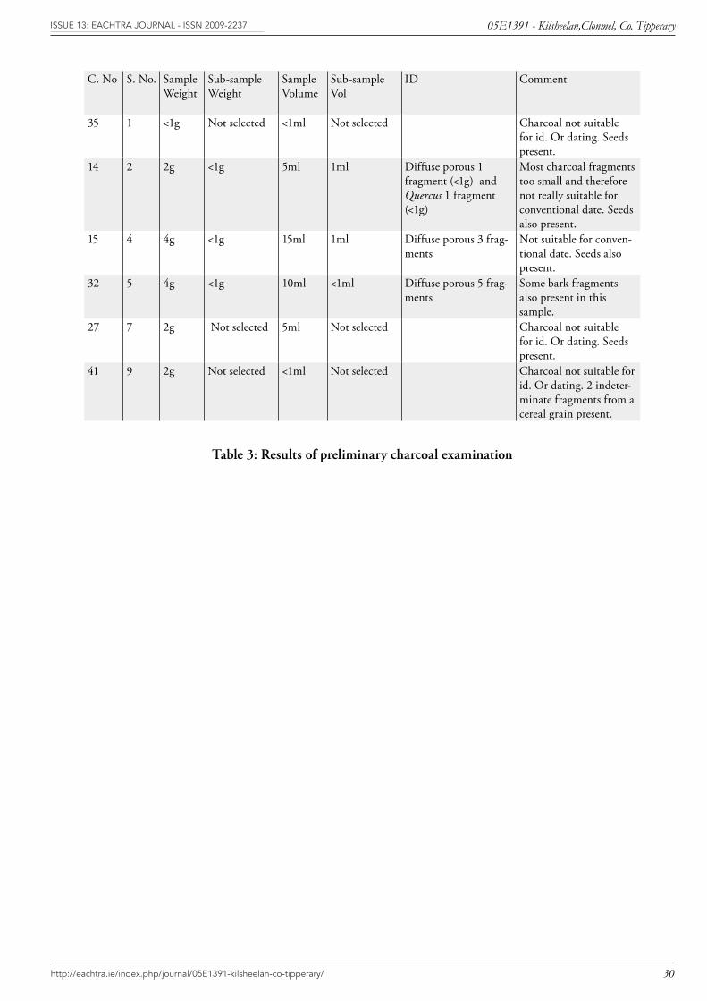
C. No S. No. Sample Weight
Sub-sample Weight
Sample Volume
Sub-sample Vol
ID Comment
35 1 <1g Not selected <1ml Not selected Charcoal not suitable for id. Or dating. Seeds present.
14 2 2g <1g 5ml 1ml Diffuse porous 1 fragment (<1g) and Quercus 1 fragment (<1g)
Most charcoal fragments too small and therefore not really suitable for conventional date. Seeds also present.
15 4 4g <1g 15ml 1ml Diffuse porous 3 frag-ments
Not suitable for conven-tional date. Seeds also present.
32 5 4g <1g 10ml <1ml Diffuse porous 5 frag-ments
Some bark fragments also present in this sample.
27 7 2g Not selected 5ml Not selected Charcoal not suitable for id. Or dating. Seeds present.
41 9 2g Not selected <1ml Not selected Charcoal not suitable for id. Or dating. 2 indeter-minate fragments from a cereal grain present.
Table 3: Results of preliminary charcoal examination
http://eachtra.ie/index.php/journal/05E1391-kilsheelan-co-tipperary/
05E1391 - Kilsheelan,Clonmel, Co. TipperaryISSUE 13: Eachtra JoUrnal - ISSn 2009-2237
31
12.4 Appendix 4: Pottery Remains Assemblage Report
By Helen Roche
SummaryThe assemblage consists of 23 sherds representing five Early Neolithic carinated bowls and a small round-bottomed cup c. 3900-3700 BC.
Early Neolithic carinated bowlsTwo types of Early Neolithic vessels are represented in this assemblage, round bottomed carinated bowls (Vessels 1-5) and a small round-bottomed cup (Vessel 6). The sherds representing Vessels 1-5, with an out-turned pointed rim (Vessel 4) and out-turned flat rims (Vessels 2, 3 and 5) and relatively simple-angled shoulders, fall between the earliest form of Neolithic carinated vessels (Case 1961, 175-177; Sheridan 1995, fig. 2.4; nos 1 & 2) and the slightly more developed form, defined by exaggerated rims and shoulders (Case 1961, 178; Sheridan 1995, fig. 2.4; no. 4). The fabric is thin-walled and well executed, hard and compact in texture and mainly brown-orange in colour. The sherds show evidence for weathering with slightly roughened surfaces and exposed, mainly quartzite, inclusions on both surfaces. However, it is clear that the vessels had originally been smoothed over, probably at the time of manufacture with a wash or slurry of fine clay applied with the fingers and probably further rubbed, perhaps with a leather cloth. Evidence for ‘pitting’, caused by the removal of protruding grits prior to firing, or the combustion of organic temper during firing is present on Vessels 3, 4, 5 and 6, a feature that characterises many Early Neolithic ceramic assemblages. Carbonised matter is present on the interior surface of the bodysherd from Vessel 5, slight traces are present on sherds from Vessel 2 and the rimsherd representing Vessel 4 appears to be fire-blackened. The sherds representing the small cup (Vessel 6) are slightly coarser than the carinated examples and more carelessly finished, creating uneven surfaces and visible protruding quartzite inclusions. Although not a frequent component of Early Neolithic assemblages similar small, carelessly fashioned cups have been found in settlement contexts at Circle L, Lough Gur and Knowth, Co. Meath (Grogan and Eogan 1987, 427; Eogan and Roche 1997, 24).
Early Neolithic pottery of this type forms a dispersed distribution throughout Ireland. It has mainly been found on settlement sites, often associated with houses but examples have also been found in funerary contexts within portal and court tombs. This is an important contribution to the growing number of Early Neolithic sites found throughout the country. Closely comparable material in this region have been found at Tankardstown South, Co. Limerick (Gowen 1988; Gowen and Tarbett 1988) and Lough Gur, Co. Limerick, Circles J, K, L and Site 10 (Grogan and Eogan 1987), and Site C (Ó Ríordáin 1954). On a broader scale similar assemblages have been found at Corbally, Co. Kildare (‘Silliot Hill’, Purcell 1998; 1999), the earliest Neolithic phase at Knowth, Co. Meath (Eogan and Roche 1997) and also in Meath associated with a house at Newtown (Gowen and Halpin 1992).

http://eachtra.ie/index.php/journal/05E1391-kilsheelan-co-tipperary/
05E1391 - Kilsheelan,Clonmel, Co. TipperaryISSUE 13: Eachtra JoUrnal - ISSn 2009-2237
32
Catalogue and descriptionThe excavation number 05E1391 is omitted throughout, only the feature number, in bold, followed by the find number is included. Numbers in square brackets indicate joining sherds.
Early Neolithic carinated bowls
Vessel 1. Rim fragment 15:6.Too small to identify rim type, the interior surface is missing. Hard compact fabric with a moderate content of quartzite inclusions (≤ 2.1mm). The exterior surface appears to be smooth. Colour: dark orange throughout.
Vessel 2. Rimsherd 31:2 and eight fragments 14:1, 3, 4, 15:2, 3, 4, 5, 31:4. Out-turned flat rim, rounded underneath and pressed in against the exterior surface. Hard, compact but slightly brittle fabric with a high content of quartzite inclusions (≤ 3.0mm). The surfaces had been smoothed but due to weathering inclusions protrude through both surfaces. Slight traces of encrusted matter are present on the interior surface. Colour: black-deep red throughout. Thickness: 5.0-7.8mm.
Vessel 3. Two rimsherds 32:4, 12, a large portion of the shoulder 32:[7/8] and four fragments 32:5, 6, 10, 11.Out-turned pointed rim and simple-angled shoulder. Thin-walled hard fabric with a moderate to high content of inclusions (≤ 4.2mm). The surfaces hade been smoothed but are now weathered and rough to touch, with inclusions protruding through both surfaces. Cavities are also present on both surfaces. Areas of both surfaces are fire-blackened. Colour: orange-black exterior and interior surfaces with an orange-grey core. Thickness: 6.2-7.0mm.
Vessel 4. Rim fragment 32:9.Out-turned pointed rim. Thin-walled, hard compact fabric with a low to moderate content of quartzite inclusions (≤ 2.1mm). The surfaces are smoothed but slightly weathered. Colour: dark brown through-out. Thickness: 5.2mm.
Vessel 5. Rimsherd 32:14 and a bodysherd 32:13.Out-turned flat rim, rounded underneath and pressed in against the exterior surface. Thin-walled, hard compact fabric with a moderate to high content of inclusions (≤ 3.6mm). The surfaces had been smoothed but due to weathering inclusions protrude through both surfaces. Carbonised matter is present on the interior surface of the bodysherd. Colour: orange-brown exterior surface, brown-black interior with a brown-orange core. Thickness: 5.0-5.1mm.
Early Neolithic cup
Vessel 6. Rim fragment 14:[2/6] and a fragment 14:5.Slightly in-turned rounded rim. Hard, compact fabric with moderate content of quartzite and mica (≤ 2.1mm). The surfaces are weathered and uneven and inclusions are visible on the surface. Colour: dark brown-black throughout. Thickness: 6.4-7.0mm.
http://eachtra.ie/index.php/journal/05E1391-kilsheelan-co-tipperary/
05E1391 - Kilsheelan,Clonmel, Co. TipperaryISSUE 13: Eachtra JoUrnal - ISSn 2009-2237
33
References
Case, H.J. 1961 Irish Neolithic pottery: distribution and sequence, Proceedings of the Prehistoric Society 27, 174-233.
Eogan, G. and Roche, H. 1997 Excavations at Knowth 2. Royal Irish Academy Monographs in Archaeology, Dublin.
Gowen, M. 1988 Three Irish Gas Pipelines: New Archaeological Evidence in Munster. Wordwell, Dublin.
Gowen, M. and Halpin, E. 1992 A Neolithic House at Newtown, Archaeology Ireland 20, 25-7.
Gowen, M. and Tarbett, C. 1988 A Third Season at Tankardstown, Archaeology Ireland 8, 156.
Grogan, E. and Eogan, G. 1987 Lough Gur excavations by Seán P. Ó Ríordáin: further Neolithic and Beaker habitations on Knockadoon, Proceedings of the Royal Irish Academy 87C, 299-506.
Ó Ríordáin, S.P. 1954 Lough Gur Excavations: Neolithic and Bronze Age Houses on Knockadoon, Proceedings of the Royal Irish Academy 56C, 297-459.
Purcell, A. 1998 Brownstown, Corbally and Silliot Hill, Co. Kildare. In I. Bennett (ed.) Excavations 1997, 91. Wordwell, Dublin.
Purcell, A. 1999 Neolithic houses at Corbally, Kilcullen, Co. Kildare, Archaeology Ireland 47, 15.
Sheridan, A. 1995 Irish Neolithic pottery: the story in 1995. In I. Kinnes and G. Varndell (eds) ‘Unbaked Urns of Rudely Shape’, 3-21. Oxbow Monograph 55, Oxford.

http://eachtra.ie/index.php/journal/05E1391-kilsheelan-co-tipperary/
05E1391 - Kilsheelan,Clonmel, Co. TipperaryISSUE 13: Eachtra JoUrnal - ISSn 2009-2237
34
12.5 Appendix 5: Lithics Finds
Farina SternkeDepartment of Archaeology, University College Cork
The lithic assemblage from Kilsheelan, Co. Tipperary presented for analysis consists of 7 pieces, all of which are knapped or modified. Three finds are flints (see Table below), three are made on mudstone and one flake appears to be of limestone.
Condition:Generally, the assemblage is in highly fractured condition. Only two finds (05E1391:32:1 and 05E1391:32:3) appear to be reasonably fresh. The remainder is patinated, while flint 05E1391:15:1 is burnt and 05E1391:32:2 slightly rolled.
Context:With the exception of surface finds 05E1391:5:1 and 05E1391:5:2, all lithic finds are associated with a series of pits form some of which sherds of Early Neolithic pottery were recovered.
Technology: The worked lithic material includes the technologically classifiable items shown in the Table below.
Find No. Material Type
05E1391:15:1 Flint Blade
05E1391:32:2 Mudstone Blade
05E1391:32:1 Mudstone Flake
05E1391:32:3 Mudstone Blade
05E1391:31:1 Limestone? Flake
05E1391:5:2 Flint Retouched Blade
05E1391:5:1 Flint? Scraper?
Due to the heavily fractured nature of the assemblage it is not possible to determine the exact method and technique of flake and blade production. However, flake 05E1391:32:1 and blade 05E1391:32:2 derive from polished mudstone axes.

http://eachtra.ie/index.php/journal/05E1391-kilsheelan-co-tipperary/
05E1391 - Kilsheelan,Clonmel, Co. TipperaryISSUE 13: Eachtra JoUrnal - ISSn 2009-2237
35
Retouched Artefacts:Flint blades 05E1391:15:1and 05E1391:5:2 are laterally retouched, while blade 05E1391:32:3 and flake 05E1391:5:1 are possibly retouched on their proximal and distal ends. The latter find is a possible scraper, however, none of the retouched artefacts are diagnostic types.
Dating:Despite the absence of any diagnostic retouched artefacts, the assemblage can be dated to the Neolithic period due to the presence of two lithics which clearly derive from polished stone axes. Further, the presence of Early Neolithic pottery on the site supports this dating.
Interpretation:The lithic finds from Kilsheelan, Co. Tipperary represent flint and other knapping debris associated with an Early Neolithic site. Based on the fractured nature of the assemblage, it is possible to interpret at least some of the pits uncovered during excavation as potential refuse pits.