archaeological monitoring reportgrey-lit-suffolkarchaeology.s3.amazonaws.com/2005_100.pdf ·...
TRANSCRIPT

ARCHAEOLOGICAL MONITORING REPORT______________________________________
The Car Park, Ickworth House, IckworthIKW 014
A REPORT ON THE ARCHAEOLOGICAL MONITORING, 2004(Planning app. no. SE/03/2509/P)
J.A.CravenField Team
Suffolk C.C. Archaeological Service
© July 2005
Lucy Robinson, County Director of Environment and TransportEndeavour House, Russel Road, Ipswich, IP1 2BX
______________________________________SCCAS Report No. 2005/100

i
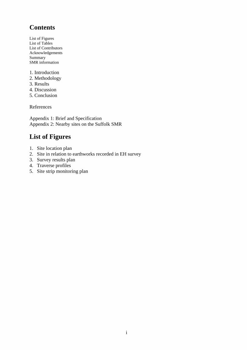
ContentsList of FiguresList of TablesList of ContributorsAcknowledgementsSummarySMR information
1. Introduction2. Methodology3. Results4. Discussion5. Conclusion
References
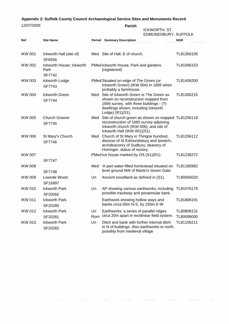
Appendix 1: Brief and SpecificationAppendix 2: Nearby sites on the Suffolk SMR
List of Figures
1. Site location plan2. Site in relation to earthworks recorded in EH survey3. Survey results plan4. Traverse profiles5. Site strip monitoring plan
ii
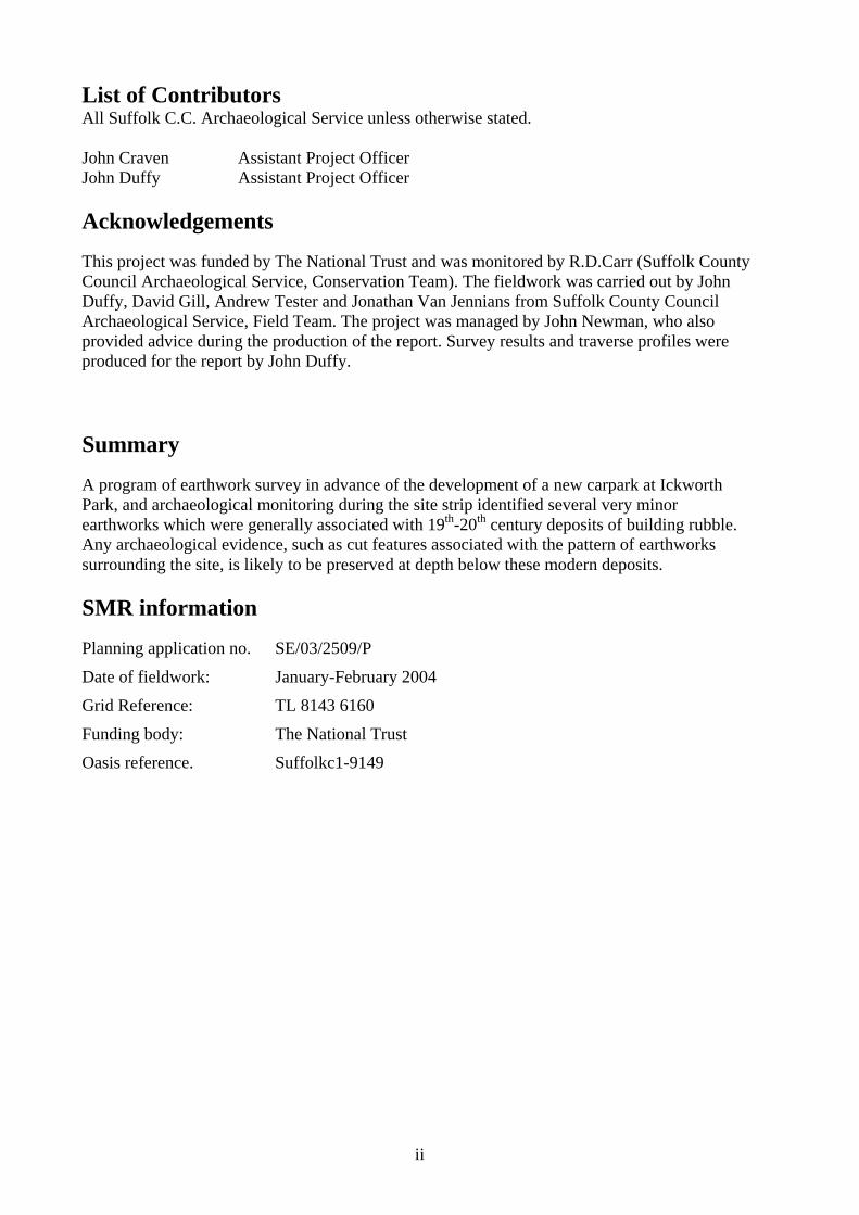
List of ContributorsAll Suffolk C.C. Archaeological Service unless otherwise stated.
John Craven Assistant Project OfficerJohn Duffy Assistant Project Officer
Acknowledgements
This project was funded by The National Trust and was monitored by R.D.Carr (Suffolk CountyCouncil Archaeological Service, Conservation Team). The fieldwork was carried out by JohnDuffy, David Gill, Andrew Tester and Jonathan Van Jennians from Suffolk County CouncilArchaeological Service, Field Team. The project was managed by John Newman, who alsoprovided advice during the production of the report. Survey results and traverse profiles wereproduced for the report by John Duffy.
Summary
A program of earthwork survey in advance of the development of a new carpark at IckworthPark, and archaeological monitoring during the site strip identified several very minorearthworks which were generally associated with 19th-20th century deposits of building rubble.Any archaeological evidence, such as cut features associated with the pattern of earthworkssurrounding the site, is likely to be preserved at depth below these modern deposits.
SMR information
Planning application no. SE/03/2509/P
Date of fieldwork: January-February 2004
Grid Reference: TL 8143 6160
Funding body: The National Trust
Oasis reference. Suffolkc1-9149

1
ICKWORTH PARKICKWORTH PARKICKWORTH PARKICKWORTH PARKICKWORTH PARKICKWORTH PARKICKWORTH PARKICKWORTH PARKICKWORTH PARK
IKW 007IKW 007IKW 007IKW 007IKW 007IKW 007IKW 007IKW 007IKW 007
IKW 012IKW 012IKW 012IKW 012IKW 012IKW 012IKW 012IKW 012IKW 012
IKW 013IKW 013IKW 013IKW 013IKW 013IKW 013IKW 013IKW 013IKW 013
IKW 014IKW 014IKW 014IKW 014IKW 014IKW 014IKW 014IKW 014IKW 014
IKW 009IKW 009IKW 009IKW 009IKW 009IKW 009IKW 009IKW 009IKW 009
IKW 008IKW 008IKW 008IKW 008IKW 008IKW 008IKW 008IKW 008IKW 008
2000 400
metres
IKW 002
IKW 014IKW 014IKW 014IKW 014IKW 014IKW 014IKW 014IKW 014IKW 014
IKW 003/004
IKW 001
IKW 005
IKW 006
IKW 010IKW 010IKW 010IKW 010IKW 010IKW 010IKW 010IKW 010IKW 010
IKW 011IKW 011IKW 011IKW 011IKW 011IKW 011IKW 011IKW 011IKW 011
Figure 1. Site location plan
© Crown Copyright. All rightsreserved. Suffolk County Council
Licence No. 100023395 2005.
© Crown Copyright. All rightsreserved. Suffolk County Council
Licence No. 100023395 2005.

2
1. Introduction
A program of archaeological survey and monitoring was carried out in advance of, and during,the groundworks for the redesign and extension of an existing carpark at Ickworth Park, Suffolk.The work was carried out to a Brief and Specification issued by R.D.Carr (Suffolk CountyCouncil Archaeological Service, Conservation Team, Appendix 1) to fulfil a planning conditionon application SE/03/2509/P. The work was funded by the developer, the National Trust.
The site is located at TL 8143 6160 (Fig. 1) and covers an area of c.1.2ha at the centre ofIckworth Park, at a height of 95m OD. The existing carpark occupied an area of c.0.34ha, withthe remaining western part of the site being part of a wider landscape of open parkland withscattered mature oak trees, situated to the north-west of Ickworth House.
Due to its location the development area is surrounded by a series of known sites that areassociated with the park and recorded on the Suffolk SMR (Appendix 2). Lying 200m to thesouth-east is Ickworth House (IKW 002), which was built from 1796-1828 by the Hervey familyand lay at the centre of over 13ha of landscaped gardens. This replaced the earlier medievalIckworth Hall (IKW 001), which probably lay to the south near Ickworth Church but wascomprehensively demolished in the early 18th century. 350m to the north is Ickworth Lodge(IKW 003), an estate building with 18th century landscaped gardens, that was used by the Herveyfamily during the construction of Ickworth House. The building is thought to have developedfrom a medieval farmhouse and is probably a surviving element of a deserted medieval greenand village (IKW 004). 400m-450m to the south, are Ickworth church (IKW 006) and ChurchGreene (IKW 005), the probable site of another deserted medieval village. Finally numerousother areas of earthworks and an icehouse have been recorded within the park (IKW 007-012).
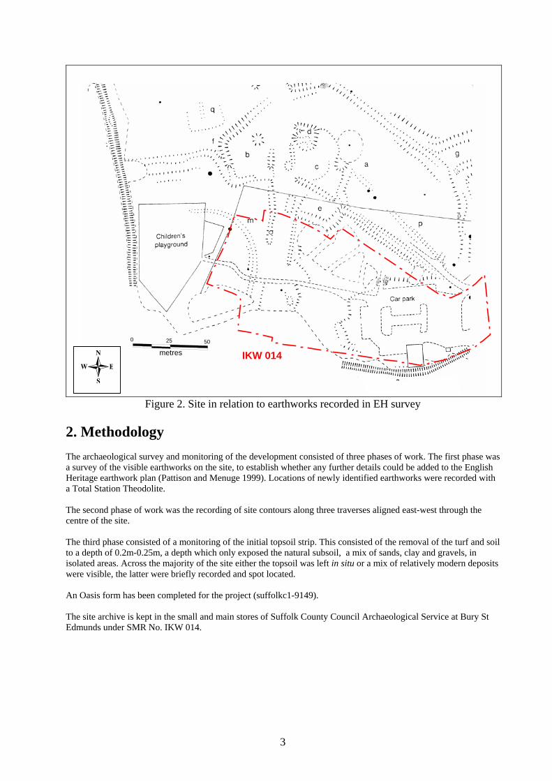
A survey report by English Heritage in 1999 (Pattison and Menuge 1999) had identified a seriesof earthworks within the open parkland between Ickworth Lodge and Ickworth House. These arethought to be a mixture of features dating from the medieval period to the 19th century andseveral extended south into the development area.
The English Heritage plan (Fig. 2) shows an elongated enclosure, A, lying to the north of thedevelopment area, which probably developed over a period of time from a layout of pre-existingfields. A trackway runs north-south through the western part of the enclosure (and into thedevelopment area) creating smaller subdivisons B,C,D and E , of which D is a shallowdepression interpreted as the site of a building with robbed out foundations. Together theseenclosures are thought to be a post-medieval farmstead, incorporated into the park in the late 17th
century.
F and G mark where other ditch and banks meet enclosure A, with the latter possibly beinganother trackway. M is a curving ditch and bank, thought to be an ornamental feature possiblymarking a plantation boundary. P is a shallow linear depression with a bank, marking a footpathbetween Ickworth Lodge and Ickworth House. Finally Q is a rectangular earthwork, probablymarking an early 20th century tennis court or similar area.
The large-scale site strip and ground levelling that was to occur during the carparks constructiontherefore was going to wholly remove several existing earthworks. It also had the potential todisturb or destroy any medieval or post-medieval archaeological deposits surviving belowground level and a program of archaeological monitoring was therefore required to record thearea before and during its development.
3
0 25 50
metres IKW 014IKW 014IKW 014IKW 014IKW 014IKW 014IKW 014IKW 014IKW 014
Figure 2. Site in relation to earthworks recorded in EH survey
2. MethodologyThe archaeological survey and monitoring of the development consisted of three phases of work. The first phase wasa survey of the visible earthworks on the site, to establish whether any further details could be added to the EnglishHeritage earthwork plan (Pattison and Menuge 1999). Locations of newly identified earthworks were recorded witha Total Station Theodolite.
The second phase of work was the recording of site contours along three traverses aligned east-west through thecentre of the site.
The third phase consisted of a monitoring of the initial topsoil strip. This consisted of the removal of the turf and soilto a depth of 0.2m-0.25m, a depth which only exposed the natural subsoil, a mix of sands, clay and gravels, inisolated areas. Across the majority of the site either the topsoil was left in situ or a mix of relatively modern depositswere visible, the latter were briefly recorded and spot located.
An Oasis form has been completed for the project (suffolkc1-9149).
The site archive is kept in the small and main stores of Suffolk County Council Archaeological Service at Bury StEdmunds under SMR No. IKW 014.

4
3. Results
The first phase of work consisted of an earthwork survey over the development area. Severalminor new earthworks were identified (Fig. 3), amidst those already mapped by EH, and wererecorded using a TST.
Earthwork 01 was a short extension, c.10m in length, to the already known north-south bank onthe eastern edge of ditch M. It also further defines the course of the north-south trackway thatruns through enclosure A.
Earthwork 02 was a short extension, c.10m in length, to an already known north-south bank onthe eastern edge of the trackway.
Earthwork 03 was a low, sub-circular mound, measuring c.18m in diameter and 0.3m high. Tothe south and north of this feature several other small, irregular and indistinct, earthworks werevisible.
The second phase of works was the recording of contour surveys along three traverses using aTST (Figs. 3 and 4). These clearly showed the indistinct, low-level, nature of the earthworkswith banks and ditches only becoming apparent when the profiles vertical axis was exaggerated.
The third phase of monitoring was the topsoil strip (Fig. 5), which levelled the site for thecarpark construction. Across most of the site removal of the 0.2m thick topsoil showed it tooverlie a thin layer of brown clay/loam. Beneath this was the natural subsoil, an undulatingsurface of yellow clay/sands with spreads of green clay infilling shallow natural hollows that wasonly seen in scattered areas. Frequent deposits or spreads of redeposited brick, tile and slaterubble were observed throughout the site at the base of the topsoil, of which the most obvious aredetailed below.
The sinous hollows, recorded on the EH plan at point 04 had largely been infilled with a depositof black peat/clay mixed with dense 19th century brick rubble, slate and glass, which was left insitu.
05 was a concentrated mass, c.10m diameter, of brick, flint and chalk lump building debris. Itwas exposed and left in situ in a large spread across the subsoil surface.
At point 06 a small area of debris contained some pieces of oyster shell and fragments of brokenearthenware flowerpots, which was not collected.
07 was a concentrated area of rubble, formed from complete and finely crushed bricks, withslate, mortar, flints and flowerpot fragments, set in a matrix of black peat/clay/silt.

5
95.2m
Cattle Grid
TrackBM 95.88m
Car Park
Existing hard carpark
Extension hard parking
New identified earthworksNew identified earthworksNew identified earthworksNew identified earthworksNew identified earthworksNew identified earthworksNew identified earthworksNew identified earthworksNew identified earthworks
030303030303030303
010101010101010101
020202020202020202
0 25 50
metres
Extension overflow parking
Traverse 01Traverse 01Traverse 01Traverse 01Traverse 01Traverse 01Traverse 01Traverse 01Traverse 01
50
Traverse 02Traverse 02Traverse 02Traverse 02Traverse 02Traverse 02Traverse 02Traverse 02Traverse 02
Traverse 03Traverse 03Traverse 03Traverse 03Traverse 03Traverse 03Traverse 03Traverse 03Traverse 03
metres
0New identified earthworksNew identified earthworksNew identified earthworksNew identified earthworksNew identified earthworksNew identified earthworksNew identified earthworksNew identified earthworksNew identified earthworks 25
Figure 3. Survey results plan
© Crown Copyright. All rightsreserved. Suffolk County Council
Licence No. 100023395 2005.

6
East
50250
East
Traverse 03
EastTraverse 02 - base measurements
Traverse 02 - one third vertical stretch
Traverse 02
Traverse 03 - base measurements
Traverse 03 -one third vertical stretch
metres
Traverse 01
Traverse 01 - base record
Traverse 01 - one third stretch
West
West
West
Figure 4. Traverse profiles
040404040404040404050505050505050505
070707070707070707
060606060606060606
0 25 50
metres
Ho
95.2m
Cattle Grid
TrackBM 95.88m
Car Park
Figure 5. Site strip monitoring plan
© Crown Copyright. All rightsreserved. Suffolk County Council
Licence No. 100023395 2005.
7
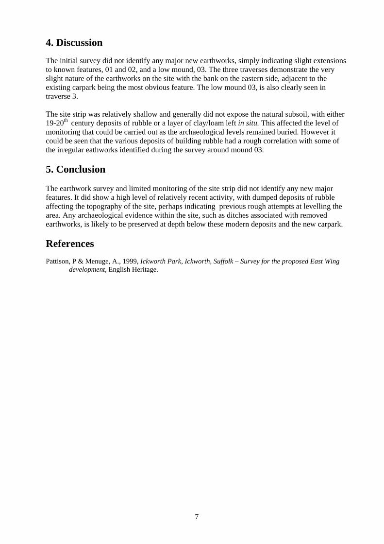
4. Discussion
The initial survey did not identify any major new earthworks, simply indicating slight extensionsto known features, 01 and 02, and a low mound, 03. The three traverses demonstrate the veryslight nature of the earthworks on the site with the bank on the eastern side, adjacent to theexisting carpark being the most obvious feature. The low mound 03, is also clearly seen intraverse 3.
The site strip was relatively shallow and generally did not expose the natural subsoil, with either19-20th century deposits of rubble or a layer of clay/loam left in situ. This affected the level ofmonitoring that could be carried out as the archaeological levels remained buried. However itcould be seen that the various deposits of building rubble had a rough correlation with some ofthe irregular eathworks identified during the survey around mound 03.
5. Conclusion
The earthwork survey and limited monitoring of the site strip did not identify any new majorfeatures. It did show a high level of relatively recent activity, with dumped deposits of rubbleaffecting the topography of the site, perhaps indicating previous rough attempts at levelling thearea. Any archaeological evidence within the site, such as ditches associated with removedearthworks, is likely to be preserved at depth below these modern deposits and the new carpark.
ReferencesPattison, P & Menuge, A., 1999, Ickworth Park, Ickworth, Suffolk – Survey for the proposed East Wing
development, English Heritage.

Append ix 1 :
S U F F O L K C O U N T Y C O U N C I L
A R C H A E O L O G I C A L S E R V I C E - C O N S E R V A T I O N T E A M
Brief and Specification for Archaeological Survey and Monitoring of Development
ICKWORTH HOUSE CAR PARK
Although this document is fundamental to the work of the specialistarchaeological contractor the developer should be aware that certain of itsrequirements are likely to impinge upon the working practices of a generalbuilding contractor and may have financial implications, for example seeparagraphs 2.4, 5.3, 5.4, 5.5 & 5.6.
1. Background
1.1 A planning application (SE/03/2509/P) has been made to redesign the existingcar park, involving resurfacing and an extension to the west. The local planningauthority have been advised that the site has high archaeological potential andthat any consent should be conditional on a PPG 16, paragraph 30 condition.Assessment of the available archaeological evidence indicates that the areaaffected can be adequately recorded by archaeological monitoring.
1.2 The extension area is currently grassed and shows faint earthworks marks whichare part of the park complex. Engineering design is not precisely defined butremoval of topsoil is apparently required so mitigation to record the present landsurface, the removal of soil, and subsequently any exposed subsoil surface, isrequired.
1.3 In accordance with the standards and guidance produced by the Institute of FieldArchaeologists this brief should not be considered sufficient to enable the totalexecution of the project. A Project Design or Written Scheme of Investigation(PD/WSI) based upon this brief and the accompanying outline specification ofminimum requirements, is an essential requirement. This must be submitted bythe developers, or their agent, to the Conservation Team of the ArchaeologicalService of Suffolk County Council (Shire Hall, Bury St Edmunds IP33 2AR;telephone/fax: 01284 352443) for approval. The work must not commence untilthis office has approved both the archaeological contractor as suitable toundertake the work, and the PD/WSI as satisfactory. The PD/WSI will providethe basis for measurable standards and will be used to establish whether therequirements of the planning condition will be adequately met.

2. Brief for Archaeological Monitoring
2.1 To provide a record of archaeological deposits which are damaged or removedby any development [including services and landscaping] permitted by thecurrent planning consent.
2.2 The main academic objective will be the record of the historic landscape featureand the opportunity to establish relationships and dates for any exposed subsoilfeatures.
2.3 The present surface is to be surveyed and analysed in it earthwork context.
2.4 The significant archaeologically damaging activity in this proposal is theremoval of topsoil and exposure of subsoil to prepare for the laying of car parksub base. Soil moving operations are to be controlled and observed as they areconducted by the construction contractor. Adequate control of the soil movingmethodology is to be provided such that unnecessary damage is not caused,cleaned surfaces are not obscured before recording, and time is allowed forarchaeological recording before sub base is laid.
3. The Survey
3.1 Preliminary observation suggests that the earthwork features are slight and areunlikely to be readily defined by even a close contour survey. Based upon anoutline level survey create an interpretative survey showing surface features ashatched outlines.
3.2 Relate the area to the surrounding earthwork areas on the area to the west of themain car park, i.e. the area to be used as overflow car park; this area should besurveyed in the same way.
4. Arrangements for Monitoring
4.1 To carry out the monitoring work the developer will appoint an archaeologist(the archaeological contractor) who must be approved by the Conservation Teamof Suffolk County Council’s Archaeological Service (SCCAS) - see 1.3 above.
4.2 The developer or his archaeologist will give the Conservation Team of SCCASfive working days notice of the commencement of ground works on the site, inorder that the work of the archaeological contractor may be monitored. Themethod and form of development will also be monitored to ensure that itconforms to previously agreed locations and techniques upon which this brief isbased.
4.3 Allowance must be made to cover archaeological costs incurred in monitoringthe development works by the contract archaeologist. The size of thecontingency should be estimated by the approved archaeological contractor,based upon the outline works in paragraph 2.4 and 5.6 of the Brief andSpecification and the building contractor’s programme of works and time-table.
4.4 If unexpected remains are encountered the Conservation Team of SCCAS mustbe informed immediately. Amendments to this specification may be made toensure adequate provision for archaeological recording.
5. Specification
5.1 The developer shall afford access at all reasonable times to both the CountyCouncil Conservation Team archaeologist and the contracted ‘observingarchaeologist’ to allow archaeological observation of building and engineeringoperations which disturb the ground.
5.2 Opportunity must be given to the ‘observing archaeologist’ to hand excavate anydiscrete archaeological features which appear during earth moving operations,retrieve finds and make measured records as necessary.
5.3 Topsoil stripping is to be observed whilst it takes place.
5.4 A suitable machine which does not track over cleaned areas is to be used (i.e.not a pushed blade). All vehicle traffic is to be kept off cleaned subsoil (ormaximum formation levels) until archaeological recording is completed andagreed with the project archaeologist.
5.5 If subsoil is to be exposed following removal of hardcore in the area of currenthardstanding/carpark, the same archaeological method is to be used, althoughconstant observation of hardcore removal will not necessary.
5.6 The archaeologist is to have unimpeded access to cleaned subsoil surfaces(5.4/5.5) at an average rate of one hour per 50 sq metres.
5.7 All archaeological features exposed must be planned at a minimum scale of 1:50on a plan showing the proposed layout of the development.
5.8 All contexts must be numbered and finds recorded by context.
5.9 The data recording methods and conventions used must be consistent with, andapproved by, the County Sites and Monuments Record.
6. Report Requirements
6.1 An archive of all records and finds is to be prepared consistent with theprinciples of Management of Archaeological Projects (MAP2), particularlyAppendix 3.This must be deposited with the County Sites and MonumentsRecord within 3 months of the completion of work. It will then become publiclyaccessible.
6.2 Finds must be appropriately conserved and stored in accordance with UKInstitute of Conservators Guidelines. The finds, as an indissoluble part of thesite archive, should be deposited with the County SMR if the landowner can bepersuaded to agree to this. If this is not possible for all or any part of the finds

archive, then provision must be made for additional recording (e.g. photography,illustration, analysis) as appropriate.
6.3 A report on the fieldwork and archive, consistent with the principles of MAP2,particularly Appendix 4, must be provided. The report must summarise themethodology employed, the stratigraphic sequence, and give a period by perioddescription of the contexts recorded, and an inventory of finds. The objectiveaccount of the archaeological evidence must be clearly distinguished from itsinterpretation. The Report must include a discussion and an assessment of thearchaeological evidence. Its conclusions must include a clear statement of thearchaeological value of the results, and their significance in the context of theRegional Research Framework (East Anglian Archaeology, Occasional Papers 3& 8, 1997 and 2000).
6.4 A summary report, in the established format, suitable for inclusion in the annual‘Archaeology in Suffolk’ section of the Proceedings of the Suffolk Institute ofArchaeology, must be prepared and included in the project report.
6.5 County Sites and Monuments Record sheets must be completed, as per thecounty SMR manual, for all sites where archaeological finds and/or features arelocated.
Specification by: R D Carr
Suffolk County CouncilArchaeological Service Conservation TeamEnvironment and Transport DepartmentShire HallBury St EdmundsSuffolk IP33 2AR
Date: 24 October 2003 Reference: /Ickworthcarpark10
This brief and specification remains valid for 12 months from the above date. Ifwork is not carried out in full within that time this document will lapse; theauthority should be notified and a revised brief and specification may be issued.
If the work defined by this brief forms a part of a programme of archaeologicalwork required by a Planning Condition, the results must be considered by theConservation Team of the Archaeological Service of Suffolk County Council, whohave the responsibility for advising the appropriate Planning Authority.
12/07/2005 Parish
Appendix 2: Suffolk County Council Archaeological Service Sites and Monuments Record
ICKWORTH, ST EDMUNDSBURY, SUFFOLK
NGRRef Summary DescriptionSite Name Period
IKW 001 Ickworth Hall (site of) Site of Hall, E of church.SF6556
Med TL81356105
IKW 002 Ickworth House; Ickworth Park
Ickworth House, Park and gardens (registered).
SF7742
PMed TL81066153
IKW 003 Ickworth Lodge Situated on edge of The Green (or Ickworth Green) (IKW 004) in 1665 when probably a farmhouse.
SF7743PMed TL81406200
IKW 004 Ickworth Green Site of Ickworth Green or The Green as shown on reconstruction mapped from 1665 survey, with three buildings - (?) dwellings shown, including Ickworth Lodge) (R1)(S1).
SF7744Med TL81306215
IKW 005 Church Greene Site of church green as shown on mapped reconstruction of 1665 survey adjoining Ickworth church (IKW 006), and site of Ickworth Hall (IKW 001)(S1).
SF7745Med TL81256119
IKW 006 St Mary's Church Church of St Mary in Thingoe hundred, diocese of St Edmundsbury and Ipswich, archdeaconry of Sudbury, deanery of Horringer, status of rectory.
SF7746Med TL81256112
IKW 007 Ice house marked by OS (S1)(R1).SF7747
PMed TL81236272
IKW 008 'A part water-filled homestead situated on level ground NW of Martin's Green Gate.SF7748
Med TL81185982
IKW 009 Lownde Wood Ancient woodland as defined in (S1).SF15997
Un TL80506020
IKW 010 Ickworth Park AP showing various earthworks, including possible trackway and penannular bank.SF20092
Un TL81076176
IKW 011 Ickworth Park Earthwork showing hollow ways and banks circa 50m N-S, by 150m E-WSF20280
TL81806191
IKW 012 Ickworth Park Earthworks: a series of parallel ridges circa 20m apart in rectilinear field system.SF20281
Un TL80806131
IKW 013 Ickworth Park Ditch and bank with further internal ditch to N of buildings. Also earthworks to north, possibly from medieval village
SF20282Un TL81106211Rom TL80006000