archaeological investigations at the catoma creek site ... · pdf fileanimal bone, stone...
TRANSCRIPT

20 ● Journal of Alabama Archaeology
Archaeological Investigations at the Catoma Creek Site (1MT209): A Cobbs Swamp Phase Site in
East-Central Alabama
Thomas M. Shelby, Kareen L. Hawsey, and Sharon A. Freeman
Thomas M. Shelby, College of Architecture, Georgia Institute of Technology, Atlanta, GA Kareen L. Hawsey, Department of Anthropology, The University of Alabama, Tuscaloosa, ALSharon A. Freeman, Tuscaloosa, AL
Journal of Alabama Archaeology Vol. 60, Nos.1 and 2:20-60, 2014.
The incipient Middle Woodland pe-riod of east-central Alabama is marked by a dramatic infusion of sand-tempered, check-stamped pottery analogous to the Cartersville and Booger Bottom pottery of the Georgia Piedmont. Both Cartersville and this local type, called Cobbs Swamp, are regional variations of the all-encom-passing Deptford pottery of the Coastal Plain. Centered along the upper Alabama River valley and extending up the Coosa and Tallapoosa rivers, these Cobbs Swamp sites share a number of socioeconomic traits and material culture and are relat-ed to other Middle Woodland complexes defined elsewhere within the Coosa, Tall-apoosa, Alabama, and Chattahoochee river valleys. All of these rivers served as major conduits for goods, ideas, and people be-tween the Coastal Plain and the Piedmont Uplands of Alabama and Georgia.
To date, the most intensively studied Cobbs Swamp site is 1MT209, located along Catoma Creek, a major tributary of the Alabama River. Excavations have identified a variety of feature types, asso-ciations, and material culture, including structural remains. Although multiple com-ponents are present at this site, the most
significant occupation dates to the Cobbs Swamp and, to a lesser extent, Calloway phases of the Middle Woodland period. This chapter summarizes the results of several field seasons of work while incor-porating and reevaluating what we know to date of this important Middle Woodland phase.
Previous Work on the Cobbs Swamp Phase
The Cobbs Swamp phase was first de-fined by David Chase in the late 1960s, who noted that a number of sites he had studied or visited contained pottery belonging to the Deptford/Cartersville complex of west-ern Georgia. Chase (1998:61) described one particularly large site, 1EE111, located on an alluvial terrace adjacent to an old riv-er channel, now called Cobbs Swamp. This and a nearby site, 1EE112, both contained a number of eroded and exposed pits, then nothing more than piles of midden (Oakley and Watson 1977:293-298). According to Chase, based on his observations at these and other sites, “certain departures were noted in the styling of the pottery and asso-ciated artifacts, [and] a new name seemed
Archaeological Investigations at the Catoma Creek Site ● 21
appropriate” (Chase 1998:61). Most of what we know about Cobbs Swamp is based on Chase’s observations from his years of survey work and site testing and excavation in central Alabama and also by analogy with the Cartersville and Deptford cultures to the east in Georgia. Unfortu-nately, most of the sites that Chase worked on over the years have not been reported on, though he does nonetheless mention some of them in his published summaries and unpublished manuscripts.
Few sites have been excavated that possess significant Cobbs Swamp compo-nents, even though they are found at nu-merous sites throughout east-central Ala-bama; rather, they usually constitute one of many components found at multicompo-nent sites. The Deptford/Cobbs Swamp de-posits found in the sub-mound midden and the north midden at the Durant Bend site illustrates this second point (Nance 1976). Prior to the 1MT209 investigations, three major Cobbs Swamp sites were excavated by the University of Alabama in the late 1960s before the impoundment of Jones Bluff Reservoir. The first was Site 1AU28, one of the most important sites excavated to date in the Alabama River valley. It con-tained a shell midden and stratified depos-its spanning the Late Archaic through the Mississippian. At least 11 features, consist-ing of hearths and basin- and bell-shaped pits, contained Cobbs Swamp ceramics. In addition to Cobbs Swamp, ten of these features also contained Henderson ceram-ics as well. Six of the bell-shaped pits con-tained complicated-stamped pottery, and one of these also contained Dunlap Fabric Marked. Outside of the features, the upper portion of the site is a shell midden, but this appears to have been mixed by later occupants of the site (Dickens et al. 1968; Nielson 1970, 1976). The second site is
1AU32, also a shell midden, though here the deposits were much shallower and less stratified than at 1AU28. This is probably an early Cobbs Swamp site, as only one sherd of complicated-stamped pottery was recovered from the excavations. There were several features 1identified, consist-ing of eleven associated postholes, a pile of mussel shell with an intrusive cooking pit, a large, semi-ground greenstone hoe, and an artifact cluster of 52 sherds of a check-stamped, tetrapodal vessel, the upper two inches of the vessel being plain rather than stamped (Dickens et al. 1968). A third site is 1MT82 excavated by Chase in 1967 and later in 1971 as part of an I-65 highway salvage project. Seven of eleven non-post-hole features (midden-filled pits and rock hearths) at the site are affiliated with the Cobbs Swamp component, as are fifteen of thirty-three postholes identified. Although a large enough area was not excavated to delineate the post patterns, they none-theless suggest that Cobbs Swamp struc-tures were circular in nature with a central hearth. Simple-, checked-, and complicat-ed-stamped and fabric-marked pottery was recovered, as were perforated potsherd disks, greenstone celt fragments, shell and animal bone, stone gorget fragments, and a variety of chipped and ground stone tools. Chase’s interpretation of this well-strati-fied site is that of a Cobbs Swamp village stratigraphically overlain by a Calloway phase village (Chase n.d.).
Other sites with Cobbs Swamp com-ponents have been recorded, test pitted, and excavated to varying degrees, but more often than not this information is buried in the archaeological “gray” liter-ature. These small testing or test-pitting programs have been important in terms of material culture studies, though without large scale excavation this data does not al-

22 ● Journal of Alabama Archaeology
low for intrasite research and their overall value is somewhat limited. Among these are projects at the Lower Antioch Branch site (1MT134) (Cottier 1979), the Catoma Creek sites of 1MT210 and 1MT214 (Price 1999; Shelby et al. 2007) and the Baggett Hill site (1MT211) (Hawsey and Shelby 2005), the Autauga Hill site (1AU247) (Betterton 1997; forthcoming Phase III report), and a number of sites investigated by Chase, including 1MT50, 1MT56/100, 1MT74, 1MT75/180, 1MT82/178/179, and 1MT99. The latter site is particular-ly interesting. Excavated in 1973, the site consisted of several shell dumps associat-ed with Chase’s Late Woodland Hope Hull phase and underlain by an undisturbed Early Archaic horizon. The burials and many of the items he recorded reflect Late Woodland ceremonialism, but one faintly outlined cache pit was distinctively differ-ent from the others. It contained the bases of three small tetrapodal vessels with the broken edges ground smooth and the ves-sel exteriors appearing “flaked.” Accompa-nying these three “dishes” or “trays” were 28 water-smoothed chert and ferruginous siltstone pebbles, some of which had been perforated (both naturally and intention-ally), a perfectly spherical cobble some 8 cm in diameter, two large nuggets of what Chase described as pure hematite ochre, and the bowl of a clay effigy pipe (Chase 1998:63).
Chase ascribes a Cobbs Swamp affil-iation to this ceremonial cache, and it is continually noted in his writings as reflec-tive of possible ceremonialism by Cobbs Swamp people. However, in his notes he does not mention a Cobbs Swamp compo-nent at this site, with the material culture, based on his analysis sheets, pointing to a Late Woodland occupation. Chase himself
admits that “since no other finds have been noted on this site for this period, the cache pit remains anomalous” (Chase n.d.). Al-though there is a lack of analogous caches in Cartersville contexts, it is entirely pos-sible that the tetrapodal trays were picked up by later groups (Hope Hull) and reused. Discard and reuse is an important aspect of culture that is often overlooked when considering past human behavior. From our work at 1MT209, for instance, a large number of Dalton projectile points were found in Cobbs Swamp context, some of which had been modified and reused within the Woodland toolkit. Nonetheless, Chase appears to have been secure with his field interpretation of the cache, and to date it remains an important find.
Surveys that have been important for understanding site distribution in east-cen-tral Alabama include the Selma Area Ar-chaeological Project of the early 1970s, directed by Roger Nance of the Univer-sity of Alabama at Birmingham (Nance 1978; Jeter 1973, 1978), which included the identification of Cobbs Swamp com-ponents at the Durant Bend site (Nance 1976), the 1976 Jones Bluff Lake survey by the University of Alabama, Office of Archaeological Research (OAR) (Oakley and Watson 1977), and the surveys of the lower Coosa and Tallapoosa Rivers by Au-burn University (Waselkov 1980, 1981) and the University of Alabama (Knight et al. 1984). During the latter project, Knight reported the presence of a type resembling Cobbs Swamp Complicated Stamped at the Sylacauga Water Works Site (1TA115). Smaller surveys have also contributed to the growing pool of data on overall Cobbs Swamp site distribution, though the quality of these reports, as well as the quality of artifact identification, varies greatly.

Archaeological Investigations at the Catoma Creek Site ● 23
Site DistributionBased on current data, Cobbs Swamp
sites range in size from small artifact scat-ters in the uplands, probably representing short forays and seasonal cycles of move-ment related to plant and animal resource procurement, to larger, semi-permanent villages or communities along the river and larger stream terraces. They are found along the upper Alabama River valley from Dallas County to the Tallapoosa and Coosa confluence above the city of Mont-gomery and up both of these river valleys into Elmore and Macon counties. Even though Cobbs Swamp shell middens and smaller artifact scatters are known along these rivers and adjacent oxbows, Chase (1998:61-63) suggests that the more ex-tensive settlements are located up tributary streams like Catoma Creek. Based on the number of sites that dot the uplands and terraces along Catoma Creek, this seems to be a reasonable assertion, but the data is probably distorted due to the burial or destruction of sites by river meandering, deposition, and erosion. As a result of these processes, our understanding of site distribution is skewed.
In terms of size, one of the largest Cobbs Swamp sites is 1MT108 located on the south bank of the Alabama River and within a 180° horseshoe bend just east of I-65. It measures nearly 300 by 400 meters in size and consists of what the archaeol-ogists who have revisited the site called a “massive” artifact scatter with shell mid-den and a reasonable degree of subsur-face integrity (Alabama State Site Files). Chase recovered check- and complicat-ed-stamped pottery, as well as greenstone, perforated and ground potsherd disks, and cord-marked and Calloway pottery from this site (Chase n.d.). Another large Cobbs Swamp site is 1EE323, measuring some
350 by 200 meters and located on an old channel meander of the Tallapoosa River. This site contains a deep midden and was considered by Sheldon (personal commu-nication, March 2008) to be one of the most impressive Cobbs Swamp sites re-corded, with very large check- and com-plicated-stamped potsherds littering the surface. The site also has Calloway phase and Historic Creek components.
Site 1MT209 is a medium-sized, semi-permanent settlement situated along a sandy secondary terrace within the flood-plain of Catoma Creek. It overlooks a swampy relic channel meander or slough to the northeast. During the Middle Wood-land, the water level would have been higher than it is now, and this channel me-ander would have been flooded. Although artifacts were noted along the length of the terrace and within the agricultural fields above the site, it was determined that the site itself was approximately 75 by 40 me-ters and centered at the northern and east-ern edges of the terrace and near an ephem-eral drainage.
Excavations at 1MT209
The Catoma Creek investigations be-gan in December 1975 with Chase’s sur-vey of a proposed sewer pipeline for the Montgomery Water Works (Chase 1975). In addition to 1MT209, he also considered two other sites, 1MT210 and 1MT214, to possess potentially high research value. The following January, Chase and Rog-er Nance of the University of Alabama at Birmingham (UAB) began salvage exca-vations at these three sites.
Site 1MT209 was the largest of the three sites slated for salvage work. Here a total of 34 designated units, comprising full size excavation units, unit expansions, and

24 ● Journal of Alabama Archaeology
excavated balks, were excavated which re-sulted in the identification of 32 features and 18 postholes (Figures 1-2).These units were six feet square, separated by two-foot balks, and excavated in four- and six-inch arbitrary levels. Most of the UAB units were clustered together in a contiguous grid, except for eight outlying units (two of which were expansions of the same unit). In all, some 864 ft2 (80 m2) were excavated by Nance. Almost all of the features iden-tified from the UAB salvage excavations appeared to be associated with a Middle Woodland occupation of the site.
A total of 32 features were identified during the UAB salvage excavations. Only the largest features were labeled as such in the field and were simply designated as Pit A, Pit B, etc. Thus, the current fea-ture numbers were assigned based on field notes and drawings by George Price, a graduate student at UAB, with additional feature numbers assigned by OAR during our excavations at the same site. The fea-tures identified during the UAB salvage excavations consists of five artifact scatters (UAB Features 12, 15, 16, 17, and 23), five pottery scatters or “pot busts” (UAB Fea-tures 5, 24, 26, 27, and 28), five hearths, fire basins, or other heat-related features (UAB Features 1, 4, 20, 22, and 29), seven rock clusters (UAB Features 7, 9, 18, 19, 21, 31, and 32), five pits (UAB Features 8, 11, 14, 25, and 30), a house midden (UAB Feature 3), and a locus of material that is interpreted to constitute a lithic workshop area (UAB Feature 6). Three of the num-bered features appear to be natural (UAB Features 2, 10, and 13), and some features were not completely investigated or were simply not excavated. A loosely defined midden zone was noted throughout the site, and 18 postholes were identified, thir-teen of which are related to a structure.
By far the most important discovery was of the remains of a Middle Woodland, Cobbs Swamp phase dwelling and its as-sociated features (UAB Features 3, 4, 24, 26, 31, and 32 and Postholes 6-18) which represent the house’s posts, floor, kitchen/house midden, central hearth, a circular area of small pebbles, and artifact concen-trations of pottery and rock. The discovery of this structure was announced in a num-ber of local newspapers, but otherwise the results of the UAB salvage excavations remained unpublished, though in 1999 UAB graduate student George D. Price (1999) analyzed some of the material from 1MT209 and 1MT210 for his master’s the-sis.
The Office of Archaeological Re-search at the University of Alabama be-came involved with the Catoma Creek work during a 2004 survey for a proposed new sewer pipeline, which was planned to largely parallel the course of the pipe-line built in 1976 and surveyed by Chase. Three sites underwent archaeological test-ing (1MT209, 1MT211, and 1MT214), but only 1MT209 proved to retain significant archaeological deposits and intact features (Shelby 2005).
Between June and September of 2006, OAR conducted extensive excavations at 1MT209 in anticipation of the construction of the new sewer pipeline, and the 1976 UAB excavations were documented in an OAR report of investigations (Shelby et al. 2007). This project entailed the excavation of four blocks of contiguous 2 m2 units (Blocks A, B, C, and D) and two outlying excavation units. In all, 153 m2 were exca-vated by OAR. Blocks B and C were the largest and, consequently, the most pro-ductive in terms of artifact recovery and feature identification.

Archaeological Investigations at the Catoma Creek Site ● 25
Figure 1. Map of the 1MT209 Catoma Creek excavations. Small test units excavated by OAR in 2005 are labeled with the TU prefix. Units excavated by OAR in 2006 are contiguous and labeled by block. The grid of non-contiguous units (separated by balks) excavated by UAB in 1976 are canted several degrees in relation to the OAR blocks. Note: for greater map clarity and simplicity, natural features and dis-turbed or unidentified features have been omitted.

26 ● Journal of Alabama Archaeology
In most places the plowzone (PZ or Stratum A) contained a high density of cultural material, along with a narrow zone of artifacts retrieved from the upper levels of the sub-plowzone (Stratum B) deposits, though artifacts were recovered from the deeper levels of Stratum B and outside of sealed contexts such as features. Few arti-
facts were recovered from the underlying Stratums C or D. Overall the sub-plow-zone deposits appear well stratified and, for the most part, have maintained a rea-sonable degree of integrity (Figure 3). A geoarchaeological study of the site indi-cates that this terrace has likely been stable since the mid-Holocene, and artifact burial
Figure 2. Map of the 1MT209 Catoma Creek excavations, detail of the central portion of the site.

Archaeological Investigations at the Catoma Creek Site ● 27
Figu
re 3
. 1M
T209
Cat
oma
Cre
ek, r
epre
sent
ativ
e st
ratig
raph
y an
d pr
ofile
s: w
est p
rofil
e ac
ross
Blo
ck C
and
Blo
ck D
with
Fe
atur
es 5
, 11,
and
16
(OA
R 2
006)
, nor
th p
rofil
e ac
ross
Blo
ck C
with
Fea
ture
7, a
nd a
n ea
st p
rofil
e al
ong
the
UA
B (1
976)
gr
id w
ith U
AB
Fea
ture
3.

28 ● Journal of Alabama Archaeology
has largely been a consequence of the pro-duction and accumulation of the A Horizon and to a lesser extent alluvial and eolian deposition.
A total of twenty-one features were identified and investigated by the OAR field project (numbered 1 through 21). Features 20 and 21 are here considered artifact clusters. Four features (3, 10, 12, and 18) were later determined to be natural (i.e. stump, tap root, or root burns). The re-maining features, save for one, are prehis-toric. Four of these features (5, 6, 13, and 15) are interpreted as hearths. Three fea-tures appear to be trash pits (1, 7, and 8), seven were clusters of rock, cobbles, and fire-cracked rock (4, 9, 11, 13, 16, 17, and 19), and one feature (14) appears to have been a disturbed hearth or small pit. Fea-ture 2 is a backfilled UAB unit—Unit 1, to be exact. Two “midden” deposits (Midden 1 and Midden 2), a term used loosely here, were noted, as were six possible postholes.
An integral part of the research design was the incorporation of the unpublished work undertaken by Nance in 1976. This material was reanalyzed and the two exca-vation grids were merged, greatly enhanc-ing the research value of the site. Thus, this discussion of the features and feature associations identified at the site includes those found during the UAB work, with its features designated by the prefix UAB.
Feature TypesIn almost all cases features such as
hearths and pits were identified at the in-terface between Stratums A and B (PZ and sub-PZ), suggesting that these features have been truncated from past plowing. The feature types present at 1MT209 and their associated artifacts suggests a range of activities reflective of semi-sedentary Middle Woodland peoples. The 53 features
at the site were categorized into seven different groups based upon their overall morphology, presumed function, and asso-ciated artifacts.
The first group consists of hearths, fire basins, earth ovens, clusters of rock, and other heating related features, and is comprised of Features 5, 6, 9, 11, 13, 15, 16, and 19, and UAB Features 1, 4, 7, 9, 18, 19, 20, 21, 22, 31, and 32. Although similar in morphology to pits, hearths were classified as such based upon their relative-ly shallow depth, loose, granular fill con-taining a moderate to high density of fire-cracked rock, fired clay or oxidized soil, some calcined bone, and a relatively low density of artifacts, such as debitage and pottery, in comparison to frequencies with-in refuse pits. Of the eight hearths identi-fied, almost all were circular in plan and basin shaped in profile. However, subtle differences in morphology could be not-ed. UAB Feature 1 was lined with rocks along its bottom and may be the remains of an earth oven. Feature 15 was lined and filled almost entirely with small river-worn pebbles and contained a number of large pieces of a broken, heavily sooted Cobbs Swamp Complicated Stamped vessel. Fea-ture 13 was the only prepared hearth noted, with distinct layers of charcoal, rock, and clay. Much of the rock from this feature was identified as weathered schist, consid-ered a non-local material but one that could be procured in random locales within the Alabama River valley where it has been deposited with alluvium over the millenia. UAB Feature 4, located at the center of the house structure, appears to have been a fire basin based on its size and the fact that it was filled with cobbles, rocks, and a few artifacts. Two hearths containing lenses of charcoal each returned a 14C date. Fea-ture 5 was a shallow, ovoid, basin-shaped
Archaeological Investigations at the Catoma Creek Site ● 29
hearth containing Cobbs Swamp check- and complicated-stamped types and Dun-lap Fabric Marked sherds. An associcated radiocarbon date had a calibration curve intercept of cal A.D. 240. Feature 6, sim-ilar in morphology to Feature 5 and only slightly deeper, contained little pottery, all of which was plain, and six projectile points—four of the Expanded Stemmed Cluster, one a Residual Stemmed-Wood-land, and one a Late Archaic type. A car-bon sample from Feature 6 returned a radiocarbon date with a calibration curve intercept of cal A.D. 540. It should also be noted here that Feature 6 was located in Block B, which on the whole did not yield much Cobbs Swamp pottery; rather, much of it was thin, plain, and grit tempered and not assignable to a particular type (e.g., Calloway). Rock cluster features consisted of clusters of heated quartzite cobbles and fire-cracked rock that probably represent a hearth cleaning episode and are believed to have been deposited in a single event. In some cases these clusters of rocks appear to be associated with nearby hearths; how-ever, this is merely based on proximity and approximate stratigraphic position.
The second group consists of post-holes, which are defined here as circular or somewhat circular dark stains that were generally shallow but whose morphology did not suggest a natural stain from a root or rodent burrow.
The third group consists of seven pits including Features 1, 7, 8, and UAB Fea-tures 8, 11, 25, and 30. Three of these (Fea-tures 7, 8, and UAB 25) were quite large, and one appears to have been somewhat bell shaped (Feature 8). The other two may have been configured in a similar manner but have since been truncated by plowing. These pits would have begun as sealable storage pits for seeds or nuts, and after
several episodes of use or whenever they could no longer be effectively sealed, they would be reused for trash or smudge pits. Some of the other smaller pits were prob-ably purposefully dug refuse pits, or like Feature 1, may have served in a second-ary function as a fire basin or hearth. Many of the pits and hearths at 1MT209 appear similar in many respects, but pits are gen-erally deeper and have lower densities of fire-cracked rock and fired clay and much higher densities of artifacts and midden re-fuse as compared to features categorized as hearths. Fire-cracked rock, charcoal, and occasionally fired clay are present in pits, and they are interpreted as being deposit-ed, along with midden refuse, from hearth cleanings and rejuvenation. Three of the pits are associated with four 14C dates. Fea-ture 1 contained a large amount of debitage and lithics, including a greenstone celt fragment, steatite, and a Swan Lake pro-jectile point that had been reworked into an awl or perforator, a complicated stamped centrally perforated and ground potsherd disk, fire-cracked rock and fired clay, a fair amount of animal bone (mostly deer), and a minimum of seven ceramic vessels repre-sented Cobbs Swamp simple-, check-, and complicated-stamped types, Dunlap Fabric Marked, and a number of large pieces of a finely made, grit and mica-tempered, Cal-loway Plain jar. A carbon sample from Fea-ture 1 returned a radiocarbon date with a calibration curve intercept of cal A.D. 430. Feature 7 was the largest feature excavated by OAR at 1MT209. It was a large trash pit containing a large volume of animal bone (fish, small-large mammal), mussel shell, debitage and other lithics, including Bakers Creek, Hamilton, Swan Lake, Co-osa, and Coosa Notched projectile points, some daub, fire-cracked rock, steatite ves-sel sherds, and a minimum of eleven ce-

30 ● Journal of Alabama Archaeology
ramic vessels represented which included Calloway Plain, Cobbs Swamp check- and complicated-stamped types, Dunlap Fabric Marked, and Furrs Cord Marked, as well as sand- and grit-tempered plain types. Two 14C assays from Feature 7 yielded multi-ple intercept dates, the first being cal A.D. 540, and the remainder cal A.D. 440, 490, and 520. Finally, Feature 8, which con-tained mostly grit-tempered plain pottery, one sherd each of Cobbs Swamp Simple Stamped and Furrs Cord Marked, a green-stone celt fragment, a large hammerstone/anvil, a bipolar core, and a Dalton, Pick-wick, and two Swan Lake projectile points, was associated with multiple intercept dates of cal A.D. 450, 460, 480, and 530.
The fourth group encompasses dis-crete clusters of artifacts noted during the excavations that lacked any characteristics of a pit or hearth. There were twelve arti-fact clusters identified at 1MT209, includ-ing several “pot busts” which are defined as clusters where the majority of the ma-terial consists largely of pieces of a single broken pottery vessel. Features 20 and 21 were designated as artifact clusters after the close of excavations, and both consist of dense layers of fire-cracked rock, deb-itage, chipped stone tools, and some pot-tery though in much smaller frequencies. UAB Features 15, 16, and 17 are clusters of potsherds associated with some chipped stone tools and other artifacts, but unfortu-nately, this material could not be separated within the UAB collection. UAB Feature 23 consists of a mano and metate. The “pot busts” are found in UAB Features 5, 12, 24, 26, and 27. UAB Feature 5 contained a large portion of a Cobbs Swamp Check Stamped vessel. It was a jar, some 41 cm tall with a flared rim and podal supports, the upper portion of which was plain. Feature 12 contained portions of two ves-
sels—classified as Cobbs Swamp Check Stamped and Cobbs Swamp Complicated Stamped specimens. Both appear to have been jars. Feature 24 is comprised of por-tions of a Dunlap Fabric Marked vessel and a sand-tempered plain vessel, and Feature 26 contained the remains of two Cobbs Swamp Check Stamped vessels. Feature 27 contained portions of three vessels—two are Cobbs Swamp Check Stamped and one is a Cobbs Swamp Complicated Stamped vessel.
The fifth group encompasses midden deposits; these were numbered sequential-ly as M1, M2, and so forth. The term “mid-den” is used loosely in these contexts, and though not necessarily “black and greasy” it nonetheless refers to zones of extremely high artifact density of varying sizes and depths. Midden 1 perhaps best approach-es the definition of a midden, yielding high frequencies of debitage, chipped and ground stone tools, and large fragments of pottery. It was noted in a single outlying unit which, due to time constraints, could not be expanded. Midden 2 refers to a distinct zone of refuse accumulated from repeated, long term occupation within the area of Block C that appears to surround Features 1 and 15. This midden corre-sponds with the midden zones observed by the UAB archaeologists throughout their excavation grid but especially evi-dent in the vicinity of the house structure. UAB Feature 3 corresponds to the house midden, measuring some 8 feet in diame-ter and depressed towards the center. This midden is discussed in more detail under Feature Association 4.
Feature AssociationsAt least four feature associations could
be discerned in the 1MT209 data. Perhaps the most obvious of these is Feature 5 and
Archaeological Investigations at the Catoma Creek Site ● 31
Feature 11 in Block D, a hearth and a clus-ter of cobbles and fire-cracked rock, re-spectively. The second feature association consists of Features 14 and Postholes 4, 5, and 6, though this association is somewhat tenuous.
Feature Association Three consists of Features 15, 16, and 19 and Postholes 2 and 3. Feature 15 is a shallow, basin-shaped hearth that was lined and filled with small, stream worn pebbles, many of which have been heated. The most significant artifacts recovered from this feature consist of frag-ments of a heavily sooted and worn Cobbs Swamp Complicated Stamped vessel. Oth-er materials, such as debitage, charcoal, fire-cracked rock, bone, shell, fired clay, as well as other pottery types such as Cobbs Swamp Check Stamped and Dunlap Fab-ric Marked, were also recovered in Feature 15. The large volume of pebbles noted also extended from the feature to the west and north in a shallow zone partially suspend-ed in the lower part of the plowzone and the upper part of Stratum B and may repre-sent hearth sweepings and thus an activity floor. If this interpretation is correct, then Features 16 and 19, both clusters of heated quartzite cobbles, are probably associated with this hearth and represent either hearth cleanings or rocks that were used for stone boiling. Postholes 2 and 3 could possibly be the remnants of an associated house structure.
Feature Association Four consists of what UAB archaeologists referred to as a pit house and Pit A (Figures 4-5). It is comprised of thirteen postholes (Postholes 6-18), circular in plan and measuring some 2-2 ½ inches in diameter, that form a semi-circular pattern around a floor littered with household midden refuse (UAB Feature 3) and a pebble concentration. This latter feature, dubbed the “pebble patio” in the
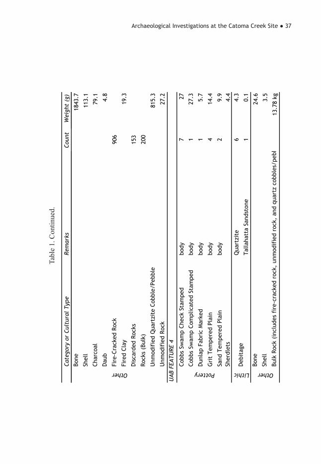
UAB field notes, consists of a dense lay-er of small stream-worn pebbles located within the area of Postholes 13-18 and to the southwest of the house midden. Small pieces of daub were also recovered. This midden, containing dense quantities of charcoal, fire-cracked rock, bone (fish, small-large mammal), mussel shells, pot-tery, chipped and ground stone tools, and debitage, was circular in plan, some 8 feet in diameter, and depressed towards the central hearth or fire basin (UAB Feature 4) by approximately 13 inches (Figure 6). The midden was described as darker in col-or towards the center and lighter along the periphery, and it contained pottery sherds representing a minimum of 25 ceramic ves-sels. In addition to grit- and sand-tempered plain types, the midden contained diagnos-tic ceramics including Adams Plain, Cobbs Swamp Check Stamped, Cobbs Swamp Complicated Stamped, Cobbs Swamp Simple Stamped, Dunlap Fabric Marked, Furrs Cord Marked, and some unidenti-fied fabric- and cord-marked sherds. The chipped stone tools from the house midden comprise some five biface fragments, six bifaces, one core, one hafted drill, one mi-crolith, one retouched flake, four preforms, two tested cobbles, and eleven projec-tile points. These points include a Candy Creek, a Coosa Notched, a Greeneville, a Hamilton, three Swan Lakes, two Flint Creeks, and two residual stemmed-Archaic types. The groundstone tools include two hammerstones, a metate fragment, a ste-atite sherd, and an abrader. A 14C sample obtained from the midden and submitted for radiometric dating by George Price (1999) returned a calibration curve inter-cept of cal A.D. 540 (see Table 1).
The central hearth, containing nearly 30 lbs of cobbles and fire-cracked rock, had an approximate diameter of 2 ½ feet.

32 ● Journal of Alabama Archaeology
Figure 4. Photographs of successive excavation stages of UAB Feature 3 (pit house floor and midden) and UAB Feature 4 (central hearth) (UAB 1976).

Archaeological Investigations at the Catoma Creek Site ● 33
Figure 5. Plan views of UAB Feature 3 (pit house floor and midden) at the base of the plowzone prior to excavation, with UAB Features 24, 26, 31, and 32 and Post Holes 6 through 18, and following complete excavation (including balks) with UAB Feature 4 (central hearth); photographs of Feature 24, a “pot bust” of a Dunlap Fabric Marked vessel (Vessel 71) pedestalled and adjacent UAB Feature 3; and a photograph of UAB Feature 4 (central hearth) following complete excavation.

34 ● Journal of Alabama Archaeology
Figu
re 6
. Pla
n vi
ew a
nd p
hoto
grap
hs o
f UA
B F
eatu
re 4
(cen
tral h
earth
) dur
ing
and
afte
r exc
avat
ion;
stra
tig-
raph
y of
UA
B F
eatu
res 3
and
4 th
roug
h a
sout
h pr
ofile
; and
cro
ss-s
ectio
n of
UA
B F
eatu
res 3
and
4 fo
llow
ing
exca
vatio
n w
ith p
hoto
grap
h.

Archaeological Investigations at the Catoma Creek Site ● 35
Cate
gory
or
Cult
ural
Typ
eRe
mar
ksCo
unt
Wei
ght
(g)
Adam
s Pl
ain
body
437
.2
body
7759
2.8
rim
796
.6
refi
tted
bod
y an
d ri
m7
122.
3
body
1791
.8
rim
324
.5
Cobb
s Sw
amp
Sim
ple
Stam
ped
body
316
.9
Dun
lap
Fabr
ic M
arke
dbo
dy2
24.8
Erod
ed G
rit
Tem
pere
dbo
dy9
31.6
Furr
s Co
rd M
arke
dbo
dy2
30.1
body
5335
8.3
rim
18.
6
rim
, no
tche
d2
10.1
body
8640
3.2
rim
518
.4
rim
, fl
arin
g1
14.6
body
, gr
it t
empe
red
14.
2
body
16
46.3
Uni
dent
ifie
d Co
rd M
arke
dbo
dy
13.
3
Uni
dent
ifie
d Fa
bric
Mar
ked
body
11.
5
127.
6
UA
B FE
ATU
RE 3
Gri
t Te
mpe
red
Plai
n
Sand
Tem
pere
d Pl
ain
UID
ero
ded
Dec
orat
ed
Sher
dlet
s
Pottery
Cobb
s Sw
amp
Chec
k St
ampe
d
Cobb
s Sw
amp
Com
plic
ated
Sta
mpe
d
Tabl
e 1.
Tab
ular
Sum
mar
y of
UA
B F
eatu
re 3
and
UA
B F
eatu
re 4
Arti
fact
s.

36 ● Journal of Alabama Archaeology
Cate
gory
or
Cult
ural
Typ
eRe
mar
ksCo
unt
Wei
ght
(g)
Coas
tal P
lain
Che
rt1
0.7
Knox
Che
rt15
4.5
Qua
rtzi
te34
628
2.7
Talla
hatt
a Sa
ndst
one
40.
6
Bifa
ce F
ragm
ents
511
.1
Bifa
ces
638
.5
Core
158
.3
Haf
ted
Dri
ll, r
ecyc
led
13.
8
Mic
rolit
h1
1
Pref
orm
s4
59.8
PPK,
Can
dy C
reek
13.
4
PPK,
Coo
sa N
otch
ed1
5.5
PPK,
Flin
t Cr
eek
212
.8
PPK,
Gre
envi
lle1
4
PPK,
Ham
ilton
12.
6
PPK,
Sw
an L
ake
315
.1
PPK,
Res
idua
l Ste
mm
ed-A
rcha
ic2
9.2
Reto
uche
d Fl
ake
14.
9
Test
ed C
ore
245
Uni
dent
ifie
d Ch
ippe
d St
one
Tool
s9
69.9
Ham
mer
ston
e2
521.
7
Met
ate
Frag
men
t1
34.9
Abra
der
110
0.7
Stea
tite
120
.1
Lithics
Deb
itag
e
Chip
ped
Ston
e To
ols
Gro
unds
tone
Tabl
e 1.
Con
tinue
d.
Archaeological Investigations at the Catoma Creek Site ● 37
Cate
gory
or
Cult
ural
Typ
eRe
mar
ksCo
unt
Wei
ght
(g)
1843
.7
113.
1
79.1 4.8
906
19.3
153
200
815.
3
27.2
Cobb
s Sw
amp
Chec
k St
ampe
dbo
dy7
27
Cobb
s Sw
amp
Com
plic
ated
Sta
mpe
dbo
dy1
27.3
Dun
lap
Fabr
ic M
arke
dbo
dy1
5.7
Gri
t Te
mpe
red
Plai
nbo
dy4
14.4
Sand
Tem
pere
d Pl
ain
body
29.
94.
4Q
uart
zite
64.
3
Talla
hatt
a Sa
ndst
one
10.
1
24.6 3.5
13.7
8 kg
UA
B FE
ATU
RE 4
Rock
s (B
ulk)
Unm
odif
ied
Qua
rtzi
te C
obbl
e/Pe
bble
Unm
odif
ied
Rock
OtherSh
ell
Char
coal
Dau
b
Fire
-Cra
cked
Roc
k
Fire
d Cl
ay
Dis
card
ed R
ocks
OtherLithic Pottery
Deb
itag
e
Bone
Shel
l
Bulk
Roc
k (i
nclu
des
fire
-cra
cked
roc
k, u
nmod
ifie
d ro
ck,
and
quar
tz c
obbl
es/p
ebb
Sher
dlet
s
Bone
Tabl
e 1.
Con
tinue
d.

38 ● Journal of Alabama Archaeology
The fill was described as black, greasy midden that was darker than the overly-ing house midden, and extended to a depth of one foot. A smaller pit adjacent to the hearth is interpreted as evidence of a cen-tral roof support. Two clusters of heated quartzite cobbles and fire-cracked rock (UAB Features 31 and 32) were in associ-ation. UAB Feature 31 was located to the west of the presumed house wall, and UAB Feature 32 was found within the post pat-tern to the northwest of the house midden. Two discrete clusters of pottery, or “pot busts,” were located within and adjacent to the house midden. UAB Feature 24 was comprised of portions of a Dunlap Fabric Marked vessel and a sand-tempered plain vessel, and UAB Feature 26 was com-prised of portions of two Cobbs Swamp Check Stamped vessels.
In sum, this feature association is in-terpreted as the remains of a Middle Wood-land, Cobbs Swamp dwelling. It was some-what circular to slightly ovate, enclosing a sloped floor littered with house midden refuse that encircled a central hearth. No postholes were noted along the eastern side of the dwelling, though this may be that they were not recognized as such or did not survive, even though they would have been anticipated by the excavators. The relative-ly small posts, along with the larger central post support, would have supported a light wooden superstructure, possibly a cabana type structure and maybe even partially open, suggesting a warmer weather shel-ter. Interpreting the pebble concentration, however, is problematic, but it was likely connected to heat and/or cooking activi-ties. The architectural signatures evidenced from Feature Associations 3 and 4, as well as the other postholes at the site that do not form a distinct pattern, suggest a Middle Woodland semi-permanent settlement, and
a range of activities can be discerned based on artifact patterning across the site, with specific areas attributed to particular tasks.
Structural Remains
The house at 1MT209 is unique in that it is thought to be the first known re-corded complete dwelling from east-cen-tral Alabama. At the time of its discovery, Nance was quoted in the newspapers as stating that it was the first Deptford house found in Alabama, and few dwellings have been documented for the Early and Mid-dle Woodland periods in the Southeast. In northwestern Alabama, a circular post pattern approximately 12 feet in diameter and encircling a central hearth was found at the Copena settlement of Wright Village (1LU65) (Walthall 1980). In the north-eastern part of Alabama, excavations at the Dry Creek site (1CA52) revealed four possible semicircular posthole alignments, ranging in size from 2.2to 7.2 m across and in association with Cartersville Check Stamped pottery. They were interpreted as warm weather shelters (Little et al. 1997). Elsewhere in the Southeast, some of the earliest dwellings have been found along the Georgia coast and Piedmont. Along the coast on Cumberland Island, Milanich (1973a) excavated a large Deptford house at Table Point, and in the Piedmont, circu-lar structures were documented at 9BR3 (Bowen 1980), the Two Run Creek site (Wauchope 1966), and the Kellogg site (Caldwell 1950), with dates ranging from 500 B.C. to A.D. 300. Sites with multiple dwellings, dating from late Early Wood-land to Middle Woodland, are also doc-umented in Georgia at the Pumpkin Pile site (9Po27) (Ledbetter 1992) and the Six Flags site (9Fu14) (Kelly 1973; Kelly and Meir 1969). Finally, two oval structures in association with triangular points and

Archaeological Investigations at the Catoma Creek Site ● 39
check-stamped and fabric-marked pottery are reported from Cane Island (9PM209) located in far northeastern Georgia. Inter-estingly, traces of squash and maize were noted at this latter site (Wood and Bowen 1995).
Based on the 1MT209 data, coupled with Chase’s (n.d.) observations on post-hole segments uncovered at 1MT82 and by analogy with similar groups in neigh-boring regions, Cobbs Swamp houses ap-pear to be small and circular, often with a central hearth. Architectural signatures such as postholes are also in evidence at other reported Cobbs Swamp and Carters-ville-Deptford sites in the region, but their associations and patterns are too incom-plete to draw any meaningful conclusions.
ChronologyChase (n.d.), when he originally de-
fined the Cobbs Swamp Phase, estimated a temporal range of 300 B.C. to A.D. 200, and Walthall (1980:175) suggested a simi-lar range of 200 B.C. to A.D. 300. Jenkins and Sheldon (2014) suggest a date range of 100 B.C. to A.D. 650. However, un-til Price’s (1999) thesis research and this work, no radiocarbon dates were available. Rather, the phase was only tentatively dated by associations with other artifacts, namely Alexander and Calloway pottery, and stratigraphic position beneath Cal-loway and Henderson deposits for which we do have radiocarbon dates. These re-lationships position Cobbs Swamp within the Early to Middle Woodland time frame (Table 2).
For his thesis, Price submitted one sample for radiometric dating from UAB Feature 3, the house midden, which re-turned a calibration curve intercept of cal A.D. 540. Six 14C assays submitted by the OAR from sealed contexts at 1MT209
yielded dates tightly clustered within the Middle Woodland period, the earliest in-tercept being cal A.D. 240 for Feature 5; the latest cal A.D. 540 for Features 6 and 7. Six of these seven dates fall within a 100 year time span of cal A.D. 440 to 540.
CeramicsCobbs Swamp pottery is considered
by some to be the central Alabama expres-sion of Deptford (i.e., Cartersville), though morphologically it is much closer to the Cartersville pottery of the upper Coosa River valley and northern Georgia than the classic Deptford wares of the Coastal Plain. Knight and Mistovich (1984:217-218) have noted that Deptford, which specifical-ly refers to the Early to Middle Woodland culture that used sand-tempered, check-stamped pottery and developed along the Atlantic coast of Georgia and the Gulf Coast of northwest Florida, has come to be used as a generic term to describe Middle Woodland check-stamped pottery, which is found throughout the Piedmont and Val-ley and Ridge as well as the Coastal Plain. This emphasis on ceramic complexes has led to an oversimplified and misleading understanding of Middle Woodland cul-tures in the Southeast, as other cultural traits and material culture are just as im-portant. Although some have posited that the similarities between Cartersville and Cobbs Swamp assemblages are likely due to their common origin among coastal Deptford groups and their subsequent and contemporaneous diffusion into the interi-or regions (Walthall 1980:175), Wauchope (1966), in his groundbreaking survey of northern Georgia, essentially equated Car-tersville and Booger Bottom with Deptford, while Caldwell (1957, 1958), based on his work in the Allatoona Reservoir, viewed the differences between Cartersville and

40 ● Journal of Alabama Archaeology
Feat
ure
C14
Dat
e (B
P)D
unla
p Fa
bric
M
arke
dCo
bbs
Swam
p Si
mpl
e St
ampe
dCo
bbs
Swam
p Ch
eck
Stam
ped
Cobb
s Sw
amp
Com
plic
ated
Sta
mpe
dPl
ain1
Callo
way
Pla
in
517
80±4
01
-13
212
-
116
00±4
01
19
343
29
715
80±4
02
-26
1179
3
815
70±4
0-
1-
-16
7-
UAB
32
1550
±60
103
171
2115
7-
615
50±4
0-
--
-14
-
7A3
1540
±40
--
61
8-
15-
1-
930
28-
UAB
25
--
-31
511
45
UAB
11
-1
-38
770
1
UAB
8-
1-
111
3-
2 UAB
Fea
ture
3 (
hous
e m
idde
n) a
lso
incl
udes
UAB
Fea
ture
4 (
cent
ral h
eart
h) a
nd U
AB F
eatu
res
24 a
nd 2
6, b
oth
pott
ery
clus
ters
wit
hin
the
hous
e m
idde
n.3 F
eatu
re 7
A w
as a
dis
tinc
t as
hy d
epos
it w
ithi
n Fe
atur
e 7
(pit
) th
at w
as la
ter
dete
rmin
ed t
hrou
gh v
esse
l ana
lysi
s (i
.e.
refi
ts)
to h
ave
been
con
tem
pora
neou
s.
1 Thi
s ca
tego
ry in
clud
es b
oth
sand
, co
arse
san
d, a
nd c
rush
ed q
uart
zite
(gr
it)
tem
per.
Tabl
e 2.
Tab
le o
f Maj
or C
eram
ic T
ypes
With
in S
elec
ted
Feat
ures
and
Ass
ocia
ted
Rad
ioca
rbon
Dat
es.

Archaeological Investigations at the Catoma Creek Site ● 41
Deptford as significant. Nonetheless, the “splitting” of Deptford into region-specific complexes, such as Booger Bottom, Cobbs Swamp, McLeod, Wakulla, and Cleveland, reinforces the notion that these phases are “related to the classical core tradition but sufficiently removed in time and space or associated material culture to justify the need for separate identification in publica-tions (Chase n.d.).” Given the morphologi-cal similarities of the pottery, other cultural traits, and the riverine connection between the Georgia Piedmont and the Alabama River, Cobbs Swamp is best considered a local example of Cartersville, rather than Deptford.
Cobbs Swamp pottery consists of sand- and sand/coarse sand/crushed quartz-ite (i.e., grit)-tempered, plain and simple-, check-, and complicated-stamped pottery. Vessel form is consistently a conoidal jar formed by the coiling method, usually with podal supports, though flat bases are known. Surface treatment can be either from rim to base or from shoulder to base. Vessel rims are straight to slightly flaring, and lips are usually flattened but are some-times rounded or beveled (Caldwell and Waring 1939a:8). Combinations of simple, check, and complicated stamping on the same vessel are known from 1MT82 and 1MT108 (Chase n.d.) (Table 3).
A number of ceramic types were iden-tified in the 1MT209 collection, ranging from the fiber-tempered Millbrook Plain, Late Gulf Formational/Early Woodland Alexander types such as Alexander Incised and Alexander Punctated, a few Weeden Island types such as Carabelle Punctat-ed and Santa Rosa Punctated, to the Late Woodland Adams Plain. The vast majori-ty of the types, though, date to the Middle Woodland period, and the Cobbs Swamp series predominates, with simple-, check-,
and complicated-stamped sherds; other types include Dunlap Fabric Marked, Furrs Cord Marked, Tensaw Stamped, and the grit and mica-tempered Calloway Plain. In addition to the identification of twelve formal and twelve informal types, a vessel analysis was undertaken for the cultural features at 1MT209.
Cobbs Swamp Check Stamped was the most common formal type identified at 1MT209, representing 23 percent of the total ceramic assemblage. This decoration/surface treatment consists of deeply im-pressed, small to medium checks, resem-bling a sloppily to carefully applied grid pattern. Linear check stamping occurs in much less frequency than general and bold check stamping, and very fine checks are also known. Unfortunately, sorting out these check-stamped categories has not proven to be analytically useful and re-search indicates the variations in stamping are of little chronological value (Milanich 1973b:112).
There is some debate as to wheth-er check stamping is a surface textur-ing treatment or a decoration. Although check stamping applied by a carved pad-dle against an interior anvil did serve to strengthen the vessel, the application of the pattern on the podals and at contrived junc-tures and along rims indicates some degree of aesthetic awareness. Interestingly, few check-stamped sherds were recovered from Block B, with none from Block B fea-tures. Rather, check-stamped pottery was concentrated in Blocks A, C, and D and the UAB units, especially in and around the pit house (Figures 7-8). The check-stamped vessel forms from the 1MT209 generally took the form of large, medium-to-thick walled, flared rim, conoidal jars, most with tetrapodal supports, although some bowls were suggested by certain rims.

42 ● Journal of Alabama Archaeology
Surf
ace
Trea
tmen
tTy
peBo
dyBa
sePo
dal
Perf
orat
ed D
iscs
Rim
Tota
lAd
ams
Plai
n4
----
--1
5
Callo
way
Pla
in57
----
--8
65
Mill
broo
k Pl
ain
31--
----
233
Sand
tem
pere
d42
5620
187
202
4503
Gri
t te
mpe
red
1684
13--
--86
1783
Subt
otal
6032
3318
729
963
89
Alex
ande
r In
cise
d8
----
--1
9
Subt
otal
8--
----
19
Alex
ande
r Pu
ncta
ted
----
----
11
Sant
a Ro
sa P
unct
ated
2--
----
13
UID
San
d te
mpe
red
9--
----
--9
Subt
otal
11--
----
213
Cobb
s Sw
amp
Chec
k St
ampe
d25
3432
26--
134
2726
Subt
otal
2534
3226
--13
427
26
Cobb
s Sw
amp
Com
plic
ated
Sta
mpe
d71
5--
--1
3575
1
Subt
otal
715
----
135
751
Cobb
s Sw
amp
Sim
ple
Stam
ped
50--
----
252
Subt
otal
50--
----
252
Tens
aw C
reek
Sta
mpe
d1
----
----
1
Subt
otal
1--
----
--1
Dun
lap
Fabr
ic M
arke
d15
3--
----
1817
1
UID
San
d te
mpe
red
9--
----
--9
Subt
otal
162
----
--18
180
Plai
n
Inci
sed
Punc
tate
d
Chec
k St
ampe
d
Com
plic
ated
Sta
mpe
d
Sim
ple
Stam
ped
Rock
er S
tam
ped
Fabr
ic M
arke
d
Tabl
e 3.
Tab
ular
Sum
mar
y of
Sur
face
Tre
atm
ent b
y Te
mpe
r and
Ves
sel E
lem
ents
for 1
MT2
09 C
eram
ics.

Archaeological Investigations at the Catoma Creek Site ● 43
Surf
ace
Trea
tmen
tTy
peBo
dyBa
sePo
dal
Perf
orat
ed D
iscs
Rim
Tota
lFu
rrs
Cord
Mar
ked
9--
----
110
UID
San
d te
mpe
red
22--
----
--22
Subt
otal
31--
----
132
UID
Gri
t te
mpe
red
1--
----
--1
UID
San
d te
mpe
red
4--
----
--4
Subt
otal
5--
----
--5
Gri
t te
mpe
red
9--
----
--9
Sand
tem
pere
d72
0--
----
1973
9
Subt
otal
729
----
--19
748
Gri
t te
mpe
red
27--
----
128
Sand
tem
pere
d76
65
3--
377
7
Sand
/mic
a te
mpe
red
2--
----
--2
Subt
otal
795
53
--4
807
Cord
Mar
ked
Brus
hed
Uni
dent
ifie
d D
ecor
ated
Erod
ed
Tabl
e 3.
Con
tinue
d.

44 ● Journal of Alabama Archaeology
Figu
re 7
. UA
B F
eatu
re 5
, a “p
ot b
ust”
of a
Cob
bs S
wam
p C
heck
Sta
mpe
d ve
ssel
(Ves
sel 3
), w
ith th
e fea
ture
ped
esta
lled
on le
ft (U
AB
19
76) a
nd a
men
ded
and
refit
ted
Vess
el 3
on
the
right
.

Archaeological Investigations at the Catoma Creek Site ● 45
Figu
re 8
. UA
B F
eatu
re 2
6, a
“po
t bus
t” o
f a C
obbs
Sw
amp
Che
ck S
tam
ped
vess
el (V
esse
l 72)
adj
acen
t the
pit
hous
e m
idde
n an
d flo
or (U
AB
Fea
ture
3),
with
the
feat
ure
pede
stal
led
on le
ft (U
AB
197
6) a
nd a
men
ded
and
refit
ted
Vess
el 7
2 on
the
right
.

46 ● Journal of Alabama Archaeology
Minority types such as Dunlap Fab-ric Marked and Cobbs Swamp Simple Stamped are present but together only comprise 2 percent of the total ceramic assemblage. Simple-stamped pottery was found in Features 1, 8, and UAB Feature 3, all three of which contained later pottery types such as Cobbs Swamp Complicat-ed Stamped and Calloway Plain. Dunlap Fabric Marked, representing 1.5 percent of the assemblage, was the third most com-mon formal type at 1MT209. Based on the original type descriptions, vessel forms are usually deep simple jars or cups with conoidal bases that are slightly flattened when podal supports, almost always point-ed and elongated, are present (Caldwell and Waring 1939b:7; Haag 1940:7). Rims are generally slightly flaring or straight; vessel lips, which are rarely decorated, are rounded or flat, with some examples show-ing a slight extrusion. The Dunlap Fab-ric Marked sherds were concentrated in Blocks C and D and within the UAB units;
only one sherd was recovered in Block B and none from Block B features. Features in which a significant percentage of Dun-lap Fabric Marked sherds were found are UAB Feature 24, a pottery cluster on the house floor; UAB Feature 28, a pottery cluster to the northeast of Feature 3; and UAB Feature 3 from which a few sherds were recovered (Figure 9).
Chase considered fabric-marked and simple-stamped pottery to be early, while Walthall (1980:175) posited that fab-ric-marked pottery is early and simple and complicated stamping are later in the Chat-tahoochee River valley. He extends this hypothesis to the Alabama River valley, though here neither appears to hold true. At 1MT209, Dunlap Fabric Marked sherds were recovered from later features and in association with complicated-stamped sherds and were clearly not from an ear-lier component. In light of the persistent, continued use of check stamping for over a millennia in this region (Jenkins and Shel-
Figure 9. Vessel 76, Cobbs Swamp Complicated Stamped, and Vessel 77, Dunlap Fabric Marked.

Archaeological Investigations at the Catoma Creek Site ● 47
don 2014), it seems reasonable to assume that this conservatism was pervasive and that perhaps fabric-marked pottery also en-joyed a long history of use in the area. In the Piedmont of Georgia, simple stamping occurs late in the sequence in Cartersville, while Dunlap Fabric Marked is a marker of the preceding Kellogg phase and early Car-tersville. It would seem best to assume the absence of complicated stamping reflects the early part of the phase, and its presence indicates the late part of the phase, rather than basing it on the presence or absence of fabric-marked or simple-stamped mi-norities.
The primary occupation of 1MT209 seems to have occurred during the later part of the Middle Woodland Period, as 6.4 percent of the assemblage is Cobbs Swamp Complicated Stamped. This minority type is analogous to Early Swift Creek Compli-cated Stamped, but the vessel wall is thick-er, and the stamping is generally cruder with extensive overstamping. However, the quality of the stamping application can range widely from sloppy to markedly less overstamping, though still not approaching the quality of Early Swift Creek. Designs consist of curvilinear parallel line motifs, usually concentric circles and parallel bars. At 1MT209, the most common designs are the scroll and “figure 8.” No rectilin-ear designs or zoned stamping were ob-served. The curvilinear stamping possibly represents a more aesthetic and symbolic emphasis on vessel decoration. Fifteen out of twenty-one ceramic producing features, both pits and hearths, contained this type. It was as also found in and around Feature Association Four or the pit house. It is in-teresting to note again that few complicat-ed-stamped sherds were recovered from Block B and none from Block B features; rather, they were concentrated in Blocks C
and D and the UAB units. The highest fre-quencies of this type occurred in Features 7 and 15 in Block C and UAB Features 8, 12 and 27. The Cobbs Swamp Complicat-ed Stamped vessels with identifiable forms consisted of large, flared rim, conoidal jars with wall thicknesses comparable to those of the check-stamped vessels.
The presence of Calloway Plain, a grit-tempered plain ware containing liberal amounts of mica, within four of the fea-tures also suggests an occupation contem-poraneous with the Maxwell subphase of the Calloway phase (see Jenkins and Shel-don 2014) and interactions between pop-ulations associated with the two phases. These vessels ranged from straight-sid-ed bowls with conoidal bases to notched, flared rim jars, all thin walled (Figure 10).
LithicsChase observed that Cobbs Swamp
projectile points consistently were of the large triangular types, namely Green-eville and Camp Creek, but also Candy Creek and Copena, with the smaller Co-osa Notched appearing late in the phase (Chase 1998:63; n.d.). Based on our work at 1MT209, these tend to fall within the Greeneville/Woodland Triangular Clus-ter, which includes such point types as Greeneville, Camp Creek, Candy Creek, Copena, Benjamin, and Nolichucky, all of which were recovered from Cobbs Swamp contexts at 1MT209 (Figure 11). Interest-ingly, several Hamilton points were found in Cobbs Swamp feature contexts, sug-gesting an earlier development of this type than previously thought. Indeed, the size of many of these projectile points suggests the bow-and-arrow was in use by at least the Middle Woodland period. Additional Mid-dle Woodland types recovered include the Lanceolate Expanded Stemmed Cluster,
48 ● Journal of Alabama Archaeology
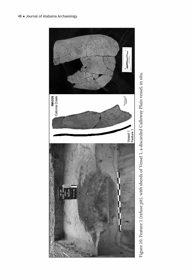
Figu
re 1
0. F
eatu
re 1
(ref
use
pit),
with
sher
ds o
f Ves
sel 1
, a d
iscar
ded
Cal
low
ay P
lain
ves
sel,
in si
tu.

Archaeological Investigations at the Catoma Creek Site ● 49
Figu
re 1
1. S
elec
ted
lithi
cs: L
ate
Pale
o-In
dian
stag
e cl
uste
r too
ls; G
reen
evill
e/W
oodl
and
Tria
ngul
ar c
lust
er to
ols;
and
Lan
ceol
ate
Expa
nded
Ste
m c
lust
er to
ols.

50 ● Journal of Alabama Archaeology
which consists of the Bakers Creek, Swan Lake, and Mud Creek types, the Bradley Spike of the Tapered Stemmed Cluster, and finally the ubiquitous Coosa and Coosa Notched types. Chase associates the Brad-ley Spike, Coosa, and Swan Lake types with the Calloway Phase (Chase n.d.). Late Paleoindian and Early Archaic tools from 1MT209 were recovered in contexts with later tools and were likely picked up and utilized by the later populations (see Fig-ure 11) (Table 4).
An analysis of the chipped stone tool assemblage indicated a higher ratio of late stage and finished tools than early stage tools, suggesting that late stage biface pro-duction and maintenance was the primary focus of lithic activity. This observation is further strengthened based on the paucity of of cores and non-bifacial tools and the low frequency of 1-inch or greater flakes. Most of the chipped stone tools were man-ufactured from locally available quartzite and Knox Group chert, often a lustrous black stone, though some were made of Tallahatta sandstone and Coastal Plain chert.
Several heavy lithic activity areas were noted, perhaps the most significant being UAB Feature 6 which Nance interpreted as a “lithic workshop” in 1976. This feature loosely includes UAB Unit 7 and probably extends into adjacent balks and units. The basis for this interpretation lies in the sheer volume and variety of debitage (n=1224) from one unit, including greenstone and an unusually high frequency of black Knox chert, the presence of a number of complete and broken chert and quartzite cobbles, and chipped stone tools ranging from preforms to completed projectile points. This latter category includes Middle Woodland types as well as earlier ones, such as a Dalton, which were probably meant to be recycled.
Other items from this lithic workshop area include greenstone celt fragments, sever-al cores, one of which is a bipolar core, a hammerstone, a retouched flake, and a pos-sible gorget blank.
Certain tool types associated with spe-cific tasks could also be discerned in the 1MT209 data. For instance, scrapers used for hide processing and other tools such as perforators, gravers, and drills were found across the site but tended to cluster in por-tions of Blocks B and C and the UAB units. Multiple hammerstones, choppers, and an-vils were noted to be especially concentrat-ed within the UAB units and the pithouse (Feature Association Four) and to a lesser extent within in Block B. Other ground stone tools identified include sandstone abraders, a burnishing stone from Block B, two nutting stone fragments—both from features—and manos and metates (Table 5). Fragments of the latter two types, as-sociated exclusively with food processing, were found across the site though with an obvious absence from Blocks A and D. UAB Feature 25, consisted of a nearly intact large sandstonemetateand a mano found together just over two meters to the northwest of the pithouse. Finally, evi-dence of a bipolar core industry was iden-tified with several hammerstones, anvils, and bipolar cores occurring in the same or adjacent units, namely in Block B. Based on the chipped stone data, 1MT209 may have been a significant late stage lithic re-duction site during the Middle Woodland.
Other ArtifactsArtifacts typically found at other
Cobbs Swamp phase sites include partial-ly ground greenstone celts, stone gorgets, and ceramic discs that are either plain or stamped and often have a central perfora-tion. Perforated ceramic discs are known.

Archaeological Investigations at the Catoma Creek Site ● 51
Stag
eCu
ltur
al T
ype
Stra
t A
Stra
t A
/BSt
rat
BFe
atur
eTo
tal
Ass
ocia
ted
Clus
ters
Mad
ison
10
10
2H
amilt
on
Ham
ilton
40
54
13H
amilt
on
Brad
ley
Spik
e0
02
02
Tape
red
Stem
med
Swan
Lak
e27
110
947
Lanc
eola
te E
xpan
ded
Stem
med
Bake
rs C
reek
190
66
31La
nceo
late
Exp
ande
d St
emm
ed
Mud
Cre
ek2
01
25
Lanc
eola
te E
xpan
ded
Stem
med
Resi
dual
Ste
mm
ed-W
oodl
and
30
01
4Re
sidu
al S
tem
med
Cus
ter
Coos
a N
otch
ed14
08
527
Coos
a
141
22
19
Cope
na4
02
17
Gre
enev
ille/
Woo
dlan
d Tr
iang
ular
Gre
envi
lle21
017
543
Gre
enev
ille/
Woo
dlan
d Tr
iang
ular
Benj
amin
00
20
2G
reen
evill
e/W
oodl
and
Tria
ngul
ar
Cand
y Cr
eek
11
11
4G
reen
evill
e/W
oodl
and
Tria
ngul
ar
Cam
p Cr
eek
40
00
4G
reen
evill
e/W
oodl
and
Tria
ngul
ar
Nol
ichu
cky
31
00
4G
reen
evill
e/W
oodl
and
Tria
ngul
ar
LW/M
(n=
15)
MW
(n=
199)
Late
Woo
dlan
d/M
issi
ssip
pian
(LW
/M),
Mid
dle
Woo
dlan
d (M
W)
Tabl
e 4.
Chr
onol
ogy
Tabl
e B
ased
on
Chi
pped
Sto
ne T
ool C
lust
ers.
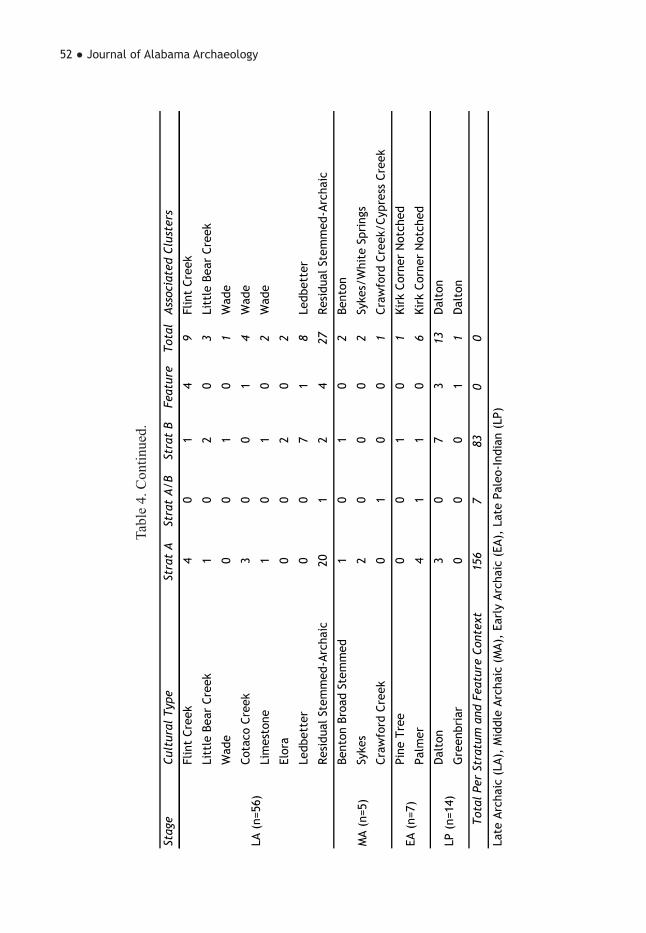
52 ● Journal of Alabama Archaeology
Stag
eCu
ltur
al T
ype
Stra
t A
Stra
t A
/BSt
rat
BFe
atur
eTo
tal
Ass
ocia
ted
Clus
ters
Flin
t Cr
eek
40
14
9Fl
int
Cree
k
Litt
le B
ear
Cree
k1
02
03
Litt
le B
ear
Cree
k
Wad
e0
01
01
Wad
e
Cota
co C
reek
30
01
4W
ade
Lim
esto
ne1
01
02
Wad
e
Elor
a0
02
02
Ledb
ette
r0
07
18
Ledb
ette
r
Resi
dual
Ste
mm
ed-A
rcha
ic20
12
427
Resi
dual
Ste
mm
ed-A
rcha
ic
Bent
on B
road
Ste
mm
ed1
01
02
Bent
on
Syke
s2
00
02
Syke
s/W
hite
Spr
ings
Craw
ford
Cre
ek0
10
01
Craw
ford
Cre
ek/C
ypre
ss C
reek
Pine
Tre
e0
01
01
Kirk
Cor
ner
Not
ched
Palm
er4
11
06
Kirk
Cor
ner
Not
ched
Dal
ton
30
73
13D
alto
n
Gre
enbr
iar
00
01
1D
alto
n
156
783
00
Late
Arc
haic
(LA
), M
iddl
e Ar
chai
c (M
A),
Earl
y Ar
chai
c (E
A),
Late
Pal
eo-I
ndia
n (L
P)
LP (
n=14
)
Tota
l Pe
r St
ratu
m a
nd F
eatu
re C
onte
xt
LA (
n=56
)
MA
(n=5
)
EA (
n=7)
Tabl
e 4.
Con
tinue
d.

Archaeological Investigations at the Catoma Creek Site ● 53
Category/Subcategory Weight (g) Count
Bipolar Core 15
Core (amorphous & expended) 58
Utilized Core 12
Tested Cobble/Pebble 21
Core/Core Tool Total 106
Preform 39
Biface I 32
Biface II 111
Hafted Thinned Biface 296
Biface Graver 2
Hafted Scraper 2
Hafted Drill 2
Biface Scraper 3
Biface Fragment 65
Biface Total 552
Anvil 3
Sandstone Abrader 3
Burnishing Stone 1
Celt Fragment 3
Chopper 7
Hammerstone 19
Mano 11
Metate 2
Modified Sandstone 2
Modified Schist/Abrader 1
Modified Slate 1
Nutting Stone fragment 2
Ground Stone Total 55
Core/Core Tool
Biface
Pecked and Ground Stone
Table 5. Tabular Summary of Lithic Artifacts by Category/Subcategory.

54 ● Journal of Alabama Archaeology
Category/Subcategory Weight (g) Count
Retouched Flake 5
Utilized Flake 14
Possible Blade Flake 6
Perforator 5
Microlith Tool 4
Flake and Microlith Tool Total 34
<1/4" Cortical 8.2 121
<1/4" Noncortical 40.6 860
1/4" Cortical 1119.2 2136
1/4" Noncortical 1051.9 3239
1/2" Cortical 1652.3 615
1/2" Noncortical 518.8 317
1" Cortical 676.0 35
1" Noncortical 13.7 1
Debitage Size Grade Total 5,080.70 7,324
Flake and Microlith Tool
Debitage Size Grade Category
Table 5. Continued.
from Copena contexts, where they may have been used as a gaming piece, personal ornament, or they may have functioned as a readily made spindle whorl. The green-stone would have been procured upstream in the Coosa River drainage from the Hilla-bee Greenstone Formation. Cobbs Swamp celts were chipped with only the bit end being ground smooth (Chase 1998:63; Walthall 1980:175). Steatite also has been consistently recovered from Cobbs Swamp contexts. Like greenstone, it too would have been procured from upstream sourc-es. Gorgets are generally of the two-hole type and are usually made from steatite, hematite, schist, or other stone, and many of them have rectilinear designs engraved on their surfaces (Chase n.d.). Other arti-facts of note, but not widely found, include cut and ground sheets of mica recovered from 1MT82, hinting at Copena relation-ships, hematite concretions, the ochre re-
moved and ground into a small cup, noted at 1MT74, and naturally perforated beads as well as ground stone beads (Chase n.d.).
This pattern is repeated at 1MT209, with 13 greenstone celt fragments, as well as greenstone debitage, 39 steatite vessel sherds, some quite large and most being grooved, and 10 modified potsherds recov-ered from both feature and general unit/level contexts. Eight potsherd disks were recovered at 1MT209, all from feature or midden contexts. Only one from Feature 1 was complete—a Cobbs Swamp Com-plicated Stamped sherd with a central, bi-conical perforation and ground edges. One check-stamped sherd had been ground and beveled along the edges to produce a squared form, and one rim sherd with a perforation is interpreted as a mended vessel sherd. In addition, one ground and drilled bead of ferruginous sandstone was recovered near UAB Feature 11. Two natu-
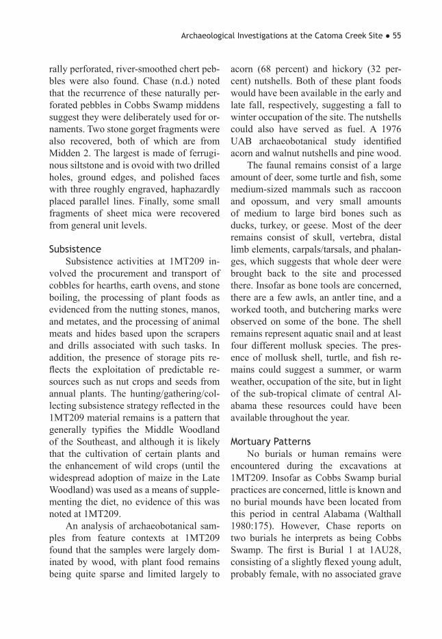
Archaeological Investigations at the Catoma Creek Site ● 55
rally perforated, river-smoothed chert peb-bles were also found. Chase (n.d.) noted that the recurrence of these naturally per-forated pebbles in Cobbs Swamp middens suggest they were deliberately used for or-naments. Two stone gorget fragments were also recovered, both of which are from Midden 2. The largest is made of ferrugi-nous siltstone and is ovoid with two drilled holes, ground edges, and polished faces with three roughly engraved, haphazardly placed parallel lines. Finally, some small fragments of sheet mica were recovered from general unit levels.
SubsistenceSubsistence activities at 1MT209 in-
volved the procurement and transport of cobbles for hearths, earth ovens, and stone boiling, the processing of plant foods as evidenced from the nutting stones, manos, and metates, and the processing of animal meats and hides based upon the scrapers and drills associated with such tasks. In addition, the presence of storage pits re-flects the exploitation of predictable re-sources such as nut crops and seeds from annual plants. The hunting/gathering/col-lecting subsistence strategy reflected in the 1MT209 material remains is a pattern that generally typifies the Middle Woodland of the Southeast, and although it is likely that the cultivation of certain plants and the enhancement of wild crops (until the widespread adoption of maize in the Late Woodland) was used as a means of supple-menting the diet, no evidence of this was noted at 1MT209.
An analysis of archaeobotanical sam-ples from feature contexts at 1MT209 found that the samples were largely dom-inated by wood, with plant food remains being quite sparse and limited largely to
acorn (68 percent) and hickory (32 per-cent) nutshells. Both of these plant foods would have been available in the early and late fall, respectively, suggesting a fall to winter occupation of the site. The nutshells could also have served as fuel. A 1976 UAB archaeobotanical study identified acorn and walnut nutshells and pine wood.
The faunal remains consist of a large amount of deer, some turtle and fish, some medium-sized mammals such as raccoon and opossum, and very small amounts of medium to large bird bones such as ducks, turkey, or geese. Most of the deer remains consist of skull, vertebra, distal limb elements, carpals/tarsals, and phalan-ges, which suggests that whole deer were brought back to the site and processed there. Insofar as bone tools are concerned, there are a few awls, an antler tine, and a worked tooth, and butchering marks were observed on some of the bone. The shell remains represent aquatic snail and at least four different mollusk species. The pres-ence of mollusk shell, turtle, and fish re-mains could suggest a summer, or warm weather, occupation of the site, but in light of the sub-tropical climate of central Al-abama these resources could have been available throughout the year.
Mortuary PatternsNo burials or human remains were
encountered during the excavations at 1MT209. Insofar as Cobbs Swamp burial practices are concerned, little is known and no burial mounds have been located from this period in central Alabama (Walthall 1980:175). However, Chase reports on two burials he interprets as being Cobbs Swamp. The first is Burial 1 at 1AU28, consisting of a slightly flexed young adult, probably female, with no associated grave
56 ● Journal of Alabama Archaeology
goods. The other is Burial 5 at 1MT56/100 (Hickory Bend), which Chase describes as being a bundle burial, possibly male, con-taining long bones, skull fragments, and a mandible, located in a pit overlain with midden fill approximately one foot below a house floor. Associated with the bundle were two bear canines and the jaws of a carnivore—possibly a wolf—that had been ground on its ventral side and bore green stains, suggesting contact with a copper object. Fifteen marginella shell beads were found six inches to the north of the bundle (Chase 1998:63, n.d.).
Concluding Remarks
The work at 1MT209 is the first ex-cavation at a major Cobbs Swamp phase site in at least three decades. Prior to this work, the only other major excavations were at 1AU28 during the late 1960s and at 1MT209 in 1976. The results of the 1MT209 excavations, and building upon previous work, has widened our knowl-edge of the Middle Woodland period in central Alabama. The material culture of the Cobbs Swamp phase has largely been established—the most basic units being check-stamped pottery and Green-eville type projectile points. The Cobbs Swamp pottery assemblage, comprised of sand- and sand/grit-tempered vessels, usually with podal supports, is dominated by check-stamped surface treatment, with minorities of Dunlap Fabric Marked and simple-stamped pottery which appear to occur throughout the phase. A complicat-ed-stamped type, analogous to Early Swift Creek, is another minority that occurs but appears during the later part of the phase. Cobbs Swamp projectile points types in-clude Greeneville/Woodland Triangu-lar Cluster, Coosa, Coosa Notched, and
Hamilton. Other artifacts include partially ground greenstone celts or hoes, perforat-ed potsherd disks, stone beads and gorgets, steatite vessels or cooking surfaces, and mica.
Beyond the material culture that con-stitutes the Cobbs Swamp phase, several observations can be offered. These Cobbs Swamp communities would have consisted of autonomous, semi-sedentary, self-suffi-cient groups (bands or segmentary tribes) that practiced a hunting, gathering, and collecting economy and probably practiced limited horticulture towards the end of the phase. Small to medium size mammals, es-pecially deer, figured prominently in their diet, as did fish, mollusks, and nut crops, especially acorn and hickory. Dwellings were small, the twelve foot in diameter structure seen at 1MT209 being the only known complete example, and circular in plan with a central support post and hearth. Jeter (1973, 1978) has suggested that Henderson culture, which is thought to have evolved out of Cobbs Swamp, uti-lized a settlement system whereby sites on the banks of the Alabama River were base camps or semi-permanent villages that were occupied from spring to fall by many individuals, and upland and tribu-tary stream sites were occupied by small groups from later fall to early spring.
Finally, it should be noted that Cobbs Swamp groups did not exist in a cultural vacuum; rather, they participated in the ex-change of knowledge, ideology, and exotic items, such as foreign pottery types and regional and exotic raw materials. This ex-change of ideas, albeit tenuous, is perhaps evident in the perforated potsherd disks, usually associated with the Copena com-plex, which may have been used as orna-mentation. Personal adornment in the form of gorgets, beads, and pendants was also

Archaeological Investigations at the Catoma Creek Site ● 57
documented, and although no burials were found at 1MT209, evidence from other Cobbs Swamp sites, according to Chase’s (1998) interpretation, indicates a minor degree of participation in the Hopewellian interaction sphere, albeit a very minor one. The relationship to Cartersville, though, is apparent in the use of check-stamped pot-tery.
Future work regarding the Cobbs Swamp phase could follow several poten-tial avenues of inquiry. The first of these should be a critical reanalysis and rein-terpretation of the work of David Chase, whose notes, files, and artifacts are housed at Auburn University in Montgomery. The vast majority of this material has never been analyzed or reported on to any de-gree, and would be a productive and ben-eficial mine of data. The second avenue should focus on settlement patterns and site distribution, as our current understand-ing is largely speculation. A third avenue, and one more site specific, should involve extensive horizontal excavations at one of the larger known Cobbs Swamp sites with well-preserved middens, which would hopefully answer additional questions on intrasite structure. Together, these suggest-ed research avenues, along with the work that has gone before, will untangle the archaeology and provide a clearer under-standing of central Alabama prehistory.
Acknowledgements. The senior author grate-fully acknowledges the assistance of Kareen L. Hawsey, Sharon A. Freeman, V. Stephen Jones, and the rest of the crew from the Office of Archaeological Research for their hard work during the field and laboratory aspects of the project as well as Myron Estes for the graph-ics. Thanks also go to James J. Kocis of the University of Tennessee, who performed the geoarchaeological study of 1MT209; Renee B. Walker of the SUNY-Oneonta, who undertook
the analysis of the animal bones; Katherine R. Mickleson of Rhodes College in Memphis for looking over the archaeobotanical samples; and Jeffrey T. Garner of the Alabama Division of Wildlife and Freshwater Fisheries for iden-tifying the shell. Other individuals who shared their knowledge of Alabama prehistory and gave their input include Eugene Futato, Ste-ven Meredith, George Price, Ned Jenkins, and Craig Sheldon, who granted me access to the David Chase collections held at Auburn Uni-versity at Montgomery. Finally, I wish to thank Mr. Gene H. Johnson of Montgomery who gen-erously supplied us with heavy equipment and an operator.
References Cited
Betterton, Joseph T., III 1997 Phase II Testing of Three Sites
in Autauga County, Alabama. Report submitted to the Alabama Department of Transportation by the University of Alabama Museums, Office of Archae-ological Services.
Bowen, William R. 1980 An Early Woodland Campsite in
North Central Georgia. Early Georgia 8(1-2):37-58.
Caldwell, Joseph R. 1950 A Preliminary Report on Ex-
cavations in the Allatoona Reservoir. Early Georgia 1:4-21.
1957 Survey and Excavations in the Allatoona Reservoir, Northern Geor-gia. Report submitted to the Nation-al Park Service by the University of Georgia, Department of Anthropology.
1958 Trend and Tradition in the Pre-history of the Eastern United States.
58 ● Journal of Alabama Archaeology
American Anthropological Associa-tion, Memoir 88.
Caldwell, Joseph R., and Antonio J. Waring, Jr. 1939a Pottery Type Descriptions.
Southeastern Archaeological Confer-ence Newsletter 1(5):6-14.
1939b Pottery Type Descriptions. Southeastern Archaeological Confer-ence Newsletter 1(6):1-11.
Chase, David W. 1975 An Archeological Survey of the
Montgomery Sewage Treatment Sys-tem. Report submitted to J. B. Con-verse, Mobile by David W. Chase.
1998 Prehistoric Pottery of Central Alabama. Journal of Alabama Archae-ology 44(1-2):52-98.
n.d. Assorted files containing corre-spondence, field notes, site informa-tion, analysis sheets, maps, general manuscripts, and various papers by unknown authors on central Alabama prehistory. Auburn University at Montgomery, Archaeological Labora-tory, Chase Collection.
Cottier, John W. 1979 The Lower Antioch Branch Site,
Central Alabama. Report submitted to the United States Army Corps of En-gineers, Mobile, by the Department of Sociology and Anthropology, Auburn University.
Dickens, Roy S., Jr., Edward L. Prince, and Joseph L. Benthall 1968 Archaeological Investigations
in the Jones Bluff Reservoir of the Al-
abama River. Report submitted to the National Park Service by the Universi-ty of Alabama, Department of Anthro-pology.
Haag, William G. 1940 Pottery Type Descriptions.
Southeastern Archaeological Confer-ence Newsletter 2(2).
Hawsey, Kareen L., and Thomas M. Shelby 2005 Archaeological Testing at Site
1MT211, a Woodland Stage Site on Ca-toma Creek near Montgomery, Mont-gomery County, Alabama. Report sub-mitted to the City of Montgomery,by the University of Alabama Museums, Office of Archaeological Research.
Jenkins, Ned J., and Craig T. Sheldon 2014 Ceramic Chronology, Social
Identity, and Social Boundaries: Cen-tral Alabama and Neighbors 100 B,C.-A.D. 1300. Journal of Alabama Ar-chaeology 60(1-2):61-116.
Jeter, Marvin D. 1973 An Archaeological Survey in
the Area East of Selma, Alabama, 1971–1972. Report submitted to the Archaeological Research Association of Alabama by the University of Ala-bama at Birmingham, Department of Anthropology and Sociology.
1978 Archaeological Investigations in the Mulberry Creek Area, Dallas and Autauga Counties, Central Ala-bama, 1975. Report submitted to the Alabama Historical Commission by the University of Alabama at Birming-ham, Department of Anthropology.

Archaeological Investigations at the Catoma Creek Site ● 59
Kelly, A.R. 1973 Early Villages along the Chatta-
hoochee River, Georgia. Archaeology 26(1):32-37.
Kelly, A.R., and Larry Meier 1969 A Pre-Agricultural Village Site
in Fulton County, Georgia. Southeast-ern Archaeological Conference, Bulle-tin 11:26-29.
Knight, Vernon J., Jr., Gloria G. Cole, and Richard Walling 1984 An Archaeological Reconnais-
sance of the Coosa and Tallapoosa River Valleys, East Alabama: 1983. Report submitted to the Alabama His-torical Commission, Montgomery by The University of Alabama, Office of Archaeological Research, Report of Investigations 43.
Knight, Vernon J., Jr., and Tim S. Mistovich 1984 Walter F. George Lake: Archae-
ological Survey of Fee Owned Lands, Alabama and Georgia. The University of Alabama, Office of Archaeological Research, Report of Investigations 42.
Ledbetter, Jerald R. 1992 Archaeological Investigations at
the Pumpkin Pile Site (9Po27), Polk County, Georgia. Report submitted to the USDA Soil Conservation Service by Southeastern Archaeological Ser-vices.
Little, Keith J., Harry O. Holstein, Curtis E. Hill, and Pearl Jones 1997 Archaeological Investigations of
the Dry Creek Site. Jacksonville State University, Archaeological Resource Laboratory, Research Series 2.
Milanich, Jerald T. 1973a A Deptford Phase House Struc-
ture, Cumberland Island, Georgia. The Florida Anthropologist 26(3):105-118.
1973b The Southeastern Deptford Culture: A Preliminary Definition. Bu-reau of Historic Sites and Properties, Bulletin 3:57-63. Tallahassee.
Nance, C. Roger 1976 The Archaeological Sequence
at Durant Bend, Dallas County, Al-abama. Special Publication 2. Ala-bama Archaeological Society, Orange Beach.
1978 Test Excavations at Middle and Late Woodland Sites near Selma, Al-abama. Report submitted to the Ala-bama Historical Commission and the U.S. Department of the Interior by the University of Alabama at Birming-ham, Department of Anthropology.,
Nielsen, Jerry J. 1970 Archaeological Investigations
at Site 1AU28 in the Jones Bluff Res-ervoir on the Alabama River. Report submitted to the National Park Ser-viceby the University of Alabama, De-partment of Anthropology.
1976 Archaeological Salvage Investi-gations at Site 1AU28. Journal of Ala-bama Archaeology 22(2):90-173.
Oakley, Carey B., and G. Michael Watson 1977 Cultural Resources Inventory of
the Jones Bluff Lake, Alabama River, Alabama. The University of Alabama, Office of Archaeological Research, Report of Investigations 4.

60 ● Journal of Alabama Archaeology
Price, George D. 1999 A Case for Increasing Sedentism
in the Middle Woodland Prehistory of East Central Alabama. Unpublished masters thesis, The University of Al-abama, Department of Anthropology, Tuscaloosa.
Shelby, Thomas M. 2005 Archaeological Test Excavations
at Site 1MT209: A Middle Woodland Site on Catoma Creek near Montgom-ery, Montgomery County, Alabama. Report submitted to the City of Mont-gomery, Alabama by the University of Alabama Museums, Office of Archae-ological Research.
Shelby, Thomas M., Sharon A. Freeman, and Kareen L. Hawsey 2007 Archaeological Investigations
Along Catoma Creek, Montgomery County, Alabama. 3 Vols. Report sub-mitted to The City of Montgomery by the University of Alabama, Office of Archaeological Research.
Walthall, John A. 1980 Prehistoric Indians of the South-
east: Archaeology of Alabama and the
Middle South. The University of Ala-bama Press, Tuscaloosa.
Waselkov, Gregory A. 1980 Coosa River Valley Archaeol-
ogy: Results of a Cultural Resources Reconnaissance. 2 vols. Auburn Uni-versity, Department of Sociology and Anthropology, Archaeological Mono-graph 2.
1981 Lower Tallapoosa River Cultur-
al Resources Survey, Phase I Report. Report submitted to the Alabama His-torical Commission by Auburn Uni-versity, Department of Sociology and Anthropology.
Wauchope, Robert 1966 Archaeological Survey of North-
ern Georgia with a Test of Some Cul-tural Hypotheses. Memoir 21. Society for American Archaeology, Salt Lake City.
Wood, W. Dean, and William R. Bowen 1995 Woodland Period Archaeology
of Northern Georgia. University of Georgia Laboratory of Archaeology Series Report 23.