arboricultural impact assessment (ascerta) · - 4 - doc 42 issue 14 feb 2017/ s:...
TRANSCRIPT

Ascerta Landscape, Arboricultural & Ecological Solutions
for the Built Environment
Arboricultural
Impact
Assessment
Ysgol Gynradd
Dolgarrog Primary School
LL32 8QE
April 2017
Ascerta Mere One, Mere Grange, Elton Head Road, St Helens WA9 5GG
T: 0845 463 4404 F: 0845 463 4405 E: [email protected]
www.landscapetreesecology.com

Contents
Page
EXECUTIVE SUMMARY .................................................................................................................. - 3 - 1.0 Introduction ............................................................................................................................... - 4 - 2.0 Objectives ................................................................................................................................... - 4 - 3.0 Planning Policy & Relevant Legislation .................................................................................. - 5 - 4.0 Survey & Survey Methodology ................................................................................................ - 6 -
5.0 Survey Results & Impact Assessment...................................................................................... - 7 - 5.1 Existing Tree Cover: .............................................................................................................. - 7 -
5.2 Direct Impact on Trees .......................................................................................................... - 7 - 5.3 Indirect Impact on Trees ....................................................................................................... - 7 - 5.4 Hedgerows .............................................................................................................................. - 7 - 5.5 Potential Mitigation for Development Impacts ................................................................... - 7 -
5.6 Potential for Shading & Nuisance ........................................................................................ - 7 - 5.7 Boundary Screening .............................................................................................................. - 7 -
5.8 Long Term Spatial Constraints ............................................................................................ - 8 - 5.9 Existing Areas of Hard Standing .......................................................................................... - 8 - 5.10 Existing buildings/structures to be removed ................................................................... - 8 -
5.11 Proposed Areas of Hard Standing .................................................................................... - 8 - 5.12 Proposed Buildings Located Adjacent / Within Root Protection Areas ....................... - 8 -
5.13 Proposed Drainage & Services: ........................................................................................ - 9 - 5.14 Working Space During the Construction Phase: ............................................................ - 9 - 5.15 Access Facilitation Pruning ............................................................................................... - 9 -
5.16 Protection of Planting Areas ............................................................................................. - 9 -
5.17 Requirement for an Arboricultural Method Statement ................................................. - 9 - 5.18 Planning for New Landscaping ....................................................................................... - 10 -
6.0 Tree Protection Measures ....................................................................................................... - 10 -
7.0 Summary of Impacts & Potential Mitigation Factors .......................................................... - 12 - 8.0 Conclusions & Recommendations ......................................................................................... - 13 - 9.0 References ................................................................................................................................ - 14 -
Appendix 1
Tree Data Tables in accordance with Table 1 of BS5837: 2012
Appendix 2
Drawing P.876.17.01 Tree Survey
Drawing P.876.17.02 Tree Constraints & Draft Protection Drawing

- 3 - Doc 42 Issue 14 Feb 2017/ S: Templates/Arboricultural Impact Assessment
EXECUTIVE SUMMARY
A survey of the existing trees on and adjacent Ysgol Gynradd, Dolgarrog Primary School,
LL32 8QE has been carried out by a suitably qualified and competent Arboriculturist in
accordance with British Standard 5837: 2012 Trees in relation to design, demolition and
construction – Recommendations.
The purpose of the survey and of this report is to identify the impact of the proposed
development of the site on trees, both within and immediately adjacent the site, in accordance
with the provisions of BS5837: 2012.
The development of the site will involve the demolition of the existing school buildings and the
construction of a new school building. This will require the removal of three trees, T1, T2, and
T19 to accommodate the new school entrance; also T5 will require removal to provide new
access to the bin storage area. G3 and part of G2 will require removal to install a gabion wall
that will support a raise in ground level towards to south east corner of the site. Part removal of
H1 will be required to allow construction of a new bat house. In the absence of suitable
controls, the development proposals have the potential to have an indirect impact on a number
of the trees proposed for retention.
Mitigation for the impact of the development can be provided in the form of the following:
The erection of protective fencing in advance of the commencement of the
development to safeguard the root systems of retained trees;
The agreement, in advance of the commencement of the development, together with
the implementation during the construction phase, of a methodology for the protection
of retained trees; and
The use of geotextiles and a ‘no-dig’ construction methodology where proposed hard
surfaces overlap with root protection areas.
Compensation for the impact of the development, together with landscape and biodiversity
enhancements can be achieved by way of the following:
The planting of trees, shrubs and where applicable hedges as part of a comprehensive
landscape scheme to replace any vegetation lost and to integrate the development into
the wider landscape.
In addition to the loss of trees for the new development of the school, it is recommended that
T16 and T17 be removed due to their current condition.

- 4 - Doc 42 Issue 14 Feb 2017/ S: Templates/Arboricultural Impact Assessment
1.0 Introduction
1.1 Ascerta has been instructed to carry out a survey of the trees within and immediately adjacent
Ysgol Gynradd, Dolgarrog Primary School, LL32 8QE and to assess the potential impact of the
development as proposed on trees within / adjacent the site in accordance with British Standard
5837: 2012 Trees in relation to design, demolition and construction – Recommendations.
1.2 The site was visited on 10th
April, 2017 by Helen Sullivan, a competent and qualified
arboriculturist with 8 years experience of the UK and European arboricultural and landscape
industries within the context of the planning system. During the site visit, a survey was carried
out of the trees growing both on and immediately adjacent the site to the standards contained
within BS5837: 2012. This report presents the results of the survey, provides an assessment of
the impact of the development and includes recommendations for further actions, where
applicable, in order to mitigate any potentially negative effects of the development on tree cover
within the local landscape.
2.0 Objectives
2.1 Our client’s objective is to develop the site by demolishing the existing building followed by the
construction of a new school building.
2.2 Our objectives are as follows:
Identify what arboricultural features exist presently within and adjacent the site and to
record and categorise them in a manner consistent with BS5837: 2012;
Identify which trees will need to be removed directly as a result of the proposed
development of the site;
Identify any indirect impact from the proposed development on trees proposed for retention;
Provide an indication of what protection measures can be implemented as part of the
development of the site to ensure the physical protection of retained trees;
Provide recommendations for mitigation and compensation in terms of new planting or
enhancement of existing features of arboricultural, landscape or ecological interest or
importance; and
Provide any other recommendations to assist our clients in achieving their objectives whilst
satisfying current legislation or policy guidance in relation to the woody vegetation on site.

- 5 - Doc 42 Issue 14 Feb 2017/ S: Templates/Arboricultural Impact Assessment
3.0 Planning Policy & Relevant Legislation
3.1 The National Planning Policy Framework (March 2012) sets out the Government’s planning
policies for England and how these are expected to be applied. The Framework contains a
presumption in favour of sustainable development, with sustainable development in the UK
being defined under the UK Sustainable Development Strategy Securing the Future. This sets
out five ‘guiding principles’ of sustainable development: living within the planet’s
environmental limits; ensuring a strong, healthy and just society; achieving a sustainable
economy; promoting good governance; and using sound science responsibly.
3.2 The Framework seeks to facilitate the approval, without delay, of developments that meet the
objectives of up to date Local Plans. Where proposed developments involve net gains for nature
and biodiversity, this is to be seen as a positive improvement in the quality of the natural
environment and thus in compliance with the objectives of the Framework.
3.3 The site lies within the Conway County Borough Council administrative area and is subject to
the policies contained within its Local Plan. These have been taken into account when writing
this report.
3.4 Checks made with the Local Planning Authority on 11th
April, 2017 indicate that none of the
trees within the site are subject to statutory controls either in the form of a Tree Preservation
Order, nor by virtue of their location within a Conservation Area.
3.5 British Standard 5837: 2012 Trees in relation to design, demolition and construction –
Recommendations provides current recommendations and guidance on the relationship between
trees and design, demolition and the construction processes. It sets out the principles and
procedures to be applied to achieve a harmonious and sustainable relationship between trees and
structures.
3.6 Notwithstanding the aforementioned policies and legislation, consideration should also be given
to any impacts from the proposed development in respect of the Hedgerow Regulations 1997 and
the Forestry Act 1967 (and specifically the potential need for a felling licence), as well as
existing UK and European legislation relating to wildlife and nature conservation.

- 6 - Doc 42 Issue 14 Feb 2017/ S: Templates/Arboricultural Impact Assessment
4.0 Survey & Survey Methodology
4.1 We have been supplied with a digital copy of the topographical survey for the site, which
satisfies the relevant part of section 4.2 of BS5837: 2012. Features of arboricultural or landscape
interest that have been excluded from the original plan (for example trees on or located off site
but within a distance from the boundary of the site equal to or less than 12 times the stem
diameter of that tree) have been added to the plan manually.
4.2 Our assessment of the soils within the site, based on local site conditions, geography, available
soil maps and our own experience of soils across the United Kingdom, indicates that the soils on
site are likely to contain a clay element, and that this will have a plasticity index in the low to
medium range. Any further details or confirmation of the exact nature of soil conditions on site
will require further, more rigorous sampling and analysis. It is not however anticipated that the
clay content will cause specific issues relating to retention of trees given the impact of the
development proposals, providing that consideration is given to this aspect in advance of and
during the construction phase of the development. Provision will need to be made for the
protection of soil structure in key areas during the construction phase and the repair of any
damage post construction. Further details are provided throughout this report and final details
can be secured via planning condition.
4.3 Our survey of the trees within and adjacent the site was carried out by a qualified and competent
arboriculturist in accordance with sections 4.4 and 4.5 of BS5837: 2012 on 10th
April, 2017
during intermittent rainy weather conditions. Those trees surveyed have been numbered
sequentially, although for the purposes of this project they have not been tagged by Ascerta,
although some trees within the site boundary have been tagged previously. The trees have also
been categorised in accordance with section 4.5 and Table 1 of the Standard.
4.4 Where relevant and where the quality of shrub masses and hedges justifies recording, details
have been recorded to the tree survey plan and tree data tables.
4.5 Where trees are surveyed that require immediate attention, for example to abate a nuisance,
prevent a serious hazard to life or property, or are affected by a pathogen or pest that could cause
widespread damage unless it is controlled, notification will be issued to the relevant person or
organisation such that appropriate action can be taken.
4.6 Root Protection Areas for those trees surveyed have been calculated in accordance with the
formulas within section 4.6 and Annex C of the Standard and can be found within the tree data
tables that accompany this report. The tree data tables also contain a key to abbreviations used
and the rationale for determining Root Protection Areas for groups of trees and woodlands
(where applicable).

- 7 - Doc 42 Issue 14 Feb 2017/ S: Templates/Arboricultural Impact Assessment
5.0 Survey Results & Impact Assessment
5.1 Existing Tree Cover: Eighteen individual trees and three groups of trees were recorded during
our survey, the details of which can be found within Appendix 1 to this report and cross
referenced with drawing P.876.17.01 Tree Survey.
5.2 Direct Impact on Trees: The development of the site as proposed will directly require the
removal of four trees, T1, T2, T5 and T19 and tree group G3 and part removal of G2 and H1.
Also, it is recommended T16 and T17 are removed due to their condition. Compensation for the
loss of trees and the impact on canopy cover can be provided by way of planting new trees at the
landscape stage of the project.
5.3 Indirect Impact on Trees: In the absence of suitable controls, the development may well have
an indirect impact on a number of trees on and adjacent the site. Measures are therefore required
during the construction phase, as described throughout this report and on supporting drawings, in
order to safeguard retained trees for the long term benefit of the landscape.
5.4 Hedgerows: In accordance with the Hedgerow Regulations 1997, ‘important’ hedgerows (in the
context of the Regulations) should not be removed without a Hedgerow Removal Notice issued
by the relevant Local Authority, unless that removal is subject to an appropriate consent under
the Town and Country Planning Act 1990. In this instance however, no hedgerows are proposed
for removal to accommodate the development proposals, therefore there are no arboricultural
implications associated with such work.
5.5 Potential Mitigation for Development Impacts: Mitigation of the direct impacts from the
development of the site can be provided in the form of the erection of protective fencing as
indicated on the attached drawings and the use of site specific actions adopting modern methods
of construction as agreed and documented within an appropriate Arboricultural or Tree
Protection Method Statement.
5.6 Potential for Shading & Nuisance: We do not consider in this case that shade will be
excessive, or that any other ordinary circumstance arising from the presence of trees, for example
from leaf or fruit drop, will constitute an unacceptable nuisance.
5.7 Boundary Screening: Trees located adjacent to site boundaries generally make a welcome
contribution to the screening of views, however in some cases there may be valid reasons for
opening up views to enhance visibility. Where applicable, the drawings supporting this report
indicate opportunities for management of boundaries in line with project aims and objectives.

- 8 - Doc 42 Issue 14 Feb 2017/ S: Templates/Arboricultural Impact Assessment
5.0 Survey Results & Impact Assessment (Continued)
5.8 Long Term Spatial Constraints: The proposed layout has been designed to meet the standards
set by the local planning authority as well as current best practice guidance. Where applicable,
and subject to the possibility of an element of acceptable pruning, there should generally be
adequate space between new buildings and trees to limit the potential for future pressure to
remove trees.
5.9 Existing Areas of Hard Standing: There are a number of existing areas of hard standing to the
west of the site at the front of the school building, remnants from the site’s use. Where there is a
risk of damage to retained trees from the proposed removal of these surfaces, appropriate
controls and safeguards will need to be implemented, for example the erection of suitable
protective fencing in advance of the commencement of works and the careful breaking up and
removal of surfaces using tools and equipment suitable for the task without causing unnecessary
damage either to above or below ground parts of trees. This element of the project should be
agreed in advance and documented within a suitable Method Statement. Specific areas of
concern in this regard are marked on the drawings supporting this report.
5.10 Existing buildings/structures to be removed: There are a number of existing buildings
associated with the current / previous use of the site that have the potential to cause significant
damage to retained trees during their demolition and removal. Care will therefore be required
during the demolition / remediation phase in order to safeguard those trees proposed for
retention. Works should be controlled by way of an agreed methodology written into a suitable
Method Statement, to include suitable physical protection and safeguarding measures for
retained trees.
5.11 Proposed Areas of Hard Standing: Areas where proposed hard surfaces encroach within or are
immediately adjacent root protection areas of retained trees are marked on the drawings
appended to this report and the extent of precautionary measures required in order to safeguard
retained trees are also indicated.
5.12 Proposed Buildings Located Adjacent / Within Root Protection Areas: The drawings
appended to this report indicate areas where proposed built structures encroach within or are
located immediately adjacent root protection areas of retained trees. The drawings also suggest
appropriate measures for the safeguarding of retained trees, the final details for which should be
agreed in advance and documented within a suitable Method Statement.

- 9 - Doc 42 Issue 14 Feb 2017/ S: Templates/Arboricultural Impact Assessment
5.0 Survey Results & Impact Assessment (Continued)
5.13 Proposed Drainage & Services: At the planning application stage of the project, details of
proposed drainage arrangements and provision of utility services are generally not known.
During the installation process however, general guidance can be obtained from the National
Joint Utilities Group publication Guidelines for the Planning, Installation and Maintenance of
Utility Apparatus in Proximity to Trees – Volume 4 such as to minimise the impact of works on
retained trees.
5.14 Working Space During the Construction Phase: The site is of a size such that there will be
adequate working space throughout the construction phase, with little if any potential impact on
retained trees. However, it is essential that construction exclusion zones created to safeguard
retained trees are not breached without prior consideration and implementation of control
measures to limit any potentially negative impacts on trees.
5.15 Access Facilitation Pruning: There may be a limited number of areas within the site where an
element of access facilitation pruning may be required, as indicated on the attached drawings.
Providing that these works are controlled and carried out to a minimum of the standards as
contained within BS3998: 2010 Tree work – Recommendations, then the visual impact of the
work will be minimal and will not detract from the overall landscape value of the site. Our
preliminary recommendations for arboricultural works are stated within the Tree Data Tables at
Appendix 2 to this report.
5.16 Protection of Planting Areas: It is often desirable to fence off areas that are to be newly planted
to protect the soil structure; however, works will be required across the majority of the site,
therefore there is little scope to set aside areas for such treatment. Provided that adequate
provisions are made for ground preparations in advance of the landscape stage, there is unlikely
to be a negative impact on the viability of newly planted stock.
5.17 Requirement for an Arboricultural Method Statement: It would be beneficial to agree and
implement a Method Statement for Tree Protection (an Arboricultural Method Statement) to
ensure that retained trees are adequately protected from the outset and that no unnecessary harm
occurs during the construction phase. Section 6 of this report contains further details of the
aspects of the development that could successfully be controlled, which can in turn be subject to
a suitably worded planning condition.

- 10 - Doc 42 Issue 14 Feb 2017/ S: Templates/Arboricultural Impact Assessment
5.0 Survey Results & Impact Assessment (Continued)
5.18 Planning for New Landscaping: If not considered carefully at the design stage, new planting
and landscaping can have an adverse impact on existing trees and cause long term problems for
the built environment. Care should be taken in the design of new landscapes to prevent physical
damage to retained trees during the planting process, and to ensure that schemes are designed to
survive and thrive rather than compete for resources. Similarly new trees and shrubs should not
be planted where they will cause damage to structures, either directly or indirectly in the future.
Table A1 at Annex A of the Standard gives advice on minimum distances for new trees from
structures to avoid direct damage from future tree growth. Further advice should be sought from
the project arboriculturist and a suitably qualified and experienced engineer as to the potential
indirect impact of trees on structures in the long term (from clay shrinkage subsidence).
6.0 Tree Protection Measures
6.1 Based on the proposed layout and those trees proposed for retention, the drawings attached to
this report show our preliminary recommendations for the physical protection of retained trees
throughout the construction phase. The plans indicate the location of protective barriers, as well
as the specification for construction of the protective fencing in accordance with Figures 2 & 3 of
the Standard. These barriers will form a construction exclusion zone around the retained trees.
6.2 In addition to the erection of protective fencing, the attached drawings show areas where it
would be beneficial to agree a tree protection method statement between the project
arboriculturist, design & construction teams and the local planning authority tree officer. The
method statement will need to address and make allowance for the following:
All forms of access required to the site;
Site cabins and storage areas;
Proposed parking for site personnel;
Phasing of works;
Space required for excavations (including foundation excavations);
Any required special construction techniques (for example provision of porous surfaces);
The location and construction methodology for installation of services in close proximity to
retained trees & hedges;
Any changes in ground levels and any resulting requirement for retaining structures;
Proposed root zone enhancement measures;
Working space for cranes, plant and scaffolding; and
Management of waste products within the site.

- 11 - Doc 42 Issue 14 Feb 2017/ S: Templates/Arboricultural Impact Assessment
6.0 Tree Protection Measures (Continued)
6.3 Over and above the physical tree protection measures that should form the basis for the tree
protection method statement, the following details should be provided within the method
statement:
Protection of the soil structure within the proposed planted areas (where applicable);
Planting operations within the root protection areas of retained trees;
Any required / additional precautions outside of construction exclusion zones in relation to
the treatment & landscaping of garden or open space areas;
System of arboricultural site monitoring / schedule of site visits and resulting actions.

- 12 - Doc 42 Issue 14 Feb 2017/ S: Templates/Arboricultural Impact Assessment
7.0 Summary of Impacts & Potential Mitigation Factors
7.1 Table 1 below summarises the impacts of the development as proposed on tree cover within and
immediately adjacent the site. Comments are also provided on potential mitigation,
compensation or special measures required in order to minimise the impact of the development
and safeguard trees proposed for retention.
Table 1: Summary of the impacts of the development on trees within / adjacent the site.
Issue Affecting Mitigation / Compensation / Special Procedures
Trees / hedges to be
removed
T1, T2, T5, T19, G3
and part removal of
G2 and H1
Appropriate compensation can be provided by way of
new / replacement planting at the landscape stage of
the project. Biodiversity enhancements can also be
achieved through the landscape proposals.
Indirect physical
impact on retained
trees
Retained trees Tree protection fencing should be erected to an
agreed specification in advance of the
commencement of the development. Key areas where
works are proposed within or immediately adjacent
root protection areas of retained trees should be
subject to a method statement, agreed in advance as a
condition of planning consent.
Removal of existing
hard standing
T3 and T4 Existing hard standing should be removed with care
and no excavations permitted deeper than existing
sub-base without adequate precautionary measures to
prevent unnecessary damage to retained trees.
Provision of new
hard surfaces
T3, T4 and T18 Suitable construction methodologies are achievable,
with the use of geotextiles / porous surfaces where
applicable. Careful excavations with an element of
root pruning when necessary. Works in this area to be
overseen by project arboriculturist.
Demolition /
remediation works
T18 and G2 Buildings to be demolished carefully, removing the
structures away from tree stems. Such works should
be subject to a tree protection method statement.
Construction of new
buildings/structures
T3, T4, T18, and two
mature trees located
offsite to the east
boundary.
Sections of foundations within and immediately
adjacent root protection areas to be excavated
carefully, with machinery located outside of RPAs
and roots pruned cleanly back to the soil surface
when necessary. Works in these areas of the site to be
subject to a tree protection method statement.
Provision of drainage
/ services
Unknown Where existing services cannot be utilised, NJUG
principles must be adopted to and adhered to.
Access Facilitation
Pruning
T3 and T4 All pruning works should be carried out to a
minimum of the standards contained within BS3998:
2010 Tree work – Recommendations.
Protective Fencing To be erected to an agreed specification in advance of the commencement of
the development and retained in-situ throughout the course of the construction
phase.

- 13 - Doc 42 Issue 14 Feb 2017/ S: Templates/Arboricultural Impact Assessment
7.0 Summary of Impacts & Potential Mitigation Factors (Continued)
7.2 On the basis of the above and the contents of this report, it is considered appropriate that a
Method Statement for Tree Protection be prepared to demonstrate how trees proposed for
retention can be suitably safeguarded. The Method Statement can be secured by way of an
appropriately worded planning condition attached to the consent for the development and should
be adopted as a control document by site personnel.
8.0 Conclusions & Recommendations
8.1 The direct and indirect impacts on tree cover as a result of the development proposals are
outlined within this report and mitigation proposed accordingly that seeks where possible to
satisfy local and national planning guidance and policy. Where trees are proposed for removal,
replacement planting should be considered as part of a landscape strategy for the site in line with
local plan requirements and to integrate the development into the surrounding landscape.
Arrangements for the safeguarding and physical protection of retained trees should be agreed and
implemented in a manner consistent with current best arboricultural management practices to
minimise any potentially negative effects on long term tree cover.
8.2 We recommend that tree protection measures are implemented in accordance with finalised
versions of the drawings appended to this report and that a tree protection / arboricultural method
statement be prepared and implemented to safeguard those trees proposed for retention.

- 14 - Doc 42 Issue 14 Feb 2017/ S: Templates/Arboricultural Impact Assessment
9.0 References
Department for Communities and Local Government (March 2012) National Planning Policy
Framework;
British Standard 5837: 2012 Trees in relation to design, demolition and construction –
Recommendations;
National Joint Utilities Group publication Guidelines for the Planning, Installation and
Maintenance of Utility Apparatus in Proximity to Trees – Volume 4.

Ascerta Landscape, Arboricultural & Ecological Solutions
for the Built Environment
P:\Technical References & Standard Report Inserts\Appendix 1 Ascerta.doc
Appendix 1
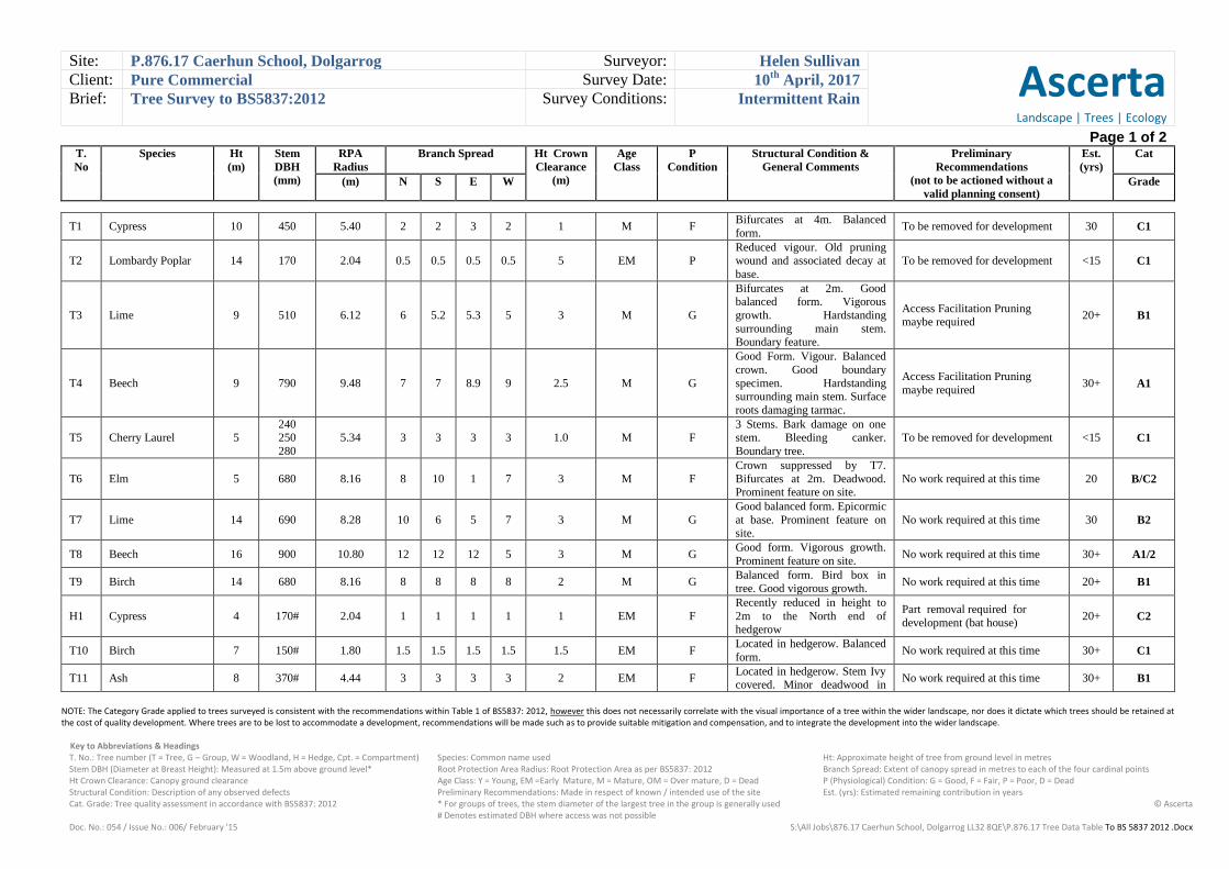
Site: P.876.17 Caerhun School, Dolgarrog Surveyor: Helen Sullivan
Ascerta Landscape | Trees | Ecology
Client: Pure Commercial Survey Date: 10th
April, 2017
Brief: Tree Survey to BS5837:2012 Survey Conditions: Intermittent Rain
Page 1 of 2
T.
No
Species Ht
(m)
Stem
DBH
(mm)
RPA
Radius
Branch Spread Ht Crown
Clearance
(m)
Age
Class
P
Condition
Structural Condition &
General Comments
Preliminary
Recommendations
(not to be actioned without a
valid planning consent)
Est.
(yrs)
Cat
(m) N S E W Grade
NOTE: The Category Grade applied to trees surveyed is consistent with the recommendations within Table 1 of BS5837: 2012, however this does not necessarily correlate with the visual importance of a tree within the wider landscape, nor does it dictate which trees should be retained at the cost of quality development. Where trees are to be lost to accommodate a development, recommendations will be made such as to provide suitable mitigation and compensation, and to integrate the development into the wider landscape.
Key to Abbreviations & Headings T. No.: Tree number (T = Tree, G – Group, W = Woodland, H = Hedge, Cpt. = Compartment) Species: Common name used Ht: Approximate height of tree from ground level in metres Stem DBH (Diameter at Breast Height): Measured at 1.5m above ground level* Root Protection Area Radius: Root Protection Area as per BS5837: 2012 Branch Spread: Extent of canopy spread in metres to each of the four cardinal points Ht Crown Clearance: Canopy ground clearance Age Class: Y = Young, EM =Early Mature, M = Mature, OM = Over mature, D = Dead P (Physiological) Condition: G = Good, F = Fair, P = Poor, D = Dead Structural Condition: Description of any observed defects Preliminary Recommendations: Made in respect of known / intended use of the site Est. (yrs): Estimated remaining contribution in years Cat. Grade: Tree quality assessment in accordance with BS5837: 2012 * For groups of trees, the stem diameter of the largest tree in the group is generally used
# Denotes estimated DBH where access was not possible © Ascerta
Doc. No.: 054 / Issue No.: 006/ February '15 S:\All Jobs\876.17 Caerhun School, Dolgarrog LL32 8QE\P.876.17 Tree Data Table To BS 5837 2012 .Docx
T1 Cypress 10 450 5.40 2 2 3 2 1 M F Bifurcates at 4m. Balanced
form. To be removed for development 30 C1
T2 Lombardy Poplar 14 170 2.04 0.5 0.5 0.5 0.5 5 EM P Reduced vigour. Old pruning wound and associated decay at
base.
To be removed for development <15 C1
T3 Lime 9 510 6.12 6 5.2 5.3 5 3 M G
Bifurcates at 2m. Good balanced form. Vigorous
growth. Hardstanding
surrounding main stem. Boundary feature.
Access Facilitation Pruning maybe required
20+ B1
T4 Beech 9 790 9.48 7 7 8.9 9 2.5 M G
Good Form. Vigour. Balanced
crown. Good boundary
specimen. Hardstanding surrounding main stem. Surface
roots damaging tarmac.
Access Facilitation Pruning
maybe required 30+ A1
T5 Cherry Laurel 5 240 250
280
5.34 3 3 3 3 1.0 M F 3 Stems. Bark damage on one stem. Bleeding canker.
Boundary tree.
To be removed for development <15 C1
T6 Elm 5 680 8.16 8 10 1 7 3 M F
Crown suppressed by T7.
Bifurcates at 2m. Deadwood. Prominent feature on site.
No work required at this time 20 B/C2
T7 Lime 14 690 8.28 10 6 5 7 3 M G
Good balanced form. Epicormic
at base. Prominent feature on site.
No work required at this time 30 B2
T8 Beech 16 900 10.80 12 12 12 5 3 M G Good form. Vigorous growth.
Prominent feature on site. No work required at this time 30+ A1/2
T9 Birch 14 680 8.16 8 8 8 8 2 M G Balanced form. Bird box in tree. Good vigorous growth.
No work required at this time 20+ B1
H1 Cypress 4 170# 2.04 1 1 1 1 1 EM F
Recently reduced in height to
2m to the North end of hedgerow
Part removal required for
development (bat house) 20+ C2
T10 Birch 7 150# 1.80 1.5 1.5 1.5 1.5 1.5 EM F Located in hedgerow. Balanced
form. No work required at this time 30+ C1
T11 Ash 8 370# 4.44 3 3 3 3 2 EM F Located in hedgerow. Stem Ivy covered. Minor deadwood in
No work required at this time 30+ B1

Site: P.876.17 Caerhun School, Dolgarrog Surveyor: Helen Sullivan
Ascerta Landscape | Trees | Ecology
Client: Pure Commercial Survey Date: 10th
April, 2017
Brief: Tree Survey to BS5837:2012 Survey Conditions: Intermittent Rain
Page 2 of 2
T.
No
Species Ht
(m)
Stem
DBH
(mm)
RPA
Radius
Branch Spread Ht Crown
Clearance
(m)
Age
Class
P
Condition
Structural Condition &
General Comments
Preliminary
Recommendations
(not to be actioned without a
valid planning consent)
Est.
(yrs)
Cat
(m) N S E W Grade
NOTE: The Category Grade applied to trees surveyed is consistent with the recommendations within Table 1 of BS5837: 2012, however this does not necessarily correlate with the visual importance of a tree within the wider landscape, nor does it dictate which trees should be retained at the cost of quality development. Where trees are to be lost to accommodate a development, recommendations will be made such as to provide suitable mitigation and compensation, and to integrate the development into the wider landscape.
Key to Abbreviations & Headings T. No.: Tree number (T = Tree, G – Group, W = Woodland, H = Hedge, Cpt. = Compartment) Species: Common name used Ht: Approximate height of tree from ground level in metres Stem DBH (Diameter at Breast Height): Measured at 1.5m above ground level* Root Protection Area Radius: Root Protection Area as per BS5837: 2012 Branch Spread: Extent of canopy spread in metres to each of the four cardinal points Ht Crown Clearance: Canopy ground clearance Age Class: Y = Young, EM =Early Mature, M = Mature, OM = Over mature, D = Dead P (Physiological) Condition: G = Good, F = Fair, P = Poor, D = Dead Structural Condition: Description of any observed defects Preliminary Recommendations: Made in respect of known / intended use of the site Est. (yrs): Estimated remaining contribution in years Cat. Grade: Tree quality assessment in accordance with BS5837: 2012 * For groups of trees, the stem diameter of the largest tree in the group is generally used
# Denotes estimated DBH where access was not possible © Ascerta
Doc. No.: 054 / Issue No.: 006/ February '15 S:\All Jobs\876.17 Caerhun School, Dolgarrog LL32 8QE\P.876.17 Tree Data Table To BS 5837 2012 .Docx
crown. Boundary tree.
T12 Eucalyptus 9 660# 7.92 3 3 3 3 0.5 M G Boundary.feature. Good.
Vigour. No work required at this time 20+ B1
G1 Elm, Maple, Ash
and Holly
11
8
100
270
1.20
3.24 3 3 3 3 2 M F
Poor specimens self seeded
Maple/Ash. Ivy covered stems.
Suppressed by larger trees.
No work required at this time 20+ C2
T13 Fir 15 440 5.28 3 3 3 3 2 M F Ivy covered stem. Birds nest in tree.
No work required at this time 20+ B/C2
T14 Fir 21 580 6.96 3 3 3 3 3 M F Ivy covered stem. Good form
and vigour. Bird box. No work required at this time 20+ B2
T15 Fir 21 620 7.44 3 3 3 3 3 M F Ivy covered stem. Good form and vigour. Bird box.
No work required at this time 20+ B2
T16 Willow 11 630 7.56 3 3 3 3 6 M P
Previously poorly pruned.
Associated regrowth at pruning
wounds. Large cavity at base (NW) side. Stem Ivy covered.
Phellinus bracket fungi found on floor.
Fell for Health and Safety >20 C2
T17 Poplar 11 660# 7.92 3 3 3 3 6 M P
Ivy covered stem. Large limb
recently failed. Previously
reduced, associated regrowth at pruning wounds
Fell for Health and Safety >20 C2
G2
Holly, Ash, Laurel,
Elm, Hawthorn and Oak
17 150
650#
1.80
7.80 5 5 5 5 2 EM/M F
Some mature trees in group
located off site.
Part removal required for
development 30+ B/C2
G3 Ash and Blackthorn 7 170
250
2.04
3.00 2 2 2 2 1 EM F
Poor specimens. Reduced
vigour. Off site. To be removed for development 30 C2
T18 Oak 12 690 8.28 4 4 4 4 2.5 M F Balanced crown form. Decreased vigour.
No work required at this time 20+ B1
T19 Lombardy Poplar 6 100# 1.20 0.5 0.5 0.5 0.5 2 EM D Dead. Standing. To be removed for development - U
Ascerta Landscape, Arboricultural & Ecological Solutions
for the Built Environment
S:\Technical References & Standard Report Inserts\Appendix 2 Ascerta.doc
Appendix 2

15.75
15.6915.74
13.03
14.13
14.19
13.81
14.11
15.52
15.65
15.75
16.59
17.38
17.27
17.15
17.44
17.75
18.19
18.41
18.56
18.98
19.39
19.68
20.29
20.01 19.86
14.47
14.68
14.76
15.00
15.18
15.79
16.06
16.41
16.77
17.09
17.42
17.82
18.17
18.57
IC CL = 12.32
IC CL = 12.05
IC CL = 11.74
IC CL = 13.15
IC CL = 13.55IC CL = 13.51
IC CL = 13.15
IC CL = 14.38
IC CL = 14.83
IC CL = 15.06
IC CL = 14.17
IC CL = 13.41IC CL = 13.07
IC CL = 15.75
IC CL = 15.83
IC CL = 15.80
IC CL = 15.54
IC CL = 15.49
IC CL = 15.90
IC CL = 16.02
IC CL = 15.99
IC CL = 15.97 IC CL = 15.97
IC CL = 14.31
IC CL = 17.36
IC CL = 19.19
TP
13.4613.10
12.7912.40
12.39
12.6012.77
12.89
13.50
13.98
14.28
14.53
14.5214.5414.65
14.8314.9815.07
15.0515.00
14.6214.33
13.7113.9014.22
14.89
15.11
15.24
15.62
15.73
15.8215.8215.84
16.1216.02
15.8715.8915.78
15.49
15.2315.3415.48
15.84
16.04
16.0216.02
15.97
15.98
16.03 16.03 16.00 16.00 15.98 15.93 16.00 16.02 16.02 15.99 15.94 15.98
16.07 14.22
19.62
19.33
19.19
18.61
18.60
FL = 13.47
FL = 12.93
FL = 16.21
FL = 16.19
FL = 16.24
13.99
13.55
12.92
12.62
12.35
11.8811.36
11.14
10.8810.68
10.349.809.8610.28
10.6510.9911.3511.7311.86
12.0912.2812.5012.73
12.9613.27
13.5213.6713.9114.46
14.58
14.79
14.94
15.09
15.32
15.47
16.03
16.93
17.14
17.15
17.39
16.84
17.2617.21
17.15
17.16
17.31
17.51
18.10
18.5218.5918.5418.4818.4018.48
18.4018.4218.37
16.35
19.58
19.56
19.73
19.97
20.26
20.63
20.90
20.98
20.95
20.81
20.65
20.44
20.19
18.75
18.37
18.18
14.47
14.71
14.81
15.12
15.22
15.77
16.09
16.46
16.87
17.22
17.54
17.84
18.16
18.58
18.97
19.41
19.89
14.72
15.28
15.79
12.3912.10
11.8311.57
11.3411.08
10.82
10.6210.9111.25
11.5511.79
12.8713.1613.4113.56
13.79
13.24
13.54
13.81
14.20
14.20
14.57
15.56
15.80
16.02
16.09
16.14
14.26
14.49
14.65
14.86
15.00
15.30
15.60
15.89
16.23
16.60
16.96
17.30
17.69
18.06
18.43
18.88
19.29
19.73
G
G
G
G
G
G
G
G
G
G
G G G G
G
G
G
GG G
G
G
GGG
G
G
G
G
G
G
G
G
G
G G
G
G G
G G
G G G G
11.36
11.91
12.0412.3112.5912.7613.0813.1313.3513.45
13.39
13.12 12.84 12.77
12.75
12.64
12.47 12.22 12.05
16.27 16.27 16.27 16.28 16.2716.28
17.63
17.66
17.93
17.92
15.98 15.96 15.94
Steps
Steps
StepsSteps
Steps
15.52
15.66
15.84
16.04
16.12
16.00
15.94
15.83
15.70
15.63
16.25
16.53 16.65
16.64
16.55 16.43 16.20
15.98
12.81 12.73
12.59
12.36 12.14 11.88
16.00
17.46
20.23
20.08
19.23
13.07
13.34
13.62
13.87
14.14
14.30
14.22
14.53
14.79
15.05
15.30 Steps
Steps
15.08 14.96 14.82
13.4213.47
13.36 13.30
16.96
18.54
19.06
19.67
20.16
18.70
16.13
16.14
16.39
16.39
16.66
16.67
16.94
16.92
16.84
17.20
17.12
17.12
17.24
16.82 16.67
16.76 16.7516.76
16.55 16.52 16.41 16.30 16.1515.9516.95 17.07 17.08 17.04 17.04 17.02 17.00 17.03
17.20 17.19 17.18 17.19 17.19 17.17 17.17 17.18
17.03
17.09
17.17
17.19
18.0618.1618.0017.94
17.9017.93
17.96
17.82
15.79
16.07
16.15
16.52
17.08
18.3818.5418.4718.30
18.24
18.2818.30
18.20
18.49
19.01
19.09
19.41
RS
WP
WP
WP
WP
WP
WP
16.04 15.91 15.70 14.7214.47
15.91 15.92 15.88
15.9616.05
15.36
15.84
16.30
16.93
17.45
17.81
14.37
14.55
14.94
15.12
15.38
15.66
15.94
16.36
16.69
17.06
17.41
17.79
18.17
18.56
18.92
19.37
19.87
14.18
14.36
14.53
14.71
14.91
15.16
15.44
15.72
16.11
16.41
16.87
17.22
17.58
17.99
18.35
18.70
19.16
19.58
20.53
20.02
Bin
MP
MP
RS
RS
SV
SV
SV
SV
SV
Building
Shed
Playhouse
Stables
Building
Playhouse
Conc.
Conc.
Conc.
Line of Evergreens
Line of Evergreens
Tarm
ac F
ootpa
th
Tarm
ac F
ootpa
th
Conc.
RocksB510
6
P/W
H=1
mP/
W H
=1m
NRG1
NRG2
NRG3NRG4
NRG5
NRG6
NRG7
C/L H
=1.3m
Gas T
ank
Grass
Grass
Grass
Grass
Conc.
Conc. ChannelConc. Channel
Grass
P/Mesh H=1.7m Grass
P/Mesh H=1.5m
P/Mesh H=1.7m
Grass
C/L H=1.5m
Grass
Grass
Grass
Playg
round
Equ
ipmen
t
C/L H=1.5m
Playg
round
Equip
ment
Grass
C/L H=1.5m
Tarmac
Tarmac
Tarmac
TarmacTarmac
Tarmac
Tarmac
Tarmac
Tarmac
Tarmac
Tarmac
Tarmac
Tarmac
Tarmac
Tarmac
Tarmac
Tarmac
Conc. Drainage Channel
Conc. Ramp
Conc. Ramp
ACO Drain
Salt B
in
Planter
Planter
Conc.
Conc. Ramp
Table
Table
I/R H
=0.8m
Rend
ered
Wall
P/Me
sh H
=1.5m
Tarm
ac F
ootpa
th
Tarm
ac F
ootpa
th
P/W
H=1
m
P/W
H=1
m
Tarm
ac F
ootpa
th
Tarm
ac F
ootpa
th
Tarmac
Tarmac
Bushes
I/R H
=0.8m
Bin Storage
Rendered Ret. Wall
GrassGrass
Brick Ret. Wall
Tarmac Gas
Grass
TarmacGrass
Conc.
Conc.
Rendered Ret. Wall
Brick Ret. Wall
Grass
Conc. Drainage ChannelConc. Drainage Channel
Conc. Drainage ChannelI/R H=1.4m
I/R H=1.2m
Steps
Grass
Rendered Ret. Wall
Conc.
P/Mesh H=1.5m
C/L H=3m
C/L H=3m
P/Mesh H=1.5m
P/Mesh H=1.5m
StumpSapling
Sapling
Sapling
Sapling
Bushes
Bushes
Bushes
BushesBushes
Bushes
Bushes
Rocks
Rocks
Rocks
Grass
Grass
Grass Grass
Grass
Grass
Grass
Grass
Grass
Hardcore
P/Me
sh H
=2m
Gas Tank
Grass
Grass
I/R H
=0.8m
Rend
ered
Wall
Tarm
ac F
ootpa
th
Tarm
ac F
ootpa
th
P/W
H=1
m
P/Mesh H=1.5m
Grass
Hedg
e H=1
.6m
P/W
H=1
m
P/R
H=1.1
m Tarm
ac F
ootpa
th
Tarm
ac F
ootpa
th
P/R H=1.1m
P/R H=1.1m
P/R H=1.1m
Grass
Grass
Grass
Grass
Grass
Grass
Grass
Grass
Grass
P/W H=1m
B510
6
I/R H=0.9m
Rendered Wall
Rendered WallRendered Wall
I/R H=1.1m
RL = 22.91RL = 22.90 RL = 22.91
RL = 22.94
RL = 25.42RL = 23.28
RL = 17.32
RL = 17.35
RL = 22.64
RL = 22.21RL = 22.24
RL = 23.33
T1
T2
T3
T4
T5
T6
T7 T8
T9
T10
T11
T12
T16
T15
T14
T13
T17
T18
T19
G3
G2
G2
Cypress
hedge
12m Elm
#450Ø
15m Ash
#650Ø
Cypress
hedge
Maintained
Hawthorn
hedge 1.5m
2m Holly
Shrubs - Laurel 1.5m
and small Cypress
17m Ash
#660Ø
14m Oak
#370Ø
12m Oak
#690Ø
in decline
3m Hawthorn
#170Ø
Ash
#450Ø
Located outside of site
boundary. Remove as part
of development.
Fell under Arboriculturist advice
due to age and condition.
REV
DESCRIPTIONDATE
CLIENT:
PROJECT:
DRAWING TITLE:
DRAWING No: REV:
Pure Commercial
Caerhun School, Dolgarrog, LL32 8QE
P.876.17.01 A
Tree Survey
ALL COORDINATES RELATED TO LOCAL GRID
LOCATED TO OS NG BY BEST FIT TO DETAIL,
EXTRACTED FROM OS DIGITAL DATA.
DO NOT SCALE
DRAWN BY:SCALE:
CP1:500 @A3
CHKD BY:
HS
DATE:
10/04/2017
Mere One, Mere Grange
Elton Head Road, St Helens
Merseyside WA9 5GG
t: 0845 463 4404 f: 0845 463 4405
Web: www.landscapetreesecology.com
Ascerta
Landscape | Trees | Ecology
KEY
Existing tree to be retained
Existing tree to be removed
A General updates21/04/17

New footpath and boundary
wall to be constructed so not
to cause damage to tree
roots.
Existing hard surface to be
removed carefully. Care
should be taken not to
damage / disturb tree roots.
Area where proposed built
structure is located
immediately adjacent RPA.
New hardstanding to be
constructed not to cause
damage to tree roots.
Area where gabion wall to be
installed within RPA. Excavation to
be subject to agreed methodology
and appropriate supervision.
T3
T4
T6
T7 T8
T9
T10
T11
T12
T15
T14
T13
T18
G2
G2
Cypress
hedge H1
12m Elm
#450Ø
15m Ash
#650Ø
Cypress
hedge
Maintained
Hawthorn
hedge 1.5m
2m Holly
Shrubs - Laurel 1.5m
and small Cypress
17m Ash
#660Ø
14m Oak
#370Ø
12m Oak
#690Ø
in decline
3m Hawthorn
#170Ø
Tree pruning maybe required
to raise canopies. Tree
owners consent needed as
trees located out of site
boundary
REV
DESCRIPTIONDATE
CLIENT:
PROJECT:
DRAWING TITLE:
DRAWING No: REV:
Pure Commercial
Caerhun School, Dolgarrog, LL32 8QE
P.876.17.02 A
Tree Constraints & Draft Protection Drawing
ALL COORDINATES RELATED TO LOCAL GRID
LOCATED TO OS NG BY BEST FIT TO DETAIL,
EXTRACTED FROM OS DIGITAL DATA.
DO NOT SCALE
DRAWN BY:SCALE:
CP1:500 @A3
CHKD BY:
HS
DATE:
10/04/2017
Mere One, Mere Grange
Elton Head Road, St Helens
Merseyside WA9 5GG
t: 0845 463 4404 f: 0845 463 4405
Web: www.landscapetreesecology.com
Ascerta
Landscape | Trees | Ecology
KEY
Existing tree to be retained
Extent of Root Protection Area for
retained trees in accordance with
BS5837: 2012 Trees in relation to
design, demolition and
construction - Recommendations
Proposed location of protective
fencing - see inset for type /
construction detail
A
A
A
A
a) Stabilizer strut with base plate secured with ground pins
b) Stabilizer strut mounted on block tray
BS5837:2012
Figure 3 Examples of above-ground stabilizing systems
Root protection methodology to
be agreed in these areas.
Geotextiles/ porour surfacing to be
agreed / implemented
A General updates21/04/17