arab walled cities: historic cairo, damascus, …sss8.cl/8002.pdf · robert kronenburg
TRANSCRIPT

PAPER REF # 8002 Proceedings: Eighth International Space Syntax Symposium Edited by M. Greene, J. Reyes and A. Castro. Santiago de Chile: PUC, 2012.
8002: 1
ARAB WALLED CITIES: investigating peripheral patterns in historic Cairo, Damascus, Alexandria, and Tripoli
AUTHOR: Nabil MOHAREB Faculty of Architectural Engineering, Beirut Arab University, Lebanon e‐mail: [email protected] Robert KRONENBURG School of Architecture, University of Liverpool, United Kingdom KEYWORDS: Peripheral Patterns, Urban Edges, Walled Cities, Spatial Configuration
THEME: Urban Structure and Spatial Distribution
Abstract
Peripheral edge patterns in liveable historic walled cities of Arab Mediterranean countries are the focus of
this comparative analysis. Four cities are selected Cairo (Egypt), Damascus (Syria), Alexandria (Egypt), and
Tripoli (Lebanon). Cairo and Damascus because they are major capitals located away from the
Mediterranean Sea, and their walls still exist in relatively good condition; Alexandria and Tripoli because they
are port cities in which the walls have been demolished with few traces remaining. The four cities have a
common historical and cultural background; however, they have various spatial configurations on their
peripheries and urban growth patterns outside their walls.
The aim of this paper is to analyse the urban edges of historic walled Arab cities. This comparative analysis
will highlight whether a repetitive pattern of spatial configurations, accompanied with land use activities,
exists in these locations, and to what extent. Understanding such patterns will enhance future development
plans inside the historic walls of Arab cities. In addition, it will assist in developing appropriate interrelations
between the historic urban fabric and the adjacent urban development.
An analytical framework is proposed to compare the different case studies based on their spatial
configuration. The spatial configuration patterns and land‐uses activities are analysed using GIS (Geographic
Information Analysis) and space syntax. The analysis traces the four cities through the twentieth century up
to the present day, highlighting the transformation of their peripheral edges’ and their relationship with
successive urban growth outside the historic city wall.
Proceedings: Eighth International Space Syntax Symposium. Santiago de Chile: PUC, 2012.
8002:2
1. INTRODUCTION
Historic walled cities represent multiple layers of history; their identity does not belong to defined past
periods (Creighton, 2007). The walls had functioned as a protection for the inside inhabitant from outsiders,
identified the city’s boundary, and in some cases defined powerful families’ or rulers' territory (Bennison &
Gascoigne, 2007). However, their defensive function was withering through time owing to the successive
urban growth outside the city’s wall and less dependence on walls as a defensive method. Currently, the
wall’s traces, the former path, and the spaces surrounding them form an ‘urban edge’ between the walled
city’s old fabric and the surrounding urban context. The historic urban edges have ‘witnessed’ chronological
events through history that are embedded in their form. The embedded quality affects daily movements and
their associated activities on both sides of the wall’s spatial patterns. Therefore, defining the ‘urban edge’ is
crucial to understanding its effect on the historic city. ‘Urban Edge’ represents a boundary between two
kinds of areas (Lynch, 1960). It is not a definite line based on walls’ fences and gates, the edge of a walled
city becoming a zone that comprises gates, areas of social and commercial activity, and architectural
character rather than a line (Bosselmann, 2008). Thus, ‘Urban edge’ is used as a term to analyse the
peripheral patterns between historic fabric and the surrounding context that extended beyond the edge of
the historic wall. Urban edges have causes and effects on the historic core, which can affect conventional
development plans inside the walled city.
This paper aims to analyse the spatial configuration of urban edges on both sides of the wall in Arab cities. It
extends the scope of analysis beyond the conventional concern that focuses on either the walled city as one
unit, or viewing the wall as an archaeological artefact. The analysis tackles the wall’s path and urban context
transformation of four cities through the twentieth century up to the present day. Most of these cities had
witnessed major transformations in their urban patterns under European domination from the end of the
19th century to the mid of the 20th century. In analysing urban edges, the research introduces two
premises: first, the urban edge of the former wall forms an ‘amenable barrier’ between the historic core and
the adjacent fabric. They affect the liveability conditions inside the walled cities considering accessibility,
and connecting activities that link between the historic city and the surrounding context. Second, there are
apparent patterns of cause and effect of both spatial configurations and related activities along the former
wall’s path forming that barrier. The more accessible and connected parts with the adjacent urban fabric,
the better existing living conditions, while the less accessible ones are attracting squatters or poorer living
conditions on their edges.
In the next sections, the paper proposes an analytical framework to analyse the case studies, followed by
highlighting the historical background of the four cities, their urban growth patterns, wall conditions, and
common historical background. The paper conducts spatial comparative analyses using space syntax analysis
and GIS (Geographic Information System) methods and techniques. Finally, results and conclusions are
introduced to understand the peripheral patters in Arab walled cities.
2. PROPOSED FRAMEWORK
The research methodology comprises two stages. First, establish a preliminary classification to categorise
each selected case study. The proposed classification acts as a comparative analysis between different
eras/cases to understand the wall’s existing condition, type, location, spatial configuration of urban patterns
surrounding the wall and their interactions, see Table (1). Second, propose an analytical framework to
compare the different case studies based on their spatial configuration, architectural features, and land‐uses

Proceedings: Eighth International Space Syntax Symposium. Santiago de Chile: PUC, 2012.
8002:3
activities on both sides of the wall. The spatial configuration analysis concerns accessibility and spatial
patterns that form the main base to compare the case studies without restrictions on sizes, distances, and
types of the spatial configuration, see Table (2). Space syntax embedded within GIS measures the
connectivity of spatial configuration that exists on the wall’s path while using field observation assists in
identifying both the architectural features and the land‐use activities along the former wall path. The three
methods highlight two main points: whether there are patterns of spatial configuration at the urban edge of
the walled cities, which give the ability to forecast similar effects with other case studies; and to
comprehend the interrelation between urban edges and the surrounding context in order to assign
appropriate developing plans for the historical core. Analysing the four case studies based on the previous
preliminary classification and the analytical framework responds to the research second premises whether
there is a systematic pattern of spatial configuration at urban edges in diverse cases or not. Moreover, it
highlights the type of barriers that urban edges form between the historic core and the surrounding context.
Finally, a conclusion and set of recommendations will introduce methods of dealing with the urban edges of
walled cities.
The case studies selection reflects various existing wall conditions, locations, and spatial configuration types
that surround the historic wall. The selected Arab cities are within three Mediterranean countries.
Alexandria (Egypt) and Tripoli (Lebanon) are port‐cities while Cairo (Egypt) and Damascus (Syria) represent
main capitals and far from the sea. The four cities share political, cultural, and architectural similarities;
however, their walls’ condition and surrounding urban fabric have a wide variety that strengthens the
comparative analysis with diverse conditions, see Table (1).
Table (1), preliminary classification to categorise each selected case study. (Author)
Description Cairo Damascus Alexandria Tripoli (Lebanon)
Date of
Foundation
‐ 640 AD (Al Fustat City)
‐ 750 AD (Al Askar)
‐ 870 AD (Al Qata’i)
‐ 969 AD (Fatimid Cairo)
‐ Origin dated back prior to
1200 BC, Aramean nomads
‐ In 64 BC became major
cities in Roman Empire, the
city gained its walls and iron‐
grid spatial configuration
‐ Origin dated back to the
Pharaonic era
‐ 332‐331 BC (Foundation)
‐ 1805 – 1849 AD the city
gained its current
European Grid‐iron
pattern
‐ Origin dated back to early
Christian times
‐ 1289 Mamluk Sultan Al‐
Mansur Qalawun abandoning
the old city known as Al‐Mina
and built a new city, which is
the origin of the present town.
Size of Walled
city
Area per m2
Approximate
4003600 m2
Approximate
1277100 m2
Approximate
3831107 m2
Approximate
859360 m2 (Old Tripoli)
451179 m2 (El Mina)
Existing
condition of the
wall
Exists on the north and
partially on the east side of
the old city
Almost completed, except on
the western part and parts of
the southern wall
Does not exists except
three archaeological
traces
Does not exists anymore at El‐
Mina part, while old Tripoli did
not had defensive wall except
for the citadel of Saint‐Gilles
Type of urban
fabric inside
walled city
Organic pattern‐ high
number of dead‐end
streets
Based on a grid‐iron old
configuration. Current
pattern is partially organic
pattern
Orthogonal pattern The old fabric is Organic
pattern
Level of
integration with
surrounding
context
Highly integrated with the
western side of the
historic Cairo
Highly integrated with the
western side of the historic
Damascus
Less integrated with the
south part of the formal
wall’s path
Old Tripoli is highly integrated
with the western side of the
city
Proceedings: Eighth International Space Syntax Symposium. Santiago de Chile: PUC, 2012.
8002:4
3. METHODOLOGY OF ANALYSIS
The paper suggests using space syntax as a tool to monitor the spatial configuration of urban edges and their
evolving patterns through time. The space syntax theory was originated in the 1970s by Bill Hillier and
colleagues at the Bartlett School of Architecture UCL, UK. The theory attempts to understand why, from a
spatial point of view, the built environment takes its shape and in relation to corresponding socio‐cultural
activities (Hillier & Hanson, 1997). Although the society creates the spatial system that is used; it is affected
and influenced by the spaces it inhabits (Dalton & Holscher, 2006). Hillier argues that the urban grid is a
record of a historical process of evolution rather than a static spatial framework holding human activities
(Hillier, Turner, Yang, & Park, 2007). Therefore, the relationship between the spatial and the social
interaction is a two way process. As a result, a fundamental link between the structures and functions of
cities is related, as the configuration of the network is the primary shaper of the pattern of movement.
Space syntax measures integration in reference to accessibility. It describes the average depth of a space to
all other spaces in the systems, which indicates the preferable potential places to move to as a movement
destination ‘to‐movement' (Hillier et al., 2007). The space of the system can be ranked graphically from the
most integrated (red axial lines‐ or dark thick lines in greyscale ranking) to the most segregated one (Blue
axial lines‐ or grey thin lines) (Hillier & Iida, 2005), for an example, see Figures (1), (2), (3) and (5). Another
measurement, Choice analysis indicates the degree of choice that each space represents, or how likely it is
to be passed through on all shortest routes from a space to all the other spaces in the system (Hillier &
Hanson, 1997). This is the potential of ‘through‐movement' (Hillier & Iida, 2005). The paper also employs
‘intelligibility’ analysis, which is defined as the correlation between connectivity and global integration and it
is an important indicator for how clear an urban system is for its users. (Hillier, 1997). The paper uses the
segment’s length as a weighted factor for each segment for both integration and choice analysis to override
the segments’ length effect on the analysis.
To understand various potential movements, Turner suggests using metric radius in the graph analysis
within the boundary of the modelled area (Turner, 2007). These metric radii give the ability to analyse
different scales of urban spaces from micro to macro scale within the same model or across different case
studies. It gives a flexible analysis without the restrictions of urban fabric type, size, or location. The lower
metric values (radii) are suitable for pedestrian movement analysis while higher values suit vehicle
movement analysis. In this paper, radius 500m is used to analyse pedestrian movement within walkable
distance along and between the spatial fabrics on the urban edge of the walled city.
Using space syntax in monitoring the spatial configuration evolution of the historic city/ walled city was used
previously, for example (Karimi, 1997), (Kubat, 1997), (Mohareb, 2008) and others examine the entire
historic city’ core or compare it with other cities. In this paper, however, it is used to analyse the urban
edges of historic walled cities, which represents a new analysing focus for both space syntax applications
and historic walled cities.
3.2 Spatial Analysis
There are two stages of analysis. First, the paper monitors the spatial transformation of selected cases
through two eras: the current situation and the beginning of the twentieth century. The selected earlier eras
were Cairo in 1933, Damascus in 1929, Alexandria in 1927, and Tripoli in 1945. It was difficult to find a
unified dated map for all cases, however the dates are simultaneously related and represent the era prior to
Proceedings: Eighth International Space Syntax Symposium. Santiago de Chile: PUC, 2012.
8002:5
the cities’ independence. Choice segment length weighted analysis is selected to monitor the ‘though‐
movement’ transformation resulting from the use of specified routes (urban edges) over a period of time,
see figure (1), (3), (5), and (7). This transformation analysis highlights the relationship between the historic
core and the surrounding context to understand whether the urban edges are constant or changeable
through time. The second stage suggests five analytical points as a comparative analysis between the four
cities to analyse the urban edges of walled cities, they are as follows: Mean global integration (Rn), mean
global choice (Rn), mean choice of radius 500m, mean integration of radius 500m, and intelligibility (r2
coefficient) analysis, see Table (2). Each point of the comparative analysis is examined on five main
destinations:
The historic city/walled city and its relation to the surrounding context
Inside the historic city/walled city
Examining the interrelation between the outside edge of the walled city and the wall former path
using a buffer zone of 400m (walkable distance from the wall to the adjacent fabric)
Examining the interrelation between the inside edge of the walled city using buffer zone of 400m
(walkable distance from the wall toward the inside fabric)
Cross relationship between outside and inside fabric on both sides of the wall with a buffer zone of
200m on each side (total 400m as a walkable distance)
This stage of analysis is crucial to interpret the peripheral conditions and monitor patterns of spatial
configuration along the urban edges in the selected case studies. In the next parts, each city is analysed
according to the previous research framework followed by a comparative spatial analysis of urban edges of
the four cities see Table (2).
4. CASE STUDIES ANALYSIS: SPATIAL TRANSFORMATION
4.1 Cairo
Historic Cairo was originally a Byzantine settlement with a defence fort: the ‘Babylon Fort’. After the Arab
conquest, four successive settlements were constructed and combined together to form what is called
‘historic Cairo’. The four settlements are: Al Fustat which was founded in (640 AD), Al Askar (750 AD), Al
Qata’i (870 AD) and Fatimid Cairo (Al‐Qahira) which was founded in 969 AD constructed by Djawhar. The
Mamluks era (1250 to 1517 AD) was an important period of construction and urbanisation of Cairo city. It is
worth mentioning that this era also affected Tripoli and Damascus’ historic cities: both cities were under the
rule of the Mamluks for a period. The current extensive fortification wall was built by Salah al‐Din to encircle
the two cities of Al Fustat an Al Qahira. In the north, Al‐Qahira expanded over its boundaries to the other
side of Bab Al‐Futuh and the northern wall; the extension continued from Bab Al‐Shairiyya towards Bab Al‐
Bahar and connected them to Bulaq. In the west, the expansion of the town was also considered as large
parts of the Khalij side were built upon. On the other hand, the south parts started from Bab Al‐Kharg
towards Bab Al‐Luq were terminated in the same port (Bulaq). Commerce gained great importance and a
large number of Wekalas, caravanserais and Khans has been established. The political power was
transformed around the Qasaba, the principal axis inside the Fatimid town, see Figure (2 right), where the
economic and cultural activities were concentrated. The main commercial and religious activities took place
Proceedings: Eighth International Space Syntax Symposium. Santiago de Chile: PUC, 2012.
8002:6
around the theological university of Al‐Azhar that was not far from the complex that Sultan Al‐Ghuri had
built in 1509 AD (Ibrahim, 1998a). During the Ottoman era (1517 to 1798 AD), there was a slight change in
Cairo. In the west, the town expanded across Khalij and spread towards the Nile. The southern districts had
expanded, spread along the two urban axes in the eighteen century. The first expansion was on the east,
started from Bab Zuwaylah, rejoined the citadel by passing Al‐ Darb Al‐Ahmar and Tabbana, while the
second expansion was along the principal axis of the town from Bab Zuwaylah to the old town of Ibn Tulun,
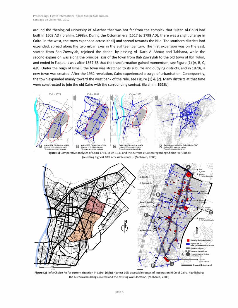
and ended in Fustat. It was after 1867‐68 that the transformation gained momentum, see Figure (1) (A, B, C,
&D). Under the reign of Ismail, the town was stretched to its suburbs and outlying districts, and in 1870s, a
new town was created. After the 1952 revolution, Cairo experienced a surge of urbanisation. Consequently,
the town expanded mainly toward the west bank of the Nile, see Figure (1) & (2). Many districts at that time
were constructed to join the old Cairo with the surrounding context, (Ibrahim, 1998b).
Figure (1) Comparative analyses of Cairo 1744, 1809, 1933 and the current situation regarding Choice Rn (Global)
(selecting highest 10% accessible routes) (Mohareb, 2008)
Figure (2) (left) Choice Rn for current situation in Cairo, (right) Highest 10% accessible routes of Integration R500 of Cairo, highlighting
the historical buildings (in red) and the existing walls location. (Mohareb, 2008)
Proceedings: Eighth International Space Syntax Symposium. Santiago de Chile: PUC, 2012.
8002:7
A number of restrictions governed the city’s spatial expansions through time see Figure (1). The northern
part is less connected although there are two main gates on that wall. On the eastern part, the walled city is
completely segregated due to the existing of Al Azhar park and a huge cemetery (in literature it is called the
‘dead city’), in addition to Al Mouqatum Hill which forced the city to expand mainly toward the river Nile,
see Figure (2). El Muiz Street is the main accessible street inside historic Cairo and it connects the walled city
directly through the northern gates and by a number of horizontal routes with the surrounding urban
patterns. The western edge of the walled city is highly accessible and connects the surrounding context to
the historic city through a number of accessible routes such as Gohar El Qaid Street and Mohamed Ali
Street. Although there are no walls or gates along the western side, it represents both a defined spatial edge
(Port Said Street) and a main activity connecter between the surrounding context and the historic city
through a number of access points resembling gating points. These access points lead to either main
religious buildings (mosques) or Khans (traditional markets) for example, Khan EL Khalili.
4.2 Damascus
Damascus is an ancient city and currently is the capital of the Syrian Republic. The city gained its first
westward orientation after the conquest of Alexander the Great in 333 B.C, as a Greek city grew up there
alongside the Aramean one that existed before. A rectangular wall system was constructed with seven gates
to provide protection against marauding nomads. The city’s urban configuration changed rapidly after the
Arab conquest of the city. In the Umayyad’s periods, two new Muslim cemeteries were constructed in
addition to that of Bab al‐Faradis: the first was situated at Bab Tuma and the south of the city outside Bab al‐
Saghir. During the Abbassid period, Sultan Ahmed Bin Tulun was appointed governor of Egypt and occupied
Damascus in 878 AD. Under the Turkish domination, the plan of the city had changed slightly since Roman
times. It became broken up into several compartments starting from the 10th century. Each quarter had its
walls and gates and all the essential urban constituents. Under the Nur El Din rule in 1154 AD, the
surrounding city walls were strengthened, and new towers were built. A sector of the northern part of the
city wall was carried forward as far as the right bank of the Barada, and the new gate of Bab al‐Faraj was
opened to the east of the citadel, while Bab Kaysan to the south was blocked up (Bosworth, 2007). For
centuries, the walled city did not change much in its spatial configuration; however, new settlements were
constructed outside the wall towards the west, north and the southern parts of the defensive wall. It is
worth mentioning that Egypt and Damascus were once united in recent history for a very short period in the
mid of the twentieth century; however, it lasted for only three years (1958–1961).
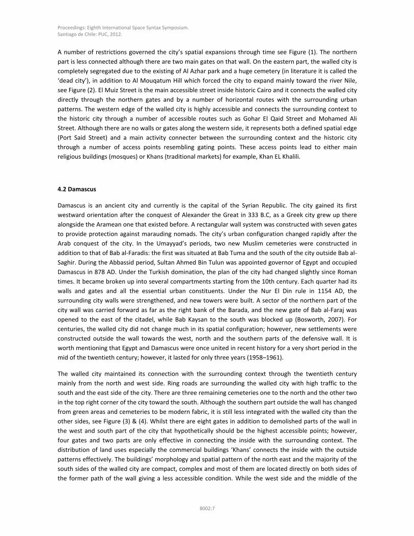
The walled city maintained its connection with the surrounding context through the twentieth century
mainly from the north and west side. Ring roads are surrounding the walled city with high traffic to the
south and the east side of the city. There are three remaining cemeteries one to the north and the other two
in the top right corner of the city toward the south. Although the southern part outside the wall has changed
from green areas and cemeteries to be modern fabric, it is still less integrated with the walled city than the
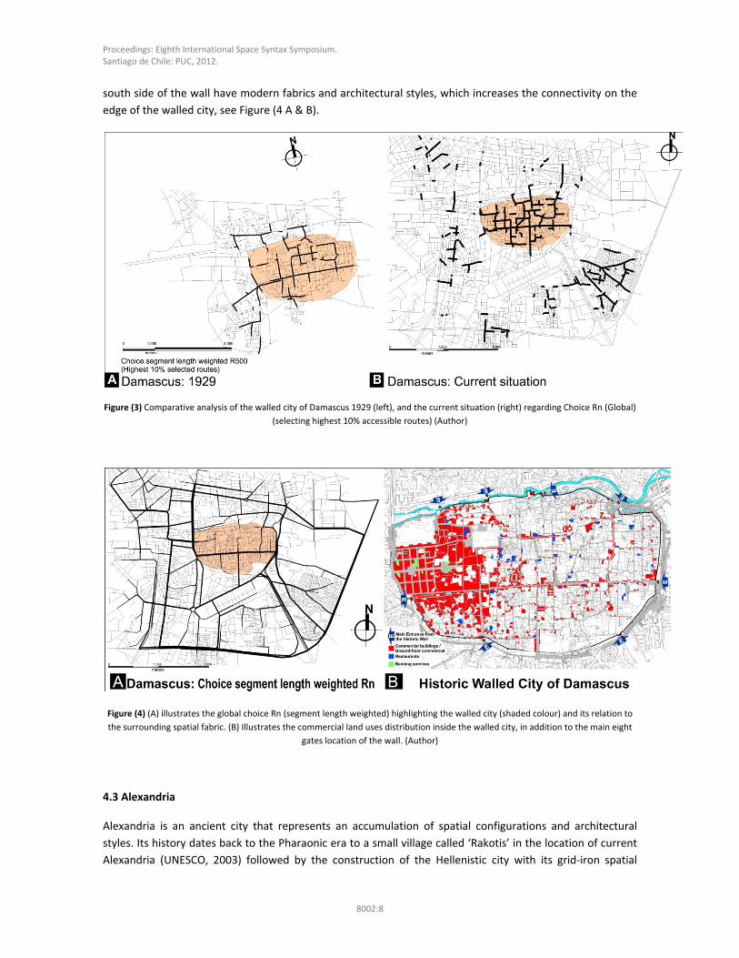
other sides, see Figure (3) & (4). Whilst there are eight gates in addition to demolished parts of the wall in
the west and south part of the city that hypothetically should be the highest accessible points; however,
four gates and two parts are only effective in connecting the inside with the surrounding context. The
distribution of land uses especially the commercial buildings ‘Khans’ connects the inside with the outside
patterns effectively. The buildings’ morphology and spatial pattern of the north east and the majority of the
south sides of the walled city are compact, complex and most of them are located directly on both sides of
the former path of the wall giving a less accessible condition. While the west side and the middle of the
Proceedings: Eighth International Space Syntax Symposium. Santiago de Chile: PUC, 2012.
8002:8
south side of the wall have modern fabrics and architectural styles, which increases the connectivity on the
edge of the walled city, see Figure (4 A & B).
Figure (3) Comparative analysis of the walled city of Damascus 1929 (left), and the current situation (right) regarding Choice Rn (Global)
(selecting highest 10% accessible routes) (Author)
Figure (4) (A) illustrates the global choice Rn (segment length weighted) highlighting the walled city (shaded colour) and its relation to
the surrounding spatial fabric. (B) Illustrates the commercial land uses distribution inside the walled city, in addition to the main eight
gates location of the wall. (Author)
4.3 Alexandria
Alexandria is an ancient city that represents an accumulation of spatial configurations and architectural
styles. Its history dates back to the Pharaonic era to a small village called ‘Rakotis’ in the location of current
Alexandria (UNESCO, 2003) followed by the construction of the Hellenistic city with its grid‐iron spatial
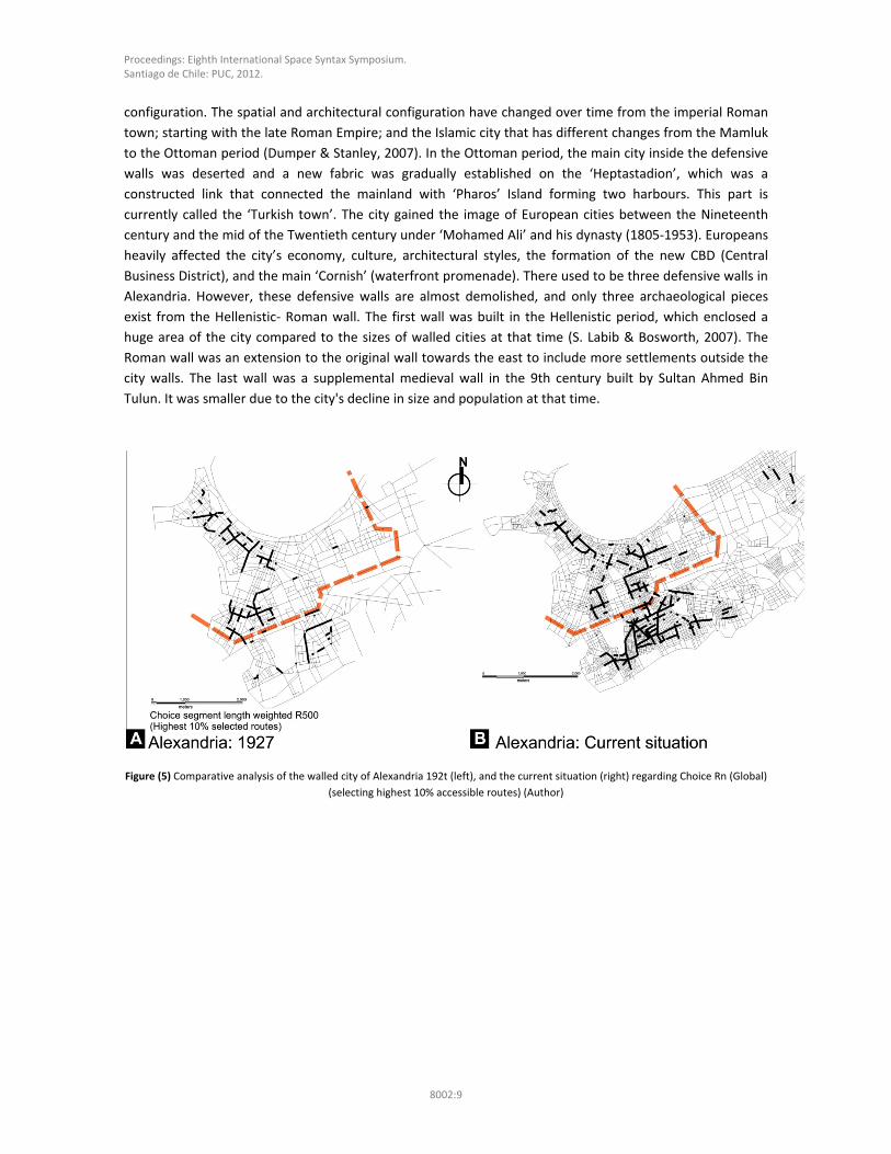
Proceedings: Eighth International Space Syntax Symposium. Santiago de Chile: PUC, 2012.
8002:9
configuration. The spatial and architectural configuration have changed over time from the imperial Roman
town; starting with the late Roman Empire; and the Islamic city that has different changes from the Mamluk
to the Ottoman period (Dumper & Stanley, 2007). In the Ottoman period, the main city inside the defensive
walls was deserted and a new fabric was gradually established on the ‘Heptastadion’, which was a
constructed link that connected the mainland with ‘Pharos’ Island forming two harbours. This part is
currently called the ‘Turkish town’. The city gained the image of European cities between the Nineteenth
century and the mid of the Twentieth century under ‘Mohamed Ali’ and his dynasty (1805‐1953). Europeans
heavily affected the city’s economy, culture, architectural styles, the formation of the new CBD (Central
Business District), and the main ‘Cornish’ (waterfront promenade). There used to be three defensive walls in
Alexandria. However, these defensive walls are almost demolished, and only three archaeological pieces
exist from the Hellenistic‐ Roman wall. The first wall was built in the Hellenistic period, which enclosed a
huge area of the city compared to the sizes of walled cities at that time (S. Labib & Bosworth, 2007). The
Roman wall was an extension to the original wall towards the east to include more settlements outside the
city walls. The last wall was a supplemental medieval wall in the 9th century built by Sultan Ahmed Bin
Tulun. It was smaller due to the city's decline in size and population at that time.
Figure (5) Comparative analysis of the walled city of Alexandria 192t (left), and the current situation (right) regarding Choice Rn (Global)
(selecting highest 10% accessible routes) (Author)

Proceedings: Eighth International Space Syntax Symposium. Santiago de Chile: PUC, 2012.
8002:10
Figure (6) (A) Choice Rn for current situation in Alexandria, (B) major land use distribution along the former path of Alexandria’s wall.
(Author)
In 1927, the wall was demolished leading to more urban growth from the northern part, towards the city
centre, to the southern fabric. While these urban growth were less in 1900, as the wall was partially
removed. Currently, the buffer zone of the former path attracts short trip movements more than the historic
city centre, although this situation was reversed in 1927. The reason is due to the urban growth of the city.
The main concentration was inside the city wall until 1927. Currently, the city expanded tremendously
outside the historic city centre. The southern part is more accessible at the level of pedestrian movement
and encourages the ‘to‐movement’ destinations that attract more activities. The buffer zone and the
northern spatial patterns attract longer trips (vehicle trips), see also Figure (6A). The southern part of the
former wall represents the main interactive zone; however, it is less connected to the surrounding fabric
due to the existence of the huge Muslim cemetery located outside the city’s wall and the presence of huge
blocks of industrial, administrative, and educational activities (re‐used buildings) on the northern part of the
former wall. These activities form an urban edge between the fabrics on both sides of the wall’s path. The
majority of pedestrian daily movements and activities are enclosed within the compact urban form of
residential blocks on both sides of the path. The railway station terminal (Misr Station) and the bus terminals
are attracting massive commercial and administrative activities that surround them, see Figure (6B). In
contrast, the existing tramline along the path of the formal wall does not cause the same effect of increasing
connectivity between the wall’s path and the urban fabric on either side. This is due to the high vehicle
movements along the path (daytime). These factors increase the segregation of spatial patterns between
both sides of the path. From the previous analysis, it is clear that two segregation levels are occurring at the
urban edge of the former historic wall. The first level is between both sides of the former path. The second
level is along the wall’s former path, see Figure (5B, 6B).
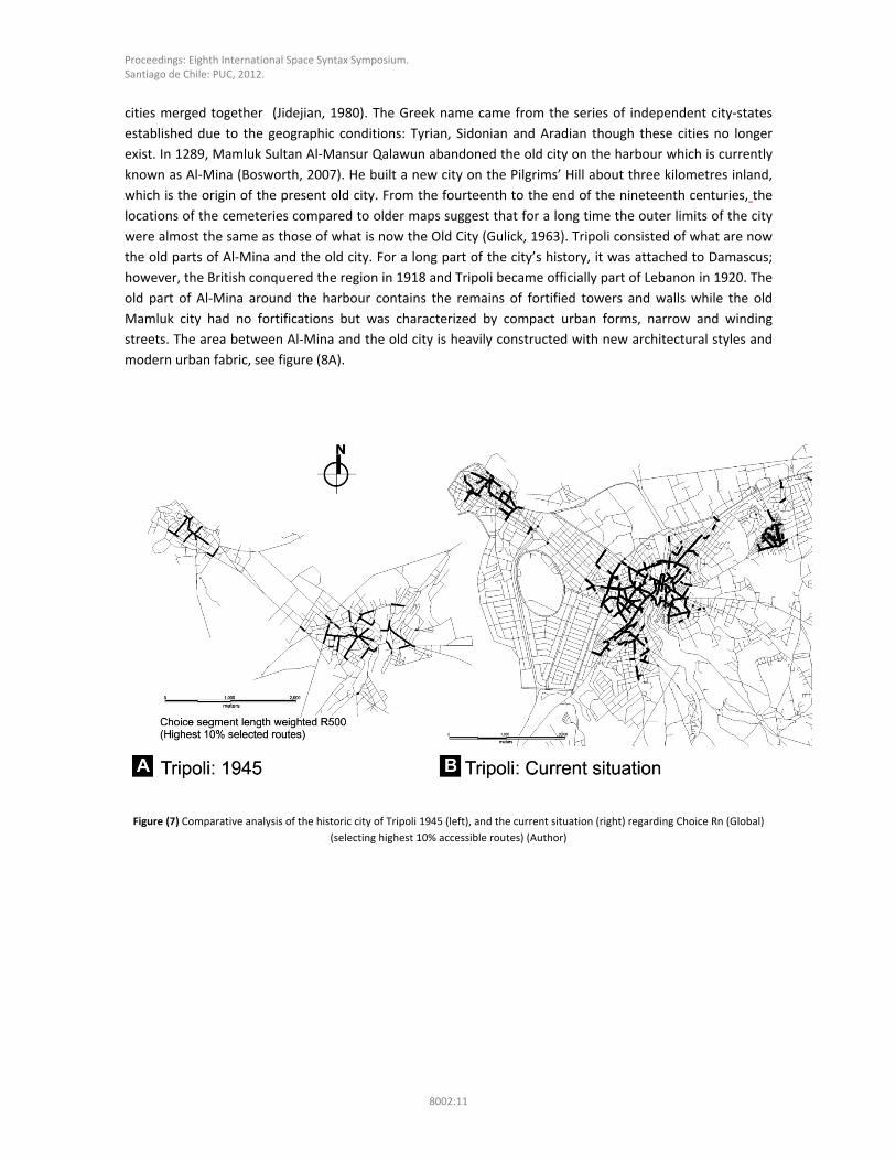
4.4 Tripoli
Tripoli (Lebanon) is not the only Arab city that has the name of Tripoli, as there is Tripoli in Lybia; however
this city is distinguished as ‘Tarabulus al‐Sham or Tripoli of the west’ (Bosworth, 2007). It is the second
largest city after Beirut located on the north coast of Lebanon. ‘Tripolis’ or the ‘Tri‐city’ were historical three
Proceedings: Eighth International Space Syntax Symposium. Santiago de Chile: PUC, 2012.
8002:11
cities merged together (Jidejian, 1980). The Greek name came from the series of independent city‐states
established due to the geographic conditions: Tyrian, Sidonian and Aradian though these cities no longer
exist. In 1289, Mamluk Sultan Al‐Mansur Qalawun abandoned the old city on the harbour which is currently
known as Al‐Mina (Bosworth, 2007). He built a new city on the Pilgrims’ Hill about three kilometres inland,
which is the origin of the present old city. From the fourteenth to the end of the nineteenth centuries, the
locations of the cemeteries compared to older maps suggest that for a long time the outer limits of the city
were almost the same as those of what is now the Old City (Gulick, 1963). Tripoli consisted of what are now
the old parts of Al‐Mina and the old city. For a long part of the city’s history, it was attached to Damascus;
however, the British conquered the region in 1918 and Tripoli became officially part of Lebanon in 1920. The
old part of Al‐Mina around the harbour contains the remains of fortified towers and walls while the old
Mamluk city had no fortifications but was characterized by compact urban forms, narrow and winding
streets. The area between Al‐Mina and the old city is heavily constructed with new architectural styles and
modern urban fabric, see figure (8A).
Figure (7) Comparative analysis of the historic city of Tripoli 1945 (left), and the current situation (right) regarding Choice Rn (Global)
(selecting highest 10% accessible routes) (Author)
Proceedings: Eighth International Space Syntax Symposium. Santiago de Chile: PUC, 2012.
8002:12
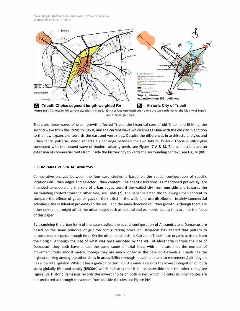
Figure (8) (A) Choice Rn for current situation in Tripoli, (B) major land use distribution along the two settlements: the Old city of Tripoli
and El Mina. (Author)
There are three waves of urban growth affected Tripoli: the historical core of old Tripoli and El Mina, the
second wave from the 1920s to 1960s, and the current wave which links El Mina with the old city in addition
to the new expansions towards the east and west sides. Despite the differences in architectural styles and
urban fabric patterns, which reflects a clear edge between the two fabrics; historic Tripoli is still highly
connected with the second wave of modern urban growth, see Figure (7 A & B). The connections are an
extension of commercial roots from inside the historic city towards the surrounding context, see Figure (8B).
5. COMPARATIVE SPATIAL ANALYSIS
Comparative analysis between the four case studies is based on the spatial configuration of specific
locations on urban edges and selected urban content. The specific locations, as mentioned previously, are
intended to understand the role of urban edges toward the walled city from one side and towards the
surrounding context from the other side, see Table (2). The paper selected the following urban content to
compare the effects of gates or gaps (if they exist) in the wall; land use distribution (mainly commercial
activities); the residential proximity to the wall; and the main direction of urban growth. Although there are
other points that might affect the urban edges such as cultural and economic issues; they are not the focus
of this paper.
By examining the urban form of the case studies, the spatial configuration of Alexandria and Damascus are
based on the same principle of gridiron configuration; however, Damascus has altered that pattern to
become more organic through time. On the other hand, historic Cairo and Tripoli have organic patterns from
their origin. Although the size of what was once enclosed by the wall of Alexandria is triple the size of
Damascus; they both have almost the same count of axial lines, which indicate that the number of
movement routs almost match, though they are much longer in the case of Alexandria. Tripoli has the
highest ranking among the other cities in accessibility (through‐movements and to‐movements) although it
has a low intelligibility. Whilst it has a gridiron pattern, old Alexandria records the lowest integration on both
sizes: globally (Rn) and locally (R500m) which indicates that it is less accessible than the other cities, see
Figure (9). Historic Damascus records the lowest choice on both scales, which indicates its inner routes are
not preferred as through‐movement from outside the city, see Figure (4A).
Proceedings: Eighth International Space Syntax Symposium. Santiago de Chile: PUC, 2012.
8002:13
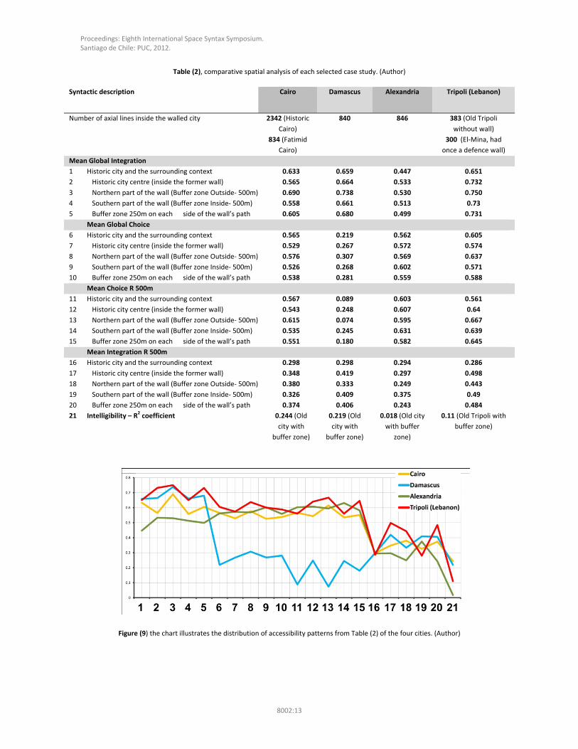
Table (2), comparative spatial analysis of each selected case study. (Author)
Syntactic description Cairo Damascus Alexandria Tripoli (Lebanon)
Number of axial lines inside the walled city 2342 (Historic
Cairo)
834 (Fatimid
Cairo)
840 846 383 (Old Tripoli
without wall)
300 (El‐Mina, had
once a defence wall)
Mean Global Integration
1 Historic city and the surrounding context 0.633 0.659 0.447 0.651
2 Historic city centre (inside the former wall) 0.565 0.664 0.533 0.732
3 Northern part of the wall (Buffer zone Outside‐ 500m) 0.690 0.738 0.530 0.750
4 Southern part of the wall (Buffer zone Inside‐ 500m) 0.558 0.661 0.513 0.73
5 Buffer zone 250m on each side of the wall’s path 0.605 0.680 0.499 0.731
Mean Global Choice
6 Historic city and the surrounding context 0.565 0.219 0.562 0.605
7 Historic city centre (inside the former wall) 0.529 0.267 0.572 0.574
8 Northern part of the wall (Buffer zone Outside‐ 500m) 0.576 0.307 0.569 0.637
9 Southern part of the wall (Buffer zone Inside‐ 500m) 0.526 0.268 0.602 0.571
10 Buffer zone 250m on each side of the wall’s path 0.538 0.281 0.559 0.588
Mean Choice R 500m
11 Historic city and the surrounding context 0.567 0.089 0.603 0.561
12 Historic city centre (inside the former wall) 0.543 0.248 0.607 0.64
13 Northern part of the wall (Buffer zone Outside‐ 500m) 0.615 0.074 0.595 0.667
14 Southern part of the wall (Buffer zone Inside‐ 500m) 0.535 0.245 0.631 0.639
15 Buffer zone 250m on each side of the wall’s path 0.551 0.180 0.582 0.645
Mean Integration R 500m
16 Historic city and the surrounding context 0.298 0.298 0.294 0.286
17 Historic city centre (inside the former wall) 0.348 0.419 0.297 0.498
18 Northern part of the wall (Buffer zone Outside‐ 500m) 0.380 0.333 0.249 0.443
19 Southern part of the wall (Buffer zone Inside‐ 500m) 0.326 0.409 0.375 0.49
20 Buffer zone 250m on each side of the wall’s path 0.374 0.406 0.243 0.484
21 Intelligibility – R2 coefficient 0.244 (Old
city with
buffer zone)
0.219 (Old
city with
buffer zone)
0.018 (Old city
with buffer
zone)
0.11 (Old Tripoli with
buffer zone)
Figure (9) the chart illustrates the distribution of accessibility patterns from Table (2) of the four cities. (Author)
Proceedings: Eighth International Space Syntax Symposium. Santiago de Chile: PUC, 2012.
8002:14
Considering the former path for each city (urban edges), the results in Table (2) and Figure (9) show that the
wall’s path as a buffer zone attracts more global integration (to‐movement) followed by global choice
(through‐movement) especially in Tripoli; however, for walking distances they are less preferable for both
choice R500m and (integration R500m). Outside the wall’s path, all the cities have a high attraction of
accessibility (to‐movements and through‐movements) due to the ring roads or major routes that pass
around the historic core, even though on the level of walking distances they still have high accessibility
(except Damascus). Damascus spatial configuration does not encourage through‐movements compared to
the other cities on both levels of choice Rn and R500m. Moreover, outside Damascus’s wall there is a limited
chance to walk except from the west part of the city and partially the southern part, see Figure (4 A & B).
The historic cities of Damascus and Cairo are the only cases that still have gates and walls. When examining
Figures (2 (Left), 4(A & B)), their gates are not all accessible or link the outside patterns with the inside.
Cairo’s main accessible gates are Bab Al‐Futuh and Bab Zuwayla, and both are located on the extension of
the same route, see Figure (2 right). Out of eight gates in the walled city of Damascus, five entrances are
globally selected as through‐movements, while four others are local (Choice R500m) selected. For
Alexandria, the former path of its wall is still limiting the connectivity on both sides of the path except in two
locations surrounding the transportation hub. Old Tripoli is well connected with its surrounding context
through its main eight entry points, see Figure (8 A & B).
Land use distribution and locations heavily affect the urban edges, especially commercial and residential
buildings. The commercial zones of Cairo and to a less extent Damascus are distributed along an urban
corridor with high accessible routes connected directly to the urban edges. On the other hand, the west
commercial side of Damascus is near/ on the urban edge, this part of the historic city is highly accessible on
both local and global movements see Figure (4 A & B). In the case of Tripoli, the commercial zone is in the
centre and it is highly connected through various routes toward the surrounding context, sees Figure (8B).
Residential quarters of the four case studies are segregated sectors, which reflect high privacy demands.
Religious buildings’ locations are located on the highest selected routes in three cases except Alexandria.
Cemeteries are located on the urban edges of all the historic cities with different sizes and distributions. In
Damascus, they are located on the north and south side of the wall, in Alexandria in the east and south side,
while Tripoli’s cemeteries are distributed in all directions. Urban growth direction is affected by natural
barriers or encouraging land uses such as commercial activities, in addition to the cemeteries' locations.
Residential buildings are sometimes built in proximity to the wall, for example, in Cairo and Damascus. This
is owing to the expansion needed inside the walled city and the limited availability for that growth. The
proximity sectors on the urban edges are less accessible and have low quality living conditions, for example,
on the east side of the Cairo’s walled city and the east and south part of Damascus’s wall, see Figure (2A & B,
3B, 4A &B) and Table (2).
6. CONCLUSION
Urban edges are the gateway of the historic / walled city that connect with the surrounding context. They
control the liveability condition inside the walled city by permitting accessibility of different types of
movements and the continuity of socio‐cultural activities that reflect on the economic standards of the
historic city and its capability to provide its inhabitants and visitors the moderate standards of living.
Therefore, they needed to be highly considered when preparing urban development plans for the historic
city.
Proceedings: Eighth International Space Syntax Symposium. Santiago de Chile: PUC, 2012.
8002:15
The four case studies represent various conditions of Arab walled cities; however, the investigation found
repetitive spatial patterns along their urban edges. The patterns are related to the typology of the edge
considering the following issues. First, the edges that comprise walls and gates as in the case of Cairo and
Damascus attract residential sectors with low standards of living. The walls’ gates are accessible points
between the outside fabric and the inside one; however, they do not interact with the surrounding
residential quarters if those quarters are close to both sides of the wall, as in both cases of north and east
Damascus and north Cairo. Second, the gates either physical or virtual entry points represent a highly
accessible point if they are connected directly to a commercial route as in the case of Tripoli, Cairo (Bab Al
Futuh gate and Bab Zuwayla), and Damascus (Souk Medhat Basha, Souk El Hamdia). Third, land use
distribution heavily affects the urban edges of historic walled cities. At early point of their distribution, they
were the periphery of the city with heavy industrial usage (at that time) and low standard living conditions,
currently they are the first contact between the outside context and the historic city’s core. This issue is
clear in the case of Alexandria, although the wall was demolished a century ago, the land use distribution
along its former path are still segregated (except at the transportation hub) (see Figure 5B). They attract a
low percentage of (to‐movement) accessibility in the lower radius (see Table (2) and Figure (9)). Numbers of
factors affect urban growth of walled historic cities toward the outside of the wall. First, natural obstacles or
attractors have a long term effect on urban growth, as in the eastern side of Cairo (as an obstacle); the river
Nile (as an attractor); and Tripoli (as an obstacle). Second, the aggregation of the previously discussed
points: gates/ entry point’s condition, land uses type on the edge, cemetery's location/ size and the
existence of the wall affects the urban growth direction. Ring roads outside historic cities minimise the
through‐movement accessibility on various levels (local and global) of the historic city, for example,
Damascus; see Table (2, no. 6 to 15)). In addition, they minimise the local to‐movement accessibility for the
four cases, see Figure (9, no. 16 ‐ 20).
There are two key contributions in this paper. First, developing a framework analysis that compares and
analyses different case studies to understand current situations and to forecast any future interventions, see
Table (1 & 2). Second, it extends the scope of analysis beyond the conventional concern that focuses on
either the walled city as one unit, or viewing the wall as an archaeological artefact. This paper managed to
review four different case studies. Although the concluded points highlighted particular spatial patterns in
the selected cases; however, in a future research, more case studies needed to be explored from the Arab
Mediterranean countries in order to detect general patterns in Arab walled historic cities.
REFERENCES
Bennison, A. K., & Gascoigne, A. L. (2007). Cities in the Pre‐Modern Islamic World: The Urban Impact of
Religion, State and Society: Taylor & Francis.
Bosselmann, P. (2008). Urban Transformation: Understanding City Design and Form. Washington DC: Island
Press.
Bosworth, C. E. (Ed.). (2007). Historic Cities of the Islamic World. Leiden Boston: Brill.
Creighton, O. (2007). Contested Townscapes: The walled city as world heritage. World Architecture ‐
Routledge, 39(3), 339 ‐ 354.
Proceedings: Eighth International Space Syntax Symposium. Santiago de Chile: PUC, 2012.
8002:16
Dalton, R. C., & Holscher, C. (2006). Understanding Space: the nascent synthesis of cognition and the syntax
of spatial morphologies. Paper presented at the Space Syntax and Spatial Cognition, Bremen.
Dumper, M. R. T., & Stanley, B. E. (2007). Cities of the Middle East and North Africa: a Historical
Encyclopedia. California: ABC‐CLIO.
Gulick, J. (1963). Images of an Arab City. Journal of the American Planning Association, 29(3), 179 ‐ 198.
Hillier, B. (1997). The Hidden Geometry of Deformed Grids: or, why space syntax works when it looks as
though it shoudn't. Paper presented at the Space Syntax First International Symposium, London.
Hillier, B., & Hanson, J. (1997). The Reasoning Art: or the need for an analytical theory of Architecture. Paper
presented at the Space Syntax First International symposium, London.
Hillier, B., & Iida, S. (2005). Network effects and psychological effects: a theory of urban movement. Paper
presented at the 5th International Space Syntax Symposium, University of Delft.
Hillier, B., Turner, A., Yang, T., & Park, H.‐T. (2007). Metric and Topo‐Geometric properties of Urban Street
Networks: some convergences, divergences and new results. Paper presented at the 6th International Space
Syntax Symposium, Istanbul.
Ibrahim, A. M. (1998a). Cairo II: information supplement from Institue Francais D' Architecture. Alam El‐Bina.
Ibrahim, A. M. (1998b). Cairo III: information supplement from Institue Francais D' Architecture. Alam El‐
Bina.
Jidejian, N. (1980). Tripoli through the ages: Librairie orientale.
Karimi, K. (1997). The Spatial Logic of Organic Cities in Iran and the United Kingdom. Paper presented at the
Space Syntax first International Symposium, London.
Kubat, A. S. (1997). Morphological characteristics of Anatolian Fortified Towns. Environment and Planning B:
Planning and Design, 24, 95‐123.
Lynch, K. (1960). The Image of the City: The MIT Press.
Mohareb, N. I. (2008). Re‐reading Historical Cairo: Spatial Configuration Transformation. Paper presented at
the 7th International Space Syntax Symposium Stockholm
S. Labib, R. G., & Bosworth, C. E. (2007). Alexandria (al‐Iskandariyya; in EI1, al‐Iskandarya). In C. E. Bosworth
(Ed.), Historic Cities of the Islamic World. LEIDEN • BOSTON: Brill.
Turner, A. (2007). From axial to road‐centre lines: a new representation for space syntax and a new model of
route choice for transport network analysis. Environment and Planning B: Planning and Design, 34(3), 539‐
555.
UNESCO. (2003). Towards Integrated Management of Alexandria's Coastal Heritage. Coastal Region and
Small Island papers 14. Paris: UNESCO.