aquatic science unit 1 introduction to freshwater ecology · introduction to freshwater ecology ....
TRANSCRIPT

Aquatic Science Unit 1
Introduction to Freshwater Ecology
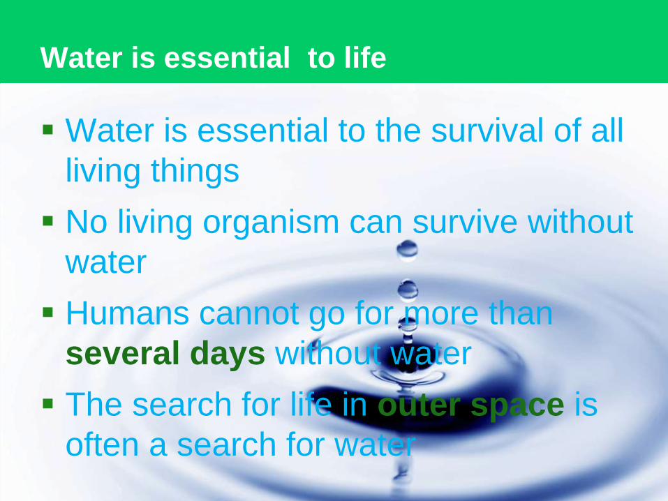
Water is essential to life
Water is essential to the survival of all
living things
No living organism can survive without
water
Humans cannot go for more than
several days without water
The search for life in outer space is
often a search for water

Water covers 75% of the earth’s surface

Water on the earth’s surface
Oceans - 97%
Freshwater – 3%
• Atmospheric moisture 0.03%
• Glaciers and ice sheets 75%
• Groundwater – 24.7%
• Lakes, streams and wetlands- < 0.9%

Physical and Chemical Properties of Water
Water is a universal solvent
Water is the only natural substance that exists
in all 3 physical states on earth solid, liquid
and gas
Pure water has a neutral pH of 7.0 meaning it
is neither acidic nor basic
Water has a very high surface tension which
allows for the movement of water through
plants via capillary action

Physical and chemical properties of water - 2
Water has a very high specific heat which has a
moderating effect on climate
Solid water (ice) is less dense than liquid water
which makes ice float.
Floating ice is crucial for the protection of
aquatic life because it insulates the water in
extreme climates
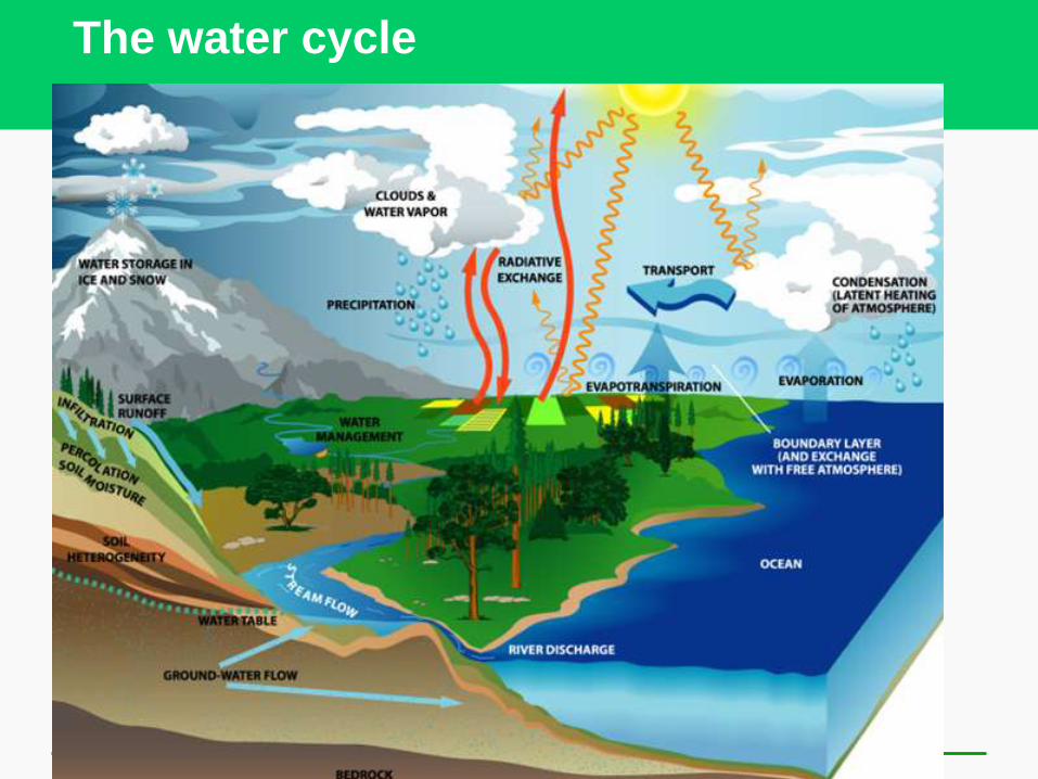
The water cycle

What is a freshwater ecosystem?
A freshwater ecosystem has two
components:
• biotic (living organisms)
• abiotic (the non-living environment in
which they inhabit)
Both the biotic and abiotic elements of
the ecosystem must be healthy for it to
thrive

Why Are Freshwater Ecosystems
Important?
They provide major ecological and economic
benefits
They are irreplaceable reservoirs of
biodiversity

Ecological benefits
Climate moderation
Nutrient cycling
Water treatment
Flood control
Groundwater recharge
Habitat for many species
Genetic resources and biodiversity
Scientific information

Economic benefits
Food
Drinking water
Irrigation water
Hydroelectricity
Transportation
corridors
Recreation
Employment

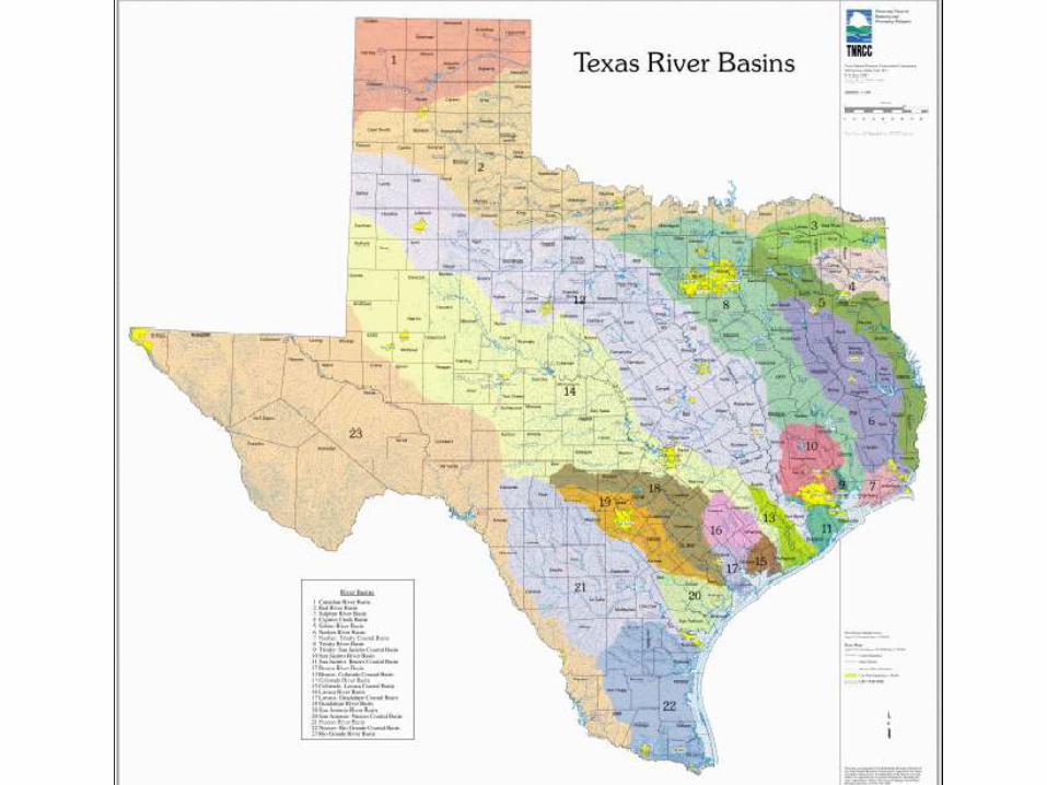
Drainage Basins
Freshwater ecosystems lie within drainage basins
Most drainage basins are river basins
Texas has 23 major river basins
Waco is in the Brazos River Basin, the longest river
within Texas

Drainage Basins

Watersheds vs drainage basins
The term “watershed” has a
much broader meaning than
drainage basin
“Drainage basin” refers to the
topography that drains water
from a geographic are into a
single outlet
“Watershed” is a broader term
that includes the natural
habitat and human built
environment of the area.


Texas Lakes and Rivers
Texas has over 10,000 lakes and ponds
• Only one major lake is natural (Caddo Lake)
• all others are man-made with dams
Texas has over 11,000 streams and rivers large
enough to be named
• 191,000 miles of streams and rivers
• Only 40,000 miles are perennial (wet year round)
Texas has 6.3 million acres of wetlands (that’s a
lot!)

Flowing (lotic) systems of
freshwater
• Streams
• Rivers
Standing (lentic) bodies of
freshwater
• Lakes
• Ponds
• Inland wetlands
Water flows in some freshwater systems
and stands in others
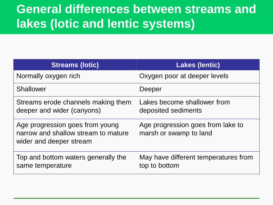
General differences between streams and
lakes (lotic and lentic systems)
Streams (lotic) Lakes (lentic)
Normally oxygen rich Oxygen poor at deeper levels
Shallower Deeper
Streams erode channels making them
deeper and wider (canyons)
Lakes become shallower from
deposited sediments
Age progression goes from young
narrow and shallow stream to mature
wider and deeper stream
Age progression goes from lake to
marsh or swamp to land
Top and bottom waters generally the
same temperature
May have different temperatures from
top to bottom

Stream order

Stream types
Perennial streams flow year round

Stream types
Intermittent streams
become dry for a week
or longer each year
• Many of the streams
around Waco are
intermittent

Stream types
Ephemeral streams flow only following rainfall
and cease to flow shortly after.

Gaining and losing streams
Streams can gain water from the ground, usually
fed by springs or groundwater (gaining stream)
Streams can lose water to the ground through
percolation (losing stream)

Stream habitat types
Erosional streams are characterized by fast
moving water and little sediment

Stream habitat types -2
Depositional streams are slow moving,
meandering, and deposit sediment

Stream habitat types - 3
Streams can have both erosional zones and
depositional zones at the same time

Stream habitats – 4
A riparian zone is a vegetated buffer between
streams and nearby lands. A riparian zone is
often heavily wooded.
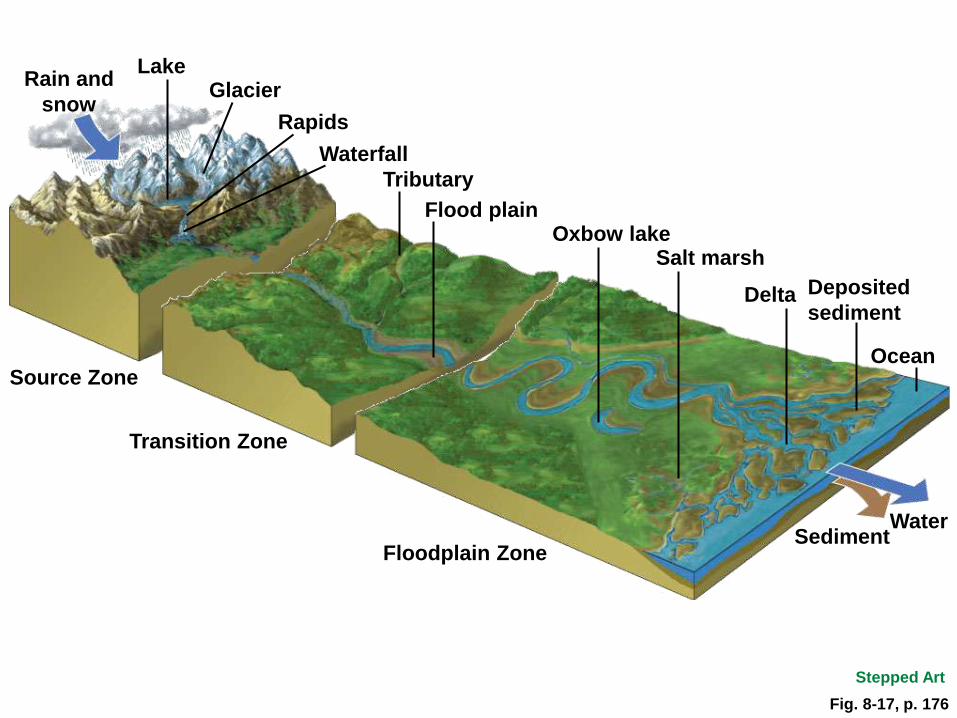
Waterfall
Lake Glacier
Rain and
snow Rapids
Source Zone
Fig. 8-17, p. 176
Transition Zone
Tributary
Flood plain Oxbow lake
Salt marsh
Delta Deposited
sediment
Ocean
Water Sediment
Floodplain Zone
Stepped Art

Formation of lentic systems (lakes,
ponds, and wetlands)
In the northern regions, many lakes and ponds were gouged out by glaciers during the Ice Ages

Oxbow Lakes
Lakes formed by meanders in rivers flowing over
floodplains are called oxbow lakes

Playa lakes
Playa lakes are small ephemeral lakes common
in West Texas and the southern high plains

Wetlands – the transition zone between
water and land
There are four basic categories of wetlands,
• marshes
• swamps
• bogs
• fens

Marshes
Marshes are shallow wetlands originating from
water runoff and floodwaters and are mainly
grassy

Swamps
Swamps are areas of wet soils with poor
drainage and standing water during times of the
year. Swamps are dominated by trees and
scrubs

Bogs
Bogs are characterized by floating spongy peat
deposits. They support carnivorous plants and
are acidic

Fens
Fens are groundwater fed wetlands that are
more alkaline that bogs

Lentic habitat zones
Littoral zone – shallow vegetated zone near the
shoreline
Limnetic zone – the top layer of open water
areas close enough to the surface for light to
penetrate and photosynthesis to occur
Profundal zone – deep bottom water area with
little or no light penetration
Benthic zone – the bottom surface of the lake
fed only by dead matter that falls from the upper
layers

Fig. 8-15, p. 175
Sunlight
Painted
turtle
Blue-winged
teal
Green
frog Muskrat
Pond
snail Littoral zone Plankton
Diving
beetle Northern
pike
Yellow
perch Bloodworms

Lake Classification - Some Lakes Have
More Nutrients Than Others
Oligotrophic lakes – low levels of nutrients and
low primary productivity

Lake Types . . .
Mesotrophic lakes – moderate nutrient levels.

Lake types . . .
Eutrophic lakes – High levels of nutrients and
high primary productivity
Lake types . . .
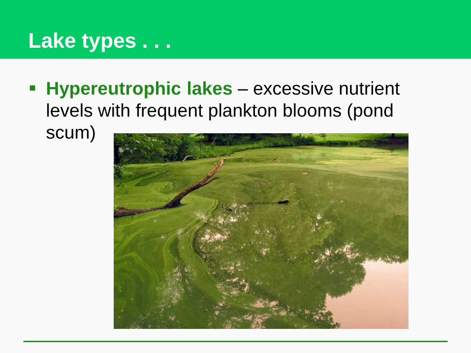
Hypereutrophic lakes – excessive nutrient
levels with frequent plankton blooms (pond
scum)
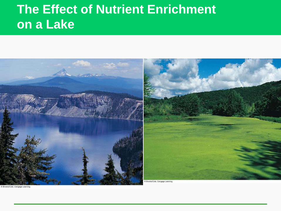
The Effect of Nutrient Enrichment
on a Lake

Water stratification in lakes
Large deepwater lakes become layered during
summer months
Epilimnion – The warmest zone near the water
surface
Metalimnion – The middle layer where
temperature declines. The Thermocline is found
here, where the temperature changes rapidly
Hypolimnion – The bottom layer that is deep
and cold with little change in temperature

Lake stratification layers

Lakes “turn over” during the year
When the seasons change, the water in lakes turns
over
During winter when the surface layer becomes colder
than the bottom layers the colder more dense water
sinks and the lake “turns over”
Texas lakes turnover once a year, northern lakes turn
over in both spring and fall

Seasonal lake turnover

Aging of lakes
Lakes and ponds go through
a natural aging process
called succession
As lakes slowly fill with
sediment they become
marshes, swamps, or bogs
As wetland plants move in
they build a soil base and
eventually the lake becomes
dry land