aqbat jaber camp profile - applied research institute...
TRANSCRIPT

Aqbat Jaber Camp Profile
Prepared by
The Applied Research Institute – Jerusalem
Funded by
Spanish Cooperation
2012

Palestinian Localities Study Jericho Governorate
1
Acknowledgments
ARIJ hereby expresses its deep gratitude to the Spanish agency for International Cooperation for Development (AECID) for their funding of this project. ARIJ is grateful to the Palestinian officials in the ministries, municipalities, joint services councils, camp committees and councils, and the Palestinian Central Bureau of Statistics (PCBS) for their assistance and cooperation with the project team members during the data collection process. ARIJ also thanks all the staff who worked throughout the past couple of years towards the accomplishment of this work.
Palestinian Localities Study Jericho Governorate
2
Background This report is part of a series of booklets, which contain compiled information about each city, village, and town in the Jericho Governorate. These booklets came as a result of a comprehensive study of all localities in Jericho Governorate, which aims at depicting the overall living conditions in the governorate and presenting developmental plans to assist in developing the livelihood of the population in the area. It was accomplished through the "Village Profiles and Needs Assessment;" the project funded by the Spanish Agency for International Cooperation for Development (AECID). The project's objectives are to survey, analyze, and document the available natural, human, socioeconomic and environmental resources, and the existing limitations and needs assessment for the development of the rural and marginalized areas in the Jericho Governorate. In addition, the project aims at preparing strategic developmental programs and activities to mitigate the impact of the current political, social, and economic instability with special emphasize on agriculture, environment and water. All locality profiles in Arabic and English are available online at http://vprofile.arij.org.

Palestinian Localities Study Jericho Governorate
3
Table of Content
Location and Physical Characteristics ........................................................ 4
History ................................................................................................................... 5
Religious and Archaeological Sites .............................................................. 6
Population ............................................................................................................ 7
Education .............................................................................................................. 8
Health Status ....................................................................................................... 9
Economic Activities ........................................................................................... 9
Agricultural Sector ......................................................................................... 11
Institutions and Services .............................................................................. 12
Infrastructure and Natural Resources .................................................... 13
The Geopolitical Status in Aqbat Jaber Camp ........................................ 17
Development Plans and Projects ............................................................... 18
Locality Development Priorities and Needs .......................................... 19
References ......................................................................................................... 20

Palestinian Localities Study Jericho Governorate
4
Aqbat Jaber Camp Profile
Location and Physical Characteristics Aqbat Jaber is a Palestinian camp in Jericho Governorate located (horizontally) 3km south-west of Jericho City. Aqbat Jaber is bordered by Jericho city to the east and north, and An Nabi Musa to both the west and south (ARIJ – GIS Unit, 2010) (See map 1).
Map 1: Aqbat Jaber location and borders
Source: ARIJ – GIS unit, 2011
Aqbat Jaber is located at an altitude of 249m above sea level with a mean annual rainfall of 137mm. The average annual temperature is 24 o C, and the average annual humidity is approximately 50% (ARIJ – GIS Unit, 2010). Since 1995, Aqbat Jaber has been governed by a Camp Committee, which is currently administrated by 9 members appointed by the Palestinian National Authority. There are additionally 10 employees working in the Committee. Moreover, the Camp Committee owns a permanent headquarters and one device for water maintenance, but does not own a vehicle for the collection of solid waste (Aqbat Jaber Camp Committee, 2011).

Palestinian Localities Study Jericho Governorate
5
It is the responsibility of the Camp Committee to provide a number of services to the residents of Aqbat Jaber, including (Aqbat Jaber Camp Committee, 2011):
Establishing and maintaining the water network. Road construction, pavement and rehabilitation, and providing social
development services. Implementing projects and case studies for the camp. Providing a sewage network. Providing kindergartens.
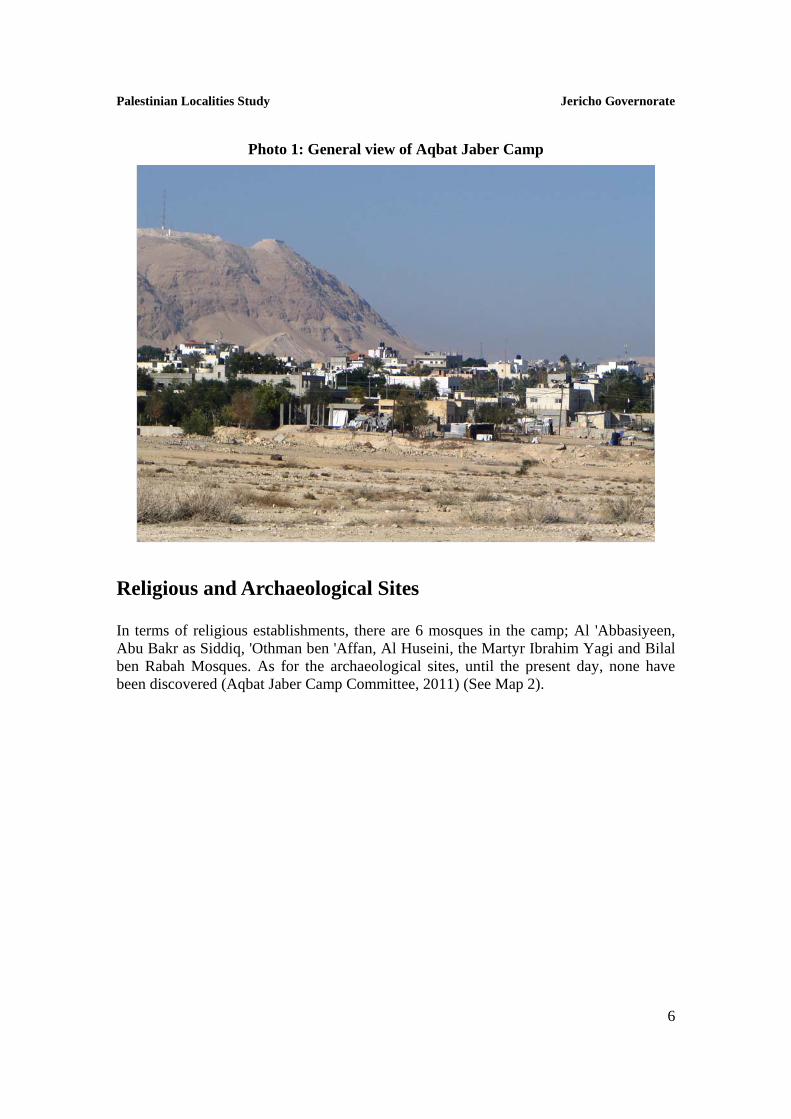
History Aqbat Jaber camp was set up in 1948 on land leased by UNRWA from the Jordanian government. The indigenous residents of the camp descend from nearly 300 villages north of Haifa, in addition to areas in Gaza and Hebron, and until the war of 1967, Aqbat Jaber camp was considered the largest in the oPt in terms of population size, after which the camp witnessed a large displacement of residents to Jordan. The Camp became a reality under the control of the Palestinian Authority after signing the Cairo Agreement in 1994. However, the rest of the refugees in the camp descend from 22 different villages, including Deir ad Dannam, 'Ajjour, Al Masamiya, Al 'Abbasiya, Beit Jibrin, Tall as Safi, Beit Dajan, Yazoo and Kafr 'Anna. It is noted that persons without refugee status have also moved to reside in the camp territories (UNRWA, 2012) (See photo below for Aqbat Jaber Camp).
Palestinian Localities Study Jericho Governorate
6
Photo 1: General view of Aqbat Jaber Camp
Religious and Archaeological Sites In terms of religious establishments, there are 6 mosques in the camp; Al 'Abbasiyeen, Abu Bakr as Siddiq, 'Othman ben 'Affan, Al Huseini, the Martyr Ibrahim Yagi and Bilal ben Rabah Mosques. As for the archaeological sites, until the present day, none have been discovered (Aqbat Jaber Camp Committee, 2011) (See Map 2).

Palestinian Localities Study Jericho Governorate
7
Map 2: Main locations in Aqbat Jaber Camp
Source: ARIJ – GIS unit, 2011
Population According to the Palestinian Central Bureau of Statistics (PCBS), the total population of Aqbat Jaber in 2007 was 6,851; of whom 3,466 were male and 3,385, female. There were additionally registered to be 1,298 households living in 1,369 housing units.
Age Groups and Gender The General Census of Population and Housing carried out by PCBS in 2007 showed the distribution of age groups in Aqbat Jaber was as follows: 44.2% were less than 15 years, 49.9% between 15 - 64 years, whilst 2.3% fell in the 65 years and older category. Data additionally showed that the sex ratio of males to females in the camp is 102.4:100, meaning that males and females constituted 50.6% and 49.4% of the population, respectively.

Palestinian Localities Study Jericho Governorate
8
Families Aqbat Jaber residents are composed of several families, mainly: Al Maqayta, Al Ka'abnah, Abu al 'Asal and Ad Dawahik families (Aqbat Jaber Camp Committee, 2011).
Education According to the results of the PCBS Population, Housing and Establishment Census-2007, the illiteracy rate among Aqbat Jaber population was approximately 8.3%, of whom 74.4% were females. Of the literate population, 16.4% could only read and write, with no formal education 30.4% had elementary education, 30.3% had preparatory education, 8.7% had secondary education, and 5.5% completed higher education. Table 1, shows the educational level in the camp of Aqbat Jaber, by sex, and educational attainment in 2007.
Table 1: Aqbat Jaber population (10 years and above) by sex and educational attainment, 2007
S E x
Illite-rate
Can read
& write
Elem-entary
Prepa-ratory
Second-ary
Associate Diploma
Bach-elor
Higher Diploma
Master PhD Un-
known Total
M 96 363 756 705 196 53 70 1 7 2 5 2,254
F 280 378 619 665 198 49 75 2 1 1 5 2,273
T 376 741 1,375 1,370 394 102 145 3 8 3 10 4,527
Source: PCBS, 2009. Population, Housing and Establishment Census-2007, Final Results
With regards to the basic and secondary education institutions and schools in Aqbat Jaber in the academic year 2010/2011, there are two schools in the camp run by UNRWA (Directorate of Education in Jericho, 2011) (See table 2). In the camp there are also 1,569 students, 52 teachers, and 44 classes (Directorate of Education in Jericho, 2011). It should be noted here that the average number of students per teacher in the school is nearly 30, whilst the average number of students per class is approximately 36. Table 2: The Schools in Aqbat Jaber by name, stage, sex, and supervising authority
School Name Supervising Authority Sex
Aqbat Jaber Co-educated Preparatory School UNRWA
Males Aqbat Jaber Girls Elementary School Females Source: Directorate of Education in Jericho, 2011
Moreover, there are four kindergartens in the camp; all run by a private body. The total number of children in the kindergartens is 256 children. Table 2 shows the kindergartens
Palestinian Localities Study Jericho Governorate
9
according to their names and supervising authority (Aqbat Jaber Camp Committee, 2011).
Table 3: The Kindergartens in Aqbat Jaber by name and supervising authority
Kindergarten Name No. of
Children Supervising Authority
Al 'Awdah Kindergarten 109 Private Al Berr be Abna' ash Shuhada' Society Kindergarten 37 Private The Young Christian Females Society Kindergarten 81 Private Palestine Kindergarten 29 Private Source: Directorate of Education in Jericho, 2011 However, due to the lack of secondary level education in the camp, students, in order to complete their secondary education, head to Hisham ben Abd al Malik Boys High School; 3km in distance from the camp, (Aqbat Jaber Camp Committee, 2011).
Health Status There are a few health centers available in Aqbat Jaber camp; a health clinic supervised by UNRWA and two private specialized physicians' clinics (Aqbat Jaber Camp Committee, 2011). However, the health sector in the camp suffers many obstacles and problems, including:
1. The lack of a clinic that operates during afternoon hours to serve patients. 2. The lack of a permanent and constantly accessible ambulance in the camp.
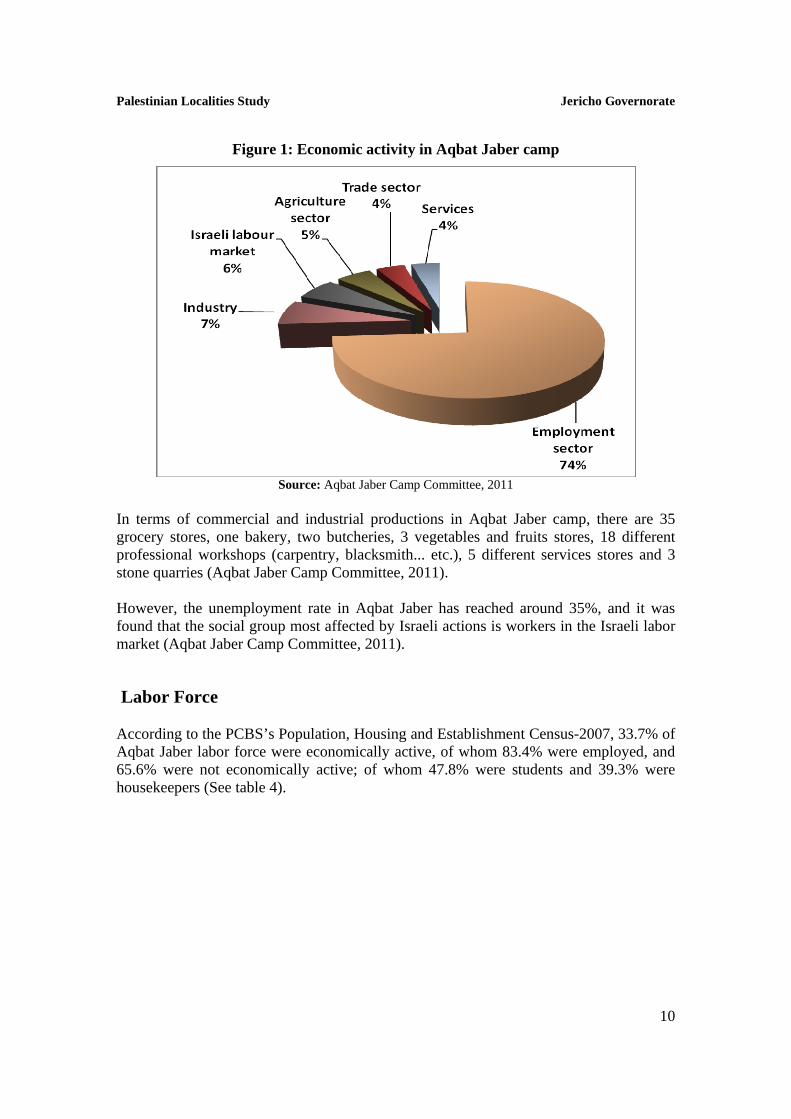
Economic Activities The economy in Aqbat Jaber is dependent on several economic sectors, mainly: the employees sector, which absorbs 74% of the camp workforce (See Figure1). The results of a field survey conducted by ARIJ in 2011 in order to achieve this study for the distribution of labor by economic activity in Aqbat Jaber are as follows:
Government or Private Employees Sector (74%). Industry (7%). Israeli Labor Market (6%). Agriculture Sector (5%). Trade Sector (4%). Services Sector (4%).
Palestinian Localities Study Jericho Governorate
10
Figure 1: Economic activity in Aqbat Jaber camp
Source: Aqbat Jaber Camp Committee, 2011
In terms of commercial and industrial productions in Aqbat Jaber camp, there are 35 grocery stores, one bakery, two butcheries, 3 vegetables and fruits stores, 18 different professional workshops (carpentry, blacksmith... etc.), 5 different services stores and 3 stone quarries (Aqbat Jaber Camp Committee, 2011). However, the unemployment rate in Aqbat Jaber has reached around 35%, and it was found that the social group most affected by Israeli actions is workers in the Israeli labor market (Aqbat Jaber Camp Committee, 2011).
Labor Force According to the PCBS’s Population, Housing and Establishment Census-2007, 33.7% of Aqbat Jaber labor force were economically active, of whom 83.4% were employed, and 65.6% were not economically active; of whom 47.8% were students and 39.3% were housekeepers (See table 4).

Palestinian Localities Study Jericho Governorate
11
Table 4: Aqbat Jaber camp population (10 years and above) by sex and employment status
S E X
Economically Active Not Economically Active
Un-known
Total Emp-loyed
Currently Unemp-
loyed
Unemp-loyed
(Never worked)
Total Stud-ents
House- keeping
Unable to work
Not working & Not looking
for work
Other Total
M 1,135 135 92 1,362 678 3 129 22 40 872 20 2,254 F 139 15 11 165 743 1,164 153 3 35 2,098 10 2,273 T 1,274 150 103 1,527 1,421 1,167 282 25 75 2,970 30 4,527 Source: PCBS, March 2009. Population, Housing and Establishment Census-2007, Final Results
Agricultural Sector Aqbat Jaber lies on a total area of about 1,859 dunums of which 240 dunums are considered ‘arable’ lands, and 1,342 dunums are registered as ‘residential’ (See table 5 and map 3).
Table 5: Land use and land cover in Aqbat Jaber Camp in 2010 (area in dunum)
Total Area
Built-
up Area
Agricultural area (26,032 dunums)
Inland water
Forests Open Space
Area of Industrial,
Commercial & Transport Unit
Area of Settlements & Military
Bases Permanent
Crops Green-houses
Range-lands
Arable lands
1,859 1,342 47 0 9 184 10 0 234 34 0
Source: ARIJ – GIS unit, 2011
According to agricultural statistics of the Directorate of Agriculture in Jericho and Al Aghwar (2011), there is no cultivation in the camp, which is due to the fact that the whole area of the camp is a residential populated area; there are no empty spaces for the exploitation of agriculture. However, the difference in the two sets of results of agricultural areas, obtained from the Ministry of Agriculture and by ARIJ’s GIS Unit, is explained by the fact that the Ministry of Agriculture, who in combination with the Palestinian Central Bureau of Statistics (2011) conducted a survey considering a definition of agricultural areas based on the size of ownership. Thus, the areas included in the survey were those of actual holdings of agricultural areas instead of seasonal ones. The survey did not consider fragmented and small seasonal cultivated areas in residential and agricultural areas which contains some springs. ARIJ’s survey however indicated the existence of a high proportion of small and fragmented holdings (home gardens) throughout the occupied Palestinian territories. This illustrates the bigger area of agricultural holdings calculated by ARIJ.

Palestinian Localities Study Jericho Governorate
12
Map 3: Land use/land cover in Aqbat Jaber Camp
Source: ARIJ – GIS unit, 2011
The field survey conducted by ARIJ, in 2011 to realize this study, shows that approximately 56% of the residents in Aqbat Jaber Camp rear and keep domestic animals such as sheep, camels, poultry and bees (See Table 6).
Table 6: Livestock in Aqbat Jaber Camp
Cows* Sheep Camels Poultry Bee Hives
0 2,426 286 54,800 2,365
* Including cows, bull calves, heifer calves and bulls Source: Jericho & Al Aghwar Directorate of Agriculture – Jericho, 2011
Institutions and Services Aqbat Jaber camp has very few governmental institutions; a police station and UNRWA office, in addition to a number of local institutions and associations that provide services to various segments of society such as; children, youth, and women. The services are in the areas of culture, sports and others, including (Aqbat Jaber Camp Committee, 2011):
Palestinian Localities Study Jericho Governorate
13
Aqbat Jaber Camp Committee: Founded in 1995 with the goal of taking care of all the issues in the camp and providing various services to its population.
The Youth Social Center: Founded in 1954 by UNRWA and the Youth Centers Union, with an aim to serve younger persons within the camp.
Bees Breeding Society: Founded in 2008, in order to assist bee farmers. The YMCA: Founded in 1950 and now functioning as a vocational training
school. Al Berr be 'Abna' ash Shuhada' Society: Founded in 1952- also now acting as
an industrial school for camp students. Muftah al 'Awdah (the Key to Return) Society: Founded in 2011 in order to
preserve the cultural heritage of camp residents and emphasize and advocate for the ‘the right of (Palestinian) return.
Infrastructure and Natural Resources
Electricity and Telecommunication Services Aqbat Jaber has been connected to a public electricity network since 1979; served by Jerusalem Electricity Company, which is the main source of electricity in the camp, and to which approximately 100% of the housing units in the camp are connected to. However, the camp residents suffer some problems concerning electricity, mainly (Aqbat Jaber Camp Committee, 2011):
1. The old and worn out condition of the network and its need for renovation and expansion.
2. The weak electric current in many parts of the network. Furthermore, Aqbat Jaber is connected to a telecommunication network and approximately 80% of the housing units within the camp boundaries are connected to phone lines (Aqbat Jaber Camp Committee, 2011).
Transportation Services There are 25 public taxis which are considered to be the main means of transportation in Aqbat Jaber camp (Aqbat Jaber Camp Committee, 2011). As for the road network in the camp; there are a total of 4km of ‘main’ roads and a total of 14km of ‘secondary’ roads (See Table 7) (Aqbat Jaber Camp Committee, 2011).

Palestinian Localities Study Jericho Governorate
14
Table 7: Roads in Aqbat Jaber Camp
Status of Internal Roads Road Length (km) Main Sub
Paved & in good condition - - Paved but in poor condition - 4 Unpaved 4 10 Source: Aqbat Jaber Camp Committee, 2011
Water Resources Aqbat Jaber is provided with water by a combination of water authorities; the privately owned Israeli ‘Mekorot’ Company, Jericho Municipality and occasionally water provided by UNRWA through Al Fuwwar spring. It is noted that approximately 100% of the housing units are connected to this water network (Aqbat Jaber Camp Committee, 2011). According to Aqbat Jaber Camp Committee, the quantity of water supplied to Aqbat Jaber in 2011 was an estimated 20,000 cubic meters/ month, equating to approximately 79 liters/day (Aqbat Jaber Camp Committee, 2011). Here it should be noted that no Aqbat Jaber citizen in fact consumes this amount of water due to water losses, which are around 24%. The losses happen at the main source, major transport lines, distribution network, and at the household level, thus the rate of water consumption per capita in Aqbat Jaber can be more accurately set at 74 liters per day (Aqbat Jaber Camp Committee, 2011). This is a low rate compared with the minimum quantity proposed by the World Health Organization; set at 100 liters per capita per day (Aqbat Jaber Camp Committee, 2011). It is worth mentioning that Jericho Municipality sporadically provides the camp with water from 'Ein as Sultan spring through the public water network, but is currently, not providing the camp with any regular quantity of water (Aqbat Jaber Camp Committee, 2011). Based on a study prepared by the Palestinian Hydrology Group, the quantity of water supplied from 'Ein as Sultan spring to the camp residents in 2009 was approximately 60,891 cubic meters/ year (PHG, 2011). Due to the scarcity of water resources in the camp, residents are sometimes forced to buy water tanks at a very high price per cubic meter; noting that the price per cubic meter of water from the public network is 2 NIS. However there are, located within the camp, three public harvesting reservoirs with a capacity of 1,300 cubic meters each for residents’ use (Aqbat Jaber Camp Committee, 2011).
Sanitation Aqbat Jaber lacks a public sewerage network with most of the camp residents using cesspits as their main means of waste-water disposal (Aqbat Jaber Camp Committee, 2011).
Palestinian Localities Study Jericho Governorate
15
Based on the estimated daily per capita water consumption, the estimated amount of wastewater generated per day, is approximately 356 cubic meters, or 129,964 cubic meters annually. At the individual level, it is estimated that the per capita wastewater generation is approximately 52 liters per day. The wastewater collected by cesspits is discharged by wastewater tankers directly to open areas or nearby valleys without any regard for the environment. Here it should be noted that there is no wastewater treatment either at the source or at the disposal sites, which poses a serious threat to both the environment and public health.
Solid Waste Management The Joint Services Council for Planning & Development for the Management of Solid Waste in Jerichi & Al Aghwar and UNRWA are considered the official bodies responsible for managing solid waste, i.e. solid waste collection and disposal, generated from the citizens and establishments in the camp, which is currently represented by solid waste collection and disposal. Upon an agreement between Jericho Municipality and UNRWA, the Council is to overtake and maintain the management of part of the solid waste collection and disposal (The Joint Services Council, 2012). Most of the population in Aqbat Jaber benefit from solid waste services, whereby waste is collected from households, institutions, shops, and public squares in plastic bags and then transferred to 35 containers1, distributed throughout the locality. The Council collects the solid waste from the containers once a day and transports it through a tractor owned by the Joint Council to Jericho dumping site, which is located 6km away from the camp. The common method for solid waste treatment in this dumping site is through burying the waste. It is noted that the disposal of solid waste in the dumping site costs 20 NIS per ton (Aqbat Jaber Camp Committee, 2011). It should be further commented upon that medical solid waste and hazardous wastes are being separated at the landfill; there being a specific area for each type of waste to be collected at2, which has a beneficial impact on both local environmental and public health (The Joint Services Council, 2012). It should be noted here that Jericho sanitary landfill was established in 2007 with funding from the Japanese International Cooperation Agency (JICA), and serves approximately 72.2% of Jericho and Al Aghwar Governorate area (PNA, 2010); covering Jericho city, Ad Duyuk and An Nuwei'ma town, and Aqbat Jaber and 'Ein as Sultan camps (The Joint Services Council, 2012). Through designing the landfill, the standards of a Japanese (Fukouka Theory) Semi aerobic system, were taken into consideration. This resulted in the landfill being lined by two layers of soil and a layer of high density plastic (HDPE) in order to prevent leakage of leachate into groundwater, in addition to the extension of a network of pipes to collect the leachate and discharge it into a pool made specially for its collection. In addition,
1 Each with a capacity of 1 m3 2 For example, there are separate areas for slaughterhouse and medical wastes.

Palestinian Localities Study Jericho Governorate
16
pipes were installed to collect gas and release it into the air in order to dispose of it in a sanitary and environmentally conscious manner (The Joint Services Council, 2012). Table 8 shows selected information about Jericho sanitary landfill; its capacity, its geographical scope and the population number it serves. As shown in the table below, the work in the landfill was to be finished in 2011, thus, the Council is currently preparing a plan to expand the area of the landfill by an additional 20 dunums.
Table 8: Information on Jericho sanitary landfill for solid waste
Area served by the landfill
Served population
Daily amount of waste (ton/day)
Capacity (m3)
Landfill area
(dunum)
Total area
(dunum)
Life-time
Time of
completion
Jericho city, Ad Duyuk & An Nuwei'ma town, and Aqbat Jaber & 'Ein as
Sultan Camps (72.2% of Jericho & Al Aghwar Governorate)
32,368 33 - 35 53,000 10.3 26.5 4
years 2011
Source: The Joint Services Council for Development & Planning for the Management of Solid Waste in Jericho & Al Aghwar, 2012
The daily per capita rate of solid waste production in Aqbat Jaber is 0.7kg. Thus the estimated amount of solid waste produced per day from Aqbat Jaber residents is nearly 4.8 tons, or 1,750 tons per year (ARIJ – WERU, 2012).
Environmental Conditions Like other camps and villages in the governorate, Aqbat Jaber experiences several environmental problems which must be addressed and solved. These problems can be identified as follows: Water Crisis Groundwater resources have been vastly depleted by the privately owned Israeli
‘Mekorot’ wells, which have been granted a monopoly over the excavation, restoration, distribution and sale of water, whilst Palestinians have been forbidden from constructing new wells and/or restoring existing ones. In many cases, as is the holds true in Aqbat Jaber camp, the local authority relies heavily on the purchase of water from Mekorot to provide the camp with water. The Company, through the wells it owns, extracts large quantities of ground water, where it pumps the bulk of this water for the benefit of the illegal Israeli settlements, as settlers, mainly those in the Jordan Valley area, use huge amounts of water (ARIJ, 2011). Moreover, there are two wells in Aqbat Jaber camp belonging to Mekorot Company; Jericho well no. 1 and Jericho well no. 2 (ARIJ – WERU, 2012).
The old and worn condition of the public water network and its subsequent need for rehabilitation.
Palestinian Localities Study Jericho Governorate
17
Wastewater Management The absence of a public sewage network means that the majority of camp residents discharge of wastewater in the streets or make use of random and unsanitary cesspits, especially in winter, as citizens cannot afford the high cost of sewage tankers at this time. All of this causes environmental damages, health problems, and the spread of epidemics and diseases in the camp. The use of cesspits pollutes both the groundwater and water collected in domestic cisterns (rainwater harvesting cisterns) as the wastewater mixes with water and contaminates, thus making it inappropriate for human consumption. This is due to the fact that most cesspits are built without lining, which allows wastewater to enter into the ground and avoids from time to time the need to use sewage tankers. Moreover, the untreated wastewater collected from cesspits by sewage tankers is disposed of in open areas without taking into account the damage it causes to either environmental or residents' health.
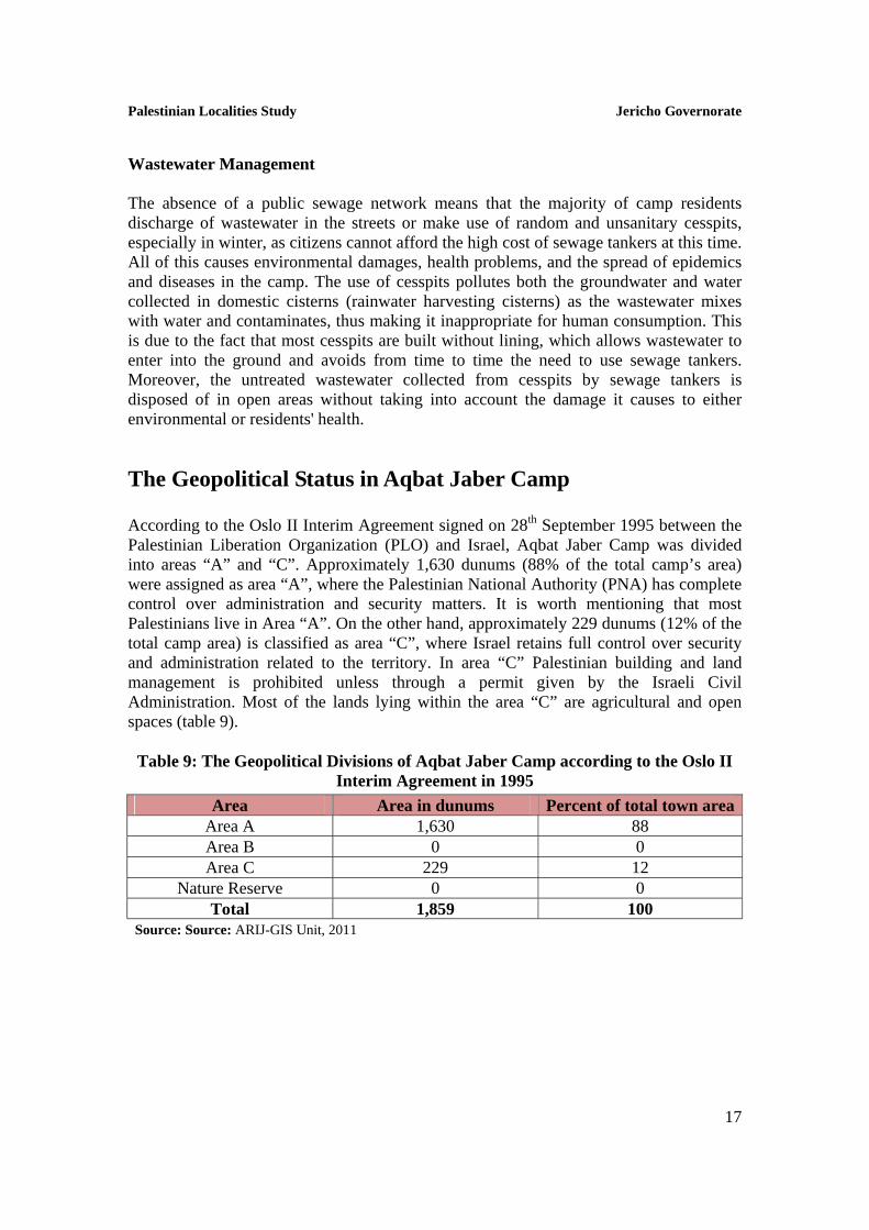
The Geopolitical Status in Aqbat Jaber Camp According to the Oslo II Interim Agreement signed on 28th September 1995 between the Palestinian Liberation Organization (PLO) and Israel, Aqbat Jaber Camp was divided into areas “A” and “C”. Approximately 1,630 dunums (88% of the total camp’s area) were assigned as area “A”, where the Palestinian National Authority (PNA) has complete control over administration and security matters. It is worth mentioning that most Palestinians live in Area “A”. On the other hand, approximately 229 dunums (12% of the total camp area) is classified as area “C”, where Israel retains full control over security and administration related to the territory. In area “C” Palestinian building and land management is prohibited unless through a permit given by the Israeli Civil Administration. Most of the lands lying within the area “C” are agricultural and open spaces (table 9).
Table 9: The Geopolitical Divisions of Aqbat Jaber Camp according to the Oslo II Interim Agreement in 1995
Percent of total town areaArea in dunums Area 88 1,630 Area A 0 0 Area B
12 229 Area C 0 0 Nature Reserve
100 1,859 Total Source: Source: ARIJ-GIS Unit, 2011
Palestinian Localities Study Jericho Governorate
18
Development Plans and Projects
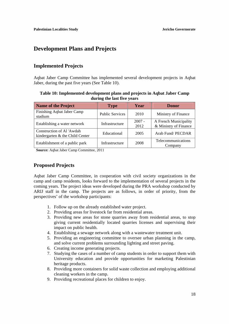
Implemented Projects Aqbat Jaber Camp Committee has implemented several development projects in Aqbat Jaber, during the past five years (See Table 10).
Table 10: Implemented development plans and projects in Aqbat Jaber Camp during the last five years
Name of the Project Type Year Donor Finishing Aqbat Jaber Camp stadium
Public Services 2010 Ministry of Finance
Establishing a water network Infrastructure 2007 - 2012
A French Municipality & Ministry of Finance
Construction of Al 'Awdah kindergarten & the Child Center
Educational 2005 Arab Fund/ PECDAR
Establishment of a public park Infrastructure 2008 Telecommunications
Company Source: Aqbat Jaber Camp Committee, 2011
Proposed Projects Aqbat Jaber Camp Committee, in cooperation with civil society organizations in the camp and camp residents, looks forward to the implementation of several projects in the coming years. The project ideas were developed during the PRA workshop conducted by ARIJ staff in the camp. The projects are as follows, in order of priority, from the perspectives’ of the workshop participants:
1. Follow up on the already established water project. 2. Providing areas for livestock far from residential areas. 3. Providing new areas for stone quarries away from residential areas, to stop
giving current residentially located quarries licenses and supervising their impact on public health.
4. Establishing a sewage network along with a wastewater treatment unit. 5. Providing an engineering committee to oversee urban planning in the camp,
and solve current problems surrounding lighting and street paving. 6. Creating income generating projects. 7. Studying the cases of a number of camp students in order to support them with
University education and provide opportunities for marketing Palestinian heritage products.
8. Providing more containers for solid waste collection and employing additional cleaning workers in the camp.
9. Providing recreational places for children to enjoy.
Palestinian Localities Study Jericho Governorate
19
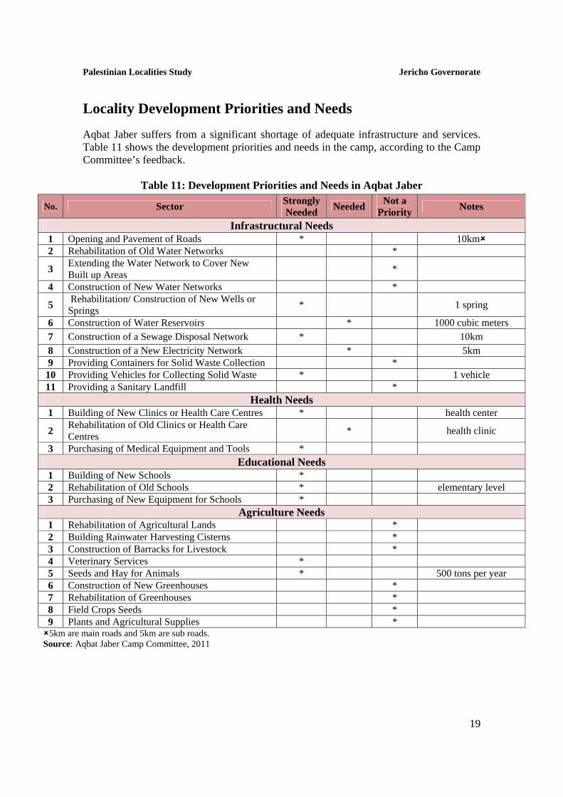
Locality Development Priorities and Needs
Aqbat Jaber suffers from a significant shortage of adequate infrastructure and services. Table 11 shows the development priorities and needs in the camp, according to the Camp Committee’s feedback.
Table 11: Development Priorities and Needs in Aqbat Jaber
No. Sector Strongly Needed
Needed Not a
Priority Notes
Infrastructural Needs 1 Opening and Pavement of Roads * 10km 2 Rehabilitation of Old Water Networks *
3 Extending the Water Network to Cover New Built up Areas
*
4 Construction of New Water Networks *
5 Rehabilitation/ Construction of New Wells or Springs
* 1 spring
6 Construction of Water Reservoirs * 1000 cubic meters
7 Construction of a Sewage Disposal Network * 10km
8 Construction of a New Electricity Network * 5km 9 Providing Containers for Solid Waste Collection *
10 Providing Vehicles for Collecting Solid Waste * 1 vehicle 11 Providing a Sanitary Landfill *
Health Needs 1 Building of New Clinics or Health Care Centres * health center
2 Rehabilitation of Old Clinics or Health Care Centres
* health clinic
3 Purchasing of Medical Equipment and Tools * Educational Needs
1 Building of New Schools * 2 Rehabilitation of Old Schools * elementary level 3 Purchasing of New Equipment for Schools *
Agriculture Needs 1 Rehabilitation of Agricultural Lands * 2 Building Rainwater Harvesting Cisterns * 3 Construction of Barracks for Livestock * 4 Veterinary Services * 5 Seeds and Hay for Animals * 500 tons per year 6 Construction of New Greenhouses * 7 Rehabilitation of Greenhouses * 8 Field Crops Seeds * 9 Plants and Agricultural Supplies * 5km are main roads and 5km are sub roads. Source: Aqbat Jaber Camp Committee, 2011

Palestinian Localities Study Jericho Governorate
20
References Applied Research Institute - Jerusalem (ARIJ), 2010. Geographic Information
Systems and Remote Sensing unit Database. Bethlehem - Palestine. Applied Research Institute - Jerusalem (ARIJ), 2011. Geographic Information
Systems and Remote Sensing Unit; Land Use Analysis (2010) – Half Meter High Accuracy. Bethlehem - Palestine.
Applied Research Institute - Jerusalem (ARIJ). 2012. Water & Environment Research Unit Database (WERU). Bethlehem - Palestine.
Aqbat Jaber Camp Committee, 2011. Ministry of Education & Higher Education (MOHE) - Jericho, 2010/2011.
Directorate of Education; A database of schools. Jericho – Palestine. Palestinian Central Bureau of Statistics. 2009. Ramallah, Palestine: General Census
of Population and Housing Censuses, 2007. Palestinian Hydrology Group (PHG) (2011). Water Master Plan for Jericho. Palestinian Ministry of Agriculture (MOA), 2010/2011. Directorate of Agriculture
data. Jericho - Palestine. Palestinian National Authority (PNA), 2010. The National Strategy for the
Management of Solid Waste in Palestine (2010 – 2014). Ramallah – Palestine. The Joint Services Council for Development & Planning for the Management of Solid
Waste in Jericho & Al Aghwar, 2012. The Council Database. Jericho – Palestine. UNRWA (2012), Aqbat Jaber Refugee Camp. Retrieved on 31, January 2012; from
the United Nations Relief and Works Agency for Palestinian Refugees (UNRWA). Available at: http://www.unrwa.org/atemplate.php?id=149.