april 7, 2009 cross canal south levee phase 2 and … · 2015-05-19 · sankey road riego road...
TRANSCRIPT

1007 7th
Street, 7th
Floor – Sacramento, CA – 95814 – (916) 874-7606
April 7, 2009 To: Interested Parties and Project Neighbors From: Stein Buer, Executive Director Re: Natomas Levee Improvement Program (NLIP): Contract 3980 - Natomas
Cross Canal South Levee Phase 2 and Sacramento River East Levee Phase 1 (Reach 1) Construction Update
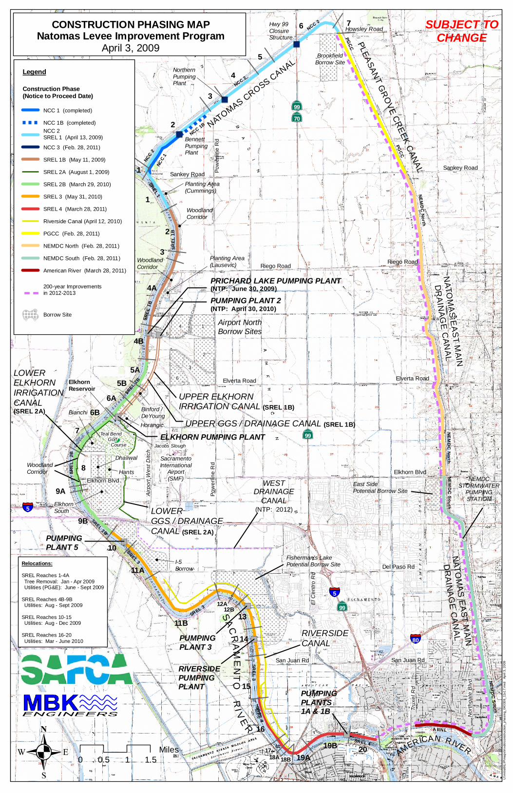
This memorandum is part of a series of notifications you will receive on construction activities for the Natomas Cross Canal (NCC) South Levee Phase 2 and Sacramento River East Levee Phase 1 (Reach 1) levee improvements. The NCC South Levee Phase 2 improvements will include the construction of a cutoff wall in the NCC south levee, from the end of the wall completed in 2008 eastward to the Pleasant Grove Creek Canal, and then raising and widening the entire levee. The Sacramento River East Levee Phase 1 (Reach 1) work will include construction of a cutoff wall and an adjacent setback levee along the northern-most 3900 feet of the levee. The contract for this work is anticipated to be awarded at the April 16, 2009 SAFCA Board meeting. Upon award, the contractor will begin to prepare the site and mobilize equipment and labor on or around May 1, 2009. Work on Contract 4032 - Sacramento River East Levee Phase 1B (Reaches 2-4B) is expected to begin in mid to late May of 2009. Upon selection of the contractor, and prior to performing this work, additional construction information will be mailed directly to you that will further explain what level of activity you can expect, including haul routes and work hours. Neighbors of the project can also expect important information regarding pre-construction activity relating to the temporary relocation of utility poles and lines. These relocations are required to be undertaken before the construction of any levee improvements. SAFCA is working with the utility companies, PG&E and AT&T, to ensure that the pole relocations are performed in a manner that avoids or minimizes power and telephone service disruptions. Proposed utility pole relocations will include the installation of temporary wood poles along the landside (east side) of the Garden Highway. Power lines will be fed from the temporary poles on the landside to the waterside homes via existing service

1007 7th
Street, 7th
Floor – Sacramento, CA – 95814 – (916) 874-7606
NLIP Construction Update April 7, 2009 Page 2 hookups, whether they are overhead or under the Garden Highway. Once the construction of the levee embankment is completed, the temporary wood poles will be replaced with permanent metal poles along the new drainage swale between the new adjacent levee and the Garden Highway. SAFCA does not anticipate the need for any new power poles on the waterside of the Garden Highway at this time. Once a temporary and permanent pole relocation plan is approved by the utility provider, SAFCA will make it available for your review. In addition, prior to any power service interruptions during the relocation process, SAFCA and the utility provider will let you know in advance what the anticipated activity and power outage schedule will be. Detailed information about the project, including the Environmental Impact Report and Environmental Impact Statement, is available on SAFCA’s web site at www.safca.org. Click on the link “Natomas Levee Improvement Program” located under “Current Construction Projects”. Again, you may anticipate additional project construction updates coming to you via direct mail, email, or posted on the SAFCA website. If you have questions or comments, to please call Jay Davis or Barbara Gualco from Gualco Consulting at (916) 351-0600 or email [email protected]. Attachment: Construction Phasing Map
")
")
")
")
")
")
")
") ")
")
NATOM
AS CRO
SS CANAL
PLE
AS
AN
T G
RO
VE
CR
EE
K C
AN
AL
NA
TO
MA
S E
AS
T M
AIN
DR
AIN
AG
E C
AN
AL
SA
CR
AM
EN
TO
RIV
ER
AMERICAN RIVER
UPPER GGS / DRAINAGE CANAL (SREL 1B)
UPPER ELKHORNIRRIGATION CANAL (SREL 1B)
PRICHARD LAKE PUMPING PLANT(NTP: June 30, 2009)
LOWERELKHORNIRRIGATIONCANAL(SREL 2A)
1
2
3
4
5
6 7
1
2
3
4A
4B
5A
5B
6A
7
8
9B
10
11A
11B
12A
13
14
15
16
1718A 19A
19B20
18B
PUMPING PLANT 2(NTP: April 30, 2010)
6B
NA
TO
MA
S E
AS
T M
AIN
DR
AIN
AG
E C
AN
AL
9A
12B
"S
NEMDCSTORMWATER
PUMPINGSTATION
WESTDRAINAGE
CANAL(NTP: 2012)
Sankey RoadSankey Road
Riego RoadRiego Road
Elverta Road Elverta Road
Elkhorn Blvd
Elkhorn Blvd
Del Paso Rd
San Juan RdSan Juan Rd
El C
entro
Rd
Po
we
rlin
e R
dP
ow
erl
ine
Rd
·|}þ70
·|}þ99
·|}þ99
·|}þ99
§̈¦5
SacramentoInternational
Airport(SMF)
Nor
thga
te B
lvd
§̈¦80
Trux
el R
d
Howsley Road
5
1
2
3
6
BrookfieldBorrow Site
East SidePotential Borrow Site
sTeal Bend Golf Course
Airport NorthBorrow Sites
Fisherman's LakePotential Borrow Site
4
§̈¦5
WoodlandCorridor
Binford /DeYoungHorangic
Bianchi!
!
!
WoodlandCorridor
!
!
Nor th
D
rain
ag
e C
ana
l
ElkhornReservoir
!
RIVERSIDECANAL
BennettPumpingPlant
NorthernPumpingPlant
Hwy 99ClosureStructure
Dhaliwal
Hants
!
LOWERGGS / DRAINAGE CANAL (SREL 2A)
ELKHORN PUMPING PLANT
RIVERSIDEPUMPINGPLANT
PUMPING PLANT 3
WoodlandCorridor
PUMPINGPLANTS 1A & 1B
PUMPING PLANT 5
!
ElkhornSouth
!
I-5Borrow
!
Planting Area(Cummings)!
Planting Area(Lausevic)
!
Airp
ort W
est D
itch
Jacobs Slough
!
NCC
2
SR
EL 3
NE
MD
C N
orth
SR
EL 2B
NE
MD
C S
ou
th
SR
EL
1B
SR
EL
4
NC
C 1
SR
EL 1
NCC
1B
ARN L
PG
CC
SR
EL
1B
SR
EL 2
B
SR
EL
2
B
SREL 3
SR
EL
3
SREL 4
NE
MD
C S
ou
th
NE
MD
C N
or t h
PG
CC
NCC 2
NC
C 2
Legend
Construction Phase(Notice to Proceed Date)
NCC 1 (completed)
NCC 1B (completed)
NCC 2
SREL 1 (April 13, 2009)
NCC 3 (Feb. 28, 2011)
SREL 1B (May 11, 2009)
SREL 2A (August 1, 2009)
SREL 2B (March 29, 2010)
SREL 3 (May 31, 2010)
SREL 4 (March 28, 2011)
Riverside Canal (April 12, 2010)
PGCC (Feb. 28, 2011)
NEMDC North (Feb. 28, 2011)
NEMDC South (Feb. 28, 2011)
American River (March 28, 2011)
200-year Improvements
in 2012-2013
Borrow Site
CONSTRUCTION PHASING MAPNatomas Levee Improvement Program
April 3, 2009
. 0 1.50.5 1
Miles
U:\m
itra
\NL
IP\m
ap
s\m
xds\c
onstr
uction
_p
ha
sin
g_
04
030
9_
11x1
7.m
xd
A
pril 3
, 2
009
Relocations:
SREL Reaches 1-4A
Tree Removal: Jan - Apr 2009 Utilities (PG&E): June - Sept 2009
SREL Reaches 4B-9B Utilities: Aug - Sept 2009
SREL Reaches 10-15 Utilities: Aug - Dec 2009
SREL Reaches 16-20
Utilities: Mar - June 2010
SUBJECT TOCHANGE