april 21, 2021 david g williams - cityofws.org
TRANSCRIPT

City Council: Mayor Allen Joines; Denise D. Adams, Mayor Pro Tempore, North Ward; Kevin Mundy, Southwest Ward; Robert C. Clark, West Ward; John C. Larson, South Ward; Jeff MacIntosh, Northwest Ward; Barbara Hanes Burke, Northeast Ward; Annette Scippio, East Ward; James Taylor, Jr., Southeast Ward; City Manager: Lee D. Garrity County Commissioners: David R. Plyler, Chairman; Don Martin, Vice Chair, Fleming El-Amin; Ted Kaplan; Richard V. Linville; Tonya McDaniel; Gloria D. Whisenhunt; County Manager: Dudley Watts, Jr. City-County Planning Board: Chris Leak, Chair; Melynda Dunigan, Vice-Chair; George M. Bryan, Jr.; Jason Grubbs; Tommy Hicks; Clarence R. Lambe, Jr.; Mo McRae; Brenda J. Smith; Jack Steelman
April 21, 2021 David G Williams 1336 Westgate Center Drive Winston-Salem, NC 27103 Re: Zoning Petition F-1601
Dear Petitioner: The attached report of the Planning Board to the Forsyth County Board of Commissioners is sent to you at the request of the Commissioners. You will be notified by the Board of Commissioner’s Office of the date on which the Commissioners will hear this petition. Sincerely, Aaron King Director of Planning and Development Services pc: Clerk to the Board of Commissioners Forsyth County Government Center, 5th Floor, 201
N. Chestnut Street, Winston-Salem, NC 27101 John Lipka, 514 Edwards Road, Rural Hall, NC 27045 David Niblock, 110 Oakwood Drive, Suite 300, Winston-Salem, NC 27103 Joseph Gatto, 521 Ridgehaven Circle, Winston-Salem, NC 27104

FORSYTH COUNTY BOARD OF COMMISSIONERS
MEETING DATE: ________________________ AGENDA ITEM NUMBER: _______ SUBJECT:- Public hearing on zoning petition of David G. Williams from RS40 to NO-S (Residential Building, Single Family; Offices; and Combined Use): property is located on the south side of Styers Ferry Road, west of Styers Crossing Lane (Zoning Docket F-1601) COUNTY MANAGER’S RECOMMENDATION OR COMMENTS:- SUMMARY OF INFORMATION:- See attached staff report. After consideration, the Planning Board recommended approval of the rezoning petition. ATTACHMENTS:- X YES NO SIGNATURE: DATE: ________________ County Manager

COUNTY ORDINANCE - SPECIAL USE Zoning Petition of David G. Williams, Docket F-1601 AN ORDINANCE AMENDING THE FORSYTH COUNTY ZONING ORDINANCE AND THE OFFICIAL ZONING MAP OF THE COUNTY OF FORSYTH, NORTH CAROLINA _________________________________
BE IT ORDAINED by the Board of County Commissioners of the County of Forsyth as
follows:
Section 1. The Zoning Ordinance of the Unified Development Ordinances of the County
of Forsyth, North Carolina, and the Official Zoning Map of the County of Forsyth, North
Carolina, are hereby amended by changing from RS40 to NO-S (Residential Building, Single
Family; Offices; and Combined Use) the zoning classification of the following described
property: Being a parcel of land lying in Lewisville Township, Forsyth County, North Carolina, informally known as a portion of Tax Parcel Identification Number 5874-72-8160.00, Forsyth County Tax Records as presently constituted, lying on the south side of Styers Ferry Road, and being more particularly described as follows: BEGINNING at an existing iron pipe marking the northwest corner of the herein-described parcel, and being the northeast corner of David G. Williams Heirs (Deed Book 2022, page 504 and Deed Book 2436, page 1627, Tract 2, Forsyth County Registry; Part of Tax Parcel Identification Number ("PIN"} 5874-72-8160.00), and marking a point in the southern right of way line of Styers Ferry Road, a Public Right of Way, said iron pipe having North Carolina Grid (NAD83/NSRS2011) coordinates of North 842,997.96 US Survey Feet, East 1,577,848.95 US Survey Feet; thence with said southern right of way line of Styers Ferry Road, N 70°17'29" E, 350.07 feet to an existing iron pipe marking the northwest corner of Robert S. & Debra L. Prince (Deed Book 2523, page 2547, Deed Book 2355, page 2721 and Deed Book 2134, page 2820, Forsyth County Registry; Tax PIN 5874-82-3904.00}; thence with said Prince west line, S 02°03'33" W, 426.62 feet to an existing iron pipe marking the southwest corner of said Prince and the northwest corner of Jeffrey & Elizabeth Skinner (Deed Book 2632, page 3586, Forsyth County Registry; Tax PIN 5874-82-4548.00); thence with Skinner the following four {4} calls: {1} S 02°03'33"W, 127.11 feet to an existing iron pipe; (2) S 88°58'46" E, 160.36 feet to an existing iron pipe; (3) S 02°02'35" W, 530.15 feet to an existing iron pipe, said existing iron pipe lying S 88°28'37" E, 100.31 feet from an existing iron pipe marking the southwest corner of a tract contained within the herein-described overall parcel (David G. Williams Heirs, Deed Book 2148, page 3010, Forsyth County Registry; Part of Tax PIN 5874-72-8160.00}; (4) S 88°36'55" E, 268.34 feet to an existing iron pipe marking a point in the west line of Michael W. Wernsing and Kimberly A. Poor (Deed Book 2975, page 675, Forsyth County Registry; Tax PIN 5874-81-7817.00}; thence with the west line of Wernsing & Poor the following two (2) calls: S 01 °26'30" W, 60.06 feet to an existing iron pipe; S 01 °20'47" W, 115.29 feet to an existing iron pipe marking the southwest corner of Wernsing & Poor, and marking the northwest corner of Scott D. and Julie W. Elliott (Deed Book

3338, page 2654, Forsyth County Registry; Tax PIN 5874-81-6662.00}; thence with the west line of said Elliott, S 01 °29'27" W, 244.25 feet to an existing iron pipe marking the northeast corner of Robert K. & Teresa V. Hoover (Deed Book 2391, page 3879, Forsyth County Registry; Tax PIN 5874-81-3415.00), said existing iron pipe lying N 01°26'50" E, 36.27 feet from an existing iron pipe marking the southwest corner of Elliott; thence with aforesaid Hoover the following two (2) calls: (1) N 88°33'41" W, 433.13 feet to an existing iron pipe; (2) S 02°00'06" W, 432.93 feet to an existing iron pipe marking the southwest corner of Hoover, and marking a point in a north line of Jimmy D. and Misty Hall (Deed Book 2692, page 3387, Forsyth County Registry; Tax PIN 5874-80-5959.00}; thence with Hall, N 86°54'15" W, 171.69 feet to an existing planted stone marking a common corner of said Hall and of Jeffrey W. and Nancy H. Cox (Deed Book 2694, page 760, Forsyth County Registry; Tax PIN 5874-80- 1953.00} and marking the northeast corner of Grady S. Phillips, Jr. (Deed Book 891, page 495, Forsyth County Registry; Tax PIN 5874-70-7528.00); thence with the north line of Phillips, N 89°44'45" W, 148.32 feet to an existing planted stone marking the southwest corner of Williams Land Trust (Joseph J. Gatto, trustee, Deed Book 3311, page 2054, Forsyth County Registry; Tax PIN 5874-72-0150.00); thence with the east line of Tracts 1 and 2 of said Williams Land Trust the following two (2) calls: (1) N 01 °57'43" E, 661.19 feet to a point; (2) N 01 °50'01" E, 466.34 feet to an existing rebar marking the southeast corner of aforementioned David G. Williams Heirs Deed Book 2202, page 504 and Deed Book 2436, page 1627 tracts; thence N 03°04'35" E, 341.54 feet to an existing iron; thence N 00°32'26" E, 337.86 feet to an existing iron pipe, the point and place of BEGINNING. The parcel described herein contains 19.8529 acres more or less.
Section 2. This Ordinance is adopted after approval of the site plan entitled Williams
Dispute Resolution Center, and identified as Attachment A of the Special Use District Permit
issued by the Forsyth County Board of Commissioners the ______ day of _________________,
20_____ to David G. Williams.
Section 3. The Board of Commissioners hereby directs the issuance of a Special Use
District Permit pursuant to the Zoning Ordinance of the Unified Development Ordinances for a
development to be known as Williams Dispute Resolution Center. Said Special Use District
Permit and site plan with associated documents are attached hereto and incorporated herein.
Section 4. This Ordinance shall be effective from and after its adoption.
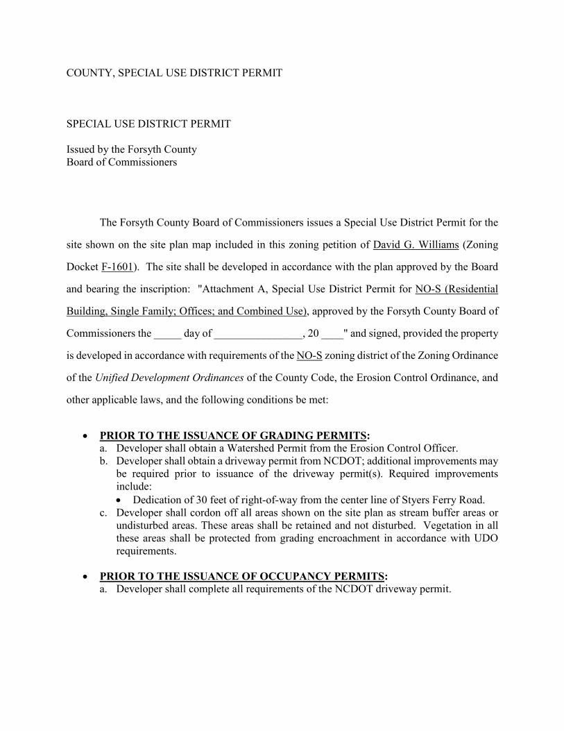
COUNTY, SPECIAL USE DISTRICT PERMIT SPECIAL USE DISTRICT PERMIT Issued by the Forsyth County Board of Commissioners
The Forsyth County Board of Commissioners issues a Special Use District Permit for the
site shown on the site plan map included in this zoning petition of David G. Williams (Zoning
Docket F-1601). The site shall be developed in accordance with the plan approved by the Board
and bearing the inscription: "Attachment A, Special Use District Permit for NO-S (Residential
Building, Single Family; Offices; and Combined Use), approved by the Forsyth County Board of
Commissioners the _____ day of ________________, 20 ____" and signed, provided the property
is developed in accordance with requirements of the NO-S zoning district of the Zoning Ordinance
of the Unified Development Ordinances of the County Code, the Erosion Control Ordinance, and
other applicable laws, and the following conditions be met:
• PRIOR TO THE ISSUANCE OF GRADING PERMITS:
a. Developer shall obtain a Watershed Permit from the Erosion Control Officer. b. Developer shall obtain a driveway permit from NCDOT; additional improvements may
be required prior to issuance of the driveway permit(s). Required improvements include: • Dedication of 30 feet of right-of-way from the center line of Styers Ferry Road.
c. Developer shall cordon off all areas shown on the site plan as stream buffer areas or undisturbed areas. These areas shall be retained and not disturbed. Vegetation in all these areas shall be protected from grading encroachment in accordance with UDO requirements.
• PRIOR TO THE ISSUANCE OF OCCUPANCY PERMITS:
a. Developer shall complete all requirements of the NCDOT driveway permit.

F-1601 Staff Report 1 April 2021
CITY-COUNTY PLANNING BOARD STAFF REPORT
PETITION INFORMATION
Docket F-1601 Staff Gary Roberts, Jr., AICP Petitioner(s) Williams Land Trust (David G. Williams heirs) Owner(s) Same Subject Property Portion of PIN 5874-72-8160 Address 7550 Styers Ferry Road Type of Request Special Use rezoning from RS40 to NO-S Proposal The petitioner is requesting to amend the Official Zoning Map for the
subject property from RS40 (Residential, Single Family – 40,000-square foot minimum lot size) to NO-S (Neighborhood Office – Special Use). The petitioner is requesting the following uses:
• Residential Building, Single Family; Offices; and Combined Use
Neighborhood Contact/Meeting A summary of the petitioner’s neighborhood outreach is attached.
Zoning District Purpose Statement
The NO District is primarily intended to accommodate very low-intensity office uses within converted single-family detached units. The district is intended to be located on the periphery of established residential areas along major and minor thoroughfares. The district is established to provide convenient locations for offices, the size and operating characteristics of which require limited parking and which generate little traffic. Standards are designed so that this district may serve as a transitional land use between residential districts and commercial districts. This district is intended for application in GMAs 2, 3 and 4.
Rezoning Consideration from Section 3.2.15 A 13
Is the proposal consistent with the purpose statement(s) of the requested zoning district(s)? No, while the request is for a low-intensity office use within a converted single-family home, the site is within the Rural Growth Management Area.
GENERAL SITE INFORMATION Location South side of Styers Ferry Road, between Styers Ferry Trail and Styers
Crossing Lane Jurisdiction Forsyth County Site Acreage ± 19.85 acres Current Land Use A single-family home is currently located on this site.

F-1601 Staff Report 2 April 2021
Surrounding Property Zoning and Use
Direction Zoning District Use
North GI Evo Corporation (construction contractors)
East RS40 Single-family homes on large lots
South AG Single-family homes on large lots
West AG and RS30 Undeveloped land and
single-family homes on very large lots
Rezoning Consideration from Section 3.2.15 A 13
Is/are the use(s) permitted under the proposed classification/request compatible with uses permitted on other properties in the vicinity? Considering the scale of the improvements shown on the site plan and the surrounding large lot development pattern, the proposed uses are generally compatible with the uses permitted on other properties in the vicinity.
Physical Characteristics
The site is partially wooded, traversed by Hauser Creek, and includes a small pond. The topography is variable.
Proximity to Water and Sewer
A public water main can be accessed from Styers Ferry Road. Public sewer is not available.
Stormwater/ Drainage No known issues.
Watershed and Overlay Districts
The site is located within the balance area of the Yadkin River WS IV Water Supply Watershed.
Analysis of General Site Information
The site is developed with a single-family home located approximately 900 feet from Styers Ferry Road. The property does not have access to public sewer service and is located within the Yadkin River Water Supply Watershed. It is also traversed by a stream.
RELEVANT ZONING HISTORIES
Case Request Decision & Date
Direction from Site Acreage Recommendation
Staff CCPB
F-138 R6 to I3 (GI) Approved 4/6/1970
Directly north 7 Denial Denial
SITE ACCESS AND TRANSPORTATION INFORMATION
Street Name Classification Frontage
Average Daily Trip
Count
Capacity at Level of Service D
Styers Ferry Road Minor Thoroughfare 348 feet 1,000 15,300
Proposed Access Point(s) The site will continue to use the existing access from Styers Ferry Road.

F-1601 Staff Report 3 April 2021
Trip Generation - Existing/Proposed
Existing Zoning: RS40 19.85 acres / 40,000 sf = 21 homes x 9.57 (single-family trip rate) = 201 trips per day Proposed Zoning: NO-S 3,000 sf / 1,000 x 11.57 (single-tenant office building trip rate) = 35 trips per day
Sidewalks There are no sidewalks in the general area. Transit Transit is not available at this location. Analysis of Site Access and Transportation Information
Styers Ferry Road is a minor thoroughfare with ample capacity. The request would generate less traffic than what could be expected with the current zoning, and staff does not anticipate any transportation-related issues associated with this request.
SITE PLAN COMPLIANCE WITH UDO REQUIREMENTS Building Square Footage
Square Footage Placement on Site 3,000 Central and western portion of the site
Parking Required Proposed 10 spaces 10 spaces
Building Height Maximum Proposed 40 feet One story
Impervious Coverage
Maximum Proposed 60 percent 3.7 percent
UDO Sections Relevant to Subject Request
• Section 4.6.1: Neighborhood Office District • Section 8.3: Watershed Protection
Complies with Section 3.2.11
(A) Legacy 2030 policies: No (B) Environmental Ord. N/A (C) Subdivision Regulations N/A
Analysis of Site Plan Compliance with UDO Requirements
The proposed site plan accommodates the conversion of an existing single-family home into an office, including a minor building expansion and associated parking area.
CONFORMITY TO PLANS AND PLANNING ISSUES Legacy 2030 Growth Management Area
Growth Management Area 5 - Rural Area
Relevant Legacy 2030 Recommendations
• The rural area is intended to remain very low-density and residential and agricultural in character.
• Without public sewer, the Rural Area will be much more likely to contain only scattered, very low-density residential uses in addition to agricultural uses and woodlands.
F-1601 Staff Report 4 April 2021
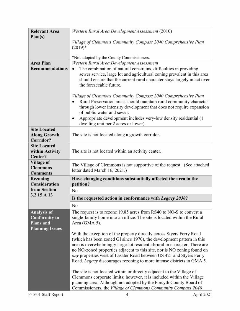
Relevant Area Plan(s)
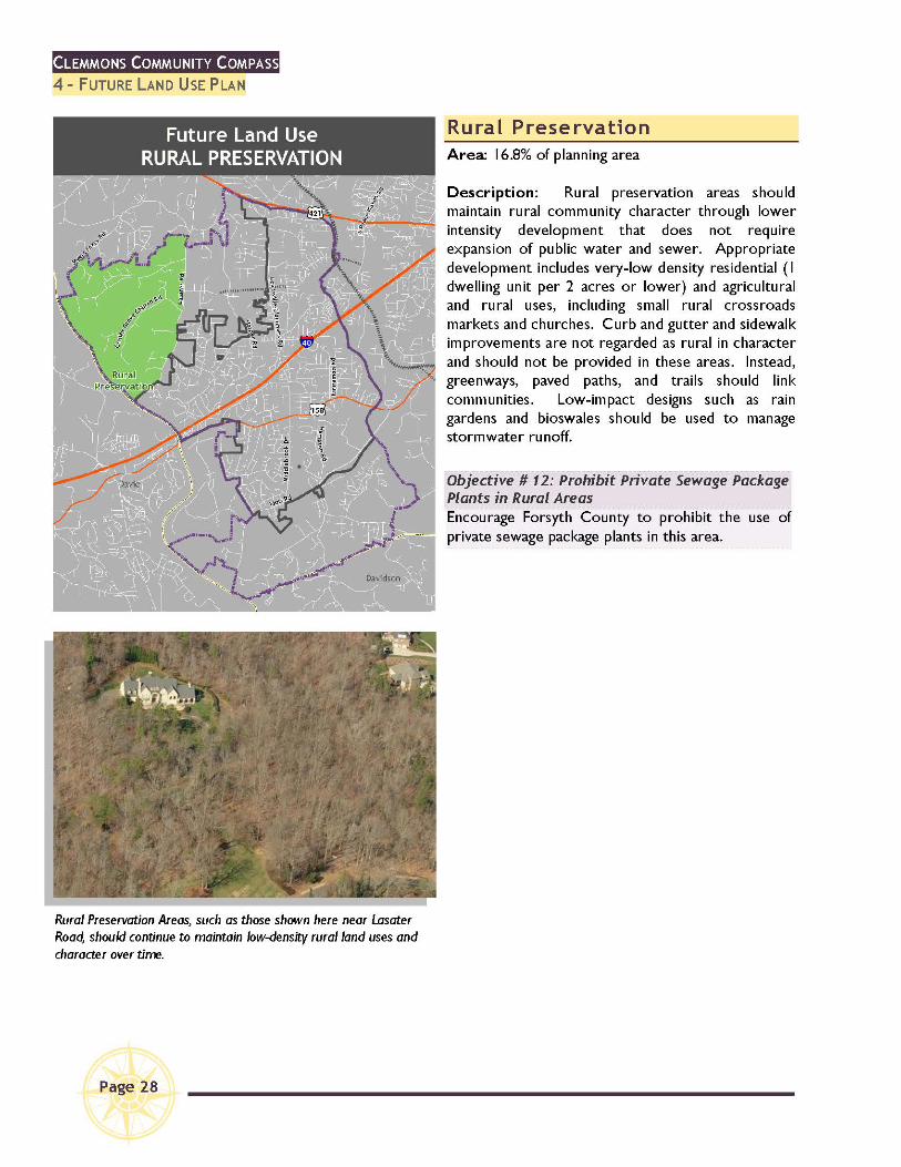
Western Rural Area Development Assessment (2010) Village of Clemmons Community Compass 2040 Comprehensive Plan (2019)* *Not adopted by the County Commissioners.
Area Plan Recommendations
Western Rural Area Development Assessment • The combination of natural constrains, difficulties in providing
sewer service, large lot and agricultural zoning prevalent in this area should ensure that the current rural character stays largely intact over the foreseeable future.
Village of Clemmons Community Compass 2040 Comprehensive Plan • Rural Preservation areas should maintain rural community character
through lower intensity development that does not require expansion of public water and sewer.
• Appropriate development includes very-low density residential (1 dwelling unit per 2 acres or lower).
Site Located Along Growth Corridor?
The site is not located along a growth corridor.
Site Located within Activity Center?
The site is not located within an activity center.
Village of Clemmons Comments
The Village of Clemmons is not supportive of the request. (See attached letter dated March 16, 2021.)
Rezoning Consideration from Section 3.2.15 A 13
Have changing conditions substantially affected the area in the petition? No Is the requested action in conformance with Legacy 2030? No
Analysis of Conformity to Plans and Planning Issues
The request is to rezone 19.85 acres from RS40 to NO-S to convert a single-family home into an office. The site is located within the Rural Area (GMA 5). With the exception of the property directly across Styers Ferry Road (which has been zoned GI since 1970), the development pattern in this area is overwhelmingly large-lot residential/rural in character. There are no NO-zoned properties adjacent to this site, nor is NO zoning found on any properties west of Lasater Road between US 421 and Styers Ferry Road. Legacy discourages rezoning to more intense districts in GMA 5. The site is not located within or directly adjacent to the Village of Clemmons corporate limits; however, it is included within the Village planning area. Although not adopted by the Forsyth County Board of Commissioners, the Village of Clemmons Community Compass 2040

F-1601 Staff Report 5 April 2021
Comprehensive Plan generally aligns with the recommendations of Legacy regarding the Rural Area. Recognizing this site is within the Yadkin River watershed, the plan recommends low-density residential development with lot sizes of 2 acres or larger.
CONCLUSIONS TO ASSIST WITH RECOMMENDATION Positive Aspects of Proposal Negative Aspects of Proposal
The existing building is not visible from Styers Ferry Road, and the proposed use would not intensify the amount of traffic that could otherwise be expected with traditional single-family development.
The request is not consistent with the purpose statement of the NO district. The site is located in the Rural Growth Management Area, and the request is not consistent with the recommendations of Legacy for this area. The request is not consistent with the Village of Clemmons Community Compass 2040 Comprehensive Plan, nor is it supported by the Village of Clemmons. Approval could establish a precedent for similar rezoning in the general area.
SITE-SPECIFIC RECOMMENDED CONDITIONS OF APPROVAL The following conditions are proposed from interdepartmental review comments to meet established standards or to reduce negative off-site impacts: • PRIOR TO THE ISSUANCE OF GRADING PERMITS:
a. Developer shall obtain a Watershed Permit from the Erosion Control Officer. b. Developer shall obtain a driveway permit from NCDOT; additional improvements may
be required prior to issuance of the driveway permit(s). Required improvements include: • Dedication of 30 feet of right-of-way from the center line of Styers Ferry Road.
c. Developer shall cordon off all areas shown on the site plan as stream buffer areas or undisturbed areas. These areas shall be retained and not disturbed. Vegetation in all these areas shall be protected from grading encroachment in accordance with UDO requirements.
• PRIOR TO THE ISSUANCE OF OCCUPANCY PERMITS:
a. Developer shall complete all requirements of the NCDOT driveway permit. STAFF RECOMMENDATION: Denial NOTE: These are staff comments only; the City-County Planning Board makes final recommendations, and final action is taken by the appropriate Elected Body, which may approve, deny, continue or request modification to any request. THE APPLICANT OR REPRESENTATIVE IS STRONGLY ENCOURAGED TO ATTEND THE PUBLIC HEARINGS WHERE THE CASE WILL BE CONSIDERED BY THE PLANNING BOARD AND THE ELECTED BODY.

F-1601 Staff Report 6 April 2021
CITY-COUNTY PLANNING BOARD PUBLIC HEARING
MINUTES FOR F-1601 APRIL 8, 2021
Gary Roberts presented the staff report. PUBLIC HEARING FOR: John Lipka (civil engineer), 514 Edwards Road, Rural Hall, NC 27045
• I wanted to provide a little bit of insight into development of the property from the engineer's perspective. There will be limited impact as far as traffic goes. We have proposed 10 parking spaces, we anticipate maybe four or five of those being used at a time. As far as the frequency of the use of the space, I can let my client speak to that a little bit more, but relatively no impacts to traffic.
• We are adding some impervious surface area. There is a downstream pond onsite. Relatively no impacts to the environment for the little bit of impervious we are adding to widen the driveway. We've had conversations with the adjacent property owners during our neighborhood outreach regarding visual impacts. The two immediate property owners to the east had concerns about what the impacts would be. There are several hundred feet of existing natural canopy buffer between this property and their residences, and we are required to install a Type II landscape buffer, if our site plan gets approved, to the east, so that would add to the pretty extensive canopy buffer that is there.
• I think that summarizes the impacts to the site. As far as a specific use of the site, it will benefit Forsyth County. As to the benefits that would meet the owners' intent for the use of the property, I will have my client speak to that.
David Niblock, 110 Oakwood Drive, Suite 300, Winston-Salem, NC 27103
• As for the proposed use of this property, I will begin by saying that folks engage in what we call alternative dispute resolution processes. Frequently that consists of mediation. Sometimes it is arbitration, but mediation is the voluntary endeavor for folks to resolve disputes without having to avail themselves of our court system. It is very worthwhile and very successful. And the idea of the Williams Dispute Resolution Center, which is in fact the proposed use of this property, is to provide a pastoral setting in a situation that is not necessarily office space or high-rise space, where folks can come together and have the opportunity to meet with a mediator or arbitrator and resolve these disputes. This is consistent with the wishes of Dave Williams, and it is consistent with the acts of the trust.

F-1601 Staff Report 7 April 2021
And we don't think that it is inconsistent with any of the neighborhood, although I respect the recommendation for denial because of the reasons set forth. This use will be more minimal but much more meaningful than any potential use that would be allowed in terms of residential development in this location.
• From a traffic standpoint, it would be less problematic than if it were developed as would otherwise be allowed. It is a not-for-profit endeavor. I want to make perfectly clear that this is not something being considered for commercial reasons. You have seen the site plan. It would involve folks arriving, and the most that would be in the actual house or building at any one time would be maybe 6-10 people.
• We are excited about this possibility because it isn't inconsistent with anything in the neighborhood other than that it is not residential. The support we've received from outreach efforts has been across the board. I believe you commented there is no one in opposition to this. It is actually very nice, from my standpoint, to be involved in something that feels this good for the neighborhood, the community, and the county. Understanding the challenges faced, we would respectfully ask you to consider approving us for that purpose.
Joseph Gatto, 521 Ridgehaven Circle, Winston-Salem, NC 27104
• I am the trustee of this trust. David Williams was my client. Obviously, I'm an attorney. David Niblock and I do a lot of mediation. We've especially done a lot of them during the COVID period because of the delays that have occurred at the courthouse. The trust does not allow for this property to be developed, but we wanted to use it as some type of community-based resource, and we looked at several options and felt the pastoral setting would be able to serve as a community-based resource. It would be non-profit, it would be a venue for people to come and have their disputes resolved in an area where there are trees and a pond; again, the atmosphere would lend itself to avoiding litigation and hopefully lessen, to some extent, the massive backlog we are going to have of cases since the courthouse has essentially been shut down for the last year. We really thought that would be a valid approach and we do not, especially Mr. Williams, want to do anything to disturb the natural surroundings and the natural aspects of this property. That is the last thing we want to do. Having said that, I just appreciate your consideration. And I do understand how it may not be consistent with the long-term plan, but we would hope that this would be an addition and would not disturb the rural growth plan.
AGAINST: None WORK SESSION George asked Mr. Niblock how he would currently be allowed to use the home as a home office. Mr. Niblock stated that Aaron would be in a better position to answer that question from the zoning perspective. He stated that this always seems to be a matter of degree, which is why they are trying to rezone the property.

F-1601 Staff Report 8 April 2021
Aaron stated that a home office has to be a primary residence, but there are also restrictions in terms of square footage. The home occupation provisions are tightly restricted in the UDO. What is being contemplated here goes above and beyond what is done with a home occupation. Melynda asked whether the request would rise to the level of spot zoning. Aaron explained that looking across the street, there is a large block of GI, and further southeast there is some Campus zoning. Given those two non-residential areas on the zoning map, staff didn't feel like it would rise to the level of illegal spot zoning. The use classification and zoning districts were discussed at length among the Board and staff. George stated that it is clear in the Clemmons 2040 Plan that this whole area should be rural preservation. He stated that they define it, they clarify it and they underline it, and if Clemmons is saying they don't want precedents here, then the Board needs to be careful about precedents. Melynda also noted that she was concerned about precedents. She stated that she thought it was a good use, but the Board should be conscious of the precedent that they would potentially be setting with an approval. Jack confirmed with Mr. Gatto the property development prohibitions and whether those included the possibility of a conservation easement or donation to Clemmons so that it would protect the agricultural nature of the property and the surrounding area while providing a non-profit entity a great location. Mr. Gatto specified that he did not know whether the specific terms of the trust would allow it but that he would not be averse to it. Aaron asked the Board to keep in mind that staff does not monitor what the trust does or does not do, but they enforce the site plan that has been submitted with the request. The site plan that has been submitted does not show any proposed grade lines outside of the area that is being contemplated for development and the parking by the house. If someone were to come in to get a grading permit from staff, they would not issue it because there is no proposed grading going on there. By virtue of the site plan, there is a pretty solid level of conservation going on, considering the fact that the site plan restricts grading activity. MOTION: Clarence Lambe recommended that the Planning Board find that the request is
inconsistent with the comprehensive plan. SECOND: Jason Grubbs VOTE: FOR: George Bryan, Melynda Dunigan, Jason Grubbs, Clarence Lambe, Chris Leak,
Mo McRae, Brenda Smith, Jack Steelman AGAINST: None EXCUSED: None MOTION: Clarence Lambe recommended approval of the zoning petition. SECOND: Jason Grubbs VOTE:

F-1601 Staff Report 9 April 2021
FOR: Jason Grubbs, Clarence Lambe, Chris Leak, Mo McRae, Brenda Smith, Jack
Steelman AGAINST: George Bryan, Melynda Dunigan
EXCUSED: None ____________________________ Aaron King Director of Planning and Development Services

Printed: 3/5/2021
PROPOSED ZONING:NO-S
EXISTING ZONING:RS40
SCALE: 1'' represents 500'
STAFF: Roberts
GMA: 5ACRES: 19.85
DOCKET #: F-1601
F
BLDG: 45' eastNEAREST
PETITIONER:David G. Williams (Williams Dispute Resolution Center)
MAP(S): 5874.04
Property included in zoning request.
500' mail notificationradius. Property not in zoning request.
STYERS CROSSING LN
CEN
TER
GR
OV
E P
LAC
E D
R
STYERS FERRY RD
CENTER GROVE CHURCH RD
CENTERGROVE PLACE CTRS30
GI
RS30
AG
RS40
C-S
AG552'
160'
533'
266'
432'
432'
433'
310'
1800
'
348'!(S
UVDS

Lewisville Comprehensive Plan
Clemmons Comprehensive Plan
CENTERGR
OV
EP
L ACE
DR
BULLARD RD
LASA
TER
RD
STYERS CROSSING LN
LANSFORDCT
LEATH RD
CENTER GROVE CHURCH RD
MILLE
RFO
RE
ST
LN
ELKMONTD
R
MILE
STO
NE
PO
INT
STYERS FERRY RD
HAR
PER
S G
RO
VE
LN
WOODSTOCK RD
BINKLEY WOODS DR
WELLSBURG
CT
WOODFORD RD
STY
ERS
FERRY
TL
CENTERGROVE PLACECT
STONE VALLEY DR
ELLISON CR EEK
CaseF1601
Clemmons Comprehensive Plan, 2019(Proposed land uses shown are generalized.See area plan for specific recommendtations.)
¯500 0 500250
Feet
Office
Industrial
Institutional
Mixed-Use Development
Park
Rural Preservation
Commercial
Multifamily Residential
Future Growth Area
Cluster Residential
Neighborhood Residential
Village-Scale Retail/Office

Rezoning Site P
lan
ZON
ING
WID
TH P
RO
VID
ED
:
TYP
E R
EQ
UIR
ED
:
AD
JOIN
ING
ZON
ING
:
BU
FFER
YAR
DS
10 SP
AC
ES
1 SP
AC
ES
/300 SF G
FA (3,000 S
F/300)
PA
RK
ING
CA
LCU
LATION
S
TOTA
L PA
RK
ING
PR
OV
IDE
D =
10 SP
AC
ES
AG
, RS
40, RS
30
TYP
E I
SE
E P
LAN
S
PIN
:P
ortion of 5874-72-8160
TOTA
L AC
RE
AG
E:
SITE
SIZE
AN
D C
OVER
AGES
% % %%
0.5
3.2
96.3
100.0
PR
OP
OS
ED
BU
ILDIN
G TO
LAN
D
PR
OP
OS
ED
PA
VE
ME
NT TO
LAN
D
PR
OP
OS
ED
OP
EN
SP
AC
E
TOTA
L
SITE
CO
VE
RA
GE
S:
19.8529 AC
AC
RE
(S)
INFR
ASTRU
CTU
RE
STR
EE
TS:
SE
WE
R:
WA
TER
:
X
FTLIN
EA
R FE
ET O
F PU
BLIC
STR
EE
TS:
PU
BLIC
PR
IVA
TE
X
(STR
EE
T, SID
EW
ALK
S A
ND
DR
IVE
WA
YS
)
%
0.5E
XIS
TING
BU
ILDIN
G TO
LAN
D%
2.0E
XIS
TING
PA
VE
ME
NT TO
LAN
D(S
IDE
WA
LKS
, GR
AV
EL A
ND
DR
IVE
WA
YS
)%
97.5E
XIS
TING
OP
EN
SP
AC
E
XNA
FTLIN
EA
R FE
ET O
F EX
ISTIN
G P
RIV
ATE
STR
EE
TS:
FTLIN
EA
R FE
ET O
F PR
OP
OS
ED
PR
IVA
TE S
TRE
ETS
:FT
LINE
AR
FEE
T OF P
RIV
ATE
STR
EE
TS:
PLA
NN
ING
BO
AR
D R
EV
IEW
FINA
L DE
VE
LOP
ME
NT P
LAN
PR
ELIM
INA
RY
SU
BD
IVIS
ION
TYP
E O
F RE
VIE
W: R
EV
IEW
INFO
RM
ATION
SP
EC
IAL U
SE
PE
RM
IT (FOR
SY
TH C
O. ZB
OA
)
SITE
PLA
N A
ME
ND
ME
NT
SP
EC
IAL U
SE
RE
ZON
ING
X
CITY
OF W
INS
TON
-SA
LEM
FOR
SY
TH C
OU
NTY
VILLA
GE
OF C
LEM
MO
NS
JUR
ISD
ICTIO
N:TO
WN
OF W
ALK
ER
TOW
N
PU
RP
OS
E S
TATE
ME
NT: TH
E P
UR
PO
SE
OF TH
IS R
EQ
UE
ST
IS TO
:S
PE
CIA
L US
E R
EZO
NIN
G FR
OM
RS
40 TO N
O-S
X
WA
TER
SH
ED
:
EN
VIR
ON
ME
NTAL
FLOO
DP
LAIN
/ FLOO
DW
AY
:
YA
DK
IN R
IVE
R W
ATE
RS
HE
D
PR
OJE
CT A
RE
A IS
NO
T WITH
IN A
DE
SIG
NA
TED
FLO
OD
PLA
IN / FLO
OD
WA
Y
STR
EA
MS
/ STR
EA
M B
UFFE
RS
:P
RO
JEC
T AR
EA
IS N
OT W
ITHIN
DE
SIG
NA
TED
S
TRE
AM
OR
STR
EA
M B
UFFE
R A
RE
AS
EX
ISTIN
G ZO
NIN
G:
RS
40
NO
-SP
RO
PO
SE
D ZO
NIN
G:
PR
OP
OS
ED
US
ES
:
19.8529 AC
Consulting Engineers
Land & Infrastructure
Developm
ent Solutions
Consulting Engineers
658 McG
regor Rd
Winston-S
alem, N
C 27103
(336) 945-0302JLipka@
LPK-C
onsulting.com7550 Styers Ferry RoadLewisville TownshipForsyth County, NC
Williams Dispute Resolution Center
03-25-21
NA
NA
NA
EX. G
RAD
E
EX
. PA
VE
ME
NT S
EC
TION
%

USES ALLOWED IN THE EXISTING RS40 ZONING DISTRICT Forsyth County Jurisdiction
F-1601 Permitted Uses 1 April 2021
USES ALLOWED WITH A PERMIT FROM THE ZONING OFFICER (Z) Adult Day Care Home Agricultural Production, Crops Agricultural Production, Livestock Child Day Care, Small Home Church or Religious Institution, Neighborhood Family Group Home A Kennel, Outdoor Police or Fire Station Recreation Facility, Public Residential Building, Single Family Swimming Pool, Private Transmission Tower (see use-specific standards
in UDO ClearCode) USES ALLOWED WITH REVIEW BY THE PLANNING BOARD (P) Cemetery Church or Religious Institution, Community Golf Course Landfill, Land Clearing/Inert Debris, 2 acres or
less Library, Public Planned Residential Development School, Private School, Public Utilities
USES ALLOWED WITH SPECIAL USE PERMIT FROM ZONING BOARD OF ADJUSTMENT (A) Bed and Breakfast Borrow Site Campground Child Day Care, Large Home Dirt Storage Fishing, Fee Charged Habilitation Facility A Manufactured Home, Class A Manufactured Home, Class B Manufactured Home, Class C Nursing Care Institution Park and Shuttle Lot Recreational Vehicle Park Riding Stable3
Shooting Range, Outdoor Special Events Center Transmission Tower USES ALLOWED WITH SPECIAL USE PERMIT FROM ELECTED BODY (E) Access Easement, Private Off-Site5
Landfill, Land Clearing/Inert Debris, greater than 2 acres
Parking, Off-Site, for Multifamily or Institutional Uses
3See Section 5.2.74 5SUP not required if standards of Section 5.2.2A are met

F -1601 Williams DisputeResolution Center (Special
Use Rezoning)Bryce A. Stuart Municipal Building100 East First Street, Suite 225
Winston-Salem, NC 27101Phone: 336-747-7040 Fax: 336-748-3163 City of W-S Planning
John Lipka LPK Consulting, PA 7750 Seasons Hollow RdLewisville, NC 27023
Project Name: F -1601 Williams Dispute Resolution Center(Special Use Rezoning)
Jurisdiction: City of Winston-Salem ProjectID: 504400
Wednesday, March 17, 2021
The comments listed below reflect remaining issues that must be addressed before your request can proceed to the Planning Board.All outstanding issues included in this list must be satisfactorily addressed on the revised site plan and re-submitted back to Planningstaff no later than 5:00pm on the Thursday two weeks before (14 days prior to) the Planning Board meeting.
Open Issues: 10
Erosion Control General Issues
14. Erosion Control Plan Needed City of Winston-Salem
Matthew Osborne336-747-7453
[email protected]/8/21 9:08 AM
01.03) Rezoning-Special Use District - 2
If the proposed project creates more than 10,000 sq. feet of land disturbance, an Erosion Control/GradingPermit will be required prior to the start of work. In order to obtain this permit you must submit aprofessionally designed Erosion and Sedimentation Control Plan along with an original signed/notarizedFinancial Responsibility/Ownership (FRO) form for review and approval. Please submit the plan throughthe electronic plan review portal at the following link: https://winston-salem.idtplans.com/secure/
15. Watershed Permit Needed
Created with idtPlans Review 3/17/21 F -1601 Williams Dispute Resolution Center (Special Use Rezoning) Page 1 of 4

City of Winston-SalemMatthew Osborne
3/8/21 9:08 AM01.03) Rezoning-
Special Use District - 2
The proposed project is within the Yadkin River Watershed which is regulated per Winston-Salem/ForsythCounty UDO, Chapter 8, Section 3 – Watershed Protection. This project must comply with the Winston-Salem/Forsyth County UDO, Chapter 8, Section 3 – Watershed Protection requirements and provisions. The Environmental Grading and Erosion Control Permit will not be issued until compliance with theWatershed Protection requirements have been verified and a Watershed Protection Permit has beenapproved. Please submit for a Watershed Protection Permit through the electronic plan review portal atthe following link: https://winston-salem.idtplans.com/secure/.
Health Department General Issues
20. Septic concerns Forsyth County Health
DepartmentChad Rakes
3/15/21 4:21 PM01.03) Rezoning-
Special Use District - 2
As it appears that Private Water does not refer to a Private Drinking Water Well, but asa Private Water Line.Would suggest that prior to any grading permits, that an application be submitted to theHealth Department to determine feasibility of a septic area.
MapForsyth Addressing Team General Issues
17. Addressing & Street Naming Forsyth County
GovernmentGloria Alford3367032337
[email protected]/10/21 2:51 PM01.03) Rezoning-
Special Use District - 2
Please contact the MapForsyth Addressing team in regards to addresses.
NCDOT General Issues
16. NCDOT Comments NCDOT Division 9
Victoria Kildea336-747-7900
[email protected]/8/21 1:42 PM
01.03) Rezoning-Special Use District - 2
Driveway Permit required.Encroachment agreement(s) required for any work or utility ties within the right ofway.
Planning General Issues
10. Historic Resources
Created with idtPlans Review 3/17/21 F -1601 Williams Dispute Resolution Center (Special Use Rezoning) Page 2 of 4

City of Winston-SalemHeather Bratland336-727-8000
[email protected]/3/21 1:40 PM
01.03) Rezoning-Special Use District - 2
No comments
21. Plan Consistency City of Winston-Salem
Desmond Corley336-727-8000
[email protected]/17/21 10:32 AM01.03) Rezoning-
Special Use District - 2
Despite its relatively low impact, this proposal is inconsistent with therecommendation(s) of the applicable area plan(s) and the character of the surroundingarea, which is overwhelmingly residential. The Neighborhood Office (NO) district isintended to be located on the periphery of established residential areas, along majorand minor thoroughfares. This request is centrally located within an establishedresidential area. Further, the district's standards are designed so that it can serve as atransitional area between residential districts and commercial districts, which would beinappropriate at this location.
The staff report will recommend denial of the petition.[Ver. 2] [Edited By Desmond Corley]
Utilities General Issues
13. General Comments City of Winston-Salem
Charles Jones336-727-8000
[email protected]/8/21 11:08 AM01.03) Rezoning-
Special Use District - 2
Any existing connections not intended for reuse must be terminated at the main.Backflow preventer for the Private Fire Hydrant will be a Reduce Pressure DetectorAssembly. Fire Hydrant will be painted red as is the standard. Domestic water serviceshall have a separate tap and will require a backflow preventer as well. Water meterspurchased through COWS. System development fees due at time of new meterpurchase. All plans will be submitted through the building plan process and approved atthat time by Utilities.[Ver. 3] [Edited By Charles Jones]
WSDOT General Issues
12. General Comments City of Winston-Salem
David Avalos336-727-8000
[email protected]/3/21 3:41 PM
01.03) Rezoning-Special Use District - 2
Dedicate right of way 30' from center along entire styers ferry rd frontage.
Zoning General Issues
18. Zoning
Created with idtPlans Review 3/17/21 F -1601 Williams Dispute Resolution Center (Special Use Rezoning) Page 3 of 4

City of Winston-SalemElizabeth Colyer336-747-7427
[email protected]/15/21 11:27 AM
01.03) Rezoning-SpecialUse District - 2
See Section 4.6.1 for supplementary district requirements for the NO zoning district. A Type IIbufferyard is required for parking to the side of the principal building adjacent to residentialzoning.
Any proposed exterior lighting must meet the additional requirements of Section 6.6.
[Ver. 2] [Edited By Elizabeth Colyer]
Created with idtPlans Review 3/17/21 F -1601 Williams Dispute Resolution Center (Special Use Rezoning) Page 4 of 4

F-1601 Neighborhood Outreach Summary 1 of 7 April 2021

F-1601 Neighborhood Outreach Summary 2 of 7 April 2021

F-1601 Neighborhood Outreach Summary 3 of 7 April 2021

F-1601 Neighborhood Outreach Summary 4 of 7 April 2021

F-1601 Neighborhood Outreach Summary 5 of 7 April 2021

F-1601 Neighborhood Outreach Summary 6 of 7 April 2021
F-1601 Neighborhood Outreach Summary 7 of 7 April 2021

Planning & Community Development Telephone 336-766-7511 3715 Clemmons Road Fax 336-766-7536 Clemmons, NC 27012
TO: Mr. Gary H. Roberts, Jr., Winston-Salem/Forsyth County Principal Planner
From: Nasser Rahimzadeh & Caroline Drake, Clemmons Planning Staff
Date: March 16, 2021
Re: Williams Dispute Resolution Center (F-1601) Portion of Parcel PIN #5874-72-8160
The purpose of this memorandum is to comment on proposal F-1601 as it relates to the Village of Clemmons Future Land Use Plan. The Williams Dispute Resolution Center proposal is not in agreement with the Village of Clemmons Community Compass 2040 Comprehensive Plan. The property is currently zoned RS-40. The site plan shows that the proposed subdivision would be developed using Winston-Salem/Forsyth County’s NO-S/Neighborhood Office-Special District zone. NO-S is primarily intended to accommodate very low intensity office uses within converted single family detached units. The district is intended for application in GMAs 2, 3, and 4.
Parcel PIN #5874-72-8160 falls under the Village of Clemmons Rural Preservation1 area per the 2040 Comprehensive Plan. The Rural Preservation area is described as an area that maintains rural community character through lower intensity development that does not require expansion of public water and sewer. Appropriate uses for this area include very low-density residential, agricultural, and rural uses, including small rural crossroads markets and churches. Furthermore, the parcel falls under the Growth Management Area 5 for which the NO-S district zone is not intended. Since the proposed office use is not listed as an appropriate use for the Rural Preservation area, and the NO-S zoning district is not intended for GMA 5, Planning Staff for the Village of Clemmons finds the proposal to be inconsistent with the Clemmons Comprehensive Plan.
1 See attached excerpt from the Village of Clemmons Community Compass 2040 Comprehensive Plan