april, 2001 - alberta parks · pdf filecontributed to the succesful completion of this...
TRANSCRIPT

Preliminary Classificationof Native Wheat Grass (Agropyron spp.) Community Types
in Alberta
Prepared for:
Alberta Natural Heritage Information CentreAlberta EnvironmentEdmonton, Alberta
Prepared by:
K. VujnovicJ. Bentz
Geowest Environmental Consultants Ltd.Suite 203, 4209 - 99 Street
Edmonton, AlbertaT6E 5V7
April, 2001

Preliminary Classification of Native Agropyron Community Types in Alberta
Geowest Environmental Consultants Ltd. Page i
EXECUTIVE SUMMARY
Biological diversity is under threat and declining, both within Alberta and Canada, as well asaround the world. Alberta’s natural regions and the biodiversity they contain are affected byhuman activities and natural influences, including urban growth, agriculture, large-scaleindustrial activities such as forest harvesting and petroleum extraction, and climate change. TheCanadian Biodiversity Strategy was developed to sustain and promote biological diversity inCanada and to help combat this decline.
Alberta Natural Heritage Information Centre (ANHIC) collects, evaluates and makes availableinformation on elements of natural biodiversity in Alberta, including flora, fauna and naturalplant communities. A preliminary tracking list of natural plant community elements is currentlyunder development. However, ANHIC requires more information on plant community types inAlberta to better define their characteristics and species composition and to determine theirdistribution and provincial ranking. In support of ANHIC, Alberta Environment contractedGeowest Environmental Consultants Ltd. to produce a synopsis of historical data on nativeAgropyron (wheat grass) plant community types and to create a preliminary provincialclassification of these community types.
The following specific project objectives were identified:
• review and compilation of existing information from various sources (includingexisting field plot data, published literature, unpublished reports, consultations withknowledgeable individuals, etc.) on native Agropyron community types in Alberta;
• development of a comprehensive preliminary classification of Agropyron plantcommunities for each alliance or major vegetation type;
• cross-referencing of the proposed Agropyron community types to the communitytypes described in other Alberta studies, and in adjacent provinces and states;
• evaluation and assignment of a preliminary provincial ranking to each communitytype;
• identification of knowledge gaps;
• completion of a community characterization abstract for each community type, forinclusion in the ANHIC database; and
• production of a summary report.
The classification was based on an exhaustive literature review of relevant Agropyroncommunity types identified previously within Alberta and in other geographic jurisdictionsincluding Saskatchewan, British Columbia, Montana, Washington, Colorado, Idaho and Utah.As well, cluster and ordination analyses were completed of 416 selected plots from theEcological Site Inventory System (ESIS) electronic database provided by Alberta Environment,Resource Data Division. The classification was based on the attributes of the vegetation as wellas environmental site factors. Procedures outlined in the publication International Classificationof Ecological Communities: Terrestrial Vegetation of the United States: Volume 1 - The National

Preliminary Classification of Native Agropyron Community Types in Alberta
Geowest Environmental Consultants Ltd. Page ii
Classification System: Development, Status, and Applications (Grossman et al. 1998) werefollowed.
The preliminary classification of Agropyron community types based on the literature review andthe cluster analysis of the ESIS database identified 39 potential Agropyrondominated/codominated community types within Alberta. These were grouped into fourHerbaceous Alliances.
Within the Agropyron spicatum Alliance, five communities were identified: Agropyronspicatum; Agropyron spicatum - Festuca campestris; Agropyron spicatum - Elymus innovatus -Aster conspicuous; Agropyron spicatum - Carex obtusata; and, Agropyron spicatum - Festucaidahoensis;
Within the Agropyron trachycaulum Alliance, 11 communities were identified: Agropyrontrachycaulum; Agropyron trachycaulum - Stipa spp.; Agropyron trachycaulum - Carexatherodes; Agropyron trachycaulum - Carex praegracilis - Fragaria virginiana; Agropyrontrachycaulum - Distichlis stricta; Agropyron trachycaulum - Koeleria macrantha; Agropyrontrachycaulum - Festuca ovina - Poa palustris - Equisetum arvense; Agropyron trachycaulum -Hierochloe odorata; Agropyron trachycaulum - Elymus innovatus - Thalictrum venulosum;Poa interior - Agropyron trachycaulum; and, Hordeum jubatum - Agropyron trachycaulum -Distichlis stricta.
Within the Agropyron dasystachyum Alliance, 11 communities were identified: Agropyrondasystachyum; Agropyron dasystachyum - Calamovilfa longifolia; Agropyron dasystachyum -Agropyron smithii; Agropyron dasystachyum - Koeleria macrantha - Artemisia frigida;Agropyron dasystachyum - Poa pratensis; Agropyron dasystachyum - Muhlenbergia cuspidata;Agropyron dasystachyum - Artemisia dracunculus - Artemisia frigida; Agropyron dasystachyum- Antennaria nitida; Agropyron dasystachyum - Stipa comata; Agropyron dasystachyum -Agropyron subsecundum; and, Juniperus horizontalis - Arctostaphylos uva-ursi / Agropyrondasystachyum - Elymus innovatus.
Within the Agropyron smithii Alliance, 12 communities were identified: Agropyron smithii;Agropyron smithii - Artemisia ludoviciana; Agropyron smithii - Artemisia frigida; Agropyronsmithii - Artemisia tilesii - Artemisia frigida; Agropyron smithii - Bouteloua gracilis; Agropyronsmithii - Hordeum jubatum; Agropyron smithii - Pyrrocoma uniflora; Agropyron smithii -Atriplex nuttallii; Agropyron smithii - Stipa comata - Bouteloua gracilis; Carex stenophylla -Agropyron smithii; Distichlis stricta - Agropyron smithii; and, Koeleria macrantha - Agropyronsmithii.
All proposed Agropyron community types were described and assigned a preliminary provincialranking. Knowledge gaps were identified and strategies to address these gaps were provided.Community characterization abstracts were also compiled for each of the proposed communitytypes. The information in this report can be used to update the preliminary community trackinglist by including new community types, as well as by changing ranking for those communitiesthat are currently on the list. It can also be used to decide which community types need furtherstudies and to prioritize these studies. Finally, this preliminary classification of Agropyroncommunities in Alberta is a part of a larger project to classify and describe the vegetation ofAlberta within a North American context.

Preliminary Classification of Native Agropyron Community Types in Alberta
Geowest Environmental Consultants Ltd. Page iii
ACKNOWLEDGEMENTS
We wish to thank Lorna Allen (Alberta Natural Heritage Information Centre, AlbertaEnvironment), Keith Ainsley (Resource Data Division, Alberta Environment), Arthur Schwarz(University of Alberta), Mike Willoughby (Land and Forest Service, Alberta Environment), andRussell Wells (Resource Data Division, Alberta Environment) for assistance throughout theproject. We are also grateful to Dragomir Vujnovic for his assistance in report preparation.Dennis O’Leary, Jim Squarok and Terry Lang (Geowest Environmental Consultants Ltd.) alsocontributed to the succesful completion of this project.

Preliminary Classification of Native Agropyron Community Types in Alberta
Geowest Environmental Consultants Ltd. Page v
TABLE OF CONTENTS Page
EXECUTIVE SUMMARY................................................................................................................. iACKNOWLEDGEMENTS..............................................................................................................iiiTABLE OF CONTENTS.................................................................................................................. vLIST OF TABLES .......................................................................................................................... viiLIST OF FIGURES ......................................................................................................................viiiLIST OF APPENDICES ............................................................................................................... viii
1. INTRODUCTION...................................................................................................................... 1
1.1 Background Information ......................................................................................... 11.2 Project Objectives.................................................................................................... 3
2. METHODS................................................................................................................................. 5
2.1 Collection of Background Information ................................................................... 52.2 Development of Comprehensive Classification ...................................................... 5
2.2.1 Vegetation Data Analyses and Classification.............................................. 72.2.2 Ordination of Agropyron Community Types Identified by Cluster Analysis...................................................................................... 9
2.3 Cross referencing of proposed Agropyron community types with the literature and analysis of plot data ........................................................................................... 10
2.4 Evaluation and Assignment of Preliminary Provincial Ranking........................... 102.5 Identification of Knowledge Gaps......................................................................... 122.6 Creation of Community Characterization Abstracts ............................................. 13
3. RESULTS AND DISCUSSION................................................................................................ 15
3.1. Preliminary Classification of Native Agropyron Communities ............................ 153.1.1. Previously Reported Native Agropyron Community Types................... 15
3.1.1.1. Agropyron spicatum Alliance in Alberta..................................... 153.1.1.2. Agropyron spicatum Alliance Outside Alberta ........................... 173.1.1.3. Agropyron trachycaulum Alliance in Alberta ............................. 213.1.1.4. Agropyron trachycaulum Alliance Outside Alberta.................... 243.1.1.5. Agropyron dasystachyum Alliance in Alberta............................. 253.1.1.6. Agropyron dasystachyum Alliance Outside Alberta ................... 293.1.1.7. Agropyron smithii Alliance in Alberta ........................................ 313.1.1.8. Agropyron smithii Alliance Outside Alberta............................... 343.1.1.9. Agropyron albicans group........................................................... 383.1.1.10. Other Related Communities Found Within Alberta................... 38
3.1.2. Vegetation Data Analysis and Classification ............................................ 43

Preliminary Classification of Native Agropyron Community Types in Alberta
Geowest Environmental Consultants Ltd. Page vi
3.1.3 Relationship Between Classified Agropyron Communities and Environmental Variables........................................................................... 443.1.4. Cross Referencing of Proposed Agropyron Community Types With
the Literature and Analysis of Plot Data From Alberta............................. 683.1.4.1. Cross Reference Tables With the Literature From Alberta And Analysis of the ESIS Plot Data............................................ 683.1.4.2. Cross Reference Tables With the Literature From Outside Alberta ......................................................................................... 77
3.1.5 Description of Proposed Agropyron Community Types ........................... 833.1.5.1. Agropyron spicatum Herbaceous Alliance................................... 833.1.5.2. Agropyron trachycaulum Herbaceous Alliance ........................... 843.1.5.3. Agropyron dasystachyum Herbaceous Alliance........................... 883.1.5.4. Agropyron smithii Herbaceous Alliance ...... ............................... 933.1.5.5. Agropyron albicans Group........................................................... 96
3.2. Assignment of Preliminary Provincial Ranking and Identification of Knowledge Gaps ...................................................................................................... 97 3.3. Conclusions ............................................................................................................ 104
4. LITERATURE CITED.......................................................................................................... 105

Preliminary Classification of Native Agropyron Community Types in Alberta
Geowest Environmental Consultants Ltd. Page vii
LIST OF TABLES Page
Table 1. Latin names, common names, synonyms, native status, typical habitat description, and hybrids for ten Agropyron species occurring within the province of Alberta, Canada............................................................................................... 2
Table 2. Community Ranking Guidelines .................................................................................... 11
Table 3. Preliminary Sub-national Community Ranking Guidelines........................................... 12
Table 4. Confidence levels assigned to each community.............................................................. 12
Table 5: Code equivalents between cluster groups (communities) identified by cluster analysis, PC-ORD plots, and "Other Plot Number" - unique plot codes in ESIS database................................................................................................... 52
Table 6. Descriptive statistics for environmental variables extracted from the ESIS database for 18 Agropyron community types identified by cluster analysis ................... 57
Table 7. Agropyron spicatum Alliance: crosswalk with literature from Alberta and cluster analysis.................................................................................................................. 69
Table 8. Agropyron trachycaulum Alliance: crosswalk with literature from Alberta and cluster analysis........................................................................................................... 70
Table 9. Agropyron dasystachyum Alliance: crosswalk with literature from Alberta and cluster analysis.......................................................................................................... 72
Table 10. Agropyron smithii Alliance: crosswalk with literature from Alberta and cluster analysis................................................................................................................ 74
Table 11. Other than Agropyron Alliances: crosswalk with literature from Alberta and cluster analysis........................................................................................................ 76
Table 12. Agropyron spicatum Alliances: crosswalk with literature from outside Alberta ............................................................................................................... 78
Table 13. Agropyron trachycaulum Alliances: crosswalk with literature from outside Alberta ............................................................................................................... 79
Table 14. Agropyron dasystachyum Alliances: crosswalk with literature from outside Alberta ............................................................................................................... 80
Table 15. Agropyron smithii Alliances: crosswalk with literature from outside Alberta ............................................................................................................... 81

Preliminary Classification of Native Agropyron Community Types in Alberta
Geowest Environmental Consultants Ltd. Page viii
LIST OF FIGURES Page
Figure 1. Cluster analysis of 416 selected plots from ESIS database........................................... 45
Figure 2. Ordination diagram based on Detrended Canonical Correspondence Analysis (DCCA) of 120 plots from the Ecological Site Inventory System (ESIS) database................................................................................................. 55
Figure 3. Ordination diagram based on Detrended Canonical Correspondence Analysis (DCCA) of 120 plots from the Ecological Site Inventory System (ESIS) database................................................................................................. 56
LIST OF APPENDICES
Appendix 1. List of species assigned to the dwarf shrub layer .................................................. 113
Appendix 2. Detailed description of fields in the community characterization abstract................................................................................................................... 117
Appendix 3. Descriptive statistics for species cover within each cluster (community) derived from the Furthest Neighbor cluster analysis............................................. 125
Appendix 4. Summary of Detrended Canonical Correspondence Analysis (DCCA) of 120 plots from ESIS database ............................................................................ 161
Appendix 5. Statistics for environmental variables used in Detrended Canonical Correspondence Analysis (DCCA) of 120 plots from ESIS database.................... 169
Appendix 6. Community characterization absracts..................................................................... 173

Preliminary Classification of Native Agropyron Community Types in Alberta
Geowest Environmental Consultants Ltd. Page 1
1. INTRODUCTION
1.1 Background Information
Biological diversity is under threat and declining, both within Alberta, Canada and the world.Alberta’s natural regions and the biodiversity they contain are affected by human activities andnatural influences, including urban growth, agriculture, large-scale industrial activities such asforest harvesting and petroleum extraction, and climate change. The Canadian BiodiversityStrategy was developed to sustain and promote biological diversity in Canada and to help combatthis decline. Alberta signed a statement of commitment in 1995, along with the federalgovernment and all other provinces and territories, to use the strategy as a guide for actions toconserve biological diversity.
The Resource Data Division of Alberta Environment has contracted Geowest EnvironmentalConsultants Ltd. to undertake a study to compile information on selected Agropyroncommunities in Alberta. This initiative is in support of the Alberta Natural Heritage InformationCentre (ANHIC); ANHIC collects, evaluates and makes available information on elements ofnatural biodiversity of Alberta, including flora, fauna and natural plant communities. ANHICdevelops tracking lists of elements that are considered of high priority because they are rare orspecial in some way. A preliminary tracking list of natural plant community elements is currentlyunder development. However, ANHIC requires more information on plant community types inAlberta to better define their characteristics and species composition and to determine theirdistribution and provincial ranking. A number of high priority alliances or major vegetation typeshave been identified for which information needs to be collected. The long-term goal is todevelop a complete list of plant community types within each alliance or major vegetation type,to help identify community types that warrant protection. A consolidation of materials onAgropyron community types in Alberta was necessary to allow for biodiversity measures andmore comprehensive plant community rankings.
Agropyron spp., a perennial commonly known as wheat grass, occurs extensively across NorthAmerica, ranging from Alaska, Yukon, Ellesmere Island, and Greenland in the north toNewfoundland in the east and Texas, California and Arizona in the south. Agropyron specieshybridize so that recognition of taxonomic units is somewhat arbitrary. Hybrids betweenAgropyron species and those of other genera also occur. Ten species of Agropyron have beenidentified by Moss (1983) in the Flora of Alberta (see table 1).

Preliminary Classification of Native Agropyron Community Types in Alberta
Geowest Environmental Consultants Ltd. Page 2
Table 1. Latin names, common names, synonyms, native status, typical habitat description, and hybrids for ten Agropyron species occurring within the province of Alberta, Canada(present Latin names according to Moss (1983) and used by NatureServe are presented); *http://www.fs.fed.us/database/feis/plants/
Moss 1983 AEP 1995 Synonyms used by NatureServe Other Synonyms* NativeStatus
Typical habitat description(from Moss 1983)
A. albicans Scribn. & J.G. Smith
Awnednorthernwheat grass
Elymus albicans (Scribn. & J. G.Smith) A. Löve
Elymus albicans (Scribn. & J. G.Smith) A. Löve
Native Dry prairie grasslands
A. dasystachyum (Hook)Scribn. & J. G. Smith
Northernwheat grass
Elymus lanceolatus (Scribn. & J. G.Smith) Gould
Agropyron albicans, Agropyron elmeri,Agropyron Griffithsii, Agropyronpsammophilus, Agropyron riparium
Native Prairie grasslands, sand hills anddry open woodlands; produceshybrids with A. trachycaulum andA. spicatum.
A. prectiniforme Roemer& J. A. Schultes
Crested whetgrass
A. cristatum (L.) Gaertn. ssp.pectinatum (Bieb) Tzvelev
Introduced Along roadsides and on wasteground
A. repens (L.) Beauv. Quack grass Elytringia repens (L.) Desv. ex B. D.Jackson
Introduced Along roadsides, waste groundsand gardens
A. scribneri Vasey Scribner’swheat grass
Native Dry alpine slopes; produces ahybrid with A. violaceum
A. sibiricum (Willd.)Beauv.
Siberianwheat grass
Agropyron fragile (Roth) P. Candargyssp. sibiricum (Willd.) Melderis
Introduced Waste grounds
A. smithii Rydb. Westernwheat grass
Pascopyrum smithii (Rydb.) A. Löve Native Prairie grasslands; produces ahybrid with Elymus innovatus
A. spicatum (Pursh)Sribn. & Smith
Bluebunchwheat grass
Pseudoroegneria spicata (Pursh A.Löve
Agropyron spicatum (Pursh)Agropyron inerme (Scribn. & Smith)Rydb.Elymus spicatus (Pursh) GouldElytrigia spicata (Pursh) D. R. Dewey
Native Grasslands and open forests ondry southern slopes
A. trachycaulum (Link)Malte
Slenderwheat grass
Elymus trachycaulus (Link) Gould exShinners
Agropyron caninum (L.) Beauv.Agropyron pauciforum (Schwcinitz) A.Hitchc., Agropyron tenerum Vaset.,Agropyron trachycaulum (Link) Malteex H. F. Lewis Agropyronsubsecundum (Link) A. Hitchc.Agropyron violaceum (Hornem.) Lange
Native Prairie, Parkland, and openwoods; produces a hybrid withHordeum jubatum, Elymusinnovatus and possibly E.canadensis
A. violaceum (Hornem.)Lange
Broad-glumedwheat grass
Elymus alaskanus (Scribn. & Merr.) A.Löve ssp alaskanus
Elymus alaskanus (Scribn. & Merr.) A.Löve ssp latiglumis (Scribn. & J. G.Smith) A. Löve
Native Commonly found in montane toalpine slopes and meadows;produces a hybrid with A.scribneri

Preliminary Classification of Native Agropyron Community Types in Alberta
Geowest Environmental Consultants Ltd. Page 3
At present, ANHIC’s preliminary plant community tracking list contains the followingAgropyron dominated communities, as well as communities where Agropyron does not dominatebut is an important species (values in brackets signify provincial ranking):
� Agropyron albicans - Artemisia frigida (SU);
� Elymus lanceolatus (Agropyron dasystachyum) - Artemisia frigida (SU);
� Elymus trachycaulus (Agropyron trachycaulum) - Carex atherodes (S1);
� Pseudoroegneria spicata (Agropyron spicatum) (SU);
� Pseudoroegneria spicata - Leymus innovatus (Elymus innovatus) - Aster conspicuous(SU)
� Pseudoroegneria spicata - Festuca campestris (SU)
� Spartina gracilis - (Pascopyrum smithii) (S2S3)
� Danthonia unispicata - Elymus lanceolatus - Pascopyrum smithii (S3) � Carex spp. - Danthonia intermedia - Stipa curtiseta (S1)
1.2 Project Objectives
The overall goal of this project was to produce a synopsis of historical data on selected (native)Agropyron plant community types and to create a preliminary provincial classification of thesecommunity types. This information will be used to provide a better understanding of the plantcommunity aspects of Alberta's biodiversity.
In order to meet the overall project goal, the following specific project objectives weredeveloped:
• review and compilation of existing information from various sources (includingexisting field plot data, published literature, unpublished reports, consultations withknowledgeable individuals, etc.) on native Agropyron community types in Alberta;
• development of a comprehensive preliminary classification of Agropyron plantcommunities for each alliance or major vegetation type;
• cross-referencing of the proposed Agropyron community types to the communitytypes described in other Alberta studies, and in adjacent provinces and states;

Preliminary Classification of Native Agropyron Community Types in Alberta
Geowest Environmental Consultants Ltd. Page 4
• evaluation and assignment of a preliminary provincial ranking to each communitytype;
• identification of knowledge gaps;
• completion of a community characterization abstract for each community type, forinclusion in the ANHIC database; and
• production of a summary report.

Preliminary Classification of Native Agropyron Community Types in Alberta
Geowest Environmental Consultants Ltd. Page 5
2. METHODS
2.1 Collection of Background Information
Following the Project Initiation Meeting in early September, Geowest staff obtained andreviewed all available existing information on potential native Agropyron communities inAlberta. Agropyron communities dominated by non-native species (Agropyron repens, A.pectiniforme and A. sibiricum) were not considered. In addition, project staff also undertook anexhaustive literature search of relevant Agropyron community types identified in othergeographic jurisdictions including Saskatchewan, British Columbia, Montana, Washington,Colorado, Idaho and Utah. Summaries of the previously described Agropyron communities thatare presented in the results section of this report contain only the original species names (bothLatin and English) as they appear in the literature. No attempt was made to update taxonomy.
This review also involved discussions with knowledgeable experts in the field of grasslandecology (see References).
Geowest also reviewed the Ecological Site Inventory System (ESIS) electronic database providedby Alberta Environment, Resource Data Division, for information on Agropyron communitytypes. The plot data was reviewed for floristic composition and habitat conditions. All pertinentdata was utilized for community analysis.
2.2 Development of Comprehensive Classification
In order to provide a consistent and useable classification system, Geowest researchers developeda preliminary classification of Alberta’s Agropyron communities for each alliance in a mannerthat is compatible with the classification system utilized by ANHIC. The classification was basedon the attributes of the vegetation as well as environmental site factors. All procedures outlinedin the publication International Classification of Ecological Communities: Terrestrial Vegetationof the United States: Volume 1 - The National Classification System: Development, Status, andApplications (Grossman et al. 1998) were followed. The hierarchical vegetation classificationsystem outlined in this publication organizes terrestrial vegetation into seven different levels:

Preliminary Classification of Native Agropyron Community Types in Alberta
Geowest Environmental Consultants Ltd. Page 6
Hierarchical Levels Foundation of the classification within each levelFORMATION CLASS structure of the vegetation (e.g. forest, woodland,
herbaceous) FORMATION SUBCLASS growth-form characteristics such as leaf phenology,
persistence and growth form (e.g. evergreen,deciduous)
FORMATION GROUP Leaf characters such as broad-leaf or xeromorphic, incombination with broadly defined microclimatic types
FORMATION SUBGROUP Further division into Natural, Semi-natural or aCultural Subgroup
physiognomic FORMATIONlevels
Broadly defined environmental factors such asrelative landscape position or hydrologic regime
floristic levels ALLIANCE Group of plant associations sharing one or moredominant or diagnostic species which must be foundin the uppermost stratum of the vegetation
ASSOCIATION The names of dominant and diagnostic species;species within same stratum are separated by hyphen (- ), while a slash ( / ) separates those occurring indifferent strata.
The ASSOCIATION is the finest level of the hierarchy and is defined as a plant community witha definite floristic composition and uniform physiognomy, occurring on uniform habitatconditions (Grossman et al. 1998). “Habitat” is defined as the combination of environmental(site) conditions and ecological processes (such as disturbances) influencing the community(Grossman et al. 1998). The following example, which is pertinent to this project, is taken fromthe International Classification of Ecological Communities: Terrestrial Vegetation of the UnitedStates: Volume II - The National Classification System: List of Types (Anderson et al. 1998):
V. HERBACEOUS. Herbs (graminoids, forbs, and ferns) dominants (generally formingat lest 25% cover; trees, shrubs, and dwarf-shrubs generally with less than 25% cover). Herb cover may be less than 25% where it exceeds tree, shrub, dwarf-shrub, and nonvascular cover, respectively.
V.A. Perennial graminoid vegetation (grasslands). Perennial graminoids generally contribute to greater than 50% of total herbaceous canopy cover when the cover of each of the other life forms present (i.e. tree, shrub, dwarf-shrub, nonvascular) is less than 25% and herbaceous cover exceeds the cover of the
other life forms.
V.A.5. Temperate or subpolar grasslands
V.A.5.N.c. Medium-tall sod temperate or subpolar grasslands (includes sod or mixed sod-bunch graminoids)

Preliminary Classification of Native Agropyron Community Types in Alberta
Geowest Environmental Consultants Ltd. Page 7
ELYMUS LANCEOLATUS HERBACEOUS ALLIANCE Elymus lanceolatus - Phacelia hastata Herbaceous Vegetation Elymus lanceolatus - Stipa comata Herbaceous Vegetation
The data found in ESIS allowed for quantitative analysis using such techniques as clustering andordination. Where sufficient data was lacking, Geowest researchers used qualitative proceduresbased on the comparisons of such factors as species composition and environmental conditions.These techniques were reviewed by the Project Monitor to ensure the thoroughness of statisticaltechniques and to obtain approval of the qualitative techniques. PC ORD4 and CANOCOsoftware were used. Clustering allowed for a more objective classification of Agropyroncommunities based on species composition only, while ordination strengthened the classificationby including environmental variables when available. It also provided the possible explanationsfor the distribution of Agropyron communities within Alberta.
Naming of plant community types follow standard procedures as outlined Grossman et al. (1998)and Anderson et al. (1998). Plant taxonomy follows Moss (1983) and Kartesz (1999) forscientific nomenclature and Alberta Environmental Protection (1993) for common names.
2.2.1. Vegetation Data Analysis and Classification
The majority of plot/species cover data for the quantitative data analysis was extracted from theAlberta Ecological Site Inventory System (ESIS) ASCII data file provided by AlbertaEnvironment. Peter Achuff provided additional plots for Waterton Lakes National Park. Coarsefiltration of the original ESIS database, which contained more than 10,000 plots resulted in 757plots containing at least one of the Agropyron species with at least 4% ground cover. Additionalplots were eliminated if contained introduced species of Agropyron only.
Consultation with Alberta Environment personnel resulted in the decision to concentrate ongrassland communities only. Taking into consideration the Anderson et al. (1998) definition ofgrasslands “Perennial graminoid vegetation (grasslands). Perennial graminoids generallycontribute to greater than 50% of total herbaceous canopy cover when the cover of each of theother life forms present (i.e. tree, shrub, dwarf-shrub, nonvascular) is less than 25% andherbaceous cover exceeds the cover of the other forms” all plots that contained more than 25%of either tree, shrub or dwarf shrub cover, were removed. Because the shrub layer in ESISdatabase is separated on tall (S1) and low (S2) shrub layers according to the Ecological LandSurvey Site Description Manual (CFS-LFS 1994), some adjustments had to be made prior tofurther filtration of the database. All shrub species in layer S2 were screened to decide whether ornot they should be placed in the dwarf shrub layer. Anderson et al. (1998) provide the followingdefinition for dwarf shrubs "low-growing shrub life form usually under 0.5 m (never exceeding 1m at maturity)". Various publications including Anderson et al. (1998), Field Manual forDescribing Terrestrial Ecosystems (MOE and MOF 1998), database provided by Peter Achuffthat separated shrub species into tall shrub, low shrub and dwarf shrub layer, and numerousbooks describing flora of Alberta and surrounding area were consulted to create the list of speciesthat were assigned to the dwarf shrub layer for this project (Appendix 1). Low and tall shrublayers were than combined to be treated as one shrub layer. Removal of all tree, shrub and dwarfshrub dominated plots resulted in the creation of a database containing 432 plots and 714 species.

Preliminary Classification of Native Agropyron Community Types in Alberta
Geowest Environmental Consultants Ltd. Page 8
An additional 16 plots were removed because they were clearly dominated by introduced speciessuch as Bromus inermis, Poa pratensis, Taraxacum officinale, Phleum pratense and Trifoliumspp., whose dominance most probably resulted from heavy disturbances or even deliberateintroduction. This resulted in a further reduction of species to 708.
Since the presence of a large number of species with low frequency in a database tends to distortmultivariate community analysis and also makes data manipulation and analysis difficult, furtherreduction in the number of species was required. Therefore, species that appeared in less than 10plots (ca 2%) were queried and removed from the analysis.
The final version of the database contained 416 plots and 210 species. Further filtration of thedatabase to exclude all plots that may not exactly follow the Anderson et al. (1998) definition ofgrasslands (i.e. graminoids contributing less than 50% of total herbaceous canopy cover, havingmore than 25% non-vascular cover) was not done prior to the cluster analyses to allow moreobjective clustering of potential communities. One additional adjustment of the species databasehad to be done prior to the cluster and ordination analyses. After the consultation with theAlberta Environment personnel, species code CAREPRE (stands for Carex preslii, a rare speciesin Alberta) was changed into CAREPRG (stands for a widespread species, Carex praegracilis).This change was necessary because a large number of occurrences and their distribution withinAlberta of the CAREPRE from the ESIS database and the unusually small number of occurrencesfor Carex praegracilis indicated an error within the database.
The vegetation classification was not limited to potential or predicted climax communities butwas rather applied to existing vegetation at any seral stage (see Braun-Blanquet 1965). Threedifferent clustering methods (TWINSPAN, UPGMA and Furthest Neighbor Analysis) wereemployed to ensure that all species were considered in the classification, and to facilitatevegetation classification based on related plot data.
TWINSPAN is a polythetic divisive method of classification (Hill 1979, Kent and Coker 1992).It clusters both plots and species and constructs a two-way table from a plot-by-species matrixthat are easier to interpret than the outputs of other clustering methods. It assumes that eachgroup of plots can be characterized by a group of species that prevail on one side of thedichotomy (differential species). TWINSPAN ordinates samples by correspondence analysis(Hill 1973) and divides them into negative and positive sides of a dichotomy. Detailedprocedures of clustering of species and plots and the construction of a species-by-plots table aregiven in Jongman et al. (1987).
The two additional clustering methods use a hierarchical agglomerative clustering that proceedsfrom individual samples or plots and progressively combines them based on their similarity untilall samples are in one group (similarity analysis). Dissimilarity (D) is related to similarity (S) inthe following way:
D = 1 - S
From eight similarity/dissimilarity measurements available in PC-ORD (version 4.0), the Bray-Curtis dissimilarity coefficient was chosen to obtain a dissimilarity matrix (Legendre and

Preliminary Classification of Native Agropyron Community Types in Alberta
Geowest Environmental Consultants Ltd. Page 9
Legendre 1983). The Bray-Curtis coefficient is a semimetric measure that uses data on speciesabundance to calculate the distance between plots. The formula for the Bray-Curtis coefficient is:
D(i,h) = Σ |Xij - Xhj| / Σ (Xij + Xhj)
where D(i, h) represents the percentage difference between quadrats i and h, Xij is the value ofspecies j for quadrat i, and |X| means the absolute value of quantity X. The property of thatdistance measure is that a set difference contributes the same amount to the distance, whether itoccurs between rare or abundant species. Bloom (1981) emphasized the ability of the Bray Curtisdistance measure to identify accurately the true resemblance of plots along the entire range ofspecies abundance. Numerous clustering methods available in PC-ORD4 were explored and thetwo with the lowest percent chaining (maximum information) were selected for the analyses(Unweighted Arithmetical Average Clustering - UPGMA and Farthest Neighbor). All threecluster analyses were carried out using the PC-ORD (Version 4.0) analysis program.
2.2.2. Ordination of Agropyron Community Types Identified by Cluster Analysis
To relate plant species composition of clusters determined by the classification analysis to theunderlying environmental factors, a direct gradient analysis was performed (Whittaker 1967,Whittaker 1978). The preference for direct over indirect gradient analysis has been discussed in anumber of publications (Legendre and Legendre 1983, Keddy 1991, Kent and Coker 1992).Environmental data found in the ESIS database provided a spatially discontinuous gradient(Keddy 1991), which can be used for a direct gradient analysis. The complexity of topographicand other environmental factors in space make the plant community pattern complicated and therelationships between plant species composition and underlying environmental factors obscure.Direct gradient analysis "disentangles" that spatially complex relationship and shows howpatterns of species composition relate to environmental variables (Whittaker 1978). DetrendedCanonical Correspondence Analysis (DCCA) was used to relate environmental variables to theplant species composition (Hill and Gauch 1980). This multivariate technique is an extension ofDetrended Correspondence Analysis (DCA), with the restriction that canonical axes that arelinear combinations of environmental variables replace axes from DCA. Detrended canonicalcorrespondence analysis includes a multiple regression of the original plot scores on theenvironmental variables during the algorithm. Therefore, DCCA performs environmentallyconstrained ordinations of plots and species. Detrended canonical correspondence analysis wasperformed by CANOCO 3.1.
All data points are necessary in order to run the direct ordination analysis, therefore, the ESISdatabase was examined for completeness of the data. The majority of variables had too manydata points missing to be used in the analysis and only data for the following 7 variables wasextracted to be linked through the ordination to the vegetation plot data: moisture, drainage,slope, aspect, elevation, latitude and longitude. Latitude, slope, and aspect data were used tocalculate mean annual solar radiations for each plot by the Bonan method (Bonan 1989). Meanannual solar radiation combines the three variables into a more useful indicator of themicroclimatic conditions at each particular site and was used in the analyses instead of slope, andaspect data. Latitude was retained in the analysis as a large scale, spatial variable. Only thoseplots representing Agropyron communities in the cluster analysis were used in the directordination analysis. Not all of these plots had all the required environmental data in the ESIS

Preliminary Classification of Native Agropyron Community Types in Alberta
Geowest Environmental Consultants Ltd. Page 10
database. When data on latitude and longitude was missing, it was calculated from the legaldescription, if available. Missing altitude data for a number of plots was estimated from the NTSmaps based on the positional data (latitude and longitude). After the removal of the plots withmissing data, 127 plots were retained for the DCCA analysis. The first run of the analysisindicated 7 plots to be the outliers and they were removed from the final analysis. Species scores,sample (plot) scores, and biplot scores of the environmental variables that are produced as theDCCA output were then used to create a graphic representation of the results from the DCCAanalysis. This was performed using SigmaPlot 2.1.
In addition to ordination, descriptive statistics (median, minimum, maximum) were calculatedfor environmental variables for each proposed Agropyron community type. These calculationswere done in SPSS for Windows and included both variables used in the ordination and variableswith a lot of missing data (soil drainage, site position - macro, site position - meso, nutrientregimes, % bedrock, % mineral soil, and % organic material. The information on naturalsubregion was taken directly from the GIS based on the geographical position of each plot. A listof values was presented instead of statistics for the natural subregion.
2.3 Cross Referencing of Proposed Agropyron Community Types With the Literature and Analysis of Plot Data
Based upon the review of existing information and the development of a preliminarycomprehensive classification for Agropyron community types in Alberta, Geowest researchersdeveloped two types of cross-reference tables. One type cross-references all of the proposedAgropyron community types with those previously identified for Alberta. These tables alsoinclude pertinent information from the classification based on the ESIS plot data. A second typecross-references proposed Agropyron community types with those identified in otherjurisdictions, including Saskatchewan, British Columbia, Montana, Idaho, Washington andelsewhere. These tables allowed Geowest personnel to identify similarities and differencesbetween community types and assisted in the identification of information gaps.
2.4 Evaluation and Assignment of Preliminary Provincial Ranking
Each community type identified was evaluated and given a provincial ranking. The rankingsystem is intended to help determine conservation priorities through the protection of the bestexample of all community types. ANHIC criteria guidelines were followed.
The methods for applying conservation rankings to communities is subjective. The relativeimportance of, and amount of information available for each of the ranking factors vary for eachcommunity. Ranks are assigned based on the best available information and are refined overtime. The ranking system provides a reasonable estimate of the community rarity and threat,although some degree of error is inherent.
The communities were ranked according to their relative abundance similar to a system originallydeveloped by The Nature Conservancy for ranking species (Grossman et al. 1994). They areranked on a global, national and sub-national scale of 1 to 5. A rank of G1 (Global 1) indicatesthat a community is critically imperilled globally due to extreme rarity (five or fewer occurrencesor very few remaining acres) or because some factor(s) make it vulnerable to extinction, and a

Preliminary Classification of Native Agropyron Community Types in Alberta
Geowest Environmental Consultants Ltd. Page 11
rank of G5 (Global 5) indicates that the community is demonstrably widespread and abundant.Similarly, a rank of N1 (National 1) or S1 (Sub-National 1) suggests that the community is ofhigh conservation concern at the national or provincial level, respectively.
The two major criteria for determining a communities ranking are the total number ofoccurrences and the total area (acreage) of the community range-wide. Measures of geographicrange, trends in status (expanding or shrinking range), trends in condition (declining condition ofremaining acreage), threats and fragility are secondary ranking factors that are considered whenassigning a rank. The criteria used to assign a rank to a particular community are documented inTable 2, using a standardized format as follows:
Table 2. Community Ranking Guidelines (adapted from ANHIC 2001)
Rank General Criteria
S1 Five or fewer occurrences or very few remaining hectares, or some factor(s) existthat make the community especially vulnerable to extirpation.
S2 Six to 20 occurrences or few remaining hectares or some factor(s) exist that make itvery vulnerable to extirpation throughout its range.
S3 21 to 100 occurrences; may be rare and local throughout its range or found locally,even abundantly, in a restricted range, or vulnerable to extirpation throughout itrange because of some specific factor.
S4 Uncommon, but not rare, although it may be quite rare in parts of its range,especially at the periphery; apparently not vulnerable in most of its range.
S5 Common, widespread and abundant provincially; although it may be quite rare inparts of its range, especially at the periphery; not vulnerable in most of its range.
SU Unrankable; status is uncertain.
SH Historic; presumed eliminated in the province with little or no likelihood it will berediscovered; there may be potential for restoration.
SX Believed to be eliminated throughout the province with virtually no likelihood thatit will be rediscovered; no restoration potential due to extinction of dominant orcharacteristic species.
SP Potentially exists; further documentation required.
S? Element is not yet ranked.
Where information is incomplete rankings are estimated. Table 3 provides some typical ranksand normal variation in ranks, drawing upon the two major factors in element ranking, theestimated number of occurrences and the estimated overall area or acreage.

Preliminary Classification of Native Agropyron Community Types in Alberta
Geowest Environmental Consultants Ltd. Page 12
Table 3. Preliminary Sub-national Community Ranking Guidelines (from Grossman et al. 1994)
EstimatedProvincial
Occurrences
Estimated Provincial Acreage
< 2,000 ac 2,000 - 10,000 ac 10,000 - 50,000 ac > 50,000 ac
A (1 - 5) S1 S1 S1 S1
B (6 - 20) S1(S2) S2 (S1) S2 (S1) S2 (S1, S3)
C (21 - 100) S2 (S1) S2 (S1, S3) S3 (S2) S3 (S2, S4)
D (> 100) S2 (S1) S2 (S1, S3) S3 (S2, S4) S4 (S3, S5)
The preliminary ranks for communities are determined by considering the estimated acreageand total number of occurrences province wide. Ranks in parenthesis indicate the acceptancerange of adjustments that can be made on secondary ranking criteria.
Secondary ranking factors such as trends in status, threats, range size, ecological fragility andsimilar considerations often shift the rank up or down one level (as indicated in Table 3). Whendata was insufficient to rank a community type, Geowest researchers outlined the steps necessaryto acquire the needed data.
Each community was also assigned a confidence level based on the type and amount ofinformation used to classify it (Table 4)
Table 4. Confidence Levels assigned to each community (adopted from Grossman et al.1994)
Confidence Level Basis for the Classification1 - STRONG Recent, verified field data (includes both species and associated
environmental data); classification is a result of statistical analysisof more than 10 samples; information is based on occurrences thatcan be relocated.
2 - MODERATE Field data are of questionable quality; include limited number ofsamples or have not been statistically analyzed.
3 - WEAK Anecdotal information or community descriptions lacking data.
2.5 Identification of Knowledge Gaps
The amount and the quality of available information varied from community to community. As aresult, some community types were difficult to rank at present due to incomplete or insufficientdata. Based on the classification and cross-referencing with previously described communitieswithin and outside the province, our project team identified information gaps and providedstrategies to address these gaps.

Preliminary Classification of Native Agropyron Community Types in Alberta
Geowest Environmental Consultants Ltd. Page 13
2.6 Creation of Community Characterization Abstract
For each community type identified within the study, a Community Characterization Abstractwas completed according to ANHIC standards. Required fields with detailed description of allfields in the characterization abstract are presented in Appendix 2.

Preliminary Classification of Native Agropyron Community Types in Alberta
Geowest Environmental Consultants Ltd. Page 15
3. RESULTS AND DISCUSSION
3.1. Preliminary Classification of Agropyron Communities
The preliminary classification of native Agropyron communities in Alberta involved a review ofpreviously reported native Agropyron community types for Alberta and adjacent states andprovinces, qualitative classification of selected ESIS and Waterton Lakes plots, and ordination ofAgropyron community types identified by cluster analysis.
3.1.1. Previously Reported Native Agropyron Community Types
This section is organized into four Agropyron alliances - Agropyron spicatum, A. trachycaulum,A. dasystachyum and A. smithii. Within each alliance, references are further organized based onwhether the communities occur in Alberta or adjacent States and provinces.
3.1.1.1 Agropyron spicatum Alliance in Alberta
The Agropyron spicatum community type was described for the Waterton Lakes National Parkby Achuff et al. (1997) (Type H42) and is considered provincially rare (ranked SU) in the“Alberta Natural Heritage Information Centre Preliminary Plant Community Tracking List”(Allen 2000). This community is associated with subxeric to mesic, moderately sloping, easterlyand southerly oriented sites, in the Lower Subalpine Subregion (elevation range: 1700 - 1900 m)within the park (Achuff et al. 1997). Soils are well drained Brunisols and Regosols developed onfluvial, colluvial and morainal landforms. Agropyron spicatum dominates this successionallymature community (30 - 40% cover) in association with other common grasses such as Bromusmarginatus, Phleum pratense and Poa palustris. Main forbs include Achillea millefolium,Fragaria virginiana, Galium boreale and Penstemon confertus, in addition to some othercommon species such as Aster conspicuous, Campanula rotundifolia, Epilobium angustifolium,Hedysarum sulphurescens, Lathyrus ochroleucus and Thalictrum occidentale. Similarcommunity types noted by Achuff et al. (1997) include Agropyron (Pseudoroegneria) spicatumfrom Colorado (cited from Baker 1982, Baker and Kennedy 1985) and Agropyron spicatum -Festuca idahoensis from portions of the palouse prairie in Montana, Idaho, Washington andOregon (cited from Anderson 1953, Doubenmire 1970, Hall 1973, Johnson and Clausnitzer1992, Johnson and Simion 1987, Poulton 1955, Tisdale 1986).
Achuff et al. (1997) also described the Agropyron spicatum - Festuca scabrella community type(Type H27) for the Waterton Lakes National Park. This successionally mature community occurson subxeric to mesic Foothills Parkland and Lower Subalpine sites in the park (elevation range:1300 - 1700 m), on gentle to steep slopes with mostly southerly aspects. Soils are developed onfluvial, colluvial and morainal landforms, and include Regosols and Black Chernozems.Agropyron spicatum and Festuca scabrella dominate with 15 - 40% and 25 - 40% cover,respectively. Other common species include Festuca idahoensis (5 - 15%), Galium boreale (2 -10%) and Anemone multifida (1%). Erigeron caespitosus, Lupinus sericeus, Geraniumviscosissimum, Potentilla fruticosa, and Potentilla gracilis are some of the frequent species.Tortula ruralis is the most common species of the bryoid layer, which generally covers more

Preliminary Classification of Native Agropyron Community Types in Alberta
Geowest Environmental Consultants Ltd. Page 16
than 5%. This community type differs from the aforementioned Agropyron spicatum communitytype by the combined dominance of Agropyron spicatum and Festuca scabrella and byoccurring mainly in Foothills Parkland and Lower Subalpine Subregions (Achuff et al. 1997). Itis also similar to the Danthonia spp. - Festuca scabrella - Koeleria macrantha (H25)community, from which it differs by the codominance of Agropyron spicatum and Festucascabrella and a lack of Danthonia spp. (Achuff et al. 1997). The authors also suggested thesimilarity of the H27 community type to the Agropyron spicatum - Carex obtusata type from theMontane Subregion of southwestern Alberta (Willoughby et al. 1998), and to the Festucascabrella - Agropyron spicatum community type from Montana (cited from Mueggler andStewart 1980). The Agropyron spicatum - Festuca campestris1 community type is consideredprovincially rare (Allen 2000).
The Agropyron spicatum - Elymus innovatus - Aster conspicuous community type occupies smallareas on dry, moderately steep southwest facing slopes, within the Montane and Lower SubalpineSubregions (elevation 1400 m - 1700 m) of Banff National Park (Type H19 in Corns and Achuff1982). Soils are predominantly rapidly drained Orthic Regosols with xeric moisture regimes,developed on colluvial and glacial landforms. Shrub cover is low with Juniperus communis andRosa acicularis occurring sporadically. Agropyron spicatum, Elymus innovatus and Koeleriacristata dominate the community (15 - 30%, 10 - 30%, and 3 - 10% cover, respectively)accompanied by common forbs such as Aster conspicuous, Oxytropis splendens, Antennarianitida/rosea and Cerastium arvense (3 - 5%, <8%, <2%, and <2% cover, respectively).. Cornsand Achuff (1982) reported that this successionally mature community is limited in extent toslopes above Hillsdale meadow in Banff and has been maintained by the dry conditions onsoutherly aspects. They also suggested that it resembles the Festuca scabrella - Agropyronspicatum grassland described for Montana by Mueggler and Stewart (1980), with Elymusinnovatus in Banff substituting for Festuca scabrella in Montana. The Agropyron spicatum -Elymus innovatus - Aster conspicuous community type is considered provincially rare (rankedSU) (Allen 2000).
Willoughby et al. (1998) recognized the Agropyron spicatum - Carex obtusata community typefound on well-drained, south to westerly facing slopes (slope range: 0 - 65%) within the MontaneSubregion (elevation range: 1394 - 1848 m) throughout southern Alberta. Soils are characterizedby subxeric to submesic moisture regimes and submesotrophic to mesotrophic nutrient regimes.Amelanchier alnifolia and Symphoricarpos occidentalis are characteristic shrub species Thedominant grass and sedge species, Agropyron spicatum, A. dasystachyum, Carex obtusata,Festuca scabrella, and Koeleria macrantha make up 17.0%, 1.0%, 3.0%, 5.0% and 9.0% of thecanopy cover, respectively. Some of the dominant forb and dwarf shrub species include Lupinussericeus, Arctostaphylos uva-ursi and Artemisia frigida. An increase in grazing pressure on thedrier sites results in a decline of Agropyron spicatum and an increase of low growing forbs andsedges in this vegetation community (Willoughby et al. 1998). The author also notes similarcommunities from British Columbia described in Tisdale (1947), with the codominance ofAgropyron spicatum with Artemisia tridentata at lower elevations, and fescue at higherelevations.
1 Pavlick, L. E., and J. Looman. (1984) revised the taxonomy and nomenclature of rough fescue, thereby dividingFestuca scabrella into three separate species, namely Festuca altaica, F. campestris (F. scabrella var. major), andF. hallii

Preliminary Classification of Native Agropyron Community Types in Alberta
Geowest Environmental Consultants Ltd. Page 17
3.1.1.2. Agropyron spicatum Alliance Outside Alberta
NatureServe (2000) provides the following summary on the Pseudoroegneria spicataHerbaceous Vegetation: "This association typically occurs at elevations between 7200 - 9300 feet. It canoccur on any aspect but is most likely found on southerly facing, nearly flat to gently sloping rock outcrops,mesas, plateaus and ridgetops. Although this association can occur on steeper surfaces, slopes generallydo not exceed 15%. Soils are rocky with an average pH of 7.9. The predominant parent materials aresandstone and marlstone of the Uinta and Green River formations. The vegetation cover in thisassociation is very thinly distributed with bare ground often exceeding 40%. This association consists of avery sparse collection of graminoids and low-growing forbs. Artemisia frigida can occur in small amountsbut for the most part a shrub layer is non-existent. Pseudoroegneria spicata occurs with 5 - 7% cover andKoeleria macrantha is repeatedly present in low abundance. The low-growing forbs that are consistentlypresent with 1 - 5% cover are Arenaria hookeri, Astragalus spatulatus, Draba oligosperma, Tetraneurisacaulis var. acaulis (= Hymenoxys acaulis), Lesquerella alpina, Paronychia sessiliflora, Phlox hoodii,Townsendia incana and Eriogonum lonchophyllum. There are no clear dominants in this list and thepercent of each species present will vary from site to site. A diverse and abundant forb layer probablyindicates a degraded occurrence (Rondeau pers. comm. 1998)". This community is also listed inGrossman et al. (1994), Bourgeron and Engelking (1994), as well as in Anderson et al.(1998) under Pseudoroegneria spicata Herbaceous Alliance.
Tisdale (1947) described Agropyron spicatum - Festuca scabrella community type for uppergrassland zone in British Columbia. This community occupies relatively small area on the upperslopes of the main valleys, on altitudes ranging from 823 m - 1005 m. It is more common inNicola and Okanagan Valleys. Soils occupied by this community type belong mainly to "BlackEarth zonal group". Agropyron spicatum dominates throughout this community type, whileFestuca scabrella varies in importance from site to site. Where the two species codominate,Festuca scabrella mainly occupies wetter, northern and eastern slopes. Other relatively abundantgrasses include Koeleria cristata and Poa secunda. Important forbs include Achillea millefolium,Antennaria parvifolia, and Erigeron campestris. Agropyron spicatum - Festuca scabrellacommunity type represents the climax vegetation, which become replaced by Stipa columbiana -Poa pratensis or Poa secunda - Bromus tectorum community types as a result of grazing.Festuca scabrella - Pseudoroegneria spicata Herbaceous Vegetation described by NatureServe(2000) seems be the same vegetation type as Agropyron spicatum - Festuca scabrella type fromBritish Columbia. It is found in the northwestern Great Plains on both level topography and steepslopes of all aspects, on loamy and moderately deep soils. It is heavily dominated by Festucascabrella. Pseudoroegneria spicata is abundant while Festuca idahoensis is common. Othergraminoids that may be found are Bouteloua gracilis, Muhlenbergia cuspidata, and Stipacomata. Forbs may include Heterotheca villosa, Liatris punctata, and Lupinus sericeus, and shortshrubs Artemisia frigida and Gutierrezia sarothrae are also common (NatureServe 2000).
Pseudoroegneria spicata - Festuca idahoensis (Palouse) Herbaceous Vegetation was describedfor the Columbia Basin, central Washington, northwest Idaho and north-central Oregon(Grossman et al. 1994). The authors suggested that this association may occur in the southernBritish Columbia, as well. The General climate where this community occurs is characterized bymoderately cold winters and warm to hot summers. The community occupies flat areas to steepslopes with northerly aspects. Soils are deep loams and silt loams of loess origin, over basaltbedrock. Pseudoroegneria spicata, Festuca idahoensis and Poa secunda var. secunda are themost abundant and diagnostic species. Pseudoroegneria spicata, and Festuca idahoensiscontribute from 30% to 100% to the vegetation cover, while cover of Poa secunda var. secunda

Preliminary Classification of Native Agropyron Community Types in Alberta
Geowest Environmental Consultants Ltd. Page 18
varies from 10% to over 45%. Forbs cover less than 25% but their richness is high (46 species).More common and constant forbs include Achillea millefolium, Lithophragma glabrum,Lomatium triternatum and Calochortus macrocarpus. Shrubs are infrequent. Bromus tectorumincreases its cover with increased grazing pressure. Pseudoroegneria spicata - Festucaidahoensis (Palouse) Herbaceous Vegetation is also listed in Tisdale (1982), in “The PreliminaryHierarchical Classification of the Vegetation of the Western United States” under thePseudoroegneria spicata Alliance (Bourgeron and Engelking 1994), and under Pseudoroegneriaspicata Herbaceous Alliance in "The International Classification of Ecological Communities:Terrestrial Vegetation of the United States " (Anderson et al. 1998) and in NatureServe (2000).
Pseudoroegneria spicata - Bouteloua gracilis Herbaceous Vegetation is the only vegetation typelisted under the Pseudoroegneria spicata - Bouteloua gracilis Herbaceous Alliance in “TheStatus of Biodiversity in Great Plains: Great Plains Vegetation Classification” (Schneider et al.1997), Anderson et al. (1998) and in NatureServe (2000). It is also listed in Tisdale (1982) and inBourgeron and Engelking (1994) under the Pseudoroegneria spicata Alliance. Comer et al.(1999) described Pseudoroegneria spicata - Bouteloua gracilis Herbaceous Vegetation forMontana stands but notes the presence of the same community in Colorado. In Montana, thiscommunity occupies toeslopes of the foothills and steep slopes of valley bottoms. Soils aredescribed as moderately deep (40-100 cm) and neutral in pH. The vegetation is open (40 - 60%cover) and dominated by Pseudoroegneria spicata, Stipa comata and Bouteloua gracilis. Coverof Bouteloua gracilis increases with increased grazing pressure. Associated species includeCarex stenophylla, Koeleria macrantha, Poa sandbergii, Artemisia frigida, Phlox hoodii andSphaeralcea coccinea. More productive sites contain Calamagrostis montanensis, Carex filifolia,Chrysopsis villosa and Liatris punctata. Additional species include Gutierrezia sarothrae,Opuntia polyacantha and Chrysothamnus nauseosus.
Comer et al. (1999) described Pseudoroegneria spicata - Pascopyrum smithii HerbaceousVegetation for Montana and Wyoming. This association occurs on gently sloping areas to slopesas steep as 40%, on all aspects. Soils are usually shallow and include sands, sandy loams, loams,and clays. Sites are often exposed to strong, persistent winds. Pseudoroegneria spicatadominates with Pascopyrum smithii and/or Elymus lanceolatus being secondary species(sometimes codominating with Pseudoroegneria spicata). Stipa comata, Koeleria macrantha andPoa secunda are present in small amounts, but Stipa comata may become a codominant (west-central Montana). Some stands may have a substantial cover of Nassella viridula (Stipa viridula)(Great Plains). Others may contain Poa cusicki, Festuca kingii, Calamagrostis montanensis(foothills) and Bouteloua curtipendula (southeastern Montana and Wyoming). Forbs are of minorimportance in this association and include Draba oligosperma, Erigeron compositus,Haplopappus acaulis, Heterotheca villosa, Sphaeralcea coccinea, Phlox hoodii, Tragopogondubius and Vicia americana. Artemisia frigida and Gutierrezia sarothrae are also frequentlypresent. The Pseudoroegneria spicata - Pascopyrum smithii Herbaceous Vegetation also appearsin Tisdale (1982), in Bourgeron and Engelking (1994) under Pseudoroegneria spicata Alliance,as well as in Schneider et al. (1997), Anderson et al. (1998) and NatureServe (2000) under thePseudoroegneria spicata Herbaceous Alliance.
Comer et al. (1999) described Pseudoroegneria spicata - Carex filifolia Herbaceous Vegetationfor Montana and Wyoming. Stands occur on nearly level sites with loam and silt loam soils.Pseudoroegneria spicata dominates the community, Carex filifolia contributes substantially, and

Preliminary Classification of Native Agropyron Community Types in Alberta
Geowest Environmental Consultants Ltd. Page 19
Bouteloua gracilis may also be present. Frequently present species (in Great Plains stands)include Stipa comata, Koeleria macrantha and Carex heliophila. Artemisia frigida andGutierrezia sarothrae may also be present. NatureServe (2000) provides the following commentson the association classification: "This association seems to resemble very closely, in environment andvegetation, the more widespread Pseudoroegneria spicata - Bouteloua gracilis association, except thatthis association contains little or no Bouteloua gracilis. The geographic ranges of the two associationsoverlap, and it is unclear whether good reasons exist to differentiate the two". The Pseudoroegneriaspicata - Carex filifolia Herbaceous Vegetation is also listed under the Pseudoroegneria spicataAlliance in Bourgeron and Engelking (1994), and under the Pseudoroegneria spicata HerbaceousAlliance in Schneider et al. (1997) and Anderson et al. (1998).
Comer et al. (1999) also described Pseudoroegneria spicata - Poa secunda HerbaceousVegetation. The authors suggested that this association occurs in British Columbia, Washington,Oregon, Idaho, Utah, Colorado, Wyoming and Montana. Stands of this association occur onridges and slopes of all aspects. Soils are well drained, often shallow, and frequently gravely orrocky, and include loams, silt loams and sandy loams. Wide geographical distribution indicates awide range of climates and grazing regimes under which this association grows, therefore thecomposition of the vegetation varies. However, Comer et al. (1999) suggested a number ofconstant traits. Pseudoroegneria spicata dominates or codominates while Poa secunda andKoeleria macrantha are usually present in substantial amounts. Festuca idahoensis is usuallyabsent. Stipa comata increases in importance with increased grazing pressure along with Bromustectorum. Other common species include Artemisia tridentata, Chrysothamnus nauseosus and C.viscidiflorus. In southern British Columbia, eastern Washington and northeastern Oregon theundisturbed vegetation of this type consists mainly of Pseudoroegneria spicata and Poa secundawith minor importance of other species such as Lomatium macrocarpum, Draba verna,Artemisia frigida, and Gutierrezia sarothrae. In these communities, Stipa comata increases withincreased grazing pressure. Many other variations in species diversity are described in Comer etal. (1999).
Tisdale (1982) summarized the classification of bunchgrass communities of western NorthAmerica, and in addition to some of the Agropyron spicatum dominated communities describedabove, described the Agropyron spicatum - Poa secunda (Poa sandbergii) community type foundin British Columbia, Oregon, Idaho, and Montana. The author compared stands described as theAgropyron spicatum - Poa sandbergii community type in different studies, and noted that asidefrom the two dominant species, Agropyron spicatum and Poa sandbergii, only Bromus tectorum,Achillea millefolium var. lanulosa, Balsamorhiza sagittata and Tragopogon (dubius/pratensis)were present throughout. Daubenmire (1970) described the Agropyron spicatum - Poa secundacommunity type and its lithosolic phase for Washington. The two dominant grasses characterizeboth community types. Chrysothamnus nauseosus and Plantago patagonica are listed ascharacteristic species for the Agropyron spicatum - Poa secunda community type, while Allium,Erigeron and certain species of Lomatium characterize the lithosolic phase. The lithosolic phaseoccurs on very shallow soil (>35 cm) over bedrock. Anderson et al. (1998) and Bourgeron andEngelking (1994) listed Pseudoroegneria spicata - Poa secunda Herbaceous Vegetation and itslithosolic phase under the Pseudoroegneria spicata Herbaceous Alliance and Pseudoroegneriaspicata Alliance, respectively. The Pseudoroegneria spicata - Poa secunda HerbaceousVegetation type is also listed under the Pseudoroegneria spicata Herbaceous Alliance inSchneider et al. (1997) and Anderson et al. (1998), and under the Pseudoroegneria spicata
Preliminary Classification of Native Agropyron Community Types in Alberta
Geowest Environmental Consultants Ltd. Page 20
Alliance in Bourgeron and Engelking (1994). NatureServe (2000) provides the followingcomments on association classification: "Relationships between this association and several othersare unclear. The Pseudoroegneria spicata - Balsamorhiza sagittata - Poa secunda HerbaceousVegetation (CEGL001662) from Idaho and Oregon, apparently taken from Tisdale’s (1986) Agropyronspicatum / Poa secunda / Balsamorhiza sagittata habitat type of western Idaho, is included here. ThePseudoroegneria spicata - Poa secunda (Lithosol) Herbaceous Vegetation (CEGL001678) of Idaho,Oregon, and Washington may be based on the lithosolic phase of Daubenmire’s (1988) habitat type; thisassociation presently includes that vegetation. If these types are to be considered separate associations,clear distinctions must be made between them".
Pseudoroegneria spicata - Koeleria macrantha Herbaceous Vegetation was described by Comeret al. (1999) based on one study in Montana. This type mainly occurs on gentle slopes of fans andoutwash areas in the foothills of southcentral, southwestern and maybe central Manitoba.Pseudoroegneria spicata dominates with Koeleria macrantha being a weak-subdominant. Poasandbergii, Pascopyrum smithii, Stipa comata, Bouteloua gracilis, and Artemisia frigida havehigh constancy but low cover. The authors questioned the validity of the classification for thePseudoroegneria spicata - Koeleria macrantha Herbaceous Vegetation type based on the factthat this community resembles other described communities such as Pseudoroegneria spicata -Poa secunda, Pseudoroegneria spicata - Bouteloua gracilis, or Pseudoroegneria spicata - Carexfilifolia, and that distinction should not be based on the codominance of Koeleria macrantha, awidespread species with broad tolerance of soil types and a frequent associate of numerous othergrass species. Pseudoroegneria spicata - Koeleria macrantha Herbaceous Vegetation alsoappears under the Pseudoroegneria spicata Herbaceous Alliance in Schneider et al. (1997) andAnderson et al. (1998), and under Pseudoroegneria spicata Alliance in Bourgeron and Engelking(1994).
Comer et al. (1999) described Pseudoroegneria spicata - Muhlenbergia cuspidata HerbaceousVegetation for Montana. This community occurs in small patches on ridgetops and ridgeshoulders on cool aspects. Soils are described as stony and poorly developed. Pseudoroegneriaspicata and Muhlenbergia cuspidate codominate with combined cover of more than 50% onaverage. Other grass species with high constancy but low coverage include Bouteloua gracilis, B.curtipendula, Schizachyrium scoparium and Carex filifolia. Artemisia frigida, Gutierreziasarothrae and Yucca glauca have high constancy. Phlox hoodii, Gaura coccinea, Liatrispunctata and Echinacea angustifolia are frequently present. Pseudoroegneria spicata -Muhlenbergia cuspidata Herbaceous Vegetation is also listed under the Pseudoroegneria spicataHerbaceous Alliance in Schneider et al. (1997) and Anderson et al. (1998), and under thePseudoroegneria spicata Alliance in Bourgeron and Engelking (1994).
NatureServe (2000) provides the following summary and classification comments onPseudoroegneria spicata - Cushion Plant Herbaceous Vegetation: "This association is found in theTendoy Mountains in southwestern Montana and the Pryor Mountains and adjacent Bighorn Canyon areain south-central Montana. In the Pyror Mountains this type occurs at foothill elevations between 1250 -1680 m (4100 - 5500 feet). In the Tendoy Mountains it has been documented from 2580 m (8450 feet)elevation, but is noted in reconnaissance from 2075 - 2685 m (6800 - 8800 feet) elevation. This vegetationoccurs on moderately deep gravelly soils from limestone or calcareous sandstone of mesas, ridgetopsand saddles and the upper slopes of outwash plains. The primary influencing environmental factor is wind;in most examples of this type wind deflation has produced a gravel paved surface. This herbaceous typeis characterized by the presence of short stature, compact cushion plants of the genera Arenaria,Hymenoxys, Phlox, Cryptantha, Eriogonum and in the Bighorn region, Sphaeromeria capitata.Pseudoroegneria spicata is present at relatively low canopy cover…… This type was described by
Preliminary Classification of Native Agropyron Community Types in Alberta
Geowest Environmental Consultants Ltd. Page 21
DeVelice and Lesica (1993) as the Agropyron spicatum / cushion plant community type but no clearvegetational parameters were described for the type; in their key this was a default type dropping out atthe bottom of the key. To incorporate this type into a comprehensive classification a means of treating the"cushion plant" component would have to be found. It would be a first step to name the various cushionplants that could serve as alternative diagnostic species and also specify what species would not beexpected due to severity of these sites. " Pseudoroegneria spicata - Cushion Plant HerbaceousVegetation was also noted by Bourgeron and Engelking (1994) and Anderson et al. (1998).
Tisdale (1982) listed the Agropyron spicatum - Opuntia polyacantha community type identifiedfor Idaho by the author and his students.
NatureServe (2000) provides the following summary and classification comments onPseudoroegneria spicata - Opuntia polyacantha - (Poa secunda) Herbaceous Vegetation: "Thisplant association is described from sites within the Hells Canyon region of the Blue Mountains ecoregionalsection. The association occurs on the harshest sites occupied by Pseudoroegneria spicata-dominatedplant communities. These are moderately steep to steep, south-southeast- to south-southwest-facingslopes in mid- to upper-slope positions. Stands occur at (800) 1800 to 3700 feet elevation. Stands aretypically open, with well spaced Pseudoroegneria spicata bunches. Opuntia polyacantha, Erigeronpumilus, and Scutellaria angustifolia are principal forb species. Bromus tectorum and Bromus japonicusare often present. The vegetation is described as Agropyron spicatum - Poa secunda / Opuntiapolyacantha by Johnson and Simon (1987). Tisdale (1986) identified the vegetation as Agropyronspicatum / Opuntia polyacantha. The two classification units are identical in composition and function".Pseudoroegneria spicata -Opuntia polyacantha - (Poa secunda) Herbaceous Vegetation was alsolisted in Anderson et al. (1998) and Bourgeron and Engelking (1994).
The following additional communities are listed under the Pseudoroegneria spicata HerbaceousAlliance in Anderson et al. (1998) and Schneider et al. (1997), and under Pseudoroegneriaspicata Alliance in Bourgeron and Engelking (1994): Pseudoroegneria spicata - Oryzopsishymenoides Herbaceous Vegetation; Pseudoroegneria spicata - Stipa comata HerbaceousVegetation. In addition to these, the following communities are listed only in Anderson et al.(1998) and Bourgeron and Engelking (1994): Pseudoroegneria spicata ssp. inermis HerbaceousVegetation; Pseudoroegneria spicata - Balsamorhiza sagittata - Poa secunda HerbaceousVegetation; Pseudoroegneria spicata - Festuca idahoensis Canyon Herbaceous Vegetation.
Bourgeron and Engelking (1994) also listed Pseudoroegneria spicata - Aristida longiseta -Sporobolus cryptandrus association under Aristida longiseta Alliance. The same authors alsosuggested the possible existence of the Pseudoroegneria spicata - Eriogonum ovalifoliumcommunity type, but noted that there was no quantitative documentation for these communities.
3.1.1.3. Agropyron trachycaulum Alliance in Alberta
The Agropyron trachycaulum community type was described for very xeric to xeric, steep south-facing slopes (40 - 48°) of the Silver Valley study area situated within the Peace River ParklandSubregion (Rintoul 1985). Soils are rapidly to well drained Orthic Regosols and Orthic EutricBrunisols (clay loam to sandy loam texture). Unvegetated surface varies from 30 - 75%.Agropyron trachycaulum dominates this community, while other common species includeArtemisia frigida, Koeleria macrantha, Vicia americana and Allium cernuum. A similarcommunity occurs in the same area on well-drained moderately steep, south facing slopes, whereit becomes dominated by low shrubs such as Symphoricarpos occidentalis, Rosa spp. and Prunusvirginiana (Rintoul 1985). The author considered the later community a subtype of the

Preliminary Classification of Native Agropyron Community Types in Alberta
Geowest Environmental Consultants Ltd. Page 22
Agropyron trachycaulum community type for this study area. Adams et al. (1997) also noted theAgropyron trachycaulum community type for the Suffield National Wildlife Area situated withinthe Dry Mixedgrass Subregion. This community occurs on well to imperfectly well drained,sandy loam to silty loam soils of lower terraces. No details on the vegetation composition havebeen provided. Raup (1935) described an A. trachycaulum var. unilaterale dominated grasslandcommunity for the Peace Point area in Wood Buffalo National Park. This community occurs onclay loam soils about 60 cm deep, with some glacial boulders. An assemblage of perennial forbscharacterizing these grasslands includes Geum triflorum, Stachys scopulorum, Geummacrophyllum var. perincisum, and Galium boreale. Equisetum pratense, Bromus pumpellianus,Schizachne purpurascens and Calamagrostis spp. are some of the secondary species.
Fairbarns (1990) described a dry meadow community type dominated by Agropyrontrachycaulum and/or Hierochloe odorata in the Boreal Region of northwestern Alberta (ChildLake, High Level and Hay River). These community types occupy the wettest and least salineend of the moisture and salinity gradients characterizing saline meadows of northwesternAlberta. Carex spp., Rosa acicularis and Symphoricarpos albus are some of the more abundantspecies, while Achillea millefolium, Agrostis scabra, Antennaria parviflora, Astragalusdasyglottis, Galium boreale, Geum triflorum, Hieracium umbellatum, Lactuca pulchella, Violaadunca and some halophytic species represent some of the less abundant species characterizingthis community type.
Moss (1952) described the Agropyron - Stipa faciation, a prevalent subtype (climax type) of theAgropyron - Stipa - Carex community, for the moderately dry slopes and certain flat mesicgrasslands in the Peace River Region2. Sites are quite variable and include rocky grounds of anold moraine, well drained alluvial soils, level areas with heavy textured black soils developed onsilty flood plains of streams, and black loam of silty to clay mixture with a "solodized solonetztype of profile", developed on lacustrine or alluvial-lacustrine material. This faciation ischaracterized by the dominance of grass and sedge species such as Agropyron trachycaulum,Stipa curtiseta, Koeleria cristata and Carex obtusata, accompanied by numerous forb speciessuch as Galium boreale, Achillea millefolium and Thalictrum venulosum. Stipa richardsonis,Danthonia intermedia, Agropyron dasystachyum, Carex praticola, C. siccata, and some shrubbyspecies (e.g. Amelanchier alnifolia) may become locally abundant. Although recognizing it’srelatively high local variability in species composition related to the differences in localmicroclimatic and edaphic conditions, as well as disturbance regimes, the author emphasizedremarkable constancy of the main floristic features of the Agropyron - Stipa faciation throughoutthe region. Wilkinson (1981) called this community type Carex spp. - Danthonia intermedia -Stipa curtiseta; it is currently on the community tracking list (ranked S1). Western RangelandConsultants (1999) confirmed the presence of the aforementioned community northeast ofGrande Prairie, but indicated that the majority of these grasslands have been lost within the last50 years due to farming practices. Wallis (1982) suggested that the upland grasslands of thePeace River, which are the edaphic climax on Solonetzic soils, should be classified as Agropyrontrachycaulum var. unilaterale - Stipa spartea - Danthonia intermedia - Carex type.
2 This study included Peace River Parkland of Achuff (1994), immediately adjacent areas, south base of the Cariboumountains, as well as a number of smaller areas in the NW corner of Alberta.

Preliminary Classification of Native Agropyron Community Types in Alberta
Geowest Environmental Consultants Ltd. Page 23
Redmann and Schwarz (1986) described the similar grassland community for the Peace Pointarea in Wood Buffalo National Park. This community occupies relatively flat areas with OrthicCumulic Regosols of sandy-loam texture, developed on glaciolacustrine sediments. Agropyrontrachycaulum (20.8% cover) and Stipa columbiana (9.7% cover) dominate the herb layer. Scomata, S. curtiseta, Artemisia frigida and Galium boreale are some of the additional grass andforb species characterizing these grasslands. Heavy grazing in Agropyron - Stipa community typeresults in a decrease of cover of leading grass species and an increase of other species,particularly Carex obtusata (Moss 1952; Redmann and Schwarz 1986). Redmann and Schwarz1986 compared grasslands from the Peace Point area in Wood Buffalo National Park with thosedescribed for the Peace River region by Moss (1952). They concluded that the Peace River sitesare closer in species composition to the Stipa faciation than to the Agropyron - Stipa faciation,and explained it by the drier and non-solonetzic soil nature characterizing the Peace Pointgrasslands. Moss (1955) suggested that the Agropyron - Stipa grasslands in the Peace Riverregion differed considerably from the Mixed Prairie (Stipa - Bouteloua) association by lackingBouteloua gracilis and Stipa comata, and from the Festuca scabrella association by the absenceof Festuca scabrella, thereby proposing the Agropyron - Stipa association as an eighthassociation in the Grassland Formation of North America.
Schwarz and Wein (1997) described the Agropyron trachycaulum - Poa glauca - Galium borealecommunity type for level terrain along the Peace River at Peace Point, Wood Buffalo NationalPark. Soils inhabited by these grasslands are Cumulic Regosols. In addition to the three dominantspecies, grasses such as Stipa curtiseta, S. viridula, S. comata and Koeleria macrantha representimportant elements of this community type (Schwarz 1994, Schwarz and Wein 1997). Timoney(1999) commented on the classification of dry grasslands within Wood Buffalo National Park bySchwartz and Wein (1997), and suggested that dry grasslands in Wood Buffalo National Parkbelong predominantly to the Agropyron - Stipa association (Peace River Prairie) as classified byMoss (1952,1955).
The Agropyron - Carex faciation was another community subtype of the Agropyron - Stipa -Carex community type described by Moss (1952) for the Peace River region of Alberta. Thiscommunity is more sporadic than the Agropyron - Stipa faciation, occupying only a shallowbasin fed by slope seepage (north of Fort Vermilion and east of the Caribou River, near the baseof the Caribou Mountains). It occupies flood plain sites with fertile black loam soils (5 - 10 cm)over silty subsoil, as well as deposits of fine sand and clay. Somewhat modified versions of thiscommunity occur along the Boyer River on the deposits of fine sand and clay, in Buffalo Prairieon silty flood plain sites, and near the Keg River (Moss 1952). Agropyron trachycaulum andCarex atherodes dominate, accompanied by other grass and forb species such as Carex praticola,Calamagrostis spp., Bromus spp., Solidago lepida and Vicia americana. Symphoricarposoccidentalis, Symphoricarpos albus and Rosa woodsii are frequent species in the shrub layer.Symphoricarpos occidentalis, Rosa woodsii and Carex atherodes become more abundant undermodified (grazed) conditions. The Elymus trachycaulus (Agropyron trachycaulum) - Carexatherodes community type is considered provincially rare (Allen 2000).
The Agropyron trachycaulum - Carex spp. / Fragaria virginiana community type was noted onmesic to subhygric, moderately well drained soils with mesotrophic nutrient regimes within theUpper Foothills Subregion (1400 - 2438 masl) (Willoughby and Smith 1999). It represented adegradation of a Festuca scabrella - Deschampsia caespitosa community type and is very

Preliminary Classification of Native Agropyron Community Types in Alberta
Geowest Environmental Consultants Ltd. Page 24
common in valley bottoms in areas with heavy grazing. The dominant grass and sedge speciesare Agropyron trachycaulum, Carex praegracilis, Bromus ciliatus and Elymus innovatus. Onaverage, they contributed 26.0%, 21.0%, 9.0% and 5.0% to the canopy cover, respectively. Someof the dominant forbs, Fragaria virginiana, Potentilla gracilis, Achillea millefolium and Asterciliolatus, made up 12.0%, 9.0%, 8.0% and 5.0% of the canopy cover, respectively.
The Agropyron trachycaulum - Distichlis stricta community type was described for erodedSolods and saline seeps on glacialacustrine materials at the Salt River escarpment in WoodBuffalo National Park (Schwarz 1994, Schwarz and Wein 1997). Sites occur on southerly aspectsat approximately 210 masl. Soils are moderately fine textured and rapidly drained, Dark BrownSolods and saline Regosols. A relatively small number of species, including Symphoricarposoccidentalis, Agropyron trachycaulum, Distichlis stricta, Koeleria macrantha, Spartina gracilis,Poa juncifolia and Carex siccata, characterizes this community.
Roup (1935) described the Agropyron trachycaulum - Koeleria cristata community type for thesalt plains of Wood Buffalo National Park. This community was reported from an area about twomiles south of Heart Lake, on nearly level terrain. Subdominant species include Juniperushorizontalis, Hierochloe odorata, Deschampsia caespitosa, Danthonia intermedia, Schizachnepurpurascens and Agrostis scabra. The author emphasized the striking similarity of this prairiecommunity to the Peace Point prairie and a prairie found at the base of the Caribou Mountains (ina few places, the Calamagrostis canadensis - Carex trichocarpa community type from the baseof Caribou Mountains was characterized by the nearly pure stands of Agropyron trachycaulum).The Agropyron trachycaulum - Koeleria cristata community type as described by Raup (1935)may no longer exist in Wood Buffalo National Park (Art Schwarz - personal communications).
The Agropyron trachycaulum - Festuca ovina - Poa palustris - Equisetum arvense communitytype occupies sand beaches at Shelter Point, Athabasca Lake (Raup 1928). Dominant speciesinclude Agropyron tenerum, Festuca ovina, Poa palustris, Equisetum arvense. Secondary speciesinclude Sisyrinchium angustifolium, Rumex altisimus, Corydalis aurea, Potentilla monspeliensis,Rubus idaeus var. canadensis, and Epilobium angustifolium.
Langevin (1973) listed the Agropyron - Festuca community type for the Kleskun Hills area,situated within the Peace River Parkland Subregion. The author did not provide details on thespecies composition or the type of habitat where this community occurs.
3.1.1.4. Agropyron trachycaulum Alliance Outside Alberta
Elymus trachycaulus Herbaceous Vegetation was described for a wet meadow area withinSheridan County, Montana (Heidel et al. 2000). Elymus trachycaulus dominates withapproximately 70% ground cover. Some other grasses that contributed more than 1% to the coverinclude Muhlenbergia richardsonis and Panicum virgatum, and the most abundant herb isHelianthus nuttallii.
The Elymus trachycaulus - Muhlenbergia richardsonis community type was described by Thieret(1959) who studied grassland vegetation near Fort Providence, Northwest Territories. Only onesite is occupied by this community. Dominant species were Agropyron trachycaulum var.glaucum, A. trachycaulum var. novae-angliae, and Muhlenbergia richardsonis. Some of the

Preliminary Classification of Native Agropyron Community Types in Alberta
Geowest Environmental Consultants Ltd. Page 25
frequent species included Hordeum jubatum, Carex praticola, Stellaria longipes, Potentillapensylvanica, Vicia americana, Gentiana amarella, Castilleja raupii, Achillea lanulosa,Antennaria subviscosa and Senecio pauperculus. The Agropyron - Muhlenbergia communitywas also described by Dodd and Coupland (1966) for saline, Calcareous Chernozemic soils ofSaskatchewan. Unidentified species of Agropyron and Muhlenbergia richardsonis dominatedthis community type, accompanied by other species such as Distichlis stricta, Carex spp.,Calamagrostis montanensis, Spartina pectinata, Juncus ater, Eleocharis palustris, and Festucascabrella. Frequent forbs include Grindelia squarrosa, Solidago nemoralis, Achillea lanuginose,Crepis glauca, Suaeda erecta, Helianthus petiolaris, Aster ericoides and Glycyrrhiza lepidota.
Heidel et al. (2000) described another prairie association dominated by Elymus trachycauluswithin Sheridan County, Montana, the Elymus trachycaulus - Distichlis spicata HerbaceousVegetation. This is a wet meadow found on soils with high clay content, which are associatedwith alkali lakes.
Elymus trachycaulus - Spartina gracilis Herbaceous Vegetation is yet another plant communitydescribed by Heidel et al. (2000) for Sheridan County, Montana. This community occupiestemporarily inundated wet meadows associated with a series of wetlands and an alkaline lake.The authors suggested that further documentation is needed for the Elymus trachycaulusdominated communities.
3.1.1.5. Agropyron dasystachyum Alliance in Alberta
Jaques and vanEck (1979) described the Agropyron dasystachyum community type on very dryand steep southeast to southwest facing slopes in the Kakwa Falls Region (study site located ca.160 km south of Grand Prairie, 50 km northwest of Grande Cache). Agropyron dasystachyumdominates in undisturbed conditions accompanied by other abundant grass and forb species suchas Agropyron caninum var. andinum, Carex obtusata, Calamagrostis purpurascens, Koeleriacristata, Poa interior, Stipa spartea, Stipa occidentalis var. minor, Allium cernuum, Artemisiafrigida, Cerastium arvense, and Vicia americana. Selaginella densa, Potentilla arguta andPotentilla hippiana were some of the less abundant, but characteristic species of this communitytype. Symphoricarpos occidentalis dominates the shrub layer, rarely exceeding 10% in cover.Willoughby (1999) found a similar community type associated with steep south facing slopes (30- 60%), with shallow soils, at lower elevations within the Subalpine Subregion of Alberta(elevation range 1220 - 1859 m). Soils are rapidly drained, with subxeric to xeric moistureregimes and submesotrophic nutrient regimes. Agropyron dasystachyum contributes on average30% to the ground cover. Koeleria cristata, Phleum commutatum, Carex obtusata, Elymusinnovatus, Thalictrum occidentale, Epilobium angustifolium and Arctostaphylos uva-ursi arepresent at low cover values. The Agropyron dasystachyum community type described by Wallisand Wershler (1981) for the Kootenay Plains area occurs in only one, moderately well drained,level, mesic site, at the toe position of an alluvial fan. In this community, Agropyrondasystachyum contributes 26 - 50% to the ground cover. Other major species included Geumtriflorum, Linum lewisii and Stellaria longipes. Koeleria macrantha, Agoseris glauca, andCampanula rotundifolia are present with low cover values. Agropyron dasystachyum dominatedcommunity has also been described for very steep slopes (60 - 90%) with northerly aspects in theSuffield National Wildlife Area situated within the Dry Mixedgrass Subregion (Adams et al.1997). Soils are sandy loam textured and developed on the fluvial materials. Agropyron

Preliminary Classification of Native Agropyron Community Types in Alberta
Geowest Environmental Consultants Ltd. Page 26
dasystachyum contributes on average 35% to the ground cover, while Amelanchier alnifolia,Artemisia cana, A. frigida, Koeleria macrantha, Anemone patens, Gutierrezia sarothrae andComandra umbellata are present with much lower cover values.
The Agropyron dasystachyum - Festuca saximontana community type was described for theMontane Subregion of Alberta (elevation range 1220 - 1859 m) for dry, steep (slope range 5 -65%), south facing slopes in the river valleys near Banff and Jasper (Willoughby et al. 1998).Soils are rapidly drained with subxeric moisture regimes and submesotrophic nutrient regimes.Agropyron dasystachyum and Festuca saximontana contribute on average 34% and 2% to thecanopy cover, respectively. Other important species are Koeleria macrantha, Elymus innovatus,Achillea millefolium, Antennaria parviflora and Lupinus sericeus. Amelanchier alnifoliadominates the shrub layer (4% cover).
The Northern Wheat Grass - Sand Grass community type was reported by Adams et al. (1997)from the Suffield National Wildlife Area. This community represented a minor vegetationcomponent on well drained, sandy Orthic Brown Chernozems developed on fluvial materialswithin broad ravines with relatively low-angle side slopes.
Adams and Moisey (1999) described the Northern wheat grass - Western wheat grass communitytype for moderately well to well drained Solonetzic soils in the Milk River Natural Area and theKennedy Coulee Ecological Reserve, situated within the Dry Mixedgrass Subregion. Soilsinclude Brown Solodized Solonetz and Brown Solonetz, with minor importance of BrownSolods, Brow Chernozems and Orthic Regosols. Besides the two dominant grasses, additionalspecies included pasture sagewort, blue grama, needle-and thread, Kentucky bluegrass and Junegrass.
Adams (1981) identified a rangeland type dominated by northern wheat grass, western wheatgrass, upland sedge, June grass and fringed sage for steep, unstable mid-slopes with southerlyaspects in the Peace River and Clear River canyons in the Dry Mixedwood Subregion. Soils areOrthic Regosols with silt loam textures, developed on morainal and colluvial materials.Snowberry, Saskatoon and rose intersperse the grassland. The author noted that this typerepresents rangeland in good condition, whereas the same vegetation community becamedominated by western porcupine grass, green needle grass, fringed sage and upland sedge, whenin excellent condition (lower grazing pressure).
The Agropyron dasystachyum - Artemisia frigida community type was described for Jasper andBanff National Parks by Corns and Achuff (1982). These grasslands occur within the MontaneSubregion (elevation range 1040 -1640 m) on xeric, generally steeply sloping sites with southerlyaspects. Soils are rapidly to well drained and include Orthic Eutric Brunisols and Orthic Regosolsdeveloped on colluvial, glacial, and fluvial materials. Agropyron dasystachyum dominates thecommunity (5 - 50% cover) with lesser amounts of Artemisia frigida (1 - 10%), Koeleria cristata(2 - 10%) and Achillea millefolium (<5%). The unvegetated ground reaches up to 50%. Rintoul(1985) described a similar community type for the Silver Valley study site situated within theDry Mixedwood Subregion. It occurs on very xeric to xeric, moderate to steep south andsouthwest facing slopes. Soils are rapidly to well drained Orthic Regosols and Orthic EutricBrunisols with clay loam or sandy loam textures. In addition to Agropyron dasystachyum,Artemisia frigida and Koeleria macrantha, other grass and forb species that occur include Stipa

Preliminary Classification of Native Agropyron Community Types in Alberta
Geowest Environmental Consultants Ltd. Page 27
spartea, Allium cernuum, Astragalus agrestis, Crepis tectorum and Linum lewisii. Noteworthyspecies of this community are Lomatium foeniculaceum and Opuntia fragilis, species morecommonly found in southeastern Alberta. Beckginham et al. (1996) described a grasslandcommunity from the Montane Subregion dominated by Artemisia frigida, Koeleria macrantha,Agropyron dasystachyum, Calamagrostis purpurascens, Poa pratensis, Carex spp. and Linumlewisii. This community occurs on upper slopes with southerly, westerly and easterly aspects, aswell as on near level terrain. Soils are xeric to mesic and include Orthic Regosols and OrthicEutric Brunisols and numerous others.
The Agropyron dasystachyum - Koeleria macrantha / Artemisia frigida community type has beendescribed for south and west facing slopes (slope range 10 - 90%) along the banks of the Peace,Smoky and Wapiti rivers throughout the Dry Mixedwood Subregion (elevation range 345 - 606m) (Willoughby et al. 2000). Soils are very rapidly drained with xeric-subxeric moisture regimesand submesotrophic nutrient regimes. Wallis and Wershler (1981) described this community typefor well drained, submesic alluvial fans in the north and central portions of the Kootenay Plainsarea situated within the Montane Subregion. This community occupies a variety of slopes andaspects, but generally occurs on near level terrain on alluvial fans. In addition to the threedominant species, Agropyron dasystachyum (10%), Koeleria macrantha (5%), and Artemisiafrigida (6%), this community type from the Dry Mixedwood Subregion is characterized byspecies such as Carex spp. Agropyron trachycaulum, Stipa richardsonis (Willoughby et al.2000). Amelanchier alnifolia (6%) and Rosa acicularis (3%) are the dominant shrubs in theshrub layer. In the Kootenay Plains area, the community is generally forb poor. Bare groundoccupies up to 50% of the area (mineral soil 0 - 40%, angular detritus 5 - 50%). The moss layerreaches up to 30% ground cover. Agropyron dasystachyum, Koeleria macrantha and Artemisiafrigida contribute 6 - 75%, 6 - 25% and 6 - 25%, to the ground cover, respectively. Antennarianitida occurs sporadically, mainly in wetter depressions, an all stands. Additional frequentspecies include Astragalus striatus, Linum lewisii, Orthocarpus luteus, and Erigeroncaespitosus. This community is frequently grazed by wapiti and horses (Wallis and Wershler1981).
Wallis and Wershler (1981) also described the Agropyron dasystachyum - Koeleria macrantha -Artemisia frigida - Antennaria nitida community for the Kootenay Plains. It occurs onmoderately well to well drained, mesic to submesic sites on alluvial fans in the south-centralportion of the area. It occupies depressions, and nearly level sites (1 - 35%) at the toe or upperslopes of alluvial fans. Unvegetated ground surface reaches up to 40% (mineral soil 5 - 30%,angular detritus <5 - 20%). Moss cover varies between 2% and 20%. It is a forb poor community.Some grazing was observed. Agropyron dasystachyum, Koeleria macrantha, Artemisia frigidaand Antennaria nitida contributed 6 - 50%, 1 - 15%, 6 - 25%, and 6 - 25% to the ground cover,respectively. Astragalus striatus, Linum lewisii, Oxytropis splendens, Orthocarpus luteus,Campanula rotundifolia, and Erigeron caespitosus are frequently occurring species. Astragalusstriatus and Aster alpinus are locally abundant. Haplopappus uniflora was a significant speciesof this community.
The Agropyron dasystachyum - Poa pratensis community type was described by Willoughby etal. (1998) for only one site above the Oldman River in the Outer Gap Range Allotment in theMontane Subregion of Alberta (elevation 1545 m). The Outer Gap range is subjected toextremely strong desiccating winds. This community occupies dry, moderately to heavily grazed,

Preliminary Classification of Native Agropyron Community Types in Alberta
Geowest Environmental Consultants Ltd. Page 28
south facing slopes (slope 15%). Soils are shallow, rapidly drained, with submesic moistureregimes and submesotrophic nutrient regimes. The dominant grass and sedge species areAgropyron dasystachyum (35%), Carex obtusata (11%), Poa pratensis (10%), and Poa canbyi(5%). Taraxacum officinale, Vicia americana, Antennaria parvifolia, Oxytropis splendens andSolidago missouriensis, which make up 15.0%, 13.0%, 10.0%, 8.0% and 6.0% of the canopycover, respectively, are the dominant forbs. Symphoricarpos occidentalis (12%) and Rosaarkansana (7%) are the dominant species in the shrub and dwarf shrub layers. The authorssuggested that this community has been driven by disturbance (grazing pressure) which hasfavored exotic species such as Poa pratensis and Taraxacum officinale, however, relatively drysoil conditions have prevented Poa pratensis from dominating this community type. In theabsence of disturbance, the community would probably resemble moister sites within theAgropyron spicatum - Carex obtusata community type. (Willoughby et al. 1998).
Coupland (1950) described the Agropyron - Muhlenbergia Facies associated with water erodedareas scattered throughout rolling topography of the Canadian mixed prairie. Characterized byfrequent bare spots, this community is dominated by Agropyron dasystachyum and Muhlenbergiacuspidata. Agropyron smithii represents only a minor component of the wheat grass cover in thiscommunity, and together, the two wheat grass species make up 35.2 % of the total basal area.The codominant species, Muhlenbergia cuspidata, contributes 18.2% of the total species cover.The principal associated grasses and sedges, Koeleria cristata, Bouteloua gracilis, Stipa comata,S. spartea var. curtiseta, S. viridula, Carex eleocharis and C. filifolia, contribute 8.1%,13.0%,1.4%, 1.4%, 1.2%, 14.9% and 1.4% of the total basal area, respectively. Artemisia frigida andPhlox hoodii were the most abundant forbs, making up 8.8% and 4.9% of the total basal area.The author suggested that the vegetation of these sites, in the absence of disturbance, would bethat of the Stipa - Bouteloua type, however, water erosion has modified the relative abundance ofthe grasses. With the exception of Grassland Research Area at Cadillac, Saskatchewan, Coupland(1950) did not provide the precise location of sites supporting this community type. However, theauthor indicated that this community type occurs throughout the area of rolling topography, withwhich the Bouteloua - Stipa faciation is associated, indicating that the Agropyron - Muhlenbergiacommunity type may exist in Alberta.
The Agropyron dasystachyum - Artemisia dracunculus - Artemisia frigida community typeoccurs on near level, well-drained, submesic sites, at the toe edge of alluvial fans in the KootenayPlains (Wallis and Wershler 1981). Agropyron dasystachyum, Artemisia dracunculus, andArtemisia frigida contribute about 26 - 50%, 16 - 25%, and 16 - 25% to the ground cover,respectively. Agropyron subsecundum and Koeleria cristata are locally abundant. Additionalspecies include Linum lewisii, Oxytropis campestris, Astragalus striatus, Potentillapensylvanica, Antennaria nitida, Erigeron caespitosus, Orthocarpus luteus and Poa glauca.
The Agropyron dasystachyum - Antennaria nitida community type occupies woodland edges andformer wooded sites in the Kootenay Plains area, where it is a significant vegetation component(Wallis and Wershler 1981). It occupies mid slopes (3 - 5%) with northerly and southerly aspectson alluvial fans. Soils are well drained with submesic moisture regimes. Ground cover of each ofthe codominant species, Agropyron dasystachyum and Antennaria nitida, generally reaches from25 to 50%. Numerous other species characterize this community type, including Koeleriacristata, Artemisia frigida, Comandra pallida, Linum lewisii, Astragalus striatus, Anemonemultifida, Androsace septentionalis, Gentianella amarella, Galium boreale, Campanula

Preliminary Classification of Native Agropyron Community Types in Alberta
Geowest Environmental Consultants Ltd. Page 29
rotundifolia, Agoseris glauca, Aster alpinus, Erigeron caespitosus, Gaillardia aristata, Seneciocanus, Solidago decumbens, Allium cernuum, Sisyrinchium montanum, and Bromuspumpellianus. In some areas, shrub species such as Rosa woodsii and Potentilla fruticosa invadethese grasslands. Some areas are more open with bare soil and rock comprising up to 45% and25%, respectively of the ground surface. Antennaria nitida, Artemisia frigida, Agropyrondasystachyum, Koeleria cristata and various lichens are locally common. In certain areas coverof Antennaria reaches 75%.
Wallis and Wershler (1981) described the Agropyron dasystachyum - Stipa comata communitytype as locally prevalent in one area in the central portion of the Kootenay Plains study site. Itoccupies alluvial fan sites, with well-drained soils characterized by submesic moisture regimes. Itwas described as closely related to the Agropyron dasystachyum - Koeleria macrantha /Artemisia frigida community type. Agropyron dasystachyum and Stipa comata dominate, eachcontributing from 26% to 50% to the total ground cover. Artemisia frigida (16 - 25%), Koeleriacristata (6 - 15%), and Agropyron subsecundum (6 - 15%) are other significant species in thiscommunity. Astragalus agrestis, Linum lewisii, Antennaria nitida, Solidago decumbens,Orthocarpus luteus, Agropyron smithii and Festuca saximontana are present with very lowcover. Lichens may cover up to 25% of the ground surface.
Besides the abovementioned community types, Wallis and Wershler (1981) described anotherminor type, the Agropyron dasystachyum - Agropyron subsecundum community. It occurs inonly one depressional area with considerable bare ground (mineral soil 15%) on a river terrace.Soils are well drained with submesic moisture regimes. Agropyron dasystachyum and Agropyronsubsecundum codominate contributing about 5% to the ground cover. Linum lewisii, Astragalusstriatus, A. tenellus, Oxytropis sericea, Gentianella amarella, Achillea millefolium, Artemisiadracunculus, A. frigida, and Solidago decumbens (all present at very low covers) are theadditional species characterizing this community type.
3.1.1.6. Agropyron dasystachyum Alliance Outside Alberta
The Elymus lanceolatus - Stipa comata Herbaceous Vegetation community was described forSheridan County, Montana (Heidel et al. 2000). It was described as a productive plant associationof northern Great Plain provinces and adjacent states. It inhabits glaciated landscapes on well-drained slopes with fine-textured soils, and gently rolling uplands with silt or silt loam soils. Twodominant grasses usually provide at least 30% of the total graminoid cover. Carex filifolia, C.stenophylla and Bouteloua gracilis represent only minor components of the graminoid cover.Polygala alba is the only important forb, while other associates include Phlox hoodii, Achilleamillefolium, Anemone patens and Vicia americana. The authors suggested that this communitymay be restricted to the northwestern corner of Montana and adjoining areas in Saskatchewanand North Dakota. It is believed that this community represents a "missing link" between theprevailing Pascopyrum smithii - Stipa comata - Bouteloua gracilis association of U.S. GreatPlains and the prevailing Elymus lanceolatus - Stipa curtiseta association of the Canadian GreatPlains. Heidel et al. (2000) also suggested that this association falls within the "Stipa - Agropyronfaciation" of Coupland (1950). The Elymus lanceolatus ssp. lanceolatus - Stipa comataHerbaceous Vegetation community was also described by Comer et al. (1999) for low elevationsin the western Columbia Basin in Oregon, primarily along the Columbia River. The environmentwhere the association occurs was described as semi-arid, with typically hot and dry summers and

Preliminary Classification of Native Agropyron Community Types in Alberta
Geowest Environmental Consultants Ltd. Page 30
moderately-cold winters. Terrain was described as flat to gently sloping with dry, deep loess orsandy soils. Elymus lanceolatus dominates with Stipa comata being a common associate. Veryscattered shrubs include Artemisia tridentata, Chrysothamnus nauseosus, and Purshia tridentata.Bromus tectorum increases its cover with increased grazing pressure. NatureServe (2000)provides the following association summary for the Elymus lanceolatus - Stipa comatacommunity: "This is an open, sandy grassland on flat, Columbia River plains. The topography iscomposed of very low (0.5 meter) dunes and open sand comprises almost 50% of the cover. Elymuslanceolatus is a rhizomatous grass which binds the sand and occurs throughout the site, providing 10 -15% cover. The bunchgrass Stipa comata occurs in areas that are marginally stabilized, but overallrepresents only about 1% cover. Oryzopsis hymenoides and Poa secunda occur at very low coverthroughout the stand, as do some forbs: Astragalus sclerocarpus, Oenothera pallida, Achillea millefolium,and Phlox longifolia. Non-native species include Bromus tectorum, Centaurea diffusa, Sisymbriumaltissimum, and Salsola kali". The Elymus lanceolatus - Stipa comata association is also listed inAnderson et al. (1998) as one of the two associations within the Elymus lanceolatus HerbaceousAlliance, as well as in Bourgeron and Engelking (1994) under the Agropyron dasystachyumAlliance.
Heidel et al. (2000) described another productive prairie association within Sheridan County,Montana, the Elymus lanceolatus - (Koeleria macrantha) Herbaceous Vegetation association. Itis a community of northern Great Plain provinces and the northernmost areas of adjoining states,occurring on glacial landscapes with fine-textured soils. This community prevails on claydeposits of former glacial lakes. In Sheridan County, this community is restricted to near levelupland hilltop positions. In this species-poor, but productive upland plant association, graminoidcover ranges from 70% to 100%. Elymus lanceolatus dominates, contributing at least half of thetotal cover, sometimes being the sole dominant. Koeleria macrantha is generally present, but itscover may range from 1% to almost half the total cover. Additional grasses include Carexfilifolia, C. stenophylla and Bouteloua gracilis. Total forb cover is less than 5% and associatedforbs include Linum lewisii, Machaeranthera pinnatifida and Sphaeralcea coccinea. Thiscommunity falls within the " Agropyron - Bouteloua faciation" of Coupland (1950) (Heidel et al.2000). The Agropyron - Koeleria faciation of the Mixed Prairie (Stipa - Bouteloua) associationwas described for brown soils developed on uniform clay deposits found in beds of formerglacial lakes within mixed grass prairies in southwestern Saskatchewan (Coupland 1950, 1961,1973). Coupland (1950) emphasized the uniformity of this community type characterized by afew grass and sedge species that dominate at the expense of numerous other species whichappear infrequently in sampling plots. Agropyron dasystachyum and Koeleria cristata are the twodominant grasses, contributing 41.2% and 24.6% to the total species composition, respectively,whereas three other important grass and sedge species, Stipa viridula, Agropyron smithii andCarex eleocharis, make up 6.1%, 8.7% and 13.8% of the total species composition, respectively.Principal forbs, Artemisia frigida and Phlox hoodii, make up 2.3% and 1.3% of the total speciescomposition, respectively. The Elymus lanceolatus - Koeleria macrantha Herbaceous Vegetationcommunity is also listed as the only community within the Elymus lanceolatus - Koeleriamacrantha Herbaceous Alliance in Schneider et al. (1997). NatureServe (2000) states that thiscommunity is "a Canadian mixedgrass prairie type that does not occur south into the UnitedStates".
The Elymus lanceolatus - Bouteloua gracilis Herbaceous Vegetation community is yet anotherplant community described by Heidel et al. (2000) for Sheridan County, Montana. Thiscommunity occupies rocky, silt loam upland sites, above alkaline lake beds. Elymus lanceolatus

Preliminary Classification of Native Agropyron Community Types in Alberta
Geowest Environmental Consultants Ltd. Page 31
and Bouteloua gracilis dominate in association with stress-tolerant species such as Atriplexgardneri and Astragalus pectinatus.
3.1.1.7. Agropyron smithii Alliance in Alberta
The Agropyron smithii consocies occurs on slightly alkaline clay flats and on some alluviatedclay flats within the Mixed Grass prairie in Canada where it is held in a subclimax stage relatedto the Agropyron - Koeleria faciation by the accumulation of soluble salts or by the deposition ofsediments (Coupland 1950). It is solely dominated by Agropyron smithii. Koeleria cristata andPoa secunda are less common grasses, while Gutierrezia diversifolia and Phlox hoodii representthe principal forbs. Wallis (1976) reported a similar community on Solonetzic soils in the MilkRiver canyon. In this community, Agropyron smithii dominates, accompanied by secondarygrasses such as Bouteloua gracilis, Muhlenbergia richardsonis, Carex eleocharis and C. filifolia.Numerous forbs characterized this community, including Gutierrezia sarothrae, Phlox hoodii,Lomatium foeniculaceum, L. macrocarpum, and Liatris punctata. The author indicated thatnearly pure stands of Agropyron smithii occur in certain old sloughs with finer-textured andslightly alkaline soils. Brierley et al. (1989) and Adams and Moisey (1999) also describedcommunities solely dominated by Agropyron smithii in the Milk River Natural Area. Brierley etal. (1989) found this community type on moderately well drained Brown Solods (possibly someGleysolic soils) with clay and loamy textures, occupying local depressions. They reporteddominance of Agropyron smithii (60 - 99%), accompanied by species such as Deschampsiacaespitosa, Beckmannia syzigachne, and Hordeum jubatum in moister depressions in lakebeds,or Poa juncifolia, Puccinellia spp. and Distichlis stricta in association with saline depressions.Adams and Moisey (1999), who analyzed vegetation for the Milk River Natural Area and theKennedy Coulee Ecological Reserve, found that northern wheat grass, Kentucky bluegrass, lowsedge, prairie sagewort and creeping spike-rush represent important components of theAgropyron smithii community in these two study sites. They occupy lower, swale anddepressional sites with moderately well to imperfectly drained Brown Solonetz and BrownSolodized Solonetz soils. Exposed soil may reach up to 50%. Direct gradient analysis showedthat salinity was a major factor affecting plant composition in this vegetation community type(Adams and Moisey 1999).
Adams et al. (1997) noted the presence of the Agropyron smithii - Artemisia ludovicianacommunity type on sand plains in the Suffield National Wildlife Area (Dry MixedgrassSubregion). This community occurs in depressions and on gentle slopes (2 - 9%) with variableaspects. Soils are Orthic Regosols developed on morainal materials and include imperfectly towell drained sandy soils, well to rapidly drained loamy sends, or well drained sandy loams.Agropyron smithii and Artemisia ludoviciana dominate with 42% and 9% ground cover,respectively. Other notable species include Carex stenophylla (6%), Poa pratensis (4%),Grindelia squarrosa and Chenopodium pratericola (last two with low covers).
Adams et al. (1997) also reported the Agropyron smithii - Artemisia frigida community type fromthe Suffield National Wildlife Area in Dry Mixedgrass Subregion. This community occurs onvarious landform/surficial materials with various soil types. These include sand plains and sanddunes with well drained sandy Orthic Regosols; broad ravines with well drained sandy OrthicBrown Chernozems; glacio-fluvial terraces with well drained sandy Orthic Regosols and RegoBrown Chernozems; glacio-fluvial terraces with well drained loamy sand Orthic Brown

Preliminary Classification of Native Agropyron Community Types in Alberta
Geowest Environmental Consultants Ltd. Page 32
Chernozems; outwash plains with well drained Orthic and Rego Brown Chernozems and OrthicRegosols of loamy sand texture; undulating outwash and hummocky moraine with well drainedOrthic and Rego Brown Chernozems of sandy loam texture; rolling moraine with well drainedOrthic and Calcareous Brown Chernozem of sandy loam to loamy texture; and, morainal depositswith thin eolian veneers with well to rapidly drained Orthic Brown Chernozems of loamy sandtexture. No details were provided on the vegetation composition for this community type.
Smith (1993) described the Agropyron smithii - Atriplex nuttallii community type for themoderate slopes of the Manyberries badlands (Mixedgrass Subregion, elevation ranges 968 -1066 m). Soils of the general area are Brown Solonetzs with loamy textures derived frommoderately calcareous till, overlaying shales and sandstones. This community was found on thenortheast side of an un-named coulee with gravel-clay pavement and some sandier patches, andwas characterized by 75% to 80% bare ground. Agropyron smithii and Atriplex nuttalliicodominated in this community. Koeleria macrantha and Artemisia frigida are also abundant onone site. Other characteristic species included Phlox hoodii, Gutierrezia sarothrae, Gauracoccinea, Grindelia squarrosa, Haplopappus nuttallii, Chrysothamnus nauseosus, Oenatheracaespitosa, Erigeron caespitosus, and Carex filifolia (locally abundant in sandier patches). Oneof the two sampling sites is one of the most important habitats for the Short-horned Lizard(Phrynosoma douglassii var. brevirostre), both in the study area and in Alberta. The creepingjuniper - June grass community type borders the Agropyron smithii - Atriplex nuttalliicommunity in this area.
Adams (1981) found slump sites in colluvial and morainal material on steep slopes (mid-slopeposition) in the Peace River area re-colonized by western wheat grass, Herriots sage (Artemisiaherriotii) and fringed sage. These sites occur just above the areas occupied by the northern wheatgrass - western wheat grass - upland sedge - June grass community type. On the upper (lesssteep) slope it is bordered by the western porcupine grass - green needle grass - upland sedge -milk vetch community type. In contrast to the adjacent community types, which are primaryrange for livestock and primary winter range for mule deer, steep slopes re-colonized by westernwheat grass, Herriots sage and fringed sage were rarely used for grazing by either cattle orwildlife. Herriots sage (Artemisia herriotii in Adams (1981), A. tilesii in Moss (1983)) isconsidered rare in Alberta (ranked S2) (ANHIC 2001).
Comer et al. (1999) described the Pascopyrum smithii (Agropyron smithii) - Bouteloua gracilis -Carex filifolia Herbaceous Vegetation community type for the western United States, thesoutheast corner of Alberta and the southwestern corner of Saskatchewan. It occurs on flat togently rolling terrain, on loamy, deep fertile soils. Agropyron smithii or Elymus lanceolatus (A.dasystachyum)3 dominate this community, accompanied by other grass species such as Koeleriamacrantha (sometimes with a substantial cover), Stipa comata, Nassella viridula (Stipa viridula)and Bouteloua gracilis. Stipa comata is more prominent under drier soil conditions, whereasStipa viridula occurs on the lower slopes and floodplains with finer-textured soils. Carex filifoliais often present but its cover varies or it is absent altogether. Some of the forbs characterizing thiscommunity include Tragopogon dubius, Gaura coccinea, Sphaeralcea coccinea, Hedeomahispidum and Phlox hoodii. Comer et al. (1999) suggested that the stands of this community type 3 Agropyron smithii and A. dasystachyum have overlapping ecological niches and are difficult to distinguish fromone another (Comer et al. 1999).

Preliminary Classification of Native Agropyron Community Types in Alberta
Geowest Environmental Consultants Ltd. Page 33
found in Alberta and Saskatchewan represented the same community type described by Coupland(1961) as Bouteloua - Agropyron faciation of the Mixed Prairie. The authors also noted that inAlberta and Saskatchewan, Stipa spartea var. curtiseta may be as common as S. comata. Comeret al. (1999) also suggested that almost any combination of Agropyron smithii/Elymuslanceolatus, Bouteloua gracilis, Carex filifolia and Stipa comata is found in the northern andnorthwestern Great plains, depending partially on climatic conditions (wet or dry weather), soiltexture and grazing history. Consequently this makes differentiating plant associations based onlyon the relative species abundance very difficult. As well, any of these species may be absent fromcertain areas, so an area of at least several acres should be examined to determine whichassociation the vegetation may belong to (Comer et al. 1999). Comer et al. (1999) also suggestedthat the typical Agropyron smithii - Bouteloua gracilis - Carex filifolia community type grows onthe soils finer than loam, while the Stipa comata - Bouteloua gracilis - Carex filifolia communitytype occupies coarser soils.
The Agropyron - Stipa - Carex associes was described in Moss (1944) for southwestern Alberta.In contrast to the Agropyron - Stipa - Carex community type found in the Peace River Region,which characterized by Agropyron trachycaulum, the Agropyron - Stipa - Carex associes ischaracterized by Agropyron smithii, A. dasystachyum and A. Grifithsii (20 - 50%), with minorimportance of A. trachycaulum and A. spicatum. The author suggested that this associes wasfavored in the shallow black soil zone in this region, but also occurs on black soils when grazingpressure allowed Agropyron species to replace more palatable fescues. Stipa spartea v. curtiseta,S. comata and S. viridula are present with 5 - 10%, 1 - 5%, and 1 - 5% cover, respectively.Additional graminoid species include Carex eleocharis and Carex spp. (together cover 5 - 10%),Bouteloua gracilis (1 - 10%), Koeleria gracilis (5 - 10%), Poa spp. (5 - 10%), and Festucaidahoensis (5 - 20%). Agropyron species dominates over Stipa species on heavier lowland soils,while the opposite situation occurs under lighter and better drained soils (Moss 1944).
Brierley et al. (1989) described the Stipa - Agropyron community type from the Milk RiverNatural Area, Dry Mixedgrass Subregion. It occupies moderate slopes (10 - 22%) with westerlyand some easterly aspects. Soils are well drained Orthic Brown Chernozems, fine to coarsetextured, with mesic moisture regimes, developed on colluvial materials. Agropyron smithii(22%), Stipa comata/S. curtiseta (23%) and Selaginella densa (34%) dominate this community,accompanied by less abundant species such as Carex filifolia, Koeleria macrantha, Poasandbergii, Bouteloua gracilis, Phlox hoodii and Calamovilfa longifolia.
The Agropyron smithii - Agropyron trachycaulum - Artemisia sp. community type is believed tooccur in the Grassland Region, on floodplain terraces (Lorna Allen, personal communications).
In a reconnaissance survey of saline wetlands within the Grassland-Parkland Regions of EasternAlberta, Wallis (1990) identified the Agropyron smithii - Hordeum jubatum community type. Itrepresented the driest vegetation sequence along a moisture gradient in the northernmost portionof a large saline wetland located within the Neutral Hills central study site (Northern FescueSubregion).
Wallis and Wershler (1981) described the Agropyron smithii - Haplopappus unifloruscommunity type as rare within the Kootenay Plains study area. This community type was foundat only one site in the vicinity of Puccinellia nuttalliana depressions at Whirlpool Point. It occurs

Preliminary Classification of Native Agropyron Community Types in Alberta
Geowest Environmental Consultants Ltd. Page 34
in areas with high water tables. The vegetation has low cover values with considerable bareground. Scattered forbs include Cerastium arvense, Anemone multifida, Astragalus agrestis,Achillea millefolium, Senecio canus, Taraxacum officinale and Aster sibiricus.
3.1.1.8. Agropyron smithii Alliance Outside Alberta
Pascopyrum smithii Herbaceous Vegetation occupies both temporary and permanently floodedareas with fine-textured soils, and is the most widespread seasonally flooded plant association inparts of northern Montana (Heidel et al. 2000). Species diversity is low and Pascopyrum smithiiachieves more than 70% ground cover. Forbs include Grindelia squarrosa, Lactuca canadensis,Conyza canadensis and Hackelia deflexa. The authors noted that this community appears as aminor component of Saskatchewan’s mixed grass prairie (cited from Riparian and WetlandResearch Program 2000). Pascopyrum smithii Herbaceous Vegetation is also listed in Andersonet al. (1998) and in Schneider et al. (1997) under the Pascopyrum smithii Herbaceous Alliance,as well as in Bourgeron and Engelking (1994) under Pascopyrum smithii Alliance. Dodd andCoupland (1966) noted that Pascopyrum smithii dominated communities occupying depressionsand alluvial flood plains in the driest parts of Saskatchewan. NatureServe (2000) provides thefollowing association summary and association classification comments: " This midgrass prairietype is found in the northern and western Great Plains, Rocky Mountains, and western basins of theUnited States and possibly Canada. Stands occur on level to gently sloping terrain. They are sometimesfound on alluvial fans. The soils are clay, clay loam, and silt loam. The dominant mixedgrass species growto approximately 1 m. Pascopyrum smithii may have as much as 50% coverage. Other grasses that co-occur and may achieve local dominance are Koeleria macrantha and Poa spp. Many other speciescommon in midgrass prairies are also found in this community. These include Artemisia ludoviciana,Bouteloua gracilis, Nassella viridula, and Stipa comata. This community is similar to several others thathave significant amounts of Pascopyrum smithii. Further work needs to be done to better define thediagnostic characteristics of this community……This community is similar to several others that aredominated or codominated by Pascopyrum smithii. As currently defined, it represents a western GreatPlains and foothills version of the western wheatgrass types in the central Great Plains. Further workneeds to be done to refine the differences in composition and environmental characteristics. See recentdescriptions by Thilenius et al. (1995), "Pascopyrum smithii sodgrass steppe," a more playa-likewheatgrass type) and by Steinauer and Rolfsmeier (1997). In Nebraska, Steinauer and Rolfsmeier (1997)suggest that their stands may resemble Pascopyrum smithii - Nassella viridula Herbaceous Vegetation(CEGL001583)."
The Pascopyrum smithii - Stipa comata - Bouteloua gracilis Herbaceous Vegetation communityhas been described for Sheridan County, Montana (Heidel et al. 2000). This is a widespreadcommunity of the Great Plains centered in North Dakota, South Dakota, Montana and Wyoming,and entering adjoining states and provinces. It prevails on unglaciated plains within the "mixedgrass prairie", widespread within the unglaciated "shortgrass prairie" and common to prevalent inthe glaciated great plains. It occupies flat to gently sloping terrain with clay loam, loam, siltyloam, silty clay and clay soils. Within Sheridan County, this community occupies well-drainedcreek benches and terraces and some uplands. This community of intermediate productivity andgenerally high vegetation cover (60 - 100%) is codominated by Pascopyrum smithii, Stipacomata and Bouteloua gracilis. Koeleria macrantha usually contributes with up to 10% of totalcover. Carex filifolia and C. heliophila sometimes replace Bouteloua gracilis. Typical forbsinclude Phlox hoodii, Sphaeralcea coccinea, Gaura coccinea, Penstemon albidus, Antennariamicrophylla, Dalea purpurea and Hedeoma hispidum. Heidel et al. 2000 suggested that thisassociation falls within the "Stipa - Bouteloua - Agropyron faciation" of Coupland (1950). Heidelet al. (2000) also suggested that the Pascopyrum smithii - Stipa comata - Bouteloua gracilis

Preliminary Classification of Native Agropyron Community Types in Alberta
Geowest Environmental Consultants Ltd. Page 35
association represented an equivalent to the Pascopyrum smithii - Stipa comata in the CentralMixed Grass Prairie, which is listed in Anderson et al. (1998) and in Schneider et al. (1997)under the Pascopyrum smithii Herbaceous Alliance.
The Pascopyrum smithii - Bouteloua gracilis Herbaceous Vegetation community is anothercommunity described by Heidel et al. (2000) for Sheridan County. This community occupies hotalluvial and thinsoil settings overlying shale which are saturated in spring but dry during most ofthe growing season. Pascopyrum smithii contributes at least 20% of the cover, while Boutelouacovers about twice as much as Pascopyrum smithii. Species diversity is generally low andOpuntia polyacantha, Linum lewisii and Hedeoma hispida are some of the characteristic forbs.This association corresponds well with the "Bouteloua - Agropyron faciation" of Coupland(1950) (Heidel et al. 2000). With an increase in soil salinity, Pascopyrum smithii - Boutelouagracilis association grades into Pascopyrum smithii - Distichlis spicata. NatureServe (2000)provides the following summary for this association: "This western wheatgrass - blue grama prairiewas once an extensive grassland of the Southern Great Plains and Chihuahuan Desert of the UnitedStates. Stands occur within montane swales or along upland valley bottoms. It generally occurs onnortherly aspects at elevations between 1900 and 2500 m (6000 and 8000 feet). Slopes are typicallygentle with fine-textured and well-developed soils that are predominantly from eroded Paleozoicsandstone and limestone. Luxuriant cover that can be dominated by either Bouteloua gracilis orPascopyrum smithii typifies this grassland. Juniperus monosperma or Pinus edulis communities usuallysurround this swale association. Graminoid diversity is usually low, with scattered grasses such asMuhlenbergia repens, Koeleria macrantha and Elymus elymoides, often present. In Kansas, Boutelouacurtipendula and Buchloe dactyloides may also be present. The shrub layer is very open and moderate indiversity and generally includes Atriplex canescens and Krascheninnikovia lanata (which both occur asphases and can become dominant in disturbed areas), Opuntia phaeacantha and Opuntia imbricata. Forbdiversity and cover is generally low". Pascopyrum smithii - Bouteloua gracilis HerbaceousVegetation is also listed in Anderson et al. (1998) and in Schneider et al. (1997) under thePascopyrum smithii Herbaceous Alliance, as well as in Bourgeron and Engelking (1994) underthe Pascopyrum smithii Alliance.
The Pascopyrum smithii - Distichlis spicata Herbaceous Vegetation community occurs onunglaciated landscapes of Wyoming, Nebraska and North Dakota (Comer et al. 1999, Heidel etal. 2000). It is found in depressions and on stream terraces with deep, moderately saline soils, andin alkaline lake systems of the prairie pothole region. Most sites are wet for part of the year andmay be flooded periodically, but the community occurs on some upland settings, as well (Heidelet al. 2000). Heidel et al. 2000 suggested that Pascopyrum smithii and Distichlis spicatadominate this community, accompanied by forbs such as Iva annua, Helianthus petiolaris,Plantago patagonica, Gutierrezia sarothrae and Aster falcatus. Bouteloua gracilis may also bepresent. When present, woody plants are represented by Artemisia tridentata subsp.wyomingensis, Artemisia cana subsp. cana, Salix exigua and Populus deltoides. Comer et al.(1999) provided a slightly different description of this association. Pascopyrum smithii generallydominates, but Distichlis spicata may be codominant. Other frequently present species includeBouteloua gracilis, Poa pratensis, Hordeum jubatum, Spartina gracilis, Stipa comata, Nassellaviridula, Artemisia frigida, A. ludoviciana, Aster falcatus and Taraxacum officinale. Scatteredwoody plants include Artemisia tridentate, A. cana ssp. cana, Salix exigua and Populus deltoids.Poa juncifolia and P. glaucifolia are the important species in Nebraska’s "alkaline intermittentstream bottoms" included in this community type. NatureServe (2000) provides the followingassociation classification comments: "This type is somewhat complex, with Pascopyrum smithii moreimportant in less saline/alkaline areas, and Distichlis spicata and other alkaline indicators present in more

Preliminary Classification of Native Agropyron Community Types in Alberta
Geowest Environmental Consultants Ltd. Page 36
alkaline areas. As such this type tends to share similarities to Distichlis spicata - (Hordeum jubatum, Poaarida, Sporobolus airoides) Herbaceous Vegetation (CEGL002042), which, in Nebraska is called "westernalkaline meadows" (Steinauer and Rolfsmeier 1997)". Pascopyrum smithii - Distichlis spicataHerbaceous Vegetation appears in Anderson et al. (1998) and Schneider et al. (1997) under thePascopyrum smithii Temporarily Flooded Herbaceous Alliance, as well as in Bourgeron andEngelking (1994) under the Pascopyrum smithii Alliance.
The Pascopyrum smithii - Nassella viridula Herbaceous Vegetation community was described byComer et al. (1999) for Montana, North Dakota, South Dakota, Wyoming, and eastern Colorado.It occurs on relatively mesic sites such as narrow valleys, stream terraces and gentle uplandslopes, with fine-textured soils. Pascopyrum smithii usually dominates with Nassella viridulacontributing at least 5% cover. Elymus lanceolatus is frequently present and may replacePascopyrum smithii in some stands. Poa juncifolia, Poa nevadensis, Poa pratensis and Achilleamillefolium are present with significant covers in more mesic sites while Calamovilfa longifoliacharacterizes sandier soils. Bouteloua gracilis, Carex eleocharis, C. filifolia, C. inops ssp.heliophila and C. pensylvanica are present but contribute little cover. Bromus commutatus, B.japonicus, and B. tectorum are frequently present and sometimes achieve significant cover.Associated forbs include Aster falcatus, Lepidium densiflorum, Achillea millefolium,Sphaeralcea coccinea, Artemisia ludoviciana and Vicia americana. The shrub layer is sparse andincludes species such as Artemisia cana and Artemisia tridentate ssp. wyomingensis. Comer et al.(1999) suggested that this community may occur in southwestern Saskatchewan where it occurswith an unusually large amount of Koeleria macrantha (described in Coupland 1961). Heidel etal. (2000) described the Pascopyrum smithii - Nassella viridula association as widespread acrossmuch of the northern Great Plains. The authors indicated that the community occupies level tonearly level grounds (sometimes slopes of any aspects) in narrow valleys, stream terraces, and onsome upland sites. Soils are fine-textured and moderately-drained, and include clays, silty clays,and clay loams (rarely loams). NatureServe (2000) provides the following associationclassification comments: "This association includes stands growing on mesic sites, and containingsubstantial cover of plants characteristic of such sites, including Nassella viridula, Poa secunda (= Poajuncifolia, = Poa nevadensis), Poa pratensis, and Achillea millefolium. The amount of these species that isdiagnostic of this association is unknown (pending further analysis of stand data), but they contribute atleast 5% of the herbaceous canopy cover. Some of these species (especially Nassella viridula) may bepresent in upland vegetation such as Pascopyrum smithii - Bouteloua gracilis - Carex filifolia HerbaceousVegetation (CEGL001579), but they contribute only trace amounts to the vegetation. In Nebraska this typeis recognizable, but forms a close association with other mixedgrass types, and thus is lumped with them.Nassella viridula does often strongly dominate with Pascopyrum smithii in mesic bottoms, but if grazingpressures were removed from upland slopes dominated by Pascopyrum smithii and Bouteloua gracilis, itis thought that Nassella viridula would recover its dominance on those slopes (G. Steinauer pers. comm.2000). Pascopyrum smithii - Nassella viridula Herbaceous Vegetation is also listed in Andresonet al. (1998) and in Schneider et al. (1997) under the Pascopyrum smithii Herbaceous Alliance,as well as in Bourgeron and Engelking (1994) under the Pascopyrum smithii Alliance.
Pascopyrum smithii - Stipa comata Northern Herbaceous Vegetation is yet another vegetationassociation described for Sheridan County, where it occupies stable northern sandplains anduplands with gentle and nearly-level slopes with medium-textured soils (Heidel et al. 2000). Theauthors suggest that this type may represent a cold, dry phase of the Pascopyrum smithii - Stipacomata - Bouteloua gracilis community.

Preliminary Classification of Native Agropyron Community Types in Alberta
Geowest Environmental Consultants Ltd. Page 37
Comer et al. (1999) described Pascopyrum smithii - Stipa comata Central MixedgrassHerbaceous Vegetation found throughout the north-central Great Plains on many differenttopographic types, including upland slopes, ridgetops, plateaus, stream terraces, and rollingsandhills. The soils, which are derived from a variety of parent materials, are also variable, fromfine- to medium-textured (clay to sandy loam), to moderately deep to deep. Pascopyrum smithiiand Stipa comata dominate this moderately open to dense community type, accompanied byother species of various cover such as Aristida purpurea, A. basiramea, Bouteloua gracilis,Calamovilfa longifolia (on sandy soils), Carex eleocharis, C. filifolia, Koeleria macrantha,Schizachyrium scoparium and Stipa spartea. Amorpha canadensis, Artemisia campestris,Helianthus petiolaris, and Tragopogon dubius are some common forbs. Rosa arkansana andSymphoricarpos occidentalis may be present. NatureServe (2000) provides the followingassociation classification comments: "This type may not occur in Nebraska (Steinauer and Rolfsmeier1997). This type is somewhat conceptually vague. It potentially includes stands that have more moderatelycoarse-textured and somewhat drier soils than other Pascopyrum smithii types, but not dry enough to shiftthe dominance toward Stipa comata types. A major review of published material is needed in central Northand South Dakota to clarify this type. In particular it would be worth examining whether or not morewestern Great Plains species are absent from the Central Mixed Grass Region, and where this type ismost common".
Anderson et al. (1998) and Schneider et al. (1997) listed Pascopyrum smithii - (Elymustrachycaulus) Clay Pan Herbaceous Vegetation under the Pascopyrum smithii HerbaceousAlliance. Pascopyrum smithii - (Elymus trachycaulus) Wet Meadow Herbaceous Vegetation islisted but not described in Grossman et al. (1994). NatureServe (2000) provides the followingsummary and the association classification comments for this association: "This westernwheatgrass clay flats prairie type is found in the northern Great Plains of the United States and possiblyadjacent Canada. Stands occur on a heavy clay pan such as can occur along streams and rivers. Theseclay pans are particularly extensive in western South Dakota. The vegetation is strongly dominated byPascopyrum smithii. The associated flora may be very simple. Further review of this type is needed…….type concept is of a heavy clay pan such as can occur along streams and rivers, that tends to promotestrong dominance by Pascopyrum smithii. Species associates need to be described. Concept may overlapwith temporarily flooded upland depression ponds also dominated by Pascopyrum smithii".
Anderson et al. (1998) and Schneider et al. (1997) listed Pascopyrum smithii - Eleocharis spp.Herbaceous Vegetation under the Temporarily Flooded Herbaceous Alliance. The samecommunity is listed in Bourgeron and Engelking (1994) under the Pascopyrum smithii Alliance.Comer et al. (1999) provided details on species composition and habitat characteristics for thisassociation found in Wyoming and most likely occurring in south-eastern Montana. It occupiesperiodically-inundated closed basins (playas) underlined by fine-textured soils that impedesdrainage. Water tables are higher and the sodium content is lower compared to sites occupied byPascopyrum smithii - Hordeum jubatum Herbaceous Vegetation. The lowest and the mostinundated parts of the stands are dominated by Eleocharis acicularis (sometimes Eleocharispalustris or Eleocharis machrostachya), and may contain Hordeum brachyantherum, Juncusbalticus, and Alopecurus aequalis or A. carolinianus. Bare ground may account for up to 75% ofthe ground surface. Pascopyrum smithii generally dominates the higher parts of the stand,accompanied by Carex douglasii and Festuca octoflora. Hordeum jubatum occupies standmargins. Some stands may be entirely dominated by Pascopyrum smithii, Eleocharis acicularisand Hordeum jubatum. This community is listed as rare for the Northern Great Plains in Faber-Langendoen et al. (1997). NatureServe (2000) provides the following comments on associationclassification: "Species composition varies among stands of this type depending on the degree ofinundation, but the degree of variation is unknown. More stand data might indicate that this association
Preliminary Classification of Native Agropyron Community Types in Alberta
Geowest Environmental Consultants Ltd. Page 38
and Pascopyrum smithii - Hordeum jubatum Herbaceous Vegetation (CEGL001582) should be combinedas it also occupies small playas".
Comer et al. (1999) provided details on species composition and habitat characteristics forPascopyrum smithii - Hordeum jubatum Herbaceous Vegetation found in Wyoming, Montana,Nebraska, and most likely in North Dakota, South Dakota, Kansas, Alberta, and Saskatchewan. Itoccurs as small patches in temporarily flooded sites (playas and stock ponds), surrounded bygrasslands or shrublands. Soils are deep, poorly drained, clayey and alkaline-saline. Pascopyrumsmithii or Elymus lanceolatus are the dominant species, but Hordeum jubatum contributessubstantial cover. When present, other species contribute little cover (i.e. Atriplex gardneri). Theauthors noted that more work needs to be done on the inventory and description of thisassociation to define its characteristics and differentiating features. Pascopyrum smithii -Hordeum jubatum Herbaceous Vegetation also appears in Anderson et al. (1998), Schneider et al.(1997) and NatureServe (2000) under the Pascopyrum smithii Temporarily Flooded HerbaceousAlliance and in Bourgeron and Engelking (1994) under the Pascopyrum smithii Alliance.
The Pascopyrum smithii - Carex filifolia association is listed in Bourgeron and Engelking (1994)under Pascopyrum smithii Alliance. The same authors also suggested the possible existence ofthe Agropyron smithii - Poa secunda association, but noted that there was no quantitativedocumentation for this community.
The Pascopyrum smithii - Bouteloua gracilis - Carex filifolia Herbaceous Vegetation is listed inAnderson et al. (1998), Schneider et al. (1997) and NatureServe (2000) under the Pascopyrumsmithii Herbaceous Alliance.
3.1.1.9. Agropyron albicans Group
Agropyron albicans - Artemisia frigida community type is listed in the “Alberta Natural HeritageInformation Centre Preliminary Plant Community Tracking List” and ranked SU (Allen 2000). Itoccurs on subxeric, west to southeast facing, active slopes within the Montane or SubalpineSubregions. Some of the characteristic species include Prunus virginiana, Koeleria macranthaand Galium boreale (Allen 2000).
3.1.1.10. Other Related Communities Found Within Alberta
Stacey (1927) reported the Poa - Agropyron association for the Grande Prairie - Beaverlodgedistrict. It was found, among other places, in areas of sand ridges where the growth of pine,spruce and poplar helped the development of an inch or two of black soil. Poa interior,Agropyron tenerum, and A. caninum were the dominant grasses in this association. Othercharacteristic species included Calamagrostis inexpansa, Agrostis hiemalis, Poa palustris,Elymus innovatus, Koeleria cristata, Carex praticola, and C. xerantica. In the numerous localdepressions, Calamagrostis canadensis replaced the more xerophytic C. inexpansa. The authordescribed this association as very widespread on drier habitats within the study area.
Deschampsia caespitosa - Agropyron trachycaulum - Thalictrum venulosum inhabited higherelevations and moist, level flood plains and fluvial terraces within the Lower Foothills Subregion(Lane et al. 2000). Deschampsia caespitosa, Agropyron trachycaulum and Thalictrum venulosum

Preliminary Classification of Native Agropyron Community Types in Alberta
Geowest Environmental Consultants Ltd. Page 39
contributed 25%, 10% and 22% to the ground cover, respectively. The dominant species wereaccompanied by a number of other species such as Achillea millefolium, Mertensia paniculataand different sedges.
The Deschampsia caespitosa - Carex spp. - Agropyron trachycaulum community type wasbelieved to represent an earlier successional stage (as a result of grazing) of a willow-dominatedcommunity in the Upper Foothills Subregion (Willoughby and Smith 1999). Characteristic forbsincluded Thalictrum venulosum, Mertensia paniculata, Aster ciliolatus and Fragaria virginiana.
The Carex praticola - Agropyron trachycaulum - Thalictrum venulosum inhabited Cutoff Creekrangelands in the Upper Foothills Subregion (Willoughby and Smith 1999). Carex praticola, C.praegracilis, C. prairea, Agropyron trachycaulum, and Thalictrum venulosum dominated thiscommunity, contributing 24%, 15%, 14%, 12% and 32% to the ground cover, respectively.Additional forbs included Geum triflorum, Achillea millefolium, and Potentilla arguta.
Willoughby (1999) described Carex obtusata - Elymus innovatus - Agropyron trachycaulum forthe Subalpine Subregion. Potentilla diversifolia, Achillea millefolium and Fragaria virginianawere some of the forbs characterizing this community. The author believed that this communitytype represented a degradation of the Festuca scabrella - Carex spp. community type resultingfrom moderate to heavy grazing.
The Carex praegracilis - Agropyron trachycaulum - Bromus ciliatus / forbs community typeoccurs adjacent to outfitter campsites in the Job Lake, Blackstone-Wapiabi forest land use zonesof the Subalpine Subregion (Willoughby 1999). In addition to the dominant grasses, a number offorbs such as Potentilla diversifolia, Fragaria virginiana, and Solidago multiradiata,characterize the community.
Moss (1953) described the Hordeum jubatum - Agropyron trachycaulum - Distichlis strictasaline meadow community for areas about 8 km west of Fort Vermilion, in northwestern Alberta.Sites included pools, sinkholes, barren patches, and extensive grassy flats. In addition to the threedominant species, the author listed Elymus macounii, Muhlenbergia richardsonis, Puccinellianuttalliana, Suaeda depressa as leading species. Aster ericoides, Grindelia squarrosa, Viciaamericana, Plantago eriopoda, Aster caerulescens, Gallium boreale, Solidago lepida, Carexpraticola and Carex praegracilis are just some of the additional species listed for thesemeadows.
The Sand Grass - Needle Grass - Northern Wheat Grass community type was noted by Adams etal. (1997) for the well drained, sandy soils on valley walls within the Suffield National WildlifeArea.
Coupland (1950, 1961, 1973) described the Stipa - Agropyron faciation of the Mixed Prairie(Stipa - Bouteloua) association. This faciation occurs on undulating to gently rolling areas withmedium textured soils in the dark-brown soil zone of the mixed prairie of Canada. Agropyrondasystachyum is a dominant wheat grass species of this faciation, with a minor importance ofAgropyron smithii. The three dominant species Agropyron dasystachyum, Stipa comata, and S.spartea var. curtiseta, contribute 43% of the cover, while sedges make up 25.5% of the totalbasal area. Selaginella densa may cover up to 30% of the ground area as a result of disturbance.

Preliminary Classification of Native Agropyron Community Types in Alberta
Geowest Environmental Consultants Ltd. Page 40
The principal subdominant grasses and sedges are Bouteloua gracilis, Koeleria cristata, Carexfilifolia, C. eleocharis and C. heliophila (Coupland 1950). Carex eleocharis may reach the sameprominence as Agropyron dasystachyum. Coupland (1961) indicated that within this communitytype in the mixed grass prairie, the abundance of Agropyron smithii and Stipa comata increase atthe expense of A. dasystachyum and S. spartea var. curtiseta under drier, local conditions and/oras a result of disturbances.
Wheeler (1976) noted the existence of the Stipa - Agropyron community dominated by S. sparteavar. curtiseta and Agropyron smithii in the Central Parkland Subregion (Kinsella Ranch).Because this community occurs in only two small stands surrounded by fescue grasslands, theauthor concluded that they resulted from past grazing patterns in interaction with some edaphicand other microclimatic factors.
Brierley et al. (1989) and Adams and Moisey (1999) provided details on the Stipa - Agropyroncommunity type within the Milk River area. It occurs on east- and west-facing colluvial slopes(slope 10 - 20%) in the western third of the Milk River Natural Area (elevation about 1000m)(Brierley et al.1989). Soils are well drained, fine to coarse textured, Orthic Brown Chernozemswith submesic moisture regimes. The community is dominated by Stipa comata/S. spartea,Agropyron smithii and Selaginella densa (average percent compositional cover of 23%, 22%, and34%, respectively), accompanied by Carex spp., Koeleria macrantha, Poa sandbergii, Boutelouagracilis, Calamovilfa longifolia, Phlox hoodii and numerous other species. In agreement withCoupland (1961), Brierley et al. (1989) suggested that on east facing slopes, which were less drycompared to west facing slopes, species characteristic of moister habitats (e.g. Agropyrondasystachyum, Stipa spartea, Festuca scabrella and Fritillaria pudica) occur. Adams andMoisey (1999) described their community as dominated by needle and thread, northern wheatgrass, blue grama and plains reed grass. This community occupies landscapes with well-drainedsoils (slope 1 - 4%), upslope of the western wheat grass and the northern wheat grass - westernwheat grass community types within the study area. Soils are mainly Orthic Brown Chernozemswith minor importance of Calcareous Brown and Solonetzic Brown Chernozems.
Adams et al. (1997) described the Stipa comata - Agropyron smithii community type from theSuffield National Wildlife Area situated in the Dry Mixedgrass Subregion. Sites occupied withthis community type included: middle terraces with well drained, sandy Orthic BrownChernozems; lower terraces with imperfectly drained, sandy loam Orthic Regosols and OrthicGleysols; valley walls with well drained sandy Orthic Brown Chernozems; hilly outwash withwell drained, loamy sand Orthic Brown Chernozems; hummocky morainal loam with welldrained, sandy Orthic Brown Chernozems; and inclined morainal slopes with sandy loam Orthicand Rego Brown Chernozems. The community generally occurs on gentle slopes (<15%) withvariable aspects. Agropyron smithii, Stipa comata and Carex stenophylla dominate, contributingon average 21%, 31% and 19% to the ground cover, respectively. Additional species includeBouteloua gracilis (3%), Chenopodium pratericola (4%), Descurainia pinnata (1%), Lactucapulchella, Lygodesmia juncea and Opuntia polyacantha (low covers).
The Danthonia unispicata - Agropyron dasystachyum - Agropyron smithii community typeoccupied mesic depressions in the Dry Mixed Subregion of Alberta (Eastern Slopes RangelandSeeds Ltd. 1995). Danthonia unispicata dominates with ground covers from 25.7% to 52.4%.Agropyron smithii and Agropyron dasystachyum were the subdominant species, together
Preliminary Classification of Native Agropyron Community Types in Alberta
Geowest Environmental Consultants Ltd. Page 41
contributing from 14.7% to 21.2% of the ground cover. This community is consideredprovincially rare (ranked S2) (Allen 2000).
NatureServe (2000) describes the Festuca idahoensis - Pascopyrum smithii HerbaceousVegetation: "..occurs primarily east of the Continental Divide on gentle slopes. It is found on moderatelydeep soils of sedimentary origin, generally from 1200 to 1800 m elevation, but may be found up to 2400m. Festuca idahoensis is the dominant graminoid, but wheatgrasses including Pascopyrum smithii and/orElymus lanceolatus may be abundant. Pascopyrum smithii appears to become restricted in distribution tothe north. In Alberta, it is restricted to swales or to specific soil types and Elymus lanceolatus becomes theprominent wheatgrass. Koeleria macrantha is also an important component of this type. Poa cusickii isoften conspicuous; growing with or replacing Poa secunda (= Poa sandbergii). Graminoids are far moreabundant than shrubs and forbs. The most prominent forbs are Phlox hoodii, Gaillardia aristata,Antennaria rosea, and Achillea millefolium. The short shrub Artemisia frigida may be present. Othershrubs are absent or scattered…… This type can be recognized by the dominance of Festuca idahoensisand the presence and often abundance of Pascopyrum smithii (= Agropyron smithii) and/or Elymuslanceolatus (= Agropyron dasystachyum). Pascopyrum smithii seems to be more prominent to the south,Elymus lanceolatus to the north. Festuca campestris (= Festuca scabrella) and Pseudoroegneria spicataare only minor components, if present at all. Which species of the Festuca campestris complex occurs inthis type has yet to be determined, but based on the distributions of the species, it seems most likely to beFestuca campestris. Tisdale (1982) considers Festuca idahoensis - Pascopyrum smithii HerbaceousVegetation to be an example of an association that is a result of the interface between the PacificNorthwest bunchgrass and the Great Plains grasslands. He suggests that this is one of a number of typesessentially unique to Montana, resulting from the extensive, complex intermingling between the twograssland types. Mueggler and Stewart (1980) suggest that this type is found in the plains/mountainstransition area from Wyoming to the Canadian border. In Alberta, a similar type has been documented butwith Elymus lanceolatus as the predominant wheatgrass (B. Adams pers. comm.). Additional work isrequired to determine if these should be split out as different types".
The Bouteloua - Agropyron faciation of the Mixed Prairie (Stipa - Bouteloua) association inCoupland (1950, 1961, 1973) was described as a ”burn-out” occupying 16% of the ground instudied sites with clay loam Solonetzic soils in the southwestern part of Saskatchewan, south ofthe Cypress Hills. Bouteloua gracilis, Agropyron smithii and A. dasystachyum contributed54.7%, 13.5% and 1.7% to the vegetation cover, respectively. Other important grass species,Stipa comata, Koeleria cristata, Poa secunda and Calamagrostis montanensis made up 13.5% ofthe total vegetation cover (Coupland 1950). Carex eleocharis was the dominant sedge with minorimportance of C. filifolia. Artemisia frigida, Opuntia polyacantha and Phlox hoodii were some ofthe frequent forbs. Selaginella densa occupied more than 27% of the ground surface. Coupland(1973) discussed the possibility of renaming this plant community into the Agropyron -Bouteloua community because of the tendency of Agropyron to dominate over Bouteloua undermoister conditions. However, the author concluded that these ”burn-outs” should be considered anatural disturbance feature dictating the species composition, and that the original communityname should remain. Brierley et al. (1989) described the Bouteloua gracilis - Agropyron smithiicommunity type from the Milk River area where it occupied gently inclined and undulatingmorainal deposits. Soils were well drained Brown Solonetz, Brown Solodized Solonetz, andoccasionally Orthic Brown Chernozems with loam and clay loam textures. Agropyron smithii(28.1% composition), Poa sandbergii (13.1% composition), Koeleria macrantha (6.6%composition), Stipa comata (4.4% composition), Bouteloua gracilis (3.9% composition), andSelaginella densa (29.3% composition) dominated, accompanied with secondary species such asPhlox hoodii, Tragopogon dubius, Artemisia frigida, Carex sp., Atriplex nuttallii, Artemisiacana, Eurotia lanata, Achillea millefolium, Opuntia polyacantha and Grindelia squarrosa.

Preliminary Classification of Native Agropyron Community Types in Alberta
Geowest Environmental Consultants Ltd. Page 42
The Stipa viridula - Agropyron smithii community type was reported by Adams et al. (1997) forthe Suffield National Wildlife Area. This community occupied imperfectly to well drained, sandyloam soils of channel banks, moderately drained loams on alluvial materials, well drained loamysands on glacio-fluvial terraces, and well drained sandy moraines.
Adams et al. (1997) noted the presence of the Stipa comata - Agropyron smithii community typein the Suffield National Wildlife Area. The soils supporting this plant community included: welldrained sands on middle terraces, valley walls, moraines, and undulating outwash in shallowglacial drainage channels; well to imperfectly drained sandy loams on inclined morainal slopesand lower terraces; and well drained loamy sands on hilly outwashes.
The Carex stenophylla - Agropyron smithii community type occupied depressional sites on welldrained sandy Orthic Regosols and Rego Brown Chernozems on glacio-fluvial terraces, well torapidly drained loamy sand textured Orthic Brown Chernozems developed on morainal depositsand well drained sandy loam to loam Orthic and Calcareous Brown Chernozems on morainaldeposits, within the Suffield National Wildlife Area within the Dry Mixedgrass Subregion(Adams et al. 1997). Agropyron smithii (43%) and Carex stenophylla (57%) dominated,accompanied by only three more species, Chenopodium pratericola (4%), Vicia americana (1%)and Taraxacum officinale (<1%).
The Needle & Thread - Blue Grama - Western Wheat Grass community type was noted byAdams et al. (1997) on well drained sandy loam soils of undulating outwash in the SuffieldNational Wildlife Area. Johnston et al. (1967) described a similar community type dominated byneedle & thread, blue grama, western wheat grass, northern wheat grass, and western porcupinegrass for the mixed grass prairie. Coupland (1961, 1973) described the Stipa - Bouteloua -Agropyron faciation of the Mixed Prairie (Stipa - Bouteloua) association for the Northern GreatPlains. Agropyron smithii, Agropyron dasystachyum, Stipa comata, S. spartea var. curtiseta andBouteloua gracilis were the principal grasses of this community. The author noted that thedominance of certain principal grass species depended on the moisture conditions, so that drierconditions favored Agropyron smithii, Stipa comata and Bouteloua gracilis, while undermoisture conditions, Agropyron dasystachyum increased in cover at the expense of Boutelouagracilis and, in certain areas, of Agropyron smithii. Other important grasses of this communityincluded Calamagrostis montanensis, Poa secunda, Muhlenbergia cuspidata, Calamovilfalongifolia and Stipa viridula.
In his reconnaissance survey of saline wetlands in the Grassland-Parkland Region of easternAlberta, Wallis (1990) described the Distichlis stricta - Agropyron smithii saline dry meadowcommunity as transitional between the driest portion of the halophytic communities and thesemi-halophytic communities. Numerous upland species accompanied the two dominant grasses,including Aster ericoides and Grindelia squarrosa. The various locations where this communitywas found included Altario, Birch Lake, Capt. Eyre Lake, Sand Plain North, Irma-Jarrow Lakes,Kenilworth Lake, Neutral Hills South, Old Channel Lake Springs, and Ribstone South. Wallis(1990) described the Spartina gracilis - Agropyron smithii community type as an open sandy sitevariant of the Distichlis stricta - Agropyron smithii community. The Distichlis stricta -Agropyron spp. community type was described as widespread for Saskatchewan’s saline areaswithin the dark brown soil zone by Dodd and Coupland (1966). Soils range in texture from finesandy loam to clay. Distichlis stricta and Agropyron sp. dominate, contributing from 57 to 100%

Preliminary Classification of Native Agropyron Community Types in Alberta
Geowest Environmental Consultants Ltd. Page 43
to the total graminoid cover. Basal cover of these species ranges from 10 - 10%, with denserstands occupying finer-textured soils. There may be more than one species of Agropyroninvolved but their identification and relative importance were not investigated. Additionalspecies include Puccinellia airoides, Muhlenbergia richardsonis, Calamagrostis montanensis,Plantago eriopoda, Grindelia squarrosa, Solidago nemoralis, Lactuca pulchella, and Achillealanuginosa.
The Stipa sp. - Agropyron trachycaulum community type was described for Wood BuffaloNational Park by Schwarz and Wein (1997). This community occurs on Black Solod soils and ischaracterized by grass and sedge species such as Agropyron trachycaulum, Carex siccata, C.xerantica, Stipa richardsonis, S. curtiseta and Muhlenbergia richardsonis. Geum triflorum andPotentilla hippiana were two of the important forb species in this community.
Schwarz and Wein (1997) described the Calamagrostis inexpansa - Agropyron trachycaulum -Carex sp. community type on Brunisolic soils within Wood Buffalo National Park.Calamagrostis inexpansa, Agropyron trachycaulum, Carex siccata, Muhlenbergia richardsonisand Poa juncifolia were the important species of this community type.
The Koeleria - Agropyron association was described by Stacey (1927) for the Grand Prairie -Beaverlodge area. This association inhabited drier upland and exposed sites. Koeleria cristata,Agropyron albicans and A. smithii were the dominant grasses, accompanied by other grass andforb species such as Agrostis hiemalis, Poa interior, Stipa columbiana, S. spartea, Elymusinnovatus, Agropyron tenerum, A. inerme, A. caninum, and A. albicans. Agropyron inerme, andA. albicans were more prominent species within the limited range of Niobe. The Koeleriacristata - Agropyron smithii community type was also described for the proposed RumseyEcological Reserve, situated within the Central Parkland Subregion (Wroe 1971; Fehr 1982). Itoccupies xeric sites with Brown and Black Solonetzic soils on level areas and lower slopes.Koeleria cristata (59%), Agropyron smithii (46%) Selaginella densa (59%), Carex eleocharis(35%), Poa secunda (15%), Grindelia squarrosa (13%) and Distichlis stricta (8%) are the mostabundant species of this community. Some additional species include Achillea millefolium,Antennaria nitida, Artemisia frigida, Bouteloua gracilis and Hordeum jubatum.
Langevin (1973) listed the Koeleria - Agropyron - Artemisia community type from the KleskunHills area in the Peace River Parkland Subregion. Soils occupied by this community aredescribed as having a shallow layer of peat on grey wooded loam. The author did not provide anydetails on the species composition.
3.1.2. Vegetation Data Analysis and Classification
The TWINSPAN clustering program failed to designate plots dominated or codominated bydifferent Agropyron species into separate groups (with the exception of plots dominated byAgropyron smithii) and was therefore abandoned. Results from the two agglomerative clusteringmethods were carefully examined for the ecological meaning of the clusters, and those from theFarthest Neighbor analysis were retained for the interpretation. Classification of 416 plotsreflected the complexity of environmental factors driving the plant community composition ofsampled grassland communities. Careful examination of the dendrogram resulting from thecluster analysis and the matrix of plots by species used in the cluster analysis revealed 55 plot
Preliminary Classification of Native Agropyron Community Types in Alberta
Geowest Environmental Consultants Ltd. Page 44
groups ("clusters", "community types"), ranging in size from 1 to 50 plots (Figure 1). Descriptivestatistics for the species cover within each cluster (range, minimum, maximum, sum, mean,standard deviation and variance) (Appendix 3) showed that 18 out of 55 clusters representedcommunity types that belong to four Agropyron alliances: Agropyron spicatum (communities #3, # 29, # 31, # 54), A. trachycaulum (communities # 4, # 5, # 9, # 12, # 15, # 17, # 48), A.dasystachyum (communities # 44, # 45, # 46, # 53), and A. smithii (communities # 36, # 47, #51) (Figure 1). Although 13 out of the remaining 37 communities have a significant cover of oneof the four Agropyron species, they are clearly dominated by one or more species other thanAgropyron, which indicates that they do not belong to any of Agropyron alliances (Appendix 3).
3.1.3. Relationship between Classified Agropyron Communities and Environmental Variables
The first four axes of the Detrended Canonical Correspondence Analysis (DCCA) explain 16%of the variation in the species data set (Appendix 4). The relative magnitude of the eigenvalues(λ) for the first four canonical axes and the species/environmental correlation, indicate that thefirst two axes are the most important for the interpretation of the ordination of 120 plots and 204species along 6 environmental variables. The highest eigenvalue of the first axis shows that thehighest percentage variance in the species data is accounted for by that axis. The relatively smalldecrease in the magnitude of the second eigenvalue (λ1/λ2 = 2.8) indicates that the vegetationclusters are influenced by environmental gradients, which form at least two (complex) gradientsrepresented by the first two axes.
Based on the canonical coefficients and inter-set correlations (ter Braak 1988), longitude andmoisture are the most important variables defining Axis 1, followed by latitude and elevation(Appendix 5). Drainage and annual radiation have no statistical significance in explainingspecies/environmental correlation along this axis. All four significant factors increase in the samedirection. Species (Figure 2) and plots (Figure 3) on the right side of the ordination are generallyfound in the southeastern portion of the province and/or on drier soils. They are also found onlower elevations. On the other hand, species and plots toward the left end of the first axis aregenerally found within the northwestern portion of the province, and relate to moister soils, andhigher elevations.
Elevation has the highest correlation with Axis 2, followed by latitude, longitude, and drainage(Appendix 5). Elevation increases in the opposite directions of latitude, longitude, and drainage.Species (Figure 2) and plots (Figure 3) on the upper end of Axis 2 are generally more northerlysituated and associated with lower elevations and moister soils compared to plots found along thelower end of the axes.
In addition to ordination analysis, descriptive statistics that were calculated for environmentalvariables, including those with a lot of missing data (soil drainage, site position - macro, siteposition - meso, nutrient regimes, % bedrock, % mineral soil, and % organic material), for eachAgropyron community type from cluster analysis are presented in Table 6.
The foregoing results suggest that most of the communities dominated and codominated byAgropyron trachycaulum are found within the northwestern and western portions of the provinceand on moister soils compared to the communities dominated by other Agropyron species.

Preliminary Classification of Native Agropyron Community Types in Alberta
Geowest Environmental Consultants Ltd. Page 45
Figure 1. Cluster analysis of 416 selected plots from Ecological Site Inventory System (ESIS) database: Linkage method: FARTHEST NEIGHBOR; Distance measure: Sorensen (Bray-Curtis); Percent chaining = 2.28; code equivalents between cluster groups (communities) identified by cluster analysis, PC-ORD plots, and "Other Plot Number" - unique plot codes in ESIS database are presented in Table 5.
Distance (Objective Function) 0.006 20.655 41.304 61.953 82.601 |-------+-------+-------+-------+-------+-------+-------+-------+ Information remaining (%) 100.000 75.000 50.000 25.000 0.000 |-------+-------+-------+-------+-------+-------+-------+-------+ 1a ----------------------|--------------| 1b -|--------------------| |----------| 1c -| | | 1d -----------------------|-------------| || 1e -----------------------| || 2a -------------|----------| || 2b |------------| |-----------------------|| 2c | | |-----| 2d -----|------------------| | | 2e -----| | | 3a -------------------|---------------| | | 3b -------------------| |-------------| | 3c ---------------|-------------------| | 3d |--------------| |---| 3e | | | 4a ---------------------------|--------------| | | 4b ---------------------------| | | | 4c --|-----------| |-------| | | 4d --| |----------| | | | | 4e --------------| |----------------| |----| | 4f -------------|-----------| | | 4g -------------| | | 5a ------------------------------------|-------------| | 5b -------------|----------------------| | 5c -------------| | 6a |-----------------------------------------------------| | 6b | | | 7a ----------------|--------------------------| || | 7b ----------------| |--------| || || 7c ----|-------------------------| | | || || 7d ----| |------------| |-|| || 7e ------------------------------| | | || 8 ----------------------------------------------------| | || 9a ------------|-------------------| | || 9b |-----------| |-----| | || 9c | | | | || 9d ----------|---------------------| |--------| | || 9e ----------| | | | || 9f ---------|-----------| | | | || 9g ---------| |----------------| | | || 9h ------------|--------| |-| | || 9i |-----------| | | | || 9j | | | | || 10a ----------------------------|-------| | | |---|| 10b -----------|----------------| |----------| | | | 10c -----------| | | | | 10d ------------------------------------| | | |
Preliminary Classification of Native Agropyron Community Types in Alberta
Geowest Environmental Consultants Ltd. Page 46
11a -|-----| |----|| | 11b || |-----| | || | 11c | | | | || | 11d |------| |----| | || | 11e | | | | || | 11f |-----| | | | || | 11g | |------| |---| | || | 11h --|---| | | | || | 11i --| | |--------------------------| || | 11j ------------------| | || | 11k |---------------------| || | 11l | || | 12a -----------------------|---------------| || | 12b -------------------|---| | | | 12c -------------------| | | | 12d -|------| |-----| | | 12e -| |-------| | | | | 12f --------| |---------| | | | | 12g |---------------| |------------| | | | 12h | | |----| | | 12i --------------------------| | | | | 13a |---------| | | | | 13b | |------------| | | | | 13c -|--------| | | | | | 13d -| |---------------------| | | | 13e -----------|------| | |---| | 13f --|--------| |----| | | 13g --| | | | 13h ------------------| | | 14a -------------------------------|-------------| | | 14b ----|--------------------------| | | | 14c ----| | | | 15a -----|-------------------| |----| | 15b -----| |--------| | | 15c ----|--------------------| | | | 15d ----| | | | 15e -|------| |----------| | 15f -| |-| | | 15g --------| |---------------------| | | 15h ----------| | | | 15i |-| |-| | 15j | || | | 15k --||-------------| | | 15l |--| |--------------| | 15m | | | 15n --|--------------| | 15o --| | 16a |------------------| | 16b | |------| | 16c |----------| | | | 16d | |-------| |------------| | 16e |----------| | | | 16f | | |--------| | 16g --------|-----------------| | | | 16h --------| | | | 16i --------------------|------------------| |---| | 16j --------------------| | | | 17a ----|-------------------| | | | 17b ----| |-----------------------| | | 17c ----------------|-------| | | 17d ----------------| | | 18a -----------------------------|------------| |---| | 18b ---------|-------------------| |------| | | |

Preliminary Classification of Native Agropyron Community Types in Alberta
Geowest Environmental Consultants Ltd. Page 47
18c ---------| | | | | | 18d --------------|---------------------------| | | | | 18e --------|-----| | | | | 18f --------| | | | | 19a -----|---| | | | | 19b -----| |------------| |--| | | 19c -|-------| | | | | 19d -| |--------------| | | | 19e -|----------| | | | | | 19f -| |---------| | | |--|| 19g |-----| | | | | || 19h | |-----| |-----------| | || 19i ------| | | || 19j ----|-----------------| | | || 19k ----| |----------| | | || 19l |---------------------| |---| | || 19m | | | || 19n --------------------|------------| | || 19o |-------------------| | || 19p | | || 20a -----------------|--------------| | || 20b ---|-------------| |-----------------------| || 20c ---| | || 20d ----------------|---------------| || 20e ----------------| || 21a ----------------------------------------|----------| || 21b ----------------------------------------| |-------|| 22a ---------------------|-------------------------| | | 22b ---------------------| |---| | 23a ---------------------------|-------------------| | 23b ---------------------------| | 24a -----|------------------| | 24b -----| |-----| | 24c -----|------------| | | | 24d |----| |-----| | | 24e | | |-| | 24f ------------|-----| | | | 24g ------------| | | | 24h -----|-----------| | | | 24i -----| |------------| | | 24j -|---------------| | | 24k -| |-------| | 24l --|---------------| | | | 24m |-| | | | | 24n | |-----| | | | 24o |-----| | | | | | 24p | |--------| | | | | || 24q ---|--| |--| | | | || 24r ---| | |-------| | || 24s ---------|-----| | | || 24t |--------| | | || 24u | | | || 24v ---|--| | | || 24w ---| |-----------------| |--| || 24x |-----| | | || 24y | | | || 24z | | | || 24A --|-------------| | | || 24B --| |--| | | || 24C |------| | | | | || 24D | |--------| |-------| | | || 24E -------| | | | | || 24F -------------------| |---------| | | ||

Preliminary Classification of Native Agropyron Community Types in Alberta
Geowest Environmental Consultants Ltd. Page 48
24G -|---| | | | | || 24H -| |--------| | | | | || 24I -----| |------------| |--| |--| || 24J --------------| | | | || 24K ---|-----------| | | | || 24L ---| |------| | | | || 24M --|------------| |--------------| | | || 24N --| | | | || 24O ----------------------| | | || 24P ------------| | | || 24Q |-| |--------| | | || 24R | |---------| | | |---------| || 24S |-| |--------| | | | || 24T | | | | | | || 24U |--------------------| |------------| | | || 24V | | | | || 24W ---------------|--------------| | | || 24X ---------------| | | || 25a -----|----------------------| | |-| || 25b -----| |---------| | | | || 25c -----------|----------------| | | | | || 25d --|--------| |-------| | | || 25e --| | | | || 25f -----------------|--------------------| | | || 25g -----------------| | | || 26a --------------|-----------------------------------------| | || 26b --------------| | || 27a --------------------|-----| | || 27b --------------------| |-------| | || 27c ------|-------------------| | | || 27d ------| |----| | || 27e ----------------| | | | || 27f |-----| |-----------------| | | || 27g | |---------| |------| |||| 27h ------| | | |||| 27i ---------------| | | |||| 27j ----|----| |-----------------------| | |||| 27k ----| |-----| | |||| 27l -|-------| |----------||||| 27m -| | ||||| 28a |------| | ||||| 28b | |------| | ||||| 28c -------| |----------------| | ||||| 28d -|-----| | | | ||||| 28e -| |------| |--------------| ||||| 28f -------| | ||||| 28g -----------------------|-------| ||||| 28h ---------|-------------| ||||| 28i ---------| ||||| 29a -------------|-----| | ||| 29b -------------| |----| | ||| 29c -------------------| |-------------| | ||| 29d ------------------------| | | ||| 29e ---------|--| |-------| | ||| 29f ---------| |----------------| | | | ||| 29g ------------| |--------| |----| | ||| 29h -----------------------------| | | | ||| 30a --------------|---------------| | | | ||| 30b ----|---------| |---------------| | | ||| 30c ----| | |-----| ||| 30d ------------------------------| | ||| 31a ---------|-----------------| | ||| 31b ---------| |-------------| | |||
Preliminary Classification of Native Agropyron Community Types in Alberta
Geowest Environmental Consultants Ltd. Page 49
31c ---------------|-----------| |---------| | | 31d ---------------| | | | 31e ----|------------------------------------| | | 31f ----| | | 32a --|--------| | | 32b --| |--| | | 32c -----------| |-------------| | | 32d -----|--------| |------| | | 32e -----| | | | | 32f --------------|-------------| | | | 32g --------------| | | | 32h ----|---------------| | | | 32i ----| || |------| | | 32j -------|-------| || | | | | 32k -------| |----||-----| | | | | 32l |--------------| | | | | | | 32m | | | | | | | 32n ----------|----------| |-------| | | | 32o ------|---| | | | | 32p ------| | |-----| | | 32q -------------------|-------| | | | | 32r ---|---------------| | | | | 32s ---| | | | | 32t -|-----| | | | | 32u -| |----------| | |-------| | | 32v -------| |------| | | | | | 32w ------------------| |----------------| | | | | 32x -|-----------------------| | | | | 32y -| | | | | 33a -----|----------------------------| | |--| | 33b -----| |-------------| | | 33c ----------|-----------------------| | | 33d ----|-----| | | 33e ----| | | 34a -----------------------------------|---------| | | 34b -----------------|-----------------| |----------| | 34c -----------------| | | 35 ---------------------------------------------| | 36a -----------------------------|-------------| | 36b -----------|-----------------| | | 36c -----------| | | 36d | | | 36e |---| | | 36f | |---------------------------| |--------------| | 36g ----| | | | | 36h || | | | | 36i || | | | | 36j ||-| | | | | 36k || | |----------| | | 36l || | | | | 36m || |------| | | | 36n | | | | |--| 36o | | |---------------| | | | 36p ---| | | | | | 36q |---------| |-----| | | 36r | | | | 36s | | | | 36t --------------------------| | | 37a -----------------------------------------| | | 37b ---|--| | | | 37c |--| |-| |----------------| | 37d | | | | | 37e ------| |--------------------------------| |

Preliminary Classification of Native Agropyron Community Types in Alberta
Geowest Environmental Consultants Ltd. Page 50
37f || | | 37g ||------| | 37h -| | 38a -----------------------------|-----------------| | 38b |----------------------------| |--| | 38c | | | | 39a -----------------------------------------|-----| | | 39b -----------------------------------------| | | 40a --------|------------| | | 40b --------| |---------| | | 40c ----------------|----| | |--| | 40d ----------------| |--------| | | | 40e ---------|---------------| | | | | | 40f |--------| | | | | | | 40g | |-----| | | | || 40h --|---------| | | | | || 40i --| |------------| | | | || 40j ---|--------| |---------| | || 40k ---| | | || 40l ------|-----------| | | || 40m -|----| |------------| | |---| || 40n -| | | | | | || 40o -------------|----| | | | | || 40p -------------| |--------| | | || 40q -|-----| | | | || 40r -| |--| | | | || 40s -------| |--------------------| | | || 40t --|----| | | | || 40u --| |--| | | || 40v -------| | |---|| 41a ----------------------------------|----------| | | || 41b ----------------------------------| |-------| | || 42a --------------------|--------------| | | || 42b --------------------| |---------| | || 42c ---|-------| | | || 42d ---| |-----------------------| | || 42e -----------| | || 43a ------------|--------------------| | || 43b ------------| |----------| | || 43c ---------------------------------| |------------| || 43d -------------------------------------|------| || 43e ----------------------------|--------| || 43f ----------------------------| || 44a ----------------------|-------------| || 44b ----------------------| |------| || 44c ----|---------------------| | | || 44d ----| |---------| | || 44e --------------------------| |---------| || 44f --|---| | | || 44g --| |---------------------| | | || 44h ------| |--------------| | || 44i |---------------------------| | || 44j | | || 45a -----------------|----------------| | || 45b -------------|---| | |-------|| 45c -------------| | | | 45d |--| |---------| | | 45e | |--------------| | | | | 45f ---| |----| | | | | 45g ------------------| |----------| | | | 45h -----------------------| | | | 46a | |--------| | 46b |------| | |

Preliminary Classification of Native Agropyron Community Types in Alberta
Geowest Environmental Consultants Ltd. Page 51
46c | || | | 46d -------||------------| | | 46e --------| |-------------------| | | 46f ---------------------| |--| | 46g ----------|--------------| | | 46h ----------| |---------------| | 46i -------------------------| | 47a |------| || 47b | |---------------------| || 47c -------| |---------------------| || 47d -----|-----------------------| | || 47e -----| |-| || 48a --|-----| | | || 48b --| |------------------------| | | || 48c --------| |-----------------| | || 48d ---------------------------------| |--------|| 49a -----------|----------------------------| | || 49b -----------| |------| | || 49c ----------------------------------------| | | || 50a |-----------| |-----| || 50b | |---------------| | || 50c ------------| |------------------| || 50d ------|-| | || 50e ------| |-------------------| || 50f --------| || 51a -----------------------|--------------------| || 51b -----------------------| | || 51c ---|------| | || 51d ---| |---------| |------------| || 51e ----------| |----| | | || 51f -------|------------| | | | || 51g |------| |------------------| | || 51h | | |----|| 51i -------------------------| | | 52a |-----------------------------------| | | 52b | |-| | | 52c |-----------------------------------| |------------------| | 52d | | | 52e -------------------|------------------| | 52f -------------------| | 53a -----------------|---------------| | 53b -----------------| |------------------| | 53c ---------------------------------| |--| | 54a --------|------| | | | 54b --------| |------------------------------------| | | 54c ---------------| |-------| 55a -------------|-------------------------| | 55b -------------| | | 55c ----|-------------------| |---------------| 55d ----| |-----| | 55e ----------|-------------| |--------| 55f ----------| | 55g ---|--------------------------| 55h ---|
************************* Cluster analysis completed *************************

Preliminary Classification of Native Agropyron Community Types in Alberta
Geowest Environmental Consultants Ltd. Page 52
Table 5: Code equivalents between cluster groups (communities) identified by cluster analysis,PC-ORD plots, and "Other Plot Number" - unique plot codes in ESIS database.Cluster
No.PC-ORD ESIS Code Cluster
No.PC-ORD ESIS Code Cluster
No.PC-ORD ESIS Code
1 1a 17SW1069 11 11a 72RCK003 16 16a 32BKR0051 1b WATE5029 11 11b RF04 16 16b 72JEE0051 1c WATE5054 11 11c RF05 16 16c 32BKR0251 1d 94JE8146 11 11d RF01 16 16d 72JEE0191 1e 94JM7010 11 11e SM92O 16 16e 32BKR0292 2a 72JOG003 11 11f 72RIE015 16 16f 72JEE0292 2b 72JOG011 11 11g 72RIE023 16 16g 32BKR0122 2c 72JOG013 11 11h 72RIE022 16 16h 32BKR0242 2d 72JOG014 11 11i RR1A 16 16i 34PC10122 2e STODDO 11 11j 72RIE028 16 16j 94JM80223 3a 72JOW009 11 11k 72WMP012 17 17a 72BSD0023 3b 72PFM003 11 11l 72WMP013 17 17b 72BSP0023 3c NTODDO 12 12a 72BDH002 17 17c 72BSS0023 3d STATIN 12 12b 72WMP023 17 17d 72JWG0083 3e STATO 12 12c 72WMP025 18 18a 72BDH0014 4a 32EB0132 12 12d 72WMP017 18 18b 72BJP0044 4b 37KR1075 12 12e 72WMP019 18 18c 72BTD0024 4c 34KP0019 12 12f 72WMP018 18 18d SMB97O4 4d 37SP1004 12 12g SULPI98 18 18e YE034 4e 94PA8151 12 12h SULPO98 18 18f YE054 4f 34KP0048 12 12i RF06 19 19a 72BHF0014 4g 94PA8160 13 13a 72JVH004 19 19b 72BHF0025 5a 34KCK003 13 13b 72JVH010 19 19c 72BHF0105 5b 72BHF008 13 13c 72JVS011 19 19d 72BSC0025 5c 72BPM001 13 13d 72JVT002 19 19e RF136 6d 31GP7478 13 13e 72JVN001 19 19f RN016 6e 32EB0030 13 13f 72JVS002 19 19g RF15A7 7a 37BL1020 13 13g 72JVS005 19 19h RF20A7 7b 72POA001 13 13h 72JVT004 19 19i RF20B7 7c 72PAU005 14 14a 72BIW006 19 19j 72BHF0057 7d HOLBRNA 14 14b 72BIW008 19 19k 72BHF0117 7e SVHTP02 14 14c 72BIW009 19 19l CU928 8 72PEP001 15 15a 72PGB002 19 19m CU92O9 9a 31GP8508 15 15b 72PGB004 19 19n 72BJL0029 9b 37EP1009 15 15c 72RBD016 19 19o 72BJP0029 9c 37EP1038 15 15d 72RBD017 19 19p 72BTD0019 9d 32CC0040 15 15e 72RCK002 20 20a 57WCA1069 9e 72RIE009 15 15f RR03 20 20b BR029 9f 34CB8615 15 15g RF21B 20 20c BR139 9g PANT42 15 15h RR3B 20 20d 94IC80899 9h 37BF1151 15 15i 72RIE008 20 20e 94PA71589 9i 72RIE004 15 15j RF07 21 21a 32LA40019 9j 72RIE026 15 15k RF19 21 21b 94JC8012
10 10a 31GP8597 15 15l RF09 22 22a 94JE809310 10b 34RDP029 15 15m RF16 22 22b 94JM809410 10c 34RDP036 15 15n RF17 23 23a 94LC904210 10d 72RFL010 15 15o RF2B 23 23b 94SJ9036

Preliminary Classification of Native Agropyron Community Types in Alberta
Geowest Environmental Consultants Ltd. Page 53
ClusterNo.
PCORD ESIS Code ClusterNo.
PCORD ESIS Code ClusterNo.
PCORD ESIS Code
24 24a 32EB0002 24 24V LM93O 31 31b WATE513124 24b 32EB0105 24 24W 72JWG121 31 31c WATE408724 24c 72JEE001 24 24X 72JWG143 31 31d WATE503324 24d 72JEE003 25 25a 34URD003 31 31e WATE504524 24e 72JEE012 25 25b 34URD059 31 31f WATE504724 24f 72WMP015 25 25c 72JAF003 32 32a 72JAF00224 24g HC92 25 25d PANT03 32 32b 72JAF01624 24h 72BFM002 25 25e PANT50 32 32c 72LAN00124 24i 72BFM003 25 25f WATE5114 32 32d 72JAF01924 24j 72JVS010 25 25g YC92O 32 32e 72JOG00724 24k JR92 26 26a 32EB0051 32 32f 72JAF00624 24l 72BBB002 26 26b 32EB0089 32 32g 72JAF00924 24m 72BHF012 27 27a 34CP2003 32 32h 72JAF00424 24n 72BRA001 27 27b 72JLG007 32 32i 72JAF01324 24o 72JEE018 27 27c 72JLB013 32 32j 72JSS01624 24p MC92 27 27d 72JNT016 32 32k STRBA224 24q 72JLG008 27 27e 72JLB004 32 32l 72WTR01324 24r PANT13 27 27f 72JNT003 32 32m 72WTR01724 24s WATE5081 27 27g 72JNT007 32 32n 72JLG00124 24t WATE5140 27 27h 72JNT012 32 32o STRBA324 24u WATE5143 27 27i 72JWG010 32 32p STRBA724 24v 72JEA016 27 27j 72JWG060 32 32q 72JLG00924 24w SCHIMIN 27 27k 72JWG073 32 32r 72JSS00924 24x 72JOC007 27 27l 72JWG066 32 32s 72JSS02324 24y 72JOC008 27 27m 72JWG104 32 32t 72JEA00624 24z 72JOC009 28 28a 72JEE006 32 32u 72JOC00524 24A 34ET4425 28 28b JHEAIN 32 32v 72JOC00224 24B 72JEA012 28 28c 72JWG067 32 32w 72JEA01124 24C 72JEA015 28 28d 72JWG064 32 32x 72JEA00724 24D 72JOC006 28 28e 72JWG065 32 32y 72JEA00924 24E 72JOC010 28 28f 72JWG083 33 33a 72JOG00224 24F 72JOC011 28 28g 72JWG079 33 33b HS93I24 24G 72JEA004 28 28h 72JWG107 33 33c 72JVN00324 24H 72JEA008 28 28i 72JWG116 33 33d 72JVN00524 24I 72JOG001 29 29a 72JBC015 33 33e 72WMP01624 24J NROCKIN 29 29b 72JWG093 34 34a 72JNC07624 24K 72JCC001 29 29c 72JWE001 34 34b 72JWG01424 24L 72JNT017 29 29d 72JMC013 34 34c 72JWG02824 24M 72JWG070 29 29e 72JDD010 35 35 72PRC00124 24N 72JWG113 29 29f TROU4B 36 36a 32EB000324 24O 72JWT006 29 29g 72JTC011 36 36b 32EB003124 24P 72JWG020 29 29h TRO13A 36 36c 32EB004024 24Q 72JWG061 30 30a 72JNC019 36 36d 32PK100224 24R 72JWG117 30 30b 72JNT010 36 36e 32PU102124 24S 72JWG077 30 30c 72JWG016 36 36f 32PU100524 24T LIVING 30 30d 72JWT001 36 36g 32PK102524 24U LM93I 31 31a WATE4082 36 36h 34MR0B01

Preliminary Classification of Native Agropyron Community Types in Alberta
Geowest Environmental Consultants Ltd. Page 54
Cluster No. ESIS Code Cluster No. ESIS Code Cluster No. ESIS Code36i 34MR0Q01 41a 72JNC043 48c 57WCA10336j 34MR0C01 41b 94SJ9032 48d 57WCA10736k 34MR0F01 42a 72JOG004 49a 72JNC00636l 34MR0P01 42b 72JOG006 49b 72JNC008
36m 34MR0I01 42c 72WTR002 49c TROU1A36n 34MR0L01 42d 72WTR003 50a PANT0436o 34MR0D01 42e 72WTR015 50b PANT1436p 34MR0M01 43a 72JBR006 50c PANT0836q 34MR0G01 43b DEEP10 50d PANT4136r 34MR0S01 43c 72JMC016 50e PANT4336s 34MR0T01 43d 72JLL024 50f PANT4836t 34MR0K01 43e 72JWG026 51a 32PK100537a 32MI1016 43f 72JYK001 51b 34MR0O0137b 32PK1023 44a 32EB0024 51c 32PK100737c 32PU1007 44b 34KP0033 51d 34KCG50137d 32PU1016 44c 34KP0041 51e 32PU100637e 32PU1017 44d 94PA7048 51f 34KCK00137f 34KCG162 44e YE09 51g 34MR0H0137g 34KCK002 44f 37SP1012 51h 34MR0U0137h 34KCG301 44g 94SJ9001 51i 34MR0R0138a 32EB0013 44h 37SP1028 52a 32PK100938b GR92 44i 37SP1013 52b 32PK101438c RR92O 44j 94JI5018 52c 34KCG40139a 32EB0059 45a 32SC0002 52d 34KCK00539b 32PK1015 45b 94JI9009 52e 32PK101040a 32EB0087 45c 94PA7145 52f 32PU100440b 94JM7017 45d 32SC0007 53a 34KP000440c 72JAF010 45e 37SP1001 53b 34KP001640d 72JWT014 45f 34KP0010 53c BR0540e 72JWG021 45g 94JC8080 54a SS2540f 72JWG058 45h 34KCG211 54b WM0240g 72JWG105 46a 34KP0008 54c TM0840h 72JWG037 46b 34KP0014 55a 72BSP00340i 72JWG096 46c 34KP0029 55b 72JAF02140j 72JWG091 46d 34KP0015 55c 72JLB01540k 72JWG101 46e 94SJ7025 55d SCSO9640l 72JAF014 46f 94JI6052 55e 72JMC006
40m 72LAN005 46g 94IC7032 55f 72JST00140n 72WTR011 46h 94IC8087 55g 72JMC01440o 72JSS008 46i 94JE9151 55h SD3040p LRILEYI 47a 32MI101040q 72JOC001 47b 32MI101240r JRO92 47c 32MI103140s MC92O 47d 32MI102240t 72RBD018 47e 32MI102540u RR06 48a 32MI101340v 72WMP020 48b 32MI1026

Preliminary Classification of Native Agropyron Community Types in Alberta
Geowest Environmental Consultants Ltd. Page 55
Figure 2. Ordination diagram based on Detrended Canonical Correspondence Analysis (DCCA)of 120 plots from the Ecological Site Inventory System (ESIS) database. The diagram displays allbut the infrequent species from 120 plots.

Preliminary Classification of Native Agropyron Community Types in Alberta
Geowest Environmental Consultants Ltd. Page 56
Figure 3. Ordination diagram based on Detrended Canonical Correspondence Analysis (DCCA)of 120 plots from the Ecological Site Inventory System (ESIS) database. The diagram displaysplots representing 18 Agropyron community types identified by the cluster analysis. Plot labelswere created by combining the first three letters of the species name of the dominant Agropyronspecies and the number assigned to the community (Cluster No.) from the cluster analysis (Figure1, Table 5).

Preliminary Classification of Native Agropyron Community Types in Alberta
Geowest Environmental Consultants Ltd. Page 57
Table 6. Descriptive statistics for environmental variables extracted from the ESIS database for 18 Agropyron community types identified bycluster analysis: " - " represents missing data in the database; the information on Natural Subregion was taken directly from the GIS based on thegeographical position of each plot, and list of values is shown instead of descriptive statistics.
COMMUNITY TYPE = 3
N Valid N Missing Median Minimum MaximumSoil Drainage 4 1 Well drained Very rapidly drained Well drainedSite Position - Macro 3 2 Middle slope Face Middle slopeSite Position - Meso 3 2 Upper slope Upper slope Middle slopeEcological Moisture Regime 4 1 Subxeric Subxeric MesicNutrient Regime 4 1 Mesotrophic Submesotrophic MesotrophicBedrock (%) 0 5 - - -Mineral Soil (%) 0 5 - - -Organic Matter (%) 0 5 - - -Elevation (m) 5 0 1580 606 1610Aspect ( o ) 5 0 180 90 230Slope (%) 5 0 40 4 48Natural Subregion 5 0 Subalpine; Montane
COMMUNITY TYPE = 4
N Valid N Missing Median Minimum MaximumSoil Drainage 7 0 Well drained Rapidly drained Moderately well drainedSite Position - Macro 5 2 Lower slope Lower slope PlainSite Position - Meso 5 2 Middle slope Upper slope Lower slopeEcological Moisture Regime 7 0 Subxeric Subxeric SubhygricNutrient Regime 5 2 Mesotrophic Mesotrophic PermesotrophicBedrock (%) 2 5 0.5 0 1Mineral Soil (%) 5 2 5 1 20Organic Matter (%) 5 2 99 89 100Elevation (m) 7 0 1372 345 2080Aspect ( o ) 6 1 124.5 45 280Slope (%) 6 1 23.5 1 67Natural Subregion 7 0 Dry Mixedwood; Montane; Subalpine

Preliminary Classification of Native Agropyron Community Types in Alberta
Geowest Environmental Consultants Ltd. Page 58
COMMUNITY TYPE = 5
N Valid N Missing Median Minimum MaximumSoil Drainage 3 0 Moderately well drained Rapidly drained Moderately well drainedSite Position - Macro 1 2 Valley floor Valley floor Valley floorSite Position - Meso 1 2 Level Level LevelEcological Moisture Regime 3 0 Hygric Subhygric SubhydricNutrient Regime 3 0 Mesotrophic Mesotrophic PermesotrophicBedrock (%) 0 3 - - -Mineral Soil (%) 0 3 - - -Organic Matter (%) 1 2 100 100 100Elevation (m) 3 0 1737 942 2438Aspect ( o ) 1 2 130 130 130Slope (%) 1 2 1 1 1Natural Subregion 3 0 Upper Foothills; Subalpine; Dry Mixedgrass
COMMUNITY TYPE = 9
N Valid N Missing Median Minimum MaximumSoil Drainage 8 2 Moderately well drained Well drained Imperfectly drainedSite Position - Macro 3 7 Plain Lower slope PlainSite Position - Meso 3 7 Level Depression LevelEcological Moisture Regime 9 1 Subhygric Subhygric HygricNutrient Regime 8 2 Permesotrophic Mesotrophic EutrophicBedrock (%) 6 4 0 0 0Mineral Soil (%) 6 4 0 0 0Organic Matter (%) 6 4 100 99 100Elevation (m) 10 0 1341 472 1650Aspect ( o ) 6 4 45 0 135Slope (%) 10 0 0 0 5Natural Subregion 10 0 Upper Foothills; Central Mixedwood; Dry Mixedwood; Subalpine

Preliminary Classification of Native Agropyron Community Types in Alberta
Geowest Environmental Consultants Ltd. Page 59
COMMUNITY TYPE = 12
N Valid N Missing Median Minimum MaximumSoil Drainage 8 1 Well drained Rapidly drained Moderately well drainedSite Position - Macro 2 7 Plain Valley floor PlateauSite Position - Meso 2 7 Level Level LevelEcological Moisture Regime 8 1 Subhygric Mesic HygricNutrient Regime 8 1 Permesotrophic Mesotrophic PermesotrophicBedrock (%) 0 9 - - -Mineral Soil (%) 0 9 - - -Organic Matter (%) 0 9 - - -Elevation (m) 9 0 1830 1364 2150Aspect ( o ) 3 6 0 0 0Slope (%) 3 6 2 0 2Natural Subregion 9 0 Central Parkland; Subalpine; Alpine; Upper Foothills
COMMUNITY TYPE = 15
N Valid N Missing Median Minimum MaximumSoil Drainage 15 0 Moderately well drained Well drained Imperfectly drainedSite Position - Macro 11 4 Valley floor Upper slope PlateauSite Position - Meso 11 4 Level Toe LevelEcological Moisture Regime 15 0 Subhygric Mesic SubhydricNutrient Regime 15 0 Mesotrophic Mesotrophic EutrophicBedrock (%) 0 15 - - -Mineral Soil (%) 0 15 - - -Organic Matter (%) 0 15 - - -Elevation (m) 15 0 1400 576 1540Aspect ( o ) 12 3 90 0 315Slope (%) 13 2 1 0 35Natural Subregion 15 0 Upper Foothills, Lower Foothills

Preliminary Classification of Native Agropyron Community Types in Alberta
Geowest Environmental Consultants Ltd. Page 60
COMMUNITY TYPE = 17
N Valid N Missing Median Minimum MaximumSoil Drainage 4 0 Well drained Rapidly drained Moderately well drainedSite Position - Macro 4 0 Valley floor Valley floor Valley floorSite Position - Meso 4 0 Depression Lower slope LevelEcological Moisture Regime 4 0 Subhygric Subxeric SubhygricNutrient Regime 4 0 Mesotrophic Mesotrophic PermesotrophicBedrock (%) 0 4 - - -Mineral Soil (%) 0 4 - - -Organic Matter (%) 0 4 - - -Elevation (m) 4 0 1700 1463 1950Aspect ( o ) 3 1 45 45 225Slope (%) 4 0 1.5 0 3Natural Subregion 4 0 Subalpine
COMMUNITY TYPE = 29
N Valid N Missing Median Minimum MaximumSoil Drainage 8 0 Rapidly drained Very rapidly drained Well drainedSite Position - Macro 3 5 Middle slope Upper slope Lower slopeSite Position - Meso 3 5 Middle slope Upper slope Middle slopeEcological Moisture Regime 8 0 Mesic Subxeric Hydric (error?)Nutrient Regime 8 0 Mesotrophic Submesotrophic HypereutrophicBedrock (%) 0 8 - - -Mineral Soil (%) 0 8 - - -Organic Matter (%) 0 8 - - -Elevation (m) 8 0 1640 1430 1867Aspect ( o ) 7 1 180 20 315Slope (%) 7 1 47 20 180Natural Subregion 8 0 Montane; Subalpine; Foothils Parkland

Preliminary Classification of Native Agropyron Community Types in Alberta
Geowest Environmental Consultants Ltd. Page 61
COMMUNITY TYPE = 31
N Valid N Missing Median Minimum MaximumSoil Drainage 5 1 Rapidly drained Rapidly drained Moderately well drainedSite Position - Macro 0 6 - - -Site Position - Meso 0 6 - - -Ecological Moisture Regime 6 0 Subxeric Subxeric SubhygricNutrient Regime 0 6 - -Bedrock (%) 6 0 0 0 0Mineral Soil (%) 6 0 0 0 1Organic Matter (%) 6 0 37.5 0 65Elevation (m) 6 0 1710 1340 1900Aspect ( o ) 6 0 55.25 0 113Slope (%) 6 0 32.5 2 60Natural Subregion 6 0 Montane; Lower Subalpine; Alpine; Foothills Parkland
COMMUNITY TYPE = 36
N Valid N Missing Median Minimum MaximumSoil Drainage 20 0 Well drained Rapidly drained Well drainedSite Position - Macro 7 13 Middle slope Middle slope PlainSite Position - Meso 7 13 Middle slope Middle slope LevelEcological Moisture Regime 20 0 Subxeric Xeric MesicNutrient Regime 19 1 Mesotrophic Submesotrophic EutrophicBedrock (%) 3 17 0 0 0Mineral Soil (%) 20 0 2.5 0 23Organic Matter (%) 20 0 55.5 0 100Elevation (m) 20 0 991 780 1365Aspect ( o ) 14 6 185 40 280Slope (%) 20 0 2 0 28Natural Subregion 20 0 Dry Mixedgrass; Mixedgrass; Montane

Preliminary Classification of Native Agropyron Community Types in Alberta
Geowest Environmental Consultants Ltd. Page 62
COMMUNITY TYPE = 44
N Valid N Missing Median Minimum MaximumSoil Drainage 9 1 Rapidly drained Rapidly drained Well drainedSite Position - Macro 7 3 Middle slope Upper slope Lower slopeSite Position - Meso 7 3 Middle slope Crest LevelEcological Moisture Regime 9 1 Subxeric Xeric SubxericNutrient Regime 7 3 Mesotrophic Submesotrophic PermesotrophicBedrock (%) 6 4 0 0 30Mineral Soil (%) 9 1 30 15 70Organic Matter (%) 6 4 53.5 40 70Elevation (m) 10 0 1216.5 374 1600Aspect ( o ) 9 1 180 90 220Slope (%) 10 0 45 1 65Natural Subregion 10 0 Montane; Dry Mixedwood
COMMUNITY TYPE = 45
N Valid N Missing Median Minimum MaximumSoil Drainage 8 0 Well drained Rapidly drained Moderately well drainedSite Position - Macro 3 5 Valley floor Upper slope PlainSite Position - Meso 3 5 Level Crest LevelEcological Moisture Regime 8 0 Mesic Subxeric HygricNutrient Regime 3 5 Mesotrophic Submesotrophic MesotrophicBedrock (%) 6 2 0.5 0 10Mineral Soil (%) 8 0 4 0 10Organic Matter (%) 5 3 95 0 96Elevation (m) 8 0 1524 503 2300Aspect ( o ) 6 2 180 45 220Slope (%) 8 0 19.5 1 55Natural Subregion 8 0 Montane; Subalpine; Dry Mixedgrass; Alpine; Peace River Parkland

Preliminary Classification of Native Agropyron Community Types in Alberta
Geowest Environmental Consultants Ltd. Page 63
COMMUNITY TYPE = 46
N Valid N Missing Median Minimum MaximumSoil Drainage 5 4 Well drained Well drained Imperfectly drainedSite Position - Macro 4 5 Valley floor Valley floor Valley floorSite Position - Meso 4 5 Level Middle slope LevelEcological Moisture Regime 9 0 Mesic Subxeric SubhygricNutrient Regime 4 5 Mesotrophic Submesotrophic MesotrophicBedrock (%) 2 7 3 1 5Mineral Soil (%) 4 5 20 1 35Organic Matter (%) 4 5 100 75 100Elevation (m) 9 0 1372 1050 2250Aspect ( o ) 9 0 225 72 315Slope (%) 9 0 5 1 64Natural Subregion 9 0 Montane; Alpine; Subalpine
COMMUNITY TYPE = 47
N Valid N Missing Median Minimum MaximumSoil Drainage 5 0 Rapidly drained Very rapidly drained Rapidly drainedSite Position - Macro 5 0 Upper slope Upper slope Upper slopeSite Position - Meso 5 0 Upper slope Upper slope Middle slopeEcological Moisture Regime 5 0 Subxeric Subxeric SubxericNutrient Regime 5 0 Mesotrophic Mesotrophic MesotrophicBedrock (%) 0 5 - - -Mineral Soil (%) 5 0 25 5 50Organic Matter (%) 5 0 75 50 95Elevation (m) 0 5 - - -Aspect ( o ) 5 0 160 140 190Slope (%) 5 0 52 40 86Natural Subregion 5 0 Dry Mixedwood

Preliminary Classification of Native Agropyron Community Types in Alberta
Geowest Environmental Consultants Ltd. Page 64
COMMUNITY TYPE = 48
N Valid N Missing Median Minimum MaximumSoil Drainage 4 0 Rapidly drained Rapidly drained Moderately well drainedSite Position - Macro 4 0 Middle slope Upper slope Middle slopeSite Position - Meso 4 0 Upper slope Crest Upper slopeEcological Moisture Regime 4 0 Subxeric Subxeric MesicNutrient Regime 4 0 Mesotrophic Mesotrophic MesotrophicBedrock (%) 2 2 0 0 0Mineral Soil (%) 2 2 20 0 40Organic Matter (%) 3 1 59 0 100Elevation (m) 0 4 - - -Aspect ( o ) 4 0 191 140 216Slope (%) 4 0 35 6 58Natural Subregion 4 0 Dry Mixedwood; Montane; Upper Foothills
COMMUNITY TYPE = 51
N Valid N Missing Median Minimum MaximumSoil Drainage 9 0 Well drained Very rapidly drained Moderately well drainedSite Position - Macro 5 4 Plain Upper slope PlainSite Position - Meso 5 4 Middle slope Middle slope DepressionEcological Moisture Regime 9 0 Subxeric Subxeric SubhygricNutrient Regime 8 1 Mesotrophic Submesotrophic EutrophicBedrock (%) 0 9 - - -Mineral Soil (%) 9 0 15 3 40Organic Matter (%) 9 0 75 21 95Elevation (m) 9 0 983 754 1021Aspect ( o ) 4 5 75 42 234Slope (%) 7 2 2 0 31Natural Subregion 9 0 Dry Mixedgrass

Preliminary Classification of Native Agropyron Community Types in Alberta
Geowest Environmental Consultants Ltd. Page 65
COMMUNITY TYPE = 53
N Valid N Missing Median Minimum MaximumSoil Drainage 3 0 Rapidly drained Rapidly drained Moderately well drainedSite Position - Macro 3 0 Valley floor Middle slope Valley floorSite Position - Meso 3 0 Upper slope Upper slope Middle slopeEcological Moisture Regime 3 0 Subxeric Subxeric SubhygricNutrient Regime 3 0 Mesotrophic Submesotrophic MesotrophicBedrock (%) 0 3 - - -Mineral Soil (%) 2 1 6 2 10Organic Matter (%) 3 0 91 85 95Elevation (m) 3 0 1356 1036 1372Aspect ( o ) 3 0 180 89 272Slope (%) 3 0 5 5 5Natural Subregion 3 0 Montane
COMMUNITY TYPE = 54
N Valid N Missing Median Minimum MaximumSoil Drainage 3 0 Rapidly drained Very rapidly drained Well drainedSite Position - Macro 3 0 Middle slope Upper slope Middle slopeSite Position - Meso 3 0 Upper slope Crest Middle slopeEcological Moisture Regime 3 0 Subxeric Xeric SubxericNutrient Regime 3 0 Submesotrophic Oligotrophic MesotrophicBedrock (%) 1 2 69 69 69Mineral Soil (%) 0 3 - - -Organic Matter (%) 1 2 15 15 15Elevation (m) 3 0 1856 1554 1874Aspect ( o ) 3 0 230 36 240Slope (%) 3 0 24 22 50Natural Subregion 3 0 Montane

Preliminary Classification of Native Agropyron Community Types in Alberta
Geowest Environmental Consultants Ltd. Page 66
They are characterized by a number of species from moister habitats such as Zizia aptera,Schizachne purpurascens, Poa pratensis, Carex aquatilis, Deschampsia cespitosa, Hierochloeodorata, Calamagrostis canadensis, Geum aleppicum, Thalictrum venulosum, Mertensiapaniculata, Arnica chamissonis and Delphinium glaucum (Figure 2).
On the other hand, communities dominated and codominated by Agropyron smithii are mostlyfound within the southeastern portion of the province and on drier soils than communitiesdominated by other Agropyron species. These communities are characterized by a number ofdrought-tolerant species from dry habitats such as Bouteloua gracilis, Calamovilfa longifolia,Carex filifolia, Stipa viridula, Gaura coccinea, Sphaeralcea coccinea, Tragopogon dubius,Phlox hoodii, Heterotheca villosa, Atriplex nuttallii and Selaginella densa (Figure 2). Spatially,and in relation to the soil moisture, communities dominated and codominated by Agropyronspicatum and A. dasystachyum fall in between the previous two groups. In addition to this,communities dominated and codominated by Agropyron spicatum generally occupy higherelevations than the other three groups. A number of species characteristic for high altitudes arefound in this communities (Festuca brachyphylla, Androsace chamaejasme, Sedumstenopetalum, Antennaria lanata) (Figure 2).
Within the Agropyron trachycaulum Alliance, separation between communities can be partiallyexplained by soil moisture conditions. Community # 9 (Agropyron trachycaulum - Elymusinnovatus - Thalictrum venulosum Herbaceous Vegetation) occupies the most moist soils,followed by communities #15, #12, #17 (Agropyron trachycaulum - Carex praegracilis -Fragaria virginiana Herbaceous Vegetation), #48 (Agropyron trachycaulum HerbaceousVegetation), and #5 (Agropyron trachycaulum - Carex atherodes Herbaceous Vegetation).Community #4 (Agropyron trachycaulum - Koeleria cristata Herbaceous Vegetation) occupiesthe driest soils of these four community types (Figure 3. Table 6).
Within the Agropyron smithii Alliance, Community #47 (Carex stenophylla - Agropyron smithiiHerbaceous Vegetation) is spatially separated from community # 51 (Agropyron smithiiHerbaceous Vegetation) and community # 36 (Agropyron smithii - Stipa comata - Boutelouagracilis Herbaceous Vegetation) by occurring within the northeastern portion of the province,while the later two mostly occupy sites within the southeastern portion of the province. Theordination analysis did not provide a possible explanation for the compositional differencebetween the Agropyron smithii Herbaceous Vegetation and the Agropyron smithii - Stipa comata- Bouteloua gracilis Herbaceous Vegetation community types (Figure 3, Table 6).
Compositional differences between communities within the Agropyron spicatum Alliance can bepartially explained by elevation. Community #31 (Agropyron spicatum Herbaceous Vegetation)occupies sites at the highest elevations, while community #3 (Agropyron spicatum - Carexobtusata Herbaceous Vegetation) occurs at the lowest elevations of all four communities.Community #29 (Agropyron spicatum - Festuca campestris Herbaceous Vegetation) andcommunity #54 (Agropyron spicatum - Festuca idahoensis Herbaceous Vegetation) occupyelevations between the previous two communities, however, the ordination analysis did notprovide a possible explanation for the compositional differences between the last twocommunities (Figure 3).
Preliminary Classification of Native Agropyron Community Types in Alberta
Geowest Environmental Consultants Ltd. Page 67
The ordination analysis did not provide a possible explanation for the compositional differencesbetween the three communities within the Agropyron dasystachyum Alliance situated in thecentre of a diagram (Figure 3) (communities #44, #46 (Agropyron dasystachyum - Koeleriamacrantha - Artemisia frigida Herbaceous Vegetation), #45 (Agropyron dasystachyumHerbaceous Vegetation), and #53 (Juniperus horizontalis - Arctostaphylos uva-ursi / Agropyrondasystachyum - Elymus innovatus Dwarf Shrub Herbaceous Vegetation)).
There are two possible reasons for the inability of ordination analysis to provide more insightinto the separation between Agropyron Alliances and between community types within each ofAgropyron Alliances:
1) Only a limited number of environmental variables was available from the ESIS database andthey did not include some of the very important variables such as soil salinity and disturbances.The geographical distribution of community types within the province (represented by thelatitude and longitude variables in the analysis) is partially controlled by climatically drivenmoisture availability (see Strong and Legat 1992 for the overview of the general distribution ofplant communities within the province). On a smaller scale, the composition of grasslandcommunities depends not only on the general soil moisture conditions (represented by the soilmoisture and drainage in the analysis), but also on the species competition with each other foravailable resources such as light, soil moisture, and soil nutrients. In undisturbed grasslandcommunities, the live plant canopy of taller dominant grasses, as well as dead plant material,cause inadequate light conditions for shorter plants (Grime 1979). In addition to this, theavailability of soil water, which also influences the uptake of nutrients by roots, not only dependson the competitive abilities of neighboring plants, but is also influenced by soil physical andchemical properties (Barbour et al. 1980). Chemical properties of the soil such as salinity andsodicity, are important characteristics of local soil conditions. Besides their direct toxic effectupon plants, high concentrations of soluble salts interfere with soil water availability by raisingthe osmotic potential of the soil solution and reducing water uptake by plant roots (Bresler et al.1982). These soil conditions prevent successful establishment of salt-intolerant species(glycophytes), thereby allowing numerous facultative and obligate halophytic species to grow.On the other hand, in non-saline sodic soils (soils in which sodium represents the main solublesalt), high concentrations of sodium salts have a twofold effect on plants. First, they significantlyinfluence the physical properties of the soil by causing fragmentation of silt particles into clayparticles, resulting in low soil permeability to water and air, frequent puddling, and soil hardnessduring dry periods (Cairns and Szabolcs 1973, Bresler et al. 1982). These soil conditions limitroot penetration and water and air uptake by plants. Second, high sodium concentrations interferewith the uptake of other cations from the soil solution, resulting in magnesium, calcium, andnitrogen deficiencies in plants (Cairns et al. 1962, Toogood and Cairns 1978, Bresler et al. 1982).Grazing and trampling by ungulates (both domestic and wild) also have complex effects onspecies composition by removing vegetation and influencing the nitrogen cycle (Hobbs 1996). Aremoval of live and dead vegetation lowers the competitive abilities of dominant grasses, thusallowing the invasion of inferior competitors (Weaver and Roland 1952, Harper 1977). Thereverse may be true for urine addition (providing readily available nitrogen to the topsoil), whichcauses a switch in species composition back to a small number of competitive species (Steinauerand Collins 1995).
Preliminary Classification of Native Agropyron Community Types in Alberta
Geowest Environmental Consultants Ltd. Page 68
2) Two of the variables extracted from the ESIS database, soil moisture and drainage,underwent revisions in coding over the years, which has resulted in an inconsistency in codesrepresenting the same moisture/drainage level within the ESIS database (Russell Wells -personal communications). Although changes may be considered minor (i.e. change of onelevel on the scale of 1 to 8), they do represent a source of error in the ordination analysis.
3.1.4. Cross Referencing of Proposed Agropyron Community Types With the Literature and Analysis of Plot Data From Alberta
In this section, the proposed 39 Agropyron dominated/codominated community types withinAlberta are cross referenced with the similar community types described in the literature fromAlberta and from adjacent provinces and States, and with the analysis of ESIS plot data (Tables7, 8, 9, 10, 12, 13, 14 and 15). Additional 19 communities from the Alberta’s literature and fromthe classification of ESIS plots which do not represent Agropyron dominated/codominatedcommunity types but were examined during the classification process are organized in Table 11.
3.1.4.1. Cross Reference Tables With the Literature from Alberta and Analysis of the ESIS Plot Data
Following cross reference tables summarize proposed Agropyron community types in Alberta inrelation to their literature sources from Alberta and the equivalent community types from clusteranalysis of ESIS plot data.

Preliminary Classification of Native Agropyron Community Types in Alberta
Geowest Environmental Consultants Ltd. Page 69
Table 7. Agropyron spicatum Alliance: crosswalk with literature from Alberta and cluster analysis
Community Synonymy and Sources CommentsAgropyron spicatumHerbaceous Vegetation
Agropyron spicatum (Achuff et al. 1997, Allen 2000) Community # 31 from cluster analysis has a good fit; earlier reports based onquantitative data as well
Agropyron spicatum -Festuca campestrisHerbaceous Vegetation
Agropyron spicatum - Festuca scabrella (Achuff et al.1997); Agropyron spicatum - Festuca campestris (Allen2000)
Earlier reports based on quantitative data; community # 29 from cluster analysis may bethe equivalent, although Festuca scabrella dominates over Agropyron spicatum; therelationship between Agropyron spicatum - Festuca scabrella and Agropyron spicatum- Festuca campestris community types is based on the revised taxonomy andnomenclature of rough fescue, which divided Festuca scabrella into three separatespecies, namely Festuca altaica, F. campestris (F. scabrella var. major), and F. hallii(Pavlick and Looman 1984)
Agropyron spicatum -Elymus innovatus - AsterconspicuousHerbaceous Vegetation
Agropyron spicatum - Elymus innovatus - Asterconspicuous (Corns and Achuff 1982, Allen 2000)
Earlier reports based on quantitative data
Agropyron spicatum -Carex obtusataHerbaceous Vegetation
Agropyron spicatum - Carex obtusata (Willoughby et al.1998)
Earlier reports based on quantitative data; Community # 3 from cluster analysis may bethe equivalent, although Carex obtusata dominates somewhat over Agropyronspicatum; the Agropyron spicatum - Carex obtusata community type (Willoughby et al.1998) includes the Agropyron spicatum - Carex obtusata community type as describedin this report. Careful examination of plot data used by Willoughby et al. (1998) todescribe the community showed that the low average cover of Carex obtusata resultedfrom the combination of two kinds of plots: one that shows the codominance ofAgropyron spicatum and Carex obtusata, and the other where C. obtusata is notpresent. The community presented in this report is codominated by these two species
Agropyron spicatum -Festuca idahoensisHerbaceous Vegetation
Not reported previously Plot # 54 from cluster analysis indicates possible existence of this community type inAlberta
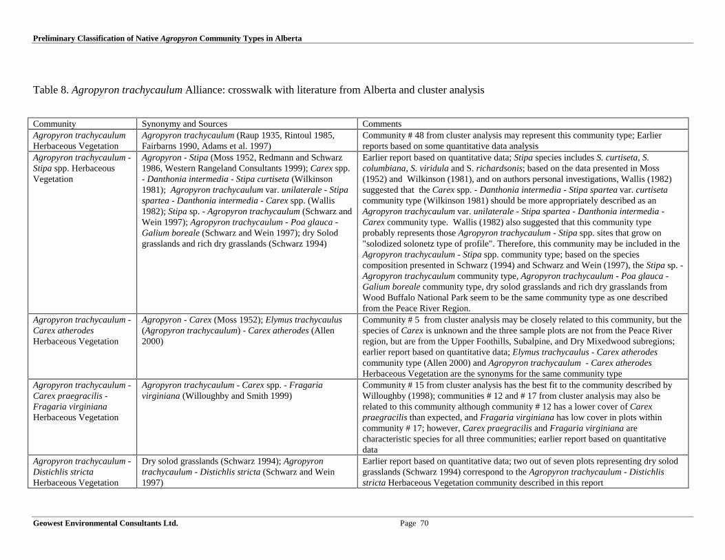
Preliminary Classification of Native Agropyron Community Types in Alberta
Geowest Environmental Consultants Ltd. Page 70
Table 8. Agropyron trachycaulum Alliance: crosswalk with literature from Alberta and cluster analysis
Community Synonymy and Sources CommentsAgropyron trachycaulumHerbaceous Vegetation
Agropyron trachycaulum (Raup 1935, Rintoul 1985,Fairbarns 1990, Adams et al. 1997)
Community # 48 from cluster analysis may represent this community type; Earlierreports based on some quantitative data analysis
Agropyron trachycaulum -Stipa spp. HerbaceousVegetation
Agropyron - Stipa (Moss 1952, Redmann and Schwarz1986, Western Rangeland Consultants 1999); Carex spp.- Danthonia intermedia - Stipa curtiseta (Wilkinson1981); Agropyron trachycaulum var. unilaterale - Stipaspartea - Danthonia intermedia - Carex spp. (Wallis1982); Stipa sp. - Agropyron trachycaulum (Schwarz andWein 1997); Agropyron trachycaulum - Poa glauca -Galium boreale (Schwarz and Wein 1997); dry Solodgrasslands and rich dry grasslands (Schwarz 1994)
Earlier report based on quantitative data; Stipa species includes S. curtiseta, S.columbiana, S. viridula and S. richardsonis; based on the data presented in Moss(1952) and Wilkinson (1981), and on authors personal investigations, Wallis (1982)suggested that the Carex spp. - Danthonia intermedia - Stipa spartea var. curtisetacommunity type (Wilkinson 1981) should be more appropriately described as anAgropyron trachycaulum var. unilaterale - Stipa spartea - Danthonia intermedia -Carex community type. Wallis (1982) also suggested that this community typeprobably represents those Agropyron trachycaulum - Stipa spp. sites that grow on"solodized solonetz type of profile". Therefore, this community may be included in theAgropyron trachycaulum - Stipa spp. community type; based on the speciescomposition presented in Schwarz (1994) and Schwarz and Wein (1997), the Stipa sp. -Agropyron trachycaulum community type, Agropyron trachycaulum - Poa glauca -Galium boreale community type, dry solod grasslands and rich dry grasslands fromWood Buffalo National Park seem to be the same community type as one describedfrom the Peace River Region.
Agropyron trachycaulum -Carex atherodesHerbaceous Vegetation
Agropyron - Carex (Moss 1952); Elymus trachycaulus(Agropyron trachycaulum) - Carex atherodes (Allen2000)
Community # 5 from cluster analysis may be closely related to this community, but thespecies of Carex is unknown and the three sample plots are not from the Peace Riverregion, but are from the Upper Foothills, Subalpine, and Dry Mixedwood subregions;earlier report based on quantitative data; Elymus trachycaulus - Carex atherodescommunity type (Allen 2000) and Agropyron trachycaulum - Carex atherodesHerbaceous Vegetation are the synonyms for the same community type
Agropyron trachycaulum -Carex praegracilis -Fragaria virginianaHerbaceous Vegetation
Agropyron trachycaulum - Carex spp. - Fragariavirginiana (Willoughby and Smith 1999)
Community # 15 from cluster analysis has the best fit to the community described byWilloughby (1998); communities # 12 and # 17 from cluster analysis may also berelated to this community although community # 12 has a lower cover of Carexpraegracilis than expected, and Fragaria virginiana has low cover in plots withincommunity # 17; however, Carex praegracilis and Fragaria virginiana arecharacteristic species for all three communities; earlier report based on quantitativedata
Agropyron trachycaulum -Distichlis strictaHerbaceous Vegetation
Dry solod grasslands (Schwarz 1994); Agropyrontrachycaulum - Distichlis stricta (Schwarz and Wein1997)
Earlier report based on quantitative data; two out of seven plots representing dry solodgrasslands (Schwarz 1994) correspond to the Agropyron trachycaulum - Distichlisstricta Herbaceous Vegetation community described in this report

Preliminary Classification of Native Agropyron Community Types in Alberta
Geowest Environmental Consultants Ltd. Page 71
Agropyron trachycaulum -Koeleria cristataHerbaceous Vegetation
Agropyron trachycaulum - Koeleria cristata (Raup1935)
Earlier report based only on the qualitative data; community # 4 from cluster analysismay be the same community type, however, this community type is characterized by anumber of species not mentioned in the Raup (1935)
Agropyron trachycaulum -Festuca ovina - Poapalustris - Equisetumarvense HerbaceousVegetation
Agropyron trachycaulum - Festuca ovina - Poa palustris- Equisetum arvense (Raup 1928)
Earlier report probably based on reconnaissance survey
Agropyron trachycaulum -Hierochloe odorataHerbaceous Vegetation
Agropyron trachycaulum - Hierochloe odorata(Fairbarns 1990)
Earlier report based on reconnaissance survey
Agropyron trachycaulum -Elymus innovatus -Thalictrum venulosumHerbaceous Vegetation
Not reported previously Based solely on ESIS data (community # 9)
Poa interior - Agropyrontrachycaulum
Poa - Agropyron (Stacey 1927) Earlier report based on qualitative data
Hordeum jubatum -Agropyron trachycaulum -Distichlis strictaHerbaceous Vegetation
Hordeum jubatum - Agropyron trachycaulum - Distichlisstricta (Moss 1953)
Earlier report based on qualitative data

Preliminary Classification of Native Agropyron Community Types in Alberta
Geowest Environmental Consultants Ltd. Page 72
Table 9. Agropyron dasystachyum Alliance: crosswalk with literature from Alberta and cluster analysis
Community Synonymy and Sources CommentsAgropyron dasystachyumHerbaceous Vegetation
Agropyron dasystachyum (Jaques and vanEck1979, Wallis and Wershler 1981, Adams et al.1997; Willoughby 1999); Agropyrondasystachyum - Festuca saximontana(Willoughby et al. 1998)
Community # 45 from cluster analysis has a good fit; earlier reports based onquantitative data; the Agropyron dasystachyum community type includes theAgropyron dasystachyum - Festuca saximontana community type; Agropyrondasystachyum community type is characterized by the sole dominance of Agropyrondasystachyum in all locations; Festuca saximontana is just one of the numerous lowabundance species that accompany Agropyron dasystachyum, and which combinationchanges from location to location.
Agropyron dasystachyum -Calamovilfa longifolia HerbaceousVegetation
Agropyron dasystachyum - Calamovilfalongifolia (Adams et al. 1997)
Earlier report based most likely on the reconnaissance level survey
Agropyron dasystachyum -Agropyron smithii HerbaceousVegetation
Agropyron dasystachyum - Agropyron smithii(Adams and Moisey 1999); Agropyrondasystachyum - Agropyron smithii - Carex spp -Koeleria macrantha (Adams 1981)
Earlier report based on quantitative and some qualitative data; the Agropyrondasystachyum - Agropyron smithii Herbaceous Vegetation includes the Agropyrondasystachyum - Agropyron smithii - Carex spp - Koeleria macrantha community type
Agropyron dasystachyum -Koeleria macrantha - Artemisiafrigida Herbaceous Vegetation
Agropyron dasystachyum - Artemisia frigida(Corns and Achuff 1982, Rintoul 1985);Agropyron dasystachyum - Koeleria macrantha- Artemisia frigida (Wallis and Wershler 1981,Willoughby et al. 2000); Agropyrondasystachyum - Koeleria macrantha - Artemisiafrigida - Antennaria nitida (Wallis and Wershler1981); pasture sagewort grassland (Beckinghamet al. 1996)
Community # 46 from cluster analysis has a good fit with the Agropyron dasystachyum- Koeleria macrantha - Artemisia frigida Herbaceous Vegetation; community # 44resembles it as well but all species have significantly lower cover values; earlier reportsbased on quantitative data; Agropyron dasystachyum - Artemisia frigida communitytype seems to be the same community type as Agropyron dasystachyum - Koeleriamacrantha - Artemisia frigida; Agropyron dasystachyum - Koeleria macrantha -Artemisia frigida - Antennaria nitida is included in Agropyron dasystachyum -Koeleria macrantha - Artemisia frigida community type (Antennaria nitida is aconstant species of the Agropyron dasystachyum - Koeleria macrantha - Artemisiafrigida community type under drier conditions which increases its cover under wetterconditions); the pasture sagewort grassland may be a variant of the Agropyrondasystachyum - Koeleria macrantha - Artemisia frigida community type
Agropyron dasystachyum - Poapratensis Herbaceous Vegetation
Agropyron dasystachyum - Poa pratensis(Willoughby et al. 1998)
Earlier report based on quantitative data
Agropyron dasystachyum -Muhlenbergia cuspidataHerbaceous Vegetation
Agropyron - Muhlenbergia (Coupland 1950) Earlier report based on quantitative data
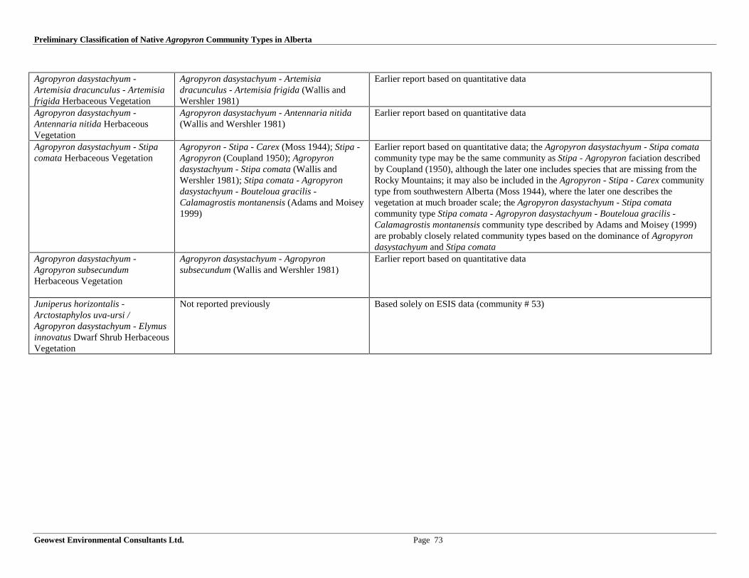
Preliminary Classification of Native Agropyron Community Types in Alberta
Geowest Environmental Consultants Ltd. Page 73
Agropyron dasystachyum -Artemisia dracunculus - Artemisiafrigida Herbaceous Vegetation
Agropyron dasystachyum - Artemisiadracunculus - Artemisia frigida (Wallis andWershler 1981)
Earlier report based on quantitative data
Agropyron dasystachyum -Antennaria nitida HerbaceousVegetation
Agropyron dasystachyum - Antennaria nitida(Wallis and Wershler 1981)
Earlier report based on quantitative data
Agropyron dasystachyum - Stipacomata Herbaceous Vegetation
Agropyron - Stipa - Carex (Moss 1944); Stipa -Agropyron (Coupland 1950); Agropyrondasystachyum - Stipa comata (Wallis andWershler 1981); Stipa comata - Agropyrondasystachyum - Bouteloua gracilis -Calamagrostis montanensis (Adams and Moisey1999)
Earlier report based on quantitative data; the Agropyron dasystachyum - Stipa comatacommunity type may be the same community as Stipa - Agropyron faciation describedby Coupland (1950), although the later one includes species that are missing from theRocky Mountains; it may also be included in the Agropyron - Stipa - Carex communitytype from southwestern Alberta (Moss 1944), where the later one describes thevegetation at much broader scale; the Agropyron dasystachyum - Stipa comatacommunity type Stipa comata - Agropyron dasystachyum - Bouteloua gracilis -Calamagrostis montanensis community type described by Adams and Moisey (1999)are probably closely related community types based on the dominance of Agropyrondasystachyum and Stipa comata
Agropyron dasystachyum -Agropyron subsecundumHerbaceous Vegetation
Agropyron dasystachyum - Agropyronsubsecundum (Wallis and Wershler 1981)
Earlier report based on quantitative data
Juniperus horizontalis -Arctostaphylos uva-ursi /Agropyron dasystachyum - Elymusinnovatus Dwarf Shrub HerbaceousVegetation
Not reported previously Based solely on ESIS data (community # 53)

Preliminary Classification of Native Agropyron Community Types in Alberta
Geowest Environmental Consultants Ltd. Page 74
Table 10. Agropyron smithii Alliance: crosswalk with literature from Alberta and cluster analysis
Community Synonymy and Sources CommentsAgropyron smithii HerbaceousVegetation
Agropyron smithii (Coupland 1950, Wallis 1976,Brierley et al. 1989, Adams and Moisey 1999)
Community # 51 from cluster analysis has a good fit; earlier reports based onquantitative data
Agropyron smithii - Artemisialudoviciana HerbaceousVegetation
Agropyron smithii - Artemisia ludoviciana(Adams et al. 1997)
Earlier report based on quantitative data
Agropyron smithii - Artemisiafrigida Herbaceous Vegetation
Agropyron smithii - Artemisia ludoviciana(Adams et al. 1997)
Earlier report based on quantitative data
Agropyron smithii - Artemisiatilesii - Artemisia frigida.Herbaceous Vegetation
Agropyron smithii - Artemisia herriotii -Artemisia frigida (Adams 1981)
Earlier report based on quantitative data; Artemisia tilesii is a synonym for Artemisiaherriotii (Moss 1983)
Agropyron smithii - Boutelouagracilis Herbaceous Vegetation
Bouteloua gracilis - Agropyron smithii (Brierleyet al. 1989); Pascopyrum smithii - Boutelouagracilis - Carex filifolia (Comer et al. 1999)
Earlier reports based on quantitative data; the description of the Agropyron smithii -Bouteloua gracilis Herbaceous Vegetation in this report is based on the Boutelouagracilis - Agropyron smithii community type from the Milk River Natural Areadescribed by Brierley et al. (1989) (name was changed to reflect the significantdominance of Agropyron smithii over Bouteloua gracilis on these sites); the Agropyronsmithii - Bouteloua gracilis Herbaceous Vegetation may include Pascopyrum smithii -Bouteloua gracilis - Carex filifolia Herbaceous Vegetation community type fromsoutheast corner of Alberta (Comer et al. 1999, NatureServe 2000), based on thedominance of Agropyron smithii and Bouteloua gracilis and a presence of Carexfilifolia. As Comer et al. (1999) suggested, Carex filifolia is often present in thiscommunity type, but its cover varies or may be absent altogether
Agropyron smithii - Hordeumjubatum Herbaceous Vegetation
Agropyron smithii - Hordeum jubatum (Wallis1990)
Earlier reports based on the reconnaissance survey
Agropyron smithii - Pyrrocomauniflora Herbaceous Vegetation
Agropyron smithii - Haplopappus uniflorus(Wallis and Wershler 1981)
Earlier report based on quantitative data; Pyrrocoma uniflora (Kartesz 1999) is arevised name for Haplopappus uniflorus (Moss 1983)
Agropyron smithii - Atriplexnuttallii Herbaceous Vegetation
Agropyron smithii - Atriplex nuttallii (Smith1993)
Earlier report based on some quantitative data (method not described)
Agropyron smithii - Stipa comata- Bouteloua gracilis HerbaceousVegetation
Stipa - Agropyron (Brierley et al.1989); Stipacomata - Agropyron smithii (Adams et al. 1997)
Based on the Stipa - Agropyron community type (Brierley et al.1989), the Stipa comata- Agropyron smithii community type (Adams et al. 1997) and cluster analysis of ESISdata (community # 36); the name was changed to reflect the high abundance ofBouteloua gracilis in plots from the ESIS database and because it agrees with the nameof the similar community from the adjacent states

Preliminary Classification of Native Agropyron Community Types in Alberta
Geowest Environmental Consultants Ltd. Page 75
Carex stenophylla - Agropyronsmithii Herbaceous Vegetation
Carex stenophylla - Agropyron smithii (Adams etal. 1997)
Earlier reports based on quantitative data; community # 47 from the cluster analysis ofESIS data has a good fit, however, species of Carex characterizing this community isunknown, although it may be C. stenophylla, since this species occurs in the generalarea where the community described by Adams et al. (1997) occurs
Distichlis stricta - Agropyronsmithii Herbaceous Vegetation
Distichlis stricta - Agropyron smithii (Wallis1990); Spartina gracilis - Agropyron smithii(Wallis 1990)
Earlier reports based on quantitative and reconnaissance data; Wallis (1990) describedthe Spartina gracilis - Agropyron smithii community type as an open sandy site variantof the Distichlis stricta - Agropyron smithii community
Koeleria macrantha - Agropyronsmithii Herbaceous Vegetation
Koeleria cristata - Agropyron spp. (Stacey 1927);Koeleria cristata - Agropyron smithii (Wroe1971, Fehr 1982); Koeleria - Agropyron -Artemisia (Langevin 1973)
Earlier reports based on quantitative data; Koeleria cristata - Agropyron spp. (Stacey1927) is the same community type as the Koeleria cristata - Agropyron smithiiHerbaceous Vegetation although in the former one Agropyron albicans seems to be anadditional important Agropyron species; the relationship between the Koeleria -Agropyron - Artemisia community type from the Kleskun Hills area in the Peace RiverParkland Subregion (Langevin 1973) and the Koeleria cristata - Agropyron smithiiHerbaceous Vegetation community is not clear because Langevin (1973) did notprovide details on the species composition

Preliminary Classification of Native Agropyron Community Types in Alberta
Geowest Environmental Consultants Ltd. Page 76
Table 11. Other than Agropyron Alliances
Community Synonymy and Sources CommentsStipa columbiana - Koeleria macrantha -Agropyron spicatum Herbaceous Vegetation
Based solely on ESIS data (community # 1)
Arctostaphylos uva-ursi - Agropyronspicatum Dwarf Shrub HerbaceousVegetation
Based solely on cluster analysis of ESIS data (community # 55)
Cares xerantica - Agropyron smithiiHerbaceous Vegetation
Based solely on ESIS data (community # 50)
Hordeum jubatum - Agropyron smithiiHerbaceous Vegetation
Based solely on ESIS data (community # 52)
Stipa viridula - Agropyron smithiiHerbaceous Vegetation
Stipa viridula - Agropyron smithii; Stipa viridula -Agropyron smithii - A. dasystachyum (Adams et al. 1997)
Stipa comata - Bouteloua gracilis -Agropyron smithii Herbaceous Vegetation
Stipa comata - Bouteloua gracilis - Agropyron smithii(Coupland 1961, 1973 Johnston et al. 1967; Adams et al.1997)
Danthonia unispicata - Agropyron smithii -Agropyron dasystachyum HerbaceousVegetation
Danthonia unispicata - Agropyron smithii - Agropyrondasystachyum (Eastern Slopes Rangeland Seeds Ltd. 1995,Allen 2000)
Carex spp. - Agropyron dasystachyum - A.smithii - Koeleria macrantha - Stipacurtiseta Herbaceous Vegetation
Carex spp. - Agropyron dasystachyum - A. smithii -Koeleria macrantha - Stipa curtiseta (Adams 1981)
Festuca idahoensis - Agropyrontrachycaulum Herbaceous Vegetation
Based solely on ESIS data (community # 16)
Festuca scabrella - Festuca idahoensis -Agropyron trachycaulum HerbaceousVegetation
Based solely on ESIS data (cluster # 32)
Deschampsia caespitosa - Poa pratensis -Agropyron trachycaulum HerbaceousVegetation
Based solely on ESIS data (community # 38)
Poa pratensis - Agropyron trachycaulumHerbaceous Vegetation
Based solely on ESIS data (community # 40)
Festuca saximontana - Carex spp. -Agropyron trachycaulum HerbaceousVegetation
Based solely on ESIS data (community # 34)

Preliminary Classification of Native Agropyron Community Types in Alberta
Geowest Environmental Consultants Ltd. Page 77
Carex obtusata - Elymus innovatus -Agropyron trachycaulum HerbaceousVegetation
Carex obtusata - Elymus innovatus - Agropyrontrachycaulum (Willoughby 1999)
Community #13 from cluster analysis has a good fit
Deschampsia caespitosa - Agropyrontrachycaulum - Thalictrum venulosumHerbaceous Vegetation
Deschampsia caespitosa - Agropyron trachycaulum -Thalictrum venulosum (Lane et al. 2000)
Carex praticola - Agropyron trachycaulum -Thalictrum venulosum HerbaceousVegetation
Carex praticola - Agropyron trachycaulum - Thalictrumvenulosum (Willoughby and Smith 1999)
Carex praegracilis - Agropyrontrachycaulum - Bromus ciliatus - forbsHerbaceous Vegetation
Carex praegracilis - Agropyron trachycaulum - Bromusciliatus - forbs (Willoughby 1999)
Community #18 from cluster analysis may be related to thiscommunity type
Calamagrostis inexpansa - Agropyrontrachycaulum - Carex siccata HerbaceousVegetation
Calamagrostis inexpansa - Agropyron trachycaulum -Carex siccata (Schwarz and Wein 1997)
Deschampsia caespitosa - Carexpraegracilis - Agropyron trachycaulumHerbaceous Vegetation
Deschampsia caespitosa - Carex spp. - Agropyrontrachycaulum (Willoughby and Smith 1999)
Cluster #11 from cluster analysis has a good fit; cluster #19 hassimilar species composition, different proportions of species
3.1.4.2. Cross Reference Tables With the Literature from Outside Alberta
Following cross reference tables summarize proposed Agropyron community types in Alberta in relation to their literature sources from adjacentprovinces and states.

Preliminary Classification of Native Agropyron Community Types in Alberta
Geowest Environmental Consultants Ltd. Page 78
Table 12. Agropyron spicatum Alliance: crosswalk with literature from outside Alberta
Community Synonymy and Sources CommentsAgropyron spicatumHerbaceous Vegetation
Not reported previously Pseudoroegneria spicata Herbaceous Vegetation from neighboring states (Bourgeronand Engelking 1994, Grossman et al. 1994, Anderson et al. 1998, NatureServe 2000)does not seem to be the same community type as the proposed one with the same namein Alberta. In the Agropyron spicatum Herbaceous Vegetation from southwesternAlberta Agropyron spicatum dominates the herbaceous layer (ground cover 30 - 40%),whereas Pseudoroegneria spicata Herbaceous Vegetation from Colorado pertains tothe community of sparse graminoids and abundant forb layer where Agropyronspicatum reaches covers of only 5 - 7 %, and there are no clear dominants
Agropyron spicatum - Festucacampestris HerbaceousVegetation
Agropyron spicatum - Festuca scabrella (Tisdale1947); Festuca scabrella - Agropyron spicatumcommunity type (Tisdale 1982); Festuca scabrella -Pseudoroegneria spicata (NatureServe 2000)
Festuca scabrella - Pseudoroegneria spicata Herbaceous Vegetation, Agropyronspicatum - Festuca campestris Herbaceous Vegetation and Agropyron spicatum -Festuca scabrella Herbaceous Vegetation seem to be the same community type namedby different researchers. The associated species do vary from type to type but all threetypes share the codominance of Agropyron spicatum and Festuca campestris;Agropyron spicatum - Festuca scabrella (Tisdale 1947) and Festuca scabrella -Agropyron spicatum community type (Tisdale 1982) are just the two names for thesame community type appearing in two different publications
Agropyron spicatum - Elymusinnovatus - Aster conspicuousHerbaceous Vegetation
Not reported previously
Agropyron spicatum - Carexobtusata HerbaceousVegetation
Not reported previously
Agropyron spicatum - Festucaidahoensis HerbaceousVegetation
Not reported previously Pseudoroegneria spicata - Festuca idahoensis Herbaceous Vegetation fromneighboring states (Grossman et al. 1994, Bourgeron and Engelking 1994, Anderson etal. 1998, NatureServe 2000) does not seem to be the same community type as theproposed one with the same name in Alberta. In the Agropyron spicatum - Festucaidahoensis Herbaceous Vegetation from southwestern Alberta both Agropyronspicatum and Festuca idahoensis characterize the herbaceous layer (ground cover 4.3%and 3%, respectively), and the herb layer is generally very sparse (non-vegetatedground up to 69%). In contrast, Pseudoroegneria spicata - Festuca idahoensisHerbaceous Vegetation from portions of the palouse prairie in neighboring states andpossible British Columbia (Tisdale 1982) pertains to the community with an abundantherb layer where Agropyron spicatum and Festuca idahoensis reach a cover of 30 -100%

Preliminary Classification of Native Agropyron Community Types in Alberta
Geowest Environmental Consultants Ltd. Page 79
Table 13. Agropyron trachycaulum Alliance: crosswalk with literature from outside Alberta
Community Synonymy and Sources CommentsAgropyron trachycaulum HerbaceousVegetation
Elymus trachycaulus Herbaceous Vegetation(Heidel et al. 2000)
Agropyron trachycaulum Herbaceous Vegetation from Alberta and Elymustrachycaulus from Sheridan County in Montana (Heidel et al. 2000) may bethe same community type, although Montana’s community has much highercover of Agropyron trachycaulum (70% vs. 7%) and seems to resemble moreElymus trachycaulus community as described by Fairbarns (1990)
Agropyron trachycaulum - Stipa spp.Herbaceous Vegetation
Not reported previously
Agropyron trachycaulum - Carexatherodes Herbaceous Vegetation
Not reported previously
The Agropyron trachycaulum - Carexpraegracilis - Fragaria virginianaHerbaceous Vegetation
Not reported previously
Agropyron trachycaulum - Distichlisstricta Herbaceous Vegetation
Elymus trachycaulus - Distichlis spicata (Heidelet al. 2000)
Agropyron trachycaulum - Distichlis stricta Herbaceous Vegetation fromAlberta and Elymus trachycaulus - Distichlis spicata Herbaceous Vegetationfrom Sheridan County in Montana (Heidel et al. 2000) may be the samecommunity type; however, no details on the vegetation composition have beenprovided by Heidel et al. (2000) and the authors suggested that furtherdocumentation is needed for this community type
Agropyron trachycaulum - Koeleriacristata Herbaceous Vegetation
Not reported previously
Agropyron trachycaulum - Festuca ovina -Poa palustris - Equisetum arvenseHerbaceous Vegetation
Not reported previously
Agropyron trachycaulum - Hierochloeodorata Herbaceous Vegetation
Not reported previously
Agropyron trachycaulum - Elymusinnovatus - Thalictrum venulosumHerbaceous Vegetation
Not reported previously
Poa interior - Agropyron trachycaulumHerbaceous Vegetation
Not reported previously
Hordeum jubatum - Agropyrontrachycaulum - Distichlis spicataHerbaceous Vegetation
Not reported previously
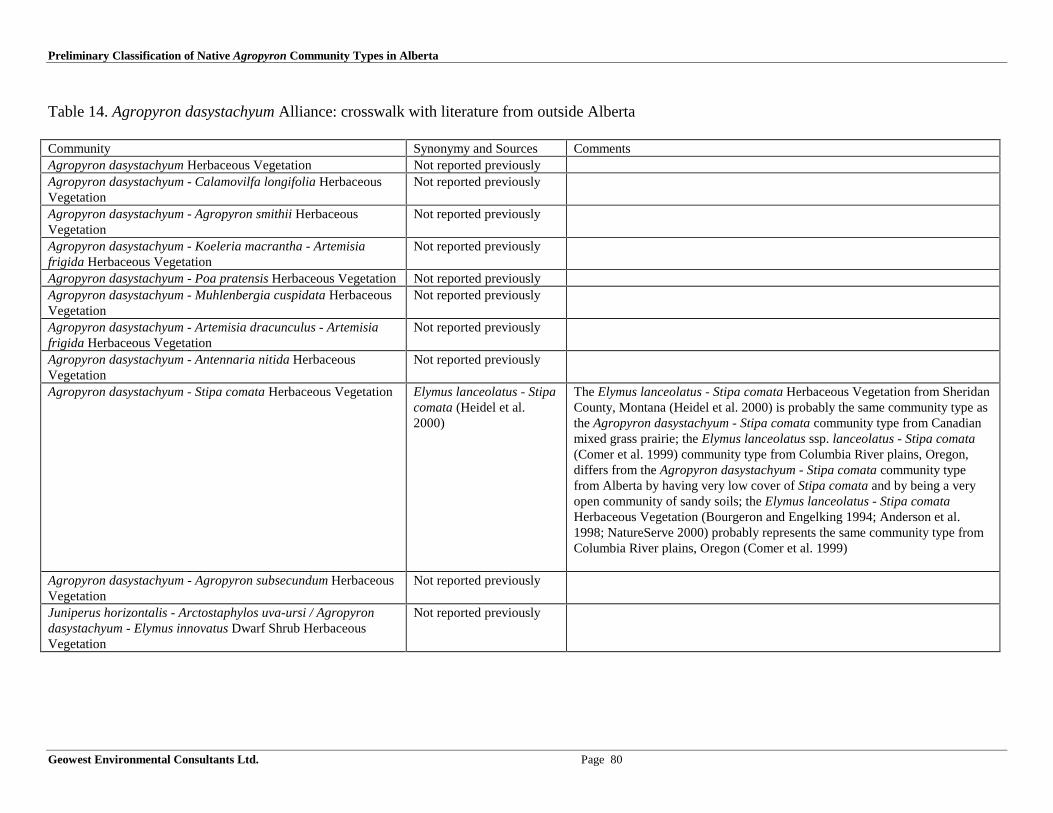
Preliminary Classification of Native Agropyron Community Types in Alberta
Geowest Environmental Consultants Ltd. Page 80
Table 14. Agropyron dasystachyum Alliance: crosswalk with literature from outside Alberta
Community Synonymy and Sources CommentsAgropyron dasystachyum Herbaceous Vegetation Not reported previouslyAgropyron dasystachyum - Calamovilfa longifolia HerbaceousVegetation
Not reported previously
Agropyron dasystachyum - Agropyron smithii HerbaceousVegetation
Not reported previously
Agropyron dasystachyum - Koeleria macrantha - Artemisiafrigida Herbaceous Vegetation
Not reported previously
Agropyron dasystachyum - Poa pratensis Herbaceous Vegetation Not reported previouslyAgropyron dasystachyum - Muhlenbergia cuspidata HerbaceousVegetation
Not reported previously
Agropyron dasystachyum - Artemisia dracunculus - Artemisiafrigida Herbaceous Vegetation
Not reported previously
Agropyron dasystachyum - Antennaria nitida HerbaceousVegetation
Not reported previously
Agropyron dasystachyum - Stipa comata Herbaceous Vegetation Elymus lanceolatus - Stipacomata (Heidel et al.2000)
The Elymus lanceolatus - Stipa comata Herbaceous Vegetation from SheridanCounty, Montana (Heidel et al. 2000) is probably the same community type asthe Agropyron dasystachyum - Stipa comata community type from Canadianmixed grass prairie; the Elymus lanceolatus ssp. lanceolatus - Stipa comata(Comer et al. 1999) community type from Columbia River plains, Oregon,differs from the Agropyron dasystachyum - Stipa comata community typefrom Alberta by having very low cover of Stipa comata and by being a veryopen community of sandy soils; the Elymus lanceolatus - Stipa comataHerbaceous Vegetation (Bourgeron and Engelking 1994; Anderson et al.1998; NatureServe 2000) probably represents the same community type fromColumbia River plains, Oregon (Comer et al. 1999)
Agropyron dasystachyum - Agropyron subsecundum HerbaceousVegetation
Not reported previously
Juniperus horizontalis - Arctostaphylos uva-ursi / Agropyrondasystachyum - Elymus innovatus Dwarf Shrub HerbaceousVegetation
Not reported previously

Preliminary Classification of Native Agropyron Community Types in Alberta
Geowest Environmental Consultants Ltd. Page 81
Table 15. Agropyron smithii Alliance: crosswalk with literature from outside Alberta
Community Synonymy and Sources CommentsAgropyron smithii HerbaceousVegetation
Agropyron smithii (Pascopyrum smithii) (Doddand Coupland 1966, Bourgeron and Engelking1994, Schneider et al. 1997, Anderson et al. 1998,Riparian and Wetland Research Program 2000,Heidel et al. 2000, NatureServe 2000)
Agropyron smithii Herbaceous Vegetation and Pascopyrum smithii HerbaceousVegetation from northern Montana and Saskatchewan represent the same communitytype based on the sole dominance of A. smithii
Agropyron smithii - Artemisialudoviciana HerbaceousVegetation
No previous reports
Agropyron smithii - Artemisiafrigida Herbaceous Vegetation
No previous reports
Agropyron smithii - Artemisiatilesii - Artemisia frigida.Herbaceous Vegetation
No previous reports
Agropyron smithii - Boutelouagracilis Herbaceous Vegetation
Bouteloua - Agropyron (Coupland 1950, 1961,1973); Pascopyrum smithii (Agropyron smithii) -Bouteloua gracilis - Carex filifolia (Schneider etal. 1997, Anderson et al. 1998, Comer et al.1999, NatureServe 2000); Pascopyrum smithii -Bouteloua gracilis (Heidel et al. 2000)
The Pascopyrum smithii - Bouteloua gracilis Herbaceous Vegetation from SheridanCounty, Montana (Heidel et al. 2000) is similar to the Agropyron smithii - Boutelouagracilis Herbaceous Vegetation described in this report, although Bouteloua graciliscovers about twice as much ground compared to Pascopyrum smithii; the Bouteloua -Agropyron community type from southwestern Saskatchewan (Coupland 1950, 1961,1973) represents the same community type as the Agropyron smithii - Boutelouagracilis Herbaceous Vegetation from Alberta; the Agropyron smithii - Boutelouagracilis Herbaceous Vegetation may include Pascopyrum smithii (Agropyron smithii) -Bouteloua gracilis - Carex filifolia Herbaceous Vegetation community type from thewestern United States and the southwestern corner of Saskatchewan (Comer et al. 1999,NatureServe 2000), based on the dominance of Agropyron smithii and Boutelouagracilis and a presence of Carex filifolia. As Comer et al. (1999) suggested, Carexfilifolia is often present in this community type, but its cover varies or may absentaltogether
Agropyron smithii - Hordeumjubatum Herbaceous Vegetation
Agropyron smithii - Hordeum jubatum(Bourgeron and Engelking 1994, Schneider et al.1997, Anderson et al. 1998, Comer et al. 1999,NatureServe 2000)
The Pascopyrum smithii - Hordeum jubatum Herbaceous Vegetation from Wyoming,Montana, Nebraska, and most likely North Dakota, South Dakota, Kansas, Alberta, andSaskatchewan (Comer et al. 1999) is the same community type as the Pascopyrumsmithii - Hordeum jubatum Herbaceous Vegetation described by Wallis (1990) forAlberta
Agropyron smithii - Haplopapusuniflorus Herbaceous Vegetation
No previous reports

Preliminary Classification of Native Agropyron Community Types in Alberta
Geowest Environmental Consultants Ltd. Page 82
Agropyron smithii - Atriplexnuttallii Herbaceous Vegetation
No previous reports
Agropyron smithii - Stipa comata- Bouteloua gracilis HerbaceousVegetation
Pascopyrum smithii - Stipa comata - Boutelouagracilis (Heidel et al. 2000) Pascopyrum smithii -Stipa comata Northern Herbaceous Vegetation(Heidel et al. 2000, NatureServe 2000)
Pascopyrum smithii - Stipa comata - Bouteloua gracilis Herbaceous Vegetation fromSheridan County, Montana (Heidel et al. 2000) seems to be the same community typeas the Agropyron smithii - Stipa comata - Bouteloua gracilis Herbaceous Vegetationfrom southeastern Alberta. Heidel et al. (2000) suggested that the Pascopyrum smithii -Stipa comata - Bouteloua gracilis community type represents an equivalent to thePascopyrum smithii - Stipa comata Central Mixed Grass Prairie and that Pascopyrumsmithii - Stipa comata Northern Herbaceous Vegetation may represent a cold, dryphase of the Pascopyrum smithii - Stipa comata - Bouteloua gracilis community;therefore the Agropyron smithii - Stipa comata - Bouteloua gracilis HerbaceousVegetation from southeastern Alberta includes the Pascopyrum smithii - Stipa comataCentral Mixedgrass Herbaceous vegetation from the north-central Great Plains (Comeret al. 1999, NatureServe 2000), and probably the Pascopyrum smithii - Stipa comataNorthern Herbaceous Vegetation from Sheridan County (Heidel et al. 2000)
Carex stenophylla - Agropyronsmithii Herbaceous Vegetation
No previous reports
Distichlis stricta - Agropyronsmithii Herbaceous Vegetation
Distichlis stricta - Agropyron sp. (Dodd andCoupland 1966)
Distichlis stricta - Agropyron sp. from Saskatchewan’s saline areas (Dodd andCoupland 1966) is probably the same community type as Distichlis stricta - Agropyronsmithii from the Grassland and Parkland Regions of eastern Alberta (Wallis 1990);however, there may be more than one species of Agropyron involved in the Distichlisstricta - Agropyron sp. from Saskatchewan’s saline areas, but their identification andthe relative importance were not investigated (Dodd and Coupland 1966)
Koeleria cristata - Agropyronsmithii Herbaceous Vegetation
No previous reports
Preliminary Classification of Native Agropyron Community Types in Alberta
Geowest Environmental Consultants Ltd. Page 83
3.1.5 Description of Proposed Agropyron Community Types
The preliminary classification of Agropyron community types based on the literature review andthe cluster analysis of the ESIS database identified 39 potential Agropyrondominated/codominated community types within Alberta. They are grouped into four HerbaceousAlliances: Agropyron spicatum (5 communities), A. trachycaulum (11 communities), A.dasystachyum (11 communities) and A. smithii (12 communities).
3.1.5.1. Agropyron spicatum Herbaceous Alliance
Agropyron spicatum Herbaceous Vegetation
This community occurs within Waterton Lakes National Park (Achuff et al. (1997) (Type H42).It is associated with subxeric to mesic, moderately sloping, easterly and southerly oriented sites,mainly in the Subalpine Subregion (elevation range: 1700 - 1900 m) (Achuff et al. 1997). It alsooccurs in Montane and Foothills Parkland, and possibly Alpine (community #31 in this report)Subregions. Soils are well drained Brunisols and Regosols developed on fluvial, colluvial andmorainal landforms. Agropyron spicatum dominates this successionally mature community (30 -40% cover) accompanied by a number of common grasses such as Bromus marginatus, Phleumpratense and Poa palustris. Main forbs include Achillea millefolium, Fragaria virginiana,Galium boreale and Penstemon confertus, in addition to various other common species such asAster conspicuous, Campanula rotundifolia, Epilobium angustifolium, Hedysarumsulphurescens, Lathyrus ochroleucus and Thalictrum occidentale. Cluster analysis andexamination of environmental data by Geowest researchers indicate that Poa interior maybecome codominant on certain lower elevational sites while Poa palustris and Bromus carinatusmay become abundant on sites with wetter soils (subhygric moisture regimes).
Agropyron spicatum - Festuca campestris Herbaceous Vegetation
This community type occurs in the area just north of the Waterton Lakes National Park(community #29 in this report). It occurs on subxeric to mesic Foothills Parkland, Subalpine andMontane sites (elevation range: 1430 - 1867 m), on gentle to steep slopes with mostly southerlyaspects. Soils are well to very rapidly drained, with subxeric to mesic moisture regimes andsubmesotrophic to mesotrophic nutrient regimes. Agropyron spicatum and Festuca campestrisdominate with 8.8% and 14.9% cover, respectively. Other common species include Festucaidahoensis (7.4%), Koeleria macrantha (4.1%), Danthonia parryi (3.9%), Galium boreale(3.4%), Aster conspicuous (3.6%), Lupinus sericeus (2.8%), Fragaria virginiana (2.5%),Monarda fistulosa (2%), Geranium viscosissimum (2%) and Anemone multifida (1%). Commonshrub species include Amelanchier alnifolia (6.1%), Rosa acicularis (5.5%) and Spiraeabetulifolia (3.1%).
Agropyron spicatum - Elymus innovatus - Aster conspicuous Herbaceous Vegetation
This community type occupies small areas on dry, southwest facing slopes, with rapidly drainedsoils, within the Montane and Subalpine subregions of Banff National Park (Type H19 in Cornsand Achuff 1982). Soils are predominantly Orthic Regosols with xeric moisture regimes,

Preliminary Classification of Native Agropyron Community Types in Alberta
Geowest Environmental Consultants Ltd. Page 84
developed on colluvial and glacial landforms. Shrub cover is low, with Juniperus communis andRosa acicularis occurring sporadically. Agropyron spicatum, Elymus innovatus and Koeleriacristata dominate the community (15 - 30%, 10 - 30%, and 3 - 10% cover, respectively)accompanied by various forbs such as Aster conspicuous, Oxytropis splendens, Antennarianitida/rosea and Cerastium arvense (3 - 5%, <8%, <2%, and <2% cover, respectively). Cornsand Achuff (1982) report that this successionally mature community is limited in extent to slopesabove Hillsdale Meadow in Banff.
Agropyron spicatum - Carex obtusata Herbaceous Vegetation
This community type occupies middle and upper slopes with mostly southerly aspects (sloperange: 4 - 48%) within the Montane and Subalpine subregions (elevation range 606 m - 1618 m)in southwestern Alberta (Willoughby et al. 1998, community #3 in this report). Soils are veryrapidly to well-drained, with mostly subxeric moisture regimes and submesotrophic tomesotrophic nutrient regimes. Amelanchier alnifolia (4.2%) and Symphoricarpos occidentalis(6.2%) are characteristic species of the shrub layer. The dominant grass and sedge species,Agropyron spicatum, Carex obtusata, Koeleria macrantha and Festuca scabrella, make up11.6%, 19.8%, 5.4%, and 4.2% of the canopy cover, respectively. Some of the dominant forb anddwarf shrub species include Arctostaphylos uva-ursi, Rosa arkansana and Artemisia frigida.Increasing grazing pressure on the drier sites results in a decline of Agropyron spicatum and anincrease of low growing forbs and sedges (Willoughby et al. 1998).
Agropyron spicatum - Festuca idahoensis Herbaceous Vegetation
This community occurs at elevations between 1554 m and 1874 m, on moderately sloping siteswith westerly or northerly aspects (community #54 in this report). Sites can occupy crest tomiddle slope positions. Soils are very rapidly drained to well drained with xeric to subxericmoisture regimes and mesotrophic to oligotrophic nutrient regimes. The vegetation cover in thiscommunity is very thinly distributed with bare ground reaching up to 69%. This communityconsists of a sparse collection of graminoids and forbs. Some shrub and dwarf shrub species arealso present. Potentilla fruticosa, Shepherdia canadensis, Rosa acicularis and Arctostaphylosuva-ursi can occur in small amounts, but for the most part, a shrub layer is non-existent.Pseudoroegneria spicata and Festuca idahoensis occur with 4.3% and 3% cover, respectively.Other constant species include Agoseris glauca, Selaginella densa, Oxytropis sericeus,Gaillardia aristata and Anemone multifida.
3.1.5.2. Agropyron trachycaulum Herbaceous Alliance
Agropyron trachycaulum Herbaceous Vegetation
This community type occurs in Alberta under variable site conditions. It occurs on very xeric toxeric, steep to moderately steep southerly oriented slopes of the Peace River Parkland Subregionand possibly Montane and Upper Foothills subregions ((Rintoul 1985; community #48 in thisreport). Soils are rapidly to moderately well drained. They include Orthic Regosols and OrthicEutric Brunisols with clay loam to sandy loam textures. It also occurs in saline meadows of theBoreal Forest Natural Region (Fairbarns 1990). The community also inhabits lower terraces inthe Suffield National Wildlife Area situated within the Dry Mixedgrass Subregion on well to

Preliminary Classification of Native Agropyron Community Types in Alberta
Geowest Environmental Consultants Ltd. Page 85
imperfectly drained Orthic Regosols and Orthic Eutric Brunisols with sandy loam to silt loamtextures (Adams et al. 1997). Small areas characterized by clay loam soils about 60 cm deep,with some glacial boulders support this community type in the Peace Point area of Wood BuffaloNational Park (Raup 1935). Vegetation on drier sites is relatively open with unvegetated surfacevarying from 30 - 75%. Agropyron trachycaulum dominates this community, while othercommon species include Artemisia frigida, Koeleria macrantha, Vicia americana, Achilleamillefolium, Gallium boreale, and Allium cernuum. Commonly associated shrubs such asSymphoricarpos occidentalis, Rosa spp., Prunus virginiana and Amelanchier alnifolia maybecome dominant in some areas. Wetter sites (Boreal Region) may have a higher cover ofAgropyron trachycaulum, and include species such as Symphoricarpos albus, Carex spp.,Agrostis scabra, Antennaria parviflora, Astragalus dasyglottis, Geum triflorum, Hieraciumumbellatum, Lactuca pulchella, Viola adunca and some halophytic species (Fairbarns 1990).Wood Buffalo National Park grasslands are characterized by an assemblage of perennial forbssuch as Geum triflorum, Stachys scopulorum, Geum macrophyllum var. perincisum, and Galiumboreale. Equisetum pratense, Bromus pumpellianus, Schizachne purpurascens andCalamagrostis spp. are some of the secondary species.
Agropyron trachycaulum - Stipa spp. Herbaceous Vegetation
This community occupies moderately dry slopes and certain flat mesic grasslands in the PeaceRiver area (Moss 1952). Sites are quite variable and include rocky grounds of an old moraine,well drained alluvial soils, level areas with heavy textured black soils developed on flood plainsof streams, and black loam of silty to clay mixture with a "solodized solonetz type of profile",developed on lacustrine or alluvial-lacustrine material. In the Peace Point area of Wood BuffaloNational Park this community occupies relatively flat areas with Orthic Cumulic Regosols ofsandy-loam texture, developed on glaciolacustrine sediments (Redmann and Schwarz 1986). Thesame community occurs at Salt River sites in Wood Buffalo National Park on Black Solod soils(Schwarz 1994; Schwarz and Wein 1997). Vegetation on the Peace River sites is characterizedby the dominance of grass and sedge species such as Agropyron trachycaulum, Stipa curtiseta,Koeleria macrantha and Carex obtusata, accompanied by numerous forb species (e.g. Galiumboreale, Achillea millefolium, Thalictrum venulosum). Stipa richardsonis, Danthonia intermedia,Agropyron dasystachyum, Carex praticola, C. siccata, and some shrubby species (e.g.Amelanchier alnifolia) may become locally abundant. Agropyron trachycaulum (20.8% cover)and Stipa columbiana (9.7% cover) dominate the herb layer on the Peace Point sites described byRedmann and Schwarz (1986). S comata, S. curtiseta, Artemisia frigida, and Galium boreale aresome of the additional grass and forb species characterizing these grasslands. The communitydescribed by Schwarz (1994) and Schwarz and Wein (1997) is dominated by A. trachycaulum,Stipa curtiseta (S. richardsonis, S. viridula), accompanied by some typically southern speciessuch as Koeleria macrantha, Carex siccata, C. xerantica, Muhlenbergia richardsonis, Geumtriflorum and Potentilla hippiana. Heavy grazing in the Agropyron - Stipa community typeresults in a decrease of cover of the leading grass species and an increase of other species,particularly Carex obtusata (Moss 1952; Redmann and Schwarz 1986).
Agropyron trachycaulum - Carex atherodes Herbaceous Vegetation
In its unmodified condition, this community occupies only one shallow basin in the Peace Riverarea (N of Fort Vermilion and E of the Caribou River, near the base of the Caribou Mountains)

Preliminary Classification of Native Agropyron Community Types in Alberta
Geowest Environmental Consultants Ltd. Page 86
of Alberta (Moss 1952). Somewhat modified versions of this community by moderate grazingand roadside ditching occur near the Boyer River on deposits of fine sand and clay, in BuffaloPrairie on silty flood plain sites with fertile black loam (5 - 10 cm) over brown silt subsoil, andnear Keg River (Moss 1952). Typically, Agropyron trachycaulum and Carex atherodesdominate, accompanied by other principal grass and forb species such as Carex praticola,Calamagrostis spp., Bromus spp., Solidago lepida and Vicia americana. Symphoricarposoccidentalis, Symphoricarpos albus and Rosa woodsii are frequent species in the shrub layer, andbecome more abundant under modified (grazed) conditions.
Agropyron trachycaulum - Carex praegracilis - Fragaria virginiana Herbaceous Vegetation
This community occurs on mesic to subhygric, moderately well drained soils with mesotrophicnutrient regimes within the Upper Foothills Subregion (1400 - 2438 masl) (Willoughby andSmith 1999), and the Upper and Lower Foothills subregions (576 - 1540 m) ((communities #15,#12 and #17 in this report)). The dominant grass and sedge species are Agropyron trachycaulum,Carex praegracilis, Bromus ciliatus and Elymus innovatus. On average, they contributed 26.0%,21.0%, 9.0% and 5.0% to the canopy cover, respectively (this report). Some of the dominantforbs, Fragaria virginiana, Potentilla gracilis, Achillea millefolium and Aster ciliolatus, make up12.0%, 9.0%, 8.0% and 5.0% of the canopy cover, respectively (this report). At least some standsof this community represent a degradation of the Festuca scabrella - Deschampsia caespitosacommunity type and are very common in valley bottoms in areas with heavy grazing(Willoughby and Smith 1999).
Agropyron trachycaulum - Distichlis stricta Herbaceous Vegetation
This community type occupies small areas with eroded Solods and saline seeps onglaciolacustrine materials on the Salt River escarpment in Wood Buffalo National Park (Schwarz1994, Schwarz and Wein 1997). Sites occur on southerly aspects at 210 masl. Soils aremoderately fine textured and rapidly drained Dark Brown Solods and saline Regosols. Thiscommunity is characterized by a relatively small number of species, including Symphoricarposoccidentalis, Agropyron trachycaulum, Distichlis stricta, Koeleria macrantha, Spartina gracilis,Poa juncifolia and Carex siccata.
Agropyron trachycaulum - Koeleria cristata Herbaceous Vegetation
Raup (1935) described the Agropyron trachycaulum - Koeleria cristata community type for thesalt plains (level country just west of the Slave River) of Wood Buffalo National Park (PeaceRiver Lowlands Subregion). This community was found about two miles south of Heart Lake onnearly level terrain where streams carried off the outwash and left the soil with little or no salt.Agropyron trachycaulum and Koeleria cristata dominate the community. Subdominant speciesinclude Juniperus horizontalis, Hierochloe odorata, Deschampsia caespitosa, Danthoniaintermedia, Schizachne purpurascens and Agrostis scabra. Cluster analysis of the ESIS databasepresented in this report indicates the possible existence of this community type in the DryMixedwood, Subalpine and Montane subregions (community #4). However, with the exceptionof the two dominant species, Agropyron trachycaulum and Koeleria cristata, few other speciesare shared between these two communities. Grasslands outside Wood Buffalo National Park arecharacterized by a number of species not mentioned in Raup (1935) such as Helictotrichon

Preliminary Classification of Native Agropyron Community Types in Alberta
Geowest Environmental Consultants Ltd. Page 87
hookeri, Carex pensylvanica, Bromus inermis, Artemisia frigida, Stipa curtiseta, Muhlenbergiarichardsonis, Festuca scabrella, and Carex obtusata.
Agropyron trachycaulum - Festuca ovina - Poa palustris - Equisetum arvense Herbaceous Vegetation
This community type occupies sandy beach deposits with few rocks in the vicinity of ShelterPoint, along the north shore of Lake Athabasca (Raup 1928). Dominant species includeAgropyron tenerum, Festuca ovina, Poa palustris and Equisetum arvense. Secondary speciesinclude Sisyrinchium angustifolium, Rumex altissimus, Corydalis aurea, Potentillamonspeliensis, Rubus idaeus var. canadensis, and Epilobium angustifolium.
Agropyron trachycaulum - Hierochloe odorata Herbaceous Vegetation
This community type occurs in the Boreal Region of northwestern Alberta (Child Lake, HighLevel and Hay River) (Fairbarns 1990). It occupies the wettest and least saline end of themoisture and salinity gradients characterizing saline meadows of northwestern Alberta.Agropyron trachycaulum and Hierochloe odorata dominate, while Carex spp., Rosa acicularisand Symphoricarpos albus represent some of the more abundant species. Achillea millefolium,Agrostis scabra, Antennaria parviflora, Astragalus dasyglottis, Galium boreale, Geum triflorum,Hieracium umbellatum, Lactuca pulchella, Viola adunca and some halophytic species are someof the less abundant species characterizing this community type.
Agropyron trachycaulum - Elymus innovatus - Thalictrum venulosum Herbaceous Vegetation
This community type occurs on lower slopes and plains of the Central Mixedwood, DryMixedwood, Upper Foothills and Subalpine subregions, at elevations ranging from 472 to 1650masl (community #9 in this report)). It occurs on level terrain and in depressions. When onsloping terrain (ca 5%), the community occupies northerly and easterly aspects. Soils are well toimperfectly drained, with subhygric to hygric moisture regimes and mesotrophic to eutrophicnutrient regimes. Agropyron trachycaulum, Elymus innovatus, Thalictrum venulosum andMertensia paniculata are the dominant species (average ground cover of 14%, 14%, 14%, and10%, respectively). Other important species include Deschampsia caespitosa, Achilleamillefolium, Carex praegracilis, Bromus inermis, B. ciliatus, Delphinium glaucum, Asterciliolatus, Vicia americana, Epilobium angustifolium, and Schizachne purpurascens. Salixbarclayi and Betula glandulosa are prominent species in the shrub layer.
Poa interior - Agropyron trachycaulum Herbaceous Vegetation
This community type was described for the Grande Prairie - Beaverlodge area by Stacey (1927).It was found, among other places, in parts of the sand ridge where the growth of pine, spruce andpoplar helped the development of an inch or two of black soil. Poa interior, Agropyron tenerum,and A. caninum are the dominant grasses in this association. Other important species includedCalamagrostis inexpansa, Agrostis hiemalis, Poa palustris, Elymus innovatus, Koeleria cristata,Carex praticola, and C. xerantica. In the numerous local depressions, Calamagrostis canadensisreplaces the more xerophytic C. inexpansa. The author described this association as verywidespread on drier habitats within the study area.

Preliminary Classification of Native Agropyron Community Types in Alberta
Geowest Environmental Consultants Ltd. Page 88
Hordeum jubatum - Agropyron trachycaulum - Distichlis stricta Herbaceous Vegetation
This community inhabits saline meadows in areas about eight km west of Fort Vermilion, innorthwestern Alberta (Moss 1953). Sites include pools, sinkholes, barren patches, and extensivegrassy flats. In addition to the three dominant species, Hordeum jubatum, Agropyrontrachycaulum, and Distichlis stricta, the author listed Elymus macounii, Muhlenbergiarichardsonis, Puccinellia nuttalliana, Suaeda depressa as leading species. Aster ericoides,Grindelia squarrosa, Vicia americana, Plantago eriopoda, Aster caerulescens, Gallium boreale,Solidago lepida, Carex praticola and Carex praegracilis are just some of the additional specieslisted for these meadows. The Hordeum jubatum - Agropyron trachycaulum - Distichlis strictacommunity type (Moss 1953) may be a successional or disturbance variant of the Agropyrontrachycaulum - Distichlis stricta (Schwarz and Wein 1997) community type. Hordeum jubatuminvades as a result of grazing or some other low-level disturbance on saline/semi-saline Gleysolicsoils (Art Schwarz - personal communications).
3.1.5.3. Agropyron dasystachyum Herbaceous Alliance
Agropyron dasystachyum Herbaceous Vegetation
This community occurs in a variety of locations including very dry and steep southeast tosouthwest facing slopes in the Kakwa Falls region (Jaques and vanEck 1979), steep south facingslopes with shallow, rapidly drained soils, with subxeric to xeric moisture regimes andsubmesotrophic nutrient regimes, at lower elevations within the Subalpine and the Montanesubregions (Willoughby et al. 1998, Willoughby 1999), very steep slopes with northerly aspectsin the Suffield National Wildlife Area situated within the Dry Mixedgrass Subregion (Adams etal. 1997), and one moderately well drained, mesic site at the toe position of an alluvial fan in theKootenay Plains area (Wallis and Wershler 1981). Classification of the ESIS plots indicate thepossible presence of this community in the Alpine and Peace River Parkland subregions(community #45 in this report). Agropyron dasystachyum dominates in all sites (average cover30 - 40%) accompanied by other, less abundant species such as Symphoricarpos occidentalis,Agropyron caninum var. andinum, Carex obtusata, Calamagrostis purpurascens, Koeleriacristata, Poa interior, Stipa spartea, Stipa occidentalis var. minor, Allium cernuum, Artemisiafrigida, Cerastium arvense, and Vicia americana in the Kakwa Falls (Jaques and vanEck 1979),Arctostaphylos uva-ursi, Koeleria cristata, Phleum commutatum, Carex obtusata, Elymusinnovatus, Festuca saximontana, Thalictrum occidentale, Epilobium angustifolium, Antennariaparviflora and Lupinus sericeus on Montane and Subalpine sites (Willoughby et al. 1998,Willoughby 1999), Geum triflorum, Linum lewisii, Stellaria longipes, Koeleria macrantha,Agoseris glauca and Campanula rotundifolia in the Kootenay Plains (Wallis and Wershler1981), Amelanchier alnifolia, Artemisia cana, A. frigida, Koeleria macrantha, Anemone patens,Gutierrezia sarothrae and Comandra umbellata in the Suffield National Wildlife Area (Adamset al. 1997), or Koeleria cristata, Epilobium angustifolium, Festuca spp. and Galium boreale(this report).

Preliminary Classification of Native Agropyron Community Types in Alberta
Geowest Environmental Consultants Ltd. Page 89
Agropyron dasystachyum - Calamovilfa longifolia Herbaceous Vegetation
This community type was noted by Adams et al. (1997) for the Suffield National Wildlife Area.It represents a minor vegetation component on well drained, sandy soils developed on fluvialmaterials within broad ravines with relatively low-angle side slopes.
Agropyron dasystachyum - Agropyron smithii Herbaceous Vegetation
This community type occurs on moderately well to well drained Solonetzic soils in the MilkRiver Natural Area and the Kennedy Coulee Ecological Reserve, situated within the DryMixedgrass Subregion (Adams and Moisey 1999). Soils include Brown Solodized Solonetz andBrown Solonetz, with minor occurrences of Brown Solods, Brown Chernozems and OrthicRegosols. The same community type inhabits steep, unstable mid-slopes with southerly aspectsin the Peace River and Clear River canyons in the Dry Mixedwood Subregion (Adams 1981).Soils are Orthic Regosols with silty loam texture, developed on morainal and colluvial materials.Besides the two dominant grasses, Agropyron dasystachyum and Agropyron smithii, additionalspecies in the Milk River region include Artemisia frigida, Bouteloua gracilis, Stipa comata, Poapratensis and Koeleria macrantha. Carex spp., Koeleria macrantha, Stipa curtiseta, Artemisiafrigida and Stipa viridula characterize sites in the Peace River region.
Agropyron dasystachyum - Koeleria macrantha - Artemisia frigida Herbaceous Vegetation
In the Montane Subregion, this community type occurs within Jasper and Banff National Parks(elevation range 1040 - 1640 m) on xeric, generally steeply sloping sites with southerly aspects(Corns and Achuff 1982). Soils are rapidly to well drained and include Orthic Eutric Brunisolsand Orthic Regosols developed on colluvial, glacial, and fluvial materials. In the north andcentral portion of the Kootenay Plains area, this community occupies well drained, submesicalluvial fans (Wallis and Wershler 1981). The community occupies variety of slopes and aspects,but mainly occurs on near level terrain or on the toe or ridges of the fan. On the west and northside of the river in the south-central portion of the Kootenay Plains area, the same communityoccurs on moderately well to well drained, mesic to submesic depressions and nearly level sitesat the toe or upper slope of the alluvial fans (Wallis and Wershler 1981). Within the MontaneSubregion, this community type is also reported from areas with Cumulic Regosols and Orthicand Brunisolic Gray Luvisols (Beckginham et al. 1996). Willoughby et al. (2000) described thesame community type for the south and west facing slopes (slope range 10 - 90%) along thebanks of the Peace, Smoky and Wapiti rivers throughout the Dry Mixedwood Subregion(elevation range 345 - 606 m). Soils are very rapidly drained with xeric-subxeric moistureregimes and submesotrophic nutrient regimes. Within the Silver Valley area this communityoccurs on moderate to steep, south and southwest facing slopes with rapidly to well drained, veryxeric to xeric Orthic Regosols and Orthic Eutric Brunisols of clay loam or sandy loam texture(Rintoul 1985). Cluster analysis from this report indicates that this community type may alsooccur within the Alpine, Subalpine and Cypress Hills Montane subregions.
Within the Montane Subregion sites are generally forb poor, moss layer covers up to 30% of theground, and unvegetated surface reaches up to 50%. Sites described by Corns and Achuff (1982)are dominated by Agropyron dasystachyum (5 - 50% cover) with lesser amounts of Artemisiafrigida (1 - 10%), Koeleria cristata (2 - 10%) and Achillea millefolium (<5%). In the Kootenay

Preliminary Classification of Native Agropyron Community Types in Alberta
Geowest Environmental Consultants Ltd. Page 90
Plains area, on somewhat drier stands, Agropyron dasystachyum, Koeleria macrantha andArtemisia frigida contribute 6 - 75%, 6 - 25% and 6 - 25%, to the ground cover, respectively,while Antennaria nitida occurs scattered, mainly in wetter depressions (Wallis and Wershler1981). Additional frequent species include Astragalus striatus, Linum lewisii, Orthocarpusluteus, and Erigeron caespitosus. (Wallis and Wershler 1981). In wetter sites, Artemisia frigidaand Antennaria nitida become more abundant, with a lower cover of Koeleria macrantha(Wallis and Wershler 1981). Astragalus striatus and Aster alpinus may also become locallyabundant. On some sites within the Montane Subregion, Artemisia frigida and Koeleriamacrantha may reach higher ground cover than Agropyron dasystachyum (Beckginham et al.1996). Calamagrostis purpurascens, Poa pratensis, Carex spp. and Linum lewisii are also foundon this sites. This community type from the Dry Mixedwood Subregion seems to have a lowercover of the three dominant species. Agropyron dasystachyum, Koeleria macrantha andArtemisia frigida cover on average 10%, 5% and 6% of the ground, respectively (Willoughby etal. 2000). Other characteristic species include Amelanchier alnifolia (6%), Rosa acicularis (3%),Carex spp. Agropyron trachycaulum and Stipa richardsonis. In addition to the three dominantspecies, sites within the Silver Valley area include species such as Stipa spartea, Alliumcernuum, Astragalus agrestis, Crepis tectorum and Linum lewisii. Cluster analysis from thisreport indicates that this community type may have much higher vegetation cover, especially ofthe three dominant species, when occurring on moister sites within Montane, Subalpine andAlpine subregions, compared to drier sites of the Montane, Cypress Hills Montane and DryMixedwood subregions. Noteworthy species of this community within the Silver Valley studysite are Lomatium foeniculaceum and Opuntia fragilis, species more commonly found insoutheastern Alberta (Rintoul 1985).
Agropyron dasystachyum - Poa pratensis Herbaceous Vegetation
This community type was described by Willoughby et al. (1998) for only one site above theOldman River in the Outer Gap Range Allotment in the Montane Subregion of Alberta (elevation1545 m). The Outer Gap range is subjected to extremely high desiccating winds. This communityoccupied dry, moderately to heavily grazed south facing slopes (slope 15%). Soils are shallow,rapidly drained, with submesic moisture regimes and submesotrophic nutrient regimes. Thedominant grass and sedge species are Agropyron dasystachyum (35%), Carex obtusata (11%),Poa pratensis (10%), and Poa canbyi (5%). Taraxacum officinale, Vicia americana, Antennariaparvifolia, Oxytropis splendens and Solidago missouriensis, which made up 15.0%, 13.0%,10.0%, 8.0% and 6.0% of canopy cover, respectively, are the dominant forbs. Symphoricarposoccidentalis (12%) and Rosa arkansana (7%) are the dominant species in the shrub and dwarfshrub layers. The authors suggest that this community has been driven by disturbance (grazing)which favored exotic species such as Poa pratensis and Taraxacum officinale, however,relatively dry soil conditions have prevented Poa pratensis from dominating this communitytype. In the absence of the disturbance the community would probably more closely resemblemoister sites within the Agropyron spicatum - Carex obtusata community type. (Willoughby etal. 1998).
Agropyron dasystachyum - Muhlenbergia cuspidata Herbaceous Vegetation
This community type is associated with water eroded areas scattered throughout rollingtopography of the Canadian mixed prairie (Coupland 1950). Characterized by frequent areas of

Preliminary Classification of Native Agropyron Community Types in Alberta
Geowest Environmental Consultants Ltd. Page 91
bare ground, this community is dominated by Agropyron dasystachyum and Muhlenbergiacuspidata. Agropyron smithii represents only a minor component of the wheat grass cover in thiscommunity, and together, the two wheat grass species make up 35.2 % of the total basal area.The codominant species, Muhlenbergia cuspidata, contributes 18.2% of the total vegetationcover. The principal associated grasses and sedges, Koeleria cristata, Bouteloua gracilis, Stipacomata, S. spartea var. curtiseta, S. viridula, Carex eleocharis and C. filifolia contribute8.1%,13.0%, 1.4%, 1.4%, 1.2%, 14.9% and 1.4% of the total basal area, respectively. Artemisiafrigida and Phlox hoodii were the most abundant forbs, making up 8.8% and 4.9% of the totalbasal area. Coupland (1950) suggested that the vegetation of these sites, in the absence ofdisturbance, would more closely resemble that of the Stipa - Bouteloua type, however, watererosion has modified the relative abundance of the grasses.
Agropyron dasystachyum - Artemisia dracunculus - Artemisia frigida Herbaceous Vegetation
This community type occurs on near level, well-drained, submesic sites, at the toe edge ofalluvial fans in the Kootenay Plains area (Wallis and Wershler 1981). Agropyron dasystachyum,Artemisia dracunculus, and Artemisia frigida contribute about 26 - 50%, 16 - 25%, and 16 - 25%to the ground cover, respectively. Agropyron subsecundum and Koeleria cristata are locallyabundant. Additional species include Linum lewisii, Oxytropis campestre, Astragalus striatus,Potentilla pensylvanica, Antennaria nitida, Erigeron caespitosus, Orthocarpus luteus and Poaglauca.
Agropyron dasystachyum - Antennaria nitida Herbaceous Vegetation
This community type occupies woodland edges and former wooded sites on south or east side ofriver in the Kootenay Plains area, where it is a major community type (Wallis and Wershler1981). It occupies mid slopes (3 - 5%) with northerly and southerly aspects on alluvial fans. Soilsare well drained with submesic moisture regimes. Ground cover of each of the codominantspecies, Agropyron dasystachyum and Antennaria nitida, generally reaches from 25 to 50%,although, in certain areas cover of Antennaria reaches 75%. Numerous other species characterizethis community type, including Koeleria cristata, Artemisia frigida, Comandra pallida, Linumlewisii, Astragalus striatus, Anemone multifida, Androsace septentionalis, Gentianella amarella,Galium boreale, Campanula rotundifolia, Agoseris glauca, Aster alpinus, Erigeron caespitosus,Gaillardia aristata, Senecio canus, Solidago decumbens, Allium cernuum, Sysirinchiummontanum, and Bromus pumpellianus. In some areas shrub species such as Rosa woodsii. andPotentilla fruticosa invade these grasslands. Some areas are more open, with the cover of baresoil and rock being up to 45% and 25%, respectively. Antennaria nitida, Artemisia frigida,Agropyron dasystachyum, Koeleria cristata and lichens are locally common.
Agropyron dasystachyum - Stipa comata Herbaceous Vegetation
This community type is locally prevalent in one area on the west side of the North SaskatchewanRiver, in the central portion of the Kootenay Plains study site (Wallis and Wershler 1981). Itoccupies the toe edges of alluvial fans, with well-drained soils characterized by submesicmoisture regimes. Coupland (1950) described this community type for undulating to gentlyrolling areas, with medium textured soils of the dark-brown soil zone in the mixed prairie ofCanada. More details on this community type from the Milk River area is given by Adams and

Preliminary Classification of Native Agropyron Community Types in Alberta
Geowest Environmental Consultants Ltd. Page 92
Moisey (1999). In the Milk River area this community occupies landscapes with well-drainedsoils (slope 1 - 4%), situated upslope from the western wheat grass and the northern wheat grass -western wheat grass community types. Soils are mainly Orthic Brown Chernozems with minorimportance of Calcareous Brown and Solonetzic Brown Chernozems. The same community typemay also exist in southwestern Alberta in the shallow black soil zone and on black soils whengrazing pressure has allowed Agropyron species to replace more palatable fescues (Moss 1944).In the Kootenay Plains area, Agropyron dasystachyum and Stipa comata dominate, eachcontributing 26 - 50% to the ground cover. Artemisia frigida (16 - 25%), Koeleria cristata (6 -15%), and Agropyron subsecundum (6 - 15%) are the few major species in this community, whileAstragalus agrestis, Linum lewisii, Antennaria nitida, Solidago decumbens, Orthocarpus luteus,Agropyron smithii, and Festuca saximontana are present with very low covers. Lichens cover upto 25% of the ground. Coupland (1950) noted that the three dominant species of this communitytype within the mixed grass prairie, Agropyron dasystachyum, Stipa comata, and S. spartea var.curtiseta, contribute 43% to the ground cover, while sedges make up 25.5% of the total basalarea. Selaginella densa may cover up to 30% in disturbed areas. The principal subdominantgraminoids are Bouteloua gracilis, Koeleria cristata, Carex filifolia, C. eleocharis and C.heliophila. Carex eleocharis may reach the same basal cover as Agropyron dasystachyum. Stipacomata, Agropyron dasystachyum, Bouteloua gracilis and Calamagrostis montanensis dominategrasslands described for the Milk River area. Grasslands in southwestern Alberta are alsodominated by Agropyron dasystachyum, Stipa comata, and S. spartea var. curtiseta, but alsoinclude some A. smithii and Festuca idahoensis. Heidel et al. (2000) believe that this communityrepresents a "missing link" between the prevailing Pascopyrum smithii - Stipa comata -Bouteloua gracilis association of the U.S. Great Plains and the prevailing Elymus lanceolatus -Stipa curtiseta association of the Canadian Great Plains. Heidel et al. (2000) also suggested thatthis association falls within the "Stipa - Agropyron faciation" of Coupland (1950).
Agropyron dasystachyum - Agropyron subsecundum Herbaceous Vegetation
This community type occurs in only one location in a depressional site with considerable bareground (mineral soil 15%) on a river terrace in the Kootenay Plains area (Wallis and Wershler1981). Soils are well drained with submesic moisture regimes. Agropyron dasystachyum andAgropyron subsecundum codominate, contributing about 50 - 75% to the ground cover. Linumlewisii (5 - 15%) is the only abundant forb species. Additional species characterizing thiscommunity type, but with very low cover, include Astragalus striatus, A. tenellus, Oxytropissericea, Gentianella amarella, Achillea millefolium, Artemisia dracunculus, A. frigida andSolidago decumbens.
Juniperus horizontalis - Arctostaphylos uva-ursi / Agropyron dasystachyum - Elymus innovatusDwarf Shrub Herbaceous Vegetation
This community type occurs on nearly level terrain on valley floors and middle slope positionswithin the Rocky Mountain Natural Region (Montane Subregion) (elevation range of 1036 to1372 m) (community #53 in this report). Soils are rapidly to moderately well drained, withsubxeric to subhygric moisture regimes and submesotrophic to mesotrophic nutrient regimes.Juniperus horizontalis and Agropyron dasystachyum are the most abundant species; Potentillafruticosa; Juniperus horizontalis, Arctostaphylos uva-ursi, Agropyron dasystachyum and Elymusinnovatus occur in each inventoried stand of this community. Juniperus horizontalis,

Preliminary Classification of Native Agropyron Community Types in Alberta
Geowest Environmental Consultants Ltd. Page 93
Arctostaphylos uva-ursi and Elymus innovatus are the three characteristic species; tree and shrubspecies such as Picea glauca, Pinus contorta, Shepherdia canadensis, and Salix spp. may reachsignificant covers in some stands, but none of them are constant species.
3.1.5.4. Agropyron smithii Herbaceous Alliance
Agropyron smithii Herbaceous Vegetation
This community type occupies slightly alkaline clay flats and some alluviated clay flats withinthe mixed grass prairie in Canada, where it is held in a subclimax stage related to the Agropyron- Koeleria faciation by the accumulation of soluble salts or by the deposition of sediments(Coupland 1950). In the Milk River Natural Area and the Kennedy Coulee Ecological Reserve, itoccupies lower, swale and depressional sites with moderately well to imperfectly drained BrownSolonetz, Brown Solodized Solonetz and Brown Solods (possibly some Gleysolic soils) with clayand loam textures (Wallis 1976; Brierley et al. 1989, Adams and Moisey 1999). The samecommunity type is documented by the cluster analysis (community #51 in this report). Thiscommunity is solely dominated by Agropyron smithii. Koeleria cristata and Poa secunda are lesscommon grasses, while Gutierrezia diversifolia and Phlox hoodii represent the principal forbs(Coupland 1950). It may also include species such as Bouteloua gracilis, Muhlenbergiarichardsonis, Carex eleocharis, C. filifolia, Gutierrezia serothrae, Phlox hoodii, Lomatiumfoeniculaceum, L. macrocarpum, Liatris punctata (Wallis 1976). Other species reported byAdams and Moisey (1999) include Agropyron dasystachyum, Poa pratensis, Carex stenophylla,Artemisia ludoviciana and Eleocharis palustris. It may also have Deschampsia cespitosa,Beckmannia syzigachne, and Hordeum jubatum in moister depressions in lakebeds, and Poajuncifolia, Puccinellia spp. and Distichlis stricta in association with saline depressions (Brierleyet al. 1989).
Agropyron smithii - Artemisia ludoviciana Herbaceous Vegetation
This community type occurs on sand plains in the Suffield National Wildlife Area within the DryMixedgrass Subregion, where it occupies depressions and gentle slopes (2 - 9%) with variableaspects (Adams et al. 1997). Soils are Orthic Regosols developed on morainal materials andinclude imperfectly to well drained sandy soils, well to rapidly drained loamy sands, or welldrained sandy loams. Agropyron smithii and Artemisia ludoviciana dominate with 42% and 9%ground cover, respectively. Other notable species include Carex stenophylla (6%), Poa pratensis(4%), Grindelia squarrosa and Chenopodium pratericola (last two with very low covers).
Agropyron smithii - Artemisia frigida Herbaceous Vegetation
This community type occurs in the Suffield National Wildlife Area within the Dry MixedgrassSubregion. It occupies various landform/surficial materials with various soil types. Theseinclude: sand plains and sand dunes with well drained sandy Orthic Regosols; broad ravines withwell drained sandy Orthic Brown Chernozems; glacio-fluvial terraces with well drained, sandyOrthic Regosols and Rego Brown Chernozems; glacio-fluvial terraces with well drained loamysandy Orthic Brown Chernozems; outwash plains with well drained Orthic and Rego BrownChernozems and Orthic Regosols of sandy loam texture; undulating outwash and hummockymoraine with well drained Orthic and Rego Brown Chernozems of sandy loam texture; rolling
Preliminary Classification of Native Agropyron Community Types in Alberta
Geowest Environmental Consultants Ltd. Page 94
moraine with well drained Orthic and Calcareous Brown Chernozems of sandy loam to loamtexture; and, morainal deposits with thin eolian veneers with well to rapidly drained OrthicBrown Chernozems of sandy loam texture. No details were provided on the vegetationcomposition for this community type.
Agropyron smithii - Artemisia tilesii - Artemisia frigida. Herbaceous Vegetation
This community type occupies slump sites in colluvial and morainal material on steep slopes(mid-slope position) in the Peace River area within the Dry Mixedwood Subregion (Adams1981). It occurs just upslope from the areas occupied by Agropyron dasystachyum - Agropyronsmithii - Carex spp. - Koeleria macrantha community type. On the upper (less steep) slope it isbordered by the Agropyron smithii - Stipa viridula - Carex spp. - Vicia americana communitytype. In contrast to adjacent community types which provide primary range for livestock andprimary winter range for mule deer, the steep slopes re-colonized by Agropyron smithii,Artemisia tilesii and Artemisia frigida were rarely used for grazing by either cattle or wildlife.
Agropyron smithii - Bouteloua gracilis Herbaceous Vegetation
This community type occurs in the Milk River area on well drained Brown Solonetz and BrownSolodized Solonetz soils, and occasionally Orthic Brown Chernozems with loam and clay loamtexture developed on gently inclined and undulating till (Brierley et al. 1989). Comer et al. 1999confirmed the existence of this community on gently rolling terrain with loamy, deep, fertile soilswithin the southeast corner of Alberta. Agropyron smithii (28.1% composition), Poa sandbergii(13.1% composition), Koeleria macrantha (6.6% composition), Stipa comata (4.4%composition), Bouteloua gracilis (3.9% composition), and Selaginella densa (29.3%composition) dominate, accompanied by secondary species such as Phlox hoodii, Tragopogondubius, Artemisia frigida, Carex filifolia, Atriplex nuttallii, Artemisia cana, Eurotia lanata,Achillea millefolium, Opuntia polyacantha and Grindelia squarrosa (Brierley et al. 1989).
Agropyron smithii - Hordeum jubatum Herbaceous Vegetation
This community occurs in the northmost portion of a large saline wetland located within theNeutral Hills area, Northern Fescue Subregion (Wallis 1990). It represents the driest vegetationcomponent along a moisture gradient adjacent to the Distichlis stricta community type occupyingsomewhat wetter soils.
Agropyron smithii - Pyrrocoma uniflora Sparse Herbaceous Vegetation
This community type was found at only one site in the vicinity of alkali grass (Puccinellianuttalliana) depressions in the vicinity of Whirlpool Point in the Kootenay Plains area (Wallisand Wershler 1981). It occurs on sites with high water tables. Vegetation has low cover valueswith considerable bare ground. Scattered forbs include Cerastium arvense, Anemone multifida,Astragalus agrestis, Achillea millefolium, Senecio canus, Taraxacum officinale and Astersibiricus.

Preliminary Classification of Native Agropyron Community Types in Alberta
Geowest Environmental Consultants Ltd. Page 95
Agropyron smithii - Atriplex nuttallii Herbaceous Vegetation
This community type occurs on moderate slopes on the northeast side of an un-named coulee inthe Manyberries badlands within the Mixedgrass Subregion (elevation ranges 968 - 1066 m)(Smith 1993). Soils of the general area are Brown Solonetz with loamy textures derived frommoderately calcareous till, and overlaying shales and sandstones. This community ischaracterized by having 75% to 80% bare ground. Agropyron smithii and Atriplex nuttalliicodominated in this community. Koeleria macrantha and Artemisia frigida are also abundant onone site inventoried. Other characteristic species include Phlox hoodii, Gutierrezia serothrae,Gaura coccinea, Grindelia squarrosa, Haplopappus nuttallii, Chrysothamnus nauseosus,Oenathera caespitosa, Erigeron caespitosus and Carex filifolia (locally abundant in sandierpatches).
Agropyron smithii - Stipa comata - Bouteloua gracilis Herbaceous Vegetation
This community type occurs within the western portion of the Milk River Natural Area (elevationabout 1000m) on west- and some east-facing colluvial slopes (slope 10 - 20%) (Brierley etal.1989). Soils are well drained, fine to coarse textured Orthic Brown Chernozems with submesicmoisture regimes. The same community type also occurs on gentle slopes (<15%) with variableaspects within the Suffield National Wildlife Area within the Dry Mixedgrass Subregion (Adamset al. 1997). Sites occupied by this community type included: middle terraces with well drained,sandy Orthic Brown Chernozems; lower terraces with imperfectly drained, sandy loam OrthicRegosols and Orthic Gleysols; valley walls with well drained sandy Orthic Brown Chernozems;hilly outwash with well drained, loamy sand Orthic Brown Chernozems; hummocky morainewith well drained, sandy Orthic Brown Chernozems; and inclined morainal slopes with sandyloam Orthic and Rego Brown Chernozems. Finally, this community type may also occur withinthe Cypress Hills Montane and Mixedgrass Subregions on rapidly to well drained soils withsubxeric to mesic moisture regimes (community #36 in this report). In the Milk River NaturalArea, this community is dominated by Stipa comata/S. spartea, Agropyron smithii andSelaginella densa (average percent compositional cover of 23%, 22%, and 34%, respectively),accompanied by Bouteloua gracilis, Carex spp., Koeleria macrantha, Poa sandbergii,Calamovilfa longifolia, Phlox hoodii and numerous other species (Brierley et al. 1989). Withinthe Suffield National Wildlife Area, Agropyron smithii, Stipa comata and Carex stenophylladominate, contributing on average 21%, 31% and 19% to the ground cover, respectively.Additional species include Bouteloua gracilis (3%), Chenopodium pratericola (4%),Descurainia pinnata (1%), Lactuca pulchella, Lygodesmia juncea and Opuntia polyacantha (lowcovers). Analysis of plots from the ESIS database (this report) indicates that this community typefound within the Cypress Hills Montane, and the Dry Mixedgrass and Mixedgrass subregions ofsoutheastern Alberta is dominated by Agropyron smithii (16%), Stipa comata (9.7%), Boutelouagracilis (9.7%) and Selaginella densa (35%), accompanied by less abundant species such asKoeleria macrantha, Carex filifolia, Agropyron dasystachyum and Stipa viridula.
Carex stenophylla - Agropyron smithii Herbaceous Vegetation
This community type occurs on a variety of sites including depressional sites on well drained,sandy Orthic Regosols and Rego Brown Chernozems of glacio-fluvial terraces, well to rapidlydrained loamy sand Orthic Brown Chernozems developed on morainal deposits, and on well

Preliminary Classification of Native Agropyron Community Types in Alberta
Geowest Environmental Consultants Ltd. Page 96
drained, sandy loam to loam Orthic and Calcareous Brown Chernozems on morainal depositswithin the Suffield National Wildlife Area within the Dry Mixedgrass Subregion (Adams et al.1997). The same community possibly exists northwest of Fairview (Boreal Forest - DryMixedwood Subregion) where it occupies steep slopes (25 - 50%) with southerly aspects, on veryrapidly drained soils with subxeric moisture regimes (community #47 in this report). In theSuffield National Wildlife Area Agropyron smithii (43%) and Carex stenophylla (57%)dominate, accompanied by only three additional species, Chenopodium pratericola (4%), Viciaamericana (1%) and Taraxacum officinale (<1%). The same community from the Boreal ForestRegion is less vegetated (ca. 30% vegetation cover) dominated by A. smithii (7.6%) and Carexspp. (4.6%), and accompanied by species such as Amelanchier alnifolia, Symphoricarpos albus,Koeleria macrantha, Stipa curtiseta, and S. comata.
Distichlis stricta - Agropyron smithii Herbaceous Vegetation
This community type occurs in saline wetlands in the Grassland and Parkland Regions of easternAlberta (Wallis 1990). This "saline dry meadow" is transitional between the driest portion of thehalophytic communities and the semi-halophytic communities. Numerous upland speciesaccompany the two dominant grasses, including Aster ericoides and Grindelia squarrosa.Locations where this community was found include Altario, Birch Lake, Capt. Eyre Lake, SandPlain North, Irma-Jarrow Lakes, Kenilworth Lake, Neutral Hills South, Old Channel LakeSprings, and Ribstone South. Wallis (1990) described the Spartina gracilis - Agropyron smithiicommunity type as a variant of the Distichlis stricta - Agropyron smithii community occurring onopen sandy sites.
Koeleria cristata - Agropyron smithii Herbaceous Vegetation
This community occurs on drier upland and exposed sites in the Grand Prairie - Beaverlodge areawithin the Peace River Parkland Subregion (Stacey 1927). It also occurs in the RumseyEcological Reserve, situated within Central Parkland Subregion, on level areas and lower slopeswith xeric Brown and Black Solonetzic soils (Wroe 1971; Fehr 1982). Koeleria cristata,Agropyron albicans and A. smithii are the dominant grasses in the Grand Prairie - Beaverlodgearea, accompanied by other grass and forb species such as Agrostis hiemalis, Poa interior, Stipacolumbiana, S. spartea, Elymus innovatus, Agropyron tenerum, A. inerme, A. caninum, and A.albicans. Agropyron inerme, and A. albicans are more prominent species within the limited rangeof Niobe. In the Rumsey Ecological Reserve, Koeleria cristata (59%), Agropyron smithii (46%)Selaginella densa (59%), Carex eleocharis (35%), Poa secunda (15%), Grindelia squarrosa(15%) and Distichlis stricta (8%) are the most abundant species. Some additional species includeAchillea millefolium, Antennaria nitida, Artemisia frigida, Bouteloua gracilis and Hordeumjubatum.
3.1.5.5. Agropyron albicans group
Agropyron albicans - Artemisia frigida community type
This community type occurs on subxeric, west to southeast facing, active slopes within theMontane and Subalpine subregions. Some of the characteristic species include Prunusvirginiana, Koeleria macrantha and Galium boreale (Allen 2000). This community type has no
Preliminary Classification of Native Agropyron Community Types in Alberta
Geowest Environmental Consultants Ltd. Page 97
written documentation, and in agreement with the ANHIC personnel, no characterization abstractis prepared for it at present time.
3.2. Assignment of Preliminary Provincial Ranking and Identification of Knowledge Gaps
The amount and the quality of available information used to describe proposed Agropyroncommunity types and assign provincial rankings varied from community to community. As aresult, some community types were difficult to rank at present due to incomplete or insufficientdata. For those that are ranked, more information is needed for confirmation of the proposed rankand to fill in the gaps in the Community Characterization Abstracts. Following are the suggestedprovincial ranks for each of the proposed Agropyron community types, accompanied by anexplanation of information gaps and suggested strategies to address these gaps.
Agropyron spicatum Herbaceous Vegetation
This community is considered provincially rare (ranked SU) in the preliminary plant communitytracking list (Allen 2000). Its provincial ranking should be changed to S1 because it is restrictedto Waterton Lakes National Park, with only 6 known sites. All known sites should be revisitedand the size and condition of each occurrence documented.
Agropyron spicatum - Festuca campestris Herbaceous Vegetation
This community type is considered provincially rare (ranked SU) (Allen 2000). Provincial statusshould be changed to S1 because this community is restricted to the very southwestern corner ofAlberta (area just north of the Waterton Lakes National Park). Cluster analysis of the combinedESIS database and the additional plots from Waterton Lakes National Park indicated that most ofthe plots from Waterton Lakes National Park used by Achuff et al. (1997) to describe Agropyronspicatum - Festuca scabrella community type belong either to the Festuca scabrella communitytype or to the Agropyron spicatum community type. Plots indicated by cluster analysis to belongto Agropyron spicatum - Festuca campestris community type are located just north of theWaterton Lakes National Park. It seems that the inclusion of these Waterton plots into theAgropyron spicatum - Festuca scabrella community type resulted from the relatively small scale(1:20,000) at which the ecological land classification was done (see details in Achuff et al. 1997)(Peter Achuff - personal communications).All sites from Waterton Lakes National Parkdescribed as Agropyron spicatum - Festuca scabrella in Achuff et al. (1997) should be revisitedto clarify their classification .
Agropyron spicatum - Elymus innovatus - Aster conspicuous Herbaceous Vegetation
This community type is considered provincially rare (ranked SU) (Allen 2000). Rank should bechanged to S1 because of its small size and restricted distribution (only on slopes above HillsdaleMeadow in Banff National Park). All known sites should be revisited and the actual size of eachoccurrence documented.

Preliminary Classification of Native Agropyron Community Types in Alberta
Geowest Environmental Consultants Ltd. Page 98
Agropyron spicatum - Carex obtusata Herbaceous Vegetation
This community type is probably restricted to southwestern Alberta, just north of Waterton LakesNational Park, therefore it should be placed on the provincial tracking list and ranked S1.
Agropyron spicatum - Festuca idahoensis Herbaceous Vegetation
Insufficient information exists for this community type. The classification is based on the clusteranalysis of only three ESIS plots. No other provincial ranking but SU is possible until moreinformation is collected. Known sites should be revisited and more information collected toconfirm the validity of the classification for this community type.
Agropyron trachycaulum Herbaceous Vegetation
This community seems to be widespread occurring within Parkland (Peace River ParklandSubregion), Grassland (Dry Mixedgrass Subregion), Boreal Forest (Dry Mixedwood), andpossibly Rocky Mountain (Montane Subregion) and Foothills (Upper Foothills Subregion)Natural Regions. although the exact number of occurrences is not known, this community may beranked S3.
Agropyron trachycaulum - Stipa spp. Herbaceous Vegetation
Western Rangeland Consultants (1999) indicated that the majority of the grasslands northeast ofGrande Prairie have been lost within the last 50 years due to farming practices. In addition,stands in Wood Buffalo National Park are very small and threatened from tree and shrubencroachment. Redmann and Schwarz 1986 compared grasslands from the Peace Point area inWood Buffalo National Park with those described for the Peace River region by Moss (1952).They concluded that the Peace River sites are closer in species composition to the Stipa faciationthan to the Agropyron - Stipa faciation, and explained it by the presence of drier, non-solonetzicsoils characterizing the Peace Point grasslands. Further study is needed to confirm that theAgropyron trachycaulum and Stipa spp. dominated communities from Wood Buffalo NationalPark and the Peace River region represent the same community type, and to estimate their sizesand the potential threats to the communities. The Agropyron trachycaulum - Stipa spp.Herbaceous Vegetation community type is currently on community tracking list as Carex spp. -Danthonia intermedia - Stipa curtiseta Herbaceous Vegetation community, and ranked S1.
Agropyron trachycaulum - Carex atherodes Herbaceous Vegetation
Because of its limited distribution (restricted to an area north of Fort Vermilion and east of theCaribou River, near the base of the Caribou Mountains within the Peace River ParklandSubregion) this community type is currently considered provincially rare (ranked S1) (Allen2000). Three plots from the ESIS database clustered together into a "community type" that maybe named "Agropyron trachycaulum - Carex spp. community type". However, the species ofCarex is not known, and the three sampling plots are not from the Peace River region, but arefrom the Upper Foothills, Subalpine, and Dry Mixedwood subregions. More information isneeded to show if these three plots represent the same community type as the one described inMoss (1952).

Preliminary Classification of Native Agropyron Community Types in Alberta
Geowest Environmental Consultants Ltd. Page 99
Agropyron trachycaulum - Carex praegracilis - Fragaria virginiana Herbaceous Vegetation
Willoughby and Smith (1999) described this community based on 10 plots. The additional 12plots from the ESIS database represent the same community type (community #15 in this reportincludes 15 plots, of which three were used by Willoughby and Smith (1999) to describe thesame community). The additional 13 plots represent communities # 12 and # 17 from this report.However, the relationship of these communities to the Agropyron trachycaulum - Carexpraegracilis - Fragaria virginiana Herbaceous Vegetation community is not clear. Community #12 has a lower cover of Carex praegracilis than expected, and Fragaria virginiana has low coverin plots within community # 17. However, Carex praegracilis and Fragaria virginiana arecharacteristic species for all three communities. It should also be noted that plots fromcommunity #17 occur in Subalpine Subregion, and plots from community #12 occupy siteswithin the Subalpine, Montane, Upper Foothills and Central Parkland subregions. Moreinformation is needed to understand the relationship between the Agropyron trachycaulum -Carex praegracilis - Fragaria virginiana community type and the communities represented byclusters #12 and #17 from the ESIS database analysis. Therefore, provincial rank S2S3 isproposed until more information is collected on this community type.
Agropyron trachycaulum - Distichlis stricta Herbaceous Vegetation
This community has extremely limited in distribution and size (a few small areas in WoodBuffalo National Park), and is threatened by the aspen and shrub encroachment. Therefore, itshould be placed on the provincial tracking list and ranked S1. Known sites should be revisited toassess the actual size of occurrences.
Agropyron trachycaulum - Koeleria cristata Herbaceous Vegetation
This community has limited distribution and size (most likely only a few small areas in WoodBuffalo National Park) and is threatened by aspen and shrub encroachment. Art Schwarz(personal communications) suggested that the Agropyron trachycaulum - Koeleria cristatacommunity type from the salt plains as described by Raup (1935) may not exist any longer inWood Buffalo National Park. The relationship between this community type described by Raup(1935), and community #4 from this report is not clear. This community should be placed on theprovincial tracking list and ranked SU. Further studies are needed to confirm the existence of thiscommunity in Wood Buffalo National Park and to examine it’s relationship to the RockyMountain grasslands from the ESIS database.
Agropyron trachycaulum - Festuca ovina - Poa palustris - Equisetum arvense HerbaceousVegetation
This community was described in an old report from the Boreal Forest Natural Region in theShelter Point area near Lake Athabasca. It should be ranked SU until further information iscollected on its presence, and the number and size of occurrences.

Preliminary Classification of Native Agropyron Community Types in Alberta
Geowest Environmental Consultants Ltd. Page 100
Agropyron trachycaulum - Hierochloe odorata Herbaceous Vegetation
It is not clear at this time whether Agropyron trachycaulum dominated stands and Hierochloeodorata dominated stands mentioned in Fairbarns (1990) can be identified as separatecommunity types, or if they just represent components of the Agropyron trachycaulum -Hierochloe odorata community type. Additional detailed study is needed to examine thecomposition of these communities, especially with regard to the spatial distribution and size ofAgropyron trachycaulum and Hierochloe odorata dominated patches. Until further informationis available, this community should be placed on the provincial tracking list and ranked SU.
Agropyron trachycaulum - Elymus innovatus - Thalictrum venulosum Herbaceous Vegetation
Classification of this community type is based solely on the ESIS database analysis. Additional,more detailed study is needed to confirm the actual similarity in vegetation composition betweenoccurrences. Until more information is available this community should be ranked SU.
Poa interior - Agropyron trachycaulum Herbaceous Vegetation
Classification of this community type was based only on the qualitative data. It should be rankedSU until more information is available.
Hordeum jubatum - Agropyron trachycaulum - Distichlis stricta Herbaceous Vegetation
Classification of this community type was based only on the qualitative data, therefore it shouldbe ranked SU until more information is available.
Agropyron dasystachyum Herbaceous Vegetation
This community seems to be found mostly in the Rocky Mountains Region: Kakwa Falls area(study site located ca. 160 km S of Grand Prairie, 50 km NW of Grand Cache), Kootenay Plainsarea, and other sites within the Subalpine and Montane subregions. It also exists within the DryMixedgrass Subregion. Its possible presence within the Alpine and Peace River Parklandsubregions needs future confirmation. Based on the distributional data and approximate numberof occurrences (between 20 and 100), this community type should be ranked S3.
Agropyron dasystachyum - Calamovilfa longifolia Herbaceous Vegetation
This community type was reported only from the Suffield National Wildlife Area - GrasslandNatural Region (Dry Mixedgrass Subregion). No details on the community were provided,therefore, it should be ranked SU until more information is available.
Agropyron dasystachyum - Agropyron smithii Herbaceous Vegetation
This community seems to be found only in the Milk River Natural Area and the Kennedy CouleeEcological Reserve, and along the Peace River and Clear River canyons between Bear Canyonand Many Islands. There may be more that 5 but less than 20 occurrences of this community type

Preliminary Classification of Native Agropyron Community Types in Alberta
Geowest Environmental Consultants Ltd. Page 101
within the province, therefore, it should be placed on the provincial tracking list and ranked S2?until more information on the precise number of occurrences is available.
Agropyron dasystachyum - Koeleria macrantha - Artemisia frigida Herbaceous Vegetation
This community has been reported from Banff and Jasper National Parks (Rocky MountainsNatural Region - Montane and possibly Subalpine and Alpine subregions), the banks of thePeace, Smoky and Wapiti rivers, and the Silver Valley (Boreal Forest Natural Region - DryMixedwood Subregion), and it possibly exists within the Cypress Hills area (Rocky MountainsNatural Region - Montane Subregion). The exact number of sites and their sizes is not known,therefore, this community should be placed on the provincial tracking list ranked S2S3 untilmore information is available.
Agropyron dasystachyum - Poa pratensis Herbaceous Vegetation
Classification of this community type was based on only one sampling plot. This communitypotentially exists and it should be ranked SU until more information is available. The onlyknown location should be revisited and other similar sites investigated for possible occurrencesof this community. Because the exotic but naturalized and widespread species, Poa pratensis is aweak codominant in this community type, more information is needed on the ecology of thiscommunity to determine whether it should be considered native or non-native for the purposes ofidentifying biodiversity of communities in Alberta.
Agropyron dasystachyum - Muhlenbergia cuspidata Herbaceous Vegetation
With the exception of the Grassland Research Area at Cadillac, Saskatchewan, Coupland (1950)did not provide the precise location of sites inhabited by this community type. However, theauthor indicated that this community type occurs "throughout the area of rolling topography",with which the Bouteloua - Stipa faciation is associated, indicating that the Agropyron -Muhlenbergia community type may exist in Alberta. Therefore, this community type should beplaced on the provincial tracking list and ranked SP until further information is collected.
Agropyron dasystachyum - Artemisia dracunculus - Artemisia frigida Herbaceous Vegetation
This community type seems to be restricted to sites in the Kootenay Plains study area. Therefore,it should be placed on the provincial tracking list and ranked S1.
Agropyron dasystachyum - Antennaria nitida Herbaceous Vegetation
This community type seems to be restricted to sites in the Kootenay Plains study area. Therefore,it should be placed on the provincial tracking list and ranked S1.
Agropyron dasystachyum - Stipa comata Herbaceous Vegetation
Besides one documented site in the Kootenay plains area, and one in the Milk River NaturalArea, the precise number and location of sites occupied by this community within Alberta is
Preliminary Classification of Native Agropyron Community Types in Alberta
Geowest Environmental Consultants Ltd. Page 102
unknown. Until further sites are documented, this community should be placed on the provincialtracking list and ranked S1S2.
Agropyron dasystachyum - Agropyron subsecundum Herbaceous Vegetation
This community type occurs in only one area on a river terrace in the Kootenay Plains area; itshould be placed on the community tracking list and ranked S1
Juniperus horizontalis - Arctostaphylos uva-ursi / Agropyron dasystachyum - Elymus innovatusDwarf Shrub Herbaceous Vegetation
Classification of this community type was based solely on the ESIS database analysis.Additional, more detailed study is needed to confirm the similarity in vegetation compositionbetween plots and the validity of the classification for this community type. Until furtherinformation is available, this community should be ranked SU.
Agropyron smithii Herbaceous Vegetation
Reported from Milk River Natural Area, the Kennedy Creek Ecological Reserve (GrasslandNatural Region - Dry Mixedgrass Subregion), and east of Manyberries (Grassland NaturalRegion - Mixedgrass Subregion). Based on the information on this community type provided byCoupland (1950), Wallis (1976), Brierley et al. (1989), Adams and Moisey (1999), and clusteranalysis from this report (community #51), there may be about 20 individual occurrences.Therefore, this community type should be placed on the provincial tracking list and ranked S2S3until more information on the location and size of occurrences is available.
Agropyron smithii - Artemisia ludoviciana Herbaceous Vegetation
This community type was reported from only one site within the Suffield National Wildlife Area(Grassland Natural Region, Dry Mixedgrass Subregion), but it may be more widespread.Therefore, it should be added to the community tracking list and ranked S1S2.
Agropyron smithii - Artemisia frigida Herbaceous Vegetation
This community type was reported only from the Suffield National Wildlife Area (GrasslandNatural Region - Dry Mixedgrass Subregion), but with a number of occurrences. Adams et al.(1997) did not provide any details on the vegetation composition for this community type,therefore, it should be ranked SU and all known sites should be revisited to document the actualvegetation composition.
Agropyron smithii - Artemisia tilesii - Artemisia frigida. Herbaceous Vegetation
This community type was reported only from areas along the Peace River and Clear Rivercanyons between Bear Canyon and Many Islands (Boreal forest Natural Region - DryMixedwood Subregion). Because of its limited distribution and presence of Herriots sage(Artemisia herriotii (Adams 1981) or A. tilesii (Moss 1983)) which is considered rare in Alberta

Preliminary Classification of Native Agropyron Community Types in Alberta
Geowest Environmental Consultants Ltd. Page 103
(ranked S2) (ANHIC 2001), this community type should be placed on the community trackinglist and ranked S1.
Agropyron smithii - Bouteloua gracilis Herbaceous Vegetation
This community type was reported with certainty only from the Milk River Natural Area(Grassland Natural Region, Dry Mixedgrass Subregion). This community type should be placedon the provincial tracking list and ranked S1 until further information is available about thedistribution of this community within the province.
Agropyron smithii - Hordeum jubatum Herbaceous Vegetation
This community type was reported only from the Neutral Hills Central site (Grassland NaturalRegion - Northern Fescue Subregion). It should be placed on the provincial tracking list andranked S1
Agropyron smithii - Pyrrocoma uniflora Sparse Herbaceous Vegetation
This community type was reported from only one site within the Kootenay Plains area, atWhirlpool Point (Rocky Mountain Natural Region - Montane Subregion). Pyrrocoma uniflora isranked S3 in the province and is listed on the Alberta Natural Heritage Information CentreVascular Plants on the Watch List (ANHIC 2001). This community type should be placed on theprovincial tracking list and ranked S1.
Agropyron smithii - Atriplex nuttallii Herbaceous Vegetation
This community type seems to be restricted to the Mannyberries badlands (Grassland NaturalRegion - Mixedgrass Subregion), therefore it should be placed on the provincial tracking list andranked S1.
Agropyron smithii - Stipa comata - Bouteloua gracilis Herbaceous Vegetation
This community type was reported from the western part of the Milk River Natural Area andfrom the Suffield National Wildlife Area (Grassland Natural Region - Dry MixedgrassSubregion). It possibly exist in other places within the Dry Mixedgrass and MixedgrassSubregions, and within the Rocky Mountain Natural Region (Cypress Hills Montane Subregion)in the southwestern corner of Alberta (this report). Based on the estimated number of occurrences(about 20) this community should be placed on the tracking list and ranked S2S3.
Carex stenophylla - Agropyron smithii Herbaceous Vegetation
This community type was reported only from the Suffield National Wildlife Area (GrasslandNatural Region - Dry Grassland Subregion) (Adams et al. 1997). It possibly also exists northwestof Fairview (Boreal Forest - Dry Mixedwood Subregion)(this report), but this location needs tobe confirmed. This community should be placed on the provincial community tracking list andranked S1 until further information is available.

Preliminary Classification of Native Agropyron Community Types in Alberta
Geowest Environmental Consultants Ltd. Page 104
Distichlis stricta - Agropyron smithii Herbaceous Vegetation
This community type was described for Altario, Birch Lake, Capt. Eyre Lake Sand Plain North,Irma-Jarrow Lakes, Kenilworth Lake, Neutral Hills South, Old Channel Lake Springs, andRibstone South. Its existence is also possible in numerous other small areas characterized bysolonetzic soils in the Parkland and Grassland Natural Regions (Ksenija Vujnovic - personalobservations). Until more information is available on the extent of the distribution of thiscommunity type, it should be placed on the provincial community tracking list and ranked S2.
Koeleria cristata - Agropyron smithii Herbaceous Vegetation
This community seems to be limited to the Grande Prairie - Beaverlodge area (Parkland NaturalRegion - Peace River Parkland Subregion) and Rumsey Ecological Reserve (Parkland NaturalRegion - Central Parkland Subregion). Based on the estimated number of occurrences (between 5and 20) it should be placed on the community tracking list and ranked S1S2.
3.3. Conclusions
The preliminary classification of Agropyron community types based on the literature review andthe cluster analysis of the ESIS database identified 39 potential Agropyrondominated/codominated community types within Alberta. These were grouped into fourHerbaceous Alliances: Agropyron spicatum, A. trachycaulum, A. dasystachyum and A. smithii.All proposed Agropyron community types were described and assigned a suggested preliminaryprovincial ranking. Cross-reference tables were created to present all the synonyms found in theliterature and explain their relationship to proposed community types. Knowledge gaps wereidentified and strategies to address these gaps were provided. Community characterizationabstracts were also compiled for each of the proposed community types. The information in thisreport can be used to update the preliminary community tracking list by including newcommunity types, as well as by changing ranking for those communities that are currently on thelist. It can also be used to decide which community types need further studies and to prioritizethese studies. Finally, this preliminary classification of Agropyron communities in Alberta is apart of a larger project to classify and describe the vegetation of Alberta within a North Americancontext.

Preliminary Classification of Native Agropyron Community Types in Alberta
Geowest Environmental Consultants Ltd. Page 105
4. LITERATURE CITED
Achuff, L. Peter, Conservation Biologist, Jasper National Park, Box 10, Jasper, AB, T0E 1E0; tel(780) 852-6197; fax (780) 852-4775; email: [email protected]
Achuff, P. L., R. L. McNeil, M. L. Coleman. 1997. Ecological Land Classification of WatertonLakes National Park, Alberta - Soil and vegetation resources. Report prepared byWaterton lakes National Park, Waterton park and Contract Pedology Services Ltd.,Ledbridge, AB
Adams, B. 1981. Range Ecology and the impact of livestock grazing on the Peace River Slopes,Alberta. Public Lands Division,
Adams, g. D., G. C. Trottier, W. L. Strong, I. D. MacDonald, S. J. Barry, P. G. Gregoire, G. W.Babish and G. Weiss. 1997. Vegetation component report: Canadian Forces BaseSuffield national Wildlife area - Wildlife Inventory. Report prepared for the CanadianWildlife service, Environment Canada, Edmonton, AB.
Adams, B and D. Moisey. 1999. Analysis of vegetation and soil monitoring records for MilkRiver Natural Area and Kennedy Creek Ecological Reserve. 1999. Public Lands, AlbertaAgriculture, Food and Rural Development, Lethbridge
Alberta Environmental Protection (AEP). 1993. Alberta plants and fungi - master species listand species group checklist. Publ. No.; Ref. 75.Edmonton, AB.
Alberta Environmental Protection (AEP). 1994. Ecological land survey site description manual.Report prepared by the Canadian Forest Service and Alberta Land and Forest Services,Edmonton, AB.
Allen J. Lorna, Biologist, Recreation and Protected Areas Division, Natural Heritage Planningand valuation Branch, 2nd Floor, Oxbridge Place, 9820-106 Street, Edmonton, AB, T5K2J6; tel: (780) 427-5209; email: [email protected].
Allen, L. 2000. Alberta Natural Heritage Information Centre Preliminary Plant CommunityTracking List. Alberta Environment, Edmonton, AB
Anderson, M., P. Bougeron, M. T. Bryer, R. Crawford, L. Engelking, D. Faber-Langendoen, M.Gallyoun, K. Goodin, D. H. Grossman, S. Landaal, K. Metzler, K. D. Patterson, M. Pyne,M. Reid, L. Sneddon and A. S. Weakley. 1998. International classification of ecologicalcommunities: terrestrial vegetation of the United States, Volume II, The NationalVegetation Classification System: list of types. The Nature Conservancy, Arlington, VA.
Alberta Natural Heritage Information Centre (ANHIC). 2001. Alberta Natural HeritageInformation Centre Element Tracking Lists.http://www.gov.ab.ca/env/parks/anhic/trackanh.html

Preliminary Classification of Native Agropyron Community Types in Alberta
Geowest Environmental Consultants Ltd. Page 106
Barbour, M. G., J. H. Burk, and W. D. Pitts. 1980. Terrestrial plant ecology. The BenjaminCummings Publishing Company, Menlo Park, California, USA.
Beckingham, J.D., I. G. W. Corns and J. H. Archibald. 1996. Field Guide to Ecosites of West-Central Alberta. Canadian Forest Service Special Report No.9, Northern Forestry Centre,Edmonton, AB.
Bloom, S. A. 1981. Similarity indices in community studies: potential pitfalls. Marine EcologyProgress Series 5:125-128.
Bonan, G. B. 1989. A computer model of the solar radiation, soil moisture and soil thermalregime in Boreal forests. Ecological Modeling 45:275-306.
Bourgeron, P. S and L. D. Engelking. 1994. A preliminary vegetation classification of theWestern United States. Unpublished report prepared by the Wetern Heritage task Forcefor The Nature Conservancy, Boulder, CO.
Braun-Blanquet, J. 1965. Plant sociology: the study of plant communities. English translation ofPflanzensoziologie revised and edited by G. D. Fuller and H. S. Conard. HafnerPublishing Co., London, England.
Bresler, E., B. L. McNeal, and D. L. Carter. 1982. Saline and sodic soils: principles-dynamics-modeling. Springer-Verlag, New York, New York, USA.
Brierley, D., D. Bradshaw, and D. Downing. 1989. Milk River Natural Area - biophysicalinventory - southern uplands. Report prepared for Alberta Forestry, Lands and Wildlife,land information services division, resource Information Branch, Edmonton, AB.
Cairns, R. R., R. A. Milne, and W. E. Bowser. 1962. A nutrient disorder in barley seedlingsgrown on an alkali solonetzic soil. Canadian Journal of Soil Science 42:1-6.
Cairns, R. R., and I. Szabolcs. 1973. Effect of sodium sulfate and sodium carbonate solutionson chemical and physical properties of a chernozem soil. Canadian Journal of SoilScience 53:399-403.
Canadian Forest Service and Alberta Land and Forest Service (CFS-LFS). 1994. Ecologicalland survey site description manual. Canada/Alberta Partnership Agreement in Forestrypublications.
Comer P., L. Allen, Steve Cooper, D. Faber-Langendoen, and G. Jones. 1999. Selectedshrubland and grassland communities of the Northern Great Plains. A Report to NebraskaNational Forest.
Corns, I. G. W. and P. L. Achuff. 1982. Vegetation type descriptions in W. D. Holland and G.M. Coen (eds.). Ecological (Biophysical) Land Classification of Banff and JasperNational Parks. Alberta Institute of Pedology, Publication No. SS-82-44.

Preliminary Classification of Native Agropyron Community Types in Alberta
Geowest Environmental Consultants Ltd. Page 107
Coupland, R. T. 1950. Ecology of mixed prairie in Canada. Ecological Monographs 20: 271-315
Coupland, R. T. 1961. A reconstruction of grassland classification in the northern Great Plainsof North America. Journal of Ecology 49:135-167.
Coupland, R. T. 1973. A theme study of natural grasslands in western Canada. A Report toNational and Historic Parks Branch Canada, Department of Indian affairs and NorthernDevelopment.
Daubenmire, R. 1970. Steppe vegetation of Washington. Washington Agriculture ExperimentalStation Technical Bulletin No. 62.
Dodd, J. D. and R. T. Coupland. 1966. Vegetation of saline Areas in Saskatchewan. Ecology47: 958-967
Eastern slopes rangeland seeds ltd. 1995. A five year summary of the range inventory andselected species monitoring on the Milk River Natural Area (1991 - 1995). Report for theMilk River Management Committee.
Fairbarns, M. 1990. The Salt Meadows of Northwestern Alberta: A Reconnaissance BiophysicalInventory. Alberta Forestry, Lands and Wildlife.
Faber-Langendoen, J. Drake, G. Jones, D. Lenz, P. Lesica and S. Rolfsmeier. 1997. Rare plantcommunities of the Northern Great Plains. A report to the Nebraska National Forest bythe Nature Conservancy.
Fehr, A. W. 1982. The Candidate Rumsey Ecological Reserve: A Biophysical Inventory.Alberta Energy and Natural Resources.
Grime, J. P. 1979. Plant strategies and vegetation processes. John Wiley and Sons, GreatBritain.
Grossman, D. H., K. L. Goodin and C. L. Reuss (editors). 1994. Rare plant communities of theconterminous United States - an initial survey. The Nature Conservancy, Arlington, VA.
Grossman, D. H., D. Faber-Langendoen, A. S. Weakley, M. Anderson, P. Bougeron, R.Crawford, K. Goodin, S. Landaal, K. Metzler, K. D. Patterson, M. Pyne, M. Reid and L.Sneddon. 1998. International classification of ecological communities: terrestrialvegetation of the United States, Volume I, The National Vegetation ClassificationSystem: development, status and applications. The Nature Conservancy, Arlington, VA.
Harper, J. L. 1977. Population biology of plants. Academic press, New York, New York, USA.

Preliminary Classification of Native Agropyron Community Types in Alberta
Geowest Environmental Consultants Ltd. Page 108
Heidal, B., S. V. Cooper and C. Jean. 2000. Plant species of special concern and plantassociations of Sheridan County, Montana. Report to the U.S. Fish and Wildlife Service.Montana Natural Heritage Program, Helena, Montana.
Hill, M. O. 1979. TWINSPAN - A FORTRAN program for arranging multivariate data in anordered two-way table by classification of the individuals and attributes. CornellUniversity, Ithaca, New York.
Hill, M. O. and H. G. Gauch. 1973. Diversity and evenness: a unifying notation and itsconsequences. Ecology 54:427-432.
Hill, M. O. and H. G. Gauch. 1980. Detrended correspondence analysis, an improved ordinationtechnique. Vegetatio 42: 47-58
Hobbs, N. T. 1996. Modification of ecosystems by ungulates. Journal of Wildlife Management60:695-713.
Jaques, D. & P. Van Eck. 1979. Biophysical Features and Recommendations for RecreationalDevelopment in the Kakwa Falls Region, Alberta. Kananaskis Center for EnvironmentalResearch, U of C.
Johnston, A., S. Smoliak, L. M. Forbes, and J. A. Campbell. 1967. Alberta Range ManagementGuide. Albert department of Agriculture, Lands and Forests. Publication No. 134/14
Jongman, R. H. G., C. J. F. ter Braak, and O. F. van Tongeren (editors). 1987. Data analysis incommunity ecology. Pudoc Wageningen, Netherlands.
Kartesz, JT. 1999. A synonymized checklist and atlas with biological attributes for the vascularflora of the United States, Canada, and Greenland. 1st edition. In: Meacham, CA.Synthesis of the north American flora [computer program]. Version 1.0. North CarolinaBotanical Garden, Chapel Hill ( NC).
Keddy, P. A. 1991. Working with heterogeneity: an operator’s guide to environmental gradients.Pages181-201 in Kolasa, J., and S. T. A. Pickett, editors. Ecological heterogeneity.Spring-Verlag New York, Inc., New York, USA.
Kent, M., and P. Coker. 1992. Vegetation description and analysis: a practical approach. CRSPress, London, Belhaven Press.
Lane, C. T., M. G., Willoughby, M. J. Alexander and the Rangeland Health Assessment Projectand Forest Rangeland Action Plan. 2000. Guide to range plant community types andcarrying capacity for the Lower Foothills Subregion of Alberta - third approximation.Alberta Environment, Land and Forest Service and Alberta Agriculture, Food and RuralDevelopment, Public Lands Division, Edmonton, AB.
Langevin, A. 1973. A preliminary paper on the Kleskun Hills Area. Report prepared byEnvironmental Research Station, Parks Planning, Alberta.

Preliminary Classification of Native Agropyron Community Types in Alberta
Geowest Environmental Consultants Ltd. Page 109
Legendre, L., and P. Legendre. 1983. Numerical ecology. Elsevier, Amsterdam.
Ministry of Environment, Lands and Parks, and Ministry of Forests (MOE and MOF). 1998.Field Manual for describing terrestrial Ecosystems. British Columbia
Moss, E. H. 1944. The prairie and associated vegetation of southwestern Alberta. CanadianJournal of Research 22:11-31.
Moss, E. H. 1952. Grasslands of the Peace River Region, western Canada. Canadian Journal ofBotany 30: 98-104
Moss, E. H. 1953. Marsh and bog vegetation in northwestern Alberta. Canadian Journal ofBotany 31: 448-470.
Moss, E. H. 1955. The vegetation of Alberta. The Botanical Review, Vol. XXI, No. 9
Moss, E. H. 1983. The flora of Alberta. (2nd edition). Revised by J. G. Packer. University ofToronto Press, Toronto, ON.
NatureServe: An online encyclopedia of life [web application]. 2000. Version 1.0. Arlington(VA): Association for Biodiversity Information. Available: http://www.natureserve.org
Pavlick, L. E., and J. Looman. 1984. Taxonomy and nomenclature of rough fescue, Festucaaltaica, F. campestris (F. scabrella var. major), and F. hallii, in Canada and adjacent partof United States. Canadian Journal of Botany 62:1739-1749.
Raup, L.C. 1928. A survey of the vegetation of Shelter Point, Athabasca Lake. Doctorate thesis,University of Pittsburgh.
Raup, H. M. 1935. Botanical Investigations in Wood Buffalo Park. Bulletin No. 74, BiologicalSeries, No. 20. Canada Dept. of Mines and National Museum of Canada. Ottawa,Ontario.
Redmann R. E. and A. G. Schwarz. 1986. Dry grassland plant communities in Wood BuffaloNational park, Alberta. Canadian Field-Naturalist 100: 526-532.
Rintoul, J. 1985. Silver Valley: Biophysical Resource Analysis. Alberta Forestry, Lands andWildlife.
Schneider, R. E., D. Faber-Langendoen, R. C. Crawford and A. S. Weakley. 1997. The status ofbiodiversity in the Great Plains: great Planes vegetation classification. Supplementaldocument 1, In: W.R. Ostlie, R. E. Schneider, J. M. Aldrich, T. M. Faust, R. L. B.McKim and S. J. Chaplin, The Status of Biodiversity in the Great Plains. The NatureConservancy, Arlington, VA.

Preliminary Classification of Native Agropyron Community Types in Alberta
Geowest Environmental Consultants Ltd. Page 110
Schwarz, Arthur, Rm 855, General Service Building, Department of Renewable Resources,University of Alberta; email: [email protected].
Schwarz, A. G. 1994. Inventory of dry grasslands and associated vegetation in Wood BuffaloNational Park. Report prepared for Parks Canada, Wood Buffalo National Park, FortSmith.
Schwarz, A. G. and R. W. Wein. 1997. Threatened dry grasslands in the continental borealforests of Wood Buffalo National Park. Canadian journal of Botany 75: 1363-1370
Smith, W. 1993. An Assessment of Short-horned Lizard Habitat and Use Manyberries Badland,Alberta. Alberta Fish and Wildlife, Lethbridge, AB.
Stacey, E. C. 1927. Ecological studies on the native grasses of the Grande Prairie-Beaverlodgedistrict. M.Sc. thesis, Department of Field Husbandry, University of Alberta, Edmonton,Alberta.
Steinauer, E. M., and S. L. Collins. 1995. Effect of urine deposition on small-scale patchstructure in prairie vegetation. Ecology 76:1195-1205.
ter Braak, C. J. F. 1987. The analysis of vegetation-environmental relationships by canonicalcorrespondence analysis. Vegetatio 69:69-77.
ter Braak, C. J. F. 1988. CANOCO: A FORTRAN program for canonical, communityordination by (partial)(detrended)(canonical) correspondence analysis, principalcomponent analysis and redundancy analysis (Version 2.1). Technical report LWA-88-02.Agricultural Mathematics Group, Wagenien.
Thieret, J. W. 1959. Grassland vegetation near Fort Province, Northwest Territories. TheCanadian field-Naturalist 73: 161-167
Timoney, P. T. 1999. Threatened dry grasslands in the continental boreal forest of WoodBuffalo National Park: commentary. Canadian Journal of Botany 77: 913-917
Tisdale, E. W. 1947. The grasslands of the southern interior of British Columbia. Ecology 28:346-382.
Tisdale, E. W. 1982. Grasslands of western North America: the Pacific Northwest Bunchgrass.Grassland Ecology and Classification: Symposium proceeding June 1982. Ministry ofForests, BC
Toogood, J. A., and R. R. Cairns 1978. Solonetzic soils technology and management.Department of Extension, University of Alberta, Edmonton, Alberta.
Vujnovic, Ksenija, Plant Ecologist, 2608-83 Street, Edmonton, AB, T6K 2Y6; tel: (780) 466-8837; email: [email protected]

Preliminary Classification of Native Agropyron Community Types in Alberta
Geowest Environmental Consultants Ltd. Page 111
Wallis, C. 1976. Milk river canyon resource evaluation. report prepared for planning anddesign, Alberta recreation, parks, and wildlife, Edmonton, AB.
Wallis, C. A. 1982. An overview of the mixed grasslands of North America. GrasslandEcology and Classification: Symposium proceeding June 1982. Ministry of Forests, BC
Wallis, C. 1990. Reconnaissance survey of saline wetlands and springs in the Grassland-Parkland region of Eastern Alberta. World Wildlife Fund, Canada
Wallis, C. and C. Wershler. 1981. Kootenay Plains Flora and Grassland Vegetation Assessment- 1981. Alberta Energy and Natural Resources.
Weaver, J. E., and Roland. 1952. Effect of excessive natural mulch on development, yield, andstructure of native grassland. Botanical Gazette 114:1-19.
Wells E. Russell, Landscape Ecologist, Resource Data Division, Alberta Environment, 12thFloor, Oxbridge Place, 9820 - 106 street, Edmonton; tel: (780) 422-0139; email:[email protected]
Western Rangeland Consultants Inc. (with the assistance of Beulah Tec Limited). 1999.Mitigation measures and future recommendations for rare native grasslands on theCochrane property and three other adjacent to Highway 43, near Grande Prairie, Alberta.Report prepared for Planning and Technical Services Division, Planning Services Branch,Alberta Transportation and Utilities, Edmonton, AB.
Wheeler, G. H. 1976. Some grasslands and shrubland communities in the parklands of centralAlberta. M.Sc. thesis, Department of Plant Science, University of Alberta, Edmonton,Alberta.
Whittaker, R. H. 1967. Gradient analysis of vegetation. Biological Review 42:207-264
Whittaker, R. H. 1978. Ordination of plant communities. Dr. W. Junk Publishers, The Hague,Boston.
Wilkinson, K. 1981. Remnant and early settlement prairies and solonetzic soils in the PeaceRiver District. M.Sc. thesis, Department of Biology, University of Calgary, Calgary,Alberta.
Willoughby M. G. 1999. Range plant community types and carrying capacity for the Subalpineand Alpine Subregions - first approximation. Environmental protection, Land and ForestService, Edmonton, AB.

Preliminary Classification of Native Agropyron Community Types in Alberta
Geowest Environmental Consultants Ltd. Page 112
Willoughby, M. G., M. J. Alexander and K. M. Sundquist. 1998. Range plant community typesand carrying capacity for the Montane Subregion of Alberta - third approximation.Environmental Protection, Lands and Forest Services, Edmonton, AB.
Willoughby, M. G. and D. Smith. 1999. Range plant community types and carrying capacity forthe Upper Foothills Subregion - third approximation. Environmental Protection, Land andForest Service, Edmonton, AB.
Willoughby M. G. and the Rangeland Health Assessment Project and Forest Rangeland ActionPlan. 2000. Guide to range plant community types and carrying capacity for the Dry andCentral Mixedwood Subregions in Alberta - third approximation. Alberta Environment,Land and Forest Service and Alberta Agriculture, Food and Rural Development, PublicLands Division, Edmonton, AB.
Wroe, R. A. 1971. Synecology of a Festuca scabrella Torr. grassland. Ph.D. thesis, Departmentof Plant Science, University of Alberta, Edmonton, Alberta.
Zar, J. H. 1984. Biostatistical analysis. Prentice Hall, Englewood Cliffs, New Jersey, USA.

APPENDIX 1List of Species Assigned to
the Dwarf Shrub Layer

Preliminary Classification of Native Agropyron Community Types in Alberta
Geowest Environmental Consultants Ltd. Page 115
Appendix 1. List of species assigned to the dwarf shrub layer
Species Latin name
Arctostaphylos rubraArctostaphylos uva-ursiAtriplex nuttalliiBerberis repensDryas drummondiiDryas octopetalaEmpetrum nigrumEriogonum umbellatumJuniperus horizontalisLinnaea borealisPenstemon fruticosusPhyllodoce glandulifloraRosa arkansanaRubus arcticusRubus pubescensSalix reticulataSibbaldia procumbensSphaeralcea coccineaSpiraea betulifoliaVaccinium caespitosumVaccinium myrtillusVaccinium scoparium

APPENDIX 2Detailed Description of Fields in
the Community Characterization Abstract

Preliminary Classification of Native Agropyron Community Types in Alberta
Geowest Environmental Consultants Ltd. Page 119
Appendix 2: TERRESTRIAL COMMUNITY CHARACTERIZATlON ABSTRACT SUB-NATIONAL(CCAS) - DRAFT DESIGN STRUCTURE - JANUARY 19951
NOTE: This document is a draft of the design for the terrestrial community characterization abstractglobal for the BCD system. It is meant only as a training tool and should not be confused with the word-processing version of this database (September 1992) which is currently in use. Differences among thesetwo designs will be rectified at the time the databases become available in the BCD system.
KEY:Fields with no designated field type are single valuemv=multivalue fieldamv=associated multivalue fieldtxt=text fields=symbolic field: Acronyms in the left margins identify the files from which symbolic fields aretranslated.
Field Name: Brief Description:
1.IDENTIFIERS
SEL.SUMMARY A one paragraph abstract for the Community Elementdescribed in this record.
ET SNAME (s) Sub-national Element name. May be the same asSCOMNAME
ET SCOMNAME (s) Sub-national Element common name. May be the same asSNAME
2. CLASSIFICATION
ET SYSTEM (s) Name for System in which Element is located(TERRESTRIAL, AQUATIC, SUBTERRANEAN)
ET CLASS (s) Physiognomic class in which the element fits. Based onvegetation structural classification adapted from UNESCO,1973 and DriscoIl, 1984. Determined largely byIifeform/height and percent cover of each.
ET SUBCLASS (s) Physiognomic subclass in which the element fits. Based onvegetation structural classification adapted from UNESCO,1973 and DriscoIl, 1984. Determined largely by predominantleaf phenology for communities dominated by woody coverand on vegetation height for communities dominated byherbaceous cover.
ET GROUP (s) Formation group. Based on vegetation structural classificationadapted from UNESCO, 1973 and DriscoIl, 1984. Determinedlargely on a combination of climate, leaf morphology, and leafphenology.

Preliminary Classification of Native Agropyron Community Types in Alberta
Geowest Environmental Consultants Ltd. Page 120
ET FORMATION (s) Formation based on vegetation structural classificationadapted from UNESCO, 1973 and Driscoll, 1984. Based onbroadly defined environmental factors which are associatedwith structural differences in the vegetation and additionalstructural descriptors such as crown shape and lifeform of thedominant lower stratum
ET ALLIANCE (s) Name of alliance in which the element fits. Alliances aregroups of elements sharing one or more diagnostic specieswhich, as a rule, are found in the uppermost strata of thevegetation.
CONFIDENCE.LEVEL Indication of the level of confidence in the type.
SSIMILAR.COMMUNITIES (txt) List of closely related or apparently similar communities to thetype at hand, and comments on how they differ.
3. RELATED NOMENCLATURE
SOTHER.NAMES (amv) Any other names used by other State systems or agencies.Specify the source and provide reference if available.
SOTHER.NAMES.RELATION (amv) Indication of the relationship of the SOTHER.NAMES to thetype at hand.
SOTHER.NAMES.RELATION.NOTE (amv) Brief description of the relationship to the SNAME.
SNAMES.COM (txt) Summary of related names used for the Element within thestate. Also comments on the relationship of these other typesto the Element.
4. DISTRIBUTION
EGR SRANGE (s) Code indicating the estimated present size of the Elementsrange.
EGR SRANGECOM (s) Description of the Element’s present and historic range withinthe state. Describe the relationship of original to current range.Comment on shifting boundaries of the range and change ofthe extent of the occurrence of the community within therange.
SDISTRIBUTION.COM (txt) Summary of the distribution of the Element, across statephysiographic provinces, counties, ecoregions, watersheds,EPAEMAP hexagons, local jurisdictions, and other statedistribution information not covered in the above list.
5. ENVIRONMENTAL FACTORS
SMINELEV Minimum elevation at which Community Element occurswithin the state.
SMAXELEV Maximum elevation at which Community Element occurswithin the state.
SLANDFORM (mv) Landform(s) on which State Element is generally located.

Preliminary Classification of Native Agropyron Community Types in Alberta
Geowest Environmental Consultants Ltd. Page 121
STOPO.POSITION (mv) Topographic position(s) of the State Element on the landscape.
SSLOPE (mv) Range of slopes on which State Element occurs.
SASPECT (mv) Range of aspects over which State Element occurs.
SGEOLOGY.COM (txt) Comments on geologic substrate and other important geologicfeatures on which the State Element generally occurs.
SSOIL.TYPE (mv) Soil type(s) based on any level of taxonomy available: Soilsurvey map unit, series, great group, etc. as detailed as existinginformation allows.
SSOIL.MOISTURE (mv) The amount of water available to plants. Based on soildrainage, soil structure and texture, and climate.
SSOIL.COM (txt) Information on soil properties. Include information on howsoil information was collected, a description of soil texture,stoniness, root penetration, notes on horizon depths, mottling,pH etc. Comment on the level of taxonomy of soil listed inSOILTYPE field.
SHYDRO.INFLUENCE (txt) Comments on hydrologic influences on the communityincluding: zonation reflecting water level fluctuations, tidallyinfluenced, permanent or temporary, hydrologic seasonality,standing water, etc.
SSEASONAL.VAR (txt) Description of important seasonal influences/variations.
SKEY.ENVIRO.FACTORS (txt) Comments on important environmental determinants of thebiological composition or structure of this community and/orits subtypes within the state.
SENVIRO.COM (txt) Summary of environmental conditions associated with theElement within the state. Include information on topographicposition, landform, slope, aspect, geological substrate, soiltextures and moisture, hydrologic influences, and climate, andany other important environmental factors not listed above.
6. BIOLOGICAL AND STRUCTURAL DESCRIPTION
6a. VEGETATION
SSTRATA.LIFEFORM (amv) Layers of vegetation occurring within the State Element.
SPCT.COVER (amv) Percent cover of each layer.
SHEIGHT (amv) Height of each layer.
SMOST.ABUND.SPP (amv) Most abundant (in terms of percent cover) plant species ineach layer. Use Latin names and a comma as a delimiter.
SUNVEGETATED.SURFACE (amv) Description of unvegetated surface.
SUNVEGETATED.SURFACE.COVER (amv) Percent cover of substrate.

Preliminary Classification of Native Agropyron Community Types in Alberta
Geowest Environmental Consultants Ltd. Page 122
SCONSTANT.SPP (mv) List of plant species likely to be found in every occurrence ofthe Element, but that can also be found in other communities.
SCHARACTERISTIC.SPP (mv) List of key plant species which occur only in this communitytype in the state, but may not necessarily be found in everyoccurrence of the type.
SVEGETATION.COM (txt) Summary description of the leaf type and phenology,physiognomy and plant species composition of the Element.Include a list of strata present, height and percent cover ofeach strata, most abundant plant species (in terms of percentcover) in each layer as well as characteristic and constantspecies associated with the Element and any other relevantvegetation features not listed above.
6b. OTHER SPECIES
SHIGH.RANK.SPP (mv) Names of global and state high ranking plant or animal speciesthat are expected to be found within occurrences of this StateElement.
SFAUNA.COM (txt) Comments on animals commonly associated with this type.
SOTHER.SPP.COM (txt) Summary of other noteworthy species associated with theElement. Include information on high ranking plant and animalspecies, common fauna, endemics or exotic, or any othernoteworthy species commonly associated with the type.
6c. VARIABILITY
SSPP.COMP.VAR (txt) Comments on variability in species composition within andamong occurrences.
SPHYSIOG.VAR (txt) Comments on structural variation and patterns within andamong occurrences.
SSUBTYPES (txt) Comments on subtypes of this Element recognized at the statelevel.
SVARIABILITY.COM (txt) Summary of the variability in species composition andphysiognomy within and among occurrences of the type. Noteany subtypes tracked within the state. Also include any othercomments on variability not outlined above.
7. DYNAMIC PROCESSES
SNAT.DISTURBANCE (txt) Comments on the type and duration of natural disturbances (onany scale) particular to this Element type.
SSUCCESS.STATUS Successional status.
SSUCCESS.DYNAM.COM (txt) Summary of natural disturbance regimes, successional status,any temporal dynamics, an age structure, dispersal agents, oldgrowth forest characteristics, etc. include any other commentson succession and dynamics not outlined above.

Preliminary Classification of Native Agropyron Community Types in Alberta
Geowest Environmental Consultants Ltd. Page 123
8. SPATIAL RELATIONS
SSIZE (txt) Common size of Element occurrences.
SSPATIAL.DISTRIBUTION (txt) Comments on whether this Element is generally patchy, oroften one continuous patch on the landscape.
SADJACENT.COMMUNITIES (txt) Name(s) of other community types commonly adjacent to thisElement. Comment on their spatial relationships across thelandscape.
SINCLUSION.COMMUNITIES (txt) Name(s) of community types frequently occurring within thisElement (i.e. heath bog within an occurrence of mixedconiferous forest).
SMOSAlC.COM (txt) If the Element represents a complex mosaic of sub-associations such as Dune/Swale communities, or zonalcoastal plain pond shores, indication of the scale and pattern ofthe components.
SSPATIAL.COM (txt) Summary of general size and shape and distribution pattern ofthe Element across the landscape. Note common adjacent andinclusion communities, or any other spatial relation notoutlined above.
9. STATUS
ESR SRANK (s) State Element rank which characterizes the relative rarity orendangerment of the Element state-wide.
ESR SREASONS (txt, s) Reason for assigning the State Element Rank.
SEXEMPLARY.EO Element Occurrence Code for the “bests" example of anElement Occurrence of the type within the state or province.
SEXEMP.EO.SITENAME Sitename for the where the exemplary Element Occurrence islocated within the state.
SSTATCOM (txt) Summary and any additional comments on the conservationstatus of the Element state-wide.
10. MANAGEMENT
SECONCOM (txt) Comments on economic uses of this type. i.e. timber and forestproducts usage, recreation, flood control, groundwaterrecharge, any other economically important species, etc.
SMANAGE.COM (txt) Summary and additional comments on the management of thecommunity including economically important species or uses,threats to the community, management strategies for exotics,animal usage, restrictions to size/shape for sustainability.
11. INVENTORY AND SAMPLING PROCEDURES
SIMAGERY.COM (txt) Comments on imagery that is useful for identifying theElement - Can the community be easily distinguished from

Preliminary Classification of Native Agropyron Community Types in Alberta
Geowest Environmental Consultants Ltd. Page 124
other communities on imagery? e.g. from adjacentcommunities and from similar communities; comments ontypes and scales of useful imagery.
SSAMPLE.STRATEGY (txt) Comments on the best way to sample this community.Describe any unusual sampling procedures that are specific tothe type.
SINVENTORY.COM (txt) Summary and additional comments on the recommendedsampling strategy for the community. Include information onthe best imagery, overflight, and ground survey methods to beused for the type.
12. ANALYSIS PROCEDURES AND DATA MANAGEMENT
SANALYSIS.COM (txt) Description of the data and analysis used to determine thetype.
SANALYSIS.DATA.MANAGE.COM (txt) Summary of the analysis procedures and data used todetermine the type. Include information on the location of thedata. If a permanent plot of the type exists within the state,give the location. provide element Occurrence numbers andState names, if available.
13. GENERAL COMMENTS
SCOMMUNITY.COM (txt) Any other comments about this community not covered in thefields above.
14. REFERENCES
SA CITATION (amv, s) Citation from source(s) listed in SOURCECODE field.

APPENDIX 3Descriptive Statistics for Species Cover
Within Each Cluster (Community)

Preliminary Classification of Native Agropyron Community Types in Alberta
Geowest Environmental Consultants Ltd. Page 127
Appendix 3. Descriptive statistics (number of plots, range, minimum, maximum, sum, mean,standard deviation and variance) for species cover within each cluster (community) derived fromthe Furthest Neighbor cluster analysis; to save on space, only statistics for those species with atleast 1% cover are shown (the number of species that are not shown is presented at the end ofeach cluster).
CLUSTER1
N Range Minimum Maximum Sum Mean Std. Deviation VarianceSTIPCOL 5.0 35.0 0.0 35.0 85.0 17.0 17.5 307.5KOELMAC 5.0 13.0 7.0 20.0 69.0 13.8 4.8 22.7AGROSPI 5.0 20.0 0.0 20.0 48.0 9.6 7.6 58.3LUPISER 5.0 15.0 0.0 15.0 26.0 5.2 6.9 47.7ARTEFRI 5.0 10.0 0.0 10.0 17.0 3.4 4.2 17.3SELADEN 5.0 15.0 0.0 15.0 16.0 3.2 6.6 43.7GALIBOR 5.0 8.0 0.0 8.0 14.0 2.8 3.3 10.7MONAFIS 5.0 10.0 0.0 10.0 12.0 2.4 4.3 18.8ANTEPAR 5.0 10.0 0.0 10.0 11.0 2.2 4.4 19.2ACHIMIL 5.0 5.0 0.0 5.0 9.0 1.8 1.9 3.7LITHRUD 5.0 5.0 0.0 5.0 7.0 1.4 2.1 4.3CALAPUR 5.0 7.0 0.0 7.0 7.0 1.4 3.1 9.8HEDYSUL 5.0 5.0 0.0 5.0 6.0 1.2 2.2 4.7FESTIDA 5.0 5.0 0.0 5.0 6.0 1.2 2.2 4.7PHLEPRA 5.0 5.0 0.0 5.0 5.0 1.0 2.2 5.0LINULEW 5.0 2.0 0.0 2.0 5.0 1.0 1.0 1.0FESTSPP 5.0 5.0 0.0 5.0 5.0 1.0 2.2 5.0DANTPAR 5.0 5.0 0.0 5.0 5.0 1.0 2.2 5.0CARESPP 5.0 5.0 0.0 5.0 5.0 1.0 2.2 5.0BALSSAG 5.0 5.0 0.0 5.0 5.0 1.0 2.2 5.0ANEMMUL 5.0 2.0 0.0 2.0 5.0 1.0 0.7 0.5AGROTRA 5.0 5.0 0.0 5.0 5.0 1.0 2.2 5.0(plus 40 species)
CLUSTER2
N Range Minimum Maximum Sum Mean Std. Deviation VarianceSELADEN 5.0 42.0 0.0 42.0 123.0 24.6 18.7 349.8PHLOHOO 5.0 15.0 6.0 21.0 65.0 13.0 5.8 33.5CAREOBT 5.0 12.0 8.0 20.0 61.0 12.2 4.7 22.2DANTPAR 5.0 17.0 0.0 17.0 53.0 10.6 6.5 41.8FESTIDA 5.0 25.0 0.0 25.0 37.0 7.4 10.5 109.3KOELMAC 5.0 11.0 3.0 14.0 33.0 6.6 4.3 18.8FESTSCA 5.0 5.0 1.0 6.0 21.0 4.2 2.2 4.7AGRODAS 5.0 14.0 0.0 14.0 21.0 4.2 6.3 39.2ARTEFRI 5.0 3.0 2.0 5.0 17.0 3.4 1.1 1.3AGROSPI 5.0 7.0 0.0 7.0 17.0 3.4 3.3 10.8ANTEPAR 5.0 12.0 0.0 12.0 16.1 3.2 5.2 27.0POACUS 5.0 12.0 0.0 12.0 14.1 2.8 5.2 26.6ERIGCAE 5.0 5.0 0.0 5.0 14.0 2.8 2.3 5.2

Preliminary Classification of Native Agropyron Community Types in Alberta
Geowest Environmental Consultants Ltd. Page 128
ASTRALP 5.0 13.0 0.0 13.0 14.0 2.8 5.7 32.7ANEMPAT 5.0 7.0 0.0 7.0 14.0 2.8 3.0 8.7STIPCOL 5.0 13.0 0.0 13.0 13.0 2.6 5.8 33.8CERAARV 5.0 7.0 0.0 7.0 12.2 2.4 3.3 11.1GALIBOR 5.0 3.0 1.0 4.0 12.0 2.4 1.3 1.8GAILARI 5.0 5.0 0.0 5.0 8.1 1.6 2.1 4.2ASTRSTR 5.0 8.0 0.0 8.0 8.0 1.6 3.6 12.8POTEFRU 5.0 4.0 0.0 4.0 7.1 1.4 1.7 2.7LUPISER 5.0 3.0 0.0 3.0 7.0 1.4 1.1 1.3POACAN 5.0 6.0 0.0 6.0 6.0 1.2 2.7 7.2ANEMMUL 5.0 4.0 0.0 4.0 5.2 1.0 1.7 2.9LITHRUD 5.0 4.0 0.0 4.0 5.1 1.0 1.7 3.0HETEVIL 5.0 5.0 0.0 5.0 5.1 1.0 2.2 5.0(plus 31 species)
CLUSTER3
N Range Minimum Maximum Sum Mean Std. Deviation VarianceCAREOBT 5.0 34.0 3.0 37.0 99.0 19.8 14.9 221.7AGROSPI 5.0 20.0 0.0 20.0 58.0 11.6 9.1 82.3SYMPOCC 5.0 14.0 1.0 15.0 31.0 6.2 5.5 30.7KOELMAC 5.0 4.0 3.0 7.0 27.0 5.4 1.7 2.8ARTEFRI 5.0 13.0 0.0 13.0 22.0 4.4 5.3 28.3AMELALN 5.0 10.9 0.1 11.0 21.1 4.2 4.9 24.5FESTSCA 5.0 18.0 0.0 18.0 21.0 4.2 7.8 61.2ROSAARK 5.0 6.0 1.0 7.0 17.0 3.4 2.3 5.3MONAFIS 5.0 8.0 0.0 8.0 12.0 2.4 3.6 12.8FESTIDA 5.0 9.0 0.0 9.0 11.0 2.2 3.9 15.2CALARUB 5.0 11.0 0.0 11.0 11.0 2.2 4.9 24.2STIPVIR 5.0 6.0 0.0 6.0 10.0 2.0 2.8 8.0POACUS 5.0 8.0 0.0 8.0 8.0 1.6 3.6 12.8GALIBOR 5.0 4.0 0.0 4.0 7.1 1.4 1.7 2.7BROMPUM 5.0 5.0 0.0 5.0 7.1 1.4 2.2 4.7ARTELUD 5.0 7.0 0.0 7.0 7.1 1.4 3.1 9.7STIPCUR 5.0 7.0 0.0 7.0 7.0 1.4 3.1 9.8SMILSTE 5.0 7.0 0.0 7.0 7.0 1.4 3.1 9.8PHLEPRA 5.0 7.0 0.0 7.0 7.0 1.4 3.1 9.8CERAARV 5.0 2.0 0.0 2.0 7.0 1.4 0.9 0.8ASTECON 5.0 7.0 0.0 7.0 7.0 1.4 3.1 9.8TARAOFF 5.0 6.0 0.0 6.0 6.1 1.2 2.7 7.1POPUTRE 5.0 3.0 0.0 3.0 6.0 1.2 1.6 2.7VICIAME 5.0 5.0 0.0 5.0 5.1 1.0 2.2 5.0ANTEPAR 5.0 3.0 0.0 3.0 5.1 1.0 1.4 2.0SOLIMIS 5.0 5.0 0.0 5.0 5.0 1.0 2.2 5.0FRAGVIR 5.0 5.0 0.0 5.0 5.0 1.0 2.2 5.0CAMPROT 5.0 4.0 0.0 4.0 5.0 1.0 1.7 3.0ASTELAE 5.0 5.0 0.0 5.0 5.0 1.0 2.2 5.0AGROSMI 5.0 5.0 0.0 5.0 5.0 1.0 2.2 5.0(plus 35 species)

Preliminary Classification of Native Agropyron Community Types in Alberta
Geowest Environmental Consultants Ltd. Page 129
CLUSTER4
N Range Minimum Maximum Sum Mean Std. Deviation VarianceKOELMAC 7.0 47.0 3.0 50.0 165.0 23.6 15.2 230.3AGROTRA 7.0 27.0 3.0 30.0 149.0 21.3 9.7 93.9HELIHOO 7.0 26.0 0.0 26.0 64.0 9.1 11.7 135.8CAREPEN 7.0 30.0 0.0 30.0 56.0 8.0 13.7 188.0BROMINE 7.0 30.0 0.0 30.0 55.0 7.9 12.2 148.8ARTEFRI 7.0 20.0 0.0 20.0 54.0 7.7 7.7 59.9STIPCUR 7.0 26.0 0.0 26.0 31.0 4.4 9.7 94.0MUHLRIC 7.0 26.0 0.0 26.0 26.0 3.7 9.8 96.6FESTSCA 7.0 26.0 0.0 26.0 26.0 3.7 9.8 96.6CAREOBT 7.0 26.0 0.0 26.0 26.0 3.7 9.8 96.6AGROSCA 7.0 26.0 0.0 26.0 26.0 3.7 9.8 96.6ANTEPAR 7.0 15.0 0.0 15.0 26.0 3.7 6.2 38.2SYMPOCC 7.0 15.0 0.0 15.0 18.0 2.6 5.6 31.3ANEMMUL 7.0 10.0 0.0 10.0 16.0 2.3 3.5 12.6STIPVIR 7.0 15.0 0.0 15.0 15.0 2.1 5.7 32.1OXYTSPL 7.0 5.0 0.0 5.0 12.0 1.7 2.0 3.9HEDYSUL 7.0 10.0 0.0 10.0 10.0 1.4 3.8 14.3CAMPROT 7.0 4.0 0.0 4.0 9.0 1.3 1.6 2.6ELYMINN 7.0 5.0 0.0 5.0 8.0 1.1 2.0 4.1CALAPUR 7.0 8.0 0.0 8.0 8.0 1.1 3.0 9.1GEUMTRI 7.0 5.0 0.0 5.0 7.0 1.0 1.8 3.3ARTEDRA 7.0 6.0 0.0 6.0 7.0 1.0 2.2 5.0(plus 46 species)
CLUSTER5
N Range Minimum Maximum Sum Mean Std. Deviation VarianceAGROTRA
3.0 26.0 18.0 44.0 94.0 31.3 13.0 169.3
CARESPP 3.0 50.0 0.0 50.0 84.0 28.0 25.5 652.0BROMCIL 3.0 57.0 0.0 57.0 65.0 21.7 30.9 952.3KOELMAC 3.0 35.0 4.0 39.0 49.0 16.3 19.7 386.3POTEGRA 3.0 31.0 0.0 31.0 36.0 12.0 16.6 277.0ANEMMUL 3.0 27.0 0.0 27.0 27.1 9.0 15.6 242.1OXYTSPL 3.0 10.0 0.0 10.0 18.0 6.0 5.3 28.0ACHIMIL 3.0 8.0 1.0 9.0 16.0 5.3 4.0 16.3CALALON 3.0 10.0 0.0 10.0 10.0 3.3 5.8 33.3AGOSGLA 3.0 8.0 0.0 8.0 8.1 2.7 4.6 21.1TARAOFF 3.0 8.0 0.0 8.0 8.0 2.7 4.6 21.3RANUCAR 3.0 8.0 0.0 8.0 8.0 2.7 4.6 21.3POAPAL 3.0 8.0 0.0 8.0 8.0 2.7 4.6 21.3EPILANG 3.0 8.0 0.0 8.0 8.0 2.7 4.6 21.3STIPCOM 3.0 4.0 0.0 4.0 4.0 1.3 2.3 5.3SOLIMUL 3.0 2.0 0.0 2.0 4.0 1.3 1.2 1.3POACAN 3.0 3.0 0.0 3.0 3.0 1.0 1.7 3.0(plus 19 species)

Preliminary Classification of Native Agropyron Community Types in Alberta
Geowest Environmental Consultants Ltd. Page 130
CLUSTER6
N Range Minimum Maximum Sum Mean Std. Deviation VarianceCAREAQU 2.0 12.0 34.0 46.0 80.0 40.0 8.5 72.0AGROTRA 2.0 2.0 5.0 7.0 12.0 6.0 1.4 2.0GEUMALE 2.0 7.0 0.0 7.0 7.0 3.5 4.9 24.5JUNCBAL 2.0 5.0 0.0 5.0 5.0 2.5 3.5 12.5VALEDIO 2.0 3.0 0.0 3.0 3.0 1.5 2.1 4.5CALACAN 2.0 3.0 0.0 3.0 3.0 1.5 2.1 4.5BETUGLA 2.0 3.0 0.0 3.0 3.0 1.5 2.1 4.5RUBUARC 2.0 2.0 0.0 2.0 2.0 1.0 1.4 2.0(plus 7 species)
CLUSTER7
N Range Minimum Maximum Sum Mean Std. Deviation VarianceCALACAN 5.0 38.0 2.0 40.0 79.0 15.8 16.4 267.7POAPRA 5.0 19.0 0.0 19.0 52.0 10.4 9.2 83.8TARAOFF 5.0 16.0 0.0 16.0 36.0 7.2 7.4 54.7EPILANG 5.0 20.0 1.0 21.0 35.0 7.0 8.0 64.0AGROTRA 5.0 9.0 4.0 13.0 35.0 7.0 3.9 15.5HERALAN 5.0 21.0 0.0 21.0 34.0 6.8 9.7 94.7MERTPAN 5.0 11.0 0.0 11.0 30.0 6.0 4.1 16.5CAREPRA 5.0 20.0 0.0 20.0 25.0 5.0 8.7 75.0BROMCIL 5.0 9.0 1.0 10.0 25.0 5.0 3.6 13.0THALVEN 5.0 10.0 0.0 10.0 18.0 3.6 4.6 21.3VICIAME 5.0 10.0 0.0 10.0 16.0 3.2 4.0 15.7DELPGLA 5.0 8.0 0.0 8.0 14.0 2.8 3.6 12.7SALISPP 5.0 8.0 0.0 8.0 12.0 2.4 3.6 12.8ROSAACI 5.0 10.0 0.0 10.0 10.1 2.0 4.5 19.9GERARIC 5.0 10.0 0.0 10.0 10.0 2.0 4.5 20.0FRAGVIR 5.0 7.0 0.0 7.0 10.0 2.0 2.9 8.5EQUIARV 5.0 6.0 0.0 6.0 9.0 1.8 2.7 7.2CARESPP 5.0 9.0 0.0 9.0 9.0 1.8 4.0 16.2RUBUIDA 5.0 4.0 0.0 4.0 8.1 1.6 1.8 3.2PICEGLA 5.0 5.0 0.0 5.0 8.0 1.6 2.3 5.3GEUMMAC 5.0 5.0 0.0 5.0 8.0 1.6 2.1 4.3STELLON 5.0 5.0 0.0 5.0 7.0 1.4 2.2 4.8CAREATH 5.0 7.0 0.0 7.0 7.0 1.4 3.1 9.8LATHOCH 5.0 6.0 0.0 6.0 6.0 1.2 2.7 7.2ASTECIL 5.0 2.0 0.0 2.0 6.0 1.2 0.8 0.7ACHIMIL 5.0 3.0 0.0 3.0 5.1 1.0 1.2 1.5SYMPOCC 5.0 4.0 0.0 4.0 5.0 1.0 1.7 3.0POPUTRE 5.0 5.0 0.0 5.0 5.0 1.0 2.2 5.0(plus 9 species)

Preliminary Classification of Native Agropyron Community Types in Alberta
Geowest Environmental Consultants Ltd. Page 131
CLUSTER8
N Range Minimum Maximum Sum Mean Std. Deviation VarianceFESTRUB 1.0 0.0 65.0 65.0 65.0 65.0 . .ROSAACI 1.0 0.0 25.0 25.0 25.0 25.0 . .TARAOFF 1.0 0.0 8.0 8.0 8.0 8.0 . .TRIFPRA 1.0 0.0 6.0 6.0 6.0 6.0 . .AGROTRA 1.0 0.0 6.0 6.0 6.0 6.0 . .BROMINE 1.0 0.0 2.0 2.0 2.0 2.0 . .POAPRA 1.0 0.0 1.0 1.0 1.0 1.0 . .FRAGVIR 1.0 0.0 1.0 1.0 1.0 1.0 . .VICIAME 1.0 0.0 0.1 0.1 0.1 0.1 . .GALIBOR 1.0 0.0 0.1 0.1 0.1 0.1 . .ACHIMIL 1.0 0.0 0.1 0.1 0.1 0.1 . .
CLUSTER9
N Range Minimum Maximum Sum Mean Std. Deviation VarianceAGROTRA 10.0 24.0 5.0 29.0 144.0 14.4 7.0 48.7THALVEN 10.0 28.0 3.0 31.0 141.0 14.1 9.3 86.3ELYMINN 10.0 50.0 0.0 50.0 138.0 13.8 18.1 329.1MERTPAN 10.0 30.0 2.0 32.0 100.0 10.0 10.0 99.6DESCCES 10.0 24.0 0.0 24.0 63.0 6.3 9.2 85.3ACHIMIL 10.0 15.0 0.0 15.0 63.0 6.3 4.6 20.9CAREPRG 10.0 21.0 0.0 21.0 55.0 5.5 9.0 81.6BROMINE 10.0 20.0 0.0 20.0 47.0 4.7 7.5 56.5DELPGLA 10.0 14.0 0.0 14.0 44.0 4.4 4.2 17.6ASTECIL 10.0 13.0 0.0 13.0 36.0 3.6 5.3 28.5VICIAME 10.0 7.0 0.0 7.0 35.0 3.5 2.1 4.3EPILANG 10.0 11.0 0.0 11.0 30.0 3.0 3.7 13.3BROMCIL 10.0 15.0 0.0 15.0 30.0 3.0 5.9 34.2SCHIPUR 10.0 9.0 0.0 9.0 29.0 2.9 3.3 11.0SALIBAR 10.0 20.0 0.0 20.0 26.0 2.6 6.4 40.9FRAGVIR 10.0 8.0 0.0 8.0 22.1 2.2 2.6 6.6GALIBOR 10.0 4.0 0.0 4.0 22.0 2.2 1.4 2.0BETUGLA 10.0 10.0 0.0 10.0 21.1 2.1 3.6 12.9POTEGRA 10.0 9.0 0.0 9.0 21.0 2.1 2.8 7.7CAREXER 10.0 10.0 0.0 10.0 20.0 2.0 4.2 17.8ASTELAE 10.0 15.0 0.0 15.0 15.1 1.5 4.7 22.5CARESPP 10.0 6.0 0.0 6.0 14.0 1.4 2.4 5.6PICEGLA 10.0 10.0 0.0 10.0 11.1 1.1 3.1 9.9POTEDIV 10.0 11.0 0.0 11.0 11.0 1.1 3.5 12.1(plus 45 species)
CLUSTER10
N Range Minimum Maximum Sum Mean Std. Deviation VarianceGEUMTRI 4.0 16.0 2.0 18.0 36.0 9.0 6.8 46.7POTEGRA 4.0 13.0 0.0 13.0 30.0 7.5 6.1 37.7

Preliminary Classification of Native Agropyron Community Types in Alberta
Geowest Environmental Consultants Ltd. Page 132
BROMINE 4.0 20.0 0.0 20.0 29.0 7.3 9.5 90.3HELIHOO 4.0 20.0 0.0 20.0 28.0 7.0 9.5 89.3FESTBRA 4.0 21.0 0.0 21.0 21.0 5.3 10.5 110.3AGROTRA 4.0 4.0 4.0 8.0 21.0 5.3 1.9 3.6ACHIMIL 4.0 8.0 0.0 8.0 14.0 3.5 3.4 11.7POTEFRU 4.0 8.0 0.0 8.0 13.0 3.3 3.9 15.6DELPGLA 4.0 6.0 0.0 6.0 13.0 3.3 2.5 6.3BETUGLA 4.0 10.0 0.0 10.0 13.0 3.3 4.7 22.3SALISPP 4.0 10.0 0.0 10.0 12.0 3.0 4.8 22.7CARESPP 4.0 8.0 0.0 8.0 12.0 3.0 3.8 14.7VICIAME 4.0 5.0 0.0 5.0 10.1 2.5 2.9 8.2FRAGVIR 4.0 2.0 2.0 4.0 10.0 2.5 1.0 1.0THALVEN 4.0 3.0 0.0 3.0 9.0 2.3 1.5 2.3GALIBOR 4.0 2.0 1.0 3.0 8.0 2.0 1.2 1.3KOBRMYO 4.0 6.0 0.0 6.0 6.0 1.5 3.0 9.0GENTAMA 4.0 3.0 0.0 3.0 6.0 1.5 1.3 1.7DESCCES 4.0 6.0 0.0 6.0 6.0 1.5 3.0 9.0ASTRALP 4.0 6.0 0.0 6.0 6.0 1.5 3.0 9.0POAPRA 4.0 5.0 0.0 5.0 5.0 1.3 2.5 6.3FESTSCA 4.0 5.0 0.0 5.0 5.0 1.3 2.5 6.3ELYMINN 4.0 5.0 0.0 5.0 5.0 1.3 2.5 6.3LATHOCH 4.0 2.0 0.0 2.0 4.0 1.0 1.2 1.3DANTCAL 4.0 4.0 0.0 4.0 4.0 1.0 2.0 4.0(plus 22 species)
CLUSTER11
N Range Minimum Maximum Sum Mean Std. Deviation VarianceDESCCES 12.0 25.0 20.0 45.0 390.0 32.5 7.0 48.8CAREPRG 12.0 31.0 0.0 31.0 161.0 13.4 10.8 115.9THALVEN 12.0 24.0 0.0 24.0 106.0 8.8 8.5 71.6AGROTRA 12.0 15.0 4.0 19.0 102.0 8.5 5.0 24.6ASTECIL 12.0 18.0 0.0 18.0 92.0 7.7 6.7 45.3FRAGVIR 12.0 23.9 0.1 24.0 89.1 7.4 8.0 64.7ACHIMIL 12.0 13.0 3.0 16.0 88.0 7.3 4.0 16.1POTEGRA 12.0 12.0 0.0 12.0 80.2 6.7 4.4 19.6TARAOFF 12.0 14.0 0.0 14.0 37.5 3.1 5.0 25.4SALIBAR 12.0 12.0 0.0 12.0 37.1 3.1 4.7 22.0FESTSAX 12.0 12.0 0.0 12.0 36.0 3.0 4.0 15.8BROMPUM 12.0 29.0 0.0 29.0 32.1 2.7 8.3 69.1MERTPAN 12.0 8.0 0.0 8.0 26.0 2.2 2.2 4.7CALACAN 12.0 23.0 0.0 23.0 23.5 2.0 6.6 43.9JUNCBAL 12.0 6.0 0.0 6.0 22.3 1.9 2.1 4.2GALIBOR 12.0 3.9 0.1 4.0 22.2 1.9 1.2 1.4ZIZIAPT 12.0 14.0 0.0 14.0 21.0 1.8 4.0 15.7GEUMTRI 12.0 14.0 0.0 14.0 21.2 1.8 3.9 15.6SCHIPUR 12.0 10.0 0.0 10.0 21.1 1.8 3.2 10.5CAREAQU 12.0 20.0 0.0 20.0 21.0 1.8 5.8 33.1PENSPRO 12.0 6.0 0.0 6.0 17.2 1.4 1.9 3.7FESTSCA 12.0 4.0 0.0 4.0 17.1 1.4 1.7 2.8

Preliminary Classification of Native Agropyron Community Types in Alberta
Geowest Environmental Consultants Ltd. Page 133
POAPRA 12.0 11.0 0.0 11.0 16.3 1.4 3.1 9.6DANTCAL 12.0 5.0 0.0 5.0 14.2 1.2 1.6 2.5DELPGLA 12.0 6.0 0.0 6.0 13.1 1.1 1.8 3.3AGOSGLA 12.0 7.0 0.0 7.0 13.1 1.1 2.2 5.0TRIFPRA 12.0 7.0 0.0 7.0 12.0 1.0 2.4 5.6(plus 51 species)
CLUSTER12
N Range Minimum Maximum Sum Mean Std. Deviation VarianceAGROTRA 9.0 21.0 4.0 25.0 118.0 13.1 6.4 41.1FRAGVIR 9.0 27.0 3.0 30.0 108.0 12.0 7.9 62.8SALIBAR 9.0 20.0 0.0 20.0 56.1 6.2 9.1 83.5CAREPRA 9.0 45.0 0.0 45.0 45.0 5.0 15.0 225.0ACHIMIL 9.0 6.0 1.0 7.0 43.0 4.8 2.1 4.4FESTSAX 9.0 11.0 0.0 11.0 38.0 4.2 3.5 12.4CAREPRG 9.0 17.0 0.0 17.0 38.0 4.2 6.4 41.4DANTCAL 9.0 19.0 0.0 19.0 36.0 4.0 6.1 36.8TRIFPRA 9.0 17.0 0.0 17.0 26.1 2.9 6.1 36.8PENSPRO 9.0 7.0 0.0 7.0 24.0 2.7 2.2 5.0OXYTSER 9.0 24.0 0.0 24.0 24.0 2.7 8.0 64.0CERAARV 9.0 3.9 0.1 4.0 17.1 1.9 1.3 1.8ELYMINN 9.0 9.0 0.0 9.0 17.1 1.9 2.9 8.3ARCTUVA 9.0 13.0 0.0 13.0 16.0 1.8 4.3 18.2POAALP 9.0 10.0 0.0 10.0 15.0 1.7 3.4 11.5ASTRALP 9.0 8.0 0.0 8.0 14.2 1.6 2.7 7.5ANTEPAR 9.0 6.0 0.0 6.0 14.1 1.6 2.1 4.5FESTSCA 9.0 8.0 0.0 8.0 14.0 1.6 2.7 7.0POAPRA 9.0 7.0 0.0 7.0 13.1 1.5 2.6 7.0POTEGRA 9.0 6.0 0.0 6.0 12.2 1.4 2.2 4.7TARAOFF 9.0 4.0 0.0 4.0 10.1 1.1 1.4 1.8CAREOBT 9.0 4.0 0.0 4.0 10.0 1.1 1.5 2.1KOELMAC 9.0 6.0 0.0 6.0 9.2 1.0 2.1 4.5(plus 63 species)
CLUSTER13
N Range Minimum Maximum Sum Mean Std. Deviation VarianceCAREOBT 8.0 40.0 0.0 40.0 154.0 19.3 13.9 194.2SOLIMIS 8.0 22.0 4.0 26.0 108.0 13.5 7.2 51.4ELYMINN 8.0 27.0 1.0 28.0 101.0 12.6 10.2 103.1AGROTRA 8.0 18.0 4.0 22.0 98.0 12.3 6.3 39.4FRAGVIR 8.0 14.0 3.0 17.0 77.0 9.6 4.8 23.4ACHIMIL 8.0 10.0 5.0 15.0 76.0 9.5 3.3 10.9FESTSCA 8.0 24.0 0.0 24.0 70.0 8.8 8.0 64.8POTEDIV 8.0 23.0 0.0 23.0 65.0 8.1 9.2 85.3POTEFRU 8.0 15.0 0.0 15.0 56.0 7.0 6.0 35.4JUNCBAL 8.0 15.9 0.1 16.0 50.1 6.3 5.6 31.5GEUMTRI 8.0 12.0 0.0 12.0 49.0 6.1 3.8 14.4TARAOFF 8.0 25.9 0.1 26.0 44.3 5.5 8.6 73.2DESCCES 8.0 19.0 0.0 19.0 39.0 4.9 6.1 37.6

Preliminary Classification of Native Agropyron Community Types in Alberta
Geowest Environmental Consultants Ltd. Page 134
BROMCIL 8.0 10.0 0.0 10.0 39.0 4.9 4.5 20.1ARCTUVA 8.0 18.0 0.0 18.0 37.0 4.6 7.5 56.3PENSPRO 8.0 12.0 0.0 12.0 35.0 4.4 5.3 28.0KOELMAC 8.0 13.0 1.0 14.0 33.0 4.1 4.2 17.6POAALP 8.0 11.0 0.0 11.0 31.0 3.9 4.9 23.6FESTIDA 8.0 8.9 0.1 9.0 29.1 3.6 3.0 9.0DANTCAL 8.0 13.0 0.0 13.0 28.1 3.5 4.6 21.0POTEARG 8.0 18.0 0.0 18.0 25.0 3.1 6.5 42.1HEDYSUL 8.0 11.0 0.0 11.0 23.0 2.9 4.4 19.3PENSCON 8.0 14.0 0.0 14.0 22.1 2.8 4.9 23.6ASTELAE 8.0 8.0 0.0 8.0 22.0 2.8 2.7 7.4BROMPUM 8.0 9.0 0.0 9.0 20.0 2.5 4.1 16.6DANTPAR 8.0 10.0 0.0 10.0 19.0 2.4 3.8 14.3STIPRIC 8.0 6.0 0.0 6.0 18.0 2.3 2.7 7.1POACUS 8.0 13.0 0.0 13.0 17.0 2.1 4.5 20.1THALVEN 8.0 8.0 0.0 8.0 16.0 2.0 2.7 7.4POTEGRA 8.0 14.0 0.0 14.0 16.0 2.0 4.9 24.0CERAARV 8.0 2.0 1.0 3.0 16.0 2.0 1.1 1.1GALIBOR 8.0 4.9 0.1 5.0 15.1 1.9 1.7 2.9ANTELAN 8.0 8.0 0.0 8.0 13.2 1.7 2.8 7.6OXYTSPL 8.0 7.0 0.0 7.0 13.0 1.6 3.0 9.1AGOSGLA 8.0 5.0 0.0 5.0 9.0 1.1 1.7 3.0SALISPP 8.0 8.0 0.0 8.0 8.0 1.0 2.8 8.0FESTRUB 8.0 8.0 0.0 8.0 8.0 1.0 2.8 8.0(plus 26 species)
CLUSTER14
N Range Minimum Maximum Sum Mean Std. Deviation VarianceELYMINN 3.0 23.0 23.0 46.0 99.0 33.0 11.8 139.0CAREPRG 3.0 54.0 3.0 57.0 93.0 31.0 27.1 732.0POTEDIV 3.0 26.0 12.0 38.0 81.0 27.0 13.5 181.0DANTCAL 3.0 41.0 0.0 41.0 63.0 21.0 20.5 421.0BROMCIL 3.0 50.0 0.0 50.0 50.0 16.7 28.9 833.3KOBRMYO 3.0 20.0 0.0 20.0 39.0 13.0 11.3 127.0AGROTRA 3.0 10.0 5.0 15.0 35.0 11.7 5.8 33.3SOLIMUL 3.0 25.0 1.0 26.0 31.0 10.3 13.7 186.3LUZUPAR 3.0 25.0 0.0 25.0 28.0 9.3 13.7 186.3FRAGVIR 3.0 25.0 0.0 25.0 25.0 8.3 14.4 208.3DESCCES 3.0 25.0 0.0 25.0 25.0 8.3 14.4 208.3ARNICHA 3.0 25.0 0.0 25.0 25.0 8.3 14.4 208.3ANTEPAR 3.0 25.0 0.0 25.0 25.0 8.3 14.4 208.3THALVEN 3.0 22.0 0.0 22.0 22.0 7.3 12.7 161.3ACHIMIL 3.0 10.0 0.0 10.0 16.0 5.3 5.0 25.3DELPGLA 3.0 13.0 0.0 13.0 15.0 5.0 7.0 49.0PENSPRO 3.0 11.0 0.0 11.0 14.0 4.7 5.7 32.3FESTBRA 3.0 13.0 0.0 13.0 14.0 4.7 7.2 52.3TARAOFF 3.0 13.0 0.0 13.0 13.0 4.3 7.5 56.3HEDYBOR 3.0 13.0 0.0 13.0 13.0 4.3 7.5 56.3CALACAN 3.0 5.0 0.0 5.0 9.0 3.0 2.6 7.0TRISSPI 3.0 2.0 1.0 3.0 6.0 2.0 1.0 1.0POLYVIV 3.0 6.0 0.0 6.0 6.0 2.0 3.5 12.0

Preliminary Classification of Native Agropyron Community Types in Alberta
Geowest Environmental Consultants Ltd. Page 135
POAPRA 3.0 2.0 1.0 3.0 5.0 1.7 1.2 1.3GALIBOR 3.0 4.0 0.0 4.0 5.0 1.7 2.1 4.3BETUGLA 3.0 5.0 0.0 5.0 5.0 1.7 2.9 8.3SALIBAR 3.0 4.0 0.0 4.0 4.0 1.3 2.3 5.3STELLON 3.0 0.0 1.0 1.0 3.0 1.0 0.0 0.0SISYMON 3.0 3.0 0.0 3.0 3.0 1.0 1.7 3.0RUMEACE 3.0 2.0 0.0 2.0 3.0 1.0 1.0 1.0POTEGRA 3.0 3.0 0.0 3.0 3.0 1.0 1.7 3.0POTEFRU 3.0 2.0 0.0 2.0 3.0 1.0 1.0 1.0OXYTSPL 3.0 3.0 0.0 3.0 3.0 1.0 1.7 3.0AGROSCA 3.0 3.0 0.0 3.0 3.0 1.0 1.7 3.0(plus 7 species)
CLUSTER15
N Range Minimum Maximum Sum Mean Std. Deviation VarianceAGROTRA 15.0 53.0 6.0 59.0 304.0 20.3 15.1 227.4FRAGVIR 15.0 23.0 7.0 30.0 268.0 17.9 7.2 51.8CAREPRG 15.0 38.0 0.0 38.0 251.0 16.7 12.2 147.8DESCCES 15.0 46.0 0.0 46.0 172.0 11.5 15.8 249.6ACHIMIL 15.0 19.0 2.0 21.0 163.0 10.9 5.6 30.8DANTCAL 15.0 58.0 0.0 58.0 155.2 10.3 15.6 244.5SCHIPUR 15.0 33.0 0.0 33.0 127.0 8.5 7.9 62.7TARAOFF 15.0 31.0 0.0 31.0 115.1 7.7 11.1 123.8ASTECIL 15.0 18.0 0.0 18.0 115.1 7.7 6.8 45.6THALVEN 15.0 12.0 2.0 14.0 86.0 5.7 3.2 10.4POTEGRA 15.0 16.0 0.0 16.0 84.1 5.6 5.4 29.2FESTSAX 15.0 21.0 0.0 21.0 71.0 4.7 6.6 44.1GEUMTRI 15.0 46.0 0.0 46.0 62.2 4.1 11.7 137.7BROMPUM 15.0 41.0 0.0 41.0 61.2 4.1 10.4 108.8ELYMINN 15.0 15.0 0.0 15.0 49.1 3.3 4.8 23.3ASTRALP 15.0 18.0 0.0 18.0 49.1 3.3 5.0 24.9POAPRA 15.0 12.0 0.0 12.0 47.1 3.1 3.7 13.9VICIAME 15.0 12.0 0.0 12.0 44.1 2.9 3.1 9.5GALIBOR 15.0 6.0 1.0 7.0 40.0 2.7 2.0 4.0GENTAMA 15.0 10.0 0.0 10.0 37.3 2.5 3.3 10.9ARCTUVA 15.0 15.0 0.0 15.0 35.0 2.3 5.2 26.8STIPCOL 15.0 21.0 0.0 21.0 28.0 1.9 5.6 31.3GEUMALE 15.0 8.0 0.0 8.0 26.2 1.7 2.4 5.9CERAARV 15.0 17.0 0.0 17.0 24.1 1.6 4.4 19.1ERIGPER 15.0 10.0 0.0 10.0 23.0 1.5 3.3 11.0AGROSCA 15.0 10.0 0.0 10.0 22.2 1.5 2.6 6.9CAREPRA 15.0 11.0 0.0 11.0 21.0 1.4 3.7 13.7KOELMAC 15.0 7.0 0.0 7.0 20.3 1.4 2.2 5.0MERTPAN 15.0 9.0 0.0 9.0 19.4 1.3 2.5 6.4BROMINE 15.0 10.0 0.0 10.0 18.1 1.2 2.9 8.4PHLEPRA 15.0 17.0 0.0 17.0 17.0 1.2 4.4 19.2ROSAACI 15.0 16.0 0.0 16.0 17.1 1.1 4.1 17.0CALACAN 15.0 5.0 0.0 5.0 15.2 1.0 1.8 3.1(plus 47 species)

Preliminary Classification of Native Agropyron Community Types in Alberta
Geowest Environmental Consultants Ltd. Page 136
CLUSTER16
N Range Minimum Maximum Sum Mean Std. Deviation VarianceFESTSPP 10.0 43.0 0.0 43.0 120.0 12.0 14.9 221.6FESTIDA 10.0 24.0 0.0 24.0 119.0 11.9 7.5 57.0GEUMTRI 10.0 20.0 0.0 20.0 88.0 8.8 7.3 54.0POAPRA 10.0 21.0 0.0 21.0 78.0 7.8 8.6 74.0DANTPAR 10.0 17.0 0.0 17.0 55.0 5.5 6.3 39.6AGROTRA 10.0 6.0 4.0 10.0 54.0 5.4 2.1 4.3FESTSCA 10.0 22.0 0.0 22.0 52.0 5.2 8.4 71.1POTEFRU 10.0 14.0 1.0 15.0 43.0 4.3 4.1 17.1ACHIMIL 10.0 7.0 1.0 8.0 42.0 4.2 2.8 7.7DODECON 10.0 12.0 0.0 12.0 39.0 3.9 4.6 20.8GALIBOR 10.0 5.0 0.0 5.0 29.0 2.9 1.9 3.7POTEGRA 10.0 5.0 1.0 6.0 29.0 2.9 1.7 2.8TARAOFF 10.0 5.0 1.0 6.0 28.0 2.8 2.0 4.2ANEMMUL 10.0 4.0 1.0 5.0 26.0 2.6 1.7 2.9PENSPRO 10.0 9.0 0.0 9.0 23.0 2.3 3.7 14.0CARESPP 10.0 14.0 0.0 14.0 23.0 2.3 4.5 20.5VICIAME 10.0 3.0 0.0 3.0 18.0 1.8 1.2 1.5STIPRIC 10.0 8.0 0.0 8.0 18.0 1.8 3.3 10.8PENSCON 10.0 5.0 0.0 5.0 17.0 1.7 2.1 4.5KOELMAC 10.0 1.0 1.0 2.0 17.0 1.7 0.5 0.2MYOSALP 10.0 4.0 0.0 4.0 15.0 1.5 1.5 2.3CAREPRA 10.0 15.0 0.0 15.0 15.0 1.5 4.7 22.5AGOSGLA 10.0 3.0 0.0 3.0 15.0 1.5 1.1 1.2CAREOBT 10.0 4.0 0.0 4.0 13.0 1.3 1.7 2.9CERAARV 10.0 3.0 0.0 3.0 12.0 1.2 0.8 0.6CAREXER 10.0 5.0 0.0 5.0 12.0 1.2 2.0 4.2FRAGVIR 10.0 4.0 0.0 4.0 10.2 1.0 1.4 2.0LUPISER 10.0 4.0 0.0 4.0 10.1 1.0 1.6 2.6ROSAACI 10.0 4.0 0.0 4.0 10.0 1.0 1.6 2.7ASTESPP 10.0 6.0 0.0 6.0 10.0 1.0 2.0 4.0plus 52 species
CLUSTER17
N Range Minimum Maximum Sum Mean Std. Deviation VarianceMOSSSPP 4.0 6.0 24.0 30.0 108.0 27.0 2.9 8.7CAREPRG 4.0 40.0 0.0 40.0 58.0 14.5 18.0 323.7AGROTRA 4.0 7.0 6.0 13.0 43.0 10.8 3.2 10.3KOBRMYO 4.0 23.0 0.0 23.0 33.0 8.3 10.9 118.9ARCTUVA 4.0 17.0 0.0 17.0 29.0 7.3 8.6 74.3GEUMTRI 4.0 17.0 0.0 17.0 25.0 6.3 7.6 57.6DESCCES 4.0 13.0 0.0 13.0 25.0 6.3 7.2 52.3FESTSAX 4.0 11.0 0.0 11.0 23.0 5.8 4.8 22.9BETUGLA 4.0 20.0 0.0 20.0 20.0 5.0 10.0 100.0SOLIMUL 4.0 13.0 0.0 13.0 19.0 4.8 6.2 37.9POASAN 4.0 19.0 0.0 19.0 19.0 4.8 9.5 90.3THALVEN 4.0 15.0 0.0 15.0 15.0 3.8 7.5 56.3

Preliminary Classification of Native Agropyron Community Types in Alberta
Geowest Environmental Consultants Ltd. Page 137
POTEFRU 4.0 3.0 1.0 4.0 10.0 2.5 1.3 1.7POTEGRA 4.0 8.0 0.0 8.0 9.0 2.3 3.9 14.9POAINT 4.0 9.0 0.0 9.0 9.0 2.3 4.5 20.3PENSPRO 4.0 5.0 0.0 5.0 9.0 2.3 2.1 4.3DANTPAR 4.0 9.0 0.0 9.0 9.0 2.3 4.5 20.3ACHIMIL 4.0 2.0 1.0 3.0 8.0 2.0 0.8 0.7POLYVIV 4.0 7.0 0.0 7.0 7.1 1.8 3.5 12.1FESTSCA 4.0 7.0 0.0 7.0 7.0 1.8 3.5 12.3AGOSGLA 4.0 3.0 1.0 4.0 7.0 1.8 1.5 2.3THALOCC 4.0 6.0 0.0 6.0 6.0 1.5 3.0 9.0CERAARV 4.0 3.0 0.0 3.0 6.0 1.5 1.3 1.7PINUCON 4.0 5.0 0.0 5.0 5.0 1.3 2.5 6.3VALEDIO 4.0 3.0 0.0 3.0 4.0 1.0 1.4 2.0(plus 22 species)
CLUSTER18
N Range Minimum Maximum Sum Mean Std. Deviation VarianceBROMCIL 6.0 35.0 0.0 35.0 57.0 9.5 13.1 171.1CAREPRG 6.0 7.0 7.0 14.0 55.0 9.2 2.8 7.8FESTSCA 6.0 13.0 0.0 13.0 30.0 5.0 5.7 32.8AGROTRA 6.0 13.0 0.0 13.0 30.0 5.0 4.9 24.0GEUMTRI 6.0 14.0 0.0 14.0 26.0 4.3 5.9 34.7ACHIMIL 6.0 8.0 1.0 9.0 22.0 3.7 2.8 7.9HEDYALP 6.0 5.0 1.0 6.0 22.0 3.7 1.8 3.1POAPRA 6.0 14.0 0.0 14.0 20.0 3.3 5.8 33.1BETUGLA 6.0 16.0 0.0 16.0 20.0 3.3 6.4 41.1POTEDIV 6.0 8.0 0.0 8.0 18.0 3.0 4.0 15.6ELYMINN 6.0 11.0 0.0 11.0 18.0 3.0 4.6 20.8AGRODAS 6.0 11.0 0.0 11.0 18.0 3.0 4.8 23.2ARCTUVA 6.0 15.0 0.0 15.0 17.0 2.8 6.0 36.2CAREFIL 6.0 15.0 0.0 15.0 16.0 2.7 6.1 36.6VICIAME 6.0 5.0 0.0 5.0 14.0 2.3 2.6 6.7SOLIMUL 6.0 12.0 0.0 12.0 13.0 2.2 4.8 23.3POLYVIV 6.0 7.0 0.0 7.0 12.0 2.0 2.9 8.4FRAGVIR 6.0 7.0 0.0 7.0 11.0 1.8 2.6 7.0DANTCAL 6.0 4.0 0.0 4.0 9.0 1.5 1.6 2.7OXYTMON 6.0 8.0 0.0 8.0 8.0 1.3 3.3 10.7AGOSGLA 6.0 1.9 0.1 2.0 7.1 1.2 0.7 0.5THALVEN 6.0 3.0 0.0 3.0 6.0 1.0 1.3 1.6POTEFRU 6.0 3.0 0.0 3.0 6.0 1.0 1.1 1.2FESTIDA 6.0 5.0 0.0 5.0 6.0 1.0 2.0 4.0(plus 38 species)
CLUSTER19
N Range Minimum Maximum Sum Mean Std. Deviation VarianceCAREPRG 16.0 56.0 23.0 79.0 717.0 44.8 15.6 243.5AGROTRA 16.0 29.0 4.0 33.0 232.0 14.5 9.1 82.4DESCCES 16.0 31.0 0.0 31.0 171.0 10.7 10.2 103.7ACHIMIL 16.0 40.0 1.0 41.0 155.0 9.7 9.8 95.8

Preliminary Classification of Native Agropyron Community Types in Alberta
Geowest Environmental Consultants Ltd. Page 138
ASTECIL 16.0 45.0 0.0 45.0 149.0 9.3 14.5 210.9THALVEN 16.0 37.0 0.0 37.0 146.0 9.1 11.5 131.6JUNCBAL 16.0 37.0 0.0 37.0 128.0 8.0 10.9 119.2GEUMTRI 16.0 20.0 0.0 20.0 110.0 6.9 7.6 57.1BROMCIL 16.0 31.0 0.0 31.0 103.1 6.4 11.1 123.5FESTSAX 16.0 34.0 0.0 34.0 91.0 5.7 10.2 103.4FRAGVIR 16.0 19.0 0.0 19.0 87.3 5.5 6.9 47.2DANTCAL 16.0 25.0 0.0 25.0 77.1 4.8 7.9 62.9FESTSCA 16.0 31.0 0.0 31.0 75.0 4.7 9.1 82.9POAPRA 16.0 36.0 0.0 36.0 61.2 3.8 8.9 79.8POTEGRA 16.0 13.0 0.0 13.0 56.0 3.5 4.2 18.0ELYMINN 16.0 29.0 0.0 29.0 48.0 3.0 7.8 60.4CAREPRT 16.0 26.0 0.0 26.0 48.0 3.0 8.2 67.7TARAOFF 16.0 18.0 0.0 18.0 47.0 2.9 4.5 20.3POLYVIV 16.0 18.0 0.0 18.0 44.0 2.8 6.0 36.3GALIBOR 16.0 14.0 0.0 14.0 43.2 2.7 3.5 12.2CERAARV 16.0 12.0 0.0 12.0 39.3 2.5 3.3 11.1ASTRALP 16.0 24.0 0.0 24.0 38.3 2.4 6.0 35.6VICIAME 16.0 18.0 0.0 18.0 35.0 2.2 4.8 23.4PENSPRO 16.0 9.0 0.0 9.0 34.1 2.1 3.2 10.4SOLIMUL 16.0 14.0 0.0 14.0 29.0 1.8 3.8 14.1RUMEACE 16.0 9.0 0.0 9.0 27.0 1.7 3.0 8.9POTEDIV 16.0 13.0 0.0 13.0 26.0 1.6 3.8 14.4KOBRMYO 16.0 25.0 0.0 25.0 25.0 1.6 6.3 39.1HEDYALP 16.0 13.0 0.0 13.0 24.0 1.5 3.6 12.8POTEFRU 16.0 14.0 0.0 14.0 21.1 1.3 3.5 12.1SALIBAR 16.0 16.0 0.0 16.0 18.1 1.1 4.0 16.0DELPGLA 16.0 8.0 0.0 8.0 17.1 1.1 2.3 5.1AGOSGLA 16.0 4.0 0.0 4.0 16.3 1.0 1.1 1.2OXYTSPL 16.0 9.0 0.0 9.0 15.2 1.0 2.4 5.6(plus 47 species)
CLUSTER20
N Range Minimum Maximum Sum Mean Std. Deviation VarianceELYMINN 5.0 17.0 15.0 32.0 122.0 24.4 7.0 49.3BROMINE 5.0 15.0 0.0 15.0 19.0 3.8 6.4 40.7POAPRA 5.0 8.0 0.0 8.0 17.0 3.4 4.2 17.8SHEPCAN 5.0 16.0 0.0 16.0 16.0 3.2 7.1 51.0AGROTRA 5.0 6.0 0.0 6.0 16.0 3.2 2.9 8.7HEDYALP 5.0 8.0 0.0 8.0 14.0 2.8 3.3 11.1PICEGLA 5.0 10.0 0.0 10.0 14.0 2.8 4.4 19.2FRAGVIR 5.0 5.0 0.0 5.0 13.0 2.6 2.3 5.3CARESPP 5.0 6.0 0.0 6.0 12.0 2.4 3.3 10.8ASTRALP 5.0 8.0 0.0 8.0 12.0 2.4 3.4 11.3TARAOFF 5.0 7.0 0.0 7.0 11.0 2.2 2.9 8.7ROSAACI 5.0 8.0 0.0 8.0 11.0 2.2 3.5 12.2SALISPP 5.0 10.1 0.0 10.1 10.2 2.0 4.5 20.3PHLECOM 5.0 10.0 0.0 10.0 10.0 2.0 4.5 20.0ASTECIL 5.0 10.0 0.0 10.0 10.0 2.0 4.5 20.0ACHIMIL 5.0 4.0 1.0 5.0 10.0 2.0 1.7 3.0TRISSPI 5.0 5.0 0.0 5.0 9.0 1.8 2.5 6.2

Preliminary Classification of Native Agropyron Community Types in Alberta
Geowest Environmental Consultants Ltd. Page 139
GALIBOR 5.0 5.0 0.0 5.0 9.0 1.8 2.2 4.7EPILANG 5.0 5.0 0.0 5.0 8.0 1.6 2.1 4.3CAREPEN 5.0 8.0 0.0 8.0 8.0 1.6 3.6 12.8SYMPOCC 5.0 7.0 0.0 7.0 7.0 1.4 3.1 9.8KOELMAC 5.0 5.0 0.0 5.0 6.0 1.2 2.2 4.7POASAN 5.0 4.0 0.0 4.0 5.0 1.0 1.7 3.0CAMPROT 5.0 2.0 0.0 2.0 5.0 1.0 0.7 0.5(plus 42 species)
CLUSTER21
N Range Minimum Maximum Sum Mean Std. Deviation VarianceKOBRMYO 2.0 30.0 0.0 30.0 30.0 15.0 21.2 450.0HEDYSUL 2.0 20.0 0.0 20.0 20.0 10.0 14.1 200.0AGROSPP 2.0 0.0 10.0 10.0 20.0 10.0 0.0 0.0KOELMAC 2.0 7.0 0.0 7.0 7.0 3.5 5.0 24.5ELYMINN 2.0 7.0 0.0 7.0 7.0 3.5 5.0 24.5CERAARV 2.0 5.0 0.0 5.0 5.0 2.5 3.5 12.5ARCTUVA 2.0 5.0 0.0 5.0 5.0 2.5 3.5 12.5ACHIMIL 2.0 3.0 1.0 4.0 5.0 2.5 2.1 4.5MYOSALP 2.0 4.0 0.0 4.0 4.0 2.0 2.8 8.0JUNIHOR 2.0 3.0 0.0 3.0 3.0 1.5 2.1 4.5DELPGLA 2.0 3.0 0.0 3.0 3.0 1.5 2.1 4.5POTEFRU 2.0 2.0 0.0 2.0 2.0 1.0 1.4 2.0ANEMPAT 2.0 2.0 0.0 2.0 2.0 1.0 1.4 2.0ANEMMUL 2.0 2.0 0.0 2.0 2.0 1.0 1.4 2.0PENSPRO 2.0 1.0 0.0 1.0 1.0 0.5 0.7 0.5HETEVIL 2.0 1.0 0.0 1.0 1.0 0.5 0.7 0.5GUTISAR 2.0 1.0 0.0 1.0 1.0 0.5 0.7 0.5ERIGCAE 2.0 1.0 0.0 1.0 1.0 0.5 0.7 0.5BROMINE 2.0 1.0 0.0 1.0 1.0 0.5 0.7 0.5BOTRLUN 2.0 1.0 0.0 1.0 1.0 0.5 0.7 0.5ARTECAN 2.0 1.0 0.0 1.0 1.0 0.5 0.7 0.5ANDRCHA 2.0 1.0 0.0 1.0 1.0 0.5 0.7 0.5AGROSCA 2.0 1.0 0.0 1.0 1.0 0.5 0.7 0.5
CLUSTER22
N Range Minimum Maximum Sum Mean Std. Deviation VarianceAGROSPP 2.0 50.0 30.0 80.0 110.0 55.0 35.4 1250.0ELYMINN 2.0 25.0 0.0 25.0 25.0 12.5 17.7 312.5SALIGLA 2.0 17.0 3.0 20.0 23.0 11.5 12.0 144.5FRAGVIR 2.0 1.0 2.0 3.0 5.0 2.5 0.7 0.5CAREXER 2.0 5.0 0.0 5.0 5.0 2.5 3.5 12.5TORTRUR 2.0 3.0 0.0 3.0 3.0 1.5 2.1 4.5DESCCES 2.0 3.0 0.0 3.0 3.0 1.5 2.1 4.5PHLECOM 2.0 2.0 0.0 2.0 2.0 1.0 1.4 2.0HERALAN 2.0 2.0 0.0 2.0 2.0 1.0 1.4 2.0EPILANG 2.0 2.0 0.0 2.0 2.0 1.0 1.4 2.0ARCTUVA 2.0 2.0 0.0 2.0 2.0 1.0 1.4 2.0ACHIMIL 2.0 0.0 1.0 1.0 2.0 1.0 0.0 0.0

Preliminary Classification of Native Agropyron Community Types in Alberta
Geowest Environmental Consultants Ltd. Page 140
TARAOFF 2.0 1.0 0.0 1.0 1.0 0.5 0.7 0.5POTEFRU 2.0 1.0 0.0 1.0 1.0 0.5 0.7 0.5POTEDIV 2.0 1.0 0.0 1.0 1.0 0.5 0.7 0.5POLYVIV 2.0 1.0 0.0 1.0 1.0 0.5 0.7 0.5POASPP 2.0 1.0 0.0 1.0 1.0 0.5 0.7 0.5PENSPRO 2.0 1.0 0.0 1.0 1.0 0.5 0.7 0.5MYOSALP 2.0 1.0 0.0 1.0 1.0 0.5 0.7 0.5HEDYSUL 2.0 1.0 0.0 1.0 1.0 0.5 0.7 0.5GERARIC 2.0 1.0 0.0 1.0 1.0 0.5 0.7 0.5GENTAMA 2.0 1.0 0.0 1.0 1.0 0.5 0.7 0.5ERIOUMB 2.0 1.0 0.0 1.0 1.0 0.5 0.7 0.5DELPGLA 2.0 1.0 0.0 1.0 1.0 0.5 0.7 0.5CARESPP 2.0 1.0 0.0 1.0 1.0 0.5 0.7 0.5CAMPROT 2.0 1.0 0.0 1.0 1.0 0.5 0.7 0.5BOTRLUN 2.0 1.0 0.0 1.0 1.0 0.5 0.7 0.5AGOSGLA 2.0 1.0 0.0 1.0 1.0 0.5 0.7 0.5
CLUSTER23
N Range Minimum Maximum Sum Mean Std. Deviation VarianceDANTCAL 2.0 5.0 15.0 20.0 35.0 17.5 3.5 12.5PENSPRO 2.0 30.0 0.0 30.0 30.0 15.0 21.2 450.0AGROSPP 2.0 7.0 5.0 12.0 17.0 8.5 5.0 24.5TRISSPI 2.0 10.0 0.0 10.0 10.0 5.0 7.1 50.0PHLECOM 2.0 10.0 0.0 10.0 10.0 5.0 7.1 50.0VALEDIO 2.0 7.0 1.0 8.0 9.0 4.5 4.9 24.5FRAGVIR 2.0 7.0 1.0 8.0 9.0 4.5 4.9 24.5TORTRUR 2.0 4.0 1.0 5.0 6.0 3.0 2.8 8.0DELPGLA 2.0 6.0 0.0 6.0 6.0 3.0 4.2 18.0CARESPP 2.0 4.0 1.0 5.0 6.0 3.0 2.8 8.0GALIBOR 2.0 5.0 0.0 5.0 5.0 2.5 3.5 12.5FESTSPP 2.0 5.0 0.0 5.0 5.0 2.5 3.5 12.5BETUGLA 2.0 5.0 0.0 5.0 5.0 2.5 3.5 12.5ACHIMIL 2.0 0.0 2.0 2.0 4.0 2.0 0.0 0.0VICIAME 2.0 1.0 1.0 2.0 3.0 1.5 0.7 0.5POTEFRU 2.0 3.0 0.0 3.0 3.0 1.5 2.1 4.5EPILANG 2.0 3.0 0.0 3.0 3.0 1.5 2.1 4.5THALOCC 2.0 2.0 0.0 2.0 2.0 1.0 1.4 2.0POTEDIV 2.0 2.0 0.0 2.0 2.0 1.0 1.4 2.0GENTAMA 2.0 2.0 0.0 2.0 2.0 1.0 1.4 2.0ELYMINN 2.0 1.0 0.0 1.0 1.0 0.5 0.7 0.5ASTECIL 2.0 1.0 0.0 1.0 1.0 0.5 0.7 0.5ARCTUVA 2.0 1.0 0.0 1.0 1.0 0.5 0.7 0.5ANTEPAR 2.0 1.0 0.0 1.0 1.0 0.5 0.7 0.5
CLUSTER24
N Range Minimum Maximum Sum Mean Std. Deviation VarianceFESTSCA 50.0 44.0 16.0 60.0 1890.0 37.8 13.4 180.2DANTPAR 50.0 41.0 0.0 41.0 296.0 5.9 9.2 83.8

Preliminary Classification of Native Agropyron Community Types in Alberta
Geowest Environmental Consultants Ltd. Page 141
AGROTRA 50.0 23.0 0.0 23.0 295.0 5.9 4.4 19.3GEUMTRI 50.0 29.0 0.0 29.0 252.1 5.0 7.1 51.0FESTIDA 50.0 48.0 0.0 48.0 250.3 5.0 9.4 88.3CAREOBT 50.0 22.0 0.0 22.0 239.0 4.8 6.4 41.3PENSCON 50.0 39.0 0.0 39.0 224.2 4.5 8.5 73.0ACHIMIL 50.0 38.0 0.0 38.0 183.3 3.7 5.4 28.7FRAGVIR 50.0 40.0 0.0 40.0 138.1 2.8 6.3 39.5GALIBOR 50.0 11.0 0.0 11.0 133.2 2.7 2.8 7.7STIPRIC 50.0 28.0 0.0 28.0 131.3 2.6 5.4 29.6POAPRA 50.0 23.0 0.0 23.0 127.3 2.5 5.1 25.8ARCTUVA 50.0 23.0 0.0 23.0 116.0 2.3 5.4 29.2POTEFRU 50.0 23.0 0.0 23.0 111.1 2.2 4.0 16.3POTEGRA 50.0 11.0 0.0 11.0 93.4 1.9 2.8 7.7MOSSSPP 50.0 20.0 0.0 20.0 87.0 1.7 4.5 20.0ELYMINN 50.0 34.0 0.0 34.0 79.2 1.6 5.5 30.6DANTCAL 50.0 16.0 0.0 16.0 74.2 1.5 3.5 12.1POACOM 50.0 24.0 0.0 24.0 67.0 1.3 4.9 23.9ANEMMUL 50.0 11.0 0.0 11.0 65.6 1.3 2.4 5.6LUPISER 50.0 23.0 0.0 23.0 64.1 1.3 3.9 15.6AGOSGLA 50.0 9.0 0.0 9.0 59.0 1.2 1.7 2.8KOBRMYO 50.0 37.0 0.0 37.0 57.0 1.1 5.6 31.1AGROSPI 50.0 21.0 0.0 21.0 56.0 1.1 3.8 14.4GERAVIS 50.0 9.0 0.0 9.0 54.0 1.1 2.0 4.1POAPAL 50.0 41.0 0.0 41.0 51.0 1.0 5.9 34.9TARAOFF 50.0 15.0 0.0 15.0 51.0 1.0 2.6 6.5PHLEPRA 50.0 25.0 0.0 25.0 50.0 1.0 4.0 16.1EPILANG 50.0 23.0 0.0 23.0 48.2 1.0 3.5 12.1KOELMAC 50.0 7.0 0.0 7.0 47.7 1.0 1.6 2.6(plus 118 species)
CLUSTER25
N Range Minimum Maximum Sum Mean Std. Deviation VarianceFESTSCA 7.0 24.0 11.0 35.0 159.0 22.7 8.0 63.6GEUMTRI 7.0 35.0 0.0 35.0 75.0 10.7 12.2 147.9CARESPP 7.0 25.0 0.0 25.0 72.0 10.3 9.6 92.6EPILANG 7.0 35.0 0.0 35.0 68.0 9.7 14.1 197.6POTEDIV 7.0 25.0 0.0 25.0 45.0 6.4 11.1 122.6ACHIMIL 7.0 14.0 2.0 16.0 44.0 6.3 4.8 22.6POTEFRU 7.0 15.0 0.0 15.0 38.0 5.4 5.0 25.3ELYMINN 7.0 18.0 0.0 18.0 38.0 5.4 8.3 69.3FRAGVIR 7.0 10.0 0.0 10.0 35.0 5.0 4.5 20.7TARAOFF 7.0 12.0 0.0 12.0 34.0 4.9 4.9 24.1AGROTRA 7.0 14.0 0.0 14.0 29.0 4.1 4.9 24.1CAREPRA 7.0 25.0 0.0 25.0 25.0 3.6 9.4 89.3GALIBOR 7.0 10.0 0.0 10.0 25.0 3.6 3.2 10.3POAPRA 7.0 19.0 0.0 19.0 24.1 3.4 7.1 50.5SALIGLA 7.0 20.0 0.0 20.0 20.0 2.9 7.6 57.1POTEGRA 7.0 6.0 0.0 6.0 20.0 2.9 2.3 5.5DESCCES 7.0 20.0 0.0 20.0 20.0 2.9 7.6 57.1

Preliminary Classification of Native Agropyron Community Types in Alberta
Geowest Environmental Consultants Ltd. Page 142
VICIAME 7.0 8.0 0.0 8.0 18.0 2.6 3.0 9.0THALVEN 7.0 10.0 0.0 10.0 17.1 2.4 3.8 14.5AGROSPP 7.0 10.0 0.0 10.0 17.0 2.4 4.2 18.0POASPP 7.0 5.0 0.0 5.0 11.0 1.6 2.4 5.6DANTCAL 7.0 11.0 0.0 11.0 11.0 1.6 4.2 17.3CAMPROT 7.0 3.0 0.0 3.0 11.0 1.6 1.0 1.0SMILSTE 7.0 7.0 0.0 7.0 9.0 1.3 2.6 6.9FESTIDA 7.0 8.0 0.0 8.0 8.0 1.1 3.0 9.1CERAARV 7.0 7.0 0.0 7.0 7.1 1.0 2.6 7.0(plus 39 species)
CLUSTER26
N Range Minimum Maximum Sum Mean Std. Deviation VarianceSTIPCUR 2.0 37.0 23.0 60.0 83.0 41.5 26.2 684.5KOELMAC 2.0 10.0 0.0 10.0 10.0 5.0 7.1 50.0FESTSCA 2.0 3.0 2.0 5.0 7.0 3.5 2.1 4.5HETEVIL 2.0 6.0 0.0 6.0 6.0 3.0 4.2 18.0AGROTRA 2.0 5.0 0.0 5.0 5.0 2.5 3.5 12.5VICIAME 2.0 0.0 2.0 2.0 4.0 2.0 0.0 0.0AGRODAS 2.0 4.0 0.0 4.0 4.0 2.0 2.8 8.0POAPRA 2.0 2.0 0.0 2.0 2.0 1.0 1.4 2.0ASTEFAL 2.0 2.0 0.0 2.0 2.0 1.0 1.4 2.0ARTELUD 2.0 2.0 0.0 2.0 2.0 1.0 1.4 2.0ARTEFRI 2.0 0.0 1.0 1.0 2.0 1.0 0.0 0.0ACHIMIL 2.0 0.0 1.0 1.0 2.0 1.0 0.0 0.0TRAGDUB 2.0 1.0 0.0 1.0 1.0 0.5 0.7 0.5SYMPOCC 2.0 1.0 0.0 1.0 1.0 0.5 0.7 0.5STIPCOL 2.0 1.0 0.0 1.0 1.0 0.5 0.7 0.5ROSAWOO 2.0 1.0 0.0 1.0 1.0 0.5 0.7 0.5MUHLRIC 2.0 1.0 0.0 1.0 1.0 0.5 0.7 0.5GUTISAR 2.0 1.0 0.0 1.0 1.0 0.5 0.7 0.5GAILARI 2.0 1.0 0.0 1.0 1.0 0.5 0.7 0.5ARTECAN 2.0 1.0 0.0 1.0 1.0 0.5 0.7 0.5ANTEPAR 2.0 1.0 0.0 1.0 1.0 0.5 0.7 0.5
CLUSTER27
N Range Minimum Maximum Sum Mean Std. Deviation VarianceFESTIDA 13.0 25.0 13.0 38.0 289.0 22.2 7.4 54.0MOSSSPP 13.0 74.0 0.0 74.0 231.0 17.8 22.3 499.2KOELMAC 13.0 18.0 0.0 18.0 131.0 10.1 4.4 19.6LUPISER 13.0 26.0 0.0 26.0 86.0 6.6 7.5 56.6FESTSCA 13.0 25.0 0.0 25.0 76.1 5.9 7.5 56.4STIPRIC 13.0 22.0 0.0 22.0 59.0 4.5 7.8 61.1GALIBOR 13.0 11.0 1.0 12.0 50.0 3.8 3.1 9.6AGROTRA 13.0 16.0 0.0 16.0 43.0 3.3 4.7 22.4AGROSPI 13.0 14.0 0.0 14.0 43.0 3.3 4.6 20.7ACHIMIL 13.0 11.0 0.0 11.0 42.0 3.2 3.0 9.2CARESPP 13.0 12.0 0.0 12.0 37.0 2.8 4.2 17.3ANTEPAR 13.0 20.0 0.0 20.0 35.0 2.7 5.7 32.6
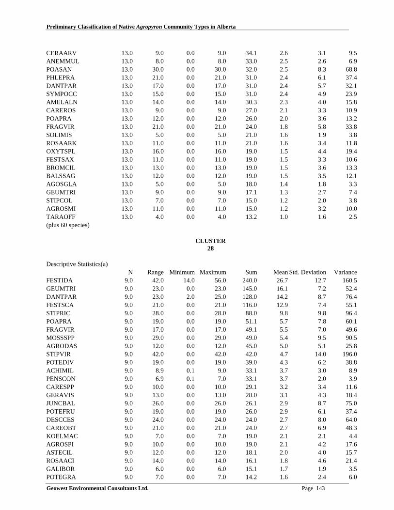
Preliminary Classification of Native Agropyron Community Types in Alberta
Geowest Environmental Consultants Ltd. Page 143
CERAARV 13.0 9.0 0.0 9.0 34.1 2.6 3.1 9.5ANEMMUL 13.0 8.0 0.0 8.0 33.0 2.5 2.6 6.9POASAN 13.0 30.0 0.0 30.0 32.0 2.5 8.3 68.8PHLEPRA 13.0 21.0 0.0 21.0 31.0 2.4 6.1 37.4DANTPAR 13.0 17.0 0.0 17.0 31.0 2.4 5.7 32.1SYMPOCC 13.0 15.0 0.0 15.0 31.0 2.4 4.9 23.9AMELALN 13.0 14.0 0.0 14.0 30.3 2.3 4.0 15.8CAREROS 13.0 9.0 0.0 9.0 27.0 2.1 3.3 10.9POAPRA 13.0 12.0 0.0 12.0 26.0 2.0 3.6 13.2FRAGVIR 13.0 21.0 0.0 21.0 24.0 1.8 5.8 33.8SOLIMIS 13.0 5.0 0.0 5.0 21.0 1.6 1.9 3.8ROSAARK 13.0 11.0 0.0 11.0 21.0 1.6 3.4 11.8OXYTSPL 13.0 16.0 0.0 16.0 19.0 1.5 4.4 19.4FESTSAX 13.0 11.0 0.0 11.0 19.0 1.5 3.3 10.6BROMCIL 13.0 13.0 0.0 13.0 19.0 1.5 3.6 13.3BALSSAG 13.0 12.0 0.0 12.0 19.0 1.5 3.5 12.1AGOSGLA 13.0 5.0 0.0 5.0 18.0 1.4 1.8 3.3GEUMTRI 13.0 9.0 0.0 9.0 17.1 1.3 2.7 7.4STIPCOL 13.0 7.0 0.0 7.0 15.0 1.2 2.0 3.8AGROSMI 13.0 11.0 0.0 11.0 15.0 1.2 3.2 10.0TARAOFF 13.0 4.0 0.0 4.0 13.2 1.0 1.6 2.5(plus 60 species)
CLUSTER28
Descriptive Statistics(a)N Range Minimum Maximum Sum Mean Std. Deviation Variance
FESTIDA 9.0 42.0 14.0 56.0 240.0 26.7 12.7 160.5GEUMTRI 9.0 23.0 0.0 23.0 145.0 16.1 7.2 52.4DANTPAR 9.0 23.0 2.0 25.0 128.0 14.2 8.7 76.4FESTSCA 9.0 21.0 0.0 21.0 116.0 12.9 7.4 55.1STIPRIC 9.0 28.0 0.0 28.0 88.0 9.8 9.8 96.4POAPRA 9.0 19.0 0.0 19.0 51.1 5.7 7.8 60.1FRAGVIR 9.0 17.0 0.0 17.0 49.1 5.5 7.0 49.6MOSSSPP 9.0 29.0 0.0 29.0 49.0 5.4 9.5 90.5AGRODAS 9.0 12.0 0.0 12.0 45.0 5.0 5.1 25.8STIPVIR 9.0 42.0 0.0 42.0 42.0 4.7 14.0 196.0POTEDIV 9.0 19.0 0.0 19.0 39.0 4.3 6.2 38.8ACHIMIL 9.0 8.9 0.1 9.0 33.1 3.7 3.0 8.9PENSCON 9.0 6.9 0.1 7.0 33.1 3.7 2.0 3.9CARESPP 9.0 10.0 0.0 10.0 29.1 3.2 3.4 11.6GERAVIS 9.0 13.0 0.0 13.0 28.0 3.1 4.3 18.4JUNCBAL 9.0 26.0 0.0 26.0 26.1 2.9 8.7 75.0POTEFRU 9.0 19.0 0.0 19.0 26.0 2.9 6.1 37.4DESCCES 9.0 24.0 0.0 24.0 24.0 2.7 8.0 64.0CAREOBT 9.0 21.0 0.0 21.0 24.0 2.7 6.9 48.3KOELMAC 9.0 7.0 0.0 7.0 19.0 2.1 2.1 4.4AGROSPI 9.0 10.0 0.0 10.0 19.0 2.1 4.2 17.6ASTECIL 9.0 12.0 0.0 12.0 18.1 2.0 4.0 15.7ROSAACI 9.0 14.0 0.0 14.0 16.1 1.8 4.6 21.4GALIBOR 9.0 6.0 0.0 6.0 15.1 1.7 1.9 3.5POTEGRA 9.0 7.0 0.0 7.0 14.2 1.6 2.4 6.0
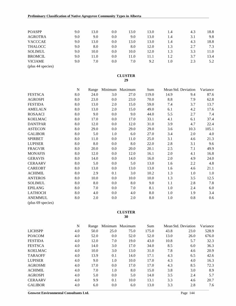
Preliminary Classification of Native Agropyron Community Types in Alberta
Geowest Environmental Consultants Ltd. Page 144
POASPP 9.0 13.0 0.0 13.0 13.0 1.4 4.3 18.8AGROTRA 9.0 9.0 0.0 9.0 13.0 1.4 3.1 9.8VACCCAE 9.0 13.0 0.0 13.0 13.0 1.4 4.3 18.8THALOCC 9.0 8.0 0.0 8.0 12.0 1.3 2.7 7.3SOLIMUL 9.0 10.0 0.0 10.0 12.0 1.3 3.3 11.0BROMCIL 9.0 11.0 0.0 11.0 11.1 1.2 3.7 13.4VICIAME 9.0 7.0 0.0 7.0 9.2 1.0 2.3 5.2(plus 44 species)
CLUSTER29
N Range Minimum Maximum Sum Mean Std. Deviation VarianceFESTSCA 8.0 24.0 3.0 27.0 119.0 14.9 9.4 87.6AGROSPI 8.0 23.0 0.0 23.0 70.0 8.8 7.9 62.8FESTIDA 8.0 13.0 2.0 15.0 59.0 7.4 3.7 13.7AMELALN 8.0 13.0 2.0 15.0 49.0 6.1 4.2 17.6ROSAACI 8.0 9.0 0.0 9.0 44.0 5.5 2.7 7.4KOELMAC 8.0 17.0 0.0 17.0 33.1 4.1 6.1 37.4DANTPAR 8.0 12.0 0.0 12.0 31.0 3.9 4.7 22.4ASTECON 8.0 29.0 0.0 29.0 29.0 3.6 10.3 105.1GALIBOR 8.0 5.0 1.0 6.0 27.0 3.4 2.0 4.0SPIRBET 8.0 11.0 0.0 11.0 25.0 3.1 4.6 21.3LUPISER 8.0 8.0 0.0 8.0 22.0 2.8 3.1 9.6FRAGVIR 8.0 20.0 0.0 20.0 20.1 2.5 7.1 49.9MONAFIS 8.0 12.0 0.0 12.0 16.1 2.0 4.1 16.8GERAVIS 8.0 14.0 0.0 14.0 16.0 2.0 4.9 24.0CERAARV 8.0 5.0 0.0 5.0 13.0 1.6 2.2 4.8CAREOBT 8.0 13.0 0.0 13.0 13.0 1.6 4.6 21.1ACHIMIL 8.0 2.9 0.1 3.0 10.2 1.3 1.0 1.0ANTEROS 8.0 10.0 0.0 10.0 10.0 1.3 3.5 12.5SOLIMUL 8.0 8.0 0.0 8.0 9.0 1.1 2.8 7.8EPILANG 8.0 7.0 0.0 7.0 8.1 1.0 2.4 6.0LATHOCH 8.0 4.0 0.0 4.0 8.0 1.0 1.9 3.4ANEMMUL 8.0 2.0 0.0 2.0 8.0 1.0 0.8 0.6(plus 69 species)
CLUSTER30
N Range Minimum Maximum Sum Mean Std. Deviation VarianceLICHSPP 4.0 50.0 25.0 75.0 175.0 43.8 23.0 528.9POACOM 4.0 52.0 0.0 52.0 52.0 13.0 26.0 676.0FESTIDA 4.0 12.0 7.0 19.0 43.0 10.8 5.7 32.3FESTSCA 4.0 14.0 3.0 17.0 34.0 8.5 6.0 36.3KOELMAC 4.0 10.0 3.0 13.0 31.0 7.8 4.6 20.9TARAOFF 4.0 13.9 0.1 14.0 17.1 4.3 6.5 42.6LUPISER 4.0 9.0 1.0 10.0 17.0 4.3 4.0 16.3AGROSMI 4.0 17.0 0.0 17.0 17.0 4.3 8.5 72.3ACHIMIL 4.0 7.0 1.0 8.0 15.0 3.8 3.0 8.9AGROSPI 4.0 5.0 0.0 5.0 14.0 3.5 2.4 5.7CERAARV 4.0 9.9 0.1 10.0 13.1 3.3 4.6 20.7GALIBOR 4.0 6.0 0.0 6.0 13.0 3.3 2.8 7.6

Preliminary Classification of Native Agropyron Community Types in Alberta
Geowest Environmental Consultants Ltd. Page 145
ANTEPAR 4.0 6.9 0.1 7.0 12.1 3.0 3.1 9.8ASTELAE 4.0 11.0 0.0 11.0 11.2 2.8 5.5 29.9STIPCOL 4.0 5.0 0.0 5.0 10.0 2.5 2.1 4.3DANTPAR 4.0 10.0 0.0 10.0 10.0 2.5 5.0 25.0CARESPP 4.0 5.0 0.0 5.0 10.0 2.5 2.9 8.3OXYTSPL 4.0 9.0 0.0 9.0 9.0 2.3 4.5 20.3GAILARI 4.0 8.0 0.0 8.0 8.0 2.0 4.0 16.0GEUMTRI 4.0 4.0 0.0 4.0 7.0 1.8 2.1 4.3FESTSAX 4.0 7.0 0.0 7.0 7.0 1.8 3.5 12.3AGROTRA 4.0 7.0 0.0 7.0 7.0 1.8 3.5 12.3ROSAACI 4.0 5.0 0.0 5.0 6.1 1.5 2.4 5.6AMELALN 4.0 6.0 0.0 6.0 6.1 1.5 3.0 8.9AGOSGLA 4.0 5.0 0.0 5.0 6.1 1.5 2.4 5.6SOLIMIS 4.0 6.0 0.0 6.0 6.0 1.5 3.0 9.0ANEMMUL 4.0 1.9 0.1 2.0 5.1 1.3 0.9 0.8POTEFRU 4.0 3.0 0.0 3.0 5.0 1.3 1.5 2.3PHLEPRA 4.0 5.0 0.0 5.0 5.0 1.3 2.5 6.3OXYTSER 4.0 3.0 0.0 3.0 5.0 1.3 1.5 2.3HETEVIL 4.0 3.0 0.0 3.0 5.0 1.3 1.5 2.3BROMINE 4.0 5.0 0.0 5.0 5.0 1.3 2.5 6.3SMILSTE 4.0 4.0 0.0 4.0 4.0 1.0 2.0 4.0CAREROS 4.0 4.0 0.0 4.0 4.0 1.0 2.0 4.0BROMPUM 4.0 4.0 0.0 4.0 4.0 1.0 2.0 4.0(plus 29 species)
CLUSTER31
N Range Minimum Maximum Sum Mean Std. Deviation VarianceAGROSPI 6.0 25.0 15.0 40.0 190.0 31.7 9.3 86.7BROMCAR 6.0 25.0 0.0 25.0 40.0 6.7 10.8 116.7FESTIDA 6.0 25.0 0.0 25.0 35.0 5.8 9.7 94.2HEDYSUL 6.0 25.0 0.0 25.0 31.0 5.2 9.9 98.2PHLEPRA 6.0 15.0 0.0 15.0 28.0 4.7 6.3 39.9FESTSCA 6.0 25.0 0.0 25.0 27.0 4.5 10.1 101.5LOMATRI 6.0 15.0 0.0 15.0 26.0 4.3 6.5 42.7POAPAL 6.0 15.0 0.0 15.0 25.0 4.2 6.7 44.2POAINT 6.0 20.0 0.0 20.0 20.0 3.3 8.2 66.7ANTEPAR 6.0 15.0 0.0 15.0 20.0 3.3 6.1 36.7GERAVIS 6.0 10.0 0.0 10.0 19.0 3.2 3.9 15.0GALIBOR 6.0 4.0 1.0 5.0 19.0 3.2 1.6 2.6SPIRBET 6.0 10.0 0.0 10.0 17.0 2.8 4.0 15.8FRAGVIR 6.0 5.0 0.0 5.0 17.0 2.8 2.5 6.2ASTECON 6.0 15.0 0.0 15.0 17.0 2.8 6.0 35.8LUPISER 6.0 10.0 0.0 10.0 15.0 2.5 3.8 14.7BROMINE 6.0 10.0 0.0 10.0 15.0 2.5 4.2 17.5ARTELUD 6.0 15.0 0.0 15.0 15.0 2.5 6.1 37.5ACHIMIL 6.0 4.0 1.0 5.0 14.0 2.3 2.1 4.3EPILANG 6.0 5.0 0.0 5.0 13.0 2.2 1.8 3.4OSMOOCC 6.0 10.0 0.0 10.0 12.0 2.0 4.0 15.6MONAFIS 6.0 10.0 0.0 10.0 11.0 1.8 4.0 16.2AMELALN 6.0 10.0 0.0 10.0 11.0 1.8 4.0 16.2ERIGPER 6.0 10.0 0.0 10.0 11.0 1.8 4.0 16.2
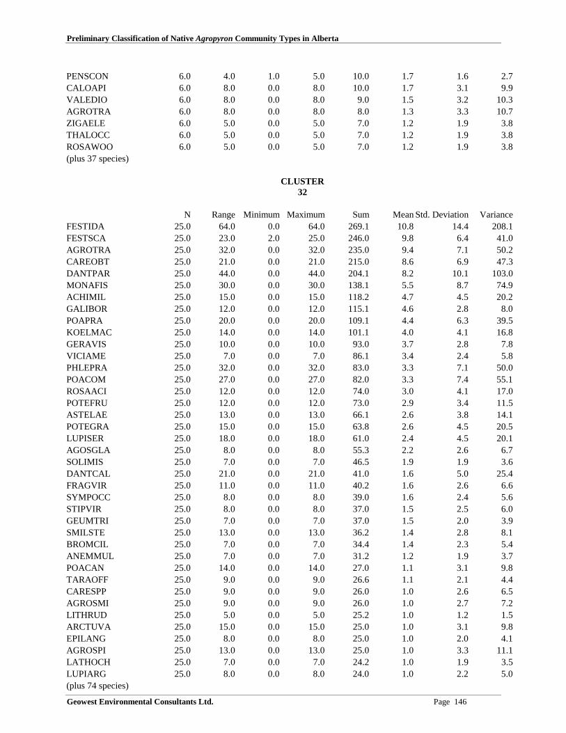
Preliminary Classification of Native Agropyron Community Types in Alberta
Geowest Environmental Consultants Ltd. Page 146
PENSCON 6.0 4.0 1.0 5.0 10.0 1.7 1.6 2.7CALOAPI 6.0 8.0 0.0 8.0 10.0 1.7 3.1 9.9VALEDIO 6.0 8.0 0.0 8.0 9.0 1.5 3.2 10.3AGROTRA 6.0 8.0 0.0 8.0 8.0 1.3 3.3 10.7ZIGAELE 6.0 5.0 0.0 5.0 7.0 1.2 1.9 3.8THALOCC 6.0 5.0 0.0 5.0 7.0 1.2 1.9 3.8ROSAWOO 6.0 5.0 0.0 5.0 7.0 1.2 1.9 3.8(plus 37 species)
CLUSTER32
N Range Minimum Maximum Sum Mean Std. Deviation VarianceFESTIDA 25.0 64.0 0.0 64.0 269.1 10.8 14.4 208.1FESTSCA 25.0 23.0 2.0 25.0 246.0 9.8 6.4 41.0AGROTRA 25.0 32.0 0.0 32.0 235.0 9.4 7.1 50.2CAREOBT 25.0 21.0 0.0 21.0 215.0 8.6 6.9 47.3DANTPAR 25.0 44.0 0.0 44.0 204.1 8.2 10.1 103.0MONAFIS 25.0 30.0 0.0 30.0 138.1 5.5 8.7 74.9ACHIMIL 25.0 15.0 0.0 15.0 118.2 4.7 4.5 20.2GALIBOR 25.0 12.0 0.0 12.0 115.1 4.6 2.8 8.0POAPRA 25.0 20.0 0.0 20.0 109.1 4.4 6.3 39.5KOELMAC 25.0 14.0 0.0 14.0 101.1 4.0 4.1 16.8GERAVIS 25.0 10.0 0.0 10.0 93.0 3.7 2.8 7.8VICIAME 25.0 7.0 0.0 7.0 86.1 3.4 2.4 5.8PHLEPRA 25.0 32.0 0.0 32.0 83.0 3.3 7.1 50.0POACOM 25.0 27.0 0.0 27.0 82.0 3.3 7.4 55.1ROSAACI 25.0 12.0 0.0 12.0 74.0 3.0 4.1 17.0POTEFRU 25.0 12.0 0.0 12.0 73.0 2.9 3.4 11.5ASTELAE 25.0 13.0 0.0 13.0 66.1 2.6 3.8 14.1POTEGRA 25.0 15.0 0.0 15.0 63.8 2.6 4.5 20.5LUPISER 25.0 18.0 0.0 18.0 61.0 2.4 4.5 20.1AGOSGLA 25.0 8.0 0.0 8.0 55.3 2.2 2.6 6.7SOLIMIS 25.0 7.0 0.0 7.0 46.5 1.9 1.9 3.6DANTCAL 25.0 21.0 0.0 21.0 41.0 1.6 5.0 25.4FRAGVIR 25.0 11.0 0.0 11.0 40.2 1.6 2.6 6.6SYMPOCC 25.0 8.0 0.0 8.0 39.0 1.6 2.4 5.6STIPVIR 25.0 8.0 0.0 8.0 37.0 1.5 2.5 6.0GEUMTRI 25.0 7.0 0.0 7.0 37.0 1.5 2.0 3.9SMILSTE 25.0 13.0 0.0 13.0 36.2 1.4 2.8 8.1BROMCIL 25.0 7.0 0.0 7.0 34.4 1.4 2.3 5.4ANEMMUL 25.0 7.0 0.0 7.0 31.2 1.2 1.9 3.7POACAN 25.0 14.0 0.0 14.0 27.0 1.1 3.1 9.8TARAOFF 25.0 9.0 0.0 9.0 26.6 1.1 2.1 4.4CARESPP 25.0 9.0 0.0 9.0 26.0 1.0 2.6 6.5AGROSMI 25.0 9.0 0.0 9.0 26.0 1.0 2.7 7.2LITHRUD 25.0 5.0 0.0 5.0 25.2 1.0 1.2 1.5ARCTUVA 25.0 15.0 0.0 15.0 25.0 1.0 3.1 9.8EPILANG 25.0 8.0 0.0 8.0 25.0 1.0 2.0 4.1AGROSPI 25.0 13.0 0.0 13.0 25.0 1.0 3.3 11.1LATHOCH 25.0 7.0 0.0 7.0 24.2 1.0 1.9 3.5LUPIARG 25.0 8.0 0.0 8.0 24.0 1.0 2.2 5.0(plus 74 species)

Preliminary Classification of Native Agropyron Community Types in Alberta
Geowest Environmental Consultants Ltd. Page 147
CLUSTER33
N Range Minimum Maximum Sum Mean Std. Deviation VarianceDANTCAL 5.0 30.0 13.0 43.0 159.0 31.8 11.6 134.7FESTSCA 5.0 41.0 2.0 43.0 106.0 21.2 14.6 212.7CAREOBT 5.0 18.0 6.0 24.0 60.0 12.0 7.4 54.5STIPRIC 5.0 22.0 0.0 22.0 51.0 10.2 10.8 117.2SOLIMIS 5.0 23.0 0.0 23.0 23.0 4.6 10.3 105.8AGROTRA 5.0 6.0 0.0 6.0 22.0 4.4 2.6 6.8PENSPRO 5.0 17.0 0.0 17.0 20.0 4.0 7.4 54.5FESTIDA 5.0 17.0 0.0 17.0 18.1 3.6 7.5 56.1FRAGVIR 5.0 8.0 0.0 8.0 16.0 3.2 3.6 13.2LUPISER 5.0 12.0 0.0 12.0 15.0 3.0 5.2 27.0VACCCAE 5.0 8.0 0.0 8.0 13.0 2.6 3.7 13.8POTEARG 5.0 8.0 0.0 8.0 13.0 2.6 3.7 13.8SOLIMUL 5.0 9.0 0.0 9.0 11.0 2.2 3.9 15.2TARAOFF 5.0 7.0 0.0 7.0 10.0 2.0 2.9 8.5ACHIMIL 5.0 3.9 0.1 4.0 9.2 1.8 1.7 3.0CERAARV 5.0 4.0 0.0 4.0 9.1 1.8 1.8 3.1SELADEN 5.0 4.0 0.0 4.0 8.0 1.6 2.2 4.8ELYMINN 5.0 6.0 0.0 6.0 8.0 1.6 2.5 6.3GALIBOR 5.0 3.9 0.1 4.0 6.3 1.3 1.7 3.0PENSCON 5.0 3.0 0.0 3.0 6.2 1.2 1.6 2.6JUNCBAL 5.0 5.0 0.0 5.0 6.1 1.2 2.2 4.6DANTPAR 5.0 6.0 0.0 6.0 6.0 1.2 2.7 7.2AGRODAS 5.0 6.0 0.0 6.0 6.0 1.2 2.7 7.2POTEFRU 5.0 3.0 0.0 3.0 5.1 1.0 1.4 2.0FESTSAX 5.0 5.0 0.0 5.0 5.0 1.0 2.2 5.0(plus 49 species)
CLUSTER34
N Range Minimum Maximum Sum Mean Std. Deviation VarianceFESTSAX 3.0 1.0 16.0 17.0 50.0 16.7 0.6 0.3CARESPP 3.0 13.0 3.0 16.0 27.0 9.0 6.6 43.0AGROTRA 3.0 13.0 0.0 13.0 21.0 7.0 6.6 43.0KOELMAC 3.0 12.0 0.0 12.0 19.0 6.3 6.0 36.3FESTSCA 3.0 13.0 1.0 14.0 17.0 5.7 7.2 52.3HELIHOO 3.0 17.0 0.0 17.0 17.0 5.7 9.8 96.3ACHIMIL 3.0 10.0 1.0 11.0 16.0 5.3 5.1 26.3GALIBOR 3.0 9.9 0.1 10.0 15.1 5.0 5.0 24.5SYMPOCC 3.0 15.0 0.0 15.0 15.0 5.0 8.7 75.0STIPCOL 3.0 7.0 0.0 7.0 14.0 4.7 4.0 16.3GERAVIS 3.0 11.0 0.0 11.0 13.0 4.3 5.9 34.3AGROSPI 3.0 13.0 0.0 13.0 13.0 4.3 7.5 56.3BROMCIL 3.0 11.0 0.0 11.0 13.0 4.3 5.9 34.3ASTELAE 3.0 12.0 0.0 12.0 12.0 4.0 6.9 48.0MOSSSPP 3.0 11.0 0.0 11.0 11.0 3.7 6.3 40.0VICIAME 3.0 6.0 0.0 6.0 11.0 3.7 3.2 10.3FRAGVIR 3.0 10.0 0.0 10.0 10.0 3.3 5.8 33.3

Preliminary Classification of Native Agropyron Community Types in Alberta
Geowest Environmental Consultants Ltd. Page 148
CERAARV 3.0 6.0 0.0 6.0 9.0 3.0 3.0 9.0POLYVIV 3.0 8.0 0.0 8.0 8.0 2.7 4.6 21.3POTEGRA 3.0 7.0 0.0 7.0 8.0 2.7 3.8 14.3LATHOCH 3.0 7.0 0.0 7.0 7.0 2.3 4.0 16.3AGOSGLA 3.0 6.0 0.0 6.0 6.0 2.0 3.5 12.0TARAOFF 3.0 2.9 0.1 3.0 4.1 1.4 1.5 2.2POACOM 3.0 3.0 0.0 3.0 4.0 1.3 1.5 2.3FESTIDA 3.0 4.0 0.0 4.0 4.0 1.3 2.3 5.3OXYTSER 3.0 4.0 0.0 4.0 4.0 1.3 2.3 5.3TRAGDUB 3.0 3.0 0.0 3.0 3.0 1.0 1.7 3.0THALOCC 3.0 3.0 0.0 3.0 3.0 1.0 1.7 3.0POAPRA 3.0 3.0 0.0 3.0 3.0 1.0 1.7 3.0BROMCAR 3.0 3.0 0.0 3.0 3.0 1.0 1.7 3.0ASTECIL 3.0 3.0 0.0 3.0 3.0 1.0 1.7 3.0(plus 20 species)
CLUSTER35
N Range Minimum Maximum Sum Mean Std. Deviation VarianceFESTSAX 1.0 0.0 10.0 10.0 10.0 10.0 . .ARTECAM 1.0 0.0 10.0 10.0 10.0 10.0 . .CAREPRA 1.0 0.0 7.0 7.0 7.0 7.0 . .ERIGPHI 1.0 0.0 6.0 6.0 6.0 6.0 . .PICEGLA 1.0 0.0 5.0 5.0 5.0 5.0 . .AGROTRA 1.0 0.0 5.0 5.0 5.0 5.0 . .TRIFREP 1.0 0.0 4.0 4.0 4.0 4.0 . .POAPRA 1.0 0.0 4.0 4.0 4.0 4.0 . .AMELALN 1.0 0.0 4.0 4.0 4.0 4.0 . .GALIBOR 1.0 0.0 1.0 1.0 1.0 1.0 . .VICIAME 1.0 0.0 0.1 0.1 0.1 0.1 . .TARAOFF 1.0 0.0 0.1 0.1 0.1 0.1 . .ROSAACI 1.0 0.0 0.1 0.1 0.1 0.1 . .AGROSCA 1.0 0.0 0.1 0.1 0.1 0.1 . .
CLUSTER36
Descriptive Statistics(a)N Range Minimum Maximum Sum Mean Std. Deviation Variance
SELADEN 20.0 50.0 7.0 57.0 708.0 35.4 14.1 200.1AGROSMI 20.0 50.0 0.0 50.0 326.0 16.3 14.6 212.7BOUTGRA 20.0 45.0 0.0 45.0 194.0 9.7 12.4 153.8STIPCOM 20.0 33.0 0.0 33.0 193.0 9.7 8.7 75.4KOELMAC 20.0 26.0 0.0 26.0 115.0 5.8 6.1 37.4ARTEFRI 20.0 18.0 0.0 18.0 66.0 3.3 4.1 16.7CAREFIL 20.0 27.0 0.0 27.0 60.0 3.0 6.4 40.8CALALON 20.0 34.0 0.0 34.0 41.0 2.1 7.6 57.8STIPVIR 20.0 22.0 0.0 22.0 38.0 1.9 5.3 28.0AGRODAS 20.0 11.0 0.0 11.0 27.0 1.4 3.2 10.2(plus 50 species)

Preliminary Classification of Native Agropyron Community Types in Alberta
Geowest Environmental Consultants Ltd. Page 149
CLUSTER37
N Range Minimum Maximum Sum Mean Std. Deviation VarianceSTIPCOM 8.0 48.0 10.0 58.0 306.0 38.3 14.9 221.9BOUTGRA 8.0 20.0 0.0 20.0 99.0 12.4 6.4 41.1CAREFIL 8.0 20.0 0.0 20.0 48.0 6.0 8.5 72.0CALALON 8.0 30.0 0.0 30.0 45.0 5.6 10.1 102.6AGROSMI 8.0 10.0 0.0 10.0 42.0 5.3 4.6 21.4KOELMAC 8.0 10.0 0.0 10.0 22.0 2.8 3.6 13.1AGRODAS 8.0 10.0 0.0 10.0 16.0 2.0 3.9 14.9ARTEFRI 8.0 3.0 0.0 3.0 13.0 1.6 1.1 1.1AGROTRA 8.0 12.0 0.0 12.0 12.0 1.5 4.2 18.0CARESPP 8.0 7.0 0.0 7.0 10.0 1.3 2.6 6.5HETEVIL 8.0 3.0 0.0 3.0 7.2 0.9 1.1 1.2ARTELUD 8.0 7.0 0.0 7.0 7.0 0.9 2.5 6.1ARTECAN 8.0 4.0 0.0 4.0 7.0 0.9 1.5 2.1PHLOHOO 8.0 5.0 0.0 5.0 6.1 0.8 1.7 3.1SELADEN 8.0 3.0 0.0 3.0 6.0 0.8 1.4 1.9VICIAME 8.0 2.0 0.0 2.0 5.1 0.6 0.9 0.8ROSAWOO 8.0 3.0 0.0 3.0 4.0 0.5 1.1 1.1LIATPUN 8.0 1.0 0.0 1.0 3.1 0.4 0.5 0.3GLYCLEP 8.0 2.0 0.0 2.0 3.0 0.4 0.7 0.6ASTEERI 8.0 2.0 0.0 2.0 3.0 0.4 0.7 0.6THERRHO 8.0 1.0 0.0 1.0 2.0 0.3 0.5 0.2POASAN 8.0 2.0 0.0 2.0 2.0 0.3 0.7 0.5LYGOJUN 8.0 1.0 0.0 1.0 2.0 0.3 0.5 0.2SOLIMIS 8.0 1.0 0.0 1.0 2.0 0.3 0.5 0.2GUTISAR 8.0 2.0 0.0 2.0 2.0 0.3 0.7 0.5GAURCOC 8.0 1.0 0.0 1.0 2.0 0.3 0.5 0.2SYMPOCC 8.0 1.0 0.0 1.0 1.0 0.1 0.4 0.1SYMPALB 8.0 1.0 0.0 1.0 1.0 0.1 0.4 0.1SPHACOC 8.0 1.0 0.0 1.0 1.0 0.1 0.4 0.1CERAARV 8.0 1.0 0.0 1.0 1.0 0.1 0.4 0.1ASTEFAL 8.0 1.0 0.0 1.0 1.0 0.1 0.4 0.1ANTEPAR 8.0 1.0 0.0 1.0 1.0 0.1 0.4 0.1ANEMMUL 8.0 1.0 0.0 1.0 1.0 0.1 0.4 0.1ACHIMIL 8.0 1.0 0.0 1.0 1.0 0.1 0.4 0.1COMAUMB 8.0 0.1 0.0 0.1 0.2 0.0 0.0 0.0
CLUSTER38
N Range Minimum Maximum Sum Mean Std. Deviation VarianceDESCCES 3.0 62.0 6.0 68.0 142.0 47.3 35.8 1281.3POAPRA 3.0 7.0 12.0 19.0 44.0 14.7 3.8 14.3AGROTRA 3.0 3.0 8.0 11.0 28.0 9.3 1.5 2.3TARAOFF 3.0 17.0 1.0 18.0 23.0 7.7 9.1 82.3PENSCON 3.0 13.0 0.0 13.0 14.0 4.7 7.2 52.3ASTEERI 3.0 13.0 0.0 13.0 13.0 4.3 7.5 56.3GRINSQU 3.0 8.0 0.0 8.0 8.0 2.7 4.6 21.3ACHIMIL 3.0 5.0 0.0 5.0 8.0 2.7 2.5 6.3POTEGRA 3.0 8.0 0.0 8.0 8.0 2.7 4.6 21.3POTEFRU 3.0 5.0 0.0 5.0 5.0 1.7 2.9 8.3

Preliminary Classification of Native Agropyron Community Types in Alberta
Geowest Environmental Consultants Ltd. Page 150
ASTELAE 3.0 2.9 0.1 3.0 4.1 1.4 1.5 2.2THALVEN 3.0 2.0 0.0 2.0 4.0 1.3 1.2 1.3RUMEACE 3.0 3.0 0.0 3.0 3.0 1.0 1.7 2.9VICIAME 3.0 0.0 1.0 1.0 3.0 1.0 0.0 0.0HORDJUB 3.0 3.0 0.0 3.0 3.0 1.0 1.7 3.0CAREPRT 3.0 3.0 0.0 3.0 3.0 1.0 1.7 3.0CAREATH 3.0 3.0 0.0 3.0 3.0 1.0 1.7 3.0(plus 18 species)
CLUSTER39
N Range Minimum Maximum Sum Mean Std. Deviation VariancePOAPAL 2.0 50.0 0.0 50.0 50.0 25.0 35.4 1250.0POAPRA 2.0 10.0 5.0 15.0 20.0 10.0 7.1 50.0MUHLRIC 2.0 13.0 2.0 15.0 17.0 8.5 9.2 84.5ACHIMIL 2.0 12.0 0.0 12.0 12.0 6.0 8.5 72.0SYMPOCC 2.0 9.0 1.0 10.0 11.0 5.5 6.4 40.5ARTELUD 2.0 7.0 1.0 8.0 9.0 4.5 4.9 24.5AGROTRA 2.0 5.0 2.0 7.0 9.0 4.5 3.5 12.5ROSAWOO 2.0 6.0 1.0 7.0 8.0 4.0 4.2 18.0AGROSMI 2.0 4.0 0.0 4.0 4.0 2.0 2.8 8.0STIPCUR 2.0 3.0 0.0 3.0 3.0 1.5 2.1 4.5POACOM 2.0 3.0 0.0 3.0 3.0 1.5 2.1 4.5GLYCLEP 2.0 3.0 0.0 3.0 3.0 1.5 2.1 4.5VICIAME 2.0 0.0 1.0 1.0 2.0 1.0 0.0 0.0STIPCOM 2.0 2.0 0.0 2.0 2.0 1.0 1.4 2.0SOLIMIS 2.0 0.0 1.0 1.0 2.0 1.0 0.0 0.0SELADEN 2.0 2.0 0.0 2.0 2.0 1.0 1.4 2.0KOELMAC 2.0 2.0 0.0 2.0 2.0 1.0 1.4 2.0BROMINE 2.0 2.0 0.0 2.0 2.0 1.0 1.4 2.0ASTESPP 2.0 2.0 0.0 2.0 2.0 1.0 1.4 2.0ARTEFRI 2.0 0.0 1.0 1.0 2.0 1.0 0.0 0.0STIPVIR 2.0 1.0 0.0 1.0 1.0 0.5 0.7 0.5SPHACOC 2.0 1.0 0.0 1.0 1.0 0.5 0.7 0.5LINULEW 2.0 1.0 0.0 1.0 1.0 0.5 0.7 0.5HETEVIL 2.0 1.0 0.0 1.0 1.0 0.5 0.7 0.5CAREOBT 2.0 1.0 0.0 1.0 1.0 0.5 0.7 0.5BOUTGRA 2.0 1.0 0.0 1.0 1.0 0.5 0.7 0.5ARTECAN 2.0 1.0 0.0 1.0 1.0 0.5 0.7 0.5ANTEPAR 2.0 1.0 0.0 1.0 1.0 0.5 0.7 0.5AGROSCA 2.0 1.0 0.0 1.0 1.0 0.5 0.7 0.5
CLUSTER40
N Range Minimum Maximum Sum Mean Std. Deviation VariancePOAPRA 22.0 43.0 19.0 62.0 818.0 37.2 11.1 124.2TARAOFF 22.0 32.0 0.0 32.0 233.2 10.6 10.9 117.9AGROTRA 22.0 30.0 0.0 30.0 204.0 9.3 8.5 72.1ACHIMIL 22.0 20.0 0.0 20.0 161.1 7.3 6.0 36.2GEUMTRI 22.0 41.0 0.0 41.0 159.1 7.2 12.2 148.6FRAGVIR 22.0 26.0 0.0 26.0 121.1 5.5 7.0 49.6

Preliminary Classification of Native Agropyron Community Types in Alberta
Geowest Environmental Consultants Ltd. Page 151
POTEGRA 22.0 24.0 0.0 24.0 113.0 5.1 6.7 44.3STIPRIC 22.0 43.0 0.0 43.0 109.1 5.0 11.4 130.5PHLEPRA 22.0 31.0 0.0 31.0 93.0 4.2 8.5 71.7PENSCON 22.0 30.0 0.0 30.0 77.0 3.5 7.3 52.6FESTIDA 22.0 18.0 0.0 18.0 67.2 3.1 5.5 30.8FESTSCA 22.0 20.0 0.0 20.0 58.0 2.6 5.2 26.5GERAVIS 22.0 13.0 0.0 13.0 47.0 2.1 4.3 18.2DANTPAR 22.0 16.0 0.0 16.0 47.0 2.1 3.8 14.5VICIAME 22.0 11.0 0.0 11.0 45.2 2.1 3.1 9.9POTEDIV 22.0 15.0 0.0 15.0 45.1 2.1 4.5 19.8CAREPRG 22.0 12.0 0.0 12.0 45.0 2.0 4.5 19.9CAREOBT 22.0 15.0 0.0 15.0 44.0 2.0 3.8 14.4GALIBOR 22.0 20.0 0.0 20.0 43.3 2.0 4.4 19.7CERAARV 22.0 22.0 0.0 22.0 42.2 1.9 5.0 24.9BROMCIL 22.0 17.0 0.0 17.0 38.1 1.7 3.9 15.2KOELMAC 22.0 10.0 0.0 10.0 33.2 1.5 2.9 8.2DANTCAL 22.0 18.0 0.0 18.0 29.1 1.3 4.0 15.9TRIFREP 22.0 27.0 0.0 27.0 29.0 1.3 5.8 33.1AGOSGLA 22.0 10.0 0.0 10.0 28.1 1.3 2.7 7.1CAREPRA 22.0 24.0 0.0 24.0 26.0 1.2 5.1 26.2THALVEN 22.0 9.0 0.0 9.0 26.0 1.2 2.5 6.3(plus 96 species)
CLUSTER41
N Range Minimum Maximum Sum Mean Std. Deviation VariancePOAPRA 2.0 9.0 5.0 14.0 19.0 9.5 6.4 40.5FRAGVIR 2.0 3.0 7.0 10.0 17.0 8.5 2.1 4.5TRIFREP 2.0 16.0 0.0 16.0 16.0 8.0 11.3 128.0ANEMMUL 2.0 8.0 2.0 10.0 12.0 6.0 5.7 32.0PENSPRO 2.0 11.0 0.0 11.0 11.0 5.5 7.8 60.5LICHSPP 2.0 11.0 0.0 11.0 11.0 5.5 7.8 60.5PHLEPRA 2.0 9.0 0.0 9.0 9.0 4.5 6.4 40.5ACHIMIL 2.0 1.0 4.0 5.0 9.0 4.5 0.7 0.5POTEFRU 2.0 6.0 0.0 6.0 6.0 3.0 4.2 18.0GEUMRIV 2.0 6.0 0.0 6.0 6.0 3.0 4.2 18.0GENTAMA 2.0 6.0 0.0 6.0 6.0 3.0 4.2 18.0SALIGLA 2.0 5.0 0.0 5.0 5.0 2.5 3.5 12.5CAREOBT 2.0 4.0 0.0 4.0 4.0 2.0 2.8 8.0AGRODAS 2.0 4.0 0.0 4.0 4.0 2.0 2.8 8.0TARAOFF 2.0 3.0 0.0 3.0 3.0 1.5 2.1 4.5POLEPUL 2.0 3.0 0.0 3.0 3.0 1.5 2.1 4.5GALIBOR 2.0 1.0 1.0 2.0 3.0 1.5 0.7 0.5BROMINE 2.0 3.0 0.0 3.0 3.0 1.5 2.1 4.5ASTECIL 2.0 3.0 0.0 3.0 3.0 1.5 2.1 4.5ARCTUVA 2.0 3.0 0.0 3.0 3.0 1.5 2.1 4.5FESTSAX 2.0 2.0 0.0 2.0 2.0 1.1 1.3 1.8POTEGRA 2.0 2.0 0.0 2.0 2.0 1.0 1.4 2.0ELYMINN 2.0 2.0 0.0 2.0 2.0 1.0 1.4 2.0CARESPP 2.0 2.0 0.0 2.0 2.0 1.0 1.4 2.0ROSAACI 2.0 1.0 0.0 1.0 1.0 0.5 0.7 0.5KOELMAC 2.0 1.0 0.0 1.0 1.0 0.5 0.7 0.5
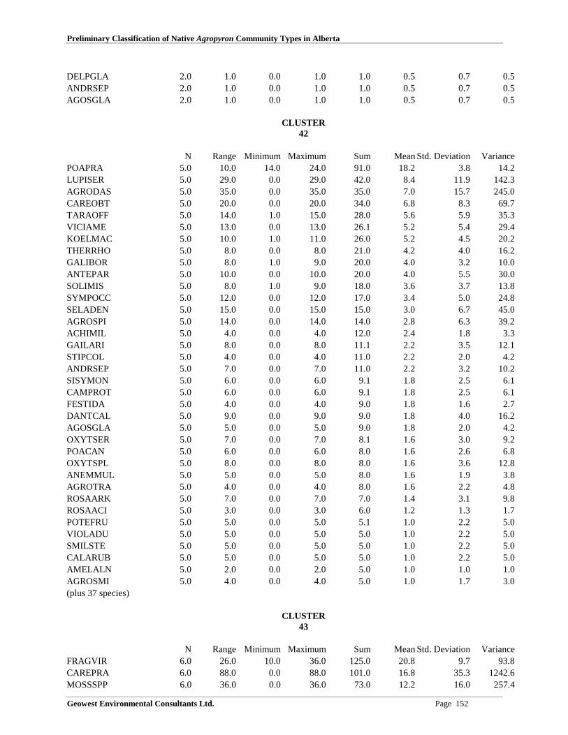
Preliminary Classification of Native Agropyron Community Types in Alberta
Geowest Environmental Consultants Ltd. Page 152
DELPGLA 2.0 1.0 0.0 1.0 1.0 0.5 0.7 0.5ANDRSEP 2.0 1.0 0.0 1.0 1.0 0.5 0.7 0.5AGOSGLA 2.0 1.0 0.0 1.0 1.0 0.5 0.7 0.5
CLUSTER42
N Range Minimum Maximum Sum Mean Std. Deviation VariancePOAPRA 5.0 10.0 14.0 24.0 91.0 18.2 3.8 14.2LUPISER 5.0 29.0 0.0 29.0 42.0 8.4 11.9 142.3AGRODAS 5.0 35.0 0.0 35.0 35.0 7.0 15.7 245.0CAREOBT 5.0 20.0 0.0 20.0 34.0 6.8 8.3 69.7TARAOFF 5.0 14.0 1.0 15.0 28.0 5.6 5.9 35.3VICIAME 5.0 13.0 0.0 13.0 26.1 5.2 5.4 29.4KOELMAC 5.0 10.0 1.0 11.0 26.0 5.2 4.5 20.2THERRHO 5.0 8.0 0.0 8.0 21.0 4.2 4.0 16.2GALIBOR 5.0 8.0 1.0 9.0 20.0 4.0 3.2 10.0ANTEPAR 5.0 10.0 0.0 10.0 20.0 4.0 5.5 30.0SOLIMIS 5.0 8.0 1.0 9.0 18.0 3.6 3.7 13.8SYMPOCC 5.0 12.0 0.0 12.0 17.0 3.4 5.0 24.8SELADEN 5.0 15.0 0.0 15.0 15.0 3.0 6.7 45.0AGROSPI 5.0 14.0 0.0 14.0 14.0 2.8 6.3 39.2ACHIMIL 5.0 4.0 0.0 4.0 12.0 2.4 1.8 3.3GAILARI 5.0 8.0 0.0 8.0 11.1 2.2 3.5 12.1STIPCOL 5.0 4.0 0.0 4.0 11.0 2.2 2.0 4.2ANDRSEP 5.0 7.0 0.0 7.0 11.0 2.2 3.2 10.2SISYMON 5.0 6.0 0.0 6.0 9.1 1.8 2.5 6.1CAMPROT 5.0 6.0 0.0 6.0 9.1 1.8 2.5 6.1FESTIDA 5.0 4.0 0.0 4.0 9.0 1.8 1.6 2.7DANTCAL 5.0 9.0 0.0 9.0 9.0 1.8 4.0 16.2AGOSGLA 5.0 5.0 0.0 5.0 9.0 1.8 2.0 4.2OXYTSER 5.0 7.0 0.0 7.0 8.1 1.6 3.0 9.2POACAN 5.0 6.0 0.0 6.0 8.0 1.6 2.6 6.8OXYTSPL 5.0 8.0 0.0 8.0 8.0 1.6 3.6 12.8ANEMMUL 5.0 5.0 0.0 5.0 8.0 1.6 1.9 3.8AGROTRA 5.0 4.0 0.0 4.0 8.0 1.6 2.2 4.8ROSAARK 5.0 7.0 0.0 7.0 7.0 1.4 3.1 9.8ROSAACI 5.0 3.0 0.0 3.0 6.0 1.2 1.3 1.7POTEFRU 5.0 5.0 0.0 5.0 5.1 1.0 2.2 5.0VIOLADU 5.0 5.0 0.0 5.0 5.0 1.0 2.2 5.0SMILSTE 5.0 5.0 0.0 5.0 5.0 1.0 2.2 5.0CALARUB 5.0 5.0 0.0 5.0 5.0 1.0 2.2 5.0AMELALN 5.0 2.0 0.0 2.0 5.0 1.0 1.0 1.0AGROSMI 5.0 4.0 0.0 4.0 5.0 1.0 1.7 3.0(plus 37 species)
CLUSTER43
N Range Minimum Maximum Sum Mean Std. Deviation VarianceFRAGVIR 6.0 26.0 10.0 36.0 125.0 20.8 9.7 93.8CAREPRA 6.0 88.0 0.0 88.0 101.0 16.8 35.3 1242.6MOSSSPP 6.0 36.0 0.0 36.0 73.0 12.2 16.0 257.4
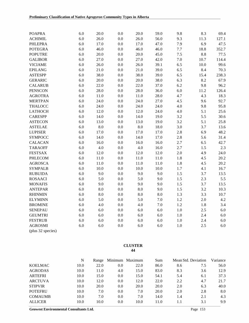
Preliminary Classification of Native Agropyron Community Types in Alberta
Geowest Environmental Consultants Ltd. Page 153
POAPRA 6.0 20.0 0.0 20.0 59.0 9.8 8.3 69.4ACHIMIL 6.0 26.0 0.0 26.0 56.0 9.3 11.3 127.1PHLEPRA 6.0 17.0 0.0 17.0 47.0 7.9 6.9 47.5POTEGRA 6.0 46.0 0.0 46.0 46.0 7.7 18.8 352.7POPUTRE 6.0 20.0 0.0 20.0 45.0 7.5 8.8 77.5GALIBOR 6.0 27.0 0.0 27.0 42.0 7.0 10.7 114.4VICIAME 6.0 26.0 0.0 26.0 39.1 6.5 10.0 99.6EPILANG 6.0 21.0 0.0 21.0 39.0 6.5 8.4 70.3ASTESPP 6.0 38.0 0.0 38.0 39.0 6.5 15.4 238.3GERARIC 6.0 20.0 0.0 20.0 38.0 6.3 8.2 67.9CALARUB 6.0 22.0 0.0 22.0 37.0 6.2 9.8 96.2PENSCON 6.0 28.0 0.0 28.0 36.0 6.0 11.2 126.4AGROTRA 6.0 11.0 0.0 11.0 28.0 4.7 4.3 18.3MERTPAN 6.0 24.0 0.0 24.0 27.0 4.5 9.6 92.7THALOCC 6.0 24.0 0.0 24.0 24.0 4.0 9.8 95.8LATHOCH 6.0 12.0 0.0 12.0 24.0 4.0 5.1 25.6CARESPP 6.0 14.0 0.0 14.0 19.0 3.2 5.5 30.6ASTECON 6.0 13.0 0.0 13.0 19.0 3.2 5.1 25.8ASTELAE 6.0 8.0 0.0 8.0 18.0 3.0 3.7 13.6LUPISER 6.0 17.0 0.0 17.0 17.0 2.8 6.9 48.2SYMPOCC 6.0 14.0 0.0 14.0 17.0 2.8 5.6 31.4CALACAN 6.0 16.0 0.0 16.0 16.0 2.7 6.5 42.7TARAOFF 6.0 4.0 0.0 4.0 16.0 2.7 1.5 2.3FESTSAX 6.0 12.0 0.0 12.0 12.0 2.0 4.9 24.0PHLECOM 6.0 11.0 0.0 11.0 11.0 1.8 4.5 20.2AGROSCA 6.0 11.0 0.0 11.0 11.0 1.8 4.5 20.2SYMPALB 6.0 10.0 0.0 10.0 10.0 1.7 4.1 16.7RUBUIDA 6.0 9.0 0.0 9.0 9.0 1.5 3.7 13.5ROSAACI 6.0 5.0 0.0 5.0 9.0 1.5 2.3 5.5MONAFIS 6.0 9.0 0.0 9.0 9.0 1.5 3.7 13.5ANTEPAR 6.0 8.0 0.0 8.0 9.0 1.5 3.2 10.3RHINMIN 6.0 8.0 0.0 8.0 8.0 1.3 3.3 10.7ELYMINN 6.0 5.0 0.0 5.0 7.0 1.2 2.0 4.2BROMINE 6.0 4.0 0.0 4.0 7.0 1.2 1.8 3.4SENEPAU 6.0 6.0 0.0 6.0 6.0 1.0 2.5 6.0GEUMTRI 6.0 6.0 0.0 6.0 6.0 1.0 2.4 6.0FESTRUB 6.0 6.0 0.0 6.0 6.0 1.0 2.4 6.0AGROSMI 6.0 6.0 0.0 6.0 6.0 1.0 2.5 6.0(plus 32 species)
CLUSTER44
N Range Minimum Maximum Sum Mean Std. Deviation VarianceKOELMAC 10.0 22.0 0.0 22.0 86.0 8.6 7.5 56.0AGRODAS 10.0 11.0 4.0 15.0 83.0 8.3 3.6 12.9ARTEFRI 10.0 15.0 0.0 15.0 54.1 5.4 6.1 37.3ARCTUVA 10.0 12.0 0.0 12.0 22.0 2.2 4.7 21.7STIPVIR 10.0 20.0 0.0 20.0 20.0 2.0 6.3 40.0POTEFRU 10.0 7.0 0.0 7.0 20.0 2.0 2.8 8.0COMAUMB 10.0 7.0 0.0 7.0 14.0 1.4 2.1 4.3ALLICER 10.0 10.0 0.0 10.0 11.0 1.1 3.1 9.9

Preliminary Classification of Native Agropyron Community Types in Alberta
Geowest Environmental Consultants Ltd. Page 154
OXYTSER 10.0 8.0 0.0 8.0 10.0 1.0 2.5 6.2JUNICOM 10.0 10.0 0.0 10.0 10.0 1.0 3.2 10.0(plus 48 species)
CLUSTER45
N Range Minimum Maximum Sum Mean Std. Deviation VarianceAGRODAS 8.0 55.0 15.0 70.0 334.0 41.8 20.6 423.6DANTCAL 8.0 40.0 0.0 40.0 41.0 5.1 14.1 198.7STIPCOM 8.0 23.0 0.0 23.0 23.0 2.9 8.1 66.1JUNIHOR 8.0 18.0 0.0 18.0 20.0 2.5 6.3 39.7AMELALN 8.0 18.0 0.0 18.0 18.0 2.3 6.4 40.5EPILANG 8.0 10.0 0.0 10.0 15.0 1.9 3.4 11.3KOELMAC 8.0 8.0 0.0 8.0 12.0 1.5 2.8 8.0FESTSPP 8.0 7.0 0.0 7.0 12.0 1.5 2.8 8.0GALIBOR 8.0 5.0 0.0 5.0 11.0 1.4 1.8 3.4SALISPP 8.0 10.0 0.0 10.0 10.0 1.3 3.5 12.5LUPISER 8.0 10.0 0.0 10.0 10.0 1.3 3.5 12.5FRAGVIR 8.0 4.0 0.0 4.0 10.0 1.3 1.6 2.5SYMPALB 8.0 5.0 0.0 5.0 8.0 1.0 1.8 3.1ARTEFRI 8.0 5.0 0.0 5.0 8.0 1.0 1.8 3.1(plus 63 species)
CLUSTER46
Descriptive Statistics(a)N Range Minimum Maximum Sum Mean Std. Deviation Variance
AGRODAS 9.0 29.0 10.0 39.0 229.0 25.4 9.3 86.8KOELMAC 9.0 60.0 0.0 60.0 215.0 23.9 20.1 404.9ARTEFRI 9.0 28.0 0.0 28.0 91.0 10.1 11.6 133.6ELYMINN 9.0 25.0 0.0 25.0 45.0 5.0 8.7 75.0FESTSAX 9.0 22.0 0.0 22.0 26.0 2.9 7.2 52.4LINULEW 9.0 20.0 0.0 20.0 22.0 2.4 6.6 43.5THALOCC 9.0 18.0 0.0 18.0 18.0 2.0 6.0 36.0CALAPUR 9.0 15.0 0.0 15.0 17.0 1.9 5.0 24.6FRAGVIR 9.0 8.0 0.0 8.0 15.0 1.7 2.9 8.3ASTESPP 9.0 15.0 0.0 15.0 15.0 1.7 5.0 25.0ARTEDRA 9.0 8.0 0.0 8.0 14.0 1.6 2.7 7.5SMILSTE 9.0 12.0 0.0 12.0 12.0 1.3 4.0 16.0POPUTRE 9.0 10.0 0.0 10.0 10.0 1.1 3.3 11.1DESCCES 9.0 10.0 0.0 10.0 10.0 1.1 3.3 11.1AGROSMI 9.0 5.0 0.0 5.0 9.0 1.0 1.7 2.8(plus 60 species)
CLUSTER47
N Range Minimum Maximum Sum Mean Std. Deviation VarianceAGROSMI 5.0 11.0 4.0 15.0 38.0 7.6 4.3 18.8CARESPP 5.0 10.0 0.0 10.0 23.0 4.6 3.7 13.8AMELALN 5.0 9.0 1.0 10.0 22.0 4.4 4.3 18.3
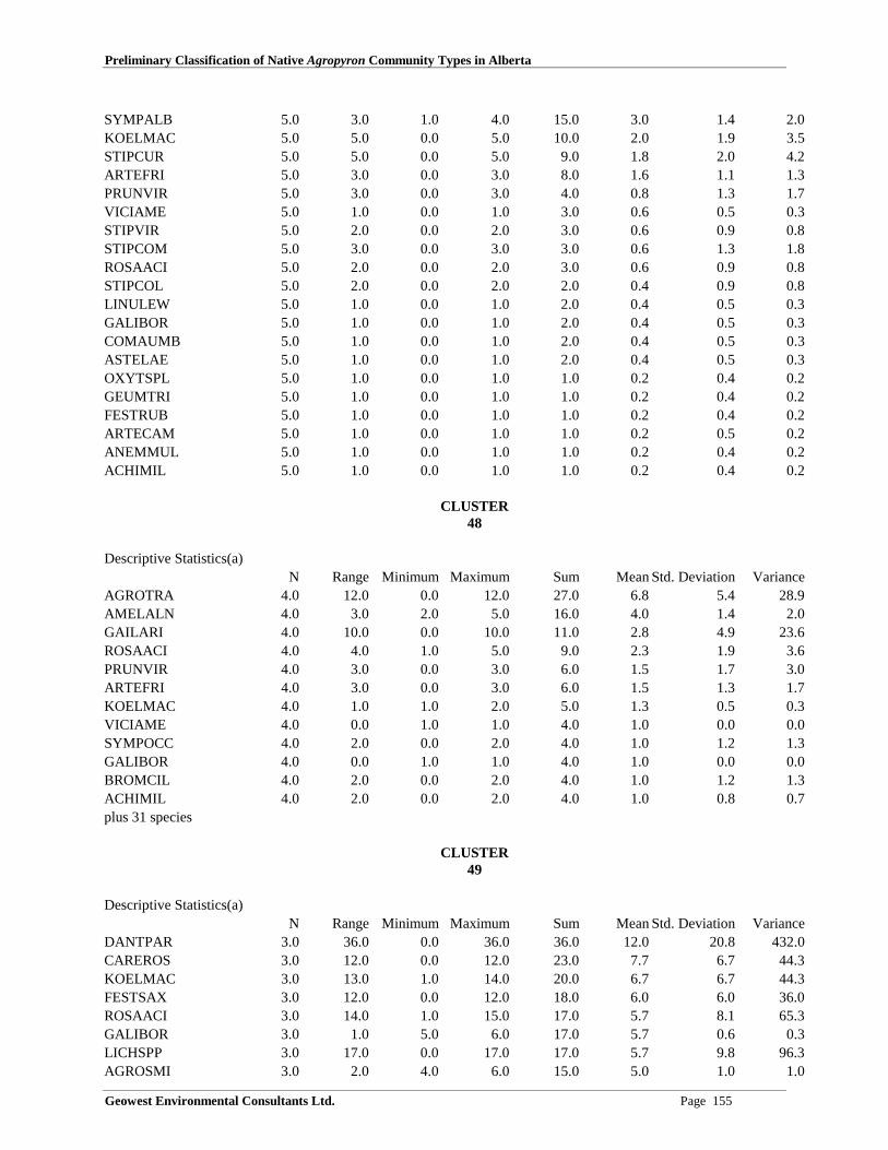
Preliminary Classification of Native Agropyron Community Types in Alberta
Geowest Environmental Consultants Ltd. Page 155
SYMPALB 5.0 3.0 1.0 4.0 15.0 3.0 1.4 2.0KOELMAC 5.0 5.0 0.0 5.0 10.0 2.0 1.9 3.5STIPCUR 5.0 5.0 0.0 5.0 9.0 1.8 2.0 4.2ARTEFRI 5.0 3.0 0.0 3.0 8.0 1.6 1.1 1.3PRUNVIR 5.0 3.0 0.0 3.0 4.0 0.8 1.3 1.7VICIAME 5.0 1.0 0.0 1.0 3.0 0.6 0.5 0.3STIPVIR 5.0 2.0 0.0 2.0 3.0 0.6 0.9 0.8STIPCOM 5.0 3.0 0.0 3.0 3.0 0.6 1.3 1.8ROSAACI 5.0 2.0 0.0 2.0 3.0 0.6 0.9 0.8STIPCOL 5.0 2.0 0.0 2.0 2.0 0.4 0.9 0.8LINULEW 5.0 1.0 0.0 1.0 2.0 0.4 0.5 0.3GALIBOR 5.0 1.0 0.0 1.0 2.0 0.4 0.5 0.3COMAUMB 5.0 1.0 0.0 1.0 2.0 0.4 0.5 0.3ASTELAE 5.0 1.0 0.0 1.0 2.0 0.4 0.5 0.3OXYTSPL 5.0 1.0 0.0 1.0 1.0 0.2 0.4 0.2GEUMTRI 5.0 1.0 0.0 1.0 1.0 0.2 0.4 0.2FESTRUB 5.0 1.0 0.0 1.0 1.0 0.2 0.4 0.2ARTECAM 5.0 1.0 0.0 1.0 1.0 0.2 0.5 0.2ANEMMUL 5.0 1.0 0.0 1.0 1.0 0.2 0.4 0.2ACHIMIL 5.0 1.0 0.0 1.0 1.0 0.2 0.4 0.2
CLUSTER48
Descriptive Statistics(a)N Range Minimum Maximum Sum Mean Std. Deviation Variance
AGROTRA 4.0 12.0 0.0 12.0 27.0 6.8 5.4 28.9AMELALN 4.0 3.0 2.0 5.0 16.0 4.0 1.4 2.0GAILARI 4.0 10.0 0.0 10.0 11.0 2.8 4.9 23.6ROSAACI 4.0 4.0 1.0 5.0 9.0 2.3 1.9 3.6PRUNVIR 4.0 3.0 0.0 3.0 6.0 1.5 1.7 3.0ARTEFRI 4.0 3.0 0.0 3.0 6.0 1.5 1.3 1.7KOELMAC 4.0 1.0 1.0 2.0 5.0 1.3 0.5 0.3VICIAME 4.0 0.0 1.0 1.0 4.0 1.0 0.0 0.0SYMPOCC 4.0 2.0 0.0 2.0 4.0 1.0 1.2 1.3GALIBOR 4.0 0.0 1.0 1.0 4.0 1.0 0.0 0.0BROMCIL 4.0 2.0 0.0 2.0 4.0 1.0 1.2 1.3ACHIMIL 4.0 2.0 0.0 2.0 4.0 1.0 0.8 0.7plus 31 species
CLUSTER49
Descriptive Statistics(a)N Range Minimum Maximum Sum Mean Std. Deviation Variance
DANTPAR 3.0 36.0 0.0 36.0 36.0 12.0 20.8 432.0CAREROS 3.0 12.0 0.0 12.0 23.0 7.7 6.7 44.3KOELMAC 3.0 13.0 1.0 14.0 20.0 6.7 6.7 44.3FESTSAX 3.0 12.0 0.0 12.0 18.0 6.0 6.0 36.0ROSAACI 3.0 14.0 1.0 15.0 17.0 5.7 8.1 65.3GALIBOR 3.0 1.0 5.0 6.0 17.0 5.7 0.6 0.3LICHSPP 3.0 17.0 0.0 17.0 17.0 5.7 9.8 96.3AGROSMI 3.0 2.0 4.0 6.0 15.0 5.0 1.0 1.0

Preliminary Classification of Native Agropyron Community Types in Alberta
Geowest Environmental Consultants Ltd. Page 156
PRUNVIR 3.0 10.0 0.0 10.0 11.0 3.7 5.5 30.3MOSSSPP 3.0 11.0 0.0 11.0 11.0 3.7 6.4 40.3POAINT 3.0 11.0 0.0 11.0 11.0 3.7 6.4 40.3LUPISER 3.0 5.0 2.0 7.0 11.0 3.7 2.9 8.3STIPCOL 3.0 7.0 0.0 7.0 10.0 3.3 3.5 12.3HELIHOO 3.0 4.0 1.0 5.0 7.0 2.3 2.3 5.3CERAARV 3.0 2.0 1.0 3.0 7.0 2.3 1.2 1.3SYMPALB 3.0 5.0 0.0 5.0 6.0 2.0 2.7 7.0OXYTSPL 3.0 6.0 0.0 6.0 6.0 2.0 3.5 12.0HETEVIL 3.0 2.0 1.0 3.0 6.0 2.0 1.0 1.0ACHIMIL 3.0 3.9 0.1 4.0 5.1 1.7 2.0 4.2ARTEFRI 3.0 3.0 0.0 3.0 5.0 1.7 1.5 2.3LITHRUD 3.0 4.0 0.0 4.0 5.0 1.7 2.1 4.3AMELALN 3.0 5.0 0.0 5.0 5.0 1.7 2.9 8.3STIPRIC 3.0 4.0 0.0 4.0 4.0 1.3 2.3 5.3MONAFIS 3.0 4.0 0.0 4.0 4.0 1.3 2.3 5.3FESTSCA 3.0 3.0 0.0 3.0 4.0 1.3 1.5 2.3CAREXER 3.0 4.0 0.0 4.0 4.0 1.3 2.3 5.3THERRHO 3.0 3.0 0.0 3.0 3.0 1.0 1.7 3.0COMAUMB 3.0 2.0 0.0 2.0 3.0 1.0 1.0 1.0(plus 22 species)
CLUSTER50
N Range Minimum Maximum Sum Mean Std. Deviation VarianceCAREXER 6.0 5.0 7.0 12.0 56.0 9.3 2.1 4.3MOSSSPP 6.0 10.0 4.0 14.0 51.0 8.5 4.1 17.1GEUMTRI 6.0 19.0 0.0 19.0 35.0 5.8 8.1 66.2AGROSMI 6.0 9.0 0.0 9.0 26.0 4.4 3.6 12.9GALIBOR 6.0 13.9 0.1 14.0 25.1 4.2 5.2 26.8FESTSCA 6.0 12.0 0.0 12.0 24.0 4.0 4.2 18.0KOELMAC 6.0 6.0 1.0 7.0 23.0 3.8 2.3 5.4STIPVIR 6.0 13.0 0.0 13.0 22.0 3.7 5.8 33.9POTEFRU 6.0 9.0 0.0 9.0 21.0 3.5 3.3 10.7OXYTSER 6.0 6.0 1.0 7.0 20.0 3.3 2.3 5.5AGROTRA 6.0 7.0 0.0 7.0 17.1 2.9 3.2 10.5VICIAME 6.0 9.0 0.0 9.0 15.0 2.5 3.5 12.3ARTEFRI 6.0 5.9 0.1 6.0 14.1 2.4 2.0 4.2ROSAACI 6.0 8.0 0.0 8.0 13.1 2.2 3.2 10.5ASTRALP 6.0 7.0 0.0 7.0 13.0 2.2 2.6 7.0HELIHOO 6.0 3.9 0.1 4.0 12.1 2.0 1.6 2.7DANTPAR 6.0 7.0 0.0 7.0 11.0 1.8 3.0 9.0BROMINE 6.0 4.0 0.0 4.0 8.0 1.3 2.1 4.3POASPP 6.0 3.0 0.0 3.0 6.0 1.0 1.5 2.4(plus 25 species)
CLUSTER51
N Range Minimum Maximum Sum Mean Std. Deviation VarianceAGROSMI 9.0 70.0 10.0 80.0 300.0 33.3 20.6 423.0ARTEFRI 9.0 16.0 0.0 16.0 41.1 4.6 6.6 43.9

Preliminary Classification of Native Agropyron Community Types in Alberta
Geowest Environmental Consultants Ltd. Page 157
STIPCOM 9.0 11.0 0.0 11.0 32.0 3.6 3.6 13.0SELADEN 9.0 17.0 0.0 17.0 31.0 3.4 6.6 44.0STIPVIR 9.0 30.0 0.0 30.0 30.0 3.3 10.0 100.0CARESPP 9.0 25.0 0.0 25.0 25.0 2.8 8.3 69.4ARTECAN 9.0 14.0 0.0 14.0 24.0 2.7 5.4 29.0BOUTGRA 9.0 8.0 0.0 8.0 22.0 2.4 3.3 10.8GRINSQU 9.0 15.0 0.0 15.0 18.0 2.0 5.0 24.8CALALON 9.0 16.0 0.0 16.0 16.0 1.8 5.3 28.4KOELMAC 9.0 6.0 0.0 6.0 15.0 1.7 2.1 4.3AGROTRA 9.0 14.0 0.0 14.0 15.0 1.7 4.6 21.5PHLOHOO 9.0 7.0 0.0 7.0 9.1 1.0 2.3 5.2(plus 32 species)
CLUSTER52
N Range Minimum Maximum Sum Mean Std. Deviation VarianceHORDJUB 6.0 50.0 10.0 60.0 181.0 30.2 23.7 562.2AGROSMI 6.0 33.0 2.0 35.0 81.0 13.5 14.8 220.3POAPAL 6.0 20.0 0.0 20.0 63.0 10.5 8.8 77.5ELEOPAL 6.0 26.0 0.0 26.0 44.0 7.3 11.6 135.5CARESPP 6.0 15.0 0.0 15.0 25.0 4.2 6.6 44.2POAPRA 6.0 10.0 0.0 10.0 23.0 3.8 4.9 24.2PUCCHAU 6.0 20.0 0.0 20.0 20.0 3.3 8.2 66.7ARTELUD 6.0 15.0 0.0 15.0 18.1 3.0 6.0 35.9DESCCES 6.0 15.0 0.0 15.0 15.0 2.5 6.1 37.5AGROSCA 6.0 10.0 0.0 10.0 10.0 1.7 4.1 16.7GRINSQU 6.0 3.0 0.0 3.0 8.0 1.3 1.4 1.9POACAN 6.0 5.0 0.0 5.0 5.0 0.9 2.0 4.1AGROTRA 6.0 5.0 0.0 5.0 5.0 0.8 2.0 4.2ROSAWOO 6.0 3.0 0.0 3.0 5.0 0.8 1.3 1.8TARAOFF 6.0 2.0 0.0 2.0 3.0 0.5 0.8 0.7ACHIMIL 6.0 2.0 0.0 2.0 2.0 0.3 0.8 0.7ARTECAM 6.0 1.0 0.0 1.0 1.0 0.2 0.4 0.2SOLIMIS 6.0 1.0 0.0 1.0 1.0 0.2 0.4 0.2GLYCLEP 6.0 1.0 0.0 1.0 1.0 0.2 0.4 0.2ASTEFAL 6.0 1.0 0.0 1.0 1.0 0.2 0.4 0.2ARTEFRI 6.0 1.0 0.0 1.0 1.0 0.2 0.4 0.2ARTECAN 6.0 1.0 0.0 1.0 1.0 0.2 0.4 0.2
CLUSTER53
N Range Minimum Maximum Sum Mean Std. Deviation VarianceAGRODAS 3.0 33.0 2.0 35.0 52.0 17.3 16.6 276.3JUNIHOR 3.0 12.0 8.0 20.0 40.0 13.3 6.1 37.3CALAPUR 3.0 23.0 0.0 23.0 23.0 7.7 13.3 176.3PICEGLA 3.0 12.0 0.0 12.0 22.0 7.3 6.4 41.3SHEPCAN 3.0 20.0 0.0 20.0 21.0 7.0 11.3 127.0ELYMINN 3.0 9.0 3.0 12.0 18.0 6.0 5.2 27.0CARESPP 3.0 16.0 0.0 16.0 16.0 5.3 9.2 85.3ARCTUVA 3.0 4.0 4.0 8.0 16.0 5.3 2.3 5.3SALISPP 3.0 15.0 0.0 15.0 15.0 5.0 8.7 75.0

Preliminary Classification of Native Agropyron Community Types in Alberta
Geowest Environmental Consultants Ltd. Page 158
PINUCON 3.0 8.0 0.0 8.0 12.0 4.0 4.0 16.0OXYTSER 3.0 6.0 0.0 6.0 11.0 3.7 3.2 10.3ROSAACI 3.0 10.0 0.0 10.0 11.0 3.7 5.5 30.3GALIBOR 3.0 10.0 0.0 10.0 11.0 3.7 5.5 30.3HEDYBOR 3.0 8.0 0.0 8.0 10.0 3.3 4.2 17.3POTEFRU 3.0 5.0 1.0 6.0 9.0 3.0 2.6 7.0KOELMAC 3.0 4.0 0.0 4.0 6.0 2.0 2.0 4.0AGROTRA 3.0 4.0 0.0 4.0 5.0 1.7 2.1 4.3SOLISPA 3.0 3.0 0.0 3.0 5.0 1.7 1.5 2.3ARTEFRI 3.0 5.0 0.0 5.0 5.0 1.7 2.9 8.3OXYTSPL 3.0 3.0 0.0 3.0 4.0 1.3 1.5 2.3ZIGAELE 3.0 3.0 0.0 3.0 3.0 1.0 1.7 3.0JUNICOM 3.0 3.0 0.0 3.0 3.0 1.0 1.7 3.0CAMPROT 3.0 2.0 0.0 2.0 3.0 1.0 1.0 1.0plus 12 species
CLUSTER54
N Range Minimum Maximum Sum Mean Std. Deviation VarianceAGROSPI 3.0 1.0 4.0 5.0 13.0 4.3 0.6 0.3FESTIDA 3.0 7.0 0.0 7.0 9.0 3.0 3.6 13.0POTEFRU 3.0 4.0 0.0 4.0 6.0 2.0 2.0 4.0SHEPCAN 3.0 5.0 0.0 5.0 5.0 1.7 2.9 8.3SELADEN 3.0 1.0 1.0 2.0 4.0 1.3 0.6 0.3ROSAACI 3.0 1.0 1.0 2.0 4.0 1.3 0.6 0.3OXYTSER 3.0 1.0 1.0 2.0 4.0 1.3 0.6 0.3GAILARI 3.0 1.0 1.0 2.0 4.0 1.3 0.6 0.3ANEMMUL 3.0 1.9 0.1 2.0 3.1 1.0 1.0 0.9ARCTUVA 3.0 2.0 0.0 2.0 3.0 1.0 1.0 1.0AGOSGLA 3.0 0.0 1.0 1.0 3.0 1.0 0.0 0.0(plus 22 species)
CLUSTER55
N Range Minimum Maximum Sum Mean Std. Deviation VarianceARCTUVA 8.0 13.0 8.0 21.0 130.0 16.3 4.1 16.5AGROSPI 8.0 16.0 0.0 16.0 47.0 5.9 6.2 38.7AMELALN 8.0 12.0 0.0 12.0 36.0 4.5 5.3 27.7FESTSCA 8.0 13.0 0.0 13.0 29.0 3.6 4.6 21.1ROSAACI 8.0 8.0 0.0 8.0 27.0 3.4 3.5 12.6FESTIDA 8.0 9.0 0.0 9.0 27.0 3.4 3.5 12.3OXYTSPL 8.0 10.0 0.0 10.0 25.1 3.1 3.2 10.3AGROTRA 8.0 8.0 0.0 8.0 24.0 3.0 3.5 12.3GEUMTRI 8.0 14.0 0.0 14.0 22.0 2.8 5.3 28.5CAREOBT 8.0 7.0 0.0 7.0 21.0 2.6 3.0 9.1ANDRCHA 8.0 20.0 0.0 20.0 20.0 2.5 7.1 50.0FRAGVIR 8.0 14.0 0.0 14.0 19.0 2.4 4.8 23.4KOELMAC 8.0 6.0 0.0 6.0 17.1 2.1 2.9 8.6POAPRA 8.0 9.0 0.0 9.0 17.0 2.1 3.2 10.1GALIBOR 8.0 5.0 0.0 5.0 15.2 1.9 1.9 3.7ACHIMIL 8.0 5.0 0.0 5.0 14.1 1.8 1.7 2.7

Preliminary Classification of Native Agropyron Community Types in Alberta
Geowest Environmental Consultants Ltd. Page 159
CERAARV 8.0 5.0 0.0 5.0 14.0 1.8 1.7 2.8POTEFRU 8.0 5.0 0.0 5.0 13.2 1.7 1.9 3.6DANTCAL 8.0 9.0 0.0 9.0 13.0 1.6 3.2 10.0PENSCON 8.0 5.0 0.0 5.0 12.1 1.5 1.9 3.7FESTSAX 8.0 8.0 0.0 8.0 11.0 1.4 2.8 7.7MONAFIS 8.0 9.0 0.0 9.0 11.0 1.4 3.2 10.0ANTEPAR 8.0 7.0 0.0 7.0 11.0 1.4 2.3 5.4SPIRBET 8.0 6.0 0.0 6.0 10.1 1.3 2.1 4.5PHLEPRA 8.0 6.0 0.0 6.0 10.0 1.3 2.4 5.6ANEMMUL 8.0 3.0 0.0 3.0 10.0 1.3 1.2 1.4SELADEN 8.0 6.0 0.0 6.0 8.1 1.0 2.1 4.3SHEPCAN 8.0 4.0 0.0 4.0 8.0 1.0 1.9 3.4(plus 64 species)

APPENDIX 4Summary of Detrended Canonocal Correspondence Analysis
(DCCA) of 120 Plots From ESIS Database

Preliminary Classification of Native Agropyron Community Types in Alberta
Geowest Environmental Consultants Ltd. Page 163
Appendix 4: Summary of Detrended Canonocal Correspondence Analysis (DCCA) of 120 plotsfrom ESIS database.
[Mon Jan 01 17:54:26 2001] Log file created[Mon Jan 01 17:56:21 2001] Settings changed[Mon Jan 01 17:56:41 2001] CON file [C:\My Documents\zadnjire.con] saved[Mon Jan 01 17:56:44 2001] Running CANOCO:[Mon Jan 01 17:56:44 2001] CON file [C:\My Documents\zadnjire.con] saved Program CANOCO Version 4.0 April 1998 - written by Cajo J.F. Ter Braak Copyright (c) 1988-1998 Centre for Biometry Wageningen, CPRO-DLO Box 100, 6700 AC Wageningen, the Netherlands. CANOCO performs (partial) (detrended) (canonical) correspondence analysis, principal components analysis and redundancy analysis. CANOCO is an extension of Cornell Ecology program DECORANA (Hill,1979)
For explanation of the input/output see the manual or Ter Braak, C.J.F. (1995) Ordination. Chapter 5 in: Data Analysis in Community and Landscape Ecology (Jongman, R.H.G., Ter Braak, C.J.F. and Van Tongeren, O.F.R., Eds) Cambridge University Press, Cambridge, UK, 91-173 pp.
*** Type of analysis *** Model Gradient analysis indirect direct hybrid linear 1=PCA 2= RDA 3 unimodal 4= CA 5= CCA 6 ,, 7=DCA 8=DCCA 9 10=non-standard analysis Type analysis number Answer = 8
*** Data files *** Species data : C:\MYDOCU~1\KSENIJA\SPECIE~1.DAT Covariable data : Environmental data : C:\MYDOCU~1\KSENIJA\ENVIRO_4.DAT Initialization file:
Forward selection of envi. variables = 0 Scaling of ordination scores = 2 Diagnostics = 3
File : C:\MYDOCU~1\KSENIJA\SPECIE~1.DAT Title : WCanoImp produced data file Format : (I5,1X,6(I6,F5.1)) No. of couplets of species number and abundance per line : 6
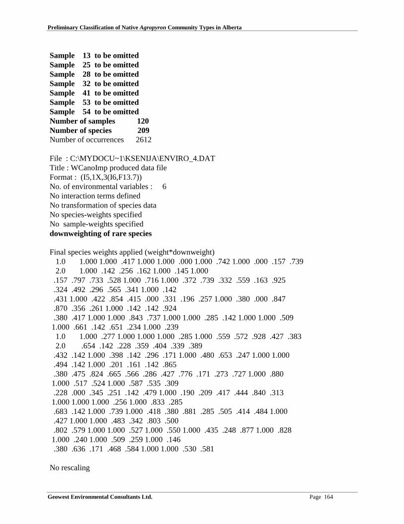
Preliminary Classification of Native Agropyron Community Types in Alberta
Geowest Environmental Consultants Ltd. Page 164
Sample 13 to be omitted Sample 25 to be omitted Sample 28 to be omitted Sample 32 to be omitted Sample 41 to be omitted Sample 53 to be omitted Sample 54 to be omitted Number of samples 120 Number of species 209 Number of occurrences 2612
File : C:\MYDOCU~1\KSENIJA\ENVIRO_4.DAT Title : WCanoImp produced data file Format : (I5,1X,3(I6,F13.7)) No. of environmental variables : 6 No interaction terms defined No transformation of species data No species-weights specified No sample-weights specified downweighting of rare species
Final species weights applied (weight*downweight)1.0 1.000 1.000 .417 1.000 1.000 .000 1.000 .742 1.000 .000 .157 .7392.0 1.000 .142 .256 .162 1.000 .145 1.000
.157 .797 .733 .528 1.000 .716 1.000 .372 .739 .332 .559 .163 .925 .324 .492 .296 .565 .341 1.000 .142 .431 1.000 .422 .854 .415 .000 .331 .196 .257 1.000 .380 .000 .847 .870 .356 .261 1.000 .142 .142 .924 .380 .417 1.000 1.000 .843 .737 1.000 1.000 .285 .142 1.000 1.000 .509 1.000 .661 .142 .651 .234 1.000 .239
1.0 1.000 .277 1.000 1.000 1.000 .285 1.000 .559 .572 .928 .427 .3832.0 .654 .142 .228 .359 .404 .339 .389
.432 .142 1.000 .398 .142 .296 .171 1.000 .480 .653 .247 1.000 1.000 .494 .142 1.000 .201 .161 .142 .865 .380 .475 .824 .665 .566 .286 .427 .776 .171 .273 .727 1.000 .880 1.000 .517 .524 1.000 .587 .535 .309 .228 .000 .345 .251 .142 .479 1.000 .190 .209 .417 .444 .840 .313 1.000 1.000 1.000 .256 1.000 .833 .285 .683 .142 1.000 .739 1.000 .418 .380 .881 .285 .505 .414 .484 1.000 .427 1.000 1.000 .483 .342 .803 .500 .802 .579 1.000 1.000 .527 1.000 .550 1.000 .435 .248 .877 1.000 .828 1.000 .240 1.000 .509 .259 1.000 .146 .380 .636 .171 .468 .584 1.000 1.000 .530 .581
No rescaling

Preliminary Classification of Native Agropyron Community Types in Alberta
Geowest Environmental Consultants Ltd. Page 165
No. of active samples: 120 No. of passive samples: 0 No. of active species: 204
Total inertia in species data= Sum of all eigenvalues of CA = 9.74620
****** Check on influence in covariable/environment data ****** The following sample(s) have extreme values Sample Environmental Covariable + Environment space variable Influence influence influence
24 3.1x 26 4.6x 27 4.3x ****** End of check ******
***MESSAGE*** No detrending with respect to term AX3**2
***MESSAGE*** No detrending with respect to term AX1*AX3
***MESSAGE*** No detrending with respect to term AX2*AX3
1 **** Weighted correlation matrix (weight = sample total) ****
SPEC AX1 1.0000 SPEC AX2 .0218 1.0000 SPEC AX3 -.0519 -.0169 1.0000 SPEC AX4 .1099 .1249 -.5026 1.0000 ENVI AX1 .9334 .0000 .0000 .0000 1.0000 ENVI AX2 .0000 .7882 .0000 .0000 .0000 1.0000 ENVI AX3 .0000 .0000 .6833 .0000 .0000 .0000 1.0000 ENVI AX4 .0000 .0000 .0000 .0000 .0000 .0000 .0000 .0000 Drainage -.3428 .1945 -.2079 .0000 -.3673 .2467 -.3042 .0000 E. Mosit -.6296 .0952 .2476 .0000 -.6745 .1208 .3624 .0000 Annual R .1383 -.2107 -.1105 .0000 .1482 -.2673 -.1617 .0000 Elevatio -.5310 -.6114 -.0480 .0000 -.5689 -.7757 -.0703 .0000 LATITUDE -.5594 .5343 -.0246 .0000 -.5993 .6779 -.0359 .0000 LONGITUD -.7205 .2168 -.1865 .0000 -.7720 .2750 -.2729 .0000
SPEC AX1 SPEC AX2 SPEC AX3 SPEC AX4 ENVI AX1 ENVI AX2ENVI AX3 ENVI AX4

Preliminary Classification of Native Agropyron Community Types in Alberta
Geowest Environmental Consultants Ltd. Page 166
Drainage 1.0000 E. Mosit .6515 1.0000 Annual R -.2887 -.2713 1.0000 Elevatio .2229 .3619 .1424 1.0000 LATITUDE .0909 .2074 -.1924 -.2353 1.0000 LONGITUD .0401 .2335 -.0337 .1178 .7889 1.0000
Drainage E. Mosit Annual R Elevatio LATITUDELONGITUD
N name (weighted) mean stand. dev. inflation factor
1 SPEC AX1 .0000 1.0714 2 SPEC AX2 .0000 1.2687 3 SPEC AX3 .0000 1.4634 4 SPEC AX4 .0000 1.0000 5 ENVI AX1 .0000 1.0000 6 ENVI AX2 .0000 1.0000 7 ENVI AX3 .0000 1.0000 8 ENVI AX4 .0000 .0000 1 Drainage 3.0453 .8157 1.8352 2 E. Mosit 3.9143 1.3160 2.1423 3 Annual R 743.2941 77.0216 1.2120 4 Elevatio 1304.3050 385.6898 1.8056 5 LATITUDE 51.4198 2.1104 4.1719 6 LONGITUD 114.4941 2.5598 3.7886
**** Summary ****
Axes 1 2 3 4 Total inertia 9.746
Eigenvalues : .701 .251 .119 .511 Species-environment correlations : .933 .788 .683 .000 Cumulative percentage variance of species data : 7.2 9.8 11.0 16.2 of species-environment relation: 45.5 61.9 69.6 .0
Sum of all unconstrained eigenvalues 9.746 Sum of all canonical eigenvalues 1.540
*** Unrestricted permutation ***
Seeds: 23239 945

Preliminary Classification of Native Agropyron Community Types in Alberta
Geowest Environmental Consultants Ltd. Page 167
**** Summary of Monte Carlo test ****
Test of significance of first canonical axis: eigenvalue = .701 F-ratio = 8.761 P-value = .0050
Test of significance of all canonical axes : Trace = 1.540 F-ratio = 3.533 P-value = .0050
( 199 permutations under reduced model)
***MESSAGE*** No detrending with respect to term AX3**2
***MESSAGE*** No detrending with respect to term AX1*AX3
***MESSAGE*** No detrending with respect to term AX2*AX3
[Mon Jan 01 17:57:02 2001] CANOCO call succeeded

APPENDIX 5Statistics for Environmental Variables Used
in Detrended Canonical Correspondence Analysis (DCCA)

Preliminary Classification of Native Agropyron Community Types in Alberta
Geowest Environmental Consultants Ltd. Page 171
Appendix 5: Statistics for environmental variables used in detrended canonical correspondenceanalysis (DCCA) of 120 plots from ESIS database. Bold values in "Regression/canonicalcoefficients" table are important values based on significant canonical coefficients (P < 0.05, DF= 113)(Zar 1984, p. 371-377). Bold values in "t-values of regression coefficients" table indicatesignificant regression coefficients (P < 0.05, DF = 113). Bold values in "Inter set correlations ofenvironmental variables" table represent truly significant variables (significant in bothaforementioned tables).______________________________________________________________________________ WCanoImp produced data file DCCA Canonical axes: 3 Covariables: 0 Scaling: 2DETR-POLY2 Downweight No transformation Regr: Regression/canonical coefficients for standardized variables
N NAME AX1 AX2 AX3 AX4
EIG .7012 .2514 .1191 .5106
1 Drainage .0303 .4990 -.8710 .0000 2 E. Mosit -.3385 .0627 1.2477 .0000 3 Annual R .0538 -.0720 -.0375 .0000 4 Elevatio -.5105 -.6381 -.0023 .0000 5 LATITUDE -.3782 .6673 .5162 .0000 6 LONGITUD -.3338 -.3538 -1.0820 .0000
______________________________________________________________________________ WCanoImp produced data file DCCA Canonical axes: 3 Covariables: 0 Scaling: 2DETR-POLY2 Downweight No transformation tVal: t-values of regression coefficients
N NAME AX1 AX2 AX3 AX4
FR EXPLAINED .4554 .1633 .0774 .0000
1 Drainage .6183 5.0149 -6.3965 .0000 2 E. Mosit -6.3924 .5834 8.4814 .0000 3 Annual R 1.3511 -.8909 -.3390 .0000 4 Elevatio -10.5017 -6.4657 -.0169 .0000 5 LATITUDE -5.1184 4.4480 2.5142 .0000 6 LONGITUD -4.7408 -2.4747 -5.5306 .0000______________________________________________________________________________

Preliminary Classification of Native Agropyron Community Types in Alberta
Geowest Environmental Consultants Ltd. Page 172
WCanoImp produced data file DCCA Canonical axes: 3 Covariables: 0 Scaling: 2DETR-POLY2 Downweight No transformation CorE: Inter set correlations of environmental variables with axes
N NAME AX1 AX2 AX3 AX4
FR EXTRACTED .2745 .1329 .0257 .0000
1 Drainage -.3428 .1945 -.2079 .0000 2 E. Mosit -.6296 .0952 .2476 .0000 3 Annual R .1383 -.2107 -.1105 .0000 4 Elevatio -.5310 -.6114 -.0480 .0000 5 LATITUDE -.5594 .5343 -.0246 .0000 6 LONGITUD -.7205 .2168 -.1865 .0000

Preliminary Classification of Native Agropyron Community Types in Alberta
Geowest Environmental Consultants Ltd. Page 173
APPENDIX 6Community Characterization Abstracts

Preliminary Classification of Native Agropyron Community Types in Alberta
Geowest Environmental Consultants Ltd. Page 175
COMMUNITY CHARACTERIZATION ABSTRACTAgropyron spicatum Herbaceous Vegetation
1. IDENTIFIERS
SEL.SUMMARY: The Agropyron spicatum community type was described for the WatertonLakes National Park by Achuff et al. (1997) (Type H42). This community is associated withsubxeric to mesic, moderately sloping, easterly and southerly oriented sites, in the lowerSubalpine Subregion (elevation range: 1700 - 1900 m) within the park (Achuff et al. 1997). Soilsare well drained Brunisols and Regosols developed on fluvial, colluvial and morainal landforms.Agropyron spicatum dominates this successionally mature community (30 - 40% cover)accompanied with some common grasses, such as Bromus marginatus, Phleum pratense and Poapalustris. Main forbs include Achillea millefolium, Fragaria virginiana, Galium boreale andPenstemon confertus, in addition to various other common species, such as Aster conspicuous,Campanula rotundifolia, Epilobium angustifolium, Hedysarum sulphurescens, Lathyrusochroleucus and Thalictrum occidentale.
SNAME: Agropyron spicatum Herbaceous Vegetation
SCOMNAME: Bluebunch wheat grass Herbaceous Vegetation
2. CLASSIFICATION
SYSTEM: Terrestrial
CLASS: Herbaceous vegetation
SUBCLASS: Perennial graminoid vegetation (grasslands)
GROUP: Temperate or subpolar grasslands
FORMATION: Medium-tall sod temperate or subpolar grasslands
ALLIANCE: Agropyron spicatum Herbaceous Alliance
CLASSIFICATION CONFIDENCE LEVEL: 1
SSIMILAR COMMUNITIES: Lack of codominants separates this community from most otherAgropyron spicatum community types. Although Aster conspicuous is common, lack of Elymusinnovatus separates this type from the Agropyron spicatum - Elymus innovatus - Asterconspicuous community type from Banff National Park (Corns and Achuff 1982). In theAgropyron spicatum Herbaceous Vegetation community from southwestern Alberta, Agropyronspicatum dominates the herbaceous layer (ground cover 30 - 40%), whereas the Pseudoroegneriaspicata Herbaceous Vegetation community from Colorado (NatureServe 2000) pertains to acommunity of sparse graminoids and abundant forb layer, where Agropyron spicatum(Pseudoroegneria spicata) reaches covers of only 5 - 7 %, and there are no clear dominants. The

Preliminary Classification of Native Agropyron Community Types in Alberta
Geowest Environmental Consultants Ltd. Page 176
Agropyron spicatum community type occupies the highest elevations of all four types describedwithin the Agropyron spicatum alliance in Alberta.
4. DISTRIBUTION
SNATREG: Mainly Rocky Mountain, some Parkland
SSUBREG: Mainly lower Subalpine, some Montane and Foothills Parkland, possibly Alpine(community #31 in this report)
SRANGECOM: Presently known only from the Waterton Lakes National Park in southwesternAlberta (Achuff et al. 1997).
SDISTRIBUTION.COM: Presently known only from the Waterton Lakes National Park insouthwestern Alberta (Achuff et al. 1997); mainly in Rocky Mountain Natural Region (lowerSubalpine, some Montane and possibly Alpine Subregions), some in Parkland Natural Region(Foothills Parkland Subregion).
5. ENVIRONMENTAL FACTORS
SMINELEV: 1700 m
SMAXELEV: 1900 m
SLANDFORM: Fluvial, colluvial and morainal
STOP.POSITION: Generally midslope position
SSLOPE: Median: 32.5% (2 - 60%)
SASPECT: Median: 55.3° (0 - 113°)
SSOIL.TYPE: Brunisols and Regosols
SSOIL.MOSTURE: Subxeric to mesic
SSOIL.COM: Well to rapidly drained soils
SKEY.ENVIRO.FACTORS: Most likely droughty conditions on subxeric to mesic, moderatelysloping, easterly and southerly oriented sites, as well as the high elevation (1700 - 1900 m).
SENVIRO.COM: Subxeric to mesic, moderately sloping, easterly and southerly oriented sites, inthe lower Subalpine Subregion (elevation range: 1700 - 1900 m) within the Waterton LakesNational Park. Soils are well to rapidly drained Brunisols and Regosols developed on fluvial,colluvial and morainal landforms. (Achuff et al. 1997). Cluster analysis and environmental dataexamination by Geowest researchers indicate that this community type may occur on lowerelevations (one plot at 1340 m) and on moister (subhygric) soils.
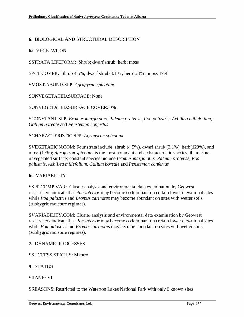
Preliminary Classification of Native Agropyron Community Types in Alberta
Geowest Environmental Consultants Ltd. Page 177
6. BIOLOGICAL AND STRUCTURAL DESCRIPTION
6a VEGETATION
SSTRATA LIFEFORM: Shrub; dwarf shrub; herb; moss
SPCT.COVER: Shrub 4.5%; dwarf shrub 3.1% ; herb123% ; moss 17%
SMOST.ABUND.SPP: Agropyron spicatum
SUNVEGETATED.SURFACE: None
SUNVEGETATED.SURFACE COVER: 0%
SCONSTANT.SPP: Bromus marginatus, Phleum pratense, Poa palustris, Achillea millefolium,Galium boreale and Penstemon confertus
SCHARACTERISTIC.SPP: Agropyron spicatum
SVEGETATION.COM: Four strata include: shrub (4.5%), dwarf shrub (3.1%), herb(123%), andmoss (17%); Agropyron spicatum is the most abundant and a characteristic species; there is nounvegetated surface; constant species include Bromus marginatus, Phleum pratense, Poapalustris, Achillea millefolium, Galium boreale and Penstemon confertus
6c VARIABILITY
SSPP.COMP.VAR: Cluster analysis and environmental data examination by Geowestresearchers indicate that Poa interior may become codominant on certain lower elevational siteswhile Poa palustris and Bromus carinatus may become abundant on sites with wetter soils(subhygric moisture regimes).
SVARIABILITY.COM: Cluster analysis and environmental data examination by Geowestresearchers indicate that Poa interior may become codominant on certain lower elevational siteswhile Poa palustris and Bromus carinatus may become abundant on sites with wetter soils(subhygric moisture regimes).
7. DYNAMIC PROCESSES
SSUCCESS.STATUS: Mature
9. STATUS
SRANK: S1
SREASONS: Restricted to the Waterton Lakes National Park with only 6 known sites

Preliminary Classification of Native Agropyron Community Types in Alberta
Geowest Environmental Consultants Ltd. Page 178
SSTATCOM: This community is presently considered provincially rare (ranked SU) in thePreliminary Plant Community Tracking List (Allen 2000); its provincial ranking should bechanged to S1 because it is restricted to the Waterton Lakes National Park with only 6 knownsites.
12. ANALYSIS PROCEDURES AND DATA MANAGEMENT
SANALYSIS.COM: Within each of the 5 sampling plots (10 m × 10 m) canopy cover wasestimated visually to the nearest percent. Plants with less than 1% were assigned 0.5% cover.Noted environmental factors included elevation, slope, aspect, topographic position, relief shape,landform, soil group, drainage class and moisture regimes. A Global Positioning System (GPS)instrument was used to define the precise location of each plot. Data was analyzed by tabularcomparison, and both indirect and direct ordination (Achuff et al. 1997). Waterton Lakes plotdata was also used in the cluster and ordination analysis of combined ESIS database andWaterton Lakes database performed by the Geowest personnel. Cluster analysis included speciesdata from 416 plots. Ordination analysis related vegetation data from 120 plots to the followingenvironmental variables: solar radiation (combines slope, aspect, and latitude), drainage class,moisture regimes, elevation, latitude, and longitude (last two variables represent macroclimaticvariables - NW position in the province coincides with cooler and wetter climate as opposed tothe SE end of the province). In addition to ordination, descriptive statistics (median, minimum,maximum) were calculated for environmental variables. These calculations were done in SPSSfor Windows and included both variables used in the ordination and variables with a lot ofmissing data (soil drainage, site position - macro, site position - meso, nutrient regimes, %bedrock, % mineral soil, and % organic material). The information on Natural Subregion wastaken from the GIS based on the geographical position of each plot.
SANALYSIS.DATA.MANAGE.COM: Within each of the 5 sampling plots (10 m × 10 m)canopy cover was estimated visually to the nearest percent. Plants with less than 1% wereassigned 0.5% cover. Noted environmental factors included elevation, slope, aspect, topographicposition, relief shape, landform, soil group, drainage class and moisture regimes. A GlobalPositioning System (GPS) instrument was used to define the precise location of each plot. Datawas analyzed by tabular comparison, and both indirect and direct ordination (Achuff et al. 1997).Waterton Lakes plot data was also used in the cluster and ordination analysis of combined ESISdatabase and Waterton Lakes database performed by the Geowest personnel. Cluster analysisincluded species data from 416 plots. Ordination analysis related vegetation data from 120 plotsto the following environmental variables: solar radiation (combines slope, aspect, and latitude),drainage class, moisture regimes, elevation, latitude, and longitude (last two variables representmacroclimatic variables - NW position in the province coincides with cooler and wetter climateas oppose to the SE end of the province). In addition to ordination, descriptive statistics (median,minimum, maximum) were calculated for environmental variables. These calculations were donein SPSS for Windows and included both variables used in the ordination and variables with a lotof missing data (soil drainage, site position - macro, site position - meso, nutrient regimes, %bedrock, % mineral soil, and % organic material). The information on Natural Subregion wastaken from the GIS based on the geographical position of each plot. Waterton Lakes plot data(both vegetation and environmental files) are available from Dr. Peter Achuff. The EcologicalSite Inventory System (ESIS) electronic database is stored in the Resource Data Division ofAlberta Environment, Edmonton.

Preliminary Classification of Native Agropyron Community Types in Alberta
Geowest Environmental Consultants Ltd. Page 179
14. REFERENCES
CITATION:
Achuff, P. L., R. L. McNeil, M. L. Coleman. 1997. Ecological Land Classification of WatertonLakes National Park, Alberta - Soil and vegetation resources. Report prepared byWaterton lakes National Park, Waterton park and Contract Pedology Services Ltd.,Ledbridge, AB
Allen, L. 2000. Alberta Natural Heritage Information Centre Preliminary Plant CommunityTracking List. Alberta Environment, Edmonton, AB
Corns, I. G. W. and P. L. Achuff. 1982. Vegetation type descriptions in W. D. Holland and G.M. Coen (eds.). Ecological (Biophysical) Land Classification of Banff and JasperNational Parks. Alberta Institute of Pedology, Publication No. SS-82-44.
NatureServe: An online encyclopedia of life [web application]. 2000. Version 1.0. Arlington(VA): Association for Biodiversity Information. Available: http://www.natureserve.org

Preliminary Classification of Native Agropyron Community Types in Alberta
Geowest Environmental Consultants Ltd. Page 180
COMMUNITY CHARACTERIZATION ABSTRACTAgropyron spicatum - Festuca campestris Herbaceous Vegetation
1. IDENTIFIERS
SEL.SUMMARY: The Agropyron spicatum - Festuca campestris community type occurs in thearea just north of the Waterton Lakes National Park (community #29 in this report). It occurs onsubxeric to mesic Foothills Parkland, Subalpine and Montane sites (elevation range: 1430 - 1867m), on gentle to steep slopes with mostly southerly aspects. Soils are well to very rapidly drained,with subxeric to mesic moisture regimes and submesotrophic to mesotrophic nutrient regimes.Agropyron spicatum and Festuca campestris dominate with 8.8% and 14.9% cover, respectively.Other common species include Festuca idahoensis (7.4%), Koeleria macrantha (4.1%),Danthonia parryi (3.9%), Galium boreale (3.4%), Aster conspicuous (3.6%), Lupinus sericeus(2.8%), Fragaria virginiana (2.5%), Monarda fistulosa (2%), Geranium viscosissimum (2%) andAnemone multifida (1%). Common shrub species include Amelanchier alnifolia (6.1%), Rosaacicularis (5.5%) and Spiraea betulifolia (3.1%).
SNAME: Agropyron spicatum - Festuca campestris Herbaceous Vegetation
SCOMNAME: Bluebunch wheat grass - bluebunch fescue Herbaceous Vegetation
2. CLASSIFICATION
SYSTEM: Terrestrial
CLASS: Herbaceous vegetation
SUBCLASS: Perennial graminoid vegetation (grasslands)
GROUP: Temperate or subpolar grasslands
FORMATION: Medium-tall sod temperate or subpolar grasslands
ALLIANCE: Agropyron spicatum Herbaceous Alliance
CLASSIFICATION CONFIDENCE LEVEL: 1
SSIMILAR COMMUNITIES: The Agropyron spicatum Herbaceous Vegetation communitylacks codominants and Festuca campestris is only present in low cover, if at all. The Danthoniaspp. - Festuca scabrella - Koeleria macrantha community type from Waterton Lakes NationalPark (Achuff et al. 1997) (H25) has little or no Agropyron spicatum, and Festuca campestris isinstead codominant with Danthonia spp., which has low cover in the Agropyron spicatum -Festuca campestris community type. The Agropyron spicatum - Festuca idahoensis HerbaceousVegetation community type (this report) is a more sparsely vegetated type, with bare ground upto 69%. Festuca campestris is generally lacking. Although Aster conspicuous is common, lack ofElymus innovatus and the codominance of Agropyron spicatum and Festuca campestris separatethis type from the Agropyron spicatum - Elymus innovatus - Aster conspicuous community type

Preliminary Classification of Native Agropyron Community Types in Alberta
Geowest Environmental Consultants Ltd. Page 181
from Banff National Park (Corns and Achuff 1982). The Pseudoroegneria spicata - Koeleriamacrantha Herbaceous Vegetation community from Montana (Comer et al. 1999) is also similarto the Agropyron spicatum - Festuca campestris community type, but it lacks Festucacampestris. The Pseudoroegneria spicata - Festuca idahoensis Herbaceous Vegetationcommunity from portions of the palouse prairie in Montana, Idaho, Washington, Oregon andpossibly British Columbia (Grossman et al. 1994) also generally lacks Festuca campestris. ThePseudoroegneria spicata - Festuca idahoensis Canyon Herbaceous Vegetation community(Idaho, Oregon, Washington) (Anderson et al. 1998) is another potentially similar communitytype, but a detailed vegetation description was not available, therefore no direct comparison withthe Agropyron spicatum - Festuca campestris Herbaceous Vegetation community is possible atthis time.
Cluster analysis of the combined ESIS database and the additional plots from Waterton LakesNational Park indicated that most of the plots from Waterton Lakes National Park used byAchuff et al. (1997) to describe the Agropyron spicatum - Festuca scabrella community typebelong either to the Festuca scabrella community type or to the Agropyron spicatum communitytype. Plots indicated by cluster analysis to belong to the Agropyron spicatum - Festucacampestris community type are located just north of Waterton Lakes National Park. It seems thatthe inclusion of these Waterton plots into the Agropyron spicatum - Festuca scabrellacommunity type resulted from the relatively small scale (1:20,000) at which the ecological landclassification was done (see details in Achuff et al. 1997) and the necessity to combine the twocommunities into one more generalised community (Peter Achuff - personal communications).
3. RELATED NOMENCLATURE
SOTHER.NAMES: Festuca scabrella - Pseudoroegneria spicata Herbaceous Vegetation(NatureServe 2000); Agropyron spicatum - Festuca scabrella (Tisdale 1947); and Festucascabrella - Agropyron spicatum community type (Tisdale 1982).
SOTHER.NAMES.RELATION.NOTE: The relationship between Agropyron spicatum - Festucascabrella and Agropyron spicatum - Festuca campestris community types is based on the revisedtaxonomy and nomenclature of rough fescue, which divided Festuca scabrella into three separatespecies, namely Festuca altaica, F. campestris (F. scabrella var. major), and F. hallii (Pavlickand Looman 1984). Festuca scabrella - Pseudoroegneria spicata Herbaceous Vegetation andFestuca scabrella - Agropyron spicatum community type seem to be the same community typenamed by different researchers.
SNAMES.COM: The relationship between Agropyron spicatum - Festuca scabrella andAgropyron spicatum - Festuca campestris community types is based on the revised taxonomyand nomenclature of rough fescue, which divided Festuca scabrella into three separate species,namely Festuca altaica, F. campestris (F. scabrella var. major), and F. hallii (Pavlick andLooman 1984). Festuca scabrella - Pseudoroegneria spicata Herbaceous Vegetation andAgropyron spicatum - Festuca scabrella Herbaceous Vegetation seem to be the same communitytype named by different researchers. The associated species do vary from type to type but allthree types share the codominance of Agropyron spicatum and Festuca campestris. Agropyronspicatum - Festuca scabrella (Tisdale 1947) and Festuca scabrella - Agropyron spicatum

Preliminary Classification of Native Agropyron Community Types in Alberta
Geowest Environmental Consultants Ltd. Page 182
community type (Tisdale 1982) are just the two names for the same community type appearing intwo different publications.
4. DISTRIBUTION
SNATREG: Rocky Mountain, Parkland
SSUBREG: Mainly Montane, some Subalpine, some Foothills Parkland
SRANGECOM: Restricted to the southwestern corner of Alberta (area just north of the WatertonLakes National Park)
SDISTRIBUTION.COM: Restricted to the southwestern corner of Alberta(area just north of theWaterton Lakes National Park); Rocky Mountain Natural Region (mainly Montane and someSubalpine Subregions) and some in Parkland Natural Region (Foothills Parkland).
5. ENVIRONMENTAL FACTORS
SMINELEV: 1430 m
SMAXELEV: 1867 m
STOP.POSITION: Generally midslope position
SSLOPE: Median: 47% (20 - 180%)
SASPECT: Median: 180° (20 - 315°)
SSOIL.MOSTURE: Subxeric to mesic
SSOIL.COM: Well to very rapidly drained soils with submesotrophic to mesotrophic nutrientregimes
SKEY.ENVIRO.FACTORS: Most likely droughty conditions on subxeric to mesic sites
SENVIRO.COM: Subxeric to mesic Foothills Parkland, Montane and Subalpine sites in the park(elevation range: 1430 - 1867 m), on gentle to steep slopes with mostly southerly aspects. Soilsare well to very rapidly drained, with subxeric to mesic moisture regimes and submesotrophic tomesotrophic nutrient regimes.
6. BIOLOGICAL AND STRUCTURAL DESCRIPTION
6a VEGETATION
SSTRATA LIFEFORM: Shrub; dwarf shrub; herb
SPCT.COVER: Shrub 12%; dwarf shrub 3.4% ; herb 84.7%

Preliminary Classification of Native Agropyron Community Types in Alberta
Geowest Environmental Consultants Ltd. Page 183
SMOST.ABUND.SPP: Amelanchier alnifolia, Rosa acicularis, Agropyron spicatum, Festucacampestris, Festuca idahoensis
SUNVEGETATED.SURFACE: None
SUNVEGETATED.SURFACE COVER: 0%
SCONSTANT.SPP: Amelanchier alnifolia, Agropyron spicatum, Festuca campestris, Festucaidahoensis, Galium boreale, Achillea millefolium
SVEGETATION.COM: Three strata include: shrub (12%), dwarf shrub (3.4%), andherb(84.7%); Agropyron spicatum, Festuca campestris and Festuca idahoensis are the dominantspecies in the herb layer (8.8%, 14.9% and 7.4%, respectively); there is no unvegetated surface;constant species include Amelanchier alnifolia, Agropyron spicatum, Festuca campestris,Festuca idahoensis, Galium boreale, Achillea millefolium.
9. STATUS
SRANK: S1
SREASONS: Restricted to the southwestern corner of Alberta
SSTATCOM: This community type is presently considered provincially rare (ranked SU) (Allen2000). Provincial status should be changed to S1 because this community is restricted to thesouthwestern corner of Alberta (area just north of the Waterton Lakes National Park).
12. ANALYSIS PROCEDURES AND DATA MANAGEMENT
SANALYSIS.COM: Cluster and ordination analysis of the combined ESIS database andWaterton Lakes database was performed by the Geowest personnel. Cluster analysis includedspecies data from 416 plots. Ordination analysis related vegetation data from 120 plots to thefollowing environmental variables: solar radiation (combines slope, aspect, and latitude),drainage class, moisture regimes, elevation, latitude, and longitude (last two variables representmacroclimatic variables - NW position in the province coincides with cooler and wetter climateas oppose to the SE end of the province). In addition to ordination, descriptive statistics (median,minimum, maximum) were calculated for environmental variables. These calculations were donein SPSS for Windows and included both variables used in the ordination and variables with a lotof missing data (soil drainage, site position - macro, site position - meso, nutrient regimes, %bedrock, % mineral soil, and % organic material. The information on Natural Subregion wastaken from the GIS based on the geographical position of each plot. List of values was presentedinstead of statistics for the natural Subregion.
SANALYSIS.DATA.MANAGE.COM: Cluster and ordination analysis of the combined ESISdatabase and Waterton Lakes database was performed by the Geowest personnel. Cluster analysisincluded species data from 416 plots. Ordination analysis related vegetation data from 120 plotsto the following environmental variables: solar radiation (combines slope, aspect, and latitude),

Preliminary Classification of Native Agropyron Community Types in Alberta
Geowest Environmental Consultants Ltd. Page 184
drainage class, moisture regimes, elevation, latitude, and longitude (last two variables representmacroclimatic variables - NW position in the province coincides with cooler and wetter climateas oppose to the SE end of the province). In addition to ordination, descriptive statistics (median,minimum, maximum) were calculated for environmental variables. These calculations were donein SPSS for Windows and included both variables used in the ordination and variables with a lotof missing data (soil drainage, site position - macro, site position - meso, nutrient regimes, %bedrock, % mineral soil, and % organic material. The information on Natural Subregion wastaken from the GIS based on the geographical position of each plot. List of values was presentedinstead of statistics for the natural Subregion. Waterton Lakes plot data (both vegetation andenvironmental files) is available from Dr. Peter Achuff. Ecological Site Inventory System (ESIS)electronic database is stored in the Resource Data Division of Alberta Environment, Edmonton.
13. GENERAL COMMENTS
SCOMMUNITY.COM: Cluster analysis of the combined ESIS database and the additional plotsfrom Waterton Lakes National Park indicated that most of the plots from Waterton LakesNational Park used by Achuff et al. (1997) to describe Agropyron spicatum - Festuca scabrellacommunity type belong either to the Festuca scabrella community type or to the Agropyronspicatum community type. Plots indicated by cluster analysis to belong to Agropyron spicatum -Festuca campestris community type are located just north of the Waterton Lakes National Park.It seems that the inclusion of these Waterton plots into the Agropyron spicatum - Festucascabrella community type resulted from the relatively small scale (1:20,000) at which theecological land classification was done (see details in Achuff et al. 1997) (Peter Achuff -personal communications).
14. REFERENCES
CITATION:
Achuff, L. Peter, Conservation Biologist, Jasper National Park, Box 10, Jasper, AB, T0E 1E0; tel(780) 852-6197; fax (780) 852-4775; email: [email protected]
Achuff, P. L., R. L. McNeil, M. L. Coleman. 1997. Ecological Land Classification of WatertonLakes National Park, Alberta - Soil and vegetation resources. Report prepared byWaterton lakes National Park, Waterton park and Contract Pedology Services Ltd.,Ledbridge, AB
Allen, L. 2000. Alberta Natural Heritage Information Centre Preliminary Plant CommunityTracking List. Alberta Environment, Edmonton, AB
Anderson, M., P. Bougeron, M. T. Bryer, R. Crawford, L. Engelking, D. Faber-Langendoen, M.Gallyoun, K. Goodin, D. H. Grossman, S. Landaal, K. Metzler, K. D. Patterson, M. Pyne,M. Reid, L. Sneddon and A. S. Weakley. 1998. International classification of ecologicalcommunities: terrestrial vegetation of the United States, Volume II, The NationalVegetation Classification System: list of types. The Nature Conservancy, Arlington, VA.

Preliminary Classification of Native Agropyron Community Types in Alberta
Geowest Environmental Consultants Ltd. Page 185
Corns, I. G. W. and P. L. Achuff. 1982. Vegetation type descriptions in W. D. Holland and G.M. Coen (eds.). Ecological (Biophysical) Land Classification of Banff and JasperNational Parks. Alberta Institute of Pedology, Publication No. SS-82-44.
Comer, P., L. Allen, Steve Cooper, D. Faber-Langendoen, and G. Jones. 1999. Selectedshrubland and grassland communities of the Northern Great Plains. A Report to NebraskaNational Forest.
Grossman, D. H., K. L. Goodin and C. L. Reuss (editors). 1994. Rare plant communities of theconterminous United States - an initial survey. The Nature Conservancy, Arlington, VA.
NatureServe: An online encyclopedia of life [web application]. 2000. Version 1.0. Arlington(VA): Association for Biodiversity Information. Available: http://www.natureserve.org
Pavlick, L. E., and J. Looman. 1984. Taxonomy and nomenclature of rough fescue, Festucaaltaica, F. campestris (F. scabrella var. major), and F. hallii, in Canada and adjacent partof United States. Canadian Journal of Botany 62:1739-1749.
Tisdale, E. W. 1947. The grasslands of the southern interior of British Columbia. Ecology 28:346-382.
Tisdale, E. W. 1982. Grasslands of western North America: the Pacific Northwest Bunchgrass.Grassland Ecology and Classification: Symposium proceeding June 1982. Ministry ofForests, BC

Preliminary Classification of Native Agropyron Community Types in Alberta
Geowest Environmental Consultants Ltd. Page 186
COMMUNITY CHARACTERIZATION ABSTRACTAgropyron spicatum - Elymus innovatus - Aster conspicuousHerbaceous Vegetation
1. IDENTIFIERS
SEL.SUMMARY: The Agropyron spicatum - Elymus innovatus - Aster conspicuous communitytype occupies small areas on dry, southwest facing slopes, with rapidly drained soils, within theMontane and Lower Subalpine Subregions of the Banff National Park (Type H19 in Corns andAchuff 1982). Soils are predominantly Orthic Regosols with xeric moisture regimes, developedon colluvial and glacial landforms. Shrub cover is low, with Juniperus communis and Rosaacicularis occurring sporadically. Agropyron spicatum, Elymus innovatus and Koeleria cristatadominate the community (15 - 30%, 10 - 30%, and 3 - 10% cover, respectively) accompanied bysome common forbs, such as Aster conspicuous, Oxytropis splendens, Antennaria nitida/roseaand Cerastium arvense (3 - 5%, <8%, <2%, and <2% cover, respectively). Corns and Achuff(1982) report that this successionally mature community is limited in extent to slopes aboveHillsdale meadow in Banff.
SNAME: Agropyron spicatum - Elymus innovatus - Aster conspicuous Herbaceous Vegetation
SCOMNAME: Bluebunch wheatgrass - hairy wild rye - showy aster Herbaceous Vegetation
2. CLASSIFICATION
SYSTEM: Terrestrial
CLASS: Herbaceous vegetation
SUBCLASS: Perennial graminoid vegetation (grasslands)
GROUP: Temperate or subpolar grasslands
FORMATION: Medium-tall sod temperate or subpolar grasslands
ALLIANCE: Agropyron spicatum Herbaceous Alliance
CLASSIFICATION CONFIDENCE LEVEL: 1
SSIMILAR COMMUNITIES: Aster conspicuous is common in the Agropyron spicatumHerbaceous Vegetation community type from southwestern Alberta (Achuff et al. 1997), but lackof Elymus innovatus separates this type from the Agropyron spicatum - Elymus innovatus - Asterconspicuous community type. Pseudoroegneria spicata Herbaceous Vegetation from Colorado(NatureServe 2000) and Pseudoroegneria spicata - Koeleria macrantha Herbaceous Vegetationfrom Montana (Comer et al. 1999) generally lack both Elymus innovatus and Aster conspicuous.
4. DISTRIBUTION

Preliminary Classification of Native Agropyron Community Types in Alberta
Geowest Environmental Consultants Ltd. Page 187
SNATREG: Rocky Mountain
SSUBREG: Montane and lower Subalpine
SRANGECOM: Restricted to the slopes above Hillsdale meadow in Banff National Park
SDISTRIBUTION.COM: Restricted to the slopes above Hillsdale meadow in Banff NationalPark (Achuff et al. 1997); Rocky Mountain Natural Region, Montane and some lower SubalpineSubregions.
5. ENVIRONMENTAL FACTORS
SMINELEV: 1400 m
SMAXELEV: 1700 m
SLANDFORM: Colluvial and glacial
SSLOPE: Moderately steep
SASPECT: Southwest
SSOIL.TYPE: Orthic Regosols
SSOIL.MOSTURE: Xeric
SSOIL.COM: Rapidly drained soils
SKEY.ENVIRO.FACTORS: Dry conditions on southerly aspects.
SENVIRO.COM: Dry, moderately steep southwest facing slopes, within the Montane and LowerSubalpine Subregions (elevation 1400 m - 1700 m) of Banff National Park; soils arepredominantly rapidly drained Orthic Regosols with xeric moisture regimes, developed oncolluvial and glacial landforms (Corns and Achuff 1982)
6. BIOLOGICAL AND STRUCTURAL DESCRIPTION
6a VEGETATION
SSTRATA LIFEFORM: Shrub; herb-dwarf shrub
SPCT.COVER: Shrub (2%); herb-dwarf shrub (50 - 85%)
SMOST.ABUND.SPP: Juniperus communis, Rosa acicularis; Agropyron spicatum, Elymusinnovatus, Koeleria cristata
SCONSTANT.SPP: Antennaria nitida/rosea, Achillea millefolium, Koeleria cristata

Preliminary Classification of Native Agropyron Community Types in Alberta
Geowest Environmental Consultants Ltd. Page 188
SCHARACTERISTIC.SPP: Aster conspicuous
SVEGETATION.COM: two strata include: shrub (2%), herb - dwarf shrub (50 - 85%); Juniperuscommunis and Rosa acicularis are the dominant species in the shrub layer; Agropyron spicatum,Elymus innovatus, Koeleria cristata dominate the herb layer; constant species include Antennarianitida/rosea, Achillea millefolium, Koeleria cristata; Aster conspicuous is the characteristicspecies.
7. DYNAMIC PROCESSES
SSUCCESS.STATUS: Mature
9. STATUS
SRANK: S1
SREASONS: Small size and restriction in distribution
SSTATCOM: This community type is presently considered provincially rare (ranked SU) (Allen2000); rank should be changed to S1 because of its small size and restriction in distribution (onlyon slopes above Hillsdale meadow in Banff National Park)
12. ANALYSIS PROCEDURES AND DATA MANAGEMENT
SANALYSIS.COM: Within each of the 5 sampling plots (10 m × 10 m) canopy cover wasestimated visually to the nearest percent. Plants with less than 1% were assigned 0.5% cover.Noted environmental factors included elevation, slope, aspect, topographic position, relief shape,landform, soil group, drainage class and moisture regimes. Data was analyzed by tabularcomparison, and both indirect and direct ordination (Corns and Achuff 1982).
SANALYSIS.DATA.MANAGE.COM: Within each of the 5 sampling plots (10 m × 10 m)canopy cover was estimated visually to the nearest percent. Plants with less than 1% wereassigned 0.5% cover. Noted environmental factors included elevation, slope, aspect, topographicposition, relief shape, landform, soil group, drainage class and moisture regimes. Data wasanalyzed by tabular comparison, and both indirect and direct ordination (Corns and Achuff1982). It was also entered into the Ecological Site Inventory System (ESIS) electronic databasewhich is stored in the Resource Data Division of Alberta Environment, Edmonton.
14. REFERENCES
CITATION:
Achuff, P. L., R. L. McNeil, M. L. Coleman. 1997. Ecological Land Classification of WatertonLakes National Park, Alberta - Soil and vegetation resources. Report prepared byWaterton lakes National Park, Waterton park and Contract Pedology Services Ltd.,Ledbridge, AB

Preliminary Classification of Native Agropyron Community Types in Alberta
Geowest Environmental Consultants Ltd. Page 189
Allen, L. 2000. Alberta Natural Heritage Information Centre Preliminary Plant CommunityTracking List. Alberta Environment, Edmonton, AB
Corns, I. G. W. and P. L. Achuff. 1982. Vegetation type descriptions in W. D. Holland and G.M. Coen (eds.). Ecological (Biophysical) Land Classification of Banff and JasperNational Parks. Alberta Institute of Pedology, Publication No. SS-82-44.
Comer, P., L. Allen, Steve Cooper, D. Faber-Langendoen, and G. Jones. 1999. Selectedshrubland and grassland communities of the Northern Great Plains. A Report to NebraskaNational Forest.
NatureServe: An online encyclopedia of life [web application]. 2000. Version 1.0. Arlington(VA): Association for Biodiversity Information. Available: http://www.natureserve.org

Preliminary Classification of Native Agropyron Community Types in Alberta
Geowest Environmental Consultants Ltd. Page 190
COMMUNITY CHARACTERIZATION ABSTRACTAgropyron spicatum - Carex obtusata Herbaceous Vegetation
1. IDENTIFIERS
SEL.SUMMARY: This community type occupies middle and upper slopes with mostly southerlyaspects (slope range: 4 - 48%) within the Montane and Subalpine subregions (elevation range606 m -1618 m) in southwestern Alberta (Willoughby et al. 1998, community #3 in this report).Soils are very rapidly to well-drained, with mostly subxeric moisture regimes andsubmesotrophic to mesotrophic nutrient regimes. Amelanchier alnifolia (4.2%) andSymphoricarpos occidentalis (6.2%) are characteristic species of the shrub layer. The dominantgrass and sedge species, Agropyron spicatum, Carex obtusata, Koeleria macrantha and Festucacampestris, make up 11.6%, 19.8%, 5.4%, and 4.2% of the canopy cover, respectively. Some ofthe dominant forb and dwarf shrub species include Arctostaphylos uva-ursi, Rosa arkansana andArtemisia frigida.
SNAME: Agropyron spicatum - Carex obtusata Herbaceous Vegetation
SCOMNAME: Bluebunch wheatgrass - blunt sedge Herbaceous Vegetation
2. CLASSIFICATION
SYSTEM: Terrestrial
CLASS: Herbaceous vegetation
SUBCLASS: Perennial graminoid vegetation (grasslands)
GROUP: Temperate or subpolar grasslands
FORMATION: Medium-tall sod temperate or subpolar grasslands
ALLIANCE: Agropyron spicatum Herbaceous Alliance
CLASSIFICATION CONFIDENCE LEVEL: 1
SSIMILAR COMMUNITIES: The Agropyron spicatum Herbaceous Vegetation community typefrom southwestern Alberta (Achuff et al. 1997) has no codominants and lacks a significant Carexobtusata component. The Agropyron spicatum - Festuca campestris Herbaceous Vegetationcommunity (this report) has a much higher ground cover of Festuca campestris, and Carexobtusata is not a significant component. The Pseudoroegneria spicata Herbaceous Vegetationcommunity from Colorado (NatureServe 2000) and the Pseudoroegneria spicata - Koeleriamacrantha Herbaceous Vegetation community from Montana (Comer et al. 1999) generally lacka significant Carex obtusata component.
3. RELATED NOMENCLATURE

Preliminary Classification of Native Agropyron Community Types in Alberta
Geowest Environmental Consultants Ltd. Page 191
SOTHER.NAMES: Agropyron spicatum - Carex obtusata community type (Willoughby et al.1998)
SOTHER.NAMES.RELATION.NOTE: The Agropyron spicatum - Carex obtusata communitytype (Willoughby et al. 1998) includes the Agropyron spicatum - Carex obtusata community typeas described in this report.
SNAMES.COM: Willoughby et al. (1998) described the Agropyron spicatum - Carex obtusatacommunity type at a broader level, including sites that represent the Agropyron spicatum - Carexobtusata community type as is described in this report, as well as sites with very low covers ofCarex obtusata, or with high shrub covers.
4. DISTRIBUTION
SNATREG: Rocky Mountain
SSUBREG: Montane and Subalpine (community #3 in this report)
SRANGECOM: Restricted to southwestern Alberta (just north of Waterton National Park)
SDISTRIBUTION.COM: Restricted to the southwestern Alberta (just north of Waterton NationalPark); Rocky Mountain Natural Region (Montane and Subalpine subregions)
5. ENVIRONMENTAL FACTORS
SMINELEV: 606 m
SMAXELEV: 1610 m
STOP.POSITION: Middle to upper slopes
SSLOPE: Median 40% (4 - 48%)
SASPECT: Median 180° (90 - 230°)
SSOIL.MOSTURE: Mostly subxeric
SSOIL.COM: Very rapidly to well-drained soils with submesotrophic to mesotrophic nutrientregimes
SKEY.ENVIRO.FACTORS: Droughty conditions on southerly slopes
6. BIOLOGICAL AND STRUCTURAL DESCRIPTION
6a VEGETATION
SSTRATA LIFEFORM: Shrub; dwarf shrub; herb

Preliminary Classification of Native Agropyron Community Types in Alberta
Geowest Environmental Consultants Ltd. Page 192
SPCT.COVER: Shrub 10%; dwarf shrub 4%; herb 83%
SMOST.ABUND.SPP: Symphoricarpos occidentalis, Amelanchier alnifolia; Rosa arkansana;Agropyron spicatum, Carex obtusata, Koeleria macrantha
SCONSTANT.SPP: Symphoricarpos occidentalis, Amelanchier alnifolia; Rosa arkansana;Agropyron spicatum, Carex obtusata, Koeleria macrantha
SCHARACTERISTIC.SPP: Carex obtusata
SVEGETATION.COM: Three strata include: shrub (10%), dwarf shrub (4%) and herb(83%);Symphoricarpos occidentalis and Amelanchier alnifolia are the dominant species in the shrublayer; Rosa arkansana dominates the dwarf shrub layer; Agropyron spicatum, Carex obtusataand Koeleria macrantha are the most abundant herbs; constant species include Symphoricarposoccidentalis, Amelanchier alnifolia, Rosa arkansana, Agropyron spicatum, Carex obtusata,Koeleria macrantha; Carex obtusata is the characteristic species.
6c VARIABILITY
SSPP.COMP.VAR: Increased grazing pressure on drier sites results in a decline of Agropyronspicatum and an increase of low growing forbs and sedges (Willoughby et al. 1998).
SVARIABILITY.COM: Increased grazing pressure on drier sites results in a decline ofAgropyron spicatum and an increase of low growing forbs and sedges (Willoughby et al. 1998).
9. STATUS
SRANK: S1
SREASONS: Probably restricted to southwestern Alberta, just north of Waterton Lakes NationalPark
SSTATCOM: It is probably restricted to southwestern Alberta, just north of Waterton LakesNational Park, therefore it should be placed on the provincial tracking list and ranked S1.
10. MANAGEMENT
SECONCOM: Grazing
SMANAGECOM: Increased grazing pressure on the drier sites results in a decline of Agropyronspicatum and an increase of low growing forbs and sedges (Willoughby et al. 1998).
12. ANALYSIS PROCEDURES AND DATA MANAGEMENT
SANALYSIS.COM: Within each of the 10 m × 10 m sampling plots, canopy cover wasestimated using ten randomly selected 1 × 1 m microplots for shrubs, and 20 × 50 cm microplots
Preliminary Classification of Native Agropyron Community Types in Alberta
Geowest Environmental Consultants Ltd. Page 193
for herbs. Noted environmental factors included elevation, slope, aspect, soil drainage, nutrientregimes, and moisture regimes. Data was analyzed by both cluster and both indirect andordination analyses (Willoughby et al. 1998). Additional cluster and ordination analysis of thecombined ESIS database (including most of the plots analyzed by M. Willoughby) and theWaterton Lakes database was performed by Geowest personnel. Cluster analysis included speciesdata from 416 plots. Ordination analysis related vegetation data from 120 plots to the followingenvironmental variables: solar radiation (combines slope, aspect, and latitude), drainage class,moisture regimes, elevation, latitude, and longitude (last two variables represent macroclimaticvariables - NW position in the province coincides with cooler and wetter climate as oppose to theSE end of the province). In addition to ordination, descriptive statistics (median, minimum,maximum) were calculated for environmental variables. These calculations were done in SPSSfor Windows and included both variables used in the ordination and variables with a lot ofmissing data (soil drainage, site position - macro, site position - meso, nutrient regimes, %bedrock, % mineral soil, and % organic material. The information on Natural Subregion wastaken from the GIS based on the geographical position of each plot.
SANALYSIS.DATA.MANAGE.COM: Within each of the 10 m × 10 m sampling plots, canopycover was estimated using ten randomly selected 1 × 1 m microplots for shrubs, and 20 × 50 cmmicroplots for herbs. Noted environmental factors included elevation, slope, aspect, soildrainage, nutrient regimes, and moisture regimes. Data was analyzed by both cluster and bothindirect and ordination analyses (Willoughby et al. 1998). Additional cluster and ordinationanalysis of the combined ESIS database (including most of the plots analyzed by M. Willoughby)and the Waterton Lakes database was performed by Geowest personnel. Cluster analysis includedspecies data from 416 plots. Ordination analysis related vegetation data from 120 plots to thefollowing environmental variables: solar radiation (combines slope, aspect, and latitude),drainage class, moisture regimes, elevation, latitude, and longitude (last two variables representmacroclimatic variables - NW position in the province coincides with cooler and wetter climateas oppose to the SE end of the province). In addition to ordination, descriptive statistics (median,minimum, maximum) were calculated for environmental variables. These calculations were donein SPSS for Windows and included both variables used in the ordination and variables with a lotof missing data (soil drainage, site position - macro, site position - meso, nutrient regimes, %bedrock, % mineral soil, and % organic material. The information on Natural Subregion wastaken from the GIS based on the geographical position of each plot. Subregion. Ecological SiteInventory System (ESIS) electronic database is stored in the Resource Data Division of AlbertaEnvironment, Edmonton.
14. REFERENCES
CITATION:
Achuff, P. L., R. L. McNeil, M. L. Coleman. 1997. Ecological Land Classification of WatertonLakes National Park, Alberta - Soil and vegetation resources. Report prepared byWaterton lakes National Park, Waterton park and Contract Pedology Services Ltd.,Ledbridge, AB

Preliminary Classification of Native Agropyron Community Types in Alberta
Geowest Environmental Consultants Ltd. Page 194
Comer, P., L. Allen, Steve Cooper, D. Faber-Langendoen, and G. Jones. 1999. Selectedshrubland and grassland communities of the Northern Great Plains. A Report to NebraskaNational Forest.
NatureServe: An online encyclopedia of life [web application]. 2000. Version 1.0. Arlington(VA): Association for Biodiversity Information. Available: http://www.natureserve.org
Willoughby, M. G., M. J. Alexander and K. M. Sundquist. 1998. Range plant community typesand carrying capacity for the Montane Subregion of Alberta - third approximation.Environmental Protection, Lands and Forest Services, Edmonton, AB.
Preliminary Classification of Native Agropyron Community Types in Alberta
Geowest Environmental Consultants Ltd. Page 195
COMMUNITY CHARACTERIZATION ABSTRACTAgropyron spicatum - Festuca idahoensis Herbaceous Vegetation
1. IDENTIFIERS
SEL.SUMMARY: This community occurs at elevations between 1554 m and 1874 m, onmoderately sloping sites with westerly or northerly aspects (community #54 in this report). Sitescan occupy crest to middle slope positions. Soils are very rapidly drained to well drained withxeric to subxeric moisture regimes and mesotrophic to oligotrophic nutrient regimes. Thevegetation cover in this association is very thinly distributed with bare ground reaching up to69%. This community consists of a sparse collection of graminoids and forbs. Some shrub anddwarf shrub species are also present. Potentilla fruticosa, Shepherdia canadensis, Rosaacicularis and Arctostaphylos uva-ursi can occur in small amounts, but for the most part a shrublayer is non-existent. Agropyron spicatum and Festuca idahoensis occur with 4.3% and 3%cover, respectively. Other constant species include Agoseris glauca, Selaginella densa, Oxytropissericeus, Gaillardia aristata and Anemone multifida.
SNAME: Agropyron spicatum - Festuca idahoensis Herbaceous Vegetation
SCOMNAME: Bluebunch wheat grass - bluebunch fescue Herbaceous Vegetation
2. CLASSIFICATION
SYSTEM: Terrestrial
CLASS: Herbaceous vegetation
SUBCLASS: Perennial graminoid vegetation (grasslands)
GROUP: Temperate or subpolar grasslands
FORMATION: Medium-tall sod temperate or subpolar grasslands
ALLIANCE: Agropyron spicatum Herbaceous Alliance
CLASSIFICATION CONFIDENCE LEVEL: 2
SSIMILAR COMMUNITIES: The Agropyron spicatum - Festuca campestris community typefrom southwestern Alberta (this report) has a greater overall ground cover and Festucacampestris codominates. Festuca idahoensis is present, but with lower cover than Festucacampestris. The Pseudoroegneria spicata - Festuca idahoensis Herbaceous Vegetationcommunity type from portions of the palouse prairie in Montana, Idaho, Washington, Oregon andpossible British Columbia (Grossman et al. 1994) represents a community of abundant herbswhere Agropyron spicatum (Pseudoroegneria spicata) and Festuca idahoensis reach a cover of30 - 100%. In contrast, in the Agropyron spicatum - Festuca idahoensis Herbaceous Vegetationcommunity type from southwestern Alberta, Agropyron spicatum and Festuca idahoensiscontribute only 4.3% and 3% to the ground cover, respectively, and the herb layer is generally

Preliminary Classification of Native Agropyron Community Types in Alberta
Geowest Environmental Consultants Ltd. Page 196
very sparse (non-vegetated ground up to 69%). The Pseudoroegneria spicata HerbaceousVegetation community type from Colorado (NatureServe 2000) resembles the Agropyronspicatum - Festuca idahoensis community type from southwestern Alberta by its sparsevegetation cover and diverse forb layer, however, it generally lacks the presence of Festucaidahoensis.
The Pseudoroegneria spicata - Festuca idahoensis Canyon Herbaceous Vegetation community(Idaho, Oregon, Washington) (Anderson et al. 1998) is another potentially similar communitytype, but a detailed vegetation description was not available, therefore no direct comparison withthe Agropyron spicatum - Festuca idahoensis Herbaceous Vegetation community is possible atthis time.
4. DISTRIBUTION
SNATREG: Rocky Mountain
SSUBREG: Montane
SRANGECOM: Presently known only from the area just north of Waterton Lakes National Park
SDISTRIBUTION.COM: Presently known only from the area just north of Waterton LakesNational Park (Rocky Mountain Natural Region - Montane Subregion).
5. ENVIRONMENTAL FACTORS
SMINELEV: 1554 m
SMAXELEV: 1874 m
STOP.POSITION: crest to middle slope
SSLOPE: Median: 24% (22 - 50%)
SASPECT: Median: 230° (36 - 240°)
SSOIL.MOSTURE: Xeric to subxeric
SSOIL.COM: Very rapidly drained to well drained, with mesotrophic to oligotrophic nutrientregimes
SENVIRO.COM: Moderately sloping sites with westerly or northerly aspects; can occupy crestto middle slope positions; soils very rapidly drained to well drained with xeric to subxericmoisture regimes and mesotrophic to oligotrophic nutrient regimes.
6. BIOLOGICAL AND STRUCTURAL DESCRIPTION
6a VEGETATION
Preliminary Classification of Native Agropyron Community Types in Alberta
Geowest Environmental Consultants Ltd. Page 197
SSTRATA LIFEFORM: Shrub; dwarf shrub; herb
SPCT.COVER: Shrub 5.3%; dwarf shrub 1.7%; herb 20%
SMOST.ABUND.SPP: Potentilla fruticosa, Shepherdia canadensis, Rosa acicularis;Arctostaphylos uva-ursi; Pseudoroegneria spicata, Festuca idahoensis
SUNVEGETATED.SURFACE: bedrock, organic matter
SUNVEGETATED.SURFACE COVER: Bedrock 69%, organic matter 15%
SCONSTANT.SPP: Pseudoroegneria spicata, Agoseris glauca, Selaginella densa, Oxytropissericeus, Gaillardia aristata, Anemone multifida.
SCHARACTERISTIC.SPP: Festuca idahoensis
SVEGETATION.COM: The vegetation cover is very thinly distributed with unvegetated surfacereaching up to 69%. This community consists of a sparse collection of graminoids and forbs.Some shrub and dwarf shrub species are also present. Potentilla fruticosa, Shepherdiacanadensis, Rosa acicularis and Arctostaphylos uva-ursi can occur in small amounts, but for themost part a shrub layer is non-existent. Agropyron spicatum and Festuca idahoensis occur with4.3% and 3% cover, respectively. Other constant species include Agoseris glauca, Selaginelladensa, Oxytropis sericeus, Gaillardia aristata and Anemone multifida.
9. STATUS
SRANK: SU
SREASONS: Insufficient information - the classification of this community is based on thecluster analysis of only three ESIS plots
SSTATCOM: Insufficient information - the classification of this community is based on thecluster analysis of only three ESIS plots; this community should be placed on the provincialtracking list and ranked SU until more information is collected
10. MANAGEMENT
SMANAGECOM: Generally low vegetation cover and a diverse forb layer probably indicate adegraded occurrence that may have resulted from the heavy grazing or wind/water caused soilerosion.
12. ANALYSIS PROCEDURES AND DATA MANAGEMENT
SANALYSIS.COM: Cluster and ordination analysis of the combined ESIS database andWaterton Lakes database was performed by the Geowest personnel. Cluster analysis includedspecies data from 416 plots. Ordination analysis related vegetation data from 120 plots to the

Preliminary Classification of Native Agropyron Community Types in Alberta
Geowest Environmental Consultants Ltd. Page 198
following environmental variables: solar radiation (combines slope, aspect, and latitude),drainage class, moisture regimes, elevation, latitude, and longitude (last two variables representmacroclimatic variables - NW position in the province coincides with cooler and wetter climateas opposed to the SE end of the province). In addition to ordination, descriptive statistics(median, minimum, maximum) were calculated for environmental variables. These calculationswere done in SPSS for Windows and included both variables used in the ordination and variableswith a lot of missing data (soil drainage, site position - macro, site position - meso, nutrientregimes, % bedrock, % mineral soil, and % organic material. The information on NaturalSubregion was taken from the GIS based on the geographical position of each plot.
SANALYSIS.DATA.MANAGE.COM: Cluster and ordination analysis of the combined ESISdatabase and Waterton Lakes database performed by Geowest personnel. Cluster analysisincluded species data from 416 plots. Ordination analysis related vegetation data from 120 plotsto the following environmental variables: solar radiation (combines slope, aspect, and latitude),drainage class, moisture regimes, elevation, latitude, and longitude (last two variables representmacroclimatic variables - NW position in the province coincides with cooler and wetter climateas opposed to the SE end of the province). In addition to ordination, descriptive statistics(median, minimum, maximum) were calculated for environmental variables. These calculationswere done in SPSS for Windows and included both variables used in the ordination and variableswith a lot of missing data (soil drainage, site position - macro, site position - meso, nutrientregimes, % bedrock, % mineral soil, and % organic material. The information on NaturalSubregion was taken from the GIS based on the geographical position of each plot. the ecologicalSite Inventory System (ESIS) electronic database is stored in the Resource Data Division ofAlberta Environment, Edmonton.
14. REFERENCES
CITATION:
Anderson, M., P. Bougeron, M. T. Bryer, R. Crawford, L. Engelking, D. Faber-Langendoen, M.Gallyoun, K. Goodin, D. H. Grossman, S. Landaal, K. Metzler, K. D. Patterson, M. Pyne,M. Reid, L. Sneddon and A. S. Weakley. 1998. International classification of ecologicalcommunities: terrestrial vegetation of the United States, Volume II, The NationalVegetation Classification System: list of types. The Nature Conservancy, Arlington, VA.
Grossman, D. H., K. L. Goodin and C. L. Reuss (editors). 1994. Rare plant communities of theconterminous United States - an initial survey. The Nature Conservancy, Arlington, VA.
NatureServe: An online encyclopedia of life [web application]. 2000. Version 1.0. Arlington(VA): Association for Biodiversity Information. Available: http://www.natureserve.org

Preliminary Classification of Native Agropyron Community Types in Alberta
Geowest Environmental Consultants Ltd. Page 199
COMMUNITY CHARACTERIZATION ABSTRACTAgropyron trachycaulum Herbaceous Vegetation
1. IDENTIFIERS
SEL.SUMMARY: The Agropyron trachycaulum community type occurs in Alberta undervariable site conditions. It occurs on very xeric to xeric, steep to moderately steep southerlyoriented slopes of the Peace River Parkland Subregion and possibly Montane and UpperFoothills subregions (Rintoul 1985; community #48 in this report). Soils are rapidly tomoderately well drained. They include Orthic Regosols and Orthic Eutric Brunisols with clayloam to sandy loam texture. It also occurs in saline meadows of the Boreal Forest Natural Region(Fairbarns 1990). The community also inhabits lower terraces in the Suffield National WildlifeArea situated within the Dry Mixedgrass Subregion on well to imperfectly drained OrthicRegosols and Orthic Eutric Brunisols with sandy loam to silty loam texture (Adams et al. 1997).Small areas characterized by clay loam soils about 60 cm deep, with some glacial boulderssupport this community type in the Peace Point area of Wood Buffalo National Park (Raup1935). Vegetation on drier sites is relatively open with unvegetated surface varying from 30 -75%. Agropyron trachycaulum dominates this community, while other common species includeArtemisia frigida, Koeleria macrantha, Vicia americana, Achillea millefolium, Gallium boreale,and Allium cernuum. Commonly associated shrubs, such as Symphoricarpos occidentalis, Rosaspp., Prunus virginiana or Amelanchier alnifolia may become dominant in some areas. Wettersites (Boreal Region) may have a higher cover of Agropyron trachycaulum, and include speciessuch as Symphoricarpos albus, Carex spp., Agrostis scabra, Antennaria parviflora, Astragalusdasyglottis, Geum triflorum, Hieracium umbellatum, Lactuca pulchella, Viola adunca and somehalophytic species (Fairbarns 1990). Wood Buffalo National Park grasslands are characterized byan assemblage of perennial forbs, such as Geum triflorum, Stachys scopulorum, Geummacrophyllum var. perincisum, and Galium boreale. Equisetum pratense, Bromus pumpellianus,Schizachne purpurascens and Calamagrostis spp. are some of the secondary species.
SNAME: Agropyron trachycaulum Herbaceous Vegetation
SCOMNAME: Slender wheat grass Herbaceous Vegetation
2. CLASSIFICATION
SYSTEM: Terrestrial
CLASS: Herbaceous vegetation
SUBCLASS: Perennial graminoid vegetation (grasslands)
GROUP: Temperate or subpolar grasslands
FORMATION: Medium-tall sod temperate or subpolar grasslands
ALLIANCE: Agropyron trachycaulum Herbaceous Alliance

Preliminary Classification of Native Agropyron Community Types in Alberta
Geowest Environmental Consultants Ltd. Page 200
CLASSIFICATION CONFIDENCE LEVEL: 2
SSIMILAR COMMUNITIES: Lack of codominants separates this community from most otherAgropyron trachycaulum community types. Agropyron trachycaulum - Koeleria macranthaHerbaceous Vegetation (Raup 1935, this report) is a similar community type, however, althoughKoeleria macrantha may be present in the Agropyron trachycaulum Herbaceous Vegetationcommunity, it never codominates.
The Agropyron trachycaulum Herbaceous Vegetation community also seems to occur on driersoils than the Agropyron trachycaulum - Elymus innovatus - Thalictrum venulosum andAgropyron trachycaulum - Carex praegracilis - Fragaria virginiana community types (thisreport).
3. RELATED NOMENCLATURE
SOTHER.NAMES: Elymus trachycaulus Herbaceous Vegetation
SOTHER.NAMES.RELATION.NOTE: The Agropyron trachycaulum Herbaceous Vegetationfrom Alberta and Elymus trachycaulus Herbaceous Vegetation from Sheridan County inMontana (Heidel et al. 2000) may be the same community type.
SNAMES.COM: The Agropyron trachycaulum Herbaceous Vegetation from Alberta and Elymustrachycaulus Herbaceous Vegetation from Sheridan County in Montana (Heidel et al. 2000) maybe the same community type, although Montana’s community has a higher cover of Agropyrontrachycaulum (70%) and seems to resemble more those sites in Alberta described by Fairbarns(1990). More information is needed to better understand variability in the cover of the dominantspecies and in the community composition between the Alberta’s and Montana’s sites.
4. DISTRIBUTION
SNATREG: Parkland, Grassland, Boreal Forest, possibly Rocky Mountain and Foothills
SSUBREG: Peace River Parkland, Dry Mixedgrass, Dry Mixedwood, and possibly Montane andUpper Foothills
SRANGE: Seems to be widespread
SDISTRIBUTION.COM: Seems to be widespread; occurs within Parkland (Peace RiverParkland Subregion), Grassland (Dry Mixedgrass Subregion), Boreal Forest (Dry Mixedwood),and possibly Rocky Mountain (Montane Subregion) and Foothills (Upper Foothills Subregion)Natural Regions
5. ENVIRONMENTAL FACTORS
SLANDFORM: Occurs on, but is probably not restricted to lower terraces (Adams et al. 1997)
SSLOPE: Median: 35% (6 - 58%) (this report)

Preliminary Classification of Native Agropyron Community Types in Alberta
Geowest Environmental Consultants Ltd. Page 201
SASPECT: Median: 191° (140 - 216°) (this report)
SSOIL.TYPE: Orthic Regosols and Orthic Eutric Brunisols (Adams et al. 1997)
SSOIL.MOSTURE: Very xeric to mesic (this report)
SSOIL.COM: Rapidly to imperfectly drained, with clay loam, silty loam, and sandy loam texture;some clay loam soils about 60 cm deep, with some glacial boulders; soils include those withmesotrophic nutrient regimes
SENVIRO.COM: This community type occurs under variable site conditions. It occurs on veryxeric to xeric, steep to moderately steep southerly oriented slopes of the Peace River ParklandSubregion and possibly Montane and Upper Foothills subregions. Soils are rapidly to moderatelywell drained. They include Orthic Regosols and Orthic Eutric Brunisols with clay loam to sandyloam texture. The community also occurs in saline meadows of the Boreal Region. It alsoinhabits lower terraces within the Dry Mixedgrass Subregion on well to imperfectly drainedOrthic Regosols and Orthic Eutric Brunisols with sandy loam to silty loam texture.
6. BIOLOGICAL AND STRUCTURAL DESCRIPTION
6a VEGETATION
SSTRATA LIFEFORM: Shrub; herb
SPCT.COVER: Shrub 9.6%; herb 28% (this report)
SMOST.ABUND.SPP: Symphoricarpos occidentalis, Rosa spp., Amelanchier alnifolia;Agropyron trachycaulum
SUNVEGETATED.SURFACE: Mineral soils and organic matter (this report)
SUNVEGETATED.SURFACE COVER: Generally 30 - 75%, much lower on wetter sites
SCONSTANT.SPP: Rosa spp.; Agropyron trachycaulum, Koeleria macrantha, Vicia americana,Achillea millefolium, Gallium boreale
SVEGETATION.COM: Vegetation is relatively open with unvegetated surface varying from 30 -75% on drier sites to much lower on wetter sites. Agropyron trachycaulum dominates thiscommunity, while other common species include Artemisia frigida, Koeleria macrantha, Viciaamericana, Achillea millefolium, Galium boreale, and Allium cernuum. Commonly associatedshrub species, such as Symphoricarpos occidentalis, Rosa spp., Prunus virginiana orAmelanchier alnifolia may become dominant in some areas.
6c VARIABILITY

Preliminary Classification of Native Agropyron Community Types in Alberta
Geowest Environmental Consultants Ltd. Page 202
SSUBTYPES: Similar community occurs on well-drained moderately steep, south facing slopes,where it becomes dominated by low shrub, such as Symphoricarpos occidentalis, Rosa spp. andPrunus virginiana (Rintoul 1985). The author considered this community a subtype of theAgropyron trachycaulum community type in his study area.
SVARIABILITY.COM: Commonly associated shrub species, such as Symphoricarposoccidentalis, Rosa spp., Prunus virginiana or Amelanchier alnifolia may become dominant insome areas. Wetter sites, such as slightly saline areas described by Fairbarns (1990), may have ahigher cover of Agropyron trachycaulum compared to the community on drier soils described byRintoul (1985) and in this report. Wetter sites also include species such as Symphoricarposalbus, Carex spp., Agrostis scabra, Antennaria parviflora, Astragalus dasyglottis, Geumtriflorum, Hieracium umbellatum, Lactuca pulchella, Viola adunca and some halophytic species.Wetter sites from Wood Buffalo National Park are characterized by an assemblage of perennialforbs, such as Geum triflorum, Stachys scopulorum, Geum macrophyllum var. perincisum, andGalium boreale.
8. SPATIAL RELATIONS
SADJACENT.COMMUNITIES: In Wood Buffalo National Park, grasslands are surrounded byaspen stands.
SSPATIAL.COM: In Wood Buffalo National Park, grasslands are surrounded by aspen stands.
9. STATUS
SRANK: S3
SREASONS: Fairly widespread
SSTATCOM: This community seems to be fairly widespread, therefore it should be ranked S3
10. MANAGEMENT
SMANAGECOM: Prescribed burning or natural fires would help prevent aspen and shrubencroachment into grassland areas of the Wood Buffalo National Park (Schwarz and Wein 1997).
12. ANALYSIS PROCEDURES AND DATA MANAGEMENT
SANALYSIS.COM: Rintoul (1985) used tabular comparisons of vegetation cover data andenvironmental data to describe the community. Adams et al. (1997) collected the vegetation data(percent cover for each species) from a number of subsamples (15 - 20 cm × 50 cm) locatedwithin the circular (200 m diameter) plots. Their vegetation classification was based on themanual grouping of subsamples using the cluster analysis dendrogram as a general guide. Plantcommunities were also associated with environmental factors, such as slope and aspect.Fairbarns (1990) based the vegetation description only on the reconnaissance level survey.Cluster and ordination analyses of the combined ESIS database and Waterton Lakes databasewere performed by Geowest personnel. Cluster analysis included species data from 416 plots.

Preliminary Classification of Native Agropyron Community Types in Alberta
Geowest Environmental Consultants Ltd. Page 203
Ordination analysis related vegetation data from 120 plots to the following environmentalvariables: solar radiation (combines slope, aspect, and latitude), drainage class, moisture regimes,elevation, latitude, and longitude (last two variables represent macroclimatic variables - NWposition in the province coincides with cooler and wetter climate as oppose to the SE end of theprovince). In addition to ordination, descriptive statistics (median, minimum, maximum) werecalculated for environmental variables. These calculations were done in SPSS for Windows andincluded both variables used in the ordination and variables with a lot of missing data (soildrainage, site position - macro, site position - meso, nutrient regimes, % bedrock, % mineral soil,and % organic material. The information on Natural Subregion was taken from the GIS based onthe geographical position of each plot.
SANALYSIS.DATA.MANAGE.COM: Rintoul (1985) used tabular comparisons of vegetationcover data and environmental data to describe the community. Adams et al. (1997) collected thevegetation data (percent cover for each species) from a number of subsamples (15 - 20 cm × 50cm) located within the circular (200 m diameter) plots. Their vegetation classification was basedon the manual grouping of subsamples using the cluster analysis dendrogram as a general guide.Plant communities were also associated with environmental factors, such as slope and aspect.Fairbarns (1990) based his vegetation description only on the reconnaissance level survey.Cluster and ordination analysis of combined ESIS database and Waterton Lakes databaseperformed by the Geowest personnel. Cluster analysis included species data from 416 plots.Ordination analysis related vegetation data from 120 plots to the following environmentalvariables: solar radiation (combines slope, aspect, and latitude), drainage class, moisture regimes,elevation, latitude, and longitude (last two variables represent macroclimatic variables - NWposition in the province coincides with cooler and wetter climate as oppose to the SE end of theprovince). In addition to ordination, descriptive statistics (median, minimum, maximum) werecalculated for environmental variables. These calculations were done in SPSS for Windows andincluded both variables used in the ordination and variables with a lot of missing data (soildrainage, site position - macro, site position - meso, nutrient regimes, % bedrock, % mineral soil,and % organic material. The information on Natural Subregion was taken from the GIS based onthe geographical position of each plot. The Ecological Site Inventory System (ESIS) electronicdatabase is stored in the Resource Data Division of Alberta Environment, Edmonton.
13. GENERAL COMMENTS
SCOMMUNITY.COM: Further studies are needed to assess if this community should be split upinto two community types (open community on dry sites and the community on wetter-solonetzicsites).
14. REFERENCES
CITATION:
Adams, G. D., G. C. Trottier, W. L. Strong, I. D. MacDonald, S. J. Barry, P. G. Gregoire, G. W.Babish and G. Weiss. 1997. Vegetation component report: Canadian Forces BaseSuffield national Wildlife area - Wildlife Inventory. Report prepared for the CanadianWildlife Service, Environment Canada, Edmonton, AB.

Preliminary Classification of Native Agropyron Community Types in Alberta
Geowest Environmental Consultants Ltd. Page 204
Fairbarns, M. 1990. The Salt Meadows of Northwestern Alberta: A Reconnaissance BiophysicalInventory. Alberta Forestry, Lands and Wildlife.
Heidal, B., S. V. Cooper and C. Jean. 2000. Plant species of special concern and plantassociations of Sheridan County, Montana. Report to the U.S. Fish and Wildlife Service.Montana Natural Heritage Program, Helena, Montana.
Rintoul, J. 1985. Silver Valley: Biophysical Resource Analysis. Alberta Forestry, Lands andWildlife.
Raup, H. M. 1935. Botanical Investigations in Wood Buffalo Park. Bulletin No. 74, BiologicalSeries, No. 20. Canada Dept. of Mines and National Museum of Canada. Ottawa,Ontario. 174 pp.
Schwarz, A. G. and R. W. Wein. 1997. Threatened dry grasslands in the continental borealforests of Wood Buffalo National Park. Canadian journal of Botany 75: 1363-1370

Preliminary Classification of Native Agropyron Community Types in Alberta
Geowest Environmental Consultants Ltd. Page 205
COMMUNITY CHARACTERIZATION ABSTRACTAgropyron trachycaulum - Stipa spp. Herbaceous Vegetation
1. IDENTIFIERS
SEL.SUMMARY: This community occupies moderately dry slopes and certain flat mesicgrasslands in the Peace River Region (Moss 1952). Sites are quite variable and include rockygrounds of an old moraine, well drained alluvial soils, level areas with heavy textured black soilsdeveloped on flood plains of streams, and black loam of silty to clay mixture with a "solodizedsolonetz type of profile", developed on lacustrine or alluvial-lacustrine material. In the PeacePoint area of Wood Buffalo National Park this community occupies relatively flat areas withOrthic Cumulic Regosols of sandy-loam texture, developed on glaciolacustrine sediments(Redmann and Schwarz 1986). It also occurs at Salt River sites in the Wood Buffalo NationalPark on Black Sold soils (Schwarz 1994; Schwarz and Wein 1997). Vegetation on Peace Riversites is characterized by the dominance of grass and sedge species such as Agropyrontrachycaulum, Stipa curtiseta, Koeleria macrantha and Carex obtusata, accompanied bynumerous forb species (e.g. Galium boreale, Achillea millefolium, Thalictrum venulosum). Stiparichardsonis, Danthonia intermedia, Agropyron dasystachyum, Carex praticola, C. siccata, andsome shrubby species (e.g. Amelanchier alnifolia) may become locally abundant. Agropyrontrachycaulum (20.8% cover) and Stipa columbiana (9.7% cover) dominate the herb layer on thePeace Point sites described by Redmann and Schwarz (1986). S comata, S. curtiseta, Artemisiafrigida, and Galium boreale are some of the additional grass and forb species characterizingthese grasslands. The community described by Schwarz (1994) and Schwarz and Wein (1997) isdominated by A. trachycaulum, Stipa curtiseta (S. richardsonis, S. viridula), accompanied bysome typically southern species, such as Koeleria macrantha, Carex siccata, C. xerantica,Muhlenbergia richardsonis, Geum triflorum and Potentilla hippiana.
SNAME: Agropyron trachycaulum - Stipa spp. Herbaceous Vegetation
SCOMNAME: Slender wheat grass - needle grass Herbaceous Vegetation
2. CLASSIFICATION
SYSTEM: Terrestrial
CLASS: Herbaceous vegetation
SUBCLASS: Perennial graminoid vegetation (grasslands)
GROUP: Temperate or subpolar grasslands
FORMATION: Medium-tall sod temperate or subpolar grasslands
ALLIANCE: Agropyron trachycaulum Herbaceous Alliance
CLASSIFICATION CONFIDENCE LEVEL: 1

Preliminary Classification of Native Agropyron Community Types in Alberta
Geowest Environmental Consultants Ltd. Page 206
SSIMILAR COMMUNITIES: The Agropyron trachycaulum Herbaceous Vegetationcommunity (Raup 1935, Rintoul 1985, Fairbarns 1990, Adams et al. 1997, this report) lackscodominants and Stipa spp. is sparse to absent. The Agropyron trachycaulum - Koeleria cristataHerbaceous Vegetation (Raup 1935, this report) is a similar community type, however, Stipaspecies are either absent or present in low cover. The Elymus trachycaulus - Muhlenbergiarichardsonis Herbaceous Vegetation community from Fort Providence (Northwest Territories)and Saskatchewan (Thieret 1959, Dodd and Coupland 1966) is another similar community type.Muhlenbergia richardsonis can be present in the Agropyron trachycaulum - Stipa spp.Herbaceous Vegetation community type, but it never codominates. In addition, the Elymustrachycaulus - Muhlenbergia richardsonis Herbaceous Vegetation community lacks a significantStipa spp. component.
3. RELATED NOMENCLATURE
SOTHER.NAMES: Carex spp. - Danthonia intermedia - Stipa spartea var. curtiseta (Wilkinson1981); Agropyron trachycaulum var. unilaterale - Stipa spartea - Danthonia intermedia - Carexcommunity type (Wallis 1982); Stipa sp. - Agropyron trachycaulum community type (Schwarzand Wein 1997); Agropyron trachycaulum - Poa glauca - Galium boreale community type(Schwarz and Wein 1997); dry solod grasslands and rich dry grasslands (Schwarz 1994).
SOTHER.NAMES.RELATION.NOTE: Based on the data presented in Moss (1952) andWilkinson (1981), and on authors personal investigations, Wallis (1982) suggested that theCarex spp. - Danthonia intermedia - Stipa spartea var. curtiseta community type should be moreappropriately described as an Agropyron trachycaulum var. unilaterale - Stipa spartea -Danthonia intermedia - Carex community type. Wallis (1982) also suggested that thiscommunity type probably represents those Agropyron trachycaulum - Stipa spp. sites that growon "solodized solonetz type of profile". Based on the species composition presented in Schwarz(1994) and Schwarz and Wein (1997), the Stipa sp. - Agropyron trachycaulum community type,Agropyron trachycaulum - Poa glauca - Galium boreale community type, dry solod grasslandsand rich dry grasslands from the Wood Buffalo National Park seem to be the same communitytype as one described from the Peace River region by Moss (1952).
SNAMES.COM: Based on the data presented in Moss (1952) and Wilkinson (1981), and onauthors personal investigations, Wallis (1982) suggested that the Carex spp. - Danthoniaintermedia - Stipa spartea var. curtiseta community type (Wilkinson 1981) should be moreappropriately described as an Agropyron trachycaulum var. unilaterale - Stipa spartea -Danthonia intermedia - Carex community type. Wallis (1982) also suggested that thiscommunity type probably represents those Agropyron trachycaulum - Stipa spp. sites that growon "solodized solonetz type of profile". Therefore, this community may be included in theAgropyron trachycaulum - Stipa spp. community type. Based on the species compositionpresented in Schwarz (1994) and Schwarz and Wein (1997), the Stipa sp. - Agropyrontrachycaulum community type, Agropyron trachycaulum - Poa glauca - Galium borealecommunity type, dry solod grasslands and rich dry grasslands from the Wood Buffalo NationalPark seem to be the same community type as one described from the Peace River region by Moss(1952). Further studies are needed to assess whether communities occurring on the solonetzicsoils should be separated from the Agropyron trachycaulum - Stipa spp. community type.

Preliminary Classification of Native Agropyron Community Types in Alberta
Geowest Environmental Consultants Ltd. Page 207
4. DISTRIBUTION
SNATREG: Parkland, Boreal Forest
SSUBREG: Peace River Parkland, Peace River Lowlands
SRANGE: Northern Alberta (Peace River Parkland, immediately adjacent areas, south base ofthe Caribou Mountains, a number of smaller areas in the NW corner of Alberta, Wood BuffaloNational Park - Peace Point, Salt River and Square Lake sites)
SRANGECOM: Restricted to the northern portion of Alberta
SDISTRIBUTION.COM: Northern Alberta (Peace River Parkland, immediately adjacent areas,south base of the Caribou Mountains, a number of smaller areas in the NW corner of Alberta,Wood Buffalo National Park - Peace Point, Salt River and Square Lake sites); Parkland NaturalRegion (Peace River Parkland Subregion), Boreal Forest Natural Region (Peace River LowlandsSubregion)
5. ENVIRONMENTAL FACTORS
SMINELEV: 200 m (Wood Buffalo National Park)
SMAXELEV: 220 m (Wood Buffalo National Park)
SLANDFORM: Alluvial, lacustrine, alluvial-lacustrine, glaciolacustrine
STOP.POSITION: Variable (level areas, flood plains of streams, middle slope, crest)
SSLOPE: 0 - 30% (Wood Buffalo National Park)
SASPECT: Southerly (Wood Buffalo National Park)
SSOIL.TYPE: Variable; in the Peace River region it includes rocky grounds of an old moraine,well drained alluvial soils, heavy textured black soils developed on silty flood plain, black loamof silty to clay mixture with a "solodized solonetz type of profile", developed on lacustrine oralluvial-lacustrine material; in the Peace Point area occurs on coarse textured, rapidly drainedOrthic Cumulic Regosols, developed on glaciolacustrine sediments; it also occupies Black Solod,Dark Gray Solod and Humic Folisol soils in Wood Buffalo National Park.
SSOIL.MOSTURE: Includes mesic soils
SENVIRO.COM: In Wood Buffalo National Park sites range in elevation from 200 m to 220 m;community occurs under variable soil conditions: in the Peace River region it includes rockygrounds of an old moraine, well drained alluvial soils, heavy textured black soils developed onflood plain, black loam of silty to clay mixture with a "solodized solonetz type of profile",developed on lacustrine or alluvial-lacustrine material; the Peace Point community occurs oncoarse textured, rapidly drained Orthic Cumulic Regosols of sandy-loam texture, developed on

Preliminary Classification of Native Agropyron Community Types in Alberta
Geowest Environmental Consultants Ltd. Page 208
glaciolacustrine sediments; it also occupies Black Solod, Dark Gray Solod and Humic Folisolsoils in Wood Buffalo National Park.
6. BIOLOGICAL AND STRUCTURAL DESCRIPTION
6a VEGETATION
SSTRATA LIFEFORM: Shrub; herb
SPCT.COVER: Shrub (0 - 14%); herb (75 - 105%) (Wood Buffalo National Park)
SHEIGHT: Shrub (0 - 1.4 m) (Wood Buffalo National Park)
SMOST.ABUND.SPP: Agropyron trachycaulum, Stipa curtiseta and/or S. columbiana/S.richardsonis/S. viridula, Koeleria cristata and Carex obtusata/C. siccata
SCONSTANT.SPP: Agropyron trachycaulum, Galium boreale, Achillea millefolium, Thalictrumvenulosum
SCHARACTERISTIC.SPP: Stipa curtiseta, S. columbiana, S. richardsonis, or S. viridula
SVEGETATION.COM: Shrub layer not prominent but some shrubby species (e.g. Amelanchieralnifolia) may become locally abundant; herb layer abundant, with Agropyron trachycaulum,Stipa curtiseta, S. columbiana, S. richardsonis, or S. viridula, Koeleria macrantha and Carexobtusata/C. siccata being the most abundant species; Agropyron trachycaulum, Galium boreale,Achillea millefolium, Thalictrum venulosum are the constant species; Stipa curtiseta/S.columbiana/S. richardsonis/S. viridula are the characteristic species.
6b OTHER SPECIES
SOTHERSPP.COM: A number of species which are characteristic for more southern regions ofAlberta are present in stands from Wood Buffalo National Park: Stipa curtiseta, S. richardsonis,S. viridula, Koeleria macrantha, Geum triflorum, Carex siccata, C. xerantica, C. filifolia,Muhlenbergia richardsonis, Comandra umbellata, Potentilla hippiana, Orthocarpus luteus, Poaarida, P. juncifolia, Ranunculus cardiophyllus, Solidago missouriensis, Silene drummondii andAnemone cylindrica, A. patens. S. viridula, S. comata and Ranunculus cardiophyllus are thoughtto be uncommon in the boreal forest region (Schwarz and Wein 1997).
6c VARIABILITY
SSPP.COMP.VAR: In the Wood Buffalo National Park sites, Stipa columbiana, Stiparichardsonis or S. viridula replace or accompany Stipa curtiseta which characterizes the PeaceRiver community. The same stands at Peace Point may have higher covers of Stipa viridula andPoa glauca.
Preliminary Classification of Native Agropyron Community Types in Alberta
Geowest Environmental Consultants Ltd. Page 209
SVARIABILITY.COM: In the Wood Buffalo sites Stipa columbiana, Stipa richardsonis and S.viridula are more characteristic than Stipa curtiseta, which is more typical for Peace Rivercommunities.
8. SPATIAL RELATIONS
SSIZE: A few hectares in the Wood Buffalo National Park; limited extend in the Peace Riverregion
SADJACENT.COMMUNITIES: Agropyron trachycaulum - Carex atherodes HerbaceousVegetation occupies moister areas adjacent to the Agropyron trachycaulum - Stipa spp.Community in the Peace River Region. Grasslands of the Peace Point area in Wood BuffaloNational Park are surrounded by aspen stands.
9. STATUS
SRANK: S1
SREASONS: Western Rangeland Consultants (1999) indicated that the majority of thegrasslands NE from Grande Prairie have been lost within the last 50 years due to farmingpractices; also, very small size of stands in Wood Buffalo National Park, along with the threatfrom the tree and shrub encroachment.
SSTATCOM: Western Rangeland Consultants (1999) indicated that the majority of thegrasslands NE from Grande Prairie have been lost within the last 50 years due to farmingpractices; stands in Wood Buffalo National Park are very small and threatened from the tree andshrub encroachment; this community type is currently on the community tracking list as Carexspp. - Danthonia intermedia - Stipa curtiseta community (ranked S1).
10. MANAGEMENT
SECONCOM: Grazed by cattle in the Peace River and by bison in Wood Buffalo National Park
SMANAGECOM: Heavy grazing in the Agropyron - Stipa community type results in a decreaseof cover of the leading grass species and on increase of other species, particularly Carex obtusata(Moss 1952; Redmann and Schwarz 1986); prescribed burning or natural fires would helpprevent aspen and shrub encroachment into grassland areas of Wood Buffalo National Park(Schwarz and Wein 1997).
12. ANALYSIS PROCEDURES AND DATA MANAGEMENT
SANALYSIS.COM: Moss (1952) recorded species abundance, frequency and, for some sites,relative coverage of the species. Sampling areas varied in size from a few square “rods” toseveral acres. Redmann and Schwarz (1986) performed baseline sampling of vegetation at 5 mintervals using 50 × 25 cm quadrats. Species cover was estimated using a five-point scale.Comparison with the Peace River grasslands described by Moss (1952) was done by ranking theeight most dominant graminoids and 8 most dominant forb species in each grassland type.

Preliminary Classification of Native Agropyron Community Types in Alberta
Geowest Environmental Consultants Ltd. Page 210
Dominance similarity index was calculated to assess the similarity between different grasslandtypes. Schwarz (1994) and Schwarz and Wein (1997) assigned the percent cover classes to allvascular plants within 25 m2 circular plots. Ordination (DCA) and cluster (TWINSPAN) analyseswere perfumed to classify grassland communities.
SANALYSIS.DATA.MANAGE.COM: Moss (1952) recorded species abundance, frequencyand, for some sites, relative coverage of the species. Sampling areas varied in size from a fewsquare “rods” to several acres. Redmann and Schwarz (1986) performed baseline sampling ofvegetation at 5 m intervals using 50 × 25 cm quadrats. Species cover was estimated using a five-point scale. Comparison with the Peace River grasslands described by Moss (1952) was done byranking the eight most dominant graminoids and 8 most dominant forb species in each grasslandtype. Dominance similarity index was calculated to assess the similarity between differentgrassland types. Schwarz (1994) and Schwarz and Wein (1997) assigned the percent coverclasses to all vascular plants within 25 m2 circular plots. Ordination (DCA) and cluster(TWINSPAN) analyses were perfumed to classify grassland communities. Vegetation data usedin Redmann and Schwarz (1986), Schwarz (1994) and in Schwarz and Wein (1996) is in thepossession of A.G. Schwarz (see the reference section of this report).
13. GENERAL COMMENTS
SCOMMUNITY.COM: Redmann and Schwarz 1986 compared grasslands from the Peace Pointarea in Wood Buffalo National Park with those described for the Peace River region by Moss(1952). They concluded that the Peace River sites are closer in species composition to the Stipafaciation than to the Agropyron - Stipa faciation, and explained it by the presence of drier andnon-solonetzic soils characterizing the Peace Point grasslands. Further study is needed to confirmthat the Agropyron trachycaulum and Stipa spp. dominated communities from Wood BuffaloNational Park and the Peace River region represent the same community type, and to estimatetheir sizes and potential threats to the communities.
14. REFERENCES
CITATION:
Adams, G. D., G. C. Trottier, W. L. Strong, I. D. MacDonald, S. J. Barry, P. G. Gregoire, G. W.Babish and G. Weiss. 1997. Vegetation component report: Canadian Forces BaseSuffield national Wildlife area - Wildlife Inventory. Report prepared for the CanadianWildlife Service, Environment Canada, Edmonton, AB.
Dodd, J. D. and R. T. Coupland. 1966. Vegetation of saline Areas in Saskatchewan. Ecology47: 958-967
Fairbarns, M. 1990. The Salt Meadows of Northwestern Alberta: A Reconnaissance BiophysicalInventory. Alberta Forestry, Lands and Wildlife.
Moss, E. H. 1952. Grasslands of the Peace River Region, western Canada. Canadian Journal ofBotany 30: 98-104

Preliminary Classification of Native Agropyron Community Types in Alberta
Geowest Environmental Consultants Ltd. Page 211
Redmann, R. E. and A. G. Schwarz. 1986. Dry grassland plant communities in Wood BuffaloNational park, Alberta. Canadian Field-Naturalist 100: 526-532.
Rintoul, J. 1985. Silver Valley: Biophysical Resource Analysis. Alberta Forestry, Lands andWildlife.
Raup, H. M. 1935. Botanical Investigations in Wood Buffalo Park. Bulletin No. 74, BiologicalSeries, No. 20. Canada Dept. of Mines and National Museum of Canada. Ottawa,Ontario. 174 pp.
Schwarz, A. G. 1994. Inventory of dry grasslands and associated vegetation in Wood BuffaloNational Park. Report prepared for Parks Canada, Wood Buffalo National Park, FortSmith.
Schwarz, A. G. and R. W. Wein. 1997. Threatened dry grasslands in the continental borealforests of Wood Buffalo National Park. Canadian journal of Botany 75: 1363-1370
Thieret, J. W. 1959. Grassland vegetation near Fort Province, Northwest Territories. TheCanadian field-Naturalist 73: 161-167
Wallis, C. A. 1982. An overview of the mixed grasslands of North America. GrasslandEcology and Classification: Symposium proceeding June 1982. Ministry of Forests, BC
Western Rangeland Consultants Inc. (with the assistance of Beulah Tec Limited). 1999.Mitigation measures and future recommendations for rare native grasslands on theCochrane property and three other adjacent to Highway 43, near Grande Prairie, Alberta.Report prepared for Planning and Technical Services Division, Planning Services Branch,Alberta Transportation and Utilities, Edmonton, AB.
Wilkinson, K. 1981. Remnant and early settlement prairies and solonetzic soils in the PeaceRiver District. M.Sc. thesis, Department of Biology, University of Calgary, Calgary,Alberta.

Preliminary Classification of Native Agropyron Community Types in Alberta
Geowest Environmental Consultants Ltd. Page 212
COMMUNITY CHARACTERIZATION ABSTRACTAgropyron trachycaulum - Carex atherodes Herbaceous Vegetation
1. IDENTIFIERS
SEL.SUMMARY: In its unmodified condition this community occupies only one shallow basinin the Peace River Region (N of Fort Vermilion and E of the Caribou River, near the base of theCaribou Mountains) of Alberta (Moss 1952). Somewhat modified versions of this communityoccur on the Boyer River site on deposits of fine sand and clay, in Buffalo Prairie on silty floodplain sites with fertile black loam (5 - 10 cm) over brown silt subsoil, and near Keg River (Moss1952). Typically, Agropyron trachycaulum and Carex atherodes dominate, accompanied by otherprincipal grass and forb species, such as Carex praticola, Calamagrostis spp., Bromus spp,Solidago lepida and Vicia americana. Symphoricarpos occidentalis, Symphoricarpos albus andRosa woodsii are frequent species in the shrub layer, and become more abundant under modified(grazed) conditions.
SNAME: Agropyron trachycaulum - Carex atherodes Herbaceous Vegetation
SCOMNAME: Slender wheat grass - awned sedge Herbaceous Vegetation
2. CLASSIFICATION
SYSTEM: Terrestrial
CLASS: Herbaceous vegetation
SUBCLASS: Perennial graminoid vegetation (grasslands)
GROUP: Temperate or subpolar grasslands
FORMATION: Medium-tall sod temperate or subpolar grasslands
ALLIANCE: Agropyron trachycaulum Herbaceous Alliance
CLASSIFICATION CONFIDENCE LEVEL: 1
SSIMILAR COMMUNITIES: The Agropyron trachycaulum Herbaceous Vegetation communitytype (Rintoul 1985, Fairbarns 1990, Adams et al. 1997, this report) lacks codominants and Carexspecies are mostly absent.
3. RELATED NOMENCLATURE
SOTHER.NAMES: Elymus trachycaulus - Carex atherodes community type (Allen 2000).
SOTHER.NAMES.RELATION. NOTE: Elymus trachycaulus - Carex atherodes communitytype (Allen 2000) and Agropyron trachycaulum - Carex atherodes Herbaceous Vegetation arethe synonyms for the same community type.

Preliminary Classification of Native Agropyron Community Types in Alberta
Geowest Environmental Consultants Ltd. Page 213
SNAMES.COM: Elymus trachycaulus - Carex atherodes community type (Allen 2000) andAgropyron trachycaulum - Carex atherodes Herbaceous Vegetation are the synonyms for thesame community type; Elymus trachycaulus (Kartesz 1999) is a synonym for Agropyrontrachycaulum (Moss 1983).
4. DISTRIBUTION
SNATREG: Parkland
SSUBREG: Peace River Parkland
SRANGECOM: Restricted to an area north of the Fort Vermilion and east of the Caribou River,near the base of the Caribou Mountains
SDISTRIBUTION.COM: Restricted to an area north of Fort Vermilion and east of the CaribouRiver, near the base of the Caribou Mountains (Parkland Natural Region - Peace River ParklandSubregion)
5. ENVIRONMENTAL FACTORS
STOP.POSITION: Mainly in low areas
SSLOPE: Level
SSOIL.COM: Somewhat modified versions of this community occur on the Boyer River site ondeposits of fine sand and clay, and in Buffalo Prairie on silty flood plain sites with fertile blackloam (5 - 10 cm) over the brown silt subsoil, and near the Keg River.
SENVIRO.COM: Somewhat modified versions of this community occur on the Boyer River siteon deposits of fine sand and clay, and in Buffalo Prairie on silty flood plain sites with fertileblack loam (5 - 10 cm) over the brown silt subsoil, and near the Keg River.
6. BIOLOGICAL AND STRUCTURAL DESCRIPTION
6a VEGETATION
SSTRATA LIFEFORM: Shrub; herb
SMOST.ABUND.SPP: Symphoricarpos occidentalis, Symphoricarpos albus, Rosa woodsii:Agropyron trachycaulum, Carex atherodes
SCONSTANT.SPP: Agropyron trachycaulum, Carex atherodes, Carex praticola, Calamagrostisspp., Bromus spp, Solidago lepida, Gallium boreale, Vicia americana
SCHARACTERISTIC.SPP: Carex atherodes
Preliminary Classification of Native Agropyron Community Types in Alberta
Geowest Environmental Consultants Ltd. Page 214
SVEGETATION.COM: Symphoricarpos occidentalis, Symphoricarpos albus and Rosa woodsiidominate the shrub layer; Agropyron trachycaulum, Carex atherodes are the dominant herbs;Agropyron trachycaulum, Carex atherodes, Carex praticola, Calamagrostis spp., Bromus spp,Solidago lepida, Gallium boreale, and Vicia americana are some of the constant species; Carexatherodes is the characteristic species.
6c VARIABILITY
SSPP.COMP.VAR: Symphoricarpos occidentalis, Rosa woodsii and Carex atherodes becomemore abundant under grazed conditions.
SVARIABILITY.COM: Symphoricarpos occidentalis, Rosa woodsii and Carex atherodesbecome more abundant under grazed conditions
8. SPATIAL RELATIONS
SADJACENT.COMMUNITIES: Agropyron trachycaulum - Stipa spp. Herbaceous Vegetationoccupies drier areas adjacent to the Agropyron trachycaulum - Carex atherodes community type
SSPATIAL.COM: Agropyron trachycaulum - Stipa spp. Herbaceous Vegetation occupies drierareas adjacent to the Agropyron trachycaulum - Carex atherodes community type
9. STATUS
SRANK: S1
SREASONS: Very limited distribution (Restricted to an area north of Fort Vermilion and east ofthe Caribou River, near the base of the Caribou Mountains, Parkland Natural Region - PeaceRiver Parkland Subregion)
SSTATCOM: Very limited distribution (Restricted to an area north of Fort Vermilion and east ofthe Caribou River, near the base of the Caribou Mountains, Parkland Natural Region - PeaceRiver Parkland Subregion); this community is presently considered provincially rare (ranked S1)in the Preliminary Plant Community Tracking List (Allen 2000)
12. ANALYSIS PROCEDURES AND DATA MANAGEMENT
SANALYSIS.COM: Moss (1952) recorded species abundance, frequency and, for some sites,relative coverage of the species. Sampling areas varied in size from a few square “rods” toseveral acres. Cluster and ordination analysis of the combined ESIS database and Waterton Lakesdatabase was performed by Geowest personnel. Cluster analysis included species data from 416plots. Ordination analysis related vegetation data from 120 plots to the following environmentalvariables: solar radiation (combines slope, aspect, and latitude), drainage class, moisture regimes,elevation, latitude, and longitude (last two variables represent macroclimatic variables - NWposition in the province coincides with cooler and wetter climate as oppose to the SE end of theprovince). In addition to ordination, descriptive statistics (median, minimum, maximum) werecalculated for environmental variables. These calculations were done in SPSS for Windows and

Preliminary Classification of Native Agropyron Community Types in Alberta
Geowest Environmental Consultants Ltd. Page 215
included both variables used in the ordination and variables with a lot of missing data (soildrainage, site position - macro, site position - meso, nutrient regimes, % bedrock, % mineral soil,and % organic material. The information on Natural Subregion was taken from the GIS based onthe geographical position of each plot.
SANALYSIS.DATA.MANAGE.COM: Moss (1952) recorded species abundance, frequencyand, for some sites, relative coverage of the species. Sampling areas varied in size from a fewsquare rods to several acres. Cluster and ordination analysis of the combined ESIS database andWaterton Lakes database was performed by Geowest personnel. Cluster analysis included speciesdata from 416 plots. Ordination analysis related vegetation data from 120 plots to the followingenvironmental variables: solar radiation (combines slope, aspect, and latitude), drainage class,moisture regimes, elevation, latitude, and longitude (last two variables represent macroclimaticvariables - NW position in the province coincides with cooler and wetter climate as oppose to theSE end of the province). In addition to ordination, descriptive statistics (median, minimum,maximum) were calculated for environmental variables. These calculations were done in SPSSfor Windows and included both variables used in the ordination and variables with a lot ofmissing data (soil drainage, site position - macro, site position - meso, nutrient regimes, %bedrock, % mineral soil, and % organic material. The information on Natural Subregion wastaken from the GIS based on the geographical position of each plot. The Ecological SiteInventory System (ESIS) electronic database is stored in the Resource Data Division of AlbertaEnvironment, Edmonton.
13. GENERAL COMMENTS
SCOMMUNITY.COM: Three plots from the ESIS database clustered together into a"community type" that may be named "Agropyron trachycaulum - Carex spp. community type"(community #5 in this report). However, the species of Carex is not known, and the threesampling plots are not from the Peace River region, but are from Upper Foothills, Subalpine, andDry Mixedwood subregions. More information is needed to show if these three plots representthe same community type as the one described in Moss (1952).
14. REFERENCES
CITATION:
Adams, G. D., G. C. Trottier, W. L. Strong, I. D. MacDonald, S. J. Barry, P. G. Gregoire, G. W.Babish and G. Weiss. 1997. Vegetation component report: Canadian Forces BaseSuffield national Wildlife area - Wildlife Inventory. Report prepared for the CanadianWildlife Service, Environment Canada, Edmonton, AB.
Allen, L. 2000. Alberta Natural Heritage Information Centre Preliminary Plant CommunityTracking List. Alberta Environment, Edmonton, AB
Fairbarns, M. 1990. The Salt Meadows of Northwestern Alberta: A Reconnaissance BiophysicalInventory. Alberta Forestry, Lands and Wildlife.

Preliminary Classification of Native Agropyron Community Types in Alberta
Geowest Environmental Consultants Ltd. Page 216
Kartesz, JT. 1999. A synonymized checklist and atlas with biological attributes for the vascularflora of the United States, Canada, and Greenland. 1st edition. In: Meacham, CA.Synthesis of the north American flora [computer program]. Version 1.0. North CarolinaBotanical Garden, Chapel Hill ( NC).
Moss, E. H. 1952. Grasslands of the Peace River Region, western Canada. Canadian Journal ofBotany 30: 98-104
Moss, E. H. 1983. The flora of Alberta. (2nd edition). Revised by J. G. Packer. University ofToronto Press, Toronto, ON.
Rintoul, J. 1985. Silver Valley: Biophysical Resource Analysis. Alberta Forestry, Lands andWildlife.

Preliminary Classification of Native Agropyron Community Types in Alberta
Geowest Environmental Consultants Ltd. Page 217
COMMUNITY CHARACTERIZATION ABSTRACTAgropyron trachycaulum - Carex praegracilis - Fragaria virginiana Herbaceous Vegetation
1. IDENTIFIERS
SEL.SUMMARY: This community occurs on mesic to subhygric, moderately well drained soilswith mesotrophic nutrient regimes within the Upper Foothills Subregion (elevation ranges 1400 -2438 m) (Willoughby and Smith 1999), and the Upper and Lower Foothills (576 - 1540 m)(communities #15, #12 and #17 in this report). The dominant grass and sedge species areAgropyron trachycaulum, Carex praegracilis, Bromus ciliatus and Elymus innovatus. Onaverage, they contributed 26.0%, 21.0%, 9.0% and 5.0% to the canopy cover, respectively (thisreport). Some of the dominant forbs, Fragaria virginiana, Potentilla gracilis, Achilleamillefolium and Aster ciliolatus, make up 12.0%, 9.0%, 8.0% and 5.0% of the canopy cover,respectively (this report). At least some stands of this community represent a degradation of theFestuca scabrella - Deschampsia caespitosa community type and is very common in valleybottoms in areas with heavy grazing (Willoughby and Smith 1999).
SNAME: Agropyron trachycaulum - Carex praegracilis - Fragaria virginiana HerbaceousVegetation
SCOMNAME: Slender wheat grass - graceful sedge - wild strawberry Herbaceous Vegetation
2. CLASSIFICATION
SYSTEM: Terrestrial
CLASS: Herbaceous vegetation
SUBCLASS: Perennial graminoid vegetation (grasslands)
GROUP: Temperate or subpolar grasslands
FORMATION: Medium-tall sod temperate or subpolar grasslands
ALLIANCE: Agropyron trachycaulum Herbaceous Alliance
CLASSIFICATION CONFIDENCE LEVEL: 1
SSIMILAR COMMUNITIES: The Agropyron trachycaulum Herbaceous Vegetation communitytype (Rintoul 1985, Fairbarns 1990, Adams et al. 1997, this report) lacks codominants. Carex sppand Fragaria virginiana are also generally absent. The Agropyron trachycaulum - Elymusinnovatus - Thalictrum venulosum Herbaceous Vegetation community type (this report) is alsosimilar to the Agropyron trachycaulum - Carex praegracilis - Fragaria virginiana HerbaceousVegetation community, but, in the former community, Carex praegracilis does not codominateand Fragaria virginiana is generally absent.

Preliminary Classification of Native Agropyron Community Types in Alberta
Geowest Environmental Consultants Ltd. Page 218
The Agropyron trachycaulum - Carex praegracilis - Fragaria virginiana community type alsoseems to occur on drier soils than the Agropyron trachycaulum - Elymus innovatus - Thalictrumvenulosum community type, and on wetter soils than the Agropyron trachycaulum andAgropyron trachycaulum - Koeleria cristata community types (this report).
4. DISTRIBUTION
SNATREG: Foothills
SSUBREG: Upper Foothills, Lower Foothills
SDISTRIBUTION.COM: Foothills Natural Region (Upper and Lower Foothills Subregions)
5. ENVIRONMENTAL FACTORS
SMINELEV: 576 m (this report)
SMAXELEV: 2438 m (Willoughby and Smith 1999)
STOP.POSITION: Toe, level (this report)
SSLOPE: Median 1% (0 - 35%) (this report)
SASPECT: Median 90° (0 - 315°) (this report)
SSOIL.MOSTURE: Mesic to subhygric (this report)
SSOIL.COM: Moderately well drained soils with mesotrophic nutrient regimes; some well toimperfectly drained soils (this report)
SENVIRO.COM: This community occurs on mostly level terrain with mesic to subhygric,moderately well drained soils with mesotrophic nutrient regimes. Elevation ranges from 576 m to2438 m.
6. BIOLOGICAL AND STRUCTURAL DESCRIPTION
6a VEGETATION
SSTRATA LIFEFORM: Shrub; dwarf shrub; herb; moss
SPCT.COVER: Shrub 3.5%; dwarf shrub 2.5%; herb 180%; moss 0 - 27% (this report)
SMOST.ABUND.SPP: Salix barclayi; Arctostaphylos uva-ursi; Agropyron trachycaulum, Carexpraegracilis, Fragaria virginiana
SCONSTANT.SPP: Agropyron trachycaulum, Fragaria virginiana, Achillea millefolium

Preliminary Classification of Native Agropyron Community Types in Alberta
Geowest Environmental Consultants Ltd. Page 219
SCHARACTERISTIC.SPP: Carex praegracilis, Fragaria virginiana
SVEGETATION.COM: The four strata include shrub 3.5%, dwarf shrub 2.5%, herb 180%, andmoss 0 - 27%; the most abundant species per strata include Salix barclayi; Arctostaphylos uva-ursi; Agropyron trachycaulum, Carex praegracilis, Fragaria virginiana; moss (unidentified)may be abundant in some stands; Agropyron trachycaulum, Fragaria virginiana and Achilleamillefolium are constant species; Carex praegracilis and Fragaria virginiana are characteristicspecies.
9. STATUS
SRANK: S2S3
SREASONS: Willoughby and Smith (1999) described this community based on 10 plots; theadditional 12 plots from the ESIS database represent the same community type (community #15in this report includes 15 plots, out of which three were used by Willoughby and Smith (1999) todescribe the same community); additional 13 plots represent communities # 12 and # 17 fromthis report which relationship with the Agropyron trachycaulum - Carex praegracilis - Fragariavirginiana Herbaceous Vegetation community is not clear.
SSTATCOM: Willoughby and Smith (1999) described this community based on 10 plots; theadditional 12 plots from the ESIS database represent the same community type (community #15in this report includes 15 plots, out of which three were used by Willoughby and Smith (1999) todescribe the same community); additional 13 plots represent communities # 12 and # 17 fromthis report which relationship with the Agropyron trachycaulum - Carex praegracilis - Fragariavirginiana Herbaceous Vegetation community is not clear; Provincial rank S2S3 is proposeduntil more information is collected on this community type.
10. MANAGEMENT
SECONCOM: Used for cattle grazing
SMANAGECOM: At least some stands within this community appear to be a result of moderateto heavy grazing of the Festuca scabrella - Deschampsia caespitosa community type. Withoutmoderate to heavy grazing, they would most likely revert to the original grassland communitytype.
12. ANALYSIS PROCEDURES AND DATA MANAGEMENT
SANALYSIS.COM: Within each of the 10 m × 10 m sampling plots, canopy cover wasestimated using ten randomly selected 1 × 1 m microplots for shrubs, and 20 × 50 cm microplotsfor herbs. Noted environmental factors included elevation, slope, aspect, soil drainage, nutrientregimes, and moisture regimes. Data was analyzed by both cluster and ordination analyses(Willoughby and Smith 1999). Additional cluster and ordination analysis of the combined ESISdatabase (including a number of plots analyzed by M. Willoughby) and Waterton Lakes databasewas performed by Geowest personnel. Cluster analysis included species data from 416 plots.Ordination analysis related vegetation data from 120 plots to the following environmental

Preliminary Classification of Native Agropyron Community Types in Alberta
Geowest Environmental Consultants Ltd. Page 220
variables: solar radiation (combines slope, aspect, and latitude), drainage class, moisture regimes,elevation, latitude, and longitude (last two variables represent macroclimatic variables - NWposition in the province coincides with cooler and wetter climate as oppose to the SE end of theprovince). In addition to ordination, descriptive statistics (median, minimum, maximum) werecalculated for environmental variables. These calculations were done in SPSS for Windows andincluded both variables used in the ordination and variables with a lot of missing data (soildrainage, site position - macro, site position - meso, nutrient regimes, % bedrock, % mineral soil,and % organic material. The information on Natural Subregion was taken from the GIS based onthe geographical position of each plot.
SANALYSIS.DATA.MANAGE.COM: Within each of the 10 m × 10 m sampling plots, canopycover was estimated using ten randomly selected 1 × 1 m microplots for shrubs, and 20 × 50 cmmicroplots for herbs. Noted environmental factors included elevation, slope, aspect, soildrainage, nutrient regimes, and moisture regimes. Data was analyzed by both cluster andordination analyses (Willoughby and Smith 1999). Additional cluster and ordination analysis ofthe combined ESIS database (including a number of plots analyzed by M. Willoughby) andWaterton Lakes database was performed by Geowest personnel. Cluster analysis included speciesdata from 416 plots. Ordination analysis related vegetation data from 120 plots to the followingenvironmental variables: solar radiation (combines slope, aspect, and latitude), drainage class,moisture regimes, elevation, latitude, and longitude (last two variables represent macroclimaticvariables - NW position in the province coincides with cooler and wetter climate as oppose to theSE end of the province). In addition to ordination, descriptive statistics (median, minimum,maximum) were calculated for environmental variables. These calculations were done in SPSSfor Windows and included both variables used in the ordination and variables with a lot ofmissing data (soil drainage, site position - macro, site position - meso, nutrient regimes, %bedrock, % mineral soil, and % organic material. The information on Natural Subregion wastaken from the GIS based on the geographical position of each plot. The Ecological SiteInventory System (ESIS) electronic database is stored in the Resource Data Division of AlbertaEnvironment, Edmonton.
13. GENERAL COMMENTS
SCOMMUNITY.COM: The classification analysis of the ESIS data performed by Geowestpersonnel showed three similar clusters (community types) (# 12, #15, #17), out of which one (#15) has the best fit to the community described by Willoughby (1998). Cluster group #15 wasused to describe environmental conditions under which the community occurs. The other twoclusters may represent the same type, although cluster # 12 has a lower cover of Carexpraegracilis than expected, and Fragaria virginiana has low cover in plots within cluster # 17.However, Carex praegracilis and Fragaria virginiana are characteristic species for all threeclusters. It should also be noted that plots from cluster #17 occur in Subalpine Subregion, andplots from cluster #12 occupy sites within the Subalpine, Montane, Upper Foothills and CentralParkland subregions. More information is needed to understand the relationship betweenAgropyron trachycaulum - Carex praegracilis - Fragaria virginiana community type and thecommunities represented by clusters #12 and #17 from the ESIS database analysis.
14. REFERENCES

Preliminary Classification of Native Agropyron Community Types in Alberta
Geowest Environmental Consultants Ltd. Page 221
CITATION:
Adams, G. D., G. C. Trottier, W. L. Strong, I. D. MacDonald, S. J. Barry, P. G. Gregoire, G. W.Babish and G. Weiss. 1997. Vegetation component report: Canadian Forces BaseSuffield national Wildlife area - Wildlife Inventory. Report prepared for the CanadianWildlife Service, Environment Canada, Edmonton, AB.
Fairbarns, M. 1990. The Salt Meadows of Northwestern Alberta: A Reconnaissance BiophysicalInventory. Alberta Forestry, Lands and Wildlife.
Rintoul, J. 1985. Silver Valley: Biophysical Resource Analysis. Alberta Forestry, Lands andWildlife.
Willoughby, M. G. and D. Smith. 1999. Range plant community types and carrying capacity forthe Upper Foothills Subregion - third approximation. Environmental Protection, Landand Forest Service, Edmonton, AB.

Preliminary Classification of Native Agropyron Community Types in Alberta
Geowest Environmental Consultants Ltd. Page 222
COMMUNITY CHARACTERIZATION ABSTRACTAgropyron trachycaulum - Distichlis stricta Herbaceous Vegetation
1. IDENTIFIERS
SEL.SUMMARY: This community type occupies small areas with eroded Solods and salineseeps on glaciolacustrine materials on the Salt River escarpment in Wood Buffalo National Park(Schwarz 1994, Schwarz and Wein 1997). Sites occur on southerly aspects at 210 m elevation.Soils are moderately fine textured and rapidly drained Dark Brown Solods and saline Regosols.This community is characterized by relatively small number of species, includingSymphoricarpos occidentalis, Agropyron trachycaulum, Distichlis stricta, Koeleria macrantha,Spartina gracilis, Poa juncifolia and Carex siccata.
SNAME: Agropyron trachycaulum - Distichlis stricta Herbaceous Vegetation
SCOMNAME: Slender wheat grass - salt grass Herbaceous Vegetation
2. CLASSIFICATION
SYSTEM: Terrestrial
CLASS: Herbaceous vegetation
SUBCLASS: Perennial graminoid vegetation (grasslands)
GROUP: Temperate or subpolar grasslands
FORMATION: Medium-tall sod temperate or subpolar grasslands
ALLIANCE: Agropyron trachycaulum Herbaceous Alliance
CLASSIFICATION CONFIDENCE LEVEL: 1
SSIMILAR COMMUNITIES: The Agropyron trachycaulum Herbaceous Vegetation communitytype (Rintoul 1985, Fairbarns 1990, Adams et al. 1997, this report) is dominated solely byAgropyron trachycaulum, and Distichlis stricta is generally absent. Agropyron trachycaulum -Koeleria macrantha Herbaceous Vegetation (Raup 1935, this report) is another similarcommunity type, but it generally lacks Distichlis stricta. The difference between the Hordeumjubatum - Agropyron trachycaulum - Distichlis stricta community from the Peace River area, andthe Agropyron trachycaulum - Distichlis stricta community from Wood Buffalo National Park, isbased on the much greater prevalence of Hordeum jubatum in the composition of the formercommunity. The Elymus trachycaulus - Spartina gracilis Herbaceous Vegetation communitytype from Sheridan County, Montana (Heidel et al. 2000) may differ from the Agropyrontrachycaulum - Distichlis stricta Herbaceous Vegetation community type by a much greaterprevalence of Spartina gracilis in the species composition, but a detailed vegetation descriptionwas not available, therefore no direct comparison with the Agropyron trachycaulum - Distichlisstricta Herbaceous Vegetation community is possible at this time.

Preliminary Classification of Native Agropyron Community Types in Alberta
Geowest Environmental Consultants Ltd. Page 223
3. RELATED NOMENCLATURE
SOTHER.NAMES: Dry solod grasslands (Schwarz 1994); Elymus trachycaulus - Distichlisspicata Herbaceous Vegetation (Heidel et al. 2000)
SOTHER.NAMES.RELATION.NOTE: Two plots from the dry solod grasslands (Schwarz 1994)represent the Agropyron trachycaulum - Distichlis stricta Herbaceous Vegetation communitydescribed in this report. The Agropyron trachycaulum - Distichlis stricta Herbaceous Vegetationfrom Alberta and Elymus trachycaulus - Distichlis spicata Herbaceous Vegetation from SheridanCounty in Montana (Heidel et al. 2000) may be the same community type.
SNAMES.COM: Two plots from the dry solod grasslands (Schwarz 1994) represent theAgropyron trachycaulum - Distichlis stricta Herbaceous Vegetation community described in thisreport. The Agropyron trachycaulum - Distichlis stricta Herbaceous Vegetation from Alberta andElymus trachycaulus - Distichlis spicata Herbaceous Vegetation from Sheridan County inMontana (Heidel et al. 2000) may be the same community type. However, no details on thevegetation composition have been provided by Heidel et al. (2000) and the authors suggested thatfurther documentation is needed for this community type.
4. DISTRIBUTION
SNATREG: Boreal Forest
SSUBREG: Peace River Lowlands
SRANGECOM: Limited to small openings in the boreal forest of Wood Buffalo National Park
SDISTRIBUTION.COM: Limited to small forest openings in Wood Buffalo National Park,Boreal Forest Natural Region
5. ENVIRONMENTAL FACTORS
SMINELEV: 210 m
SMAXELEV: 210 m
SLANDFORM: Glaciofluvial
STOP.POSITION: Upper slopes
SSLOPE: 30 - 33%
SASPECT: 133 - 159º
SSOIL.TYPE: Dark Brown Solod and saline Regosols
SSOIL.COM: Moderately fine textured and rapidly drained soils

Preliminary Classification of Native Agropyron Community Types in Alberta
Geowest Environmental Consultants Ltd. Page 224
SENVIRO.COM: Community occurs on southerly aspects at 210 m elevation; soils aremoderately fine textured and rapidly drained Dark Brown Solods and saline Regosols onglaciolacustrine sediments.
6. BIOLOGICAL AND STRUCTURAL DESCRIPTION
6a VEGETATION
SSTRATA LIFEFORM: Shrub; herb
SPCT.COVER: Shrub (1.5 - 2.5%); herb (98 - 100%)
SMOST.ABUND.SPP: Agropyron trachycaulum, Distichlis stricta
SUNVEGETATED.SURFACE: Probably mineral soils
SUNVEGETATED.SURFACE COVER: Probably mineral soils (1 - 5%)
SCHARACTERISTIC.SPP: Distichlis stricta
SVEGETATION.COM: A relatively small number of species characterizes this community.Dominant species are Agropyron trachycaulum and Distichlis stricta. Distichlis stricta is also thecharacteristic species of this community. Koeleria macrantha, Spartina gracilis, Poa juncifoliaand Carex siccata are some of the additional important species.
6b OTHER SPECIES
SOTHERSPP.COM: A number of species which are characteristic for more southern regions ofAlberta are present in this community: Koeleria macrantha, Geum triflorum, Carex siccata, C.xerantica, Muhlenbergia richardsonis, Poa juncifolia, Spartina gracilis, Distichlis stricta andPoa arida. Distichlis stricta is thought to be uncommon in the Boreal Forest Region (Schwarzand Wein 1997).
8. SPATIAL RELATIONS
SSIZE: Less than 1 ha
SADJACENT.COMMUNITIES: Grasslands in Wood Buffalo National Park are surrounded byaspen stands.
9. STATUS
SRANK: S1
SREASONS: Extremely limited distribution and size (few small areas in Wood Buffalo NationalPark), as well as the threat from the aspen and shrub encroachment.

Preliminary Classification of Native Agropyron Community Types in Alberta
Geowest Environmental Consultants Ltd. Page 225
SSTATCOM: Extremely limited distribution and size (few small areas in Wood Buffalo NationalPark), as well as the threat from the aspen and shrub encroachment; this community should beplaced on the provincial tracking list and ranked S1
10. MANAGEMENT
SMANAGECOM: Prescribed burning or natural fires would help prevent aspen and shrubencroachment into grassland areas of Wood Buffalo National Park (Schwarz and Wein 1997).
12. ANALYSIS PROCEDURES AND DATA MANAGEMENT
SANALYSIS.COM: Schwarz 1994 and Schwarz and Wein (1997) assigned percent cover classesto all vascular plants within 25 m2 circular plots. Ordination (DCA) and cluster (TWINSPAN)analyses were performed to classify grassland communities.
SANALYSIS.DATA.MANAGE.COM: Schwarz 1994 and Schwarz and Wein (1997) assignedpercent cover classes to all vascular plants within 25 m2 circular plots. Ordination (DCA) andcluster (TWINSPAN) analyses were performed to classify grassland communities. Vegetationdata used in Schwarz 1994 and Schwarz and Wein (1997) is in the possession of A.G. Schwarz(see the reference section of this report).
13. GENERAL COMMENTS
SCOMMUNITY.COM: Timoney (1999) commented on the classification of dry grasslandswithin Wood Buffalo National Park by Schwartz and Wein (1997), and suggested that thedominant dry grasslands in Wood Buffalo National Park belong predominantly to the Agropyron- Stipa association (Peace River Prairie) as classified by Moss (1952,1955). Authors of this reportbelieve that the Agropyron trachycaulum - Distichlis stricta community type should be acceptedas a separate community type because of the general lack of Stipa species and the dominance ofDistichlis stricta.
14. REFERENCES
CITATION:
Adams, G. D., G. C. Trottier, W. L. Strong, I. D. MacDonald, S. J. Barry, P. G. Gregoire, G. W.Babish and G. Weiss. 1997. Vegetation component report: Canadian Forces BaseSuffield national Wildlife area - Wildlife Inventory. Report prepared for the CanadianWildlife Service, Environment Canada, Edmonton, AB.
Fairbarns, M. 1990. The Salt Meadows of Northwestern Alberta: A Reconnaissance BiophysicalInventory. Alberta Forestry, Lands and Wildlife.
Heidal, B., S. V. Cooper and C. Jean. 2000. Plant species of special concern and plantassociations of Sheridan County, Montana. Report to the U.S. Fish and Wildlife Service.Montana Natural Heritage Program, Helena, Montana.

Preliminary Classification of Native Agropyron Community Types in Alberta
Geowest Environmental Consultants Ltd. Page 226
Moss, E. H. 1952. Grasslands of the Peace River Region, western Canada. Canadian Journal ofBotany 30: 98-104
Moss, E. H. 1955. The vegetation of Alberta. The Botanical Review, Vol. XXI, No. 9
Rintoul, J. 1985. Silver Valley: Biophysical Resource Analysis. Alberta Forestry, Lands andWildlife.
Raup, H. M. 1935. Botanical Investigations in Wood Buffalo Park. Bulletin No. 74, BiologicalSeries, No. 20. Canada Dept. of Mines and National Museum of Canada. Ottawa,Ontario. 174 pp.
Schwarz, A. G. 1994. Inventory of dry grasslands and associated vegetation in Wood BuffaloNational Park. Report prepared for Parks Canada, Wood Buffalo National Park, FortSmith.
Schwarz, A. G. and R. W. Wein. 1997. Threatened dry grasslands in the continental borealforests of Wood Buffalo National Park. Canadian journal of Botany 75: 1363-1370
Timoney, P. T. 1999. Threatened dry grasslands in the continental boreal forest of WoodBuffalo National Park: commentary. Canadian Journal of Botany 77: 913-917
Preliminary Classification of Native Agropyron Community Types in Alberta
Geowest Environmental Consultants Ltd. Page 227
COMMUNITY CHARACTERIZATION ABSTRACTAgropyron trachycaulum - Koeleria macrantha Herbaceous Vegetation
1. IDENTIFIERS
SEL.SUMMARY: This community type occupies salt plains (level country just west of the SlaveRiver) of Wood Buffalo National Park (Peace River Lowlands Subregion) (Raup 1935). It islocated about 2 miles south of Heart Lake on nearly level terrain where streams carried off theoutwash and left the soil with little or no salt. Cluster analysis of the ESIS database presented inthis report (community #4) indicates the possible existence of this community type in the DryMixedwood, Subalpine and Montane subregions on level to steeply sloping areas of variableaspects. Soils are moderately well to rapidly drained with mostly subxeric moisture regimes.Agropyron trachycaulum and Koeleria macrantha dominate the community described by Raup(1935). Subdominant species include Juniperus horizontalis, Hierochloe odorata, Deschampsiacaespitosa, Danthonia intermedia, Schizachne purpurascens and Agrostis scabra. With theexception of the two dominant species, Agropyron trachycaulum and Koeleria macrantha, fewother species are shared between this community described by Raup (1935) and one based on thecluster analysis (this report). Grasslands outside Wood Buffalo National Park are characterizedby a number of species not mentioned in the Raup (1935), such as Helictotrichon hookeri, Carexpensylvanica, Bromus inermis, Artemisia frigida, Stipa curtiseta, Muhlenbergia richardsonis,Festuca scabrella, and Carex obtusata.
The Agropyron trachycaulum - Koeleria macrantha community type also seems to occur on driersoils than the Agropyron trachycaulum - Elymus innovatus - Thalictrum venulosum andAgropyron trachycaulum - Carex praegracilis - Fragaria virginiana community types (thisreport).
SNAME: Agropyron trachycaulum - Koeleria macrantha Herbaceous Vegetation
SCOMNAME: Slender wheat grass - June grass Herbaceous Vegetation
2. CLASSIFICATION
SYSTEM: Terrestrial
CLASS: Herbaceous vegetation
SUBCLASS: Perennial graminoid vegetation (grasslands)
GROUP: Temperate or subpolar grasslands
FORMATION: Medium-tall sod temperate or subpolar grasslands
ALLIANCE: Agropyron trachycaulum Herbaceous Alliance
CLASSIFICATION CONFIDENCE LEVEL: 2

Preliminary Classification of Native Agropyron Community Types in Alberta
Geowest Environmental Consultants Ltd. Page 228
SSIMILAR COMMUNITIES: Koeleria macrantha is a component of the Agropyrontrachycaulum - Stipa spp. Herbaceous Vegetation (Moss 1952, Redmann and Schwarz 1986,Schwarz 1994, Schwarz and Wein 1997), Poa interior - Agropyron trachycaulum HerbaceousVegetation (Stacey 1927) and the Agropyron trachycaulum Herbaceous Vegetation (Rintoul1985, Fairbarns 1990, Adams et al. 1997, this report) community types, but is not a codominantspecies. In addition, Stipa spp. and Poa interior are generally not a significant component of theAgropyron trachycaulum - Koeleria macrantha Herbaceous Vegetation community. TheAgropyron trachycaulum - Hierochloe odorata Herbaceous Vegetation community (Fairbarns1990) differs from the Agropyron trachycaulum - Koeleria macrantha Herbaceous Vegetationcommunity by a much greater importance of Hierochloe odorata in the vegetation cover. TheElymus trachycaulus - Muhlenbergia richardsonis Herbaceous Vegetation community from FortProvidence (Northwest Territories) and Saskatchewan (Thieret 1959, Dodd and Coupland 1966)differs from the Agropyron trachycaulum - Koeleria macrantha Herbaceous Vegetationcommunity by a much greater importance of Muhlenbergia richardsonis in the vegetation cover,and by an absence of Koeleria macrantha.
4. DISTRIBUTION
SNATREG: Boreal Forest, possibly Rocky Mountain
SSUBREG: Peace River Lowlands, possibly Dry Mixedwood, Subalpine and Montane
SRANGECOM: Possibly limited to the salt plains of Wood Buffalo National Park (Boreal ForestNatural Region - Peace River Lowlands Subregion); may be present in the Rocky MountainNatural Region (Montane and Subalpine Subregions) and in the Dry Mixedwood Subregion ofthe Boreal Forest Natural Region.
SDISTRIBUTION.COM: Most likely limited to the Boreal Forest Natural Region on the saltplains of Wood Buffalo National Park; may also be present in the Rocky Mountain NaturalRegion.
5. ENVIRONMENTAL FACTORS
SMINELEV: 345 m (this report)
SMAXELEV: 2080 m (this report)
STOP.POSITION: Lower to upper slopes (this report)
SSLOPE: 1 - 67%
SASPECT: Variable
SSOIL.MOSTURE: Subxeric (some subhygric) (this report)
SSOIL.COM: Moderately well to rapidly drained soils (this report)
Preliminary Classification of Native Agropyron Community Types in Alberta
Geowest Environmental Consultants Ltd. Page 229
SENVIRO.COM: It occurs on level to steeply sloping areas of variable aspects; soils aremoderately well to rapidly drained with mostly subxeric moisture regimes (this report)
6. BIOLOGICAL AND STRUCTURAL DESCRIPTION
6a VEGETATION
SSTRATA LIFEFORM: Shrub; herb
SMOST.ABUND.SPP: Agropyron trachycaulum, Koeleria macrantha
SCONSTANT.SPP: Probably Juniperus horizontalis; Hierochloe odorata, Deschampsiacaespitosa, Danthonia intermedia, Schizachne purpurascens and Agrostis scabra
SVEGETATION.COM: Agropyron trachycaulum and Koeleria macrantha dominate thecommunity; subdominant species include Juniperus horizontalis, Hierochloe odorata,Deschampsia caespitosa, Danthonia intermedia, Schizachne purpurascens and Agrostis scabra(Raup 1935).
6c VARIABILITY
SSPP.COMP.VAR: Grasslands outside Wood Buffalo National Park, which are described in thisreport based on the cluster analysis of the ESIS database, are characterized by a number ofspecies not mentioned in Raup (1935), such as Helictotrichon hookeri, Carex pensylvanica,Bromus inermis, Artemisia frigida, Stipa curtiseta, Muhlenbergia richardsonis, Festucascabrella, and Carex obtusata.
SVARIABILITY.COM: Grasslands outside Wood Buffalo National Park, which are described inthis report based on cluster analysis of the ESIS database, are characterized by a number ofspecies not mentioned in Raup (1935), such as Helictotrichon hookeri, Carex pensylvanica,Bromus inermis, Artemisia frigida, Stipa curtiseta, Muhlenbergia richardsonis, Festucascabrella, and Carex obtusata.
8. SPATIAL RELATIONS
SSIZE: Small
SADJACENT.COMMUNITIES: The Hordeum jubatum community type occurs down slopefrom the Agropyron trachycaulum - Koeleria macrantha community type on more saline soils, inWood Buffalo National Park.
SSPATIAL.COM: The Hordeum jubatum community type occurs down slope from theAgropyron trachycaulum - Koeleria macrantha community type on more saline soils, in WoodBuffalo National Park.
9. STATUS

Preliminary Classification of Native Agropyron Community Types in Alberta
Geowest Environmental Consultants Ltd. Page 230
SRANK: SU
SREASONS: Limited distribution and size (few small areas in Wood Buffalo National Park), aswell as the threat from aspen and shrub encroachment; the Agropyron trachycaulum - Koeleriamacrantha community type from the salt plains as described by Raup (1935) may not exist anylonger in Wood Buffalo National Park (Art Schwarz - personal communications); relationshipbetween this community type described by Raup (1935) and from this report (community #4) isnot clear.
SSTATCOM: Limited distribution and size (few small areas in Wood Buffalo National Park), aswell as the threat from aspen and shrub encroachment; the Agropyron trachycaulum - Koeleriamacrantha community type from the salt plains as described by Raup (1935) may not exist anylonger in Wood Buffalo National Park (Arts Schwarz - personal communications); relationshipbetween this community type described by Raup (1935) and from this report (community #4) isnot clear; this community should be placed on the provincial tracking list and ranked SU untilfurther information is collected.
10. MANAGEMENT
SMANAGECOM: Prescribed burning or natural fires would help prevent aspen and shrubencroachment into grassland areas of Wood Buffalo National Park (Schwarz and Wein 1997).
13. GENERAL COMMENTS
SCOMMUNITY.COM: Raup (1935) emphasized the striking similarity of this prairiecommunity to the Peace Point prairie, described by Raup (1935) as Stipa comata - Koeleriacristata community, and to a prairie found at the base of Caribou Mountains. In a few places,Calamagrostis canadensis - Carex trichocarpa community type from the base of the CaribouMountains was characterized by the nearly pure stands of Agropyron trachycaulum. It is not clearat the present time whether the Agropyron trachycaulum - Koeleria macrantha communitydescribed in this report based on the cluster analysis of ESIS data represents the same communitytype as the one described by Raup (1935). Further studies are needed to confirm the existence ofthis community in Wood Buffalo National Park and to examine it’s similarity to the RockyMountain grasslands from the ESIS database.
14. REFERENCES
CITATION:
Adams, G. D., G. C. Trottier, W. L. Strong, I. D. MacDonald, S. J. Barry, P. G. Gregoire, G. W.Babish and G. Weiss. 1997. Vegetation component report: Canadian Forces BaseSuffield national Wildlife area - Wildlife Inventory. Report prepared for the CanadianWildlife Service, Environment Canada, Edmonton, AB.
Dodd, J. D. and R. T. Coupland. 1966. Vegetation of saline Areas in Saskatchewan. Ecology47: 958-967

Preliminary Classification of Native Agropyron Community Types in Alberta
Geowest Environmental Consultants Ltd. Page 231
Fairbarns, M. 1990. The Salt Meadows of Northwestern Alberta: A Reconnaissance BiophysicalInventory. Alberta Forestry, Lands and Wildlife.
Moss, E. H. 1952. Grasslands of the Peace River Region, western Canada. Canadian Journal ofBotany 30: 98-104
Redmann, R. E. and A. G. Schwarz. 1986. Dry grassland plant communities in Wood BuffaloNational park, Alberta. Canadian Field-Naturalist 100: 526-532.
Rintoul, J. 1985. Silver Valley: Biophysical Resource Analysis. Alberta Forestry, Lands andWildlife.
Raup, H. M. 1935. Botanical Investigations in Wood Buffalo Park. Bulletin No. 74, BiologicalSeries, No. 20. Canada Dept. of Mines and National Museum of Canada. Ottawa,Ontario. 174 pp.
Schwarz, Arthur, Rm 855, General Service Building, Department of Renewable Resources,University of Alberta; email: [email protected];
Schwarz, A. G. 1994. Inventory of dry grasslands and associated vegetation in Wood BuffaloNational Park. Report prepared for Parks Canada, Wood Buffalo National Park, FortSmith.
Schwarz, A. G. and R. W. Wein. 1997. Threatened dry grasslands in the continental borealforests of Wood Buffalo National Park. Canadian journal of Botany 75: 1363-1370
Thieret, J. W. 1959. Grassland vegetation near Fort Province, Northwest Territories. TheCanadian field-Naturalist 73: 161-167

Preliminary Classification of Native Agropyron Community Types in Alberta
Geowest Environmental Consultants Ltd. Page 232
COMMUNITY CHARACTERIZATION ABSTRACTAgropyron trachycaulum - Festuca ovina - Poa palustris - Equisetum arvense Herbaceous Vegetation
1. IDENTIFIERS
SEL.SUMMARY: This community type occupies sand beaches with few rocks at Shelter Point,Athabasca Lake (Raup 1928). Dominant species include Agropyron tenerum (Agropyrontrachycaulum), Festuca ovina, Poa palustris and Equisetum arvense. Secondary species includeSisyrinchium angustifolium, Rumex altissimus, Corydalis aurea, Potentilla monspeliensis, Rubusidaeus var. canadensis, and Epilobium angustifolium.
SNAME: Agropyron trachycaulum - Festuca ovina - Poa palustris - Equisetum arvenseHerbaceous Vegetation
SCOMNAME: slender wheat grass - sheep fescue - fowl bluegrass - common horsetailHerbaceous Vegetation
2. CLASSIFICATION
SYSTEM: Terrestrial
CLASS: Herbaceous vegetation
SUBCLASS: Perennial graminoid vegetation (grasslands)
GROUP: Temperate or subpolar grasslands
FORMATION: Medium-tall sod temperate or subpolar grasslands
ALLIANCE: Agropyron trachycaulum Herbaceous Alliance
CLASSIFICATION CONFIDENCE LEVEL: 2
SSIMILAR COMMUNITIES: The Agropyron trachycaulum Herbaceous Vegetation communitytype (Rintoul 1985, Fairbarns 1990, Adams et al. 1997, this report) is dominated solely byAgropyron trachycaulum. In addition, Festuca ovina, Poa palustris and Equisetum arvense donot represent a significant component of the above community.
4. DISTRIBUTION
SNATREG: Boreal Forest
SSUBREG: Peace River Lowlands
SRANGECOM: Limited to the Shelter Point area near Lake Athabasca

Preliminary Classification of Native Agropyron Community Types in Alberta
Geowest Environmental Consultants Ltd. Page 233
SDISTRIBUTION.COM: Limited to the Boreal Forest Natural Region at Shelter Point area nearLake Athabasca
5. ENVIRONMENTAL FACTORS
SSLOPE: Near level
SSOIL.COM: Sandy soils with few rocks
SENVIRO.COM: Sandy soils with few rocks
6. BIOLOGICAL AND STRUCTURAL DESCRIPTION
6a VEGETATION
SMOST.ABUND.SPP: SEL.SUMMARY: Agropyron tenerum, Festuca ovina, Poa palustris,Equisetum arvense
SUNVEGETATED.SURFACE: Sand
SVEGETATION.COM: Dominant species include Agropyron tenerum, Festuca ovina, Poapalustris, Equisetum arvense. Secondary species include Sisyrinchium angustifolium, Rumexaltissimus, Corydalis aurea, Potentilla monspeliensis, Rubus idaeus var. canadensis, andEpilobium angustifolium.
9. STATUS
SRANK: SU
SREASONS: Old report of a community; reported only for the Boreal Forest Natural Region atShelter Point area near Lake Athabasca
SSTATCOM: Old report of a community; reported only for the Boreal Forest Natural Region atShelter Point area near Lake Athabasca, this community should be ranked SU until furtherinformation is collected.
12. ANALYSIS PROCEDURES AND DATA MANAGEMENT
SANALYSIS.COM: Probably only the reconnaissance survey
SANALYSIS.DATA.MANAGE.COM: Probably only the reconnaissance survey
13. GENERAL COMMENTS
SCOMMUNITY.COM: Future study is needed to confirm the existence of this community at thereported site.

Preliminary Classification of Native Agropyron Community Types in Alberta
Geowest Environmental Consultants Ltd. Page 234
14. REFERENCES
CITATION:
Adams, G. D., G. C. Trottier, W. L. Strong, I. D. MacDonald, S. J. Barry, P. G. Gregoire, G. W.Babish and G. Weiss. 1997. Vegetation component report: Canadian Forces BaseSuffield national Wildlife area - Wildlife Inventory. Report prepared for the CanadianWildlife Service, Environment Canada, Edmonton, AB.
Fairbarns, M. 1990. The Salt Meadows of Northwestern Alberta: A Reconnaissance BiophysicalInventory. Alberta Forestry, Lands and Wildlife.
Rintoul, J. 1985. Silver Valley: Biophysical Resource Analysis. Alberta Forestry, Lands andWildlife.
Raup, L.C. 1928. A survey of the vegetation of Shelter Point, Athabasca Lake. Doctorate thesis,University of Pittsburgh.

Preliminary Classification of Native Agropyron Community Types in Alberta
Geowest Environmental Consultants Ltd. Page 235
COMMUNITY CHARACTERIZATION ABSTRACTAgropyron trachycaulum - Hierochloe odorata Herbaceous Vegetation
1. IDENTIFIERS
SEL.SUMMARY: This community type occurs in the Boreal Region of northwestern Alberta(Child Lake, High Level and Hay River) (Fairbarns 1990). It occupies the wettest and least salineend of the moisture and salinity gradients characterizing saline meadows of northwesternAlberta. Agropyron trachycaulum and Hierochloe odorata dominate, while Carex spp., Rosaacicularis and Symphoricarpos albus represent some of the more abundant species. Achilleamillefolium, Agrostis scabra, Antennaria parviflora, Astragalus dasyglottis, Galium boreale,Geum triflorum, Hieracium umbellatum, Lactuca pulchella, Viola adunca and some halophyticspecies are some of the less abundant species characterizing this community type.
SNAME: Agropyron trachycaulum - Hierochloe odorata Herbaceous Vegetation
SCOMNAME: Slender wheat grass - sweet grass Herbaceous Vegetation
2. CLASSIFICATION
SYSTEM: Terrestrial
CLASS: Herbaceous vegetation
SUBCLASS: Perennial graminoid vegetation (grasslands)
GROUP: Temperate or subpolar grasslands
FORMATION: Medium-tall sod temperate or subpolar grasslands
ALLIANCE: Agropyron trachycaulum Herbaceous Alliance
CLASSIFICATION CONFIDENCE LEVEL: 3
SSIMILAR COMMUNITIES: The Agropyron trachycaulum Herbaceous Vegetation communitytype (Rintoul 1985, Fairbarns 1990, Adams et al. 1997, this report) has no codominants andgenerally lacks a significant Hierochloe odorata component. The Agropyron trachycaulum -Hierochloe odorata Herbaceous Vegetation community differs from the Agropyrontrachycaulum - Koeleria macrantha Herbaceous Vegetation community (Raup 1935, this report)by the much greater importance of Hierochloe odorata in the vegetation cover.
4. DISTRIBUTION
SNATREG: Boreal Forest
SSUBREG: Dry Mixedwood

Preliminary Classification of Native Agropyron Community Types in Alberta
Geowest Environmental Consultants Ltd. Page 236
SRANGECOM: Child Lake, High Level and Hay River areas
SDISTRIBUTION.COM: Child Lake, High Level and Hay River areas in the Boreal ForestNatural Region (Dry Mixedwood Subregion)
5. ENVIRONMENTAL FACTORS
SENVIRO.COM: It occupies the wettest and least saline end of the moisture and salinitygradients characterizing saline meadows of northwestern Alberta.
6. BIOLOGICAL AND STRUCTURAL DESCRIPTION
6a VEGETATION
SSTRATA LIFEFORM: shrub, herb
SMOST.ABUND.SPP: Rosa acicularis, Symphoricarpos albus; Agropyron trachycaulum,Hierochloe odorata; Carex spp.
SVEGETATION.COM: Agropyron trachycaulum and Hierochloe odorata dominate thecommunity; Rosa acicularis and Symphoricarpos albus are some of the more abundant shrubspecies; Achillea millefolium, Agrostis scabra, Antennaria parviflora, Astragalus dasyglottis,Galium boreale, Geum triflorum, Hieracium umbellatum, Lactuca Pulchella, Viola adunca areless abundant species in this community type.
6c VARIABILITY
SSPP.COMP.VAR: Agropyron trachycaulum and/or Hierochloe odorata may dominate incertain areas
SVARIABILITY.COM: Agropyron trachycaulum and/or Hierochloe odorata may dominate incertain areas
8. SPATIAL RELATIONS
SADJACENT.COMMUNITIES: Vegetation on moderately saline sites adjacent to the sitesoccupied by the Agropyron trachycaulum - Hierochloe odorata community type are oftendominated by Aster ericoides, Deschampsia caespitosa, Grindelia squarrosa and Hordeumjubatum.
SSPATIAL.COM: Vegetation on moderately saline sites adjacent to the sites occupied by theAgropyron trachycaulum - Hierochloe odorata community type are often dominated by Asterericoides, Deschampsia caespitosa, Grindelia squarrosa and Hordeum jubatum.
9. STATUS
SRANK: SU

Preliminary Classification of Native Agropyron Community Types in Alberta
Geowest Environmental Consultants Ltd. Page 237
SREASONS: Not enough information about this community type to assess the rank; it should beplaced on the provincial tracking list and assigned rank SP until more information is collected
SSTATCOM: Not enough information about this community type to assess the rank; it should beplaced on the provincial tracking list and assigned rank SP until more information is collected
12. ANALYSIS PROCEDURES AND DATA MANAGEMENT
SANALYSIS.COM: Reconnaissance survey
SANALYSIS.DATA.MANAGE.COM: Reconnaissance survey
13. GENERAL COMMENTS
SCOMMUNITY.COM: It is not clear at this time whether Agropyron trachycaulum dominatedstands and Hierochloe odorata dominated stands mentioned in Fairbarns (1990) can be identifiedas a separate community types, or if they just represent components of the Agropyrontrachycaulum - Hierochloe odorata community type. Additional detailed study is needed toexamine the composition of these communities, especially with regard to the spatial distributionand size of Agropyron trachycaulum and Hierochloe odorata dominated patches.
14. REFERENCES
CITATION:
Adams, G. D., G. C. Trottier, W. L. Strong, I. D. MacDonald, S. J. Barry, P. G. Gregoire, G. W.Babish and G. Weiss. 1997. Vegetation component report: Canadian Forces BaseSuffield national Wildlife area - Wildlife Inventory. Report prepared for the CanadianWildlife Service, Environment Canada, Edmonton, AB.
Fairbarns, M. 1990. The Salt Meadows of Northwestern Alberta: A Reconnaissance BiophysicalInventory. Alberta Forestry, Lands and Wildlife.
Rintoul, J. 1985. Silver Valley: Biophysical Resource Analysis. Alberta Forestry, Lands andWildlife.
Raup, H. M. 1935. Botanical Investigations in Wood Buffalo Park. Bulletin No. 74, BiologicalSeries, No. 20. Canada Dept. of Mines and National Museum of Canada. Ottawa,Ontario. 174 pp.

Preliminary Classification of Native Agropyron Community Types in Alberta
Geowest Environmental Consultants Ltd. Page 238
COMMUNITY CHARACTERIZATION ABSTRACTAgropyron trachycaulum - Elymus innovatus - Thalictrum venulosumHerbaceous Vegetation
1. IDENTIFIERS
SEL.SUMMARY: This community type occurs on lower slopes and plains of the CentralMixedwood, Dry Mixedwood, Upper Foothills and Subalpine Subregions, at elevations rangingfrom 472 to 1650 m (community #9 in this report). It occurs on level terrain and in depressions.When on slopping terrain (ca 5%), community occupies northerly and easterly aspects. Soils arewell to imperfectly drained, with subhygric to hygric moisture regimes and mesotrophic toeutrophic nutrient regimes. Agropyron trachycaulum, Elymus innovatus, Thalictrum venulosumand Mertensia paniculata are the dominant species (average ground cover of 14%, 14%, 14%,and 10%, respectively). Other important species include Deschampsia caespitosa, Achilleamillefolium, Carex praegracilis, Bromus inermis, B. ciliatus, Delphinium glaucum, Asterciliolatus, Vicia americana, Epilobium angustifolium, and Schizachne purpurascens. Salixbarclayi and Betula glandulosa are prominent species in the shrub layer.
SNAME: Agropyron trachycaulum - Elymus innovatus - Thalictrum venulosum HerbaceousVegetation
SCOMNAME: Slender wheat grass - hairy wild rye - veiny meadow rue Herbaceous Vegetation
2. CLASSIFICATION
SYSTEM: Terrestrial
CLASS: Herbaceous vegetation
SUBCLASS: Perennial graminoid vegetation (grasslands)
GROUP: Temperate or subpolar grasslands
FORMATION: Medium-tall sod temperate or subpolar grasslands
ALLIANCE: Agropyron trachycaulum Herbaceous Alliance
CLASSIFICATION CONFIDENCE LEVEL: 2
SSIMILAR COMMUNITIES: The Agropyron trachycaulum Herbaceous Vegetation communitytype (Rintoul 1985, Fairbarns 1990, Adams et al. 1997, this report) has no codominants andgenerally lacks significant Elymus innovatus and Thalictrum venulosum components. TheAgropyron trachycaulum - Elymus innovatus - Thalictrum venulosum Herbaceous Vegetationcommunity is also similar to the Agropyron trachycaulum - Carex praegracilis - Fragariavirginiana Herbaceous Vegetation community (Willoughby and Smith 1999, this report), but, inthe former community, Carex praegracilis does not codominate and Fragaria virginiana isgenerally absent. Although Elymus innovatus is an important species in the Poa interior -

Preliminary Classification of Native Agropyron Community Types in Alberta
Geowest Environmental Consultants Ltd. Page 239
Agropyron trachycaulum Herbaceous Vegetation community (Stacey 1927), it doesn’tcodominate. Poa interior is also generally lacking in the Agropyron trachycaulum - Elymusinnovatus - Thalictrum venulosum Herbaceous Vegetation community type.
The Agropyron trachycaulum - Elymus innovatus - Thalictrum venulosum community type alsoseems to occur on wetter sites than the Agropyron trachycaulum - Carex praegracilis - Fragariavirginiana, Agropyron trachycaulum and Agropyron trachycaulum - Koeleria macranthacommunity types (this report).
4. DISTRIBUTION
SNATREG: Boreal Forest, Foothills, Rocky Mountain
SSUBREG: Central Mixedwood, Dry Mixedwood, Upper Foothills and Subalpine Subregions
SDISTRIBUTION.COM: Boreal Forest (Central Mixedwood, Dry Mixedwood Subregions),Foothills (Upper Foothills Subregion), and Rocky Mountain (Subalpine Subregion) NaturalRegions.
5. ENVIRONMENTAL FACTORS
SMINELEV: 472 m
SMAXELEV: 1650 m
STOP.POSITION: lower slopes and plains
SSLOPE: Median 0% (0 - 5%)
SASPECT: Median 45° (0 - 135°)
SSOIL.MOSTURE: Subhygric to hygric
SSOIL.COM: Well to imperfectly drained soils with mesotrophic to eutrophic nutrient regimes
SENVIRO.COM: This community type occurs on lower slopes and plains at elevations rangingfrom 472 to 1650 m. It occurs on level terrain and in depressions. When on sloping terrain (ca5%), community occupies northerly and easterly aspects. Soils are well to imperfectly drained,with subhygric to hygric moisture regimes and mesotrophic to eutrophic nutrient regimes.
6. BIOLOGICAL AND STRUCTURAL DESCRIPTION
6a VEGETATION
SSTRATA LIFEFORM: shrub; herb
SPCT.COVER: shrub 5%; herb 120%

Preliminary Classification of Native Agropyron Community Types in Alberta
Geowest Environmental Consultants Ltd. Page 240
SMOST.ABUND.SPP: Salix barclayi, Betula glandulosa; Agropyron trachycaulum, Elymusinnovatus, Thalictrum venulosum, Mertensia paniculata
SCONSTANT.SPP: Agropyron trachycaulum, Thalictrum venulosum, Mertensia paniculata
SCHARACTERISTIC.SPP: Elymus innovatus
SVEGETATION.COM: Agropyron trachycaulum, Elymus innovatus, Thalictrum venulosum andMertensia paniculata are the dominant species (average ground cover of 14%, 14%, 14%, and10%, respectively). Other important species include Deschampsia caespitosa, Achilleamillefolium, Carex praegracilis, Bromus inermis, B. ciliatus, Delphinium glaucum, Asterciliolatus, Vicia americana, Epilobium angustifolium, and Schizachne purpurascens. Agropyrontrachycaulum, Thalictrum venulosum, and Mertensia paniculata are constant species. Elymusinnovatus is a characteristic species. Salix barclayi and Betula glauca are prominent species inthe shrub layer.
9. STATUS
SRANK: SU
SREASONS: Classification based solely on the ESIS database analysis; additional, more detailedstudy is needed to confirm the similarity in vegetation composition between plots (occurrences).
SSTATCOM: Classification based solely on the ESIS database analysis; additional, moredetailed study is needed to confirm the actual similarity in vegetation composition betweenoccurrences; until more information is available this community should be ranked SU.
12. ANALYSIS PROCEDURES AND DATA MANAGEMENT
SANALYSIS.COM: Cluster and ordination analysis of the combined ESIS database andWaterton Lakes database was performed by Geowest personnel. Cluster analysis included speciesdata from 416 plots. Ordination analysis related vegetation data from 120 plots to the followingenvironmental variables: solar radiation (combines slope, aspect, and latitude), drainage class,moisture regimes, elevation, latitude, and longitude (last two variables represent macroclimaticvariables - NW position in the province coincides with cooler and wetter climate as oppose to theSE end of the province). In addition to ordination, descriptive statistics (median, minimum,maximum) were calculated for environmental variables. These calculations were done in SPSSfor Windows and included both variables used in the ordination and variables with a lot ofmissing data (soil drainage, site position - macro, site position - meso, nutrient regimes, %bedrock, % mineral soil, and % organic material. The information on Natural Subregion wastaken from the GIS based on the geographical position of each plot.
SANALYSIS.DATA.MANAGE.COM: Cluster and ordination analysis of the combined ESISdatabase and Waterton Lakes database was performed by Geowest personnel. Cluster analysisincluded species data from 416 plots. Ordination analysis related vegetation data from 120 plotsto the following environmental variables: solar radiation (combines slope, aspect, and latitude),

Preliminary Classification of Native Agropyron Community Types in Alberta
Geowest Environmental Consultants Ltd. Page 241
drainage class, moisture regimes, elevation, latitude, and longitude (last two variables representmacroclimatic variables - NW position in the province coincides with cooler and wetter climateas oppose to the SE end of the province). In addition to ordination, descriptive statistics (median,minimum, maximum) were calculated for environmental variables. These calculations were donein SPSS for Windows and included both variables used in the ordination and variables with a lotof missing data (soil drainage, site position - macro, site position - meso, nutrient regimes, %bedrock, % mineral soil, and % organic material. The information on Natural Subregion wastaken from the GIS based on the geographical position of each plot. The Ecological SiteInventory System (ESIS) electronic database is stored in the Resource Data Division of AlbertaEnvironment, Edmonton.
14. REFERENCES
CITATION:
Adams, G. D., G. C. Trottier, W. L. Strong, I. D. MacDonald, S. J. Barry, P. G. Gregoire, G. W.Babish and G. Weiss. 1997. Vegetation component report: Canadian Forces BaseSuffield national Wildlife area - Wildlife Inventory. Report prepared for the CanadianWildlife Service, Environment Canada, Edmonton, AB.
Fairbarns, M. 1990. The Salt Meadows of Northwestern Alberta: A Reconnaissance BiophysicalInventory. Alberta Forestry, Lands and Wildlife.
Rintoul, J. 1985. Silver Valley: Biophysical Resource Analysis. Alberta Forestry, Lands andWildlife.
Stacey, E. C. 1927. Ecological studies on the native grasses of the Grande Prairie-Beaverlodgedistrict. M.Sc. thesis, Department of Field Husbandry, University of Alberta, Edmonton,Alberta.
Willoughby, M. G. and D. Smith. 1999. Range plant community types and carrying capacity forthe Upper Foothills Subregion - third approximation. Environmental Protection, Landand Forest Service, Edmonton, AB.

Preliminary Classification of Native Agropyron Community Types in Alberta
Geowest Environmental Consultants Ltd. Page 242
COMMUNITY CHARACTERIZATION ABSTRACTPoa interior - Agropyron trachycaulum Herbaceous Vegetation
1. IDENTIFIERS
SEL.SUMMARY: This community type was described for the Grande Prairie - Beaverlodge areaby Stacey (1927). It was found, among other places, in parts of the sand ridge where the growthof pine, spruce and poplar helped the development of an inch or two of black soil. Poa interior,Agropyron tenerum, and A. caninum are the dominant grasses in this association. Other importantspecies included Calamagrostis inexpansa, Agrostis hiemalis, Poa palustris, Elymus innovatus,Koeleria macrantha, Carex praticola, and C. xerantica. In the numerous local depressions,Calamagrostis canadensis replaces the more xerophytic C. inexpansa. The author described thisassociation as very widespread on drier habitats within the study area.
SNAME: Poa interior - Agropyron trachycaulum Herbaceous Vegetation
SCOMNAME: Inland bluegrass - slender wheat grass Herbaceous Vegetation
2. CLASSIFICATION
SYSTEM: Terrestrial
CLASS: Herbaceous vegetation
SUBCLASS: Perennial graminoid vegetation (grasslands)
GROUP: Temperate or subpolar grasslands
FORMATION: Medium-tall sod temperate or subpolar grasslands
ALLIANCE: Agropyron trachycaulum Herbaceous Alliance
CLASSIFICATION CONFIDENCE LEVEL: 3
SSIMILAR COMMUNITIES: The General lack of a significant Poa interior componentseparates the Agropyron trachycaulum - Koeleria macrantha Herbaceous Vegetation community(Raup 1935, this report) and the Agropyron trachycaulum - Elymus innovatus - Thalictrumvenulosum Herbaceous Vegetation (this report) from this community type. The Agropyrontrachycaulum Herbaceous Vegetation community type (Rintoul 1985, Fairbarns 1990, Adams etal. 1997, this report) is dominated solely by Agropyron trachycaulum and generally lacks asignificant Poa interior component.
4. DISTRIBUTION
SNATREG: Parkland
SSUBREG: Peace River Parkland

Preliminary Classification of Native Agropyron Community Types in Alberta
Geowest Environmental Consultants Ltd. Page 243
SRANGECOM: Grande Prairie - Beaverlodge district
SDISTRIBUTION.COM: Grande Prairie - Beaverlodge area; Parkland Natural Region (PeaceRiver Parkland)
5. ENVIRONMENTAL FACTORS
SSOIL.COM: Among other places, parts of the sand ridge where the growth of pine, spruce andpoplar helped the development of an inch or two of black soil.
SENVIRO.COM: Among other places, parts of the sand ridge where the growth of pine, spruceand poplar helped the development of an inch or two of black soil.
6. BIOLOGICAL AND STRUCTURAL DESCRIPTION
6a VEGETATION
SMOST.ABUND.SPP: Poa interior, Agropyron trachycaulum (Agropyron tenerum and A.caninum)
SUNVEGETATED.SURFACE: Probably sandy soil
SCHARACTERISTIC.SPP: Poa interior
SVEGETATION.COM: Poa interior, Agropyron trachycaulum (Agropyron tenerum, and A.caninum) are the dominant grasses; other important species included Calamagrostis inexpansa,Agrostis hiemalis, Poa palustris, Elymus innovatus, Koeleria macrantha, Carex praticola, and C.xerantica.
6c VARIABILITY
SSPP.COMP.VAR: In the numerous local depressions, Calamagrostis canadensis replaces themore xerophytic C. inexpansa.
SVARIABILITY.COM: In the numerous local depressions, Calamagrostis canadensis replacesthe more xerophytic C. inexpansa.
8. SPATIAL RELATIONS
SADJACENT.COMMUNITIES: Poa pratensis community type grows in moister areas
SSPATIAL.COM: Poa pratensis community type grows in moister areas
9. STATUS
SRANK: SU

Preliminary Classification of Native Agropyron Community Types in Alberta
Geowest Environmental Consultants Ltd. Page 244
SREASONS: Classification based on the qualitative data;
SSTATCOM: Classification based on the qualitative data; should be ranked SU until moreinformation is available.
12. ANALYSIS PROCEDURES AND DATA MANAGEMENT
SANALYSIS.COM: Classification based only on qualitative data; little attention given to forbspecies.
SANALYSIS.DATA.MANAGE.COM: Classification based only on qualitative data; littleattention given to forb species.
13. GENERAL COMMENTS
SCOMMUNITY.COM: Revisit to the described sites and more detailed study on the actualspecies composition is needed.
14. REFERENCES
CITATION:
Adams, G. D., G. C. Trottier, W. L. Strong, I. D. MacDonald, S. J. Barry, P. G. Gregoire, G. W.Babish and G. Weiss. 1997. Vegetation component report: Canadian Forces BaseSuffield national Wildlife area - Wildlife Inventory. Report prepared for the CanadianWildlife Service, Environment Canada, Edmonton, AB.
Fairbarns, M. 1990. The Salt Meadows of Northwestern Alberta: A Reconnaissance BiophysicalInventory. Alberta Forestry, Lands and Wildlife.
Rintoul, J. 1985. Silver Valley: Biophysical Resource Analysis. Alberta Forestry, Lands andWildlife.
Raup, H. M. 1935. Botanical Investigations in Wood Buffalo Park. Bulletin No. 74, BiologicalSeries, No. 20. Canada Dept. of Mines and National Museum of Canada. Ottawa,Ontario. 174 pp.
Stacey, E. C. 1927. Ecological studies on the native grasses of the Grande Prairie-Beaverlodgedistrict. M.Sc. thesis, Department of Field Husbandry, University of Alberta, Edmonton,Alberta.

Preliminary Classification of Native Agropyron Community Types in Alberta
Geowest Environmental Consultants Ltd. Page 245
COMMUNITY CHARACTERIZATION ABSTRACTHordeum jubatum - Agropyron trachycaulum - Distichlis stricta Herbaceous Vegetation
1. IDENTIFIERS
SEL.SUMMARY: This community inhabits saline meadows in areas about 8 km west of FortVermilion, northwestern Alberta (Moss 1953). Sites include pools, sinkholes, barren patches, andextensive grassy flats. In addition to the three dominant species, Hordeum jubatum, Agropyrontrachycaulum, and Distichlis stricta, the author listed Elymus macounii, Muhlenbergiarichardsonis, Puccinellia nuttalliana and Suaeda depressa as leading species. Aster ericoides,Grindelia squarrosa, Vicia americana, Plantago eriopoda, Aster caerulescens, Gallium boreale,Solidago lepida, Carex praticola and Carex praegracilis are just some of the additional specieslisted for these meadows.
SNAME: Hordeum jubatum - Agropyron trachycaulum - Distichlis stricta HerbaceousVegetation
SCOMNAME: Foxtail barley - slender wheat grass Herbaceous Vegetation
2. CLASSIFICATION
SYSTEM: Terrestrial
CLASS: Herbaceous vegetation
SUBCLASS: Perennial graminoid vegetation (grasslands)
GROUP: Temperate or subpolar grasslands
FORMATION: Medium-tall sod temperate or subpolar grasslands
ALLIANCE: Agropyron trachycaulum Herbaceous Alliance
CLASSIFICATION CONFIDENCE LEVEL: 3
SSIMILAR COMMUNITIES: The Agropyron trachycaulum Herbaceous Vegetation communitytype (Rintoul 1985, Fairbarns 1990, Adams et al. 1997, this report) is dominated solely byAgropyron trachycaulum and generally lacks significant Hordeum jubatum and Distichlis strictacomponents. The difference between the Hordeum jubatum - Agropyron trachycaulum -Distichlis stricta community and the Agropyron trachycaulum - Distichlis stricta communityfrom Wood Buffalo National Park (Schwarz and Wein 1997), is based on the much greaterprevalence of Hordeum jubatum in the composition of the former community. Although Carexpraegracilis occurs in the Hordeum jubatum - Agropyron trachycaulum - Distichlis strictacommunity, a general lack of both Hordeum jubatum and Distichlis stricta in the Agropyrontrachycaulum - Carex praegracilis - Fragaria virginiana Herbaceous Vegetation community(Willoughby and Smith 1999, this report) separates this community type from the former one.The Elymus trachycaulus - Muhlenbergia richardsonis Herbaceous Vegetation community from

Preliminary Classification of Native Agropyron Community Types in Alberta
Geowest Environmental Consultants Ltd. Page 246
Fort Providence (Northwest Territories) and Saskatchewan (Thieret 1959, Dodd and Coupland1966) differs from the Hordeum jubatum - Agropyron trachycaulum - Distichlis strictaHerbaceous Vegetation community by the much greater importance of Muhlenbergiarichardsonis in the vegetation cover, and the lower cover of Hordeum jubatum and Distichlisstricta.
4. DISTRIBUTION
SNATREG: Boreal Forest
SSUBREG: Dry Mixedwood
SRANGECOM: Limited in distribution to saline soils of the area west of Fort Vermilion,northwestern Alberta
SDISTRIBUTION.COM: Limited in distribution to saline soils of the area west of FortVermilion, northwestern Alberta; Boreal Forest Natural Region (Dry Mixedwood Subregion)
5. ENVIRONMENTAL FACTORS
SSOIL.COM: Saline soils
SENVIRO.COM: Saline soils
6. BIOLOGICAL AND STRUCTURAL DESCRIPTION
6a VEGETATION
SMOST.ABUND.SPP: Hordeum jubatum, Agropyron trachycaulum, and Distichlis stricta
SVEGETATION.COM: Hordeum jubatum, Agropyron trachycaulum, and Distichlis stricta arethe dominant species; Elymus macounii, Muhlenbergia richardsonis, Puccinellia nuttalliana,Suaeda depressa are other leading species. Aster ericoides, Grindelia squarrosa, Viciaamericana, Plantago eriopoda, Aster caerulescens, Galium boreale, Solidago lepida, Carexpraticola and Carex praegracilis are some of the additional species listed for this community.
9. STATUS
SRANK: SU
SREASONS: Classification based on the qualitative data;
SSTATCOM: Classification based on the qualitative data; it should be ranked SU until moreinformation is available.
10. MANAGEMENT

Preliminary Classification of Native Agropyron Community Types in Alberta
Geowest Environmental Consultants Ltd. Page 247
SMANAGECOM: Hordeum jubatum - Agropyron trachycaulum - Distichlis stricta communitytype (Moss 1953) may be a successional or disturbance variant of Agropyron trachycaulum -Distichlis stricta (Schwarz and Wein 1997) community type. Hordeum jubatum invades as aresult of grazing or some other low-level disturbance on saline/semi-saline Gleysols (ArtSchwarz - personal communications).
12. ANALYSIS PROCEDURES AND DATA MANAGEMENT
SANALYSIS.COM: Classification based mostly on qualitative data
SANALYSIS.DATA.MANAGE.COM: Classification based mostly on qualitative data
13. GENERAL COMMENTS
SCOMMUNITY.COM: Revisit to the described sites and more detailed study on the actualspecies composition is needed
14. REFERENCES
CITATION:
Adams, G. D., G. C. Trottier, W. L. Strong, I. D. MacDonald, S. J. Barry, P. G. Gregoire, G. W.Babish and G. Weiss. 1997. Vegetation component report: Canadian Forces BaseSuffield national Wildlife area - Wildlife Inventory. Report prepared for the CanadianWildlife Service, Environment Canada, Edmonton, AB.
Fairbarns, M. 1990. The Salt Meadows of Northwestern Alberta: A Reconnaissance BiophysicalInventory. Alberta Forestry, Lands and Wildlife.
Dodd, J. D. and R. T. Coupland. 1966. Vegetation of saline Areas in Saskatchewan. Ecology47: 958-967
Moss, E. H. 1953. Marsh and bog vegetation in northwestern Alberta. Canadian Journal ofBotany 31: 448-470.
Rintoul, J. 1985. Silver Valley: Biophysical Resource Analysis. Alberta Forestry, Lands andWildlife.
Schwarz, Arthur. Rm 855, General Service Building, Department of Renewable Resources,University of Alberta; E-mail: [email protected];
Schwarz, A. G. and R. W. Wein. 1997. Threatened dry grasslands in the continental borealforests of Wood Buffalo National Park. Canadian journal of Botany 75: 1363-1370
Thieret, J. W. 1959. Grassland vegetation near Fort Province, Northwest Territories. TheCanadian field-Naturalist 73: 161-167
Preliminary Classification of Native Agropyron Community Types in Alberta
Geowest Environmental Consultants Ltd. Page 248
Willoughby, M. G. and D. Smith. 1999. Range plant community types and carrying capacity forthe Upper Foothills Subregion - third approximation. Environmental Protection, Landand Forest Service, Edmonton, AB.

Preliminary Classification of Native Agropyron Community Types in Alberta
Geowest Environmental Consultants Ltd. Page 249
COMMUNITY CHARACTERIZATION ABSTRACTAgropyron dasystachyum Herbaceous Vegetation
1. IDENTIFIERS
SEL.SUMMARY: This community has been reported from a variety of locations in the provinceincluding very dry and steep southeast to southwest facing slopes in the Kakwa Falls area (Jaquesand vanEck 1979), steep south facing slopes with shallow, rapidly drained soils, with subxeric toxeric moisture regimes and submesotrophic nutrient regimes, at lower elevations within theSubalpine and the Montane Subregions (Willoughby et al. 1998, Willoughby 1999), very steepslopes with northerly aspects in the Suffield National Wildlife Area situated within the DryMixedgrass Subregion (Adams et al. 1997), and one moderately well drained, mesic site at thetoe position of an alluvial fan in the Kootenay Plains area (Wallis and Wershler 1981).Classification of ESIS plots also indicates the possible presence of this community (community#45 in this report) in the Alpine and Peace River Parkland Subregions. Agropyron dasystachyumdominates in all sites (average cover 30 - 40%) accompanied by other, less abundant species,such as Symphoricarpos occidentalis, Agropyron caninum var. andinum, Carex obtusata,Calamagrostis purpurascens, Koeleria macrantha, Poa interior, Stipa spartea, Stipaoccidentalis var. minor, Allium cernuum, Artemisia frigida, Cerastium arvense, and Viciaamericana in the Kakwa Falls area (Jaques and vanEck 1979), Arctostaphylos uva-ursi, Koeleriamacrantha, Phleum commutatum, Carex obtusata, Elymus innovatus, Festuca saximontana,Thalictrum occidentale, Epilobium angustifolium, Antennaria parviflora and Lupinus sericeus inthe Subalpine and Montane sites (Willoughby et al. 1998, Willoughby 1999), Geum triflorum,Linum lewisii, Stellaria longipes, Koeleria macrantha, Agoseris glauca and Campanularotundifolia in the Kootenay Pass site (Wallis and Wershler 1981), Amelanchier alnifolia,Artemisia cana, A. frigida, Koeleria macrantha, Anemone patens, Gutierrezia sarothrae andComandra umbellata Suffield National Wildlife Area (Adams et al. 1997), and Koeleriamacrantha, Epilobium angustifolium, Festuca spp. and Galium boreale (this report).
SNAME: Agropyron dasystachyum Herbaceous Vegetation
SCOMNAME: Northern wheat grass Herbaceous Vegetation
2. CLASSIFICATION
SYSTEM: Terrestrial
CLASS: Herbaceous vegetation
SUBCLASS: Perennial graminoid vegetation (grasslands)
GROUP: Temperate or subpolar grasslands
FORMATION: Medium-tall sod temperate or subpolar grasslands
ALLIANCE: Agropyron dasystachyum Herbaceous Alliance

Preliminary Classification of Native Agropyron Community Types in Alberta
Geowest Environmental Consultants Ltd. Page 250
CLASSIFICATION CONFIDENCE LEVEL: 1
SSIMILAR COMMUNITIES: Although Koeleria macrantha is generally present in theAgropyron dasystachyum Herbaceous Vegetation community type, this type differs from theAgropyron dasystachyum - Koeleria macrantha - Artemisia frigida (Wallis and Wershler 1981,Corns and Achuff 1982, Rintoul 1985, Beckginham et al. 1996, Willoughby et al. 2000, thisreport), Elymus lanceolatus - Koeleria macrantha from Saskatchewan (Coupland 1950) and theElymus lanceolatus - (Koeleria macrantha) from Sheridan County, Montana (Heidel et al. 2000)Herbaceous Vegetation community types by the lack of codominants. In addition, the last twocommunities differ from the Agropyron dasystachyum Herbaceous Vegetation community typeby having high cover values of Carex eleocharis and by the presence of Bouteloua gracilis. TheJuniperus horizontalis - Arctostaphylos uva-ursi / Agropyron dasystachyum - Elymus innovatusdwarf shrub Herbaceous Vegetation community type (this report) separates from the Agropyrondasystachyum Herbaceous Vegetation community type described by Willoughby et al. (1998) andWilloughby (1999) by having much higher cover of Arctostaphylos uva-ursi and Elymusinnovatus, and by the presence of Juniperus horizontalis. The Elymus lanceolatus - Stipa comatacommunity type from Oregon is also dominated solely by Agropyron dasystachyum, however, itis a very open community type (usually less than 50% vegetation ground cover) occurring onlyon sandy soils.
3. RELATED NOMENCLATURE
SOTHER.NAMES: Agropyron dasystachyum - Festuca saximontana (Willoughby et al. 1998)
SOTHER.NAMES.RELATION.NOTE: Agropyron dasystachyum community type includesAgropyron dasystachyum - Festuca saximontana community type (Willoughby et al. 1998)
SNAMES.COM: Agropyron dasystachyum community type includes Agropyron dasystachyum -Festuca saximontana community type (Willoughby et al. 1998); Agropyron dasystachyumcommunity type is characterized by the sole dominance of Agropyron dasystachyum in alllocations; Festuca saximontana is just one of the numerous low abundance species thataccompany Agropyron dasystachyum, and which vary in prominence from location to location.
4. DISTRIBUTION
SNATREG: Rocky Mountains; possibly Parkland and Grassland
SSUBREG: Subalpine, Montane; possibly Alpine, Peace River Parkland and Dry Mixedgrass
SRANGECOM: Mostly found in Rocky Mountains Region: Kakwa Falls area (study site locatedca. 160 km S of Grand Prairie, 50 km NW of Grand Cache), Kootenay Plains area, and othersites within Subalpine and Montane Subregions
SDISTRIBUTION.COM: Mostly found in Rocky Mountains Natural Region: Kakwa Falls area(study site located ca. 160 km S of Grand Prairie, 50 km NW of Grand Cache), Kootenay Plainsarea, and other sites within Subalpine and Montane Subregions; possibly exists within the

Preliminary Classification of Native Agropyron Community Types in Alberta
Geowest Environmental Consultants Ltd. Page 251
Alpine, Peace River Parkland and Dry Mixedgrass Subregions (this report), but more informationis needed to confirm these locations.
5. ENVIRONMENTAL FACTORS
SMINELEV: 1220 m (Willoughby et al. 1998, Willoughby 1999)
SMAXELEV: 1859 m (Willoughby et al. 1998, Willoughby 1999)
SSLOPE: Mostly on steep slopes, occasionally on level terrain
SASPECT: Southerly (Rocky Mountains) to northerly (Dry Mixedgrass)
SSOIL.MOSTURE: Subxeric to xeric, occasionally mesic
SSOIL.COM: Rapidly drained soils, with submesotrophic nutrient regimes; occasionally onmoderately well drained soils
SENVIRO.COM: This community mainly occupies very dry and steep southeast to southwestfacing slopes. Soils are mainly shallow and rapidly drained, with subxeric to xeric moistureregimes and submesotrophic nutrient regimes; it may also occur on moderately well drained,level, mesic site, at toe position of the alluvial fan.
6. BIOLOGICAL AND STRUCTURAL DESCRIPTION
6a VEGETATION
SSTRATA LIFEFORM: Shrub; dwarf shrub; herb
SPCT.COVER: Shrub 5.9%; dwarf shrub 3.4%; herb 76.6% (this report)
SMOST.ABUND.SPP: Agropyron dasystachyum
SUNVEGETATED.SURFACE: Organic matter (this report)
SUNVEGETATED.SURFACE COVER: Organic matter (0 - 95%) (this report)
SCONSTANT.SPP: Koeleria macrantha
SCHARACTERISTIC.SPP: Agropyron dasystachyum
SVEGETATION.COM: There are three main vegetation strata in this community: shrub (5.9%),dwarf shrub (3.4%) and herb (76.6%); Agropyron dasystachyum dominates on all locations;Koeleria macrantha is the only constant species, while the combination of numerous lowabundance species that accompany Agropyron dasystachyum changes from location to location.
6c VARIABILITY

Preliminary Classification of Native Agropyron Community Types in Alberta
Geowest Environmental Consultants Ltd. Page 252
SSPP.COMP.VAR: The combination of numerous low abundance species that accompanyAgropyron dasystachyum varies from location to location: Symphoricarpos occidentalis,Agropyron caninum var. andinum, Carex obtusata, Calamagrostis purpurascens, Poa interior,Stipa spartea, Stipa occidentalis var. minor, Allium cernuum, Artemisia frigida, Cerastiumarvense, and Vicia americana characterize the community in the Kakwa Falls region;Arctostaphylos uva-ursi, Phleum commutatum, Carex obtusata, Elymus innovatus, Festucasaximontana, Thalictrum occidentale, Epilobium angustifolium, Antennaria parviflora andLupinus sericeus are characteristic for sites described by Willoughby et al. (1998) andWilloughby (1999); Geum triflorum, Linum lewisii, Stellaria longipes, Koeleria macrantha,Agoseris glauca and Campanula rotundifolia are found in the Kootenay Plains area; andAmelanchier alnifolia, Artemisia cana, A. frigida, Anemone patens, Gutierrezia sarothrae andComandra umbellata are found on sites in the Dry Mixedgrass Subregion.
SVARIABILITY.COM: The combination of numerous low abundance species that accompanyAgropyron dasystachyum changes from location to location: Symphoricarpos occidentalis,Agropyron caninum var. andinum, Carex obtusata, Calamagrostis purpurascens, Poa interior,Stipa spartea, Stipa occidentalis var. minor, Allium cernuum, Artemisia frigida, Cerastiumarvense, and Vicia americana characterize the community in the Kakwa Falls region;Arctostaphylos uva-ursi, Phleum commutatum, Carex obtusata, Elymus innovatus, Festucasaximontana, Thalictrum occidentale, Epilobium angustifolium, Antennaria parviflora andLupinus sericeus are characteristic for sites described by Willoughby et al. (1998) andWilloughby (1999); Geum triflorum, Linum lewisii, Stellaria longipes, Koeleria macrantha,Agoseris glauca and Campanula rotundifolia are found in Kootenay Plains area; andAmelanchier alnifolia, Artemisia cana, A. frigida, Anemone patens, Gutierrezia sarothrae andComandra umbellata are found on sites in the Dry Mixedgrass Subregion.
9. STATUS
SRANK: S3
SREASONS: This community seems to be found mostly in the Rocky Mountains Region: KakwaFalls area (study site located ca. 160 km S of Grand Prairie, 50 km NW of Grand Cache),Kootenay Plains area, and other sites within Subalpine and Montane Subregions; it also existswithin the Dry Mixedgrass Subregion; possible presence within the Alpine and Peace RiverParkland Subregions needs future confirmation.
SSTATCOM: This community seems to be found mostly in the Rocky Mountains region: KakwaFalls area (study site located ca. 160 km S from Grand Prairie, 50 km NW of Grand Cache),Kootenay Plains area, and other sites within Subalpine and Montane Subregions; it also existswithin the Dry Mixedgrass Subregions; possible presence within the Alpine and Peace RiverParkland Subregions needs future confirmation; based on the distributional data, this communitytype should be ranked S3.
12. ANALYSIS PROCEDURES AND DATA MANAGEMENT

Preliminary Classification of Native Agropyron Community Types in Alberta
Geowest Environmental Consultants Ltd. Page 253
SANALYSIS.COM: Within each of the 10 m × 10 m sampling plots, canopy cover wasestimated using ten randomly selected 1 × 1 m microplots for shrubs, and 20 × 50 cm microplotsfor herbs. Noted environmental factors included elevation, slope, aspect, soil drainage, nutrientregimes, and moisture regimes. Data was analyzed by both cluster and ordination analyses(Willoughby et al. 1998, Willoughby 1999). Additional cluster and ordination analysis ofcombined ESIS database (including a number of plots analyzed by M. Willoughby) and WatertonLakes database was performed by Geowest personnel. Cluster analysis included species datafrom 416 plots. Ordination analysis related vegetation data from 120 plots to the followingenvironmental variables: solar radiation (combines slope, aspect, and latitude), drainage class,moisture regimes, elevation, latitude, and longitude (last two variables represent macroclimaticvariables - NW position in the province coincides with cooler and wetter climate as oppose to theSE end of the province). In addition to ordination, descriptive statistics (median, minimum,maximum) were calculated for environmental variables. These calculations were done in SPSSfor Windows and included both variables used in the ordination and variables with a lot ofmissing data (soil drainage, site position - macro, site position - meso, nutrient regimes, %bedrock, % mineral soil, and % organic material). The information on Natural Subregion wastaken from the GIS based on the geographical position of each plot. Ecological Site InventorySystem (ESIS) electronic database is stored in the Resource Data Division of the AlbertaEnvironment, Edmonton. Wallis and Wershler (1981) recorded detailed canopy coverage withinrepresentative 1 × 1 m plots, which were nested within 15 m diameter sampling areas. Additionalinformation on species presence was collected within 15 m diameter sampling areas. Jaques andvanEck (1979) determined vegetation cover within ten 20 × 50 cm micro plots located at 10 mintervals along the upper and lower boundary of 50 × 15 m macro plots. Jaques and vanEck(1979) and Wallis and Wershler (1981) did not perform any cluster or ordination analyses ontheir data. Adams et al. (1997) collected vegetation data (percent cover for each species) from anumber of subsamples (15 - 20 cm × 50 cm) located within circular (200 m diameter) plots. Theirvegetation classification was based on the manual grouping of subsamples using a clusteranalysis dendrogram as a general guide. Plant communities were also associated withenvironmental factors, such as slope and aspect.
SANALYSIS.DATA.MANAGE.COM: Within each of the 10 m × 10 m sampling plots, canopycover was estimated using ten randomly selected 1 × 1 m microplots for shrubs, and 20 × 50 cmmicroplots for herbs. Noted environmental factors included elevation, slope, aspect, soildrainage, nutrient regimes, and moisture regimes. Data was analyzed by both cluster andordination analyses (Willoughby et al. 1998, Willoughby 1999). Additional cluster andordination analysis of combined ESIS database (including a number of plots analyzed by M.Willoughby) and Waterton Lakes database was performed by Geowest personnel. Clusteranalysis included species data from 416 plots. Ordination analysis related vegetation data from120 plots to the following environmental variables: solar radiation (combines slope, aspect, andlatitude), drainage class, moisture regimes, elevation, latitude, and longitude (last two variablesrepresent macroclimatic variables - NW position in the province coincides with cooler and wetterclimate as oppose to the SE end of the province). In addition to ordination, descriptive statistics(median, minimum, maximum) were calculated for environmental variables. These calculationswere done in SPSS for Windows and included both variables used in the ordination and variableswith a lot of missing data (soil drainage, site position - macro, site position - meso, nutrientregimes, % bedrock, % mineral soil, and % organic material). The information on NaturalSubregion was taken from the GIS based on the geographical position of each plot. List of values

Preliminary Classification of Native Agropyron Community Types in Alberta
Geowest Environmental Consultants Ltd. Page 254
was presented instead of statistics for the natural Subregion. Ecological Site Inventory System(ESIS) electronic database is stored in the Resource Data Division of the Alberta Environment,Edmonton. Wallis and Wershler (1981) recorded detailed canopy coverage within representative1 × 1 m plots, which were nested within 15 m diameter sampling areas. Additional informationon species presence was collected within 15 m diameter sampling areas. Jaques and vanEck(1979) determined vegetation cover within ten 20 × 50 cm micro plots located at 10 m intervalsalong the upper and lower boundary of each 50 × 15 m macro plots. Jaques and vanEck (1979)and Wallis and Wershler (1981) did not perform any cluster or ordination analyses on their data.Adams et al. (1997) collected vegetation data (percent cover for each species) from a number ofsubsamples (15 - 20 cm × 50 cm) located within circular (200 m diameter) plots. Theirvegetation classification was based on the manual grouping of subsamples using a clusteranalysis dendrogram as a general guide. Plant communities were also associated withenvironmental factors, such as slope and aspect.
14. REFERENCES
CITATION:
Adams, G. D., G. C. Trottier, W. L. Strong, I. D. MacDonald, S. J. Barry, P. G. Gregoire, G. W.Babish and G. Weiss. 1997. Vegetation component report: Canadian Forces BaseSuffield national Wildlife area - Wildlife Inventory. Report prepared for the CanadianWildlife Service, Environment Canada, Edmonton, AB.
Beckingham, J.D., I. G. W. Corns and J. H. Archibald. 1996. Field Guide to Ecosites of West-Central Alberta. Canadian Forest Service Special Report No.9, Northern Forestry Centre,Edmonton, AB.
Corns, I. G. W. and P. L. Achuff. 1982. Vegetation type descriptions in W. D. Holland and G.M. Coen (eds.). Ecological (Biophysical) Land Classification of Banff and JasperNational Parks. Alberta Institute of Pedology, Publication No. SS-82-44.
Coupland, R. T. 1950. Ecology of mixed prairie in Canada. Ecological Monographs 20: 271-315
Heidal, B., S. V. Cooper and C. Jean. 2000. Plant species of special concern and plantassociations of Sheridan County, Montana. Report to the U.S. Fish and Wildlife Service.Montana Natural Heritage Program, Helena, Montana.
Jaques, D. & P. Van Eck. 1979. Biophysical Features and Recommendations for RecreationalDevelopment in the Kakwa Falls Region, Alberta. Kananaskis Center for EnvironmentalResearch, U of C.
Rintoul, J. 1985. Silver Valley: Biophysical Resource Analysis. Alberta Forestry, Lands andWildlife.
Wallis, C. and C. Wershler. 1981. Kootenay Plains Flora and Grassland Vegetation Assessment- 1981. Alberta Energy and Natural Resources.
Preliminary Classification of Native Agropyron Community Types in Alberta
Geowest Environmental Consultants Ltd. Page 255
Willoughby, M. G. 1999. Range plant community types and carrying capacity for the Subalpineand Alpine Subregions - first approximation. Environmental protection, Land and ForestService, Edmonton, AB.
Willoughby, M. G., M. J. Alexander and K. M. Sundquist. 1998. Range plant community typesand carrying capacity for the Montane Subregion of Alberta - third approximation.Environmental Protection, Lands and Forest Services, Edmonton, AB.
Willoughby, M. G. and the Rangeland Health Assessment Project and Forest Rangeland ActionPlan. 2000. Guide to range plant community types and carrying capacity for the Dry andCentral Mixedwood Subregions in Alberta - third approximation. Alberta Environment,Land and Forest Service and Alberta Agriculture, Food and Rural Development, PublicLands Division, Edmonton, AB.

Preliminary Classification of Native Agropyron Community Types in Alberta
Geowest Environmental Consultants Ltd. Page 256
COMMUNITY CHARACTERIZATION ABSTRACTAgropyron dasystachyum - Calamovilfa longifolia Herbaceous Vegetation
1. IDENTIFIERS
SEL.SUMMARY: This community type was noted by Adams et al. (1997) for the SuffieldNational Wildlife Area. It represents a minor vegetation component on well drained, sandy soilsdeveloped on fluvial materials within broad ravines with relatively low-angle side slopes.
SNAME: Agropyron dasystachyum - Calamovilfa longifolia Herbaceous Vegetation
SCOMNAME: Northern Wheat Grass - Sand Grass Herbaceous Vegetation
2. CLASSIFICATION
SYSTEM: Terrestrial
CLASS: Herbaceous vegetation
SUBCLASS: Perennial graminoid vegetation (grasslands)
GROUP: Temperate or subpolar grasslands
FORMATION: Medium-tall sod temperate or subpolar grasslands
ALLIANCE: Agropyron dasystachyum Herbaceous Alliance
CLASSIFICATION CONFIDENCE LEVEL: 3
SSIMILAR COMMUNITIES: This community type differs from the Agropyron dasystachyumHerbaceous Vegetation community type (Jaques and vanEck 1979, Wallis and Wershler 1981,Adams et al. 1997, Willoughby et al. 1998, Willoughby 1999) by the importance of Calamovilfalongifolia. However, Adams et al. (1997) did not provide sufficient details on the speciescomposition to enable direct comparison of these two community types.
4. DISTRIBUTION
SNATREG: Grassland
SSUBREG: Dry Mixedgrass
SRANGECOM: Reported only from the Suffield National Wildlife Area
SDISTRIBUTION.COM: Reported only from the Suffield National Wildlife Area -Grassland Natural Region (Dry Mixedgrass Subregion)
5. ENVIRONMENTAL FACTORS

Preliminary Classification of Native Agropyron Community Types in Alberta
Geowest Environmental Consultants Ltd. Page 257
SLANDFORM: Fluvial materials
SSLOPE: 15 - 45%
SSOIL.COM: Well drained, sandy soils
SENVIRO.COM: It occurs on well drained, sandy soils developed on fluvial materials withinbroad ravine with relatively low-angle side slopes
6. BIOLOGICAL AND STRUCTURAL DESCRIPTION
6a VEGETATION
SMOST.ABUND.SPP: Agropyron dasystachyum and Calamovilfa longifolia
6b OTHER SPECIES
9. STATUS
SRANK: SU
SREASONS: Reported only from the Suffield National Wildlife Area - Grassland NaturalRegion (Dry Mixedgrass Subregion); no details on the community provided
SSTATCOM: Reported only from the Suffield National Wildlife Area - Grassland NaturalRegion (Dry Mixedgrass Subregion); no details on the community provided, therefore, it shouldbe ranked SU until more information is available.
12. ANALYSIS PROCEDURES AND DATA MANAGEMENT
SANALYSIS.COM: Adams et al. (1997) collected vegetation data (percent cover for eachspecies) from a number of subsamples (15 - 20 cm × 50 cm) located within circular (200 mdiameter) plots. The vegetation classification was based on the manual grouping of subsamplesusing cluster analysis dendrogram as a general guide. Plant communities were also associatedwith environmental factors, such as slope and aspect. Since no details were provided on thevegetation composition for this community type, it is most likely that this community type wasnamed based on the reconnaissance level survey that preceded more detailed collection of thevegetation data.
SANALYSIS.DATA.MANAGE.COM: Adams et al. (1997) collected vegetation data (percentcover for each species) from a number of subsamples (15 - 20 cm × 50 cm) located withincircular (200 m diameter) plots. The vegetation classification was based on the manual groupingof subsamples using cluster analysis dendrogram as a general guide. Plant communities were alsoassociated with environmental factors, such as slope and aspect. Since no details were providedon the vegetation composition for this community type, it is most likely that this community type

Preliminary Classification of Native Agropyron Community Types in Alberta
Geowest Environmental Consultants Ltd. Page 258
was named based on the reconnaissance level survey that preceded more detailed collection ofthe vegetation data.
13. GENERAL COMMENTS
SCOMMUNITY.COM: More information is needed to confirm the existence of this communitytype in Alberta.
14. REFERENCES
CITATION:
Adams, G. D., G. C. Trottier, W. L. Strong, I. D. MacDonald, S. J. Barry, P. G. Gregoire, G. W.Babish and G. Weiss. 1997. Vegetation component report: Canadian Forces BaseSuffield national Wildlife area - Wildlife Inventory. Report prepared for the CanadianWildlife Service, Environment Canada, Edmonton, AB.
Jaques, D. & P. Van Eck. 1979. Biophysical Features and Recommendations for RecreationalDevelopment in the Kakwa Falls Region, Alberta. Kananaskis Center for EnvironmentalResearch, U of C.
Wallis, C. and C. Wershler. 1981. Kootenay Plains Flora and Grassland Vegetation Assessment- 1981. Alberta Energy and Natural Resources.
Willoughby, M. G. 1999. Range plant community types and carrying capacity for the Subalpineand Alpine Subregions - first approximation. Environmental protection, Land and ForestService, Edmonton, AB.
Willoughby, M. G., M. J. Alexander and K. M. Sundquist. 1998. Range plant community typesand carrying capacity for the Montane Subregion of Alberta - third approximation.Environmental Protection, Lands and Forest Services, Edmonton, AB.

Preliminary Classification of Native Agropyron Community Types in Alberta
Geowest Environmental Consultants Ltd. Page 259
COMMUNITY CHARACTERIZATION ABSTRACTAgropyron dasystachyum - Agropyron smithii Herbaceous Vegetation
1. IDENTIFIERS
SEL.SUMMARY: This community type occurs on moderately well to well drained Solonetzicsoils in the Milk River Natural Area and the Kennedy Coulee Ecological Reserve, situated withinthe Dry Mixedgrass Subregion (Adams and Moisey 1999). Soils include Brown SolodizedSolonetz and Brown Solonetz, with minor occurrences of Brown Solods, Brown Chernozemsand Orthic Regosols. The same community type inhabits steep, unstable mid-slopes withsoutherly aspects in the Peace River and Clear River canyons in the Dry Mixedwood Subregion(Adams 1981). Soils are Orthic Regosols with silty loamy texture, developed on morainal andcolluvial materials. Besides the two dominant grasses, Agropyron dasystachyum and Agropyronsmithii, additional species in the Milk River region include Artemisia frigida, Bouteloua gracilis,Stipa comata, Poa pratensis and Koeleria macrantha. Carex spp., Koeleria macrantha, Stipacurtiseta, Artemisia frigida and Stipa viridula characterize sites in the Peace River region.
SNAME: Agropyron dasystachyum - Agropyron smithii Herbaceous Vegetation
SCOMNAME: Northern wheat grass - Western wheat grass Herbaceous Vegetation
2. CLASSIFICATION
SYSTEM: Terrestrial
CLASS: Herbaceous vegetation
SUBCLASS: Perennial graminoid vegetation (grasslands)
GROUP: Temperate or subpolar grasslands
FORMATION: Medium-tall sod temperate or subpolar grasslands
ALLIANCE: Agropyron dasystachyum Herbaceous Alliance
CLASSIFICATION CONFIDENCE LEVEL: 1
SSIMILAR COMMUNITIES: Similar community types include: Agropyron dasystachyumHerbaceous Vegetation (Jaques and vanEck 1979, Wallis and Wershler 1981, Adams et al. 1997,Willoughby et al. 1998, Willoughby 1999), Agropyron dasystachyum - Koeleria macrantha -Artemisia frigida Herbaceous Vegetation (Wallis and Wershler 1981, Corns and Achuff 1982,Rintoul 1985, Beckginham et al. 1996, Willoughby et al. 2000, this report), Agropyrondasystachyum - Poa pratensis Herbaceous Vegetation (Willoughby et al. 1998), and Agropyrondasystachyum - Stipa comata Herbaceous Vegetation (Moss 1944, Coupland 1950, Wallis andWershler 1981, Adams and Moisey 1999) from Alberta, as well as Elymus lanceolatus - Stipacomata Herbaceous Vegetation from Oregon and Montana (Heidel et al. 2000, NatureServe2000), Elymus lanceolatus -Koeleria macrantha community from Saskatchewan (Coupland
Preliminary Classification of Native Agropyron Community Types in Alberta
Geowest Environmental Consultants Ltd. Page 260
1950), Elymus lanceolatus - (Koeleria macrantha) Herbaceous Vegetation from SheridanCounty, Montana (Heidel et al. 2000), and Elymus lanceolatus - Bouteloua gracilis HerbaceousVegetation from Sheridan County, Montana (Heidel et al. 2000). All of the aforementionedcommunity types differ from the Agropyron dasystachyum - Agropyron smithii HerbaceousVegetation community by having little or no Agropyron smithii. Although Koeleria macrantha,Artemisia frigida, Poa pratensis and Stipa comata may be present in the Agropyrondasystachyum - Agropyron smithii Herbaceous Vegetation community type, they nevercodominate.
3. RELATED NOMENCLATURE
SOTHER.NAMES: Agropyron dasystachyum - Agropyron smithii - Carex spp - Koeleriamacrantha (Adams 1981)
SOTHER.NAMES.RELATION.NOTE: The Agropyron dasystachyum - Agropyron smithiiHerbaceous Vegetation includes the Agropyron dasystachyum - Agropyron smithii - Carex spp -Koeleria macrantha community type (Adams 1981)
SNAMES.COM: The Agropyron dasystachyum - Agropyron smithii Herbaceous Vegetationincludes the Agropyron dasystachyum - Agropyron smithii - Carex spp - Koeleria macranthacommunity type (Adams 1981).
4. DISTRIBUTION
SNATREG: Grassland, Boreal Forest
SSUBREG: Dry Mixedgrass, Dry Mixedwood
SRANGECOM: Milk River Natural Area and the Kennedy Coulee Ecological Reserve, andalong the Peace River and Clear River canyons between Bear Canyon and Many Islands.
SDISTRIBUTION.COM: Milk River Natural Area and the Kennedy Coulee Ecological Reserve(Grassland Natural Region - Dry Mixedgrass Subregion), and along the Peace River and ClearRiver (Boreal Forest Natural Region - Dry Mixedwood Subregion)
5. ENVIRONMENTAL FACTORS
SMINELEV: 950 m (Adams and Moisey 1999)
SLANDFORM: Includes morainal and colluvial materials
STOP.POSITION: Midslopes (Adams 1981)
SSLOPE: 1 - 4% in Milk River sites to steep slopes in the Peace River region
SASPECT: Southerly aspects (Adams 1981)

Preliminary Classification of Native Agropyron Community Types in Alberta
Geowest Environmental Consultants Ltd. Page 261
SSOIL.TYPE: Major soil types are Brown Solodized Solonetz and Brown Solonetz, with minorimportance of Brown Solods, Brown Chernozems and Orthic Regosols.
SSOIL.COM: Soils characterizing Milk River sites are moderately well to well drained
SENVIRO.COM: This community type occurs on moderately well to well drained Solonetzicsoils in the Milk River Natural Area and the Kennedy Creek Ecological. Soils include BrownSolodized Solonetz and Brown Solonetz, with minor importance of Brown Solods, BrowChernozems and Orthic Regosols. The same community type inhabits steep, unstable mid-slopeswith southerly aspects along the Peace River and Clear River in Dry Mixedwood Subregion.Soils are Orthic Regosols with silty loamy texture, developed on morainal and colluvialmaterials.
6. BIOLOGICAL AND STRUCTURAL DESCRIPTION
6a VEGETATION
SMOST.ABUND.SPP: Agropyron dasystachyum and Agropyron smithii
SCONSTANT.SPP: Koeleria macrantha
SCHARACTERISTIC.SPP: One, or the combination of different Stipa species (Stipa curtiseta,S. comata, S. viridula)
SVEGETATION.COM: Besides the two dominant grasses, Agropyron dasystachyum andAgropyron smithii, additional species in the Milk River region include Artemisia frigida,Bouteloua gracilis, Stipa comata, Poa pratensis and Koeleria macrantha. Carex spp., Koeleriamacrantha, Stipa curtiseta, Artemisia frigida and Stipa viridula characterize sites in the PeaceRiver region.
6b OTHER SPECIES
SFAUNA.COM: Winter range for Mule deer
SOTHERSPP.COM: Prickly pear cactus may still occur in the community from the Peace Riverregion; it is a decreaser in the study area on this site type, because of its sensitivity to trampling(Adams 1981)
6c VARIABILITY
SSPP.COMP.VAR: In the Peace River region Stipa curtiseta and S. viridula replace S. comatafrom the Milk River region
SVARIABILITY.COM: In the Peace River region Stipa curtiseta and S. viridula replace S.comata from the Milk River region
7. DYNAMIC PROCESSES

Preliminary Classification of Native Agropyron Community Types in Alberta
Geowest Environmental Consultants Ltd. Page 262
SNAT.DISTURBANCE: Soil erosion
SSUCCESS.DYNAM.COM: Natural soil erosion is further enhanced by livestock and wildlifetrampling
9. STATUS
SRANK: S2?
SREASONS: This community seems to be found only in the Milk River Natural Area and theKennedy Coulee Ecological Reserve, and along the Peace River and Clear River canyonsbetween Bear Canyon and Many Islands.
SSTATCOM: This community seems to be found only in the Milk River Natural Area and theKennedy Coulee Ecological Reserve, and along the Peace River and Clear River canyonsbetween Bear Canyon and Many Islands. There may be more that 5 but less than 20 occurrencesof this community type within the province, therefore, it should be placed on the provincialtracking list and ranked S2? until more information on the precise number of occurrences isavailable.
10. MANAGEMENT
SECONCOM: Grazed by cattle at Peace River sites
SMANAGECOM: Adams (1981) noted that this type within the Peace River region representsrangeland in good condition, whereas the same vegetation community became dominated bywestern porcupine grass, green needle grass, and upland sedge, when in excellent condition(lower grazing pressure).
12. ANALYSIS PROCEDURES AND DATA MANAGEMENT
SANALYSIS.COM: For their vegetation classification, Adams and Moisey (1999) usedestimated percent cover of vascular plant species, mosses, lichens and exposed mineral soil in 20× 50 cm plots located along transects at about 5 m intervals. Vegetation was classified based onclassification and ordination analyses using PC-ORD software. Adams (1981) combined transectsampling of representative sites with reconnaissance observations and more detailed sitesampling , such as recording species crown cover and various site factors. No classification orordination analyses were used to classify vegetation communities.
SANALYSIS.DATA.MANAGE.COM: For their vegetation classification, Adams and Moisey(1999) used estimated percent cover of vascular plant species, mosses, lichens and exposedmineral soil in 20 × 50 cm plots located along transects at about 5 m intervals. Vegetation wasclassified based on classification and ordination analyses using PC-ORD software. Plot data isstored in the Prairie Data Base (PLD - AAFRD), Public Lands - Alberta Agriculture, Food andRural Development, Lethbridge. Adams (1981) combined transect sampling of representativesites with reconnaissance observations and more detailed site sampling , such as recording

Preliminary Classification of Native Agropyron Community Types in Alberta
Geowest Environmental Consultants Ltd. Page 263
species crown cover and various site factors. No classification or ordination analyses were usedto classify vegetation communities.
14. REFERENCES
CITATION:
Adams, B. 1981. Range Ecology and the impact of livestock grazing on the Peace River Slopes,Alberta. Public Lands Division,
Adams, G. D., G. C. Trottier, W. L. Strong, I. D. MacDonald, S. J. Barry, P. G. Gregoire, G. W.Babish and G. Weiss. 1997. Vegetation component report: Canadian Forces BaseSuffield national Wildlife area - Wildlife Inventory. Report prepared for the CanadianWildlife Service, Environment Canada, Edmonton, AB.
Adams, B and D. Moisey. 1999. Analysis of vegetation and soil monitoring records for MilkRiver Natural Area and Kennedy Creek Ecological Reserve. 1999. Public Lands, AlbertaAgriculture, Food and Rural Development, Lethbridge
Beckingham, J.D., I. G. W. Corns and J. H. Archibald. 1996. Field Guide to Ecosites of West-Central Alberta. Canadian Forest Service Special Report No.9, Northern Forestry Centre,Edmonton, AB.
Corns, I. G. W. and P. L. Achuff. 1982. Vegetation type descriptions in W. D. Holland and G.M. Coen (eds.). Ecological (Biophysical) Land Classification of Banff and JasperNational Parks. Alberta Institute of Pedology, Publication No. SS-82-44.
Coupland, R. T. 1950. Ecology of mixed prairie in Canada. Ecological Monographs 20: 271-315
Heidal, B., S. V. Cooper and C. Jean. 2000. Plant species of special concern and plantassociations of Sheridan County, Montana. Report to the U.S. Fish and Wildlife Service.Montana Natural Heritage Program, Helena, Montana.
Jaques, D. & P. Van Eck. 1979. Biophysical Features and Recommendations for RecreationalDevelopment in the Kakwa Falls Region, Alberta. Kananaskis Center for EnvironmentalResearch, U of C.
Moss, E. H. 1944. The prairie and associated vegetation of southwestern Alberta. CanadianJournal of Research 22:11-31.
NatureServe 2000. An online encyclopedia of life [web application]. 2000. Version 1.0.Arlington (VA): Association for Biodiversity Information. Available:http://www.natureserve.org
Rintoul, J. 1985. Silver Valley: Biophysical Resource Analysis. Alberta Forestry, Lands andWildlife.

Preliminary Classification of Native Agropyron Community Types in Alberta
Geowest Environmental Consultants Ltd. Page 264
Wallis, C. and C. Wershler. 1981. Kootenay Plains Flora and Grassland Vegetation Assessment- 1981. Alberta Energy and Natural Resources.
Willoughby, M. G. 1999. Range plant community types and carrying capacity for the Subalpineand Alpine Subregions - first approximation. Environmental protection, Land and ForestService, Edmonton, AB.
Willoughby, M. G., M. J. Alexander and K. M. Sundquist. 1998. Range plant community typesand carrying capacity for the Montane Subregion of Alberta - third approximation.Environmental Protection, Lands and Forest Services, Edmonton, AB.
Willoughby, M. G. and the Rangeland Health Assessment Project and Forest Rangeland ActionPlan. 2000. Guide to range plant community types and carrying capacity for the Dry andCentral Mixedwood Subregions in Alberta - third approximation. Alberta Environment,Land and Forest Service and Alberta Agriculture, Food and Rural Development, PublicLands Division, Edmonton, AB.

Preliminary Classification of Native Agropyron Community Types in Alberta
Geowest Environmental Consultants Ltd. Page 265
COMMUNITY CHARACTERIZATION ABSTRACTAgropyron dasystachyum - Koeleria macrantha - Artemisia frigidaHerbaceous Vegetation
1. IDENTIFIERS
SEL.SUMMARY: In the Montane Subregion this community type occurs within Jasper andBanff National Parks (elevation range 1040 - 1640 m) on xeric, generally steeply sloping siteswith southerly aspects (Corns and Achuff 1982). Soils are rapidly to well drained and includeOrthic Eutric Brunisols and Orthic Regosols developed on colluvial, glacial, and fluvialmaterials. In the north and central portion of the Kootenay Plains area, this community occurs onwell drained, submesic alluvial fans on a variety of slopes and aspects, but mainly on near levelterrain at the toe or ridges of the fan (Wallis and Wershler 1981). In the south-central portion ofthe Kootenay Plains area, this community occurs on moderately well to well drained, mesic tosubmesic depressions and nearly level sites at the toe or upper slope of the alluvial fans (Wallisand Wershler 1981). Within the Montane Subregion this community type is also reported forareas with Cumulic Regosols and Orthic and Brunisolic Gray Luvisols (Beckginham et al. 1996).Willoughby et al. (2000) described this community type for the south and west facing slopes(slope range 10 - 90%) along the banks of the Peace, Smoky and Wapiti rivers throughout theDry Mixedwood Subregion (elevation range 345 - 606 m). Soils are very rapidly drained withxeric-subxeric moisture regimes and submesotrophic nutrient regimes. Within the Silver Valleyarea this community occurs on moderate to steep, south and southwest facing slopes with rapidlyto well drained, very xeric to xeric Orthic Regosols and Orthic Eutric Brunisols of clay loam orsandy loam texture (Rintoul 1985). Cluster analysis from this report indicates that thiscommunity type (communities #4 and #44) may also occur within the Alpine and Subalpinesubregions, and the Montane Subregion within the Cypress Hills.
Within the Montane Subregion, sites are generally forb poor, the moss layer covers up to 30% ofthe ground, and the unvegetated ground surface reaches up to 50%. Sites described by Corns andAchuff (1982) are dominated by Agropyron dasystachyum (5 - 50% cover) with lesser amountsof Artemisia frigida (1 - 10%), Koeleria macrantha (2 - 10%) and Achillea millefolium (<5%). Inthe Kootenay Plains area, on somewhat drier sites, Agropyron dasystachyum, Koeleriamacrantha and Artemisia frigida contribute 6 - 75%, 6 - 25% and 6 - 25% to the ground cover,respectively, while Antennaria nitida occurs sporadically, mainly in wetter depressions (Wallisand Wershler 1981). Additional frequent species include Astragalus striatus, Linum lewisii,Orthocarpus luteus, and Erigeron caespitosus. (Wallis and Wershler 1981). In wetter sites,Artemisia frigida and Antennaria nitida become more abundant, while Koeleria macrantha islower in cover (Wallis and Wershler 1981). Astragalus striatus and Aster alpinus may alsobecome locally abundant. On some sites within the Montane Subregion, Artemisia frigida andKoeleria macrantha may reach higher ground cover than Agropyron dasystachyum (Beckginhamet al. 1996). Calamagrostis purpurascens, Poa pratensis, Carex spp. and Linum lewisii are alsofound on these sites. This community type from the Dry Mixedwood Subregion seems to havelower cover values for the three dominant species. Agropyron dasystachyum, Koeleriamacrantha and Artemisia frigida cover an average of 10%, 5% and 6% of the ground,respectively (Willoughby et al. 2000). Other characteristic species include Amelanchier alnifolia(6%), Rosa acicularis (3%), Carex spp., Agropyron trachycaulum and Stipa richardsonis. Inaddition to the three dominant species, sites within the Silver Valley include species such as

Preliminary Classification of Native Agropyron Community Types in Alberta
Geowest Environmental Consultants Ltd. Page 266
Stipa spartea, Allium cernuum, Astragalus agrestis, Crepis tectorum and Linum lewisii. Clusteranalysis from this report indicates that this community type may have much higher cover,especially of the three dominant species, when occurring on moister sites within the Montane,Subalpine and Alpine Subregions, as compared to cover values on drier sites in the Montane(Cypress Hills), and Dry Mixedwood Subregions.
SNAME: Agropyron dasystachyum - Koeleria macrantha - Artemisia frigida HerbaceousVegetation
SCOMNAME: Northern wheat grass - June grass - pasture sagewort Herbaceous Vegetation
2. CLASSIFICATION
SYSTEM: Terrestrial
CLASS: Herbaceous vegetation
SUBCLASS: Perennial graminoid vegetation (grasslands)
GROUP: Temperate or subpolar grasslands
FORMATION: Medium-tall sod temperate or subpolar grasslands
ALLIANCE: Agropyron dasystachyum Herbaceous Alliance
CLASSIFICATION CONFIDENCE LEVEL: 1
SSIMILAR COMMUNITIES: Similar community types include: Agropyron dasystachyumHerbaceous Vegetation (Jaques and vanEck 1979, Wallis and Wershler 1981, Adams et al. 1997,Willoughby et al. 1998, Willoughby 1999), Agropyron dasystachyum - Poa pratensisHerbaceous Vegetation (Willoughby et al. 1998), Agropyron dasystachyum - Artemisiadracunculus - Artemisia frigida Herbaceous Vegetation (Wallis and Wershler 1981), Agropyrondasystachyum - Antennaria nitida Herbaceous Vegetation (Wallis and Wershler 1981) fromAlberta, as well as Elymus lanceolatus - (Koeleria macrantha) Herbaceous Vegetation fromSheridan County, Montana (Heidel et al. 2000) and Elymus lanceolatus - Koeleria macranthafrom Saskatchewan (Coupland 1950). The last two communities differ from the Agropyrondasystachyum - Koeleria macrantha - Artemisia frigida Herbaceous Vegetation community byhaving very low cover of Artemisia frigida and by the high cover values of Carex eleocharis, andthe presence of Bouteloua gracilis. The Agropyron dasystachyum - Koeleria macrantha -Artemisia frigida Herbaceous Vegetation community differs from the rest of the aforementionedcommunities by a greater cover of Koeleria macrantha and Artemisia frigida, and a generallylow importance (or absence) of species such as Poa pratensis, Artemisia dracunculus andAntennaria nitida .
3. RELATED NOMENCLATURE
Preliminary Classification of Native Agropyron Community Types in Alberta
Geowest Environmental Consultants Ltd. Page 267
SOTHER.NAMES: Agropyron dasystachyum - Artemisia frigida (Corns and Achuff 1982;Rintoul 1985); Agropyron dasystachyum - Koeleria macrantha - Artemisia frigida - Antennarianitida (Wallis and Wershler 1981); pasture sagewort grassland (Beckingham et al. 1996)
SOTHER.NAMES.RELATION.NOTE: The Agropyron dasystachyum - Artemisia frigidacommunity type seems to be the same community type as Agropyron dasystachyum - Koeleriamacrantha - Artemisia frigida (Wallis and Wershler 1981, Beckginham et al. 1996, Willoughbyet al. 2000); The Agropyron dasystachyum - Koeleria macrantha - Artemisia frigida - Antennarianitida community type (Wallis and Wershler 1981) is included within the Agropyrondasystachyum - Koeleria macrantha - Artemisia frigida community type. The pasture sagewortgrassland (Beckingham et al. 1996) may be a variant of the Agropyron dasystachyum - Koeleriamacrantha - Artemisia frigida community type.
SNAMES.COM: The Agropyron dasystachyum - Artemisia frigida community type seems to bethe same community type as Agropyron dasystachyum - Koeleria macrantha - Artemisia frigida(Wallis and Wershler 1981, Beckginham et al. 1996, Willoughby et al. 2000); The Agropyrondasystachyum - Koeleria macrantha - Artemisia frigida - Antennaria nitida community type(Wallis and Wershler 1981) is included within the Agropyron dasystachyum - Koeleriamacrantha - Artemisia frigida community type. Antennaria nitida is a constant species of theAgropyron dasystachyum - Koeleria macrantha - Artemisia frigida community type under drierconditions, and increases its cover under wetter conditions. The pasture sagewort grassland(Beckingham et al. 1996) may be a variant of the Agropyron dasystachyum - Koeleria macrantha- Artemisia frigida community type.
4. DISTRIBUTION
SNATREG: Rocky Mountain, Boreal Forest
SSUBREG: Montane, Dry Mixedwood (possibly Subalpine, Alpine and Cypress Hills Montane)
SRANGECOM: This community has been reported from the Banff and Jasper National Parks,the banks of the Peace, Smoky and Wapiti rivers, and the Silver Valley; it also possibly existwithin the Cypress Hills area.
SDISTRIBUTION.COM: This community has been reported from the Banff and Jasper NationalParks (Rocky Mountains Natural Region - Montane and possibly Subalpine and AlpineSubregions), the banks of the Peace, Smoky and Wapiti rivers, and the Silver Valley (BorealForest Natural Region - Dry Mixedwood Subregion); it also possibly exists within the CypressHills area (Rocky Mountains Natural Region - Montane Subregion).
5. ENVIRONMENTAL FACTORS
SMINELEV: 345 m
SMAXELEV: 1640 m (possibly 2250 m)
SLANDFORM: Colluvial, glacial, and fuivial, alluvial

Preliminary Classification of Native Agropyron Community Types in Alberta
Geowest Environmental Consultants Ltd. Page 268
STOP.POSITION: Toe slopes, upper slopes, and ridges of the alluvial fans;
SSLOPE: Variable (0 - 90%)
SASPECT: Variable
SSOIL.TYPE: Mostly Orthic Eutric Brunisols and Orthic Regosols; also on Cumulic Regosolsand Orthic and Brunisolic Gray Luvisols (Beckginham et al. 1996).
SSOIL.MOSTURE: Very xeric to mesic (possibly subhygric)
SSOIL.COM: Soils are mostly rapidly to well drained; also on very rapidly drained and possiblyimperfectly drained
SENVIRO.COM: Occurs at elevations between 345 m and 1640 m (possibly as high as 2250 m)on variable slopes (0 - 90%) on all aspects; on the alluvial fans it occupies toe, upper slopes orridge positions; soils are mostly Orthic Eutric Brunisols and Orthic Regosols (also on CumulicRegosols and Orthic Gray Luvisols) developed on colluvial, glacial, and fluvial, and alluvialmaterials; soils are commonly rapidly to well drained, but community also occurs on very rapidlydrained and possibly imperfectly drained soils; soil moisture regimes ranges from very xeric tomesic, and possibly subhygric;
6. BIOLOGICAL AND STRUCTURAL DESCRIPTION
6a VEGETATION
SSTRATA LIFEFORM: Shrub; dwarf shrub; herb; moss
SPCT.COVER: Shrub; dwarf shrub; herb; moss
SHEIGHT: Shrub (wetter sites 2%, drier sites 3.5% - this report); dwarf shrub (wetter sites 0.3%,drier sites 2.5% this report); herb (wetter sites 98%, drier sites 41% this report); moss layer mayreach up to 30% in certain areas (Wallis and Wershler 1981)
SMOST.ABUND.SPP: Agropyron dasystachyum, Koeleria macrantha, Artemisia frigida
SUNVEGETATED.SURFACE: Mineral soil and angular detritus (rock particles)
SUNVEGETATED.SURFACE COVER: Up to 50% (mineral soil 0 - 40%, angular detritus 5 -50%) (Wallis and Wershler 1981)
SCONSTANT.SPP: Agropyron dasystachyum, Koeleria macrantha, Artemisia frigida, Linumlewisii
SVEGETATION.COM: Sites are generally forb poor, moss layer covers up to 30% of theground, and unvegetated surface (mineral soil and angular detritus) reaches up to 50%.

Preliminary Classification of Native Agropyron Community Types in Alberta
Geowest Environmental Consultants Ltd. Page 269
Agropyron dasystachyum, Koeleria macrantha, and Artemisia frigida dominate on all sites, andAntennaria nitida increases its abundance under certain wetter conditions. The three dominantspecies are also the only constant species. Frequent species that occur in different combinationsinclude Astragalus striatus, Linum lewisii, Orthocarpus luteus, Erigeron caespitosus, Asteralpinus, Calamagrostis purpurascens, Poa pratensis, Carex spp., Agropyron trachycaulum,Stipa richardsonis, Stipa spartea, Allium cernuum, Astragalus agrestis and Crepis tectorum.Amelanchier alnifolia, Rosa acicularis, Juniperus communis and Arctostaphylos uva-ursi are theimportant shrubs and dwarf shrubs species on some sites.
6b OTHER SPECIES
SHIGH.RANK.SPP: Noteworthy species of this community within the Silver Valley study siteinclude Lomatium foeniculaceum and Opuntia fragilis, species found primarily in southeasternAlberta (Rintoul 1985).
SOTHERSPP.COM: Noteworthy species of this community within the Silver Valley study siteare Lomatium foeniculaceum and Opuntia fragilis, species found primarily in southeasternAlberta (Rintoul 1985).
6c VARIABILITY
SSPP.COMP.VAR: Antennaria nitida increases its abundance under certain wetter conditions inthe Kootenay Plains area (Wallis and Wershler 1981).
SVARIABILITY.COM: Antennaria nitida increases its abundance under certain wetterconditions in the Kootenay Plains area (Wallis and Wershler 1981); cluster analysis from thisreport indicates that this community type may have much higher vegetation cover, especially ofthe three dominant species, when occurring on moister sites within Montane, Subalpine andAlpine subregions, as compared to drier sites of the Montane, Cypress Hills Montane and DryMixedwood subregions.
9. STATUS
SRANK: S2S3
SREASONS: This community has been reported from the Banff and Jasper National Parks(Rocky Mountains Natural Region - Montane and possibly Subalpine and Alpine Subregions),the banks of the Peace, Smoky and Wapiti rivers, and the Silver Valley (Boreal Forest NaturalRegion - Dry Mixedwood Subregion), and it possibly exists within the Cypress Hills area (RockyMountains Natural Region - Montane Subregion); however, the exact number of sites and theirsize is not known; more information is needed to assign the proper provincial rank for thiscommunity.
SSTATCOM: This community has been reported from the Banff and Jasper National Parks(Rocky Mountains Natural Region - Montane and possibly Subalpine and Alpine Subregions),the banks of the Peace, Smoky and Wapiti rivers, and the Silver Valley (Boreal Forest NaturalRegion - Dry Mixedwood Subregion), and it possibly exists within the Cypress Hills area (Rocky

Preliminary Classification of Native Agropyron Community Types in Alberta
Geowest Environmental Consultants Ltd. Page 270
Mountains Natural Region - Montane Subregion); however, the exact number of sites and theirsize is not known; this community should be placed on the provincial tracking list ranked S2S3until more information is available.
10. MANAGEMENT
SMANAGECOM: This community is frequently grazed by wapiti and horses in the KootenayPlains area; it is possible that this community occurs as a result of grazing pressure.
12. ANALYSIS PROCEDURES AND DATA MANAGEMENT
SANALYSIS.COM: Within each of the 10 m × 10 m sampling plots, canopy cover wasestimated using ten randomly selected 1 × 1 m microplots for shrubs, and 20 × 50 cm microplotsfor herbs. Noted environmental factors included elevation, slope, aspect, soil drainage, nutrientregimes, and moisture regimes. Data was analyzed by both cluster and ordination analyses(Willoughby et al. 2000). Additional cluster and ordination analysis of the combined ESISdatabase (including a number of plots analyzed by M. Willoughby) and the Waterton Lakesdatabase was performed by Geowest personnel. Cluster analysis included species data from 416plots. Ordination analysis related vegetation data from 120 plots to the following environmentalvariables: solar radiation (combines slope, aspect, and latitude), drainage class, moisture regimes,elevation, latitude, and longitude (last two variables represent macroclimatic variables - NWposition in the province coincides with cooler and wetter climate as oppose to the SE end of theprovince). In addition to ordination, descriptive statistics (median, minimum, maximum) werecalculated for environmental variables. These calculations were done in SPSS for Windows andincluded both variables used in the ordination and variables with a lot of missing data (soildrainage, site position - macro, site position - meso, nutrient regimes, % bedrock, % mineral soil,and % organic material. The information on Natural Subregion was taken from the GIS based onthe geographical position of each plot. Wallis and Wershler (1981) recorded detailed canopycoverage within representative 1 × 1 m plots, which were nested within 15 m diameter samplingareas. Additional information on species presence was collected within 15 m diameter samplingareas. The authors did not perform any cluster or ordination analyses on their data. Corns andAchuff (1982) visually estimated canopy cover to the nearest percent within each 10 m × 10 msampling plot. Plants with less than 1% were assigned 0.5% cover. Noted environmental factorsincluded elevation, slope, aspect, topographic position, relief shape, landform, soil group,drainage class and moisture regimes. Data was analyzed by tabular comparison, and both indirectand direct ordination. Rintoul (1985) used tabular comparisons of vegetation cover data andenvironmental data to describe the community.
SANALYSIS.DATA.MANAGE.COM: Within each of the 10 m × 10 m sampling plots, canopycover was estimated using ten randomly selected 1 × 1 m microplots for shrubs, and 20 × 50 cmmicroplots for herbs. Noted environmental factors included elevation, slope, aspect, soildrainage, nutrient regimes, and moisture regimes. Data was analyzed by both cluster andordination analyses (Willoughby et al. 2000). Additional cluster and ordination analysis of thecombined ESIS database (including a number of plots analyzed by M. Willoughby) and theWaterton Lakes database was performed by Geowest personnel. Cluster analysis included speciesdata from 416 plots. Ordination analysis related vegetation data from 120 plots to the followingenvironmental variables: solar radiation (combines slope, aspect, and latitude), drainage class,

Preliminary Classification of Native Agropyron Community Types in Alberta
Geowest Environmental Consultants Ltd. Page 271
moisture regimes, elevation, latitude, and longitude (last two variables represent macroclimaticvariables - NW position in the province coincides with cooler and wetter climate as oppose to theSE end of the province). In addition to ordination, descriptive statistics (median, minimum,maximum) were calculated for environmental variables. These calculations were done in SPSSfor Windows and included both variables used in the ordination and variables with a lot ofmissing data (soil drainage, site position - macro, site position - meso, nutrient regimes, %bedrock, % mineral soil, and % organic material. The information on Natural Subregion wastaken from the GIS based on the geographical position of each plot. Ecological Site InventorySystem (ESIS) electronic database is stored in the Resource Data Division of the AlbertaEnvironment, Edmonton. Wallis and Wershler (1981) recorded detailed canopy coverage withinrepresentative 1 × 1 m plots, which were nested within 15 m diameter sampling areas. Additionalinformation on species presence was collected within 15 m diameter sampling areas. The authorsdid not perform any cluster or ordination analyses on their data. Corns and Achuff (1982)visually estimated canopy cover to the nearest percent within each 10 m × 10 m sampling plot.Plants with less than 1% were assigned 0.5% cover. Noted environmental factors includedelevation, slope, aspect, topographic position, relief shape, landform, soil group, drainage classand moisture regimes. Data was analyzed by tabular comparison, and both indirect and directordination It was also entered into the Ecological Site Inventory System (ESIS) electronicdatabase which is stored in the Resource Data Division of Alberta Environment, Edmonton.Rintoul (1985) used tabular comparisons of vegetation cover data and environmental data todescribe the community.
14. REFERENCES
CITATION:
Adams, G. D., G. C. Trottier, W. L. Strong, I. D. MacDonald, S. J. Barry, P. G. Gregoire, G. W.Babish and G. Weiss. 1997. Vegetation component report: Canadian Forces BaseSuffield national Wildlife area - Wildlife Inventory. Report prepared for the CanadianWildlife Service, Environment Canada, Edmonton, AB.
Beckingham, J.D., I. G. W. Corns and J. H. Archibald. 1996. Field Guide to Ecosites of West-Central Alberta. Canadian Forest Service Special Report No.9, Northern Forestry Centre,Edmonton, AB.
Corns, I. G. W. and P. L. Achuff. 1982. Vegetation type descriptions in W. D. Holland and G.M. Coen (eds.). Ecological (Biophysical) Land Classification of Banff and JasperNational Parks. Alberta Institute of Pedology, Publication No. SS-82-44.
Coupland, R. T. 1950. Ecology of mixed prairie in Canada. Ecological Monographs 20: 271-315
Heidal, B., S. V. Cooper and C. Jean. 2000. Plant species of special concern and plantassociations of Sheridan County, Montana. Report to the U.S. Fish and Wildlife Service.Montana Natural Heritage Program, Helena, Montana.

Preliminary Classification of Native Agropyron Community Types in Alberta
Geowest Environmental Consultants Ltd. Page 272
Jaques, D. & P. Van Eck. 1979. Biophysical Features and Recommendations for RecreationalDevelopment in the Kakwa Falls Region, Alberta. Kananaskis Center for EnvironmentalResearch, U of C.
Rintoul, J. 1985. Silver Valley: Biophysical Resource Analysis. Alberta Forestry, Lands andWildlife.
Wallis, C. and C. Wershler. 1981. Kootenay Plains Flora and Grassland Vegetation Assessment- 1981. Alberta Energy and Natural Resources.
Willoughby, M. G. 1999. Range plant community types and carrying capacity for the Subalpineand Alpine Subregions - first approximation. Environmental protection, Land and ForestService, Edmonton, AB.
Willoughby, M. G., M. J. Alexander and K. M. Sundquist. 1998. Range plant community typesand carrying capacity for the Montane Subregion of Alberta - third approximation.Environmental Protection, Lands and Forest Services, Edmonton, AB.
Willoughby, M. G. and the Rangeland Health Assessment Project and Forest Rangeland ActionPlan. 2000. Guide to range plant community types and carrying capacity for the Dry andCentral Mixedwood Subregions in Alberta - third approximation. Alberta Environment,Land and Forest Service and Alberta Agriculture, Food and Rural Development, PublicLands Division, Edmonton, AB.

Preliminary Classification of Native Agropyron Community Types in Alberta
Geowest Environmental Consultants Ltd. Page 273
COMMUNITY CHARACTERIZATION ABSTRACTAgropyron dasystachyum - Poa pratensis Herbaceous Vegetation
1. IDENTIFIERS
SEL.SUMMARY: This community type was described by Willoughby et al. (1998) for only onesite located above the Oldman River in the Outer Gap Range Allotment in the MontaneSubregion of Alberta (elevation 1545 m). The Outer Gap Range is subjected to extremely highdesiccating winds. This community occupies dry, moderately to heavily grazed, south facingslopes (slope 15%). Soils are shallow, rapidly drained, with submesic moisture regimes andsubmesotrophic nutrient regimes. The dominant grass and sedge species are Agropyrondasystachyum (35%), Carex obtusata (11%), Poa pratensis (10%), and Poa canbyi (5%).Taraxacum officinale, Vicia americana, Antennaria parvifolia, Oxytropis splendens andSolidago missouriensis, which made up 15.0%, 13.0%, 10.0%, 8.0% and 6.0% of canopy cover,respectively, are the dominant forbs. Symphoricarpos occidentalis (12%) and Rosa arkansana(7%) are the dominant species in the shrub and dwarf shrub layers. The authors suggested thatthis community has been driven by disturbance (grazing) which has favored exotic species suchas Poa pratensis and Taraxacum officinale, however, relatively dry soil conditions haveprevented Poa pratensis from dominating this community type. In the absence of the disturbance,the community would probably resemble moister sites within the Agropyron spicatum - Carexobtusata community type. (Willoughby et al. 1998).
SNAME: Agropyron dasystachyum - Poa pratensis Herbaceous Vegetation
SCOMNAME: Northern wheat grass - Kentucky bluegrass Herbaceous Vegetation
2. CLASSIFICATION
SYSTEM: Terrestrial
CLASS: Herbaceous vegetation
SUBCLASS: Perennial graminoid vegetation (grasslands)
GROUP: Temperate or subpolar grasslands
FORMATION: Medium-tall sod temperate or subpolar grasslands
ALLIANCE: Agropyron dasystachyum Herbaceous Alliance
CLASSIFICATION CONFIDENCE LEVEL: 2
SSIMILAR COMMUNITIES: The Agropyron dasystachyum Herbaceous Vegetation communitytype (Jaques and vanEck 1979, Wallis and Wershler 1981, Adams et al. 1997, Willoughby et al.1998, Willoughby 1999) is dominated solely by Agropyron dasystachyum, and generally lacks asignificant Poa pratensis component.

Preliminary Classification of Native Agropyron Community Types in Alberta
Geowest Environmental Consultants Ltd. Page 274
4. DISTRIBUTION
SNATREG: Rocky Mountain
SSUBREG: Montane
SDISTRIBUTION.COM: Rocky Mountains Natural Region (Montane Subregion)
5. ENVIRONMENTAL FACTORS
SMINELEV: 1545 m
SMAXELEV: 1545 m
SSLOPE: 15%
SASPECT: Southerly
SSOIL.MOSTURE: Submesic
SSOIL.COM: Rapidly to well drained, shallow soils with submesotrophic nutrient regimes
SKEY.ENVIRO.FACTORS: The authors suggested that this community has been driven bydisturbance (grazing) which has favored exotic species such as Poa pratensis and Taraxacumofficinale, however, relatively dry soil conditions have prevented Poa pratensis from dominatingthis community type. In the absence of the disturbance, the community would probably resemblemoister sites within the Agropyron spicatum - Carex obtusata community type. (Willoughby etal. 1998).
SENVIRO.COM: The Outer Gap range where this community occurs is subjected to extremelystrong desiccating winds. This community occupies dry, moderately to heavily grazed, southfacing slopes (slope 15%). Soils are shallow, rapidly drained, with submesic moisture regimesand submesotrophic nutrient regimes.
6. BIOLOGICAL AND STRUCTURAL DESCRIPTION
6a VEGETATION
SSTRATA LIFEFORM: Shrub; dwarf shrub; herb
SPCT.COVER: Shrub (12%); dwarf shrub (7%); herb (113%)
SMOST.ABUND.SPP: Agropyron dasystachyum, Carex obtusata, Poa pratensis
SCHARACTERISTIC.SPP: Poa pratensis

Preliminary Classification of Native Agropyron Community Types in Alberta
Geowest Environmental Consultants Ltd. Page 275
SVEGETATION.COM: The dominant grass and sedge species are Agropyron dasystachyum(35%), Carex obtusata (11%), Poa pratensis (10%), and Poa canbyi (5%). Taraxacum officinale,Vicia americana, Antennaria parvifolia, Oxytropis splendens and Solidago missouriensis, whichmade up 15.0%, 13.0%, 10.0%, 8.0% and 6.0% of the canopy cover, respectively, are thedominant forbs. Symphoricarpos occidentalis (12%) and Rosa arkansana (7%) are the dominantspecies in the shrub and dwarf shrub layers.
9. STATUS
SRANK: SU
SREASONS: Classification of this community type was based on only one sampling plot
SSTATCOM: Classification of this community type was based on only one sampling plot; thiscommunity potentially exists and it should be ranked SU until more information is available.
10. MANAGEMENT
SECONCOM: Grazed
SMANAGECOM: The authors suggested that this community has been driven by disturbance(grazing) which has favored exotic species such as Poa pratensis and Taraxacum officinale,however, relatively dry soil conditions have prevented Poa pratensis from dominating thiscommunity type. In the absence of the disturbance, the community would probably resemblemoister sites within the Agropyron spicatum - Carex obtusata community type. (Willoughby etal. 1998).
12. ANALYSIS PROCEDURES AND DATA MANAGEMENT
SANALYSIS.COM: Within each of the 10 m × 10 m sampling plots, canopy cover wasestimated using ten randomly selected 1 × 1 m microplots for shrubs, and 20 × 50 cm microplotsfor herbs. Noted environmental factors included elevation, slope, aspect, soil drainage, nutrientregimes, and moisture regimes. Data was analyzed by cluster and ordination analyses(Willoughby et al. 1998).
SANALYSIS.DATA.MANAGE.COM: Within each of the 10 m × 10 m sampling plots, canopycover was estimated using ten randomly selected 1 × 1 m microplots for shrubs, and 20 × 50 cmmicroplots for herbs. Noted environmental factors included elevation, slope, aspect, soildrainage, nutrient regimes, and moisture regimes. Data was analyzed by cluster and ordinationanalyses (Willoughby et al. 1998). Data analyzed by Willoughby et al. (1998) is part of theEcological Site Inventory System (ESIS) electronic database, which is stored in the ResourceData Division of Alberta Environment, Edmonton.
13. GENERAL COMMENTS
SCOMMUNITY.COM: Only one site was described. More information is needed to show if thiscommunity type repeats over the landscape.

Preliminary Classification of Native Agropyron Community Types in Alberta
Geowest Environmental Consultants Ltd. Page 276
14. REFERENCES
CITATION:
Adams, G. D., G. C. Trottier, W. L. Strong, I. D. MacDonald, S. J. Barry, P. G. Gregoire, G. W.Babish and G. Weiss. 1997. Vegetation component report: Canadian Forces BaseSuffield national Wildlife area - Wildlife Inventory. Report prepared for the CanadianWildlife Service, Environment Canada, Edmonton, AB.
Jaques, D. & P. Van Eck. 1979. Biophysical Features and Recommendations for RecreationalDevelopment in the Kakwa Falls Region, Alberta. Kananaskis Center for EnvironmentalResearch, U of C.
Wallis, C. and C. Wershler. 1981. Kootenay Plains Flora and Grassland Vegetation Assessment- 1981. Alberta Energy and Natural Resources.
Willoughby, M. G. 1999. Range plant community types and carrying capacity for the Subalpineand Alpine Subregions - first approximation. Environmental protection, Land and ForestService, Edmonton, AB.
Willoughby, M. G., M. J. Alexander and K. M. Sundquist. 1998. Range plant community typesand carrying capacity for the Montane Subregion of Alberta - third approximation.Environmental Protection, Lands and Forest Services, Edmonton, AB.

Preliminary Classification of Native Agropyron Community Types in Alberta
Geowest Environmental Consultants Ltd. Page 277
COMMUNITY CHARACTERIZATION ABSTRACTAgropyron dasystachyum - Muhlenbergia cuspidata Herbaceous Vegetation
1. IDENTIFIERS
SEL.SUMMARY: This community type is associated with water eroded areas scatteredthroughout rolling topography of the Canadian mixed prairie (Coupland 1950). Characterized byfrequent bare spots, this community is dominated by Agropyron dasystachyum and Muhlenbergiacuspidata. Agropyron smithii represents only a minor component of wheat grass’ cover in thiscommunity, and together, the two wheat grass species make up 35.2 % of the total basal area.Codominant species, Muhlenbergia cuspidata, contributes 18.2% of the total species cover. Theprincipal associated grasses and sedges, Koeleria macrantha, Bouteloua gracilis, Stipa comata,S. spartea var. curtiseta, S. viridula, Carex eleocharis and C. filifolia contribute 8.1%,13.0%,1.4%, 1.4%, 1.2%, 14.9% and 1.4% of the total basal area, respectively. Artemisia frigida andPhlox hoodii were the most abundant forbs, making up 8.8% and 4.9% of the total basal area.
SNAME: Agropyron dasystachyum - Muhlenbergia cuspidata Herbaceous Vegetation
SCOMNAME: Northern wheat grass - plains muhly Herbaceous Vegetation
2. CLASSIFICATION
SYSTEM: Terrestrial
CLASS: Herbaceous vegetation
SUBCLASS: Perennial graminoid vegetation (grasslands)
GROUP: Temperate or subpolar grasslands
FORMATION: Medium-tall sod temperate or subpolar grasslands
ALLIANCE: Agropyron dasystachyum Herbaceous Alliance
CLASSIFICATION CONFIDENCE LEVEL: 3
SSIMILAR COMMUNITIES: Similar community types include: Agropyron dasystachyumHerbaceous Vegetation (Jaques and vanEck 1979, Wallis and Wershler 1981, Adams et al. 1997,Willoughby et al. 1998, Willoughby 1999), Agropyron dasystachyum - Agropyron smithiiHerbaceous Vegetation (Adams 1981, Adams and Moisey 1999), Agropyron dasystachyum -Koeleria macrantha - Artemisia frigida Herbaceous Vegetation (Wallis and Wershler 1981,Corns and Achuff 1982, Rintoul 1985, Beckginham et al. 1996, Willoughby et al. 2000, thisreport), and Agropyron dasystachyum - Stipa comata Herbaceous Vegetation (Moss 1944,Coupland 1950, Wallis and Wershler 1981, Adams and Moisey 1999) from Alberta, as well asElymus lanceolatus - Stipa comata Herbaceous Vegetation from Oregon and Montana (Heidel etal. 2000, NatureServe 2000), Elymus lanceolatus - Koeleria macrantha from Saskatchewan(Coupland 1950), Elymus lanceolatus - (Koeleria macrantha) Herbaceous Vegetation from

Preliminary Classification of Native Agropyron Community Types in Alberta
Geowest Environmental Consultants Ltd. Page 278
Sheridan County, Montana (Heidel et al. 2000), and Elymus lanceolatus - Bouteloua gracilisHerbaceous Vegetation from Sheridan County, Montana (Heidel et al. 2000). The generalabsence of Muhlenbergia cuspidata in the aforementioned community types separate these typesfrom the Agropyron dasystachyum -Muhlenbergia cuspidata Herbaceous Vegetation community.
4. DISTRIBUTION
SNATREG: Grasslands
SSUBREG: Probably Dry Mixedgrass
SRANGECOM: May be scattered through the area of rolling topography in southeastern Alberta
SDISTRIBUTION.COM: This community possibly exists within the Grassland Natural Region,scattered within the rolling topography of southeastern Alberta.
5. ENVIRONMENTAL FACTORS
SLANDFORM: Glacial till
SSOIL.TYPE: Chernozems
SENVIRO.COM: This community type is associated with water eroded areas scatteredthroughout rolling topography
6. BIOLOGICAL AND STRUCTURAL DESCRIPTION
6a VEGETATION
SMOST.ABUND.SPP: Agropyron dasystachyum, Muhlenbergia cuspidata, Carex eleocharis
SUNVEGETATED.SURFACE: Mineral soil
SUNVEGETATED.SURFACE COVER: Mineral soil (86%)
SCHARACTERISTIC.SPP: Muhlenbergia cuspidata
SVEGETATION.COM: This community is dominated by Agropyron dasystachyum andMuhlenbergia cuspidata. Agropyron smithii represents only a minor component of wheat grass’cover in this community, and together, the two wheat grass species make up 35.2 % of the totalbasal area. Codominant species, Muhlenbergia cuspidata, contributes 18.2% of the total speciescover. The principal associated grasses and sedges, Koeleria macrantha, Bouteloua gracilis,Stipa comata, S. spartea var. curtiseta, S. viridula, Carex eleocharis and C. filifolia contribute8.1%,13.0%, 1.4%, 1.4%, 1.2%, 14.9% and 1.4% of the total basal area, respectively. Artemisiafrigida and Phlox hoodii were the most abundant forbs, making up 8.8% and 4.9% of the totalbasal area.

Preliminary Classification of Native Agropyron Community Types in Alberta
Geowest Environmental Consultants Ltd. Page 279
7. DYNAMIC PROCESSES
SNAT.DISTURBANCE: Water erosion
SSUCCESS.DYNAM.COM: Coupland (1950) suggested that the vegetation of these sites, in theabsence of disturbance, would be that of the Stipa - Bouteloua type, however, water erosion hasmodified the relative abundance of the grasses.
9. STATUS
SRANK: SP
SREASONS: Other than the Grassland Research Area at Cadillac, Saskatchewan, Coupland(1950) did not provide the precise location of sites supporting this community type. However, theauthor indicated that this community type occurred throughout the area of rolling topography,with which the Bouteloua - Stipa faciation is associated, indicating that the Agropyron -Muhlenbergia community type may exist in Alberta.
SSTATCOM: Other than the Grassland Research Area at Cadillac, Saskatchewan, Coupland(1950) did not provide the precise location of sites supporting this community type. However, theauthor indicated that this community type occurred throughout the area of rolling topography,with which the Bouteloua - Stipa faciation is associated, indicating that the Agropyron -Muhlenbergia community type may exist in Alberta. Therefore, this community type should beplaced on the provincial tracking list and ranked SP until further information is collected.
12. ANALYSIS PROCEDURES AND DATA MANAGEMENT
SANALYSIS.COM: Coupland (1950) collected vegetation data by point transects (for basal areaand percent composition) and list quadrats (for the relative abundance of subdominant species).In addition to total basal area, the distribution of subdominant species was used to differentiatesubtypes within major communities.
SANALYSIS.DATA.MANAGE.COM: Coupland (1950) collected vegetation data by pointtransects (for basal area and percent composition) and list quadrats (for the relative abundance ofsubdominant species). In addition to total basal area, the distribution of subdominant species wasused to differentiate subtypes within major communities
13. GENERAL COMMENTS
SCOMMUNITY.COM: Other than the Grassland Research Area at Cadillac, Coupland (1950)did not provide the precise location of sites supporting this community type. However, the authorindicated that this community type occurred throughout the area of rolling topography, withwhich the Bouteloua - Stipa faciation is associated, indicating that the Agropyron - Muhlenbergiacommunity type may exist in Alberta. Future study is needed to show whether this communitytype occurs within Alberta.
14. REFERENCES

Preliminary Classification of Native Agropyron Community Types in Alberta
Geowest Environmental Consultants Ltd. Page 280
CITATION:
Adams, B. 1981. Range Ecology and the impact of livestock grazing on the Peace River Slopes,Alberta. Public Lands Division,
Adams, G. D., G. C. Trottier, W. L. Strong, I. D. MacDonald, S. J. Barry, P. G. Gregoire, G. W.Babish and G. Weiss. 1997. Vegetation component report: Canadian Forces BaseSuffield national Wildlife area - Wildlife Inventory. Report prepared for the CanadianWildlife Service, Environment Canada, Edmonton, AB.
Adams, B and D. Moisey. 1999. Analysis of vegetation and soil monitoring records for MilkRiver Natural Area and Kennedy Creek Ecological Reserve. 1999. Public Lands, AlbertaAgriculture, Food and Rural Development, Lethbridge
Beckingham, J.D., I. G. W. Corns and J. H. Archibald. 1996. Field Guide to Ecosites of West-Central Alberta. Canadian Forest Service Special Report No.9, Northern Forestry Centre,Edmonton, AB.
Corns, I. G. W. and P. L. Achuff. 1982. Vegetation type descriptions in W. D. Holland and G.M. Coen (eds.). Ecological (Biophysical) Land Classification of Banff and JasperNational Parks. Alberta Institute of Pedology, Publication No. SS-82-44.
Coupland, R. T. 1950. Ecology of mixed prairie in Canada. Ecological Monographs 20: 271-315
Heidal, B., S. V. Cooper and C. Jean. 2000. Plant species of special concern and plantassociations of Sheridan County, Montana. Report to the U.S. Fish and Wildlife Service.Montana Natural Heritage Program, Helena, Montana.
Jaques, D. & P. Van Eck. 1979. Biophysical Features and Recommendations for RecreationalDevelopment in the Kakwa Falls Region, Alberta. Kananaskis Center for EnvironmentalResearch, U of C.
Moss, E. H. 1944. The prairie and associated vegetation of southwestern Alberta. CanadianJournal of Research 22:11-31.
NatureServe 2000. An online encyclopedia of life [web application]. 2000. Version 1.0.Arlington (VA): Association for Biodiversity Information. Available:http://www.natureserve.org
Rintoul, J. 1985. Silver Valley: Biophysical Resource Analysis. Alberta Forestry, Lands andWildlife.
Wallis, C. and C. Wershler. 1981. Kootenay Plains Flora and Grassland Vegetation Assessment- 1981. Alberta Energy and Natural Resources.

Preliminary Classification of Native Agropyron Community Types in Alberta
Geowest Environmental Consultants Ltd. Page 281
Willoughby, M. G. 1999. Range plant community types and carrying capacity for the Subalpineand Alpine Subregions - first approximation. Environmental protection, Land and ForestService, Edmonton, AB.
Willoughby, M. G., M. J. Alexander and K. M. Sundquist. 1998. Range plant community typesand carrying capacity for the Montane Subregion of Alberta - third approximation.Environmental Protection, Lands and Forest Services, Edmonton, AB.
Willoughby, M. G. and the Rangeland Health Assessment Project and Forest Rangeland ActionPlan. 2000. Guide to range plant community types and carrying capacity for the Dry andCentral Mixedwood Subregions in Alberta - third approximation. Alberta Environment,Land and Forest Service and Alberta Agriculture, Food and Rural Development, PublicLands Division, Edmonton, AB.

Preliminary Classification of Native Agropyron Community Types in Alberta
Geowest Environmental Consultants Ltd. Page 282
COMMUNITY CHARACTERIZATION ABSTRACTAgropyron dasystachyum - Artemisia dracunculus - Artemisia frigidaHerbaceous Vegetation
1. IDENTIFIERS
SEL.SUMMARY: This community type occurs on nearly level, well-drained, submesic sites, atthe toe edge of an alluvial fan in Kootenay Plains area (Wallis and Wershler 1981). Agropyrondasystachyum, Artemisia dracunculus, and Artemisia frigida contribute about 26 - 50%, 16 -25%, and 16 - 25% to the ground cover, respectively. Agropyron subsecundum and Koeleriamacrantha are locally abundant. Additional species include Linum lewisii, Oxytropis campestre,Astragalus striatus, Potentilla pensylvanica, Antennaria nitida, Erigeron caespitosus,Orthocarpus luteus and Poa glauca.
SNAME: Agropyron dasystachyum - Artemisia dracunculus - Artemisia frigida HerbaceousVegetation
SCOMNAME: Northern wheat grass - sagewort - pasture sagewort Herbaceous Vegetation
2. CLASSIFICATION
SYSTEM: Terrestrial
CLASS: Herbaceous vegetation
SUBCLASS: Perennial graminoid vegetation (grasslands)
GROUP: Temperate or subpolar grasslands
FORMATION: Medium-tall sod temperate or subpolar grasslands
ALLIANCE: Agropyron dasystachyum Herbaceous Alliance
CLASSIFICATION CONFIDENCE LEVEL: 1
SSIMILAR COMMUNITIES: Similar community types include: Agropyron dasystachyumHerbaceous Vegetation (Jaques and vanEck 1979, Wallis and Wershler 1981, Adams et al. 1997,Willoughby et al. 1998, Willoughby 1999), Agropyron dasystachyum - Koeleria macrantha -Artemisia frigida Herbaceous Vegetation (Wallis and Wershler 1981, Corns and Achuff 1982,Rintoul 1985, Beckginham et al. 1996, Willoughby et al. 2000, this report), and Agropyrondasystachyum - Antennaria nitida Herbaceous Vegetation (Wallis and Wershler 1981) fromAlberta, as well as Elymus lanceolatus - Koeleria macrantha from Saskatchewan (Coupland1950) and Elymus lanceolatus - (Koeleria macrantha) Herbaceous Vegetation from SheridanCounty, Montana (Heidel et al. 2000). The general lack of Artemisia dracunculus separates theaforementioned communities from the Agropyron dasystachyum - Artemisia dracunculus -Artemisia frigida Herbaceous Vegetation community type.

Preliminary Classification of Native Agropyron Community Types in Alberta
Geowest Environmental Consultants Ltd. Page 283
4. DISTRIBUTION
SNATREG: Rocky Mountain
SSUBREG: Montane
SRANGECOM: This community type seems to be restricted to the Kootenay Plains study area.
SDISTRIBUTION.COM: This community type seems to be restricted to the Kootenay Plainsstudy area (Rocky Mountains Natural Region - Montane Subregion)
5. ENVIRONMENTAL FACTORS
SLANDFORM: Alluvial fan
STOP.POSITION: Toe
SSLOPE: 0 - 1%
SSOIL.MOSTURE: Submesic
SSOIL.COM: Well-drained soils
SENVIRO.COM: This community type occurs on near level, well-drained, submesic sites, at thetoe edge of alluvial fan in the Kootenay Plains area.
6. BIOLOGICAL AND STRUCTURAL DESCRIPTION
6a VEGETATION
SSTRATA LIFEFORM: Shrub; herb; moss
SPCT.COVER:
SHEIGHT: Herb 20 - 80 cm
SMOST.ABUND.SPP: Agropyron dasystachyum, Artemisia dracunculus, and Artemisia frigidacontribute about 26 - 50%, 16 - 25%, and 16 - 25% to the ground cover, respectively. Agropyronsubsecundum and Koeleria macrantha are locally abundant. Additional species include Linumlewisii, Oxytropis campestre, Astragalus striatus, Potentilla pensylvanica, Antennaria nitida,Erigeron caespitosus, Orthocarpus luteus and Poa glauca.
SUNVEGETATED.SURFACE: Stones; mineral soil
SUNVEGETATED.SURFACE COVER: Stones 5 - 50%; mineral soil 0 - 10%

Preliminary Classification of Native Agropyron Community Types in Alberta
Geowest Environmental Consultants Ltd. Page 284
SCHARACTERISTIC.SPP: Agropyron dasystachyum, Artemisia dracunculus, Artemisiafrigida, Astragalus striatus, Antennaria nitida, Erigeron caespitosus, Orthocarpus luteus,Koeleria macrantha
SVEGETATION.COM: Agropyron dasystachyum, Artemisia dracunculus, and Artemisia frigidacontribute about 26 - 50%, 16 - 25%, and 16 - 25% to the ground cover, respectively. Agropyronsubsecundum and Koeleria macrantha are locally abundant. Additional species include Linumlewisii, Oxytropis campestre, Astragalus striatus, Potentilla pensylvanica, Antennaria nitida,Erigeron caespitosus, Orthocarpus luteus and Poa glauca.
9. STATUS
SRANK: S1
SREASONS: This community type seems to be restricted to sites southeast of the NorthSaskatchewan River in the Kootenay Plains study area
SSTATCOM: This community type seems to be restricted to sites southeast of the NorthSaskatchewan River in the Kootenay Plains study area; it should be placed on the provincialtracking list and ranked S1
10. MANAGEMENT
SECONCOM: Grazed by horses
SMANAGECOM: Some aspen invasion observed
12. ANALYSIS PROCEDURES AND DATA MANAGEMENT
SANALYSIS.COM: Wallis and Wershler (1981) recorded detailed canopy coverage withinrepresentative 1 × 1 m plots, which were nested within 15 m diameter sampling areas. Additionalinformation on species presence was collected within 15 m diameter sampling areas. The authorsdid not perform any cluster or ordination analyses on their data.
SANALYSIS.DATA.MANAGE.COM: Wallis and Wershler (1981) recorded detailed canopycoverage within representative 1 × 1 m plots, which were nested within 15 m diameter samplingareas. Additional information on species presence was collected within 15 m diameter samplingareas. The authors did not perform any cluster or ordination analyses on their data.
14. REFERENCES
CITATION:
Adams, G. D., G. C. Trottier, W. L. Strong, I. D. MacDonald, S. J. Barry, P. G. Gregoire, G. W.Babish and G. Weiss. 1997. Vegetation component report: Canadian Forces BaseSuffield national Wildlife area - Wildlife Inventory. Report prepared for the CanadianWildlife Service, Environment Canada, Edmonton, AB.

Preliminary Classification of Native Agropyron Community Types in Alberta
Geowest Environmental Consultants Ltd. Page 285
Beckingham, J.D., I. G. W. Corns and J. H. Archibald. 1996. Field Guide to Ecosites of West-Central Alberta. Canadian Forest Service Special Report No.9, Northern Forestry Centre,Edmonton, AB.
Corns, I. G. W. and P. L. Achuff. 1982. Vegetation type descriptions in W. D. Holland and G.M. Coen (eds.). Ecological (Biophysical) Land Classification of Banff and JasperNational Parks. Alberta Institute of Pedology, Publication No. SS-82-44.
Coupland, R. T. 1950. Ecology of mixed prairie in Canada. Ecological Monographs 20: 271-315
Heidal, B., S. V. Cooper and C. Jean. 2000. Plant species of special concern and plantassociations of Sheridan County, Montana. Report to the U.S. Fish and Wildlife Service.Montana Natural Heritage Program, Helena, Montana.
Jaques, D. & P. Van Eck. 1979. Biophysical Features and Recommendations for RecreationalDevelopment in the Kakwa Falls Region, Alberta. Kananaskis Center for EnvironmentalResearch, U of C.
Rintoul, J. 1985. Silver Valley: Biophysical Resource Analysis. Alberta Forestry, Lands andWildlife.
Wallis, C. and C. Wershler. 1981. Kootenay Plains Flora and Grassland Vegetation Assessment- 1981. Alberta Energy and Natural Resources.
Willoughby, M. G. 1999. Range plant community types and carrying capacity for the Subalpineand Alpine Subregions - first approximation. Environmental protection, Land and ForestService, Edmonton, AB.
Willoughby, M. G., M. J. Alexander and K. M. Sundquist. 1998. Range plant community typesand carrying capacity for the Montane Subregion of Alberta - third approximation.Environmental Protection, Lands and Forest Services, Edmonton, AB.
Willoughby, M. G. and the Rangeland Health Assessment Project and Forest Rangeland ActionPlan. 2000. Guide to range plant community types and carrying capacity for the Dry andCentral Mixedwood Subregions in Alberta - third approximation. Alberta Environment,Land and Forest Service and Alberta Agriculture, Food and Rural Development, PublicLands Division, Edmonton, AB.

Preliminary Classification of Native Agropyron Community Types in Alberta
Geowest Environmental Consultants Ltd. Page 286
COMMUNITY CHARACTERIZATION ABSTRACTAgropyron dasystachyum - Antennaria nitida Herbaceous Vegetation
1. IDENTIFIERS
SEL.SUMMARY: This community type occupies woodland edges and former wooded sites onthe southeast side of the North Saskatchewan River in the Kootenay Plains area where it is amajor community type (Wallis and Wershler 1981). It occupies mid slopes (3 - 5%) withnortherly and southerly aspects on alluvial fans. Soils are well drained with submesic moistureregimes. Ground cover of each of the codominant species, Agropyron dasystachyum andAntennaria nitida, generally reaches from 25 to 50%, although, in certain areas cover ofAntennaria reaches 75%. Numerous other species characterize this community type, includingKoeleria macrantha, Artemisia frigida, Comandra pallida, Linum lewisii, Astragalus striatus,Anemone multifida, Androsace septentionalis, Gentianella amarella, Galium boreale,Campanula rotundifolia, Agoseris glauca, Aster alpinus, Erigeron caespitosus, Gaillardiaaristata, Senecio canus, Solidago decumbens, Allium cernuum, Sisyrinchium montanum, andBromus pumpellianus. In some areas shrub species such as Rosa woodsii and Potentilla fruticosahave invaded these grasslands. Some areas are more open with bare soil and rock covering up to45% and 25%, respectively. Antennaria nitida, Artemisia frigida, Agropyron dasystachyum,Koeleria macrantha or lichens are locally common.
SNAME: Agropyron dasystachyum - Antennaria nitida Herbaceous Vegetation
SCOMNAME: Northern wheat grass - small-leaved everlasting Herbaceous Vegetation
2. CLASSIFICATION
SYSTEM: Terrestrial
CLASS: Herbaceous vegetation
SUBCLASS: Perennial graminoid vegetation (grasslands)
GROUP: Temperate or subpolar grasslands
FORMATION: Medium-tall sod temperate or subpolar grasslands
ALLIANCE: Agropyron dasystachyum Herbaceous Alliance
CLASSIFICATION CONFIDENCE LEVEL: 1
SSIMILAR COMMUNITIES: Similar community types include: Agropyron dasystachyumHerbaceous Vegetation (Jaques and vanEck 1979, Wallis and Wershler 1981, Adams et al. 1997,Willoughby et al. 1998, Willoughby 1999) and Agropyron dasystachyum - Koeleria macrantha -Artemisia frigida Herbaceous Vegetation (Wallis and Wershler 1981, Corns and Achuff 1982,Rintoul 1985, Beckginham et al. 1996, Willoughby et al. 2000, this report) from Alberta, as wellas Elymus lanceolatus - Koeleria macrantha from Saskatchewan (Coupland 1950) and Elymus

Preliminary Classification of Native Agropyron Community Types in Alberta
Geowest Environmental Consultants Ltd. Page 287
lanceolatus - (Koeleria macrantha) Herbaceous Vegetation from Sheridan County, Montana(Heidel et al. 2000). The Agropyron dasystachyum - Antennaria nitida Herbaceous Vegetationcommunity differs from the aforementioned communities by the combined dominance ofAgropyron dasystachyum and Antennaria nitida, and generally low cover of other species,including Koeleria macrantha and Artemisia frigida. In addition, Antennaria nitida is generallyabsent in the aforementioned communities, or present with very low cover.
4. DISTRIBUTION
SNATREG: Rocky Mountain
SSUBREG: Montane
SRANGECOM: This community type seems to be restricted to sites on the southeast side of theNorth Saskatchewan River in the Kootenay Plains study area.
SDISTRIBUTION.COM: This community type seems to be restricted to sites on the southeastside of the North Saskatchewan River in the Kootenay Plains study area (rocky MountainsNatural Region - Montane Subregion)
5. ENVIRONMENTAL FACTORS
SLANDFORM: Alluvial fan
STOP.POSITION: Middle
SSLOPE: 3 - 5%
SASPECT: Northerly and southerly
SSOIL.MOSTURE: Submesic
SSOIL.COM: Well drained soils
SENVIRO.COM: This community occupies gentle slopes (3 - 5%) with northerly and southerlyaspects on alluvial fans. Soils are well drained with submesic moisture regimes.
6. BIOLOGICAL AND STRUCTURAL DESCRIPTION
6a VEGETATION
SSTRATA LIFEFORM: Shrub; herb; moss/lichens
SHEIGHT: Shrub ; herb 20 - 40 cm; moss/lichens 2 - 3 cm
SMOST.ABUND.SPP: Agropyron dasystachyum and Antennaria nitida

Preliminary Classification of Native Agropyron Community Types in Alberta
Geowest Environmental Consultants Ltd. Page 288
SUNVEGETATED.SURFACE: bare soil, rock
SUNVEGETATED.SURFACE COVER: bare soil 45%; rock 25%
SCONSTANT.SPP: Agropyron dasystachyum, Antennaria nitida, Koeleria macrantha, Linumlewisii, Anemone multifida, Galium boreale, Campanula rotundifolia, Erigeron caespitosus,Allium cernuum, and Bromus pumpellianus
SCHARACTERISTIC.SPP:
SVEGETATION.COM: Agropyron dasystachyum and Antennaria nitida dominate thiscommunity; Koeleria macrantha, Linum lewisii, Anemone multifida, Galium boreale,Campanula rotundifolia, Erigeron caespitosus, Allium cernuum, and Bromus pumpelianus arethe constant species; other species include Koeleria macrantha, Artemisia frigida, Comandrapallida, Linum lewisii, Astragalus striatus, Anemone multifida, Androsace septentionalis,Gentianella amarella, Galium boreale, Campanula rotundifolia, Agoseris glauca, Aster alpinus,Erigeron caespitosus, Gaillardia aristata, Senecio canus, Solidago decumbens, Allium cernuum,Sisyrinchium montanum, and Bromus pumpelianus.
6c VARIABILITY
SSPP.COMP.VAR: In some areas shrub species, such as Rosa woodsii and Potentilla fruticosahave invaded these grasslands. Some areas are more open with bare soil and rock covering up to45% and 25%, respectively. Antennaria nitida, Artemisia frigida, Agropyron dasystachyum,Koeleria macrantha or lichens are locally common.
SVARIABILITY.COM: In some areas shrub species, such as Rosa woodsii and Potentillafruticosa have invaded these grasslands. Some areas are more open with bare soil and rockcovering up to 45% and 25%, respectively. Antennaria nitida, Artemisia frigida, Agropyrondasystachyum, Koeleria macrantha or lichens are locally common
8. SPATIAL RELATIONS
SSPATIAL DISTRIBUTION: This community type occupies woodland edges and formerwooded sites on south or east side of river
SADJACENT.COMMUNITIES: General area is wooded (balsam poplar and spruce mentioned)
SSPATIAL.COM: This community type occupies woodland edges and former wooded sites onthe southeast side of the North Saskatchewan River in the Kootenay Plains study area; generalarea is wooded (balsam poplar and spruce mentioned)
9. STATUS
SRANK: S1

Preliminary Classification of Native Agropyron Community Types in Alberta
Geowest Environmental Consultants Ltd. Page 289
SREASONS: This community type seems to be restricted to sites on the southeast side of theNorth Saskatchewan River in the Kootenay Plains study area.
SSTATCOM: This community type seems to be restricted to sites on the southeast side of theNorth Saskatchewan River in the Kootenay Plains study area; it should be placed on theprovincial tracking list and ranked S1
12. ANALYSIS PROCEDURES AND DATA MANAGEMENT
SANALYSIS.COM: Wallis and Wershler (1981) recorded detailed canopy coverage withinrepresentative 1 × 1 m plots, which were nested within 15 m diameter sampling areas. Additionalinformation on species presence was collected within 15 m diameter sampling areas. The authorsdid not perform any cluster or ordination analyses on their data.
SANALYSIS.DATA.MANAGE.COM: Wallis and Wershler (1981) recorded detailed canopycoverage within representative 1 × 1 m plots, which were nested within 15 m diameter samplingareas. Additional information on species presence was collected within 15 m diameter samplingareas. The authors did not perform any cluster or ordination analyses on their data.
14. REFERENCES
CITATION:
Adams, G. D., G. C. Trottier, W. L. Strong, I. D. MacDonald, S. J. Barry, P. G. Gregoire, G. W.Babish and G. Weiss. 1997. Vegetation component report: Canadian Forces BaseSuffield national Wildlife area - Wildlife Inventory. Report prepared for the CanadianWildlife Service, Environment Canada, Edmonton, AB.
Beckingham, J.D., I. G. W. Corns and J. H. Archibald. 1996. Field Guide to Ecosites of West-Central Alberta. Canadian Forest Service Special Report No.9, Northern Forestry Centre,Edmonton, AB.
Corns, I. G. W. and P. L. Achuff. 1982. Vegetation type descriptions in W. D. Holland and G.M. Coen (eds.). Ecological (Biophysical) Land Classification of Banff and JasperNational Parks. Alberta Institute of Pedology, Publication No. SS-82-44.
Coupland, R. T. 1950. Ecology of mixed prairie in Canada. Ecological Monographs 20: 271-315
Heidal, B., S. V. Cooper and C. Jean. 2000. Plant species of special concern and plantassociations of Sheridan County, Montana. Report to the U.S. Fish and Wildlife Service.Montana Natural Heritage Program, Helena, Montana.
Rintoul, J. 1985. Silver Valley: Biophysical Resource Analysis. Alberta Forestry, Lands andWildlife.
Preliminary Classification of Native Agropyron Community Types in Alberta
Geowest Environmental Consultants Ltd. Page 290
Wallis, C. and C. Wershler. 1981. Kootenay Plains Flora and Grassland Vegetation Assessment- 1981. Alberta Energy and Natural Resources.
Willoughby, M. G. 1999. Range plant community types and carrying capacity for the Subalpineand Alpine Subregions - first approximation. Environmental protection, Land and ForestService, Edmonton, AB.
Willoughby, M. G., M. J. Alexander and K. M. Sundquist. 1998. Range plant community typesand carrying capacity for the Montane Subregion of Alberta - third approximation.Environmental Protection, Lands and Forest Services, Edmonton, AB.
Willoughby, M. G. and the Rangeland Health Assessment Project and Forest Rangeland ActionPlan. 2000. Guide to range plant community types and carrying capacity for the Dry andCentral Mixedwood Subregions in Alberta - third approximation. Alberta Environment,Land and Forest Service and Alberta Agriculture, Food and Rural Development, PublicLands Division, Edmonton, AB.

Preliminary Classification of Native Agropyron Community Types in Alberta
Geowest Environmental Consultants Ltd. Page 291
COMMUNITY CHARACTERIZATION ABSTRACTAgropyron dasystachyum - Stipa comata Herbaceous Vegetation
1. IDENTIFIERS
SEL.SUMMARY: This community type is locally prevalent in one area on the west side of theNorth Saskatchewan River, in the central portion of the Kootenay Plains area (Wallis andWershler 1981). It occupies the toe edge of alluvial fans, with well-drained soils characterized bysubmesic moisture regimes. Coupland (1950) described this community for undulating to gentlyrolling areas with medium textured soils of dark-brown soil zone in the mixed prairie of Canada.More details on this community type from the Milk River area are given by Adams and Moisey(1999). In the Milk River area this community occupies landscapes with well-drained soils (slope1 - 4%), situated on sites upslope from the western wheat grass and the northern wheat grass -western wheat grass community types. Soils are mainly Orthic Brown Chernozems with minorcomponents of Calcareous Brown and Solonetzic Brown Chernozems. The same community typemay also exist in the southwestern Alberta in shallow black soil zone and on black soils whengrazing pressure allowed Agropyron species to replace more palatable fescues (Moss 1944). Inthe Kootenay Plains area, Agropyron dasystachyum and Stipa comata dominate, contributing 26 -50% to the ground cover each. Artemisia frigida (16 - 25%), Koeleria macrantha (6 - 15%), andAgropyron subsecundum (6 - 15%) are the few major species in this community, whileAstragalus agrestis, Linum lewisii, Antennaria nitida, Solidago decumbens, Orthocarpus luteus,Agropyron smithii, and Festuca saximontana are present with very low covers. Lichens cover upto 25% of the ground. Coupland (1950) noted that the three dominant specie of this communitytype within the mixed grass prairie, Agropyron dasystachyum, Stipa comata, and S. spartea var.curtiseta, contribute 43% to the ground cover, while sedges make up 25.5% of the total basalaria. Selaginella densa may cover up to 30% in disturbed areas. The principal subdominantgrasses and sedges are Bouteloua gracilis, Koeleria macrantha, Carex filifolia, C. eleocharis andC. heliophila. Carex eleocharis may reach the same basal cover as Agropyron dasystachyum.Needle and thread, northern wheat grass, blue grama and plains reed grass dominate grasslandsdescribed for the Milk River area. Grasslands in the southwestern Alberta are also dominated byAgropyron dasystachyum, Stipa comata, and S. spartea var. curtiseta but also include some A.smithii and Festuca idahoensis.
SNAME: Agropyron dasystachyum - Stipa comata Herbaceous Vegetation
SCOMNAME: Northern wheat grass - needle-and-thread Herbaceous Vegetation
2. CLASSIFICATION
SYSTEM: Terrestrial
CLASS: Herbaceous vegetation
SUBCLASS: Perennial graminoid vegetation (grasslands)
GROUP: Temperate or subpolar grasslands

Preliminary Classification of Native Agropyron Community Types in Alberta
Geowest Environmental Consultants Ltd. Page 292
FORMATION: Medium-tall sod temperate or subpolar grasslands
ALLIANCE: Agropyron dasystachyum Herbaceous Alliance
CLASSIFICATION CONFIDENCE LEVEL: 2
SSIMILAR COMMUNITIES: There are several similar community types from Alberta withAgropyron and Stipa components, but they differ from the Agropyron dasystachyum - Stipacomata community type by having a much higher importance of Agropyron smithii. In addition,Stipa curtiseta frequently replaces Stipa comata as a codominant species. Examples are:Agropyron smithii - Stipa curtiseta Herbaceous Vegetation (Wheeler 1976), Stipa curtiseta -Agropyron smithii/A. dasystachyum Herbaceous Vegetation (Johnston et al. 1967), Stipa comata- Bouteloua gracilis - Agropyron smithii Herbaceous Vegetation (Coupland 1961, 1973 Johnstonet al. 1967; Adams et al. 1997), Stipa - Agropyron Herbaceous Vegetation (Brierley et al.1989),and Stipa comata - Agropyron smithii Herbaceous Vegetation (Adams et al. 1997). The Elymuslanceolatus - Stipa comata community type from the Columbia River plains, Oregon(NatureServe 2000) differs from the Agropyron dasystachyum - Stipa comata community typefrom Alberta by its very low cover of Stipa comata, and by being a very open community ofsandy soils.
Other similar communities include: Agropyron dasystachyum - Agropyron smithii HerbaceousVegetation (Adams 1981, Adams and Moisey 1999), Agropyron dasystachyum - Koeleriamacrantha - Artemisia frigida Herbaceous Vegetation (Wallis and Wershler 1981, Corns andAchuff 1982, Rintoul 1985, Beckginham et al. 1996, Willoughby et al. 2000, this report),Agropyron dasystachyum - Agropyron subsecundum Herbaceous Vegetation (Wallis andWershler 1981) and Agropyron dasystachyum - Antennaria nitida Herbaceous Vegetation(Wallis and Wershler 1981) from Alberta, as well as Elymus lanceolatus - Koeleria macranthafrom Saskatchewan (Coupland 1950), Elymus lanceolatus - (Koeleria macrantha) HerbaceousVegetation from Sheridan County, Montana (Heidel et al. 2000), and Elymus lanceolatus -Bouteloua gracilis Herbaceous Vegetation from Sheridan County, Montana (Heidel et al. 2000).Although Koeleria macrantha, Agropyron subsecundum and Bouteloua gracilis mayoccasionally attain significant ground cover, these species, as well as Agropyron smithii andAntennaria nitida, never codominate in the Agropyron dasystachyum - Stipa comata HerbaceousVegetation community type. In addition, generally low cover or absence of Stipa comataseparates the aforementioned communities from the Agropyron dasystachyum - Stipa comataHerbaceous Vegetation community type.
3. RELATED NOMENCLATURE
SOTHER.NAMES: Stipa - Agropyron faciation of Mixed Prairie (Stipa - Bouteloua) associationCoupland (1950); needle and thread - northern wheat grass - blue grama - plains reed grass(Adams and Moisey 1999); Agropyron - Stipa - Carex associes of southwestern Alberta (Moss1944); and Elymus lanceolatus - Stipa comata Herbaceous Vegetation from Sheridan County,Montana (Heidel et al. 2000).
SOTHER.NAMES.RELATION.NOTE: The Agropyron dasystachyum - Stipa comatacommunity type may be the same community as Stipa - Agropyron faciation of the Mixed Prairie

Preliminary Classification of Native Agropyron Community Types in Alberta
Geowest Environmental Consultants Ltd. Page 293
(Stipa - Bouteloua) association described by Coupland (1950); it may also be included in theAgropyron - Stipa - Carex associes of southwestern Alberta (Moss 1944); the Agropyrondasystachyum - Stipa comata community type and needle and thread - northern wheat grass -blue grama - plains reed grass community type described by Adams and Moisey (1999) areprobably closely related community types based on the dominance of Agropyron dasystachyumand Stipa comata; the Elymus lanceolatus - Stipa comata Herbaceous Vegetation from SheridanCounty, Montana (Heidel et al. 2000) is probably the same community type as the Agropyrondasystachyum - Stipa comata community type from Canadian mixed grass prairie.
SNAMES.COM: Agropyron dasystachyum - Stipa comata community type may be the samecommunity as Stipa - Agropyron faciation of Mixed Prairie (Stipa - Bouteloua) associationdescribed by Coupland (1950), although the later one includes species that are missing from theRocky Mountain community such as Selaginella densa and Carex eleocharis; it may also beincluded in the Agropyron - Stipa - Carex associes of southwestern Alberta (Moss 1944), wherethe later community type describes the vegetation at much broader scale and includes areas withsignificant covers of Agropyron smithii, Stipa curtiseta, Bouteloua gracilis and Cares eleocharis;the Agropyron dasystachyum - Stipa comata community type and needle and thread - northernwheat grass - blue grama - plains reed grass community type described by Adams and Moisey(1999) are probably closely related community types based on the dominance of Agropyrondasystachyum and Stipa comata; the Elymus lanceolatus - Stipa comata Herbaceous Vegetationfrom Sheridan County, Montana (Heidel et al. 2000) is probably the same community type as theAgropyron dasystachyum - Stipa comata community type from Canadian mixed grass prairie.
4. DISTRIBUTION
SNATREG: Rocky Mountains, Grasslands
SSUBREG: Montane, Dry Mixedgrass, possibly Foothills Fescue (Moss 1994)
SRANGE: This community is limited in distribution to southern Alberta and the MontaneSubregion of westcentral Alberta
SRANGECOM: Besides one documented site in the Kootenay Plains area, and one in the MilkRiver Natural Area, the precise location of other sites occupied by this community within Albertais unknown.
SDISTRIBUTION.COM: This community occurs within the Rocky Mountains Natural Region(Montane Subregion) and the Grasslands Natural Region (Dry Mixedgrass and possibly FoothillsFescue Subregions). Besides one location documented site in the Kootenay plains area, and onein the Milk River Natural Area, the precise location of other sites occupied by this communitywithin Alberta is unknown.
5. ENVIRONMENTAL FACTORS
STOP.POSITION: Toe edge of an alluvial fan site (Wallis and Wershler 1981)
SSLOPE: 1 - 4% (Adams and Moisey 1999)
Preliminary Classification of Native Agropyron Community Types in Alberta
Geowest Environmental Consultants Ltd. Page 294
SSOIL.TYPE: Orthic Brown Chernozems with minor importance of Calcareous Brown andSolonetzic Brown Chernozems (Adams and Moisey 1999), possibly on shallow black and blacksoils (Moss 1944)
SSOIL.MOSTURE: Submesic moisture regimes(Wallis and Wershler 1981)
SSOIL.COM: Well-drained soils
SENVIRO.COM: This community type occupies the toe edge of an alluvial fan, with well-drained soils characterized by submesic moisture regimes in the Kootenay Plains study site(Wallis and Wershler 1981). It is also known from undulating to gently rolling areas withmedium textured soils of the dark-brown soil zone in the mixed prairie of Saskatchewan andpossibly Alberta (Coupland 1950). In the Milk River area this community occupies gentle slopes(1 - 4%) with well-drained Orthic Brown Chernozems, Calcareous Brown and Solonetzic BrownChernozems (Adams and Moisey 1999). The same community type may also exist in thesouthwestern Alberta on shallow black or black soils.
6. BIOLOGICAL AND STRUCTURAL DESCRIPTION
6a VEGETATION
SMOST.ABUND.SPP: Agropyron dasystachyum, Stipa comata
SCONSTANT.SPP: Agropyron dasystachyum, Stipa comata, possibly Koeleria macrantha
SVEGETATION.COM: In the Kootenay Plains area, Agropyron dasystachyum and Stipa comatadominate, contributing 26 - 50% to the ground cover each. Artemisia frigida (16 - 25%), Koeleriamacrantha (6 - 15%), and Agropyron subsecundum (6 - 15%) are the few major species in thiscommunity, while Astragalus agrestis, Linum lewisii, Antennaria nitida, Solidago decumbens,Orthocarpus luteus, Agropyron smithii, and Festuca saximontana are present with very lowcovers. Lichens cover up to 25% of the ground. Within the mixed grass prairie, the threedominant species of this community, Agropyron dasystachyum, Stipa comata, and S. spartea var.curtiseta, contribute 43% to the ground cover, while sedges make up 25.5% of the total basalarea (Coupland 1950). Selaginella densa may cover up to 30% in disturbed areas. The principalsubdominant grasses and sedges are Bouteloua gracilis, Koeleria macrantha, Carex filifolia, C.eleocharis and C. heliophila. Carex eleocharis may reach the same basal cover as Agropyrondasystachyum. Needle and thread, northern wheat grass, blue grama and plains reed grassdominate grasslands described for the Milk River area. Grasslands in the southwestern Albertaare also dominated by Agropyron dasystachyum, Stipa comata, and S. spartea var. curtiseta butalso include some A. smithii and Festuca idahoensis.
6c VARIABILITY
SSPP.COMP.VAR: In addition to the two dominant species, Artemisia frigida, Koeleriamacrantha, and Agropyron subsecundum are additional major species of this community in theKootenay Plains area. Lichens also cover up to 25% of the ground. Within the mixed grass
Preliminary Classification of Native Agropyron Community Types in Alberta
Geowest Environmental Consultants Ltd. Page 295
prairie, Stipa curtiseta becomes codominant with Stipa comata and Agropyron dasystachyum.Sedges (especially C. eleocharis), Selaginella densa (mostly in disturbed areas), and Boutelouagracilis, are also important components of this community type in the Grassland Natural Region.Calamagrostis montanensis is a prominent component of this community described for the MilkRiver area. A. smithii and Festuca idahoensis are some of the additional species in grasslandsfrom the southwestern Alberta
SVARIABILITY.COM: In addition to the two dominant species, Artemisia frigida, Koeleriamacrantha, and Agropyron subsecundum are additional major species of this community in theKootenay Plains area. Lichens also cover up to 25% of the ground. Within the mixed grassprairie, Stipa curtiseta becomes codominant with Stipa comata and Agropyron dasystachyum.Sedges (especially C. eleocharis), Selaginella densa (mostly in disturbed areas), and Boutelouagracilis, are also important components of community type in the Grassland Natural Region.Calamagrostis montanensis is a prominent component of this community described for the MilkRiver area. It is also important to note that Coupland (1950, 1961) reported that changes in soilmoisture conditions over the landscape dictated the shift in species composition; the abundanceof Agropyron smithii and Stipa comata increased at the expense of A. dasystachyum and S.spartea var. curtiseta under drier local conditions and/or as a result of disturbances. A. smithiiand Festuca idahoensis are some of the additional species in grasslands from the southwesternAlberta. Moss (1944) also noted that in this community from the southwestern AlbertaAgropyron species dominated over Stipa species on heavier lowland soils, while the oppositesituation occurred under lighter and better drained soils.
7. DYNAMIC PROCESSES
SNAT.DISTURBANCE: Drought
SSUCCESS.DYNAM.COM: Drought
8. SPATIAL RELATIONS
SADJACENT.COMMUNITIES: In the Milk River area this community is situated on slopesabove the western wheat grass and the northern wheat grass - western wheat grass communitytypes.
SSPATIAL.COM: In the Milk River area this community is situated above the western wheatgrass and the northern wheat grass - western wheat grass community types.
9. STATUS
SRANK: S1S2
SREASONS: Besides one documented site in the Kootenay plains area, and one in the MilkRiver Natural Area, the precise number and location of other sites occupied by this communitywithin Alberta is unknown.

Preliminary Classification of Native Agropyron Community Types in Alberta
Geowest Environmental Consultants Ltd. Page 296
SSTATCOM: Besides one documented site in the Kootenay plains area, and one in the MilkRiver Natural Area, the precise number and location of sites occupied by this community withinAlberta is unknown. until further sites are documented, this community should be placed on theprovincial tracking list and ranked S1S2.
12. ANALYSIS PROCEDURES AND DATA MANAGEMENT
SANALYSIS.COM: Coupland (1950) collected vegetation data by point transects (for basal areaand percent composition) and list quadrats (for the relative abundance of subdominant species).In addition to total basal area, the distribution of subdominant species was used to differentiatesubtypes within major communities. Wallis and Wershler (1981) recorded detailed canopycoverage within representative 1 × 1 m plots, which were nested within 15 m diameter samplingareas. Additional information on species presence was collected within 15 m diameter samplingareas. The authors did not perform any cluster or ordination analyses on their data. For theirvegetation classification, Adams and Moisey (1999) used estimated percent cover of vascularplant species, mosses, lichens and exposed mineral soil in 20 × 50 cm plots located alongtransects at about 5 m intervals. Vegetation was classified based on classification and ordinationanalyses using PC-ORD software. Moss (1944) listed plant species, their relative coverage andfrequency, and noted environmental conditions influencing different community types.
SANALYSIS.DATA.MANAGE.COM: Coupland (1950) collected vegetation data by pointtransects (for basal area and percent composition) and list quadrats (for the relative abundance ofsubdominant species). In addition to total basal area, the distribution of subdominant species wasused to differentiate subtypes within major communities. Wallis and Wershler (1981) recordeddetailed canopy coverage within representative 1 × 1 m plots, which was nested within 15 mdiameter sampling areas. Additional information on species presence was collected within 15 mdiameter sampling areas. The authors did not perform any cluster or ordination analyses on theirdata. For their vegetation classification, Adams and Moisey (1999) used estimated percent coverof vascular plant species, mosses, lichens and exposed mineral soil in 20 × 50 cm plots locatedalong transects at about 5 m intervals. Vegetation was classified based on classification andordination analyses using PC-ORD software. Plot data is stored in the Prairie Data Base (PLD -AAFRD), Public Lands - Alberta Agriculture, Food and Rural Development, Lethbridge. Moss(1944) listed plant species, their relative coverage and frequency, and noted environmentalconditions influencing different community types.
13. GENERAL COMMENTS
SCOMMUNITY.COM: Heidel et al. (2000) believe that this community represents the "missinglink" between the prevailing Pascopyrum smithii - Stipa comata - Bouteloua gracilis associationof the U.S. Great Plains and the prevailing Elymus lanceolatus - Stipa curtiseta association of theCanadian Great Plains. Heidel et al. (2000) also suggested that this association falls within the"Stipa - Agropyron faciation" of Coupland (1950).
14. REFERENCES
CITATION:

Preliminary Classification of Native Agropyron Community Types in Alberta
Geowest Environmental Consultants Ltd. Page 297
Adams, B. 1981. Range Ecology and the impact of livestock grazing on the Peace River Slopes,Alberta. Public Lands Division,
Adams, G. D., G. C. Trottier, W. L. Strong, I. D. MacDonald, S. J. Barry, P. G. Gregoire, G. W.Babish and G. Weiss. 1997. Vegetation component report: Canadian Forces BaseSuffield national Wildlife area - Wildlife Inventory. Report prepared for the CanadianWildlife Service, Environment Canada, Edmonton, AB.
Adams, B and D. Moisey. 1999. Analysis of vegetation and soil monitoring records for MilkRiver Natural Area and Kennedy Creek Ecological Reserve. 1999. Public Lands, AlbertaAgriculture, Food and Rural Development, Lethbridge
Beckingham, J.D., I. G. W. Corns and J. H. Archibald. 1996. Field Guide to Ecosites of West-Central Alberta. Canadian Forest Service Special Report No.9, Northern Forestry Centre,Edmonton, AB.
Brierley, D., D. Bradshaw, and D. Downing. 1989. Milk River Natural Area - biophysicalinventory - southern uplands. Report prepared for Alberta Forestry, Lands and Wildlife,land information services division, resource Information Branch, Edmonton, AB.
Corns, I. G. W. and P. L. Achuff. 1982. Vegetation type descriptions in W. D. Holland and G.M. Coen (eds.). Ecological (Biophysical) Land Classification of Banff and JasperNational Parks. Alberta Institute of Pedology, Publication No. SS-82-44.
Coupland, R. T. 1950. Ecology of mixed prairie in Canada. Ecological Monographs 20: 271-315
Coupland, R. T. 1961. A reconstruction of grassland classification in the northern Great Plainsof North America. Journal of Ecology 49:135-167.
Coupland, R. T. 1973. A theme study of natural grasslands in western Canada. A Report toNational and Historic Parks Branch Canada, Department of Indian affairs and NorthernDevelopment.
Heidal, B., S. V. Cooper and C. Jean. 2000. Plant species of special concern and plantassociations of Sheridan County, Montana. Report to the U.S. Fish and Wildlife Service.Montana Natural Heritage Program, Helena, Montana.
Johnston, A., S. Smoliak, L. M. Forbes, and J. A. Campbell. 1967. Alberta Range ManagementGuide. Albert department of Agriculture, Lands and Forests. Publication No. 134/14
Moss, E. H. 1944. The prairie and associated vegetation of southwestern Alberta. CanadianJournal of Research 22:11-31.
NatureServe 2000. An online encyclopedia of life [web application]. 2000. Version 1.0.Arlington (VA): Association for Biodiversity Information. Available:http://www.natureserve.org

Preliminary Classification of Native Agropyron Community Types in Alberta
Geowest Environmental Consultants Ltd. Page 298
Rintoul, J. 1985. Silver Valley: Biophysical Resource Analysis. Alberta Forestry, Lands andWildlife.
Wallis, C. and C. Wershler. 1981. Kootenay Plains Flora and Grassland Vegetation Assessment- 1981. Alberta Energy and Natural Resources.
Willoughby, M. G. and the Rangeland Health Assessment Project and Forest Rangeland ActionPlan. 2000. Guide to range plant community types and carrying capacity for the Dry andCentral Mixedwood Subregions in Alberta - third approximation. Alberta Environment,Land and Forest Service and Alberta Agriculture, Food and Rural Development, PublicLands Division, Edmonton, AB.
Wheeler, G. H. 1976. Some grasslands and shrubland communities in the parklands of centralAlberta. M.Sc. thesis, Department of Plant Science, University of Alberta, Edmonton,Alberta.

Preliminary Classification of Native Agropyron Community Types in Alberta
Geowest Environmental Consultants Ltd. Page 299
COMMUNITY CHARACTERIZATION ABSTRACTAgropyron dasystachyum - Agropyron subsecundum Herbaceous Vegetation
1. IDENTIFIERS
SEL.SUMMARY: This community type was described for only one location on a river terrace inthe Kootenay Plains area (Wallis and Wershler 1981). Soils are well drained with submesicmoisture regimes. Agropyron dasystachyum and Agropyron subsecundum codominatecontributing about 50-75% to the ground cover. Linum lewisii (5-15%) is the only abundant forbspecies. The additional species characterizing this community type (with very low cover) includeAstragalus striatus, A. tenellus, Oxytropis sericea, Gentianella amarella, Achillea millefolium,Artemisia dracunculus, A. frigida, and Solidago decumbens.
SNAME: Agropyron dasystachyum - Agropyron subsecundum Herbaceous Vegetation
SCOMNAME: Northern wheat grass - slender wheat grass Herbaceous Vegetation
2. CLASSIFICATION
SYSTEM: Terrestrial
CLASS: Herbaceous vegetation
SUBCLASS: Perennial graminoid vegetation (grasslands)
GROUP: Temperate or subpolar grasslands
FORMATION: Medium-tall sod temperate or subpolar grasslands
ALLIANCE: Agropyron dasystachyum Herbaceous Alliance
CLASSIFICATION CONFIDENCE LEVEL: 1
SSIMILAR COMMUNITIES: The Agropyron dasystachyum Herbaceous Vegetation community(Jaques and vanEck 1979, Wallis and Wershler 1981, Adams et al. 1997, Willoughby et al. 1998,Willoughby 1999) is solely dominated by Agropyron dasystachyum and generally lacksAgropyron subsecundum. Although Agropyron subsecundum may be locally abundant in theAgropyron dasystachyum - Artemisia dracunculus - Artemisia frigida Herbaceous Vegetationcommunity (Wallis and Wershler 1981), this community separates from the Agropyrondasystachyum - Agropyron subsecundum Herbaceous Vegetation community by having a muchhigher ground cover of Artemisia dracunculus and Artemisia frigida.
4. DISTRIBUTION
SNATREG: Rocky Mountain
SSUBREG: Montane

Preliminary Classification of Native Agropyron Community Types in Alberta
Geowest Environmental Consultants Ltd. Page 300
SRANGECOM: This community type occurs only on one site on a river terrace in the KootenayPlains area.
SDISTRIBUTION.COM: This community type occurs only in one area on a river terrace in theKootenay Plains area (Rocky Mountain Natural Region - Montane Subregion)
5. ENVIRONMENTAL FACTORS
SLANDFORM: River terrace
STOP.POSITION: Depressional site
SENVIRO.COM: This community type occurs in depression on a river terrace.
6. BIOLOGICAL AND STRUCTURAL DESCRIPTION
6a VEGETATION
SSTRATA LIFEFORM: Herb
SPCT.COVER: Herb (51 - 75%)
SHEIGHT: 30 - 80 cm
SMOST.ABUND.SPP: Agropyron dasystachyum and Agropyron subsecundum
SVEGETATION.COM: Agropyron dasystachyum and Agropyron subsecundum codominatecontributing about 50-75% to the ground cover. Linum lewisii (5-15%) is the only abundant forbspecies. The additional species characterizing this community type, but with very low covers,include Astragalus striatus, A. tenellus, Oxytropis sericea, Gentianella amarella, Achilleamillefolium, Artemisia dracunculus, A. frigida, and Solidago decumbens. Scattered patches ofshrub species, Juniperus horizontalis and Shepherdia canadensis, occur within the community.
8. SPATIAL RELATIONS
SSIZE: Probably less than 1 ha
SSPATIAL.COM: Probably less than 1 ha
9. STATUS
SRANK: S1
SREASONS: This community type occurs only in one area on a river terrace in the KootenayPlains area (Rocky Mountain Natural Region - Montane Subregion)

Preliminary Classification of Native Agropyron Community Types in Alberta
Geowest Environmental Consultants Ltd. Page 301
SSTATCOM: This community type occurs only in one area on a river terrace in the KootenayPlains area (Rocky Mountain Natural Region - Montane Subregion); it should be placed on thecommunity tracking list and ranked S1
10. MANAGEMENT
SECONCOM: Grazing noted
SMANAGECOM: Grazing noted
12. ANALYSIS PROCEDURES AND DATA MANAGEMENT
SANALYSIS.COM: Wallis and Wershler (1981) recorded detailed canopy coverage withinrepresentative 1 × 1 m plots, which were nested within 15 m diameter sampling areas. Additionalinformation on species presence was collected within 15 m diameter sampling areas. The authorsdid not perform any cluster or ordination analyses on their data.
SANALYSIS.DATA.MANAGE.COM: Wallis and Wershler (1981) recorded detailed canopycoverage within representative 1 × 1 m plots, which were nested within 15 m diameter samplingareas. Additional information on species presence was collected within 15 m diameter samplingareas. The authors did not perform any cluster or ordination analyses on their data.
14. REFERENCES
CITATION:
Adams, G. D., G. C. Trottier, W. L. Strong, I. D. MacDonald, S. J. Barry, P. G. Gregoire, G. W.Babish and G. Weiss. 1997. Vegetation component report: Canadian Forces BaseSuffield national Wildlife area - Wildlife Inventory. Report prepared for the CanadianWildlife Service, Environment Canada, Edmonton, AB.
Jaques, D. & P. Van Eck. 1979. Biophysical Features and Recommendations for RecreationalDevelopment in the Kakwa Falls Region, Alberta. Kananaskis Center for EnvironmentalResearch, U of C.
Wallis, C. and C. Wershler. 1981. Kootenay Plains Flora and Grassland Vegetation Assessment- 1981. Alberta Energy and Natural Resources.
Willoughby, M. G. 1999. Range plant community types and carrying capacity for the Subalpineand Alpine Subregions - first approximation. Environmental protection, Land and ForestService, Edmonton, AB.
Willoughby, M. G., M. J. Alexander and K. M. Sundquist. 1998. Range plant community typesand carrying capacity for the Montane Subregion of Alberta - third approximation.Environmental Protection, Lands and Forest Services, Edmonton, AB.

Preliminary Classification of Native Agropyron Community Types in Alberta
Geowest Environmental Consultants Ltd. Page 302
COMMUNITY CHARACTERIZATION ABSTRACTJuniperus horizontalis - Arctostaphylos uva-ursi / Agropyron dasystachyum - Elymusinnovatus Dwarf Shrub Herbaceous Vegetation
1. IDENTIFIERS
SEL.SUMMARY: This community type occurs on nearly level terrain on valley floors to middleslope positions within Rocky Mountain Natural Region (Montane Subregion) (elevation range of1036 to 1372 m) (community #53 in this report). Soils are rapidly to moderately well drainedsoils with subxeric to subhygric moisture regimes and submesotrophic to mesotrophic nutrientregimes. Juniperus horizontalis and Agropyron dasystachyum are the most abundant species;Potentilla fruticosa; Juniperus horizontalis, Arctostaphylos uva-ursi, Agropyron dasystachyumand Elymus innovatus occur in each stand of this community. Juniperus horizontalis,Arctostaphylos uva-ursi and Elymus innovatus are the three characteristic species; tree and shrubspecies such as Picea glauca, Pinus contorta, Shepherdia canadensis and Salix spp. may reachsignificant cover in some stands, but none of them are constant species.
SNAME: Juniperus horizontalis - Arctostaphylos uva-ursi / Agropyron dasystachyum - Elymusinnovatus Dwarf Shrub Herbaceous Vegetation
SCOMNAME: Creeping juniper - common bearberry / northern wheat grass - hairy wild ryeDwarf Shrub Herbaceous Vegetation
2. CLASSIFICATION
SYSTEM: Terrestrial
CLASS: Herbaceous vegetation
SUBCLASS: Perennial graminoid vegetation (grasslands)
GROUP: Temperate or subpolar grassland with a sparse dwarf-shrub layer
FORMATION: Short temperate or subpolar lowland grassland with a sparse needle-leaved ormicrophyllous dwarf-shrub layer
ALLIANCE: Agropyron dasystachyum Herbaceous Alliance
CLASSIFICATION CONFIDENCE LEVEL: 2
4. DISTRIBUTION
SNATREG: Rocky Mountain
SSUBREG: Montane
SDISTRIBUTION.COM: Rocky Mountain Natural Region (Montane Subregion)

Preliminary Classification of Native Agropyron Community Types in Alberta
Geowest Environmental Consultants Ltd. Page 303
5. ENVIRONMENTAL FACTORS
SMINELEV: 1036 m
SMAXELEV: 1372 m
SLANDFORM:
STOP.POSITION: Valley floor to middle slope macro site positions; middle slope to upper slopemeso site positions
SSLOPE: 5%
SASPECT: Median 180° (89 - 272°)
SSOIL.MOSTURE: Subxeric to subhygric
SSOIL.COM: Rapidly to moderately well drained soils with submesotrophic to mesotrophicnutrient regimes
SENVIRO.COM: This community type occurs on nearly level terrain on valley floors to middleslope positions within elevation range of 1036 to 1372 m. Soils are rapidly to moderately welldrained with subxeric to subhygric moisture regimes and submesotrophic to mesotrophic nutrientregimes.
6. BIOLOGICAL AND STRUCTURAL DESCRIPTION
6a VEGETATION
SSTRATA LIFEFORM: tree; shrub; dwarf shrub; herb
SPCT.COVER: tree 11%; shrub 18.7%; dwarf shrub18.6%; herb 63.7%
SMOST.ABUND.SPP: Juniperus occidentalis, Agropyron dasystachyum
SUNVEGETATED.SURFACE: Mineral soil, organic matter
SUNVEGETATED.SURFACE COVER: Mineral soil (2 - 10%), organic matter (85 - 95%)
SCONSTANT.SPP: Potentilla fruticosa; Juniperus occidentalis, Arctostaphylos uva-ursi;Agropyron dasystachyum, Elymus innovatus
SCHARACTERISTIC.SPP: Juniperus occidentalis, Arctostaphylos uva-ursi; Elymus innovatus
SVEGETATION.COM: Juniperus occidentalis and Agropyron dasystachyum are the mostabundant species; Potentilla fruticosa; Juniperus occidentalis, Arctostaphylos uva-ursi,

Preliminary Classification of Native Agropyron Community Types in Alberta
Geowest Environmental Consultants Ltd. Page 304
Agropyron dasystachyum and Elymus innovatus occur in each stand of this community;Juniperus occidentalis, Arctostaphylos uva-ursi and Elymus innovatus are the three characteristicspecies; tree and shrub species, such as Picea glauca, Pinus contorta, Shepherdia canadensis,and Salix spp. may reach significant cover in some stands, but none of them are constant species.
8. SPATIAL RELATIONS
SADJACENT.COMMUNITIES: Probably Picea glauca and Pinus contorta dominated stands
SSPATIAL.COM: Picea glauca and Pinus contorta dominated stands may be the adjacent stands
9. STATUS
SRANK: SU
SREASONS: Classification based solely on the ESIS database analysis; additional, more detailedstudy is needed to confirm the similarity in vegetation composition between plots and the validityof the classification for this community type.
SSTATCOM: Classification based solely on the ESIS database analysis; additional, moredetailed study is needed to confirm the similarity in vegetation composition between plots andthe validity of the classification for this community type; until further information is available,this community should be ranked SU.
12. ANALYSIS PROCEDURES AND DATA MANAGEMENT
SANALYSIS.COM: Cluster and ordination analysis of the combined ESIS database and theWaterton Lakes database was performed by Geowest personnel. Cluster analysis included speciesdata from 416 plots. Ordination analysis related vegetation data from 120 plots to the followingenvironmental variables: solar radiation (combines slope, aspect, and latitude), drainage class,moisture regimes, elevation, latitude, and longitude (last two variables represent macroclimaticvariables - NW position in the province coincides with cooler and wetter climate as oppose to theSE end of the province). In addition to ordination, descriptive statistics (median, minimum,maximum) were calculated for environmental variables. These calculations were done in SPSSfor Windows and included both variables used in the ordination and variables with a lot ofmissing data (soil drainage, site position - macro, site position - meso, nutrient regimes, %bedrock, % mineral soil, and % organic material. The information on Natural Subregion wastaken from the GIS based on the geographical position of each plot.
SANALYSIS.DATA.MANAGE.COM: Cluster and ordination analysis of the combined ESISdatabase and Waterton Lakes database was performed by Geowest personnel. Cluster analysisincluded species data from 416 plots. Ordination analysis related vegetation data from 120 plotsto the following environmental variables: solar radiation (combines slope, aspect, and latitude),drainage class, moisture regimes, elevation, latitude, and longitude (last two variables representmacroclimatic variables - NW position in the province coincides with cooler and wetter climateas oppose to the SE end of the province). In addition to ordination, descriptive statistics (median,minimum, maximum) were calculated for environmental variables. These calculations were done
Preliminary Classification of Native Agropyron Community Types in Alberta
Geowest Environmental Consultants Ltd. Page 305
in SPSS for Windows and included both variables used in the ordination and variables with a lotof missing data (soil drainage, site position - macro, site position - meso, nutrient regimes, %bedrock, % mineral soil, and % organic material. The information on Natural Subregion wastaken from the GIS based on the geographical position of each plot. Ecological Site InventorySystem (ESIS) electronic database is stored in the Resource Data Division of the AlbertaEnvironment, Edmonton.
13. GENERAL COMMENTS
SCOMMUNITY.COM: Classification based solely on the ESIS database analysis; additional,more detailed study is needed to confirm the similarity in vegetation composition between plotsand the validity of the classification for this community type.

Preliminary Classification of Native Agropyron Community Types in Alberta
Geowest Environmental Consultants Ltd. Page 306
COMMUNITY CHARACTERIZATION ABSTRACTAgropyron smithii Herbaceous Vegetation
1. IDENTIFIERS
SEL.SUMMARY: This community type occupies slightly alkaline clay flats and some alluviatedclay flats within the mixed grass prairie in Canada, where it is held in a subclimax stage inrelation to the Agropyron-Koeleria faciation by the accumulation of soluble salts or by thedeposition of sediments (Coupland 1950). In the Milk River Natural Area and the KennedyCoulee Ecological Reserve, it occupies lower swale and depressional sites, with moderately wellto imperfectly drained Brown Solonetz, Brown Solodized Solonetz and Brown Solods (possiblysome Gleysolic soils) with clay and loamy textures (Wallis 1976; Brierley et al. 1989, Adams andMoisey 1999). This community is dominated solely by Agropyron smithii. Koeleria macranthaand Poa secunda are less common grasses, while Gutierrezia diversifolia and Phlox hoodiirepresent the principal forbs (Coupland 1950). It may also include species such as Boutelouagracilis, Muhlenbergia richardsonis, Carex eleocharis, C. filifolia, Gutierrezia sarothrae, Phloxhoodii, Lomatium foeniculaceum, L. macrocarpum, Liatris punctata (Wallis 1976), Agropyrondasystachyum, Poa pratensis, Carex stenophylla, Artemisia ludoviciana and Eleocharis palustris(Adams and Moisey 1999). It may also have Deschampsia cespitosa, Beckmannia syzigachne,and Hordeum jubatum in moister depressions in lakebeds, and Poa juncifolia, Puccinellia spp.and Distichlis stricta in association with saline depressions (Brierley et al. 1989).
SNAME: Agropyron smithii Herbaceous Vegetation
SCOMNAME: Western wheat grass Herbaceous Vegetation
2. CLASSIFICATION
SYSTEM: Terrestrial
CLASS: Herbaceous vegetation
SUBCLASS: Perennial graminoid vegetation (grasslands)
GROUP: Temperate or subpolar grasslands
FORMATION: Medium-tall sod temperate or subpolar grasslands
ALLIANCE: Agropyron smithii Herbaceous Alliance
CLASSIFICATION CONFIDENCE LEVEL: 1
SSIMILAR COMMUNITIES: Similar community types include: Agropyron smithii - Artemisialudoviciana Herbaceous Vegetation (Adams et al. 1997), Agropyron smithii - Bouteloua gracilisHerbaceous Vegetation (Brierley et al 1989, Comer et al. 1999), Agropyron smithii - Hordeumjubatum Herbaceous Vegetation (Wallis 1990), Distichlis stricta - Agropyron smithii HerbaceousVegetation (Wallis 1990), Carex stenophylla - Agropyron smithii Herbaceous Vegetation

Preliminary Classification of Native Agropyron Community Types in Alberta
Geowest Environmental Consultants Ltd. Page 307
(Adams et al. 1997, this report), and Koeleria cristata - Agropyron smithii HerbaceousVegetation (Stacey 1927; Wroe 1971, Fehr 1982) community types (all from Alberta), as well asDistichlis stricta - Agropyron sp. Herbaceous Vegetation from Saskatchewan (Dodd andCoupland 1966) and Agropyron smithii - Bouteloua gracilis Herbaceous Vegetation fromSaskatchewan and Montana (Coupland 1950, Comer et al. 1999, Heidel et al. 2000). AlthoughArtemisia ludoviciana, Bouteloua gracilis, Distichlis stricta, Carex stenophylla (C. eleocharis)and Koeleria macrantha are frequently present in the Agropyron smithii Herbaceous Vegetationcommunity, this community type differs from the aforementioned communities by the soledominance of Agropyron smithii.
3. RELATED NOMENCLATURE
SOTHER.NAMES: Agropyron smithii Herbaceous Vegetation (Dodd and Coupland 1966);Pascopyrum smithii Herbaceous Vegetation (Heidel et al. 2000, NatureServe 2000).
SOTHER.NAMES.RELATION.NOTE: The Agropyron smithii Herbaceous Vegetation fromSaskatchewan (Dodd and Coupland 1966) and the Pascopyrum smithii Herbaceous Vegetationfrom northern Montana (Heidel et al. 2000, NatureServe 2000) represent the same communitytype based on the sole dominance of A. smithii.
SNAMES.COM: The Agropyron smithii Herbaceous Vegetation from Saskatchewan (Dodd andCoupland 1966) and the Pascopyrum smithii Herbaceous Vegetation from northern Montana(Heidel et al. 2000, NatureServe 2000) represent the same community type based on the soledominance of A. smithii.
4. DISTRIBUTION
SNATREG: Grassland
SSUBREG: Dry Mixedgrass, Mixedgrass
SRANGECOM: Reported from Milk River Natural Area, the Kennedy Coulee EcologicalReserve, and east of Manyberries
SDISTRIBUTION.COM: Reported from Milk River Natural Area, the Kennedy CouleeEcological Reserve (Grassland Natural Region - Dry Mixedgrass Subregion), and east ofManyberries (Grassland Natural Region - Mixedgrass Subregion).
5. ENVIRONMENTAL FACTORS
SMINELEV: 754 m (this report)
SMAXELEV: 1066 m
SLANDFORM: Include alluviated flats
STOP.POSITION: Lower, swale and depressional sites

Preliminary Classification of Native Agropyron Community Types in Alberta
Geowest Environmental Consultants Ltd. Page 308
SSLOPE: Near level
SSOIL.TYPE: Brown Solonetz, Brown Solodized Solonetz and Brown Solods (possibly someGleysolic soils)
SSOIL.COM: Soils are moderately well to imperfectly drained with clay and loam textures
SKEY.ENVIRO.FACTORS: Salinity seems to be the main factor influencing the dominance byAgropyron smithii
SENVIRO.COM: This community type occupies slightly alkaline clay flats and some alluviatedclay flats within mixed grass prairie in Canada; in the Milk River Natural Area and the KennedyCoulee Ecological Reserve it occupies lower, swale and depressional sites with moderately wellto imperfectly drained Brown Solonetz, Brown Solodized Solonetz and Brown Solods (possiblysome Gleysolic soils) with clay and loam textures (Wallis 1976; Brierley et al. 1989)
6. BIOLOGICAL AND STRUCTURAL DESCRIPTION
6a VEGETATION
SSTRATA LIFEFORM: Herb
SMOST.ABUND.SPP: Agropyron smithii.
SUNVEGETATED.SURFACE: Probably mineral soil
SUNVEGETATED.SURFACE COVER: Up to 50%
SCONSTANT.SPP: Agropyron smithii
SVEGETATION.COM: This community is solely dominated by Agropyron smithii. Koeleriamacrantha and Poa secunda are less common grasses, while Gutierrezia diversifolia and Phloxhoodii represent the principal forbs (Coupland 1950). It may also include species such asBouteloua gracilis, Muhlenbergia richardsonis, Carex eleocharis, C. filifolia, Gutierreziasarothrae, Phlox hoodii, Lomatium foeniculaceum, L. macrocarpum, Liatris punctata (Wallis1976), Agropyron dasystachyum, Poa pratensis, Carex stenophylla, Artemisia ludoviciana andEleocharis palustris (Adams and Moisey 1999). It may also have Deschampsia cespitosa,Beckmannia syzigachne, and Hordeum jubatum in moister depressions in lakebeds, and Poajuncifolia, Puccinellia spp. and Distichlis stricta in association with saline depressions (Brierleyet al. 1989).
9. STATUS
SRANK: S2S3

Preliminary Classification of Native Agropyron Community Types in Alberta
Geowest Environmental Consultants Ltd. Page 309
SREASONS: Reported from the Milk River Natural Area, the Kennedy Coulee EcologicalReserve (Grassland Natural Region - Dry Mixedgrass Subregion), and east of Manyberries(Grassland Natural Region - Mixedgrass Subregion). Based on the information on thiscommunity type provided by Coupland (1950), Wallis (1976), Brierley et al. (1989), Adams andMoisey (1999) and the cluster analysis from this report (community #51), there may be about 20individual occurrences.
SSTATCOM: Reported from the Milk River Natural Area, the Kennedy Coulee EcologicalReserve (Grassland Natural Region - Dry Mixedgrass Subregion), and east of Manyberries(Grassland Natural Region - Mixedgrass Subregion). Based on the information on thiscommunity type provided by Coupland (1950), Wallis (1976), Brierley et al. (1989), Adams andMoisey (1999) and the cluster analysis from this report (community #51), there may be about 20individual occurrences. Therefore, this community type should be placed on the provincialtracking list and ranked S2S3.
12. ANALYSIS PROCEDURES AND DATA MANAGEMENT
SANALYSIS.COM: Brierley et al. (1989) based their classification on both detailed andreconnaissance site information. On detailed sites they estimated vegetation cover within five toeight 20 × 50 cm microplots arranged at a fixed distance (100 m) along transects. Vegetation datafrom detailed plots were grouped by species composition according to tabular methods describedin Muller-Dombois and Ellenberg (1974). Plots with similar vegetation structure were groupedinto plant communities. Coupland (1950) collected vegetation data by point transects (for basalarea and percent composition) and list quadrats (for the relative abundance of subdominantspecies). In addition to total basal area, the distribution of subdominant species was used todifferentiate subtypes within major communities. Wallis (1976) based his vegetation descriptionon the reconnaissance survey. For their vegetation classification, Adams and Moisey (1999) usedestimated percent cover of vascular plant species, mosses, lichen and exposed mineral soil in 20× 50 cm plots located along transects at about 5 m intervals. Vegetation was classified based onclassification and ordination analyses using PC-ORD software. Plot data is stored in the PrairieData Base (PLD - AAFRD), Public Lands - Alberta Agriculture, Food and Rural Development,Lethbridge.
Cluster and ordination analysis of the combined ESIS database and Waterton Lakes database wasperformed by Geowest personnel. Cluster analysis included species data from 416 plots.Ordination analysis related vegetation data from 120 plots to the following environmentalvariables: solar radiation (combines slope, aspect, and latitude), drainage class, moisture regimes,elevation, latitude, and longitude (last two variables represent macroclimatic variables - NWposition in the province coincides with cooler and wetter climate as oppose to the SE end of theprovince). In addition to ordination, descriptive statistics (median, minimum, maximum) werecalculated for environmental variables. These calculations were done in SPSS for Windows andincluded both variables used in the ordination and variables with a lot of missing data (soildrainage, site position - macro, site position - meso, nutrient regimes, % bedrock, % mineral soil,and % organic material. The information on Natural Subregion was taken from the GIS based onthe geographical position of each inventory plot.

Preliminary Classification of Native Agropyron Community Types in Alberta
Geowest Environmental Consultants Ltd. Page 310
SANALYSIS.DATA.MANAGE.COM: Brierley et al. (1989) based their classification on bothdetailed and reconnaissance site information. On detailed sites they estimated vegetation coverwithin five to eight 20 × 50 cm microplots arranged at a fixed distance (100 m) along transects.Vegetation data from detailed plots were grouped by species composition according to tabularmethods described in Muller-Dombois and Ellenberg (1974). Plots with similar vegetationstructure were grouped into plant communities. Coupland (1950) collected vegetation data bypoint transects (for basal area and percent composition) and list quadrats (for the relativeabundance of subdominant species). In addition to total basal area, the distribution ofsubdominant species was used to differentiate subtypes within major communities. Wallis (1976)based his vegetation description on the reconnaissance survey. For their vegetation classification,Adams and Moisey (1999) used estimated percent cover of vascular plant species, mosses,lichens and exposed mineral soil in 20 × 50 cm plots located along transects at about 5 mintervals. Vegetation was classified based on classification and ordination analyses using PC-ORD software. Plot data is stored in the Prairie Data Base (PLD - AAFRD), Public Lands -Alberta Agriculture, Food and Rural Development, Lethbridge.
Cluster and ordination analysis of the combined ESIS database and Waterton Lakes databasewas performed by Geowest personnel. Cluster analysis included species data from 416 plots.Ordination analysis related vegetation data from 120 plots to the following environmentalvariables: solar radiation (combines slope, aspect, and latitude), drainage class, moisture regimes,elevation, latitude, and longitude (last two variables represent macroclimatic variables - NWposition in the province coincides with cooler and wetter climate as oppose to the SE end of theprovince). In addition to ordination, descriptive statistics (median, minimum, maximum) werecalculated for environmental variables. These calculations were done in SPSS for Windows andincluded both variables used in the ordination and variables with a lot of missing data (soildrainage, site position - macro, site position - meso, nutrient regimes, % bedrock, % mineral soil,and % organic material. The information on Natural Subregion was taken from the GIS based onthe geographical position of each inventory plot. The Ecological Site Inventory System (ESIS)electronic database is stored in the Resource Data Division of Alberta Environment, Edmonton.
14. REFERENCES
CITATION:
Adams, G. D., G. C. Trottier, W. L. Strong, I. D. MacDonald, S. J. Barry, P. G. Gregoire, G. W.Babish and G. Weiss. 1997. Vegetation component report: Canadian Forces BaseSuffield national Wildlife area - Wildlife Inventory. Report prepared for the CanadianWildlife Service, Environment Canada, Edmonton, AB.
Adams, B and D. Moisey. 1999. Analysis of vegetation and soil monitoring records for MilkRiver Natural Area and Kennedy Creek Ecological Reserve. 1999. Public Lands, AlbertaAgriculture, Food and Rural Development, Lethbridge
Brierley, D., D. Bradshaw, and D. Downing. 1989 Milk River Natural Area - biophysicalinventory - southern uplands. Report prepared for Alberta Forestry, Lands and Wildlife,land information services division, resource Information Branch, Edmonton, AB.

Preliminary Classification of Native Agropyron Community Types in Alberta
Geowest Environmental Consultants Ltd. Page 311
Comer, P., L. Allen, Steve Cooper, D. Faber-Langendoen, and G. Jones. 1999. Selectedshrubland and grassland communities of the Northern Great Plains. A Report to NebraskaNational Forest.
Coupland, R. T. 1950. Ecology of mixed prairie in Canada. Ecological Monographs 20: 271-315
Dodd, J. D. and R. T. Coupland. 1966. Vegetation of saline Areas in Saskatchewan. Ecology47: 958-967
Fehr, Alan W. 1982. The Candidate Rumsey Ecological Reserve: A Biophysical Inventory.Alberta Energy and Natural Resources.
Heidal, B., S. V. Cooper and C. Jean. 2000. Plant species of special concern and plantassociations of Sheridan County, Montana. Report to the U.S. Fish and Wildlife Service.Montana Natural Heritage Program, Helena, Montana.
Muller-Dombois, D., and H. Ellenberg. 1974. Aims and methods of vegetation ecology. Wiley,New York.
NatureServe: An online encyclopedia of life [web application]. 2000. Version 1.0. Arlington(VA): Association for Biodiversity Information. Available: http://www.natureserve.org
Stacey, E. C. 1927. Ecological studies on the native grasses of the Grande Prairie-Beaverlodgedistrict.
Wallis, C. 1976. Milk River canyon resource evaluation. Report prepared for Planning andDesign, Alberta Recreation, Parks, and Wildlife, Edmonton, AB.
Wallis, C. 1990. Reconnaissance survey of saline wetlands and springs in the Grassland-Parkland region of Eastern Alberta. World Wildlife Fund, Canada
Wroe, R. A. 1971. Synecology of a Festuca scabrella Torr. grassland. Ph.D. thesis, Departmentof Plant Science, University of Alberta, Edmonton, Alberta.

Preliminary Classification of Native Agropyron Community Types in Alberta
Geowest Environmental Consultants Ltd. Page 312
COMMUNITY CHARACTERIZATION ABSTRACTAgropyron smithii - Artemisia ludoviciana Herbaceous Vegetation
1. IDENTIFIERS
SEL.SUMMARY: This community type occurs on sand plains in the Suffield National WildlifeArea, Dry Mixedgrass Subregion, where it occupies depressions and gentle slopes (2-9%) withvariable aspects (Adams et al. 1997). Soils are Orthic Regosols developed on morainal materialsand include imperfectly to well drained sandy soils, well to rapidly drained loamy sands and welldrained sandy loams. Agropyron smithii and Artemisia ludoviciana dominate with 42% and 9%ground cover, respectively. Other notable species include Carex stenophylla (6%), Poa pratensis(4%), Grindelia squarrosa and Chenopodium pratericola (last two with very low covers).
SNAME: Agropyron smithii - Artemisia ludoviciana Herbaceous Vegetation
SCOMNAME: Western wheat grass - prairie sagewort Herbaceous Vegetation
2. CLASSIFICATION
SYSTEM: Terrestrial
CLASS: Herbaceous vegetation
SUBCLASS: Perennial graminoid vegetation (grasslands)
GROUP: Temperate or subpolar grasslands
FORMATION: Medium-tall sod temperate or subpolar grasslands
ALLIANCE: Agropyron smithii Herbaceous Alliance
CLASSIFICATION CONFIDENCE LEVEL: 1
SSIMILAR COMMUNITIES: SSIMILAR COMMUNITIES: Although Artemisia ludovicianamay be present, the Agropyron smithii Herbaceous Vegetation community from Alberta(Coupland 1950, Wallis 1976, Brierley et al. 1989, Adams and Moisey 1999) and the Agropyronsmithii Herbaceous Vegetation community from Saskatchewan and Montana (Dodd andCoupland 1966, Heidel et al. 2000, NatureServe 2000) differ from the Agropyron smithii -Artemisia ludoviciana Herbaceous Vegetation community type by the sole dominance ofAgropyron smithii. Much higher ground cover of Carex stenophylla and a general absence ofArtemisia ludoviciana separate the Carex stenophylla - Agropyron smithii HerbaceousVegetation community type (Adams et al. 1997, this report) from the Agropyron smithii -Artemisia ludoviciana Herbaceous Vegetation community.
4. DISTRIBUTION
SNATREG: Grassland

Preliminary Classification of Native Agropyron Community Types in Alberta
Geowest Environmental Consultants Ltd. Page 313
SSUBREG: Dry Mixedgrass
SRANGECOM: Reported only for the Suffield National Wildlife Area
SDISTRIBUTION.COM: Reported only from the Suffield National Wildlife Area (GrasslandNatural Region, Dry Mixedgrass Subregion)
5. ENVIRONMENTAL FACTORS
SLANDFORM: Morainal
STOP.POSITION: Depressions
SSLOPE: 2-9%
SASPECT: Variable
SSOIL.TYPE: Orthic Regosols
SSOIL.COM: Include imperfectly to well drained sandy soils, well to rapidly drained loamysands and well drained sandy loams.
SENVIRO.COM: This community type occupies depressions and gentle slopes (2-9%) withvariable aspects; soils are Orthic Regosols developed on morainal materials and includeimperfectly to well drained sandy soils, well to rapidly drained loamy sands and well drainedsandy loams.
6. BIOLOGICAL AND STRUCTURAL DESCRIPTION
6a VEGETATION
SSTRATA LIFEFORM: Herb
SPCT.COVER: Herb 61%
SMOST.ABUND.SPP: Agropyron smithii, Artemisia ludoviciana, Carex stenophylla
SCHARACTERISTIC.SPP: Artemisia ludoviciana
SVEGETATION.COM: Agropyron smithii and Artemisia ludoviciana dominate with 42% and9% ground cover, respectively. Other notable species include Carex stenophylla (6%), Poapratensis (4%), Grindelia squarrosa and Chenopodium pratericola (last two with very lowcovers).
9. STATUS
Preliminary Classification of Native Agropyron Community Types in Alberta
Geowest Environmental Consultants Ltd. Page 314
SRANK: S1S2
SREASONS: Reported only from one site within the Suffield National Wildlife Area (GrasslandNatural Region, Dry Mixedgrass Subregion)
SSTATCOM: Reported only from one site within the Suffield National Wildlife Area (GrasslandNatural Region, Dry Mixedgrass Subregion), but it may be more widespread; should be added tothe community tracking list and ranked S1S2.
12. ANALYSIS PROCEDURES AND DATA MANAGEMENT
SANALYSIS.COM: Adams et al. (1997) collected the vegetation data (percent cover for eachspecies) from a number of subsamples (15-20 cm × 50 cm) located within circular (200 mdiameter) plots. Their vegetation classification was based on the manual grouping of subsamplesusing a cluster analysis dendrogram as a general guide. Plant communities were also associatedwith environmental factors, such as slope and aspect.
SANALYSIS.DATA.MANAGE.COM: Adams et al. (1997) collected the vegetation data(percent cover for each species) from a number of subsamples (15-20 cm × 50 cm) located withincircular (200 m diameter) plots. Their vegetation classification was based on the manualgrouping of subsamples using a cluster analysis dendrogram as a general guide. Plantcommunities were also associated with environmental factors, such as slope and aspect.
14. REFERENCES
CITATION:
Adams, G. D., G. C. Trottier, W. L. Strong, I. D. MacDonald, S. J. Barry, P. G. Gregoire, G. W.Babish and G. Weiss. 1997. Vegetation component report: Canadian Forces BaseSuffield national Wildlife area - Wildlife Inventory. Report prepared for the CanadianWildlife Service, Environment Canada, Edmonton, AB.
Adams, B and D. Moisey. 1999. Analysis of vegetation and soil monitoring records for MilkRiver Natural Area and Kennedy Creek Ecological Reserve. 1999. Public Lands, AlbertaAgriculture, Food and Rural Development, Lethbridge
Brierley, D., D. Bradshaw, and D. Downing. 1989 Milk River Natural Area - biophysicalinventory - southern uplands. Report prepared for Alberta Forestry, Lands and Wildlife,land information services division, resource Information Branch, Edmonton, AB.
Coupland, R. T. 1950. Ecology of mixed prairie in Canada. Ecological Monographs 20: 271-315
Dodd, J. D. and R. T. Coupland. 1966. Vegetation of saline Areas in Saskatchewan. Ecology47: 958-967

Preliminary Classification of Native Agropyron Community Types in Alberta
Geowest Environmental Consultants Ltd. Page 315
Heidal, B., S. V. Cooper and C. Jean. 2000. Plant species of special concern and plantassociations of Sheridan County, Montana. Report to the U.S. Fish and Wildlife Service.Montana Natural Heritage Program, Helena, Montana.
NatureServe: An online encyclopedia of life [web application]. 2000. Version 1.0. Arlington(VA): Association for Biodiversity Information. Available: http://www.natureserve.org
Wallis, C. 1976. Milk River canyon resource evaluation. Report prepared for Planning andDesign, Alberta Recreation, Parks, and Wildlife, Edmonton, AB.

Preliminary Classification of Native Agropyron Community Types in Alberta
Geowest Environmental Consultants Ltd. Page 316
COMMUNITY CHARACTERIZATION ABSTRACTAgropyron smithii - Artemisia frigida Herbaceous Vegetation
1. IDENTIFIERS
SEL.SUMMARY: This community type occurs in the Suffield National Wildlife Area, DryMixedgrass Subregion (Adams et al. 1997). It occupies various landforms/surficial materials withvarious soil types. These include: sand plains and sand dunes with well drained sandy OrthicRegosols; broad ravines with well drained sandy Orthic Brown Chernozems; glacio-fluvialterraces with well drained sand Orthic Regosols and Rego Brown Chernozems; glacio-fluvialterraces with well drained loamy sand Orthic Brown Chernozems; outwash plains with welldrained Orthic and Rego Brown Chernozems and Orthic Regosols of loamy sand texture;undulating outwash and hummocky moraine with well drained Orthic and Rego BrownChernozems of sandy loam texture; rolling moraine with well drained Orthic and CalcareousBrown Chernozems of sandy loam to loam texture; and, morainal deposits with thin eolianveneers with well to rapidly drained Orthic Brown Chernozems of loamy sand texture. No detailswere provided on the vegetation composition of this community type.
SNAME: Agropyron smithii - Artemisia frigida Herbaceous Vegetation
SCOMNAME: Western wheat grass - pasture sagewort Herbaceous Vegetation
2. CLASSIFICATION
SYSTEM: Terrestrial
CLASS: Herbaceous vegetation
SUBCLASS: Perennial graminoid vegetation (grasslands)
GROUP: Temperate or subpolar grasslands
FORMATION: Medium-tall sod temperate or subpolar grasslands
ALLIANCE: Agropyron smithii Herbaceous Alliance
CLASSIFICATION CONFIDENCE LEVEL: 3
SSIMILAR COMMUNITIES: Current information suggests that the codominance of Agropyronsmithii and Artemisia frigida separates the Agropyron smithii - Artemisia frigida HerbaceousVegetation community from other Agropyron smithii community types. However, lack of detailson vegetation composition means no other comparisons can be made at this time.
4. DISTRIBUTION
SNATREG: Grassland

Preliminary Classification of Native Agropyron Community Types in Alberta
Geowest Environmental Consultants Ltd. Page 317
SSUBREG: Dry Mixedgrass
SRANGECOM: Reported only for the Suffield National Wildlife Area
SDISTRIBUTION.COM: Reported only from the Suffield National Wildlife Area (GrasslandNatural Region, Dry Mixedgrass Subregion)
5. ENVIRONMENTAL FACTORS
SLANDFORM: It occupies various landform/surficial materials, including: sand plains and sanddunes; broad ravines; glacio-fluvial terraces; outwash plains; undulating outwash and hummockymoraine; morainal deposits with thin eolian veneers.
SSLOPE: 0-45% (mostly <10%)
SSOIL.TYPE: Orthic Regosols, Orthic Brown Chernozems, Rego Brown Chernozems,Calcareous Brown Chernozems
SSOIL.COM: Well drained sandy Orthic Regosols; well drained sandy Orthic BrownChernozems; well drained sandy Orthic Regosols and Rego Brown Chernozems; well drainedloamy sand Orthic Brown Chernozems; well drained Orthic and Rego Brown Chernozems andOrthic Regosols of loamy sand texture; well drained Orthic and Rego Brown Chernozems ofsandy loam texture; well drained Orthic and Calcareous Brown Chernozems of sandy loam toloam texture; well to rapidly drained Orthic Brown Chernozems of loamy sand texture.
SENVIRO.COM: It occupies various landform/surficial materials and various soil types. Theseinclude: sand plains and sand dunes with well drained sandy Orthic Regosols; broad ravines withwell drained sandy Orthic Brown Chernozems; glacio-fluvial terrace with well drained sandyOrthic Regosols and Rego Brown Chernozems; glacio-fluvial terrace with well drained loamysand Orthic Brown Chernozems; outwash plains with well drained Orthic and Rego BrownChernozems and Orthic Regosols of loamy sand texture; undulating outwash and hummockymoraine with well drained Orthic and Rego Brown Chernozems of sandy loam texture; rollingmoraine with well drained Orthic and Calcareous Brown Chernozems of sandy loam to loamtexture; and, morainal deposits with thin eolian veneer with well to rapidly drained, OrthicBrown Chernozems of loamy sand texture.
6. BIOLOGICAL AND STRUCTURAL DESCRIPTION
6a VEGETATION
SMOST.ABUND.SPP: Agropyron smithii, Artemisia frigida
SVEGETATION.COM Agropyron smithii and Artemisia frigida are the most abundant species
9. STATUS
SRANK: SU

Preliminary Classification of Native Agropyron Community Types in Alberta
Geowest Environmental Consultants Ltd. Page 318
SREASONS: Reported only from the Suffield National Wildlife Area (Grassland NaturalRegion, Dry Mixedgrass Subregion) but with a number of occurrences
SSTATCOM: Reported only from the Suffield National Wildlife Area (Grassland NaturalRegion, Dry Mixedgrass Subregion) but with a number of occurrences; Adams et al. (1997) didnot provide any details on the vegetation composition for this community type, therefore, itshould be ranked SU and all known sites should be revisited to document the actual vegetationcomposition.
12. ANALYSIS PROCEDURES AND DATA MANAGEMENT
SANALYSIS.COM: Adams et al. (1997) collected the vegetation data (percent cover for eachspecies) from a number of subsamples (15-20 cm × 50 cm) located within circular (200 mdiameter) plots. Their vegetation classification was based on the manual grouping of subsamplesusing cluster analysis dendrogram as a general guide. Plant communities were also associatedwith environmental factors such as slope and aspect. Since no details on vegetation compositionwere provided, this community type is probably based on a reconnaissance survey only.
SANALYSIS.DATA.MANAGE.COM: Adams et al. (1997) collected the vegetation data(percent cover for each species) from a number of subsamples (15-20 cm × 50 cm) located withincircular (200 m diameter) plots. Their vegetation classification was based on the manualgrouping of subsamples using cluster analysis dendrogram as a general guide. Plant communitieswere also associated with environmental factors such as slope and aspect. Since no details onvegetation composition were provided, this community type is probably based on areconnaissance survey only.
14. REFERENCES
CITATION:
Adams, G. D., G. C. Trottier, W. L. Strong, I. D. MacDonald, S. J. Barry, P. G. Gregoire, G. W.Babish and G. Weiss. 1997. Vegetation component report: Canadian Forces BaseSuffield national Wildlife area - Wildlife Inventory. Report prepared for the CanadianWildlife Service, Environment Canada, Edmonton, AB.

Preliminary Classification of Native Agropyron Community Types in Alberta
Geowest Environmental Consultants Ltd. Page 319
COMMUNITY CHARACTERIZATION ABSTRACTAgropyron smithii - Artemisia tilesii - Artemisia frigida. Herbaceous Vegetation
1. IDENTIFIERS
SEL.SUMMARY: This community type occupies slump sites on colluvial and morainalmaterials on steep slopes (mid-slope position) in the Peace River area (Dry MixedwoodSubregion) (Adams 1981). It occurs just upslope of areas occupied by the Agropyrondasystachyum - Agropyron smithii - Carex spp. - Koeleria macrantha community type. On theupper (less steep) slope it is bordered by the Agropyron smithii - Stipa viridula - Carex spp. -Vicia americana community type. In contrast to the adjacent community types, which areprimary range for livestock and primary winter range for mule deer, these steep slopes re-colonized by Agropyron smithii, Artemisia tilesii and Artemisia frigida were rarely used forgrazing by either cattle or wildlife.
SNAME: Agropyron smithii - Artemisia tilesii - Artemisia frigida Herbaceous Vegetation
SCOMNAME: Western wheat grass - Herriot’s sage - pasture sagewort Herbaceous Vegetation
2. CLASSIFICATION
SYSTEM: Terrestrial
CLASS: Herbaceous vegetation
SUBCLASS: Perennial graminoid vegetation (grasslands)
GROUP: Temperate or subpolar grasslands
FORMATION: Medium-tall sod temperate or subpolar grasslands
ALLIANCE: Agropyron smithii Herbaceous Alliance
CLASSIFICATION CONFIDENCE LEVEL: 3
SSIMILAR COMMUNITIES: This community most likely differs from the Agropyron smithii -Artemisia frigida Herbaceous Vegetation community (Adams et al. 1997) by the combineddominance of Agropyron smithii and Artemisia tilesii as well as by occurring primarily on verysteep, eroded slopes. However, lack of details on vegetation composition of the Agropyronsmithii - Artemisia frigida Herbaceous Vegetation type means no other comparisons can be madeat this time.
3. RELATED NOMENCLATURE
SOTHER.NAMES: Agropyron smithii - Artemisia herriotii - Artemisia frigida (Adams 1981)

Preliminary Classification of Native Agropyron Community Types in Alberta
Geowest Environmental Consultants Ltd. Page 320
SOTHER.NAMES.RELATION.NOTE: The Agropyron smithii - Artemisia herriotii - Artemisiafrigida community (Adams 1981) is the same community type as the Agropyron smithii -Artemisia tilesii - Artemisia frigida Herbaceous Vegetation community.
SNAMES.COM: The Agropyron smithii - Artemisia herriotii - Artemisia frigida (Adams 1981)is the same community type as the Agropyron smithii - Artemisia tilesii - Artemisia frigidaHerbaceous Vegetation community. Artemisia tilesii (Kartesz 1999) is a synonym for Artemisiaherriotii (Moss 1983).
4. DISTRIBUTION
SNATREG: Boreal forest
SSUBREG: Dry Mixedwood
SRANGECOM: Reported only from areas along the Peace River and Clear River canyonsbetween Bear Canyon and Many Islands.
SDISTRIBUTION.COM: Reported only from areas along the Peace River and Clear Rivercanyons between Bear Canyon and Many Islands (Boreal Forest Natural Region - DryMixedwood Subregion)
5. ENVIRONMENTAL FACTORS
SLANDFORM: Colluvial and morainal materials
STOP.POSITION: Mid-slope position
SSLOPE: Steep (probably closer to 90%)
SSOIL.MOSTURE: Probably xeric to very xeric
SKEY.ENVIRO.FACTORS: Probably dry soil conditions and soil erosion (low competitionfrom other vegetation)
SENVIRO.COM: This community type occupies slump sites on colluvial and morainal materialson steep slopes (mid-slope position).
6. BIOLOGICAL AND STRUCTURAL DESCRIPTION
6a VEGETATION
SSTRATA LIFEFORM: Herb
SMOST.ABUND.SPP: Agropyron smithii, Artemisia tilesii, Artemisia frigida
SUNVEGETATED.SURFACE: Bedrock, probably some mineral soil

Preliminary Classification of Native Agropyron Community Types in Alberta
Geowest Environmental Consultants Ltd. Page 321
SCONSTANT.SPP: Probably Agropyron smithii, Artemisia tilesii
SCHARACTERISTIC.SPP: Artemisia tilesii
SVEGETATION.COM: This community type is characterized by the dominance of Agropyronsmithii, Artemisia tilesii, and Artemisia frigida.
6b OTHER SPECIES
SFAUNA.COM: Mule deer
7. DYNAMIC PROCESSES
SNAT.DISTURBANCE: Soil erosion
SSUCCESS.DYNAM.COM: Because of the steep slopes and unstable subsoil, these sites areconstantly exposed to soil erosion.
7. SPATIAL RELATIONS
SADJACENT.COMMUNITIES: It occurs just above the areas occupied by the northern wheatgrass - western wheat grass - upland sedge - June grass community type; on the upper (less steep)slope it is bordered by the western porcupine grass - green needle grass - upland sedge - milkvetch community type.
SSPATIAL.COM: It occurs just above the areas occupied by northern wheat grass - westernwheat grass - upland sedge - June grass community type; on the upper (less steep) slope it isbordered by the western porcupine grass - green needle grass - upland sedge - milk vetchcommunity type.
9. STATUS
SRANK: S1
SREASONS: Reported only from areas along the Peace River and Clear River canyons betweenBear Canyon and Many Islands (Boreal forest Natural Region - Dry Mixedwood Subregion);because of its limited distribution and presence of Herriots sage (Artemisia herriotii (Adams1981) or A. tilesii (Moss 1983) which is considered rare in Alberta (ranked S2) (ANHIC 2001),this community type should be placed on the community tracking list and ranked S1.
SSTATCOM: Reported only from areas along the Peace River and Clear River canyons betweenBear Canyon and Many Islands (Boreal forest Natural Region - Dry Mixedwood Subregion);because of its limited distribution and presence of Herriots sage (Artemisia herriotii (Adams1981) or A. tilesii (Moss 1983) which is considered rare in Alberta (ranked S2) (ANHIC 2001),this community type should be placed on the community tracking list and ranked S1.

Preliminary Classification of Native Agropyron Community Types in Alberta
Geowest Environmental Consultants Ltd. Page 322
10. MANAGEMENT
SMANAGECOM: In contrast to the adjacent community types which are primary range forlivestock and primary winter range for mule deer, steep slopes re-colonized by western wheatgrass, Herriots sage and fringed sage are rarely used for grazing by either cattle or wildlife.
12. ANALYSIS PROCEDURES AND DATA MANAGEMENT
SANALYSIS.COM: Adams (1981) combined transect sampling of representative sites withreconnaissance observations and more detailed site sampling , such as recording species crowncover and various site factors. No classification or ordination analyses were used to classifyvegetation communities.
SANALYSIS.DATA.MANAGE.COM: Adams (1981) combined transect sampling ofrepresentative sites with reconnaissance observations and more detailed site sampling , such asrecording species crown cover and various site factors. No classification or ordination analyseswere used to classify vegetation communities.
13. GENERAL COMMENTS
SCOMMUNITY.COM: More information is need on the actual composition and ground coversof plant species for this community; actual size of the occurrences also needs to be assessed;considering that both Agropyron smithii and Artemisia tilesii occur along the Peace and NorthSaskatchewan Rivers (distribution maps in Moss 1983), all potential sites (steep, eroded slopes)should be visited to check for additional occurrences of this community type.
14. REFERENCES
CITATION:
Adams, B. 1981. Range Ecology and the impact of livestock grazing on the Peace River Slopes,Alberta. Public Lands Division,
Adams, G. D., G. C. Trottier, W. L. Strong, I. D. MacDonald, S. J. Barry, P. G. Gregoire, G. W.Babish and G. Weiss. 1997. Vegetation component report: Canadian Forces BaseSuffield national Wildlife area - Wildlife Inventory. Report prepared for the CanadianWildlife Service, Environment Canada, Edmonton, AB.
Alberta Natural Heritage Information Centre (ANHIC). 2001. Alberta Natural HeritageInformation Centre Element Tracking Lists.http://www.gov.ab.ca/env/parks/anhic/trackanh.html
Kartesz, JT. 1999. A synonymized checklist and atlas with biological attributes for the vascularflora of the United States, Canada, and Greenland. 1st edition. In: Meacham, CA.Synthesis of the north American flora [computer program]. Version 1.0. North CarolinaBotanical Garden, Chapel Hill ( NC).

Preliminary Classification of Native Agropyron Community Types in Alberta
Geowest Environmental Consultants Ltd. Page 323
Moss, E. H. 1983. The flora of Alberta. (2nd edition). Revised by J. G. Packer. University ofToronto Press, Toronto, ON.

Preliminary Classification of Native Agropyron Community Types in Alberta
Geowest Environmental Consultants Ltd. Page 324
COMMUNITY CHARACTERIZATION ABSTRACTAgropyron smithii - Bouteloua gracilis Herbaceous Vegetation
1. IDENTIFIERS
SEL.SUMMARY: This community type occurs in the Milk River area on well drained BrownSolonetz and Brown Solodized Solonetz soils, and occasionally Orthic Brown Chernozems withloam and clay loam textures developed on gently inclined and undulating moraine (Brierley et al.1989). Comer (1999) confirmed the existence of this community on gently rolling terrain withloamy, deep fertile soils within the southeast corner of Alberta. Agropyron smithii (28.1%composition), Poa sandbergii (13.1% composition), Koeleria macrantha (6.6% composition),Stipa comata (4.4% composition), Bouteloua gracilis (3.9% composition), and Selaginella densa(29.3% composition) dominate, accompanied by secondary species such as Phlox hoodii,Tragopogon dubius, Artemisia frigida, Carex filifolia, Atriplex nuttallii, Artemisia cana, Eurotialanata, Achillea millefolium, Opuntia polyacantha and Grindelia squarrosa (Brierley et al.1989).
SNAME: Agropyron smithii - Bouteloua gracilis Herbaceous Vegetation
SCOMNAME: Western wheat grass - blue grama Herbaceous Vegetation
2. CLASSIFICATION
SYSTEM: Terrestrial
CLASS: Herbaceous vegetation
SUBCLASS: Perennial graminoid vegetation (grasslands)
GROUP: Temperate or subpolar grasslands
FORMATION: Medium-tall sod temperate or subpolar grasslands
ALLIANCE: Agropyron smithii Herbaceous Alliance
CLASSIFICATION CONFIDENCE LEVEL: 2
SSIMILAR COMMUNITIES: The Agropyron smithii Herbaceous Vegetation community fromAlberta (Coupland 1950, Wallis 1976, Brierley et al. 1989, Adams and Moisey 1999) and theAgropyron smithii (Pascopyrum smithii) Herbaceous Vegetation community from Saskatchewanand Montana (Dodd and Coupland 1966, Heidel et al. 2000, NatureServe 2000) separate from theAgropyron smithii - Bouteloua gracilis Herbaceous Vegetation community by being solelydominated by Agropyron smithii and by having much lower cover of species such as Poasandbergii, Koeleria macrantha and Bouteloua gracilis. The Agropyron smithii - Atriplexnuttallii Herbaceous Vegetation community (Smith 1993) is a much more open community (upto 80% bare ground), and generally lacks a significant Bouteloua gracilis component. TheAgropyron smithii - Stipa comata - Bouteloua gracilis Herbaceous Vegetation community from

Preliminary Classification of Native Agropyron Community Types in Alberta
Geowest Environmental Consultants Ltd. Page 325
Alberta (Brierley et al. 1989, Adams et al. 1997, this report) and the Pascopyrum smithii - Stipacomata - Bouteloua gracilis Herbaceous Vegetation community from Montana (Heidel et al.2000) differ from the Agropyron smithii - Bouteloua gracilis Herbaceous Vegetation communityby having a much higher component of Stipa comata, and by occurring on soils of coarsertexture. A much higher importance of Koeleria macrantha in vegetation composition, as well aslow cover of Bouteloua gracilis, and general lack of Stipa comata separate the Koeleria cristata -Agropyron smithii Herbaceous Vegetation community (Stacey 1927; Wroe 1971, Fehr 1982)from the Agropyron smithii - Bouteloua gracilis Herbaceous Vegetation community type.
3. RELATED NOMENCLATURE
SOTHER.NAMES: Bouteloua gracilis -Agropyron smithii community type from the Milk RiverNatural Area (Brierley et al. 1989); Bouteloua-Agropyron faciation of Mixed Prairie (Stipa -Bouteloua) association in Coupland (1950); Pascopyrum smithii (Agropyron smithii) - Boutelouagracilis - Carex filifolia Herbaceous Vegetation community type from the western United States,southeast corner of Alberta and the southwestern corner of Saskatchewan (Comer et al. 1999,NatureServe 2000); and, Pascopyrum smithii - Bouteloua gracilis Herbaceous Vegetation fromSheridan County, Montana (Heidel et al. 2000).
SOTHER.NAMES.RELATION.NOTE: Bouteloua gracilis -Agropyron smithii community type(Brierley et al. 1989); Bouteloua-Agropyron faciation of Mixed Prairie Coupland (1950),Pascopyrum smithii (Agropyron smithii) - Bouteloua gracilis - Carex filifolia HerbaceousVegetation (Comer et al. 1999, NatureServe 2000); and, Pascopyrum smithii - Bouteloua gracilisHerbaceous Vegetation (Heidel et al. 2000) are the most likely names for the same communitytype.
SNAMES.COM: The description of the Agropyron smithii - Bouteloua gracilis HerbaceousVegetation community in this report is based on the Bouteloua gracilis -Agropyron smithiicommunity type from the Milk River Natural Area described by Brierley et al. (1989). The namewas changed to more accurately reflect the significant dominance of Agropyron smithii overBouteloua gracilis on these sites. In the Bouteloua-Agropyron faciation of the Mixed Prairie(Stipa - Bouteloua) association from Saskatchewan, Agropyron also has a tendency to dominateover Bouteloua under moister conditions (Coupland 1950), and in a later publication, Coupland(1973) discussed the possibility of renaming this plant community the Agropyron - Boutelouacommunity. However, the author concluded that these ”burn-outs” should be considered a naturaldisturbance feature dictating the species composition, and that the original community nameshould remain. The Agropyron smithii - Bouteloua gracilis Herbaceous Vegetation communitymay include the Pascopyrum smithii (Agropyron smithii) - Bouteloua gracilis - Carex filifoliaHerbaceous Vegetation community type from the western United States, southeast corner ofAlberta, and the southwestern corner of Saskatchewan (Comer et al. 1999, NatureServe 2000),based on the dominance of Agropyron smithii and Bouteloua gracilis, and the presence of Carexfilifolia. As Comer et al. (1999) suggested, Carex filifolia is often present in this communitytype, but its cover varies, or it may absent altogether. The Pascopyrum smithii - Boutelouagracilis Herbaceous Vegetation community from Sheridan County, Montana (Heidel et al. 2000)is probably the same community type as the Agropyron smithii - Bouteloua gracilis HerbaceousVegetation described in this report, although Bouteloua gracilis covers about twice as much

Preliminary Classification of Native Agropyron Community Types in Alberta
Geowest Environmental Consultants Ltd. Page 326
ground compared to Pascopyrum smithii. Finally, it should be noted that all of theaforementioned communities occupy soils with finer textures.
4. DISTRIBUTION
SNATREG: Grassland
SSUBREG: Dry Mixedgrass
SRANGECOM: Reported with certainty only from the Milk River Natural Area
SDISTRIBUTION.COM: Reported with certainty only from the Milk River Natural Area(Grassland Natural Region, Dry Mixedgrass Subregion)
5. ENVIRONMENTAL FACTORS
SMINELEV: Around 1000 m (Brierley et al. 1989)
SSLOPE: 0-2%
SSOIL.TYPE: Brown Solonetz, Brown Solodized Solonetz, and occasionally Orthic BrownChernozems (Brierley et al. 1989)
SSOIL.MOSTURE: Very xeric to subxeric
SSOIL.COM: Well drained soils (Brierley et al. 1989)
SENVIRO.COM: This community type occurs in the Milk River area on well drained BrownSolonetz and Brown Solodized Solonetz, and occasionally Orthic Brown Chernozems with loamand clay loam textures developed on gently inclined and undulating moraine (Brierley et al.1989); may also exist in some other areas within southeast corner of Alberta on gently rollingterrain with loamy, deep fertile soils (Comer et al. 1999)
6. BIOLOGICAL AND STRUCTURAL DESCRIPTION
6a VEGETATION
SMOST.ABUND.SPP: Agropyron smithii, Poa sandbergii, Selaginella densa
SUNVEGETATED.SURFACE: Mineral soil
SUNVEGETATED.SURFACE COVER: Mineral soil (up to 40%)
SCONSTANT.SPP: Probably Agropyron smithii and Bouteloua gracilis
SVEGETATION.COM: Agropyron smithii (28.1% composition), Poa sandbergii (13.1%composition), Koeleria macrantha (6.6% composition), Stipa comata (4.4% composition),

Preliminary Classification of Native Agropyron Community Types in Alberta
Geowest Environmental Consultants Ltd. Page 327
Bouteloua gracilis (3.9% composition), and Selaginella densa (29.3% composition) dominate,accompanied by secondary species such as Phlox hoodii, Tragopogon dubius, Artemisia frigida,Carex filifolia, Atriplex nuttallii, Artemisia cana, Eurotia lanata, Achillea millefolium, Opuntiapolyacantha and Grindelia squarrosa (Brierley et al. 1989).
9. STATUS
SRANK: S1
SREASONS: Reported with certainty only from the Milk River Natural Area (Grassland NaturalRegion, Dry Mixedgrass Subregion); this community should be placed on the provincial trackinglist and ranked S1 until further information is available about the distribution of this communitywithin the province.
SSTATCOM: Reported with certainty only from the Milk River Natural Area (Grassland NaturalRegion, Dry Mixedgrass Subregion); this community should be placed on the provincial trackinglist and ranked S1 until further information is available about the distribution of this communitywithin the province.
11. INVENTORY AND SAMPLING PROCEDURES
SSAMPLE.STRATEGY: Comer et al. (1999) suggested that almost any combination ofAgropyron smithii/Elymus lanceolatus, Bouteloua gracilis, Carex filifolia and Stipa comata isfound in the northern and northwestern Great Plains, depending partially on climatic conditions(wet or dry weather), soil texture and grazing history. This consequently makes differentiatingplant associations based only on the relative species abundance very difficult. As well, any ofthese species may be absent from certain areas, so an area of at least several acres should beexamined to determine the community type (Comer et al. 1999).
SINVENTORY.COM: Comer et al. (1999) suggested that almost any combination of Agropyronsmithii/Elymus lanceolatus, Bouteloua gracilis, Carex filifolia and Stipa comata is found in thenorthern and northwestern Great Plains, depending partially on climatic conditions (wet or dryweather), soil texture and grazing history. This consequently makes differentiating plantassociations based only on the relative species abundance very difficult. As well, any of thesespecies may be absent from certain areas, so an area of at least several acres should be examinedto determine the community type (Comer et al. 1999).
12. ANALYSIS PROCEDURES AND DATA MANAGEMENT
SANALYSIS.COM: Brierley et al. (1989) based their classification on both detailed andreconnaissance site information. On detailed sites they estimated vegetation cover within five toeight 20 × 50 cm microplots arranged at a fixed distance (100 m) along transects. Vegetation datafrom detailed plots were grouped by species composition according to tabular methods describedin Muller-Dombois and Ellenberg (1974). Plots with similar vegetation structure were groupedinto plant communities.

Preliminary Classification of Native Agropyron Community Types in Alberta
Geowest Environmental Consultants Ltd. Page 328
SANALYSIS.DATA.MANAGE.COM: Brierley et al. (1989) based their classification on bothdetailed and reconnaissance site information. On detailed sites they estimated vegetation coverwithin five to eight 20 × 50 cm microplots arranged at a fixed distance (100 m) along transects.Vegetation data from detailed plots were grouped by species composition according to tabularmethods described in Muller-Dombois and Ellenberg (1974). Plots with similar vegetationstructure were grouped into plant communities.
14. REFERENCES
CITATION:
Adams, G. D., G. C. Trottier, W. L. Strong, I. D. MacDonald, S. J. Barry, P. G. Gregoire, G. W.Babish and G. Weiss. 1997. Vegetation component report: Canadian Forces BaseSuffield national Wildlife area - Wildlife Inventory. Report prepared for the CanadianWildlife Service, Environment Canada, Edmonton, AB.
Adams, B and D. Moisey. 1999. Analysis of vegetation and soil monitoring records for MilkRiver Natural Area and Kennedy Creek Ecological Reserve. 1999. Public Lands, AlbertaAgriculture, Food and Rural Development, Lethbridge
Brierley, D., D. Bradshaw, and D. Downing. 1989 Milk River Natural Area - biophysicalinventory - southern uplands. Report prepared for Alberta Forestry, Lands and Wildlife,land information services division, resource Information Branch, Edmonton, AB.
Comer, P., L. Allen, Steve Cooper, D. Faber-Langendoen, and G. Jones. 1999. Selectedshrubland and grassland communities of the Northern Great Plains. A Report to NebraskaNational Forest.
Coupland, R. T. 1950. Ecology of mixed prairie in Canada. Ecological Monographs 20: 271-315
Coupland, R. T. 1973. A theme study of natural grasslands in western Canada. A Report toNational and Historic Parks Branch Canada, Department of Indian affairs and NorthernDevelopment.
Dodd, J. D. and R. T. Coupland. 1966. Vegetation of saline Areas in Saskatchewan. Ecology47: 958-967
Fehr, Alan W. 1982. The Candidate Rumsey Ecological Reserve: A Biophysical Inventory.Alberta Energy and Natural Resources.
Heidal, B., S. V. Cooper and C. Jean. 2000. Plant species of special concern and plantassociations of Sheridan County, Montana. Report to the U.S. Fish and Wildlife Service.Montana Natural Heritage Program, Helena, Montana.
Muller-Dombois, D., and H. Ellenberg. 1974. Aims and methods of vegetation ecology.Wiley, New York.

Preliminary Classification of Native Agropyron Community Types in Alberta
Geowest Environmental Consultants Ltd. Page 329
NatureServe: An online encyclopedia of life [web application]. 2000. Version 1.0. Arlington(VA): Association for Biodiversity Information. Available: http://www.natureserve.org
Smith, W. 1993. An Assessment of Short-horned Lizard Habitat and Use Manyberries Badland,Alberta. Alberta Fish and Wildlife, Lethbridge, AB.
Stacey, E. C. 1927. Ecological studies on the native grasses of the Grande Prairie-Beaverlodgedistrict.
Wallis, C. 1976. Milk River canyon resource evaluation. Report prepared for Planning andDesign, Alberta Recreation, Parks, and Wildlife, Edmonton, AB.
Wroe, R. A. 1971. Synecology of a Festuca scabrella Torr. grassland. Ph.D. thesis, Departmentof Plant Science, University of Alberta, Edmonton, Alberta.

Preliminary Classification of Native Agropyron Community Types in Alberta
Geowest Environmental Consultants Ltd. Page 330
COMMUNITY CHARACTERIZATION ABSTRACTAgropyron smithii - Hordeum jubatum Herbaceous Vegetation
1. IDENTIFIERS
SEL.SUMMARY: This community occurs in the northernmost portion of a large saline wetlandlocated within the Neutral Hills Central site, Northern Fescue Subregion (Wallis 1990). Itrepresents the driest vegetation sequence along a moisture gradient adjacent to the Distichlisstricta community type, which occupies somewhat wetter soils.
SNAME: Agropyron smithii - Hordeum jubatum Herbaceous Vegetation
SCOMNAME: Western wheat grass - foxtail barley Herbaceous Vegetation
2. CLASSIFICATION
SYSTEM: Terrestrial
CLASS: Herbaceous vegetation
SUBCLASS: Perennial graminoid vegetation (grasslands)
GROUP: Temperate or subpolar grasslands
FORMATION: Medium-tall sod temperate or subpolar grasslands
ALLIANCE: Agropyron smithii Herbaceous Alliance
CLASSIFICATION CONFIDENCE LEVEL: 3
SSIMILAR COMMUNITIES: Although Hordeum jubatum may occur in the Agropyron smithiiHerbaceous Vegetation community from Alberta (Coupland 1950, Wallis 1976, Brierley et al.1989, Adams and Moisey 1999), and possibly in the Agropyron smithii (Pascopyrum smithii)Herbaceous Vegetation from Saskatchewan and Montana (Dodd and Coupland 1966, Heidel etal. 2000, NatureServe 2000), these community types separate from the Agropyron smithii -Hordeum jubatum Herbaceous Vegetation community by being solely dominated by Agropyronsmithii. The Distichlis stricta - Agropyron smithii Herbaceous Vegetation community fromAlberta (Wallis 1990) and the Distichlis stricta - Agropyron sp. Herbaceous Vegetationcommunity from Saskatchewan (Dodd and Coupland 1966) generally occur on somewhat wettersoils where Distichlis stricta replaces Hordeum jubatum.
3. RELATED NOMENCLATURE
SOTHER.NAMES: Pascopyrum smithii - Hordeum jubatum Herbaceous Vegetation (Comer etal. 1999)

Preliminary Classification of Native Agropyron Community Types in Alberta
Geowest Environmental Consultants Ltd. Page 331
SOTHER.NAMES.RELATION.NOTE: The Pascopyrum smithii - Hordeum jubatumHerbaceous Vegetation community from Wyoming, Montana, Nebraska, and most likely NorthDakota, South Dakota, Kansas, Alberta, and Saskatchewan (Comer et al. 1999) is the samecommunity type as the Agropyron smithii - Hordeum jubatum Herbaceous Vegetationcommunity described by Wallis (1990) for Alberta.
SNAMES.COM: The Pascopyrum smithii - Hordeum jubatum Herbaceous Vegetationcommunity from Wyoming, Montana, Nebraska, and most likely North Dakota, South Dakota,Kansas, Alberta, and Saskatchewan (Comer et al. 1999) is the same community type as theAgropyron smithii - Hordeum jubatum Herbaceous Vegetation community described by Wallis(1990) for Alberta.
4. DISTRIBUTION
SNATREG: Grassland
SSUBREG: Northern Fescue
SRANGE: Reported only from the Neutral Hills Central site
SDISTRIBUTION.COM: Reported only from the Neutral Hills Central site (Grassland NaturalRegion - Northern Fescue Subregion)
5. ENVIRONMENTAL FACTORS
SKEY.ENVIRO.FACTORS: Soil salinity
SENVIRO.COM: Soil salinity is certainly one of the factors responsible for the existence of thiscommunity type
7. SPATIAL RELATIONS
SADJACENT.COMMUNITIES: Adjacent to the Distichlis stricta community type, whichoccupies somewhat wetter soils.
SSPATIAL.COM: Adjacent to the Distichlis stricta community type, which occupies somewhatwetter soils.
9. STATUS
SRANK: S1
SREASONS: Reported only from the Neutral Hills Central area (Grassland Natural Region -Northern Fescue Subregion)
SSTATCOM: Reported only from the Neutral Hills Central area (Grassland Natural Region -Northern Fescue Subregion); it should be placed on the provincial tracking list and ranked S1

Preliminary Classification of Native Agropyron Community Types in Alberta
Geowest Environmental Consultants Ltd. Page 332
12. ANALYSIS PROCEDURES AND DATA MANAGEMENT
SANALYSIS.COM: Wallis (1990) based the vegetation description only on a reconnaissancelevel survey.
SANALYSIS.DATA.MANAGE.COM: Wallis (1990) based the vegetation description only on areconnaissance level survey.
14. REFERENCES
CITATION:
Adams, B and D. Moisey. 1999. Analysis of vegetation and soil monitoring records for MilkRiver Natural Area and Kennedy Creek Ecological Reserve. 1999. Public Lands, AlbertaAgriculture, Food and Rural Development, Lethbridge
Brierley, D., D. Bradshaw, and D. Downing. 1989 Milk River Natural Area - biophysicalinventory - southern uplands. Report prepared for Alberta Forestry, Lands and Wildlife,land information services division, resource Information Branch, Edmonton, AB.
Comer, P., L. Allen, Steve Cooper, D. Faber-Langendoen, and G. Jones. 1999. Selectedshrubland and grassland communities of the Northern Great Plains. A Report to NebraskaNational Forest.
Coupland, R. T. 1950. Ecology of mixed prairie in Canada. Ecological Monographs 20: 271-315
Dodd, J. D. and R. T. Coupland. 1966. Vegetation of saline Areas in Saskatchewan. Ecology47: 958-967
Heidal, B., S. V. Cooper and C. Jean. 2000. Plant species of special concern and plantassociations of Sheridan County, Montana. Report to the U.S. Fish and Wildlife Service.Montana Natural Heritage Program, Helena, Montana.
NatureServe: An online encyclopedia of life [web application]. 2000. Version 1.0. Arlington(VA): Association for Biodiversity Information. Available: http://www.natureserve.org
Wallis, C. 1976. Milk River canyon resource evaluation. Report prepared for Planning andDesign, Alberta Recreation, Parks, and Wildlife, Edmonton, AB.
Wallis, C. 1990. Reconnaissance survey of saline wetlands and springs in the Grassland-Parkland region of Eastern Alberta. World Wildlife Fund, Canada

Preliminary Classification of Native Agropyron Community Types in Alberta
Geowest Environmental Consultants Ltd. Page 333
COMMUNITY CHARACTERIZATION ABSTRACTAgropyron smithii - Pyrrocoma uniflora Sparse Herbaceous Vegetation
1. IDENTIFIERS
SEL.SUMMARY: This community type was found only at one site in the vicinity of alkali grass(Puccinellia nuttalliana) depressions at Whirlpool Point in the Kootenay Plains area (Wallis andWershler 1981). It occurs in areas with high water tables. Vegetation cover is low, withconsiderable bare ground. Scattered forbs include Cerastium arvense, Anemone multifida,Astragalus agrestis, Achillea millefolium, Senecio canus, Taraxacum officinale and Astersibiricus.
SNAME: Agropyron smithii - Pyrrocoma uniflora Sparse Herbaceous Vegetation
SCOMNAME: Western wheat grass - one-flowered ironplant Sparse Herbaceous Vegetation
2. CLASSIFICATION
SYSTEM: Terrestrial
CLASS: Herbaceous vegetation
SUBCLASS: Perennial graminoid vegetation (grasslands)
GROUP: Temperate or subpolar grasslands
FORMATION: Medium-tall sod temperate or subpolar grasslands
ALLIANCE: Agropyron smithii Herbaceous Alliance
CLASSIFICATION CONFIDENCE LEVEL: 2
SSIMILAR COMMUNITIES The Agropyron smithii Herbaceous Vegetation community fromAlberta (Coupland 1950, Wallis 1976, Brierley et al. 1989, Adams and Moisey 1999) and theAgropyron smithii (Pascopyrum smithii) Herbaceous Vegetation community type fromSaskatchewan and Montana (Dodd and Coupland 1966, Heidel et al. 2000, NatureServe 2000)separate from the Agropyron smithii - Pyrrocoma uniflora sparse Herbaceous Vegetationcommunity by being solely dominated by Agropyron smithii and by a general lack of Pyrrocomauniflora. The Agropyron smithii - Pyrrocoma uniflora Herbaceous Vegetation community differsfrom the other Agropyron smithii communities by the combined dominance of Pyrrocomauniflora and Agropyron smithii, and by its very open, sparsely vegetated appearance.
3. RELATED NOMENCLATURE
SOTHER.NAMES: Agropyron smithii - Haplopappus uniflorus community (Wallis andWershler 1981)

Preliminary Classification of Native Agropyron Community Types in Alberta
Geowest Environmental Consultants Ltd. Page 334
SOTHER.NAMES.RELATION.NOTE: The Agropyron smithii - Haplopappus unifloruscommunity (Wallis and Wershler 1981) is the same community as the Agropyron smithii -Pyrrocoma uniflora Sparse Herbaceous Vegetation community.
SNAMES.COM: The Agropyron smithii - Haplopappus uniflorus community (Wallis andWershler 1981) is the same community as the Agropyron smithii - Pyrrocoma uniflora SparseHerbaceous Vegetation community. Pyrrocoma uniflora (Kartesz 1999) is a revised name forHaplopappus uniflorus (Moss 1983).
4. DISTRIBUTION
SNATREG: Rocky Mountain
SSUBREG: Montane
SRANGECOM: Reported only from one site in the Kootenay Plains area, at Whirlpool Point
SDISTRIBUTION.COM: Reported only from one site in the Kootenay Plains area, at WhirlpoolPoint (Rocky Mountain Natural Region - Montane Subregion)
5. ENVIRONMENTAL FACTORS
STOP.POSITION: Depressions
SSLOPE: 0%
SSOIL.MOSTURE: Mesic
6. BIOLOGICAL AND STRUCTURAL DESCRIPTION
6a VEGETATION
SSTRATA LIFEFORM: Herb
SPCT.COVER: Herb (20%)
SHEIGHT: 20 cm
SMOST.ABUND.SPP: Agropyron smithii and Pyrrocoma uniflora
SUNVEGETATED.SURFACE: Mineral soil
SUNVEGETATED.SURFACE COVER: Mineral soil (80%)
SCHARACTERISTIC.SPP: Agropyron smithii and Pyrrocoma uniflora

Preliminary Classification of Native Agropyron Community Types in Alberta
Geowest Environmental Consultants Ltd. Page 335
SVEGETATION.COM: Agropyron smithii and Pyrrocoma uniflora dominate; scattered forbsinclude Cerastium arvense, Anemone multifida, Astragalus agrestis, Achillea millefolium,Senecio canus, Taraxacum officinale and Aster sibiricus.
8. SPATIAL RELATIONS
SADJACENT.COMMUNITIES: Puccinellia nuttalliana community type
SSPATIAL.COM: Adjacent to the Puccinellia nuttalliana community type
9. STATUS
SRANK: S1
SREASONS: Reported only from one site within the Kootenay Plains area, at Whirlpool Point(Rocky Mountain Natural Region - Montane Subregion)
SSTATCOM: Reported only from one site within the Kootenay Plains area, at Whirlpool Point(Rocky Mountain Natural Region - Montane Subregion); Pyrrocoma uniflora is ranked S3 in theprovince and is listed on the Alberta Natural Heritage Information Centre Vascular Plants on theWatch List (ANHIC 2001); this community type should be placed on the provincial tracking listand ranked S1
12. ANALYSIS PROCEDURES AND DATA MANAGEMENT
SANALYSIS.COM: Wallis and Wershler (1981) recorded detailed canopy coverage withinrepresentative 1 × 1 m plots, which were nested within 15 m diameter sampling areas. Additionalinformation on species presence was collected within 15 m diameter sampling areas. The authorsdid not perform any cluster or ordination analyses on their data.
SANALYSIS.DATA.MANAGE.COM: Wallis and Wershler (1981) recorded detailed canopycoverage within representative 1 × 1 m plots, which were nested within 15 m diameter samplingareas. Additional information on species presence was collected within 15 m diameter samplingareas. The authors did not perform any cluster or ordination analyses on their data.
14. REFERENCES
CITATION:
Adams, B and D. Moisey. 1999. Analysis of vegetation and soil monitoring records for MilkRiver Natural Area and Kennedy Creek Ecological Reserve. 1999. Public Lands, AlbertaAgriculture, Food and Rural Development, Lethbridge
Alberta Natural Heritage Information Centre (ANHIC). 2001. Alberta Natural HeritageInformation Centre Element Tracking Lists.http://www.gov.ab.ca/env/parks/anhic/trackanh.html

Preliminary Classification of Native Agropyron Community Types in Alberta
Geowest Environmental Consultants Ltd. Page 336
Brierley, D., D. Bradshaw, and D. Downing. 1989 Milk River Natural Area - biophysicalinventory - southern uplands. Report prepared for Alberta Forestry, Lands and Wildlife,land information services division, resource Information Branch, Edmonton, AB.
Coupland, R. T. 1950. Ecology of mixed prairie in Canada. Ecological Monographs 20: 271-315
Dodd, J. D. and R. T. Coupland. 1966. Vegetation of saline Areas in Saskatchewan. Ecology47: 958-967
Heidal, B., S. V. Cooper and C. Jean. 2000. Plant species of special concern and plantassociations of Sheridan County, Montana. Report to the U.S. Fish and Wildlife Service.Montana Natural Heritage Program, Helena, Montana.
Kartesz, JT. 1999. A synonymized checklist and atlas with biological attributes for the vascularflora of the United States, Canada, and Greenland. 1st edition. In: Meacham, CA.Synthesis of the north American flora [computer program]. Version 1.0. North CarolinaBotanical Garden, Chapel Hill ( NC).
Moss, E. H. 1983. The flora of Alberta. (2nd edition). Revised by J. G. Packer. University ofToronto Press, Toronto, ON.
NatureServe: An online encyclopedia of life [web application]. 2000. Version 1.0. Arlington(VA): Association for Biodiversity Information. Available: http://www.natureserve.org
Wallis, C. 1976. Milk River canyon resource evaluation. Report prepared for Planning andDesign, Alberta Recreation, Parks, and Wildlife, Edmonton, AB.
Wallis, C. and C. Wershler. 1981. Kootenay Plains Flora and Grassland Vegetation Assessment- 1981. Alberta Energy and Natural Resources.

Preliminary Classification of Native Agropyron Community Types in Alberta
Geowest Environmental Consultants Ltd. Page 337
COMMUNITY CHARACTERIZATION ABSTRACTAgropyron smithii - Atriplex nuttallii Herbaceous Vegetation
1. IDENTIFIERS
SEL.SUMMARY: This community type occurs on moderate slopes on the northeast side of anun-named coulee in the Manyberries badlands (Mixedgrass Subregion) (elevation ranges 968 -1066 m) (Smith 1993). Soils of the general area are Brown Solonetz with loam textures derivedfrom moderately calcareous till, overlaying shales and sandstones. This community ischaracterized by having 75% to 80% bare ground. Agropyron smithii and Atriplex nuttalliicodominant in this community. Koeleria macrantha and Artemisia frigida are also abundant onone site sampled. Other characteristic species included Phlox hoodii, Gutierrezia sarothrae,Gaura coccinea, Grindelia squarrosa, Haplopappus nuttallii, Chrysothamnus nauseosus,Oenothera caespitosa, Erigeron caespitosus, and Carex filifolia (locally abundant in sandierpatches).
SNAME: Agropyron smithii - Atriplex nuttallii Herbaceous Vegetation
SCOMNAME: Western wheat grass - Nuttall’s atriplex Herbaceous Vegetation
2. CLASSIFICATION
SYSTEM: Terrestrial
CLASS: Herbaceous vegetation
SUBCLASS: Perennial graminoid vegetation (grasslands)
GROUP: Temperate or subpolar grasslands
FORMATION: Medium-tall sod temperate or subpolar grasslands
CLASSIFICATION CONFIDENCE LEVEL: 2
ALLIANCE: Agropyron smithii Herbaceous Alliance
SSIMILAR COMMUNITIES: The Agropyron smithii Herbaceous Vegetation community fromAlberta (Coupland 1950, Wallis 1976, Brierley et al. 1989, Adams and Moisey 1999) and theAgropyron smithii Herbaceous Vegetation community from Saskatchewan and Montana (Doddand Coupland 1966, Heidel et al. 2000, NatureServe 2000) separate from the Agropyron smithii -Atriplex nuttallii Herbaceous Vegetation community by being solely dominated by Agropyronsmithii and by the lack of a significant Atriplex nuttallii component. The codominance ofAgropyron smithii and Artemisia frigida most likely separates the Agropyron smithii - Artemisiafrigida Herbaceous Vegetation community (Adams et al. 1997) from the Agropyron smithii -Atriplex nuttallii Herbaceous Vegetation community type. However, lack of details on thevegetation composition of the Agropyron smithii - Artemisia frigida Herbaceous Vegetation typemeans no other comparisons can be made at this time. The general lack of a significant Atriplex
Preliminary Classification of Native Agropyron Community Types in Alberta
Geowest Environmental Consultants Ltd. Page 338
nuttallii component separates the Koeleria cristata - Agropyron smithii Herbaceous Vegetationcommunity type (Stacey 1927; Wroe 1971, Fehr 1982) from the Agropyron smithii - Atriplexnuttallii Herbaceous Vegetation community.
4. DISTRIBUTION
SNATREG: Grassland
SSUBREG: Mixedgrass
SRANGE: Reported only from Mannyberries badlands
SDISTRIBUTION.COM: Reported only from Mannyberries badlands (Grassland Natural Region- Mixedgrass Subregion)
5. ENVIRONMENTAL FACTORS
SMINELEV: 968 m
SMAXELEV: 1066 m
STOP.POSITION: Toe to mid-slope
SSLOPE: Moderate slopes
SGEOLOGY.COM: Shales and sandstones of the Bearpaw and Oldman formations
SSOIL.TYPE: Brown Solonetz
SSOIL.COM: Gravel-clay pavement and some sandier patches
SENVIRO.COM: This community type occurs on moderate slopes. Soils of the general area areBrown Solonetz with loam textures derived from moderately calcareous till, and overlayingshales and sandstones. This community was found mostly on gravel-clay pavement with somesandier patches.
6. BIOLOGICAL AND STRUCTURAL DESCRIPTION
6a VEGETATION
SMOST.ABUND.SPP: Agropyron smithii and Atriplex nuttallii
SUNVEGETATED.SURFACE: Mineral soil, gravel
SUNVEGETATED.SURFACE COVER: Mineral soil, gravel (75 - 80%)
SCONSTANT.SPP: Agropyron smithii and Atriplex nuttallii

Preliminary Classification of Native Agropyron Community Types in Alberta
Geowest Environmental Consultants Ltd. Page 339
SCHARACTERISTIC.SPP: Atriplex nuttallii
SVEGETATION.COM: Agropyron smithii and Atriplex nuttallii codominate in this community.Koeleria macrantha and Artemisia frigida are also abundant on one site. Other characteristicspecies include Phlox hoodii, Gutierrezia sarothrae, Gaura coccinea, Grindelia squarrosa,Haplopappus nuttallii, Chrysothamnus nauseosus, Oenothera caespitosa, Erigeron caespitosus,and Carex filifolia (locally abundant in sandier patches).
6b OTHER SPECIES
SHIGH.RANK.SPP: One of the two sampling sites is the most important habitat for the Short-horned Lizard (Phrynosoma douglassii ssp. brevirostre), both in the study area and in Alberta(Smith 1993).
SOTHERSPP.COM: One of the two sampling sites is the most important habitat for the Short-horned Lizard (Phrynosoma douglassi ssp. brevirostre), both in the study area and in Alberta(Smith 1993).
6c VARIABILITY
SVARIABILITY.COM: Koeleria macrantha and Artemisia frigida are more abundant on one ofthe two studied sites.
9. STATUS
SRANK: S1
SREASONS: Seems to be restricted to Mannyberries badlands (Grassland Natural Region -Mixedgrass Subregion)
SSTATCOM: Seems to be restricted to Mannyberries badlands (Grassland Natural Region -Mixedgrass Subregion); it should be placed on the provincial tracking list and ranked S1.
12. ANALYSIS PROCEDURES AND DATA MANAGEMENT
SANALYSIS.COM: Mostly reconnaissance vegetation survey with some vegetation cover data.
SANALYSIS.DATA.MANAGE.COM: Mostly reconnaissance vegetation survey with somevegetation cover data.
14. REFERENCES
CITATION:
Adams, G. D., G. C. Trottier, W. L. Strong, I. D. MacDonald, S. J. Barry, P. G. Gregoire, G. W.Babish and G. Weiss. 1997. Vegetation component report: Canadian Forces Base

Preliminary Classification of Native Agropyron Community Types in Alberta
Geowest Environmental Consultants Ltd. Page 340
Suffield national Wildlife area - Wildlife Inventory. Report prepared for the CanadianWildlife Service, Environment Canada, Edmonton, AB.
Adams, B and D. Moisey. 1999. Analysis of vegetation and soil monitoring records for MilkRiver Natural Area and Kennedy Creek Ecological Reserve. 1999. Public Lands, AlbertaAgriculture, Food and Rural Development, Lethbridge
Brierley, D., D. Bradshaw, and D. Downing. 1989 Milk River Natural Area - biophysicalinventory - southern uplands. Report prepared for Alberta Forestry, Lands and Wildlife,land information services division, resource Information Branch, Edmonton, AB.
Coupland, R. T. 1950. Ecology of mixed prairie in Canada. Ecological Monographs 20: 271-315
Dodd, J. D. and R. T. Coupland. 1966. Vegetation of saline Areas in Saskatchewan. Ecology47: 958-967
Fehr, Alan W. 1982. The Candidate Rumsey Ecological Reserve: A Biophysical Inventory.Alberta Energy and Natural Resources.
Heidal, B., S. V. Cooper and C. Jean. 2000. Plant species of special concern and plantassociations of Sheridan County, Montana. Report to the U.S. Fish and Wildlife Service.Montana Natural Heritage Program, Helena, Montana.
NatureServe: An online encyclopedia of life [web application]. 2000. Version 1.0. Arlington(VA): Association for Biodiversity Information. Available: http://www.natureserve.org
Smith, W. 1993. An Assessment of Short-horned Lizard Habitat and Use Manyberries Badland,Alberta. Alberta Fish and Wildlife, Lethbridge, AB.
Stacey, E. C. 1927. Ecological studies on the native grasses of the Grande Prairie-Beaverlodgedistrict.
Wallis, C. 1976. Milk River canyon resource evaluation. Report prepared for Planning andDesign, Alberta Recreation, Parks, and Wildlife, Edmonton, AB.
Wroe, R. A. 1971. Synecology of a Festuca scabrella Torr. grassland. Ph.D. thesis, Departmentof Plant Science, University of Alberta, Edmonton, Alberta.

Preliminary Classification of Native Agropyron Community Types in Alberta
Geowest Environmental Consultants Ltd. Page 341
COMMUNITY CHARACTERIZATION ABSTRACTAgropyron smithii - Stipa comata - Bouteloua gracilis Herbaceous Vegetation
1. IDENTIFIERS
SEL.SUMMARY: This community type occurs in the western portion of the Milk River NaturalArea (elevation about 1000m) on west- and some east-facing colluvial slopes (slope 10 - 20%)(Brierley et al.1989). Soils are well drained, fine to coarse textured, Orthic Brown Chernozemswith submesic moisture regimes. The same community type also occurs on gentle slopes (<15%)with variable aspects within the Suffield National Wildlife Area (Dry Mixedgrass Subregion)(Adams et al. 1997). Sites supporting this community type include: middle terraces with welldrained, sandy Orthic Brown Chernozems; lower terraces with imperfectly drained, sandy loamOrthic Regosols and Orthic Gleysols; valley walls with well drained sandy Orthic BrownChernozems; hilly outwash deposits with well drained, loamy sand Orthic Brown Chernozems;hummocky moraine with well drained, loam sandy textured Orthic Brown Chernozems; and,inclined morainal slopes with sandy loam Orthic and Rego Brown Chernozems. Finally, thiscommunity type may also occur within the Cypress Hills Montane and Mixedgrass Subregionson rapidly to well drained soils with subxeric to mesic moisture regimes (community #36 in thisreport). In the Milk River Natural Area this community is dominated by Stipa comata/S. spartea,Agropyron smithii and Selaginella densa (average percent compositional cover of 23%, 22%, and34%, respectively), accompanied by Bouteloua gracilis, Carex spp., Koeleria macrantha, Poasandbergii, Calamovilfa longifolia, Phlox hoodii and numerous other species (Brierley etal.1989). Within the Suffield National Wildlife Area, Agropyron smithii, Stipa comata and Carexstenophylla dominate, contributing on average 21%, 31% and 19% to the ground cover,respectively. Additional species include Bouteloua gracilis (3%), Chenopodium pratericola(4%), Descurainia pinnata (1%), Lactuca pulchella, Lygodesmia juncea and Opuntiapolyacantha (low covers). Analysis of plots from the ESIS database (this report) indicates thatthis community type found within the Cypress Hills Montane, Dry Mixedgrass and MixedgrassSubregions of southeastern Alberta is dominated by Agropyron smithii (16%), Stipa comata(9.7%), Bouteloua gracilis (9.7%) and Selaginella densa (35%), accompanied by less abundantspecies such as Koeleria macrantha, Carex filifolia, Agropyron dasystachyum and Stipa viridula.
SNAME: Agropyron smithii - Stipa comata - Bouteloua gracilis Herbaceous Vegetation
SCOMNAME: Western wheat grass - needle-and-thread - blue grama Herbaceous Vegetation
2. CLASSIFICATION
SYSTEM: Terrestrial
CLASS: Herbaceous vegetation
SUBCLASS: Perennial graminoid vegetation (grasslands)
GROUP: Temperate or subpolar grasslands
FORMATION: Medium-tall sod temperate or subpolar grasslands

Preliminary Classification of Native Agropyron Community Types in Alberta
Geowest Environmental Consultants Ltd. Page 342
ALLIANCE: Agropyron smithii Herbaceous Alliance
CLASSIFICATION CONFIDENCE LEVEL: 1
SSIMILAR COMMUNITIES: The Agropyron smithii Herbaceous Vegetation community fromAlberta (Coupland 1950, Wallis 1976, Brierley et al. 1989, Adams and Moisey 1999) and theAgropyron smithii (Pascopyrum smithii) Herbaceous Vegetation community type fromSaskatchewan and Montana (Dodd and Coupland 1966, Heidel et al. 2000, NatureServe 2000)separate from the Agropyron smithii - Stipa comata - Bouteloua gracilis Herbaceous Vegetationcommunity by being solely dominated by Agropyron smithii and by having much lower cover ofspecies such as Koeleria macrantha, Stipa comata and Bouteloua gracilis. The Agropyronsmithii - Stipa comata - Bouteloua gracilis Herbaceous Vegetation community differs from theAgropyron smithii - Bouteloua gracilis Herbaceous Vegetation from Alberta (Brierley et al 1989,Comer et al. 1999) and the Agropyron smithii (Pascopyrum smithii) - Bouteloua gracilisHerbaceous Vegetation community from Saskatchewan and Montana (Coupland 1950, Comer etal. 1999, Heidel et al. 2000) by generally occurring on coarser soils, and by having higher groundcover of Stipa comata. Although Bouteloua gracilis may be present in the Koeleria cristata -Agropyron smithii Herbaceous Vegetation community (Stacey 1927, Wroe 1971, Fehr 1982), themuch higher importance of Koeleria macrantha and the general lack of a significant Stipacomata component separate this community type from the Agropyron smithii - Stipa comata -Bouteloua gracilis Herbaceous Vegetation community.
3. RELATED NOMENCLATURE
SOTHER.NAMES: Stipa - Agropyron (Brierley et al.1989); Stipa comata - Agropyron smithii(Adams et al. 1997); Pascopyrum smithii - Stipa comata - Bouteloua gracilis HerbaceousVegetation from Sheridan County, Montana (Heidel et al. 2000); Pascopyrum smithii - Stipacomata Northern Herbaceous Vegetation from Sheridan County (Heidel et al. 2000);Pascopyrum smithii - Stipa comata Central Mixedgrass Herbaceous vegetation from the north-central Great Plains (Comer et al. 1999, NatureServe 2000).
SOTHER.NAMES.RELATION.NOTE: Stipa - Agropyron (Brierley et al.1989) and Stipacomata - Agropyron smithii (Adams et al. 1997) are the two community types used to describethe Agropyron smithii - Stipa comata - Bouteloua gracilis Herbaceous Vegetation from thisreport; Pascopyrum smithii - Stipa comata - Bouteloua gracilis Herbaceous Vegetation fromSheridan County, Montana (Heidel et al. 2000) seems to be the same community type as theAgropyron smithii - Stipa comata - Bouteloua gracilis Herbaceous Vegetation from southeasternAlberta; the Agropyron smithii - Stipa comata - Bouteloua gracilis Herbaceous Vegetation fromsoutheastern Alberta also includes the Pascopyrum smithii - Stipa comata Northern HerbaceousVegetation community from Sheridan County (Heidel et al. 2000) and the Pascopyrum smithii -Stipa comata Central Mixedgrass Herbaceous Vegetation community from the north-centralGreat Plains (Comer et al. 1999, NatureServe 2000).
SNAMES.COM: Stipa - Agropyron (Brierley et al.1989) and Stipa comata - Agropyron smithii(Adams et al. 1997) are the two community types used to describe the Agropyron smithii - Stipacomata - Bouteloua gracilis Herbaceous Vegetation community from this report. The name was

Preliminary Classification of Native Agropyron Community Types in Alberta
Geowest Environmental Consultants Ltd. Page 343
changed to reflect the high abundance of Bouteloua gracilis in plots from the ESIS database, andbecause it agrees with the name of the same community from the adjacent States; Pascopyrumsmithii - Stipa comata - Bouteloua gracilis Herbaceous Vegetation community from SheridanCounty, Montana (Heidel et al. 2000) seems to be the same community type as the Agropyronsmithii - Stipa comata - Bouteloua gracilis Herbaceous Vegetation from southeastern Alberta.Heidel et al. (2000) suggested that this association falls within the "Stipa - Bouteloua -Agropyron faciation" of Coupland (1950). Heidel et al. (2000) also suggested that thePascopyrum smithii - Stipa comata - Bouteloua gracilis community type represents an equivalentto the Pascopyrum smithii - Stipa comata Central Mixed Grass Prairie community, and that thePascopyrum smithii - Stipa comata Northern Herbaceous Vegetation community may represent acold, dry phase of the Pascopyrum smithii - Stipa comata - Bouteloua gracilis community;therefore, the Agropyron smithii - Stipa comata - Bouteloua gracilis Herbaceous Vegetationcommunity from southeastern Alberta includes the Pascopyrum smithii - Stipa comata CentralMixedgrass Herbaceous vegetation from the north-central Great Plains (Comer et al. 1999,NatureServe 2000), and probably the Pascopyrum smithii - Stipa comata Northern HerbaceousVegetation from Sheridan County (Heidel et al. 2000).
4. DISTRIBUTION
SNATREG: Grassland, possibly Rocky Mountain
SSUBREG: Dry Mixedgrass, possibly Montane and Mixedgrass (this report)
SRANGECOM: Reported from the western portion of the Milk River Natural Area and from theSuffield National Wildlife Area; it possibly exists in other locations within the Dry Mixedgrass,Mixedgrass and Cypress Hills Montane Subregions in the southwestern corner of Alberta (thisreport)
SDISTRIBUTION.COM: Reported from the western portion of the Milk River Natural Area andfrom the Suffield National Wildlife Area (Grassland Natural Region - Dry MixedgrassSubregion); it possibly exists in other locations within the Dry Mixedgrass and MixedgrassSubregions, and within Rocky Mountain Natural Region (Cypress Hills Montane Subregion) inthe southwestern corner of Alberta (this report)
5. ENVIRONMENTAL FACTORS
SMINELEV: 780 m (this report)
SMAXELEV: 1365 m (this report); 1000 m (Brierley et al.1989)
SLANDFORM: Within the Suffield National Wildlife Area, sites occupied by this communitytype include: middle and lower terraces, valley walls, hilly outwash deposits, hummockymoraine, and inclined morainal slopes (Adams et al. 1997); it occupies colluvial slopes in theMilk River Natural Area (Brierley et al.1989).
STOP.POSITION: Middle slopes (this report)

Preliminary Classification of Native Agropyron Community Types in Alberta
Geowest Environmental Consultants Ltd. Page 344
SSLOPE: 10 - 20% in the Milk River Natural Area (Brierley et al.1989); <15% within theSuffield National Wildlife Area (Adams et al. 1997); 0 - 28% (this report).
SASPECT: West- and some east-facing slopes in the Milk River Natural Area (Brierley etal.1989); variable aspects within the Suffield National Wildlife Area (Adams et al. 1997);variable on additional sites (this report)
SSOIL.TYPE: In the Milk River Natural Area this community occurs on Orthic BrownChernozems; within the Suffield National Wildlife Area it occurs on Orthic Brown Chernozems,Orthic Regosols, Orthic Gleysols and Rego Brown Chernozems.
SSOIL.MOSTURE: Soils with submesic moisture regimes in the Milk River Natural Area; alsosoils with subxeric to mesic moisture regimes (this report).
SSOIL.COM: In the Milk River Natural Area this community occurs on well drained, fine tocoarse textured soils; within the Suffield National Wildlife Area this community occurs on welldrained, sandy Orthic Brown Chernozems; imperfectly drained, sandy loam Orthic Regosols andOrthic Gleysols; well drained, loamy sand Orthic Brown Chernozems, and sandy loam RegoBrown Chernozems; on additional sites it may occur on rapidly to well drained soils (this report).
SENVIRO.COM: This community type occurs at about 1000m elevation within the Milk RiverNatural Area, on west- and some east-facing colluvial slopes (slope 10 - 20%) (Brierley etal.1989). Soils are well drained, fine to coarse textured, Orthic Brown Chernozems withsubmesic moisture regimes. It also occurs on gentle slopes (<15%) with variable aspects withinthe Suffield National Wildlife Area (Adams et al. 1997). Sites occupied by this community typeincluded: middle terraces with well drained, sandy Orthic Brown Chernozems; lower terraceswith imperfectly drained, sandy loam Orthic Regosols and Orthic Gleysols; valley walls withwell drained sandy Orthic Brown Chernozems; hilly outwash deposits with well drained, loamysand Orthic Brown Chernozems; hummocky moraine loam with well drained, sandy OrthicBrown Chernozems; and, inclined morainal slopes with sandy loam Orthic and Rego BrownChernozems. Finally, this community type may also occur within the Cypress Hills Montane andMixedgrass Subregions on rapidly to well drained soils, with subxeric to mesic moisture regimes(this report).
6. BIOLOGICAL AND STRUCTURAL DESCRIPTION
6a VEGETATION
SSTRATA LIFEFORM: Dwarf shrub; herb
SPCT.COVER: Dwarf shrub 1.3%; herb 98% (this report)
SMOST.ABUND.SPP: Agropyron smithii, Stipa comata, Selaginella densa (Bouteloua gracilis,Carex stenophylla - in some areas)
SUNVEGETATED.SURFACE COVER: Low

Preliminary Classification of Native Agropyron Community Types in Alberta
Geowest Environmental Consultants Ltd. Page 345
SCONSTANT.SPP: Agropyron smithii, Stipa comata
SVEGETATION.COM: In the Milk River Natural Area this community is dominated by Stipacomata/S. spartea, Agropyron smithii and Selaginella densa (average percent compositionalcover of 23%, 22%, and 34%, respectively), accompanied by Bouteloua gracilis, Carex spp.,Koeleria macrantha, Poa sandbergii, Calamovilfa longifolia, Phlox hoodii and numerous otherspecies (Brierley et al.1989). Within the Suffield National Wildlife Area, Agropyron smithii,Stipa comata and Carex stenophylla dominate, contributing in average 21%, 31% and 19% to theground cover, respectively. Additional species include Bouteloua gracilis (3%), Chenopodiumpratericola (4%), Descurainia pinnata (1%), Lactuca pulchella, Lygodesmia juncea and Opuntiapolyacantha (low covers). Analysis of plots from the ESIS database (this report) indicate that thesame community type, found within the Cypress Hills Montane, Dry Mixedgrass and MixedgrassSubregions of southeastern Alberta, is dominated by Agropyron smithii (16%), Stipa comata(9.7%), Bouteloua gracilis (9.7%) and Selaginella densa (35%), accompanied by less abundantspecies such as Koeleria macrantha, Carex filifolia, Agropyron dasystachyum and Stipa viridula.
6c VARIABILITY
SSPP.COMP.VAR: Bouteloua gracilis seems to have much lower ground cover than Agropyronsmithii and Stipa comata within the Milk River Natural Area and the Suffield National WildlifeArea, while it becomes the codominant in the Cypress Hills sites (this report). Carex stenophyllais a codominant species within the Suffield National Wildlife Area. Selaginella densa reacheshigh ground covers in some areas (Milk River Natural Area and the Cypress Hills plots from thisreport) while it is not reported from the Suffield National Wildlife Area.
9. STATUS
SRANK: S2S3
SREASONS: Reported from the western portion of the Milk River Natural Area and from theSuffield National Wildlife Area (Grassland Natural Region - Dry Mixedgrass Subregion); itpossibly exists in other locations within the Dry Mixedgrass and Mixedgrass Subregions, andwithin the Rocky Mountain Natural Region (Cypress Hills Montane Subregion) in thesouthwestern corner of Alberta (this report); it is estimated that there may be about 20 or moreoccurrences of this community type in Alberta.
SSTATCOM: Reported from the western portion of the Milk River Natural Area and from theSuffield National Wildlife Area (Grassland Natural Region - Dry Mixedgrass Subregion); itpossibly exists in other locations within the Dry Mixedgrass and Mixedgrass Subregions, andwithin the Rocky Mountain Natural Region (Cypress Hills Montane Subregion) in thesouthwestern corner of Alberta (this report); based on the estimated number of occurrences(about 20 or more) this community should be placed on the provincial tracking list and rankedS2S3.
12. ANALYSIS PROCEDURES AND DATA MANAGEMENT

Preliminary Classification of Native Agropyron Community Types in Alberta
Geowest Environmental Consultants Ltd. Page 346
SANALYSIS.COM: Brierly et al. (1989) based their classification on both detailed andreconnaissance site information. On detailed sites, they estimated vegetation cover within five toeight 20 × 50 cm microplots arranged at a fixed distance (100 m) along transects. Vegetation datafrom detailed plots were grouped by species composition according to tabular methods describedin Muller-Dombois and Ellenberg (1974). Plots with similar vegetation structure were groupedinto plant communities. Adams et al. (1997) collected the vegetation data (percent cover for eachspecies) from a number of subsamples (15 - 20 cm × 50 cm) located within the circular (200 mdiameter) plots. Their vegetation classification was based on the manual grouping of subsamplesusing a cluster analysis dendrogram as a general guide. Plant communities were also associatedwith environmental factors, such as slope and aspect. Since no details on vegetation compositionwere provided, this community type is probably based on the reconnaissance survey.
Cluster and ordination analysis of the combined ESIS database and the Waterton Lakes databasewas performed by Geowest personnel. Cluster analysis included species data from 416 plots.Ordination analysis related vegetation data from 120 plots to the following environmentalvariables: solar radiation (combines slope, aspect, and latitude), drainage class, moisture regimes,elevation, latitude, and longitude (last two variables represent macroclimatic variables - NWposition in the province coincides with cooler and wetter climate as oppose to the SE end of theprovince). In addition to ordination, descriptive statistics (median, minimum, maximum) werecalculated for environmental variables. These calculations were done in SPSS for Windows andincluded both variables used in the ordination and variables with a lot of missing data (soildrainage, site position - macro, site position - meso, nutrient regimes, % bedrock, % mineral soil,and % organic material. The information on Natural Subregion was taken from the GIS based onthe geographical position of each plot. The Ecological Site Inventory System (ESIS) electronicdatabase is stored in the Resource Data Division of Alberta Environment, Edmonton.
SANALYSIS.DATA.MANAGE.COM: Ecological Site Inventory System (ESIS) electronicdatabase is stored in the Resource Data Division of Alberta Environment, Edmonton.
14. REFERENCES
CITATION:
Adams, G. D., G. C. Trottier, W. L. Strong, I. D. MacDonald, S. J. Barry, P. G. Gregoire, G. W.Babish and G. Weiss. 1997. Vegetation component report: Canadian Forces BaseSuffield national Wildlife area - Wildlife Inventory. Report prepared for the CanadianWildlife Service, Environment Canada, Edmonton, AB.
Adams, B and D. Moisey. 1999. Analysis of vegetation and soil monitoring records for MilkRiver Natural Area and Kennedy Creek Ecological Reserve. 1999. Public Lands, AlbertaAgriculture, Food and Rural Development, Lethbridge
Brierley, D., D. Bradshaw, and D. Downing. 1989 Milk River Natural Area - biophysicalinventory - southern uplands. Report prepared for Alberta Forestry, Lands and Wildlife,land information services division, resource Information Branch, Edmonton, AB.

Preliminary Classification of Native Agropyron Community Types in Alberta
Geowest Environmental Consultants Ltd. Page 347
Comer, P., L. Allen, Steve Cooper, D. Faber-Langendoen, and G. Jones. 1999. Selectedshrubland and grassland communities of the Northern Great Plains. A Report to NebraskaNational Forest.
Coupland, R. T. 1950. Ecology of mixed prairie in Canada. Ecological Monographs 20: 271-315
Dodd, J. D. and R. T. Coupland. 1966. Vegetation of saline Areas in Saskatchewan. Ecology47: 958-967
Fehr, Alan W. 1982. The Candidate Rumsey Ecological Reserve: A Biophysical Inventory.Alberta Energy and Natural Resources.
Heidal, B., S. V. Cooper and C. Jean. 2000. Plant species of special concern and plantassociations of Sheridan County, Montana. Report to the U.S. Fish and Wildlife Service.Montana Natural Heritage Program, Helena, Montana.
Mueller-Dombois, D., and H. Ellenberg. 1974. Aims and methods of vegetation ecology. Wiley,New York.
NatureServe: An online encyclopedia of life [web application]. 2000. Version 1.0. Arlington(VA): Association for Biodiversity Information. Available: http://www.natureserve.org
Stacey, E. C. 1927. Ecological studies on the native grasses of the Grande Prairie-Beaverlodgedistrict.
Wallis, C. 1976. Milk River canyon resource evaluation. Report prepared for Planning andDesign, Alberta Recreation, Parks, and Wildlife, Edmonton, AB.
Wroe, R. A. 1971. Synecology of a Festuca scabrella Torr. grassland. Ph.D. thesis, Departmentof Plant Science, University of Alberta, Edmonton, Alberta.

Preliminary Classification of Native Agropyron Community Types in Alberta
Geowest Environmental Consultants Ltd. Page 348
COMMUNITY CHARACTERIZATION ABSTRACTCarex stenophylla - Agropyron smithii Herbaceous Vegetation
1. IDENTIFIERS
SEL.SUMMARY: This community type occupies depressional sites on well drained sandyOrthic Regosols and Rego Brown Chernozems on Glacio-fluvial terraces, well to rapidly drainedloamy sand textured Orthic Brown Chernozems developed on morainal deposits, and on welldrained sandy loam to loam Orthic and Calcareous Brown Chernozems on morainal deposits,within the Suffield National Wildlife Area (Dry Mixedgrass Subregion) (Adams et al. 1997). Thesame community possibly exists northwest of Fairview (Boreal Forest - Dry MixedwoodSubregion), where it occupies steep slopes (25 - 50%) with southerly aspects, on very rapidlydrained soils with subxeric moisture regimes (community #47 in this report). In the SuffieldNational Wildlife Area, Agropyron smithii (43%) and Carex stenophylla (57%) dominate,accompanied by only three additional species, Chenopodium pratericola (4%), Vicia americana(1%) and Taraxacum officinale (<1%). The same community from the Boreal Forest Region ismore sparsely vegetated (ca. 30% vegetation cover) dominated by A. smithii (7.6%) and Carexspp. (4.6%), and accompanied by species such as Amelanchier alnifolia, Symphoricarpos albus,Koeleria macrantha, Stipa curtiseta, and S. comata.
SNAME: Carex stenophylla - Agropyron smithii Herbaceous Vegetation
SCOMNAME: Low sedge - western wheat grass Herbaceous Vegetation
2. CLASSIFICATION
SYSTEM: Terrestrial
CLASS: Herbaceous vegetation
SUBCLASS: Perennial graminoid vegetation (grasslands)
GROUP: Temperate or subpolar grasslands
FORMATION: Medium-tall sod temperate or subpolar grasslands
ALLIANCE: Agropyron smithii Herbaceous Alliance
CLASSIFICATION CONFIDENCE LEVEL: 1
SSIMILAR COMMUNITIES: The Agropyron smithii Herbaceous Vegetation community fromAlberta (Coupland 1950, Wallis 1976, Brierley et al. 1989, Adams and Moisey 1999) and theAgropyron smithii (Pascopyrum smithii) Herbaceous Vegetation community type fromSaskatchewan and Montana (Dodd and Coupland 1966, Heidel et al. 2000, NatureServe 2000)separate from the Carex stenophylla - Agropyron smithii Herbaceous Vegetation community bybeing solely dominated by Agropyron smithii and by having much lower cover of Carexstenophylla. The Agropyron smithii - Stipa comata - Bouteloua gracilis Herbaceous Vegetation

Preliminary Classification of Native Agropyron Community Types in Alberta
Geowest Environmental Consultants Ltd. Page 349
community from Alberta (Brierley et al. 1989, Adams et al. 1997, this report) and the Agropyronsmithii - Stipa comata - Bouteloua gracilis Herbaceous Vegetation community from Montana(Heidel et al. 2000) are similar to the stands of the Carex stenophylla - Agropyron smithiiHerbaceous Vegetation community from the Boreal Forest Region. However, these Carexstenophylla - Agropyron smithii stands have more sparse vegetation and generally lack Boutelouagracilis. Relatively low ground cover of Koeleria macrantha (K. cristata) in the Carexstenophylla - Agropyron smithii Herbaceous Vegetation community separates this communitytype from the Koeleria cristata - Agropyron smithii Herbaceous Vegetation community (Stacey1927, Wroe 1971, Fehr 1982).
4. DISTRIBUTION
SNATREG: Grassland, possibly Boreal Forest
SSUBREG: Dry Mixedgrass, possibly Dry Mixedwood
SRANGECOM: Reported only from the Suffield National Wildlife Area (Adams et al. 1997);possibly exists northwest of Fairview (this report)
SDISTRIBUTION.COM: Reported only from the Suffield National Wildlife Area (GrasslandNatural Region - Dry Grassland Subregion) (Adams et al. 1997); possibly exists northwest ofFairview (Boreal Forest - Dry Mixedwood Subregion)(this report)
5. ENVIRONMENTAL FACTORS
SLANDFORM: Glacio-fluvial terraces, morainal deposits (Adams et al. 1997)
STOP.POSITION: Depressional sites (Adams et al. 1997); possibly upper slopes in the BorealForest (this report)
SSLOPE: Gentle slopes (<10%) or level terrain in the Grassland Natural Region; possibly onsteeper slopes (25 - 50%) in the Boreal Forest Natural Region
SASPECT: Variable aspects in the Grassland Region; southerly aspects in the Boreal ForestRegion
SSOIL.TYPE: Orthic Regosols, Rego Brown Chernozems, Orthic Brown Chernozems andCalcareous Brown Chernozems (Adams et al. 1997)
SSOIL.MOSTURE: Subxeric (this report)
SSOIL.COM: Soils include well drained sandy Orthic Regosols and Rego Brown Chernozems,well to rapidly drained loamy sand Orthic Brown Chernozems, and well drained sandy loam toloamy Orthic and Calcareous Brown Chernozems.
SENVIRO.COM: This community type occupies depressional sites on well drained sandy OrthicRegosols and Rego Brown Chernozems on glacio-fluvial terraces, well to rapidly drained loamy

Preliminary Classification of Native Agropyron Community Types in Alberta
Geowest Environmental Consultants Ltd. Page 350
sand Orthic Brown Chernozems developed on morainal deposits, and on well drained sandy loamto loamy Orthic and Calcareous Brown Chernozems on morainal deposits, within the SuffieldNational Wildlife Area (Dry Mixedgrass Subregion) (Adams et al. 1997). The same communitypossibly exists northwest of Fairview (Boreal Forest - Dry Mixedwood Subregion) where itoccupies steep slopes (25 - 50%) with southerly aspects, on very rapidly drained soils withsubxeric moisture regimes (this report).
6. BIOLOGICAL AND STRUCTURAL DESCRIPTION
6a VEGETATION
SMOST.ABUND.SPP: Agropyron smithii, Carex stenophylla
SUNVEGETATED.SURFACE: Mineral soil (this report)
SUNVEGETATED.SURFACE COVER: Low in the Grassland Region (Adams et al. 1997);Mineral soil (20 - 50%) in the Boreal Forest Region (this report)
SCONSTANT.SPP: Agropyron smithii, Carex stenophylla
SCHARACTERISTIC.SPP: Carex stenophylla
SVEGETATION.COM: In the Suffield National Wildlife Area, Agropyron smithii (43%) andCarex stenophylla (57%) dominate, accompanied by only three additional species, Chenopodiumpratericola (4%), Vicia americana (1%) and Taraxacum officinale (<1%). The same communityfrom the Boreal Forest Region is more sparsely vegetated (ca. 30% vegetation cover), dominatedby A. smithii (7.6%) and Carex spp. (4.6%), and accompanied by species such as Amelanchieralnifolia, Symphoricarpos albus, Koeleria macrantha, Stipa curtiseta, and S. comata.
6c VARIABILITY
SSPP.COMP.VAR: Stipa species not reported from the Grassland Region.
SVARIABILITY.COM: Stipa species not reported from the Grassland Region; species of Carexcharacterizing the community in the Boreal Forest Region (from the ESIS database) is unknown,although it may be C. stenophylla, since this species occurs in the general area where thiscommunity occurs.
9. STATUS
SRANK: S1
SREASONS: Reported only from the Suffield National Wildlife Area (Grassland Natural Region- Dry Grassland Subregion) (Adams et al. 1997); possibly exists northwest of Fairview (BorealForest - Dry Mixedwood Subregion)(this report)

Preliminary Classification of Native Agropyron Community Types in Alberta
Geowest Environmental Consultants Ltd. Page 351
SSTATCOM: Reported only from the Suffield National Wildlife Area (Grassland NaturalRegion - Dry Grassland Subregion) (Adams et al. 1997); possibly exists northwest of Fairview(Boreal Forest - Dry Mixedwood Subregion)(this report), but this location needs to be confirmed;it should be placed on the provincial community tracking list and ranked S1 until furtherinformation is available
12. ANALYSIS PROCEDURES AND DATA MANAGEMENT
SANALYSIS.COM: Adams et al. (1997) collected vegetation data (percent cover for eachspecies) from a number of subsamples (15 - 20 cm × 50 cm) located within circular (200 mdiameter) plots. Their vegetation classification was based on the manual grouping of subsamplesusing a cluster analysis dendrogram as a general guide. Plant communities were also associatedwith environmental factors, such as slope and aspect. Since no details on vegetation compositionwere provided, this community type is probably based on a reconnaissance survey. Cluster andordination analysis of the combined ESIS database (including most of the plots analyzed by M.Willoughby) and the Waterton Lakes database was performed by Geowest personnel. Clusteranalysis included species data from 416 plots. Ordination analysis related vegetation data from120 plots to the following environmental variables: solar radiation (combines slope, aspect, andlatitude), drainage class, moisture regimes, elevation, latitude, and longitude (last two variablesrepresent macroclimatic variables - NW position in the province coincides with cooler and wetterclimate as oppose to the SE end of the province). In addition to ordination, descriptive statistics(median, minimum, maximum) were calculated for environmental variables. These calculationswere done in SPSS for Windows and included both variables used in the ordination and variableswith a lot of missing data (soil drainage, site position - macro, site position - meso, nutrientregimes, % bedrock, % mineral soil, and % organic material. The information on NaturalSubregion was taken from the GIS based on the geographical position of each plot.
SANALYSIS.DATA.MANAGE.COM: Adams et al. (1997) collected vegetation data (percentcover for each species) from a number of subsamples (15 - 20 cm × 50 cm) located withincircular (200 m diameter) plots. Their vegetation classification was based on the manualgrouping of subsamples using a cluster analysis dendrogram as a general guide. Plantcommunities were also associated with environmental factors, such as slope and aspect. Since nodetails on vegetation composition were provided, this community type is probably based on areconnaissance survey. Cluster and ordination analysis of the combined ESIS database (includingmost of the plots analyzed by M. Willoughby) and the Waterton Lakes database was performedby Geowest personnel. Cluster analysis included species data from 416 plots. Ordination analysisrelated vegetation data from 120 plots to the following environmental variables: solar radiation(combines slope, aspect, and latitude), drainage class, moisture regimes, elevation, latitude, andlongitude (last two variables represent macroclimatic variables - NW position in the provincecoincides with cooler and wetter climate as oppose to the SE end of the province). In addition toordination, descriptive statistics (median, minimum, maximum) were calculated forenvironmental variables. These calculations were done in SPSS for Windows and included bothvariables used in the ordination and variables with a lot of missing data (soil drainage, siteposition - macro, site position - meso, nutrient regimes, % bedrock, % mineral soil, and %organic material. The information on Natural Subregion was taken from the GIS based on thegeographical position of each plot. The Ecological Site Inventory System (ESIS) electronicdatabase is stored in the Resource Data Division of Alberta Environment, Edmonton.

Preliminary Classification of Native Agropyron Community Types in Alberta
Geowest Environmental Consultants Ltd. Page 352
14. REFERENCES
CITATION:
Adams, G. D., G. C. Trottier, W. L. Strong, I. D. MacDonald, S. J. Barry, P. G. Gregoire, G. W.Babish and G. Weiss. 1997. Vegetation component report: Canadian Forces BaseSuffield national Wildlife area - Wildlife Inventory. Report prepared for the CanadianWildlife Service, Environment Canada, Edmonton, AB.
Adams, B and D. Moisey. 1999. Analysis of vegetation and soil monitoring records for MilkRiver Natural Area and Kennedy Creek Ecological Reserve. 1999. Public Lands, AlbertaAgriculture, Food and Rural Development, Lethbridge
Brierley, D., D. Bradshaw, and D. Downing. 1989 Milk River Natural Area - biophysicalinventory - southern uplands. Report prepared for Alberta Forestry, Lands and Wildlife,land information services division, resource Information Branch, Edmonton, AB.
Coupland, R. T. 1950. Ecology of mixed prairie in Canada. Ecological Monographs 20: 271-315
Dodd, J. D. and R. T. Coupland. 1966. Vegetation of saline Areas in Saskatchewan. Ecology47: 958-967
Fehr, Alan W. 1982. The Candidate Rumsey Ecological Reserve: A Biophysical Inventory.Alberta Energy and Natural Resources.
Heidal, B., S. V. Cooper and C. Jean. 2000. Plant species of special concern and plantassociations of Sheridan County, Montana. Report to the U.S. Fish and Wildlife Service.Montana Natural Heritage Program, Helena, Montana.
NatureServe: An online encyclopedia of life [web application]. 2000. Version 1.0. Arlington(VA): Association for Biodiversity Information. Available: http://www.natureserve.org
Stacey, E. C. 1927. Ecological studies on the native grasses of the Grande Prairie-Beaverlodgedistrict.
Wallis, C. 1976. Milk River canyon resource evaluation. Report prepared for Planning andDesign, Alberta Recreation, Parks, and Wildlife, Edmonton, AB.
Wroe, R. A. 1971. Synecology of a Festuca scabrella Torr. grassland. Ph.D. thesis, Departmentof Plant Science, University of Alberta, Edmonton, Alberta.

Preliminary Classification of Native Agropyron Community Types in Alberta
Geowest Environmental Consultants Ltd. Page 353
COMMUNITY CHARACTERIZATION ABSTRACTDistichlis stricta - Agropyron smithii Herbaceous Vegetation
1. IDENTIFIERS
SEL.SUMMARY: This community type occurs in saline wetlands in the Grassland and Parklandregions of eastern Alberta (Wallis 1990). This "saline dry meadow" community is transitionalbetween the driest portion of the halophytic communities and the semi-halophytic communities.Numerous upland species accompanied the two dominant grasses, including Aster ericoides andGrindelia squarrosa. The various locations recorded for this community included Altario, BirchLake, Capt. Eyre Lake Sand Plain North, Irma-Jarrow Lakes, Kenilworth Lake, Neutral HillsSouth, Old Channel Lake Springs, and Ribstone South. Wallis (1990) described the Spartinagracilis - Agropyron smithii community type as an open sandy site variant of the Distichlisstricta - Agropyron smithii community.
SNAME: Distichlis stricta - Agropyron smithii Herbaceous Vegetation
SCOMNAME: Salt grass - western wheat grass Herbaceous Vegetation
2. CLASSIFICATION
SYSTEM: Terrestrial
CLASS: Herbaceous vegetation
SUBCLASS: Perennial graminoid vegetation (grasslands)
GROUP: Temperate or subpolar grasslands
FORMATION: Medium-tall sod temperate or subpolar grasslands
ALLIANCE: Agropyron smithii Herbaceous Alliance
CLASSIFICATION CONFIDENCE LEVEL: 3
SSIMILAR COMMUNITIES: Although Distichlis stricta may occur in the Agropyron smithiiHerbaceous Vegetation community from Alberta (Coupland 1950, Wallis 1976, Brierley et al.1989, Adams and Moisey 1999) and possibly in the Agropyron smithii (Pascopyrum smithii)Herbaceous Vegetation from Saskatchewan and Montana (Dodd and Coupland 1966, Heidel etal. 2000, NatureServe 2000), these community types separate from the Distichlis stricta -Agropyron smithii Herbaceous Vegetation community by being solely dominated by Agropyronsmithii. The Agropyron smithii - Hordeum jubatum Herbaceous Vegetation community (Wallis1990) is another similar community type, but it generally occurs on somewhat drier soils whereHordeum jubatum replaces Distichlis stricta.
3. RELATED NOMENCLATURE

Preliminary Classification of Native Agropyron Community Types in Alberta
Geowest Environmental Consultants Ltd. Page 354
SOTHER.NAMES: Distichlis stricta - Agropyron sp. community type (Dodd and Coupland1966)
SOTHER.NAMES.RELATION.NOTE: The Distichlis stricta - Agropyron sp. community fromSaskatchewan’s saline areas (Dodd and Coupland 1966) is probably the same community type asDistichlis stricta - Agropyron smithii from the Grassland and Parkland regions of eastern Alberta(Wallis 1990).
SNAMES.COM: The Distichlis stricta - Agropyron sp. community from Saskatchewan’s salineareas (Dodd and Coupland 1966) is probably the same community type as Distichlis stricta -Agropyron smithii from the Grassland and Parkland Regions of eastern Alberta (Wallis 1990).However, there may be more than one species of Agropyron involved in the Distichlis stricta -Agropyron sp. from Saskatchewan’s saline areas, but their identification and relative importancewere not investigated (Dodd and Coupland 1966).
4. DISTRIBUTION
SNATREG: Parkland, Grasslands
SSUBREG: Central Parkland, Northern Fescue, Dry Mixedgrass
SRANGECOM: This community type was described for Altario, Birch Lake, Capt. Eyre LakeSand Plain North, Irma-Jarrow Lakes, Kenilworth Lake, Neutral Hills South, Old Channel LakeSprings, and Ribstone South
SDISTRIBUTION.COM: This community type occurs within the Parkland (Central ParklandSubregion) and Grassland (Northern Fescue and Dry Mixedgrass Subregions) Natural Regions; itwas described for Altario, Birch Lake, Capt. Eyre Lake Sand Plain North, Irma-Jarrow Lakes,Kenilworth Lake, Neutral Hills South, Old Channel Lake Springs, and Ribstone South.
5. ENVIRONMENTAL FACTORS
SSOIL.COM: Saline soils
SKEY.ENVIRO.FACTORS: Soil salinity
SENVIRO.COM: Soil salinity is one of the principal factors responsible for the existence of thiscommunity type
6. BIOLOGICAL AND STRUCTURAL DESCRIPTION
6a VEGETATION
SMOST.ABUND.SPP: Distichlis stricta, Agropyron smithii
SCONSTANT.SPP: Distichlis stricta, Agropyron smithii

Preliminary Classification of Native Agropyron Community Types in Alberta
Geowest Environmental Consultants Ltd. Page 355
SCHARACTERISTIC.SPP: many halophytic and salt-tolerant species, such as Aster ericoidesand Grindelia squarrosa differentiate this community type from those on non-saline soils.
SVEGETATION.COM: Distichlis stricta and Agropyron smithii dominate the communityaccompanied by the numerous upland species including Aster ericoides and Grindelia squarrosa.
6b OTHER SPECIES
SFAUNA.COM: Certain sites associated with this community type are good shorebird feedinghabitats; these areas are utilized by Dunlin, Red-necked Phalarope, Sanderling, Baird’sSandpiper, Semipalmated Sandpiper, Lesser Yellowlegs, Marbled Godwits, Willets, StiltSandpiper, Piping Plover (endangered species), and many other shorebirds.
SOTHERSPP.COM: Certain sites associated with this community type are good shorebirdfeeding habitats; these areas are utilized by Dunlin, Red-necked Phalarope, Sanderling, Baird’sSandpiper, Semipalmated Sandpiper, Lesser Yellowlegs, Marbled Godwits, Willets, StiltSandpiper, Piping Plover (endangered species), and many other shorebirds.
6c VARIABILITY
SSPP.COMP.VAR: Wallis (1990) described the Spartina gracilis - Agropyron smithiicommunity type as an open sandy site variant of the Distichlis stricta - Agropyron smithiicommunity in the Grassland and Parkland regions of eastern Alberta.
SVARIABILITY.COM: Wallis (1990) described the Spartina gracilis - Agropyron smithiicommunity type as an open sandy site variant of the Distichlis stricta - Agropyron smithiicommunity.
8. SPATIAL RELATIONS
SSPATIAL DISTRIBUTION: This "saline dry meadow" community type is transitional betweenthe driest portion of the halophytic communities and the semi-halophytic communities.
SADJACENT.COMMUNITIES: Distichlis stricta, Puccinellia nuttalliana, Muhlenbergiaasperifolia and Hordeum jubatum community types.
SSPATIAL.COM: This "saline dry meadow" community type is transitional between the driestportion of the halophytic communities and the semi-halophytic communities; adjacentcommunities include the Distichlis stricta, Puccinellia nuttalliana, Muhlenbergia asperifolia andHordeum jubatum community types.
9. STATUS
SRANK: S2
SREASONS: This community type was described for Altario, Birch Lake, Capt. Eyre Lake SandPlain North, Irma-Jarrow Lakes, Kenilworth Lake, Neutral Hills South, Old Channel Lake

Preliminary Classification of Native Agropyron Community Types in Alberta
Geowest Environmental Consultants Ltd. Page 356
Springs, and Ribstone South; its occurrence is also possible in numerous other similar sitescharacterized by Solonetzic soils in the Parkland and Grassland natural regions (KsenijaVujnovic - personal observations).
SSTATCOM: This community type was described for Altario, Birch Lake, Capt. Eyre Lake SandPlain North, Irma-Jarrow Lakes, Kenilworth Lake, Neutral Hills South, Old Channel LakeSprings, and Ribstone South. Its occurrence is also possible in numerous other similar sitescharacterized by Solonetzic soils in the Parkland and Grassland natural regions (KsenijaVujnovic - personal observations). Until more information is available on the extent of thedistribution for this community type, it should be placed on the provincial community trackinglist and ranked S2.
12. ANALYSIS PROCEDURES AND DATA MANAGEMENT
SANALYSIS.COM: Wallis (1990) based the vegetation description on only a reconnaissancelevel survey.
SANALYSIS.DATA.MANAGE.COM: Wallis (1990) based the vegetation description on only areconnaissance level survey.
13. GENERAL COMMENTS
SCOMMUNITY.COM: Further study is needed to provide additional information on theSpartina gracilis - Agropyron smithii community type of open sandy sites in the Grassland andParkland natural regions of eastern Alberta to ascertain whether or not it can be separated fromthe Distichlis stricta - Agropyron smithii community type. The Spartina gracilis - Agropyronsmithii community type is presently considered provincially rare (S2S3)
14. REFERENCES
CITATION:
Adams, B and D. Moisey. 1999. Analysis of vegetation and soil monitoring records for MilkRiver Natural Area and Kennedy Creek Ecological Reserve. 1999. Public Lands, AlbertaAgriculture, Food and Rural Development, Lethbridge
Brierley, D., D. Bradshaw, and D. Downing. 1989 Milk River Natural Area - biophysicalinventory - southern uplands. Report prepared for Alberta Forestry, Lands and Wildlife,land information services division, resource Information Branch, Edmonton, AB.
Coupland, R. T. 1950. Ecology of mixed prairie in Canada. Ecological Monographs 20: 271-315
Dodd, J. D. and R. T. Coupland. 1966. Vegetation of saline Areas in Saskatchewan. Ecology47: 958-967

Preliminary Classification of Native Agropyron Community Types in Alberta
Geowest Environmental Consultants Ltd. Page 357
Heidal, B., S. V. Cooper and C. Jean. 2000. Plant species of special concern and plantassociations of Sheridan County, Montana. Report to the U.S. Fish and Wildlife Service.Montana Natural Heritage Program, Helena, Montana.
NatureServe: An online encyclopedia of life [web application]. 2000. Version 1.0. Arlington(VA): Association for Biodiversity Information. Available: http://www.natureserve.org
Vujnovic, Ksenija, Plant Ecologist, 2608-83 Street, Edmonton, AB, T6K 2Y6; tel: (780) 466-8837; email: [email protected]
Wallis, C. 1976. Milk River canyon resource evaluation. Report prepared for Planning andDesign, Alberta Recreation, Parks, and Wildlife, Edmonton, AB.
Wallis, C. 1990. Reconnaissance survey of saline wetlands and springs in the Grassland-Parkland region of Eastern Alberta. World Wildlife Fund, Canada

Preliminary Classification of Native Agropyron Community Types in Alberta
Geowest Environmental Consultants Ltd. Page 358
COMMUNITY CHARACTERIZATION ABSTRACTKoeleria macrantha - Agropyron smithii Herbaceous Vegetation
1. IDENTIFIERS
SEL.SUMMARY: This community occurs on drier upland and exposed sites in the Grand Prairie- Beaverlodge area (Peace River Parkland Subregion) (Stacey 1927). It also occurs in the RumseyEcological Reserve (Central Parkland Subregion), on level areas and lower slopes with xericBrown and Black Solonetzic soils (Wroe 1971, Fehr 1982). Koeleria macrantha, Agropyronalbicans and A. smithii are the dominant grasses in the Grand Prairie - Beaverlodge area,accompanied by other grass and forb species such as Agrostis hiemalis, Poa interior, Stipacolumbiana, S. curtiseta, Elymus innovatus, A. trachycaulum, and A. albicans. A. albicans ismore prominent species within the limited range of Niobe. In the Rumsey Ecological Reserve,Koeleria macrantha (59%), Agropyron smithii (46%) Selaginella densa (59%), Carex eleocharis(35%), Poa secunda (15%), Grindelia squarrosa (15%) and Distichlis stricta (8%) are the mostabundant species. Some additional species include Achillea millefolium, Antennaria nitida,Artemisia frigida, Bouteloua gracilis and Hordeum jubatum.
SNAME: Koeleria macrantha - Agropyron smithii Herbaceous Vegetation
SCOMNAME: June grass - western wheat grass Herbaceous Vegetation
2. CLASSIFICATION
SYSTEM: Terrestrial
CLASS: Herbaceous vegetation
SUBCLASS: Perennial graminoid vegetation (grasslands)
GROUP: Temperate or subpolar grasslands
FORMATION: Medium-tall sod temperate or subpolar grasslands
ALLIANCE: Agropyron smithii Herbaceous Alliance
CLASSIFICATION CONFIDENCE LEVEL: 2
SSIMILAR COMMUNITIES: The Agropyron smithii Herbaceous Vegetation community fromAlberta (Coupland 1950, Wallis 1976, Brierley et al. 1989, Adams and Moisey 1999) and theAgropyron smithii (Pascopyrum smithii) Herbaceous Vegetation community from Saskatchewanand Montana (Dodd and Coupland 1966, Heidel et al. 2000, NatureServe 2000) separate from theKoeleria macrantha - Agropyron smithii Herbaceous Vegetation community by being solelydominated by Agropyron smithii. The Koeleria macrantha - Agropyron smithii HerbaceousVegetation community differs from the Agropyron smithii - Bouteloua gracilis HerbaceousVegetation community from Alberta (Brierley et al 1989, Comer et al. 1999) and the Agropyronsmithii (Pascopyrum smithii) - Bouteloua gracilis Herbaceous Vegetation community from

Preliminary Classification of Native Agropyron Community Types in Alberta
Geowest Environmental Consultants Ltd. Page 359
Saskatchewan and Montana (Coupland 1950, Comer et al. 1999, Heidel et al. 2000) by having amuch higher ground cover of Koeleria macrantha. Although Distichlis stricta may occur in theKoeleria macrantha - Agropyron smithii Herbaceous Vegetation community, the lack of asignificant Koeleria macrantha component separates the Distichlis stricta - Agropyron smithiiHerbaceous Vegetation community from Alberta (Wallis 1990) and the Distichlis stricta -Agropyron sp. Herbaceous Vegetation community from Saskatchewan (Dodd and Coupland1966) from this community type. Low cover of Koeleria macrantha separates the Carexstenophylla - Agropyron smithii Herbaceous Vegetation (Adams et al. 1997, this report) from theKoeleria macrantha - Agropyron smithii Herbaceous Vegetation community. The Agropyronsmithii - Artemisia frigida Herbaceous Vegetation community (Adams et al. 1997) and theAgropyron smithii - Hordeum jubatum Herbaceous Vegetation (Wallis 1990) may separate fromthe Koeleria macrantha - Agropyron smithii Herbaceous Vegetation community by having lowcover of Koeleria macrantha. However, a lack of details on the species composition of theAgropyron smithii - Artemisia frigida Herbaceous Vegetation and Agropyron smithii - Hordeumjubatum Herbaceous Vegetation community types does not enable a direct comparison of thesecommunity types with the Koeleria macrantha - Agropyron smithii Herbaceous Vegetationcommunity at this time.
3. RELATED NOMENCLATURE
SOTHER.NAMES: Koeleria cristata - Agropyron spp. (Stacey 1927); Koeleria - Agropyron -Artemisia (Langevin 1973).
SOTHER.NAMES.RELATION.NOTE: The Koeleria cristata - Agropyron spp. community(Stacey 1927) is the same community type as the Koeleria macrantha - Agropyron smithiiHerbaceous Vegetation community; the relationship between the Koeleria - Agropyron -Artemisia community type from the Kleskun Hills area in the Peace River Parkland Subregion(Langevin 1973) and the Koeleria macrantha - Agropyron smithii Herbaceous Vegetationcommunity is not clear.
SNAMES.COM: The Koeleria cristata - Agropyron spp. community (Stacey 1927) is the samecommunity type as the Koeleria macrantha - Agropyron smithii Herbaceous Vegetationcommunity although in the former type Agropyron albicans seems to be an additional importantAgropyron species; the relationship between the Koeleria - Agropyron - Artemisia communitytype from the Kleskun Hills area in the Peace River Parkland Subregion (Langevin 1973) and theKoeleria macrantha - Agropyron smithii Herbaceous Vegetation community is not clear becauseLangevin (1973) did not provide details on the species composition.
4. DISTRIBUTION
SNATREG: Parkland
SSUBREG: Peace River Parkland, Central Parkland
SRANGE: Grande Prairie - Beaverlodge area

Preliminary Classification of Native Agropyron Community Types in Alberta
Geowest Environmental Consultants Ltd. Page 360
SDISTRIBUTION.COM: Grande Prairie - Beaverlodge area (Parkland Natural Region -PeaceRiver Parkland) and Rumsey Ecological Reserve (Parkland Natural Region - Central ParklandSubregion)
5. ENVIRONMENTAL FACTORS
STOP.POSITION: Level areas and lower slopes in the Rumsey Ecological Reserve
SSOIL.TYPE: Brown and Black Solonetz soils in the Rumsey Ecological Reserve.
SSOIL.MOSTURE: Xeric
SENVIRO.COM: This community occurs on drier upland and exposed sites in the Grand Prairie- Beaverlodge area; it also occurs in the Rumsey Ecological Reserve on level areas and lowerslopes with xeric Brown and Black Solonetzic soils
6. BIOLOGICAL AND STRUCTURAL DESCRIPTION
6a VEGETATION
SMOST.ABUND.SPP: Koeleria macrantha, A. smithii, Agropyron albicans, Selaginella densa,Carex eleocharis
SCONSTANT.SPP: Koeleria macrantha, A. smithii
SVEGETATION.COM: Koeleria macrantha, Agropyron albicans and A. smithii are thedominant grasses in the Grand Prairie - Beaverlodge district area, accompanied by other grassand forb species such as Agrostis hiemalis, Poa interior, Stipa columbiana, S. spartea, Elymusinnovatus, Agropyron tenerum, A. inerme, A. caninum, and A. albicans. In the RumseyEcological Reserve, Koeleria macrantha (59%), Agropyron smithii (46%) Selaginella densa(59%), Carex eleocharis (35%), Poa secunda (15%), Grindelia squarrosa (15%) and Distichlisstricta (8%) are the most abundant species. Some additional species include Achillea millefolium,Antennaria nitida, Artemisia frigida, Bouteloua gracilis and Hordeum jubatum.
6c VARIABILITY
SSPP.COMP.VAR: A. albicans is more prominent species within the limited range of Niobe.
SVARIABILITY.COM: A. albicans is more prominent species within the limited range ofNiobe.
9. STATUS
SRANK: S1S2
SREASONS: Limited geographical distribution: Grande Prairie - Beaverlodge area (ParklandNatural Region - Peace River Parkland) and Rumsey Ecological Reserve (Parkland Natural

Preliminary Classification of Native Agropyron Community Types in Alberta
Geowest Environmental Consultants Ltd. Page 361
Region - Central Parkland Subregion); there may be between 5 and 20 occurrences of thiscommunity type known so far from Alberta.
SSTATCOM: Limited geographical distribution: Grande Prairie - Beaverlodge area (ParklandNatural Region - Peace River Parkland) and Rumsey Ecological Reserve (Parkland NaturalRegion - Central Parkland Subregion); based on the estimated number of occurrences (between 5and 20) it should be placed on the community tracking list and ranked S1S2.
12. ANALYSIS PROCEDURES AND DATA MANAGEMENT
SANALYSIS.COM: Stacey (1927) based her classification only on qualitative data with littleattention given to forb species; Wroe (1971) defined plant communities based on speciesdominance and composition. Canopy cover was estimated as percent canopy classes.
SANALYSIS.DATA.MANAGE.COM: Classification based only on qualitative data; littleattention given to forb species. Wroe (1971) defined plant communities based on speciesdominance and composition. Canopy cover was estimated as percent canopy classes.
13. GENERAL COMMENTS
SCOMMUNITY.COM: More information is needed on the composition of this community typewithin the Peace River area to compare it with sites within the Ramsey Ecological Reserve.
14. REFERENCES
CITATION:
Adams, G. D., G. C. Trottier, W. L. Strong, I. D. MacDonald, S. J. Barry, P. G. Gregoire, G. W.Babish and G. Weiss. 1997. Vegetation component report: Canadian Forces BaseSuffield national Wildlife area - Wildlife Inventory. Report prepared for the CanadianWildlife Service, Environment Canada, Edmonton, AB.
Adams, B and D. Moisey. 1999. Analysis of vegetation and soil monitoring records for MilkRiver Natural Area and Kennedy Creek Ecological Reserve. 1999. Public Lands, AlbertaAgriculture, Food and Rural Development, Lethbridge
Brierley, D., D. Bradshaw, and D. Downing. 1989 Milk River Natural Area - biophysicalinventory - southern uplands. Report prepared for Alberta Forestry, Lands and Wildlife,land information services division, resource Information Branch, Edmonton, AB.
Comer, P., L. Allen, Steve Cooper, D. Faber-Langendoen, and G. Jones. 1999. Selectedshrubland and grassland communities of the Northern Great Plains. A Report to NebraskaNational Forest.
Coupland, R. T. 1950. Ecology of mixed prairie in Canada. Ecological Monographs 20: 271-315
Preliminary Classification of Native Agropyron Community Types in Alberta
Geowest Environmental Consultants Ltd. Page 362
Dodd, J. D. and R. T. Coupland. 1966. Vegetation of saline Areas in Saskatchewan. Ecology47: 958-967
Fehr, Alan W. 1982. The Candidate Rumsey Ecological Reserve: A Biophysical Inventory.Alberta Energy and Natural Resources.
Heidal, B., S. V. Cooper and C. Jean. 2000. Plant species of special concern and plantassociations of Sheridan County, Montana. Report to the U.S. Fish and Wildlife Service.Montana Natural Heritage Program, Helena, Montana.
Langevin, A. 1973. A preliminary paper on the Kleskun Hills Area. Report prepared byEnvironmental Research Station, Parks Planning, Alberta.
NatureServe: An online encyclopedia of life [web application]. 2000. Version 1.0. Arlington(VA): Association for Biodiversity Information. Available: http://www.natureserve.org
Stacey, E. C. 1927. Ecological studies on the native grasses of the Grande Prairie-Beaverlodgedistrict.
Wallis, C. 1976. Milk River canyon resource evaluation. Report prepared for Planning andDesign, Alberta Recreation, Parks, and Wildlife, Edmonton, AB.
Wallis, C. 1990. Reconnaissance survey of saline wetlands and springs in the Grassland-Parkland region of Eastern Alberta. World Wildlife Fund, Canada
Wroe, R. A. 1971. Synecology of a Festuca scabrella Torr. grassland. Ph.D. thesis, Departmentof Plant Science, University of Alberta, Edmonton, Alberta.