appropriate assessment for sectoral marine plan for
TRANSCRIPT

Appropriate Assessment for Sectoral Marine Plan for Offshore Wind Energy (2020)
October 2020

Appropriate Assessment for Sectoral Marine Plan for Offshore Wind Energy (2020)
SCOTTISH MINISTERS’ ASSESSMENT OF THE IMPLICATIONS OF
THE SECTORAL MARINE PLAN FOR OFFSHORE WIND ENERGY
FOR DESIGNATED SPECIAL AREAS OF CONSERVATION (“SAC”),
SPECIAL PROTECTION AREAS (“SPA”), CANDIDATE SPECIAL
AREAS OF CONSERVATION (“cSAC”) AND PROPOSED SPECIAL
PROTECTION AREAS (“pSPA”) IN VIEW OF THE SITES’
CONSERVATION OBJECTIVES.
PLAN DETAILS: SECTORAL MARINE PLAN FOR OFFSHORE WIND ENERGY -
15 PLAN OPTIONS LOCATED WITHIN THE SCOTTISH MARINE AREA (0-200
NAUTICAL MILES) – FURTHER DETAILS PROVIDED AT SECTION 2
DATE: 16 OCTOBER 2020

Appropriate Assessment for Sectoral Marine Plan for Offshore Wind Energy (2020)
TABLE OF CONTENTS
SECTION 1: BACKGROUND................................................................................................ 2
1. Introduction and background ................................................................................................. 2
1.1 Introduction ............................................................................................................ 2
1.2 Draft and Final Plan Options ............................................................................... 3
1.3 Legal Context and HRA approach ..................................................................... 5
1.4 Appropriate assessment (“AA”) conclusion ...................................................... 5
1.5 Background to including assessment of proposed SPAs ............................... 6
2. Plan details and purpose (including geographic scope) ................................................... 7
2.1 Plan purpose and geographic scope ................................................................. 7
2.2 Key issues and technology types ..................................................................... 10
2.3 Maximum realistic development scenarios ..................................................... 10
2.4 Iterative plan review and management ........................................................... 11
2.5 Plan governance structure................................................................................. 12
2.6 Addressing research gaps ................................................................................. 17
2.7 Project-level mitigation measures considered................................................ 19
3. Preparation of the HRA Report ........................................................................................... 21
4. Consultation ........................................................................................................................... 25
5. Consultation responses ........................................................................................................ 27
5.2 SNH (now NatureScot)....................................................................................... 27
5.3 Joint Nature Conservation Committee (“JNCC”) ........................................... 31
5.4 Royal Society for the Protection of Birds (Scotland) (“RSPB Scotland”) ... 35
6. Publication of updated seabird foraging ranges (December 2019)............................... 40
6.2 HRA Update Note & Technical Appendix ....................................................... 41
6.3 SNCB response to updated seabird foraging ranges ................................... 44
6.4 Further consultation (post March 2020) .......................................................... 44
7. Amendments made to Appropriate Assessment following consultation with SNH..... 45
SECTION 2: INFORMATION ON NATURA SITES ......................................................... 46
8. Background information and qualifying interests for the relevant Natura sites ........... 46
SECTION 3: ASSESSMENT IN RELATION TO REGULATION 48 OF THE
CONSERVATION (NATURAL HABITATS, &C.) REGULATIONS 1994 (AS
AMENDED) AND REGULATION 63 OF THE CONSERVATION OF HABITATS AND
SPECIES REGULATIONS 2017 ........................................................................................ 53
Requirement for appropriate assessment ....................................................................................... 53
9. Is the whole of the Plan directly connected with or necessary to the management of a
European site for nature conservation purposes? ........................................................... 53
10. Is the Plan a ‘strategic development plan’ or ‘local development plan’ or
‘supplementary guidance’ or a ‘core path plan’ or a revision thereof? ......................... 53
11. Does the Plan provide a framework for deciding applications for project consents
and/or does it influence decision makers on the outcome of applications for project
consents? ............................................................................................................................... 53
12. Is the Plan likely to have a significant effect on the qualifying interests?..................... 53
12.2 HABITAT........................................................................................................... 54

2
12.3 MARINE MAMMALS....................................................................................... 56
12.4 ORNITHOLOGY .............................................................................................. 57
Physical loss/gain of habitat (foraging and onshore habitat loss); ................................ 58
Physical loss/gain of habitat (fish aggregation or artificial reef); ................................... 58
Physical damage to habitat (reduction in habitat quality); .............................................. 58
Physical damage to species (collision risk); ..................................................................... 58
Non-physical disturbance (noise/visual disturbance causing exclusion effects); ....... 58
Toxic contamination (contamination and spillages); and ................................................ 58
Non-toxic contamination (increased turbidity). ................................................................. 58
12.5 DIADROMOUS FISH AND FRESHWATER PEARL MUSSEL
FEATURES .................................................................................................................... 58
12.6 LSE Conclusion ............................................................................................... 59
13. Appropriate assessment of the implications for the site in view of the site’s
conservation objectives. ....................................................................................................... 60
13.2 Coastal and marine habitat features ............................................................ 60
Habitats - conclusion........................................................................................................................... 61
13.3 Marine Mammals ............................................................................................. 70
Conclusions – Marine Mammals................................................................................. 71
13.4 Diadromous fish and freshwater pearl mussel features............................ 85
Fish and freshwater pearl mussel features – conclusion .............................................................. 86
13.5 Seabird SPAs and pSPAs............................................................................103
Ornithology – conclusions ................................................................................................................106
14. In-combination effects ........................................................................................................116
14.2 Marine mammals ...........................................................................................117
14.3 Ornithology .....................................................................................................119
14.4 Fish and freshwater pearl mussel qualifying interests ............................122
15. Overall Conclusion ..............................................................................................................122
SECTION 4: MITIGATION MEASURES .........................................................................126
16. Mitigation measures ............................................................................................................126
16.2 Monitoring and review ..................................................................................126
16.3 Project-level HRA ..........................................................................................126
16.4 Maximum realistic development scenarios ...............................................127
16.5 Plan Options subject to high-levels of ornithological constraint.............127
16.6 Plan Options subject to the need for further regional level survey and
assessment ..................................................................................................................128
APPENDIX 1: IN-COMBINATION ASSESSMENT – OFFSHORE WIND FARMS ..130
APPENDIX TWO: IN-COMBINATION ASSESSMENT – OTHER PLANS AND
PROJECTS (NON OFFSHORE WINDFARMS) ............................................................135
APPENDIX THREE: SCREENING MAPS – PER DPO ................................................137
APPENDIX FOUR: GENERIC IMPACT PATHWAYS ASSOCIATED WITH THE PLAN
................................................................................................................................................146
APPENDIX FIVE – DRAFT OFFSHORE WIND PLAN TECHNICAL NOTE: UPDATED
BIRD FORAGING RANGES (MARCH 2020) .................................................................151

3
APPENDIX SIX: HRA UPDATE NOTE............................................................................165

Appropriate Assessment for Sectoral Marine Plan for Offshore Wind Energy (2020)
LIST OF FIGURES AND TABLES
Figure 1 Draft Sectoral Marine Plan for Offshore Wind Energy - Draft Plan Options
(2019) ........................................................................................................................................ 2
Figure 2 Final Plan Options (2020) and Draft Plan Options (2019) ................................ 4
Figure 3 Sectoral Marine Plan for Offshore Wind Energy - Plan Vision (2020) ............ 7
Figure 4 Final Plan Options (POs) (2020) ........................................................................... 9
Figure 5 Sectoral marine planning process ...................................................................... 21
Figure 6 HRA Plan Process................................................................................................. 22
Figure 7 SAC, cSAC and SCI sites; Migratory Fish and Freshwater Pearl Mussel
Interest Features (Screening map ...................................................................................... 52
Figure 8 Plan Options subject to ornithology mitigation measures .............................129
Figure 9 Screening map - DPO E2...................................................................................138
Figure 10 Screening table - DPO E1................................................................................138
Figure 11 Screening map - DPO E3 ................................................................................139
Figure 12 Screening map - DPO N1 ................................................................................139
Figure 13 Screening map - DPO N2 ................................................................................140
Figure 14 Screening map - DPO N3 ................................................................................140
Figure 15 Screening map - DPO N4 ................................................................................141
Figure 16 Screening map - DPO NE1..............................................................................141
Figure 17 Screening map - DPO NE2..............................................................................142
Figure 18 Screening map - DPO NE3..............................................................................142
Figure 19 Screening map - DPO NE4..............................................................................143
Figure 20 Screening map - DPO NE6..............................................................................143
Figure 21 Screening map - DPO NE7..............................................................................144
Figure 22 Screening map - DPO NE8..............................................................................144
Figure 23 Screening map - DPO W1 ...............................................................................145
Table 1 Plan Options located adjacent to designated sites ............................................. 8
Table 2 Plan governance structure .................................................................................... 12
Table 3 Maximum realistic development scenarios ......................................................... 20
Table 4 HRA Report - 3 Phase Reports ............................................................................ 24
Table 5 Summary of amendments to DPOs and Plan-level mitigation measures
between the draft and final Plans ....................................................................................... 25
Table 6 JNCC comments - pSPA not screened in........................................................... 33
Table 7 RSPB Scotland - Consultation Responses - Individual DPOs ........................ 36
Table 8 Comparison of Thaxter et al 2012 and Woodward et al 2019 mean max.
foraging ranges (± one standard deviation) for seabirds ............................................... 42
Table 9 Name of Natura sites affected and current status ............................................. 46
Table 10 European qualifying interests ............................................................................. 47
Table 11 Conservation objectives ...................................................................................... 50
Table 12 Coastal and marine habitat features - consideration of AEOSI .................... 62
Table 13 Marine mammals - consideration of AEOSI ..................................................... 73
Table 14 Fish and freshwater pearl mussel features - consideration of AEOSI ......... 87

2
Table 15 Seabird qualifying interests - consideration of AEOSI..................................107
Table 16 SNCB responses to recent applications - Forth, Tay and Moray ...............119
Table 17 Summary of operational and planned offshore wind, tidal and wave
renewable energy projects within Scottish Territorial Waters ......................................130
Table 18 Generic impact pathways associated with the Plan......................................146

Appropriate Assessment for Sectoral Marine Plan for Offshore Wind Energy (2020)
ACRONYMS
Acronym Term
AA Appropriate Assessment
AEOSI Adverse Effect on Site Integrity
CES Crown Estate Scotland
cSAC Candidate Special Areas of Conservation
DPOs Draft Plan Options
dSPA Draft Special Protection Areas
EMF Electromagnetic field
FAD Fish aggregating device
GW Gigawatts
HRA Habitats Regulations Appraisal
INNS Invasive Non-Native Species
IPR Iterative Plan Review
JNCC Joint Nature Conservation Committee
LSE Likely Significant Effect
MS-LOT Marine Scotland Licensing Operations Team
MSS Marine Scotland Science
MW Megawatts
Nm Nautical Miles
OWF Offshore windfarm
PO Plan Options
pSPA Potential Special Protection Areas
RSPB Scotland Royal Society for the Protection of Birds Scotland
s.36 Section 36, Electricity Act 1989
SA Sustainability Appraisal
SAC Special Areas of Conservation
SCI Site of Community Importance
ScotMER Scottish Marine Energy Research Programme
SEA Strategic Environmental Assessment
SEIA Socio Economic Impact Assessment
SNCB Statutory Nature Conservation Bodies
SNH Scottish Natural Heritage (now NatureScot)
SPA Special Protection Areas
The Plan Sectoral Marine Plan for Offshore Wind Energy
WCS Worst Case Scenario
WTG Wind turbine generators

2
SECTION 1: BACKGROUND
1. Introduction and background
1.1 Introduction
1.1.1 The Sectoral Marine Plan for Offshore Wind Energy (“the Plan”) has been
developed to provide the spatial framework for the leasing programme for
commercial-scale offshore wind by Crown Estate Scotland (“CES”) (“the
ScotWind leasing round”). The Plan has been developed on a technology
neutral basis and has identified Plan Options suitable for the deployment of up
to 10 gigawatts (“GW”) of generating capacity nationally.
1.1.2 A full Sustainability Appraisal (“SA”) (incorporating Strategic Environmental
Assessment (“SEA”), Socio Economic Impact Assessment (“SEIA”) and
Habitats Regulations Appraisal (“HRA”)) was undertaken for the draft Plan and
17 Draft Plan Options (“DPOs”) selected by Scottish Ministers. These 17
DPOs were split across five regions (North, North East, East, South West and
West), as shown in Figure 1 below.
Figure 1 Draft Sectoral Marine Plan for Offshore Wind Energy - Draft Plan Options (2019)

3
1.1.3 The HRA report concluded that, due to the current levels of predicted
cumulative impacts on key seabird species from East coast colonies and
uncertainty regarding the distribution and abundance of certain species during
the non-breeding season, it was not possible to conclude that there would not
be an adverse effect on site integrity resulting from development within DPOs
E1, E2, E3, NE2, NE3, NE4, NE5 and NE6, without the application of plan-
level mitigation measures. Two separate sets of plan-level mitigation are
proposed in the HRA Report to mitigate these impacts;
DPOs subject to high-levels of ornithological constraint (E3, NE2, NE3,
NE4, NE5 and NE6); and
DPOs subject to the need for further regional-level survey (E1 and E2).
1.1.4 Further, the HRA Report identifies the following mitigation measures should
be applied across all Plan Options, in order to avoid an AEOSI;
The legal requirement for individual projects to undergo HRA;
Restricting development within individual POs to the scenarios assessed
in the Sustainability Appraisal and HRA Report (‘maximum realistic
development scenarios’); and
The enactment of an iterative plan review (“IPR”) process to support the
implementation of the Plan.
1.1.5 Further detail regarding these mitigation measures is provided at Section 4 of
this AA.
1.2 Draft and Final Plan Options
1.2.1 As a result of the consultation feedback, 15 Plan Options (“POs”) have been
chosen to progress as final Plan Options, with boundary reductions applied to
7 Plan Options – in order to address consultee comments in relation to a
range of issues (including, but not limited to, commercial fisheries,
navigational safety and seascape, landscape and coastal character impacts).
One DPO has been removed in the North East region (DPO NE5) and the
only DPO in the South West region (DPO SW1) has also been removed. The
changes are shown in Figure 2 below.
1.2.2 These changes are not required to have significant impacts on the
conclusions of the assessment undertaken (which was completed using a
range of scenarios (compared within the ‘do nothing’ approach) at a regional
and national scale and on a worst-case scenario basis per receptor),
therefore, further re-assessment has not been undertaken. Further information
regarding the consultation process is provided at section 4 below.

4
Figure 2 Final Plan Options (2020) and Draft Plan Options (2019)
5
1.3 Legal Context and HRA approach
1.3.1 In developing the Plan, Scottish Ministers have appraised whether the Plan
(alone, or in combination with other plans and projects) are likely to have a
significant effect (“LSE”) on any European site or European offshore marine
site (special areas of conservation (“SAC”) and special protection areas
(“SPA”)) and, if so, whether the Plan may have an adverse effect on the
integrity of such sites.
1.3.2 The assessment has been undertaken by Scottish Ministers and is required
under regulation 48 of the Conservation (Natural Habitats, &c.) Regulations
1994 (as amended) and regulation 63 of the Conservation of Habitats and
Species Regulations 2017 (herein collectively referred to as “the Habitats
Regulations”). This AA is in accordance with Council Directive 92/43/EEC on
the conservation of natural habitats and of wild fauna and flora (“the Habitats
Directive”) and Council Directive 2009/147/EC on the conservation of wild
birds (“the Birds Directive”). Scottish Ministers, as the competent authority
under the Habitats Regulations, must be satisfied that the Plan will not
adversely affect the integrity of any European site or European offshore
marine site (special areas of conservation (“SAC”) and special protection
areas (“SPA”)) either in isolation or in-combination with other plans or projects
before they can grant consent for the Development.
1.3.3 A detailed AA has been undertaken and Scottish Natural Heritage (“SNH”)
and the Joint Nature Conservation Committee (“JNCC”) have been consulted.
1.3.4 It should be noted that this plan-level HRA is not a substitute for the future
requirements of HRAs carried out for individual projects. Such project-level
HRA processes will still be required in accordance with the relevant legislation
and further project-level assessment is a required mitigation measure (see
further, Section 4).
1.4 Appropriate assessment (“AA”) conclusion
1.4.1 This AA concludes that there will be no adverse effect on the site integrity of
any European sites or European marine sites arising from the Plan, either in
isolation or in-combination with other plans or projects, providing that the
following mitigation measures are applied (also included at Section 4 of this
AA and the final Plan);
The application of iterative plan review (to ensure that the Plan remains
reflective of current scientific knowledge and understanding and the wider
spatial and regulatory landscape);

6
Further project-level assessment to identify and assess the potential
impacts of individual projects brought forward within the Plan Option
areas;
The application of Plan-level mitigation measures to Plan Options E1 and
E2, requiring the completion of further regional-level survey work and
assessment;
The application of Plan-level mitigation measures to Plan Options E3,
NE2, NE3, NE4 and NE6 (named Plan Options subject to high levels of
ornithological constraint), preventing development within these Plan
Options until such time as sufficient evidence on the environmental
carrying capacity for seabirds exists to reduce the risk to an acceptable
level”; and
Restricting development within individual POs to the scenarios assessed
in the Sustainability Appraisal and HRA Report (‘maximum realistic
development scenarios’).
1.4.2 Scottish Ministers consider that the most up to date and best scientific
evidence available has been used in reaching the conclusion that the Plan will
not adversely affect the integrity of the sites outlined in section 8 and are
satisfied that no reasonable scientific doubt remains.
1.5 Background to including assessment of proposed SPAs
1.5.1 In Scotland, the Scottish Ministers are currently in the process of identifying a
suite of new marine SPAs. In 2014, advice was received from the statutory
nature conservation bodies (“SNCBs”) on the sites most suitable for
designation and at this stage they became draft SPAs (“dSPA”). Once the
Scottish Ministers have agreed the case for a dSPA to be the subject of a
public consultation, the proposal is given the status of proposed SPA (“pSPA”)
and receives policy protection, which effectively offers the sites the same level
of protection as designated sites, from that point forward until a decision on
classification of the site is made. This policy protection for pSPAs is provided
by Scottish Planning Policy (paragraph 210), the UK Marine Policy Statement
(paragraph 3.1.3) and Scotland’s National Marine Plan (paragraph 4.45).
1.5.2 It is not a legal requirement under the Habitats Directive or the Habitats
Regulations for this assessment to assess the implications of the Plan on any
pSPAs. This AA includes an assessment of implications upon these sites in
accordance with domestic policy. The Scottish Ministers are also required to
consider article 4(4) of the Birds Directive in respect of pSPAs. The
considerations under article 4(4) of the Birds Directive are separate and
distinct to the considerations which must be assessed under this Habitats
Directive assessment but they are, nevertheless, set out within this AA.

7
Figure 3 Sectoral Marine Plan for Offshore Wind Energy - Plan Vision (2020)
1.5.3 In accordance with the Habitats Regulations the Scottish Ministers will, as
soon as reasonably practicable following the formal designation of the pSPA,
review their decisions if the Plan is authorised. If required, this will include a
supplementary AA being undertaken concerning the implications of the Plan
on the site as designated (as the site is currently a pSPA, at present, the
conservation objectives are in draft form and will be finalised at the point that
the site is designated).
2. Plan details and purpose (including geographic scope)
2.1 Plan purpose and geographic scope
2.1.1 The Plan aims to identify the most sustainable plan options for the future
development of commercial-scale offshore wind energy in Scottish waters,
including deep water wind technologies, in line with the vision below:
This Plan seeks to contribute to the achievement of Scottish and UK
energy and climate change policy objectives and targets, through the
provision of a spatial strategy to inform the seabed leasing process for
commercial offshore wind energy in Scottish waters, which;
Minimises the potential adverse effects on other marine users,
economic sectors and the environment resulting from further
commercial-scale offshore wind development; and
Maximises opportunities for economic development, investment and
employment in Scotland, by identifying new opportunities for
commercial-scale offshore wind development, including deeper water
wind technologies.
This Plan has been developed to ensure consistency with the objectives
and principles set out within Scotland’s National Marine Plan (2015) and
the UK Marine Policy Statement (2011).
2.1.2 The geographic scope of the Plan covers Scottish Waters (0-200 nautical
miles (nm)), including Scottish Territorial Waters (0-12 nm) and the Scottish
Marine Area (12-200 nm) (which is executively devolved to Scottish Ministers
under the Marine and Coastal Access Act 2009).
2.1.3 For the purposes of the Plan, “commercial-scale development” is defined as
projects capable of generating more than 100 MW of electricity. Projects
which generate less than 100 MW of electricity are considered to be test and
8
demonstration (or pre-commercial) and therefore are not included within the
scope of this Plan.
2.1.4 The final Plan provides the spatial framework for the first cycle of seabed
leasing by CES (the ‘ScotWind’ leasing round). Only the areas of seabed
contained within the POs identified within the final Plan can be made available
for lease for commercial-scale offshore wind development. The final Plan
identifies a total of 15 Plan Options, located within four geographic regions
(North (4), West (1), East (3) and North East (7) – as shown in Figure 1).
2.1.5 No POs overlap with any European or Ramsar sites, although a number of
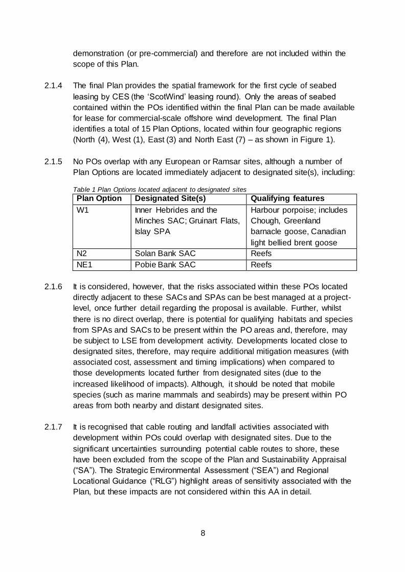
Plan Options are located immediately adjacent to designated site(s), including: Table 1 Plan Options located adjacent to designated sites
Plan Option Designated Site(s) Qualifying features
W1 Inner Hebrides and the
Minches SAC; Gruinart Flats,
Islay SPA
Harbour porpoise; includes
Chough, Greenland
barnacle goose, Canadian
light bellied brent goose
N2 Solan Bank SAC Reefs
NE1 Pobie Bank SAC Reefs
2.1.6 It is considered, however, that the risks associated within these POs located
directly adjacent to these SACs and SPAs can be best managed at a project-
level, once further detail regarding the proposal is available. Further, whilst
there is no direct overlap, there is potential for qualifying habitats and species
from SPAs and SACs to be present within the PO areas and, therefore, may
be subject to LSE from development activity. Developments located close to
designated sites, therefore, may require additional mitigation measures (with
associated cost, assessment and timing implications) when compared to
those developments located further from designated sites (due to the
increased likelihood of impacts). Although, it should be noted that mobile
species (such as marine mammals and seabirds) may be present within PO
areas from both nearby and distant designated sites.
2.1.7 It is recognised that cable routing and landfall activities associated with
development within POs could overlap with designated sites. Due to the
significant uncertainties surrounding potential cable routes to shore, these
have been excluded from the scope of the Plan and Sustainability Appraisal
(“SA”). The Strategic Environmental Assessment (“SEA”) and Regional
Locational Guidance (“RLG”) highlight areas of sensitivity associated with the
Plan, but these impacts are not considered within this AA in detail.

9
Figure 4 Final Plan Options (POs) (2020)
10
2.2 Key issues and technology types
2.2.1 For plan-level assessments, it is recognised that there is often limited
information on the precise location and scale of development, or about the
relevant construction methods and associated activities. Whilst 15 Plan
Options have been selected and their locations are indicated, no project-level
details are currently available.
2.2.2 The HRA report outlines the potential for floating offshore wind technologies to
be deployed, to allow exploitation of deep-water sites. The Plan, however,
does not direct which types of technology should be deployed within each
Plan Option and these details will only be available at a project-level. These
uncertainties have been duly recognised throughout all assessment stages.
2.2.3 The assessment has, therefore, taken account of the likely range of
development options and activities (based on previous wind energy projects)
and the potential worst case scenario(s) for each impact pathway and species.
The Plan has a broad spatial scope and long-term temporal component, which
will influence the range of potential impacts. The temporal aspects and scale
of impacts will be influenced by the technological advances that will occur over
the coming years. These will influence the scale of potential impacts, as well
as the distances offshore that developments can be undertaken, whilst
remaining commercially-viable. It will also influence the needs for future
upgrading of wind generating technologies in established areas.
2.2.4 The assessment presented in the HRA Report, therefore, has not made
specific assumptions about the project-level activities (e.g. device type and
generating capacity). The full range of potential impacts have been
incorporated in the assessment envelope (in line with the precautionary
approach). The potential envelope of change has therefore been determined
to identify the potential effects on features. On this basis, screening matrices
and maps were produced in the Phase 3 report for the DPOs, which identified
where features within individual European/Ramsar sites are at risk of LSE (or
where the risk LSE could not be excluded). The Phase 3 report builds on the
screening process, by considering the particular environmental
pressures/changes that give rise to these risks and then provides a generic
assessment of the impacts (having regard to the typical conservation
objectives).
2.3 Maximum realistic development scenarios
2.3.1 The Plan provides flexibility over the exact location, nature and scale of the
proposal to enable adverse effects on site integrity to be avoided at a project-
level. In order to avoid significant adverse environmental effects, the Strategic

11
Environmental Assessment identified, under this iteration of the Plan,
development should be limited to 10 GW nationally. The SA has used ‘realistic
deployment scenarios’ to assess the potential positive and negative impacts of
DPOs. These ‘realistic development scenarios’ equated to a proportion of the
overall area of the DPO (which varies according to the size and conditions of
the DPO and have been derived from known constraints on development,
early indications as to developer interest and established infrastructure to
support development).
2.3.2 Whilst 10 GW was used as a total maximum realistic development scenario
for the Plan as a whole (nationally), the individual PO scenarios (shown in
Table 3) should not be taken as being an endorsement of projects up to this
size within a PO, as further project level assessment and planning will be
required to ensure avoidance of significant adverse effects. The use of
maximum realistic development scenarios within each PO provides sufficient
flexibility regarding the exact location, scale and nature of the proposal to
enable potential AEOSI to be avoided (i.e. further spatial planning within POs
to avoid sensitive areas).
2.4 Iterative plan review and management
2.4.1 Once adopted, the Plan will be subject to ‘iterative plan review’ and
management, to ensure that;
The Plan and the underpinning assessments are informed by the best
available and most up-to-date scientific research and understanding,
including outputs of project-level assessments and monitoring;
The Plan accurately reflects spatial/regional context (i.e. level of
construction, operational, and other activity within the region) and
potential transboundary impacts; and
The Plan reflects the prevailing market conditions, technological
advancements and regulatory environment (including connections to the
national grid and coastal infrastructure).
Section 11.5 of the HRA Report provides an outline of the proposed iterative
plan review cycle (for the first 2 years of the Plan’s lifespan). To support the
iterative review process, a Programme Board and Technical Advisory Group
will be established upon adoption of the final Plan, to consider the implications
of emerging research, evidence and assessment methodologies. In addition,
an Ornithology Working Group will be established, to specifically consider
ornithology evidence gaps identified during the planning process.

12
2.4.2 The iterative plan review process will be informed by the best available
scientific information, project-level assessment and post-consent monitoring
(for consented and operational wind farm projects). As monitoring data is
collected, it will be used to validate the conclusions of project-level
assessment and the Sustainability Appraisal. The iterative plan review
process will also consider the level of current and planned activity within the
POs, regionally and nationally and potential transboundary impacts.
2.4.3 In addition, it is anticipated that the Plan will be initially reviewed after two
years, to consider emerging monitoring and research evidence, the wider
policy, market and regulatory context and if required, to provide an updated
spatial framework for any future CES leasing round. The formal review
process will commence two years after adoption of the Plan, unless Scottish
Ministers seek to commence the review process earlier than Year 2. In the
event that significant changes are required to the Plan, further assessment
and/or consultation may be required and further details regarding this process
will be confirmed at the appropriate juncture.
2.4.4 Each iteration of the Plan will be informed by any new and relevant
information and research regarding the environmental, economic and social
impacts of offshore wind and the effectiveness of any mitigation measures.
Final decision making power regarding the Plan and any revisions will
continue to rest with Scottish Ministers.
2.5 Plan governance structure
2.5.1 In order to facilitate the implementation of the Plan and iterative plan review
process, a formal governance structure is required to be put in place, as
outlined below in Table 2. The groupings outlined below will be formed upon
adoption of the Plan and have specific functions in relation to the Plan-level
mitigation measures outlined in this AA and the HRA Report.
Table 2 Plan governance structure
Group Role/Function
Scottish
Ministers
Responsible for approving and adopting the SMP
Responsible for approving amendments/updates to the SMP
Responsible for granting/refusing consent/licenses for individual offshore wind projects
The final decision making power rests with Scottish Ministers.
Sectoral
Planning
Comprised of key officials from relevant policy areas across Scottish Government, as well as representatives from Marine Planning and Policy, Marine Scotland (“MPP”).

13
Programme
Board
Considers advice and evidence received from Technical Advisory Group, Ornithology Working Group and Sectoral
Evidence Group.
Provides recommendations to Scottish Ministers regarding the need to revise or update the Plan (iterative plan review
process), including the need and scope of further assessment. This will be on the basis of the evidence
submitted to it, which may justify the need to revise or update the Plan.
External advice may be sought as appropriate.
Chair: Deputy Director, Marine Scotland
Secretariat: MPP
The group will meet at least once per annum, or more frequently if circumstances require.
Technical
Advisory
Group
Comprised of representatives from the statutory consultation bodies - NatureScot, the Joint Nature Conservation Committee (“JNCC”), Historic Environment Scotland (“HES”)
and the Scottish Environment Protection Agency (“SEPA”).
In addition, representatives from Marine Scotland Science
(“MSS”) and MPP will be formal members of the Advisory Group.
Chair: Head of Planning, Development and Crown Estate
Strategy Unit, MPP
Secretariat: MPP
Meets on at least an annual basis to consider Plan-level issues.
Provides advice and report to the Programme Board regarding continued application of plan-level mitigation
measures, the need for revisions to the Plan (as adopted) and further research/evidence/guidance requirements.
This advice will be informed by consideration of the evidence
provided during by the Sectoral Evidence Group and other stakeholders, consideration of other policy, legislative and
regulatory changes which have occurred over the time period, outputs of project-level assessment and other research programmes and the spatial context (i.e.
development which takes place after adoption of the SMP).
The evidence submitted and considered may likely pertain to
fields outside the expertise of members of the Advisory Group (e.g. fisheries). In such cases, the Technical Advisory
Group (and Programme Board) will be required to seek further advice and representation from the relevant stakeholders (i.e. from the Sectoral Evidence Group). These
views will support the formulation of advice and production of the Report.
The decision has been taken to restrict membership of this group to the statutory consultees (as defined by the Environmental Assessment (Scotland) Act 2005), with the

14
addition of JNCC given geographic coverage of the Plan. Other stakeholders will have the opportunity to provide input via the Sectoral Evidence Group and as above if issues
pertaining to their area of interest arise.
Sectoral
Evidence
Group
Formed of a wide range of sectoral interests (i.e. drawn from
the current Steering Groups formed to support the planning process), i.e. commercial fisheries, commercial shipping and navigation, renewables industry.
Membership shall be as follows; Crown Estate Scotland; Highlands and Islands Enterprise; Marine Scotland Science;
Regional Inshore Fisheries Groups; RSPB Scotland; Scottish Enterprise; Scottish Fishermen’s Federation; Scottish Government; Scottish Renewables; UK Chamber of
Shipping; and WWF Scotland.
The exact operation of this group will be confirmed following
adoption of the Plan.
This grouping will be asked to provide
evidence/representations to support the iterative plan review process or may be asked to provide further representations/evidence to the Programme Board and/or
Technical Advisory Board on specific issues.
This grouping will be able to provide further evidence
(relevant to the implementation of the Plan and the iterative plan review process) as it becomes available, for consideration by the Technical Advisory Group and
Programme Board however, at a minimum an annual call will seek any relevant responses.
Ornithology
Working
Group
Formed of relevant ornithology experts (drawn from the
current ScotMER ornithology receptor group), i.e. NatureScot, JNCC, MSS and Scottish Environment Link (“SE
Link”).
Crown Estate Scotland will also be formal members of this
group.
Chair: MPP
Secretariat: MPP
Role in relation to application of Plan-level mitigation measures for
Plan Options E1 and E2
To be formed immediately upon adoption of the Plan to
define the scope and nature of regional surveys and research work, including assessment of survey outputs, in
relation to development within Plan Options E1 and E2.
The recommendations will be formed in consultation with
relevant Option Agreement holders (or their representatives). Option Agreement holders, however, will not form part of the membership of the Ornithology Working Group.

15
The Ornithology Working Group will then provide advice to the Programme Board (this is due to the replication of
members on the Advisory Group with the relevant expertise and to avoid unnecessary duplication). The Programme Board will then confirm the final survey and research
requirements and these details will be communicated to developers via Marine Scotland.
Developers will be advised to complete the surveys and assessment by Marine Scotland, prior to the submission of any licence/consent application.
Survey and assessment outputs should be provided by developers to the Ornithology Working Group, prior to the
submission of any licence and consent applications, in the format directed by Marine Scotland, to support the iterative plan review process and further planning and
licensing/consenting decision-making processes.
Wider role – iterative plan review process, application of plan-level
mitigation measures (i.e. E3, NE2-NE4 and NE6), defining research
requirements
To assist in identifying and addressing evidence gaps (relating to ornithology) that constrain potential development
within the Plan Options and are required to be addressed to inform future planning exercises.
The Working Group will provide guidance in the production of an ‘Ornithology Roadmap’, which will be prepared by a contractor(s) (appointment process currently underway). The
Roadmap will identify ongoing research and any specific actions required to produce the evidence base for assessing
ornithological constraints.
Upon completion of the Roadmap, the Working Group will
work with the appointed contractor(s) to support the production of a ‘Programme of Works’ – a detailed programme of works to address strategic research projects
that can be implemented within the short to medium term to initiate Roadmap actions.
The Working Group will also be asked to; o Provide views regarding the continued application of
plan-level mitigation measures in relation to Plan
Options E1-E3, NE2-NE4 and NE6; o To provide advice/views regarding whether further
research or guidance is required to inform planning and consenting; and
o Consider the findings of future project-level
assessments, relevant research programmes and the wider spatial context and provide advice regarding the
potential implications of these changes for the Plan (as adopted).

16
2.5.2 The process for continued submission of new evidence (which the draft Plan
and SA referred to as the Annual Forum) is a key mechanism to support the
Plan implementation and iterative review processes. Key stakeholder
representatives, who form part of the Sectoral Evidence Group, will be asked
to provide details of emerging evidence and research, which could have a
bearing on the implementation of the Plan and resultant development on at
least an annual basis, but will have the opportunity to provide this evidence as
it emerged.
2.5.3 The evidence submitted may have arisen as a result of technological
advances, scientific evidence, project survey and monitoring (including of the
effectiveness of mitigation measures) and or as the result of project-level
assessments. The request for new evidence, to support iterative plan review,
should not be an opportunity for further public consultation on the Plan.
Should sufficient evidence be presented, which Scottish Ministers consider
justifies the need to review the Plan, then public consultation will occur at the
appropriate stage in the planning process. It is currently anticipated that the
Plan will be reviewed at Year 2 (although this may occur earlier if sufficient
justification is provided).
2.5.4 The scope of evidence submitted will be restricted to ensure it is only relevant
to the Plan and its implementation. Discussions within the Sectoral Evidence
Group could follow a similar approach to that taken recently regarding
consideration and discussion of emerging assessment methodologies for
projects in the Forth and Tay region (2020). Further details regarding this
process will be provided in due course.
2.5.5 The first annual request for evidence from the Sectoral Evidence Group and
other stakeholders will be undertaken one year after the adoption of the Plan.
The exact process and functioning of the Sectoral Evidence Group will be
confirmed after the adoption of this Plan. The Technical Advisory Group shall
provide the Report of findings to the Programme Board.
2.5.6 Members of the two Steering Groups formed to support the planning process
would be approached to provide relevant evidence. The Steering Group
members were as follows:-
Crown Estate Scotland;
Highlands and Islands Enterprise;
Historic Environment Scotland;
Joint Nature Conservation Committee;
Marine Scotland Science;
NatureScot;

17
Regional Inshore Fisheries Groups;
RSPB Scotland;
Scottish Enterprise;
Scottish Environment Protection Agency;
Scottish Fishermen’s Federation;
Scottish Government;
Scottish Renewables;
UK Chamber of Shipping; and
WWF Scotland.
2.5.7 In addition, the chairs of the ScotMER Receptor-Specific groups and Regional
Marine Planning Partnerships, as well as Local Authorities, will be approached
to provide any relevant evidence or advice. Invitations to provide evidence will
also be made to other representative groups which may have an interest in
the implementation of the Plan, such as Fisheries Management Scotland.
2.5.8 Evidence submitted will be considered by the Technical Advisory Group for its
relevance and appropriateness. A summary of all evidence provided (as it
may likely pertain to fields outside the expertise of members of the Technical
Advisory Group) will be summarised and presented to the Programme Board
by officials.
2.5.9 The Programme Board will then use this information to provide
recommendations to Ministers regarding whether there is the need to review
the Plan at this juncture (e.g. earlier than the planned review at Year 2) or
whether the Plan remains reflective of current scientific understanding and
knowledge. This report will be published online.
2.5.10 The Programme Board and Technical Advisory Group will also consider
evidence submitted in light of other policy, legislative and regulatory changes
which have occurred over the time period and the spatial context. Further, we
anticipate that we will have an improved understanding of transmission and
grid connection issues, as individual projects progress through the pipeline,
which may have a bearing on the Plan.
2.6 Addressing research gaps
2.6.1 The planning process and HRA Report have identified potential gaps in
knowledge and data, which may need to be addressed at a Plan and/or
project-level. The Technical Advisory Group and Ornithology Working Group,
as outlined above, will consider these data and knowledge gaps in further
detail over the coming years to support future planning exercises.

18
2.6.2 A number of strategic research programmes already exist and are undertaking
work to address these gaps. Further, project-level assessment and monitoring
may provide data and evidence which can address these gaps. As this
evidence becomes available, it is anticipated that it will inform future plan and
project-level assessment accordingly. Particularly, for example, in relation to
emerging technology and installation methods (i.e. floating offshore wind
technologies) and post-consent monitoring regarding seabird
behaviour/interactions with wind turbine generators (“WTG”).
2.6.3 Consideration of the potential impacts on seabird qualifying interests has
identified a number of evidence gaps, which are currently being considered by
the Scottish Marine Energy Research (“ScotMER”) programme, including;
Collision mortality and avoidance behaviour of Black-legged Kittiwake,
Northern Gannet and Great Black-backed Gull (OR. 17). All three species
concerned are of direct relevance to future offshore wind farm
development in the Moray Firth region, whilst in the Forth and Tay region
Kittiwake and Gannet are the key species of concern in relation to
potential collision mortality.
The consequences of displacement and barrier effects on survival and
productivity (OR. 23), and subsequently populations of Atlantic Puffin,
Razorbill and Common Guillemot are key constraints in the Forth and Tay
region, and to a lesser extent in the Moray Firth region.
The drivers of any observed changes in distribution and abundance of
Black-legged Kittiwake, Northern Gannet, Atlantic Puffin, Razorbill, and
Common Guillemot in and around offshore wind farms (OR. 06, OR. 19,
OR. 20, OR. 21).
The movements of adult birds during the non-breeding season and
immature birds during the entire year, and their level of exposure to
cumulative effects (OR. 02, OR. 03, OR. 09).
2.6.4 Addressing these evidence gaps will support future project and plan-level
decision making and assessment process.
2.6.5 The Post Adoption Statement (2020) sets out in further detail the research and
evidence gaps which need to be addressed, including planned research work
to be undertaken in the coming years. The requirement, for example, for
regional-level survey and assessment work to be undertaken for POs E1 and
E2 (a mitigation measure outlined at section 4 of this AA) seeks to address
uncertainty regarding the presence, distribution and abundance of seabirds
during the non-breeding season in this region, as well as connectivity with key
seabird colonies on the East and North East coast.

19
2.7 Project-level mitigation measures considered
2.7.1 Details of mitigation measures deployed for individual wind farm projects have
been collated to produce a central ‘project-level mitigations options’ table
(Table J1, Appendix J)1 – which have been measured against the impacts
matrix included within Table J2, to cross-reference potential mitigation
measures to impacts. These mitigation measures have been derived from
previous strategic assessments and project-level assessments and provide a
comprehensive overview. One of these measures is, during the early stages
of any development, ‘a primary consideration will be to try to avoid habitats
within a European/Ramsar site and minimise exposure and risk’.
2.7.2 Further relevant project-level mitigation measures identified in Appendix J
include (but are not limited to);
Identification of the most appropriate mechanism for disposal of excavated
sediment to avoid adverse impacts on designated intertidal/coastal habitat
features from smothering;
Use of cable and device installation methods that minimise sediment re-
suspension (impacts on fish and shellfish from increased suspended
sediment and turbidity);
Survey design to mitigation/avoid visual disturbance from vessels or
shoreline activity; and
Use of methods and/or timing to reduce noise from geophysical survey,
borehole work, seismic survey and use of standard measures to
avoid/mitigate effects on designated habitats and species (impacts of
noise on marine mammal qualifying interests).
2.7.3 Whilst this list demonstrates a range of potential project-level mitigation
measures which could be deployed, the list does not provide further certainty
that European/Ramsar sites will not be affected. The application of these
measures is not a formal requirement of the Plan, however, they provide
useful context for the HRA Report and can inform further project-level
assessment and discussion as development progresses (as appropriate to the
project location and impacts).
1 See further, https://www.gov.scot/publications/draft -sectoral-marine-plan-offshore-wind-energy-
habitat-regulations-appraisal/pages/26/ (Last accessed 17/09/20)

20
Table 3 Maximum realistic development scenarios
Region DPO Total DPO Area
(km²)
Realistic
maximum
development
scenario for DPO
(GW)
Realistic
development as
percentage of
total DPO Area
Regional
Low
Scenario
(GW)
Regional
Medium
Scenario
(GW)
Regional
High
Scenario
(GW)
East
E1 3742 3 16%
E2 1287 2 31%
E3 474 1 42%
Sub-total 5505 6 1 2 3
North East
NE1 751 2 53%
NE2 345 1 58%
NE3 265 1 76%
NE4 440 1 45%
NE6 699 2 57%
NE7 684 3 88%
NE8 339 1 59%
Sub-total 3522 11 1.5 3 4.5
North
N1 1163 2 34%
N2 561 2 71%
N3 1106 2 36%
N4 200 1 100%
Sub-total 3030 7 1 2 3
West W1 754 2 53%
Sub-total 754 2 0.5 1 2
Total: 14646 26 4.3 8.6 13.5
Scaled back to national scenarios (GW): 3 5 10

21
3. Preparation of the HRA Report
3.1.1 The planning process commenced in 2017 and was conducted in accordance
with the process shown in Figure 5. Further detail regarding the planning
process can be found in the final Plan.
Figure 5 Sectoral marine planning process
3.1.2 The HRA process for the Plan has followed the 13-step process set out in the
agreed SNH guidance for undertaking plan-level HRA in Scotland and as set
out in the Pre-Screening HRA Report2 and as shown in Figure 6.
2 See further: David Tyldesley and Associates, 2015. Habitats and Regulations Appraisal of Plan.
Guidance for Plan-Making Bodies in Scotland Version 3.0, January 2015 SNH Ref 1739.

22
Figure 6 HRA Plan Process

23
3.1.3 The 13 step process has been adopted, and consulted upon, over three key
project phases to ensure there is clarity and a clear audit trail in the
assessment process (an important requirement for strategic-level HRAs,
which need to be carried out in an iterative, transparent and auditable
manner). The HRA and this Appropriate Assessment have been undertaken in
accordance with guidance provided by SNH on HRA of Plans.3 This process
also takes into the guidance produced by the European Commission on the
“Assessment of plans and projects significantly affecting Natura 2000 sites”.4
3.1.4 The HRA process for the draft Plan was overseen by a Plan Steering Group
which included representatives of the Scottish Government, Scottish Natural
Heritage, Joint Nature Conservation Committee (“JNCC”), Royal Society for
Protection of Birds (Scotland) (“RSPB (Scotland))”, Historic Environment
Scotland, Marine Scotland Science (“MSS”), Regional Inshore Fisheries
Groups, Scottish Environmental Protection Agency, Scottish Fishermen’s
Federation, Scottish Renewables, World Wildlife Fund and Crown Estate
Scotland (“CES”). This ensured that the planning process met the
requirements of these bodies and therefore the Appropriate Assessment
Information Report incorporated the consultation and revision requirements of
stages 11 – 13 of the HRA process.
3.1.5 Public consultation was undertaken on the scoping reports (including the HRA
Pre-Screening Report) between 13 June 2018 and 18 July 2018. The
Consultation Analysis Report is available, which summarises the outputs of
this scoping consultation phase and further consultation undertaken post-
scoping (e.g. July 2018 to June 2019).5 The findings from the three phases
are presented in the reports set out in Table 4.
3 SNH, Habitats Regulations Appraisal of Plans – Guidance for Plan-Making Bodies in Scotland (V
3.0, January 2015) Available at: https://www.nature.scot/habitats-regulations-appraisal-plans-
guidance-plan-making-bodies-scotland-jan-2015 (Last accessed: 17/06/20) 4 European Commission, Assessment of plans and projects significantly affecting Natura 2000 sites
(2011). 5 Available here: https://www2.gov.scot/Resource/0054/00549055.pdf (Last accessed: 09/09/2020)

24
Table 4 HRA Report - 3 Phase Reports
Phase HRA Stage(s) Document and details
1 1-3 Pre-Screening Report (June 2018)
https://www.gov.scot/publications/sectoral-marine-plan-
offshore-wind-energy-encompassing-deep-water-plan-
9781788519632/
Sets out the evidence base and proposed methods to be
applied for the subsequent screening/scoping and
assessment stages.
2 4 Review of proposed Assessment Methodology
(November 2018)
https://www.gov.scot/publications/draft-sectoral-marine-
plan-offshore-wind-energy-habitat-regulations-
appraisal/pages/18/
Produced following consultation on the pre-screening
report. Considered the responses received and revisited
the proposed HRA scoping and assessment methods in
light of feedback and recent case-law developments.
This document was discussed with the Steering Group on
9 November 2018, generally positive feedback was
received and it was agreed that the methods proposed in
the Phase 1 report would be applied with minor changes
(as set out in the Phase 2 report).
3 5-10 Screening and Appropriate Assessment Information
Report (“HRA Report”) (December 2019)
https://www.gov.scot/publications/draft-sectoral-marine-
plan-offshore-wind-energy-habitat-regulations-
appraisal/pages/4/
Produced rationalised screening list, reflected case-law
developments, impact pathways review, identification of
features which are sensitive, activity-based screening of
European/Ramsar sites, detailed pathway-feature
sensitivity review and assessment of potential effects on
European/Ramsar sites.
25
4. Consultation
4.1.1 The draft Plan and SA were published for statutory consultation, in
accordance with the Strategic Environment (Scotland) Act 2005, for a period
of 14 weeks between 18 December 2019 and 25 March 2020. Eighteen
consultation events took place during February and March 2020, to raise
awareness of the consultation and discuss the draft Plan and SA in detail with
stakeholders. The full outputs of this consultation process can be found in the
Consultation Analysis Report6 and the full consultation responses are
available to view on the Citizen Space consultation hub page.7
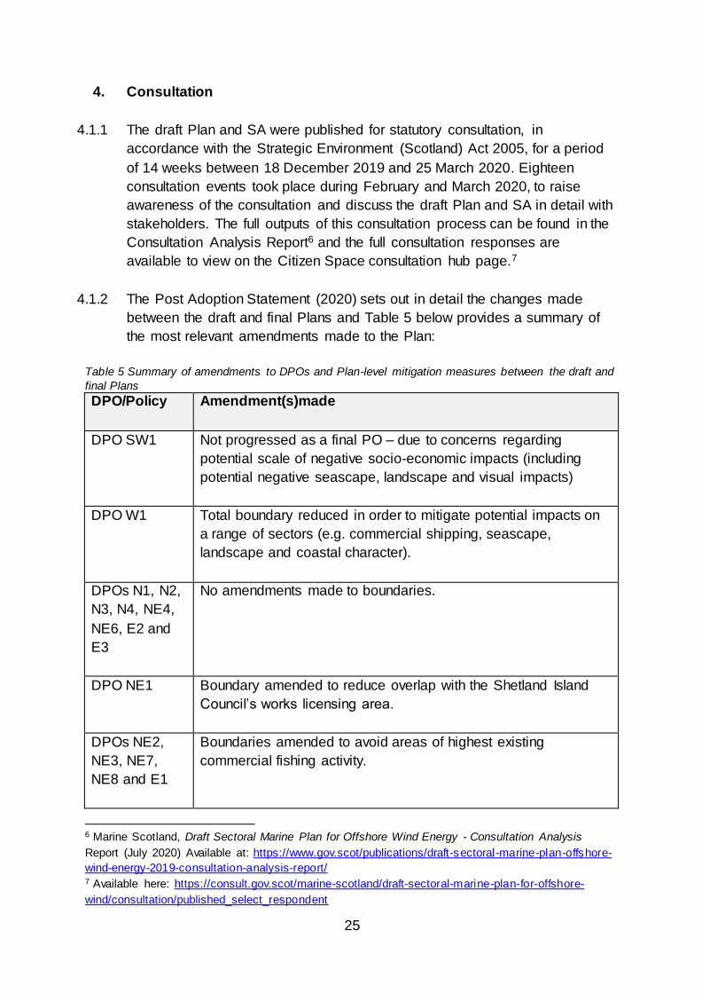
4.1.2 The Post Adoption Statement (2020) sets out in detail the changes made
between the draft and final Plans and Table 5 below provides a summary of
the most relevant amendments made to the Plan:
Table 5 Summary of amendments to DPOs and Plan-level mitigation measures between the draft and
final Plans
DPO/Policy Amendment(s)made
DPO SW1 Not progressed as a final PO – due to concerns regarding
potential scale of negative socio-economic impacts (including
potential negative seascape, landscape and visual impacts)
DPO W1 Total boundary reduced in order to mitigate potential impacts on
a range of sectors (e.g. commercial shipping, seascape,
landscape and coastal character).
DPOs N1, N2,
N3, N4, NE4,
NE6, E2 and
E3
No amendments made to boundaries.
DPO NE1 Boundary amended to reduce overlap with the Shetland Island
Council’s works licensing area.
DPOs NE2,
NE3, NE7,
NE8 and E1
Boundaries amended to avoid areas of highest existing
commercial fishing activity.
6 Marine Scotland, Draft Sectoral Marine Plan for Offshore Wind Energy - Consultation Analysis
Report (July 2020) Available at: https://www.gov.scot/publications/draft-sectoral-marine-plan-offshore-
wind-energy-2019-consultation-analysis-report/ 7 Available here: https://consult.gov.scot/marine-scotland/draft-sectoral-marine-plan-for-offshore-
wind/consultation/published_select_respondent

26
DPO/Policy Amendment(s)made
DPO NE5 Not progressed as a final PO- due to potential cumulative
impacts.
Definition of
commercial-
scale offshore
wind
Definition of commercial-scale offshore wind retained as “projects
being capable of generating more than 100 MW of electricity’.
DPOs classed
as, ‘being
subject to high
levels of
ornithological
constraint’ (E3,
NE2-NE6)
DPO NE5 has not been progressed as a final PO and is therefore
removed from this category.
Inconsistencies in the wording regarding this mitigation measure
between the SA, HRA and Plan documents were highlighted by
respondents, including the shift away from the term ‘temporal
mitigation’.
This mitigation measure has been retained, however, the text in
the final Plan makes clear that it will be possible for a developer
to submit an application for licence/consent for these POs before
the mitigation measure is removed at a Plan-level (i.e. via the
iterative plan review process). Regulatory approval/consent,
however, may only be granted in these instances, if it can be
concluded that there would no AEOSI, or if Scottish Ministers opt
to pursue a derogation under the Habitats Regulations.
DPOs classed
as ‘being
subject to the
need for
regional-level
survey’ (E1
and E2)
POs E1 and E2 remain subject to this mitigation measure.
Respondents provided comments regarding the potential scope
of the required survey and assessment work and Option
Agreement holders will be expected to carry out this survey and
assessment work as directed by Marine Scotland, following
further discussion with the Ornithology Working Group (to be
established upon adoption of the Plan).
Developers are able to pursue a licence/consent application
without first completing the regional-level survey and assessment
work, however, it is likely that the Responsible Authority would be
unable to conclude no AEOSI with any reasonable certainty and
further survey and assessment would be required (unless
Scottish Ministers opt to pursue a derogation under the Habitats
Regulations).

27
5. Consultation responses
5.1.1 Detailed comments were received from SNH, RSPB Scotland and JNCC. The
main points by each of the respondents that included HRA specific comments
are summarised below. It should be noted that SNH rebranded to NatureScot
during August 2020.
5.2 SNH (now NatureScot)
5.2.1 SNH provided a response to the scoping phase on 17 July 2018.8 SNH
indicated it was content with the scope and level of detail proposed for the
environmental report and provided comments on the scoping in/out of topics.
SNH considered that Invasive Non-Native Species and impacts on prey
species should be scoped into the assessment. SNH also advised that an
additional objective, “to avoid significant adverse physical damage to coastal
geodiversity sites from coastal infrastructure”.
5.2.2 SNH provided a consultation response to the draft Plan and HRA Report on
25 March 2020,9 which was accompanied by Landscape and Visual Impact
Appraisal and Design Guidance. SNH also provided the same response via
the Scottish Government Strategic Environmental Assessment (“SEA”)
Gateway. Following further discussion with Marine Scotland regarding the
implications of the removal of NE4 and NE5 on the status of NE6, and wider
discussions regarding NE6, SNH provided additional advice on 11 May 2020.
5.2.3 In its response dated 25 March 2020, SNH advised that, broadly speaking, it
agreed with and endorsed the conclusions of the HRA Report and the
recommendations made. In particular, it endorsed the finding that ‘appropriate
and meaningful mitigation measures’ are required to ensure no AEOSI arises
from Plan related activity, and the range of measures that are set out in the
draft Plan and Sustainability Appraisal to secure this. SNH considered that the
Plan level mitigation measures, relating to the temporary restriction on
windfarm development in DPOs E3 and NE2-NE6, the additional survey work
required for DPOs E1-2 and the establishment of the IPR process and
Technical Advisory Group are critical measures to avoid AEOSI.
Ornithology
8 Available on the Scottish Government Strategic Environmental Assessment Gateway here:
https://www2.gov.scot/seag/details.aspx?sid=5&id=SEA\01392 (Last accessed: 09/09/2020) 9 SNH, Draft Sectoral Marine Plan for Offshore Wind Energy (2019) – Response and comments from
SNH (25 March 2020). Available at: https://www.nature.scot/sites/default/files/2020-
04/Sectoral%20Plan%20Consultation%20-%20SNH%20Response%20Summary.pdf (Last accessed:
19/06/20)

28
DPOs E3 and NE2-NE6
5.2.4 SNH advised that it strongly supports the need for temporary restriction on
windfarm development in DPOs E3 and NE2-NE6, “until such time as enough
evidence on the environmental capacity for seabirds exists to reduce the risk
to an acceptable level.” SNH advised that, due to concerns regarding the
predicted in-combination impacts of existing and consented offshore
windfarms (“OWF”) on specific east coast SPAs and seabird species, “no
development should be permitted until and unless research and post consent
monitoring of existing OWF in eastern Scotland demonstrate that capacity for
further development, with respect to SPA interests, exists.” SNH further
advised that the same criteria regarding mitigation measures should not be
applied to all six DPOs. SNH advised that, in its opinion, the research and
monitoring should be completed to inform future ornithological impact
assessments and understanding regarding ornithological impacts, “rather than
bypassing this through derogation.”
DPOs E1 and E2
5.2.5 SNH advised that it strongly supports the specific Plan level mitigation
identified for DPOs E1 and E2, “in recognition that kittiwakes, gannets and
razorbills, with potential connectivity to East Coast SPAs, may be foraging in
these areas.” SNH advised that, at this stage, it would be unable to advise that
there would no AEOSI arising from development in these DPOs in-
combination with existing consented OWF development in this region. SNH
advised that it considers it necessary for “regional surveys on seabird density
and SPA connectivity to be undertaken in these DPOs to establish whether
these species are present in sufficient numbers for some or all of the sea area
within E1 and E2 to be subject to the same temporary restriction on
development as applied at E3 and NE2-NE6 or whether and where they are
sufficiently low as to enable leasing and consenting to proceed with no further
Plan mitigation measures required.” SNH advised that the recently published
updated foraging ranges10 further supported the application of this mitigation
measure and the increased mean-max foraging ranges for both kittiwakes and
razorbills (as well as gannets). SNH advised that these updated foraging
ranges should be used to support future iterations of the Plan and in any
project-level assessment for development arising from the current Plan.
Technical Advisory Group and addressing knowledge gaps
10 Woodward, I., Thaxter, C.B., Owen, E., and Cook, A.S.C.P., Desk-based revision of seabird
foraging ranges used for HRA screening (2019). BTO Research Report Number 724.

29
5.2.6 SNH highlighted that it had concerns regarding inconsistencies in the
documentation presented for consultation regarding the plan-level mitigation
measures for ornithology and the role and function of the (as named) Advisory
Group and Stakeholder Project Steering Group(s) referred to in the
documentation. SNH highlighted the establishment of the Advisory Group
should not be delayed until plan adoption and that it wished to be represented
on this grouping. SNH are represented on both the Technical Advisory Group
and Ornithology Working Group to be established upon adoption of the Plan
(see further, Post Adoption Statement (2020)).
5.2.7 SNH highlighted that more data and detailed analyses around flight heights
over water would be particularly valuable in assessment of (cumulative) risk
and noted that migratory pathways of Whooper swans from Iceland could also
potentially transect POs (in particular, N2, N3 and N4), further supporting the
need for a wider updated review of migratory pathways. This knowledge gap
has been highlighted within the Post Adoption Statement and will be
addressed via existing research fora (e.g. the ScotMER Ornithology Sub-
Group) as well as the Ornithology Working Group (to be formed upon adoption
of the Plan).
5.2.8 SNH advised that existing plans for post-consent monitoring are likely to
include proposals for bird tracking and collision/behaviour monitoring. SNH
advised that it considers that, whilst extra resources to support/expand this
work would be welcomed, it would need to be planned and co-ordinated with
other developer(s) and the relevant Regional Advisory Group(s) to ensure
best-value.
5.2.9 SNH advised that the reference to the further collection of oceanographic and
ecological data is sensible, but that the scale at which such data is collected
must be appropriate, to enable understanding of seabird movement (i.e. relate
to the foraging or migratory range of the species being considered). SNH
advised that there may be a significant amount of such information which is
already being routinely recorded, particularly in relation to fisheries science,
which could be used to consider seabird distribution.
Migratory bird species (all regions)
5.2.10 SNH stated that the recommendation included at section 10.7.11 of the HRA
Report, “to consider possible in-combination effects arising from development
within DPO SW1, with respect to Whooper swan feature of the classified
Upper Solway Flats and Marshes SPA and the proposed marine extension, as
further detail of the Round 4 leasing emerges” should be included as a
mitigation measure. As SW1 has now been removed from further

30
consideration, this has not been recommended as a mitigation measure as a
result of this AA.
Ornithology - general
5.2.11 SNH advised that it considers that the assessment of sensitivity for collision
impacts for species such as kittiwake and gannet has been underestimated.
SNH consider that the assessment of sensitivity included at Section 6 and
Table 9 of the HRA Report should be ‘High’ and not ‘Medium’, given that
collision impacts are the driver for the conclusion of AEOSI for a number of
developments located in the Forth and Tay and Moray Firth regions. SNH
consider the statement provided in the HRA Report that, “sensitivities at a
population level are also likely to be inherently lower than for individuals” is
misleading, as it is both individual risk of mortality from collision and status of
impacted, including SPA, populations which determines overall sensitivities.
5.2.12 SNH further consider that the categorisation of seabirds provided at Table 8 of
the HRA Report (categorising seabirds by foraging mode, nocturnal
flight/diving activity and nesting location) may present an over-simplification of
the impacts and may be potentially misleading. SNH advised that there is a
growing recognition of the importance of understanding the extent of nocturnal
and twilight activity when assessing collision risk to seabirds and that this may
vary between season, age class and breeding status.11 SNH further advised
that it is unclear what basis has been used for scoring within Table 8 as no
supporting references are provided. SNH advised that the scoring for Arctic
skua, great skua and Arctic tern (‘No’ for Nocturnal Activity) contradicts
Furness and Wade (2012). SNH advised that the information presented in the
Table is too simplistic and the conclusions are not sufficiently evidenced or
supported by the latest available information. SNH advised that this is an
increasingly important area of impact assessment and therefore, this should
be given further consideration in any future or revised HRA Report, including
more nuanced categorisations. ABPmer have advised that the divergence
from the figures provided in Furness and Wade (2012) is due to the use of
different references. ABPmer agree that Table 8 could be amended to present
a more nuanced characterisation and updated references, but consider that
this does not alter the conclusions of the assessment presented. ABPmer
consider that the information above Table 9 provides sufficient detail regarding
references/sources.
5.2.13 SNH consider it is unclear why some impact pathways have been given a
lower sensitivity score, particularly;
11 See further, Paragraph 47 of SNH advice (25 March 2020)

31
Presence of structures resulting in an exclusion/displacement of species from
the area; and
Visual disturbance and exclusion from areas, as a result of surveying, cable
and device installation/operation and decommissioning activities and
movements of vessels.
5.2.14 SNH consider that the score of ‘medium low’ during the operational phase
does not reflect evidence presented in the HRA Report regarding large scale
displacement from operational OWF and the high sensitivity to visual
disturbance for certain species (e.g. divers).
5.2.15 SNH further stated that it considers that the HRA Report does not
acknowledge the terrestrial aspect which will be required to fully cover large
gull activity within assessment.
Marine Mammals
5.2.16 SNH advised that it considers that the delivery of OWF developments under
the Plan would be greatly facilitated by the completion of regional ‘strategic’
marine mammal surveys, to inform licensing and consenting decisions, rather
than relying on site-specific surveys (linked to individual projects). These
surveys would be used to characterise and quantify marine mammal usage
and cover broader areas (e.g. around clusters of POs) and incorporate sound
recorders. The need for further strategic-level survey work has been
highlighted within the Post Adoption Statement and will be discussed and
considered via the existing research mechanisms, such as the ScotMER
Marine Mammal specialist receptor group.
5.2.17 SNH commented that the information presented in Tables 14 and 15 of the
HRA Report is not clear whether it is displaying sensitivity or risk.
5.2.18 SNH advised that the greatest level of impacts will arise during the
construction phase of the Plan. SNH welcomed the commitment to require
plan-level HRA to identify necessary mitigation mitigations and
consent/licence conditions.
5.2.19 SNH advised that there would be no adverse effect on the integrity of any
SAC or cSAC with marine mammal qualifying interests from the Plan alone or
in-combination with other projects.
5.3 Joint Nature Conservation Committee (“JNCC”)

32
5.3.1 In its response, dated 25 March 2020, JNCC12 advised that it supported the
systemic and iterative planning process undertaken to date. JNCC consider
that the consistent application of plan-level mitigation measures will be critical
to the success of the Plan.
5.3.2 JNCC stated it is fully supportive of the iterative plan process (as outlined in
the HRA Report at section 11.4-11.5) and requested further clarity regarding
the ‘ownership’ of the various parts of the iterative plan review process. JNCC
indicated that further clarity was sought regarding what would trigger
(adequate justification) earlier review of the Plan. JNCC provided further
comments on the Advisory Group (as named), including its membership and
the need for Terms of Reference and the potential need for further receptor-
specific groups (i.e. marine mammals). Further detail regarding the iterative
plan review process and Technical Advisory Group is provided in the final
Plan and Post Adoption Statement.
5.3.3 JNCC further stated that it considers that Marine Scotland and Crown Estate
Scotland should consider the recent work undertaken by The Crown Estate in
relation to a Cable Route Protocol. The Plan and HRA Report do not consider
cable routes to shore in detail and these matters will be addressed at a
project-level, via project-level assessment and licence/consent conditions (as
appropriate).
Ornithology responses
5.3.4 JNCC stated that it strongly supports the plan-level mitigation proposed for
DPOs NE2-NE6 and E3, although it considered that this would effectively
“delay consent in these DPOs until the scientific evidence from research and
post consent monitoring suggests further capacity… may be feasible.” JNCC
sought further clarity on how this process would be undertaken by the
Advisory Group (as named). JNCC also stated that there were discrepancies
in the terminology around plan-level mitigation measures for these DPOs
between the various documents presented for consultation.
5.3.5 JNCC stated that it considers DPOs E1 and E2 should be subject to the same
mitigation measure as DPOs E3 and NE2-NE6 but did acknowledge that the
evidence required in order to facilitate opening up these DPOs, or parts of
these DPOs, to developers may be less onerous than the other DPOs. JNCC
stated that it considers a first step would be to establish the presence, and
numbers of, birds within and across these DPOs and potential connectivity to
12 Available here: https://consult.gov.scot/marine-scotland/draft-sectoral-marine-plan-for-offshore-
wind/consultation/view_respondent?show_all_questions=0&sort=submitted&order=ascending&_q__te
xt=Bird&uuId=587437195 (Last accessed: 04/09/20)

33
relevant SPAs. This might highlight whether ongoing restriction was necessary
across whole of, or only parts of, these DPOs. Such evidence could be
available within a few years, as opposed to the likely longer timeframes that
would be required to collect strategic evidence of impacts that would be
required to re-evaluate the other DPOs within the temporal moratorium. JNCC
stated that it would be keen to work with Marine Scotland and other relevant
parties to help define the regional- level survey work required in this region.
5.3.6 JNCC queried why the following pSPAs (for which it has responsibility) had
not been screened into the assessment, which it considers meet the outlined
criteria:
Table 6 JNCC comments - pSPA not screened in
DPO pSPA
N1 Seas off Kilda pSPA
Seas off Foula pSPA (Fulmar (breeding))
N3 Seas off Kilda pSPA
Seas off Foula pSPA (Fulmar (breeding))
N4 Seas off Kilda pSPA
Seas off Foula pSPA (Fulmar (breeding))
E1 Seas off Kilda pSPA
Outer Firth of Forth and St Andrews Bay Complex pSPA
Seas off Foula pSPA (Fulmar (breeding))
E2 Seas off Kilda pSPA
Outer Firth of Forth and St Andrews Bay Complex pSPA
Seas off Foula pSPA (Fulmar (breeding))
5.3.7 JNCC, however, noted that that the inclusion of these pSPAs would not alter
the conclusions of the Plan regarding AEOSI, given the conservation
objectives of the pSPAs impacted.
5.3.8 JNCC further queried the statement provided at section 6.3.4 regarding the
potential impacts of loss of habitat (also raised by RSPB Scotland) and how
the avoidance of key feeding sites would be ensured. JNCC stated, given the
conservation objectives of the marine pSPAs, it is important to ensure that
development (inside or outside of the pSPAs) does not affect prey availability
within the pSPAs such that AEOSI occurs. JNCC therefore, suggest that sites
should not damage key sources of prey which then might become available

34
within pSPAs (e.g. breeding or nursing grounds for key forage species that are
known to be linked to prey availability within pSPAs).
5.3.9 JNCC provided suggested amendments to the text for additional clarity. JNCC
further queried to what extent previous research has considered marine birds
and underwater noise (sections 6.7.7 to 6.7.11 of the HRA Report) and how
this understanding relates to the type of noise disturbance generating by
windfarm construction, operation and decommissioning.
5.3.10 JNCC advised that Table 9 of the HRA Report should indicate a degree of
variability of sensitivity to pressures between species (e.g. physical damage to
species or exclusion/displacement from non-physical disturbance may be
higher for certain species than others).
5.3.11 JNCC further highlighted that concerns regarding in-combination assessment
relate to “existing and therefore any further” offshore wind development (i.e.
not just existing development). JNCC further stated that it considers section
11.6.4 of the HRA Report is an inaccurate portrayal of JNCC advice and that
DPOs E1 and E2 should be subject to the same ‘temporal mitigation’ measure
as DPOs E3 and NE2-NE6. JNCC consider that surveys are required to
establish numbers and distributions of key species within E1 and E2 and
connectivity with SPAs, in order to determine if/or which parts of the DPOs
warrant ongoing moratorium with E3 and NE2-NE6.
5.3.12 JNCC consider that additional knowledge gaps exist in relation to accurate
and robust estimates of flight height and speeds for key species affected by
collision (e.g. from a combination of tracking or LiDAR or other appropriate
methods). JNCC further highlighted that it may be helpful to document
evidence needs at a project-level for proposals within certain DPOs (e.g.
impacts on certain migratory species), particularly where these needs have
not been apparent from previous/existing developments.
Marine mammals responses
5.3.13 JNCC stated that it considers that the North and North East regions are
already subject to consider offshore activity and further development in these
regions could result in prolonged disturbance from the construction of
consecutive projects. JNCC stated that the potential impacts of such
prolonged disturbance on marine mammal populations are unknown. JNCC
highlighted the need for strategic-level research into the impacts of multiple
projects to marine mammal populations.

35
5.3.14 JNCC provided comments only for the SACs for which it has responsibility,
e.g. harbour porpoise. JNCC stated that it defers to comments from SNH on
the inshore sites (see above).
5.3.15 JNCC stated that it has no concerns regarding impact pathways resulting from
potential development, given the distance between the DPOs and the harbour
porpoise SACs and lack of overlap between the area of disturbance and
SACs. JNCC advised that there would be no LSE on the harbour porpoise
SACs as a result of development within the DPOs.
5.3.16 JNCC provided advice regarding DPO SW1 and the North Channel SAC,
which is located adjacent to the DPO, however, this DPO has not been
progressed as a final Plan Option and this advice has not been considered
within this AA.
5.3.17 JNCC provided comments regarding potential impacts from the clearance of
unexploded ordnance associated with development. JNCC agree that this
impacts should be assessed and mitigated at a project-level but stated that,
currently, potential injury from large devices cannot be mitigated to negligible
levels, without the use of noise abatement measures or deflagration. If those
alternatives/mitigation measures are not feasible, devices should be cleared in
conjunction with a European Protected Species (“EPS”) licence for injury.
JNCC provided detailed comments on how these issues should be considered
and assessed at a project-level.
5.4 Royal Society for the Protection of Birds (Scotland) (“RSPB Scotland”)
5.4.1 In its response,13 RSPB Scotland highlighted that it considers project-level
assessment will be essential for all DPOs. RSPB Scotland welcomed the fact
that several proposed DPOs are located further from shore, in deeper waters,
which is it considers “is likely to reduce the impacts to seabirds, particularly
during the breeding season.”
5.4.2 RSPB Scotland provided general comments on the planning process, as well
as specific comments on the DPOs and Sustainability Appraisal reports.
RSPB Scotland stated that it considers that, in addition to a strong plan-led
approach, further investment and effort is required in relation to environmental
monitoring and research to support decision-making processes and protect
the marine environment. RSPB Scotland reiterated that it considers the
cumulative impacts from approved offshore wind projects in UK waters
13 Available here: https://consult.gov.scot/marine-scotland/draft-sectoral-marine-plan-for-offshore-
wind/consultation/view_respondent?show_all_questions=0&sort=submitted&order=ascending&_q__te
xt=Bird&uuId=152126641 (Last accessed: 04/09/20)

36
already pose a risk to the long-term conservation status of several seabird
populations.
5.4.3 RSPB Scotland reiterated that its previously submitted comment that
nearshore areas are used more intensely by a range of seabird species,
especially during the breeding season, thus indicating that these areas are of
greater ecological sensitivity (particularly during this season). RSPB Scotland
highlighted that some DPOs overlap with these higher-utilised areas,
presenting a clear additional risk to some seabird populations (e.g. those
DPOs located in the Moray Firth). RSPB highlighted that the cumulative
impacts of the DPOs, with the existing Scottish and rest of UK offshore wind
farm projects (including those consented, operational and in planning), often
located closer to shore and/or in shallow sites, will be a major and necessary
consideration in future assessment(s).
5.4.4 RSPB Scotland provided comments on DPOs and NE5 and SW1 which have
not been included in the final Plan and, therefore, these comments have not
been included in this AA. Detailed comments on each of the DPOs were
provided, as summarised below:
Table 7 RSPB Scotland - Consultation Responses - Individual DPOs
DPO RSPB Scotland comments
W1 The site is a migratory flyway – significant numbers of geese, ducks and
waders and other key species (e.g. corncrake) transit this area, with
some being nocturnal migrants.
Area is subject to breeding and passage seabird movements, passage
events can be high in numbers and birds are weather driven, so it is
difficult to predict/model a storm-blown seabird interaction. In-
combination barrier effects are likely to occur.
The area overlaps with areas known to be utilised by species sensitive
to offshore wind development, including kittiwake, razorbill and
guillemot.
North Development across multiple DPOs in this region will require careful
consideration of cumulative impacts on bird species, particularly
focussing on migratory species and flyways, with increased turbine
heights, as well as the consideration of collision risk, displacement and
barrier effects to seabird populations.
Migration pathways for migratory bird species transiting from the UK
towards the Faroe Islands and Iceland intersect DPOs in this region and
development within multiple DPOs could result in cumulative barrier

37
DPO RSPB Scotland comments
effects, increased collision risk and increased energetic requirements for
these birds.
N1 This area overlaps with areas known to be utilised by species sensitive
to offshore wind development including kittiwake, guillemot and razorbill.
Potential connectivity to several SPAs as outlined in the SEA.
Scandinavian-Russia migratory species (passerines, geese, waders etc)
pass through these areas and potential impacts are difficult to predict
but will require specific consideration in any project level assessments.
Consideration of turbine height, as outlined in the SEA, will be
necessary.
N2 This DPO is in a major migratory flyway - significant numbers of ducks,
geese and waders transit this area with some being nocturnal migrants.
Areas subject to breeding and passage seabird movements, passage
events can be in high numbers and birds are weather driven so difficult
to predict/model a storm blown seabird interaction. N2 considered to be
poorly located in the context of these migratory flyways. In combination
barrier effects are also likely to be a key concern requiring specific
assessment. N2 and N3 are close to the North Rona and Sula Sgeir
Seabird SPA. Most of the qualifying seabird features are in unfavourable
declining condition with the exception of gannet and storm petrel.
This DPO also overlaps with areas known to be utilised by species
sensitive to offshore wind development including kittiwake, guillemot
and razorbill.
N3 Comments as per N2 above. Further research and specific mitigation
will be necessary, as set out in the SEA
N4 There is a possibility that there could be impacts on red-throated diver
breeding on the Lewis Peatlands SPA and commuting between feeding
grounds in or around N4 and breeding grounds on the peatlands. N4 is
also quite close to the Flannan Isle seabird SPA.
This DPO is located close to migratory pathways especially for species
breeding in Iceland and wintering in the UK, including wildfowl and
whooper swans. N4 is also an area used heavily by foraging and
migrating gannets.
North
East
We agree that within the North East region, development across
multiple DPOs could result in significant cumulative collision risk and
displacement impacts on key seabird species. We also consider there
38
DPO RSPB Scotland comments
may be potential impacts to birds on migratory pathways. These
concerns are detailed in full in the HRA Report and DPOs NE2, NE3,
NE4, NE5 and NE6 are therefore classed as being ‘DPOs subject to
higher levels of ornithological constraint’ and require that sufficient
scientific evidence, which reduces the level of risk to an acceptable
level, is made available. We also agree that this should therefore delay
the progression of licence and consent applications within these DPOs,
until such time that further evidence, research and knowledge around
mitigation is available to support decision-making in this region.
It is proposed, therefore, that development will only be able to progress
at DPOs NE2-6 where sufficient scientific evidence can be provided to
enable a further assessment of the environmental risks. RSPB Scotland
understand this further assessment will be in the form of a renewed
Habitats Regulations Appraisal (HRA) of the plan and for these sites to
proceed then the Appropriate Assessment is required to reach a
conclusion of no adverse effects on site integrity to the Natura 2000
network. Need bird monitoring.
NE1 The Plan acknowledges that inshore waters east of Shetland are of high
importance and used by high numbers of seabirds. The SEA states that
bird usage of NE1 is generally low but does also acknowledge there are
hotspots of high bird activity overlapping with SE extent of NE1.
In view of the above, we recommend an adjustment is made to the
extent of DPO NE1 to remove the section with high seabird records,
thereby reducing potential for impacts on these species.
There is mention of migratory bird species in transit through NE1 but no
detail is given. Scandinavian-Russia migratory species (passerines,
geese, waders etc) pass through these areas. This activity and the risks
posed to these species is a specific issue requiring further consideration
for this DPO.
NE2-
NE8
These span a vast area of sea with the easternmost sites located further
from shore.
Seabird distribution estimates indicate that this region is used during the
breeding season, particularly for species transiting north south.
Scandinavian-Russia migratory species (passerines, geese, waders
etc.) pass through these areas and potential impacts are difficult to
predict. NE4 & NE5 are highly sensitive due to potential in-combination
impacts with existing Moray Firth offshore wind projects that are either
39
DPO RSPB Scotland comments
being constructed, consented but not yet built and in planning, all
impacting the same receptor colonies.
East These DPOs pose risks to bird species, including collision risk and
displacement, as well as potential impacts to birds on migratory
pathways. There is a need to take into account existing and planned
offshore wind farms, specifically the potential for increased in-
combination impacts to seabirds.
The HRA report identifies these concerns regarding the scale of the
potential in-combination impacts on key seabird species from
development at DPOs E1 and E2. We agree therefore that further
regional survey effort and discussion will be required (as outlined in
section 5.2.2) before development can progress in these DPOs.
E1-E3 DPOs E1, E2 and E3 present a particularly high risk of additional
seabird population impacts to the cumulative pressures posed by the
consented and planned offshore wind development in the Firth of Forth
and Tay (and other east coast demonstration projects).
Furthermore, Scandinavian-Russia migratory species (passerines,
geese, waders etc.) are likely to pass through these DPO areas.
Potential impacts on these species are likely to require further
assessment at the project level and should be considered further via the
plan level mitigation process. We support the need for further regional-
level survey effort and consultation would be required.
5.4.5 Further, RSPB Scotland provided detailed comments on the mitigation
measures proposed in relation to DPOs E1 and E2, and E3 and NE2-NE6.
RSPB Scotland stated that the DPOs E3 and NE2-NE6 are subject to high
levels of ornithological constraint due to the predicted in-combination impacts
associated with consented and existing operational offshore wind farm
projects. Other DPOs, including but not limited to NE7-8 and E1-2 will present
additional risks to the same receptor seabird colonies where cumulative
impacts are currently significant. This additional risk may be less pronounced
during the breeding season as seabirds are constrained to the vicinity of their
colony. However, the non-breeding season impacts may occur at these DPOs
as individual birds disperse from their colonies. The whole lifecycle effects
must be considered in the cumulative impact assessment. RSPB Scotland
consider that the cumulative impacts, for some species, from existing
operational and consented offshore wind farms in Scotland and wider UK
waters presents risks of UK population level effects. RSPB Scotland consider

40
that this issue must remain a key consideration as the Plan progresses and
stated that it supports the need for further spatial planning with the regions.
5.4.6 RSPB Scotland consider that impacts from non-marine (terrestrial)
development should have been included within the scope of the HRA
assessment, given the potential for onshore development and offshore
development to have cumulative impacts on certain species, such as divers.
Divers may be impacted at their terrestrial breeding grounds and/or their
offshore feeding grounds.
5.4.7 RSPB Scotland consider that the caveat included at section 6.3.4 of the HRA
Report is unfounded and not consistent with the statements made at section
6.3.1. Section 6.3.4 states, “However, while all species are considered to be
of high sensitivity to this risk [direct loss of seabed habitat during construction
and operation], sites would only occupy a small proportion of the foraging
ranges and avoid key feeding areas, therefore the residual significance of
such effects would likely be at most medium.” RSPB Scotland consider that
there is the potential for habitat loss to cause significant risks, particularly if
the extent and distribution of supporting habitats is limited.
5.4.8 Further, RSPB Scotland consider that the summary provided at sections 6.6.5
and 6.6.8 of the HRA Report do not acknowledge issues associated with
comparability, or lack of outputs from empirical data sets and models. These
sections provide a summary of recent research/monitoring examining collision
rates. RSPB Scotland further consider that the statements at section 6.6.11
are unsupported. Section 6.6.11 states, “At this time, the sensitivity of
seabirds to collision risk during the operational phase is considered to be
medium: however, it is acknowledged that this is a developing area of
research with several recent studies indicating a much greater avoidance
behaviour… Sensitivities at a population-level are also likely to be inherently
lower than for individuals.”
5.4.9 RSPB Scotland stated that the proposed mitigation measures required
clarification and that any review of the Plan must include an updated
environmental assessment, including updated HRA, to take account of new
data, evidence and research outputs. Any amendments to the Plan must be
supported by the updated HRA. The Plan will be reviewed at Year 2 after
adoption and further assessment will take place at this juncture, if
amendments are required. Scottish Ministers may choose to undertake the
review process at an earlier juncture, if sufficient evidence is produced to
justify this change in timescale.
6. Publication of updated seabird foraging ranges (December 2019)

41
6.1.1 During the preparation of the HRA Report, stakeholders highlighted that
updated foraging ranges for key seabird species were due to be published by
The Crown Estate, as part of its enabling actions to support the Round 4
Leasing Programme. The updated foraging ranges were published in
December 2019 (Woodward et al 2019),14 after the publication of the HRA
Report and were therefore not used in the assessment presented for
consultation. The HRA Report highlighted the imminent publication of these
foraging ranges and stated that “consideration of any updates will be
incorporated into the iterative plan review cycle”.15
6.2 HRA Update Note & Technical Appendix
6.2.1 Following consideration of the consultation responses received, a HRA
Update Note has been drafted by ABPmer, outlining the changes made to the
DPOs and the implications of the publication of the updated foraging ranges
(as outlined above). The HRA Update Note has been included at Appendix Six
for further information. The HRA Update Note states that the publication of
updated foraging ranges in 2019 provides further scientific evidence regarding
the scale of potential impacts arising from development within the DPOs and
the need to apply plan-level mitigation measures to address concerns
regarding potential impacts on key seabird species and colonies. The HRA
Update Note concludes that no further mitigation measures are considered to
be necessary and that the conclusions of the plan level HRA remain valid.
6.2.2 The HRA Report was been completed using the historic data (a synthesis of
available tracking studies published by Thaxter et al in 2012).16 These data,
principally focussed on mean max. foraging ranges, have been referred to
across multiple plan and project-level HRAs to support the screening process.
6.2.3 A 100 km buffer was used in the screening process (as agreed with the
Steering Groups), which captured all sites within the buffer, irrespective of the
foraging ranges of the designated species. Where Thaxter et al identified
species with mean max. foraging ranges larger than the 100 km buffer, the
mean max. foraging ranges were used to screen in additional SPA and
Ramsar sites, including;
Atlantic puffin (105 km);
Lesser black-backed gull (141 km);
14 Woodward, I., Thaxter, C.B., Owen, E. & Cook, A.S.C.P. 2019. Desk-based revision of seabird
foraging ranges used for HRA screening, Report of work carried out by the British Trust for
Ornithology on behalf of NIRAS and The Crown Estate, ISBN 978-1-912642-12-0. 15 See further, paragraph 2.3.10 (page 47). 16 Thaxter, C.B., Lascelles, B., Sugar, K., Cook, A.S.C.P., Roos, S., Bolton, M., Langston, R.H.W. and
Burton, N.H.K Seabird foraging ranges as a preliminary tool for identifying candidate Marine Protected
Areas (2012). Biological Conservation 156: 53-61.

42
Manx Shearwater (330 km);
Northern Fulmar (400 km); and
Northern Gannet (229 km).
6.2.4 These foraging ranges were referred within the HRA Report to support the
assessment of LSE on seabird species, in addition to species or location
specific spatial evidence such as the RSPB seabird utilisation study.17
6.2.5 The Woodward et al (2019) study has resulted in a number of changes to the
foraging ranges of seabirds, including the provision of foraging ranges for
species where none had previously been presented. ABPmer carried out a
comparison of the mean max. foraging ranges presented by Woodward et al
(2019) (see further, Technical Note at Appendix 5) and identified that mean
max. foraging ranges for the following species had significantly increased;
Table 8 Comparison of Thaxter et al 2012 and Woodward et al 2019 mean max. foraging ranges (± one standard deviation) for seabirds
Species Thaxter et al (2012) –
as used in the HRA
Report
Woodward et al (2019)
Black-legged kittiwake 60 ± 23.3 156.1 ± 144.5 km
Razorbill 48.5 ± 35.0 km 88.7 ± 75.9 km
Great skua 86.4 km 443.3 ± 487.9 km
Great black backed
gull
N/A 73 km
6.2.6 The Technical Note considers the potential implications of these increased
foraging ranges for the conclusions presented in the HRA Report, in addition
to the spatial data utilised in the HRA Report (e.g. Cleasby et al 2020).
6.2.7 The Technical Note concludes that, whilst the increased foraging ranges
presented have the potential to impact on sections of the HRA Report
methodology utilised (e.g. increasing the number of DPOs which fall within the
buffered SPA foraging ranges), the conclusions of the HRA Report are
considered to remain valid. It is anticipated that the increased foraging ranges
will be used to inform future project-level assessment.
17 Cleasby, I., Owen, E., Wilson, L., Wakefield E.D., O’Connell, P. ,Bolton, M. 2020. Identifying
important at-sea areas for seabirds using species distribution models and hotspot mapping. Biological
Conservation. Volume 241, January 2020, 108375 and Wakefield, E.D., Owen, E., Baer, J., Carroll,
M.J., Daunt, F., Dodd, S.G., Green, J.A., Guilford, T., Mavor, R.A., Miller, P.I., Newell, M.A., Newton,
S.F., Robertson, G.S., Shoji, A., Soanes, L.M., Votier, S.C., Wanless, S., Bolton, M. 2017. Breeding
density, fine-scale tracking, and large-scale modelling reveal the regional distribution of four seabird
species. Ecological Applications, 27(7), 2017, pp. 2074–2091.

43
Black-legged kittiwake
6.2.8 The increased foraging range for black-legged kittiwake would have resulted
in four additional DPOs being included in the screening buffer (NE7, NE8, E1
and E2). The Technical Report does not consider that the application of plan-
level ornithological mitigation measures (see later discussion re: mitigation
measures) is required, however, consideration of additional spatial data
provided by Cleasby demonstrates that, whilst there is potential for usage by
black-legged kittiwake within these DPOs, this usage is less dense than other
DPOs and therefore, application of the same level of mitigation would not be
proportionate.
Razorbill
6.2.9 For razorbill, the increase in foraging range would lead to greater overlap with
DPO areas, however, the increased foraging range still falls within the 100 km
buffer utilised. Spatial distribution data demonstrates that for razorbill the
areas of greater concern are generally restricted to coastal areas of shallower
water.
Great skua
6.2.10 The single Scottish pSPA for which great skua is a designated feature, was
already screened into the HRA Report due to its proximity to NE1. The
increased foraging range will lead to an overlap with all DPOs (with the
exception of SW1 and W1). Great skua are generally considered to be at
lower risk from offshore wind development and, whilst the extended foraging
range covers a greater area with more overlap with DPOs areas, the increase
in risk is uncertain and spatial distribution of great skua is uncertain.
Great black-backed gull
6.2.11 Woodward et al (2019) provides the first published foraging range, based on
tracking studies, for great black-backed gull. The new foraging range
presented, however, falls within the 100 km buffer used within the HRA
Report. The North East DPOs which overlap with the great black-backed gull
foraging range (NE2, NE3, NE4, NE5 and NE6) are already included in the
plan-level mitigation measures proposed as a result of impacts on kittiwake,
which require the provision of additional information of bird distribution in this
region. The Technical Note identifies that for DPOs in the North region located
in close proximity to the North Rona and Sula Sgeir SPA (N2 and N3) and Hoy
SPA (N1), further consideration and assessment will be required at a project-
level.

44
6.3 SNCB response to updated seabird foraging ranges
6.3.1 In its response, dated 25 March 2020, SNH advised that the updated foraging
ranges “should be applied in future revisions to the Plan as well as in all OWF
consenting arising from the Plan”. SNH further advised that the publication of
updated foraging ranges further justifies the need for further regional-level
survey work of seabirds within DPOs E1 and E2 (as proposed in the draft
Plan) to establish if and where kittiwake, gannet and razorbills exist in
sufficient numbers to contribute to the cumulative impact on East Coast SPAs.
6.3.2 In response to the publication of the updated seabird foraging ranges, and
other developments in relation to impact assessment, key stakeholders met
on 20 February 2020 to discuss current bird guidance and tools for impact
assessment.18 The outputs from this workshop will be used to produce
guidance for developers in connection with development within the Plan
Options identified, including the development of guidance relating to the use of
updated foraging ranges presented by Woodward et al (2019). The Workshop
Report notes that SNH recommends the use of Woodward et al (2019) for
impact assessments.
6.4 Further consultation (post March 2020)
6.4.1 Following receipt and consideration of the formal consultation responses,
further discussions took place with SNH, RSPB and JNCC (on 23, 24 and 29
April 2020 respectively) to discuss options to amend DPOs NE4 and NE5 and
the potential implications of any changes to these DPOs for NE6. In particular,
whether the removal of either or both of these DPOs would provide sufficient
capacity for NE6 to proceed without the application of plan-level mitigation
measures.
6.4.2 JNCC, SNH and RSPB confirmed that, due to the publication of updated
foraging ranges since the publication of the HRA report, NE6 should be
subject to plan-level mitigation – regardless of the status of DPOs NE4 and
NE5.
6.4.3 SNH indicated that it may be beneficial to have targeted aerial breeding
season survey data for NE6 and/or kittiwake tracking data from the Troup,
Pennan and Lion’s Heads SPA to inform future decision-making processes.
18 For further information, including copies of workshop presentations and the Workshop Report (May
2020), please visit: https://www.nature.scot/bird-impact-assessment-guidance-workshop-offshore-
wind-report-and-presentations

45
6.4.4 Following further consideration of consultation feedback on the draft Plan,
Scottish Ministers have taken the decision to remove NE5 from the Plan. The
removal of NE5 has not resulted in any amendments to the application of
mitigation measures to NE6.
7. Amendments made to Appropriate Assessment following consultation
with SNH
7.1.1 Consultation on draft AA was undertaken with SNH prior to adoption on 25
September 2020 (in accordance with the guidance noted above) and
responded on 30 September 2020, providing a for statement of support for,
and agreement with, the conclusions drawn in the draft AA.
7.1.2 SNH highlighted a number of minor points which require updates to be made
to the draft AA, however, it confirmed its agreement with the broad
conclusions of the AA are not dependent on these comments being
addressed. Officials are currently working to address these comments, prior to
the anticipated publication of the final Plan. An excerpt from their formal
statement of support is provided below for reference,
“While we offer a few minor comments below, we are pleased to be able to
agree with the conclusion of the Assessment (as set out in S1.4 and S15) that
there will be no adverse effect on the site integrity of any European sites or
European marine sites arising from the Plan, either in isolation or in-
combination with other plans or projects, providing that the mitigation set out
in S1.4.1 and S16 of this AA is adhered to.
In addition we are pleased to offer our strong support for the proposed
establishment of an Ornithological Working Group (OWG), including the remit
set out for it in S2.5, for the process proposed for iterative plan review and
update, as set out in S2.4-2.7, and for the planned governance structure
described in S2.5.
Other than that:
•We agree with the removal from the Plan of DPOs SW1 and NE5 and
with your contention that, in spite of removal of DPO NE5, DPO NE6
should still be subject to the plan level mitigation identified for DPOs
E3, NE2, NE3 and NE4.
•We fully support the ‘central principle’, set out in S15.1.4: “there
needs to be a clear process for the implementation of the Plan. In
particular, the process needs to involve a phased and iterative process
to further offshore wind deployment, linked to ongoing monitoring and
research effort”.”

46
SECTION 2: INFORMATION ON NATURA SITES
8. Background information and qualifying interests for the relevant Natura
sites
8.1.1 The screening process identified a total 468 European/Ramsar sites for which
there was LSE (or where the potential for LSE could not be excluded). This
comprises of a total of 267 SACs, SCIs and cSACs, 150 SPAs and pSPAs
and a further 51 Ramsar sites with qualifying feature interests which were
screened in. The relevant qualifying features within these sites included a
range of coastal, intertidal and sublittoral habitats. Habitats within SPAs also
warrant consideration and are considered in this AA (dealing with impacts to
seabird features).
8.1.2 During the previous HRAs for the Draft Plan for Offshore Wind Energy in
Scottish Waters and the Draft Sectoral Marine Plan for Offshore Wind Energy
(ABPmer, 2011a: 2017) it was agreed with the overseeing Project Steering
Group that it was not possible to identify and review the individual and specific
objectives for each European/Ramsar site, because of the large number of
sites screened into the assessment. Therefore, a series of typical and generic
objectives were identified which could be applied across all European/Ramsar
sites. The same approach has been taken in this instance.
8.1.3 This section provides links to the SNH Interactive website, where background
information on the sites being considered in this assessment is available. The
qualifying interests for the sites are listed below at Table 5 and the
conservation objectives at Table 6.
8.1.4 The Figures provided at Annex 3 detail the SPA, pSPA, cSAC and SAC
screened in to the assessment for each DPO.
Table 9 Name of Natura sites affected and current status
Details of the Natura sites which were screened in to the assessment are
provided in Table C1 of the HRA Report.19
Appendix D of the HRA Report provides details of the Natura sites and
qualifying interests screened in per DPO.20
19 Appendix C: Screening Table, Table C1, Available here: https://www.gov.scot/publications/draft-
sectoral-marine-plan-offshore-wind-energy-habitat -regulations-appraisal/pages/19/ (Last accessed:
15/09/20) 20 Appendix D, Available here: https://www.gov.scot/publications/draft -sectoral-marine-plan-offshore-
wind-energy-habitat-regulations-appraisal/pages/20/ (Last accessed: 24/09/20)

47
Table 10 European qualifying interests
SAC and cSAC:
Morphological features encompassing a range of habitats;
Estuaries (1130) which will encompass sub-feature habitats
such as saltmarsh, eelgrass, mussel beds, as well as many
other Annex I habitats (cited separately below); and
Large shallow inlets and bays (1160) which, as with estuaries,
encompass a range of other feature and sub-feature habitats.
Sub-tidal habitats with typically soft-sediment habitat;
Subtidal sandbanks (i.e. sandbanks which are slightly covered by
seawater at all time’ 1110)
Subtidal habitats with typically hard-substratum habitat:
▪ Reefs (1170);
▪ Submarine structures made by leaking gases (1180); and
▪ Submerged or partially submerged sea caves (8330).
Intertidal habitats (including saltmarshes):
▪ Intertidal mudflats and sandflats (i.e. ‘Mudflats and sandflats not
covered
by seawater at low tide’ 1140);
Annual vegetation of drift lines (1210);
Salicornia and other annuals colonising mud and sand (1310);
Spartina swards (1320);
Atlantic salt meadows (1330); and
Mediterranean and thermo-Atlantic halophilous scrubs.
Supralittoral habitats:
Coastal lagoons (1150);
Supralittoral dune habitats encompassing the following
o 2130 Fixed dunes with herbaceous vegetation (`grey
dunes`);
o 2150 Atlantic decalcified fixed dunes Calluno-Ulicetea;
o 2170 Dunes with Salix repens spp. argentea Salicion
arenariae;
o 2250 Coastal dunes with Juniperus spp;
o 2120 Shifting dunes along the shoreline with Ammophila
arenaria (`white dunes`);
Perennial vegetation of stony banks (1220);
Vegetated sea cliffs.
Harbour seal Phoca vitulina;
Grey seal Halichoerus grypus;
Bottlenose dolphin Tursips truncatus;

48
Harbour porpoise Phocoena phocoena;
Atlantic salmon Salmo salar;
Sea lamprey Petromyzon marinus;
River lamprey Lampreta fluviatilis;
Allis shad Alosa alosa;
Twaite shad Alosa fallax; and
Freshwater pearl mussel Margaritifera margaritifera.
SPA and pSPA:
Arctic skua Stercorarius parasiticus
Arctic tern Sterna paradisaea
Atlantic puffin Fratercula arctica
Barnacle goose Branta leucopsis
Bar-tailed godwit Limosa lapponica
Black (common) scoter Melanitta nigra
Black-legged kittiwake Rissa tridactyla
Black-tailed godwit Limosa limosa islandica
Black-throated diver Gavia arctica
Common eider Somateria mollissima
Common goldeneye Bucephala clangula
Common greenshank Tringa nebularia
Common guillemot Uria aalge
Common pochard Aythya ferina
Common redshank Tringa totanus
Common shelduck Tadorna tadorna
Common tern Sterna hirundo
Corn crake Crex crex
Dunlin Calidris alpina alpina
Dunlin Calidris alpina schinzii
Eurasian curlew Numenius arquata
Eurasian oystercatcher Haematopus ostralegus
Eurasian teal Anas crecca
Eurasian wigeon Anas penelope
European golden plover Pluvialis apricaria
European shag Phalacrocorax aristotelis
European storm-petrel Hydrobates pelagicus
Golden eagle Aquila chrysaetos
Goosander Mergus merganser
Great black-backed gull Larus marinus
Great cormorant Phalacrocorax carbo
Great crested grebe Podiceps cristatus
Great northern diver Gavia immer
Great skua Catharacta skua
Greater scaup Aythya marila
Greenland white-fronted goose Anser albifrons flavirostris

49
Grey plover Pluvialis squatarola
Greylag goose Anser anser
Hen harrier Circus cyaneus
Herring gull Larus argentatus
Leach's Storm Petrel Oceanodroma leucorhoa
Lesser black-backed gull Larus fuscus
Light-bellied brent goose Branta bernicla hrota
Little egret Egretta garzetta
Little gull Larus minutus
Little tern Sterna albifrons
Long-tailed duck Clangula hyemalis
Mallard Anas platyrhynchos
Manx shearwater Puffinus puffinus
Mediterranean gull Larus melanocephalus
Mew gull Larus canus
Northern fulmar Fulmarus glacialis
Northern gannet Morus bassanus
Northern lapwing Vanellus vanellus
Northern pintail Anas acuta
Northern shoveler Anas clypeata
Pale-bellied Brent Goose Branta bernicla hrota
Osprey Pandion haliaetus
Pink-footed goose Anser brachyrhynchus
Purple sandpiper Calidris maritima
Razorbill Alca torda
Red knot Calidris canutus
Red-breasted merganser Mergus serrator
Red-necked phalarope Phalaropus lobatus
Red-throated diver Gavia stellata
Ringed plover Charadrius hiaticula
Roseate tern Sterna dougallii
Ruddy turnstone Arenaria interpres
Ruff Philomachus pugnax
Sanderling Calidris alba
Sandwich tern Sterna sandvicensis
Seabird assemblage
Slavonian grebe Podiceps auritus
Tufted duck Aythya fuligula
Tundra swan Cygnus columbianus bewickii
Velvet scoter Melanitta fusca
Whimbrel Numenius phaeopus
Whooper swan Cygnus cygnus
50
Table 11 Conservation objectives
During the previous HRAs for the Draft Plan for Offshore Wind Energy in
Scottish Waters and the Draft Sectoral Marine Plan for Offshore Wind Energy
(ABPmer, 2011a: 2017) it was agreed with the overseeing Project Steering
Group that it was not possible to identify and review the individual and specific
objectives for each European/Ramsar site, because of the large number of
sites screened into the assessment. Therefore, a series of typical and generic
objectives were identified which could be applied across all European/Ramsar
sites. The same approach has been taken in this instance.
The following conservation objections have been used in the assessment:
Coastal and marine habitat features:
To avoid deterioration of the habitats of the qualifying species, or significant
disturbance to the qualifying species, thus ensuring that the integrity of the
site is maintained and the site makes an appropriate contribution to achieving
favourable conservation status for each of the qualifying features; and
To ensure that for qualifying habitats the following are maintained in the long
term;
Extent of the habitat within the site;
Distribution of habitat within the site;
Structure and function of the habitat;
Processes supporting the habitat;
Distribution of typical species of the habitat;
Viability of typical species as components of the habitat; and
No significant disturbance of the habitat.
Marine mammal qualifying interests:
To avoid deterioration of the habitats of the qualifying species, or significant
disturbance to the qualifying species, thus ensuring that the integrity of the
site is maintained; and
To ensure for the qualifying species that the following are maintained in the
long term;
Population of the species as a viable component of the site;
Distribution of the species within site;
Distribution and extent of habitats supporting the species;
Structure, function and supporting processes of habitats supporting the
species; and

51
No significant disturbance of the species.
Fish and freshwater pearl mussel qualifying features:
To avoid deterioration of the habitats of the qualifying species, or significant
disturbance to the qualifying species, thus ensuring that the integrity of the
site is maintained and the site makes an appropriate contribution to achieving
favourable conservation status for each of the qualifying features; and
To ensure that for qualifying habitats the following are maintained in the long
term;
Population of the species, including range of genetic types for salmon,
as a viable component of the site;
Distribution of the species within site;
Distribution and extent of habitats supporting the species;
Structure, function and supporting processes of habitats supporting the
species;
No significant disturbance of the species;
Distribution and viability of the species’ host species (e.g. freshwater
pearl mussel); and
Structure, function and supporting processes of habitats supporting the
species’ host species.
Seabird qualifying features:
To avoid deterioration of the habitats of the qualifying species, or significant
disturbance to the qualifying species, thus ensuring that the integrity of the
site is maintained; and
To ensure that for qualifying habitats the following are maintained in the long
term;
Population of the species as a viable component of the site;
Distribution of the species within site;
Distribution and extent of habitats supporting the species;
Structure, function and supporting processes of habitats supporting the
species; and
No significance disturbance of the species.

52
Figure 7 SAC, cSAC and SCI sites; Migratory Fish and Freshwater Pearl Mussel Interest Features (Screening map
53
SECTION 3: ASSESSMENT IN RELATION TO REGULATION
48 OF THE CONSERVATION (NATURAL HABITATS, &C.)
REGULATIONS 1994 (AS AMENDED) AND REGULATION 63
OF THE CONSERVATION OF HABITATS AND SPECIES
REGULATIONS 2017
Requirement for appropriate assessment
9. Is the whole of the Plan directly connected with or necessary to the
management of a European site for nature conservation purposes?
9.1.1 The Plan is not directly connected with or necessary to the management of
any European site for nature conservation purposes.
10. Is the Plan a ‘strategic development plan’ or ‘local development plan’ or
‘supplementary guidance’ or a ‘core path plan’ or a revision thereof?
10.1.1 The Plan is not considered a Scottish ‘land use plan’ under Part IVA of The
Conservation (Natural Habitats, & c). Regulations 1994 (as amended)
(Regulations 85A-85E).
11. Does the Plan provide a framework for deciding applications for project
consents and/or does it influence decision makers on the outcome of
applications for project consents?
11.1.1 Yes, the Plan from provides a framework for future applications for seabed
leases under the ScotWind leasing process, marine licence applications
(under the Marine and Coastal Access Act 2009 and the Marine (Scotland)
Act 2010), applications for consent under section 36 of the Electricity Act 1989
and deemed planning under the Town and Country Planning (Scotland) Act
1997.
12. Is the Plan likely to have a significant effect on the qualifying interests?
12.1.1 The Pre-Screening and Scoping reports identified that the Plan is likely to
have a significant effect on a range of qualifying interests. A summary of the
broad impact pathways is provided below. Table 18 (Appendix Four) provides
an overview of the generic impact pathways associated with the Plan, which
can be broadly split into the following categories:
Physical loss/gain of habitats from removal or smothering;

54
Physical damage of habitats and species from siltation, erosion or
physical injury/death;
Non-physical (indirect) disturbance from noise or visual presence and
reduced availability or exclusion/displacement of species, including
prey;
Toxic contamination form the introduction of synthetic compounds,
introduction of non-synthetic compounds;
Non-toxic contamination from nutrient enrichment, organic enrichment,
changes in suspended sediment and turbidity, changes in salinity or
changes to the thermal regime; and
Biological disturbance from introduction of microbial pathogens, the
introduction of invasive non-native species (“INNS”) and translocation,
or from selective extraction of selected species.
12.2 HABITAT
12.2.1 Given the size of the area covered by the draft Plan, a large number of
European/Ramsar sites were identified where it was not possible to rule out
LSE from development under the draft Plan for some, or all, of the qualifying
interests. It was concluded that, given the scale of the Plan, it was not
necessary to individually review the full list of sites and the qualifying seabed
interests they support. The screening phase concluded it was not possible to
rule out LSE for a range of Annex I qualifying habitats features, as follows:
Morphological features encompassing a range of habitats;
Estuaries (1130) which will encompass sub-feature habitats such as
saltmarsh, eelgrass, mussel beds, as well as many other Annex I
habitats (cited separately below); and
Large shallow inlets and bays (1160) which, as with estuaries,
encompass a range of other feature and sub-feature habitats.
Sub-tidal habitats with typically soft-sediment habitat;
Subtidal sandbanks (i.e. sandbanks which are slightly covered by seawater at
all time’ 1110)
Subtidal habitats with typically hard-substratum habitat:
▪ Reefs (1170);
▪ Submarine structures made by leaking gases (1180); and
▪ Submerged or partially submerged sea caves (8330).
Intertidal habitats (including saltmarshes):
▪ Intertidal mudflats and sandflats (i.e. ‘Mudflats and sandflats not covered
by seawater at low tide’ 1140);
Annual vegetation of drift lines (1210);
Salicornia and other annuals colonising mud and sand (1310);
Spartina swards (1320);

55
Atlantic salt meadows (1330); and
Mediterranean and thermo-Atlantic halophilous scrubs.
Supralittoral habitats:
Coastal lagoons (1150);
Supralittoral dune habitats encompassing the following
- 2130 Fixed dunes with herbaceous vegetation (`grey dunes`);
- 2150 Atlantic decalcified fixed dunes Calluno-Ulicetea;
- 2170 Dunes with Salix repens spp. argentea Salicion arenariae;
- 2250 Coastal dunes with Juniperus spp;
- 2120 Shifting dunes along the shoreline with Ammophila
arenaria (`white dunes`);
Perennial vegetation of stony banks (1220); and
Vegetated sea cliffs.
12.2.2 In addition to these habitats, there are individual habitats that are identified
within Ramsar citations (e.g. “sand and shingle spit”) although these individual
features are not listed. There are also sub-features of SACs which include a
range of habitats and fish species, which have not been cited as qualifying
features;
Rocky shore communities;
Kelp forest communities;
Sublittoral faunal turf communities;
Mussel bed communities;
Eelgrass communities;
Intertidal sea cave communities;
Subtidal sea cave communities;
Rocky and coarse sediment shores;
Extensive reedbeds in the inner Firth of Tay;
A population of nationally rare fish ‘smelt’ (or sparling) in the Firth of Tay;
Rocky scar communities; and
Infralittoral gravel and sand communities.
12.2.3 The impact pathways for these supporting features are considered to be the
same as for the qualifying habitat interest features (with particular distinctions
being possible between soft sediment, hard substratum, intertidal and
supralittoral categories, as identified above). Therefore, the impacts to these
specific habitats were not considered separately within the HRA Report.
12.2.4 For the purposes of the HRA Report, these habitat and sub-habitat features
were divided into four distinct categories (reefs, subtidal sandflats, intertidal
(including saltmarsh) and supralittoral habitats), thus ensuring Annex I

56
habitats ‘estuaries’ and ‘large shallow inlets and bays’ are not considered
separately, as these habitats encompass a range of the component features.
12.2.5 The HRA Report identifies that the habitat interest features may be subject to
LSE as a result of the following impact pathways:
Physical loss/gain of habitat (loss of onshore or offshore habitat);
Physical damage to habitat (damage of onshore or offshore habitat);
Toxic contamination (contamination and spillages);
Non-toxic contamination (elevated turbidity); and
Biological disturbance (introduction of non-native species).
12.3 MARINE MAMMALS
12.3.1 For screening, all relevant SAC and Ramsar sites located within the 100 km
buffer of the DPOs were included. A total of 99 SACs with qualifying marine
mammal interest features were screened into the assessment given the
number of DPOs and the extensive ranges of some marine mammals. Figures
F6 and F7 of the HRA Report show the SACs screened in for harbour
porpoise and bottlenose dolphin.21
12.3.2 The screening phase concluded that there was a possibility of LSE (or that it
was not possible to rule out the risk of LSE) for the following four qualifying
marine mammal interest features:
Harbour seal Phoca vitulina;
Grey seal Halichoerus grypus;
Bottlenose dolphin Tursips truncatus; and
Harbour porpoise Phocoena phocoena.
12.3.3 The HRA Report identified the following impact pathways may result in LSE
for the marine mammal qualifying interests of the sites;
Physical loss/gain of habitat (loss of foraging area);
Physical loss/gain of habitat (fish aggregating effects);
Physical damage to habitat (reduction in foraging habitat quality);
Physical damage to species (damage to seal haul-outs);
Physical damage to species (collision risk);
Non-physical disturbance (noise/visual disturbance causing barrier and
exclusion effects);
21 Available here: https://www.gov.scot/publications/draft-sectoral-marine-plan-offshore-wind-energy-
habitat-regulations-appraisal/pages/21/

57
Non-physical disturbance (Electromagnetic fields);
Toxic contamination (contamination and spillages); and
Non-toxic contamination (increased turbidity).
12.3.4 In its advice, dated 25 March 2020, JNCC advised that there would be no LSE
on SACs designated for harbour porpoise, due to the distance between the
DPOs and harbour porpoise SACs and the lack of overlap of the area of
disturbance and SACs. SNH concur with this view for SACs located outwith
Scottish waters, but that LSE does still exist within the Inner Hebrides and
Minches SAC (depending on the route of offshore export cables associated
with development).
12.3.5 JNCC provided comments regarding potential impacts from the clearance of
unexploded ordnance associated with development. JNCC agree that this
impacts should be assessed and mitigated at a project-level but stated that,
currently, potential injury from large devices cannot be mitigated to negligible
levels, without the use of noise abatement measures or deflagration. If those
alternatives/mitigation measures are not feasible, devices should be cleared in
conjunction with a European Protected Species (“EPS”) licence for injury.
JNCC provided detailed comments on how these issues should be considered
and assessed at a project-level.
12.4 ORNITHOLOGY
12.4.1 The screening phase concluded that there was a possibility of LSE (or that it
was not possible to rule out the risk of LSE) from the draft Plan for some, or
all, of the qualifying bird interest features for 135 SPAs, 15 pSPAs and a
further 51 Ramsar sites (with qualifying bird or habitat interest features).
12.4.2 An individual review of the full list of screened in sites has not been
undertaken, given the scale of the Plan and uncertainties surrounding future
development, but consideration has been given at a regional level of the
potential for cumulative impacts on identified seabird species of concern given
the recent consultation responses for OWF development in the Moray, Forth
and Tay regions (see later, Section 14.3).
12.4.3 The screening phase identified that LSE was possible for seabird qualifying
interests set out in Table 10.
12.4.4 SPA and Ramsar sites also contained other interest features for which it could
not be concluded that there was no LSE (e.g. eelgrass) and/or the habitats
within them are an important component of the functionality of the
European/Ramsar sites (e.g. provision of foraging area for bird species) and
have, therefore, been assigned conservation objectives.

58
12.4.5 The HRA Report identified that the following impact pathways may result in
LSE for the qualifying interests of these SPA, pSPA and Ramsar sites:
Physical loss/gain of habitat (foraging and onshore habitat loss);
Physical loss/gain of habitat (fish aggregation or artificial reef);
Physical damage to habitat (reduction in habitat quality);
Physical damage to species (collision risk);
Non-physical disturbance (noise/visual disturbance causing exclusion
effects);
Toxic contamination (contamination and spillages); and
Non-toxic contamination (increased turbidity).
12.5 DIADROMOUS FISH AND FRESHWATER PEARL MUSSEL FEATURES
12.5.1 Given the size of the area covered by the draft Plan, a large number of
European/Ramsar sites were identified where it was not possible to rule out
LSE from development under the draft Plan on qualifying diadromous fish and
freshwater pearl mussel interest features. Although some diadromous fish
species such as Atlantic salmon migrate much further than 100 km from their
natal rivers in the absence of detailed information on migration routes a 100
km buffer was used for screening. Figure 7 provides an overview of the SAC,
cSAC and SCI sites screened in using the 100 km buffer.
12.5.2 It was concluded that, given the scale of the Plan, it was not necessary to
individually review the full list of sites and the qualifying diadromous fish and
freshwater pearl mussel interest features that they support within the HRA
Report. European sites support additional fish species as ‘typical species of
habitat’ features, for example, sparling (the European smelt Osmerus
operlanus). The impact pathways for these supporting features are considered
to be the same as the qualifying interest fish features and, therefore, have not
been considered separately in the HRA Report or this AA. It is recognised that
differences in their life histories may mean they are more or less susceptible
to impacts than other species and that this may influence the level of risk of
impact and project-level mitigation measures.
12.5.3 The screening phase concluded that there was a possibility of LSE (or that it
was not possible to conclude no LSE) for the following fish and freshwater
pearl mussel features:
Atlantic salmon Salmo salar;
Sea lamprey Petromyzon marinus;
River lamprey Lampreta fluviatilis;
59
Allis shad Alosa alosa;
Twaite shad Alosa fallax; and
Freshwater pearl mussel Margaritifera margaritifera.
12.5.4 The HRA Report identified the following key effects on the qualifying interests;
Physical loss/gain of habitat (loss of onshore and offshore habitat);
Physical loss/gain of habitat (fish aggregating effects);
Physical damage to habitat (reduction in foraging habitat quality);
Physical damage to species (collision risk);
Non-physical disturbance (noise disturbance causing barrier and
exclusion effects);
Non-physical disturbance (Electromagnetic fields);
Toxic contamination (contamination and spillages); and
Non-toxic contamination (increased turbidity).
12.6 LSE Conclusion
12.6.1 Scottish Ministers have undertaken an AA for the qualifying interests and sites
listed above.

60
13. Appropriate assessment of the implications for the site in view of the
site’s conservation objectives.
13.1.1 The following assessment is based upon the information contained in the HRA
Report and the advice received from SNH, JNCC and MSS. Consideration
has also been given to other consultation responses detailed above.
Consideration of the effect on site integrity for each European site or
European offshore marine site and qualifying interest(s) follows below.
13.1.2 For each of the qualifying interests identified, the worst-case scenario (“WCS”)
has been considered and details of the WCS for each receptor have been
provided in the HRA Report. As detailed above, generic conservation
objectives have been applied in this assessment.
13.2 Coastal and marine habitat features
13.2.1 The following generic conservation objectives (“GCO”) ensure that for
qualifying habitats the following are maintained in the long term;
Extent of the habitat within the site (GCO-CMH1);
Distribution of habitat within the site (GCO-CMH2);
Structure and function of the habitat (GCO-CMH3);
Processes supporting the habitat (GCO-CMH4);
Distribution of typical species of the habitat (GCO-CMH5);
Viability of typical species as components of the habitat (GCO-CMH6); and
No significant disturbance of the habitat (GCO-CMH7).
13.2.2 Intertidal, subtidal and supralittoral interest feature habitats are sensitive to
physical loss or gain of habitat, where new structures are introduced to or
removed from the seabed or coastal habitats. Development under the Plan
may result in the introduction of permanent or temporary structures (either
lying on the seabed or protruding from the seabed), causing a direct loss
(either temporary or permanent) of habitat. The installation, presence and/or
removal of WTG foundations could result in habitat loss or gain, where WTG
foundations are located within the area of an interest feature habitat. It should
be noted that no Plan Options overlap with these areas, although several POs
do abut European/Ramsar sites.
13.2.3 In addition, works associated with the installation or removal of cables (or
cable armouring) may also result in direct loss. At present, detail regarding
cable routes to shore are not available and any European/Ramsar sites which
support coastal or marine habitat features and lie within 100 km of the DPOs
61
were screened into the assessment (except those located well seaward of the
DPOs).
13.2.4 The sensitivity of habitats from direct effects and the magnitude of any effects
are dependent on a range of factors, including; the habitat type impacted, the
extent of the habitat impacted, the location and nature of the activities and the
temporal nature of the activities. The potential for AEOSI on the qualifying
marine and coastal habitat features from the generic impact pathways (Table
18) is considered below in Table 12.
Habitats - conclusion
13.2.5 Direct habitat loss or gain can be mitigated by avoiding habitat interest
features within European/Ramsar sites at the project-planning stage (i.e.
careful cable routing and landfall, as well as further spatial planning within
POs). Standard licence conditions pertaining to toxic contamination and
introduction of INNS may mitigate the risk of AEOSI.
13.2.6 Scottish Ministers consider that the Plan will not cause an adverse effect on
the integrity on the coastal and marine habitat features of any SAC or cSAC,
provided the mitigation measures set out in Section 4 of this AA are complied
with (i.e. the completion of further project-level assessment which considers
the timing, scale, nature and location of future activities).

62
Table 12 Coastal and marine habitat features - consideration of AEOSI
Qualifying and
supporting feature
Impact pathway Sensitivity and relevant
generic conservation
objectives (see above for
reference)
Conclusion
Morphological
features
encompassing
a range of
habitats
Subtidal
habitats (with
typically soft-
sediment
habitat)
Subtidal
habitats with
typically hard-
substratum
habitat (reefs)
Intertidal
habitats
(including
saltmarshes)
Supralittoral
habitats
Physical loss/gain of habitat
Loss of coastal and offshore habitat –
under footprint of devices, cables and
cable armouring.
During the installation, operation and
decommissioning phases of any works.
GCO-CMH1
GCO-CMH2
GCO-CMH3
GCO-CMH5
GCO-CMH6
GCO-CMH7
No direct overlap between
POs and relevant sites,
therefore, no direct habitat
loss.
Cable alignment and landfall
may cause LSE (physical
loss/gain of qualifying habitat
features).
Possibility of AEOSI due to
inherent uncertainties at Plan-
level.
Mitigation measures include
further spatial planning at
project-level to avoid habitats
and minimise exposure/risk
(e.g. cable routeing,
installation methods such as
HDD at landfall).
No AEOSI, provided mitigation
measures set out in Section 4
of this AA are complied with.
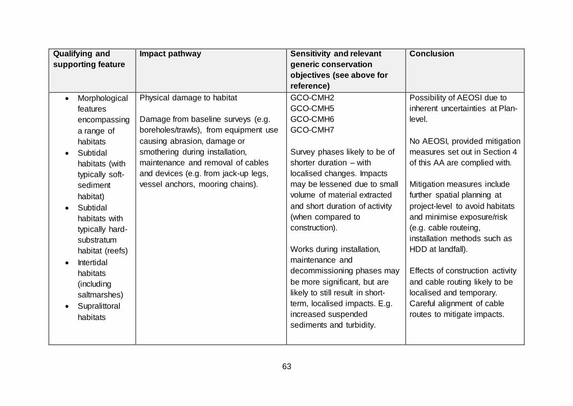
63
Qualifying and
supporting feature
Impact pathway Sensitivity and relevant
generic conservation
objectives (see above for
reference)
Conclusion
Morphological
features
encompassing
a range of
habitats
Subtidal
habitats (with
typically soft-
sediment
habitat)
Subtidal
habitats with
typically hard-
substratum
habitat (reefs)
Intertidal
habitats
(including
saltmarshes)
Supralittoral
habitats
Physical damage to habitat
Damage from baseline surveys (e.g.
boreholes/trawls), from equipment use
causing abrasion, damage or
smothering during installation,
maintenance and removal of cables
and devices (e.g. from jack-up legs,
vessel anchors, mooring chains).
GCO-CMH2
GCO-CMH5
GCO-CMH6
GCO-CMH7
Survey phases likely to be of
shorter duration – with
localised changes. Impacts
may be lessened due to small
volume of material extracted
and short duration of activity
(when compared to
construction).
Works during installation,
maintenance and
decommissioning phases may
be more significant, but are
likely to still result in short-
term, localised impacts. E.g.
increased suspended
sediments and turbidity.
Possibility of AEOSI due to
inherent uncertainties at Plan-
level.
No AEOSI, provided mitigation
measures set out in Section 4
of this AA are complied with.
Mitigation measures include
further spatial planning at
project-level to avoid habitats
and minimise exposure/risk
(e.g. cable routeing,
installation methods such as
HDD at landfall).
Effects of construction activity
and cable routing likely to be
localised and temporary.
Careful alignment of cable
routes to mitigate impacts.

64
Qualifying and
supporting feature
Impact pathway Sensitivity and relevant
generic conservation
objectives (see above for
reference)
Conclusion
Disposal of construction
material may damage habitats
(e.g. sediment deposition on
habitat features)
Morphological
features
encompassing
a range of
habitats
Subtidal
habitats (with
typically soft-
sediment
habitat)
Subtidal
habitats with
typically hard-
substratum
habitat (reefs)
Intertidal
habitats
(including
saltmarshes)
Physical damage to habitat
Changes to coastal and offshore
habitat as a result of alterations to the
wave climate or hydrodynamic regime,
from the presence of devices or cable
armouring causing physical changes
(including changes to sediment
transport and/or sediment scour).
GCO-CMH1
GCO-CMH2
GCO-CMH3
GCO-CMH4
GCO-CMH5
GCO-CMH6
GCO-CMH7
Extent will be influenced by
type and location of devices.
Deposition of fine sediment
may occur in areas of reduced
tidal flow and scouring of
benthic communities may
result on the seabed around
the base of WTG. Cumulative
impacts of multiple devices
likely to be additive.
Possibility of AEOSI due to
inherent uncertainties at Plan-
level.
No AEOSI, provided mitigation
measures set out in Section 4
of this AA are complied with.

65
Qualifying and
supporting feature
Impact pathway Sensitivity and relevant
generic conservation
objectives (see above for
reference)
Conclusion
Extent of effect defined in the
HRA Report as being 1 tidal
excursion distance from the
DPO.
Effects of scour around
devices and associated
moorings considered to be of
generally low significance and
highly localised.
Resultant changes in coastal
processes and, potentially,
sediment transport are likely
to have the greatest risks of
impact in areas of medium to
high energy. Consideration of
impacts required at a project-
level.
Morphological
features
encompassing
Toxic contamination (reduction in water
quality)
GCO-CMH5
GCO-CMH6
GCO-CMH7
No AEOSI, provided mitigation
measures set out at Section 4
of this AA are complied with.
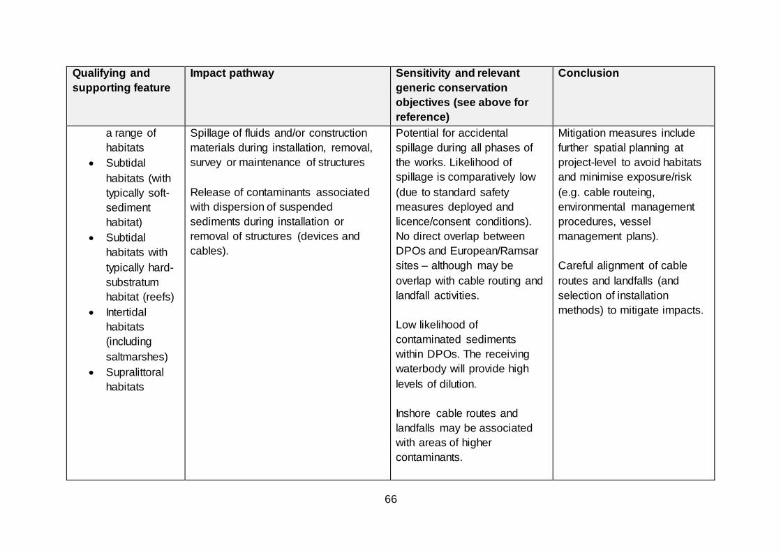
66
Qualifying and
supporting feature
Impact pathway Sensitivity and relevant
generic conservation
objectives (see above for
reference)
Conclusion
a range of
habitats
Subtidal
habitats (with
typically soft-
sediment
habitat)
Subtidal
habitats with
typically hard-
substratum
habitat (reefs)
Intertidal
habitats
(including
saltmarshes)
Supralittoral
habitats
Spillage of fluids and/or construction
materials during installation, removal,
survey or maintenance of structures
Release of contaminants associated
with dispersion of suspended
sediments during installation or
removal of structures (devices and
cables).
Potential for accidental
spillage during all phases of
the works. Likelihood of
spillage is comparatively low
(due to standard safety
measures deployed and
licence/consent conditions).
No direct overlap between
DPOs and European/Ramsar
sites – although may be
overlap with cable routing and
landfall activities.
Low likelihood of
contaminated sediments
within DPOs. The receiving
waterbody will provide high
levels of dilution.
Inshore cable routes and
landfalls may be associated
with areas of higher
contaminants.
Mitigation measures include
further spatial planning at
project-level to avoid habitats
and minimise exposure/risk
(e.g. cable routeing,
environmental management
procedures, vessel
management plans).
Careful alignment of cable
routes and landfalls (and
selection of installation
methods) to mitigate impacts.
67
Qualifying and
supporting feature
Impact pathway Sensitivity and relevant
generic conservation
objectives (see above for
reference)
Conclusion
Morphological
features
encompassing
a range of
habitats
Subtidal
habitats (with
typically soft-
sediment
habitat)
Subtidal
habitats with
typically hard-
substratum
habitat (reefs)
Intertidal
habitats
(including
saltmarshes)
Non-Toxic contamination
Elevated turbidity
Increase in turbidity associated with
release of suspended sediments during
installation or removal of structures
GCO–CMH5
GCO–CMH6
GCO -CMH7
Excavation work has the
potential to cause
redistribution of sediment and
potential adverse effects on
surrounding habitats. Extent of
effect defined in the HRA
Report as being 1 tidal
excursion distance from the
DPO.
No direct overlap with DPO
and European/Ramsar sites
but cable routing/landfall
activities may overlap.
Tidal excursions of several
DPOs overlap with
European/Ramsar sites.
Disposal of construction
material from installations and
Possibility of AEOSI due to
inherent uncertainties at Plan-
level.
No AEOSI, provided mitigation
measures set out in Section 4
of this AA are complied with.
Effects are likely to be
localised and temporary.
Spatial planning with DPOs to
mitigate potential impacts.

68
Qualifying and
supporting feature
Impact pathway Sensitivity and relevant
generic conservation
objectives (see above for
reference)
Conclusion
piled devices may have the
potential increase turbidity
levels.
Morphological
features
encompassing
a range of
habitats
Subtidal
habitats (with
typically soft-
sediment
habitat)
Subtidal
habitats with
typically hard-
substratum
habitat (reefs)
Intertidal
habitats
(including
saltmarshes)
Biological disturbance
Introduction of non-native species
(“INNS”)
Introduction of new substructures,
providing new substratum, facilitates
the colonisation and ingress of INNS.
Introduction and ingress of INNS as
biofouling species on the surfaces of
vessels/construction plant.
GCO–CMH5
GCO–CMH6
GCO -CMH7
No direct overlap with DPO
and European/Ramsar sites
but cable routing/landfall
activities may overlap.
Placement of structures
underwater introduces new,
potentially barren, surfaces
which have the potential to
facilitate spread of INNS.
Difficult to quantify risk of
INNS. Assumption that current
spread of species limited by
prevailing physical regime and
lack of new colonizing
Possibility of AEOSI due to
inherent uncertainties at a
Plan-level.
No AEOSI provided mitigation
measures set out in Section 4
of this AA are complied with.
Standard licence/consent
conditions, including the
requirement to prepare and
adhere to a biosecurity plan to
reduce risk of introduction and
spread of INNS.

69
Qualifying and
supporting feature
Impact pathway Sensitivity and relevant
generic conservation
objectives (see above for
reference)
Conclusion
substrate, the options which
cause the greatest change in
physical processes and
provide the greatest amount of
colonizing space would be
expected to pose the greatest
risk.
INNS may be introduced by
plant/vessels used during the
construction, operational and
decommissioning phases.
Likelihood considered low due
to regular maintenance and
cleaning regimes (provided
these are undertaken).

70
13.3 Marine Mammals
13.3.1 In its response, dated 25 March 2020, SNH advised that there would be no
adverse effect on the integrity of any SAC or cSAC with marine mammal
qualifying interests from the Plan alone or in-combination with other projects.
13.3.2 The HRA Report considers the potential for AEOSI from Section 7 (page 28)
onwards. Potential effects were considered against the following generic
conservation measures for the qualifying species;
Population of the species as a viable component of the site (GCO-MM-1);
Distribution of the species within site (GCO-MM-2);
Distribution and extent of habitats supporting the species (GCO-MM3);
Structure, function and supporting processes of habitats supporting the
species (GCO-MM4); and
No significant disturbance of the species (GCO-MM5).
13.3.3 Marine mammals have extensive ranges and cover large distances to forage
in the pelagic environment. Critical habitat areas are those which are essential
for day-to-day well-being and survival, as well as maintaining population
growth. These critical habitat areas will be the most sensitive parts of a marine
mammal’s range to any loss (or gain) of habitat.
13.3.4 Foraging areas are critical habitat for marine mammals and these may
encompass large areas, however, marine mammals may aggregate in
hotspots (where prey resources found in high densities). Spawning and
nursery sites for prey species will be particularly sensitive to any
environmental change and such spawning/nursery grounds may be impacted
by activities such as piling/noise/vibration.
13.3.5 There is the potential for collision risk to occur with underwater structures,
although as underwater structures are essentially static (for floating and fixed
technologies), the risk is considered low.22 Further, marine mammals have the
potential to become entangled with rope and/or lines. The risk factors for
entanglement are associated with the biological characteristics of the marine
mammals and the physical features of the mooring lines. Current evidence
suggests that entanglement in mooring lines is unlikely to be a significant
issue and high visibility mooring lines may mitigate potential risks. As further
deployment of floating offshore wind technologies take place, it is expected
that understanding of the potential risks and impacts of entanglement and
efficacy of mitigation measures will become available.
22 See further, HRA Report (2019), Section 7.7

71
13.3.6 Marine mammals are sensitive to acoustic disturbance in the marine
environment and the hearing sensitivity and frequency range of marine
mammals varies between species and physiology. The impacts of noise on
marine mammals can broadly be split into lethal and physical injury, auditory
injury and behavioural response. Chronic stress related disorders can also
occur with long-term, repeated exposure to a noise source. Very high
exposure levels (e.g. associated with offshore impact piling, underwater
explosive operations) it is possible for lethality and physical damage to occur.
Permanent threshold shift (“PTS”) can occur as a result of prolonged exposure
to noise or very intensive noise, with temporary threshold shift – a temporary
reduction in hearing capability – occurring as a result exposure to underwater
noise. Levels of PTS and TTS will depend on the species and physiology.
13.3.7 The HRA Report considers marine mammals are at low sensitivity to all
generic impact pathways during all phases of the works, with the exception of
non-physical disturbance during the construction phase, i.e. as a result of pile
driving, seismic survey, UXO clearance, vessel movements. The level of risk
will be dependent on the level of exposure (i.e. exposure may be higher if
development takes place closer to a designated site). As it is not possible to
predict the level of exposure a WCS has been assumed in the HRA Report.
13.3.8 The HRA Report considered that there was the potential for AEOSI from
certain activities, but these could be mitigated via appropriate and meaningful
mitigation measures at a project-level. The potential for AEOSI from the
generic impact pathways is summarised below in Table 13.
Conclusions – Marine Mammals
13.3.9 In the event that concurrent construction noise in a particular geographic
region requires further consideration, then there is the potential to implement
sequencing of developments within the same broad geographical region. This
approach could, however, extend the duration of effects (depending on the
nature and type of activity and receptors impacted). It is, therefore, considered
appropriate that such risks are most appropriately and effectively managed at
a project-level, once the necessary details are available and there is greater
certainty regarding the nature and timings of potential impacts. As further
deployment of floating offshore wind technologies takes place, it is anticipated
that an increased understanding of the potential risks of entanglement with
mooring lines will take place and the potential effects of this impact pathway
will need to be considered within future project-level HRAs (as appropriate to
the proposal).
13.3.10 Scottish Ministers concur with the view of SNH, that the Plan will not cause an
adverse effect on the integrity on the marine mammal qualifying interests of

72
any SAC or cSAC, provided the mitigation measures set out in Section 4 of
this AA are complied with (i.e. the completion of further project-level
assessment which considers the timing, scale, nature and location of future
activities).

73
Table 13 Marine mammals - consideration of AEOSI
Qualifying and
supporting feature
Impact pathway Sensitivity and relevant
generic conservation
objectives (listed above)
Conclusion
Common seal
Grey seal
Bottlenose
dolphin
Harbour
porpoise
Physical loss/gain of habitat
Potential for loss of foraging areas from
reduction in coastal and offshore
habitat due to installation of devices
and cable armouring (both at the
development footprint and outside
these areas from associated scour and
indirectly from changes to the
hydrodynamic regime, as well as from
chains anchoring devices disturbing
seabed habitat during operation.
GCO-MM4
GCO-MM3
Marine mammals are highly
mobile and have large
foraging ranges.
Any loss of habitat from
development is likely to only
constitute a small part of the
available foraging range and,
therefore, sufficient alternative
habitat likely to be available.
Possibility of AEOSI due to
inherent uncertainties at a
Plan-level.
No AEOSI provided mitigation
measures set out in Section 4
of this AA are complied with
Common seal
Grey seal
Bottlenose
dolphin
Harbour
porpoise
Physical loss/gain of habitat
Presence of structures on seabed for
duration of project may result in
changes to prey and species behaviour
(e.g. acting as fish aggregating device
(“FAD”), artificial reef or bird roost).
GCO-MM2
GCO-MM3
GCO-MM4
Turbine bases could act as
artificial reefs and FADs for
prey species (e.g. increase in
biomass resulting in positive
feeding opportunities).
Possibility of AEOSI due to
inherent uncertainties at a
Plan-level.
No AEOSI provided mitigation
measures set out in Section 4
of this AA are complied with

74
Qualifying and
supporting feature
Impact pathway Sensitivity and relevant
generic conservation
objectives (listed above)
Conclusion
The size of the array will be
key consideration – and
devices with the highest FAD
potential are those with large
elements, e.g. large mooring
points or floating structures.
Devices with large moorings
may provide additional shelter
and food (habitat) for small
demersal fish such as
territorial biennies and
gobles). Increases in
demersal fish have been
found around piles of OWF.
Empirical data regarding this
impact is currently limited.
Common seal
Grey seal
Bottlenose
dolphin
Damage to habitat
Reduction in quality of foraging areas,
as a result of damage to coastal and
offshore habitat from survey activities
GCO-MM3
GCO-MM4
Possibility of AEOSI due to
inherent uncertainties at a
Plan-level.

75
Qualifying and
supporting feature
Impact pathway Sensitivity and relevant
generic conservation
objectives (listed above)
Conclusion
Harbour
porpoise
(i.e. borehole and trawls) and
equipment use causing abrasion,
damage or smothering during
installation, maintenance or removal of
cables/devices or from scour, sediment
transport and hydrodynamic change
during operation.
Marine mammals are highly
mobile and have large
foraging ranges.
The extent of habitat reduced
in quality is likely to constitute
on a small proportion of the
available foraging habitat and,
therefore, sufficient alternative
habitat likely to be available.
No AEOSI provided mitigation
measures set out in Section 4
of this AA are complied with
Common seal
Grey seal
Physical damage to habitat
Damage to seal haul out locations
during installation, decommissioning
and operation of cables and cable
armouring
Seal haul-out sites are
generally located in remote
areas and are highly sensitive
to damage and disturbance
(particularly during the
breeding season).
Cable routes most likely to
make landfall near existing
infrastructure. Most seal haul-
outs are not located close to
this infrastructure, therefore,
impacts unlikely.
Possibility of AEOSI due to
inherent uncertainties at a
Plan-level.
No AEOSI provided mitigation
measures set out in Section 4
of this AA are complied with.
Spatial planning of cable
routes to avoid sensitive
areas/mitigate potential
impacts.

76
Qualifying and
supporting feature
Impact pathway Sensitivity and relevant
generic conservation
objectives (listed above)
Conclusion
Common seal
Grey seal
Bottlenose
dolphin
Harbour
porpoise
Damage to species
Collision risk and possible mortality –
due to presence of devices or vessels
transiting to/from the development site
(including above and below water) and
the influence of lighting.
Risk of entanglement following a
collision with power cables or mooring
elements.
GCO-MM1
GCO-MM2
GCO-MM5
Pinnipeds and cetaceans may
collide with construction
vessel propellors and
machinery (leading to physical
injury/fatality). Juvenile grey
seal pups most vulnerable to
collision risks.
Ships travelling at >14 knots
more likely to cause
lethal/serious injuries. Vessels
used during the construction
phase are likely to be
travelling at lower speeds or
be stationary, thereby
reducing risks.
Marine mammals have the
potential to become entangled
with ropes and/or lines. Risk
factors are related to
Possibility of AEOSI due to
inherent uncertainties at a
Plan-level.
No AEOSI provided mitigation
measures set out in Section 4
of this AA are complied with.
Deployment of high visibility
mooring lines to mitigate risk
of entanglement. Systemic
inspection of mooring and
anchor lines to check for
presence of ghost gear and
arrangement for removal.

77
Qualifying and
supporting feature
Impact pathway Sensitivity and relevant
generic conservation
objectives (listed above)
Conclusion
biological characteristics of
marine mammals (body size,
flexibility, ability to detect
moorings and mode of
feeding) and the physical
features of the mooring lines.
Marine mammals may
become entangled if the
animal’s ability to detect the
object is compromised (e.g.
particular environmental
conditions such as low light or
storm conditions) or when
distracted while feeding on
mobile prey species.
Entanglement risk may be
mitigated by using high
visibility mooring lines.
Ghost fishing gear (where
abandoned or lost fishing gear
becomes entangled in lines
and cables), thereby creating
78
Qualifying and
supporting feature
Impact pathway Sensitivity and relevant
generic conservation
objectives (listed above)
Conclusion
a potential entanglement risk
for marine mammals, fish and
seabirds. Systemic inspection
of mooring and anchor lines to
check for the presence of
ghost gear and removal of
gear may mitigate this risk.
Behavioural responses to
wind farm development may
either be long-range
avoidance or close-range
evasion, depending upon the
distance at which the threat is
perceived and the subsequent
behavioural response.
Collision risk with WTG
structures is considered to be
low.
Common seal
Grey seal
Non-physical disturbance
GCO-MM2
GCO-MM3
Possibility of AEOSI due to
inherent uncertainties at a
Plan-level.

79
Qualifying and
supporting feature
Impact pathway Sensitivity and relevant
generic conservation
objectives (listed above)
Conclusion
Bottlenose
dolphin
Harbour
porpoise
Barrier to movement – presence of
sub-surface structures and disturbance
(noise or visual) which may block
migratory pathways or access to
feeding grounds
Potential for barrier effect will
be dependent on the extent to
which noise and visual cues
from the device cause an
avoidance response.
Dependent on ability of marine
mammal to navigate around
devices.
Significance of obstruction will
depend on spatial confines
and size of array.
Marine mammals are highly
manoeuvrable and offshore
location of DPOs, sensitivity
considered low.
No AEOSI provided mitigation
measures set out in Section 4
of this AA are complied with
Common seal
Grey seal
Bottlenose
dolphin
Harbour
porpoise
Non-physical disturbance
Visual disturbance and exclusion from
areas as a result of surveying, cable
and device installation, operation and
decommissioning and vessel
movements.
GCO-MM2
GCO-MM5
Visual disturbance during all
phases of works considered to
be short-term.
Possibility of AEOSI due to
inherent uncertainties at a
Plan-level.
No AEOSI provided mitigation
measures set out in Section 4
of this AA are complied with

80
Qualifying and
supporting feature
Impact pathway Sensitivity and relevant
generic conservation
objectives (listed above)
Conclusion
Level of impact dependent on
distance from seal haul-out
sites and key foraging areas.
Common seal
Grey seal
Bottlenose
dolphin
Harbour
porpoise
Non-physical disturbance
Noise/vibration disturbance and
exclusion from areas as a result of
vessels and other activities during
survey work (e.g. seismic exploration
and geophysical surveys), construction
(e.g. piling, drilling, cable laying),
operation (e.g. device noise),
maintenance or decommissioning
works.
GCO-MM2
GCO-MM5
Sensitivity during construction
phase considered to be high
(particularly if piling activity
undertaken), but low/medium
during other phases.
Geophysical surveys involving
side scan sonar may cause
acoustic disturbance.
Effects from vessel noise are
not clear, with both attraction
and avoidance reactions
having been observed.
Key sources of noise during
construction and installation
include;
Possibility of AEOSI due to
inherent uncertainties at a
Plan-level.
No AEOSI provided mitigation
measures set out in Section 4
of this AA are complied with.
Standard licence/consent
conditions, including the
requirement to prepare and
adhere to a Piling Strategy,
Construction Method
Statement, Vessel
Management Plan and the
requirement to obtain and
adhere to European Protected
Species licenses (if
appropriate) to mitigate
potential impacts.

81
Qualifying and
supporting feature
Impact pathway Sensitivity and relevant
generic conservation
objectives (listed above)
Conclusion
Shipping and machinery;
Dredging;
Pile-driving and drilling.
Cable burial may require use
of trenching, jetting machinery
or rock cutting machinery
depending on habitat type (or
laying of mattresses/rock
protection).
Bottlenose
dolphin
Harbour
porpoise
Non-physical disturbance
Impacts from EMF on
electromagnetically sensitive fish and
cetaceans, interfering with prey
location and mate detection in some
species and creating barriers to
migration, during the operational
phase.
GCO-MM2
GCO-MM5
It is assumed cetaceans may
be sensitive to
electromagnetic cables, but
that anticipated magnetic
fields from cables is likely to
be very small. Sensitivity
considered low.
Risk can be mitigated via
cable
Possibility of AEOSI due to
inherent uncertainties at a
Plan-level.
No AEOSI provided mitigation
measures set out in Section 4
of this AA are complied with.
Standard licence/consent
conditions, including the
requirement to prepare and
adhere to a Cable Laying
Strategy (and associated

82
Qualifying and
supporting feature
Impact pathway Sensitivity and relevant
generic conservation
objectives (listed above)
Conclusion
armouring/protection/burial
methods.
burial/protection/armouring) to
mitigate potential impacts.
Common seal
Grey seal
Harbour
porpoise
Bottlenose
dolphin
Toxic contamination (reduction in water
quality)
Spillage of fluids and/or construction
materials during installation, removal,
survey or maintenance of structures
Release of contaminants associated
with dispersion of suspended
sediments during installation or
removal of structures (devices and
cables).
GCO-MM1
GCO-MM2
GCO-MM5
Potential for accidental
spillage during all phases of
the works. Likelihood of
spillage is comparatively low
(due to standard safety
measures deployed and
licence/consent conditions).
May include anti-fouling
paints, accidental leakage of
fluids and/or spillage fuels or
cargo from vessels.
Quantities and toxicities
associated with sacrificial
anodes and antifouling
coatings are considered to be
extremely low, therefore
Possibility of AEOSI due to
inherent uncertainties at a
Plan-level.
No AEOSI, provided mitigation
measures set out at Section 4
of this AA are complied with.
Mitigation measures include
further spatial planning at
project-level to avoid habitats
and minimise exposure/risk
(e.g. cable routeing,
environmental management
procedures, vessel
management plans).
Careful alignment of cable
routes and landfalls (and
selection of installation
methods) to mitigate impacts.

83
Qualifying and
supporting feature
Impact pathway Sensitivity and relevant
generic conservation
objectives (listed above)
Conclusion
impact considered negligible
significance.
Low likelihood of
contaminated sediments
within DPOs. The receiving
waterbody will provide high
levels of dilution. Impacts
likely to be extremely
localised, thus minimising
impact on water quality.
Common seal
Grey seal
Harbour
porpoise
Bottlenose
dolphin
Non-toxic contamination
Elevated turbidity
Increase in turbidity associated with
release of suspended sediments during
installation or removal of structures
Local suspended sediment
concentrations may increase
as a result of drilling activity,
burial of power export cables
and disposal of drill cuttings.
Increased turbidity could affect
foraging, social and
predator/prey interactions of
marine mammals (although
marine mammals around UK
regularly recorded foraging in
highly turbid environments).
Possibility of AEOSI due to
inherent uncertainties at a
Plan-level.
No AEOSI provided mitigation
measures set out in Section 4
of this AA are complied with.

84
Qualifying and
supporting feature
Impact pathway Sensitivity and relevant
generic conservation
objectives (listed above)
Conclusion
All features considered to
have low sensitivity to this
impact pathway.

85
13.4 Diadromous fish and freshwater pearl mussel features
13.4.1 The HRA Report considers the potential for AEOSI at Section 8 (page 183
onwards). Potential effects were considered against the following generic
conservation measures for the qualifying species and interests;
Population of the species, including range of genetic types for salmon, as a
viable component of the site (GCO-FF1);
Distribution of the species within site (GCO-FF2);
Distribution and extent of habitats supporting the species (GCO-FF3);
Structure, function and supporting processes of habitats supporting the
species (GCO-FF4);
No significant disturbance of the species (GCO-FF5);
Distribution and viability of the species’ host species (e.g. freshwater pearl
mussel) (GCO-FF6); and
Structure, function and supporting processes of habitats supporting the
species’ host species (GCO-FF7).
13.4.2 Although direct loss of freshwater habitats may occur as a result of cable
installation or landside infrastructure works, potential effects from non-marine
development are outwith the scope of the HRA Report and this AA. There is,
however, the potential for loss of migratory fish foraging areas or pearl mussel
habitat in marine and estuarine environments. It is anticipated that any
sensitive habitats should be avoided where possible (e.g. via further spatial-
planning at a project-level) and that during the construction period the WCS
would involve temporary effects. Damage to the offshore habitats during the
operational phase may influence the foraging area for migratory fish species,
however, the high mobility and ranges of this group may enable them to utilise
other foraging areas (if required).
13.4.3 There are several migratory diadromous fish species found within Scottish
waters and which use Scottish rivers for spawning, including Atlantic salmon,
sea trout, sea lamprey, river lamprey and shad, plus European eel which
spawns at sea. Many migratory species are protected, generally through SAC
in riverine environments. Scotland is a stronghold for Atlantic salmon with
nearly all rivers which are accessible to upstream migrating salmon other than
those with poor water quality containing salmon populations (see further, the
Regional Locational Guidance). The largest salmon rivers with the largest
populations of salmon are on the east coast. The sea feeding grounds are
remote from Scottish marine waters which the outgoing smolts and returning
adult fish must pass through

86
13.4.4 There is now some information on the migration paths of the outgoing salmon
smolts from acoustic tagging and research trawling studies and the likely
migration routes of the returning adult salmon, mainly from traditional tagging
studies, particularly close to the coast. Outgoing smolts or returning adults
are likely to migrate through all Plan Options but there remain uncertainties
about the relative numbers passing through particular Plan Options. These
impacts will need to be considered and assessed at a Project-level.
13.4.5 Potential impacts on salmon associated with offshore wind development
include those which could arise from high impact piling and detonation of
unexploded ordnance during construction, possible increased predator
abundance at structures, and subtle changes to magnetic fields stemming
from cables conducting electricity affecting the migratory behaviour of salmon
using geomagnetic cues. The salmon populations associated with each river
vary in their productivity and resilience to any impacts, with some populations,
but not others, able to accommodate some losses.
13.4.6 A summary of the consideration of the potential of AEOSI from the generic
impact pathways on the fish and freshwater mussel features is provided at
Table 14 below.
Fish and freshwater pearl mussel features – conclusion
13.4.7 There is the potential for AEOSI on fish and freshwater pearl mussel qualifying
interests of SACs and cSACs as a result of development under this Plan. Non-
physical disturbance presents the highest risk of effects (of all assessed
impact pathways) for these qualifying interests. Mitigation measures relating to
spatial planning within POs, array layout, restrictions on piling activities
(including timing, duration and frequency) and cable routing will need further
consideration at a project-level (as appropriate). Further, it is anticipated that
further evidence regarding migratory routes will become available and can be
used to inform future plan and project-level assessments.
13.4.8 Scottish Ministers consider that the Plan will not cause an adverse effect on
the integrity of the fish and freshwater pearl mussel features of any SAC or
cSAC, provided the mitigation measures set out in Section 4 of this AA are
complied with (e.g. the completion of further project-level assessment which
considers the timing, scale, location and nature of future activities).

87
Table 14 Fish and freshwater pearl mussel features - consideration of AEOSI
Qualifying and
supporting feature
Impact pathway Sensitivity and relevant
generic conservation
objectives (listed above)
Conclusion
Atlantic
salmon
Sea lamprey
River lamprey
Allis shad
Twaite shad
Freshwater
pearl mussel
(indirectly)
Physical loss/gain of habitat
Potential for loss of foraging areas from
reduction in coastal and offshore
habitat due to installation of devices
and cable armouring (both at the
development footprint and outside
these areas from associated scour and
indirectly from changes to the
hydrodynamic regime, as well as from
chains anchoring devices disturbing
seabed habitat during operation.
GCO-FF3
GCO-FF7
Atlantic salmon and shad are
highly mobile, migratory
species – undergo large shifts
in distribution during the
marine phase of their lifecycle,
with a pelagic lifestyle at sea
(little association with the
seabed). Atlantic salmon and
shad considered to be
transient within DPOs –
therefore, potential damage to
seabed in deployment
locations will be of negligible
significance.
Sea lamprey are highly mobile
migratory species which are
widely distributed at sea -
therefore, potential damage to
seabed in deployment
Possibility of AEOSI due to
inherent uncertainties at a
Plan-level.
No AEOSI provided mitigation
measures set out in Section 4
of this AA are complied with.

88
Qualifying and
supporting feature
Impact pathway Sensitivity and relevant
generic conservation
objectives (listed above)
Conclusion
locations will be of negligible
significance.
River lamprey adults live
primarily in estuaries, before
migrating upstream to spawn
in freshwater. Therefore, no
direct overlap of POs and river
lamprey habitat/foraging
areas.
Atlantic
salmon
Sea lamprey
River lamprey
Allis shad
Twaite shad
Freshwater
pearl mussel
(indirectly)
Physical loss/habitat gain
Direct change to habitat around the
development footprint
Presence of structures on the seabed
for the duration of the project, resulting
in changes to local predator abundance
and behaviour (e.g. acting as FAD,
artificial reef or bird roost).
GCO-FF1
GCO-FF2
GCO-FF3
GCO-FF4
GCO-FF5
GCO-FF6
GCO-FF7
Empirical evidence has shown
greater presence of fish
around WTG foundations.
Possibility of AEOSI due to
inherent uncertainties at a
Plan-level.
No AEOSI provided mitigation
measures set out in Section 4
of this AA are complied with.

89
Qualifying and
supporting feature
Impact pathway Sensitivity and relevant
generic conservation
objectives (listed above)
Conclusion
Wilhelmsson et al23
investigated the potential for
WTG to function as artificial
reefs and FADs. Fish
abundance was found to be
greater in the vicinity of the
WTG, whilst species richness
and Shannon-Wiener diversity
(H’) were similar. On the
monopiles of foundations, fish
community structure was
different and total fish
abundance was greater, while
species richness and diversity
(H’) were lower on the
surrounding seabed. Blue
mussels and barnacles
covered most of the
submerged parts of the WTG.
On the seabed, more blue
mussels and less red algae
were recorded (compared to
adjacent areas).
23 Wilhelmsson, D., Malm, T., and Ohman, M., 2006. The influence of offshore wind power on demersal fish. ICES Journal of Marine Science 63, 775-784

90
Qualifying and
supporting feature
Impact pathway Sensitivity and relevant
generic conservation
objectives (listed above)
Conclusion
A gill netting survey at the
Svante OWF (Sweden) found
higher numbers of cod present
within 200 metres of an
operational WTG, compared
to surrounding open waters,
and higher numbers when the
WTG was non-operational.
Diver-held video surveys of
the North Hoyle OWF piles
found extremely high densities
of juvenile whiting, feeding on
dense populations of
amphipods amongst the
fouling biota on the piles.
Atlantic
salmon
Sea lamprey
River lamprey
Allis shad
Twaite shad
Physical damage to habitat
Indirect and temporary damage
Reduction in quality of foraging areas,
due to damage to coastal and offshore
habitat from baseline surveys (e.g.
GCO-FF3
GCO-FF7
Atlantic salmon and shad are
highly mobile, migratory
species – undergo large shifts
in distribution during the
Possibility of AEOSI due to
inherent uncertainties at a
Plan-level.
No AEOSI provided mitigation
measures set out in Section 4
of this AA are complied with.

91
Qualifying and
supporting feature
Impact pathway Sensitivity and relevant
generic conservation
objectives (listed above)
Conclusion
Freshwater
pearl mussel
(indirectly)
boreholes and trawls), from equipment
use causing abrasion, damage or
smothering during installation, from
maintenance and removal of
cables/devices or from scour, sediment
transport and hydrodynamic change
and damage from chains anchoring
devices during operation.
marine phase of their lifecycle,
with a pelagic lifestyle at sea
(little association with the
seabed). Atlantic salmon and
shad considered to be
transient within DPOs –
therefore, potential damage to
seabed in deployment
locations will be of negligible
significance.
Sea lamprey are highly mobile
migratory species which are
widely distributed at sea -
therefore, potential damage to
seabed in deployment
locations will be of negligible
significance.
River lamprey adults live
primarily in estuaries, before
migrating upstream to spawn
in freshwater. Therefore, no
direct overlap of POs and river

92
Qualifying and
supporting feature
Impact pathway Sensitivity and relevant
generic conservation
objectives (listed above)
Conclusion
lamprey habitat/foraging
areas.
Atlantic
salmon
Sea lamprey
River lamprey
Allis shad
Twaite shad
Freshwater
pearl mussel
(indirectly)
Physical damage
Direct damage to species from collision
risk
Collision risk and possible mortality due
to presence of devices or from vessels
transiting to/from site (including above
and below water collision risk and the
influence of lighting), risk of
entanglement following a collision with
power cables or mooring elements.
GCO-FF1
GCO-FF2
GCO-FF5
GCO-FF6
GCO-FF7
Behavioural responses in fish
to perceived threats may be
demonstrated: Long range
avoidance (i.e. avoiding the
area within the vicinity of the
device) or close-range
evasion (dependent on
distance at which device
perceived and subsequent
behavioural response). Fish
which are actively migrating
on a fixed heading may be
less likely to be displaced.
Long range response is
considered distances beyond
Possibility of AEOSI due to
inherent uncertainties at a
Plan-level.
No AEOSI provided mitigation
measures set out in Section 4
of this AA are complied with.
93
Qualifying and
supporting feature
Impact pathway Sensitivity and relevant
generic conservation
objectives (listed above)
Conclusion
which visual response can be
undertaken (e.g. noise and
vibration cues). Close range
evasion would occur where
primary stimulus is visual
reaction to physical
characteristics of the device.
The essentially static base of
the WTG (regardless of
technology type) means that
collision risk is unlikely. Fish
have been recorded colliding
with anthropogenic structures,
but generally in areas of poor
visibility.
Atlantic
salmon
Sea lamprey
River lamprey
Allis shad
Twaite shad
Non-physical disturbance
Barrier to movement from presence of
sub-surface structures and disturbance
(noise or visual) which may block
migratory pathways or access to
GCO-FF1
GCO-FF2
GCO-FF5
GCO-FF6
GCO-FF7
Possibility of AEOSI due to
inherent uncertainties at a
Plan-level.
No AEOSI provided mitigation
measures set out in Section 4
of this AA are complied with.
94
Qualifying and
supporting feature
Impact pathway Sensitivity and relevant
generic conservation
objectives (listed above)
Conclusion
Freshwater
pearl mussel
(indirectly)
feeding grounds depending on array
design
It is considered WTG arrays
will pose minimal barrier
effects to the highly mobile
migratory fish species.
Significance of obstructions
dependent on spatial confines
and size of devices/arrays
(e.g. whether it spans the
entire mouth of an estuary)
and the functional use of the
area by the fish species.
Atlantic
salmon
Sea lamprey
River lamprey
Allis shad
Twaite shad
Freshwater
pearl mussel
(indirectly)
Non-physical disturbance
Noise/vibration disturbance from
vessels and other activities during
survey work (e.g. seismic exploration
and geophysical surveys), construction
(e.g. piling, drilling, cable laying),
operation (e.g. device noise),
maintenance or decommissioning.
GCO-FF1
GCO-FF2
GCO-FF5
GCO-FF6
GCO-FF7
Noise from installation
activities could arise from
vessel traffic, possible
requirements for bed levelling,
driving and drilling of piles,
Possibility of AEOSI due to
inherent uncertainties at a
Plan-level.
No AEOSI provided mitigation
measures set out in Section 4
of this AA are complied with.
Project-level mitigation
measures may include the
requirement to prepare and

95
Qualifying and
supporting feature
Impact pathway Sensitivity and relevant
generic conservation
objectives (listed above)
Conclusion
installation of power export
cables (i.e. ploughing
sediment, rock cutting hard
seabed areas, bolting to the
seabed and/or directional
drilling).
Understanding of source noise
impacts and frequencies is
increasing.
Impacts from pile driving and
the use of explosives are of
most concern to these
qualifying interests. Some
exposures can result in
changes/damage to sensory
structures or hearing
capabilities, with the potential
for mortality.
Behaviour changes may result
in animals avoiding migratory
routes or leaving feeding or
reproduction grounds, with
adhere to a Piling Strategy
and consideration of timing of
activities and migratory
patterns.

96
Qualifying and
supporting feature
Impact pathway Sensitivity and relevant
generic conservation
objectives (listed above)
Conclusion
potential population-level
consequences. Biologically
important sounds can be
masked where received levels
are marginally above existing
background levels.24 The
ability to detect and localise
the source of sound is of
considerable biological
importance to these qualifying
interests.
Disturbance effects on
migratory fish from noise are
most likely during the
construction phase of works.
The potential for activities
such as impact piling means it
is concluded that migratory
fish are highly sensitive to
construction noise.
24 Hawkins, A.D. & Myrberg Jr, A. A., 1983. Hearing and sound communication under water. In: Bioacoustics: A comparative approac h (Ed. By B. Lewis), pp.
347-405: Academic Press.
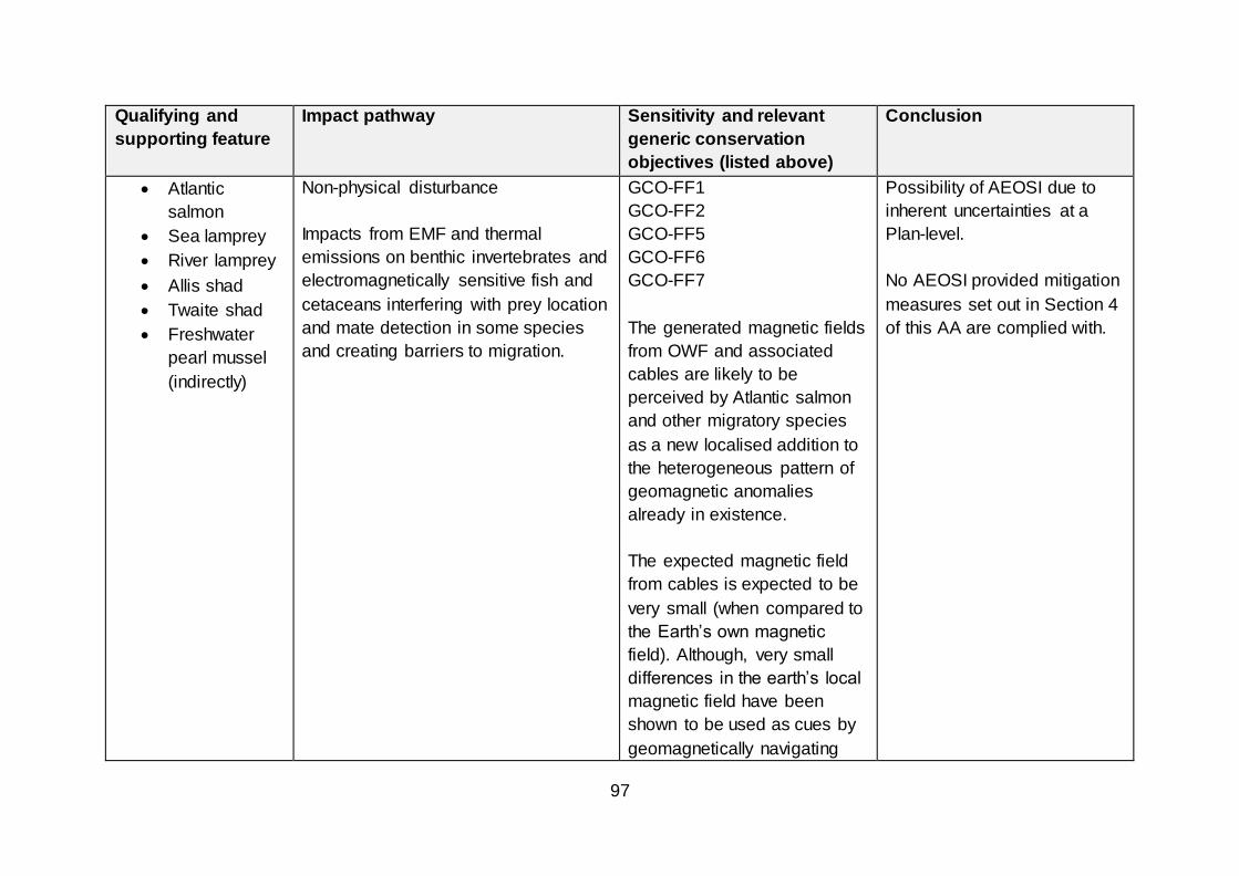
97
Qualifying and
supporting feature
Impact pathway Sensitivity and relevant
generic conservation
objectives (listed above)
Conclusion
Atlantic
salmon
Sea lamprey
River lamprey
Allis shad
Twaite shad
Freshwater
pearl mussel
(indirectly)
Non-physical disturbance
Impacts from EMF and thermal
emissions on benthic invertebrates and
electromagnetically sensitive fish and
cetaceans interfering with prey location
and mate detection in some species
and creating barriers to migration.
GCO-FF1
GCO-FF2
GCO-FF5
GCO-FF6
GCO-FF7
The generated magnetic fields
from OWF and associated
cables are likely to be
perceived by Atlantic salmon
and other migratory species
as a new localised addition to
the heterogeneous pattern of
geomagnetic anomalies
already in existence.
The expected magnetic field
from cables is expected to be
very small (when compared to
the Earth’s own magnetic
field). Although, very small
differences in the earth’s local
magnetic field have been
shown to be used as cues by
geomagnetically navigating
Possibility of AEOSI due to
inherent uncertainties at a
Plan-level.
No AEOSI provided mitigation
measures set out in Section 4
of this AA are complied with.

98
Qualifying and
supporting feature
Impact pathway Sensitivity and relevant
generic conservation
objectives (listed above)
Conclusion
Pacific salmon, the modified
fields only exist relatively
close to OWF and associated
cables.
The conclusion of most
project-specific EIA to-date is
that, whilst there could be an
interaction between these
species and subsea cables,
the result is unlikely to be of
significance at a population-
level.25
Atlantic
salmon
Sea lamprey
River lamprey
Allis shad
Twaite shad
Toxic contamination
Spillage of fluids and/or construction
materials during installation or removal
of structures (devices and cables) or
during survey/maintenance works.
GCO-FF1
GCO-FF2
GCO-FF5
GCO-FF6
GCO-FF7
There is the potential for
accidental discharge/spillages
Possibility of AEOSI due to
inherent uncertainties at a
Plan-level.
No AEOSI provided mitigation
measures set out in Section 4
of this AA are complied with.
25 DECC, 2009. UK Offshore Energy Strategic Assessment. Future leasing for Offshore Wind Farms and Licensing for Offshore Oil & Gas and Gas Storage.
Environmental Report.

99
Qualifying and
supporting feature
Impact pathway Sensitivity and relevant
generic conservation
objectives (listed above)
Conclusion
Freshwater
pearl mussel
(indirectly)
during all phases of works.
Adoption of standard safety
measures would reduce the
likelihood of this occurrence.
Quantities and toxicities
associated with sacrificial
anodes and antifouling
coatings are generally
expected to be small,
therefore, potential effects will
likely be of negligible
significance.
Should toxic contamination
occur, it is not possible to
make an estimation of the
geographic extent of any
impact, due to the large
number of potential variables
(e.g. metocean conditions,
quantities leaked).
Accidental leakage of
hydraulic fluids may be more
Project-level mitigation
measures may include the
need to prepare and adhere to
the terms of a Vessel
Management Plan and
Environmental Management
Plan to minimise and mitigate
any risks associated with toxic
contamination.
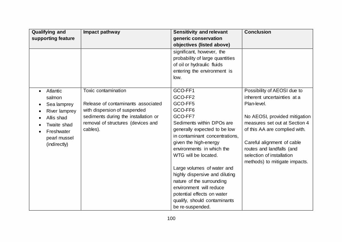
100
Qualifying and
supporting feature
Impact pathway Sensitivity and relevant
generic conservation
objectives (listed above)
Conclusion
significant, however, the
probability of large quantities
of oil or hydraulic fluids
entering the environment is
low.
Atlantic
salmon
Sea lamprey
River lamprey
Allis shad
Twaite shad
Freshwater
pearl mussel
(indirectly)
Toxic contamination
Release of contaminants associated
with dispersion of suspended
sediments during the installation or
removal of structures (devices and
cables).
GCO-FF1
GCO-FF2
GCO-FF5
GCO-FF6
GCO-FF7
Sediments within DPOs are
generally expected to be low
in contaminant concentrations,
given the high-energy
environments in which the
WTG will be located.
Large volumes of water and
highly dispersive and diluting
nature of the surrounding
environment will reduce
potential effects on water
qualify, should contaminants
be re-suspended.
Possibility of AEOSI due to
inherent uncertainties at a
Plan-level.
No AEOSI, provided mitigation
measures set out at Section 4
of this AA are complied with.
Careful alignment of cable
routes and landfalls (and
selection of installation
methods) to mitigate impacts.

101
Qualifying and
supporting feature
Impact pathway Sensitivity and relevant
generic conservation
objectives (listed above)
Conclusion
There is the potential for
contaminated sediments to be
re-suspended during cable
routing and landfall works,
depending on the contaminant
levels of the sediment.
Impacts are likely to be highly
localised, thus minimising
impact on water quality.
Atlantic
salmon
Sea lamprey
River lamprey
Allis shad
Twaite shad
Freshwater
pearl mussel
(indirectly)
Non-toxic contamination
Increase in turbidity associated with the
release of suspended sediments during
the installation or removal of structures
(devices and cables).
GCO-FF1
GCO-FF2
GCO-FF5
GCO-FF6
GCO-FF7
Migratory fish regularly transit
through estuaries with high
levels of suspended sediment
and are relatively tolerant of
turbid conditions (unless
associated with reduced
oxygen levels or the presence
No AEOSI, provided mitigation
measures set out at Section 4
of this AA are complied with.
Careful alignment of cable
routes and landfalls (and
selection of installation
methods) to mitigate impacts.

102
Qualifying and
supporting feature
Impact pathway Sensitivity and relevant
generic conservation
objectives (listed above)
Conclusion
of toxic materials). The
characteristically high-energy
offshore environments in
which the POs are located will
assist in the dispersion of any
localised increases in turbidity,
thus minimising any impacts
on water quality.

103
13.5 Seabird SPAs and pSPAs
13.5.1 The HRA Report considers the potential for AEOSI for seabird qualifying
interests of SPAs and pSPAs at Section 8 (page 183 onwards) Potential
effects on the qualifying bird species listed in Table 10 were considered in
light of the following generic conservation objectives;
13.5.2 To avoid deterioration of the habitats of the qualifying species, or significant
disturbance to the qualifying species, thus ensuring that the integrity of the site
is maintained; and
To ensure that for qualifying habitats the following are maintained in the long
term;
Population of the species as a viable component of the site (GCO-ON1);
Distribution of the species within site (GCO-ON2);
Distribution and extent of habitats supporting the species (GCO-ON3);
Structure, function and supporting processes of habitats supporting the
species (GCO-ON4); and
No significance disturbance of the species (GCO-ON5).
13.5.3 General characteristics and sensitivities of relevant bird features were
presented and reviewed against OWF development activities. Different
species will have different sensitivities to effects, according to several factors,
including;
Their foraging strategy, e.g. pursuit divers or surface feeders;
Daily activity patterns across seasons, e.g. nocturnal, crepuscular or
diurnal activity; and
Their life-history and breeding ecology, e.g. diving species such as auk
species may incur increased energetic costs (individual fitness) and/or
subsequent effects to breeding success via barrier or displacement
effects.
13.5.4 For example, diving species may be at increased risk from the effects of
increased turbidity, due to predator-prey interactions. Species with higher
energy cost burdens of flight and foraging (such as auks) may find it harder to
increase their foraging ranges in response to barrier effects resulting during
the operational phase.
Collision risk and displacement are considered to be the key impact pathways
for seabird qualifying interests, particularly as a result of in-combination effects
with other consented/operational OWF in the Moray, Forth and Tay regions.
All species scoped into the assessment are considered to be at collision risk

104
during all phases of the works, although this will differ according to the nature
of the environment and species foraging modes. The HRA Report concluded
that large gulls, such as a great black-backed gull, herring gull, lesser black-
backed gull, northern gannet and black-legged kittiwake are most sensitive to
the risk of collision mortality, as these species tend to spend a comparatively
higher proportion of their flying time at an altitude that overlaps with blade
height.26 The HRA Report presents a detailed consideration of the models
used to assess and predict collision risk. The current predicted levels of in-
combination collision risk arising from consented/operational development in
the North East and East regions has resulted in the application of Plan-level
mitigation measures, as discussed later in this AA.
13.5.5 Displacement and barrier effects may result in AEOSI for the seabird
qualifying interests of designated sites during all phases of the works.
Exclusion from habitats prevents access to prey sources (although such
exclusion could reduce other effects, such as collision risk). Reductions in the
availability of habitat and access to prey could lead to changes in seabird
foraging behaviour, including increased individual stress levels and alterations
to individual time budgets (owing to increased foraging distances), with
consequent population-level impacts (i.e. decreases in breeding success and
individual fitness).27 The level of impact will be dependent on the project
specifics (i.e. location, timing of activity, scale of development), the availability
of areas of alternative habitat, the number of disturbance occurrences and the
status of the conditions that are prevalent.
13.5.6 SNH advised that, at this stage, at the Plan-level, it would be unable to advise
that there would be no AEOSI arising from development within DPOs E1 and
E2, alongside existing consented OWF development in this region. SNH
advised that considers it, “necessary for regional studies of seabird density
and SPA connectivity to be undertaken within these DPOs to establish
whether these species are present in sufficient numbers for some or all of the
sea area within E1 and E2 to be subject to the same temporary restriction on
development as applied at E3 and NE2-NE6 or whether and where they are
sufficiently low as to enable leasing and consenting to proceed with no further
Plan mitigation measures required.”
13.5.7 Further, SNH advised that it strongly supported the need for temporary
restriction on OWF development within DPOs E3 and NE2-NE6, until such
time “that enough evidence on the environmental capacity for seabirds exists
to reduce the risk to an acceptable level.” SNH advised that, due to concerns
regarding the predicted in-combination impacts of existing and consented
26 See further discussion, HRA Report (2019), Section 6.6 27 See further discussion, HRA Report (2019), Section 6.7.12

105
OWF on specific east coast SPAs and seabird species, no development
should be permitted until and unless research and post-consent monitoring of
existing OWFs in eastern Scotland demonstrate that “capacity for further
development, with respect to SPA impacts, exists.” SNH strongly advised that
the research and monitoring requirements outlined be completed, to improve
understanding regarding the impacts of OWF development, and that
derogations should be pursued only in circumstances where such research
and monitoring effort has been undertaken and is unable to demonstrate
further capacity of OWF development.
13.5.8 Potential applicants will be able to submit licence and consent applications for
the POs covered by Plan-level mitigation before the removal of the mitigation
at a Plan-level (via the iterative plan review process). Such applications,
however, will be subject to further project-level assessment and consideration.
A consent/licence will not be granted unless it can be concluded that the
project will not have an AEOSI, or Scottish Ministers opt to pursue a
derogation under the Habitats Regulations. Given the current predicted in-
combination levels of collision and displacement impacts and level of
uncertainty regarding the presence and distribution of key seabird species
within certain DPOs, it is unlikely that Scottish Ministers would be able to
conclude that development within these DPOs would not result in an AEOSI.
Should applicants wish to pursue this consenting route, they are encouraged
to undertake early and sustained engagement with Scottish Ministers and the
SNCBs.
13.5.9 Developers who are successful in obtaining Option Agreements for POs E1
and E2 are expected to discuss the parameters of the necessary survey and
assessment work with the Ornithology Working Group (to be established upon
the adoption of the Plan, see Table 2 for further detail) prior to undertaking
any such work. The outputs will need to be provided in the manner/format and
timescales set out by Marine Scotland, before the submission of any licence
or consent application(s). The continued application of these mitigation
measures will be considered via the iterative plan review process.
13.5.10 The HRA Report highlights that there may, in some cases, be a lack of
evidence regarding nocturnal activities and, therefore, “future project level
HRAs should consider individual species behaviour and current research.”28
SNH stated that it considered that the information regarding nocturnal
behaviour (provided at Table 8 of the HRA Report) was potentially misleading
as the categorisation presented was too simplistic. ABPmer have considered
this response and consider that, whilst future HRA Reports should include a
28 See further, HRA Report (2019), Section 6, Page 91

106
more nuanced categorisation of impacts, this would not alter the conclusions
regarding the significance of this impact.
Ornithology – conclusions
13.5.11 Scottish Ministers consider that the Plan, in-isolation, will not cause an
adverse effect on the integrity of the seabird qualifying features of any SPA or
pSPA, provided the mitigation measures set out in Section 4 of this AA are
complied with (e.g. the completion of further project-level assessment which
considers the timing, scale, location and nature of future activities). Further
consideration of potential in-combination impacts follows at section 14.3
below.
.

107
Table 15 Seabird qualifying interests - consideration of AEOSI
Qualifying and
supporting feature
Impact pathway Sensitivity and relevant
generic conservation
objectives (listed above)
Conclusion
All seabird
species
Physical loss/gain of habitat
Potential for loss of foraging areas from
reduction in coastal and offshore
habitat due to installation of devices
and cable armouring (both at the
development footprint and outside
these areas from associated scour and
indirectly from changes to the
hydrodynamic regime, as well as from
chains anchoring devices disturbing
seabed habitat during operation.
GCO-ON3
GCO-ON4
All seabird species are
considered sensitive to this
effect during the operational
phase of works.
Effects dependent on quality
and location of habitat
impacted, e.g. loss of sandy
sediments within DPOs may
have greatest impacts due to
importance for sandeels (prey
species). Loss of intertidal
habitat due to cable
installation works could
potentially affect foraging
areas for over-wintering birds.
Dependent on the array size,
if the area lost represents a
small proportion of the
available habitat, there may
Possibility of AEOSI due to
inherent uncertainties at a
Plan-level.
No AEOSI provided mitigation
measures set out in Section 4
of this AA are complied with.

108
Qualifying and
supporting feature
Impact pathway Sensitivity and relevant
generic conservation
objectives (listed above)
Conclusion
be sufficient alternative habitat
available thereby resulting in
no AEOSI.
All seabird
species
Physical loss/gain of habitat
Presence of structures on seabed for
duration of project may result in
changes to prey and species behaviour
(e.g. acting as FAD), artificial reef or
bird roost).
GCO-ON3
GCO-ON4
Underwater structures may
provide new foraging
opportunities for diving
species.
Construction of OWF and
structures above water (with a
stable platform) may serve as
an additional resting and/or
breeding habitat for gulls and
terns.
Extent of this habitat creation
effect and potential
implications for increased
collision risk (negative effect)
are unknown at present. It is
Possibility of AEOSI due to
inherent uncertainties at a
Plan-level.
No AEOSI provided mitigation
measures set out in Section 4
of this AA are complied with

109
Qualifying and
supporting feature
Impact pathway Sensitivity and relevant
generic conservation
objectives (listed above)
Conclusion
considered sensitivity is likely
to be low.
All seabird
species
Damage to habitat
Reduction in quality of foraging areas,
as a result of damage to coastal and
offshore habitat from survey activities
(i.e. borehole and trawls) and
equipment use causing abrasion,
damage or smothering during
installation, maintenance or removal of
cables/devices or from scour, sediment
transport and hydrodynamic change
during operation.
GCO-ON3
GCO-ON4
HRA Report considered all
species of low to medium
sensitivity to this impact.
Higher sensitivities occurring
during the construction and
decommissioning phases of
works.
Effect dependent on quality
and location of impacted
habitat and its function.
Possibility of AEOSI due to
inherent uncertainties at a
Plan-level.
No AEOSI provided mitigation
measures set out in Section 4
of this AA are complied with
All seabird
species
Damage to species
Collision risk and possible mortality –
due to presence of devices or vessels
transiting to/from the development site
(including above and below water) and
the influence of lighting.
All conservation objectives
relevant.
Deployment of WTG leading
to creation of ‘barrier effect’ –
deviation of flight routes to
avoid structures.
Possibility of AEOSI due to
inherent uncertainties at a
Plan-level.
No AEOSI provided mitigation
measures set out in Section 4
of this AA are complied with.

110
Qualifying and
supporting feature
Impact pathway Sensitivity and relevant
generic conservation
objectives (listed above)
Conclusion
Evidence of birds exhibiting
avoidance behaviour by
increasing flight height has
been obtained via post
consent monitoring at Robin
Rigg and Barrow OWF.
Seabirds flying and foraging at
night are considered to have
medium sensitivity to collision
risk. Diurnally foraging species
considered to be of low
sensitivity to risk of collision
mortality.
All seabird
species
Non-physical disturbance
Barrier to movement – presence of
sub-surface structures and disturbance
(noise or visual) which may block
migratory pathways or access to
feeding grounds (depending on array
design).
GCO-ON2
GCO-ON3
GCO-ON4
Empirical evidence regarding
sensitivity of species to barrier
effects and their ability to alter
flight heights is limited.
Possibility of AEOSI due to
inherent uncertainties at a
Plan-level.
No AEOSI provided mitigation
measures set out in Section 4
of this AA are complied with.

111
Qualifying and
supporting feature
Impact pathway Sensitivity and relevant
generic conservation
objectives (listed above)
Conclusion
Avoidance behaviour may
lead to increased energy
expenditure – potentially
leading to disruption of
linkages between distant
feeding, breeding, moulting
and roosting areas which
otherwise would be
unaffected.
Anticipated further evidence
and research regarding
seabird behaviour at sea and
energetics will come forward.
All seabird
species
Non-physical disturbance
Visual disturbance and exclusion from
areas as a result of surveying, cable
and device installation, operation and
decommissioning and vessel
movements.
GCO-ON2
GCO-ON5
Potential to occur during
survey, cable lay and device
installation works. May occur
during operation and
decommissioning.
Greatest disturbance likely to
be caused by human
presence, which may lead to
displacement of seabirds.
Possibility of AEOSI due to
inherent uncertainties at a
Plan-level.
No AEOSI provided mitigation
measures set out in Section 4
of this AA are complied with

112
Qualifying and
supporting feature
Impact pathway Sensitivity and relevant
generic conservation
objectives (listed above)
Conclusion
All seabird
species
Non-physical disturbance
Noise/vibration disturbance and
exclusion from areas as a result of
vessels and other activities during
survey work (e.g. seismic exploration
and geophysical surveys), construction
(e.g. piling, drilling, cable laying),
operation (e.g. device noise),
maintenance or decommissioning
works.
GCO-ON1
GCO-ON2
GCO-ON4
GCO-ON5
Potential effects during cable
and device installation,
operation and
decommissioning. Lesser
effects anticipated during pre-
construction survey phase.
Sensitivity of airborne birds to
construction noise is
considered to be low/medium
(given their ability to habituate
to continual noises such as
piling).
Sensitivity of species to
underwater noise is unknown,
but likely to be greater for
diving species and sea
surface foragers. Potential for
displacement impacts as a
Possibility of AEOSI due to
inherent uncertainties at a
Plan-level.
No AEOSI provided mitigation
measures set out in Section 4
of this AA are complied with.

113
Qualifying and
supporting feature
Impact pathway Sensitivity and relevant
generic conservation
objectives (listed above)
Conclusion
result of noise/vibration
disturbance.
All seabird
species
Non-physical disturbance
Presence of structures resulting in an
exclusion/displacement of a species
from the area.
GCO-ON2
GCO-ON3
GCO-ON4
Exclusion or displacement
from foraging areas may result
in increased energy burdens
for seabird species. HRA
Report considers that surface
feeding species will have a
low sensitivity to this effect,
compared to medium
sensitivity for diving birds.
Possibility of AEOSI due to
inherent uncertainties at a
Plan-level.
No AEOSI provided mitigation
measures set out in Section 4
of this AA are complied with.
All seabird
species
Toxic contamination (reduction in water
quality)
Spillage of fluids and/or construction
materials during installation, removal,
survey or maintenance of structures
GCO-ON2
GCO-ON4
GCO-ON5
Potential for accidental
spillage during all phases of
the works. Likelihood of
spillage is comparatively low
Possibility of AEOSI due to
inherent uncertainties at a
Plan-level.
No AEOSI, provided mitigation
measures set out at Section 4
of this AA are complied with.

114
Qualifying and
supporting feature
Impact pathway Sensitivity and relevant
generic conservation
objectives (listed above)
Conclusion
Release of contaminants associated
with dispersion of suspended
sediments during installation or
removal of structures (devices and
cables).
(due to standard safety
measures deployed and
licence/consent conditions).
May include anti-fouling
paints, accidental leakage of
fluids and/or spillage fuels or
cargo from vessels.
Quantities and toxicities
associated with sacrificial
anodes and antifouling
coatings are considered to be
extremely low, therefore
impact considered negligible
significance.
Low likelihood of
contaminated sediments
within DPOs. The receiving
waterbody will provide high
levels of dilution. Impacts
likely to be extremely
localised, thus minimising
impact on water quality.
Mitigation measures include
further spatial planning at
project-level to avoid habitats
and minimise exposure/risk
(e.g. cable routeing,
environmental management
procedures, vessel
management plans).
Careful alignment of cable
routes and landfalls (and
selection of installation
methods) to mitigate impacts.

115
Qualifying and
supporting feature
Impact pathway Sensitivity and relevant
generic conservation
objectives (listed above)
Conclusion
All seabird
species
Non-toxic contamination
Elevated turbidity
Increase in turbidity associated with
release of suspended sediments during
installation or removal of structures
GCO-ON2
GCO-ON4
GCO-ON5
Local suspended sediment
concentrations may increase
as a result of drilling activity,
burial of power export cables
and disposal of drill cuttings.
Impact may occur during
construction or
decommissioning phases.
Increased turbidity could affect
foraging and predator-prey
interactions.
Possibility of AEOSI due to
inherent uncertainties at a
Plan-level.
No AEOSI provided mitigation
measures set out in Section 4
of this AA are complied with.

116
14. In-combination effects
14.1.1 In-combination effects arising from the draft Plan have been considered in the
HRA Report. Consideration of in-combination effects included development
between DPOs and / or other plans or projects with connectivity to the same
qualifying interests of European/Ramsar sites.
14.1.2 The HRA Report assumed that OWF development would occur in all 17 DPOs
(as a WCS) and thereby considered potential effects arising from development
within any or all DPOs, in tandem with potential effects arising from other
plans or projects. The HRA Report used the maximum realistic development
scenarios (as set out above in this AA), as it is not possible to predict the
degree of development which will occur (if any) within each DPO. The HRA
Report assumed that development could occur potentially occur in any part of
the DPO (although it is recognised that development will not take place across
the entirety of any DPO).
14.1.3 The other plans and projects considered in the in-combination assessment are
outlined in Annex 1 (Table 17) and Annex 2. Assessments completed for other
currently consented or operational windfarms identified the following key
impact pathways;
Direct and indirect damage to habitats;
Physical damage and mortality to species, especially birds, due to collision
risk;
Non-physical disturbance to species due to displacement effects, noise and
vibration effects and effects from EMF; and
Non-toxic contamination due to elevated turbidity.
14.1.4 The key concerns raised in relation to other plans and projects primarily relate
to direct and indirect damage to habitat (within and adjacent to the OWF) and
potential impacts to mobile species due to collision risk, displacement and
disturbance (noise, visual and vibration). These impacts may occur during the
survey, construction, operation and/or maintenance phases and may,
therefore, overlap in terms of timing.
14.1.5 The direct and indirect effects to benthic habitats and species in the vicinity of
individual projects are well-understood. These impacts are relatively localised
and can be addressed/offset through mitigation measures, if required, if they
result in an adverse effect on a European site or European marine site.
Although DPOs do not directly overlap these sites, there is the potential for
direct impacts to occur due to cable routing and landfall locations.

117
14.1.6 Further spatial-planning within DPOs at a project-level (in order to avoid or
minimise impacts) and array design will be a key measure to mitigating
potential impacts to qualifying interests and features.
14.1.7 The greatest risk of in-combination effects (between DPOs and with other
existing/consented OWF) are for mobile features. There is the potential for
AOESI to occur for these receptors, particularly seabird qualifying interests,
due to a variety of impact pathways and activities, during different phases of
development. In particular, there is the potential for an AEOSI to occur for
seabird colonies on the East and North East coasts due to in-combination
displacement and collision risk impacts for a number of seabird species (as
discussed above).
14.1.8 In-combination impacts with non-OWF projects (e.g. harbour redevelopment
works) may also occur, for example as a result of prolonged periods of
underwater noise associated with piling activity. Non-marine activities for
developments may have the potential to impact river SACs, resulting in
potential in-combination effects on Atlantic salmon, freshwater pearl mussel
and otter interest features. Within the offshore environment, potential in-
combination effects may occur where there are a number of developments
over a range of sectors (e.g. fishing, oil and gas), resulting in impacts on
habitats and foraging species. In addition, there is the potential for in-
combination effects as a result of seismic survey activity (associated with oil
and gas activity), which are generally of a greater magnitude than survey
activity associated with OWF development.
14.2 Marine mammals
14.2.1 Key risks to marine mammals are considered to occur during the construction
phase and, therefore, there is greater opportunity for project-level mitigation
measures to minimise, reduce or avoid impacts (e.g. the requirement to
prepare and adhere to Piling Strategies).
14.2.2 The HRA Report considered the SNCB responses to project-level HRAs for
Inch Cape, Moray West, Seagreen, Neart na Gaoithe and Dounreay Tri.
SNCB consultation responses have consistently indicated that, “compliance
with consent conditions would be sufficient to result in no adverse effect on
marine mammals as qualifying interests of designated sites, either alone or in-
combination with other developments.”29
14.2.3 There is scope, however, for additive cumulative effect resulting from temporal
overlap between construction works (e.g. underwater noise from piling
29 HRA Report (2019), Section 10.7.14 (Page 263)

118
activities) within the same region, as highlighted by JNCC in its consultation
response (see Section 5). These in-combination effects could be mitigated via
measures such as temporal sequencing of development to avoid additive
effects, although such an approach could result in an extension to the duration
of effects. Therefore, Scottish Ministers consider that these risks are most
appropriately managed at a project-level, when further detail regarding the
location, scale, duration and nature of activities can be provided and
assessed. Furthermore, there is the potential for additive in-combination
effects to occur as a result of oil and gas survey activity (e.g. seismic survey).
The level of future activity cannot be predicted at this time and therefore,
Scottish Ministers consider that these risks can only be appropriately and
effectively managed at a project-level.
14.2.4 In its consultation response, SNH highlighted that it considers that
development under the Plan could be facilitated by the conduct of regional
strategic marine mammal surveys to inform consenting (rather than reliance
on site-specific survey effort linked to specific projects which may be unable to
characterise and quantify marine mammal usage of the proposed
development area). These survey outputs could be used to inform modelling
of population-level impacts and further Plan and project-level assessment.
Since completion of the HRA Report, a report has been published which
collates and presents the most up-to-date information on the abundance and
distribution of marine mammal species in the Scottish Northern North Sea
Region and Scottish Atlantic waters, with a specific focus on the DPOs.30 The
report identifies data and evidence gaps and provides recommendations on
how such gaps can be addressed. The information and recommendations
presented in this report will be useful in informing further research and
assessment, at both strategic and project-levels. Further recent research
reports of relevance to future plan and project-level assessment have
examined the use of dynamic energy budget models (and their potential for
integration into the iPCoD framework)31 and parameterisation and sensitivity
analysis for disturbance assessments.32
14.2.5 Scottish Ministers therefore concluded that this Plan will not result in adverse
effects on the marine mammal qualifying interests of designated sites, either
30 E L Hague, R R Sinclair and C E Sparling. 2020. Regional baselines for marine mammal knowledge across
the North Sea and Atlantic areas of Scottish waters. Scottish Marine and Freshwater Science Vol 11 No 12 31 Harwood, J., Booth, C., Sinclair, R. and Hague, E. 2020. Developing marine mammal Dynamic Energy
Budget models and their potential for integration into the iPCoD framework. Scottish Marine and Freshwater
Science Vol 11 No 11, 74pp. DOI: 10.7489/12328-1 32 R R Sinclair, C E Sparling and J Harwood. 2020. Review Of Demographic Parameters And Sensitivity
Analysis To Inform Inputs And Outputs Of Population Consequences Of Disturbance Assessments For Marine
Mammals. Scottish Marine and Freshwater Science Vol 11 No 14, 74pp. DOI: 10.7489/12331-1

119
alone or in-combination with other plans or projects, provided the mitigation
measures set out in Section 4 are adhered to.
14.3 Ornithology
14.3.1 Key risks to ornithology interests are considered to occur during the
operational phase (i.e. collision risk and displacement) and, therefore, there is
less opportunity for project-level mitigation measures to minimise, reduce or
avoid impacts (when compared to receptors most impacted during the
construction phases, for example).
14.3.2 SNH advised that, in relation to DPOs E3 and NE2-NE6, due to concerns
regarding the current “predicted in-combination impacts of existing and
consented OWF on specific east coast SPAs and seabird species, no
development should be permitted until and unless research and post consent
monitoring of existing OWFs in eastern Scotland demonstrate that capacity for
further development, with respect to SPA impacts, exists.” Further, SNH
advised that they are unable to conclude, at the Plan level, “no in-combination
AEOSI arising from developments in these DPOs (E1 and E2) alongside those
of existing consented OWF development in this region.” JNCC and RSPB
Scotland provided similar statements in their responses to the consultation on
the draft Plan.
14.3.3 The HRA Report (section 10, page 259 onwards) provides an overview of the
SNCB responses to recent OWF applications for large scale commercial OWF
proposals in the Forth, Tay and Moray Firths. Consents have been granted for
these proposals (and revised proposals) (Inch Cape, Neart na Gaoithe,
Seagreen, Moray West) in the past 3 years. The assessments presented in
the HRA Reports for Inch Cape, Neart na Goaithe and Seagreen utilised a
WCS approach, looking at the existing consents granted in 2014 for the other
OWF when considering in-combination impacts with the new (2017)
proposals. The AAs prepared for these consents acknowledge the highly
precautionary nature of these assessments when considering the potential for
AEOSI. The concerns raised by the SNCBs are summarised briefly below
(see Table 23, Page 260 of the HRA Report for further detail);
Table 16 SNCB responses to recent applications - Forth, Tay and Moray
Region Proposal SNH consultation response
Moray Moray West –
Up to 85
WTG
Objection – in-combination impacts with Moray East and
Beatrice will have AEOSI for:
North Caithness Cliffs SPA – Kittiwake (collision risk);
and
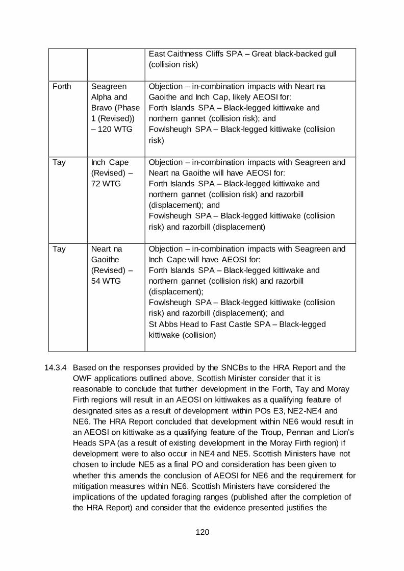
120
East Caithness Cliffs SPA – Great black-backed gull
(collision risk)
Forth Seagreen
Alpha and
Bravo (Phase
1 (Revised))
– 120 WTG
Objection – in-combination impacts with Neart na
Gaoithe and Inch Cap, likely AEOSI for:
Forth Islands SPA – Black-legged kittiwake and
northern gannet (collision risk); and
Fowlsheugh SPA – Black-legged kittiwake (collision
risk)
Tay Inch Cape
(Revised) –
72 WTG
Objection – in-combination impacts with Seagreen and
Neart na Gaoithe will have AEOSI for:
Forth Islands SPA – Black-legged kittiwake and
northern gannet (collision risk) and razorbill
(displacement); and
Fowlsheugh SPA – Black-legged kittiwake (collision
risk) and razorbill (displacement)
Tay Neart na
Gaoithe
(Revised) –
54 WTG
Objection – in-combination impacts with Seagreen and
Inch Cape will have AEOSI for:
Forth Islands SPA – Black-legged kittiwake and
northern gannet (collision risk) and razorbill
(displacement);
Fowlsheugh SPA – Black-legged kittiwake (collision
risk) and razorbill (displacement); and
St Abbs Head to Fast Castle SPA – Black-legged
kittiwake (collision)
14.3.4 Based on the responses provided by the SNCBs to the HRA Report and the
OWF applications outlined above, Scottish Minister consider that it is
reasonable to conclude that further development in the Forth, Tay and Moray
Firth regions will result in an AEOSI on kittiwakes as a qualifying feature of
designated sites as a result of development within POs E3, NE2-NE4 and
NE6. The HRA Report concluded that development within NE6 would result in
an AEOSI on kittiwake as a qualifying feature of the Troup, Pennan and Lion’s
Heads SPA (as a result of existing development in the Moray Firth region) if
development were to also occur in NE4 and NE5. Scottish Ministers have not
chosen to include NE5 as a final PO and consideration has been given to
whether this amends the conclusion of AEOSI for NE6 and the requirement for
mitigation measures within NE6. Scottish Ministers have considered the
implications of the updated foraging ranges (published after the completion of
the HRA Report) and consider that the evidence presented justifies the

121
continued application of the plan-level ornithological mitigation measure, in
spite of the removal of NE6 (See earlier discussion, section 6).
14.3.5 Consideration has been given to potential in-combination effects as a result of
development within PO E1 and E2, as a result of existing and consented OWF
and other POs. These sites are generally beyond the mean max foraging
ranges for Kittiwake and Razorbill, and therefore a LSE has not been
identified. However, if the more precautionary measure of mean max foraging
range in addition to one standard deviation is considered this would include
more significant areas of the two sites. Based on this, although the extent to
which developments in sites E1 and E2 would increase currently assessed
cumulative impacts for east coast SPAs is unclear, the sites may overlap with
the foraging distribution for some seabird species from east coast SPAs,
especially the western parts of E1 and E2 that are more inshore. Therefore,
whilst not classed in the same risk category as POs E3, NE2-NE4 and NE6,
there will be a requirement for the collection and assessment of regional-level
ornithology survey data (e.g. from digital aerial surveys) in this region. This
would improve confidence in assessing the likely level of effects from collision,
displacement, and barrier effects from any developments. The potential for
LSE on east coast SPAs could be further understood by tracking studies of
seabirds from these SPAs. Such information would improve confidence in
assessing what proportion of any effects at the two sites should be
apportioned to these SPAs and hence support project level HRA.
14.3.6 It is anticipated that further empirical data and research regarding seabird
behaviour at sea, connectivity with colonies, foraging activity etc. will become
available as further OWF development takes places and research is
completed. These outputs may allow the current estimations of impact to be
revised downwards, thereby facilitating further development in these regions,
or may result in these estimations being revised upwards – indicating that no
further carrying capacity exists. These conclusions regarding potential in-
combination impacts have led to POs E3, NE2-NE4 and NE6 being classed as
‘being subject to high levels of ornithological constraint’ (Plan-level mitigation
measure).
14.3.7 There is the potential for in-combination effects relating to collision risk for
migratory birds, seabirds and non-seabirds, including the impact of multiple
developments along the migratory passage route for Whooper Swan. A key
migration flyway for Whooper Swan encompasses the Cumbrian coast,
Solway Firth and North Channel and extends along the west coast of
Scotland, with 50% of Whooper Swan estimated to fly at collision risk height.
In-combination effects of PO W1 with proposed and operational OWF (Robin
Rigg, Ormonde, Walney, Barrow and Burbo Bank) may increase collision risk
and lead to an AEOSI for sites with the relevant qualifying interest. Further,

122
development progressed as a result of The Crown Estate’s Round 4 Leasing
may result in further in-combination effects. As such, SNH has highlighted the
need to consider updating the guidance for the assessment of collision risk for
migratory bird species and this work will be progressed to inform future
project-level assessment and the iterative plan review process.
14.3.8 Scottish Ministers therefore conclude that this Plan will not result in adverse
effects on the ornithology qualifying interests of designated sites, either alone
or in-combination with other plans or projects, provided the mitigation
measures set out in Section 4 are adhered to.
14.4 Fish and freshwater pearl mussel qualifying interests
14.4.1 The HRA Report considered the SNCB responses to project-level HRAs for
Inch Cape, Moray West, Seagreen, Neart na Gaoithe and Dounreay Tri.
SNCB consultation responses have consistently indicated that, “compliance
with consent conditions would be sufficient to result in no adverse effect on
diadromous (migratory) fish and freshwater pearl mussel as qualifying
interests of designated sites, either alone or in-combination with other
developments.”33
14.4.2 There is scope, however, for additive cumulative effect resulting from temporal
overlap between construction works (e.g. non-physical disturbance – piling
noise and vibration) within the same region. These in-combination effects
could be mitigated via measures such as temporal sequencing of
development to avoid additive effects, although such an approach could result
in an extension to the duration of effects. Therefore, Scottish Ministers
consider that these risks are most appropriately managed at a project-level,
when further detail regarding the location, scale, duration and nature of
activities can be provided and assessed.
14.4.3 Scottish Ministers therefore concluded that this Plan will not result in adverse
effects on the fish and freshwater pearl mussel qualifying interests of
designated sites, either alone or in-combination with other plans or projects,
provided the mitigation measures set out in Section 4 are adhered to.
15. Overall Conclusion
15.1.1 The assessment presented in the HRA Report concluded that it is not possible
to be certain of No Adverse Effect on Site Integrity, due to uncertainties that
exist about the Plan and other plans and projects. These uncertainties relate
to several aspects, including;
33 HRA Report (2019), Section 10.7.18 (Page 264)

123
The detail of the Sectoral Offshore Wind Plan implementation process;
Future generation capacities;
The location, scale and densities of development;
The proposed technologies to be used, and future advances in these
technologies;
The scale of the effects arising via some of the defined impact pathways; and
The efficacy of some project-level mitigation measures.
15.1.2 The level of certainty required under the Habitats Regulations to conclude that
there will be no AEOSI cannot be achieved, as it cannot be guaranteed there
will be no analysis gaps or a lack of evidence between the different
assessment processes and methods leading to in-combination effects (even
though each assessment considers these effects).
15.1.3 Based on lessons learnt and approaches followed in past plan-level HRAs,
key mitigation measures are proposed in the Plan to provide the necessary
assurances that the adopted Plan as whole will have no AEOSI on
European/Ramsar sites, either alone or in-combination with other plans or
projects. These mitigation measures include;
The requirement for further project-level HRA and assessment;
The application of iterative plan-review (to ensure the Plan remains reflective
of current and emerging scientific knowledge and understanding);
Development within individual POs being constrained to the assessed
‘maximum realistic development scenarios’ (which provide sufficient flexibility
for further spatial planning at a project-level);
The requirement for the completion of regional-level survey and assessment effort prior to development within POs E1 and E2, due to
Uncertainty regarding the potential scale of cumulative impacts
in this region on seabird species (resulting from collision, displacement and barrier effects); and
A lack of information regarding seabird densities and
behaviours in the offshore region during the non-breeding season; and
POs E3, NE2-NE4 and NE6 being classed as ‘subject to high levels of
ornithological constraint’, whereby development cannot proceed until “such
time that enough evidence on the environmental capacity for seabird exists to
reduce the risk to an acceptable level”. Development can only progress in
these POs if sufficient scientific evidence can be provided to demonstrate this,
unless it can be determined that there are imperative reasons of overriding

124
public interest that require development to proceed and Scottish Ministers opt
to pursue a derogation under the Habitats Regulations.
15.1.4 The central principle of these measures is that there needs to be a clear
process for the implementation of the Plan. In particular, the process needs to
involve a phased process and iterative process to further offshore wind
deployment, linked to ongoing monitoring and research effort.
15.1.5 Each individual project will need to undergo project-level HRA (where
possibility of LSE cannot be excluded on the basis of the currently available
information), in accordance with the Habitats Regulations. These project-level
assessments will reflect the precise location, scale, nature and design of the
proposals, which cannot be predicted at this stage. This Plan-level AA,
however, provides direction to these future project-level AAs and HRA, by
identifying measures which may be required at a project-level to avoid AEOSI
and potential impacts. The outputs of project-level assessments and
associated monitoring will be used to inform the iterative plan review process
for the Plan, to ensure that the Plan remains reflective of current scientific
knowledge and understanding.
15.1.6 Applicants who are successful in obtaining Option and Lease Agreements via
the ScotWind leasing round will need to re-examine the issues identified in the
Plan-level HRA and this AA when progressing their proposals, to ensure that
they adhere to the mitigation measures outlined therein. The exact manner of
implementation of these measures will be identified in project-level HRA. It is
recognised, therefore, that not all measures identified in the Plan-level HRA
and this AA will be applicable to every proposed project.
15.1.7 Development within certain POs may pose a greater risk of impacts to
designated sites and features, when compared to other POs, due to their
proximity to designated sites (i.e. located adjacent to or within tidal excursion
distance). Development located within these POs may, therefore, require the
implementation of additional/more mitigation measures when compared to
other POs - at possibly greater cost and time commitments for assessment,
consenting and monitoring. Inherently, it is recognised that development
located close to or within designated sites is more likely to have an AEOSI
than development located further away. Mobile features from nearby and
remote designated sites, however, may be present in POs and therefore,
detailed assessment and consideration of mitigation measures (and their
efficacy) will be required if such species are likely to impacted by the proposed
development.
15.1.8 Cable routes and landfall points have the potential to cause both indirect and
direct effects and further spatial planning at a project-level can mitigate these

125
risks (i.e. by avoiding sensitive areas or timing of activity to avoid sensitive
periods). There is no presumption within this HRA or the Habitats Regulations
that designated sites will not or cannot be affected, although the risks of
impact and associated requirement for mitigation measures are likely to be
greater where designated sites may be impacted. It is, therefore, expected
that developers will seek to avoid designated sites in the first instance.

126
SECTION 4: MITIGATION MEASURES
16. Mitigation measures
16.1.1 Key mitigation measures have been implemented to provide the necessary
assurances that the Plan will not have an adverse effect on any European site
or European marine site, either alone or in-combination with other plans and
projects. These mitigation measures are outlined in the Plan document itself
and have been identified via the Habitats Regulations Appraisal. The
mitigation measures are set out below.
16.2 Monitoring and review
16.2.1 The iterative plan review (“IPR”) process will involve a phased and iterative
approach to plan-implementation which is linked to ongoing project
developments and their associated post-consent monitoring work, with the
findings from such project-level work feeding back into the next phases of
Plan implementation.
16.2.2 This is required so that results from post consent monitoring for consented
projects and ongoing research programmes (such as ScotMER) can be fed
into subsequent developments, in order for lessons learnt to be shared and
evidence gaps filled, thus reducing potential impacts to these sites. Further
detail regarding monitoring and review is provided in the Post Adoption
Statement (2020).
16.3 Project-level HRA
16.3.1 Individual applications for marine licence and/or s.36 consent for commercial-
scale offshore wind development within the POs will be required to under the
HRA process prior to the grant of any consent/licence, in accordance with the
Habitats Regulations. Project-level HRA must be informed by the current best
available scientific knowledge and understanding. In addition, developers
should note that the screening process for project-level HRA may identify sites
or features which have been screened out of the HRA Report for the Plan.
16.3.2 This project-level HRA will be informed by the information contained in the
HRA Report and this AA. Project-level HRA will identify more precisely the
nature, scale, duration and location of the proposed development, and thus its
potential effects, than is possible at a Plan-level.
16.3.3 Project-level HRA should take into consideration the mitigation measures
outlined in the HRA Report, but may identify additional/alternative mitigation

127
measures, dependent on the nature of the predicted impacts of the individual
project. The final decision on the need for, and sufficiency of project-level
specific measures, will be undertaken at a project-level and will be a matter for
the consenting body to determine.
16.3.4 Information that will need to be provided in project-level HRAs will include (but
not be limited to);
Updates on the location and status of new European/Ramsar designations;
New information on interest feature sensitivities, distributions, abundance and
connectivity (in the context of latest scientific understanding) (baseline
conditions);
Assessment of effects during all phases of the works (survey, construction,
operation, maintenance and decommissioning), including in-combination
effects with other plans and projects; and
Proposed mitigation measures.
16.3.5 The outputs of project-level HRA will be used to inform the iterative plan
review process.
16.4 Maximum realistic development scenarios
16.4.1 Development within individual Plan Options shall not exceed the ‘maximum
realistic development scenario’ for that Plan Option, set out in the Plan (see
Table 3 above). The use of maximum realistic development scenarios within
the overall boundary of the PO provides flexibility over the exact location,
nature and scale of the proposal to enable adverse effects on site integrity to
be avoided at a project-level.
16.5 Plan Options subject to high-levels of ornithological constraint
16.5.1 Plan Options E3, NE2, NE3, NE4 and NE6 (as shown in green in Figure 8) are
subject to Plan-level mitigation and are deemed as being ‘subject to high
levels of ornithological constraint’. Development within these Plan Options can
only progress where sufficient scientific evidence can be provided to reduce
the risk to an acceptable level (unless it can be determined that there are
imperative reasons of overriding public interest that require development to
proceed). This scientific evidence would thereby facilitate either;
a) Revision to the Plan (via the iterative plan review process) which
removes the application of this mitigation measure at a Plan level; or b) The granting of a licence or consent for the project, where it can be
concluded by the competent authority that there would be no adverse

128
effect on the integrity of any European site(s) or European marine site(s).
16.5.2 The HRA Report provides an outline of the research gaps/uncertainties at
section 11.6. The Ornithology Working Group will establish the research and
evidence gaps and work required to address said gaps following the adoption
of the Plan.
16.6 Plan Options subject to the need for further regional level survey and
assessment
16.6.1 Plan Options E1 and E2 (as shown in orange in Figure 8) are subject to the
need for the completion of further regional level survey, research and
assessment work. This regional survey work should cover the region(s) which
will be likely impacted by the development and should not solely be limited to
the Plan Option area or the offshore region in which the Plan Option is
located. This regional level survey, research and assessment work is required
to address:
Uncertainty regarding the potential scale of cumulative impacts in this region on seabird species (resulting from collision, displacement
and barrier effects); and
A lack of information regarding seabird densities and behaviours in the offshore region during the non-breeding season.
16.6.2 Any developers which secure Option Agreements for Plan Options E1 and/or
E2 should discuss and establish the parameters of the required survey work
and the assessment of survey outputs with the Ornithology Working Group
prior to commencing any such works. Marine Scotland will then provide
direction as to the scope and format of the survey, research and assessment
work and how the outputs should be provided.
16.6.3 This regional level survey and assessment activity could incorporate, for
example, an initial study to identify foraging areas for key seabird species SPA
populations and at-sea densities. This study could then be supplemented by
regional level survey effort, which could incorporate elements such as aerial
surveys or possibly seabird tagging work at key colonies.

129
Figure 8 Plan Options subject to ornithology mitigation measures

130
APPENDIX 1: IN-COMBINATION ASSESSMENT –
OFFSHORE WIND FARMS
Table 17 below provides a summary of the operational and planned offshore wind,
tidal and wave renewable energy projects within Scottish Territorial Waters taken into
account in this AA. This list was current at time of publication of the HRA Report
(December 2019).
Table 17 Summary of operational and planned offshore wind, tidal and wave renewable energy
projects within Scottish Territorial Waters
Energy
Type
Name/
Location
Company (Project
Website)
Status Capacity
(MW)
Wind Robin Rigg E.ON
https://www.eonenergy.co
m/About-eon/our-
company/generation/our-
current-
portfolio/wind/offshore/robi
n-rigg
Fully operational
since September
2010.
174
Wind Beatrice
Demonstrat
or
SSE Renewables /
Talisman
Entering
decommissioning
(2024 – 2027)
10
Wind Levenmouth
Turbine
ORE Catapult
https://ore.catapult.org.uk/p
ress-releases/levenmouth-
turbine-offers-unrivalled-
opportunity-for-renewable-
energy-rd/
Fully operational 7
Wind Hywind Equinor / Masdar
http://www.statoil.com/en/e
nvironmentsociety/environ
ment/impactassessments/n
ewenergy/intwind/pages/hy
windscotland.aspx
Fully operational 30
Wind Aberdeen
Bay
(EOWDC)
Vattenfall
http://www.statoil.com/en/e
nvironmentsociety/environ
ment/impactassessments/n
ewenergy/intwind/pages/hy
windscotland.aspx
Fully operational 93.2

131
Energy
Type
Name/
Location
Company (Project
Website)
Status Capacity
(MW)
Wind Beatrice SSE Renewables / SDIC /
Copenhagen Infrastructure
Partners
https://www.sserenewables
.com/offshore-wind/
Fully operational 588
Wind Neart na
Gaoithe
EDF Renewables
https://nngoffshorewind.co
m/about/
Consented
December 2018
(Varied June
2019).
450
Wind Firth of
Forth 1
(Seagreen
Alpha and
Bravo)
SSE Renewables
http://www.seagreenwinde
nergy.com
Consent granted
October 2014
(varied August
2018 to remove
maximum
capacity).
Updated
application for
optimised project
submitted
September 2018.
Construction
anticipated to
commence by
2022.
1500
Wind Moray East EDPR
http://www.morayoffshorere
newables.com/Home.aspx
Consent granted
in March 2014.
Delivery
expected early
2020s.
950
Wind Inch Cape SDIC
http://www.inchcapewind.c
om
New application
submitted August
2018.
700
Wind Kincardine Atkins / Pilot Offshore
Renewables
http://pilot-renewables.com/
Consent received
2017. Currently
under
construction (one
turbine
operational)
49.6

132
Energy
Type
Name/
Location
Company (Project
Website)
Status Capacity
(MW)
Wind Dounreay
Tri
Demonstrati
on Project
Hexicon
https://www.hexicon.eu/dou
nreay-tri/
Currently on
hold, delivery
expected 2020
(company in
administration)
12
Wind Firth of
Forth 2
(Charlie)
SSE Renewables
http://www.seagreenwinde
nergy.com
In planning 1800
Wind Firth of
Forth 3
(Delta)
SSE Renewables
http://www.seagreenwinde
nergy.com
In planning 800
Wind Moray Firth
Western
Developme
nt Area
EDPR
https://www.moraywest.co
m
Consented June
2019. Delivery
potential in mid
2020s
850
Wind Forthwind
OWF, Methil
Forthwind Ltd Consented,
(Consent varied
May 2019 to
increase
capacity)
29.9
Wind Total 8209.7
Tidal
Stream
North Yell,
Bluemull
Sound,
Shetland
Nova Innovation
(https://www.novainnovatio
n.com/bluemull-sound)
Fully operational
since 2017.
Expansion to 0.6
MW planned.
0.3
Tidal
Stream
Sound of
Islay
Scottish Power
Renewables
(https://www.scottishpowerr
enewables.com)
Consent granted
in March 2011.
Pre-construction.
(not currently
active as a
project)
10
Tidal
Stream
Ness of
Duncansby,
Pentland
Firth
Scottish Power
Renewables
(https://www.scottishpowerr
enewables.com)
In early stages of
planning.
Agreement to
lease secured.
95
Tidal
Stream
Westray
South,
DP Energy
(http://www.dpenergy.com/
In development.
Agreement to
200

133
Energy
Type
Name/
Location
Company (Project
Website)
Status Capacity
(MW)
Pentland
Firth
projects/tidal/westray-
south)
lease secured.
Scoping Report
submitted
November 2011.
Tidal
Stream
Brough
Ness,
Pentland
Firth
Simec Atlantis Energy
(https://simecatlantis.com/p
rojects)
In development. 100
Tidal
Stream
Inner
Sound,
Pentland
Firth
Simec Atlantis Energy
(https://simecatlantis.com/p
rojects/meygen/)
Phase 1 (6 MW)
in operation.
398
Tidal
Stream
Mull of
Kintyre,
Argyll
Argyll Tidal Ltd
(https://www.webarchive.or
g.uk/wayback/archive/2018
0529225408/http://www.go
v.scot/Topics/marine/Licen
sing/marine/scoping/Argyll
TidalArray)
Consent granted
in May 2014 for
one
demonstration
turbine (0.5MW)
to be installed.
Pre-construction.
0.5
Tidal
Stream
Isle of Islay,
Islay
DP Marine Energy Ltd
(http://www.dpenergy.com/
projects)
In development.
Agreement to
lease secured.
Consent received
2017.
30
Tidal
Stream
Lashy
Sound
Scotrenewables Tidal
Power Limited (SRTP)
(https://www2.gov.scot/Top
ics/marine/Licensing/marin
e/scoping/LashySound)
In development.
Agreement to
lease secured.
Scoping Report
submitted in July
2014.
10
Tidal
Stream
Brims Tidal
Array
(formerly
Cantick
Head)
SSE Renewables and
OpenHydro Group Ltd
In development.
Agreement to
lease secured.
EIA submitted
2016 (company
in administration)
200

134
Energy
Type
Name/
Location
Company (Project
Website)
Status Capacity
(MW)
Tidal
Stream
Mull of
Galloway
Marine Current Turbines
(https://simecatlantis.com/p
rojects/galloway/)
In planning.
Agreement to
lease secured.
30
Tidal
Stream
Fall of
Warness
European Marine Energy
Centre Ltd
Test site.
Operational Feb
2019.
N/A
Tidal
Stream
Shapinsay
Sound
European Marine Energy
Centre Ltd
Test site. N/A
Tidal
Stream
Islay
Demonstrati
on Zone
European Marine Energy
Centre Ltd
Test site. N/A
Tidal
Stream
Stronsay
Firth
European Marine Energy
Centre Ltd
Test site. N/A
Tidal Total 1,073
Wave Billia Croo European Marine Energy
Centre Ltd
Test site N/A
Wave Scapa Flow European Marine Energy
Centre Ltd
N/A
Wave Scottish
Sea Farms
(MANTA) -
Teisti Geo
Scottish Sea Farms Marine Licence
Granted May
2018
(Operational)
0.262
Wave WaveNet
Mingary Wavenet Energy Mingary
Ltd.
Marine Licence
issued –
operational
0.45
Wave Harris
Demonstrati
on Zone
European Marine Energy
Centre Ltd
Test site N/A
Wave Total 0.712
Hybrid Katanes
Floating
Energy Park
Katanes Floating Energy
Ltd
Screening
opinion issued
November 2017
11.6
Hybrid Total 11.6

135
APPENDIX TWO: IN-COMBINATION ASSESSMENT – OTHER
PLANS AND PROJECTS (NON OFFSHORE WINDFARMS)
In addition to the offshore wind projects outlined above, a wide range of other plans
and projects are potentially relevant to this Plan, including:
Marine Renewables Infrastructure Plan
National Renewables Infrastructure Plan (“N-RIP”)
The National Planning Framework for Scotland (“NPF3”)
The Crown Estate Scotland (ScotWind) Leasing Round (2020)
The Crown Estate Offshore Wind Leasing – Round 4 (2019)
Waterfront regeneration projects (e.g. Helensburgh)
Harbour expansion plans (e.g. Aberdeen)
Onshore wind farms
Increased vessel activity from all other sources (no specific plan), including
offshore development and shipping from other ports
ISLES project
ISLES II project
Proposals for the offshore grid and other proposed cable routes
Container transhipment hub at Scapa Flow
Other proposals included within the Pentland Firth and Orkney Waters Marine
Spatial Plan
Oil and gas development activities
Port and marine developments (e.g. Granton)
Aquaculture developments
Fishing activities
Military activities
Non-marine developments potentially affecting Atlantic Salmon, freshwater
pearl mussel or otter features associated with SAC rivers
An overarching National Marine Plan was introduced in Scotland through the Marine
(Scotland) Act 2010. The plan, adopted in March 2015, is designed to inform
decision making in the marine environment by governing more detailed planning at
the regional level and informing marine licensing and other decision-making
functions. An HRA was carried out for this Plan and following the screening stage of
that process it was concluded that an AA was not required. Having followed SNH
guidance, this view was taken in respect of both the Plan’s ‘cross-cutting’ and
‘sector-specific’ policies as follows:
The cross-cutting policies are general in direction, as they apply to all
activities and development in the marine environment. In consequence, no
136
connectivity or direct pathway for impact was identified between these and
specific European sites.
The sector-specific policies are general in direction, as they do not direct
development or activities to a particular location and do not have a pathway
for impact on specific European sites. For those which could have a significant
effect on the integrity of European sites, mitigation measures have been
recommended in the form of changes to the wording of the policies.
In conclusion, the National Marine Plan was considered to have no significant effect
on the integrity of European sites, and for the same reason there will be no in-
combination effects between the Sectoral Offshore Wind Plan and the National
Marine Plan. The Sectoral Offshore Wind Plan provides the spatial strategy for
developing offshore wind energy at the national and regional level. This spatial
strategy has been assessed within this plan-level HRA. Future developments which
take place within these areas will be assessed against the proposals and policies
contained within the National Marine Plan at the project licensing stage.
It should also be noted that in the coming years regional Marine Plans will be
developed (e.g. Clyde Regional Marine Plan). These regional plans will include more
focused policies for the coastal regions and, as such, an HRA for these plans may be
required.

137
APPENDIX THREE: SCREENING MAPS – PER DPO
The figures below provide an overview of the screening maps per DPO (please note, maps for DPOs SW1 and NE5 have not been
included here as these DPOs have not been chosen to progress as final Plan Options).
A 100 km buffer was used in the screening process (as agreed with the Steering Groups), which captured all sites within the buffer,
irrespective of the foraging ranges of the designated species. Where Thaxter et al identified species with mean max. foraging
ranges larger than the 100 km buffer, the mean max. foraging ranges were used to screen in additional SPA and Ramsar sites,
including;
Atlantic puffin (105 km);
Lesser black-backed gull (141 km);
Manx Shearwater (330 km);
Northern Fulmar (400 km); and
Northern Gannet (229 km).
These maps are also included at Appendix E of the HRA Report (2019) and can be viewed online here:
https://www.gov.scot/publications/draft-sectoral-marine-plan-offshore-wind-energy-habitat-regulations-appraisal/pages/21/
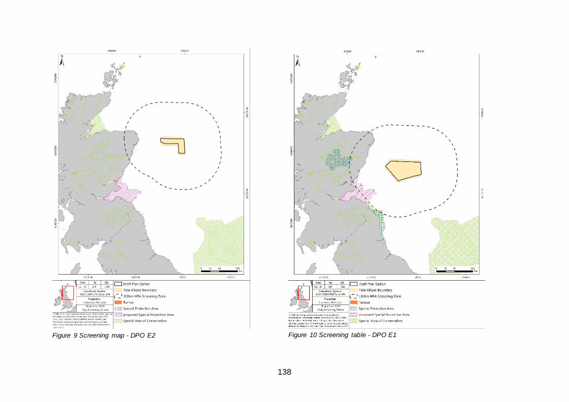
138
Figure 9 Screening map - DPO E2
Figure 10 Screening table - DPO E1

139
Figure 11 Screening map - DPO E3
Figure 12 Screening map - DPO N1

140
Figure 13 Screening map - DPO N2
Figure 14 Screening map - DPO N3

141
Figure 15 Screening map - DPO N4
Figure 16 Screening map - DPO NE1

142
Figure 17 Screening map - DPO NE2
Figure 18 Screening map - DPO NE3

143
Figure 19 Screening map - DPO NE4
Figure 20 Screening map - DPO NE6

144
Figure 21 Screening map - DPO NE7
Figure 22 Screening map - DPO NE8

145
Figure 23 Screening map - DPO W1

146
APPENDIX FOUR: GENERIC IMPACT PATHWAYS ASSOCIATED WITH THE PLAN Table 18 Generic impact pathways associated with the Plan
Pathway
Ref No.
Potential Issue/Sensitivity
Category
Impact Pathway Impact Summary
Categories to
Deterioration or
Disturbance
Code Impacts arising from Plan Activity (Summary
Impact Pathway Description)
1 Physical Loss/Gain of
habitat (loss of habitat
in development
footprint)
PLG Loss of coastal and offshore habitat due to
installation of devices, cables and cable armouring
from the installation, operation and decommissioning
of these structures.
Loss of coastal/offshore
seabed within development
footprint
2 Physical Loss/Gain of
habitat (direct change
to habitat around the
development footprint)
PLG Loss of foraging areas from reduction in coastal and
offshore habitat due to installation of devices and
cable armouring both at the development footprint
and outside these areas from associated scour and
indirectly from changes to the hydrodynamic regime,
as well as from chains anchoring devices disturbing
seabed habitat during operation.
Loss of coastal/offshore
foraging areas within
development footprint
3 Physical Loss/Gain of
habitat (direct change
to habitat around the
development footprint)
PLG Presence of structures on or above seabed for the
duration of the project resulting in changes to prey
and species behaviour (e.g. acting as FAD (Fish
Aggregating Device), artificial reef or bird roost).
Loss or gain of habitat from
introduced structures
causing species change
4 Physical Damage to
habitat (indirect and
temporary damage to
marine habitat)
PD Changes to coastal and offshore habitat as result of
damage from baseline surveys (e.g.
boreholes/trawls); from equipment use causing
abrasion, damage or smothering during installation
Damage to
coastal/offshore seabed
during all project phases

147
Pathway
Ref No.
Potential Issue/Sensitivity
Category
Impact Pathway Impact Summary
Categories to
Deterioration or
Disturbance
Code Impacts arising from Plan Activity (Summary
Impact Pathway Description)
and from maintenance and removal of cables/devices
(e.g. jack-up legs, vessels, anchors, mooring chain).
5 Physical Damage to
habitat (indirect and
longer-term damage to
habitat)
PD Changes to coastal and offshore habitat as a result of
alterations to the wave climate or hydrodynamic
regime from the presence of devices, power cables
or cable armouring causing physical changes
(including changes to sediment transport and/or
sediment scour.
Damage to
coastal/offshore seabed
from hydrodynamic
changes
6 Physical Damage to
habitat (indirect and
temporary damage to
habitat)
PD Reduction in quality of foraging areas as result of
damage to coastal and offshore habitat from baseline
surveys (e.g. boreholes and trawls); from equipment
use causing abrasion, damage or smothering during
installation; from maintenance and removal of
cables/devices or from scour, sediment transport and
hydrodynamic change, and damage from chains
anchoring devices during operation.
Damage to
coastal/offshore foraging
areas during all project
phases
7 Physical Damage to
species (direct and
temporary damage to
habitat)
PD Damage to seal haul out locations during the
installation, decommissioning and operation of the
cables and cable armouring.
Damage to seal haul out
from cables or pipelines
8 Physical Damage to
species (direct damage
PD Collision risk and possible mortality of species due to
the presence of devices or from vessels travelling to
and from the site (including above and below water
Damage to species from
collision, entanglement or
disorientation

148
Pathway
Ref No.
Potential Issue/Sensitivity
Category
Impact Pathway Impact Summary
Categories to
Deterioration or
Disturbance
Code Impacts arising from Plan Activity (Summary
Impact Pathway Description)
to species from collision
risk)
collision risk and the influence of lighting); risk of
entanglement following a collision with power cables
or mooring elements.
9 Non-Physical
disturbance (barrier to
species movement)
NPD Presence of structures or disturbance (noise or
visual) resulting in a barrier to movement, migratory
pathways and/or access to feeding grounds
depending on array design.
Disturbance from
introduced structures
causing barrier to mobile
species movement
10 Non-Physical
disturbance
(disturbance to species)
NPD Visual disturbance and exclusion from areas as a
result of surveying, cable and device
installation/operation and decommissioning activities
and movements of vessels.
Disturbance (visual) from
activities during all project
phases
11 Non-Physical
disturbance
(disturbance to species)
NPD Noise/vibration disturbance and exclusion from areas
as a result of vessels and other activities during
survey work (e.g. seismic exploration and
geophysical surveys), construction (e.g. piling,
drilling, cable laying), operation (e.g. device noise),
maintenance or decommissioning.
Disturbance (noise) from
activities during all project
phases
12 Non-Physical
disturbance
(disturbance to34
species)
NPD Impacts from Electromagnetic Fields (EMF) and
thermal emissions on benthic invertebrates and
electromagnetically sensitive fish and cetaceans
Disturbance (EMF and
thermal emissions) from
activities during all project
phases
34 Source: ABPmer, Sectoral Marine Plan for Offshore Wind Energy HRA Report (2019), Table 2 (Page 51)

149
Pathway
Ref No.
Potential Issue/Sensitivity
Category
Impact Pathway Impact Summary
Categories to
Deterioration or
Disturbance
Code Impacts arising from Plan Activity (Summary
Impact Pathway Description)
interfering with prey location and mate detection in
some species and creating barriers to migration.
13 Non-Physical
disturbance
(exclusion/
displacement of
species)
NPD Presence of structures resulting in an
exclusion/displacement of a species from the area.
Disturbance from
introduced structures
causing exclusion/
displacement of species
14 Toxic Contamination
(reduction in water
quality)
TC Spillage of fluids, fuels and/or construction materials
during installation or removal of structures (devices
and cables) or during survey/maintenance.
Contamination during
surveys or maintenance
activities
15 Toxic Contamination
(reduction in water
quality)
TC Release of contaminants associated with the
dispersion of suspended sediments during
installation or removal of structures (devices and
cables).
Contamination during
installations/removal of
structures
16 Non-Toxic
Contamination
(elevated turbidity)
NTC Increase in turbidity (and possibly reduced dissolved
oxygen) associated with the release of suspended
sediments during installation or removal of structures
(devices and cables).
Non-toxic contamination
from increases in turbidity
17 Biological
Disturbance
(introduction of non-
native species)
BD Introduction of new structures on the seabed
providing new substratum that facilitates the
colonisation and ingress of invasive non-native
species.
Biological disturbance from
non-native species on
substratum
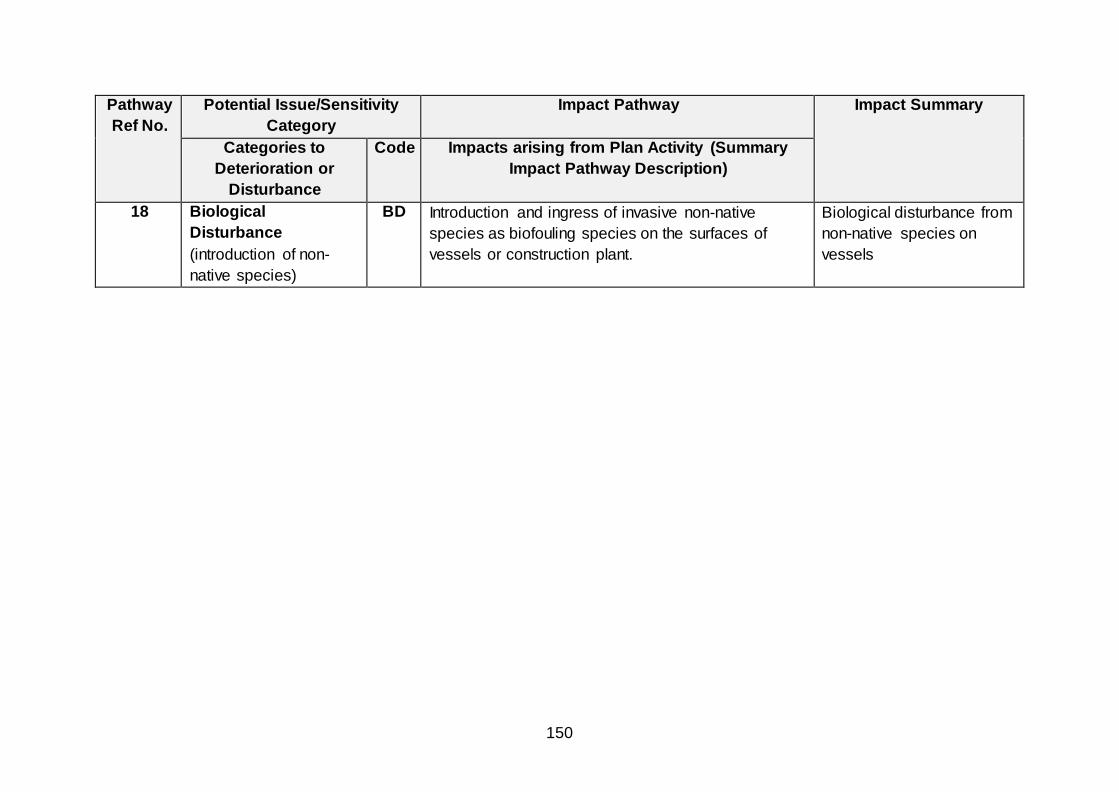
150
Pathway
Ref No.
Potential Issue/Sensitivity
Category
Impact Pathway Impact Summary
Categories to
Deterioration or
Disturbance
Code Impacts arising from Plan Activity (Summary
Impact Pathway Description)
18 Biological
Disturbance
(introduction of non-
native species)
BD Introduction and ingress of invasive non-native
species as biofouling species on the surfaces of
vessels or construction plant.
Biological disturbance from
non-native species on
vessels

151
APPENDIX FIVE – DRAFT OFFSHORE WIND PLAN
TECHNICAL NOTE: UPDATED BIRD FORAGING RANGES
(MARCH 2020)
Marine Scotland
Draft Offshore Wind Plan Technical Note: Updated Bird Foraging Ranges
Suggested Citation
ABPmer,(2020). Draft Offshore Wind Plan,Technical Note: Updated Bird Foraging Ranges , ABPmer Report No. R.3379/TN. A report produced by ABPmer for Marine Scot land March 2020

152
Notice
ABP Marine Environmental Research Ltd ("ABPmer") has prepared this document in accordance with the client's instructions, for the client's sole purpose and use. No third party may rely upon this document without the prior and express written agreement of ABPmer . ABPmer does not
accept liability to any person other than the client. If the client d iscloses this document to a third party, it shall make them aware that ABPmer shall not be liable to them in relation to this document. The client shall indemnify ABPmer in the event that ABPmer suffers any loss or
damage as a result of the client's failure to comply with this requirement.
Sections of this document may rely on information supplied by or drawn from third party sources. Unless otherwise expressly stated in this document, ABPmer has not independently checked or
verified such information. ABPmer does not accept liability for any loss or damage suffered by any person, including the client, as a result of any error or inaccuracy in any third party information or for any conclusions drawn by ABPmer which are based on such information.
All content in this document should be considered provisional and should not be relied upon until a final version marked 'issued for client use' is issued.
All images on front cover copyright ABPmer apart from
seahorse (A J Pearson).
ABPmer Quayside Suite, Medina Chambers,Town
Quay,Southampton,Hampshire 5014 2AQ T: +44 (0) 2380 711844 W: http://www.abpmer.co.uk/

153
1 Introduction
This note has been prepared following the recent release of an update to the seabird foraging ranges historically used in HRA screening of offshore wind projects.
The historic data, a synthesis of available tracking studies was published by
Thaxter et al. in 2012. These data,principally focussed on mean maximum foraging ranges, have subsequently been referred to across multiple project and
plan level HRA to support screening of Special Protection Areas (SPA) for bird species receptors.
Within the HRA produced for the Scottish Sectoral Marine Plan for Offshore Wind, pre-screening of SPA sites was based on a 100 km buffer, therefore
capturing all sites within the buffer irrespective of the foraging ranges of the designated species (Figure 1). However, there are a number of seabird species
that forage over greater distances, beyond the 100 km pre-screening buffer. Based on the Thaxter et al (2012) mean maximum foraging ranges, the species included were:
• Atlantic Puffin (1OS km)
• Lesser Black-backed Gull (141 km)
• Manx Shearwater (330 km)
• Northern Fulmar (400 km)
• Northern Gannet (229 km)
Thus, the mean maximum foraging ranges of these species (according to
Thaxter et al., 2012) were used to screen in additional SPA and Ramsar sites beyond the 100 km pre-screening buffer.
During the HRA, these foraging ranges were then referred to, supporting assessment of likely impact for bird species in addition to species or location
specific spatial evidence such as the RSPB seabird utilisation study (Cleasby et al., 2018).
An updated synthesis of seabird tracking studies was released in early 2020
which incorporates both the studies considered in the Thaxter et al paper, and those undertaken from 2012 to 2019 (Woodward et al, 2019). The Woodward et al (2019) study has resulted in a number of changes to the
foraging ranges of seabirds, including the provision of a range where none had previously been presented. These revisions are of note to those seabird species considered particularly sensitive to the potential impacts from offshore windfarms.
Upon review of the updated data we have identified significant increases in mean
maximum foraging ranges for Black-legged kittiwake, Razorbill, Great skua and Great black backed gull (Table 1) which warrant further consideration and discussion, contained herein.

154
Table 1. Foraging ranges for the focus species
Species Thaxter et al., 2012 Woodward et al.,2019
Black-legged kittiwake 60 ± 23.3 km 156.1 ± 144.S km
Razorbill 48.S ± 35.0 km 88.7 ± 75.9 km
Great skua 86.4 km 443.3 ± 487.9 km
Great black backed gull N/A 73 km Source: Woodward et al., 2019

155
Figure 1. SPA Screened in by 100 km buffer

156
2 Black-legged kittiwake
Black-legged kittiwake are of particular concern when considering the impact of
offshore wind farms due to the currently observed declines in populations, particularly on the east coast of the UK. As a result, for DPO areas (NE2, NE3,
NE4, NE5, NE6 and E3) within the Thaxter et al, (2012) foraging range (60 km) on the east coast, ‘temporal mitigation’ was proposed within the HRA, to postpone any development until such a time that sufficient data around likely collision risk and
kittiwake distribution is available to support a conclusion of no adverse effect.
The increase in foraging range from 60 km to 156 km increases the number of DPO which fall within the buffered SPA foraging ranges, and therefore the question may be raised as to whether it is appropriate to incorporate these
additional DPO areas into the ‘temporal mitigation’. Figure 2 shows all SPA with Kittiwake as an interest feature buffered out to both the 60 km and 156 km ranges,
showing that four DPO areas off the east coast of Scotland which were previously outwith the foraging ranges, are now wholly within the extended buffer (i.e. NE7, NE8, E1 and E2.)
However, based on the consideration of other spatial data, as reported in
Cleasby et al (2018) it is our view that these sites should not be included in the temporal mitigation policy. These hotspot maps, based on utilisation distribution
reported in Wakefield et al. (2017) (Figure 4), show that whilst there is potential for some usage by Black-legged kittiwake within these additional DPO areas, it is considerably lower density than the other north east and east DPO sites, and
therefore grouping all east coast sites into the same mitigation measures would not be considered proportionate.
It should be recognised, however, that at a project level, these increased
foraging ranges will be used for HRA screening. This will likely result in additional SPA/Ramsar being screened to those during the plan level HRA, For example, offshore windfarm proposals in E2 will screen in the Firth of Forth SPA
Overall, for Black-legged kittiwake, whilst the increase in foraging range has the potential to impact on sections of the HRA methodology, the conclusions of the
HRA are considered to remain valid.

157
Figure 2. Black-legged kittiwake SPA foraging buffers

158
3 Razorbill
Similar to Black-legged kittiwake, Razorbill was considered to be a higher risk
species from offshore windfarms during assessment for the purposes of HRA, although, this risk is primarily due to displacement rather than collision risk as
synthesised within the HRA for the Sectoral Marine Plan for Offshore Wind. The increase in mean maximum foraging range from 48.5 km to 88.7 km would lead to greater overlap with DPO areas (Figure 3). However, whilst this may influence
minor changes in the assessment of risk to Razorbill, the screening process will not be impacted, as all sites within 100 km were already screened in.
In addition, from the use of spatial distribution data for Razorbill, as presented in Cleasby et al (2020) and Wakefield et al (2017), it is clear that for Razorbill
(Figure 4), areas of concern are generally restricted to coastal areas of shallower water. Consequently, the conclusions of the HRA remain valid.

159
Figure 3 Razorbill SPA foraging buffers

160
Figure 4 Black-legged kittiwake and Razorbill utilisation distribution data
4 Great skua
There is a single proposed SPA (pSPA) in Scotland, for which Great skua are a designated feature (Seas off Foula pSPA). This site was previously screened in,
based on proximity to site NE1 (Figure 5). The increased foraging range will lead to an overlap with all DPO areas except SW1 and W1.
Great skua is generally considered of lower risk from offshore wind development compared to other species such as Black-legged kittiwake (Furness et
al. 2013). Therefore, whilst the extended foraging range covers a significantly greater area with more overlap with DPOs the increase in risk from offshore wind development is uncertain. In addition, the significant area covered by the
foraging range indicates that whilst there may be potential for usage throughout the range, the spatial distribution of Great skua throughout this area is uncertain, with
data collected by Pollock et al (2000) indicating that areas of highest usage is more likely to be in areas within the initial foraging range of 80 km with lower usage towards the edges of the updated range.
Therefore, whilst there is potential for minor changes to the assessment
process for Great Skua, the conclusions of the HRA are considered to remain valid.
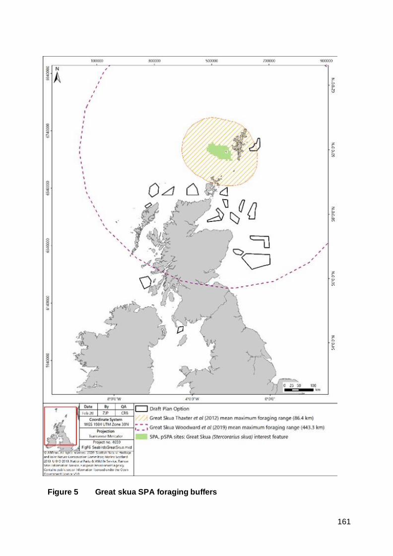
161
Figure 5 Great skua SPA foraging buffers

162
5 Great black-backed gull
Great black-backed gull did not previously have a published foraging range
based on tracking study evidence. Therefore, all sites within 100 km were screened in and, as a result the new foraging range of 73 km would not impact this step.
Large gull species are generally considered to be of higher risk to collision with offshore wind farms, based on the results of the ORJIP study (Skov et al, 2018).
The new foraging range, whilst giving an indication of potential overlaps between the foraging ranges from SPA and some DPOs (Figure 6), does not include any consideration of the distribution or usage density for Great black-backed
gull.
The NE DPOs within the Moray Firth which overlap with the GBBG foraging
range (NE2, NE3, NE4, NE5 and NE6) are already included in the mitigation proposed for kittiwake within the HRA. Hence, concerns regarding Great black-
backed gull would be managed through further work required to provide additional information on bird distribution in this area to address the mitigation requirement.
However, for sites in the north, particularly N2 and N3 which are in close proximity to the North Rona and Sula Sgeir SPA and N1 in proximity to Hoy SPA,
consideration will be required at a project level as to the usage of the seas by Great black-backed gull for foraging.
The conclusion of the HRA for Great black-backed gull, that work required for
the purposes of project level HRA would identify areas of concern and support avoidance of significant adverse effects, will remain valid.

163
Figure 6 Great black backed gull SPA foraging buffers

164
6 References
Cleasby, I., Owen, E., Wilson, L., Wakefield E.D., O’Connell, P.,Bolton, M. 2020. Identifying important at- sea areas for seabirds using species distribution
models and hotspot mapping. Biological Conservation. Volume 241, January 2020, 108375
Pollock, C.M., Mavor, R., Weir, C.R., Reid, A., White, R.W., Tasker, M.L.,
Webb, A. and Reid, J.B., 2000. The distribution of seabirds and marine mammals in the Atlantic Frontier, north and west of Scotland. The distribution of seabirds and marine mammals in the Atlantic Frontier, north and west of Scotland, pp.1-
92.
Thaxter, C.B., Lascelles, B., Sugar, K., Cook, A.S.C.P., Roos, S., Bolon, M., Langston, R.H.W. & Burton, N.H.K. 2012. Seabird foraging ranges as a preliminary tool for identifying candidate Marine Protected Areas. Biological Conservation 156: 53-61.
Skov, H., Heinänen, S., Norman, T., Ward, R.M., Méndez-Roldán, S. & Ellis,
I. 2018. ORJIP Bird Collision and Avoidance Study. Final report – April 2018. The Carbon Trust. United Kingdom. 247 pp.
Wakefield, E.D., Owen, E., Baer, J., Carroll, M.J., Daunt, F., Dodd, S.G., Green, J.A., Guilford, T., Mavor,
R.A., Miller, P.I., Newell, M.A., Newton, S.F., Robertson, G.S., Shoji, A.,
Soanes, L.M., Votier, S.C., Wanless, S., Bolton, M. 2017. Breeding density, fine-scale tracking, and large-scale modelling reveal the regional distribution of four seabird species. Ecological Applications, 27(7), 2017, pp. 2074–2091.
Woodward, I., Thaxter, C.B., Owen, E. & Cook, A.S.C.P. 2019. Desk-based
revision of seabird foraging ranges used for HRA screening, Report of work carried out by the British Trust for Ornithology on behalf of NIRAS and The
Crown Estate, ISBN 978-1-912642-12-0.

165
APPENDIX SIX: HRA UPDATE NOTE
A.1 Implications of updated Plan Options / data
This HRA update note provides a review of the changes made to DPOs and the implication of scientific evidence on seabird foraging ranges that has emerged since
publication of the draft Sectoral Marine Plan for Offshore Wind Energy in December 2019.
A.1.1 Updates to Plan Options
The changes that have been made in developing Plan Options (Figure 1) from the DPOs (Figure 2), following consultation of the Draft Plan for Offshore Wind Energy
and summarised below. The implications of these changes on the conclusions of the plan level HRA are also discussed.
DPOs removed
SW1 DPO has not been chosen for progression as a final Plan Option, due to concerns regarding the potential scale of negative socio-economic impacts in this
region (including negative impacts on seascape, landscape and coastal character).
NE5 DPO has not been chosen to progress as a final Plan Option due to the
potential cumulative impacts on the fishing sector arising from development in this DPO, in-combination with existing and consented projects and other DPOs.
It can reasonably be concluded that the removal of SW1 and NE5 from the Offshore Wind Plan will reduce the potential in-combination effect with any currently operational or consented developments on mobile interest features of
European/Ramsar sites. This is particularly the case for DPOs off the North East coast of Scotland where risks relating to impacts on Black-legged Kittiwake interest
features of SPAs in the region were identified in the plan level HRA for the Draft Offshore Wind Plan. Whilst the risk of in-combination effects on Black-legged Kittiwake will reduce as a result of the removal of NE5, there remains uncertainty
regarding whether this is sufficient to avoid an adverse effect on integrity (AEOI) and therefore there is still considered to be a need for ‘temporal mitigation’35 for NE4 and
NE6 until further evidence is available.
35 ‘Temporal mitigation’ on development was required for a number of DPOs (NE2, NE3, NE4, NE5,
NE6 and E3). It was proposed that this would restrict development and would remain in place until
such time that sufficient evidence was available regarding likely collision risk and kittiwake distribution
to demonstrate that no AEOI would occur.

166
DPOs boundaries amended or reduced
W1 DPO has been chosen for progression as a final Plan Option, but has been
reduced in area across all boundaries, in order to mitigate potential negative impacts on a range of sectors, including commercial shipping and seascape, landscape and
coastal character.
NE1 DPO has been chosen for progression as a final Plan Option, but the portion of
the site which overlaps with the Shetland Island Council’s jurisdiction has been removed to reduce potential administrative burdens.
NE2, NE3, NE7, NE8 and E1 have been chosen for inclusion as final Plan Options, but have been reduced in area in order to avoid the areas of highest existing fishing activity highlighted by the fishing sector. In the case of NE3 the fishing sector had
proposed a greater reduction in the area of the DPO, however, this would render the site commercially unviable and limit opportunities to mitigate impacts on other
receptors (as required) at a project-level.
The reduction in the area of DPOs has the potential to reduce the in-combination
effect on mobile interest features of European/Ramsar sites, in particular bird interest features of DPOs located in proximity to each other (e.g. NE2 and NE3). Although
the potential for in-combination effects will reduce as a result of the reduced area comprising these DPOs, there is still uncertainty regarding whether an AEOI will be avoided and therefore there is still considered to be a need for ‘temporal mitigation’36
for NE2 and NE3 until further evidence is available.
DPOs no amendments made
N1, N2, N3, N4, NE4, NE6, E2 and E3 have been chosen for progression as final Plan Options without amendments. This will have no potential implications to the
outcomes of the plan-level HRA.
A.1.2 Updates to foraging ranges
The draft Sectoral Marine Plan Offshore Wind Energy HRA that was published in December 201937 used the synthesis of available seabird tracking data that was available at the time of publication (Thaxter et al., 2012) to determine the mean
maximum foraging ranges to support the screening of SPA/Ramsar site bird interest features. The HRA initially applied a pre-screening 100 km buffer to capture all
36 ‘Temporal mitigation’ on development was required for a number of DPOs (NE2, NE3, NE4, NE5,
NE6 and E3). It was proposed that this would restrict development and would remain in place until
such time that sufficient evidence was available to demonstrate that no AEOI would be realised. 37 Draft Sectoral Marine Plan for Offshore Wind Energy: Strategic Habitats Regulations Appraisal.
Available at: https://www.gov.scot/publications/draft-sectoral-marine-plan-offshore-wind-energy-
habitat-regulations-appraisal/ (accessed July 2020).

167
European/Ramsar sites within the buffer irrespective of the foraging ranges of the interest features. The mean maximum foraging ranges of species from Thaxter et al.
(2012) that extended beyond the 100 km pre-screening buffer were used to screen in additional SPA/Ramsar sites into the HRA, specifically:
Atlantic Puffin (105 km);
Lesser Black-backed Gull (141 km);
Manx Shearwater (330 km);
Northern Fulmar (400 km); and
Northern Gannet (229 km).
An updated synthesis of seabird tracking studies published at the end of 2019 as
part of The Crown Estate’s Round 4 Enabling Actions programme38 incorporates the tracking studies considered by Thaxter et al. 39, and those undertaken from 2012 to 2019. This latest 2019 study provides updated foraging ranges for a number of
seabirds, including the provision of a foraging range for Great Black-backed Gull which had not featured in the previous 2012 study. In particular, this latest study has identified significant increases in the mean maximum foraging ranges for Black-
legged Kittiwake, Razorbill, Great Skua and Great Black-backed Gull. The implications of these updated foraging ranges on the conclusions of the plan level
HRA are reviewed in the following sub-sections.
Black-legged Kittiwake
The extended mean maximum foraging range of Black-legged Kittiwake in the latest 2019 study means that a number of additional DPOs fall within the foraging ranges of SPA seabirds (specifically NE7, NE8, E1 and E2). Based on a review of other
available spatial data40,41, and the considerably lower density of Black-legged Kittiwakes that utilise these additional DPOs, it is not considered proportionate to
apply the same plan level mitigation measures (e.g. temporal mitigation) that have been recommended for other DPOs (NE2, NE3, NE4, NE6 and E3) to these
38 Woodward, I., Thaxter, C.B., Owen, E. & Cook, A.S.C.P. 2019. Desk-based revision of seabird
foraging ranges used for HRA screening, Report of work carried out by the British Trust for
Ornithology on behalf of NIRAS and The Crown Estate, ISBN 978-1-912642-12-0. 39 Thaxter, C.B., Lascelles, B., Sugar, K., Cook, A.S.C.P., Roos, S., Bolon, M., Langston, R.H.W. &
Burton, N.H.K. 2012. Seabird foraging ranges as a preliminary tool for identifying candidate Marine
Protected Areas. Biological Conservation 156: 53-61. 40 Cleasby, I., Owen, E., Wilson, L., Wakefield E.D., O’Connell, P.,Bolton, M. 2020. Identifying
important at-sea areas for seabirds using species distribution models and hotspot mapping. Biological
Conservation. Volume 241, January 2020, 108375 41 Wakefield, E.D., Owen, E., Baer, J., Carroll, M.J., Daunt, F., Dodd, S.G., Green, J.A., Guilford, T.,
Mavor, R.A., Miller, P.I., Newell, M.A., Newton, S.F., Robertson, G.S., Shoji, A., Soanes, L.M., Votier,
S.C., Wanless, S., Bolton, M. 2017. Breeding density, fine-scale tracking, and large-scale modelling
reveal the regional distribution of four seabird species. Ecological Applications, 27(7), 2017, pp. 2074–
2091.

168
additional DPOs. Overall, therefore, the conclusions of the plan level HRA remain valid and do not require any changes.
It should be noted that individual project-level HRAs for offshore wind farm
development will need to consider the implications of the increased mean maximum foraging range from the latest study42. This could result in additional SPA/Ramsar sites being screened into the project level HRA compared to the plan level HRA.
Razorbill
The extended mean maximum foraging range of Razorbill in the latest 2019 study is
less than the 100 km pre-screening buffer that has been applied to the DPOs in the plan level HRA. This means that there is no change to the SPA/Ramsar sites that fall within this buffer. In addition, other available spatial data 43,44, indicates that areas
used by Razorbill are generally restricted to coastal areas of shallower water and are therefore unlikely to be affected by any additional DPOs to those already identified in
the plan level HRA. Consequently, the conclusions of the HRA remain valid.
Great Skua
Great skua is generally considered of lower risk from offshore wind development compared to other species such as Black-legged Kittiwake and Razorbill45. Therefore, whilst the extended foraging range of the latest 2019 study covers a
greater area with more overlap with DPOs, the spatial distribution of Great skua throughout this area is uncertain and therefore the increase in risk from offshore wind
development is not clear. Data collected by Pollock et al.46 indicates that areas of highest usage are more likely to be in areas within the smaller foraging range of the previous 2012 study with lower usage towards the extended areas of the updated
range. Therefore, whilst there is potential for minor changes to the assessment
42 Woodward, I., Thaxter, C.B., Owen, E. & Cook, A.S.C.P. 2019. Desk-based revision of seabird
foraging ranges used for HRA screening, Report of work carried out by the British Trust for
Ornithology on behalf of NIRAS and The Crown Estate, ISBN 978-1-912642-12-0. 43 Cleasby, I., Owen, E., Wilson, L., Wakefield E.D., O’Connell, P.,Bolton, M. 2020. Identifying
important at-sea areas for seabirds using species distribution models and hotspot mapping. Biological
Conservation. Volume 241, January 2020, 108375 44 Wakefield, E.D., Owen, E., Baer, J., Carroll, M.J., Daunt, F., Dodd, S.G., Green, J.A., Guilford, T.,
Mavor, R.A., Miller, P.I., Newell, M.A., Newton, S.F., Robertson, G.S., Shoji, A., Soanes, L.M., Votier,
S.C., Wanless, S., Bolton, M. 2017. Breeding density, fine-scale tracking, and large-scale modelling
reveal the regional distribution of four seabird species. Ecological Applications, 27(7), 2017, pp. 2074–
2091. 45 Furness, R.W., Wade, H.M. and Masden, E.A., 2013. Assessing vulnerability of marine bird
populations to offshore wind farms. Journal of environmental management, 119, pp.56-66. 46 Pollock, C.M., Mavor, R., Weir, C.R., Reid, A., White, R.W., Tasker, M.L., Webb, A. and Reid, J.B.,
2000. The distribution of seabirds and marine mammals in the Atlantic Frontier, north and west of
Scotland. The distribution of seabirds and marine mammals in the Atlantic Frontier, north and west of
Scotland, pp.1-92.

169
process for Great Skua, the conclusions of the plan level HRA are considered to remain valid.
Great Black-backed Gull
The latest 2019 study includes a foraging range for Great Black-backed Gull which
did not feature in the previous 2012 study. This foraging range is less than the 100 km pre-screening buffer that has been applied to the DPOs in the plan level HRA and therefore there are no additional SPA/Ramsar sites that need to be screened
into the assessment.
The DPOs within the Moray Firth which overlap with the foraging range for Great Black-backed Gull (NE2, NE3, NE4 and NE6) are already subject to the plan level mitigation proposed for Black-legged Kittiwake (i.e. temporal mitigation). Hence,
concerns regarding Great black-backed gull would be managed through further work required to provide additional information on bird distribution in this area to address
the mitigation requirement.
It is recognised that further consideration will be required at a project level of the
foraging use by Great Black-backed Gull of sites in the north (i.e. N2 and N3). The plan level HRA concluded that that work required for the purposes of project level
HRA would identify any areas of concern and support avoidance of significant adverse effects and these conclusions remain valid.
A.1.3 Further information raised during consultation
A number of stakeholder organisations (5) highlighted the requirement for HRA updates to be undertaken upon receipt of new evidence, such as the updated bird
foraging ranges47 which have been taken into account in this HRA update note (see Section D.1.2). No further information was provided during consultation that has any
implications to the conclusions of the plan level HRA.
A.2 Summary
The DPOs that have been retained and/or modified as part of the final Plan remain subject to the application of plan-level mitigation measures. The Regional Locational Guidance and final Plan will highlight the need for consideration of adequate project-
level mitigation measures to address any significant negative impacts identified by further assessment.
The publication of updated foraging ranges in 2019 provides further scientific evidence regarding the scale of potential impacts arising from development within
the DPOs and the need to apply plan-level mitigation measures to address concerns
47 Woodward, I., Thaxter, C.B., Owen, E. & Cook, A.S.C.P. 2019. Desk-based revision of seabird
foraging ranges used for HRA screening, Report of work carried out by the British Trust for
Ornithology on behalf of NIRAS and The Crown Estate, ISBN 978-1-912642-12-0.

170
regarding potential impacts on key seabird species and colonies. No further mitigation measures are considered to be necessary and the conclusions of the plan
level HRA remain valid.
The Scottish Government, as the Responsible Authority, is currently preparing the Appropriate Assessment for the final Plan. This Appropriate Assessment will consider the potential likely significant effects of the Plan and includes consideration
of the implications of the updated foraging ranges for the assessment undertaken.
Where data gaps have been highlighted by respondents, for example regarding migratory birds, further consideration of these issues will take place via the iterative plan review process, Technical Advisory Group and Ornithology Working Group.
Annex E, in the Post Adoption Statement, provides further detail regarding how the iterative plan review process will be undertaken and the governance structure for the
Plan.

© Crown copyright 2020
This publication is licensed under the terms of the Open Government Licence v3.0 except where otherwise stated. To view this licence, visit nationalarchives.gov.uk/doc/open-government-licence/version/3 or write to the Information Policy Team, The National Archives, Kew, London TW9 4DU, or email: [email protected].
Where we have identified any third party copyright information you will need to obtain permission from the copyright holders concerned.
This publication is available at www.gov.scot
Any enquiries regarding this publication should be sent to us at
The Scottish GovernmentSt Andrew’s HouseEdinburghEH1 3DG
ISBN: 978-1-80004-241-4 (web only)
Published by The Scottish Government, October 2020
Produced for The Scottish Government by APS Group Scotland, 21 Tennant Street, Edinburgh EH6 5NAPPDAS773286 (10/20)
w w w . g o v . s c o t