applying gis technology to arc flash study at bwi thurgood
TRANSCRIPT

October 25, 2017
David Lin, PE, LC, LEED APKen Lepera
Applying GIS Technology to Arc Flash Study atBWI Thurgood Marshall Airport

Presentation Overview
2 Applying GIS Technology to BWI Marshall Airport - Arc Flash Study
–Arc Flash Study at BWI Thurgood Marshall Airport• Arc Flash• Arc Flash Labelling
–GIS
–GIS application for our study

Arc Flash Study at Baltimore-Washington International Thurgood Marshall Airport
3 Applying GIS Technology to BWI Marshall Airport - Arc Flash Study

Arc Flash Study at Baltimore-Washington International Thurgood Marshall Airport
4 Applying GIS Technology to BWI Marshall Airport - Arc Flash Study
–Maryland Aviation Administration (MAA)
–AECOM
–Baltimore-Washington International Thurgood Marshall Airport

What is Arc Flash?
5 Applying GIS Technology to BWI Marshall Airport - Arc Flash Study

What is Arc Flash?
6 Applying GIS Technology to BWI Marshall Airport - Arc Flash Study
–NFPA 70E-2015 Article 100. Arc Flash Hazard• A dangerous condition associated with the possible release of
energy caused by an electric arc

What electrical tasks at an airport may cause Arc Flash?
7 Applying GIS Technology to BWI Marshall Airport - Arc Flash Study
–Per NFPA 70E Table 130.7(C)(15)(A)(a)
–Work on energized electrical conductors and circuit parts, including voltage testing
–Removal or installation of circuit breakers or switches

What tasks at an airport may cause Arc Flash?
8 Applying GIS Technology to BWI Marshall Airport - Arc Flash Study
–Removal of bolted covers (to expose bare energized electrical conductors and circuit parts)
– Insertion or removal of individual starter buckets from motor control center (MCC)
–Open hinged doors or covers (to expose bare energized electrical conductors and circuit parts)

What tasks at an airport may cause Arc Flash?
9 Applying GIS Technology to BWI Marshall Airport - Arc Flash Study
– Insertion or removal of plug-in devices into or from busways
– In general, electrical tasks involve any exposed energized electrical component.

Standards Covering Arc Flash
10 Applying GIS Technology to BWI Marshall Airport - Arc Flash Study
NFPA 70 National Electrical Code (NEC)• NEC 110.16 Flash Protection
Occupational Safety and Health Administration (OSHA)• OSHA 29 CFR Part 1910
Institute of Electrical and Electronics Engineers (IEEE)• IEEE standard 1584
NFPA 70E Standard For Electrical Safety in the Workplace

U.S. Bureau of Labor Statistics
11 Applying GIS Technology to BWI Marshall Airport - Arc Flash Study
–2,000 fatal and 24,000 non-fatal electrical injuries from an arc flash in the last 10 years.–Over 2,000 people admitted to burn
centers yearly with severe arc flash burns–80% of electrically related
accidents, incidents and fatalities among qualified workers are caused by arc flash

De-energized Equipment
12 Applying GIS Technology to BWI Marshall Airport - Arc Flash Study
– The most effective way to eliminate the risk of electrical shock or arc flash is to simply de-energize the equipment

Arc flash released incident energy
13 Applying GIS Technology to BWI Marshall Airport - Arc Flash Study
– Incident energy expressed in cal/cm2
–1.2 cal/cm2 exposure will cause second degree burns on human skin
–1 cal/cm2 energy approximately equal to hottest part of lighter in 1 sec

Arc flash Boundary Definitions in NFPA 70E - 2015
14 Applying GIS Technology to BWI Marshall Airport - Arc Flash Study

Selection of PPE
15 Applying GIS Technology to BWI Marshall Airport - Arc Flash Study
–Arc Flash PPE Categories Method– Incident Energy Analysis Method

Selection of PPEArc Flash PPE Categories Method
16 Applying GIS Technology to BWI Marshall Airport - Arc Flash Study
–NFPA Tables: NFPA 70E – 2015 • Tables 130.7(C)(15)(A) and (B)• Table 130.7(C)(16) • Voltage rating • Maximum available short-circuit current
–Pro: Easiest and quickest
–Con: Provides the least amount of accuracy. Limited equipment are listed in tables.

Selection of PPEIncident Energy Analysis Method
17 Applying GIS Technology to BWI Marshall Airport - Arc Flash Study
–Electrical modeling
–Pro: More accurate result
–Con: Cost and time

Arc Flash Label
18 Applying GIS Technology to BWI Marshall Airport - Arc Flash Study
–Equipment ID (name)–Nominal system voltage–Arc flash boundary–One of the following (Not Both):
1. Available incident energy and the corresponding working distance (Minimum arc rating of clothing required)
2. Arc flash PPE category from NFPA -70E Tables

Arc Flash Protection Label
19 Applying GIS Technology to BWI Marshall Airport - Arc Flash Study

Arc Flash Study at BWI Thurgood Marshall Airport
20 Applying GIS Technology to BWI Marshall Airport - Arc Flash Study
– Incident Energy Analysis Method
–Electrical Modeling Software: SKM

SKM Single Line Model – Airfield Lighting Substation
21 Applying GIS Technology to BWI Marshall Airport - Arc Flash Study

Information needed for SKM Modeling
22 Applying GIS Technology to BWI Marshall Airport - Arc Flash Study
–Available fault current of power source from utility company
–switchgear/switchboard information

Information needed for SKM Modeling
23 Applying GIS Technology to BWI Marshall Airport - Arc Flash Study
– transformer information
– (The most difficult task)
– feeder information
–panelboard information
–Connection between electrical equipment.

Existing Electrical Power Distribution System at BWI Thurgood Marshall Airport
24 Applying GIS Technology to BWI Marshall Airport - Arc Flash Study

Friendship International Airport 1950
25 Applying GIS Technology to BWI Marshall Airport - Arc Flash Study

Baltimore Washington International Airport 1972Substations ST-AB, NT-CT, NT-D
26 Applying GIS Technology to BWI Marshall Airport - Arc Flash Study

Terminal D Extension 1983Substation D-1
27 Applying GIS Technology to BWI Marshall Airport - Arc Flash Study

Terminal DY Extension 1988Substations DY-1 and DY-2
28 Applying GIS Technology to BWI Marshall Airport - Arc Flash Study

Hourly Garage 1991Substation PG-1
29 Applying GIS Technology to BWI Marshall Airport - Arc Flash Study

Terminal C Extension 1994Substation C-1
30 Applying GIS Technology to BWI Marshall Airport - Arc Flash Study

Terminal B Extension/Parking Garage Addition 1998Substations B-3, B-4, PG-1 (Expansion)
31 Applying GIS Technology to BWI Marshall Airport - Arc Flash Study

International Terminal (Pier E) 1999Substations E-1, E-2
32 Applying GIS Technology to BWI Marshall Airport - Arc Flash Study

Terminal Curbside Expansion & Skywalks 2004Substation ST-TU
33 Applying GIS Technology to BWI Marshall Airport - Arc Flash Study

Terminal A/B Expansion 2005 Substations A-1, B-1, B-2
34 Applying GIS Technology to BWI Marshall Airport - Arc Flash Study

DE Baggage System Claim Improvement (DEBSCI) 2010Major Modification to Substation E-1
35 Applying GIS Technology to BWI Marshall Airport - Arc Flash Study

B/C Connector 2013Substation ST-BC
36 Applying GIS Technology to BWI Marshall Airport - Arc Flash Study

D/E Connector 2016Substation NT-D1
37 Applying GIS Technology to BWI Marshall Airport - Arc Flash Study

Concourse E Extension 2017Substation E-3
38 Applying GIS Technology to BWI Marshall Airport - Arc Flash Study

Baltimore Washington International Airport 1972Substations ST-AB, NT-CT, NT-D
39 Applying GIS Technology to BWI Marshall Airport - Arc Flash Study

Terminal D Extension 1983Substation D-1
40 Applying GIS Technology to BWI Marshall Airport - Arc Flash Study

Terminal DY Extension 1988Substations DY-1 and DY-2
41 Applying GIS Technology to BWI Marshall Airport - Arc Flash Study

Hourly Garage 1991Substation PG-1
42 Applying GIS Technology to BWI Marshall Airport - Arc Flash Study

Terminal C Extension 1994Substation C-1
43 Applying GIS Technology to BWI Marshall Airport - Arc Flash Study

Terminal B Extension/Parking Garage Addition 1998Substations B-3, B-4, PG-1 (Expansion)
44 Applying GIS Technology to BWI Marshall Airport - Arc Flash Study

International Terminal (Pier E) 1999Substations E-1, E-2
45 Applying GIS Technology to BWI Marshall Airport - Arc Flash Study

Terminal Curbside Expansion & Skywalks 2004Substation ST-TU
46 Applying GIS Technology to BWI Marshall Airport - Arc Flash Study

Terminal A/B Expansion 2005 Substations A-1, B-1, B-2
47 Applying GIS Technology to BWI Marshall Airport - Arc Flash Study

DE Baggage System Claim Improvement (DEBSCI) 2010Major Modification to Substation E-2
48 Applying GIS Technology to BWI Marshall Airport - Arc Flash Study

B/C Connector 2013Substation ST-BC
49 Applying GIS Technology to BWI Marshall Airport - Arc Flash Study

D/E Connector 2016Substation NT-D1
50 Applying GIS Technology to BWI Marshall Airport - Arc Flash Study

Concourse E Extension 2017Substation E-3
51 Applying GIS Technology to BWI Marshall Airport - Arc Flash Study

Complexity of Electrical Distribution System
52 Applying GIS Technology to BWI Marshall Airport - Arc Flash Study
The electrical system was constructed, modified, replaced through the growth of the airport over more than 60 years.
• Service area of different substations are overlapping with each other. • Some of the electrical equipment was fed from one substation before.
Now they are fed from different substation.• Electrical equipment in the same electrical room are fed from different
substations.

Complexity of Electrical Distribution System
53 Applying GIS Technology to BWI Marshall Airport - Arc Flash Study

GIS
54 Applying GIS Technology to BWI Marshall Airport - Arc Flash Study

What is GIS?
55 Applying GIS Technology to BWI Marshall Airport - Arc Flash Study
GIS stands for Geographic Information System.
A geographic information system (GIS) is a computer system for capturing, storing, checking, analyze, and displaying data related to positions on Earth’s surface. (National Geographic Society)
Geographic → MapsInformation → DataSystem → Computers

Typical GIS Application –water and sewer piping management
56 Applying GIS Technology to BWI Marshall Airport - Arc Flash Study

Typical GIS Application – Areas (Change in Rate of Homeownership)
57 Applying GIS Technology to BWI Marshall Airport - Arc Flash Study

Typical GIS Application – Hospital Facilities Management
58 Applying GIS Technology to BWI Marshall Airport - Arc Flash Study

Typical GIS Application – Airfield Electrical Equipment Management
59 Applying GIS Technology to BWI Marshall Airport - Arc Flash Study

Four basic categories of GIS Applications
60 Applying GIS Technology to BWI Marshall Airport - Arc Flash Study
• Environmental/natural resource management• Urban and regional management• Infrastructure management• Commercial

Components of GIS
61 Applying GIS Technology to BWI Marshall Airport - Arc Flash Study
–Hardware–Software–Data–People–Applications

Spatial Data and Attribute Data
62 Applying GIS Technology to BWI Marshall Airport - Arc Flash Study
–Spatial data (location of an object)• Coordinate system
oLatitude and Longitude
–Attribute data (information about an object) • Specifies characteristics at the location

GIS Architecture
63 Applying GIS Technology to BWI Marshall Airport - Arc Flash Study
Spatial data are organized into layers. GIS can show many different kinds of data on one map through different layers, such as streets, buildings, and vegetation.

Data Capture – Entering Information into the system
64 Applying GIS Technology to BWI Marshall Airport - Arc Flash Study
–Map Scan–Remote sensing–Field data collector

GIS Application for Our Study
65 Applying GIS Technology to BWI Marshall Airport - Arc Flash Study

GIS Software – App for iPad
66 Applying GIS Technology to BWI Marshall Airport - Arc Flash Study

BWI GIS Map for Arc Flash Study on Desktop
67 Applying GIS Technology to BWI Marshall Airport - Arc Flash Study

Electrical Equipment Attribute Data
68 Applying GIS Technology to BWI Marshall Airport - Arc Flash Study

Electrical Equipment Attribute Data
69 Applying GIS Technology to BWI Marshall Airport - Arc Flash Study

Substation ST-TU
70 Applying GIS Technology to BWI Marshall Airport - Arc Flash Study
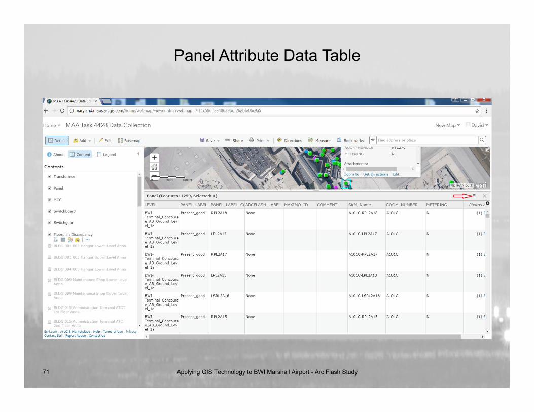
Panel Attribute Data Table
71 Applying GIS Technology to BWI Marshall Airport - Arc Flash Study

Panel Attribute Data Table
72 Applying GIS Technology to BWI Marshall Airport - Arc Flash Study

Panel Attribute Data Table
73 Applying GIS Technology to BWI Marshall Airport - Arc Flash Study

Panel Attribute Data Table
74 Applying GIS Technology to BWI Marshall Airport - Arc Flash Study

BWI Enterprise GIS Application
75 Applying GIS Technology to BWI Marshall Airport - Arc Flash Study
