applying geodesign in urban planning: case study … · applying geodesign in urban planning: case...
TRANSCRIPT
APPLYING GEODESIGN IN URBAN PLANNING: CASE STUDY OF PAMPULHA, BELO HORIZONTE, BRAZIL
Geodesign aplicado ao Planejamento Urbano: Estudo de Caso da Pampulha, Belo Horizonte, Brasil
Chiara Cocco1, Bráulio Magalhães Fonseca2 & Michele Campagna1
1Università di Cagliari – UNICADipartimento di Ingegneria Civile, Ambientale e Architettura - DICAAR
Via Università, 40, Cagliari, Sardinia, CEP 09124, [email protected], [email protected]
2Universidade Federal de Minas Gerais – UFMGDepartamento de Cartografi a /Instituto de Geociências - IGC/DCART
Avenida Antônio Carlos, 6627, Pampulha, Belo Horizonte, MG, CEP 31270-901, [email protected]
Received on July 22, 2015/ Accepted on August 14, 2015 Recebido em 22 de Julho , 2015/ Aceito em 14 de Agosto, 2015
ABSTRACTThis paper discusses the results of an early case of the application of the concept of Geodesign in Brazil. Geodesign is a new multi-disciplinary approach to spatial planning and design that is characterized by the use of GIS methods and tools. In this study, the Geodesign approach is applied - focusing on its analytical part – in two neighbor-hoods in Pampulha, Belo Horizonte, Brazil, aiming at evaluating their urban quality. The case study was chosen for the inte-grated capability of balancing urban transformation and preservation of environmental characteristics of the area. In order to evaluate their evolution dynamics a novelty multi-criteria analytical approach was applied to explore which implications spatial phenomena have on the urban quality level and transformation risk in the area. The results of the study highlight the role of knowledge as an essential starting point for urban interventions, in order to inform the design by the specifi c characteristics of the area and the needs of the citizens.
Keywords: Geodesign, Pampulha, Brazilian Modernism, Landscape.
RESUMOEste artigo discute os resultados de um dos primeiros estudos de caso da aplicação do conceito de Geodesign no Bra-sil. Geodesign é uma nova abordagem multidisciplinar para o planejamento urbano e ambiental, que é caracterizada pela utilização de métodos e ferramentas SIG. Neste estudo, o Geodesign é aplicado - concentrando-se em sua parte analítica - em dois bairros da Pampulha, Belo Horizonte, com o objetivo de avaliar a sua qualidade urbana. O estudo de caso foi escolhido para avaliar a relação entre a capacidade de transformação urbana e preservação das características ambientais e culturais da área de estudo. Com o objetivo de avaliar a dinâmica de transformação urbana e preservação ambiental foram aplicadas análises de multicritérios associadas às análises de incerteza e sensibilidade. Os resultados do estudo destacam a importância do conhecimento do funcionamento da área de estudo como um ponto de partida
Brazilian Journal of Cartography (2015), Nº 67/5 Special Issue 27th ICC: 929-940Brazilian Society of Cartography, Geodesy, Photgrammetry and Remote SenseISSN: 1808-0936
S B C
Cocco C. et al.
930 Brazilian Journal of Cartography, Rio de Janeiro, Nº 67/5 p. 929-940, Aug/2015
essencial para proposição de intervenções urbanas, objetivando a escolha de projetos que se adaptam às características específi cas da região e as necessidades dos cidadãos.
Palavras chaves: Geodesign, Pampulha, Modernismo Brasileiro, Paisagem.
1. INTRODUCTION
Strong development pressure affects urban areas in many countries worldwide. Design is often guided by economic factors and implemented without taking into proper consideration the local, social and environmental contexts. The risk arises of unsustainable form of urban sprawl which can seriously undermine the achievement of acceptable levels of urban quality. Therefore investments in methodological procedures, capability, and technological bases are needed in order to ad-dress its great potential for transformation through sustainable development processes. Capability refers to a collaborative process that can be deployed and through which individual potentials can be exploited. For this reason, Geodesign represents an interesting alternative and methodological approach to involve different actors - from technicians to stakeholders-in an open and participatory process that enables high visibility of the various actions and responsibilities.
The essence of the Geodesign concept is not new: it is present implicitly in the organic architecture of Frank Lloyd Wright (1867-1959) and more explicitly in the book “Design with Nature” by Ian McHarg (1969). Geodesign is design with the territory and for the territory and it aims at contextualized transformation of the landscape, respecting natural and cultural conditions (MILLER. 2012).
The concept of Geodesign, therefore, has its roots in more than a century of disciplinary evolution, but nowadays, it gets renewed interest internationally through methods and tools of Geographic Information Science and Technology (Goodchild, 2010). Steinitz (2012) recently pro-posed an integrated Geodesign framework (GDF) for the development of spatial planning studies, which can be applied at several scales, from the regional to the local one. The framework proposes an integrated collaborative and participatory approach which is based on the application of six models: from the analysis of the context and its internal dynamics, through the development of design
alternatives, simulation and evaluation of their impacts, up until the decision making phase in a process strongly linked to the use of Geographic Information Science methods and tools. In this context, Geodesign may provide a systematic methodological framework for regional and urban planning aiming at sustainable integration of human activities with natural environment, respecting cultural peculiarities, and enabling a process of democratic decision making.
Previous studies by Faria and Moura (2014) and Teixeira and Moura (2014) show that specifi cally the neighborhoods of São Luiz and São José, in Pampulha, which are signifi cant examples of the urban development during the modernist movement in Belo Horizonte in 1940’s, have enormous potential in combining areas with environmental and cultural conservation and development attractiveness due to the excel-lent infrastructures and location. Therefore, in the light of the concepts and practice of Geodesign, this study aims at understanding the processes that describe and explain the condition of a sort of “implicit geodesign” which was observed in this area.
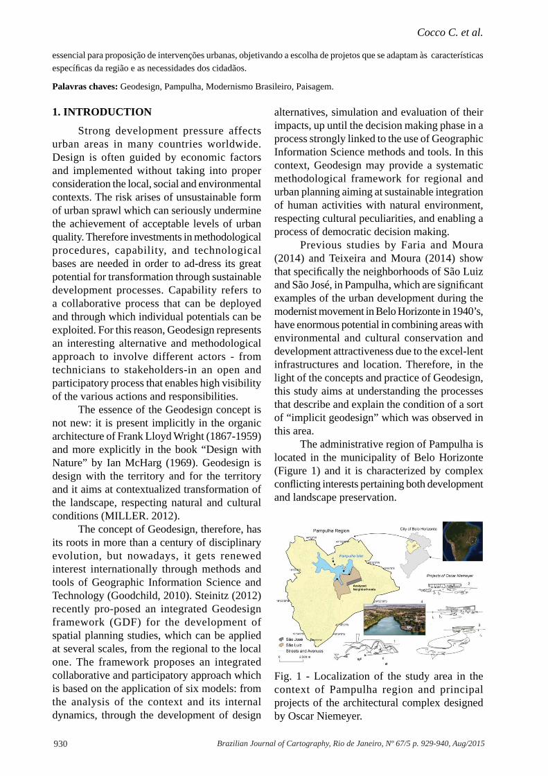
The administrative region of Pampulha is located in the municipality of Belo Horizonte (Figure 1) and it is characterized by complex confl icting interests pertaining both development and landscape preservation.
Fig. 1 - Localization of the study area in the context of Pampulha region and principal projects of the architectural complex designed by Oscar Niemeyer.
931Brazilian Journal of Cartography, Rio de Janeiro, Nº 67/5 p. 929-940, Aug/2015
Applying Geodesign in Urban Planning: Case Study of Pampulha, Belo Horizonte, Brazil
The region presents excellent urban infrastructure and services, and still it features a landscape not affected by excessive vertical or volumetric occupation (FARIA & MOURA, 2014; TEIXEIRA & MOURA, 2014). The name of “Pampulha” is commonly associated more with the immediate edge of the lake, rather than with the entire administrative region. The area usually perceived as Pampulha also includes the Museum of Art (located in the former Casino) and the Bandeirantes neighborhood.
Along time, the landscape of the neighborhoods of São Luiz and São José was not substantially altered. For São Luiz the municipal Master Plan established a low-density zoning, and it was declared an Area de Diretrizes Especiais (area of special guidelines). The same kind of protection was applied in other zoning districts of the region; however, in the latter, it did not result in such protection of the original urban landscape as in the chosen area. Therefore, it is possible to say that it was not a legal issue that protected the landscape, but rather the values and the uses intrinsic in its characteristics. For this reason, it is important to understand the which factors determinate the genius loci (NORBERG-SCHULZ, 1979) of this place, and it is worth investigating its components and key processes.
Conversely, São José was affected by different urban regulations that allowed higher densities, being surrounded by important connecting avenues and large shopping centers. Hence, it suffered more for the impact of densifi cation. Despite its landscape is different from São Luiz, this neighborhood has been included as object of analysis for its position, as well as for the intention to compare different realities in the same territory. The landscape of both neighborhoods is characterized by an interesting environmental and anthropic balance. It can be said that, in its essence, the area is a practical example of Geodesign, since it sup-ports a balanced territorial occupation, with clearly anthropized area, but it still keeps a strong environmental and cultural character. The relationship between environmental and anthropic elements is of great value, hence it should be preserved and protected.
1.1 The Pampulha Region
As Carsalade (2007) noticed the history of the Pampulha district started with the creation of the artifi cial lake at the beginning of the 1940s, un-der the prefecture of Juscelino Kubitschek, who chose Pampulha as fl agship development strategy for his government. His idea of transformation concerned at the same time the development of the area as place of residence and as a main tourist and leisure hub for the city. The project aimed to make the region more balanced and socially accessible by everyone in the metropolis, and to protect it from the continuous sprawl of the perverse effects of high density urbanization. Pampulha, along its evolution, shows the double face of urban development and modernization: they were also the seeds of its own environmental degradation and segregation. Its history, therefore, is in itself a synthesis of metropolitan issues of social inequality, irregular occupations, conurbation, environmental problems, but it is also a story of beauty and pro-found cultural meaning for Belo Horizonte. In Pampulha struggles and celebrations are hidden: the man struggles to create his spaces and the celebration of beauty that comes from the dialogue that man does with nature (CARSALADE, 2007).
Pampulha can be considered as one of the earliest example of a genuine Brazilian modernist movement, especially at the urban scale. Starting from the common approach to all modern movements, Oscar Niemeyer broke with the hitherto consensual understanding of architectural rationalism and demonstrated new practice possibilities with a close connection between architecture, structure and references to local languages (CAVALCANTI, 2006). However, according to Cavalcanti (2006) Pampulha can be considered the starting place of both the new architectural language, with the projects of the architectural complex by Oscar Niemeyer, and a new type of expansion and urban organization very attentive to environmental quality. As a matter of fact, at that time people were unsure whether to move or not to live in the area. However, slowly Pampulha marked his time and became a trendy spot. In these places it was possible to breathe modernity, the
Cocco C. et al.
932 Brazilian Journal of Cartography, Rio de Janeiro, Nº 67/5 p. 929-940, Aug/2015
new times, the esprit nouveau. The regulations reinforced the urban residential single-family estates in the lakefront, while they were less strict with the preservation in the most peripheral neighborhoods. It is important to understand the impact of this distinction of land occupation when looking at the differences between the São Luiz and São José neighborhoods. Thus, under the stewardship of environmental preservation with highly restricted use and occupation, the neighborhoods around the lake reinforced the urban enclave of large lots with high value, differing from those prevailing in the north axe of the urban expansion characterized by low-income dwellings.
Given the peculiarities of the region, in this study the concept and the methodological approach of Geodesign were used to understand the processes infl uencing the urban quality level in order to develop a thorough investigation of the actual conditions and to evaluate the trans-formation potential of the particular urban context.
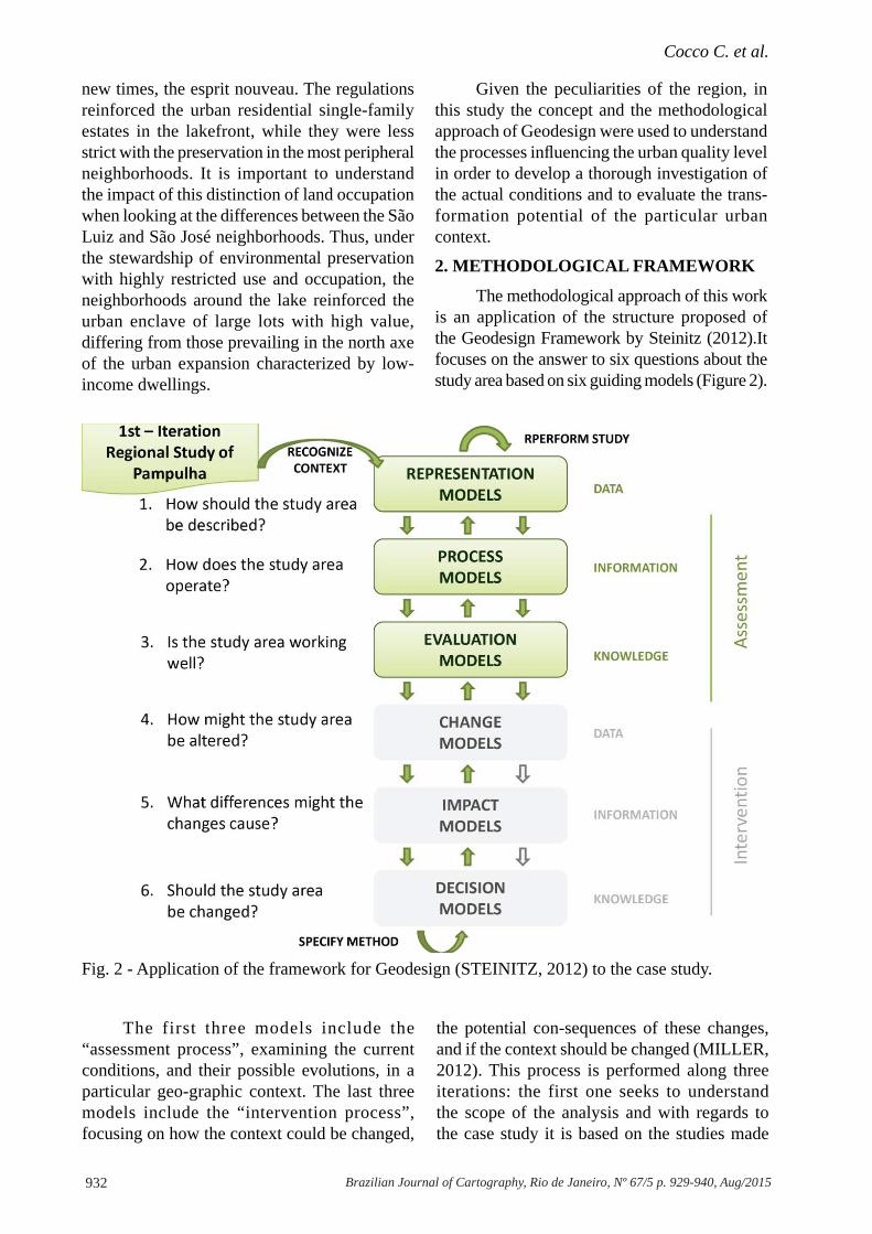
2. METHODOLOGICAL FRAMEWORK
The methodological approach of this work is an application of the structure proposed of the Geodesign Framework by Steinitz (2012).It focuses on the answer to six questions about the study area based on six guiding models (Figure 2).
Fig. 2 - Application of the framework for Geodesign (STEINITZ, 2012) to the case study.
The first three models include the “assessment process”, examining the current conditions, and their possible evolutions, in a particular geo-graphic context. The last three models include the “intervention process”, focusing on how the context could be changed,
the potential con-sequences of these changes, and if the context should be changed (MILLER, 2012). This process is performed along three iterations: the first one seeks to understand the scope of the analysis and with regards to the case study it is based on the studies made
933Brazilian Journal of Cartography, Rio de Janeiro, Nº 67/5 p. 929-940, Aug/2015
Applying Geodesign in Urban Planning: Case Study of Pampulha, Belo Horizonte, Brazil
by Faira and Moura (2014) and Teixeira and Moura (2014), that pointed out the main urban phenomena that characterize the study area; in the second iteration, in the light of the objectives, methods and technologies of the analysis process are defi ned. Finally, in the third iteration, we performed the analytical procedures, starting with the representation, Process and Evaluation Models that are discussed in the following paragraph: 2.1, 2.2 and 2.3 respectively. The results of the analysis are expected to play an important role in the design of alternative scenarios for future development in the area, which are, however, beyond the scope of this paper.
2.1 Representation Model
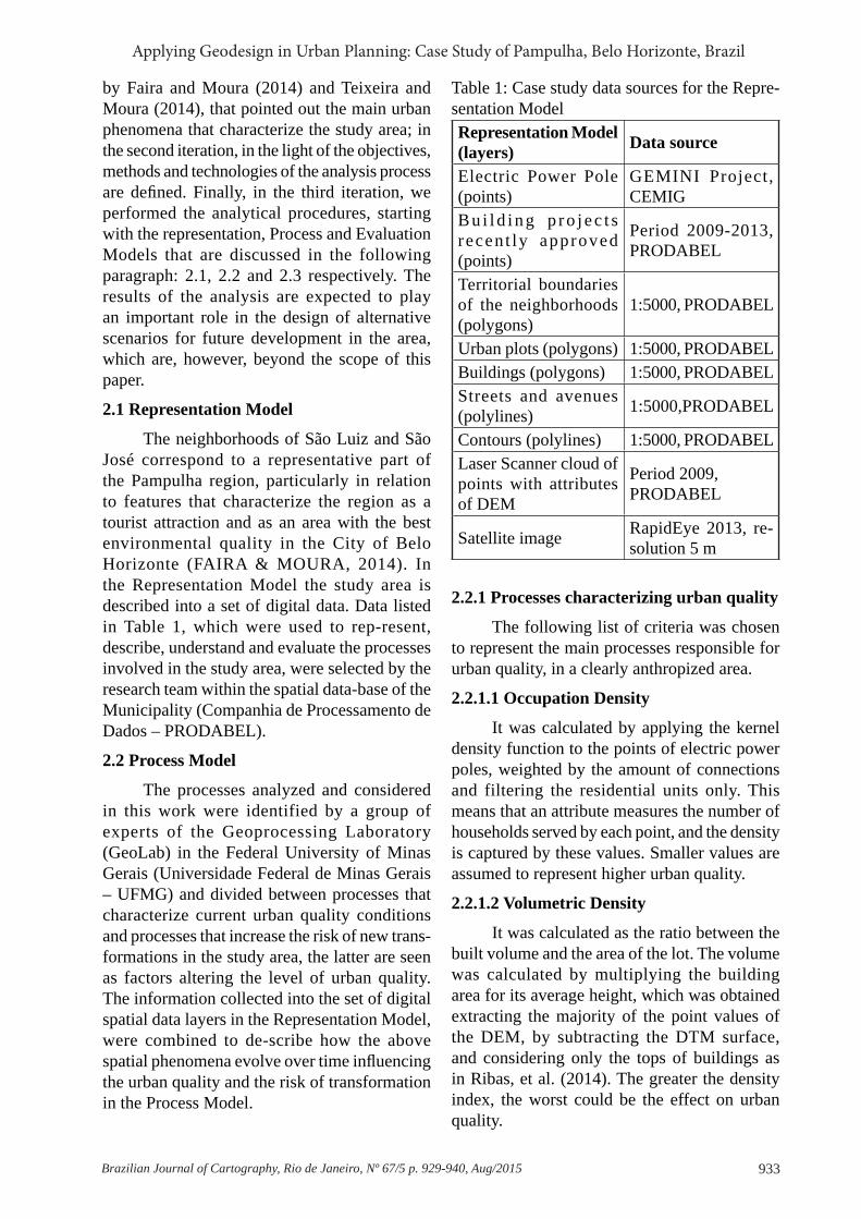
The neighborhoods of São Luiz and São José correspond to a representative part of the Pampulha region, particularly in relation to features that characterize the region as a tourist attraction and as an area with the best environmental quality in the City of Belo Horizonte (FAIRA & MOURA, 2014). In the Representation Model the study area is described into a set of digital data. Data listed in Table 1, which were used to rep-resent, describe, understand and evaluate the processes involved in the study area, were selected by the research team within the spatial data-base of the Municipality (Companhia de Processamento de Dados – PRODABEL).
2.2 Process Model
The processes analyzed and considered in this work were identified by a group of experts of the Geoprocessing Laboratory (GeoLab) in the Federal University of Minas Gerais (Universidade Federal de Minas Gerais – UFMG) and divided between processes that characterize current urban quality conditions and processes that increase the risk of new trans-formations in the study area, the latter are seen as factors altering the level of urban quality. The information collected into the set of digital spatial data layers in the Representation Model, were combined to de-scribe how the above spatial phenomena evolve over time infl uencing the urban quality and the risk of transformation in the Process Model.
2.2.1 Processes characterizing urban quality
The following list of criteria was chosen to represent the main processes responsible for urban quality, in a clearly anthropized area.
2.2.1.1 Occupation Density
It was calculated by applying the kernel density function to the points of electric power poles, weighted by the amount of connections and filtering the residential units only. This means that an attribute measures the number of households served by each point, and the density is captured by these values. Smaller values are assumed to represent higher urban quality.
2.2.1.2 Volumetric Density
It was calculated as the ratio between the built volume and the area of the lot. The volume was calculated by multiplying the building area for its average height, which was obtained extracting the majority of the point values of the DEM, by subtracting the DTM surface, and considering only the tops of buildings as in Ribas, et al. (2014). The greater the density index, the worst could be the effect on urban quality.
Table 1: Case study data sources for the Repre-sentation ModelRepresentation Model (layers) Data source
Electric Power Pole (points)
GEMINI Project, CEMIG
B u i l d i n g p r o j e c t s recen t ly approved (points)
Period 2009-2013, PRODABEL
Territorial boundaries of the neighborhoods (polygons)
1:5000, PRODABEL
Urban plots (polygons) 1:5000, PRODABELBuildings (polygons) 1:5000, PRODABELStreets and avenues (polylines) 1:5000,PRODABEL
Contours (polylines) 1:5000, PRODABELLaser Scanner cloud of points with attributes of DEM
Period 2009, PRODABEL
Satellite image RapidEye 2013, re-solution 5 m

Cocco C. et al.
934 Brazilian Journal of Cartography, Rio de Janeiro, Nº 67/5 p. 929-940, Aug/2015
2.2.1.3 Vegetation Cover
The amount of green areas was calculated by mapping the existing expressive vegetation fragments with automatic classification of RapidEye image composition RGB543. Green areas rep-resent a fundamental parameter in determining the urban quality level of a neighborhood.
2.2.1.4 Insolation
It was calculated as the potential impact of solar radiation on buildings wh/m² (Solar Radiation algorithm -ESRI ArcGIS 10.2), which is assumed to infl uence activities and habits of citizens.
In an area characterized by a high potential of transformation, urban planning and design priorities need to ensure the proper balance be-tween environmental and cultural conditions and urban development.
2.2.2 Processes increasing the risk of trans-formations
In order to evaluate urban quality, it is necessary to recognize the elements that reduce its level increasing the risk of transformation. In this paragraph, three processes are indicated, which have been identifi ed as major risk factors in the Pampulha case study.
2.2.2.1 Vehicles Concentration
The number of vehicles per lane was calculated by the kernel density function applied to the polyline vector dataset, representing the axis of streets and avenues, weighted by the number of vehicles traveling in each direction stored as attribute. This criterion is assumed to infl uence the perception of security.
2.2.2.2 Approved Projects
The concentration of approved projects by the municipal government in the last four years was calculated by the kernel density function applied to the point vector dataset of new approved projects. These interventions assumed to act as ‘attractors’ for urban transformation by directing economic interests and infl uencing decision-making processes.
2.2.2.3 Trade Concentration
The concentration of commercial establishments and services was calculated by applying the kernel density function to the points of electric power poles weighted by the amount of connections to buildings with commercial or service use. This data is used as an indicator of the potential transformation level of the area.
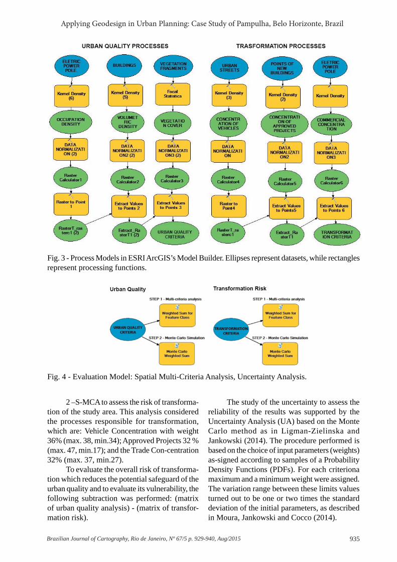
With regards to the territorial context, these processes are already underway and can directly affect the future development. The overall Process Model is shown in the analytical model shown in Figure 3.
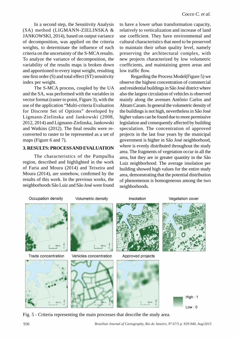
2.3 Evaluation Model
The Evaluation Model allows exploring how the processes analyzed affect the territorial context and it consists of two analytical models. The fi rst one identifi es areas most in need of maintaining urban quality and cultural heritage, while the second one identifi es the areas with higher risk of transformation and change in current conditions. Both analytical models were based on Spatial Multi-Criteria Analysis techniques (S-MCA) (MALCZEWSKI, 1999), coupled by the Uncertainty and Sensitivity Analysis (USA) (LIGMANN-ZIELINSKA & JANKOWSKI, 2008) of the results (Figure 4).
The S-MCA was based on the assignment of weights to each criteria, chosen by a simplifi ed Delphi (MOURA, JANKOWSKI & COCCO, 2014) answered by the study team members. The weights assigned in a multi-criteria analysis are often the parameters that provide more subjectivity to the process, directly interfering in assessment and consequently in decision making (LIGMANN-ZIELINSKA & JANKOWSKI, 2012; 2014). Therefore, the USA method is applied in order to investigate the weights variability and ensure robustness to the model outcomes. The weights obtained through the simplifi ed Delphi were:
1 –S-MCA to assess the need for maintaining urban quality. This analysis considered the processes that characterize current environmental conditions: Occupation Density with weight 28% (max. 31, min.25); Volumetric Density37% (max. 40, min.34); and Vegetation Cover 35% (max. 38, min.32).
935Brazilian Journal of Cartography, Rio de Janeiro, Nº 67/5 p. 929-940, Aug/2015
Applying Geodesign in Urban Planning: Case Study of Pampulha, Belo Horizonte, Brazil
2 –S-MCA to assess the risk of transforma-tion of the study area. This analysis considered the processes responsible for transformation, which are: Vehicle Concentration with weight 36% (max. 38, min.34); Approved Projects 32 % (max. 47, min.17); and the Trade Con-centration 32% (max. 37, min.27).
To evaluate the overall risk of transforma-tion which reduces the potential safeguard of the urban quality and to evaluate its vulnerability, the following subtraction was performed: (matrix of urban quality analysis) - (matrix of transfor-mation risk).
The study of the uncertainty to assess the reliability of the results was supported by the Uncertainty Analysis (UA) based on the Monte Carlo method as in Ligman-Zielinska and Jankowski (2014). The procedure performed is based on the choice of input parameters (weights) as-signed according to samples of a Probability Density Functions (PDFs). For each criteriona maximum and a minimum weight were assigned. The variation range between these limits values turned out to be one or two times the standard deviation of the initial parameters, as described in Moura, Jankowski and Cocco (2014).
Fig. 3 - Process Models in ESRI ArcGIS’s Model Builder. Ellipses represent datasets, while rectangles represent processing functions.
Fig. 4 - Evaluation Model: Spatial Multi-Criteria Analysis, Uncertainty Analysis.
Cocco C. et al.
936 Brazilian Journal of Cartography, Rio de Janeiro, Nº 67/5 p. 929-940, Aug/2015
In a second step, the Sensitivity Analysis (SA) method (LIGMANN-ZIELINSKA & JANKOWSKI, 2014), based on output variance of decomposition, was applied on the criteria weights, to determinate the infl uence of each criteria on the uncertainty of the S-MCA results. To analyze the variance of decomposition, the variability of the results maps is broken down and apportioned to every input weight, resulting one fi rst order (S) and total effect (ST) sensitivity index per weight.
The S-MCA process, coupled by the UA and the SA, was performed with the variables in vector format (raster to point, Figure 3), with the use of the application “Multi-criteria Evaluation for Discrete Set of Options” developed by Ligmann-Zielinska and Jankowski (2008, 2012, 2014) and Ligmann-Zielinska, Jankowski and Watkins (2012). The fi nal results were re-converted to raster to be represented as a set of maps (Figure 6 and 7).
3. RESULTS: PROCESS AND EVALUATION
The characteristics of the Pampulha region, described and highlighted in the work of Faria and Moura (2014) and Teixeira and Moura (2014), are somehow, confi rmed by the results of this work. In the previous works, the neighborhoods São Luiz and São José were found
to have a lower urban transformation capacity, relatively to verticalization and increase of land use coeffi cient. They have environmental and cultural characteristics that need to be preserved to maintain their urban quality level, namely preserving the architectural complex, with new projects characterized by low volumetric coeffi cients, and maintaining green areas and low traffi c fl ow.
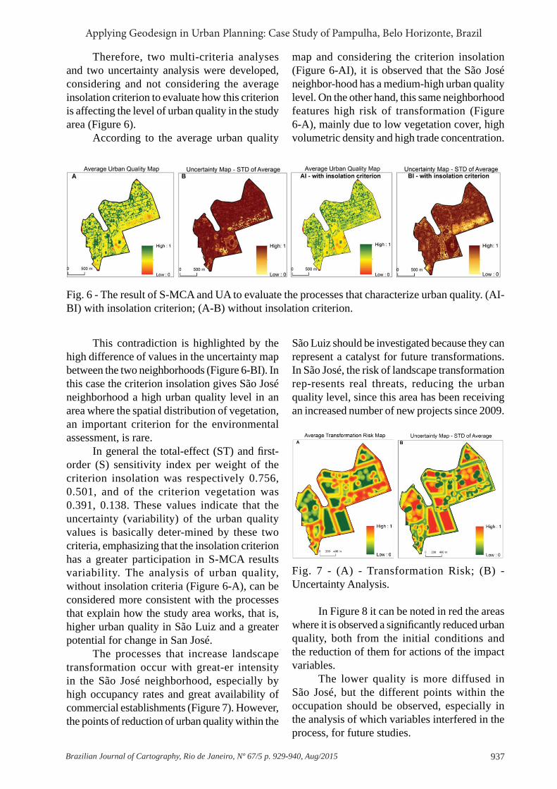
Regarding the Process Model(Figure 5) we observe the highest concentration of commercial and residential buildings in São José district where also the largest circulation of vehicles is observed mainly along the avenues Antônio Carlos and Abram Caram. In general the volumetric density of the buildings is not high, nevertheless in São José higher values can be found due to more permissive legislation and consequently affected by building speculation. The concentration of approved projects in the last four years by the municipal government is higher in São José neighborhood, where is evenly distributed throughout the study area. The fragments of vegetation occur in all the area, but they are in greater quantity in the São Luiz neighborhood. The average insolation per building showed high values for the entire study area, demonstrating that the potential distribution of phenomenon is homogeneous among the two neighborhoods.
Fig. 5 - Criteria representing the main processes that describe the study area.
937Brazilian Journal of Cartography, Rio de Janeiro, Nº 67/5 p. 929-940, Aug/2015
Applying Geodesign in Urban Planning: Case Study of Pampulha, Belo Horizonte, Brazil
Therefore, two multi-criteria analyses and two uncertainty analysis were developed, considering and not considering the average insolation criterion to evaluate how this criterion is affecting the level of urban quality in the study area (Figure 6).
According to the average urban quality
map and considering the criterion insolation (Figure 6-AI), it is observed that the São José neighbor-hood has a medium-high urban quality level. On the other hand, this same neighborhood features high risk of transformation (Figure 6-A), mainly due to low vegetation cover, high volumetric density and high trade concentration.
Fig. 6 - The result of S-MCA and UA to evaluate the processes that characterize urban quality. (AI-BI) with insolation criterion; (A-B) without insolation criterion.
This contradiction is highlighted by the high difference of values in the uncertainty map between the two neighborhoods (Figure 6-BI). In this case the criterion insolation gives São José neighborhood a high urban quality level in an area where the spatial distribution of vegetation, an important criterion for the environmental assessment, is rare.
In general the total-effect (ST) and fi rst-order (S) sensitivity index per weight of the criterion insolation was respectively 0.756, 0.501, and of the criterion vegetation was 0.391, 0.138. These values indicate that the uncertainty (variability) of the urban quality values is basically deter-mined by these two criteria, emphasizing that the insolation criterion has a greater participation in S-MCA results variability. The analysis of urban quality, without insolation criteria (Figure 6-A), can be considered more consistent with the processes that explain how the study area works, that is, higher urban quality in São Luiz and a greater potential for change in San José.
The processes that increase landscape transformation occur with great-er intensity in the São José neighborhood, especially by high occupancy rates and great availability of commercial establishments (Figure 7). However, the points of reduction of urban quality within the
São Luiz should be investigated because they can represent a catalyst for future transformations. In São José, the risk of landscape transformation rep-resents real threats, reducing the urban quality level, since this area has been receiving an increased number of new projects since 2009.
Fig. 7 - (A) - Transformation Risk; (B) - Uncertainty Analysis.
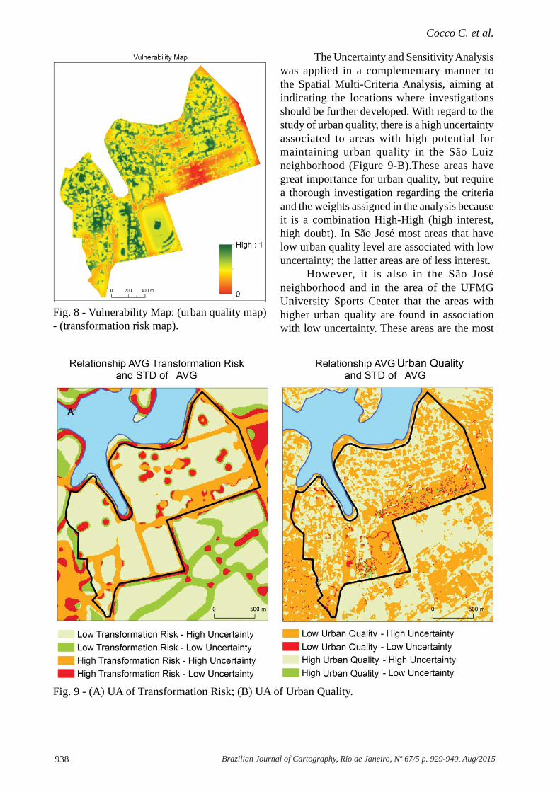
In Figure 8 it can be noted in red the areas where it is observed a signifi cantly reduced urban quality, both from the initial conditions and the reduction of them for actions of the impact variables.
The lower quality is more diffused in São José, but the different points within the occupation should be observed, especially in the analysis of which variables interfered in the process, for future studies.
Cocco C. et al.
938 Brazilian Journal of Cartography, Rio de Janeiro, Nº 67/5 p. 929-940, Aug/2015
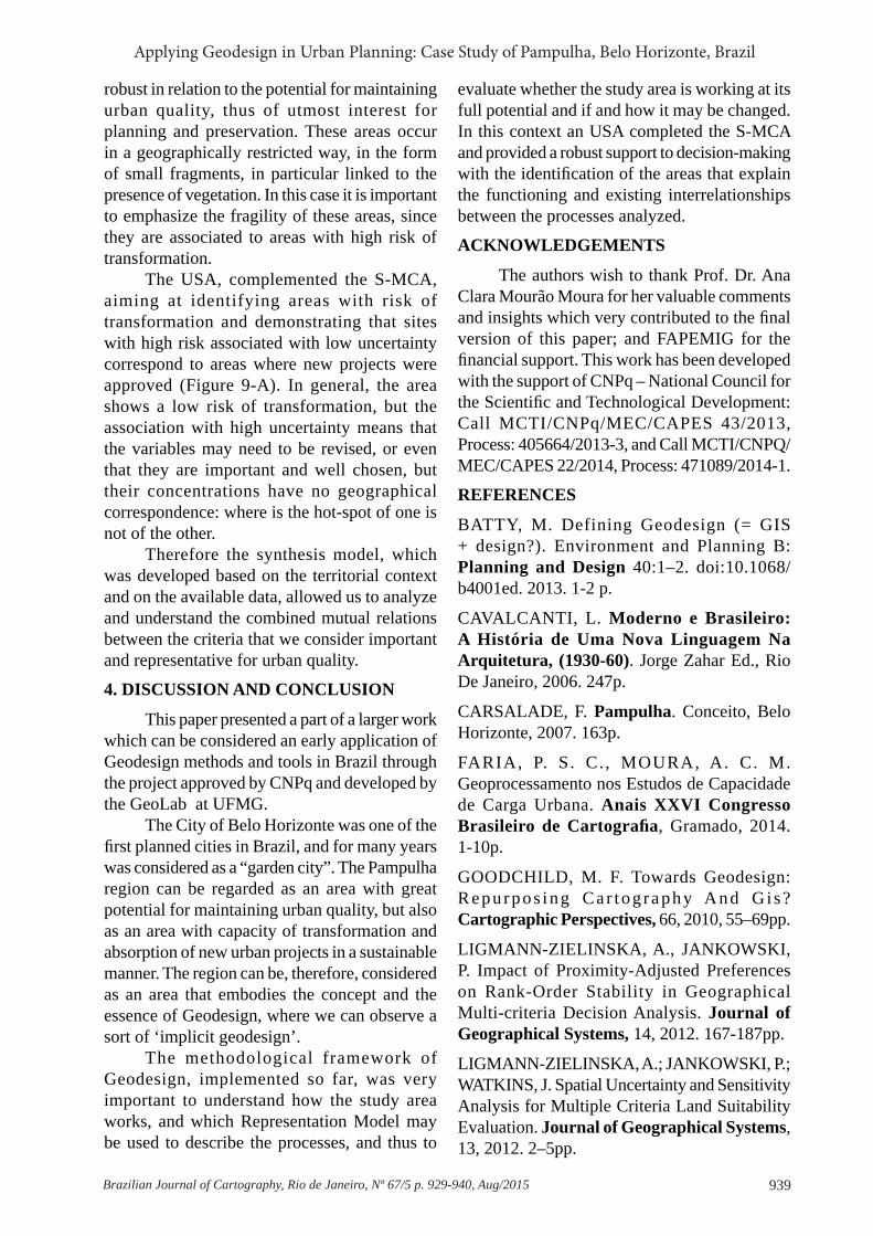
The Uncertainty and Sensitivity Analysis was applied in a complementary manner to the Spatial Multi-Criteria Analysis, aiming at indicating the locations where investigations should be further developed. With regard to the study of urban quality, there is a high uncertainty associated to areas with high potential for maintaining urban quality in the São Luiz neighborhood (Figure 9-B).These areas have great importance for urban quality, but require a thorough investigation regarding the criteria and the weights assigned in the analysis because it is a combination High-High (high interest, high doubt). In São José most areas that have low urban quality level are associated with low uncertainty; the latter areas are of less interest.
However, it is also in the São José neighborhood and in the area of the UFMG University Sports Center that the areas with higher urban quality are found in association with low uncertainty. These areas are the most
Fig. 8 - Vulnerability Map: (urban quality map) - (transformation risk map).
Fig. 9 - (A) UA of Transformation Risk; (B) UA of Urban Quality.
939Brazilian Journal of Cartography, Rio de Janeiro, Nº 67/5 p. 929-940, Aug/2015
Applying Geodesign in Urban Planning: Case Study of Pampulha, Belo Horizonte, Brazil
robust in relation to the potential for maintaining urban quality, thus of utmost interest for planning and preservation. These areas occur in a geographically restricted way, in the form of small fragments, in particular linked to the presence of vegetation. In this case it is important to emphasize the fragility of these areas, since they are associated to areas with high risk of transformation.
The USA, complemented the S-MCA, aiming at identifying areas with risk of transformation and demonstrating that sites with high risk associated with low uncertainty correspond to areas where new projects were approved (Figure 9-A). In general, the area shows a low risk of transformation, but the association with high uncertainty means that the variables may need to be revised, or even that they are important and well chosen, but their concentrations have no geographical correspondence: where is the hot-spot of one is not of the other.
Therefore the synthesis model, which was developed based on the territorial context and on the available data, allowed us to analyze and understand the combined mutual relations between the criteria that we consider important and representative for urban quality.
4. DISCUSSION AND CONCLUSION
This paper presented a part of a larger work which can be considered an early application of Geodesign methods and tools in Brazil through the project approved by CNPq and developed by the GeoLab at UFMG.
The City of Belo Horizonte was one of the fi rst planned cities in Brazil, and for many years was considered as a “garden city”. The Pampulha region can be regarded as an area with great potential for maintaining urban quality, but also as an area with capacity of transformation and absorption of new urban projects in a sustainable manner. The region can be, therefore, considered as an area that embodies the concept and the essence of Geodesign, where we can observe a sort of ‘implicit geodesign’.
The methodological framework of Geodesign, implemented so far, was very important to understand how the study area works, and which Representation Model may be used to describe the processes, and thus to
evaluate whether the study area is working at its full potential and if and how it may be changed. In this context an USA completed the S-MCA and provided a robust support to decision-making with the identifi cation of the areas that explain the functioning and existing interrelationships between the processes analyzed.
ACKNOWLEDGEMENTS
The authors wish to thank Prof. Dr. Ana Clara Mourão Moura for her valuable comments and insights which very contributed to the fi nal version of this paper; and FAPEMIG for the fi nancial support. This work has been developed with the support of CNPq – National Council for the Scientifi c and Technological Development: Call MCTI/CNPq/MEC/CAPES 43/2013, Process: 405664/2013-3, and Call MCTI/CNPQ/MEC/CAPES 22/2014, Process: 471089/2014-1.
REFERENCES
BATTY, M. Defining Geodesign (= GIS + design?). Environment and Planning B: Planning and Design 40:1–2. doi:10.1068/b4001ed. 2013. 1-2 p.
CAVALCANTI, L. Moderno e Brasileiro: A História de Uma Nova Linguagem Na Arquitetura, (1930-60). Jorge Zahar Ed., Rio De Janeiro, 2006. 247p.
CARSALADE, F. Pampulha. Conceito, Belo Horizonte, 2007. 163p.
FARIA, P. S. C. , MOURA, A. C. M. Geoprocessamento nos Estudos de Capacidade de Carga Urbana. Anais XXVI Congresso Brasileiro de Cartografi a, Gramado, 2014. 1-10p.
GOODCHILD, M. F. Towards Geodesign: Repurpos ing Ca r tog raphy And Gi s? Cartographic Perspectives, 66, 2010, 55–69pp.
LIGMANN-ZIELINSKA, A., JANKOWSKI, P. Impact of Proximity-Adjusted Preferences on Rank-Order Stability in Geographical Multi-criteria Decision Analysis. Journal of Geographical Systems, 14, 2012. 167-187pp.
LIGMANN-ZIELINSKA, A.; JANKOWSKI, P.; WATKINS, J. Spatial Uncertainty and Sensitivity Analysis for Multiple Criteria Land Suitability Evaluation. Journal of Geographical Systems, 13, 2012. 2–5pp.
Cocco C. et al.
940 Brazilian Journal of Cartography, Rio de Janeiro, Nº 67/5 p. 929-940, Aug/2015
LIGMANN-ZIELINSKA, A.; JANKOWSKI, P. A Framework for Sensitivity Analysis in Spatial Multiple Criteria Evaluation. In: COVA, T. J.; MILLER, H. J.; BEARD, K.; FRANK, A. U.; GOODCHILD, M. F.; Geographic Information Science 5th International Conference, GIScience 2008, Park City, UT, USA, September 23-26, 2008. Proceedings. Springer Verlag, Berlin-Heidelberg 5266, 2008. 217-233pp.
LIGMANN-ZIELINSKA, A.; JANKOWSKI, P. Spatially-Explicit Integrated Uncertainty And Sensitivity Analysis Of Criteria Weights In Multi-criteria Land Suitability Evaluation. Environmental Modelling & Software. 57, 2014. 235-247pp.
MALCZEWSKI, J. GIS and Multi-criteria Decision Analysis. New York: J. Wiley & Sons, 1999. 408p.
MILLER, W. R. Introducing Geodesign : The Concept Director Of Geodesign Services.
Redlands: Esri Press, 2012 1–36pp.
MOURA, A. C. M.; JANKOWSKI, P.; COCCO, C. Contribuições Aos Estudos De Análises De Incertezas Como Complementação Às Análises Multicrité-rios - “Sensitivity Analysis To Suitability Evaluation”. Anais XXVI Congresso Brasileiro de Cartografi a. Gramado, 2014. 1-20pp.
STEINITZ, C. A Framework For Geodesign: Changing Geography By Design. Redlands: Esri Press, 2012. 224p.
Soares-Filho, B.; Rajão, R.; Macedo, M.; Carneiro, A.; Costa, W.; Coe, M.; Alencar, A. Cracking Brazil’s Forest Code. Science 344(6182), 2014. 363-364pp.
TEIXEIRA, P. P.; MOURA, A. C. M. Contribuições ao Estudo de Impacto de Vizinhança (Eiv). Anais XXVI Congresso Brasileiro De Cartografi a. Gramado, 2014. 1-14pp.