applications of radar-interferometry · applications of radar-interferometry. f. bovenga, n....
TRANSCRIPT
AO-COSMO Final Workshop – 27 March 2012, Rome 1
Assessment of the suitability of COSMO-SkyMed data to multi-temporal and multi-chromatic
applications of radar-interferometry
F. Bovenga, N. Veneziani
(PI), A. Refice, F. RanaNational Research Council of Italy
ISSIA Institute, Via Amendola, 122/D, Bari, Italy
J. WasowskiNational Research Council of Italy
IRPI Institute, Via Amendola, 122/D, Bari, Italy
M.T. Chiaradia, R. Nutricato, D.O. NittiDipartimento
Interateneo
di
Fisica
“M. Merlin”, Politecnico
di
Bari, Via Amendola 173, Bari, Italy
FINAL WORKSHOP “ACHIEVED RESULTS IN RESPONSE TO THE FIRST
COSMO-SkyMed
ANNOUNCEMENT OF OPPORTUNITY”
Rome, March 27th, 28th and 29th

AO-COSMO Final Workshop – 27 March 2012, Rome 2
SAR Interferometry
Coherent combination of two (or more) SAR images of the same area taken from slightly different directions:
tvfHrc
B⋅−⋅−=Φ ⊥
λπ
θπ 4sin
40
InSAR
Absolute Phase
Topography Movement
Multi-temporalAnalysis
time
t0
tN
Multi-frequencyAnalysis
frequencyf0 fNf

AO-COSMO Final Workshop – 27 March 2012, Rome 3
Project objectives
•
A systematization of the technical aspects related to the innovative Multi-Chromatic Analysis (MCA) in the context of repeat-pass interferometry and validation of the MCA for height retrieval with COSMO-SkyMed
(CSK) data
.
•
Assessment of the suitability of CSK data to multi-temporal SAR interferometry, highlighting advantages and possible shortcomings of CSK mission with respect to the rest of present-day SAR data.
•
A quantitative assessment
of
the nature of
frequency-persistent scatterers
(F-PS), in correlation
to
known
temporal-PS
targets.

AO-COSMO Final Workshop – 27 March 2012, Rome 4
Project status
The time scheduling of the project has been updated according to
a delay of six months in the activities due to a correspondent delay of the CSK
data procurement.

AO-COSMO Final Workshop – 27 March 2012, Rome 5
Test sites
•
ULURU monolith
(Australia), the topographic configuration as well as the surface coverage make this site well suited for MCA development and tuning. (S2: 8)
•
Zhouqu
area
(Gansu Province, China) for experimenting the potentiality of CSK interferometric application to landslide monitoring.
(S2: 25)
•
Parkfield
(USA), well suited for PSI investigations and comparison between PS and F-PS. (HI: 48, S2: 33)

AO-COSMO Final Workshop – 27 March 2012, Rome 6
Absolute Phase vs Wrapped measured Phase
),(2),(),( rxkrxrx W ⋅+Φ=Φ π
fyxHrc
Byx ⋅−=Φ ⊥ ),(sin
4),(0 θπ
Multi Chromatic Approach (MCA) is aimed at performing Phase Unwrapping (PU) and measuring ground elevation.

AO-COSMO Final Workshop – 27 March 2012, Rome 7
Multi-Chromatic Approach (MCA) principles
•
Starting from the original idea of Madsen and Zebker, MCA involves the computation of a set of several equal-resolution interferograms from SAR sub-look images of bandwidth Bp centred at different carrier frequencies fi :
iiWi frxCrxCfrxR
crxkrx ⋅+=⋅Δ⋅−⋅−=Φ ),(),(),(4),(2),( 10
ππ
Height
measurement
),(4
),( 1 rxCcrxR ⋅−=Δπ
Absolute
phase
measurement
/Fringes
classification
π2),(),( 0 rxCrxk −=

AO-COSMO Final Workshop – 27 March 2012, Rome 8
Multi-Chromatic
Approach
(MCA) principles
•
The basic MCA algorithm, for the height measurement, consists of performing standard InSAR
processing on sub-band signals, followed by
a point-wise estimation of C0 and C1 through a linear regression method.
•
The height
of any pixel is retrieved independently
from the others and no phase unwrapping step is needed in the spatial domain. The resolution of the resulting interferogram depends on the spectral sub-
band width, Bp .
•
The inter-band coherence or the multi-frequency phase STD can be assumed as a quality index of the measurements:
•
Reliable measurement can be performed on the targets showing a good linear phase trend vs. frequency (PSfd ):
( ) ( ) ( )[ ]∑=
⋅−−Φ=Φ
fN
iii
f
frxcrxcrxN 1
210 ,,,1 σ
( ){ }thfd yxyxPS
ΦΦ≤= σσ ),(|,

AO-COSMO Final Workshop – 27 March 2012, Rome 9
MCA potentials
•
Absolute phase/height retrieval (point-based PU, instead of conventional gradient-based PU)
•
Support to standard (gradient-based) PU procedures
•
Support to SAR image coregistration
•
Coherent scatterers
identification
•
Absolute ranging

AO-COSMO Final Workshop – 27 March 2012, Rome 10
MCA processing
•
MCA computes C0 (x,y), C1 (x,y), σφ
(x,y):–
Phase unwrapping: ΦMCA (x,y)=C1 (x,y)⋅ f0 + Φ drg_coreg (x,y) (if coregistration is performed once at full band)
–
Height retrieval: H(x,y) = Φ2H(x,y)⋅Φ MCA (x,y)
PU

AO-COSMO Final Workshop – 27 March 2012, Rome 11
MCA parametric analysis
•
At least B=300 MHz seems to be required to a reliable application.
•
The technique appears optimally suited for the new generation of
satellite sensors, which operate with larger bandwidths →COSMO-SkyMed
•
A parametric analysis has been carried out with the aim of evaluating the impact of the MCA processing parameters (B , Nf
, Bp
, Be
) on the estimation performance.
•
Results indicate that the estimation is improved mainly by using
wider explored bandwidth, and secondly by using a wider bandwidth of the sub-look images or by increasing the number of sub-bands.

AO-COSMO Final Workshop – 27 March 2012, Rome 12
MCA on Uluru monolith
Tandem pairs acquired with ENHANCED SPOTLIGHT (B≥300MHz) acquired over the Uluru monolith, in central Australia along descending orbits.
350 m
ID MASTER SLAVE Bn
(m) Ha (m) B (MHz) Look ΔRg ΔAz
1 22.01.2011 22.01.2011 17.8 334 325 28.4° 0.5 1.1
2 03.09.2011 04.09.2011 221.4 28 325 28.3° 0.5 1.1
3 25.01.2012 26.01.2012 614 9.6 325 28.4° 0.5 1.1

AO-COSMO Final Workshop – 27 March 2012, Rome 13
MCA on Uluru monolith
ID MASTER SLAVE Bn
(m) Ha (m) B (MHz) Look ΔRg ΔAz
2 03.09.2011 04.09.2011 221.4 28 325 28.3° 0.5 1.1

AO-COSMO Final Workshop – 27 March 2012, Rome 14
•
Split-band processing of MASTER and SLAVE to generate Nf
sub-band images
•
Generation of Nf
InSAR
phase fields
•
Smoothing filtering of each sub-band phase field
•
MCA analysis to compute C0 (x,y), C1 (x,y), σφ
(x,y):
–
Phase unwrapping: ΦMCA (x,y)=C1 (x,y)⋅ f0 + Φ drg_coreg (x,y) (if coregistration is performed once at full band)
–
Height retrieval: H(x,y) = Φ2H(x,y)⋅Φ MCA (x,y)
B = 325 MHz, f0 = 9.65 GHz
(CSK)Nf
= 3÷15BP
(df) = 20 ÷100 MHzBe
= 180÷280 MHz
MCA processing
f1
B
fNf
f0
BP
Be
AO-COSMO Final Workshop – 27 March 2012, Rome 15
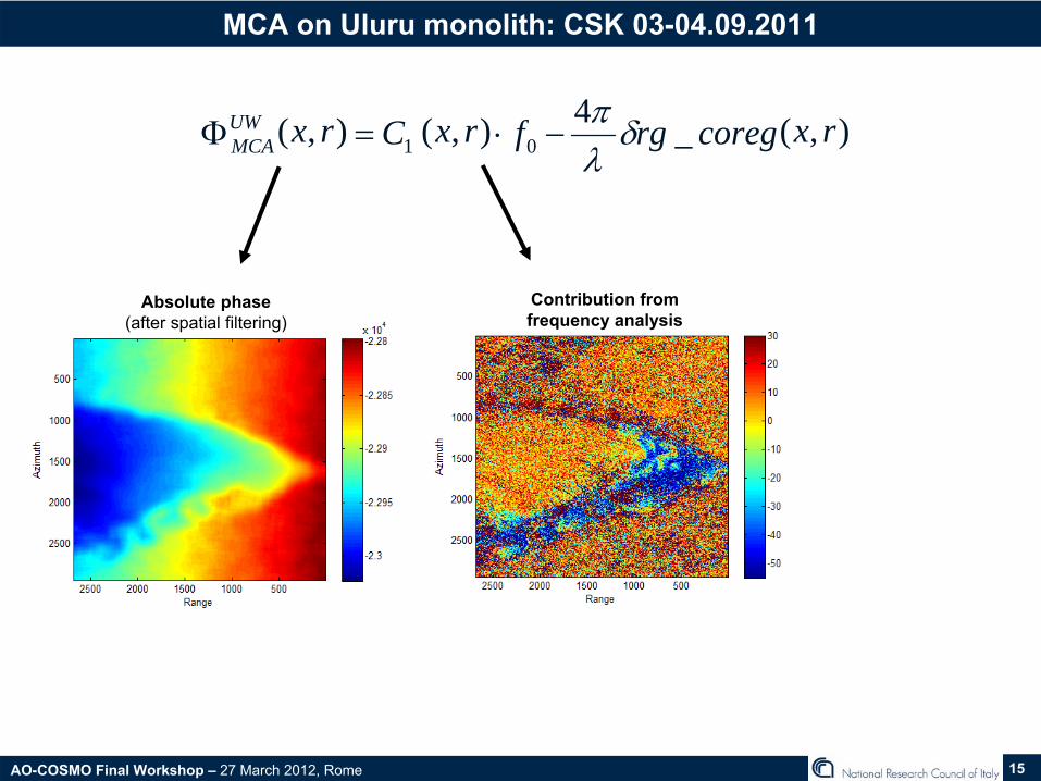
MCA on Uluru monolith: CSK 03-04.09.2011
),(_4),(),( 01 rxcoregrgfrxCrxUWMCA δ
λπ
−⋅=Φ
Absolute
phase(after
spatial
filtering)Contribution
from
frequency
analysis

AO-COSMO Final Workshop – 27 March 2012, Rome 16
MCA on Uluru monolith: CSK 03-04.09.2011
),( rxWMCAΦ
( )MCAW jj ee Φ⋅−Φ⋅ ⋅∠
The flattening is successful:There is less than one residual fringe on the whole flat area.
On the monolith it self, there is also less than one residual fringe.
Flattening fails where absolute phase derived through MCA is too noisy (due to decorrelation).
The flattening is successful:There is less than one residual fringe on the whole flat area.
On the monolith it self, there is also less than one residual fringe.
Flattening fails where absolute phase derived through MCA is too noisy (due to decorrelation).
•
In order to validate this MCA-based absolute phase we compare the modulo 2π
of this phase, , wrt
to the original interferogram, ),( rxWΦ ),( rxWMCAΦ
Classical interferogram
),( rxWΦ
Filtered MCA-
derived absolute phase modulo 2π

AO-COSMO Final Workshop – 27 March 2012, Rome 17
MCA on Uluru monolith: CSK 03-04.09.2011
•
A calibration was required to remove the offset due to orbital errors
as well as atmospheric signal
which impact on the height computation.
•
Calibration was performed by exploring the SRTM DEM.
•
Smoothing filtering is also applied during calibration to reduce noise.
Difference
between
the MCA heights
SRTM DEM: only
an
OFFSET!
),(),(2),( rxrxHrxH UWMCAΦ⋅Φ=

AO-COSMO Final Workshop – 27 March 2012, Rome 18
MCA on Uluru monolith: CSK 03-04.09.2011
•
Offset removed though calibration•
Constraints have been applied on σΦ
.

AO-COSMO Final Workshop – 27 March 2012, Rome 19
MCA on Uluru monolith
•
As reference DEM we used a post-processed
3-arc second
(90 m) SRTM DEM provided
by
CGIAR-CSI.
•
No-data regions due to insufficient textural detail (found especially in mountainous regions) are filled through interpolation.
Original
NASA-USGS FIlled
CGIAR-CSI SRTM DEM Difference
H_MCA
–
DEM_SRTM_CGIR
MCA on InSAR
phase provides information (except for a bias) where the coregistration
fails. In the same area the reference DEM used for comparison is not accurate due to steep slopes and coarse interpolation.
MCA on InSAR
phase provides information (except for a bias) where the coregistration
fails. In the same area the reference DEM used for comparison is not accurate due to steep slopes and coarse interpolation.

AO-COSMO Final Workshop – 27 March 2012, Rome 20
MCA on Uluru monolith

AO-COSMO Final Workshop – 27 March 2012, Rome 21
MCA on Parkfield
test site
SRTM
MCA_H_filt
σΦ
mask
CSK Spotlight•
CSK_SCS_B_S2_02_VV_LD•
Master: 18.09.2010 •
Master: 19.09.2010 •
Bn
= 112 m•
Bp
= 75 m•
fo = 9.6 GHz
(λ=3.12 cm)•
B = 379 MHz•
Slant
range
res. = 0.5 m•
Azimuth res. = 1.1 m•
Ha ~
44 m

AO-COSMO Final Workshop – 27 March 2012, Rome 22
MCA parametric analysis
•
The theoretical parametric model has been also validated by processing ENANCED SPOTLIGHT CSK tandem couples acquired on ULURU test case.
•
Results confirm that the estimation is improved mainly with wider explored bandwidth Be,
and secondly with wider sub-look bandwidth Bp
or more sub-bands Nf
.
Model
CSK data
AO-COSMO Final Workshop – 27 March 2012, Rome 23
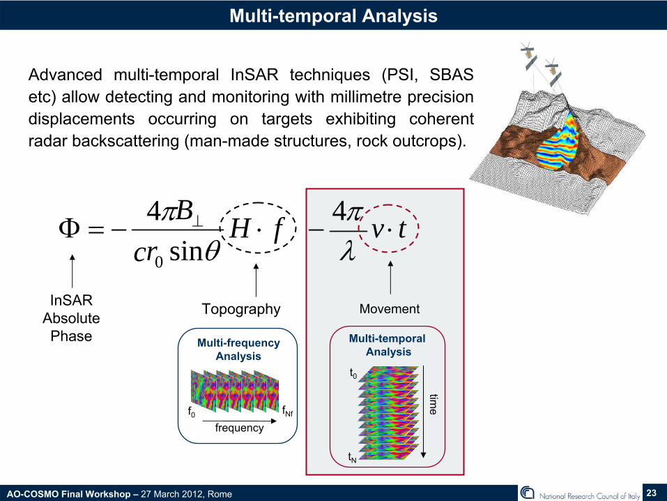
Multi-temporal
Analysis
Advanced multi-temporal InSAR
techniques (PSI, SBAS etc) allow detecting and monitoring with millimetre precision displacements occurring on targets exhibiting coherent radar backscattering (man-made structures, rock outcrops).
tvfHrc
B⋅−⋅−=Φ ⊥
λπ
θπ 4 sin
40
InSAR
Absolute Phase
Topography Movement
Multi-temporalAnalysis
time
t0
tN
Multi-frequencyAnalysis
frequencyf0 fNf

AO-COSMO Final Workshop – 27 March 2012, Rome 24
Multi-temporal
Analysis
•
In the framework of DInSAR
applications it is worthwhile to investigate potential of the multi-temporal DInSAR
processing of the high-resolution
COSMO-SkyMedSAR
data with respect to the thoroughly exploited medium resolution C-band SAR data.
•
In particular, two specific questions come up:
1. How do the characteristics of the new SAR sensors impact on PS processing?
2. Can the minimum number of SAR images required to obtain reliable PSI results be lower for high resolution data with respect to medium resolution data?
λ, B, dt Ni , NPS

AO-COSMO Final Workshop – 27 March 2012, Rome 25
Multi-temporal
Analysis
( ) ( ) ( ) ( )θσλσσπλσ φ ,,,,,
4, 02111 BfTNifTNifTNif dv ⋅=⋅=⋅≈
•
Through a simple theoretical model, it is possible to take into account the differences in wavelength, resolution and revisit time between X-band high resolution
and C-band medium resolution
sensors.
We demonstrated that with the higher resolution, new generation X- band sensors, reliable estimates of the displacement rates are possible
using fewer SAR scenes
than in the case of C-band medium resolution data.
The high resolution leads to PS spatial density between five and ten times greater
than that derived by medium resolution data.
Ni
NPS

AO-COSMO Final Workshop – 27 March 2012, Rome 26
PSI SPINUA Processing -
Zhouqu
The Zhouqu
area is located in the central part of the China (Gansu region) along Bailong
river and it results very interesting for landslides investigation.
AOI

AO-COSMO Final Workshop – 27 March 2012, Rome 27
The geomorphology/geology of the Zhouqu
area.
•
Seismicaly
active area (high, even >7, magnitude earthquakes), fault controlled landscape, very high relief.
•
The highest peak reaches over 3000 m, the lowest point is the main river at about 1340 m elevation. Very steep mountain terrain (upper slopes gradients exceeding 35°).
•
Tree cover only at the highest elevations.
•
Relatively dry climate, but with monsoon-like late spring-summer.
•
Geology/Lithology
make the area susceptible to slope instability: loess, limestones, argillites/shales, igneous and metamorphic rocks.

AO-COSMO Final Workshop – 27 March 2012, Rome 28
PSI SPINUA Processing -
Zhouqu
•
In the area, there are several active landslides, moving slowly and can block the Bailong
River at any time.
•
In August 2010, debris flows destroyed about 200 houses, causing the deaths of more than 1500 people, in the town of Zhouqu. The Sanyayu
catchment generated the largest debris flows.
(STR/AFP/Getty Images)Satellite images showing Zhouqu
before (left) in July, 2008 and after the recent landslide (right), taken on August 8, 2010 (from the State Bureau of Surveying and Mapping).

AO-COSMO Final Workshop – 27 March 2012, Rome 29
PSI SPINUA Processing -
Zhouqu
•
22 CSK HIMAGE acquisitions.•
Pass: Descending.•
Polarization: HH.•
Look side: Right; Beam: HI_09,
θ:40°•
The topographic range is ~
2km.
•
Steep
tpography, low urbanisation and scarse number
of
images
make
difficoult
the processing.

AO-COSMO Final Workshop – 27 March 2012, Rome 30
PSI SPINUA Processing -
Zhouqu

AO-COSMO Final Workshop – 27 March 2012, Rome 31
PSI SPINUA Processing -
Zhouqu
•
SPINUA adopts some ad hoc solutions (robust patch-wise processing scheme) which enable to get fast results, on small areas by processing also scarcely populated stack of SAR images.
•
InSAR
processor
has
been
upadated
in order
to
handle:–
Left-looking
acquisitions
–
Rough
topography
and long baselines
(DEM-assisted
coregistration)
–
The high variability
of
Doppler centroid
along
azimuth direction in enhanced
spotlight
acquisitions
(resampling, common-band
filtering)
–
PRF changes
between
master and slave acquisitions (stripmap/spotlight)

AO-COSMO Final Workshop – 27 March 2012, Rome 32
PSI SPINUA Processing -
Zhouqu

AO-COSMO Final Workshop – 27 March 2012, Rome 33
PSI SPINUA Processing -
Zhouqu
3
1
4
5
2

AO-COSMO Final Workshop – 27 March 2012, Rome 34
PSI SPINUA Processing -
Zhouqu
3
1
4
5
2
LOS

AO-COSMO Final Workshop – 27 March 2012, Rome 35
PSI SPINUA Processing -
Zhouqu
1. Large (well over 1 km
long), deep, active landslide (known –
inspected in 2009 e 2011); arrows indicate the direction of movement.
1

AO-COSMO Final Workshop – 27 March 2012, Rome 36
PSI SPINUA Processing -
Zhouqu
2. Landslide zone or landslide complex (with superimposed, coalescing movements), on the GE image can note 2 active landslides (known -
visited 2009 e 2011).
2

AO-COSMO Final Workshop – 27 March 2012, Rome 37
PSI SPINUA Processing -
Zhouqu
3. Area characterized by the presence of more or less recent landslides; signs of recent slope instability were noted during a
visit in 2011.
3

AO-COSMO Final Workshop – 27 March 2012, Rome 38
PSI SPINUA Processing -
Zhouqu
4
4. A large, composite/complex landslide; we did not know about it, but one can recognize it on GE image.

AO-COSMO Final Workshop – 27 March 2012, Rome 39
Conclusions
•
Multi-Chromatic Analysis (MCA)
It was shown that MCA is able to derive a reliable unwrapped interferometric phasesurface (with some spatial smoothing) where, due to the steep terrain slopes, conventional 2D PU results critical.
The absolute measurements (phase / height) are affected by atmospheric artefacts as well as orbital errors. Calibration procedures through independent measurements (e.g. reference points) are required. Surface model has been obtained also on steep terrain slopes (ULURU).
The impact of the processing parameters (B , Nf , Bp , Be) have been evaluated through modeling and CSK processing.
•
Multi-temporal analysis
SPINUA PSI algorithm was updated to handle CSK specifics and applied to detect displacements induced by slope instabilities in an complex area (steep slopes, low urbanisation, few CSK HI acquisitions).
Results confirm the indications coming from theoretical analysis as well as previous studies: thanks to the higher resolution of CSK, reliable displacements are derived even by processing few SAR scenes. A practical implication is that, also thanks to the short repeat cycle of CSK constellation, landslide assessment and hazard monitoring results can be obtained in a shorter time, which is particularly relevant in high risk cases.

AO-COSMO Final Workshop – 27 March 2012, Rome 40
Ongoing activities and future works
•
Multi-temporal analysis for atmospheric artefacts reduction.
•
Investigation of the impact of the scattering nature on the frequency behaviour (PSfd
vs PS).
•
Performing MCA on single SAR image to infer atmospheric delay and to perform absolute ranging.

AO-COSMO Final Workshop – 27 March 2012, Rome 41
Thank you !