applications division canada centre for remote sensing natural resources canada glc 2000 land cover...
TRANSCRIPT

Applications DivisionCANADA CENTRE FOR REMOTE SENSING
Natural Resources Canada
GLC 2000 Land Cover Database of North America
Workshop GLC 2000 “Final Results”Ispra, Italy 21-24/03/2003

Applications DivisionCANADA CENTRE FOR REMOTE SENSING
Natural Resources Canada

Applications DivisionCANADA CENTRE FOR REMOTE SENSING
Natural Resources Canada
TABLE 1. Conversion table
LCCS Code
20089-O1 / 20089-O2 A3A10B2XXD1E1-O1 / A3A10B2XXD1E1-O2 1 2Tropical or Sub-tropical Broadleaved Evergreen Forest - Closed Canopy
20090-O1 / 20090-O2 A3A10B2XXD1E2-O1 / A3A10B2XXD1E2-O2 2 2Tropical or Sub-tropical Broadleaved Deciduous Forest - Closed Canopy
20090-O5 / 20090-O7 A3A10B2XXD1E2-O5 / A3A10B2XXD1E2-O7 3 4Temperate or Sub-polar Broadleaved Deciduous Forest - Closed Canopy
20092-O5 / 20092-O7 A3A10B2XXD2E1-O5 / A3A10B2XXD2E1-O7 4 1Temperate or Sub-polar Needleleaved Evergreen Forest - Closed Canopy
20134-1-O5 / 20134-1-O7 A3A11B2XXD2E1-A12-O5 / A3A11B2XXD2E1-A12-O7 5 1Temperate or Sub-polar Needleleaved Evergreen Forest - Open Canopy
20092-O5 / 20093-O5 / 20093-O7A3A10B2XXD2E1-O5 / A3A10B2XXD2E2-O5 / A3A10B2XXD2E2-O7 6 5
Temperate or Sub-polar Needleleaved Mixed Forest - Closed Canopy
20088-O5 / 20088-O7 / 20091-O5A3A10B2XXD1-O5 / A3A10B2XXD1-O7 / A3A10B2XXD2-O5 7 5
Temperate or Sub-polar Mixed Broadleaved or Needleleaved Forest - Closed Canopy
20130-1-O5 / 20130-1-O7 / 20133-1-O5
A3A11B2XXD1-A12-O5 / A3A11B2XXD1-A12-O7 / A3A11B2XXD2-A12-O5 8 5
Temperate or Sub-polar Mixed Broaddleleaved or Needleleaved Forest - Open Canopy
21436-05/21436-07 A8A10-O5 / A8A10-O7 20 8Subpolar Needleleaved Evergreen Forest Open Canopy - lichen understory
20152-O5 / 20152-O7 A4A10B3XXD1E1-O5 / A4A10B3XXD1E1-O7 9 7Temperate or Subpolar Broadleaved Evergreen Shrubland - Closed Canopy
20174-1-O5 / 20174-1-O7 A4A11B3XXD1E2-A12-O5 / A4A11B3XXD1E2-A12-O7 10 6Temperate or Subpolar Broadleaved Deciduous Shrubland - Open Canopy
20176-1-O5 / 20176-1-O7 A4A11B3XXD2E1-A12-O5 / A4A11B3XXD2E1-A12-O7 11 7Temperate or Subpolar Needleleaved Evergreen Shrubland - Open Canopy
20172-2-O5 / 20172-2-O7 / 20175-2-O5
A4A11B3XXD1-A12B10-O5 / A4A11B3XXD1-A12B10-O7 / A4A11B3XXD2-A12B10-O5 12 7
Temperate or Sub-polar Mixed Broadleaved and Needleleaved Dw arf -Shrubland - Open Canopy
20033-05/20033-07 A6A10-05/A6A10-07 13 10 Temperate or Subpolar Grassland
20033-05/20033-07/20052-9032 A6A10-05/A6A10-07/A3A14-A16 14 8 Temperate or Subpolar Grassland w ith a Sparse Tree Layer
20033-05/20033-07/20055-9032 A6A10-05/A6A10-07/A4A14-A16 15 8 Temperate or Subpolar Grassland w ith a Sparse Shrub Layer
20033-08/20055-9032 A6A10-08/A4A14-A16 16 16 Polar Grassland w ith a Sparse Shrub Layer
20033-08/20056-9033 A6A10-08/A4A14B3-A16B10 17 16 Polar Grassland w ith a Dw arf -Sparse Shrub Layer
10025 A3 18 12 Cropland
10025/20055 A3/A4A14 19 12 Cropland and Shrubland/w oodland
6004/20055 A2/A4A14 21 7Unconsolidated Material Sparse Vegetation (old burnt or other disturbance)
5001 A1 22 13 Urban and Built-up
8001/6004 A1/A2 23 17 Consolidated Rock Sparse Vegetation
8001 A1 24 17 Water bodies
6004 25 16 Burnt area (resent burnt area)
8005/8008 A2/A3 26 15 Snow and Ice
40007 A3/A13 27 11 Wetlands
40019 A2/A13 28 16 Herbaceous Wetlands
LCCS Level NVCS-FGDC IGBP USER_CLASS_NAME
Legend conversion table for NVSC (FGDC), LCCS and IGBP

Applications DivisionCANADA CENTRE FOR REMOTE SENSING
Natural Resources Canada
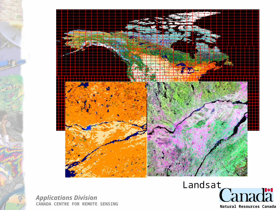
R:NIR; G:SWIR; B:RED Classification
Accuracy assessment: Building confidence
Applications DivisionCANADA CENTRE FOR REMOTE SENSING
Natural Resources Canada
Landsat

Applications DivisionCANADA CENTRE FOR REMOTE SENSING
Natural Resources Canada
Quantitative accuracy assessment
Reference data

Applications DivisionCANADA CENTRE FOR REMOTE SENSING
Natural Resources Canada
Source: Centre de foresterie des LaurentidesService canadien des forêts

Applications DivisionCANADA CENTRE FOR REMOTE SENSING
Natural Resources Canada
Assessment of reference data
Applications DivisionCANADA CENTRE FOR REMOTE SENSING
Natural Resources Canada
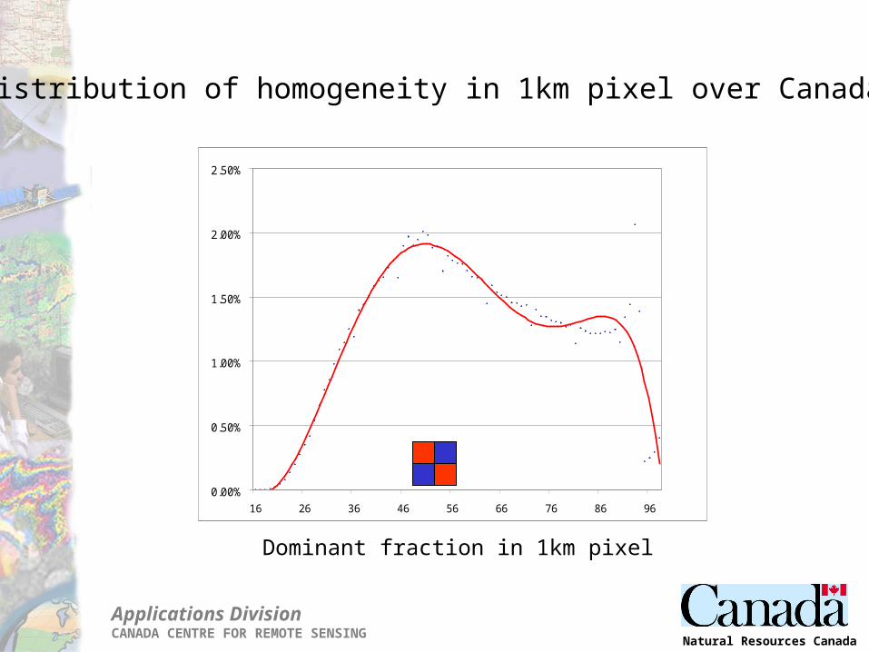
0.00%
0.50%
1.00%
1.50%
2.00%
2.50%
16 26 36 46 56 66 76 86 96
Distribution of homogeneity in 1km pixel over Canada
Dominant fraction in 1km pixel

Applications DivisionCANADA CENTRE FOR REMOTE SENSING
Natural Resources Canada
GLC 2000
0%
20%
40%
60%
80%
100%
0% 20% 40% 60% 80% 100%
Dominant Fraction
Acc
ura
cy
IGBP
0%
20%
40%
60%
80%
100%
0% 20% 40% 60% 80% 100%
Dominant Fraction
Acc
ura
cy
UMd
0%
20%
40%
60%
80%
100%
0% 20% 40% 60% 80% 100%
Dominant Fraction
Acc
ura
cy
UMB
0%
20%
40%
60%
80%
100%
0% 20% 40% 60% 80% 100%
Dominant Fraction
Acc
urac
y

Applications DivisionCANADA CENTRE FOR REMOTE SENSING
Natural Resources Canada
y = 1.4156x-0.1164
R2 = 0.9753
40%
50%
60%
70%
80%
90%
100%
0 50 100 150 200 250 300 350 400 450 500 550 600 650 700 750 800 850 900 950 1000
Resolution (m)
Do
min
ant
frac
tio
n

Applications DivisionCANADA CENTRE FOR REMOTE SENSING
Natural Resources Canada
GLC 2000 NA IGBP UMB UMD
Forest classes 45.68% 48.06% 42.23% 53.95%Evergreen Needleleaf Fores t 22.45% 17.45% 14.38% 10.27%Evergreen Broadleaf Fores t 3.50% 2.64% 4.89% 2.54%Deciduous Needleleaf Fores t 0.00% 0.00% 0.10% 0.00%Deciduous Broadleaf Fores t 5.38% 7.38% 4.47% 4.18%Mixed Fores t 5.50% 13.04% 10.36% 5.55%Woody Savannas 8.85% 7.55% 8.03% 31.41%
Non-forest classes 54.32% 51.94% 57.77% 46.05%Closed Shrublands 1.77% 2.45% 0.80% 7.75%Open Shrublands 18.25% 11.49% 23.62% 13.42%Grass lands 7.75% 8.69% 10.73% 9.80%Perm anent Wetlands 0.28% 1.46% 0.49% 0.00%Croplands 14.31% 17.53% 15.74% 9.21%Urban and Built-Up 0.45% 0.43% 0.41% 0.43%Snow and Ice 2.93% 1.70% 1.58% 0.00%Barren or Sparsely Vegetated 8.56% 8.18% 4.41% 5.45%
Areal comparison
·The IGBP Global land cover classification produced by U.S. Geological Survey for the International Geosphere-Biosphere Programme IGBP (Loveland et al., 2000);
·The UMd global land cover classification produced by University Maryland (Hansen et al., 2000);
·The UMB MODIS Global land cover classification produced by University Boston (Hodges 2001); and
·GLC2000_NA North America 2000 Land Cover database, here presented

Applications DivisionCANADA CENTRE FOR REMOTE SENSING
Natural Resources Canada
Agreement [%] KappaGLC2000_NA - IGBP 78.85% 0.554GLC2000_NA - UMB 79.03% 0.548GLC2000_NA - UMD 78.17% 0.491
Agreement in depicting the forest area over North America among analysed land cover maps
Per pixel comparison
GLC 2000NA -IGBP
GLC 2000NA -UMB
GLC 2000NA -UMD
Agreement
Disagreement non-forest / forest Disagreement forest / non-forest

Applications DivisionCANADA CENTRE FOR REMOTE SENSING
Natural Resources Canada
Outputs
Papers in progress:
Latifovic, R., Zhu, Z., Cihlar,J., Giri, C., and Olthof, I. (2003) Land Cover Mapping of North America - Global Land Cover 2000
Latifovic, R., Olthof, I., and Fraser R., Assessing the accuracy of remote sensing based large scaled land cover data
Database:
NRCan and USGS (2003) Land Cover Database of North America 2000 ftp://ftp.ccrs.nrcan.gc.ca/ftp/ad/EMS/Landcover2000/

Applications DivisionCANADA CENTRE FOR REMOTE SENSING
Natural Resources Canada
Poster:

Applications DivisionCANADA CENTRE FOR REMOTE SENSING
Natural Resources Canada
Acknowledgements
We also gratefully acknowledge the support of the Canadian Space Agency for this study, the Centre national d’etudes spatiales and European Union for the provision of 2000 VGT data and National Aeronautic and Space Administration for the provision of some ETM+ scenes as part of Satellite Information for the Landcover of Canada (SILC) project.
CCRS Team
Rasim LatifovicCihlar JosefJean BeaubienIan OlthofRobert Fraser
Zhi-Liang Zhu Chandra Giri
USGS Team