application of gis in optimizing the aggregate...
TRANSCRIPT
121
Scientific Papers. Series E. Land Reclamation, Earth Observation & Surveying, Environmental Engineering. Vol. III, 2014Print ISSN 2285-6064, CD-ROM ISSN 2285-6072, ISSN-L 2285-6064
APPLICATION OF GIS IN OPTIMIZING THE AGGREGATE
COMPOSITION OF THE SOIL
Manol DALLEV, Zhulieta ARNAUDOVA, Ivan IVANOV
Agricultural University of Plovdiv, 12 Mendeleev Blvd, 4000, Plovdiv, Bulgaria,
Phone: +35934654414,Email: [email protected]
Corresponding author email: [email protected] Abstract Tested a new machine for surface treatment of the soil, according to the indicator aggregate composition of the soil. Data were processed with the program for the processing of statistical data and regression equations are derived describing the fragmentation of soil aggregates of different sizes (1 mm, from 1 to 25 mm, over 25 mm) at different speeds. Regression equations are introduced by GIS and the current humidity is set to an appropriate speed. Were created layers of fragmentation of soil aggregates to optimize the aggregate composition. Key words: GIS, surface tilling, disk machine INTRODUCTION The process of proceeding of the soil surface is one of the determining factors for the development of plants. The aim of the process is to create optimal agrotechnical conditions for the sowing, germination and the development of the plants, by achieving a condition of cultivated soil unto which soil aggregates have the most favourable structure. The modern agriculture necessitates the creation and use of agricultural machinery, which allow management of the aggregate composition and use of new information technologies. Such a information technology is Geographic Information Systems-GIS. The combination of database objects and geographical location allow: introduction a large volume information, centralization of the data, as a means of the managing them, automating the design process, visualizing and evaluation of the incoming and outgoing information on certain criteria. MATERIALS AND METHODS Machine for surface tillage combined kinematics of rotary cultivators with a horizontal axis of rotation and horizontal displacement of soil from disk working body.
(Dallev, 2013). It is a rotor with flanges which are attached a disk under Adjusting angle. The rotor take movement named PTO of the tractor by gimbal and reductant. At rotation of the rotor and the forward velocity of the machine, disks enter the ground and ruin layer of soil. (Dallev, 2013) Unto consideration of the factors of the soil humidity and the forward speed of the machine can be controlled aggregate composition of the soil after treatment. Preparation of materials and data for GIS 1. Graphic information • Municipality, digital cadastral map and map
of reclaimed property in the studied area. The digital model format is ZEM, CAD. Information source: the Geodesy, Cartography and Cadastre Agency;
• Digital soil map of the area. Information sources: The Soil Resources Agency and the Institute of Soil Science “Nikola Pushkarov”, Bulgaria;
• map of the soil samples 2. Attribute information • soil type - physical parameters, humidity, • velocity of the agricultural machine ;

122
Scientific Papers. Series E. Land Reclamation, Earth Observation & Surveying, Environmental Engineering. Vol. III, 2014Print ISSN 2285-6064, CD-ROM ISSN 2285-6072, ISSN-L 2285-6064
Application of GIS • Development of interpolation to raster by
Spatial Analyst, ARCGIS 10.0. It was used a spline regulized method.
Spline estimates values using a mathematical function that minimizes overall surface curvature, resulting in a smooth surfacethat passes exactly throu the input points (Arnaudova, 2011). Study area The experiments were conducted in the agricultural lands of village Banya, Plovdiv
region. There are selected a study parcel on Dystric Fluvisol with soil texture 24% The data were obtained from soil samples on selected areas and were localized by handheld portable GPS - GIS Trimble Juno SB. Used coordinate system WGS 84 UTM zone 35. The forward speed of the machine is amended to three levels - 3.6, 4.9, 6 km / h Humidity measured immediately before the passage of the machine is given in the following table:
Table. 1 Soil humidity 1 2 3 4 5 6 7 8 9 10 11 12 13 14 15 16 17 18 19 20
Measured humidity
of soil with a clay
content of 24%
8.3 9.1 10.8 10.3 13.6 14.3 11.7 13.8 14.2 18.3 19.1 14.7 12.9 13.6 14.1 15.7 17.8 18.2 16.9 19.2
The regression equations describing the process of comminuting the soil aggregates of a size from 1 to 25 mm. Z from 1 to 25 mm % = -78.67 - 0,84W + 59.03V + 0.04W2 + 0.09WV - 6.14V2 (Dallev, 2013) RESULTS AND DISCUSSIONS Experiments have been conducted on a Dystric Fluvisols with soil texture 24% of clay?
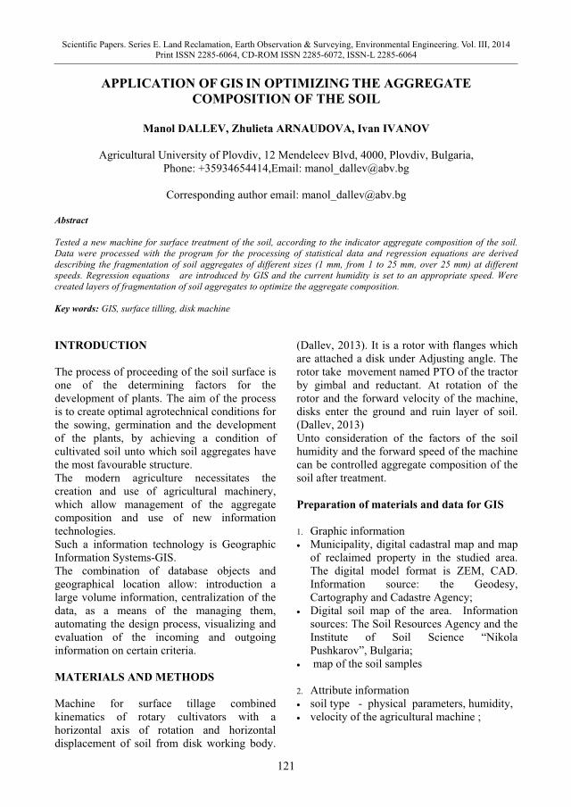
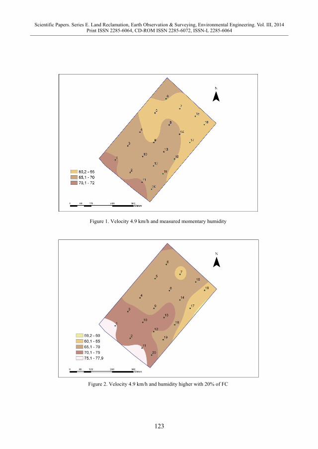
Samples for a momentary humidity were taken from 20 points on the field. On the basis of the equation is a calculated agrotechnical requirement – z from 1 to 25 mm. Numerical experiments were conducted with humidity ±20% of that obtained in experiments at velocity 3.6 km/h and 6 km/h. Seen to be that with increasing of soil moisture by 20% at a speed of 4.9 km/h percent fraction ranging from 1 to 25 mm, is increased relative to control (Fig. 1,2).
123
Scientific Papers. Series E. Land Reclamation, Earth Observation & Surveying, Environmental Engineering. Vol. III, 2014Print ISSN 2285-6064, CD-ROM ISSN 2285-6072, ISSN-L 2285-6064
Figure 1. Velocity 4.9 km/h and measured momentary humidity
Figure 2. Velocity 4.9 km/h and humidity higher with 20% of FC

124
Scientific Papers. Series E. Land Reclamation, Earth Observation & Surveying, Environmental Engineering. Vol. III, 2014Print ISSN 2285-6064, CD-ROM ISSN 2285-6072, ISSN-L 2285-6064
Figure 3. Velocity 4.9 km/h and humidity less with 20% of FC
Figure 4. Velocity 6 km/h and humidity higher with 20% of FC

125
Scientific Papers. Series E. Land Reclamation, Earth Observation & Surveying, Environmental Engineering. Vol. III, 2014Print ISSN 2285-6064, CD-ROM ISSN 2285-6072, ISSN-L 2285-6064
Figure 5. Velocity 3.6 km/h and humidity higher with 20% of FC
Figure 6. Velocity 6 km/h and humidity less with 20% of FC

126
Scientific Papers. Series E. Land Reclamation, Earth Observation & Surveying, Environmental Engineering. Vol. III, 2014Print ISSN 2285-6064, CD-ROM ISSN 2285-6072, ISSN-L 2285-6064
Figure 7. Velocity 3.6 km/h and humidity less with 20% of FC
The effect of the working bodies at a rate of 3.6 km / h on the soil is higher than that at 6 km / h. The soil was ground better, but at 3.6 km / h increased the fraction of aggregates of less than 1 mm. Increasing percentage of 1-25 mm at 6 km/h, due to the fact that the soil is light. Better quality is obtained at a low speed (Fig. 4,5). By reducing the humidity of 20% of the FC and keeping speeds of 6 and 3.6 km/h in the percent change of the aggregates of 1 to 25mm in the minimum limits, which are not sufficient to satisfy the requirements agrotechnical – from 1 to 25 mm 70%, by which it can be concluded that the humidity is too low. Upon reducing the moisture to 20% oFC and speeds of 6 and 3.6 km/ h for the modification of the units of 1 to 25mm is amended to a minimum, which is not sufficient to satisfy the requirements agriculturally - 1-25 mm 70%. From this it follows that in a low humidity, processing is unsatisfactory( Fig. 5 and 7). CONCLUSIONS • Were conducted numerical experiments and made maps in GIS.
• After consideration of all the cards here can draw the following conclusions: - The trends in the fragmentation case depends entirely on the humidity - After establishing the humidity field and select the appropriate speed closest to the calculated, can determine whether to process or wait for the right humidity ACKNOWLEDGEMENTS This research work was carried out with the support of SRC - at the Agricultural University of Plovdiv and also was financed of Project No 03-13/2013. REFERENCES Arnaudova Zh., Use of GIS in spatial placement of vine varieties in Bulgaria, a monograph of the Academic Publishing House-AU Plovdiv, 2011 Dallev M., Investigation of a working body for the surface tilling of the soil, Dissertation for acquiring the degree PhD,2013 AU-Plovdiv Dallev M., Iv. Ivanov. 2012. Influence of the disk angle adjustment on the condition soil surface using surface tilling machine, Agricultural science and technology, Volume 4, Number 1. Longley P.A., M.F. Goodchild and s.o., Geographic Information: Systems and Science, England: John Wiley&Sons, 2001.