application for listed building consent for alterations...
TRANSCRIPT

Planning Portal Reference : PP-05373741
Application for listed building consent for alterations, extension or demolition of a listed building.Planning (Listed Buildings and Conservation Areas) Act 1990
Publication of applications on planning authority websites.Please note that the information provided on this application form and in supporting documents may be published on the Authority’s website.If you require any further clarification, please contact the Authority’s planning department.
1. Applicant Name, Address and Contact Details
Title: Mr First Name: Mark Surname: Cox
Company name: The National Trust
Street address: The National Trust
Lanhydrock Telephone number:
Mobile number:
Town/City: Bodmin Fax number:
Country: Email address:
Postcode: PL30 4DE
Are you an agent acting on behalf of the applicant? Yes No
2. Agent Name, Address and Contact Details
Title: Mr First Name: Liam Surname: Filer
Company name: BSW (Exeter)
Street address: Bsw Consulting The Boat Shed City I
Michael Browning Way Telephone number: 01392422331
Mobile number:
Town/City: EXETER Fax number:
Country: Email address:
Postcode: EX2 8DD [email protected]
3. Description of the Proposal
Please describe the proposed works:
The works comprise remedial repairs to the Western Breakwater at Mullion Harbour following storm damage sustained in early 2016. Two areas of concrete repairs are proposed.
The proposed repairs are to minimise the risk of further damage and to extend the life of the harbour.
The harbour is of historic, cultural and economic value to Mullion, Cornwall and the South West. Repair works should be carried out as soon as possible to prevent further degradation of the structure.
Has the work already started? Yes No

Planning Portal Reference : PP-05373741
4. Site Address Details
Full postal address of the site (including full postcode where available) Description:
House: Suffix:
House name: Mullion Harbour
Street address: Mullion Cove
Town/City: MULLION
Postcode: TR12 7ES
Description of location or a grid reference(must be completed if postcode is not known):
Easting: 166740
Northing: 17904
5. Related Proposals
Are there any current applications, previous proposals or demolitions for the site? Yes No
6. Pre-application Advice
Has assistance or prior advice been sought from the local authority about this application? Yes No
7. Neighbour and Community Consultation
Have you consulted your neighbours or the local community about the proposal? Yes No
8. Authority Employee/Member
With respect to the Authority, I am: (a) a member of staff (b) an elected member (c) related to a member of staff (d) related to an elected member
Do any of these statements apply to you? Yes No
9. Materials
Please provide a description of existing and proposed materials and finishes to be used in the build (demolition excluded):
External Walls - description:Description of existing materials and finishes:
Coursed local Elvan stone
Description of proposed materials and finishes:
Recovered and stored local stone
Concrete repairs: Proposed concrete to use aggregates that are of similar colour to match existing stonework
Are you supplying additional information on submitted plan(s)/drawing(s)/design and access statement? Yes No
If Yes, please state references for the plan(s)/drawing(s)/design and access statement:

Planning Portal Reference : PP-05373741
9. Materials
XNTZ3077-01 - Site PlanXNTZ3077-02 - Western BreakwaterXNTZ3077-03 - DetailsXNTZ3077-PD03
10. Demolition
Does the proposal include total or partial demolition of a listed building? Yes No
11. Listed building alterations
Do the proposed works include alterations to a listed building? Yes No
If Yes, will there be works to the interior of the building? Yes No
Will there be works to the exterior of the building? Yes No
Will there be works to any structure or object fixed to the property (or buildings within its curtilage) internally orexternally?
Yes No
Will there be stripping out of any internal wall, ceiling or floor finishes (e.g. plaster, floorboards)? Yes No
If the answer to any of these questions is Yes, please provide plans, drawings and photographs sufficient to identify the location, extent and characterof the items to be removed, and the proposal for their replacement, including any new means of structural support, and state references for the plan(s)/drawing(s).
State references for these plan(s)/drawing(s):
A Design and Access Statement and Statement of Cultural Significance has been prepared for the proposed works (XNTZ3077-PD03). This includes a justification explaining why the works are desirable and necessary, statement of cultural significance and an assessment of the impact of the works on the significance of the structure. In 2004 The National Trust commissioned a study of Mullion Harbour to provide appropriate strategies for the future management of the harbour; reference to this report has been made throughout outlining the future strategy for works on the harbour. The proposed works have been prepared by a structural engineer.
Drawings are attached to support this application;XNTZ3077-01 - Site PlanXNTZ3077-02 - Western BreakwaterXNTZ3077-03 - DetailsXNTZ3077-901 - Location Plan
12. Listed Building Grading
If known, what is the grading of the listed building (as stated in thelist of Buildings of Special Architectural or Historical Interest)?
Don't know Grade I Grade II* Grade II
Is it an ecclesiastical building? Don't know Yes No
13. Immunity from Listing
Has a Certificate of Immunity from listing been sought in respect of this building? Yes No
14. Site Visit
Can the site be seen from a public road, public footpath, bridleway or other public land? Yes No
If the planning authority needs to make an appointment to carry out a site visit, whom should they contact? (Please select only one)
The agent The applicant Other person

Planning Portal Reference : PP-05373741
15. Certificates (Certificate A)
Certificate of Ownership - Certificate ACertificate under Regulation 6 of the Planning (Listed Buildings and Conservation Areas) Regulations 1990
I certify/The applicant certifies that on the day 21 days before the date of this application nobody except myself/the applicant was the owner (owner is a person with afreehold interest or leasehold interest with at least 7 years left to run) of any part of the land or building to which the application relates.
Title: Mr First name: Liam Surname: Filer
Person role: AGENT Declaration date: 01/08/2016 Declaration made
16. Declaration
I/we hereby apply for planning permission/consent as described in this form and the accompanying plans/drawings and additional information. I/we confirm that, to the best of my/our knowledge, any facts stated aretrue and accurate and any opinions given are the genuine opinions of the person(s) giving them.
Date
01/08/2016

Details
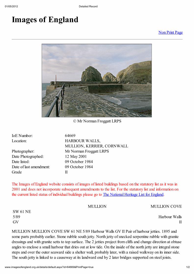
MULLION MULLION COVE SW 61 NE 5/89 Harbour Walls GV II Pair of harbour jetties. 1895 and some parts probably earlier. Stone rubble south jetty. North jetty of snecked serpentine rubble with granite dressings and with granite setts to top surface. The 2 jetties project from cliffs and change direction at obtuse angles to enclose a small harbour that dries out at low tide. On the inside of the north jetty are integral stone steps and over the outer seaward side a shelter wall, probably later, with a raised walkway on its inner side. The south jetty is linked to a causeway at its landward end by 2 later bridges supported on steel joists. Railings are modern. Mullion Cove was especially important for pilchard fishing,later superceded in the C19 by crab and lobster fishing. The harbour has remained largely unaltered.
Listing NGR: SW6660917880

© Crown copyright. All rights reserved. Licence number AL100033295


CONSULTING CIVIL AND STRUCTURAL ENGINEERS
DESIGN AND ACCESS STATEMENT AND STATEMENT OF CULTURAL SIGNIFICANCE
Mullion Harbour, Mullion, Cornwall
For: National Trust Ref: XNTZ3077-PD03
August 2016
THE BOAT SHED MICHAEL BROWNING WAY
EXETER EX2 8DD Tel: 01392 422331
Fax: 01392 430597 e-mail: [email protected]
website: www.bsw-engineers.co.uk

Mullion Harbour, Cornwall Design and Access Statement and Statement of Cultural Significance
XNTZ3077-PD03
Design and Access Statement and Statement of Cultural Significance.doc i
Document Status
Issue Issue date Status Author Checked
01 August 2016 Listed Building LF SB
Contents
1 Purpose ............................................................................................................................. 1
2 Location ............................................................................................................................. 3
3 Statement of cultural significance .................................................................................... 4
4 Mullion Harbour Study ..................................................................................................... 8
5 Design Statement .............................................................................................................. 9
6 Access .............................................................................................................................. 11
7 Conclusions ..................................................................................................................... 12
Appendix A - Listings
English Heritage Listing
Images of England Listing
Appendix B
Repair History of Mullion Harbour 1950-1998
Mullion Harbour, Cornwall Design and Access Statement and Statement of Cultural Significance
XNTZ3077-PD03
Design and Access Statement and Statement of Cultural Significance.doc 1
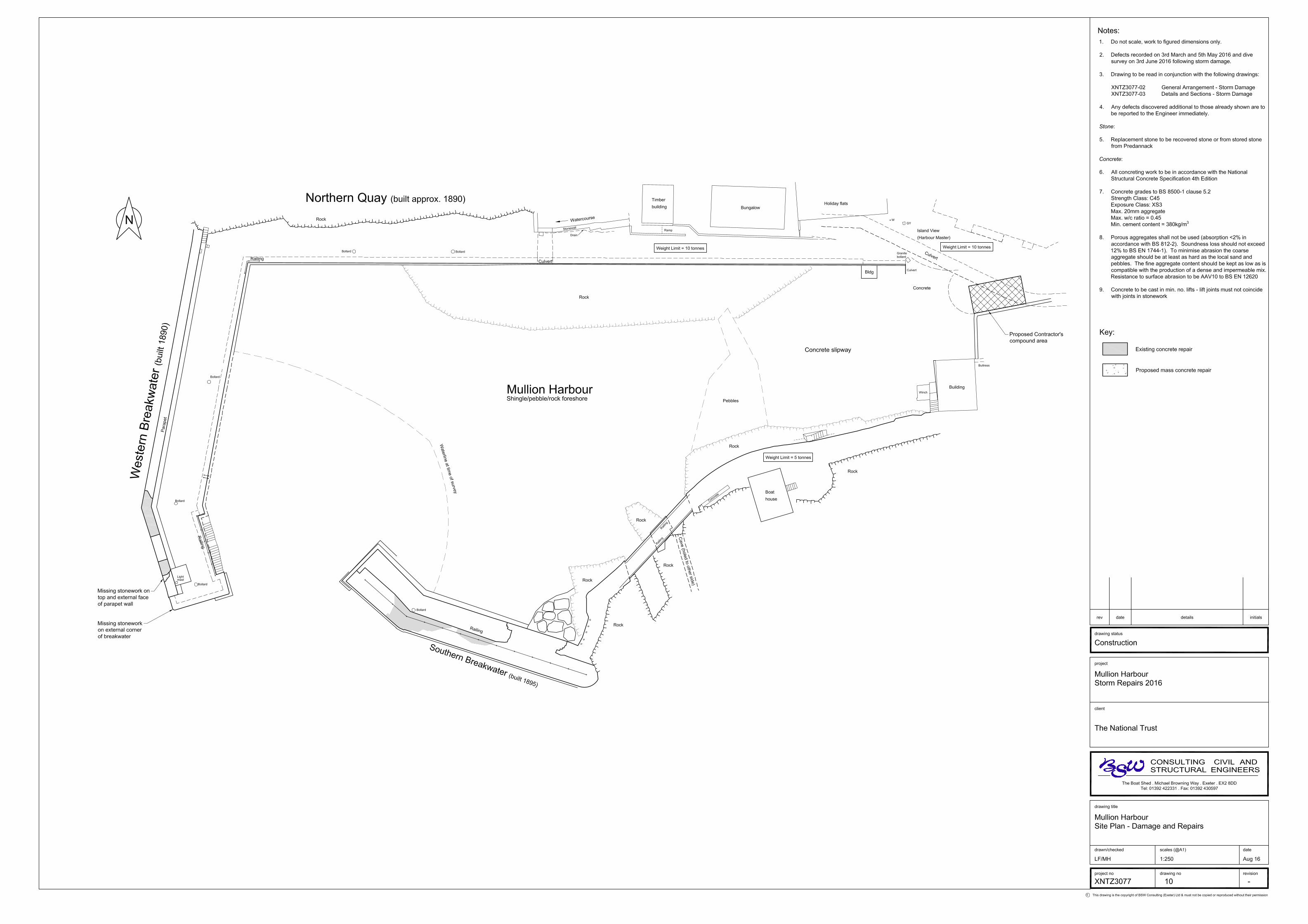
1 Purpose
1.1 Mullion Harbour consist of a Northern Quay which runs parallel to the cliffs and two harbour
arms; the Southern and Western Breakwaters.
1.2 The harbour suffered storm damage in February 2016. Most of the damage was visible from the
harbour and will be repaired in September 2016 on a like for like basis. However, there are two
areas on the seaward side of the Western Breakwater, that were not visible initially, that require
repair. For these two areas a concrete, rather than stone repair is proposed, hence this listed
building application.
1.3 The object of the design is to achieve a repair that will extend the life of the Breakwaters as far
as possible, whilst retaining the cultural significance of the harbour.
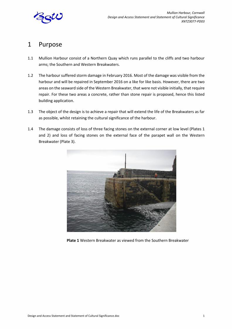
1.4 The damage consists of loss of three facing stones on the external corner at low level (Plates 1
and 2) and loss of facing stones on the external face of the parapet wall on the Western
Breakwater (Plate 3).
Plate 1 Western Breakwater as viewed from the Southern Breakwater

Mullion Harbour, Cornwall Design and Access Statement and Statement of Cultural Significance
XNTZ3077-PD03
Design and Access Statement and Statement of Cultural Significance.doc 2
Plate 2 Damage to external corner of Western Breakwater
Plate 3 Damage to top of parapet wall on Western Breakwater
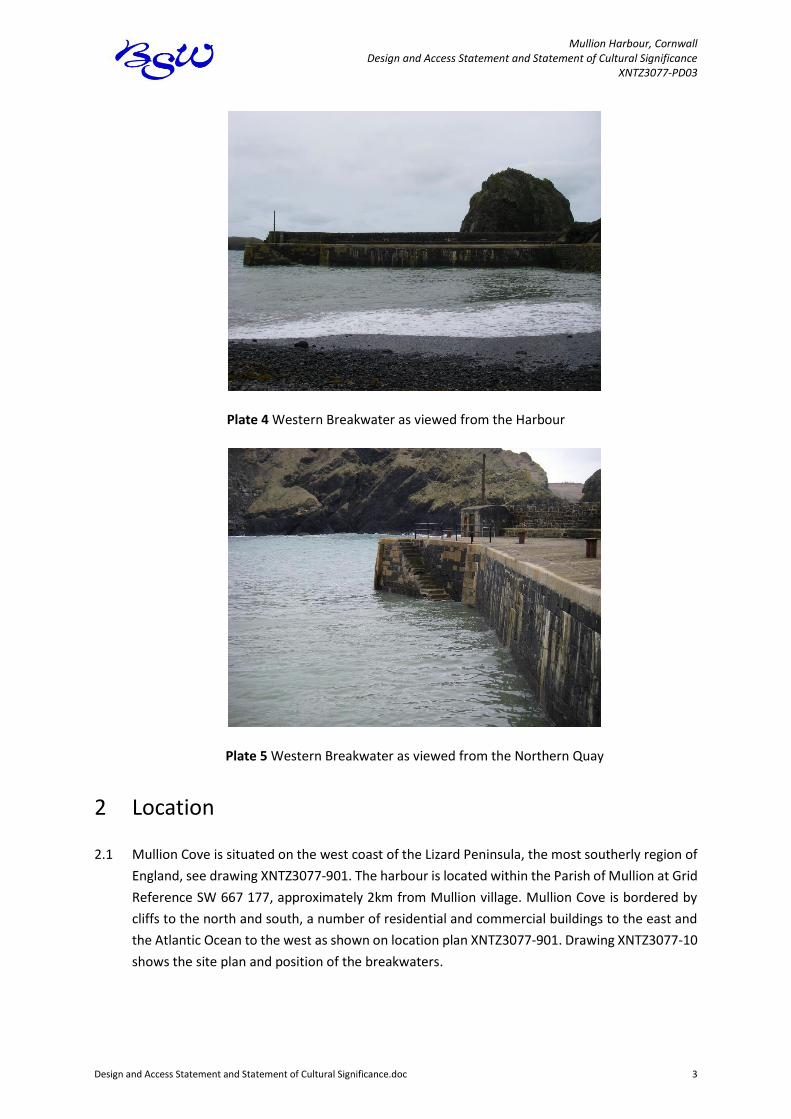
1.5 Plates 4 and 5 show the harbour elevations which will not be affected by the proposed repairs.
Mullion Harbour, Cornwall Design and Access Statement and Statement of Cultural Significance
XNTZ3077-PD03
Design and Access Statement and Statement of Cultural Significance.doc 3
Plate 4 Western Breakwater as viewed from the Harbour
Plate 5 Western Breakwater as viewed from the Northern Quay
2 Location
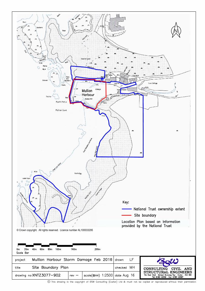
2.1 Mullion Cove is situated on the west coast of the Lizard Peninsula, the most southerly region of
England, see drawing XNTZ3077-901. The harbour is located within the Parish of Mullion at Grid
Reference SW 667 177, approximately 2km from Mullion village. Mullion Cove is bordered by
cliffs to the north and south, a number of residential and commercial buildings to the east and
the Atlantic Ocean to the west as shown on location plan XNTZ3077-901. Drawing XNTZ3077-10
shows the site plan and position of the breakwaters.

Mullion Harbour, Cornwall Design and Access Statement and Statement of Cultural Significance
XNTZ3077-PD03
Design and Access Statement and Statement of Cultural Significance.doc 4
3 Statement of cultural significance
Listing
3.1 Mullion Harbour is a Grade II listed structure. Listing details, from English Heritage and Images
of England, are attached in Appendix A. It should be noted that the Western Breakwater is
referred to as the North Jetty and the Southern Breakwater as the South Jetty.
History
3.2 Settlement of the cove occurred between 1748 (when it was not mapped) and 1811 (when it
was shown as “Porth Mellin” on an OS Surveyor’s drawing), whilst nearby Mullion village has
medieval origins.
3.3 In the 1890s, there was a pilchard fishing fleet at Porth Mellin (Mullion Cove) and the boats were
kept on the beach as can be seen in Plate 6. The Cove supported a successful fishing industry
and was also active in the smuggling trade. Following several seasons of poor pilchard fishing,
Lord Robartes of Lanhydrock decided that a harbour should be built at Mullion Cove to provide
protection for the fishing fleet.
Plate 6 Mullion Cove pre 1893
3.4 Mr Matthews, a Civil Engineer of Westminster, prepared a report in 1890 for Lord Robartes in
which he recommended that the harbour should be built to the present layout. In his report he
proposed that the external faces of the breakwaters should be of stone, with heartings of
concrete and large rocks. Plate 7 shows the layout he proposed. The Western Breakwater was
built in 1890 and was linked to the Northern Quay, which appears to have been constructed just
before the Western Breakwater. The construction of the Southern Breakwater followed in 1895.
The estimated cost of the harbour was £9,300.
Mullion Harbour, Cornwall Design and Access Statement and Statement of Cultural Significance
XNTZ3077-PD03
Design and Access Statement and Statement of Cultural Significance.doc 5
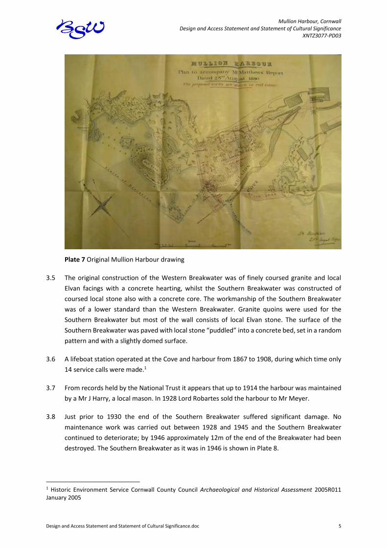
Plate 7 Original Mullion Harbour drawing
3.5 The original construction of the Western Breakwater was of finely coursed granite and local
Elvan facings with a concrete hearting, whilst the Southern Breakwater was constructed of
coursed local stone also with a concrete core. The workmanship of the Southern Breakwater
was of a lower standard than the Western Breakwater. Granite quoins were used for the
Southern Breakwater but most of the wall consists of local Elvan stone. The surface of the
Southern Breakwater was paved with local stone “puddled” into a concrete bed, set in a random
pattern and with a slightly domed surface.
3.6 A lifeboat station operated at the Cove and harbour from 1867 to 1908, during which time only
14 service calls were made.1
3.7 From records held by the National Trust it appears that up to 1914 the harbour was maintained
by a Mr J Harry, a local mason. In 1928 Lord Robartes sold the harbour to Mr Meyer.
3.8 Just prior to 1930 the end of the Southern Breakwater suffered significant damage. No
maintenance work was carried out between 1928 and 1945 and the Southern Breakwater
continued to deteriorate; by 1946 approximately 12m of the end of the Breakwater had been
destroyed. The Southern Breakwater as it was in 1946 is shown in Plate 8.
1 Historic Environment Service Cornwall County Council Archaeological and Historical Assessment 2005R011 January 2005
Mullion Harbour, Cornwall Design and Access Statement and Statement of Cultural Significance
XNTZ3077-PD03
Design and Access Statement and Statement of Cultural Significance.doc 6
Plate 8 Southern Breakwater damage 1946
3.9 On 8 October 1945 the National Trust acquired the harbour from Mr and Mrs Montague Levison
Meyer and the harbour is still owned by the Trust.
3.10 Mr Alan Wilfrid Ladner AMICE (Member of the Institution of Civil Engineers) prepared a report
on the Harbour in 1950. It was decided that the end of the Southern Breakwater should be
rebuilt with a sloping face and that the end of the breakwater should be set back by 12 feet
(3.6m) from the original line so that it could be constructed on rock. In 1950 the tender for the
works to the Southern Breakwater was £4,233 from Costain who carried out the works; Plate 9
shows the works nearing completion.
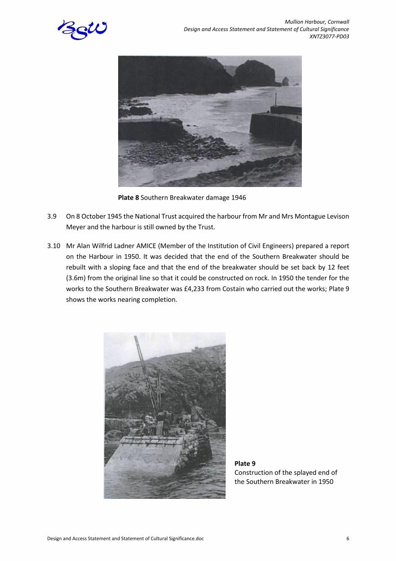
Plate 9 Construction of the splayed end of the Southern Breakwater in 1950
Mullion Harbour, Cornwall Design and Access Statement and Statement of Cultural Significance
XNTZ3077-PD03
Design and Access Statement and Statement of Cultural Significance.doc 7
3.11 In 1951-2 storm damage occurred to the splayed end and at foundation level of the Southern
Breakwater. At about this time, possibly earlier, there was a cliff fall that severely damaged the
end of the Southern Breakwater. Concrete repairs were carried out at the land end and no facing
or surface stones were used.
3.12 In 1978 the sloped end of the Southern Breakwater was rebuilt back to its original square end
(as seen today). It appears, from documentation that the sloping end was breaking away from
the main body of the breakwater. The end of the breakwater was constructed approximately
5.6m back from the line of the original 1895 construction. Four through ties were also added.
The cost of the works was £35,000.
3.13 In December 1994/January 1995 a 9m length of seaward facing stone and concrete was lost
from the Southern Breakwater. The maximum depth of damage was 2.2m.
3.14 The old bridges to the Southern Breakwater were replaced in 1995 with pre-cast concrete
bridges.
3.15 Large rock armour was added to the south east corner of the harbour in 1996 to try and minimise
the effect of reflective waves.
3.16 Major repair works were carried out in 1992, 1995 and 1998 to repair storm damage and to
generally maintain the harbour structures. The cost of these works was of the order of
£1,000,000. Most of these works, other than the 9m of facing damage referred to above, were
to the Western Breakwater.
3.17 In December 2011 significant storm damage occurred, damaging both the Western and
Southern Breakwaters. Sections of the Western Breakwater parapet wall were missing facing
stones on the external and top face of the wall and listed building consent was given
(PA12/05857) to concrete repairs rather than using facing stones with concrete backing. The
reason for the concrete repair was to try and stabilise the breakwater against storm damage to
extend the life of the breakwater. These repairs were completed in 2012 and remained intact
during the 2014 storms, whilst more of the stone facing and deck were lost in the 2014 storm.
3.18 A summary of the works and repairs carried out between 1950 and 1998 is attached in
Appendix B. Records also show that on many occasions concrete and mortar that had not gained
sufficient strength was washed away in storms or bad weather that occurred during the works.
Fishing and Diving
3.19 Historically the cove and harbour were used by boats that fished for pilchards, but pilchard
fishing dwindled at the end of the nineteenth century, shortly after the harbour was
constructed.
3.20 By 2004 fishing was limited to a part time boat fishing for crabs and lobsters.
Mullion Harbour, Cornwall Design and Access Statement and Statement of Cultural Significance
XNTZ3077-PD03
Design and Access Statement and Statement of Cultural Significance.doc 8
3.21 The harbour is used to launch boats for diving and some divers use the harbour itself.
Tourism
3.22 Mullion is the largest village on the Lizard and has plentiful holiday accommodation. Mullion
Harbour attracts many tourists each year and the harbour is considered by many as a typical
Cornish fishing harbour.
Landscape
3.23 Mullion Harbour is located within the Cornwall Area of Outstanding Natural Beauty (AONB) and
Heritage Coast. The Cornwall Landscape Assessment identifies three distinct character areas
within the Peninsula. The south, covering Mullion is described as ‘A special landscape containing
many remnants of the past perceptible in a coherent way to give a feeling of time and
continuity’.
3.24 Views of the Harbour are limited to the immediate environs of the cove and the adjacent cliffs.
For the walker or the driver, there are few visual clues as to the presence of the cove before
arriving there. This hidden quality makes a strong contribution to its sense of place.
Cultural Significance Summary
3.25 Mullion Harbour has significant historic cultural significance and is an important tourist
destination that provides economic benefit to Mullion, Cornwall and the South West. For many
the harbour represents a typical Cornish fishing harbour and so has aesthetic significance within
the Area of Outstanding Natural Beauty.
4 Mullion Harbour Study
4.1 In 2004 the National Trust commissioned the Mullion Harbour Study2 to investigate
management strategies for the harbour for the next 100 years. The aim of the Study was to assist
the Trust in selecting an appropriate strategy for the future management of Mullion Cove. A
stakeholder group including representatives from the local community, government agencies
(including English Heritage), local councils and other Cornwall harbours, was established to liaise
with the study team.
2 National Trust Mullion Harbour Study Halcrow and BSW Consulting 2006

Mullion Harbour, Cornwall Design and Access Statement and Statement of Cultural Significance
XNTZ3077-PD03
Design and Access Statement and Statement of Cultural Significance.doc 9
4.2 The Study concluded that the harbour structures will continue to deteriorate as they age. In
addition, sea level has risen since the structures were built, and projected, accelerated sea level
rise over the next century, due to climate change, will result in larger waves attacking the
structures more frequently. Due to the effects of global warming and post-glacial rebound, sea
level rise of 5mm per year is presently projected for the South-West region of the United
Kingdom. If the water depth increases (due to sea level rise), so will the wave heights. It is
expected that the wave heights approaching the harbour will increase by approximately 60% of
the predicted increase in water level. By 2100, it is presently projected that the sea will have
risen by 0.5m, and therefore the wave heights would be expected to increase by approximately
0.3m. The result of continuing structural deterioration, sea level rise and increased wave energy
is that damage to the harbour will increase over the next 100 years.
4.3 The study identified that the “maintain and repair until failure” option was the preferred
management strategy for Mullion Cove for the next 100 years. The study was endorsed by the
stakeholder group, which made a significant contribution to the project and its findings, as well
as the Mullion Harbour Association, Mullion Parish Council and the National Trust’s Projects and
Acquisitions committee.
4.4 The Study showed that the most likely first failure would be the end of the Southern Breakwater.
This assessment was made on the basis of the condition of the structures in 2004/5, the history
of damage and predicted storms.
4.5 The maintain and repair until failure option provides a viable management strategy for the
future which enables the community and the Trust to balance the environmental, technical, risk
and economic considerations associated with Mullion Harbour. It will allow the community,
visitors and Trust members to enjoy the harbour for as long as practicable, while recognising
that it will not be possible to sustain the harbour indefinitely and that there will come a time
when the harbour is damaged beyond repair.
5 Design Statement
General
5.1 Mullion Harbour is battered by gales. There is no land between Mullion and America, other than
Mullion Island that does offer some protection, and therefore storms are often intense and
loadings very high. The Study demonstrated that it will not be possible to keep the harbour
structures forever and it was accepted at local meetings, by consultation and with the National
Trust that at some point there would be so much damage that a strategy of managed retreat
would be adopted.
5.2 Plate 10 gives an indication of the waves that cause damage at Mullion. This particular wave was
at the end of a storm that started three days previously and caused significant damage.

Mullion Harbour, Cornwall Design and Access Statement and Statement of Cultural Significance
XNTZ3077-PD03
Design and Access Statement and Statement of Cultural Significance.doc 10
Plate 10 End of the 1998 storm that caused significant damage
5.3 As can be seen from Section 3 above the Breakwaters have suffered extensive storm damage
since 1930. The end of the Southern Breakwater has been rebuilt on two separate occasions.
Steel ties have been installed in the end of the breakwater on many occasions in an attempt to
strengthen the structure sufficiently to withstand storm damage. Despite these repairs, the
storms in December 2011, January 2014 and February 2014 washed mortar out of joints,
removed facing stones, copings and surface stones. The damage has been so severe that stones
tied in two directions with stainless steel bars were twisted out from the structure. However,
concrete repairs carried out in 2012 and 2014 have remained in place during both the 2014 and
2016 storms.
5.4 It is considered that the current damage to the Western Breakwater is not so severe that
managed retreat should be adopted.
5.5 It is necessary to repair the damage to the external corner of the Western Breakwater as the
defect provides a weakness to the structure. In the event of a storm further, much more severe,
damage is likely to occur as waves could “get under” the remaining stones which would destroy
the corner and if this were to happen it could be the tipping point to managed retreat.
5.6 The existing corner defect is located within the tidal zone of the structure, where it is always
very difficult to carry out a repair. One of the missing stones has broken away from the remaining
stone and the other two are missing. To re-fix the stones in a structurally satisfactory manner
would be almost impossible. Thus a stone repair is unlikely to last the next winter of storms.
5.7 It is proposed to use a full concrete repair as shown on drawing XNTZ3077-11 for the external
corner of the Western Breakwater. The external corner of the breakwater is very exposed to
loads associated with future storms and it is important that the repair is sufficiently robust,
Mullion Harbour, Cornwall Design and Access Statement and Statement of Cultural Significance
XNTZ3077-PD03
Design and Access Statement and Statement of Cultural Significance.doc 11
particularly as, with climate change, the strength of the storms will increase over time. This type
of repair has the advantage of being a relatively heavy, monolithic mass that does not have the
vulnerability of individual stones placed in the existing wall.
5.8 The parapet wall has a concrete hearting and stone facing. The stones are relatively small and
replacing them would almost inevitably lead to further loss. The parapet wall was similarly
damaged during both the 2011 and 2014 storms and was repaired with concrete. These concrete
repairs have withstood all further storms. As such, it is proposed to use a full concrete repair as
shown on drawing XNTZ3077-11 for the damage to the external face of the parapet wall.
5.9 The 1950 concrete repairs, the later adjacent concrete repairs and the 2012 and 2014 repairs,
have weathered and blend well with the rest of the structure. The repairs can be seen as repairs,
but they do not stand out visually or conflict with the remaining stonework.
5.10 The damage is located in the tidal zone on the external face of the Western Breakwater and as
such it in only visible during certain phases of the tide from the end of the Southern Breakwater
– it is not visible from the harbour, the Northern Quay or the Western Breakwater itself. The
damage to the parapet wall is largely down the external face of the wall and on the top of the
parapet wall. The damage is only visible from the seaward side of the breakwater and from on
top of the parapet wall – it is not visible from the harbour, the Northern quay, the Southern
Breakwater or the deck of the Western Breakwater.
5.11 Precedents for concrete repair include the extensive concrete repairs to the Southern
Breakwater in 2012 and 2014, concrete repairs to the external face of the Western Breakwater
parapet wall, as well a substantial pour of concrete to repair damage to the land end of the
Southern Breakwater in approximately 1950, concrete repairs at foundation level at the end of
the Southern Breakwater and at the land end on the seaward side. Drawing XNTZ3077-10 shows
the existing concrete repairs.
5.12 The proposed concrete will use the same mix as previously approved for the more major work
on the Southern Breakwater. As the concrete repairs weather the aggregate will be exposed
which will ensure the repair is in harmony with the rest of the breakwater structure.
5.13 The intention of the proposed repairs is to minimise the risk of further damage and thus extend
the life of the harbour. Stone repairs to the corner and to the parapet are more likely to become
damaged in the future than the proposed repairs.
6 Access
6.1 Once the proposed repairs have been carried out the access to the Southern and Western
Breakwaters will be the same as before the storm damage i.e. full access.

Mullion Harbour, Cornwall Design and Access Statement and Statement of Cultural Significance
XNTZ3077-PD03
Design and Access Statement and Statement of Cultural Significance.doc 12
7 Conclusions
7.1 The proposed concrete repair to the external corner of the Western Breakwater and to the
external face of the parapet will give the best chance of extending the life of the historic
breakwater; thus maintaining the harbour as a tourist destination and ensuring continuing
economic benefit to Mullion, Cornwall and the South West.
7.2 The aesthetic significance of the harbour will be altered only slightly by the repair. Due to the
location, the proposed concrete repair to the corner will only be seen from the Southern
Breakwater, and would often be partially or completely blocked from view due to the tide for
much of the tidal cycle. The parapet repair will not be visible from the harbour, only from the
sea.
7.3 The proposed repairs are in line with previous concrete repairs to structurally significant areas
of the structure. Some may consider the aesthetic significance of the harbour to be diminished
by the use of concrete rather than stone. However, in accordance with the latest conservation
thinking, the proposed repair will be different from, but in sympathy with, the 1978 construction
and the remainder of the original 1890-95 structures. The concrete will weather and with time
will blend with the rest of the structure.
7.4 Overall, the cultural significance of the harbour will be enhanced by extending the potential life
of the structures.

Mullion Harbour, Cornwall Design and Access Statement and Statement of Cultural Significance
XNTZ3077-PD03
Design and Access Statement and Statement of Cultural Significance.doc
Appendix A - Listings
English Heritage Listing Images of England Listing

List Entry SummaryThis building is listed under the Planning (Listed Buildings and Conservation Areas) Act 1990 as amended for its special architectural or historic interest.
Name: HARBOUR WALLS
List Entry Number: 1158181
Location
HARBOUR WALLS
The building may lie within the boundary of more than one authority.
County: District: Cornwall District Type: Unitary Authority Parish: Mullion
National Park: Not applicable to this List entry.
Grade: II
Date first listed: 09-Oct-1984
Date of most recent amendment: Not applicable to this List entry.
Legacy System InformationThe contents of this record have been generated from a legacy data system.
Legacy System: LBS
UID: 64669
Asset GroupingsThis List entry does not comprise part of an Asset Grouping. Asset Groupings are not part of the official record but are added later for information.
Page 1 of 3List Entry
01/05/2012http://list.english-heritage.org.uk/resultsingle_print.aspx?uid=1158181&showMap=1...

List Entry DescriptionSummary of Building
Legacy Record - This information may be included in the List Entry Details.
Reasons for Designation
Legacy Record - This information may be included in the List Entry Details.
History
Legacy Record - This information may be included in the List Entry Details.
Details
MULLION MULLION COVE SW 61 NE 5/89 Harbour Walls GV II Pair of harbour jetties. 1895 and some parts probably earlier. Stone rubble south jetty. North jetty of snecked serpentine rubble with granite dressings and with granite setts to top surface. The 2 jetties project from cliffs and change direction at obtuse angles to enclose a small harbour that dries out at low tide. On the inside of the north jetty are integral stone steps and over the outer seaward side a shelter wall, probably later, with a raised walkway on its inner side. The south jetty is linked to a causeway at its landward end by 2 later bridges supported on steel joists. Railings are modern. Mullion Cove was especially important for pilchard fishing,later superceded in the C19 by crab and lobster fishing. The harbour has remained largely unaltered.
Listing NGR: SW6660917880
Selected SourcesLegacy Record - This information may be included in the List Entry Details.
MapNational Grid Reference: SW 66609 17880
The below map is for quick reference purposes only and may not be to scale. For a copy of the full scale map, please see the attached PDF - 1158181.pdf
Page 2 of 3List Entry
01/05/2012http://list.english-heritage.org.uk/resultsingle_print.aspx?uid=1158181&showMap=1...


Heritage Category:
Listing
List Entry No : 1158181
Grade: II
County:
District: Cornwall
Parish: Mullion
For all entries pre-dating 4 April 2011 maps and national grid
references do not form part of the official record of a listed building.
In such cases the map here and the national grid reference are
generated from the list entry in the official record and added later to
aid identification of the principal listed building or buildings.
For all list entries made on or after 4 April 2011 the map here and
the national grid reference do form part of the official record. In
such cases the map and the national grid reference are to aid
identification of the principal listed building or buildings only and
must be read in conjunction with other information in the record.
Any object or structure fixed to the principal building or buildings
and any object or structure within the curtilage of the building,
which, although not fixed to the building, forms part of the land and
has done so since before 1st July, 1948 is by law to be treated as
part of the listed building.
This map was delivered electronically and when printed may not be
to scale and may be subject to distortions.
List Entry NGR: SW 66609 17880
1:2500Map Scale:
1 May 2012Print Date:© Crown Copyright and database right 2011. All rights reserved. Ordnance Survey Licence number 100019088.
HARBOUR WALLSName:
1 Waterhouse Square, 138 -142 Holborn, EC1N 2ST
Tel: 020 7973 3000 www.english-heritage.org.uk
© Crown Copyright and database right 2012. All rights reserved. Ordnance Survey Licence number 100019088.
© British Crown and SeaZone Solutions Limited 2012. All rights reserved. Licence number 102006.006.
This copy shows the entry on 01-May-2012 at 11:54:14.
Page 3 of 3List Entry
01/05/2012http://list.english-heritage.org.uk/resultsingle_print.aspx?uid=1158181&showMap=1...
Mullion Harbour, Cornwall Design and Access Statement and Statement of Cultural Significance
XNTZ3077-PD03
Design and Access Statement and Statement of Cultural Significance.doc
Appendix B
Repair History of Mullion Harbour 1950-1998
