appleton parish thorn ward neighbourhood development plan thorn ndp final draft jm jan 17...
TRANSCRIPT
word

Appleton Parish Thorn Ward Neighbourhood Development Plan – Amended Version February 2017 (inc. Proposed Modifications)
2
Appleton Parish Thorn Ward Neighbourhood Development Plan – Amended Version February 2017 (inc. Proposed Modifications)
3
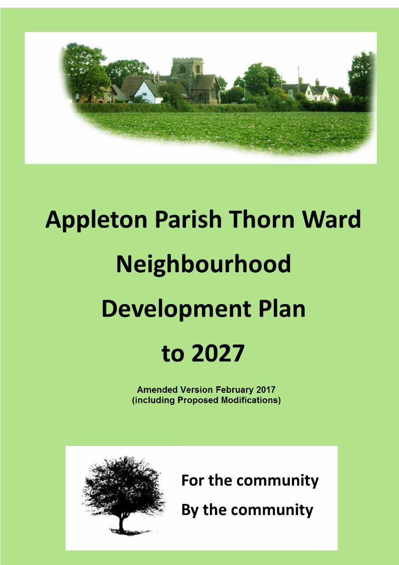
This is the Neighbourhood Development Plan for the Thorn Electoral Ward in the Parish of Appleton. It identifies the aspirations of the community and therefore the policies for the next twenty years in respect of planning and progressive growth for the residential and business community within the Ward. It complements Warrington Borough Council’s Local Plan and provides guidance as to how we are interpreting their strategic policies for the benefit of our community. The designated area includes Appleton Thorn, Wrights Green, Appleton Cross, Bradley Hall area, Barleycastle and Stretton Trading Estates, and H.M.P Thorn Cross. The Ward is rural in character and is constrained with limited capacity to develop the services and the infrastructure requirements to support significant development. The local school is at capacity and the road network struggles to cope with the traffic coming and going to the trading estates and nearby motorways. High peaks, early and late in the day, exacerbate this problem giving rise to extensive periods of congestion. Nevertheless, as a community we recognise that change is inevitable and we have a duty to take account of the needs of those living and working within the Ward especially for those starting their journey on the housing ladder and those wishing to downsize in later life. This issue can be addressed with the construction of starter homes and bungalows, whilst preserving the essential rural character and heritage of the Ward. Our Neighbourhood Development Plan contains a carefully balanced mix of policies which are intended to support future development which meets those important issues identified by our community, and also acknowledges the current housing demand in the wider area of Warrington and addresses the constraints placed on this Ward in meeting those needs.
Executive Summary
Appleton Parish Thorn Ward Neighbourhood Development Plan – Amended Version February 2017 (inc. Proposed Modifications)
4
Neighbourhood Plan Steering Group Appleton Parish Council Kirkwells Appleton Thorn Village Hall St Cross Church, Appleton Thorn H.M.P. Thorn Cross Warrington Borough Council Appleton Thorn School C.A.R.E. (Campaign against Ruining our Environment) Thorn Ward residents Volunteers who have supported the process Locality
Acknowledgements
Appleton Parish Thorn Ward Neighbourhood Development Plan – Amended Version February 2017 (inc. Proposed Modifications)
5
1. What is an NDP? 6 2. Appleton Parish Thorn Ward NDP 7 3. Appleton Parish Thorn Ward The Past (Character and Heritage) 9 The Present 14 4. Key issues for Appleton Parish Thorn Ward 19 5. Vision and objectives 25 6. Planning policies i. Housing 27 ii. Design, built and natural environment 34 iii. Traffic and highways 40 iv. Employment 42 iv. Community facilities and open spaces 44 Maps Map 1 Designated area 47 Map 2 Appleton Thorn Settlement Boundary 48 Map 3 Land at Appleton Cross 49 Map 4 Land at Stretton Road/Pepper Street 50 Map 5 Protected local green spaces 51 Appendices A Relevant Planning Policy Framework 52 B Listed buildings 55 C. Census Information (2011) - Housing tenure, type and 57 number of bedrooms. D. Option maps from Drop-in event (October 2015) 60 Glossary of terms 61
Contents
Appleton Parish Thorn Ward Neighbourhood Development Plan – Amended Version February 2017 (inc. Proposed Modifications)
6
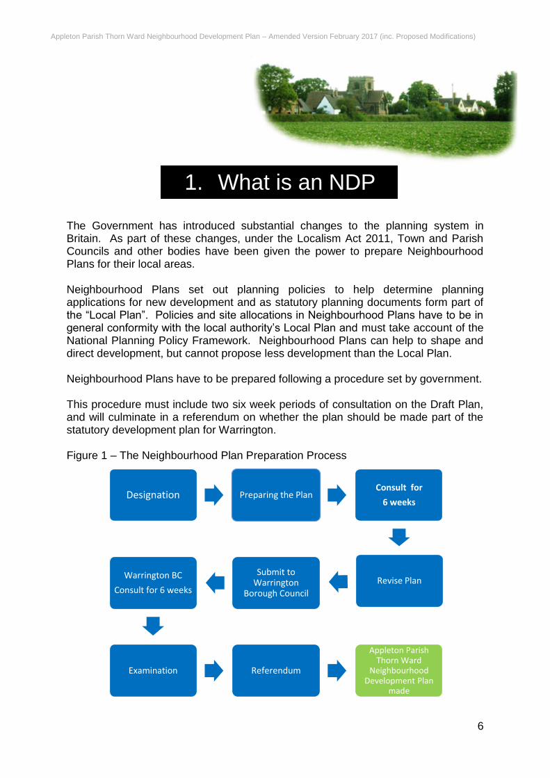
The Government has introduced substantial changes to the planning system in Britain. As part of these changes, under the Localism Act 2011, Town and Parish Councils and other bodies have been given the power to prepare Neighbourhood Plans for their local areas. Neighbourhood Plans set out planning policies to help determine planning applications for new development and as statutory planning documents form part of the “Local Plan”. Policies and site allocations in Neighbourhood Plans have to be in general conformity with the local authority’s Local Plan and must take account of the National Planning Policy Framework. Neighbourhood Plans can help to shape and direct development, but cannot propose less development than the Local Plan. Neighbourhood Plans have to be prepared following a procedure set by government. This procedure must include two six week periods of consultation on the Draft Plan, and will culminate in a referendum on whether the plan should be made part of the statutory development plan for Warrington. Figure 1 – The Neighbourhood Plan Preparation Process
1. What is an NDP
Designation Preparing the Plan Consult for
6 weeks
Revise PlanSubmit to
Warrington Borough Council
Warrington BC
Consult for 6 weeks
Examination Referendum
Appleton Parish Thorn Ward
Neighbourhood Development Plan
made
Appleton Parish Thorn Ward Neighbourhood Development Plan – Amended Version February 2017 (inc. Proposed Modifications)
7
Aims of the Neighbourhood Plan This Neighbourhood Development Plan details the wishes of the people of Appleton Thorn Ward and how the community wishes the Ward to grow. It is designed to influence considered, sympathetic growth while also protecting our environment. It is designed to ensure development meets the needs of the local community and the environment around is protected and where possible, enhanced. In addition, as a land use document produced in consultation with the community, our Neighbourhood Development Plan only identifies challenges and needs which are manifest within the Ward and which are strictly of planning concern. These should be of note to the Local and Parish Councils, the wider community and potential developers as they provide the local Parish Council with guidance and direction concerning issues to be addressed over the duration of Neighbourhood Development Plan to 2027.
2. Appleton Thorn Ward’s
NDP
Appleton Parish Thorn Ward Neighbourhood Development Plan – Amended Version February 2017 (inc. Proposed Modifications)
8
Designation and Consultation The production of our neighbourhood plan was a result of residents’ concerns over the prospect of several tracts of land within the Ward being identified by the local council as available for development. The Appleton Parish Council applied to Warrington Borough Council for designation as a Neighbourhood area in January 2015. This was approved by the Council on 26th May 2015. The Designated Neighbourhood Area is shown on Map 1 on page 47. A volunteer steering group of villagers and parish councillors was set up by the Parish Council to formulate the development of this plan. From an early stage, the Steering Group carried out consultations. The aim was to reach right across the various groups, businesses, local residents, individuals and landowners etc. to build up a picture (and evidence base) the results of which formed the basis for the development of a comprehensive set of policies. The Appleton Parish Thorn Ward Neighbourhood Development Plan must take account of national planning policy. This is contained in the National Planning Policy Framework (NPPF) and the National Planning Policy Guidance (NPPG). This means the Neighbourhood Development Plan must “plan positively to promote local development” and must “support the strategic development needs” set out in Warrington Borough Council Local Plan Core Strategy (2027) Therefore, our Neighbourhood Development Plan has been prepared to be in “general conformity” with Warrington Borough Council’s existing planning policies. A full list of relevant policies in included at Appendix A. The process was staggered with each step reinforcing the findings of the earlier stages. This is set out in Section 4. To check that the policies were acceptable to the residents and businesses within the Ward, a drop-in session was arranged in the local village hall on 3rd October 2015 between 3pm and 7pm. During this session the policies were on display and attendees were invited to comment using a pre-prepared feedback sheet. In addition, opinions were sought on options for the future use of the central village field. The results of these discussions were noted and, where relevant, were used to modify the policies prior to the formal review and public consultation process.
Appleton Parish Thorn Ward Neighbourhood Development Plan – Amended Version February 2017 (inc. Proposed Modifications)
9
The Past (Character and Heritage) The Thorn Ward has always been rural in nature with a significant agricultural pedigree. It was therefore populated by essentially a farming community predominantly made of farm owners and agricultural workers living in low density housing. They lived in either farms or tied cottages situated near the sites in which they laboured. Supporting this activity were some residents who offered essential back up rural artisan services such as wheelwrights, blacksmiths, carpenters, tanners, brewers, and millers. The first recorded mention of Appleton was in the Domesday Survey of 1086 in which the following entry was made “The same Osbern (a landowner) hols Epletune- helt it- and was a free man. There is one hide rateable to the gelt. The land is 4 caricurates. It was and is waste. There is a wood there half a league and forty perches broad.” Apart from this small wood, the land was then covered with heath, gorse, and broome and as is seen from the Domesday Book was practically worthless. Despite a difficult terrain the Romans previously had built an East- West road perpendicular to their main North- South Rd (now London Rd) along the ridge from Stretton towards Bradley Hall to the East of the Ward passing through Appleton Thorn. Excavation work in the 1960’s under Cross Farm and School Farm (both formerly to the West of Appleton Thorn) uncovered sections of this Roman road. It is therefore most probable that this dissected the village, maybe continuing through the central field opposite today’s Village Hall. The first recorded landowner lost the township of Epletune (‘a place where the apples grow’) in battle to Osbern who subsequently handed it over to the Norman Knight Adam de Dutton around 1178. It was he who planted in Appleton an offshoot of the famous Glastonbury Thorn, allegedly grown from the staff of St Joseph of Aramathea, as a thanksgiving for his safe return from the Crusades.
3. Appleton Thorn Ward
Appleton Parish Thorn Ward Neighbourhood Development Plan – Amended Version February 2017 (inc. Proposed Modifications)
10
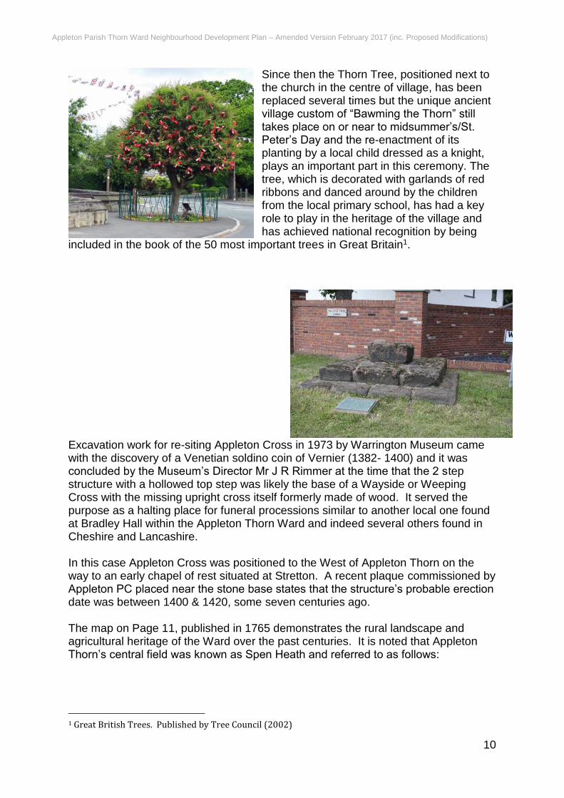
Since then the Thorn Tree, positioned next to the church in the centre of village, has been replaced several times but the unique ancient village custom of “Bawming the Thorn” still takes place on or near to midsummer’s/St. Peter’s Day and the re-enactment of its planting by a local child dressed as a knight, plays an important part in this ceremony. The tree, which is decorated with garlands of red ribbons and danced around by the children from the local primary school, has had a key role to play in the heritage of the village and has achieved national recognition by being
included in the book of the 50 most important trees in Great Britain1.
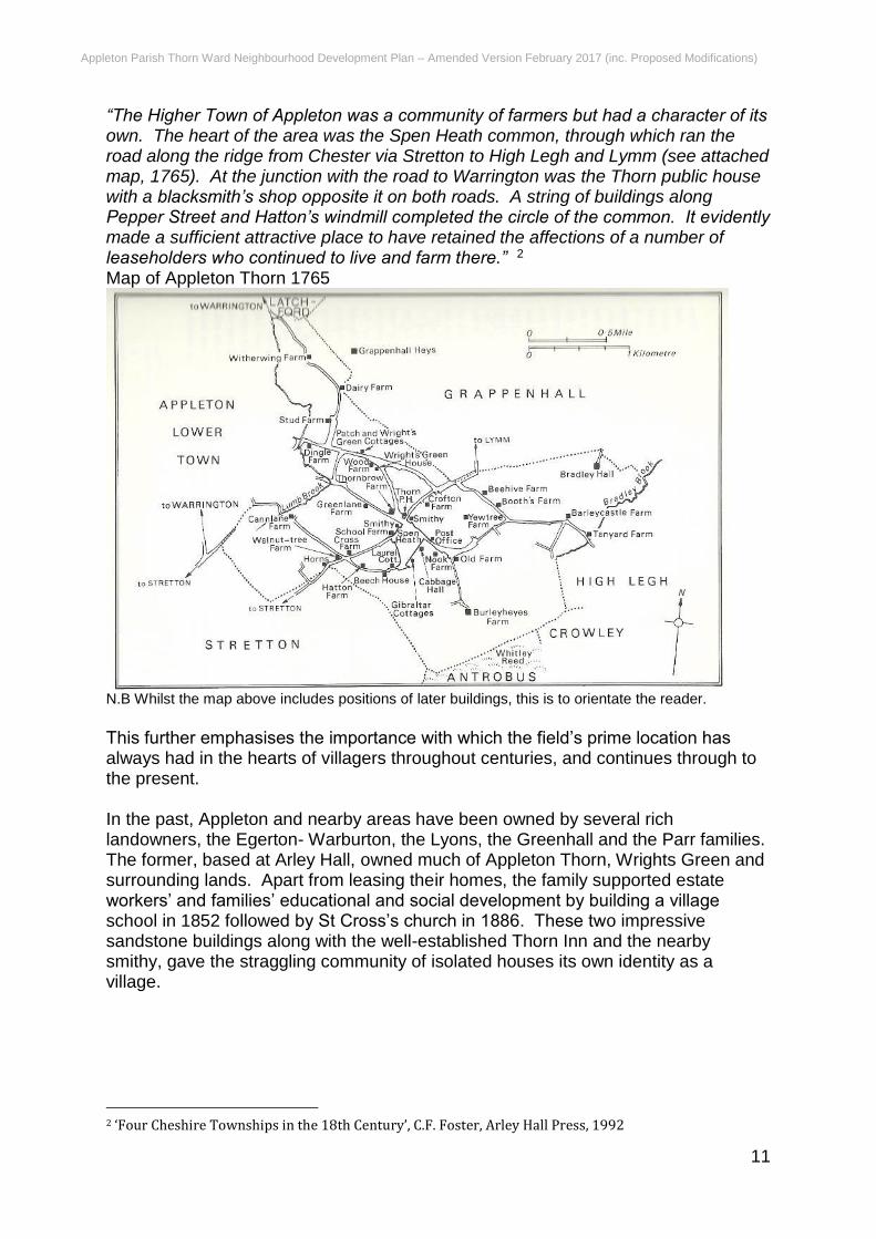
Excavation work for re-siting Appleton Cross in 1973 by Warrington Museum came with the discovery of a Venetian soldino coin of Vernier (1382- 1400) and it was concluded by the Museum’s Director Mr J R Rimmer at the time that the 2 step structure with a hollowed top step was likely the base of a Wayside or Weeping Cross with the missing upright cross itself formerly made of wood. It served the purpose as a halting place for funeral processions similar to another local one found at Bradley Hall within the Appleton Thorn Ward and indeed several others found in Cheshire and Lancashire. In this case Appleton Cross was positioned to the West of Appleton Thorn on the way to an early chapel of rest situated at Stretton. A recent plaque commissioned by Appleton PC placed near the stone base states that the structure’s probable erection date was between 1400 & 1420, some seven centuries ago. The map on Page 11, published in 1765 demonstrates the rural landscape and agricultural heritage of the Ward over the past centuries. It is noted that Appleton Thorn’s central field was known as Spen Heath and referred to as follows:
1 Great British Trees. Published by Tree Council (2002)
Appleton Parish Thorn Ward Neighbourhood Development Plan – Amended Version February 2017 (inc. Proposed Modifications)
11
“The Higher Town of Appleton was a community of farmers but had a character of its own. The heart of the area was the Spen Heath common, through which ran the road along the ridge from Chester via Stretton to High Legh and Lymm (see attached map, 1765). At the junction with the road to Warrington was the Thorn public house with a blacksmith’s shop opposite it on both roads. A string of buildings along Pepper Street and Hatton’s windmill completed the circle of the common. It evidently made a sufficient attractive place to have retained the affections of a number of leaseholders who continued to live and farm there.” 2 Map of Appleton Thorn 1765
N.B Whilst the map above includes positions of later buildings, this is to orientate the reader.
This further emphasises the importance with which the field’s prime location has always had in the hearts of villagers throughout centuries, and continues through to the present. In the past, Appleton and nearby areas have been owned by several rich landowners, the Egerton- Warburton, the Lyons, the Greenhall and the Parr families. The former, based at Arley Hall, owned much of Appleton Thorn, Wrights Green and surrounding lands. Apart from leasing their homes, the family supported estate workers’ and families’ educational and social development by building a village school in 1852 followed by St Cross’s church in 1886. These two impressive sandstone buildings along with the well-established Thorn Inn and the nearby smithy, gave the straggling community of isolated houses its own identity as a village.
2 ‘Four Cheshire Townships in the 18th Century’, C.F. Foster, Arley Hall Press, 1992
Appleton Parish Thorn Ward Neighbourhood Development Plan – Amended Version February 2017 (inc. Proposed Modifications)
12
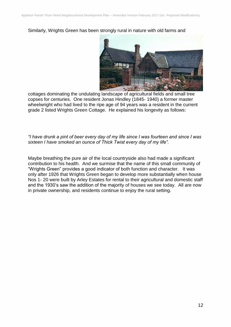
Similarly, Wrights Green has been strongly rural in nature with old farms and
cottages dominating the undulating landscape of agricultural fields and small tree copses for centuries. One resident Jonas Hindley (1845- 1940) a former master wheelwright who had lived to the ripe age of 94 years was a resident in the current grade 2 listed Wrights Green Cottage. He explained his longevity as follows: “I have drunk a pint of beer every day of my life since I was fourteen and since I was sixteen I have smoked an ounce of Thick Twist every day of my life”. Maybe breathing the pure air of the local countryside also had made a significant contribution to his health. And we surmise that the name of this small community of “Wrights Green” provides a good indicator of both function and character. It was only after 1926 that Wrights Green began to develop more substantially when house Nos 1- 20 were built by Arley Estates for rental to their agricultural and domestic staff and the 1930’s saw the addition of the majority of houses we see today. All are now in private ownership, and residents continue to enjoy the rural setting.
Appleton Parish Thorn Ward Neighbourhood Development Plan – Amended Version February 2017 (inc. Proposed Modifications)
13
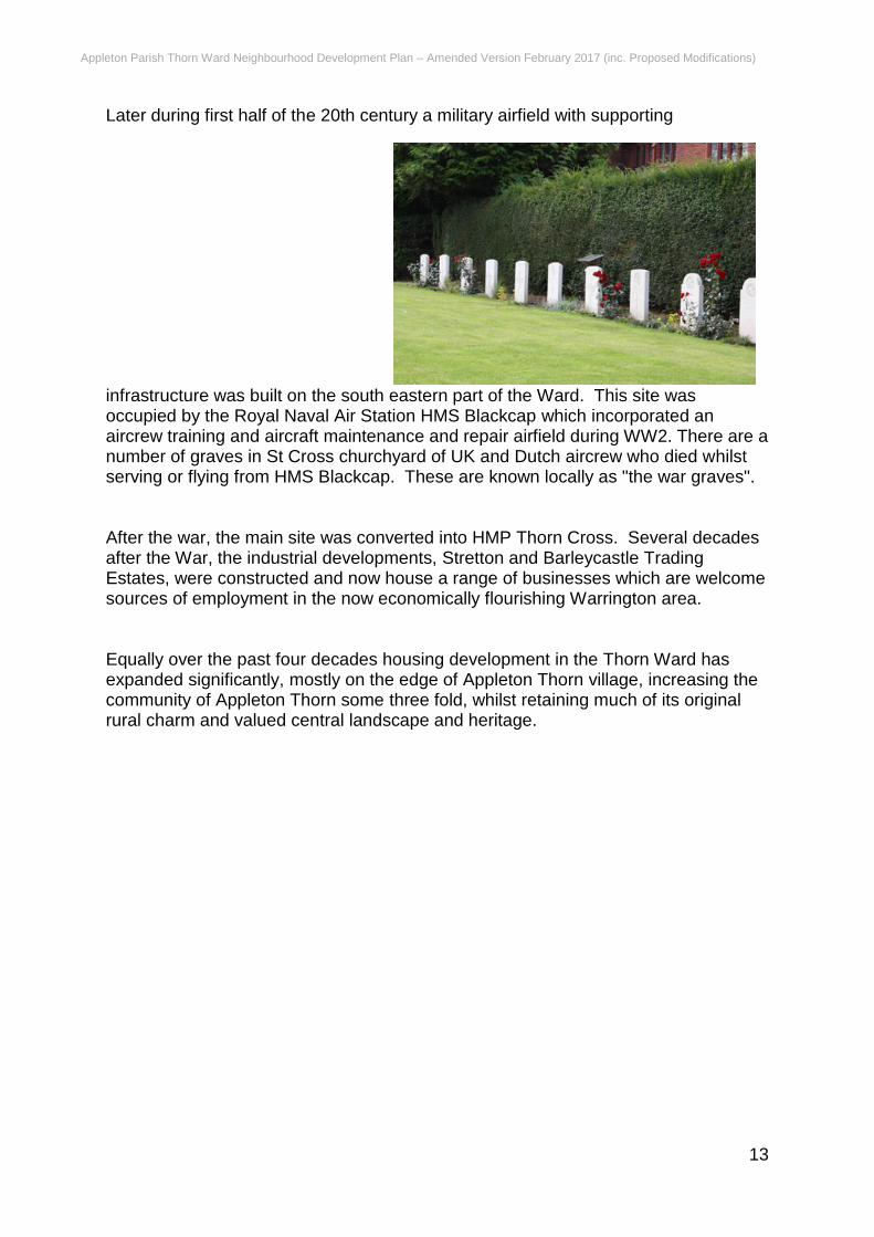
Later during first half of the 20th century a military airfield with supporting
infrastructure was built on the south eastern part of the Ward. This site was occupied by the Royal Naval Air Station HMS Blackcap which incorporated an aircrew training and aircraft maintenance and repair airfield during WW2. There are a number of graves in St Cross churchyard of UK and Dutch aircrew who died whilst serving or flying from HMS Blackcap. These are known locally as "the war graves". After the war, the main site was converted into HMP Thorn Cross. Several decades after the War, the industrial developments, Stretton and Barleycastle Trading Estates, were constructed and now house a range of businesses which are welcome sources of employment in the now economically flourishing Warrington area. Equally over the past four decades housing development in the Thorn Ward has expanded significantly, mostly on the edge of Appleton Thorn village, increasing the community of Appleton Thorn some three fold, whilst retaining much of its original rural charm and valued central landscape and heritage.
Appleton Parish Thorn Ward Neighbourhood Development Plan – Amended Version February 2017 (inc. Proposed Modifications)
14
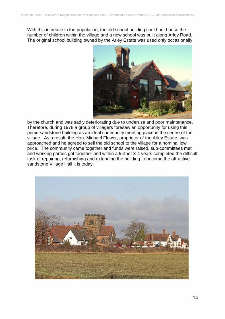
With this increase in the population, the old school building could not house the number of children within the village and a new school was built along Arley Road. The original school building owned by the Arley Estate was used only occasionally
by the church and was sadly deteriorating due to underuse and poor maintenance. Therefore, during 1978 a group of villagers foresaw an opportunity for using this prime sandstone building as an ideal community meeting place in the centre of the village. As a result, the Hon. Michael Flower, proprietor of the Arley Estate, was approached and he agreed to sell the old school to the village for a nominal low price. The community came together and funds were raised, sub-committees met and working parties got together and within a further 3-4 years completed the difficult task of repairing, refurbishing and extending the building to become the attractive sandstone Village Hall it is today.

Appleton Parish Thorn Ward Neighbourhood Development Plan – Amended Version February 2017 (inc. Proposed Modifications)
15
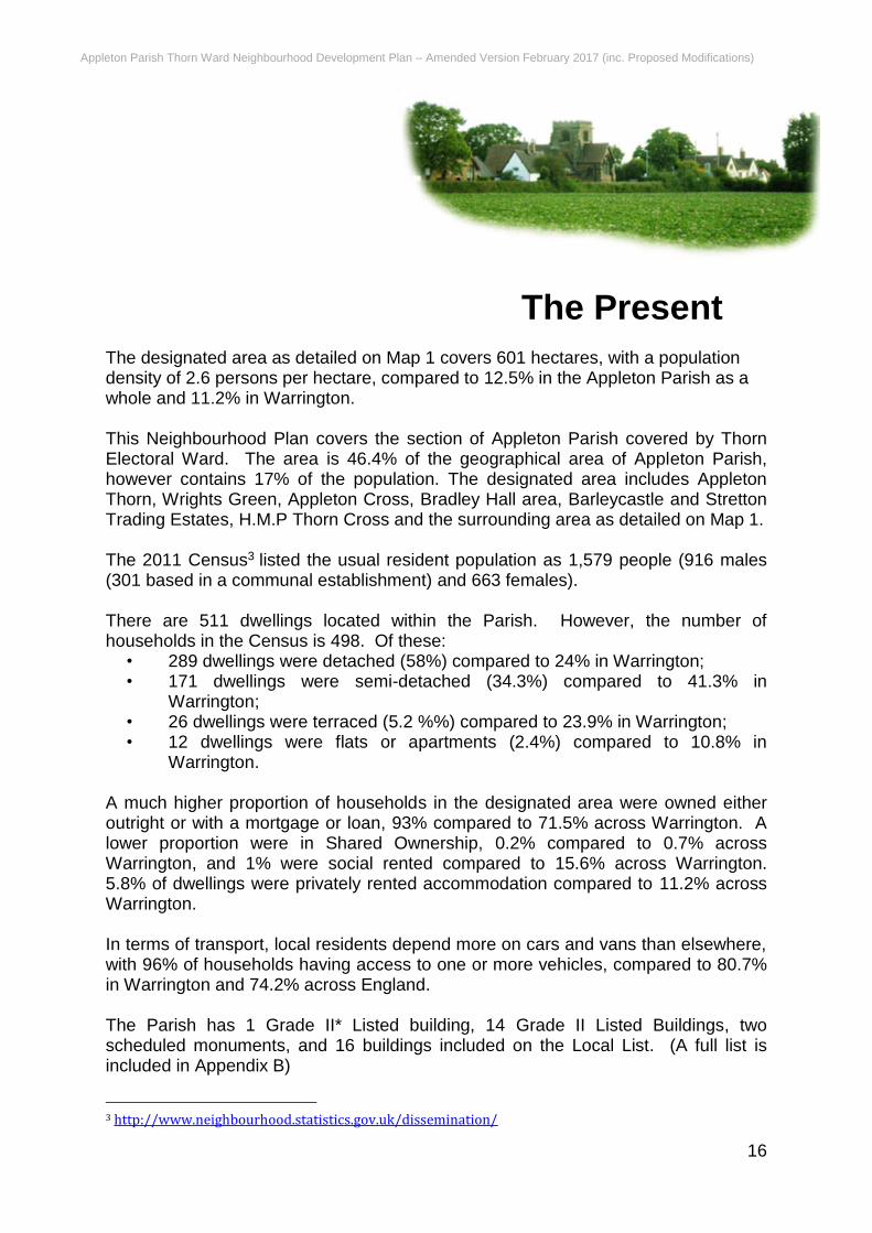
Together with the Thorn Inn, School Cottage (built to house the local schoolmaster), the church and the Village Hall are a vital part of Thorn Ward’s heritage. They have made an attractive landscape, becoming the essential heart of the rural community, as these impressive buildings are situated at the heart of Appleton Thorn village. The Landscape Character Assessments states
Appleton Parish Thorn Ward Neighbourhood Development Plan – Amended Version February 2017 (inc. Proposed Modifications)
16
The Present The designated area as detailed on Map 1 covers 601 hectares, with a population density of 2.6 persons per hectare, compared to 12.5% in the Appleton Parish as a whole and 11.2% in Warrington. This Neighbourhood Plan covers the section of Appleton Parish covered by Thorn Electoral Ward. The area is 46.4% of the geographical area of Appleton Parish, however contains 17% of the population. The designated area includes Appleton Thorn, Wrights Green, Appleton Cross, Bradley Hall area, Barleycastle and Stretton Trading Estates, H.M.P Thorn Cross and the surrounding area as detailed on Map 1. The 2011 Census3 listed the usual resident population as 1,579 people (916 males (301 based in a communal establishment) and 663 females). There are 511 dwellings located within the Parish. However, the number of households in the Census is 498. Of these:
• 289 dwellings were detached (58%) compared to 24% in Warrington; • 171 dwellings were semi-detached (34.3%) compared to 41.3% in
Warrington; • 26 dwellings were terraced (5.2 %%) compared to 23.9% in Warrington; • 12 dwellings were flats or apartments (2.4%) compared to 10.8% in
Warrington. A much higher proportion of households in the designated area were owned either outright or with a mortgage or loan, 93% compared to 71.5% across Warrington. A lower proportion were in Shared Ownership, 0.2% compared to 0.7% across Warrington, and 1% were social rented compared to 15.6% across Warrington. 5.8% of dwellings were privately rented accommodation compared to 11.2% across Warrington. In terms of transport, local residents depend more on cars and vans than elsewhere, with 96% of households having access to one or more vehicles, compared to 80.7% in Warrington and 74.2% across England. The Parish has 1 Grade II* Listed building, 14 Grade II Listed Buildings, two scheduled monuments, and 16 buildings included on the Local List. (A full list is included in Appendix B)
3 http://www.neighbourhood.statistics.gov.uk/dissemination/
Appleton Parish Thorn Ward Neighbourhood Development Plan – Amended Version February 2017 (inc. Proposed Modifications)
17
The Parish is predominantly rural in character. The Warrington Landscape Character Assessment 2007 4 identifies the landscape character types as being ‘Undulating Enclosed Farmland (1B-Appleton Thorn), level areas of land and former airfield (4C-Stretton Airfield). Undulating Enclosed Farmland (1B – Appleton Thorn) The farmland is generally undulating and slopes down to reasonably level areas of mosslands known as Appleton and Stretton Moss. Agriculture is mainly arable and is characteristically composed of very large fields with few hedgerows. Settlement is mainly represented by the attractive village centre of Appleton Thorn, highlighted by its church tower set on the ridgeline and by the ‘village extension’ of Appleton Thorn Trading Estate. Its key characteristics are:
• broad expansive agricultural landscape lacking hedgerows • strong visual and audible effect of M56 • noticeably gently sloping land to the south • views of the Pennine skyline to the east • skyline imposition of commercial development on ridgeline at Appleton Thorn • ridgeline feature of Appleton Thorn church tower
To the east of the village is the large Barleycastle Trading Estate, based on land which was formerly part of the Stretton Airfield. North of the Barleycastle Trading Estate is the Appleton Thorn Trading Estate, a smaller mixed use Trading Estate. This estate does have a major visual impact on the area, being located directly on the ridgeline of the escarpment. Bradley Hall, an attractive group of farm buildings is sited on the summit of the escarpment. Key cultural elements in the landscape:
• St. Cross Church • Village Hall • School Cottage • The Thorn Tree • The Thorn Inn • HMP Thorn Cross • Appleton Thorn and Barleycastle Trading Estate. • Bradley Hall Farm • The M56 motorway • The M6 motorway
Key elements of landscape sensitivity:
• Skyline location • Remaining hedgerows • Remaining views of Appleton Thorn Church on skyline • Marl pit ponds
4 https://www.warrington.gov.uk/downloads/file/5301/tps077_landscape_character_assessment
Appleton Parish Thorn Ward Neighbourhood Development Plan – Amended Version February 2017 (inc. Proposed Modifications)
18
Recommended Management and Landscape Objectives: Although much of the original agricultural landscape of the area has been lost to development and agricultural ‘modernisation’, a basic framework of field patterns can still be improved and restored to improve the landscape quality. The restoration and management of hedgerows, together with the re-introduction of hedgerow trees, would greatly strengthen the landscape structure and improve the visual appearance of the area. A strong control of the type, quality and location of new development should aim to reassert the village centre and prevent further skyline intrusions to the crest line. The emphasis for the landscape management of the area should therefore be one of restoration and enhancement. Native woodland screen planting should also be considered for the more obtrusive aspects of the industrial estate, together with the more exposed sections of the M56. Level Areas of Farmland and Former Airfields (4C – Stretton Airfield) The former Stretton Airfield occupies an area of level ground situated adjoining the Appleton Thorn Trading Estate. Its key characteristics are:
• level ground • visual and audible dominance of M56 motorway • very large scale, open area of largely grassland with few trees • absence of agricultural heritage
Key cultural elements in the landscape:
• remnant sections of Stretton Airfield runway • buildings from the former airfield
The Local Wildlife Site of Stretton Moss borders the south western corner of the designated area. There are several records of protected species (Great Crested Newts) within H.M.P. Thorn Cross.
Appleton Parish Thorn Ward Neighbourhood Development Plan – Amended Version February 2017 (inc. Proposed Modifications)
19
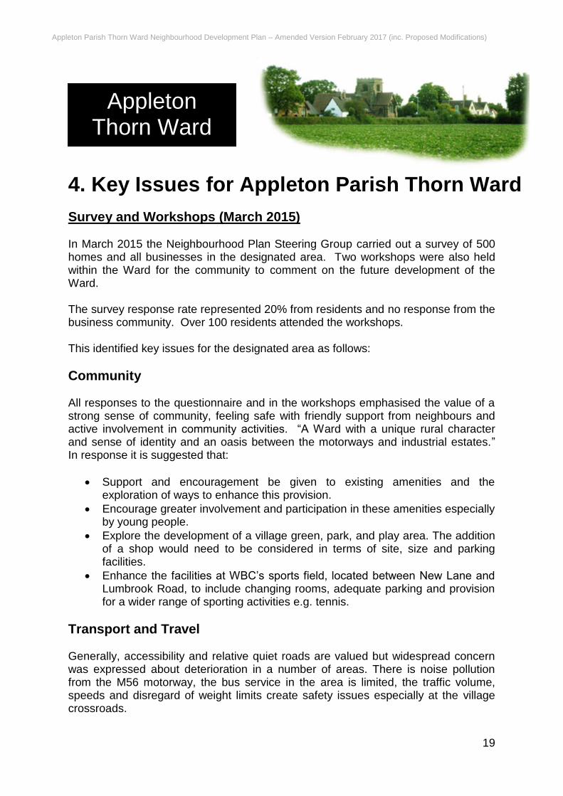
4. Key Issues for Appleton Parish Thorn Ward
Survey and Workshops (March 2015) In March 2015 the Neighbourhood Plan Steering Group carried out a survey of 500 homes and all businesses in the designated area. Two workshops were also held within the Ward for the community to comment on the future development of the Ward. The survey response rate represented 20% from residents and no response from the business community. Over 100 residents attended the workshops. This identified key issues for the designated area as follows:
Community All responses to the questionnaire and in the workshops emphasised the value of a strong sense of community, feeling safe with friendly support from neighbours and active involvement in community activities. “A Ward with a unique rural character and sense of identity and an oasis between the motorways and industrial estates.” In response it is suggested that:
Support and encouragement be given to existing amenities and the exploration of ways to enhance this provision.
Encourage greater involvement and participation in these amenities especially by young people.
Explore the development of a village green, park, and play area. The addition of a shop would need to be considered in terms of site, size and parking facilities.
Enhance the facilities at WBC’s sports field, located between New Lane and Lumbrook Road, to include changing rooms, adequate parking and provision for a wider range of sporting activities e.g. tennis.
Transport and Travel Generally, accessibility and relative quiet roads are valued but widespread concern was expressed about deterioration in a number of areas. There is noise pollution from the M56 motorway, the bus service in the area is limited, the traffic volume, speeds and disregard of weight limits create safety issues especially at the village crossroads.
Appleton Thorn Ward
Appleton Parish Thorn Ward Neighbourhood Development Plan – Amended Version February 2017 (inc. Proposed Modifications)
20
There is congestion out of the area at peak times with vehicles using Wrights Green as a rat run, along with vehicles from Appleton Thorn wishing to gain access to the motorways and heavier vehicles moving onto the trading estate. There is a lack of adequate street lighting in certain parts of the village and along with the lack of roadside footpaths, creates areas which are generally not pedestrian friendly. Similarly, the lack of cycle paths and limited parking, especially around the local school, playing fields and prison can cause safety issues. Concern was also expressed that the bus stops outside the Village Hall posed a safety issue given the number of secondary school children using it at the start and end of the school day. In response to these comments the following actions were suggested:
Consider a request for consideration of noise reduction measures on relevant part of the M56.
Consultation required on the use of the bus stop used by the school children.
Support improvements to the bus service in the area.
Support methods to reduce the negative impacts of increased traffic speed and size with consideration given to most appropriate site for pedestrian crossing and traffic calming measures.
Support improvements to car parking provision.
Support improvements to and creation of roadside footpaths and cycle paths.
Landscape A lot of emphasis was placed on the quiet feel of the surrounding area with its historical character, natural beauty, walkways and views with the green spaces and good agricultural land creating a clear demarcation between urbanisations. In particular, the openness of the village centre in Appleton Thorn created the essential "village feel". The responses to these points should be to produce a plan which:
Values and preserves the natural beauty of the area
Encourages new developments to introduce different habitats-water, hedges, trees and wildlife corridors.
Creates strict planning constraints to ensure any development preserves the traditional character green spaces and history of the environment, including maintaining the landscape and protecting listed buildings, farms and farmlands.
Housing Comments in this section centred on the small size of the community and residents not feeling overcrowded, the need to address the provision of facilities should there be any increase in the population of the Ward. The housing mix should include affordable single and two storey homes catering for young families and elderly residents which enhance the character of the village and provide adequate off-road parking. In the light of these comments it was suggested that:

Appleton Parish Thorn Ward Neighbourhood Development Plan – Amended Version February 2017 (inc. Proposed Modifications)
21
Selective new housing, especially in the right place subject to specific conditions and satisfying the needs identified, should be investigated, in order to prevent any single development having a dominating appearance on the surrounding area.
Encouragement of conversion of barns/existing buildings/brown field sites should take priority, so that green space can be protected.
Business and Employment There was support for the development of local businesses through the conversion of old or unused buildings in appropriate ways and in particular the encouragement of more local employment opportunities on the industrial estate.
Other Issues The approaches to the village centre particularly from the M6 to the trading estate are plagued by litter. There is a lack of public benches. Possible solutions to explore:
Financial levy on trading estate in order to supplement cost of litter collection.
Removal of litter regularly, possibly by volunteers.
Sufficient litter/dog bins
Increase in the number of public benches
Drop-in Event (October 2015) A further drop-in event was held on 3rd October 2015. This included draft sections and policies of the draft neighbourhood plan and included Options Maps for the site in the centre of the village. A total of 77 residents attended the drop-in event. The main point of interest was the choice of options for the field in the centre of the village. The most popular were options 2 or 4. Option 4 would give views across the field towards the church from Pepper Street. The maps of the four options are provided in Appendix D
Engaging with the younger community (November 2015) A meeting was held with Appleton Thorn School council to discuss the Neighbourhood Development Plan. 15 Students took part; all years were represented. The students were put into 3 groups with a scribe nominated. All ages were represented. Question 1 - “What do you like about Appleton Thorn village?” Answers fell into 4 main sections with 16 responses in total. (* comments are actual written responses) 6 responses mentioned how nice an environment AT village is. *The looks of the area *We like it because it is cosy *We can look at (interesting) things around the village
Appleton Parish Thorn Ward Neighbourhood Development Plan – Amended Version February 2017 (inc. Proposed Modifications)
22
*There is farming *Open space and nice place to walk *A nice environment 5 responses mentioned how nice the people of the community are *The people are kind *The people are nice *We have lots of friends *There are nice people *The friendly community 3 responses mentioned the excellent school *We have a fantastic school *The school *It has a good school 2 responses mentioned village events *There are nice events going on *The community and events like Bawming the Thorn Question 2 - “Thinking about the “NDP”, If development was to take place, how would you like to see the village develop? Answers fell into 5 main sections with18 responses in total 6 responses mentioned some form of shop *We would like to see a village shop *there could be a local shop *a small shop e.g.co-op *a newsagent *bright and colourful (shop) *shops (to be pretty) 5 responses mention some form of park *could be a playground *a public park *a football field *a small park *a public woodland 4 responses mentioned the present environment *a happier environment *new coats of paint on some old houses *an eye catching sign for the village *a water fountain 2 responses mentioned more houses *a few more houses *more houses 1 response mentioned transport
Appleton Parish Thorn Ward Neighbourhood Development Plan – Amended Version February 2017 (inc. Proposed Modifications)
23
*a train service (from Sandymore) To conclude the group went through the comments and 3 students expressed concern that if more houses were built, this would mean more traffic and a bigger school.
Summary of Teenagers’ thoughts about Appleton Thorn Village They were asked two questions like the Junior School. Question 1 “What do you like about Appleton Thorn village?” Question 2 “Thinking about the village plan for the future (“NDP”), If further development (community facilities, housing, the environment, transport, etc.) was to take place, how would you like to see the village develop? A total of 17 youngsters replied to this survey. Two 12 year olds, one boy and one girl One 13-year-old boy One 14-year-old girl Two 15 year olds two girls Three 16 year olds two girls and one boy Four 17 year olds one boy and three girls Two 19-year-old girls Two 20 year olds one boy and one girl Although there is a diverse age range there was a common trend of opinions. Most if not all had lived here most of their lives. All liked the rural aspect of the village, quietness, open space and the wild life including foxes, birds and bats. 4 of them are at University and enjoyed coming home because of this. Most of them mentioned the close community and knowing many people in the village who know them and of feeling safe. Several enjoyed the walks around the village and liked the current amenities, the bus service, school, pub, church and the Village Hall mentioning the Bawming ceremony as being a favourite event. Enjoying the views as well as the openness was mentioned with a particular like of seeing the sunrise when waiting for the school bus. In summary ‘a lovely place to live’
Appleton Parish Thorn Ward Neighbourhood Development Plan – Amended Version February 2017 (inc. Proposed Modifications)
24
Most mentioned they did not want any more development in the centre of the village, leaving any new builds to the outskirts. If there was any development in the centre of the village that it must be kept to a minimum making sure that the open feel was kept. Most mentioned that they would like an open area such as a park/ green with seats. The majority would like a small shop, one saying that the new farm shop may cover this. One 12-year-old wanted a sports centre somewhere in the village and one wanted a tennis court. Several were worried about the traffic increase with increased development as they said the main road is already dangerous at busy times requiring some traffic calming already. One was worried about the construction period and of the disruption this would cause as well as the mess another was worried about protecting the hedgerows and the wild life as well as the character of the village. Some wanted improved bus shelters when they were waiting for the buses to go to school or college as well as cycle paths and pavements to other villages. A Pelican crossing was also mentioned as a requirement for them crossing the road to the bus stop. An improved bus service was mentioned as the buses are often full and infrequent.
Appleton Parish Thorn Ward Neighbourhood Development Plan – Amended Version February 2017 (inc. Proposed Modifications)
25
5. Vision and objectives The vision and objectives for the Neighbourhood Plan have been prepared taking into consideration the results and the key issues generated by the community survey and workshops.
Objectives
Housing
1. To ensure that new housing in the designated area is provided in
developments that are in keeping with the size scale and function of the
Ward.
2. To ensure that housing choices are available for all sectors of the
community.
Design, Natural and Built Environment
3. To ensure that all new development is of high quality and sustainable and
reflects the character and heritage of the designated area.
4. To protect and enhance the heritage assets of the designated area.
5. To protect and enhance the landscape and setting of the designated area.
Traffic and Highways
6. To ensure that all traffic and transport issues are addressed especially
with respect to safety, speed and congestion.
The Vision for Appleton Parish Thorn Ward
A part of the Parish of Appleton with a valued heritage and unique identity that retains its rural character, maintains its community spirit, and develops in a sustainable way to meet the needs and aspirations of all those who live or work within it.
Appleton Thorn Ward

Appleton Parish Thorn Ward Neighbourhood Development Plan – Amended Version February 2017 (inc. Proposed Modifications)
26
7. To promote safe walking and cycle routes both within the designated area and to nearby towns and villages.
Employment
8. To support services and other businesses providing employment
opportunities.
Community Facilities and Infrastructure
9. To protect and enhance community facilities within the designated area.
10. To protect and enhance the quality of open spaces
Appleton Parish Thorn Ward Neighbourhood Development Plan – Amended Version February 2017 (inc. Proposed Modifications)
27
6. Neighbourhood Plan Policies This section sets out the planning policies to guide development in Appleton Parish Thorn Ward up to 2027 and is split into five themes. These five themes have developed from the consultations, workshops (Section 4) and the objectives (Section 5). Whilst the policies are divided between the themes the plan should be read as a whole. 6.1 Housing 6.1.1 Appleton Thorn is an inset village within the Green Belt as identified in Policy
CC1 of the Warrington Local Plan Core Strategy (2027). Policy CS1 of the Warrington Local Plan Core Strategy (2027) states that throughout the borough, development proposals that are sustainable will be welcomed and approved without delay. To be sustainable, development must accord with national and local planning policy frameworks, taking into account all other material considerations.
6.1.2 Policy SN1 states that “60% of new homes within the plan period will be
delivered within Inner Warrington, with the remaining 40% primarily through development within the suburban areas of Warrington. Within all of the borough’s defined settlements, the Council will support proposals which:
1. relate entirely to the delivery of affordable or social housing which is
proven to meet identified needs; or 2. meet identified specialist needs including units specifically provided to
meet the needs of the elderly or infirm; or 3. relate to mixed use schemes where the inclusion of an element of
housing will make the development as a whole more sustainable and viable; or
4. constitute small-scale, low-impact infill development. Within the Green Belt, outside any of the borough's defined settlements, new housing will only be approved where the proposal accords with relevant national policy. Should monitoring indicate that an ongoing deliverable and developable 10-year supply of housing land can no longer be sustained from the above sources, or housing need is not being met, the Council will review its housing land provision, and bring on-stream additional housing sites as required, in accordance with Policy CS3.”
Appleton Thorn Ward
Appleton Parish Thorn Ward Neighbourhood Development Plan – Amended Version February 2017 (inc. Proposed Modifications)
28
6.1.3 A High Court challenge to the Core Strategy resulted in the Local Plan housing target being quashed in February 2015. Warrington Borough Council are seeking to re-instate this through a Primary Plan Alteration. Warrington Borough Council has updated and published its “Strategic Housing Land Availability Assessment” (SHLAA), 2015 to identify the land available for housing over the next 15 years and undertaken with neighbouring planning authorities the”Mid Mersey Strategic Housing Market Assessment” (SHMA),2016, to establish the ‘Objectively Assessed Need’ for housing in Warrington.
6.1.4 Through undertaking this work, the Council is not currently able to
identify sufficient land to meet its likely housing need in accordance with the requirements of the National Planning Policy Framework (NPPF). This means that the Council will need to undertake a more fundamental review of the Plan than currently envisaged in the LDS with further work required to enable the Council to assess the options for and Implications of meeting its housing need in full.
6.1.5 Key issues arising out of the workshops held by the Steering Group related to
new development being small scale, ensuring there is a range of house types, tenures and sizes and ensuring there is housing for local needs including starter homes. Presently, the objectively assessed need for Warrington is identified through the Mid Mersey SHMA (2016).
6.1.6 However, responses from consultation with the community centred on the
small size of the community and residents not feeling overcrowded, the need to address the provision of facilities should there be any increase in the size of the Ward.
6.1.7 The housing mix should include affordable single and two storey homes
catering for young families and elderly residents which enhance the character of the village and provide adequate off-road parking. In the light of these comments it was suggested that:
6.1.8 Selective new housing, especially in the right place subject to specific
conditions and satisfying the needs identified, should be investigated, in order to prevent any single development having a dominating appearance on the surrounding area.
6.1.9 Policy SN2 of the Warrington Local Plan Core Strategy states that a mixture
of housing types and tenures will be provided through the delivery of new homes in order to secure mixed and inclusive communities:
requiring development proposals to deliver a mix of dwellings which seek to better balance the housing market by matching supply to identified needs;
requiring development proposals to give specific consideration to meeting the needs of the elderly and enabling a greater degree of self-independent living; and
Appleton Parish Thorn Ward Neighbourhood Development Plan – Amended Version February 2017 (inc. Proposed Modifications)
29
ensuring that all developments which incorporate open market housing and with a capacity of 5 or more dwellings make provision for affordable housing on the following basis: o 20% on a previously developed or greenfield site between 5 and 14
dwellings regardless of its location within the borough o 20% on a previously developed site of 15 or more dwellings within
Inner Warrington inclusive of the Town Centre o 30% on a previously developed site of 15 or more dwellings where
that site is located outside of Town Centre and Inner Warrington o 30% on a greenfield site of 15 or more dwellings regardless of its
location within the borough 6.1.10 “Since the Local Plan was adopted, updates to national policy in the NPPG
mean the Council is no longer able to secure affordable housing on sites of 10 or fewer homes or when the proposed cumulative floor space is less than 1000sq. metres. The Housing and Planning Act 2016 has also been published following the adoption of the Local Plan. The Act places a duty on the Council to promote the supply of Starter Homes in carrying out its relevant planning functions. Forthcoming regulations will require provision of a proportion of Starter Homes on all sites above a certain threshold. Consequently the Council has adopted a Planning Obligations SPD which elaborates on how Policy SN2 will be applied in practice, taking into account this new legislation and guidance. The threshold will now be 11 residential units with qualifying sites required to provide a minimum of 20% affordable housing on-site. In accordance with Policy SN2 this target increases to 30% on sites of 15 or more dwellings where they are greenfield sites or located outside of inner Warrington. Planning obligations relating to affordable housing will be sought for residential developments of 11 or more units. 50% of the affordable housing should be for rented and 50% intermediate provision. Starter Homes will be considered as intermediate provision. The level, tenure and mix of affordable housing will be considered on a site by site basis subject to viability, other policy and planning obligation requirements, any vacant building credit and forthcoming regulations under the Housing and Planning Act 2016. In accordance with Local Plan Core Strategy Policy SN2, affordable housing should normally be provided on-site. Only where exceptional circumstances exist and where the Council is satisfied that it would deliver a better outcome, will off-site provision be accepted. Where exceptionally, housing cannot be provided on or off-site, a commuted sum will be required in lieu of provision to secure delivery of affordable housing on sites elsewhere in the borough.
6.1.11 In each case the provision to be made will be based on negotiation and
agreement on a site by site basis. A lower proportion and/or a different tenure split may be permitted where it can clearly be demonstrated to the satisfaction of the Council that development would otherwise not be financially viable, and affordable housing provision is nevertheless being maximised.
Appleton Parish Thorn Ward Neighbourhood Development Plan – Amended Version February 2017 (inc. Proposed Modifications)
30
6.1.12 The presumption will be for affordable housing to be provided on the application site unless the type of housing proposed does not accord with priority needs, or the nature of the site is deemed unsuitable for affordable housing, in which case a commuted sum in lieu of on-site provision will be required.
6.1.13 Wrights Green is a small hamlet included in the designated area. However, it
is not located within a defined settlement in the Warrington Local Plan Core Strategy, and therefore future housing development will be in accordance with the Green Belt policies set out in National Planning Policy and Warrington Local Plan Core Strategy.
6.1.14 The Neighbourhood Plan Steering Group considered that a range of house
sizes is required, to meet future needs and this concern is reflected in the results from the workshops with the community.
6.1.15 The 2011 Census information relating to, tenure mix, house type and number
of bedrooms in dwellings within the designated area is included in Appendix C.
6.1.16 Any mix of house sizes, types and tenures will be expected to take account of
objectively assessed need in the area, identified in the Mid Mersey SHMA 2016 or latest up to date information for the area.
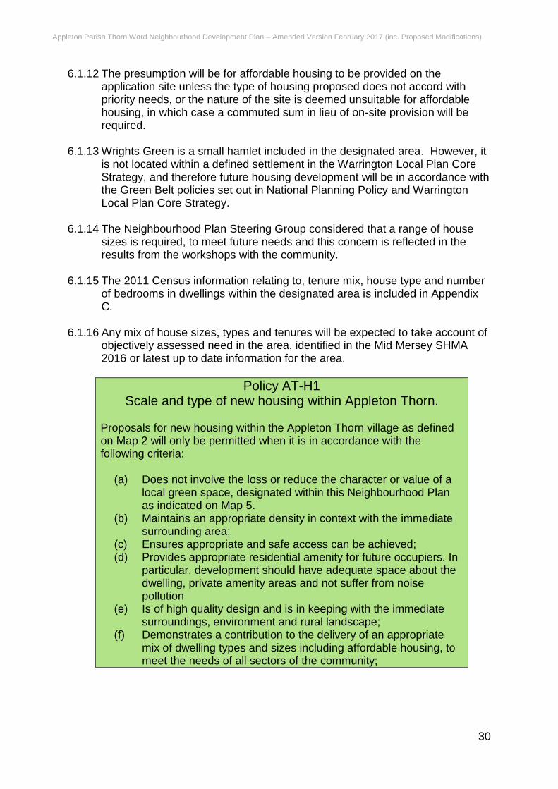
Policy AT-H1 Scale and type of new housing within Appleton Thorn.
Proposals for new housing within the Appleton Thorn village as defined on Map 2 will only be permitted when it is in accordance with the following criteria:
(a) Does not involve the loss or reduce the character or value of a local green space, designated within this Neighbourhood Plan as indicated on Map 5.
(b) Maintains an appropriate density in context with the immediate surrounding area;
(c) Ensures appropriate and safe access can be achieved; (d) Provides appropriate residential amenity for future occupiers. In
particular, development should have adequate space about the dwelling, private amenity areas and not suffer from noise pollution
(e) Is of high quality design and is in keeping with the immediate surroundings, environment and rural landscape;
(f) Demonstrates a contribution to the delivery of an appropriate mix of dwelling types and sizes including affordable housing, to meet the needs of all sectors of the community;
Appleton Parish Thorn Ward Neighbourhood Development Plan – Amended Version February 2017 (inc. Proposed Modifications)
31
(g) Reflects the scale and function of the settlement; and (h) Includes adequate off-street parking5, garaging and private and
public amenity space for future residents; (i) The proposal would not have any adverse effect on
neighbouring residential amenity; and (j) Is in accordance with all other relevant policies.
6.1.17 The Strategic Housing Land Availability Assessment (SHLAA) produced by
Warrington Borough Council in 2015 includes a large area of land in the ownership of the Homes and Communities Agency (land at Appleton Cross) as identified on Map 3. The following policy identifies criteria for the future development of this land. The land is not within the Green Belt and offers scope for a natural extension of the built form of the surrounding suburban development. It offers good scope for connection to the local highway network. Development of the site for housing will help meet the housing targets the Borough Council is endeavoring to meet. A particular issue concerns the scale and size of the proposed dwellings. The site abuts the Green Belt and the suburban area of Warrington. The predominant scale of dwelling is two-storeys. In accordance with the core principles and paragraph 88 of the NPPF, it is important that the green belt is protected from harm and as the dwellings will be readily visible in the green belt landscape, they need to respect the rural character. It is also necessary to bear in mind the proximity of the site to the urban area and that a range of dwelling types can be provided to meet the identified demand for housing. There is therefore a need to restrict the scale and height of dwellings to a reasonable degree in order that it respects the prevailing character in the area, particularly the green belt from where it is most visible. The 2011 Census data, shown in Appendix C illustrates that the plan area has significantly less 1 and 2 bedroomed accommodation than the local and national average and a higher proportion of 4 and 5 bedroomed dwellings. The lack of smaller and affordable housing is identified as a response in the public consultation and also in the Mid Mersey Strategic Housing Market Assessment (SHMA) 2016. The policy needs to seek to provide for housing needs identified in appropriate assessments and needs surveys, for open market and affordable units
6.1.18 Discussions have been undertaken with the landowner (The Homes and
Communities Agency [HCA]) to seek to develop a shared view for the development of the site.
5 In accordance with Warrington BC Standards for Parking in New Development (March 2015) (SPD) and subsequent updates
Appleton Parish Thorn Ward Neighbourhood Development Plan – Amended Version February 2017 (inc. Proposed Modifications)
32
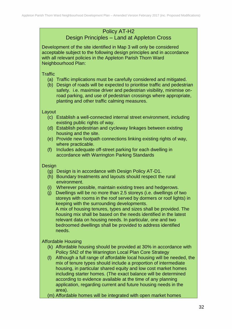
Policy AT-H2 Design Principles – Land at Appleton Cross
Development of the site identified in Map 3 will only be considered acceptable subject to the following design principles and in accordance with all relevant policies in the Appleton Parish Thorn Ward Neighbourhood Plan: Traffic
(a) Traffic implications must be carefully considered and mitigated. (b) Design of roads will be expected to prioritise traffic and pedestrian
safety. i.e. maximise driver and pedestrian visibility, minimise on-road parking, and use of pedestrian crossings where appropriate, planting and other traffic calming measures.
Layout
(c) Establish a well-connected internal street environment, including existing public rights of way.
(d) Establish pedestrian and cycleway linkages between existing housing and the site.
(e) Provide new footpath connections linking existing rights of way, where practicable.
(f) Includes adequate off-street parking for each dwelling in accordance with Warrington Parking Standards
Design
(g) Design is in accordance with Design Policy AT-D1. (h) Boundary treatments and layouts should respect the rural
environment. (i) Wherever possible, maintain existing trees and hedgerows. (j) Dwellings will be no more than 2.5 storeys (i.e. dwellings of two
storeys with rooms in the roof served by dormers or roof lights) in keeping with the surrounding developments. A mix of housing tenures, types and sizes shall be provided. The housing mix shall be based on the needs identified in the latest relevant data on housing needs. In particular, one and two bedroomed dwellings shall be provided to address identified needs.
Affordable Housing
(k) Affordable housing should be provided at 30% in accordance with Policy SN2 of the Warrington Local Plan Core Strategy
(l) Although a full range of affordable local housing will be needed, the mix of tenure types should include a proportion of intermediate housing, in particular shared equity and low cost market homes including starter homes. (The exact balance will be determined according to evidence available at the time of any planning application, regarding current and future housing needs in the area).
(m) Affordable homes will be integrated with open market homes
Appleton Parish Thorn Ward Neighbourhood Development Plan – Amended Version February 2017 (inc. Proposed Modifications)
33
where both are represented on the site, wherever possible. Self-Build
(n) Proposals for custom-built dwellings will be supported and encouraged. The Parish Council will work with developers and/or landowners to utilise ’Community Right to Build’ provisions where a partnership approach between landowners, developers and the community are agreed to have mutual benefits.
(o) A site shall be reserved within the site to provide a local centre which shall include a health centre. Such site shall be reserved as a local centre unless there is evidence that such provision is not necessary or viable.
6.1.19 In addition to the above site, the Strategic Housing Land Availability Assessment also includes a site in the centre of the village identified on Map 4. The following policy identifies criteria for the future development of this land. Design of future dwellings will be a key issue on this site given its proximity to the village centre 6.1.20 There is an identified shortage of 1 and 2 bedroomed dwellings as referred to above in relation to policy ATH-2. Public consultation identified a preference for smaller family housing. The policy needs to respond to this evidence on housing mix. 6.1.21 The open space adds to the intrinsic and unique rural nature of the village. It
is essential in preserving views of the village centre and landscape from important vantage points both from within and outside the village. The space has potential for village recreational purposes.
Policy AT-H3 Design Principles – Land at Stretton Road/Pepper Street
Development of the site identified in Map 4 will only be considered acceptable subject to the following design principles and in accordance with all relevant policies in the Appleton Parish Thorn Ward Neighbourhood Plan: Traffic
(a) Traffic implications must be carefully considered and mitigated. (b) Design of roads to prioritise traffic and pedestrian safety. i.e.
maximise driver and pedestrian visibility, minimise on-road parking, and use of planting and other traffic calming measures, where appropriate.
(c) Location of access to minimise the impact on visual amenity.
Layout (d) The character and setting of the Church and Village Hall (Village
Core) will be respected in any future development. (e) Open green space, which is accessible to the public, will be
incorporated along the frontage of Stretton Road to retain the open character of the central village core and help achieve the
Appleton Parish Thorn Ward Neighbourhood Development Plan – Amended Version February 2017 (inc. Proposed Modifications)
34
objectives of criterion (d) above. (f) Establish a well-connected internal street environment, including
existing public rights of way. (g) Establish pedestrian and cycleway linkages between existing
housing and the site. (h) Provide new footpath connections linking existing rights of way. (i) Include adequate off-street parking for each dwelling. (j) The setting of existing dwellings and the amenities of their
residents will be respected in the layout of any development proposals.
Design
(k) Design should reflect architectural features of the immediate surrounding area, and should be in accordance with Design Policy AT-D1.
(l) Wherever possible, maintain existing trees and hedgerows. (m) Dwellings will be no more than 2.5 storeys (i.e. dwellings of two
storeys with rooms in the roof served by dormers or roof lights) in
keeping with the surrounding developments. (n) A mix of house tenures, types and sizes will be required across
the site in accordance with the needs identified in the latest Census, Strategic Housing Market Assessment or relevant housing needs survey. In particular one and two bedroomed dwellings shall be provided to address identified needs.
Affordable Housing
(o) Affordable housing should be provided at 30% in accordance with Policy SN2 of the Warrington Local Plan Core Strategy
(p) Although a full range of affordable local housing will be needed, the mix of tenure types should include a proportion of intermediate housing, in particular shared equity and low cost market homes including starter homes,. (The exact balance will be determined according to evidence available at the time of any planning application, regarding current and future housing needs in the area.)
(q) Affordable homes will be integrated with open market homes where both are represented on the site, wherever possible.
6.2 Design, Built and Natural Environment 6.2.1 Policy QE 7: Ensuring a High Quality Place of the Warrington Local Plan Core
Strategy states that the Council will look positively upon proposals that are designed to;
be sustainable, durable, adaptable and energy efficient;
create inclusive, accessible and safe environments;
function well in relation to existing patterns of movement and activity;
reinforce local distinctiveness and enhance the character, appearance and function of the street scene, local area and wider townscape;
Appleton Parish Thorn Ward Neighbourhood Development Plan – Amended Version February 2017 (inc. Proposed Modifications)
35
harmonise with the scale, proportions and materials of adjacent and / or existing buildings;
maintain and respect the landscape character and, where appropriate, distinctiveness of the surrounding countryside;
use the density and mix of development to optimise the potential of the site without damaging the character of the area; and
be visually attractive as a result of good architecture and the inclusion of appropriate public space.
6.2.2 Developers will be encouraged to engage with neighbourhoods and communities in developing design solutions. Where appropriate, developments should harness the imagination and creative skills of artists and urban designers in the design process to create distinctive urban environments.
6.2.3 The Council will promote design excellence in new housing developments and will use accepted environmental standards such as Building for Life and the Code for Sustainable Homes to evaluate the design quality of all proposals for major residential development within the borough.
6.2.4 Policy QE6 of the Warrington Local Plan Core Strategy - Environment and Amenity Protection states The Council, in consultation with other Agencies, will only support development which would not lead to an adverse impact on the environment or amenity of future occupiers or those currently occupying adjoining or nearby properties, or does not have an unacceptable impact on the surrounding area. The Council will take into consideration the following:
The integrity and continuity of tidal and fluvial flood defences;
The quality of water bodies, including canals, rivers, ponds and lakes;
Groundwater resources in terms of their quantity, quality and the ecological features they support;
Land quality;
Air quality;
Noise and vibration levels and times when such disturbances are likely to occur;
Levels of light pollution and impacts on the night sky;
Levels of odours, fumes, dust, litter accumulation and refuse collection / storage.
The need to respect the living conditions of existing neighbouring residential occupiers and future occupiers of new housing schemes in relation to overlooking/loss of privacy, outlook, sunlight, daylight, overshadowing, noise and disturbance;
The effect and timing of traffic movement to, from and within the site and car parking including impacts on highway safety;
The ability and the effect of using permitted development rights to change use within the same Use Class (as set out in the in the Town and Country Planning (General Permitted Development Order) without the need to obtain planning consent.
Appleton Parish Thorn Ward Neighbourhood Development Plan – Amended Version February 2017 (inc. Proposed Modifications)
36
6.2.5 The consultation workshops identified that residents of the Ward valued its appearance, and they wished to preserve it for the future, this included the surrounding landscape, and the existing built environment. The Parish Council consider it to be essential that the character of the village and the surrounding landscape should be retained and enhanced. “The Parish Council encourages originality, innovation and initiative.”
Policy AT- D1 Design of Development in Appleton Parish Thorn Ward.
The designated area has a unique local character and distinctiveness. All new development within the area will be permitted where it makes a positive contribution to that distinctive character and be of good quality design. In seeking to protect and enhance the unique identity of the area, all development will be expected to take account of the following:
(a) The contribution it makes to maintaining and enhancing local identity, and sense of place;
(b) Respects the character and setting of any heritage asset; (c) Is suitable in terms of the overall design and appearance of the
proposed development (including size, scale, density, layout, access, lighting, street furniture, and signage) when assessed in relationship with surrounding buildings, existing layout, spaces, vegetation, water areas and other features of the street scene;
(d) Uses, and where appropriate re-uses, local and traditional materials or suitable artificial alternatives; Does not result in backland development (see Glossary for the definition)
(e) Which has a detrimental impact on the character of the area. (f) Includes adequate parking, garaging and private and public
amenity space for future residents. (g) Ensures the use of space and landscape design is appropriate; (h) Relates well to the street and has an active frontage; (i) Respects local settings and garden forms/landscaping; (j) Ensures movement to, within, around, and through the
development is acceptable; (k) Encourages originality, innovation and initiative; (l) Includes appropriate energy efficiency and conservation
measures; (m) Uses Sustainable Drainage Systems; (n) Uses appropriate lighting for the location.
6.2.6 The Warrington Landscape Character Assessment, 2007 provides an
objective view of Warrington’s landscape as it stands today, defines its current landscape character and highlights the pressures of change upon it. It sets out recommendations for management that will help shape the landscape in the future. It divides the borough into Landscape Character Types and Areas. Those most relevant to Appleton Thorn are:
undulating enclosed farmland (1B – Appleton Thorn)
Appleton Parish Thorn Ward Neighbourhood Development Plan – Amended Version February 2017 (inc. Proposed Modifications)
37
level areas of farmland and former airfields (4C – Stretton Airfield)
6.2.7 Both Landscape characters are detailed in the section titled “The Present” 6.2.8 The Parish Council and the residents consider it important to protect the setting of the Ward and the surrounding landscape within it. In addition, there are several views in and around the parish which accentuate the rural aspect of the area, despite being so close to the M6 and M56 motorways, and only a few miles from Warrington. Whilst the plan area is not recognised as being vulnerable to flood risk, in accordance with the NPFF there is a need to take account of climate change and create sustainable development, which seeks to prevent flooding elsewhere.
Appleton Parish Thorn Ward Neighbourhood Development Plan – Amended Version February 2017 (inc. Proposed Modifications)
38
Policy AT – D2 Protecting and enhancing local landscape character and
views Development proposals will be required to incorporate the following landscape design principles. They should:
(a) Seek to preserve and enhance the character of the village and surrounding scattered rural settlements and farmsteads. Development will be expected to conserve and protect the integrity and fabric of historic buildings and their settings, particularly where new uses are proposed, through the use of appropriate styles and sustainable locally distinctive materials;
(b) Preserve and enhance local habitats and wildlife corridors.
Landscaping schemes will be required to incorporate planting schemes which use traditional and locally appropriate species to support and enhance biodiversity. Species should be appropriate to the location and setting in terms of type, height, density and the need for on-going management. When constructing boundaries native tree species should be used. Existing hedgerows should be retained and the establishment of new native hedges is encouraged to support and protect wildlife;
(c) Conserve and enhance important local landscape features wherever possible. Mature and established trees should be retained and incorporated into landscaping schemes wherever possible;
(d) Preserve the settings of open landscapes or buildings of architectural or historic character by avoiding whenever possible the siting of development in highly visible and intrusive positions or where it is unrelated to existing built development or landscape features;
(e) Conserve traditional farm buildings through continued and appropriate new uses in accordance with the Borough Council’s Core Strategy policy QE 8 and adopted Supplementary Planning Document “Design and Construction, October 2010 or any subsequent relevant policies or guidance. Repairs and alterations should wherever possible use materials and techniques which have been used in the construction of the traditional farm buildings in the local area;
(f) Sustainable construction methods, low carbon technologies and use of innovative solutions will be encouraged such as grey water recycling, rainwater harvesting, and reedbeds for sewerage and opportunities for local food production.
Appleton Parish Thorn Ward Neighbourhood Development Plan – Amended Version February 2017 (inc. Proposed Modifications)
39
Policy AT-D3 Flood Risk, Water Management and surface water run-off
(a) All new residential development should be directed away from
areas at highest risk of flooding in accordance with the approach to national policy.
(b) New development should be designed to maximise the retention of surface water within the development site and to minimise run-off. Sustainable drainage systems (SuDS) should be implemented wherever possible.
(c) The design of new buildings and infrastructure should take account of existing topography to manage the flow of water along specific flow routes away from property and into appropriate storage facilities, where possible.
(d) Where necessary, water attenuation facilities such as lagoons, ponds and swales should be provided within development sites.
(e) Sustainable design of buildings which support rain water harvesting are supported. Storage of rain water for non-drinking water purposes such as watering gardens and flushing toilets is encouraged.
(f) Areas of hard standing such as driveways and parking areas should be minimised and porous materials used where possible.
(g) Opportunities, where appropriate, should help to conserve and enhance watercourses and habitats. Where necessary, this should be through management and mitigation measures for the improvement and/or enhancement of water quality and habitat of any aquatic environment in or adjoining the development site.
Appleton Parish Thorn Ward Neighbourhood Development Plan – Amended Version February 2017 (inc. Proposed Modifications)
40
6.3 Traffic and Highways
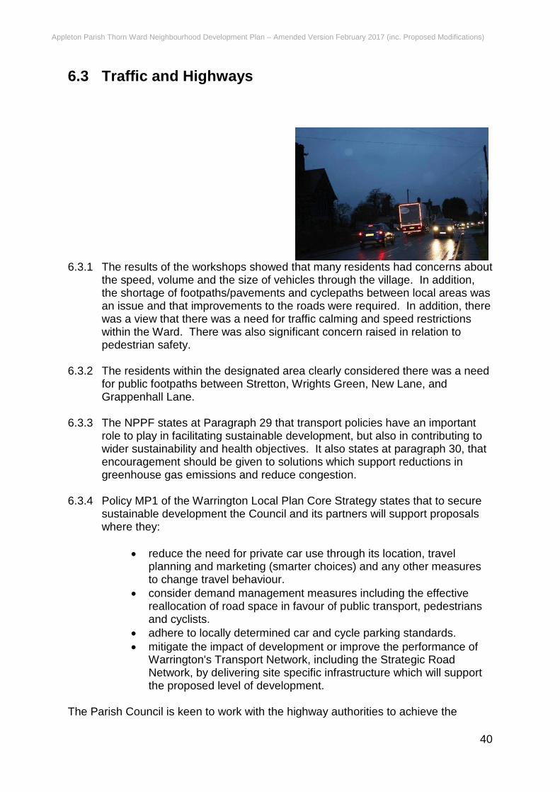
6.3.1 The results of the workshops showed that many residents had concerns about the speed, volume and the size of vehicles through the village. In addition, the shortage of footpaths/pavements and cyclepaths between local areas was an issue and that improvements to the roads were required. In addition, there was a view that there was a need for traffic calming and speed restrictions within the Ward. There was also significant concern raised in relation to pedestrian safety.
6.3.2 The residents within the designated area clearly considered there was a need
for public footpaths between Stretton, Wrights Green, New Lane, and Grappenhall Lane.
6.3.3 The NPPF states at Paragraph 29 that transport policies have an important
role to play in facilitating sustainable development, but also in contributing to wider sustainability and health objectives. It also states at paragraph 30, that encouragement should be given to solutions which support reductions in greenhouse gas emissions and reduce congestion.
6.3.4 Policy MP1 of the Warrington Local Plan Core Strategy states that to secure
sustainable development the Council and its partners will support proposals where they:
reduce the need for private car use through its location, travel planning and marketing (smarter choices) and any other measures to change travel behaviour.
consider demand management measures including the effective reallocation of road space in favour of public transport, pedestrians and cyclists.
adhere to locally determined car and cycle parking standards.
mitigate the impact of development or improve the performance of Warrington's Transport Network, including the Strategic Road Network, by delivering site specific infrastructure which will support the proposed level of development.
The Parish Council is keen to work with the highway authorities to achieve the
Appleton Parish Thorn Ward Neighbourhood Development Plan – Amended Version February 2017 (inc. Proposed Modifications)
41
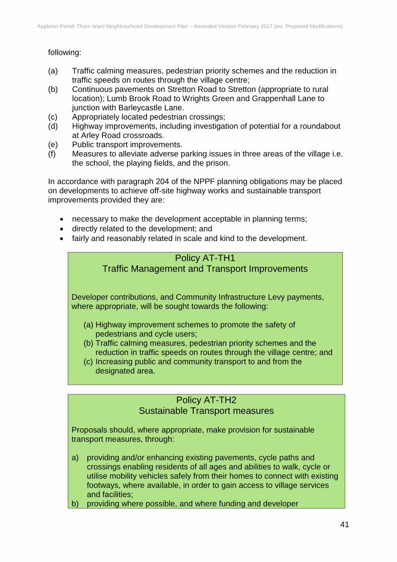
following: (a) Traffic calming measures, pedestrian priority schemes and the reduction in
traffic speeds on routes through the village centre; (b) Continuous pavements on Stretton Road to Stretton (appropriate to rural
location); Lumb Brook Road to Wrights Green and Grappenhall Lane to junction with Barleycastle Lane.
(c) Appropriately located pedestrian crossings; (d) Highway improvements, including investigation of potential for a roundabout
at Arley Road crossroads. (e) Public transport improvements. (f) Measures to alleviate adverse parking issues in three areas of the village i.e.
the school, the playing fields, and the prison. In accordance with paragraph 204 of the NPPF planning obligations may be placed on developments to achieve off-site highway works and sustainable transport improvements provided they are:
necessary to make the development acceptable in planning terms;
directly related to the development; and
fairly and reasonably related in scale and kind to the development.
Policy AT-TH1 Traffic Management and Transport Improvements
Developer contributions, and Community Infrastructure Levy payments, where appropriate, will be sought towards the following:
(a) Highway improvement schemes to promote the safety of pedestrians and cycle users;
(b) Traffic calming measures, pedestrian priority schemes and the reduction in traffic speeds on routes through the village centre; and
(c) Increasing public and community transport to and from the designated area.
Policy AT-TH2 Sustainable Transport measures
Proposals should, where appropriate, make provision for sustainable transport measures, through: a) providing and/or enhancing existing pavements, cycle paths and
crossings enabling residents of all ages and abilities to walk, cycle or utilise mobility vehicles safely from their homes to connect with existing footways, where available, in order to gain access to village services and facilities;
b) providing where possible, and where funding and developer
Appleton Parish Thorn Ward Neighbourhood Development Plan – Amended Version February 2017 (inc. Proposed Modifications)
42
contributions allow, new pedestrian footpaths and cycle routes or improving existing village networks, both within the village and beyond in the wider countryside;
c) providing linkages to wildlife corridors and provision of landscaping and planting along routes to support local biodiversity objectives such as provision of new areas of woodland, new hedgerows, grassland and wetland habitats.
6.4 Employment 6.4.1 The workshops results indicate that residents considered that the
neighbourhood Plan should encourage small businesses and enterprises into the area. The Steering Group also consider that existing businesses should be supported and protected.
6.4.2 The Parish Council consider it important to protect existing employment
premises and support new small scale local employment opportunities including working from home, which will require up to date communications systems and networks.
6.4.3 The NPPF is concerned to promote a prosperous rural economy. In the Plan
area the NPPF and the Local Plan Core Strategy effectively direct new employment provision to within the settlement boundary. In the NPPF paragraphs 89 and 90, development in the Green Belt is essentially restricted to existing employment sites, farm diversification and appropriate conversion of buildings.
6.4.4 “The Countryside and Its Constituent Settlements” section of the Warrington
Local Plan Core Strategy identifies Appleton & Stretton as Trading Estates. These are often collectively known as Barley Castle Trading Estate. This well-established site has developed as a key distribution location as it is ideally located approximately 1.5 miles from Junction 20 of the M6 motorway and Junction 9 of the M56 motorway. Whilst few development opportunities remain within the site, policies elsewhere within the Local Plan Core Strategy seek to retain the major warehousing and distribution function this estate performs.
6.4.5 Representing the only major employment site within the south of the borough,
increasing the accessibility of the site from a public transport perspective and modes other than the car remain a priority.
6.4.6 The Barleycastle Industrial Estate within the Appleton Parish Thorn Ward
Neighbourhood Plan is managed by the Policies in the Warrington Local Plan Core Strategy. Policy PV1 states that the Council will support development, redevelopment and changes of use proposals within existing employment areas as defined on the Policies Map, provided that the proposed use falls within Use Classes B1, B2, or B8, or is a sui-generis employment use. (A use not falling in any other use class).
Appleton Parish Thorn Ward Neighbourhood Development Plan – Amended Version February 2017 (inc. Proposed Modifications)
43
6.4.7 Subject to assessment of local transport impacts, major warehousing and distribution developments will be primarily directed towards preferred locations at: Appleton & Stretton Trading Estates.
6.4.8 Policy SN6 states that Warrington Borough Council will seek to assist the
continued viability and growth of the local economy and support the sustainability of local communities by ensuring development proposals:
(a) do not lead to the loss of viable, accessible sites and buildings used for
industrial/commercial purposes or other employment generating uses in local communities including the countryside and its settlements;
(b) avoid the loss or change of use of viable convenience shops, cultural facilities, post offices and public houses where the loss would impact on the diversity of local services in communities;
(c) support the retention of viable local health and community facilities; (d) support the diversification of farm enterprises; (e) support the sustainable growth of existing businesses.
Policy AT-E1 New local employment opportunities.
Proposals for the development of employment opportunities, including homeworking will be permitted provided they conform to national and local policies and the following criteria:
(a) Give priority to the conversion of an existing building where this option exists
(b) Are of a scale appropriate to the area; (c) Do not have a detrimental impact on surrounding residential
character and amenity; (d) Do not lead to the loss of open space or green infrastructure; (e) Have a good connection to the highway network and are acceptable
in terms of highway safety and parking provision.
Appleton Parish Thorn Ward Neighbourhood Development Plan – Amended Version February 2017 (inc. Proposed Modifications)
44
6.5 Community Facilities and Open Spaces 6.5.1 The vast majority of Thorn Ward is open countryside, predominantly
comprising of agricultural land within the Green Belt. The value this brings to the character of the Ward cannot be underestimated, providing a natural habitat for local wildlife and allowing for a number of public rights of way which are well used, especially by dog walkers.
6.5.2 The local survey and workshops identified the importance of these open
spaces and the need to protect them. It was also noted that further community benefit, especially for families could be gained by the provision of play and picnic areas.
6.5.3 Residents of the area considered that the Village Hall, School and church
should be encouraged to enhance and further promote community activities. 6.5.4 The National Planning Policy Framework (NPPF) advises at paragraph 76
that “local communities through local and neighbourhood plans should be able to identify for special protection green areas of particular importance to them. By designating land as Local Green Space communities will be able to rule out new development other than in very special circumstances”.
6.5.5 Paragraph 77 of the NPPF advises that “the Local Green Space designation
will not be appropriate for most green areas or open space. The designation should only be used:
• where the green space is in reasonably close proximity to the
community it serves; • where the green area is demonstrably special to a local community and
holds a particular local significance, for example because of its beauty, historic significance, recreational value (including as a playing field), tranquility or richness of its wildlife; and
• where the green area concerned is local in character and is not an extensive tract of land.”
6.5.6 Table 4 below sets out how each of the proposed protected local green
spaces meet these criteria:
Policy AT-CF1 Protection of local green spaces
The following local green space(s) as shown on Map 6 are designated in accordance with paragraphs 76 and 77 of the NPPF: Land to rear of Appleton Thorn Village Hall New development which impacts adversely on the openness of these sites will not be permitted, unless in very special circumstances.
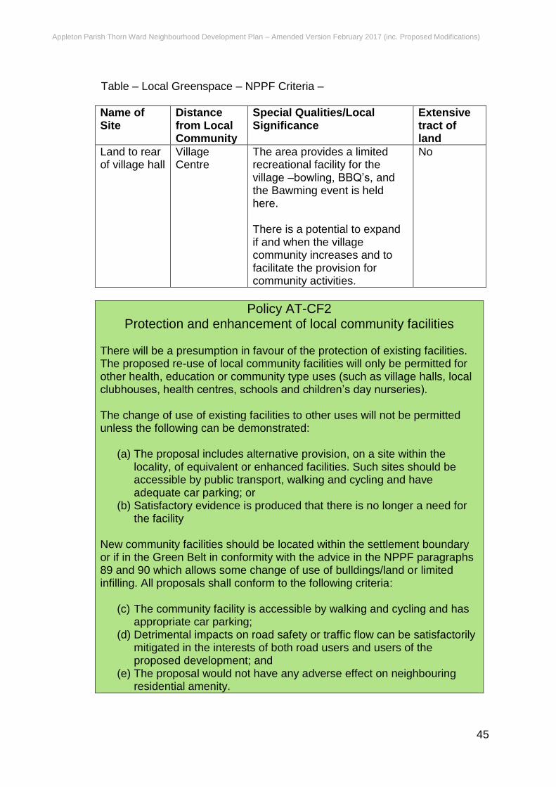
Appleton Parish Thorn Ward Neighbourhood Development Plan – Amended Version February 2017 (inc. Proposed Modifications)
45
Table – Local Greenspace – NPPF Criteria –
Name of Site
Distance from Local Community
Special Qualities/Local Significance
Extensive tract of land
Land to rear of village hall
Village Centre
The area provides a limited recreational facility for the village –bowling, BBQ’s, and the Bawming event is held here. There is a potential to expand if and when the village community increases and to facilitate the provision for community activities.
No
Policy AT-CF2 Protection and enhancement of local community facilities
There will be a presumption in favour of the protection of existing facilities. The proposed re-use of local community facilities will only be permitted for other health, education or community type uses (such as village halls, local clubhouses, health centres, schools and children’s day nurseries). The change of use of existing facilities to other uses will not be permitted unless the following can be demonstrated:
(a) The proposal includes alternative provision, on a site within the locality, of equivalent or enhanced facilities. Such sites should be accessible by public transport, walking and cycling and have adequate car parking; or
(b) Satisfactory evidence is produced that there is no longer a need for the facility
New community facilities should be located within the settlement boundary or if in the Green Belt in conformity with the advice in the NPPF paragraphs 89 and 90 which allows some change of use of bulldings/land or limited infilling. All proposals shall conform to the following criteria:
(c) The community facility is accessible by walking and cycling and has appropriate car parking;
(d) Detrimental impacts on road safety or traffic flow can be satisfactorily mitigated in the interests of both road users and users of the proposed development; and
(e) The proposal would not have any adverse effect on neighbouring residential amenity.

Appleton Parish Thorn Ward Neighbourhood Development Plan – Amended Version February 2017 (inc. Proposed Modifications)
46
Policy AT-CF3 Community facilities and Community Infrastructure Levy
Development should support proposals for improved community facilities and infrastructure in the parish where justified in accordance with the advice on planning obligations in the NPPF, paragraph 204 and the NPPG paragraph 001. Funding received from developer contributions and Community Infrastructure Levy will be prioritised for the following proposals:
(a) Provision of adequate recreational green space in the centre of the village.
(b) Contribution to designing and constructing appropriate rural pathways for recreational purposes.
(c) Expansion of the Village Hall to meet increased demand for community facilities and storage space.
(d) Provision for changing rooms and adequate parking at the sports field to avoid congestion and on-road parking.
(e) Provision of community facilities e.g. medical centre, shop
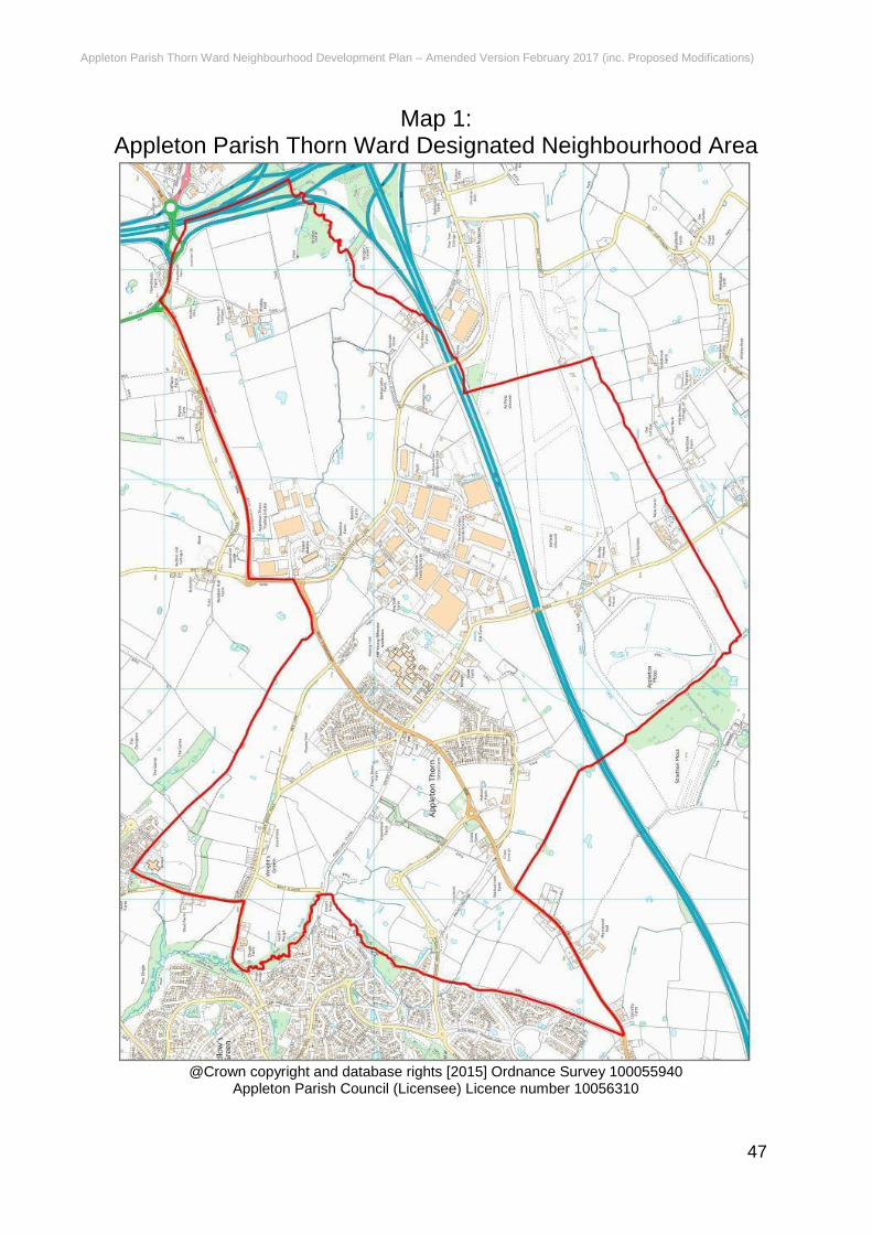
Appleton Parish Thorn Ward Neighbourhood Development Plan – Amended Version February 2017 (inc. Proposed Modifications)
47
Map 1: Appleton Parish Thorn Ward Designated Neighbourhood Area
@Crown copyright and database rights [2015] Ordnance Survey 100055940
Appleton Parish Council (Licensee) Licence number 10056310
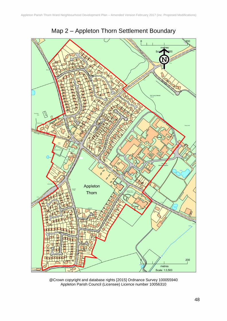
Appleton Parish Thorn Ward Neighbourhood Development Plan – Amended Version February 2017 (inc. Proposed Modifications)
48
Map 2 – Appleton Thorn Settlement Boundary
@Crown copyright and database rights [2015] Ordnance Survey 100055940
Appleton Parish Council (Licensee) Licence number 10056310
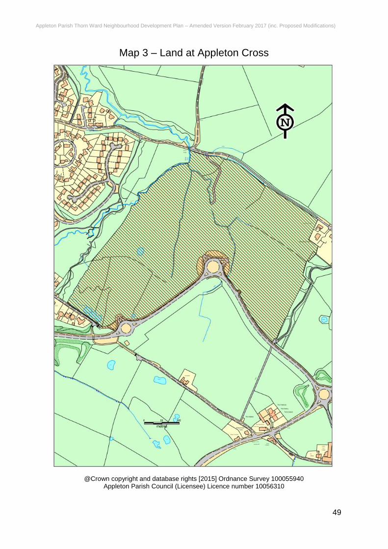
Appleton Parish Thorn Ward Neighbourhood Development Plan – Amended Version February 2017 (inc. Proposed Modifications)
49
Map 3 – Land at Appleton Cross
@Crown copyright and database rights [2015] Ordnance Survey 100055940
Appleton Parish Council (Licensee) Licence number 10056310
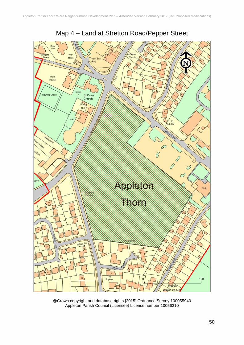
Appleton Parish Thorn Ward Neighbourhood Development Plan – Amended Version February 2017 (inc. Proposed Modifications)
50
Map 4 – Land at Stretton Road/Pepper Street
@Crown copyright and database rights [2015] Ordnance Survey 100055940
Appleton Parish Council (Licensee) Licence number 10056310
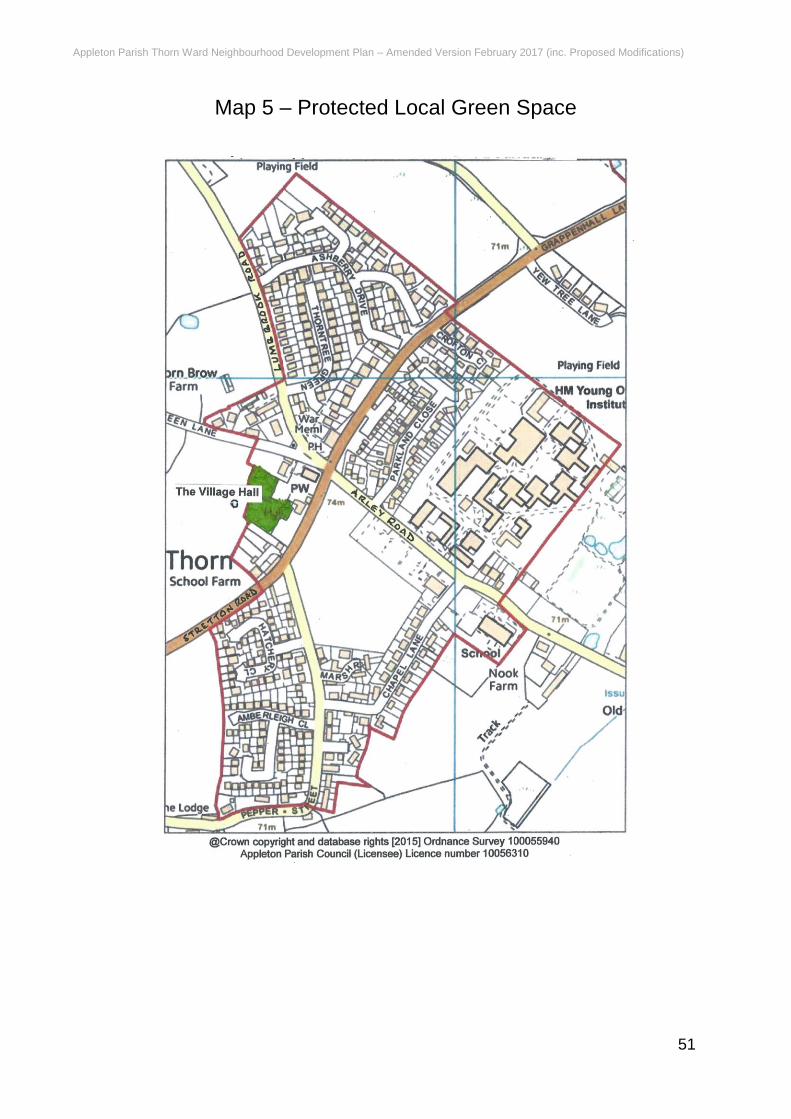
Appleton Parish Thorn Ward Neighbourhood Development Plan – Amended Version February 2017 (inc. Proposed Modifications)
51
Map 5 – Protected Local Green Space

Appleton Parish Thorn Ward Neighbourhood Development Plan – Amended Version February 2017 (inc. Proposed Modifications)
52
Appendix A – Planning Policy Framework
National Planning Policy Framework (NPPF) The NPPF sets out the Government’s national planning policies and the priorities for development. It advises that: Para 6: The purpose of the planning system is to contribute to the achievement of sustainable development. Para 7: There are three dimensions to sustainable development: economic, social and environmental. These dimensions give rise to the need for the planning system to perform a number of roles:
an economic role – contributing to building a strong, responsive and competitive economy, by ensuring that sufficient land of the right type is available in the right places and at the right time to support growth and innovation; and by identifying and coordinating development requirements, including the provision of infrastructure;
a social role – supporting strong, vibrant and healthy communities, by providing the supply of housing required to meet the needs of present and future generations; and by creating a high quality built environment, with accessible local services that reflect the community’s needs and support its health, social and cultural well-being; and
an environmental role – contributing to protecting and enhancing our natural, built and historic environment; and, as part of this, helping to improve biodiversity, use natural resources prudently, minimise waste and pollution, and mitigate and adapt to climate change including moving to a low carbon economy.
Para16: The application of the presumption will have implications for how communities engage in neighbourhood planning. Critically, it will mean that neighbourhoods should:
develop plans that support the strategic development needs set out in Local Plans, including policies for housing and economic development;
plan positively to support local development, shaping and directing development in their area that is outside the strategic elements of the Local Plan; and
identify opportunities to use Neighbourhood Development Orders to enable developments that are consistent with their neighbourhood plan to proceed.
Delivering Sustainable Development This includes:
1. Building a strong, competitive economy 2. Ensuring the vitality of town centres 3. Supporting a prosperous rural economy 4. Promoting sustainable transport 5. Supporting high quality communications infrastructure 6. Delivering a wide choice of high quality homes
Appleton Parish Thorn Ward Neighbourhood Development Plan – Amended Version February 2017 (inc. Proposed Modifications)
53
7. Requiring good design 8. Promoting healthy communities 9. Protecting Green Belt land 10. Meeting the challenge of climate change and flooding 11. Conserving and enhancing the natural environment 12. Conserving and enhancing the historic environment 13. Facilitating the sustainable use of minerals
Neighbourhood plans Para 183: Neighbourhood planning gives communities direct power to develop a shared vision for their neighbourhood and deliver the sustainable development they need. Parishes and neighbourhood forums can use neighbourhood planning to:
set planning policies through neighbourhood plans to determine decisions on planning applications; and
grant planning permission through Neighbourhood Development Orders and Community Right to Build Orders for specific development which complies with the order.
Para 184: Neighbourhood planning provides a powerful set of tools for local people to ensure that they get the right types of development for their community. The ambition of the neighbourhood should be aligned with the strategic needs and priorities of the wider local area. Neighbourhood plans must be in general conformity with the strategic policies of the Local Plan. To facilitate this, local planning authorities should set out clearly their strategic policies for the area and ensure that an up-to-date Local Plan is in place as quickly as possible. Neighbourhood plans should reflect these policies and neighbourhoods should plan positively to support them. Neighbourhood plans and orders should not promote less development than set out in the Local Plan or undermine its strategic policies. Para 185: Outside these strategic elements, neighbourhood plans will be able to shape and direct sustainable development in their area. Once a neighbourhood plan has demonstrated its general conformity with the strategic policies of the Local Plan and is brought into force, the policies it contains take precedence over existing non-strategic policies in the Local Plan for that neighbourhood, where they are in conflict. Local planning authorities should avoid duplicating planning processes for non-strategic policies where a neighbourhood plan is in preparation.
Warrington Borough Local Plan Core Strategy The following policies are of relevance to the Appleton Thorn Neighbourhood Plan:
Policy CS1 - Overall Spatial Strategy - Delivering Sustainable Development Policy CS2 - Overall Spatial Strategy - Quantity and Distribution of Development Policy CS4 - Overall Spatial Strategy – Transport Policy CS5 - Overall Spatial Strategy - Green Belt Policy PV1 - Development in Existing Employment Areas Policy PV3 - Strengthening the Borough's Workforce Policy PV7 - Promoting the Visitor Economy
Appleton Parish Thorn Ward Neighbourhood Development Plan – Amended Version February 2017 (inc. Proposed Modifications)
54
Policy SN1 - Distribution and Nature of New Housing Policy SN2 - Securing Mixed and Inclusive Neighbourhoods Policy SN6 - Sustaining the Local Economy and Services Policy SN7 - Enhancing Health and Well-being Policy QE1 - Decentralised Energy Networks and Low Carbon Development Policy QE3 - Green Infrastructure Policy QE5 - Biodiversity and Geodiversity Policy QE6 - Environment and Amenity Protection Policy QE7 - Ensuring a High Quality Place Policy MP1 - General Transport Principles Policy MP2 - Telecommunications Policy MP3 - Active Travel Policy MP4 - Public Transport Policy MP5 - Freight Transport Policy MP7 - Transport Assessments and Travel Plans Policy MP10 - Infrastructure Policy CC1 - Inset and Green Belt Settlements Policy CC2 - Protecting the Countryside
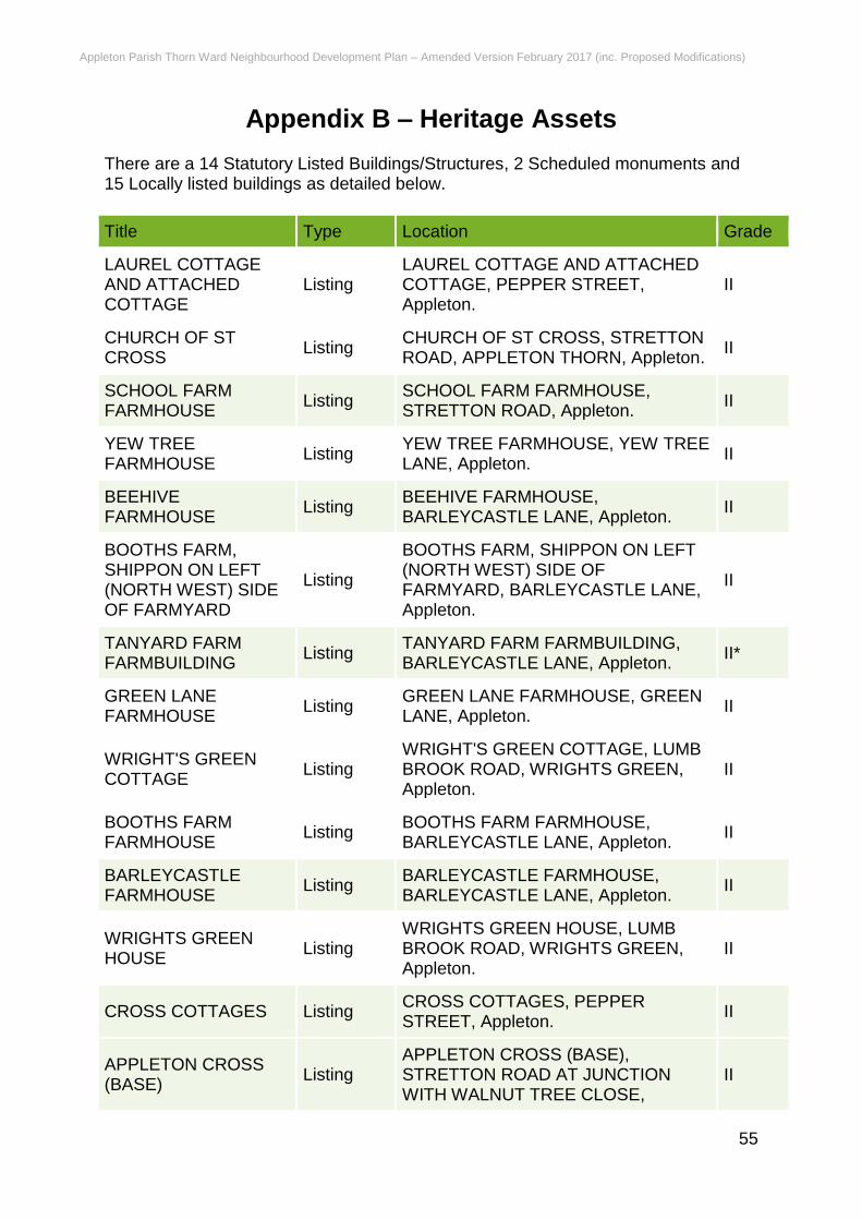
Appleton Parish Thorn Ward Neighbourhood Development Plan – Amended Version February 2017 (inc. Proposed Modifications)
55
Appendix B – Heritage Assets There are a 14 Statutory Listed Buildings/Structures, 2 Scheduled monuments and 15 Locally listed buildings as detailed below.
Title Type Location Grade
LAUREL COTTAGE AND ATTACHED COTTAGE
Listing LAUREL COTTAGE AND ATTACHED COTTAGE, PEPPER STREET, Appleton.
II
CHURCH OF ST CROSS
Listing CHURCH OF ST CROSS, STRETTON ROAD, APPLETON THORN, Appleton.
II
SCHOOL FARM FARMHOUSE
Listing SCHOOL FARM FARMHOUSE, STRETTON ROAD, Appleton.
II
YEW TREE FARMHOUSE
Listing YEW TREE FARMHOUSE, YEW TREE LANE, Appleton.
II
BEEHIVE FARMHOUSE
Listing BEEHIVE FARMHOUSE, BARLEYCASTLE LANE, Appleton.
II
BOOTHS FARM, SHIPPON ON LEFT (NORTH WEST) SIDE OF FARMYARD
Listing
BOOTHS FARM, SHIPPON ON LEFT (NORTH WEST) SIDE OF FARMYARD, BARLEYCASTLE LANE, Appleton.
II
TANYARD FARM FARMBUILDING
Listing TANYARD FARM FARMBUILDING, BARLEYCASTLE LANE, Appleton.
II*
GREEN LANE FARMHOUSE
Listing GREEN LANE FARMHOUSE, GREEN LANE, Appleton.
II
WRIGHT'S GREEN COTTAGE
Listing WRIGHT'S GREEN COTTAGE, LUMB BROOK ROAD, WRIGHTS GREEN, Appleton.
II
BOOTHS FARM FARMHOUSE
Listing BOOTHS FARM FARMHOUSE, BARLEYCASTLE LANE, Appleton.
II
BARLEYCASTLE FARMHOUSE
Listing BARLEYCASTLE FARMHOUSE, BARLEYCASTLE LANE, Appleton.
II
WRIGHTS GREEN HOUSE
Listing WRIGHTS GREEN HOUSE, LUMB BROOK ROAD, WRIGHTS GREEN, Appleton.
II
CROSS COTTAGES Listing CROSS COTTAGES, PEPPER STREET, Appleton.
II
APPLETON CROSS (BASE)
Listing APPLETON CROSS (BASE), STRETTON ROAD AT JUNCTION WITH WALNUT TREE CLOSE,
II
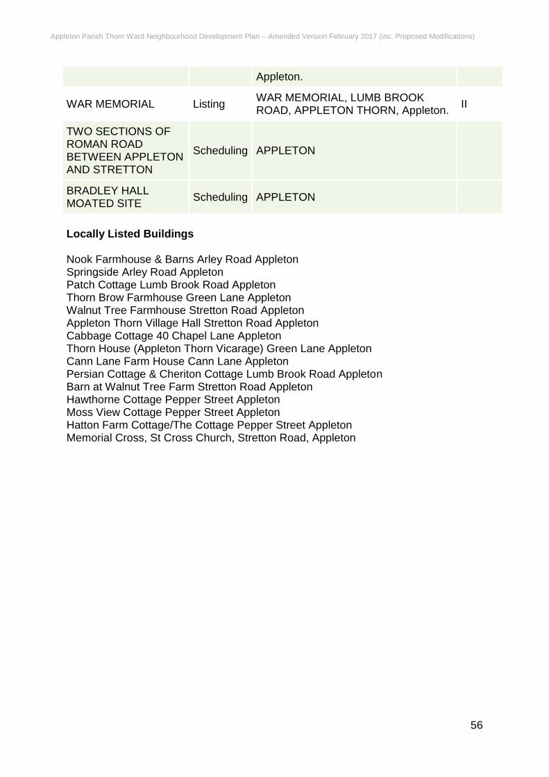
Appleton Parish Thorn Ward Neighbourhood Development Plan – Amended Version February 2017 (inc. Proposed Modifications)
56
Appleton.
WAR MEMORIAL Listing WAR MEMORIAL, LUMB BROOK ROAD, APPLETON THORN, Appleton.
II
TWO SECTIONS OF ROMAN ROAD BETWEEN APPLETON AND STRETTON
Scheduling APPLETON
BRADLEY HALL MOATED SITE
Scheduling APPLETON
Locally Listed Buildings Nook Farmhouse & Barns Arley Road Appleton Springside Arley Road Appleton Patch Cottage Lumb Brook Road Appleton Thorn Brow Farmhouse Green Lane Appleton Walnut Tree Farmhouse Stretton Road Appleton Appleton Thorn Village Hall Stretton Road Appleton Cabbage Cottage 40 Chapel Lane Appleton Thorn House (Appleton Thorn Vicarage) Green Lane Appleton Cann Lane Farm House Cann Lane Appleton Persian Cottage & Cheriton Cottage Lumb Brook Road Appleton Barn at Walnut Tree Farm Stretton Road Appleton Hawthorne Cottage Pepper Street Appleton Moss View Cottage Pepper Street Appleton Hatton Farm Cottage/The Cottage Pepper Street Appleton Memorial Cross, St Cross Church, Stretton Road, Appleton
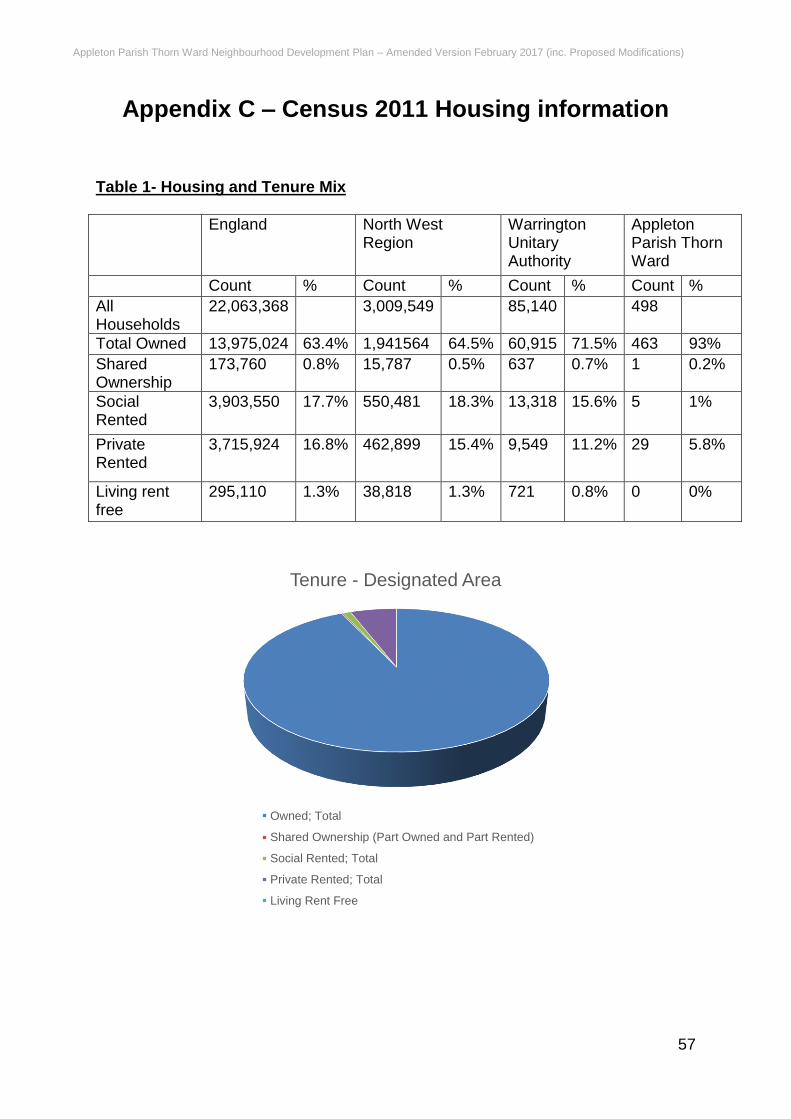
Appleton Parish Thorn Ward Neighbourhood Development Plan – Amended Version February 2017 (inc. Proposed Modifications)
57
Appendix C – Census 2011 Housing information Table 1- Housing and Tenure Mix
England North West Region
Warrington Unitary Authority
Appleton Parish Thorn Ward
Count % Count % Count % Count %
All Households
22,063,368 3,009,549 85,140 498
Total Owned 13,975,024 63.4% 1,941564 64.5% 60,915 71.5% 463 93%
Shared Ownership
173,760 0.8% 15,787 0.5% 637 0.7% 1 0.2%
Social Rented
3,903,550 17.7% 550,481 18.3% 13,318 15.6% 5 1%
Private Rented
3,715,924 16.8% 462,899 15.4% 9,549 11.2% 29 5.8%
Living rent free
295,110 1.3% 38,818 1.3% 721 0.8% 0 0%
Tenure - Designated Area
Owned; Total
Shared Ownership (Part Owned and Part Rented)
Social Rented; Total
Private Rented; Total
Living Rent Free
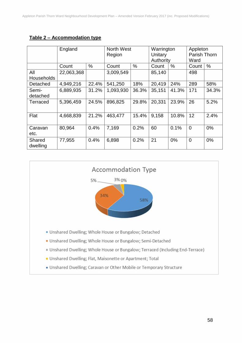
Appleton Parish Thorn Ward Neighbourhood Development Plan – Amended Version February 2017 (inc. Proposed Modifications)
58
Table 2 – Accommodation type
England North West Region
Warrington Unitary Authority
Appleton Parish Thorn Ward
Count % Count % Count % Count %
All Households
22,063,368 3,009,549 85,140 498
Detached 4,949,216 22.4% 541,250 18% 20,419 24% 289 58%
Semi-detached
6,889,935 31.2% 1,093,930 36.3% 35,151 41.3% 171 34.3%
Terraced 5,396,459 24.5% 896,825 29.8% 20,331 23.9% 26 5.2%
Flat 4,668,839 21.2% 463,477 15.4% 9,158 10.8% 12 2.4%
Caravan etc.
80,964 0.4% 7,169 0.2% 60 0.1% 0 0%
Shared dwelling
77,955 0.4% 6,898 0.2% 21 0% 0 0%
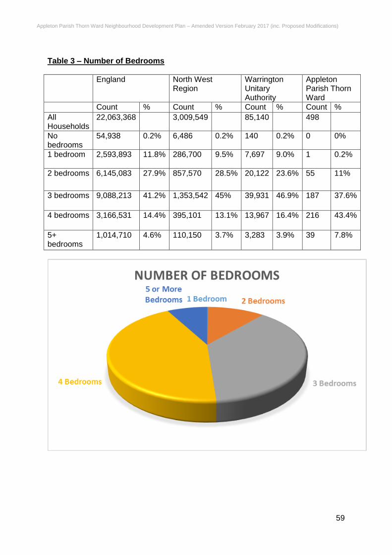
Appleton Parish Thorn Ward Neighbourhood Development Plan – Amended Version February 2017 (inc. Proposed Modifications)
59
Table 3 – Number of Bedrooms
England North West Region
Warrington Unitary Authority
Appleton Parish Thorn Ward
Count % Count % Count % Count %
All Households
22,063,368 3,009,549 85,140 498
No bedrooms
54,938 0.2% 6,486 0.2% 140 0.2% 0 0%
1 bedroom 2,593,893 11.8% 286,700 9.5% 7,697 9.0% 1 0.2%
2 bedrooms 6,145,083 27.9% 857,570 28.5% 20,122 23.6% 55 11%
3 bedrooms 9,088,213 41.2% 1,353,542 45% 39,931 46.9% 187 37.6%
4 bedrooms 3,166,531 14.4% 395,101 13.1% 13,967 16.4% 216 43.4%
5+ bedrooms
1,014,710 4.6% 110,150 3.7% 3,283 3.9% 39 7.8%
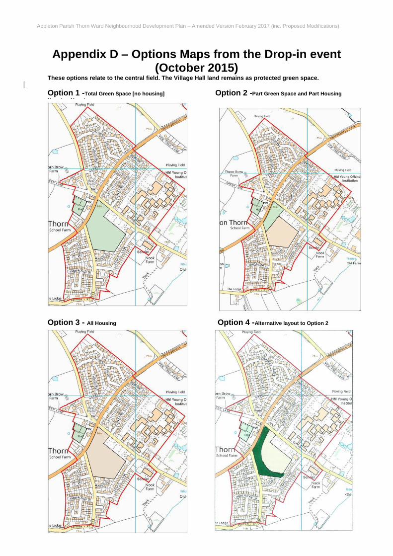
Appleton Parish Thorn Ward Neighbourhood Development Plan – Amended Version February 2017 (inc. Proposed Modifications)
60
Appendix D – Options Maps from the Drop-in event (October 2015)
These options relate to the central field. The Village Hall land remains as protected green space.
Option 1 -Total Green Space [no housing] Option 2 -Part Green Space and Part Housing
Housing Housing
Option 3 - All Housing Option 4 -Alternative layout to Option 2
Appleton Parish Thorn Ward Neighbourhood Development Plan – Amended Version February 2017 (inc. Proposed Modifications)
61
Glossary of Terms
Term Meaning
A
Affordable Housing
Social rented, affordable rented and intermediate housing, provided to eligible households whose needs are not met by the market. Eligibility is determined with regard to local incomes and local house prices. Affordable housing should include provisions to remain at an affordable price for future eligible households or for the subsidy to be recycled for alternative affordable housing provision.
B
Backland Development Development of 'landlocked' sites behind existing buildings, such as rear gardens and private open space, usually within predominantly residential areas. Such sites often have no street frontages.
Biodiversity
The variety of plants and animal life on earth, encompassing the diversity of habitats, species and genetic variation. Biodiversity provides our life support system as well as having social and economic value.
Brownfield Land
Both land and premises are included in this term, which refers to a site that has previously been used or developed. It may be vacant, derelict or contaminated. This excludes open spaces and land where the remains of previous use have blended into the landscape, or have been overtaken by nature conservation value or amenity use.
C
Census An official count or survey of a population, typically recording various details of individuals. Last undertaken in 2011.
Community facilities Land and buildings uses to help meet health, education and social needs in terms of developing and maintaining the health and wellbeing of all.
Community Infrastructure Levy (CIL)
A mechanism that empowers local authorities to apply a levy or charge on new developments in their areas to support community infrastructure delivery.
D
Developer Contributions This includes section 106 agreements and the Community Infrastructure Levy (CIL)
E
Employment land Land used for office, industrial and warehousing purposes.
Appleton Parish Thorn Ward Neighbourhood Development Plan – Amended Version February 2017 (inc. Proposed Modifications)
62
Energy efficiency
Making the best or the most efficient use of energy in order to achieve a given output of goods or services, and of comfort and convenience. This does not necessitate the use of less energy, in which respect it differs from the concept of energy conservation.
Environmental assets Features in the physical environment that are valued for a variety of cultural and scientific reasons.
F
Flood zone An area identified by the Environment Agency as being at risk of flooding, flood zone 3 having the greatest risk.
G
Green Belt
A designation for land around certain cities and large built-up areas, which aims to keep this land permanently open or largely undeveloped. The purpose of the Green Belt is to;
check the unrestricted sprawl of large built up areas
prevent neighbouring towns from merging
safeguard the countryside from encroachment
assist urban regeneration by encouraging the recycling of derelict and other urban land
The boundaries of the Green Belt in Warrington, which is contiguous with the Green Belt in Merseyside, Greater Manchester, and North Cheshire, are shown on the Warrington Local Plan Policies Map.
Greenfield land Land that has not been previously developed, often in agricultural use.
Green infrastructure
A planned and delivered network of green spaces and other environmental features designed and managed as a multifunctional resource providing a range of environmental and quality of life benefits for local communities. Green infrastructure includes parks, open spaces, playing fields, woodlands, allotments and private gardens.
Green space
A collective term used to describe all parks, public gardens, playing fields, children's play areas, woodlands, nature reserves, and allotment gardens, linear and other open spaces.
H
Habitats Regulation Assessment
A Habitats Regulations Assessment is the assessment of the impacts of implementing a plan or policy on a Natura 2000 site. Its purpose is to consider the impacts of a land use plan against conservation objectives of the site and to ascertain whether it would adversely affect the integrity of the site. Where significant negative effects are identified, alternative options should be examined to avoid any potential damaging effects.
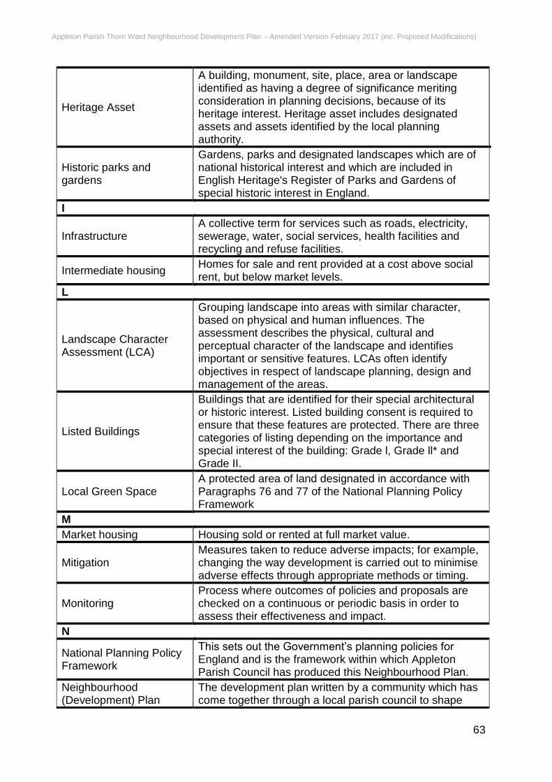
Appleton Parish Thorn Ward Neighbourhood Development Plan – Amended Version February 2017 (inc. Proposed Modifications)
63
Heritage Asset
A building, monument, site, place, area or landscape identified as having a degree of significance meriting consideration in planning decisions, because of its heritage interest. Heritage asset includes designated assets and assets identified by the local planning authority.
Historic parks and gardens
Gardens, parks and designated landscapes which are of national historical interest and which are included in English Heritage's Register of Parks and Gardens of special historic interest in England.
I
Infrastructure A collective term for services such as roads, electricity, sewerage, water, social services, health facilities and recycling and refuse facilities.
Intermediate housing Homes for sale and rent provided at a cost above social rent, but below market levels.
L
Landscape Character Assessment (LCA)
Grouping landscape into areas with similar character, based on physical and human influences. The assessment describes the physical, cultural and perceptual character of the landscape and identifies important or sensitive features. LCAs often identify objectives in respect of landscape planning, design and management of the areas.
Listed Buildings
Buildings that are identified for their special architectural or historic interest. Listed building consent is required to ensure that these features are protected. There are three categories of listing depending on the importance and special interest of the building: Grade l, Grade ll* and Grade II.
Local Green Space A protected area of land designated in accordance with Paragraphs 76 and 77 of the National Planning Policy Framework
M
Market housing Housing sold or rented at full market value.
Mitigation Measures taken to reduce adverse impacts; for example, changing the way development is carried out to minimise adverse effects through appropriate methods or timing.
Monitoring Process where outcomes of policies and proposals are checked on a continuous or periodic basis in order to assess their effectiveness and impact.
N
National Planning Policy Framework
This sets out the Government’s planning policies for England and is the framework within which Appleton Parish Council has produced this Neighbourhood Plan.
Neighbourhood (Development) Plan
The development plan written by a community which has come together through a local parish council to shape

Appleton Parish Thorn Ward Neighbourhood Development Plan – Amended Version February 2017 (inc. Proposed Modifications)
64
new development by saying where a development should be located and what it should look like. Introduced via the Localism Act 2011.
O
Open space
All open space of public value, including not just land, but also areas of water (such as rivers, canals, lakes and reservoirs), which offer important opportunities for sport and recreation and can act as a visual amenity.
P
Planning obligations See section 106 Agreements and Community Levy payments.
Previously developed land (PDL)
See Brownfield land.
R
Registered social housing providers
Either not for profit or profit making organisations (subject to the same standards and address the same housing priorities) providing social housing and regulated by the Homes and Community Agency.
Renewable energy
Power derived from a source that is continually replenished, such as wind, wave, solar, hydroelectric and energy from plant material, but not fossil fuels or nuclear energy. Although not strictly renewable, geothermal energy is generally included.
S
Scheduled Monument A nationally important archaeological site or monument given legal protection.
Section 106 agreements
An agreement by the local authority with a landowner/developer restricting or regulating the development or use of land either permanently or temporarily, in accordance with the Town and Country Planning Act (1990).
Self-build homes.
Self-build is the practice of creating an individual home for yourself through a variety of different methods. The term self-build is specifically used in the UK and Ireland when an individual obtains a building plot and then builds their own home on that plot.
Strategic Environmental Assessment (SEA)
A formal environmental assessment of certain plans and programmes which are likely to have significant effects on the environment. Local authorities who prepare and adopt such a plan or programme must prepare a report on its likely environmental effects. They must consult environmental authorities and the public, and take the report and the results of the consultation into account during the preparation process, before the plan or programme is adopted.
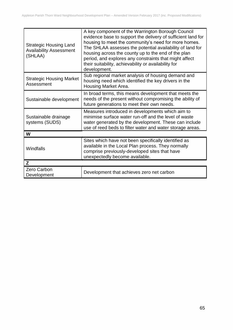
Appleton Parish Thorn Ward Neighbourhood Development Plan – Amended Version February 2017 (inc. Proposed Modifications)
65
Strategic Housing Land Availability Assessment (SHLAA)
A key component of the Warrington Borough Council evidence base to support the delivery of sufficient land for housing to meet the community’s need for more homes. The SHLAA assesses the potential availability of land for housing across the county up to the end of the plan period, and explores any constraints that might affect their suitability, achievability or availability for development.
Strategic Housing Market Assessment
Sub regional market analysis of housing demand and housing need which identified the key drivers in the Housing Market Area.
Sustainable development
In broad terms, this means development that meets the needs of the present without compromising the ability of future generations to meet their own needs.
Sustainable drainage systems (SUDS)
Measures introduced in developments which aim to minimise surface water run-off and the level of waste water generated by the development. These can include use of reed beds to filter water and water storage areas.
W
Windfalls
Sites which have not been specifically identified as available in the Local Plan process. They normally comprise previously-developed sites that have unexpectedly become available.
Z
Zero Carbon Development
Development that achieves zero net carbon

Appleton Parish Thorn Ward Neighbourhood Development Plan – Amended Version February 2017 (inc. Proposed Modifications)
66
Appleton Parish Thorn Ward Neighbourhood Development Plan – Amended Version February 2017 (inc. Proposed Modifications)
67