appendix o - government comments - in
TRANSCRIPT

APPENDIX O
Correspondence – Government other
than Resource Agencies
Tier 2 Environmental Impact Statement
I-69 Section 6
Martinsville to Indianapolis

Appendix O Table of Contents
City of Greenwood, October 20, 2014 ...................................................................................... 3
Morgan County Economic Development Corporation, April 17, 2015 ................................... 4
City Of Martinsville Redevelopment Commission, June 4, 2015............................................ 5
Indianapolis Department of Public Works, June 19, 2015 ...................................................... 6
City of Martinsville Engineer, November 2, 2015 .................................................................. 10
Mooresville Schools, December 3, 2015 ................................................................................ 11
Town of Mooresville, November 4, 2015 ................................................................................ 13
Metropolitan School District of Martinsville, December 4, 2015 .......................................... 14
City of Martinsville Redevelopment Commission, December 15, 2015 ............................... 16
Morgan County Council, December 16, 2015 ........................................................................ 17
Harrison Township Fire and Rescue, undated ...................................................................... 20
Metropolitan School District of Martinsville, April 21, 2016 ................................................. 21
Morgan County Three Creeks Community Alliance, April 28, 2016 ..................................... 22
City of Martinsville, May 13, 2016 ........................................................................................... 26
Indianapolis Department of Public Works, undated ............................................................. 34
Morgan County, May 6, 2016 .................................................................................................. 39
Indianapolis Department of Public Works, July 19, 2017……………………………………………………….43
MARK W. MYERS Mayor
300 South Madison Avenlle Greenwood IN 46142
317-887-5000 greenwood.in .gov
10/20/2014
Commissioner Karl Browning Indiana Department of Transportation 100 N. Senate Ave., IGCN 755 Indianapolis, IN 46204
RE: 1-69 Proposed Route - Section 6
Dear Commissioner Browning,
As you know, infrastructure is a critical component to the economic vitality and continued progress of any community. As a representative of the City of Greenwood, our goal is to work collaboratively with other stakeholder groups to help spur economic growth, not only in my respective community, but throughout all of Johnson County.
We understand the existing proposed route for Section 6 is to go north on S. R. 37 from Martinsville through Johnson County to Indianapolis.
On behalf of the City of Greenwood, we support the route as proposed and ask that serious consideration be given to retaining the existing proposed route through Johnson County.
We welcome the opportunity to discuss further.
Sincerely,
Cc: Governor Mike ence State Representative John Price
or.1 2 3 2014
Appendix O, Page 3 of 43

April 17, 2015
Ms. Sarah Rubin 7848 Waverly Road Martinsville, Indiana 46151
Dear Ms. Rubin,
As you know, the Morgan County Economic Development Corporation (MCEDC) is very excited about I-69 and has a vested interest in the route that Section 6 takes. The MCEDC would like to ask INDOT to consider alternative routes for I-69, including an outer loop that would connect I-70 with I-65.
The overall thought is that both western and eastern routes are needed to establish additional economic development opportunities for Morgan County and the Central Indiana region. From a microeconomic standpoint, a route west to the Indianapolis International Airport is important for travel within the State of Indiana. Keeping in mind the overall goal of I-69 is to have an improved route from Mexico to Canada, a route following I-69 that goes east, bypassing Indianapolis, would provide a greater opportunity for freight traveling that route.
On a local level, we are appreciative of the companies and individuals who already call Morgan County home. It is not our intent to disrupt current business, and we would like to limit disruptions made to land owners, area farmers, and others affected by the new interstate as much as possible while keeping in mind this is an opportunity to plan for the future.
As the City of Martinsville has stated, they want I-69 to continue on SR 37 through Martinsville. On the north end of Martinsville, the proposed routes break off either near Henderson Ford interchange or slightly further north. New terrain would head north/west, going around the west or east of Brooklyn, and hook onto SR 67. Per the Town of Mooresville’s preference, an interchange would be located just south of Merriman Road and new terrain would go along the back side of the Equipment Technologies property, with the thought of not disturbing any additional industries in Flagstaff Business Park or disrupting potentially favorable industrial ground.
A new interchange west of SR 267 in Plainfield and east of SR 39 has been discussed for quite some time and is a part of the Town of Plainfield’s Comprehensive Plan. We are proposing I-69 hook onto either CR 525E or CR 600E at I-70, just outside of Morgan County, creating a new interchange.
I have included some proposed maps for your consideration. Please contact me with questions or comments.
Best regards,
Chelsey Manns Executive Director Morgan County Economic Development Corporation
Appendix O, Page 4 of 43
0
REDEVELOPMENT COMMISSION Hon. Phil R. Deckard, Mayor
June 4, 2015
1-69, Section 6 Indiana Department Transportation Section 6, Project Office 7851 Waverly Road Martinsville, IN 46151
Attn: Sarah Rubin , Section 6 Project Manager
Re: Public Comment - 1-69, Section 6
Dear Ms. Rubin,
The City of Martinsville Redevelopment Commission currently has two TIF districts that will be directly impacted by the route and ultimate configuration of 1-69, Section 6. Also as a result of recent annexation the Commission is the process of combining the several TIF districts and Economic Development Areas in to one TIF and EDA. Because one of the goals of the Redevelopment Commission is to support and increase economic opportunity in Martinsville the connectivity of the community and rapid access to existing and potential economic development areas is of great importance.
At the meeting of May 13th the Commission voted unanimously to submit a public comment concerning the alternatives for the route of 1-69 that INDOT is now considering. It is the Commissions firm belief that the 1-69 should follow the current path of SR-37 through Martinsville but more importantly that if the final selected alternative is on SR-37 that there is an interchange at Ohio Street and that there be a vehicular overpass with pedestrian accommodation from Grand Valley Blvd. west to connect to Home Ave. at or near South Street.
Ohio Street provides a more direct route to two major employers! the downtown business district, and the schools. An overpass from Grand Valley is needed to provide safe pedestrian access from the low/moderate income residential area west of SR-37 to the major shopping area of Grand Valley. This overpass if also required for vehicular connectivity for that part of the City west the interstate to the Grand Valley Commercial area. Without this interchange and overpass the construction of 1-69 will have a severe and adverse impact on the, safety, economy and social wellbeing of the City and its citizens.
It is our hope that you incorporate these important and necessary access points into the final selected alternative for Section 6. Thank you.
Sincerely, .. ..
William (Chip) Keller, Secretary Martinsville Redevelopment Commission
Cc: Mayor Deckard Commission Members Rod Bray, Commission Attorney Ross Holloway, City Engineer Chelsey Manns, Morgan County EDC file
Appendix O, Page 5 of 43

Page 1 of 4
MemorandumTo: Lori Miser, AICP, Director of Planning Services, HNTB
From: Andy Lutz, PE, Director, Department of Public Works (DPW)
Adam Thies, AICP, Director, Department of Metropolitan Development (DMD)
Jeremiah Shirk, Chief of Staff, DPW
Melody Park, PE, Chief Engineer, DPW
Nathan Sheets, Assistant Administrator for Traffic Engineering, DPW
Brad Beaubien, AICP, Administrator for Long Range Planning, DMD
Meredith Klekotka, Transportation Integration Planner, DMD
Date: 6/19/2015
Re: Interstate 69 Section 6 Preliminary Comments
Mrs. Miser,
In response to your request soliciting feedback on the four alternative Interstate 69 Section 6 routes
through Marion County, particularly for the three that use the Mann Road corridor, we offer the
following comments.
We note that these comments do not incorporate or address the significant public outreach efforts that
must continue to be taken regardless of this memo. Elected officials at the township, city/county, and
state levels, neighborhood and community leaders and stakeholders, and business community
stakeholders are among those who undoubtedly have strong opinions on these alternatives and we trust
will have ample opportunity for meaningful and robust engagement.
Finally, we note that because INDOT would not authorize release of detailed, GIS‐based routing
information, our conclusions on assessed value impact are based on our adaptation of low‐resolution
routing maps into GIS, and therefore are subject to inaccuracies.
GeneralComments1. Marion County is currently a Maintenance area for Particulate Matter of 2.5 microns or less
(PM2.5) based on the 1997 standard. Any projects that add capacity and/or increase VMT may
increase PM2.5 levels leading to non‐attainment of EPA targets.
2. All alternatives should improve planned East‐West connections and Priority Projects identified in
the Marion County Thoroughfare Plan, including the extension of Southport Road, the extension
of Ameriplex Parkway to Camby Road, and the Thompson Road connection to Kentucky Avenue.
East‐West connectivity in the southwest portion of Marion County is already challenging
because of White River, and any alternative must not exacerbate this problem.
Appendix O, Page 6 of 43
Page 2 of 4
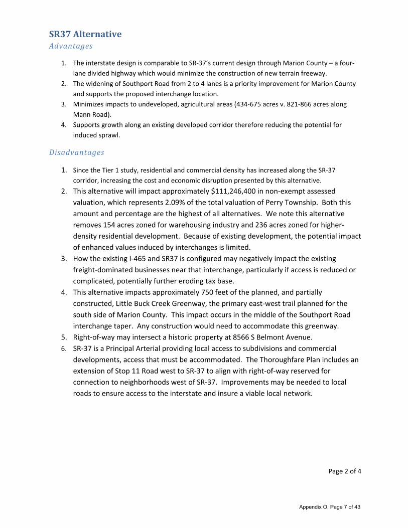
SR37AlternativeAdvantages
1. The interstate design is comparable to SR‐37’s current design through Marion County – a four‐
lane divided highway which would minimize the construction of new terrain freeway.
2. The widening of Southport Road from 2 to 4 lanes is a priority improvement for Marion County
and supports the proposed interchange location.
3. Minimizes impacts to undeveloped, agricultural areas (434‐675 acres v. 821‐866 acres along
Mann Road).
4. Supports growth along an existing developed corridor therefore reducing the potential for
induced sprawl.
Disadvantages
1. Since the Tier 1 study, residential and commercial density has increased along the SR‐37
corridor, increasing the cost and economic disruption presented by this alternative.
2. This alternative will impact approximately $111,246,400 in non‐exempt assessed
valuation, which represents 2.09% of the total valuation of Perry Township. Both this
amount and percentage are the highest of all alternatives. We note this alternative
removes 154 acres zoned for warehousing industry and 236 acres zoned for higher‐
density residential development. Because of existing development, the potential impact
of enhanced values induced by interchanges is limited.
3. How the existing I‐465 and SR37 is configured may negatively impact the existing
freight‐dominated businesses near that interchange, particularly if access is reduced or
complicated, potentially further eroding tax base.
4. This alternative impacts approximately 750 feet of the planned, and partially
constructed, Little Buck Creek Greenway, the primary east‐west trail planned for the
south side of Marion County. This impact occurs in the middle of the Southport Road
interchange taper. Any construction would need to accommodate this greenway.
5. Right‐of‐way may intersect a historic property at 8566 S Belmont Avenue.
6. SR‐37 is a Principal Arterial providing local access to subdivisions and commercial
developments, access that must be accommodated. The Thoroughfare Plan includes an
extension of Stop 11 Road west to SR‐37 to align with right‐of‐way reserved for
connection to neighborhoods west of SR‐37. Improvements may be needed to local
roads to ensure access to the interstate and insure a viable local network.
Appendix O, Page 7 of 43

Page 3 of 4
MannRoadAlternativesK1,K3,K4Advantages
1. Because of the relative inaccessibility of southern Decatur Township today, the alternatives
would open additional land for development, particularly if utilities were also extended in
conjunction with the interstate. This could be positive for a township with tax base challenges
resulting from its smaller size and presence of the tax exempt Indianapolis International Airport.
2. The extension of Southport Road/Camby Road in the Thoroughfare Plan supports the proposed
interchange location. However, this connection, along with the need for additional widening,
would need to be considered as part of the project.
3. Compared with the SR‐37 alternative, these alternatives have less of an impact on assessed
valuation, both in terms of total amount (around $24 million) as well as percentage of total
township value (around 1.6%). Additionally, the relatively undeveloped agricultural and rural
nature of land provides potential for economic development and increase in valuation. The
Comprehensive Plan for Marion County would need to be updated, however.
4. The number of parcels impacted (between 637 and 763) and the relatively undeveloped nature
means fewer residents and businesses would be negatively impacted than the SR‐37 alternative.
Disadvantages
1. This alternative creates yet another barrier for east‐west connectivity on the south side of
Indianapolis, which is already constrained by limited access highways SR‐67, SR‐37, and
Interstate 65, as well as White River.
2. These alternatives impact two planned components of the Thoroughfare Plan.
a. Extension of Southport Road/Camby Road, along with probably need for widening of
existing street to accommodate interchange activity, must be considered.
b. The planned extension and expansion of Thompson Road from Mann Road to SR‐
67/Kentucky Avenue in the plan would be impacted. Maintenance of access east of
what would be the I69 to I465 interchange via Thompson Road would need to be
maintained.
3. These alternatives would create a barrier for residential neighborhoods and commercial
development from White River, including prime estate housing opportunities along the west
side of White River.
4. These alternatives would significantly degrade the rural and pastoral character of the area. The
current Comprehensive Plan for Marion County proposes low‐density residential, limited
community commercial, and expansion of Southwestway Park, recommendations that would be
inconsistent and need to be revisited with such a significant change in infrastructure.
5. These alternatives would negatively impact approximately 2,000 feet of the planned White River
Trail and Southwest Trail, which converge at the intersection of Southport Road and Mann Road,
at what would be the Southport Road interchange.
6. These alternatives significantly impact Decatur Township’s largest continuous greenspace:
Southwestway Park, Winding Rivers Golf Course, and Swamp Creek. Not only would the
Appendix O, Page 8 of 43
Page 4 of 4
interstate degrade the peaceful and rural nature of these amenities, it would isolate them from
the vast majority of their users in neighborhoods west of Mann Road. Vehicular, pedestrian,
and bicycle access must be maintained. It is likely that these facilities may require additional
parking and vehicular accommodations as the result of decreased pedestrian and bicycle
connections.
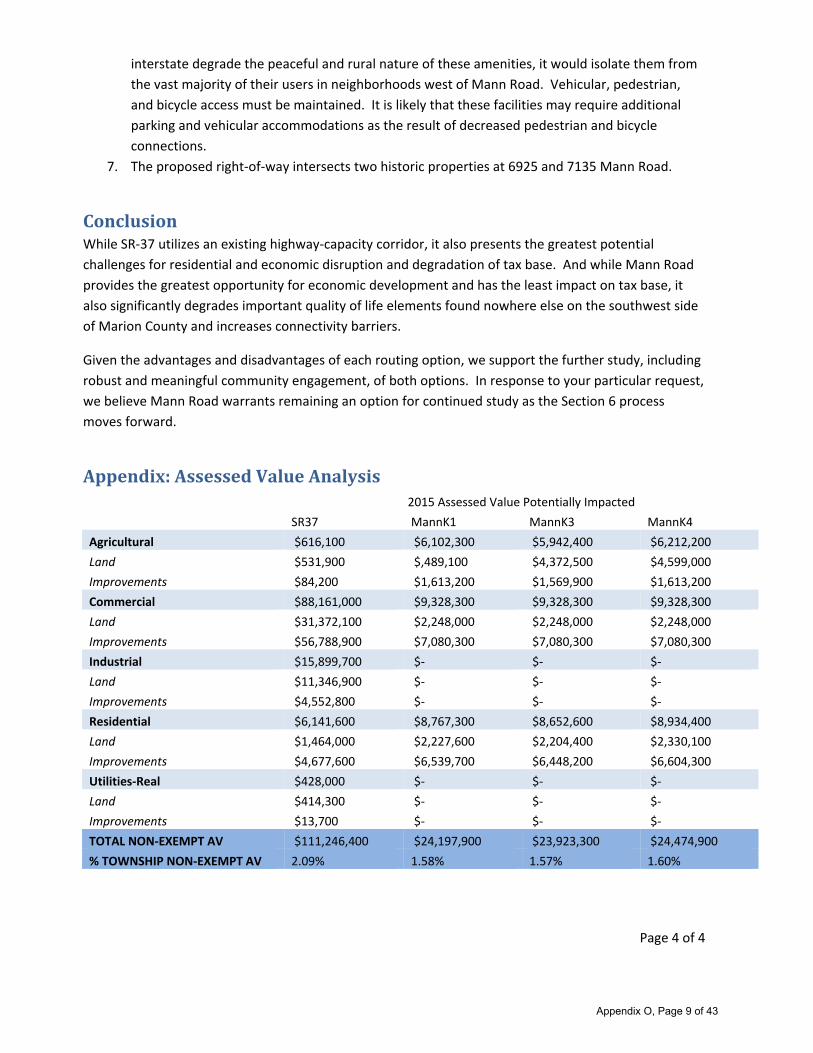
7. The proposed right‐of‐way intersects two historic properties at 6925 and 7135 Mann Road.
ConclusionWhile SR‐37 utilizes an existing highway‐capacity corridor, it also presents the greatest potential
challenges for residential and economic disruption and degradation of tax base. And while Mann Road
provides the greatest opportunity for economic development and has the least impact on tax base, it
also significantly degrades important quality of life elements found nowhere else on the southwest side
of Marion County and increases connectivity barriers.
Given the advantages and disadvantages of each routing option, we support the further study, including
robust and meaningful community engagement, of both options. In response to your particular request,
we believe Mann Road warrants remaining an option for continued study as the Section 6 process
moves forward.
Appendix:AssessedValueAnalysis2015 Assessed Value Potentially Impacted
SR37 MannK1 MannK3 MannK4
Agricultural $616,100 $6,102,300 $5,942,400 $6,212,200
Land $531,900 $,489,100 $4,372,500 $4,599,000
Improvements $84,200 $1,613,200 $1,569,900 $1,613,200
Commercial $88,161,000 $9,328,300 $9,328,300 $9,328,300
Land $31,372,100 $2,248,000 $2,248,000 $2,248,000
Improvements $56,788,900 $7,080,300 $7,080,300 $7,080,300
Industrial $15,899,700 $‐ $‐ $‐
Land $11,346,900 $‐ $‐ $‐
Improvements $4,552,800 $‐ $‐ $‐
Residential $6,141,600 $8,767,300 $8,652,600 $8,934,400
Land $1,464,000 $2,227,600 $2,204,400 $2,330,100
Improvements $4,677,600 $6,539,700 $6,448,200 $6,604,300
Utilities‐Real $428,000 $‐ $‐ $‐
Land $414,300 $‐ $‐ $‐
Improvements $13,700 $‐ $‐ $‐
TOTAL NON‐EXEMPT AV $111,246,400 $24,197,900 $23,923,300 $24,474,900
% TOWNSHIP NON‐EXEMPT AV 2.09% 1.58% 1.57% 1.60%
Appendix O, Page 9 of 43

TELEPHONE RECORD
Date of Call: November 2, 2015 Phone Number: 317- 831-7918
Conversation With: Ross Holloway Submitted By: Bill Wiedelman
Company Name: Martinsville City Engin. Copies To: LaMar Holliday
Subject: Concern regarding interchange & grade separation at I-69 & SR 44
Remarks:
I called Mr. Holloway to discuss the street connection from Grand Valley over I-69 to South Street
(or possibly York Street). I indicated to Mr. Holloway that both street were very much local in
character and I was concerned showing a more major use as part of an alternative. Mr. Holloway
assured me that this had been discussed internally and with the High School. They fully support a
connection to South Street (not York) and would be considering a upgrade of South Street as part
of their thoroughfare plan update next year. He indicated that the intersection of Ohio Street and
South Street was adjacent to a major manufacturing plant and the City was interested in
redevelopment in the area.
Appendix O, Page 10 of 43

1
Holliday, Lamar
From: INDOT Section 6 PM
Sent: Thursday, December 03, 2015 3:46 PM
To: 'Web Form Poster'
Subject: RE: [Section 6 Comment Form]
Hello,
Thank you for your comment on the I-69 Section 6 project. Your comment has been added to the public record. If you
wish to make additional comments, you can do so at [email protected].
Thank you,
LaMar
LaMar Holliday
Public Involvement Specialist
I-69 Project, Section 6
7847 Waverly Road
Martinsville, IN 46151
Office: (317) 881-6408
Email: [email protected]
Website: www.i69indyevn.org
-----Original Message-----
From: Web Form Poster [mailto:[email protected]]
Sent: Thursday, December 03, 2015 3:41 PM
To: INDOT Section 6 PM
Subject: [Section 6 Comment Form]
First Name:
Dr. David
Last Name:
Marcotte
Street Address:
11 W. Carlisle St.
City:
Mooresville
State:
IN
Appendix O, Page 11 of 43

2
Zip/Postal:
46158
E-mail:
Comments
As Superintendent of the Mooresville Consolidated School Corporation,I have strong concerns with Preliminary Routes
B, D, K3, and K4 due tothe potential negative impact on the Mooresville Schools. Theseconcerns include:
1) The loss of Assessed Valuation as property is removed from thelocal tax rolls causing a reduction in our capital
projects,transportation, and debt service budgets.
2) The potential loss of student enrollment as familiesâ relocate, which could further reduce the operating budget
and mayresult in redistricting of attendance areas for our elementaryschools.
3) All four routes through the Mooresville school district willcreate transportation problems with regard to school
busses having tonavigate around the highway. The impact will not only be longer busrides and safety fears for our
children, but the added cost of fueland maintenance on our bus fleet as well.
Thank you.
Dr. David Marcotte, Superintendent
Mooresville Schools
---------------------------------------------------------------
FIELDS NOT DEFINED IN THE TEMPLATE FOLLOW
---------------------------------------------------------------
Appendix O, Page 12 of 43

TOWN of MOORESVILLE 4 East Harrison Street Mooresville, Indiana 46158
DATE: November 4, 2015
TO: La Mar Holliday, Public Involvement Specialist, INDOT
RE: 1-69 Project Section 6
Telephone (317) 831-1608 Fax (317) 831-9559
The Tow·n Council of Mooresville, at their October 61h meeting, confirmed their preferred route for Section 6 of 1-69 is State Road 37.
Whichever route INDOT chooses, the Town of Mooresville must be involved in all interchange decisions.
Sincerely,
Mark Mathis
Town Council President
Town of Mooresville
Appendix O, Page 13 of 43

1
Holliday, Lamar
From: INDOT Section 6 PM
Sent: Tuesday, December 08, 2015 2:55 PM
To: 'Web Form Poster'
Subject: RE: [Section 6 Comment Form]
Hello,
Thank you for your comment on the I-69 Section 6 project. Your comment has been added to the project record. If you
wish to make additional comments, you can do so at [email protected].
Thank you,
LaMar
LaMar Holliday
Public Involvement Specialist
I-69 Project, Section 6
7847 Waverly Road
Martinsville, IN 46151
Office: (317) 881-6408
Email: [email protected]
Website: www.i69indyevn.org
-----Original Message-----
From: Web Form Poster [mailto:[email protected]]
Sent: Tuesday, December 08, 2015 12:52 PM
To: INDOT Section 6 PM
Subject: [Section 6 Comment Form]
First Name:
Dennis
Last Name:
Mills
Street Address:
389 E Jackson St
City:
Martinsville
State:
IN
Zip/Postal:
Appendix O, Page 14 of 43

2
46151
E-mail:
Comments
Please consider the following in regards to I69 Section 6.
I would suggest that the grade separation from Grand Valley connectto South St instead of the proposed York Street.
South Streetprovides a straight path to Ohio Street. It also provides analternative to using the school lot as a through
street. At least 49buses are at the York Street and front drive intersection in themorning and at least half of those use
the intersection in theevening. Buses stage for dismissal along the front of the buildingand the south drive off Illinois.
This restricts traffic flow alongthose drives and provides for safety through separation from othertraffic. The student lot
has four exits that intersect York whichwould cause further congestion. Student traffic both vehicular andpedestrian
would be negatively impacted.
The parking area with the observation building is currently used bythe band as a practice area. Pedestrians also use the
lot to enter orexit. This area is also designated as a staging area in several areasof the safety plan. Large events also
result in this area being usedas parking.
I believe that a connection at York Street would create congestionand result in a significant increase in traffic using the
schoolgrounds as a through area. This would result in decreased safety tothe public, students and bus traffic.
Thank you for your consideration.
Dennis M. Mills
Transportation/Safety Director
MSD of Martinsville
389 E Jackson
Martinsville, IN
765-342-5597
---------------------------------------------------------------
FIELDS NOT DEFINED IN THE TEMPLATE FOLLOW
---------------------------------------------------------------
Appendix O, Page 15 of 43

REDEVELOPMENT COMMISSION Hon. Phil R. Deckard, Mayor
December 9, 2015
1-69, Section 6 Indiana Department Transportation Section 6, Project Office 7851 Waverly Road Martinsville, IN 46151
Attn: Sarah Rubin, Section 6 Project Manager
Re: Public Comment - 1-69, Section 6
Dear Ms. Rubin,
The City of Martinsville Redevelopment Commission is in the process of combining several EDA and TIF districts into one. This single EDA and TIF district will encompass much of the "Preliminary Alternative C" route of 1-69, Section 6 through Martinsville. In June of this year the Commission sent you a letter supporting 1-69 following SR-37 through Martinsville and asked INDOT to place an interchange at Ohio Street and a grade separation from Home Ave., in the vicinity of South Street, to Grand Valley Blvd. While we were pleased that the grade separation is being considered we were very disappointed to find that the Ohio Street interchange was not.
As stated in our previous letter, Ohio Street provides a direct route to two major employers, the downtown business district, and the schools. It is extremely important to the Commission that an Ohio Street interchange be constructed. Not only would this interchange provide access north to the City center but is required to provide quick and easy access to 1-69 from the area south and east of Grand Valley. This land is bounded by Mahalasville Road (Ohio Street) on the west and Cramertown Loop Road on the south and east. This area is a portion of the recently completed annexation and is a prime location for green field site development which makes it vitally important to the overall economic growth of the City.
The goals and purpose of the Martinsville Redevelopment Commission is to support and fund the infrastructure needed to encourage and promote economic development. As we move into the DEIS for Section 6 the Commission would request that interchanges, grade separations and access roads be designed and constructed to accommodate pedestrians and bicycles. We are also looking to, where possible, extend the City's fiber network. To that end we would request that the final design for Section 6, through Martinsville consider incorporation of duct for fiber.
We believe that as the DEIS progresses for Section 6 there is opportunity for the RDC, as part of City government, to work with INDOT to help facilitate an interchange at Ohio Street and the Home Ave. - Grand Valley access. Both of which are critical to the economic growth and the good jobs that the citizens of Martinsville deserve.
Sincerely,
~ lfresh, Presl ent Martinsville Redevelopment Commission
Cc: Mayor Deckard Martinsville Common Council Commission Members Rod Bray, Commission Attorney Ross Holloway, City Engineer Morgan County Commissioners Morgan County EDC file
City Hall • 59 S. Jefferson St. • PO Box 141 5 • Martinsville, fN 4615 1 Ph. 765-342-2861 • Fax 765-349-4904
Appendix O, Page 16 of 43

1
Holliday, Lamar
From: INDOT Section 6 PM
Sent: Thursday, December 17, 2015 10:20 AM
To: '[email protected]'
Subject: RE: Section 6 Letter
Attachments: Goodwin_I-69_Letter.pdf
Importance: High
Thank you for your comment on the I-69 Section 6 project. Your comment has been added to the project record. If you
wish to make additional comments, you can do so at [email protected].
LaMar Holliday
Public Involvement Specialist
I-69 Project, Section 6
7847 Waverly Road
Martinsville, IN 46151
Office: (317) 881-6408
Email: [email protected]
Website: www.i69indyevn.org
From: Ryan Goodwin [mailto:[email protected]]
Sent: Wednesday, December 16, 2015 6:45 PM To: INDOT Section 6 PM
Subject: Section 6 Letter
Importance: High
**** This is an EXTERNAL email. Exercise caution. DO NOT open attachments or click links from unknown senders or unexpected email. ****
To Whom It May Concern:
After much review of the facts, of the maps, and after much discussion with members of my community – both in
Mooresville and county-wide – I’ve attached a letter outlining my thoughts and concerns regarding Section 6 of I-69,
specifically with a few of the proposed alternatives.
Thank you for your time, attention, and consideration to this matter as INDOT prepares for the next step.
Most Sincerely,
Ryan Goodwin
Morgan County Council
Appendix O, Page 17 of 43

December 1, 2015
Ryan T. Goodwin 203 Shadowview Circle
Mooresville, Indiana 46158
Indiana Department of Transportation
Section 6 Office
7847 Waverly Road
Martinsville, Indiana 46151
RE: 1-69 Section 6
To Whom It May Concern:
I am writing this letter to state my support of 1-69, section 6, following the existing
roadway of State Road 37, as the interstate makes its way through Morgan County. I am also
writing to support this position with a few observations, made as a long-time resident of the
county, as a former law enforcement officer in Morgan County, and based on my experience as
an elected official in Morgan County, currently serving as chairman of the Morgan County
Council. Please note: I am not writing this letter on behalf of the county council; however, I
believe my experience in this role lends me a unique perspective on this project.
I count myself among those that believe Morgan County can benefit from the presence
of an interstate, if the county is well-prepared, and the route chosen is conducive to our local
geography and economy. The key word is can.
My first concern regarding the proposed alternative routes has to do with farmland.
County-wide, nearly 9% of our assessed valuation is farmland. This is a significant number,
clearly demonstrating the importance of farming as a dominant industry in our county - one
worth protecting. With the exception of the route aligning with State Road 37, the proposed
alternative routes significantly comprise existing, operating farmland. This concerns me, with
the clear importance of farming to our local economy.
With regard to our local geography, the alternative routes concern me for public safety
accessibility and response times. The footprint of our county is large - much larger than our
population reflects - and it takes first responders a significant amount of time to travel from
Appendix O, Page 18 of 43

one end of the county to another, particularly east to west or west to east. Right now, we have
an existing network of state roads, running north/south and east/west that help facilitate
response times as best as possible, given the footprint size of our county. I fear that with 1-69
following one of the alternative routes - particularly B or D - that response times will be
increased, as law enforcement officers and first responders will need to navigate interstate
interchanges with increased frequency, and our major population centers will be divided by an
interstate, versus the more limited impact if 1-69 were to follow the existing State Road 37
roadway.
Lastly, with regard to proper planning, Morgan County can benefit from this interstate,
and we are prepared for the interstate to follow the existing State Road 37 pathway.
Development areas have been established at probable interchange locations, and the
wastewater facility near the Waverly area is growing and expanding to be able to support the
State Road 37 path with the needed utility infrastructure to attract quality, job-producing
development.
It goes without saying change is difficult and not without sacrifice. I am concerned,
though, about the proposed alternatives that deviate from the existing State Road 37 roadway.
Interweaving an interstate throughout the county, displacing farm owners, homeowners, and
dividing the county's major population centers with an interstate, just doesn't make good
sense.
For the reasons outlined above, I ask that you continue 1-69 Section 6 along existing
roadway: State Road 37.
Respectfully Submitted,
Ryan T. Goodwin
Appendix O, Page 19 of 43

COMMENT SHEET
RE: 1-69 Section 6: Martinsville to Indianapolis (SR 39 to 1-465) Public Information Meeting
TO: I-69, Section 6 Project Office 7847 Waverly Road Martinsville, IN 46151
FROM: Name ______ ___ ______________ _ _ ______ _
Address ____ _ _ _ _ _____ ___________ ___ _,__(O"'""'P-tio~n_a~l)
Phone (_) (Optional) Email ___ ____ ___ ..,__(O=--p=t~io~n=a=<-l)
Organization/ Agency (if relevant) ------------------~(O_p_t_io_n_a~l)
COMMENTS: (Note: Comments are requested by December 17, 2015. Comments can also be submitted via the project website at www.i69indyevn.org )
~ctrriznn 'illnfunsJrip
J}f in~ ctnb: ~z.c11£ Chief David Allison
84 75 Waverly Road Martinsville IN. 46151 Station 317-831-5357 Cell 317-694-8445 chief@htfd .org
.t
Appendix O, Page 20 of 43

Metropolitan School District of Martinsville P.O. Box 1416
389 E. Jackson St.
Martinsville, Indiana 46151
765-342-6641
Fax 765-342-6877
Board of Education Superintendent
Tana Lobb, President Dr. Michele Moore
Stephanie Fraker, Vice-President Assistant Superintendent
Steve Brock, Secretary Mr. Terry Terhune
Michelle Baugh, Member Treasurer
Julie Reeves, Member Kimberly LaRue
April 21, 2016
I69 Section 6 LaMar Holliday Public Involvement Specialist I-69 Project, Section 6 7847 Waverly Road Martinsville, IN 46151
Dear Indiana Department of Transportation:
As the superintendent of the MSD of Martinsville, I would like to provide public comments for the proposed Section 6 that will run through the City of Martinsville.
Thank you for listening to us and understanding our need to have the overpass for Grand Valley be placed at South St. instead of York St. Your willingness to work with us is very much appreciated.
We believe the following would also provide for better student safety:
The on/off exit to be on the NW corner of current Ohio St./State Rd. 37 intersection (Outer Drive) To minimize the number of retaining walls and sound barrier walls It is not in our best interests to have underpasses (the 252 interchange being the exception), as they
are an attractive nuisance, especially to children and teens.
Thank you again for listening to us and taking them time to read our comments.
Sincerely,
Michele D. Moore, Ed.D. Superintendent
Appendix O, Page 21 of 43
April 28, 2016 FROM: Morgan County Three Creeks Community Alliance (MCTCCA) c/o Foxcliff Estates Community Association 4041 N. Foxcliff Drive East Martinsville, Indiana 46151 TO: Mr. Jim Earl Mr. LaMar Holliday Project Co-Manager Public Involvement Specialist INDOT I-69 Project, Section 6 INDOT I-69 Project, Section 6 7847 Waverly Road 7847 Waverly Road Martinsville, IN 46151 Martinsville, IN 46151 [email protected] [email protected] Dear Mr. Earl and Mr. Holliday: We, the members of the coordinating committee for the Morgan County Three Creeks Community Alliance (MCTCCA), are pleased once again to provide important and ongoing information to you and to your colleagues. We know full well that the task at hand in the planning for Section 6 of the I-69 interstate is a formidable one, and we want you to know that we are grateful for the attention and work already committed by you personally and by all with whom you are working. In general terms, we of the MCTCCA are pleased with the contents of the INDOT report issued earlier this month. However, we still continue to have a number of specific concerns which we now share with you in this formal communication. Rest assured that this letter is as succinct as we were able to craft, and it presents a reasonably limited number of issues about which we remain quite legitimately concerned. It would be our pleasure to have the opportunity to sit down with you and your colleagues to discuss these issues. And we will make every effort to be available at a date and time convenient for you. With both succinctness and clarity in mind, here are the concerns – and in several instances alternative recommendations – presented in numbered paragraphs for the sake of future review and clarification. Once again, our priorities include: (a) timely access for fire, police and emergency vehicles; (b) access for residents of our neighborhoods to both northbound and southbound I-69; (c) access for school buses to and from neighborhoods both east (Mapleturn Road) and west (Egbert Road); (d) access for non-motorized use insuring safety for walkers, runners and cyclists; and (e) minimum noise pollution during construction and after completion. These priorities were noted in our response letter dated December 16, 2015.
Appendix O, Page 22 of 43

1. We are concerned that the frontage and intersecting (S-Line) roads that are proposed willnot be able to handle the higher traffic on these existing routes to the newly constructedfrontage roads. Will INDOT test the condition of these existing roads and help thecounty upgrade these roads if necessary to accommodate increased traffic? We presumethat new frontage roads will be designed to accommodate such increased traffic over atleast a 20-year future life. Correct?
2. To help minimize congestion through the I-69 new work zone, we request that thefrontage road from Old SR 37 to Morgan Street in Martinsville be constructed prior to theI-69 work south of the Old SR 37 so that we can access the city and avoid constructionduring that phase of the work.
3. As noted in our December entry, the City of Martinsville needs to have an interchange ator near Ohio Street (or at Industrial Drive) so that the public can get to a hub ofcommercial activity without going beyond the town and back or driving through theentirety of the downtown congestion. We clearly support an interchange at Ohio Street.
4. A long-term goal is to have sidewalks or paths along Mapleturn Road up to the newhighway and across it. We ask for room for pedestrian and bicycle traffic on a bridgeover I-69 connecting to Egbert Road … assuming that no I-69 access/egress takes shapeat Egbert Road. Please see entry #8.
5. The route from our neighborhoods provides a direct access for a number of individualsand services from Blue Bluff Road to the west of the MCTCCA region. This route willsee even greater traffic when (and it happens frequently) Blue Bluff Road is closed due toflooding. Absent consideration of a new interchange at Egbert Road, we support a moredirect and free-flowing access to Egbert Road as shown in Alternates C1 and C3. We areopposed to the Alternative C2 option.
6. We support the idea that the bridges over I-69 or along the S-lines through the City ofMartinsville provide for pedestrian traffic. A few years ago, a pedestrian was killedwhile attempting to access the Grand Valley shopping area.
7. The Grand Valley shopping center constitutes a main commercial area to bothMartinsville and our MCTCCA communities. We support an eastern access road toGrand Valley to and from the Cramertown Loop. This backway access will support theshopping and further development of this commercial area. We do not wish to suffer aloss in either short-term or long-term business success.
8. We are deeply, deeply concerned about sustaining – and we hope enhancing – theresponse time of emergency vehicles (ambulance, fire and law enforcement) to ourneighborhoods. While we most certainly appreciate INDOT’s willingness to provide afrontage road that will allow access along the west side of SR 37 from Mapleturn Road toEast Morgan Street, this option alone will not positively address any enhancement ofemergency response time to the MCTCCA neighborhoods. The width and speed limitsalong this new frontage road – while wonderfully convenient as a good routine access
Appendix O, Page 23 of 43

option for us – will only serve to further delay emergency vehicle response times. Indeed, if this new frontage road becomes our only alternative, then increased width and substantially increased speed limits will be absolutely critical … two changes of real significance that we believe will be uniformly disliked by residents, businesses, churches and the Martinsville Golf Club lying along the path of this new road.
It is on this critical point of safety that we decided to submit for your consideration a new option and, if unacceptable to INDOT, a less costly alternative solution. The entries below represent our succinct analysis of the two options
A. Should current plans remain unchanged, then emergency vehicles dispatchedfrom Martinsville would be slowed very significantly if approaching theMCTCCA neighborhoods via only the new access road noted above or bybeing forced to unnecessarily drive further north to the proposedHenderson Ford interchange and then to double back to our MCTCCAlocations. The State standard for an appropriate emergency vehicle responsetime for calls out into our counties is eight (8) minutes. The MCTCCA regionalready and often experiences response times in excess of 8 minutes, and theloop north to the Henderson Ford interchange (1+ miles and an additional 5minutes), the trip south to our neighborhoods, and then the return northward inorder to go south (another 5 minutes or more) will only serve to extendresponse times into the realm of potentially tragic delays.
We recommend that INDOT revisit and return to an original plan toprovide a full interchange at the Egbert Road location. Emergencyvehicles could then access MCTCCA neighborhoods without dependenceupon the new frontage road noted above or the proposed interchange atHenderson Ford Road. A Henderson Ford interchange forces allemergency vehicles to drive well north on I-69 and then double back toaccess Old 37, Egbert and Mapleturn Roads in order to best serve ourneighborhoods. In the case of ambulance calls – and absent a fullinterchange at Egbert Road – the patient must be transported once againnorth to a Henderson Ford interchange and then southward to the closestemergency room facility at the IU Morgan Hospital in Martinsville.
Please bear in mind that our neighborhoods represent a conservativeestimate of some 1500 to 2500 existing residences. This is, we believe,well in excess of extant residences in the immediate or close proximity toHenderson Ford Road. We stand prepared to refine this estimate.
Pursuit of this preceding option will also serve to provide easier and fasteraccess to all of the residents in our MCTCCA neighborhoods for their normalactivities and needs.
B. While less preferable, we have identified an alternate solution to this problemof interminably long access times for emergency vehicles to reach and serve
Appendix O, Page 24 of 43
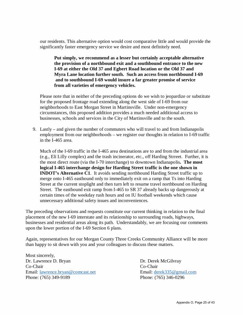
our residents. This alternative option would cost comparative little and would provide the significantly faster emergency service we desire and most definitely need. Put simply, we recommend as a lesser but certainly acceptable alternative the provision of a northbound exit and a southbound entrance to the new I-69 at either the Old 37 and Egbert Road location or the Old 37 and Myra Lane location further south. Such an access from northbound I-69 and to southbound I-69 would insure a far greater promise of service from all varieties of emergency vehicles. Please note that in neither of the preceding options do we wish to jeopardize or substitute for the proposed frontage road extending along the west side of I-69 from our neighborhoods to East Morgan Street in Martinsville. Under non-emergency circumstances, this proposed addition provides a much needed additional access to businesses, schools and services in the City of Martinsville and to the south.
9. Lastly – and given the number of commuters who will travel to and from Indianapolis employment from our neighborhoods – we register our thoughts in relation to I-69 traffic in the I-465 area. Much of the I-69 traffic in the I-465 area destinations are to and from the industrial area (e.g., Eli Lilly complex) and the trash incinerator, etc., off Harding Strreet. Further, it is the most direct route (via the I-70 interchange) to downtown Indianapolis. The most logical I-465 interchange design for Harding Street traffic is the one shown in INDOT’s Alternative C1. It avoids sending northbound Harding Street traffic up to merge onto I-465 eastbound only to immediately exit on a ramp that Ts into Harding Street at the current stoplight and then turn left to resume travel northbound on Harding Street. The eastbound exit ramp from I-465 to SR 37 already backs up dangerously at certain times of the weekday rush hours and on IU football weekends which cause unnecessary additional safety issues and inconveniences.
The preceding observations and requests constitute our current thinking in relation to the final placement of the new I-69 interstate and its relationship to surrounding roads, highways, businesses and residential areas along its path. Understandably, we are focusing our comments upon the lower portion of the I-69 Section 6 plans. Again, representatives for our Morgan County Three Creeks Community Alliance will be more than happy to sit down with you and your colleagues to discuss these matters. Most sincerely, Dr. Lawrence D. Bryan Dr. Derek McGilvray Co-Chair Co-Chair Email: [email protected] Email: [email protected] Phone: (765) 349-9189 Phone: (765) 346-0296
Appendix O, Page 25 of 43

OFFICE OF THE MAYOR Honorable Shannon E. Kohl, Mayor
Dear Tim Miller:
Thank you for allowing the City of Martinsville the continued opportunity to discuss the impacts of Interstate 69 - Section 6 as it relates to our community. Our previous discussions have been very beneficial and we look forward to continuing our discussions with you. Per our last conversation, we are in the process of formalizing a written report for you outlining our preferred options for access points, access roads and site configurations and plan to have that report to you in the next few weeks
Sincerely,
01~~/) Mayor Shannon E. Kohl
City of Martinsville
P.O. Box 1415 • Martinsville, Indiana 46151 • Phone: 765-342-2861 • Fax: 765-349-4904 [email protected] • www.martinsville.in.gov
Appendix O, Page 26 of 43

HWC ENGINEERING
MEMORANDUM
TO: Jim Earl, Tim Miller, Jennifer Goins
FROM: Ma or Shannon Kohl , Cit of Martinsville
DATE: May 131h, 2016
RE: Martinsville 1-69 Route and Access Points
Confidence in the built environment.
151 N. Delaware. Suite 800 Indianapolis. Indiana 46204
www.hwcengineering.com
On Monday, May 9th, representatives from the City of Martinsville, HWC Engineering, HNTB and INDOT met to review the proposed 1-69 Section 6 route through Martinsville including access point location and design. Attendees included Tim Miller and Jennifer Goins with HNTB, Jim Earl with INDOT, Chris Hamm, Harold Place, and Kyle Lueken with HWC Engineering and Mayor Shannon Kohl and City Attorney Dale Coffey with the City of Martinsville.
The City of Martinsville appreciates the continued opportunity to discuss the impacts of Interstate 69 - Section 6 as it relates to our community and the continued willingness of INDOT to hear our concerns. Martinsville wants to ensure that 1-69 will have a positive economic impact on the community. While it is understood there will be some adverse impacts, the goal of this on-going conversation is to minimize those impacts as much as possible and ensure the City has appropriate access points to continue to spur economic development in the City.
This memo serves as a summary of our conversation. The summary points outlined below will be contained in a final report to be presented to INDOT in later this summer.
Assumptions and Understandings:
• The provided layouts from HWC included with this memo address broad access considerations and represent working drafts not final layouts. We understand there will be opportunity to discuss individual right of way parcel impacts once a firm alignment is established.
• The right of way illustrated within our layouts may need to expand in detailed design. However, the access concepts should sti ll apply with increased right of way.
Indianapolis Terre Haute Lafayette Scottsburg Noblesville
www.hwr.e ·gineering com
Appendix O, Page 27 of 43

• HWC ENGINEERING Confidence in the built environment.
151 N. Delaware. Suite 800 Indianapolis. Indiana 46204
www.hwcengineering.com
• We recognize the fact that right of way impacts are not defined as of yet, and we reserve the right to comment on right of way impacts when they are established in the future.
General Comments:
• Overall, there is a lot of overlap between the options presented in the Preliminary Alternatives Screening Report (PASR) and the preferences put forth by the City. See attached layouts for SR 252/44, Ohio Street and Burton Lane for our recommendations of interchange alternatives. Further description of each interchange/grade separation is provided in this memorandum.
• City is very averse to an elevated interstate as proposed in option C1. It is strongly preferred that, as best as possible and unless otherwise noted in this memorandum, Interstate 69 maintain the existing grade of State Road 37.
• There is a desire to limit the use of sound barriers along the corridor to those areas that are most adversely impacted by the proposed improvements and that are also supported by the impacted property owners.
• The City of Martinsville is willing to work to help encourage alternative housing options for those who are displaced by the project.
Access and Frontage Road Preferences:
• South Street to Home Avenue. Additional improvements will be needed along South Street from Home Avenue to Ohio Street.
• Improvements and extension of Grand Valley Boulevmd to Cramertown Loop. • Improvements to Cramertown Loop from Grand Valley Boulevard north to SR 252. • Extension of SR 44 south to an intersection with SR 252 at Cramertown Loop. • Improvements to Ohio Street north to the edge of t:1e commercial center and south
to the point where the road turns into Mahalasville Road.
• Extension of Southview Drive west towards Burton Lane and east towards Ohio Street.
• Extension of Flag Stone Drive southwest to Robert Curry Drive.
• Frontage road between Ohio Street south of the interstate and Industrial Drive. • Improvements to SR 39 • Frontage road on south side of interstate running west towards Jordan Road from
SR 39 interchange. Connection to Jordan Road is preferable. but it is understood that a bridge may be unmanageable.
lndianapo11s Terre Haute Lafayette ::,,; ottsburg Noblesville
www.hwcengineering.com
Appendix O, Page 28 of 43

• HWC ENGINEERING Confidence in the built environment.
151 N. Delaware. Suite 800 Ind ianapolis. Indiana 46204
www.hwcengineering.com
• Frontage road on the northwest side of the Interstate between Hospital Drive and Reuben Drive.
Local Access Preferences:
SR 39 • Options C1 or C2 are preferred which provides access to south side of the
interstate. • If the traffic flow of current and anticipated bus and truck traffic can be maintained,
we are open to the roundabout option presented in C2.
Burton Lane • Option C2 is most closely aligned with our preference. To maintain connectivity,
preference is to have a grade separation with Burton Lane over Interstate 69. • In order of priority zones to minimize impacts, the northwest quadrant is fi rst,
followed by the southeast, then northeast and finally southwest. • Retaining walls to minimize impacts in lieu of embankments should be considered. • Connect existing frontage road (Southview Drive) in southeast quadrant. • Understand that after INDOT discussion with prope11y owners at the church in the
northeast quadrant and southwest quadrant, maintaining access to these areas may not be critical.
Ohio Street
• Option C3 is most closely al igned with our preference. Th is interchange is critically important to the City.
• Include Southview Road connection to Burton Lane.
• The priority is to protect development in the northwest quadrant. The City would like to see if a fo lded loop design in the northeast quadrant could minimize impact to the northwest development (see attached alternative) . Priorities of zones to minimize impacts after the northwe5i quadrant are the southeast, then the southwest, and lastly the northeast.
• We understand that the connection to the northwest commercial area may need to shift north and the connection to the south commercial areas may need to shift south.
lndianapclis Te1·rE: Haute
www.hwce11g1neering.com
Sc.,uttsl,urg Noblesv,lle
Appendix O, Page 29 of 43
HWC ENGINEERING
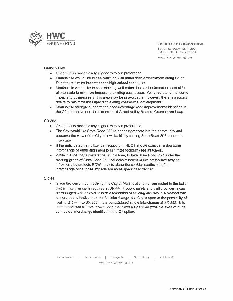
Grand Valley
• Option C2 is most closely aligned with our preference.
Confidence in the built environment.
J51 N. Delaware. Suite 800 Indianapol is. Indiana 46204
www.hwcengineering.com
• Martinsville would like to see retaining wall rather than embankment along South Street to minimize impacts to the high school parking lot.
• Martinsville would like to see retaining wall rather than embankment on east side of interstate to minimize impacts to existing businesses. We understand that some impacts to businesses in this area may be unavoidable, however, there is a strong desire to minimize the impacts to exiting commercial development.
• Martinsville strongly supports the access/frontage road improvements identified in the C2 alternative and the extension of Grand Valley Road to Cramertown Loop.
SR 252
• Option c ·1 is most closely aligned with our preference. • The City would like State Road 252 to be thei r gateway into the community and
preserve tl1e view of the City below the hill by routing State Road 252 under the interstate.
• If the anticipated traffic flow can support it, INDOT should consider a dog bone interchange or other alignment to minimize footprint (see attached).
• While it is the City's preference, at th is time, to take State Road 252 under the existing grade of State Road 37, final determination of this preference may be influenced by projects ROW impacts along the corridor southwest of the interchange once those impacts are more specifically defined.
SR44
• Given the current connectivity, the City of Martinsville is not committed to the belief that an interchange is required at SR 44. If public safety and traffic concerns can be managed with an overpass or a relocation of existing facilities in a method that is more cost effective than the full inle1·change, the City 1s open to the possibility of routing SR 44 into SR 252 into a consol,dated single interchange at SR 252. It is understood that a Cramertown Loop extension rnay still be possible even with the connected interchange identified in ihe C1 option.
Indianapolis Terre Haute
www.hwcengineering.com
Scottsburg Noblesville
Appendix O, Page 30 of 43

CONSTRUCTION LIMITS
DRAINAGE STRUCTURES
EDGE OF PAVEMENT
BRIDGE
RETAINING WALL
MAY 12, 2016
INTERCHANGE LAYOUT
OHIO STREET
CITY OF MARTINSVILLE
Appendix O, Page 31 of 43

MARCH 21, 2016
INTERCHANGE LAYOUT
SR252
CITY OF MARTINSVILLE
CONSTRUCTION LIMITS
DRAINAGE STRUCTURES
EDGE OF PAVEMENT
BRIDGE
RETAINING WALL
Appendix O, Page 32 of 43

CONSTRUCTION LIMITS
DRAINAGE STRUCTURES
EDGE OF PAVEMENT
BRIDGE
RETAINING WALL
MAY 12, 2016
OVERPASS LAYOUT
BURTON LANE
CITY OF MARTINSVILLE
Appendix O, Page 33 of 43

To: James A. Earl, P.E. Project Manager Indiana Department of Transportation 100 N. Senate Avenue Indianapolis IN 46204-2216
From: Department of Public Works Engineering Division 1200 Madison, Suite 200 Indianapolis, Indiana 46225
Re: I-69 from South County Line Road to I-465
Alternate C-1 Review Comments
Overview
Alternate C-1 uses existing SR 37 from SCLR to I-465. Direct access from I-69/SR 37 to Harding Street is provided. Flyover ramps are also constructed to provide direct access to I-465 eastbound and westbound without having to use the Harding Street Interchange.
Interchanges
Partial folded interchange with roundabouts at SCLR and a diverging diamond Interchange at Southport Road and flyovers at I-465.
Grade Separations
Epler Avenue, Edgewood Ave, Banta Road, Southport Road, Wicker Road and South County Line Road (SCLR) will be grade separated from I-69.
DPW Engineering Recommendations to INDOT for Alternate C-1:
Provide north- south connectivity by constructing a local access road network on the east side of I-69 between Southport Road and Banta Road.
Provide additional capacity to Bluff Road from Wicker Road to Harding Street and Harding Street from Bluff Road to SR 37 since it will soon be the best north-south connector replacing SR 37 and still connecting to I-465 via SR 37.
Note: Bluff Road is on the Official Thoroughfare Plan for Marion County, Indiana. However, the segment of Harding Street is not on the Official Thoroughfare Plan for Marion County, Indiana. If additional right of way is needed to be acquired approximately 80 parcels appear to be metes and bounds described and most likely will require right of way acquisition beyond the existing pavement.
Appendix O, Page 34 of 43

The platted right of way on adjacent subdivisions may not be sufficient for more than a three lane section of roadway.
SR 37/I-69 crosses Little Buck Creek just north of Southport Road. The City of Indianapolis Greenway Master Plan includes a greenway trail to be constructed along Little Buck Creek. Please design the I-69 crossing to provide adequate space for this new trail.
On all grade separations please design space in the bridge width or roadway under the bridge to provide room for bike lanes and pedestrian facilities. Please install bridge railings that accommodate pedestrian facilities. Southport Road has a multi-use path constructed on the north side of the road that must be accommodated through the I-69 interchange.
Alternate C-2 Review Comments
Overview
Alternate C-2 uses existing SR 37 from SCLR to Edgewood Ave. At Edgewood I-69 curves to the west towards a new interchange to be constructed with I-465. Direct access from I-69/SR 37 to Harding Street is no longer provided. Northbound I-69 access to Harding Street is obtained by using the new I-69 and I-465 interchange on to eastbound I-465 to the existing Harding Street interchange. SR 37 will remain from Epler Ave to I-465 providing access to Epler Road and Thompson Road to downtown and I-465 .
Interchanges
Tight diamond interchanges at SCLR and Southport Road and flyovers at I-465.
Local Road Closures
Edgewood Ave. from Belmont Ave to just east of I-69 INDOT Mitigation Proposed Cul de sac at west end of Edgewood Ave.
Note: IFD Station No. 64 is located immediately east of SR 37 on Edgewood Ave. This option does not provide access across I-69 on Edgewood Ave. This may have a significant impact to IFD 64”s response time to emergency’s west of SR 37/I-69. To improve response time a local access road between Edgewood Ave. and Banta Rd may be required.
Grade Separations
Thompson Road, Epler Avenue, Banta Road, Southport Road, Wicker Road and South County Line Road (SCLR) will be grade separated from I-69.
Appendix O, Page 35 of 43

DPW Engineering Recommendations to INDOT for Alternate C-2: Provide north- south connectivity by constructing a local access road network on the east side of I-69 between Banta Ave. and Epler Ave. Provide additional capacity to Bluff Road from Wicker Road to Harding Street and Harding Street from Bluff Road to SR 37 since it will soon be the best north-south connector replacing SR 37 and still connecting to I-465 via SR 37. Note: Bluff Road is on the Official Thoroughfare Plan for Marion County, Indiana. However, the segment of Harding Street is not on the Official Thoroughfare Plan for Marion County, Indiana. If additional right of way is needed to be acquired approximately 80 parcels appear to be metes and bounds described and most likely will require right of way acquisition beyond the existing pavement. The platted right of way on adjacent subdivisions may not be sufficient for more than a three lane section of roadway. SR 37/I-69 crosses Little Buck Creek just north of Southport Road. The City of Indianapolis Greenway Master Plan includes a greenway trail to be constructed along Little Buck Creek. Please design the I-69 crossing to provide adequate space for this new trail. On all grade separations please design space in the bridge width or roadway under the bridge to provide room for bike lanes and pedestrian facilities. Please install bridge railings that accommodate pedestrian facilities. Southport Road has a multi-use path constructed on the north side of the road that must be accommodated through the I-69 interchange. Alternate C-3 Review Comments Overview Alternate C-3 uses existing SR 37 from SCLR to Edgewood Ave. At Edgewood I-69 curves to the west towards a new interchange to be constructed with I-465. Direct access from I-69/SR 37 to Harding Street is no longer provided. Northbound I-69 access to Harding Street is obtained by using the new I-69 and I-465 interchange on to eastbound I-465 to the existing Harding Street interchange. SR 37 will remain from Epler Ave to I-465 providing access to Epler Road and Thompson Road to downtown and I-465 . Interchanges Tight diamond interchanges at SCLR, a folded diamond at Southport Road and flyovers at I-465.
Appendix O, Page 36 of 43

Direct access from I-69/SR 37 to Harding Street is no longer provided. Northbound I-69 access to Harding Street is obtained by using the new I-69 and I-465 interchange on to eastbound I-465 to the existing Harding Street interchange.
Local Road Closure
Edgewood Ave. from Belmont Ave to just east of I-69 INDOT Mitigation Proposed Cul de sac at west end of Edgewood Ave.
Note: IFD Station No. 64 is located immediately east of SR 37 on Edgewood Ave. This option does not provide access across I-69 on Edgewood Ave. This may have a significant impact to IFD 64”s response time to emergency’s west of SR 37/I-69. To improve response time a local access road between Edgewood Ave. and Banta Rd may be required.
Grade Separations
Epler Avenue, Banta Road, Southport Road, Wicker Road and South County Line Road (SCLR) will be grade separated from I-69.
DPW Engineering Recommendations to INDOT for Alternate C-3:
Provide north- south connectivity by constructing a local access road network on the east side of I-69 between Southport Road and Epler Ave. with new intersections with Banta Road and Edgewood Ave.
Provide additional capacity to Bluff Road from Wicker Road to Harding Street and Harding Street from Bluff Road to SR 37 since it will soon be the best north-south connector replacing SR 37 and still connecting to I-465 via SR 37.
Note: Bluff Road is on the Official Thoroughfare Plan for Marion County, Indiana. However, the segment of Harding Street is not on the Official Thoroughfare Plan for Marion County, Indiana. If additional right of way is needed to be acquired approximately 80 parcels appear to be metes and bounds described and most likely will require right of way acquisition beyond the existing pavement. The platted right of way on adjacent subdivisions may not be sufficient for more than a three lane section of roadway.
SR 37/I-69 crosses Little Buck Creek just north of Southport Road. The City of Indianapolis Greenway Master Plan includes a greenway trail to be constructed along Little Buck Creek. Please design the I-69 crossing to provide adequate space for this new trail.
On all grade separations please design space in the bridge width or roadway under the bridge to provide room for bike lanes and pedestrian facilities. Please install bridge railings that accommodate
Appendix O, Page 37 of 43

pedestrian facilities. Southport Road has a multi-use path constructed on the north side of the road that must be accommodated through the I-69 interchange.
Appendix O, Page 38 of 43
May 4, 2016 Page 1
MEETING MINUTES Morgan
County Local Access Meeting Section
6 Project Office
May 6, 2016; 10am
Attendee OrganizationNorman Voyles Morgan County Commissioner Larry Smith Morgan County Engineer Jim Earl INDOT Tim Miller HNTB Matt Miller HNTB
I. Meeting Purpose – The purpose of the meeting was to brief Morgan County representativeson the status of Section 6 and discuss their comments on the reasonable alternatives.
II. Discussion Topics
Jim provided a briefing on the project status. Noted the project is still on schedule to havea Draft Environmental Impact Statement (DEIS) released in the first quarter of 2017 andthe Final EIS/Record of Decision (ROD) in the first quarter of 2018.
Larry provided the team members an itemized list of the preferences at specific locations.In addition to the specific location comments (See attached), the following were alsodiscussed:
o There may have to be a improvements at the Cramertown Loop intersection withSR 252 in conjunction with extending Grand Valley.
o The County prefers a grade separation at Burton Lane.o The extension of Morgan Street (in all alternatives) is important.o Twin branch extension on the east side of Cikana is not advisable due to bad
intersection location with SR 44.o At Egbert Road, their comment sheet states a preference for C3, but C1 is equally
acceptable.o The owner of the Gill property on the west side of SR 37 between Egbert and
Henderson Ford is interested in remaining. There is a cell tower on this property.Adjacent property has irrigation wells.
o There is an existing sight distance limitation at the Egbert/Centennial intersectiono Consider constructing a local access road between Banta and CR144.o Consider a signal at old SR37 and SR 144. Heavy traffic, including mining
trucks.o Bargersville is planning a sewage treatment plant off of Old SR 37, just north of
SR 144.
Appendix O, Page 39 of 43

May 4, 2016, Page 2
o Larry is aware that the County will need to assume the local access roads built inhis jurisdiction. INDOT will pay for the design and construction of the roads.
o The gas for the new IPL plant will be provided by a 16” high pressure gas lineunder SR 37 between Big Bend and Whiteland Roads. It is suggested INDOT getthe plans for where the line will cross SR37.
Details discussed in this meeting are subject to change. This summary is a reflection of the status of these items at the close of the meeting. These meeting minutes represent the understanding of the events that occurred.
Note: This meeting summary documents ongoing, internal agency deliberations. Accordingly, the information contained in this summary is considered to be pre-decisional and deliberative.
Appendix O, Page 40 of 43
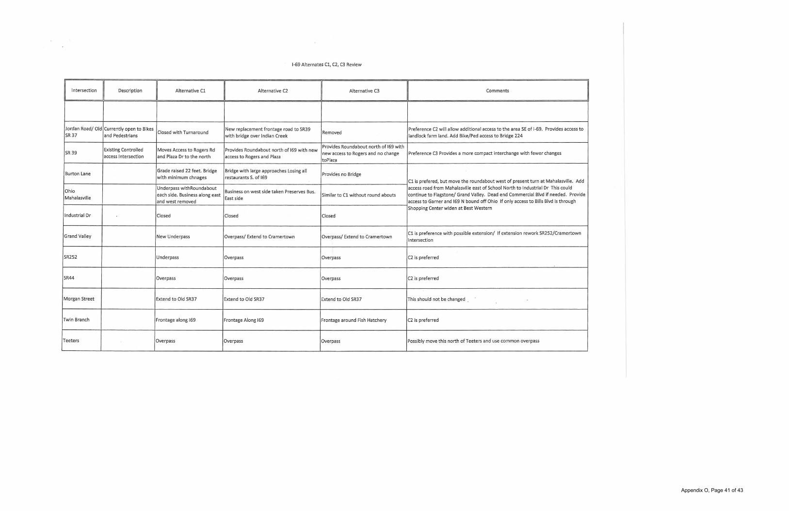
1-69 Alternates Cl, C2, C3 Review
Intersection Description
I Alternative Cl
II Alternative C2
II Alternative C3
I Comments
Jordan Road/ Old Currently open to Bikes Closed with Turnaround
New replacement frontage road to SR39 Preference C2 will allow additional access to the area SE of 1-69. Provides access to SR 37 and Pedestrians with bridge over Indian Creek
Removed land lock farm land. Add Bike/Ped access to Bridge 224
Existing Controlled Moves Access to Rogers Rd Provides Roundabout north of 169 with new Provides Roundabout north of 169 with
SR 39 new access to Rogers and no change Preference C3 Provides a more compact interchange with fewer changes access Intersection and Plaza Dr to the north access to Rogers and Plaza
toPlaza
Burton Lane Grade raised 22 feet. Bridge Bridge with large approaches Losing all
Provides no Bridge with minimum chnages restaurants S. of 169
Cl is prefered, but move the roundabout west of present turn at Mahalasville. Add
Ohio Underpass withRoundabout
Business on west side taken Preserves Bus. access road from Mahalasville east of School North to Industrial Dr This could
Mahalasville each side. Business along east
East side Similar to Cl without round abouts continue to Flagstone/ Grand Valley. Dead end Commercial Blvd if needed. Provide
and west removed access to Garner and 169 N bound off Ohio If only access to Bills Blvd is through
Shopping Center widen at Best Western
Industrial Dr Closed Closed Closed
Grand Valley New Underpass Overpass/ Extend to Cramertown Overpass/ Extend to Cramertown Cl is preference with possible extension/ If extension rework SR252/Cramertown
Intersection
SR252 Underpass Overpass Overpass C2 is preferred
SR44 Overpass Overpass Overpass C2 is preferred
Morgan Street Extend to Old SR37 Extend to Old SR37 Extend to Old SR37 This should not be changed .
Twin Branch Frontage along 169 Frontage Along 169 Frontage around Fish Hatchery C2 is preferred
Teeters Overpass Overpass Overpass Possibly move this north of Teeters and use common overpass
Appendix O, Page 41 of 43

Myra Lane Overpass Overpass Overpass
Country Club Connection to Morgan St Connection to Morgan St Connection to Morgan St
NOLD SR37 Bridge to Egbert/ Daigonal
C3 is preferred as it takes less farm ground or possibly remove bridge and add Maple Turn
Extend and bridge to Egbert Extend and bridge to Egbert frontage to Hendersonford.
Hendersonford Intersection Intersection Intersection
Ennis Road Closed New frontage to Hendersonford and Cragen New frontage to Hendersonford C2 is preferred as it will provide greater Connectivity; Access to farnland needs to
be provided west of 169
New Bridge with connection to C2 is preferred as it will provide greater Connectivity
New Harmony 9 Hendersonford New Bridge
Cragen Closed Closed Closed
New Bridge and frontage Rd to Gravel is currently being mined on the west side of 169. This will require the new
Perry Old SR37 New Bridge and frontage Rd to Old SR37 Closed section of frontage road . Cl or C2 is preferred
Big Bend Overpass Overpass Overpass West of 169 poor width and alignment widen to Old SR 37
Waverly Frontage to Whiteland Overpass Frontage to Waverly The extisting Waverly Rd north to Old SR37 is poorly designed- widen
The extisting Waverly Rd north to Old SR37 is poorly designed- widen; New
Whiteland Overpass Frontage to Waverly Overpass Harmony to the east needs to have vertical alignment improved.
Banta Closed Closed Closed
A frontage road to SR144 would provide a good access to the area SE of 169 and
Huggin Hollow eliminate traffic on Old SR37. Also promote development in the SE quad of SR 144
Rd Closed Closed Closed interchange. Would provide access to the winery on Whiteland Rd.
OLD SR37 at This intersection should have a traffic study completed as it may need a signal with SR144 N/A N/A N/A the increased amount of traffic redirected to the roadway.
Appendix O, Page 42 of 43

Appendix O, Page 43 of 43