appendix j historic architecture report€¦ · the significance of all historic architecture...
TRANSCRIPT
APPENDIX J HISTORIC ARCHITECTURE REPORT

Colusa Generating Station Application for Certification Table of Contents
R:\06 CPV Colusa\Appendix J.doc November 2006
TABLE OF CONTENTS
Appendix J1 Historic Architecture Report (2001)
Appendix J2 Historic Properties Inventory and Evaluation Report (2006)

APPENDIX J1 HISTORIC ARCHITECTURE REPORT (2001)

APPENDIX J
HISTORIC ARCHITECTURE REPORT for
COLUSA POWER PLANT PROJECT COLUSA COUNTY, CALIFORNIA
Prepared by: Michael Corbett and Denise Bradley URS Corporation 221 Main Street, Suite 600 San Francisco, California 94105 Prepared for: Reliant Energy
January 2001 R:\06 CPV Colusa\Appendix J From 01.doc

Colusa Power Plant Appendix J Historic Architecture Report Application for Certification Table of Contents
R:\06 CPV Colusa\Appendix J From 01.doc November 1, 2006
TABLE OF CONTENTS
Page
J.1 PROJECT DESCRIPTION............................................................................................. J-1
J.2 RESEARCH METHODS ................................................................................................ J-1 J.2.1 Field Methods..................................................................................................... J-1 J.2.2 Research Methods ............................................................................................. J-1
J.3 HISTORICAL CONTEXTS ............................................................................................. J-4 J.3.1 Irrigation and the Development of Colusa County.............................................. J-4 J.3.2 Electric Power Transmission .............................................................................. J-6
J.4 FINDINGS ...................................................................................................................... J-7 J.4.1 Two 230 kV Transmission Lines......................................................................... J-7 J.4.2 Glenn-Colusa Canal and Glenn-Colusa Irrigation District .................................. J-8 J.4.3 Small Animal Feeder .......................................................................................... J-8 J.4.4 Ranch Buildings on Section 1 ............................................................................ J-9 J.4.5 Farm on Section 6 ............................................................................................ J-10 J.4.6 Teresa Creek Bridge ........................................................................................ J-10 J.4.7 Conclusions...................................................................................................... J-11
J.4.7.1 Two 230 kV Transmission Lines........................................................... J-11 J.4.7.2 Glenn-Colusa Canal and GCID ............................................................ J-12
J.5 BIBLIOGRAPHY .......................................................................................................... J-12
FIGURES
Figure J-1 Area of Potential Effects Map Figure J-2 Location of Historic Architecture Resources Greater than 45 Years of Age within
Area of Potential Effects
ATTACHMENT
Attachment J1 DPR 523 Records

Colusa Power Plant Appendix J Application for Certification Historic Architecture Report
R:\06 CPV Colusa\Appendix J From 01.doc Page J-1 November 1, 2006
J.1 PROJECT DESCRIPTION
The proposed Colusa Power Plant Project (CPP) is a 500 MW combined cycle power plant to be located in northernmost Colusa County adjacent to the Glenn County line, in northern California. It is approximately 4 miles northwest of the historic settlement of Delevan and 8 miles north of the municipality of Maxwell, west of Interstate 5. The topography consists of low rolling hill and basins that flank the northwest portion of the Sacramento Valley region.
The proposed plant site location is in the southwest corner of the 200-acre project area. The plant site and switchyard area and associated construction laydown areas encompass approximately 62 acres. The project will be fueled with natural gas that will be delivered to the power plant site via an approximately 1,700-foot-long natural gas fuel line connecting to an existing natural gas pipeline on the southeast side of the PG&E Compressor Station site. A proposed 2,000-foot-long water supply pipeline will extend from an intake structure on the side of the existing Tehama-Colusa Canal and transport water easterly to connect with the power plant. The proposed transmission line interconnection corridor will interconnect the plant site and run northeasterly to the existing north-south oriented electrical transmission line system along the eastern edge of the project area.
J.2 RESEARCH METHODS
The purpose of this report is to provide a summary of the evaluation of the significance of the historic architecture properties that are greater than 45 years of age. The significance of all historic architecture properties that pre-date 1957 were evaluated using the National Register of Historic Places (NRHP) and California Register of Historical Resources (CRHR) criteria.
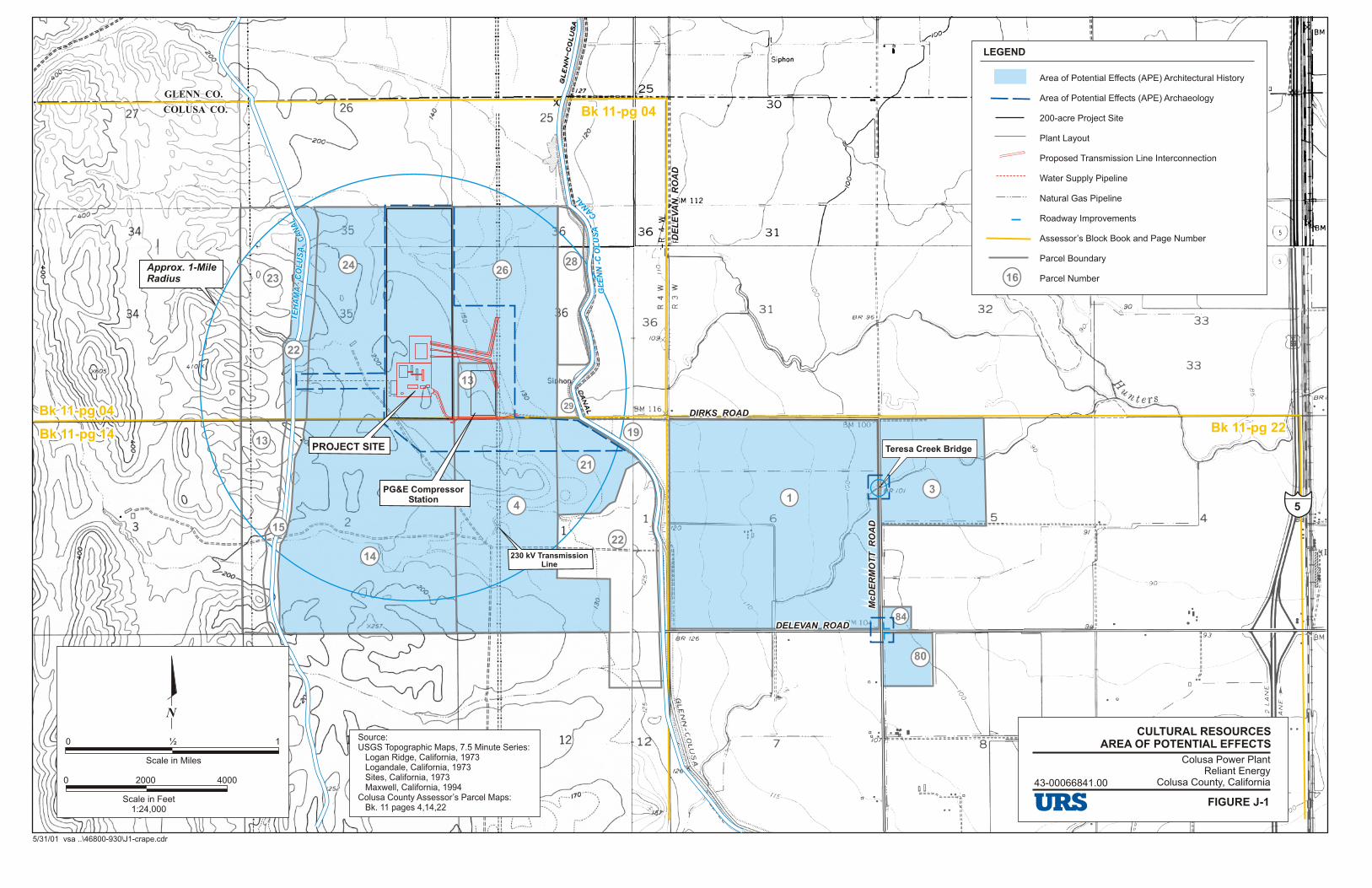
The Area of Potential Effects (APE) for this project was established in consultation with Gary Reinoehl (California Energy Commission), Denise Heick (Project Manager, URS Corporation), and Denise Bradley (Senior Landscape Historian, URS Corporation) on April 3, 2001. The APE consists of parcels of land that either border or contain project actions. Additionally, the project area was reviewed to identify any properties that pre-date 1957 that were within a one-mile radius of the proposed project site and that would have views of the proposed project facility; this was to consider visual effects to historic architectural properties. See Figure J-1 for the APE Map.
J.2.1 FIELD METHODS
Brian Vahey took photographs of the properties within the APE and surrounding vicinity on March 8 and 11, 2001. A survey of the APE and surrounding area was conducted by Jody Stock (Architectural Historian) March 13, 14, and 20, 2001 to take field notes used in the preparation of the DPR 523 records (Attachment J1). A survey of the APE was conducted by Michael Corbett (Senior Architectural Historian, URS Corporation) and Denise Bradley on April 6, 2001. Additional field notes and photographs were taken on that date.
J.2.2 RESEARCH METHODS
Research for this report was conducted for three different purposes: preliminary research, research for the historical overview, and research on the individual properties. Research was conducted in March and April 2001.
Preliminary research included a literature review and record search of historic literature and maps, and federal, state, and local inventories of historic properties. The following list includes libraries, other repositories, and sources of information that were consulted or contacted and the subjects that were researched:

Colusa Power Plant Appendix J Application for Certification Historic Architecture Report
R:\06 CPV Colusa\Appendix J From 01.doc Page J-2 November 1, 2006
Colusa County Agricultural Agency for rice farming history.
Colusa County Assessor’s Office, Colusa, California for APN maps and information.
Colusa County Historical Commission (Kathy Moran) for Colusa County history.
Colusa County Planning Department, Colusa, California for building permits.
Colusa County Public Records, Colusa, California for background information on the area and the Glenn-Colusa Canal.
Colusa County Public Works Department (Jon Wrysinski) for Colusa County history, including bridges and rice farming.
Colusa County Recorder (Wylie Anderson) for survey and subdivision maps.
Christopher Doerr (Garcia & Associates) for a report on an evaluation of a portion of the transmission line from the Pit 1 Power Plant.
Earth Sciences Library, University of California, Berkeley for historic maps.
Glenn-Colusa Irrigation District, Willows, California (Ben Tennock) for information on the Glenn-Colusa Canal and Glenn-Colusa Irrigation District (GCID) and general history of the region and a map of the Delevan Unit of the GCID.
Glenn County Assessor’s Office, Willows, California for APN maps and information.
Glenn County Planning Department, Willows, California for building permits.
Pacific Gas & Electric Company (Stan Mishoika) for history of transmission lines.
San Francisco Public Library for information on Colusa County history.
State Board of Equalization Assessors Office for information on transmission lines.
Water Resources Archives, University of California, Berkeley for information on the Glenn-Colusa Canal.
The following list includes persons or agencies that were contacted but from which no information or reply has yet been received:
Depue Warehouse Company (Kevin Dennis) for history of rice warehouse in Delevan (waiting for response as of April 27, 2001)
Emerald Farms (Allan Etchepare) for information on farm located within APE (waiting for response as of April 27, 2001)
Holthouse Water District for district history (waiting for response as of April 27, 2001)
Pacific Gas & Electric Company (Jim Clausen) for information on bridge over Glenn-Colusa Canal at Dirks Road (waiting for response as of April 27, 2001)
Colusa Power Plant Appendix J Application for Certification Historic Architecture Report
R:\06 CPV Colusa\Appendix J From 01.doc Page J-3 November 1, 2006
Additionally, the book Where Water Is King: The Story of Glenn Colusa Irrigation District by Cynthia F. Davis (1984) provided an excellent source of information and contextual history for the development of the area and the Glenn-Colusa Irrigation District. The newly revised Water Conveyance Systems in California, Historic Context Development and Evaluation Procedures prepared jointly by JRP Historical Consultants and the California Department of Transportation (Caltrans, 2000) was consulted for contextual information on irrigation districts and for the evaluation of the Glenn-Colusa Canal and GCID.
The portions of the 230 kV transmission lines that are located within the APE for this project are part of a larger system that historically delivered electricity from the Pit 1 Power Plant to the San Francisco Bay area via transmission lines that ran from Pit 1 to the Cottonwood Substation and then to the Vaca-Dixon Substation. This line was online by 1922. National Register of Historic Places and California Register of Historical Resources Evaluation of CA-SHA-2939-H and CA-SHA-2920-H, Shasta County, California (Hair, 2000) evaluated a segment of the 230 kV transmission line (Trinomial CA-SHA-2939-H) that runs from the Pit 1 Power Plant to the Cottonwood substation, approximately 59 miles away. This report was consulted for information on its historical context, evaluation of the transmission line, and references and for information on the plans for the original transmission towers used in the ca. 1920 construction, contained in Appendix C and labeled as “Pit River 220,000 Volt Transmission Line, Mt Shasta Power Corp (PG&E Co).” These plans were designed by Frank G. Baum, Chief Engineer with PG&E. Two of the plans – “Standard Tower, 220 K.V. Transmission Line” and “Type ‘M’ Tower, 222K.V. Line” – appear similar to the towers located within the APE for the Colusa Power Plant project.
Hair found the transmission line from Pit 1 to the Cottonwood Substation (Trinomial CA-SHA-2939-H) to be significant under NRHP criterion A and CRHR criterion 1 “because of the significant effect the Pit 1 Hydroelectric Development had on the development of the San Francisco Bay region” and under NRHP criterion C and CRHR criterion 3 “for its revolutionary engineering feat of transmitting high voltage electricity over a great distance” (Hair, 2000: 12). No period of significance was established. The transmission line does not retain its integrity because “Most of the original towers have been replaced…,” and it is not eligible for NRHP or CRHR. (Hair, 2000: 13)
The report by Duncan Hay and Michael Corbett, Historic Resources Assessment Report for the Pit 1 Hydroelectric Project, Shasta County, California, revised draft (1992), was reviewed for its historical context on the development of electrical generation and transmission and the evaluation of the Pit 1 Power Plant. Hay and Corbett found the Pit 1 Power Plant eligible for the NRHP under criteria A and C:
“The Pit 1 Hydroelectric Plant appears eligible for the National Register under Criteria A and C. Under Criterion A, it is significant at the local level for its impact on local economic and social life, replacing much of the old agricultural economy and ending the isolation of the area from the mainstream of the State. And it is significant at the State level for its place in the hydroelectric development of the State, representing the beginning of the hydroelectric development of a major river by PG&E and the confidence of an era of growth. Under Criterion C, it is significant at the national level for its engineering and architecture, with one of the largest generating capacities of its day and an unusual degree of embellishment of its plant, in comparison with hydroelectric plants around the country. The whole system was unified by an architectural idea, focused on the power house. The result was a powerful visual image that represented the importance of Pit 1 to PG&E and to the development of hydroelectric power in California. In addition, it represents the work of Frank Baum, one of the leading hydroelectric engineers of his day in the United States.
The following features of the Pit 1 Hydroelectric Plant appear to be contributors to its significance: the transformer yard, power house, generating machinery, Fall River
Colusa Power Plant Appendix J Application for Certification Historic Architecture Report
R:\06 CPV Colusa\Appendix J From 01.doc Page J-4 November 1, 2006
diversion dam, Intake No. 1, canal, tunnel, surge tank and spillway, valve house, penstocks, tail race, and towers for transmission lines A and B. The following appear to be non-contributors: the forebay dam, intake, forebay, transformers, and towers for transmission line C.” (Hay and Corbett, 1992, Appendix Historic Resources Inventory Form for the Pit No. 1 Power Plant: 5)
It should be noted that the transmission towers that contribute to Pit 1’s significance are those located immediately adjacent to the Pit 1 Power Plant.
Standard references were consulted in the preparation of this report: National Register Bulletin 15: How to Apply the National Register Criteria for Evaluation was used in evaluating properties under NRHP criteria; CEQA Guideline Summary: Historical Resource Sections 15064.5, 15126.4, 15325, 15332, Appendix G (California Office of Historic Preservation, 1999) was used in applying the California Register of Historical Resources criteria; and Instructions for Nominating Historical Resources to the California Register of Historical Resources (California Office of Historic Preservation, 1997) was used in preparing the Historical Resources Inventory (DPR 523) records.
Jody Stock (Architectural Historian, B.S., Architectural Studies, Preservation, 1995, University of Utah) and Roxana Khakpour (Architect, URS Corporation; B.A. Architecture, 1996, University of California Berkeley) conducted research. Stock also prepared the historical context for irrigation and Colusa County.
Michael Corbett (Senior Architectural Historian, URS Corporation) evaluated the properties within the APE, prepared the DPR 523 records, and wrote the historical context on transmission lines. Corbett (Ph.D. Candidate, History of Architecture, University of California Berkeley and A.B., 1973, Anthropology and American Studies, Princeton University) has over 27 years of experience as an architectural historian and has particular expertise in the history of the built environment in California. He meets the Secretary of the Interior’s standards for professionals for historians and architectural historians.
Denise Bradley (Senior Landscape Historian, URS Corporation) assisted Corbett in the evaluation of the Glenn-Colusa Canal and GCID and prepared the technical report for historic architecture. Bradley (Master of Landscape Architecture, 1986, Louisiana State University and B.S., Agriculture, 1979, the University of Tennessee) has over 15 years of experience in historic resources analysis and has worked in California since 1993. She meets the Secretary of the Interior’s standards for professionals for historians and historical landscape architects.
J.3 HISTORICAL CONTEXTS
J.3.1 IRRIGATION AND THE DEVELOPMENT OF COLUSA COUNTY
The project area is located to the west of the small town of Delevan. The history of this area is related to the development of ranching, farming, and irrigation within the west Sacramento Valley. In 1849, the gold rush brought miners to the area, many of whom stayed once they were unable to make a living searching for gold. They found that the climate made the Sacramento Valley amenable to farming, but seasonal water supplies limited the crops to dry farming, primarily wheat, and ranching.
By the 1880s wheat farming had become less profitable for several reasons. First, the intensive dry farming was beginning to deplete the soil, and crops were thinning. Second the completion of the transcontinental railroad reduced the West’s dependence on locally grown wheat. Finally, a drought in 1898 drove many farmers to abandon farming and the Sacramento Valley.

Colusa Power Plant Appendix J Application for Certification Historic Architecture Report
R:\06 CPV Colusa\Appendix J From 01.doc Page J-5 November 1, 2006
William S. Green, one of the founders of Colusa, envisioned revolutionizing agriculture in the area by constructing a major canal that would divert water from the Sacramento River to the farms along the western side of the Sacramento Valley. Not all landowners in the area were convinced of the need for a canal, but the passage of the Wright Irrigation District Act on March 7, 1887 by the state legislature encouraged the formation of irrigation districts by giving them powers similar to those of municipalities. On November 22, 1887, the Central Irrigation District was founded in Colusa County (Glenn County was part of Colusa County until 1891) and construction on the Central Canal began.
Litigation over rights-of-way soon hampered the project, construction stopped, and portions of the canal were not built. The fate of the Central Irrigation District was not unique; most of the 49 districts proposed under the Wright Act were never completed (Davis 1984: 13-15). In 1897 a new law, the Bridgeford Act, was adopted that made forming irrigation districts easier. In 1903 the Central Canal and Irrigation Company purchased the works, with the hopes of irrigating a smaller area. Despite its progress on the canal, the Central Canal and Irrigation Company had financial troubles similar to those of the Central Irrigation District (JRP and Caltrans 2000: 23).
On June 15, 1909, the Kuhn banking firm from Pittsburgh founded the Sacramento Valley Irrigation Company, which purchased the Central Canal and Irrigation District (Davis 1984: 30). After the Kuhn bank failed in 1915, the Sacramento Valley West Side Canal Company was in receivership with the State Railroad Commission fixing the rates. During these years farmers discovered that rice could be grown on the alkaline and heavy clay soils. However, the fields had to be flooded during the growing season, a practice that required massive amounts of water.
Land adapted to rice culture consists of any soil with tight subsoil in which losses from seepage are minimal, especially as the land is continuously flooded during the growing season. To keep rice fields constantly covered during the growing season, water must be supplied at the fields in sufficient quantity to provide for evaporation losses, for transpiration from the growing plants, and for consumers’ waste from imperfect regulation of the supply (Supplement Report).
Although it demanded lots of water, rice farming was attractive to many farmers, because prices were high due to a tremendous demand caused by World War I. Unfortunately, the existing irrigation system was inadequate to meet the increased demand, and the State Railroad Commission would not increase rates to pay for expansion (Davis 1984:63).
During this period, several other counties in the Sacramento Valley were organizing irrigation districts. By 1929, there were 15 irrigation districts in the valley between Sacramento and Redding. Over half of these were constructed between 1916 and 1919 during the years of the great expansion of the rice industry (Supplement). Landowners within the boundaries of the Central Irrigation District also organized and had the goal of purchasing and then expanding the system. A committee named the organization the Glenn-Colusa Irrigation District. Although some landowners protested the purchase (and the fees that would be levied), the organization overcame opposition through legal means and purchased the system from the Sacramento Valley West Side Canal Company for $1,000,000 in 1920 (JRP and Caltrans 2000: 23).
The canal was finally finished, but the weather and the economy combined to deal the district a serious blow. In 1920 rice crops were lost due to an early and continuous rain that resulted in the “Crash of 1920.” Ten years later, the Great Depression further devastated farmers. Holders of poorer lands increasingly were delinquent on their payments to the irrigation district, Reclamation District 2047, and taxes to the county. Those unable to pay lost their land. The irrigation and reclamation districts became rich in land but poor in fees. In the late 1930s Charles Lambert headed the reorganization of district lands and the sale of the property back to farmers at low prices. Options to buy went first to those who had lost their lands. World War II increased demand for grains, and once again rice was a profitable crop. The

Colusa Power Plant Appendix J Application for Certification Historic Architecture Report
R:\06 CPV Colusa\Appendix J From 01.doc Page J-6 November 1, 2006
war years were a period of growth for the towns of Colusa County many of the farming structures with the project area were built at that time.
In the 1950s, the Bureau of Reclamation constructed the Shasta Dam and questioned Glenn-Colusa Irrigation District’s water rights. Litigation ensued and the Secretary of the Interior finally settled the disagreement in 1964 in favor of the district. In the 1960s, agriculture continued to be the major industry in Glenn and Colusa counties. Gross receipts in Colusa County in 1965 were $29,786,500 from field crops, followed by fruits and nuts at $6,123,000, and livestock at $5,431,000 (“Map of Colusa County California, Colusa County Chamber of Commerce” 1966). Today the land surrounding the project area is used for rice farming and for growing all types of vegetables.
J.3.2 ELECTRIC POWER TRANSMISSION
The earliest hydroelectric generating plants in the United States were built in the 1880s and 1890s. These were generally of two different types. In the eastern United States, steam-powered generating plants provided most of the power, with the remainder provided from hydroelectric facilities. Both types of plants were located near the consumers of electricity and required short transmission lines with low voltages. In the west, hydroelectric plants provided a much greater share of electric power. However, these hydroelectric plants were located far from cities — in California, they were in the Sierra Nevada — and required long transmission lines with high voltages. For new transmission lines to operate successfully at greater distances, new technologies were developed.
In the 1890s, systems were built that were generally ten to twenty miles long. In 1899, an 83-mile-long line was built in southern California, and in 1900, a 142-mile-long system was built from the Sierra Nevada to Oakland. By 1915, at least two lines were over 200 miles long. This early period of hydroelectric development culminated in more efficient transmission systems in the early 1920s, among the first of which was the transmission line from the Pit 1 power plant in Shasta County to the Vaca-Dixon substation in Solano County. This line was built southwest from Pit 1 to the Cottonwood substation near Redding. From Cottonwood, it ran south, through the APE for this project in Glenn and Colusa counties to Vaca-Dixon.
At Vaca-Dixon the power was fed into the San Francisco Bay area distribution systems.
“To carry power from the Pit River to users in the San Francisco Bay Area, engineer Frank G. Baum designed a 220,000 volt transmission system. It is more efficient to transmit electricity over long distances at high voltages, but the power is also more difficult to control. Baum designed PG&E’s Pit River project as a 220 kV system from the outset with all of its components arranged to handle voltages that had not yet been tested commercially. When Pit 1 first went on line its output, combined with that of the Hat Creek plants, went out at 110 kV, matching the voltage of existing PG&E high tension lines. Voltage was stepped up to 175 kV in 1923 (?), to 220 kV after the 70,000 KW line went in. At the time it started up, its machinery was similar to that of scores of other plants built throughout the country in the late 1910s and 1920s, except in one respect – it was larger than most, and in particular, its transmission system operated at a record voltage.
Since it was completed, changes to Pit 1 and its parts have been relatively minor. The most significant changes were made in 1946 when a new dam and a second intake were built creating a forebay to store water for use in times in high demand. . .
The larger Pit River system was expanded with the construction of Pit 3 in 1925, followed by several other plants, all downstream of Pit 1. In 1967, a new substation was

Colusa Power Plant Appendix J Application for Certification Historic Architecture Report
R:\06 CPV Colusa\Appendix J From 01.doc Page J-7 November 1, 2006
built at Round Mountain in the lower Pit River valley as part of the development of an intertie system linking northern and southern California with transmission lines of increased capacity. This ended the original relationship between Pit 1 and the Vaca-Dixon substation.” (Hay and Corbett 1992, Appendix Historic Resources Inventory Form for the Pit No. 1 Power Plant: 4-5)
J.4 FINDINGS
Within the APE, there are six properties that are at least 45 years of age. None of these had been previously evaluated for significance under NRHP or CRHR criteria. These six properties include the following:
Two 230 kV transmission lines; The Glenn-Colusa Canal and portions of the Delevan Unit of the Glenn-Colusa Irrigation District; A small animal feeder located in APN 11-14-21; A group of ranch buildings located in APN 11-14-4; A farmstead located in APN 11-22-1; and The Teresa Creek Bridge.
See Figure J-2 for the location of these properties within the APE. See Appendix J1 for DPR 523 records for all of these properties.
J.4.1 TWO 230 kV TRANSMISSION LINES
This property consists of two parallel north-south high voltage (230 kV) electrical power transmission lines, each consisting of steel towers, insulators, and conductors (connecting cables). Each tower carries two circuits (Mishioka, pers. comm., 2001). The towers in the two parallel lines are similar but not identical. The base of each tower flares outward to four legs. The upper part of each tower is vertical and supports three crossarms, each of which carries a hanging insulator at each end. The conductors are strung from the insulators.
A small portion of these two transmission lines — approximately two miles — is located within the APE for this project. From the Pacific Gas and Electric Company (PG&E) Compressor Station, located within the APE, the transmission lines run north to the Cottonwood Substation (approximately 72 miles away) and south to the Vaca-Dixon Substation (approximately 70 miles away) (Mishioka, pers. comm., 2001).
As discussed above in Section J.3.2, during the early 1920s, a transmission line was built from the Pit 1 Power Plant in Shasta County to the Vaca-Dixon substation in Solano County. This line was built southwest from Pit 1 to the Cottonwood substation near Redding. From Cottonwood, it ran south, through the APE for this project in Glenn and Colusa counties to Vaca-Dixon.
Because significant portions of the line have been rebuilt, it is not clear whether the portions that are located within the APE for this project are original. The sections of the two 230 kV transmission lines that are located within the APE are part of a larger system that transmitted power from the Pit 1 Power Plant to the Bay Area. Specifically the sections of the two 230 kV transmission lines that are located within the APE are part of the transmission lines between the Cottonwood and Vaca-Dixon substations. The sections of the transmission lines with the APE are not individually significant. However, if either of the transmission lines between the Cottonwood and Vaca-Dixon substations were significant, then these sections may have significance as contributing features to the larger property.

Colusa Power Plant Appendix J Application for Certification Historic Architecture Report
R:\06 CPV Colusa\Appendix J From 01.doc Page J-8 November 1, 2006
An evaluation of the transmission lines between the Cottonwood and Vaca-Dixon substations has not been done. However, this system would appear to have the potential to be significant under NRHP criteria A and/or C. Potential areas of significance would be in the development of electrical power in northern California, its impact on the development of the economy, as an example of transmission line engineering in the 1920s, and as an example of the work of engineer Frank Baum, one of the leading hydroelectric engineers of his day in the United States. Before the eligibility of either of the transmission lines could be determined, more research would be required to more fully assess the significance within the appropriate historical contexts, to document the history of the properties, to establish a period of significance, and to document the integrity of the character defining features. Following this, the contributing status of the sections of the transmission lines within the APE could then be established.
J.4.2 GLENN-COLUSA CANAL AND GLENN-COLUSA IRRIGATION DISTRICT
The Glenn-Colusa Irrigation District (GCID) provides irrigation water to 175,000 acres of farmland in Glenn and Colusa counties. The Glenn-Colusa Canal, the main water distribution canal for the GCID, diverts water from the Sacramento River at a point just east of the town of Artois. Water travels southwesterly through the roughly 65-mile canal. The canal finally terminates just south of the town of Williams near Interstate 5.
A portion of the GCID’s Delevan Unit irrigation infrastructure, including interconnections, ditches, valves, concrete turnouts and gates, and a bridge at Dirks Road, are located within the APE for this project. The interconnections, ditches, and various concrete diversion structures appear to date from the original irrigation district construction (ca. 1920s). The bridge at Dirks Road dates from ca. 1960 when it was built or renovated at the same time that the gas pipeline was built to the PG&E compressor (Wrysinski, pers. comm., 2001).
A one-and-a-half to two-mile portion of the Glenn-Colusa Canal is located within or borders the APE for this project. The canal is dirt lined with rock or rubble riprap at the bridge abutment at Dirks Road. There is a levee on either side of the canal and a dirt maintenance road on top of each levee.
The portions of the Glenn-Colusa Canal and other GCID features that are within the APE are part of a larger property — the GCID. The portions of the canal and irrigation system within the APE are not individually significant. However, if either the Glenn-Colusa Canal or the GCID were significant, then these portions may have significance as contributing features to the overall canal or irrigation system.
An evaluation of the GCID or Glenn-Colusa Canal has not been done. However, the GCID and the Glenn-Colusa Canal would appear to have the potential to be significant under NRHP criteria A and/or C. Potential areas of significance would be in the development of irrigation districts and irrigation infrastructure in the Sacramento Valley, development of twentieth-century farming in Colusa County, and/or as an example of early twentieth-century irrigation engineering. Before the NRHP eligibility of either the GCID or Glenn-Colusa Canal could be determined, more research would be required to more fully assess the significance of these properties within appropriate historical contexts, to document the history of the properties, to establish a period of significance, and to document the integrity of the features of the properties. Following this, the contributing status of the portions the GCID system within the APE could then be established.
J.4.3 SMALL ANIMAL FEEDER
The property located on APN 11-14-21 is a 77.87-acre parcel that is a fenced pasture devoid of buildings except for one small structure — a movable small animal feeder. The feeder is a rectangular wood structure built on skids so that it can be moved by being dragged behind a tractor or other vehicle. Viewed from a few feet away behind a barbed wire fence, it appears to be a wood-frame structure with one-foot-

Colusa Power Plant Appendix J Application for Certification Historic Architecture Report
R:\06 CPV Colusa\Appendix J From 01.doc Page J-9 November 1, 2006
wide boards nailed to its frame except at the base of the long sides where the boards are omitted for a trough. The feeder is covered by a broad gable roof that overhangs the sides to protect feeding animals from the weather. The structure appears to be about 3 feet wide, 15 feet long, and 5 feet high to the ridge. Steel posts in the ground around it indicate that, at one time, the feeder was separately enclosed by a fence.
As a small portable structure, this feeder has never appeared on U.S. Geological Survey (USGS) maps. Neither is its history known from any other source. It is assumed to be a small animal feeder from its size - it is too small to have served adult cattle. It appears to be the right size for calves or sheep. Judging from its structure and materials as viewed from a few feet away, it appears to have been built in the 1950s or later.
This small animal feeder does not appear eligible for the NRHP. Although its date of construction is unknown, it probably does not meet the normal age criteria of 50 years for eligibility to the NRHP. Moreover, it is an isolated structure of ordinary construction. Additionally, this structure does appear to be significant under CRHR criteria. For purposes of CEQA, this structure is not a historic resource.
J.4.4 RANCH BUILDINGS ON SECTION 1
The property located on Assessor’s Parcel Number 11-14-4 west of the Glenn-Colusa Canal occupies 360 acres in Section 1 of Township 17 north, Range 4 west. This property has been accessible by dirt road since at least 1904 when the USGS map showed roads from the east, west, and south converging in this section. The roads from the east and south provided links to the Southern Pacific Railroad and to an east-west route to Lake County, respectively. The road from the west went only as far as the next section. In the absence of any mines or buildings of any sort, this property and the surrounding area appear to have functioned as wheat farms or ranch land in the early twentieth century. Unlike roads in agricultural areas on lower land to the east that followed section lines, these ranch roads provided access to higher grazing land — presumably summer pastures. The same conditions were shown on the 1917 USGS map.
The next record of the property, a 1943 USGS map, showed a high voltage electric power transmission line running north-south through this property in section 1. The only building shown in the vicinity of the property at that time was indicated on the west side of the boundary between sections 1 and 2. No evidence of further changes within the parcel appear until the 1958 USGS map which showed farm structures at the ends of dirt roads in sections 3 and 35, to the west and northwest, respectively. The building previously shown on the boundary between sections 1 and 2 was not shown, and there were still no buildings or structures shown on this property. Thus, the buildings and structures now standing on the property all appear to have been built after 1960. One collapsed building may be older.
There are no structures on the property except for a cluster of seven features in the center, near the western boundary of this irregular parcel. These features include three buildings, one water tank structure, one manufactured home, one abandoned truck with a water tank mounted on its bed, and one collapsed building.
The three buildings, the tank structure, and the manufactured home appear to be post-1960. The truck appears to be a model manufactured between 1928 and the end of the 1930s; it is not known how long it has been at this site. The collapsed building’s date of construction is unknown. The site appears little used and is overgrown with weeds. Dilapidated fences and abandoned machinery are also located on the property.
These ranch buildings do not appear to be eligible for the NRHP. Six of the seven major features appear to have been built on this property or moved to it after 1960 and do not meet the normal age threshold of 50 years. One structure, of uncertain date, has collapsed and is not addressed under criteria A, B, or C.
Colusa Power Plant Appendix J Application for Certification Historic Architecture Report
R:\06 CPV Colusa\Appendix J From 01.doc Page J-10 November 1, 2006
Although the land itself (before any structures were built on it) appears to have been associated with the early wheat and ranching history of the area, the buildings and structures that are now standing were built long after that period. There is no evidence that the property meets criteria consideration G for resources that are less than 50 years old but possess exceptional significance. Additionally, this property does appear to be significant under CRHR criteria. For purposes of CEQA, this property is not a historic resource.
J.4.5 FARM ON SECTION 6
This property occupies a section of land consisting of 635 acres, on which are grown row crops which succeeded rice in the 1990s. This is a square parcel bordered on all four sides by section line roads, including Delevan Road on the south and west, McDermott Road on the east, and Dirks Road on the north. A cluster of six buildings and structures near the center of the property is approached by two driveways, from the south and west. Just beyond this property on the west side is the Glenn-Colusa Canal. The building cluster includes two dwellings, a domestic garage, a barn, a farm vehicle garage, and a building that appears to be a bunkhouse. All of the buildings, except the garage, appear to date from ca. 1945 based on visual appearance. The garage appears to be less than 45 years of age.
Frances M. Etchepare and trustees have owned the property since July 1992. From March 17, 1964 to 1992, the property was owned by Ruth S. Sevier.
This farm property in Section 6 of Township 17 North/Range 4 West (APN 11-22-1) does not appear eligible for the NRHP. Under criterion A, it is one of many farms established in northern Colusa County in the 1940s for rice farming. Many similar farms survive today, visible from public roads. The property lacks significance under criterion A.
Under criterion C, this is a typical example of a common type of mid–twentieth-century farm in northern California. The property lacks significance under criterion C.
Additionally, this property does not appear to be significant under CRHR criteria. For purposes of CEQA, this is not a historic property.
J.4.6 TERESA CREEK BRIDGE
The Teresa Creek Bridge is located on McDermott Road about 0.7 mile north of the intersection with Delevan Road. The bridge spans Teresa Creek, a branch of Hunter’s Creek. McDermott Road is a two-lane, asphalt-surfaced road on a section line. The road provides access to farmland in a rural part of northern Colusa County. In 1977, the average daily traffic was 200 vehicles. According to the American Civil Engineer’s Handbook of 1930 (p. 1174), this was a secondary road and the bridge was classified as a Class C bridge. The bridge is 20.4 feet long and 24 feet wide with a 15-foot-wide roadway. It was designed for one lane of traffic.
This is a wood bridge that spans between concrete abutments — by definition, a “simple bridge,” as distinct from more complex types of bridges classified as continuous, cantilever, arch, and suspension bridges. A 1980 California Department of Transportation report (Burgan, 1980) described it as follows: “Timber deck, on timber stringers, on RC wing abutments.” According to the American Civil Engineer’s Handbook (Merriman, 1930, p. 1668), “Wooden bridges resting on concrete piers and abutments are in very common use.” The abutments are poured concrete structures with the exposed imprints of formboards, straight sides, and a curb-like base. The west faces of these abutments are cracked and spalling where they meet the flow of water in the creek. The abutments are spanned by 3- by 8-inch wood stringers 18.4 feet long. The deck consists of two layers: 4- by 8-inch timbers laid across the
Colusa Power Plant Appendix J Application for Certification Historic Architecture Report
R:\06 CPV Colusa\Appendix J From 01.doc Page J-11 November 1, 2006
stringers, and a top layer of boards and asphalt. The deck of the bridge is flat and flush with the road. The east and west sides of the bridge have curbs made of 10- × 10-inch timbers.
The Teresa Creek Bridge is located on a section line road that appeared on a 1906 USGS map. The current bridge was built about 1940, apparently replacing an earlier structure. A 1949 Thomas Brothers map showed this bridge in an area served by a network of improved roads. The bridge was repaired in 1959.
In 1980, a California Department of Transportation Bridge Report (Burgan, 1980) described it as follows: “The structure is in poor condition . . .. The planks are very worn. Outer stringers have some incipient rot, near ends.” A handwritten note on the Bridge Report stated: “Removed from biennial inspection process in re letter dated 10-10-85.”
The Teresa Creek Bridge does not appear eligible for the NRHP. Under criterion A, it was one of many bridges built on secondary roads in rural agricultural areas of Colusa County in the 1920s through the 1940s. These bridges were associated with the development of rice farming in the Glenn-Colusa Irrigation District. As one of many surviving bridges in this area, this lacks significance.
Under criterion C, this is a common type of simple bridge. Because many of these survive in the area, this bridge lacks significance.
Additionally, the Teresa Creek Bridge does not appear to be significant under CRHR criteria. For purposes of CEQA, this bridge is not a historic property.
J.4.7 CONCLUSIONS
Of the six properties evaluated for NRHP and CRHR significance, four do not appear be eligible for the NRHP or have significance under CRHR criteria. These include the
small animal feeder located in APN 11-14-21; group of ranch buildings located on Section 1 (APN 11-14-4); farmstead located on Section 6 (APN 11-22-1); and Teresa Creek Bridge.
For the purposes of CEQA, these four properties are not historic resources.
The two remaining properties within the APE are small sections of larger properties, and for both more research would be required to provide a complete evaluation. These properties are described below.
J.4.7.1 Two 230 kV Transmission Lines
The sections of the two 230 kV transmission lines that are located within the APE are part of a larger system that transmitted power from the Pit 1 Power Plant to the Bay Area. Specifically the sections of the two 230 kV transmission lines that are located within the APE are part of the transmission lines between the Cottonwood and Vaca-Dixon substations. The sections of the transmission lines with the APE are not individually significant. However, if either of the transmission lines between the Cottonwood and Vaca-Dixon substations were significant, then these sections may have significance as contributing features to the larger property.
An evaluation of the transmission lines between the Cottonwood and Vaca-Dixon substations has not been done. However, this system would appear to have the potential to be significant under NRHP criteria A and/or C. Potential areas of significance would be in the development of electrical power in

Colusa Power Plant Appendix J Application for Certification Historic Architecture Report
R:\06 CPV Colusa\Appendix J From 01.doc Page J-12 November 1, 2006
northern California, its impact on the development of the economy, as an example of transmission line engineering in the 1920s, and as an example of the work of engineer Frank Baum, one of the leading hydroelectric engineers of his day in the United States. Before the eligibility of either of the transmission lines could be determined, more research would be required to more fully assess the significance within the appropriate historical contexts, to document the history of the properties, to establish a period of significance, and to document the integrity of the character defining features. Following this, the contributing status of the sections of the transmission lines within the APE could then be established.
J.4.7.2 Glenn-Colusa Canal and GCID
The portions of the Glenn-Colusa Canal and other GCID features that are within the APE are part of a larger property — the GCID. The portions of the canal and irrigation system within the APE are not individually significant. However, if either the Glenn-Colusa Canal or the GCID were significant, then these portions may have significance as contributing features to the overall canal or irrigation system.
An evaluation of the GCID or Glenn-Colusa Canal has not been done. However, the GCID and the Glenn-Colusa Canal would appear to have the potential to be significant under NRHP criteria A and/or C. Potential areas of significance would be in the development of irrigation districts and irrigation infrastructure in the Sacramento Valley, development of twentieth-century farming in Colusa County, and/or as an example of early twentieth-century irrigation engineering. Before the NRHP eligibility of either the GCID or Glenn-Colusa Canal could be determined, more research would be required to more fully assess the significance of these properties within appropriate historical contexts, to document the history of the properties, to establish a period of significance, and to document the integrity of the features of the properties. Following this, the contributing status of the portions the GCID system within the APE could then be established.
J.5 BIBLIOGRAPHY
Maps
“Assessor Parcel Map.” Maps. 14-18-0-011-00. Glenn County Assessors Office, Willows, CA.
“Assessor Plat Maps for Colusa County.” Maps. Book 11 pages 4, 5, 14, and 22. Glenn County Assessors Office, Willows, CA.
“Assessor Plat Maps for Glenn County.” Maps. Book 14 pages 16-18. Glenn County Assessors Office, Willows, CA.
Delevan Unit of the Glenn-Colusa Irrigation District.” n.d. Photocopy of portion of larger map provided by Ben Tennock, Glenn-Colusa Irrigation District.
“Map of Colusa County California, Colusa County Chamber of Commerce.” Map. 1966. Earth Sciences Library, University of California, Berkeley.
“Map of the Glenn-Colusa Irrigation District: Glenn & Colusa Counties, California.” Map. 1956. Water Resources Archives, University of California, Berkeley.
“Metsker’s Map of Colusa County California.” Map. 1960. Earth Sciences Library, University of California, Berkeley.
“Official Chamber of Commerce Map of Colusa County and Its Communities.” Map. 1988. Earth Sciences Library, University of California, Berkeley.

Colusa Power Plant Appendix J Application for Certification Historic Architecture Report
R:\06 CPV Colusa\Appendix J From 01.doc Page J-13 November 1, 2006
“Rand McNally Map of Colusa County.” Map. 1962. Earth Sciences Library, University of California, Berkeley.
“State of California, The Resources Agency, Department of Conservation, Division of Forestry, Colusa County.” Map. 1947. Earth Sciences Library, University of California, Berkeley.
“Thomas Bros. Map of Colusa County California.” Map. 1946. Earth Sciences Library, University of California, Berkeley.
“Title Insurance and Trust Map of Colusa County and Its Cities.” Map. 1978. Earth Sciences Library, University of California, Berkeley.
United States Geological Survey. “Sites Quad.” Map. 1904 revised.
United States Geological Survey. “Colusa Quad.” Map. 1907.
United States Geological Survey. “Sites Quad.” Map. 1917 revised.
United States Geological Survey. “Colusa Quad.” Map. 1973.
United States Geological Survey. “Lodoga Quad.” Map. 1943.
United States Geological Survey. “Lodoga Quad.” Map. 1958 revised.
United States Geological Survey. “Lodoga Quad.” Map. 1960.
United States Geological Survey. “Maxwell Quad.” Map. January 1906 reprinted 1936.
United States Geological Survey. “Maxwell Quad.” Map. 1952.
United States Geological Survey. “Maxwell Quad.” Map. 1952-1954.
United States Geological Survey. “Maxwell Quad.” Map. 1973.
United States Geological Survey. “Maxwell Quad.” Map. 1994 revised.
“WAC-96CA.” Aerial photograph. 6 April 1996.
Texts
Adams, Frank, 1929. Irrigation Districts in California, Bulletin No. 21. Sacramento: State of California Department of Public Works.
Baum, Frank G. “The Pit River Power and 220,000-Volt Transmission Problem.” Electrical World, 27 January 1923, 81: 205-12.
Blair, Lynda, 1994. An Evaluation of Eighteen Historic Transmission Line Systems That Originate from Hoover Dam, Clark County, Nevada. Prepared for Los Angeles Department of Water and Power.
“Blueprint Bridge Plans & Specifications,” 1915. Index located at Colusa County Archives.
Bradley, Denise, and Michael Corbett, 1996. Rural Historic Landscape Report for Reclamation District 1000. Chico, CA: Dames & Moore, Inc., January 1996.

Colusa Power Plant Appendix J Application for Certification Historic Architecture Report
R:\06 CPV Colusa\Appendix J From 01.doc Page J-14 November 1, 2006
Burgan, R.W., P.E. (C.E. #9268), 1980. Bridge Report on Bridge No. 15C-167. California Department of Transportation. 31 January 1980.
California Office of Historic Preservation, 1997. Instructions for Nominating Historical Resources to the California Register of Historical Places. Sacramento, CA. August 1997.
California Office of Historic Preservation, 1999. Guideline Summary: Historical Resource Sections 15064.5, 15126.4, 15325, 15332, Appendix G. Sacramento, CA. January 1999.
Coleman, Charles M. PG&E of California. New York: McGraw Hill. 1952.
Cramer, Cecile B, 1993. “Water History in the Making.” Wagon Wheels 1 (1983): 4.
Davis, Cynthia F., 1984. Where Water is King. Willows, CA: Glenn-Colusa Irrigation District.
Davis, Edwin F., 1960. “Charles F. Lambert, and Irrigation in the Sacramento Valley.” Wagon Wheels IX:1 (1960): 1.
Donohoe, Charles L. and Frank Freeman, no date. “Petition of Central Canal and Irrigation Company to the War Department of the United States for Permission . . .” Willows, CA.
Gudde, Erwin G, 1969. California Place Names. Berkeley: University of California Press.
Hair, Jennifer M. National Register of Historic Places and California Register of Historical Resources Evaluation of CA-SHS-2939-H an dCA-SHA-29020-H, Shasta County, California. Prepared by Garcia and Associates for Ogden Environment and Energy Services. October 2000.
Hanna, Phil Townsend, 1946. The Dictionary of California Land Names. Los Angeles: Automobile Club of Southern California.
Hay, Duncan, 1991. Hydroelectric Development in the United States, 1880-1940. Washington, D.C.: Edison Electric Institute.
Hay Duncan and Michael R. Corbett, 1992. Historic Resources Assessment Report for the Pit 1 Hydroelectric Project, Shasta County, California, revised draft. Prepared for the Pacific Gas & Electric Company by Dames & Moore.
Jollyman, J.P. “The Purpose and Problems of 220,000-Volt Transmission.” Journal of Electricity and Western Industry, 15 August 1922, 49: 131-33.
JRP Historical Consulting Services and California Department of Transportation, 2000. Water Conveyance Systems in California: Historic Context Development and Evaluation Procedures. Davis and Sacramento, CA, December 2000.
Kelley, Robert, 1989. Battling the Inland Sea. Berkeley and Los Angeles, CA: University of California Press.
Knowlton, Archer E., editor, 1957. Standard Handbook for Electrical Engineers, 9th edition. New York: McGraw Hill.
Kyly, Douglas E. et al., 1990. Historic Spots in California, 4th edition. Stanford: Stanford University Press.
Colusa Power Plant Appendix J Application for Certification Historic Architecture Report
R:\06 CPV Colusa\Appendix J From 01.doc Page J-15 November 1, 2006
Matthew, Raymond, Manager, no date. “Report to the Honorable Board of Directors of the Glenn-Colusa Irrigation District on Operation Maintenance and Construction Work 1922-1923.” Manuscript. Available at the Water Resources Archives, University of California, Berkeley.
Merriman, Thaddeus, editor, 1930. American Civil Engineers’ Handbook, fifth edition. New York: John Wiley & Sons.
Mikesell, Stephen D., 1990 Historic Bridges of California. [Sacramento]: California Department of Transportation.
Northern California Atlas & Gazetteer, 1986. Freeport, Maine: DeLorme Publishing Company.
“Orland Project California,” 2001. http://dataweb.usbr.gov/html/orland.html. March 2, 2001.
Pisani, Donald J., 1984. From the Family Farm to Agribusiness: The Irrigation Crusade in California and the West, 1850-1931. Berkeley and Los Angeles, CA: University of California Press.
“Pumping Plant Dedication and Water Rights Centennial,” 1985. Wagon Wheels 1 (1985): 24.
“Report on Proposed Contract between Williams Irrigation District and Glenn-Colusa Irrigation District.” 1922. Manuscript. Cope, Rand, Means Co. Part of Means Collection at the Water Resources Archives, University of California, Berkeley. January 1922.
“Report to the Board of Directors of the Glenn-Colusa Irrigation District,” 1921. Project Report 20 No. 118, June 1921. Part of Means Collection at the Water Resources Archives, University of California, Berkeley.
Rogge, A.E. (Gene), Michael Corbett, and Lori Hunsaker, 1997. Cultural Resources Survey for the McCullough-Liberty Fiber Optics Project. Dames & Moore. International Cultural Resource Services Research Paper No. 41. Phoenix.
Scott, W.A. “202 Miles of Transmission Lines to Operate at 220,000 Bolts.” Engineering World, March 1922.
Stene, Eric A, 1994. “Central Valley Project: Sacramento River Division.” Bureau of Reclamation History Program. http://dataweb.usbr.gov/html/sacriver.html.
“Supplement Report: Connection between Glenn-Colusa Main Canal and Williams Irrigation District,” 1922. Manuscript. Part of Means Collection at the Water Resources Archives, University of California, Berkeley. April 24, 1922.
Urquhart, Leonard Church, editor, 1950. Civil Engineering Handbook, third edition. New York: McGraw-Hill.
Personal Communications
Anderson, Wylie (Colusa County Assessors Office). Interview with Roxana Khakpour. 12 and 20 April 2001.
Anderson, Wylie (Colusa County Assessors Office). Telephone conversation with Roxana Khakpour. 20 April 2001
Colusa County Agricultural Agency. Telephone conversation with Roxana Khakpour. 20 April 2001.

Colusa Power Plant Appendix J Application for Certification Historic Architecture Report
R:\06 CPV Colusa\Appendix J From 01.doc Page J-16 November 1, 2006
Doerr, Christopher (Garcia & Associates). Telephone conversation with Michael Corbett. 26 April 2001.
Etchepare, Jean. Telephone conversation with Michael Corbett. 25 April 2001.
Mishioka, Stan (PG&E). Telephone conversation with Roxana Khakpour. 26 April 2001.
Mishioka, Stan (PG&E). Telephone conversation with Michael Corbett, 1 and 2 May 2001.
Moran, Kathy (Colusa County Historical Commission). Interview with Jody Stock. 20 March 2001.
Moran, Kathy (Colusa County Historical Commission). Interview with Roxana Khakpour. 20 April 2001.
Tennock, Ben (Glenn-Colusa Irrigation District). Telephone conversation with Roxana Khakpour. 12 April 2001.
Thuemler, Nancy (Colusa County Assessors Office). Interview with Jody Stock. 14 March 2001.
Wrysinski, Jon (Colusa County Department of Public Works). Interview with Jody Stock. 14 March 2001.
Wrysinski, Jon (Colusa County Department of Public Works). Interview with Roxana Khakpour. 12 April 2001.
Wrysinski, John (Colusa County Department of Public Works). Telephone conversation with Roxana Khakpour. 23 April 2001.
Bk 11-pg 22Bk 11-pg 22
Bk 11-pg 04Bk 11-pg 04
Bk 11-pg 04Bk 11-pg 04
Bk 11-pg 14Bk 11-pg 14
14
4
21
19
13
2623
24 28
22
13
13
80
84
29
43-00066841.00
Colusa Power PlantReliant Energy
Colusa County, California
CULTURAL RESOURCES AREA OF POTENTIAL EFFECTS
FIGURE J-1
N
Source: USGS Topographic Maps, 7.5 Minute Series: Logan Ridge, California, 1973 Logandale, California, 1973 Sites, California, 1973 Maxwell, California, 1994Colusa County Assessor’s Parcel Maps: Bk. 11 pages 4,14,22
5/31/01 vsa ..\46800-930\J1-crape.cdr
0 ½ 1
Scale in Miles
0 2000 4000
Scale in Feet1:24,000
Approx. 1-Mile Radius
DIRKS ROADDIRKS ROAD
DELEVAN ROADDELEVAN ROAD
DE
LE
VA
N R
OA
DD
EL
EV
AN
R
OA
D
Mc
DE
RM
OT
T R
OA
DM
cD
ER
MO
TT
R
OA
D
5
SG
LE
NN
-C
OL
UA
SG
LE
NN
-C
OL
UA
CNAL
AC
NAL
A
AA
CN
LA
AC
NL
TE
HA
MA
- C
OL
US
A
TE
HA
MA
- C
OL
US
A
Teresa Creek Bridge
GLENN CO.GLENN CO.
COLUSA CO.COLUSA CO.
PG&E CompressorStation
230 kV TransmissionLine
15
22
PROJECT SITE
LEGEND
Area of Potential Effects (APE) Architectural History
Area of Potential Effects (APE) Archaeology
200-acre Project Site
Plant Layout
Proposed Transmission Line Interconnection
Water Supply Pipeline
Natural Gas Pipeline
Roadway Improvements
Assessor’s Block Book and Page Number
Parcel Boundary
Parcel Number16

Bk 11-pg 22Bk 11-pg 22
Bk 11-pg 04Bk 11-pg 04
Bk 11-pg 04Bk 11-pg 04
Bk 11-pg 14Bk 11-pg 14PROJECT SITE
14
4
21
19
13
2623
24 28
22
13
13
80
84
29
43-00066841.00
Colusa Power PlantReliant Energy
Colusa County, California
LOCATION OF HISTORIC ARCHITECTURAL RESOURCES
GREATER THAN 45 YEARS OF AGEWITHIN AREA OF POTENTIAL EFFECTS
FIGURE J-2
N
Source: USGS Topographic Maps, 7.5 Minute Series: Logan Ridge, California, 1973 Logandale, California, 1973 Sites, California, 1973 Maxwell, California, 1994Colusa County Assessor’s Parcel Maps: Bk. 11 pages 4,14,22
5/31/01 vsa ..\46800-930\J2-histarch.cdr
0 ½ 1
Scale in Miles
0 2000 4000
Scale in Feet1:24,000
Approx. 1-Mile Radius
DIRKS ROADDIRKS ROAD
DELEVAN ROADDELEVAN ROAD
DE
LE
VA
N R
OA
DD
EL
EV
AN
R
OA
D
Mc
DE
RM
OT
T R
OA
DM
cD
ER
MO
TT
R
OA
D
5
SG
LE
NN
-C
OL
UA
SG
LE
NN
-C
OL
UA
CNAL
AC
NAL
A
AA
CN
LA
AC
NL
TE
HA
MA
- C
OL
US
A
TE
HA
MA
- C
OL
US
A
Teresa Creek Bridge
GLENN CO.GLENN CO.
COLUSA CO.COLUSA CO.
PG&E CompressorStation
230 kV TransmissionLine
15
22
LEGEND
Area of Potential Effects (APE) Architectural History
200-acre Project Site
Plant Layout
Proposed Transmission Line Interconnection
Water Supply Pipeline
Natural Gas Pipeline
Roadway Improvements
Assessor’s Block Book and Page Number
Parcel Boundary
Parcel Number16
A
B
C
D
E
F
230 kV Transmission Line
Glenn-Colusa Canal and Irrigation District
Small Animal Feeder
Ranch Buildings in Section 1
Farmstead in Section 6
Teresa Creek Bridge
Historic Architectural Resources Greater Than 45 Years of Age
A
B
C
E
F
D
ATTACHMENT J1
DPR 523 RECORDS
January 2001 R:\06 CPV Colusa\Appendix J From 01.doc
State of California — The Resources Agency Primary # DEPARTMENT OF PARKS AND RECREATION HRI # PRIMARY RECORD Trinomial NRHP Status Code 4S1 Other Listings Review Code Reviewer Date
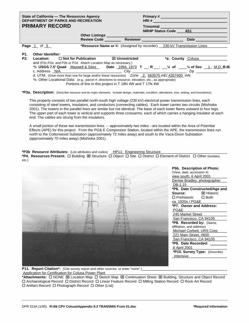
Page 1 of 5 *Resource Name or #: (Assigned by recorder) 230 kV Transmission Lines P1. Other Identifier: P2. Location: Not for Publication ⌧ Unrestricted *a: County Colusa and (P2c,P2e, and P2b or P2d. Attach Location Map as necessary.) *b. USGS 7.5' Quad Maxwell & Sites Date 1994, 1973 T ; R ; ¼ of ¼ of Sec 1 ; M.D. B.M. c. Address N/A City Zip d. UTM: (Give more than one for large and/or linear resources) Zone 2; 563570 mE/ 4357400 mN *e. Other Locational Data: (e.g., parcel #, directions to resource, elevation, etc., as appropriate) Portions of line in this project in T 18N 4W and T 17N 4W *P3a. Description: (Describe resource and its major elements. Include design, materials, condition, alterations, size, setting, and boundaries)
*P3b Resource Attributes: (List attributes and codes) HP11: Engineering Structure
This property consists of two parallel north-south high voltage (230 kV) electrical power transmission lines, each consisting of steel towers, insulators, and conductors (connecting cables). Each tower carries two circuits (Mishioka 2001). The towers in the parallel lines are similar but not identical. The base of each tower flares outward to four legs. The upper part of each tower is vertical and supports three crossarms, each of which carries a hanging insulator at each end. The cables are strung from the insulators. A small portion of these two transmission lines -- approximately two miles --are located within the Area of Potential Effects (APE) for this project. From the PG& E Compressor Station, located within the APE, the transmission lines run north to the Cottonwood Substation (approximately 72 miles away) and south to the Vaca-Dixon Substation (approximately 70 miles away) (Mishioka 2001).
*P4. Resources Present: Building ⌧ Structure Object Site District Element of District Other (isolates, etc.)
P5b. Description of Photo: (View, date, accession #) view south, 6 April 2001 Denise Bradley, photographer DB-1:15 *P6. Date Constructed/Age and Source: ⌧ Historic
Prehistoric Both ca. 1920s / PG&E *P7. Owner and Address: PG&E 245 Market Street San Francisco, CA 94105 *P8. Recorded by: (Name, affiliation, and address) Michael Corbett, URS Corp 221 Main Street, #600 San Francisco, CA 94105 *P9. Date Recorded: 6 April 2001 *P10. Survey Type: (Describe) intensive
P11. Report Citation*: (Cite survey report and other sources, or enter "none".) Application for Certification for Colusa Power Plant *Attachments: NONE ⌧ Location Map Sketch Map ⌧ Continuation Sheet ⌧ Building, Structure and Object Record
Archaeological Record District Record Linear Feature Record Milling Station Record Rock Art Record Artifact Record Photograph Record Other (List)
DPR 523A (1/95) R:\06 CPV Colusa\Appendix 8.3 TRANSMIS From 01.doc *Required Information

State of California — The Resources Agency Primary # DEPARTMENT OF PARKS AND RECREATION HRI # BUILDING, STRUCTURE, AND OBJECT RECORD Page 2 of 5 *NRHP Status Code 4S1 *Resource Name or # (Assigned by recorder) 230 kV Transmission Lines B1. Historic Name: unknown B2. Common Name: PG&E Transmission Lines B3. Original Use: transmission lines B4. Present Use: transmission lines *B5. Architectural Style: utilitarian *B6. Construction History: (Construction date, alterations, and date of alterations) ca. 1920s one line second line unknown construction date. *B7. Moved? ⌧ No Yes Unknown Date: Original Location: *B8. Related Features: none B9a. Architect: unknown b. Builder: unknown *B10. Significance: Theme Area Period of Significance Property Type Applicable Criteria NA (Discuss importance in terms of historical or architectural context as defined by theme, period, and geographic scope. Also address integrity.) History
The earliest hydroelectric generating plants in the United States were built in the 1880s and 1890s. These were generally of two different types. In the eastern United States, steam powered generating plants provided most of the power, with the remainder provided from hydroelectric facilities. Both types of plants were located near the consumers of electricity and required short transmission lines with low voltages. In the west, hydroelectric plants provided a much greater share of electric power. However, these hydroelectric plants were located far from cities – in California, they were in the Sierra Nevada – and required long transmission lines with high voltages. For new transmission lines to operate successfully at greater distances, new technologies were developed. See Continuation Sheet
B11. Additional Resource Attributes: (List attributes and codes) *B12. References: (Sketch map with north arrow required) See continuation sheet B13. Remarks: *B14. Evaluator: Michael Corbett Date of Evaluation: 25 April 2001
(This space reserved for official comments.)
DPR 523B (1/95) R:\06 CPV Colusa\Appendix 8.3 TRANSMIS From 01.doc *Required Information

DPR 523L (1/95) R:\06 CPV Colusa\Appendix 8.3 TRANSMIS From 01.doc *Required Information
State of California — The Resources Agency Primary # DEPARTMENT OF PARKS AND RECREATION HRI/Trinomial CONTINUATION SHEET Page 3 of 5 Resource Identifier: 230 kV Transmission Lines Recorded by Michael R. Corbett *Date 25 April 2001 ⌧ Continuation Update History (continued) In the 1890s, systems were built that were generally ten to twenty miles long. In 1899, an 83-mile-long line was built in southern California, and in 1900, a 142-mile-long system was built from the Sierra Nevada to Oakland. By 1915, at least two lines were over 200 miles long. This early period of hydroelectric development culminated in more efficient transmission systems in the early 1920s, among the first of which was the transmission line from the Pit 1 power plant in Shasta County to the Vaca-Dixon substation in Solano County. This line was built southwest from Pit 1 to the Cottonwood substation near Redding. From Cottonwood, it ran south through the Area of Potential Effects (APE) for this project in Glenn and Colusa counties to Vaca-Dixon. At Vaca-Dixon, the power was fed into the San Francisco Bay area. Because significant portions of the line have been rebuilt, it is not clear whether the portion that is located within the APE for this project is original.
To carry power from the Pit River to users in the San Francisco Bay Area, engineer Frank G. Baum designed a 220,000 volt transmission system. It is more efficient to transmit electricity over long distances at high voltages, but the power is also more difficult to control. Baum designed PG&E’s Pit River project as a 220 kV system from the outset with all of its components arranged to handle voltages that had not yet been tested commercially. When Pit 1 first went on line its output, combined with that of the Hat Creek plants, went out at 110 kV, matching the voltage of existing PG&E high tension lines. Voltage was stepped up to 175 kV in 1923 (?), to 220 kV after the 70,000 kW line went in. At the time it started up, its machinery was similar to that of scores of other plants built throughout the country in the late 1910s and 1920s, except in one respect – it was larger than most, and in particular, its transmission system operated at a record voltage. Since it was completed, changes to Pit 1 and its parts have been relatively minor. The most significant changes were made in 1946 when a new dam and a second intake were built creating a forebay to store water for use in times in high demand... The larger Pit River system was expanded with the construction of Pit 3 in 1925, followed by several other plants, all downstream of Pit 1. In 1967, a new substation was built at Round Mountain in the lower Pit River valley as part of the development of an intertie system linking northern and southern California with transmission lines of increased capacity. This ended the original relationship between Pit 1 and the Vaca-Dixon substation.” (Hay and Corbett 1992, Appendix Historic Resources Inventory Form for the Pit No. 1 Power Plant: 4-5).
Evaluation The sections of the two 230kV transmission lines that are located within the APE are part of a larger system that transmitted power from the Pit 1 Power Plant to the Bay Area. Specifically the sections of the two 230 kV transmission lines that are located within the APE are part of the transmission lines between the Cottonwood and Vaca-Dixon substations. The sections of the transmission lines with the APE are not individually significant. However, if either of the transmission lines between the Cottonwood and Vaca-Dixon substations were significant, then these sections may have significance as contributing features to the larger property. An evaluation of the transmission lines between the Cottonwood and Vaca-Dixon substations has not been done. However, this system would appear to have the potential to be significant under NRHP criteria A and/or C. Potential areas of significance would be in the development of electrical power in northern California, its impact on the development of the economy, as an example of transmission line engineering in the 1920s, and as an example of the work of engineer Frank Baum, one of the leading hydroelectric engineers of his day in the United States. Before the eligibility of either of the transmission lines could be determined, more research would be required to more fully assess the significance within the appropriate historical contexts, to document the history of the properties, to establish a period of significance, and to document the integrity of the character defining features. Following this, the contributing status of the sections of the transmission lines within the APE could then be established. References Baum, Frank G. “The Pit River Power and 220,000-Volt Transmission Problem.” Electrical World, 27 January 1923, 81: 205-12. Blair, Lynda. An Evaluation of Eighteen Historic Transmission Line Systems That Originate from Hoover Dam, Clark County, Nevada. Prepared for Los Angeles Department of Water and Power, 1994. Coleman, Charles M. PG&E of California. New York: McGraw Hill. 1952.

DPR 523L (1/95) R:\06 CPV Colusa\Appendix 8.3 TRANSMIS From 01.doc *Required Information
State of California — The Resources Agency Primary # DEPARTMENT OF PARKS AND RECREATION HRI/Trinomial CONTINUATION SHEET Page 4 of 5 Resource Identifier: 230 kV Transmission Lines Recorded by Michael R. Corbett *Date 25 April 2001 ⌧ Continuation Update References (continued) Doerr, Christopher (Garcia & Associates). Telephone conversation with Michael Corbett. 26 April 2001. Hair, Jennifer M. National Register of Historic Places and California Register of Historical Resources Evaluation of CA-SHS-2939-H an dCA-SHA-29020-H, Shasta County, California. Prepared by Garcia and Associates for Ogden Environment and Energy Services. October 2000. Hay, Duncan. Hydroelectric Development in the United States, 1880-1940. Washington, D.C.: Edison Electric Institute, 1991. Hay Duncan and Michael R. Corbett. Historic Resources Assessment Report for the Pit 1 Hydroelectric Project, Shasta County, California, revised draft. Prepared for the Pacific Gas & Electric Company by Dames & Moore. 1992. Jollyman, J.P. “The Purpose and Problems of 220,000-Volt Transmission.” Journal of Electricity and Western Industry, 15 August 1922, 49: 131-33. Knowlton, Archer E., editor. Standard Handbook for Electrical Engineers, 9th edition. New York: McGraw Hill, 1957. Mishioka, Stan, PG&E. Telephone conversation with Roxana Khakpour (URS Corp.). 26 April 2001. Mishioka, Stan (PG&E). Telephone conversation with Michael Corbett (URS Corp.), 1 and 2 May 2001. Northern California Atlas & Gazetteer. Freeport, Maine: DeLorme Publishing Company, 1986. Rogge, A.E. (Gene), Michael Corbett, and Lori Hunsaker. Cultural Resources Survey for the McCullough-Liberty Fiber Optics Project. Dames & Moore. International Cultural Resource Services Research Paper No. 41. Phoenix, 1997. Scott, W.A. “202 Miles of Transmission Lines to Operate at 220,000 Bolts.” Engineering World, March 1922.
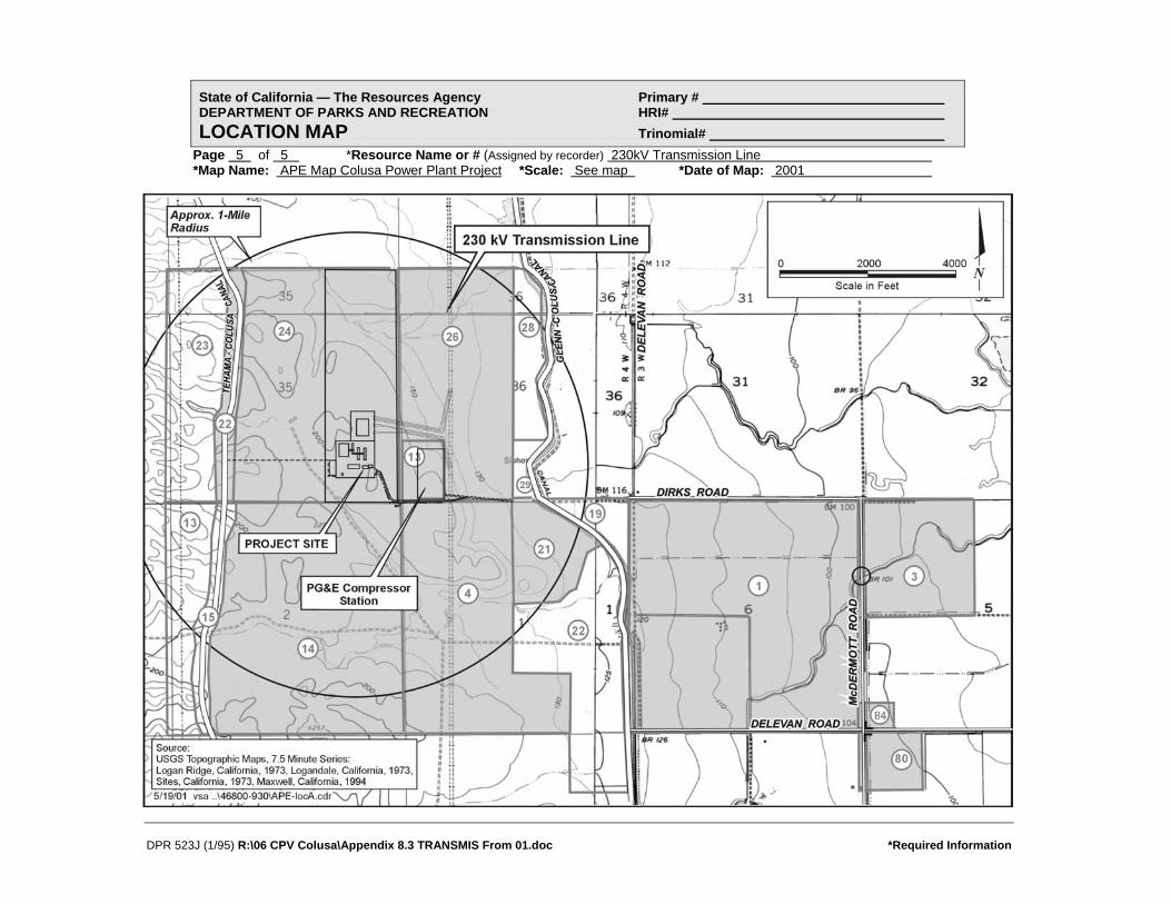
State of California — The Resources Agency Primary # DEPARTMENT OF PARKS AND RECREATION HRI# LOCATION MAP Trinomial#
Page 5 of 5 *Resource Name or # (Assigned by recorder) 230kV Transmission Line *Map Name: APE Map Colusa Power Plant Project
DPR 523J (1/95) R:\06 CPV Colusa\Appendix 8.3 TRANSMIS From 01.doc *Required Information
*Scale: See map *Date of Map: 2001

State of California — The Resources Agency Primary # DEPARTMENT OF PARKS AND RECREATION HRI # PRIMARY RECORD Trinomial NRHP Status Code 4S1 Other Listings Review Code Reviewer Date
Page 1 of 8 *Resource Name or #: (Assigned by recorder) Glenn-Colusa Canal and Irrigation District P1. Other Identifier: P2. Location: Not for Publication ⌧ Unrestricted *a: County Glenn County and (P2c, P2e, and P2b or P2d. Attach Location Map as necessary.) *b. USGS 7.5' Quad Maxwell & Sites Date 1994 & 1973 T ; R ; ¼ of ¼ of Sec ; M.D. B.M. c. Address N/A City Maxwell Zip 95955 d. UTM: (Give more than one for large and/or linear resources) Zone 2; 564240 mE/ 4357140 mN *e. Other Locational Data: (e.g., parcel #, directions to resource, elevation, etc., as appropriate) canal and irrigation features located in vicinity of APNs 11-14-21, 11-22-1, 11-22-3, 11-22-84, 11-22-80 *P3a. Description: (Describe resource and its major elements. Include design, materials, condition, alterations, size, setting, and boundaries)
*P3b Resource Attributes: (List attributes and codes) HP20: Canal
The Glenn-Colusa Irrigation District (GCID) provides irrigation water to 175,000 acres of farmland in Glenn and Colusa counties. The Glenn-Colusa Canal, the main water distribution canal for the GCID, diverts water from the Sacramento River at a point just east of the town of Artois. Water travels through the roughly 65-mile canal southwesterly. The canal finally terminates just south of the town of Williams near Interstate-5. A portion of the GCID’s Delevan Unit irrigation infrastructure, including laterals, ditches, valves, concrete gates, and a bridge at Dirks Road, are located within the Area of Potential Effects (APE) for this project. The laterals, ditches, and various concrete diversion structures appear to date from the original irrigation district construction (ca. 1920s). The bridge at Dirks Road dates from ca. 1960 when it was built or renovated at the same time that the gas pipeline was built to the PG&E compressor (Wrysinski 2001). See continuation sheet
*P4. Resources Present: Building ⌧ Structure Object Site District Element of District Other (isolates, etc.)
P5b. Description of Photo: (View, date, accession #) view north of Canal near Dirks Road; Brian Vahey, photographer 11 March 2001, BRV-2:8 *P6. Date Constructed/Age and Source: ⌧ Historic
Prehistoric Both ca. 1920/GCID *P7. Owner and Address: Glenn-Colusa Irrigation District P.O. Box 150 Willows, CA 95988 *P8. Recorded by: (Name, affiliation, and address) J. Stock and M. Corbett URS Corp 221 Main Street, #600 San Francisco, CA 94105 *P9. Date Recorded: 14 March and 6 April 2001 *P10. Survey Type: (Describe) Intensive
P11. Report Citation*: (Cite survey report and other sources, or enter "none".) Application for Certification of Colusa Power Plant *Attachments: NONE ⌧ Location Map Sketch Map ⌧ Continuation Sheet ⌧ Building, Structure and Object Record
Archaeological Record District Record Linear Feature Record Milling Station Record Rock Art Record Artifact Record Photograph Record Other (List)
DPR 523A (1/95) R:\06 CPV Colusa\Appendix 8.3 CANAL From 01.doc *Required Information

State of California — The Resources Agency Primary # DEPARTMENT OF PARKS AND RECREATION HRI/Trinomial CONTINUATION SHEET Page 2 of 8 Resource Identifier: Glenn-Colusa Canal and Irrigation District Recorded by Jody Stock/Michael Corbett *Date 25 April 2001 ⌧ Continuation Update Description (continued) A one and one half to two mile portion of the Glenn-Colusa Canal is located within or borders the APE for this project. The canal is dirt lined with rock or rubble rip rap at the bridge abutment at Dirks Road. There is a levee on either side of the canal and a dirt maintenance road on top of each levee.
Photo 2. View NW of Canal and Bridge at Dirks Road, 11 March 2001. BRV 2:7. Brian Vahey, photographer.
Photo 3. View of typical ditch and concrete diversion structure located on east side of McDermott Road south of Delevan Road; 6 March 2001. DB 1:5. Denise Bradley, photographer.
DPR 523L (1/95) R:\06 CPV Colusa\Appendix 8.3 CANAL From 01.doc *Required Information
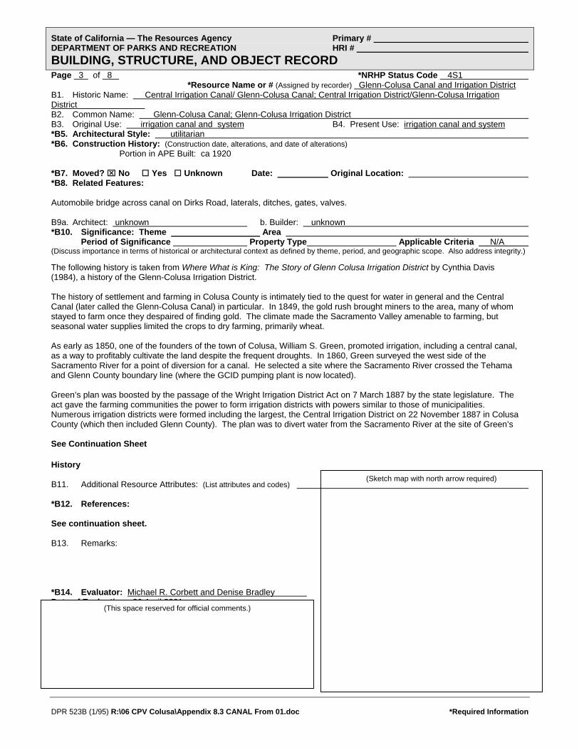
State of California — The Resources Agency Primary # DEPARTMENT OF PARKS AND RECREATION HRI # BUILDING, STRUCTURE, AND OBJECT RECORD Page 3 of 8 *NRHP Status Code 4S1
*Resource Name or # (Assigned by recorder) Glenn-Colusa Canal and Irrigation District B1. Historic Name: Central Irrigation Canal/ Glenn-Colusa Canal; Central Irrigation District/Glenn-Colusa Irrigation District B2. Common Name: Glenn-Colusa Canal; Glenn-Colusa Irrigation District B3. Original Use: irrigation canal and system B4. Present Use: irrigation canal and system *B5. Architectural Style: utilitarian *B6. Construction History: (Construction date, alterations, and date of alterations) Portion in APE Built: ca 1920 *B7. Moved? ⌧ No Yes Unknown Date: Original Location: *B8. Related Features: Automobile bridge across canal on Dirks Road, laterals, ditches, gates, valves. B9a. Architect: unknown b. Builder: unknown *B10. Significance: Theme Area Period of Significance Property Type Applicable Criteria N/A (Discuss importance in terms of historical or architectural context as defined by theme, period, and geographic scope. Also address integrity.)
The following history is taken from Where What is King: The Story of Glenn Colusa Irrigation District by Cynthia Davis (1984), a history of the Glenn-Colusa Irrigation District. The history of settlement and farming in Colusa County is intimately tied to the quest for water in general and the Central Canal (later called the Glenn-Colusa Canal) in particular. In 1849, the gold rush brought miners to the area, many of whom stayed to farm once they despaired of finding gold. The climate made the Sacramento Valley amenable to farming, but seasonal water supplies limited the crops to dry farming, primarily wheat. As early as 1850, one of the founders of the town of Colusa, William S. Green, promoted irrigation, including a central canal, as a way to profitably cultivate the land despite the frequent droughts. In 1860, Green surveyed the west side of the Sacramento River for a point of diversion for a canal. He selected a site where the Sacramento River crossed the Tehama and Glenn County boundary line (where the GCID pumping plant is now located). Green’s plan was boosted by the passage of the Wright Irrigation District Act on 7 March 1887 by the state legislature. The act gave the farming communities the power to form irrigation districts with powers similar to those of municipalities. Numerous irrigation districts were formed including the largest, the Central Irrigation District on 22 November 1887 in Colusa County (which then included Glenn County). The plan was to divert water from the Sacramento River at the site of Green’s See Continuation Sheet
History (Sketch map with north arrow required) B11. Additional Resource Attributes: (List attributes and codes) *B12. References: See continuation sheet. B13. Remarks: *B14. Evaluator: Michael R. Corbett and Denise Bradley Date of Evaluation 26 April 2001 (This space reserved for official comments.)
DPR 523B (1/95) R:\06 CPV Colusa\Appendix 8.3 CANAL From 01.doc *Required Information

DPR 523L (1/95) R:\06 CPV Colusa\Appendix 8.3 CANAL From 01.doc *Required Information
State of California — The Resources Agency Primary # DEPARTMENT OF PARKS AND RECREATION HRI/Trinomial CONTINUATION SHEET Page 4 of 8 Resource Identifier: Glenn-Colusa Canal and Irrigation District Recorded by Jody Stock/Michael Corbett *Date 26 April 2001 ⌧ Continuation Update History (continued) earlier survey and transport water throughout the irrigation district through a main canal, branch canals, and lateral ditches. Litigation over rights-of-way soon hampered the project, and portions of the canal were not built. The uncertainty of the rights-of-way and limitations stipulated in the Wright Act scared investors, and in November of 1891 work was suspended for lack of funds. The fate of the Central Irrigation District was not unique; most of the forty-nine districts proposed under the act were never completed (Davis, 13-15). Several factors contributed to difficulties in wheat farming in the 1880s. First, the intensive dry farming was beginning to deplete the soil and crops were thinning. Second the completion of the transcontinental railroad reduced the West’s dependence on locally grown wheat. Finally, a drought in 1898 drove many farmers to abandon farming and the Sacramento Valley. The decline of wheat as a viable crop forced farmers to look for other crops and ways to irrigate them. In 1897 a new law, the Bridgeford Act, was adopted which made forming irrigation districts easier. In 1903 the Central Canal and Irrigation Company purchased the works, with the hopes of irrigating a smaller area. The new company immediately began construction. From 1904 to 1907 a great deal of work was completed; 40 miles of canal were finished including the gap from the main canal to the Sacramento River, the six-and-a half-mile gap on the Glenn property, and many lateral ditches. Despite its progress on the canal, the Central Canal and Irrigation Company had financial troubles similar to those of the Central Irrigation District (JRP 23). The Kuhn banking firm from Pittsburgh was involved in projects throughout the country including water-supply, transportation, and power and electricity. Believing their massive funding would allow them to succeed where others had failed, on June 15, 1909 the Kuhn firm founded the Sacramento Valley Irrigation Company, which purchased the Central Canal and Irrigation District. The newly founded enterprise began a massive campaign of buying the best lands in Glenn and Colusa Counties inside and outside the boundaries of the Central Irrigation District. The land was then subdivided into regular 40-acre lots with water rights to the canal (Davis, 30). The Kuhn firm then began a nationwide publicity campaign advertising the two counties as fertile farmland with the most advanced irrigation system. Engineers were hired, and construction was resumed on the main canal; the upper end of the canal was expanded from a capacity of 700 to 1240 second feet (Davis, 48). In addition laterals were built to provide access to the 40-acre lots. The canal was completed from the intake on the Sacramento River near the Tehama County line to a site several miles south of the town of Maxwell. Despite the financial backing of a large national interest, the project once again met financial trouble when the Kuhn’s First-Second National Bank in Pittsburgh failed. To complicate matters further, several landholders within the district filed suit claiming it was against the company’s lease to provide water to land outside the former Central Irrigation District. On 29 April 1915 the Supreme Court ruled that the Sacramento Valley Irrigation Company must meet all the needs of the landholders within the district before selling water outside the district. The ruling made the enterprise unprofitable for the Kuhns. More than the company was injured by the outcome; landowners outside the district were left without a means to irrigate their crops. From 1915 through 1919 the Sacramento Valley West Side Canal Company was in receivership with the State Railroad Commission fixing the rates. During these years the demand for water increased because farmers discovered that rice could be grown on the alkali and heavy clay soils. To grow rice, the fields had to be flooded during the entire growing season. Rice was enticing, because prices were high due to a tremendous demand caused by World War I. Unfortunately, the existing irrigation system was inadequate to meet the increased demand, and the State Railroad Commission would not increase rates to pay for expansion (Davis, 63). During this period, several other counties in the valley were organizing irrigation districts. Landowners within the boundaries of the Central Irrigation District also organized and had the goal of purchasing and then expanding the system. A committee named the organization the Glenn-Colusa Irrigation District (Glenn County had been created out of Colusa County in 1891). Although some landowners protested the purchase (and the fees that would be levied), the organization overcame opposition through legal means and purchased the system from the Sacramento Valley West Side Canal Company for $1,000,000 in 1920. The Glenn-Colusa Irrigation District was headquartered in Willows. Water was desperately needed for the 1920-growing season, so construction on the canal began in December of 1919 before the canal was officially purchased. The main canal was enlarged from 900 cubic feet per second to 1700 cubic feet per second (Davis 67). The canal was sufficiently finished to use by spring, and the irrigation season began in mid May and ended in October. Breaks in the systems were a major concern, and early in the season 6 men patrolled the canal for weak points. In 1922 a telephone line ran along the side of the canal, which was used for notifying crews of breaks along the line (Supplemental Report).

State of California — The Resources Agency Primary # DEPARTMENT OF PARKS AND RECREATION HRI/Trinomial CONTINUATION SHEET Page 5 of 8 Resource Identifier: Glenn-Colusa Canal and Irrigation District Recorded by Jody Stock/Michael Corbett *Date 26 April 2001 ⌧ Continuation Update History (continued) Although the district had finally finished the canal, the weather and economic climate combined to deal the district a serious blow. In 1920 rice crops were lost due to an early and continuous rain that resulted in the crash of 1920. The Great Depression further devastated farmers. Holders of poorer lands increasingly were delinquent on their payments to the irrigation district and to Reclamation District 2047. Those unable to pay lost their land to the irrigation and reclamation districts. The district became rich in land but poor in fees. In the late 1930s Charles Lambert headed the reorganization of district lands and the sale of the property back to farmers at low prices. Options to buy went first to those who had lost their lands. World War II increased demand for grains, and once again rice was a profitable crop. However, trouble wasn’t over for the irrigation district and the farmers. In the 1950s, the Bureau of Reclamation constructed the Shasta Dam and questioned Glenn-Colusa Irrigation District’s water rights. Litigation ensued and the Secretary of the Interior finally settled the disagreement in 1964. With the settlement of the suit the district began a new master plan, which would take the next two decades to complete. By 1983, the canal was 65 miles long and served 175,000 acres of farmland. From northeastern Glenn County near Hamilton City, the canal extended south to Williams in Colusa County (Cramer 4). Although newer canals such as the Tehama Canal have been constructed to supplement irrigation in the two counties, the Glenn-Colusa Canal is still an essential source of water for farmers. Evaluation The portions of the Glenn-Colusa Canal and other GCID features that are within the APE fare part of a larger property – the GCID. The portions of the canal and irrigation system within the APE are not individually significant. However, if either the Glenn-Colusa Canal or the GCID were significant, then these portions may have significance as contributing features to the overall canal or irrigation system. An evaluation of the GCID or Glenn-Colusa Canal has not been done. However, the GCID and the Glenn-Colusa Canal would appear to have the potential to be significant under NRHP criteria A and/or C. Potential areas of significance would be in the development of irrigation districts and irrigation infrastructure in the Sacramento Valley, development of 20th century farming in Colusa County, and/or as an example of early 20th century irrigation engineering. Before the NRHP eligibility of either the GCID or Glenn-Colusa Canal could be determined, more research would be required to more fully assess the significance of these properties within appropriate historical contexts, to document the history of the properties, to establish a period of significance, and to document the integrity of the features of the properties. Following this, the contributing status of the portions the GCID system within the APE could then be established.
Photo 4. View of typical gate structure located on east side of McDermott Road south of Delevan Road; 6 March 2001. DB 1:6.
Denise Bradley, photographer.
DPR 523L (1/95) R:\06 CPV Colusa\Appendix 8.3 CANAL From 01.doc *Required Information

DPR 523L (1/95) R:\06 CPV Colusa\Appendix 8.3 CANAL From 01.doc *Required Information
State of California — The Resources Agency Primary # DEPARTMENT OF PARKS AND RECREATION HRI/Trinomial CONTINUATION SHEET Page 6 of 8 Resource Identifier: Glenn-Colusa Canal and Irrigation District Recorded by Jody Stock/Michael Corbett *Date 26 April 2001 ⌧ Continuation Update References (continued) Maps Delevan Unit of the Glenn-Colusa Irrigation District.” n.d. Photocopy of portion of larger map provided by Ben Tennock, Glenn-Colusa Irrigation District. “Map of Colusa County California, Colusa County Chamber of Commerce.” Map. 1966. Earth Sciences Library, University of California, Berkeley. “Map of the Glenn-Colusa Irrigation District: Glenn & Colusa Counties, California.” Map. 1956. Water Resources Archives, University of California, Berkeley. “Metsker’s Map of Colusa County California.” Map. 1960. Earth Sciences Library, University of California, Berkeley. “Official Chamber of Commerce Map of Colusa County and Its Communities.” Map. 1988. Earth Sciences Library, University of California, Berkeley. “Rand McNally Map of Colusa County.” Map. 1962. Earth Sciences Library, University of California, Berkeley. “State of California, The Resources Agency, Department of Conservation, Division of Forestry, Colusa County.” Map. 1947. Earth Sciences Library, University of California, Berkeley. “Thomas Bros. Map of Colusa County California.” Map. 1946. Earth Sciences Library, University of California, Berkeley. “Title Insurance and Trust Map of Colusa County and Its Cities.” Map. 1978. Earth Sciences Library, University of California, Berkeley. United States Geological Survey. “Colusa Quad.” Map. 1907. United States Geological Survey. “Colusa Quad.” Map. 1973. United States Geological Survey. “Lodoga Quad.” Map. 1943. United States Geological Survey. “Lodoga Quad.” Map. 1958 revised. United States Geological Survey. “Lodoga Quad.” Map. 1960. United States Geological Survey. “Maxwell Quad.” Map. January 1906 reprinted 1936. United States Geological Survey. “Maxwell Quad.” Map. 1952. United States Geological Survey. “Maxwell Quad.” Map. 1952-1954. United States Geological Survey. “Maxwell Quad.” Map. 1973. United States Geological Survey. “Maxwell Quad.” Map. 1994 revised. United States Geological Survey. “Sites Quad.” Map. 1904 revised. United States Geological Survey. “Sites Quad.” Map. 1917 revised. “WAC-96CA.” Aerial photograph. 6 April 1996. Wrysinski, Jon (Colusa County Department of Public Works). Telephone conversation with Roxana Khakpour. 3 April 2001.
DPR 523L (1/95) R:\06 CPV Colusa\Appendix 8.3 CANAL From 01.doc *Required Information
State of California — The Resources Agency Primary # DEPARTMENT OF PARKS AND RECREATION HRI/Trinomial CONTINUATION SHEET Page 7 of 8 Resource Identifier: Glenn-Colusa Canal and Irrigation District Recorded by Denise Bradley *Date 26 April 2001 ⌧ Continuation Update References (continued) Texts Bradley, Denise, and Michael Corbett. Rural Historic Landscape Report for Reclamation District 1000. Chico, CA: Dames & Moore, Inc., January 1996. Cramer, Cecile B. “Water History in the Making.” Wagon Wheels 1 (1983): 4. Davis, Cynthia F. Where Water is King: The Story of Glenn Colusa Irrigation District. Willows, CA: Glenn-Colusa Irrigation District, 1984. Davis, Edwin F. “Charles F. Lambert, and Irrigation in the Sacramento Valley.” Wagon Wheels IX:1 (1960): 1. Donohoe, Charles L. and Frank Freeman. “Petition of Central Canal and Irrigation Company to the War Department of the United States for Permission . . .” Willows, CA, no date. JRP Historical Consulting Services and California Department of Transportation. Water Conveyance Systems in California: Historic Context Development and Evaluation Procedures. Davis and Sacramento, CA, December 2000. Kelley, Robert. Battling the Inland Sea. Berkeley and Los Angeles, CA: University of California Press, 1989. Matthew, Raymond, Manager. “Report to the Honorable Board of Directors of the Glenn-Colusa Irrigation District on Operation Maintenance and Construction Work 1922-1923.” Manuscript. Available at the Water Resources Archives, University of California, Berkeley. “Orland Project California.” 2 March 2001. http://dataweb.usbr.gov/html/orland.html. Pisani, Donald J. From the Family Farm to Agribusiness: The Irrigation Crusade in California and the West, 1850-1931. Berkeley and Los Angeles, CA: University of California Press, 1984. “Pumping Plant Dedication and Water Rights Centennial.” Wagon Wheels 1 (1985): 24. Cope, Rand, Means Co. “Report on Proposed Contract between Williams Irrigation District and Glenn-Colusa Irrigation District.” January 1922. Manuscript. Part of Means Collection at the Water Resources Archives, University of California, Berkeley. “Report to the Board of Directors of the Glenn-Colusa Irrigation District.” Project Report 20 No. 118, June 1921. Part of Means Collection at the Water Resources Archives, University of California, Berkeley. Stene, Eric A. “Central Valley Project: Sacramento River Division.” Bureau of Reclamation History Program, 1994. http://dataweb.usbr.gov/html/sacriver.html “Supplement Report: Connection between Glenn-Colusa Main Canal and Williams Irrigation District.” 24 April 1922. Manuscript. Part of Means Collection at the Water Resources Archives, University of California, Berkeley.
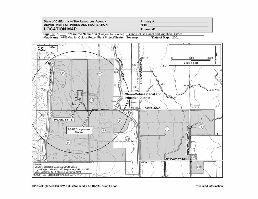
State of California — The Resources Agency Primary # DEPARTMENT OF PARKS AND RECREATION HRI# LOCATION MAP Trinomial#
Page 8
DPR 523J (1/95) R:\06 CPV Colusa\Appendix 8.3 CANAL From 01.doc *Required Information
of 8 *Resource Name or # (Assigned by recorder) Glenn-Colusa Canal and Irrigation District *Map Name: APE Map for Colusa Power Plant Project*Scale: See map *Date of Map: 2001

State of California — The Resources Agency Primary # DEPARTMENT OF PARKS AND RECREATION HRI # PRIMARY RECORD Trinomial NRHP Status Code 6 Other Listings Review Code Reviewer Date
Page 1 of 3 *Resource Name or #: (Assigned by recorder) Small Animal Feeder P1. Other Identifier: P2. Location: Not for Publication ⌧ Unrestricted *a: County Colusa and (P2c,P2e, and P2b or P2d. Attach Location Map as necessary.) *b. USGS 7.5' Quad Sites Date 1973 T 17N ; R 4W ; ¼ of ¼ of Sec 1 ; M.D. B.M. c. Address south of Dirks Road City Maxwell Zip 95955 d. UTM: (Give more than one for large and/or linear resources) Zone 2; 564120 mE/ 4356800 mN *e. Other Locational Data: (e.g., parcel #, directions to resource, elevation, etc., as appropriate) APN # 11-14-21 *P3a. Description: (Describe resource and its major elements. Include design, materials, condition, alterations, size, setting, and boundaries)
*P3b Resource Attributes: (List attributes and codes) HP4: Ancillary Building
The property located on APN #11-14-21 is a 77.87-acre parcel that is a fenced pasture devoid of buildings except for one small structure — a movable small animal feeder. The feeder is a rectangular wood structure built on skids so that it can be moved by dragging behind a tractor or other vehicle. Viewed from a few feet away behind a barbed wire fence, it appears to be a wood frame structure with one-foot-wide boards nailed to its frame except at the base of the long sides where the boards are omitted for a trough. The feeder is covered by a broad gable roof that overhangs the sides to protect feeding animals from the weather. The structure appears to be about three feet wide, 15 feet long, and five feet high to the ridge. Steel posts in the ground around it indicate that, at one time, the feeder was separately enclosed by a fence.
*P4. Resources Present: Building ⌧ Structure Object Site District Element of District Other (isolates, etc.)
P5b. Description of Photo: (View, date, accession #) view northeast, 6 April 2001 Denise Bradley, photographer, DB-1:17 *P6. Date Constructed/Age and Source: ⌧ Historic
Prehistoric Both 1950s-1970s (estimate) *P7. Owner and Address: Leo M. Holthouse et al. HC 84 Box 66, Canyon City Oregon, 97820-9702 *P8. Recorded by: (Name, affiliation, and address) Michael Corbett, URS Corp 221 Main Street, #600 San Francisco, CA 94105 *P9. Date Recorded: 6 April 2001 *P10. Survey Type: (Describe) intensive
P11. Report Citation*: (Cite survey report and other sources, or enter "none".) Application for Certification for Colusa Power Plant *Attachments: NONE ⌧ Location Map Sketch Map ⌧ Continuation Sheet ⌧ Building, Structure and Object Record
Archaeological Record District Record Linear Feature Record Milling Station Record Rock Art Record Artifact Record Photograph Record Other (List)
DPR 523A (1/95) R:\06 CPV Colusa\Appendix 8.3 FEEDER From 01.DOC *Required Information

State of California — The Resources Agency Primary # DEPARTMENT OF PARKS AND RECREATION HRI # BUILDING, STRUCTURE, AND OBJECT RECORD Page 2 of 3 *NRHP Status Code 6 *Resource Name or # (Assigned by recorder) Small Animal Feeder B1. Historic Name: none B2. Common Name: B3. Original Use: small animal feeder B4. Present Use: small animal feeder *B5. Architectural Style: utilitarian *B6. Construction History: (Construction date, alterations, and date of alterations) Built 1950s to 1970s (estimate) *B7. Moved? No ⌧ Yes Unknown Date: Original Location: unknown *B8. Related Features: none B9a. Architect: none b. Builder: unknown *B10. Significance: Theme N/A Area Period of Significance Property Type Applicable Criteria (Discuss importance in terms of historical or architectural context as defined by theme, period, and geographic scope. Also address integrity.) History
As a small portable structure, this feeder has never appeared on USGS maps. Neither is its history known from any other source. It is assumed to be a small animal feeder from its size — it is too small to have served adult cattle. It appears to be the right size for calves or sheep. Judging from its structure and materials as viewed from a few feet away, it appears to have been built in the 1950s or later. Evaluation This small animal feeder does not appear eligible for the NRHP. Although its date of construction is unknown, it probably does not meet the normal age criteria of 50 years for eligibility to the NRHP. Moreover, it is an isolated structure of ordinary construction. Additionally, this structure does appear to be significant under CRHR criteria. For purposes of CEQA, this structure is not a historic resource.
B11. Additional Resource Attributes: (List attributes and codes) *B12. References: (Sketch map with north arrow required) USGS, 1960. B13. Remarks: *B14. Evaluator: Michael Corbett Date of Evaluation: 25 April 2001
(This space reserved for official comments.)
DPR 523B (1/95) R:\06 CPV Colusa\Appendix 8.3 FEEDER From 01.DOC *Required Information

DPR 523J (1/95) R:\06 CPV Colusa\Appendix 8.3 FEEDER From 01.DOC *Required Information
State of California — The Resources Agency Primary # DEPARTMENT OF PARKS AND RECREATION HRI# LOCATION MAP Trinomial#
Page 3 of 3 *Resource Name or # (Assigned by recorder) Small animal feeder *Map Name: APE Map Colusa Power Plant Project *Scale: See map *Date of Map: 2001

State of California — The Resources Agency Primary # DEPARTMENT OF PARKS AND RECREATION HRI # PRIMARY RECORD Trinomial NRHP Status Code 6 Other Listings Review Code Reviewer Date
Page 1 of 8 *Resource Name or #: (Assigned by recorder) Ranch Buildings in Section 1 P1. Other Identifier: P2. Location: Not for Publication ⌧ Unrestricted *a: County Colusa County and (P2c,P2e, and P2b or P2d. Attach Location Map as necessary.) *b. USGS 7.5' Quad Sites Date 1973 T 17N ; R 4W ; ¼ of ¼ of Sec 1 ; M.D. B.M. c. Address south of Dirks Road City Maxwell Zip 95955 d. UTM: (Give more than one for large and/or linear resources) Zone 2; 563355 mE/ 4356300 mN *e. Other Locational Data: (e.g., parcel #, directions to resource, elevation, etc., as appropriate) APN 11-14-4 *P3a. Description: (Describe resource and its major elements. Include design, materials, condition, alterations, size, setting, and boundaries)
*P3b Resource Attributes: (List attributes and codes) HP33: Farm/Ranch
The property located on Assessor’s Parcel Number 11-14-4 west of the Glenn-Colusa Canal occupies 360 acres in Section 1 of Township 17 north, Range 4 west. This property has been accessible by dirt road since at least 1904 when the USGS map showed roads from the east, west, and south converging in this section. The roads from the east and south provided links to the Southern Pacific Railroad and to an east-west route to Lake County, respectively. The road from the west went only as far as the next section. In the absence of any mines or buildings of any sort, this property and the surrounding area appear to have functioned as wheat farms or ranch land in the early 20th century. Unlike roads in agricultural areas on lower land to the east which followed section lines, these ranch roads provided access to higher grazing land — presumably summer pastures. The same conditions were shown on the 1917 USGS map. See continuation sheet.
*P4. Resources Present: ⌧ Building ⌧ Structure Object Site District Element of District Other (isolates, etc.)
P5b. Description of Photo: (View, date, accession #) Barn, view northwest, Brian Vahey, photographer 11 March 2001, BRV-2:22 *P6. Date Constructed/Age and Source: ⌧ Historic
Prehistoric Both post 1960/ USGS Map *P7. Owner and Address: Leo Holthouse, et al. HC 84 Box 66 Canyon City, OR 97820-9702 *P8. Recorded by: (Name, affiliation, and address) Michael Corbett, URS Corp 221 Main Street, #600 San Francisco, CA 94105 *P9. Date Recorded: 6 April 2001 *P10. Survey Type: (Describe) intensive
P11. Report Citation*: (Cite survey report and other sources, or enter "none".) Application for Certification of Colusa Power Plant *Attachments: NONE ⌧ Location Map Sketch Map ⌧ Continuation Sheet ⌧ Building, Structure and Object Record
Archaeological Record District Record Linear Feature Record Milling Station Record Rock Art Record Artifact Record Photograph Record Other (List)
DPR 523A (1/95) R:\06 CPV Colusa\Appendix 8.3 SECTION1 From 01.doc *Required Information

DPR 523L (1/95) R:\06 CPV Colusa\Appendix 8.3 SECTION1 From 01.doc *Required Information
State of California — The Resources Agency Primary # DEPARTMENT OF PARKS AND RECREATION HRI/Trinomial CONTINUATION SHEET Page 2 of 8 Resource Identifier: Ranch Buildings in Section 1 Recorded by Michael Corbett *Date 6 April 2001 ⌧ Continuation Update Description (continued) The next record of the property, a 1943 USGS map, showed a high voltage electric power transmission line running north-south through this property in section 1. The only building shown in the vicinity of the property at that time was indicated on the west side of the boundary between sections 1 and 2. No evidence of further changes within the parcel appear until the 1958 USGS map which showed farm structures at the ends of dirt roads in sections 3 and 35, to the west and northwest, respectively. The building previously shown on the boundary between sections 1 and 2 was not shown, and there were still no buildings or structures shown on this property. Thus, the buildings and structures now standing on the property all appear to have been built after 1960. One collapsed building may be older. There are no structures on the property except for a cluster of seven features in the center, near the western boundary of this irregular parcel. These features include three buildings, one water tank structure, one manufactured home, one abandoned truck with water tank mounted on its bed, and one collapsed building. The site appears little used and is overgrown with weeds. Dilapidated fences and abandoned machinery are also located on the property. Each major feature is described below: 1. The most substantial structure is a large one-story barn with a long rectangular footprint. The gable-roofed wood-frame
structure is covered with corrugated metal panels. On the long sides of the building there appear to be seven doors that slide on an overhead rail. At the center of one of the gable ends there is larger door on rails. On this end of the building there is also a raised metal feed bin. Post 1960.
2. A double-wide, manufactured home is also located on the site. The one-story structure has a rectangular footprint and is
raised off the ground on blocks. The structure is covered with vertical aluminum siding. The building has a shallow gabled roof that is supported by brackets under the gable ends. The building is badly deteriorated, and the frames and glazing of the windows are missing. Post 1960.
3. Next to the manufactured home, there is a garage with a rectangular footprint. It is covered with a gabled roof with
wooden shingles and has exposed rafter ends. The wood-frame structure is covered with horizontal plank siding. There is a window opening on one side of the building and a wooden plank door on an overhead rail underneath one of the gable ends. Post 1960.
4. A rectangular wood frame structure with a shed roof. The walls are sheathed in corrugated metal panels and the roofing
is missing. One side of the building has been left open. The floor is dirt. Post 1960. 5. Behind the shed roofed structure is a metal tank on top of a heavy timber structure with wooden “X” bracing. The lower
portion of the structure has been enclosed with a shed roof and siding on three sides to form a small enclosure. Post 1960.
6. Another building has completely collapsed. All that is visible is the remains of a gabled roof covered with corrugated
metal panels. Date unknown. 7. An abandoned truck with a water tank mounted on its bed. The truck appears to be a Model A Ford, built sometime
between 1928 and the end of the 1930s. This may have been a means of moving the water tank around the ranch, or it may have been parked permanently and the engine reattached to a pump. Date on this site is unknown.
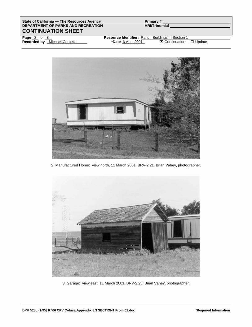
State of California — The Resources Agency Primary # DEPARTMENT OF PARKS AND RECREATION HRI/Trinomial CONTINUATION SHEET Page 3 of 8 Resource Identifier: Ranch Buildings in Section 1 Recorded by Michael Corbett *Date 6 April 2001 ⌧ Continuation Update
2. Manufactured Home: view north, 11 March 2001. BRV-2:21. Brian Vahey, photographer.
3. Garage: view east, 11 March 2001. BRV-2:25. Brian Vahey, photographer.
DPR 523L (1/95) R:\06 CPV Colusa\Appendix 8.3 SECTION1 From 01.doc *Required Information

State of California — The Resources Agency Primary # DEPARTMENT OF PARKS AND RECREATION HRI/Trinomial CONTINUATION SHEET Page 4 of 8 Resource Identifier: Ranch Buildings in Section 1 Recorded by Michael Corbett *Date 6 April 2001 ⌧ Continuation Update
4. and 5. Shed and tank: view northeast, 11 March 2001. BRV-2:24. Brian Vahey, photographer.
6. Collapsed Building: view south, 11 March 2001. BRV-2:23. Brian Vahey, photographer.
DPR 523L (1/95) R:\06 CPV Colusa\Appendix 8.3 SECTION1 From 01.doc *Required Information
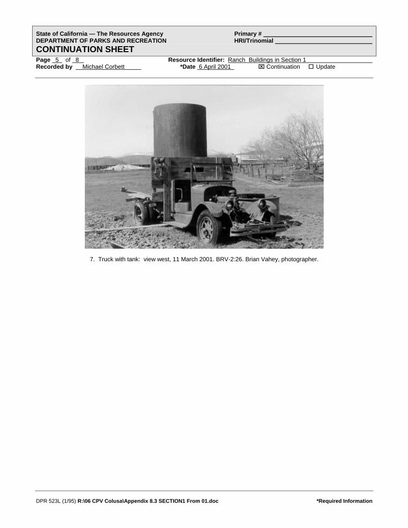
State of California — The Resources Agency Primary # DEPARTMENT OF PARKS AND RECREATION HRI/Trinomial CONTINUATION SHEET Page 5 of 8 Resource Identifier: Ranch Buildings in Section 1 Recorded by Michael Corbett *Date 6 April 2001 ⌧ Continuation Update
7. Truck with tank: view west, 11 March 2001. BRV-2:26. Brian Vahey, photographer.
DPR 523L (1/95) R:\06 CPV Colusa\Appendix 8.3 SECTION1 From 01.doc *Required Information

State of California — The Resources Agency Primary # DEPARTMENT OF PARKS AND RECREATION HRI # BUILDING, STRUCTURE, AND OBJECT RECORD Page 6 of 8 *NRHP Status Code 6 *Resource Name or # (Assigned by recorder) Ranch Buildings in Section 1 B1. Historic Name: unknown B2. Common Name: B3. Original Use: ranch B4. Present Use: ranch *B5. Architectural Style: vernacular *B6. Construction History: (Construction date, alterations, and date of alterations) 1. Barn - post 1960 2. Manufactured home - post 1960 3. Garage - post 1960 4. Shed - post 1960 5. Metal tank - post 1960 6. Collapsed building - date unknown 7. Abandoned truck with tank - date on this site unknown *B7. Moved? No Yes ⌧ Unknown Date: Original Location: several features possibly move to site *B8. Related Features: B9a. Architect: unknown b. Builder: unknown *B10. Significance: Theme N/A Area Period of Significance Property Type Applicable Criteria (Discuss importance in terms of historical or architectural context as defined by theme, period, and geographic scope. Also address integrity.) History
As early as 1904, the land that now forms the current property was crossed by trails that ran along and into the foothills (United States Geological Survey. “Sites Quad.” Map. 1904 revised). At that time, Colusa County was occupied by large wheat farms and ranches. By 1943, the paths through the property had been straightened but were still dirt. Maps from that year show that buildings had been constructed at the ends of the paths in the hills, but do not show any buildings on this property (United States Geological Survey. “Lodoga Quad.” Map. 1943). The land west of this property was used as a ranch (“Map of Colusa County California 1966). None of the maps of the area from 1904 to 1960 show any buildings on the property. It is possible that some of the features were moved to the site after the latter date, or that the buildings were missed by the map-makers. The manufactured home that is now on the property was built in a factory and was moved to the site. See continuation sheet
B11. Additional Resource Attributes: (List attributes and codes) *B12. References: (Sketch map with north arrow required) See continuation sheet. B13. Remarks: *B14. Evaluator: Michael R. Corbett Date of Evaluation: 26 April 2001
(This space reserved for official comments.)
DPR 523B (1/95) R:\06 CPV Colusa\Appendix 8.3 SECTION1 From 01.doc *Required Information

DPR 523L (1/95) R:\06 CPV Colusa\Appendix 8.3 SECTION1 From 01.doc *Required Information
State of California — The Resources Agency Primary # DEPARTMENT OF PARKS AND RECREATION HRI/Trinomial CONTINUATION SHEET Page 7 of 8 Resource Identifier: Ranch Buildings in Section 1 Recorded by Michael Corbett *Date 6 April 2001 ⌧ Continuation Update History (continued) On 19 June 1974 Roy Holiday Elliott, et al., purchased the property. A short time later, 7 March 1975, the property was passed to W.E. and Julie M. Holthouse. Four years later, in 1979, the Holthouses mortgaged the property to the Bank of America. In 1987, the property was transferred to the current owners, Leo Holthouse et al. (Assessor Inquiry for APN 11-14-4. Colusa County Assessor’s Printout, 20 March 2001). By 1987 the property included 360 acres; the land was valued at $173,285 and the buildings were assessed at $52,266. Evaluation These ranch buildings located in Section 1 of T 17 N, R 4 W (APN #11-14-4) do not appear eligible for the NRHP. Six of the seven major features appear to have been built on this property or moved to it after 1960. One structure, of uncertain date, has collapsed and is not addressed under criteria A, B, or C. The features of the property are less than 45 years of age and do not meet the normal age threshold of 50 years. Although the land itself (before any structures were built on it) appears to have been associated with the early wheat and ranching history of the area, the buildings and structures that are now standing were built long after that period. There is no evidence that the property meets criteria consideration G for resources that are less than 50 years old but possess exceptional significance. Additionally, this property does appear to be significant under CRHR criteria. For purposes of CEQA, this property is not a historic resource. References Assessor Inquiry for APN 11-14-4. Colusa County Assessor’s printout, 20 March 2001. “Assessor Plat Maps for Colusa County.” Maps. Book 11 pages 4. Colusa County Assessors Office, Willows, CA. “Map of Colusa County California, Colusa County Chamber of Commerce.” Map. 1966. Earth Sciences Library, University of California, Berkeley. “Metsker’s Map of Colusa County California.” Map. 1960. Earth Sciences Library, University of California, Berkeley. “Official Chamber of Commerce Map of Colusa County and Its Communities.” Map. 1988. Earth Sciences Library, University of California, Berkeley. “Rand McNally Map of Colusa County.” Map. 1962. Earth Sciences Library, University of California, Berkeley. “State of California, The Resources Agency, Department of Conservation, Division of Forestry, Colusa County.” Map. 1947. Earth Sciences Library, University of California, Berkeley. “Thomas Bros. Map of Colusa County California.” Map. 1946. Earth Sciences Library, University of California, Berkeley. “Title Insurance and Trust Map of Colusa County and Its Cities.” Map. 1978. Earth Sciences Library, University of California, Berkeley. United States Geological Survey. “Lodoga Quad.” Map. 1943 United States Geological Survey. “Lodoga Quad.” Map. 1960. United States Geological Survey. “Sites Quad.” Map. 1904 revised. United States Geological Survey. “Sites Quad.” Map. 1973.

State of California — The Resources Agency Primary # DEPARTMENT OF PARKS AND RECREATION HRI# LOCATION MAP Trinomial#
Page 8 of 8 *Resource Name or # (Assigned by recorder) Ranch Buildings in Section 1 *Map Name: APE Map Colusa Power Plant Project
DPR 523J (1/95) R:\06 CPV Colusa\Appendix 8.3 SECTION1 From 01.doc *Required Information
*Scale: See map *Date of Map: 2001

State of California — The Resources Agency Primary # DEPARTMENT OF PARKS AND RECREATION HRI # PRIMARY RECORD Trinomial NRHP Status Code 6 Other Listings Review Code Reviewer Date
Page 1 of 7 *Resource Name or # (Assigned by recorder) Farm in Section 6 P1. Other Identifier: P2. Location: Not for Publication ⌧ Unrestricted *a: County Colusa County and (P2c,P2e, and P2b or P2d. Attach Location Map as necessary.) *b. USGS 7.5' Quad Maxwell Date 1994 T 17N ; R 3W ; ¼ of ¼ of Sec 6 ; M.D. B.M. c. Address north of Delevan Road City Maxwell Zip 95955 d. UTM: (Give more than one for large and/or linear resources) Zone 2; 565505 mE/ 4356325 mN *e. Other Locational Data: (e.g., parcel #, directions to resource, elevation, etc., as appropriate) APN 11-22-1 *P3a. Description: (Describe resource and its major elements. Include design, materials, condition, alterations, size, setting, and boundaries)
*P3b Resource Attributes: (List attributes and codes) HP33: Farm/Ranch
This property occupies a section of land consisting of 635 acres. This is a square parcel bordered on all four sides by section line roads, including Delevan Road on the south and west, McDermott Road on the east, and Dirks Road on the north. A cluster of six buildings and structures near the center of the property is approached by two driveways — from the south and west. Just beyond this property on the west side is the Glenn Colusa Canal. The building cluster includes two dwellings, a domestic garage, a barn, a farm vehicle garage, and a building that appears to be a bunkhouse. These are described below. 1. Large House. This is a one-story house with an irregular “T”-shaped footprint. The building has a complex roofline; the
different sections of the house are all covered with low-pitched gable roofs with overhanging eaves. All portions of the roof have asphalt shingles. The wood-frame structure is covered with horizontal siding, and the windows are sliding with aluminum frames. In appearance, the design of this house suggests both pre-war bungalows and post-war ranch style houses.
See continuation sheet.
*P4. Resources Present: ⌧ Building ⌧ Structure Object Site District Element of District Other (isolates, etc.)
P5b. Description of Photo: (View, date, accession #) view west, 8 March 2001 Brian Vahey, photographer BRV-1:30 *P6. Date Constructed/Age and Source: ⌧ Historic
Prehistoric Both ca. 1945/Visual Estimate *P7. Owner and Address: Frances M. Etchepare, Trustee P.O. Box 658 Maxwell, CA 94955 *P8. Recorded by: (Name, affiliation, and address) Michael Corbett/URS Corp 221 Main Street, #600 San Francisco, CA 94105 *P9. Date Recorded: 6 April 2001 *P10. Survey Type: (Describe) intensive
P11. Report Citation*: (Cite survey report and other sources, or enter "none".) Application for Certification of Colusa Power Plant *Attachments: NONE ⌧ Location Map Sketch Map ⌧ Continuation Sheet ⌧ Building, Structure and Object Record
Archaeological Record District Record Linear Feature Record Milling Station Record Rock Art Record Artifact Record Photograph Record Other (List)
DPR 523A (1/95) R:\06 CPV Colusa\Appendix 8.3 SECTION6 From 01.doc *Required Information

State of California — The Resources Agency Primary # DEPARTMENT OF PARKS AND RECREATION HRI/Trinomial CONTINUATION SHEET Page 2 of 7 Resource Identifier: Farm in Section 6 Recorded by Michael Corbett *Date 6 April 2001 ⌧ Continuation Update Description (continued) 2. Small House. This is a one-story building with a rectangular footprint and a box-like form. It has a gable roof with asphalt
shingles and no eaves. The wood-frame structural system is covered with what appear to be asbestos shingles. The screen door and sliding windows are aluminum.
3. There is a large barn east of the residences. The wood-frame structure has a rectangular footprint. It is covered with a
gable roof with double-pitched shed roofs on the north and south sides of the building. All sections of the roof are covered with corrugated metal siding with several panels of translucent plastic for light. The exterior walls of the building are sheathed with vertical, wood siding. There is a roll-up metal door in the center of the west facade. On either side of this are two sliding wooden plank doors, and bordering these, there are pairs of wood, swing doors. On the north facade, the central bay is open to allow for farm machinery storage.
4. Between the two houses is a rectangular four-bay garage for domestic use. This is a recent building with a cupola on the
gable roof. It is a wood frame structure. 5. Near the barn is a rectangular garage with a low-pitched gable roof for farm vehicles. 6. Between the garages is a rectangular wood frame structure with a gable roof and a small entrance porch. This appears to
have been a residence, perhaps a bunkhouse for farm workers.
1. Large House. view south, 8 March 2001, BRV-1:31. Brian Vahey, photographer.
DPR 523L (1/95) R:\06 CPV Colusa\Appendix 8.3 SECTION6 From 01.doc *Required Information

State of California — The Resources Agency Primary # DEPARTMENT OF PARKS AND RECREATION HRI/Trinomial CONTINUATION SHEET Page 3 of 7 Resource Identifier: Farm in Section 6 Recorded by Michael Corbett *Date 6 April 2001 ⌧ Continuation Update
2. Small House. view southeast, 6 April 2001, DB-1:21. Denise Bradley, photographer.
3. Barn. view southeast, 8 March 2001, BRV-1:32. Brian Vahey, photographer.
DPR 523L (1/95) R:\06 CPV Colusa\Appendix 8.3 SECTION6 From 01.doc *Required Information

State of California — The Resources Agency Primary # DEPARTMENT OF PARKS AND RECREATION HRI/Trinomial CONTINUATION SHEET Page 4 of 7 Resource Identifier: Farm in Section 6 Recorded by Michael Corbett *Date 6 April 2001 ⌧ Continuation Update
4. Domestic Garage. view south, 6 April 2001, DB-1:20. Denise Bradley, photographer.
DPR 523L (1/95) R:\06 CPV Colusa\Appendix 8.3 SECTION6 From 01.doc *Required Information
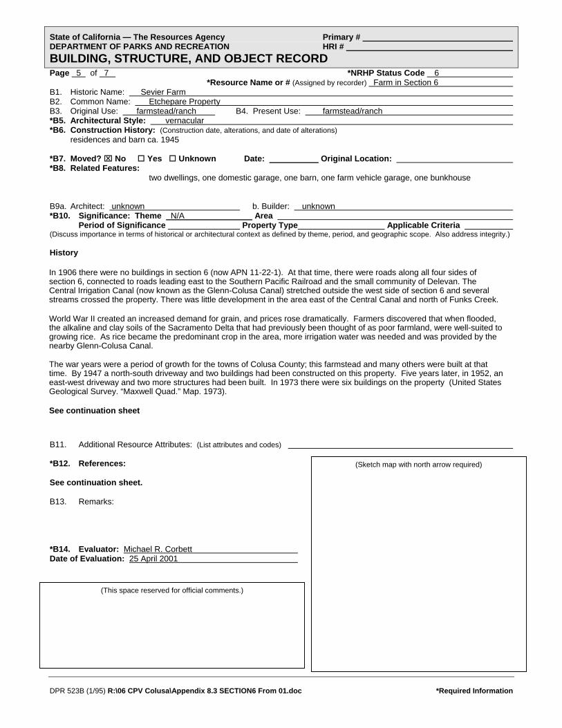
State of California — The Resources Agency Primary # DEPARTMENT OF PARKS AND RECREATION HRI # BUILDING, STRUCTURE, AND OBJECT RECORD Page 5 of 7 *NRHP Status Code 6 *Resource Name or # (Assigned by recorder) Farm in Section 6 B1. Historic Name: Sevier Farm B2. Common Name: Etchepare Property B3. Original Use: farmstead/ranch B4. Present Use: farmstead/ranch *B5. Architectural Style: vernacular *B6. Construction History: (Construction date, alterations, and date of alterations) residences and barn ca. 1945 *B7. Moved? ⌧ No Yes Unknown Date: Original Location: *B8. Related Features: two dwellings, one domestic garage, one barn, one farm vehicle garage, one bunkhouse B9a. Architect: unknown b. Builder: unknown *B10. Significance: Theme N/A Area Period of Significance Property Type Applicable Criteria (Discuss importance in terms of historical or architectural context as defined by theme, period, and geographic scope. Also address integrity.) History
In 1906 there were no buildings in section 6 (now APN 11-22-1). At that time, there were roads along all four sides of section 6, connected to roads leading east to the Southern Pacific Railroad and the small community of Delevan. The Central Irrigation Canal (now known as the Glenn-Colusa Canal) stretched outside the west side of section 6 and several streams crossed the property. There was little development in the area east of the Central Canal and north of Funks Creek. World War II created an increased demand for grain, and prices rose dramatically. Farmers discovered that when flooded, the alkaline and clay soils of the Sacramento Delta that had previously been thought of as poor farmland, were well-suited to growing rice. As rice became the predominant crop in the area, more irrigation water was needed and was provided by the nearby Glenn-Colusa Canal. The war years were a period of growth for the towns of Colusa County; this farmstead and many others were built at that time. By 1947 a north-south driveway and two buildings had been constructed on this property. Five years later, in 1952, an east-west driveway and two more structures had been built. In 1973 there were six buildings on the property (United States Geological Survey. “Maxwell Quad.” Map. 1973). See continuation sheet
B11. Additional Resource Attributes: (List attributes and codes) *B12. References: (Sketch map with north arrow required) See continuation sheet. B13. Remarks: *B14. Evaluator: Michael R. Corbett Date of Evaluation: 25 April 2001
(This space reserved for official comments.)
DPR 523B (1/95) R:\06 CPV Colusa\Appendix 8.3 SECTION6 From 01.doc *Required Information
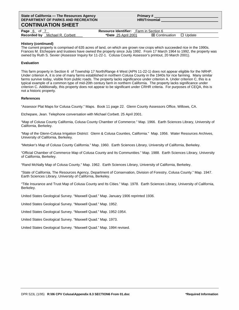
DPR 523L (1/95) R:\06 CPV Colusa\Appendix 8.3 SECTION6 From 01.doc *Required Information
State of California — The Resources Agency Primary # DEPARTMENT OF PARKS AND RECREATION HRI/Trinomial CONTINUATION SHEET Page 6 of 7 Resource Identifier: Farm in Section 6 Recorded by Michael R. Corbett *Date 25 April 2001 ⌧ Continuation Update History (continued) The current property is comprised of 635 acres of land, on which are grown row crops which succeeded rice in the 1990s. Frances M. Etchepare and trustees have owned the property since July 1992. From 17 March 1964 to 1992, the property was owned by Ruth S. Sevier (Assessor Inquiry for 11-22-1. Colusa County Assessor’s printout, 20 March 2001). Evaluation
This farm property in Section 6 of Township 17 North/Range 4 West (APN 11-22-1) does not appear eligible for the NRHP. Under criterion A, it is one of many farms established in northern Colusa County in the 1940s for rice farming. Many similar farms survive today, visible from public roads. The property lacks significance under criterion A. Under criterion C, this is a typical example of a common type of mid-20th century farm in northern California. The property lacks significance under criterion C. Additionally, this property does not appear to be significant under CRHR criteria. For purposes of CEQA, this is not a historic property. References “Assessor Plat Maps for Colusa County.” Maps. Book 11 page 22. Glenn County Assessors Office, Willows, CA. Etchepare, Jean. Telephone conversation with Michael Corbett. 25 April 2001. “Map of Colusa County California, Colusa County Chamber of Commerce.” Map. 1966. Earth Sciences Library, University of California, Berkeley. “Map of the Glenn-Colusa Irrigation District: Glenn & Colusa Counties, California.” Map. 1956. Water Resources Archives, University of California, Berkeley. “Metsker’s Map of Colusa County California.” Map. 1960. Earth Sciences Library, University of California, Berkeley. “Official Chamber of Commerce Map of Colusa County and Its Communities.” Map. 1988. Earth Sciences Library, University of California, Berkeley. “Rand McNally Map of Colusa County.” Map. 1962. Earth Sciences Library, University of California, Berkeley. “State of California, The Resources Agency, Department of Conservation, Division of Forestry, Colusa County.” Map. 1947. Earth Sciences Library, University of California, Berkeley. “Title Insurance and Trust Map of Colusa County and Its Cities.” Map. 1978. Earth Sciences Library, University of California, Berkeley. United States Geological Survey. “Maxwell Quad.” Map. January 1906 reprinted 1936. United States Geological Survey. “Maxwell Quad.” Map. 1952. United States Geological Survey. “Maxwell Quad.” Map. 1952-1954. United States Geological Survey. “Maxwell Quad.” Map. 1973. United States Geological Survey. “Maxwell Quad.” Map. 1994 revised.

State of California — The Resources Agency Primary # DEPARTMENT OF PARKS AND RECREATION HRI# LOCATION MAP Trinomial#
Page 7
DPR 523J (1/95) R:\06 CPV Colusa\Appendix 8.3 SECTION6 From 01.doc *Required Information
of 7 *Resource Name or # (Assigned by recorder) Farm in Section 6 *Map Name: APE Map Colusa Power Plant Project *Scale: See map *Date of Map: 2001

State of California — The Resources Agency Primary # DEPARTMENT OF PARKS AND RECREATION HRI # PRIMARY RECORD Trinomial NRHP Status Code 6 Other Listings Review Code Reviewer Date
Page 1 of 5 *Resource Name or #: (Assigned by recorder) Teresa Creek Bridge P1. Other Identifier: Bridge No. 15C-167; also Co. No. 24F P2. Location: Not for Publication ⌧ Unrestricted *a: County Colusa County and (P2c,P2e, and P2b or P2d. Attach Location Map as necessary.) *b. USGS 7.5' Quad Maxwell Date 1994 T 17N ; R 3W ; ¼ of ¼ of Sec 5, 6 ; M.D. B.M. c. Address McDermott Road City Maxwell (vicinity) Zip NA d. UTM: (Give more than one for large and/or linear resources) Zone 2; 566500 mE/ 4356800 mN *e. Other Locational Data: (e.g., parcel #, directions to resource, elevation, etc., as appropriate)s
0.7 mile north of Delevan Road; 03-Col-Co. Rd.
*P3a. Description: (Describe resource and its major elements. Include design, materials, condition, alterations, size, setting, and boundaries)
*P3b Resource Attributes: (List attributes and codes) HP19
The Teresa Creek Bridge is located on McDermott Road about 0.7 miles north of the intersection with Delevan Road. The bridge spans Teresa Creek, a branch of Hunter’s Creek. McDermott Road is a two-lane, asphalt-surfaced road on a section line. The road provides access to farmland in a rural part of northern Colusa County. In 1977, the average daily traffic was 200 vehicles. According to the American Civil Engineer’s Handbook of 1930 (p. 1174), this was a secondary road and the bridge was classified as a Class C bridge. The bridge is 20.4 feet long and 24 feet wide with a 15-foot-wide roadway. It was designed for one lane of traffic. See Continuation Sheet
*P4. Resources Present: Building ⌧ Structure Object Site District Element of District Other (isolates, etc.)
P5b. Description of Photo: (View, date, accession #) view west, 11 March 2001 Brian Vahey, photographer BRV-2:10 *P6. Date Constructed/Age and Source: ⌧ Historic
Prehistoric Both 1940; repaired 1959/Caltrans Bridge Report *P7. Owner and Address: Colusa County, Department of Public Works, 1215 Market St. Colusa, CA 95932 *P8. Recorded by: (Name, affiliation, and address) J. Stock/M. Corbett, URS Corp 221 Main Street, #600 San Francisco, CA 94105 *P9. Date Recorded: 13 March and 6 April 2001 *P10. Survey Type: (Describe) Intensive Survey
P11. Report Citation*: (Cite survey report and other sources, or enter "none".) Application for Certification of Colusa Power Plant *Attachments: NONE ⌧ Location Map Sketch Map ⌧ Continuation Sheet ⌧ Building, Structure and Object Record
Archaeological Record District Record Linear Feature Record Milling Station Record Rock Art Record Artifact Record Photograph Record Other (List)
DPR 523A (1/95) R:\06 CPV Colusa\Appendix 8.3 TERESABR From 01.doc *Required Information

State of California — The Resources Agency Primary # DEPARTMENT OF PARKS AND RECREATION HRI/Trinomial CONTINUATION SHEET Page 2 of 5 Resource Identifier: Teresa Creek Bridge Recorded by Jody R. Stock/Michael Corbett *Date 13 March 2001 ⌧ Continuation Update Description (continued) This is a wood bridge that spans between concrete abutments — by definition, a “simple bridge,” as distinct from more complex types of bridges classified as continuous, cantilever, arch, and suspension bridges. A 1980 California Department of Transportation report described it as follows: “Timber deck, on timber stringers, on RC wing abutments.” According to the American Civil Engineer’s Handbook (p. 1668), “Wooden bridges resting on concrete piers and abutments are in very common use.” The abutments are poured concrete structures with the exposed imprints of formboards, straight sides, and a curb-like base. The west faces of these abutments are cracked and spalling where they meet the flow of water in the creek. The abutments are spanned by 3- by 8-inch wood stringers 18.4 feet long. The deck consists of two layers: 4- by 8-inch timbers laid across the stringers, and a top layer of boards and asphalt. The deck of the bridge is flat and flush with the road. The east and west sides of the bridge have curbs made of 10- × 10-inch timbers.
View southeast. 11 March 2001. BRV-2:35. Brian Vahey, photographer.
DPR 523L (1/95) R:\06 CPV Colusa\Appendix 8.3 TERESABR From 01.doc *Required Information
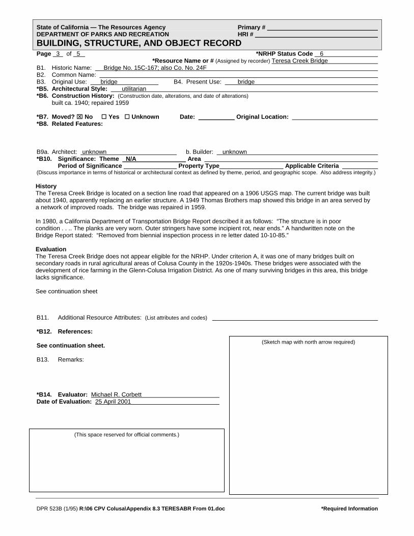
State of California — The Resources Agency Primary # DEPARTMENT OF PARKS AND RECREATION HRI # BUILDING, STRUCTURE, AND OBJECT RECORD Page 3 of 5 *NRHP Status Code 6 *Resource Name or # (Assigned by recorder) Teresa Creek Bridge B1. Historic Name: Bridge No. 15C-167; also Co. No. 24F B2. Common Name: B3. Original Use: bridge B4. Present Use: bridge *B5. Architectural Style: utilitarian *B6. Construction History: (Construction date, alterations, and date of alterations) built ca. 1940; repaired 1959 *B7. Moved? ⌧ No Yes Unknown Date: Original Location: *B8. Related Features: B9a. Architect: unknown b. Builder: unknown *B10. Significance: Theme N/A Area Period of Significance Property Type Applicable Criteria (Discuss importance in terms of historical or architectural context as defined by theme, period, and geographic scope. Also address integrity.)
History The Teresa Creek Bridge is located on a section line road that appeared on a 1906 USGS map. The current bridge was built about 1940, apparently replacing an earlier structure. A 1949 Thomas Brothers map showed this bridge in an area served by a network of improved roads. The bridge was repaired in 1959. In 1980, a California Department of Transportation Bridge Report described it as follows: “The structure is in poor condition . . .. The planks are very worn. Outer stringers have some incipient rot, near ends.” A handwritten note on the Bridge Report stated: “Removed from biennial inspection process in re letter dated 10-10-85.” Evaluation The Teresa Creek Bridge does not appear eligible for the NRHP. Under criterion A, it was one of many bridges built on secondary roads in rural agricultural areas of Colusa County in the 1920s-1940s. These bridges were associated with the development of rice farming in the Glenn-Colusa Irrigation District. As one of many surviving bridges in this area, this bridge lacks significance. See continuation sheet
B11. Additional Resource Attributes: (List attributes and codes) *B12. References: (Sketch map with north arrow required) See continuation sheet. B13. Remarks: *B14. Evaluator: Michael R. Corbett Date of Evaluation: 25 April 2001
(This space reserved for official comments.)
DPR 523B (1/95) R:\06 CPV Colusa\Appendix 8.3 TERESABR From 01.doc *Required Information

DPR 523L (1/95) R:\06 CPV Colusa\Appendix 8.3 TERESABR From 01.doc *Required Information
State of California — The Resources Agency Primary # DEPARTMENT OF PARKS AND RECREATION HRI/Trinomial CONTINUATION SHEET Page 4 of 5 Resource Identifier: Teresa Creek Bridge Recorded by Jody R. Stock / Michael Corbett *Date 13 March 2001 ⌧ Continuation Update Evaluation (continued) Under criterion C, this is a common type of simple bridge. Because many of these survive in the area, this bridge lacks significance. Additionally, the Teresa Creek Bridge does not appear to be significant under CRHR criteria. For purposes of CEQA, this is not a historic property. References (continued) Burgan, R.W., P.E. (C.E. #9268). Bridge Report on Bridge No. 15C-167. California Department of Transportation. 31 January 1980. “Map of Colusa County California, Colusa County Chamber of Commerce.” Map. 1966. Earth Sciences Library, University of California, Berkeley. Merriman, Thaddeus, editor. American Civil Engineers’ Handbook, fifth edition. New York: John Wiley & Sons, 1930. “Metsker’s Map of Colusa County California.” Map. 1960. Earth Sciences Library, University of California, Berkeley. Mikesell, Stephen D. Historic Bridges of California. [Sacramento]: California Department of Transportation, 1990. “Official Chamber of Commerce Map of Colusa County and Its Communities.” Map. 1988. Earth Sciences Library, University of California, Berkeley. “Rand McNally Map of Colusa County.” Map. 1962. Earth Sciences Library, University of California, Berkeley. “State of California, The Resources Agency, Department of Conservation, Division of Forestry, Colusa County.” Map. 1947. Earth Sciences Library, University of California, Berkeley. “Thomas Bros. Map of Colusa County California.” Map. 1946. Earth Sciences Library, University of California, Berkeley. “Title Insurance and Trust Map of Colusa County and Its Cities.” Map. 1978. Earth Sciences Library, University of California, Berkeley. United States Geological Survey. “Maxwell Quad.” Map. 1952). United States Geological Survey. “Maxwell Quad.” Map. 1952-1954. United States Geological Survey. “Maxwell Quad.” Map. 1973. United States Geological Survey. “Maxwell Quad.” Map. 1994 revised. United States Geological Survey. “Maxwell Quad.” Map. January 1906 reprinted 1936 Urquhart, Leonard Church, editor. Civil Engineering Handbook, third edition. New York: McGraw-Hill, 1950. Wrysinski, Jon, Colusa County Department of Public Works. Interview by Jody Stock, 11 April 2001.
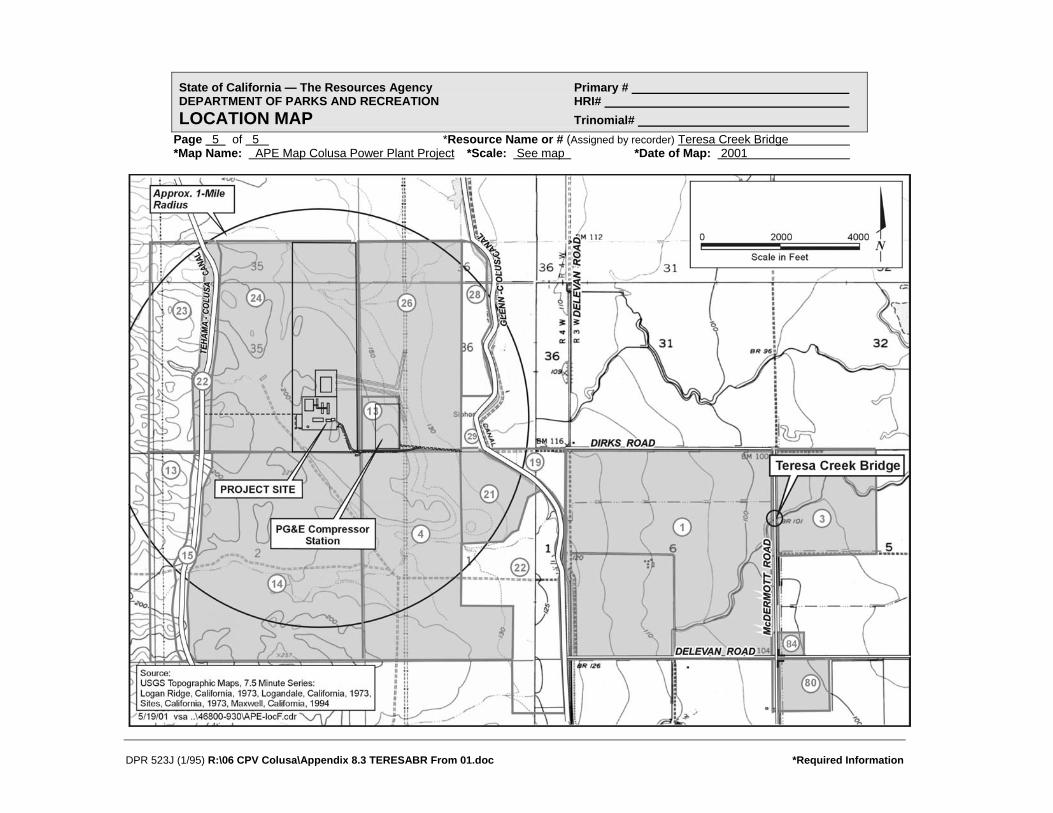
State of California — The Resources Agency Primary # DEPARTMENT OF PARKS AND RECREATION HRI# LOCATION MAP Trinomial#
Page 5 of 5 *Resource Name or # (Assigned by recorder) Teresa Creek Bridge *Map Name: APE Map Colusa Power Plant Project
DPR 523J (1/95) R:\06 CPV Colusa\Appendix 8.3 TERESABR From 01.doc *Required Information
*Scale: See map *Date of Map: 2001
APPENDIX J2 HISTORIC PROPERTIES INVENTORY AND
EVALUATION REPORT (2006)
HISTORIC PROPERTIES INVENTORY AND EVALUATION REPORT:
COLUSA GENERATION STATION COLUSA COUNTY, CALIFORNIA
Prepared for: Prepared by:
URS Corporation JRP Historical Consulting, LLC 221 Main Street, Suite 600 1490 Drew Avenue, Suite 110
San Francisco, CA 94105-1917 Davis, California 95618
October 2006

i
EXECUTIVE SUMMARY
JRP Historical Consulting (JRP) prepared this study based on the previous report prepared by URS Corporation in 2001 for the “Historic Architecture Report for Colusa Power Plant Project, Colusa County, California.” For that report URS inventoried and evaluated six historic-era resources. Of the six resources formally evaluated, URS concluded that two were potentially eligible for the National Register of Historic Places (National Register) as contributors to historic districts that have not been documented or evaluated. One such resource, a segment of Pacific Gas & Electric Company’s 230kV transmission line (Map Reference No 5), is part of a larger line that runs between the Cottonwood and Vaca Dixon substations, which transmitted power from the Pit 1 Power Plant to the San Francisco Bay Area. The other resource includes portions of irrigation infrastructure that are part of the Glenn-Colusa Canal and Irrigation District (GCID) (Map Reference No. 6). The present report, a supplement to the 2001 report, updates the survey resources previously evaluated by URS for listing in the National Register of Historic Places as well as for potential eligibility to the California Register.
The purpose of this document is to comply with applicable sections of the National Historic Preservation Act of 1966 (16 USC 470), as amended, and the implementing regulations of the Advisory Council on Historic Preservation (36 CFR Part 800), as these pertain to federally-funded undertakings and their effects on historic properties and with the California Environmental Quality Act (CEQA), as it pertains to historical resources. The resources studied for this report has been evaluated in accordance with Section 15064.5(a)(2)-(3) of CEQA Guidelines using the California Register criteria outlined in Section 5024.1 of the California Public Resources Code.
This report concludes that two resources, the segment of Pacific Gas & Electric Company’s 230kV transmission line (Map Reference No 5) and the Glenn-Colusa Canal and Irrigation District (GCID) resources (Map Reference No. 6) have the potential to meet National Register Criterion A and/or Criterion C. Both the transmission lines and GCID features appear to be historical resources for the purposes of CEQA.
The project location and vicinity are shown in Figures 1 and 2 (Appendix A), and Area of Potential Effects (APE) is depicted in Figure 3 (Appendix A). The six resources formally evaluated on Department of Parks and Recreation Primary and Buildings Structures and Objects Record form (DPR 523 form) are found in Appendix B.

ii
TABLE OF CONTENTS EXECUTIVE SUMMARY ............................................................................................................. i
1. PROJECT DESCRIPTION..................................................................................................... 1
2. RESEARCH AND FIELD METHODS ................................................................................. 2
3. HISTORICAL OVERVIEW .................................................................................................. 4
3.1. Glenn-Colusa Canal and Irrigation District .................................................................... 4
3.2. Development of Hydroelectric Power and Transmission Lines in California................ 5
3.3. Conclusion ...................................................................................................................... 7
4. DESCRIPTION OF RESOURCES ........................................................................................ 9
5. FINDINGS AND CONCLUSIONS ..................................................................................... 12
5.1. Evaluation Criteria ........................................................................................................ 12
5.2. Evaluation ..................................................................................................................... 14
6. BIBLIOGRAPHY................................................................................................................. 16
ATTACHMENTS Appendix A Figures
Appendix B DPR 523 Forms

1
1. PROJECT DESCRIPTION
This Application for Certification (AFC) is for the construction and operation of a nominal 660 megawatt (MW) combined cycle power plant in Colusa County. E&L Westcoast, LLC (E&L Westcoast) would construct and commission the power plant. Under a contract executed earlier this year, E&L Westcoast would then transfer ownership and operation of the plant to PG&E after completion of commissioning. The site is located approximately four miles to the west of Interstate 5 (I-5) and approximately 72 miles north of the City of Sacramento. The site is located adjacent to both PG&E’s Cottonwood to Vaca-Dixon transmission corridor, and the Pacific Gas Transmission (PGT)/PG&E gas transmission pipelines (lines 400 and 401). The site locale is a rural, sparsely populated portion of the western Sacramento Valley and is primarily dedicated to farming and grazing agricultural uses. The nearest inhabitant to the proposed project site is approximately 1.7 miles from the site, and there are approximately 12 residences within two miles of the project site, which is shown in Figure 4 in Appendix A.
The facility, to be known as the Colusa Generating Station (CGS), will incorporate two combustion gas turbines that will burn natural gas and a steam turbine driven with steam generated by Heat Recovery Steam Generators (HRSGs). Each combustion gas turbine and the steam turbine will be connected to one of three separate electric generators. Output of the generators will be connected to step-up transformers and then to a new PG&E switchyard. The CGS will be interconnected to PG&E’s northern California transmission grid and power generated by the facility will be available to serve energy needs throughout California. The project will use a mechanical draft cooling tower as the ultimate heat sink, and will employ a zero liquid discharge system.

2
2. RESEARCH AND FIELD METHODS
The California Energy Commission (CEC) and URS developed the APE for the architectural survey of the proposed project in April 2001. That APE included land within or that bordered the project site or that would be potentially effected by proposed project actions. In consideration of potential visual effects, the architectural APE also included any buildings or groups of buildings and structures constructed in or before 1957 that were within a one-mile radius of the project site and that would have had views of the proposed facility. In August 2006, JRP, in consultation with URS, revised the architectural to include the replacement of the Glenn-Colusa Canal Bridge over Dirks Road. Only those resources located within the architectural study area were included the survey. The architectural APE is shown in Figure 3 (Appendix A).
JRP conducted background research to assess which resources would be part of the survey population for this supplemental report. JRP staff conducted a reconnaissance survey of the area on August 16 and 17, 2006 to account in the field for all the buildings, structures and objects found within the APE. This field reconnaissance helped to determine which resources appeared to be more than 45 years of age and would therefore be studied for this project. While the Secretary of Interior sets the standard guidelines for review of potential National Register eligible buildings, structures, or features that are 50 years of age or older, this age limit has been extended to include resources constructed in 1961 or before to account for lead-time between preparation of environmental documentation and actual project construction. Buildings, structures, and features built in or after 1961 are not included in the survey. The remaining parcels or features, those that are documented to be, or that appear to be over 45 years of age, were surveyed. Additional background research was done review of historic and current USGS topographic maps, and other documents to account for construction dates of potentially new architectural resources.
The historical overview (Section 3) for this report is based on the research and historical context outlined in the 2001 URS report.1 For a complete listing of materials consulted, please see the references listed in Section 6. Additionally, JRP reviewed the National Register, California Register, California Historical Landmarks, and the California Points of Historic Interest lists to assess the location of any known historic properties within the study area.
JRP architectural historian Toni Webb was the project manager/lead historian for the project. Ms. Webb conducted this project’s fieldwork, research, historic evaluations, and report preparation. Ms. Webb received a B.F.A. in Historic Preservation from the Savannah College of Art & Design and has over seven years of experience in public history and historic preservation. Based on her level of experience and education, Ms. Webb qualifies as an architectural historian under the Secretary of the Interior’s Professional Qualification Standards (as defined in 36 CFR Part 61). Research assistant Shawn Riem assisted in the fieldwork and contributed to the
1 Michael Corbett and Denise Bradley, URS Corporation, “Historic Architecture Report for Colusa Power Plant Project, Colusa County, California,” (January 2001) prepared for Reliant Energy, pp J-4 through J-12.

3
preparation of forms and historic context. Mrs. Riem holds a B.A. in History from California State University, Sacramento, and is currently completing her M.A. in Public History from California State University, Sacramento.
This project was conducted under the general direction of Rand Herbert (M.A.T. in History, University of California, Davis), a principal at JRP with more than 25 years experience conducting these types of studies. Mr. Herbert qualifies as a historian/architectural historian under the United States Secretary of the Interior’s Professional Qualification Standards (as defined in 36 CFR Part 61).

4
3. HISTORICAL OVERVIEW
The project study area is located in rural northern Colusa County, approximately 1.25 miles south of the Glenn County line, and nine miles southwest of the Willows. Like many agricultural areas in the Sacramento Valley, the plains surrounding the study area has historically remained largely devoted to agricultural endeavors since the mid nineteenth century, when miners who were unsuccessful at the prospecting of gold, settled in the region and took advantage of the temperate climate and abundant land that was well-suited for the dry farming of wheat and barley farming, as well as cattle ranching. However, droughts, depleted soil, and the decline of the wheat market at the end of the nineteenth century caused farmers in the Sacramento Valley to turn to irrigated crops by the turn of the twentieth century.
The shift to irrigated agriculture led to diversion of water away from streams and lakes. Such diversions resulted in conflicts between diverters and those who relied on natural flows to water their cattle and pastures. While the state instituted no statewide or comprehensive system on its own, in an effort to support irrigated farming and solve conflicts over control of water, the California legislature passed the Wright Act in 1887. This landmark legislation allowed for formation of irrigation districts under control of their landowners. Wealthy landowners with riparian rights fought the validity of the act, but their opposition only delayed establishment of irrigation districts for a short time. More than 90 districts were formed in the ensuing years. Most were plagued by water rights litigation, political opposition, or poor fiscal management. By the second decade of the twentieth century only a handful survived. A second wave of district organization began after the state legislature passed further legislation that increased its supervision over organization and financing of such districts. The legislature created the Bond Certification Commission, which rendered opinions on the viability of proposed districts and approved their bonds. After 1915 there was an increase in the number of successful districts organized. Many districts obtained needed funding through partnership with private power companies by putting powerhouses on their dams. By the 1930s, California had more than 1.5 million acres of irrigated land in over 94 districts, the majority of which were located in the San Joaquin Valley.2
3.1. Glenn-Colusa Canal and Irrigation District
The earliest attempts in the development of irrigated lands in Colusa County were aided by the Wright Irrigation Act and Bridgeford Act (1897). However, marred by financial difficulties and litigation over right-of-ways, these early irrigation districts failed at constructing completed canals or irrigation systems.3 This was the case with the Central Irrigation District, founded in 1887. Construction of a main canal was initially started in the late 1880s, but by 1915, after three attempts by different owners to finish a system to irrigate parts of Colusa and Glenn
2 JRP Historical Consulting Services and California Department of Transportation, Water Conveyance Systems in California: Historic Context Development and Evaluation Procedures, (Davis, CA: December 2000) 12-15; Cooper, Erwin. Aqueduct Empire: A Guide to Water in California, Its Turbulent History and Management Today (Glendale: Arthur H. Clark Company, 1968) 43-44. 3 Corbett, “Historic Architecture Report for Colusa Power Plant Project” J-5.

5
counties, many landowners within the district still had no means to irrigate their crops. The system was finally absorbed by the Glenn-Colusa Irrigation District in 1920.4 Desperate for water, the GCID had began construction to complete the Glenn-Colusa Canal (formerly known as the Central Canal) and its secondary canals and ditches that had been constructed after the turn of the century by Central Canal and Irrigation Company and later Sacramento Valley Irrigation Company, in 1919. When it was completed in 1920, GCID had nearly doubled the capacity of the main canal but despite its construction, heavy rainfall resulted in failed rice crops that year, and combined with economic disasters of the stock market crashes of 1920 and 1929, and the Great Depression, Glenn and Colusa county farmers lost their land to irrigation and reclamation districts.5 In the late 1930s, Charles Lambert reorganized the district, offering sale of land back to the farmers. Within a few years, the onset of World War II once again provided high demand for grains, making local rice a lucrative crop for a second time.
3.2. Development of Hydroelectric Power and Transmission Lines in California
At the turn of the twentieth century, demand for electric energy in California, especially in the larger urban areas, was on the rise, spurred by the State’s population growth and the need for inexpensive and steady supply of power for mining, agricultural, railroad, and manufacturing industries. Where principal sources of fuel, like coal and oil, were increasingly expensive, hydroelectric energy – electricity created from the flow of water – was comparatively inexpensive and abundant. California’s mountain ranges provided ample runoff in numerous creeks, streams, and rivers that dropped rapidly from the mountains to lower elevations. Congress enacted federal laws to promote development of hydroelectric power. Among these were the Water Acts of 1901 and 1910, which authorized the Secretary of the Interior power to grant right of way for dams, reservoirs, power plant and power lines over public land, and the Federal Power Act of 1920, which established a Federal Power Commission (FPC, now FERC) with authority to license hydroelectric power development on all public lands except National Parks. Still, it was years before technological and engineering developments advanced to allow delivery of electricity from the hydroelectric plants to prospective markets that were often over 100 miles away. After a 20-year experimental period in hydroelectric plant design that ended around 1910, the state emerged as a world leader in the development of hydroelectric power.6
The development of long distance transmission lines in California began when the San Francisco-based California Electric Light Company started generating electricity and distributing it to local subscribers in 1879. The use of electricity in California became increasingly widespread during the 1880s, and local electric companies sprang up in cities throughout the state. These early power plants, which used low-voltage direct current (D.C.) dynamos, could only transmit electricity about three miles, meaning that only urban areas with concentrated 4 JRP Historical Consulting Services and California Department of Transportation, Water Conveyance Systems in California: Historic Context Development and Evaluation Procedures, (Davis, CA: December 2000) 23. 5 Corbett, “Historic Architecture Report for Colusa Power Plant Project…,” J-5; Michael Corbett and Denise Bradley, URS Corporation, “California Department of Parks and Recreation (DPR) Form 523 for the Glenn-Colusa Canal and Irrigation District,” (2001). 6 JRP et al, Water Conveyance Systems, 54-56.

6
populations could be economically served with a local electrical generating plant. Long-distance transmission of electricity was made possible by the development of alternating current (A.C.) systems by Nikola Tesla. The use of these systems, which could produce higher voltage than the D.C. systems, did not catch on immediately, however, primarily because the D.C. system was already in place in most of the existing power stations.7
The development of “step-up” A.C. transformers at the Pomona Power Plant of the San Antonio Light and Power Company in 1892 greatly helped advance the electric industry in California. These transformers boosted voltage for transmission; the voltage was then “stepped down” at the receiving stations. This allowed for longer distances between the generating plants and the receiving stations. By December 1892, San Antonio Light & Power was transmitting electricity 28 miles. A series of technological advancements over the next decade, such as the development of a three-phase A.C. plant and glazed porcelain insulators capable of handling 40,000 volts made it possible for power companies to transport electricity in increasing amounts over ever-longer distances. By 1901, the Bay Counties Power Company completed a transmission line 142 miles in length, bringing hydroelectric power from the Colgate Powerhouse in the Sierra Nevada near Grass Valley to Oakland. This line, consisting of two parallel rows of cedar poles carrying copper and aluminum wires, marked the first time electrical power produced in the Sierra crossed the rugged mountain terrain and the wide Sacramento Valley to be utilized by residents of the Bay Area.8
The hydroelectric industry grew rapidly in the first decade of the twentieth century. Between 1900 and 1910 the population of California increased by 60 percent, and with it came an increased demand for electric power. Dozens of hydroelectric companies formed throughout California, each building networks of long-distance transmission lines to service new and growing markets. In 1907, California Gas & Electric purchased the lines of several Northern California operations, resulting in a consolidated system of transmission lines that spanned from Chico in the north to San Jose in the south, serving dozens of communities in between. Also in 1907, Edison Electric completed its Kern River No. 1 hydroelectric plant in Kern Canyon, and constructed a 118-mile long transmission line that carried 75,000 volts to Los Angeles. It was the first line entirely to use steel towers. In 1908, the Great Western Power Company completed its hydroelectric plant at Big Bend on the Feather River, and by January 1909 began sending electrical power to the Bay Area via its 165-mile stretch of transmission lines.9 By the spring of
7 William A. Myers, Iron Men and Copper Wires: A Centennial History of the Southern California Edison Company (Glendale, California: Trans-Anglo Books, 1983), 11, 23. 8 Fredrick Hall Fowler, Hydroelectric Power Systems of California and Their Extensions into Oregon and Nevada (Washington DC: Government Printing Office, 1923), 1-2; Myers, Iron Men and Copper Wires, 24-31, 39; Charles M. Coleman, PG&E of California: The Centennial Story of Pacific Gas and Electric Company 1952-1952 (New York: McGraw-Hill Book Company Inc., 1953), 146-148. 9 Coleman, PG&E of California, 257; Galloway and Markwart Consulting Engineers, “Map of Central California Showing Principal Power Plants and Transmission Lines.” In: J.D. Galloway, “Report on the Stanislaus Electric Power Company on the Stanislaus River, California,” March 1909; Fowler, Hydroelectric Power Systems of California, 273-274; Myers, Iron Men and Copper Wires, 44-47; Jackson Research Projects, “Great Western Power Company: Hydroelectric Power Development on the North Fork of the Feather River, 1902-1930,” prepared for PG&E, 1986, 96, 102; Fowler, Hydroelectric Power Systems of California, 275.
7
1909, the major hydroelectric companies of Northern California had a network of long-distance transmission lines in place that crisscrossed the state.
More efficient systems of transmitting power over long distances were developed by the early 1920s. The first among many was the transmission line (located within the project APE) that ran from the Pit No. 1 Power Plant in Shasta County southwest to the Cottonwood Substation (south of Redding) where it continued southward into the Vaca Dixon (near Vacaville). The hydroelectric power generated at the Pit power plant supplied electricity to the San Francisco Bay Area.10 As explained in Duncan Hay and Michael R. Corbett’s Historic Resources Assessment Report for the Pit 1 Hydroelectric Project, Shasta County, California (revised draft 1992):
To carry power from the Pit River to users in the San Francisco Bay Area, engineer Frank G. Baum designed a 220,000 volt transmission system. It is more efficient to transmit electricity over long distances at high voltages, but the power is also more difficult to control. Baum designed PG&E’s Pit River project as a 220kV system from the outset with all of its components arranged to handle voltages that had not yet been tested commercially. When Pit 1 first went on line its output, combined with that of the Hat Creek plants, went out at 110 kV, matching the voltage of existing PG&E high tension lines. Voltage was stepped up to 175 kV in 1923, to 220 kV after the 70,000 KW line went in. At the time it started up, its machinery was similar to that of scores of other plants built throughout the county in the late 1910s and 1920s, except in one respect – it was larger than most, and in particular, its transmission system operated at a record voltage.
Since it was completed, changes to Pit 1 and its parts have been relatively minor. The most significant changes were made in 1946 when a new dam and a second intake were built creating a forebay to store water for use in times of high demand.
The larger Pit River system was expanded with the construction of Pit 3 in 1925, followed by several other plants, all downstream of Pit 1. In 1967, a new substation was built at Round Mountain in the lower Pit River valley as part of the development of an intertie system linking northern and southern California with transmission lines of increased capacity. This ended the original relationship between Pit 1 and the Vaca-Dixon substation.
3.3. Conclusion
Today, little has changed in the lands surrounding the project study area. Only a handful of buildings, most of which were constructed in the second half of the twentieth century, are extant within one mile of the APE. Currently, over 175,000 acres of land both Colusa and Glenn counties are irrigated with water provided by the GCID. The system, which diverts water from the Sacramento River near Artois (approximately 25 miles northeast of the project study area)
10 Corbett, “Historic Architecture Report for Colusa Power Plant Project,” J-6.

8
and carries it southwest 65 miles through the project APE to its terminus just south of Williams, supports the agriculture of both Glenn and Colusa counties where field crops, fruit and nuts orchards and cattle continues to be the primary industries. Presently the land surrounding the project area is used for row crops and rice farming.11
11 Corbett, “Historic Architecture Report for Colusa Power Plant Project” J-6.

9
4. DESCRIPTION OF RESOURCES
The architectural APE includes six survey population resources located in Colusa County. This survey population includes a mixture of water and power resources, agricultural buildings and structures, and one bridge, the majority of which were constructed in the mid twentieth century. Below is a brief summary of these resources, which are described in detail on DPR 523 forms in Appendix B.
Agricultural Resources There are three properties that contain typical buildings or structures constructed as part of farms. Nearly all of the buildings were constructed in 1940s or later and are located on land between Dirks and Delevan roads. The largest grouping of buildings is found within a single farm (Map Reference No. 2), sited on the east side (and adjacent to) of the Glenn-Colusa Canal. This intact 685-acre farm includes two single-family residences, a California-style barn, garage and a bunkhouse. All buildings are wood-frame structures sheathed with wood siding. A second large grouping of farm buildings and structures (Map Reference No. 3) within the APE is found on the west side of the canal. This 360-acre parcel includes a water tank, a large wood-frame, corrugated metal-clad barn, doublewide mobile home, wood-frame garage, and various collapsed buildings. All buildings and structures date to the modern period and appear to have been constructed after 1960. Also included is a portable animal feeder (Map Reference No. 4) likely constructed in the 1950s or after.
Photograph 1. View of 1940s residence and California-style barn (Map Reference No. 2), camera facing southwest.
Bridge No. 15C-0167 The Teresa Creek Bridge (Map Reference No. 1) is a two-lane, single-span bridge with an asphalt-covered timber deck supported by reinforced, board-formed concrete abutments.

10
Constructed as the second bridge at this location around 1940, the bridge measures approximately 20’-5” in length and has a 15’ wide roadway. Alterations include the addition of an asphalt deck and other unknown repairs in 1959.
Photograph 2. Bridge over Teresa Creek (Map Reference No. 1), camera facing southwest.
Irrigation Resources The irrigation resources within the architectural APE include portions of infrastructure for the Glenn-Colusa Irrigation District’s Delevan Unit (Map Reference No. 5). The laterals, ditches, valves, and concrete gates extant within the project study all appear to date to the systems original construction in the 1920s, while the bridge over Dirks Road was constructed in 1965 to support the construction of the Pacific Gas & Electric Delevan Gas Compressor Station.
Photograph 3. Glenn-Colusa Canal (Map Reference No. 5) at Dirks Road.

11
Transmission Lines The architectural APE includes one transmissions line, labeled Map Reference No. 6, which is associated with California’s twentieth century hydroelectric power. Constructed in the 1920s, this line transmits 230kV of power from the Pit No. 1 Powerplant to the San Francisco Bay Area. The short segments that crosses the project APE is part of a larger line that runs from the Cottonwood Substation (in Shasta County) south to Vaca Dixon Substation in Solano County. This resource includes steel towers with flared legs and cross bracing, insulators and connecting cables. Each tower carries two circuits.
Photograph 4. View of transmission lines within the APE (Map Reference No. 6)

12
5. FINDINGS AND CONCLUSIONS
5.1. Evaluation Criteria
JRP evaluated the survey population resources under both National Register and California Register criteria because properties that are listed in or eligible for listing in the National Register are automatically eligible for listing in the California Register. The California Register closely follows the National Register, and Office of Historic Preservation’s instructions for interpreting and applying the California criteria include directions to use the National Park Service, National Register Bulletin 15, “How to Apply the National Register Criteria for Evaluation” and other National Register bulletins.12
The eligibility criteria for listing in the National Register of Historic Places are codified in 36 CFR Part 60. They are further expanded upon in numerous guidelines published by the Keeper of the National Register.13 Eligibility to the National Register of Historic Places rests on twin factors: significance and integrity. A property must have both significance and integrity to be considered eligible for listing on the National Register. Loss of integrity, if sufficiently great, will overwhelm the historical significance of a resource and render it ineligible. Likewise, a resource can have complete integrity, but if it lacks significance, it must also be considered ineligible.
Integrity is determined through application of seven factors: location, design, setting, workmanship, materials, feeling, and association. These seven can be roughly grouped into three types of integrity considerations. Location and setting relate to the relationship between the property and its environment. Design, materials, and workmanship, as they apply to historic buildings, relate to construction methods and architectural details. Feeling and association are the least objective of the seven criteria, pertaining to the overall ability of the property to convey a sense of the historical time and place in which it was constructed.
Historical significance is judged by application of four criteria, denominated A through D:
Criterion A: association with “events that have made a significant contribution to the broad patterns of our history”
Criterion B: association with “the lives of persons significant in our past”
Criterion C: resources “that embody the distinctive characteristics of a type, period, or method of construction, or that represent the work of a master, or that possess high artistic values, or that represent a significant and distinguishable entity whose components may lack individual distinction”
12 California Office of Historic Preservation, “How To Nominate a Resource to the California Register of Historical Resources,” Technical Assistance Series #7, September 2001, 11. 13 The most widely accepted guidelines are contained in US Department of the Interior, Guidelines for Applying the National Register Criteria for Evaluation, National Register Bulletin 15. (U. S. Government Printing Office: 1991).

13
Criterion D: resources “that have yielded, or may be likely to yield, information important to history or prehistory.”14
To apply these criteria, it is necessary to address both significance and integrity because the period of significance establishes the baseline or standard against which integrity is measured. In addition, a resource must be at least fifty years old in order to be eligible to the National Register, unless it meets specific and exacting criteria for special significance.
The eligibility criteria for listing a property in the California Register closely parallel that of the National Register. CEQA requires consideration of the possible impacts to and the evaluation of historic resources using the criteria set forth by the California Register. Each resource must be determined to be significant under the local, state, or national level under one of four criteria, paraphrased below, in order to be determined eligible:
Criterion 1: Resources associated with important events that have made a significant contribution to the broad patterns of our history.
Criterion 2: Resources associated with the lives of persons important to our past.
Criterion 3: Resources that embody the distinctive characteristics of a type, period, or method of construction, or represents the work of a master.
Criterion 4: Resources that have yielded, or may be likely to yield, information important in prehistory or history.15
As with National Register Criterion D, the property in the study area does not appear to be significant under California Register Criterion 4 because it does not appear to be a principal source of important information in this regard.
The California Register definition of integrity and its special considerations for certain properties are slightly different than those for the National Register. Integrity is defined as “the authenticity of an historical resource’s physical identity evidenced by the survival of characteristics that existed during the resource’s period of significance.” The CRHR further states that eligible resources must “retain enough of their historic character or appearance to be recognizable as historical resources and to convey the reasons for their significance” and it lists the same seven aspects of integrity used for evaluating properties under the NRHP criteria.
14 This category is largely applied to archeological sites and, therefore, is not used in the evaluation of most historic architectural resources. 15 California Public Resources Code, Sections 4850 through 4858; California Office of Historic Preservation, “Instructions for Nominating Historical Resources to the California Register of Historical Resources,” August 1997.
14
5.2. Evaluation
Map Reference No. 1 URS formally evaluated this resource in 2001, concluding that Bridge No. 15C0167 does not appear to be eligible for inclusion in the NRHR or CRHR and this conclusion still appears to be valid. Constructed around 1940, this structure is the second bridge to span Teresa Creek at McDermott Road, and was one of many bridges constructed during 1920s, 1930s and 1940s on local secondary routes in the county. While it appear to be indirectly associated with the development of rice farming in the GCID, its association with that industry is secondary, thus the bridge does not appear to be eligible under Criterion A (1) nor does it appear meet the eligibility standard as outlined under Criterion B (2). Furthermore, the bridge is of a construction type that is commonplace, therefore it does not appear to be eligible under Criterion C (3). This structure does not appear to be a historical resource for the purposes of CEQA.
Map Reference No. 2 URS formally evaluated this property in 2001, concluding that none of the buildings or structure appeared to be eligible for inclusion in the NRHR or CRHR, nor do they appear to be historical resources under CEQA. This conclusion still appears to be valid. It appears the buildings on this farm were all constructed during the 1940s or later, at a time of post-World War II growth in the region. While the farm is associated with the rice industry during the mid twentieth century, it is one of many extant rice farms established during this period in the county, therefore none of the building appear to be important under Criterion A (1) nor does it appear to be associated with any historic persons under Criterion B (2). Under Criterion C (3), all of the buildings are typical examples of agricultural buildings and do not appear to be important for their type, period, or methods of construction, nor do they appear to be the work of a master.
Map Reference No. 3 URS formally evaluated this property in 2001, concluding that none of the buildings or structure appeared to be eligible for inclusion in the NRHR or CRHR, nor do they appear to be historical resources under CEQA. This conclusion still appears to be valid. As outlined by URS in 2001, all but one of the resources on this parcel were constructed or moved to this site after 1960. The remaining resource is a collapsed building, which therefore lacks integrity. As such, none of the buildings or structures appear to merit inclusion in the NRHP or CRHR.
Map Reference No. 4 URS formally evaluated this property in 2001, concluding that none of the buildings or structure appeared to be eligible for inclusion in the NRHR or CRHR. The exact date of construction could not be determined for this structure, however URS estimated that it was likely constructed in the 1950s or 1960s. The structure does not appear to have any associations with historical events, trends or people, as defined by Criteria A (1) or B (2), nor does it appear to be architecturally important under Criterion C (3). As such it does not appear to be a historical resource for the purposes of CEQA.

15
Map Reference No. 5 The laterals, ditches, valves, and concrete gates found within the study area were all constructed in the 1920s as part of the larger GCID, a system which provided irrigation to farmers in Glenn and Colusa counties. URS inventoried and evaluated these resource in 2001 and found that these resources, while not eligible individually for the NRHP (or CRHR), are potentially significant as contributors to a possible overall canal and irrigation system historic district, under Criterion A (1), in association with “the development of irrigation districts and irrigation infrastructure in the Sacramento Valley and development of twentieth century farming in Colusa County,” and/or under Criterion C (2), as an example of early twentieth century irrigation engineering.16 This potential district has not been documented to date, therefore further research would be necessary to identify context, and association of the resources identified in this project to that district. As such, the GCID resources within the APE appear to be historical resources for the purposes of CEQA.
Map Reference No. 6 This line was constructed in the 1920s as part of a larger line that carried power generated from the Pit No. 1 Power Plant between the Cottonwood and Vaca Dixon substations. URS inventoried and evaluated this resource in 2001 and found that the short segment of the line that is extant in the APE does not appear to be individually eligible for the NRHP (or CRHR). However, URS advised that it may qualify as contributor to a larger resource (Cottonwood and Vaca Dixon Transmission Lines) that is potentially significant under Criterion A (1), within the context of “the development of electric power in northern California and its impact on the development of the economy,” and Criterion C (3), as “an example of transmission line engineering in the 1920s,” as well as an “example of the work of engineer Frank Baum, one of the leading hydroelectric engineers of his day in the United States.”17 The Cottonwood and Vaca Dixon line has not been formally evaluated for the NRHP or CRHR, therefore more research would be required for the evaluation of that line and the 230kV line that is addressed for this project. As such, this resource appears to be a historical resource for the purposes of CEQA.
16 Michael Corbett et al, “California Department of Parks and Recreation (DPR) Form 523 for the Glenn-Colusa Canal and Irrigation District.” 17 Michael Corbett and Denise Bradley, URS Corporation, “California Department of Parks and Recreation (DPR) Form 523 for the 230kV Transmission Line,” (2001).

16
6. BIBLIOGRAPHY
California Office of Historic Preservation. “How To Nominate a Resource to the California Register of Historical Resources,” Technical Assistance Series #7. September 2001.
California Public Resources Code, Sections 4850 through 4858.
Coleman, Charles M. PG&E of California: The Centennial Story of Pacific Gas and Electric Company 1952-1952. New York: McGraw-Hill Book Company Inc., 1953.
Cooper, Erwin. Aqueduct Empire: A Guide to Water in California, Its Turbulent History and Management Today. Glendale: Arthur H. Clark Company, 1968.
Corbett, Michael and Denise Bradley. URS Corporation. “California Department of Parks and Recreation (DPR) Form 523 for the 230kV Transmission Line.” 2001.
Corbett, Michael and Denise Bradley. URS Corporation. “Historic Architecture Report for Colusa Power Plant Project, Colusa County, California.” Prepared for Reliant Energy, January 2001.
Corbett, Michael and Denise Bradley. URS Corporation. “California Department of Parks and Recreation (DPR) Form 523 for the Glenn-Colusa Canal and Irrigation District.” 2001.
Fowler, Fredrick Hall. Hydroelectric Power Systems of California and Their Extensions into Oregon and Nevada. Washington DC: Government Printing Office, 1923.
Galloway and Markwart Consulting Engineers. “Map of Central California Showing Principal Power Plants and Transmission Lines.” In: J.D. Galloway. “Report on the Stanislaus Electric Power Company on the Stanislaus River, California.” March 1909.
Jackson Research Projects. “Great Western Power Company: Hydroelectric Power Development on the North Fork of the Feather River, 1902-1930.” Prepared for PG&E. 1986.
JRP Historical Consulting Services and California Department of Transportation. Water Conveyance Systems in California: Historic Context Development and Evaluation Procedures. Davis, CA: December 2000.
Myers, William A. Iron Men and Copper Wires: A Centennial History of the Southern California Edison Company. Glendale, California: Trans-Anglo Books, 1983.
US Department of the Interior. Guidelines for Applying the National Register Criteria for Evaluation, National Register Bulletin 15. U. S. Government Printing Office: 1991.

Appendix A: Figures


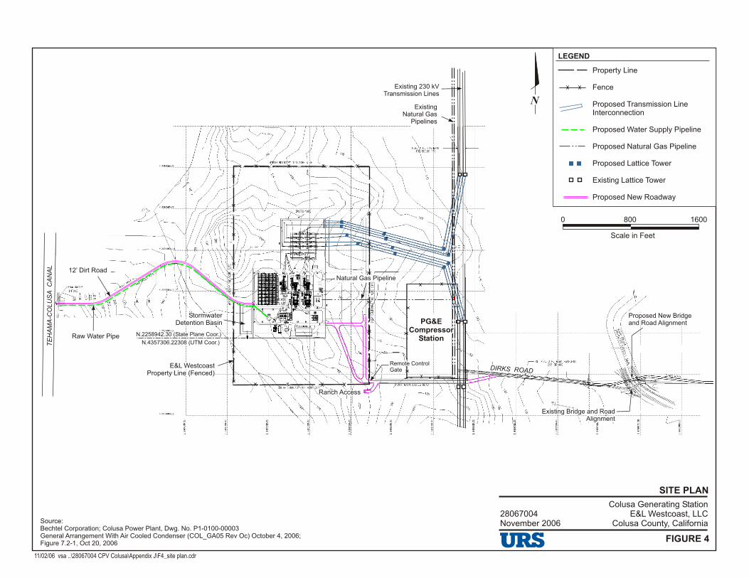
SITE PLAN
11/02/06 vsa ..\28067004 CPV Colusa\Appendix J\F4_site plan.cdr
Source:Bechtel Corporation; Colusa Power Plant, Dwg. No. P1-0100-00003General Arrangement With Air Cooled Condenser (COL_GA05 Rev Oc) October 4, 2006;Figure 7.2-1, Oct 20, 2006
28067004November 2006
Colusa Generating StationE&L Westcoast, LLC
Colusa County, California
FIGURE 4
0 800 1600
Scale in Feet
N
LEGEND
Property Line
Fence
Proposed Transmission Line Interconnection
Proposed Water Supply Pipeline
Proposed Natural Gas Pipeline
Proposed Lattice Tower
Existing Lattice Tower
Proposed New Roadway
Existing 230 kVTransmission Lines
Existing Natural Gas
Pipelines
12’ Dirt Road
Raw Water Pipe
TE
HA
MA
-CO
LU
SA
C
AN
AL
E&L Westcoast Property Line (Fenced)
E&L Westcoast Property Line (Fenced)
N.2258942.30 (State Plane Coor.)N.2258942.30 (State Plane Coor.)
N.4357306.22308 (UTM Coor.)N.4357306.22308 (UTM Coor.)
StormwaterDetention Basin
StormwaterDetention Basin
Ranch AccessRanch Access
Remote ControlGateRemote ControlGate
Natural Gas PipelineNatural Gas Pipeline
PG&ECompressor
Station
PG&ECompressor
Station
Proposed New Bridge and Road AlignmentProposed New Bridge and Road Alignment
Existing Bridge and Road Alignment
Existing Bridge and Road Alignment
I K RD R S OADI K RD R S OAD
Appendix B: DPR 523 Forms

DPR 523A (1/95) T:\TECHDRAW\46800-930 Colusa Power Plant\PDF DOCUMENT\Reliant-word docs\Appendix 8.3TERESABR.copy.doc *Required Information
State of California — The Resources Agency Primary # DEPARTMENT OF PARKS AND RECREATION HRI #
PRIMARY RECORD Trinomial NRHP Status Code 6
Other Listings Review Code Reviewer Date
Page 1 of 5 *Resource Name or #: (Assigned by recorder) Teresa Creek Bridge
P1. Other Identifier: Bridge No. 15C-167; also Co. No. 24F P2. Location: ¨ Not for Publication ⌧ Unrestricted *a: County Colusa County
and (P2c,P2e, and P2b or P2d. Attach Location Map as necessary.)*b. USGS 7.5' Quad Maxwell Date 1994 T 17N ; R 3W ; ¼ of ¼ of Sec 5, 6 ; M.D. B.M.c. Address McDermott Road City Maxwell (vicinity) Zip NA d. UTM: (Give more than one for large and/or linear resources) Zone 2; 566500 mE/ 4356800 mN*e. Other Locational Data: (e.g., parcel #, directions to resource, elevation, etc., as appropriate)s
0.7 mile north of Delevan Road; 03-Col-Co. Rd.
*P3a. Description: (Describe resource and its major elements. Include design, materials, condition, alterations, size, setting, and boundaries)
*P3b Resource Attributes: (List attributes and codes) HP19 *P4. Resources Present: ¨ Building ⌧ Structure ¨ Object ¨ Site ¨ District ¨ Element of District ¨ Other (isolates,etc.)
P5b. Description of Photo:(View, date, accession #) view west, 11 March 2001 Brian Vahey, photographer BRV-2:10 *P6. Date Constructed/AgeandSource: ⌧ Historic¨ Prehistoric ¨ Both1940; repaired 1959/CaltransBridge Report *P7. Owner and Address: Colusa County, Department of Public Works, 1215 Market St. Colusa, CA 95932 *P8. Recorded by: (Name,affiliation, and address) J. Stock/M. Corbett, URS Corp 221 Main Street, #600 San Francisco, CA 94105 *P9. Date Recorded: 13 March and 6 April 2001 *P10. Survey Type: (Describe) Intensive Survey
P11. Report Citation*: (Cite survey report and other sources, or enter "none".) Application for Certification of Colusa Power Plant *Attachments: ¨ NONE ⌧ Location Map ¨ Sketch Map ⌧ Continuation Sheet ⌧ Building, Structure and Object Record¨ Archaeological Record ¨ District Record ¨ Linear Feature Record ¨ Milling Station Record ¨ Rock Art Record¨ Artifact Record ¨ Photograph Record ¨ Other (List)
The Teresa Creek Bridge is located on McDermott Road about 0.7 miles north of the intersection with Delevan Road.The bridge spans Teresa Creek, a branch of Hunter’s Creek. McDermott Road is a two-lane, asphalt-surfaced road on asection line. The road provides access to farmland in a rural part of northern Colusa County. In 1977, the average dailytraffic was 200 vehicles. According to the American Civil Engineer’s Handbook of 1930 (p. 1174), this was a secondaryroad and the bridge was classified as a Class C bridge. The bridge is 20.4 feet long and 24 feet wide with a 15-foot-wideroadway. It was designed for one lane of traffic.
See Continuation Sheet
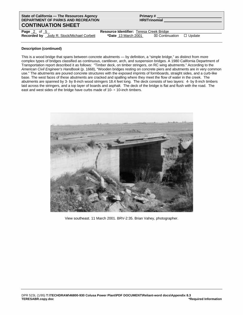
DPR 523L (1/95) T:\TECHDRAW\46800-930 Colusa Power Plant\PDF DOCUMENT\Reliant-word docs\Appendix 8.3TERESABR.copy.doc *Required Information
State of California — The Resources Agency Primary # DEPARTMENT OF PARKS AND RECREATION HRI/Trinomial
CONTINUATION SHEETPage 2 of 5 Resource Identifier: Teresa Creek Bridge Recorded by Jody R. Stock/Michael Corbett *Date 13 March 2001 ⌧ Continuation ¨ Update
Description (continued)
This is a wood bridge that spans between concrete abutments — by definition, a “simple bridge,” as distinct from morecomplex types of bridges classified as continuous, cantilever, arch, and suspension bridges. A 1980 California Department ofTransportation report described it as follows: “Timber deck, on timber stringers, on RC wing abutments.” According to theAmerican Civil Engineer’s Handbook (p. 1668), “Wooden bridges resting on concrete piers and abutments are in very commonuse.” The abutments are poured concrete structures with the exposed imprints of formboards, straight sides, and a curb-likebase. The west faces of these abutments are cracked and spalling where they meet the flow of water in the creek. Theabutments are spanned by 3- by 8-inch wood stringers 18.4 feet long. The deck consists of two layers: 4- by 8-inch timberslaid across the stringers, and a top layer of boards and asphalt. The deck of the bridge is flat and flush with the road. Theeast and west sides of the bridge have curbs made of 10- × 10-inch timbers.
View southeast. 11 March 2001. BRV-2:35. Brian Vahey, photographer.

DPR 523B (1/95) T:\TECHDRAW\46800-930 Colusa Power Plant\PDF DOCUMENT\Reliant-word docs\Appendix 8.3TERESABR.copy.doc *Required Information
(Sketch map with north arrow required)
State of California — The Resources Agency Primary # DEPARTMENT OF PARKS AND RECREATION HRI #
BUILDING, STRUCTURE, AND OBJECT RECORDPage 3 of 5 *NRHP Status Code 6
*Resource Name or # (Assigned by recorder) Teresa Creek Bridge B1. Historic Name: Bridge No. 15C-167; also Co. No. 24F B2. Common Name: B3. Original Use: bridge B4. Present Use: bridge *B5. Architectural Style: utilitarian *B6. Construction History: (Construction date, alterations, and date of alterations)
built ca. 1940; repaired 1959
*B7. Moved? ⌧ No ¨ Yes ¨ Unknown Date: Original Location: *B8. Related Features:
B9a. Architect: unknown b. Builder: unknown *B10. Significance: Theme N/A Area
Period of Significance Property Type Applicable Criteria (Discuss importance in terms of historical or architectural context as defined by theme, period, and geographic scope. Also address integrity.)
B11. Additional Resource Attributes: (List attributes and codes)
*B12. References:
See continuation sheet.
B13. Remarks:
*B14. Evaluator: Michael R. Corbett Date of Evaluation: 25 April 2001
(This space reserved for official comments.)
HistoryThe Teresa Creek Bridge is located on a section line road that appeared on a 1906 USGS map. The current bridge was builtabout 1940, apparently replacing an earlier structure. A 1949 Thomas Brothers map showed this bridge in an area served bya network of improved roads. The bridge was repaired in 1959.
In 1980, a California Department of Transportation Bridge Report described it as follows: “The structure is in poorcondition . . .. The planks are very worn. Outer stringers have some incipient rot, near ends.” A handwritten note on theBridge Report stated: “Removed from biennial inspection process in re letter dated 10-10-85.”
EvaluationThe Teresa Creek Bridge does not appear eligible for the NRHP. Under criterion A, it was one of many bridges built onsecondary roads in rural agricultural areas of Colusa County in the 1920s-1940s. These bridges were associated with thedevelopment of rice farming in the Glenn-Colusa Irrigation District. As one of many surviving bridges in this area, this bridgelacks significance.
See continuation sheet

DPR 523L (1/95) T:\TECHDRAW\46800-930 Colusa Power Plant\PDF DOCUMENT\Reliant-word docs\Appendix 8.3TERESABR.copy.doc *Required Information
State of California — The Resources Agency Primary # DEPARTMENT OF PARKS AND RECREATION HRI/Trinomial
CONTINUATION SHEETPage 4 of 5 Resource Identifier: Teresa Creek Bridge Recorded by Jody R. Stock / Michael Corbett *Date 13 March 2001 ⌧ Continuation ¨ Update
Evaluation (continued)
Under criterion C, this is a common type of simple bridge. Because many of these survive in the area, this bridge lackssignificance. Additionally, the Teresa Creek Bridge does not appear to be significant under CRHR criteria.
For purposes of CEQA, this is not a historic property.
References (continued)
Burgan, R.W., P.E. (C.E. #9268). Bridge Report on Bridge No. 15C-167. California Department of Transportation. 31 January1980.
“Map of Colusa County California, Colusa County Chamber of Commerce.” Map. 1966. Earth Sciences Library, University ofCalifornia, Berkeley.
Merriman, Thaddeus, editor. American Civil Engineers’ Handbook, fifth edition. New York: John Wiley & Sons, 1930.
“Metsker’s Map of Colusa County California.” Map. 1960. Earth Sciences Library, University of California, Berkeley.
Mikesell, Stephen D. Historic Bridges of California. [Sacramento]: California Department of Transportation, 1990.
“Official Chamber of Commerce Map of Colusa County and Its Communities.” Map. 1988. Earth Sciences Library, Universityof California, Berkeley.
“Rand McNally Map of Colusa County.” Map. 1962. Earth Sciences Library, University of California, Berkeley.
“State of California, The Resources Agency, Department of Conservation, Division of Forestry, Colusa County.” Map. 1947.Earth Sciences Library, University of California, Berkeley.
“Thomas Bros. Map of Colusa County California.” Map. 1946. Earth Sciences Library, University of California, Berkeley.
“Title Insurance and Trust Map of Colusa County and Its Cities.” Map. 1978. Earth Sciences Library, University of California,Berkeley.
United States Geological Survey. “Maxwell Quad.” Map. 1952).
United States Geological Survey. “Maxwell Quad.” Map. 1952-1954.
United States Geological Survey. “Maxwell Quad.” Map. 1973.
United States Geological Survey. “Maxwell Quad.” Map. 1994 revised.
United States Geological Survey. “Maxwell Quad.” Map. January 1906 reprinted 1936
Urquhart, Leonard Church, editor. Civil Engineering Handbook, third edition. New York: McGraw-Hill, 1950.
Wrysinski, Jon, Colusa County Department of Public Works. Interview by Jody Stock, 11 April 2001.

DPR 523J (1/95) T:\TECHDRAW\46800-930 Colusa Power Plant\PDF DOCUMENT\Reliant-word docs\Appendix 8.3 TERESABR.copy.doc*Required Information
State of California — The Resources Agency Primary # DEPARTMENT OF PARKS AND RECREATION HRI#
LOCATION MAP Trinomial#
Page 5 of 5 *Resource Name or # (Assigned by recorder) Teresa Creek Bridge *Map Name: APE Map Colusa Power Plant Project *Scale: See map *Date of Map: 2001
Page 1 of 1 *Resource Name or # (Assigned by recorder) Map Reference No. 1 *Recorded by T.Webb/S.Riem *Date August 2006 Continuation ⌧ Update
DPR 523L (1/95) *Required Information
State of California – The Resources Agency Primary # _____________________________________ DEPARTMENT OF PARKS AND RECREATION HRI # ________________________________________ UPDATE SHEET Trinomial ___________________________________________
NRHP Status Code 6Z
P1. Other Identifier: Bridge No. 15C0167; Teresa Creek Bridge c. Address McDermott Road City Maxwell Zip e. Other Locational Data: 0.7 mile north of Delevan Road; 03-Col-Cl. Rd.
P3a. Description: The Teresa Creek Bridge has been field checked and does not appear to have undergone any alterations since its previous evaluation in 2001.
*P8. Recorded by: JRP Historical Consulting, LLC, 1490 Drew Ave., Suite 110, Davis, CA 95618 *P9. Date Recorded: August 2006 *P11. Report Citation: JRP Historical Consulting, LLC, “Historic Properties Inventory and Evaluation Report: Colusa Generating Station Project, Colusa County, California.”
B10. Significance: Michael Corbett of URS Corporation inventoried and evaluated this bridge in 2001 for the report entitled “Historic Architecture Report for Colusa Power Plant Project.” That report concluded that the Teresa Creek Bridge did not appear to be eligible for the National Register of Historic Places, a conclusion that still appears to be valid. This resource has also been evaluated in accordance with Section 15064.5(a)(2)-(3) of the CEQA Guidelines, using the criteria outlined in Section 5024.1 of the California Public Resources Code. This bridge does not appear to be eligible for the California Register of Historical Resources, nor does it appear to be a historical resource for the purposes of CEQA. *B14. Evaluator: Toni Webb *Date of Evaluation: August 2006

State of California — The Resources Agency Primary # DEPARTMENT OF PARKS AND RECREATION HRI # PRIMARY RECORD Trinomial NRHP Status Code 6 Other Listings Review Code Reviewer Date
Page 1 of 7 *Resource Name or # (Assigned by recorder) Farm in Section 6 P1. Other Identifier: P2. Location: Not for Publication ⌧ Unrestricted *a: County Colusa County and (P2c,P2e, and P2b or P2d. Attach Location Map as necessary.) *b. USGS 7.5' Quad Maxwell Date 1994 T 17N ; R 3W ; ¼ of ¼ of Sec 6 ; M.D. B.M. c. Address north of Delevan Road City Maxwell Zip 95955 d. UTM: (Give more than one for large and/or linear resources) Zone 2; 565505 mE/ 4356325 mN *e. Other Locational Data: (e.g., parcel #, directions to resource, elevation, etc., as appropriate) APN 11-22-1 *P3a. Description: (Describe resource and its major elements. Include design, materials, condition, alterations, size, setting, and boundaries)
*P3b Resource Attributes: (List attributes and codes) HP33: Farm/Ranch
This property occupies a section of land consisting of 635 acres. This is a square parcel bordered on all four sides by section line roads, including Delevan Road on the south and west, McDermott Road on the east, and Dirks Road on the north. A cluster of six buildings and structures near the center of the property is approached by two driveways — from the south and west. Just beyond this property on the west side is the Glenn Colusa Canal. The building cluster includes two dwellings, a domestic garage, a barn, a farm vehicle garage, and a building that appears to be a bunkhouse. These are described below. 1. Large House. This is a one-story house with an irregular “T”-shaped footprint. The building has a complex roofline; the
different sections of the house are all covered with low-pitched gable roofs with overhanging eaves. All portions of the roof have asphalt shingles. The wood-frame structure is covered with horizontal siding, and the windows are sliding with aluminum frames. In appearance, the design of this house suggests both pre-war bungalows and post-war ranch style houses.
See continuation sheet.
*P4. Resources Present: ⌧ Building ⌧ Structure Object Site District Element of District Other (isolates, etc.)
P5b. Description of Photo: (View, date, accession #) view west, 8 March 2001 Brian Vahey, photographer BRV-1:30 *P6. Date Constructed/Age and Source: ⌧ Historic
Prehistoric Both ca. 1945/Visual Estimate *P7. Owner and Address: Frances M. Etchepare, Trustee P.O. Box 658 Maxwell, CA 94955 *P8. Recorded by: (Name, affiliation, and address) Michael Corbett/URS Corp 221 Main Street, #600 San Francisco, CA 94105 *P9. Date Recorded: 6 April 2001 *P10. Survey Type: (Describe) intensive
P11. Report Citation*: (Cite survey report and other sources, or enter "none".) Application for Certification of Colusa Power Plant *Attachments: NONE ⌧ Location Map Sketch Map ⌧ Continuation Sheet ⌧ Building, Structure and Object Record
Archaeological Record District Record Linear Feature Record Milling Station Record Rock Art Record Artifact Record Photograph Record Other (List)
DPR 523A (1/95) R:\06 CPV Colusa\Appendix 8.3 SECTION6 From 01.doc *Required Information

State of California — The Resources Agency Primary # DEPARTMENT OF PARKS AND RECREATION HRI/Trinomial CONTINUATION SHEET Page 2 of 7 Resource Identifier: Farm in Section 6 Recorded by Michael Corbett *Date 6 April 2001 ⌧ Continuation Update Description (continued) 2. Small House. This is a one-story building with a rectangular footprint and a box-like form. It has a gable roof with asphalt
shingles and no eaves. The wood-frame structural system is covered with what appear to be asbestos shingles. The screen door and sliding windows are aluminum.
3. There is a large barn east of the residences. The wood-frame structure has a rectangular footprint. It is covered with a
gable roof with double-pitched shed roofs on the north and south sides of the building. All sections of the roof are covered with corrugated metal siding with several panels of translucent plastic for light. The exterior walls of the building are sheathed with vertical, wood siding. There is a roll-up metal door in the center of the west facade. On either side of this are two sliding wooden plank doors, and bordering these, there are pairs of wood, swing doors. On the north facade, the central bay is open to allow for farm machinery storage.
4. Between the two houses is a rectangular four-bay garage for domestic use. This is a recent building with a cupola on the
gable roof. It is a wood frame structure. 5. Near the barn is a rectangular garage with a low-pitched gable roof for farm vehicles. 6. Between the garages is a rectangular wood frame structure with a gable roof and a small entrance porch. This appears to
have been a residence, perhaps a bunkhouse for farm workers.
1. Large House. view south, 8 March 2001, BRV-1:31. Brian Vahey, photographer.
DPR 523L (1/95) R:\06 CPV Colusa\Appendix 8.3 SECTION6 From 01.doc *Required Information
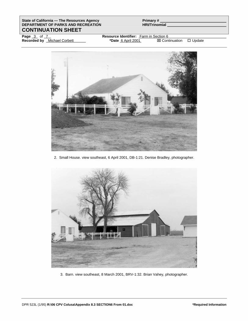
State of California — The Resources Agency Primary # DEPARTMENT OF PARKS AND RECREATION HRI/Trinomial CONTINUATION SHEET Page 3 of 7 Resource Identifier: Farm in Section 6 Recorded by Michael Corbett *Date 6 April 2001 ⌧ Continuation Update
2. Small House. view southeast, 6 April 2001, DB-1:21. Denise Bradley, photographer.
3. Barn. view southeast, 8 March 2001, BRV-1:32. Brian Vahey, photographer.
DPR 523L (1/95) R:\06 CPV Colusa\Appendix 8.3 SECTION6 From 01.doc *Required Information

State of California — The Resources Agency Primary # DEPARTMENT OF PARKS AND RECREATION HRI/Trinomial CONTINUATION SHEET Page 4 of 7 Resource Identifier: Farm in Section 6 Recorded by Michael Corbett *Date 6 April 2001 ⌧ Continuation Update
4. Domestic Garage. view south, 6 April 2001, DB-1:20. Denise Bradley, photographer.
DPR 523L (1/95) R:\06 CPV Colusa\Appendix 8.3 SECTION6 From 01.doc *Required Information

State of California — The Resources Agency Primary # DEPARTMENT OF PARKS AND RECREATION HRI # BUILDING, STRUCTURE, AND OBJECT RECORD Page 5 of 7 *NRHP Status Code 6 *Resource Name or # (Assigned by recorder) Farm in Section 6 B1. Historic Name: Sevier Farm B2. Common Name: Etchepare Property B3. Original Use: farmstead/ranch B4. Present Use: farmstead/ranch *B5. Architectural Style: vernacular *B6. Construction History: (Construction date, alterations, and date of alterations) residences and barn ca. 1945 *B7. Moved? ⌧ No Yes Unknown Date: Original Location: *B8. Related Features: two dwellings, one domestic garage, one barn, one farm vehicle garage, one bunkhouse B9a. Architect: unknown b. Builder: unknown *B10. Significance: Theme N/A Area Period of Significance Property Type Applicable Criteria (Discuss importance in terms of historical or architectural context as defined by theme, period, and geographic scope. Also address integrity.) History
In 1906 there were no buildings in section 6 (now APN 11-22-1). At that time, there were roads along all four sides of section 6, connected to roads leading east to the Southern Pacific Railroad and the small community of Delevan. The Central Irrigation Canal (now known as the Glenn-Colusa Canal) stretched outside the west side of section 6 and several streams crossed the property. There was little development in the area east of the Central Canal and north of Funks Creek. World War II created an increased demand for grain, and prices rose dramatically. Farmers discovered that when flooded, the alkaline and clay soils of the Sacramento Delta that had previously been thought of as poor farmland, were well-suited to growing rice. As rice became the predominant crop in the area, more irrigation water was needed and was provided by the nearby Glenn-Colusa Canal. The war years were a period of growth for the towns of Colusa County; this farmstead and many others were built at that time. By 1947 a north-south driveway and two buildings had been constructed on this property. Five years later, in 1952, an east-west driveway and two more structures had been built. In 1973 there were six buildings on the property (United States Geological Survey. “Maxwell Quad.” Map. 1973). See continuation sheet
B11. Additional Resource Attributes: (List attributes and codes) *B12. References: (Sketch map with north arrow required) See continuation sheet. B13. Remarks: *B14. Evaluator: Michael R. Corbett Date of Evaluation: 25 April 2001
(This space reserved for official comments.)
DPR 523B (1/95) R:\06 CPV Colusa\Appendix 8.3 SECTION6 From 01.doc *Required Information

DPR 523L (1/95) R:\06 CPV Colusa\Appendix 8.3 SECTION6 From 01.doc *Required Information
State of California — The Resources Agency Primary # DEPARTMENT OF PARKS AND RECREATION HRI/Trinomial CONTINUATION SHEET Page 6 of 7 Resource Identifier: Farm in Section 6 Recorded by Michael R. Corbett *Date 25 April 2001 ⌧ Continuation Update History (continued) The current property is comprised of 635 acres of land, on which are grown row crops which succeeded rice in the 1990s. Frances M. Etchepare and trustees have owned the property since July 1992. From 17 March 1964 to 1992, the property was owned by Ruth S. Sevier (Assessor Inquiry for 11-22-1. Colusa County Assessor’s printout, 20 March 2001). Evaluation
This farm property in Section 6 of Township 17 North/Range 4 West (APN 11-22-1) does not appear eligible for the NRHP. Under criterion A, it is one of many farms established in northern Colusa County in the 1940s for rice farming. Many similar farms survive today, visible from public roads. The property lacks significance under criterion A. Under criterion C, this is a typical example of a common type of mid-20th century farm in northern California. The property lacks significance under criterion C. Additionally, this property does not appear to be significant under CRHR criteria. For purposes of CEQA, this is not a historic property. References “Assessor Plat Maps for Colusa County.” Maps. Book 11 page 22. Glenn County Assessors Office, Willows, CA. Etchepare, Jean. Telephone conversation with Michael Corbett. 25 April 2001. “Map of Colusa County California, Colusa County Chamber of Commerce.” Map. 1966. Earth Sciences Library, University of California, Berkeley. “Map of the Glenn-Colusa Irrigation District: Glenn & Colusa Counties, California.” Map. 1956. Water Resources Archives, University of California, Berkeley. “Metsker’s Map of Colusa County California.” Map. 1960. Earth Sciences Library, University of California, Berkeley. “Official Chamber of Commerce Map of Colusa County and Its Communities.” Map. 1988. Earth Sciences Library, University of California, Berkeley. “Rand McNally Map of Colusa County.” Map. 1962. Earth Sciences Library, University of California, Berkeley. “State of California, The Resources Agency, Department of Conservation, Division of Forestry, Colusa County.” Map. 1947. Earth Sciences Library, University of California, Berkeley. “Title Insurance and Trust Map of Colusa County and Its Cities.” Map. 1978. Earth Sciences Library, University of California, Berkeley. United States Geological Survey. “Maxwell Quad.” Map. January 1906 reprinted 1936. United States Geological Survey. “Maxwell Quad.” Map. 1952. United States Geological Survey. “Maxwell Quad.” Map. 1952-1954. United States Geological Survey. “Maxwell Quad.” Map. 1973. United States Geological Survey. “Maxwell Quad.” Map. 1994 revised.

State of California — The Resources Agency Primary # DEPARTMENT OF PARKS AND RECREATION HRI# LOCATION MAP Trinomial#
Page 7
DPR 523J (1/95) R:\06 CPV Colusa\Appendix 8.3 SECTION6 From 01.doc *Required Information
of 7 *Resource Name or # (Assigned by recorder) Farm in Section 6 *Map Name: APE Map Colusa Power Plant Project *Scale: See map *Date of Map: 2001
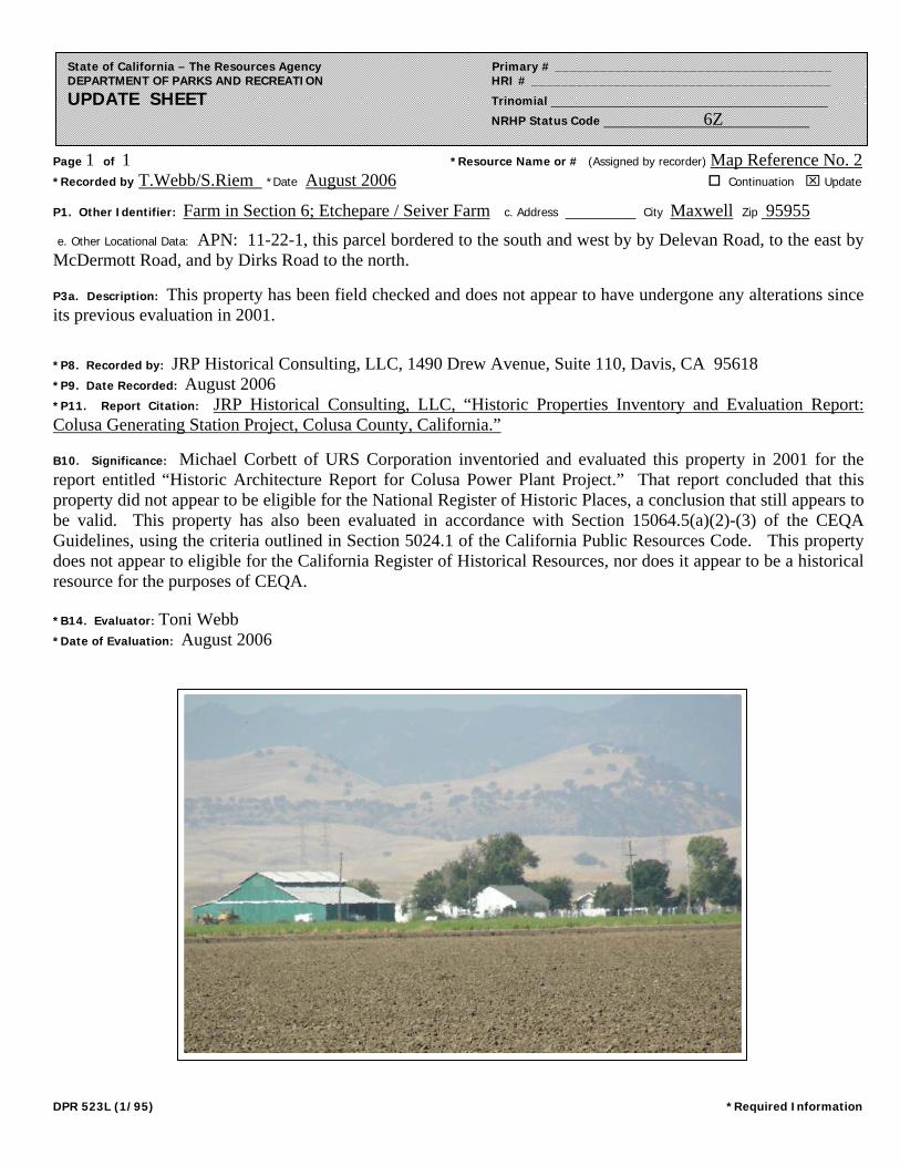
Page 1 of 1 *Resource Name or # (Assigned by recorder) Map Reference No. 2 *Recorded by T.Webb/S.Riem *Date August 2006 Continuation ⌧ Update
DPR 523L (1/95) *Required Information
State of California – The Resources Agency Primary # _____________________________________ DEPARTMENT OF PARKS AND RECREATION HRI # ________________________________________ UPDATE SHEET Trinomial ___________________________________________
NRHP Status Code 6Z
P1. Other Identifier: Farm in Section 6; Etchepare / Seiver Farm c. Address City Maxwell Zip 95955
e. Other Locational Data: APN: 11-22-1, this parcel bordered to the south and west by by Delevan Road, to the east by McDermott Road, and by Dirks Road to the north.
P3a. Description: This property has been field checked and does not appear to have undergone any alterations since its previous evaluation in 2001.
*P8. Recorded by: JRP Historical Consulting, LLC, 1490 Drew Avenue, Suite 110, Davis, CA 95618 *P9. Date Recorded: August 2006 *P11. Report Citation: JRP Historical Consulting, LLC, “Historic Properties Inventory and Evaluation Report: Colusa Generating Station Project, Colusa County, California.”
B10. Significance: Michael Corbett of URS Corporation inventoried and evaluated this property in 2001 for the report entitled “Historic Architecture Report for Colusa Power Plant Project.” That report concluded that this property did not appear to be eligible for the National Register of Historic Places, a conclusion that still appears to be valid. This property has also been evaluated in accordance with Section 15064.5(a)(2)-(3) of the CEQA Guidelines, using the criteria outlined in Section 5024.1 of the California Public Resources Code. This property does not appear to eligible for the California Register of Historical Resources, nor does it appear to be a historical resource for the purposes of CEQA. *B14. Evaluator: Toni Webb *Date of Evaluation: August 2006

DPR 523A (1/95) T:\TECHDRAW\46800-930 Colusa Power Plant\PDF DOCUMENT\Reliant-word docs\Appendix 8.3SECTION1.copy.doc *Required Information
State of California — The Resources Agency Primary # DEPARTMENT OF PARKS AND RECREATION HRI #
PRIMARY RECORD Trinomial NRHP Status Code 6
Other Listings Review Code Reviewer Date
Page 1 of 8 *Resource Name or #: (Assigned by recorder) Ranch Buildings in Section 1
P1. Other Identifier: P2. Location: ¨ Not for Publication ⌧ Unrestricted *a: County Colusa County
and (P2c,P2e, and P2b or P2d. Attach Location Map as necessary.)*b. USGS 7.5' Quad Sites Date 1973 T 17N ; R 4W ; ¼ of ¼ of Sec 1 ; M.D. B.M.c. Address south of Dirks Road City Maxwell Zip 95955 d. UTM: (Give more than one for large and/or linear resources) Zone 2; 563355 mE/ 4356300 mN*e. Other Locational Data: (e.g., parcel #, directions to resource, elevation, etc., as appropriate)
APN 11-14-4
*P3a. Description: (Describe resource and its major elements. Include design, materials, condition, alterations, size, setting, and boundaries)
*P3b Resource Attributes: (List attributes and codes) HP33: Farm/Ranch *P4. Resources Present: ⌧ Building ⌧ Structure ¨ Object ¨ Site ¨ District ¨ Element of District ¨ Other (isolates,etc.)
P5b. Description of Photo:(View, date, accession #) Barn, view northwest, Brian Vahey, photographer 11 March 2001, BRV-2:22 *P6. Date Constructed/Age andSource: ⌧ Historic¨ Prehistoric ¨ Bothpost 1960/ USGS Map *P7. Owner and Address:Leo Holthouse, et al. HC 84 Box 66 Canyon City, OR 97820-9702 *P8. Recorded by: (Name,affiliation, and address) Michael Corbett, URS Corp 221 Main Street, #600 San Francisco, CA 94105 *P9. Date Recorded: 6 April 2001 *P10. Survey Type: (Describe) intensive
P11. Report Citation*: (Cite survey report and other sources, or enter "none".) Application for Certification of Colusa Power Plant *Attachments: ¨ NONE ⌧ Location Map ¨ Sketch Map ⌧ Continuation Sheet ⌧ Building, Structure and Object Record¨ Archaeological Record ¨ District Record ¨ Linear Feature Record ¨ Milling Station Record ¨ Rock Art Record
The property located on Assessor’s Parcel Number 11-14-4 west of the Glenn-Colusa Canal occupies 360 acres inSection 1 of Township 17 north, Range 4 west. This property has been accessible by dirt road since at least 1904 whenthe USGS map showed roads from the east, west, and south converging in this section. The roads from the east andsouth provided links to the Southern Pacific Railroad and to an east-west route to Lake County, respectively. The roadfrom the west went only as far as the next section. In the absence of any mines or buildings of any sort, this property andthe surrounding area appear to have functioned as wheat farms or ranch land in the early 20th century. Unlike roads inagricultural areas on lower land to the east which followed section lines, these ranch roads provided access to highergrazing land — presumably summer pastures. The same conditions were shown on the 1917 USGS map.
See continuation sheet.

DPR 523L (1/95) T:\TECHDRAW\46800-930 Colusa Power Plant\PDF DOCUMENT\Reliant-word docs\Appendix 8.3SECTION1.copy.doc *Required Information
State of California — The Resources Agency Primary # DEPARTMENT OF PARKS AND RECREATION HRI/Trinomial
CONTINUATION SHEETPage 3 of 8 Resource Identifier: Ranch Buildings in Section 1 Recorded by Michael Corbett *Date 6 April 2001 ⌧ Continuation ¨ Update
Description (continued)
The next record of the property, a 1943 USGS map, showed a high voltage electric power transmission line running north-south through this property in section 1. The only building shown in the vicinity of the property at that time was indicated on thewest side of the boundary between sections 1 and 2. No evidence of further changes within the parcel appear until the 1958USGS map which showed farm structures at the ends of dirt roads in sections 3 and 35, to the west and northwest,respectively. The building previously shown on the boundary between sections 1 and 2 was not shown, and there were still nobuildings or structures shown on this property. Thus, the buildings and structures now standing on the property all appear tohave been built after 1960. One collapsed building may be older.
There are no structures on the property except for a cluster of seven features in the center, near the western boundary of thisirregular parcel. These features include three buildings, one water tank structure, one manufactured home, one abandonedtruck with water tank mounted on its bed, and one collapsed building.
The site appears little used and is overgrown with weeds. Dilapidated fences and abandoned machinery are also located onthe property. Each major feature is described below:
1. The most substantial structure is a large one-story barn with a long rectangular footprint. The gable-roofed wood-framestructure is covered with corrugated metal panels. On the long sides of the building there appear to be seven doors thatslide on an overhead rail. At the center of one of the gable ends there is larger door on rails. On this end of the buildingthere is also a raised metal feed bin. Post 1960.
2. A double-wide, manufactured home is also located on the site. The one-story structure has a rectangular footprint and israised off the ground on blocks. The structure is covered with vertical aluminum siding. The building has a shallowgabled roof that is supported by brackets under the gable ends. The building is badly deteriorated, and the frames andglazing of the windows are missing. Post 1960.
3. Next to the manufactured home, there is a garage with a rectangular footprint. It is covered with a gabled roof withwooden shingles and has exposed rafter ends. The wood-frame structure is covered with horizontal plank siding. Thereis a window opening on one side of the building and a wooden plank door on an overhead rail underneath one of thegable ends. Post 1960.
4. A rectangular wood frame structure with a shed roof. The walls are sheathed in corrugated metal panels and the roofingis missing. One side of the building has been left open. The floor is dirt. Post 1960.
5. Behind the shed roofed structure is a metal tank on top of a heavy timber structure with wooden “X” bracing. The lowerportion of the structure has been enclosed with a shed roof and siding on three sides to form a small enclosure. Post1960.
6. Another building has completely collapsed. All that is visible is the remains of a gabled roof covered with corrugatedmetal panels. Date unknown.
7. An abandoned truck with a water tank mounted on its bed. The truck appears to be a Model A Ford, built sometimebetween 1928 and the end of the 1930s. This may have been a means of moving the water tank around the ranch, or itmay have been parked permanently and the engine reattached to a pump. Date on this site is unknown.

DPR 523L (1/95) T:\TECHDRAW\46800-930 Colusa Power Plant\PDF DOCUMENT\Reliant-word docs\Appendix 8.3SECTION1.copy.doc *Required Information
State of California — The Resources Agency Primary # DEPARTMENT OF PARKS AND RECREATION HRI/Trinomial
CONTINUATION SHEETPage 3 of 8 Resource Identifier: Ranch Buildings in Section 1 Recorded by Michael Corbett *Date 6 April 2001 ⌧ Continuation ¨ Update
2. Manufactured Home: view north, 11 March 2001. BRV-2:21. Brian Vahey, photographer.
3. Garage: view east, 11 March 2001. BRV-2:25. Brian Vahey, photographer.
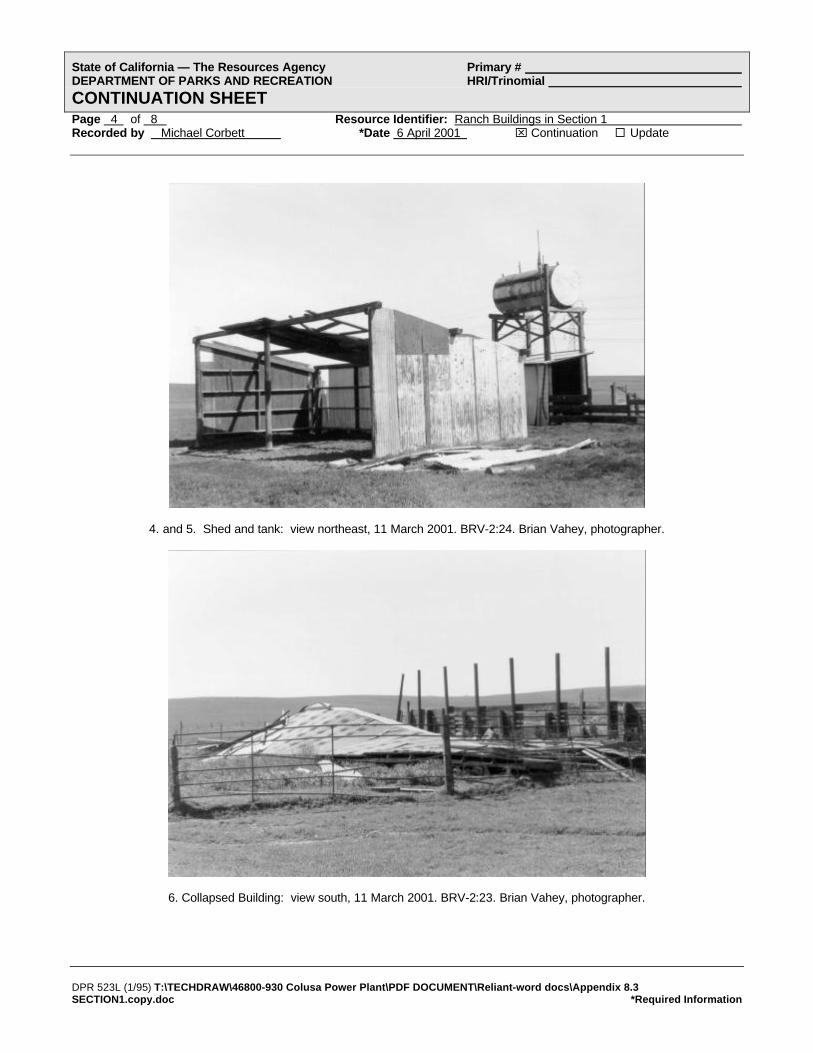
DPR 523L (1/95) T:\TECHDRAW\46800-930 Colusa Power Plant\PDF DOCUMENT\Reliant-word docs\Appendix 8.3SECTION1.copy.doc *Required Information
State of California — The Resources Agency Primary # DEPARTMENT OF PARKS AND RECREATION HRI/Trinomial
CONTINUATION SHEETPage 4 of 8 Resource Identifier: Ranch Buildings in Section 1 Recorded by Michael Corbett *Date 6 April 2001 ⌧ Continuation ¨ Update
4. and 5. Shed and tank: view northeast, 11 March 2001. BRV-2:24. Brian Vahey, photographer.
6. Collapsed Building: view south, 11 March 2001. BRV-2:23. Brian Vahey, photographer.

DPR 523L (1/95) T:\TECHDRAW\46800-930 Colusa Power Plant\PDF DOCUMENT\Reliant-word docs\Appendix 8.3SECTION1.copy.doc *Required Information
State of California — The Resources Agency Primary # DEPARTMENT OF PARKS AND RECREATION HRI/Trinomial
CONTINUATION SHEETPage 5 of 8 Resource Identifier: Ranch Buildings in Section 1 Recorded by Michael Corbett *Date 6 April 2001 ⌧ Continuation ¨ Update
7. Truck with tank: view west, 11 March 2001. BRV-2:26. Brian Vahey, photographer.

DPR 523B (1/95) T:\TECHDRAW\46800-930 Colusa Power Plant\PDF DOCUMENT\Reliant-word docs\Appendix 8.3SECTION1.copy.doc *Required Information
(Sketch map with north arrow required)
State of California — The Resources Agency Primary # DEPARTMENT OF PARKS AND RECREATION HRI #
BUILDING, STRUCTURE, AND OBJECT RECORDPage 6 of 8 *NRHP Status Code 6
*Resource Name or # (Assigned by recorder) Ranch Buildings in Section 1 B1. Historic Name: unknown B2. Common Name: B3. Original Use: ranch B4. Present Use: ranch *B5. Architectural Style: vernacular *B6. Construction History: (Construction date, alterations, and date of alterations)
1. Barn - post 19602. Manufactured home - post 19603. Garage - post 19604. Shed - post 19605. Metal tank - post 19606. Collapsed building - date unknown7. Abandoned truck with tank - date on this site unknown
*B7. Moved? ¨ No ¨ Yes ⌧ Unknown Date: Original Location: several features possibly move to site *B8. Related Features:
B9a. Architect: unknown b. Builder: unknown *B10. Significance: Theme N/A Area
Period of Significance Property Type Applicable Criteria (Discuss importance in terms of historical or architectural context as defined by theme, period, and geographic scope. Also address integrity.)
History
B11. Additional Resource Attributes: (List attributes and codes)
*B12. References:
See continuation sheet.
B13. Remarks:
*B14. Evaluator: Michael R. Corbett Date of Evaluation: 26 April 2001
(This space reserved for official comments.)
As early as 1904, the land that now forms the current property was crossed by trails that ran along and into the foothills(United States Geological Survey. “Sites Quad.” Map. 1904 revised). At that time, Colusa County was occupied by largewheat farms and ranches. By 1943, the paths through the property had been straightened but were still dirt. Maps from thatyear show that buildings had been constructed at the ends of the paths in the hills, but do not show any buildings on thisproperty (United States Geological Survey. “Lodoga Quad.” Map. 1943). The land west of this property was used as a ranch(“Map of Colusa County California 1966).
None of the maps of the area from 1904 to 1960 show any buildings on the property. It is possible that some of the featureswere moved to the site after the latter date, or that the buildings were missed by the map-makers. The manufactured homethat is now on the property was built in a factory and was moved to the site.See continuation sheet
DPR 523L (1/95) T:\TECHDRAW\46800-930 Colusa Power Plant\PDF DOCUMENT\Reliant-word docs\Appendix 8.3SECTION1.copy.doc *Required Information
State of California — The Resources Agency Primary # DEPARTMENT OF PARKS AND RECREATION HRI/Trinomial
CONTINUATION SHEETPage 7 of 8 Resource Identifier: Ranch Buildings in Section 1 Recorded by Michael Corbett *Date 6 April 2001 ⌧ Continuation ¨ Update
History (continued)On 19 June 1974 Roy Holiday Elliott, et al., purchased the property. A short time later, 7 March 1975, the property waspassed to W.E. and Julie M. Holthouse. Four years later, in 1979, the Holthouses mortgaged the property to the Bank ofAmerica. In 1987, the property was transferred to the current owners, Leo Holthouse et al. (Assessor Inquiry for APN 11-14-4.Colusa County Assessor’s Printout, 20 March 2001). By 1987 the property included 360 acres; the land was valued at$173,285 and the buildings were assessed at $52,266.
Evaluation
These ranch buildings located in Section 1 of T 17 N, R 4 W (APN #11-14-4) do not appear eligible for the NRHP. Six of theseven major features appear to have been built on this property or moved to it after 1960. One structure, of uncertain date, hascollapsed and is not addressed under criteria A, B, or C. The features of the property are less than 45 years of age and do notmeet the normal age threshold of 50 years. Although the land itself (before any structures were built on it) appears to havebeen associated with the early wheat and ranching history of the area, the buildings and structures that are now standing werebuilt long after that period. There is no evidence that the property meets criteria consideration G for resources that are lessthan 50 years old but possess exceptional significance. Additionally, this property does appear to be significant under CRHRcriteria. For purposes of CEQA, this property is not a historic resource.
References
Assessor Inquiry for APN 11-14-4. Colusa County Assessor’s printout, 20 March 2001.
“Assessor Plat Maps for Colusa County.” Maps. Book 11 pages 4. Colusa County Assessors Office, Willows, CA.
“Map of Colusa County California, Colusa County Chamber of Commerce.” Map. 1966. Earth Sciences Library, University ofCalifornia, Berkeley.
“Metsker’s Map of Colusa County California.” Map. 1960. Earth Sciences Library, University of California, Berkeley.
“Official Chamber of Commerce Map of Colusa County and Its Communities.” Map. 1988. Earth Sciences Library, Universityof California, Berkeley.
“Rand McNally Map of Colusa County.” Map. 1962. Earth Sciences Library, University of California, Berkeley.
“State of California, The Resources Agency, Department of Conservation, Division of Forestry, Colusa County.” Map. 1947.Earth Sciences Library, University of California, Berkeley.
“Thomas Bros. Map of Colusa County California.” Map. 1946. Earth Sciences Library, University of California, Berkeley.
“Title Insurance and Trust Map of Colusa County and Its Cities.” Map. 1978. Earth Sciences Library, University of California,Berkeley.
United States Geological Survey. “Lodoga Quad.” Map. 1943
United States Geological Survey. “Lodoga Quad.” Map. 1960.
United States Geological Survey. “Sites Quad.” Map. 1904 revised.
United States Geological Survey. “Sites Quad.” Map. 1973.

DPR 523J (1/95) T:\TECHDRAW\46800-930 Colusa Power Plant\PDF DOCUMENT\Reliant-word docs\Appendix 8.3 SECTION1.copy.doc*Required Information
State of California — The Resources Agency Primary # DEPARTMENT OF PARKS AND RECREATION HRI#
LOCATION MAP Trinomial#
Page 8 of 8 *Resource Name or # (Assigned by recorder) Ranch Buildings in Section 1 *Map Name: APE Map Colusa Power Plant Project *Scale: See map *Date of Map: 2001

Page 1 of 1 *Resource Name or # (Assigned by recorder) Map Reference No. 3 *Recorded by T.Webb/S.Riem *Date August 2006 Continuation ⌧ Update
DPR 523L (1/95) *Required Information
State of California – The Resources Agency Primary # _____________________________________ DEPARTMENT OF PARKS AND RECREATION HRI # ________________________________________ UPDATE SHEET Trinomial ___________________________________________
NRHP Status Code 6Z
P1. Other Identifier: Ranch Buildings in Section 1 c. Address City Maxwell Zip 95955 e. Other Locational Data: APN: 11-14-4, parcel is located west of the Glenn-Colusa Canal, south of Dirks Road and north of Delevan Road P3a. Description: This property has been field checked and does not appear to have undergone any alterations since its previous evaluation in 2001.
*P8. Recorded by: JRP Historical Consulting, LLC, 1490 Drew Ave., Suite 110, Davis, CA 95618 *P9. Date Recorded: August 2006 *P11. Report Citation: JRP Historical Consulting, LLC, “Historic Properties Inventory and Evaluation Report: Colusa Generating Station Project, Colusa County, California.”
B10. Significance: Michael Corbett of URS Corporation inventoried and evaluated this bridge in 2001 for the report entitled “Historic Architecture Report for Colusa Power Plant Project.” That report concluded that the buildings located on this parcel did not appear to be eligible for the National Register of Historic Places, a conclusion that still appears to be valid. This resource has also been evaluated in accordance with Section 15064.5(a)(2)-(3) of the CEQA Guidelines, using the criteria outlined in Section 5024.1 of the California Public Resources Code. This property does not appear to be eligible for the California Register of Historical Resources, nor does it appear to be a historical resource for the purposes of CEQA.
*B14. Evaluator: Toni Webb *Date of Evaluation: August 2006

DPR 523A (1/95) T:\TECHDRAW\46800-930 Colusa Power Plant\PDF DOCUMENT\Reliant-word docs\Appendix 8.3FEEDER.copy.DOC *Required Information
State of California — The Resources Agency Primary # DEPARTMENT OF PARKS AND RECREATION HRI #
PRIMARY RECORD Trinomial NRHP Status Code 6
Other Listings Review Code Reviewer Date
Page 1 of 3 *Resource Name or #: (Assigned by recorder) Small Animal Feeder
P1. Other Identifier: P2. Location: ¨ Not for Publication ⌧ Unrestricted *a: County Colusa
and (P2c,P2e, and P2b or P2d. Attach Location Map as necessary.)*b. USGS 7.5' Quad Sites Date 1973 T 17N ; R 4W ; ¼ of ¼ of Sec 1 ; M.D. B.M.c. Address south of Dirks Road City Maxwell Zip 95955 d. UTM: (Give more than one for large and/or linear resources) Zone 2; 564120 mE/ 4356800 mN*e. Other Locational Data: (e.g., parcel #, directions to resource, elevation, etc., as appropriate)
APN # 11-14-21
*P3a. Description: (Describe resource and its major elements. Include design, materials, condition, alterations, size, setting, and boundaries)
*P3b Resource Attributes: (List attributes and codes) HP4: Ancillary Building *P4. Resources Present: ¨ Building ⌧ Structure ¨ Object ¨ Site ¨ District ¨ Element of District ¨ Other (isolates,etc.)
P5b. Description of Photo:(View, date, accession #)view northeast, 6 April 2001 Denise Bradley, photographer, DB-1:17 *P6. Date Constructed/AgeandSource: ⌧ Historic¨ Prehistoric ¨ Both1950s-1970s (estimate) *P7. Owner and Address: Leo M. Holthouse et al. HC 84 Box 66, Canyon City Oregon, 97820-9702 *P8. Recorded by: (Name,affiliation, and address) Michael Corbett, URS Corp 221 Main Street, #600 San Francisco, CA 94105 *P9. Date Recorded: 6 April 2001 *P10. Survey Type: (Describe) intensive
P11. Report Citation*: (Cite survey report and other sources, or enter "none".) Application for Certification for Colusa Power Plant *Attachments: ¨ NONE ⌧ Location Map ¨ Sketch Map ⌧ Continuation Sheet ⌧ Building, Structure and Object Record¨ Archaeological Record ¨ District Record ¨ Linear Feature Record ¨ Milling Station Record ¨ Rock Art Record¨ Artifact Record ¨ Photograph Record ¨ Other (List)
The property located on APN #11-14-21 is a 77.87-acre parcel that is a fenced pasture devoid of buildings except for onesmall structure — a movable small animal feeder. The feeder is a rectangular wood structure built on skids so that it canbe moved by dragging behind a tractor or other vehicle. Viewed from a few feet away behind a barbed wire fence, itappears to be a wood frame structure with one-foot-wide boards nailed to its frame except at the base of the long sideswhere the boards are omitted for a trough. The feeder is covered by a broad gable roof that overhangs the sides toprotect feeding animals from the weather. The structure appears to be about three feet wide, 15 feet long, and five feethigh to the ridge. Steel posts in the ground around it indicate that, at one time, the feeder was separately enclosed by afence.

DPR 523B (1/95) T:\TECHDRAW\46800-930 Colusa Power Plant\PDF DOCUMENT\Reliant-word docs\Appendix 8.3 FEEDER.copy.DOC*Required Information
(Sketch map with north arrow required)
State of California — The Resources Agency Primary # DEPARTMENT OF PARKS AND RECREATION HRI #
BUILDING, STRUCTURE, AND OBJECT RECORDPage 2 of 3 *NRHP Status Code 6
*Resource Name or # (Assigned by recorder) Small Animal Feeder B1. Historic Name: none B2. Common Name: B3. Original Use: small animal feeder B4. Present Use: small animal feeder *B5. Architectural Style: utilitarian *B6. Construction History: (Construction date, alterations, and date of alterations)
Built 1950s to 1970s (estimate)
*B7. Moved? ¨ No ⌧ Yes ¨ Unknown Date: Original Location: unknown *B8. Related Features:
none
B9a. Architect: none b. Builder: unknown *B10. Significance: Theme N/A Area
Period of Significance Property Type Applicable Criteria (Discuss importance in terms of historical or architectural context as defined by theme, period, and geographic scope. Also address integrity.)
History
B11. Additional Resource Attributes: (List attributes and codes)
*B12. References:
USGS, 1960.
B13. Remarks:
*B14. Evaluator: Michael Corbett Date of Evaluation: 25 April 2001
(This space reserved for official comments.)
As a small portable structure, this feeder has never appeared on USGS maps. Neither is its history known from any othersource. It is assumed to be a small animal feeder from its size — it is too small to have served adult cattle. It appears to bethe right size for calves or sheep. Judging from its structure and materials as viewed from a few feet away, it appears to havebeen built in the 1950s or later.
Evaluation
This small animal feeder does not appear eligible for the NRHP. Although its date of construction is unknown, it probablydoes not meet the normal age criteria of 50 years for eligibility to the NRHP. Moreover, it is an isolated structure of ordinaryconstruction. Additionally, this structure does appear to be significant under CRHR criteria. For purposes of CEQA, thisstructure is not a historic resource.

DPR 523J (1/95) T:\TECHDRAW\46800-930 Colusa Power Plant\PDF DOCUMENT\Reliant-word docs\Appendix 8.3 FEEDER.copy.DOC *Required Information
State of California — The Resources Agency Primary # DEPARTMENT OF PARKS AND RECREATION HRI#
LOCATION MAP Trinomial#
Page 3 of 3 *Resource Name or # (Assigned by recorder) Small animal feeder *Map Name: APE Map Colusa Power Plant Project *Scale: See map *Date of Map: 2001

Page 1 of 1 *Resource Name or # (Assigned by recorder) Map Reference No. 4 *Recorded by T.Webb/S.Riem *Date August 2006 Continuation ⌧ Update
DPR 523L (1/95) *Required Information
State of California – The Resources Agency Primary # _____________________________________ DEPARTMENT OF PARKS AND RECREATION HRI # ________________________________________ UPDATE SHEET Trinomial ___________________________________________
NRHP Status Code 6Z
P1. Other Identifier: Small Animal Feeder c. Address City Maxwell Zip 95955 e. Other Locational Data: APN: 11-14-21, parcel is located just west of the Glenn-Colusa Canal, south of Dirks Road and north of Delevan Road.
P3a. Description: This property has been field checked and does not appear to have undergone any alterations since its previous evaluation in 2001.
*P8. Recorded by: JRP Historical Consulting, LLC, 1490 Drew Ave., Suite 110, Davis, CA 95618 *P9. Date Recorded: August 2006 *P11. Report Citation: JRP Historical Consulting, LLC, “Historic Properties Inventory and Evaluation Report: Colusa Generating Station Project, Colusa County, California.” B10. Significance: Michael Corbett of URS Corporation inventoried and evaluated this building in 2001 for the report entitled “Historic Architecture Report for Colusa Power Plant Project.” That report concluded that this building did not appear to be eligible for the National Register of Historic Places, a conclusion that still appears to be valid. This resource has also been evaluated in accordance with Section 15064.5(a)(2)-(3) of the CEQA Guidelines, using the criteria outlined in Section 5024.1 of the California Public Resources Code. This resource does not appear to be eligible for the California Register of Historical Resources, nor does it appear to be a historical resource for the purposes of CEQA. *B14. Evaluator: Toni Webb *Date of Evaluation: August 2006

DPR 523A (1/95) T:\TECHDRAW\46800-930 Colusa Power Plant\PDF DOCUMENT\Reliant-word docs\Appendix 8.3 CANAL.copy.doc*Required Information
State of California — The Resources Agency Primary # DEPARTMENT OF PARKS AND RECREATION HRI #
PRIMARY RECORD Trinomial NRHP Status Code 4S1
Other Listings Review Code Reviewer Date
Page 1 of 8 *Resource Name or #: (Assigned by recorder) Glenn-Colusa Canal and Irrigation District
P1. Other Identifier: P2. Location: ¨ Not for Publication ⌧ Unrestricted *a: County Glenn Countyand (P2c, P2e, and P2b or P2d. Attach Location Map as necessary.)
*b. USGS 7.5' Quad Maxwell & Sites Date 1994 & 1973 T ; R ; ¼ of ¼ of Sec ; M.D. B.M.c. Address N/A City Maxwell Zip 95955 d. UTM: (Give more than one for large and/or linear resources) Zone 2; 564240 mE/ 4357140 mN*e. Other Locational Data: (e.g., parcel #, directions to resource, elevation, etc., as appropriate)
canal and irrigation features located in vicinity of APNs 11-14-21, 11-22-1, 11-22-3, 11-22-84, 11-22-80
*P3a. Description: (Describe resource and its major elements. Include design, materials, condition, alterations, size, setting, and boundaries)
*P3b Resource Attributes: (List attributes and codes) HP20: Canal *P4. Resources Present: ¨ Building ⌧ Structure ¨ Object ¨ Site ¨ District ¨ Element of District ¨ Other (isolates,etc.)
P5b. Description of Photo:(View, date, accession #)view north of Canal near DirksRoad; Brian Vahey, photographer 11 March 2001, BRV-2:8 *P6. Date Constructed/Age andSource: ⌧ Historic¨ Prehistoric ¨ Bothca. 1920/GCID *P7. Owner and Address:Glenn-Colusa Irrigation District P.O. Box 150 Willows, CA 95988 *P8. Recorded by: (Name,affiliation, and address) J. Stock and M. Corbett URS Corp 221 Main Street, #600 San Francisco, CA 94105 *P9. Date Recorded: 14 March and 6 April 2001 *P10. Survey Type: (Describe) Intensive
P11. Report Citation*: (Cite survey report and other sources, or enter "none".) Application for Certification of Colusa Power Plant *Attachments: ¨ NONE ⌧ Location Map ¨ Sketch Map ⌧ Continuation Sheet ⌧ Building, Structure and Object Record¨ Archaeological Record ¨ District Record ¨ Linear Feature Record ¨ Milling Station Record ¨ Rock Art Record¨ Artifact Record ¨ Photograph Record ¨ Other (List)
The Glenn-Colusa Irrigation District (GCID) provides irrigation water to 175,000 acres of farmland in Glenn and Colusacounties. The Glenn-Colusa Canal, the main water distribution canal for the GCID, diverts water from the SacramentoRiver at a point just east of the town of Artois. Water travels through the roughly 65-mile canal southwesterly. The canalfinally terminates just south of the town of Williams near Interstate-5.
A portion of the GCID’s Delevan Unit irrigation infrastructure, including laterals, ditches, valves, concrete gates, and abridge at Dirks Road, are located within the Area of Potential Effects (APE) for this project. The laterals, ditches, andvarious concrete diversion structures appear to date from the original irrigation district construction (ca. 1920s). Thebridge at Dirks Road dates from ca. 1960 when it was built or renovated at the same time that the gas pipeline was builtto the PG&E compressor (Wrysinski 2001).
See continuation sheet

DPR 523L (1/95) T:\TECHDRAW\46800-930 Colusa Power Plant\PDF DOCUMENT\Reliant-word docs\Appendix 8.3 CANAL.copy.doc*Required Information
State of California — The Resources Agency Primary # DEPARTMENT OF PARKS AND RECREATION HRI/Trinomial
CONTINUATION SHEETPage 2 of 8 Resource Identifier: Glenn-Colusa Canal and Irrigation District Recorded by Jody Stock/Michael Corbett *Date 25 April 2001 ⌧ Continuation ¨ Update
Description (continued)
A one and one half to two mile portion of the Glenn-Colusa Canal is located within or borders the APE for this project. Thecanal is dirt lined with rock or rubble rip rap at the bridge abutment at Dirks Road. There is a levee on either side of the canaland a dirt maintenance road on top of each levee.
Photo 2. View NW of Canal and Bridge at Dirks Road, 11 March 2001. BRV 2:7. Brian Vahey, photographer.
Photo 3. View of typical ditch and concrete diversion structure located on east side of McDermott Road south of DelevanRoad; 6 March 2001. DB 1:5. Denise Bradley, photographer.

DPR 523B (1/95) T:\TECHDRAW\46800-930 Colusa Power Plant\PDF DOCUMENT\Reliant-word docs\Appendix 8.3 CANAL.copy.doc*Required Information
(Sketch map with north arrow required)
State of California — The Resources Agency Primary # DEPARTMENT OF PARKS AND RECREATION HRI #
BUILDING, STRUCTURE, AND OBJECT RECORDPage 3 of 8 *NRHP Status Code 4S1
*Resource Name or # (Assigned by recorder) Glenn-Colusa Canal and Irrigation DistrictB1. Historic Name: Central Irrigation Canal/ Glenn-Colusa Canal; Central Irrigation District/Glenn-Colusa IrrigationDistrict B2. Common Name: Glenn-Colusa Canal; Glenn-Colusa Irrigation District B3. Original Use: irrigation canal and system B4. Present Use: irrigation canal and system*B5. Architectural Style: utilitarian *B6. Construction History: (Construction date, alterations, and date of alterations)
Portion in APE Built: ca 1920
*B7. Moved? ⌧ No ¨ Yes ¨ Unknown Date: Original Location: *B8. Related Features:
Automobile bridge across canal on Dirks Road, laterals, ditches, gates, valves.
B9a. Architect: unknown b. Builder: unknown *B10. Significance: Theme Area
Period of Significance Property Type Applicable Criteria N/A (Discuss importance in terms of historical or architectural context as defined by theme, period, and geographic scope. Also address integrity.)
History
B11. Additional Resource Attributes: (List attributes and codes)
*B12. References:
See continuation sheet.
B13. Remarks:
*B14. Evaluator: Michael R. Corbett and Denise Bradley Date of Evaluation 26 April 2001
(This space reserved for official comments.)
The following history is taken from Where What is King: The Story of Glenn Colusa Irrigation District by Cynthia Davis(1984), a history of the Glenn-Colusa Irrigation District.
The history of settlement and farming in Colusa County is intimately tied to the quest for water in general and the CentralCanal (later called the Glenn-Colusa Canal) in particular. In 1849, the gold rush brought miners to the area, many of whomstayed to farm once they despaired of finding gold. The climate made the Sacramento Valley amenable to farming, butseasonal water supplies limited the crops to dry farming, primarily wheat.
As early as 1850, one of the founders of the town of Colusa, William S. Green, promoted irrigation, including a central canal,as a way to profitably cultivate the land despite the frequent droughts. In 1860, Green surveyed the west side of theSacramento River for a point of diversion for a canal. He selected a site where the Sacramento River crossed the Tehamaand Glenn County boundary line (where the GCID pumping plant is now located).
Green’s plan was boosted by the passage of the Wright Irrigation District Act on 7 March 1887 by the state legislature. Theact gave the farming communities the power to form irrigation districts with powers similar to those of municipalities.Numerous irrigation districts were formed including the largest, the Central Irrigation District on 22 November 1887 in ColusaCounty (which then included Glenn County). The plan was to divert water from the Sacramento River at the site of Green’s
See Continuation Sheet
DPR 523L (1/95) T:\TECHDRAW\46800-930 Colusa Power Plant\PDF DOCUMENT\Reliant-word docs\Appendix 8.3 CANAL.copy.doc *Required Information
State of California — The Resources Agency Primary # DEPARTMENT OF PARKS AND RECREATION HRI/Trinomial
CONTINUATION SHEETPage 4 of 8 Resource Identifier: Glenn-Colusa Canal and Irrigation District Recorded by Jody Stock/Michael Corbett *Date 26 April 2001 ⌧ Continuation ¨ Update
History (continued)earlier survey and transport water throughout the irrigation district through a main canal, branch canals, and lateral ditches.Litigation over rights-of-way soon hampered the project, and portions of the canal were not built. The uncertainty of the rights-of-way and limitations stipulated in the Wright Act scared investors, and in November of 1891 work was suspended for lack offunds. The fate of the Central Irrigation District was not unique; most of the forty-nine districts proposed under the act werenever completed (Davis, 13-15).
Several factors contributed to difficulties in wheat farming in the 1880s. First, the intensive dry farming was beginning todeplete the soil and crops were thinning. Second the completion of the transcontinental railroad reduced the West’sdependence on locally grown wheat. Finally, a drought in 1898 drove many farmers to abandon farming and the SacramentoValley.
The decline of wheat as a viable crop forced farmers to look for other crops and ways to irrigate them. In 1897 a new law, theBridgeford Act, was adopted which made forming irrigation districts easier. In 1903 the Central Canal and Irrigation Companypurchased the works, with the hopes of irrigating a smaller area. The new company immediately began construction. From1904 to 1907 a great deal of work was completed; 40 miles of canal were finished including the gap from the main canal to theSacramento River, the six-and-a half-mile gap on the Glenn property, and many lateral ditches. Despite its progress on thecanal, the Central Canal and Irrigation Company had financial troubles similar to those of the Central Irrigation District(JRP 23).
The Kuhn banking firm from Pittsburgh was involved in projects throughout the country including water-supply, transportation,and power and electricity. Believing their massive funding would allow them to succeed where others had failed, on June 15,1909 the Kuhn firm founded the Sacramento Valley Irrigation Company, which purchased the Central Canal and IrrigationDistrict. The newly founded enterprise began a massive campaign of buying the best lands in Glenn and Colusa Countiesinside and outside the boundaries of the Central Irrigation District. The land was then subdivided into regular 40-acre lots withwater rights to the canal (Davis, 30).
The Kuhn firm then began a nationwide publicity campaign advertising the two counties as fertile farmland with the mostadvanced irrigation system. Engineers were hired, and construction was resumed on the main canal; the upper end of thecanal was expanded from a capacity of 700 to 1240 second feet (Davis, 48). In addition laterals were built to provide access tothe 40-acre lots. The canal was completed from the intake on the Sacramento River near the Tehama County line to a siteseveral miles south of the town of Maxwell. Despite the financial backing of a large national interest, the project once againmet financial trouble when the Kuhn’s First-Second National Bank in Pittsburgh failed. To complicate matters further, severallandholders within the district filed suit claiming it was against the company’s lease to provide water to land outside the formerCentral Irrigation District. On 29 April 1915 the Supreme Court ruled that the Sacramento Valley Irrigation Company mustmeet all the needs of the landholders within the district before selling water outside the district. The ruling made the enterpriseunprofitable for the Kuhns. More than the company was injured by the outcome; landowners outside the district were leftwithout a means to irrigate their crops.
From 1915 through 1919 the Sacramento Valley West Side Canal Company was in receivership with the State RailroadCommission fixing the rates. During these years the demand for water increased because farmers discovered that rice couldbe grown on the alkali and heavy clay soils. To grow rice, the fields had to be flooded during the entire growing season. Ricewas enticing, because prices were high due to a tremendous demand caused by World War I. Unfortunately, the existingirrigation system was inadequate to meet the increased demand, and the State Railroad Commission would not increase ratesto pay for expansion (Davis, 63).
During this period, several other counties in the valley were organizing irrigation districts. Landowners within the boundaries ofthe Central Irrigation District also organized and had the goal of purchasing and then expanding the system. A committeenamed the organization the Glenn-Colusa Irrigation District (Glenn County had been created out of Colusa County in 1891).Although some landowners protested the purchase (and the fees that would be levied), the organization overcame oppositionthrough legal means and purchased the system from the Sacramento Valley West Side Canal Company for $1,000,000 in1920.
The Glenn-Colusa Irrigation District was headquartered in Willows. Water was desperately needed for the 1920-growingseason, so construction on the canal began in December of 1919 before the canal was officially purchased. The main canalwas enlarged from 900 cubic feet per second to 1700 cubic feet per second (Davis 67). The canal was sufficiently finished touse by spring, and the irrigation season began in mid May and ended in October. Breaks in the systems were a majorconcern, and early in the season 6 men patrolled the canal for weak points. In 1922 a telephone line ran along the side of thecanal, which was used for notifying crews of breaks along the line (Supplemental Report).

DPR 523L (1/95) T:\TECHDRAW\46800-930 Colusa Power Plant\PDF DOCUMENT\Reliant-word docs\Appendix 8.3 CANAL.copy.doc *Required Information
State of California — The Resources Agency Primary # DEPARTMENT OF PARKS AND RECREATION HRI/Trinomial
CONTINUATION SHEETPage 5 of 8 Resource Identifier: Glenn-Colusa Canal and Irrigation District Recorded by Jody Stock/Michael Corbett *Date 26 April 2001 ⌧ Continuation ¨ UpdateHistory (continued)Although the district had finally finished the canal, the weather and economic climate combined to deal the district a seriousblow. In 1920 rice crops were lost due to an early and continuous rain that resulted in the crash of 1920. The GreatDepression further devastated farmers. Holders of poorer lands increasingly were delinquent on their payments to theirrigation district and to Reclamation District 2047. Those unable to pay lost their land to the irrigation and reclamationdistricts. The district became rich in land but poor in fees. In the late 1930s Charles Lambert headed the reorganization ofdistrict lands and the sale of the property back to farmers at low prices. Options to buy went first to those who had lost theirlands.
World War II increased demand for grains, and once again rice was a profitable crop. However, trouble wasn’t over for theirrigation district and the farmers. In the 1950s, the Bureau of Reclamation constructed the Shasta Dam and questionedGlenn-Colusa Irrigation District’s water rights. Litigation ensued and the Secretary of the Interior finally settled thedisagreement in 1964. With the settlement of the suit the district began a new master plan, which would take the next twodecades to complete.
By 1983, the canal was 65 miles long and served 175,000 acres of farmland. From northeastern Glenn County near HamiltonCity, the canal extended south to Williams in Colusa County (Cramer 4). Although newer canals such as the Tehama Canalhave been constructed to supplement irrigation in the two counties, the Glenn-Colusa Canal is still an essential source ofwater for farmers.
EvaluationThe portions of the Glenn-Colusa Canal and other GCID features that are within the APE fare part of a larger property – theGCID. The portions of the canal and irrigation system within the APE are not individually significant. However, if either theGlenn-Colusa Canal or the GCID were significant, then these portions may have significance as contributing features to theoverall canal or irrigation system.
An evaluation of the GCID or Glenn-Colusa Canal has not been done. However, the GCID and the Glenn-Colusa Canal wouldappear to have the potential to be significant under NRHP criteria A and/or C. Potential areas of significance would be in thedevelopment of irrigation districts and irrigation infrastructure in the Sacramento Valley, development of 20th century farming inColusa County, and/or as an example of early 20th century irrigation engineering. Before the NRHP eligibility of either theGCID or Glenn-Colusa Canal could be determined, more research would be required to more fully assess the significance ofthese properties within appropriate historical contexts, to document the history of the properties, to establish a period ofsignificance, and to document the integrity of the features of the properties. Following this, the contributing status of theportions the GCID system within the APE could then be established.
Photo 4. View of typical gate structure located on east side of McDermott Road south of Delevan Road; 6 March 2001. DB 1:6.Denise Bradley, photographer.

DPR 523L (1/95) T:\TECHDRAW\46800-930 Colusa Power Plant\PDF DOCUMENT\Reliant-word docs\Appendix 8.3 CANAL.copy.doc *Required Information
State of California — The Resources Agency Primary # DEPARTMENT OF PARKS AND RECREATION HRI/Trinomial
CONTINUATION SHEETPage 6 of 8 Resource Identifier: Glenn-Colusa Canal and Irrigation District Recorded by Jody Stock/Michael Corbett *Date 26 April 2001 ⌧ Continuation ¨ Update
References (continued)
Maps
Delevan Unit of the Glenn-Colusa Irrigation District.” n.d. Photocopy of portion of larger map provided by Ben Tennock, Glenn-Colusa Irrigation District.
“Map of Colusa County California, Colusa County Chamber of Commerce.” Map. 1966. Earth Sciences Library, University ofCalifornia, Berkeley.
“Map of the Glenn-Colusa Irrigation District: Glenn & Colusa Counties, California.” Map. 1956. Water Resources Archives,University of California, Berkeley.
“Metsker’s Map of Colusa County California.” Map. 1960. Earth Sciences Library, University of California, Berkeley.
“Official Chamber of Commerce Map of Colusa County and Its Communities.” Map. 1988. Earth Sciences Library, Universityof California, Berkeley.
“Rand McNally Map of Colusa County.” Map. 1962. Earth Sciences Library, University of California, Berkeley.
“State of California, The Resources Agency, Department of Conservation, Division of Forestry, Colusa County.” Map. 1947.Earth Sciences Library, University of California, Berkeley.
“Thomas Bros. Map of Colusa County California.” Map. 1946. Earth Sciences Library, University of California, Berkeley.
“Title Insurance and Trust Map of Colusa County and Its Cities.” Map. 1978. Earth Sciences Library, University of California,Berkeley.
United States Geological Survey. “Colusa Quad.” Map. 1907.
United States Geological Survey. “Colusa Quad.” Map. 1973.
United States Geological Survey. “Lodoga Quad.” Map. 1943.
United States Geological Survey. “Lodoga Quad.” Map. 1958 revised.
United States Geological Survey. “Lodoga Quad.” Map. 1960.
United States Geological Survey. “Maxwell Quad.” Map. January 1906 reprinted 1936.
United States Geological Survey. “Maxwell Quad.” Map. 1952.
United States Geological Survey. “Maxwell Quad.” Map. 1952-1954.
United States Geological Survey. “Maxwell Quad.” Map. 1973.
United States Geological Survey. “Maxwell Quad.” Map. 1994 revised.
United States Geological Survey. “Sites Quad.” Map. 1904 revised.
United States Geological Survey. “Sites Quad.” Map. 1917 revised.
“WAC-96CA.” Aerial photograph. 6 April 1996.
Wrysinski, Jon (Colusa County Department of Public Works). Telephone conversation with Roxana Khakpour. 3 April 2001.

DPR 523L (1/95) T:\TECHDRAW\46800-930 Colusa Power Plant\PDF DOCUMENT\Reliant-word docs\Appendix 8.3 CANAL.copy.doc *Required Information
State of California — The Resources Agency Primary # DEPARTMENT OF PARKS AND RECREATION HRI/Trinomial
CONTINUATION SHEETPage 7 of 8 Resource Identifier: Glenn-Colusa Canal and Irrigation District Recorded by Denise Bradley *Date 26 April 2001 ⌧ Continuation ¨ Update
References (continued)
Texts
Bradley, Denise, and Michael Corbett. Rural Historic Landscape Report for Reclamation District 1000. Chico, CA: Dames &Moore, Inc., January 1996.
Cramer, Cecile B. “Water History in the Making.” Wagon Wheels 1 (1983): 4.
Davis, Cynthia F. Where Water is King: The Story of Glenn Colusa Irrigation District. Willows, CA: Glenn-Colusa IrrigationDistrict, 1984.
Davis, Edwin F. “Charles F. Lambert, and Irrigation in the Sacramento Valley.” Wagon Wheels IX:1 (1960): 1.
Donohoe, Charles L. and Frank Freeman. “Petition of Central Canal and Irrigation Company to the War Department of theUnited States for Permission . . .” Willows, CA, no date.
JRP Historical Consulting Services and California Department of Transportation. Water Conveyance Systems in California:Historic Context Development and Evaluation Procedures. Davis and Sacramento, CA, December 2000.
Kelley, Robert. Battling the Inland Sea. Berkeley and Los Angeles, CA: University of California Press, 1989.
Matthew, Raymond, Manager. “Report to the Honorable Board of Directors of the Glenn-Colusa Irrigation District onOperation Maintenance and Construction Work 1922-1923.” Manuscript. Available at the Water Resources Archives,University of California, Berkeley.
“Orland Project California.” 2 March 2001. http://dataweb.usbr.gov/html/orland.html.
Pisani, Donald J. From the Family Farm to Agribusiness: The Irrigation Crusade in California and the West, 1850-1931.Berkeley and Los Angeles, CA: University of California Press, 1984.
“Pumping Plant Dedication and Water Rights Centennial.” Wagon Wheels 1 (1985): 24.
Cope, Rand, Means Co. “Report on Proposed Contract between Williams Irrigation District and Glenn-Colusa IrrigationDistrict.” January 1922. Manuscript. Part of Means Collection at the Water Resources Archives, University of California,Berkeley.
“Report to the Board of Directors of the Glenn-Colusa Irrigation District.” Project Report 20 No. 118, June 1921. Part ofMeans Collection at the Water Resources Archives, University of California, Berkeley.
Stene, Eric A. “Central Valley Project: Sacramento River Division.” Bureau of Reclamation History Program, 1994.http://dataweb.usbr.gov/html/sacriver.html
“Supplement Report: Connection between Glenn-Colusa Main Canal and Williams Irrigation District.” 24 April 1922.Manuscript. Part of Means Collection at the Water Resources Archives, University of California, Berkeley.

DPR 523J (1/95) T:\TECHDRAW\46800-930 Colusa Power Plant\PDF DOCUMENT\Reliant-word docs\Appendix 8.3 CANAL.copy.doc *Required Information
State of California — The Resources Agency Primary # DEPARTMENT OF PARKS AND RECREATION HRI#
LOCATION MAP Trinomial#
Page 8 of 8 *Resource Name or # (Assigned by recorder) Glenn-Colusa Canal and Irrigation District *Map Name: APE Map for Colusa Power Plant Project*Scale: See map *Date of Map: 2001
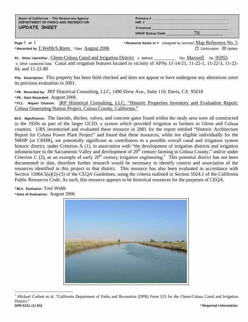
Page 1 of 1 *Resource Name or # (Assigned by recorder) Map Reference No. 5 *Recorded by T.Webb/S.Riem *Date August 2006 Continuation ⌧ Update
DPR 523L (1/95) *Required Information
State of California – The Resources Agency Primary # _____________________________________ DEPARTMENT OF PARKS AND RECREATION HRI # ________________________________________ UPDATE SHEET Trinomial ___________________________________________
NRHP Status Code 7N
P1. Other Identifier: Glenn-Colusa Canal and Irrigation District c. Address City Maxwell Zip 95955 e. Other Locational Data: Canal and irrigation features located in vicinity of APNs 11-14-21, 11-22-1, 11-22-3, 11-22-84, and 11-22-80
P3a. Description: This property has been field checked and does not appear to have undergone any alterations since its previous evaluation in 2001.
*P8. Recorded by: JRP Historical Consulting, LLC, 1490 Drew Ave., Suite 110, Davis, CA 95618 *P9. Date Recorded: August 2006 *P11. Report Citation: JRP Historical Consulting, LLC, “Historic Properties Inventory and Evaluation Report: Colusa Generating Station Project, Colusa County, California.”
B10. Significance: The laterals, ditches, valves, and concrete gates found within the study area were all constructed in the 1920s as part of the larger GCID, a system which provided irrigation to farmers in Glenn and Colusa counties. URS inventoried and evaluated these resource in 2001 for the report entitled “Historic Architecture Report for Colusa Power Plant Project” and found that these resources, while not eligible individually for the NRHP (or CRHR), are potentially significant as contributors to a possible overall canal and irrigation system historic district, under Criterion A (1), in association with “the development of irrigation districts and irrigation infrastructure in the Sacramento Valley and development of 20th century farming in Colusa County,” and/or under Criterion C (2), as an example of early 20th century irrigation engineering.1 This potential district has not been documented to date, therefore further research would be necessary to identify context and association of the resources identified in this project to that district. This resource has also been evaluated in accordance with Section 15064.5(a)(2)-(3) of the CEQA Guidelines, using the criteria outlined in Section 5024.1 of the California Public Resources Code. As such, this resource appears to be historical resources for the purposes of CEQA.
*B14. Evaluator: Toni Webb *Date of Evaluation: August 2006
1 Michael Corbett et al, “California Department of Parks and Recreation (DPR) Form 523 for the Glenn-Colusa Canal and Irrigation District.”

DPR 523A (1/95) T:\TECHDRAW\46800-930 Colusa Power Plant\PDF DOCUMENT\Reliant-word docs\Appendix 8.3TRANSMIS.copy.doc *Required Information
State of California — The Resources Agency Primary # DEPARTMENT OF PARKS AND RECREATION HRI #
PRIMARY RECORD Trinomial NRHP Status Code 4S1
Other Listings Review Code Reviewer Date
Page 1 of 5 *Resource Name or #: (Assigned by recorder) 230 kV Transmission Lines
P1. Other Identifier: P2. Location: ¨ Not for Publication ⌧ Unrestricted *a: County Colusa
and (P2c,P2e, and P2b or P2d. Attach Location Map as necessary.)*b. USGS 7.5' Quad Maxwell & Sites Date 1994, 1973 T ; R ; ¼ of ¼ of Sec 1 ; M.D. B.M.c. Address N/A City Zip d. UTM: (Give more than one for large and/or linear resources) Zone 2; 563570 mE/ 4357400 mN*e. Other Locational Data: (e.g., parcel #, directions to resource, elevation, etc., as appropriate)
Portions of line in this project in T 18N 4W and T 17N 4W
*P3a. Description: (Describe resource and its major elements. Include design, materials, condition, alterations, size, setting, and boundaries)
*P3b Resource Attributes: (List attributes and codes) HP11: Engineering Structure *P4. Resources Present: ¨ Building ⌧ Structure ¨ Object ¨ Site ¨ District ¨ Element of District ¨ Other (isolates,etc.)
P5b. Description of Photo:(View, date, accession #)view south, 6 April 2001 Denise Bradley, photographer DB-1:15 *P6. Date Constructed/Age andSource: ⌧ Historic¨ Prehistoric ¨ Bothca. 1920s / PG&E *P7. Owner and Address: PG&E 245 Market Street San Francisco, CA 94105 *P8. Recorded by: (Name,affiliation, and address) Michael Corbett, URS Corp 221 Main Street, #600 San Francisco, CA 94105 *P9. Date Recorded: 6 April 2001 *P10. Survey Type: (Describe) intensive
P11. Report Citation*: (Cite survey report and other sources, or enter "none".) Application for Certification for Colusa Power Plant *Attachments: ¨ NONE ⌧ Location Map ¨ Sketch Map ⌧ Continuation Sheet ⌧ Building, Structure and Object Record¨ Archaeological Record ¨ District Record ¨ Linear Feature Record ¨ Milling Station Record ¨ Rock Art Record¨ Artifact Record ¨ Photograph Record ¨ Other (List)
This property consists of two parallel north-south high voltage (230 kV) electrical power transmission lines, eachconsisting of steel towers, insulators, and conductors (connecting cables). Each tower carries two circuits (Mishioka2001). The towers in the parallel lines are similar but not identical. The base of each tower flares outward to four legs.The upper part of each tower is vertical and supports three crossarms, each of which carries a hanging insulator at eachend. The cables are strung from the insulators.
A small portion of these two transmission lines -- approximately two miles --are located within the Area of PotentialEffects (APE) for this project. From the PG& E Compressor Station, located within the APE, the transmission lines runnorth to the Cottonwood Substation (approximately 72 miles away) and south to the Vaca-Dixon Substation(approximately 70 miles away) (Mishioka 2001).
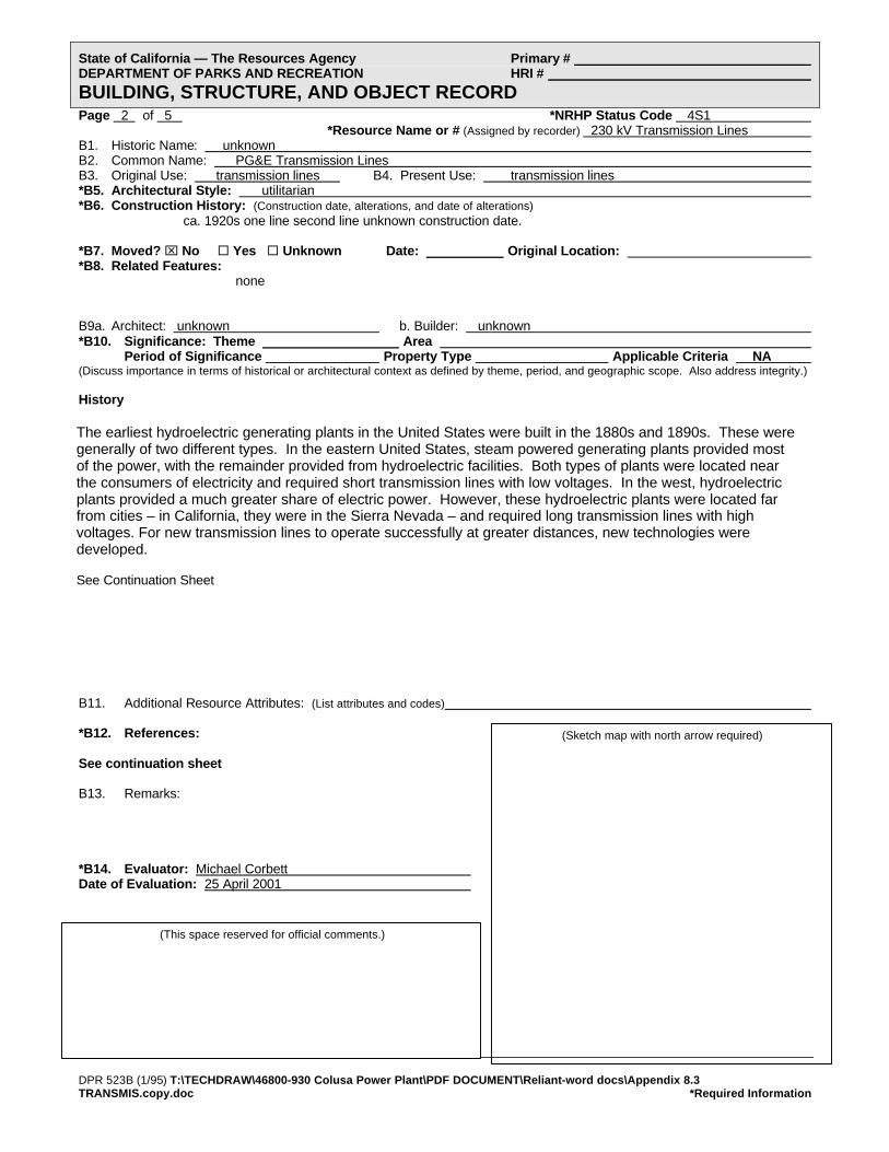
DPR 523B (1/95) T:\TECHDRAW\46800-930 Colusa Power Plant\PDF DOCUMENT\Reliant-word docs\Appendix 8.3TRANSMIS.copy.doc *Required Information
(Sketch map with north arrow required)
State of California — The Resources Agency Primary # DEPARTMENT OF PARKS AND RECREATION HRI #
BUILDING, STRUCTURE, AND OBJECT RECORDPage 2 of 5 *NRHP Status Code 4S1
*Resource Name or # (Assigned by recorder) 230 kV Transmission Lines B1. Historic Name: unknown B2. Common Name: PG&E Transmission Lines B3. Original Use: transmission lines B4. Present Use: transmission lines *B5. Architectural Style: utilitarian *B6. Construction History: (Construction date, alterations, and date of alterations)
ca. 1920s one line second line unknown construction date.
*B7. Moved? ⌧ No ¨ Yes ¨ Unknown Date: Original Location: *B8. Related Features:
none
B9a. Architect: unknown b. Builder: unknown *B10. Significance: Theme Area
Period of Significance Property Type Applicable Criteria NA (Discuss importance in terms of historical or architectural context as defined by theme, period, and geographic scope. Also address integrity.)
History
B11. Additional Resource Attributes: (List attributes and codes)
*B12. References:
See continuation sheet
B13. Remarks:
*B14. Evaluator: Michael Corbett Date of Evaluation: 25 April 2001
(This space reserved for official comments.)
The earliest hydroelectric generating plants in the United States were built in the 1880s and 1890s. These weregenerally of two different types. In the eastern United States, steam powered generating plants provided mostof the power, with the remainder provided from hydroelectric facilities. Both types of plants were located nearthe consumers of electricity and required short transmission lines with low voltages. In the west, hydroelectricplants provided a much greater share of electric power. However, these hydroelectric plants were located farfrom cities – in California, they were in the Sierra Nevada – and required long transmission lines with highvoltages. For new transmission lines to operate successfully at greater distances, new technologies weredeveloped.
See Continuation Sheet
DPR 523L (1/95) T:\TECHDRAW\46800-930 Colusa Power Plant\PDF DOCUMENT\Reliant-word docs\Appendix 8.3TRANSMIS.copy.doc *Required Information
State of California — The Resources Agency Primary # DEPARTMENT OF PARKS AND RECREATION HRI/Trinomial
CONTINUATION SHEETPage 3 of 5 Resource Identifier: 230 kV Transmission Lines Recorded by Michael R. Corbett *Date 25 April 2001 ⌧ Continuation ¨ Update
History (continued)In the 1890s, systems were built that were generally ten to twenty miles long. In 1899, an 83-mile-long line was built insouthern California, and in 1900, a 142-mile-long system was built from the Sierra Nevada to Oakland. By 1915, at least twolines were over 200 miles long. This early period of hydroelectric development culminated in more efficient transmissionsystems in the early 1920s, among the first of which was the transmission line from the Pit 1 power plant in Shasta County tothe Vaca-Dixon substation in Solano County. This line was built southwest from Pit 1 to the Cottonwood substation nearRedding. From Cottonwood, it ran south through the Area of Potential Effects (APE) for this project in Glenn and Colusacounties to Vaca-Dixon. At Vaca-Dixon, the power was fed into the San Francisco Bay area. Because significant portions ofthe line have been rebuilt, it is not clear whether the portion that is located within the APE for this project is original.
To carry power from the Pit River to users in the San Francisco Bay Area, engineer Frank G. Baumdesigned a 220,000 volt transmission system. It is more efficient to transmit electricity over long distancesat high voltages, but the power is also more difficult to control. Baum designed PG&E’s Pit River project asa 220 kV system from the outset with all of its components arranged to handle voltages that had not yetbeen tested commercially. When Pit 1 first went on line its output, combined with that of the Hat Creekplants, went out at 110 kV, matching the voltage of existing PG&E high tension lines. Voltage was steppedup to 175 kV in 1923 (?), to 220 kV after the 70,000 kW line went in. At the time it started up, its machinerywas similar to that of scores of other plants built throughout the country in the late 1910s and 1920s, exceptin one respect – it was larger than most, and in particular, its transmission system operated at a recordvoltage.
Since it was completed, changes to Pit 1 and its parts have been relatively minor. The most significantchanges were made in 1946 when a new dam and a second intake were built creating a forebay to storewater for use in times in high demand...
The larger Pit River system was expanded with the construction of Pit 3 in 1925, followed by several otherplants, all downstream of Pit 1. In 1967, a new substation was built at Round Mountain in the lower Pit Rivervalley as part of the development of an intertie system linking northern and southern California withtransmission lines of increased capacity. This ended the original relationship between Pit 1 and the Vaca-Dixon substation.” (Hay and Corbett 1992, Appendix Historic Resources Inventory Form for the Pit No. 1Power Plant: 4-5).
EvaluationThe sections of the two 230kV transmission lines that are located within the APE are part of a larger system that transmittedpower from the Pit 1 Power Plant to the Bay Area. Specifically the sections of the two 230 kV transmission lines that arelocated within the APE are part of the transmission lines between the Cottonwood and Vaca-Dixon substations. The sectionsof the transmission lines with the APE are not individually significant. However, if either of the transmission lines between theCottonwood and Vaca-Dixon substations were significant, then these sections may have significance as contributing featuresto the larger property.
An evaluation of the transmission lines between the Cottonwood and Vaca-Dixon substations has not been done. However,this system would appear to have the potential to be significant under NRHP criteria A and/or C. Potential areas ofsignificance would be in the development of electrical power in northern California, its impact on the development of theeconomy, as an example of transmission line engineering in the 1920s, and as an example of the work of engineer FrankBaum, one of the leading hydroelectric engineers of his day in the United States. Before the eligibility of either of thetransmission lines could be determined, more research would be required to more fully assess the significance within theappropriate historical contexts, to document the history of the properties, to establish a period of significance, and to documentthe integrity of the character defining features. Following this, the contributing status of the sections of the transmission lineswithin the APE could then be established.
References
Baum, Frank G. “The Pit River Power and 220,000-Volt Transmission Problem.” Electrical World, 27 January 1923, 81: 205-12.
Blair, Lynda. An Evaluation of Eighteen Historic Transmission Line Systems That Originate from Hoover Dam, Clark County,Nevada. Prepared for Los Angeles Department of Water and Power, 1994.
Coleman, Charles M. PG&E of California. New York: McGraw Hill. 1952.

DPR 523L (1/95) T:\TECHDRAW\46800-930 Colusa Power Plant\PDF DOCUMENT\Reliant-word docs\Appendix 8.3TRANSMIS.copy.doc *Required Information
State of California — The Resources Agency Primary # DEPARTMENT OF PARKS AND RECREATION HRI/Trinomial
CONTINUATION SHEETPage 4 of 5 Resource Identifier: 230 kV Transmission Lines Recorded by Michael R. Corbett *Date 25 April 2001 ⌧ Continuation ¨ Update
References (continued)
Doerr, Christopher (Garcia & Associates). Telephone conversation with Michael Corbett. 26 April 2001.
Hair, Jennifer M. National Register of Historic Places and California Register of Historical Resources Evaluation of CA-SHS-2939-H an dCA-SHA-29020-H, Shasta County, California. Prepared by Garcia and Associates for Ogden Environment andEnergy Services. October 2000.
Hay, Duncan. Hydroelectric Development in the United States, 1880-1940. Washington, D.C.: Edison Electric Institute, 1991.
Hay Duncan and Michael R. Corbett. Historic Resources Assessment Report for the Pit 1 Hydroelectric Project, ShastaCounty, California, revised draft. Prepared for the Pacific Gas & Electric Company by Dames & Moore. 1992.
Jollyman, J.P. “The Purpose and Problems of 220,000-Volt Transmission.” Journal of Electricity and Western Industry, 15August 1922, 49: 131-33.
Knowlton, Archer E., editor. Standard Handbook for Electrical Engineers, 9th edition. New York: McGraw Hill, 1957.
Mishioka, Stan, PG&E. Telephone conversation with Roxana Khakpour (URS Corp.). 26 April 2001.
Mishioka, Stan (PG&E). Telephone conversation with Michael Corbett (URS Corp.), 1 and 2 May 2001.
Northern California Atlas & Gazetteer. Freeport, Maine: DeLorme Publishing Company, 1986.
Rogge, A.E. (Gene), Michael Corbett, and Lori Hunsaker. Cultural Resources Survey for the McCullough-Liberty Fiber OpticsProject. Dames & Moore. International Cultural Resource Services Research Paper No. 41. Phoenix, 1997.
Scott, W.A. “202 Miles of Transmission Lines to Operate at 220,000 Bolts.” Engineering World, March 1922.
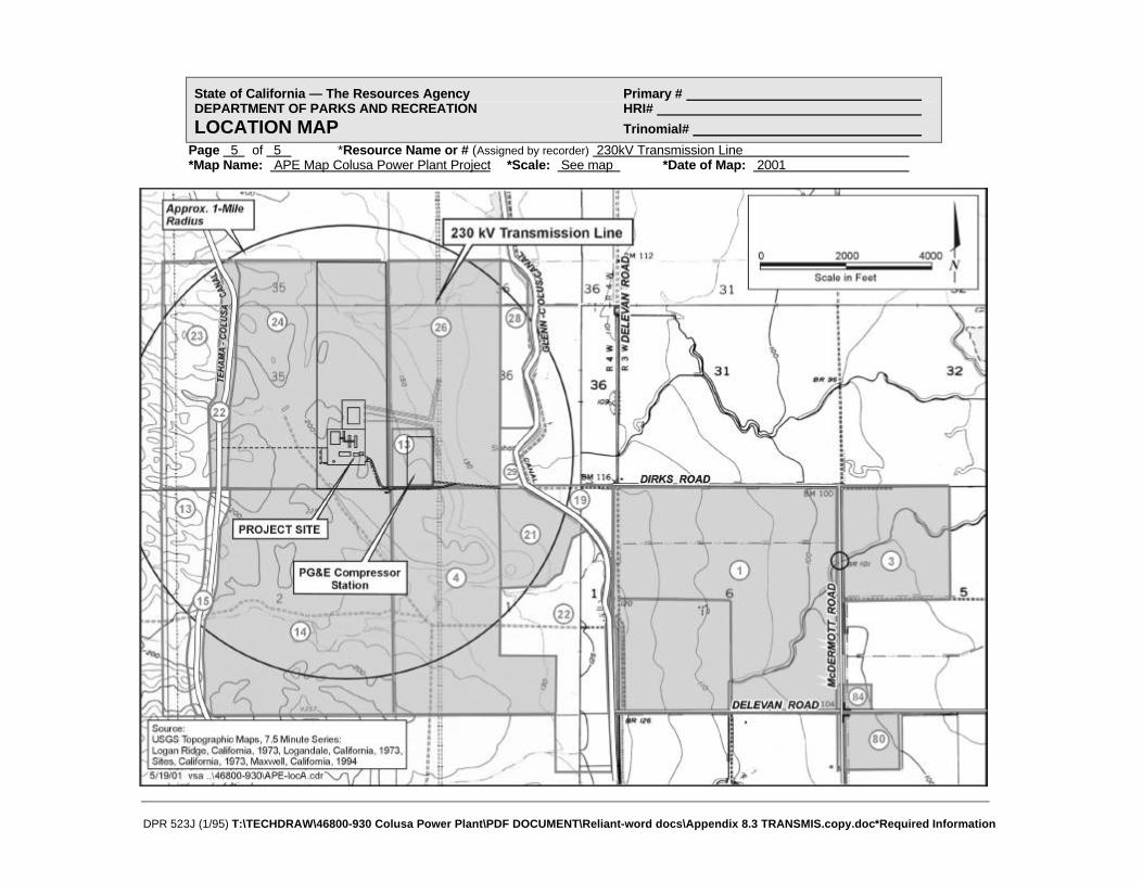
DPR 523J (1/95) T:\TECHDRAW\46800-930 Colusa Power Plant\PDF DOCUMENT\Reliant-word docs\Appendix 8.3 TRANSMIS.copy.doc*Required Information
State of California — The Resources Agency Primary # DEPARTMENT OF PARKS AND RECREATION HRI#
LOCATION MAP Trinomial#
Page 5 of 5 *Resource Name or # (Assigned by recorder) 230kV Transmission Line *Map Name: APE Map Colusa Power Plant Project *Scale: See map *Date of Map: 2001

Page 1 of 1 *Resource Name or # (Assigned by recorder) Map Reference No. 6 *Recorded by T.Webb/S.Riem *Date August 2006 Continuation ⌧ Update
DPR 523L (1/95) *Required Information
State of California – The Resources Agency Primary # _____________________________________ DEPARTMENT OF PARKS AND RECREATION HRI # ________________________________________ UPDATE SHEET Trinomial ___________________________________________
NRHP Status Code 7N
P1. Other Identifier: 230kV Transmission Lines c. Address City Zip e. Other Locational Data: Segment of line within project study area located in T 18N 4W and T 17N 4W
P3a. Description: This resource has been field checked and does not appear to have undergone any alterations since its previous evaluation in 2001.
*P8. Recorded by: JRP Historical Consulting, LLC, 1490 Drew Ave., Suite 110, Davis, CA 95618 *P9. Date Recorded: August 2006 *P11. Report Citation: JRP Historical Consulting, LLC, “Historic Properties Inventory and Evaluation Report: Colusa Generating Station Project, Colusa County, California.”
B10. Significance: This line was constructed in the 1920s as part of a larger line that carried power generated from the Pit No. 1 Power Plant between the Cottonwood and Vaca Dixon substations. Michael Corbett of URS Corporation inventoried and evaluated this building in 2001 for the report entitled “Historic Architecture Report for Colusa Power Plant Project” and found that the short segment of the line that is extant in the APE does not appear to be individually eligible for the NRHP (or CRHR). However, it may qualify as contributor to a larger resource (Cottonwood and Vaca Dixon Transmission Lines) that is potentially significant under Criterion A (1), within the context of “the development of electric power in northern California and its impact on the development of the economy,” and Criterion C (3), as “an example of transmission line engineering in the 1920s,” as well as an “example of the work of engineer Frank Baum, one of the leading hydroelectric engineers of his day in the United States.”1 The Cottonwood and Vaca Dixon line has not been formally evaluated for the NRHP or CRHR to date, therefore more research would be required for the evaluation of that line and the 230kV line that is addressed for this project. This resource has been evaluated in accordance with Section 15064.5(a)(2)-(3) of the CEQA Guidelines, using the criteria outlined in Section 5024.1 of the California Public Resources Code. Because this resource is potentially significant, it appears to be a historical resource for the purposes of CEQA.
*B14. Evaluator: Toni Webb *Date of Evaluation: August 2006
1 Michael Corbett and Denise Bradley, URS Corporation, “California Department of Parks and Recreation (DPR) Form 523 for the 230kV Transmission Line,” (2001).