appendix g aboriginal cultural heritage assessment · aboriginal heritage is of interest and...
TRANSCRIPT

APPENDIX GABORIGINAL CULTURAL HERITAGE ASSESSMENT

WILPINJONG COAL MINE, CENTRAL TABLELANDS
OF NEW SOUTH WALES - MODIFICATION:
ABORIGINAL CULTURAL HERITAGE ASSESSMENT
A report to
Wilpinjong Coal Pty Limited 1434 Ulan Wollar Road WILPINJONG NSW 2850
by
Peter Kuskie SOUTH EAST ARCHAEOLOGY Pty Limited ACN 091 653 048
www.southeastarchaeology.com.au
24 Bamford Street HUGHES ACT 2605 Telephone: 02-6260 4439 Email: [email protected] July 2013

EXECUTIVE SUMMARY The Wilpinjong Coal Mine is an existing open-cut coal mining operation situated approximately 40 kilometres north-east of Mudgee, within the Mid-Western Regional Council Local Government Area, in the Central Tablelands of New South Wales. The Wilpinjong Coal Mine is owned and operated by Wilpinjong Coal Pty Limited (WCPL), a wholly owned subsidiary of Peabody Energy Australia Pty Limited. The Wilpinjong Coal Mine was approved under Part 3A of the NSW Environmental Planning and Assessment Act 1979 (EP&A Act) in February 2006 (Project Approval 05-0021). The mine has been operating since 2006. WCPL has determined that a number of minor alterations to the approved Wilpinjong Coal Mine are required, including extensions to the existing open cut pits. These variations to the Wilpinjong Coal Mine are being sought via a Modification under Section 75W of the EP&A Act (the Modification). This supplementary report has been prepared by South East Archaeology for WCPL to address the potential impacts of the proposed Modification on Aboriginal heritage. The investigation area measures 70 hectares in total and comprises a number of spatially separate areas that are classified as 'Area 1' through to 'Area 6'. The investigation proceeded with reference to standard Department of Planning and Infrastructure (DP&I) and Office of Environment and Heritage (OEH) policies, including the 2005 Guidelines for Aboriginal Cultural Heritage Assessment and Community Consultation and 2010 Code of Practice for Archaeological Investigation of Aboriginal Objects in New South Wales. Consultation was undertaken with the Aboriginal community in accordance with the OEH policy entitled Aboriginal Cultural Heritage Consultation Requirements for Proponents 2010. A comprehensive field survey sampling the entire 70 hectare investigation area was undertaken by South East Archaeology over five days in January and March 2013, assisted on every day by representatives of the registered Aboriginal parties. A total of 27 Aboriginal sites, Potential Archaeological Deposits (PADs) or values are known to occur directly within or immediately adjacent to the investigation area, comprising:
Twenty-two open artefact sites;
Two possible Aboriginal scarred trees;
One 'possible waterhole';
One rock shelter with PAD; and
One possible cultural value/association. Other contemporary cultural values associated with the investigation area have also been identified by the registered Aboriginal parties, including:
In general terms, the use of subsistence or other resources;
In general terms, the traditional use of the area by north-eastern Wiradjuri people, and an ongoing cultural and spiritual connection to the land and resources of the study area by the north-eastern Wiradjuri; and
In relation to 'Area 4', the contemporary cultural significance of the adjacent 'Castle
Rock', located outside of the Modification area.

The nature of the evidence from the investigation area is consistent with the results from the previous heritage assessment. No specific aspects of the heritage evidence located within the Modification investigation area are rare or unique within a local or regional context, although site WCP 1 is a less commonly reported example of a larger site in a secondary resource zone, with a relatively high number of artefacts and broad range of types and stone materials. A number of open artefact sites were identified within the investigation area. On the basis of the occupation model and survey results, the potential for further artefact evidence to occur in the areas that were not directly sampled or are currently obscured by vegetation can be summarised as follows:
In the 'modified' areas and in other minor, localised portions of the Modification investigation area in which the upper soil unit has been totally removed, previous land use has caused such substantial impacts that there is generally negligible potential for any Aboriginal heritage evidence to survive;
In the portion of the Modification investigation area that may be characterised as being
within a secondary resource zone (portions of survey areas WM30 and WM32 in Area 5 within 200 metres of Cumbo Creek) there is a high potential for sub-surface deposits of artefacts to occur, including deposits that may be of research value; and
In the remainder of the Modification investigation area, a low to very low density sub-surface deposit of artefacts may occur, consistent with the survey results and occupation model. In general, this evidence will be consistent with background discard, and although a low frequency of activity areas (with consequent higher artefact density) may be present, will not represent focused occupation. The potential for sub-surface deposits of artefacts that may be of high research value to occur within these portions of the investigation area is generally low.
The significance of the Aboriginal heritage evidence was assessed. It is noted that all Aboriginal heritage is of interest and contemporary value to the Aboriginal community. Aboriginal heritage evidence represents a tangible link with the traditional past and with the lifestyle and values of community ancestors. One of the open artefact sites was assessed as being of high significance within a local context (WCP 1), four as being of low to possibly moderate significance (WCP 2, 213, 216 and 438), sixteen of low significance and one of nil significance. The rock shelter with PAD (WCP 340), purported water hole (WCP 61) and scarred trees (WCP 64 and 124) were assessed as being of low heritage significance. Notwithstanding the cultural value to the Aboriginal stakeholders of the investigation area, flora/fauna resources, site WCP 58 and the identified Aboriginal objects, the size of the impact area is relatively small within a regional context and these places/values are not unique or rare within the region. However, the feature known locally as 'Castle Rock' adjacent to Area 4 has been strongly identified by all Aboriginal parties involved in the survey as being of high contemporary cultural significance. The potential impacts of the proposed Modification on each of the Aboriginal sites and cultural areas/values within or immediately adjacent to the investigation area has been assessed. In the absence of appropriate management and mitigation measures, it is concluded that the impacts of the proposed Modification on Aboriginal heritage will be low1 within a local context and very low within a regional context. With the implementation of mitigation measures, the impacts will be low within a local context and very low within a regional context.
1 On the basis that impacts to site WCP 1, through the Cumbo Creek diversion, are already approved
under the existing Project.

The Modification may result in impacts to 17 open artefact sites, two scarred trees, a possible water hole and three cultural values/associations. The Modification may also result in impacts to a zone with a high potential for sub-surface deposits of artefacts of research value (portions of survey areas WM30 and 32 in Area 5 within 200 metres of Cumbo Creek)2, along with a potentially low to very low density sub-surface deposit of artefacts consistent with low heritage value background discard across much of the remainder of the area. Significantly, impacts will be avoided to Castle Rock (which is located adjacent to Area 4 of the Modification), a feature of high cultural significance. There is generally a low or negligible potential for other forms of heritage evidence (for example, rock shelters or grinding grooves) to be subject to impacts. Given that approval for the Modification is being sought under Section 75W of Part 3A of the EP&A Act, management of the heritage resource post-approval within the Modification area through amendments to the existing Aboriginal Cultural Heritage Management Plan (ACHMP; WCPL 2008) for the approved project area would be the most practical and appropriate strategy. The following recommendations are made on the basis of legal requirements under the EP&A Act and NP&W Act, the results of the investigation and consultation with the registered Aboriginal parties: 1) The existing ACHMP for the approved project will be revised to incorporate the
following provisions relating to Aboriginal heritage for the Modification area. These provisions will be formulated in consultation with the registered Aboriginal parties and subject to DP&I approval and will specify the policies and actions required to manage the potential impacts of the Modification on Aboriginal heritage within the Modification area after approval is granted:
a) In order to mitigate the impacts of the Modification on scientific and cultural values
and to retrieve and conserve samples of the heritage evidence, mitigation measures will be implemented prior to any impacts occurring to specified sites and areas, including:
i) Systematic surface collection of the identified artefact evidence from the open
artefact site WCP 1, involving procedures outlined in Section 10.2.1; ii) Broad area hand excavation of the open artefact site WCP 1, involving
procedures outlined in Section 10.2.1; iii) Surface scrapes, accompanied by localised hand excavation of any features of
significance that are identified, of the open artefact site WCP 1, involving procedures outlined in Section 10.2.1;
iv) Where requested by the registered Aboriginal parties, salvage of stone artefacts
by systematic surface collection from the portions of the open artefact sites WCP 213, 216 and 438 within the Modification area, involving procedures outlined in Section 10.2.1;
2 Impacts to site WCP 1, through the Cumbo Creek diversion, are already approved under the existing
Part 3A Major Project Approval, although have not yet occurred. Total loss of value may have occurred through the Approved Project, in which case the additional effect of the Modification on the heritage values would be negligible. The requirements for salvage of site WCP 1 under the existing Project Approval and ACHMP (WCPL 2008) are clarified here, in consideration of currently accepted best-practice methods and techniques in archaeological salvage.

v) If impacts cannot be avoided to the scarred tree WCP 64, further assessment by an arboricultural specialist to evaluate potential non-Aboriginal origins of the scar, followed by salvage in accordance with the procedures outlined in Section 4.2.3 and Attachment C of the approved ACHMP if an Aboriginal origin for the scar is not eliminated;
b) All heritage mitigation and monitoring measures undertaken for the Modification will
be adequately documented with reference to relevant OEH guidelines. Reports will be prepared and provided to relevant stakeholders (such as the DP&I and the OEH and the registered Aboriginal parties) within appropriate timeframes;
c) All heritage evidence salvaged under the Modification will be curated in an
appropriate manner, as determined in consultation with the registered Aboriginal parties and the OEH during preparation of the revised ACHMP. An application will be made to the OEH under Section 85A of the NP&W Act for the curation of any salvaged items that are removed from any heritage site. Temporary storage of items at locations off the mine site (for example, during analysis and recording) will be allowed;
d) Where impacts from surface works will be avoided to identified heritage evidence,
appropriate site-specific precautionary measures will be implemented for those sites within close proximity of the area of works;
e) As a general principle, all relevant contractors and staff engaged on the Modification
who are undertaking tasks on site that may give rise to any interactions with Aboriginal heritage will receive heritage awareness training prior to commencing work on-site;
f) The Aboriginal Site Database established for this project that lists known Aboriginal
sites within the WCPL lease area will continue to be maintained and regularly updated, with hard copies of information made available to any registered Aboriginal party upon request;
g) Site records will be lodged in a timely manner with the OEH for any previously
unrecorded Aboriginal heritage evidence that is identified within the Modification area during the course of operations and/or further heritage assessments, or that is subject to salvage;
h) Provisions will be included to guide the assessment of any future alterations that may
be proposed to the mine plan within the Modification area;
i) Provisions will be included to guide the management of any previously unrecorded Aboriginal heritage sites within the Modification area that may be identified during future investigations or works;
j) Should any skeletal remains be detected during the course of the Modification, work
in that location will cease immediately and the finds will be reported to the appropriate authorities, including the Police, the OEH and the registered Aboriginal parties. Subject to the Police requiring no further involvement, the management of any Aboriginal skeletal remains will be determined in consultation with the DP&I, the OEH and the registered Aboriginal parties;
k) Archaeological investigations will only be undertaken by archaeologists qualified and
experienced in Aboriginal heritage, in consultation with and with the involvement of the registered Aboriginal parties, and will occur prior to any development impacts occurring to those specific areas or sites;

l) Provisions will be included to ensure that Aboriginal community representatives are permitted access to any identified sites or cultural areas within WCPL controlled Modification area land when requested, in consideration of safety and operational requirements at the time;
m) The revised ACHMP will be regularly verified to establish that it is functioning as
designed to the standard required;
n) The protocol for the involvement of Aboriginal stakeholders specified in the ACHMP will be updated in consultation with all registered Aboriginal parties;
2) Under the terms of the NP&W Act it is an offence to harm or desecrate an object that the
person knows is an Aboriginal object, or to harm an Aboriginal object ('strict liability offence'). Therefore, no activities or work should be undertaken within the Aboriginal site areas as described in this report without approval under Section 75W of Part 3A of the EP&A Act and subsequent implementation of any relevant approval conditions;
3) Copies of this report should be forwarded to each registered Aboriginal party and the
DP&I and the OEH as part of the public exhibition of the Modification application.

TABLE OF CONTENTS
Page 1. Introduction 1 1.1 Background and Overview of Proposed Modification 1 1.2 Study Purpose 2 1.3 Authorship 3 2. Environmental Context 7 3. Aboriginal Archaeological Context 10 3.1 Heritage Register Searches 10 3.2 Previous Archaeological Research 12 3.2.1 Wilpinjong Coal Mine Environmental Assessment 12 3.2.2 Wilpinjong Coal Mine Salvages and Additional Investigations 12 3.2.3 Other Relevant Investigations Adjacent to the Wilpinjong Coal Mine 13 3.2.4 Moolarben Coal Mine 14 3.2.5 Ulan Coal Mine 15 3.2.6 Other Relevant Regional Investigations 18 3.2.7 Synthesis 19 3.3 Local Aboriginal Culture 20 3.4 Occupation Model 22 3.5 Predictive Model of Site Location 32 4. Methodology 38 5. Results and Discussion 42 5.1 Survey Coverage 42 5.2 Aboriginal Heritage Evidence 49 5.2.1 Overview 49 5.2.2 Open Artefact Sites 50 5.2.3 Other Site Types 53 5.2.4 Cultural Values 55
5.3 Discussion 56 5.3.1 Integrity of Evidence 56 5.3.2 Lithic Assemblage 56 5.3.3 Spatial Distribution, Site Interpretation and Reassessment of Occupation Model 59 5.3.4 Regional Context 60 5.3.5 Reassessment of Predictive Model 61 6. Aboriginal Consultation 63 7. Significance Assessment 73 7.1 Criteria 73 7.2 Significance of Heritage Evidence Within the Modification Investigation Area 76

Page 8. Statutory Obligations 80 8.1 Commonwealth 80 8.2 State 81 8.3 Local 89 9. Potential Impacts 90 9.1 Potential Surface Impacts 90 9.2 Regional Context and Cumulative Impacts 92 10. Potential Mitigation and Management Strategies 97 10.1 General Strategies 97 10.1.1 Strategy A: Further Investigation 97 10.1.2 Strategy B: Conservation 98 10.1.3 Strategy C: Mitigated Impact 98 10.1.4 Strategy D: Unmitigated Impact 99 10.1.5 Strategy E: Monitoring 100 10.2 Assessment of Specific Management Options for Aboriginal Sites and Cultural Areas/Values 100 10.2.1 Open Artefact Sites and Potential Artefact Evidence 101 10.2.2 Other Site Types 104 10.2.3 Cultural Places/Values 104 11. Recommendations 105 References 111 Acknowledgements 118 Disclaimer 118 Appendix 1: Relevant Previously Recorded Aboriginal Site Records 119 Appendix 2: Archaeological Survey Coverage Database 157 Appendix 3: Aboriginal Heritage Site Data 162 Appendix 4: Plates 201 Appendix 5: Aboriginal Community Consultation 207

FIGURES Page Figure 1: Location of Wilpinjong Coal Mine 4 Figure 2: General arrangement of approved Wilpinjong Coal Mine 5 Figure 3: General arrangement incorporating the Modification 6 Figure 4: Topographic context of investigation area and recorded Aboriginal heritage
sites 9 Figure 5: Cultural group boundaries in the Wilpinjong Coal Mine locality 21 Figure 6: Approximate location of GPS recorded transects within the investigation area 41 Figure 7: Western portion of the 'Area 1' investigation area showing archaeological
survey areas, modified areas and Aboriginal heritage sites 44 Figure 8: Eastern portion of the 'Area 1' investigation area showing archaeological
survey areas and Aboriginal heritage sites 45 Figure 9: 'Area 2' and 'Area 3' portions of the investigation area showing
archaeological survey areas and Aboriginal heritage sites 46 Figure 10: 'Area 4' and 'Area 5' portions of the investigation area showing
archaeological survey areas and Aboriginal heritage sites 47 Figure 11: 'Area 6' portion of the investigation area showing archaeological survey
areas and Aboriginal heritage sites 48

TABLES Page Table 1: Summary of known Aboriginal sites within the vicinity of the Wilpinjong
Coal Mine 11 Table 2: Known Aboriginal sites within the vicinity of the Modification investigation
area 11 Table 3: Environmental contexts, class of slope and landform elements - summary of
survey coverage and artefact density for investigation area 43 Table 4: Summary of Aboriginal sites and cultural values located within or
immediately adjacent to the investigation area 51 Table 5: Summary of open artefact sites recorded during the present survey 52 Table 6: Summary of stone artefacts recorded during the present heritage survey 57 Table 7: Summary of registered Aboriginal parties involvement 65 Table 8: Summary of registered Aboriginal parties key comments and how they have
been addressed by the Modification 69 Table 9: Significance assessment of Aboriginal sites, cultural areas/values and potential
deposits within or immediately adjacent to the investigation area 78 Table 10: Potential impacts to Aboriginal sites, cultural areas/values and potential
deposits within or immediately adjacent to the investigation area from the Modification prior to the implementation of mitigation measures 93
Table 11: Summary of recommended management strategies and consequent
potential impacts to Aboriginal sites, cultural areas/values and potential deposits within or immediately adjacent to the Modification investigation area after the implementation of mitigation measures 108

PLATES (APPENDIX 4) Page Plate 1: View south-east of the Aboriginal stakeholders inspecting Survey Area
WM1 (level - very gentle simple slope) between the Sandy Hollow Railway and Ulan - Wollar Road 202
Plate 2: View south-east of Survey Area WM6 (gentle drainage depression) south
of the Ulan - Wollar Road 202 Plate 3: Modified area, along the Wilpinjong Mine access road at the intersection
with the Ulan - Wollar Road, adjacent to Survey Area WM7 203 Plate 4: View west of Survey Area WM9 (gentle drainage depression) south of
the Gulgong - Sandy Hollow Railway 203 Plate 5: View south-east of Survey Area WM10 (gentle simple slope) 204 Plate 6: View west across Cumbo Creek (foreground) towards hillocks and ridgeline
with Survey Areas WM12-29 204 Plate 7: View north of Survey Areas WM17 (level - very gentle hillock) and WM18
(level - very gentle ridge crest) 205 Plate 8: View north-east across Survey Area WM20 (moderate simple slope) to
WM19 (level - very gentle hillock) 205 Plate 9: View north of Survey Area WM21 (moderate spur crest) 206 Plate 10: View north-east from Survey Area WM13 across WM12 (gentle simple
slope - foreground) and Cumbo Creek to WM32 and 30 and Site WCP1 206

Wilpinjong Coal Mine, Central Tablelands of New South Wales - Modification: 1 Aboriginal Cultural Heritage Assessment. South East Archaeology Pty Ltd 2013
1. INTRODUCTION 1.1 Background and Overview of Proposed Modification The Wilpinjong Coal Mine is an existing open-cut coal mining operation situated approximately 40 kilometres north-east of Mudgee, near the village of Wollar, within the Mid-Western Regional Council Local Government Area, in the Central Tablelands of New South Wales (NSW) (Figure 1). The Wilpinjong Coal Mine is owned and operated by Wilpinjong Coal Pty Limited (WCPL), a wholly owned subsidiary of Peabody Energy Australia Pty Limited. Mining is undertaken within Mining Lease (ML) 1573. The approved open cut and contained infrastructure area at the Wilpinjong Coal Mine comprises approximately 1,920 hectares (Figure 2). The Wilpinjong Coal Mine was approved under Part 3A of the NSW Environmental Planning and Assessment Act 1979 (EP&A Act) by the then NSW Minister for Planning in February 2006 (Project Approval 05_0021). The mine has been operating since 2006, and is approved to produce up to 15 million tonnes per annum (Mtpa) of run-of-mine (ROM) coal from six open cut pits (Figure 2). The Wilpinjong Coal Mine produces both washed and unwashed coal products. The coal handling and processing infrastructure has been designed to accommodate the processing of raw coal and the handling of raw (bypass) and washed product coal. The Project Approval currently allows for the beneficiation of up to 8.5 Mt of ROM coal in the Coal Handling and Preparation Plant (CHPP) per year and up to 12.5 Mtpa of thermal coal products from the Wilpinjong Coal Mine are transported by rail to domestic customers for use in electricity generation and to port for export. Following a review of mine planning, CHPP capacity, waste rock bulking factors, planned building and demolition works and light vehicle servicing requirements, WCPL has determined that a number of minor alterations to the approved Wilpinjong Coal Mine are required, including:
Development of incremental extensions to the existing open cut pits (Figure 3) that would extend the open cuts by approximately 70 hectares and would result in the recovery of approximately 3 Mt of additional ROM coal;
Higher rates of annual waste rock production (from 28 million bank cubic metres [Mbcm]
to 33.3 Mbcm) in order to maintain approved ROM coal production;
Minor CHPP upgrades to improve fine coal reject management (installation of a belt press filter) and an increase in the rate of ROM coal beneficiation in the CHPP to approximately 9 Mtpa;
Upgrade of the existing reverse osmosis plant to a water treatment facility with the
addition of pre-filtration and flocculation/dosing facilities to improve plant efficiency;
Amendment of the waste emplacement strategy to include:
o Development of an elevated waste rock emplacement landform (up to approximately 450 metres AHD) within the footprint of Pit 2 (Figure 3);
o Disposal of some inert building and demolition waste that is produced from off-site
building demolition in the approved mine waste rock emplacements;

Wilpinjong Coal Mine, Central Tablelands of New South Wales - Modification: 2 Aboriginal Cultural Heritage Assessment. South East Archaeology Pty Ltd 2013
o Co-disposal of fine coal reject material produced by the belt press filter with coarse rejects; and
Operation a light vehicle servicing workshop at an existing farm shed that is located in the
north of the Project application area (Figure 3). Construction of the belt press filter and augmentation of the existing Reverse Osmosis Plant may require a temporary construction workforce of up to 20 people for periods in 2014. These variations to the Wilpinjong Coal Mine are being sought via a Modification under Section 75W of the EP&A Act (the Modification). It is noted that no changes are proposed to the approved rates of production of ROM coal (15 Mtpa) or product coal (12.5 Mtpa), and the current owner-operator mobile fleet would not require augmentation. In addition, the Modification would not require any significant alteration to the existing approved Wilpinjong Coal Mine mining operations and general supporting infrastructure, or current operational workforce of approximately 550 staff and contractors. Further details on the Modification description are provided in Section 2 of the main text of the Environmental Assessment (EA). 1.2 Study Purpose This Aboriginal cultural heritage assessment of the proposed Modification has been prepared by South East Archaeology Pty Ltd for WCPL. Director-General's Requirements for the proposed Modification were not required and have therefore not been obtained from the NSW Department of Planning and Infrastructure (DP&I). In their absence, it has been assumed that Aboriginal cultural heritage would be a key issue for the EA, with the following requirements needing to be addressed:
A description of the existing environment;
Consideration of all relevant environmental planning instruments;
An assessment of the potential impacts of the development, including cumulative impacts;
Effective consultation with Aboriginal communities in determining and assessing impacts, and developing and selecting mitigation options and measures;
A description of the measures that would be implemented to avoid, minimise and if
necessary, offset the potential impacts of the development; and
An assessment taking into account relevant guidelines, policies and plans. In relation to Aboriginal heritage, these are primarily assumed to comprise the draft Guidelines for Aboriginal Cultural Heritage Assessment and Community Consultation (DEC 2005).
It is noted that the draft Guidelines for Aboriginal Cultural Heritage Assessment and Community Consultation (DEC 2005) require an assessment in accordance with the Aboriginal Cultural Heritage Standards and Guidelines Kit (DEC 1997) and Interim Community Consultation Requirements for Applicants (DEC 2004), notwithstanding that the latter policies have now effectively been superseded by the Code of Practice for Archaeological Investigation of Aboriginal Objects in New South Wales (DECCW 2010b) and the Aboriginal Cultural Heritage Consultation Requirements for Proponents 2010 policy (DECCW 2010c). This assessment has been prepared with reference to the latter policies (DECCW 2010b and 2010c).

Wilpinjong Coal Mine, Central Tablelands of New South Wales - Modification: 3 Aboriginal Cultural Heritage Assessment. South East Archaeology Pty Ltd 2013
The primary aims and tasks of this Aboriginal cultural heritage assessment have therefore been to: Building on the studies completed to date (Navin Officer 2005, 2006a, 2006b), undertake
register searches, research, Aboriginal community consultation and an archaeological survey, and where required excavations, to identify and record any Aboriginal heritage evidence or areas of potential evidence or cultural values within the investigation area;
Assess the potential impacts of the proposed Modification upon any identified or potential
Aboriginal heritage evidence or cultural values; Assess the significance of any Aboriginal heritage evidence or cultural values identified; Provide details of any Aboriginal heritage evidence in accordance with the OEH1
requirements; Consult with the Aboriginal community as per the OEH policy entitled Aboriginal
Cultural Heritage Consultation Requirements for Proponents 2010 (DECCW 2010c); Present recommendations for the management of any identified Aboriginal heritage
evidence and potential heritage resources or cultural values; and Prepare an archaeological report to meet the requirements of WCPL, the DP&I and the
OEH (primarily with reference to the DEC 2005 Guidelines for Aboriginal Cultural Heritage Assessment and Community Consultation and DECCW 2010b Code of Practice for Archaeological Investigation of Aboriginal Objects in New South Wales).
For the purposes of this Aboriginal cultural heritage assessment, the investigation area totals 70 hectares, as marked on Figure 3, although portions of 'Area 1' and 'Area 5' are subject to approval for disturbance by existing operations. This report builds on the previous heritage assessment of Navin Officer (2005, 2006a, 2006b) and does not seek to repeat background information contained within those reports. 1.3 Authorship This assessment has been prepared by Peter Kuskie, an archaeologist with a BA (Honours) degree in Aboriginal archaeology and over 23 years experience in the conduct of Aboriginal cultural heritage assessments throughout Australia. The field investigation was undertaken by Peter Kuskie and Birgitta Stephenson. Birgitta Stephenson has a BA (Honours) degree in Aboriginal archaeology and Bachelor of Pharmacy degree and over three years experience in the conduct of Aboriginal heritage surveys and use-wear and residue analysis.
1 Prior to April 2011 the NSW Office of Environment and Heritage (OEH) in the Department of
Premier and Cabinet was known as the Department of Environment, Climate Change and Water (DECCW), and previously as the Department of Environment and Climate Change (DECC), Department of Environment and Conservation (DEC) and National Parks and Wildlife Service (NPWS).

Wilpinjong Coal Mine, Central Tablelands of New South Wales - Modification: 4 Aboriginal Cultural Heritage Assessment. South East Archaeology Pty Ltd 2013
Figure 1: Location of Wilpinjong Coal Mine (courtesy Resource Strategies).

Wilpinjong Coal Mine, Central Tablelands of New South Wales - Modification: 5 Aboriginal Cultural Heritage Assessment. South East Archaeology Pty Ltd 2013
Figure 2: General arrangement of approved Wilpinjong Coal Mine (courtesy Resource
Strategies).

Wilpinjong Coal Mine, Central Tablelands of New South Wales - Modification: 6 Aboriginal Cultural Heritage Assessment. South East Archaeology Pty Ltd 2013
Figure 3: General arrangement incorporating the Modification (courtesy Resource Strategies).
Are
a 1
A
rea
2
Are
a 3
Are
a 4
A
rea
5
Are
a 6

Wilpinjong Coal Mine, Central Tablelands of New South Wales - Modification: 7 Aboriginal Cultural Heritage Assessment. South East Archaeology Pty Ltd 2013
2. ENVIRONMENTAL CONTEXT
The investigation area is located in the Central Tablelands region of NSW. It is situated in the Mid-Western Regional Council local government area and extends between MGA grid reference eastings 767200 and 774600 and northings 6415900 and 6421300 on the Wollar 8833-2N 1:25,000 topographic map (refer to Figure 4). Moolarben Coal Mine is situated immediately to the west of the Wilpinjong Coal Mine, and Ulan Coal Mine is located further to the north-west. The village of Wollar is located three kilometres east of the investigation area and Munghorn Gap Nature Reserve is located immediately to the south and west. The investigation area essentially comprises a number of spatially separate areas within ML1573 that can be identified as follows (refer to Figure 3): Area 1: A series of four areas, measuring in total approximately six hectares, along the
northern margin of ML1573 adjacent to the Ulan - Wollar Road and Gulgong - Sandy Hollow Railway;
Area 2: An area of 2.5 hectares adjacent to the south-western corner of Pit 5, in the
western portion of ML1573; Area 3: An area of three hectares south of Pit 5, in the western portion of ML1573; Area 4: An area of 21 hectares east of the rail loop and Pit 2 and south of Pit 4; Area 5: An area of 17 hectares immediately west of Pit 3 and south of Pit 4, in the eastern
portion of ML1573; and Area 6: An area of 20 hectares immediately south of Pit 3 in the south-eastern corner of
ML1573, near the Wollar Road and Upper Cumbo Road junction. The investigation area is located east of the Great Divide. It comprises portions of the broad, open valleys associated with the higher order watercourses of Wilpinjong Creek (particularly Area 1) and Cumbo Creek (particularly Area 5) and foothills on the margins of the more elevated sandstone terrain (Areas 2, 3, 4 and 6) (refer to Figure 4). However, only a small portion of Area 5 is located within close proximity (c.200 metres) of the higher order Cumbo Creek. The remainder of the investigation areas are located over 200 metres from any higher order watercourses. Apart from a small portion of a second order tributary of Wilpinjong Creek in Area 1, only lower order watercourses (typically first order) are present. In terms of the surface area of the 68.5 hectares of land subject to detailed archaeological survey sampling (as derived from two-dimensional base mapping), gently inclined slopes (1.45-5.45º, as per McDonald et al 1984) comprise 61.3% of this area, moderately and steeply inclined slopes (>5.45º) comprise 25.5% and level to very gently inclined slopes (<1.45º) comprise 13.2%. In relation to landform units, simple slopes occupy 72.3% of this investigation area, spur crests 11.4%, ridge crests 11.2%, drainage depressions 4.5% and hillocks 0.6% (refer to Table 3). The investigation area is dominated by Late Permian age Illawarra Coal Measures, with sandstone, mudstone, claystone, coal, torbanite and rhyolitic tuff. Elevated portions of the investigation area include Triassic era Narrabeen Group sandstone, mudstone and conglomerate. Conglomerate, sandstone, shale and siltstone or claystone of the Shoalhaven Group are also present around Cumbo Creek.

Wilpinjong Coal Mine, Central Tablelands of New South Wales - Modification: 8 Aboriginal Cultural Heritage Assessment. South East Archaeology Pty Ltd 2013
Sandstone rock formations may occur within the investigation area, potentially including boulders, shelters, overhangs and open surfaces. These can host evidence of Aboriginal occupation, such as deposits of artefacts and cultural material in rock shelters or overhangs, rock art on surfaces of shelters or overhangs, and grinding grooves on exposed bedrock or isolated cobbles/boulders. The presence of tuff within the geology of the Illawarra Coal Measures and quartz and quartzose rich conglomerates indicates that stone materials suitable for manufacturing Aboriginal artefacts may occur in various locations throughout the investigation area. Much of the investigation area lies within the Ulan Soil Landscape. This contains yellow podsolic soils on lower slopes and drainage lines with patches of yellow solodic soils in association with salt sands. Yellow and brown earths are also present on footslopes with minor areas of earthy sands (Murphy and Lewis 1998). Native vegetation has been removed from much of the investigation area, and these areas tend to be dominated by introduced grasses. Portions of the investigation area, particularly in Area 6, retain forest and woodland with Ironbark, Apple Gum and Box trees. A number of mature native trees are present, although significant timber extraction has occurred in historical times. The cover of vegetation acts to reduce ground surface visibility and thereby reduces the potential to identify archaeological evidence during a field survey. Nevertheless, where mature native trees are present, the potential occurrence of carved or scarred trees cannot be discounted. Much of the investigation area only comprises a single resource zone (woodland/forest) in which higher-order watercourses are absent. However, a portion of the investigation area is located closer to a higher-order watercourse (Area 5 near Cumbo Creek) and Area 1 lies within 400 metres of Wilpinjong Creek and even closer proximity to the associated broad creek flats. These are likely to have been significant factors in relation to Aboriginal occupation of the locality (refer to Section 3). In the late Pleistocene, during the last glacial maximum from about 24,000 to 17,000 years ago, the climate was cooler (possibly 6-10º Celsius) and drier than at present. Potable water was probably not frequently available in the locality. In terms of subsistence resources and potable water, the investigation area would not have represented an environment conducive to Aboriginal occupation. After temperatures rose in the late Pleistocene/early Holocene, potable water may have been more frequently available in the locality, particularly in the higher-order watercourses such as Wilpinjong Creek and Cumbo Creek. As such, the locality was more conducive to occupation in the Holocene period, although as discussed in Section 3, occupation may have been focused outside of much of the immediate investigation area in locations where conditions were more favourable. Non-indigenous settlement has resulted in impacts to the investigation area, most noticeably from vegetation removal, timber harvesting, pastoral activities, mining and infrastructure (such as the Ulan - Wollar Road and Wilpinjong Mine entrance road). However, in general, disturbance levels are low across the investigation area and should sub-surface deposits of artefacts occur, they may exhibit reasonable integrity. Impacts are higher across Area 1, due to mining and infrastructure, and in small portions of Area 4, due to adjacent mining. Approximately 1.3 hectares (2% of the investigation area) has been totally modified by previous land use, such that negligible potential for Aboriginal heritage evidence remains.

Wilpinjong Coal Mine, Central Tablelands of New South Wales - Modification: 9 Aboriginal Cultural Heritage Assessment. South East Archaeology Pty Ltd 2013
Figure 4: Topographic context of investigation area and recorded Aboriginal heritage sites
(red stars; includes now extant sites) (Wollar 8833-2N AMG 1:25,000 topographic map; Aboriginal site data from Wilpinjong Aboriginal Site Database Revision 2, April 2013).

Wilpinjong Coal Mine, Central Tablelands of New South Wales - Modification: 10 Aboriginal Cultural Heritage Assessment. South East Archaeology Pty Ltd 2013
3. ABORIGINAL ARCHAEOLOGICAL CONTEXT
3.1 Heritage Register Searches Searches were undertaken on 21 November 2012 of the OEH Aboriginal Heritage Information Management System (AHIMS), between MGA grid coordinates 766000 and 776000 east and 6415000 and 6423000 north. A total of 306 Aboriginal sites and/or Potential Archaeological Deposits (PADs) are listed on the OEH register within this area of 80 square kilometres, which encompasses the present investigation area. The sites identified in the broad search area are predominantly open artefact sites, but also include a number of scarred trees and rock shelters. Numerous sites (particularly those recorded by Navin Officer 2005) are listed by the OEH AHIMS with the incorrect grid reference datum. A number of sites recorded in subsequent surveys and salvages by Kayandel Archaeological Services (Kayandel) are yet to be listed on the OEH AHIMS register. To address these issues South East Archaeology has prepared a revised Aboriginal Site Database for WCPL, based on information currently known from various sources (including the OEH AHIMS register, Navin Officer reports and site records, and data provided by Kayandel). The current database (Version 2, April 2013), incorporating the results of the present survey, identifies the known heritage resources within the area bounded by MGA eastings 766000 - 776000 and northings 6415000 - 6423000 (refer to Table 1 and Figure 4). Fifteen previously recorded sites have been located within or in the immediate vicinity of the Modification investigation area. These sites are listed in Table 2 and full descriptions are presented in Appendix 1. They comprise 10 open artefact sites, a rock shelter with PAD, a 'possible waterhole', a 'possible cultural value/association' and two 'possible' scarred trees. These sites are discussed further in Section 5. No Aboriginal heritage sites are listed within the Modification investigation area on any other heritage registers or planning instruments, including the Mid-Western Regional Local Environmental Plan 2012, Aboriginal and Torres Strait Islander Heritage Protection Act 1984 or the EPBC Act 1999 (Commonwealth Heritage List or National Heritage List).

Wilpinjong Coal Mine, Central Tablelands of New South Wales - Modification: 11 Aboriginal Cultural Heritage Assessment. South East Archaeology Pty Ltd 2013
Table 1: Summary of known Aboriginal sites within the vicinity of the Wilpinjong Coal Mine (MGA eastings 766000 - 776000 and northings 6415000 - 6423000) (based on WCPL Aboriginal Site Database Revision 2, April 2013).
Aboriginal Site Type Total
Bora/ceremonial site and carved tree 1
Grinding grooves 2
Grinding grooves and open artefact site 1
Lithic quarry 1
Non-Aboriginal mounds 1
Open artefact site 271
PAD 2
Possible cultural value/association 2
Rock shelter with art 4
Rock shelter with art and PAD 2
Rock shelter with artefacts 25
Rock shelter with artefacts and art 1
Rock shelter with artefacts and waterhole/well 1
Rock shelter with PAD 80
Scarred tree 8
Scarred tree (possible Aboriginal) 45
Scarred tree (possible European) 4
Uncertain 2
Waterhole (possible) 3
Waterhole/well 7
Total 463
Table 2: Known Aboriginal sites within the vicinity of the Modification investigation area.
OEH AHIMS # Site Name Recorder Site Type
36-3-0575 WCP1 Navin Officer Open artefact site
36-3-0576 WCP2 Navin Officer Open artefact site
36-3-0632 WCP58 Navin Officer Possible cultural value/association
36-3-0635 WCP61 Navin Officer Water hole (possible)
36-3-0638 WCP64 Navin Officer Scarred tree (possible Aboriginal)
36-3-0644 WCP70 Navin Officer Open artefact site
36-3-0645 WCP71 Navin Officer Open artefact site
36-3-0560 WCP124 Navin Officer Scarred tree (possible Aboriginal)
36-3-0461 WCP184 Navin Officer Open artefact site
36-3-0471 WCP195 Navin Officer Open artefact site
36-3-0488 WCP212 Navin Officer Open artefact site
36-3-0489 WCP213 Navin Officer Open artefact site
36-3-0492 WCP216 Navin Officer Open artefact site
36-3-0792 WCP259 Navin Officer Open artefact site
pending WE52 (WCP 340) Kayandel Rock shelter with PAD

Wilpinjong Coal Mine, Central Tablelands of New South Wales - Modification: 12 Aboriginal Cultural Heritage Assessment. South East Archaeology Pty Ltd 2013
3.2 Previous Archaeological Research A number of Aboriginal heritage investigations have been undertaken within the vicinity of the Modification investigation area, principally for Environmental Impact Assessments relating to the Wilpinjong Coal Mine and the adjacent Moolarben Coal Mine and Ulan Coal Mines. Brief discussion of the most relevant investigations will highlight the range of site types and variety of site contents in the region, identify typical site locations, and assist with the construction of a predictive model of site location for the investigation area. 3.2.1 Wilpinjong Coal Mine Environmental Assessment At Wilpinjong Coal Mine, Navin Officer (2005) undertook surveys over 17 days in 2004 and 2005 for the Wilpinjong Coal Mine EA. Samples were surveyed across the 2,510 hectare Project area, involving teams of archaeologists and representatives of the Aboriginal community. The Aboriginal stakeholders for the Project included the Mudgee Local Aboriginal Land Council (LALC), Warrabinga Native Title Claimants Aboriginal Corporation (WNTCAC) and Murong Gialinga Aboriginal and Torres Strait Islanders Corporation (MGATSIC). Navin Officer (2005) recorded a total of 224 Aboriginal sites and PADs. These included several artefact scatters with over 500 artefacts, numerous other artefact scatters and isolated artefacts, rock shelters with artefacts, PADs and/or art, and scarred trees. However, a number of the items are scarred trees of only 'possible' Aboriginal origin and other places/values (such as natural springs/'waterholes'), that do not comprise Aboriginal objects under the NSW National Parks and Wildlife Act 1974, were recorded. Detailed records or mapping of survey units were not presented by Navin Officer (2005). From the pattern of site recordings it is evident that the Navin Officer (2005) survey must have sampled some portions of the present Modification investigation area, although it is inferred that much of the Modification area has not been systematically inspected. Six of the sites were assessed as being of high significance, 59 of moderate to high significance and 48 of moderate significance (Navin Officer 2005). Impacts from the project were anticipated to occur to many sites, however others were situated outside of the proposed disturbance area. Navin Officer (2005) proposed a range of mitigation and conservation measures, including the development of an Aboriginal Cultural Heritage Management Plan (ACHMP) to manage interactions of the project with the Aboriginal heritage resource under the Part 3A Project Approval. 3.2.2 Wilpinjong Coal Mine Salvages and Additional Investigations An ACHMP was subsequently developed for the Wilpinjong Coal Mine in consultation with the North East Wiradjuri Native Title Party (WCPL 2008). It incorporated commitments made with the North Eastern Wiradjuri Native Title Party under a separate agreement. Management of Aboriginal heritage within the approved project area has subsequently occurred with reference to this ACHMP. Navin Officer (2006a) undertook a salvage program primarily focused on the Pit 1 and initial infrastructure areas, but included surveys of additional areas. The program included:

Wilpinjong Coal Mine, Central Tablelands of New South Wales - Modification: 13 Aboriginal Cultural Heritage Assessment. South East Archaeology Pty Ltd 2013
Collection of surface artefacts from 40 sites; Survey of areas to be impacted by initial construction and ground disturbance, resulting
in the recording of 24 new sites (mostly small open artefact sites), of which a number were salvaged;
Surface scrapes of small sample areas within site WCP11, the 'Rail Borrow Area' and the
'Select Borrow Area'; and Mechanically excavated test pits (eight in total) at site WCP11, the 'Rail Borrow Area'
and the 'Select Borrow Area'. Only 319 artefacts were recovered, and of those, only 266 from 24 different locations were subjected to analysis. These results indicate that much of the salvage activities occurred in locations of low heritage potential. Navin Officer (2006b) also undertook a comprehensive baseline recording of rock shelter with art sites WCP 72, 152 and 153. Kayandel (2006) reported on surveys undertaken within 'escarpment areas' within 500 metres of the open cut pits to satisfy Section 4.6 of the ACHMP. During a five day survey an additional 88 sites or PADs were identified, mostly rock shelters with PADs. Additional pre-clearance surveys and site salvages have subsequently been undertaken by Kayandel in areas outside of the Pit 1 and initial infrastructure area, however reports were not available for review at the time of this report's preparation. WCPL is working with Kayandel to ensure timely finalisation of these reports and their distribution to relevant stakeholders. 3.2.3 Other Relevant Investigations Adjacent to the Wilpinjong Coal Mine OzArk (2005) conducted a survey of the Wollar to Wellington 330 kV electricity transmission line, which passes through the Wilpinjong locality, immediately to the north of the Ulan - Wollar Road and the Wilpinjong Coal Mine. OzArk (2005) conducted a survey over 14 days for the project, in which inspection was made of various tower locations and access tracks, excluding those areas for which property access was not available. Nineteen artefact scatters, seven isolated artefacts and two PADs were identified during the survey, including 13 close to the Wilpinjong Coal Mine around Wilpinjong Creek (WC-OS 12-18, WC IF 2-5 and WC PADs 1-2). Test excavation was recommended for a number of sites, along with monitoring, collection and avoidance of impacts (OzArk 2005). A number of sites have also been recorded by Kayandel (2006b) in the area immediately north of the Wilpinjong Coal Mine and the Gulgong - Sandy Hollow Railway, in relation to the survey of an Essential Energy (formerly Country Energy) powerline route. Approximately 12 sites have been listed on the OEH register in this location, primarily open artefact sites and PADs. Besant and Wyatt (2011) report on a survey of a two kilometre long rail passing loop along the Gulgong - Sandy Hollow Railway, immediately north of Wilpinjong Mine. This area is located adjacent to the eastern portion of Area 1 of the Modification investigation area. Besant and Wyatt (2011) located three small open artefact scatters and an isolated artefact. A Section 90 Aboriginal Heritage Impact Permit (AHIP) was subsequently obtained for this evidence and the passing loop constructed.

Wilpinjong Coal Mine, Central Tablelands of New South Wales - Modification: 14 Aboriginal Cultural Heritage Assessment. South East Archaeology Pty Ltd 2013
3.2.4 Moolarben Coal Mine Moolarben Coal Mine is located immediately west of the Wilpinjong Coal Mine and has been subject to several detailed heritage investigations. The Aboriginal heritage assessment of the Stage 1 project area of 3,480 hectares was prepared by Hamm (2006a, 2006b). Hamm (2006a) conducted an archaeological survey sampling portions of Stage 1 and identified 222 Aboriginal sites. In the EA, (WES 2006) it is stated that 302 Aboriginal sites were recorded, with 1,598 Aboriginal objects comprising 219 isolated artefacts, 63 artefact scatters, 18 rock shelters with artefacts and/or art, one scarred tree and one grinding groove site, along with 14 PADs. Hamm (2006a) noted that the most concentrated occupation areas were the central Moolarben Creek and Bora Creek alluvial flats and the northern ridge lines. Hamm (2006a) recommended a range of mitigation measures for the sites which may be impacted by Stage 1, including surface collection for 51 sites, test excavation and salvage for 43 sites, intensive recording and salvage for three sites, subsidence monitoring for 10 sites, and subsidence monitoring and intensive recording for 13 sites, with the remainder to be left in situ to be either impacted or subject to conservation. An Aboriginal Heritage Management Plan (AHMP) was prepared by Hamm (2008b) for the Stage 1 Main Infrastructure Area (MIA) and Open Cut 1 (OC1) and mitigation measures within this area of 530 hectares were subsequently completed (Hamm and Foley 2010). The salvage activities included: A preliminary geomorphological assessment; Additional surface survey of minor areas for the rail loop expansion, resulting in the
identification of three sites (six others were recorded during another investigation for a Modification to the Stage 1 Approval);
Surface collection (generally within a grid of 20 x 20 metre collection units) of 34 open
artefact sites within the MIA and 32 open artefact sites within OC1; Surface scrapes (each measuring approximately 50 x 4 metres) at 12 locations in the
MIA, 17 locations within the rail loop development and 12 locations within OC1; Hand excavation, including three shovel test pit locations within the MIA and two within
OC1; Assessment of the scarred tree S1MC1 by a professional arborist; Artefact analysis and reporting; and Recommendations for further implementation of the Stage 1 AHMP conditions and
additional recommendations arising from the results of the salvage investigation. In total, an approximate surface area of 13,700 m2 was subject to controlled mechanical exposure (surface scrapes) and 271 m2 excavated by hand in the shovel testing, resulting in the recovery of 2,643 artefacts and identification of 35 new open artefact sites (Hamm and Foley 2010). The Aboriginal heritage assessment of the Stage 2 project area of 3,700 hectares was prepared by Hamm (2008a). Hamm (2008a) employed a similar survey strategy to Stage 1, using transects that sampled portions of this area over a period of 40 days in late 2006 and early 2007, with additional surveys in June 2008. The survey resulted in coverage of approximately 20% of Stage 2, with effective survey coverage of about 1.9%.

Wilpinjong Coal Mine, Central Tablelands of New South Wales - Modification: 15 Aboriginal Cultural Heritage Assessment. South East Archaeology Pty Ltd 2013
Hamm (2008a) identified 258 Aboriginal sites in Stage 2 (in addition to several previously recorded sites within the area), comprising 102 isolated artefacts and 150 artefact scatters, five rock shelters with artefacts and one grinding groove site. Hamm (2008a) also reported 33 PADs (associated with the open artefact sites, not rock shelters). A total of 4,825 stone artefacts were recorded during the sample survey. Hamm (2008a) identified the "most concentrated occupation areas" as being: The central and southern portions of Murragamba Creek, within 100 metres of the
channel; Eastern Creek, a tributary of Wilpinjong Creek, within 100 metres of the channel; The headwaters of the Wilpinjong North Creek catchment, within 100 metres of the
creek; and Moolarben Ridge, south of Carr's Gap, and "Trig Station eastern flank of the ridge". Substantial impacts were anticipated to occur from the open cut mine and infrastructure, with potentially 173 sites affected. Hamm (2008a) recommended a range of mitigation measures for the sites which may be impacted, including surface collection of 133 sites, test excavation and salvage of 34 sites, and intensive recording for six of those sites. South East Archaeology (Kuskie 2013) has subsequently undertaken a survey of a 178 hectare area for a modification to the Stage 1 approval (Stage 1 Optimisation Modification). Almost the entire investigation area was sampled over nine days in November 2012. Five Aboriginal sites (three isolated artefacts and two rock shelters with artefacts) and 28 rock shelters with PADs are known to occur directly within or immediately adjacent to the investigation area. 3.2.5 Ulan Coal Mine Comprehensive details of the archaeological investigations undertaken to date at Ulan Coal Mines Limited (UCML), several kilometres north-west of the Wilpinjong Coal Mine, are presented by Kuskie (2009). The investigation of the North 1 Panels modification and test excavation of three rock shelter sites within the North 1 Panels are reported by Kuskie (2010, 2012). Haglund and Associates had completed many of the heritage assessments at UCML prior to the year 2000 and South East Archaeology has undertaken investigations at UCML since that date. The key investigations are noted below (refer to Kuskie 2009 for further details): Haglund’s (1980) initial work involved a preliminary archaeological survey of the Ulan
Colliery and No. 2 Underground Mine areas (lease CCL741). This survey resulted in the identification and recording of six sites and numerous isolated finds, largely within the area proposed for open cut mining;
Further studies were conducted of this area by Haglund between 1980 and 1981
(Haglund 1981a, 1981b). These studies involved the collection of historical and ethnographic information for the region, an intended minimum 50% survey coverage of areas to be affected by the proposed open cut mining and associated works, sampling of sites to be directly impacted by the mining activities, and test excavations of rock shelters and other sites;

Wilpinjong Coal Mine, Central Tablelands of New South Wales - Modification: 16 Aboriginal Cultural Heritage Assessment. South East Archaeology Pty Ltd 2013
Corkill (1991) surveyed a four kilometre route of a coal conveyor between the ROM stockpile and just east of the Underground Office, and a 400 x 150 metre area to be impacted by mine infrastructure development northwest of the Underground Office, within CCL741. A proposed diversion channel for Ulan Creek was also investigated. Two artefact scatters and one isolated find were located;
Haglund (1992) undertook further surveys in relation to a preliminary investigation of a
northward extension of the No. 3 underground mine, a basalt quarry, a new access road and other infrastructure. Sixteen Aboriginal sites were recorded during these investigations, which included "intensive" survey of the areas of proposed surface facilities and access routes and "reconnaissance" inspection of the underground extension area;
A shelter site recorded during Haglund's (1992) investigation, ID# 116 (OEH #36-3-
177), was subsequently the focus of a salvage excavation (Haglund 1996a), which remains one of the few rock shelters to be excavated within the locality. The salvage excavation was undertaken in February 1996 with a total area of 20 m2 excavated and 765 artefacts recovered at a density equating to 139 artefacts/m3;
Haglund (1996b) recorded eight rock shelter sites and three artefact scatters during a
survey of longwall panels 11 and 12 and associated surface infrastructure; Edgar (1997) surveyed longwall panels 13-17 in the Spring Gully area in 1996 and
recorded an additional 16 sites (to those previously recorded by Haglund), including a number of rock shelters and an ochre quarry;
The SG5 (Spring Gully 5) rock shelter site (ID# 132), above longwall panel 13, was
subject to an extensive salvage excavation in May 1998, prior to undermining. The results were reported by Haglund (2001a, 2001b) and White (2001a, 2001b), with a section on use-wear and residue analysis by Therin (2000). A total of 37 m2 was subject to salvage excavation and 10,002 stone artefacts recovered. Radiocarbon dates were obtained for a number of charcoal samples, including one of 4,147 ± 60 years Before Present (BP) (NZA 10766), which equates to an age calibrated to two standard deviations of 4840 - 4446 calBP;
Further surveys were undertaken by Haglund from November 1995 to December 1997 as
part of the preparation of an EIS for a second longwall mine (Ulan West) and additional lease area, now ML1468 (Haglund 1999a, 1999b). The survey focused on areas susceptible to subsidence impacts and areas of high archaeological potential, but the overall coverage involved a relatively small sample. A total of 59 rock shelters with archaeological deposits were found and at least seven shelters with rock art were also recorded (Haglund 1999a, 1999b). Five rock shelters were associated with grinding grooves, both portable and permanent. Sixteen artefact scatters were located, along with a grinding groove site in an open context;
Haglund (1999c, 1999d) conducted further investigations for infrastructure in the
northern longwall panels, an irrigation area, earthworks at the aircraft landing strip south of Ulan Road and additional highwall trenches and associated water management measures west of the open cut mine (Open Cut Extension). A number of artefact scatters and potential Pleistocene creek terrace deposits were reported;
Kuskie (2000a) investigated the grinding groove site Bobadeen 5 (BO5, ID# 202), within
Longwall Panels 25 and 26 and an offset site, Bobadeen 13 (ID# 323); A proposed basalt quarry was investigated in 2002 (Kuskie 2002);

Wilpinjong Coal Mine, Central Tablelands of New South Wales - Modification: 17 Aboriginal Cultural Heritage Assessment. South East Archaeology Pty Ltd 2013
In 2003, as part of a proposal to consolidate existing development consents, South East Archaeology prepared a two volume report (Kuskie and Clarke 2003, Kuskie 2004) focused on the assessment of new works and a comprehensive review of all of the previous heritage assessments at Ulan, along with preparation of a revised site database;
Further investigations of the area west of the open cut were conducted by South East
Archaeology (Kuskie 2004, Kuskie and Clarke 2005a), locating mainly open artefact sites, including evidence of tuff quarries;
Kuskie and Clarke (2005a) undertook further investigations of the Open Cut Extension
and irrigation area, confirming the probable presence of contexts suitable for the preservation of Pleistocene age evidence of Aboriginal occupation ;
Kuskie and Webster (2001) undertook a comprehensive survey of longwall panels 18-22,
with direct coverage of 57.8 hectares (12% of the 498 hectare study area) and 56 open artefact sites, one rock shelter with archaeological deposit and one ochre quarry located;
Kuskie and Clarke (2005b) undertook a comprehensive survey of longwall panels 23-26
and W1, with direct coverage of 85.8 hectares (10% of the 840 hectare study area) and 52 open artefact sites, seven rock shelters with artefacts, three grinding groove and artefact scatter sites, two other grinding groove sites and one scarred tree being recorded;
Kuskie and Clarke (2007) undertook a comprehensive survey of longwall panels W2 and
W3, with direct coverage of 75.8 hectares (21% of the 351 hectare study area) and 22 open artefact sites, two rock shelters with grinding grooves and artefacts, two rock shelters with grinding grooves, and two rock shelters with artefacts reported (including several previously recorded sites);
Kuskie (2009) investigated a large portion of the Ulan lease for the Continued Operations
Project. An extensive field survey was conducted over 104 days in 2008, sampling an area of 4,785 hectares, and resulting in the development and refinement of a detailed model of occupation for the locality. During the survey 8,774 stone artefacts were recorded in detail and in total 709 Aboriginal sites and 296 rock shelters with PADs were recorded within the study area. These sites comprised 558 open artefact sites, nine open grinding groove sites, 128 rock shelters with artefacts, art and/or grinding grooves, five scarred trees, five stone arrangements, two ochre quarries, a waterhole/well and a combined groove and artefact scatter site. Overall, artefacts occurred at a very low mean density of 0.0176 per square metre of effective survey coverage and the spatial distribution and nature of evidence was inferred to be largely consistent with background discard, interspersed by occasional focalised areas of higher artefact density where activities or repeated activities occurred. This evidence indicated that Aboriginal utilisation of the study area was generally of a low intensity, which was inferred to relate to the limited presence of higher order watercourses within the analysis area (being situated on and around the crest of the Great Divide) (Kuskie 2009);
Kuskie (2010) investigated the North 1 Panels, in relation to a modification to the
Continued Operations Part 3A project approval. A comprehensive field survey sampling almost the entire 236 hectare investigation area was undertaken in 2010, with 32 rock shelters with PADs, nine rock shelters with artefacts, one rock shelter with art, one rock shelter with grinding grooves and artefacts and seven open artefact sites recorded;
Test excavation of rock shelter sites ID# 104, 105 and 1420 within the North 1 Panels
was undertaken by South East Archaeology (Kuskie 2012). A total of 2,896 stone artefacts were retrieved in the three square metres of test excavations, comprising 1,709 artefacts from ID# 104, 904 artefacts from ID# 105 and 283 artefacts from ID# 1420. An Aboriginal fireplace in ID# 105 was radiocarbon dated to around 3,200 to 3,500 years ago;

Wilpinjong Coal Mine, Central Tablelands of New South Wales - Modification: 18 Aboriginal Cultural Heritage Assessment. South East Archaeology Pty Ltd 2013
Salvage excavation of rock shelter sites ID# 104 and 105 within the North 1 Panels was undertaken by South East Archaeology in 2012, with excavation of 2 m2 in ID# 105 and 6.75 m2 in ID# 104;
Test excavation by South East Archaeology of 12 rock shelter sites within longwall
panels W3 and W4 has been partially completed; and Numerous ongoing activities have occurred under the Part 3A approved Heritage
Management Plan (reporting pending), including surveys along roads, pipeline corridors, conveyor routes and other infrastructure locations with surface collections of artefact sites where required, surveys of areas previously not subject to inspection, blast monitoring of rock shelter sites, and salvage by collection and excavation of sites within the Open Cut Extension area.
3.2.6 Other Relevant Regional Investigations In the broader Ulan region, there have been several relevant archaeological investigations, as listed below: Initial surveys in the Gulgong - Ulan - Cassilis area were undertaken by the Australian
Museum in the period 1965 - 1967. A small rock shelter, BOB/1, was excavated in 1967, with the results reported by Moore (1970). A relatively high total of 16,609 artefacts were recovered from the small shelter, at a density of around 4,260 artefacts/m3. Moore (1981) concluded that occupation of the site began about 6,000 years BP;
Pearson (1981) undertook a broad-ranging PhD study of Aboriginal settlement in the
Bathurst - Mudgee - Wellington region and more recent non-indigenous settlement. This included sample surveys for Aboriginal sites in various locations, including the "Mudgee - Cooyal area", extending across the Moolarben, Cooks Gap and Cooyal localities, along with test excavation of the Botobolar 5 rock shelter;
McBryde conducted an archaeological survey that sampled portions of an area of 5,000
km2 in the region of Dunedoo, Gulgong, Wollar and Coolah. Thirty Aboriginal heritage sites were located during this investigation, which was part of research focusing on rock art within the western slopes of the New England region (Haglund 1981a);
Haglund (1985) undertook a desktop assessment of the Aboriginal heritage resources of
Mudgee Shire; Haglund (1980b, 1981c) undertook a heritage study for the Kerrabee Dam proposal,
across much of the area that is now conserved as the Goulburn River National Park. A total of 343 Aboriginal sites were recorded, including rock shelters with deposits and/or art, artefact scatters and grinding grooves; and
Purcell (2002) undertook a broad regional cultural heritage study of the Brigalow Belt
South Bioregion, which stretches west from the Ulan area to Dubbo and north to Moree and measures over 52,000 square kilometres in area. In a wide-ranging project, over 110 oral history interviews were conducted, 60 traditionally used plant species documented, extensive landform mapping was undertaken, and 1,110 Aboriginal sites were located and recorded.

Wilpinjong Coal Mine, Central Tablelands of New South Wales - Modification: 19 Aboriginal Cultural Heritage Assessment. South East Archaeology Pty Ltd 2013
3.2.7 Synthesis Several archaeological surveys and salvage programs have been undertaken within portions of the current investigation area, or in the immediate surrounds, primarily in relation to the Wilpinjong Mine (Navin Officer 2005, 2006a, 2006b, Kayandel 2006). The extent of existing archaeological survey coverage directly within the current investigation area is not known, as it has not been reported in the previous investigations, however it is assumed to have been relatively limited. Prior to the conduct of the present investigation, approximately ten open artefact sites, along with one rock shelter with PAD, one 'possible water hole', one 'possible cultural value/association' and two 'possibly Aboriginal scarred trees' were known to occur within or immediately adjacent to the investigation area (refer to Figure 4, Table 2 and Appendix 1). Archaeological investigations at the Wilpinjong, Moolarben, Ulan coal mines and elsewhere in the locality have resulted in the identification of a large number of rock shelter sites with archaeological deposits and/or rock art or grinding grooves, along with many shelters with potential deposits. The large numbers of shelter sites partly reflects the focus of the underground mining related surveys, which have predominantly targeted sandstone rock formations within elevated terrain. These sites have been identified in isolated rock formations and more commonly along more extensive rock formations. The shelter sites vary widely in terms of topographical context (eg. distance to watercourse, size/order of watercourse and aspect), contents, nature (eg. size of shelter and extent of habitable floor area) and potential (eg. depth and extent of potential artefact deposits). Apart from several major sites such as the "Hands on Rock" complex, rock art occurs relatively infrequently in the recorded shelters and tends to comprise red ochre hand stencils (Kuskie 2009). Numerous open artefact occurrences have also been identified in the locality. The numbers of artefacts vary from minor scatters and numerous isolated finds, for which details have not often been recorded in earlier studies, to dense concentrations of lithic material with hundreds of artefacts present. A conservative conclusion is that artefact evidence is distributed in a widespread manner across the locality, in generally low densities equating to background discard (manuport and artefactual material which is insufficient either in number or in association with other material to suggest focused activity in a particular location; cf. Rich 1993, Kuskie and Kamminga 2000), with occasional higher densities representing more focused occupation (eg. encampments, or events of longer duration or involving larger numbers of people) or repeated occupation in favourable environmental contexts. Such contexts appear to include elevated, well-drained and low gradient flats, terraces, spur crests, ridge crests and simple slopes adjacent to watercourses, particularly higher order watercourses and/or multiple subsistence resource zones. The identified artefact evidence tends to predominantly comprise items associated with non-specific stone flaking, on quartz and to a lesser extent tuff, chert and other stone materials. Other activities are also represented, such as microblade and microlith production, discard of microliths and discard of non-microlith tools, many of which are associated with working of plant and/or animal materials, food preparation or tool maintenance (Kuskie 2009). Grinding groove sites in the locality are typically located in sedimentary bedrock along watercourses, but also occur on open surfaces of sandstone in other contexts (eg. simple slopes) and on smaller sandstone slabs or surfaces in rock shelters.

Wilpinjong Coal Mine, Central Tablelands of New South Wales - Modification: 20 Aboriginal Cultural Heritage Assessment. South East Archaeology Pty Ltd 2013
Other Aboriginal site types have been recorded in low numbers within the Ulan locality, including scarred trees, ochre quarries, lithic quarries, stone arrangements and a possible burial. Sites of traditional or historical cultural significance to Aboriginal people (excluding the contemporary significance attached to the site types noted above), have also been reported within the locality. Excavations of rock shelters provide valuable information about the nature and chronology of Aboriginal occupation in the locality. Moore’s (1970, 1981) investigations of the Bobadeen 1 site provide a basal date of about 6,000 years BP for the locality, while Pearson (1981) recovered an occupation date of 5,500 years BP from a shelter at Botobolar, towards Mudgee. Nevertheless, a number of contexts have been identified within the locality that could host older evidence of Aboriginal occupation extending back into the Pleistocene period (ie. over 10,000 years of age), including creek terrace deposits covered by colluvial slopewash and rock shelter sites. 3.3 Local Aboriginal Culture The investigation area lies within the north-eastern portion of the territory of the Wiradjuri people as defined by Tindale (1974) and Horton (1994, 2000), close to the boundary with the Kamilaroi to the north, and the Geawegal and Wonnarua further to the east (refer to Figure 5). Pearson (1981:75-76) inferred from the ethnohistorical evidence of Gunther, Lawson, Cox and others, that the upper Macquarie was inhabited by large localised groups of Aboriginal people, who in the normal course of life were divided into small groups of up to 20 people. These groups could easily come together for short periods for subsistence, ceremonial or social reasons and form larger groups of 80 to 150 people. Pearson (1981:81) inferred that the Wiradjuri in the Upper Macquarie River region was probably subdivided into three groups, one centred in the general Mudgee-Rylstone area and the others in the general areas of Bathurst and Wellington. Haglund (1999a) noted that these groups may have comprised several clans each, with descendants of one of at least two clans in the Mudgee-Rylstone group still living in the locality. Pearson's (1981:81a) map of the hypothetical group distributions places the Mudgee-Rylstone group in the vicinity of the Ulan locality, albeit on the fringe of other (probable Kamilaroi) territory to the north. A wide variety of subsistence resources were available in the past to the local Aboriginal people. Ethnohistorical and other evidence suggests that the diet of the local Aboriginal people would have included amongst other foods, possum, kangaroo, wallaby, wombat, kangaroo rat, platypus, lizards, snakes, goanna, tortoise, fish, mussels, crayfish, various birds, insects, and various plants (Pearson 1981:335). More than 20 species of native mammals, various reptiles and over 100 species of native birds have been recorded at Ulan, many of which would have been utilised as food resources. Predominantly within the immediate vicinity of the areas that are the subject of the present investigation it was the subsistence resources of forest and woodland environments that were available for exploitation. However, a small portion of Area 5 is located within close proximity (c.200 metres) of the higher order Cumbo Creek, where more reliable potable water and subsistence resources would have been available. The material culture of the local Aboriginal population would have included a range of items related to subsistence, cultural and social activities and shelter. However, in the archaeological record, few of these items are preserved. Stone, bone and shell are the materials most frequently represented in archaeological sites.

Wilpinjong Coal Mine, Central Tablelands of New South Wales - Modification: 21 Aboriginal Cultural Heritage Assessment. South East Archaeology Pty Ltd 2013
Figure 5: Cultural group boundaries in the Wilpinjong Coal Mine locality (Tindale 1974
above and Horton 2000 below).
Wilpinjong
Wilpinjong

Wilpinjong Coal Mine, Central Tablelands of New South Wales - Modification: 22 Aboriginal Cultural Heritage Assessment. South East Archaeology Pty Ltd 2013
The influx of non-indigenous settlers into the region had profound effects upon the Wiradjuri, as the newcomers sought to gain the land for agricultural and pastoral utilisation and later for mining the valuable mineral resources present (Clayton and Barlow 1997). In the Ulan area, fighting between non-indigenous and Aboriginal people occurred in the 1820s as settlers sought to establish grazing runs, with hostilities peaking between 1824 and 1826 (Haglund 1999a). The dramatic increase in the number of non-indigenous settlers around Mudgee, Bathurst and Gulgong from the 1850s to the 1870s, during the gold rush, resulted in the displacement of the Aboriginal people and further incidents of warfare (Burless 1997). Despite all this, the Wiradjuri people survived. A vibrant Aboriginal population remains in the region today and takes an active interest in the management of their heritage (refer to Section 6 for details of consultation with the Aboriginal community in relation to the present assessment). 3.4 Occupation Model In order for any investigation to contribute effectively to the management of the heritage resource, the following key elements of a research design (cf. Boismier 1991) are essential: 1) Identification of the specific environmental and cultural characteristics of the area; 2) Construction of a model of Aboriginal occupation for the locality; 3) Definition of the expected nature and distribution of evidence; 4) Formation of a methodology to test the predictive model and relevant research questions,
in consideration of the expected nature and distribution of evidence; and 5) Analytical techniques for the evidence recovered that are appropriate to address the
research questions and project objectives. The environmental context of the investigation area has been outlined in Section 2, and the proposed methodology and analytical techniques are discussed in Section 4. The model of Aboriginal occupation for the locality and expected nature and distribution of evidence are discussed below and in Section 3.5. Several occupation models or elements thereof have been proposed during archaeological studies at Ulan, primarily to explain the results from individual sites (eg. Edgar 1997, Haglund 1999a, 1999d, Witter 1994). These have tended to be narrowly focused on particular aspects of Aboriginal occupation, rather than on the development of a broader model of Aboriginal occupation for the Ulan locality. More recently, White (2001a) has discussed broader regional models of occupation (eg. Attenbrow 1987, Hiscock 1994, McDonald 1994) in relation to the ID# 132 salvage excavation at UCML, particularly with respect to changes over time. White (2001a:8-9, 144-146) presented a revised model of the Eastern Regional Sequence for the region: Pre-Bondaian phase: The region was visited sporadically from the end of the Late
Pleistocene, probably by small groups of highly mobile people. Tool-kits are inferred to have been highly portable, but inter-site variation is expected in relation to the nature of locally available stone materials and tasks performed, potentially along with the duration and nature of occupation (eg. rare/occasional use of a site or more frequent use);

Wilpinjong Coal Mine, Central Tablelands of New South Wales - Modification: 23 Aboriginal Cultural Heritage Assessment. South East Archaeology Pty Ltd 2013
Early-Bondaian phase: Occupation of the region increased in the Early Bondaian, but people remained highly mobile. Backed artefacts were more numerous than other retouched and/or utilised tools and were used for a variety of on-site and off-site tasks. Figurative pigment art and possibly open engraved art were developed at this time with increased social interaction (cf. McDonald 1994:348);
Middle-Bondaian phase: Occupation of the region was well established, and people
remained highly mobile. Backed artefacts were an integral part of the toolkit and still outnumbered other retouched and/or utilised tools. Backed artefacts were produced en masse, particularly in or in proximity to more open valleys. The high discard rate in shelter sites was probably a result of backed artefact production rather than more intensive occupation. McDonald (1994) identifies that pigment and engraved art were important for negotiating increased social interaction during this phase, and backed artefacts and their production techniques may also have related to social factors; and
Late-Bondaian phase: Group mobility decreased markedly, with people occupying
residential sites for longer periods of time, although not semi-permanently or in a sedentary manner. Toolkits changed (probably relating to a shift in emphasis towards the production and use of wooden items), with less discard of backed artefacts, increased discard of edge-ground artefacts, eloueras and grindstones, and increased use of bipolar flaking. McDonald (1994) argues that people stopped using shelters as residential sites (leading to a decline in artefact density), but began to live in larger groups and as such, preferred open site locations for residential camping, using shelters only to escape wet weather or on short-term trips by small numbers of people. White (2001a) however identifies that at ID# 132 lower artefact densities were also a result of the way stone technology was organised at the site.
Kuskie and Clarke (2005b, 2007) proposed several elements that may relate to a general model of occupation for the Ulan locality. Kuskie (2009) further developed this model and identified the nature of evidence required to test the model, so that ultimately through field survey and excavation the model could be refined. The general model of occupation for the Ulan locality is outlined below (Kuskie 2009) with the nature of expected archaeological evidence to test the individual elements specified in italics: Members of the north-eastern clan of the Wiradjuri, that was centred around the Mudgee-
Rylstone area, predominantly occupied the study area. Interactions with and visitation from members of neighbouring cultural groups (particularly the Kamilaroi) may also have sporadically occurred;
No specific evidence expected of particular cultural groups.
Occupation primarily occurred within the past 5,000 years, but may have extended as far
back as 30,000 - 40,000 years BP (although it is uncertain that any evidence for this may remain);
Charcoal in a cultural context may be radiocarbon dated or other forms of dating
may be used to establish the age of occupation. Specific artefact types may also provide evidence on the age of occupation.

Wilpinjong Coal Mine, Central Tablelands of New South Wales - Modification: 24 Aboriginal Cultural Heritage Assessment. South East Archaeology Pty Ltd 2013
Occupation was predominantly focused on the relatively more abundant and diverse resource rich zones within the north-east Wiradjuri territory (eg. the junction of multiple resource zones) particularly along higher order watercourses (eg. the Goulburn River and Talbragar River). Within these primary resource zones, such occupation could include nuclear/extended family base camps, community base camps and occasional larger congregations of groups where resources permitted. Encampments in more favourable locations (eg. abundant resources and water) may have been the subject of stays of longer duration and more frequent episodes of occupation than in other areas (eg. secondary resource zones, refer below);
Substantially higher counts and densities of artefacts and numbers of activity areas,
along with a greater range of stone material and artefact types may occur in the primary resource zones than in other areas.
Encampments in more favourable locations used for longer durations and more often may exhibit greater superimpositioning of activity areas, greater quantity and density of evidence, and evidence of different episodes in the form of in situ deposits with stratified or vertically separated evidence of activity events and datable material.
Refer below for discussion of expected evidence for different occupation types. Outside of the primary resource zones sporadic occupation of secondary resource zones,
focused on the watercourses and swamps/wetlands, particularly within close proximity of higher order watercourses and associated flats and terraces (eg. the higher order portions of Cumbo Creek, Wilpinjong Creek, etc.). These zones were utilised for encampments by small parties of hunters/gatherers and nuclear/extended family groups during the course of the seasonal round. There was a strong preference for camping on level ground, adjacent to reliable water sources and more abundant subsistence resources. A greater range and frequency of activities were undertaken at the encampments, rather than in the surrounding landscape. Camp sites near the watercourses were occupied by these small groups of people for varying lengths of time (but of typically short duration), during both the course of the seasonal round and in different years. Occupation of these camp sites was predominantly sporadic, rather than continuous;
Moderately higher counts and densities of artefacts and numbers of activity areas,
along with a relatively broad range of stone material and artefact types may occur in the secondary resource zones than in other areas, but to a much lesser degree than in the primary resource zones.
Refer below for discussion of expected evidence for different occupation types and identifying whether occupation is sporadic or continuous.
Occupation outside of the primary resource zones and secondary resource zones tended to
involve hunting and gathering activities by small parties of men and/or women and children, along with transitory movement between locations and procurement of stone materials. However, the utilisation of these areas (eg. typically simple slopes, ridge crests, spur crests and lower order watercourses) was far less intense than along the higher order watercourses or swamp margins where encampments were situated and potable water and more abundant resources present. These areas outside of the primary and secondary resource zones were probably typically exploited during the course of the normal daily round by inhabitants of encampments located in the primary or secondary resource zones, foraging within an area of up to ten kilometres radius from their campsites;
Evidence of low intensity occupation that may include low to very low artefact counts
and densities and low numbers of activity areas, along with dates/stratigraphy indicating sporadic occupation over time, not continuous occupation.
Refer below for discussion of expected evidence for different occupation types.

Wilpinjong Coal Mine, Central Tablelands of New South Wales - Modification: 25 Aboriginal Cultural Heritage Assessment. South East Archaeology Pty Ltd 2013
Occupation outside of the primary and secondary resource zones also involved special purpose journeys (eg. to procure stone or ochre from a known source or to access an area for ceremonial/spiritual purposes) and non-secular activities (eg. ceremonial activities);
Evidence of lithic or quarry sites may occur at stone/ochre sources. More abundant
evidence at a particular location may indicate repeated and special-purpose visits, as may the absence of evidence associated with other occupation types.
Refer below for discussion of expected evidence associated with ceremonial activities. Thus, occupation extended over the entire tribal territory, with varying intensities and
involving different activities, and occurring at different times of the year and different periods within the overall time-span of occupation;
Evidence of occupation at different times of year may be tested only if specific
seasonal plant/food evidence and/or associated tool types involved in their processing can be identified in association with occupation.
Identification of different episodes of occupation over time would require in situ deposits with stratified or vertically separated evidence of activity events and datable material.
Activities such as food procurement (hunting, gathering and land management practices
such as burning-off), food processing, food consumption, maintenance of wooden and stone tools, production of stone tools (including systematic production of types such as backed artefacts, as well as hafting of implements and casual, opportunistic production of other items on an as needed basis), production of wooden tools and other implements, procurement of stone, erection of shelters, children's play, ceremonial activity, spiritual activity, human burials and social and political activity were among the types of pursuits engaged in by the local Aboriginal people across the tribal territory;
Food procurement (including hunting, gathering and land management): minimal
evidence expected for most types of food procurement, apart from the presence of stone artefacts such as eloueras, wooden implements where preserved, such as digging sticks, or food refuse (eg. shell and bone) in sites.
Food processing and consumption: evidence expected includes tools with specific use-wear/residues on cutting/chopping/pounding edges, specific tools that are related to processing certain foods (eg. eloueras, seed grinding slabs), evidence associated with hearths or ovens, and food refuse (eg. shell and bone) in sites.
Production and maintenance of wooden implements: expected evidence includes stone and shell tools with design and/or use-wear/residues consistent with working wood, and the presence of wooden implements in sites.
Production of stone tools: evidence expected includes hammerstones, anvils and most abundantly knapping debitage (eg. cores, flakes, flake portions, microblades, etc), along with some of the finished tools themselves.
Production of backed artefacts: evidence expected includes finished microliths (unused), bondi point preforms, backing flakes, chimblers/hammerstones, high quantities of debitage including a high frequency of elongated flakes (microblades);
Maintenance of stone tools: expected evidence includes cutting-edge rejuvenation flakes (eg. flakes from utilised edges of eloueras or other tools), portable whetstones, and axe-grinding grooves in sandstone.
Procurement of stone: presence of stone sources and evidence for procurement at those sources (lithic quarry sites).
Ceremonial activity: presence of ochre in sites, and evidence of ceremonial sites (bora grounds, stone arrangements, carved trees, rock engravings, etc).
Spiritual, social and other activity: presence of ochre in sites, evidence of ceremonial sites (bora grounds, stone arrangements, carved trees, etc) and rock art and engravings.

Wilpinjong Coal Mine, Central Tablelands of New South Wales - Modification: 26 Aboriginal Cultural Heritage Assessment. South East Archaeology Pty Ltd 2013
Activities varied in frequency and occurrence within the landscape (and between the different occupation site types), probably in relation to numerous variables such as topography, distance to resource zones, distance to water, aspect, slope and cultural choice. However, few activities will be evident within the archaeological record other than those involving the use of stone, or where preservation conditions permit, other materials such as bone, shell and wood. The majority of evidence within an archaeological context will relate to the reduction of stone, but some evidence will exist of hearths, food processing, food procurement and ceremonial and other activities;
Predominance of stone artefacts as the surviving physical evidence of occupation. Occasional evidence of hearths and other activities (refer elsewhere in this section).
The stone material quartz was favoured for stone working activities, largely because of its
local availability. Tuff was also used, along with chert in lower frequencies, with the relatively intensity of use of each material dependent upon the proximity of local colluvial and alluvial and terrestrial outcrop sources;
Predominance of quartz within the artefact assemblages. Evidence of nature and
location of stone sources and attributes on individual artefacts that can potentially be linked to sources (eg. cortex, size, extent of reduction).
Stone was typically procured during the course of normal daily and seasonal movements,
without the need for special purpose trips. The conservation of the most commonly used stone materials was not a priority. However, high quality less commonly utilised materials may have been procured from more distant sources by special purpose journeys and/or trade;
Presence of stone sources and evidence for procurement at those sources (lithic
quarry sites). More abundant evidence at a particular location may indicate repeated and special-purpose visits, as may the absence of evidence associated with other occupation types. Particular stone materials may be traced by chemical/physical tests.
Casual and opportunistic reduction of stone or selection of flakes to meet requirements on
an 'as needed' basis was a widespread occurrence. Suitable flakes (sometimes after being retouched) were used in domestic tasks such as fashioning or repairing a wooden implement, while a higher proportion of flaked products were simply discarded at the site of their manufacture, without use;
Limited evidence of activity areas associated with microblade/microlith production,
and presence of artefacts relating to non-specific knapping with a low proportion of items possessing retouch or use-wear may be expected.
A low frequency of items was knapped using bipolar technology. This technology is
largely, although not entirely, restricted to the reduction of quartz. It is likely that this technology was mainly employed to reduce small pebbles rather than as strategy to prolong the use-life of existing cores;
Presence of artefacts associated with bipolar knapping in relatively low frequencies,
and mostly on quartz. Exposed sandstone bedrock was used for the shaping and/or maintenance of ground-edge
hatchets. This activity may have been occasional and incidental to transitory movement or short-term occupation during the course of the normal daily hunting/gathering round, rather than a result of special purpose visits;

Wilpinjong Coal Mine, Central Tablelands of New South Wales - Modification: 27 Aboriginal Cultural Heritage Assessment. South East Archaeology Pty Ltd 2013
Sites with grinding grooves may exhibit evidence consistent with transitory movement or hunting/gathering without camping. Sites with extensive evidence of grinding and limited evidence of other activities will not occur.
Plant foods were processed and consumed at temporary hunter/gatherer encampments, at
family base camps, and where larger groups of people congregated, as well as at the sites of procurement. A range of plant resources was available in the region. Women played a much larger role than men in obtaining and processing plant foods;
Evidence relating to food processing and consumption occurring in association with
evidence representative of these site types. Animal foods were processed and consumed at temporary hunter/gatherer encampments,
at family base camps, and where larger groups of people congregated, as well as at the sites of procurement. Men hunted for larger game, while women played a key role in obtaining smaller game.
Evidence for consumption and processing of animal food located in association with
evidence interpreted as representing these occupation types. The proposed model of occupation for the Ulan locality (Kuskie 2009) has been derived from archaeological, ethnographic, ethnohistorical and anthropological information. However, as these data are generally scant and subject to biases and other constraints, the proposed model is highly inferential and speculative in nature and subject to reassessment by more detailed future investigations throughout a wide range of environmental/cultural contexts in the region. Much of the Modification investigation area is located in contexts that do not conform to primary or secondary resource zones. These areas are distant from higher order watercourses. According to the modelling above, occupation of these portions of the investigation area is therefore more likely to have related to hunting and gathering activities, along with transitory movement between locations and procurement of stone materials, and have been of a generally low intensity. However, a portion of Area 5 (portions of survey areas WM30 and 32) is located within 200 metres of Cumbo Creek, a higher order watercourse where more reliable potable water and subsistence resources would have been available. This area can be classified as a secondary resource zone. According to the modelling above, occupation of this portion of the investigation area may have included camping by small parties of hunters/gatherers and nuclear/extended family groups, in addition to hunting and gathering and transitory movement between locations. Occupation of this area is expected to have occurred at a higher intensity than in the surrounding areas. In general terms, the nature of occupation at each site within the investigation area could represent a variety of circumstances (Kuskie and Kamminga 2000), for example: Transitory movement;
Ceremonial activity;
Hunting and/or gathering (without camping);
Camping by small hunting and/or gathering parties;
Nuclear/extended family base camp;
Community base camp; or
Larger congregation of groups.

Wilpinjong Coal Mine, Central Tablelands of New South Wales - Modification: 28 Aboriginal Cultural Heritage Assessment. South East Archaeology Pty Ltd 2013
The evidence could represent a single episode or multiple episodes of one or more of the above types of occupations. The episodes of occupations could have occurred at different times over the entire time-span of occupation in the region. Each episode of occupation could also have been for a different duration of time. Unless the archaeological evidence for individual activity events is readily identifiable, it can be highly problematic to determine the types of occupation, number of episodes, and times and duration represented by evidence at a particular site. Suitable circumstances are rarely present in open sites, due to mixing of evidence by post-depositional processes and the superimpositioning of evidence caused by repeated episodes of occupation. Listed below is a brief description of the nature of each type of occupation and the material circumstances or evidence that may relate to such occupation types within the present investigation area (cf. Kuskie and Kamminga 2000): Transitory movement: May occur when an individual or group of people are moving between base camps, or
from a campsite to resources or a ceremonial or other special purpose site; Duration would be less than a day and probably less than a few hours; Total numbers of people would generally be relatively low; Could occur on most topographical units and classes of slope, but possibly more
frequently on ridge and spur crests and along watercourses and valley flats; Could occur in any type of rock shelter (ie. any size, topographic location, or distance
from water source) where shelter may be sought from inclement weather; Proximity to potable water was probably not important; Proximity to food resources was probably not important; Evidence may represent accidental discard, repair of hunting or gathering equipment,
children's play or knapping activity; Quantity and density of evidence and range of artefact and stone types are expected to be
low, consistent with 'background discard', with few discrete activity areas unless repeated episodes have occurred causing superimpositioning.
Ceremonial activity: May occur when a group of people gathers at a particular location to perform a ceremony; Evidence may be present of ceremonial site features such as earthen rings or stone
arrangements, or ochre; Evidence of large encampments (similar to that expected for the 'larger congregation of
groups' listed below) may be present nearby, including in locations with an aspect towards the ceremonial site.
Hunting and/or gathering (without camping): May occur when an individual, or more likely a small group of closely related people,
engage in hunting activities (more likely to be a party of men) or gathering activities (more likely to be women and children);

Wilpinjong Coal Mine, Central Tablelands of New South Wales - Modification: 29 Aboriginal Cultural Heritage Assessment. South East Archaeology Pty Ltd 2013
Duration would be less than a day, with people returning to a base to sleep; Total numbers of people would be relatively small; Would be expected to occur where food resources were available, which for different
foods may be a seasonal or annual occurrence; Could occur in any type of rock shelter (ie. any size, topographic location, or distance
from water source) particularly where shelter may be sought from inclement weather; Proximity to potable water was probably not important; Evidence may represent accidental discard, loss during use, repair of hunting or gathering
equipment, children's play or knapping activity; Quantity and density of evidence and range of artefact and stone types are expected to be
low, consistent with 'background discard', possibly with a few discrete activity areas. Loss or discard of specific tool types may be a useful indicator (particularly items with use-wear/residue that are not in association with evidence of their manufacture or maintenance). Repeated visits to particularly food sources may cause a build up of unrelated evidence over a period of time in a specific location.
Camping by small hunting and/or gathering parties: May occur when an individual, or more likely a small group of closely related people, that
are engaged in hunting activities (more likely to be a party of men) or gathering activities (more likely to involve women and children) camp overnight near the resource being procured;
Duration would be one or several days; Total numbers of people would be relatively small; Would be expected to occur close to where food resources were available, which for
different foods may be a seasonal or annual occurrence; Would be expected to occur in open contexts and also in rock shelters, particularly
relatively larger rock shelters with sufficient habitable floor areas for activities and sleeping. Aspect of the rock shelter towards the rising or setting sun may have been important;
Proximity to potable water probably was important, although temporary sources may have
been sufficient; Evidence may represent accidental discard, repair of hunting or gathering equipment,
children's play, stone knapping activity, food processing or temporary camp fires; Quantity and density of evidence and range of artefact and stone types are expected to be
low to moderate, and distinguishable from 'background discard', with at least several activity areas. A reasonably broad range of artefact and stone types may be discarded (although not as diverse as expected at a base camp). Items likely to be cached for future use at a base camp, or unlikely to be carried around on a hunting or gathering journey (eg. grindstones) are not expected to occur. Time-consuming activities like construction and use of ovens or heat treatment pits are also unlikely to have occurred.

Wilpinjong Coal Mine, Central Tablelands of New South Wales - Modification: 30 Aboriginal Cultural Heritage Assessment. South East Archaeology Pty Ltd 2013
Nuclear/extended family base camp: May occur when a single nuclear family or extended family camps together; Duration uncertain but probably dependent on availability of food resources and potable
water in the locality; Total numbers of people would be relatively small; In open sites, probably situated on level or very gently inclined ground, close to potable
water and close to food resources; In rock shelters, probably occurred in shelters close to potable water (with greater
potential near higher order sources), close to food resources and only in large rock shelters with sufficient habitable floor area for activities and sleeping. Aspect of the rock shelter towards the rising or setting sun may have been important;
The encampment area in open contexts may consist of a several small huts, dispersed in a
spatial patterning depending on the social mix of the people; Evidence may represent accidental discard, repair of equipment, children's play, stone
knapping activity, food processing, campfires, heat treatment of silcrete and manufacturing of tools;
Quantity and density of evidence and range of artefact and stone types discarded are
expected to be high. Discrete activity areas should occur. Repeated visits to a camp site or stays of long duration may cause a build-up of evidence over a period of time in a specific location. Items are likely to have been cached for future use at a base camp. Specific artefact indicators include grindstones. Evidence of casual knapping and production of tools is expected to be common. The significant differences with a temporary hunter/gatherer's camp include the possible presence of features such as heat treatment pits and ovens, broader range of artefact and stone types, presence of specific artefact indicators, higher density of evidence (reflecting more activity and longer duration of use) and relatively common evidence for the production of tools.
Community base camp: May occur when a number of nuclear families camp together; Duration uncertain but probably dependent on availability of food resources; Total numbers of people could be relatively large (30+); Probably situated on level or very gently inclined ground in open contexts; Probably situated close to potable water; Probably situated close to food resources (eg. conjunction of wetlands and forest zones); The encampment area may exceed 100 m2 and consist of a number of individual groups
and huts, dispersed in a spatial patterning depending on the social mix of the groups; Quantity and density of evidence and range of artefact and stone types discarded are
expected to be high. Spatially discrete evidence of individual camp sites would be expected (if the resulting evidence has not been affected by disturbance or superimpositioning). Items may not have been cached for future use. Specific artefact indicators include grindstones, relatively more common evidence of food processing and possibly ochre. Evidence of casual knapping and production of tools is expected to be common. However, features such as heat treatment pits may not occur.

Wilpinjong Coal Mine, Central Tablelands of New South Wales - Modification: 31 Aboriginal Cultural Heritage Assessment. South East Archaeology Pty Ltd 2013
Larger congregation of groups: May occur in relation to special events (eg. major ceremonies) or when a particularly
desirable food was most abundant; Probably of short duration (eg. <1-2 weeks) but potentially for longer duration (eg. up to
several months); Total numbers of people could vary widely, but possibly exceed 100; Probably situated on level or very gently inclined ground in open contexts; Probably situated close to potable water; Probably situated close to food resources; A large area or areas of encampments would be expected, possibly covering hundreds of
square metres or more; Spatially discrete evidence of individual camp sites would be expected (if the resulting
evidence has not been affected by disturbance or superimpositioning); Quantity and density of evidence and range of artefact and stone types discarded are
expected to be high (similar to community base camp). Items may not have been cached for future use. Specific artefact indicators include grindstones, relatively more common evidence of food processing and possibly ochre, and possibly evidence of processing uncommon foods for which the gathering may be related. Evidence of casual knapping and production of tools is expected to be common. However, features such as heat treatment pits may not occur (Kuskie 2009).
To distinguish whether single or multiple episodes of occupation occurred, several factors can be examined. Multiple episodes of occupation would tend to exhibit superimpositioning of artefact evidence (eg. mix of unrelated stone materials and artefact types and activity areas). However, identifying which items belong to which activity events can be problematical. Also, distinguishing the effects of post-depositional disturbance from cultural superimpositioning is problematical (cf. Koettig 1994). The analysis of distributions of stone material and artefact types is of benefit in some circumstances. In a stratified deposit, multiple episodes of occupation would be indicated by evidence in different stratigraphic layers, particularly discrete activity areas to exclude the possibility that items have moved vertically through the deposit by bioturbation. Another indicator of multiple occupation is an expectation of a relatively higher density of artefacts within a locality (combined with superimpositioning as discussed above). Larger areas of occupation may also result, when occupations only partially overlap (eg. Camilli 1989). Identification of different episodes of occupation over time would require in situ deposits with stratified or vertically separated evidence of activity events and datable material (eg. charcoal or midden deposits). Identification of the duration of individual episodes of occupation may prove very difficult. Where a single episode of occupation has occurred, a greater quantity of items, frequency of discrete activity events and size of contemporaneous shell midden deposit may be indicative of a longer stay.

Wilpinjong Coal Mine, Central Tablelands of New South Wales - Modification: 32 Aboriginal Cultural Heritage Assessment. South East Archaeology Pty Ltd 2013
Identification of the types of occupations when multiple episodes have occurred may prove highly problematical. Unless specific artefact indicators for different types of occupation are present, the superimpositioning of evidence from unrelated occupations (eg. transitory movement over a nuclear family base camp) may not be possible to determine. 3.5 Predictive Model of Site Location A predictive model of site location is constructed to identify areas of archaeological sensitivity (ie. locations where there is a potential of archaeological evidence occurring), so it can be used as a basis for the planning and management of Aboriginal heritage. Predictive modelling involves reviewing existing literature to determine basic patterns of site distribution. These patterns are then modified according to the specific environment of the investigation area to form a predictive model of site location. A sampling strategy is employed to test the predictive model and the results of the survey used to confirm, refute or modify aspects of the model. The use of land systems and environmental factors in predictive modelling is based upon the assumption that they provided distinctive sets of constraints that influenced Aboriginal land use patterns. Following from this is the expectation that land use patterns may differ between each zone, because of differing environmental constraints, and that this may result in the physical manifestation of different spatial distributions and forms of archaeological evidence (Hall and Lomax 1993:26). The predictive model is based on information from the following sources: Identification of land systems and landform units; Previous archaeological surveys conducted within the region; Distribution of recorded sites and known site density; Traditional Aboriginal land use patterns; and Known importance of any parts of the investigation area to the local Aboriginal
community. In certain circumstances, such as where low surface visibility or recent sediment deposition precludes effective assessment of the potential archaeological resource, sub-surface testing may be a viable alternative for further testing the predictive model and assessing the investigation area. The following is a brief description of the site types that may occur within the investigation area. Artefact Scatters: In most archaeological contexts, an artefact scatter has been defined as either the presence of two or more stone artefacts within 50 or 100 metres of each other, or a concentration of artefacts at a higher density than surrounding low density ‘background scatter’. The definition of an artefact scatter ‘site’ is often an arbitrary one, which can offer benefits from a heritage management perspective but is a source of theoretical/analytical debate for heritage practitioners.

Wilpinjong Coal Mine, Central Tablelands of New South Wales - Modification: 33 Aboriginal Cultural Heritage Assessment. South East Archaeology Pty Ltd 2013
Due to the nature of the underlying evidence, its identification only within exposures created by erosion or disturbance, and the limited suitability of existing definitions, artefact scatter sites are defined within this study as the presence of one or more stone artefacts within a survey area (cf. Kuskie 2000b). The boundaries of the site are defined by the boundaries of the visible extent of artefacts within the survey area. The survey areas are based on discrete, repeated environmental contexts termed archaeological terrain units (eg. a particular combination of landform unit and class of slope). It is generally assumed that there is a similar probability for comparable evidence to occur elsewhere within the same survey area. As such, while the visible site boundaries are defined by the extent of visible evidence (consistent with the definition of an Aboriginal object under the National Parks & Wildlife Act 1974), across the entire survey area in which a site is identified there exists a potential resource of comparable evidence. An artefact scatter may consist of surface material only, which has been exposed by erosion, or it more typically involves a sub-surface deposit of varying depth. Other features may be present within artefact scatter sites, including hearths or stone-lined fireplaces, and heat treatment pits. Artefact scatters may represent the evidence of: Camp sites, where everyday activities such as habitation, maintenance of stone or wooden
tools, manufacturing of stone or wooden tools, management of raw materials, preparation and consumption of food and storage of tools has occurred;
Hunting or gathering events; Other events spatially separated from a camp site (eg. tool production or maintenance); or Transitory movement through the landscape. The detection of artefact scatters depends upon conditions of surface visibility and ground disturbance and whether recent sediment deposition has occurred (cf. Dean-Jones and Mitchell 1993). Vegetation cover and deposition of sediments generally obscures artefact scatter sites and prevents their detection during surface surveys. High levels of ground disturbance can also obscure or remove evidence of a site. Artefact scatters are a common site type in the Ulan locality and the broader Central Tablelands region. There is potential for stone artefact evidence to occur in the investigation area wherever A unit soil is present, apart from in areas which have been substantially impacted by recent land-use (ie. areas in which the A unit or upper soil horizon has been totally removed). In general, the artefact evidence may be of a low to very low density consistent with background discard, as much of the investigation area is distant from higher order watercourses and not consistent with a primary or secondary resource zone under the model proposed by Kuskie (2009). However, a higher artefact density and potentially deposits of research significance may occur where more focused occupation (eg. encampments, or events of longer duration or involving larger numbers of people) and/or repeated Aboriginal occupation has occurred. These contexts may comprise areas of low gradient close to Cumbo Creek.

Wilpinjong Coal Mine, Central Tablelands of New South Wales - Modification: 34 Aboriginal Cultural Heritage Assessment. South East Archaeology Pty Ltd 2013
Bora/Ceremonial Sites: Bora grounds are a type of ceremonial site associated with initiation ceremonies. They are usually made of two circular depressions in the earth, sometimes edged with stone. Bora grounds can occur on soft sediments in river valleys and elsewhere, although occasionally they are located on high, rocky ground where they may be associated with stone arrangements. Pearson (1981:104-105) identified that the location of ceremonial sites appears to have related to a desire to isolate the site in a secret or seldom visited location. The potential for bora/ceremonial sites within the investigation area is assessed as being very low, but cannot be discounted. The presence of "Bora Creek" to the north-west of the investigation area and a reported bora/ceremonial ground on the ridge immediately north of Wilpinjong Creek (Mathews 1894) are noted. Burials: Human remains tended to be placed in hollow trees, caves, rock shelters or sand deposits. The location of burials may once have been marked by carved trees (eg. Etheridge 1918:85), although subsequent tree clearing and the long passage of time since the disruption of this practice has rendered these markers extremely rare. Pearson (1981:102-104) noted on the basis of recorded burials and ethnohistorical observations that burials in the region took place relatively close to encampments, due to the fact that most people unless killed by hunting accidents or in warfare tended to die in or close to camp, and movement of bodies over long distances by foot was problematic. A number of these observations (eg. by Reverend Gunther and Dr Curtis) identify burials within a mile of a campsite, in soft ground, with carved trees around. Usually burials are only identified when eroding out of sand deposits or creek banks, or when disturbed by development. The probability of detecting burials during archaeological fieldwork is extremely low. The potential for burial sites to occur within the investigation area is assessed as being very low, but cannot be discounted. Carved Trees: Carved trees were still relatively common in NSW in the early 20th century (Etheridge 1918). They were commonly used as markers for ceremonial or symbolic areas, including burials. Both vegetation removal and the long passage of time since the practice of tree carving was prevalent have rendered this site type rare. Given these factors and the extent of recent land use impacts, the potential for carved trees to occur within the investigation area is considered to be low, but cannot be discounted where mature native trees remain. Cultural Significant Sites or Areas: Sites of cultural significance to Aboriginal people (excluding the contemporary significance attached to the other site types listed here) can take three forms: Sites or places associated with ceremonies, spiritual/mythological beliefs and traditional
knowledge, which date from the pre-contact period and have persisted until the present time;
Sites or places associated with historical associations, which date from the post-contact
period and are remembered by people today (for example, plant and animal resource use areas and known camp sites); and

Wilpinjong Coal Mine, Central Tablelands of New South Wales - Modification: 35 Aboriginal Cultural Heritage Assessment. South East Archaeology Pty Ltd 2013
Sites or places of contemporary significance (apart from those areas for which Aboriginal objects remain, which are discussed elsewhere here), for which the significance has been acquired in recent times.
Although these sites do not qualify as Aboriginal objects under the National Parks and Wildlife Act 1974 they can be declared as Aboriginal places under the Act. Mythological sites, or other sites of traditional, historical or contemporary significance to Aboriginal people, can occur in any location. Often natural landscape features may be related to important mythological stories. Consultation with the local Aboriginal community is essential to identify the presence of such cultural significant sites. Physical evidence of historical contact can occur in the form of artefacts manufactured from introduced materials (eg. porcelain or glass). Grinding Grooves: Grinding grooves are typically elongated narrow depressions in soft rocks (particularly sedimentary) and are generally associated with watercourses. The depressions are created by the shaping and sharpening of ground-edge hatchets and grinding of seeds and processing of other plant matter and animal foods. Grinding grooves are typically located in sedimentary bedrock along watercourses, but also occur in the Ulan locality on open surfaces of sandstone in other contexts (eg. simple slopes) and on smaller sandstone slabs or surfaces in rock shelters. The extent of sandstone rock formations is generally limited within the investigation area and the potential for grinding grooves sites to occur, both in association with rock shelters and in open contexts, is assessed as moderate to low. Quarry Sites: A lithic quarry is the location of an exploited stone source (Hiscock and Mitchell 1993:32). Sites will only be located where exposures of a stone type suitable for use in artefact manufacture occurs. Geological mapping of the investigation area indicates that materials suitable for stone knapping are likely to be exposed, including quartz and tuff. As such, the potential for lithic quarry evidence within the investigation area is assessed as moderate. Ochre quarry sites are an uncommon site type, however, several have been recorded in the locality. Ochre quarries take the form of circular depressions or tunnels and are frequently associated with artefacts utilised in the process of extracting ochre (Hiscock and Mitchell 1993:62). The potential for evidence of ochre quarries within the investigation area is assessed as low. Rock Engravings: Rock engravings include outlines or filled-in figures, created on rock surfaces (typically sedimentary stone) by pecking, hammering or scraping. Rock engravings are more common on exposed sandstone bedrock on ridge and spur crests than in the bases of valleys or margins of steep slopes. Although rock engravings have not been recorded within the locality, suitable sandstone bedrock may be present in the investigation area and engravings are known to occur elsewhere in the region (Haglund 1985, Navin 1990). The potential for rock engravings is assessed as very low, but cannot be discounted.
Wilpinjong Coal Mine, Central Tablelands of New South Wales - Modification: 36 Aboriginal Cultural Heritage Assessment. South East Archaeology Pty Ltd 2013
Rock Shelters With Art, Deposits and/or Grinding Grooves: Rock shelters include rock overhangs, shelters or caves which were used by Aboriginal people. Rock shelter sites may contain artefacts, deposits and/or rock art or grinding grooves. These sites will only occur where suitable geological formations are present. Numerous rock shelter sites have been identified in the locality, many with artefacts and some with art and/or grinding grooves. Numerous other rock shelters have been noted with PADs. Although artefacts may not have been visible at the time of recording, these shelters have some probability of containing artefact deposits, which can be confirmed or refuted by test excavation. These sites have been recorded in isolated rock formations and along more extensive rock formations. Rock shelter sites in the locality vary widely in terms of contents (eg. containing artefacts, potential deposits, painted art and/or grinding grooves), location (eg. topographic context, distance to watercourse, size/order of watercourse and aspect), nature (eg. size of shelter, extent of habitable floor area, number and types of artefacts and stone materials) and research potential (eg. depth and extent of potential artefact deposits). Stone artefacts would be the primary form of expected evidence within the rock shelters, in anything from very low to very high densities. Charcoal from fireplaces/hearths may also occur, as may bones and/or shell from fauna used by Aboriginal people for subsistence (or incorporated into the deposit by other means, such as animal activity or natural processes). The presence of other evidence, such as the remains of wooden implements, cannot be discounted, even though their occurrence has rarely been documented in the region. Apart from several major sites such as the nearby "Hands on Rock" complex or the "Castle Rock" site (WCP 72) in the Wilpinjong Coal Mine ML1573 boundary, rock art occurs relatively infrequently in the recorded shelters and tends to comprise red ochre hand stencils. Hand stencils were part of a complex form of communication and utilised in the representation of signatures, special occasions, individuals, messages, stories, myths and spiritual events. Sandstone rock formations may occur in parts of the study area, including boulders, shelters and overhangs and as such, the potential for rock shelter sites is assessed as moderate. Scarred Trees: Scarred trees contain scars caused by the removal of bark for use in manufacturing canoes, containers, shields or shelters. Mature trees, remnants of stands of the original vegetation, have the potential to contain scars. Numerous scarred trees, many of uncertain (Aboriginal, non-indigenous or natural) origin, have been recorded in the Wilpinjong locality (Navin Officer 2005). Considering the long time period that has elapsed since this practice was prevalent and the extent of vegetation removal from within the investigation area, the potential for scarred tree sites to occur is assessed as moderate to low, and cannot be discounted where mature native trees remain. Stone Arrangements: Stone arrangements include circles, mounds, lines or other patterns of stone arranged by Aboriginal people. Some were associated with bora grounds or ceremonial sites and others with mythological or sacred sites.

Wilpinjong Coal Mine, Central Tablelands of New South Wales - Modification: 37 Aboriginal Cultural Heritage Assessment. South East Archaeology Pty Ltd 2013
Pearson (1981:106) noted that stone arrangements in the region typically occur as lines or cairns on bare, exposed hill crests in the plateau/isolated hill areas, or on bare areas of flat land where flatter land predominates. The stone arrangements on hill crests are noted as being often a considerable distance from water, and therefore not within close proximity of any camp sites. Hill tops and ridge crests which contain stone outcrops or surface stone, and have been subject to minimal impacts from recent land use practices, are potential locations for stone arrangements. Given the limited presence of these contexts within the investigation area, the potential for stone arrangements to occur is assessed as low.
Wilpinjong Coal Mine, Central Tablelands of New South Wales - Modification: 38 Aboriginal Cultural Heritage Assessment. South East Archaeology Pty Ltd 2013
4. METHODOLOGY During the initial stages of the investigation, research was conducted into the environmental, cultural and archaeological background of the investigation area, building on the substantial work already completed by South East Archaeology in the region. Searches were undertaken of the OEH Aboriginal Heritage Information Management System and other relevant heritage registers and planning instruments (refer to Section 3.1). The Wilpinjong Aboriginal Site Database was revised to address numerous issues with existing data (refer to Section 3.1). In order to address anticipated requirements (refer to Section 1.2), the investigation involved: Consultation with the Aboriginal community in accordance with the Aboriginal Cultural
Heritage Consultation Requirements for Proponents 2010 policy (DECCW 2010c); and A cultural heritage assessment conducted in accordance with the Guidelines for
Aboriginal Cultural Heritage Assessment and Community Consultation (DEC 2005) and with reference to the Code of Practice for Archaeological Investigation of Aboriginal Objects in New South Wales (DECCW 2010b).
This report builds on the previous heritage assessments of Navin Officer (2005, 2006a, 2006b) and does not seek to repeat background information contained within those reports. The registered Aboriginal parties were invited to attend a meeting on 18 December 2012 at which details of the Modification and proposed methodology were presented and a reconnaissance inspection was made of portions of the investigation area. Field inspection of the investigation area was undertaken over five days (23-25 January and 4-5 March 2013) by Peter Kuskie and Birgitta Stephenson of South East Archaeology, assisted by representatives of the registered Aboriginal parties (refer to Section 6). Full details of the Aboriginal community involvement in the survey are presented in the consultation database in Appendix 5. During the course of the survey, assistance was provided by the following individuals: North-East Wiradjuri - Kelsey Williams-Fawcett and Gail Ratcliffe; Warrabinga NTCAC - Kevin Williams; MGATSIC - Stephen Flick; Mudgee LALC - Christine Maynard; and Wellington Valley Wiradjuri Aboriginal Corporation (WVWAC) - Robert Stewart. All registered parties were invited to attend (and many participated in) a site inspection and meeting on 28 June 2013 to discuss the survey results, cultural values and draft heritage assessment report (refer to Section 6 and Appendix 5). The investigation occurred in accordance with the methodology dated 3 December 2012 that was provided to the registered Aboriginal parties.

Wilpinjong Coal Mine, Central Tablelands of New South Wales - Modification: 39 Aboriginal Cultural Heritage Assessment. South East Archaeology Pty Ltd 2013
For the purposes of the Aboriginal cultural heritage assessment, the investigation area totals almost 70 hectares, as marked on Figure 3 (including 5.5 hectares of land in Area 5 associated with an existing approval for the Cumbo Creek diversion). Approximately 1.3 hectares (2% of the investigation area) had been totally modified by previous land use, such that negligible potential for Aboriginal heritage evidence exists. The remaining 68.5 hectares was subject to detailed systematic archaeological survey sampling (refer below). The investigation area was divided into particular combinations of environmental variables that are assumed to relate to Aboriginal usage of the area. These archaeological terrain units or environmental contexts were defined on the basis of landform element and class of slope (following McDonald et al 1984). They are discrete, recurring areas of land for which it is assumed that the Aboriginal land use and resultant heritage evidence in one location may be extrapolated to other similar locations. Therefore survey areas were defined as the individual environmental context that is bounded on all sides by different environmental contexts (cf. Kuskie 2000b). Detailed recording of the archaeological survey areas was made on survey recording forms, including environmental variables and heritage resources identified or potentially present. Each survey area was assigned a unique sequential number after the Wilpinjong Modification (WM) initials (refer to survey coverage database in Appendix 2). Within each survey area, the areas inspected on foot correspond to the DECCW (2010b) definition of survey units. The survey units typically comprised general transects through vegetated terrain, or coverage of and separate recording of specific exposure types, such as vehicle tracks. Data for each survey unit was recorded separately on the survey area recording forms and representative photographs of survey units and survey areas were taken and are included in Appendix 4 where relevant and informative. For the purposes of the analysis, survey unit data from each survey area are combined (refer to Appendix 2), and data from each survey area can be combined with comparable survey areas to analyse coverage and artefact density with respect to environmental variables such as landform element and slope (refer to Table 3). For a thorough discussion of the rationale for use of the individual artefact as the basic unit of analysis, including the problems with open artefact site definitions due to exposure/obscurement issues, and the margins of error, variables and constraints associated with the data collection procedures and analysis, refer to the comprehensive discussion in Kuskie (2000b). The general survey procedure involved working together as a single team or separation of the crew into two teams, each comprising an archaeologist and several Aboriginal community representatives, inspecting each survey area. The survey teams were equipped with high resolution 1:3,000 scale mapping of the investigation area, with one metre contours, a 100 metre MGA grid and an aerial photograph underlay. Along with the use of hand-held Global Positioning System (GPS) units (generally accurate to within five metres), these features assisted with defining survey areas and survey units and accurately establishing the location of Aboriginal sites and marking the above onto the detailed base mapping (refer to Figures 6 - 11 and Appendix 3). Hence, the survey sampled the entire geographic extent of the investigation area (excluding the 2% of totally modified ground), within individual survey areas based on specific combinations of landform element and class of slope. The extent of the sample and nature of survey coverage is discussed in Section 5.1. As the investigation area encompassed the proposed impact areas, the coverage sampled much of the potential impact areas of the proposed Modification.

Wilpinjong Coal Mine, Central Tablelands of New South Wales - Modification: 40 Aboriginal Cultural Heritage Assessment. South East Archaeology Pty Ltd 2013
Within each survey area: Inspection was made widely for the obtrusive site types, such as rock shelters with
deposit and/or art, grinding grooves and scarred trees; and Inspection was also made widely for stone artefacts and other cultural evidence, focusing
on areas with ground surface visibility. Aboriginal heritage site recording forms for each identified site were also completed. Spatially separate locations of heritage evidence were recorded as separate site loci named after the sequential Wilpinjong Coal Project (WCP) site numbering system (refer to Section 3.5 for further discussion of site definitions and delineation of site boundaries and Appendix 3 for detailed descriptions of all newly identified sites). As required under Section 89A of the National Parks and Wildlife Act 1974, site records have been completed for all new or updated site recordings conducted during the assessment and lodged with the OEH. Stone artefacts were recorded on a lithic item recording form, including details about provenance, stone material type, artefact type, size class, cortex and other relevant attributes (refer to Appendix 3). During the survey and throughout the consultation process registered Aboriginal parties were also asked of their knowledge of any areas of cultural significance within the investigation area, for example: Sites or places associated with ceremonies, spiritual/mythological beliefs and traditional
knowledge, which date from the pre-contact period and have persisted until the present time;
Sites or places associated with historical associations, which date from the post-contact
period and are remembered by people today (for example, plant and animal resource use areas and known camp sites); and
Sites or places of contemporary significance (apart from those areas for which Aboriginal
objects remain, which are discussed above), for which the significance has been acquired in recent times.
The results of the investigation are presented in Section 5. Photographs of the identified sites are presented in Appendix 3 and additional photographs of survey areas and the general investigation area are presented in Appendix 4.

Wilpinjong Coal Mine, Central Tablelands of New South Wales - Modification: 41 Aboriginal Cultural Heritage Assessment. South East Archaeology Pty Ltd 2013
Figure 6: Approximate location of GPS recorded transects (yellow lines) within the
investigation area (orange border) (noting that vegetation cover limited the effectiveness and accuracy of the hand-held GPS units at times; that the field teams involved a number of participants, only one of which in each team carried a GPS unit; and that some coverage outside of the investigation area relates to access, not direct survey coverage) (aerial photograph courtesy WCPL; one kilometre MGA grid).

Wilpinjong Coal Mine, Central Tablelands of New South Wales - Modification: 42 Aboriginal Cultural Heritage Assessment. South East Archaeology Pty Ltd 2013
5. RESULTS AND DISCUSSION 5.1 Survey Coverage Comprehensive archaeological survey coverage was obtained across the geographic extent of the 70 hectare investigation area (potential impact area) (refer to Figures 6 - 11). Approximately 1.3 hectares (2% of the investigation area) had been totally modified by previous land use, such that negligible potential for Aboriginal heritage evidence exists. Detailed survey was not conducted within these areas (refer to Figure 7). The remaining 68.5 hectares was subject to systematic archaeological survey sampling (refer to Figures 7 - 11). This area was subdivided into a total of 38 archaeological survey areas (WM1 - WM38), each representing a specific combination of landform unit and class of slope (definitions as per McDonald et al 1984). Each archaeological survey area was inspected for Aboriginal heritage evidence. The environmental contexts surveyed included the five landform elements and four classes of slope present (refer to Table 3). The locations of the individual survey areas are marked on Figures 7 - 11 and descriptions are presented in Appendix 2. A summary of the survey coverage is presented in Table 3 for the combined environmental contexts and individual classes of slope and landform elements. The total survey coverage (ground physically inspected for heritage evidence) equated to approximately 150,040 m2, or 21.9% of the sampled area. As this coverage only refers to an area of several metres width directly inspected by each member of the survey team, the actual coverage for obtrusive site types (for example, scarred trees and rock shelters) was significantly greater than this. The total effective survey coverage (visible ground surface physically inspected with potential to host heritage evidence) equated to around 17,040 m2, or 2.5% of the sampled area. Conditions of surface visibility were generally low across the investigation area, due to the dense cover of vegetation and leaf litter (Appendix 2). Archaeological visibility, the actual visible ground surface with potential for heritage evidence (accounts for factors such as ground disturbance and sediment deposition), was generally similar to surface visibility. Mean archaeological visibility across the entire survey sample was approximately 11%. Exposures tended to be present along vehicle tracks and other areas of recent ground disturbance, such as animal diggings and erosion. Several mature native trees exist within the investigation area and where identified, these were inspected for evidence of Aboriginal scarring. Few rock formations are present within the investigation area. These were targeted for inspection during the survey. Notwithstanding the low surface visibility and resulting low proportion of effective survey coverage as a percentage of the entire investigation area, the level and nature of effective survey coverage is considered satisfactory enough to present an effective assessment of the Aboriginal heritage resources identified and potentially present within the investigation area. The coverage was relatively comprehensive for obtrusive site types (for example, scarred trees, grinding grooves and rock shelters) but limited for the less obtrusive stone artefacts. Nevertheless, in view of the predictive modelling and results obtained from the sample of effective coverage, it is concluded that the survey provides a valid basis for formulating recommendations for the management of the identified and potential Aboriginal heritage resources.

Wilpinjong Coal Mine, Central Tablelands of New South Wales - Modification: 43 Aboriginal Cultural Heritage Assessment. South East Archaeology Pty Ltd 2013
Table 3: Environmental contexts, class of slope and landform elements - summary of survey coverage and artefact density for investigation area.
Environmental Context Total Area
of Context
(m2)
% Context
Comprises of
Investigation
Area
Total
Area
Surveyed
(m2)
%
Surveyed
of
Context
Effective
Survey
Coverage
Total (m2)
% Effective
Survey
Coverage
of Context
Total #
Artefacts
(open
sites)
Artefact Density
(# artefacts per
m2 effective
survey coverage)
gentle drainage depression 16,464 2.4% 5,200 31.6% 200 1.2% 0 - moderate drainage depression 11,246 1.6% 1,600 14.2% 64 0.6% 0 - steep drainage depression 3,268 0.5% 320 9.8% 32 1.0% 0 - level-very gentle simple slope 8,574 1.3% 5,600 65.3% 1,216 14.2% 0 - gentle simple slope 333,025 48.6% 58,680 17.6% 5,232 1.6% 11 0.002 moderate simple slope 95,406 13.9% 22,580 23.7% 2,406 2.5% 4 0.002 steep simple slope 57,980 8.5% 11,600 20.0% 4,120 7.1% 0 - level-very gentle spur crest 58,078 8.5% 21,940 37.8% 1,762 3.0% 162 0.092 gentle spur crest 12,960 1.9% 3,200 24.7% 64 0.5% 0 - moderate spur crest 4,775 0.7% 2,000 41.9% 40 0.8% 0 - steep spur crest 1,942 0.3% 200 10.3% 100 5.1% 0 - level-very gentle ridge crest 19,480 2.8% 9,600 49.3% 480 2.5% 11 0.023 gentle ridge crest 57,137 8.3% 6,200 10.9% 1,180 2.1% 0 - level-very gentle hillock 4,200 0.6% 1,320 31.4% 144 3.4% 0 -
Totals/Means Class of Slope
684,535 100% 150,040 21.9% 17,040 2.5% 188 0.011
level-very gentle 90,332 13.2% 38,460 42.6% 3,602 4.0% 173 0.048 gentle 419,586 61.3% 73,280 17.5% 6,676 1.6% 11 0.002 moderate 111,427 16.3% 26,180 23.5% 2,510 2.3% 4 0.002 steep 63,190 9.2% 12,120 19.2% 4,252 6.7% 0 -
Totals/Means Landform Element
684,535 100% 150,040 21.9% 17,040 2.5% 188 0.011
drainage depression 30,978 4.5% 7,120 23.0% 296 1.0% 0 - simple slope 494,985 72.3% 98,460 19.9% 12,974 2.6% 15 0.001 spur crest 77,755 11.4% 27,340 35.2% 1,966 2.5% 162 0.082 ridge crest 76,617 11.2% 15,800 20.6% 1,660 2.2% 11 0.007 hillock 4,200 0.6% 1,320 31.4% 144 3.4% 0 -
Totals/Means 684,535 100% 150,040 21.9% 17,040 2.5% 188 0.011
*Totals and coverage exclude approximately 1.3 hectares of totally modified ground.
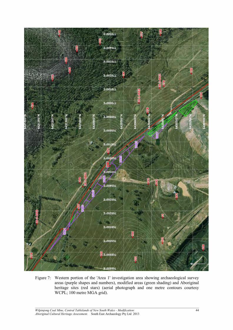
Wilpinjong Coal Mine, Central Tablelands of New South Wales - Modification: 44 Aboriginal Cultural Heritage Assessment. South East Archaeology Pty Ltd 2013
Figure 7: Western portion of the 'Area 1' investigation area showing archaeological survey areas (purple shapes and numbers), modified areas (green shading) and Aboriginal heritage sites (red stars) (aerial photograph and one metre contours courtesy WCPL; 100 metre MGA grid).
225599

Wilpinjong Coal Mine, Central Tablelands of New South Wales - Modification: 45 Aboriginal Cultural Heritage Assessment. South East Archaeology Pty Ltd 2013
Figure 8: Eastern portion of the 'Area 1' investigation area showing archaeological survey areas (purple shapes and numbers) and Aboriginal heritage sites (red stars) (aerial photograph and one metre contours courtesy WCPL; 100 metre MGA grid).

Wilpinjong Coal Mine, Central Tablelands of New South Wales - Modification: 46 Aboriginal Cultural Heritage Assessment. South East Archaeology Pty Ltd 2013
Figure 9: 'Area 2' and 'Area 3' portions of the investigation area showing archaeological survey areas (purple shapes and numbers) and Aboriginal heritage sites (red stars and pink shapes) (aerial photograph and one metre contours courtesy WCPL; 100 metre MGA grid).

Wilpinjong Coal Mine, Central Tablelands of New South Wales - Modification: 47 Aboriginal Cultural Heritage Assessment. South East Archaeology Pty Ltd 2013
Figure 10: 'Area 4' and 'Area 5' portions of the investigation area showing archaeological
survey areas (purple shapes and numbers) and Aboriginal heritage sites (red stars and pink shapes) (aerial photograph and one metre contours courtesy WCPL; 100 metre MGA grid).
WWMM
2255
WM
30
AApp
pprr oo
vveedd
CCuu
mmbb
oo CC
rr eeee
kk
DDii ss
tt uurr bb
aann
ccee AA
rr eeaa

Wilpinjong Coal Mine, Central Tablelands of New South Wales - Modification: 48 Aboriginal Cultural Heritage Assessment. South East Archaeology Pty Ltd 2013
Figure 11: 'Area 6' portion of the investigation area showing archaeological survey areas
(purple shapes and numbers) and Aboriginal heritage sites (red stars and pink shapes) (aerial photograph and one metre contours courtesy WCPL; 100 metre MGA grid).

Wilpinjong Coal Mine, Central Tablelands of New South Wales - Modification: 49 Aboriginal Cultural Heritage Assessment. South East Archaeology Pty Ltd 2013
5.2 Aboriginal Heritage Evidence
5.2.1 Overview The conduct of the present survey has resulted in an increase in the known heritage resource within the investigation area. Prior to this survey, approximately 15 Aboriginal sites or values had been reported within or adjacent to this area (refer to Section 3.1). The present survey has resulted in the identification of another 12 open artefact sites2. A number of the previously recorded sites were relocated and re-recorded. The grid references of several of these sites were revised (updated mapping of all site locations within the investigation area is presented in Figures 7 - 11, with detailed maps of site locations in Appendix 3). Hence, a total of 27 sites/PADs/values are known to occur directly within or immediately adjacent to the investigation area (refer to Table 4), comprising: Twenty-two open artefact sites; Two possible Aboriginal scarred trees; One 'possible waterhole'; One rock shelter with PAD; and One possible cultural value/association (as reported by Navin Officer 2005). Full descriptions of the previously recorded sites are presented in Appendix 1. Where these sites were relocated and re-recorded, updated descriptions are also presented in Appendices 1 and 3. Full descriptions of all newly identified sites recorded during the current survey are presented in Appendix 3. For the purposes of the significance assessment and impact assessment (refer to Sections 7 and 9), all sites directly within or immediately adjacent to the investigation area (as listed in Table 4) have been subject to consideration. No Aboriginal heritage sites within the investigation area are listed on any other heritage registers or planning instruments (refer to Section 3.1). While the above discussion focuses on Aboriginal objects and physical evidence of Aboriginal occupation3, contemporary cultural values associated with the investigation area have been identified by the registered Aboriginal parties. These include: In general terms, the use of subsistence or other resources, with comments made about the
presence of various native flora and fauna where observed. These comments were not of a historical nature (ie. did not relate to plant and animal resource use areas known from the post-contact period) but rather were general observations of the occurrence of particular species and their known traditional uses (eg. for food, medicine, tools, etc.);
2 For the purposes of this assessment, "artefact scatters" and "isolated finds" are typically assessed
together in recognition that the occurrence of a single artefact often represents the only visible portion of a larger artefact resource within a broader site/survey area.
3 Apart from the 'possible cultural value/association' recorded by Navin Officer (2005) and listed on the OEH AHIMS register (notwithstanding that the value is not consistent with the definition of an Aboriginal object under the NP&W Act 1974).

Wilpinjong Coal Mine, Central Tablelands of New South Wales - Modification: 50 Aboriginal Cultural Heritage Assessment. South East Archaeology Pty Ltd 2013
In general terms, the traditional use of the area by north-eastern Wiradjuri people, and an ongoing cultural and spiritual connection to the land and resources of the study area by the north-eastern Wiradjuri; and
In relation to 'Area 4', the registered parties have identified the contemporary cultural
significance of the adjacent 'Castle Rock', a visually prominent hill crest with rock formations and a rock shelter with art (site WCP72), located outside of the Modification area.
The possibility cannot be excluded that further Aboriginal values or associations may exist within the locality of the investigation area that were not divulged to South East Archaeology by the persons consulted. In addition to these places, other archaeological sites (eg. artefact scatters) identified within the investigation area are of contemporary significance to the Aboriginal community, as they represent a tangible link with the traditional past and with the lifestyle and values of community ancestors (refer to Section 7). 5.2.2 Open Artefact Sites A total of 22 open artefact sites are known to occur directly within or immediately adjacent to the investigation area (refer to Table 4). A summary of open artefact sites recorded during the current survey is presented in Table 5 (several previously recorded sites could not be relocated). Typically these are small, low density open isolated finds or open artefact scatters with ten or less artefacts. However, site WCP 438 (which marginally extends into 'Area 2') with 27 artefacts, and site WCP 1 (located almost entirely within 'Area 5') with 159 artefacts, are substantially larger sites. Typically "isolated finds" or "isolated artefacts" represent the only visible evidence of larger artefact scatters, in which low conditions of visibility have prevented the detection of further items. The terms "isolated artefact" and "artefact scatter" have been used interchangeably in previous studies. The term "open artefact site" encompasses those spatially discrete locations of visible artefact evidence in open contexts, that have been or can be referred to as "isolated artefacts" or "artefact scatters". The identified artefacts probably only represent a small fraction of the entire artefact resource that is present within the investigation area, because the vast majority of evidence is likely to be currently obscured by vegetation and soil. Substantial portions of the investigation area were not directly sampled for artefacts, and where the sample was obtained, conditions of surface visibility were typically low (mean archaeological visibility across the entire survey sample was 11%: refer to Section 5.1). The survey sample has, however, served to refine the predictive model with respect to artefact distribution (refer to Section 5.3).

Wilpinjong Coal Mine, Central Tablelands of New South Wales - Modification: 51 Aboriginal Cultural Heritage Assessment. South East Archaeology Pty Ltd 2013
Table 4: Summary of Aboriginal sites and cultural values located within or immediately adjacent to the investigation area.
Site Name OEH AHIMS # Site Type Comments
WCP1 36-3-0575 Open artefact site Area 5
WCP2 36-3-0576 Open artefact site Marginally outside of Area 5
WCP58 36-3-0632 Possible cultural value/association Area 4
WCP61 36-3-0635 Water hole (possible) Area 4
WCP64 36-3-0638 Scarred tree (possible Aboriginal) Area 6
WCP70 36-3-0644 Open artefact site Area 4
WCP71 36-3-0645 Open artefact site Area 4
WCP124 36-3-0560 Scarred tree (possible Aboriginal) Area 2, Aboriginal origin very unlikely
WCP184 36-3-0461 Open artefact site Marginally outside of Area 1, area now totally modified by approved activities
WCP195 36-3-0471 Open artefact site Marginally outside of Area 6, not relocated during present survey
WCP212 36-3-0488 Open artefact site Area 2, not relocated during present survey
WCP213 36-3-0489 Open artefact site Area 2, not relocated during present survey - may have been collected during WCPL 'pre-clearance works' but data not available for review
WCP216 36-3-0492 Open artefact site Almost entirely located to the north of Area 3, may extend to within Area 3 but excavation data not available for review
WCP259 36-3-0792 Open artefact site Area 1, not relocated during present survey
WE52 (WCP 340) pending Rock shelter with PAD Outside of Area 3
WCP 437 pending Open artefact site Area 1
WCP 438 pending Open artefact site Portion within Area 2, most outside of Area 2
WCP 439 pending Open artefact site Area 3
WCP 440 pending Open artefact site Area 3
WCP 441 pending Open artefact site Marginally outside of Area 3
WCP 442 pending Open artefact site Area 4
WCP 443 pending Open artefact site Area 4
WCP 444 pending Open artefact site Area 5
WCP 445 pending Open artefact site Area 5
WCP 446 pending Open artefact site Marginally outside of Area 5
WCP 447 pending Open artefact site Area 5
WCP 448 pending Open artefact site Area 6
Modification Investigation Area
n/a Cultural area/value All of Modification area
Use of subsistence and other resources
n/a Cultural area/value All of Modification area
Castle Rock n/a Cultural area/value Marginally outside of Area 4

Wilpinjong Coal Mine, Central Tablelands of New South Wales - Modification: 52 Aboriginal Cultural Heritage Assessment. South East Archaeology Pty Ltd 2013
Table 5: Summary of open artefact sites recorded during the present survey.
Sit
e N
am
e
La
nd
form
Ele
men
t
Slo
pe
Dis
tan
ce t
o W
ate
r
Veg
eta
tio
n
Gro
un
d D
istu
rb
an
ce
Vis
ible
Ex
ten
t o
f S
urfa
ce
Ex
po
sure
s: L
en
gth
(m
)
Vis
ible
Ex
ten
t o
f S
urfa
ce
Ex
po
sure
s: W
idth
(m
)
Vis
ible
Ex
ten
t o
f E
vid
en
ce:
Len
gth
(m
)
Vis
ible
Ex
ten
t o
f E
vid
en
ce:
Wid
th (
m)
Vis
ible
Locu
s A
rea (
m2)
Mea
n S
urfa
ce V
isib
ilit
y o
f
Locu
s (%
)
Mea
n A
rch
aeo
log
ical
Vis
ibil
ity
of
Lo
cu
s (%
)
Eff
ecti
ve
Lo
cu
s A
rea
(m
2)
# o
f A
rte
facts
WCP 1 spur crest level - very gentle >50 1 low varies varies 250 130 32500 10 10 3250 159
WCP70 ridge crest level - very gentle >50 1 mod 12 2 1 1 1 90 90 1 1
WCP 437 spur crest level - very gentle >50 1 mod 50+ 0.3 1 0.3 0.3 80 80 0.2 2
WCP 438 simple slope gentle >50 1,2 mod 180+ 10+ 180 15 2700 80 80 2160 27
WCP 439 simple slope moderate >50 1 low varies varies 8 2 16 70 70 11 2
WCP 440 simple slope moderate >50 1 low varies varies 1 1 1 70 70 0.7 1
WCP 441 simple slope moderate >50 1 low varies varies 1 1 1 50 50 0.5 1
WCP 442 ridge crest level - very gentle >50 1 mod 4 1 2 1 2 60 60 1.2 10
WCP 443 simple slope gentle >50 1 high 50+ 3 1 1 1 80 80 0.8 1
WCP 444 simple slope gentle >50 1 mod varies varies 14 2 28 50 50 14 2
WCP 445 simple slope gentle >50 1 mod - high 15 10 1 1 1 90 90 0.9 1
WCP 446 spur crest level - very gentle >50 1 low - mod varies varies 1 1 1 30 30 0.3 1
WCP 447 simple slope gentle >50 1 low varies varies 1 1 1 50 50 0.5 2
WCP 448 simple slope gentle >50 2 high 150+ 5 60 3 180 95 80 144 3 Vegetation: 1 = cleared/grass; 2 = forest/bush/regrowth.
Sit
e N
am
e
# o
f A
rte
facts
# o
f A
rte
facts
/m2 o
f
Eff
ecti
ve
Lo
cu
s A
rea
Su
b-S
urfa
ce D
ep
osi
t
Co
mm
en
ts
MG
A R
efe
ren
ce
Ea
stin
g
MG
A R
efe
ren
ce
No
rth
ing
WCP 1 159 0.049 probable high research potential with probable sub-surface deposits; uncertain of potential depth of deposits as >1m wombat hole; broad low elevated open crest or terrace immediately east of Cumbo Creek; many more artefacts obscured by vegetation; only visible artefacts were identified due to vehicle track, erosion scours and animal tracks; some rock stockpiles but provenance of collected material uncertain; includes previous site on road (WCP1); mostly low ground disturbance; available stone materials quartz and tuffaceous
772810 6418120
WCP70 1 1.111 unlikely site WCP 70 as recorded by Navin Officer; grassy area with ground disturbance including erosion, cattle and vegetation removal; two quartz pebbles identified but not artefacts; low research potential and unlikely to be sub-surface deposits
771930 6417903
WCP 437 2 8.333 possible moderate ground disturbance due to vegetation removal, animal track and Telstra cable; low research potential for possible sub-surface deposits; low quality quartz gravel present; 6m south of fence bordering Ulan-Wollar Road
769210 6421029
WCP 438 27 0.012 possible low research potential; some distance from creek; on a gentle slope 75m to gate on main vehicle track from eastern most artefact; site WCP 123 still present at gate, east of this site; grassy area with moderate ground disturbance due to vehicle track, vegetation removal and erosion; site mostly extends east of the modification investigation area
767407 6419032
WCP 439 2 0.180 possible cleared pastoral area; slightly moderate slope; low research potential; grassy area used for pastoral practices; erosion and vegetation removal; stone materials available are tuff and quartz, with abundant tuffaceous material eroding from hillslope; artefact #1 12m north of fence (from 5m west of tree/change in fence direction)
767332 6418374

Wilpinjong Coal Mine, Central Tablelands of New South Wales - Modification: 53 Aboriginal Cultural Heritage Assessment. South East Archaeology Pty Ltd 2013
Sit
e N
am
e
# o
f A
rte
facts
# o
f A
rte
facts
/m2 o
f
Eff
ecti
ve
Lo
cu
s A
rea
Su
b-S
urfa
ce D
ep
osi
t
Co
mm
en
ts
MG
A R
efe
ren
ce
Ea
stin
g
MG
A R
efe
ren
ce
No
rth
ing
WCP 440 1 1.428 possible cleared pastoral area north of fenceline; low research potential; grassy area used for pastoral practices; erosion and vegetation removal; stone materials available are tuff and quartz, with abundant tuffaceous material eroding from hillslope; artefact located 8m north of fence, 11m east of point where fence changes direction
767415 6418365
WCP 441 1 2.000 probable low-moderate research potential with probable sub-surface deposits to a depth of <0.5m; edge of near level small spur, overlooks valley; grass, bush and regrowth pine cover area; low-moderate ground disturbance with some erosion and vegetation removal; stone materials available are tuff and quartz
767691 6418274
WCP 442 10 8.333 unlikely broad crest; also natural shattered quartz in other exposures; grassy area with moderate ground disturbance due to stock, erosion and vegetation removal; sandstone outcrops; low research potential and unlikely to be sub-surface deposits
771916 6417762
WCP 443 1 1.250 unlikely located on vehicle track; highly disturbed area 772119 6417750
WCP 444 2 0.143 possible broad almost very gentle simple slope; artefacts on track north of fence east of dam; grassy area with moderate ground disturbance due to track and vegetation removal; materials available include quartz and tuff; low research potential
773310 6417737
WCP 445 1 1.111 possible low research potential; probably shallow deposit; grassy area with moderate-high ground disturbance due to erosion adjacent to dam; material available include tuff and quartz; located 15m west of dam and 15m north of fence in erosion scour
773212 6417765
WCP 446 1 3.333 possible broad low open ridge; very gentle; marginally outside modification study area; grassy area with low-moderate ground disturbance due to vegetation removal, erosion and pastoral use; stone materials available include tuffaceous stone and minor amounts of quartz; low research potential; probably shallow deposits
773020 6418012
WCP 447 2 4.000 probable 45 metres east of road and 17 metres south of Eucalypt tree, near regrowth scrub 772945 6418415
WCP 448 3 0.021 possible low research potential; probably shallow deposit; high impacts - located on vehicle track opposite Upper Cumbo Road; quartz and tuff stone available; Box forest; site probably continues further west along road but not inspected as outside modification study area
774470 6415964
5.2.3 Other Site Types One rock shelter with PAD, site WCP 340 (WE52) was reported by Kayandel (2006) as being located within Area 3 of the Modification investigation area (refer to Appendix 1). Despite systematic survey, this site was not relocated. No rock formations that could host the shelter are present within Area 3 and it is probable that the reported grid reference is in error and the site is located further west on the steep side slopes of the adjacent ridge. One 'possible waterhole' (WCP 61) has been reported by Navin Officer (2005) within Area 4 of the Modification investigation area (refer to Appendix 1). This feature was relocated and determined to be derived from animal diggings, as inferred by Navin Officer (2005). It is situated in soft sandy sediments at a wombat hole, where minor water seepage occurs from the adjacent sandstone. Two possible Aboriginal scarred trees (WCP 64 and 124) have been reported by Navin Officer (2005) in Areas 6 and 2 of the Modification investigation area respectively (refer to Appendix 1). Both trees were relocated and re-assessed during the present survey.

Wilpinjong Coal Mine, Central Tablelands of New South Wales - Modification: 54 Aboriginal Cultural Heritage Assessment. South East Archaeology Pty Ltd 2013
Aboriginal scarred trees exhibit the evidence of Aboriginal utilisation of bark and/or wood for the manufacture of canoes, containers, shelters, shields or boomerangs. Scarred trees may also have been associated with cultural activities and places, such as initiation ceremonies and burials, although these are more often associated with carved trees. Beesley (1989), Bell (1982) and Crew (1990, 1991) outline the criteria for identifying Aboriginal scarred trees: The scar is wholly enclosed; The scar exhibits the removal of bark and/or wood; The scar is regular in shape and usually oval, elongated, rectangular, or curved to fit the
shape of the trunk; Multiple scars on one tree may be present; Stone or steel axe marks may be present around the edge of the scar; Multiple, small, regularly spaced scars may be present; The tree is of indigenous species and of mature age; The tree may be associated with particular resource zones such as rivers; and The tree may be associated with other Aboriginal sites. A number of non-Aboriginal causes for scarred trees exist, including loss of branches, lightning and fire damage, insect damage, growth stress, bird activity and modern (or historical) activity such as survey marks and mechanical damage from machinery and vehicles (Crew 1990, 1991). Natural causes for scarring often result in basal scars and scars irregular or ragged in shape, while scars on immature and exotic trees are not considered to be characteristic of Aboriginal activity and may be the result of either natural or modern causes (Crew 1990, 1991). Scars arising from recent (non-Aboriginal) human activity are generally fully enclosed, but usually exhibit the removal of bark only and are often rectangular, arched or half oval in shape (Crew 1990, 1991). Such scars may also exhibit steel axe marks and occur on exotic species, often associated with sites of non-Aboriginal human activity, such as construction areas, roads or farm buildings (Crew 1990, 1991). Notwithstanding the low height above ground of the base of the scar on the tree at site WCP 64, the possible previous branch removal immediately above the scar and its location within the broad vegetated road reserve of the Wollar Road, an Aboriginal origin for the scar cannot be entirely discounted. Hence, on a preliminary basis, the tree can be regarded as a 'possible Aboriginal scarred tree'. However, the tree at site WCP 124 in Area 2 does not exhibit attributes consistent with a possible Aboriginal origin. The tree exhibits attributes consistent with non-Aboriginal causes for the scarring and in agreement with the conclusion of Navin Officer (2005), a non-Aboriginal origin is inferred.

Wilpinjong Coal Mine, Central Tablelands of New South Wales - Modification: 55 Aboriginal Cultural Heritage Assessment. South East Archaeology Pty Ltd 2013
5.2.4 Cultural Values Contemporary cultural values associated with the investigation area have been identified by the registered Aboriginal parties. Some of these relate to physical objects, including items that qualify as Aboriginal objects as defined under the National Parks and Wildlife Act 1974. However, some relate to intangible values, associations or landscape features that do not qualify as Aboriginal objects. These include: In general terms, the use of subsistence or other resources, with comments made about the
presence of various native flora and fauna where observed. These comments were not of a historical nature (ie. did not relate to plant and animal resource use areas known from the post-contact period) but rather were general observations of the occurrence of particular species and their known traditional uses (eg. for food, medicine, tools, etc.);
In general terms, the traditional use of the area by north-eastern Wiradjuri people, and an
ongoing cultural and spiritual connection to the land and resources of the study area by the north-eastern Wiradjuri;
In relation to Area 4, the registered Aboriginal parties have identified the contemporary
cultural significance of the adjacent 'Castle Rock', a visually prominent hill crest with rock formations and a rock shelter with art (site WCP72) located adjacent to the Modification area; and
One possible cultural value/association identified by Navin Officer (2005) at site WCP 58
in Area 4 (refer to Appendix 1), which is the locally prominent hill crest on the ridgeline north-east of Castle Rock. Navin Officer (2005) report that the location was considered by several younger representatives of Murong Gialinga ATSIC (and later by several older female members of this organisation and the Mudgee LALC) to be an area of special significance to women. The cultural value was considered by these representatives to extend along the ridge south-west to Castle Rock. However, other members of these organisations expressed reservations about the identification of this value and members of the Warrabinga NTCAC were of the view that the ridgeline and hillock does not have any special cultural significance (Navin Officer 2005).
In addition to these places, other archaeological sites (eg. artefact scatters) identified within the investigation area are of contemporary significance to the Aboriginal community, as they represent a tangible link with the traditional past and with the lifestyle and values of community ancestors (refer to Section 7). In general terms, the attachment of the north-eastern Wiradjuri people to the landscape and continuing strong cultural connections with the locality of the study area was evident. As noted by Goulding (2002:63) land is a fundamental part of Aboriginal culture, and such cultural connections are integral to the health and wellbeing of Aboriginal people, although can be complex and are not always obvious to others. Representatives not of Wiradjuri descent also expressed or have expressed a strong spiritual and cultural connection with the locality.

Wilpinjong Coal Mine, Central Tablelands of New South Wales - Modification: 56 Aboriginal Cultural Heritage Assessment. South East Archaeology Pty Ltd 2013
5.3 Discussion The results of the investigation are discussed below, including the potential integrity of the evidence, nature of the evidence and interpretations of the evidence. 5.3.1 Integrity of Evidence The integrity of the identified sites and the remainder of the investigation area can primarily be assessed for surface evidence only through examination of land use impacts. Controlled excavation enables integrity to be assessed through the horizontal and vertical distribution of artefacts and by conjoining items. As discussed in Section 2, recent non-Aboriginal land-use practices have had generally low impacts on the investigation area. Some impacts have been caused by: Vegetation removal and timber harvesting; Pastoral activities; and Mining and infrastructure (such as the Ulan - Wollar Road and Wilpinjong Mine entrance
road). Approximately 1.3 hectares (2% of the investigation area) has been totally modified by previous land use, such that negligible potential for Aboriginal heritage evidence remains. These areas have been extensively impacted by road construction and mining activity. In the remainder of the investigation area, levels of ground disturbance were recorded during the survey, after McDonald et al (1984) (Appendix 2). The survey areas typically exhibited low levels of ground disturbance. The open artefact sites tend to be located in exposures created by ground disturbance (eg. vehicle tracks and erosion) and as a result exhibit varying levels of integrity. Five open artefact sites recorded during the present survey exhibit low levels of disturbance, one a low to moderate level, five a moderate level, one a moderate to high level and one a high level. However, in general, disturbance levels are low across much of the investigation area and should sub-surface deposits of artefacts occur, they may exhibit reasonable integrity. Impacts are higher across Area 1, due to approved mining and infrastructure, and in small portions of Area 4, due to adjacent mining activities. 5.3.2 Lithic Assemblage A total of 213 lithic items were recorded during the survey. These items are listed for each site in Appendix 3 and summarised in Table 6. Most of the items were recorded in site WCP 1 (159 in total) and to a lesser extent site WCP 438 (27 in total), with only 27 items recorded in the remaining 12 open artefact sites. In terms of stone materials, consistent with assemblages from the locality (for example, the overall Ulan assemblage of Kuskie 2009 of over 9,000 artefacts), the combined open site assemblage is overwhelmingly dominated by quartz (including crystal quartz; 65.7% of the combined assemblage), with lower frequencies of tuff (19.2%) and chert (10.8%) and very low frequencies of other materials such as acidic volcanic, jasper, petrified wood, porphyritic rhyolite and quartzite.

Wilpinjong Coal Mine, Central Tablelands of New South Wales - Modification: 57 Aboriginal Cultural Heritage Assessment. South East Archaeology Pty Ltd 2013
Table 6: Summary of stone artefacts recorded during the present heritage survey.
Stone Material
Lithic Item Type
acidic volcanic chert
crystal quartz jasper
petrified wood
porphyritic rhyolite quartz quartzite tuff Total
backed artefact - portion 1 1
blade - medial 1 1
bondi point 1 1
core 1 3 1 1 28 6 40
core fragment 3 1 12 1 17
flake 1 8 3 1 1 33 17 64
flake - distal 2 1 1 7 2 13
flake - distal - utilised 1 1
flake - longitudinal 1 9 10
flake - medial 1 1
flake - proximal 1 1 2 4
flake - proximal - utilised 1 1
geometric microlith 1 1
hammerstone 1 1
lithic fragment 3 36 7 46
microblade 1 1
microblade core 1 1
retouched flake 1 1 2
retouched piece 1 1 1 3
retouched piece - utilised 3 3
tula 1 1
Total 2 23 10 1 3 2 130 1 41 213
There are three main forms of massive quartz: veins, geodes and macro-crystals. For the purposes of flaking, these varieties are essentially similar, although vein or reef quartz is more likely to contain major pre-existing flaws. Quartz is composed of extremely small hexagonal crystals of silicon dioxide, which give it a glossy texture. When pure it is translucent, but minute traces of minerals may add colours such as smoky grey, pink or yellow. Most quartz has microscopic gas or liquid filled vacuoles that give it a milky appearance. While this does not affect the rock's strength, clay minerals in ground water, particularly iron compounds, may seep into the minute flaws and weaken the stone, leading to natural fracturing. It can also break with a conchoidal fracture. Because quartz exhibits a small degree of cleavage and tends to have internal flaws, it ranges in flaking quality from very poor to acceptable. Internal cracking of quartz often occurs during flaking and its fracture path is usually much less predictable than stone which breaks with a strong conchoidal fracture. For these reasons quartz is generally a low-quality flaking material. However, because of its abundance and availability, in some areas such as the Ulan locality it is the main stone type used for flaking. Its other advantage is that it provides small flakes with very sharp edges, which are suitable for light-duty work such as skinning, light butchering and cutting plant matter.

Wilpinjong Coal Mine, Central Tablelands of New South Wales - Modification: 58 Aboriginal Cultural Heritage Assessment. South East Archaeology Pty Ltd 2013
About 10.7% of the quartz artefacts display waterworn cortex and 2.9% terrestrial cortex. Quartz pebbles have been noted in numerous locations across the locality and are derived from decomposed conglomerate rock. The pebbles occur in various sizes and quality, but are often sufficient for knapping (cf. Kuskie 2009). Tuff comprises 19.2% of the combined assemblage. Tuff is a fine grained, isotropic stone formed after a cloud of ash was ejected in an explosive volcanic eruption. The ash settled to the ground or through ponded water. After burial, some tuff beds became indurated, through a low-grade metamorphic process (probably involving pressure) in which the stone recrystallised to a more stable structure. Tuff seams are commonly associated with Permian era Coal Measures. Tuff samples examined from the nearby Hunter Valley are rhyolitic in chemical composition (quartz and potassium-feldspar, occasionally with layer silicate or goethite) (Kuskie and Kamminga 2000). Tuff is typically grey in colour in the lower Hunter Valley (a function of grain size, not a reference to individual grains, which can be of a variety of colours). However, tuff is porous enough for the diffusion of iron bearing solution, with iron precipitating out to give a yellow, brown, red or orange colour. Variations to the surface colouration can also result from weathering processes. In the Ulan and Wilpinjong locality, the tuff is predominantly yellow or brown in colour, indicating the presence of the mineral goethite. As with quartz, tuff was probably procured from local sources in the Wilpinjong area. Tuff occurs widely in the locality, as seams exposed in the scarps and slopes of the dissected sandstone terrain (including occasional manifestation within rock shelters) and as tabular colluvial gravels on the slopes and also in the drainage depressions where it has migrated further downwards. Extensive tuffaceous stone is present on the steep slopes bordering Area 3 (survey area WM11) and in Area 6 (survey area WM35). Chert comprises 10.8% of the combined assemblage (12.7% including the separately identified jasper and petrified wood items). Cherts are highly siliceous sedimentary rocks, with a chemical composition of silicon dioxide and major constituent minerals of chalcedony, quartz and opal. Chert is formed in marine sediments and occurs as nodules in limestone. The various accumulations of other substances, for example iron oxides, during the process of formation often colours the parent matrix of chert, leaving the final material often quite visually arresting colours or patterns of colours, particularly banded layers. Chert was a favoured material for manufacturing artefacts, as it breaks by the process of conchoidal fracture and provides flakes that have sharp, durable edges. Chert is present in the local Illawarra Coal Measures and occurs in a relatively low frequency as pebbles in the conglomeritic derived gravels. Colluvial gravels probably represented relatively local sources for this stone. In terms of artefact types, consistent with assemblages from the locality (for example, the overall Ulan assemblage of Kuskie 2009), the combined open site assemblage is overwhelmingly dominated by flakes (30%), flake portions (13%), lithic fragments (21.6%), cores (18.8%) and core fragments (8%). These items may represent the fragmented debris of on-site knapping of primary flakes and/or microblades or other on-site fracture, such as accidental breakage, or accidental discard. Backed artefacts comprise a relatively small (1.4%) component of the assemblage, with only one bondi point, one geometric microlith and one backed artefact portion present (all in site WCP 1). Several other items, such as a microblade and microblade core, provide some evidence that the manufacturing of backed artefacts may have occurred on-site at WCP 1, along with the discard of complete microliths.

Wilpinjong Coal Mine, Central Tablelands of New South Wales - Modification: 59 Aboriginal Cultural Heritage Assessment. South East Archaeology Pty Ltd 2013
Bondi points are a form of microlith often found in artefact scatter sites dating to the mid-late Holocene. While the function of these finely fashioned implements is not known with certainty, most archaeologists consider that they were used in armatures of hunting and fighting spears (Mulvaney and Kamminga 1999:235-36). Microliths may have served as barbs, or else as lacerators intended to disable an enemy or prey by causing haemorrhage. It is possible that different microlith types were designed to serve these different functions. Alternative uses have been proposed for bondi points, including their use as cutting implements (cf. Sokoloff 1977). Most recently, Fullagar (et al 1994) has inferred from residues on a small sample of bondi points from the Hunter Valley that they served as multi-functional tools. Therin (2000) inferred that some backed artefacts from the ID# 132 salvage assemblage at Ulan were used as knives rather than spear barbs. However, the evidence for use in spear armatures is persuasive and it could easily account for the range of residues observed. One tula slug was also identified at site WCP 1. Tulas were hafted and used to adze, shave and incise wood, but were also used as light-duty wood scrapers and for butchering tasks (Mulvaney and Kamminga 1999:248). Similar to bondi points, they have been reliably dated to the mid-late Holocene period. One hammerstone (a quartzite item) was recorded in site WCP 1. The incidence and extent of cortex reflects the nature of this item (elongated pebble), which was selected because of the suitability of the stone material and morphology for the intended task. The hammerstone exhibits extensive damage from pounding at one end. Approximately 4.7% of the assemblage comprises other retouched and/or utilised flakes or flake portions (10 items). Although the functions of the utilised items are uncertain, they indicate that tasks other than artefact production occurred. Retouched flakes and pieces are artefacts that can have limited analytical value, because the purpose of the retouch they exhibit is not necessarily known. Some may be associated with backed artefact production or be portions of backed artefacts. Nevertheless, in general terms, the frequency of utilised and/or retouched items is relatively low. 5.3.3 Spatial Distribution, Site Interpretation and Reassessment of Occupation
Model The spatial distribution of evidence can be examined, particularly in relation to environmental variables such as slope and landform element. However, the inferences that can be made from this comparison are limited by the small nature of the sample. Overall, artefacts in open contexts in the Modification investigation area occur at a low mean density of less than 0.01 per square metre of effective survey coverage (refer to Table 3). Apart from site WCP 1, the spatial distribution and nature of evidence is largely consistent with background discard, manuport and artefactual material which is insufficient either in number or in association with other material to suggest focused activity in a particular location (cf. Kuskie and Kamminga 2000). In general terms, the artefact density indicates a generally low-intensity utilisation of the Modification investigation area. Although the identified open artefact evidence probably only represents a fraction of the artefact resource that is present within the investigation area, because the majority of evidence is likely to be currently obscured by vegetation and soil (cf. Kuskie 2009), much of the Modification investigation area is located in contexts that do not conform to primary or secondary resource zones under the model of occupation presented in Section 3.4.

Wilpinjong Coal Mine, Central Tablelands of New South Wales - Modification: 60 Aboriginal Cultural Heritage Assessment. South East Archaeology Pty Ltd 2013
These areas are generally distant from higher order watercourses, where more reliable potable water and subsistence resources would have been available, and/or of moderate to steep gradient. As such, rather than having represented focused occupation, Aboriginal use of these portions of the investigation area is therefore more likely to have related to hunting and gathering activities, along with transitory movement between locations and procurement of stone materials, and would have been of a generally low intensity. The survey results support these conclusions. However, a portion of Area 5 (portions of survey areas WM30 and 32) is located within 200 metres of Cumbo Creek, a higher order watercourse where more reliable potable water and subsistence resources would have been available. This area can be classified as a secondary resource zone. According to the modelling in Section 3.4, occupation of this portion of the investigation area may have included camping by small parties of hunters/gatherers and nuclear/extended family groups, in addition to hunting and gathering and transitory movement between locations. Occupation of this area is expected to have occurred at a higher intensity than in the surrounding areas. Significantly, the survey results (site WCP 1) support these predictions of the occupation model. Site WCP 1 contains a relatively high number of artefacts, diverse range of stone materials and artefact types and has a high potential for substantial sub-surface deposits. The evidence identified during the survey is consistent with the occupation model for the locality (refer to Section 3.4). No evidence was identified that would lead to revisions to the model. The inferences that can be made about the nature of occupation at the identified sites or elsewhere in the investigation area are limited by the small nature of the sample. It is inferred from the evidence obtained during the survey of the Modification investigation area that:
Aboriginal people widely used the Modification investigation area, but generally at a low intensity, apart from around Cumbo Creek were occupation may have occurred at a higher intensity;
The artefact evidence is consistent with transitory movement through the landscape and
occasional and short-duration visits by small parties of hunters and/or gatherers, apart from at Cumbo Creek (site WCP 1), where camping by small parties of hunters/gatherers and nuclear/extended family groups may also have occurred;
At least some of the evidence within the area relates to occupation during the past 5,000
years;
The stone material quartz was predominantly used for stone-working activities, largely because of its local availability, and it was probably procured from relatively local colluvial gravels in a casual, opportunistic manner; and
Core reduction strategies are inferred to have been largely expedient, to produce flakes for
immediate use (ie. largely casual and opportunistic, meeting requirements on an 'as needed' basis).
5.3.4 Regional Context The nature of the evidence from the investigation area can be compared with other studies and sites in the region (refer to Section 3.2). The primary purpose is to identify similarities and differences with other reported evidence, in order to provide a framework for interpreting representativeness and assessing potential cumulative impacts.

Wilpinjong Coal Mine, Central Tablelands of New South Wales - Modification: 61 Aboriginal Cultural Heritage Assessment. South East Archaeology Pty Ltd 2013
Several primary similarities have been identified with other survey results in the locality including the: Occurrence of similar open artefact sites in similar topographical contexts; Similar stone material and artefact types; Generally low artefact numbers and densities; and Presence of evidence in similar environmental contexts, including landform elements and
gradients. The nature of the evidence from the investigation area is consistent with the results from the previous heritage assessment for the EA (Navin Officer 2005). No specific aspects of the heritage evidence located within the Modification investigation area are rare or unique within a local or regional context, although the site WCP 1 is a less commonly reported example of a larger site in a secondary resource zone, with a relatively high number of artefacts and broad range of types and stone materials. 5.3.5 Reassessment of Predictive Model In view of the survey results, the predictive model of site location for the investigation area (refer to Section 3.5) can be reassessed in relation to the areas within the sampled zone that were not directly inspected. Visual inspection confirmed that negligible potential for heritage evidence exists within the modified areas, which has been extensively impacted by earthmoving works associated with existing roads and mining operations. The potential for bora/ceremonial, carved tree, rock engraving, rock shelter and stone arrangement sites to occur within the portions of the investigation area that have not been directly sampled can be reassessed as very low or negligible. No direct evidence of lithic procurement sites was identified, however the potential for casual, opportunistic procurement of stone, such as quartz, from colluvial gravels within the investigation area cannot be discounted. No evidence was encountered of burial sites, and although the potential for skeletal remains to occur within the investigation area is considered to be very low, it cannot be discounted. Minor areas of exposed sandstone bedrock were identified within the investigation area and widely sampled for the presence of grinding grooves. The potential for open grinding groove sites to occur can be revised downward to very low, but cannot be discounted in areas that were not directly sampled or are currently obscured by sediment or vegetation/leaf litter. No additional scarred tree sites were identified during the survey, to the items previously recorded by Navin Officer (2005). The potential for additional scarred tree sites to occur can be revised downward to very low, but cannot be discounted in areas that were not directly sampled and in which mature native trees remain.

Wilpinjong Coal Mine, Central Tablelands of New South Wales - Modification: 62 Aboriginal Cultural Heritage Assessment. South East Archaeology Pty Ltd 2013
Sites of traditional cultural significance (such as mythological sites) were not identified by the Aboriginal representatives involved in the investigation. The registered Aboriginal parties also did not disclose any specific knowledge of other cultural values/places (for example, historically known places or resource use areas). Although the possibility cannot be excluded that traditional or historical Aboriginal values or associations may exist that were not divulged by the persons consulted, this potential is reassessed as very low. The registered Aboriginal parties did identify contemporary values/associations with the investigation area and previously recorded values have been reported by Navin Officer (2005). A number of open artefact sites were identified within the investigation area. There remains potential for additional open artefact evidence to occur in the areas that were not directly sampled or are currently obscured by vegetation. The artefact evidence may involve a broad range of artefact and stone types, but will predominantly comprise evidence associated with non-specific stone flaking of quartz. On the basis of the occupation model and survey results, the potential for further artefact evidence to occur within the Modification investigation area can be summarised as follows: In the 'modified' areas and in other minor, localised portions of the Modification
investigation area in which the upper soil unit has been totally removed, previous land use has caused such substantial impacts that there is generally negligible potential for any Aboriginal heritage evidence to survive;
In the portion of the Modification investigation area that may be characterised as being
within a secondary resource zone (portions of survey areas WM30 and 32 in Area 5 within 200 metres of Cumbo Creek) there is a high potential for sub-surface deposits of artefacts to occur, including deposits that may be of research value; and
In the remainder of the Modification investigation area, a low to very low density sub-surface deposit of artefacts may occur, consistent with the survey results and occupation model. In general, this evidence will be consistent with background discard, and although a low frequency of activity areas (with consequent higher artefact density) may be present, will not represent focused occupation. The potential for sub-surface deposits of artefacts that may be of high research value to occur within these portions of the investigation area is generally low.

Wilpinjong Coal Mine, Central Tablelands of New South Wales - Modification: 63 Aboriginal Cultural Heritage Assessment. South East Archaeology Pty Ltd 2013
6. ABORIGINAL CONSULTATION The investigation area lies within the boundaries of the Mudgee Local Aboriginal Land Council (Mudgee LALC) and within an area of interest to other Aboriginal persons and organisations. The Aboriginal heritage assessment has involved a comprehensive program of consultation with the Aboriginal community that complies with the policy requirements of the OEH (refer to consultation database and relevant correspondence in Appendix 5). These requirements are specified in the OEH policy entitled Aboriginal Cultural Heritage Consultation Requirements for Proponents 2010 (DECCW 2010c). Notwithstanding that the Guidelines for Aboriginal Cultural Heritage Impact Assessment and Community Consultation (DEC 2005) reference the now outdated Interim Community Consultation Requirements for Applicants policy (DEC 2004), the assessment has proceeded in accordance with the 2010 guidelines. These were introduced on 12 April 2010 and supercede the 2004 policy, but effectively incorporate the same procedures. The consultation requirements specified in the OEH Aboriginal Cultural Heritage Consultation Requirements for Proponents 2010 (DECCW 2010c) involve the following procedures (numbering follows the OEH guidelines): 4.1.2) In order to identify Aboriginal people who may have an interest in the investigation
area and hold knowledge relevant to determining the cultural significance of Aboriginal objects or places, providing written notification of the project to the relevant DECCW Environment, Protection and Regulation Group (EPRG) regional office, LALC, Local Council and Catchment Management Authority (CMA), along with the Registrar of Aboriginal Owners under the Aboriginal Land Rights Act 1983 (Department of Aboriginal Affairs), National Native Title Tribunal and Native Title Services Corporation Ltd (NTSCORP)4 including the name and contact details of the proponent, the location and a brief overview of the proposed project, and a request for advice on the contact details of such Aboriginal people;
4.1.3) Providing written notification of the project directly to those Aboriginal
persons/organisations that were identified in Procedure 4.1.2, along with the LALC, and placing an advertisement in a local newspaper circulated in the general location of the investigation area, explaining the project and its location. The notification includes the name and contact details of the proponent, the location and a brief overview of the proposal, a statement about the purpose of the consultation, an invitation for Aboriginal people with cultural knowledge relevant to the investigation area to register an interest and advice on privacy matters5, with a minimum 14 day response period6;
4.1.6) Providing a record of the names of each Aboriginal person who registered an interest
along with a copy of that registration and the notification letter in Procedure 4.1.3 to the relevant DECCW EPRG regional office and LALC within 28 days of the closing date for registrations of interest;
4 Procedures 4.1.2 - 4.1.7 are not required where an approved native title determination exists over
the entire investigation area. In this event, consultation is only required with the native title holders. 5 Procedure 4.1.5. 6 Procedure 4.1.4.

Wilpinjong Coal Mine, Central Tablelands of New South Wales - Modification: 64 Aboriginal Cultural Heritage Assessment. South East Archaeology Pty Ltd 2013
4.2 & 4.3) Providing detailed information about the project, heritage impact assessment process and proposed heritage assessment methodology to all registered Aboriginal parties identified in Procedure 4.1, with a minimum 28 day response period for comments;
4.2 & 4.3) Considering any input received from the registered parties in finalising the
heritage assessment methodology and process, and implementing the methodology in consultation with the registered Aboriginal parties. This included seeking input on knowledge of Aboriginal objects and places of cultural value to Aboriginal people within the investigation area and views on potential management strategies, and incorporated a field inspection of the investigation area;
4.3 & 4.4) Preparation of a draft Aboriginal heritage impact assessment report and seeking
the views of registered Aboriginal parties on cultural values and potential management strategies through provision of a copy of the draft report to the registered parties, with a minimum 28 day response period for comments; and
4.3 & 4.4) Preparation of a final Aboriginal heritage impact assessment report that
incorporates the input of the registered Aboriginal parties and the proponent's response to each submission made on the draft report, and making the final report available to the registered Aboriginal parties and the relevant LALC.
All consultation with the Aboriginal community is documented in Appendix 5 of this report. Compliance with Procedure 4.1.2 of the OEH policy was achieved through correspondence forwarded to the relevant organisations by Jamie Lees of WCPL on 18 October 2012. The following responses were received: The Registrar of Aboriginal Owners responded on 22 October 2012 advising that there
are no Registered Aboriginal Owners for this area but that the Mudgee and Wanaruah Local Aboriginal Land Councils may be able to assist further;
The OEH responded on 26 October 2012 advising that 21 Aboriginal organisations or
individuals should be contacted; Mid-Western Regional Council responded on 26 October 2012 advising that seven Local
Aboriginal Land Councils are within the Council boundaries and another 15 organisations should be contacted;
Native Title Services Corporation responded on 29 October 2012 advising that privacy
restrictions prevent provision of any details but the letter had been forwarded to relevant individuals/organisations with a request to register an interest as soon as possible; and
The National Native Title Tribunal responded on 30 October 2012 advising that there is
one Registered Native Title Claim within the search area, NC09/4 of the Wellington Valley Wiradjuri People (although further investigation identified that the geographic area of the claim did not encompass the Modification investigation area).
Through the operation of the Native Title Act 1993 (NTA), an Ancillary Deed is maintained between WCPL and William Allen, Martin de Launey and Lynette Syme (Native Title Party) for Mining Lease Application (MLA) 259. The “Deed” (Government Party Deed) represents an agreement for the purposes of section 31(1)(b) of the NTA and was executed on 12 December 2005.

Wilpinjong Coal Mine, Central Tablelands of New South Wales - Modification: 65 Aboriginal Cultural Heritage Assessment. South East Archaeology Pty Ltd 2013
As a result of the above correspondence, Procedure 4.1.3 of the OEH consultation policy was then implemented by Jamie Lees of WCPL writing in November 2012 to the organisations named by the parties above, with an invitation to register an interest. An advertisement was also placed in the Public Notices sections of the Mudgee Guardian on 9 November 2012 (refer to Appendix 5). At the conclusion of these registration of interest procedures, eight Aboriginal parties had registered an interest in the assessment, as listed in Table 7. Following discussion and clarification that the investigation area is located wholly within the Mudgee LALC boundary, the Wanaruah LALC requested only to be provided with a copy of the draft heritage report. Table 7: Summary of registered Aboriginal parties involvement.
Registered Party Date
Registered
Sent
Modification
Information
and
Methodology
Responded to
Methodology
Participation
in Field
Survey
Wellington Valley Wiradjuri Aboriginal Corporation (WVWAC)
6/11/12 3/12/12 - 4-5/3/13
Murong Gialinga Aboriginal and Torres Straight Islander Corporation (MGATSIC)
7/11/12 3/12/12 - 22-25/1/13, 4-5/3/13
Paul Brydon 13/11/12 3/12/12 - -
Wanaruah LALC 19/11/12 * * *
Binjang Wellington Wiradjuri Heritage Survey (Binjang WWHS)
21/11/12 3/12/12 - -
North East Wiradjuri Company Ltd (NEWCO) 23/11/12 3/12/12 18/1/13 22-25/1/13, 4-5/3/13
Mudgee LALC 23/11/12 3/12/12 - 22-25/1/13, 4-5/3/13
Warrabinga Native Title Claimants Aboriginal Corporation (Warrabinga NTCAC)
23/11/12 3/12/12 21/1/13 22-25/1/13, 4-5/3/13
*Following discussion, Wanaruah LALC requested only to be provided with copy of draft report (Modification area is located wholly within the Mudgee LALC boundaries). Compliance with Procedure 4.1.6 of the OEH consultation policy was achieved on 4 December 2012 by providing copies of the required information to the OEH and Mudgee LALC. As per Procedures 4.2 and 4.3 of the OEH consultation policy, detailed information about the Modification and the proposed (draft) methodology were forwarded to all registered Aboriginal parties on 3 December 2012 with a request for comment by 18 January 2013. An invitation was also sent to each party on 30 November 2012 to attend a meeting on 18 December 2012 to discuss the Modification and methodology and undertake a reconnaissance inspection of the investigation area. Verbal confirmation of receipt of this information was obtained from every party.

Wilpinjong Coal Mine, Central Tablelands of New South Wales - Modification: 66 Aboriginal Cultural Heritage Assessment. South East Archaeology Pty Ltd 2013
The meeting to discuss the Modification and proposed methodology, followed by a reconnaissance inspection of the investigation area, was held on 18 December 2012. Representatives of Mudgee LALC, NEWCO, MGATSIC, Warrabinga NTCAC and WVWAC were in attendance. No comments were raised about the proposed methodology. No additional written comments were received about the proposed methodology within the timeframe provided for comment, although NEWCO raised issues associated with Occupational Health and Safety (OH&S) for the proposed survey. Comments and queries were provided by Warrabinga NTCAC about the proposed methodology after the closing date (refer to Table 8 for responses). WCPL offered to engage representatives from each of the registered Aboriginal parties for paid participation in the field survey, subject to receipt of evidence of appropriate insurance and compliance with relevant WCPL OH&S procedures, including attendance at a safety induction. The field survey was conducted over five days (23-25 January and 4-5 March 2013) by archaeologists from South East Archaeology (Peter Kuskie and Birgitta Stephenson), accompanied on every day by representatives of the registered Aboriginal parties. Full details of the registered parties involvement in the survey are presented in the consultation database in Appendix 5. Through the course of the survey, assistance was provided by the following individuals: NEWCO - Kelsey Williams-Fawcett and Gail Ratcliffe; MGATSIC - Stephen Flick; Warrabinga NTCAC - Kevin Williams; Mudgee LALC - Christine Maynard; and WVWAC - Robert Stewart. On several days, representatives of several organisations that had been invited to send a representative were unable to attend. Additional information and assistance was provided by WCPL to these organisations to encourage and facilitate their attendance. The representatives expressed satisfaction with the level of survey coverage and the consultation process, as well as a strong interest in the findings. The representatives did not disclose any specific knowledge of sites or places associated with ceremonies, spiritual/mythological beliefs or traditional knowledge, which date from the pre-contact period and have persisted until the present time, within the investigation area. The representatives also did not disclose any specific knowledge of sites or places associated with historical associations, which date from the post-contact period and are remembered by people today (for example, plant and animal resource use areas and known camp sites), within the investigation area. The possibility cannot be excluded however, that traditional or historical Aboriginal values or associations may exist that were not divulged to South East Archaeology by the persons consulted. It was not feasible to contact every single knowledge holder in the north-eastern Wiradjuri community. The representatives did however disclose a number of associations with the investigation area of contemporary significance, including:

Wilpinjong Coal Mine, Central Tablelands of New South Wales - Modification: 67 Aboriginal Cultural Heritage Assessment. South East Archaeology Pty Ltd 2013
In general terms, the use of subsistence or other resources, with comments made about the presence of various native flora and fauna where observed. These comments were not of a historical nature (ie. did not relate to plant and animal resource use areas known from the post-contact period) but rather were general observations of the occurrence of particular species and their known traditional uses (eg. for food, medicine, tools, etc.);
In general terms, the traditional use of the area by north-eastern Wiradjuri people, and an
ongoing cultural and spiritual connection to the land and resources of the study area by the north-eastern Wiradjuri;
In relation to Area 4, the contemporary cultural significance of the adjacent 'Castle Rock',
a visually prominent hill crest with rock formations and a rock shelter with art (site WCP72) located adjacent to the Modification area; and
In relation to Area 4, one possible or disputed cultural value/association identified by
Navin Officer (2005) at site WCP 58 (refer to Appendix 1), which is the locally prominent hill crest on the ridgeline north-east of Castle Rock.
In addition to these places, other archaeological sites (eg. artefact scatters) identified within the investigation area are of contemporary significance to the Aboriginal community, as they represent a tangible link with the traditional past and with the lifestyle and values of community ancestors (refer to Section 7). In general terms, the attachment of the north-eastern Wiradjuri people to the landscape and continuing strong cultural connections with the locality of the study area was evident. As noted by Goulding (2002:63) land is a fundamental part of Aboriginal culture, and such cultural connections are integral to the health and wellbeing of Aboriginal people, although can be complex and are not always obvious to others. Representatives not of Wiradjuri descent also expressed or have expressed a strong spiritual and cultural connection with the locality. Compliance with Procedures 4.3 and 4.4 of the OEH consultation policy was achieved by providing copies of the draft heritage assessment report to each of the registered Aboriginal parties on 11 June 2013, with a request for their comment by 10 July 2013, followed by preparation of a final report incorporating and addressing any input received. Subsequent to the completion of the field survey and draft report, all registered Aboriginal parties were also invited to attend a site inspection and meeting to discuss the survey results, cultural values and draft heritage assessment report. The meeting and site inspection occurred on 28 June 2013, with representatives of Mudgee LALC, NEWCO, MGATSIC, Warrabinga NTCAC and WVWAC in attendance. No issues were raised with the draft heritage assessment report. In addition to the meeting, all registered Aboriginal parties were telephoned both before and after the meeting to discuss the draft heritage report and to seek further input. A final Aboriginal cultural heritage assessment report has been prepared that incorporates and addresses the input received from the registered Aboriginal parties. Correspondence received from the registered parties is included in Appendix 5. Issues raised by the registered Aboriginal parties during the course of the assessment and subsequent consultation and how they have been addressed are outlined in Table 8. Each issue number has been noted on the correspondence provided by the registered Aboriginal parties in Appendix 5.

Wilpinjong Coal Mine, Central Tablelands of New South Wales - Modification: 68 Aboriginal Cultural Heritage Assessment. South East Archaeology Pty Ltd 2013
At the conclusion of the period for comments on the draft heritage assessment report, written responses had been received from three registered parties and verbal responses from two parties: MGATSIC responded on 9 July 2013, noting agreement with the recommendations of the
draft heritage report and commenting on several other issues not directly related to the Modification (refer to Table 8 and Appendix 5);
NEWCO responded on 10 and 11 July 2013, noting agreement with the recommendations
of the draft heritage report and commenting on several other issues (refer to Table 8 and Appendix 5);
Mudgee LALC responded on 10 July 2013, noting agreement with the recommendations
of the draft heritage report and commenting on several other issues (refer to Table 8 and Appendix 5);
Paul Brydon advised via telephone on 9 July 2013 that he had no comments to make on
the draft heritage report; and Dorothy Stewart of Binjang WWHS advised via telephone on 10 July 2013 that she was
generally satisfied with the draft heritage report. Wanaruah LALC, Warrabinga NTCAC and WVWAC were all contacted regarding the draft report, however no comments were provided. WVWAC commented on 9 July 2013 regarding an observation during the on-site inspection of 28 June that a fence in the locality of site WCP 1 had been removed subsequent to the survey, and requested that it be reinstated. WVWAC also requested details on what survey or investigation had been undertaken for a nearby haul road within the approved Project area. WVWAC viewed the methodology outlined in the draft report as representing an acceptable standard for such investigation. WCPL will further address these issues as part of ongoing operations (refer to Recommendation 1n, which was added to the draft report in response to these and other comments as noted in Table 8). Copies of the final heritage assessment report will be made available to the registered Aboriginal parties.

Wilpinjong Coal Mine, Central Tablelands of New South Wales - Modification: 69 Aboriginal Cultural Heritage Assessment. South East Archaeology Pty Ltd 2013
Table 8: Summary of registered Aboriginal parties key comments and how they have been addressed by the Modification.
Issue # Issue Raised by Modification Team Response
1 Response provided after the closing date for comments on the proposed methodology, requesting total survey coverage across the entire area.
Robyn Williams, Warrabinga NTCAC (21/1/13)
The proposed methodology already involved comprehensive sampling of the geographic extent of the Modification area.
2 Response provided after the closing date for comments on the proposed methodology, requesting consultation if any areas are not surveyed.
Robyn Williams, Warrabinga NTCAC (21/1/13)
All areas will be subject to survey sampling, as identified in the proposed methodology.
3 Response provided after the closing date for comments on the proposed methodology, requesting clarification of the composition of survey teams.
Robyn Williams, Warrabinga NTCAC (21/1/13)
Composition of survey teams already identified in the proposed methodology.
4 Response provided after the closing date for comments on the proposed methodology, requesting consultation if any sub-surface investigations are required and immediate notification of any changes.
Robyn Williams, Warrabinga NTCAC (21/1/13)
Proposal to consult registered Aboriginal parties about specific methodology for any sub-surface investigation if required and to notify parties of any changes already included in proposed methodology.
5 Response provided after the closing date for comments on the proposed methodology, requesting copies of all information collected in the field.
Robyn Williams, Warrabinga NTCAC (21/1/13)
Relevant information to be included in the cultural heritage assessment report.
6 Response provided after the closing date for comments on the proposed methodology, requesting a meeting to discuss the draft report.
Robyn Williams, Warrabinga NTCAC (21/1/13)
Meeting already planned to discuss draft report.
7 Response to draft report, identifying that all Aboriginal heritage evidence is of high cultural significance.
Lyn Syme, North-East Wiradjuri Company Ltd (10/7/13, 11/7/13)
Comment noted.
As noted in Section 7.2, several registered Aboriginal parties have expressed the view that all of the sites/places within the Modification area are of high cultural significance and make no differentiation on the comparative level of value between any site or place. This is acknowledged and respected.
Table 9 of the draft report has been updated to reflect that all sites are of high Aboriginal/cultural significance.
8 Response to draft report, agreeing with recommendations in the draft report in relation to Areas 1, 2, 3 and 5.
Lyn Syme, North-East Wiradjuri Company Ltd (10/7/13, 11/7/13)
Comments noted.

Wilpinjong Coal Mine, Central Tablelands of New South Wales - Modification: 70 Aboriginal Cultural Heritage Assessment. South East Archaeology Pty Ltd 2013
Issue # Issue Raised by Modification Team Response
9 Response to draft report, noting that Castle Rock (WCP72) is a significant shelter site with art in close proximity to mining operations, and requesting the provision of a report on a current investigation on the impacts of dust, after which further comment will be provided.
Lyn Syme, North-East Wiradjuri Company Ltd (10/7/13)
Comment noted.
A draft report on the rock art site has been completed and provided to NEWCO for review.
As detailed in Sections 9.1 and 10.2.3, direct impacts to site WCP 72 will be avoided and this site would not be subject to any additional impacts as a result of the Modification. The high cultural significance of the site has been acknowledged, as is reflected in Table 9.
In response to the comments regarding dust, two additional paragraphs have been added to the end of Section 9.1 outlining monitoring measures currently occurring under the ACHMP and Air Quality and Greenhouse Gas Management Plan.
10 Response to draft report, noting any amendments to the existing ACHMP will need to be carefully examined.
Lyn Syme, North-East Wiradjuri Company Ltd (10/7/13)
As detailed in Section 11, the existing ACHMP would be revised to incorporate provisions relating to Aboriginal heritage for the Modification area. These provisions would be formulated in consultation with the registered Aboriginal parties and would be subject to approval by the DP&I.
11 Response to draft report, noting that MGATSIC does not approve of mining.
Larry Foley, MGATSIC (9/7/13)
Comment noted.
12 Response to draft report, noting that MGATSIC agrees with the heritage assessment, seeks continued involvement and endorses the heritage consultant's involvement.
Larry Foley, MGATSIC (9/7/13)
Comments noted.
Section 11 includes recommendations for the continued involvement of the registered Aboriginal parties.
13 Response to draft report, outlining other concerns with heritage management at WCPL outside of the scope of this Modification, including:
Seeking copies of reports completed on other Aboriginal heritage works at WCPL;
MGATSIC not involved in previous salvage works;
Seeking access to Castle Rock and keeping place, without requirements for approval of Native Title Claimants;
Not involved in preparation of existing ACHMP.
Larry Foley, MGATSIC (9/7/13)
Comments noted, although considered to be outside of the scope of this Modification assessment:
WCPL to address as part of ongoing operations, with a recommendation (1n) added to update, in consultation with all registered Aboriginal parties, the protocol in the existing ACHMP for the involvement of Aboriginal stakeholders in the broader approved Project;
WCPL to address as part of ongoing operations (refer to Recommendation 1n);
WCPL to address as part of ongoing operations (refer to Recommendation 1n);
WCPL to address as part of ongoing operations (refer to Recommendation 1n).
14 Response to draft report, noting that Mudgee LALC does not approve of impacts to cultural heritage but recognises that with developments such as the Modification it will occur.
Aleshia Lonsdale, Mudgee LALC (10/7/13)
Comment noted.
15 Response to draft report, concluding that report and recommendations are appropriate.
Aleshia Lonsdale, Mudgee LALC (10/7/13)
Comment noted.

Wilpinjong Coal Mine, Central Tablelands of New South Wales - Modification: 71 Aboriginal Cultural Heritage Assessment. South East Archaeology Pty Ltd 2013
Issue # Issue Raised by Modification Team Response
16 Response to draft report, queried the effect of the Modification on watercourses such as Cumbo Creek.
Aleshia Lonsdale, Mudgee LALC (10/7/13)
The impacts of the Modification are described in Section 9 of this report and include impacts to a small section of Cumbo Creek, albeit impacts in much of that area have already been approved under the existing Project.
17 Response to draft report, queried the effect of the Modification on groundwater resources.
Aleshia Lonsdale, Mudgee LALC (10/7/13)
A detailed assessment of the impacts of the Modification on groundwater resources is provided in the Groundwater Assessment (Appendix C of the EA). The Groundwater Assessment concluded that there would be no discernible impact on stream baseflows, beyond the effects of approved mining. Further, a Surface Water Assessment has been prepared for the Modification, and is presented in Appendix D of the EA. The assessment concluded that there would be a negligible change in streamflow in both Wilpinjong and Cumbo Creeks. Both of these assessments will be provided to the registered Aboriginal parties as part of the full EA during the public exhibition period.
18 Response to draft report, commenting that there may be an increased risk of unearthing skeletal remains due to the close proximity of the Modification to waterways such as Cumbo Creek.
Aleshia Lonsdale, Mudgee LALC (10/7/13)
The potential for skeletal remains is addressed in Sections 3.5 and 5.3.5 of this report. The management of any skeletal evidence, should it be uncovered during operations, is addressed in the existing ACHMP and in Section 11 (Recommendation 11j) of this report.
19 Response to draft report, querying the potential impacts on Aboriginal sites from dust.
Aleshia Lonsdale, Mudgee LALC (10/7/13)
Two additional paragraphs have been added to the end of Section 9.1 outlining monitoring measures currently occurring under the ACHMP and Air Quality and Greenhouse Gas Management Plan in relation to dust. Additional impacts from dust associated with the Modification above those associated with the Approved Project are not expected.
20 Response to draft report, recommending that consultation should involve all stakeholder organisations and fieldwork should include representatives of all registered parties.
Aleshia Lonsdale, Mudgee LALC (10/7/13)
Section 11 includes recommendations for the continued involvement of the registered Aboriginal parties in the Modification (including Recommendation 1k), with the addition of another recommendation (1n) to update, in consultation with all registered Aboriginal parties, the protocol in the existing ACHMP for the involvement of Aboriginal stakeholders in the broader approved Project.
21 Response to draft report, recommending that all stakeholders should be involved in the review of the Aboriginal heritage training.
Aleshia Lonsdale, Mudgee LALC (10/7/13)
Section 11 includes a recommendation (1e) for the involvement of all registered Aboriginal parties in a review of the WCPL Aboriginal heritage awareness training package.
22 Response to draft report, recommending that all stakeholders should be involved in decisions regarding curation of salvaged evidence.
Aleshia Lonsdale, Mudgee LALC (10/7/13)
Section 11 includes a recommendation (1c) for the involvement of all registered Aboriginal parties in determining a strategy for the curation of any salvaged heritage evidence for the Modification.

Wilpinjong Coal Mine, Central Tablelands of New South Wales - Modification: 72 Aboriginal Cultural Heritage Assessment. South East Archaeology Pty Ltd 2013
Issue # Issue Raised by Modification Team Response
23 Response to draft report, recommending that all stakeholders should be allowed access in consultation with WCPL staff to the keeping place.
Aleshia Lonsdale, Mudgee LALC (10/7/13)
WCPL to address as part of ongoing operations, with a recommendation (1n) added to update, in consultation with all registered Aboriginal parties, the protocol in the existing ACHMP for the involvement of Aboriginal stakeholders in the broader approved Project.
24 Response to draft report, recommending that access to information from the Aboriginal site database is made available by arrangement to all stakeholders.
Aleshia Lonsdale, Mudgee LALC (10/7/13)
Recommendation (1f) in Section 11, relating to the maintenance of the Wilpinjong Aboriginal site database, has been revised to include a provision that hard copies of this information will be made available to any registered Aboriginal party upon request.
25 Response to draft report, recommending that all heritage reports relating to the broader Project that have not as yet been distributed to the registered Aboriginal parties should be made available.
Aleshia Lonsdale, Mudgee LALC (10/7/13)
Although considered to be outside of the scope of this Modification assessment, WCPL will address this issue as part of ongoing operations (refer to Recommendation 1n).
26 Response to draft report, recommending that all stakeholders should be allowed access to visit sites, including Castle Rock, without requirements for approval of any particular party.
Aleshia Lonsdale, Mudgee LALC (10/7/13)
Section 11 includes a recommendation (1l) for access to sites within the Modification area for all registered Aboriginal parties. In relation to the broader approved Project area, WCPL will address this issue as part of ongoing operations (refer to Recommendation 1n).
27 Response to draft report, commendation of the work of South East Archaeology and recommendation that if another heritage consultant is to be engaged, all stakeholders should be consulted.
Aleshia Lonsdale, Mudgee LALC (10/7/13)
Comment noted. WCPL will further address this issue as part of ongoing operations (refer to Recommendation 1n).

Wilpinjong Coal Mine, Central Tablelands of New South Wales - Modification: 73 Aboriginal Cultural Heritage Assessment. South East Archaeology Pty Ltd 2013
7. SIGNIFICANCE ASSESSMENT
7.1 Criteria
The information contained within this report, along with an assessment of the significance of the Aboriginal heritage evidence, provides the basis for informed decisions to be made regarding the management and degree of protection which should be afforded to specific Aboriginal heritage sites. The significance of Aboriginal heritage evidence can be assessed along the following criteria, widely used in Aboriginal heritage management, derived from the relevant aspects of the International Council on Monuments and Sites (ICOMOS) Burra Charter: I. Scientific (Archaeological) value; II. Importance to Aboriginal people (Cultural value); III. Educational value; IV. Historic value; and V. Aesthetic value. Greater emphasis is generally placed on scientific and cultural criteria when assessing the significance of Aboriginal heritage evidence in Australia. Scientific (Archaeological) Value: Scientific value refers to the potential usefulness of heritage evidence to address further research questions, the representativeness of the evidence, the nature of the evidence and its state of preservation. Research Potential: Research potential refers to the potential for information derived from further investigation of the evidence to be used for answering current or future research questions. Research questions may relate to any number of issues concerning past human culture, human behaviour generally or the environment. Numerous locations of heritage evidence have research potential. The critical issue is the threshold level, at which the identification of research potential translates to significance/importance at a local, regional or national level. Several key questions can be posed for each location of heritage evidence: Can the evidence contribute knowledge not available from any other resource? Can the evidence contribute knowledge, which no other such location of evidence can? Is this knowledge relevant to general questions about human history, past environment or
other subjects? Assessing research potential therefore relies on comparison with other evidence in local and regional contexts. The criteria used for assessing research potential include the: a) Potential to address locally specific research questions;
b) Potential to address regional research questions;

Wilpinjong Coal Mine, Central Tablelands of New South Wales - Modification: 74 Aboriginal Cultural Heritage Assessment. South East Archaeology Pty Ltd 2013
c) Potential to address general methodological or theoretical questions; d) Potential deposits; and
e) Potential to address future research questions.
In terms of meeting a threshold level to have significant research potential, the particular questions asked of the evidence should be able to contribute knowledge that is not available from other resources or evidence (either on a local or regional scale) and are relevant to general questions about human history, past environment or other subjects. Representativeness: Representativeness is generally assessed at local, regional and national levels. It is an important criterion, because the primary goal of cultural resource management is to afford greatest protection to a representative sample of Aboriginal heritage evidence throughout a region. The more unique or rare evidence is, the greater its value as being representative within a regional context. The main criteria used for assessing representativeness include:
a) The extent to which the evidence occurs elsewhere in the region; b) The extent to which this type of evidence is subject to existing or potential future impacts
in the region; c) The integrity of the evidence compared to that at other localities in the region; d) Whether the evidence represents a prime example of its type within the region; and e) Whether the evidence has greater potential for educational or demonstrative purposes
than at other similar localities in the region. Nature of Evidence: The nature of the heritage evidence is related to representativeness and research potential. The less common the type of evidence is, the more likely it will have representative value. The nature of the evidence is directly related to its potential to be used in addressing present or future research questions. Criteria used in assessing the nature of the evidence include the: a) Presence, range and frequency of stone materials;
b) Presence, range and frequency of artefact types; and
c) Presence and types of other features.
A broader range of stone and artefact types generally equates to the potential for information to address a broader range of research questions. The presence of non-microlith and microlith tool types also equates to higher potential to address relevant research questions. The presence and frequency of particular stone or artefact types or other features also has relevance to the issue of representativeness (for example, a rare type may be present).

Wilpinjong Coal Mine, Central Tablelands of New South Wales - Modification: 75 Aboriginal Cultural Heritage Assessment. South East Archaeology Pty Ltd 2013
Integrity: The state of preservation of the evidence (integrity) is also related to representativeness and research potential. The higher the integrity of evidence, the greater the level of scientific information likely to be obtained from its further study. This translates to greater importance for the evidence within a local or regional context, as it may be a suitable example for preservation within a sample representative of the entire cultural resources of a region. The criteria used in assessing integrity include: a) Horizontal and vertical spatial distribution of artefacts;
b) Preservation of intact features such as midden deposits, hearths or knapping floors;
c) Preservation of site contents such as charcoal and shell which may enable accurate direct
dating or other analysis; and d) Preservation of artefacts which may enable use-wear/residue analysis.
Generally, many of these criteria can only be applied to evidence obtained by controlled excavation. High levels of ground disturbance limit the possibility that the evidence would surpass the threshold of significance on the basis of integrity (ie. the area would be unlikely to possess intact spatial distributions, intact features, in situ charcoal or shell, etc). Aboriginal (Cultural) Significance: Aboriginal (cultural) significance refers to the value placed upon Aboriginal heritage evidence by the local Aboriginal community. All heritage evidence tends to have some contemporary significance to Aboriginal people, because it represents an important tangible link to their past and to the landscape. Heritage evidence may be part of contemporary Aboriginal culture or be significant because of its connection to spiritual beliefs or as a part of recent Aboriginal history. Consultation with the local Aboriginal community is essential to identify the level of Aboriginal significance. Educational Value: Educational value refers to the potential of heritage evidence to be used as an educational resource for groups within the community. Historic Value: Historic value refers to the importance of heritage evidence in relation to the location of an historic event, phase, figure or activity. Aesthetic Value: Aesthetic value includes all aspects of sensory perception. This criterion is mainly applied to art sites or mythological sites.
Wilpinjong Coal Mine, Central Tablelands of New South Wales - Modification: 76 Aboriginal Cultural Heritage Assessment. South East Archaeology Pty Ltd 2013
7.2 Significance of Heritage Evidence Within the Modification Investigation Area The significance of the Aboriginal heritage sites, cultural areas/values and potential deposits within or immediately adjacent to the Modification investigation area has been assessed in relation to the criteria presented in Section 7.1. The significance assessment is presented for each site in Table 9. The significance assessment involves ratings of 'nil', 'low', 'low-moderate', 'moderate', 'moderate-high' and 'high'. Key criteria are included in Table 9 where relevant. The assessment has been conducted within both local (abbreviated as 'L') and regional ('R') contexts. It is noted that all Aboriginal heritage is of interest and contemporary value to the Aboriginal community. Aboriginal heritage evidence represents a tangible link with the traditional past and with the lifestyle and values of community ancestors. The Aboriginal community themselves are in the best position to identify the levels of cultural significance and the stakeholders have been invited throughout the course of the assessment, the field investigation and stakeholder meetings to provide input into the cultural significance of the specific sites and areas. The response of several registered Aboriginal parties is that all identified sites and cultural values, along with the Modification area itself, are of cultural significance (refer to Table 9 and Appendix 5). Registered parties are generally reluctant to engage in any comparative or ranking process (as is inherent within any system of significance assessment) and prefer to identify all sites and the investigation area as being of cultural significance. The key conclusions of the significance assessment are presented below for each site type. In overall terms for the cultural values, along with the sites that comprise physical objects under the NP&W Act or potential deposits (ie. the artefact scatters, scarred trees and rock shelters with PADs), two (6.7%) are assessed as being of high significance within a local context, four (13.3%) of low to possibly moderate significance within a local context, 22 (73.3%) of low significance within a local context and two (6.7%) of nil significance. None of the sites are assessed as being of significance within a regional context. Open Artefact Sites One of the open artefact sites is assessed as being of high significance within a local context (WCP 1), four as being of low to possibly moderate significance (WCP 2, 213, 216 and 438), sixteen of low significance and one of nil significance (WCP 184) (refer to Table 9). Artefact scatters and isolated artefacts are common occurrences throughout the region and are therefore generally of low representative value. The sites tended to be of lower significance if levels of ground disturbance were high (and therefore the integrity of any evidence low), there was a limited range and nature of artefact evidence, and/or the potential for deposits of research value was low. Many of the open artefact sites contained low numbers of artefacts, with a consequent limited range of contents, and were located outside of secondary resource zones in areas of low potential for deposits of research value. The artefact sites (WCP 2, 213, 216 and 438) tended to be of low to possibly moderate significance where there was a moderate range and nature of evidence present, and/or some potential for deposits of research value.

Wilpinjong Coal Mine, Central Tablelands of New South Wales - Modification: 77 Aboriginal Cultural Heritage Assessment. South East Archaeology Pty Ltd 2013
Site WCP 1 is assessed as being of high significance within a local context on the basis of: The site is of relatively low representative value within a regional context, however in a
local context it is one of few reported large open artefact sites; The site exhibits a broad range of artefact and stone material types, and relatively high
numbers of artefacts, with several less common types; The site has been affected by post-depositional impacts but generally to a low extent; and There is a high potential for sub-surface deposits of artefacts to occur, including deposits
that may be in situ and of high research value. Further investigation of these deposits could address locally important questions regarding logistical and settlement patterns and stone artefact manufacturing technology.
Rock Shelter with PAD The rock shelter with PAD WCP 340 was not relocated during the investigation and is not located within the Modification investigation area. On a preliminary basis it is assessed as being of low significance, due to the very small habitable floor area and PAD, low roof height and low research potential. Water Hole (possible) The purported water hole (site WCP 61) recorded by Navin Officer (2005) is assessed as being of nil scientific value and low heritage significance overall. This feature was reassessed as being derived from animal diggings, in a location where minor water seepage occurs from the adjacent sandstone (as inferred by Navin Officer 2005). Scarred Trees A non-Aboriginal origin is inferred for the scarred tree reported by Navin Officer (2005) as WCP 124, and on this basis the item is assessed as being of nil heritage significance. The other scarred tree reported by Navin Officer (2005), WCP 64, is assessed as being of low heritage significance, due to the low quality nature of the scar, inconclusive nature of its origin and the condition of the host tree (not living). Cultural Places/Values Notwithstanding the cultural value to the Aboriginal stakeholders of the Modification investigation area, flora/fauna resources, site WCP 58 and the identified Aboriginal objects, the size of the impact area is relatively small within a regional context and these places/values are not unique or rare within the region. Substantial areas of similar environmental contexts occur nearby (for example, within Munghorn Gap Nature Reserve and Goulburn River National Park) which are inferred to host similar cultural values. However, the feature known locally as 'Castle Rock' adjacent to Area 4, which hosts the rock art site WCP 72, has been strongly identified by all Aboriginal parties involved in the survey as being of high contemporary cultural significance. On this basis, the Castle Rock site/value is assessed as being of high heritage significance within a local context.

Wilpinjong Coal Mine, Central Tablelands of New South Wales - Modification: 78 Aboriginal Cultural Heritage Assessment. South East Archaeology Pty Ltd 2013
Table 9: Significance assessment of Aboriginal sites, cultural areas/values and potential deposits within or immediately adjacent to the investigation area.
Significance
Site Name
OEH
AHIMS #
Site Type
Overall7
Archaeological /
Scientific
Aboriginal /
Cultural
Aesthetic
Educational
Historic
WCP1 36-3-0575 Open artefact site high L, low R high (broad range of contents, some less common items, high research potential)
high7 low low nil
WCP2 36-3-0576 Open artefact site low-possibly mod L, low R
low-possibly mod (common, moderate range of contents, moderate to high research potential)
high7 low low nil
WCP58 36-3-0632 Possible cultural value/ association
low L, low R nil high7 low nil nil
WCP61 36-3-0635 Water hole (possible) low L, low R nil high7 low nil nil
WCP64 36-3-0638 Scarred tree (possible Aboriginal)
low L, low R low (uncertain origin, tree dead, low quality example)
high7 low low nil
WCP70 36-3-0644 Open artefact site low L, low R low (common, low research potential)
high7 low low nil
WCP71 36-3-0645 Open artefact site low L, low R low (common, low research potential)
high7 low low nil
WCP124 36-3-0560 Scarred tree (possible Aboriginal)
nil L, nil R nil (non-Aboriginal scar)
high7 low nil nil
WCP184 36-3-0461 Open artefact site nil L, nil R nil (area totally impacted)
high7 nil nil nil
WCP195 36-3-0471 Open artefact site low L, low R low (common, low research potential)
high7 low low nil
WCP212 36-3-0488 Open artefact site low L, low R low (probably non-Aboriginal, low research potential)
high7 low low nil
WCP213 36-3-0489 Open artefact site low-possibly mod L, low R
low-possibly mod (common, moderate range of contents, some less common items, low research potential)
high7 low low nil
WCP216 36-3-0492 Open artefact site low-possibly mod L, low R
low-possibly mod (common, moderate range of contents, low research potential)
high7 low low nil
WCP259 36-3-0792 Open artefact site low L, low R low (common, low research potential)
high7 low low nil
WE52 (WCP 340)
pending Rock shelter with PAD low L, low R low (very small habitable floor area and PAD, low roof, low research potential)
high7 low low nil
WCP 437 pending Open artefact site low L, low R low (common, low research potential)
high7 low low nil
7 Several registered Aboriginal parties have expressed the view that all of the sites/places are of high
cultural significance (ie. high importance) and make no differentiation on the comparative level of value between any site or place. This is acknowledged and respected.

Wilpinjong Coal Mine, Central Tablelands of New South Wales - Modification: 79 Aboriginal Cultural Heritage Assessment. South East Archaeology Pty Ltd 2013
Significance
Site Name
OEH
AHIMS #
Site Type
Overall7
Archaeological /
Scientific
Aboriginal /
Cultural
Aesthetic
Educational
Historic
WCP 438 pending Open artefact site low-possibly mod L, low R
low-possibly mod (common, moderate range of contents, low research potential)
high7 low low nil
WCP 439 pending Open artefact site low L, low R low (common, low research potential)
high7 low low nil
WCP 440 pending Open artefact site low L, low R low (common, low research potential)
high7 low low nil
WCP 441 pending Open artefact site low L, low R low (common, low research potential)
high7 low low nil
WCP 442 pending Open artefact site low L, low R low (common, low research potential)
high7 low low nil
WCP 443 pending Open artefact site low L, low R low (common, low research potential)
high7 low low nil
WCP 444 pending Open artefact site low L, low R low (common, low research potential)
high7 low low nil
WCP 445 pending Open artefact site low L, low R low (common, low research potential)
high7 low low nil
WCP 446 pending Open artefact site low L, low R low (common, low research potential)
high7 low low nil
WCP 447 pending Open artefact site low L, low R low (common, low research potential)
high7 low low nil
WCP 448 pending Open artefact site low L, low R low (common, low integrity, low research potential)
high7 low low nil
Modification Investigation Area
n/a Cultural area/value low L, low R n/a high7 low low nil
Use of subsistence and other resources
n/a Cultural area/value low L, low R n/a high7 low low nil
Castle Rock n/a Cultural area/value high L, low R n/a high low low nil
Contemporary significance of Aboriginal objects
n/a Cultural area/value (refer above to individual sites)
L = Local context, R = Regional context. 'mod' = moderate.

Wilpinjong Coal Mine, Central Tablelands of New South Wales - Modification: 80 Aboriginal Cultural Heritage Assessment. South East Archaeology Pty Ltd 2013
8. STATUTORY OBLIGATIONS Commonwealth, State and local legislation relevant to the protection and management of Aboriginal heritage is outlined in the sections below. The investigation area does not contain any heritage items listed for indigenous values under the Commonwealth Environment Protection and Biodiversity Conservation Act 1999 (EPBC Act) or Aboriginal and Torres Strait Islander Heritage Protection Act 1984 or NSW Heritage Act 1977, but it does contain Aboriginal objects protected under the NSW National Parks and Wildlife Act 1974. 8.1 Commonwealth While the primary legislation offering protection to Aboriginal heritage in NSW is enacted by the State (refer to Section 8.2), several Acts administered by the Commonwealth may also be relevant. Environment Protection and Biodiversity Conservation Act 1999: The EPBC Act is the primary Commonwealth legislation for the protection and management of matters of national environmental significance, which includes heritage places. The primary features of the EPBC Act relating to heritage include: A National Heritage List of natural, indigenous and historic places of national heritage
significance; A Commonwealth Heritage List of heritage places owned or managed by the
Commonwealth; and Consideration of heritage in the planning and development approvals process. Commonwealth Heritage places are protected in that: Actions taken on Commonwealth land which are likely to have a significant impact on the
environment will require the approval of the Minister; Actions taken outside Commonwealth land which are likely to have a significant impact
on the environment on Commonwealth land, will require the approval of the Minister; and Actions taken by the Commonwealth Government or its agencies that are likely to have a
significant impact on the environment anywhere will require approval by the Minister. Australian Government agencies that own or lease heritage places are required to assist the Minister and the Australian Heritage Council to identify and assess the heritage values of these places. They are required to: Develop heritage strategies; Produce a register of the heritage places under their control; Develop a management plan to manage these places consistent with the Commonwealth
Heritage Management Principles prescribed in regulations to the Act; Ensure the ongoing protection of the Commonwealth heritage values of the place when
selling or leasing a Commonwealth heritage place; and

Wilpinjong Coal Mine, Central Tablelands of New South Wales - Modification: 81 Aboriginal Cultural Heritage Assessment. South East Archaeology Pty Ltd 2013
Ask the Minister for advice about taking an action, if the action has, will have, or is likely to have, a significant impact on a Commonwealth heritage place.
The environmental assessment process of the EPBC Act protects matters of national environmental significance (including national heritage places), along with the environment where actions proposed are on, or will affect, Commonwealth land and/or where Commonwealth agencies are proposing to take an action. When a proposal is identified as having the potential to have a significant impact on a matter of national environmental significance, the proponent must refer the project to the Commonwealth Department of Sustainability, Environment, Water, Population and Communities. The matter is made public and referred to the relevant state, territory and Commonwealth ministers for comment. The Minister then decides whether the likely environmental impacts of the project are such that it should be assessed under the EPBC Act. State governments may, under agreement with the Commonwealth, assess actions that may have an impact on matters of national environmental significance. Following assessment, the Minister or their delegate may approve the action (with or without conditions) or not approve the action. Australian Heritage Council Act 2003: The Australian Heritage Council Act 2003 established the Australian Heritage Council, an independent expert body to advise the Minister on the listing and protection of heritage places and other matters relating to heritage. This Act also enabled until 19 February 2012 the continued management of the Register of the National Estate, a list of more than 13,000 heritage places around Australia that had been compiled by the former Australian Heritage Commission since 1976. The Register of the National Estate has now ceased to be a statutory list and is retained only as an archive of information. References to the Register of the National Estate have now been removed from the EPBC Act and Australian Heritage Council Act 2003. Aboriginal and Torres Strait Islander Heritage Protection Act 1984: The Aboriginal and Torres Strait Islander Heritage Protection Act 1984 provides for the protection of areas and objects which are of significance to Aboriginal people in accordance with Aboriginal tradition. The Act allows Aboriginal people to apply to the Minister to seek protection for significant Aboriginal areas and objects. The Minister has broad powers to make such a declaration should the Minister be satisfied that the area or object is a significant Aboriginal area or object and is under immediate threat of injury or desecration. An ‘emergency declaration’ can remain in force for up to 30 days. 8.2 State National Parks and Wildlife Act 1974: The National Parks and Wildlife Act 1974 (NP&W Act) provides the primary basis for the legal protection and management of Aboriginal heritage in NSW. With respect to development proposals and planning approvals, the Environmental Planning and Assessment Act 1979 (EP&A Act) is the primary legislation. Implementation of the Aboriginal heritage provisions of the NP&W Act is the responsibility of the Office of Environment and Heritage (OEH). The rationale behind the NP&W Act is to prevent the unnecessary or unwarranted destruction of Aboriginal objects and to protect and conserve objects where such action is considered warranted (DECCW 2009a, 2009b).

Wilpinjong Coal Mine, Central Tablelands of New South Wales - Modification: 82 Aboriginal Cultural Heritage Assessment. South East Archaeology Pty Ltd 2013
Section 2A of the Act, defines its objects to include 'the conservation of nature, including …
(b) the conservation of objects, places or features (including biological diversity) of cultural value within the landscape, including, but not limited to:
(i) places, objects and features of significance to Aboriginal people, and (ii) places of social value to the people of New South Wales.
Section 2A also identifies that the objects of the Act are to be achieved by applying the principles of ecologically sustainable development, defined in Section 6 of the Protection of the Environment Administration Act 1991 as requiring the integration of economic and environmental considerations (including cultural heritage) in the decision-making process. In regard to Aboriginal cultural heritage, ecologically sustainable development can be achieved by applying the principle of intergenerational equity and the precautionary principle (DECCW 2009b). Intergenerational equity is the principle whereby the present generation should ensure the health, diversity and productivity of the environment for the benefit of future generations. In terms of Aboriginal heritage, intergenerational equity can be considered in terms of the cumulative impacts to Aboriginal objects and places in a region. If few Aboriginal objects and places remain in a region, fewer opportunities remain for future generations of Aboriginal people to enjoy the cultural benefits of those Aboriginal objects and places. Information about the integrity, rarity or representativeness of the Aboriginal objects and places proposed to be impacted, and how they illustrate the occupation and use of land by Aboriginal people across the region, are therefore relevant to the consideration of intergenerational equity and the understanding of the cumulative impacts of a proposal (DECCW 2009b:26). The precautionary principle states that if there are threats of serious or irreversible environmental damage, lack of full scientific certainty should not be used as a reason for postponing cost-effective measures to prevent environmental degradation. In applying the precautionary principle, decisions should be guided by (DECCW 2009b:26): A careful evaluation to avoid, wherever practicable, serious or irreversible damage to the
environment; and An assessment of the risk-weighted consequences of various options. The precautionary principle is relevant to the OEH’s consideration of potential impacts to Aboriginal cultural heritage where: The proposal involves a risk of serious or irreversible damage to Aboriginal objects or
places or to the value of those objects or places; and There is uncertainty about the Aboriginal cultural heritage values or scientific or
archaeological values, including in relation to the integrity, rarity or representativeness of the Aboriginal objects or places proposed to be impacted (DECCW 2009b:26).
Where this is the case, the OEH instructs that a precautionary approach should be taken and all cost-effective measures implemented to prevent or reduce damage to the objects/place (DECCW 2009b).

Wilpinjong Coal Mine, Central Tablelands of New South Wales - Modification: 83 Aboriginal Cultural Heritage Assessment. South East Archaeology Pty Ltd 2013
With the exception of some artefacts in collections, the NP&W Act generally defines all Aboriginal objects to be the property of the Crown. The Act then provides various controls for the protection, management of and impacts to these objects. An 'Aboriginal object' is defined under Section 5(1) as:
'any deposit, object or material evidence (not being a handicraft made for sale) relating to the Aboriginal habitation of the area that comprises New South Wales, being habitation before or concurrent with (or both) the occupation of that area by persons of non-Aboriginal extraction, and includes Aboriginal remains'.
In practice, archaeologists generally subdivide the legal category of 'object' into different site types, which relate to the way Aboriginal heritage evidence is found within the landscape. The archaeological definition of a 'site' may vary according to survey objectives, however it should be noted that even single and isolated artefacts are protected as Aboriginal objects under the NP&W Act. Under Section 89A of the NP&W Act, a person who is aware of the location of an Aboriginal object that is the property of the Crown or, not being the property of the Crown, is real property, and does not, in the prescribed manner, notify the Director-General thereof within a reasonable time after the person first becomes aware of that location is guilty of an offence against the Act unless the person believes on reasonable grounds that the Director-General is aware of the location of that Aboriginal object. The 'prescribed manner' is currently taken to be written notice in a form approved by the Director-General, being the Aboriginal Site Recording Forms available on the OEH website. Failure to comply with the requirements may result in a maximum penalty of 100 penalty units and, in the case of a continuing offence, a further 10 penalty units for each day the offence continues, for an individual, with double the fines for a corporation. Aboriginal places are defined as any place declared to be an Aboriginal place under Section 84 of the Act. Typically these are locations of 'special significance with respect to Aboriginal culture' (for example, traditional or historical cultural value to Aboriginal people), for which identified Aboriginal objects may not be present. Section 86 of the NP&W Act specifies the offences and penalties relating to harming or desecrating Aboriginal objects and Aboriginal places:
1) A person must not harm or desecrate an object that the person knows is an Aboriginal object.
Maximum Penalty: (a) in the case of an individual - 2,500 penalty units or imprisonment for one year, or
both, or (in circumstances of aggravation) 5,000 penalty units or imprisonment for two years, or both, or
(b) in the case of a corporation - 10,000 penalty units (currently $1,100,000).
2) A person must not harm an Aboriginal object ('strict liability offence').
Maximum Penalty: (a) in the case of an individual - 500 penalty units or (in circumstances of aggravation)
1,000 penalty units, or (b) in the case of a corporation - 2,000 penalty units (currently $220,000).
Under Section 86(4) it is an offence for a person to harm or desecrate an Aboriginal place, with maximum penalties of 5,000 penalty units or imprisonment for two years, or both, for individuals and 10,000 penalty units for corporations.

Wilpinjong Coal Mine, Central Tablelands of New South Wales - Modification: 84 Aboriginal Cultural Heritage Assessment. South East Archaeology Pty Ltd 2013
Harm to an Aboriginal object or place is defined under Section 5(1) as any act or omission that:
(a) destroys, defaces or damages the object or place, or (b) in relation to an object—moves the object from the land on which it had been
situated, or (c) is specified by the regulations, or (d) causes or permits the object or place to be harmed in a manner referred to in
paragraph (a), (b) or (c), but does not include any act or omission that: (e) desecrates the object or place, or (f) is trivial or negligible, or (g) is excluded from this definition by the regulations.
There are various exemptions and defences to offences under Section 86 of the Act, including: Of most relevance to development proposals generally, the offences under Section 86(1),
(2) and (4) have a defence to prosecution under Section 87(1) if the harm or desecration was authorised by an Aboriginal Heritage Impact Permit (AHIP) and the conditions to which that AHIP were subject have not been contravened;
The strict liability offence under Section 86(2) has a defence to prosecution under Section
87(2) if the person exercised due diligence to determine whether the act or omission constituting the alleged offence would harm an Aboriginal object and reasonably determined that no Aboriginal object would be harmed. Section 87(3) and the regulations associated with the Act (National Parks and Wildlife Regulation 2009) enable due diligence to be achieved through compliance with industry-specific Codes of Practice approved by the Minister. These include the DECCW (2010a) Due Diligence Code of Practice for the Protection of Aboriginal Objects in NSW and other approved codes such as the NSW Minerals Industry Due Diligence Code of Practice for the Protection of Aboriginal Objects (NSW Minerals Council 2010).
The 'due diligence' process is essentially intended to provide a defence to the strict liability offence under Section 86(2) of the NP&W Act, if an activity were subsequently to unknowingly harm an Aboriginal object in the absence of an AHIP. If Aboriginal objects are present or are likely to be present and an activity will harm those objects, then an AHIP application is required (excluding Part 3A projects). While the DECCW (2010a) Due Diligence Code of Practice for the Protection of Aboriginal Objects in NSW sets out procedures to determine whether or not Aboriginal objects are, or are likely to be present, identify whether the activity may harm objects and whether an AHIP is necessary, it does not constitute a level of Aboriginal heritage impact assessment that is typically required to satisfy the assessment requirements for projects under Part 4 and Part 5 of the EP&A Act. However, the conduct of an environmental impact assessment for a Part 4 or Part 5 project that satisfies the requirements of the Code of Practice will satisfy the 'due diligence' defence to Section 86(2) of the NP&W Act;
The strict liability offence under Section 86(2) has a defence to prosecution under Section
87(4) if the person shows that the act or omission constituting the alleged offence is prescribed by the regulations as a low impact act or omission.
Clause 80B of the National Parks and Wildlife Regulation 2009 describes low impact acts or omissions as including: Maintenance work on land already disturbed (such as maintenance of existing roads,
tracks or utilities);

Wilpinjong Coal Mine, Central Tablelands of New South Wales - Modification: 85 Aboriginal Cultural Heritage Assessment. South East Archaeology Pty Ltd 2013
Farming and land management works on land already disturbed (such as cropping or leaving paddocks fallow, or construction of farm dams, fences, irrigation infrastructure, ground water bores, flood mitigation works, erosion control or soil conservation works, or maintenance of various existing infrastructure);
Grazing of animals; Activity on already disturbed land that comprises exempt development or was the
subject of a complying development certificate issued under the EP&A Act; Mining exploration work (such as costeaning, bulk sampling or drilling) on land
already disturbed; Geological mapping, surface geophysical surveys and sub-surface surveys involving
downhole logging, sampling or coring using hand-held equipment except where conducted as part of an archaeological investigation (exempted where the DECCW 2010 Code of Practice for Archaeological Investigation of Aboriginal Objects in New South Wales is followed);
Removal of isolated dead or dying vegetation if there is minimal ground disturbance; On already disturbed land seismic surveying or groundwater monitoring bores; Environmental rehabilitation work (such as silt fencing, tree planting, bush
regeneration and weed removal, but not erosion control or soil conservation works). For the purposes of Clause 80B, land is considered to be 'already disturbed' if it 'has been the subject of a human activity that has changed the land’s surface, being changes that remain clear and observable' (for example, soil ploughing, construction of rural infrastructure such as dams and fences, construction of roads, tracks and trails, clearing of vegetation, construction of buildings, installation of utilities, substantial grazing involving the construction of rural infrastructure, or construction of earthworks related to the above);
The defence of honest and reasonable mistake of fact applies under Section 86(5) to the
strict liability offence of Section 86(2) and to offences against Aboriginal places under Section 86(4);
The offences under Section 86(1) and (2) do not apply under Section 86(6), with respect
to an Aboriginal object that is dealt with in accordance with section 85A (refer below); Exemptions are available under Section 87A to Section 86(1)-(4) for various emergency
situations, conservation works and conservation agreements; and Exemptions are available under Section 87B to Section 86(1), (2) and (4) for Aboriginal
people in relation to the carrying out of traditional cultural activities. Consents regarding impacts to Aboriginal objects or areas with potential for Aboriginal objects are managed through the OEH Aboriginal Heritage Impact Permit system, as outlined in Section 90 of the NP&W Act and clauses 80D and 80E of the Regulations. The issuing of an AHIP is dependent upon adequate archaeological assessment and review (cultural heritage assessment report), together with an appropriate level of Aboriginal community liaison and involvement. Typically, to support an AHIP, an Aboriginal cultural heritage assessment must be undertaken in accordance with the OEH (2011a) Guide to Investigating, Assessing and Reporting on Aboriginal Cultural Heritage in NSW, which effectively involves an assessment following the DECCW (2010b) Code of Practice for Archaeological Investigation of Aboriginal Objects in New South Wales and Aboriginal community consultation in accordance with the DECCW (2010c) Aboriginal Cultural Heritage Consultation Requirements for Proponents 2010 policy (refer to Section 6).

Wilpinjong Coal Mine, Central Tablelands of New South Wales - Modification: 86 Aboriginal Cultural Heritage Assessment. South East Archaeology Pty Ltd 2013
The DECCW (2010b) Code of Practice for Archaeological Investigation of Aboriginal Objects in New South Wales contains detailed requirements for heritage assessments. Key features include: Investigations must be undertaken by people with appropriate skills and experience,
specified in Section 1.6 as:
1) A minimum of a Bachelor’s degree with honours in archaeology or relevant experience in the field of Aboriginal cultural heritage management, and
2) The equivalent of two years full-time experience in Aboriginal archaeological
investigation, including involvement in a project of similar scope, and
3) A demonstrated ability to conduct a project of the scope required through inclusion as an attributed author on a report of similar scope.
Archaeological test excavation will be necessary when (regardless of whether or not there
are objects present on the ground surface) it can be demonstrated through Requirements 1, 2, 3, 4, and 5 of the Code that sub-surface Aboriginal objects with potential conservation value have a high probability of being present in an area, and the area cannot be substantially avoided by the proposed activity; and
A Section 90 AHIP is not required for test excavations undertaken in compliance with the
Code (implementation of the Aboriginal Cultural Heritage Consultation Requirements for Proponents 2010 policy is required however).
Under clause 80D of the National Parks and Wildlife Regulation 2009, the cultural heritage assessment report that accompanies the AHIP application must address: The significance of the Aboriginal objects or Aboriginal places that are the subject of the
application; The actual or likely harm to those Aboriginal objects or Aboriginal places from the
proposed activity that is the subject of the application; Any practical measures that may be taken to protect and conserve those Aboriginal
objects or Aboriginal places; Any practical measures that may be taken to avoid or mitigate any actual or likely harm
to those Aboriginal objects or Aboriginal places; and Include any submission received from a registered Aboriginal party under clause 80C and
the applicant's response to that submission. The OEH determination of AHIP applications is guided by the OEH (2011a) Guide to Investigating, Assessing and Reporting on Aboriginal Cultural Heritage in NSW, OEH (2011b) Applying for an Aboriginal Heritage Impact Permit: Guide for Applicants, and OEH (2011c) Guide to Aboriginal Heritage Impact Permit Processes and Decision-Making policy. AHIPs may be issued in relation to a specified Aboriginal object, Aboriginal place, land, activity or person or specified types or classes of Aboriginal objects, Aboriginal places, land, activities or persons. AHIPs may be transferred or varied (subject to conditions and approval of the Director-General). AHIPs may be refused. An application is taken to be refused (unless otherwise granted or refused earlier), 60 days after the date on which the application was received by the Director-General (not including any period during which an applicant is required to supply to the Director-General further information under Section 90F).

Wilpinjong Coal Mine, Central Tablelands of New South Wales - Modification: 87 Aboriginal Cultural Heritage Assessment. South East Archaeology Pty Ltd 2013
The Director-General may attach any conditions seen fit to any AHIP granted. Failure to comply with a condition is deemed under Section 90J to be a contravention of the Act. Such offences may result in a maximum penalty of 1,000 penalty units and/or imprisonment for six months, and, in the case of a continuing offence, a further 100 penalty units for each day the offence continues, for an individual, with double the fines for a corporation. Under Section 90K of the NP&W Act, in making a decision in relation to an AHIP, the Director-General must consider the following matters (but only these matters):
a) The objects of the Act; b) Actual or likely harm to the Aboriginal objects or Aboriginal place that are the
subject of the permit; c) Practical measures that may be taken to protect and conserve the Aboriginal objects
or Aboriginal place that are the subject of the permit; d) Practical measures that may be taken to avoid or mitigate any actual or likely harm to
the Aboriginal objects or Aboriginal place that are the subject of the permit; e) The significance of the Aboriginal objects or Aboriginal place that are the subject of
the permit; f) The results of any consultation by the applicant with Aboriginal people regarding the
Aboriginal objects or Aboriginal place that are the subject of the permit (including any submissions made by Aboriginal people as part of a consultation required by the regulations);
g) Whether any such consultation substantially complied with any requirements for
consultation set out in the regulations (specified in Section 90N of the NP&W Act and clause 80C of the National Parks and Wildlife Regulation 2009 and in the DECCW Aboriginal Cultural Heritage Consultation Requirements for Proponents 2010);
h) The social and economic consequences of making the decision; i) Any documents accompanying the application and any public submission that has
been made under the EP&A Act in connection with the activity to which the permit application relates and that has been received by the Director-General; and
j) Any other matter prescribed by the regulations.
An appeals process is available under Section 90L of the NP&W Act whereby an applicant, dissatisfied with the refusal of the Director-General to grant a Section 90 AHIP, or with any conditions attached to the AHIP, may appeal to the Land and Environment Court. The appeal must be made within 21 days after notice of the decision that is being appealed. The decision of the Land and Environment Court on the appeal is final and is binding on the Director-General and the appellant. Under Section 85A of the NP&W Act, the Director-General may 'dispose' of Aboriginal objects that are the property of the crown:
a) By returning the Aboriginal objects to an Aboriginal owner or Aboriginal owners entitled to, and willing to accept possession, custody or control of the Aboriginal objects in accordance with Aboriginal tradition, or

Wilpinjong Coal Mine, Central Tablelands of New South Wales - Modification: 88 Aboriginal Cultural Heritage Assessment. South East Archaeology Pty Ltd 2013
b) By otherwise dealing with the Aboriginal objects in accordance with any reasonable directions of an Aboriginal owner or Aboriginal owners referred to in paragraph (a), or
c) If there is or are no such Aboriginal owner or Aboriginal owners - by transferring the
Aboriginal objects to a person, or a person of a class, prescribed by the regulations for safekeeping (typically implemented by way of a Care Agreement between the OEH and the Aboriginal person or organisation).
Under Section 85A(3) of the NP&W Act, the regulations may make provision as to the manner in which any dispute concerning the entitlement of an Aboriginal owner or Aboriginal owners to possession, custody or control of Aboriginal objects for the purposes of this section is to be resolved. Under Section 91AA of the NP&W Act, if the Director-General is of the opinion that any action is being, or is about to be carried out that is likely to significantly affect an Aboriginal object or Aboriginal place or any other item of cultural heritage situated on land reserved under the Act, the Director-General may make a stop-work order for a period of 40 days. Various exemptions exist, such as for emergency situations and for approved developments under the EP&A Act. A person that contravenes a stop-work order may be penalised up to 1,000 penalty units and an additional 100 units for every day the offence continues (10,000 units and 1,000 units respectively in the case of a corporation). Under Section 91A, the Director-General may also make recommendations to the Minister for an Interim Protection Order in respect of land which has cultural significance, including Aboriginal objects, for a duration of up to two years. The existence of an AHIP does not prevent the making of a stop-work order or an interim protection order (Section 90O). Under Section 91L of the NP&W Act the Director-General may direct a person to carry out remediation work to Aboriginal objects or places, if they have been harmed as a result of an offence under the Act. The remediation work may involve protection, conservation, maintenance, remediation or restoration of the harmed Aboriginal object or place. The maximum penalties under Section 91Q for contravening a remediation direction are 2,000 penalty units and 200 penalty units for each day the offence continues for a corporation. Environmental Planning and Assessment Act 1979: The EP&A Act requires that environmental impacts (including those to cultural heritage) be considered in land use planning and decision-making. The Minister administering the EP&A Act may make various planning instruments such as Local Environmental Plans (LEPs) or Development Control Plans (DCPs). These planning instruments may identify places and features of cultural heritage significance and define statutory requirements regarding the potential development, modification and conservation of these items. In general, places of identified significance, or places requiring further assessment, are listed in heritage schedules that form part of an LEP. Listed heritage items are then protected from certain defined activities, unless consent has been gained from an identified consent authority (typically the local government authority). In determining a Development Application (DA) under Part 4 of the EP&A Act, a consent authority, such as a local government authority, must take into consideration matters such as the provisions of environmental planning instruments (for example, LEPs), DCPs, the likely impacts of that development, including environmental impacts on the natural and built environments, and social and economic impacts on the locality (Section 79C{1}).

Wilpinjong Coal Mine, Central Tablelands of New South Wales - Modification: 89 Aboriginal Cultural Heritage Assessment. South East Archaeology Pty Ltd 2013
If Aboriginal objects are known to exist on the land to which the development application applies prior to the application being made, under Part 4 of the EP&A Act an 'Integrated Development Application' (IDA) must be submitted to the consent authority. Any Development Approval issued for development of this kind must be consistent with the General Terms of Approval (GTA's) or requirements provided by the relevant State Government agency (for example, the OEH). Under Part 5 of the EP&A Act, public authorities and government agencies that carry out activities have a duty to take into account to the fullest extent possible all matters affecting or likely to affect the environment (including cultural heritage) by reason of that activity. This typically takes the form of a Review of Environmental Factors (REF) or Environmental Impact Statement (EIS), with the agency (proponent) acting as the determining authority. Part 3A of the EP&A Act has been repealed, but under Division 4.1 of Part 4, 'State Significant Development' is treated in a similar manner to the former Part 3A. The Minister is the Consent authority for State Significant Development applications, although for staged developments, the Minister may determine the local Council as the Consent authority for subsequent stages. As for other development applications under Part 4, the environmental impacts of the proposal need to be considered, including those on heritage. Similar to the previous Part 3A legislation, under Section 89J of Part 4 of the EP&A Act, a Section 90 AHIP to impact Aboriginal objects is not required for an approved State Significant Development or for any investigative or other activities required to be carried out for the purpose of complying with environmental assessment requirements issued in connection with a development application for any such development. In lieu of a Section 90 AHIP, Aboriginal heritage needs to be managed post-approval under an Aboriginal Heritage Management Plan subject to the approval of the DP&I. The Wilpinjong Coal Mine is a Part 3A Major Project (notwithstanding that this Part of the Act has now been repealed). This modification to the approval is being assessed under Section 75W of the EP&A Act. The interplay of the NP&W Act and Regulation and the planning system is complex. For proposed developments, the specific level of Aboriginal heritage impact assessment and Aboriginal community consultation required, and any requirement for an AHIP, is highly dependent upon not just the NP&W Act and Regulation, but the nature of the proposal, the Part and Division of the EP&A Act under which planning approval is required, any specific project approval requirements issued by DP&I and/or the OEH, the presence or otherwise of Aboriginal objects, and the potential for Aboriginal objects to occur. 8.3 Local Under the Environmental Planning and Assessment Act 1979 the Minister may make various planning instruments such as Local Environment Plans (LEPs), that are administered at a local government level. These plans set out objectives and controls for the development of land in the local government areas. The Mid-Western Regional Local Environmental Plan 2012 applies to the investigation area, however it is noted that the NSW Minister for Planning and Infrastructure is the consent authority for the Modification, as the Wilpinjong Coal Mine is a Major Project approved under Part 3A of the EP&A Act.

Wilpinjong Coal Mine, Central Tablelands of New South Wales - Modification: 90 Aboriginal Cultural Heritage Assessment. South East Archaeology Pty Ltd 2013
9. POTENTIAL IMPACTS The proposed works associated with the Modification have been outlined in Section 1.1. Impacts to the land surface within the Modification area would involve mining, earthworks, drainage, access or other disturbance that would adversely impact any Aboriginal heritage present. The potential impacts of the proposed Modification on each of the Aboriginal sites and cultural areas/values within or immediately adjacent to the investigation area are presented in Table 10. The level of impacts will be reduced by the implementation of various mitigation measures and management strategies, as outlined in Sections 10 and 11 and demonstrated in Table 11. The 'type of harm', 'degree of harm' and 'consequence of harm' are as specified in the OEH (DECCW 2010b) guidelines. In the absence of appropriate management and mitigation measures, it is concluded that the impacts of the proposed Modification on Aboriginal heritage would be low within a local context8 and very low within a regional context. With the implementation of mitigation measures, the impacts will be low within a local context and very low within a regional context. 9.1 Potential Surface Impacts The Modification may result in impacts to the identified heritage resources as follows (refer to Table 10): 15 open artefact sites - probably broad-scale high level and total impacts; One open artefact site - probably broad-scale high level and partial impacts (part of the
site is located outside of the Modification area); One open artefact site - possibly no impacts or possibly broad-scale high level and partial
impacts (site is located on the margin of the Modification area); Five open artefact sites - probably no impacts (located adjacent to Modification area); Two scarred trees - possibly no impacts or possibly broad-scale high level and total
impacts (trees are located on the margins of the Modification area); One rock shelter with PAD - no impacts (located outside of Modification area); One possible water hole - probably broad-scale high level and total impacts; Three cultural values/associations - probably broad-scale high level and total impacts;
and One cultural value/association - probably no impacts (located adjacent to Modification
area). As discussed in Section 5.3.5, there is generally a low potential for other forms of heritage evidence (for example, site types such as rock shelters or grinding grooves) to occur within the investigation area. 8 On the basis that impacts to site WCP 1, through the Cumbo Creek diversion, are already approved
under the existing Project.

Wilpinjong Coal Mine, Central Tablelands of New South Wales - Modification: 91 Aboriginal Cultural Heritage Assessment. South East Archaeology Pty Ltd 2013
However, a number of open artefact sites were identified within the investigation area and there remains potential for additional open artefact evidence to occur in the areas that were not directly sampled or are currently obscured by vegetation as follows:
In the 'modified' areas and in other minor, localised portions of the Modification investigation area in which the upper soil unit has been totally removed, previous land use has caused such substantial impacts that there is generally negligible potential for any Aboriginal heritage evidence to survive;
In the portion of the Modification investigation area that may be characterised as being
within a secondary resource zone (portions of survey areas WM30 and 32 in Area 5 within 200 metres of Cumbo Creek) there is a high potential for sub-surface deposits of artefacts to occur, including deposits that may be of research value; and
In the remainder of the Modification investigation area, a low to very low density sub-surface deposit of artefacts may occur, consistent with the survey results and occupation model. In general, this evidence will be consistent with background discard, and although a low frequency of activity areas (with consequent higher artefact density) may be present, will not represent focused occupation. The potential for sub-surface deposits of artefacts that may be of high research value to occur within these portions of the investigation area is generally low.
The proposed works will result in impacts to this potential artefact resource. The proposed works may also result in impacts to the cultural areas/values identified by the Aboriginal stakeholders, including the cultural value of the Modification investigation area, site WCP 58, flora/fauna resources and the identified Aboriginal objects. The proposed works may result in loss of these values, albeit the size of the impact area is relatively small within a regional context and substantial areas of similar environmental contexts occur nearby (for example, within Munghorn Gap Nature Reserve and Goulburn River National Park) which are inferred to host similar cultural values. Significantly, direct impacts will be avoided to Castle Rock (which is located adjacent to Area 4 of the Modification), a feature of high cultural significance. With regard to potential indirect impacts, SLR Consulting (2013) has undertaken an assessment of potential vibration impacts from blasting on Castle Rock. SLR Consulting (2013) identifies a vibration damage criteria of 460 millimetres per second (mm/s) for Castle Rock and indicates that vibration from Modification blasting would only reach 85.8 mm/s, well below the damage criteria. Notwithstanding, SLR Consulting (2013) recommends that Castle Rock blast monitoring continues to be maintained as part of the ongoing blast monitoring program. In accordance with Section 4.7 of the ACHMP and the Air Quality and Greenhouse Gas Management Plan, dust deposition levels at the rock shelter with art sites WCP 72, 152 and 153 are currently monitored monthly whenever mining operations are conducted within one kilometre of those sites. Recent dust monitoring has recorded high levels of dust adjacent to site WCP 72, although the origin of the dust is not certain. Separate to the ACHMP requirements, in order to address a request of the Cultural Heritage Liaison Sub-Committee (CHLSC) that was formed under the ACHMP, WCPL commissioned further assessment of these rock art sites by a qualified expert, partly in order to review and report on the current condition of the sites and suggest additional measures for conservation if required (Brennan 2013).

Wilpinjong Coal Mine, Central Tablelands of New South Wales - Modification: 92 Aboriginal Cultural Heritage Assessment. South East Archaeology Pty Ltd 2013
Brennan (2013) considered potential sources of dust at site WCP 72 and noted that further investigation is required to determine if the nearby mining operations from the Approved Project are one such source. The rock art investigation is ongoing and the report will be distributed to the registered Aboriginal parties for comment. Dust deposition monitoring will continue to be implemented during the Modification as per the existing ACHMP and Air Quality and Greenhouse Gas Management Plan. However, it is concluded that any additional potential dust-related impacts from the Modification itself, above those associated with the Approved Project, would be negligible. 9.2 Regional Context and Cumulative Impacts An objective of the NP&W Act (Section 2A) is the "conservation of objects, places or features … of cultural value within the landscape, including, but not limited to … places, objects and features of significance to Aboriginal people …". This objective is to be achieved by applying the principles of ecologically sustainable development (Section 2A), defined in Section 6 of the Protection of the Environment Administration Act 1991 as requiring the integration of economic and environmental considerations (including cultural heritage) in the decision-making process. In regard to Aboriginal cultural heritage, ecologically sustainable development can be achieved by applying the principle of intergenerational equity and the precautionary principle (DECCW 2009b), which are discussed in Section 8.2.

Wilpinjong Coal Mine, Central Tablelands of New South Wales - Modification: 93 Aboriginal Cultural Heritage Assessment. South East Archaeology Pty Ltd 2013
Table 10: Potential impacts to Aboriginal sites, cultural areas/values and potential deposits within or immediately adjacent to the investigation area from the Modification prior to the implementation of mitigation measures.
Potential Impacts
Site Name Site Type Significance Surface Type of Harm Degree of Harm Consequence of Harm
WCP1 Open artefact site high L, low R Impacts to site WCP 1, through the Cumbo Creek diversion, are already approved under the existing Part 3A Major Project Approval, although have not yet occurred. Total loss of value may have occurred through the approved Project, in which case the additional effect of the Modification on the heritage values would be negligible.
WCP2 Open artefact site low-possibly mod L, low R
nil proposed (marginally outside of Modification area)
probably none probably none probably no loss of value
WCP58 Possible cultural value/ association
low L, low R probably broad-scale high level
probably direct probably total probably total loss of value
WCP61 Water hole (possible)
low L, low R probably broad-scale high level
probably direct probably total probably total loss of value
WCP64 Scarred tree (possible Aboriginal)
low L, low R possibly total or none (on margin of Modification area)
possibly direct or none
possibly total or none
possibly total loss of value or no loss of value
WCP70 Open artefact site low L, low R probably broad-scale high level
probably direct probably total probably total loss of value
WCP71 Open artefact site low L, low R probably broad-scale high level
probably direct probably total probably total loss of value
WCP124 Scarred tree (possible Aboriginal)
nil L, nil R possibly total or none (on margin of Modification area)
possibly direct or none
possibly total or none
possibly total loss of value or no loss of value
WCP184 Open artefact site nil L, nil R nil proposed (marginally outside of Modification area)
probably none probably none probably no loss of value
WCP195 Open artefact site low L, low R nil proposed (marginally outside of Modification area)
probably none probably none probably no loss of value
WCP212 Open artefact site low L, low R probably broad-scale high level
probably direct probably total probably total loss of value
WCP213 Open artefact site low-possibly mod L, low R
probably broad-scale high level
probably direct probably total probably total loss of value
WCP216 Open artefact site low-possibly mod L, low R
possibly partial or none (on margin of Modification area)
possibly direct or none
possibly partial or none
possibly partial loss of value or no loss of value
WCP259 Open artefact site low L, low R probably broad-scale high level
probably direct probably total probably total loss of value
WE52 (WCP 340) Rock shelter with PAD
low L, low R nil proposed (outside of Modification area)
probably none probably none probably no loss of value
WCP 437 Open artefact site low L, low R probably broad-scale high level
probably direct probably total probably total loss of value
WCP 438 Open artefact site low-possibly mod L, low R
probably partial (only portion of site within Modification area)
probably direct probably partial probably partial loss of value
WCP 439 Open artefact site low L, low R probably broad-scale high level
probably direct probably total probably total loss of value

Wilpinjong Coal Mine, Central Tablelands of New South Wales - Modification: 94 Aboriginal Cultural Heritage Assessment. South East Archaeology Pty Ltd 2013
Potential Impacts
Site Name Site Type Significance Surface Type of Harm Degree of Harm Consequence of Harm
WCP 440 Open artefact site low L, low R probably broad-scale high level
probably direct probably total probably total loss of value
WCP 441 Open artefact site low L, low R nil proposed (marginally outside of Modification area)
probably none probably none probably no loss of value
WCP 442 Open artefact site low L, low R probably broad-scale high level
probably direct probably total probably total loss of value
WCP 443 Open artefact site low L, low R probably broad-scale high level
probably direct probably total probably total loss of value
WCP 444 Open artefact site low L, low R probably broad-scale high level
probably direct probably total probably total loss of value
WCP 445 Open artefact site low L, low R probably broad-scale high level
probably direct probably total probably total loss of value
WCP 446 Open artefact site low L, low R nil proposed (marginally outside of Modification area)
probably none probably none probably no loss of value
WCP 447 Open artefact site low L, low R probably broad-scale high level
probably direct probably total probably total loss of value
WCP 448 Open artefact site low L, low R probably broad-scale high level
probably direct probably total probably total loss of value
Modification Investigation Area
Cultural area/value
low L, low R probably broad-scale high level
probably direct probably total probably total loss of value
Use of subsistence and other resources
Cultural area/value
low L, low R probably broad-scale high level
probably direct probably total probably total loss of value
Castle Rock Cultural area/value
high L, low R nil proposed (marginally outside of Modification area)
probably none probably none probably no loss of value
Contemporary significance of Aboriginal objects
Cultural area/value (refer above to individual sites)
broad-scale high level
probably direct probably total probably total loss of value
L = Local; R = Regional.

Wilpinjong Coal Mine, Central Tablelands of New South Wales - Modification: 95 Aboriginal Cultural Heritage Assessment. South East Archaeology Pty Ltd 2013
Hence, the extent to which the heritage resource present within the Modification investigation area may exist elsewhere in the region is therefore highly relevant to an assessment of the potential impacts of the Modification with respect to the principles of ecologically sustainable development, intergenerational equity and the precautionary principle, along with the significance assessment of the sites (representative value) and an assessment of the cumulative impacts of the proposed Modification. An analysis of the evidence from the investigation area within a regional context has been undertaken (refer to Section 5.3.4). However, there are various problems and constraints that limit comparison of the evidence within a regional context. Notable constraints to the assessment are the absence of quantitative baseline data from the region, along with the limited extent of the region that has been subject to systematic archaeological sampling, and the problems inherent with the quality and suitability of the information from some existing studies. No regional heritage assessments have been undertaken to any level of detail sufficient to provide suitable quantitative or baseline data for comparison. Two avenues of inquiry can be pursued, as to whether similar heritage resources to those identified within the investigation area exist elsewhere within the region: 1) By comparison of the identified resource with other heritage studies in the region and
known site databases; and 2) By examination of topographic mapping and aerial photographs to identify if comparable
environmental contexts exists elsewhere in the region, in which a similar potential resource may occur.
Identified Resource The identified heritage resource and cultural values of the Modification investigation area have been analysed in a regional context in Section 5.3. The nature of the evidence from the investigation area is consistent with the results from the Wilpinjong Environment Assessment (Navin Officer 2005). No specific aspects of the heritage evidence located within the Modification investigation area are rare or unique within a local or regional context, although the site WCP 1 is a less commonly reported example of a larger site in a secondary resource zone, with a relatively high number of artefacts and broad range of types and stone materials. Similar heritage evidence is known to occur within nearby areas (eg. Hamm 2006a, Hamm 2008a, Kuskie 2009, 2013) and in conserved areas, including Munghorn Gap Nature Reserve and Goulburn River National Park. Within these nearby conserved areas, many comparable environmental contexts to the current investigation area also exist. Although detailed quantitative comparison is not possible, it is inferred that similar heritage evidence to that identified within the current investigation area will frequently occur in these conserved areas. The Goulburn River National Park covers an area of 70,161 hectares, with the adjoining Munghorn Gap Nature Reserve covering a further 5,935 hectares (DECC 2003). Hence, analysis of the potential resource in the region supports the conclusions above that the impacts of the proposed Modification on Aboriginal heritage would be very low within a regional context. Cumulative Impact with Moolarben and Ulan Following a conclusion that the impacts of the proposed Modification would be very low within a regional context, it logically follows that the cumulative impact of the Modification within a regional context (in combination with other mining projects in the region such as the adjacent Moolarben and nearby Ulan mines) will be very low.

Wilpinjong Coal Mine, Central Tablelands of New South Wales - Modification: 96 Aboriginal Cultural Heritage Assessment. South East Archaeology Pty Ltd 2013
Conclusion It is concluded that the impacts of the proposed Modification on Aboriginal heritage would be low within a local context and very low within a regional context. By extension, the cumulative impacts of the proposed Modification within a regional context would also be very low. The proposed Modification is not inconsistent with the principle of intergenerational equity as outlined in Section 8.2. With the implementation of the mitigation measures as outlined in Sections 10 and 11, the proposed Modification will not cause, within a regional context, a loss of heritage resources that could be viewed as being very rare or unique or unlikely to exist elsewhere. In relation to the precautionary principle (refer to Section 8.2), the comprehensive nature of the archaeological survey and assessment and consultation process substantially reduces the risk of lack of scientific certainty. The present study sampled the geographic extent of the investigation area, consistent with the DEC (2005) Guidelines for Aboriginal Cultural Heritage Impact Assessment and Community Consultation.

Wilpinjong Coal Mine, Central Tablelands of New South Wales - Modification: 97 Aboriginal Cultural Heritage Assessment. South East Archaeology Pty Ltd 2013
10. POTENTIAL MITIGATION AND MANAGEMENT STRATEGIES 10.1 General Strategies General strategies for the management of the identified and potential Aboriginal heritage resources and cultural areas/values within the Modification investigation area are presented below. Specific options are discussed in Section 10.2 and the recommended strategies are presented in Section 11. A key consideration in selecting a suitable strategy is the recognition that Aboriginal heritage is of primary importance to the local Aboriginal community, and that decisions about the management of the sites should be made in consultation with the registered Aboriginal parties. 10.1.1 Strategy A (Further Investigation) In circumstances where an Aboriginal heritage site is identified (particularly an open artefact site, rock shelter or shell midden), but the extent of the site, the nature of its contents, its level of integrity and/or its level of significance cannot be adequately assessed solely through surface survey (generally because of conditions of low surface visibility or sediment deposition), sub-surface testing may be an appropriate strategy to further assess the site. Sub-surface testing may also be appropriate in locations where artefact or midden deposits are predicted to occur (for example, in rock shelters or in open contexts) through application of a predictive model, in order to identify whether such deposits exist and their nature, extent, integrity and significance. Test excavations can take the form of auger holes, shovel pits, mechanically excavated trenches or surface scrapes. The selection of a methodology (including a sampling strategy) is a process that involves (cf. Boismier 1991): 1) Identification of the specific environmental/cultural characteristics of the investigation
area; 2) Construction of a model of Aboriginal occupation for the locality; 3) Definition of the expected nature and distribution of evidence (predictive model); 4) Formation of research questions and a methodology to retrieve the required
data/evidence, in consideration of the expected nature and distribution of evidence; and 5) Analytical techniques for the evidence recovered that are appropriate to address the
research questions and project objectives. A Section 90 AHIP is not required for test excavations undertaken in compliance with the Code of Practice for Archaeological Investigation of Aboriginal Objects in New South Wales (DECCW 2010b), although implementation of the Aboriginal Cultural Heritage Consultation Requirements for Proponents 2010 policy (DECCW 2010c) is required.

Wilpinjong Coal Mine, Central Tablelands of New South Wales - Modification: 98 Aboriginal Cultural Heritage Assessment. South East Archaeology Pty Ltd 2013
However, under the Code of Practice for Archaeological Investigation of Aboriginal Objects in New South Wales, archaeological test excavation is necessary when (regardless of whether or not there are objects present on the ground surface) it can be demonstrated through Requirements 1, 2, 3, 4, and 5 of the Code that sub-surface Aboriginal objects with potential conservation value have a high probability of being present in an area, and the area cannot be substantially avoided by the proposed activity. A Section 90 AHIP is also not required under Section 89J of Part 4 of the EP&A Act (or under Section 75U{4}of the former Part 3A), for any investigative or other activities required to be carried out for the purpose of complying with environmental assessment requirements issued in connection with a development application for State Significant Development. In all other circumstances a Section 90 AHIP is normally required from the OEH to undertake sub-surface testing. The OEH determination of AHIP applications is guided by the OEH (2011c) Guide to Aboriginal Heritage Impact Permit Processes and Decision-Making policy. Typically, approval of an AHIP can take up to 60 days, following receipt by the OEH of all necessary information. This is a pro-active strategy, which should result in the identification, assessment and management of the Aboriginal heritage resource prior to any development activity occurring. Following assessment of each Aboriginal site, management strategies as outlined in Sections 10.1.2 - 10.1.5 can be applied. 10.1.2 Strategy B (Conservation) Conservation is a suitable strategy for all heritage sites, but particularly those of high archaeological significance and/or high cultural significance. Conservation is also appropriate for specific archaeological resources and environmental/cultural contexts, as part of a regional strategy aimed at conserving a representative sample of identified and potential heritage resources. Options exist within development proposals that can be utilised for the conservation of identified or potential Aboriginal heritage resources, including exclusion of development from zones of high heritage significance or potential, preservation of areas within formal conservation zones, or the re-design of works to avoid specific areas. 10.1.3 Strategy C (Mitigated Impact) In circumstances where an Aboriginal site may be of archaeological and/or cultural significance, but the options for conservation are limited and the surface collection of artefacts or excavation of deposits could yield benefits to the Aboriginal community and/or the archaeological study of Aboriginal occupation, mitigation measures (salvage) may be warranted. Salvage in these circumstances may include the collection of surface artefacts and/or systematic excavation of artefact or midden deposits. Salvage of other site types may also be warranted, for example scarred trees. Salvage of a scarred tree may involve cutting and removing the tree or the portion of the tree containing the scar. The imperative for salvage measures can be assessed in relation to:

Wilpinjong Coal Mine, Central Tablelands of New South Wales - Modification: 99 Aboriginal Cultural Heritage Assessment. South East Archaeology Pty Ltd 2013
The nature of the identified and expected evidence, its significance and its research potential (ie. the potential for salvage to provide additional, useful evidence that will enhance the overall understanding of the nature of human occupation in the locality);
The views of the Aboriginal stakeholders, as salvage may be warranted to minimise the
impacts of development on the cultural values of the evidence; and The extent of potential development impacts on particular sites or potential resources. Under the terms of the NP&W Act it is an offence to harm or desecrate an object that the person knows is an Aboriginal object, or to harm an Aboriginal object. As such, a Section 90 AHIP must normally be obtained from the OEH prior to impacting any Aboriginal objects, including through mitigation activities. The OEH determination of AHIP applications is guided by the OEH (2011c) Guide to Aboriginal Heritage Impact Permit Processes and Decision-Making policy. Typically, approval of an AHIP can take up to 60 days, following receipt by the OEH of all necessary information. A Section 90 AHIP is generally not required for impacts to Aboriginal objects where the project is for State Significant Development under Part 4 or Part 3A of the EP&A Act (such as the current Project), and commitments relating to the management of and mitigation of impacts to Aboriginal heritage in lieu of a Section 90 AHIP (typically in the form of an Aboriginal Heritage Management Plan) are approved by the DP&I and implemented. Salvage typically involves the development of a detailed research design (including the nature of the methodology and sampling strategy, as discussed in Section 10.1.1). Where an AHIP is required, an Aboriginal heritage impact assessment must be undertaken in accordance with the DECCW (2010b) Code of Practice for Archaeological Investigation of Aboriginal Objects in New South Wales and Aboriginal community consultation in accordance with the DECCW (2010c) Aboriginal Cultural Heritage Consultation Requirements for Proponents 2010 policy. 10.1.4 Strategy D (Unmitigated Impact) The strategy of unmitigated impact involves the proponent causing impacts to the heritage evidence without any mitigation measures. This strategy is typically suitable when the heritage evidence is of low scientific and cultural significance, the registered Aboriginal parties hold no objections, and it is unfeasible to implement any other strategy. Under the terms of the NP&W Act it is an offence to harm or desecrate an object that the person knows is an Aboriginal object, or to harm an Aboriginal object. As such, a Section 90 AHIP must normally be obtained from the OEH prior to impacting any Aboriginal objects. The OEH determination of AHIP applications is guided by the OEH (2011c) Guide to Aboriginal Heritage Impact Permit Processes and Decision-Making policy. Typically, approval of an AHIP can take up to 60 days, following receipt by the OEH of all necessary information. A Section 90 AHIP is generally not required for impacts to Aboriginal objects where the project is for State Significant Development under Part 4 or Part 3A of the EP&A Act (such as the current Project), and commitments relating to the management of and mitigation of impacts to Aboriginal heritage in lieu of a Section 90 AHIP (typically in the form of an Aboriginal Heritage Management Plan) are approved by the DP&I and implemented.

Wilpinjong Coal Mine, Central Tablelands of New South Wales - Modification: 100 Aboriginal Cultural Heritage Assessment. South East Archaeology Pty Ltd 2013
Where an AHIP is required, an Aboriginal heritage impact assessment must be undertaken in accordance with the DECCW (2010b) Code of Practice for Archaeological Investigation of Aboriginal Objects in New South Wales and Aboriginal community consultation in accordance with the DECCW (2010c) Aboriginal Cultural Heritage Consultation Requirements for Proponents 2010 policy. 10.1.5 Strategy E (Monitoring) An alternative strategy for zones where archaeological deposits are predicted to occur is to monitor construction, particularly any initial earthmoving and soil removal works, for the presence of artefacts, shell or skeletal remains. Monitoring is one of the primary strategies for managing the possible occurrence of Aboriginal skeletal remains. Monitoring for the presence of shell and stone artefacts is also often of value to the Aboriginal community, who may be seeking to identify and salvage material that was not visible on the surface during a preliminary study. The sieving of graded deposits is also a practical measure that enhances the benefits of monitoring for artefacts. However, the nature of construction methods (eg. the use of earthmoving machinery to rapidly excavate large quantities of soil) tends to limit the potential for successful identification of heritage evidence during monitoring. Monitoring for artefacts (in preference to controlled excavation) is not a widely accepted method within the context of a scientific investigation, because it could result in substantial and costly delays to construction (particularly if a Section 90 AHIP or Part 4 State Significant Development or Part 3A approval is not in force), late revisions to development plans, and/or cause undesirable impacts to sites of significance. However, monitoring for the presence of artefacts and other features during initial earthworks can be of scientific benefit and benefit to the Aboriginal community, by enabling the identification and retrieval of cultural evidence that may not otherwise have been recorded or salvaged.
10.2 Assessment of Specific Management Options for Aboriginal Sites and
Cultural Areas/Values The assessment of specific strategies for the management of the identified and potential Aboriginal heritage resources and cultural values within the Modification area can be considered in relation to various criteria, such as the nature of the heritage evidence, its significance, the nature of the potential impacts, and the views of the registered Aboriginal parties. The recommended management strategies and the primary rationale for each strategy for each Aboriginal site or cultural area/value are presented in Section 11 and Table 11. It is noted that approval for the Modification is being sought under Section 75W of Part 3A of the EP&A Act. In this case, management of the heritage resource post-approval within the Modification area will need to occur via an ACHMP approved by the DP&I, rather than via a Section 90 AHIP approved by the OEH. An ACHMP (WCPL 2008) has been developed for the approved project area in consultation with the North East Wiradjuri Native Title Party and subsequently implemented. However, without amendment, the ACHMP does not necessarily apply to or cover the proposed activities within the Modification area. As such, a new stand-alone ACHMP or amendments to the existing ACHMP (WCPL 2008) are required to address the management of heritage post-Modification approval within the Modification area.

Wilpinjong Coal Mine, Central Tablelands of New South Wales - Modification: 101 Aboriginal Cultural Heritage Assessment. South East Archaeology Pty Ltd 2013
The impracticality of implementing a separate ACHMP for the Modification area alone is noted, and consequently the most appropriate post-approval system for management of Aboriginal heritage within the Modification area would be through amendments to the existing ACHMP. 10.2.1 Open Artefact Sites and Potential Artefact Evidence In relation to the identified open artefact sites and potential artefact evidence within the majority of the Modification area (ie. the 'modified' areas and all areas outside of the secondary resource zone along Cumbo Creek), the requirement for further investigation by sub-surface testing is limited by: The generally low significance of the identified artefact evidence within these portions of
the investigation area; The results of the survey, indicating a generally low to very low density of potential
artefact evidence within these portions of the investigation area; The model of Aboriginal occupation for the locality, supported by the survey results,
indicating that Aboriginal occupation of these portions of the investigation area was probably of a low intensity, and that similar potential resources will remain unaffected by the Modification in adjacent areas of the same environmental contexts; and
The consequent generally low potential for sub-surface deposits of artefacts that may be
of high research value to occur within these portions of the investigation area. As such, sub-surface test excavation within these areas is unlikely to add significantly to this assessment and on this basis is not considered to be warranted. The potential impacts of the Modification in these areas can be adequately addressed through other measures. For similar reasons, the imperative for implementing formal conservation measures for the identified or potential artefact evidence within these areas is also limited. Management of the open artefact sites that may be subject to impacts in these areas (outside of the secondary resource zones) may feasibly involve: Unmitigated impact if agreed to by the registered Aboriginal parties; or Mitigated impact, such as surface collection of identified artefacts, where requested by
the registered Aboriginal parties. Systematic collection by Aboriginal community representatives and a qualified archaeologist of the identified artefact evidence may serve to partially mitigate the impacts of the Modification on the cultural values of this evidence. This may be particularly appropriate for the portions of the open artefact sites WCP 213, 216 and 4389 assessed as being of low to possibly moderate significance. Considering the factors discussed above, additional mitigation measures such as broad-area hand excavation or surface scrapes and localised hand excavation may not be warranted within these areas outside of the secondary resource zones. 9 Site WCP 2 of low to possibly moderate significance is not located within the Modification area.

Wilpinjong Coal Mine, Central Tablelands of New South Wales - Modification: 102 Aboriginal Cultural Heritage Assessment. South East Archaeology Pty Ltd 2013
In relation to the portion of the Modification investigation area that is characterised as being within a secondary resource zone (portions of survey areas WM30 and 32 within 200 metres of Cumbo Creek in Area 5; refer to Figure 10), in which there is a high potential for sub-surface deposits of artefacts to occur, including deposits that may be of research value, further investigation and mitigation measures are strongly warranted. This zone encompasses site WCP 1, the only open artefact site within the Modification area that is assessed as being of high significance within a local context. Further investigation and salvage would assist in developing a greater understanding of the heritage resource in these locations and mitigating the impacts of the Approved Project and any additional impacts from the Modification on these identified and potential resources. Salvage would also permit any evidence identified to be retrieved for curation by the Aboriginal community. It is noted that impacts to site WCP 1, through the Cumbo Creek diversion, are already approved under the existing Part 3A Major Project Approval, although ground disturbance works have not yet occurred. Section 4.2 of the existing ACHMP (WCPL 2008) contains requirements in relation to the further investigation and salvage of site WCP 1 and such potential sub-surface deposits. These are yet to be implemented. With respect to the proposed Modification and proposed revisions to the existing ACHMP to address the Modification, in consideration of currently accepted best-practice methods and techniques in archaeological salvage, the requirements for further investigation and salvage of site WCP 1 are refined and clarified below. It is proposed to incorporate these within a revised ACHMP that addresses the Modification area (refer to Section 11). This secondary resource zone along Cumbo Creek is one of only a few areas of high heritage potential within the approved project area (along with the lower portion of Planters Creek and most of Narrow Creek) and one of few areas yet to be impacted by mining (along with the lower portion of Planters Creek10). Notwithstanding the requirements of the WCPL (2008) ACHMP in relation to the salvage of heritage evidence, there was no documented evidence available to the consultant at the time of this report preparation of any mitigation measures having been implemented within this zone of high heritage potential11. Furthermore, there is no evidence that requirements in the existing Project Approval and ACHMP relating to the Excavation Program Designed to Test for the Presence of Deep Archaeological Deposits (Section 4.2.2 and Attachment A of the ACHMP: WCPL 2008), which are particularly relevant to Cumbo Creek, have been implemented in these areas. Ideally, sub-surface investigations would occur first at site WCP 1 in order to identify the nature and distribution and significance of the heritage evidence and subsequently permit more informed consideration of appropriate management strategies (for example, conservation or salvage). However, site WCP 1 is located in an area that has already received development approval in relation to the 'Block Bank and Cumbo Creek Relocation'. On the basis that existing development approval for ground disturbance to this area has been granted, the only appropriate heritage management measure is mitigation of impacts12, consistent with the approach already outlined within the existing ACHMP.
10 The zone along Narrow Creek has now been subject to total impacts under the existing Approved
Project. 11 Registered Aboriginal parties have advised that test excavations have been undertaken by Kayandel
at site WCP 3 and that several other sites along Cumbo Creek have been subject to surface collections. It is noted however, that portions of the Cumbo Creek zone of high heritage potential are yet to be impacted by approved project activities.
12 As specified in Section 4.2 of the existing ACHMP.

Wilpinjong Coal Mine, Central Tablelands of New South Wales - Modification: 103 Aboriginal Cultural Heritage Assessment. South East Archaeology Pty Ltd 2013
Mitigation of impacts at site WCP 1 would appropriately involve: Systematic surface collection by representatives of the registered Aboriginal parties and a
qualified archaeologist of the identified artefact evidence; Broad area hand excavation to mitigate impacts and investigate and salvage potential
deposits of research value; and Surface scrapes, accompanied by localised hand excavation of any features of
significance that are identified, to mitigate impacts and investigate and salvage potential deposits or features of research value.
These proposed mitigation measures are generally consistent with those specified in the existing ACHMP, albeit refined methodologies are presented below. Systematic surface collection of site WCP 1 (and other sites) may involve delineation of the area of the site and proposed impacts, followed by systematic collection of artefacts within the area of proposed impact, with artefact locations recorded (eg. by using measurements off baselines, or by collection within a grid such as 5 x 5 metre squares, or by GPS). Each site should be photographed and recorded, a plan prepared with the artefact locations, and the artefacts subject to washing and drying if required, followed by recording and curation. An appropriate methodology for the broad area hand excavation at site WCP 1 would involve delineation of an excavation area of sufficient size to permit relevant research questions to be addressed (eg. 40 x 2 metres) in a suitable location (eg. in the southern portion of the site, where the visible artefact density was highest, extending east from the vehicle track away from Cumbo Creek), and excavation by hand of one square metre units in appropriate vertical levels (eg. 'spits' of 0.1 metres depth), with deposits sieved and cultural materials retained for analysis. Suitable samples should be retrieved and subject to radiometric dating where appropriate. Surface scrapes may involve the systematic mechanical exposure of a sample of the potential deposit from within the impact zone at site WCP 1 (for example, a 100 x 80 metre area may be appropriate given the potential significance of the site and extent of proposed impacts), to enable investigation of the spatial distribution of artefacts and features over a broader area, with collection of any artefacts identified and controlled hand excavation of any features of significance (eg. hearths or dense artefact clusters) that may be uncovered. Surface scrapes may involve use of a dozer or similar machinery to systematically expose the A unit soil by progressively removing thin layers (eg. five centimetres) of soil. After each layer is removed, the surface could be inspected on foot and any visible evidence collected, with recording of provenance and other relevant information. Where features of potential significance are identified, hand excavation could occur to retrieve the feature. For many artefact clusters, this may involve excavation by hand of one or more contiguous one square metre units, with deposits sieved and cultural materials retained for analysis. Generally, each scrape/excavation area should be photographed and recorded, a plan prepared with the scrape location, and any artefacts collected subject to washing and drying if required, followed by recording and curation. All lithic items retrieved could be inspected under a low-magnification microscope, which would assist in accurate identification of stone materials, artefact types, use-wear, retouch and other attributes. Individual items of significance could be photographed and/or illustrated. Additional analysis, such as radiometric dating of charcoal samples may also be required. Reporting of results would need to occur to current OEH standards.

Wilpinjong Coal Mine, Central Tablelands of New South Wales - Modification: 104 Aboriginal Cultural Heritage Assessment. South East Archaeology Pty Ltd 2013
Curation of any recovered evidence would need to be resolved with the registered Aboriginal parties, with potentially a Care Agreement required under Section 85A of the NP&W Act. A process for determining the curation method has been established in the existing ACHMP, however in relation to any evidence retrieved from the Modification area, a new process is required to be established in consultation with all of the registered Aboriginal parties. 10.2.2 Other Site Types In relation to the rock shelter with PAD, WCP 340, this site has been established as not being located within the Modification area. As such, further consideration of its management is not warranted. In relation to the purported water hole (site WCP 61) recorded by Navin Officer (2005), this feature has been assessed as being of nil scientific value and low heritage significance overall. Unmitigated impact represents a feasible management strategy for this feature. In relation to the scarred tree reported by Navin Officer (2005) as WCP 124, given the conclusion of a non-Aboriginal origin and subsequent assessment as being of nil heritage significance, unmitigated impact represents a feasible management strategy. In relation to the scarred tree WCP 64, while an Aboriginal origin of the scar has not been conclusively determined, the tree is dead and the item has been assessed as being of low heritage significance. Although unmitigated impacts are feasible, the tree is located on the southern margin of Area 6 of the Modification area. As such, avoidance of impacts represents a feasible strategy, subject to design constraints, and warrants consideration in the post-approval detailed design phase. Alternatively, further assessment could be undertaken by an arboricultural specialist to evaluate potential non-Aboriginal origins of the scar. If the assessment determines that the scar is likely to derive from a non-Aboriginal cause, then unmitigated impacts are feasible. Alternatively, if an Aboriginal origin for the scar is not eliminated, salvage is feasible following procedures outlined in Section 4.2.3 and Attachment C of the approved ACHMP. 10.2.3 Cultural Places/Values Of the cultural areas/values identified by the Aboriginal parties, the ongoing cultural and spiritual connection with the Modification area itself, the use of subsistence and other resources, and site WCP 58, may be affected by the Modification. Significantly however, the feature of high heritage significance known as Castle Rock will not be subject to any additional impacts from the Modification (beyond those to the visual context of the area and potentially associated with blasting, that have been approved under the existing project). Given that the size of the Modification area (approximately 70 hectares) is relatively small within a regional context, that these places/values are not unique or rare within the region and that substantial areas of similar contexts which are inferred to host similar cultural values occur nearby (for example, within Munghorn Gap Nature Reserve and Goulburn River National Park), specific mitigation or offsetting measures are not warranted.

Wilpinjong Coal Mine, Central Tablelands of New South Wales - Modification: 105 Aboriginal Cultural Heritage Assessment. South East Archaeology Pty Ltd 2013
11. RECOMMENDATIONS This Aboriginal cultural heritage assessment of the Wilpinjong Coal Mine Modification investigation area has been prepared by South East Archaeology for WCPL in relation to an approval being sought from the DP&I for the Modification under Section 75W of Part 3A of the EP&A Act. The Modification may result in impacts to identified heritage resources, including up to 17 open artefact sites, two scarred trees, a possible water hole and three cultural values/associations (refer to Table 10). The Modification may also result in impacts to a zone with high potential for sub-surface deposits of artefacts of research value (portions of survey areas WM30 and 32 in Area 5 within 200 metres of Cumbo Creek)13, along with a potentially low to very low density sub-surface deposit of artefacts consistent with low heritage value background discard across much of the remainder of the area. Significantly, impacts will be avoided to Castle Rock (which is located adjacent to Area 4 of the Modification), a feature of high cultural significance and as discussed in Section 5.3.5, there is generally a low or negligible potential for other forms of heritage evidence (for example, rock shelters or grinding grooves) to be subject to impacts. Notwithstanding limitations of the existing ACHMP (WCPL 2008) for the approved project area, given that approval for the Modification is being sought under Section 75W of Part 3A of the EP&A Act, management of the heritage resource post-approval within the Modification area through amendments to the existing ACHMP would be the most practical and appropriate strategy. The following recommendations are made on the basis of legal requirements under the EP&A Act and NP&W Act, the results of the investigation and consultation with the registered Aboriginal parties: 1) The existing ACHMP (WCPL 2008) for the approved project will be revised to
incorporate the following provisions relating to Aboriginal heritage for the Modification area. These provisions will be formulated in consultation with the registered Aboriginal parties14 and subject to DP&I approval and will specify the policies and actions required to manage the potential impacts of the Modification on Aboriginal heritage within the Modification area after approval is granted:
a) In order to mitigate the impacts of the Modification on scientific and cultural values
and to retrieve and conserve samples of the heritage evidence, mitigation measures will be implemented prior to any impacts occurring to specified sites and areas, including:
i) Systematic surface collection of the identified artefact evidence from the open
artefact site WCP 1, involving procedures outlined in Section 10.2.1;
13 Impacts to site WCP 1, through the Cumbo Creek diversion, are already approved under the existing
Part 3A Major Project Approval, although have not yet occurred. Total loss of value may have occurred through the Approved Project, in which case the additional effect of the Modification on the heritage values would be negligible. The requirements for salvage of site WCP 1 under the existing Project Approval and ACHMP (WCPL 2008) are clarified here, in consideration of currently accepted best-practice methods and techniques in archaeological salvage.
14 In this section, references to 'registered Aboriginal parties' do not include a reference to the Wanaruah LALC, as the Modification and Project areas are located wholly within the Mudgee LALC boundaries.

Wilpinjong Coal Mine, Central Tablelands of New South Wales - Modification: 106 Aboriginal Cultural Heritage Assessment. South East Archaeology Pty Ltd 2013
ii) Broad area hand excavation of the open artefact site WCP 1, involving procedures outlined in Section 10.2.1;
iii) Surface scrapes, accompanied by localised hand excavation of any features of
significance that are identified, of the open artefact site WCP 1, involving procedures outlined in Section 10.2.1;
iv) Where requested by the registered Aboriginal parties, salvage of stone artefacts
by systematic surface collection from the portions of the open artefact sites WCP 213, 216 and 438 within the Modification area, involving procedures outlined in Section 10.2.1;
v) If impacts cannot be avoided to the scarred tree WCP 64, further assessment by
an arboricultural specialist to evaluate potential non-Aboriginal origins of the scar, followed by salvage in accordance with the procedures outlined in Section 4.2.3 and Attachment C of the approved ACHMP if an Aboriginal origin for the scar is not eliminated;
b) All heritage mitigation and monitoring measures undertaken for the Modification will
be adequately documented with reference to relevant OEH guidelines. Reports will be prepared and provided to relevant stakeholders (such as the DP&I and the OEH and the registered Aboriginal parties) within appropriate timeframes;
c) All heritage evidence salvaged under the Modification will be curated in an
appropriate manner, as determined in consultation with the registered Aboriginal parties and the OEH during preparation of the revised ACHMP. An application will be made to the OEH under Section 85A of the NP&W Act for the curation of any salvaged items that are removed from any heritage site. Temporary storage of items at locations off the mine site (for example, during analysis and recording) will be allowed;
d) Where impacts from surface works will be avoided to identified heritage evidence,
appropriate site-specific precautionary measures, such as informing relevant staff and contractors of the nature and location of the items and need to avoid impacts, potentially along with temporary protective fencing and signage, will be implemented for those sites within close proximity of the area of works;
e) As a general principle, all relevant contractors and staff engaged on the Modification
who are undertaking tasks on site that may give rise to any interactions with Aboriginal heritage will receive heritage awareness training prior to commencing work on-site. The existing training package for the Wilpinjong Coal Mine will be reviewed in consultation with the registered Aboriginal parties and include, but not be limited to, the presentation of information about the Aboriginal culture and history of the locality, nature of the identified and potential Aboriginal heritage evidence within the Modification area, heritage management measures, and legal obligations;
f) The Aboriginal Site Database established for this project that lists known Aboriginal
sites within the WCPL lease area, in both tabular and GIS form, will continue to be maintained and regularly updated, with hard copies of information made available to any registered Aboriginal party upon request;
g) Site records will be lodged in a timely manner with the OEH for any previously
unrecorded Aboriginal heritage evidence that is identified within the Modification area during the course of operations and/or further heritage assessments, or that is subject to salvage;

Wilpinjong Coal Mine, Central Tablelands of New South Wales - Modification: 107 Aboriginal Cultural Heritage Assessment. South East Archaeology Pty Ltd 2013
h) Provisions will be included to guide the assessment of any future alterations that may be proposed to the mine plan within the Modification area. This will include an assessment of the potential impacts of any changes on the heritage resource, and formulation of management strategies in consultation with the registered Aboriginal parties;
i) Provisions will be included to guide the management of any previously unrecorded
Aboriginal heritage sites within the Modification area that may be identified during future investigations or works. Management provisions will vary in relation to the nature of any evidence identified, its significance and the nature of the proposed impacts, and may include temporary protection, further investigation, longer-term conservation or avoidance of impacts, mitigation, monitoring or unmitigated impact;
j) Should any skeletal remains be detected during the course of the Modification, work
in that location will cease immediately and the finds will be reported to the appropriate authorities, including the Police, the OEH and the registered Aboriginal parties. Subject to the Police requiring no further involvement, the management of any Aboriginal skeletal remains will be determined in consultation with the DP&I, the OEH and the registered Aboriginal parties;
k) Archaeological investigations will only be undertaken by archaeologists qualified and
experienced in Aboriginal heritage, in consultation with and with the involvement of the registered Aboriginal parties, and will occur prior to any development impacts occurring to those specific areas or sites;
l) Provisions will be included to ensure that Aboriginal community representatives are
permitted access to any identified sites or cultural areas within WCPL controlled Modification area land when requested, in consideration of safety and operational requirements at the time;
m) The revised ACHMP will be regularly verified to establish that it is functioning as
designed (ie. policies adhered to and actions implemented) to the standard required;
n) The protocol for the involvement of Aboriginal stakeholders specified in the ACHMP will be updated in consultation with all registered Aboriginal parties;
2) Under the terms of the NP&W Act it is an offence to harm or desecrate an object that the
person knows is an Aboriginal object, or to harm an Aboriginal object ('strict liability offence'). Therefore, no activities or work should be undertaken within the Aboriginal site areas as described in this report and marked on Figures 7 - 11 without approval under Section 75W of Part 3A of the EP&A Act (or in lieu a valid Section 90 AHIP) and subsequent implementation of any relevant approval conditions;
3) Copies of this report should be forwarded to each registered Aboriginal party and the
DP&I and the OEH as part of the public exhibition of the Modification application.
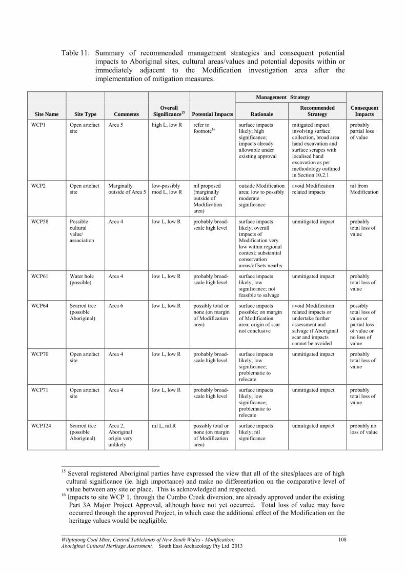
Wilpinjong Coal Mine, Central Tablelands of New South Wales - Modification: 108 Aboriginal Cultural Heritage Assessment. South East Archaeology Pty Ltd 2013
Table 11: Summary of recommended management strategies and consequent potential impacts to Aboriginal sites, cultural areas/values and potential deposits within or immediately adjacent to the Modification investigation area after the implementation of mitigation measures.
Management Strategy
Site Name Site Type Comments
Overall
Significance15 Potential Impacts Rationale
Recommended
Strategy
Consequent
Impacts
WCP1 Open artefact site
Area 5 high L, low R refer to footnote16
surface impacts likely; high significance; impacts already allowable under existing approval
mitigated impact involving surface collection, broad area hand excavation and surface scrapes with localised hand excavation as per methodology outlined in Section 10.2.1
probably partial loss of value
WCP2 Open artefact site
Marginally outside of Area 5
low-possibly mod L, low R
nil proposed (marginally outside of Modification area)
outside Modification area; low to possibly moderate significance
avoid Modification related impacts
nil from Modification
WCP58 Possible cultural value/ association
Area 4 low L, low R probably broad-scale high level
surface impacts likely; overall impacts of Modification very low within regional context; substantial conservation areas/offsets nearby
unmitigated impact probably total loss of value
WCP61 Water hole (possible)
Area 4 low L, low R probably broad-scale high level
surface impacts likely; low significance; not feasible to salvage
unmitigated impact probably total loss of value
WCP64 Scarred tree (possible Aboriginal)
Area 6 low L, low R possibly total or none (on margin of Modification area)
surface impacts possible; on margin of Modification area; origin of scar not conclusive
avoid Modification related impacts or undertake further assessment and salvage if Aboriginal scar and impacts cannot be avoided
possibly total loss of value or partial loss of value or no loss of value
WCP70 Open artefact site
Area 4 low L, low R probably broad-scale high level
surface impacts likely; low significance; problematic to relocate
unmitigated impact probably total loss of value
WCP71 Open artefact site
Area 4 low L, low R probably broad-scale high level
surface impacts likely; low significance; problematic to relocate
unmitigated impact probably total loss of value
WCP124 Scarred tree (possible Aboriginal)
Area 2, Aboriginal origin very unlikely
nil L, nil R possibly total or none (on margin of Modification area)
surface impacts likely; nil significance
unmitigated impact probably no loss of value
15 Several registered Aboriginal parties have expressed the view that all of the sites/places are of high
cultural significance (ie. high importance) and make no differentiation on the comparative level of value between any site or place. This is acknowledged and respected.
16 Impacts to site WCP 1, through the Cumbo Creek diversion, are already approved under the existing Part 3A Major Project Approval, although have not yet occurred. Total loss of value may have occurred through the approved Project, in which case the additional effect of the Modification on the heritage values would be negligible.

Wilpinjong Coal Mine, Central Tablelands of New South Wales - Modification: 109 Aboriginal Cultural Heritage Assessment. South East Archaeology Pty Ltd 2013
Management Strategy
Site Name Site Type Comments
Overall
Significance15 Potential Impacts Rationale
Recommended
Strategy
Consequent
Impacts
WCP184 Open artefact site
Marginally outside of Area 1, area now totally modified
nil L, nil R nil proposed (marginally outside of Modification area)
outside Modification area; site impacted
no action required nil from Modification
WCP195 Open artefact site
Marginally outside of Area 6, not relocated during present survey
low L, low R nil proposed (marginally outside of Modification area)
outside Modification area; low significance; problematic to relocate
avoid Modification related impacts
nil from Modification
WCP212 Open artefact site
Area 2, not relocated during present survey
low L, low R probably broad-scale high level
surface impacts likely; low significance; problematic to relocate
unmitigated impact probably total loss of value
WCP213 Open artefact site
Area 2, not relocated during present survey - may have been collected during WCPL 'pre-clearance works' but data not available for review
low-possibly mod L, low R
probably broad-scale high level
surface impacts likely; low to possibly moderate significance
mitigated impact (surface collection) where requested by Aboriginal parties (if site has not already been collected under existing ACHMP)
probably partial loss of value
WCP216 Open artefact site
Almost entirely located to the north of Area 3, may extend to within Area 3 but excavation data not available for review
low-possibly mod L, low R
possibly partial or none (on margin of Modification area)
partial surface impacts possible; low to possibly moderate significance
mitigated impact (surface collection) for portion within Modification area where requested by Aboriginal parties
possibly partial loss of value
WCP259 Open artefact site
Area 1, not relocated during present survey
low L, low R probably broad-scale high level
surface impacts likely; low significance; problematic to relocate
unmitigated impact probably total loss of value
WE52 (WCP 340)
Rock shelter with PAD
Outside of Area 3
low L, low R nil proposed (outside of Modification area)
outside Modification area; low significance
avoid Modification related impacts
nil from Modification
WCP 437 Open artefact site
Area 1 low L, low R probably broad-scale high level
surface impacts likely; low significance
unmitigated impact probably total loss of value
WCP 438 Open artefact site
Portion within Area 2, most outside of Area 2
low-possibly mod L, low R
probably partial (only portion of site within Modification area)
partial surface impacts likely; low to possibly moderate significance
mitigated impact (surface collection) for portion within Modification area where requested by Aboriginal parties
probably partial loss of value
WCP 439 Open artefact site
Area 3 low L, low R probably broad-scale high level
surface impacts likely; low significance
unmitigated impact probably total loss of value
WCP 440 Open artefact site
Area 3 low L, low R probably broad-scale high level
surface impacts likely; low significance
unmitigated impact probably total loss of value

Wilpinjong Coal Mine, Central Tablelands of New South Wales - Modification: 110 Aboriginal Cultural Heritage Assessment. South East Archaeology Pty Ltd 2013
Management Strategy
Site Name Site Type Comments
Overall
Significance15 Potential Impacts Rationale
Recommended
Strategy
Consequent
Impacts
WCP 441 Open artefact site
Marginally outside of Area 3
low L, low R nil proposed (marginally outside of Modification area)
outside Modification area; low significance
avoid Modification related impacts
nil from Modification
WCP 442 Open artefact site
Area 4 low L, low R probably broad-scale high level
surface impacts likely; low significance
unmitigated impact probably total loss of value
WCP 443 Open artefact site
Area 4 low L, low R probably broad-scale high level
surface impacts likely; low significance
unmitigated impact probably total loss of value
WCP 444 Open artefact site
Area 5 low L, low R probably broad-scale high level
surface impacts likely; low significance
unmitigated impact probably total loss of value
WCP 445 Open artefact site
Area 5 low L, low R probably broad-scale high level
surface impacts likely; low significance
unmitigated impact probably total loss of value
WCP 446 Open artefact site
Marginally outside of Area 5
low L, low R nil proposed (marginally outside of Modification area)
outside Modification area; low significance
avoid Modification related impacts
nil from Modification
WCP 447 Open artefact site
Area 5 low L, low R probably broad-scale high level
surface impacts likely; low significance
unmitigated impact probably total loss of value
WCP 448 Open artefact site
Area 6 low L, low R probably broad-scale high level
surface impacts likely; low significance
unmitigated impact probably total loss of value
Modification Investigation Area
Cultural area/value
All of Modification area
low L, low R probably broad-scale high level
overall impacts of Modification very low within regional context; substantial conservation areas/offsets nearby
unmitigated impact possibly partial loss of value
Use of subsistence and other resources
Cultural area/value
All of Modification area
low L, low R probably broad-scale high level
overall impacts of Modification very low within regional context; substantial conservation areas/offsets nearby
unmitigated impact possibly partial loss of value
Castle Rock Cultural area/value
Marginally outside of Area 4
high L, low R nil proposed (marginally outside of Modification area)
outside Modification area; high significance
avoid Modification related impacts
nil from Modification
Contemporary significance of Aboriginal objects
Cultural area/value (refer above to individual sites)
Refer above for each recorded Aboriginal site
Refer above for each site
Refer above for each site
Refer above for each site
Refer above for each site
Refer above for each site

Wilpinjong Coal Mine, Central Tablelands of New South Wales - Modification: 111 Aboriginal Cultural Heritage Assessment. South East Archaeology Pty Ltd 2013
REFERENCES Attenbrow, V.J. 1987 The Upper Mangrove Creek Catchment: A Study of Quantitative
Changes in the Archaeological Record. Unpublished PhD Thesis, University of Sydney.
Beesley, J. 1989 The Scarred Tree: A project for the Victorian Archaeological Society.
Melbourne. Bell, D. 1982 Aboriginal Carved Trees of Southeastern Australia: A Research Report.
Unpublished report to NSW NPWS. Besant, A. and Wyatt, E. 2011 Aboriginal Cultural Heritage Assessment Report Proposed
Rail Passing Loop at Wilpinjong, near Mudgee NSW. Unpublished report to Australian Rail Track Corporation.
Boismier, W. A. 1991 The role of research design in surface collection: an example from
Broom Hill, Braishfield, Hampshire. In, A. J. Schofield (ed) Interpreting Artefact Scatters: Contributions to Ploughzone Archaeology. Oxbow Monograph 4. Oxbow Books: Oxford.
Brennan, W. 2013 Wilpinjong Coal Mine, Rock Art Conservation and Monitoring Project:
Field Inspection Report and Recommendations. Unpublished report to Wilpinjong Coal Pty Limited.
Burless, J. K. 1997 The Wiradjuri: A Preliminary Study (Draft Version). Unpublished report
to Haglund & Associates. Camilli, E. 1989 The occupational history of sites and the interpretation of prehistoric
technological systems: an example from Cedar Mesa, Utah. In, Torrence, R. (ed) Time, Energy and Stone Tools. Cambridge University Press: Cambridge.
Clayton, I. and Barlow, A. 1997 Wiradjuri of the Rivers and Plains. Heinemann Library. Corkill, T. 1991 Survey for Aboriginal Archaeological Sites at Ulan Colliery, New South
Wales: Proposed Overland Conveyor and ‘Creek Site’ Development. Unpublished report to Ulan Coal Mines Limited.
Crew, D. 1990 Identifying and Recording Aboriginal Scarred Trees in New South Wales: A
Field Manual. NSW Electricity Commission. Crew, D. 1991 The Aboriginal Scarred Tree Project: Identifying, Recording and Assessing
the Significance of Aboriginal Scarred Trees in NSW. NSW Electricity Commission. Dean-Jones, P. and Mitchell, P. B. 1993 Hunter Valley Aboriginal Sites Assessment Project:
Environmental Modelling for Archaeological Site Potential in the Central Lowlands of the Hunter Valley. Unpublished report to NPWS.
DEC 1997 Aboriginal Cultural Heritage Standards and Guidelines. NPWS: Sydney. DEC 2003 Goulburn River National Park and Munghorn Gap Nature Reserve Plan of
Management. NPWS: Sydney. DEC 2004 Interim Community Consultation Requirements for Applicants. DEC: Sydney.

Wilpinjong Coal Mine, Central Tablelands of New South Wales - Modification: 112 Aboriginal Cultural Heritage Assessment. South East Archaeology Pty Ltd 2013
DEC 2005 Draft Guidelines for Aboriginal Cultural Heritage Impact Assessment and Community Consultation. DEC: Sydney.
DECCW 2009a Guide to Determining and Issuing Aboriginal Heritage Impact Permits.
DECCW: Sydney. DECCW 2009b Operational Policy: Protecting Aboriginal Cultural Heritage. DECCW:
Sydney. DECCW 2010a Due Diligence Code of Practice for the Protection of Aboriginal Objects in
New South Wales. DECCW: Sydney. DECCW 2010b Code of Practice for Archaeological Investigation of Aboriginal Objects in
New South Wales. DECCW: Sydney. DECCW 2010c Aboriginal Cultural Heritage Consultation Requirements for Proponents
2010. DECCW: Sydney. Edgar, J. 1997 Survey for Aboriginal Archaeological Sites at Ulan Coal Mines Limited,
NSW: Proposed Longwalls 13-17 and Service Corridor (Revised Version). Unpublished report to Ulan Coal Mines Limited.
Etheridge, R. 1918 The Dendroglyphs or ‘Carved Trees’ of NSW. NSW Govt. Printer,
Sydney. Fullagar, R., Furby, J. and Brass, L. 1994 Volume 5: residue analysis. In, Koettig, M. Bulga
Lease Authorisation 219 Salvage Excavations. Volumes 1-5. Unpublished report to Saxonvale Coal Pty Ltd.
Goulding, M. 2002 Cultural Places, Contested Spaces: An Approach to Managing
Aboriginal Peoples' Attachments to Landscape, Coffs Harbour Region Cultural Heritage Study Stage 2. Report to NSW NPWS.
Haglund, L. 1980 Preliminary Archaeological Survey of the Coal Mining Area at Ulan,
NSW. Unpublished report to Longworth and McKenzie Pty Ltd. Haglund, L. 1980b Preliminary Survey to Assess Archaeological Resources in the Area of
the Proposed Kerrabee Dam. Unpublished report to NSW NPWS. Haglund, L. 1981a Archaeological Survey and Sampling at the Site of the Ulan Coal Mine,
Ulan, NSW. Unpublished report to Longworth and McKenzie Pty Ltd. Haglund, L. 1981b Ulan Coal Mine: Archaeological Investigations in Connection with
Proposed Changes in Development Plans. Unpublished report to Kinhill Engineers Pty Ltd.
Haglund, L. 1981c Archaeological Investigations in the Area of the Proposed Kerrabee
Dam. Unpublished report to NSW NPWS. Haglund, L. 1985 Assessment of the Prehistoric Heritage in Mudgee Shire. Unpublished
report to Mudgee Shire Council Haglund, L. 1992 Sample Surveys in Relation to Proposed Mine Extension in the Ulan Area,
NSW. Unpublished report to Connell Wagner Pty Ltd.

Wilpinjong Coal Mine, Central Tablelands of New South Wales - Modification: 113 Aboriginal Cultural Heritage Assessment. South East Archaeology Pty Ltd 2013
Haglund, L. 1996a Salvage Excavation Completed for Ulan Coal Mines Ltd: NPWS Site 36-3-177, Ulan Heritage Identifier 116. Unpublished report to Ulan Coal Mines Limited.
Haglund, L. 1996b Summary Report on Preliminary Survey for Aboriginal Sites in the
Spring Gully Area, West of Cassilis Road, Ulan, NSW. Unpublished report to Ulan Coal Mines Limited.
Haglund, L. 1999a Ulan Coal Mines Second Longwall Project Environmental Impact
Statement (Expanded Version): Preliminary Survey for Aboriginal Sites, Parts I-III. Unpublished report to Kinhill Engineers Pty Ltd.
Haglund, L. 1999b Addendum (Archaeological Aspects) to: Ulan Coal Mines Second
Longwall Project Environmental Impact Statement (Expanded Version). Unpublished report to NSW National Parks and Wildlife Service.
Haglund, L. 1999c Ulan Coal Mines Ltd: Archaeological Review and Inspection in Relation
to Potential High Wall Mining - Areas West and North-west of Trench A. Unpublished report to Ulan Coal Mines Limited.
Haglund, L. 1999d Report on Aboriginal Heritage Studies Relating to SEPP No. 34
Application by Ulan Coal Mines Pty Ltd. Unpublished report to Ulan Coal Mines Limited (draft 1998).
Haglund, L. 2001a Salvage Excavation Completed for Ulan Coal Mines Ltd: Site SG5,
Aboriginal Rock Shelter Site, in Compliance with Requirements Under NPWS Consent #1002. Volume 1. Overview. Unpublished report to Ulan Coal Mines Limited.
Haglund, L. 2001b Salvage Excavation Completed for Ulan Coal Mines Ltd: Site SG5,
Aboriginal Rock Shelter Site, in Compliance with Requirements Under NPWS Consent #1002. Volume II1. Executive Summary (Plain English). Unpublished report to Ulan Coal Mines Limited.
Hall, R. and Lomax, K. 1993 Grafton Management Area Supplementary Report -
Archaeological Report. Unpublished report to NSW Forestry Commission. Hamm, G. 2006a Moolarben Coal Project - Aboriginal Cultural Heritage Assessment
Report. Unpublished report to Moolarben Coal Mines Pty Limited. Hamm, G. 2006b Responses to Issues Raised in Respect of the Moolarben Coal Project
Aboriginal Cultural Heritage Assessment Report. Unpublished report to Moolarben Coal Mines Pty Limited.
Hamm, G. 2008a Moolarben Coal Project - Aboriginal Cultural Heritage Assessment
Report Stage 2. Unpublished report to Moolarben Coal Mines Pty Limited. Hamm, G. 2008b Aboriginal Heritage Plan for MCP Stage 1 Development Areas: Open Cut
1 and Main Infrastructure Area. Unpublished report to Moolarben Coal Mines Pty Limited.
Hamm, G and Foley, L. 2010 Cultural Heritage Management Report on Moolarben Coal
Project Stage 1: Open Cut 1 & Main Infrastructure Area. Unpublished report to Moolarben Coal Mines Pty Limited.
Hiscock, P. 1994 Technological responses to risk in Holocene Australia. Journal of World
Prehistory. 8: 267-292.

Wilpinjong Coal Mine, Central Tablelands of New South Wales - Modification: 114 Aboriginal Cultural Heritage Assessment. South East Archaeology Pty Ltd 2013
Hiscock, P. and Mitchell, S. 1993 Stone Artefact Quarries and Reduction Sites in Australia: Towards a Type Profile. AGPS: Canberra.
Horton, D. 1994 Encyclopaedia of Aboriginal Australia. Aboriginal Studies Press, Canberra. Horton, D. 2000 Map of Australia Showing the Names of Tribal/Language Groups that
Traditionally Occupied that Area as Documented in The Encyclopaedia of Aboriginal Australia. AIATSIS: Acton, ACT.
Kayandel Archaeological Services 2006 Wilpinjong Coal Project Aboriginal Cultural
Heritage Survey: Supplemental Survey of Escarpment Areas and Report of Findings. Unpublished report to Wilpinjong Coal Pty Limited.
Kayandel Archaeological Services 2006b Proposed Electricity Transmission Line: Ulan
Substation to Wilpinjong Coal Project Aboriginal Cultural Heritage Assessment. Unpublished report to Country Energy.
Koettig, M. 1994 Bulga Lease Authorisation 219 Salvage Excavations. Volumes 1-5.
Unpublished report to Saxonvale Coal Pty Ltd. Kuskie, P. J. 2000a An Assessment of Two Aboriginal Grinding Groove Sites at Ulan Coal
Mine, Central Tablelands, New South Wales. Unpublished report to Ulan Coal Mines Ltd.
Kuskie, P. J. 2000b An Aboriginal Archaeological Assessment of the Proposed Mount Arthur
North Coal Mine, Near Muswellbrook, Hunter Valley, New South Wales. Report to URS (Australia) Pty Limited.
Kuskie, P. 2002 An Archaeological Assessment of a Proposed Basalt Quarry Within Mining
Lease 1468, Ulan Coal Mine, Central Tablelands, New South Wales. Unpublished report to Ulan Coal Mines Limited.
Kuskie, P. 2004 Proposed Open Cut Mine Extension, Additional Infrastructure and
Consolidation of Consents at Ulan Coal Mine, New South Wales: Aboriginal Heritage Assessment - Volume 2 (Working Draft). Unpublished report to Ulan Coal Mines Limited.
Kuskie, P. 2009 Ulan Coal Continued Operations: Aboriginal Heritage Assessment
(Volumes A and B). Unpublished report to Umwelt (Australia) Pty Ltd on behalf of Ulan Coal Mines Ltd.
Kuskie, P. 2010 Ulan Coal Continued Operations Aboriginal Heritage Impact Assessment -
Supplementary Report for North 1 Panels Project Modification. Unpublished report to Umwelt (Australia) Pty Ltd on behalf of Ulan Coal Mines Ltd.
Kuskie, P. 2012 Ulan Coal Continued Operations Project: Test Excavation of Aboriginal
Rock Shelter Sites Within the North 1 Panels - Interim Report. Unpublished report to Ulan Coal Mines Ltd.
Kuskie, P. 2013 Moolarben Coal Project - Stage 1 Optimisation Modification, Near Ulan,
Central Tablelands of New South Wales: Aboriginal Cultural Heritage Assessment. Unpublished report to Moolarben Coal Pty Limited.

Wilpinjong Coal Mine, Central Tablelands of New South Wales - Modification: 115 Aboriginal Cultural Heritage Assessment. South East Archaeology Pty Ltd 2013
Kuskie, P and Clarke, E. 2003 Proposed Open Cut Mine Extension, Additional Infrastructure and Consolidation of Consents at Ulan Coal Mine, New South Wales: Aboriginal Heritage Assessment (Volume 1). Unpublished report to Ulan Coal Mines Limited.
Kuskie, P. and Clarke, E. 2005a Proposed Open Cut Mine Extension and Additional
Infrastructure at Ulan Coal Mine, New South Wales: Aboriginal Heritage Assessment. Unpublished report to Ulan Coal Mines Limited.
Kuskie, P. and Clarke, E. 2005b Archaeological Survey of Aboriginal Heritage Within SMP
Application Area (Longwall Panels 23-26 and W1) of Mining Lease 1468, Ulan Coal Mine, Central Tablelands, New South Wales. Volumes A & B. Unpublished report to Ulan Coal Mines Limited.
Kuskie, P and Clarke, E. 2007 Archaeological Survey of Aboriginal Heritage Within SMP
Application Area (Longwall Panels W2-W3) of Mining Lease 1468, Ulan Coal Mine, Central Tablelands, New South Wales: Volumes A & B. Unpublished report to Ulan Coal Mines Limited.
Kuskie, P. J. and Kamminga, J. 2000 Salvage of Aboriginal Archaeological Sites in Relation
to the F3 Freeway near Lenaghans Drive, Black Hill, New South Wales. Volumes 1-3. Unpublished report to NSW Roads and Traffic Authority (Major Projects, Newcastle).
Kuskie, P. and Webster, V. 2001 Archaeological Survey of Aboriginal Heritage Within
Longwall Panels 18-22, Mining Leases 1468 and 1341, Ulan Coal Mine, Central Tablelands, New South Wales. Volumes 1 and 2. Unpublished report to Ulan Coal Mines Limited.
Mathews, R. H. 1894 Some stone implements used by the Aborigines of New South Wales.
Journal and Proceedings of Royal Society of New South Wales (28):301-305. McDonald, J. 1994 Dreamtime Superhighway: An Analysis of the Sydney Basin Rock Art
and Prehistoric Information Exchange. Unpublished PhD Thesis, Australian National University, Canberra.
McDonald, R. C., Isbell, R. F., Speight, J. G., Walker, J. and Hopkins, M. S. 1984 Australian
Soil and Land Survey Field Handbook. Inkata Press: Melbourne. Moore, D. R. 1970 Results of an Archaeological Survey of the Hunter River Valley, New
South Wales, Australia. Records of the Australian Museum, 28(2): 25-64. Moore, D. R. 1981 Results of an Archaeological Survey of the Hunter River Valley, New
South Wales, Australia. Part II. Records of the Australian Museum. 33: 388-442. Mulvaney, D.J. and Kamminga, J. 1999 Prehistory of Australia. Allen and Unwin: Sydney. Murphy, B. W. and Lewis. J. W. 1998 Soil Landscapes of the Dubbo 1:250,000 Sheet
(Dubbo, Wellington, Gulgong, Mudgee). Dept. of Land and Water Conservation Research Centre, Cowra, NSW.
Navin, K. T. 1990 Greenfields Heritage Study: Broke, Ulan and Gunnedah, Aboriginal
Cultural Resource Component. Unpublished report to Roslyn Muston & Associates for The Electricity Commission of NSW.

Wilpinjong Coal Mine, Central Tablelands of New South Wales - Modification: 116 Aboriginal Cultural Heritage Assessment. South East Archaeology Pty Ltd 2013
Navin Officer Heritage Consultants 2005 Wilpinjong Coal Project: Appendix F Aboriginal Cultural Heritage Assessment. Unpublished report to Wilpinjong Coal Pty Limited.
Navin Officer Heritage Consultants 2006a Wilpinjong Coal Project: Archaeological Salvage
and Post EIS Investigations. Unpublished report to Wilpinjong Coal Pty Limited. Navin Officer Heritage Consultants 2006b Baseline Recording of Three Aboriginal Rock Art
Sites WCP72, 152 and 153, at Wilpinjong, NSW: Wilpinjong Coal Project Aboriginal Cultural Heritage Management Program. Unpublished report to Wilpinjong Coal Pty Limited.
NSW Minerals Council 2010 NSW Minerals Industry Due Diligence Code of Practice for
the Protection of Aboriginal Objects. NSW Minerals Council Limited: Sydney. Office of Environment and Heritage (OEH) 2011a Guide to Investigating, Assessing and
Reporting on Aboriginal Cultural Heritage in NSW. OEH: Sydney. Office of Environment and Heritage (OEH) 2011b Applying for an Aboriginal Heritage
Impact Permit: Guide for Applicants. OEH: Sydney. Office of Environment and Heritage (OEH) 2011c Guide to Aboriginal Heritage Impact
Permit Processes and Decision-Making. OEH: Sydney. OzArk Environmental and Heritage Management Pty Ltd 2005 Indigenous and Non-
Indigenous Heritage Assessment: Wollar - Wellington 330kV Electricity Transmission Line. Unpublished report to International Environmental Consultants and Transgrid.
Pearson, M. 1981 Seen Through Different Eyes: Changing Land Use and Settlement
Patterns in the Upper Macquarie River Region of NSW from Prehistoric Times to 1860. Unpublished PhD Thesis, Sydney University.
Purcell, P. 2002 Aboriginal Cultural Heritage Assessment: NSW Western Regional
Assessments, Brigalow Belt South Bioregion (Stage 2). Unpublished report to Resource and Conservation Assessment Council.
Rich, E. 1993 Proposed Bengalla Coal Mine, Muswellbrook NSW: Archaeological Survey
for Aboriginal Sites. Unpublished report to Envirosciences Pty Ltd and Bengalla Joint Venture.
SLR Consulting Australia Pty Limited 2013 Wilpinjong Coal Mine Modification Noise
Impact Assessment. Unpublished report to WCPL. Sokoloff, B. 1977 Aboriginal prehistory: Interpretation of artefacts. Hunter Natural History
9:19-26. Therin, M. 2000 Spring Gully 5 Salvage Excavation Use-wear and Residue Report. In,
Haglund, L. 2001a Salvage Excavation Completed for Ulan Coal Mines Ltd: Site SG5, Aboriginal Rock Shelter Site, in Compliance with Requirements Under NPWS Consent #1002. Volume 1. Overview. Unpublished report to Ulan Coal Mines Limited.
Tindale, N.B. 1974 Aboriginal Tribes of Australia. ANU: Canberra. WCPL (Wilpinjong Coal Pty Limited) 2008 Wilpinjong Coal Mine Aboriginal Cultural
Heritage Management Plan and North Eastern Wiradjuri Cultural Heritage Management Plan. Unpublished report.

Wilpinjong Coal Mine, Central Tablelands of New South Wales - Modification: 117 Aboriginal Cultural Heritage Assessment. South East Archaeology Pty Ltd 2013
Wells Environmental Services 2006 Moolarben Coal Project Environmental Assessment Report. Unpublished report to Moolarben Coal Mines Pty Limited.
White, E. 2001a Salvage Excavation Completed for Ulan Coal Mines Ltd: Site SG5,
Aboriginal Rock Shelter Site, in Compliance with Requirements Under NPWS Consent #1002. Volume II: Stone Artefact Analysis. Unpublished report to Ulan Coal Mines Limited.
White, E. 2001b A comment on the stone artefact assemblage from squares E7 and E8 at site
SG5, Ulan, NSW. In, Haglund, L. 2001a Salvage Excavation Completed for Ulan Coal Mines Ltd: Site SG5, Aboriginal Rock Shelter Site, in Compliance with Requirements Under NPWS Consent #1002. Unpublished report to Ulan Coal Mines Limited.
Witter, D. 1994 Volume Index and Stone Tool Economic Classes in Haglund, L. (1996a)
Salvage Excavation Completed for Ulan Coal Mines Ltd: NPWS Site 36-3-177, Ulan Heritage Identifier 116. Unpublished report to Ulan Coal Mines Limited.

Wilpinjong Coal Mine, Central Tablelands of New South Wales - Modification: 118 Aboriginal Cultural Heritage Assessment. South East Archaeology Pty Ltd 2013
ACKNOWLEDGEMENTS The consultant wishes to acknowledge the assistance of the following people: Jamie Lees, Kieren Bennetts, Coral Williams, Karin Fogarty and staff, Wilpinjong Coal; Josh Peters, Jamie Warwick, Danielle Wallace, Jo Webster and staff, Resource
Strategies; Genna Mateni, OEH; and Lyn Syme, Kevin Williams, Coral Williams, Kelsey Williams-Fawcett, Robyn Williams,
Cliff Foley, Gail Ratcliffe, Christine Maynard, Steven Flick, Larry Foley, Debbie Foley, Aleshia Lonsdale, Tony Lonsdale, Brad Bliss, Brenn Doherty, Joyce Williams, Violet Carr, Robert Stewart, Noel Downs, Paul Brydon, Dorothy Stewart and the members of the registered Aboriginal parties.
DISCLAIMER The information contained within this report is based on sources believed to be reliable. Every effort has been made to ensure accuracy by using the best possible data and standards available. The accuracy of information generated during the course of this field investigation is the responsibility of the consultant. However, as no independent verification is necessarily available, South East Archaeology provides no guarantee that the base data (eg. the OEH AHIMS) or information from informants (obtained in previous studies or during the course of this investigation) is necessarily correct, and accepts no responsibility for any resultant errors contained therein and any damage or loss which may follow to any person or party. Nevertheless this study has been completed to the highest professional standards.