appendix d6 archaeological impact assessment · residential development and associated...
TRANSCRIPT

Appendix D6 – Archaeological Impact Assessment

A PHASE 1 ARCHAEOLOGICAL IMPACT ASSESSMENT FOR THE PROPOSED
RESIDENTIAL DEVELOPMENT AND ASSOCIATED INFRASTRUCTURE ON ERF
3783 IN SUMMERSTRAND, PORT ELIZABETH, NELSON MANDELA BAY
MUNICIPALITY OF THE EASTERN CAPE PROVINCE
Prepared for: CEN Integrated Environmental Management Unit
36 River Road
Walmer
Port Elizabeth
6070
Tel: 041 5812983/5817811
Fax: 041 5812983
Contact person: Ms Claire de Jongh
Email: [email protected]
Compiled by: Dr Johan Binneman and Mr Kobus Reichert
On behalf of: Eastern Cape Heritage Consultants cc
P.O. Box 689
Jeffreys Bay
6330
Tel: 042 2960399
Cell: 0728006322
Email: [email protected]
Date: August 2018

CONTENTS
EXECUTIVE SUMMARY ........................................................................................................ 1
PROJECT INFORMATION …………………………..……………..………………….…….. 2
Type of development ………………………………..…………….…………………………... 2
Developer …………………………………. …………………………………….……………. 2
Consultant ………………….……………………………….…………………....……………. 2
Purpose of the study …………………………………………………………..……………….. 2
Site and location ...……………………………………………...……….…….…....………..… 2
Relevant impact assessments, databases and collections …………………..………………….. 3
BRIEF ARCHAEOLOGICAL BACKGROUND ………………….………..….…………….. 3
Literature review ……………………………………………………...…………….…………. 3
Pre-colonial archaeology ...…………………………………………...…………….…………. 3
Driftsands historical dump …………………………………………...…………….…………. 4
References ………………….………………………………………...…………….…………. 4
ARCHAEOLOGICAL INVESTIGATION …………………………..……………………….. 5
Methodology …………………………………………………………………………….…….. 5
Limitations and assumptions ……………………………………….………………………….. 5
Results ……………………….…….....………….………...…………………...…………….... 5
DISCUSSION AND MITIGATION .......................................................................................... 7
GENERAL REMARKS AND CONDITIONS .......................................................................... 8
APPENDIX A: Brief legislative requirements .......................................................................... 8
APPENDIX B: Guidelines and procedures for developers ...................................................... 10
MAPS .................................................................................................................................. 11-12
LIST OF FIGURES
Figure 1. General views of Erf 3783.……………. …………………………………………………….6

1
A PHASE 1 ARCHAEOLOGICAL IMPACT ASSESSMENT FOR THE PROPOSED
RESIDENTIAL DEVELOPMENT AND ASSOCIATED INFRASTRUCTURE ON ERF
3783 IN SUMMERSTRAND, PORT ELIZABETH, NELSON MANDELA BAY
MUNICIPALITY OF THE EASTERN CAPE PROVINCE
Compiled by: Dr Johan Binneman and Mr Kobus Reichert
On behalf of: Eastern Cape Heritage Consultants cc
P.O. Box 689
Jeffreys Bay
6330
Tel: 042 2960399
Cell: 0728006322
Email: [email protected]
Note: This report follows the minimum standard guidelines required by the South African
Heritage Resources Agency for compiling Archaeological Phase 1 Impact Assessment (AIA)
reports and is part of an Environmental Impact Assessment.
EXECUTIVE SUMMARY
Eastern Cape Heritage Consultants cc was appointed by CEN Integrated Environmental
Management Unit to conduct a Phase 1 Archaeological Impact Assessment (AIA) for the
proposed residential development and associated infrastructure on Erf 3783 in Summerstrand,
Port Elizabeth, Nelson Mandela Bay Municipality of the Eastern Cape Province. The purpose
of the study was to establish the range and importance of possible archaeological and historical
sites/remains, the potential impact of the development and to make recommendations to
minimize possible damage to these sites.
Access to the site investigated was easy, but due to the dense grass and alien vegetation the
archaeological visibility was poor and no sites/materials were observed. However, the site is
situated within a kilometre from the coast and falls within the sensitive coastal zone where
archaeological sites and materials such as shell middens may be found. There were modern
buildings on the site, but these were demolished prior to the investigation. Historical household
materials were observed on the site where the buildings were demolished. During 1893-1909
the area between Summerstrand, Walmer and Schoenmakerskop were covered by a thin
distribution of historical rubbish dump material used for stabilising the shifting sand dunes. It
is possible that more materials may be exposed in the area covered by vegetation during
construction work.
In general the site investigated appears to be of low archaeological sensitivity, but it is possible
that heritage sites/materials and human remains may be covered by sand and vegetation. All
construction activities must be monitored. Construction managers/foremen should be informed
before construction starts on the possible types of heritage sites and cultural material they may
encounter and the procedures to follow when they find sites. Alternatively it is suggested that
the ECO should be trained to monitor the site and to report to the site foreman when heritage
sites/materials are found. If any concentrations of archaeological materials are exposed, work
must stop in the immediate area and reported to the archaeologist at the Albany Museum (Tel.:
046 6222312) and in the case of historical materials, to the appointed historian (or the historian at
Bayworld Museum in Port Elizabeth) or to the Eastern Cape Provincial Heritage Resources Authority
(Tel.: 043 745 0888). Sufficient time should be allowed to investigate and to remove/collect such
material.

2
PROJECT INFORMATION
Type of development
The proposed project comprises the construction of approximately 420 residential units and
associated infrastructure on 4,756 hectares on Erf 3783 in Summerstrand, Port Elizabeth (Maps
1-2).
Applicant
Eureka Holdings
Consultant
CEN Integrated Environmental Management Unit
36 River Road
Walmer
Port Elizabeth
6070
Tel: 041 5812983/5817811
Fax: 041 5812983
Contact person: Ms Claire de Jongh
Email: [email protected]
Purpose of the study
The original proposal was to conduct a survey of possible archaeological sites for the proposed
residential development and associated infrastructure on Erf 3783 in Summerstrand, Port
Elizabeth, Nelson Mandela Bay Municipality of the Eastern Cape Province. The survey was
conducted to establish;
the range and importance of possible exposed and in situ archaeological sites, features
and materials,
the potential impact of the development on these resources and,
to make recommendations to minimize possible damage to these resources.
Site and location
The site for the proposed residential development is located within the 1:50 000 topographic
reference map 3325DC & DD 3425BA Port Elizabeth (Map 1). It is located adjacent to the
Boardwalk Casino (southwest) and next to Second Avenue (north) on Erf 3783 in
Summerstrand, Port Elizabeth, Nelson Mandela Bay Municipality of the Eastern Cape
Province (Maps 1-2). A general GPS reading was taken at 33.59.225S; 25.39.310E. The site is
within a kilometre from the coast and covered by dune sand, dense grass and alien vegetation
(Figure 1). It has also been disturbed in the past by surrounding developments and it is also
used as an illegal dumping site for building rubble. There were modern buildings on the site,
but these were demolished prior to the investigation. The buildings were not older than 60
years and therefore the demolition activity did not trigger Section 34 of the National Heritage
Resources Act, No. 25 of 1999.

3
A short list of relevant impact assessments in the wider Summerstrand area
Binneman, J and Reichert, K. 2018. A phase 1 archaeological impact assessment for the
proposed construction of student residences and associated infra-structure by the Nelson
Mandela University on Summerstrand Erven 1904 and 3784 in Port Elizabeth, Nelson
Mandela Bay Municipality of the Eastern Cape Province. Prepared for EOH Coastal &
Environmental Services. Port Elizabeth. Eastern Cape Heritage Consultants. Jeffreys
Bay.
Binneman, J. 2013. A phase 1 archaeological impact assessment for the proposed upgrade and
expansion of the Cape Recife waste water treatment works in Port Elizabeth, Nelson
Mandela Bay Municipality, Eastern Cape Province. Prepared for CEN Integrated
Environmental Management Unit. Walmer. Eastern Cape Heritage Consultants. Jeffreys
Bay.
Binneman, J. 2011. A letter of recommendation (with conditions) for the exemption of a full
phase 1 archaeological heritage impact assessment for the proposed development of a
military health unit on a portion of Erf 1216, Port Elizabeth, Eastern Cape Province.
Prepared for CEN Integrated Environmental Management Unit. Port Elizabeth. Eastern
Cape Heritage Consultants. Jeffreys Bay.
Binneman, J. and Booth, C. 2010. A phase 1 archaeological impact assessment (AIA) for the
proposed 20MW wind farm on three alternative sites: Erf 121, Driftsands (site alternative
1), Bushy Park Farm, remainder of Erf 26, as well as portions 5, 6 and 7 thereof (site
alternative 2) and Rietfontein Farm, Erf 594, Van Stadens East (Site Alternative 3),
Nelson Mandela Metropolitan Municipality, Port Elizabeth, Eastern Cape Province.
Prepared for SRK Consulting. Port Elizabeth. Albany Museum. Grahamstown.
Booth, C. 2014. A phase 1 archaeological impact assessment (AIA) for the proposed Walmer
Gqebera low-cost housing development on erf 11305, Walmer, Port Elizabeth, Nelson
Mandela Bay Municipality (NMBM), Eastern Cape Province. Prepared for: SRK. Port
Elizabeth. Booth Heritage Consulting. Grahamstown
Webley, L. 2005a. Cultural and historical assessment of Madiba Bay Leisure Park. Prepared
for Coastal and Environmental Services. Grahamstown. Albany Museum. Grahamstown.
Webley, L. 2005b. Phase 1 Heritage Impact Assessment of a proposed water reservoir site near
Schoenmakerskop, Port Elizabeth. Prepared for SRK Consulting. Albany Museum.
Grahamstown.
Binneman, J & Webley, L. 1996. Proposed Eastern Cape Zinc and Phosphoric Acid Project:
Baseline Report: Sensitivity of Cultural Sites. Prepared for African Environmental
Solutions. Claremont. Albany Museum. Grahamstown.
The Albany Museum in Grahamstown and the Bayworld Museum in Port Elizabeth house
collections and information from the study area and wider region.
BRIEF ARCHAEOLOGICAL AND HISTORICAL BACKGROUND
Literature review
Pre-colonial archaeology
The archaeology of the immediate Summerstrand area is largely unknown, mainly because little
systematic research has been conducted there. The oldest evidence of the early inhabitants in the
Port Elizabeth area are large stone tools, called hand axes and cleavers, which can be found
amongst river gravels and in old spring deposits in the region (Deacon 1970). These large stone
tools are from a time period called the Earlier Stone Age (ESA) and may date between 1,5

4
million and 250 000 years old. The large hand axes and cleavers were replaced by smaller stone
tools called the Middle Stone Age (MSA) flake and blade industries. Evidence of MSA sites
occur throughout the Port Elizabeth region and date between 200 000 and 30 000 years old.
Fossil bone may in rare cases be associated with MSA occurrences (Deacon & Deacon 1999).
The majority of archaeological sites found in the Port Elizabeth area date from the past 10 000
years (called the Later Stone Age) and are associated with the campsites of San hunter-
gatherers and Khoi pastoralists. These sites are difficult to find because they are in the open
veld and often covered by vegetation and sand. Sometimes these sites are only represented by a
few stone tools and fragments of bone. The preservation of these sites is poor and it is not
always possible to date them (Deacon & Deacon 1999). There are many San hunter-gatherers
sites in the nearby Elandsberg and Groot Winterhoekberg Mountains. Here caves and rock
shelters were occupied by the San during the Later Stone Age and contain paintings along the
walls. The last San/KhoiSan group was killed by Commando's in the Groendal area in the
1880s. Some 2 000 years ago Khoi pastoralists occupied the region and lived mainly in small
settlements. They were the first food producers in South Africa and introduced domesticated
animals (sheep, goat and cattle) and ceramic vessels to southern Africa.
The most common archaeological sites along the nearby coast are shell middens (relatively large
piles of marine shell) found usually concentrated opposite rocky coasts, but also along sandy
beaches (Rudner 1968). These were campsites of San hunter-gatherers, Khoi herders and
KhoiSan peoples who lived along the immediate coast (up to 5 km) and collected marine foods.
Mixed with the shell are other food remains, cultural material and often human remains are found
in the middens. In general shell middens in the open found along the wider Port Elizabeth coast,
date from the past 6 000 years. Also associated with middens are large stone floors which were
probably used as cooking platforms (Binneman 2001, 2005).
Driftsands historical dump
A large part of the so-called Driftsands area which stretches from the west of
Schoenmakerskop to the borders of Walmer and Summerstrand, was covered by a thin
distribution of historical rubbish dump material between 1893 and 1909 (dating to the
Victorian period). The dump materials are older than 100 years and protected by the National
Heritage Resources Act of 1999.
According to historical records the shifting sand dunes killed all vegetation and posed a threat
to the harbour. In 1893 Joseph Storr Lister of the Cape Forestry Department was appointed to
solve the drifting sand problem. Lister proposed stabilising the dunes by dumping household
rubbish on the dunes. He constructed a railway line nine miles into the dunes and a train (called
the ‘Driftsands Special’) that dumped some 80 tons of town rubbish a day on the shifting sand
dunes. The rubbish was spread in a relatively thin layer on the dunes, and the seeds of
Australian acacias (Rooikranz, Port Jackson and Long-leaf wattles) planted into the garbage.
In total some 91 000 metric tons of refuse was dumped on the dunes between 1893 and 1909.
Between 1960 and 1970 amateur bottle collectors illegally mined the old dump extensively
Lastovica (1982). Bayworld Museum houses a large collection of material made by Dr Mike
Raath which includes glass bottles, sherds of china from various Port Elizabeth hotels, china
dolls, mother of pearl buttons, horse shoes and numerous other artefacts. He did most of his
collecting in the Summerstrand area and beyond the Nelson Mandela Metropolitan University.

5
References
Bennie, J. 1993. The Driftsands. Otolith.
Binneman, J.N.F. 2005. Archaeological research along the south-eastern Cape coast part1:
open-air shell middens Southern African Field Archaeology 13 & 14:49-77.
Binneman, J.N.F. 2001. An introduction to a Later Stone Age coastal research project along
the south-eastern Cape coast. Southern African Field Archaeology 10:75-87.
Deacon , H.J. 1970. The Acheulian occupation at Amanzi Springs, Uitenhage District, Cape Province.
Annals of the Cape Provincial Museums. 8:89-189.
Deacon, H.J. & Deacon, J. Human beginnings in South Africa. Cape Town: David Phillips
Publishers.
Dimbleby, E.P. 1961. When desert menaced Port Elizabeth. Looking Back (1): 2-8.
Rudner, J. 1968. Strandloper pottery from South and South West Africa. Annals of the South
African Museum 49:441-663.
Scott, H. 1966. Driftsands. Looking Back 6:18-21.
ARCHAEOLOGICAL INVESTIGATION
Methodology
The investigation was conducted on foot by two archaeologists. A Google aerial image
investigation and literature study were conducted of the area prior to the investigation. GPS
readings were taken with a Garmin and all important features were digitally recorded.
Limitations and assumptions
It was not possible to do a comprehensive survey of the site due to the dense bushes and grass
cover (Figure 1). Due to the dense vegetation and rubbish the archaeological visibility was
poor and it was difficult to locate archaeological and other heritage sites/materials. The site has
also been disturbed in the past by surrounding developments and is also used as an illegal
dumping site for building rubble and as an off-road motorcycle course.
Regardless of the restrictions imposed by the natural environmental conditions, the experiences
and knowledge gained from other investigations in adjacent and the wider surrounding region,
provided background information to make assumption and predictions on the incidences and
the significance of possible pre-colonial archaeological sites/material which may be located in
the area, or which may be covered by soil and vegetation. There is a possibility that coastal
archaeological sites/materials such as shell middens may be exposed during the developments
because the sites are situated within a kilometre from the coast. It is also possible that more
historical material may be exposed similar to those observed (Figure 1, bottom right insert).
Results
Due to the dense vegetation cover no archaeological sites/materials were observed. Historical
materials were observed in the area where the buildings were demolished. Archaeological and
more historical heritage sites/materials may be covered by dune sand and vegetation, but if any
are present these occurrences will most probably be disturbed and in secondary contexts.

6
Figure 1. General views of Erf 3783 in Summerstrand, the buildings before they were demolished
and the area after they were demolished where historical material were exposed (top row – image
courtesy CEN Integrated Environmental Management Unit), the dense vegetation (middle row),
dumped rubble on the site and a sample of the historical material (bottom row).

7
DISCUSSION AND MITIGATION
The dense vegetation made it difficult to observed archaeological sites/materials, but because
the site is within a kilometre from the coast it is possible that coastal archaeological
sites/materials such as shell middens may be buried. After a bushfire in the 1980s, midden
material was observed about a kilometre inland in the vicinity of the Nelson Mandela
University (then the University of Port Elizabeth). Historical household dump materials were
observed where the surface soil/dune sand was disturbed and there exist a strong possibility
that more materials may be exposed during the construction activities. In view of the
possibility that sensitive heritage sites/materials may be exposed, the following is
recommended/suggested;
1. All vegetation clearing activities and other developments must be monitored by a
professional archaeologist. The managers/foremen should be informed before clearing/
construction starts on the possible types of heritage sites and cultural material they may
encounter and the procedures to follow when they find sites. Alternatively it is suggested
that a person must be trained (ECO) as a site monitor to report to the foreman when heritage
sites/materials are found.
2. Although it would appear unlikely that any significant archaeological remains will be
exposed during the development, there is always a possibility that human remains and/or
other archaeological such as freshwater shell middens and historical dump materials may be
uncovered during the development. Should such material be exposed during construction, all
work must cease in the immediate area and it must be reported to the archaeologist at the
Albany Museum in Grahamstown (Tel: 046 6222312) or to the Eastern Cape Provincial
Heritage Resources Authority (Tel: 043 6422811), so that a systematic and professional
investigation can be undertaken. Sufficient time should be allowed to investigate and to
remove/collect such material. Recommendations will follow from the investigation (See
appendix B for a list of possible archaeological sites that maybe found in the area).
3. Due to the wide distribution of the 19th century historical dump material presently covering
the Driftsands area, it is highly possible that more material will be exposed during the
construction phase. A collecting strategy needs to be devised so that the maximum amount
of information may be obtained in terms of time and expenses. Provision should be made
for a budget to conduct the collecting of material.
It is suggested that a historian be contracted to develop such a collecting strategy
and to inform the site monitor before construction starts. Ms Jenny Bennie, a
historian and specialist on the Driftsands historical dump material may be contacted
([email protected]) or the historian at the Bayworld Museum in Port
Elizabeth. Further recommendations will be introduced by the historian.
If any dense concentrations of historical dump material are exposed (glass bottles,
sherds of chinaware, etc.), work must stop immediately and reported to the
appointed historian or to the Eastern Cape Provincial Heritage Resources Authority
(Tel.: 043 6422811) immediately. Sufficient time should be allowed to investigate and to
remove/collect such material. Recommendations will follow from the investigation.

8
GENERAL REMARKS AND CONDITIONS
Note: This is an Archaeological Impact Assessment (AIA) report compiled for the Eastern
Cape Provincial Heritage Resources Authority (ECPHRA) to enable them to make informed
decisions regarding the heritage resources assessed in this report and only they have the
authority to revise the report. This Report must be reviewed by the ECPHRA where after they
will issue their Review Comments to the EAP/developer. The final decision rests with the
ECPHRA who must grant permits if there will be any impact on cultural sites/materials as a
result of the development
This report is a Phase 1 Archaeological Impact Assessment and does not exempt the developer
from any other relevant heritage impact assessments as specified below:
In terms of the National Heritage Resources Act, No. 25 of 1999 (section 38) ECPHRA may
require a full Heritage Impact Assessment (HIA) to assess all heritage resources, that includes
inter alia, all places or objects of aesthetical, architectural, historic, scientific, social, spiritual,
linguistic, or technological significance that may be present on a site earmarked for
development. A full Heritage Impact Assessment (HIA) should assess all these heritage
components, and the assessment may include archaeology, shipwrecks, battlefields, graves, and
structures older than 60 years, living heritage, historical settlements, landscapes, geological
sites, palaeontological sites and objects.
It must be emphasized that this Phase 1 AIA is based on the visibility of archaeological
sites/material and may not therefore reflect the true state of affairs. Sites and material may be
covered by soil and vegetation and will only be located once this has been removed. In the
event of such finds being uncovered during construction activities, ECPHRA or an
archaeologist must be informed immediately so that they can investigate the importance of the
sites and excavate or collect material before it is destroyed (see attached list of possible
archaeological sites and material).The developer must finance the costs should additional
studies be required as outlined above. The onus is on the developer to ensure that the
provisions of the National Heritage Act No. 25 of 1999 and any instructions from ECPHRA
are followed. The EAP/developer must forward this report to ECPHRA in order to obtain their
Review Comments, unless alternative arrangements have been made with the heritage
specialist to submit the report.
APPENDIX A: brief legislative requirements
Parts of sections 35(4), 36(3) and 38(1) (8) of the National Heritage Resources Act 25 of 1999
apply:
Archaeology, palaeontology and meteorites
35 (4) No person may, without a permit issued by the responsible heritage resources
authority—
(a) destroy, damage, excavate, alter, deface or otherwise disturb any archaeological or
palaeontological site or any meteorite;
(b) destroy, damage, excavate, remove from its original position, collect or own any
archaeological or palaeontological material or object or any meteorite;
(d) bring onto or use at an archaeological or palaeontological site any excavation equipment
or any equipment which assist in the detection or recovery of metals or archaeological

9
and palaeontological material or objects, or use such equipment for the recovery of
meteorites.
Burial grounds and graves
36. (3) (a) No person may, without a permit issued by SAHRA or a provincial heritage
resources authority—
(a) destroy, damage, alter, exhume or remove from its original position or otherwise disturb
the grave of a victim of conflict, or any burial ground or part thereof which contains such
graves;
(b) destroy, damage, alter, exhume, remove from its original position or otherwise disturb any
grave or burial ground older than 60 years which is situated outside a formal cemetery
administered by a local authority; or
(c) bring onto or use at a burial ground or grave referred to in paragraph (a) or (b)any
excavation equipment, or any equipment which assists in the detection or recovery of
metals.
Heritage resources management
38. (1) Subject to the provisions of subsections (7), (8) and (9), any person who intends to
undertake a development categorized as –
(a) the construction of a road, wall, powerline, pipeline, canal or other similar form of linear
development or barrier exceeding 300m in length;
(b) the construction of a bridge or similar structure exceeding 50m in length;
(c) any development or other activity which will change the character of the site –
(i) exceeding 5000m2 in extent, or
(ii) involving three or more erven or subdivisions thereof; or
(iii) involving three or more erven or divisions thereof which have been
consolidated within the past five years; or
(iv) the costs of which will exceed a sum set in terms of regulations by SAHRA, or a
provincial resources authority;
(d) the re-zoning of a site exceeding 10 000m2 in extent; or
(e) any other category of development provided for in regulations by SAHRA or a provincial
heritage resources authority, must as the very earliest stages of initiating such a development,
notify the responsible heritage resources authority and furnish it with details regarding the
location, nature and extent of the proposed development.

10
APPENDIX B: IDENTIFICATION OF ARCHAEOLOGICAL FEATURES AND
MATERIAL FROM COASTAL AREAS: guidelines and procedures for developers
Shell middens
Shell middens can be defined as an accumulation of marine shell deposited by human agents
rather than the result of marine activity. The shells are concentrated in a specific locality above
the high-water mark and frequently contain stone tools, pottery, bone and occasionally also
human remains. Shell middens may be of various sizes and depths, but an accumulation which
exceeds 1 m2 in extent, should be reported to an archaeologist.
Human Skeletal material
Human remains, whether the complete remains of an individual buried during the past, or
scattered human remains resulting from disturbance of the grave, should be reported. In general
the remains are buried in a flexed position on their sides, but are also found buried in a sitting
position with a flat stone capping and developers are requested to be on the alert for this.
Fossil bone
Fossil bones or any other concentrations of bones, whether fossilized or not, should be
reported.
Stone artefacts
These are difficult for the layman to identify. However, large accumulations of flaked stones
which do not appear to have been distributed naturally should be reported. If the stone tools are
associated with bone remains, development should be halted immediately and archaeologists
notified.
Stone features and platforms
These occur in different forms and sizes, but easily identifiable. The most common are an
accumulation of roughly circular fire cracked stones tightly spaced and filled in with charcoal
and marine shell. They are usually 1-2 metres in diameter and may represent cooking platforms
for shell fish. Others may resemble circular single row cobble stone markers. These occur in
different sizes and may be the remains of wind breaks or cooking shelters.
Historical artefacts or features
These are easy to identify and include foundations of buildings or other construction features
and items from domestic and military activities.

11
Map 1. 1:50 000 Maps indicating the approximate location of the development marked by the
blue square and outlined by the blue lines.
12
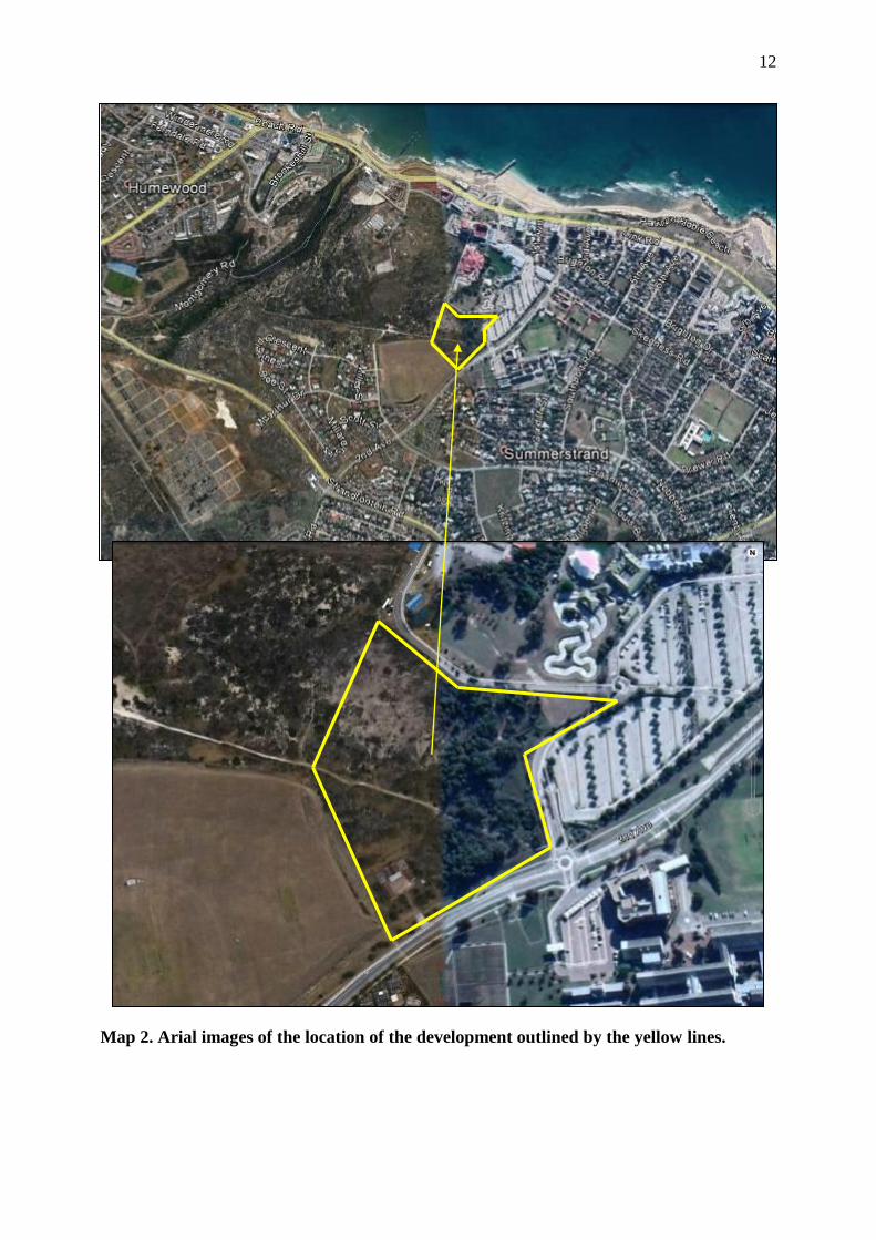
Map 2. Arial images of the location of the development outlined by the yellow lines.