appendix d - nova scotia · department library as well as external sources from the nova scotia...
TRANSCRIPT
HIGHWAY 101 DIGBY TO MARSHALLTOWN CORRIDOR ENVIRONMENTAL ASSESSMENT REGISTRATION
APPENDICES February 2017
APPENDIX D
MI’KMAQ ECOLOGICAL KNOWLEDGE STUDY (MMDI 2016)

Mi’kmaq Ecological Knowledge Study
Prepared byMainland Mi’kmaq Development Inc.
P.O. Box 159057 Martin Crescent, Truro, Nova Scotia, B2N 5V3
Tel: (902) 895-6385Fax: (902) 893-1520
1.0 INTRODUCTION
Highway 101 Twinning Exit 26 to Marshalltown
Prepared for NS Transportation and Infrastructure Renewal
November, 2016

1.0 INTRODUCTION 5
1.1 MAINLAND MI’KMAQ DEVELOPMENT INC. . . . . . . . . . . . . . . . . . . . . . . . . . . 51.2 PROJECT DESCRIPTION . . . . . . . . . . . . . . . . . . . . . . . . . . . . . . . . . . . . . . . . . . . . . . 5
2.0 DEFINITION OF TERMS 5
3.0 PURPOSE AND SCOPE OF THE MI’KMAQ ECOLOGICAL KNOWLEDGE STUDY 7
3.1 PURPOSE OF THE MI’KMAQ ECOLOGICAL KNOWLEDGE STUDY . . . . . . 73.2 SCOPE OF THE MI’KMAQ ECOLOGICAL KNOWLEDGE STUDY . . . . . . . . . 73.3 NOT INCLUDED IN THE SCOPE OF THE MI’KMAQ ECOLOGICAL
KNOWLEDGE STUDY . . . . . . . . . . . . . . . . . . . . . . . . . . . . . . . . . . . . . . . . . . . . . . . . 73.3.1 SECTION 35 CONSULTATION . . . . . . . . . . . . . . . . . . . . . . . . . . . . . . . . . . . . . . . . . 73.3.2 ARCHAEOLOGICAL SCREENING AND RESOURCE IMPACT ASSESSMENT . . . . . . . . . . . . . . . . . . . . . . . . . . . . . . . . . . . . . . . . . . . . . . . . . . . . . . . . 73.3.3 NOTIFICATION OF MI’KMAW INDIVIDUALS OR COMMUNITIES OF THE PROJECT . . . . . . . . . . . . . . . . . . . . . . . . . . . . . . . . . . . . 7
4.0 METHODOLOGY 8
4.1 HISTORIC MI’KMAQ LAND AND RESOURCE USE. . . . . . . . . . . . . . . . . . . . . . 84.1.1 STUDY AREA . . . . . . . . . . . . . . . . . . . . . . . . . . . . . . . . . . . . . . . . . . . . . . . . . . . . . . . . 84.1.2 METHODS . . . . . . . . . . . . . . . . . . . . . . . . . . . . . . . . . . . . . . . . . . . . . . . . . . . . . . . . . . . 84.1.3 LIMITATIONS . . . . . . . . . . . . . . . . . . . . . . . . . . . . . . . . . . . . . . . . . . . . . . . . . . . . . . . . 84.2 CURRENT MI’KMAQ LAND AND RESOURCE USE . . . . . . . . . . . . . . . . . . . . . 84.2.1 STUDY AREAS . . . . . . . . . . . . . . . . . . . . . . . . . . . . . . . . . . . . . . . . . . . . . . . . . . . . . . . 9
4.2.1.1 Current Mi’kmaq Land and Resource Use Sites . . . . . . . . . . . . . . . . . . . . 94.2.1.2 Species of Significance to Mi’kmaq . . . . . . . . . . . . . . . . . . . . . . . . . . . . . . . 94.2.1.3 Mi’kmaq Communities . . . . . . . . . . . . . . . . . . . . . . . . . . . . . . . . . . . . . . . . . 9
4.2.2 METHODS . . . . . . . . . . . . . . . . . . . . . . . . . . . . . . . . . . . . . . . . . . . . . . . . . . 94.2.2.1 Current Mi’kmaq Land and Resource Use Sites . . . . . . . . . . . . . . . . . . . . 94.2.2.2 Species of Significance to Mi’kmaq . . . . . . . . . . . . . . . . . . . . . . . . . . . . . . . 94.2.2.3 Mi’kmaq Communities . . . . . . . . . . . . . . . . . . . . . . . . . . . . . . . . . . . . . . . . . 10
4.2.3 LIMITATIONS . . . . . . . . . . . . . . . . . . . . . . . . . . . . . . . . . . . . . . . . . . . . . . . . . . . . . . . . 10
TABLE OF CONTENTS
5.0 RESULTS 10
5.1 HISTORIC MI’KMAQ LAND AND RESOURCE USE. . . . . . . . . . . . . . . . . . . . . . 105.1.1 CHRONOLOGY OF HISTORICAL EVENTS . . . . . . . . . . . . . . . . . . . . . . . . . . . . 135.1.2 POST CONTACT . . . . . . . . . . . . . . . . . . . . . . . . . . . . . . . . . . . . . . . . . . . . . . . . . . . . . 185.1.3 ARCHAEOLOGY . . . . . . . . . . . . . . . . . . . . . . . . . . . . . . . . . . . . . . . . . . . . . . . . . . . . . 255.2 CURRENT MI’KMAQ LAND AND RESOURCE USE . . . . . . . . . . . . . . . . . . . . . 255.2.1 CURRENT MI’KMAQ LAND AND RESOURCE USE SITES. . . . . . . . . . . . . . . . 255.2.2 SPECIES OF SIGNIFICANCE TO MI’KMAQ PRESENT IN STUDY AREA . . . 255.2.3 MI’KMAW COMMUNITIES . . . . . . . . . . . . . . . . . . . . . . . . . . . . . . . . . . . . . . . . . . . 26
6.0 POTENTIAL PROJECT IMPACTS ON MI’KMAQ LAND AND RESOURCE USE 27
7.0 SIGNIFICANCE OF POTENTIAL PROJECT IMPACTS ON MI’KMAQ LAND AND RESOURCE USE 28
7.1 SIGNIFICANCE CRITERIA . . . . . . . . . . . . . . . . . . . . . . . . . . . . . . . . . . . . . . . . . . . . 287.2 EVALUATION OF SIGNIFICANCE . . . . . . . . . . . . . . . . . . . . . . . . . . . . . . . . . . . . . 28
8.0 CONCLUSIONS AND RECOMMENDATIONS 29
9.0 RECORDS AND SOURCES CONSULTED 29
SECONDARY SOURCES . . . . . . . . . . . . . . . . . . . . . . . . . . . . . . . . . . . . . . . . . . . . . . . . . . . . 29PRIMARY SOURCES . . . . . . . . . . . . . . . . . . . . . . . . . . . . . . . . . . . . . . . . . . . . . . . . . . . . . . . 31
FIGURE 1:
Historic and Current Use Timeline . . . . . . . . . . . . . . . . . . . . . . . . . . . . . . . . . . . . . . . . . . . . . . . . . . . 6
TABLE 1:
Band Council Allotted Hunting, Fishing and Berry Gathering Areas in Kespukwitk . . . . . . . . . 13
TABLE 2:
1600s Census of Indians in Acadia (Nova Scotia) . . . . . . . . . . . . . . . . . . . . . . . . . . . . . . . . . . . . . . . 19
TABLE 3:
1687-8 Recorded Numbers of Wigwams in Acadia (Nova Scotia) . . . . . . . . . . . . . . . . . . . . . . . . . 19
TABLE 4:
1708 Census Excerpts: Micmac at Port Royal . . . . . . . . . . . . . . . . . . . . . . . . . . . . . . . . . . . . . . . . . . 19
TABLE 5:
Mi’kmaq Recorded in the 1871 Census in the sub-districts St. Mary’s Bay, Digby and Head of Saint Mary’s Bay . . . . . . . . . . . . . . . . . . . . . . . . . . . . . . . . . . . . . . . . . . . . . . . . . . . . . . . . . . . . . . . . . . . 20
TABLE 6:
Mi’kmaq Recorded on the 1881 Census of the sub-districts Digby and Marshall (Town) . . . . . 21
TABLE 7:
Digby County Mi’kmaq Population Information from The Department Of Indian Affairs Annual Reports . . . . . . . . . . . . . . . . . . . . . . . . . . . . . . . . . . . . . . . . . . . . . . . . . . . . . . . . . . . . . . . . . . . . 22
TABLE 8:
Mi’kmaw Place Names . . . . . . . . . . . . . . . . . . . . . . . . . . . . . . . . . . . . . . . . . . . . . . . . . . . . . . . . . . . . . . 26
TABLE 1:
Description of Activities Undertaken in Current Mi’kmaq Land and Resource Use Sites . . . . . 25
TABLE 2:
Number of Species of Significance to Mi’kmaq Present in the Study Areas Summer 2014/15 . . 26
TABLE 3: Potential Project Impacts on Mi’kmaq Land and Resource Use . . . . . . . . . . . . . . . . . . . . . . . . . . . 27
TABLE 4:
Significance of Potential Project Impacts on Mi’kmaq Land and Resource Use . . . . . . . . . . . . . . 28
FIGURE 2:
Map of Current Mi’kmaq Land and Resource Use Study Areas . . . . . . . . . . . . . . . . . . . . . . . . . . . 32
TABLES & FIGURES
5Mi’kmaq Ecological Knowledge Study Highway 101 Twinning Exit 26 to Marshalltown
1.0 INTRODUCTION
1.1 Mainland Mi’kmaq Development Inc.The Confederacy of Mainland Mi’kmaq (CMM) Environmental Services is a program operated by the Lands, Environment, and Natural Resources, that provides fee for service in environmental consulting; this division is currently known as Mainland Mi’kmaq Developments Incorporated (MMDI). The CMM provides advisory services to seven Mi’kmaq communities in the province of Nova Scotia: Paqtnkek Mi’kmaw Nation, Annapolis Valley First Nation, Bear River First Nation, Glooscap First Nation, Millbrook First Nation, Pictou Landing and Sipekne’katik First Nation.
The MMDI had been successful in the contract to complete a second Mi’kmaq Ecological Knowledge Study (MEKS) for the Hwy 101 Exit 26 to Marshalltown, as part of the original report 2005 Digby to Weymouth MEKS, for NS Transportation and Infrastructure Renewal.
The CMM Lands, Environment & Natural Resources, MMDI contact information:
Lynn KnockwoodActing Director, Lands, Environment and Natural Resources The Confederacy of Mainland Mi’kmaqP.O. Box 159057 Martin CrescentTruro NS, B2N 5V3(902) 895-6385 ext. 259(902) [email protected]
1.2 Project Description
The Mainland Mi’kmaq Development Inc. has been selected to complete a second MEKS for a portion of the original MEKS Digby to Weymouth 2005, Hwy 101 Exit 26 to Marshalltown MEKS. The project site is located in Digby County, NS, approximately 15kms west of Bear River First Nation.
2.0 DEFINITION OF TERMS
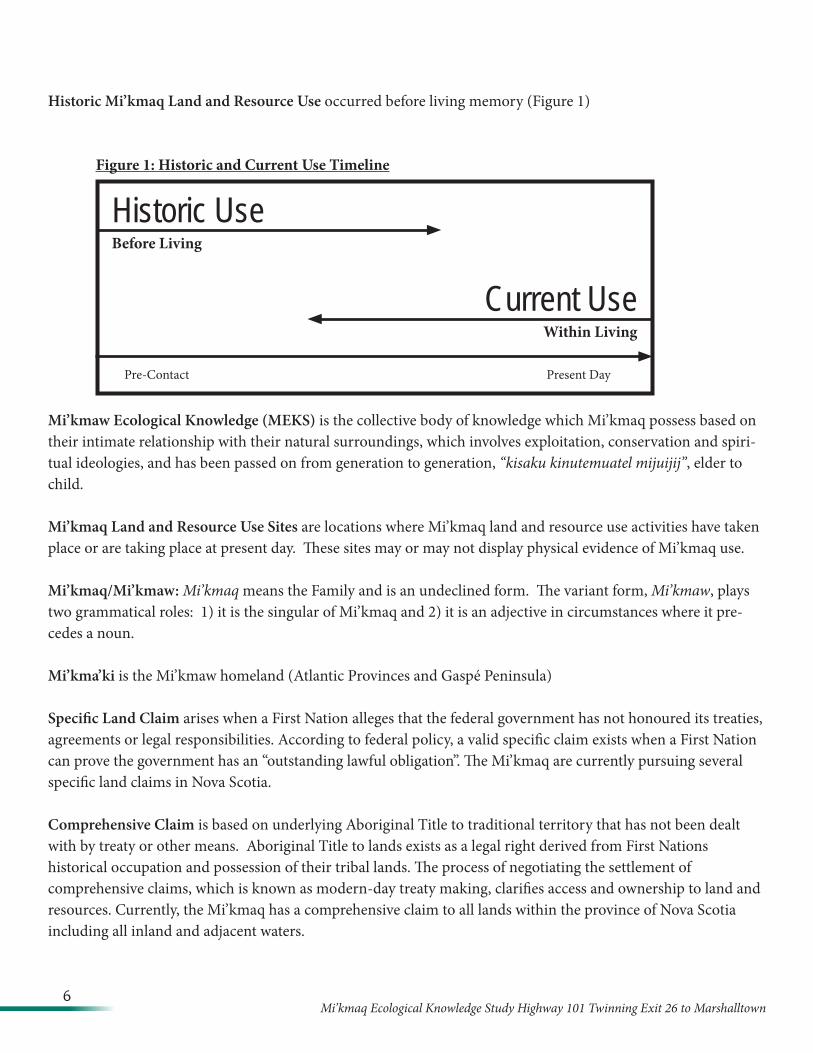
Living Memory is the memory of living Mi’kmaw. The period of time included in living memory varies from knowledge holder to knowledge holder. Living memory often extends to the parent and grandparent of the knowledge holder and can be estimated at three to four generations.
Current Mi’kmaq Land and Resource Use occurred within living memory or is occurring at the present day (Figure 1)
6Mi’kmaq Ecological Knowledge Study Highway 101 Twinning Exit 26 to Marshalltown
Historic Mi’kmaq Land and Resource Use occurred before living memory (Figure 1)
Figure 1: Historic and Current Use Timeline
Mi’kmaw Ecological Knowledge (MEKS) is the collective body of knowledge which Mi’kmaq possess based on their intimate relationship with their natural surroundings, which involves exploitation, conservation and spiri-tual ideologies, and has been passed on from generation to generation, “kisaku kinutemuatel mijuijij”, elder to child.
Mi’kmaq Land and Resource Use Sites are locations where Mi’kmaq land and resource use activities have taken place or are taking place at present day. These sites may or may not display physical evidence of Mi’kmaq use.
Mi’kmaq/Mi’kmaw: Mi’kmaq means the Family and is an undeclined form. The variant form, Mi’kmaw, plays two grammatical roles: 1) it is the singular of Mi’kmaq and 2) it is an adjective in circumstances where it pre-cedes a noun.
Mi’kma’ki is the Mi’kmaw homeland (Atlantic Provinces and Gaspé Peninsula)
Specific Land Claim arises when a First Nation alleges that the federal government has not honoured its treaties, agreements or legal responsibilities. According to federal policy, a valid specific claim exists when a First Nation can prove the government has an “outstanding lawful obligation”. The Mi’kmaq are currently pursuing several specific land claims in Nova Scotia.
Comprehensive Claim is based on underlying Aboriginal Title to traditional territory that has not been dealt with by treaty or other means. Aboriginal Title to lands exists as a legal right derived from First Nations historical occupation and possession of their tribal lands. The process of negotiating the settlement of comprehensive claims, which is known as modern-day treaty making, clarifies access and ownership to land and resources. Currently, the Mi’kmaq has a comprehensive claim to all lands within the province of Nova Scotia including all inland and adjacent waters.
Historic UseBefore Living
Current UseWithin Living
Pre-Contact Present Day
7Mi’kmaq Ecological Knowledge Study Highway 101 Twinning Exit 26 to Marshalltown
3.0 PURPOSE AND SCOPE OF THE MI’KMAQ ECOLOGICAL KNOWLEDGE STUDY
3.1 Purpose of the Mi’kmaq Ecological Knowledge Study
The purpose of the Mi’kmaq Ecological Knowledge Study is to support the integration of Mi’kmaq knowledge of use and occupation of Mi’kma’ki into development decisions via the environmental assessment process.
3.2 Scope of the Mi’kmaq Ecological Knowledge Study
The MEKS includes:
1) a study of historic and current Mi’kmaq land and resource use;2) an evaluation of the potential impacts of the Project on Mi’kmaq use and occupation and
constitutionally based rights;3) an evaluation of the significance of the potential impacts of the Project on Mi’kmaq use and
occupation; and4) Recommendations to proponents and regulators that may include recommendations for mitigation
measures, further study, or consultation with Mi’kmaq.
3.3 Not included in the scope of the Mi’kmaq Ecological Knowledge Study
3.3.1 Section 35 Consultation
This study is not consultation for justification of the infringement of constitutionally protected aboriginal and treaty rights. If the project involves possible infringements of Mi’kmaq constitutional rights, the MEKS recommends further action.
3.3.2 Archaeological Screening and Resource Impact Assessment
The study is not an Archaeological Screening or Archaeological Resource Impact Assessment. Results presented in the study can inform and be informed by archaeological screenings and assessments.
3.3.3 Notification of Mi’kmaw individuals or communities of the Project
The study is not intended to inform or notify Mi’kmaw individuals or communities of the Project, solicit the opinions or concerns of Mi’kmaw individuals or communities on the Project, or promote the Project to Mi’kmaw individuals or communities.
8Mi’kmaq Ecological Knowledge Study Highway 101 Twinning Exit 26 to Marshalltown
4.0 METHODOLOGY
4.1 Historic Mi’kmaq Land and Resource Use
Historic Mi’kmaq land and resource use occurred before living memory. The study of historic land and resource use paints a broad portrait of Mi’kmaq use and occupation of Mi’kma’ki in centuries past.
4.1.1 Study Area
This study encompasses the area surrounding Seely Brook located in Marshalltown Digby County, Nova Scotia. The study area is located about 15 kms west of Mi’kmaw community Bear River IR #6. The scope of research has been included to show Mi’kmaq use and occupation within Digby County.
4.1.2 Methods
Research was completed from within The Confederacy of Mainland Mi’kmaq research department library as well as external sources from the Nova Scotia Public Archives, Nova Scotia Museum, Cape Breton University’s Mi’kmaq Resource Centre and the Colchester library. Secondary sources include Crown Land index sheets, church records, cemetery record, maps and published papers and books on Nova Scotia History.
4.1.3 Limitations
Recorded documents are the primary source of information for the study of historic Mi’kmaq land and resource use. There are no recorded documents in the pre-contact period and recorded documents in the post-contact period are not comprehensive. Furthermore, existing documentation has largely been written by people of a different culture. This means that information may either not be completely accurate or may be incomplete.
4.2 Current Mi’kmaq Land and Resource Use
Current Mi’kmaq land and resource use occurred within living memory or is presently occurring. The MEKS includes a study of:
1) Current Mi’kmaq land and resource use sites 2) Species of Significance to Mi’kmaq

9Mi’kmaq Ecological Knowledge Study Highway 101 Twinning Exit 26 to Marshalltown
3) Mi’kmaw Communities
4.2.1 Study Areas
The study areas are described in Figure 2.
4.2.1.1 Current Mi’kmaq Land and Resource Use Sites
The study area for current Mi’kmaq land and resource use sites is the proposed area of development – five-kilometer radius surrounding proposed project site.
4.2.1.2 Species of Significance to Mi’kmaq
Study areas are marked on Figure 2.
4.2.1.3 Mi’kmaw Communities
The study area for Mi’kmaw communities is a 5 km radius surrounding the proposed development area.
4.2.2 Methods
4.2.2.1 Current Mi’kmaq Land and Resource Use Sites
Mi’kmaq knowledge on current land and resource sites will be gathered through a review of information collected through oral interviews with Mi’kmaw knowledge holders.
All individuals, whom will be interviewed, will sign consent forms. Knowledge will be gathered in accordance within the spirit of the Mi’kmaq Ecological Knowledge Protocol .
Knowledge collected is reported in a general format only. No names or specific locations are published. Collected knowledge will be digitized and compiled to allow for an analysis of potential impacts of the project on current Mi’kmaq land and resource use.
4.2.2.2 Species of Significance to Mi’kmaq
A system of stratified random sampling was employed to identify flora species present in the study areas of significance to Mi’kmaq. Plants were surveyed in the spring and fall of 2016. Information collected is reported in a general format only. The names of the species are not recorded.
10Mi’kmaq Ecological Knowledge Study Highway 101 Twinning Exit 26 to Marshalltown
4.2.2.3 Mi’kmaw Communities
A review of outstanding specific land claims within the study area was undertaken by CMM. There are no known specific land claims identified within the project area, however, the record of outstanding specific land claims in no way infers that specific land claims may not arise in the future.
4.2.3 Limitations
While every attempt was made to document all available Mi’kmaw knowledge, the knowledge gathering process may not have captured some available Mi’kmaw knowledge. It is also recognized that over generations of cultural and political suppression, much Mi’kmaq knowledge has been irretrievably lost.
5.0 RESULTS
Results of the study are divided into two categories:
1) Historic land and resource use, that is, use that occurred before living memory, and2) Current land and resource use, or use that occurred within living memory or is occurring at the
present day.
Land and resource use may be for hunting, burial/birth, ceremonial, gathering, or habitation purposes.
5.1 Historic Mi’kmaq Land and Resource Use
11Mi’kmaq Ecological Knowledge Study Highway 101 Twinning Exit 26 to Marshalltown
The project is located within the Mi’kmaq District Kespukwitk, the “lands end”1 (or ‘end of flow’). The Kespukwitk district covers the modern areas west of the La Have River to Yarmouth, including Cape Sable and southwestern Nova Scotia.2 Hoffman identified two summer villages in Kespukwitk. One village, Teoopsgig was at the mouth of the Annapolis River,3 and the other village, Gtjisipog was at the mouth of the Sissibou or Weymouth River, Digby County.4
John Reid wrote that people had been in the Maritime Provinces “continuously for more than 10,000 years and the direct ancestors of the Micmac and Maliseet-Passamaquoddy In-dian peoples had been established since about 1000 BC . Since then their culture had altered and evolved . Among the periods of most significant change was the century following the first European contacts in or about the year 1500 .”5
In Digby County, Mi’kmaq settlements could be found throughout the area. The Mi’kmaq travelled “to and from the Eastern Seaboard to seaside encampments in Digby County.”6
The Mi’kmaq of Nova Scotia sustained themselves through hunting and fishing activities. Speck, observed that the country had been “subdivided into more or less well recognized districts in which certain individual proprieties or families enjoyed the inherited privilege of hunting .”7 Typically, during the winter months families would travel to the interior “where game is found more readily, and where the lakes afford a supply of fish which are no longer to be caught on the sea-coast.”8
Speck, also writes that, “These bands and their gathering places at the present time have grown into the local groups which are found all through the province on small reservations . It may be added that Bear River seems to have been a kind of capital village for the bands in the southwestern part of the province, and Shubenecadie another for the central part .”9 It was the “Shubenacadie water way system and its connecting rivers and lakes linked all seven Districts together .”10
Darlene A. Ricker, in her book, L’sitkuk - The Story of the Bear River Mi’kmaq Community, introduces the Mi’kmaq community at Bear River as follows:
L’sitkuk is part of the Mi’kmaq Nation. The people I refer to as L’sitkuk or Bear River Mi’kmaq have lived and travelled in what is known as Digby and Annapolis counties and beyond for thousands of years. In times past this part of the province and lands south and west were known to the Mi’kmaq as Kespukwitk, one of the seven social-political districts of Mi’kmaq territory, of Mi’kma’kik. The leader or chief led within a certain geographical area.
The traditional economy of L’sitkuk was based on hunting, fishing and gathering. The People travelled a great deal in search of game. In their eyes there was no wilderness because everywhere was home. They were well-known for their artwork: embroidering porcupine quills on birchbark, leatherwork, and basketry.
1 Bernard G Hoffman, The Historical Ethnog-raphy of the Micmacs of the Sixteenth and Seventeenth Centuries (Ph D Thesis, Uni-versity of California, 1955) [unpublished] at 534 [Hoffman, Histori-cal Ethnography of the Micmacs].
2 Ta’n Weji-sqalia’tiek, Cultural Landscapes, online: http://mik-mawplacenames.ca/?page_id=57
3 Hoffman, Historical Ethnography of the Micmacs, supra note 1 at 130-132.
4 Ibid.5 John Reid, Six Cru-
cial Decades: Time of Change in the History of the Maritimes, 1987 at 3.
6Admiral Digby Mu-seum, History, online: http://admiraldigby-museum.ca/?page_id=106.
7 Frank G. Speck, Beothuk and Micmac (New York: Museum of the American In-dian Heye Foundation, 1922) at 93 [Speck, Beothuk and Micmac].
8 Captain W. Moorsom, Letters from Nova Scotia: Comprising Sketches of a Young Country (London: Henry Colburn & Richard Bentley, 1830) at 115.
9 Ibid.10 Michael McDonald,
“Sipekne`katik Title Claim: Dispelling the Misconceptions and Myths, A Mi’kmaw perspective” on line at: http://sipekneka-tik.ca/wp-content/uploads/2016/03/SIP-EKNEKATIK-TITLE-CLAIM-PAPER.pdf.
12Mi’kmaq Ecological Knowledge Study Highway 101 Twinning Exit 26 to Marshalltown
This work is carried on today in the community’s craftspeople and woodworkers. The community has also built a strong tradition as hunting and fishing guides for non-native sports. Traditional values still practiced today including respecting elders, sharing, and striving to live happy and peaceful lives. The People love their children very much.
The disruptive effects of European settlers, missionaries and fur traders profoundly affected the People. Settlers and fur traders took up land and helped to deplete fish and game so necessary for the People to survive. The Mi’kmaq in general, and L’istkuk in particular, were among the first North Americans to have continuous contact with Europeans. They were the first to be exposed to European disease, technology and Christianity. The descendents of these who survived developed a great resilience while still maintaining a distinct profound identity.11
By the turn of the nineteenth century the compounding stresses of over hunting due to the fur trade, increased waves of settlers and the Indian Wars initiated by Cornwallis had dramatically reduced the Mi’kmaq population. Daniel Paul writes, “the Mi’kmaq were beggars in their own homeland . With the arrival of hordes of new settlers, their traditional sources of food had all but disappeared.”12
Traditionally, the Mi’kmaw Kespukwitk exploited the resources of their territory by living a migratory hunter-gather life-style, moving around the region according to seasonal patterns. They lived in small kin groups. During the fall and winter the families would disperse and “to hunt big game, such as moose, deer, caribou, and bear . Smaller animals, such as beaver, some bird species, and rabbit were also taken . In the spring, these kin groups clustered in larger bands and settled mainly along the coasts…In the summer, shellfish (clam, mussel, and scallop) and several fish species (cod, salmon, trout, eel, herring, and bass) were harvested . Lobsters were caught at low tide by means of fish spears . Seal, walrus, and porpoise were also taken . Many types of nuts, berries, and other plants were harvested, among which were the wild potato, wild carrot, blueberries, cranberries, huckleberries, and sugar maples .”13
Grand Chief Membertou’s son, Louis has been recorded as hunting deer,14 and elk.15 The Mi’kmaq have been recorded as early as 1612 to 1614 as harvesting numerous resources along the edges of the Annapolis River and French Bay (Bay of Fundy). The Mi’kmaq would gather acorn and the Chiquebi root, or groundnut, the Mi’kmaw potato.16 Also in this area about 20 km from Port Royal the Mi’kmaq would set up a camp and harvest Eperlan (a little fish like sardines) in the spring season.17
Marc Lescarbot recorded that the Mi’kmaq of Kespukwitk would also harvest sturgeon and salmon from the Dauphin River at Port Royal.18 He also recorded that “Our savages also plant great store of tobacco, a thing most precious with them, and universally among all those nations .”19
The Mi’kmaq were said to “know the haunt of each, and the time of their return, go an wait for them in true devotion to bid them welcome . The smelt is the first fish of all to
11D. A. Ricker, L’sitkuk - The Story of Bear River Mi’kmaq Community (Lockeport, Nova Sco-tia: Roseway Pub-lishing, 1997) at v-vi [Ricker, L’sitkuk - The Story of Bear River].
12Daniel Paul, We Were Not the Savages, 3d ed (Halifax: Fernwood Publishing, 2006) at 192 [Paul, We Were Not the Savages].
13Simone Poliandri, Mi’kmaw Lobster Fishing in St . Mary’s Bay, Nova Scotia: A Traditional Activity?, 2001, Department of Anthropology, Brown University MA Degree, at 9.
14Reuben Gold Thwaites, ed, The Jesuit Relations and Allied Documents: Travels and Explora-tions of the Jesuit Missionaries in New France 1610—1791, vol 2, (Cleveland: The Burrows Brothers Pub-lishng Co, 1896) at 147 [Thwaites, The Jesuit Relations and Allied Documents].
15The “Canadian Elk” or moose (the latter an Indian name).
16Thwaites, The Jesuit Relations and Allied Documents, supra note 14 at 243.
17Ibid .18Marc Lescarbot, The
History of New France, vol 3, book 6, (1914) at 236.
19Ibid at 252.
13Mi’kmaq Ecological Knowledge Study Highway 101 Twinning Exit 26 to Marshalltown
present himself in the spring; and to seek examples no further than at our Port Royal, there are certain brooks there arrive such schools of these smelts, that for the space of five or six weeks one might take enough of them to feed a whole city .”20
While travelling Nova Scotia, Speck observed that the, “Micmacs, through their political resources, Grand Tribal Council and local Band Council allotted hunting, fishing and berry gathering areas to heads of family units in each Band .”21 The Hunting and Fishing areas in the King’s County area were as follows:
Table 1: Band Council Allotted Hunting, Fishing and Berry Gathering Areas in Kespukwitk
5.1.1 Chronology of Historical Events
In 1606, Marc Lescarbot fist mentions having encounters with Grand Chief Membertou.28 “Membertou was the District Chief of Kespukwitk and had been appointed by his peers from the six other Mi’kmaq Districts as the Grand Chief .”29 In 1607, Lescarbot recorded that Grand Chief Membertou had about four hundred Mi’kmaq in his band.30
On June 24, 1610, Grand Chief Membertou was baptized as Henry, after the late King Henry IV.31 Along with Membertou, one hundred and forty Mi’kmaq were baptized.32 Grand Chief Membertou passed away in 1612 at Saint Mary’s Bay, Digby County.33
Hoffman, writing that shortly after the establishment of the Port Royal colony, Lescarbot, noted: “another [chief] living at St . Mary’s Bay, more than twelve leagues away, feeling ill, sent to tell the said patriarch that he was ill, and desired to be baptized for fear of dying without becoming a Christian.”34
Between 1668 and 1688, Diervelle writes that the Indians in the neighbourhood of Port Royal are the Mi’kmaq and that the Mi’kmaq can be found along the St. John River where trout and salmon are abundant.35
In 1711, Governor [Vaudreuil] issued orders “to keep the Indians loyal to France and to use them against the English . Both the French and Indians were told to harass the English as much as possible in the neighbourhood of Port Royal.”36
In 1744 war broke out between Britain and France.37
20Ibid at 236.21The Union of Nova
Scotia Indians, Crown Land Rights and Hunt-ing and Fishing Rights of Micmac Indians in Nova Scotia (Revised Edition, 1976) at 16 [UNSI, Crown Land Rights and Hunting and Fishing Rights of Micmac].
22Ibid at 15.23Ibid .24Ibid .25Ibid .26Speck, Beothuk and
Micmac, supra note 7 at 101.
27Ibid .28Ruth Holmes White-
head, The Old Man Told Us: Excerpts from Micmac History 1500-1950 (Halifax: Nimbus Publishing Ltd, 1991) at 25-26 [Whitehead, The Old Man Told Us].
29Daniel Paul, We Were Not the Savages, 3d ed (Halifax: Fernwood Publishing, 2006) at 31 [Paul, We Were Not the Savages].
30Whitehead, The Old Man Told Us, supra note 29 at 29.
31Paul, We Were Not the Savages, supra note 12 at 30.
32J. H Kennedy, Je-suit and Savage in New France (USA Library of Congress, Acorn Books, 1971) at 3.
33Whitehead, The Old Man Told Us, supra note 29 at 39-40.
34Hoffman, Historical Ethnography of the Micmacs, supra note 1 at 531-532.
35Sieur DeDiereville, Relation of the Voyage to Port Royal in Acadia or New France, ed John Clarence Webster (1933) at 184.
36John Clarence Webster, Acadia at the End of the Seventeenth Cen-tury: Letters, Journals and Memoirs of Joselh Robineau DeVille-bon, Commandant in
Name of Mi’kmaw Proprietor DistrictJim Meuse (Sa’ya “chief ” of his band)22 West branch of Bear River to Lake JollyJohn Siah (Sa’ya)23 Mulgrave Lake neighbourhoodBen Pictou24 Around Sporting Lake, southwest of Bear RiverJohn Barriyo25 Long Tusket and Fourth LakeLouis Luxey (La’ksi)26 Ponhook Lake (divided among his sons)Jim Meuse27 Fifth lake and part of Weymouth river
14Mi’kmaq Ecological Knowledge Study Highway 101 Twinning Exit 26 to Marshalltown
October 1, 1749, the British colonial government declared war on the Mi’kmaq. Orders were given to the commanding officers at Annapolis Royal, Minas, and all others within the Province, “to annoy, distress & destroy the Indians every where-- .”38 Ten Guineas was promised for every Mi’kmaq killed or taken prisoner. Orders were also given to raise two more companies, one under Major Gilman, to be like Gorham’s Rangers, and one under Wm. Champlain.39
In 1750 the Lords of Trade wrote Cornwallis suggesting, “gentler methods and offers of Peace and Friendship should be tendered to the Indians.”40 Unfortunately, this caution from the Lords of Trade arrived too late as Cornwallis had already implemented the Provincial Proclamation on Indian Scalps and “Captain Gorham’s Rangers were already hunting down Micmacs in the backwoods of Nova Scotia.”41
In September of 1752, Major Jean Baptiste Cope, “Chief of the Schubenacadie Mi’kmaq – whose territory comprised an area that today covers approximately Cumberland, Colchester, Guysborough, Hants, Halifax and parts of Antigonish, Pictou, Kings and Lunenburg counties – approached the British … with a proposal that peace be with his District.”42 At his meeting with the Council, Cope proposed the “the Indians should be paid for land the English had settled upon in this country .”43
On November 24, 1752, “Chief Cope returned to Halifax with the approval of his followers to sign a formal treaty .”44 The treaty was sealed with the Great Seal of Nova Scotia and renewed the treaty of 1725.
By 1753 the Peace and Friendship Treaty of 1752 was broken. “Governor Hopson noted in a letter to the Lords of Trade that two sailors had arrived at Halifax in early April 1753, carrying six Indian (Shubenacadie) scalps .”45
Despite the Treaties, the English genocide campaign against the Mi’kmaq was pursued relentlessly. In 1756, the English renewed their bounty offer. Volunteer companies as well as individual Englishmen continued to hunt and kill Mi’kmaq people wherever they found them. In “Geography & History of the County of Digby”, by author Isaiah W. Wilson, records an attack on a Mi’Kmaq encampment at the north side of the Racquette near Digby by British troops from Annapolis in 1759.46 The savages thus surprised, being destitute of any effective weapons of defence, fled in disorder before the disciplined pursuers, who followed the skulking tribe along the shore to Rogers Point so called in consequence, near the light house . Here, most of them were slain, some being shot on the shore, which others plunged into the waters and drowned .47
Acadia, 1690-1700, (The New Brinswick Meuseum: St. John’s, 1935) at 195.
37Stephen E Patterson, “1744-1763: Colonial Wars and Aboriginal Peoples” in Phillip A Buckner & John G Reid, eds, The Atlantic Region to Confed-eration: A History (Toronto: University of Toronto Press and Acadiensis Press, 1994) 125 at 132 [Patterson, “Colonial Wars and Aboriginal Peoples”].
38Minutes of H.M.’s Council (transcripts), PANS RG1, vol 209, pp 22-23, reel 15310.
39Minutes of H.M.’s Council (transcripts), PANS RG1, vol 209, pp 22-23, reel 15310.
40Donald M Julien, “His-torical Perspectives”, The Confederacy of Mainland Micmacs at 10 [Julien, “Historical Prespectives”].
41Ibid . 42Paul, We Were Not the
Savages, supra note 12 at 125.
43Julien, “Historical Per-spectives,” supra note 40 at 10.
44Ibid . 45Ibid at 11.46Admiral Digby Mu-
seum, History, online: http://admiraldigby-museum.ca/?page_id=106.
47Isaiah Wilson, Geog-raphy and History of Digby County, (Hollo-way Bros, 1900).
15Mi’kmaq Ecological Knowledge Study Highway 101 Twinning Exit 26 to Marshalltown
In 1783 the British colonial government implemented a land policy that offered the Mi’kmaq “temporary grants of occupation to them [for] some of their own land.”48 Several licences were issued to those Indians that promised to settle on the lands granted.49
On February 2, 1786, Philip Bernard was granted 300 Acres of land at St. Mary’s Bay.50
In March 1801, the government changed their land policy to that of the reserve system due to white settlers encroaching on lands granted to the Indians.51
The reserve at Bear River (what is now know as Bear River Reserve #6) came into existence in 1801, when the colonial government of Nova Scotia embarked on a process to set aside lands in different counties for the Mi’kmaq. Through this process, 1000 Acres was set-aside for the Mi’kmaq in the County of Annapolis.52 An Order in Council confirmed the grant in 1822. The Order set out 1000 acres laid out for the Indians at Bear River and the additional 600 acres requested at the forks of the river.53
November 27, 1815, a Petition read in Council, from Annapolis on behalf of “Pierre Richard and Indian praying for a grant of land…”54
By November 1827, the Mi’kmaq had already begun to move onto their new settlement lands.55 In addition to the reserve at Bear River, a few families from the Bear River community lived at a site in Annapolis County called Lequille (also known as General’s Bridge).56
October 22, 1828, it was recorded that a Mi’kmaq “settlement [was] forming between the forks of Bear River under the guidance of Andrew Meuse.”57
Throughout the 1800s, the Mi’kmaq “suffered from disease and from the threat of starvation”.58 Many infectious diseases, such as smallpox, whooping cough, measles59 and tuberculosis60 were contracted from Europeans. “The Indian Statistics collected in 1838 exhibit the number of the Micmac for the western district of Nova Scotia, which includes Annapolis, Digby, Yarmouth, Shelburn, Queens, and Lunenburg Counties as 415 Mi’kmaq Souls”.61 This situation not only continued, but also worsened by 1846 “the natives at Digby were reported dying for want of food and sustenance .”
December 14, 1829, P. Wiswall, recorded that donations where given to the Mi’kmaq led by Andrew Meuse. The donations were given to the below listed Mi’kmaq:
~ Newel Toney~ Joseph Muse~ Malti Pictou~ Stephen (Nackward?)~ Francis Muse~ Peter Toney~ Joseph Gload~ James Gload
48Paul, We Were Not the Savages, supra note 12 at 186.
49Gary P Gould and Alan J Semple, Our Land: The Maritimes: The Basis of the Indian Claim in the Maritime Provinces of Canada (Fredericton: Saint Anne’s Point Press, 1980) at 40 [Gould and Semple, Our Land].
50Minutes of H.M.’s Council (transcripts), PANS RG1, vol 213, pp 79-80, reel 15312.
51Gould and Semple, Our Land at 43.
52RG 1, vol. 430, PANS No 54 and 53.
53National Archives of Canada, RG10, vol 459, reel 13,329 at 190-191 [NAC].
54MG 15, vol, reel 15108.55NSARM MG 1, vol.
979, file8, no.9.56Ricker, L’sitkuk - The
Story of Bear River, supra note 11 at 60
57MG 15, vol 17, no 34.58Paul, We Were Not the
Savages, supra note 12 at 200.
59Ibid at 199.60Ibid at 200.61Ibid at 206-07.
16Mi’kmaq Ecological Knowledge Study Highway 101 Twinning Exit 26 to Marshalltown
~ Stephen Muse~ Daniel Toney~ Andrew Muse ~ John Pictou~ Francis (Nackward?).62
August 9, 1831, Wiswall reporting to Rupert D. George on the Mi’kmaq in Bear River stated that the Mi’kmaq were doing well growing potatoes and grain, and that they ceased to be beggars.63
February 3, 1832, Paul Toney complains to Harris that Israel Rice and Thomas Rice are cutting and removing more timber from the reserve while the Mi’kmaq are away. The Mi’kmaq sought immediate remedy before all the timber is taken from the reserve land.64
In 1842 at Bear River, Indian Agent Joseph Howe documented a Mi’kmaq man cutting and tanning a moose hide, a woman frying dough, nuts and making pumpkin pies, and a second woman “working quill boxes .”65
May 20, 1848, Plan of lands for Indians near Clemens south boundary (Annapolis Co.). Shows lands of Francis Glode, Jack Glode, Peter Paul, Jasper Williams(?), Charles Glode, William Davis(?). Signed by John Spry Morris, Seurveyor General.66
On July 15, 1858, Hon. C. Sapper report the Mi’kmaq at Bear River and Shubenacadie are doing well. The people are very independent.67
In 1861, Francis Glode petitioned to request permission to transfer his licence of his lands (that he had lived on since 1831) to Joseph Peter, his nephew, who has family of boys, and who will assist petitioner in maintain self and property.68
On March 16, 1861, Robert Leslie receives a statement from Captain Charnely that he hopes can help Francis Glode in getting his wish to have land in fee simple. Leslie also reports in his letter that, malignant fever broke out at Bear River, which “had the same mortality as cholers . White farmers were so scared of the disease that they would not buy wears from the Indians and would not let them near their houses . Consequently famine and starvation threatened the community .”69 Leslie went on to say that in his report to the Lt. Governor he told of his first visit to Bear River where in one camp he found a young woman, with her brother and children lying dead beside her. He reported that Francis Glode was busy digging graves for those who had died. Gloade had spent all of the £10 or £12 he had saved procuring food for the ill.70
On March 27, 1861, in a report on the application of Francis Glode to relieve his lands of the usual restrictions on Indian lands, Fairbanks believes Gload may have wanted to sell the lot and live off the proceeds, being an old man. Fairbanks saw this as a case deserving favourable considerations.71
62RG 1, vol 430, NSARM, no 169½.
63RG 1, vol 430, doc 180, NSARM.
64MG 15, vol 17, doc 42, NSARM.
65Whitehead, The Old Man Told Us, supra note 28 at 221.
66NAC, RG10, vol 459, reel 13,329 at 154.
67RG 1, vol 431, doc 97, NSARM.
68NAC, RG10, vol 461, reel 13,330 at 631-632.
69NAC, RG10, vol 461, reel 13,330 at 638-641.
70Ibid .71NAC, RG10, vol 461,
reel 13,330 at 634-635.
17Mi’kmaq Ecological Knowledge Study Highway 101 Twinning Exit 26 to Marshalltown
On May 18, 1864, William Parker send a letter to Fairbanks regarding the property line between Parker’s property and the Indian Reserve, of Bear River. Parker’s land was mistakenly included in the Reserve and he claimed the Mi’kmaq sold all the timber off the land. Parker wanted to exchange his land for another piece.72
On July 5, 1864, in a letter Frederick Kempton requested to purchase or lease Reserve land on the west branch of the Bear River or the lake at the head of the stream. 73
In a letter dated May 8, 1866, John Leslie, writing on behalf of John Peter stated that John Peter wanted to purchase the grant of 200 acres of land that was given to Francis Glaud [Gould] who has been residing in New Brunswick for many years.74
On December 31, 1866, Samuel Fairbanks in an Indian Affairs Report estimated the number of acres for Indians in Annapolis as 1400 acres.75
A Return of Seed Distribution, signed by E. E. Rice on June 12, 1869, identified that seeds were distributed in Bear River to: Susan Glode (widow), John Bareow(?), (name?), Mary Muese (widow), Mary Nockwood (widow), Mary Ann Jeremy (widow), John Pictou, James Labradore.76
In a letter dated July 10, 1869, Edward. E. Rice informs Fairbanks that he attended the Bear River reserve to find that most of the Mi’kmaq had gone porpoise hunting, “That being their general business in the summer .” Those that were left behind were not able to seed for themselves. Rice also suggested that he save any unspent money for the Indians of Bear River for the winter months, because in the summer the Mi’kmaq can look after themselves.77
Over the winter months of 1870, Indian Agent, S. Fairbanks received receipts for blankets that were given to the Mi’kmaq in: Clare (16 blankets78 in January, another 16 blankets79 given in February), Annapolis (20 blankets80 at the brining of January, another 20 blankets at the end of the month)81 and Bear River (16 blankets82 at the beginning of February, another 20 blankets given at the end of the month).83
James Meuse was identified on a receipt dated March 11, 1870, as the present Chief of the Indians in the Western part of Nova Scotia. James Meuse received funds for travelling from Bear River to Halifax on Indian Affairs business.84
The accounts of John Harlow, Indian Agent at Bear River in 1871 includes receipts for payments made for supplies and such for Mi’kmaq. Given names on some of the receipts: Jas. Labrador, Joseph Salome, Solomon Sire, John Peters, Jas. Lewy (also Louis), S. Comeau, Jos. Muse, Jas.Muse, Molly Muse (widow), J. Paul, John Pigto, A. Labrador, A. Labrador, Widow Michelle and daughter, Harriet Pigto (widow), John Jeremy, Old Peter Bober and wife, Old Molly Knockwood, Francis Charles, F. Paul, Noel Paul and P. Michael, Widow Barreo, J. Glode.85
In May of 1871, Dr. C. H. Morse, practicing in the Weymouth area, wrote to Indian
72NAC, RG10, vol 459, reel 13,329 at 175-176.
73NAC, RG10, vol 461, reel 13,330 at 4-8.
74NAC, RG10, vol 459, reel 13,329 at 172-173.
75PANS Micro N933, reel #15, JLANS, Appendix 6, p1-4.
76NAC, RG10, vol 459, reel 13,329 at 362-363.
77NAC, RG10, vol 459, reel 13,329 at 365-366.
78NAC, RG10, vol 459, reel 13,329 at 540-543.
79NAC, RG10, vol 459, reel 13,329 at 540-541.
80NAC, RG10, vol 459, reel 13,329 at 540-543.
81NAC, RG10, vol 459, reel 13,329 at 542-543.
82NAC, RG10, vol 459, reel 13,329 at 512-513.
83NAC, RG10, vol 459, reel 13,329 at 506-507.
84NAC, RG10, vol 459, reel 13,329 at 606-607.
85NAC, RG10, vol 459, reel 13,329 at 473-497.
18Mi’kmaq Ecological Knowledge Study Highway 101 Twinning Exit 26 to Marshalltown
Agent Fairbanks stating that he had been treating an Indian, John German, who was very sick with inflammation of the lungs and that he required his payment for services.86
On November 18, 1871, John Harlow, gave a report on expenditures and conduct of Indian Affairs in his District. Harlow identified that he wanted to purchase a pair of oxen for the Mi’kmaq as it would, in his opinion, be cheaper and more cost effective to have oxen belonging to the Mi’kmaq than have to hire out teams from local farmers at higher prices. Harlow also reported, the Mi’kmaq seem to be willing to plant crops as the [Lumber/Lumberman?] have about destroyed their [the Mi’kmaq] chances for hunting as a business and that Old Molly Muse, widow of Old Governor J Muse wants a cow.87
The Mi’kmaq have been reported as being very capable mapmakers, utilizing birch-bark for charting travel routes and hunting territories. In 1885, Speck, recorded Miss Massey of Philadelphia, who stated that “she knew of a case at Digby, Nova Scotia, where a chief who was then about sixty years of age exhibited a birch-bark map of his hunting territory during a trial in court to prove his inherited claim to the same .”88
In 1888, The Mi’kmaq of Bear River submitted a Petition to the Minister of the Interior, Department of Indian Affairs, Ottawa about their concerns of overpayment to Doctors, funeral expenses, and the need for more seed provisions. There were 110 signatures to the Petition.89
On May 11, 1888, F. McDonald, Indian Agent for Bear River reported that during his visit to Bear River “most of the Indians, indeed all that can ride a log on the streams are gone stream driving and will not be home till the Middle of May, which would make it very late for planting this spring .”90
In a letter dated August 8, 1888, George Wells, Indian Agent responded to a letter of March 27th, were the Mi’kmaq request to make coffins.91
In 1899, Chief James Meuse contacted the Asst. Secretary, Department of Indian Affairs to get advise on a matter regarding the Bear River Electric Light, Heat and Power Company Ltd. Chief Meuse stated that the power company had lands that diverged from the original site line to a position half on and half off reserve land, without payment or benefit to the reserve.92
5.1.2 Post Contact
Population and Census Information
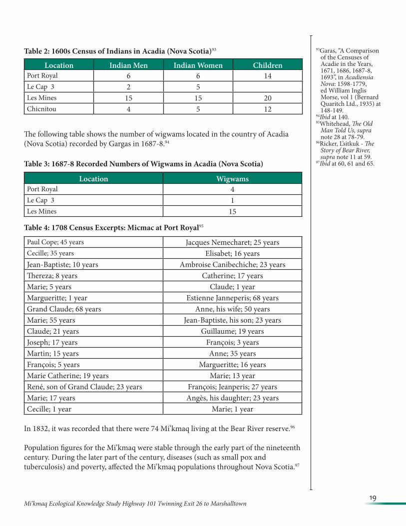
A census completed in the late 1600s, indicated the number of Indians in Acadia (Nova Scotia) as follows:
86NAC, RG10, vol 459, reel 13,329 at 126-128.
87NAC, RG10, vol 459, reel 13,329 at 571-573.
88Speck, Beothuk and Micmac, supra note 7 at 98.
89RG 10, vol 2076, File 10,987.
90Indian Affairs, RG 10, vol 2241, file 46,538.
91Indian Affairs, File 274/30-6-6.
92Ibid .
19Mi’kmaq Ecological Knowledge Study Highway 101 Twinning Exit 26 to Marshalltown
93Garas, “A Comparison of the Censuses of Acadie in the Years, 1671, 1686, 1687-8, 1693”, in Acadiensia Nova: 1598-1779, ed William Inglis Morse, vol 1 (Bernard Quaritch Ltd., 1935) at 148-149.
94Ibid at 140.95Whitehead, The Old
Man Told Us, supra note 28 at 78-79.
96Ricker, L’sitkuk - The Story of Bear River, supra note 11 at 59.
97Ibid at 60, 61 and 65.
Table 2: 1600s Census of Indians in Acadia (Nova Scotia)93
The following table shows the number of wigwams located in the country of Acadia (Nova Scotia) recorded by Gargas in 1687-8.94
Table 3: 1687-8 Recorded Numbers of Wigwams in Acadia (Nova Scotia)
Table 4: 1708 Census Excerpts: Micmac at Port Royal95
In 1832, it was recorded that there were 74 Mi’kmaq living at the Bear River reserve.96
Population figures for the Mi’kmaq were stable through the early part of the nineteenth century. During the later part of the century, diseases (such as small pox and tuberculosis) and poverty, affected the Mi’kmaq populations throughout Nova Scotia.97
Location Indian Men Indian Women ChildrenPort Royal 6 6 14Le Cap 3 2 5Les Mines 15 15 20Chicnitou 4 5 12
Location WigwamsPort Royal 4Le Cap 3 1Les Mines 15
Paul Cope; 45 years Jacques Nemecharet; 25 yearsCecille; 35 years Elisabet; 16 yearsJean-Baptiste; 10 years Ambroise Canibechiche; 23 yearsThereza; 8 years Catherine; 17 yearsMarie; 5 years Claude; 1 yearMargueritte; 1 year Estienne Janneperis; 68 yearsGrand Claude; 68 years Anne, his wife; 50 yearsMarie; 55 years Jean-Baptiste, his son; 23 yearsClaude; 21 years Guillaume; 19 yearsJoseph; 17 years François; 3 yearsMartin; 15 years Anne; 35 yearsFrançois; 5 years Margueritte; 16 yearsMarie Catherine; 19 years Marie; 13 yearRené, son of Grand Claude; 23 years François; Jeanperis; 27 yearsMarie; 17 years Angès, his daughter; 23 yearsCecille; 1 year Marie; 1 year
20Mi’kmaq Ecological Knowledge Study Highway 101 Twinning Exit 26 to Marshalltown
In 1862, Indian Affairs recorded the number of Mi’kmaq in Annapolis County at 94; and the number of Mi’kmaq in Digby County at 128.98
The following table shows the names and ages of Mi’kmaq recorded on the 1871 Census of the sub-districts Digby, Head of Saint Mary’s Bay, and St. Mary’s Bay in Digby County.
Table 5: Mi’kmaq Recorded in the 1871 Census in the sub-districts St. Mary’s Bay, Digby and Head of Saint Mary’s Bay99
98Journals of House of Assembly, NS, Appendix No. 30, Indian Affairs, PANS.99Canada, Library and Archives Canada, “Search Results: Census of Canada, 1871”, online: http://www.bac-lac.gc.ca/eng/census/1871/
Pages/results.aspx?k=Kings%20AND%20cnsProvinceCode%3A%22NS%22&start1=1.100Ibid online: http://data2.collectionscanada.ca/1871/pdf/4396664_00490.pdf101Ibid online: http://data2.collectionscanada.ca/1871/pdf/4396664_00495.pdf102Ibid online: http://data2.collectionscanada.ca/1871/pdf/4396664_00490.pdf103Ibid online: http://data2.collectionscanada.ca/1871/pdf/4396664_00495.pdf104Ibid online: http://data2.collectionscanada.ca/1871/pdf/4396664_00490.pdf105Ibid online: http://data2.collectionscanada.ca/1871/pdf/4396664_00495.pdf106Ibid online: http://data2.collectionscanada.ca/1871/pdf/4396664_00475.pdf107Ibid online: http://data2.collectionscanada.ca/1871/pdf/4396664_00495.pdf108Ibid online: http://data2.collectionscanada.ca/1871/pdf/4396664_00475.pdf.109Ibid online: http://data2.collectionscanada.ca/1871/pdf/4396664_00495.pdf.110Ibid online: http://data2.collectionscanada.ca/1871/pdf/4396664_00475.pdf.111Ibid online: http://data2.collectionscanada.ca/1871/pdf/4396664_00495.pdf.112Ibid online: http://data2.collectionscanada.ca/1871/pdf/4396664_00475.pdf.113Ibid online: http://data2.collectionscanada.ca/1871/pdf/4396664_00495.pdf.114Ibid online: http://data2.collectionscanada.ca/1871/pdf/4396664_00475.pdf.115Ibid online: http://data2.collectionscanada.ca/1871/pdf/4396664_00495.pdf.116Ibid online: http://data2.collectionscanada.ca/1871/pdf/4396664_00475.pdf.117Ibid online: http://data2.collectionscanada.ca/1871/pdf/4396664_00495.pdf.118Ibid online: http://data2.collectionscanada.ca/1871/pdf/4396664_00475.pdf.119Ibid online: http://data2.collectionscanada.ca/1871/pdf/4396664_00495.pdf.120Ibid online: http://data2.collectionscanada.ca/1871/pdf/4396664_00475.pdf.121Ibid online: http://data2.collectionscanada.ca/1871/pdf/4396664_00495.pdf.122Ibid online: http://data2.collectionscanada.ca/1871/pdf/4396664_00474.pdf.123Ibid online: http://data2.collectionscanada.ca/1871/pdf/4396664_00495.pdf.
St. Mary’s BayNone foundDigbyStephen Knockwood; 34 years; Hunter100 Joseph Pinalle; 60 years; Hunter101
Molly Knockwood; 14 years102 Hannah Pinalle; 65 years103
Mary A. Michael; 13 years104 Hannah Pinalle; 20 years105
Louis Toney; 9 years106 Joseph Pinalle; 18 years107
Rachel Toney; 7 years108 James Pinalle; 13 years109
Abraham Gload; 51 years110 Joseph Blin; 40 years; Physician111
Nellie Gload; 32 years112 Mary Blin; 45 years113
Mary Michael; 11 years114 Joseph Blin; 17 years115
Abraham J. Gload; 19 years116 Stephen Blin; 15 years117
Nastassie Gload; 26 years118 Peter Blin; 10 years119
John B. Gload; 4 years120 John Blin; 7 years121
James Toney; 33 years122 Joseph Pinalle; 60 years; Hunter123
21Mi’kmaq Ecological Knowledge Study Highway 101 Twinning Exit 26 to Marshalltown
124Ibid online: http://data2.collectionscanada.ca/1871/pdf/4396664_00474.pdf.125Ibid online: http://data2.collectionscanada.ca/1871/pdf/4396664_00495.pdf.126Ibid online: http://data2.collectionscanada.ca/1871/pdf/4396664_00474.pdf.127Ibid online: http://data2.collectionscanada.ca/1871/pdf/4396664_00495.pdf.128Ibid online: http://data2.collectionscanada.ca/1871/pdf/4396664_00474.pdf.129Ibid online: http://data2.collectionscanada.ca/1871/pdf/4396664_00495.pdf.130Ibid online: http://data2.collectionscanada.ca/1871/pdf/4396665_00120.pdf.131Ibid online: http://data2.collectionscanada.ca/1871/pdf/4396665_00120.pdf.132Ibid online: http://data2.collectionscanada.ca/1871/pdf/4396665_00120.pdf.133Canada, Library and Archives Canada, “Search Results: Census of Canada, 1881”, online: http://data2.collectionscanada.gc.ca/e/e325/
e008120396.pdf.134Ibid online: http://data2.collectionscanada.gc.ca/e/e325/e008120396.pdf.135Ibid online: http://data2.collectionscanada.gc.ca/e/e325/e008120396.pdf.136Ibid online: http://data2.collectionscanada.gc.ca/e/e325/e008120396.pdf.
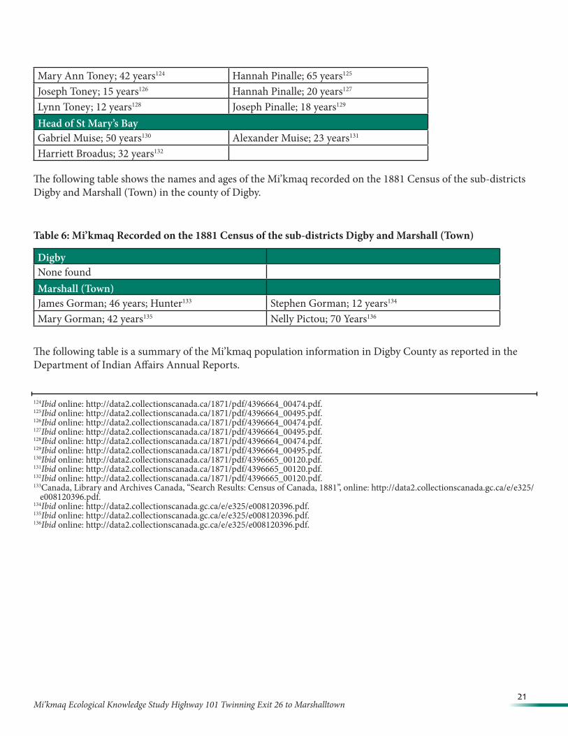
Mary Ann Toney; 42 years124 Hannah Pinalle; 65 years125
Joseph Toney; 15 years126 Hannah Pinalle; 20 years127
Lynn Toney; 12 years128 Joseph Pinalle; 18 years129
Head of St Mary’s BayGabriel Muise; 50 years130 Alexander Muise; 23 years131
Harriett Broadus; 32 years132
The following table shows the names and ages of the Mi’kmaq recorded on the 1881 Census of the sub-districts Digby and Marshall (Town) in the county of Digby.
Table 6: Mi’kmaq Recorded on the 1881 Census of the sub-districts Digby and Marshall (Town)
The following table is a summary of the Mi’kmaq population information in Digby County as reported in the Department of Indian Affairs Annual Reports.
DigbyNone foundMarshall (Town)James Gorman; 46 years; Hunter133 Stephen Gorman; 12 years134
Mary Gorman; 42 years135 Nelly Pictou; 70 Years136
22Mi’kmaq Ecological Knowledge Study Highway 101 Twinning Exit 26 to Marshalltown
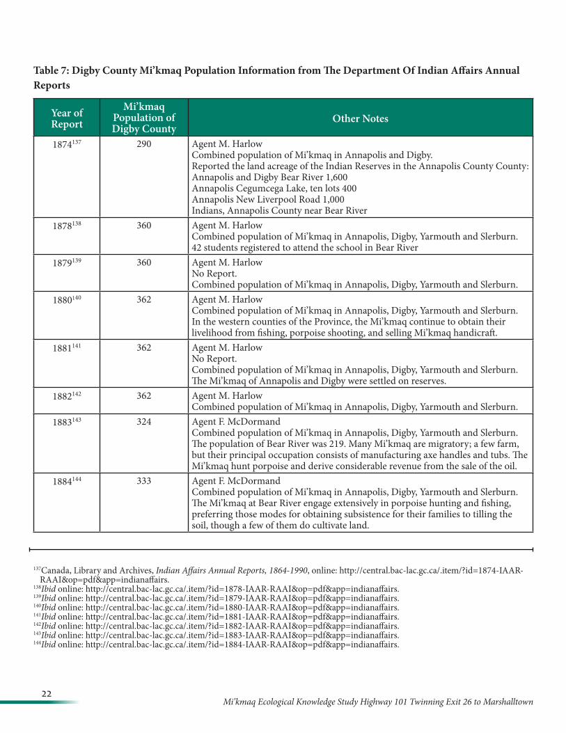
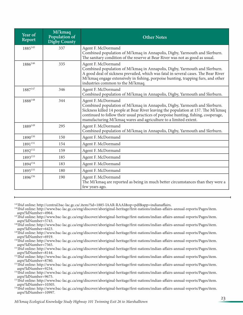
Table 7: Digby County Mi’kmaq Population Information from The Department Of Indian Affairs Annual Reports
Year of Report
Mi’kmaq Population of Digby County
Other Notes
1874137 290 Agent M. HarlowCombined population of Mi’kmaq in Annapolis and Digby.Reported the land acreage of the Indian Reserves in the Annapolis County County:Annapolis and Digby Bear River 1,600Annapolis Cegumcega Lake, ten lots 400Annapolis New Liverpool Road 1,000Indians, Annapolis County near Bear River
1878138 360 Agent M. HarlowCombined population of Mi’kmaq in Annapolis, Digby, Yarmouth and Slerburn.42 students registered to attend the school in Bear River
1879139 360 Agent M. HarlowNo Report.Combined population of Mi’kmaq in Annapolis, Digby, Yarmouth and Slerburn.
1880140 362 Agent M. HarlowCombined population of Mi’kmaq in Annapolis, Digby, Yarmouth and Slerburn.In the western counties of the Province, the Mi’kmaq continue to obtain their livelihood from fishing, porpoise shooting, and selling Mi’kmaq handicraft.
1881141 362 Agent M. HarlowNo Report.Combined population of Mi’kmaq in Annapolis, Digby, Yarmouth and Slerburn.The Mi’kmaq of Annapolis and Digby were settled on reserves.
1882142 362 Agent M. HarlowCombined population of Mi’kmaq in Annapolis, Digby, Yarmouth and Slerburn.
1883143 324 Agent F. McDormandCombined population of Mi’kmaq in Annapolis, Digby, Yarmouth and Slerburn.The population of Bear River was 219. Many Mi’kmaq are migratory; a few farm, but their principal occupation consists of manufacturing axe handles and tubs. The Mi’kmaq hunt porpoise and derive considerable revenue from the sale of the oil.
1884144 333 Agent F. McDormandCombined population of Mi’kmaq in Annapolis, Digby, Yarmouth and Slerburn.The Mi’kmaq at Bear River engage extensively in porpoise hunting and fishing, preferring those modes for obtaining subsistence for their families to tilling the soil, though a few of them do cultivate land.
137Canada, Library and Archives, Indian Affairs Annual Reports, 1864-1990, online: http://central.bac-lac.gc.ca/.item/?id=1874-IAAR-RAAI&op=pdf&app=indianaffairs.
138Ibid online: http://central.bac-lac.gc.ca/.item/?id=1878-IAAR-RAAI&op=pdf&app=indianaffairs.139Ibid online: http://central.bac-lac.gc.ca/.item/?id=1879-IAAR-RAAI&op=pdf&app=indianaffairs.140Ibid online: http://central.bac-lac.gc.ca/.item/?id=1880-IAAR-RAAI&op=pdf&app=indianaffairs.141Ibid online: http://central.bac-lac.gc.ca/.item/?id=1881-IAAR-RAAI&op=pdf&app=indianaffairs.142Ibid online: http://central.bac-lac.gc.ca/.item/?id=1882-IAAR-RAAI&op=pdf&app=indianaffairs.143Ibid online: http://central.bac-lac.gc.ca/.item/?id=1883-IAAR-RAAI&op=pdf&app=indianaffairs.144Ibid online: http://central.bac-lac.gc.ca/.item/?id=1884-IAAR-RAAI&op=pdf&app=indianaffairs.
23Mi’kmaq Ecological Knowledge Study Highway 101 Twinning Exit 26 to Marshalltown
Year of Report
Mi’kmaq Population of Digby County
Other Notes
1885145 337 Agent F. McDormandCombined population of Mi’kmaq in Annapolis, Digby, Yarmouth and Slerburn.The sanitary condition of the reserve at Bear River was not as good as usual.
1886146 335 Agent F. McDormandCombined population of Mi’kmaq in Annapolis, Digby, Yarmouth and Slerburn.A good deal of sickness prevailed, which was fatal in several cases. The Bear River Mi’kmaq engage extensively in fishing, porpoise hunting, trapping furs, and other industries common to the Mi’kmaq.
1887147 346 Agent F. McDormandCombined population of Mi’kmaq in Annapolis, Digby, Yarmouth and Slerburn.
1888148 344 Agent F. McDormandCombined population of Mi’kmaq in Annapolis, Digby, Yarmouth and Slerburn.Sickness killed 14 people at Bear River leaving the population at 157. The Mi’kmaq continued to follow their usual practices of porpoise hunting, fishing, cooperage, manufacturing Mi’kmaq wares and agriculture to a limited extent.
1889149 295 Agent F. McDormandCombined population of Mi’kmaq in Annapolis, Digby, Yarmouth and Slerburn.
1890150 150 Agent F. McDormand1891151 154 Agent F. McDormand1892152 159 Agent F. McDormand1893153 185 Agent F. McDormand1894154 183 Agent F. McDormand1895155 180 Agent F. McDormand1896156 190 Agent F. McDormand
The Mi’kmaq are reported as being in much better circumstances than they were a few years ago.
145Ibid online: http://central.bac-lac.gc.ca/.item/?id=1885-IAAR-RAAI&op=pdf&app=indianaffairs.146Ibid online: http://www.bac-lac.gc.ca/eng/discover/aboriginal-heritage/first-nations/indian-affairs-annual-reports/Pages/item.
aspx?IdNumber=4964.147Ibid online: http://www.bac-lac.gc.ca/eng/discover/aboriginal-heritage/first-nations/indian-affairs-annual-reports/Pages/item.
aspx?IdNumber=5743.148Ibid online: http://www.bac-lac.gc.ca/eng/discover/aboriginal-heritage/first-nations/indian-affairs-annual-reports/Pages/item.
aspx?IdNumber=6423.149Ibid online: http://www.bac-lac.gc.ca/eng/discover/aboriginal-heritage/first-nations/indian-affairs-annual-reports/Pages/item.
aspx?IdNumber=6919.150Ibid online: http://www.bac-lac.gc.ca/eng/discover/aboriginal-heritage/first-nations/indian-affairs-annual-reports/Pages/item.
aspx?IdNumber=7565.151Ibid online: http://www.bac-lac.gc.ca/eng/discover/aboriginal-heritage/first-nations/indian-affairs-annual-reports/Pages/item.
aspx?IdNumber=8144.152Ibid online: http://www.bac-lac.gc.ca/eng/discover/aboriginal-heritage/first-nations/indian-affairs-annual-reports/Pages/item.
aspx?IdNumber=8780.153Ibid online: http://www.bac-lac.gc.ca/eng/discover/aboriginal-heritage/first-nations/indian-affairs-annual-reports/Pages/item.
aspx?IdNumber=9234.154Ibid online: http://www.bac-lac.gc.ca/eng/discover/aboriginal-heritage/first-nations/indian-affairs-annual-reports/Pages/item.
aspx?IdNumber=9675.155Ibid online: http://www.bac-lac.gc.ca/eng/discover/aboriginal-heritage/first-nations/indian-affairs-annual-reports/Pages/item.
aspx?IdNumber=10305.156Ibid online: http://www.bac-lac.gc.ca/eng/discover/aboriginal-heritage/first-nations/indian-affairs-annual-reports/Pages/item.
aspx?IdNumber=10997.
24Mi’kmaq Ecological Knowledge Study Highway 101 Twinning Exit 26 to Marshalltown
Year of Report
Mi’kmaq Population of Digby County
Other Notes
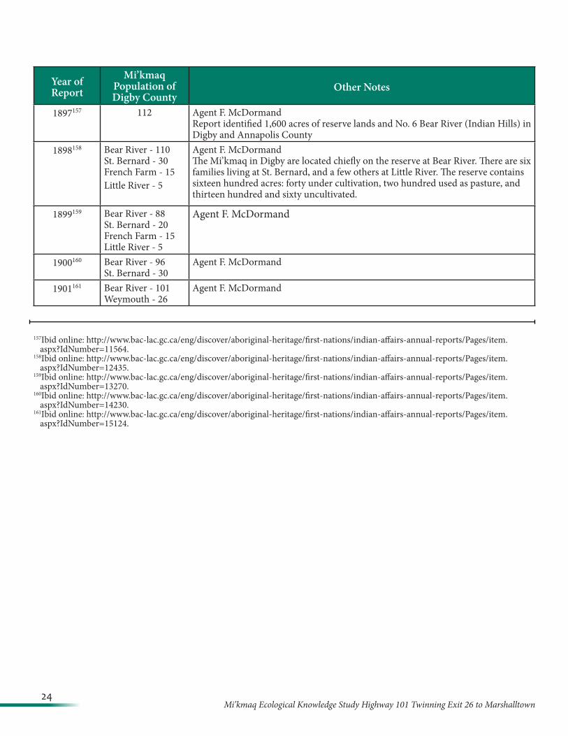
1897157 112 Agent F. McDormandReport identified 1,600 acres of reserve lands and No. 6 Bear River (Indian Hills) in Digby and Annapolis County
1898158 Bear River - 110St. Bernard - 30French Farm - 15Little River - 5
Agent F. McDormandThe Mi’kmaq in Digby are located chiefly on the reserve at Bear River. There are six families living at St. Bernard, and a few others at Little River. The reserve contains sixteen hundred acres: forty under cultivation, two hundred used as pasture, and thirteen hundred and sixty uncultivated.
1899159 Bear River - 88St. Bernard - 20French Farm - 15Little River - 5
Agent F. McDormand
1900160 Bear River - 96St. Bernard - 30
Agent F. McDormand
1901161 Bear River - 101Weymouth - 26
Agent F. McDormand
157Ibid online: http://www.bac-lac.gc.ca/eng/discover/aboriginal-heritage/first-nations/indian-affairs-annual-reports/Pages/item.aspx?IdNumber=11564.
158Ibid online: http://www.bac-lac.gc.ca/eng/discover/aboriginal-heritage/first-nations/indian-affairs-annual-reports/Pages/item.aspx?IdNumber=12435.
159Ibid online: http://www.bac-lac.gc.ca/eng/discover/aboriginal-heritage/first-nations/indian-affairs-annual-reports/Pages/item.aspx?IdNumber=13270.
160Ibid online: http://www.bac-lac.gc.ca/eng/discover/aboriginal-heritage/first-nations/indian-affairs-annual-reports/Pages/item.aspx?IdNumber=14230.
161Ibid online: http://www.bac-lac.gc.ca/eng/discover/aboriginal-heritage/first-nations/indian-affairs-annual-reports/Pages/item.aspx?IdNumber=15124.
25Mi’kmaq Ecological Knowledge Study Highway 101 Twinning Exit 26 to Marshalltown
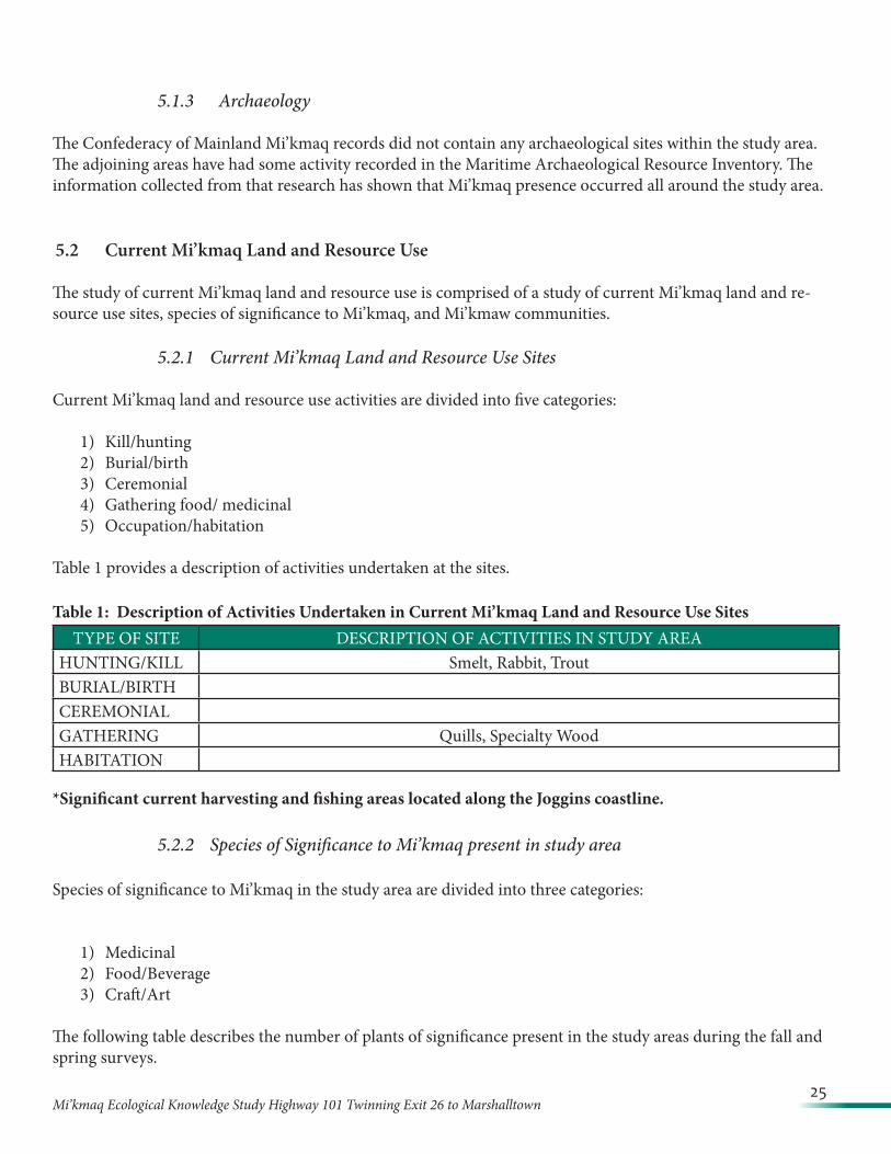
5.1.3 Archaeology
The Confederacy of Mainland Mi’kmaq records did not contain any archaeological sites within the study area. The adjoining areas have had some activity recorded in the Maritime Archaeological Resource Inventory. The information collected from that research has shown that Mi’kmaq presence occurred all around the study area.
5.2 Current Mi’kmaq Land and Resource Use
The study of current Mi’kmaq land and resource use is comprised of a study of current Mi’kmaq land and re-source use sites, species of significance to Mi’kmaq, and Mi’kmaw communities.
5.2.1 Current Mi’kmaq Land and Resource Use Sites
Current Mi’kmaq land and resource use activities are divided into five categories:
1) Kill/hunting2) Burial/birth3) Ceremonial4) Gathering food/ medicinal 5) Occupation/habitation
Table 1 provides a description of activities undertaken at the sites.
Table 1: Description of Activities Undertaken in Current Mi’kmaq Land and Resource Use Sites
*Significant current harvesting and fishing areas located along the Joggins coastline. 5.2.2 Species of Significance to Mi’kmaq present in study area
Species of significance to Mi’kmaq in the study area are divided into three categories:
1) Medicinal2) Food/Beverage3) Craft/Art
The following table describes the number of plants of significance present in the study areas during the fall and spring surveys.
TYPE OF SITE DESCRIPTION OF ACTIVITIES IN STUDY AREAHUNTING/KILL Smelt, Rabbit, TroutBURIAL/BIRTHCEREMONIALGATHERING Quills, Specialty WoodHABITATION
26Mi’kmaq Ecological Knowledge Study Highway 101 Twinning Exit 26 to Marshalltown
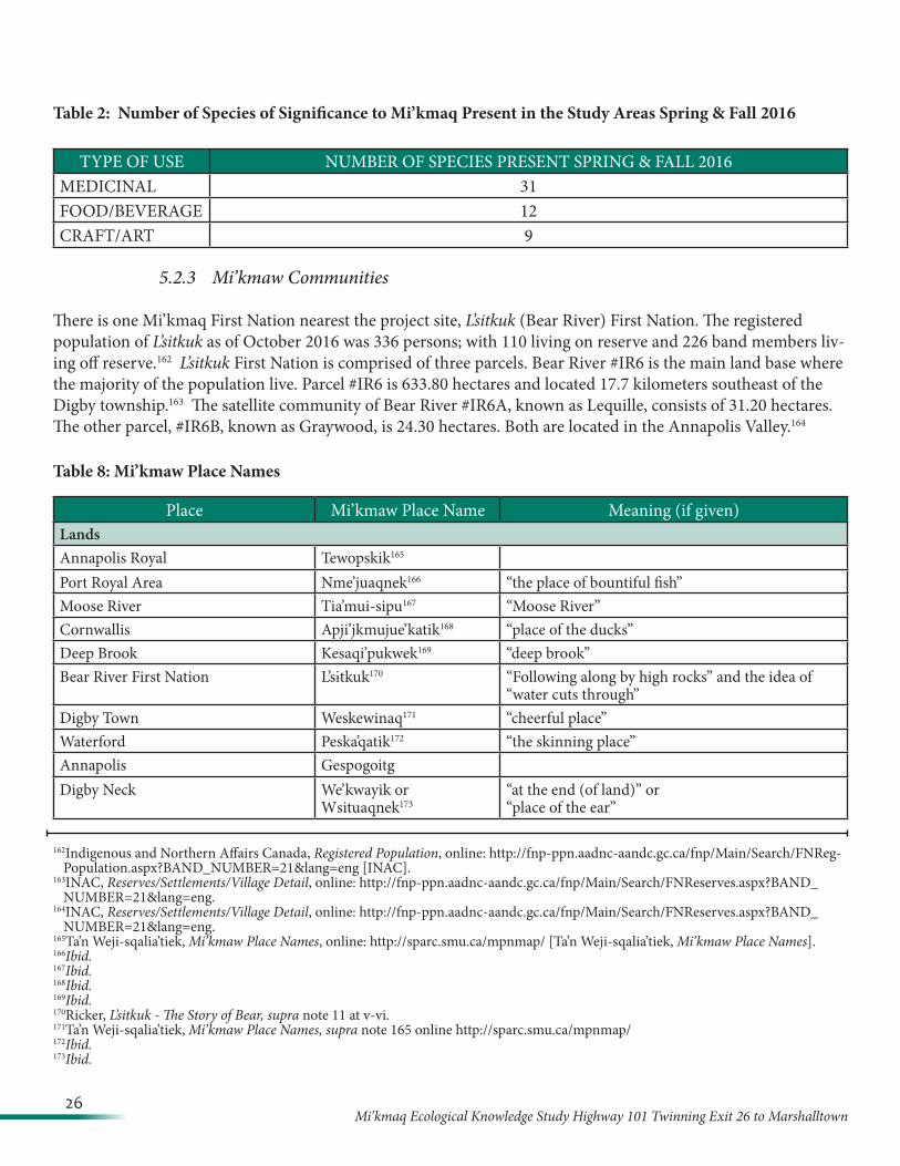
Table 2: Number of Species of Significance to Mi’kmaq Present in the Study Areas Spring & Fall 2016
5.2.3 Mi’kmaw Communities
There is one Mi’kmaq First Nation nearest the project site, L’sitkuk (Bear River) First Nation. The registered population of L’sitkuk as of October 2016 was 336 persons; with 110 living on reserve and 226 band members liv-ing off reserve.162 L’sitkuk First Nation is comprised of three parcels. Bear River #IR6 is the main land base where the majority of the population live. Parcel #IR6 is 633.80 hectares and located 17.7 kilometers southeast of the Digby township.163 The satellite community of Bear River #IR6A, known as Lequille, consists of 31.20 hectares. The other parcel, #IR6B, known as Graywood, is 24.30 hectares. Both are located in the Annapolis Valley.164
Table 8: Mi’kmaw Place Names
TYPE OF USE NUMBER OF SPECIES PRESENT SPRING & FALL 2016MEDICINAL 31FOOD/BEVERAGE 12CRAFT/ART 9
162Indigenous and Northern Affairs Canada, Registered Population, online: http://fnp-ppn.aadnc-aandc.gc.ca/fnp/Main/Search/FNReg-Population.aspx?BAND_NUMBER=21&lang=eng [INAC].
163INAC, Reserves/Settlements/Village Detail, online: http://fnp-ppn.aadnc-aandc.gc.ca/fnp/Main/Search/FNReserves.aspx?BAND_NUMBER=21&lang=eng.
164INAC, Reserves/Settlements/Village Detail, online: http://fnp-ppn.aadnc-aandc.gc.ca/fnp/Main/Search/FNReserves.aspx?BAND_NUMBER=21&lang=eng.
165Ta’n Weji-sqalia’tiek, Mi’kmaw Place Names, online: http://sparc.smu.ca/mpnmap/ [Ta’n Weji-sqalia’tiek, Mi’kmaw Place Names].166Ibid .167Ibid .168Ibid .169Ibid .170Ricker, L’sitkuk - The Story of Bear, supra note 11 at v-vi.171Ta’n Weji-sqalia’tiek, Mi’kmaw Place Names, supra note 165 online http://sparc.smu.ca/mpnmap/172Ibid .173Ibid .
Place Mi’kmaw Place Name Meaning (if given)LandsAnnapolis Royal Tewopskik165
Port Royal Area Nme’juaqnek166 “the place of bountiful fish”Moose River Tia’mui-sipu167 “Moose River”Cornwallis Apji’jkmujue’katik168 “place of the ducks”Deep Brook Kesaqi’pukwek169 “deep brook”Bear River First Nation L’sɨtkuk170 “Following along by high rocks” and the idea of
“water cuts through”Digby Town Weskewinaq171 “cheerful place”Waterford Peska’qatik172 “the skinning place”Annapolis GespogoitgDigby Neck We’kwayik or
Wsituaqnek173“at the end (of land)” or “place of the ear”
27Mi’kmaq Ecological Knowledge Study Highway 101 Twinning Exit 26 to Marshalltown
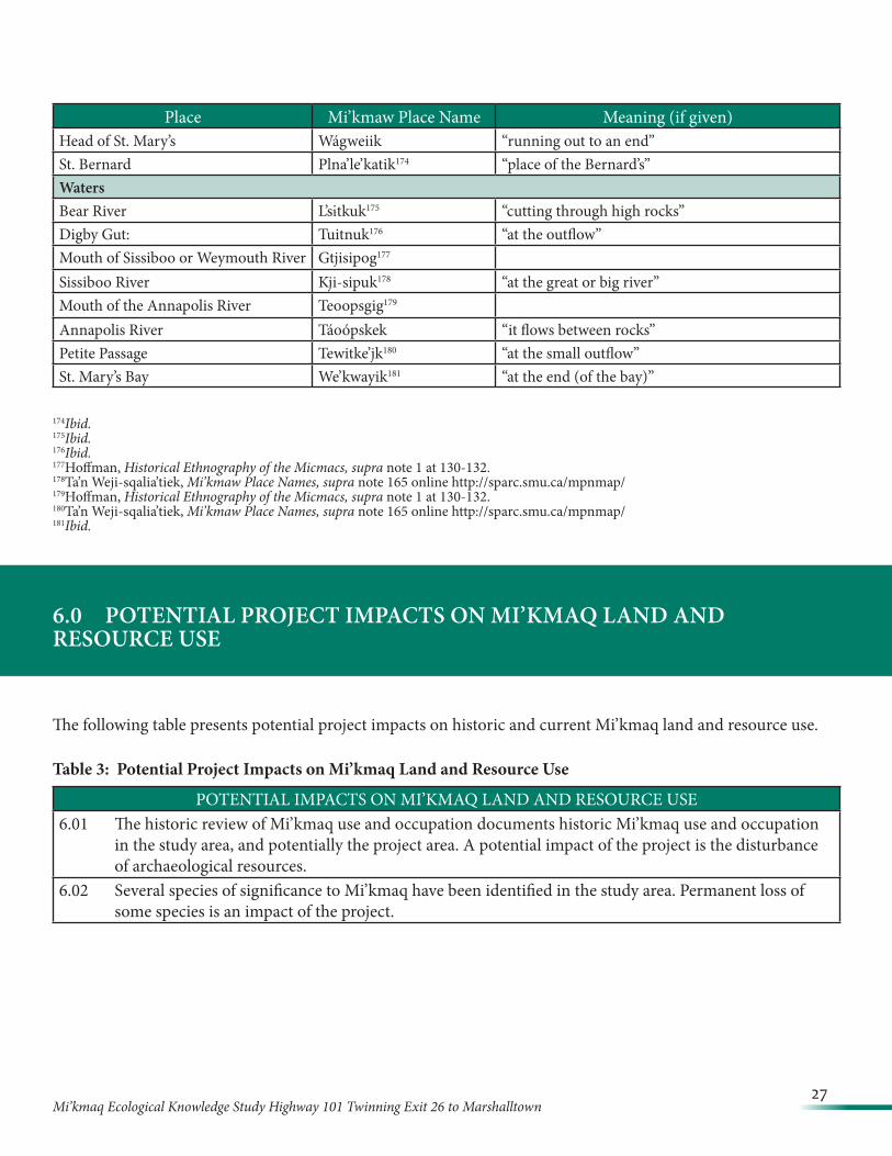
Place Mi’kmaw Place Name Meaning (if given)Head of St. Mary’s Wágweiik “running out to an end”St. Bernard Plna’le’katik174 “place of the Bernard’s”WatersBear River L’sɨtkuk175 “cutting through high rocks”Digby Gut: Tuitnuk176 “at the outflow”Mouth of Sissiboo or Weymouth River Gtjisipog177
Sissiboo River Kji-sipuk178 “at the great or big river”Mouth of the Annapolis River Teoopsgig179
Annapolis River Táoópskek “it flows between rocks”Petite Passage Tewitke’jk180 “at the small outflow”St. Mary’s Bay We’kwayik181 “at the end (of the bay)”
174Ibid .175Ibid .176Ibid .177Hoffman, Historical Ethnography of the Micmacs, supra note 1 at 130-132.178Ta’n Weji-sqalia’tiek, Mi’kmaw Place Names, supra note 165 online http://sparc.smu.ca/mpnmap/179Hoffman, Historical Ethnography of the Micmacs, supra note 1 at 130-132.180Ta’n Weji-sqalia’tiek, Mi’kmaw Place Names, supra note 165 online http://sparc.smu.ca/mpnmap/181Ibid .
6.0 POTENTIAL PROJECT IMPACTS ON MI’KMAQ LAND AND RESOURCE USE
The following table presents potential project impacts on historic and current Mi’kmaq land and resource use.
Table 3: Potential Project Impacts on Mi’kmaq Land and Resource Use
POTENTIAL IMPACTS ON MI’KMAQ LAND AND RESOURCE USE6.01 The historic review of Mi’kmaq use and occupation documents historic Mi’kmaq use and occupation
in the study area, and potentially the project area. A potential impact of the project is the disturbance of archaeological resources.
6.02 Several species of significance to Mi’kmaq have been identified in the study area. Permanent loss of some species is an impact of the project.

28Mi’kmaq Ecological Knowledge Study Highway 101 Twinning Exit 26 to Marshalltown
7.0 SIGNIFICANCE OF POTENTIAL PROJECT IMPACTS ON MI’KMAQ LAND AND RESOURCE USE
The concept of significance in the Mi’kmaq Ecological Knowledge Study is distinct from the concept of significance under the Canadian Environmental Assessment Act or the Nova Scotia Environmental Assessment Regulations. Significance to Mi’kmaq is evaluated only in accordance with the criteria listed below. The MEKS evaluation of the significance of the potential project impacts on Mi’kmaq should be used by regulators to inform their determination of the significance of the environmental effects of the Project.
7.1 Significance Criteria
The following criteria are used to analyze the significance of the potential project impacts on Mi’kmaq use:
1) Uniqueness of land or resource 2) Culture or spiritual meaning of land or resource 3) Nature of Mi’kmaq use of land or resource 4) Mi’kmaq constitutionally protected rights in relation to land or resource.
7.2 Evaluation of Significance
Table 4: Significance of Potential Project Impacts on Mi’kmaq Land and Resource Use
POTENTIAL IMPACT EVALUATION OF SIGNIFICANCE6.01 The historic review of Mi’kmaq use and
occupation documents Mi’kmaq use and occupation in the study area, and poten-tially the project area. A potential impact of the project is the disturbance of archae-ological resources.
7.2.01 Mi’kmaq archaeological resources are extremely important to Mi’kmaq as a method of determin-ing Mi’kmaq use and occupation of Mi’kma’ki and as an enduring record of the Mi’kmaq nation and culture across the centuries. Archaeological resources are irreplaceable. Any disturbance of Mi’kmaq archaeological resources is significant.
6.02 Several species of significance to Mi’kmaq have been identified in the study areas. Permanent loss of some specimens is an impact of the Project.
7.2.02 The plant species of significance to Mi’kmaq identified within the study area exists within the surrounding area. The destruction of some specimens within the study areas does not pose a threat to Mi’kmaq use of the species. The impact of the permanent loss of some specimens of plant species of significance to Mi’kmaq is evaluated as not likely significant.
29Mi’kmaq Ecological Knowledge Study Highway 101 Twinning Exit 26 to Marshalltown
8.0 CONCLUSIONS AND RECOMMENDATIONS
8.01 In the event that Mi’kmaw archaeological deposits are encountered during construction or operation of the Project, all work should be halted and immediate contact should be made Laura Bennett, Special Places Coordinator, at the Nova Scotia Museum and, Kwilmu’kw Maw-klusagn Negotiation Office (KM-KNO).
8.02 There is no land claims registered with the Specific Claims branch of Indian and Northern Affairs Can-ada in Ottawa for any of the Mi’kmaq communities in Nova Scotia within the Project area. However, that does not suggest that any other Mi’kmaw claimants for this area may not submit land claims in the future.
9.0 REFERENCES, SOURCES, AND RECORDS CONSULTED
Secondary Sources
1. Admiral Digby Museum, History, online: http://admiraldigbymuseum.ca/?page_id=106.
2. Bernard G Hoffman, The Historical Ethnography of the Micmacs of the Sixteenth and Seventeenth Centuries (Ph D Thesis, University of California, 1955).
3. Canada, Library and Archives, Indian Affairs Annual Reports, 1864-1990, online: http://central.bac-lac.gc.ca/.item/?id=1878-IAAR-RAAI&op=pdf&app=indianaffairs.
4. Canada, Library and Archives Canada, “Search Results: Census of Canada, 1871”, online: http://www.bac-lac.gc.ca/eng/census/1871/Pages/1871.aspx.
5. Canada, Library and Archives Canada, “Search Results: Census of Canada, 1881,” online: http://www.bac-lac.gc.ca/eng/census/1881/Pages/1881.aspx.
6. D. A. Ricker, L’sitkuk - The Story of Bear River Mi’kmaq Community (Lockeport, Nova Scotia: Roseway Pub-lishing, 1997).
7. Daniel Paul, We Were Not the Savages, 3d ed (Halifax: Fernwood Publishing, 2006).
8. Donald M Julien, “Historical Perspectives”, The Confederacy of Mainland Micmacs.
9. Frank G. Speck, Beothuk and Micmac (New York: Museum of the American Indian Heye Foundation, 1922).
30Mi’kmaq Ecological Knowledge Study Highway 101 Twinning Exit 26 to Marshalltown
10. Garas, “A Comparison of the Censuses of Acadie in the Years, 1671, 1686, 1687-8, 1693”, in Acadiensia Nova: 1598-1779, ed William Inglis Morse, vol 1 (Bernard Quaritch Ltd., 1935).
11. Gary P Gould and Alan J Semple, Our Land: The Maritimes: The Basis of the Indian Claim in the Maritime Provinces of Canada (Fredericton: Saint Anne’s Point Press, 1980).
12. Indigenous and Northern Affairs Canada, Registered Population, online: http://fnp-ppn.aadnc-aandc.gc.ca/fnp/Main/Search/FNRegPopulation.aspx?BAND_NUMBER=21&lang=eng
13. Indigenous and Northern Affairs Canada, Reserves/Settlements/Village Detail, online: http://fnp-ppn.aadnc-aandc.gc.ca/fnp/Main/Search/FNReserves.aspx?BAND_NUMBER=21&lang=eng.
14. John Clarence Webster, Acadia at the End of the Seventeenth Century: Letters, Journals and Memoirs of Joselh Robineau DeVillebon, Commandant in Acadia, 1690-1700, (The New Brinswick Meuseum: St. John’s, 1935).
15. Isaiah Wilson, Geography and History of Digby County, (Holloway Bros, 1900).
16. J. H Kennedy, Jesuit and Savage in New France (USA Library of Congress, Acorn Books, 1971).
17. John Reid, Six Crucial Decades: Time of Change in the History of the Maritimes, 1987.
18. Marc Lescarbot, The History of New France, vol 3, book 6, (1914).
19. Michael McDonald, “Sipekne`katik Title Claim: Dispelling the Misconceptions and Myths, A Mi’kmaw per-spective” on line at: http://sipeknekatik.ca/wp-content/uploads/2016/03/SIPEKNEKATIK-TITLE-CLAIM-PAPER.pdf.
20. Reuben Gold Thwaites, ed, The Jesuit Relations and Allied Documents: Travels and Explorations of the Jesuit Missionaries in New France 1610—1791, vol 2.
21. Ruth Holmes Whitehead, The Old Man Told Us: Excerpts from Micmac History 1500-1950 (Halifax: Nimbus Publishing Ltd, 1991).
22. Sieur DeDiereville, Relation of the Voyage to Port Royal in Acadia or New France, ed John Clarence Webster (1933).
23. Simone Poliandri, Mi’kmaw Lobster Fishing in St . Mary’s Bay, Nova Scotia: A Traditional Activity?, 2001, De-partment of Anthropology, Brown University MA Degree.
24. Stephen E Patterson, “1744-1763: Colonial Wars and Aboriginal Peoples” in Phillip A Buckner & John G Reid, eds, The Atlantic Region to Confederation: A History (Toronto: University of Toronto Press and Acadi-ensis Press, 1994).
25. Ta’n Weji-sqalia’tiek, Cultural Landscapes, online: http://mikmawplacenames.ca/?page_id=57.
31Mi’kmaq Ecological Knowledge Study Highway 101 Twinning Exit 26 to Marshalltown
26. Ta’n Weji-sqalia’tiek, Mi’kmaw Place Names, online: http://sparc.smu.ca/mpnmap/.
27. The Union of Nova Scotia Indians, Crown Land Rights and Hunting and Fishing Rights of Micmac Indians in Nova Scotia (Revised Edition, 1976).
Primary Sources
Nova Scotia Archives PANS RG1, vol 209, pp 22-23, reel 15310. PANS RG1, vol 213, pp 79-80, reel 15312. PANS Micro N933, reel #15, JLANS, Appendix 6. PANS RG 1, vol. 430, No 54 and 53. NSARM MG 1, vol. 979, file8, no.9. NSARM RG 1, vol 430, no 169½. NSARM RG 1, vol 430, doc 180. NSARM MG 15, vol 17, doc 42. NSARM RG 1, vol 431, doc 97. Journals of House of Assembly, NS, Appendix No. 30, Indian Affairs, PANS.
National Archives of Canada RG10, vol 459, reel 13,329. MG 15, vol 17, no 34. MG 15, vol, reel 15108. RG10, vol 461, reel 13,330. RG 10, vol 2076, File 10,987. Indian Affairs, RG 10, vol 2241, file 46,538.
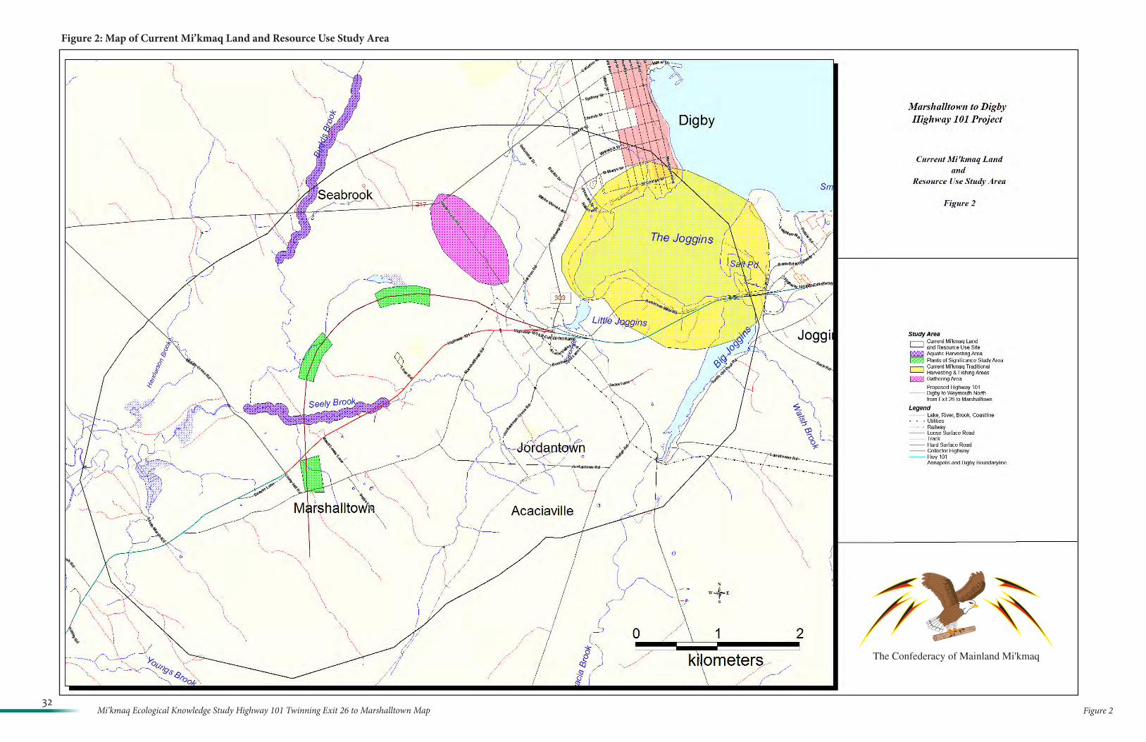
Figure 232
Mi’kmaq Ecological Knowledge Study Highway 101 Twinning Exit 26 to Marshalltown Map
Figure 2: Map of Current Mi’kmaq Land and Resource Use Study Area
The Confederacy of Mainland Mi'kmaq

HIGHWAY 101 DIGBY TO MARSHALLTOWN CORRIDOR ENVIRONMENTAL ASSESSMENT REGISTRATION
APPENDICES February 2017
APPENDIX E
ARCHAEOLOGICAL RESOURCE IMPACT ASSESSMENT: MARSHALLTOWN HIGHWAY 101
REALIGNMENT (DAVIS MACINTYRE & ASSOCIATES LIMITED 2016)
Archaeological+Resource+Impact+Assessment+A2016NS091+++++++++++++December+2016+
D a v i s + M a c I n t y r e + & + A s s o c i a t e s + L t d . +1 0 9 + J o h n + S t e w a r t + D r i v e + + + D a r t m o u t h , + N S + + + B 2 W + 4 J 7 +
+! !
Marshalltown+Highway+101+Realignment+

MARSHALLTOWN!HIGHWAY!101!REALIGNMENT:!ARCHAEOLOGICAL!RESOURCE!IMPACT!ASSESSMENT!
!Heritage!Research!Permit!A2016NS091!
Category!C!!!!
Davis!MacIntyre!&!Associates!Limited!Project!No.:!16L007.2CBH!
!!
Principal!Investigator:!Laura!de!Boer!Report!Compiled!by:!Laura!de!Boer!and!Wesley!Weatherbee!
!!!!!!
Submitted!to:!!!
CBCL!Limited!1489!Hollis!Street!PO!Box!606!
Halifax,!NS!B3J!2R7!!
LandL!!
Coordinator,!Special!Places!Communities,!Culture!and!Heritage!1741!Brunswick!Street,!3rd!Floor!
Halifax,!NS!!B3J!2R5!!!!!!!!!!!
Cover:!A!stone!wall!found!near!the!south!extent!of!the!study!area.

Davis!MacIntyre!&!Associates!Limited! !!!!!!!!!!!!!!!!!!! Marshalltown!Highway!101!Realignment!!
i!
TABLE&OF&CONTENTS&!
LIST%OF%FIGURES%....................................................................................................................................%II+LIST%OF%PLATES%....................................................................................................................................%III+1.0+ INTRODUCTION%...........................................................................................................................%1+2.0+ STUDY%AREA%.................................................................................................................................%1+3.0+ METHODOLOGY%...........................................................................................................................%4+3.1+ MARITIME+ARCHAEOLOGICAL+RESOURCE+INVENTORY+..........................................................................+4+3.2+ HISTORICAL+BACKGROUND+..........................................................................................................................+4+3.2.1+ The+Precontact+Period+....................................................................................................................+4+3.2.2+ European+Settlement+......................................................................................................................+8+
3.3+ PREVIOUS+ARCHAEOLOGICAL+ASSESSMENT+..........................................................................................+11+3.4+ FIELD+RECONNAISSANCE+...........................................................................................................................+12+3.5+ ARCHAEOLOGICAL+TESTING+.....................................................................................................................+23+
4.0+ RESULTS%AND%DISCUSSION%....................................................................................................%27+5.0+ RECOMMENDATIONS%AND%CONCLUSIONS%........................................................................%29+6.0+ REFERENCES%CITED%..................................................................................................................%31+PLATES%....................................................................................................................................................%32+APPENDIX%A:%HERITAGE%RESEARCH%PERMIT%.............................................................................%54+APPENDIX%B:%SHOVEL%TEST%FORMS%...............................................................................................%56+&
!
Davis!MacIntyre!&!Associates!Limited! !!!!!!!!!!!!!!!!!!! Marshalltown!Highway!101!Realignment!!
ii!
LIST&OF&FIGURES&!Figure!2L1:!A!map!showing!the!currently!proposed!and!future!proposed!phases!of!the!
highway!realignment,!courtesy!Stantec/NSTIR.!.........................................................!2!Figure!3L1:!Map!of!the!Mi’kmaq!districts.!..........................................................................!6!Figure!3L2:!Detail!of!Jaques!Nicolas!Bellin’s!Map!from!1744!depicting!the!cove!at!the!
Joggins!as!the!beginning!of!a!portage!route!(blue).!...................................................!7!Figure!3L3:!A!Google!Earth!overlay!of!the!development!area!(red)!on!the!NS!Crown!Land!
Grant!Index.!The!limits!of!Negrotown!are!shown!in!yellow.!......................................!9!Figure!3L4:!A!Google!Earth!overlay!showing!Patrick!Haggerty’s!grant!–!sold!to!John!
Edison!–!in!green.!.....................................................................................................!10!Figure!3L5:!Ambrose!Church’s!1870!map!shows!a!few!houses!in!proximity!to!the!study!
area!(yellow)!towards!the!northwestern!extent!near!Conway!as!well!as!to!the!south!in!Marshalltown.!.......................................................................................................!11!
Figure!3L6:!An!index!sheet!to!the!maps!illustrating!archaeological!findings!along!the!study!corridor.!..........................................................................................................!16!
Figure!3L7:!Archaeological!findings,!Sheet!1.!...................................................................!17!Figure!3L8:!Archaeological!findings,!Sheet!2.!...................................................................!18!Figure!3L9:!Archaeological!findings,!Sheet!3.!...................................................................!19!Figure!3L10:!Archaeological!findings,!Sheet!4.!.................................................................!20!Figure!3L11:!Archaeological!findings,!Sheet!5.!.................................................................!21!Figure!3L12:!Archaeological!findings,!Sheet!6.!.................................................................!22!Figure!3L13:!A!map!showing!test!unit!locations!at!four!sites!surrounding!Seely!Brook.!..!24!Figure!3L14:!A!map!showing!test!units!at!the!rectangular!depression!near!Highway!101!
and!its!surrounds.!.....................................................................................................!25!!! !
Davis!MacIntyre!&!Associates!Limited! !!!!!!!!!!!!!!!!!!! Marshalltown!Highway!101!Realignment!!
iii!
LIST&OF&PLATES&!Plate!1:!A!low,!wet!forest!of!poplar!and!scrub!birch!near!the!northeastern!end!of!the!
proposed!highway!realignment.!Looking!west.!........................................................!33!Plate!2:!A!rough!stone!wall!suggests!a!property!division,!but!no!evidence!of!oldfield!was!
present.!Looking!southeast.!.....................................................................................!33!Plate!3:!An!abandoned!school!bus!in!a!low,!wet!area!behind!(north!of)!a!modern!house.!
Looking!southwest.!...................................................................................................!34!Plate!4:!A!temporary!logging!operation!within!the!proposed!RoW,!looking!west.!..........!34!Plate!5:!Crates!of!cut!wood,!presumably!to!be!sold!as!firewood.!Looking!east.!..............!35!Plate!6:!A!recently!logged!area!west!of!the!logging!operation,!looking!west.!.................!35!Plate!7:!A!new!woods!road!near!the!transmission!line,!looking!north.!............................!36!Plate!8:!A!collapsed!and!abandoned!hunting!blind,!looking!west.!...................................!36!Plate!9:!The!southeast!bank!of!Seely!Brook!showing!the!remains!of!a!stone!dam!and!
earthen!mound,!likely!related!to!a!historic!mill.!Looking!southeast.!.......................!37!Plate!10:!The!two!remaining!edges!of!a!stone!dam!across!Seely!Brook,!looking!south.!..!37!Plate!11:!A!possible!mill!raceway!or!other!millLrelated!landscaping!(right!side)!along!with!
the!earthen!mound!beside!the!dam!(left,!distance).!Photo!taken!during!later!testing!phase!when!some!snow!was!on!the!ground.!Looking!southwest.!...........................!38!
Plate!12:!A!Rockinghamware!teapot!spout!observed!on!the!bank!of!Seely!Brook.!.........!38!Plate!13:!The!edge!of!a!long,!broad!terrace!on!the!south!side!of!Seely!Brook,!looking!
west.!.........................................................................................................................!39!Plate!14:!The!boundary!between!the!spruceLcovered!terrace!and!the!Alms!House!
property!on!the!south!side!of!Seely!Brook,!looking!southeast.!................................!39!Plate!15:!The!site!of!the!Alms!House,!looking!northwest.!Please!note!that!this!photo!was!
taken!during!geophysical!surveys!in!April!2016,!before!the!knotweed!regenerated!for!the!year.!..............................................................................................................!40!
Plate!16:!A!concrete!foundation!remaining!from!the!1968!barracks!complex,!looking!north.!Please!note!that!this!photo!was!taken!during!geophysical!survey!work!in!April!2016,!prior!to!undergrowth!regeneration!in!the!spring.!.................................!40!
Plate!17:!A!twentieth!century!dump!of!bottles!and!cans!at!the!edge!of!a!low,!wet!area!near!the!existing!101,!looking!south.!.......................................................................!41!
Plate!18:!A!grassLcovered!rectangular!foundation!beside!the!existing!101!likely!represents!an!early!twentieth!century!barn,!looking!southeast.!.............................!41!
Plate!19:!A!small!twoLroom!house!and!associated!outhouse!beside!the!probable!barn!foundation,!looking!west.!.........................................................................................!42!
Plate!20:!A!deep!ditch!observed!south!of!the!existing!Highway!101.!..............................!42!Plate!21:!An!abandoned!house!bordering!the!existing!Highway!101,!viewed!from!behind!
(looking!northwest).!.................................................................................................!43!Plate!22:!A!concrete!crock!well!presumed!to!have!fed!the!abandoned!house!to!the!north.!
Looking!northeast.!....................................................................................................!43!Plate!23:!A!hunting!blind,!possibly!abandoned,!south!of!the!abandoned!house.!Looking!
southwest.!................................................................................................................!44!
Davis!MacIntyre!&!Associates!Limited! !!!!!!!!!!!!!!!!!!! Marshalltown!Highway!101!Realignment!!
iv!
Plate!24:!An!overgrown!stone!wall!at!the!rear!of!the!abandoned!house!property,!looking!southwest!along!the!wall.!.........................................................................................!44!
Plate!25:!A!rough!stoneLlined!cellar!beside!Marshalltown!Road!(visible!in!the!background).!Looking!southeast.!.............................................................................!45!
Plate!26:!The!larger!of!two!stone!walls!encountered!immediately!south!of!Marshalltown!Road.!Looking!southwest.!........................................................................................!45!
Plate!27:!A!camperLtrailer!at!the!edge!of!a!cut!block.!Regrowth!is!found!to!the!left!(northeast)!with!more!mature!forest!to!the!right!(southwest).!Looking!southeast.!46!
Plate!28:!A!rough!stone!foundation!with!no!cellar,!looking!southeast!towards!a!possible!overgrown!road!(background).!.................................................................................!46!
Plate!29:!A!section!of!stone!wall!near!the!south!extents!of!the!study!area,!looking!southeast!along!the!wall.!.........................................................................................!47!
Plate!30:!The!tallest!section!of!the!wall,!looking!west.!....................................................!47!Plate!31:!The!northernLmost!of!three!rows!of!test!units!on!the!large!terrace.!The!south!
edge!of!Seely!Brook!is!located!just!outside!the!photograph!frame!to!the!left!(north).!..................................................................................................................................!48!
Plate!32:!Unit!20S!20E!showing!mottled!orange!hardpan!at!the!bottom.!North!is!to!the!right.!.........................................................................................................................!48!
Plate!33:!The!south!profile!of!Unit!0S!0E,!showing!sod,!fine!grey!silty!sand!with!cobbles,!and!orangeLbrown!silty!clay!overlying!mottled!orange!hardpan.!............................!49!
Plate!34:!The!two!backfilled!units!of!Terrace!1,!looking!east!to!Terrace!2.!......................!49!Plate!35:!A!compacted!greyLbrown!gravelly!soil!!encountered!in!Unit!2!of!Terrace!1.!
North!is!to!the!top.!...................................................................................................!50!Plate!36:!Unit!1!on!Terrace!2,!excavated!to!a!depth!of!123cm.!The!upper!86cm!likely!
consist!of!fill.!North!is!to!the!top.!.............................................................................!50!Plate!37:!Units!1!and!2!at!the!probable!mill!site,!looking!east!from!Unit!1!towards!2.!The!
earthen!mound!is!on!the!left!side!of!the!image,!and!the!stone!dam!is!out!of!frame!on!the!left!(northwest).!............................................................................................!51!
Plate!38:!The!south!profile!of!Unit!1!at!the!probable!mill!site,!showing!riverLwashed!gravel!and!sand!over!greyLbrown!and!mottled!orange!hardpan.!.............................!51!
Plate!39:!Four!units!in!progress!surrounding!the!rectangular!depression,!looking!southeast!towards!Highway!101.!.............................................................................!52!
Plate!40:!The!northwest!profile!of!Unit!2!at!the!rectangular!depression,!showing!sand!overlying!a!band!of!crusher!dust!(dark!belt)!with!more!sand!below.!This!unit!was!choked!out!by!rock!at!72cm!below!the!surface.!.......................................................!52!
Plate!41:!Unit!4!at!the!rectangular!depression,!showing!landscape!fabric!(likely!over!rocks)!at!the!bottom!of!the!42cm!unit.!....................................................................!53!
!!
Davis!MacIntyre!&!Associates!Limited! !!!!!!!!!!!!!!!!!!! Marshalltown!Highway!101!Realignment!!
v!
EXECUTIVE&SUMMARY&!In!October!2016,!Davis!MacIntyre!&!Associates!Limited!was!contracted!by!CBCL!Limited!on!behalf!of!Nova!Scotia!Transportation!and!Infrastructure!Renewal!to!conduct!an!archaeological!resource!impact!assessment!of!the!Highway!101!realignment!between!Digby!and!Marshalltown,!creating!and!additional!section!of!approximately!3.5km!of!controlledLaccess!highway!and!avoiding!two!unmarked!cemeteries!(see!also!HRP#!A2016NS012).!The!remainder!of!the!proposed!realignment!was!assessed!in!2001!by!Colin!Varney!(HRP#!A2001NS43).!!The!archaeological!assessment!identified!five!areas!of!elevated!archaeological!potential!that!were!subjected!to!archaeological!testing.!All!of!these!areas!were!negative!for!archaeological!material.!At!the!three!terrace!sites,!there!was!no!indication!of!First!Nations!activity.!In!the!case!of!the!rectangular!depression,!the!reason!for!assigning!it!as!having!elevated!potential!appears!to!have!in!fact!been!the!results!of!modern!infilling.!Although!the!stone!dam!and!earthen!mound!identified!on!Seely!Brook!may!represent!the!remnants!of!a!nineteenth!or!early!twentieth!century!mill,!there!is!no!evidence!of!significant!archaeological!deposits!existing!or!surviving!in!relation!to!the!mill,!and!as!such,!no!further!mitigation!at!that!site!is!currently!proposed.!!The!historic!background!study!and!field!reconnaissance!have!indicated!that!the!study!corridor!was!subject!to!moderate!levels!of!historic!activity!including!possible!First!Nations!use!for!resources!and!a!portage!route.!However,!archaeological!testing!has!shown!that!significant!archaeological!deposits!are!unlikely!to!exist!within!the!proposed!impact!zone!north!of!the!existing!Highway!101.!!!Some!evidence!of!field!clearing,!overgrown!pasture,!and!stone!property!walls!were!also!observed!within!the!impact!zone!north!of!Highway!101,!but!in!all!cases!these!did!not!appear!to!be!associated!with!significant!archaeological!features!such!as!building!foundations,!and!therefore!testing!or!mitigation!is!not!currently!proposed!in!these!areas.!These!findings!are!however!indicative!of!historic!activity!in!the!area!and!should!the!highway!be!realigned!again,!a!reassessment!is!recommended!to!ensure!that!more!significant!features!are!not!impacted.!
A!small!cellar!feature!on!the!northwest!side!of!Marshalltown!Road!has!been!identified,!!located!just!outside!the!proposed!toeLofLslope.!The!position!of!this!feature!will!allow!for!easy!avoidance!during!future!construction!by!flagging!the!area!with!a!recommended!buffer!of!approximately!10m!from!the!exposed!stone!of!the!cellar.!
A!probable!house!foundation!deep!in!the!woods!south!of!the!Marshalltown!Road!was!also!identified!during!the!reconnaissance,!but!was!not!subjected!to!archaeological!testing!or!mitigation!at!this!time!as!it!is!located!significantly!south!of!the!existing!Highway!101!and!will!not!be!impacted!in!the!currently!proposed!phase!of!the!highway!alignment,!which!will!terminate!where!the!realignment!reLjoins!the!existing!highway!in!
Davis!MacIntyre!&!Associates!Limited! !!!!!!!!!!!!!!!!!!! Marshalltown!Highway!101!Realignment!!
vi!
Marshalltown!to!the!north!of!this!site.!
In!the!event!that!archaeological!resources!are!encountered!in!the!future!and!an!archaeologist!is!not!already!present,!it!is!required!that!any!groundLdisturbing!activity!be!halted!immediately!and!the!Coordinator!of!Special!Places!(902L424L6475)!be!contacted!immediately!regarding!a!suitable!method!of!mitigation.!!
Davis!MacIntyre!&!Associates!Limited! !!!!!!!!!!!!!!!!!!! Marshalltown!Highway!101!Realignment!!
1!
1.0 INTRODUCTION&!In!October!2016,!Davis!MacIntyre!&!Associates!Limited!was!contracted!by!CBCL!Limited!on!behalf!of!Nova!Scotia!Transportation!and!Infrastructure!Renewal!to!conduct!an!archaeological!resource!impact!assessment!of!the!Highway!101!realignment!between!Digby!and!Marshalltown,!creating!an!additional!section!of!approximately!3.5km!of!controlledLaccess!highway!and!avoiding!two!unmarked!cemeteries!(see!also!HRP#!A2016NS012).!The!remainder!of!the!proposed!realignment!was!assessed!in!2001!by!Colin!Varney!(HRP#!A2001NS43).!!This!assessment!was!conducted!under!Category!C!(Archaeological!Resource!Impact!Assessment)!Heritage!Research!Permit!A2016NS091!issued!by!the!Department!of!Communities,!Culture!and!Heritage.!This!report!conforms!to!the!standards!required!by!the!Culture!and!Heritage!Development!Division!under!the!Special!Places!Protection!Act!(R.S.,%c.%438,%s.%1).!!
2.0 STUDY&AREA&!Nova!Scotia!Transportation!and!Infrastructure!Renewal!(NSTIR)!is!in!the!planning!process!for!a!new!Highway!101!alignment!between!Digby!and!Marshalltown.!The!proposed!alignment!will!pass!in!proximity!to!the!historic!Poor!Farm!or!Alms!House!in!Marshalltown!(Figure!2L1).!Since!initial!investigation!of!possible!burials!in!2003!and!additional!investigations!in!2016,!a!new!highway!alignment!has!been!developed!that!is!intended!to!avoid!disturbance!of!the!two!known!cemeteries!on!the!former!Alms!House!property.!The!new!alignment!includes!at!least!two!phases,!the!priority!phase!being!either!a!twoLlane!or!twinned!alignment!from!the!Conway/Digby!exit!to!a!location!in!Marshalltown!where!it!will!eventually!cross!the!existing!Highway!101!and!proceed!southward.!The!upcoming!phase!of!highway!construction,!however,!includes!only!the!section!as!far!as!the!crossing!at!Marshalltown,!though!this!assessment!has!included!the!southward!extension!in!order!to!predict!any!future!archaeological!concerns!when!the!next!phase!of!construction!approaches.!!Marshalltown!is!located!in!the!Valley!region!of!the!Triassic!Lowlands!(Natural!Theme!Region!#610).!The!Annapolis!Valley!extends!from!the!eastern!edge!of!St.!Mary’s!Bay!in!the!west!to!the!mouth!of!the!Cornwallis!River!in!the!east.!The!palaeoLgeology!here!was!comprised!mainly!of!sandstones!and!basalts.!The!sandstones!were!gradually!carved!out!of!the!basalt!as!a!result!of!river!action!and!glacial!scouring.!Rivers!flowed!at!right!angles!across!the!valley!rising!on!South!Mountain!and!flowing!north!across!the!present!valley!and!North!Mountain!before!emptying!into!a!river!that!flowed!down!the!Bay!of!Fundy.!As!the!ice!retreated!after!the!last!glaciation,!sea!levels!rose!and!the!land!rebounded.!In!the!Bay!of!Fundy!area,!sea!levels!encroached!inland.!
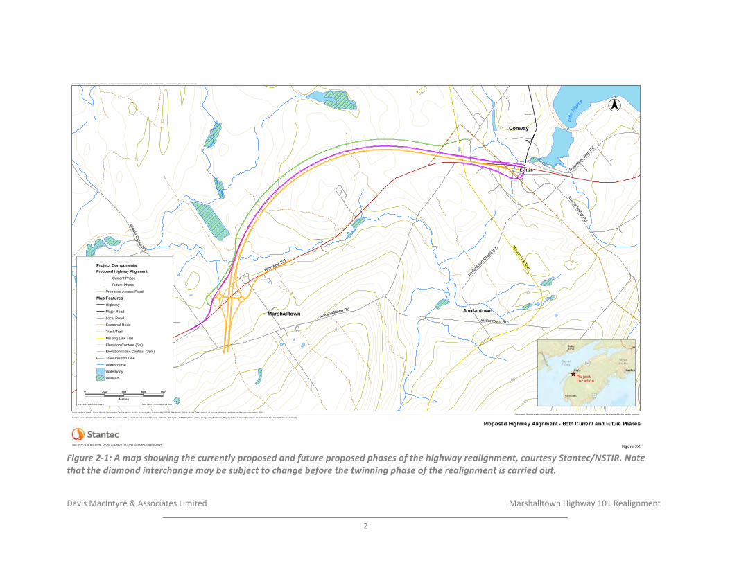
Davis&MacIntyre&&&Associates&Limited& &&&&&&&&&&&&&&&&&&& & &&&&&Marshalltown&Highway&101&Realignment&&
2&
!Figure'2)1:'A'map'showing'the'currently'proposed'and'future'proposed'phases'of'the'highway'realignment,'courtesy'Stantec/NSTIR.'Note'that'the'diamond'interchange'may'be'subject'to'change'before'the'twinning'phase'of'the'realignment'is'carried'out.
! !!!
!
!
!
!!
!!
!!!!
!!
!!
!
!
!
!
!
!
!
!
!
!
!
!
!
!
!
!
!
!
!
!
!
!
!
!
!
!
!
!
!
!
!
!
!
!
!!
!
!
!
!
!
Littl
eJo
ggins
Conway
Marshalltown Jordantown
Exit 26
Missing Link Trail
100
75
125
100
75
50
50
2550
25
5025
50
25
25
50
25
25
25
Highway 101
Marshalltown Rd
Robins
onW
eirRd
Middle
Cross
Rd
Jordantown Rd
AcaciaValley
Rd
Jorda
ntown Cros
s Rd
Rid
ge R
d
_̂ ProjectLocation
($$¯
Project ComponentsProposed Highway Alignment
Current Phase
Future Phase
Proposed Access Road
Map FeaturesHighway
Major Road
Local Road
Seasonal Road
Track/Trail
Missing Link Trail
Elevation Contour (5m)
Elevation Index Contour (25m)! Transmission Line
Watercourse
Waterbody
Wetland
V:\1214\active\121414143\03_data\gis_cad\geomatics\mapping\mxd\report\ST_NS_121414143-0012_Construction_Phases.mxd cshupe
NAD 1983 CSRS UTM Zone 20N ST NS 121414143-001 REVA
Disclaimer: This map is for illustrative purposes to support this Stantec project; questions can be directed to the issuing agency.
Figure XX
Proposed Highway Alignment - Both Current and Future PhasesService Layer Credits: Sources: Esri, HERE, DeLorme, USGS, Intermap, increment P Corp., NRCAN, Esri Japan, METI, Esri China (Hong Kong), Esri (Thailand), MapmyIndia, © OpenStreetMap contributors, and the GIS User Community
Sources: Base Data - Nova Scotia Geomatics Centre, Nova Scotia Topographic Database (NSTDB). Wetlands - Nova Scotia Department of Natural Resources, Wetland Mapping Inventory, 2010.
HIGHWAY 101 DIGBY TO MARSHALLTOWN ENVIRONMENTAL ASSESSMENT
0 200 400 600 800
Metres
Davis&MacIntyre&&&Associates&Limited& &&&&&&&&&&&&&&&&&&& Marshalltown&Highway&101&Realignment&
&
3&
The&average&elevation&above&present&sea&level&in&the&Bay&area&is&15&to&30¢imetres&
and&raised&beaches&and&terraces&can&be&seen&in&Digby&County&at&the&mouths&of&rivers&
and&around&the&lower&part&of&the&Annapolis&Basin.&Rising&sea&levels&over&the&past&4,000&
years&have&resulted&in&flooding&of&the&Annapolis&Basin&and&the&sea&broke&through&the&
gap&at&the&north&end&of&Digby&Gut.&
&
The&Valley&is&drained&by&two&major&rivers&(the&Annapolis&and&the&Cornwallis)&that&are&
separated&by&a&secondary&watershed÷.&Many&firstO&and&secondOorder&streams&drain&
off&the&North&and&South&Mountains&to&feed&both&rivers.&In&the&lower&reaches&of&each&
river&system&are&several&tertiary&watershed÷s.&Both&rivers&are&tidal&and&tidal&flats&
and&muddy&banks&can&be&seen&during&low&tide.&
&
Soils&in&this®ion&have&developed&on&parent&material&from&various&exposed&geological&
strata.&The&uppermost&layers&are&fine&grained&Triassic&shale&on&which&wellOdrained&soils&
have&developed.&This&is&underlain&by&coarser&sandstones&from&which&sandy&loams&have&
been&derived.&The&lower&most&strata&are&fineOgrained&conglomerates&from&which&a&wellO&
drained&loamy&sand&has&developed.&Alluvial&deposits&have&developed&beside&streams&and&
rivers.&
&
The&Valley&is&an&obvious&agricultural®ion&although&earlier&extensive&clearing&in&the&
eighteenth&and&nineteenth¢uries&has&reverted&to&areas&of&forest&growth.&Apple&
orchards&were&originally&located&on&the&fertile&valley&slopes&and&remnants&can&still&be&
seen&throughout&the®ion.&Sugar&Maple,&American&Beech,&Red&Spruce&and&Eastern&
Hemlock&are&common&in&these&reclaimed&areas.&Oldfields&have&been®enerated&with&
White&Spruce&except&in&wetter&areas&where&alder&and&Black&Spruce&are&more&common.&
Salt&marshes,&mud&flats&and&dykelands&provide&good&coast&habitat&for&marine&and&avian&
species.&Raccoons,&Red&Fox,&woodchuck&and&skunk&are&common&in&agricultural&areas.&
Muskrat&and&mink&are&also&common.&Pheasant,&snipe,&woodcock,&hawks,&crows&and&Bald&
Eagles&abound&in&this®ion.&Dykelands&provide&good&habitat&for&Gray&Partridge&and&
ShortOeared&Owl.&The&Annapolis&Basin&provides&an&important&migration&habitat&for&
waterfowl&in&spring&and&fall&and&a&moderate&number&of&ducks&remain&in&the&winter&
months.&High&numbers&of&shorebirds&can&be&seen&at&the&head&of&St.&Mary’s&Bay,&
particularly&in&August.&American&Shad&and&Atlantic&Salmon&pass&through&this&area&to&
spawn&in&freshwater&further&upstream.&Striped&bass&are&also&present&but&do¬&manage&
to&spawn&upstream.
1
&
&
&
&
&
!!!!!!!!!!!!!!!!!!!!!!!!!!!!!!!!!!!!!!!!!!!!!!!!!!!!!!!!1
&Davis&and&Browne&1996:159O161.&
Davis&MacIntyre&&&Associates&Limited& &&&&&&&&&&&&&&&&&&& Marshalltown&Highway&101&Realignment&
&
4&
3.0 METHODOLOGY-&
A&historic&background&study&was&conducted&by&Davis&MacIntyre&&&Associates&Limited&in&
October&2016.&Historical&maps&and&manuscripts&and&published&literature&were&consulted&
at&the&Nova&Scotia&Archives&as&well&as&online.&The&Maritime&Archaeological&Resource&
Inventory,&a&database&of&known&archaeological&resources&in&the&Maritime®ion,&was&
searched&to&understand&prior&archaeological&research&and&known&archaeological&
resources&neighbouring&the&study&area.&A&review&of&previous&archaeological&assessments&
was&also&conducted.&Finally,&a&field&reconnaissance&and&archaeological&testing&were&
conducted&in&order&to&more&effectively&predict&the&presence&of&buried&archaeological&
resources&within&the&impact&zone.&
&
3.1 Maritime-Archaeological-Resource-Inventory-&
The&Maritime&Archaeological&Resource&Inventory,&a&database&of&known&archaeological&
sites&in&the&Maritime&Provinces,&was&consulted&in&October&2016.&There&are&seven&known&
archaeological&sites&in&the&DigbyOMarshalltown&area.&
&
Shell&middens&related&to&Precontact&activity&are&known&along&Bear&River&to&the&northeast,&
chiefly&associated&with&the&Ceramic&(Kejikawek(L’nu’k)&Period&(BdDkO01,&BdDkO03,&BdDkO04,&BdDkO06).&Another&shell&midden&was&reported&at&Smith’s&Cove&in&1890,&but&could¬&
be&relocated&in&the&twentieth¢ury&(BdDkO02).&A&general&site&number&has&been&
assigned&for&isolated&Precontact&finds&reported&in&the&area&from&Joggins&Bridge&to&Bear&
River&(BdDkO07).&
&
Finally,&a&historic&midden&incorporating&shell,&bone,&and&nineteenth¢ury&ceramic,&
was&identified&near&the&Little&Joggins&(BdDkO08).&
&
&
3.2- Historical-Background-&
3.2.1- The-Precontact-Period-&
Nova&Scotia&has&been&home&to&the&Mi’kmaq&and&their&ancestors&for&at&least&11,500&years.&
A&legacy&of&experience&built&over&millennia&shaped&cultural&beliefs&and&practices,&
creating&an&intimate&relationship&between&populations&and&the&land&itself.&The&
complexity&of&this&history,&culturally&and&ecologically,&is&still&being&explored.&&
The&earliest&period&is(Sa’qewe’l(L’nu’k((the&Ancient&People)&or&the&PaleoOIndian&period&(11,500&–&9,000BP).&The&changing&ecology&following°laciation&allowed&the&entrance&of&
large&herds&of&migratory&caribou&into&Nova&Scotia,&followed&by&Paleoindian&groups&from&
Davis&MacIntyre&&&Associates&Limited& &&&&&&&&&&&&&&&&&&& Marshalltown&Highway&101&Realignment&
&
5&
the&south.&Currently,&the&Debert/Belmont&Sites&provide&the&only&significant&evidence&of&
PaleoOIndian&settlement&in&the&province.&Commonly&believed&to&be&bigOgame&hunters,&
research&is&now&aimed&at&exploring&the&diverse&subsistence&patterns&that&may&have&
supported&populations,&and&what&adaptations&were&made&when&the&environment&shifted&
once&again&in&the&early&Holocene.&&
Succeeding&the&Sa’qewe’l(L’nu’k(is&the&Mu(Awsami(Kejihaw’k(L’nu’k&(the&Not&so&Recent&People)&or&the&Archaic&Period&(9,000O3,000&BP).&This&time&saw&a&reorientation&to&a&more&
maritime&subsistence,&with&settlement&pivoting&more&towards&coastal&areas,&lakes&and&
bountiful&riverine&resources.&Remnants&of&these&sites&along&the&coast&have&largely&been&
engulfed&by&rising&seas&or&battered&by&wind&and&wave,&though&interior&sites&are&
increasingly&being&discovered.&Ground&stone&tools,&specialized&for&woodOworking,&appear&
at&this&time&and&may&have&been&used&to&create&dugOout&canoes.&Numerous&traditions&and&
distinct&technologies&have&been&documented&throughout&Maine&and&the&Atlantic&
provinces.&A&growing&catalogue&of&exotic&cultural&components&demonstrates&that&groups&
within&Nova&Scotia&were&engaged&in&spheres&of&interaction&spanning&hundreds&of&
kilometers.&Unfortunately,&a&lack&of&formally&excavated&sites&within&Nova&Scotia&still&
obscures&the°ree&to&which&these&traditions&were&present.&&
&
By&the&Kejihawek(L’nu’k((the&Recent&People)&or&Woodland/Ceramic&period&(3,000O500&
BP),&the&Mi’kmaq&were&a&maritime&people.&Known&Woodland/Ceramic&sites&concentrate&
along&coasts&shorelines,&and&navigable&watercourses.&Migration&of&ideas&and&people&
introduced&new&worldviews&and&technologies&from&groups&originating&in&places&like&
northern&New&England&and&the&Great&Lakes&area,&to&local&populations,&including&the&
earliest&ceramic&forms.&Harvesting&of&marine&molluscs&and&shellfish&appears&in&this&
period,&and&substantial&shellOmiddens&have&gifted&archaeologists&with&wellOpreserved&
records&of&these&past&lives.&Fish&weirs&populating&the&province’s&rivers&and&streams&speak&
to&the&importance&of&migrating&fish&species&to&Mi’kmaq&life.&Terrestrial&hunting&and&
foraging&was&practiced&with&varying°rees&of&intensity&depending&on&seasonality&and&
region.&A&generally&stable&cultural&form&is&believed&to&have&developed&by&2,000&BP,&
forming&the&way&of&life&first&encountered&by&Europeans&arriving&on&our&shores.&&
&
Mi’kmaw&life&was&substantially&altered&in&the&Kiskukew’k(L’nu’k&(Today’s&People)&or&Contact&Period&(500&BPO&Present).&Trade&and&European&settlement&introduced&change&
and&upheaval&to&the&traditional&way&of&First&Nation&life.&Mobile&hunting&and&gathering&
still&defined&Mi’kmaw&life,&with&identity&residing&within&family&households.&Trading&posts&
and&fishing&villages&became&intersections&of&European&and&Mi’kmaq&interaction,&
affecting&traditional&seasonal&rounds&and&access&to&land.&The&hunting&of&furObearing&
mammals&intensified&to&satisfy&the&mutual&exchange&of&skins&for&European&goods.&It&is&
not&accurate,&however,&to&say&that&Mi’kmaq&adopted&European&goods&and&culture,&but&rather&adapted&it.&The&Mi’kmaq&remained&an&influential&social&and&political&force&well&
into&the&18
th
¢ury,&forming&a&triadic&narrative&of&contention&with&the&English&and&
French.&However,&disease,&conflict,&and&alienation&from&the&land&wreaked&a&ruinous&
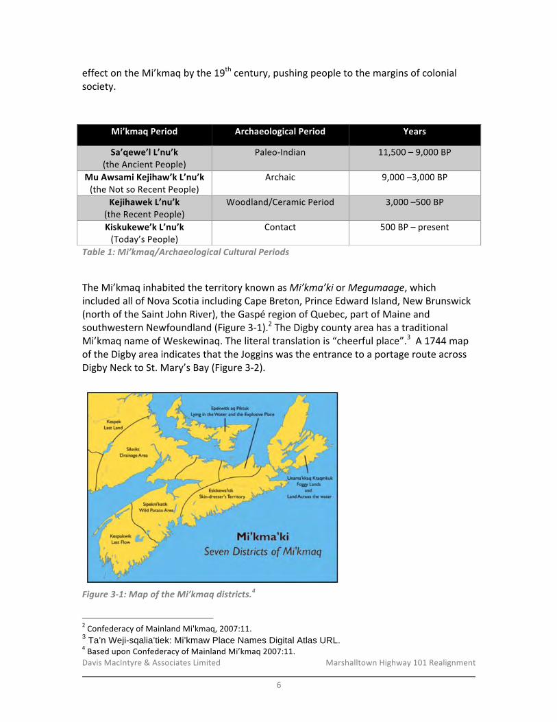
Davis&MacIntyre&&&Associates&Limited& &&&&&&&&&&&&&&&&&&& Marshalltown&Highway&101&Realignment&
&
6&
effect&on&the&Mi’kmaq&by&the&19
th
¢ury,&pushing&people&to&the&margins&of&colonial&
society.&&
&
Table&1:&Mi’kmaq/Archaeological&Cultural&Periods&
&
The&Mi’kmaq&inhabited&the&territory&known&as&Mi’kma’ki&or&Megumaage,&which&included&all&of&Nova&Scotia&including&Cape&Breton,&Prince&Edward&Island,&New&Brunswick&
(north&of&the&Saint&John&River),&the&Gaspé®ion&of&Quebec,&part&of&Maine&and&
southwestern&Newfoundland&(Figure&3O1).
2
&The&Digby&county&area&has&a&traditional&
Mi’kmaq&name&of&Weskewinaq.&The&literal&translation&is&“cheerful&place”.
3
&&A&1744&map&
of&the&Digby&area&indicates&that&the&Joggins&was&the&entrance&to&a&portage&route&across&
Digby&Neck&to&St.&Mary’s&Bay&(Figure&3O2).&
&
!Figure&3>1:&Map&of&the&Mi’kmaq&districts.4&
!!!!!!!!!!!!!!!!!!!!!!!!!!!!!!!!!!!!!!!!!!!!!!!!!!!!!!!!2
&Confederacy&of&Mainland&Mi'kmaq,&2007:11.&
3 Ta’n Weji-sqalia’tiek: Mi’kmaw Place Names Digital Atlas URL. 4
&Based&upon&Confederacy&of&Mainland&Mi’kmaq&2007:11.&
Mi’kmaq-Period- Archaeological-Period- Years-
Sa’qewe’l-L’nu’k-(the&Ancient&People)&
PaleoOIndian& 11,500&–&9,000&BP&
Mu-Awsami-Kejihaw’k-L’nu’k-(the&Not&so&Recent&People)-
Archaic& 9,000&–3,000&BP&
Kejihawek-L’nu’k-(the&Recent&People)&
Woodland/Ceramic&Period& 3,000&–500&BP&
Kiskukewe’k-L’nu’k-(Today’s&People)&
Contact& 500&BP&–&present&
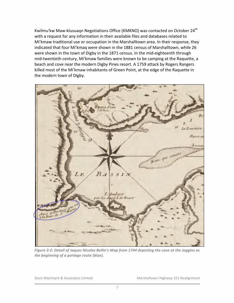
Davis&MacIntyre&&&Associates&Limited& &&&&&&&&&&&&&&&&&&& Marshalltown&Highway&101&Realignment&
&
7&
Kwilmu'kw&MawOklusuaqn&Negotiations&Office&(KMKNO)&was&contacted&on&October&24
th
&
with&a&request&for&any&information&in&their&available&files&and&databases&related&to&
Mi’kmaw&traditional&use&or&occupation&in&the&Marshalltown&area.&In&their&response,&they&
indicated&that&four&Mi’kmaq&were&shown&in&the&1881&census&of&Marshalltown,&while&26&
were&shown&in&the&town&of&Digby&in&the&1871&census.&In&the&midOeighteenth&through&
midOtwentieth¢ury,&Mi’kmaw&families&were&known&to&be&camping&at&the&Raquette,&a&
beach&and&cove&near&the&modern&Digby&Pines&resort.&A&1759&attack&by&Rogers&Rangers&
killed&most&of&the&Mi’kmaw&inhabitants&of&Green&Point,&at&the&edge&of&the&Raquette&in&
the&modern&town&of&Digby.&
&
!Figure&3>2:&Detail&of&Jaques&Nicolas&Bellin’s&Map&from&1744&depicting&the&cove&at&the&Joggins&as&the&beginning&of&a&portage&route&(blue).&
&
Davis&MacIntyre&&&Associates&Limited& &&&&&&&&&&&&&&&&&&& Marshalltown&Highway&101&Realignment&
&
8&
3.2.2- European-Settlement-&
In&1765&a&patent&for&the&plantation&of&Conway,&extending&from&modern&day&Digby&to&
Weymouth,&was&created&by&the&British.
5
&The&township&of&Conway&received&its&name&
from&Sir&Henry&Seymour&Conway,&a&British&General&during&the&Seven&Years&War.
6,7
&In&
1784,&Loyalists&pushed&for&a&renaming&of&the&township&to&Digby,&and&a&grant&was&given&
the&following&year&for&the&township&of&present&day&Conway.
8
&Different&names&have&been&
given&to&Conway&since&its&establishment&in&1785.&The&township&had&previously&been&
known&as&Brinley&Town&and&Westville&but&was&officially&renamed&as&Conway&in&1918.
9
&&
&
Marshalltown&and&Conway&were&both&historically&settled&by&Loyalists&after&the&American&
Revolutionary&War,&and&Conway¬ably&had&a&large&population&of&Black&Loyalists.&This&
large&population&of&Black&Loyalists&gave&way&to&a&portion&of&Conway&being&named&
Negrotown.&&The&boundaries&of&Negrotown&extend&on&the&grant&map&to&the&edge&of&
Acacia&Valley&Road&north&of&exit&26&on&Highway&101&(Figure&3O3).&Upon&being&offered&
free&passage&back&to&Sierra&Leone,&West&Africa,&or&a&grant&of&land&in&Nova&Scotia,&some&
Black&Loyalists&chose&the&granted&land&in&Conway&and&eventually&resettled&in&Jordantown.&
Most&of&the&inhabitants&of&Brinley&Town,&however,&relocated&to&Sierra&Leone&in&January&
of&1792.
10
&
!!!!!!!!!!!!!!!!!!!!!!!!!!!!!!!!!!!!!!!!!!!!!!!!!!!!!!!!5
&Wilson&1900:&34O35.&
6
&Fergusson&1967:145.&
7
&Hill&1901:5.&
8
&Hill&1901:5.&
9
&Hill&1901:5.&
10
&Fergusson&1967:145.&

Davis&MacIntyre&&&Associates&Limited& &&&&&&&&&&&&&&&&&&& Marshalltown&Highway&101&Realignment&
&
9&
Figure&3>3:&A&Google&Earth&overlay&of&the&development&area&(red)&on&the&NS&Crown&Land&Grant&Index.&The&limits&of&Negrotown&are&shown&in&yellow.&
&
In&1794&Marshalltown&was&named&after&Alexander&Marshall&who&settled&in&1790.&Prior&to&
this,&Marshalltown&had&been&called&Whatmanville&after&a&loyalist&Phillip&Whatman.&
Whatman&kept&a&house&of&entertainment&for&travellers&and&received&payment&from&the&
Crown.&Although&Whatman&appears&on&the&Crown&Land&Grant&Index,&Marshall&does¬,&
suggesting&he&was¬&among&the&original&grantees.
11
&The&only&reference&of&a&Marshall&in&
this®ion&is&one&James&Marshall.&&
&
American&inventor&Thomas&Edison’s&great&grandfather,&John&Edison,&was&a&Loyalist&who&
came&to&Digby&County&in&1784.
12
&John&Edison&purchased&a&piece&of&land&in&1792&along&
Saint&Mary’s&Bay&Road&from&Patrick&Haggerty
13
&who&was&granted&Lot&5
14
&(Figure&3O4)&
along&Saint&Mary’s&Bay&Road,&which&will&be&bisected&by&the&proposed&realignment.&John&
Edison&sold&20&acres&of&this&land&to&his&son&Moses&Edison&in&1805.&The&land&being&
described&in&the&deed&as&costing&60£s&for&20&acres&located&on&the&“North&side&of&St.&
!!!!!!!!!!!!!!!!!!!!!!!!!!!!!!!!!!!!!!!!!!!!!!!!!!!!!!!!11(Hill&1901:7.&12
&National&Park&Service&URL.&
13
&NS&Registry&of&Deeds&1792.&
14
&Dept.&of&Lands&and&Forests&1939.
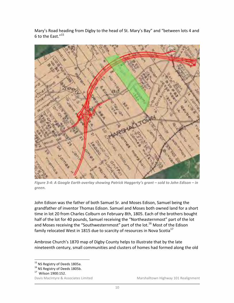
Davis&MacIntyre&&&Associates&Limited& &&&&&&&&&&&&&&&&&&& Marshalltown&Highway&101&Realignment&
&
10&
Mary’s&Road&heading&from&Digby&to&the&head&of&St.&Mary’s&Bay”&and&“between&lots&4&and&
6&to&the&East.”
15
&&
&
Figure&3>4:&A&Google&Earth&overlay&showing&Patrick&Haggerty’s&grant&–&sold&to&John&Edison&–&in&green.&
&
John&Edison&was&the&father&of&both&Samuel&Sr.&and&Moses&Edison,&Samuel&being&the&
grandfather&of&inventor&Thomas&Edison.&Samuel&and&Moses&both&owned&land&for&a&short&
time&in&lot&20&from&Charles&Colburn&on&February&8th,&1805.&Each&of&the&brothers&bought&
half&of&the&lot&for&40£s,&Samuel&receiving&the&“Northeasternmost”&part&of&the&lot&
and&Moses&receiving&the&“Southwesternmost”&part&of&the&lot.
16
&Most&of&the&Edison&
family&relocated&West&in&1815&due&to&scarcity&of&resources&in&Nova&Scotia
17
&
&
Ambrose&Church’s&1870&map&of&Digby&County&helps&to&illustrate&that&by&the&late&
nineteenth¢ury,&small&communities&and&clusters&of&homes&had&formed&along&the&old&
!!!!!!!!!!!!!!!!!!!!!!!!!!!!!!!!!!!!!!!!!!!!!!!!!!!!!!!!15
&NS&Registry&of&Deeds&1805a.&
16
&NS&Registry&of&Deeds&1805b.&
17
&&Wilson&1900:152.
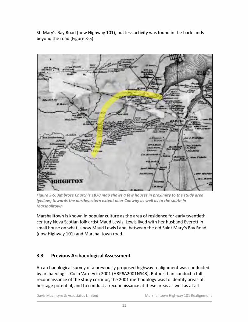
Davis&MacIntyre&&&Associates&Limited& &&&&&&&&&&&&&&&&&&& Marshalltown&Highway&101&Realignment&
&
11&
St.&Mary’s&Bay&Road&(now&Highway&101),&but&less&activity&was&found&in&the&back&lands&
beyond&the&road&(Figure&3O5).&
&
&
Figure&3>5:&Ambrose&Church’s&1870&map&shows&a&few&houses&in&proximity&to&the&study&area&(yellow)&towards&the&northwestern&extent&near&Conway&as&well&as&to&the&south&in&Marshalltown.&
Marshalltown&is&known&in&popular&culture&as&the&area&of&residence&for&early&twentieth&
century&Nova&Scotian&folk&artist&Maud&Lewis.&Lewis&lived&with&her&husband&Everett&in&
small&house&on&what&is&now&Maud&Lewis&Lane,&between&the&old&Saint&Mary’s&Bay&Road&
(now&Highway&101)&and&Marshalltown&road.&
!&
3.3- Previous-Archaeological-Assessment-!An&archaeological&survey&of&a&previously&proposed&highway&realignment&was&conducted&
by&archaeologist&Colin&Varney&in&2001&(HRP#A2001NS43).&Rather&than&conduct&a&full&
reconnaissance&of&the&study&corridor,&the&2001&methodology&was&to&identify&areas&of&
heritage&potential,&and&to&conduct&a&reconnaissance&at&these&areas&as&well&as&at&all&
Davis&MacIntyre&&&Associates&Limited& &&&&&&&&&&&&&&&&&&& Marshalltown&Highway&101&Realignment&
&
12&
stream&crossings,&which&often&exhibit&elevated&potential&for&First&Nations&activity.&During&
the&assessment,&no&areas&of&elevated&archaeological&potential&were&identified&north&of&
the&existing&Highway&101,&and&only&two&stone&walls&south&of&Marshalltown&Road&within&
the&proposed&RoW,&along&with&a§ion&of&overgrown&oldfield.&Visibility&was&very&poor&
within&the&previous&RoW&and&as&such&the&archaeological&team&was&unable&to&confirm&if&
historic&cellars&or&foundations&existed&within&the&study&area.
18
&
!3.4- Field-Reconnaissance-&
A&field&reconnaissance&of&the&full&3.5km§ion&of&realigned&highway&corridor&was&
conducted&in&November&2016&by&Laura&de&Boer,&Vanessa&McKillop,&and&coOop&student&
Irene&Hart.&The&reconnaissance&was&aided&by&two&GPR&units&programmed&with&the&
proposed&highway¢relines&and,&north&of&the&existing&Highway&101,&the&proposed&toeO
ofOslope&lines&for&the&fully&twinned&highway.&The&width&of&the&RoW,&which&included&a&
service&road&north&of&Highway&101,&was&sufficient&that&the&team&covered&the&area&in&two&
passes,&resulting&in&a&total&of&six&transects&to&cover&the&approximately&80m&width.&
Findings&are&illustrated&on&Figures&3O6&through&3O12.&
&
At&the&northOeastern&end&of&the&new&alignment,&a&realigned&off&ramp&and&roundabout&
are&positioned&over&existing&modern&residential&land&and&a&small&patch&of&low,&wet&
spruce&forest.&Moving&northwest,&the&proposed&highway&will&cross&an&elevated&railbed&
now&being&used&as&an&ATV&trail,&after&which&the&RoW&diverges&from&the&existing&highway&
and&passes&through&a&low,&wet&forest&of&alder&and&scrub&birch&and&poplar&(Plate&1).&&
&
A&single&stone&pile&and&a&stone&wall&were&observed&in&this&area&(Plate&2),&suggesting&
there&was&an&attempt&to&clear&the&land&for&agriculture,&though&the&topography&was¬&
notably&smooth&as&if&used&for&pasture&or&fields.&Modern&signs&of&cultural&activity&were&
also&present,&including&an&area&of&dumped&twentieth¢ury&cans&(Plate&3),&an&
abandoned&school&bus&behind&an&existing&house,&and&an&area&of&abandoned&cars&farther&
behind&the&house.&A&modern&logging&operation,&most&likely&producing&containers&of&cut&
and&split&firewood&(Plates&4&and&5),&is&also&located&in&this&area.&The&surrounding&forest&
has&been&recently&logged,&with&minimal®rowth&ofþs&and&scrubby&hardwood&
(Plate&6).&
&
Beyond&the&logged&block&of&land,&the&RoW&transitions&into&a&moderately&mature&spruce&
forest,&undulating&and&relatively&wellOdrained.&There&were&no&indications&of&previous&
agricultural&activity&or&of&logging&within&the&past&several&decades.&Moving&westward,&the&
forest&gradually&becomes&more&mixed&with&young&to&moderately&mature&hardwood&and&
spruce.&An&ATV&trail&with&an&abandoned&tractor&was&observed,&as&well&as&an&abandoned&
hunting&blind&on&the&property&that&once&belonged&to&Patrick&Haggerty&and&later&John&
!!!!!!!!!!!!!!!!!!!!!!!!!!!!!!!!!!!!!!!!!!!!!!!!!!!!!!!!18
&Jacques&Whitford&Environment&Limited&2003:8O9.&
Davis&MacIntyre&&&Associates&Limited& &&&&&&&&&&&&&&&&&&& Marshalltown&Highway&101&Realignment&
&
13&
Edison.&This&land&may&have&been&used&to&harvest&lumber&historically,&but&there&are&no&
signs&of&it&being&cleared&for&a&field&or&pasture.&&
&
Just&beyond&the&edge&of&the&Haggerty&property,&the&RoW&is&intersected&by&a&modern&
transmission&line&and&a&wellObuilt&sandy&woods&road&(Plate&7).&Another&abandoned&
hunting&blind&(Plate&8)&and&an&old&campfire&site&beside&an&ATV&trail&are&located&some&
400m&southwest&of&this&transmission&line.&
&
It&is&only&within&the&final&800m&before&the&realignment&crosses&the&existing&Highway&101&
that&frequent&signs&of&historic&pasture&and&agriculture&are&found.&Three&barbed&wire&
fences&were¬ed&in&mature&mixedOwood&forests,&all&consistent&with&the&northwestO
southeast&angle&of&the&original&property&grants.&The&middle&of&the&three&fences&forms&
the&northeast&boundary&of&an&area&of&smooth,&flat,&forested&ground&indicative&of&
overgrown&pasture&or&oldfield.&The&land&grant&map&indicates&that&this&was&the&
southwestern&half&of&Peter&Depeu’s&188Oacre&grant&(Lot&8).&No&stone&walls,&stone&piles,&
or&foundation&features&were¬ed&in&proximity&to&the&alignment.&
&
Approaching&Seely&Brook,&the&terrain&of&the&alignment&drops¬ably,&forming&two&small&
terraces&approximately&2m&and&1m&high&respectively,&overlooking&the&brook’s&floodplain&
under&the&proposed&eastbound&lane&(once&the&highway&is&twinned),&and&dropping&in&a&
more&gentle&and&undulating&manner&into&wet&terrain&under&the&northern&lane&that&is&
proposed&in&the&2017&phase&of&construction.&
&
Between&the&new&alignment&and&the&existing&farm&road&to&the&west&of&this§ion,&a&low&
and&overgrown&berm&or&rough&roadbed&runs¶llel&to&Seely&Brook&on&the&north&side.&
Low,&wet&ground&covered&in&alders&is&found&on&either&side&of&the&berm.&
&
At&the&eastern&edge&of&the&proposed&crossing&of&Seely&Brook,&the&remains&of&a&small&
stone&dam&was&observed&on&either&bank&(Plates&9&and&10),&with&an&earthen&mound&
approximately&3mx4m&in&area&and&1m&high&on&the&southeastern&bank.&This&is&consistent&
with&a&small&historic&mill&deriving&waterpower&from&the&dammed&brook.&The&formation&
of&the&bank&upsteam&of&this&was&somewhat&suggestive&of&a&mill&raceway&on&the&
southeast&side&(Plate&11),&but¬&clearly&enough&to&be&conclusive.&The&position&of&the&
possible&raceway&in&relation&to&the&dam&(immediately&above&rather&than&beside&or&
below)&is&also&somewhat&unusual.&A&Rockinghamware&teapot&spout&(postOc.1850)&was&
observed&in&the&river&gravel&downstream&of&this&area&(Plate&12).&
&
On&the&south&side&of&Seely&Brook,&the&bank&forms&a&high,&relatively&smooth&terrace&
approximately&2m&above&the&normal&water&level&(Plate&13).&The&terrace&is&covered&in&
mature&spruce,&and&is¬&smooth&enough&to&have&been&oldfield.&It&is&bounded&to&the&
east&by&a&small&seasonal&streambed,&and&to&the&west&by&a&historic&property&boundary&
formed&by&a&ditch,&a&low&stone&wall,&and&barbed&wire&(Plate&14).&The&eastern&side&of&this&
boundary,&located&on&the&former&Alms&House&property,&is&somewhat&terraceOlike&but&is&
Davis&MacIntyre&&&Associates&Limited& &&&&&&&&&&&&&&&&&&& Marshalltown&Highway&101&Realignment&
&
14&
covered&in&alders&and&seems&more&poorly&drained,&despite&showing&signs&of&smoother&
terrain&consistent&with&oldfield.&
&
Beyond&the&terrace,&the&realignment&continues&southward&over&a&low,&wet&field,&passing&
just&west&of&the&location&of&the&southern&Alms&House&Cemetery.&Based&upon&overlays&
with&historic&aerial&photographs,&the&future&eastbound&lane&(once&the&highway&is&
twinned)&will&pass&over&part&of&the&former&Alms&House&foundation,&now&covered&in&
Japanese&knotweed&(Plate&15).&The&Alms&House,&which&burned&down&in&1994&and&was&
subsequently&levelled,&is&unlikely&to&have&formed&a&significant&archaeological&resource&
below&ground&that&has&remained&intact.&The&institution&was&in&operation&from&c.1892&to&
1963.&
&
The&alignment&also&passes&over&a§ion&of&concrete&foundations&and&posts&related&to&
the&1968&construction&of&barracks&for&strawberry&farm&labourers&immediately&north&of&
the&existing&Highway&(Plate&16)&(see&also&HRP#A2016NS012&and&#A2001NS43).&Although&
the&barracks&were&completed,&they&were&never&fully&occupied&(if&they&were&occupied&at&
all)&due&to&a&shortage&of&workers,&and&were&subsequently&either&torn&down&or&relocated&
after&the&berry&farm&went&out&of&business.&
&
The&upcoming&realignment&phase&proposes&to&reOjoin&the&existing&Highway&101&
southwest&of&the&barracks.&The&future&twinning,&however,&may&require&a&larger&area&for&a&
diamond&interchange&and&two&roundabouts.&The&full&area&proposed&for&redevelopment&
was&surveyed&in&an&effort&to&predict&future&archaeological&concerns&in&the&area.&
&
Signs&of&twentieth¢ury&activity&are&prevalent&beside&the&101,&including&a&gravel&pad&
where&a&building&once&stood,&a&small&rectangular&depression,&and&a&twentieth¢ury&
garbage&dump&(Plate&17).&At&the&southwestern&extents&of&the&realignment&before&
crossing&the&existing&highway,&an&abandoned&well&and&possible&barn&foundation&(Plate&
18)&were&observed,&most&likely&associated&with&a&standing&but&likely&abandoned&twoO
room&house&(Plate&19).&
&
Crossing&to&the&southeast&side&of&Highway&101,&the&future&impact&zone&again&shows&
frequent&signs&of&twentieth¢ury&activity,&including&a&large,&deep&ditch&in&a&young&
mixed&wood&forest&(Plate&20),&a&northwestOsoutheast&barbed&wire&fence&consistent&with&
the&angle&of&the&original&land&grants,&and&a&twentieth¢ury&garbage&dump&near&the&
existing&road.&An&abandoned&house&with&modern&detritus&in&its&backyard&is&also&found&
bordering&the&existing&highway&(Plate&21).&The&house&appears&to&have&been&fed&by&a&
concrete&crockOlined&well&located&deeper&into&the&woods&to&the&south&(Plate&22),&as&a&
plastic&pipe&runs&from&inside&the&well&in&a&northward&direction&towards&the&house.&An&
abandoned&and&overgrown&orchard&to&the&southwest&may&also&have&been&associated&
with&the&house&and&property,&though&a&rough&hunting&blind&in&an&apple&tree&overlooking&
more&twentieth¢ury&garbage&may&have&been&established&after&the&house&was&
abandoned&(Plate&23).&Finally,&a&stone&wall&that&may&have&formed&the&back&of&this&
property&was&located&to&the&south&of&most&of&these&features&(Plate&24).&

Davis&MacIntyre&&&Associates&Limited& &&&&&&&&&&&&&&&&&&& Marshalltown&Highway&101&Realignment&
&
15&
&
Moving&farther&south,&the&terrain&becomes&more&densely&overgrown&in&scrubby&
undergrowth,&with&very&rocky&soil&exposed&in&most&areas.&Another&abandoned&hunting&
blind&was&encountered&in&this&rough&terrain,&on&a&rock&outcropping&overlooking&a&lower&
portion&of&the&forest.&
&
Just&as&the&alignment&emerges&from&the&forest&to&cross&Marshalltown&Road,&a&probable&
historic&stoneOlined&cellar&was&encountered,&less&than&10m&east&of&(outside)&the&
proposed&toeOofOslope.&The&foundation&is&approximately&3m&x&4m&in&size&and&is&heavily&
overgrown&(Plate&25).&
&
South&of&Marshalltown&Road,&the&alignment&passes&through&a&short§ion&of&mature&
mixedOwood&forest&dominated&by&spruce.&Two&historic&stone&walls&were&encountered&
(Plate&26),&but&the&surrounding&terrain&was¬&indicative&of&oldfield&and&no&foundations&
or&other&associated&historic&features&were&encountered.&
&
South&of&this&area,&the&alignment&encounters&a&large&swath&of&clearOcut&land®rowing&in&
birch&saplings&and&grasses&with&someþs&and&young&spruce.&A&small&camperOtrailer&is&
positioned&at&the&end&of&a&rough&ATV&trail&along&the&cut&block’s&southwestern&edge,&
possibly&serving&as&a&hunting&blind&or&cabin&(Plate&27).&There&were&no&signs&of&recent&
activity&but&the&camper&was&in&good&condition&and&did¬&appear&fully&abandoned.&
&
Beyond&the&cut&block,&mature&mixedOwood&forest&dominated&by&spruce&is&found&again.&A&
scatter&of&apples&along&the&alignment&suggested&an&active&hunting&blind&was&nearby,&but&
it&could¬&be&located&during&the&reconnaissance.&Approximately&60m&south,&a&rough&
hunting&blind&consisting&of&stacked&stones&forming&a&ledge&and&chair&overlooking&lower&
ground&was&encountered.&
&
Adjacent&to&the&hunting&blind,&a&rectangular&stone&foundation&was&encountered,&
approximately&4m&x&5m&in&size&and&with&no&visible&cellar&beneath&it&(Plate&28).&The&
ground&surrounding&it&was&rough,&but&as&the&team&moved&farther&south&they&
encountered&a&possible&overgrown&road,&and&two&barbed&wire&fences,&with&forested&
oldfield&between&them.&
&
South&of&the&barbed&wire,&a&small&wetland&forms&the&northern&boundary&of&a&very&young&
mixedOwood&forest®enerating&after&clearcutting.&This&area&is&bisected&by&a&fairly&wellO
maintained&gravel&logging&road.&
&
Near&the&southern&edge&of&the®enerating&forest,&the&team&began&to&encounter&stone&
piles&and&the&ground&gradually&became&smoother,&suggesting&oldfield&once&again.&Past&
the&edge&of&the&cutting,&the&more&mature&spruce&forest&makes&the&smooth&topography&
more&clear.&In&total,&four&stone&piles&and&one§ion&of&northwestOsoutheast&stone&wall&
(Plates&29&and&30)&were&encountered,&but&an&associated&foundation&or&cellar&could¬&
be&located.&The&last&of&the&stone&piles&was&located&at&the&edge&of&a&slight&drop&into&low,&
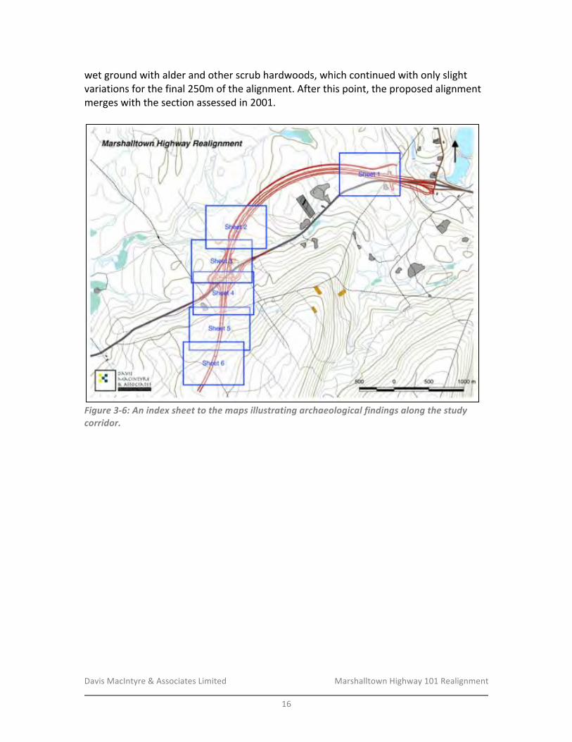
Davis&MacIntyre&&&Associates&Limited& &&&&&&&&&&&&&&&&&&& Marshalltown&Highway&101&Realignment&
&
16&
wet&ground&with&alder&and&other&scrub&hardwoods,&which&continued&with&only&slight&
variations&for&the&final&250m&of&the&alignment.&After&this&point,&the&proposed&alignment&
merges&with&the§ion&assessed&in&2001.&
&
!Figure&3>6:&An&index&sheet&to&the&maps&illustrating&archaeological&findings&along&the&study&corridor.&
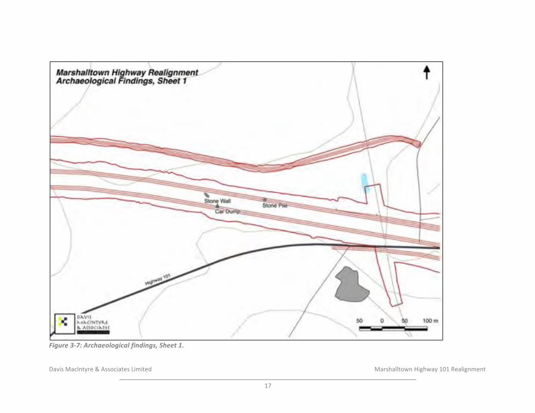
Davis&MacIntyre&&&Associates&Limited& &&&&&&&&&&&&&&&&&&& & &&&&&&Marshalltown&Highway&101&Realignment&&
17&
!Figure'3)7:'Archaeological'findings,'Sheet'1.'
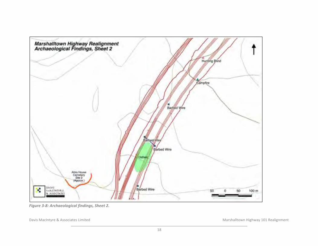
Davis&MacIntyre&&&Associates&Limited& &&&&&&&&&&&&&&&&&&& & &&&&&&Marshalltown&Highway&101&Realignment&&
18&
!Figure'3)8:'Archaeological'findings,'Sheet'2.'
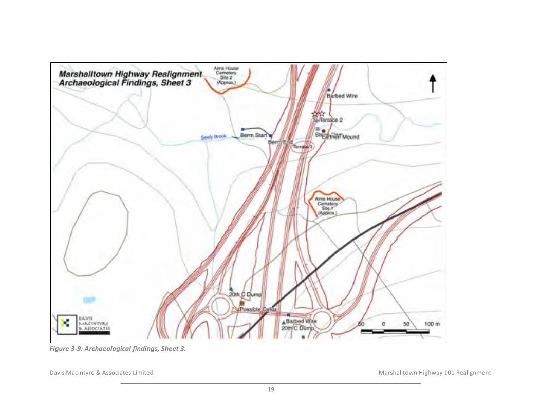
Davis&MacIntyre&&&Associates&Limited& &&&&&&&&&&&&&&&&&&& & &&&&&&Marshalltown&Highway&101&Realignment&&
19&
!Figure'3)9:'Archaeological'findings,'Sheet'3.'
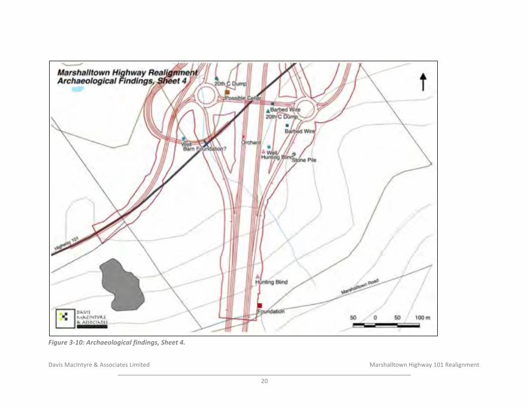
Davis&MacIntyre&&&Associates&Limited& &&&&&&&&&&&&&&&&&&& & &&&&&&Marshalltown&Highway&101&Realignment&&
20&
!Figure'3)10:'Archaeological'findings,'Sheet'4.'
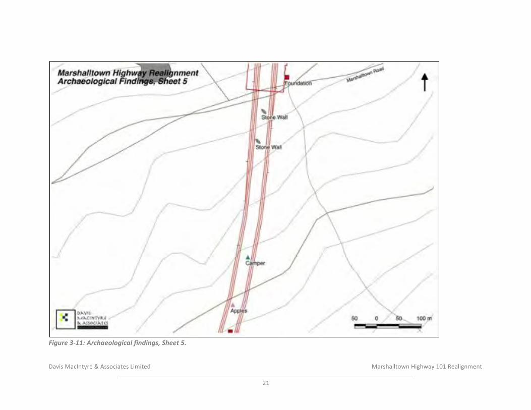
Davis&MacIntyre&&&Associates&Limited& &&&&&&&&&&&&&&&&&&& & &&&&&&Marshalltown&Highway&101&Realignment&&
21&
!Figure'3)11:'Archaeological'findings,'Sheet'5.'

Davis&MacIntyre&&&Associates&Limited& &&&&&&&&&&&&&&&&&&& & &&&&&&Marshalltown&Highway&101&Realignment&&
22&
!Figure'3)12:'Archaeological'findings,'Sheet'6.'
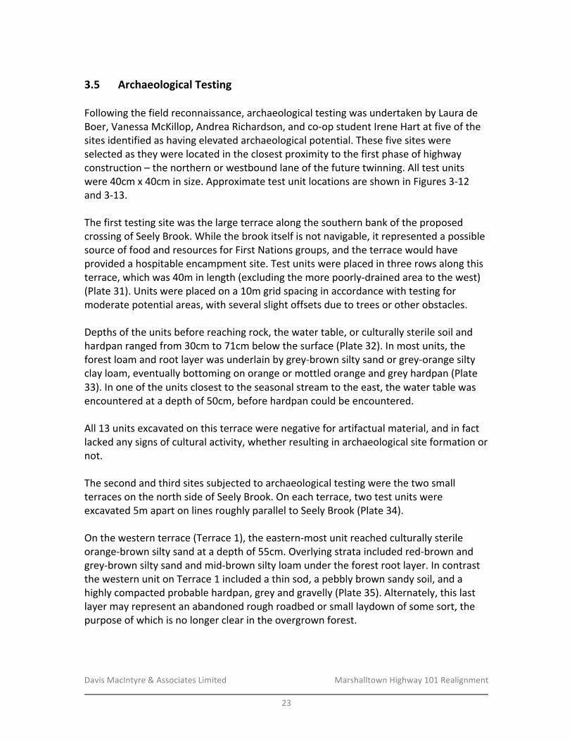
Davis&MacIntyre&&&Associates&Limited& &&&&&&&&&&&&&&&&&&& Marshalltown&Highway&101&Realignment&
&23&
3.5$ Archaeological$Testing$&Following&the&field&reconnaissance,&archaeological&testing&was&undertaken&by&Laura&de&Boer,&Vanessa&McKillop,&Andrea&Richardson,&and&coIop&student&Irene&Hart&at&five&of&the&sites&identified&as&having&elevated&archaeological&potential.&These&five&sites&were&selected&as&they&were&located&in&the&closest&proximity&to&the&first&phase&of&highway&construction&–&the&northern&or&westbound&lane&of&the&future&twinning.&All&test&units&were&40cm&x&40cm&in&size.&Approximate&test&unit&locations&are&shown&in&Figures&3I12&and&3I13.&&The&first&testing&site&was&the&large&terrace&along&the&southern&bank&of&the&proposed&crossing&of&Seely&Brook.&While&the&brook&itself&is¬&navigable,&it&represented&a&possible&source&of&food&and&resources&for&First&Nations&groups,&and&the&terrace&would&have&provided&a&hospitable&encampment&site.&Test&units&were&placed&in&three&rows&along&this&terrace,&which&was&40m&in&length&(excluding&the&more&poorlyIdrained&area&to&the&west)&(Plate&31).&Units&were&placed&on&a&10m&grid&spacing&in&accordance&with&testing&for&moderate&potential&areas,&with&several&slight&offsets&due&to&trees&or&other&obstacles.&&Depths&of&the&units&before&reaching&rock,&the&water&table,&or&culturally&sterile&soil&and&hardpan&ranged&from&30cm&to&71cm&below&the&surface&(Plate&32).&In&most&units,&the&forest&loam&and&root&layer&was&underlain&by&greyIbrown&silty&sand&or&greyIorange&silty&clay&loam,&eventually&bottoming&on&orange&or&mottled&orange&and&grey&hardpan&(Plate&33).&In&one&of&the&units&closest&to&the&seasonal&stream&to&the&east,&the&water&table&was&encountered&at&a&depth&of&50cm,&before&hardpan&could&be&encountered.&&All&13&units&excavated&on&this&terrace&were&negative&for&artifactual&material,&and&in&fact&lacked&any&signs&of&cultural&activity,&whether&resulting&in&archaeological&site&formation&or¬.&&The&second&and&third&sites&subjected&to&archaeological&testing&were&the&two&small&terraces&on&the&north&side&of&Seely&Brook.&On&each&terrace,&two&test&units&were&excavated&5m&apart&on&lines&roughly¶llel&to&Seely&Brook&(Plate&34).&&&On&the&western&terrace&(Terrace&1),&the&easternImost&unit&reached&culturally&sterile&orangeIbrown&silty&sand&at&a&depth&of&55cm.&Overlying&strata&included&redIbrown&and&greyIbrown&silty&sand&and&midIbrown&silty&loam&under&the&forest&root&layer.&In&contrast&the&western&unit&on&Terrace&1&included&a&thin&sod,&a&pebbly&brown&sandy&soil,&and&a&highly&compacted&probable&hardpan,&grey&and&gravelly&(Plate&35).&Alternately,&this&last&layer&may&represent&an&abandoned&rough&roadbed&or&small&laydown&of&some&sort,&the&purpose&of&which&is&no&longer&clear&in&the&overgrown&forest.&
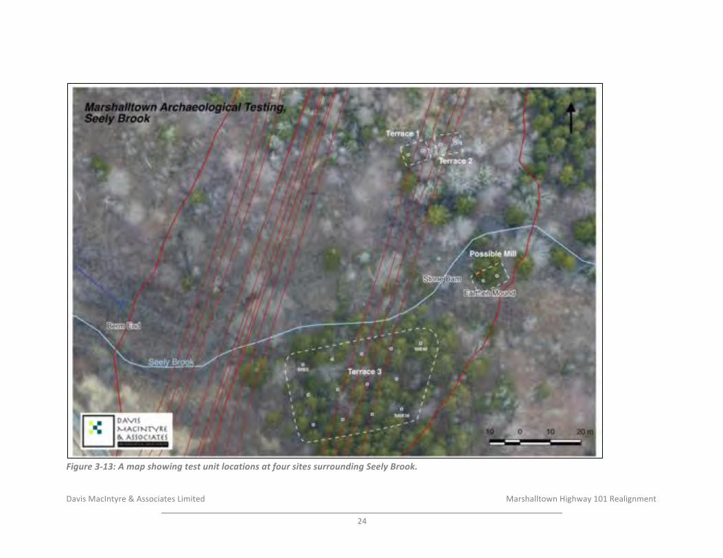
Davis&MacIntyre&&&Associates&Limited& & & &&&&&&Marshalltown&Highway&101&Realignment&&
24&
!Figure'3)13:'A'map'showing'test'unit'locations'at'four'sites'surrounding'Seely'Brook.'
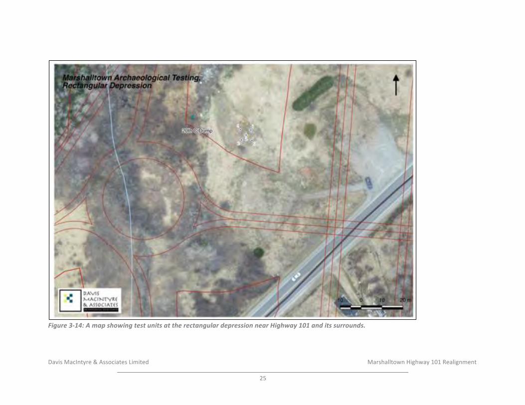
Davis&MacIntyre&&&Associates&Limited& & & &&&&&&Marshalltown&Highway&101&Realignment&&
25&
!Figure'3)14:'A'map'showing'test'units'at'the'rectangular'depression'near'Highway'101'and'its'surrounds.'

Davis&MacIntyre&&&Associates&Limited& &&&&&&&&&&&&&&&&&&& Marshalltown&Highway&101&Realignment&
&26&
On&the&eastern&small&terrace&(Terrace&2),&the&eastern&unit&was&very&deeply&stratified,&with&an&apparently&buried&sod&at&a&depth&of&86cm&(Lot&6&of&9&identified&lots)&(Plate&36).&The&soils&varied&from&silty&sands&above&the&buried&sod&to&sandy&clay&below&it,&strongly&suggesting&a&manMmade&infilling&event&in&the&past.&Excavation&of&the&unit&was&halted&at&123cm,&at&which&point&it&became&unsafe&to&continue&excavating.&Only&5m&west,&the&other&unit&placed&on&the&terrace&encountered&hardpan&at&a&depth&of&merely&35cm,&overlain&by&silty&loam&and&gravelly&clay&loam.&&All&four&units&excavated&on&these&two&terraces&were&negative&for&artifactual&material.&&The&infilled&material&on&part&of&Terrace&2&and&the&shallow&compacted&material&on&Terrace&1&are&both&suggestive&of&cultural&activity&in&the&past,&possibly&related&to&attempts&to&improve&the&landscape&for&fields,&but&no&cultural&or&artifactual&material&was&encountered&and&the&landscape&no&longer&shows&clear&signs&of&what&this&activity&may&have&fully&entailed.&Regardless,&there&is&no&evidence&of&First&Nations&activity&or&encampment,&which&was&the&purpose&of&initiating&the&testing&at&this&location.&&Two&test&units&were&also&excavated&at&the&suspected&site&of&the&mill&on&Seely&Brook.&The&units&were&placed&5m&apart&adjacent&to&the&earthen&mound&on&the&southeast&bank,&which&is&in&turn&adjacent&to&the&stone&dam&(Plate&37).&It&was&suspected&that,&like&many&historic&mills,&this&site&may&have&been&used&for&only&a&short&period&of&time,&and&as&many&mills&were&constructed&on&blocks&or&stilts&beside&a&watercourse,&following&abandonment&many&such&industrial&sites&are&swept&away&in&spring&flooding,&leaving&little&if&any&archaeological&signs&of&their&presence.&It&is&possible&that&the&mill&may&have&been&the&one&illustrated&on&Ambrose&Church’s&nineteenth¢ury&map&of&the&county&(refer&back&to§ion&3M2).&&Both&excavated&units&were&comprised&chiefly&of&riverMwashed&gravelly&sand,&and&hardpan&was&encountered&a&depths&of&40&to&50cm&below&the&surface&(Plate&38).&No&artifacts&or&signs&of&archaeological&material&were&encountered&in&either&unit,&and&unfortunately&it&appears&likely&that&if&this&site&was&a&mill,&there&is&minimal&if&any&artifactual&material&remaining&at&the&site.&As&such,&it&is¬&possible&to&confirm&the&presence&of&the&mill&or&to&assign&a&date&range&to&the&site.&&Finally,&five&test&units&were&excavated&surrounding&and&within&the&small&rectangular&depression&adjacent&to&the&existing&Highway&101&(Plate&39).&Beneath&the&grassy&sod,&all&five&units&revealed&a&very&thick&deposit&of&light&brown&and&grey&brown&sand.&In&one&unit,&a&layer&of&compacted&crusher&dust&and&gravel&was&encountered&between&sand&deposits&(Plate&40),&and&in&another,&a&layer&of&landscaping&fabric&covered&the&entire&bottom&of&the&unit&(Plate&41).&Unit&5,&placed&in&the&middle&of&the&feature,&yielded&a&92cmMthick&layer&of&light&brown&sand&overlaying&a&probable&buried&sod,&with&blackened&organic&material&and&spruce&needles.&At&120cm,&which&was&reached&by&auger,&the&unit&bottomed&on&a&layer&of&decomposing&wood.&&

Davis&MacIntyre&&&Associates&Limited& &&&&&&&&&&&&&&&&&&& Marshalltown&Highway&101&Realignment&
&27&
No&artifactual&material&was&encountered,&and&the&presence&of&the&sand,&gravel,&landscape&fabric,&and&buried&sod&make&it&clear&that&the&rectangular&feature&is&modern&in&origin,&rather&than&a&possible&historic&cellar.&&
4.0 RESULTS*AND*DISCUSSION*&The&archaeological&assessment&identified&five&areas&of&elevated&archaeological&potential&that&were&subjected&to&archaeological&testing.&All&of&these&areas&were&negative&for&archaeological&material.&At&the&three&terrace&sites,&there&was&no&indication&of&First&Nations&activity.&In&the&case&of&the&rectangular&depression,&the&reason&for&assigning&it&as&having&elevated&potential&appears&to&have&in&fact&been&the&results&of&modern&infilling.&At&the&probable&mill&site,&no&artifacts&were&recovered&to&confirm&the&presence&or&date&range&of&the&mill.&&Table&2:&Index&of¬ed&cultural&features&and&sites,&listed&from&the&east&(Conway)&to&the&Southwest&(Marshalltown).&
Feature& Coordinates&(UTM&NAD83)& Archaeological&Significance&20th*C*Can*Dump* 20&T&279213&4942036& Low&Stone*Pile*1* 20&T&279163&4942088& Low,&but&indicates&historic&
activity&nearby&Abandoned*School*Bus* 20&T&279098&4942056& Low&Car*Dump* 20&T&279058&4942075& Low&Stone*Wall*1* 20&T&279034&4942098& Low,&but&indicates&historic&
activity&nearby&Logging*Operation* 20&T&278968&4942124& Low&Hunting*Blind*1* 20&T&277857&4942016& Low&Hunting*Blind*2* 20&T&277419&4941574& Low&Campfire* 20&T&277398&4941491& Low&Barbed*Wire*Fence*1* 20&T&277288&4941397& Low&Barbed*Wire*Fence*2* 20&T&277198&4941276&to&
20&T&277237&4941241&Low&(Overgrown&pasture&to&southwest)&
Barbed*Wire*Fence*3* 20&T&277173&4941091& Low&Seely*Brook*Terrace*1* 20&T&277142&4941038& Elevated*Potential*–*Testing*
Results*Negative*–*Low*Significance*
Seely*Brook*Terrace*2* 20&T&277157&4941038& Elevated*Potential*–*Testing*Results*Negative*–*Low*Significance*
Seely*Brook*Terrace*3* 20&T&277083&4940953&to&20&T&277143&4940972&
Elevated*Potential*–*Testing*Results*Negative*–*Low*Significance*
Berm*or*Roadbed* 20&T&276982&4941004&to&20&T&277043&4940990&
Low&
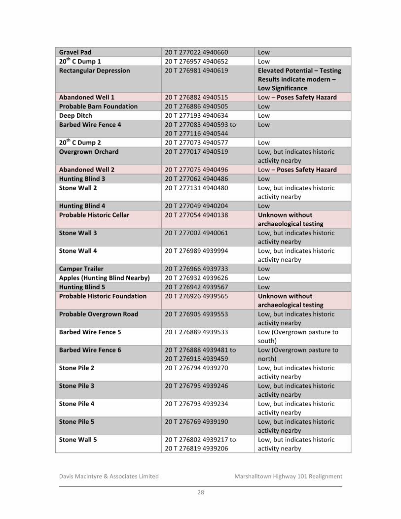
Davis&MacIntyre&&&Associates&Limited& &&&&&&&&&&&&&&&&&&& Marshalltown&Highway&101&Realignment&
&28&
Gravel*Pad* 20&T&277022&4940660& Low&20th*C*Dump*1* 20&T&276957&4940652& Low&Rectangular*Depression* 20&T&276981&4940619& Elevated*Potential*–*Testing*
Results*indicate*modern*–*Low*Significance*
Abandoned*Well*1* 20&T&276882&4940515& Low&–&Poses*Safety*Hazard&Probable*Barn*Foundation* 20&T&276886&4940505& Low&Deep*Ditch* 20&T&277193&4940634& Low&Barbed*Wire*Fence*4* 20&T&277083&4940593&to&
20&T&277116&4940544&Low&
20th*C*Dump*2* 20&T&277073&4940577& Low&Overgrown*Orchard* 20&T&277017&4940519& Low,&but&indicates&historic&
activity&nearby&Abandoned*Well*2* 20&T&277075&4940496& Low&–&Poses*Safety*Hazard&Hunting*Blind*3* 20&T&277062&4940486& Low&Stone*Wall*2* 20&T&277131&4940480& Low,&but&indicates&historic&
activity&nearby&Hunting*Blind*4* 20&T&277049&4940204& Low&Probable*Historic*Cellar* 20&T&277054&4940138& Unknown*without*
archaeological*testing*Stone*Wall*3* 20&T&277002&4940061& Low,&but&indicates&historic&
activity&nearby&Stone*Wall*4* 20&T&276989&4939994& Low,&but&indicates&historic&
activity&nearby&Camper*Trailer* 20&T&276966&4939733& Low&Apples*(Hunting*Blind*Nearby)* 20&T&276932&4939626& Low&Hunting*Blind*5* 20&T&276942&4939567& Low&Probable*Historic*Foundation* 20&T&276926&4939565& Unknown*without*
archaeological*testing*Probable*Overgrown*Road* 20&T&276905&4939553& Low,&but&indicates&historic&
activity&nearby&Barbed*Wire*Fence*5* 20&T&276889&4939533& Low&(Overgrown&pasture&to&
south)&Barbed*Wire*Fence*6* 20&T&276888&4939481&to&&
20&T&276915&4939459&Low&(Overgrown&pasture&to&north)&
Stone*Pile*2* 20&T&276794&4939270& Low,&but&indicates&historic&activity&nearby&
Stone*Pile*3* 20&T&276795&4939246& Low,&but&indicates&historic&activity&nearby&
Stone*Pile*4* 20&T&276793&4939234& Low,&but&indicates&historic&activity&nearby&
Stone*Pile*5* 20&T&276769&4939190& Low,&but&indicates&historic&activity&nearby&
Stone*Wall*5* 20&T&276802&4939217&to&20&T&276819&4939206&
Low,&but&indicates&historic&activity&nearby&
&
Davis&MacIntyre&&&Associates&Limited& &&&&&&&&&&&&&&&&&&& Marshalltown&Highway&101&Realignment&
&29&
&Please¬e&that&there&were&two&abandoned&wells&encountered&during&the&reconnaissance.&Workers&operating&in&the&area&of&the&proposed&interchange&in&the&future&should&be&aware&that&neither&of&the&two&wells&have&been&properly&covered,&but&rather&are&simply&capped&by&rotting&pieces&of&plywood.&&
5.0 RECOMMENDATIONS*AND*CONCLUSIONS*&The&historic&background&study&and&field&reconnaissance&have&indicated&that&the&study&corridor&was&subject&to&moderate&levels&of&historic&activity&including&possible&First&Nations&use&for&resources&and&a&portage&route.&However,&archaeological&testing&has&shown&that&significant&archaeological&deposits&are&unlikely&to&exist&within&the&proposed&impact&zone&north&of&the&existing&Highway&101.&Although&the&stone&dam&and&earthen&mound&identified&on&Seely&Brook&may&represent&the&remnants&of&a&nineteenth&or&early&twentieth¢ury&mill,&there&is&no&evidence&of&significant&archaeological&deposits&existing&or&surviving&in&relation&to&the&mill,&and&as&such,&no&further&mitigation&at&that&site&is¤tly&proposed.&&Some&evidence&of&field&clearing,&overgrown&pasture,&and&stone&property&walls&were&also&observed&within&the&impact&zone&north&of&Highway&101,&but&in&all&cases&these&did¬&appear&to&be&associated&with&significant&archaeological&features&such&as&building&foundations,&and&therefore&testing&or&mitigation&is¬¤tly&proposed&in&these&areas.&These&findings&are&however&indicative&of&historic&activity&in&the&area&and&should&the&highway&be&realigned&again,&a&reassessment&is&recommended&to&ensure&that&more&significant&features&are¬&impacted.&
Four&other&historic&feature&locations&have&been&identified&south&of&the&existing&Highway&101,&but&testing&at&these&locations&has¬&been&conducted&or&proposed&prior&to&the&upcoming&phase&of&highway&construction&(undivided&highway).&&
The&first&is&the&small&cellar&feature&on&the&northwest&side&of&Marshalltown&Road,&located&just&outside&the&proposed&toeMofMslope.&The&position&of&this&feature&will&allow&for&easy&avoidance&during&future&construction&by&flagging&the&area&with&a&recommended&buffer&of&approximately&10m&from&the&exposed&stone&of&the&cellar.&
The&second&location&is&at&the&western&end&of&the&proposed&Marshalltown&interchange,&where&a&probable&barn&foundation&has&been&identified&beside&a&standing&(abandoned)&house.&The&small&house&appears&to&be&of&early&twentieth¢ury&origin,&and&it&is&believed&that&an&associated&barn&would¬&represent&a&significant&archaeological&resource.&No&mitigation&is¤tly&recommended.&
The&third&site&is&an&area&of&stone&piles&and&stone&walls&related&to&a&historic&homestead&far&south&of&Marshalltown&Road.&The&foundations&of&associated&house(s)&and&
Davis&MacIntyre&&&Associates&Limited& &&&&&&&&&&&&&&&&&&& Marshalltown&Highway&101&Realignment&
&30&
outbuildings&at&this&location&could¬&be&located&within&or&in&close&proximity&to&the&impact&area,&and&it&is¤tly&assumed&that&if&these&foundations&have&survived&(the&area&is&bordered&by&heavy&clearcutting&and®rowth),&they&are¬&apparent&within&the&impact&zone.&The&stone&piles&within&the&impact&zone&vary&in&size,&but&given&the&site’s&significant&distance&(near&the&southwest&extent&of&the&study&area)&from&historic&Black&settlements&such&as&Jordantown&and&Conway,&it&does¬&appear&likely&that&the&mounds&are&related&to&any&spiritual&practices&within&the&eighteenth&and&nineteenth¢ury&AfricanMCanadian&community.&Ambrose&Church’s&historic&map&suggests&this&area&belonged&to&the&“Como”&(Comeau)&family,&presumably&of&Acadian&descent.&
Finally,&a&probable&house&foundation&deep&in&the&woods&south&of&the&Marshalltown&Road&was&also&identified&during&the&reconnaissance,&but&was¬&subjected&to&archaeological&testing&or&mitigation&at&this&time&as&it&is&located&significantly&south&of&the&existing&Highway&101&and&will¬&be&impacted&in&the¤tly&proposed&phase&of&the&highway&alignment,&which&will&terminate&where&the&realignment&reMjoins&the&existing&highway&in&Marshalltown&to&the&north&of&this&site.&
In&summary,&no&further&active&mitigation&is&recommended&for&the&proposed&2017&phase&of&the&highway&realignment.&If&at&a&future&date&the&highway&realignment&is&extended&south&past&the&existing&highway&as&has&been&proposed,&archaeological&testing&at&the&probable&historic&stone&foundation&is&required&prior&to&any&clearing&or&grubbing&of&the&RoW.&Additionally,&the&historic&cellar&beside&Marshalltown&Road&must&be&flagged&prior&to&clearing&and&grubbing.&
In&the&event&that&archaeological&resources&are&encountered&in&the&future&and&an&archaeologist&is¬&already&present,&it&is&required&that&any&groundMdisturbing&activity&be&halted&immediately&and&the&Coordinator&of&Special&Places&(902M424M6475)&be&contacted&immediately®arding&a&suitable&method&of&mitigation.&& &

Davis&MacIntyre&&&Associates&Limited& &&&&&&&&&&&&&&&&&&& Marshalltown&Highway&101&Realignment&
&31&
&
6.0 REFERENCES*CITED*&Church,&Ambrose&F.&1870.&Topographic&Map&of&Digby&County.&Halifax:&A.&F.&Church&&&Co.&&Confederacy&of&Mainland&Mi’kmaq.&&2007.&&Kekina’muek:&Learning&about&the&Mi’kmaq&of&Nova&Scotia.&&Truro:&Eastern&Woodland&Publishing.&&&Davis,&Derek&and&Sue&Browne.&&1996.&&Natural&History&of&Nova&Scotia,&Volume&II:&Theme&Regions.&&Halifax:&Nimbus&Publishing&and&Nova&Scotia&Museum.&&Department&of&Lands&and&Forests.&1939.&Crown&Land&Index&Sheet&13:&Digby&County.&&Hill,&Allan&Massie.&1901.&Some%Chapters%in%the%history%of%Digby%County,%and%its%early%settlers.&Halifax:&McAlpine.&&National&Park&Service.&n.&d.&“Samuel&and&Nancy&Elliott&Edison.”&<https://www.nps.gov/&edis/learn/historyculture/samuelMandMnancyMelliottMedison.htm>.&Accessed&October&2016.&&&Nova&Scotia&Registry&of&Deeds.&1792.&Deed,&Patrick&Haggerty&to&John&Edison.&Nova&Scotia&Archives&MFM#23452,&Book&1B,&P&384.&&Nova&Scotia&Registry&of&Deeds.&1805a.&Deed,&John&Edison&to&Moses&Edison.&MFM#17698&Book&3A&P&331.&&&Nova&Scotia&Registry&of&Deeds.&1805b.&Deed,&John&Edison&to&Samuel&Edison.&MFM#17698&Book&3A&P&305.&&&Ta’n&WejiMsqalia’tiek:&Mi’kmaw&Place&Names&Digital&Atlas.&2016.&<&http://sparc.smu.ca/&mpnmap/&>.&Accessed&November&2016.&&Wilson,&Isaiah&W.&1900.&A%Geography%and%History%of%the%County%of%Digby,%Nova%Scotia.&Holloway&Bros.&&&& &
Davis&MacIntyre&&&Associates&Limited& &&&&&&&&&&&&&&&&&&& Marshalltown&Highway&101&Realignment&
&32&
&&&&&&&&&&&&&&&&&&&&&
PLATES*&&&&&&&&&&&&&&&&&&&&

Davis&MacIntyre&&&Associates&Limited& &&&&&&&&&&&&&&&&&&& Marshalltown&Highway&101&Realignment&
&33&
!Plate&1:&A&low,&wet&forest&of&poplar&and&scrub&birch&near&the&northeastern&end&of&the&proposed&highway&realignment.&Looking&west.&
!
!Plate&2:&A&rough&stone&wall&suggests&a&property&division,&but&no&evidence&of&oldfield&was&present.&Looking&southeast.&

Davis&MacIntyre&&&Associates&Limited& &&&&&&&&&&&&&&&&&&& Marshalltown&Highway&101&Realignment&
&34&
!Plate&3:&An&abandoned&school&bus&in&a&low,&wet&area&behind&(north&of)&a&modern&house.&Looking&southwest.&
!
!Plate&4:&A&temporary&logging&operation&within&the&proposed&RoW,&looking&west.&
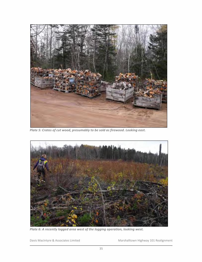
Davis&MacIntyre&&&Associates&Limited& &&&&&&&&&&&&&&&&&&& Marshalltown&Highway&101&Realignment&
&35&
!Plate&5:&Crates&of&cut&wood,&presumably&to&be&sold&as&firewood.&Looking&east.&
!
!Plate&6:&A&recently&logged&area&west&of&the&logging&operation,&looking&west.&
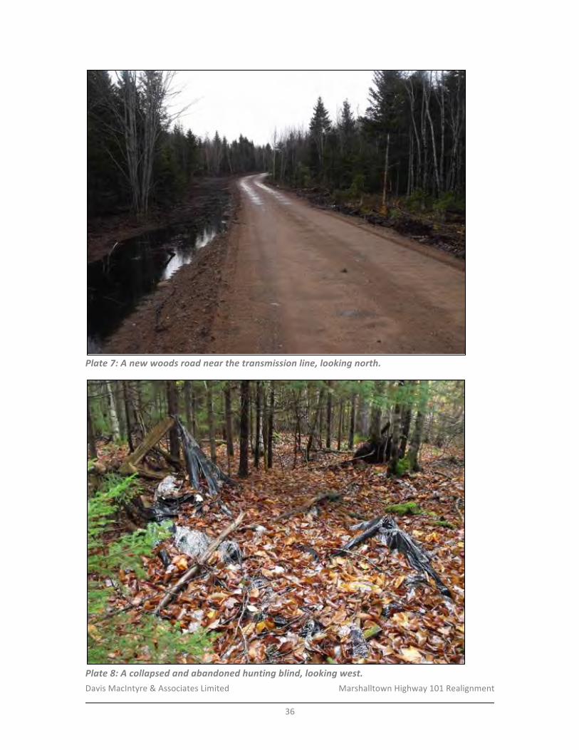
Davis&MacIntyre&&&Associates&Limited& &&&&&&&&&&&&&&&&&&& Marshalltown&Highway&101&Realignment&
&36&
!Plate&7:&A&new&woods&road&near&the&transmission&line,&looking&north.&
!Plate&8:&A&collapsed&and&abandoned&hunting&blind,&looking&west.&
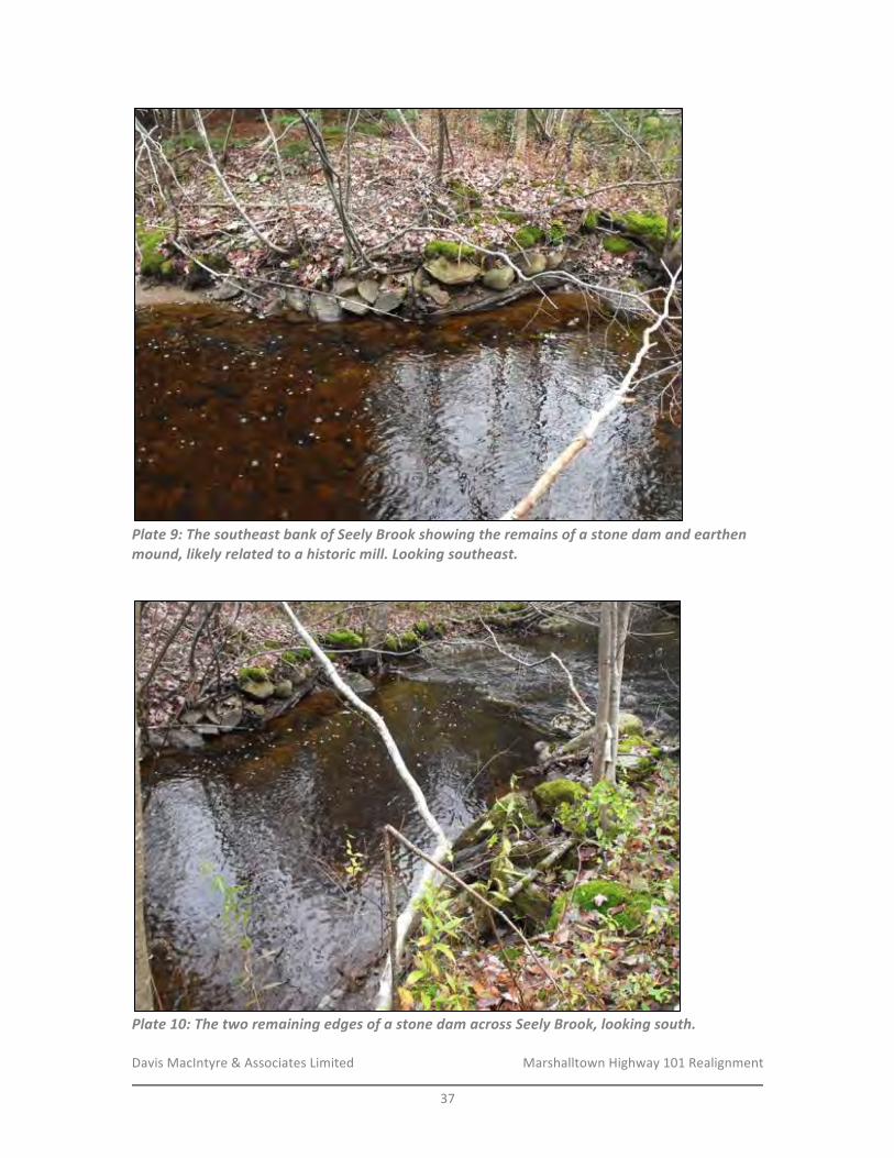
Davis&MacIntyre&&&Associates&Limited& &&&&&&&&&&&&&&&&&&& Marshalltown&Highway&101&Realignment&
&37&
!Plate&9:&The&southeast&bank&of&Seely&Brook&showing&the&remains&of&a&stone&dam&and&earthen&mound,&likely&related&to&a&historic&mill.&Looking&southeast.&
!
!Plate&10:&The&two&remaining&edges&of&a&stone&dam&across&Seely&Brook,&looking&south.&
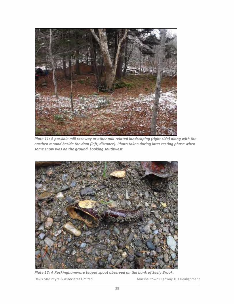
Davis&MacIntyre&&&Associates&Limited& &&&&&&&&&&&&&&&&&&& Marshalltown&Highway&101&Realignment&
&38&
!Plate&11:&A&possible&mill&raceway&or&other&millSrelated&landscaping&(right&side)&along&with&the&earthen&mound&beside&the&dam&(left,&distance).&Photo&taken&during&later&testing&phase&when&some&snow&was&on&the&ground.&Looking&southwest.&
!
!Plate&12:&A&Rockinghamware&teapot&spout&observed&on&the&bank&of&Seely&Brook.&
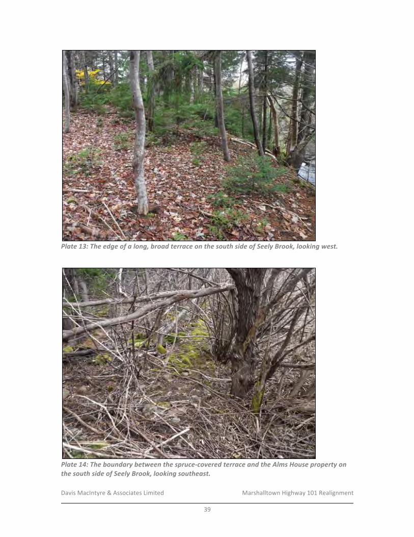
Davis&MacIntyre&&&Associates&Limited& &&&&&&&&&&&&&&&&&&& Marshalltown&Highway&101&Realignment&
&39&
!Plate&13:&The&edge&of&a&long,&broad&terrace&on&the&south&side&of&Seely&Brook,&looking&west.&
!
!Plate&14:&The&boundary&between&the&spruceScovered&terrace&and&the&Alms&House&property&on&the&south&side&of&Seely&Brook,&looking&southeast.&
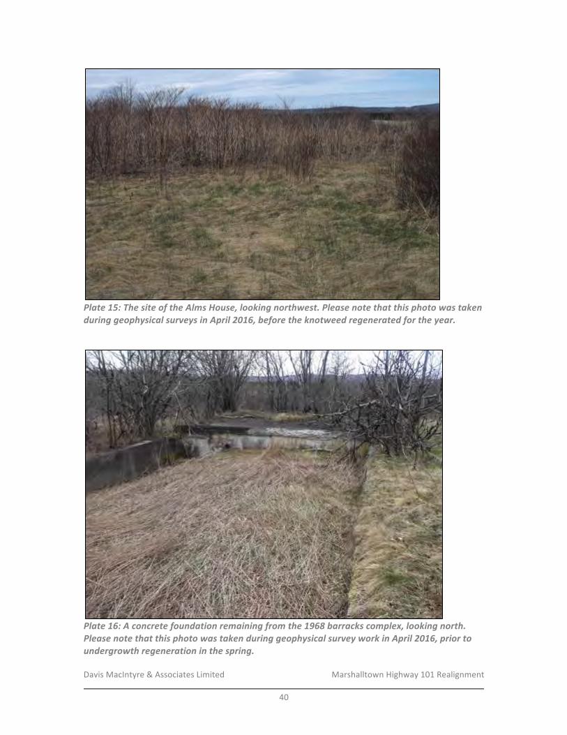
Davis&MacIntyre&&&Associates&Limited& &&&&&&&&&&&&&&&&&&& Marshalltown&Highway&101&Realignment&
&40&
!Plate&15:&The&site&of&the&Alms&House,&looking&northwest.&Please¬e&that&this&photo&was&taken&during&geophysical&surveys&in&April&2016,&before&the&knotweed®enerated&for&the&year.&
!
!Plate&16:&A&concrete&foundation&remaining&from&the&1968&barracks&complex,&looking&north.&Please¬e&that&this&photo&was&taken&during&geophysical&survey&work&in&April&2016,&prior&to&undergrowth®eneration&in&the&spring.&
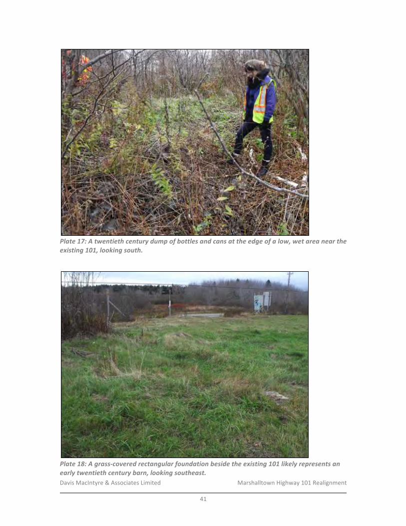
Davis&MacIntyre&&&Associates&Limited& &&&&&&&&&&&&&&&&&&& Marshalltown&Highway&101&Realignment&
&41&
!Plate&17:&A&twentieth¢ury&dump&of&bottles&and&cans&at&the&edge&of&a&low,&wet&area&near&the&existing&101,&looking&south.&
!
!Plate&18:&A&grassScovered&rectangular&foundation&beside&the&existing&101&likely&represents&an&early&twentieth¢ury&barn,&looking&southeast.&
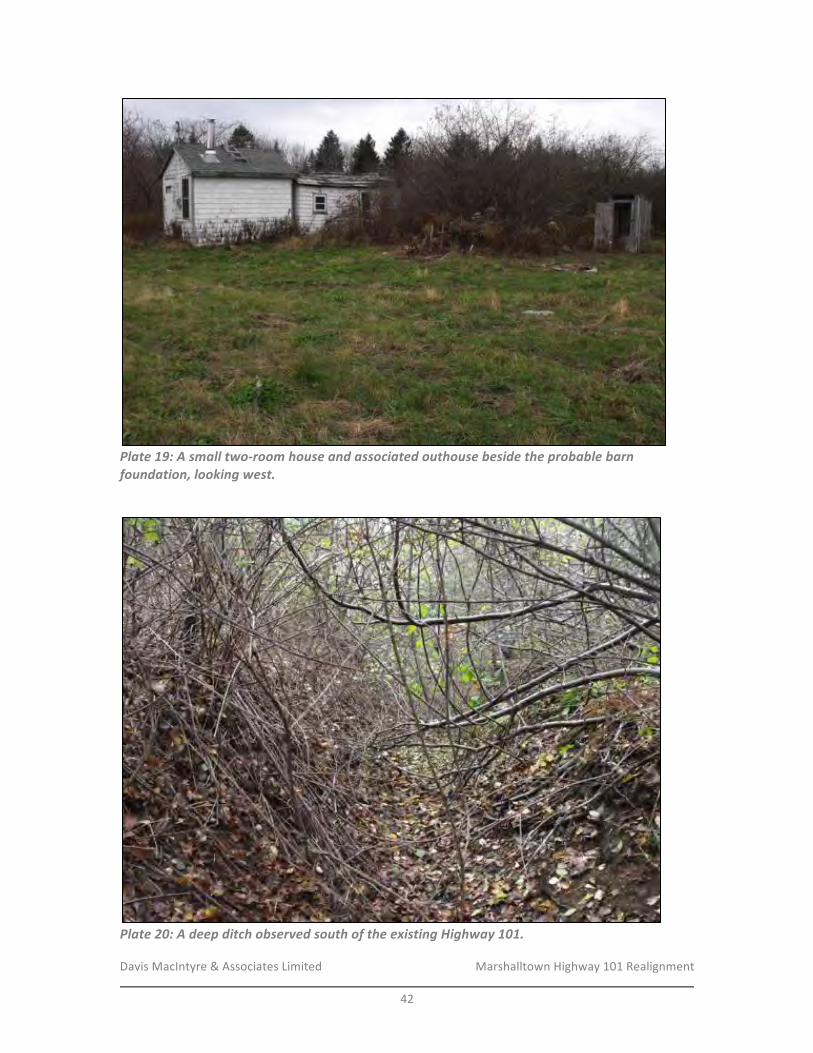
Davis&MacIntyre&&&Associates&Limited& &&&&&&&&&&&&&&&&&&& Marshalltown&Highway&101&Realignment&
&42&
!Plate&19:&A&small&twoSroom&house&and&associated&outhouse&beside&the&probable&barn&foundation,&looking&west.&
!
!Plate&20:&A&deep&ditch&observed&south&of&the&existing&Highway&101.&
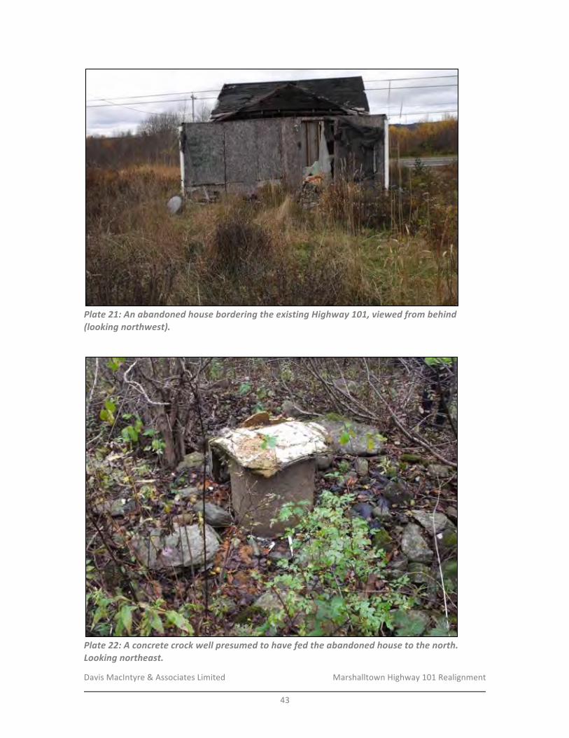
Davis&MacIntyre&&&Associates&Limited& &&&&&&&&&&&&&&&&&&& Marshalltown&Highway&101&Realignment&
&43&
!Plate&21:&An&abandoned&house&bordering&the&existing&Highway&101,&viewed&from&behind&(looking&northwest).&
!
!Plate&22:&A&concrete&crock&well&presumed&to&have&fed&the&abandoned&house&to&the&north.&Looking&northeast.&

Davis&MacIntyre&&&Associates&Limited& &&&&&&&&&&&&&&&&&&& Marshalltown&Highway&101&Realignment&
&44&
!&
&
&
!!!!Plate&23:&A&hunting&blind,&possibly&abandoned,&south&of&the&abandoned&house.&Looking&southwest.&
!!!!!!!!!
!Plate&24:&An&overgrown&stone&wall&at&the&rear&of&the&abandoned&house&property,&looking&southwest&along&the&wall.&
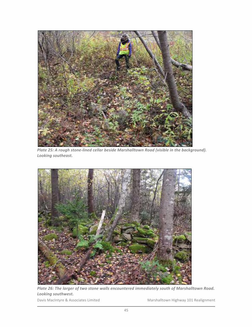
Davis&MacIntyre&&&Associates&Limited& &&&&&&&&&&&&&&&&&&& Marshalltown&Highway&101&Realignment&
&45&
!Plate&25:&A&rough&stoneSlined&cellar&beside&Marshalltown&Road&(visible&in&the&background).&Looking&southeast.&
!
!Plate&26:&The&larger&of&two&stone&walls&encountered&immediately&south&of&Marshalltown&Road.&Looking&southwest.&
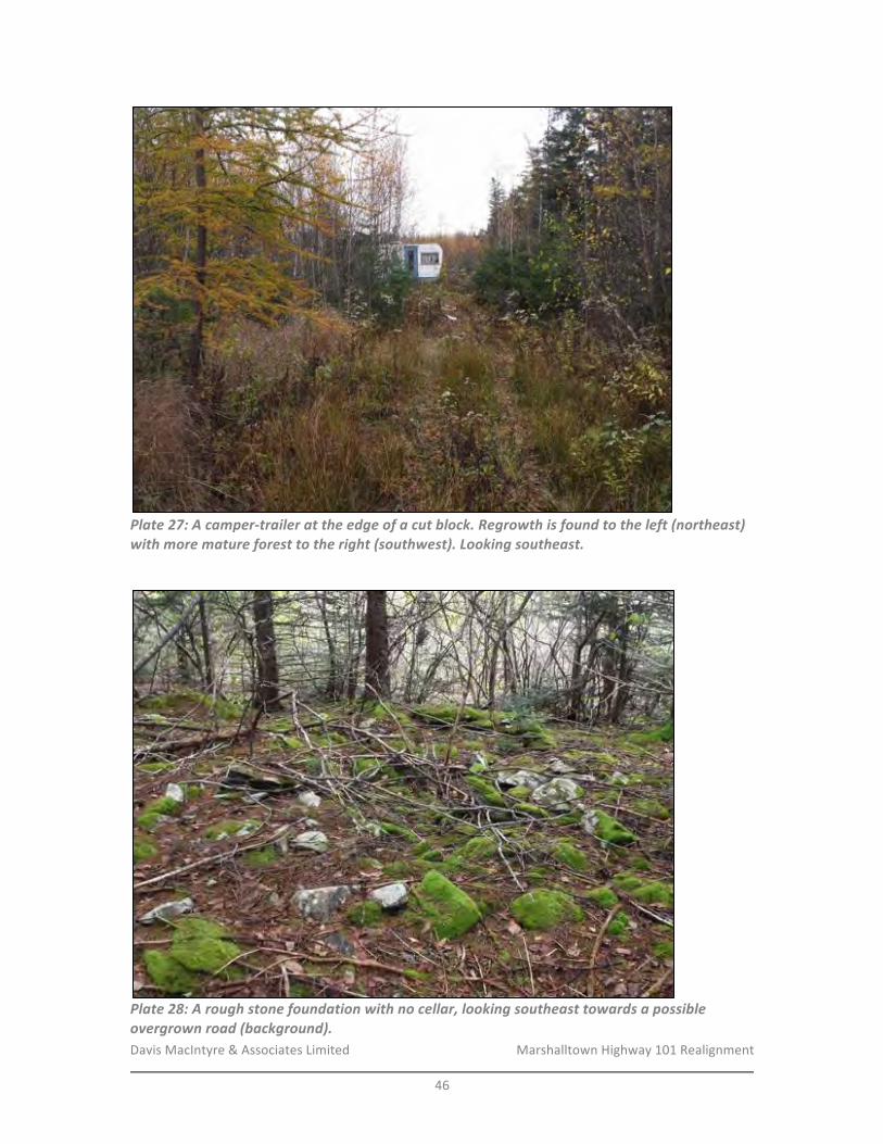
Davis&MacIntyre&&&Associates&Limited& &&&&&&&&&&&&&&&&&&& Marshalltown&Highway&101&Realignment&
&46&
!Plate&27:&A&camperStrailer&at&the&edge&of&a&cut&block.&Regrowth&is&found&to&the&left&(northeast)&with&more&mature&forest&to&the&right&(southwest).&Looking&southeast.&
!
!Plate&28:&A&rough&stone&foundation&with&no&cellar,&looking&southeast&towards&a&possible&overgrown&road&(background).&
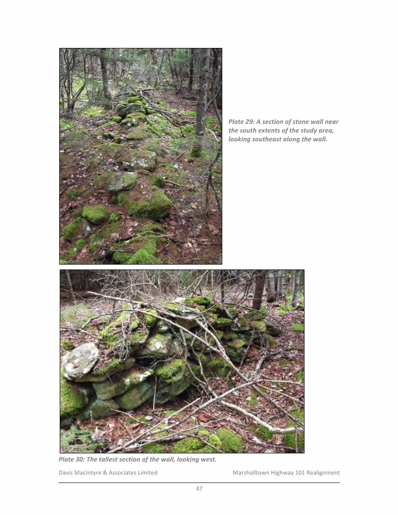
Davis&MacIntyre&&&Associates&Limited& &&&&&&&&&&&&&&&&&&& Marshalltown&Highway&101&Realignment&
&47&
!&
&
&
&
Plate&29:&A§ion&of&stone&wall&near&the&south&extents&of&the&study&area,&looking&southeast&along&the&wall.&
!!!!!!!!!!!!!
!Plate&30:&The&tallest§ion&of&the&wall,&looking&west.&
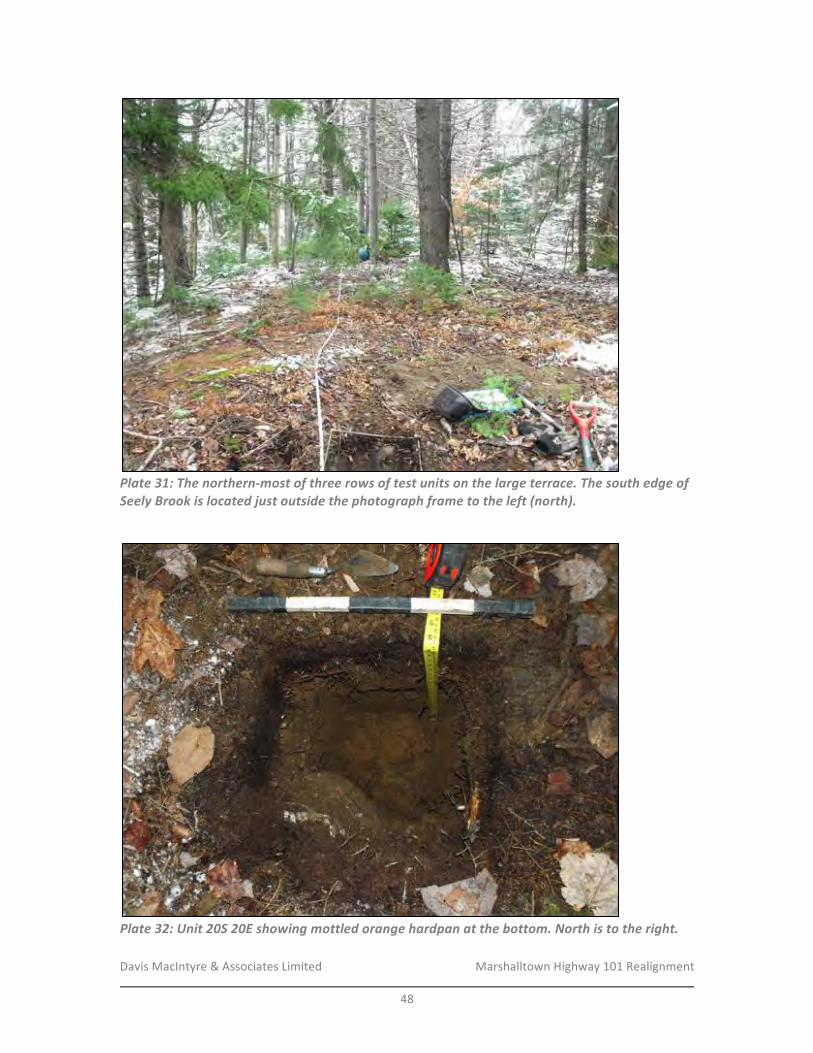
Davis&MacIntyre&&&Associates&Limited& &&&&&&&&&&&&&&&&&&& Marshalltown&Highway&101&Realignment&
&48&
!Plate&31:&The&northernSmost&of&three&rows&of&test&units&on&the&large&terrace.&The&south&edge&of&Seely&Brook&is&located&just&outside&the&photograph&frame&to&the&left&(north).&
!
!Plate&32:&Unit&20S&20E&showing&mottled&orange&hardpan&at&the&bottom.&North&is&to&the&right.&
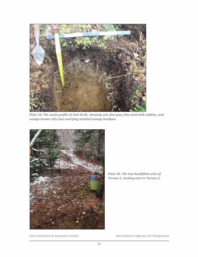
Davis&MacIntyre&&&Associates&Limited& &&&&&&&&&&&&&&&&&&& Marshalltown&Highway&101&Realignment&
&49&
!Plate&33:&The&south&profile&of&Unit&0S&0E,&showing&sod,&fine&grey&silty&sand&with&cobbles,&and&orangeSbrown&silty&clay&overlying&mottled&orange&hardpan.&
!!&
&
&
&
&
Plate&34:&The&two&backfilled&units&of&Terrace&1,&looking&east&to&Terrace&2.&
!
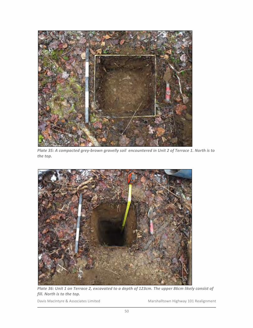
Davis&MacIntyre&&&Associates&Limited& &&&&&&&&&&&&&&&&&&& Marshalltown&Highway&101&Realignment&
&50&
!Plate&35:&A&compacted&greySbrown&gravelly&soil&&encountered&in&Unit&2&of&Terrace&1.&North&is&to&the&top.&
!
!Plate&36:&Unit&1&on&Terrace&2,&excavated&to&a&depth&of&123cm.&The&upper&86cm&likely&consist&of&fill.&North&is&to&the&top.&
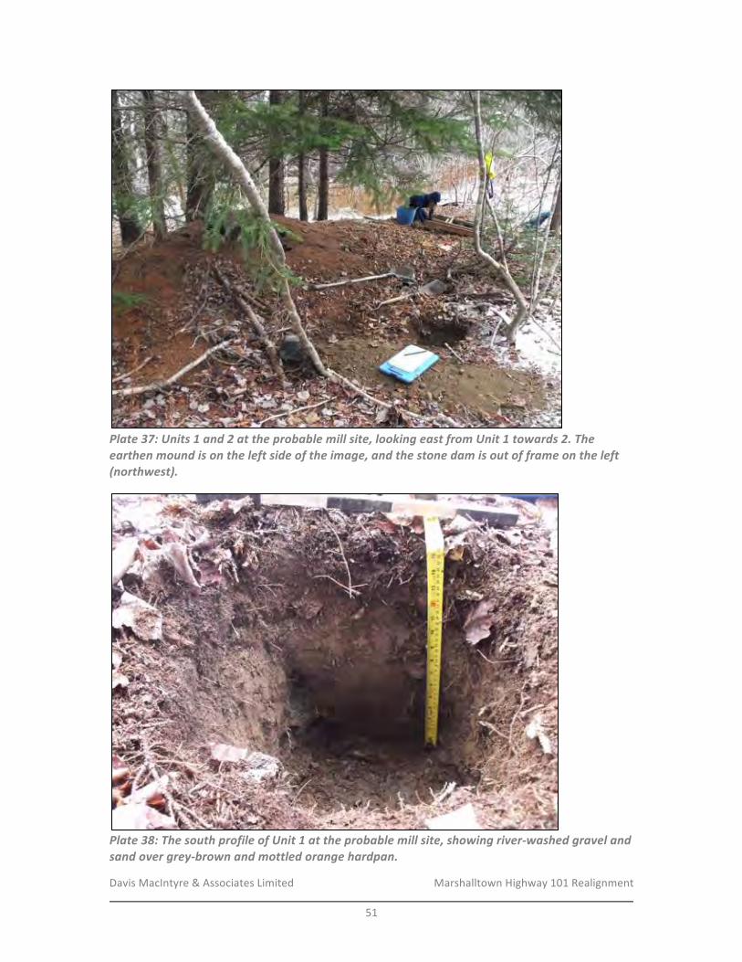
Davis&MacIntyre&&&Associates&Limited& &&&&&&&&&&&&&&&&&&& Marshalltown&Highway&101&Realignment&
&51&
!Plate&37:&Units&1&and&2&at&the&probable&mill&site,&looking&east&from&Unit&1&towards&2.&The&earthen&mound&is&on&the&left&side&of&the&image,&and&the&stone&dam&is&out&of&frame&on&the&left&(northwest).&
!Plate&38:&The&south&profile&of&Unit&1&at&the&probable&mill&site,&showing&riverSwashed&gravel&and&sand&over&greySbrown&and&mottled&orange&hardpan.&

Davis&MacIntyre&&&Associates&Limited& &&&&&&&&&&&&&&&&&&& Marshalltown&Highway&101&Realignment&
&52&
!Plate&39:&Four&units&in&progress&surrounding&the&rectangular&depression,&looking&southeast&towards&Highway&101.&
!
!Plate&40:&The&northwest&profile&of&Unit&2&at&the&rectangular&depression,&showing&sand&overlying&a&band&of&crusher&dust&(dark&belt)&with&more&sand&below.&This&unit&was&choked&out&by&rock&at&72cm&below&the&surface.&
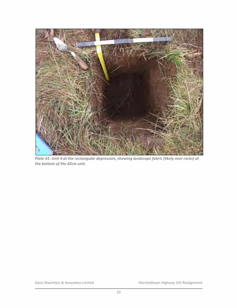
Davis&MacIntyre&&&Associates&Limited& &&&&&&&&&&&&&&&&&&& Marshalltown&Highway&101&Realignment&
&53&
!Plate&41:&Unit&4&at&the&rectangular&depression,&showing&landscape&fabric&(likely&over&rocks)&at&the&bottom&of&the&42cm&unit.&
!&& &
Davis&MacIntyre&&&Associates&Limited& &&&&&&&&&&&&&&&&&&& Marshalltown&Highway&101&Realignment&
&54&
&&&&&&&&&&&&&&&&&&&&
&
APPENDIX*A:*HERITAGE*RESEARCH*PERMIT*&
&&&&&&&&&&&&&&&&&&&
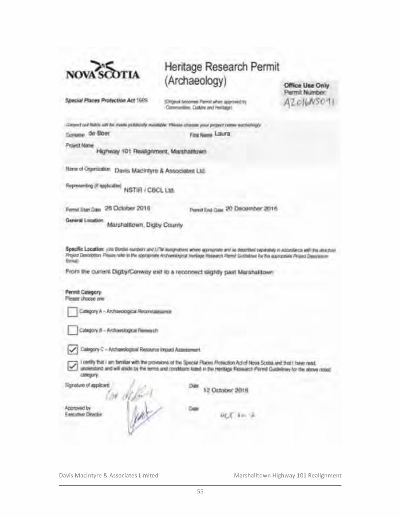
Davis&MacIntyre&&&Associates&Limited& &&&&&&&&&&&&&&&&&&& Marshalltown&Highway&101&Realignment&
&55&
&&&
*oo}$t^ Heritage Research Permit(Archaeology)
Special Placv Protecfion Acf 1989 (Oiginatbecomes permit when appmved byCommunilies, Culture and Hedtage)
G,eyed od fields wi be ma& pu ic€, y avalabb. Frease c,loosa your prcied nan e a@rditqlygumms de Boer pi*l Nqme Laura
Prcj€x, NameHighway 1 01 Realignment, Marshalltown
Name of Organization Davis Maclntyre & Associates Ltd.
Reoresentino fi f aDolicablel, NSTIR / CBCL Ltd.
permit Stat Date 26 October 2016 pemit End g31g 20 December 2016
General Location:Marshalltown, Digby County
Office Use OnlyPermit Number:
ATolr"N|oqt
Specific Location: @ite Bo{dq nnfus dtd UTM d€A'irtdic'}s wlP,re qgwiile aN as described sqaratdy in Mdan6 vtflt flD dtad:f,dPrci& Desdiptiott. Please r6fer to the apgwiate tuchadogical HeilW Reseu& Psmit Guiddlines for the qgqiate Projd D*aiptiontonnd)
From the current Digby/Conway exit to a reconnect slightty past Marshalltown
Pemit Category:Please ctpose one
I Caegory n - nrchaeological Reconnaissance
I C"trgoty e -nrchaeological Research
[| CaeOorf C -Archaeological Resource lmpactAssessnent
lcedi! hat lam hmilia with he pmvisbns of ttre Speohl Places Profectim Ad of Nova Scotia and that lhave rcad.understand and uvill abide by te tems and conditions listed in the Heritage Research Permit Guktelines for the abore notedcategory.
D* t2october2o16
Datek-d to- tb
Davis&MacIntyre&&&Associates&Limited& &&&&&&&&&&&&&&&&&&& Marshalltown&Highway&101&Realignment&
&56&
&&&&&&&&&&&&&&&&&&&&&
&
APPENDIX*B:*SHOVEL*TEST*FORMS*&
&
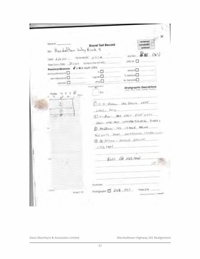
Davis&MacIntyre&&&Associates&Limited& &&&&&&&&&&&&&&&&&&& Marshalltown&Highway&101&Realignment&
&57&
&
Perr.-iit #$hc,vel Test Ee*ard
6 r."!- 5r0v. !" sAtT(iie'
Daie', Lf t lttt
Excovctor[s]'. l/trz'l A,t
Bqse Excv. 1DB$)r 3c r rv"r Sur{oce Elev {m ASL}: ..-.--''--....---'--
Presen*elAbseR*e d or H & dePth (DBS)Artifacls:il
unitOtidf'f*miffi
[,,
Fialdnotes;
Ph*to lD #.
nt,il'oc samples'f,]
pal*osai:n -- otner:D $oilsomPlm'n -*=-
Str otigr a Pft fc DescruP fions""aor- #"' , 'e::'urrl $'tJCi'!o-'ricrso'is
Lr'lT{Q , ?oc<<
@, +.:. t1,.r* - -..frqrt GPe I 6 P{ '*' 'cf u' '
{tx'f 5t cTY 5xr'l) ' ir't c${'t, r!a ( c|Mf ft<t to*)
Photogroph 5, d 6t4 o7 - Sqa *eanlln led on reT a$a Yi
-J
J'l \,tl !!r
NE*tl--^.-ri(
. i .".t--i .,1--!.-t.t-a-"-,--:.'1 'r i \t: :
GPS ref: I
;*:':i'
.,i-\ ! a- i. ;-a ")-i -,-:'.-.--.--t'
S@
S*ale" 1:44
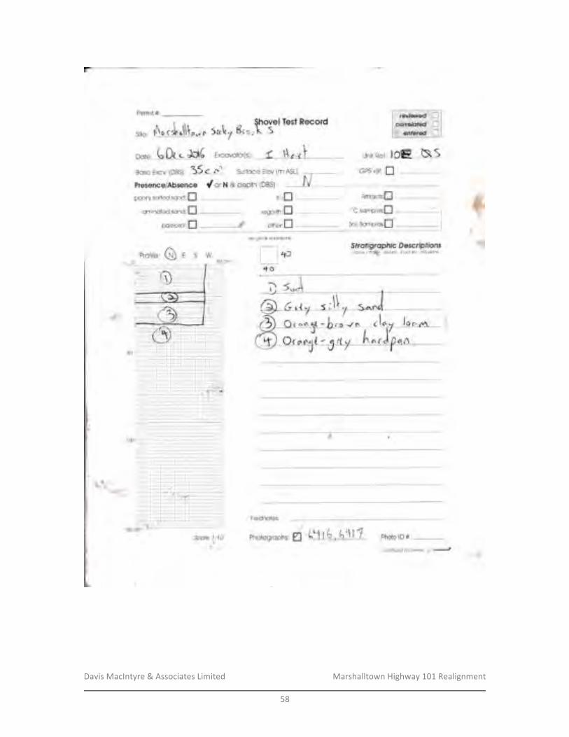
Davis&MacIntyre&&&Associates&Limited& &&&&&&&&&&&&&&&&&&& Marshalltown&Highway&101&Realignment&
&58&
&
Permii #:
site, r.\nrr\,^\\[rn 5n\r7 Br"rt3*l Test Record
oot*, 6 Dc . Jd6 Excovoior[si C il ^r I i.Jr:itRef: |OIE hSBsse Excv, {DBS}I
j5 <" ,,'f surfoce Elev (m A$LJ: GPS ret: flPreeencelAbsence C or ft & depth (DBS]
Arl1fo*is:fipoorly soried sr:nd:Ilarninuled ssn*:fl 'oc smrnpie.s:[]
Soil$arnpler:f]
$fr*ffgrcrpft i* S *serip fionscol*sr - rno1I.\ - lerl,Jre " slruciure - indusion$
ttrrDregoliih:fl
pcleoso!:il *, ottrer:flunit grid & dimefisi.fls
I l'roLI+o
Fieldncte*:
Photosroph,,d tlr6o Cil 7 PhotorD#:
't?i" . r.,.1.-"r.
ll so- -: ;;ir ;;:-'l' . "" :: , -:-r- i- ---. r-l,:',i-:,"-.:-i| - "':-1-j.:--.--I ,:l-l=:],1-:-i-;f--rr:t|lr:l:i;'-ili --;-rl:ii*;iir:-jii?#I; , i:-.ii:-.=;-;i:i1;,.5'fa::-;*iI *==;'flrli=**jl' - - ::=,r.ir-tl,-.-.--=,:ij:'.I ..,..,-;):;;a.;||r.',;-=-,.!ii[++F --l.j:li:r:i;,:;:=::ri,.t'-lI -*i--.-:: il-]-lqr;:=-==1-1J tm:,:;-,1;,_ir::-.rll , :f------r--i ,5i-iI -, , -;-;l: ii==l-l=llI :=___?t.,,._r;; :! :-_11-1_r:___!
I -.:-t'j*-t-i=[*. -----:::J::-:t'-:i.-,-;-::::::--.I t"\-" -- -''', I;;''':1;;;7-1;;;;:-;';;l-i-' :--ii'':I ,\++rr::i;- _-#:*5=[ --. ---' :: I -
H 1r-.r.jIi=E:ljrj11ij;f::i[ ,:*", .-.-" .
--" . : , :-..; -[. ":5-"-- : , _,, - :: -,J rsoc-trr-I S.ote 4,:'tOttEliH
?Lr
aafillnuedan{avfJ1l,€ 1
-t
hlb
i:,
:1
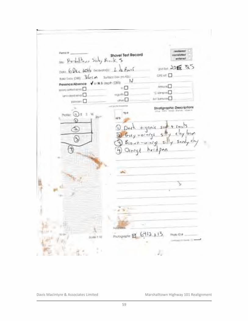
Davis&MacIntyre&&&Associates&Limited& &&&&&&&&&&&&&&&&&&& Marshalltown&Highway&101&Realignment&
&59&
&
Dote:
thsvel Test ****rdH,*.L 5
Surface Elev (m ASL): GP$ ref: flBose Excv. tnsq: 36slnPresencel*{h$*nce f ar ht & depth (DBS}
S,J,7
Excovotorlsf' L L 6.rf rrni.iRer; "Iogl N.1
Arifcch:[
Soilsqmplesil --
$frofrgroPhlc DescrrP fions;dcr, ' ,;cJ, . :c.itre 'rr-n''re ;ni;{tons
}J
poleosoi:I
if,,Iregoiith:I
ottre,:Xunit grid.& drm*r*iont
'+s
q{ilrfi.
Scc$e {;'f 0{-/
{:\
Photo lD #,
| -r - olsr-l-{6to'-*r
r1;-;"j.l)-
l,-r,.--.i-i i-i-I\:-i-: : 1 :':-+:-,-1-:.:r:'7!50--rI-:-i 1:i
aanlinuedanftwrse il J
Site:
: -t. I ..1
.i.-:-,.,i.:
Phqtogrophs:.,5:.
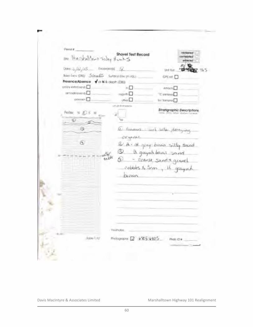
Davis&MacIntyre&&&Associates&Limited& &&&&&&&&&&&&&&&&&&& Marshalltown&Highway&101&Realignment&
&60&
&
Permit #:
(ila.
Dote:
ol- {\ 5 e\t1$hev*l Test frec*rd
11 t o"\'5
Bqse [xcv. (DBS): 5lo,r^ 65 Surfoce Etev {m ASL]:
Fresen*eiAbs*n*e dotx&depth{DBS}poorly soried sonO;I
lqmjnntecl sanO:flp*le*s*i:n
)-..,,..- r- , -:-- -I, , , =T,"-;,O,- ,-;iiiProfile: N fOS Wo* 'ol I
GFS ref: I
Sfreifigrerpft i* S eo*rfp ff onscf{clr'' fn6tri;i - letd'ul,e - #fliclure, iridu;ons
\*
$,s\t:
Fielcinotes;
Photogroph$: Ef b<b4-b{OS photo tD#:
$oil$arxples;flunfi grid & d;mer*ion$
$ca/e {:{0
3anlfiuedanrcwrsa n ---*
trt:flregolith:n
ottr*r;fl
erf aa. r/Izr.C-J
Arllfach:fl
''C *amples;fl
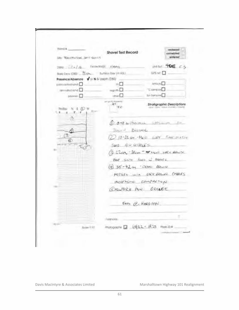
Davis&MacIntyre&&&Associates&Limited& &&&&&&&&&&&&&&&&&&& Marshalltown&Highway&101&Realignment&
&61&
&
Permit #
Site: lrilmgrhLit6^rrj Srf uY rlQrt-,x$Shev*l Ta*t Reeard
Dcfe: */tt/ te Excovoior[s1: /Ur< unrrce{: M-C-1Bose Excv {DBSJ: k crr^- Surfcce Elev (m ASLJ:
C ar N & depth (DBS)
poorly sorted sr:nO:Ilaminaied *an*;fl
paleosal:fl
-: | -t':'1:i.'---:
GF$ ref: I
w
unit orid & dirfie*sionit)or_,____-l
lYe1l50cm I I
$frcfigry*Bfirc S prcnp fioascdo$ - ,5#ri:{ - ielilr'e' slrucliye ' ifi{:iu$Dns
C 4 -r? ra-,/lqy},1A^ r a a /,{tr r',;t r'u\ F,{'li
8rb"r,-) 0(ri,1N\ rL .
(2 \ .l? 'LL tuv * MFo (,:ttY .rirua" s,..-,.1
..Swo, Q"t cogqg:* -
rtv.r€ 4c-rY lxoo .t fr*ott s
MofTLf b rri?A 6ee..d dQq$$J, G@t-{<
{ Jr..}56ril1(r rv(3 (di.t P A"; Yrc.\)
Fieldnotes:
Photogrcphs: ffi L,t *, f - *4 "fa Photo lD #
;-i-.:-+,.-+)::-j
-:.:1:- -;t
ccr/rr:u€dofi r6v6rse 3 -J
A$ifsrch:[iltrn
'uC *amples;[$oilS*mple::[
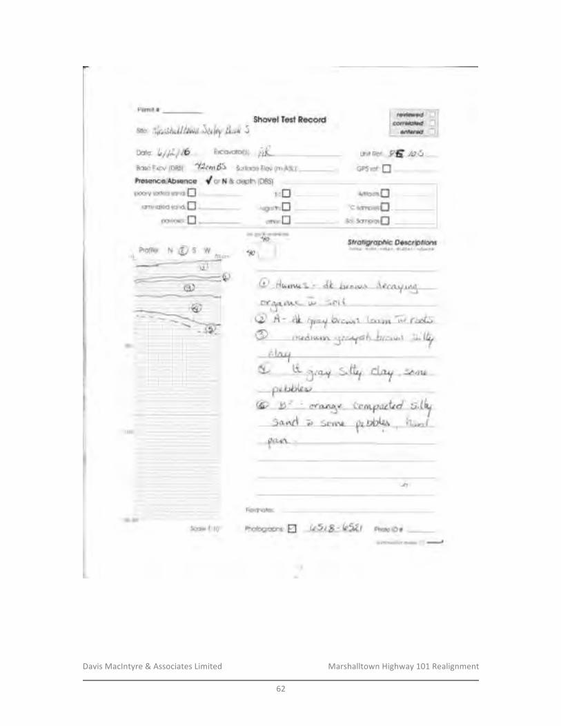
Davis&MacIntyre&&&Associates&Limited& &&&&&&&&&&&&&&&&&&& Marshalltown&Highway&101&Realignment&
&62&
&
Permit #$h*v*l Test R*c*rd
aarc: bhl/ /6 Excovotor{sf /},( Unit Re{: ,AE *; S-Bcse fixcrr 1D*q: Ifum BS Surfoce EIev {m AS1J,
s*e, !rl*d)1ul11tNx*Jetk,{ &ni 5
pci**sci:I
Presen*e1Ab$*nce dorm & depth (DBS)
pooriy sorl'ed sunC;Ilaminfited sffnd:fl
rrrrflregoiiih:n
att'rer:I
GFS ref: I
Artifcch:fl'oC *omples'[SoilSomples:[
$ frofigrapft ic S mscnp lf *ns*olou - rficlri.r- te;CruIe',s1r*:tse - ifiellrridns
Q dt-m,.. s . dt b.^,.n ,,.. r\ p r , ,/ t ,sCrfA.L /1Ac- ; S4\1 [d
uftli SridfuimerKiorts
frn
II1r
rl
J1
Fieldnotes;
Photo lD #:
H*
Scale 1:10 Photogrcphs: EI ts1iS-{{,52teanllr"tu*lJafi ftvarse n J

Davis&MacIntyre&&&Associates&Limited& &&&&&&&&&&&&&&&&&&& Marshalltown&Highway&101&Realignment&
&63&
&
Permit #$hcvel Te*t k***rd
oote,ttL,/fiftb txcovotor[sl 4{.- Unit Ref: /aE ,'A 5
stte: l]Latzfu{4btila fu/ty &*l 5
NESW
Bqse Excu 1OYs1: *ZtUdJ Surfoce Elev {mASLJ:
dorx&depth{DBS}poofiy sorted sano:f]
lsminoted sanC;Ig:{easei:I
unri sridS4fmer*ions
1b tI
;:-::; .1-;|Ifi=;,rf,: ; ll,l- !+ L l-:- +-- :,-ti-1 r t. r:r-, 1 -L:1 1-i
GFS refr f]
Sfr*ffgrcpfiic S *rorB ff onsctro$ - ffiolrir - ie:{hr'e ' Slfmi|se 'in*iu$t016
Atifacis:fl
'oC sarnp;es;[
soil$omple[l
Fieldnotes:
Photogroph s: W bfth - ff"rt Photo rD #Scale '1 :IA
canflnuedanfivafte D I
FreseneeiAbsence{]f,lit,
regolrlh:
other:
trnn
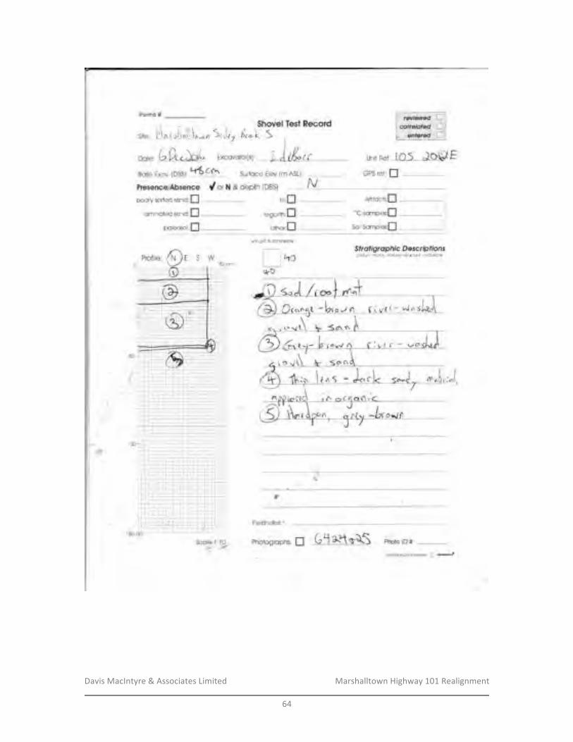
Davis&MacIntyre&&&Associates&Limited& &&&&&&&&&&&&&&&&&&& Marshalltown&Highway&101&Realignment&
&64&
&
Fermrt #
GFS ref: fl
grd & dimefisiaris
I I t-toll+o
$fr*fi$rrcpft f c S *s*rfp ff o;scclour -,T ft clt ii - teHute' iltucture' ifi ciuio.r$5W
- ---q,orc'
,:,L1-1
---.---.1-J
I
s*e: f'\^rrir,,ili,, n S,J.Z o'.*fttio:'n***
tl or n & depih {DBS)!\r,;V
o**, 6 fr.5555555555555555 Excovotorrs Y ]- I tL, t unit Ref: lO ( JO$}Et*\ C.t.,Bose Excv, tDBS)r I L Surface Etev (m ASLI:
pcoriy cod'ed sonc:fllsminilted *andrn
p*leosci:fl
j:,i._=-++,-],,i--.t -l--:-t--+i --:t-i:::irtl
1.
Fieldnotes; '
Photo lD #Photographs: flaanllnuaJdanrcve$e p ..-*
Atifc*is:['oC scmpl*s;[SoilSompies[]
rir;f]regotith:fl
otlrer:fl
Qnnl* .i'4tJ
C.d(-u.lrtj
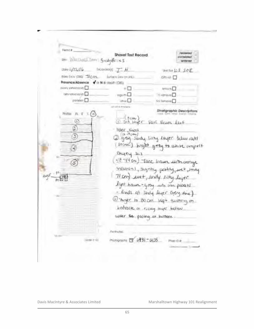
Davis&MacIntyre&&&Associates&Limited& &&&&&&&&&&&&&&&&&&& Marshalltown&Highway&101&Realignment&
&65&
&
Permit # 1?$s*$hovel Te*f E**ord
aote:hflL/1L- Excovotor[s], T. H. Unir Ref;{0 5 -S O fEqse Excy. {DB$}: "l/e rn Surfoce Etev (rn ASLJ:
siter F1q.t Vra{g To*r.1 ,S"rJ furo S
PresencelAbsenos dor X & depih (DB$ipc€rly soried sonO:fl
lsminated san*:npal*c,s*;:fl
GFS ref: fl
tiir:I Artifc*fs:fl
regalith:I ''C sompies;[*itrer':ff Scilsampl**ifl
unii grid & climersion$
Sfrofigraphic DescripffonsI I cdo(.r - mshx - teihfe. si/uciue - inciu$or*I^ r( Scrr- )t) s,'d ta\e f SnlK Bruun" "Lrr F _ --
Fieldnates;
Ph*rosrcph r' {#H:A35- photo rD #:
'I 50 dffiScaJe {:{0
canlifiL€,d afi ftverse n -...-t
.F
i-+++,.+:-iI i-+.:.i-.;-i.;?-1_:+_!- t -..-1,
'1 00* -i-ri:--.r-l-::-;2;;1--t-;*;r.'-,:-5;,:,i : l:---- -:
rl.
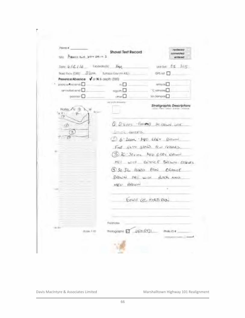
Davis&MacIntyre&&&Associates&Limited& &&&&&&&&&&&&&&&&&&& Marshalltown&Highway&101&Realignment&
&66&
&
Permit #
Site; N\**u..,* gf,.'t t3ft;c K S
dorN&depih{}BS}
5h*vel Tsst R**ord
DarettrltLllb Excovalor{s1: l/wy4 unii Ref: 66 tCrS
Bose [xcv, {DBS]: 32cna. Surfcce tlev {m ASLI: GP$ ref: fl
" pcoriy sdled s*nU;ftr
lomincrfed ssnd:f]paieosoi:fl
unft gfid & ainErsions
$fr*figr*pfif e 0 e**rp fi*rsccloui' fnclil j{ " le.ilul* " si[etlre - ift du$oils
I t1r rfil , fe,e'rlElT$ .
@ 6-7-pco. :' [m 6t4* Fqo*\]{,*rd 1n-r'r <ANJD , fr*: Pdgeurs
N6T u.> r rrl 6iq\t{G-f: B€o\^jr{ . Cogg Llrs
t-16tc €€c\$\..j
Fieldnctes:
Ph*to lD #:
@ 5o -3t _.fl rpe * PonJ rea,s afBQot.>N Mcil iJ r-,.( Ji-RcK A ."'rcr
Scr:la f ;{0aanllnuedan rcv€/:$e a --f
I
:::I50 cifi----
''C sompi*s;[$ollsomples',fl
i:i -': a" -r:|.|.;:: -.- -;: -i.- i.-, -- l-
:ii:i:i:I-a:-1-*'i -1
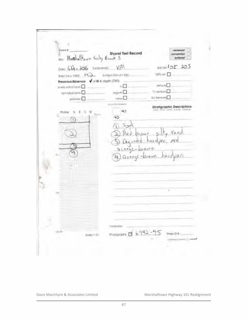
Davis&MacIntyre&&&Associates&Limited& &&&&&&&&&&&&&&&&&&& Marshalltown&Highway&101&Realignment&
&67&
&
Permil #.
Siter
$hovel Tesi Record5to\r7 8".rL S
( 0o .- ]oi6 Excovotor{sr' Vfl unit l?er:!Cf- aC-jBose Excv (DBs): t\}* Surfoce Elev (m ASLI:-- GFS re{: fl
"J rt
posriy eorted ocnolfllamincieel sr:n*:I
F"I
t"\r'
paler:soi:flunit grid & dirnerEicns
T+o
t*Yf i,g,iff*fi g,*ffJ'#im-4+f
Fielcinotes:
Photosroph-, J t 'l'l\-. tls Pholo rD #
*onllnae<J ail ftv)Jsa l:]
-f
C *r N & d*Pth (DBS)
*-irfa*ts:fl
Soil$amplm;[
iltrn
"c samptes:fl
1-, -: r,. :...:...:..,.l, -i: 1,.;-;-i:: .i..r. . -..-1 ..1.'.1--r
i'a- ; ",-1- l-r'ir ,,1-r-il:l: a i::
: a- i'"1
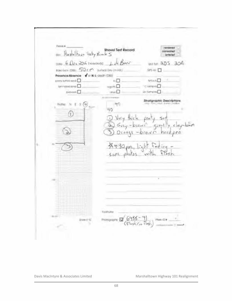
Davis&MacIntyre&&&Associates&Limited& &&&&&&&&&&&&&&&&&&& Marshalltown&Highway&101&Realignment&
&68&
&
"r , rr Shovel TestRecard
6 {\ . Jcl( Excovoro ,w, )- )t fut rHcse [xcv. {DgS): 50 c r Surfoce Elev (m ASLJ
dor hl & depth (DBSi
pooriy s*rieci sonC:Ilamincied san*;I
poleosol:fl
N t5
Fermit #:
Unii Ref:
GPS r*f: f!
gdd.& drnerEims
i l'foTd$ fr*ffgrapf li* D **cnp f ionsec'lour " fir#rr:( " ieilure - strlI]is"e . lndu*c:rs
Fi*idnates;
Scale l:4* Photogr*ph g d Photo lD *: t:cafillnued afl re\*,rsa a
-f.?f ii"
6.,{\qL -brUJn
[! l'"5
Siter
Date:
lli:tr Arl'ifcchI"C somplesilSoilSornpbs[
J".,^o"
t
regotitn:f3
ott'er:f]
',- ,-
i. .r-..t.-..i..... iili;ll^,.,i-.,i -.,i
--r- t*,1
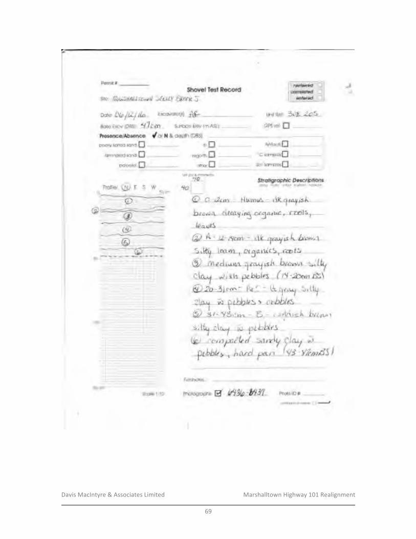
Davis&MacIntyre&&&Associates&Limited& &&&&&&&&&&&&&&&&&&& Marshalltown&Highway&101&Realignment&
&69&
&
Fermit # J&
oate: Db/tLf llr Excovotor[sl, w unit Ref: 30r 203Bcs+ Excv TDBSJ: ,{?r rm - Surface Elev (rn ASLJr
$hovel Test Recordsiter f ?flrtsflSil.zru*rl SAtfy 6eCIre.5
Cnr r* & depth (DBSi
pooriy sorted sanO: nlamincled scnd:fl
pcri**sai:fl
GPS rei: I
unil grid &dmerBicns
't"i I
ISWSfr*figrcrpfr fc S*s*rr{rfi*nscdour' |I:o!'i,r ' 1e;dui* - alructur* - lncluion$
Fieidn*tes;
photosrcph *, d t/llU -hyil Fhoto rD #:S*r:l* {:{0*arrltnwdanrcverfi I -.-J
t,ii,f]regotfn:n
ottrer:fl
Arllfnch:fI
"C srmpl*sr[SorlScrnple*:fl
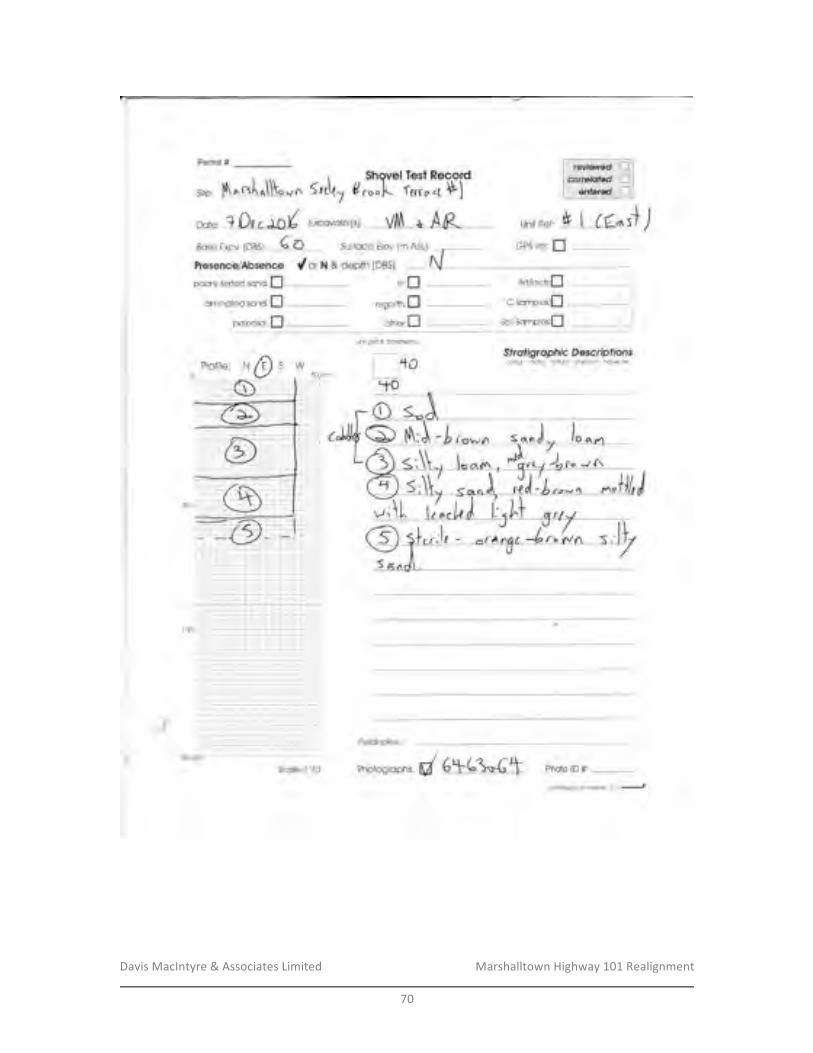
Davis&MacIntyre&&&Associates&Limited& &&&&&&&&&&&&&&&&&&& Marshalltown&Highway&101&Realignment&
&70&
&
Fermit #Shovel Test Record
B.ool- fecr"4 Pl* I rc^l
5rt\t,
oo,*, ? 00, fO/ txcov*i*r[s:, VIV\ * AF-Bose Excv (DBs]: 6 O Surfoce Elev (m ASLJ:
FresencslAb$ence dorN & dep?lr (DBSI
pooriy saried sanO:Ilorninul'eci sand:I
pateos*l:ft
Unit i?ef: )
nr:flregalith:I
omer:flunif grid & dmerEiofis
+o$ fr*figrapft fe D e*crlp fions*olsu'- :rclrli{ - ier,Jute' $ir|lc.lu.e - lndu$lon$[lt{LfO
Fi*idnctes;
Phalosraph r, d 6!|-6i*6t Photo rD #
GPS ref: I
''C somptes:f,
Qarltlnu.].d An rer*.fsa tr,-t
-.t"i-1..!,-a-.;r;.-:-i-'])ii-, --i
:t)'1'.1-.;- l.;
Artif**ft:[
Pr:fil*: I'.1
a
SoilScmple*;fl
\
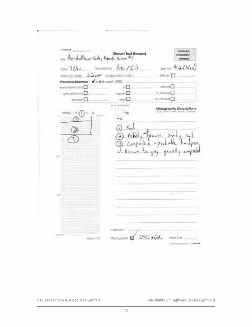
Davis&MacIntyre&&&Associates&Limited& &&&&&&&&&&&&&&&&&&& Marshalltown&Highway&101&Realignment&
&71&
&
Permit #
Qila,
$hsvel Tert fleccrd{erl1B*.1. i,,,1* *t
nare,10vc -
Exc*vctorltY AW/tl)fiose [xcv, 1DBS1: Detn Surfc*e EIev {m ASL]:
Pres*ncelAbsenss #otN&depth{38$}poorly scrl*d sanc: fl
lsminnted sane:ilpoleos*i;fl
l.lnif R*fr
rlt;flregolith;I
o*lr*':fl
GPS r*f: I
Artrfac*:n
'oC somplesfiSoilScmples;[
t"l!i grid & dime.BiorE
I l'toho
w$frofigr*pft f* S escr*ir ff cnsedLlur - iTlot|lli' fP;;{tuf* - Slilci,Jre' inclx$ion$xo*
Freldnotes;
Ph*togrophs:S*rsl* 4:44
c,onflnuedon lavarse n --,
50 cm.-,-.t
Frofii*:oa- -,--.-,. .l-",'
Fhot* lil #:
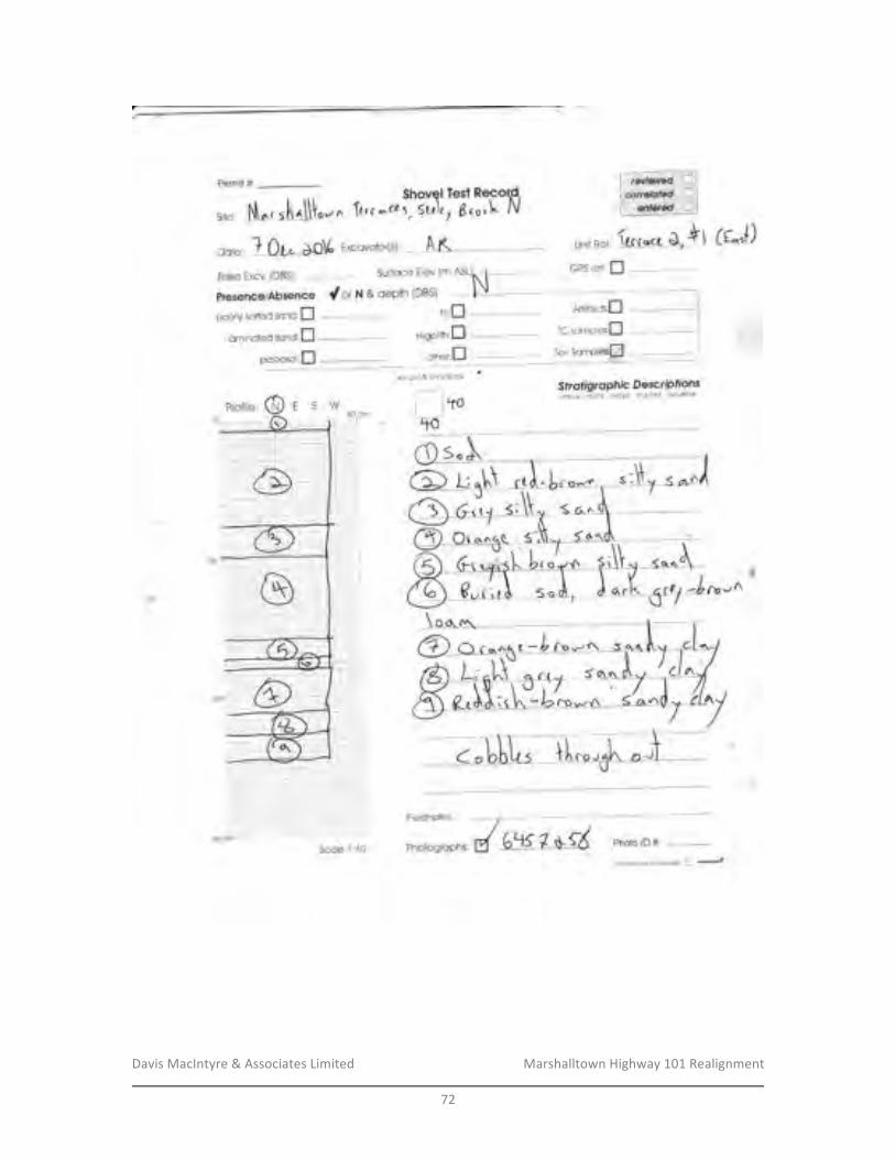
Davis&MacIntyre&&&Associates&Limited& &&&&&&&&&&&&&&&&&&& Marshalltown&Highway&101&Realignment&
&72&
&
Fermit #:Shovel Te'st ftecor.d,
\tr c --ca:, 5[{\f 7 d,o, \. iV
grid & climerKions
I ltoilto
Site; oy'A
Bqse Excv. {DBS}:
-
n*r*, ? 0L. a.O\( txccvot*r{s:, A K uniil?er: (*r** $ *l (tr.'+)
Surloce Elev (m ASL)^ I - GPS ref: n _-=___-t
depth tDBSi
:*Ylgi,fry*f:"?,ffi',#iffi-
pooriy sorted sond:fllarninafed scno:fl
p*leosci:I
fD"/n
dor ht & dePth (DBS)
5c0le 1;tu
Fi*idnotes;
conilnuedonrB!€rse 6 -'--'J
itr:fl
-
Artrfacfs:n
r*gorim:D ''C somoles;fl
citner:f]
r
:1.,1-.::,.i-i -:":-! -i -!
Photogr*Phs:
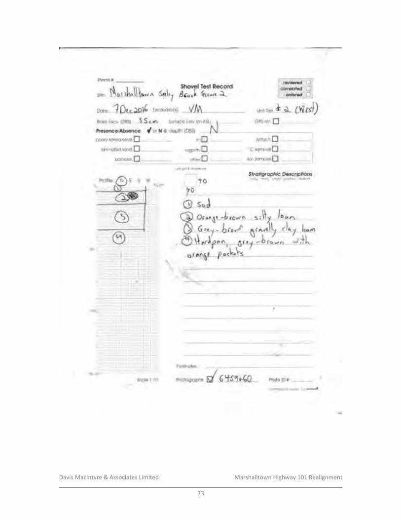
Davis&MacIntyre&&&Associates&Limited& &&&&&&&&&&&&&&&&&&& Marshalltown&Highway&101&Realignment&
&73&
&
Perrrit #
Site:
\:
$h*vel Test ilecard
GPS ref: fl
Arllfa*h:f]
"C samples;[Soilsomples:f]
rr.$t gdd & cirnet*ior6
\
Fieldnotes; /Phorosroph y d 6 +51{-60 Photo rD #:
Qafillnua.dan r*wfie tr'-t
oY.r ^ 5r.1,, dc.o). {ocr*. J-
Esse Excv {DBS}; 3 S c,^rr Surf*ce [lev (m ASL):
PreeencefAbs*nce dotx&dep1h{}BS}tlooriy eorled s*rrC:I ril;fl
iamincted scn*:fl regolith:flpaleasoi:[-l ottrer:fl
Oi.J-
. -,-:- ..""- .-.1,8--. = : -,i- rT--i- _t-tt:+i--I i i-r- l_-:-t"a-i --i-f i."*.r_+-'a-i.,
i':'.=-- --=---
l-:r!_i I I i I I r_!_l_: : i i' :' i I 1:-, .-.------.,-,-- . i-:tli
- I r - r--' : :-: :-.: :-: l-::-:t
-:-i .- .i
i-, -j
ESW
,ll
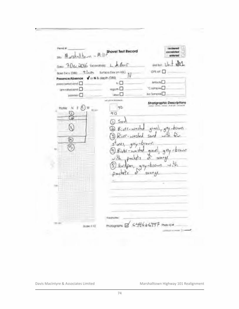
Davis&MacIntyre&&&Associates&Limited& &&&&&&&&&&&&&&&&&&& Marshalltown&Highway&101&Realignment&
&74&
&
Permit #.
note, -1 0{,.QOt6 Excovotor[s]: L )" k,f un*Ref: UISfGPS ref: IBosc Excv (DBS): t L Vf Sur{oce Elev (m ASLJ: n F
PresencelAbsence y'or N &depth (DBS) - iV
sire: , .. [d \" {,A -/t; }/ t$hovel Tesl Record
pooriy sorteclsono:[ tiii:f]ominotecl sono:fl regoiith:n
poleosoirt] - orrer;flunit grid & dimerKiols
I ltoll,to
Artifoch:n
'"c somplesJ-l
So,rsarxpies:f]
Str otigr a phic DescriP ffonscoiour -'xolrix texfure slruclLre inclusonsN 'o*
/Phorosroph , d C\4 ( te:ttl Photo rD #Scale'1:10
ci)fififiuri(i.fi teti.:rse il J
reviewed Icorrelaled I
entered t-l
Profile:
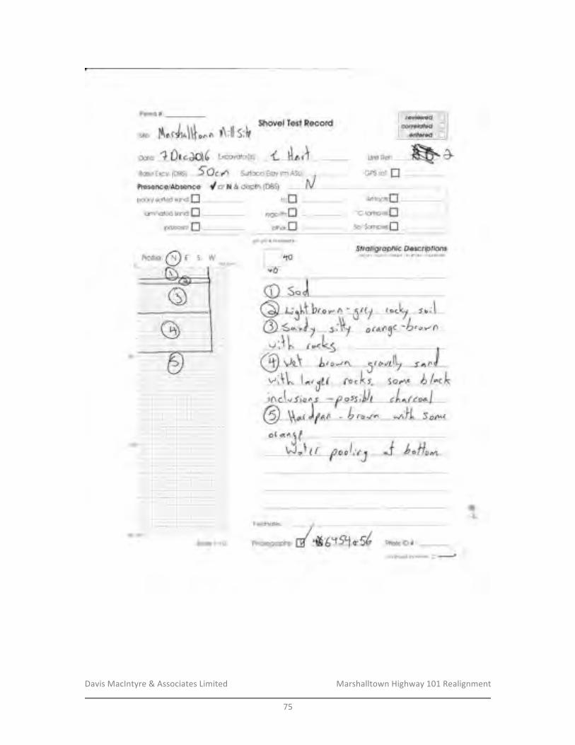
Davis&MacIntyre&&&Associates&Limited& &&&&&&&&&&&&&&&&&&& Marshalltown&Highway&101&Realignment&
&75&
&
Permit #.Sirmvel T*st &***r*
sii*; I\^.J,^\\{ o* ^ rt\;ll S;}a
not*, ? Ouclo)d Excovotorisr 4 il^J - un**,,--$&C.tt
Bsse Excv, {DBSJ: J_LJr-:A Surfoce fterr {rn A.SLI:
Fr*s*n**lAhsenee Cotx&d*pth(*B$!pooriy snried sr:n*:fl
laminsted scnd:Ipoleosol:f]
GPS ref: I
Artrfcctu[
"C somplesfiSoilSompim:[
$ fr*figrerpf'u* S *ctrup fionscoldu' - :Tc1r ]< - te;{lule - 6lrilitt$e - ifi clusions
tili,flregoirtn:I
*tner:tunit grid & dirnerEio*s
I l'ro+O
Photo lll #:
Fieidnotes;
canfrlLle<|an ftwrse n ii"""J
'Phot*grcphs:
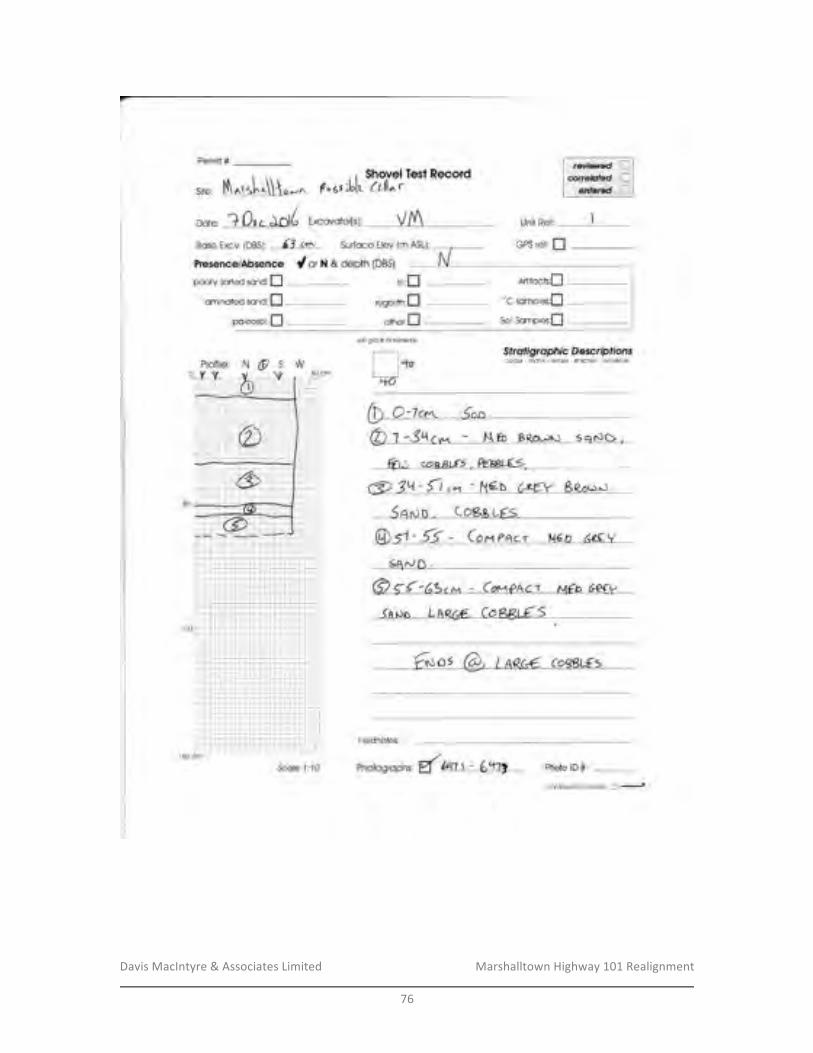
Davis&MacIntyre&&&Associates&Limited& &&&&&&&&&&&&&&&&&&& Marshalltown&Highway&101&Realignment&
&76&
&
Excovotor[si, VA unit Rer:
Bose Excv [DBS): -63 -<$ Surfoce Elev (m ASL): GPS re{: IPresence/Absence dot N & deptlr (DBS)
rill:
regollth:
other
Permit #:
poorry sorted scnd:f],om noteiC sonO:fI
pot*oro,I
N o s w
nun
St r at i gr a pftic Descrpfionsar1cu. rro|ix ie)dui'e'sliuaiure inclusicr'ls
(-\ o'tr* inn --@: SY-o^---ab- -EBerru l-aNo*
Artfocb:f"c sompies;f,
So,, Sompies:[
nLbo
@ 3!5-r - Nf'D--GgEV B-&oror!)
Ser{ o ,--(eB& u"Es-
@-t.6-. (or?ocr- Mr'LD 66y
- - €*"s @-Lneet-eezu€s-
Fieldnotes:
Photo lD #:
cooiinuedorir€\ierse n .-t
unit gdd & dimensio]$
6q^rn.
Scole 1:10 Phoiosroph , g( U,U, \ - 6gj *-
revisrred Llcorrelafed i-l
enlered ti
6{{'6?c- - cw?act M€o eetv
-lnpo-- LAR@ eo-8865
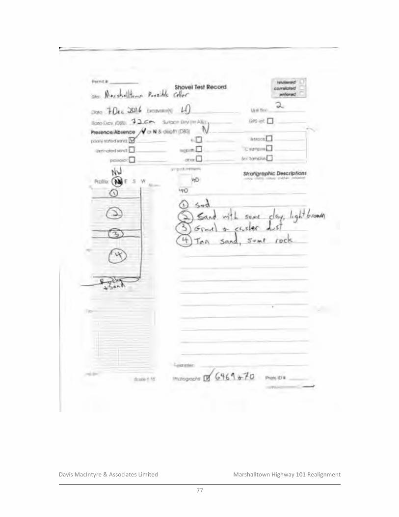
Davis&MacIntyre&&&Associates&Limited& &&&&&&&&&&&&&&&&&&& Marshalltown&Highway&101&Realignment&
&77&
&
Permit #:$hsnel Teat ****rdc"tl,rsrrr--; J,N
^. .[^[l{r-n ?"r r;Lk
n"t*, ? 0u " fgU txccvatorls ), t"'0 Unit Ref:
Bcse Excv, {DgS}: ? J-4r-" Surfsce Eiev (m ASLJ:
Preaen*e/Ab$enee /rl o, N & depth (DBS)
regolith:flifimin#l'ed ssneJ;D
pcl*osoi:I
GP$ ref: f|
Ariifr:*is:fl
"C sompies;[$oilSompk;fl
$frafigr*pitfc S*sc*Pffanrcdour' mill x - te;iture " $lruciure - irclutions
otlrer:f]unit grid & dfl€rsia|"[s
f-_lrolirvO
Fieidnates; </
Photogroph s,d Cl g\ *7 O Photo rD #.
-
Gr.,,r\ S- <{vf
Scote 4:14.:anllnLleal at't l*v*.rs1 I
-*
ESWtNl
i.i
'-i
I
:l: ir-.--:.:-.; - .--.r..i-;
.,#'
.-i:l--:

Davis&MacIntyre&&&Associates&Limited& &&&&&&&&&&&&&&&&&&& Marshalltown&Highway&101&Realignment&
&78&
&
1Ol.trO]6 Excovotor[sr, *-(*t\ Unit Ref; 3Bose Excv (DBS): 6IqeL Surfoce Etev lm ASLJ:
Presence/Absence dor ru & depih (DBS|
poorly soded sorO,Mlominoted sonO:n
pcieoscrl:f]
5C,cm
unit Cild & cirneflsiffrs
I lto40
GPS re{: I
Artifocts:fl
'oC scmpies:fl
Solsomples:n
Sfrolfgropfric D escrp ffonscdou - mali'ix - le)dure - st/uciure - inclusior-i1
Permit #:
trtrn
G q.,*-to"* .-S.rd-1cqr.r- ^rrn%l b@,r\- ,-
7ocfu o€ i.t n e', P*o.J
6 33 - AU ,-. v,n ^, ,-ro, F qon,,]*(r r rV g ,.,ro r I t -Ca P6 BBUr S
- -€yp;@-Co waLaEe-JA$JD aNo C6frLL9
Photo lD #: _conf/nuedon revBrse n -.-t
ea *-s\ eo*7A p<octt-E
Scoie 1:40 Phorosroph , { Uru:,bt'411
regolrlfr
oths
revietttrcd [1correlqled ["]
entered I

Davis&MacIntyre&&&Associates&Limited& &&&&&&&&&&&&&&&&&&& Marshalltown&Highway&101&Realignment&
&79&
&
Fermit #:
site; S^.&dI-^ $hovei test Reeord&llar
u*tu,-l Da..&)( Excovotorlsr, AR Unit R*f: +Hase Excv, {DaSj: 4}- Surfoce EIev {m A$L
Pr*s*n**lAbsencs Cor*&deplhiDBSipooriy ssl'ed sono:fl
iorninffted scnd:flpoie*sol:fl
?ors',Llt
irli:flregalith:fl
*tier:f]
GP$ ref: fl
Artifc**:fl"C snrnpies;[SoilSomples;fl
Sfr*ffgrupfiic S es*rupffonsaclori'. r-rrclril{' te;+ute ' ttttairxe, rficlu$ions
gricl & dimer6iar6
I l+oL]"to
6l-11*s FhotorD#:Scaje {;{0
Fi*lrJnotes:
conllinued an ft,larse tl ;-.-J
i-l'; ir:: itr':1; -;:-;-r: t
a\i-t1-1"
50=:-,
'ill,-i i-::
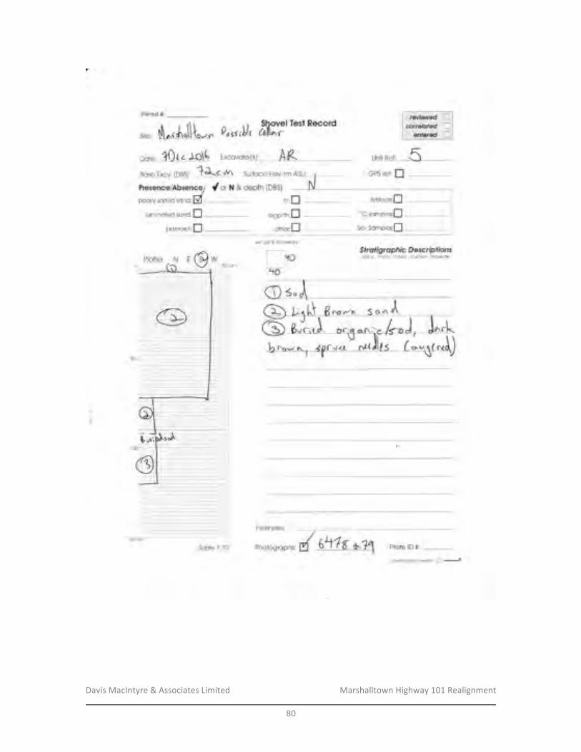
Davis&MacIntyre&&&Associates&Limited& &&&&&&&&&&&&&&&&&&& Marshalltown&Highway&101&Realignment&
&80&
&&
Fermit #
Siter
Dote:
Po.rrll,Shovel Test ftecordtoAr'r
'lfl,r, . IOI( Excovoior{sf,- A ABose fxcu (DB$]:
.-4 rYer-c w\ Surfoce Elev (m ASLJ:
Freren*elAbsencef d or i'l & dep?h (DB$)
pooriy so*ed ronC,M
lqmin*t*d s*nci;flpol*rs*i:fl
. :,? i-.r-! 1 1 i'r''-..i '-:. " t";, 7';';'; i-l ;-1 : j,' _: L..,,---t.,,L: -'.,,..,..,,,,,_..... . .. ._, _.-1 -.^.t-,.--,. - -. -.... - :-,.----,.,---'-::-* --: -- --,.,,,,---..:
.
--1,,..._".,,-..--'1,..:""-:,L.:-....:-...-r:4..*l-.;-;:-.i..-r-.1i. )--:.r".,),..r.":,-....:,1 i.l i.l-j;.'j-.:-.; t-L;r.: i j.;"-i -.i.."1"1"1.-l-r-!.i .i:::tt:t;]. a I t::,$ucm
Scste 4:lA
rili:fIregoiith:fl
omer;n
SPS refr I
ArtifccJs:n
"C somplee;[soiisarnples[l
grid & d;ms'*iorrs
-r $frofigroplti* Desent;rfions
] ITO edo\-r - lxc,1rl;{-iextuie-$trucl$e"inciu$orstlrio-
O-r.d-
Eia!r{nnlac'
/Phoiosroph * d S!15-*lE Photo rD #:
-I
ruE @w
*onllnuedofi,.everca A -t
::i t-
KUnit I?el:
Pr*file:l_.,
HIGHWAY 101 DIGBY TO MARSHALLTOWN CORRIDOR ENVIRONMENTAL ASSESSMENT REGISTRATION
APPENDICES February 2017
APPENDIX F
LETTER FROM NOVA SCOTIA COMMUNITIES, CULTURE
HERITAGE AND ARCHAEOLOGICAL RESOURCE IMPACT ASSESSMENT: MARSHALLTOWN ALMS HOUSE CEMETERIES
(DAVIS MACINTYRE & ASSOCIATES LIMITED 2016)
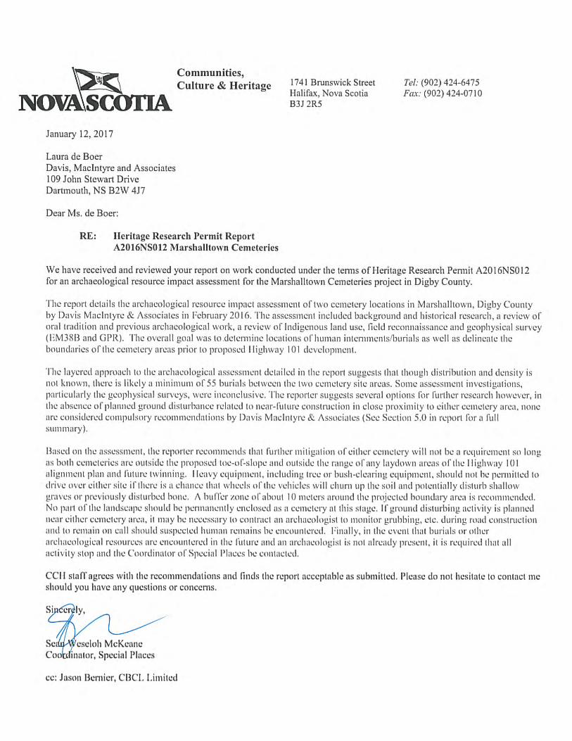
Communities,
Culture & Heritage 1741 flninswick Street Tel: (902) 424-6475
NOVASCHalifax, Nova Scotia Fax: (902) 424-0710
January 12, 2017
Laura de BoerDavis, Macintyre and Associates109 John Stewart DriveDartmouth, NS B2W 4J7
Dear Ms. de Boer;
RE: heritage Research Permit ReportA20 I6NSO 12 Marshalltown Cemeteries
We have received and reviewed your report on work conducted under the tenns of 1-leritage Research Pennit A20l6NS012for an archaeological resource impact assessment for the Marshalitown Cemeteries project in Digby County.
‘l’he report details 11w archaeological resource iinpac t assessment oft vo cemetery locations iii M arslia I Itown, I) gby Countyby l)avis Macli lyre & Associates in February 201 6. ‘[he assessment i ic I tided background an (I historical research, a review oForal tradi I ion and previous arch aeologi en I work, a review of Intl i genous land use, field reconnaissance a id geophysical survey
M 3813 and (31’ R). 1 he overall goal was to del cnn i ic locations nIh tnna ii in terninen ts/buria Is as well as delineate theboundaries of Ihe cemetery areas prior to proposed II igliway I 01 development.
‘Flie layered approach III the archaeological assessment detailed in the report suggests that though distribution and density isnot known, there is I kely a in in miu in of 55 burials between I lie Iwo cciii etery site areas. Some assessment inves Ii gal ions,pail icu Ia ny the geopliysica I surveys, were i neon clii sive. The reporter suggests several options 11w lurther research however, inthe absence of planned ground disturbance related to near—lulure construction in close proximity to either cemetery area, noneare considered compulsory recommendations by l)avis Maelntyre & Associates (See Section 5.0 in report Fr a (tillS Li ill liii) ry
Based on the assessment, the reporter recoiniueiids that Further mitigaiion of either cemetery will not be a rcqui einenl so longas both cemeteries are outside the proposed toe—ni—slope and outside the range of any laydown areas oillw I ligliway 101alignment plan and future twinning. I leavy equipnieiit. including tree or bush—clearing equipment, should not lie permitted IL)
drive over either site if here is a chance that wheels of the vehicles will churn up the soil and potentially disturb shallowgraves or previously disturbed bone. A 1w 11cr zone of about I 0 meters around the piojeeted boundary area is recommended.No part of the landscape should be pennanently enclosed as a cemetery at this stage. If ground disturbing ttcti ity is plannednear either cemetery area, it may be necessary to contract an archaeologist IL) monitor grubbing. etc. during road constructionintl to remain oii call should suspected human remains he encounicrcd. Finally, in the event that burials or otherarchaeological resources are encountered in the litture and an archaeologist is not alread present, it is required that allactivity slop and the (‘oordinator of Special Places be contacted.
CCII staff agrees with the recommendations and finds the report ;icceptahhe as submitted. Please do not hesitate to contact meshould you have any questions or concerns.
Si er ly,
Set eseioh McKeaneCoofrjhinator, Special Places
cc: Jason i3emier, C BO . I .i ml ted

Archaeological+Resource+Impact+Assessment+A2016NS012October+2016+
D a v i s + M a c I n t y r e + & + A s s o c i a t e s + L t d . +1 0 9 + J o h n + S t e w a r t + D r i v e + + + D a r t m o u t h , + N S + + + B 2 W + 4 J 7 +
++! !
Marshalltown+Alms+House+Cemeteries+

MARSHALLTOWN!ALMS!HOUSE!CEMETERIES:!ARCHAEOLOGICAL!RESOURCE!IMPACT!ASSESSMENT!
!Heritage!Research!Permit!A2016NS012!
Category!C!!!!
Davis!MacIntyre!&!Associates!Limited!Project!No.:!16J007.1CBH!
!!
Principal!Investigator:!Laura!de!Boer!Report!Compiled!by:!Laura!de!Boer,!!
Raymond!Jahncke,!and!Christopher!Barnes!!!!!!!
Submitted!to:!!!
CBCL!Limited!1489!Hollis!Street!PO!Box!606!
Halifax,!NS!B3J!2R7!!
JandJ!!
Coordinator,!Special!Places!Communities,!Culture!and!Heritage!1741!Brunswick!Street,!3rd!Floor!
Halifax,!NS!!B3J!2R5!!!!!!!!!!
Cover:!The!geophysical!surveys!in!progress!at!Cemetery!1,!looking!north.
Davis!MacIntyre!&!Associates!Limited! !!!!!!!!!!!!!!!!!!! Marshalltown!Alms!House!Cemeteries!!
i!
TABLE&OF&CONTENTS&!
LIST%OF%FIGURES%....................................................................................................................................%II+LIST%OF%PLATES%....................................................................................................................................%III+1.0+ INTRODUCTION%...........................................................................................................................%1+2.0+ STUDY%AREA%.................................................................................................................................%1+3.0+ METHODOLOGY%...........................................................................................................................%6+3.1+ MARITIME+ARCHAEOLOGICAL+RESOURCE+INVENTORY+..........................................................................+6+3.2+ HISTORICAL+BACKGROUND+..........................................................................................................................+6+3.2.1+ The(Precontact(Period(.........................................................................................................................(6+3.2.2+ European(Settlement(...........................................................................................................................(9+
3.3+ PREVIOUS+ARCHAEOLOGICAL+RESEARCH+...............................................................................................+24+3.4+ CONDUCTIVITY/SUSCEPTIBILITY+GEOPHYSICAL+SURVEY+...................................................................+26+3.5+ GROUNDYPENETRATING+RADAR+SURVEY+..............................................................................................+31+
4.0+ RESULTS%AND%DISCUSSION%....................................................................................................%37+5.0+ RECOMMENDATIONS%AND%CONCLUSIONS%........................................................................%41+6.0+ REFERENCES%CITED%..................................................................................................................%43+PLATES%....................................................................................................................................................%45+APPENDIX%A:%HERITAGE%RESEARCH%PERMIT%.............................................................................%50+APPENDIX%B:%COMPLETE%GPR%IMAGE%COLLECTION%.................................................................%52+APPENDIX%C:%PROTOCOLS%REGARDING%THE%%ACCIDENTAL%DISCOVERY%OF%HUMAN%REMAINS%.................................................................................................................................................%64+&
!
Davis!MacIntyre!&!Associates!Limited! !!!!!!!!!!!!!!!!!!! Marshalltown!Alms!House!Cemeteries!!
ii!
LIST&OF&FIGURES&!Figure!2J1:!The!location!of!the!Poor!Farm!of!Alms!House,!courtesy!NSTIR.!......................!3!Figure!2J2:!A!map!of!the!currently!proposed!highway!realignment.!The!upcoming!
construction!phase!is!shown!in!magenta,!with!the!orange!twinning!and!interchange!to!be!undertaken!at!a!future!date.!Courtesy!NSTIR/Stantec.!.....................................!4!
Figure!2J3:!The!location!of!the!cemeteries!in!relation!to!the!proposed!highway!alignment,!courtesy!NSTIR.!.........................................................................................!5!
Figure!3J1:!Map!of!the!Mi’kmaq!districts.!..........................................................................!8!Figure!3J2:!A!photograph!of!the!Digby!Poor!House!or!Alms!House!dated!1891.!...............!9!Figure!3J3:!A!1968!image!of!a!bulldozer!clearing!brush!on!the!former!Alms!House!
property.!...................................................................................................................!13!Figure!3J4:!A!second!1968!image!of!a!bulldozer!clearing!brush!and!levelling!soil!on!the!
former!Alms!House!property.!...................................................................................!14!Figure!3J5:!A!1968!image!showing!the!new!barracks!buildings!as!well!as!the!former!Alms!
House!(far!right).!Based!upon!descriptions,!Cemetery!Site!1!is!located!just!off!the!edge!of!the!photo!to!the!right.!.................................................................................!14!
Figure!3J6:!A!1945!aerial!photograph!showing!the!approximate!cemetery!locations!in!blue.!Note!the!difference!in!soil!or!vegetation!visible!at!Cemetery!Site!2!(top).!.....!16!
Figure!3J7:!A!1955!aerial!photograph!showing!the!approximate!cemetery!locations!in!blue..!.........................................................................................................................!17!
Figure!3J8:!A!1978!aerial!photograph!showing!the!approximate!cemetery!locations!in!blue.!Note!the!cleared!area!to!the!southwest!of!the!Alms!House,!where!the!Beaverbank!Farms!barracks!would!have!been!situated.!..........................................!18!
Figure!3J9:!A!modern!(c.2015)!photograph!of!the!study!area!showing!the!approximate!cemetery!locations!in!blue.!Image!courtesy!Bing!Maps.!..........................................!19!
Figure!3J10:!A!plan!drawing!of!the!anomalies!encountered!in!2003!(after!Federico!2003).!..................................................................................................................................!25!
Figure!3J11:!Conductivity!and!susceptibility!at!Cemetery!1.!............................................!28!Figure!3J12:!Magnetic!susceptibility!at!Cemetery!1!as!processed!by!Duncan!McNeill.!
Most!if!not!all!of!the!anomalies!showing!orangeJred!are!suspected!graves.!...........!29!Figure!3J13:!Conductivity!at!Cemetery!1!as!processed!by!Duncan!McNeill.!Metallic!
responses!are!represented!by!any!signature!below!0!(midJgreen!to!purple).!.........!29!Figure!3J14:!Conductivity!and!magnetic!susceptibility!at!Cemetery!2.The!sole!notable!
anomaly!is!shown!in!blue!(conductivity)!and!green!(susceptibility).!........................!30!Figure!3J15:!Susceptibility!(left)!and!conductivity!(right)!at!Cemetery!2!as!interpreted!by!
Duncan!McNeill,!showing!very!little!variation!in!the!readings!and!nothing!consistent!with!intact!graves!or!grave!shafts.!............................................................................!31!
Figure!3J16:!The!approximate!locations!of!the!three!GPR!areas!at!Cemetery!Site!1.!......!33!Figure!3J17:!Line!16!of!Area!1,!unaltered!(top)!and!showing!markJup!for!discussion!
(bottom).!The!two!horizons!rising!to!a!peak!are!shown!in!red.!...............................!34!
Davis!MacIntyre!&!Associates!Limited! !!!!!!!!!!!!!!!!!!! Marshalltown!Alms!House!Cemeteries!!
iii!
Figure!3J18:!Line!4!unaltered!(top)!and!markedJup!(bottom)!showing!a!strong!point!reflector!between!7m!and!9m!(red).!........................................................................!34!
Figure!3J19:!Line!23!of!Area!B,!showing!the!unaltered!data!(top)!and!markedJup!version!(bottom).!A!strong!reflection!underlain!by!a!vertical!stack!of!point!reflectors!is!shown!in!red.!............................................................................................................!36!
Figure!3J20:!Line!29,!showing!the!original!data!(top)!and!markedJup!data!showing!anomalies!(bottom(.!.................................................................................................!37!
Figure!4J1:!Projected!cemetery!boundaries!based!upon!oral!history!and!site!topography.!..................................................................................................................................!40!
!!
LIST&OF&PLATES&!Plate!1:!The!site!of!Cemetery!1!showing!signs!of!the!2003!excavation.!Looking!north.!..!46!Plate!2:!Raymond!Jahncke!operates!the!EMJ38B!at!the!site!of!Cemetery!1,!looking!north.
!..................................................................................................................................!46!Plate!3:!Raymond!Jahncke!operates!the!EMJ38B!at!Cemetery!2,!looking!northwest.!The!
line!of!trees!and!1960’s!ditch!are!located!to!the!right!edge!of!the!photo.!..............!47!Plate!4:!The!ongoing!survey!at!Cemetery!2,!looking!southeast.!Note!the!presence!of!an!
earthen!mound!to!the!right!(west)!likely!resulted!from!the!1960’s!bulldozing.!......!47!Plate!5:!The!Area!A!portion!of!the!GPR!survey,!after!clearing!activity,!looking!south.!....!48!Plate!6:!The!GPR!unit!in!its!toboggan,!ready!for!use.!.......................................................!48!Plate!7:!The!GPR!unit!in!use,!being!dragged!over!Line!1.!Looking!north.!.........................!49!Plate!8:!Area!C!(foreground,!exposed!soil)!and!Area!B!(background)!prior!to!clearing,!
showing!a!large!rosebush!and!abundant!Japanese!knotweed.!................................!49!!!
Davis!MacIntyre!&!Associates!Limited! !!!!!!!!!!!!!!!!!!! Marshalltown!Alms!House!Cemeteries!!
iv!
EXECUTIVE&SUMMARY&!In!February!2016,!Davis!MacIntyre!&!Associates!Limited!was!contracted!by!CBCL!Limited!on!behalf!of!Nova!Scotia!Transportation!and!Infrastructure!Renewal!to!conduct!an!archaeological!resource!impact!assessment!of!two!cemetery!locations!in!Marshalltown,!Digby!County,!previously!identified!through!oral!history.!The!assessment!included!a!historic!background!study!and!field!reconnaissance!as!well!as!a!geophysical!(magnetometry)!survey!of!both!areas,!and!a!groundJpenetrating!radar!(GPR)!study!of!the!southern!area.!The!purpose!of!the!magnetometry!survey!was!to!test!the!reliability!of!the!technology!by!comparing!the!geophysical!signatures!of!the!more!firmly!identified!burials!(through!oral!history)!near!the!former!farmhouse!(Cemetery!1)!with!the!second!known!burial!area!to!the!north!(Cemetery!2).!The!purpose!of!the!GPR!survey!was!to!attempt!to!identify!specific!burials!within!the!southern!cemetery!area!where!the!magnetometry!survey!had!not!been!initially!successful.!!A!brief!background!study!has!shown!that!the!treatment!of!the!dead!during!burial!varied!widely!across!the!history!of!the!Poor!Farm,!ranging!from!bareJminimum!effort!in!the!home’s!early!years!to!a!more!socially!acceptable!level!of!care!after!the!Second!World!War.!Cemetery!2!was!disturbed,!perhaps!extensively,!in!1968!during!conversion!of!the!closed!Poor!Farm!into!a!strawberry!farm.!!A!review!of!surface!topography!suggests!both!of!these!locations!are!suitable!for!burial,!and!that!below!the!projected!edges!of!the!cemeteries!the!ground!is!rough!and!wet!and!would!likely!have!been!considered!a!nuisance!to!dig!through,!given!that!standing!water!would!have!been!encountered!at!a!very!shallow!depth!throughout!most!of!the!year.!!!The!geophysical!surveys!have!been!shown!to!be!strongly!suggestive!but!ultimately!inconclusive!in!identifying!grave!shafts!and!burials!at!the!southern!cemetery!location,!as!even!if!all!anomalies!identified!are!later!confirmed!to!be!graves,!a!very!large!portion!of!known!burials!on!site!are!still!unaccounted!for.!Given!the!inconclusiveness!of!the!geophysical!surveys!on!their!own,!several!options!for!further!research!can!be!considered,!though!in!the!absence!of!planned!ground!disturbance!related!to!nearJfuture!construction!in!close!proximity!to!either!area,!none!are!considered!compulsory!recommendations!by!DM&A.!!!Under!ordinary!circumstances,!it!would!be!possible!to!mechanically!remove!the!upper!sod!layer!from!a!known!but!unmarked!cemetery!in!order!to!seek!out!grave!shafts!without!disturbing!the!human!remains.!This!however!has!already!been!attempted!in!2003!at!Cemetery!1,!again!with!inconclusive!results.!It!is!also!highly!inadvisable!to!attempt!such!mechanical!investigation!at!Cemetery!2,!where!there!may!be!few!or!no!grave!shafts!intact,!and!human!remains!could!have!been!scattered!and!brought!even!closer!to!the!surface!by!the!1960s!activity.!!

Davis!MacIntyre!&!Associates!Limited! !!!!!!!!!!!!!!!!!!! Marshalltown!Alms!House!Cemeteries!!
v!
While!it!is!likely!that!this!investigation!has!reached!a!point!of!“diminishing!returns,”!it!is!possible!that!a!higher!level!of!certainty!could!be!achieved!by!both!testing!several!anomalies!in!the!previously!surveyed!area!of!Site!1!and!by!undertaking!an!additional!EM38B!survey!on!the!low,!wet!field!below!(north!of)!Site!1!where!the!future!twinned!portion!of!highway!is!proposed!to!run.!The!presence!or!absence!of!comparable!anomalies!in!this!low,!wet!ground!could!help!to!provide!an!increased!level!of!certainty!as!to!the!limits!of!the!burial!area.!!One!or!more!of!the!anomalies!at!the!Cemetery!1!location!could!be!subjected!to!excavation!within!1mx1m!or!preferably!2mx2m!units!excavated!by!professional!archaeologists.!This!process!would!attempt!to!identify!the!source!of!the!anomaly.!If!human!remains!are!encountered,!they!could!be!recorded!in!situ!and!reburied!if!CCH!provides!approval!for!this!methodology,!and!if!they!are!features!unrelated!to!burial,!they!would!allow!the!research!team!to!rule!them!out!as!possible!burial!signatures.!!At!Cemetery!Site!2,!a!similar!test!unit!could!be!placed!over!the!single!anomaly!identified,!and!this!could!also!help!to!identify!whether!or!not!human!bone!has!been!densely!scattered!in!the!topsoil!of!the!area!following!previous!ground!disturbance.!Obviously!subJsurface!investigations!at!a!previously!disturbed!cemetery!site!are!not!to!be!taken!lightly.!Prior!to!applying!for!a!permit,!consultation!with!the!Coordinator!of!Special!Places!and!with!the!Curator!of!Archaeology!at!the!Nova!Scotia!Museum!would!be!necessary!in!order!to!determine!what!action!to!take!if!human!remains!are!encountered.!If!subJsurface!investigations!proceed,!continuing!efforts!to!keep!the!local!community!engaged!and!informed!would!be!prudent.!!Initiating!any!of!the!further!measures!outlined!above!may!provide!more!answers,!but!this!is!not!a!certainty.!The!only!thing!that!appears!reasonably!clear!based!on!topography!and!oral!history!is!that!the!current!Highway!101!alignment!is!unlikely!to!pass!through!areas!that!were!known!through!oral!history!as!burial!sites!and!are!most!suitable!for!burial!in!proximity!to!the!Alms!House!site!and!property.!There!has!been!no!evidence!encountered!during!this!assessment!that!indicates!burials!would!have!extended!into!the!area!currently!shown!within!the!toeJofJslope!of!the!proposed!alignment.!!In!consideration!of!the!upcoming!environmental!assessment!phase!of!the!Highway!101!alignment!planning,!further!mitigation!of!either!cemetery!will!not!be!a!requirement!so!long!as!both!cemeteries!are!outside!the!proposed!toeJofJslope!and!outside!the!range!of!any!laydown!areas.!The!2017!portion!of!the!new!section!of!the!highway!consists!of!the!northern/western!two!lanes!only!–!the!realignment!plans!allow!for!twinning,!but!it!will!not!be!twinned!in!the!upcoming!phase!of!construction.!It!is!possible,!therefore,!that!efforts!to!more!clearly!define!the!cemetery!boundary!could!be!revisited!in!the!future,!if!or!when!the!highway!is!scheduled!to!be!twinned!and!therefore!will!run!more!closely!to!the!projected!border!of!the!southern!cemetery.!!
Davis!MacIntyre!&!Associates!Limited! !!!!!!!!!!!!!!!!!!! Marshalltown!Alms!House!Cemeteries!!
vi!
Heavy!equipment!including!treeJ!or!brushJclearing!equipment!should!not!be!permitted!to!drive!over!either!site!if!there!is!a!chance!that!the!wheels!of!the!vehicles!will!churn!up!the!soil,!potentially!disturbing!shallow!graves!or!previously!disturbed!bone.!A!buffer!zone!of!approximately!ten!meters!around!the!projected!boundary!area!is!recommended,!with!the!understanding!that!this!buffer!may!be!somewhat!arbitrary!due!to!the!lack!of!a!clearly!delineated!site!–!the!buffer!may!be!too!large,!but!this!is!preferable!to!it!being!too!small.!!If!groundJdisturbing!activity!is!expected!to!take!place!in!close!proximity!to!either!cemetery,!it!may!be!necessary!to!contract!a!qualified!archaeologist!to!monitor!grubbing!or!other!groundJdisturbing!activity!during!road!construction,!and!to!remain!on!call!should!suspected!human!remains!be!encountered.!DM&A!has!previously!prepared!a!management!plan!for!similar!situations!within!the!province,!directing!onJsite!personnel!on!what!steps!are!appropriate!when!suspected!human!remains!are!encountered.!The!basic!measures!are!included!as!Appendix!C.!If!desired,!DM&A!is!able!to!provide!orientation!and!basic!training!for!construction!crew!members!to!familiarize!them!with!the!appearance!of!human!burials!and!with!the!protocols!involved!in!the!unexpected!discovery!of!human!remains.!!Commemoration!of!the!final!resting!place!of!many!of!the!inmates!is!clearly!a!priority!for!the!modern!communities!of!Marshalltown!and!Digby.!While!DM&A!strongly!supports!efforts!to!place!a!sign!or!other!commemorative!material!on!the!sites,!we!wish!to!advise!against!the!placement!of!any!kind!of!fence!structure,!which!in!the!absence!of!a!clear!delineation!currently!may!create!boundaries!that!in!future!decades!are!misunderstood!to!be!firm!borders.!If!desired,!a!standJalone!gate!could!potentially!be!placed!to!represent!an!entryway!into!the!burial!grounds,!but!no!part!of!the!landscape!should!be!enclosed!at!this!stage.!!Finally,!it!cannot!be!emphasized!strongly!enough!that!in!the!event!that!burials!or!other!archaeological!resources!are!encountered!in!the!future!and!an!archaeologist!is!not!already!present,!it!is!absolutely!required!that!any!groundJdisturbing!activity!be!halted!immediately!and!the!Coordinator!of!Special!Places!(902J424J6475)!be!contacted!immediately!regarding!a!suitable!method!of!mitigation.!!!
Davis!MacIntyre!&!Associates!Limited! !!!!!!!!!!!!!!!!!!! Marshalltown!Alms!House!Cemeteries!!
1!
1.0 INTRODUCTION&!In!February!2016,!Davis!MacIntyre!&!Associates!Limited!was!contracted!by!CBCL!Limited!on!behalf!of!Nova!Scotia!Transportation!and!Infrastructure!Renewal!to!conduct!an!archaeological!resource!impact!assessment!of!two!cemetery!locations!in!Marshalltown,!Digby!County,!identified!through!oral!history.!The!assessment!included!a!historic!background!study!and!field!reconnaissance!as!well!as!a!geophysical!(magnetometry)!survey!of!both!areas.!The!purpose!of!the!magnetometry!survey!was!to!test!the!reliability!of!the!method!for!locating!burials!at!this!site,!by!comparing!the!geophysical!signatures!of!the!known!burials!near!the!former!farmhouse!(Cemetery!1)!with!the!second!known!burial!area!to!the!north!(Cemetery!2).!Additionally,!a!groundJpenetrating!radar!(GPR)!survey!was!undertaken!at!Cemetery!1.!The!technology!was!not!used!at!Cemetery!2,!where!reported!previous!disturbance!is!suspected!to!have!erased!evidence!of!grave!shafts!and!intact!burials.!Previous!archaeological!investigation!reports!(2001,!2003)!were!reviewed!prior!to!commencement!of!fieldwork.!!This!assessment!was!conducted!under!Category!C!(Archaeological!Resource!Impact!Assessment)!Heritage!Research!Permit!A2016NS012!issued!by!the!Department!of!Communities,!Culture!and!Heritage.!This!report!conforms!to!the!standards!required!by!the!Culture!and!Heritage!Development!Division!under!the!Special!Places!Protection!Act!(R.S.,%c.%438,%s.%1).!!
2.0 STUDY&AREA&!Nova!Scotia!Transportation!and!Infrastructure!Renewal!(NSTIR)!is!in!the!planning!process!for!a!new!Highway!101!alignment!between!Digby!and!Marshalltown.!The!proposed!alignment!will!pass!in!proximity!to!the!historic!Poor!Farm!or!Alms!House!in!Marshalltown!(Figure!2J1).!Since!initial!investigation!of!possible!burials!in!2003,!a!new!highway!alignment!has!been!developed!that!is!intended!to!avoid!disturbance!of!the!two!known!cemeteries!on!the!former!Alms!House!property!(Figures!2J2!and!2J3).!!Marshalltown!is!located!in!the!Valley!region!of!the!Triassic!Lowlands!(Natural!Theme!Region!#610).!The!Annapolis!Valley!extends!from!the!eastern!edge!of!St.!Mary’s!Bay!in!the!west!to!the!mouth!of!the!Cornwallis!River!in!the!east.!The!palaeoJgeology!here!was!comprised!mainly!of!sandstones!and!basalts.!The!sandstones!were!gradually!carved!out!of!the!basalt!as!a!result!of!river!action!and!glacial!scouring.!Rivers!flowed!at!right!angles!across!the!valley!rising!on!South!Mountain!and!flowing!north!across!the!present!valley!and!North!Mountain!before!emptying!into!a!river!that!flowed!down!the!Bay!of!Fundy.!As!the!ice!retreated!after!the!last!glaciation,!sea!levels!rose!and!the!land!rebounded.!In!the!Bay!of!Fundy!area,!sea!levels!encroached!inland.!The!average!elevation!above!present!sea!level!in!the!Bay!area!is!15!to!30!centimetres!and!raised!beaches!and!terraces!can!be!seen!in!Digby!County!at!the!mouths!of!rivers!and!around!the!lower!part!of!the!Annapolis!
Davis!MacIntyre!&!Associates!Limited! !!!!!!!!!!!!!!!!!!! Marshalltown!Alms!House!Cemeteries!!
2!
Basin.!Rising!sea!levels!over!the!past!4,000!years!have!resulted!in!flooding!of!the!Annapolis!Basin!and!the!sea!broke!through!the!gap!at!the!north!end!of!Digby!Gut.!!The!Valley!is!drained!by!two!major!rivers!(the!Annapolis!and!the!Cornwallis)!that!are!separated!by!a!secondary!watershed!divide.!Many!firstJ!and!secondJorder!streams!drain!off!the!North!and!South!Mountains!to!feed!both!rivers.!In!the!lower!reaches!of!each!river!system!are!several!tertiary!watershed!divides.!Both!rivers!are!tidal!and!tidal!flats!and!muddy!banks!can!be!seen!during!low!tide.!!Soils!in!this!region!have!developed!on!parent!material!from!various!exposed!geological!strata.!The!uppermost!layers!are!fine!grained!Triassic!shale!on!which!wellJdrained!soils!have!developed.!This!is!underlain!by!coarser!sandstones!from!which!sandy!loams!have!been!derived.!The!lower!most!strata!are!fineJgrained!conglomerates!from!which!a!wellJ!drained!loamy!sand!has!developed.!Alluvial!deposits!have!developed!beside!streams!and!rivers.!!The!Valley!is!an!obvious!agricultural!region!although!earlier!extensive!clearing!in!the!eighteenth!and!nineteenth!centuries!has!reverted!to!areas!of!forest!growth.!Apple!orchards!were!originally!located!on!the!fertile!valley!slopes!and!remnants!can!still!be!seen!throughout!the!region.!Sugar!Maple,!American!Beech,!Red!Spruce!and!Eastern!Hemlock!are!common!in!these!reclaimed!areas.!Oldfields!have!been!regenerated!with!White!Spruce!except!in!wetter!areas!where!alder!and!Black!Spruce!are!more!common.!Salt!marshes,!mud!flats!and!dykelands!provide!good!coast!habitat!for!marine!and!avian!species.!Raccoons,!Red!Fox,!woodchuck!and!skunk!are!common!in!agricultural!areas.!Muskrat!and!mink!are!also!common.!Pheasant,!snipe,!woodcock,!hawks,!crows!and!Bald!Eagles!abound!in!this!region.!Dykelands!provide!good!habitat!for!Gray!Partridge!and!ShortJeared!Owl.!The!Annapolis!Basin!provides!an!important!migration!habitat!for!waterfowl!in!spring!and!fall!and!a!moderate!number!of!ducks!remain!in!the!winter!months.!High!numbers!of!shorebirds!can!be!seen!at!the!head!of!St.!Mary’s!Bay,!particularly!in!August.!American!Shad!and!Atlantic!Salmon!pass!through!this!area!to!spawn!in!freshwater!further!upstream.!Striped!bass!are!also!present!but!do!not!manage!to!spawn!upstream.1!
++++++++++++++++++++++++++++++++++++++++++++++++++++++++1!Davis!and!Browne!1996:159J161.!
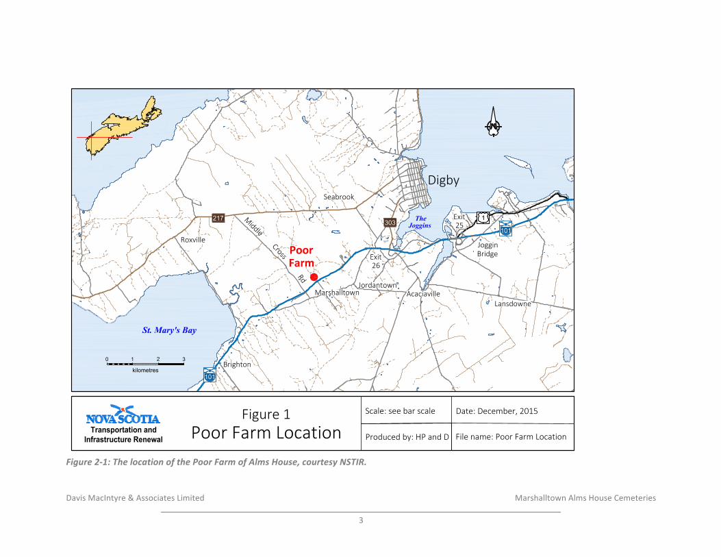
Davis&MacIntyre&&&Associates&Limited& &&&&&&&&&&&&&&&&&&& & &&&&&&&&&&&Marshalltown&Alms&House&Cemeteries&&
3&
!Figure'2)1:'The'location'of'the'Poor'Farm'of'Alms'House,'courtesy'NSTIR.'
File name: Poor Farm Location
Figure 1Poor Farm Location
Scale: see bar scale Date: December, 2015
Produced by: HP and D
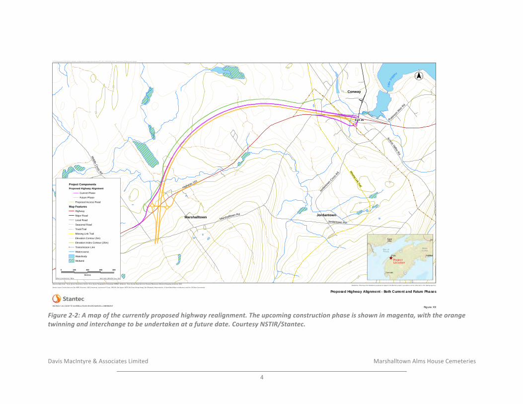
Davis&MacIntyre&&&Associates&Limited& &&&&&&&&&&&&&&&&&&& & &&&&&&&&&&&Marshalltown&Alms&House&Cemeteries&&
4&
!Figure'2)2:'A'map'of'the'currently'proposed'highway'realignment.'The'upcoming'construction'phase'is'shown'in'magenta,'with'the'orange'twinning'and'interchange'to'be'undertaken'at'a'future'date.'Courtesy'NSTIR/Stantec.'
! !!!
!
!
!
!!
!!
!!!!
!!
!!
!
!
!
!
!
!
!
!
!
!
!
!
!
!
!
!
!
!
!
!
!
!
!
!
!
!
!
!
!
!
!
!
!
!
!
!
!
!
!
!
!
Littl
eJo
ggins
Conway
Marshalltown Jordantown
Exit 26
Missing Link Trail
100
75
125
100
75
50
50
2550
25
5025
50
25
25
50
25
25
25
Highway 101
Marshalltown Rd
Robins
onW
eirRd
Middle
Cross
Rd
Jordantown Rd
AcaciaValley
Rd
Jorda
ntown Cros
s Rd
Rid
ge R
d
_̂ ProjectLocation
($$¯
Project ComponentsProposed Highway Alignment
Current Phase
Future Phase
Proposed Access Road
Map FeaturesHighway
Major Road
Local Road
Seasonal Road
Track/Trail
Missing Link Trail
Elevation Contour (5m)
Elevation Index Contour (25m)! Transmission Line
Watercourse
Waterbody
Wetland
V:\1214\active\121414143\03_data\gis_cad\geomatics\mapping\mxd\report\ST_NS_121414143-0012_Construction_Phases.mxd cshupe
NAD 1983 CSRS UTM Zone 20N ST NS 121414143-001 REVA
Disclaimer: This map is for illustrative purposes to support this Stantec project; questions can be directed to the issuing agency.
Figure XX
Proposed Highway Alignment - Both Current and Future PhasesService Layer Credits: Sources: Esri, HERE, DeLorme, USGS, Intermap, increment P Corp., NRCAN, Esri Japan, METI, Esri China (Hong Kong), Esri (Thailand), MapmyIndia, © OpenStreetMap contributors, and the GIS User Community
Sources: Base Data - Nova Scotia Geomatics Centre, Nova Scotia Topographic Database (NSTDB). Wetlands - Nova Scotia Department of Natural Resources, Wetland Mapping Inventory, 2010.
HIGHWAY 101 DIGBY TO MARSHALLTOWN ENVIRONMENTAL ASSESSMENT
0 200 400 600 800
Metres
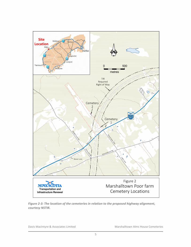
Davis&MacIntyre&&&Associates&Limited& &&&&&&&&&&&&&&&&&&& Marshalltown&Alms&House&Cemeteries&&
5&
&
!Figure'2)3:'The'location'of'the'cemeteries'in'relation'to'the'proposed'highway'alignment,'courtesy'NSTIR.'
&
Figure 2Marshalltown Poor farm
Cemetery Locations
SiteLocation
Davis&MacIntyre&&&Associates&Limited& &&&&&&&&&&&&&&&&&&& Marshalltown&Alms&House&Cemeteries&&
6&
3.0 METHODOLOGY-&A&historic&background&study&was&conducted&by&Davis&MacIntyre&&&Associates&Limited&in&February&and&March&2016.&Historical&maps&and&manuscripts&and&published&literature&were&consulted&at&the&Nova&Scotia&Archives&as&well&as&online.&The&Maritime&Archaeological&Resource&Inventory,&a&database&of&known&archaeological&resources&in&the&Maritime®ion,&was&searched&to&understand&prior&archaeological&research&and&known&archaeological&resources&neighbouring&the&study&area.&A&review&of&previous&archaeological&assessments&was&also&conducted.&Finally,&a&field&reconnaissance&and&geophysical&survey&was&conducted&in&order&to&further&evaluate&the&potential&for&burials&and&the&validity&of&the&EM38B&for&distinguishing&burials&at&the&two&locations,&followed&by&a&GPR&survey&of&the&southern&cemetery&in&an&effort&to&provide&additional&clarity.&&
3.1 Maritime-Archaeological-Resource-Inventory-&The&Maritime&Archaeological&Resource&Inventory,&a&database&of&known&archaeological&sites&in&the&Maritime&Provinces,&was&consulted&in&March&2016.&There&are&seven&known&archaeological&sites&in&the&DigbyRMarshalltown&area.&&Shell&middens&related&to&Precontact&activity&are&known&along&Bear&River&to&the&northeast,&chiefly&associated&with&the&Ceramic&(Kejikawek(L’nu’k)&Period&(BdDkR01,&BdDkR03,&BdDkR04,&BdDkR06).&Another&shell&midden&was&reported&at&Smith’s&Cove&in&1890,&but&could¬&be&relocated&in&the&twentieth¢ury&(BdDkR02).&A&general&site&number&has&been&assigned&for&isolated&Precontact&finds&reported&in&the&area&from&Joggins&Bridge&to&Bear&River&(BdDkR07).&&Finally,&a&historic&midden&incorporating&shell,&bone,&and&nineteenth¢ury&ceramic,&was&identified&near&the&Little&Joggins&(BdDkR08).&&&
3.2- Historical-Background-&
3.2.1- The-Precontact-Period-&
Nova&Scotia&has&been&home&to&the&Mi’kmaq&and&their&ancestors&for&at&least&11,500&years.&A&legacy&of&experience&built&over&millennia&shaped&cultural&beliefs&and&practices,&creating&an&intimate&relationship&between&populations&and&the&land&itself.&The&complexity&of&this&history,&culturally&and&ecologically,&is&still&being&explored.&&
The&earliest&period&is(Sa’qewe’l(L’nu’k((the&Ancient&People)&or&the&PaleoRIndian&period&(11,500&–&9,000BP).&The&changing&ecology&following°laciation&allowed&the&entrance&of&large&herds&of&migratory&caribou&into&Nova&Scotia,&followed&by&Paleoindian&groups&from&

Davis&MacIntyre&&&Associates&Limited& &&&&&&&&&&&&&&&&&&& Marshalltown&Alms&House&Cemeteries&&
7&
the&south.&Currently,&the&Debert/Belmont&Sites&provide&the&only&significant&evidence&of&PaleoRIndian&settlement&in&the&province.&Commonly&believed&to&be&bigRgame&hunters,&research&is&now&aimed&at&exploring&the&diverse&subsistence&patterns&that&may&have&supported&populations,&and&what&adaptations&were&made&when&the&environment&shifted&once&again&in&the&early&Holocene.&&
Succeeding&the&Sa’qewe’l(L’nu’k(is&the&Mu(Awsami(Kejihaw’k(L’nu’k&(the&Not&so&Recent&People)&or&the&Archaic&Period&(9,000R3,000&BP).&This&time&saw&a&reorientation&to&a&more&maritime&subsistence,&with&settlement&pivoting&more&towards&coastal&areas,&lakes&and&bountiful&riverine&resources.&Remnants&of&these&sites&along&the&coast&have&largely&been&engulfed&by&rising&seas&or&battered&by&wind&and&wave,&though&interior&sites&are&increasingly&being&discovered.&Ground&stone&tools,&specialized&for&woodRworking,&appear&at&this&time&and&may&have&been&used&to&create&dugRout&canoes.&Numerous&traditions&and&distinct&technologies&have&been&documented&throughout&Maine&and&the&Atlantic&provinces.&A&growing&catalogue&of&exotic&cultural&components&demonstrates&that&groups&within&Nova&Scotia&were&engaged&in&spheres&of&interaction&spanning&hundreds&of&kilometers.&Unfortunately,&a&lack&of&formally&excavated&sites&within&Nova&Scotia&still&obscures&the°ree&to&which&these&traditions&were&present.&&&By&the&Kejihawek(L’nu’k((the&Recent&People)&or&Woodland/Ceramic&period&(3,000R500&BP),&the&Mi’kmaq&were&a&maritime&people.&Known&Woodland/Ceramic&sites&concentrate&along&coasts&shorelines,&and&navigable&watercourses.&Migration&of&ideas&and&people&introduced&new&worldviews&and&technologies&from&groups&originating&in&places&like&northern&New&England&and&the&Great&Lakes&area,&to&local&populations,&including&the&earliest&ceramic&forms.&Harvesting&of&marine&molluscs&and&shellfish&appears&in&this&period,&and&substantial&shellRmiddens&have&gifted&archaeologists&with&wellRpreserved&records&of&these&past&lives.&Fish&weirs&populating&the&province’s&rivers&and&streams&speak&to&the&importance&of&migrating&fish&species&to&Mi’kmaq&life.&Terrestrial&hunting&and&foraging&was&practiced&with&varying°rees&of&intensity&depending&on&seasonality&and®ion.&A&generally&stable&cultural&form&is&believed&to&have&developed&by&2,000&BP,&forming&the&way&of&life&first&encountered&by&Europeans&arriving&on&our&shores.&&&Mi’kmaw&life&was&substantially&altered&in&the&Kiskukew’k(L’nu’k&(Today’s&People)&or&Contact&Period&(500&BPR&Present).&Trade&and&European&settlement&introduced&change&and&upheaval&to&the&traditional&way&of&First&Nation&life.&Mobile&hunting&and&gathering&still&defined&Mi’kmaw&life,&with&identity&residing&within&family&households.&Trading&posts&and&fishing&villages&became&intersections&of&European&and&Mi’kmaq&interaction,&affecting&traditional&seasonal&rounds&and&access&to&land.&The&hunting&of&furRbearing&mammals&intensified&to&satisfy&the&mutual&exchange&of&skins&for&European&goods.&It&is¬&accurate,&however,&to&say&that&Mi’kmaq&adopted&European&goods&and&culture,&but&rather&adapted&it.&The&Mi’kmaq&remained&an&influential&social&and&political&force&well&into&the&18th¢ury,&forming&a&triadic&narrative&of&contention&with&the&English&and&French.&However,&disease,&conflict,&and&alienation&from&the&land&wreaked&a&ruinous&
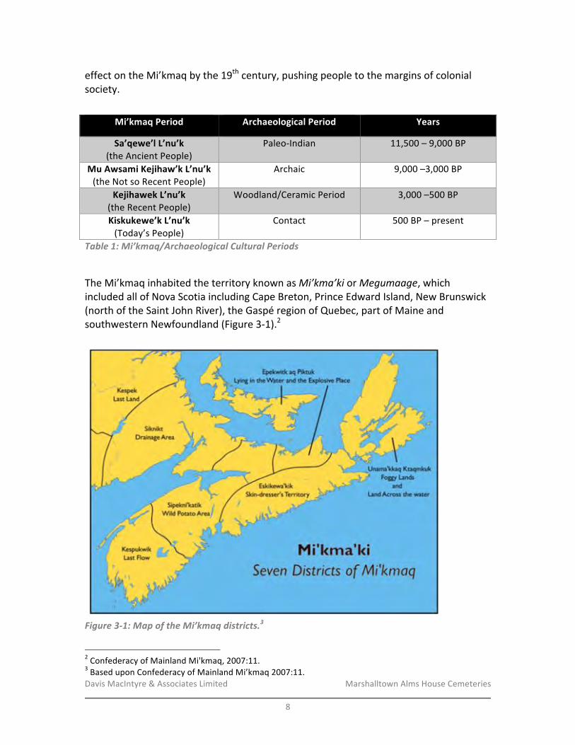
Davis&MacIntyre&&&Associates&Limited& &&&&&&&&&&&&&&&&&&& Marshalltown&Alms&House&Cemeteries&&
8&
effect&on&the&Mi’kmaq&by&the&19th¢ury,&pushing&people&to&the&margins&of&colonial&society.&&
Table'1:'Mi’kmaq/Archaeological'Cultural'Periods'
&The&Mi’kmaq&inhabited&the&territory&known&as&Mi’kma’ki&or&Megumaage,&which&included&all&of&Nova&Scotia&including&Cape&Breton,&Prince&Edward&Island,&New&Brunswick&(north&of&the&Saint&John&River),&the&Gaspé®ion&of&Quebec,&part&of&Maine&and&southwestern&Newfoundland&(Figure&3R1).2&&&&
!Figure'3)1:'Map'of'the'Mi’kmaq'districts.3'
!!!!!!!!!!!!!!!!!!!!!!!!!!!!!!!!!!!!!!!!!!!!!!!!!!!!!!!!2&Confederacy&of&Mainland&Mi'kmaq,&2007:11.&3&Based&upon&Confederacy&of&Mainland&Mi’kmaq&2007:11.&
Mi’kmaq-Period- Archaeological-Period- Years-
Sa’qewe’l-L’nu’k-(the&Ancient&People)&
PaleoRIndian& 11,500&–&9,000&BP&
Mu-Awsami-Kejihaw’k-L’nu’k-(the&Not&so&Recent&People)-
Archaic& 9,000&–3,000&BP&
Kejihawek-L’nu’k-(the&Recent&People)&
Woodland/Ceramic&Period& 3,000&–500&BP&
Kiskukewe’k-L’nu’k-(Today’s&People)&
Contact& 500&BP&–&present&
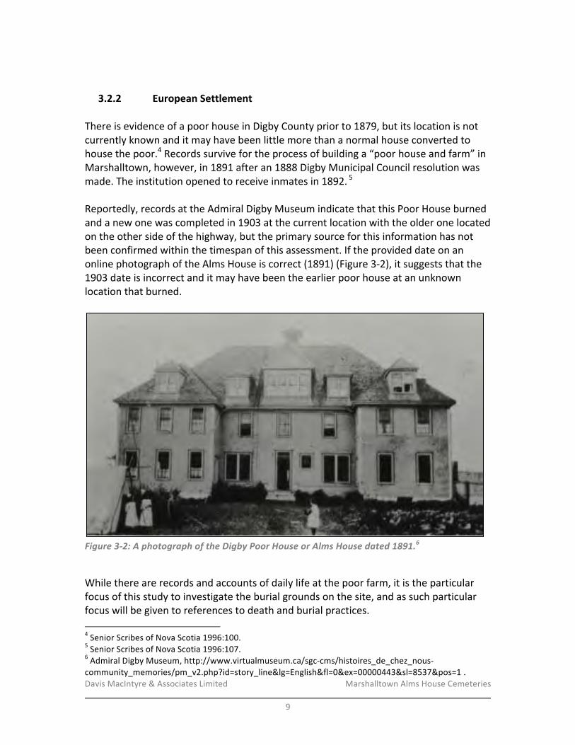
Davis&MacIntyre&&&Associates&Limited& &&&&&&&&&&&&&&&&&&& Marshalltown&Alms&House&Cemeteries&&
9&
&
3.2.2- European-Settlement-&There&is&evidence&of&a&poor&house&in&Digby&County&prior&to&1879,&but&its&location&is¬¤tly&known&and&it&may&have&been&little&more&than&a&normal&house&converted&to&house&the&poor.4&Records&survive&for&the&process&of&building&a&“poor&house&and&farm”&in&Marshalltown,&however,&in&1891&after&an&1888&Digby&Municipal&Council&resolution&was&made.&The&institution&opened&to&receive&inmates&in&1892.&5&&&Reportedly,&records&at&the&Admiral&Digby&Museum&indicate&that&this&Poor&House&burned&and&a&new&one&was&completed&in&1903&at&the¤t&location&with&the&older&one&located&on&the&other&side&of&the&highway,&but&the&primary&source&for&this&information&has¬&been&confirmed&within&the×pan&of&this&assessment.&If&the&provided&date&on&an&online&photograph&of&the&Alms&House&is&correct&(1891)&(Figure&3R2),&it&suggests&that&the&1903&date&is&incorrect&and&it&may&have&been&the&earlier&poor&house&at&an&unknown&location&that&burned.&&
!Figure'3)2:'A'photograph'of'the'Digby'Poor'House'or'Alms'House'dated'1891.6'
&While&there&are&records&and&accounts&of&daily&life&at&the&poor&farm,&it&is&the&particular&focus&of&this&study&to&investigate&the&burial&grounds&on&the&site,&and&as&such&particular&focus&will&be&given&to&references&to&death&and&burial&practices.&&!!!!!!!!!!!!!!!!!!!!!!!!!!!!!!!!!!!!!!!!!!!!!!!!!!!!!!!!4&Senior&Scribes&of&Nova&Scotia&1996:100.&5&Senior&Scribes&of&Nova&Scotia&1996:107.&6&Admiral&Digby&Museum,&http://www.virtualmuseum.ca/sgcRcms/histoires_de_chez_nousRcommunity_memories/pm_v2.php?id=story_line&lg=English&fl=0&ex=00000443&sl=8537&pos=1&.&
Davis&MacIntyre&&&Associates&Limited& &&&&&&&&&&&&&&&&&&& Marshalltown&Alms&House&Cemeteries&&
10&
&Several&accounts&of&conditions&at&the&Alms&House&survive,&and&these&vary&widely&in&tone.&Taken&together,&it&appears&that&conditions&were&extremely&bad&for&inmates&in&the&institution’s&early&years,&and&around&the&time&of&the&Second&World&War&conditions&became&somewhat&more&benign&under&the&leadership&of&different&caretakers.&&An&extremely&negative&account&of&the&early&Alms&House&includes&the&following&passages&that&are&relevant&to&the&treatment&of&the&dead:&&
These&people&were&subject&to&beatings&quite&frequent[ly].&In&case&of&death,&many&were&buried&on&the&place.&They&had&graveyards&there.&&The&people&staying&there&looked&after&the&dead&and&built&their&own&coffins&in&the&basement.&They&would&put&a&person&in&a&rough&box&right&off&the&bed,&take&him&down&in&the&field&and&bury&him&just&like&an&animal.&&There&was&a&man&from&the&North&Range&area&who&had&died&at&the&Poor&Farm.&He&was&sent&down&to&the&Catholic&Church&in&Plympton&to&be&buried.&&The&priest&had&to&view&the&remains&–&that&was&part&of&his&job.&When&he&opened&the&rough&box,&the&man&in&question&was&in&the&rough&box&without&a&stitch&of&clothes&on,&just&lying&on&an&old&blanket&that&wasn’t&fit&to&take&to&the&dump.&There&was&another&man&at&the&Poor&Farm&from&the&Doucetteville&area.&He&was&elderly&and&quite&ill&at&the&time.&A&priest&from&Plympton&went&to&the&Poor&Farm&to&give&the&man&his&last&rites.&On&arriving&at&the&farm,&the&priest&and&altar&boy&were&turned&away&by&the&Keeper&and¬&allowed&to&go&in.&The&priest&got&in&touch&with&the&man&who&had&charge&of&the&doings&at&the&Poor&Farm.&He&made&sure&the&priest&and&altar&boy&were&allowed&to&go&in.&They&got&to&the&man’s&room&and&found&him&lying&face&down&on&a&sheet&with&no&clothes&on&and&a&very&large&gash&behind&his&right&ear.&It&had&been&made&with&a&blunt&instrument.&This&was&way&back&before&Alton&[Halton]&Hayden&took&over.&[…]&If&a&young&lady&[who&was&pregnant&and&unmarried]&was&taken&there&and&had&a&long&list&of&mentally&ill&in&her&family,&she&was&made&to&do&extra&duties&hoping&she&would&have&a&miscarriage.&After&she&had&the&baby,¬hing&was&done&to&keep&the&babies&alive&and&they&were&generally&thrown&in&the&furnace.7&
&&
!!!!!!!!!!!!!!!!!!!!!!!!!!!!!!!!!!!!!!!!!!!!!!!!!!!!!!!!7&Robicheau&1985.&

Davis&MacIntyre&&&Associates&Limited& &&&&&&&&&&&&&&&&&&& Marshalltown&Alms&House&Cemeteries&&
11&
This&grim&account&contrasts&sharply&with&an&account&provided&by&Olive&Hayden,&wife&of&the&caretaker&Halton&Hayden&from&1939&to&approximately&1943,&who&recalled&the&inmates&as&“like&one&big&happy&family.”&Few&inmates&died&during&her&time&there,&but&she&recalled&caskets&being&stored&in&the&basement&with&some&cloth&in&them,&“nothing&fancy.”8&Mrs.&Hayden&did¬&know&if&the&caskets&had&been&made&at&the&House&or&had&been&provided&by&the&Municipality.&When&a&rare&death&occurred,&Mrs.&Hayden&had&the&shared&responsibility&of&preparing&the&body&for&burial,&including&laying&out&the&individual,&dressing&her&or&him,&and&putting&pennies&over&the&eyes&to&keep&them&closed.&&From&there,&they&“took&them&back&and&buried&them.&That&was&our&duty.&The&burial&grounds&have¬&been&kept&up.&I&think&Mr.&Thomas&put&a&fence&around&them&but&I&don’t&think&it’s&there&now.”9&Though&she&did¬&recall&any&burial&services,&her&brother&Lawrence&Trimper&indicated&that&a&Church&of&England&minister&said&prayers&at&each&burial.&Despite&Mrs.&Hayden’s&positive&memories,&she&and&her&husband&chose&to&give&up&the&job&after&a&few&years&because&it&“bothered&their&nerves”;&“[w]e&thought&we&would&leave&before&it&got&too&bad.&We&never&had&a&vacation&while&we&were&there.”&10&Oral&accounts&do¬&favour&Mr.&Hayden&as&a&good&caretaker,&and&accusations&have&been&made&as&to&his&inappropriate&conduct&being&the&cause&for&his&leaving&the&institution.11&&An&account&of&the&Alms&House’s&changing&conditions&was&provided&by&Earle&Thomas,&the&son&and&grandson&of&the&institution’s&last&two&caretaker&couples.&There&was&reportedly&a&“marked&difference&in&the&poor&farm”&that&he&attributed&to&“a&general&change&in&society’s&attitude&towards&the&poor&and&disabled,&a&change&which&has&led&to&many&of&the&social&programs&in&effect&today.”12&Thomas&commented,&“In&those&[earlier]&days&a&person&who&was&down&and&out&was&considered¬hing.&[…]&From&the&time&that&I&was&a&little&boy&to&1945,&I&don’t&believe&it&was&very&good.&[…]&I&am&quite&sure&that&in&those&days&they&had&good&food&and&clothing,&but&that&is&about&all.”13&The&inmates&who&died&and&were&buried&on&site&were&“put&into&caskets,&‘if&you&want&to&call&them&that’&and&deposited&in&unmarked&graves.&On&this&[one]&occasion&a&woman&had&come&to&the&farm,&and&some&of&the&men&went&to&the&back&field&to&dig&up&a&grave.&Thomas&can’t&remember&for&sure&whether&or¬&she&came&in&an&automobile&or¬,&but&assumes&she&came&to&identify&a&body,&for&perhaps&it&was&one&of&her&relatives.&They&opened&the&casket&and&left&it&on&the&barn&floor.&‘I&sneaked&in.&The&casket&was&open.&I&remember&this&body,&a&male,&had&all&turned&black&except&the&feet.&It&was&buried&in&a&shroud&like&an&onion&sack,&which&was&decomposed&enough&so&you&could&see&right&through&it.&The&body&was&put&back&in&the&grave&and&that&was&it.&[…]&My&grandfather&caught&me&and&told&me&in&no&uncertain&terms&what&he’d&do&if&he&caught&me&again.’”&14&Thomas’&parents&took&over&the&management&of&the&farm&in&1941&or&1942.&Four&separate&wards&were&in&place&at&the&time:&one&for&the&“insane”&and&
!!!!!!!!!!!!!!!!!!!!!!!!!!!!!!!!!!!!!!!!!!!!!!!!!!!!!!!!8&Norwood&1985.&9&Norwood&1985.&10&Norwood&1985.&11&Personal&communications,&Harold&Simms&and&Vincent&Giles,&November&2016.&12&The&Digby&Mirror&1983.&13&The&Digby&Mirror&1983.&14&The&Digby&Mirror&1983.&
Davis&MacIntyre&&&Associates&Limited& &&&&&&&&&&&&&&&&&&& Marshalltown&Alms&House&Cemeteries&&
12&
one&for&the&“sane”&of&each&gender.&The&inmates&worked&the&farm&to&help&make&the&institution&more&selfRsufficient.&Christmas&parties&and&church&services&were&held,&and&the&Earle’s&parents&were&called&“Mom”&and&“Dad”&by&the&inmates,&who&were&taken&on&trips&into&town&when&they&were&able,&though&there&were&two&or&four&cells&for&violent&or&outRofRcontrol&inmates&as&well.&Shortly&before&the&closure&of&the&House,&the&farm’s&very&large&barn&burned&down,&which&contributed&to&the&decision&to&close&the&institution.&15&&Harold&Ritchie,&another&grandson&of&Guy&Thomas&and&his&wife&who&took&over&as&caretakers&from&the&Haydens&in&the&early&1940s,&made&it&clear&that&no&babies&were&left&untended&and&no&inmates&made&their&own&caskets&during&his&grandparents’&time&there,&but&were&instead&given&caskets&and&rough&boxes&by&the&Municipality,&and&funerals&were&attended&by&a&priest&or&a&minister.16&&Posts&or&stakes&were&reportedly&used&to&mark&at&least&some&of&the&graves,&and&aside&from&a&mother&and&child&buried&together,&it&seems&that&most&if¬&all&burials&were&single&inhumations&rather&than&grouped&or&mass&graves.&The&burials&were&unorganized&in&terms&of&positioning,&and&some&were&placed&in&old&boxes&or&wrapped&in&sheets.17&&The&Alms&House&facility&closed&in&1963,&a&remarkably&late&date&in&comparison&with&other&poor&houses&across&the&province.&The&closure&was&due&to&the&need&for&upgrades&estimated&at&$50,000.18&Remaining&inmates&were&sent&to&“Homes&for&the&Disabled”&in&Yarmouth&and&Kings&Counties.19&&&In&1968,&the&site&of&the&former&Alms&House&was&suddenly&brought&back&to&the&forefront&of&local&news&when&Beaverbrook&Farms&began&to&clear&land&(Figures&3R3&and&3R4)&and&build&barracks&for&migrant&workers&(Figure&3R5)&to&pick&strawberries.&Much&of&the&land&had&overgrown&in&heavy&brush,&and&a&bulldozer&was&brought&in&to&clear&the&fields&of&this&growth.20&&Although&there&is&no&mention&of&it&in&published&sources,&many&local&residents&have&heard&oral&accounts&of&human&remains&being&disturbed&during&this&bulldozing&activity.&One&local&resident&indicated&that&Harold&Simms&had&hired&on&a&worker&around&that&time&who&had&left&his&employment&at&Beaverbrook&Farms&when&he&and&his&coworkers&had&encountered&bone&–&including&an&identifiably&human&skull&–&and&had&been&told&to&say¬hing&about&it.21&Reportedly,&this&same&oral&history&source&also&indicated&that&the&bone&and&scraps&of&fabric&exposed&at&this&time&were&gathered&together&and&placed&in&a&mass&
!!!!!!!!!!!!!!!!!!!!!!!!!!!!!!!!!!!!!!!!!!!!!!!!!!!!!!!!15&The&Digby&Mirror&1983.&16&Ritchie&1985.&17&Vincent&Giles,&personal&communication&March&2016.&18&The&Chronicle&Herald&Friday,&1&February&1963,&reproduced&in&The&Digby&Courier&13&March&1985.&19&Senior&Scribes&of&Nova&Scotia&1996:108,&110.&20&The&Vanguard&1968.&21&Vince&Giles,&personal&communication&March&2016.&
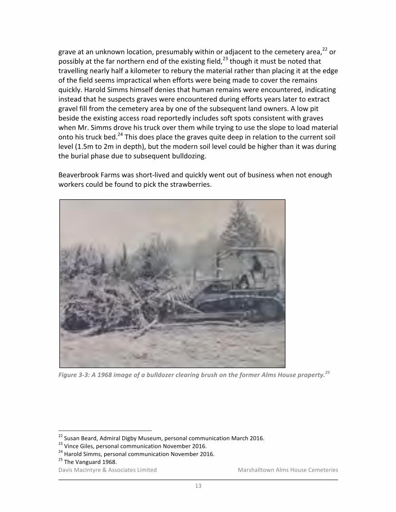
Davis&MacIntyre&&&Associates&Limited& &&&&&&&&&&&&&&&&&&& Marshalltown&Alms&House&Cemeteries&&
13&
grave&at&an&unknown&location,&presumably&within&or&adjacent&to&the&cemetery&area,22&or&possibly&at&the&far&northern&end&of&the&existing&field,23&though&it&must&be¬ed&that&travelling&nearly&half&a&kilometer&to&rebury&the&material&rather&than&placing&it&at&the&edge&of&the&field&seems&impractical&when&efforts&were&being&made&to&cover&the&remains&quickly.&Harold&Simms&himself&denies&that&human&remains&were&encountered,&indicating&instead&that&he&suspects&graves&were&encountered&during&efforts&years&later&to&extract&gravel&fill&from&the&cemetery&area&by&one&of&the&subsequent&land&owners.&A&low&pit&beside&the&existing&access&road&reportedly&includes&soft&spots&consistent&with&graves&when&Mr.&Simms&drove&his&truck&over&them&while&trying&to&use&the&slope&to&load&material&onto&his&truck&bed.24&This&does&place&the&graves&quite&deep&in&relation&to&the¤t&soil&level&(1.5m&to&2m&in&depth),&but&the&modern&soil&level&could&be&higher&than&it&was&during&the&burial&phase&due&to&subsequent&bulldozing.&&Beaverbrook&Farms&was&shortRlived&and&quickly&went&out&of&business&when¬&enough&workers&could&be&found&to&pick&the&strawberries.&&
!Figure'3)3:'A'1968'image'of'a'bulldozer'clearing'brush'on'the'former'Alms'House'property.25'
&
!!!!!!!!!!!!!!!!!!!!!!!!!!!!!!!!!!!!!!!!!!!!!!!!!!!!!!!!22&Susan&Beard,&Admiral&Digby&Museum,&personal&communication&March&2016.&23&Vince&Giles,&personal&communication&November&2016.&24&Harold&Simms,&personal&communication&November&2016.&25&The&Vanguard&1968.&
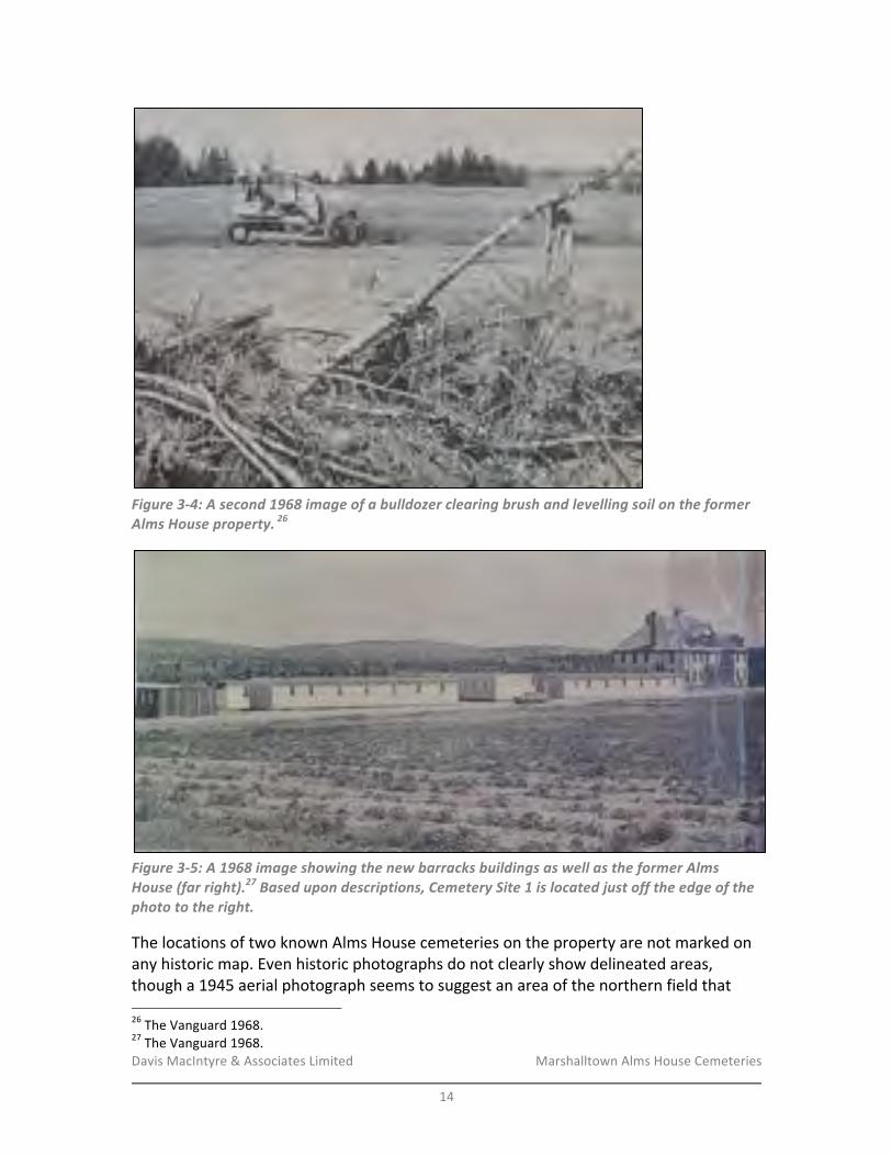
Davis&MacIntyre&&&Associates&Limited& &&&&&&&&&&&&&&&&&&& Marshalltown&Alms&House&Cemeteries&&
14&
!Figure'3)4:'A'second'1968'image'of'a'bulldozer'clearing'brush'and'levelling'soil'on'the'former'Alms'House'property.'26'
!Figure'3)5:'A'1968'image'showing'the'new'barracks'buildings'as'well'as'the'former'Alms'House'(far'right).27'Based'upon'descriptions,'Cemetery'Site'1'is'located'just'off'the'edge'of'the'photo'to'the'right.'
The&locations&of&two&known&Alms&House&cemeteries&on&the&property&are¬&marked&on&any&historic&map.&Even&historic&photographs&do¬&clearly&show&delineated&areas,&though&a&1945&aerial&photograph&seems&to&suggest&an&area&of&the&northern&field&that&!!!!!!!!!!!!!!!!!!!!!!!!!!!!!!!!!!!!!!!!!!!!!!!!!!!!!!!!26&The&Vanguard&1968.&27&The&Vanguard&1968.&
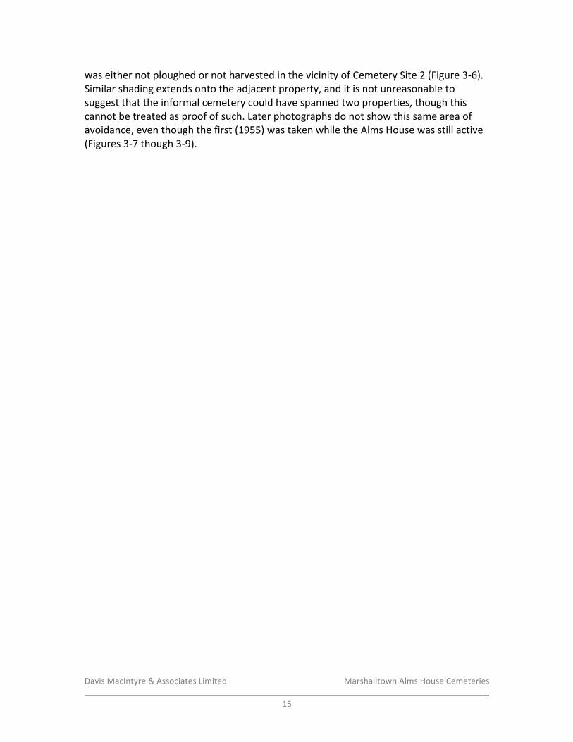
Davis&MacIntyre&&&Associates&Limited& &&&&&&&&&&&&&&&&&&& Marshalltown&Alms&House&Cemeteries&&
15&
was&either¬&ploughed&or¬&harvested&in&the&vicinity&of&Cemetery&Site&2&(Figure&3R6).&Similar&shading&extends&onto&the&adjacent&property,&and&it&is¬&unreasonable&to&suggest&that&the&informal&cemetery&could&have&spanned&two&properties,&though&this&cannot&be&treated&as&proof&of&such.&Later&photographs&do¬&show&this&same&area&of&avoidance,&even&though&the&first&(1955)&was&taken&while&the&Alms&House&was&still&active&(Figures&3R7&though&3R9).&&
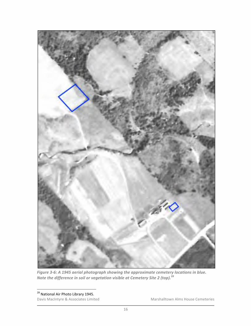
Davis&MacIntyre&&&Associates&Limited& &&&&&&&&&&&&&&&&&&& Marshalltown&Alms&House&Cemeteries&&
16&
!Figure'3)6:'A'1945'aerial'photograph'showing'the'approximate'cemetery'locations'in'blue.'Note'the'difference'in'soil'or'vegetation'visible'at'Cemetery'Site'2'(top).28'
!!!!!!!!!!!!!!!!!!!!!!!!!!!!!!!!!!!!!!!!!!!!!!!!!!!!!!!!28&National&Air&Photo&Library&1945.&
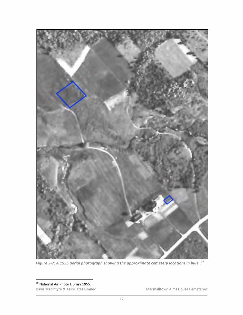
Davis&MacIntyre&&&Associates&Limited& &&&&&&&&&&&&&&&&&&& Marshalltown&Alms&House&Cemeteries&&
17&
!Figure'3)7:'A'1955'aerial'photograph'showing'the'approximate'cemetery'locations'in'blue..29'
'!!!!!!!!!!!!!!!!!!!!!!!!!!!!!!!!!!!!!!!!!!!!!!!!!!!!!!!!29&National&Air&Photo&Library&1955.&
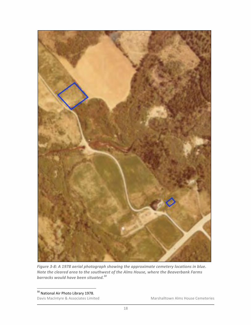
Davis&MacIntyre&&&Associates&Limited& &&&&&&&&&&&&&&&&&&& Marshalltown&Alms&House&Cemeteries&&
18&
!Figure'3)8:'A'1978'aerial'photograph'showing'the'approximate'cemetery'locations'in'blue.'Note'the'cleared'area'to'the'southwest'of'the'Alms'House,'where'the'Beaverbank'Farms'barracks'would'have'been'situated.30'
!!!!!!!!!!!!!!!!!!!!!!!!!!!!!!!!!!!!!!!!!!!!!!!!!!!!!!!!30&National&Air&Photo&Library&1978.&
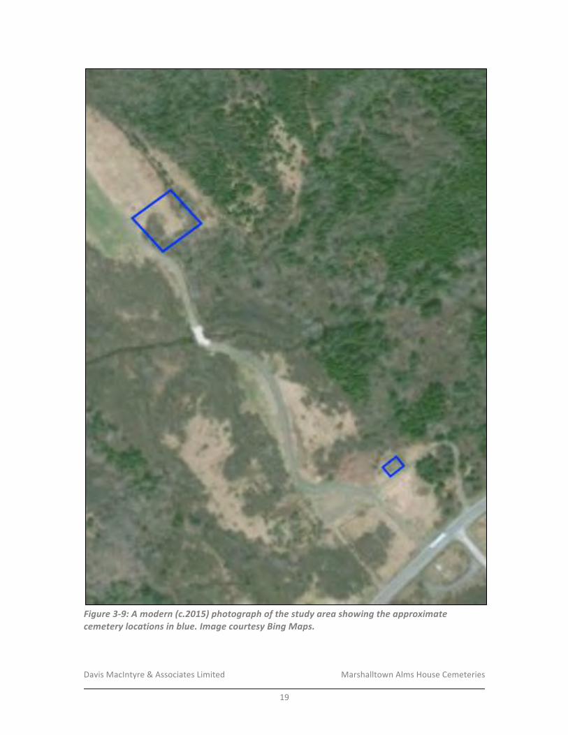
Davis&MacIntyre&&&Associates&Limited& &&&&&&&&&&&&&&&&&&& Marshalltown&Alms&House&Cemeteries&&
19&
!Figure'3)9:'A'modern'(c.2015)'photograph'of'the'study'area'showing'the'approximate'cemetery'locations'in'blue.'Image'courtesy'Bing'Maps.'
&

Davis&MacIntyre&&&Associates&Limited& &&&&&&&&&&&&&&&&&&& Marshalltown&Alms&House&Cemeteries&&
20&
In&2003,&the&cemetery&locations&were&indicated&to&Digby&Municipality&Program&Development&Coordinator&(Heritage)&Robert&Hersey&by&Harold&Ritchie&during&a&site&visit.&The&first&site,&presumed&to&be&the&older&of&the&two&by&previous&researchers&and&according&to&Harold&Simms’&oral&history,&is&located&closest&to&the&highway&and&is&immediately&beside&(east&of)&the&former&location&of&the&Alms&House&itself.&The&house&stood,&presumably&empty,&until&1994&when&it&burned&on&April&18th&of&that&year.31&The&second&cemetery&is&farther&to&the&north,&accessed&by&a&curving&road&that&crosses&over&a&stream&and&opens&into&a&hay&field&before&curving&sharply&right&(northeast,&then&east).&Though&at&the&beginning&of&this&project&the&northern&cemetery&was&indicated&as&a&long&rectangle&against&the&northeast&edge&of&the&property,&site&visits&by&two&local&contacts&(Harold&Simms,&who&recalls&some&wooden&crosses&here&as&a&child,&and&Vincent&Giles,&who&has&previously&collected&other&oral&history&from&eyeRwitnesses)&points&to&a&more&square&shape&running&between&the&access&road&and&the&property&line,&as&shown&on&the&aerial&photos&above.32&&Research&in&2003&found&that&a&total&of&175&people&died&at&the&Poor&Farm&between&1897&and&1958&(there&were&no&deaths&between&1958&and&the&closure&in&1963).&Of&these,&91&were&recorded&as&being&buried&at&the&farm&when&no&relatives&claimed&their&remains&for&burial&elsewhere,&and&84&reportedly&had&no&place&of&burial&recorded.&A&sudden&spike&in&deaths&in&1921&(12&deaths)&has&been&postulated&as&the&year&that&it&was&deemed&necessary&to&begin&burials&in&a&new,&less&crowded&location&(the&second&cemetery&to&the&north).33&&It&has&alternately&been&speculated&that&the&general&poor&–&including&nonRresidents&of&the&Alms&House,&individuals&from&mixed&racial&backgrounds,&and&so&on&–&were&buried&in&a&separate&location&from&the&“insane”&inmates,&who&had&also&been&separated&from&the&other&inmates&in&life.&Some&burials&even&reportedly&occurred&at&night,&though&it&is¬&clear&why&this&occurred.&34&&Modern&community&interest&in&the&poor&farm&and&its&cemeteries&remains&strong,&including&an&active&Facebook&group&and&community&group.&Research&conducted&by&several&members&of&the&online&group&has&helped&to&confirm&the&burial&of&many&inmates&on&the&poor&farm&property&based&upon&death&certificates,&including&some&individuals¬&on&the&original&list&of&deaths&available&from&the&Admiral&Digby&Museum&as&compiled&by&Sheryl&Stanton.&The&numbers&of&burials&continue&to&grow&as&research&proceeds.&Currently,&research&conducted&by&Faye&Lent&in&association&with&Brenda&Small&indicates&a&minimum&of&98&burials&(after&removing&apparent&duplicate&records)&are&confirmed&on&site,&with&the&rest&either&confirmed&buried&elsewhere&or&their&place&of&burial&remains&
!!!!!!!!!!!!!!!!!!!!!!!!!!!!!!!!!!!!!!!!!!!!!!!!!!!!!!!!31&The&Digby&Courier&1994.&32&Harold&Simms&and&Vincent&Giles,&personal&communications&November&2016.&33&Giddens&2003:3.&34&Vince&Giles,&personal&communication&March&2016.&
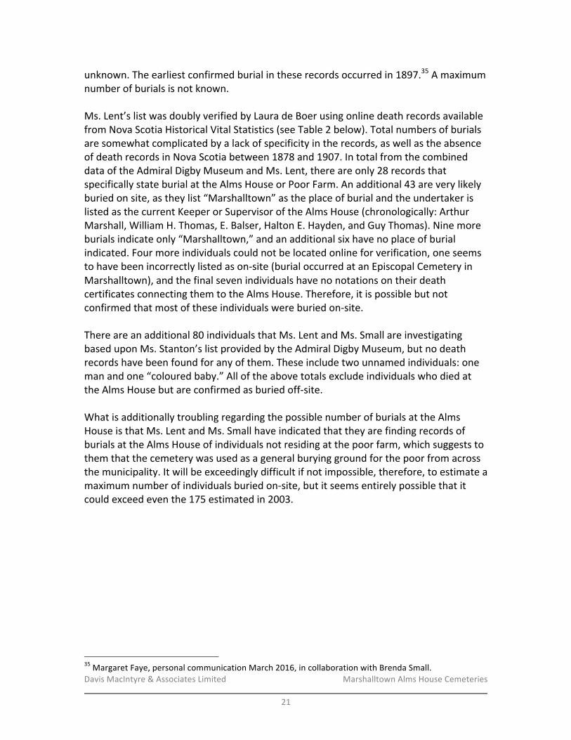
Davis&MacIntyre&&&Associates&Limited& &&&&&&&&&&&&&&&&&&& Marshalltown&Alms&House&Cemeteries&&
21&
unknown.&The&earliest&confirmed&burial&in&these&records&occurred&in&1897.35&A&maximum&number&of&burials&is¬&known.&&Ms.&Lent’s&list&was&doubly&verified&by&Laura&de&Boer&using&online&death&records&available&from&Nova&Scotia&Historical&Vital&Statistics&(see&Table&2&below).&Total&numbers&of&burials&are&somewhat&complicated&by&a&lack&of&specificity&in&the&records,&as&well&as&the&absence&of&death&records&in&Nova&Scotia&between&1878&and&1907.&In&total&from&the&combined&data&of&the&Admiral&Digby&Museum&and&Ms.&Lent,&there&are&only&28&records&that&specifically&state&burial&at&the&Alms&House&or&Poor&Farm.&An&additional&43&are&very&likely&buried&on&site,&as&they&list&“Marshalltown”&as&the&place&of&burial&and&the&undertaker&is&listed&as&the¤t&Keeper&or&Supervisor&of&the&Alms&House&(chronologically:&Arthur&Marshall,&William&H.&Thomas,&E.&Balser,&Halton&E.&Hayden,&and&Guy&Thomas).&Nine&more&burials&indicate&only&“Marshalltown,”&and&an&additional&six&have&no&place&of&burial&indicated.&Four&more&individuals&could¬&be&located&online&for&verification,&one&seems&to&have&been&incorrectly&listed&as&onRsite&(burial&occurred&at&an&Episcopal&Cemetery&in&Marshalltown),&and&the&final&seven&individuals&have&no¬ations&on&their&death&certificates&connecting&them&to&the&Alms&House.&Therefore,&it&is&possible&but¬&confirmed&that&most&of&these&individuals&were&buried&onRsite.&&There&are&an&additional&80&individuals&that&Ms.&Lent&and&Ms.&Small&are&investigating&based&upon&Ms.&Stanton’s&list&provided&by&the&Admiral&Digby&Museum,&but&no&death&records&have&been&found&for&any&of&them.&These&include&two&unnamed&individuals:&one&man&and&one&“coloured&baby.”&All&of&the&above&totals&exclude&individuals&who&died&at&the&Alms&House&but&are&confirmed&as&buried&offRsite.&&What&is&additionally&troubling®arding&the&possible&number&of&burials&at&the&Alms&House&is&that&Ms.&Lent&and&Ms.&Small&have&indicated&that&they&are&finding&records&of&burials&at&the&Alms&House&of&individuals¬&residing&at&the&poor&farm,&which&suggests&to&them&that&the&cemetery&was&used&as&a&general&burying&ground&for&the&poor&from&across&the&municipality.&It&will&be&exceedingly&difficult&if¬&impossible,&therefore,&to&estimate&a&maximum&number&of&individuals&buried&onRsite,&but&it&seems&entirely&possible&that&it&could&exceed&even&the&175&estimated&in&2003.&&&&&&&&
!!!!!!!!!!!!!!!!!!!!!!!!!!!!!!!!!!!!!!!!!!!!!!!!!!!!!!!!35&Margaret&Faye,&personal&communication&March&2016,&in&collaboration&with&Brenda&Small.&

Davis&MacIntyre&&&Associates&Limited& &&&&&&&&&&&&&&&&&&& Marshalltown&Alms&House&Cemeteries&&
22&
Table'2:'A'verified'list'of'burials'at'the'site'of'the'Alms'House'based'upon'previous'research'by'Sheryl'Stanton,'Faye'Lent,'and'Brenda'Small.'
- -Last'Name' First'Name' Date'of'Death'Confirmed-Buried-on-Site-Abbott& Henry& February&16,&1915&Abbott& Joseph& November&3,&1914&Ackers& Mary&Elizabeth& January&31,&1914&Brimner&(Brimmer)& John& September&27,&1911&Comeau& Euphemia& October&17,&1916&Comeau& Heliare& December&18,&1909&Crabb& James& November&9,&1917&Doggett& Annie& April&16,&1918&Ford& James& August&25,&1916&Gillis& Oliver& July&3,&1910&Grimes& Emmeline& June&4,&1909&Langford& Colin& March&30,&1928&Lewis& Etta& May&9,&1946&Lewis& Jessie& August&16,&1954&Lewis& Harry& June&1,&1912&McCallum& David& September&23,&1921&McCallum& Delia& October&4,&1913&McKinnon& John& October&21,&1917&Melanson& Mary& February&1,&1914&Morehouse& Cassie& November&16,&1936&Pettos& Charles& February&7,&1932&Saunders& Charles& May&27,&1909&Small& Thomas& October&22,&1917&Smith& Charles& July&16,&1911&Sweeney& Unis&Maria& April&6,&1911&Thomas& Mrs.&Sarah& June&8,&1924&Tidd& Washington& May&7,&1911&Welch& Caroline& December&1,&1913&Burial-in-Marshalltown-P-Undertaker's-Name-Suggests-Alms-House-Burial-Armstrong& James& January&9,&1924&Comeau& Almira&(Alvina)& April&17,&1924&Comeau& Ann& July&9,&1930&Cosby& Bert& May&21,&1933&Dugeau& Joseph& March&15,&1920&Doran& Edward& December&27,&1920&Duthridge&(Dutcheridge)& Sarah& July&13,&1932&
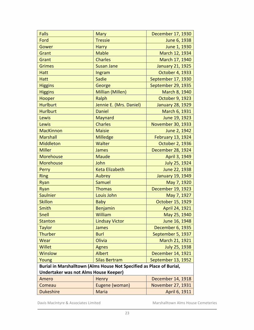
Davis&MacIntyre&&&Associates&Limited& &&&&&&&&&&&&&&&&&&& Marshalltown&Alms&House&Cemeteries&&
23&
Falls& Mary& December&17,&1930&Ford& Tressie& June&6,&1938&Gower& Harry& June&1,&1930&Grant& Mable& March&12,&1934&Grant& Charles& March&17,&1940&Grimes& Susan&Jane& January&21,&1925&Hatt& Ingram& October&4,&1933&Hatt& Sadie& September&17,&1930&Higgins& George& September&29,&1935&Higgins& Millian&(Millen)& March&8,&1940&Hooper& Ralph& October&9,&1923&Hurlburt& Jennie&E.&(Mrs.&Daniel)& January&28,&1929&Hurlburt& Daniel& March&6,&1931&Lewis& Maynard& June&19,&1923&Lewis& Charles& November&30,&1933&MacKinnon& Maisie& June&2,&1942&Marshall& Milledge& February&13,&1924&Middleton& Walter& October&2,&1936&Miller& James& December&28,&1924&Morehouse& Maude& April&3,&1949&Morehouse& John& July&25,&1924&Perry& Keta&Elizabeth& June&22,&1938&Ring& Aubrey& January&19,&1949&Ryan& Samuel& May&7,&1920&Ryan& Thomas& December&19,&1923&Saulnier& Louis&John& May&7,&1927&Skillon& Baby& October&15,&1929&Smith& Benjamin& April&24,&1921&Snell& William& May&25,&1940&Stanton& Lindsay&Victor& June&16,&1948&Taylor& James& December&6,&1935&Thurber& Burl& September&5,&1937&Wear& Olivia& March&21,&1921&Willet& Agnes& July&25,&1938&Winslow& Albert& December&14,&1921&Young& Silas&Bertram& September&13,&1952&Burial-in-Marshalltown-(Alms-House-Not-Specified-as-Place-of-Burial,-Undertaker-was-not-Alms-House-Keeper)-Amero& Henry& December&14,&1918&Comeau& Eugene&(woman)& November&27,&1931&Dukeshire& Maria& April&6,&1911&
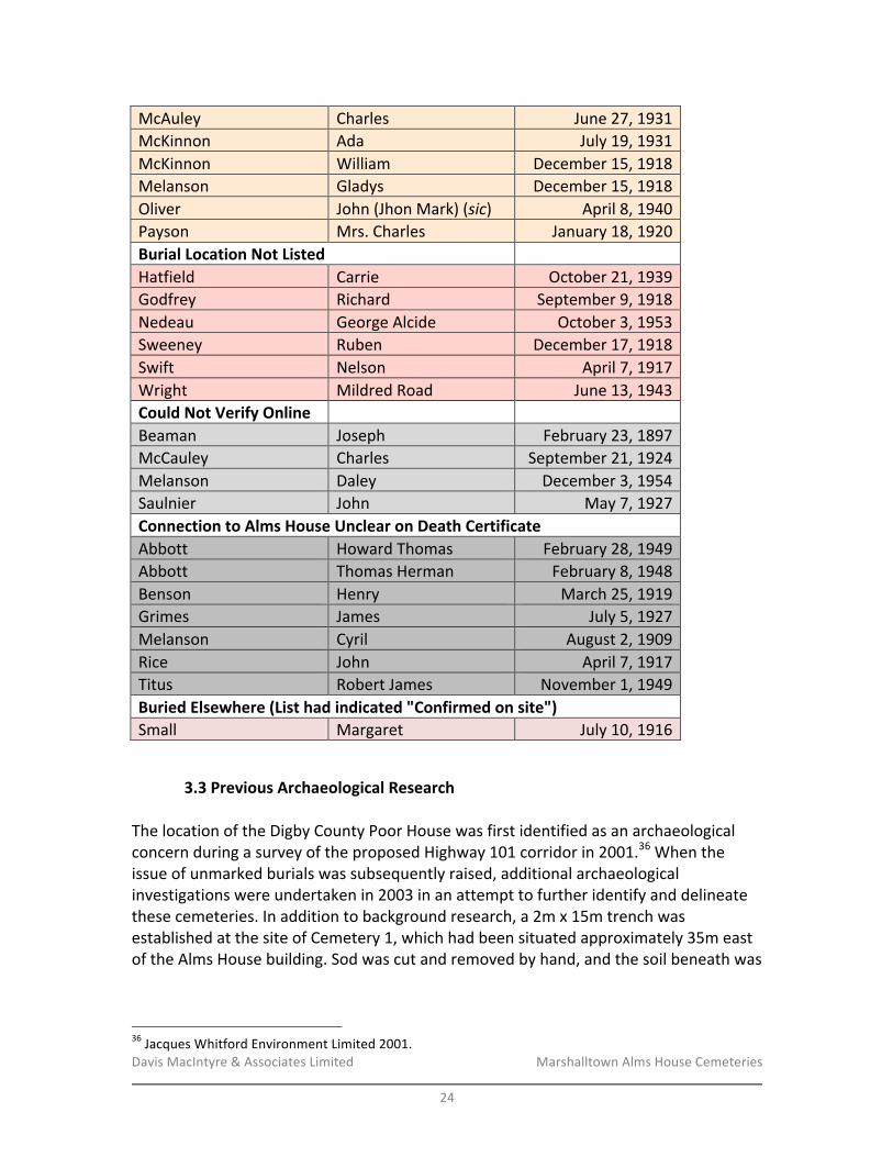
Davis&MacIntyre&&&Associates&Limited& &&&&&&&&&&&&&&&&&&& Marshalltown&Alms&House&Cemeteries&&
24&
McAuley& Charles& June&27,&1931&McKinnon& Ada& July&19,&1931&McKinnon& William& December&15,&1918&Melanson& Gladys& December&15,&1918&Oliver& John&(Jhon&Mark)&(sic)& April&8,&1940&Payson& Mrs.&Charles& January&18,&1920&Burial-Location-Not-Listed-
-Hatfield& Carrie& October&21,&1939&Godfrey& Richard& September&9,&1918&Nedeau& George&Alcide& October&3,&1953&Sweeney& Ruben& December&17,&1918&Swift& Nelson& April&7,&1917&Wright& Mildred&Road& June&13,&1943&Could-Not-Verify-Online-
- -Beaman& Joseph& February&23,&1897&McCauley& Charles& September&21,&1924&Melanson& Daley& December&3,&1954&Saulnier& John& May&7,&1927&Connection-to-Alms-House-Unclear-on-Death-Certificate-Abbott& Howard&Thomas& February&28,&1949&Abbott& Thomas&Herman& February&8,&1948&Benson& Henry& March&25,&1919&Grimes& James& July&5,&1927&Melanson& Cyril& August&2,&1909&Rice& John& April&7,&1917&Titus& Robert&James& November&1,&1949&Buried-Elsewhere-(List-had-indicated-"Confirmed-on-site")&Small& Margaret& July&10,&1916&&
3.3 Previous-Archaeological-Research-&The&location&of&the&Digby&County&Poor&House&was&first&identified&as&an&archaeological&concern&during&a&survey&of&the&proposed&Highway&101&corridor&in&2001.36&When&the&issue&of&unmarked&burials&was&subsequently&raised,&additional&archaeological&investigations&were&undertaken&in&2003&in&an&attempt&to&further&identify&and&delineate&these&cemeteries.&In&addition&to&background&research,&a&2m&x&15m&trench&was&established&at&the&site&of&Cemetery&1,&which&had&been&situated&approximately&35m&east&of&the&Alms&House&building.&Sod&was&cut&and&removed&by&hand,&and&the&soil&beneath&was&
!!!!!!!!!!!!!!!!!!!!!!!!!!!!!!!!!!!!!!!!!!!!!!!!!!!!!!!!36&Jacques&Whitford&Environment&Limited&2001.&
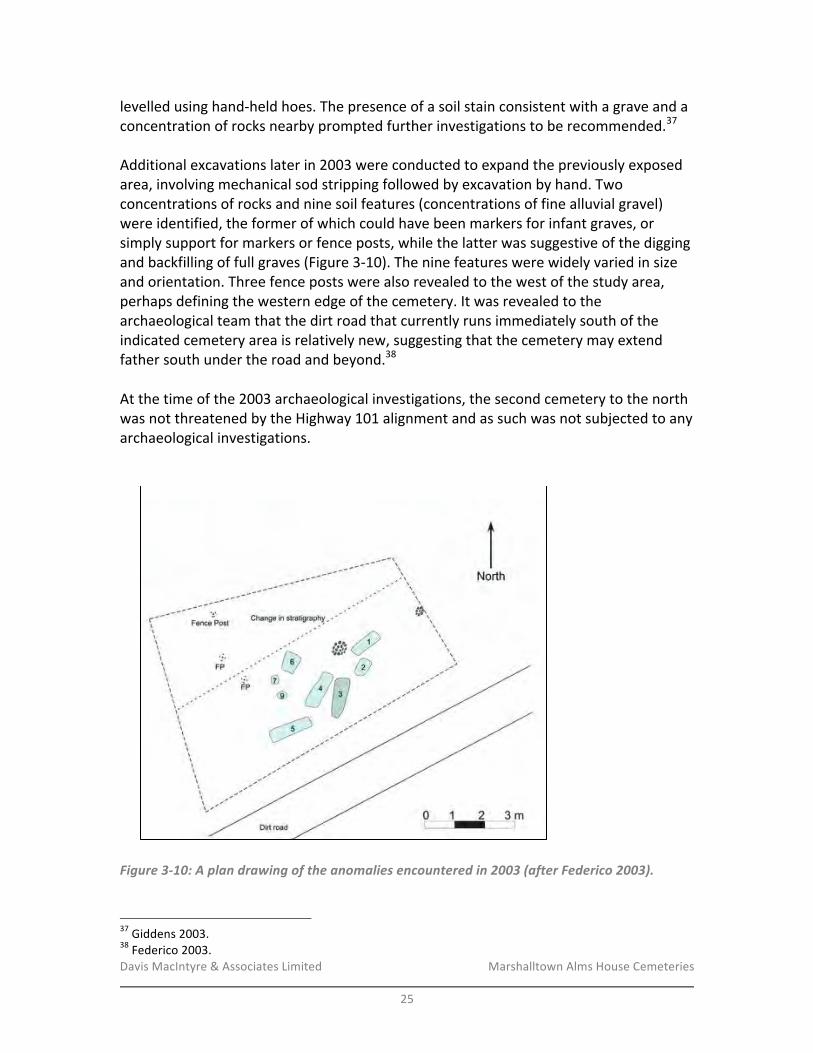
Davis&MacIntyre&&&Associates&Limited& &&&&&&&&&&&&&&&&&&& Marshalltown&Alms&House&Cemeteries&&
25&
levelled&using&handRheld&hoes.&The&presence&of&a&soil&stain&consistent&with&a&grave&and&a&concentration&of&rocks&nearby&prompted&further&investigations&to&be&recommended.37&&Additional&excavations&later&in&2003&were&conducted&to&expand&the&previously&exposed&area,&involving&mechanical&sod&stripping&followed&by&excavation&by&hand.&Two&concentrations&of&rocks&and&nine&soil&features&(concentrations&of&fine&alluvial&gravel)&were&identified,&the&former&of&which&could&have&been&markers&for&infant&graves,&or&simply&support&for&markers&or&fence&posts,&while&the&latter&was&suggestive&of&the&digging&and&backfilling&of&full&graves&(Figure&3R10).&The&nine&features&were&widely&varied&in&size&and&orientation.&Three&fence&posts&were&also&revealed&to&the&west&of&the&study&area,&perhaps&defining&the&western&edge&of&the&cemetery.&It&was&revealed&to&the&archaeological&team&that&the&dirt&road&that¤tly&runs&immediately&south&of&the&indicated&cemetery&area&is&relatively&new,&suggesting&that&the&cemetery&may&extend&father&south&under&the&road&and&beyond.38&&At&the&time&of&the&2003&archaeological&investigations,&the&second&cemetery&to&the&north&was¬&threatened&by&the&Highway&101&alignment&and&as&such&was¬&subjected&to&any&archaeological&investigations.&&&
!Figure'3)10:'A'plan'drawing'of'the'anomalies'encountered'in'2003'(after'Federico'2003).'
!!!!!!!!!!!!!!!!!!!!!!!!!!!!!!!!!!!!!!!!!!!!!!!!!!!!!!!!37&Giddens&2003.&38&Federico&2003.&
Davis&MacIntyre&&&Associates&Limited& &&&&&&&&&&&&&&&&&&& Marshalltown&Alms&House&Cemeteries&&
26&
3.4- Conductivity/Susceptibility-(Magnetometry)-Geophysical-Survey-&The&Geonics&Limited&EM38B,&the&unit&that&was&used&to&conduct&the&geophysical&survey,&is&used&to&map&terrain&conductivity&and&magnetic&susceptibility,&including&groundwater&contamination&and&soil&salinity,&but&also&for&the&identification&of&buried&archaeological&materials&and&features.&It&provides&data&from&effective&depth&ranges&of&1.5&m&for&conductivity&and&0.75&m&for&magnetic&susceptibility&when&positioned&in&the&vertical&dipole&orientation.&It&can&be&used&to&map&anomalous&materials&with&varying&electrical&or&magnetic&characteristics.&The&results&of&the&survey&are&two&map&images&displaying&colour&gradients&where&the&subsurface&is&dissimilar&to&the&surrounding&ground—the&first&image&displays&electrical&anomalies,&the&second&magnetic&susceptibility&anomalies.&&A&geophysical&survey&was&conducted&by&Raymond&Jahncke&and&Laura&de&Boer&in&late&February&2016.&Upon&arrival&on&site&it&was&immediately¬ed&that&the&sod&that&was&mechanically&removed&and&piled&to&the&north,&west,&and&east&during&the&2003&excavation&was&never&replaced,&and&after&clearing&some&dead&branches&from&the&surface&it&was&clear&that&the&subsoil&was&still&exposed&in&some&areas&(Plate&1).&A&grid&measuring&21m&(eastRwest)&by&12m&(northRsouth)&was&established&to&encompass&this&area&as&well&as&some&of&the&surrounding&landscape&(Plate&2).&&&The&site&of&Cemetery&2&comprises&the&southern&extents&of&an&active&hay&field,&with&some&remaining&strawberry&plants&still&growing&in&scattered&patches.&Based&upon&very&approximate&estimates&of&the&cemetery’s&area&from&oral&history,&a&grid&50m&long&(northRsouth)&and&11m&wide&(eastRwest)&was&established&along&the&field’s&eastern&edge,&bordering&a&modern&drainage&ditch&and&a&thin&line&of&trees&(Plate&3).&A&mound&of&earth&was&observed&to&the&west&of&the&study&area,&most&likely&related&to&the&1968&bulldozing&(Plate&4).&&Corners&of&the&grid&were&marked&and&recorded&with&the&assistance&of&NSTIR&surveyor&Benjamin&Whitmore,&and&the&data&was&later&utilized&to&reference&the&geophysical&data&into&existing&map&coordinates&(ATS77).&&Transects&were&marked&with&rope&along&the&longer&axis&of&both&sites&at&50&cm&apart.&Flags&were&set&at&five&metre&intervals&to&assist&in&recording&the&position&of&the&equipment&during&walkRover&recording.&The&EMR38B&was&set&to&collect&information&at&ten&readings&per&second.&It&was&calibrated&at&the&beginning&of&data&collection&for&both&cemetery&sites.&The&data&was&uploaded&from&the&data&logger&to&the&computer&and&processed&in&DAT38BW&software&by&Geonics.&&The&processing&by&Raymond&Jahncke&included&resampling&to&convert&from&an&interval&scale&to&metres.&The&flagged&five&metre&intervals&were&recorded&in&the&data&file&and&used&to&adjust&the&readings.&Two&spikes&(anomalous&readings)&were&removed&from&the&data&(one&from&each&site)&before&exporting&from&DAT38BW&to&a&text&file&containing&x,&y&coordinates&measured&in&metres&relative&to&the&starting&corner&(0,&0).&A&point&file&was&

Davis&MacIntyre&&&Associates&Limited& &&&&&&&&&&&&&&&&&&& Marshalltown&Alms&House&Cemeteries&&
27&
created&in&ArcMap&and&adjusted&to&UTM&zone&20N&NAD83&CSRS&using&coordinates&collected&by&the&survey&grade&GPS.&The&points&were&used&as&input&to&the&interpolation&(Kriging)&to&create&a&continuous&raster&grid.&The&grids&were&symbolized&using&a&colour&ramp&that&would&highlight&trends&in&the&data&and&anomalous&readings&that&could&indicate&a&feature&of&interest.&This&process&is&outlined&in&the&EM38B&manual.&&In&December&2016,&the&data&collected&in&March&was&reRprocessed&by&Duncan&McNeill,&retired&Geonics&Limited&president&and&who&is&at&the&forefront&of&applying&the&EM38B&to&archaeological&surveys.&Mr.&McNeill&found&that&he&could&significantly&improve&the&results&of&the&survey&at&Cemetery&1&by&using&his&improved&method&of&zeroing&the&data,&and&he&has&indicated&that&the&very&high&contrast&shown&in&this&study&area&is&among&the&best&he&has&seen&in&burial&contexts;&the&surrounding&soil&matrix&(a&very&rocky,&gravelly&till)&producing&very&little&response&in&the&susceptibility&survey&while&the&anomalies&themselves&(possibly&the&alluvial&gravel&seen&during&the&2003&excavations)&produce&a&very&high&response.&&In&contrast,&zeroing&the&data&in&Cemetery&2&and&further&opening&the&sensitivity&by&a&factor&of&x2.4&did¬&produce&any&anomalies&consistent&with&graves.&This&could&indicate&either&the&absence&of&graves&in&the&area&or,&perhaps&more&likely,&that&the&heavy&disturbance&of&the&area&in&1968&and&subsequent&ploughing&has&mingled&and&obliterated&the&distinct&signatures&caused&by&graves,&or&grave&shafts,&or&both.&&Both&sites&are&shown&on&the&following&pages&in&the&initial&interpretation&and&in&the&modified&interpretation&produced&by&Mr.&McNeill.&Observing&the&interpolated&information&on&the&raster&grid&should&be&interpreted&with&the&distribution&of&the&data&points&in&mind.&For&example,&an&abrupt&change&in&data&along&one&transect&may&cause&the&interpolation&to&expand&to&the&edge&of&the&adjacent&transects,&but&it&is&possible&that&the&feature&is&quite&small.&Features&that&cross&two&or&more&lines&are&more&likely&of&a&larger&size.&&The&conductivity&data&may&detect&differences&caused&by&disturbed&soils&within&the&graveshaft,&so&the&pattern&seen&in&the&interpolated&grid&can,&in&theory,&indicate&individual&graveshafts.&The&graveshaft&can&appear&as&either&highRresistance&or&lowRresistance&anomalies.&A&bias&depending&on&direction&is&possibly&an&indicator&of&disturbed&soils.39&&&Magnetic&susceptibility&is&affected&by&igneous&rock&and&ferrous&metal&that&can&obscure&subtle&patterns.&However,&some&materials&associated&with&burials&are&highly&ferrous,&such&as&steel&or&iron&from&the&caskets,&buried&grave&markers&or&monuments.&Magnetic&susceptibility&can&detect&subtle&anomalies&such&as&disturbed&or&compacted&soils.&
!!!!!!!!!!!!!!!!!!!!!!!!!!!!!!!!!!!!!!!!!!!!!!!!!!!!!!!!39&Dalan&and&Bevan&2002.&
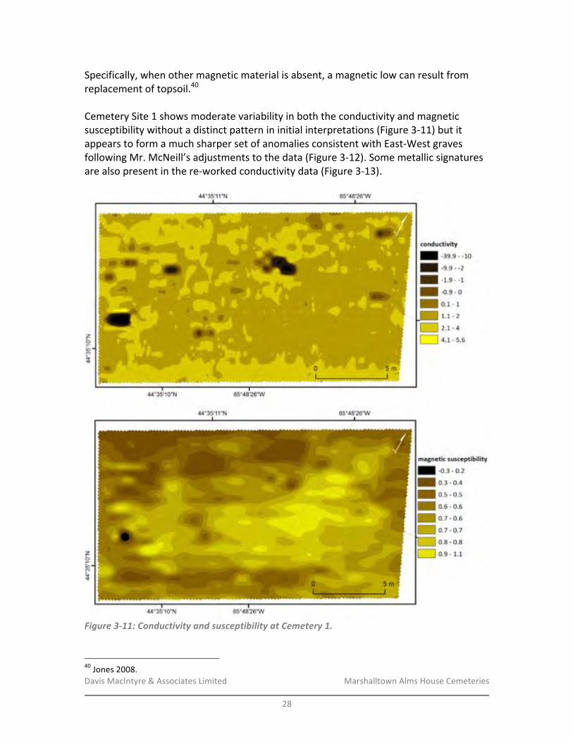
Davis&MacIntyre&&&Associates&Limited& &&&&&&&&&&&&&&&&&&& Marshalltown&Alms&House&Cemeteries&&
28&
Specifically,&when&other&magnetic&material&is&absent,&a&magnetic&low&can&result&from&replacement&of&topsoil.40&&Cemetery&Site&1&shows&moderate&variability&in&both&the&conductivity&and&magnetic&susceptibility&without&a&distinct&pattern&in&initial&interpretations&(Figure&3R11)&but&it&appears&to&form&a&much&sharper&set&of&anomalies&consistent&with&EastRWest&graves&following&Mr.&McNeill’s&adjustments&to&the&data&(Figure&3R12).&Some&metallic&signatures&are&also&present&in&the&reRworked&conductivity&data&(Figure&3R13).&&
!Figure'3)11:'Conductivity'and'susceptibility'at'Cemetery'1.'
!!!!!!!!!!!!!!!!!!!!!!!!!!!!!!!!!!!!!!!!!!!!!!!!!!!!!!!!40&Jones&2008.&
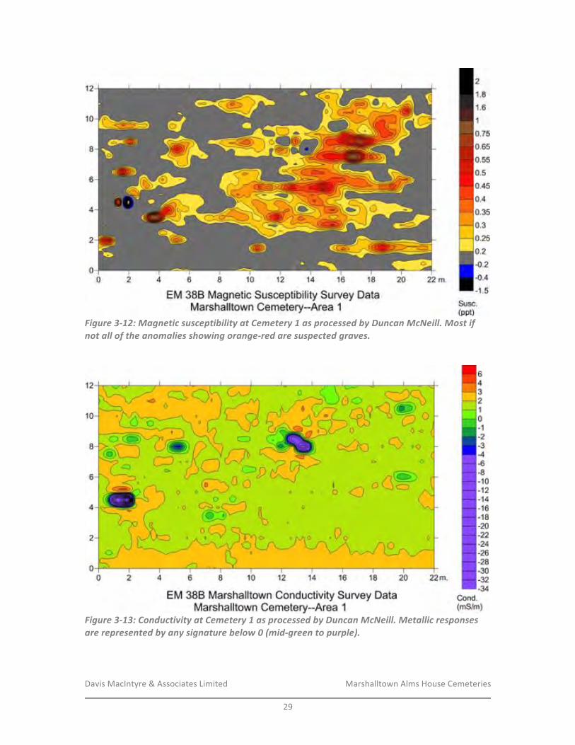
Davis&MacIntyre&&&Associates&Limited& &&&&&&&&&&&&&&&&&&& Marshalltown&Alms&House&Cemeteries&&
29&
!Figure'3)12:'Magnetic'susceptibility'at'Cemetery'1'as'processed'by'Duncan'McNeill.'Most'if'not'all'of'the'anomalies'showing'orange)red'are'suspected'graves.'
&
!Figure'3)13:'Conductivity'at'Cemetery'1'as'processed'by'Duncan'McNeill.'Metallic'responses'are'represented'by'any'signature'below'0'(mid)green'to'purple).'
&&

Davis&MacIntyre&&&Associates&Limited& &&&&&&&&&&&&&&&&&&& Marshalltown&Alms&House&Cemeteries&&
30&
In&initial&interpretations,&Cemetery&Site&2&shows&a&general&trend&of&lower&conductivity&and&lower&magnetic&susceptibility&towards&the&ditch&on&the&eastern&side&(Figure&3R14).&There&appears&to&be&one&location&where&conductivity&is&particularly&lower&than&the&surrounding&area,&and&this&is&echoed&in&the&higher&range&of&magnetic&susceptibility&(Figure&3R14,&blue).&Another,&smaller&anomaly&is&also&present&(Figure&3R14,&green).&By&modifying&how&the&data&has&been&zeroed,&Mr.&McNeill’s&reading&of&the&site&shows&that&aside&from&this&same&anomaly,&Site&2&has&none&of&the&characteristic&high&contrasts&of&Site&1&(Figure&3R15).&&
!Figure'3)14:'Conductivity'and'magnetic'susceptibility'at'Cemetery'2.The'sole'notable'anomaly'is'shown'in'blue'(conductivity)'and'green'(susceptibility).'
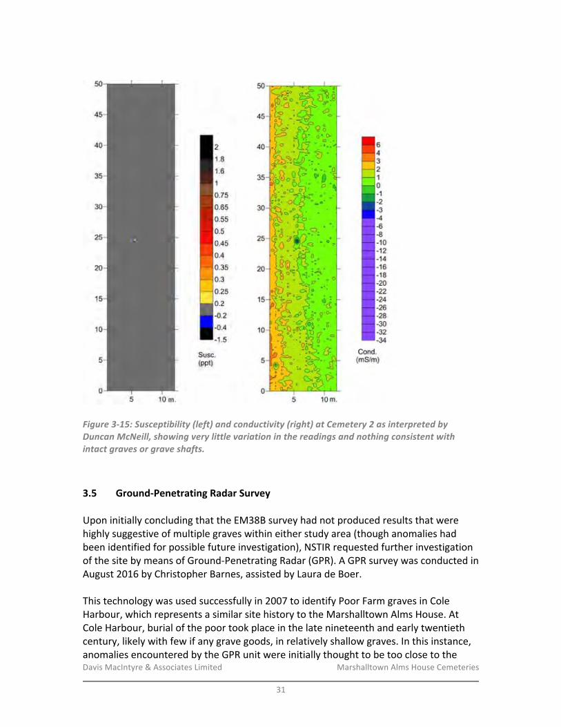
Davis&MacIntyre&&&Associates&Limited& &&&&&&&&&&&&&&&&&&& Marshalltown&Alms&House&Cemeteries&&
31&
&
!! !!Figure'3)15:'Susceptibility'(left)'and'conductivity'(right)'at'Cemetery'2'as'interpreted'by'Duncan'McNeill,'showing'very'little'variation'in'the'readings'and'nothing'consistent'with'intact'graves'or'grave'shafts.'
!3.5- GroundPPenetrating-Radar-Survey-&Upon&initially&concluding&that&the&EM38B&survey&had¬&produced&results&that&were&highly&suggestive&of&multiple&graves&within&either&study&area&(though&anomalies&had&been&identified&for&possible&future&investigation),&NSTIR&requested&further&investigation&of&the&site&by&means&of&GroundRPenetrating&Radar&(GPR).&A&GPR&survey&was&conducted&in&August&2016&by&Christopher&Barnes,&assisted&by&Laura&de&Boer.&&This&technology&was&used&successfully&in&2007&to&identify&Poor&Farm&graves&in&Cole&Harbour,&which&represents&a&similar&site&history&to&the&Marshalltown&Alms&House.&At&Cole&Harbour,&burial&of&the&poor&took&place&in&the&late&nineteenth&and&early&twentieth¢ury,&likely&with&few&if&any&grave&goods,&in&relatively&shallow&graves.&In&this&instance,&anomalies&encountered&by&the&GPR&unit&were&initially&thought&to&be&too&close&to&the&
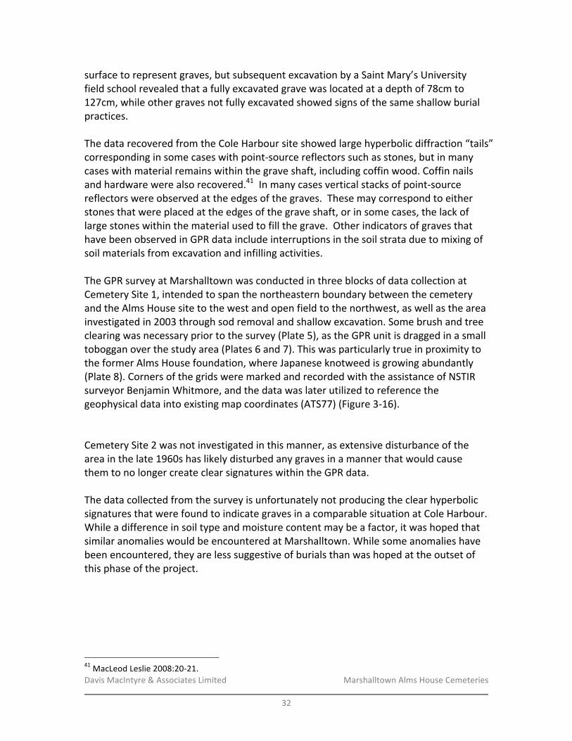
Davis&MacIntyre&&&Associates&Limited& &&&&&&&&&&&&&&&&&&& Marshalltown&Alms&House&Cemeteries&&
32&
surface&to&represent&graves,&but&subsequent&excavation&by&a&Saint&Mary’s&University&field&school&revealed&that&a&fully&excavated&grave&was&located&at&a&depth&of&78cm&to&127cm,&while&other&graves¬&fully&excavated&showed&signs&of&the&same&shallow&burial&practices.&&&The&data&recovered&from&the&Cole&Harbour&site&showed&large&hyperbolic&diffraction&“tails”&corresponding&in&some&cases&with&pointRsource&reflectors&such&as&stones,&but&in&many&cases&with&material&remains&within&the&grave&shaft,&including&coffin&wood.&Coffin&nails&and&hardware&were&also&recovered.41&&In&many&cases&vertical&stacks&of&pointRsource&reflectors&were&observed&at&the&edges&of&the&graves.&&These&may&correspond&to&either&stones&that&were&placed&at&the&edges&of&the&grave&shaft,&or&in&some&cases,&the&lack&of&large&stones&within&the&material&used&to&fill&the&grave.&&Other&indicators&of&graves&that&have&been&observed&in&GPR&data&include&interruptions&in&the&soil&strata&due&to&mixing&of&soil&materials&from&excavation&and&infilling&activities.&&&&&The&GPR&survey&at&Marshalltown&was&conducted&in&three&blocks&of&data&collection&at&Cemetery&Site&1,&intended&to&span&the&northeastern&boundary&between&the&cemetery&and&the&Alms&House&site&to&the&west&and&open&field&to&the&northwest,&as&well&as&the&area&investigated&in&2003&through&sod&removal&and&shallow&excavation.&Some&brush&and&tree&clearing&was&necessary&prior&to&the&survey&(Plate&5),&as&the&GPR&unit&is&dragged&in&a&small&toboggan&over&the&study&area&(Plates&6&and&7).&This&was&particularly&true&in&proximity&to&the&former&Alms&House&foundation,&where&Japanese&knotweed&is&growing&abundantly&(Plate&8).&Corners&of&the&grids&were&marked&and&recorded&with&the&assistance&of&NSTIR&surveyor&Benjamin&Whitmore,&and&the&data&was&later&utilized&to&reference&the&geophysical&data&into&existing&map&coordinates&(ATS77)&(Figure&3R16).&&&Cemetery&Site&2&was¬&investigated&in&this&manner,&as&extensive&disturbance&of&the&area&in&the&late&1960s&has&likely&disturbed&any&graves&in&a&manner&that&would&cause&them&to&no&longer&create&clear&signatures&within&the&GPR&data.&&&The&data&collected&from&the&survey&is&unfortunately¬&producing&the&clear&hyperbolic&signatures&that&were&found&to&indicate&graves&in&a&comparable&situation&at&Cole&Harbour.&While&a&difference&in&soil&type&and&moisture&content&may&be&a&factor,&it&was&hoped&that&similar&anomalies&would&be&encountered&at&Marshalltown.&While&some&anomalies&have&been&encountered,&they&are&less&suggestive&of&burials&than&was&hoped&at&the&outset&of&this&phase&of&the&project.&&
!!!!!!!!!!!!!!!!!!!!!!!!!!!!!!!!!!!!!!!!!!!!!!!!!!!!!!!!41&MacLeod&Leslie&2008:20R21.&

Davis&MacIntyre&&&Associates&Limited& &&&&&&&&&&&&&&&&&&& Marshalltown&Alms&House&Cemeteries&&
33&
!Figure'3)16:'The'approximate'locations'of'the'three'GPR'areas'at'Cemetery'Site'1.'
&&Area-A-
Some®ions&of&interest&were&identified&in&Area&A&where&groups&of&anomalous&reflections&were&observed&within&adjacent&lines&of&GPR&data.&&&
Two&horizons&that&run&approximately¶llel&to&ground&surface&can&be&observed&over&a&distance&from&approximately&12&to&20&m&along&the&survey&area&in&lines&1&to&13,&at&an&estimated&depth&of&approximately&1.2&to&1.3&m&and&1.6&to&1.7&m,&suggesting&an&interlayer&of&approximately&300&to&400&mm&in&thickness.&&These&horizons&appear&to&rise&to&a&peak&at&a&distance&of&17&m&in&lines&14&to&21&(Figure&3R17).&&This&horizon&may&likely&be&a&rock&shelf&or&soil&layer&that&exists&at&that&depth.&&At×&other&horizons&and&point&reflectors&appear&above&these&layers,&and&may&arise&from&buried&objects&such&as&stones,&debris,&or&tree&roots,&or&could&also&be&single&features&related&to&potential&graves&and&grave&goods.&&
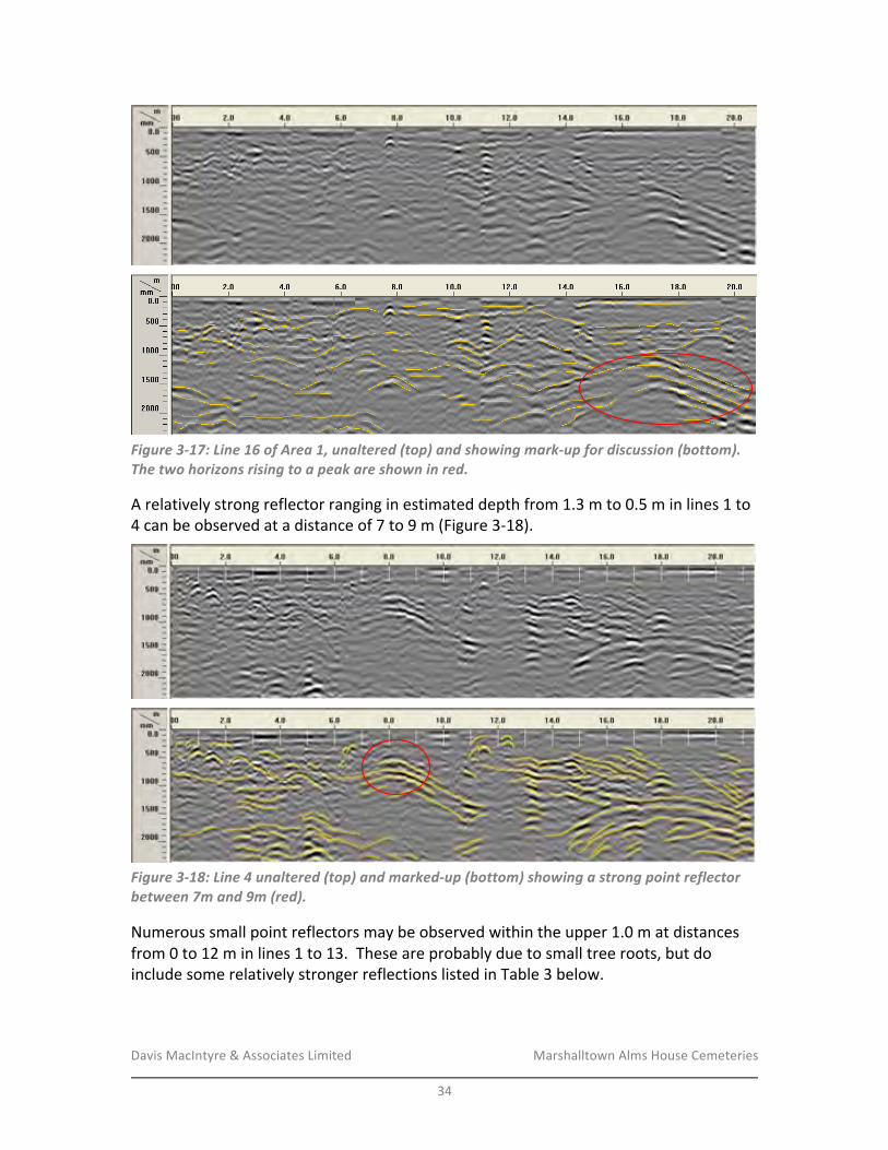
Davis&MacIntyre&&&Associates&Limited& &&&&&&&&&&&&&&&&&&& Marshalltown&Alms&House&Cemeteries&&
34&
&
!Figure'3)17:'Line'16'of'Area'1,'unaltered'(top)'and'showing'mark)up'for'discussion'(bottom).'The'two'horizons'rising'to'a'peak'are'shown'in'red.''
A&relatively&strong&reflector&ranging&in&estimated&depth&from&1.3&m&to&0.5&m&in&lines&1&to&4&can&be&observed&at&a&distance&of&7&to&9&m&(Figure&3R18).&
&
!Figure'3)18:'Line'4'unaltered'(top)'and'marked)up'(bottom)'showing'a'strong'point'reflector'between'7m'and'9m'(red).'
Numerous&small&point&reflectors&may&be&observed&within&the&upper&1.0&m&at&distances&from&0&to&12&m&in&lines&1&to&13.&&These&are&probably&due&to&small&tree&roots,&but&do&include&some&relatively&stronger&reflections&listed&in&Table&3&below.&
&
&

Davis&MacIntyre&&&Associates&Limited& &&&&&&&&&&&&&&&&&&& Marshalltown&Alms&House&Cemeteries&&
35&
Table&3&–&Point&reflectors&of&interest&in&southeast®ion&of&Area&A.&GPR&Line& Distance&(m)& Estimated&Depth&(m)&
1& 1.0,&1.8,&2.5,&4.3& 0.30,&0.35,&0.40,&0.75&2& 0.7,&1.5,&1.6,&& 0.35,&0.40,&0.35&4& 1.0,&1.5,&2.6,&3.1,&8.2&& 0.40,&0.50,&0.50,&0.60,&0.60&5& 0.9,&2.7& 0.25,&0.50&6& 0.8R1.2& 0.25R0.40&7& 2.0,&3.5,&4.5R5.3& 0.50,&0.50,&0.70R0.50&8& 2.0,&2.4,&3.8R5.4& 0.50,&0.85,&0.60R0.40&9& 1.0,&5.4,&& 0.35,&0.70&12& 0.5,&9.5& 0.40,&0.70&
Some&downward&sloping&layers&can&be&observed&in&lines&1&to&8,&beginning&at&approximately&9&to&10&m&at&a&depth&of&0.50&m,&and&running&to&a&depth&of&approximately&1.30&m&at&a&distance&of&17&to&18&m.&
One&particular&recurring&reflection&can&be&observed&at&a&distance&of&18.0&to&18.5&m&and&an&estimated&depth&of&0.80&m&in&lines&1&to&11,&inclusive.&
&
Area-B-
Two&main&features&of&interest&were&observed&in&Area&B.&&The&first&is&a&horizon&located&at&depth&of&approximately&1.6&to&2.5&m&that&occurs&from&distances&of&0.0&to&2.5&min&lines&22&to&27,&inclusive&(the&full&width&of&the&area).&&It&would&appear&that&this&horizon&may&be&related&to&the&horizon&that&was&observed&from&12&to&20&m&in&Area&A&at&a&depth&of&approximately&1.7&m.&&Observing&this&feature&in&both&survey&areas&suggests&possible&continuity&between&them,&and&supports&the&possibility&that&this&may&relate&to&a&rock&or&soil&layer&that&exists&at&that&depth.&
The&second&feature&of&interest&in&Area&B&is&a&relatively&strong&reflection&that&occurs&at&an&approximate&depth&of&0.50&to&0.70&m&at&distances&of&17.5&to&22.0&m&in&all&data&files&(22&to&27)&(Figure&3R19).&&A&vertical&stack&of&point&reflectors,&which&is&similar&to&those&observed&at&the&limits&of&graves&detected&at&the&Cole&Harbour&poor&farm&site,&can&be&observed&below&this&layer&at&a&distance&of&18.8&to&19.5&m&and&at&20.7&m&in&line&23.&&However,&a&similar&vertical&stack&of&reflectors&was¬&observed&in&lines&22&or&24,&although&the&linear&horizon&at&0.5&to&0.7&m&depth&and&additional&reflections&can&be&observed&below&it&at&approximately&1.0&and&1.3&m.&&Various&other&weaker&single&point&reflectors&can&be&seen&at&depths&of&1.3&to&2.0&m&between&distances&of&13&to&17&m&in&line&23.&&Line&25&exhibits&the&same&linear&horizon&at&0.5&to&0.7&m&depth&from&18.0&to&22.5&m,&as&well&as&vertical&stacks&of&reflectors&18.5&m&and&21.7&m.&&Lines&26&and&27&indicate&multiple&horizons&at&depths&of&0.6R0.7&m,&0.9R1.0&m,&1.2R1.3m,&and&onward&from&distances&of&17.0&to&over&22.0&m.&

Davis&MacIntyre&&&Associates&Limited& &&&&&&&&&&&&&&&&&&& Marshalltown&Alms&House&Cemeteries&&
36&
&
!Figure'3)19:'Line'23'of'Area'B,'showing'the'unaltered'data'(top)'and'marked)up'version'(bottom).'A'strong'reflection'underlain'by'a'vertical'stack'of'point'reflectors'is'shown'in'red.'
!Area-C-
Area&C&was&located&over&an&area&previously&investigated&using&the&EMR38&meter&and&shallow&excavation.&&The&GPR&data&in&line&28&shows&a&shallow&surface&soil&layer&that&varies&from&0.50&m&to&0.25&m&over&the&first&2.0&m&of&distance.&&This&corresponds&to&a&slight&decrease&in&elevation&over&this&distance,&and&tends&to&indicate&a&relatively&flat&subsurface&horizon.&&This&horizon&remains&relatively&stable&in&depth&at&approximately&0.25&m&until&a&distance&of&10.0&m,&after&which&it&gradually&decreases&to&a&depth&of&0.5&m&at&a&distance&of&13.0&m,&then&appears&to&decrease&to&approximately&1.3&m&at&a&distance&of&15.0&m&and&tends&to&1.5&m&at&the&18.0&m&limit&of&the&data.&&A&second&horizon&can&be&observed&in&line&28&that&runs&from&a&depth&of&1.5R1.6&m&from&distances&of&0.0&to&3.5&m,&then&decreases&to&2.0&at&a&distance&of&6.0&m,&and&appears&to&gradually&decrease&to&slightly&deeper&than&the&2.5&m&limit&of&the&data&at&a&distance&of&18.0&m.&&The&data&between&these&two&boundary&horizons&contains&many&small&steeply&sloping&reflectors&and&thin&layers&that&are&sometimes&relatively&strong&in&litude,&such&as&those&observed&over&the&full&depth&of&the&data&at&a&distance&of&5.5&m&in&line&29.&&Noteworthy&groupings&of&intense&reflections&occurs&throughout&the&depth&of&the&GPR&data&at&a&distance&of&4.5&to&6.5&m&in&line&29&(Figure&3R20),&3.4&m&to&5.4&m&in&line&30,&and&3.0&to&4.8&m&in&line&31.&&Some&upward&sloping&horizons&occurring&above&relatively&horizontal&horizons,&and&the&abundance&of&strong&reflectors&above&the&flat&horizon&at&a&depth&of&2.2&to&2.3&m,&might&suggest&that&this&area&could&have&been&infilled.&
&
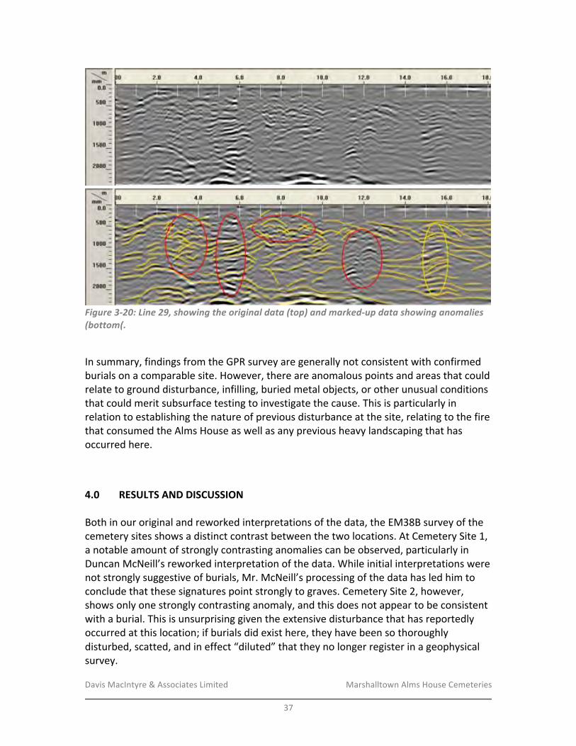
Davis&MacIntyre&&&Associates&Limited& &&&&&&&&&&&&&&&&&&& Marshalltown&Alms&House&Cemeteries&&
37&
&
!Figure'3)20:'Line'29,'showing'the'original'data'(top)'and'marked)up'data'showing'anomalies'(bottom(.'
&In&summary,&findings&from&the&GPR&survey&are&generally¬&consistent&with&confirmed&burials&on&a&comparable&site.&However,&there&are&anomalous&points&and&areas&that&could&relate&to&ground&disturbance,&infilling,&buried&metal&objects,&or&other&unusual&conditions&that&could&merit&subsurface&testing&to&investigate&the&cause.&This&is&particularly&in&relation&to&establishing&the&nature&of&previous&disturbance&at&the&site,&relating&to&the&fire&that&consumed&the&Alms&House&as&well&as&any&previous&heavy&landscaping&that&has&occurred&here.&&
4.0 RESULTS-AND-DISCUSSION-&Both&in&our&original&and&reworked&interpretations&of&the&data,&the&EM38B&survey&of&the&cemetery&sites&shows&a&distinct&contrast&between&the&two&locations.&At&Cemetery&Site&1,&a¬able&amount&of&strongly&contrasting&anomalies&can&be&observed,&particularly&in&Duncan&McNeill’s&reworked&interpretation&of&the&data.&While&initial&interpretations&were¬&strongly&suggestive&of&burials,&Mr.&McNeill’s&processing&of&the&data&has&led&him&to&conclude&that&these&signatures&point&strongly&to&graves.&Cemetery&Site&2,&however,&shows&only&one&strongly&contrasting&anomaly,&and&this&does¬&appear&to&be&consistent&with&a&burial.&This&is&unsurprising&given&the&extensive&disturbance&that&has&reportedly&occurred&at&this&location;&if&burials&did&exist&here,&they&have&been&so&thoroughly&disturbed,&scatted,&and&in&effect&“diluted”&that&they&no&longer®ister&in&a&geophysical&survey.&
Davis&MacIntyre&&&Associates&Limited& &&&&&&&&&&&&&&&&&&& Marshalltown&Alms&House&Cemeteries&&
38&
&Frustratingly,&comparison&between&the&features&identified&in&the&2003&investigation&and&the&anomalies&identified&in&the&initial&interpretation&of&the&2016&geophysical&survey&did¬&appear&to&correspond;&the&clustering&of&the&soil&features&was&very&tight&based&upon&the&scale&of&the&provided&plan,&and&much&closer&to&the&dirt&road&than&most&of&the&geophysical&anomalies.&However,&Mr.&McNeill’s&subsequent&interpretation&of&the&data&more&closely&resembles&the&tight&cluster&of&anomalies&seen&in&2003.&&In&summation,&the&results&of&the&geophysical&survey&are&more&highly&suggestive&of&graves&than&was&initially&thought&at&Cemetery&Site&1,&but¬&at&all&suggestive&of&intact&graves&at&Site&2.&The&results&support&what&has&been&suspected&based&upon&other&available&history&on&the&site:&that&Cemetery&1&may&represent&more&intact&features&with&a&certain&level&of&subsequent&disturbance&relating&to&the&Alms&House&fire,&while&the&integrity&of&Cemetery&2&may&have&been&heavily&compromised&by&bulldozing&and&other&agricultural&activity&in&the&late&1960s.&&The&circumstances&of&burial&further&complicate&efforts&to&identify&the&unmarked&cemeteries.&Burials&may¬&be&aligned&eastRwest,&and&they&may¬&be&very&deep&below&ground&or&depth&may&vary&considerably&depending&upon&the&grave.&Excavations&at&the&Cole&Harbour&Poor&Farm&in&2007&(as&observed&in&person&by&the&author)&yielded&the&tops&of&graves&as&shallow&as&40cm&below&the&surface,&well&within&the&plough&zone&if&large&modern&ploughs&were&used&at&Marshalltown.&Grave&goods&are&likely&minimal,&and&in&some&cases&burial&may&have&occurred&without&any&kind&of&coffin&or&casket.&This&hypothesis&may&be&supported&by&the&contrast&between&conductivity&and&susceptibility&results&at&Site&1,&where¬&all&susceptibility&anomalies&exhibit&corresponding&metallic&anomalies&in&the&conductivity&data.&&The&corresponding&GPR&data&at&Site&1&is&suggestive&but&somewhat&less&consistent&with&burials&as&compared&to&a&similar&site&in&Cole&Harbour.&However,&anomalies&have&been&identified&that&could&be&subjected&to&subsurface&testing&in&an&effort&to&further&groundRtruth&the&results,&if&desired.&&What&remains&obvious&is&this:&documentary&records&show&that&a&probable&minimum&of&55&burials&and&likely&many&more&should&be&present&between&these&two&cemetery&areas,&though&distribution&and&density&is¬&known.&The&geophysical&surveys,&even&when&combined&with&the&2003&investigations&and&assuming&that&all&anomalies&and&features&represent&burials,&seem&likely&to&account&for&no&more&than&20&to&30&burials,&a&small&fraction&of&the&total.&However,&the&possibility&remains&that&the&area&covered&during&the&2016&geophysical&surveys&did¬&encompass&the&entire&cemetery&as&data&provided&on&cemetery&size&was&based&entirely&on&oral&history.&&&Both&the&EM38B&and&the&GPR&do,&however,&appear&to&show&fewer&suggestive&anomalies&to&the&northwest&of&the&investigated&area&of&Site&1,&suggesting&that&the&graves&are&less&
Davis&MacIntyre&&&Associates&Limited& &&&&&&&&&&&&&&&&&&& Marshalltown&Alms&House&Cemeteries&&
39&
frequent&closer&to&the&projected&“edge”&of&the&cemetery,&where&the&natural&slope&of&the&ground&drops&towards&a&poorlyRdrained,&rough&area.&&A&field&reconnaissance&has&shown&that&much&of&the&landscape,&and&in&fact&for&much&of&the&year&all&of&the&landscape,&between&Site&1&and&Site&2&is&low,&wet,&and&rough&(Figure&4R1).&The&north&and&northwest&edge&of&Site&1&has&been&projected&at&the&base&of&a&gentle&slope&which&faces&Seeley&Brook,&where&the&dry&and&smooth&topography&that&continues&downwards&from&the&modern&road&transitions&abruptly&into&wet,&undulating&ground&grown&up&in&alders&and&grasses.&The&ground&opens&up&again&into&a&field&some&20m&farther&to&the&north,&but&again&this&field&is&much&more&wet&and&undulating&than&the&area&indicated&as&Cemetery&Site&1.&&At&Cemetery&Site&2,&a&similar&topographic&southern&boundary&is&formed&by&a&sharp&drop&from&the&treed&edge&of&the¤t&field&down&into&wet,&undulating&forest&which&further&transitions&into&wet&alder&swamp&bordering&Seeley&Brook.&&While&it&is&difficult&to&state&with&absolute&certainty&that&burials&have¬&occurred&beyond&these&two&projected&boundaries,&oral&history&has&shown&no&indication&that&burial&occurred&in&these&areas,&and&site&topography&would&make&burial&in&these&areas&inappropriate&in&a&purely&practical&sense,&as&digging&graves&here&would&be&a&wet,&muddy,&and&difficult&affair&for&the&grave&diggers,&who&by&many&accounts&did¬&put&great&effort&into&the&act&of&burial.&&
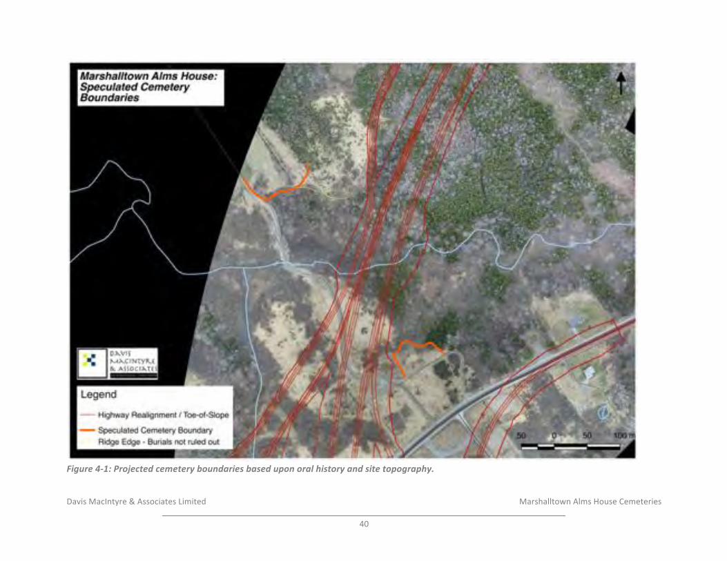
Davis&MacIntyre&&&Associates&Limited& &&&&&&&&&&&&&&&&&&& & &&&&&&&&&&&Marshalltown&Alms&House&Cemeteries&&
40&
!Figure'4)1:'Projected'cemetery'boundaries'based'upon'oral'history'and'site'topography.
Davis&MacIntyre&&&Associates&Limited& &&&&&&&&&&&&&&&&&&& Marshalltown&Alms&House&Cemeteries&
&41&
5.0 RECOMMENDATIONS/AND/CONCLUSIONS/&
The&geophysical&surveys&have&been&shown&to&be&strongly&suggestive&but&ultimately&
inconclusive&in&identifying&grave&shafts&and&burials&at&the&southern&cemetery&location,&as&
even&if&all&anomalies&identified&are&later&confirmed&to&be&graves,&a&very&large&portion&of&
known&burials&on&site&are&still&unaccounted&for.&Given&the&inconclusiveness&of&the&
geophysical&surveys&on&their&own,&several&options&for&further&research&can&be&
considered,&though&in&the&absence&of&planned&ground&disturbance&related&to&nearFfuture&
construction&in&close&proximity&to&either&area,&none&are&considered&compulsory&
recommendations&by&DM&A.&&
&
Under&ordinary&circumstances,&it&would&be&possible&to&mechanically&remove&the&upper&
sod&layer&from&a&known&but&unmarked&cemetery&in&order&to&seek&out&grave&shafts&
without&disturbing&the&human&remains.&This&however&has&already&been&attempted&in&
2003&at&Cemetery&1,&again&with&inconclusive&results.&It&is&also&highly&inadvisable&to&
attempt&such&mechanical&investigation&at&Cemetery&2,&where&there&may&be&few&or&no&
grave&shafts&intact,&and&human&remains&could&have&been&scattered&and&brought&even&
closer&to&the&surface&by&the&1960s&activity.&
&
While&it&is&likely&that&this&investigation&has&reached&a&point&of&“diminishing&returns,”&it&is&
possible&that&a&higher&level&of&certainty&could&be&achieved&by&both&testing&several&
anomalies&in&the&previously&surveyed&area&of&Site&1&and&by&undertaking&an&additional&
EM38B&survey&on&the&low,&wet&field&below&(north&of)&Site&1&where&the&future&twinned&
portion&of&highway&is&proposed&to&run.&The&presence&or&absence&of&comparable&
anomalies&in&this&low,&wet&ground&could&help&to&provide&an&increased&level&of&certainty&
as&to&the&limits&of&the&burial&area.&
&
One&or&more&of&the&anomalies&at&the&Cemetery&1&location&could&be&subjected&to&
excavation&within&1mx1m&or&preferably&2mx2m&units&excavated&by&professional&
archaeologists.&This&process&would&attempt&to&identify&the&source&of&the&anomaly.&If&
human&remains&are&encountered,&they&could&be&recorded&in&situ&and&reburied&if&CCH&
provides&approval&for&this&methodology,&and&if&they&are&features&unrelated&to&burial,&
they&would&allow&the&research&team&to&rule&them&out&as&possible&burial&signatures.&
&
At&Cemetery&Site&2,&a&similar&test&unit&could&be&placed&over&the&single&anomaly&identified,&
and&this&could&also&help&to&identify&whether&or¬&human&bone&has&been&densely&
scattered&in&the&topsoil&of&the&area&following&previous&ground&disturbance.&Obviously&
subFsurface&investigations&at&a&previously&disturbed&cemetery&site&are¬&to&be&taken&
lightly.&Prior&to&applying&for&a&permit,&consultation&with&the&Coordinator&of&Special&Places&
and&with&the&Curator&of&Archaeology&at&the&Nova&Scotia&Museum&would&be&necessary&in&
order&to&determine&what&action&to&take&if&human&remains&are&encountered.&If&subF
surface&investigations&proceed,&continuing&efforts&to&keep&the&local&community&engaged&
and&informed&would&be&prudent.&
Davis&MacIntyre&&&Associates&Limited& &&&&&&&&&&&&&&&&&&& Marshalltown&Alms&House&Cemeteries&
&42&
&
Initiating&any&of&the&further&measures&outlined&above&may&provide&more&answers,&but&
this&is¬&a&certainty.&The&only&thing&that&appears&reasonably&clear&based&on&topography&
and&oral&history&is&that&the¤t&Highway&101&alignment&is&unlikely&to&pass&through&
areas&that&were&known&through&oral&history&as&burial&sites&and&are&most&suitable&for&
burial&in&proximity&to&the&Alms&House&site&and&property.&There&has&been&no&evidence&
encountered&during&this&assessment&that&indicates&burials&would&have&extended&into&the&
area¤tly&shown&within&the&toeFofFslope&of&the&proposed&alignment.&
&
In&consideration&of&the&upcoming&environmental&assessment&phase&of&the&Highway&101&
alignment&planning,&further&mitigation&of&either&cemetery&will¬&be&a&requirement&so&
long&as&both&cemeteries&are&outside&the&proposed&toeFofFslope&and&outside&the&range&of&
any&laydown&areas.&The&2017&portion&of&the&new§ion&of&the&highway&consists&of&the&
northern/western&two&lanes&only&–&the&realignment&plans&allow&for&twinning,&but&it&will&
not&be&twinned&in&the&upcoming&phase&of&construction.&It&is&possible,&therefore,&that&
efforts&to&more&clearly&define&the&cemetery&boundary&could&be&revisited&in&the&future,&if&
or&when&the&highway&is&scheduled&to&be&twinned&and&therefore&will&run&more&closely&to&
the&projected&border&of&the&southern&cemetery.&
&
Heavy&equipment&including&treeF&or&brushFclearing&equipment&should¬&be&permitted&
to&drive&over&either&site&if&there&is&a&chance&that&the&wheels&of&the&vehicles&will&churn&up&
the&soil,&potentially&disturbing&shallow&graves&or&previously&disturbed&bone.&A&buffer&
zone&of&approximately&ten&meters&around&the&projected&boundary&area&is&recommended,&
with&the&understanding&that&this&buffer&may&be&somewhat&arbitrary&due&to&the&lack&of&a&
clearly&delineated&site&–&the&buffer&may&be&too&large,&but&this&is&preferable&to&it&being&too&
small.&
&
If&groundFdisturbing&activity&is&expected&to&take&place&in&close&proximity&to&either&
cemetery,&it&may&be&necessary&to&contract&a&qualified&archaeologist&to&monitor&grubbing&
or&other&groundFdisturbing&activity&during&road&construction,&and&to&remain&on&call&
should&suspected&human&remains&be&encountered.&DM&A&has&previously&prepared&a&
management&plan&for&similar&situations&within&the&province,&directing&onFsite&personnel&
on&what&steps&are&appropriate&when&suspected&human&remains&are&encountered.&The&
basic&measures&are&included&as&Appendix&C.&If&desired,&DM&A&is&able&to&provide&
orientation&and&basic&training&for&construction&crew&members&to&familiarize&them&with&
the&appearance&of&human&burials&and&with&the&protocols&involved&in&the&unexpected&
discovery&of&human&remains.&
&
Commemoration&of&the&final&resting&place&of&many&of&the&inmates&is&clearly&a&priority&for&
the&modern&communities&of&Marshalltown&and&Digby.&While&DM&A&strongly&supports&
efforts&to&place&a&sign&or&other&commemorative&material&on&the&sites,&we&wish&to&advise&
against&the&placement&of&any&kind&of&fence&structure,&which&in&the&absence&of&a&clear&
delineation¤tly&may&create&boundaries&that&in&future&decades&are&misunderstood&
to&be&firm&borders.&If&desired,&a&standFalone&gate&could&potentially&be&placed&to&
Davis&MacIntyre&&&Associates&Limited& &&&&&&&&&&&&&&&&&&& Marshalltown&Alms&House&Cemeteries&
&43&
represent&an&entryway&into&the&burial&grounds,&but&no&part&of&the&landscape&should&be&
enclosed&at&this&stage.&
&
Finally,&it&cannot&be&emphasized&strongly&enough&that&in&the&event&that&burials&or&other&
archaeological&resources&are&encountered&in&the&future&and&an&archaeologist&is¬&
already&present,&it&is&absolutely&required&that&any&groundFdisturbing&activity&be&halted&
immediately&and&the&Coordinator&of&Special&Places&(902F424F6475)&be&contacted&
immediately®arding&a&suitable&method&of&mitigation.&
&
6.0 REFERENCES/CITED/&
Confederacy&of&Mainland&Mi’kmaq.&&2007.&&Kekina’muek:&Learning&about&the&Mi’kmaq&of&
Nova&Scotia.&&Truro:&Eastern&Woodland&Publishing.&&
&
Dalan,&Rinita&A.,&and&Bruce&W.&Bevan.&2002.&“Geophysical&indicators&of&culturally&
emplaced&soils&and&sediments.”&Geoarchaeology&17(8):779–810.&
&
Davis,&Derek&and&Sue&Browne.&&1996.&&Natural&History&of&Nova&Scotia,&Volume&II:&Theme&
Regions.&&Halifax:&Nimbus&Publishing&and&Nova&Scotia&Museum.&
&
The&Digby&Mirror.&1983.&“Earle&Thomas&remembers&well&the&poor.”&9&February.&
&
The&Digby&Courier.&1994.&“When&the&Digby&Fire&Department…”&20&April.&
&
Federico,&Robert.&2003.&Letter&to&Dwayne&Cross,&P.&Eng,&Nova&Scotia&Dept.&of&
Transportation&and&Public&Works.&On&file,&Nova&Scotia&Transportation&and&Infrastructure&
Renewal.&
&
Fergusson,&C.&Bruce.&1967.&PlaceFNames&and&Places&of&Nova&Scotia.&Halifax;&Public&
Archives&of&Nova&Scotia.&
&
Giddens,&Heather&L.&2003.&Letter&to&Elizabeth&Pugh,&P.Eng,&Nova&Scotia&Dept.&of&
Transportation&and&Public&Works.&On&file,&Nova&Scotia&Transportation&and&Infrastructure&
Renewal.&
&
Jones,&Geoffrey.&2008.&“Geophysical&Mapping&of&Historic&Cemeteries.”&Technical&Briefs&in&
Historical&Archaeology,&Vol.&3:25F38.&
&
MacLeodFLeslie,&Heather.&2008.&“Poor’s&Farm&Cemetery&and&Dormitories:&Bisset&Road,&
Cole&Harbour.”&Heritage&Research&Permit&#A2007NS38,&report&on&file,&Department&of&
Communities,&Culture&and&Heritage.&
&
Davis&MacIntyre&&&Associates&Limited& &&&&&&&&&&&&&&&&&&& Marshalltown&Alms&House&Cemeteries&
&44&
National&Air&Photo&Library.&1945.&Flight&Line&#A8779,&Photo:.&Scan&courtesy&NSTIR.&
&
National&Air&Photo&Library.&1955.&Flight&Line&#A14654,&Photo.&Scan&courtesy&NSTIR.&
&
National&Air&Photo&Library.&1978.&Flight&LineṸ,&Photo–.&Scan&courtesy&NSTIR.&
&
Norwood,&Caroline.&1985.&“Olive&Hayden&talks&about&her&years&at&the&Poor&Farm.”&The&
Digby&Courier,&13&March.&
&
Ritchie,&Harold.&1985.&“My&19&years&at&the&Municipal&Home.”&13&March.&
&
Robicheau,&Edward.&1985.&“Times&were&tough&at&the&County&Poor&Farm.”&The&Digby&
Courier,&March&6th.&
&
Senior&Scribes&of&Nova&Scotia.&1996.&Poverty(Poor(Houses(and(Private(Philanthropy.&Nova&Scotia:&New&Horizons&Grant,&Health&Canada.&
&
The&Vanguard.&1968.&“Former&Poor&Farm&Now&Big&Farm&Industry.”&10&July,&page&2.&
Photographs&by&“Oxner.”&&
& &
Davis&MacIntyre&&&Associates&Limited& &&&&&&&&&&&&&&&&&&& Marshalltown&Alms&House&Cemeteries&
&45&
&
&
&
&
&
&
&
&
&
&
&
&
&
&
&
&
&
&
&
&
&
PLATES/&
&
&
&
&
&
&
&
&
&
&
&
&
&
&
&
&
&
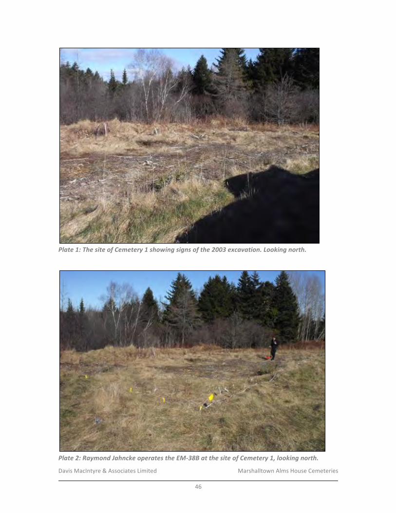
Davis&MacIntyre&&&Associates&Limited& &&&&&&&&&&&&&&&&&&& Marshalltown&Alms&House&Cemeteries&
&46&
!Plate&1:&The&site&of&Cemetery&1&showing&signs&of&the&2003&excavation.&Looking&north.&
!
!Plate&2:&Raymond&Jahncke&operates&the&EME38B&at&the&site&of&Cemetery&1,&looking&north.&
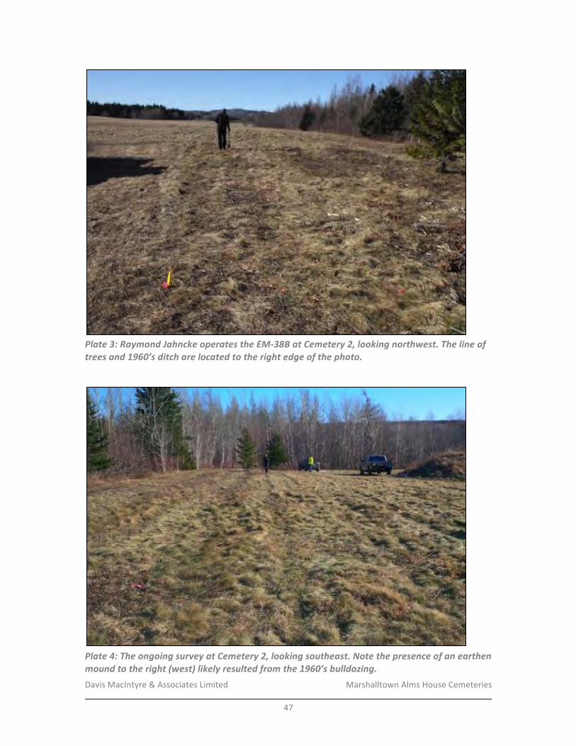
Davis&MacIntyre&&&Associates&Limited& &&&&&&&&&&&&&&&&&&& Marshalltown&Alms&House&Cemeteries&
&47&
!Plate&3:&Raymond&Jahncke&operates&the&EME38B&at&Cemetery&2,&looking&northwest.&The&line&of&trees&and&1960’s&ditch&are&located&to&the&right&edge&of&the&photo.&
!
!Plate&4:&The&ongoing&survey&at&Cemetery&2,&looking&southeast.&Note&the&presence&of&an&earthen&mound&to&the&right&(west)&likely&resulted&from&the&1960’s&bulldozing.&
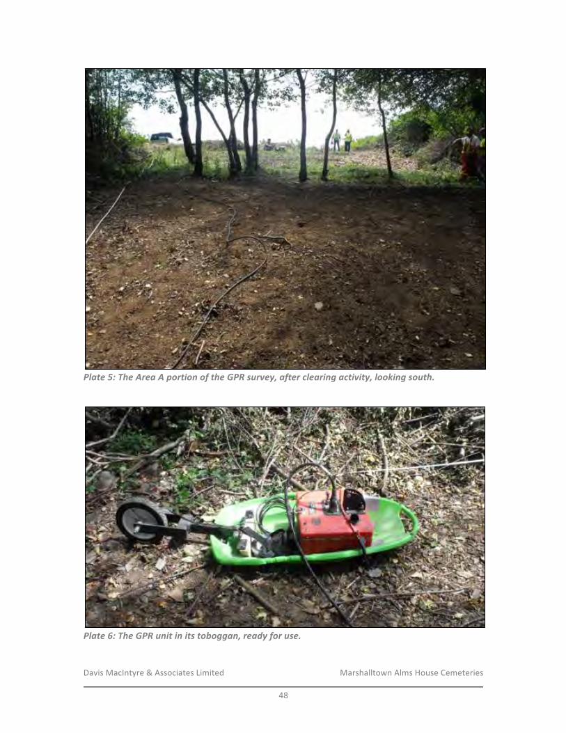
Davis&MacIntyre&&&Associates&Limited& &&&&&&&&&&&&&&&&&&& Marshalltown&Alms&House&Cemeteries&
&48&
!Plate&5:&The&Area&A&portion&of&the&GPR&survey,&after&clearing&activity,&looking&south.&
!
!Plate&6:&The&GPR&unit&in&its&toboggan,&ready&for&use.&
!
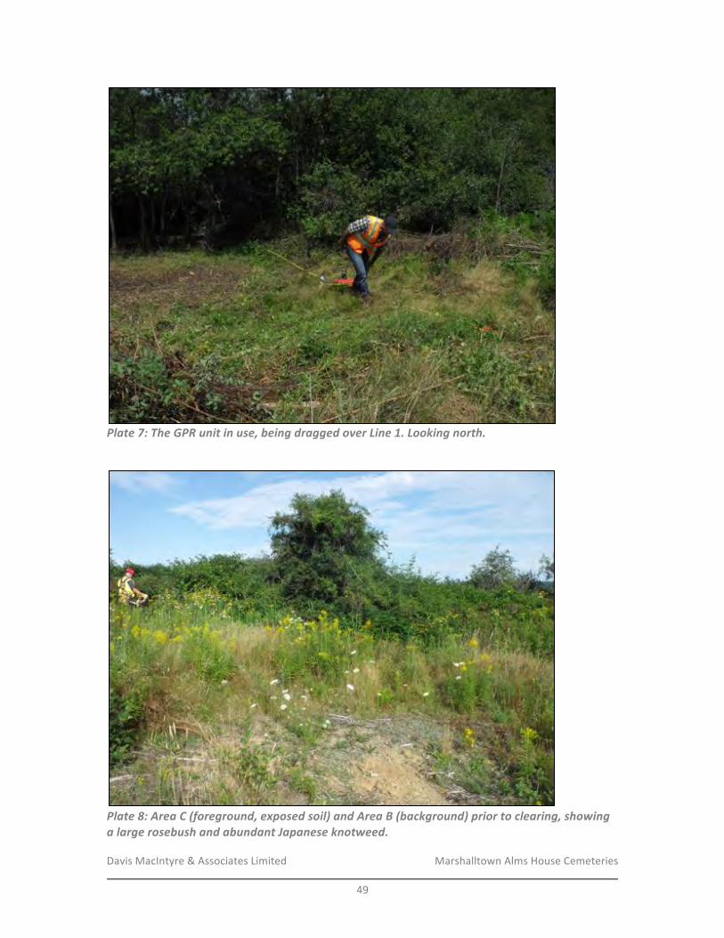
Davis&MacIntyre&&&Associates&Limited& &&&&&&&&&&&&&&&&&&& Marshalltown&Alms&House&Cemeteries&
&49&
!Plate&7:&The&GPR&unit&in&use,&being&dragged&over&Line&1.&Looking&north.&
!
!Plate&8:&Area&C&(foreground,&exposed&soil)&and&Area&B&(background)&prior&to&clearing,&showing&a&large&rosebush&and&abundant&Japanese&knotweed.& &
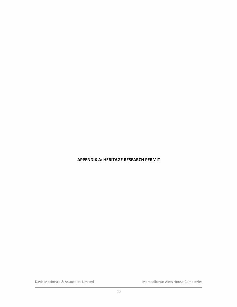
Davis&MacIntyre&&&Associates&Limited& &&&&&&&&&&&&&&&&&&& Marshalltown&Alms&House&Cemeteries&
&50&
&
&
&
&
&
&
&
&
&
&
&
&
&
&
&
&
&
&
&
&
&
APPENDIX/A:/HERITAGE/RESEARCH/PERMIT/&
&
&
&
&
&
&
&
&
&
&
&
&
&
&
&
&
&
&
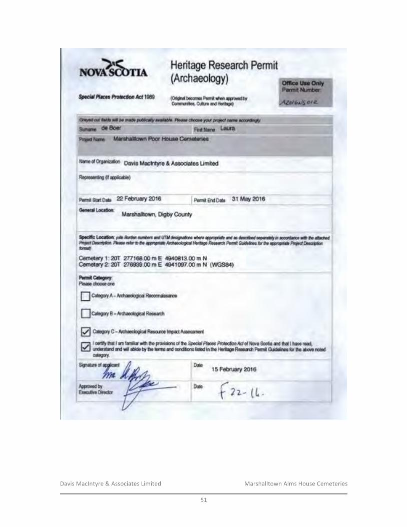
Davis&MacIntyre&&&Associates&Limited& &&&&&&&&&&&&&&&&&&& Marshalltown&Alms&House&Cemeteries&
&51&
&&
&
&
&
&
&
Davis&MacIntyre&&&Associates&Limited& &&&&&&&&&&&&&&&&&&& Marshalltown&Alms&House&Cemeteries&
&52&
&
&
&
&
&
&
&
&
&
&
&
&
&
&
&
&
&
&
APPENDIX/B://
COMPLETE/GPR/IMAGE/COLLECTION/&
&
&
&
&
&
&
&
&
&
&
&
&
&
&
&
&
&
&
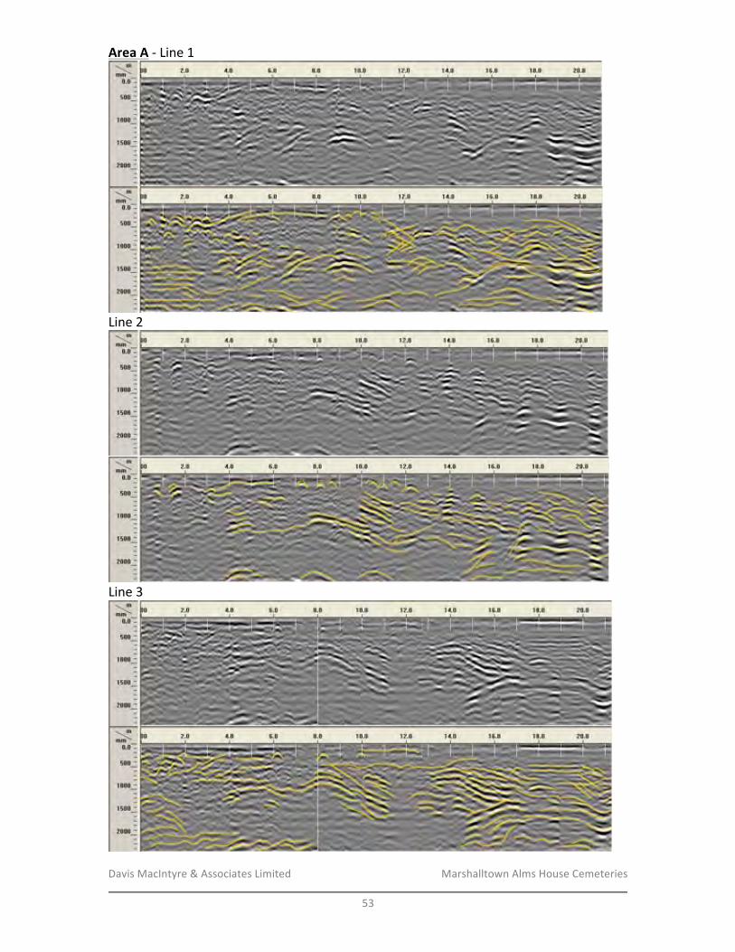
Davis&MacIntyre&&&Associates&Limited& &&&&&&&&&&&&&&&&&&& Marshalltown&Alms&House&Cemeteries&
&53&
Area/A&F&Line&1/
&
&Line&2&
&
&Line&3&
&
&
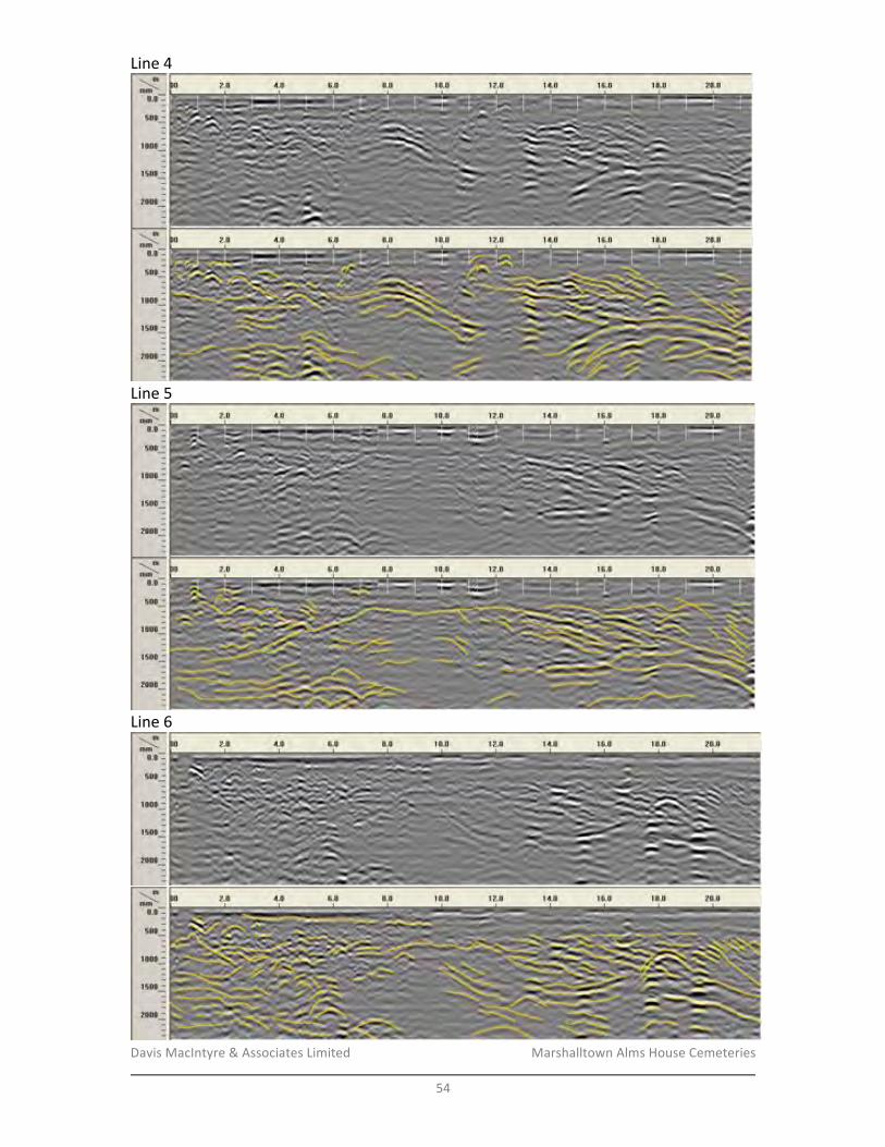
Davis&MacIntyre&&&Associates&Limited& &&&&&&&&&&&&&&&&&&& Marshalltown&Alms&House&Cemeteries&
&54&
Line&4&
&
&Line&5&
&
&Line&6&
&
&
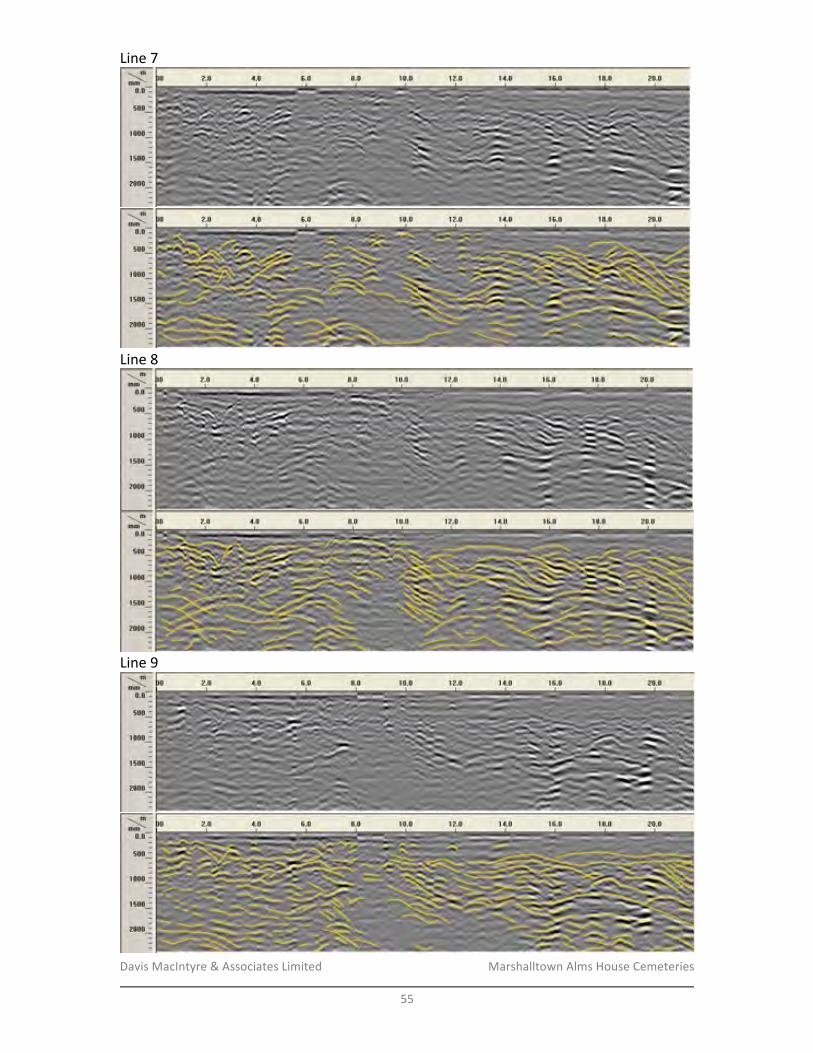
Davis&MacIntyre&&&Associates&Limited& &&&&&&&&&&&&&&&&&&& Marshalltown&Alms&House&Cemeteries&
&55&
Line&7&
&
&Line&8&
&
&Line&9&
&
&
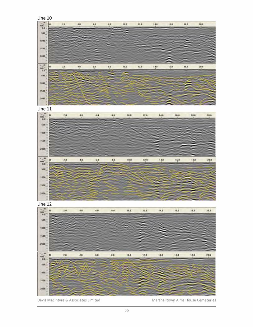
Davis&MacIntyre&&&Associates&Limited& &&&&&&&&&&&&&&&&&&& Marshalltown&Alms&House&Cemeteries&
&56&
Line&10&
&
&Line&11&
&
&Line&12&
&
&
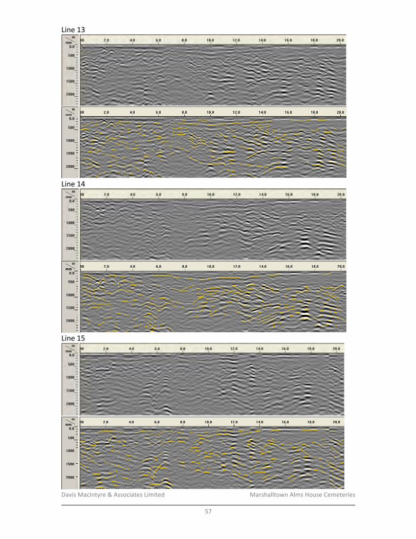
Davis&MacIntyre&&&Associates&Limited& &&&&&&&&&&&&&&&&&&& Marshalltown&Alms&House&Cemeteries&
&57&
Line&13&
&
&Line&14&
&
&Line&15&
&
&
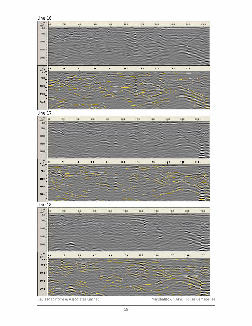
Davis&MacIntyre&&&Associates&Limited& &&&&&&&&&&&&&&&&&&& Marshalltown&Alms&House&Cemeteries&
&58&
Line&16&
&
&Line&17&
&
&Line&18&
&
&
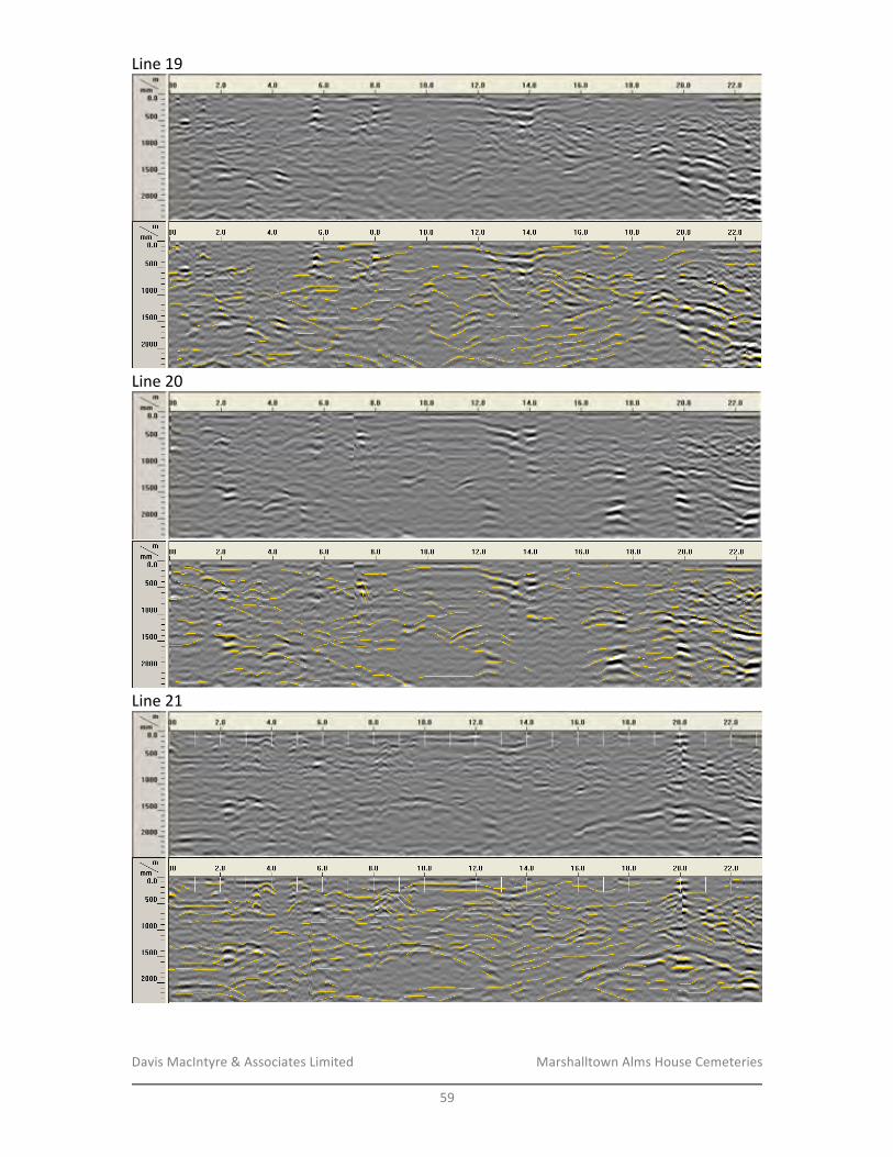
Davis&MacIntyre&&&Associates&Limited& &&&&&&&&&&&&&&&&&&& Marshalltown&Alms&House&Cemeteries&
&59&
Line&19&
&
&Line&20&
&
&Line&21&
&
&&
&

Davis&MacIntyre&&&Associates&Limited& &&&&&&&&&&&&&&&&&&& Marshalltown&Alms&House&Cemeteries&
&60&
Area/B&–&Line&22&
&
&Line&23&
&
&Line&24&
&
&&
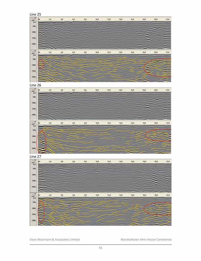
Davis&MacIntyre&&&Associates&Limited& &&&&&&&&&&&&&&&&&&& Marshalltown&Alms&House&Cemeteries&
&61&
Line&25&
&
&Line&26&
&
&Line&27&
&
&&
&
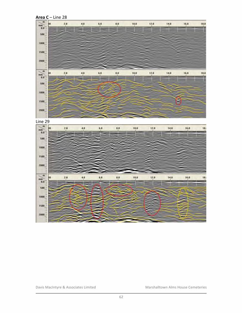
Davis&MacIntyre&&&Associates&Limited& &&&&&&&&&&&&&&&&&&& Marshalltown&Alms&House&Cemeteries&
&62&
Area/C&–&Line&28&
&
&Line&29&
&
&&
&
&
&
&
&
&
&
&
&
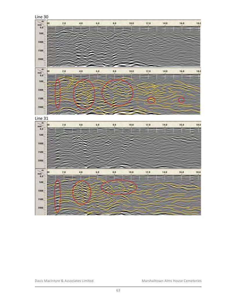
Davis&MacIntyre&&&Associates&Limited& &&&&&&&&&&&&&&&&&&& Marshalltown&Alms&House&Cemeteries&
&63&
Line&30&
&
&Line&31&
&
&& &
Davis&MacIntyre&&&Associates&Limited& &&&&&&&&&&&&&&&&&&& Marshalltown&Alms&House&Cemeteries&
&64&
&
&
&
&
&
&
&
&
&
&
&
&
&
&
&
&
&
&
&
&
&
APPENDIX/C:/PROTOCOLS/REGARDING/THE//ACCIDENTAL/DISCOVERY/OF/HUMAN/REMAINS/
&
&
&
&
&
&
&
&
&
&
&
&
&
&
&
&
&
&
&
&
&
Discovery/of/Human/Remains/&&
Davis&MacIntyre&&&Associates&Limited& &&&&&&&&&&&&&&&&&&& Marshalltown&Alms&House&Cemeteries&
&65&
&
In&the&event&that&human&remains&or&suspected&human&remains&are&discovered&in&
working&areas&the&contractor&must:&&
&
• Immediately&stop&construction&and¬ify&the&Project&Archaeologist&and&Site&
Supervisor;&&
• Cover&exposed&bone&with&plastic&sheeting,&blanket&or&some&other&clean&cover;&&
• Do¬&cover&any&finds&with&fill;&• Ensure&that&site&security&is&immediately&established&to&carry&through&until&the&
nature&of&remains&and/or&location&are&determined.&
&
The&Project&Archaeologist&will&then¬ify&the&appropriate&people&(these&may&include&the&
local&detachment&of&RCMP&and&the&Office&of&the&Medical&Examiner,&CCH,&and&
representatives&of&KMKNO).&If&the&remains&are&confirmed&to&be&of&an&archaeological&
nature&then&negotiations&will&follow&to&determine&how&the&remains&will&be&handled.&
&
Note&that&if&remains&are&discovered&during&construction&excavations,&in&the&box&of&a&
truck&or&in&an&excavation&bucket&for&example,&then&the&excavated&material&must&be&
carefully&placed&on&the&ground,&in&a&secure&area&for&inspection&by&the&Project&
Archaeologist.&If&the&detected&material&is&determined&or&suspected&to&be&human&remains,&
the&entire&contents&of&the&bucket&must&be&sifted&through&1/4&inch&mesh,&as&per&standard&
archaeological&practice.&Further&excavation&at&the&site&of&discovery&must&cease&
immediately&until&the&Project&Archaeologist&can&determine&if&additional&remains&exist&at&
the&site.&
&
&
Discovery/of/Human/Remains/that/are/of/Modern/Origin/&
If&the&remains&are&human,&and&are&determined&to&be&of&recent&origin,&the&RCMP&and&
Office&of&the&Medical&Examiner&will&assume&responsibility&for&the&remains.&
&
&
Guidelines/for/the/Archaeological/Handling/and/Treatment/of/Human/Remains/&
Onsite&management&strategies&for&the&discovery&of&human&remains&will&require&
consultation&with&CCH&and&other&representatives&(Mi’kmaq,&AfroFCanadian&community,&
etc),&as&appropriate.&One&of&the&following&two&strategies&may&be&followed:&
• The&remains&are&to&be&left&undisturbed&in&their&original&location&where&possible.&
If&additional&remains&are&suspected&to&be&present,&a&program&of&delineation&is&
required&through&archaeological&techniques&if&the&project&is&expected&to&further&
impact&on&the&area.&Once&delineated,&an&impactFexclusion&zone&can&be&
established&and&partial&project&redesign&may&be&necessary.&&
• If&the&remains&must&be&removed&or&have&been&disturbed,&salvage&or&emergency&
excavation&to&remove&the&remains&for&reburial&by&the&local&community&or&First&
Nations&(depending&upon&the&origin&of&the&remains)&may&be&required.&&&
&
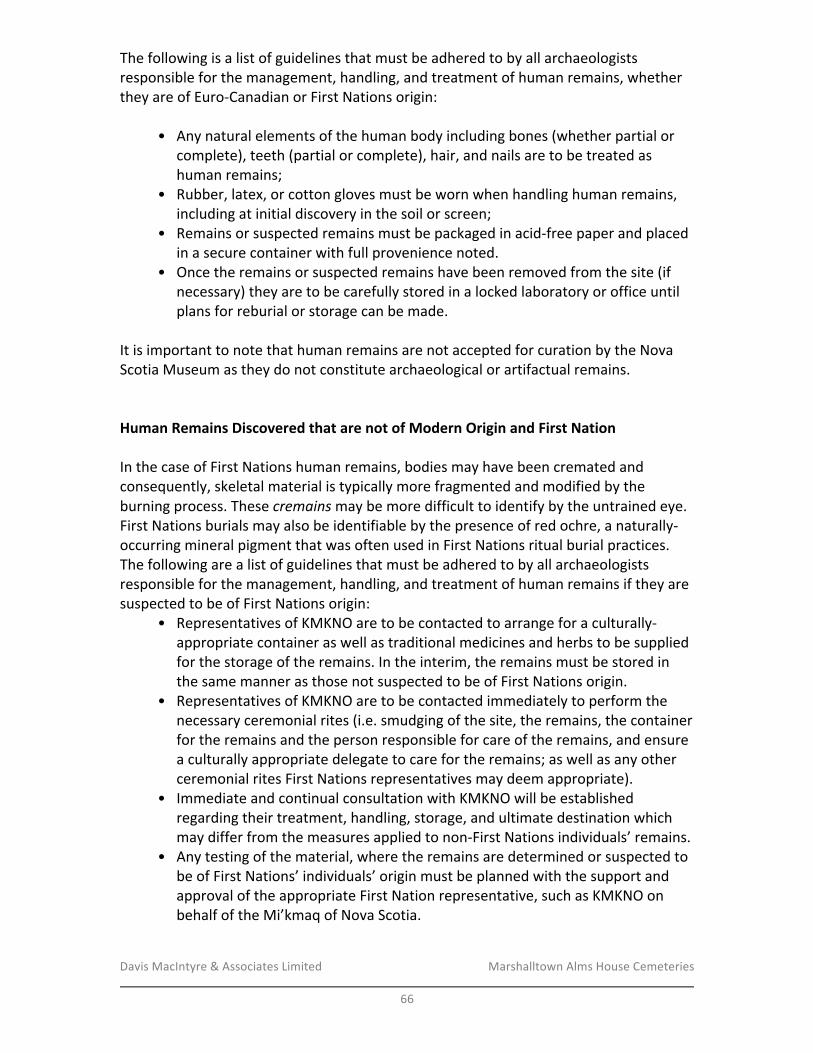
Davis&MacIntyre&&&Associates&Limited& &&&&&&&&&&&&&&&&&&& Marshalltown&Alms&House&Cemeteries&
&66&
The&following&is&a&list&of&guidelines&that&must&be&adhered&to&by&all&archaeologists&
responsible&for&the&management,&handling,&and&treatment&of&human&remains,&whether&
they&are&of&EuroFCanadian&or&First&Nations&origin:&&
&
•&& Any&natural&elements&of&the&human&body&including&bones&(whether&partial&or&
complete),&teeth&(partial&or&complete),&hair,&and&nails&are&to&be&treated&as&
human&remains;&
• Rubber,&latex,&or&cotton&gloves&must&be&worn&when&handling&human&remains,&
including&at&initial&discovery&in&the&soil&or&screen;&&
• Remains&or&suspected&remains&must&be&packaged&in&acidFfree&paper&and&placed&
in&a&secure&container&with&full&provenience¬ed.&&
• Once&the&remains&or&suspected&remains&have&been&removed&from&the&site&(if&
necessary)&they&are&to&be&carefully&stored&in&a&locked&laboratory&or&office&until&
plans&for&reburial&or&storage&can&be&made.&&&
&
It&is&important&to¬e&that&human&remains&are¬&accepted&for&curation&by&the&Nova&
Scotia&Museum&as&they&do¬&constitute&archaeological&or&artifactual&remains.&&&
&
&
Human/Remains/Discovered/that/are/not/of/Modern/Origin/and/First/Nation/&&&
In&the&case&of&First&Nations&human&remains,&bodies&may&have&been&cremated&and&
consequently,&skeletal&material&is&typically&more&fragmented&and&modified&by&the&
burning&process.&These&cremains(may&be&more&difficult&to&identify&by&the&untrained&eye.&
First&Nations&burials&may&also&be&identifiable&by&the&presence&of&red&ochre,&a&naturallyF
occurring&mineral&pigment&that&was&often&used&in&First&Nations&ritual&burial&practices.&
The&following&are&a&list&of&guidelines&that&must&be&adhered&to&by&all&archaeologists&
responsible&for&the&management,&handling,&and&treatment&of&human&remains&if&they&are&
suspected&to&be&of&First&Nations&origin:&&
• Representatives&of&KMKNO&are&to&be&contacted&to&arrange&for&a&culturallyF&
appropriate&container&as&well&as&traditional&medicines&and&herbs&to&be&supplied&
for&the&storage&of&the&remains.&In&the&interim,&the&remains&must&be&stored&in&
the&same&manner&as&those¬&suspected&to&be&of&First&Nations&origin.&&
• Representatives&of&KMKNO&are&to&be&contacted&immediately&to&perform&the&
necessary&ceremonial&rites&(i.e.&smudging&of&the&site,&the&remains,&the&container&
for&the&remains&and&the&person&responsible&for&care&of&the&remains,&and&ensure&
a&culturally&appropriate&delegate&to&care&for&the&remains;&as&well&as&any&other&
ceremonial&rites&First&Nations&representatives&may&deem&appropriate).&&
• Immediate&and&continual&consultation&with&KMKNO&will&be&established&
regarding&their&treatment,&handling,&storage,&and&ultimate&destination&which&
may&differ&from&the&measures&applied&to&nonFFirst&Nations&individuals’&remains.&&
• Any&testing&of&the&material,&where&the&remains&are&determined&or&suspected&to&
be&of&First&Nations’&individuals’&origin&must&be&planned&with&the&support&and&
approval&of&the&appropriate&First&Nation&representative,&such&as&KMKNO&on&
behalf&of&the&Mi’kmaq&of&Nova&Scotia.&&