appendix d monitoring systems within the mrgcd
TRANSCRIPT

Appendix D
Monitoring Systems within the MRGCD Contents D-1 Profiles of Gages for Monitoring MRGCD Irrigation System Flows D-2 USGS Gage Specification Sheets D-3 MRGCD Virtual Gage Records on USBR ET Toolbox Webpage

Appendix D-1
Profiles of Gages for Monitoring MRGCD Irrigation System Flows
Contents Cochiti Division Gages
Albuquerque Division Gages
Belen Division Gages
Socorro Division Gages
USGS Rio Grande Gage Specification Sheets
Notes 1) In the gage profiles, the accuracy attributed to the records collected has the
following classification: Good: Daily discharges within 10% of their true value Fair: Daily discharges within 15% of their true value. Poor: Daily discharges greater than 15% of true value. Different accuracies maybe attributed to different parts of a given record.
2) The orientation of the gage, left side or right side of canal or river, is determined by looking downstream.

Gages in MRGCD Cochiti Division CTDN5 Rio Grande below Cochiti Dam SILN5 Sili Main Canal (at Head) at Cochiti CCCN5 Cochiti East Side Main Canal at Cochiti CMCCN Cochiti Main Canal at San Felipe SFPN5 Rio Grande at San Felipe

2
CTDN5 Rio Grande below Cochiti Dam*
(USGS 08317400) ID: CTDN5 Name: Rio Grande below Cochiti Dam Division: Cochiti Date of Visit: April 30, 2001 Operator: USGS Period of Record at Present Site: 1976 - 2001
State Plane 83 NM Central Zone UTM NAD83 Zone 13 Northing Easting Northing Easting
1679906.875 1618585.875 3942287.686 380141.918 WGS84
Lat: N 35.370159 Long: W 106.192447 1999 River Mile: 232.4
Location: Rio Grande just below Cochiti Dam, Hydrologic Unit 13020201, in Pueblo de Cochiti Grant, on right bank, ± 320 feet upstream from bridge on State Hwy 22, ± 700 feet downstream from Cochiti Dam, ± 1.4 miles northeast of Cochiti Pueblo, and at USGS river mile 1,587.6 Equipment: Outside staff gage and gage shelter Gage Type and Condition: Sutron 8210 DCP, driven by a Sutron Accubar pressure sensor, a Minisonde Hydrolab water quality probe, housed in a 10 foot by 12 foot Butler building on right bank ± 325 upstream from State Hwy 22. Control: Low-stage control is gravel and rock riffle ± 100 feet downstream. Channel control for medium and high stages are probably affected by bridge pilings Quality of Section: Good Quality of Record: (Accuracy) Stage – discharge relation will be subject to some shifting. Resultant records should be good to fair Data Collection: Not noted Data Transmission: Not noted Potential Problems: None noted Remarks: None noted *For complete USGS description, see USGS gage specification sheet.

3
SILN5* Sili Main Canal (at Head) at Cochiti
(USGS 08314000) ID: SILN5 Name: Sili Main Canal (at Head) at
Cochiti Division: Cochiti Date of Visit: April 30, 2001 Operator: USGS Period of Record at Present Site: 1978 - 2001
State Plane 83 NM Central Zone UTM NAD83 Zone 13 Northing Easting Northing Easting
1680759.250 1618159.750 3942549.087 380015.362 WGS84
Lat: N 35.371001 Long: W 106.192964 1999 River Mile: 232.4
Location: Diversion from Rio Grande to west side, just below Cochiti Dam, but above CTDN5. On right bank of Rio Grande, ± 1300 feet downstream from Cochiti Dam, and 1.4 miles northeast of Cochiti Pueblo. Equipment: Stilling well and shelter on right bank Gage Type and Condition: Real-time automated gage. Sutron encoder with float, hard-wired to DCP transmitter at gaging station, Rio Grande below Cochiti Dam. Control: Concrete lined box channel Quality of Section: Good Quality of Record: Good Data Collection: Gage heights collected every 15 minutes Data Transmission: Transmitted to USGS office every four hours Potential Problems: None noted Remarks: *History of gage, from USGS fact sheet, indicates that record was being collected at this approximate site since 1936. The location of the data for the period, 1936-1954, is not known at this time. Gage station is operated by USGS, but the MRGCD makes 2 to 3 discharge measurements during the irrigation season to verify rating at gage. No photographs available for this gage No rating curve available for this gage * For complete USGS description, see USGS gage specification sheet.

4
CCCN5* Cochiti East Side Main Canal at Cochiti
(08313500) ID: CCCN5 Name: Cochiti East Side Main Canal at
Cochiti Division: Cochiti Date of Visit: April 30, 2001 Operator: USGS Period of Record at Present Site:
State Plane 83 NM Central Zone UTM NAD83 Zone 13 Northing Easting Northing Easting
1679906.875 1618585.875 3942287.686 380141.918 WGS84
Lat: N 35.370159 Long: W 106.192447 1999 River Mile: 232.4
Location: Diversion from Rio Grande to east side, just below Cochiti Dam, but above Cochiti downstream gage. On left bank of Rio Grande, ± 1300 feet downstream from heading and Cochiti Dam Equipment: Stilling well and shelter on left bank Gage Type and Condition: Real time automated gauge. Sutron encoder with float, hard-wired to DCP transmitter at gaging station, Rio Grande below Cochiti Dam Control: 8-foot Parshall flume Quality of Section: Good to fair – large amount of turbulence through flume Quality of Record: Good to fair Data Collection: Gage heights collected every 15 minutes Data Transmission: Transmitted to USGS office every four hours Potential Problems: Turbulence in flume and well. Gage heights difficult to read on O.S. Remarks: Record might be improved if gage were re-located to a site 100 to 200 feet downstream from present site and concrete rating structure installed to replace Parshall flume. This gaging station is operated by USGS, but the MRGCD makes 2 to 3 discharge measurements during the irrigation season to verify rating at gage. *For complete USGS description, see USGS gage specification sheet.
5
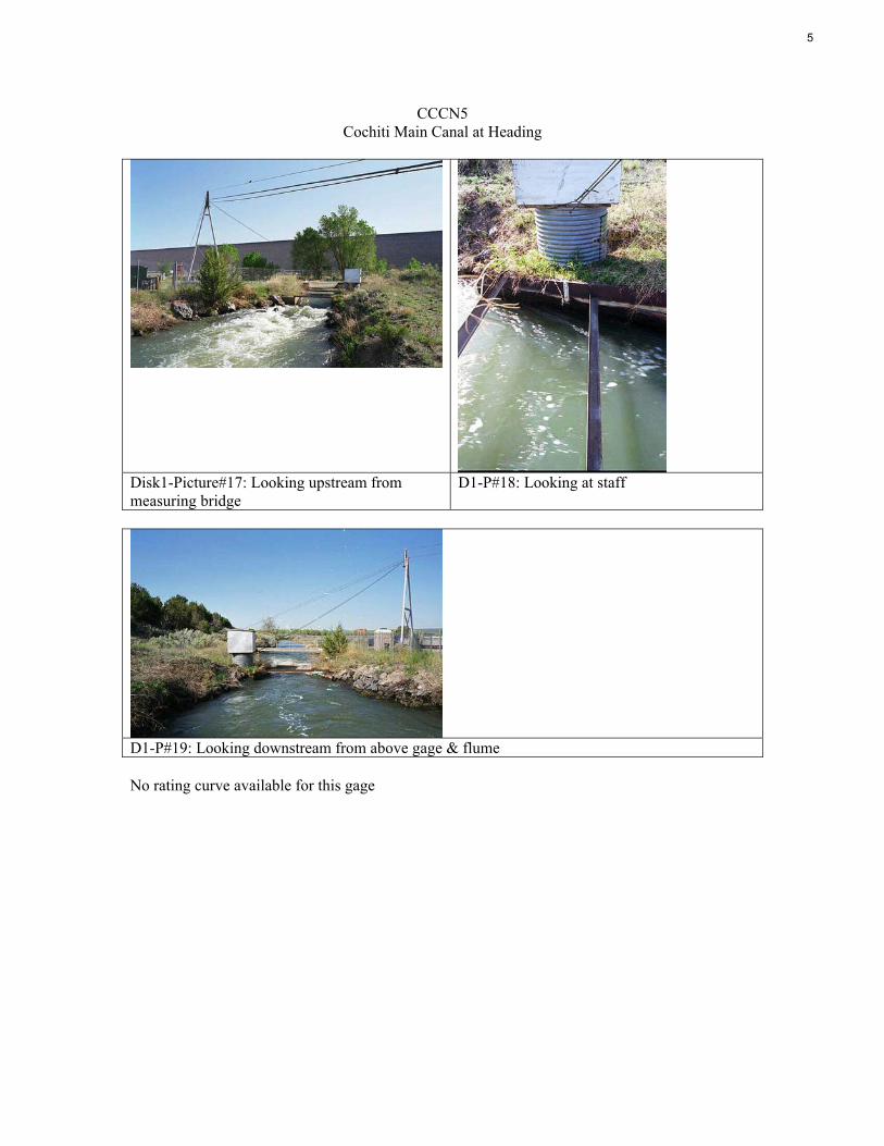
CCCN5 Cochiti Main Canal at Heading
Disk1-Picture#17: Looking upstream from measuring bridge
D1-P#18: Looking at staff
D1-P#19: Looking downstream from above gage & flume No rating curve available for this gage

6
CMCCN Cochiti Eastside Main Canal at San Felipe
ID: CMCCN Name: Cochiti Eastside Main Canal at
San Felipe Division: Cochiti Date of Visit: April 30, 2001 Operator: MRGCD Period of Record: (1954) 1974 - 2001
State Plane 83 NM Central Zone UTM NAD83 Zone 13 Northing Easting Northing Easting
1613301.375 1586353.875 3922114.725 370062.109 WGS84
Lat: N 35.260239 Long: W 106.255341 1999 River Mile: No data
Location: On San Felipe Pueblo – 2.0 miles north of I-25 on road to Pueblo from Casino. Equipment: Stilling well and shelter on right bank Gage Type and Condition: Stevens A-71 graphic recorder Control: Earthen channel and concrete culvert ± 500 feet downstream from gage Quality of Section: Fair to good condition Quality of Record: Should be fair to good Data Collection: Continuous graph of stage in canal Data Transmission: None Potential Problems: Debris buildup in culvert will cause a backwater problem. Remarks: USGS has record for this station since 1954, but MRGCD only has record since 1974. Rating appears to be fairly stable for this gaging station.
D1-P#20: Looking downstream towards gage and at culvert from right bank
D1-P#21: Looking upstream from below gage from right bank

7
CMCCN Cochiti Eastside Main Canal
D1-P#22: Looking upstream from below gage from right bank
D1-P#23: Looking at culvert plus/minus 500 feet downstream from right bank
CMCCN Cochiti Eastside Main Canal
CMCCNCOCHITI MAIN CANAL (SAN FELIPE) 2001 RATING CURVE
0.50
1.00
1.50
2.00
2.50
3.00
0.00 25.00 50.00 75.00
DISCHARGE (CFS)
STA
GE
(FT)
2001 RATING CURVE
2001 MEASURES
2000 MEASURES
EQUATION OF LINE:(((Y-0.50)^1.45)*17.5)

8
SFPN5* Rio Grande at San Felipe
(USGS 08319000) ID: SFPN5 Name: Rio Grande at San Felipe Division: Cochiti Date of Visit: Operator: USGS Period of Record at Present Site: 1957 - 2001
State Plane 83 NM Central Zone UTM NAD83 Zone 13 Northing Easting Northing Easting
1615997.25 1583135.375 3922948.695 370062.109 WGS84
Lat: N 35.262900 Long: W 106.263237 1999 River Mile: 216.4
Location: On right bank of Rio Grande 200 feet downstream from Tonque Arroyo, 1,700 feet upstream from steel highway bridge, 0.8 mile upstream from San Felipe Pueblo, 11 miles northeast of Bernalillo. Equipment: Walk-in shelter and cableway A-frame. Stilling well and outside staff gage. Gage Type and Condition: Real time automated gage. Design Analysis H-350 Bubbler system with a Telonics DCP transmitter. Control: Wide gravel and cobblestone riffle about 300 feet downstream Quality of Section: Fair Quality of Record: Fair to good Data Collection: Gage height collected every 15 minutes Data Transmission: Transmitted to USGS office every 4 hours Potential Problems: A large island 300 to 400 feet downstream from gage has divided channel and will have an effect on upper ends of ratings curve during medium and high flows Remarks: *For complete USGS description, see USGS gage specification sheet

Gages in MRGCD Albuquerque Division ALGDR Algondones Drain Outfall ALBCN Albuquerque Main Canal ATFCN Atrisco Feeder Canal JECN5 Jemez River below Jemez Canyon Dam BERCN Bernalillo Acequia CORCN Corrales Main Canal SANWW Sandia Lakes Wasteway UCRDR Upper Corrales Riverside Drain Outfall CORWW Corrales (Main Canal) Wasteway LCRDR Lower Corrales (Riverside) Drain Outfall CENWW Central Avenue Wasteway (Weedracks) ABQN5 Rio Grande at Albuquerque ARMCN Armijo Acequia ATDCN Atrisco Ditch (Acequia) ARECN Arenal Main Canal ALBDR Albuquerque Drain at Central Avenue (Tingley) ARSDR Albuquerque (Riverside) Drain Outfall ATRDR Atrisco (Riverside) Drain Outfall

10
ALGDR Algodones Riverside Drain Outfall
ID: ALGDR Name: Algondones Drain Outfall Division: Albuquerque Date of Visit: April 30, 2001 Operator: MRGCD Period of Record: (1954) 1974 - 2001
State Plane 83 NM Central Zone UTM NAD83 Zone 13 Northing Easting Northing Easting
1593368.000 1567069.000 3916114.349 364108.259 WGS84
Lat: N 35.224482 Long: W 106.294587 1999 River Mile: No data
Location: Return flow from Cochiti Division along east side, empties into Atrisco Feeder, not into Rio Grande. On the left bank of Rio Grande - ± 750 feet upstream from Angostura Diversion Structure and below confluence of Yeso & San Felipe Riverside Drain. Equipment: Stilling well and shelter on left bank Gage Type and Condition: Pressure transducer hard-wired to radio transmitter located at dam tender’s house Control: Natural earthen channel, head provided from being diverted from Angostura Diversion Structure and siphon ± 1,000 feet downstream Quality of Section: Poor Quality of Record: Poor Data Collection: Gage heights are collected every 30 minutes Data Transmission: Transmitted to office of MRGCD Potential Problems: Remarks: This gaging station is located just below the confluence of two drains returning flow diverted in the Cochiti Division. Downstream condition from the gage makes for a poor stage/discharge relationship. [Downstream conditions produce unreliable stage/discharge relationship data] Borland is not sure about how much water passes this station. “Would it be cost effective to install a flume to measure a small amount of water?”

11
ALGDR Algondones Riverside Drain Outfall
D6-P#23: Looking at gage from downstream on right bank
D6-P#24: Looking across channel at gage and pipe from Yeso Drain
D6-P#25: Looking downstream from above gage D6-P#26: Looking at gage and downstream from
above gage

12
ALGDR Algondones Riverside Drain Outfall
D2-P#2: Looking downstream from above gage (left bank)
D2-P#3: Looking upstream from above gage at side channel and pipe.
D2-P#4: Looking at pipe into main diversion channel

13
ALGDR Algondones Riverside Drain Outfall
ALGDRALGODONES RIVERSIDE DRAIN 2001 RATING CURVE
0.50
1.00
1.50
2.00
2.50
3.00
3.50
4.00
0.00 25.00 50.00 75.00 100.00 125.00
DISCHARGE (CFS)
STA
GE
(FT)
2001 RATING CURVE
2001 MEASURES
2000 MEASURES
EQUATION OF LINE:(((Y^2)*5)+20)VERY POOR STATION, EXTENSIVE BACKWATER PROBLEM
LARGE AND FREQUENT SHIFTSSCHEDULED FOR FLUME STRUCTURE NOVEMBER 2001

14
ALBCN Albuquerque Main Canal
ID: ALBCN Name: Albuquerque Main Canal Division: Albuquerque Date of Visit: April 30, 2001 Operator: MRGCD Period of Record: 1974 - 2001
State Plane 83 NM Central Zone UTM NAD83 Zone 13 Northing Easting Northing Easting
1590064.375 1564169.125 3915118.726 363211.797 WGS84
Lat: N 35.221207 Long: W 106.302079 1999 River Mile: No data
Location: Diversion from Rio Grande to east side at Angostura Diversion Structure. On the left bank, 1.0 mile downstream from Angostura Diversion Structure and 0.5 mile downstream from Diversion for Atrisco Feeder Canal. Equipment: Stilling well and shelter on left bank Gage Type and Condition: Pressure transducer hard-wired to transmitter located at dam tender’s house Control: Earthen channel and concrete culvert located 0.6 mile downstream from diversion point Quality of Section: Good to fair Quality of Record: Good Data Collection: Gage height is collected every 30 minutes Data Transmission: Transmitted to MRGCD office Potential Problems: Backwater results from debris collecting in channel affecting flow and data. Remarks: Dam tender has instructions to visit this site two or three times during the day to check below gage for backwater.
D2-P#9: At gage looking upstream D2-P#10 at bridge above gage looking downstream

15
ALBCN Albuquerque Main Canal
D2-P#11: Looking at culvert 0.6 mile below gage from left bank
D2-P#12: Looking upstream from below gage
ALBCNALBUQUERQUE MAIN CANAL 2001 RATING CURVE
0.00
0.50
1.00
1.50
2.00
2.50
3.00
3.50
4.00
4.50
5.00
0.00 25.00 50.00 75.00 100.00 125.00 150.00 175.00 200.00 225.00 250.00 275.00 300.00 325.00 350.00
DISCHARGE (CFS)
STA
GE
(FT)
2001 RATING CURVE
2001 MEASURES
2000 MEASURES
EQUATION OF LINE:(((Y-0.60)^1.3)*37)CHANNEL DREDGED MIDYEAR 2000
DS CHECK AT BERNALILLO RAISED 1.33' FEB 2001

16
ATFCN Atrisco Feeder Canal
ID: ATFCN Name: Atrisco Feeder Canal Division: Albuquerque Date of Visit: April 30, 2001 Operator: MRGCD Period of Record: 1974 - 2001
State Plane 83 NM Central Zone UTM NAD83 Zone 13 Northing Easting Northing Easting
1590113.25 1563129.125 3915137.624 362895.042 WGS84
Lat: N 35.221253 Long: W 106.303335 1999 River Mile: No data
Location: Diversion from Rio Grande to east side at Angostura Diversion Structure. On left bank of Rio Grande, 1.0 mile downstream from Angostura Diversion Structure and 0.5 mile downstream from diversion for Albuquerque Main Canal. Equipment: Stilling well and shelter on left bank Gage Type and Condition: Sutron Encoder hard-wired to radio transmitter at dam tender’s house Control: Concrete drop structure Quality of Section: Good Quality of Record: Good Data Collection: Gage height collected every 30 minutes Data Transmission: Transmitted to MRGCD office Potential Problems: Backwater from debris collecting at drop structure Remarks: Dam tender has instructions to visit gage two or three times a day to check for debris hanging up on drop structure.

17
ATFCN Atrisco Feeder Canal
D2-P#5: Looking upstream from bridge below gage
D2-P#6: Looking at instrumentation in gage
D2-P#7: looking downstream from above gage D2-P#8: Looking upstream from below control gage

18
ATFCN Atrisco Feeder Canal
ATFCNATRISCO FEEDER CANAL 2001 RATING CURVE
0.00
0.50
1.00
1.50
2.00
2.50
0.00 25.00 50.00 75.00 100.00 125.00 150.00 175.00 200.00 225.00 250.00
DISCHARGE (CFS)
STA
GE
(FT)
2001 RATING CURVE
2001 MEASURES
2000 MEASURES
EQUATION OF LINE:((Y^1.35)*65.5)

19
JECN5 Jemez River below Jemez Canyon Dam
(USGS 08329000) ID: JECN5 Name: Jemez River below Jemez Canyon
Dam Division: Alburquerque Date of Visit: Not visited Operator: USGS Period of Record at Present Site: 1951 - 2001
State Plane 83 NM Central Zone UTM NAD83 Zone 13 Northing Easting Northing Easting
1597489.625 1555509 3917414.944 360601.184 WGS84
Lat: N 35.232528 Long: W 106.320562 1999 River Mile: 208.3
Location: Right bank of Rio Grande, approximately ¾ mile downstream from former gage at Jemez dam site, about 1 ½ miles above mouth, and 6 miles north of Bernalillo, Sandoval County. Equipment: Staff gage Gage Type and Condition: Real time automated gage. Sutron Corp. model 8210 data collection platform driven by a Sutron Accubar pressure sensor housed in a 5’ x 6’ CMC walk-in type shelter. Control: Natural channel with rip-rap Quality of Section: Not noted Quality of Record: Not Noted Data Collection: Not Noted Data Transmission: Not Noted Potential Problems: Not Noted Remarks: * For complete USGS description, see USGS gage specification sheet.

20
BERCN Bernalillo Acequia
ID: BERCN Name: Bernalillo Acequia Division: Albuquerque Date of Visit: May 18, 2001 Operator: MRGCD Period of Record: 2001
State Plane 83 NM Central Zone UTM NAD83 Zone 13 Northing Easting Northing Easting
1576598.25 1556194.25 3911045.562 360729.610 WGS84
Lat: N 35.195866 Long: W 106.315662 1999 River Mile: No data
Location: West of New Mexico 313 and at southern boundary of Pueblo de Santa Ana. Equipment: Stilling well and shelter on left bank Gage Type and Condition: Pressure transducer hard-wired to radio transmitter in pump house 100 feet upstream from gage Control: Concrete lined section with weir Quality of Section: Good Quality of Record: Good Data Collection: Gage height collected every 30 minutes Data Transmission: Transmitted to MRGCD office Potential Problems: None Remarks: New gage, but should provide a good record
D6-P#20: Looking upstream from below gage D6-P#21: Looking at gage, concrete lined section and outside staff gage from left bank

21
BERCN Bernalillo Acequia
D6-P#22: Looking downstream from above gage
BERCNBERNALILLO ACEQUIA 2001 RATING CURVE
0.00
0.50
1.00
1.50
2.00
0 5 10 15 20 25 30
DISCHARGE (CFS)
STA
GE
(FT)
2001 MEASURES
2001 RATING CURVE
EQUATION OF LINE: ((Y^2.544)*7.198)

22
CORCN Corrales Main Canal
ID: CORCN Name: Corrales Main Canal Division: Albuquerque Date of Visit: April 30, 2001 Operator: MRGCD Period of Record: 1974 - 2001
State Plane 83 NM Central Zone UTM NAD83 Zone 13 Northing Easting Northing Easting
1556095.875 1535297.875 3904877.625 354282.483 WGS84
Lat: N 35.163521 Long: W 106.360797 1999 River Mile: No data
Location: Flow carried in siphon from Atrisco Feeder on east side to west side, no diversion or return. At north end of village of Corrales, 0.6 mile upstream from New Mexico 448. Equipment: Stilling well, shelter, and solar panel on right bank Gage Type and Condition: Sutron encoder with float and radio transmitter Control: Earthen channel and diversion structure located 0.5 mile downstream. Quality of Section: Good to fair Quality of Record: Fair to poor Data Collection: Gage height collected every 30 minutes Data Transmission: Transmitted to MRGCD office Potential Problems: Debris collecting on diversion structure downstream has caused backwater at gaging station. The ditch rider is aware of the potential problem. Remarks: Gage will be moved to an upstream location when time and funding are available.
D2-P#13: Looking downstream from above gage from right bank
D2-P#14: Looking upstream from measuring bridge below gage. Takeout for field on left bank ± 60 feet below gage.

23
CORCN Corrales Main Canal
D2-P#15: Looking at diversion structure and pile of debris that has been removed from structure 0.5 mile below gage. Piece in middle can probably be raised or lowered to divert water into fields on left bank—debris also a problem backwater?
CORCNCORRALES MAIN CANAL 2001 RATING CURVE
1.00
1.50
2.00
2.50
3.00
3.50
4.00
4.50
0.00 25.00 50.00 75.00
DISCHARGE (CFS)
STA
GE
(FT)
2001 RATING CURVE
2001 MEASURES
2000 MEASURES
EQUATION OF LINE:(((Y-0.80)^1.45)*15)STATION POOR, BADLY AFFECTED BY DOWNSTREAM CHECK

24
SANWW Sandia Lakes Wasteway
ID: SANWW Name: Sandia Lakes Wasteway Division: Albuquerque Date of Visit: May 2, 2001 Operator: MRGCD Period of Record: 2000 - 2001
State Plane 83 NM Central Zone UTM NAD83 Zone 13 Northing Easting Northing Easting
1538073.625 1538501.25 3899372.870 355189.564 WGS84
Lat: N 35.133706 Long: W 106.352858 1999 River Mile: No data
Location: Return flow to Rio Grande, excess bled off east side canals. Northwest corner of Sandia Lakes Recreational Area Equipment: Shelter on left bank Gage Type and Condition: Pressure transducer with gate potentiometer and radio transmitter Control: Langemann Weir Gate Quality of Section: Good, no flow over gate during visit Quality of Record: Good Data Collection: Gage height collected every 30 minutes Data Transmission: Transmitted to MRGCD office Potential Problems: None – Debris might collect on gate Remarks: Langemann Weir Gates replaced old radial gates and make for a much easier measuring situation. Currently using theoretical rating for gate, but can be checked with discharge measurements when streamflow declines in Rio Grande. *Need to make discharge measurements to define theoretical rating.

25
SANWW Sandia Lakes Wasteway
D3-P#27: Looking upstream from gage and drop structure
D3-P#28: Looking downstream from left bank above gage at gage and weir structure—no flow over weir plate.
D3-P#29: From below gage on left bank looking at gage and gate with backwater
D3-P#30: Same site as D3-P#29 with telephoto lens

26
D3-P#31: Above gage on right bank looking at gage and gate
On left bank there are four channels that go south towards Albuquerque
SANWWSANDIA LAKES WASTEWAY 2001 RATING CURVE
0.00
0.50
1.00
1.50
2.00
2.50
3.00
0.00 25.00 50.00 75.00 100.00 125.00 150.00 175.00
DISCHARGE (CFS)
STA
GE
(FT)
2001 RATING CURVE
2001 MEASURES
2000 MEASURES
EQUATION OF LINE:((Y^1.5)*(3.7*11.12))FAULTY HEAD REFERENCE IN 2000, THEORETICAL CURVE
SHOULD TAKE PRECEDENCE OVER MEASURES

27
UCRDR Upper Corrales Riverside Drain Outfall
ID: UCRCR Name: Upper Corrales Drain Division: Albuquerque Date of Visit: April 30, 2001 Operator: MRGCD Period of Record: 2001
State Plane 83 NM Central Zone UTM NAD83 Zone 13 Northing Easting Northing Easting
1530174.000 1523548.500 3897022.715 350602.244 WGS84
Lat: N 35.121838 Long: W 106.382845 1999 River Mile: 192.2
Location: Return flow to Rio Grande from Corrales area canals. Upstream from west end of bridge on Alameda Blvd. over Rio Grande – New Mexico 528. Equipment: Stilling well, shelter and solar panel on left bank Gage Type and Condition: Data recording automated gage. Pressure transducer with radio transmitter. Control: Concrete lined channel with weir Quality of Section: Good Quality of Record: Good Data Collection: Gage height is collected every 30 minutes Data Transmission: Transmitted to MRGCD office Potential Problems: None Remarks: Debris could be a problem catching on the head gates below the gage and causing backwater through weir. This problem is illustrated on the rating curve (following the photos on the next pages), where measurements of about 38 cfs plot to the left of curve as a result of a log catching on head gates.

28
UCRDR Upper Corrales Riverside Drain Outfall
D3-P#23: Looking upstream from structure to below gage
D3-P#24: Looking downstream from structure at Rio Grande
D3-P#25: Looking downstream from above gage from right bank
D3-P#26: Looking downstream from just above head gates. Gage on left bank with concrete weir or flume below man-made channel.

29
UCRDR Upper Corrales Riverside Drain Outfall
UCRDRUPPER CORRALES DRAIN 2001 RATING CURVE
0.00
0.50
1.00
1.50
2.00
2.50
0.00 25.00 50.00 75.00 100.00
DISCHARGE (CFS)
STA
GE
(FT)
2001 RATING CURVE
2001 MEASURES
2000 MEASURES
EQUATION OF LINE:((Y^1.953)*14.83)

30
CORWW Corrales (Main Canal) Wasteway
ID: CORWW Name: Corrales Wasteway Division: Albuquerque Date of Visit: April 30, 2001 Operator: MRGCD Period of Record: 1997 - 2001
State Plane 83 NM Central Zone UTM NAD83 Zone 13 Easting Northing Easting
1514230.25 1513595.25 3892201.763 347507.743 WGS84
Lat: N 35.094028 Long: W 106.402758 1999 River Mile: No data
Location: Return flow to the Rio Grande from Corrales area canals. 0.25 mile east and 1,000 feet north of the intersection of Coors Blvd. and La Orilla. Equipment: Shelter with solar panel on right bank Gage Type and Condition: Pressure transducer with radio transmitter Control: Concrete lined channel with drop structure Quality of Section: Good Quality of Record: Good Data Collection: Gage heights are collected every 30 minutes Data Transmission: Transmitted to MRGCD office Potential Problems: Debris will move through concrete lined channel at times, which results in temporary backwater conditions. Remarks: Discharge measurements can be made in the natural channel below gage to define stage-discharge relationship.

31
CORWW Corrales (Main Canal) Wasteway
D2-P#19: Looking downstream from above gage on right bank
D3-P#20: Looking upstream from gage along right bank
D3-P#21: Looking upstream from below concrete drop structure from right bank
D3-P#22: Looking down at O.S. on left bank and orifice on right bank below gage

32
CORWW Corrales (Main Canal) Wasteway
CORWWCORRALES WASTEWAY 2001 RATING CURVE
0.00
0.50
1.00
1.50
0.00 25.00 50.00 75.00
DISCHARGE (CFS)
STA
GE
(FT)
2001 RATING CURVE
2001 MEASURES
2000 MEASURES
EQUATION OF LINE:((Y^1.93)*46.3)

33
LCRDR Lower Corrales (Riverside) Drain Outfall
ID: LCRDR Name: Lower Corrales Drain Outfall Division: Albuquerque Date of Visit: April 30, 2001 Operator: MRGCD Period of Record: 2000 - 2001
State Plane 83 NM Central Zone UTM NAD83 Zone 13 Northing Easting Northing Easting
1514037.375 1513543.500 3892143.179 347491.233 WGS84
Lat: N 35.093837 Long: W 106.402819 1999 River Mile: No data
Location: Return flow to Rio Grande, very minor. Natural channel passes underneath concrete lined Corrales Main Canal Wasteway Equipment: No instruments for measuring or collecting data Gage Type and Condition: No instruments for measuring or collecting data Control: Natural earthen channel Quality of Section: Fair to good Quality of Record: Fair to good Data Collection: Continuous record not being collected Data Transmission: None Potential Problems: Vandalized after installation Remarks: Currently only discharge measurements are being made at this site. When funding is available, pressure transducer will be installed and data will be transmitted from radio at Corrales Main Canal Wasteway. Normal flow 6 to 7 cfs, very little irrigation nearby, low priority. No photographs available for this gage No rating curve available for this gage

34
CENWW Central Avenue Wasteway (Weedracks)
ID: CENWW Name: Central Avenue Wasteway Division: Albuquerque Date of Visit: May 2, 2001 Operator: MRGCD Period of Record: 2000 - 2001
State Plane 83 NM Central Zone UTM NAD83 Zone 13 Northing Easting Northing Easting
1490617.750 1509381.375 3885021.582 346133.126 WGS84
Lat: N 35.054654 Long: W 106.411708 1999 River Mile: No data
Location: Return flow to river, excess bled off Atrisco Feeder at intake to Atrisco Siphon. On right bank of Rio Grande, 0.5 mile upstream east end of bridge over Rio Grande on Central Avenue. Equipment: Shelter with solar panel on right bank. Gage Type and Condition: Pressure transducer with gate potentiometer and radio transmitter. Control: Langemann Weir Gate Quality of Section: Good Quality of Record: Good Data Collection: Gage height is collected every 30 minutes Data Transmission: Transmitted to MRGCD office Potential Problems: None – debris might get caught on or in gate Remarks: Replacement of radial gate at this site makes measurement of return flow to Rio Grande much easier. Discharge measurement will be made later to verify theoretical rating. *Note: Extreme scatter on measurements made during 2000 irrigation season (see rating curve following photographs on next pages). Need to obtain a better definition on rating at this station.

35
CENWW Central Avenue Wasteway (Weedracks)
D3-P#32: Above gage looking downstream from right bank at gate
D3-P#33: Below drop structure and gage looking upstream from left bank
D3-P#34: Above gage looking at area toward Rio Grande
D3-P#35: From above gage looking downstream towards siphon and head gates
D3-P#36: Debris pile from siphon

36
CENWW Central Avenue Wasteway (Weedracks)
CENWWCENTRAL WEEDRACKS WASTEWAY 2001 RATING CURVE
0.00
0.50
1.00
1.50
2.00
2.50
3.00
0.00 25.00 50.00 75.00 100.00 125.00 150.00 175.00
DISCHARGE (CFS)
STA
GE
(FT)
2001 RATING CURVE
2001 MEASURES
2000 MEASURES
EQUATION OF LINE:((Y^1.5)*(3.7*7.12))FAULTY HEAD REFERENCE IN 2000, THEORETICAL CURVE
SHOULD TAKE PRECEDENCE OVER MEASURES

37
ABQN5 Rio Grande at Albuquerque
(USGS 08330000) ID: ABQN5 Name: Rio Grande at Albuquerque Division: Albuquerque Date of Visit: Not visited Operator: USGS Period of Record at Present Site: 1942 - 2001
State Plane 83 NM Central Zone UTM NAD83 Zone 13 Northing Easting Northing Easting
1488217.875 1511686.500 3884281.365 346826.476 WGS84
Lat: N 35.052290 Long: W 106.404921 1999 River Mile: 183.4
Location: On the downstream side, left bank, of Central Avenue Bridge in Albuquerque, and at USGS designated mile 1,540.0. Equipment: 48 inch CMP walk-in shelter Gage Type and Condition: Real time automated gage. Sutron 8200. Control: Natural channel Remarks: See Section 5, page 148 for full USGS data sheet. No photographs available for this gage No rating curve available for this gage

38
ARMCN Armijo Acequia
ID: ARMCN Name: Armijo Acequia Division: Albuquerque Date of Visit: April 30, 2001 Operator: MRGCD Period of Record: 1958 - 2001
State Plane 83 NM Central Zone UTM NAD83 Zone 13 Northing Easting Northing Easting
1487450.125 1510809.000 3884050.735 346556.107 WGS84
Lat: N 35.051527 Long: W 106.405973 1999 River Mile: No data
Location: Medium sized ditch feeding Old Atrisco area. North (upstream) from the west end of Central Ave. bridge over Rio Grande. Equipment: Stilling well and shelter on left bank Gage Type and Condition: Sutron encoder, hard-wired to radio transmitter located at Atrisco Ditch Control: Five-foot Parshall Flume Quality of Section: Poor to fair – flume appears to have a high degree of submergence, but discharge measurements define theoretical rating Quality of Record: Fair to poor – depending on degree of submergence Data Collection: Gage height is collected every 30 minutes Data Transmission: Transmitted to MRGCD office Potential Problems: Backwater from culverts under Central Ave Remarks: Excessive degree of scatter on discharge measurements between 30 and 50 cfs—both above and below the curve—these measurements need to be examined (see ratings curve following photographs next pages). Plot theoretical rating for 5-foot flume on rating curve. Find the reason for discharge measurements plotting to right of curve around 32 and 33 cfs.

39
ARMCN Armijo Acequia
D4-P#3: Looking downstream from head gate at gage on left bank
D4-P#4: Looking upstream from below gage and head gate
D4-P#5: From right bank looking at gage, flume and submergence

40
ARMCN Armijo Acequia
ARMCNARMIJO ACEQUIA 2001 RATING CURVE
0.00
0.50
1.00
1.50
2.00
2.50
0.00 10.00 20.00 30.00 40.00 50.00 60.00 70.00
DISCHARGE (CFS)
STA
GE
(FT)
2001 RATING CURVE
2001 MEASURES
2000 MEASURES
EQUATION OF LINE:(20* ((Y^1.522)*(5^0.026)))5' PARSCHALL FLUME

41
ATDCN Atrisco Ditch (Acequia)
ID: ATDCN Name: Atrisco Ditch (Acequia) Division: Albuquerque Date of Visit: May 2, 2001 Operator: MRGCD Period of Record: 1958 - 2001
State Plane 83 NM Central Zone UTM NAD83 Zone 13 Northing Easting Northing Easting
1487408.375 1510701.625 3884038.421 346523.223 WGS84
Lat: N 35.051485 Long: W 106.410102 1999 River Mile: No data
Location: Small ditch feeding Old Atrisco area. Just north of the intersection of Central Ave. and Sunset. Equipment: Stilling well, shelter and solar panel on right bank Gage Type and Condition: Sutron encoder with float and radio transmitter Control: Two-foot Parshall Flume and culvert under Central Ave Quality of Section: Poor – flume has 100% submergence Quality of Record: Fair to poor – depending on the amount of backwater – and variance of that backwater Data Collection: Gage height collected every 30 minutes Data Transmission: Transmitted to MRGCD office Potential Problems: Debris and debris thrown into ditch collects in culverts under Central Ave, resulting in varying degrees of backwater. Remarks: Plot theoretical rating for 2-foot Parshall flume on rating curve. Measurements tend to define rating fairly well even with submergence in flume.

42
ATDCN Atrisco Ditch (Acequia)
D4-P#6: Looking downstream from above gage on right bank
D4-P#7: Looking downstream from gage at culvert and channel
D4-P#8: Looking upstream from below gage on right bank

43
ATDCN Atrisco Ditch (Acequia)
ATDCNATRISCO DITCH 2001 RATING CURVE
0.00
0.50
1.00
1.50
2.00
0.00 5.00 10.00 15.00
DISCHARGE (CFS)
STA
GE
(FT)
2001 RATING CURVE
2001 MEASURES
2000 MEASURES
EQUATION OF LINE: ((Y^2)*3.5)

44
ARECN Arenal Main Canal
ID: ARECN Name: Arenal Main Canal Division: Albuquerque Date of Visit: May 2, 2001 Operator: MRGCD Period of Record: Not Noted
State Plane 83 NM Central Zone UTM NAD83 Zone 13 Northing Easting Northing Easting
1487682.875 1507013.750 3884136.180 345400.328 WGS84
Lat: N 35.051741 Long: W 106.414542 1999 River Mile: No data
Location: Large Canal feeding southwest Albuquerque and Isleta Pueblo. North of Central Ave., west of Rio Grande and just upstream from Rincon Rd. Equipment: Stilling well, shelter, and solar panel on right bank Gage Type and Condition: Sutron encoder, float and radio transmitter Control: Concrete lined channel Quality of Section: Good Quality of Record: Good Data Collection: Gage height is collected every 30 minutes Data Transmission: Transmitted to MRGCD office Potential Problems: Debris and debris thrown into channel results in backwater at gage. Usually this backwater is for short periods only. Remarks:

45
ARECN Arenal Main Canal
D3-P#37: Looking upstream from bridge below gage
D3-P#38: Looking downstream from measuring bridge above gage. Gage on right bank in concrete lined channel
ARECNARENAL MAIN CANAL 2001 RATING CURVE
0.00
0.50
1.00
1.50
2.00
2.50
3.00
0.00 20.00 40.00 60.00 80.00 100.00 120.00
DISCHARGE (CFS)
STA
GE
(FT)
2001 RATING CURVE
2001 MEASURES
2000 MEASURES
EQUATION OF LINE:(((Y-0.20)^1.37)*35)
POOR MEASURE
POOR MEASURE

46
ALBDR Albuquerque (Riverside) Drain at Central Avenue (Tingley)
ID: ALBDR Name: Albuquerque Drain at Central Division: Albuquerque Date of Visit: May 2, 2001 Operator: MRGCD Period of Record: 1954 - 2001
State Plane 83 NM Central Zone UTM NAD83 Zone 13 Northing Easting Northing Easting
1488153.625 1512703.000 3884257.897 347136.026 WGS84
Lat: N 35.052231 Long: W 106.403698 1999 River Mile: No data
Location: Flow in eastside drain past Central Ave., no diversion or return. South of the east end of bridge on Central Ave. and east of Tingley Beach Area Equipment: Stilling well, shelter, and solar panel on left bank. Gage Type and Condition: Sutron encoder, float, and radio transmitter. Control: Natural earthen channel Quality of Section: Fair to good Quality of Record: Fair to good Data Collection: Gage heights are collected every 30 minutes Data Transmission: Transmitted to MRGCD office Potential Problems: Approximately 0.5 miles downstream from gage a new culvert has been installed. The effects of this installation can be seen at gage and it appears to have disrupted the stage/discharge relationship. Remarks: Gage appears to be out of plumb and needs to be straightened.

47
ALBDR Albuquerque (Riverside) Drain at Central Avenue (Tingley)
D4-P#9: Looking upstream from below gage—gage on left bank
D4-P#10: Looking at gage from right bank
D4-P#11: Looking downstream from above gage. Gage appears to be out of plumb.

48
ALBDR Albuquerque (Riverside) Drain at Central Avenue (Tingley)
ALBDRALBUQUERQUE DRAIN (CENTRAL AVE.) 2001 RATING CURVE
0.00
0.50
1.00
1.50
2.00
2.50
3.00
3.50
4.00
4.50
0.00 50.00 100.00 150.00 200.00 250.00
DISCHARGE (CFS)
STA
GE
(FT)
2001 RATING CURVE
2001 MEASURES
2000 MEASURES
EQUATION OF LINE: ((Y^1.7)*18.5)

49
ARSDR Albuquerque (Riverside) Drain Outfall
ID: ARSDR Name: Albuquerque Drain Outfall Division: Albuquerque Date of Visit: May 8, 2001 Operator: MRGCD Period of Record: 1997 - 2001
State Plane 83 NM Central Zone UTM NAD83 Zone 13 Northing Easting Northing Easting
1432035.750 1511664.750 3867158.982 346605.452 WGS84
Lat: N 34.560718 Long: W 106.404657 1999 River Mile: 171.1
Location: On left bank of Rio Grande, 0.2 mile upstream from railroad bridge over Rio Grande, on Isleta Pueblo and east side of Rio Grande. Equipment: Stilling well and shelter, with solar panel, on left bank Gage Type and Condition: Real time automated gage. Sutron shaft encoder, with float and radio transmitter. Control: Head gates located just downstream from gage Quality of Section: Fair to good Quality of Record: Fair to good Data Collection: Gage heights are collected every 30 minutes Data Transmission: Transmitted to MRGCD office Potential Problems: Although gates are set to a certain height and not changed, debris catching on the gates can result in backwater in channel. Ditch riders have been informed of the problem. Remarks:
D5-P#2: Looking downstream from gage at headgates
D5-P#3: Looking downstream from above gage—gage on left bank

50
ARSDR Albuquerque (Riverside) Drain Outfall
D5-P#4: Looking at head gates from upstream side—note debris
D5-P#5: Looking upstream from headgates at gage
ARSDRALBUQUERQUE DRAIN (ISLETA) 2001 RATING CURVE
4.50
5.00
5.50
6.00
6.50
7.00
0.00 20.00 40.00 60.00 80.00 100.00 120.00 140.00 160.00 180.00 200.00
DISCHARGE (CFS)
STA
GE
(FT)
2001 RATING CURVE
2001 MEASURES
2000 MEASURES
EQUATION OF LINE: (((Y-3.30)^1.88)*14.5)

51
ATRDR Atrisco (Riverside) Drain Outfall
ID: ATRDR Name: Atrisco Drain Outfall Division: Albuquerque Date of Visit: May 7, 2001 Operator: MRGCD Period of Record: 1997 - 2001
State Plane 83 NM Central Zone UTM NAD83 Zone 13 Northing Easting Northing Easting
1431973.125 1509878.750 3867146.698 346060.899 WGS84
Lat: N 34.560649 Long: W 106.410802 1999 River Mile: 171.1
Location: Return flow to Rio Grande from west side of Albuquerque Division. On right bank of Rio Grande, 0.4 mile upstream from railroad bridge over Rio Grande, on Isleta Pueblo. Equipment: Stilling well, shelter, and solar panel on left bank Gage Type and Condition: Sutron shaft encoder, with float and radio transmitter Control: Natural earthen channel Quality of Section: Fair to good. Quality of Record: Fair to good Data Collection: Gage heights are collected every 30 minutes Data Transmission: Transmitted to MRGCD office Potential Problems: Debris collecting in channel and backwater from Rio Grande during periods of high flow. Remarks: Considerable scatter to either side of curve in discharge measurement rating curve graph (following photographs on following pages).

52
ATRDR Atrisco (Riverside) Drain Outfall
D4-P#23: Looking upstream from below gage and at culverts above gage—gage on left bank
D4-P#24: Looking at inside of gage
D4-P#25: Looking downstream from above gage at channel to Rio Grande—backwater possible at times.

53
ATRDR Atrisco (Riverside) Drain Outfall
ATRDRATRISCO DRAIN (ISLETA) 2001 RATING CURVE
3.00
3.50
4.00
4.50
5.00
0.00 10.00 20.00 30.00 40.00 50.00 60.00 70.00 80.00 90.00 100.00
DISCHARGE (CFS)
STA
GE
(FT)
2001 RATING CURVE
2001 MEASURES
2000 MEASURES
EQUATION OF LINE: (((Y-3.30)^0.60)*88)

Gages in MRGCD Belen Division ISLDN Rio Grande below Isleta Diversion Structure BELCN Belen High Line Canal PERCN Peralta Main Canal at Heading CHICN Chical Lateral at Heading CHACN Chical Acequia at Heading CACCN Cacique Acequia at Heading ISLDR Isleta Drain Outfall 240WW 240 Wasteway PERWW Peralta Main Canal Wasteway LP1DR Lower Peralta Drain Outfall #1 BELDR Belen (Riverside) Drain Outfall NBLWW New Belen Drain Wasteway Outfall LP2DR Lower Peralta Drain Outfall #2 FD3WW Feeder #3 Wasteway STYWW Storey Wasteway SABDR Sabinal Drain Outfall RFBN5 Rio Grande at Bernardo SFRDR San Francisco (Riverside) Drain Outfall LSJDR Lower San Juan Riverside Drain Outfall UN7DR Unit 7 Drain Outfall

55
BELCN Belen High Line Canal at Heading
ID: BELCN Name: Belen High Line Canal Division: Belen Date of Visit: May 7, 2001 Operator: MRGCD Period of Record: 1974 - 2001
State Plane 83 NM Central Zone UTM NAD83 Zone 13 Northing Easting Northing Easting
1419001.250 1505022.125 3863211.768 344531.368 WGS84
Lat: N 34.535796 Long: W 106.420565 1999 River Mile: No data
Location: Diversion from Rio Grande to west side at Isleta Diversion Structure. 1.0 mile west of Isleta Diversion Structure on Isleta Pueblo. Equipment: Stilling well, shelter, and solar panel on right bank Gage Type and Condition: Sutron shaft encoder, with float and radio transmitter Control: Natural earthen channel Quality of Section: Good to fair Quality of Record: Good to fair Data Collection: Gage heights are collected every 30 minutes Data Transmission: Transmitted to MRGCD office Potential Problems: Debris in channel Remarks: When funding is available, gage will be moved upstream to within 500 feet of Diversion Structure and re-installed with a concrete control.
D4-P#26: Looking downstream from above gage, gage on right bank
D4-P#27: Looking upstream from below gage

56
BELCN Belen High Line Canal at Heading
BELCNBELEN HIGH LINE CANAL 2001 RATING CURVE
1
1.5
2
2.5
3
3.5
4
4.5
5
5.5
6
0.00 25.00 50.00 75.00 100.00 125.00 150.00 175.00 200.00 225.00 250.00 275.00 300.00
DISCHARGE (CFS)
STA
GE
(FT)
2001 RATING CURVE2001 MEASURES2000 MEASURES
EQUATION OF LINE:(((Y-1.00)^1.71)*22.50)

57
PERCN Peralta Main Canal at Heading
ID: PERCN Name: Peralta Main Canal Division: Belen Date of Visit: May 2, 2001 Operator: MRGCD Period of Record: 1974 - 2001
State Plane 83 NM Central Zone UTM NAD83 Zone 13 Northing Easting Northing Easting
1417487.125 1508504.375 3862737.060 345586.887 WGS84
Lat: N 34.534314 Long: W 106.412376 1999 River Mile: No data
Location: Diversion from Rio Grande to east side at Isleta Diversion Structure. On right bank of Rio Grande, 0.8 mile below Isleta Diversion Structure, on Isleta Pueblo. Equipment: Concrete well and shelter with solar panel on right bank Gage Type and Condition: Sutron encoder, float, and radio transmitter Control: Concrete drop structure Quality of Section: Good Quality of Record: Good Data Collection: Gage height is collected every 30 minutes Data Transmission: Transmitted to MRGCD office Potential Problems: Debris collecting on control and stilling well silting up Remarks: Many measurements made during 2000 irrigation season plot to the right of curve (see graphic following pictures next page). Need to examine measurements, particularly the gage height for these measurements.
D4-P#12: Looking downstream at gage, head gates (open on main channel).
D4-P#13: Looking upstream at gage and control structure

58
PERCN Peralta Main Canal at Heading
D4-P#14: Looking upstream from measuring bridge below gage
PERCNPERALTA MAIN CANAL 2001 RATING CURVE
3.00
3.50
4.00
4.50
5.00
5.50
6.00
6.50
7.00
0.00 25.00 50.00 75.00 100.00 125.00 150.00 175.00 200.00 225.00 250.00 275.00 300.00 325.00
DISCHARGE (CFS)
STA
GE
(FT)
2001 RATING CURVE2001 MEASURES2000 MEASURES
EQUATION OF LINE: (0.19*(EXP(1.0848*Y)))

59
CHICN Chical Lateral at Heading
ID: CHICN Name: Chical Lateral Division: Belen Date of Visit: May 2, 2001 Operator: MRGCD Period of Record: 1974 - 2001
State Plane 83 NM Central Zone UTM NAD83 Zone 13 Northing Easting Northing Easting
1420871.375 1510423.250 3863761.169 346184.577 WGS84
Lat: N 34.541670 Long: W 106.410090 1999 River Mile: No data
Location: Diversion from Rio Grande to east side at Isleta Diversion Structure. 200 feet east of Isleta Diversion Structure on Isleta Pueblo. Equipment: Stilling well and shelter on left bank Gage Type and Condition: Sutron shaft encoder, with float; hard-wired to radio transmitter located at Isleta Diversion Structure Control: Concrete weir in concrete lined channel Quality of Section: Good Quality of Record: Good Data Collection: Gage heights are collected every 30 minutes Data Transmission: Transmitted to MRGCD office Potential Problems: None Remarks: All three gaging stations located within a radius of 500 feet of the Diversion Structure: Cacique Acequia, Chical Acequia, and Chical Lateral transmit from the gatehouse at the dam.

60
CHICN Chical Lateral at Heading
D4-P#18: Looking downstream from above gage—gage on left bank
D4-P#19: Looking upstream at gage and control from measuring bridge
CHICNCHICAL LATERAL 2001 RATING CURVE
0.00
0.50
1.00
1.50
2.00
2.50
3.00
0.00 10.00 20.00 30.00 40.00 50.00 60.00 70.00 80.00 90.00 100.00
DISCHARGE (CFS)
STA
GE
(FT)
2001 RATING CURVE
2001 MEASURES
2000 MEASURES
EQUATION OF LINE: ((Y^2.584)*5.318)

61
CHACN Chical Acequia at Heading
ID: CHACN Name: Chical Acequia Division: Belen Date of Visit: May 2, 2001 Operator: MRGCD Period of Record: 1974 - 2001
State Plane 83 NM Central Zone UTM NAD83 Zone 13 Northing Easting Northing Easting
1420809.375 1510481.000 3863742.054 346201.942 WGS84
Lat: N 34.541608 Long: W 106.410020 1999 River Mile: No data
Location: Diversion from Rio Grande to east side at Isleta Diversion Structure. 300 feet east of Isleta Diversion Structure and 100 feet east of Chical Lateral on Isleta Pueblo. Equipment: Stilling well and shelter on right bank Gage Type and Condition: Sutron shaft encoder, with float; hard-wired to radio transmitter located at Isleta Diversion Structure Control: Concrete section with “V” notch weir—natural channel above and below control section Quality of Section: Good Quality of Record: Good Data Collection: Gage heights are collected every 30 minutes Data Transmission: Transmitted to MRGCD office Potential Problems: Debris collecting in “V” notch Remarks: All three of gaging stations located within a radius of 500 feet of the Diversion Structure: Cacique Acequia, Chical Acequia, and Chical Lateral transmit from the gatehouse at the dam.

62
CHACN Chical Acequia at Heading
D4-P#20: Looking downstream at gage and control-channel
D4-P#21: Looking upstream at gage and control from below gage
CHACNCHICAL ACEQUIA 2001 RATING CURVE
0.00
0.50
1.00
1.50
2.00
2.50
0.00 5.00 10.00 15.00 20.00 25.00 30.00 35.00 40.00
DISCHARGE (CFS)
STA
GE
(FT)
2001 RATING CURVE
2001 MEASURES
2000 MEASURES
EQUATION OF LINE: ((Y^2.20)*6.0)

63
CACCN Cacique Acequia at Heading
ID: CACCN Name: Cacique Acequia Division: Belen Date of Visit: May 2, 2001 Operator: MRGCD Period of Record: 1974 - 2001
State Plane 83 NM Central Zone UTM NAD83 Zone 13 Northing Easting Northing Easting
1420103.250 1510352.750 3863527.337 346160.168 WGS84
Lat: N 34.540909 Long: W 106.410170 1999 River Mile: No data
Location: Diversion from Rio Grande to east side at Isleta Diversion Structure, ± 500 feet south and below Isleta Diversion Structure on Isleta Pueblo. Equipment: Stilling well and shelter on right bank Gage Type and Condition: Sutron shaft encoder and float; encoder hard-wired to radio transmitter located at Isleta Diversion Structure Control: Concrete weir in concrete lined channel Quality of Section: Good Quality of Record: Fair to poor Data Collection: Gage height is collected every 30 minutes Data Transmission: Transmitted to MRGCD office Potential Problems: None Remarks: All three gaging stations located within a radius of 500 feet of the Diversion Structure: Cacique Acequia, Chical Acequia, and Chical Lateral transmit from the gatehouse at the dam. Majority of measurements made during 2000 irrigation season plot to left of curve indicating that backwater existed at the gage (see graphic following photographs next page).

64
CACCN Cacique Acequia at Heading
D4-P#15: Looking downstream from above gage—gage on right bank
D4-P#16: Looking upstream at gage and control
D4-P#17: Looking downstream from measuring bridge

65
CACCN Cacique Acequia at Heading

66
ISLDR Isleta Drain Outfall
ID: ISLDR Name: Isleta Drain Outfall Division: Belen Date of Visit: Not visited Operator: MRGCD Period of Record: Planned 2001
State Plane 83 NM Central Zone UTM NAD83 Zone 13 Northing Easting Northing Easting
1411792.500 1500030.375 3861033.749 342982.607 WGS84
Lat: N 34.524643 Long: W 106.430517 1999 River Mile: 166.6
Location: No data, only coordinates of future site Equipment: No data Gage Type and Condition: Real time automated gage planned Control: No data Quality of Section: No data Quality of Record: No data Data Collection: Gage heights to be collected every 30 minutes Data Transmission: To be transmitted to MRGCD office Potential Problems: None foreseen Remarks: Gage is planned, although dependent upon negotiations with Isleta Pueblo.

67
240WW 240 Wasteway
ID: 240WW Name: 240 Wasteway Division: Belen Date of Visit: Not visited Operator: MRGCD Period of Record: Planned 2001
State Plane 83 NM Central Zone UTM NAD83 Zone 13 Northing Easting Northing Easting
1403681.875 1499032.375 3858565.663 342647.605 WGS84
Lat: N 34.512616 Long: W 106.431669 1999 River Mile: No data
Location: No data, other than coordinates provided for future site Equipment: No data Gage Type and Condition: Real time automated gage planned Control: No data Quality of Section: No data Quality of Record: No data Data Collection: Gage heights to be collected every 30 minutes Data Transmission: To be transmitted to MRGCD office Potential Problems: None foreseen Remarks: Gage is planned and information is from data sheets provided by MRGCD

68
PERWW Peralta (Main Canal) Wasteway
ID: PERWW Name: Peralta (Main Canal) Wasteway Division: Belen Date of Visit: May 8, 2001 Operator: MRGCD Period of Record: 1999 - 2001
State Plane 83 NM Central Zone UTM NAD83 Zone 13 Northing Easting Northing Easting
1343409.000 1492710.750 3840220.162 340492.303 WGS84
Lat: N 34.412965 Long: W 106.442902 1999 River Mile: 152.5
Location: Return flow to Rio Grande from east side, north of Belen. 3.0 miles north of intersection of State Highways 47 and 308, on left bank of Rio Grande. Equipment: Stilling well and shelter, with solar panel on left bank Gage Type and Condition: Real time automated gage. Pressure transducer with radio transmitter Control: Concrete drop structure at end of man-made earthen channel Quality of Section: Good Quality of Record: Good Data Collection: Gage heights are collected every 30 minutes Data Transmission: Transmitted to MRGCD office Potential Problems: Silt collecting in stilling well. Continued vandalism Remarks:
D5-P#6: Downstream from drop structure looking upstream
D5-P#7: Looking upstream from bridge over drop structure below gage

69
PERWW Peralta (Main Canal) Wasteway
D5-P#8: Looking downstream from right bank at gage on left bank.
PERWWPERALTA MAIN WASTEWAY 2001 RATING CURVE
0.00
0.50
1.00
1.50
2.00
2.50
3.00
0 25 50 75 100 125 150 175
DISCHARGE (CFS)
STA
GE
(FT)
2001 MEASURES
2001 RATING CURVE
EQUATION OF LINE: ((Y^1.567)*31.45)

70
LP1DR Lower Peralta Drain Outfall #1
ID: LP1DR Name: Lower Peralta Drain Outfall #1 Division: Belen Date of Visit: May 8, 2001 Operator: MRGCD Period of Record: 2001
State Plane 83 NM Central Zone UTM NAD83 Zone 13 Northing Easting Northing Easting
1330660.625 1493440.875 3836332.039 340666.585 WGS84
Lat: N 34.392358 Long: W 106.441953 1999 River Mile: 149.6
Location: On left bank of Rio Grande, ± 1,500 feet upstream from the intersection of NM State Highways 47 and 309, on the east side of Belen. Equipment: Shelter with solar panel on the left bank Gage Type and Condition: Pressure transducer, with gate potentiometer and radio transmitter Control: Langemann Weir Gate Quality of Section: Good Quality of Record: Good Data Collection: Gage heights are collected every 30 minutes Data Transmission: Transmitted to MRGCD office Potential Problems: Possible vandalism Remarks: Discharge measurement can be made in channel below gage to verify theoretical rating. No discharge measurements have been made for this station in 2001

71
LP1DR Lower Peralta Drain Outfall #1
D5-P#9: Looking upstream from below drop structure (control) at Langemann Weir Gate—gage on left bank
D5-P#10: Looking upstream from below control and gage
D5-P#11: Looking across canal from left bank at gage and drop structure
D5-P#12: At gage looking at right bank, outside staff gage and control

72
LP1DR Lower Peralta Drain Outfall #1
LP1DRLOWER PERALTA DRAIN #1 2001 RATING CURVE
0.00
0.50
1.00
1.50
2.00
2.50
3.00
0 25 50 75 100 125 150 175
DISCHARGE (CFS)
STA
GE
(FT)
2001 MEASURES
2001 RATING CURVE
EQUATION OF LINE: ((Y^1.5)*33.74)

73
BELDR Belen (Riverside) Drain Outfall
ID: BELDR Name: Belen Drain Outfall Division: Belen Date of Visit: May 8, 2001 Operator: MRGCD Period of Record: 2000 - 2001
State Plane 83 NM Central Zone UTM NAD83 Zone 13 Northing Easting Northing Easting
1321719.000 1490388.250 3833618.413 339702.417 WGS84
Lat: N 34.375499 Long: W 106.445554 1999 River Mile: No data
Location: North side of railroad bridge in Belen on right bank of Rio Grande Equipment: Stilling well and shelter, with solar panel—solar panel was stolen soon after installation Gage Type and Condition: Pressure transducer with radio transmitter Control: Concrete lined section with weir in natural earthen channel Quality of Section: Good Quality of Record: Good Data Collection: Gage heights are collected every 30 minutes Data Transmission: Transmitted to MRGCD office Potential Problems: Continued vandalism at gage Remarks:
D5-P#24: Looking downstream from above gage along right bank at gage and control section
D5-P#25: Looking upstream from below gage at concrete control and channel

74
BELDR Belen (Riverside) Drain Outfall
BELDRBELEN DRAIN 2001 RATING CURVE
0.00
0.50
1.00
1.50
2.00
2.50
0 25 50 75 100
DISCHARGE (CFS)
STA
GE
(FT)
2001 MEASURES
2001 RATING CURVE
EQUATION OF LINE: ((Y^1.798)*17.54)

75
NBLWW New Belen Drain (Wasteway) Outfall
ID: NBLWW Name: New Belen Drain Outfall Division: Belen Date of Visit: Not visited Operator: MRGCD Period of Record: Planned 2001
State Plane 83 NM Central Zone UTM NAD83 Zone 13 Northing Easting Northing Easting
1319806.625 1489346.500 3833039.508 339377.690 WGS84
Lat: N 34.373602 Long: W 106.450790 1999 River Mile: 147.2
Location: No data other than coordinates of future site Equipment: No data Gage Type and Condition: Data recording automated gage Control: No data Quality of Section: No data Quality of Record: No data Data Collection: No data Data Transmission: No data Potential Problems: No data Remarks: Information is from data sheets provided by MRGCD.

76
LP2DR Lower Peralta Drain Outfall #2
ID: LP2DR Name: Lower Peralta Drain Outfall #2 Division: Belen Date of Visit: Not visited Operator: MRGCD Period of Record: Planned 2001
State Plane 83 NM Central Zone UTM NAD83 Zone 13 Northing Easting Northing Easting
1306701.875 1490743.875 3829040.243 339754.067 WGS84
Lat: N 34.352646 Long: W 106.445040 1999 River Mile: 144.7
Location: No data other than coordinates of future site Equipment: No data Gage Type and Condition: Data recording automated gage Control: No data Quality of Section: No data Quality of Record: No data Data Collection: No data Data Transmission: No data Potential Problems: No data Remarks: Information is from data sheets provided by MRGCD.

77
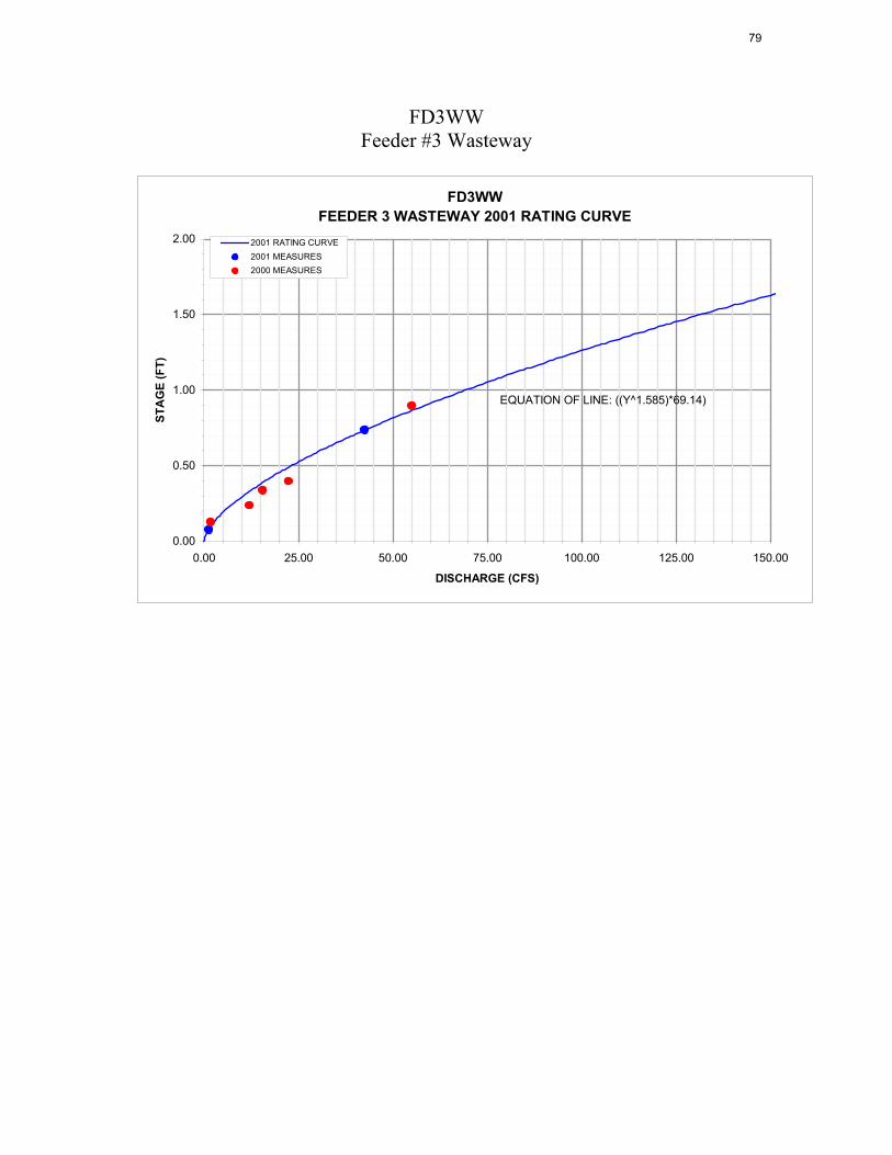
FD3WW Feeder #3 Wasteway
ID: FD3WW Name: Feeder #3 Wasteway Division: Belen Date of Visit: May 8, 2001 Operator: MRGCD Period of Record: 2000 - 2001
State Plane 83 NM Central Zone UTM NAD83 Zone 13 Northing Easting Northing Easting
1299518.875 1483277.625 3826879.231 337451.425 WGS84
Lat: N 34.341503 Long: W 106.461926 1999 River Mile: No data
Location: Return flow to Rio Grande from west side, south of Belen. 2.0 miles north of Jarales Road Bridge, on right bank of Rio Grande Equipment: Stilling well and shelter, with solar panel, on right bank Gage Type and Condition: Pressure transducer with radio transmitter Control: Concrete lined section of channel with weir, in natural channel above and below concrete Quality of Section: Good Quality of Record: Good Data Collection: Gage heights are collected every 30 minutes Data Transmission: Transmitted to MRGCD office Potential Problems: Head gates just above station were to be removed after construction of concrete section because they divert water to left of gage. Possible silt problem. Remarks: On arrival at gage we found that solar panel had been damaged by gunfire. This was the second $300 solar panel lost at this station in the last month.

78
FD3WW Feeder #3 Wasteway
D5-P#21: Looking upstream from below gage, on right bank, at control section
D5-P#22: Looking across channel from just below gage at gate structure that will be removed
D5-P#23: Looking downstream from above gage at headgate and man-made channel
79
FD3WW Feeder #3 Wasteway
FD3WWFEEDER 3 WASTEWAY 2001 RATING CURVE
0.00
0.50
1.00
1.50
2.00
0.00 25.00 50.00 75.00 100.00 125.00 150.00
DISCHARGE (CFS)
STA
GE
(FT)
2001 RATING CURVE2001 MEASURES2000 MEASURES
EQUATION OF LINE: ((Y^1.585)*69.14)

80
STYWW Storey Wasteway
ID: STYWW Name: Storey Wasteway Division: Belen Date of Visit: May 8, 2001 Operator: MRGCD Period of Record: 2001
State Plane 83 NM Central Zone UTM NAD83 Zone 13 Northing Easting Northing Easting
1286933.375 1485715.125 3823034.283 338146.835 WGS84
Lat: N 34.321066 Long: W 106.454935 1999 River Mile: No data
Location: 1.0 mile south of Jarales Road Bridge on left bank of Rio Grande Equipment: Gage not instrumented Gage Type and Condition: Control: Concrete lined section with broad crested weir, in natural earthen channel—Replogle Flume Quality of Section: Good Quality of Record: Should be good Data Collection: Will be collected every 30 minutes once reinstrumented Data Transmission: Will be transmitted to MRGCD office Potential Problems: Remarks: No discharge measurements have been made during 2001 irrigation season to date
D5-P#13: Looking upstream from below gage and flume
D5-P#14: Looking downstream from above gage at control—gage on left bank

81
STYWW Storey Wasteway
STYWWSTOREY WASTEWAY 2001 RATING CURVE
0.00
0.50
1.00
1.50
2.00
2.50
0 25 50 75 100 125 150
DISCHARGE (CFS)
STA
GE
(FT)
2001 MEASURES
2001 RATING CURVE
EQUATION OF LINE: ((Y^1.678)*31.81)

82
SABDR Sabinal Drain Outfall
ID: SABDR Name: Sabinal Drain Outfall Division: Belen Date of Visit: May 8, 2001 Operator: MRGCD Period of Record: 2001
State Plane 83 NM Central Zone UTM NAD83 Zone 13 Northing Easting Northing Easting
1283666.625 1477386.750 3822070.057 335596.226 WGS84
Lat: N 34.313791 Long: W 106.472870 1999 River Mile: No data
Location: 4.0 miles south of Jarales Road Bridge on right bank of Rio Grande Equipment: Stilling well and shelter Gage Type and Condition: Gage not instrumented Control: Concrete lined section with broad crested weir Quality of Section: Good Quality of Record: Should be good Data Collection: Manual measure Data Transmission: None at present Potential Problems: None noted Remarks: When gage is instrumented it will have transducer and radio transmitter. No discharge measurements have been made at this station during the 2001 irrigation season
D5-P#19: Looking upstream from below gage and concrete control section. Gage on right bank
D5-P#20: Looking downstream from above gage and control

83
SABDR Sabinal Drain Outfall
SABDRSABINAL DRAIN 2001 RATING CURVE
0.00
0.50
1.00
1.50
2.00
2.50
0 25 50 75 100 125 150
DISCHARGE (CFS)
STA
GE
(FT)
2001 MEASURES
2001 RATING CURVE
EQUATION OF LINE: ((Y^1.658)*30.98)

84
RFBN5 Rio Grande Near Bernardo
(USGS 0833200) ID: RFBN5 Name: Rio Grande Near Bernardo Division: Belen Date of Visit: Not visited Operator: USGS Period of Record at Present Site: 1941 - 2001
State Plane 83 NM Central Zone UTM NAD83 Zone 13 Northing Easting Northing Easting
1234683.125 1474438.750 3807152.054 334513.381 WGS84
Lat: N 34.233320 Long: W 106.480075 1999 River Mile: 130.6
Location: In Belen or Sevilleta Grant, on downstream side of bridge on US Highway 60, 5 miles downstream from Conveyance Channel Heading, 2 miles east of Bernardo, and at USGS mile 1,487.2 Equipment: Gage is 5'x5' steel building, AC power is provided Gage Type and Condition: Real time automated gage. Sutron 8200 DCP connected with a Sutron Accubar Pressure Sensor Control: Natural channel Remarks: *Established 1936, discontinued 1939, re-established 1941. For complete USGS description see USGS gage specification sheets.

85
SFRDR San Francisco (Riverside) Drain Outfall
ID: SFRDR Name: San Francisco (Riverside) Drain
Outfall Division: Belen Date of Visit: July 22, 2001 Operator: MRGCD Period of Record: Planned 2001
State Plane 83 NM Central Zone UTM NAD83 Zone 13 Northing Easting Northing Easting
1236680.125 1466019.875 3807792.334 331954.982 WGS84
Lat: N 34.235250 Long: W 106.494135 1999 River Mile: 126.5
Location: No data other than coordinates of future site. No construction as of visit date. Equipment: No data Gage Type and Condition: Periodic manual measurements Control: No data Quality of Section: No data Quality of Record: No data Data Collection: No data Data Transmission: No data Potential Problems: No data Remarks: *Measure as printed on information sheet. Information is from data sheets provided by MRGCD

86
LSJDR Lower San Juan Riverside Drain Outfall
ID: LSJDR Name: Lower San Juan Drain Outfall Division: Belen Date of Visit: May 8, 2001 Operator: MRGCD Period of Record: 2000 - 2001
State Plane 83 NM Central Zone UTM NAD83 Zone 13 Northing Easting Northing Easting
1242466.625 1476082.375 3809518.120 335043.575 WGS84
Lat: N 34.245029 Long: W 106.474163 1999 River Mile: 126.5
Location: Return flow to Rio Grande from east side, near mouth of Rio Puerco. On right bank of Rio Grande, 0.5 mile downstream from US Highway 60 East. Equipment: Stilling well and shelter, with solar panel, on right bank Gage Type and Condition: Sutron shaft encoder, with float and radio transmitter Control: Natural earthen channel Quality of Section: Good to fair Quality of Record: Good to fair Data Collection: Gage heights are collected every 30 minutes Data Transmission: Transmitted to MRGCD office Potential Problems: Some backwater problems can occur, but usually are caught quickly by ditch rider. Remarks:
D5-P#15: Looking downstream from above gage along right bank
D5-P#16: Looking upstream from below gage and measuring bridge.

87
LSJDR Lower San Juan Riverside Drain Outfall
LSJDRLOWER SAN JUAN DRAIN 2001 RATING CURVE
0.00
0.50
1.00
1.50
2.00
2.50
3.00
3.50
4.00
0.00 20.00 40.00 60.00 80.00 100.00 120.00 140.00 160.00 180.00 200.00
DISCHARGE (CFS)
STA
GE
(FT)
2001 RATING CURVE
2001 MEASURES
2000 MEASURES
EQUATION OF LINE: (((Y-0.4)^(1.45^(Y^0.1)))*35)

88
UN7DR Unit #7 Drain
ID: UN7DR Name: Unit #7 Drain Division: Belen Date of Visit: May 18, 2001 Operator: MRGCD Period of Record: 2000 - 2001
State Plane 83 NM Central Zone UTM NAD83 Zone 13 Northing Easting Northing Easting
1188560.750 1450835.875 3793183.327 327146.631 WGS84
Lat: N 34.155560 Long: W 106.523900 1999 River Mile: 116.3
Location: Return flow from west side of Belen Division, empties directly into Socorro Main Canal. Gage is located on right bank of Rio Grande, 1.0 mile upstream from San Acacia Diversion Structure. Equipment: Stilling well and shelter with solar panel on right bank Gage Type and Condition: Periodic manual measurements Control: Earthen natural channel Quality of Section: Fair Quality of Record: Fair to poor Data Collection: Gage heights are collected every 30 minutes Data Transmission: Transmitted to MRGCD office Potential Problems: Possible backwater from downstream Remarks: Large amount of scatter at upper end of this rating curve (see graphic following photographs next pages). Quality of stage: discharge relationship may improve in 2001 with new gage on Socorro North. Review rating at end of irrigation season.

89
UN7DR Unit #7 Drain
D6-P#13: From below gage looking downstream D6-P#14: From above gage looking downstream
D6-P#16: From below gage looking upstream at gage into sun
D6-P#18: From right bank looking at gage
D6-P#19: Looking at headgate above siphon before flow enters Socorro Main Canal North

90
UN7DR Unit #7 Drain
UN7DRUNIT 7 DRAIN 2001 RATING CURVE
0.80
1.30
1.80
2.30
2.80
3.30
0.00 20.00 40.00 60.00 80.00 100.00 120.00 140.00 160.00 180.00 200.00
DISCHARGE (CFS)
STA
GE
(FT)
2001 RATING CURVE
2001 MEASURES
2000 MEASURES
EQUATION OF LINE: (((Y-0.85)^1.3)*62)

Gages in MRGCD Socorro Division SOCCN Socorro Main Canal at Heading SNAN5 Rio Grande below San Acacia Diversion Structure SMCN5 Low Flow Conveyance Channel at San Marcial SMFN5 Rio Grande at San Marcial

92
SOCCN
Socorro Main Canal at Heading ID: SOCCN Name: Socorro Main Canal Division: Socorro Date of Visit: May 8, 2001 Operator: MRGCD Period of Record: 1936 - 2001
State Plane 83 NM Central Zone UTM NAD83 Zone 13 Northing Easting Northing Easting
1185576.625 1447228.875 3792287.316 326036.094 WGS84
Lat: N 34.152585 Long: W 106.532176 1999 River Mile: No data
Location: Flow in Socorro Main Canal, on right bank of Rio Grande, ± 500 feet downstream from San Acacia Diversion Structure. Equipment: Stilling well and shelter, with solar panel, on left bank of canal Gage Type and Condition: Pressure transducer with radio transmitter Control: Concrete lined section with weir control in natural earthen channel—Replogle Flume Quality of Section: Good Quality of Record: Good Data Collection: Gage heights are collected every 30 minutes Data Transmission: Transmitted to MRGCD office Potential Problems: High velocities coming out of control section have caused erosion in channel below concrete Remarks: All five measurements made during 2001 irrigation season plot to the left of curve, only measures made so far (see graphic following photographs next page).

93
SOCCN Socorro Main Canal at Heading
D5-P#17: Looking downstream from above gage along left bank at control and gage.
D5-P#18: Looking upstream from below gage at Replogle Flume and gage
SOCCNSOCORRO MAIN CANAL 2001 RATING CURVE
0.00
0.50
1.00
1.50
2.00
2.50
3.00
0 50 100 150 200 250 300 350
DISCHARGE (CFS)
STA
GE
(FT)
2001 MEASURES
2001 RATING CURVE
EQUATION OF LINE: (((Y+0.07749)^1.765)*49.82)

94
SNAN5 Rio Grande Floodway At San Acacia
(USGS 08354900) ID: SNAN5 Name: Rio Grande below San Acacia
Diversion Structure Division: Socorro Date of Visit: Operator: USGS Period of Record at Present Site: 1965 - 2001
State Plane 83 NM Central Zone UTM NAD83 Zone 13 Northing Easting Northing Easting
1185273.500 1446423.375 3792197.944 325789.453 WGS84
Lat: N 34.152281 Long: W 106.533133 1999 River Mile: No data
Location: In Sevilleta Grant, on right bank 0.2 mile below San Acacia diversion structure, 0.3 mile east of San Acacia, 2 miles downstream from Rio Salado, and at USGS mile 1,472.6. Equipment: The gage is an 8'x10' galvanized building on right bank about 28' above P.Z.F. Gage Type and Condition: A Sutron 8200 D.C.P. with a Sutron Accubar pressure sensor and Sutron Accububble self-purging pressure generator Control: Natural channel Remarks: No other data on this gage No photographs available for this gage No rating curve available for this gage * For complete USGS description see USGS gage specification sheet.

95
SMCN5 Rio Grande Conveyance Channel at San Marcial
(USGS 08358300) ID: SMCN5 Name: Low Flow Conveyance Channel at
San Marcial Division: Socorro Date of Visit: Operator: USGS Period of Record at Present Site: 1954 - 2001
State Plane 83 NM Central Zone UTM NAD83 Zone 13 Northing Easting Northing Easting
977768.563 1413467.500 3729074.672 314973.436 WGS84
Lat: N 33.410783 Long: W 106.594596 1999 River Mile: No data
Location: In Pedro Armedaris Grant No.34 on right bank 0.4 miles northwest of the Burlington Northern-Santa Fe Railway Co. bridge over the floodway channel. ± 1.0 mile southwest of the former site of San Marcial, 3.5 miles downstream from the railroad bridge near Tiffany siding, and 51 miles downstream from the heading at San Acacia. Equipment: Armor plated metal shelter 38"x38"x39" bolted to a 3-foot length of 36" diameter corrugated culvert. The 36" well is attached to a 48" culvert that extends to the channel bed Gage Type and Condition: The gage is a Design Analysis H510 logger referenced to an electric tape gage and connected to a Telonics radio transmitter Control: Natural channel Remarks: No other data on this gage No photographs available for this gage No rating curve available for this gage * For complete USGS description, see USGS gage specification sheet

96
SMFN5 Rio Grande Floodway at San Marcial
(USGS 08358400) ID: SMFN5 Name: Rio Grande Floodway at
San Marcial Division: Socorro Date of Visit: Operator: USGS Period of Record at Present Site: 1964 - 2001
State Plane 83 NM Central Zone UTM NAD83 Zone 13 Northing Easting Northing Easting
976003.875 1414452.625 3728533.166 315267.188 WGS84
Lat: N 33.405044 Long: W 106.593415 1999 River Mile: No data
Location: In Pedro Armendaris Grant, 400 feet downstream of downstream pier of Atchison Topeka and Santa Fe Railway bridge, across river (right bank) and 1.1 miles downstream from the former site of San Marcial, about 18miles southwest of San Antonio, NM. Equipment: Standard 3x3x6 foot standup shelter and staff Gage Type and Condition: Design Analysis H-350 DCP with a pressure transducer and smart gas system Control: Natural channel Remarks: Prior to 1964, USGS gage 08358500, “Rio Grande at San Marcial”, at this approximate location, period of record 1895 - 1964 No photographs available for this gage No rating curve available for this gage * For complete USGS description, see USGS gage specification sheet

Appendix D-2
USGS Gage Specification Sheets Contents 08317400 - Rio Grande below Cochiti Dam
08314000 - Sili Main Canal (at Head) at Cochiti
08313500 - Cochiti East Side Main Canal at Cochiti
08319000 - Rio Grande at San Felipe
08329000 - Jemez River below Jemez Canyon Dam
08330000 - Rio Grande at Albuquerque
08331000 - Rio Grande at Isleta
08332010 - Rio Grande Floodway near Bernardo
08354900 - Rio Grande Floodway at San Acacia
08358300 - Rio Grande Conveyance Channel (LFCC) at San Marcial
08358400 - Rio Grande Floodway at San Marcial


Appendix D-3
MRGCD Virtual Gage Records on USBR ET Toolbox Webpage
ANGDV Angostura Diversion Structure
ATSCN Atrisco (Canal) Siphon
ISLDV Isleta Diversion Structure
ISLDN Rio Grande Floodway below Isleta Diversion
SNADV San Acacia Diversion Structure

Virtual Gage ANGDV Angostura Diversion Structure
Computation: ANGDV = ALBCN + ATFCN – ALGDR (Albuquerque Main Canal + Atrisco Feeder Canal – Algodones drain outfall). Location: http://yampa.earthsci.do.usbr.gov:8080/cgi-bin/schematic.py.
Sample Graph from Web Site - ANGDV - Angostura Diversion, Year 2001

Virtual Gage ATSCN Atrisco Siphon
Computation: ATSCN = ARMCN + ATDCN + ARECN (Armijo Acequia+Atrisco Ditch+Arenal Main Canal) Location: http://yampa.earthsci.do.usbr.gov:8080/cgi-bin/schematic.py
Sample Graph from Web Site: ATSCN – Atrisco (Canal) Siphon, Year 2001

Virtual Gage ISLDV Isleta Diversion Structure
Computation: ISLDV = PERCN + CHICN + CHACN + CACCN (Peralta Main Canal+Chical Lateral+Chical Acequia+Cacique Acequia) Location: http://yampa.earthsci.do.usbr.gov:8080/cgi-bin/schematic.py.
Sample Graph from Web Site: ISLDV - Total Isleta Diversion, Year 2001

Virtual Gage ISLDN Rio Grande below Isleta Diversion Structure
Computation: ISLDN = ABQN5 +ARSDR – ISLDV (Rio Grande at Central Ave+Albuquerque Riverside Drain – Total Isleta Diversion) Location: http://yampa.earthsci.do.usbr.gov:8080/cgi-bin/schematic.py.
Sample Graph from Web Site: ISLDN - Rio Grande below Isleta Dam, Year 2001

Virtual Gage SNADV San Acacia Diversion
Computation: SNADV = SOCCN – UN7DR (Socorro Main Canal – Unit 7 Drain). Location: http://yampa.earthsci.do.usbr.gov:8080/cgi-bin/schematic.py.
Sample Graph from Web Site: SNADV - Rio Grande Floodway at San Acacia, Year 2001