appendix d hazardous!sites!historical!use!data! falcon dam... · barrera service station ust txdot...
TRANSCRIPT

EA#for#the#Proposed#Demolition#of#CBP5Owned#Housing#Falcon#Village,#Starr#County,#Texas#
!
!
Appendix D Hazardous!Sites!Historical!Use!Data!!

!
FORM-BPK-GXH
®kcehCoeG htiw tropeR ™paM suidaR RDE ehT
440 Wheelers Farms RoadMilford, CT 06461Toll Free: 800.352.0050www.edrnet.com
Falcon Village, TexasMain Street and 2nd AvenueRoma, TX 78584
Inquiry Number: 3623821.2sJune 03, 2013
SECTION PAGE
Executive Summary ES1
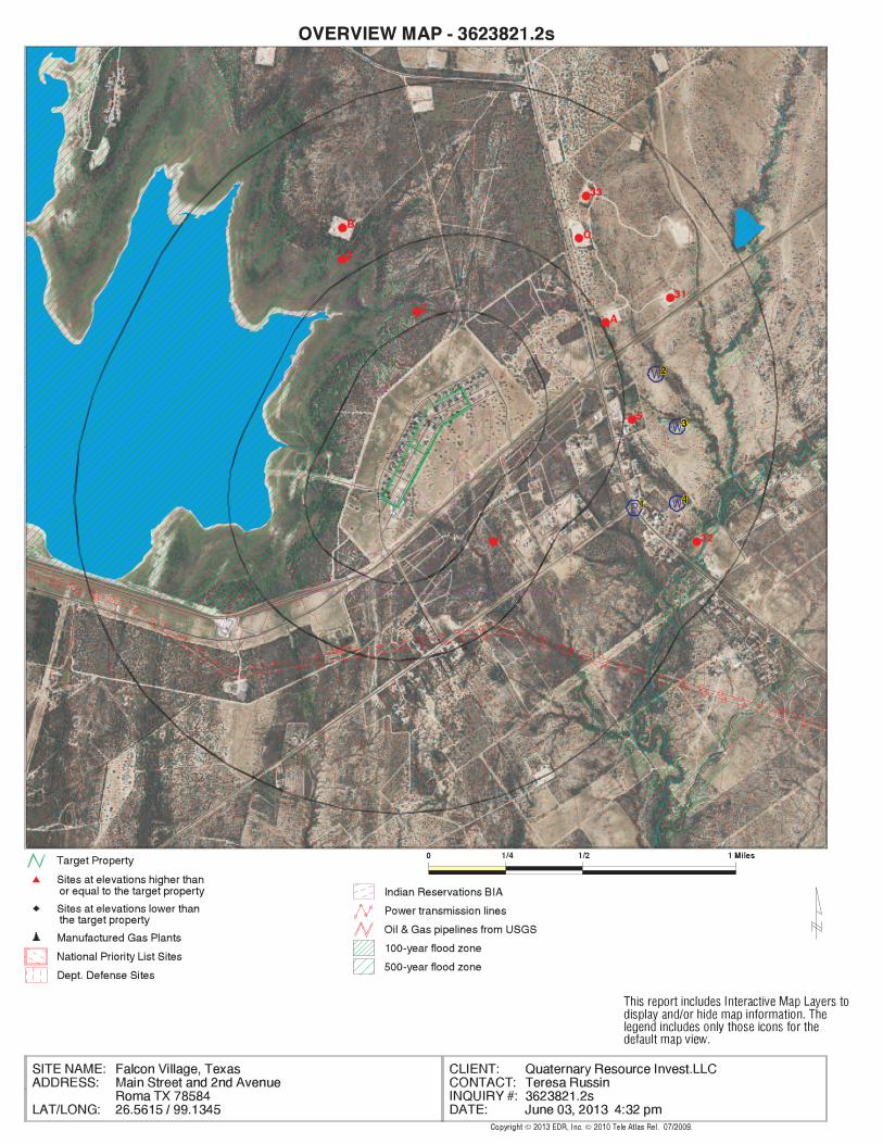
Overview Map 2
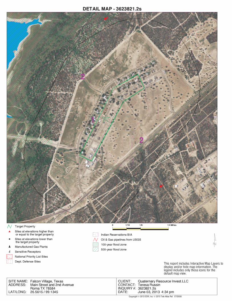
Detail Map 3
Map Findings Summary 4
Map Findings 8
Orphan Summary 9
Government Records Searched/Data Currency Tracking GR-1
GEOCHECK ADDENDUM
Physical Setting Source Addendum A-1
Physical Setting Source Summary A-2
Physical Setting SSURGO Soil Map A-5
Physical Setting Source Map A-9
Physical Setting Source Map Findings A-11
Physical Setting Source Records Searched A-45
TC3623821.2s Page 1
Thank you for your business.Please contact EDR at 1-800-352-0050
with any questions or comments.
Disclaimer - Copyright and Trademark NoticeThis Report contains certain information obtained from a variety of public and other sources reasonably available to Environmental DataResources, Inc. It cannot be concluded from this Report that coverage information for the target and surrounding properties does not exist fromother sources. NO WARRANTY EXPRESSED OR IMPLIED, IS MADE WHATSOEVER IN CONNECTION WITH THIS REPORT. ENVIRONMENTALDATA RESOURCES, INC. SPECIFICALLY DISCLAIMS THE MAKING OF ANY SUCH WARRANTIES, INCLUDING WITHOUT LIMITATION,MERCHANTABILITY OR FITNESS FOR A PARTICULAR USE OR PURPOSE. ALL RISK IS ASSUMED BY THE USER. IN NO EVENT SHALLENVIRONMENTAL DATA RESOURCES, INC. BE LIABLE TO ANYONE, WHETHER ARISING OUT OF ERRORS OR OMISSIONS, NEGLIGENCE,ACCIDENT OR ANY OTHER CAUSE, FOR ANY LOSS OF DAMAGE, INCLUDING, WITHOUT LIMITATION, SPECIAL, INCIDENTAL,CONSEQUENTIAL, OR EXEMPLARY DAMAGES. ANY LIABILITY ON THE PART OF ENVIRONMENTAL DATA RESOURCES, INC. IS STRICTLYLIMITED TO A REFUND OF THE AMOUNT PAID FOR THIS REPORT. Purchaser accepts this Report "AS IS". Any analyses, estimates, ratings,environmental risk levels or risk codes provided in this Report are provided for illustrative purposes only, and are not intended to provide, norshould they be interpreted as providing any facts regarding, or prediction or forecast of, any environmental risk for any property. Only a Phase IEnvironmental Site Assessment performed by an environmental professional can provide information regarding the environmental risk for anyproperty. Additionally, the information provided in this Report is not to be construed as legal advice.
Copyright 2013 by Environmental Data Resources, Inc. All rights reserved. Reproduction in any media or format, in wholeor in part, of any report or map of Environmental Data Resources, Inc., or its affiliates, is prohibited without prior written permission.EDR and its logos (including Sanborn and Sanborn Map) are trademarks of Environmental Data Resources, Inc. or its affiliates. All othertrademarks used herein are the property of their respective owners.
TABLE OF CONTENTS
EXECUTIVE SUMMARY
TC3623821.2s EXECUTIVE SUMMARY 1
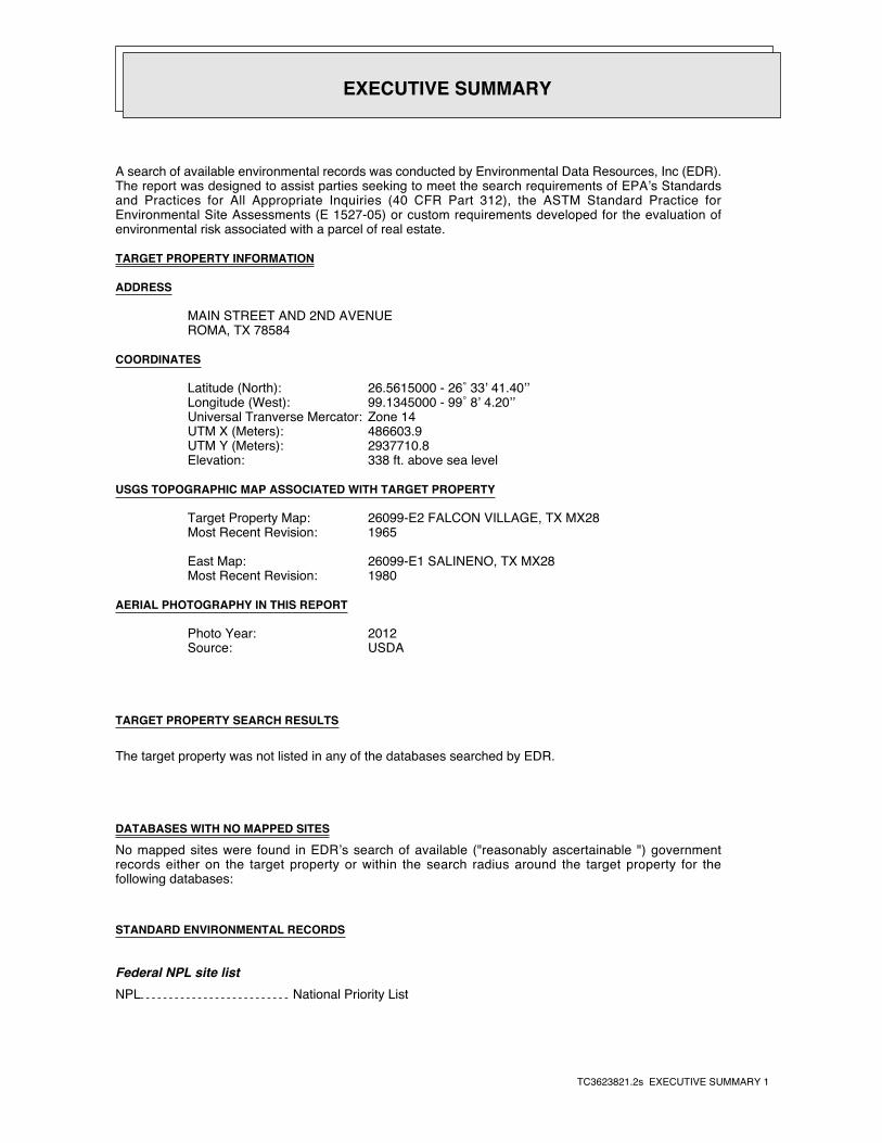
A search of available environmental records was conducted by Environmental Data Resources, Inc (EDR).The report was designed to assist parties seeking to meet the search requirements of EPA’s Standardsand Practices for All Appropriate Inquiries (40 CFR Part 312), the ASTM Standard Practice forEnvironmental Site Assessments (E 1527-05) or custom requirements developed for the evaluation ofenvironmental risk associated with a parcel of real estate.
TARGET PROPERTY INFORMATION
ADDRESS
MAIN STREET AND 2ND AVENUEROMA, TX 78584
COORDINATES
26.5615000 - 26˚ 33’ 41.40’’Latitude (North): 99.1345000 - 99˚ 8’ 4.20’’Longitude (West): Zone 14Universal Tranverse Mercator: 486603.9UTM X (Meters): 2937710.8UTM Y (Meters): 338 ft. above sea levelElevation:
USGS TOPOGRAPHIC MAP ASSOCIATED WITH TARGET PROPERTY
26099-E2 FALCON VILLAGE, TX MX28Target Property Map:1965Most Recent Revision:
26099-E1 SALINENO, TX MX28East Map:1980Most Recent Revision:
AERIAL PHOTOGRAPHY IN THIS REPORT
2012Photo Year:USDASource:
TARGET PROPERTY SEARCH RESULTS
The target property was not listed in any of the databases searched by EDR.
DATABASES WITH NO MAPPED SITES
No mapped sites were found in EDR’s search of available ("reasonably ascertainable ") governmentrecords either on the target property or within the search radius around the target property for thefollowing databases:
STANDARD ENVIRONMENTAL RECORDS
Federal NPL site listNPL National Priority List
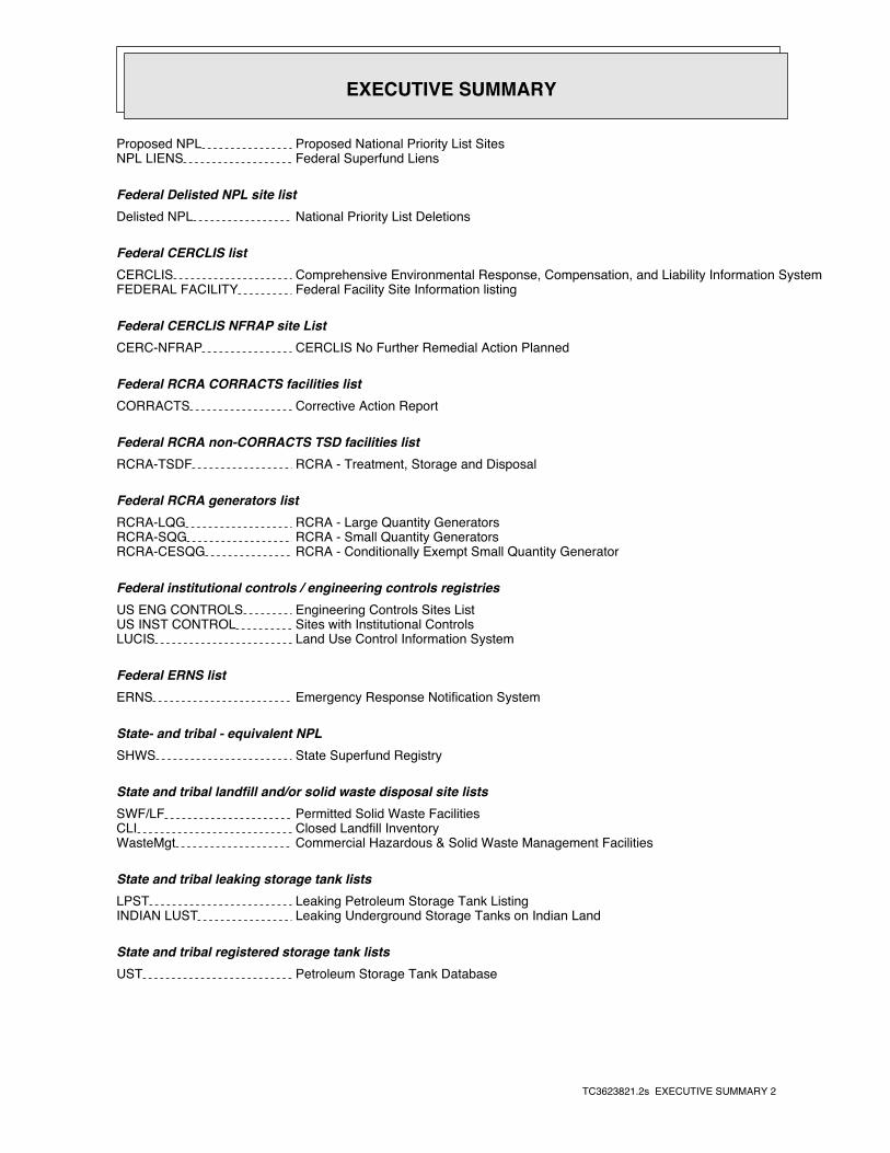
EXECUTIVE SUMMARY
TC3623821.2s EXECUTIVE SUMMARY 2
Proposed NPL Proposed National Priority List SitesNPL LIENS Federal Superfund Liens
Federal Delisted NPL site listDelisted NPL National Priority List Deletions
Federal CERCLIS listCERCLIS Comprehensive Environmental Response, Compensation, and Liability Information SystemFEDERAL FACILITY Federal Facility Site Information listing
Federal CERCLIS NFRAP site ListCERC-NFRAP CERCLIS No Further Remedial Action Planned
Federal RCRA CORRACTS facilities listCORRACTS Corrective Action Report
Federal RCRA non-CORRACTS TSD facilities listRCRA-TSDF RCRA - Treatment, Storage and Disposal
Federal RCRA generators listRCRA-LQG RCRA - Large Quantity GeneratorsRCRA-SQG RCRA - Small Quantity GeneratorsRCRA-CESQG RCRA - Conditionally Exempt Small Quantity Generator
Federal institutional controls / engineering controls registriesUS ENG CONTROLS Engineering Controls Sites ListUS INST CONTROL Sites with Institutional ControlsLUCIS Land Use Control Information System
Federal ERNS listERNS Emergency Response Notification System
State- and tribal - equivalent NPLSHWS State Superfund Registry
State and tribal landfill and/or solid waste disposal site listsSWF/LF Permitted Solid Waste FacilitiesCLI Closed Landfill InventoryWasteMgt Commercial Hazardous & Solid Waste Management Facilities
State and tribal leaking storage tank listsLPST Leaking Petroleum Storage Tank ListingINDIAN LUST Leaking Underground Storage Tanks on Indian Land
State and tribal registered storage tank listsUST Petroleum Storage Tank Database
EXECUTIVE SUMMARY
TC3623821.2s EXECUTIVE SUMMARY 3
AST Petroleum Storage Tank DatabaseINDIAN UST Underground Storage Tanks on Indian LandFEMA UST Underground Storage Tank Listing
State and tribal institutional control / engineering control registriesAUL Sites with Controls
State and tribal voluntary cleanup sitesVCP Voluntary Cleanup Program DatabaseINDIAN VCP Voluntary Cleanup Priority Listing
State and tribal Brownfields sitesBROWNFIELDS Brownfields Site Assessments
ADDITIONAL ENVIRONMENTAL RECORDS
Local Brownfield listsUS BROWNFIELDS A Listing of Brownfields Sites
Local Lists of Landfill / Solid Waste Disposal SitesDEBRIS REGION 9 Torres Martinez Reservation Illegal Dump Site LocationsODI Open Dump InventoryINDIAN ODI Report on the Status of Open Dumps on Indian Lands
Local Lists of Hazardous waste / Contaminated SitesUS CDL Clandestine Drug LabsDEL SHWS Deleted Superfund Registry SitesPRIORITYCLEANERS Dry Cleaner Remediation Program Prioritization ListUS HIST CDL National Clandestine Laboratory Register
Local Land RecordsLIENS 2 CERCLA Lien InformationLIENS Environmental Liens ListingHIST LIENS Environmental Liens Listing
Records of Emergency Release ReportsHMIRS Hazardous Materials Information Reporting SystemSPILLS Spills DatabaseSPILLS 80 SPILLS 80 data from FirstSearchSPILLS 90 SPILLS 90 data from FirstSearch
Other Ascertainable RecordsRCRA NonGen / NLR RCRA - Non GeneratorsDOT OPS Incident and Accident DataDOD Department of Defense Sites
EXECUTIVE SUMMARY
TC3623821.2s EXECUTIVE SUMMARY 4
FUDS Formerly Used Defense SitesCONSENT Superfund (CERCLA) Consent DecreesROD Records Of DecisionUMTRA Uranium Mill Tailings SitesUS MINES Mines Master Index FileTRIS Toxic Chemical Release Inventory SystemTSCA Toxic Substances Control ActFTTS FIFRA/ TSCA Tracking System - FIFRA (Federal Insecticide, Fungicide, & Rodenticide Act)/TSCA (Toxic Substances Control Act)HIST FTTS FIFRA/TSCA Tracking System Administrative Case ListingSSTS Section 7 Tracking SystemsICIS Integrated Compliance Information SystemPADS PCB Activity Database SystemMLTS Material Licensing Tracking SystemRADINFO Radiation Information DatabaseFINDS Facility Index System/Facility Registry SystemRAATS RCRA Administrative Action Tracking SystemRMP Risk Management PlansIOP Innocent Owner/Operator ProgramNPDES NPDES Facility ListUIC Underground Injection Wells Database ListingDRYCLEANERS Drycleaner Registration Database ListingENF Notice of Violations ListingInd. Haz Waste Industrial & Hazardous Waste DatabaseED AQUIF Edwards Aquifer PermitsAIRS Current Emission Inventory DataTIER 2 Tier 2 Chemical Inventory ReportsMSD Municipal Settings Designations DatabaseRWS Radioactive Waste SitesINDIAN RESERV Indian ReservationsSCRD DRYCLEANERS State Coalition for Remediation of Drycleaners ListingPCB TRANSFORMER PCB Transformer Registration DatabaseUS FIN ASSUR Financial Assurance InformationEPA WATCH LIST EPA WATCH LISTGCC Groundwater Contamination CasesPRP Potentially Responsible PartiesUS AIRS Aerometric Information Retrieval System Facility Subsystem2020 COR ACTION 2020 Corrective Action Program ListLEAD SMELTERS Lead Smelter SitesCOAL ASH DOE Steam-Electric Plant Operation DataCOAL ASH EPA Coal Combustion Residues Surface Impoundments ListFinancial Assurance Financial Assurance Information ListingCOAL ASH Coal Ash Disposal Sites
EDR HIGH RISK HISTORICAL RECORDS
EDR Exclusive RecordsEDR MGP EDR Proprietary Manufactured Gas PlantsEDR US Hist Auto Stat EDR Exclusive Historic Gas StationsEDR US Hist Cleaners EDR Exclusive Historic Dry Cleaners
SURROUNDING SITES: SEARCH RESULTS
Surrounding sites were not identified.
Unmappable (orphan) sites are not considered in the foregoing analysis.

EXECUTIVE SUMMARY
TC3623821.2s EXECUTIVE SUMMARY 5
Due to poor or inadequate address information, the following sites were not mapped. Count: 23 records.
Site Name Database(s)____________ ____________
TCC FALCON SUBSTATION TIER 2SOUTHWEST TEXAS CORPORATION #1 TIER 2SOUTHWEST TEXAS CORPORATION #1 TIER 2SOUTHWEST TEXAS CORPORATION #1 TIER 2SOUTHWEST TEXAS CORPORATION #1 PRO TIER 2CITY OF ROMA LANDFILL SWF/LFSAENZ EXXON UST, Financial AssuranceFALCON FARM & RANCH SUPPLY UST, Financial AssuranceCIRCLE G UST, Financial AssuranceFALCON DRIVE UST, Financial AssuranceBARRERA SERVICE STATION USTTXDOT AREA ENGINEER MAINTENANCE FA ASTROMA ISD FUEL HANDLING FACILITY ASTNAVEHARS WAREHOUSE RCRA NonGen / NLRROMA WAREHOUSE RCRA NonGen / NLRFALCON CUSTOMS BROKER RCRA NonGen / NLRFALCON CUSTOMS BROKER FINDSFALCON CUSTOMS BROKER FINDSFALCON STATE PARK FINDSINSIDE TEXAS CITY REFINERY IN THE SPILLSFALCON SEPTIC CLEANING ENFPROPERTY OF ALBERTO TREVINO RIO GR ENFIBWC FALCON VILLAGE ENF
EDR Inc.EDR Inc.EDR Inc.EDR Inc.EDR Inc.EDR Inc.EDR Inc.EDR Inc.EDR Inc.EDR Inc.EDR Inc.EDR Inc.EDR Inc.EDR Inc.EDR Inc.EDR Inc.EDR Inc.EDR Inc.EDR Inc.EDR Inc.EDR Inc.EDR Inc.EDR Inc.EDR Inc.EDR Inc.EDR Inc.EDR Inc.EDR Inc.EDR Inc.EDR Inc.EDR Inc.EDR Inc.EDR Inc.EDR Inc.EDR Inc.EDR Inc.EDR Inc.EDR Inc.EDR Inc.EDR Inc.
0138 kv
36
0
3 6 0
360
320
32 0
32
0
3 2 0
320
3 2 0
32
03
2 0
32 0
3 2 0
3 20
2 40
28
0
28 0
2 8 0
28
0
28 0
28 0
28
0
2
4 0
2 40
2 4 0
24
0
2 8 0
2 8 0
28
0
2 8 0
28 0
2 8 0
3 2 0
3 20
36 0
EDR Inc.EDR Inc.EDR Inc.EDR Inc.EDR Inc.EDR Inc.EDR Inc.EDR Inc.EDR Inc.EDR Inc.EDR Inc.EDR Inc.EDR Inc.EDR Inc.EDR Inc.EDR Inc.EDR Inc.EDR Inc.EDR Inc.EDR Inc.EDR Inc.EDR Inc.EDR Inc.EDR Inc.EDR Inc.EDR Inc.EDR Inc.EDR Inc.EDR Inc.EDR Inc.EDR Inc.EDR Inc.EDR Inc.EDR Inc.EDR Inc.EDR Inc.EDR Inc.EDR Inc.EDR Inc.EDR Inc.
36
0
3 2 0
320
32
0
32
0
320
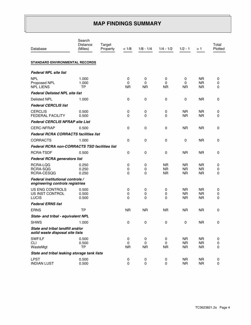
MAP FINDINGS SUMMARY
SearchTargetDistance Total
Database Property(Miles) < 1/8 1/8 - 1/4 1/4 - 1/2 1/2 - 1 > 1 Plotted
STANDARD ENVIRONMENTAL RECORDS
Federal NPL site list 0 NR 0 0 0 0 1.000NPL 0 NR 0 0 0 0 1.000Proposed NPL 0 NR NR NR NR NR TPNPL LIENS
Federal Delisted NPL site list 0 NR 0 0 0 0 1.000Delisted NPL
Federal CERCLIS list 0 NR NR 0 0 0 0.500CERCLIS 0 NR NR 0 0 0 0.500FEDERAL FACILITY
Federal CERCLIS NFRAP site List 0 NR NR 0 0 0 0.500CERC-NFRAP
Federal RCRA CORRACTS facilities list 0 NR 0 0 0 0 1.000CORRACTS
Federal RCRA non-CORRACTS TSD facilities list 0 NR NR 0 0 0 0.500RCRA-TSDF
Federal RCRA generators list 0 NR NR NR 0 0 0.250RCRA-LQG 0 NR NR NR 0 0 0.250RCRA-SQG 0 NR NR NR 0 0 0.250RCRA-CESQG
Federal institutional controls /engineering controls registries
0 NR NR 0 0 0 0.500US ENG CONTROLS 0 NR NR 0 0 0 0.500US INST CONTROL 0 NR NR 0 0 0 0.500LUCIS
Federal ERNS list 0 NR NR NR NR NR TPERNS
State- and tribal - equivalent NPL 0 NR 0 0 0 0 1.000SHWS
State and tribal landfill and/orsolid waste disposal site lists
0 NR NR 0 0 0 0.500SWF/LF 0 NR NR 0 0 0 0.500CLI 0 NR NR NR NR NR TPWasteMgt
State and tribal leaking storage tank lists 0 NR NR 0 0 0 0.500LPST 0 NR NR 0 0 0 0.500INDIAN LUST
TC3623821.2s Page 4

MAP FINDINGS SUMMARY
SearchTargetDistance Total
Database Property(Miles) < 1/8 1/8 - 1/4 1/4 - 1/2 1/2 - 1 > 1 Plotted
State and tribal registered storage tank lists 0 NR NR NR 0 0 0.250UST 0 NR NR NR 0 0 0.250AST 0 NR NR NR 0 0 0.250INDIAN UST 0 NR NR NR 0 0 0.250FEMA UST
State and tribal institutionalcontrol / engineering control registries
0 NR NR 0 0 0 0.500AULState and tribal voluntary cleanup sites
0 NR NR 0 0 0 0.500VCP 0 NR NR 0 0 0 0.500INDIAN VCP
State and tribal Brownfields sites 0 NR NR 0 0 0 0.500BROWNFIELDS
ADDITIONAL ENVIRONMENTAL RECORDS
Local Brownfield lists 0 NR NR 0 0 0 0.500US BROWNFIELDS
Local Lists of Landfill / SolidWaste Disposal Sites
0 NR NR 0 0 0 0.500DEBRIS REGION 9 0 NR NR 0 0 0 0.500ODI 0 NR NR 0 0 0 0.500INDIAN ODI
Local Lists of Hazardous waste /Contaminated Sites
0 NR NR NR NR NR TPUS CDL 0 NR 0 0 0 0 1.000DEL SHWS 0 NR NR 0 0 0 0.500PRIORITYCLEANERS 0 NR NR NR NR NR TPUS HIST CDL
Local Land Records 0 NR NR NR NR NR TPLIENS 2 0 NR NR NR NR NR TPLIENS 0 NR NR NR NR NR TPHIST LIENS
Records of Emergency Release Reports 0 NR NR NR NR NR TPHMIRS 0 NR NR NR NR NR TPSPILLS 0 NR NR NR NR NR TPSPILLS 80 0 NR NR NR NR NR TPSPILLS 90
Other Ascertainable Records 0 NR NR NR 0 0 0.250RCRA NonGen / NLR 0 NR NR NR NR NR TPDOT OPS
TC3623821.2s Page 5

MAP FINDINGS SUMMARY
SearchTargetDistance Total
Database Property(Miles) < 1/8 1/8 - 1/4 1/4 - 1/2 1/2 - 1 > 1 Plotted
0 NR 0 0 0 0 1.000DOD 0 NR 0 0 0 0 1.000FUDS 0 NR 0 0 0 0 1.000CONSENT 0 NR 0 0 0 0 1.000ROD 0 NR NR 0 0 0 0.500UMTRA 0 NR NR NR 0 0 0.250US MINES 0 NR NR NR NR NR TPTRIS 0 NR NR NR NR NR TPTSCA 0 NR NR NR NR NR TPFTTS 0 NR NR NR NR NR TPHIST FTTS 0 NR NR NR NR NR TPSSTS 0 NR NR NR NR NR TPICIS 0 NR NR NR NR NR TPPADS 0 NR NR NR NR NR TPMLTS 0 NR NR NR NR NR TPRADINFO 0 NR NR NR NR NR TPFINDS 0 NR NR NR NR NR TPRAATS 0 NR NR NR NR NR TPRMP 0 NR NR NR NR NR TPIOP 0 NR NR NR NR NR TPNPDES 0 NR NR NR NR NR TPUIC 0 NR NR NR 0 0 0.250DRYCLEANERS 0 NR NR NR NR NR TPENF 0 NR NR NR 0 0 0.250Ind. Haz Waste 0 NR NR NR NR NR TPED AQUIF 0 NR NR NR NR NR TPAIRS 0 NR NR NR NR NR TPTIER 2 0 NR NR 0 0 0 0.500MSD 0 NR NR NR NR NR TPRWS 0 NR 0 0 0 0 1.000INDIAN RESERV 0 NR NR 0 0 0 0.500SCRD DRYCLEANERS 0 NR NR NR NR NR TPPCB TRANSFORMER 0 NR NR NR NR NR TPUS FIN ASSUR 0 NR NR NR NR NR TPEPA WATCH LIST 0 NR NR NR NR NR TPGCC 0 NR NR NR NR NR TPPRP 0 NR NR NR NR NR TPUS AIRS 0 NR NR NR 0 0 0.2502020 COR ACTION 0 NR NR NR NR NR TPLEAD SMELTERS 0 NR NR NR NR NR TPCOAL ASH DOE 0 NR NR 0 0 0 0.500COAL ASH EPA 0 NR NR NR NR NR TPFinancial Assurance 0 NR NR 0 0 0 0.500COAL ASH
EDR HIGH RISK HISTORICAL RECORDS
EDR Exclusive Records 0 NR 0 0 0 0 1.000EDR MGP 0 NR NR NR 0 0 0.250EDR US Hist Auto Stat 0 NR NR NR 0 0 0.250EDR US Hist Cleaners
TC3623821.2s Page 6
MAP FINDINGS SUMMARY
SearchTargetDistance Total
Database Property(Miles) < 1/8 1/8 - 1/4 1/4 - 1/2 1/2 - 1 > 1 Plotted
NOTES: TP = Target Property NR = Not Requested at this Search Distance Sites may be listed in more than one database
TC3623821.2s Page 7
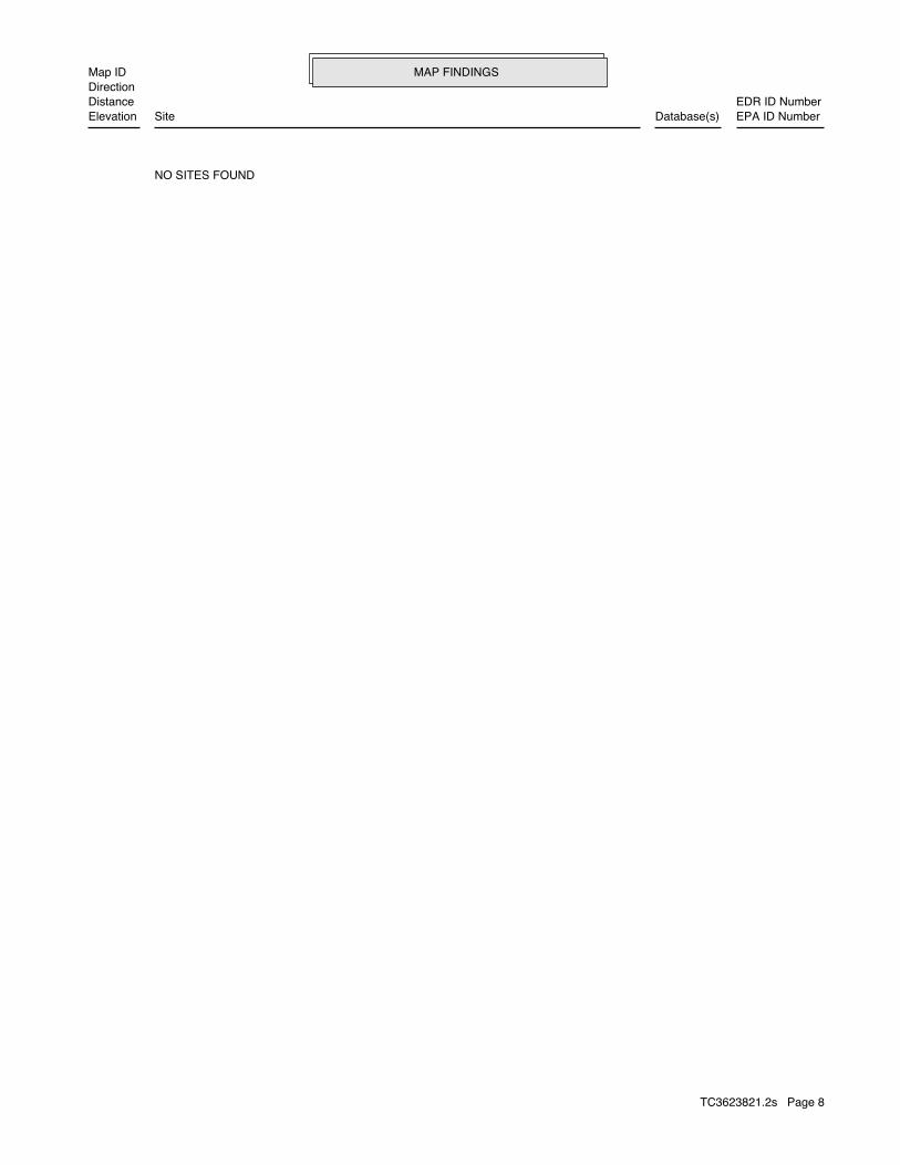
MAP FINDINGSMap IDDirection
EDR ID NumberDistanceEPA ID NumberDatabase(s)SiteElevation
NO SITES FOUND
TC3623821.2s Page 8
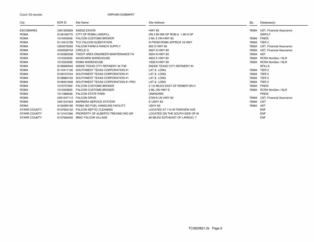
ORPHAN SUMMARY
City EDR ID Site Name Site Address Zip Database(s)
Count: 23 records.
ESCOBARES U001263829 SAENZ EXXON HWY 83 78584 UST, Financial AssuranceROMA S106169770 CITY OF ROMA LANDFILL ON 3 MI NW OF ROM & 1 MI N OF SWF/LFROMA 1010455058 FALCON CUSTOMS BROKER 2 ML E ON HWY 83 78584 FINDSROMA S110412728 TCC FALCON SUBSTATION N FROM ROMA APPROX 18 HWY 78584 TIER 2ROMA U003376326 FALCON FARM & RANCH SUPPLY 602 S HWY 83 78584 UST, Financial AssuranceROMA U003529704 CIRCLE G 2697 N HWY 83 78584 UST, Financial AssuranceROMA A100362038 TXDOT AREA ENGINEER MAINTENANCE FA 2654 N HWY 83 78584 ASTROMA 1010333595 NAVEHARS WAREHOUSE 4852 E HWY 83 78584 RCRA NonGen / NLRROMA 1010333598 ROMA WAREHOUSE 1908 N HWY 83 78584 RCRA NonGen / NLRROMA S106992949 INSIDE TEXAS CITY REFINERY IN THE INSIDE TEXAS CITY REFINERY IN SPILLSROMA S110411106 SOUTHWEST TEXAS CORPORATION #1 LAT & LONG 78584 TIER 2ROMA S109197244 SOUTHWEST TEXAS CORPORATION #1 LAT & LONG 78584 TIER 2ROMA S108884193 SOUTHWEST TEXAS CORPORATION #1 LAT & LONG 78584 TIER 2ROMA S108451658 SOUTHWEST TEXAS CORPORATION #1 PRO LAT & LONG 78584 TIER 2ROMA 1010757902 FALCON CUSTOMS BROKER 2 1/2 MILES EAST OF ROMER ON H 78584 FINDSROMA 1010333605 FALCON CUSTOMS BROKER 2 ML ON HWY E 78584 RCRA NonGen / NLRROMA 1011986536 FALCON STATE PARK UNKNOWN FINDSROMA U001247113 FALCON DRIVE 2709 N US HWY 83 78584 UST, Financial AssuranceROMA U001241653 BARRERA SERVICE STATION E USHY 83 78584 USTROMA A100290196 ROMA ISD FUEL HANDLING FACILITY USHY 83 78584 ASTSTARR COUNTY S107652132 FALCON SEPTIC CLEANING LOCATED AT 114 W FAIRVIEW AVE ENFSTARR COUNTY S112167366 PROPERTY OF ALBERTO TREVINO RIO GR LOCATED ON THE SOUTH SIDE OF W ENFSTARR COUNTY S107636450 IBWC FALCON VILLAGE 80 MILES SOTHEAST OF LAREDO, T ENF
TC3623821.2s Page 9

To maintain currency of the following federal and state databases, EDR contacts the appropriate governmental agencyon a monthly or quarterly basis, as required.
Number of Days to Update: Provides confirmation that EDR is reporting records that have been updated within 90 daysfrom the date the government agency made the information available to the public.
STANDARD ENVIRONMENTAL RECORDS
Federal NPL site list
NPL: National Priority ListNational Priorities List (Superfund). The NPL is a subset of CERCLIS and identifies over 1,200 sites for prioritycleanup under the Superfund Program. NPL sites may encompass relatively large areas. As such, EDR provides polygoncoverage for over 1,000 NPL site boundaries produced by EPA’s Environmental Photographic Interpretation Center(EPIC) and regional EPA offices.
Date of Government Version: 02/01/2013Date Data Arrived at EDR: 03/01/2013Date Made Active in Reports: 03/13/2013Number of Days to Update: 12
Source: EPATelephone: N/ALast EDR Contact: 05/09/2013Next Scheduled EDR Contact: 07/22/2013Data Release Frequency: Quarterly
NPL Site Boundaries
Sources:
EPA’s Environmental Photographic Interpretation Center (EPIC)Telephone: 202-564-7333
EPA Region 1 EPA Region 6Telephone 617-918-1143 Telephone: 214-655-6659
EPA Region 3 EPA Region 7Telephone 215-814-5418 Telephone: 913-551-7247
EPA Region 4 EPA Region 8Telephone 404-562-8033 Telephone: 303-312-6774
EPA Region 5 EPA Region 9Telephone 312-886-6686 Telephone: 415-947-4246
EPA Region 10Telephone 206-553-8665
Proposed NPL: Proposed National Priority List SitesA site that has been proposed for listing on the National Priorities List through the issuance of a proposed rulein the Federal Register. EPA then accepts public comments on the site, responds to the comments, and places onthe NPL those sites that continue to meet the requirements for listing.
Date of Government Version: 02/01/2013Date Data Arrived at EDR: 03/01/2013Date Made Active in Reports: 03/13/2013Number of Days to Update: 12
Source: EPATelephone: N/ALast EDR Contact: 05/09/2013Next Scheduled EDR Contact: 07/22/2013Data Release Frequency: Quarterly
NPL LIENS: Federal Superfund LiensFederal Superfund Liens. Under the authority granted the USEPA by CERCLA of 1980, the USEPA has the authorityto file liens against real property in order to recover remedial action expenditures or when the property ownerreceived notification of potential liability. USEPA compiles a listing of filed notices of Superfund Liens.
Date of Government Version: 10/15/1991Date Data Arrived at EDR: 02/02/1994Date Made Active in Reports: 03/30/1994Number of Days to Update: 56
Source: EPATelephone: 202-564-4267Last EDR Contact: 08/15/2011Next Scheduled EDR Contact: 11/28/2011Data Release Frequency: No Update Planned
TC3623821.2s Page GR-1
GOVERNMENT RECORDS SEARCHED / DATA CURRENCY TRACKING

Federal Delisted NPL site list
DELISTED NPL: National Priority List DeletionsThe National Oil and Hazardous Substances Pollution Contingency Plan (NCP) establishes the criteria that theEPA uses to delete sites from the NPL. In accordance with 40 CFR 300.425.(e), sites may be deleted from theNPL where no further response is appropriate.
Date of Government Version: 02/01/2013Date Data Arrived at EDR: 03/01/2013Date Made Active in Reports: 03/13/2013Number of Days to Update: 12
Source: EPATelephone: N/ALast EDR Contact: 05/09/2013Next Scheduled EDR Contact: 07/22/2013Data Release Frequency: Quarterly
Federal CERCLIS list
CERCLIS: Comprehensive Environmental Response, Compensation, and Liability Information SystemCERCLIS contains data on potentially hazardous waste sites that have been reported to the USEPA by states, municipalities,private companies and private persons, pursuant to Section 103 of the Comprehensive Environmental Response, Compensation,and Liability Act (CERCLA). CERCLIS contains sites which are either proposed to or on the National PrioritiesList (NPL) and sites which are in the screening and assessment phase for possible inclusion on the NPL.
Date of Government Version: 02/04/2013Date Data Arrived at EDR: 03/01/2013Date Made Active in Reports: 03/13/2013Number of Days to Update: 12
Source: EPATelephone: 703-412-9810Last EDR Contact: 05/29/2013Next Scheduled EDR Contact: 09/09/2013Data Release Frequency: Quarterly
FEDERAL FACILITY: Federal Facility Site Information listingA listing of National Priority List (NPL) and Base Realignment and Closure (BRAC) sites found in the ComprehensiveEnvironmental Response, Compensation and Liability Information System (CERCLIS) Database where EPA Federal FacilitiesRestoration and Reuse Office is involved in cleanup activities.
Date of Government Version: 07/31/2012Date Data Arrived at EDR: 10/09/2012Date Made Active in Reports: 12/20/2012Number of Days to Update: 72
Source: Environmental Protection AgencyTelephone: 703-603-8704Last EDR Contact: 04/10/2013Next Scheduled EDR Contact: 07/22/2013Data Release Frequency: Varies
Federal CERCLIS NFRAP site List
CERCLIS-NFRAP: CERCLIS No Further Remedial Action PlannedArchived sites are sites that have been removed and archived from the inventory of CERCLIS sites. Archived statusindicates that, to the best of EPA’s knowledge, assessment at a site has been completed and that EPA has determinedno further steps will be taken to list this site on the National Priorities List (NPL), unless information indicatesthis decision was not appropriate or other considerations require a recommendation for listing at a later time.This decision does not necessarily mean that there is no hazard associated with a given site; it only means that,based upon available information, the location is not judged to be a potential NPL site.
Date of Government Version: 02/05/2013Date Data Arrived at EDR: 03/01/2013Date Made Active in Reports: 03/13/2013Number of Days to Update: 12
Source: EPATelephone: 703-412-9810Last EDR Contact: 05/29/2013Next Scheduled EDR Contact: 05/09/2013Data Release Frequency: Quarterly
Federal RCRA CORRACTS facilities list
CORRACTS: Corrective Action ReportCORRACTS identifies hazardous waste handlers with RCRA corrective action activity.
TC3623821.2s Page GR-2
GOVERNMENT RECORDS SEARCHED / DATA CURRENCY TRACKING
Date of Government Version: 02/12/2013Date Data Arrived at EDR: 02/21/2013Date Made Active in Reports: 02/27/2013Number of Days to Update: 6
Source: EPATelephone: 800-424-9346Last EDR Contact: 05/02/2013Next Scheduled EDR Contact: 07/15/2013Data Release Frequency: Quarterly
Federal RCRA non-CORRACTS TSD facilities list
RCRA-TSDF: RCRA - Treatment, Storage and DisposalRCRAInfo is EPA’s comprehensive information system, providing access to data supporting the Resource Conservationand Recovery Act (RCRA) of 1976 and the Hazardous and Solid Waste Amendments (HSWA) of 1984. The databaseincludes selective information on sites which generate, transport, store, treat and/or dispose of hazardous wasteas defined by the Resource Conservation and Recovery Act (RCRA). Transporters are individuals or entities thatmove hazardous waste from the generator offsite to a facility that can recycle, treat, store, or dispose of thewaste. TSDFs treat, store, or dispose of the waste.
Date of Government Version: 02/12/2013Date Data Arrived at EDR: 02/15/2013Date Made Active in Reports: 02/27/2013Number of Days to Update: 12
Source: Environmental Protection AgencyTelephone: 214-665-6444Last EDR Contact: 05/02/2013Next Scheduled EDR Contact: 07/15/2013Data Release Frequency: Quarterly
Federal RCRA generators list
RCRA-LQG: RCRA - Large Quantity GeneratorsRCRAInfo is EPA’s comprehensive information system, providing access to data supporting the Resource Conservationand Recovery Act (RCRA) of 1976 and the Hazardous and Solid Waste Amendments (HSWA) of 1984. The databaseincludes selective information on sites which generate, transport, store, treat and/or dispose of hazardous wasteas defined by the Resource Conservation and Recovery Act (RCRA). Large quantity generators (LQGs) generateover 1,000 kilograms (kg) of hazardous waste, or over 1 kg of acutely hazardous waste per month.
Date of Government Version: 02/12/2013Date Data Arrived at EDR: 02/15/2013Date Made Active in Reports: 02/27/2013Number of Days to Update: 12
Source: Environmental Protection AgencyTelephone: 214-665-6444Last EDR Contact: 05/02/2013Next Scheduled EDR Contact: 07/15/2013Data Release Frequency: Quarterly
RCRA-SQG: RCRA - Small Quantity GeneratorsRCRAInfo is EPA’s comprehensive information system, providing access to data supporting the Resource Conservationand Recovery Act (RCRA) of 1976 and the Hazardous and Solid Waste Amendments (HSWA) of 1984. The databaseincludes selective information on sites which generate, transport, store, treat and/or dispose of hazardous wasteas defined by the Resource Conservation and Recovery Act (RCRA). Small quantity generators (SQGs) generatebetween 100 kg and 1,000 kg of hazardous waste per month.
Date of Government Version: 02/12/2013Date Data Arrived at EDR: 02/15/2013Date Made Active in Reports: 02/27/2013Number of Days to Update: 12
Source: Environmental Protection AgencyTelephone: 214-665-6444Last EDR Contact: 05/02/2013Next Scheduled EDR Contact: 07/15/2013Data Release Frequency: Quarterly
RCRA-CESQG: RCRA - Conditionally Exempt Small Quantity GeneratorsRCRAInfo is EPA’s comprehensive information system, providing access to data supporting the Resource Conservationand Recovery Act (RCRA) of 1976 and the Hazardous and Solid Waste Amendments (HSWA) of 1984. The databaseincludes selective information on sites which generate, transport, store, treat and/or dispose of hazardous wasteas defined by the Resource Conservation and Recovery Act (RCRA). Conditionally exempt small quantity generators(CESQGs) generate less than 100 kg of hazardous waste, or less than 1 kg of acutely hazardous waste per month.
Date of Government Version: 02/12/2013Date Data Arrived at EDR: 02/15/2013Date Made Active in Reports: 02/27/2013Number of Days to Update: 12
Source: Environmental Protection AgencyTelephone: 214-665-6444Last EDR Contact: 05/02/2013Next Scheduled EDR Contact: 07/15/2013Data Release Frequency: Varies
TC3623821.2s Page GR-3
GOVERNMENT RECORDS SEARCHED / DATA CURRENCY TRACKING

Federal institutional controls / engineering controls registries
US ENG CONTROLS: Engineering Controls Sites ListA listing of sites with engineering controls in place. Engineering controls include various forms of caps, buildingfoundations, liners, and treatment methods to create pathway elimination for regulated substances to enter environmentalmedia or effect human health.
Date of Government Version: 03/14/2013Date Data Arrived at EDR: 03/29/2013Date Made Active in Reports: 05/10/2013Number of Days to Update: 42
Source: Environmental Protection AgencyTelephone: 703-603-0695Last EDR Contact: 03/11/2013Next Scheduled EDR Contact: 06/24/2013Data Release Frequency: Varies
US INST CONTROL: Sites with Institutional ControlsA listing of sites with institutional controls in place. Institutional controls include administrative measures,such as groundwater use restrictions, construction restrictions, property use restrictions, and post remediationcare requirements intended to prevent exposure to contaminants remaining on site. Deed restrictions are generallyrequired as part of the institutional controls.
Date of Government Version: 03/14/2013Date Data Arrived at EDR: 03/29/2013Date Made Active in Reports: 05/10/2013Number of Days to Update: 42
Source: Environmental Protection AgencyTelephone: 703-603-0695Last EDR Contact: 03/11/2013Next Scheduled EDR Contact: 06/24/2013Data Release Frequency: Varies
LUCIS: Land Use Control Information SystemLUCIS contains records of land use control information pertaining to the former Navy Base Realignment and Closureproperties.
Date of Government Version: 12/09/2005Date Data Arrived at EDR: 12/11/2006Date Made Active in Reports: 01/11/2007Number of Days to Update: 31
Source: Department of the NavyTelephone: 843-820-7326Last EDR Contact: 05/20/2013Next Scheduled EDR Contact: 09/02/2013Data Release Frequency: Varies
Federal ERNS list
ERNS: Emergency Response Notification SystemEmergency Response Notification System. ERNS records and stores information on reported releases of oil and hazardoussubstances.
Date of Government Version: 12/31/2012Date Data Arrived at EDR: 01/17/2013Date Made Active in Reports: 02/15/2013Number of Days to Update: 29
Source: National Response Center, United States Coast GuardTelephone: 202-267-2180Last EDR Contact: 04/02/2013Next Scheduled EDR Contact: 07/15/2013Data Release Frequency: Annually
State- and tribal - equivalent NPL
SHWS: State Superfund RegistryState Hazardous Waste Sites. State hazardous waste site records are the states’ equivalent to CERCLIS. These sitesmay or may not already be listed on the federal CERCLIS list. Priority sites planned for cleanup using state funds(state equivalent of Superfund) are identified along with sites where cleanup will be paid for by potentiallyresponsible parties. Available information varies by state.
Date of Government Version: 12/05/2012Date Data Arrived at EDR: 01/16/2013Date Made Active in Reports: 01/30/2013Number of Days to Update: 14
Source: Texas Commission on Environmental QualityTelephone: 512-239-5680Last EDR Contact: 04/19/2013Next Scheduled EDR Contact: 07/01/2013Data Release Frequency: Semi-Annually
TC3623821.2s Page GR-4
GOVERNMENT RECORDS SEARCHED / DATA CURRENCY TRACKING
State and tribal landfill and/or solid waste disposal site lists
SWF/LF: Permitted Solid Waste FacilitiesSolid Waste Facilities/Landfill Sites. SWF/LF type records typically contain an inventory of solid waste disposalfacilities or landfills in a particular state. Depending on the state, these may be active or inactive facilitiesor open dumps that failed to meet RCRA Subtitle D Section 4004 criteria for solid waste landfills or disposalsites.
Date of Government Version: 11/29/2012Date Data Arrived at EDR: 11/30/2012Date Made Active in Reports: 01/29/2013Number of Days to Update: 60
Source: Texas Commission on Environmental QualityTelephone: 512-239-6706Last EDR Contact: 04/11/2013Next Scheduled EDR Contact: 08/12/2013Data Release Frequency: Quarterly
H-GAC CLI: Houston-Galveston Closed Landfill InventoryClosed Landfill Inventory for the Houston-Galveston Area Council Region. In 1993, the Texas Legislature passedHouse Bill (HB) 2537, which required Councils of Governments (COGs) to develop an inventory of closed municipalsolid waste landfills for their regional solid waste management plans.
Date of Government Version: 03/23/2011Date Data Arrived at EDR: 03/25/2011Date Made Active in Reports: 04/22/2011Number of Days to Update: 28
Source: Houston-Galveston Area CouncilTelephone: 832-681-2518Last EDR Contact: 05/08/2013Next Scheduled EDR Contact: 07/22/2013Data Release Frequency: Varies
CLI: Closed Landfill InventoryClosed and abandoned landfills (permitted as well as unauthorized) across the state of Texas.
Date of Government Version: 08/30/1999Date Data Arrived at EDR: 09/28/2000Date Made Active in Reports: 10/30/2000Number of Days to Update: 32
Source: Texas Commission on Environmental QualityTelephone: 512-239-6016Last EDR Contact: 04/08/2013Next Scheduled EDR Contact: 07/22/2013Data Release Frequency: Varies
WASTEMGT: Commercial Hazardous & Solid Waste Management FacilitiesThis list contains commercial recycling facilities and facilities permitted or authorized (interim status) bythe Texas Natural Resource Conservation Commission.
Date of Government Version: 07/01/2011Date Data Arrived at EDR: 10/13/2011Date Made Active in Reports: 11/15/2011Number of Days to Update: 33
Source: Texas Commission on Environmental QualityTelephone: 512-239-2920Last EDR Contact: 04/12/2013Next Scheduled EDR Contact: 07/22/2013Data Release Frequency: Varies
State and tribal leaking storage tank lists
LPST: Leaking Petroleum Storage Tank DatabaseAn inventory of reported leaking petroleum storage tank incidents. Not all states maintain these records, andthe information stored varies by state.
Date of Government Version: 03/05/2013Date Data Arrived at EDR: 04/04/2013Date Made Active in Reports: 05/24/2013Number of Days to Update: 50
Source: Texas Commission on Environmental QualityTelephone: 512-239-2200Last EDR Contact: 04/04/2013Next Scheduled EDR Contact: 07/15/2013Data Release Frequency: Quarterly
INDIAN LUST R4: Leaking Underground Storage Tanks on Indian LandLUSTs on Indian land in Florida, Mississippi and North Carolina.
TC3623821.2s Page GR-5
GOVERNMENT RECORDS SEARCHED / DATA CURRENCY TRACKING

Date of Government Version: 02/06/2013Date Data Arrived at EDR: 02/08/2013Date Made Active in Reports: 04/12/2013Number of Days to Update: 63
Source: EPA Region 4Telephone: 404-562-8677Last EDR Contact: 04/29/2013Next Scheduled EDR Contact: 08/12/2013Data Release Frequency: Semi-Annually
INDIAN LUST R9: Leaking Underground Storage Tanks on Indian LandLUSTs on Indian land in Arizona, California, New Mexico and Nevada
Date of Government Version: 03/01/2013Date Data Arrived at EDR: 03/01/2013Date Made Active in Reports: 04/12/2013Number of Days to Update: 42
Source: Environmental Protection AgencyTelephone: 415-972-3372Last EDR Contact: 04/29/2013Next Scheduled EDR Contact: 08/12/2013Data Release Frequency: Quarterly
INDIAN LUST R10: Leaking Underground Storage Tanks on Indian LandLUSTs on Indian land in Alaska, Idaho, Oregon and Washington.
Date of Government Version: 02/05/2013Date Data Arrived at EDR: 02/06/2013Date Made Active in Reports: 04/12/2013Number of Days to Update: 65
Source: EPA Region 10Telephone: 206-553-2857Last EDR Contact: 04/29/2013Next Scheduled EDR Contact: 08/12/2013Data Release Frequency: Quarterly
INDIAN LUST R1: Leaking Underground Storage Tanks on Indian LandA listing of leaking underground storage tank locations on Indian Land.
Date of Government Version: 09/28/2012Date Data Arrived at EDR: 11/01/2012Date Made Active in Reports: 04/12/2013Number of Days to Update: 162
Source: EPA Region 1Telephone: 617-918-1313Last EDR Contact: 05/01/2013Next Scheduled EDR Contact: 08/12/2013Data Release Frequency: Varies
INDIAN LUST R6: Leaking Underground Storage Tanks on Indian LandLUSTs on Indian land in New Mexico and Oklahoma.
Date of Government Version: 09/12/2011Date Data Arrived at EDR: 09/13/2011Date Made Active in Reports: 11/11/2011Number of Days to Update: 59
Source: EPA Region 6Telephone: 214-665-6597Last EDR Contact: 04/29/2013Next Scheduled EDR Contact: 08/12/2013Data Release Frequency: Varies
INDIAN LUST R7: Leaking Underground Storage Tanks on Indian LandLUSTs on Indian land in Iowa, Kansas, and Nebraska
Date of Government Version: 12/31/2012Date Data Arrived at EDR: 02/28/2013Date Made Active in Reports: 04/12/2013Number of Days to Update: 43
Source: EPA Region 7Telephone: 913-551-7003Last EDR Contact: 04/29/2013Next Scheduled EDR Contact: 08/12/2013Data Release Frequency: Varies
INDIAN LUST R8: Leaking Underground Storage Tanks on Indian LandLUSTs on Indian land in Colorado, Montana, North Dakota, South Dakota, Utah and Wyoming.
Date of Government Version: 08/27/2012Date Data Arrived at EDR: 08/28/2012Date Made Active in Reports: 10/16/2012Number of Days to Update: 49
Source: EPA Region 8Telephone: 303-312-6271Last EDR Contact: 04/29/2013Next Scheduled EDR Contact: 08/12/2013Data Release Frequency: Quarterly
State and tribal registered storage tank lists
TC3623821.2s Page GR-6
GOVERNMENT RECORDS SEARCHED / DATA CURRENCY TRACKING
UST: Petroleum Storage Tank DatabaseRegistered Underground Storage Tanks. UST’s are regulated under Subtitle I of the Resource Conservation and RecoveryAct (RCRA) and must be registered with the state department responsible for administering the UST program. Availableinformation varies by state program.
Date of Government Version: 03/05/2013Date Data Arrived at EDR: 04/04/2013Date Made Active in Reports: 05/28/2013Number of Days to Update: 54
Source: Texas Commission on Environmental QualityTelephone: 512-239-2160Last EDR Contact: 04/04/2013Next Scheduled EDR Contact: 07/15/2013Data Release Frequency: Quarterly
AST: Petroleum Storage Tank DatabaseRegistered Aboveground Storage Tanks.
Date of Government Version: 03/05/2013Date Data Arrived at EDR: 04/04/2013Date Made Active in Reports: 05/28/2013Number of Days to Update: 54
Source: Texas Commission on Environmental QualityTelephone: 512-239-2160Last EDR Contact: 04/04/2013Next Scheduled EDR Contact: 07/15/2013Data Release Frequency: Quarterly
INDIAN UST R1: Underground Storage Tanks on Indian LandThe Indian Underground Storage Tank (UST) database provides information about underground storage tanks on Indianland in EPA Region 1 (Connecticut, Maine, Massachusetts, New Hampshire, Rhode Island, Vermont and ten TribalNations).
Date of Government Version: 09/28/2012Date Data Arrived at EDR: 11/07/2012Date Made Active in Reports: 04/12/2013Number of Days to Update: 156
Source: EPA, Region 1Telephone: 617-918-1313Last EDR Contact: 04/29/2013Next Scheduled EDR Contact: 08/12/2013Data Release Frequency: Varies
INDIAN UST R4: Underground Storage Tanks on Indian LandThe Indian Underground Storage Tank (UST) database provides information about underground storage tanks on Indianland in EPA Region 4 (Alabama, Florida, Georgia, Kentucky, Mississippi, North Carolina, South Carolina, Tennesseeand Tribal Nations)
Date of Government Version: 02/06/2013Date Data Arrived at EDR: 02/08/2013Date Made Active in Reports: 04/12/2013Number of Days to Update: 63
Source: EPA Region 4Telephone: 404-562-9424Last EDR Contact: 04/29/2013Next Scheduled EDR Contact: 08/12/2013Data Release Frequency: Semi-Annually
INDIAN UST R5: Underground Storage Tanks on Indian LandThe Indian Underground Storage Tank (UST) database provides information about underground storage tanks on Indianland in EPA Region 5 (Michigan, Minnesota and Wisconsin and Tribal Nations).
Date of Government Version: 08/02/2012Date Data Arrived at EDR: 08/03/2012Date Made Active in Reports: 11/05/2012Number of Days to Update: 94
Source: EPA Region 5Telephone: 312-886-6136Last EDR Contact: 04/29/2013Next Scheduled EDR Contact: 08/12/2013Data Release Frequency: Varies
INDIAN UST R6: Underground Storage Tanks on Indian LandThe Indian Underground Storage Tank (UST) database provides information about underground storage tanks on Indianland in EPA Region 6 (Louisiana, Arkansas, Oklahoma, New Mexico, Texas and 65 Tribes).
Date of Government Version: 05/10/2011Date Data Arrived at EDR: 05/11/2011Date Made Active in Reports: 06/14/2011Number of Days to Update: 34
Source: EPA Region 6Telephone: 214-665-7591Last EDR Contact: 04/29/2013Next Scheduled EDR Contact: 08/12/2013Data Release Frequency: Semi-Annually
TC3623821.2s Page GR-7
GOVERNMENT RECORDS SEARCHED / DATA CURRENCY TRACKING
INDIAN UST R7: Underground Storage Tanks on Indian LandThe Indian Underground Storage Tank (UST) database provides information about underground storage tanks on Indianland in EPA Region 7 (Iowa, Kansas, Missouri, Nebraska, and 9 Tribal Nations).
Date of Government Version: 12/31/2012Date Data Arrived at EDR: 02/28/2013Date Made Active in Reports: 04/12/2013Number of Days to Update: 43
Source: EPA Region 7Telephone: 913-551-7003Last EDR Contact: 04/29/2013Next Scheduled EDR Contact: 08/12/2013Data Release Frequency: Varies
INDIAN UST R8: Underground Storage Tanks on Indian LandThe Indian Underground Storage Tank (UST) database provides information about underground storage tanks on Indianland in EPA Region 8 (Colorado, Montana, North Dakota, South Dakota, Utah, Wyoming and 27 Tribal Nations).
Date of Government Version: 08/27/2012Date Data Arrived at EDR: 08/28/2012Date Made Active in Reports: 10/16/2012Number of Days to Update: 49
Source: EPA Region 8Telephone: 303-312-6137Last EDR Contact: 04/29/2013Next Scheduled EDR Contact: 08/12/2013Data Release Frequency: Quarterly
INDIAN UST R10: Underground Storage Tanks on Indian LandThe Indian Underground Storage Tank (UST) database provides information about underground storage tanks on Indianland in EPA Region 10 (Alaska, Idaho, Oregon, Washington, and Tribal Nations).
Date of Government Version: 02/05/2013Date Data Arrived at EDR: 02/06/2013Date Made Active in Reports: 04/12/2013Number of Days to Update: 65
Source: EPA Region 10Telephone: 206-553-2857Last EDR Contact: 04/29/2013Next Scheduled EDR Contact: 08/12/2013Data Release Frequency: Quarterly
INDIAN UST R9: Underground Storage Tanks on Indian LandThe Indian Underground Storage Tank (UST) database provides information about underground storage tanks on Indianland in EPA Region 9 (Arizona, California, Hawaii, Nevada, the Pacific Islands, and Tribal Nations).
Date of Government Version: 02/21/2013Date Data Arrived at EDR: 02/26/2013Date Made Active in Reports: 04/12/2013Number of Days to Update: 45
Source: EPA Region 9Telephone: 415-972-3368Last EDR Contact: 04/29/2013Next Scheduled EDR Contact: 08/12/2013Data Release Frequency: Quarterly
FEMA UST: Underground Storage Tank ListingA listing of all FEMA owned underground storage tanks.
Date of Government Version: 01/01/2010Date Data Arrived at EDR: 02/16/2010Date Made Active in Reports: 04/12/2010Number of Days to Update: 55
Source: FEMATelephone: 202-646-5797Last EDR Contact: 04/18/2013Next Scheduled EDR Contact: 07/29/2013Data Release Frequency: Varies
State and tribal institutional control / engineering control registries
AUL: Sites with ControlsActivity and use limitations include both engineering controls and institutional controls.
Date of Government Version: 01/14/2013Date Data Arrived at EDR: 01/15/2013Date Made Active in Reports: 01/30/2013Number of Days to Update: 15
Source: Texas Commission on Environmental QualityTelephone: 512-239-5891Last EDR Contact: 04/08/2013Next Scheduled EDR Contact: 07/22/2013Data Release Frequency: Varies
State and tribal voluntary cleanup sites
TC3623821.2s Page GR-8
GOVERNMENT RECORDS SEARCHED / DATA CURRENCY TRACKING
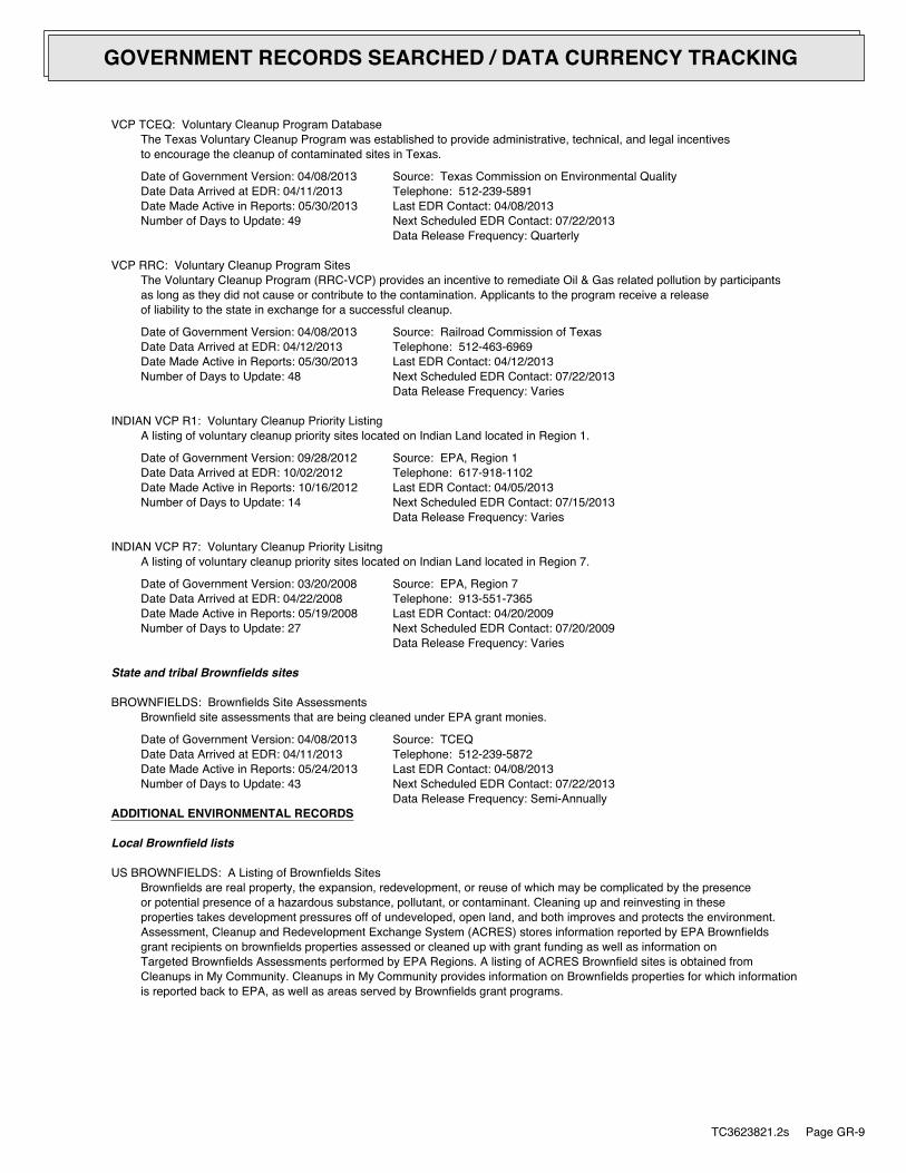
VCP TCEQ: Voluntary Cleanup Program DatabaseThe Texas Voluntary Cleanup Program was established to provide administrative, technical, and legal incentivesto encourage the cleanup of contaminated sites in Texas.
Date of Government Version: 04/08/2013Date Data Arrived at EDR: 04/11/2013Date Made Active in Reports: 05/30/2013Number of Days to Update: 49
Source: Texas Commission on Environmental QualityTelephone: 512-239-5891Last EDR Contact: 04/08/2013Next Scheduled EDR Contact: 07/22/2013Data Release Frequency: Quarterly
VCP RRC: Voluntary Cleanup Program SitesThe Voluntary Cleanup Program (RRC-VCP) provides an incentive to remediate Oil & Gas related pollution by participantsas long as they did not cause or contribute to the contamination. Applicants to the program receive a releaseof liability to the state in exchange for a successful cleanup.
Date of Government Version: 04/08/2013Date Data Arrived at EDR: 04/12/2013Date Made Active in Reports: 05/30/2013Number of Days to Update: 48
Source: Railroad Commission of TexasTelephone: 512-463-6969Last EDR Contact: 04/12/2013Next Scheduled EDR Contact: 07/22/2013Data Release Frequency: Varies
INDIAN VCP R1: Voluntary Cleanup Priority ListingA listing of voluntary cleanup priority sites located on Indian Land located in Region 1.
Date of Government Version: 09/28/2012Date Data Arrived at EDR: 10/02/2012Date Made Active in Reports: 10/16/2012Number of Days to Update: 14
Source: EPA, Region 1Telephone: 617-918-1102Last EDR Contact: 04/05/2013Next Scheduled EDR Contact: 07/15/2013Data Release Frequency: Varies
INDIAN VCP R7: Voluntary Cleanup Priority LisitngA listing of voluntary cleanup priority sites located on Indian Land located in Region 7.
Date of Government Version: 03/20/2008Date Data Arrived at EDR: 04/22/2008Date Made Active in Reports: 05/19/2008Number of Days to Update: 27
Source: EPA, Region 7Telephone: 913-551-7365Last EDR Contact: 04/20/2009Next Scheduled EDR Contact: 07/20/2009Data Release Frequency: Varies
State and tribal Brownfields sites
BROWNFIELDS: Brownfields Site AssessmentsBrownfield site assessments that are being cleaned under EPA grant monies.
Date of Government Version: 04/08/2013Date Data Arrived at EDR: 04/11/2013Date Made Active in Reports: 05/24/2013Number of Days to Update: 43
Source: TCEQTelephone: 512-239-5872Last EDR Contact: 04/08/2013Next Scheduled EDR Contact: 07/22/2013Data Release Frequency: Semi-Annually
ADDITIONAL ENVIRONMENTAL RECORDS
Local Brownfield lists
US BROWNFIELDS: A Listing of Brownfields SitesBrownfields are real property, the expansion, redevelopment, or reuse of which may be complicated by the presenceor potential presence of a hazardous substance, pollutant, or contaminant. Cleaning up and reinvesting in theseproperties takes development pressures off of undeveloped, open land, and both improves and protects the environment.Assessment, Cleanup and Redevelopment Exchange System (ACRES) stores information reported by EPA Brownfieldsgrant recipients on brownfields properties assessed or cleaned up with grant funding as well as information onTargeted Brownfields Assessments performed by EPA Regions. A listing of ACRES Brownfield sites is obtained fromCleanups in My Community. Cleanups in My Community provides information on Brownfields properties for which informationis reported back to EPA, as well as areas served by Brownfields grant programs.
TC3623821.2s Page GR-9
GOVERNMENT RECORDS SEARCHED / DATA CURRENCY TRACKING

Date of Government Version: 12/10/2012Date Data Arrived at EDR: 12/11/2012Date Made Active in Reports: 12/20/2012Number of Days to Update: 9
Source: Environmental Protection AgencyTelephone: 202-566-2777Last EDR Contact: 03/26/2013Next Scheduled EDR Contact: 07/08/2013Data Release Frequency: Semi-Annually
Local Lists of Landfill / Solid Waste Disposal Sites
DEBRIS REGION 9: Torres Martinez Reservation Illegal Dump Site LocationsA listing of illegal dump sites location on the Torres Martinez Indian Reservation located in eastern RiversideCounty and northern Imperial County, California.
Date of Government Version: 01/12/2009Date Data Arrived at EDR: 05/07/2009Date Made Active in Reports: 09/21/2009Number of Days to Update: 137
Source: EPA, Region 9Telephone: 415-947-4219Last EDR Contact: 04/29/2013Next Scheduled EDR Contact: 08/12/2013Data Release Frequency: No Update Planned
ODI: Open Dump InventoryAn open dump is defined as a disposal facility that does not comply with one or more of the Part 257 or Part 258Subtitle D Criteria.
Date of Government Version: 06/30/1985Date Data Arrived at EDR: 08/09/2004Date Made Active in Reports: 09/17/2004Number of Days to Update: 39
Source: Environmental Protection AgencyTelephone: 800-424-9346Last EDR Contact: 06/09/2004Next Scheduled EDR Contact: N/AData Release Frequency: No Update Planned
INDIAN ODI: Report on the Status of Open Dumps on Indian LandsLocation of open dumps on Indian land.
Date of Government Version: 12/31/1998Date Data Arrived at EDR: 12/03/2007Date Made Active in Reports: 01/24/2008Number of Days to Update: 52
Source: Environmental Protection AgencyTelephone: 703-308-8245Last EDR Contact: 05/03/2013Next Scheduled EDR Contact: 08/19/2013Data Release Frequency: Varies
Local Lists of Hazardous waste / Contaminated Sites
US CDL: Clandestine Drug LabsA listing of clandestine drug lab locations. The U.S. Department of Justice ("the Department") provides thisweb site as a public service. It contains addresses of some locations where law enforcement agencies reportedthey found chemicals or other items that indicated the presence of either clandestine drug laboratories or dumpsites.In most cases, the source of the entries is not the Department, and the Department has not verified the entryand does not guarantee its accuracy. Members of the public must verify the accuracy of all entries by, for example,contacting local law enforcement and local health departments.
Date of Government Version: 03/04/2013Date Data Arrived at EDR: 03/12/2013Date Made Active in Reports: 05/10/2013Number of Days to Update: 59
Source: Drug Enforcement AdministrationTelephone: 202-307-1000Last EDR Contact: 03/04/2013Next Scheduled EDR Contact: 06/17/2013Data Release Frequency: Quarterly
DEL SHWS: Deleted Superfund Registry SitesSites have been deleted from the state Superfund registry in accordance with the Act, ?361.189
Date of Government Version: 12/05/2012Date Data Arrived at EDR: 01/16/2013Date Made Active in Reports: 01/30/2013Number of Days to Update: 14
Source: Texas Commission on Environmental QualityTelephone: 512-239-0666Last EDR Contact: 04/19/2013Next Scheduled EDR Contact: 07/01/2013Data Release Frequency: Quarterly
TC3623821.2s Page GR-10
GOVERNMENT RECORDS SEARCHED / DATA CURRENCY TRACKING

PRIORITY CLEANERS: Dry Cleaner Remediation Program Prioritization ListA listing of dry cleaner related contaminated sites.
Date of Government Version: 03/01/2013Date Data Arrived at EDR: 03/13/2013Date Made Active in Reports: 04/03/2013Number of Days to Update: 21
Source: Texas Commisision on Environmenatl QualityTelephone: 512-239-5658Last EDR Contact: 03/13/2013Next Scheduled EDR Contact: 06/24/2013Data Release Frequency: Varies
US HIST CDL: National Clandestine Laboratory RegisterA listing of clandestine drug lab locations. The U.S. Department of Justice ("the Department") provides thisweb site as a public service. It contains addresses of some locations where law enforcement agencies reportedthey found chemicals or other items that indicated the presence of either clandestine drug laboratories or dumpsites.In most cases, the source of the entries is not the Department, and the Department has not verified the entryand does not guarantee its accuracy. Members of the public must verify the accuracy of all entries by, for example,contacting local law enforcement and local health departments.
Date of Government Version: 09/01/2007Date Data Arrived at EDR: 11/19/2008Date Made Active in Reports: 03/30/2009Number of Days to Update: 131
Source: Drug Enforcement AdministrationTelephone: 202-307-1000Last EDR Contact: 03/23/2009Next Scheduled EDR Contact: 06/22/2009Data Release Frequency: No Update Planned
Local Land Records
LIENS 2: CERCLA Lien InformationA Federal CERCLA (’Superfund’) lien can exist by operation of law at any site or property at which EPA has spentSuperfund monies. These monies are spent to investigate and address releases and threatened releases of contamination.CERCLIS provides information as to the identity of these sites and properties.
Date of Government Version: 02/06/2013Date Data Arrived at EDR: 04/25/2013Date Made Active in Reports: 05/10/2013Number of Days to Update: 15
Source: Environmental Protection AgencyTelephone: 202-564-6023Last EDR Contact: 04/29/2013Next Scheduled EDR Contact: 08/12/2013Data Release Frequency: Varies
LIENS: Environmental Liens ListingThe listing covers TCEQ liens placed against either State Superfund sites or Federal Superfund sites to recovercost incurred by TCEQ.
Date of Government Version: 02/27/2013Date Data Arrived at EDR: 02/27/2013Date Made Active in Reports: 04/03/2013Number of Days to Update: 35
Source: Texas Commission on Environmental QualityTelephone: 512-239-2209Last EDR Contact: 05/28/2013Next Scheduled EDR Contact: 09/09/2013Data Release Frequency: Varies
HIST LIENS: Environmental Liens ListingThis listing contains information fields that are no longer tracked in the LIENS database.
Date of Government Version: 03/23/2007Date Data Arrived at EDR: 03/23/2007Date Made Active in Reports: 05/02/2007Number of Days to Update: 40
Source: Texas Commission on Environmental QualiltyTelephone: 512-239-2209Last EDR Contact: 12/17/2007Next Scheduled EDR Contact: 03/17/2008Data Release Frequency: No Update Planned
Records of Emergency Release Reports
HMIRS: Hazardous Materials Information Reporting SystemHazardous Materials Incident Report System. HMIRS contains hazardous material spill incidents reported to DOT.
TC3623821.2s Page GR-11
GOVERNMENT RECORDS SEARCHED / DATA CURRENCY TRACKING
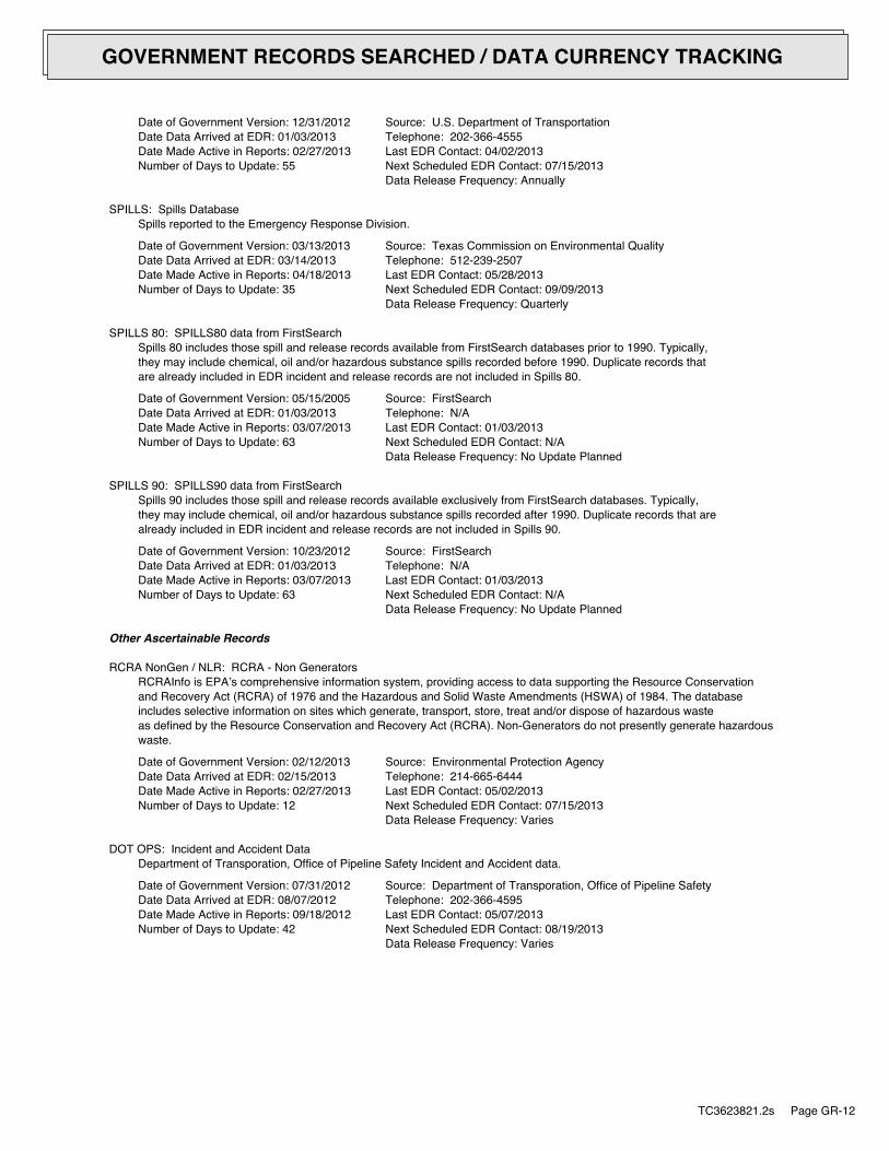
Date of Government Version: 12/31/2012Date Data Arrived at EDR: 01/03/2013Date Made Active in Reports: 02/27/2013Number of Days to Update: 55
Source: U.S. Department of TransportationTelephone: 202-366-4555Last EDR Contact: 04/02/2013Next Scheduled EDR Contact: 07/15/2013Data Release Frequency: Annually
SPILLS: Spills DatabaseSpills reported to the Emergency Response Division.
Date of Government Version: 03/13/2013Date Data Arrived at EDR: 03/14/2013Date Made Active in Reports: 04/18/2013Number of Days to Update: 35
Source: Texas Commission on Environmental QualityTelephone: 512-239-2507Last EDR Contact: 05/28/2013Next Scheduled EDR Contact: 09/09/2013Data Release Frequency: Quarterly
SPILLS 80: SPILLS80 data from FirstSearchSpills 80 includes those spill and release records available from FirstSearch databases prior to 1990. Typically,they may include chemical, oil and/or hazardous substance spills recorded before 1990. Duplicate records thatare already included in EDR incident and release records are not included in Spills 80.
Date of Government Version: 05/15/2005Date Data Arrived at EDR: 01/03/2013Date Made Active in Reports: 03/07/2013Number of Days to Update: 63
Source: FirstSearchTelephone: N/ALast EDR Contact: 01/03/2013Next Scheduled EDR Contact: N/AData Release Frequency: No Update Planned
SPILLS 90: SPILLS90 data from FirstSearchSpills 90 includes those spill and release records available exclusively from FirstSearch databases. Typically,they may include chemical, oil and/or hazardous substance spills recorded after 1990. Duplicate records that arealready included in EDR incident and release records are not included in Spills 90.
Date of Government Version: 10/23/2012Date Data Arrived at EDR: 01/03/2013Date Made Active in Reports: 03/07/2013Number of Days to Update: 63
Source: FirstSearchTelephone: N/ALast EDR Contact: 01/03/2013Next Scheduled EDR Contact: N/AData Release Frequency: No Update Planned
Other Ascertainable Records
RCRA NonGen / NLR: RCRA - Non GeneratorsRCRAInfo is EPA’s comprehensive information system, providing access to data supporting the Resource Conservationand Recovery Act (RCRA) of 1976 and the Hazardous and Solid Waste Amendments (HSWA) of 1984. The databaseincludes selective information on sites which generate, transport, store, treat and/or dispose of hazardous wasteas defined by the Resource Conservation and Recovery Act (RCRA). Non-Generators do not presently generate hazardouswaste.
Date of Government Version: 02/12/2013Date Data Arrived at EDR: 02/15/2013Date Made Active in Reports: 02/27/2013Number of Days to Update: 12
Source: Environmental Protection AgencyTelephone: 214-665-6444Last EDR Contact: 05/02/2013Next Scheduled EDR Contact: 07/15/2013Data Release Frequency: Varies
DOT OPS: Incident and Accident DataDepartment of Transporation, Office of Pipeline Safety Incident and Accident data.
Date of Government Version: 07/31/2012Date Data Arrived at EDR: 08/07/2012Date Made Active in Reports: 09/18/2012Number of Days to Update: 42
Source: Department of Transporation, Office of Pipeline SafetyTelephone: 202-366-4595Last EDR Contact: 05/07/2013Next Scheduled EDR Contact: 08/19/2013Data Release Frequency: Varies
TC3623821.2s Page GR-12
GOVERNMENT RECORDS SEARCHED / DATA CURRENCY TRACKING

DOD: Department of Defense SitesThis data set consists of federally owned or administered lands, administered by the Department of Defense, thathave any area equal to or greater than 640 acres of the United States, Puerto Rico, and the U.S. Virgin Islands.
Date of Government Version: 12/31/2005Date Data Arrived at EDR: 11/10/2006Date Made Active in Reports: 01/11/2007Number of Days to Update: 62
Source: USGSTelephone: 888-275-8747Last EDR Contact: 04/19/2013Next Scheduled EDR Contact: 07/29/2013Data Release Frequency: Semi-Annually
FUDS: Formerly Used Defense SitesThe listing includes locations of Formerly Used Defense Sites properties where the US Army Corps of Engineersis actively working or will take necessary cleanup actions.
Date of Government Version: 12/31/2011Date Data Arrived at EDR: 02/26/2013Date Made Active in Reports: 03/13/2013Number of Days to Update: 15
Source: U.S. Army Corps of EngineersTelephone: 202-528-4285Last EDR Contact: 03/11/2013Next Scheduled EDR Contact: 06/24/2013Data Release Frequency: Varies
CONSENT: Superfund (CERCLA) Consent DecreesMajor legal settlements that establish responsibility and standards for cleanup at NPL (Superfund) sites. Releasedperiodically by United States District Courts after settlement by parties to litigation matters.
Date of Government Version: 12/31/2011Date Data Arrived at EDR: 01/15/2013Date Made Active in Reports: 03/13/2013Number of Days to Update: 57
Source: Department of Justice, Consent Decree LibraryTelephone: VariesLast EDR Contact: 04/01/2013Next Scheduled EDR Contact: 07/15/2013Data Release Frequency: Varies
ROD: Records Of DecisionRecord of Decision. ROD documents mandate a permanent remedy at an NPL (Superfund) site containing technicaland health information to aid in the cleanup.
Date of Government Version: 12/18/2012Date Data Arrived at EDR: 03/13/2013Date Made Active in Reports: 04/12/2013Number of Days to Update: 30
Source: EPATelephone: 703-416-0223Last EDR Contact: 03/13/2013Next Scheduled EDR Contact: 06/24/2013Data Release Frequency: Annually
UMTRA: Uranium Mill Tailings SitesUranium ore was mined by private companies for federal government use in national defense programs. When the millsshut down, large piles of the sand-like material (mill tailings) remain after uranium has been extracted fromthe ore. Levels of human exposure to radioactive materials from the piles are low; however, in some cases tailingswere used as construction materials before the potential health hazards of the tailings were recognized.
Date of Government Version: 09/14/2010Date Data Arrived at EDR: 10/07/2011Date Made Active in Reports: 03/01/2012Number of Days to Update: 146
Source: Department of EnergyTelephone: 505-845-0011Last EDR Contact: 05/28/2013Next Scheduled EDR Contact: 09/09/2013Data Release Frequency: Varies
US MINES: Mines Master Index FileContains all mine identification numbers issued for mines active or opened since 1971. The data also includesviolation information.
Date of Government Version: 02/05/2013Date Data Arrived at EDR: 04/18/2013Date Made Active in Reports: 05/10/2013Number of Days to Update: 22
Source: Department of Labor, Mine Safety and Health AdministrationTelephone: 303-231-5959Last EDR Contact: 03/06/2013Next Scheduled EDR Contact: 06/17/2013Data Release Frequency: Semi-Annually
TC3623821.2s Page GR-13
GOVERNMENT RECORDS SEARCHED / DATA CURRENCY TRACKING
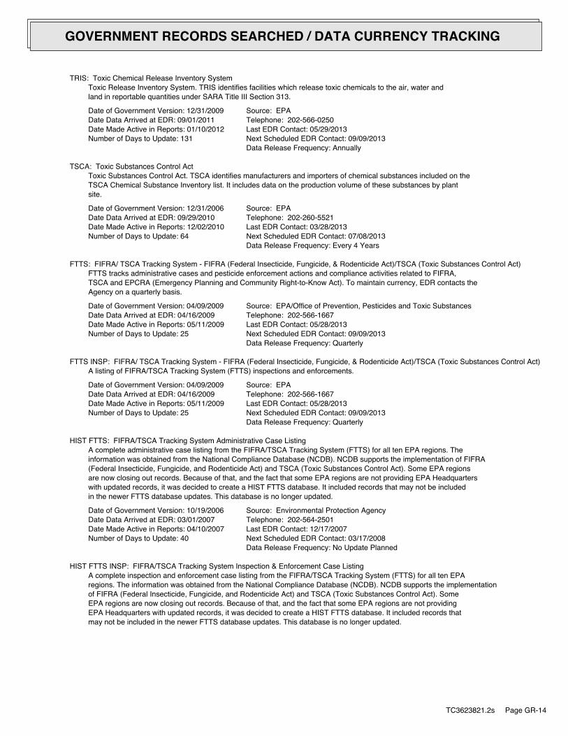
TRIS: Toxic Chemical Release Inventory SystemToxic Release Inventory System. TRIS identifies facilities which release toxic chemicals to the air, water andland in reportable quantities under SARA Title III Section 313.
Date of Government Version: 12/31/2009Date Data Arrived at EDR: 09/01/2011Date Made Active in Reports: 01/10/2012Number of Days to Update: 131
Source: EPATelephone: 202-566-0250Last EDR Contact: 05/29/2013Next Scheduled EDR Contact: 09/09/2013Data Release Frequency: Annually
TSCA: Toxic Substances Control ActToxic Substances Control Act. TSCA identifies manufacturers and importers of chemical substances included on theTSCA Chemical Substance Inventory list. It includes data on the production volume of these substances by plantsite.
Date of Government Version: 12/31/2006Date Data Arrived at EDR: 09/29/2010Date Made Active in Reports: 12/02/2010Number of Days to Update: 64
Source: EPATelephone: 202-260-5521Last EDR Contact: 03/28/2013Next Scheduled EDR Contact: 07/08/2013Data Release Frequency: Every 4 Years
FTTS: FIFRA/ TSCA Tracking System - FIFRA (Federal Insecticide, Fungicide, & Rodenticide Act)/TSCA (Toxic Substances Control Act)FTTS tracks administrative cases and pesticide enforcement actions and compliance activities related to FIFRA,TSCA and EPCRA (Emergency Planning and Community Right-to-Know Act). To maintain currency, EDR contacts theAgency on a quarterly basis.
Date of Government Version: 04/09/2009Date Data Arrived at EDR: 04/16/2009Date Made Active in Reports: 05/11/2009Number of Days to Update: 25
Source: EPA/Office of Prevention, Pesticides and Toxic SubstancesTelephone: 202-566-1667Last EDR Contact: 05/28/2013Next Scheduled EDR Contact: 09/09/2013Data Release Frequency: Quarterly
FTTS INSP: FIFRA/ TSCA Tracking System - FIFRA (Federal Insecticide, Fungicide, & Rodenticide Act)/TSCA (Toxic Substances Control Act)A listing of FIFRA/TSCA Tracking System (FTTS) inspections and enforcements.
Date of Government Version: 04/09/2009Date Data Arrived at EDR: 04/16/2009Date Made Active in Reports: 05/11/2009Number of Days to Update: 25
Source: EPATelephone: 202-566-1667Last EDR Contact: 05/28/2013Next Scheduled EDR Contact: 09/09/2013Data Release Frequency: Quarterly
HIST FTTS: FIFRA/TSCA Tracking System Administrative Case ListingA complete administrative case listing from the FIFRA/TSCA Tracking System (FTTS) for all ten EPA regions. Theinformation was obtained from the National Compliance Database (NCDB). NCDB supports the implementation of FIFRA(Federal Insecticide, Fungicide, and Rodenticide Act) and TSCA (Toxic Substances Control Act). Some EPA regionsare now closing out records. Because of that, and the fact that some EPA regions are not providing EPA Headquarterswith updated records, it was decided to create a HIST FTTS database. It included records that may not be includedin the newer FTTS database updates. This database is no longer updated.
Date of Government Version: 10/19/2006Date Data Arrived at EDR: 03/01/2007Date Made Active in Reports: 04/10/2007Number of Days to Update: 40
Source: Environmental Protection AgencyTelephone: 202-564-2501Last EDR Contact: 12/17/2007Next Scheduled EDR Contact: 03/17/2008Data Release Frequency: No Update Planned
HIST FTTS INSP: FIFRA/TSCA Tracking System Inspection & Enforcement Case ListingA complete inspection and enforcement case listing from the FIFRA/TSCA Tracking System (FTTS) for all ten EPAregions. The information was obtained from the National Compliance Database (NCDB). NCDB supports the implementationof FIFRA (Federal Insecticide, Fungicide, and Rodenticide Act) and TSCA (Toxic Substances Control Act). SomeEPA regions are now closing out records. Because of that, and the fact that some EPA regions are not providingEPA Headquarters with updated records, it was decided to create a HIST FTTS database. It included records thatmay not be included in the newer FTTS database updates. This database is no longer updated.
TC3623821.2s Page GR-14
GOVERNMENT RECORDS SEARCHED / DATA CURRENCY TRACKING
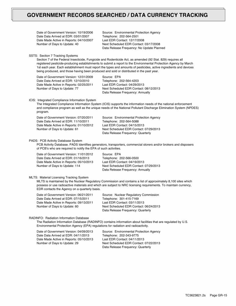
Date of Government Version: 10/19/2006Date Data Arrived at EDR: 03/01/2007Date Made Active in Reports: 04/10/2007Number of Days to Update: 40
Source: Environmental Protection AgencyTelephone: 202-564-2501Last EDR Contact: 12/17/2008Next Scheduled EDR Contact: 03/17/2008Data Release Frequency: No Update Planned
SSTS: Section 7 Tracking SystemsSection 7 of the Federal Insecticide, Fungicide and Rodenticide Act, as amended (92 Stat. 829) requires allregistered pesticide-producing establishments to submit a report to the Environmental Protection Agency by March1st each year. Each establishment must report the types and amounts of pesticides, active ingredients and devicesbeing produced, and those having been produced and sold or distributed in the past year.
Date of Government Version: 12/31/2009Date Data Arrived at EDR: 12/10/2010Date Made Active in Reports: 02/25/2011Number of Days to Update: 77
Source: EPATelephone: 202-564-4203Last EDR Contact: 04/29/2013Next Scheduled EDR Contact: 08/12/2013Data Release Frequency: Annually
ICIS: Integrated Compliance Information SystemThe Integrated Compliance Information System (ICIS) supports the information needs of the national enforcementand compliance program as well as the unique needs of the National Pollutant Discharge Elimination System (NPDES)program.
Date of Government Version: 07/20/2011Date Data Arrived at EDR: 11/10/2011Date Made Active in Reports: 01/10/2012Number of Days to Update: 61
Source: Environmental Protection AgencyTelephone: 202-564-5088Last EDR Contact: 04/15/2013Next Scheduled EDR Contact: 07/29/2013Data Release Frequency: Quarterly
PADS: PCB Activity Database SystemPCB Activity Database. PADS Identifies generators, transporters, commercial storers and/or brokers and disposersof PCB’s who are required to notify the EPA of such activities.
Date of Government Version: 11/01/2012Date Data Arrived at EDR: 01/16/2013Date Made Active in Reports: 05/10/2013Number of Days to Update: 114
Source: EPATelephone: 202-566-0500Last EDR Contact: 04/19/2013Next Scheduled EDR Contact: 07/29/2013Data Release Frequency: Annually
MLTS: Material Licensing Tracking SystemMLTS is maintained by the Nuclear Regulatory Commission and contains a list of approximately 8,100 sites whichpossess or use radioactive materials and which are subject to NRC licensing requirements. To maintain currency,EDR contacts the Agency on a quarterly basis.
Date of Government Version: 06/21/2011Date Data Arrived at EDR: 07/15/2011Date Made Active in Reports: 09/13/2011Number of Days to Update: 60
Source: Nuclear Regulatory CommissionTelephone: 301-415-7169Last EDR Contact: 03/11/2013Next Scheduled EDR Contact: 06/24/2013Data Release Frequency: Quarterly
RADINFO: Radiation Information DatabaseThe Radiation Information Database (RADINFO) contains information about facilities that are regulated by U.S.Environmental Protection Agency (EPA) regulations for radiation and radioactivity.
Date of Government Version: 04/09/2013Date Data Arrived at EDR: 04/11/2013Date Made Active in Reports: 05/10/2013Number of Days to Update: 29
Source: Environmental Protection AgencyTelephone: 202-343-9775Last EDR Contact: 04/11/2013Next Scheduled EDR Contact: 07/22/2013Data Release Frequency: Quarterly
TC3623821.2s Page GR-15
GOVERNMENT RECORDS SEARCHED / DATA CURRENCY TRACKING

FINDS: Facility Index System/Facility Registry SystemFacility Index System. FINDS contains both facility information and ’pointers’ to other sources that contain moredetail. EDR includes the following FINDS databases in this report: PCS (Permit Compliance System), AIRS (AerometricInformation Retrieval System), DOCKET (Enforcement Docket used to manage and track information on civil judicialenforcement cases for all environmental statutes), FURS (Federal Underground Injection Control), C-DOCKET (CriminalDocket System used to track criminal enforcement actions for all environmental statutes), FFIS (Federal FacilitiesInformation System), STATE (State Environmental Laws and Statutes), and PADS (PCB Activity Data System).
Date of Government Version: 10/23/2011Date Data Arrived at EDR: 12/13/2011Date Made Active in Reports: 03/01/2012Number of Days to Update: 79
Source: EPATelephone: (214) 665-2200Last EDR Contact: 03/12/2013Next Scheduled EDR Contact: 06/24/2013Data Release Frequency: Quarterly
RAATS: RCRA Administrative Action Tracking SystemRCRA Administration Action Tracking System. RAATS contains records based on enforcement actions issued under RCRApertaining to major violators and includes administrative and civil actions brought by the EPA. For administrationactions after September 30, 1995, data entry in the RAATS database was discontinued. EPA will retain a copy ofthe database for historical records. It was necessary to terminate RAATS because a decrease in agency resourcesmade it impossible to continue to update the information contained in the database.
Date of Government Version: 04/17/1995Date Data Arrived at EDR: 07/03/1995Date Made Active in Reports: 08/07/1995Number of Days to Update: 35
Source: EPATelephone: 202-564-4104Last EDR Contact: 06/02/2008Next Scheduled EDR Contact: 09/01/2008Data Release Frequency: No Update Planned
RMP: Risk Management PlansWhen Congress passed the Clean Air Act Amendments of 1990, it required EPA to publish regulations and guidancefor chemical accident prevention at facilities using extremely hazardous substances. The Risk Management ProgramRule (RMP Rule) was written to implement Section 112(r) of these amendments. The rule, which built upon existingindustry codes and standards, requires companies of all sizes that use certain flammable and toxic substancesto develop a Risk Management Program, which includes a(n): Hazard assessment that details the potential effectsof an accidental release, an accident history of the last five years, and an evaluation of worst-case and alternativeaccidental releases; Prevention program that includes safety precautions and maintenance, monitoring, and employeetraining measures; and Emergency response program that spells out emergency health care, employee training measuresand procedures for informing the public and response agencies (e.g the fire department) should an accident occur.
Date of Government Version: 05/08/2012Date Data Arrived at EDR: 05/25/2012Date Made Active in Reports: 07/10/2012Number of Days to Update: 46
Source: Environmental Protection AgencyTelephone: 202-564-8600Last EDR Contact: 04/29/2013Next Scheduled EDR Contact: 08/12/2013Data Release Frequency: Varies
BRS: Biennial Reporting SystemThe Biennial Reporting System is a national system administered by the EPA that collects data on the generationand management of hazardous waste. BRS captures detailed data from two groups: Large Quantity Generators (LQG)and Treatment, Storage, and Disposal Facilities.
Date of Government Version: 12/31/2011Date Data Arrived at EDR: 02/26/2013Date Made Active in Reports: 04/19/2013Number of Days to Update: 52
Source: EPA/NTISTelephone: 800-424-9346Last EDR Contact: 05/30/2013Next Scheduled EDR Contact: 09/09/2013Data Release Frequency: Biennially
IOP: Innocent Owner/Operator ProgramContains information on all sites that are in the IOP. An IOP is an innocent owner or operator whose propertyis contaminated as a result of a release or migration of contaminants from a source or sources not located onthe property, and they did not cause or contribute to the source or sources of contamination.
TC3623821.2s Page GR-16
GOVERNMENT RECORDS SEARCHED / DATA CURRENCY TRACKING
Date of Government Version: 04/08/2013Date Data Arrived at EDR: 04/11/2013Date Made Active in Reports: 05/30/2013Number of Days to Update: 49
Source: Texas Commission on Environmental QualityTelephone: 512-239-5894Last EDR Contact: 04/08/2013Next Scheduled EDR Contact: 07/22/2013Data Release Frequency: Quarterly
UIC: Underground Injection Wells Database ListingClass V injection wells regulated by the TCEQ. Class V wells are used to inject non-hazardous fluids underground.Most Class V wells are used to dispose of wastes into or above underground sources of drinking water and can posea threat to ground water quality, if not managed properly.
Date of Government Version: 01/22/2013Date Data Arrived at EDR: 01/25/2013Date Made Active in Reports: 04/03/2013Number of Days to Update: 68
Source: Texas Commission on Environmental QualityTelephone: 512-239-6627Last EDR Contact: 05/07/2013Next Scheduled EDR Contact: 08/05/2013Data Release Frequency: Varies
NPDES: NPDES Facility ListPermitted wastewater outfalls.
Date of Government Version: 01/28/2013Date Data Arrived at EDR: 01/30/2013Date Made Active in Reports: 04/05/2013Number of Days to Update: 65
Source: Texas Commission on Environmental QualityTelephone: 512-239-4591Last EDR Contact: 05/23/2013Next Scheduled EDR Contact: 09/02/2013Data Release Frequency: Varies
DRYCLEANERS: Drycleaner Registration Database ListingA listing of drycleaning facilities.
Date of Government Version: 12/31/2012Date Data Arrived at EDR: 03/13/2013Date Made Active in Reports: 04/03/2013Number of Days to Update: 21
Source: Texas Commission on Environmental QualityTelephone: 512-239-2160Last EDR Contact: 03/13/2013Next Scheduled EDR Contact: 06/24/2013Data Release Frequency: Varies
ENFORCEMENT: Notice of Violations ListingA listing of permit violations.
Date of Government Version: 09/18/2012Date Data Arrived at EDR: 09/18/2012Date Made Active in Reports: 10/24/2012Number of Days to Update: 36
Source: Texas Commission on Environmental QualityTelephone: 512-239-6012Last EDR Contact: 04/16/2013Next Scheduled EDR Contact: 12/24/2012Data Release Frequency: Semi-Annually
Ind. Haz Waste: Industrial & Hazardous Waste DatabaseSummary reports reported by waste handlers, generators and shippers in Texas.
Date of Government Version: 03/15/2013Date Data Arrived at EDR: 04/11/2013Date Made Active in Reports: 05/30/2013Number of Days to Update: 49
Source: Texas Commission on Environmental QualityTelephone: 512-239-0985Last EDR Contact: 04/11/2013Next Scheduled EDR Contact: 07/22/2013Data Release Frequency: Annually
ED AQUIF: Edwards Aquifer PermitsA listing of permits in the Edwards Aquifer Protection Program database. The information provided is for the countieslocated in the Austin Region (Hays, Travis, and Williamson counties).
Date of Government Version: 11/01/2012Date Data Arrived at EDR: 11/01/2012Date Made Active in Reports: 11/26/2012Number of Days to Update: 25
Source: Texas Commission on Environmental Quality, Austin RegionTelephone: 512-339-2929Last EDR Contact: 05/01/2013Next Scheduled EDR Contact: 04/15/2013Data Release Frequency: Varies
TC3623821.2s Page GR-17
GOVERNMENT RECORDS SEARCHED / DATA CURRENCY TRACKING

AIRS: Current Emission Inventory DataThe database lists by company, along with their actual emissions, the TNRCC air accounts that emit EPA criteriapollutants.
Date of Government Version: 12/31/2011Date Data Arrived at EDR: 03/21/2013Date Made Active in Reports: 04/05/2013Number of Days to Update: 15
Source: Texas Commission on Environmental QualityTelephone: N/ALast EDR Contact: 03/21/2013Next Scheduled EDR Contact: 07/01/2013Data Release Frequency: Semi-Annually
TIER 2: Tier 2 Chemical Inventory ReportsA listing of facilities which store or manufacture hazardous materials and submit a chemical inventory report.
Date of Government Version: 12/31/2011Date Data Arrived at EDR: 06/13/2012Date Made Active in Reports: 08/21/2012Number of Days to Update: 69
Source: Department of State Health ServicesTelephone: 512-834-6603Last EDR Contact: 05/28/2013Next Scheduled EDR Contact: 09/09/2013Data Release Frequency: Annually
MSD: Municipal Settings Designations DatabaseAn MSD is an official state designation given to property within a municipality or its extraterritorial jurisdictionthat certifies that designated groundwater at the property is not use as potable water, and is prohibited fromfuture use as potatable water because that groundwater is contaminated in excess of the applicable potable-waterprotective concentration level.
Date of Government Version: 03/25/2013Date Data Arrived at EDR: 03/25/2013Date Made Active in Reports: 04/03/2013Number of Days to Update: 9
Source: Texas Commission on Environmental QualityTelephone: 512-239-4982Last EDR Contact: 03/25/2013Next Scheduled EDR Contact: 07/08/2013Data Release Frequency: Varies
RWS: Radioactive Waste SitesSites in the State of Texas that have been designated as Radioactive Waste sites.
Date of Government Version: 07/24/2006Date Data Arrived at EDR: 12/14/2006Date Made Active in Reports: 01/23/2007Number of Days to Update: 40
Source: Texas Commission on Environmental QualityTelephone: 512-239-0859Last EDR Contact: 05/24/2013Next Scheduled EDR Contact: 09/02/2013Data Release Frequency: Semi-Annually
INDIAN RESERV: Indian ReservationsThis map layer portrays Indian administered lands of the United States that have any area equal to or greaterthan 640 acres.
Date of Government Version: 12/31/2005Date Data Arrived at EDR: 12/08/2006Date Made Active in Reports: 01/11/2007Number of Days to Update: 34
Source: USGSTelephone: 202-208-3710Last EDR Contact: 04/19/2013Next Scheduled EDR Contact: 07/29/2013Data Release Frequency: Semi-Annually
SCRD DRYCLEANERS: State Coalition for Remediation of Drycleaners ListingThe State Coalition for Remediation of Drycleaners was established in 1998, with support from the U.S. EPA Officeof Superfund Remediation and Technology Innovation. It is comprised of representatives of states with establisheddrycleaner remediation programs. Currently the member states are Alabama, Connecticut, Florida, Illinois, Kansas,Minnesota, Missouri, North Carolina, Oregon, South Carolina, Tennessee, Texas, and Wisconsin.
Date of Government Version: 03/07/2011Date Data Arrived at EDR: 03/09/2011Date Made Active in Reports: 05/02/2011Number of Days to Update: 54
Source: Environmental Protection AgencyTelephone: 615-532-8599Last EDR Contact: 05/06/2013Next Scheduled EDR Contact: 08/05/2013Data Release Frequency: Varies
TC3623821.2s Page GR-18
GOVERNMENT RECORDS SEARCHED / DATA CURRENCY TRACKING
2020 COR ACTION: 2020 Corrective Action Program ListThe EPA has set ambitious goals for the RCRA Corrective Action program by creating the 2020 Corrective ActionUniverse. This RCRA cleanup baseline includes facilities expected to need corrective action. The 2020 universecontains a wide variety of sites. Some properties are heavily contaminated while others were contaminated buthave since been cleaned up. Still others have not been fully investigated yet, and may require little or no remediation.Inclusion in the 2020 Universe does not necessarily imply failure on the part of a facility to meet its RCRA obligations.
Date of Government Version: 11/11/2011Date Data Arrived at EDR: 05/18/2012Date Made Active in Reports: 05/25/2012Number of Days to Update: 7
Source: Environmental Protection AgencyTelephone: 703-308-4044Last EDR Contact: 05/17/2013Next Scheduled EDR Contact: 08/26/2013Data Release Frequency: Varies
FEDLAND: Federal and Indian LandsFederally and Indian administrated lands of the United States. Lands included are administrated by: Army Corpsof Engineers, Bureau of Reclamation, National Wild and Scenic River, National Wildlife Refuge, Public Domain Land,Wilderness, Wilderness Study Area, Wildlife Management Area, Bureau of Indian Affairs, Bureau of Land Management,Department of Justice, Forest Service, Fish and Wildlife Service, National Park Service.
Date of Government Version: 12/31/2005Date Data Arrived at EDR: 02/06/2006Date Made Active in Reports: 01/11/2007Number of Days to Update: 339
Source: U.S. Geological SurveyTelephone: 888-275-8747Last EDR Contact: 04/19/2013Next Scheduled EDR Contact: 07/29/2013Data Release Frequency: N/A
PRP: Potentially Responsible PartiesA listing of verified Potentially Responsible Parties
Date of Government Version: 12/02/2012Date Data Arrived at EDR: 01/03/2013Date Made Active in Reports: 03/13/2013Number of Days to Update: 69
Source: EPATelephone: 202-564-6023Last EDR Contact: 04/04/2013Next Scheduled EDR Contact: 07/15/2013Data Release Frequency: Quarterly
US AIRS (AFS): Aerometric Information Retrieval System Facility Subsystem (AFS)The database is a sub-system of Aerometric Information Retrieval System (AIRS). AFS contains compliance dataon air pollution point sources regulated by the U.S. EPA and/or state and local air regulatory agencies. Thisinformation comes from source reports by various stationary sources of air pollution, such as electric power plants,steel mills, factories, and universities, and provides information about the air pollutants they produce. Action,air program, air program pollutant, and general level plant data. It is used to track emissions and compliancedata from industrial plants.
Date of Government Version: 01/23/2013Date Data Arrived at EDR: 01/30/2013Date Made Active in Reports: 05/10/2013Number of Days to Update: 100
Source: EPATelephone: 202-564-5962Last EDR Contact: 04/01/2013Next Scheduled EDR Contact: 07/15/2013Data Release Frequency: Annually
US AIRS MINOR: Air Facility System DataA listing of minor source facilities.
Date of Government Version: 01/23/2013Date Data Arrived at EDR: 01/30/2013Date Made Active in Reports: 05/10/2013Number of Days to Update: 100
Source: EPATelephone: 202-564-5962Last EDR Contact: 04/01/2013Next Scheduled EDR Contact: 07/15/2013Data Release Frequency: Annually
GCC: Groundwater Contamination CasesTexas Water Code, Section 26.406 requires the annual report to describe the current status of groundwater monitoringactivities conducted or required by each agency at regulated facilities or associated with regulated activities.The report is required to contain a description of each case of groundwater contamination documented during theprevious calendar year. Also to be included, is a description of each case of contamination documented duringprevious periods for which voluntary clean up action was incomplete at the time the preceding report was issued.The report is also required to indicate the status of enforcement action for each listed case.
TC3623821.2s Page GR-19
GOVERNMENT RECORDS SEARCHED / DATA CURRENCY TRACKING
Date of Government Version: 12/31/2011Date Data Arrived at EDR: 12/12/2012Date Made Active in Reports: 01/29/2013Number of Days to Update: 48
Source: Texas Commission on Environmental QualityTelephone: 512-239-5690Last EDR Contact: 03/08/2013Next Scheduled EDR Contact: 06/17/2013Data Release Frequency: Annually
EPA WATCH LIST: EPA WATCH LISTEPA maintains a "Watch List" to facilitate dialogue between EPA, state and local environmental agencies on enforcementmatters relating to facilities with alleged violations identified as either significant or high priority. Beingon the Watch List does not mean that the facility has actually violated the law only that an investigation byEPA or a state or local environmental agency has led those organizations to allege that an unproven violationhas in fact occurred. Being on the Watch List does not represent a higher level of concern regarding the allegedviolations that were detected, but instead indicates cases requiring additional dialogue between EPA, state andlocal agencies - primarily because of the length of time the alleged violation has gone unaddressed or unresolved.
Date of Government Version: 12/31/2012Date Data Arrived at EDR: 02/18/2013Date Made Active in Reports: 05/10/2013Number of Days to Update: 81
Source: Environmental Protection AgencyTelephone: 617-520-3000Last EDR Contact: 05/10/2013Next Scheduled EDR Contact: 08/26/2013Data Release Frequency: Quarterly
US FIN ASSUR: Financial Assurance InformationAll owners and operators of facilities that treat, store, or dispose of hazardous waste are required to provideproof that they will have sufficient funds to pay for the clean up, closure, and post-closure care of their facilities.
Date of Government Version: 03/04/2013Date Data Arrived at EDR: 03/15/2013Date Made Active in Reports: 05/10/2013Number of Days to Update: 56
Source: Environmental Protection AgencyTelephone: 202-566-1917Last EDR Contact: 05/20/2013Next Scheduled EDR Contact: 09/02/2013Data Release Frequency: Quarterly
PCB TRANSFORMER: PCB Transformer Registration DatabaseThe database of PCB transformer registrations that includes all PCB registration submittals.
Date of Government Version: 02/01/2011Date Data Arrived at EDR: 10/19/2011Date Made Active in Reports: 01/10/2012Number of Days to Update: 83
Source: Environmental Protection AgencyTelephone: 202-566-0517Last EDR Contact: 05/03/2013Next Scheduled EDR Contact: 08/12/2013Data Release Frequency: Varies
COAL ASH DOE: Sleam-Electric Plan Operation DataA listing of power plants that store ash in surface ponds.
Date of Government Version: 12/31/2005Date Data Arrived at EDR: 08/07/2009Date Made Active in Reports: 10/22/2009Number of Days to Update: 76
Source: Department of EnergyTelephone: 202-586-8719Last EDR Contact: 04/18/2013Next Scheduled EDR Contact: 07/29/2013Data Release Frequency: Varies
COAL ASH EPA: Coal Combustion Residues Surface Impoundments ListA listing of coal combustion residues surface impoundments with high hazard potential ratings.
Date of Government Version: 08/17/2010Date Data Arrived at EDR: 01/03/2011Date Made Active in Reports: 03/21/2011Number of Days to Update: 77
Source: Environmental Protection AgencyTelephone: N/ALast EDR Contact: 03/15/2013Next Scheduled EDR Contact: 06/24/2013Data Release Frequency: Varies
Financial Assurance 1: Financial Assurance Information ListingFinancial assurance information.
TC3623821.2s Page GR-20
GOVERNMENT RECORDS SEARCHED / DATA CURRENCY TRACKING
Date of Government Version: 04/01/2013Date Data Arrived at EDR: 04/04/2013Date Made Active in Reports: 05/28/2013Number of Days to Update: 54
Source: Texas Commission on Environmental QualityTelephone: 512-239-6239Last EDR Contact: 04/01/2013Next Scheduled EDR Contact: 07/15/2013Data Release Frequency: Varies
COAL ASH: Coal Ash Disposal SitesA listing of facilities that use surface impoundments or landfills to dispose of coal ash.
Date of Government Version: 02/05/2013Date Data Arrived at EDR: 02/07/2013Date Made Active in Reports: 04/03/2013Number of Days to Update: 55
Source: Texas Commission on Environmental QualityTelephone: 512-239-6624Last EDR Contact: 05/06/2013Next Scheduled EDR Contact: 08/19/2013Data Release Frequency: Varies
Financial Assurance 2: Financial Assurance Information ListingFinancial Assurance information for underground storage tank facilities. Financial assurance is intended to ensurethat resources are available to pay for the cost of closure, post-closure care, and corrective measures if theowner or operator of a regulated facility is unable or unwilling to pay
Date of Government Version: 03/05/2013Date Data Arrived at EDR: 04/04/2013Date Made Active in Reports: 05/28/2013Number of Days to Update: 54
Source: Texas Commission on Environmental QualityTelephone: 512-239-0986Last EDR Contact: 04/04/2013Next Scheduled EDR Contact: 07/15/2013Data Release Frequency: Quarterly
LEAD SMELTER 1: Lead Smelter SitesA listing of former lead smelter site locations.
Date of Government Version: 01/29/2013Date Data Arrived at EDR: 02/14/2013Date Made Active in Reports: 02/27/2013Number of Days to Update: 13
Source: Environmental Protection AgencyTelephone: 703-603-8787Last EDR Contact: 04/08/2013Next Scheduled EDR Contact: 07/22/2013Data Release Frequency: Varies
LEAD SMELTER 2: Lead Smelter SitesA list of several hundred sites in the U.S. where secondary lead smelting was done from 1931and 1964. These sitesmay pose a threat to public health through ingestion or inhalation of contaminated soil or dust
Date of Government Version: 04/05/2001Date Data Arrived at EDR: 10/27/2010Date Made Active in Reports: 12/02/2010Number of Days to Update: 36
Source: American Journal of Public HealthTelephone: 703-305-6451Last EDR Contact: 12/02/2009Next Scheduled EDR Contact: N/AData Release Frequency: No Update Planned
EDR HIGH RISK HISTORICAL RECORDS
EDR Exclusive Records
EDR MGP: EDR Proprietary Manufactured Gas PlantsThe EDR Proprietary Manufactured Gas Plant Database includes records of coal gas plants (manufactured gas plants)compiled by EDR’s researchers. Manufactured gas sites were used in the United States from the 1800’s to 1950’sto produce a gas that could be distributed and used as fuel. These plants used whale oil, rosin, coal, or a mixtureof coal, oil, and water that also produced a significant amount of waste. Many of the byproducts of the gas production,such as coal tar (oily waste containing volatile and non-volatile chemicals), sludges, oils and other compoundsare potentially hazardous to human health and the environment. The byproduct from this process was frequentlydisposed of directly at the plant site and can remain or spread slowly, serving as a continuous source of soiland groundwater contamination.
Date of Government Version: N/ADate Data Arrived at EDR: N/ADate Made Active in Reports: N/ANumber of Days to Update: N/A
Source: EDR, Inc.Telephone: N/ALast EDR Contact: N/ANext Scheduled EDR Contact: N/AData Release Frequency: No Update Planned
TC3623821.2s Page GR-21
GOVERNMENT RECORDS SEARCHED / DATA CURRENCY TRACKING

EDR US Hist Auto Stat: EDR Exclusive Historic Gas StationsEDR has searched selected national collections of business directories and has collected listings of potentialgas station/filling station/service station sites that were available to EDR researchers. EDR’s review was limitedto those categories of sources that might, in EDR’s opinion, include gas station/filling station/service stationestablishments. The categories reviewed included, but were not limited to gas, gas station, gasoline station,filling station, auto, automobile repair, auto service station, service station, etc. This database falls withina category of information EDR classifies as "High Risk Historical Records", or HRHR. EDR’s HRHR effort presentsunique and sometimes proprietary data about past sites and operations that typically create environmental concerns,but may not show up in current government records searches.
Date of Government Version: N/ADate Data Arrived at EDR: N/ADate Made Active in Reports: N/ANumber of Days to Update: N/A
Source: EDR, Inc.Telephone: N/ALast EDR Contact: N/ANext Scheduled EDR Contact: N/AData Release Frequency: Varies
EDR US Hist Cleaners: EDR Exclusive Historic Dry CleanersEDR has searched selected national collections of business directories and has collected listings of potentialdry cleaner sites that were available to EDR researchers. EDR’s review was limited to those categories of sourcesthat might, in EDR’s opinion, include dry cleaning establishments. The categories reviewed included, but werenot limited to dry cleaners, cleaners, laundry, laundromat, cleaning/laundry, wash & dry etc. This database fallswithin a category of information EDR classifies as "High Risk Historical Records", or HRHR. EDR’s HRHR effortpresents unique and sometimes proprietary data about past sites and operations that typically create environmentalconcerns, but may not show up in current government records searches.
Date of Government Version: N/ADate Data Arrived at EDR: N/ADate Made Active in Reports: N/ANumber of Days to Update: N/A
Source: EDR, Inc.Telephone: N/ALast EDR Contact: N/ANext Scheduled EDR Contact: N/AData Release Frequency: Varies
EDR US Hist Cleaners: EDR Proprietary Historic Dry Cleaners - Cole
Date of Government Version: N/ADate Data Arrived at EDR: N/ADate Made Active in Reports: N/ANumber of Days to Update: N/A
Source: N/ATelephone: N/ALast EDR Contact: N/ANext Scheduled EDR Contact: N/AData Release Frequency: Varies
EDR US Hist Auto Stat: EDR Proprietary Historic Gas Stations - Cole
Date of Government Version: N/ADate Data Arrived at EDR: N/ADate Made Active in Reports: N/ANumber of Days to Update: N/A
Source: N/ATelephone: N/ALast EDR Contact: N/ANext Scheduled EDR Contact: N/AData Release Frequency: Varies
COUNTY RECORDS
TRAVIS COUNTY:
Historic Tank RecordsA listing of historic records from the City of Austin.
Date of Government Version: 06/25/2012Date Data Arrived at EDR: 06/29/2012Date Made Active in Reports: 08/23/2012Number of Days to Update: 55
Source: Department of Planning & Development ReviewTelephone: 512-974-2715Last EDR Contact: 03/11/2013Next Scheduled EDR Contact: 06/24/2013Data Release Frequency: Varies
TC3623821.2s Page GR-22
GOVERNMENT RECORDS SEARCHED / DATA CURRENCY TRACKING
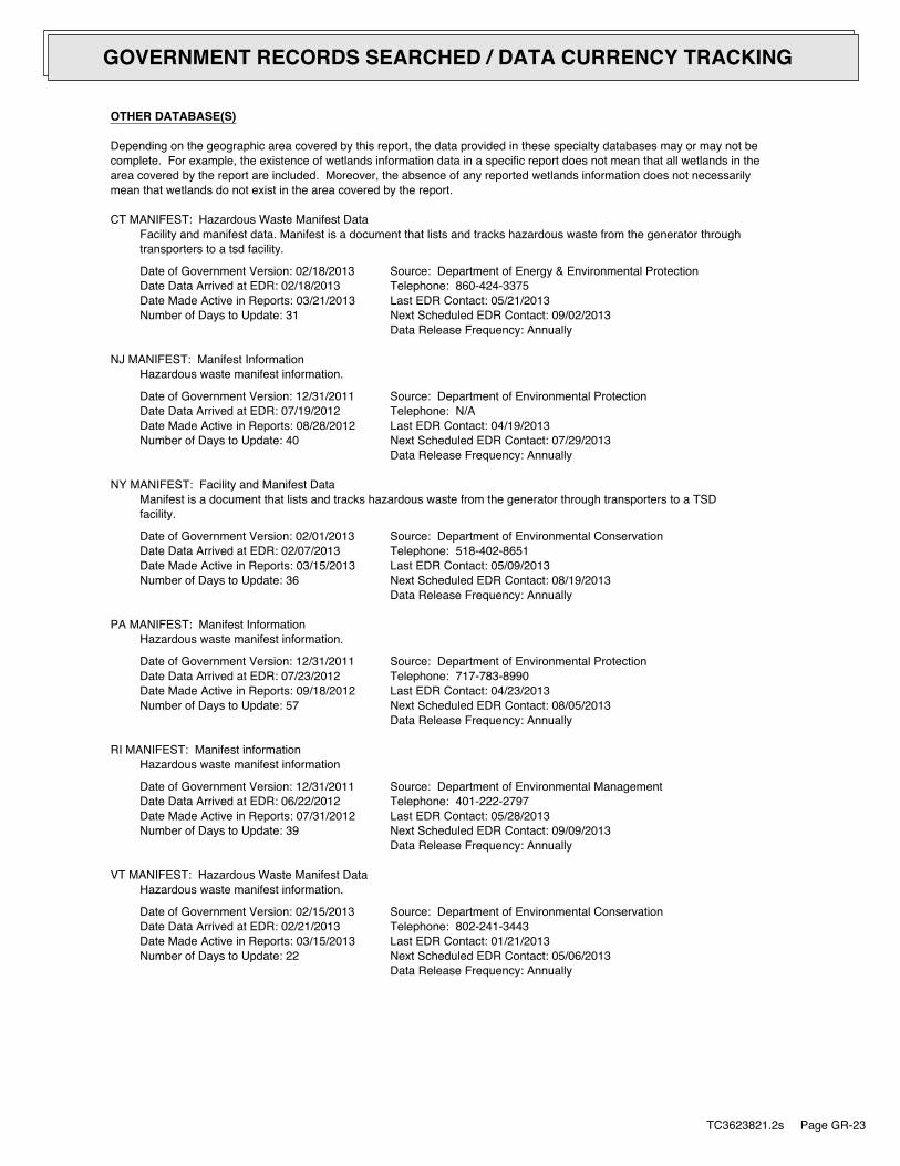
OTHER DATABASE(S)
Depending on the geographic area covered by this report, the data provided in these specialty databases may or may not becomplete. For example, the existence of wetlands information data in a specific report does not mean that all wetlands in thearea covered by the report are included. Moreover, the absence of any reported wetlands information does not necessarilymean that wetlands do not exist in the area covered by the report.
CT MANIFEST: Hazardous Waste Manifest DataFacility and manifest data. Manifest is a document that lists and tracks hazardous waste from the generator throughtransporters to a tsd facility.
Date of Government Version: 02/18/2013Date Data Arrived at EDR: 02/18/2013Date Made Active in Reports: 03/21/2013Number of Days to Update: 31
Source: Department of Energy & Environmental ProtectionTelephone: 860-424-3375Last EDR Contact: 05/21/2013Next Scheduled EDR Contact: 09/02/2013Data Release Frequency: Annually
NJ MANIFEST: Manifest InformationHazardous waste manifest information.
Date of Government Version: 12/31/2011Date Data Arrived at EDR: 07/19/2012Date Made Active in Reports: 08/28/2012Number of Days to Update: 40
Source: Department of Environmental ProtectionTelephone: N/ALast EDR Contact: 04/19/2013Next Scheduled EDR Contact: 07/29/2013Data Release Frequency: Annually
NY MANIFEST: Facility and Manifest DataManifest is a document that lists and tracks hazardous waste from the generator through transporters to a TSDfacility.
Date of Government Version: 02/01/2013Date Data Arrived at EDR: 02/07/2013Date Made Active in Reports: 03/15/2013Number of Days to Update: 36
Source: Department of Environmental ConservationTelephone: 518-402-8651Last EDR Contact: 05/09/2013Next Scheduled EDR Contact: 08/19/2013Data Release Frequency: Annually
PA MANIFEST: Manifest InformationHazardous waste manifest information.
Date of Government Version: 12/31/2011Date Data Arrived at EDR: 07/23/2012Date Made Active in Reports: 09/18/2012Number of Days to Update: 57
Source: Department of Environmental ProtectionTelephone: 717-783-8990Last EDR Contact: 04/23/2013Next Scheduled EDR Contact: 08/05/2013Data Release Frequency: Annually
RI MANIFEST: Manifest informationHazardous waste manifest information
Date of Government Version: 12/31/2011Date Data Arrived at EDR: 06/22/2012Date Made Active in Reports: 07/31/2012Number of Days to Update: 39
Source: Department of Environmental ManagementTelephone: 401-222-2797Last EDR Contact: 05/28/2013Next Scheduled EDR Contact: 09/09/2013Data Release Frequency: Annually
VT MANIFEST: Hazardous Waste Manifest DataHazardous waste manifest information.
Date of Government Version: 02/15/2013Date Data Arrived at EDR: 02/21/2013Date Made Active in Reports: 03/15/2013Number of Days to Update: 22
Source: Department of Environmental ConservationTelephone: 802-241-3443Last EDR Contact: 01/21/2013Next Scheduled EDR Contact: 05/06/2013Data Release Frequency: Annually
TC3623821.2s Page GR-23
GOVERNMENT RECORDS SEARCHED / DATA CURRENCY TRACKING

WI MANIFEST: Manifest InformationHazardous waste manifest information.
Date of Government Version: 12/31/2011Date Data Arrived at EDR: 07/19/2012Date Made Active in Reports: 09/27/2012Number of Days to Update: 70
Source: Department of Natural ResourcesTelephone: N/ALast EDR Contact: 03/18/2013Next Scheduled EDR Contact: 07/01/2013Data Release Frequency: Annually
Oil/Gas Pipelines: This data was obtained by EDR from the USGS in 1994. It is referred to by USGS as GeoData Digital Line Graphsfrom 1:100,000-Scale Maps. It was extracted from the transportation category including some oil, but primarilygas pipelines.
Electric Power Transmission Line DataSource: Rextag Strategies Corp.Telephone: (281) 769-2247U.S. Electric Transmission and Power Plants Systems Digital GIS Data
Sensitive Receptors: There are individuals deemed sensitive receptors due to their fragile immune systems and special sensitivityto environmental discharges. These sensitive receptors typically include the elderly, the sick, and children. While the location of allsensitive receptors cannot be determined, EDR indicates those buildings and facilities - schools, daycares, hospitals, medical centers,and nursing homes - where individuals who are sensitive receptors are likely to be located.
AHA Hospitals:Source: American Hospital Association, Inc.Telephone: 312-280-5991The database includes a listing of hospitals based on the American Hospital Association’s annual survey of hospitals.
Medical Centers: Provider of Services ListingSource: Centers for Medicare & Medicaid ServicesTelephone: 410-786-3000A listing of hospitals with Medicare provider number, produced by Centers of Medicare & Medicaid Services,a federal agency within the U.S. Department of Health and Human Services.
Nursing HomesSource: National Institutes of HealthTelephone: 301-594-6248Information on Medicare and Medicaid certified nursing homes in the United States.
Public SchoolsSource: National Center for Education StatisticsTelephone: 202-502-7300The National Center for Education Statistics’ primary database on elementaryand secondary public education in the United States. It is a comprehensive, annual, national statisticaldatabase of all public elementary and secondary schools and school districts, which contains data that arecomparable across all states.
Private SchoolsSource: National Center for Education StatisticsTelephone: 202-502-7300The National Center for Education Statistics’ primary database on private school locations in the United States.
Daycare Centers: Child Care Facility ListSource: Department of Protective & Regulatory ServicesTelephone: 512-438-3269
Flood Zone Data: This data, available in select counties across the country, was obtained by EDR in 2003 & 2011 from the FederalEmergency Management Agency (FEMA). Data depicts 100-year and 500-year flood zones as defined by FEMA.
NWI: National Wetlands Inventory. This data, available in select counties across the country, was obtained by EDRin 2002 and 2005 from the U.S. Fish and Wildlife Service.
Scanned Digital USGS 7.5’ Topographic Map (DRG)Source: United States Geologic SurveyA digital raster graphic (DRG) is a scanned image of a U.S. Geological Survey topographic map. The map imagesare made by scanning published paper maps on high-resolution scanners. The raster imageis georeferenced and fit to the Universal Transverse Mercator (UTM) projection.
TC3623821.2s Page GR-24
GOVERNMENT RECORDS SEARCHED / DATA CURRENCY TRACKING

STREET AND ADDRESS INFORMATION
© 2010 Tele Atlas North America, Inc. All rights reserved. This material is proprietary and the subject of copyright protectionand other intellectual property rights owned by or licensed to Tele Atlas North America, Inc. The use of this material is subjectto the terms of a license agreement. You will be held liable for any unauthorized copying or disclosure of this material.
TC3623821.2s Page GR-25
GOVERNMENT RECORDS SEARCHED / DATA CURRENCY TRACKING
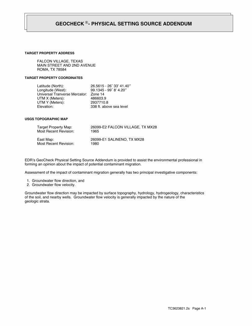
TC3623821.2s Page A-1
geologic strata.of the soil, and nearby wells. Groundwater flow velocity is generally impacted by the nature of theGroundwater flow direction may be impacted by surface topography, hydrology, hydrogeology, characteristics
2. Groundwater flow velocity. 1. Groundwater flow direction, and
Assessment of the impact of contaminant migration generally has two principal investigative components:
forming an opinion about the impact of potential contaminant migration.EDR’s GeoCheck Physical Setting Source Addendum is provided to assist the environmental professional in
1980Most Recent Revision:26099-E1 SALINENO, TX MX28East Map:
1965Most Recent Revision:26099-E2 FALCON VILLAGE, TX MX28Target Property Map:
USGS TOPOGRAPHIC MAP
338 ft. above sea levelElevation:2937710.8UTM Y (Meters): 486603.9UTM X (Meters): Zone 14Universal Tranverse Mercator: 99.1345 - 99˚ 8’ 4.20’’Longitude (West): 26.5615 - 26˚ 33’ 41.40’’Latitude (North):
TARGET PROPERTY COORDINATES
ROMA, TX 78584MAIN STREET AND 2ND AVENUEFALCON VILLAGE, TEXAS
TARGET PROPERTY ADDRESS
®GEOCHECK - PHYSICAL SETTING SOURCE ADDENDUM®

TC3623821.2s Page A-2
should be field verified.on a relative (not an absolute) basis. Relative elevation information between sites of close proximitySource: Topography has been determined from the USGS 7.5’ Digital Elevation Model and should be evaluated
SURROUNDING TOPOGRAPHY: ELEVATION PROFILES
Elev
atio
n (ft
)El
evat
ion
(ft)
TP
TP0 1/2 1 Miles
✩Target Property Elevation: 338 ft.
North South
West East
281
286
300
316
330
334
334
323
330
338
342
332
324
309
324
329
331
343
358301
301
301
301
301
301
301
312
331
338
331
337
334
312
299
284
270
260
266
General WSWGeneral Topographic Gradient:TARGET PROPERTY TOPOGRAPHY
should contamination exist on the target property, what downgradient sites might be impacted.assist the environmental professional in forming an opinion about the impact of nearby contaminated properties or,Surface topography may be indicative of the direction of surficial groundwater flow. This information can be used toTOPOGRAPHIC INFORMATION
collected on nearby properties, and regional groundwater flow information (from deep aquifers).sources of information, such as surface topographic information, hydrologic information, hydrogeologic datausing site-specific well data. If such data is not reasonably ascertainable, it may be necessary to rely on otherGroundwater flow direction for a particular site is best determined by a qualified environmental professionalGROUNDWATER FLOW DIRECTION INFORMATION
®GEOCHECK - PHYSICAL SETTING SOURCE SUMMARY®
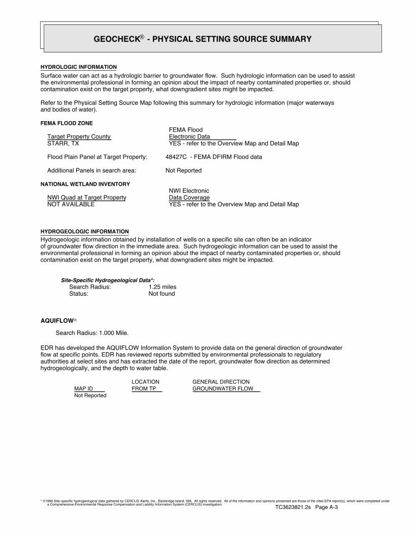
TC3623821.2s Page A-3
Not Reported
GENERAL DIRECTIONLOCATIONGROUNDWATER FLOWFROM TPMAP ID
hydrogeologically, and the depth to water table.authorities at select sites and has extracted the date of the report, groundwater flow direction as determinedflow at specific points. EDR has reviewed reports submitted by environmental professionals to regulatoryEDR has developed the AQUIFLOW Information System to provide data on the general direction of groundwater
AQUIFLOW®
Search Radius: 1.000 Mile.
Not found Status:1.25 miles Search Radius:
Site-Specific Hydrogeological Data*:
* ©1996 Site−specific hydrogeological data gathered by CERCLIS Alerts, Inc., Bainbridge Island, WA. All rights reserved. All of the information and opinions presented are those of the cited EPA report(s), which were completed undera Comprehensive Environmental Response Compensation and Liability Information System (CERCLIS) investigation.
contamination exist on the target property, what downgradient sites might be impacted.environmental professional in forming an opinion about the impact of nearby contaminated properties or, shouldof groundwater flow direction in the immediate area. Such hydrogeologic information can be used to assist theHydrogeologic information obtained by installation of wells on a specific site can often be an indicatorHYDROGEOLOGIC INFORMATION
YES - refer to the Overview Map and Detail MapNOT AVAILABLE
NATIONAL WETLAND INVENTORYNWI ElectronicData CoverageNWI Quad at Target Property
Not ReportedAdditional Panels in search area:
48427C - FEMA DFIRM Flood dataFlood Plain Panel at Target Property:
YES - refer to the Overview Map and Detail MapSTARR, TX
FEMA FLOOD ZONEFEMA FloodElectronic DataTarget Property County
and bodies of water).Refer to the Physical Setting Source Map following this summary for hydrologic information (major waterways
contamination exist on the target property, what downgradient sites might be impacted.the environmental professional in forming an opinion about the impact of nearby contaminated properties or, shouldSurface water can act as a hydrologic barrier to groundwater flow. Such hydrologic information can be used to assistHYDROLOGIC INFORMATION
®GEOCHECK - PHYSICAL SETTING SOURCE SUMMARY®
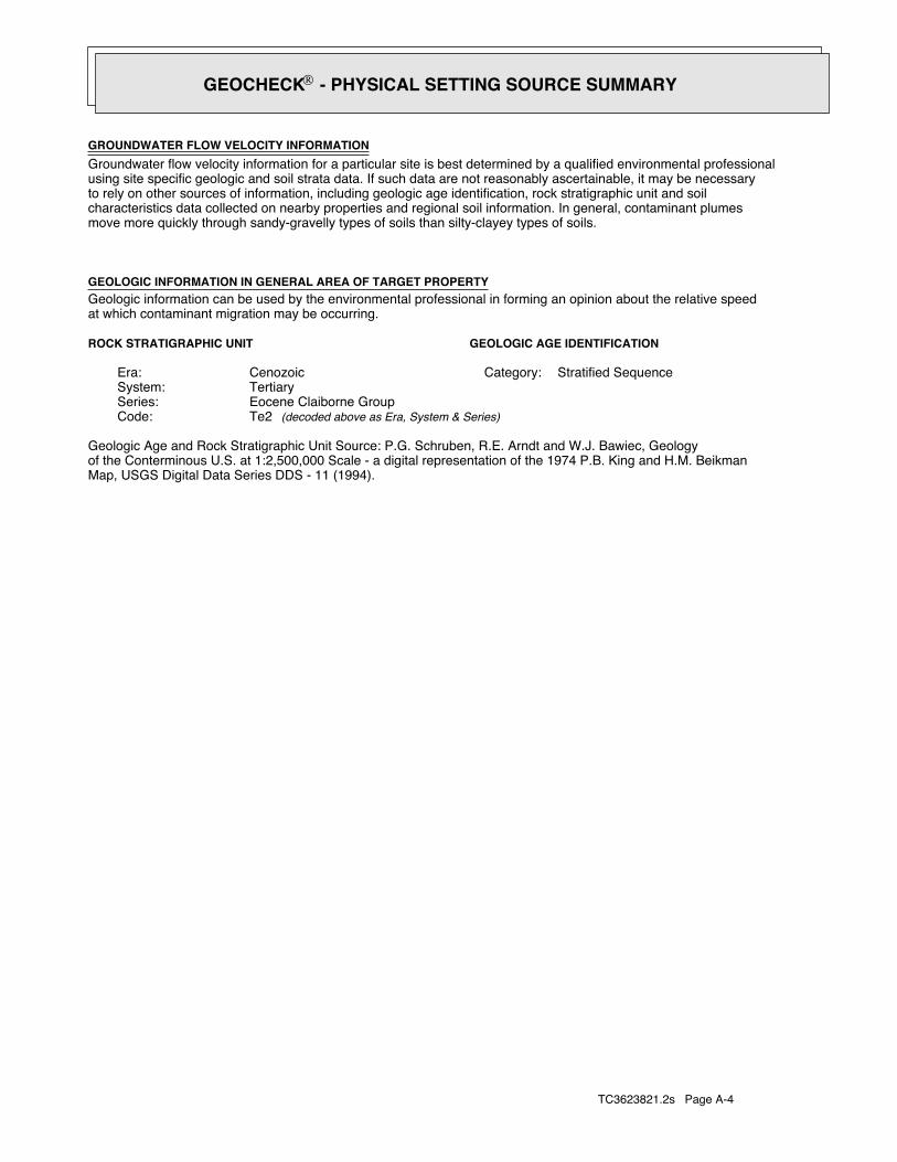
TC3623821.2s Page A-4
Map, USGS Digital Data Series DDS - 11 (1994).of the Conterminous U.S. at 1:2,500,000 Scale - a digital representation of the 1974 P.B. King and H.M. BeikmanGeologic Age and Rock Stratigraphic Unit Source: P.G. Schruben, R.E. Arndt and W.J. Bawiec, Geology
ROCK STRATIGRAPHIC UNIT GEOLOGIC AGE IDENTIFICATION
Stratified SequenceCategory:CenozoicEra:TertiarySystem:Eocene Claiborne GroupSeries:Te2Code: (decoded above as Era, System & Series)
at which contaminant migration may be occurring.Geologic information can be used by the environmental professional in forming an opinion about the relative speedGEOLOGIC INFORMATION IN GENERAL AREA OF TARGET PROPERTY
move more quickly through sandy-gravelly types of soils than silty-clayey types of soils.characteristics data collected on nearby properties and regional soil information. In general, contaminant plumesto rely on other sources of information, including geologic age identification, rock stratigraphic unit and soilusing site specific geologic and soil strata data. If such data are not reasonably ascertainable, it may be necessaryGroundwater flow velocity information for a particular site is best determined by a qualified environmental professionalGROUNDWATER FLOW VELOCITY INFORMATION
®GEOCHECK - PHYSICAL SETTING SOURCE SUMMARY®
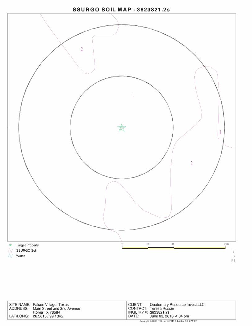
EDR Inc.EDR Inc.EDR Inc.EDR Inc.EDR Inc.EDR Inc.EDR Inc.EDR Inc.EDR Inc.EDR Inc.EDR Inc.EDR Inc.EDR Inc.EDR Inc.EDR Inc.EDR Inc.EDR Inc.EDR Inc.EDR Inc.EDR Inc.EDR Inc.EDR Inc.EDR Inc.EDR Inc.EDR Inc.EDR Inc.EDR Inc.EDR Inc.EDR Inc.EDR Inc.EDR Inc.EDR Inc.EDR Inc.EDR Inc.EDR Inc.EDR Inc.EDR Inc.EDR Inc.EDR Inc.EDR Inc.
1
2
2
1
0 1/16 1/8 1/4 Miles
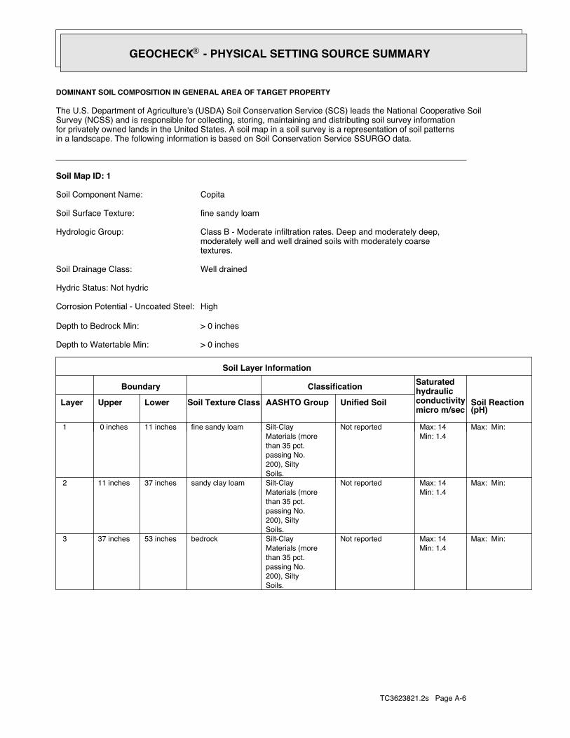
TC3623821.2s Page A-6
Max: Min: Min: 1.4Max: 14 Not reported
Soils.200), Siltypassing No.than 35 pct.Materials (moreSilt-Claybedrock53 inches37 inches 3
Max: Min: Min: 1.4Max: 14 Not reported
Soils.200), Siltypassing No.than 35 pct.Materials (moreSilt-Claysandy clay loam37 inches11 inches 2
Max: Min: Min: 1.4Max: 14 Not reported
Soils.200), Siltypassing No.than 35 pct.Materials (moreSilt-Clayfine sandy loam11 inches 0 inches 1
Soil Layer Information
Boundary Classification Saturatedhydraulicconductivitymicro m/sec
Layer Upper Lower Soil Texture Class AASHTO Group Unified Soil Soil Reaction(pH)
> 0 inchesDepth to Watertable Min:
> 0 inchesDepth to Bedrock Min:
HighCorrosion Potential - Uncoated Steel:
Hydric Status: Not hydric
Well drainedSoil Drainage Class:
textures.moderately well and well drained soils with moderately coarseClass B - Moderate infiltration rates. Deep and moderately deep,Hydrologic Group:
fine sandy loamSoil Surface Texture:
CopitaSoil Component Name:
Soil Map ID: 1
in a landscape. The following information is based on Soil Conservation Service SSURGO data.for privately owned lands in the United States. A soil map in a soil survey is a representation of soil patternsSurvey (NCSS) and is responsible for collecting, storing, maintaining and distributing soil survey informationThe U.S. Department of Agriculture’s (USDA) Soil Conservation Service (SCS) leads the National Cooperative Soil
DOMINANT SOIL COMPOSITION IN GENERAL AREA OF TARGET PROPERTY
®GEOCHECK - PHYSICAL SETTING SOURCE SUMMARY®
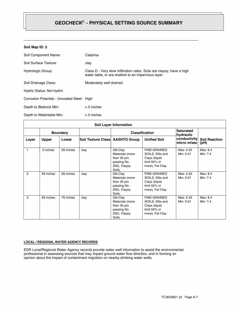
TC3623821.2s Page A-7
opinion about the impact of contaminant migration on nearby drinking water wells.professional in assessing sources that may impact ground water flow direction, and in forming anEDR Local/Regional Water Agency records provide water well information to assist the environmental
LOCAL / REGIONAL WATER AGENCY RECORDS
Min: 7.4Max: 8.4
Min: 0.01Max: 0.42
more), Fat Clay.limit 50% orClays (liquidSOILS, Silts andFINE-GRAINED
Soils.200), Clayeypassing No.than 35 pct.Materials (moreSilt-Clayclay79 inches59 inches 3
Min: 7.4Max: 8.4
Min: 0.01Max: 0.42
more), Fat Clay.limit 50% orClays (liquidSOILS, Silts andFINE-GRAINED
Soils.200), Clayeypassing No.than 35 pct.Materials (moreSilt-Clayclay59 inches29 inches 2
Min: 7.4Max: 8.4
Min: 0.01Max: 0.42
more), Fat Clay.limit 50% orClays (liquidSOILS, Silts andFINE-GRAINED
Soils.200), Clayeypassing No.than 35 pct.Materials (moreSilt-Clayclay29 inches 0 inches 1
Soil Layer Information
Boundary Classification Saturatedhydraulicconductivitymicro m/sec
Layer Upper Lower Soil Texture Class AASHTO Group Unified Soil Soil Reaction(pH)
> 0 inchesDepth to Watertable Min:
> 0 inchesDepth to Bedrock Min:
HighCorrosion Potential - Uncoated Steel:
Hydric Status: Not hydric
Moderately well drainedSoil Drainage Class:
water table, or are shallow to an impervious layer.Class D - Very slow infiltration rates. Soils are clayey, have a highHydrologic Group:
claySoil Surface Texture:
CatarinaSoil Component Name:
Soil Map ID: 2
®GEOCHECK - PHYSICAL SETTING SOURCE SUMMARY®
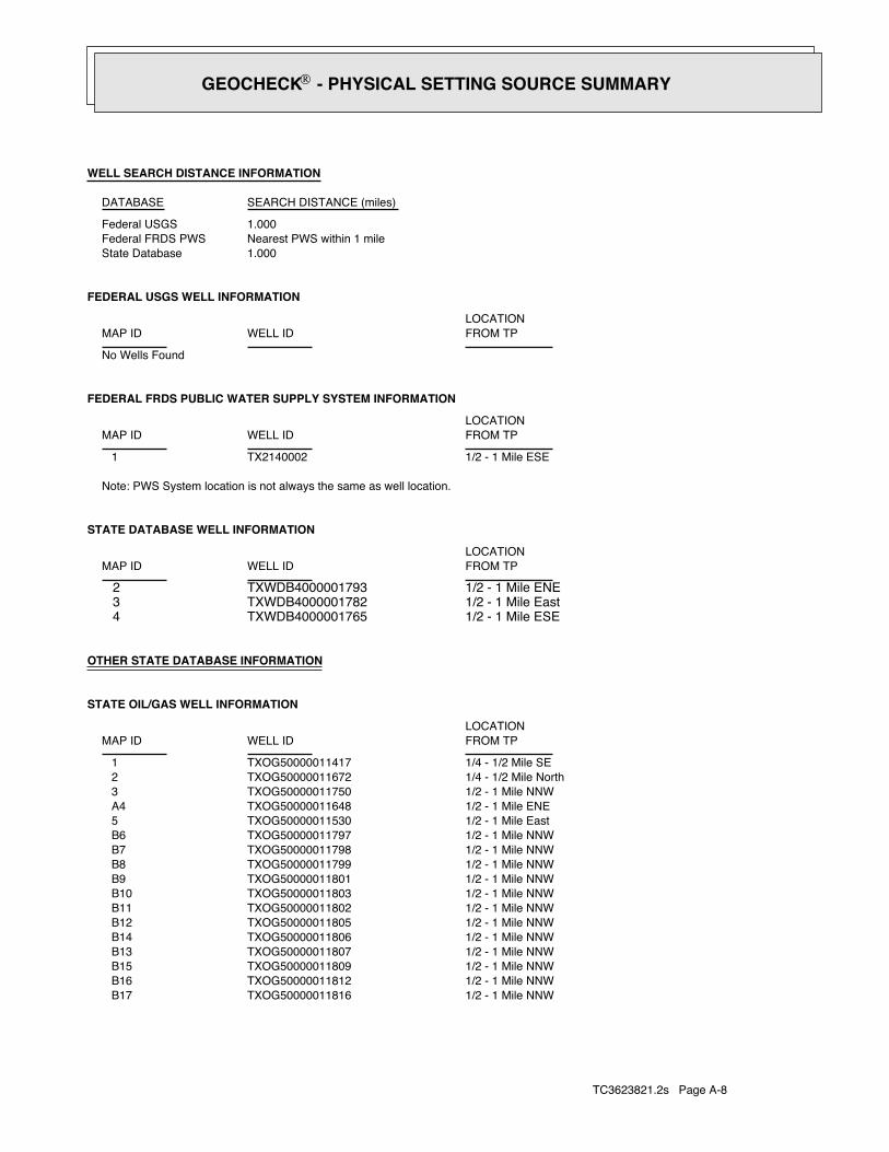
TC3623821.2s Page A-8
1/2 - 1 Mile NNWTXOG50000011816 B171/2 - 1 Mile NNWTXOG50000011812 B161/2 - 1 Mile NNWTXOG50000011809 B151/2 - 1 Mile NNWTXOG50000011807 B131/2 - 1 Mile NNWTXOG50000011806 B141/2 - 1 Mile NNWTXOG50000011805 B121/2 - 1 Mile NNWTXOG50000011802 B111/2 - 1 Mile NNWTXOG50000011803 B101/2 - 1 Mile NNWTXOG50000011801 B91/2 - 1 Mile NNWTXOG50000011799 B81/2 - 1 Mile NNWTXOG50000011798 B71/2 - 1 Mile NNWTXOG50000011797 B61/2 - 1 Mile EastTXOG50000011530 51/2 - 1 Mile ENETXOG50000011648 A41/2 - 1 Mile NNWTXOG50000011750 31/4 - 1/2 Mile NorthTXOG50000011672 21/4 - 1/2 Mile SETXOG50000011417 1
STATE OIL/GAS WELL INFORMATION
LOCATIONFROM TPWELL IDMAP ID
OTHER STATE DATABASE INFORMATION
1/2 - 1 Mile ESETXWDB4000001765 41/2 - 1 Mile EastTXWDB4000001782 31/2 - 1 Mile ENETXWDB4000001793 2
STATE DATABASE WELL INFORMATION
LOCATIONFROM TPWELL IDMAP ID
Note: PWS System location is not always the same as well location.
1/2 - 1 Mile ESETX2140002 1
FEDERAL FRDS PUBLIC WATER SUPPLY SYSTEM INFORMATION
LOCATIONFROM TPWELL IDMAP ID
No Wells Found
FEDERAL USGS WELL INFORMATION
LOCATIONFROM TPWELL IDMAP ID
1.000State DatabaseNearest PWS within 1 mileFederal FRDS PWS1.000Federal USGS
WELL SEARCH DISTANCE INFORMATION
SEARCH DISTANCE (miles)DATABASE
®GEOCHECK - PHYSICAL SETTING SOURCE SUMMARY®

TC3623821.2s Page A-9
1/2 - 1 Mile NETXOG50000011863 331/2 - 1 Mile ESETXOG50000011415 321/2 - 1 Mile ENETXOG50000011695 311/2 - 1 Mile NETXOG50000011792 C301/2 - 1 Mile NETXOG50000011786 C291/2 - 1 Mile NETXOG50000011778 C281/2 - 1 Mile NNWTXOG50000011828 B271/2 - 1 Mile NETXOG50000011668 A261/2 - 1 Mile NNWTXOG50000011822 B251/2 - 1 Mile NNWTXOG50000011821 B241/2 - 1 Mile NNWTXOG50000011818 B231/2 - 1 Mile NNWTXOG50000011811 B221/2 - 1 Mile NNWTXOG50000011819 B211/2 - 1 Mile NNWTXOG50000011815 B201/2 - 1 Mile NNWTXOG50000011817 B191/2 - 1 Mile NNWTXOG50000011813 B18
STATE OIL/GAS WELL INFORMATION
LOCATIONFROM TPWELL IDMAP ID
®GEOCHECK - PHYSICAL SETTING SOURCE SUMMARY®