appendix d: environmental overview and ... studies...forested areas provide habitat for rat snake,...
TRANSCRIPT

APPENDIX D: ENVIRONMENTAL OVERVIEW AND AGENCY
CORRESPONDENCE

Environmental Overview Clinton Study Area/Hickman County
KYTC Item 1–182.00
1
NATURAL ENVIRONMENT BASELINE
Aquatic Ecosystems
Surface Water
The study area for Clinton covers 8,648 acres and is located within the major
water basin Hatchie-Obion. Three smaller watersheds cover the study area;
they are Cane Creek, Bayou de Chien, and Hurricane Branch. Cane Creek
covers nearly all of the northern half of the study area including Clinton.
Bayou de Chien covers the southern half of the study area south of Clinton,
while Hurricane Branch covers a small portion of the study area west of
KY 123 (United States Geological Survey [USGS] 1983).
All streams in the study area flow short distances into tributaries of the
Mississippi River system; the Mississippi River is less than two miles west of
Hickman. Most blueline streams and tributaries flow north in the study area.
However, at least five intermittent blueline streams flow laterally near
downtown Clinton. Creeks and tributaries in the study area are unnamed
with the exception of Cane Creek in the northeast corner and Hurricane
Branch on the western edge of the study area. Cane Creek runs laterally
along a portion of the northeast perimeter of the study area, and Hurricane
Branch runs laterally in the Hurricane Branch watershed on the western edge
of the study area.
Wetlands and Ponds
National Wetland Inventory (NWI) mapping was reviewed for the presence of
wetlands within the project corridor. A total of 115 wetlands spread
throughout the study area were indicated on NWI mapping. A limited site
visit of the study area was conducted April 19, 2002. Wetlands were
observed throughout the study area as indicated on NWI mapping; most
appeared to be farm ponds.

Environmental Overview Clinton Study Area/Hickman County
KYTC Item 1–182.00
2
Of the 115 wetlands, 22 appear to be natural in origin according to wetland
type and therefore may be considered jurisdictional by the US Army Corps of
Engineers (USACE). Most of these natural wetlands are located in the eastern
and southern sections of the study area. The jurisdictional status of 93
wetlands, including 60 ponds that are impounded or diked areas as a result
of farming operations and another 33 wetlands that are the result of mining
activities, would need to be determined in consultation with USACE.
Attachment A includes a summary of the types and members of NWI
wetlands within the study area.
Although NWI mapping indicates wetlands are found throughout the study
area, a few places in the study area demonstrate a higher concentration of
wetlands or sizable wetlands. For example, two large sewage disposal ponds
are located near the northern end of the study area; together they cover
about 17 acres. Another five sizable wetlands are located between KY 123
and KY 58 to the east of Clinton. Three other wetlands of significant size are
located south of the intersection of US 51 and KY 780. These eight wetlands
range in size from approximately one to seven acres. Finally, the largest
wetland in the study area is Bayou de Chien, which is located in the
southeast quadrant of the study area. Bayou de Chien, in the study area, is
actually a complex of 10 interlinked (natural) wetlands found in and adjacent
to the study area. The 10 wetlands cover over 600 acres. Bayou de Chien
covers nearly 4,500 acres in Hickman County.
Hydric soils are also found in the study area and suggest the presence of
other wetlands in the study area. The soil survey for Carlisle and Hickman
Counties, Kentucky (United States Department of Agriculture [USDA] 1997)
shows that 13 hydric soils have been identified within Hickman County. Of
these 13, four potential hydric soils are found within the study area:
Convent-Mhoon silt loams, Routon-Center silt loams (rarely flooded), Mhoon
silt loam, and the most frequent hydric soil in the study area, Convent-Adler

Environmental Overview Clinton Study Area/Hickman County
KYTC Item 1–182.00
3
silt loams. Convent-Mhoon silt loams and Rhouton-Center silt loams are
hydric only in low-lying areas. The low-lying areas within the study
boundaries and with potential for these soils are in the alluvial bottoms
(along creek valleys).
Floodplains
Three 100-year floodplains cover 8.4 percent of the study area (728 acres),
the largest floodplain being the Bayou de Chien (343 acres) (Federal
Emergency Management Agency [FEMA] 1998). This floodplain borders
Bayou de Chien and covers the southeast perimeter of the study area. The
other two floodplains are from unnamed tributaries of Cane Creek, one
covering 287 acres, the other covering 98 acres. The larger floodplain starts
from the northwest quadrant of the study area near the sewage and disposal
ponds south through downtown Clinton parallel to US 51. The smaller
floodplain covers the perimeter of the northeast quadrant of the study area.
Terrestrial Ecosystems
Threatened and Endangered Species
Correspondence with the US Fish and Wildlife Service (USFWS), Kentucky
Department of Fish and Wildlfie Resources (KDFWR) and the Kentucky State
Nature Preserves Commission (KSNPC) along with a review of KDFWR’s
online database indicated 16 species listed as potentially occurring in or near
the study area. These species and their status are shown in Table 1. Copies
of correspondence with agencies are included at the back of this appendix.

Environmental Overview Clinton Study Area/Hickman County
KYTC Item 1–182.00
4
TABLE 1 – THREATENED, ENDANGERED, OR SPECIAL CONCERN SPECIES
Common Name Scientific Name Status
Relict darter Etheostoma chienense Federally endangered, state endangered
Interior least tern Sterna antillarum athalassos Federally endangered, state endangered
Indiana bat Myotis sodalis Federally endangered, state endangered
Pallid sturgeon Scaphirhynchus albus Federally endangered, state endangered
Cypress minnow Hybognathus hayi State endangered Dollar sunfish Lepomis marginatus State endangered Hooded merganser Lophodytes cucullatus State endangered Alabama shad Alosa alabamae State endangered Starhead topminnow
Fundulus dispar State endangered
Bird-voiced treefrog Hyla avivoca Viosca State threatened Cypress darter Etheostoma proeliare State threatened Lake chubsucker Erimyzon sucetta State threatened Blacktail shiner Cyprinella venusta KSNPC special concern Green treefrog Hyla Cinerea KSNPC special concern Southern painted turtle
Chrysemys picta dorsalis KSNPC special concern
Eastern ribbon snake
Thamnophis sauritus sauritus KSNPC special concern
Available habitat indicates whether these 16 species are likely to occur in the
study area. Three species are not likely to be found in the study area; these
are the Alabama shad, pallid sturgeon, and interior least tern, all of which
are associated with the Mississippi River. All other species may occur or have
been known to occur in the study area. These species are usually associated
with one of three types of habitat found within the study area: Bayou de
Chien; streams, ponds, and lakes; and mature forests with nearby streams.
Bayou de Chien is an important habitat for 11 of these species including the
relict darter, bird-voiced treefrog, starhead topminnow, cypress darter,
cypress minnow, dollar sunfish, lake chubsucker, green treefrog, black tail
shiner, southern painted turtle, and the eastern ribbon snake. KSNPC, in fact,

Environmental Overview Clinton Study Area/Hickman County
KYTC Item 1–182.00
5
notes that Bayou de Chien supports the only known relict darter population in
the world.
Other streams, ponds, and lakes found throughout the study area are
important habitats for some of these same species. The black tail shiner,
cypress darter, cypress minnow, dollar sunfish, southern painted turtle, and
eastern ribbon snake find suitable habitat in or near streams, ponds, and
lakes.
Finally, mature forested areas with nearby streams may be suitable as
maternity (summer) Indiana bat habitat and as habitat for the hooded
merganser. Small, scattered blocks of this type of potential habitat occur in a
wedge-shaped block of land from the city limits of Clinton to the study area
boundary on the east. This area has woods on slopes and permanent and
intermittent streams at the bottoms of wooded slopes. Another area of
potential habitat is located just south of Clinton and parallel to the Illinois
Central railroad; this area contains a slope, wooded area with an intermittent
stream.
Floral Communities
Primary plant communities existing in the study area include lawns,
roadsides, croplands (soybean, corn, hayfields, wheat, and milo), pasture,
and wetlands (Kentucky Natural Resources and Environmental Protection
Cabinet [KNREPC]). Such highly disturbed habitats as these areas provide
ideal habitat for weeds, exotics, naturalized and introduced species to thrive.
In addition, one forested area exists in the study area. The forested block is
located near the eastern edge of the study area, south of KY 58 and north of
US 51.
A review of Kentucky’s Big Trees (Kentucky Division of Forestry 1995)
indicated no national or state champion trees within the study area.

Environmental Overview Clinton Study Area/Hickman County
KYTC Item 1–182.00
6
Faunal Communities
Common mammals that are abundant statewide or have large home ranges
are likely to be found in the study area. These include whitetail deer,
opossum, raccoon, skunk, gray and fox squirrel, and chipmunk. Other
species such as the short-tailed shrew and southeastern shrew are likely to
inhabit the forested area of the study area. Southern bog lemming, muskrat,
and swamp rabbit prefer wetland type habitats that are found throughout the
study area.
Wetlands in the study area provide habitat for amphibian species such as
green frog, bullfrog, spotted salamander, smallmouth salamander, and mole
salamander. Midland water snake and yellowbelly water snake will likely be
found in the creeks. The early successional fields (found near croplands) and
forested areas provide habitat for rat snake, kingsnake, black racer, and
several species of lizard. Box turtles are found statewide and would be
expected in the study area. Common birds, such as robin, cardinal, starling,
and mourning dove, are also likely to be found throughout the study area.
Environmental Overview Clinton Study Area/Hickman County
KYTC Item 1–182.00
7
HUMAN ENVIRONMENT BASELINE
Land Use
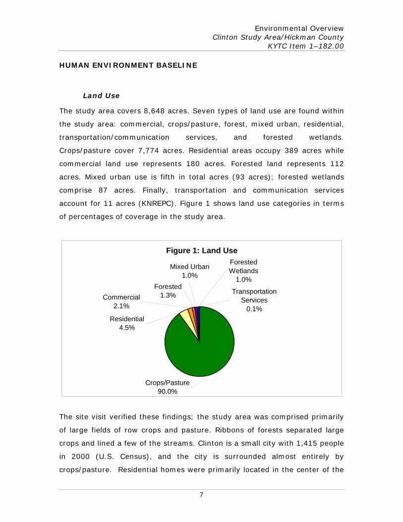
The study area covers 8,648 acres. Seven types of land use are found within
the study area: commercial, crops/pasture, forest, mixed urban, residential,
transportation/communication services, and forested wetlands.
Crops/pasture cover 7,774 acres. Residential areas occupy 389 acres while
commercial land use represents 180 acres. Forested land represents 112
acres. Mixed urban use is fifth in total acres (93 acres); forested wetlands
comprise 87 acres. Finally, transportation and communication services
account for 11 acres (KNREPC). Figure 1 shows land use categories in terms
of percentages of coverage in the study area.
Figure 1: Land Use
Crops/Pasture90.0%
Transportation Services
0.1%
Commercial2.1%
Residential4.5%
Forested Wetlands
1.0%
Mixed Urban1.0%
Forested1.3%
The site visit verified these findings; the study area was comprised primarily
of large fields of row crops and pasture. Ribbons of forests separated large
crops and lined a few of the streams. Clinton is a small city with 1,415 people
in 2000 (U.S. Census), and the city is surrounded almost entirely by
crops/pasture. Residential homes were primarily located in the center of the

Environmental Overview Clinton Study Area/Hickman County
KYTC Item 1–182.00
8
study area, in downtown Clinton (note that much of Clinton is within the
100-year floodplain); however, homes on farms and other rural houses were
seen frequently throughout the study area.
Transportation
Several connecting roadways branch out beyond Clinton. US 51, which
traverses the study area from the north to the southeast, is a rural, principal
arterial roadway. US 51 is a two-lane, undivided “AAA”-rated roadway. Main
east/west routes in the Clinton Study area include KY 58 and KY 123. KY 780
runs north to south for much of the southern section of the study area before
turning east to intersect with US 51 south of Clinton. KY 703 runs northeast
of Clinton. Other roadways to the east of Clinton include local roads Kaler
Road and Carter Road. Roadways to the west of US 51 are KY 1037, KY
1826, KY 1728, Emerson Road, Baker Road, Rash Road, and Farlee Road.
Tracks for the Illinois Central Gulf railroad run north to south across the
Clinton study area. The tracks run in a path similar to that of US 51 for most
of the study area. The tracks are west of US 51 for the entire study area and
run through the western edge of Clinton (USGS 1983).
During the site visit, a grass landing strip was seen running parallel to
KY 780. The airport is the Clinton-Hickman County Airport and is publicly
owned by the two counties. The airport is located two miles south of Clinton.
(AirNav 2002).
Total Population, Minority and Low-Income Populations
For Census 2000, the population of Hickman County was 5,262; Clinton had
a population of 1,415. Population projections for Hickman County anticipate a
decline; 2030 projections show the population at 4,360, a decline of 17.1
percent from 2000.

Environmental Overview Clinton Study Area/Hickman County
KYTC Item 1–182.00
9
The study area, located in Census Tract 9701, has a minority population of
11.8 percent. This percentage is similar or lower than percentages for
Kentucky, Hickman County, and Clinton (9.9, 11.8, and 30.1, respectively).
However, census tract 9701 is the entire county of Hickman and may not
adequately represent the study area. For example, Clinton has a high
number of minorities (30.1 percent) relative to county and state
percentages. In an informal interview with Gregory D. Pruitt, Hickman
County Judge Executive, Mr. Pruitt mentioned a relatively high concentration
of minority populations in the northwest quadrant of Clinton.
As noted, Hickman County contains one census tract, 9701. For this reason,
data in the following table for Census Tract 9701 are the same as data for
Hickman County. The racial composition for the state, town, and census tract
as released for the 2000 Census is shown in Table 2.
TABLE 2 – RACIAL COMPOSITION OF STATE, COUNTY, TOWN, AND
CENSUS TRACT
Kentucky Clinton City Census Tract
9701 One Race:
White 3,640,889 997 4,649 African American 295,994 384 521 Native American 8,616 7 15 Asian 29,744 0 3 Native Pacific Islander 1,460 0 0 Other Race 22,623 0 9
Two or more races 42,443 27 65 Hispanic Origin* 59,939 22 54 Total Minorities** 400,880 418 613 Percent Minority 9.9 30.1 11.8
*Hispanic Origin is not considered a separate race. The number shown is counted twice, once as Hispanic Origin and once as one of the other four racial groups listed above. **This number does not include Hispanic Origin in order to avoid duplication. Source: 2000 U.S. Census
Census 2000 information for income and poverty status is not currently
available. The income and poverty status of the state, county, city, and
census tract 9701 for 1990 are shown in Table 3 (for the 1990 Census,

Environmental Overview Clinton Study Area/Hickman County
KYTC Item 1–182.00
10
Hickman County was divided into two census tracts; the study area was in
census tract 9701).
TABLE 3 – INCOME AND POVERTY STATUS
Persons Below Poverty Level
Region
Median Household
Income
Median Family Income Number Percent
Kentucky $22,534 $27,028 681,827 16.9 Hickman County $20,347 $24,647 1,087 19.5
Clinton $13,672 $18,529 449 29.2
Census Tract 9701 $20,574 $24,600 1,005 20.1 Source: 1990 U.S. Census
Data indicate that low-income populations are more likely in Clinton than for
other portions of the study area. Of the geographic areas, Clinton
demonstrates the greatest levels of poverty at just over 9 percent higher
than the other areas. The census tract is similar to the county and state.
Additional demographic data for the study area are provided in Attachment
B. Tables include those for household types, housing units available,
populations by selected age groups, and commuting patterns.
Local Economy
Hickman County’s unemployment rate was 6.2 percent in 2001. This
percentage is higher than Kentucky and U.S. percentages of 5.5 and 4.8,
respectively, for the same year. The county’s 2001 percentage was up from
its 2000 low of 3.8 percent. The highest unemployment rate for the county
since 1990 was reported in 1996 at 7.3 percent.
Employment by major industry by place of work for Hickman County for the
year 2000 is shown in Table 4.

Environmental Overview Clinton Study Area/Hickman County
KYTC Item 1–182.00
11
TABLE 4 - EMPLOYMENT BY MAJOR INDUSTRY
Hickman County Employment Percent All Industries 1,320 100.0 Agriculture, Forestry & Fishing 10 0.8 Contract Construction 46 3.5 Manufacturing 382 28.9 Transportation and Public Utilities 78 5.9 Wholesale Trade 96 7.3 Retail Trade 139 10.5 Finance, Insurance and Real Estate 66 5.0 Services 234 17.7 State and Local Government 0 0.0 Source: Kentucky Economic Development Information System
The major manufacturers for Clinton as released by the Kentucky Cabinet for
Economic Development for the year 2002 are shown in Table 5.
TABLE 5 - MAJOR MANUFACTURERS
Firm Product(s) Employees Year
Established Cornerstone Building Materials
Hardwood, softwood, veneer, dimension & grade lumber cutting & sawing
6 1938
Dale Machine & Manufacturing
Machine shop: garment cutting presses, precision machining, prototypes; arc, gas, MIG, TIG, heliarc, powder welding; drilling & boring; lathe & mill
6 N/A
Harper's Country Hams Inc
Smoked ham, bacon & sausage
100 1952
Jakel Inc Sub-fractional horsepower motors
150 1989
Lewis Publishing Inc Newspaper publishing 3 1850 Reita's Country Corner Portable wooden buildings 2 1992 Source: Kentucky Economic Development Information System
Communities and Community Facilities
Typical community facilities are located within Clinton, e.g., a courthouse, a
health department, etc. Based on the addresses, ten churches exist in
Clinton; most appear to be located on side streets in Clinton. Beyond the

Environmental Overview Clinton Study Area/Hickman County
KYTC Item 1–182.00
12
town, a limited number of churches were observed scattered throughout the
study area.
Other than the town of Clinton, there are no named subdivisions or
communities in the study area.
Locations of seven community facilities were identified in the study area.
These community facilities and their locations are:
• Clinton County Fairgrounds - 50 US 51 South, • Hickman County Elementary School - 416 McMorris Street, • Hickman County High School - Cresap Street, • Headstart Preschool - 415 East Clay Street, • Draughon’s Junior College - 101 South Washington Street, • Hickman County Library - 209 Mayfield Road, and • Clinton-Hickman County Intermediate Care Facility - 366 South
Washington Street.
Agricultural Activity and Prime and Unique Farmland
As noted under Land Use, agriculture use is predominant throughout the
study area outside of Clinton. Substantial farming operations with significant
on-farm investments are evident throughout the study area and are not
limited to any one portion of the study area.
Data from the 1997 Census of Agriculture also demonstrate the magnitude of
agricultural activities in the county. For example, the average farm in
Hickman County covers 390 acres compared to the state average of 162
acres. Seventeen farms in the county cover between 1,000 and 1,999 acres;
13 farms have more than 2,000 acres each. In 1998, the county ranked 11th
in production of corn for grain, 9th for winter wheat, 8th for sorghum, and 6th
for dark fired tobacco.
The prevalence of agricultural activity in the county and subsequently the
study area may be in part attributable to the availability of fertile soils. In

Environmental Overview Clinton Study Area/Hickman County
KYTC Item 1–182.00
13
Hickman County, over half (58.7 percent or 95,120 acres) of the 161,926
acres are considered prime and unique farmland. Many of these soils fall in
the study area (USDA 1997).
Charles McIntire, Hickman County District Conservationist, indicated one
agricultural district is located partially within the study area boundaries. The
agricultural district is located in the southernmost portion of the study area
along Bayou de Chien and covers approximately 475 acres. Of the total
acres, approximately 275 acres are within the study area boundary.
Undergound Storage Tanks/Hazardous Materials
Environmental Data Resources, Inc. (EDR) was contacted to provide a review
of their environmental databases. Twenty-six environmental databases were
researched covering a 3-mile radius including the project area. The
databases revealed 14 sites, one of which was evidently mapped in an
incorrect location (the city was listed as Covington rather than Clinton).
Sites listed include three from the Resource Conservation and Recovery
Information System (RCRIS) Small Quantity Generators database, three sites
from the Emergency Response Notification System (ERNS), five sites from
the Facility Index System/Facility Identification Initiative Program Summary
Report (FINDS) database, and six from the Underground Storage Tank (UST)
database. Information regarding the remaining 13 sites is summarized on the
next page.

Environmental Overview Clinton Study Area/Hickman County
KYTC Item 1–182.00
14
Site Address Name Database
512 Pecan Drive Pictures and More RCRIS, FINDS
Moore & Short Streets Ashland Petroleum Co. #188-000 RCRIS, FINDS
204 S Jefferson Street J J Cleaners RCRIS, FINDS
374 S Washington Jakel, Inc FINDS
411 Short Street Hickman County Feed Mill FINDS
411 N Jefferson Street* N/A ERNS
411 N Jefferson Street* N/A ERNS
1272 W Broadway Clinton CITGO UST
S Jefferson Street Kentucky Utilities Company Storeroom UST
224 N Washington Street Boaz Service Station (Waycaster) UST
224 N Washington Street Clinton Marathon Station (Clarks Ashland) UST
225 N Washington Street Clinton Jiffy Mart UST
498 Short Street Clinton Bulk Plant UST Note: The ERNS database included the one site incorrectly mapped. *ERNS listings at 411 North Jefferson Street appear to be duplicate entries. National Response Center data indicates only one incident involving a natural gas release due to a pipeline being struck by a lawn mower.
In addition to the 13 sites, 21 unmapped orphan sites with inadequate
address information were listed; of these, seven could be eliminated based
on zip code or listed city. Detailed site reconnaissance will be required to
locate the remaining orphan sites.
A limited site reconnaissance was conducted in conjunction with the social
and economic concerns identification. Three other sites outside the central
portion of Clinton were noted. These include Quick Fix Auto Electric near the
southernmost US 51/KY 780 intersection, Highland Laundry at the
northernmost intersection of US 51 and KY 780, and Ken-Tenn Propane Gas,
Inc. at 450 US 51 North. Other sites outside central portions of Clinton
include hazardous materials potentially related to agricultural activities.
Large-scale farming operations often store fuel and oil on-site.

Environmental Overview Clinton Study Area/Hickman County
KYTC Item 1–182.00
15
REFERENCES
Airnav.com. A Pilots View Into A World of Aviation Information. 1996-2002 Paulo Santos. June 13, 2002. http://www.airnav.com/. Clinton, KY Information.
Burr, B.M. and M.L. Warren. 1986. A Distributional Atlas of Kentucky Fishes.
Kentucky State Nature Preserves Commission. Science and Technology Series #4. Frankfort, Kentucky.
Environmental Data Resources, Inc. (EDR). Bardwell Bypass US 51 Bardwell
KY. Inquiry Number 763485.1s. Federal Emergency Management Agency (FEMA). 1998. National Flood
Insurance Program, Q3 Flood Data Program. Disc 27, Kentucky. Kentucky Department of Education. 2001-2001 Kentucky Schools Directory.
June 2002. http://www.kde.state.ky.us/comm/pubinfo/kentucky_schools_directory/.
Kentucky Department of Fish and Wildlife Resources. Kentucky Fish and
Wildlife Information Systems. May 2002. http://www.kfwis.state.ky.us/
Kentucky Division of Forestry. 1995. Kentucky’s Big Trees. Kentucky
Department for Natural Resources, Frankfort, Kentucky. Kentucky Economic Development Information System. June 2002.
http://www.edc.state.ky.us/kyedc/resandstat.asp. Research and Statistics. Kentucky Cabinet for Economic Development.
Kentucky Hospital Association. Kentucky Hospital Directory. June 2002. http://www.kyha.com/. Kentucky Natural Resources and Environmental Protection Cabinet. May
2002. http://www.nr.state.ky.us/. Kentucky State Nature Preserves Commission. 1999. Endangered,
Threatened Special Concern, and Historic Plants and Animals of Kentucky. Kentucky State Nature Preserves Commission, Frankfort, Kentucky.
McIntire, Charles, Hickman County District Conservationist. Informal
Interview. June 2002.

Environmental Overview Clinton Study Area/Hickman County
KYTC Item 1–182.00
16
Mengel, Robert M. 1965. The Birds of Kentucky. American Ornithologists’ Union. Ornithological Monographs, No. 3. The Allen Press, Lawrence, Kansas.
National Wetland Inventory. Kentucky GIS Office. Pruit, Greg, Hickman County Judge Executive. Informal Interview. June
2002. Slone, T. and T. Wethington. 1998. Kentucky’s Threatened and Endangered
Species. Kentucky Department of Fish and Wildlife Resources, Frankfort, Kentucky.
United States Census Bureau, American Factfinder 1990 and 2000. June
2002. http://www.census.gov. United States Department of Commerce.
United States Department of Agriculture (USDA). 1997. Soil Survey of
Carlisle and Hickman Counties, Kentucky. United States Department of Agriculture (USDA) July 2002. National
Agricultural Statistics Service. 1997 Census of Agriculture. United States Geological Survey. 1983. Cayce, Clinton, Crutchfield, Oakton,
Kentucky Quadrangles, 7.5-Minute Series (Topographic). United States Department of the Interior, U.S. Geological Survey, Washington, D.C.

Environmental Overview Clinton Study Area/ Hickman County
KYTC Item 1–182.0
A-1
ATTACHMENT A – NATIONAL WETLAND INVENTORY WETLANDS
The following table summarizes the types and members of NWI wetlands
within the study area.
TABLE A-1 – NWI WETLANDS IN STUDY AREA
Wetland Type Number of Wetlands
PFO1A 9 POWHh 39 POWHx 28 PUBHx 5 PUBHh 16 PUBFh 3 PEM1Fh 1 PSS1Fh 1 POWH 1 PFO1C 4 PSS1C 1 PEM1F 1
PFO/SS1F 3 PSS/EM1F 1 PFO/EM1C 2
Total Wetlands 115 PFO1A = Palustrine, Forested, Broad-Leaved Deciduous, Temporarily Flooded POWHh = Palustrine, Open Water/Unknown Bottom, Permanently Flooded, Diked/Impounded POWHx = Palustrine, Open Water/ Unknown Bottom, Permanently Flooded, Excavated PUBHx = Palustrine, Unconsolidated Bottom, Permanently Flooded, Excavated PUBHh = Palustrine, Unconsolidated Bottom, Permanently Flooded, Diked/Impounded PUBFh = Palustrine, Unconsolidated Bottom, Semi-Permanently Flooded, Diked/Impounded PEM1Fh = Palustrine, Emergent, Persistent, Semi-Permanently Flooded, Diked/Impounded PSS1Fh = Palustrine, Scrub/Shrub, Broad-Leaved Deciduous, Semi-permanently Flooded, Diked/Impounded POWH = Palustrine, Open Water/ Unknown Bottom, Permanently Flooded PFO1C = Palustrine, Forested, Broad-Leaved Deciduous, Seasonally Flooded PSS1C = Palustrine, Scrub/Shrub, Broad-Leaved Deciduous, Seasonally Flooded PEM1F = Palustrine, Emergent, Persistent, Semi-Permanently Flooded PFO/SS1F = Palustrine, Forested/ Scrub/Shrub, Broad-Leaved Deciduous, Semi-Permanently Flooded PSS/EM1F = Palustrine, Scrub/Shrub/ Emergent, Persistent, Semi-Permanently Flooded PFO/EM1C = Palustrine, Forested/ Emergent, Persistent, Seasonally Flooded

Environmental Overview Clinton Study Area/ Hickman County
KYTC Item 1–182.0
B-1
ATTACHMENT B - DEMOGRAPHIC DATA
Hickman County had one census tract for the 2000 Census. Thus, census
data in tables C-1 through C-3 below are the same as for Hickman County.
The household types for state, town, and census tract as released for the
2000 Census are shown in Table B-1.
TABLE B-1 – HOUSEHOLD TYPES
Percent Total Households Family Households Non-family
Households
Total Married
Female Head, No Husband Total
Householder Living Alone
Kentucky 69.4 53.9 11.8 30.6 26.0 Clinton 61.3 38.9 19.5 38.7 36.1 Census Tract 9701
70.5 56.5 10.8 29.5 27.6
Source: 2000 U.S. Census
The numbers of housing units available for state, town, and census tract are
shown in Table B-2.
TABLE B-2 – HOUSING UNITS AVAILABLE
Percent
Total Housing
Units
Occupied Housing
Units Vacant Units
Vacant – For Sale
Vacant – For Rent
Kentucky 1,750,927 1,590,647 160,280 12.9 27.6
Clinton 668 579 89 20.2 25.8
Census Tract 9701 2,436 2,188 248 12.9 11.7 Source: 2000 U.S. Census

Environmental Overview Clinton Study Area/ Hickman County
KYTC Item 1–182.0
B-2
The population by selected age groups is shown in Table B-3.
TABLE B-3 – POPULATION BY SELECTED AGE GROUPS (2000)
Percent of Total Population
Total
Population Under 18
years 18 to 24
years 25 to 44
years 45 to 64
years 65 years and over
Kentucky 4,041,769 24.6 9.9 30.0 23.0 12.5 Clinton 1,415 22.8 5.8 24.6 21.8 24.9
Census Tract 9701* 5262 22.1 6.9 26.7 25.9 18.5
Source: U.S. Department of Commerce, Bureau of the Census, and Kentucky Cabinet for Economic Development. * Hickman County has one census tract: census tract 9701; data are the same for the county as the tract.
The commuting patterns for Hickman County in 1990 are shown in Table B-4.
TABLE B-4 – COMMUTING PATTERNS (1990)
1990 Percent Residents of Hickman County Working and Residing In County
1,187 54.2
Commuting Out of County 1,002 45.8 Total Residents 2,189 100.0 Employees in Hickman County Working and Residing In County
1,187 65.0
Commuting Into County 640 35.0 Total Employees 1,827 100.0 Source: Kentucky Economic Development Information System


