appendix d - balranald shire council · appendix d: hatfield flora report . ... 6.2.1 vegetation...
TRANSCRIPT
Appendix D: Hatfield Flora Report
Cristal Mining Australia Ltd Hatfield West Gravel Pits Flora Study
Ogyris Pty Ltd 2 April 2017
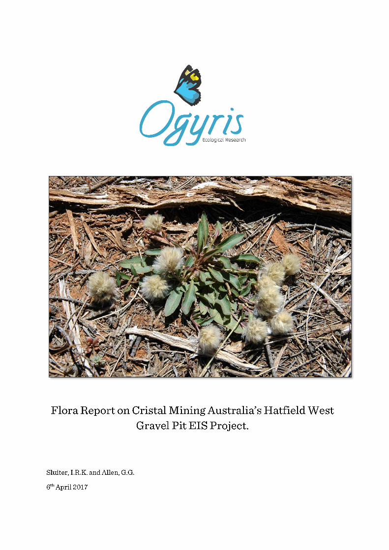
Cover Image: Rabbit-tails (Ptilotus seminudus), an uncommon perennial component of the groundflora
of Belah-Rosewood Woodlands at the Hatfield West Gravel Pit Project Area.
Cristal Mining Australia Ltd Hatfield West Gravel Pits Flora Study
Ogyris Pty Ltd 3 April 2017
Table of Contents
CHAPTER 1 INTRODUCTION AND BACKGROUND ....................................................................... 7
1.1 Context for the Atlas-Campaspe Mine Gravel Pit EIS ................................................................. 7 1.2 Location of the Atlas-Campaspe Gravel Pit EIS Investigation ..................................................... 7 1.3 Compliance with Regulatory Authority Requests ......................................................................... 9
1.3.1 Biodiversity ..................................................................................................................... 9 1.4 Authority to Conduct the Study .................................................................................................. 12 1.5 Definition of Terminology ........................................................................................................... 12
1.5.1 Geographic Terminology .............................................................................................. 12 1.5.2 Abbreviations Used in this Report ................................................................................ 15
1.6 Purpose of this Report ............................................................................................................... 15 1.7 Existing Recent Mineral Sands EIS Flora and Fauna Baseline Studies .................................... 16
1.8 Gravel Extraction in the Murray-Mallee ....................................................................... 16 1.9 Rehabilitation ............................................................................................................................. 18
CHAPTER 2 THE STUDY AREA ..................................................................................................... 20
2.1 Geological Setting ..................................................................................................................... 20 2.2 Hydrology .................................................................................................................................. 21 2.3 Rainfall Temperature and Moisture Balance ............................................................................. 21 2.4 Wind .......................................................................................................................................... 22 2.5 Climate Summary ...................................................................................................................... 23 2.6 The Natural Environment ........................................................................................................... 23
CHAPTER 3 METHODS ................................................................................................................... 24
3.1 Literature Review of Biodiversity Known from the Hatfield West Locality .................................. 24 3.1.1 New South Wales BioNet Database Search ................................................................ 24 3.1.2 EPBC Act Protected Matters Search ............................................................................ 24 3.1.3 Review of Previous Reports ......................................................................................... 24
3.2 Field Assessment ...................................................................................................................... 25 3.2.1 Flora ............................................................................................................................. 25
CHAPTER 4 FLORA OF THE HATFIELD WEST STUDY AREA ................................................... 27
4.1 Flora of the Broader Study Area ................................................................................................ 27 4.2 Hatfield West Vegetation Community Delineation and Mapping................................................ 27
4.2.1 Belah-Rosewood Woodland (LM108) .......................................................................... 32 4.2.2 Chenopod Sandplain Mallee ........................................................................................ 34 4.2.3 Sandhill Pine Woodland .............................................................................................. 34 4.2.4 Yarran Shrubland ......................................................................................................... 36 4.2.5 Pearl Bluebush Shrubland ........................................................................................... 38 4.2.6 Bluebush-Grassland Mosaic ........................................................................................ 39
4.3 Flora of the Hatfield West Study Area ....................................................................................... 40 4.3.1 Indigenous Plant Taxa Recorded from the Hatfield West Study Area .......................... 40 4.3.2 Alien Plant Taxa Recorded from the Hatfield West Study Area ................................... 43 4.3.3 Threatened Plant Taxa of the Hatfield West Study Area and Surrounds ..................... 44 4.3.4 Threatened Plant Communities of the Hatfield West Area and Surrounds ................... 50
CHAPTER 5 FLORA IMPACT ASSESSMENT ............................................................................... 52
5.1 Potential Impacts ....................................................................................................................... 52 5.2 Direct Impacts ............................................................................................................................ 52
5.2.1 Loss of Remnant Vegetation ........................................................................................ 52 5.2.2 Loss of Threatened Species and Plant Communities ................................................... 53
5.3 Indirect Impacts ......................................................................................................................... 60 5.3.1 Edge Effects ................................................................................................................. 60 5.3.2 Weeds .......................................................................................................................... 60 5.3.3 Erosion ......................................................................................................................... 61 5.3.4 Dust .............................................................................................................................. 61 5.3.5 Noise ............................................................................................................................ 61 5.3.6 Loss of Connectivity ..................................................................................................... 61 5.3.7 Fire ............................................................................................................................... 61 5.3.8 Conservation Reserves ................................................................................................ 62
5.4 Cumulative Effects ..................................................................................................................... 62

Cristal Mining Australia Ltd Hatfield West Gravel Pits Flora Study
Ogyris Pty Ltd 4 April 2017
CHAPTER 6 AVOIDANCE MANAGEMENT AND MITIGATION ..................................................... 64
6.1 Project Design ........................................................................................................................... 64 6.1.1 Site Selection ............................................................................................................... 64 6.1.2 Design Considerations ................................................................................................. 64
6.2 Construction .............................................................................................................................. 65 6.2.1 Vegetation Clearance ................................................................................................... 65 6.2.2 Fencing and Signposting .............................................................................................. 66 6.2.3 Pest and Weed Management ....................................................................................... 66
6.3 Operations ................................................................................................................................. 66 6.4 Rehabilitation and Closure ........................................................................................................ 66 6.5 Biodiversity Management Plan .................................................................................................. 67
6.5.1 Threatened Plant Management .................................................................................... 68 6.5.2 Threatened Plant Community Management ................................................................. 68
6.6 Monitoring Mitigation and Management ..................................................................................... 69
CHAPTER 7 BIODIVERSITY OFFSET STRATEGY ....................................................................... 70
7.1 Commonwealth Government Framework for Offset Development ............................................ 70 7.2 NSW Framework for an Offset Development............................................................................. 70 7.3 Quantifying the Offset Required ................................................................................................ 73
CHAPTER 8 CONCLUSIONS .......................................................................................................... 75
Appendix 1 Combined Plant Taxon List From a Search of OEH Plant Records for the Bidura, Paika, Hatfield and Turlee 1: 100,000 Map Sheet Areas. ............................................................... 79
Appendix 2: Assessments of Significance for Impacts on Threatened Flora Species under EP&A Act (Seven Part Tests)............................................................................................................ 91

Cristal Mining Australia Ltd Hatfield West Gravel Pits Flora Study
Ogyris Pty Ltd 5 April 2017
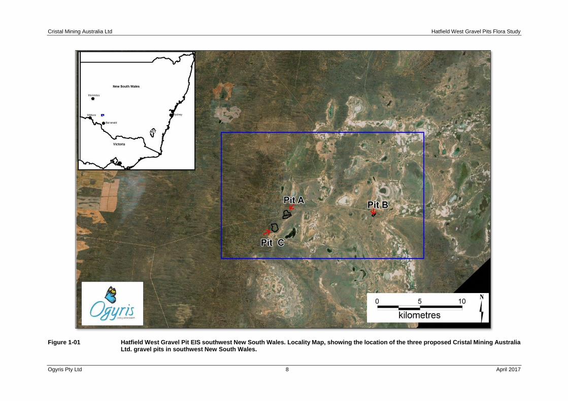
Figure 1-01 Hatfield West Gravel Pit EIS southwest New South Wales. Locality Map, showing the location of the three proposed Cristal Mining Australia Ltd. gravel pits in southwest New South Wales. ...... 8
Figure 1-02: Cristal Mining Australia Ltd. Subject Site for Pits A, B and C at Hatfield West. .......................... 14 Figure 1-03: Location of Cristal Mining Australia’s Atlas and Campaspe ML’s as well as the location of Iluka
Resources proposed Nepean Mine. ........................................................................................... 17 Figure 4-01: Vegetation Map of the Pit A proposed gravel pit location. Five vegetation community types are
present, along with a very small area where gravel has been extracted in the past. .................. 29 Figure 4-02: Vegetation Map of the Pit B proposed gravel pit location. Two vegetation community types are
present, along with an area where gravel has been extracted in the past. The location of a surrounding EEC named Sandhill Pine Woodland has been shown. ......................................... 30
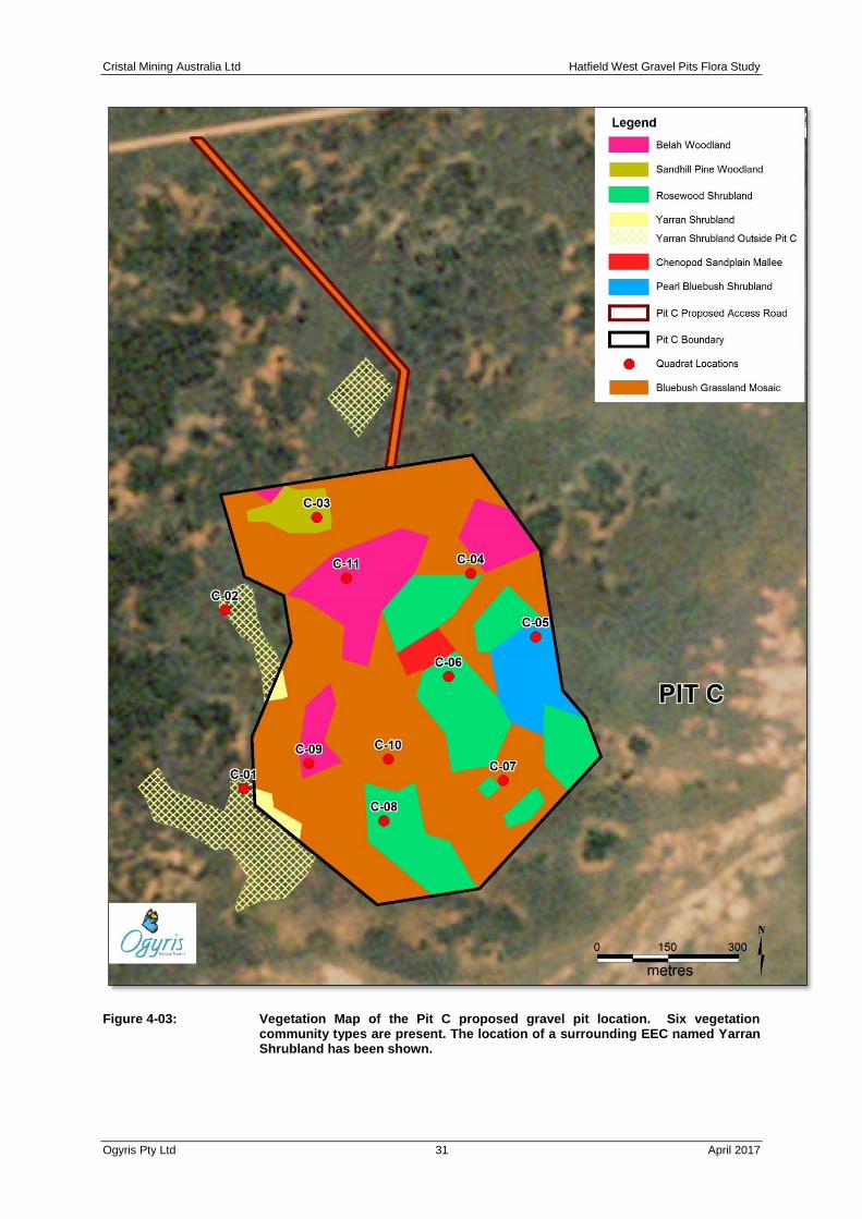
Figure 4-03: Vegetation Map of the Pit C proposed gravel pit location. Six vegetation community types are present. The location of a surrounding EEC named Yarran Shrubland has been shown. .......... 31
Figure 4-04: Map showing the location of the NSW and Australian vulnerable Mossgiel Daisy (Brachyscome papillosa) at Pits A and C and surrounds. .................................................................................. 47
Figure 4-05: Map showing the distribution of the NSW listed endangered ecological plant communities known as Sandhill Pine Woodland and Yarran Shrubland at Pits A and C and surrounds. ................... 51
Cristal Mining Australia Ltd Hatfield West Gravel Pits Flora Study
Ogyris Pty Ltd 6 April 2017
Plate 1-01: A 4wd tractor towing a laser scoop bucket with differential GPS mounted on-board undertaking topsoil stripping at the Ginkgo Mine. These machines have accurate control in soil stripping operations, but care has to be taken to avoid stripping of underlying calcareous subsoil in topsoil stripping operations. ................................................................................................................ 18
Plate 1-02: Topsoil stripping at the Snapper Mine. At this location the ‘white’ of the B horizon carbonate layer can be seen emerging in the middle of the laser-scoop cut at the mapped depth and planned cutting depth of 30cm. ............................................................................................................. 19
Plate 4-01: Belah-Rosewood Woodland at quadrat site C-11, at Pit C on 13th October 2016...................... 33 Plate 4-02: Mono-specific tree stand of Rosewood (Alectryon oleifolius ssp. canescens) at Pit C. This plant
association is considered to be a sub-community of Belah-Rosewood Woodland. ................. 33 Plate 4-03: Chenopod Sandplain Mallee at quadrat site A-04, at Pit A on 28th January 2016. The vegetation
at this site was in moderate condition only with low indigenous plant diversity and a common presence of African Boxthorn (Lycium ferocissimum). ............................................................ 34
Plate 4-04: Sandhill Pine Woodland at quadrat site C-03 within the Pit C gravel pit Subject Site. A Wedge-tailed Eagle (Aquila audax) nest appears in the crown of the large tree at right of the photograph. ................................................................................................................................................ 35
Plate 4-05: Yarran (Acacia melvillei) Shrubland at quadrat site C-01. This site was just outside the Pit C Subject Site, but the plant community extends to the east or left hand side of the photograph to be present within the Subject Site as well. The shrub layer is dominated by Black Bluebush (Maireana pyramidata) with a diverse herbaceous component as well. .................................. 37
Plate 4-06: Pearl Bluebush Shrubland at quadrat site C-05 within the Pit C Subject Site on 12th October 2016. ................................................................................................................................................ 38
Plate 4-07: Bluebush-Grassland Mosaic at quadrat site A-12 – showing an example of this plant community with the higher end of near 10% shrub cover of Black Bluebush. ............................................ 39
Plate 4-08: Bluebush-Grassland Mosaic at quadrat site C-10 – showing an example of this plant community with the lower end of 0% shrub cover of Black Bluebush. ....................................................... 40
Plate 4-08: Mossgiel Daisy (Brachyscome papillosa) flowers showing the white ray florets. ....................... 46 Plate 4-09: Mossgiel Daisy has distinctive pinnatisect leaf with flowers held singularly on an extended
peduncle. ................................................................................................................................. 46 Plate 4-11: Mossgiel Daisy location in Belah-Rosewood Woodland, just north of the Wampo-Langleydale
Road in Pit A. .......................................................................................................................... 48 Plate 4-12: Mossgiel Daisy location in Yarran Shrubland, south of the Wampo-Langleydale Road at quadrat
site C-02, immediately west of Pit C. ....................................................................................... 48 Plate 4-13: Mossgiel Daisy at the Langleydale-Magenta Road section of the Atlas-Campaspe MCTR on the
28th October 2016. At this location, plant densities were more than 50 plants per m². The population location is considered to be a meta-population in optimal habitat for the species. . 49

Cristal Mining Australia Ltd Hatfield West Gravel Pits Flora Study
Ogyris Pty Ltd 7 April 2017
CHAPTER 1 INTRODUCTION AND BACKGROUND
1.1 Context for the Atlas-Campaspe Mine Gravel Pit EIS
In 2013, Cristal Mining Australia Ltd., hereon referred to as Cristal Mining, submitted an EIS proposal to the Government of New South Wales concerning the establishment of two mineral sands mines named Atlas and Campaspe at a location approximately 75 km north-north-west of Balranald in the states southwest. Cristal Mining’s Atlas-Campaspe EIS addressed a suite of environmental and socio-economic factors requested by the New South Wales Government. In 2014, with Commonwealth Government Dept. of Environment approvals given pertinent to Environment Protection and Biodiversity Conservation Act 1999, the New South Wales Government, after a period of exhibition, receipt of submissions, responses to submissions, and subsequent assessment, Cristal Mining were notified through an affirmative determination from the Dept. of Planning and Environment (DPE), that the Atlas-Campaspe Project could proceed.
The Atlas-Campaspe Project failed to provide for the need to upgrade and maintain the road alignment identified for transport of the mineral concentrate to the Balranald-Ivanhoe Road. The road route identified, hereon referred to as the Mineral Concentrate Transport Route or MCTR, incorporating part of the existing road network, as well as two new sections of alignment, apart from one small sealed section, will be constructed from calcrete gravel. All sections of the alignment, old and new, would need to be substantially wider than the existing road width in order to cater for the large haul trucks that would ultimately use the road. It is estimated that approximately 800,000 tonnes of calcrete road-base will need to be used to maintain the MCTR over the 25-30 year life of the Atlas-Campaspe Mines.
On the 20th November 2015, the New South Wales Office of Environment and Heritage (OEH), responding to a DPE request, provided EIS requirements to Cristal Mining for an investigation concerning “Atlas-Campaspe Mine Gravel Pits”. This report addresses the DPE Secretary’s Environmental Assessment Requirements or SEAR’s as they pertain to the flora and fauna of the gravel pit sites identified.
1.2 Location of the Atlas-Campaspe Gravel Pit EIS Investigation
Three potential gravel pit sites have been identified for investigation as part of this study. The three sites are all situated in the Hatfield West Locality of southwest New South Wales (see Figure 1-01). They include:
1. Site A on Iona Station on the Wampo-Langleydale Road, approximately 3 km east of the Atlas-Campaspe ML boundary;
2. Site B on Langleydale Station on the Langleydale-Balranald Road, 1 km west of the intersection with the Langleydale-Magenta Road; and
3. Site C on Iona Station south of the Wampo-Langleydale Road, approximately 3.5 km east of the Atlas-Campaspe ML boundary.
Cristal Mining Australia Ltd Hatfield West Gravel Pits Flora Study
Ogyris Pty Ltd 8 April 2017
Figure 1-01 Hatfield West Gravel Pit EIS southwest New South Wales. Locality Map, showing the location of the three proposed Cristal Mining Australia Ltd. gravel pits in southwest New South Wales.
Cristal Mining Australia Ltd Hatfield West Gravel Pits Flora Study
Ogyris Pty Ltd 9 April 2017
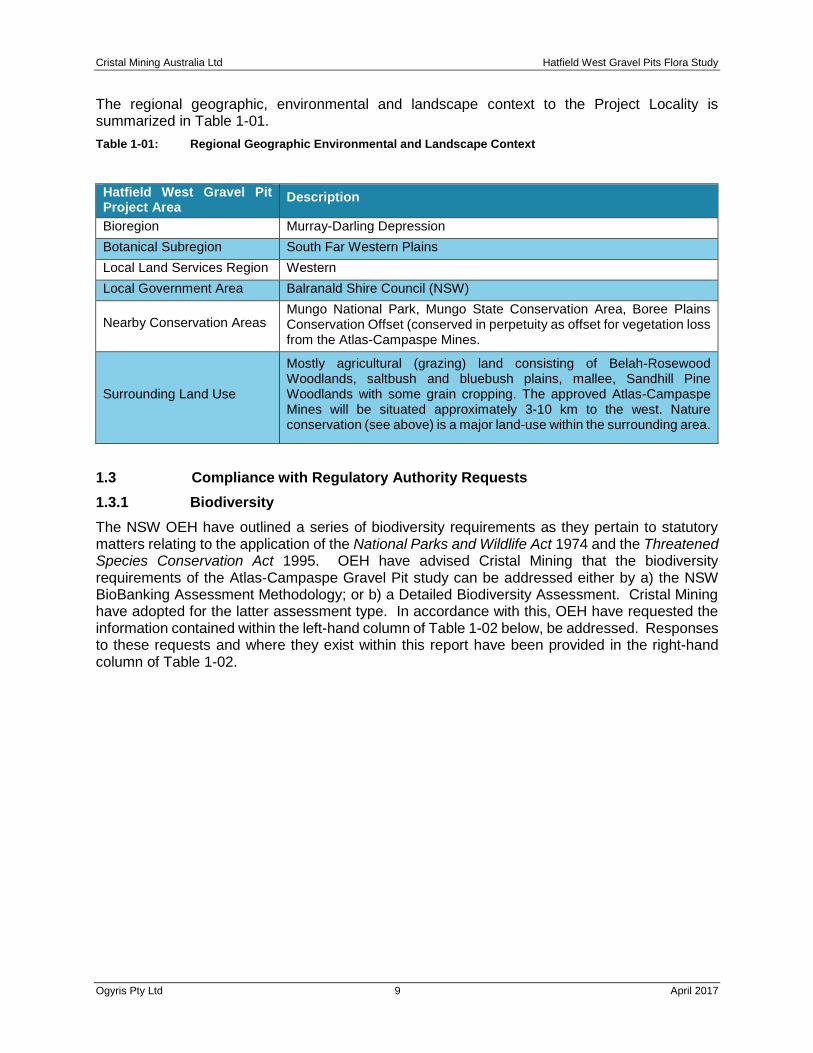
The regional geographic, environmental and landscape context to the Project Locality is summarized in Table 1-01.
Table 1-01: Regional Geographic Environmental and Landscape Context
Hatfield West Gravel Pit Project Area
Description
Bioregion Murray-Darling Depression
Botanical Subregion South Far Western Plains
Local Land Services Region Western
Local Government Area Balranald Shire Council (NSW)
Nearby Conservation Areas Mungo National Park, Mungo State Conservation Area, Boree Plains Conservation Offset (conserved in perpetuity as offset for vegetation loss from the Atlas-Campaspe Mines.
Surrounding Land Use
Mostly agricultural (grazing) land consisting of Belah-Rosewood Woodlands, saltbush and bluebush plains, mallee, Sandhill Pine Woodlands with some grain cropping. The approved Atlas-Campaspe Mines will be situated approximately 3-10 km to the west. Nature conservation (see above) is a major land-use within the surrounding area.
1.3 Compliance with Regulatory Authority Requests
1.3.1 Biodiversity
The NSW OEH have outlined a series of biodiversity requirements as they pertain to statutory matters relating to the application of the National Parks and Wildlife Act 1974 and the Threatened Species Conservation Act 1995. OEH have advised Cristal Mining that the biodiversity requirements of the Atlas-Campaspe Gravel Pit study can be addressed either by a) the NSW BioBanking Assessment Methodology; or b) a Detailed Biodiversity Assessment. Cristal Mining have adopted for the latter assessment type. In accordance with this, OEH have requested the information contained within the left-hand column of Table 1-02 below, be addressed. Responses to these requests and where they exist within this report have been provided in the right-hand column of Table 1-02.

Cristal Mining Australia Ltd Hatfield West Gravel Pits Flora Study
Ogyris Pty Ltd 10 April 2017
Table 1.02: Statement of Compliance with OEH Requests Pertaining to Biodiversity and Rehabilitation.
OEH Biodiversity and Rehabilitation Requests of Cristal Mining Pertaining to the Gravel Pit EIS Investigation.
Responses to the OEH Requests and Where they can be Found in this Report (where required).
Request 1 - Biodiversity Mapping and Description
Request 1A - Geo-referenced mapping of spatial data and sites within the Study Area.
Response 1A - All mapping and site description geo-referenced using UTM coordinates in Map Datum GDA94, Zone 54.
Request 1B - Vegetation mapping, survey locations at an appropriate scale. Response 1B - Mapping and survey conducted at an appropriate scale (see Section 4.2).
Request 1C - Vegetation plant communities aligned with NSW Plant Community Database through VIS Classification (including methodology used to classify).
Response 1C - NSW Plant Community Database/VIS Classification utilized, steps enunciated, informed by Benson et a. 2006 plant community descriptions (see Section 4.2).
Request 1D - key habitat features described. Response 1D - vegetation structure and habitat database provided (see Section 4.2).
Request 1E - threatened species, populations and endangered ecological communities present in the Subject Site and Study Area provided as separate spatial (ESRI .shp format files).
Response 1E - All mapping of Subject Site and Study Area threatened species or communities provided as separate ESRI shape files in dedicated appendix.
Request 1F - all report project files (project site, impact footprint, vegetation mapping/classification, offset delineation provided as ESRI shape files. Project metadata provided to OEH.
Response 1F - all project files and metadata provided in a dedicated appendix of this report.
Request 2 - Description of Survey Methodology
Request 2A - Description of survey methodologies used. Response 2A - provided in methods part of Chapter 3 (Section 3.1).
Request 2B - Survey effort aligned with "Guidelines for Developments and Activities - Working Draft (DEC 2004).
Response 2B - provided in methods part of Chapter 3 (Section 3.1).
Request 3 - Vegetation Community Description and Data-basing
Request 3A - Detailed description of vegetation communities (including classification method)
Response 3A - Vegetation mapping methodology outlined in Section 3.1
Request 3B - plot data entered to Vegetation Information System (VIS) via BioNet
Request 3B - plot data entered to BioNet (as per scientific license requirements)

Cristal Mining Australia Ltd Hatfield West Gravel Pits Flora Study
Ogyris Pty Ltd 11 April 2017
Request 4 - Provide Details of Qualifications and Experience
Request 4 - Provide Details of Qualifications and Experience Response 4 - Provided in Section 1.3.
Request 5 - Identify National and State Listed Threatened Biota
Request 5 - Identify National and State Listed Threatened Biota Response 5 - Outlined in Chapters 4 and 5.
Request 6 - Description of Biodiversity and Wildlife Corridor Impacts
Request 6 - Description of Biodiversity and Wildlife Corridor Impacts Response 6 - The impacts to biodiversity and wildlife corridors, direct and indirect, are outlined for flora and fauna in Chapters 4 and 5 respectively.
Request 7 - Identify how the Project Avoids and Minimizes Impacts
Request 7 - Identify how the Project Avoids and Minimizes Impacts Response 7 - The basic mantra of avoidance, minimization and measurement of impact is addressed throughout the report.
Request 8 - Describe the Residual Impacts of the Proposal.
Request 8A - Describe the Residual Impacts of the Proposal. Response 8A - Physical impacts of designated gravel pits described in Chapter 4.
Request 8B - Outline Intent to Offset if Impact to Biodiversity Cannot be Avoided
Response 8B - Offset is deemed to be required, and has been done in accordance with OEH Principle’s for Biodiversity Offsetting.
Request 9 - Undertake an Assessment of Significance
Request 9A - An "Assessment of Significance", including direct and indirect impacts must be undertaken taking into account the Environmental Planning and Assessment Act 1979.
Response 9A - Undertaken in the Main Report of the EIS.
Request 9B - An "Assessment of Significance", including direct and indirect impacts must be undertaken taking into account the DECCW (2007) "Threatened Species Assessment Guideline - The Assessment of Significance".
Response 9B - Undertaken in Chapters 4 and 5.
Request 10 - Provide Offset Provisions
Request 10 - Provide Offset Provisions Response 10 - see Response 8B above. This will be done as per OEH principles and guidelines, but is not part of this report.

Cristal Mining Australia Ltd Hatfield West Gravel Pits Flora Study
Ogyris Pty Ltd 12 April 2017
1.4 Authority to Conduct the Study
The Principal Investigator and primary author of this report is Dr. Ian Sluiter from Ogyris Ecological Research. Dr. Sluiter was assisted in the field and with office based activities including database searches, compilation of existing information, mapping and report writing by Ogyris P/L staff Heather Sluiter, Karin Sluiter and Geoffrey Allen. Ian Sluiter, Karin Sluiter and Geoffrey Allen work on ecological projects in New South Wales pursuant to OEH National Parks and Wildlife Scientific Licence Number SL101035.
1.5 Definition of Terminology
1.5.1 Geographic Terminology
Consistent descriptions and assessments of the land to be directly or indirectly affected by the development require boundaries to be defined. Definitions for a number of geographic terms including Region, Locality, Study Area and Subject Site – all of which have been adopted for use in this study, are outlined in turn below.
Region
There have been various attempts over the years to define the notion of what constitutes a ‘region’ in south-western New South Wales. Several authors have attempted to categorize the area into ‘regions’ based on criteria such as geology, geomorphology and vegetation – often with differing degrees of weighting. Published ‘regions’ of relevance to biological studies which have encompassed the Hatfield West study area include:
• ‘Murray Lowlands Province’ - Jennings and Mabbutt (1977); modified by Wasson (1989) and termed ‘Mallee Dunefields’. An area characterised by “fixed east-west longitudinal and parabolic dunes; lakes, pans with lunettes.”
• ‘Murray Mallee Region’ - Noble and Mulham (1980). Based on the fact that the aeolian landform dominated area lies north and south of the Murray River between Swan Hill and Murray Bridge and is dominated by Mallee vegetation.
• ‘Western New South Wales’ - Pressey (1990). A regional assessment of rare or threatened flora in Western New South Wales.
• ‘South Far Western Plains’ - Harden (1990). A botanical subdivision used in the Flora of New South Wales (Harden 1990).
• ‘Murray Basin Sands’ Sub-Region - Morgan and Terrey (1992). Giving priority to the fact that the area lies mostly to the west of Willandra Lakes - a relict river system of narrow channels, large lakes and fringing lunettes - and is dominated by sandplains and dunefields that appear to have been influenced by the Darling River.
• ‘Murray Darling Depression’ Interim Biogeographic Regionalisation for Australia (IBRA) region - Thackway and Cresswell (1995); and revised by Environment Australia (2000). IBRA bioregions represent a landscape based approach to classifying the land surface as the basis for understanding and explaining ecological patterns and processes which in turn are responsible for driving the observed patterns of biodiversity. Specialist ecological knowledge, combined with regional and continental scale data on climate, geomorphology, landform, lithology and characteristic flora and fauna were interpreted to describe these patterns. The Murray Darling Depression IBRA region is an extensive gently undulating sand and clay plain of Tertiary and Quaternary age frequently overlain by aeolian dunes;

Cristal Mining Australia Ltd Hatfield West Gravel Pits Flora Study
Ogyris Pty Ltd 13 April 2017
vegetation consists of semi-arid woodlands of Black Oak/Belah, Bullock Bush/Rosewood and Acacia spp., mallee shrublands and heathlands and savanna woodlands (Environment Australia 2000).
• ‘Southern Mallee Region’ - DLWC (2000); Mazzer et al. (1998); Val et al. (2000). A region recognised by former New South Wales Government Departments (DLWC and NPWS), which has been utilized for the purposes of assessment of vegetation clearance applications and regional biological studies by DLWC and NPWS.
The comprehensive definition of biogeographic regions within the IBRA system (Thackway and Cresswell 1995; Environment Australia 2000) is considered to be one of the more ecologically meaningful ways of recognising natural regions in which to assess ecological processes across Australia. Use of the IBRA bioregions has been enshrined within the NSW Environmental Planning and Assessment Act 1979, as the geographic basis within which ecological values should be assessed.
Consequently, the IBRA Murray-Darling Depression Bioregion is considered the broad ‘Region’ within the context of which the relative importance of those ecological values recognised during the Hatfield West gravel site study should be examined. The Murray-Darling Depression Bioregion in NSW is extensive, covering some 84,396 km2, with a further 47,103 km2 and 65,981 km2 occurring in adjacent parts of South Australia and Victoria respectively.
Locality
A Locality refers to the area within approximately a 20 km radius of the Study Area. In this study, the Locality as defined, would cover parts of four 1:100,000 Map Sheet areas. In essence, however, the project locality is primarily located on the Turlee (7530) and Hatfield (7630) 1:100,000 Map Sheet areas. The Locality of the project is shown in Figure 1-01.
Subject Site and Study Area
A Subject Site means “the area which is proposed for development/activity”, delineated for purposes of this study as the area of direct disturbance caused by gravel extraction activities including pit site and ancillary facilities (primary crusher, gravel screening plants, materials stockpiles, water dams and gravel pit internal access roads). The Study Area is “the Subject Site” and any additional areas that are likely to be affected by the proposal, either directly or indirectly”.
The areas of disturbance of the Subject Site are: Site A = 53.24 Ha Site B = 5.25 Ha Site C = 54.16 Ha The combined area of disturbance of the Subject Site is 113.41 Ha.
The Subject Site for each of the three gravel pits and their geographic position in relation to each other is shown in Figure 1-02.

Cristal Mining Australia Ltd Hatfield West Gravel Pits Flora Study
Ogyris Pty Ltd 14 April 2017
Figure 1-02: Cristal Mining Australia Ltd. Subject Site for Pits A, B and C at Hatfield West.
Cristal Mining Australia Ltd Hatfield West Gravel Pits Flora Study
Ogyris Pty Ltd 15 April 2017
1.5.2 Abbreviations Used in this Report
A number of acronyms and terms have been used in this report. These are explained below, but in the main, these follow the same definitions as outlined in the Atlas-Campaspe EIS Report.
Atlas-Campaspe Gravel Pit Study Area – this includes the three areas provided to the survey team as potential gravel source sites within close proximity to the designated Atlas-Campaspe Mineral Concentrate Transport Route (MCTR).
Atlas-Campaspe Gravel Pit Footprint – the extent of proposed surface development associated with gravel pit construction, including any access roads.
Balranald SC – Balranald Shire Council
Centroid of Study Area – the geographic location marking the centroid point between proposed Gravel Pit Site A, B and C.
Clearing – the destruction of remnant vegetation resulting in complete loss of all layers of vegetation.
Cristal – refers to the mining company Cristal Mining Australia Ltd.
Pit A – the physical location of proposed Gravel Pit A on the Wampo-Langleydale Road, at Iona Station, approximately 3 km east of the Atlas-Campaspe ML boundary.
Pit B– the physical location of proposed Gravel Pit B on the Langleydale-Balranald Road, 1 km west of the intersection with Magenta Road.
Pit C– the physical location of proposed Gravel Pit C south of the Wampo-Langleydale Road, approximately 3.5 km east of the Atlas-Campaspe ML boundary.
Subject Site – the combined area which is proposed for development/activity at Pits A, B and C.
1.6 Purpose of this Report
Ogyris Ecological Research has been commissioned by Cristal to undertake a biodiversity flora assessment for the Atlas-Campaspe Gravel Pit Project. The assessment has been carried out accordance with the SEARs outlined in Table 1-02 (Section 1.3) and controlling provisions for the EPBC Act.
The primary objective of this report is to describe and assess the flora baseline values within the project area and surrounds and determine whether the Hatfield West Gravel Pit Project is likely to have a significant impact on threatened flora listed on the NSW TSC Act and Commonwealth EPBC Act. The report also defines mitigation and offset measures that will reduce and manage ecological impacts from the Hatfield West Gravel Pit Project. The approach adopted in this assessment includes the following:
1. Undertake a background review of relevant literature, mapping and databases. 2. Conduct a flora field survey using recognised methods to assess the ecological
values of the site. 3. Describe the ecological values of the site in regard to flora and vegetation
communities. 4. Describe the potential flora impacts of the Hatfield West Gravel Pit Project 5. Assess impacts of the Atlas-Campaspe Gravel Pit Project on threatened flora as listed
on the TSC Act and EPBC Act. 6. Outline mitigation measures to reduce ecological impacts.

Cristal Mining Australia Ltd Hatfield West Gravel Pits Flora Study
Ogyris Pty Ltd 16 April 2017
1.7 Existing Recent Mineral Sands EIS Flora and Fauna Baseline Studies
The Atlas-Campaspe EIS (Resource Strategies 2013) included a major baseline assessment of the flora and fauna values (AMBS 2013) of land approximately 4 km west of Pits A and C. This report provides the primary background biodiversity information from the Atlas-Campaspe Project seen as relevant to this study. Some information has also been taken from the draft EIS from the Iluka Resources Ltd. Balranald Mineral Sands Project (NEH 2016). The proposed Nepean Mine component of the Balranald Mineral Sands Project is situated approximately 9 km southwest of Pits A and C and some information from that EIS is relevant to this study. The location of the proposed Hatfield West gravel pits in relation to the nearby Atlas-Campaspe ML’s and the proposed Nepean Mine is shown in Figure 1-03.
1.8 Gravel Extraction in the Murray-Mallee
Gravel used for road construction in the Murray-Mallee Region of southeastern Australia is typically the B-horizon carbonate layer existing below the reddish-brown surface topsoil layer known as the Woorinen Formation (Lawrence 1966). The carbonate type used varies by location, often depending on what resource is actually available. Topsoil has been traditionally pushed to the extremities of pits, the gravel extracted with front-end loaders and the pit left to rehabilitate through natural means. This has led to substantial areas being left with virtually no active rehabilitation undertaken.
In December 2015, the New South Wales Government (DPI 2015) recognized this problem and produced a Fact Sheet titled “Crown Land Extractive Industry Licence in the Western Division” which outlines a new and detailed process for obtaining permission to extract gravel from Crown Land in the west of the state. The extractive Industry Licence is issued pursuant to provisions of the Western Lands Act 1901 and the Crown Lands Act 1989, but in all circumstances, there is a requirement to produce either a Statement of Environmental Effects or in some cases, an Environmental Impact Statement. In the case of the Hatfield-West Gravel Pits, DPI have requested that an EIS be produced and submitted to the Balranald SC, which must be accompanied by an Environmental Management and Rehabilitation Plan.
Cristal Mining have identified a number of areas adjacent or nearby to the Atlas-Campaspe MCTR areas where sheet calcrete or the Bakara Pedoderm exists close to the surface. It is these sites (Pits A, B and C) as defined in Section 1.2 where the Extractive Industry Licence will be sought. Unlike many past gravel pit extraction sites, Cristal plan to fully rehabilitate the gravel pits after extraction of the gravel required. The rehabilitation sequence is explained conceptually below.

Cristal Mining Australia Ltd Hatfield West Gravel Pits Flora Study
Ogyris Pty Ltd 17 April 2017
Figure 1-03: Location of Cristal Mining Australia’s Atlas and Campaspe ML’s as well as the location of Iluka Resources proposed Nepean Mine.
Cristal Mining Australia Ltd Hatfield West Gravel Pits Flora Study
Ogyris Pty Ltd 18 April 2017
1.9 Rehabilitation
Rehabilitation of any site approved for gravel extraction will occur with the same processes as currently occur at existing mine sites operated by Cristal Mining within the Pooncarie West Mining Precinct where the Ginkgo and Snapper Mines exist.
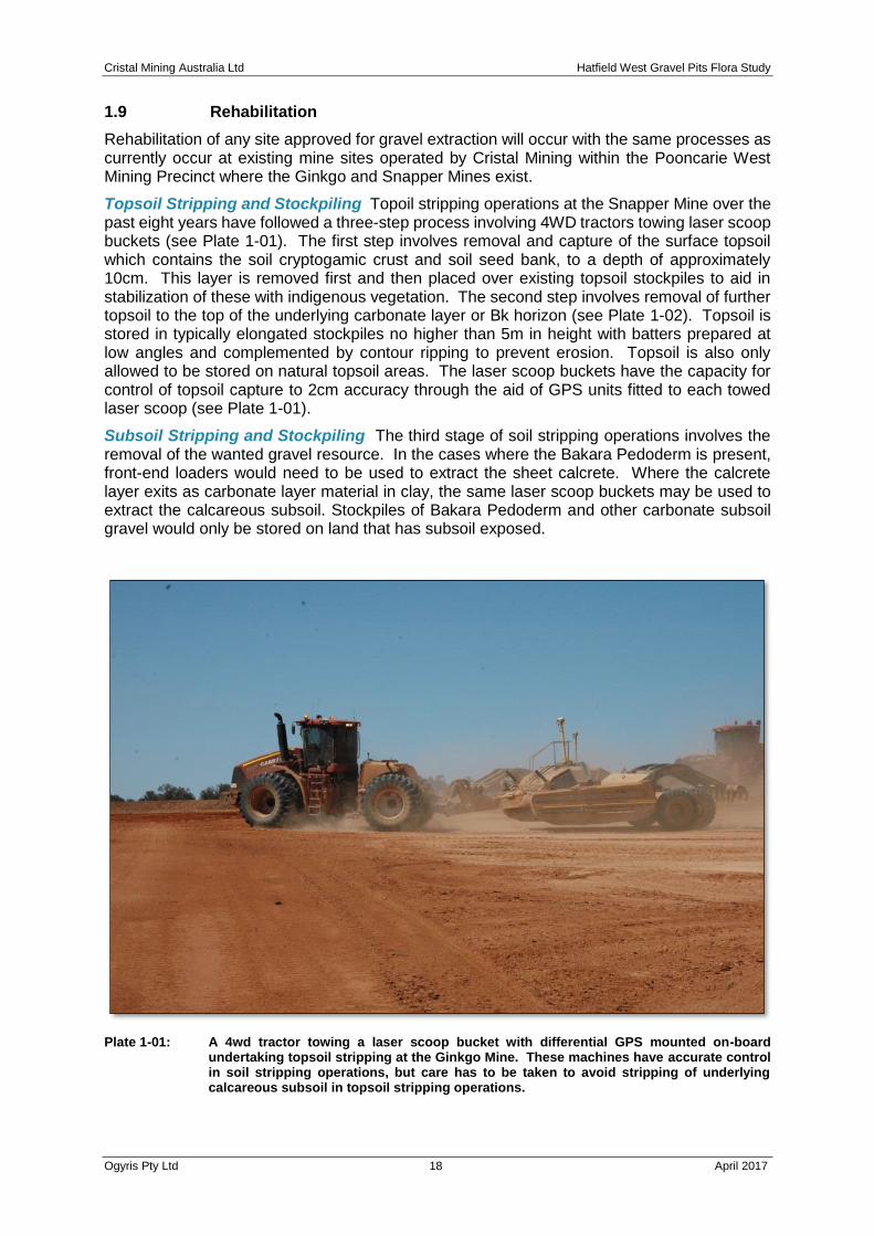
Topsoil Stripping and Stockpiling Topoil stripping operations at the Snapper Mine over the past eight years have followed a three-step process involving 4WD tractors towing laser scoop buckets (see Plate 1-01). The first step involves removal and capture of the surface topsoil which contains the soil cryptogamic crust and soil seed bank, to a depth of approximately 10cm. This layer is removed first and then placed over existing topsoil stockpiles to aid in stabilization of these with indigenous vegetation. The second step involves removal of further topsoil to the top of the underlying carbonate layer or Bk horizon (see Plate 1-02). Topsoil is stored in typically elongated stockpiles no higher than 5m in height with batters prepared at low angles and complemented by contour ripping to prevent erosion. Topsoil is also only allowed to be stored on natural topsoil areas. The laser scoop buckets have the capacity for control of topsoil capture to 2cm accuracy through the aid of GPS units fitted to each towed laser scoop (see Plate 1-01).
Subsoil Stripping and Stockpiling The third stage of soil stripping operations involves the removal of the wanted gravel resource. In the cases where the Bakara Pedoderm is present, front-end loaders would need to be used to extract the sheet calcrete. Where the calcrete layer exits as carbonate layer material in clay, the same laser scoop buckets may be used to extract the calcareous subsoil. Stockpiles of Bakara Pedoderm and other carbonate subsoil gravel would only be stored on land that has subsoil exposed.
Plate 1-01: A 4wd tractor towing a laser scoop bucket with differential GPS mounted on-board undertaking topsoil stripping at the Ginkgo Mine. These machines have accurate control in soil stripping operations, but care has to be taken to avoid stripping of underlying calcareous subsoil in topsoil stripping operations.

Cristal Mining Australia Ltd Hatfield West Gravel Pits Flora Study
Ogyris Pty Ltd 19 April 2017
Plate 1-02: Topsoil stripping at the Snapper Mine. At this location the ‘white’ of the B horizon carbonate layer can be seen emerging in the middle of the laser-scoop cut at the mapped depth and planned cutting depth of 30cm.
Return of Subsoil and Topsoil Subsoil and topsoil are ‘returned’ in reverse order of stripping on to shaped former mined areas with the land stabilized through ripping to a depth of approximately 20-30 cm.

Cristal Mining Australia Ltd Hatfield West Gravel Pits Flora Study
Ogyris Pty Ltd 20 April 2017
CHAPTER 2 THE STUDY AREA
2.1 Geological Setting
Geological Summary The Hatfield West Study Area and study area lies within the Murray Lowlands Province (Jennings and Mabbutt 1977) an area dominated by low surface relief overlying thick Murray Basin sedimentary accumulations of Early Tertiary to Recent age (60 Ma to present). This sedimentary sequence overlies Palaeozoic and Proterozoic basement rocks (Wasson 1989). The major landform and geological features at the present day are dominated by the events of the last 5 million years, a time when Late Miocene-Pliocene high-stand sea levels retreated (Brown and Stephenson 1985) leaving sheets of quartzitic sands (e.g. Parilla Sands) over formerly marine and fluvio-lacustrine sediments of Palaeocene to Miocene age. On the Pliocene strand-plain the step-wise retreating of the sea left behind a series of beach ridges (Lawrence 1966) of generally northwest-southeast trending alignment. These ridges have weathered, mineralised and consolidated over time, and represent the target mineral sands in the Balranald North area.
With the retreat of the sea, drainage lines were activated and these manifested themselves as ancient Murray and Darling River floodplains and other palaeodrainage lines such as the now dry watercourse of the Willandra Creek and associated lakes. Episodes of tectonism and related uplift and faulting blocked these watercourses at around 3.2 Ma (An et al. 1986) resulting in the formation of a large inland waterbody through the Late Pliocene to Mid-Pleistocene period named Lake Bungunnia (Stephenson 1986). The lake resulted in the deposition of lacustrine sediments termed the Blanchetown Clay (Firman 1965). As lake waters gradually becoming more saline with age, a deposit termed the Bungunnia Limestone was deposited. A combination of tectonic activity and increasing aridity from 700,000 years BP resulted in the end of Lake Bungunnia and the onset of a phase of dune-building and palaeosol development (Wasson 1989).
Two principal dune types are recognised in the Murray-Darling Basin, although only one occurs within the Study Area. This dune type consists of short, low-linear dunes of east-west alignment and moderately high clay and calcareous contents. They represent the Woorinen Formation of Lawrence (1966) and occur mostly in the southern and eastern portion of the MLA. The second type consists of steep and high-crested parabolic or sub-parabolic dunes of curved to irregular shape. Sediments are primarily siliceous with very small clay and calcareous contents. These represent the Lowan Sands of Lawrence (1966) and are best represented as Mandelman Land System (Walker 1991) in areas to the east of Mungo National Park as well as to the north and west around Pooncarie, and within the Scotia Country of southwest NSW.
Geology of the Hatfield West Area The local geology within the Murray Mallee Region of southeastern Australia’s Murray Darling Basin is complex and is dominated in any one area by the complex interplay of depositional and erosional processes combined with the influence of underlying structural characteristics such as geological troughs and ridges. The dominant structural feature of the Hatfield West Study Area is the Neckarboo Ridge of the Ivanhoe Block (Brown 1981). To the west of the Study Area, the present and ancient course(s) of the Willandra Creek have cut a swathe through the Ivanhoe Block. The complex suite of geomorphological features present within the WLWHP have been recognized as being of international significance through the World Heritage Listing process.
A highly variable climate, especially over the past 5 million years, has seen major switches from warmer and wetter to drier and more arid conditions. These variations in climate have determined the geomorphological influences present at any particular time, which in turn has influenced the process of soil formation. The surficial geology of the Hatfield West Study Area is dominated by two main types. The red-brown earths of the Woorinen Formation (Lawrence
Cristal Mining Australia Ltd Hatfield West Gravel Pits Flora Study
Ogyris Pty Ltd 21 April 2017
1966) as well as the relict playa lake country and associated clayey basins and accompanying lunettes. Numerous landforms are present, the most important of which include:
• east-west aligned sandy dunefields (with dunes and interdune corridors or swales)
• sandplains of predominantly sandy loam
• clayey to loamy plains of undulating to almost flat relief
• run-on depressions
• relict playa lakes and
• small areas of gypseous plains and rises
A feature of Woorinen Formation soils is the presence of a ‘B’ horizon zone of accumulation within the soil profile which is rich in calcium carbonate. As with other Murray Mallee areas, the ‘carbonate layer’ as it is known, is typically the Loveday Soil, however, in the Hatfield West area, some subsoils also contain a cemented carbonate named the Bakara Pedoderm. The carbonate layer is the soil horizon that typically restricts root growth within Mallee Region soils and is the single largest influence governing the natural distribution of plant species and communities. Also present at a number of locations across the Study Area is the Callabonna Clay – a pedal structured reddish light clay which is typically present immediately below a shallow layer of Woorinen Formation soil.
Underlying the surficial regolith at localized places within and around the Study Area – particularly in the Willandra Lakes area and surrounds – previously active saline groundwater discharge complexes have seen gypseous sediments deposited into a complex mixture of dunes, swales, hummocks and plains which are collectively referred to as the Yamba Formation. Because of the genesis of this sedimentary deposit in a saline setting, the gypsum or ‘copi’ can often be characterized by a high salt content.
Underlying the Woorinen and Yamba Formations is the Shepparton Formation (Lawrence 1966) a facies equivalent of the Blanchetown Clay (Firman 1965) which occurs to the west of Mungo National Park. The Shepparton Formation formed in a shallow freshwater lake or lacustrine environment. The Shepparton Formation is often an impervious layer, which when present close to the surface can cause localized drainage problems. Underlying the Shepparton Formation and locally confined by it, is the regional groundwater aquifer known as the Loxton-Parilla Sand (Firman 1973). This aquifer represents the hydrogeological unit which will be utilized to float the mine dredge at the Atlas-Campaspe Mines during mineral sands extraction activities.
2.2 Hydrology
Aside from artificial water points, there is no free standing water within the Hatfield West Study Area. The nearest free standing water occurs within the Murray River 80 km to the southwest and the Murrumbidgee River 60 km to the southeast. The Willandra Creek, a drainage line linking a series of relict lake beds exists immediately to the west of the Study Area, although this system is effectively inactive with run-off generally flowing to localized areas such as flats and run-on depressions.
2.3 Rainfall Temperature and Moisture Balance
The mean annual rainfall (MAR) for the Hatfield West Study Area is predicted to be 285 mm as calculated from Bureau of Meteorology weather stations from near Hatfield township. Rainfall seasonality as measured by a coefficient of variation of rainfall is 14, which reflects a relatively even distribution of rainfall. A comparison of average rainfall in the wettest quarter (77mm) vs average rainfall in the driest quarter (64mm) confirms this.

Cristal Mining Australia Ltd Hatfield West Gravel Pits Flora Study
Ogyris Pty Ltd 22 April 2017
The mean annual temperature (MAT) predicted for the above location is 17.1°C. The site falls within, but at the ‘driest’ end of the semi-arid climate classification of Bailey (1979). The Bailey’s Moisture Index (BMI) for the Hatfield West Study Area and other sand mine prospects and mines within the Murray Darling Basin is shown in Table 2.01 below.
Table 2.01: Bailey’s Moisture Index (BMI) values for various sand mine prospects and locations within the Murray-Darling Basin of southeastern Australia.
Dry sub-humid climate 6.37-4.7 BMI
Semi-arid climate 4.69-2.5 BMI
Arid climate <2.49 BMI
Mine Prospect/Location Bailey’s Moisture Index Climate Type
Ginkgo – via Pooncarie, NSW 2.07 Arid
Prungle – via Euston, NSW 2.55 Semi-arid
Wemen – via Robinvale, VIC 2.81 Semi-arid
Kiamal – via Ouyen, VIC 2.86 Semi-arid
Douglas – via Balmoral, VIC 5.7 Dry sub-humid
BMI increases linearly with increases in precipitation but decreases exponentially with increases in temperature. The climate of the Hatfield West Study Area is semi-arid with a cool winter period and hot, dry summer period.
2.4 Wind
The nearest wind recording stations to the Hatfield West are the Bureau of Meteorology Weather Stations located at Mildura and Wentworth. In this analysis, we have used data from both to compile a profile of the prevailing winds across the Hatfield West Study Area.
An analysis of wind direction from the Wentworth station indicates prevailing winds are received in a compass arc from southeast to northwest with the greatest individual incidence being from the southwest (approximately 27.0%). Conversely wind directions were much less commonly received from the east, northeast and north (total of <20%). Although individual wind strength data were not available at this time from this station, a Wind Frequency Analysis (WFA) highlighted that, on average, wind speed is greater than 30 kph for a little over 2% of the time in mid-afternoon (1500 hours) at this site. The figure of 30-32 kph is considered by soil conservationists as the speed at which significant soil loss is likely to be experienced on unprotected, poorly vegetated or unconsolidated soils (J. Leys, personal communication). It should be noted that this average increases to a little over 4% in the spring months of September, October and November in tandem with an increasingly intensified evapotranspiration regime. The significance of average wind speeds over 30 kph is least in the months of December to April although occasional high wind from the north, north-west and southwest are recorded in February.
Data from the Bureau of Meteorology Station at Mildura indicates an average incidence of two gale-force winds (>75 kph) per year. Normally, average monthly wind speeds 10m above ground at 1500 hrs indicate that the percentage occurrence of speeds greater than 21 kph is between 25 and 43 percent. The months of March to June are close to or at the lower part of the range, and as observed at Wentworth, August to November at the upper part of the range. For wind speed greater than 30kph, the percentage occurrence decreases to levels similar to those recorded at Wentworth. Winds with an easterly vector are relatively insignificant at Mildura. There is also a seasonal shift in direction of strong winds from northwest-north during

Cristal Mining Australia Ltd Hatfield West Gravel Pits Flora Study
Ogyris Pty Ltd 23 April 2017
July to September to west-southwest during August to January. Overall west-southwest winds dominate over directions from other quarters (Lawrence 1980).
2.5 Climate Summary
The climate of the Hatfield West Study Area is at the ‘dry’ end of the semi-arid climate classification system of Bailey (1979). The area experiences low (MAR = 285 mm), relatively evenly distributed rainfall with a cool winter period and hot, dry summer period. Mean annual temperature averages 17.1°C which is comparable, although slightly warmer than that occurring at the former Wemen Sand Mine in northwest Victoria. An analysis of wind data from Mildura and Wentworth indicates a prevalence of wind in an arc from southeast to northwest with the highest incidence arising from the southwest. Winds are typically strongest in the Spring (September to November) period and lightest over summer and early autumn.
2.6 The Natural Environment
The Vegetation Map of the Pooncarie 1:250,000 Sheet (Porteners et al. 1997) includes seven primary vegetation types in the Hatfield West Study Area. These include:
• Sandplain Mallee (dominated by mallee eucalypts with a shrubby chenopod dominated understorey);
• Callitris Woodland (dominated by Callitris glaucophylla);
• Belah-Rosewood Woodland (dominated by Casuarina pauper and Alectryon oleifolius subsp. canescens);
• Yarran Woodland (dominated by Acacia melvillei);
• Pearl Bluebush Shrublands;
• Black Bluebush Shrublands; and
• Open Area Grasslands (which are open areas of land dominated by grasslands).
All of these vegetation types were sampled during the flora survey. The Hatfield West Study Area is composed entirely of Western Land Leases administered by the NSW Department of Primary Industries – Catchment and Lands Division under the NSW Western Lands Act, 1901.

Cristal Mining Australia Ltd Hatfield West Gravel Pits Flora Study
Ogyris Pty Ltd 24 April 2017
CHAPTER 3 METHODS
This chapter provides an outline of all protocols used to extract the flora baseline of the Hatfield West Gravel Pit Study Area. The protocols used include desk-top extraction of information from all of the data sources requested by OEH (see Table 1.2 in Chapter). This includes interrogation of the New South Wales OEH BioNet database, as well as a Commonwealth EPBC Act “Protected Matters Search”. The Hatfield West Gravel Pit biodiversity assessment is located within the broader Study Area assessed for the Cristal Mining Australia Ltd. Atlas-Campaspe Mineral Sands EIS. Previous flora findings from that report are considered relevant to this study, especially as the proposed Atlas Mine lies just 3km to the northwest of the Hatfield West Study Area. We have also drawn heavily from the Iluka Resources Ltd. Balranald North Mineral Sands EIS study where the proposed Nepean Mine is located approximately 9 km south of the Hatfield West Study Area. This study also includes a field study of the proposed gravel pit sites. The location of the proposed gravel pit sites in relation to the Atlas-Campaspe and Nepean mineral sand s deposits is shown in Figure 1-03 (Chapter 1).
3.1 Literature Review of Biodiversity Known from the Hatfield West Locality
3.1.1 New South Wales BioNet Database Search
A review of the records of all flora species occurring within the Hatfield West Study Area known to be present on the NSW BioNet database were collated from a search undertaken on 27th January 2016. 3.1.2 EPBC Act Protected Matters Search
An EPBC Act “Protected Matters Search” for a 50 km area around the Hatfield West Study Area was conducted on the 1st June 2016. The search identified threatened species and ecological communities plus other listed species that could potentially be impacted by the Hatfield West Gravel Pit Project.
3.1.3 Review of Previous Reports
A number of previous reports are considered relevant with respect to the flora of the Hatfield West Study Area. These include:
• Atlas-Campaspe Mineral Sands Project – EIS Biodiversity Assessment (AMBS 2013).
• Balranald Mineral Sands Project – EIS Biodiversity Assessment (NEH 2016)
• Biodiversity Summary for Natural Resource Management Regions (DoE 2011)
• Val, J., Foster, E. and LeBreton, M. (2001). Biodiversity Study of the Lower Murray-
Darling. Dept. of Land Water Conservation, New South Wales.
• Bowen, P.F. and Pressey, R.L. (1993). Localities and Habitats of Plants with Restricted
Distributions in the Western Division of New South Wales. NSW National Parks & Wildlife
Service Occasional Paper No. 17.
• Ayers, D., Nash, S. and Baggett, K. (1996). Threatened Species of Western New South
Wales. NSW National Parks & Wildlife Service, Sydney.
• Porteners, M.F., Ashby, E.M. and Benson, J.S. (1997). The natural vegetation of the
Pooncarie 1:250,000 map. Cunninghamia 5(1): 139-231.
The information contained within each of these reports was scrutinized for relevance with respect to the Hatfield West Study Area.

Cristal Mining Australia Ltd Hatfield West Gravel Pits Flora Study
Ogyris Pty Ltd 25 April 2017
3.2 Field Assessment
3.2.1 Flora
Rationale Behind and Timing of the Gravel Pit Flora Survey The Cristal flora gravel pit survey was originally proposed to occur in late January 2016 based around the locations of two potential pits selected by that company’s geologists. Surveys were conducted at these two proposed pit sites in late January-early February 2016, which have subsequently been termed Pits A and B. After calculation of the potential gravel present in Pits A and B, it became clear later in 2016 that further gravel resources would be required to maintain roads along the MCTR from Atlas-Campaspe to Hatfield over the life of the two mines. A further location, Pit C was added to the study in September 2016, along with an expanded area at Pit A. Baseline flora surveys of Pit C as well as the new area at Pit A were surveyed in October 2016. In addition, targeted rare plant surveys of all three pit locations were also undertaken at this time.
Conditions of the Vegetation Survey The initial field assessment of vegetation at Pits A and B were conducted over two days on the 28th January 2016 and the 3rd February 2016. The ground and shrub layer condition of the vegetation at this time was poor, with little or no herbs present and low groundflora biomass. The vegetation survey in October 2016 was conducted in optimal conditions for flora survey. In excess of 100mm of precipitation in September 2016 ensured that the herbaceous groundflora layer was in peak condition.
Site Selection Survey sites were selected so as to sample all vegetation plant communities present as well as any variation present within them, at each proposed gravel pit site. Survey effort, as advised by OEH in correspondence provided to Cristal Mining of 20/11/2015, was guided by DEC (2004) “Threatened Biodiversity Survey and Assessment Guidelines for Developments and Activities – Working Draft” (see table 5.2 for quadrat sampling stratification). The DEC (2004) guidelines for quadrat based sampling are:
• at least 1 quadrat per stratification unit <2 hectares
• 2 quadrats per 2 – 50 hectares of stratification unit
• 3 quadrats per 51 – 250 hectares of stratification unit
• 5 quadrats per 251 – 500 hectares of stratification unit
• 10 quadrats per 501 – 1000 hectares of stratification unit, plus 1 additional quadrat for
each extra 100 hectares thereof.
The relatively small size of each proposed gravel pit (Pits A and C at ~ 50 Ha; Pit B at ~5Ha) meant that quadrat replication was mostly low, but in all circumstances, met the DEC requirements. A total of 13 quadrat sites were assessed at Pit A (see Figure 4-02), 3 at Pit B (see Figure 4-03) with a further 11 sites surveyed at Pit C (see Figure 4-04).
Vegetation Description The vegetation quadrats measured 50 x 20 m (0.1 Ha). All species
recorded in the (1,000m²) fixed area quadrats were allocated a cover-abundance scaling as
outlined below:
+ = few individuals, with small cover
1 = numerous individuals but < 5% cover, or scattered individuals and cover to 5%
2 = 5-25% cover
3 = 25-50% cover
4 = 50-75% cover
5 = 75-100% cover

Cristal Mining Australia Ltd Hatfield West Gravel Pits Flora Study
Ogyris Pty Ltd 26 April 2017
A structural assessment was also undertaken at a subset of the treed sites as well. This
involved quantitatively describing the structural parameters that characterized the selected
quadrat sites. Information was collected on tree, shrub and groundflora height and cover as
well as the number of live trees and large shrubs in each 0.1 Ha area. The latter assessment
facilitated a calculation of the density of trees and shrubs per hectare. The number of dead
trees, fallen logs, tree hollows, bird nests, lizard burrows and spider holes were also counted.
Plant Nomenclature Botanical nomenclature used in this report follows the Flora of New
South Wales (Harden 1990; 1991; 1992 and 1993), except where more recent taxonomic
revisions as outlined on the Atlas of Living Australia (ALA 2016) apply.
Data Collection and Compliance Ian Sluiter and Geoffrey Allen, the two botanists that undertook the surveys, are licenced to undertake plant biodiversity assessments and ecological surveys under New South Wales National Parks and Wildlife Act, 1974 Scientific Licence number SL101035. Data Curation All floristic data has been entered to the NSW BioNet, as per scientific license requirements.
VIS Classification Plant community types were allocated to Benson et al. (2006) New South Wales vegetation communities and later with the new VIS plant community type or PCT’s.
Vegetation Mapping The vegetation map produced for the Hatfield West gravel pit locations (see Chapter 4) used the same orthophotographic image used for Cristal’s 2011 Atlas-Campaspe EIS study, combined with detailed ‘ground truth’ notes taken whilst at the sites. The vegetation communities reflect the VIS terminology as derived from BioNet (OEH 2016).
Targeted Threatened Flora Searches Targeted threatened flora searches were undertaken at each proposed gravel pit site in accordance with DEC (2004) guidelines whereby meandering traverses were undertaken according to the following replication:
• 1 x meandering 30 minute traverse per stratification unit <2 hectares
• 2 x meandering 30 minute traverses per stratification unit 2 - 50 hectares.
In reality, considerably more time than this was dedicated to rare plant searches, with approximately 4 hours at each of Pits A (53.24 Ha) and C (54.16 Ha), and 1 hour at Pit B (5.25 Ha).
Limitations The initial flora survey in late summer 2016 was far from ideal. Conditions across
all sites were extremely dry with virtually no herbaceous component present. The inclusion of
Pit C to the study in spring 2016 allowed all sites to be re-assessed in October 2016. This
facilitated targeted rare plant surveys at the appropriate time of the year under optimal
seasonal conditions. Whilst the field conditions for this study were considered to be very good,
it should also be mentioned that the baseline EIS surveys of the nearby Atlas-Campaspe and
Balranald minerals sands projects were both undertaken during spring months during years
of good rainfall. This would have increased the chances of finding threatened plant species
at these locations.

Cristal Mining Australia Ltd Hatfield West Gravel Pits Flora Study
Ogyris Pty Ltd 27 April 2017
CHAPTER 4 FLORA OF THE HATFIELD WEST STUDY AREA
This chapter outlines the flora baseline of the Hatfield West Study Area. The assessment includes information provided in recent mineral sands EIS investigations (Section 4.1), as well as the vegetation occurring at the potential gravel pit sites assessed (Section 4.2). Section 4.3 provides an assessment of potential threatened species and plant communities.
4.1 Flora of the Broader Study Area
The Hatfield West Study Area lies within the south-central part of the New South Wales
1:250,000 Pooncarie Map Sheet. The vegetation of this map sheet was described by
Porteners et al. (1997), from which 18 plant communities were described. Other relevant
vegetation assessments with attendant mapping within the region include:
• Westbrooke and Miller (1995) who described and mapped the vegetation of nearby
Mungo National Park;
• Australian Museum Business Services (AMBS 2013) who described and mapped the
vegetation of the proposed Atlas-Campaspe Mineral Sands Mines, as well as adjoining
vegetation to the east of Mungo National Park in part of the Boree Plains Station
property; and
• Niche Environment and Heritage (NEH 2016) who described and mapped the
vegetation of the proposed nearby Nepean Mineral Sands Mine.
Both the AMBS (2013) and NEH (2016) studies are considered the most relevant to this study
as the vegetation described and mapped occurs within 10 km of the gravel pits sites. The plant
taxa recorded from these studies, as well as those recorded on the NSW BioNet database are
outlined in Appendix 1.
4.2 Hatfield West Vegetation Community Delineation and Mapping
The vegetation occurring at the proposed gravel pit sites was initially aligned in the field with
the southwest New South Wales plant community types described by Benson et al. (2006).
Six plant community types were recognized as occurring across the three gravel pit locations.
These were subsequently aligned with the BioMetric Vegetation Types for the Lower Murray-
Darling CMA (with relevant reference codes), as well as with the New South Wales Vegetation
Formations and Classes of Keith (2004). The six vegetation community types described below
have been aligned with the validated vegetation community types in Table 4-01. Vegetation
community mapping for each proposed gravel pit has been shown as Figure 4-01 (Pit A),
Figure 4-02 (Pit B) and Figure 4-03 (Pit C). A seventh vegetation unit has also been mapped.
This is Rosewood Woodland which is a sub-community type of Belah-Rosewood Woodland.
The vegetation maps were compiled from field notes taken whilst walking through the Subject
Site area and surrounds and from detailed assessments made at the surveyed quadrat sites.
The surveyed quadrat sites are shown for each gravel pit site within the three vegetation maps
and have been classified within Table 4-01. Some vegetation from the surrounding Study Area
has also been shown. These mapped areas represent plant community types that are
threatened NSW Endangered Ecological Communities or EEC’s and have been shown to
provide context as well as to show how the proponent has attempted to avoid disturbance
where possible.
The plant communities recognized in this study are described in turn within Sections 4.2.1 to
4.2.6 below.
Cristal Mining Australia Ltd Hatfield West Gravel Pits Flora Study
Ogyris Pty Ltd 28 April 2017
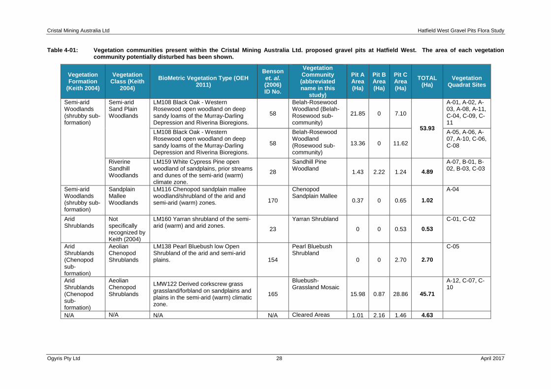
Table 4-01: Vegetation communities present within the Cristal Mining Australia Ltd. proposed gravel pits at Hatfield West. The area of each vegetation community potentially disturbed has been shown.
Vegetation Formation
(Keith 2004)
Vegetation Class (Keith
2004)
BioMetric Vegetation Type (OEH 2011)
Benson et. al. (2006) ID No.
Vegetation Community (abbreviated name in this
study)
Pit A Area (Ha)
Pit B Area (Ha)
Pit C Area (Ha)
TOTAL (Ha)
Vegetation Quadrat Sites
Semi-arid Woodlands (shrubby sub-formation)
Semi-arid Sand Plain Woodlands
LM108 Black Oak - Western Rosewood open woodland on deep sandy loams of the Murray-Darling Depression and Riverina Bioregions.
58
Belah-Rosewood Woodland (Belah-Rosewood sub-community)
21.85 0 7.10
53.93
A-01, A-02, A-03, A-08, A-11, C-04, C-09, C-11
LM108 Black Oak - Western Rosewood open woodland on deep sandy loams of the Murray-Darling Depression and Riverina Bioregions.
58
Belah-Rosewood Woodland (Rosewood sub-community)
13.36 0 11.62
A-05, A-06, A-07, A-10, C-06, C-08
Riverine Sandhill Woodlands
LM159 White Cypress Pine open woodland of sandplains, prior streams and dunes of the semi-arid (warm) climate zone.
28
Sandhill Pine Woodland
1.43 2.22 1.24 4.89
A-07, B-01, B-02, B-03, C-03
Semi-arid Woodlands (shrubby sub-formation)
Sandplain Mallee Woodlands
LM116 Chenopod sandplain mallee woodland/shrubland of the arid and semi-arid (warm) zones. 170
Chenopod Sandplain Mallee
0.37 0 0.65 1.02
A-04
Arid Shrublands
Not specifically recognized by Keith (2004)
LM160 Yarran shrubland of the semi-arid (warm) and arid zones.
23
Yarran Shrubland
0 0 0.53 0.53
C-01, C-02
Arid Shrublands (Chenopod sub-formation)
Aeolian Chenopod Shrublands
LM138 Pearl Bluebush low Open Shrubland of the arid and semi-arid plains. 154
Pearl Bluebush Shrubland
0 0 2.70 2.70
C-05
Arid Shrublands (Chenopod sub-formation)
Aeolian Chenopod Shrublands
LMW122 Derived corkscrew grass grassland/forbland on sandplains and plains in the semi-arid (warm) climatic zone.
165
Bluebush-Grassland Mosaic
15.98 0.87 28.86 45.71
A-12, C-07, C-10
N/A N/A N/A N/A Cleared Areas 1.01 2.16 1.46 4.63

Cristal Mining Australia Ltd Hatfield West Gravel Pits Flora Study
Ogyris Pty Ltd 29 April 2017
Figure 4-01: Vegetation Map of the Pit A proposed gravel pit location. Five vegetation community types are present, along with a very small area where gravel has been extracted in the past.
Cristal Mining Australia Ltd Hatfield West Gravel Pits Flora Study
Ogyris Pty Ltd 30 April 2017
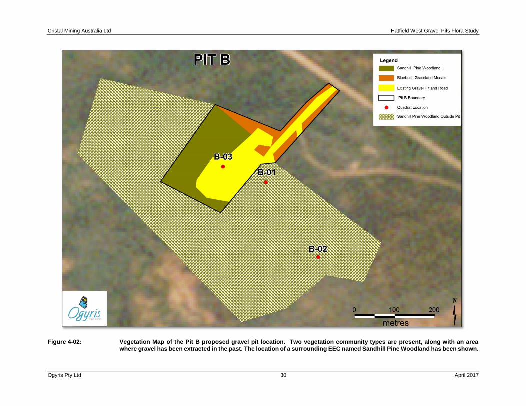
Figure 4-02: Vegetation Map of the Pit B proposed gravel pit location. Two vegetation community types are present, along with an area where gravel has been extracted in the past. The location of a surrounding EEC named Sandhill Pine Woodland has been shown.
Cristal Mining Australia Ltd Hatfield West Gravel Pits Flora Study
Ogyris Pty Ltd 31 April 2017
Figure 4-03: Vegetation Map of the Pit C proposed gravel pit location. Six vegetation community types are present. The location of a surrounding EEC named Yarran Shrubland has been shown.

Cristal Mining Australia Ltd Hatfield West Gravel Pits Flora Study
Ogyris Pty Ltd 32 April 2017
4.2.1 Belah-Rosewood Woodland
Habitat Belah-Rosewood Woodland (see Plate 4-01) was present on flat to undulating plains
comprised of Woorinen Formation reddish-brown clay loam and sandy clay loam Calcarosol soils
with topsoil depths varying from 25-40 cm.
Structure and Primary Character Species Woodland and open woodland overwhelmingly
dominated by Belah (Casuarina pauper) from 5-9m tall. Also present at most locations was a
small tree stratum of 3.5-5m in height of Rosewood (Alectryon oleifolius ssp. canescens). Another
occasional canopy tree taxon present was Sugarwood (Myoporum platycarpum ssp.
platycarpum). In some circumstances, Rosewood formed mono-specific stands of small trees to
5m tall, generally surrounded by open grasslands, but sometimes ecotonal with Belah-Rosewood
Woodland. An example of the Rosewood Woodland sub-community of Belah-Rosewood
Woodlands is shown in Plate 4-02. Tree density of Belah-Rosewood Woodland varied from 200-
260 trees per Ha in well treed areas, which were spread across several size classes. The
dominant size classes were 10-20 cm DBH (40% of trees) and 20-30cm DBH (35% of trees),
although smaller (<10cm DBH) and larger trees (30-45cm DBH) were also present. Tree hollows
averaged 170 hollows per Ha and most (80%) were in the small (<5cm) size class with lesser
numbers in the size class 5-10cm. Rosewood trees occasionally contained small hollows <5cm
in size. The shrub layer of Belah-Rosewood Woodlands was dominated by Black Bluebush
(Maireana pyramidata) which was present at an average density of 1,950 mature shrubs per Ha.
Densities of Black Bluebush across Pit A and Pit C Belah-Rosewood Woodlands were quite
variable which reflects a long history of grazing impact upon the site.
Presence at the Gravel Pit Sites Belah-Rosewood Woodland was absent from the Pit B site,
but was the dominant vegetation community of Pit A where it comprised 35.21Ha of the total pit
area of 54Ha. Belah-Rosewood Woodland was also common at the Pit C location as well where
it comprised 11.62Ha of the total area of 54.16Ha. In total, Belah-Rosewood Woodland
comprised 53.93Ha or 47.6% of the total Subject Site area of 113.41Ha. Sampled at 9 locations
including quadrats A-01, A-02, A-03, A-08, A-11 in Pit A and quadrats C-04, C-09 and C-11 in Pit
C.
Vegetation Condition The vegetation condition of Belah-Rosewood Woodlands at Pit A in late
summer 2016 was moderate only with heavily browsed Black Bluebush shrubs and very little
groundflora vegetation. This contrasted sharply with the vegetation condition in October 2016
when the vegetation at Pits A and C were considered to be in good condition with a healthy Black
Bluebush large shrub layer and common chenopod shrubs and sub-shrubs such as Ruby
Saltbush (Enchylaena tomentosa), Hedge Saltbush (Rhagodia spinescens) and Limestone
Copperburr (Sclerolaena obliquicuspis) present along with common herbs as well. The presence,
however, of common Arabian Grass (Schismus barbatus), Smooth Mustard (Sisynmbrium
erysimioides), Mediterranean Turnip (Brassica tournefortii) and Little Medic (Medicago minima)
at most sites detracted from the vegetation condition of the Pit A and C overall. The presence of
moderately common African Boxthorn (Lycium ferocissimum) was also noted.
Conservation Status Not listed by NSW or Commonwealth legislation. Benson et al. (2006) have
the Belah-Black Bluebush Woodlands (ID: 58) listed within the threat category ‘Near Threatened’.

Cristal Mining Australia Ltd Hatfield West Gravel Pits Flora Study
Ogyris Pty Ltd 33 April 2017
Plate 4-01: Belah-Rosewood Woodland at quadrat site C-11, at Pit C on 13th October 2016.
Plate 4-02: Mono-specific tree stand of Rosewood (Alectryon oleifolius ssp. canescens) at Pit C. This plant association is considered to be a sub-community of Belah-Rosewood Woodland.

Cristal Mining Australia Ltd Hatfield West Gravel Pits Flora Study
Ogyris Pty Ltd 34 April 2017
4.2.2 Chenopod Sandplain Mallee
Habitat Chenopod Sandplain Mallee (see Plate 4-03) was extremely restricted in occurrence
(see below) and was present on plains comprised of Woorinen Formation reddish-brown sandy
clay loam Calcarosol soils with shallow topsoil depths of 30 cm.
Structure and Primary Character Species A low woodland from 5-6m dominated by Pointed
Mallee (Eucalyptus socialis) and White Mallee (E. gracilis) with a chenopod understorey
containing Black Bluebush (Maireana pyramidata), Hedge Saltbush (Rhagodia spinescens)
and Limestone Copperburr (Sclerolaena obliquicuspis).
Presence at the Gravel Pit Sites Chenopod Sandplain Mallee was absent from the Pit B site,
and was present at extremely small locations at both Pits A and C where the total area was
just 1.02ha or 0.9% of the total Subject Site area of 113.41Ha. Sampled at one location in Pit
A (quadrat A-04).
Vegetation Condition The vegetation condition of Chenopod Sandplain Mallee at Pit A in
late summer 2016 was moderate only with only 11 indigenous species present along with
common African Boxthorn (Lycium ferocissimum).
Conservation Status Not listed by NSW or Commonwealth legislation. Benson et al. (2006)
have Chenopod Sandplain Mallee (ID: 170) listed within the threat category ‘Near Threatened’.
Plate 4-03: Chenopod Sandplain Mallee at quadrat site A-04, at Pit A on 28th January 2016. The vegetation at this site was in moderate condition only with low indigenous plant diversity and a common presence of African Boxthorn (Lycium ferocissimum).
4.2.3 Sandhill Pine Woodland
Habitat Sandhill Pine Woodland was originally described by Benson et al. (2006) as “White
Cypress Pine open woodland of sandplains, prior streams and dunes mainly of the semi-arid

Cristal Mining Australia Ltd Hatfield West Gravel Pits Flora Study
Ogyris Pty Ltd 35 April 2017
(warm) climate zone”. At the Hatfield West Study Area, Sandhill Pine Woodland is found on
Woorinen Formation sandy loam and light sandy clay loam dunes and sandplains which
surround the margins of relict lake beds associated with the Willandra Lakes palaeo drainage
outflow. Within and immediately surrounding the Subject Site of all three proposed gravel pits,
Sandhill Pine Woodland is always found associated with sandy soil profiles, typically with
topsoil depth of > 60cm above the carbonate layer.
Structure and Primary Character Species Sandhill Pine Woodland is an open woodland
containing scattered trees of White Cypress Pine (Callitris glaucophylla) to 10-12m tall (see
Plate 4-04), although at some locations tree cover is almost absent and all that remains are
stumps cut for fence posts or burnt remains of old trees previously killed by wildfire.
Plate 4-04: Sandhill Pine Woodland at quadrat site C-03 within the Pit C gravel pit Subject Site. A
Wedge-tailed Eagle (Aquila audax) nest appears in the crown of the large tree at right of the photograph.
The understorey within and immediately surrounding the Subject Site at each proposed gravel
pit location is composed of a large shrub cover of sparse to moderately dense Black Bluebush
(Maireana pyramidata) shrubs at a cover density varying from 1-10%, with a sub-shrub layer
dominated by Limestone Copperburr (Sclerolaena obliquicuspis) and a groundflora layer
characterized by Balcarra Speargrass (Austrostipa nitida), Flannel Cudweed (Actinoble
uliginosum), Flat Spurge (Chamaesyce drummondii) and Native Caltrop (Tribulus
micrococcus). Weeds such as Arabian Grass (Schismus barbatus), Smooth Mustard
(Sisynmbrium erysimioides), Mediterranean Turnip (Brassica tournefortii), Common Barley
Grass (Hordeum leporinum), Small Medic (Medicago minima) and Wild Sage (Salvia
verbenaca) are also common at each site
Presence at the Gravel Pit Sites Sandhill Pine Woodland was found to occur within all three
proposed gravel pit sites as small occurrences varying from 1-2Ha in size. The largest
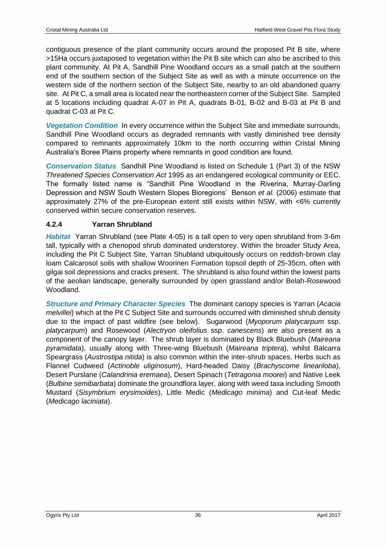
Cristal Mining Australia Ltd Hatfield West Gravel Pits Flora Study
Ogyris Pty Ltd 36 April 2017
contiguous presence of the plant community occurs around the proposed Pit B site, where
>15Ha occurs juxtaposed to vegetation within the Pit B site which can also be ascribed to this
plant community. At Pit A, Sandhill Pine Woodland occurs as a small patch at the southern
end of the southern section of the Subject Site as well as with a minute occurrence on the
western side of the northern section of the Subject Site, nearby to an old abandoned quarry
site. At Pit C, a small area is located near the northeastern corner of the Subject Site. Sampled
at 5 locations including quadrat A-07 in Pit A, quadrats B-01, B-02 and B-03 at Pit B and
quadrat C-03 at Pit C.
Vegetation Condition In every occurrence within the Subject Site and immediate surrounds,
Sandhill Pine Woodland occurs as degraded remnants with vastly diminished tree density
compared to remnants approximately 10km to the north occurring within Cristal Mining
Australia’s Boree Plains property where remnants in good condition are found.
Conservation Status Sandhill Pine Woodland is listed on Schedule 1 (Part 3) of the NSW
Threatened Species Conservation Act 1995 as an endangered ecological community or EEC.
The formally listed name is “Sandhill Pine Woodland in the Riverina, Murray-Darling
Depression and NSW South Western Slopes Bioregions’ Benson et al. (2006) estimate that
approximately 27% of the pre-European extent still exists within NSW, with <6% currently
conserved within secure conservation reserves.
4.2.4 Yarran Shrubland
Habitat Yarran Shrubland (see Plate 4-05) is a tall open to very open shrubland from 3-6m
tall, typically with a chenopod shrub dominated understorey. Within the broader Study Area,
including the Pit C Subject Site, Yarran Shubland ubiquitously occurs on reddish-brown clay
loam Calcarosol soils with shallow Woorinen Formation topsoil depth of 25-35cm, often with
gilgai soil depressions and cracks present. The shrubland is also found within the lowest parts
of the aeolian landscape, generally surrounded by open grassland and/or Belah-Rosewood
Woodland.
Structure and Primary Character Species The dominant canopy species is Yarran (Acacia
melvillei) which at the Pit C Subject Site and surrounds occurred with diminished shrub density
due to the impact of past wildfire (see below). Sugarwood (Myoporum platycarpum ssp.
platycarpum) and Rosewood (Alectryon oleifolius ssp. canescens) are also present as a
component of the canopy layer. The shrub layer is dominated by Black Bluebush (Maireana
pyramidata), usually along with Three-wing Bluebush (Maireana triptera), whilst Balcarra
Speargrass (Austrostipa nitida) is also common within the inter-shrub spaces. Herbs such as
Flannel Cudweed (Actinoble uliginosum), Hard-headed Daisy (Brachyscome lineariloba),
Desert Purslane (Calandrinia eremaea), Desert Spinach (Tetragonia moorei) and Native Leek
(Bulbine semibarbata) dominate the groundflora layer, along with weed taxa including Smooth
Mustard (Sisymbrium erysimoides), Little Medic (Medicago minima) and Cut-leaf Medic
(Medicago laciniata).
Cristal Mining Australia Ltd Hatfield West Gravel Pits Flora Study
Ogyris Pty Ltd 37 April 2017
Plate 4-05: Yarran (Acacia melvillei) Shrubland at quadrat site C-01. This site was just outside the Pit C Subject Site, but the plant community extends to the east or left hand side of the photograph to be present within the Subject Site as well. The shrub layer is dominated by Black Bluebush (Maireana pyramidata) with a diverse herbaceous component as well.
Presence at the Gravel Pit Sites Yarran Shrubland occurs at two locations totalling just
0.53Ha on the western side of the Pit C Subject Site where it is also contiguous with larger
patches of this shrubland. Sampled at 2 locations near Pit C, at quadrats C-01 and C-02.
Vegetation Condition Yarran Shrubland is in moderate-poor condition at the Pit C site and
surrounds. Shrub density of Yarran is considered to be 1-5% of pre-European density, with
most large shrubs having been killed by past wildfire, and then prevented from regenerating
by a high browsing presence from sheep and Feral Goats. Despite the diminished canopy
presence, the plant community is characterized by a healthy large shrub layer of Black
Bluebush as well as a high diversity of indigenous herbs within the groundflora layer.
Conservation Status Yarran Shrubland is listed on Schedule 1 (Part 3) of the NSW
Threatened Species Conservation Act 1995 as an endangered ecological community or EEC.
The formally listed name is “Acacia melvillei Shrubland in the Riverina and Murray-Darling
Depression Bioregions’ Benson et al. (2006) estimate that approximately 42% of the pre-
European extent still exists within NSW, with no areas currently conserved within secure
conservation reserves at that time (2006). A private conservation reserve on the Cristal Mining
Australia Ltd. property at Boree Plains contains Yarran Shrubland, but AMBS (2013; p.60)
consider this to be in “moderate to poor condition, lacking structural integrity and having higher
numbers of weed species than other (vegetation) map units in the (Atlas-Campaspe) study
area”.

Cristal Mining Australia Ltd Hatfield West Gravel Pits Flora Study
Ogyris Pty Ltd 38 April 2017
4.2.5 Pearl Bluebush Shrubland
Habitat Pearl Bluebush Shrubland are a treeless chenopod shrubland from 0.8-1.4m in height occurring on clay loam Calcarosol soils with shallow (20-30cm) topsoils and a weakly developed gilgai presence along with a strong sub-soil carbonate presence dominated by calcrete nodules. The shrublands occur in the lowest part of the eastern side of the Pit C Subject Site, bordering a relictual lakebed.
Structure and Primary Character Species Pearl Bluebush Shrubland (see Plate 4-06) was dominated by Pearl Bluebush (Maireana sedifolia), with an appreciable presence of Black Bluebush (Maireana pyramidata) as well. The inter-shrub spaces in October 2016 were characterized by a high cover of the annual weeds Hairy Rupture-wort (Herniaria cinerea), Little Medic (Medicago minima) and Cut-leaf Medic (Medicago laciniata), along with native perennial grasses including Balcarra Speargrass (Austrostipa nitida) and Common Wallaby Grass (Rytidosperma caespitosa).
Plate 4-06: Pearl Bluebush Shrubland at quadrat site C-05 within the Pit C Subject Site on 12th October 2016.
Presence at the Gravel Pit Sites Pearl Bluebush Shrubland was restricted to just 2.7 Ha on
the eastern side of Pit C. The vegetation community was described at quadrat site C-05.
Vegetation Condition The condition of the vegetation was moderate with a diminished
bluebush shrub density, but with high indigenous species diversity (n=36 taxa) as well as weed
diversity (n=16 taxa).
Conservation Status Not listed by NSW or Commonwealth legislation. Benson et al. (2006)
have Pearl Bluebush Shrubland (ID: 154) listed within the threat category ‘Near Threatened’.

Cristal Mining Australia Ltd Hatfield West Gravel Pits Flora Study
Ogyris Pty Ltd 39 April 2017
4.2.6 Bluebush-Grassland Mosaic
Habitat Undulating aeolian plains of shallow Woorinen Formation clay loam topsoils 25-35cm
thick characterized by the presence of a native perennial grass sward of Speargrass
(Austrostipa spp.) interspersed with Black Bluebush shrubs (see below) with variable density
(see Plates 4-07 and 4-08) of cover.
Structure and Primary Character Species Native perennial grassland dominated by
Balcarra Speargrass (Austrostipa nitida) and Rough Speargrass (Austrostipa scabra ssp.
falcata) with a variable presence of Black Bluebush (Maireana pyramidata) shrubs varying from
0-10% large shrub cover. Benson et al. (2006) have indicated they believe this plant community
is likely to be derived from other woody plant communities including Bluebush Shrublands and
possibly Belah-Rosewood Woodlands.
Presence at the Gravel Pit Sites Present at all three proposed gravel pit locations, but most
extensive at Pit C where this plant community made up 53% of the Subject Site of 54.16Ha.
Also well represented at Pit A where the plant community made up 30% of the Subject Site of
54Ha. Collectively, Bluebush-Grassland Mosaic comprises 45.71Ha or 40.3% of the total
Subject Site of 113.41Ha. Sampled at three quadrat locations (A-12/Pit A; and C-07 and C-
10/Pit C)
Vegetation Condition In October 2016, this plant community contained relatively low
indigenous plant diversity (n=16-22 taxa) but high weed diversity (n=7-11 taxa)
Conservation Status Not listed by NSW or Commonwealth legislation. Benson et al. (2006)
have Bluebush-Grassland Mosaic (ID: 165) listed within the threat category ‘Least Concern’.
Plate 4-07: Bluebush-Grassland Mosaic at quadrat site A-12 – showing an example of this plant community with the higher end of near 10% shrub cover of Black Bluebush.
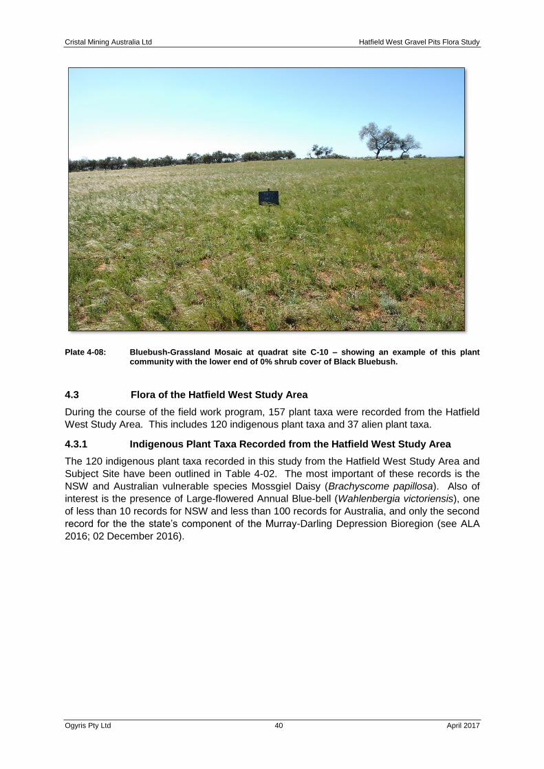
Cristal Mining Australia Ltd Hatfield West Gravel Pits Flora Study
Ogyris Pty Ltd 40 April 2017
Plate 4-08: Bluebush-Grassland Mosaic at quadrat site C-10 – showing an example of this plant community with the lower end of 0% shrub cover of Black Bluebush.
4.3 Flora of the Hatfield West Study Area
During the course of the field work program, 157 plant taxa were recorded from the Hatfield
West Study Area. This includes 120 indigenous plant taxa and 37 alien plant taxa.
4.3.1 Indigenous Plant Taxa Recorded from the Hatfield West Study Area
The 120 indigenous plant taxa recorded in this study from the Hatfield West Study Area and
Subject Site have been outlined in Table 4-02. The most important of these records is the
NSW and Australian vulnerable species Mossgiel Daisy (Brachyscome papillosa). Also of
interest is the presence of Large-flowered Annual Blue-bell (Wahlenbergia victoriensis), one
of less than 10 records for NSW and less than 100 records for Australia, and only the second
record for the the state’s component of the Murray-Darling Depression Bioregion (see ALA
2016; 02 December 2016).
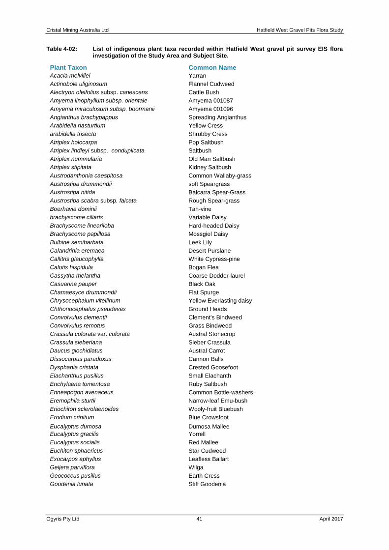
Cristal Mining Australia Ltd Hatfield West Gravel Pits Flora Study
Ogyris Pty Ltd 41 April 2017
Table 4-02: List of indigenous plant taxa recorded within Hatfield West gravel pit survey EIS flora investigation of the Study Area and Subject Site.
Plant Taxon Common Name
Acacia melvillei Yarran
Actinobole uliginosum Flannel Cudweed
Alectryon oleifolius subsp. canescens Cattle Bush
Amyema linophyllum subsp. orientale Amyema 001087
Amyema miraculosum subsp. boormanii Amyema 001096
Angianthus brachypappus Spreading Angianthus
Arabidella nasturtium Yellow Cress
arabidella trisecta Shrubby Cress
Atriplex holocarpa Pop Saltbush
Atriplex lindleyi subsp. conduplicata Saltbush
Atriplex nummularia Old Man Saltbush
Atriplex stipitata Kidney Saltbush
Austrodanthonia caespitosa Common Wallaby-grass
Austrostipa drummondii soft Speargrass
Austrostipa nitida Balcarra Spear-Grass
Austrostipa scabra subsp. falcata Rough Spear-grass
Boerhavia dominii Tah-vine
brachyscome ciliaris Variable Daisy
Brachyscome lineariloba Hard-headed Daisy
Brachyscome papillosa Mossgiel Daisy
Bulbine semibarbata Leek Lily
Calandrinia eremaea Desert Purslane
Callitris glaucophylla White Cypress-pine
Calotis hispidula Bogan Flea
Cassytha melantha Coarse Dodder-laurel
Casuarina pauper Black Oak
Chamaesyce drummondii Flat Spurge
Chrysocephalum vitellinum Yellow Everlasting daisy
Chthonocephalus pseudevax Ground Heads
Convolvulus clementii Clement's Bindweed
Convolvulus remotus Grass Bindweed
Crassula colorata var. colorata Austral Stonecrop
Crassula sieberiana Sieber Crassula
Daucus glochidiatus Austral Carrot
Dissocarpus paradoxus Cannon Balls
Dysphania cristata Crested Goosefoot
Elachanthus pusillus Small Elachanth
Enchylaena tomentosa Ruby Saltbush
Enneapogon avenaceus Common Bottle-washers
Eremophila sturtii Narrow-leaf Emu-bush
Eriochiton sclerolaenoides Wooly-fruit Bluebush
Erodium crinitum Blue Crowsfoot
Eucalyptus dumosa Dumosa Mallee
Eucalyptus gracilis Yorrell
Eucalyptus socialis Red Mallee
Euchiton sphaericus Star Cudweed
Exocarpos aphyllus Leafless Ballart
Geijera parviflora Wilga
Geococcus pusillus Earth Cress
Goodenia lunata Stiff Goodenia

Cristal Mining Australia Ltd Hatfield West Gravel Pits Flora Study
Ogyris Pty Ltd 42 April 2017
Table 4-02 continued
Plant Taxon Common Name
Goodenia pusilliflora Small-flower Goodenia
Hakea tephrosperma Hooked Needlewood
Harmsiodoxa blennodioides May Smocks
Herniaria cinerea Hairy raspwort
Hypochaeris glabra Smooth Cat's Ear
Isoetopsis graminifolia Grass Heads
Lactuca serriola Wild Lettuce
Lysiana exocarpi Harlequin Mistletoe
Maireana brevifolia Short-leaf Bluebush
Maireana georgei Slit-wing Bluebush
Maireana pentatropis Erect Bluebush
Maireana pyramidata Black Bluebush
Maireana sedifolia Pearl Bluebush
Maireana triptera Three-wing Bluebush
Maireana turbinata Satiny Bluebush
Marsdenia australis Austral Doubah
Marsilea drummondii Nardoo
Millotia perpusilla Tiny Bow-flower
Minuria cunninghami Bush Minuria
Myoporum platycarpum subsp. platycarpum Sugarwood
Nicotiana velutina Wild Tobacco
Nitraria billardierei Nitre-bush
Olearia pimeleoides Pimelea Daisy-bush
Omphalolappula concava Burrstick
Onopordum acaulon Stemless Thistle
Osteocarpum acropterum var. deminuta Babbagia
Oxalis perennans Wood Sorrel
Parietaria cardiostegia Desert Nettle
Pimelea trichostachya Annual Rice-flower
Pittosporum angustifolium Weeping Pittosporum
Plantago turrifera Small Sago-weed
Podolepis aristatasubsp. affinis Copper-wire Daisy
Podolepis muelleri Small Copper-wire Daisy
Pogonolepis muelleriana Stiff Cup-flower
Pycnosorus pleiocephalus Soft Billy-buttons
Rhagodia spinescens Hedge Saltbush
Reichardia tingitana Reichardia
Rhodanthe moschata Musk Sunray
Rhodanthe pygmaea Dwarf Sunray
Rhodanthe stuartianum Clay Sunray
Rytidosperma caespitosa Common Wallaby Grass
Salsola tragus subsp. tragus Prickly Saltwort
Schenkea australis Pink Gentian
Sclerochlamys brachyptera Short-wing Bluebush
Sclerolaena diacantha Grey Copperburr
Sclerolaena eriacantha Wooly-fruit Copperburr
Sclerolaena intricata Poverty Bush
Sclerolaena obliquicuspis Limestone Copperburr
Sclerolaena patenticuspis Spear-fruit Copperburr
Senecio glossanthus Slender Groundel
Senecio pinnatifolius var. pinnatifolius Mallee Groundsel

Cristal Mining Australia Ltd Hatfield West Gravel Pits Flora Study
Ogyris Pty Ltd 43 April 2017
Table 4-02 continued
Plant Taxon Common Name
Senna artemisioides subsp. x coriacea Broad-leaf Desert Senna
Sida intricata Twiggy Sida
Solanum esuriale Quena
Spergularia brevifolia Native Sand-spurrey
Stenopetalum lineare Slender Thread-petal
Tetragonia moorei Desert Spinach
Tribulus micrococcus Spineless Caltrop
Vittadinia cervicularis Annual New Holland Daisy
Vittadinia gracilis Hairy New Holland Daisy
Wahlenbergia gracilenta Annual Bluebell
Wahlenbergia graniticola Tufted Bluebell
Wahlenbergia victoriensis Large-flowered Annual Bluebell
Wurmea dioica subsp. brevifolia Early Nancy
Zygophyllum apiculatum Pointed Twinleaf
Zygophyllum aurantiacum Shrubby Twinleaf
Zygophyllum crenatum Notched Twinleaf
Zygophyllum iodocarpum Violet Twinleaf
Zygophyllum ovatum Dwarf Twinleaf
Zygophyllum simile White Twinleaf
4.3.2 Alien Plant Taxa Recorded from the Hatfield West Study Area
A total of 37 alien plant taxa were recorded in the Hatfield West gravel pit flora survey. They
have been listed in Table 4-03 below. Of these, only African Boxthorn (Lycium ferocissimum)
is listed under the Noxious Weeds Act 1993 as Class 4 noxious weed for control within the
Balranald Shire Council Control Area. African Boxthorn “must be managed in a manner that
continuously inhibits the ability of the plant to spread and the plant must not be sold, propagated
or knowingly distributed”. African Boxthorn was recorded at numerous sites and was present
at all three proposed pit locations. Although found within the Hatfield West Study Area, Onion
Weed (Asphodelus fistulosus) and Bathurst Burr (Xanthium spinosum), are not Category 4
noxious weeds for control within the Balranald SC Control Area, as listed by AMBS (2013).
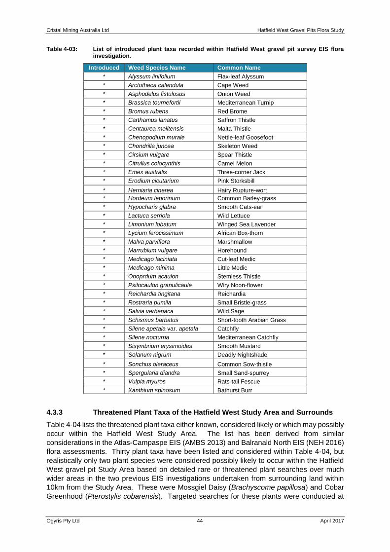
Cristal Mining Australia Ltd Hatfield West Gravel Pits Flora Study
Ogyris Pty Ltd 44 April 2017
Table 4-03: List of introduced plant taxa recorded within Hatfield West gravel pit survey EIS flora investigation.
Introduced Weed Species Name Common Name
* Alyssum linifolium Flax-leaf Alyssum
* Arctotheca calendula Cape Weed
* Asphodelus fistulosus Onion Weed
* Brassica tournefortii Mediterranean Turnip
* Bromus rubens Red Brome
* Carthamus lanatus Saffron Thistle
* Centaurea melitensis Malta Thistle
* Chenopodium murale Nettle-leaf Goosefoot
* Chondrilla juncea Skeleton Weed
* Cirsium vulgare Spear Thistle
* Citrullus colocynthis Camel Melon
* Emex australis Three-corner Jack
* Erodium cicutarium Pink Storksbill
* Herniaria cinerea Hairy Rupture-wort
* Hordeum leporinum Common Barley-grass
* Hypocharis glabra Smooth Cats-ear
* Lactuca serriola Wild Lettuce
* Limonium lobatum Winged Sea Lavender
* Lycium ferocissimum African Box-thorn
* Malva parviflora Marshmallow
* Marrubium vulgare Horehound
* Medicago laciniata Cut-leaf Medic
* Medicago minima Little Medic
* Onoprdum acaulon Stemless Thistle
* Psilocaulon granulicaule Wiry Noon-flower
* Reichardia tingitana Reichardia
* Rostraria pumila Small Bristle-grass
* Salvia verbenaca Wild Sage
* Schismus barbatus Short-tooth Arabian Grass
* Silene apetala var. apetala Catchfly
* Silene nocturna Mediterranean Catchfly
* Sisymbrium erysimoides Smooth Mustard
* Solanum nigrum Deadly Nightshade
* Sonchus oleraceus Common Sow-thistle
* Spergularia diandra Small Sand-spurrey
* Vulpia myuros Rats-tail Fescue
* Xanthium spinosum Bathurst Burr
4.3.3 Threatened Plant Taxa of the Hatfield West Study Area and Surrounds
Table 4-04 lists the threatened plant taxa either known, considered likely or which may possibly
occur within the Hatfield West Study Area. The list has been derived from similar
considerations in the Atlas-Campaspe EIS (AMBS 2013) and Balranald North EIS (NEH 2016)
flora assessments. Thirty plant taxa have been listed and considered within Table 4-04, but
realistically only two plant species were considered possibly likely to occur within the Hatfield
West gravel pit Study Area based on detailed rare or threatened plant searches over much
wider areas in the two previous EIS investigations undertaken from surrounding land within
10km from the Study Area. These were Mossgiel Daisy (Brachyscome papillosa) and Cobar
Greenhood (Pterostylis cobarensis). Targeted searches for these plants were conducted at

Cristal Mining Australia Ltd Hatfield West Gravel Pits Flora Study
Ogyris Pty Ltd 45 April 2017
the opportune time for observation of these species, in mid-late October 2016 in a season of
well above average rainfall. Only one threatened plant species, Mossgiel Daisy (Brachyscome
papillosa) was found to occur within or immediately surrounding the Hatfield West Subject
Sites of Pits A and C. Herbarium specimens of Mossgiel Daisy were collected for verification
purposes and the identification to Mossgiel Daisy was confirmed at the Melbourne Royal
Botanic Gardens (MEL) by Mr. Neville Walsh (Senior Conservation Botanist) in email
correspondence on the 19th October 2016. Mossgiel Daisy (see Plate 4-09 and 4-10) is a New
South Wales endemic species and is considered to be vulnerable in NSW as well as Australia.
The species is listed under the NSW Threatened Species Conservation Act 1995 as well the
Commonwealth’s Environment Protection and Biodiversity Conservation Act 1999. Cobar
Greenhood was not detected during the targeted rare plant surveys of the Hatfield West Study
Area despite extensive searches for this species.
The occurrences of Mossgiel Daisy at and around the Pit A and Pit C sites has been shown in
Figure 4-04. At Pit A, Mossgiel Daisy was found at eight locations within the Subject Site. At
Pit C, Mossgiel Daisy was found to occur at one location within the Subject Site. At every site
within both Pits A and C, Mossgiel Daisy was found as single plants, with the only occurrence
with multiple plants being the location immediately north of Pit C. Mossgiel Daisy was found
most commonly within Belah-Rosewood Woodland (see Plate 4-11)), but was also found in
Yarran Shrubland (see Plate 4-12). The plants found were also always present with white ray
florets and not mauve ray florets as suggested in Harden (1992). Both the habitat in which the
species was found at Hatfield West as well as the occurrence of white ray florets on the flowers
differs from the threatened species profile of OEH (2016) which is in need of amendment based
on the information found within this study.

Cristal Mining Australia Ltd Hatfield West Gravel Pits Flora Study
Ogyris Pty Ltd 46 April 2017
Plate 4-08: Mossgiel Daisy (Brachyscome papillosa) flowers showing the white ray florets.
Plate 4-09: Mossgiel Daisy has distinctive pinnatisect leaf with flowers held singularly on an extended peduncle.
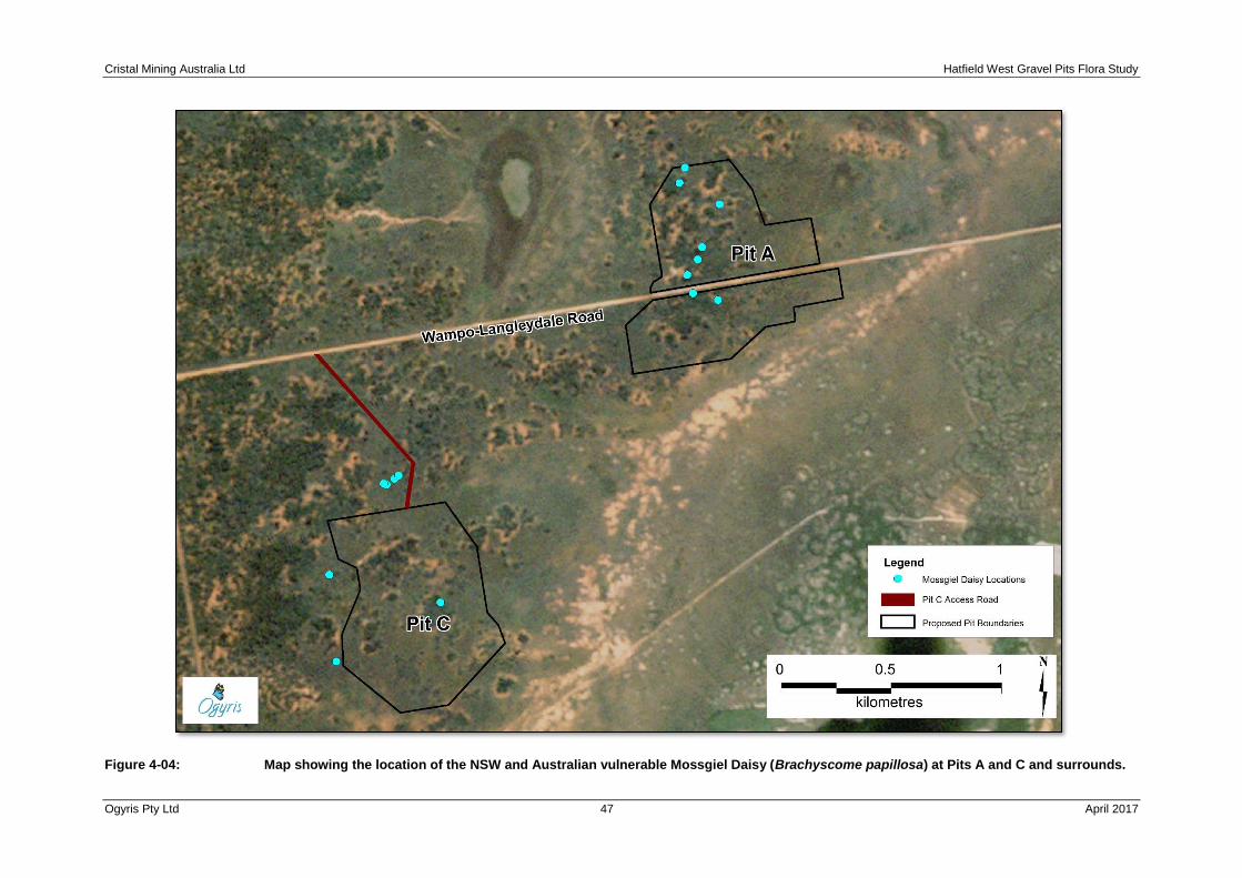
Cristal Mining Australia Ltd Hatfield West Gravel Pits Flora Study
Ogyris Pty Ltd 47 April 2017
Figure 4-04: Map showing the location of the NSW and Australian vulnerable Mossgiel Daisy (Brachyscome papillosa) at Pits A and C and surrounds.
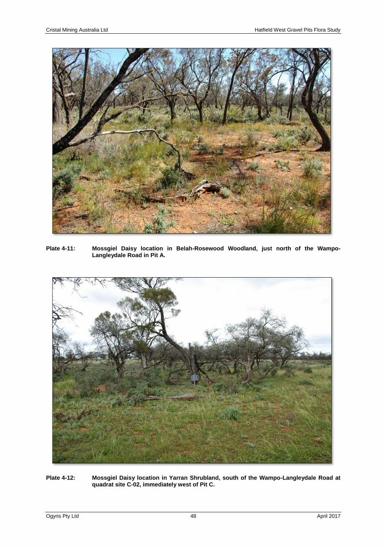
Cristal Mining Australia Ltd Hatfield West Gravel Pits Flora Study
Ogyris Pty Ltd 48 April 2017
Plate 4-11: Mossgiel Daisy location in Belah-Rosewood Woodland, just north of the Wampo-Langleydale Road in Pit A.
Plate 4-12: Mossgiel Daisy location in Yarran Shrubland, south of the Wampo-Langleydale Road at quadrat site C-02, immediately west of Pit C.

Cristal Mining Australia Ltd Hatfield West Gravel Pits Flora Study
Ogyris Pty Ltd 49 April 2017
A targeted search for Mossgiel Daisy was also conducted along the known MCTR location at
the Langleydale-Magenta Road (see AMBS 2013). This was undertaken initially to ensure that
the species was correctly identified within the Hatfield West Study Area, but also to understand
the context for any plants found in our study. The distribution of this species along the MCTR
was also mapped in greater detail than was presented by AMBS (2013), although that
information is not presented here. At the MCTR site, the habitat is closely aligned with the
published (PlantNet 2016) saltbush shrubland. Here the species was found in Bladder
Saltbush (Atriplex vesicaria) Shrubland as well as Black Bluebush (Maireana pyramidata)
Shrubland and ecotones grading between the two primary plant communities. The population
of Mossgiel Daisy at the Langleydale-Magenta Road section of the MCTR has been estimated
at greater than 200,000 plants, with the largest numbers occurring on the western side of the
road. Plate 4-13 illustrates a Black Bluebush Shrubland with more than 50 plants per m². The
population of Mossgiel Daisy at the Langleydale-Magenta Road location is considered a meta-
population in optimal habitat for the species. The population is quite possibly the largest in
New South Wales and is highly significant.
Plate 4-13: Mossgiel Daisy at the Langleydale-Magenta Road section of the Atlas-Campaspe MCTR on the 28th October 2016. At this location, plant densities were more than 50 plants per m². The population location is considered to be a meta-population in optimal habitat for the species.
The occurrences of Mossgiel Daisy within the Hatfield West Gravel Pit site are very small in
comparison and probably represent outlier occurrences in sub-optimal habitat in an
exceptional year for observation of this species. Well above average precipitation through late
August and September 2016 must have led to a massive germination event for Mossgiel Daisy
in chenopod shrublands along the Langleydale-Magenta Road section of the MCTR, as well
as the occasional germination event in woodland vegetation away from this core meta
population.

Cristal Mining Australia Ltd Hatfield West Gravel Pits Flora Study
Ogyris Pty Ltd 50 April 2017
4.3.4 Threatened Plant Communities of the Hatfield West Area and Surrounds
The Atlas-Campaspe EIS flora investigation (AMBS 2013) found two threatened ecological
plant communities occurred within the Study Area of that investigation. These were
• “Sandhill Pine Woodland in the Riverina, Murray-Darling Depression and NSW South
Western Slopes Bioregions”, known in this report as Sandhill Pine Woodland; and
• Acacia melvillei Shrubland in the Riverina and Murray-Darling Depression Bioregions,
known in this report as Yarran Shrubland.
Both of these plant communities were found to occur within the Hatfield West Study Area,
including within the Subject Site of the proposed gravel pit sites. Figure 4-05 shows the
location of both of these plant communities at the Pit A and C location.
Sandhill Pine Woodland Sandhill Pine Woodland occurs over 1.43 Ha and 1.24 Ha at Pit A
and C respectively. At Pit A, Sandhill Pine Woodland also occurs at four locations surrounding
the Subject Site comprising an appreciably greater distribution of 14.1 Ha. Figure 4-02, from
earlier in this chapter, shows the location of Sandhill Pine Woodland both within, and
immediately surrounding the Pit B Subject Site. A dis-used quarry has been excavated into a
dune at this location and has removed approximately 2 Ha of Sandhill Pine Woodland. The
Pit B Subject Site also includes 2.22 Ha, but a further 19.5 Ha also surrounds this proposed
area of disturbance. All of the Sandhill Pine Woodland at the Hatfield West Subject Site (Pits
A, B and C) and surrounds is degraded, with vastly diminished tree and large shrub (Black
Bluebush) density.
Yarran Shrubland At Pit C, Yarran Shrubland occurs primarily around the western side of the
Pit C Subject Site, but two patches are contiguous with it and total 0.53 Ha. The Yarran
Shrubland in this area is all in poor condition with vastly diminished canopy cover.
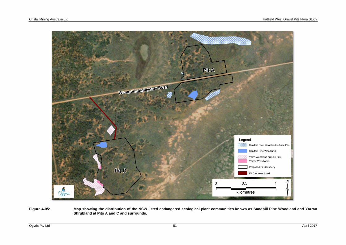
Cristal Mining Australia Ltd Hatfield West Gravel Pits Flora Study
Ogyris Pty Ltd 51 April 2017
Figure 4-05: Map showing the distribution of the NSW listed endangered ecological plant communities known as Sandhill Pine Woodland and Yarran Shrubland at Pits A and C and surrounds.

Cristal Mining Australia Ltd Hatfield West Gravel Pits Flora Study
Ogyris Pty Ltd 52 April 2017
CHAPTER 5 FLORA IMPACT ASSESSMENT
5.1 Potential Impacts
The Hatfield West gravel pits would impact biodiversity, including threatened biodiversity, through both direct and indirect impacts during construction and operation. The majority of impacts on biodiversity would occur as a result of direct impacts inside the Subject Site through clearing of native vegetation and removal of habitat for a range of flora species and plant communities. Indirect impacts are also considered within the overall assessment of impacts.
Impacts on biodiversity would occur over the operational life of the Hatfield West gravel pits, despite revegetation of the gravel extraction areas taking place concurrently with decommissioning of completed areas. Rehabilitation of the gravel extraction areas will be important in mitigating long-term impacts from removal of native vegetation from the Subject Site, but will also provide the opportunity to re-establish threatened plant communities and the known threatened plant species cleared from the site. This is discussed further in the following ‘Chapter 6 Avoidance Management and Mitigation’.
5.2 Direct Impacts
The main impact on biodiversity associated with the Hatfield West gravel pit development is clearing of native vegetation and removal of habitat, including threatened flora species habitat within the disturbance area.
5.2.1 Loss of Remnant Vegetation
The maximum extent of clearing of remnant native vegetation associated with this project would be 108.78 Ha. A further 4.63 Ha of existing cleared vegetation along fencelines and tracks, and within dis-used quarry areas would also form part of the development. Table 5-01 attempts to summarize the loss within the context of the vegetation remaining within the Southern Mallee Region as well as the Lower Murray-Darling Catchment. The two major plant community groupings occurring within the Subject Site of the Hatfield West gravel pits are Belah-Rosewood Woodland and Bluebush-Grassland Mosaic. Together, they comprise ~88% of the vegetation present. Along with Chenopod Sandplain Mallee, Belah Woodlands and Chenopod Shrublands (incorporating the degraded mapping unit Bluebush-Grassland Mosaic as well as Pearl Bluebush Shrubland) comprise the majority of the vegetation in the Southern Mallee Region of NSW. None are threatened, although Chenopod Sandplain Mallee, a very minor component (<1%) of this study, is over-cleared within the lower Murray-Darling Catchment Region.

Cristal Mining Australia Ltd Hatfield West Gravel Pits Flora Study
Ogyris Pty Ltd 53 April 2017
Table 5-01: Summary table comparing the area proposed for gravel pit clearance with estimated catchment loss of the same vegetation communities. The proportion of those communities occurring within the Southern Mallee Region has also been shown.
Vegetation Community
Community Conservation Status
Area (Ha) to be Cleared by Gravel Pit Development
Location
Estimate (%) of Vegetation Community Cleared in Lower Murray-Darling Catchment (OEH 2012)
Proportion (% of the Total) Existing Within the Southern Mallee
Semi-arid Woodlands
Belah-Rosewood Woodland
NT 53.93 Pit A and C 20 16.7
Chenopod Sandplain Mallee
NT 1.02 Pit A and C 30 8.9
Belah-Rosewood/Chenopod Mallee Mosaic
None 0 N/A Unknown 5.0
*Sandhill Pine Woodland
E 4.89 Pit A, B and C
50 NR
Arid Shrublands
*Yarran Shrubland E 0.53 Pit C 60 NR
Pearl Bluebush Shrubland
NT 2.70 Pit C 10
36.0 Bluebush-Grassland Mosaic
LC 45.71 Pit A, B and C
Unknown
Community Conservation Status E = Endangered NT = Near Threatened LC = Least Concern
5.2.2 Loss of Threatened Species and Plant Communities
Threatened Plant Communities Although degraded, the most significant impact to remnant
vegetation associated with this study will be the loss of 4.89 Ha of Sandhill Pine Woodland
which has already suffered ~50% clearance from the Lower Murray-Darling Catchment along
with >70% from other parts of the plant community’s distribution across the Lachlan,
Murrumbidgee and Murray Catchments (Benson et al. 2006). Of lesser direct impact would
be the loss of 0.53Ha of Yarran Shrubland, which is also in poor condition, but also extensively
over-cleared within the Lower Murray-Darling Catchment (~60%). Both of these plant
communities provide significant opportunity for rehabilitation within the post extraction future
of the gravel pits (see Chapter 6), as well as from enhancement of surrounding vegetation.
Threatened Plants Assessments of Significance were completed for 30 plants considered possibilities to be present within the Hatfield West Gravel Pit Project Area (see Table 5-02). Only one species, Mossgiel Daisy (Brachyscome papillosa) was actually found in this study, whilst another, Cobar Greenhood (Pterostylis cobarensis), was considered a possibility to occur there. A Seven Part Test was conducted on both of these species (see Appendix 2) and neither were predicted to be significantly impacted by the Hatfield West Gravel Pit Project.

Cristal Mining Australia Ltd Hatfield West Gravel Pits Flora Study
Ogyris Pty Ltd 54 April 2017
Table 5-02: Assessments of Significance for 30 plants considered possibilities to be present within the Hatfield West Gravel Pit Project Area.
SPECIES COMMON NAME EPBC STATUS
TSC STATUS
LIKELIHOOD OF OCCURRENCE
POTENTIAL FOR IMPACT
COMMENTS ON KNOWN ECOLOGY
Acacia acanthoclada Harrow Wattle
e None - no suitable habitat in Project Area.
None Found primarily in deep sand mallee community dune crests which do not exist within the Project Area. The nearest plants recorded (NPWS Atlas records) occur on the western side of the Willandra Lakes WHA approximately 80 km to the NNW.
Acacia carneorum Purple Wood Wattle V v Unlikely to be Present Within the Project Area
None Although nominally suitable habitat is present as Belah Woodlandcommunity, the Project Area is a considerable distance east of the known distribution of this species.
Acacia notabilis Stiff Golden Wattle
e Unlikely to be Present Within the Project Area
None The few records of this species from the Murray Mallee region of New South Wales and Victoria indicate a preference for mallee communities (Harden 1991; Walsh & Entwisle 1996). An extremely rare plant in both states but may be present in the high quality mallee dune fields that characterize the Prungle MLA. Widespread and occasionally common in South Australia, occurring in areas receiving 200-500mm rainfall (Whibley and Symon 1992). Unlikely to be present within the Project Area.
Acacia rivalis Creek Wattle
e None - no suitable habitat in Project Area.
None Confined to woodland communities near Broken Hill, bordering ephemeral creeks and streams and along watercourses. It grows in a variety of stony soils, often with limestone content.
Atriplex infrequens Saltbush V v None - no suitable habitat in Project Area.
None Atriplex infrequens is associated with broad drainage tracts (Cunningham et al. 1992), clay flats and possibly occasionally inundated habitats which are not present within the Project Area
Austrostipa metatoris speargrass V v Unlikely to be Present Within the Project Area
None Occurs across three of Harden’s botanical sub-divisions of New South Wales (viz. SFWP, SWP and CWS). Known from the Euston and Kyalite areas although ecology of the species, apart from a comment by Harden (1993) concerning a preference for sandy sites, is very poorly known. Considered unlikely to occur within the Project Area.
Austrostipa nullanulla Club Speargrass
e None - no suitable habitat in Project Area.
None Exclusively found on gypseous (copi) rises which are widespread in the Willandra Lakes WHA, but are not represented within the Project Area.

Cristal Mining Australia Ltd Hatfield West Gravel Pits Flora Study
Ogyris Pty Ltd 55 April 2017
SPECIES COMMON NAME EPBC STATUS
TSC STATUS
LIKELIHOOD OF OCCURRENCE
POTENTIAL FOR IMPACT
COMMENTS ON KNOWN ECOLOGY
Austrostipa wakoolica Speargrass E e Unlikely to be Present Within the Project Area
None Grows on floodplains of the Murray River tributaries, in open woodland on grey, silty clay or sandy loam soils; habitats include the edges of a lignum swamp with box and mallee; creek banks in grey, silty clay; mallee and lignum sandy-loam flat; open Cypress Pine forest on low sandy range; and a low, rocky rise.
Brachyscome papillosa
Mossgiel Daisy V v Known to be Present
Within the Project Area.
Low - will be
impacted. See assessment of significance. A
significant impact is not
likely.
Recorded in clay and clay loam soils in Bladder Saltbush and Black Bluebush shrublands nearby to the Project Area, along the Atlas-Campaspe MCTR in the EIS invesitigation by Cristal Mining Australia. Found within Pit A and Pit C, all as single plants.
Callitriche cyclocarpa Western Water Starwort
V v None - no suitable habitat in Project Area.
None In NSW only recorded at 'The Gut' near Koraleigh, on the floodway from the Murray to Wakool River, about 26 km NNW of Swan Hill.
Calotis moorei Moore’s Burr-daisy E e Unlikely to be Present Within the Project Area
None Moore's Burr-daisy occurs on red-brown fine sand in relatively flat areas on upper areas of low sandhills which are not present within the Project Area.
Casuarina obesa Swamp Sheoak
e None - no suitable habitat in Project Area.
None Requires moist, slightly saline soils. Potential habitats include shorelines of permanent, ephemeral or relict lakes. These systems may be freshwater or saline-influenced judging by the present distribution of the species. In NSW, associated species include Eucalyptus camaldulensis, E. largiflorens and Acacia stenophylla with the understorey dominated by grasses and sedges.
Convolvulus tedmoorei
Bindweed
e None - no suitable habitat in Project Area.
None Grows in self-mulching grey clay soils on the floodplains of the Darling and Murrumbidgee Rivers. No suitable habitat within the Project area.
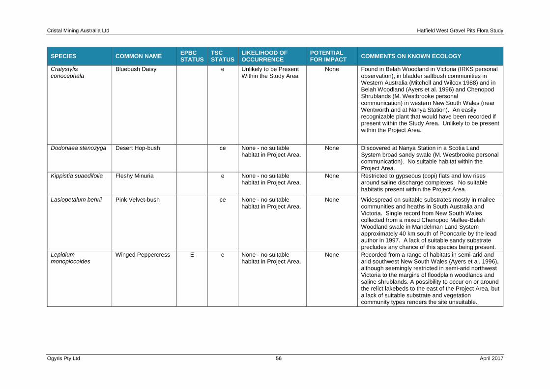
Cristal Mining Australia Ltd Hatfield West Gravel Pits Flora Study
Ogyris Pty Ltd 56 April 2017
SPECIES COMMON NAME EPBC STATUS
TSC STATUS
LIKELIHOOD OF OCCURRENCE
POTENTIAL FOR IMPACT
COMMENTS ON KNOWN ECOLOGY
Cratystylis conocephala
Bluebush Daisy
e Unlikely to be Present Within the Study Area
None Found in Belah Woodland in Victoria (IRKS personal observation), in bladder saltbush communities in Western Australia (Mitchell and Wilcox 1988) and in Belah Woodland (Ayers et al. 1996) and Chenopod Shrublands (M. Westbrooke personal communication) in western New South Wales (near Wentworth and at Nanya Station). An easily recognizable plant that would have been recorded if present within the Study Area. Unlikely to be present within the Project Area.
Dodonaea stenozyga Desert Hop-bush
ce None - no suitable habitat in Project Area.
None Discovered at Nanya Station in a Scotia Land System broad sandy swale (M. Westbrooke personal communication). No suitable habitat within the Project Area.
Kippistia suaedifolia Fleshy Minuria
e None - no suitable habitat in Project Area.
None Restricted to gypseous (copi) flats and low rises around saline discharge complexes. No suitable habitatis present within the Project Area.
Lasiopetalum behrii Pink Velvet-bush
ce None - no suitable habitat in Project Area.
None Widespread on suitable substrates mostly in mallee communities and heaths in South Australia and Victoria. Single record from New South Wales collected from a mixed Chenopod Mallee-Belah Woodland swale in Mandelman Land System approximately 40 km south of Pooncarie by the lead author in 1997. A lack of suitable sandy substrate precludes any chance of this species being present.
Lepidium monoplocoides
Winged Peppercress E e None - no suitable habitat in Project Area.
None Recorded from a range of habitats in semi-arid and arid southwest New South Wales (Ayers et al. 1996), although seemingly restricted in semi-arid northwest Victoria to the margins of floodplain woodlands and saline shrublands. A possibility to occur on or around the relict lakebeds to the east of the Project Area, but a lack of suitable substrate and vegetation community types renders the site unsuitable.

Cristal Mining Australia Ltd Hatfield West Gravel Pits Flora Study
Ogyris Pty Ltd 57 April 2017
SPECIES COMMON NAME EPBC STATUS
TSC STATUS
LIKELIHOOD OF OCCURRENCE
POTENTIAL FOR IMPACT
COMMENTS ON KNOWN ECOLOGY
Leptorynchos waitzia Button Immortelle
e Old records from within 100 km either side of the Project Area. Unlikely to be present within the Project Area.
Unlikely Widespread in semi-arid regions of South Australia with a more restricted distribution in western Victoria where the taxon is considered vulnerable. The only recent record known from western New South Wales was collection from Bluebush shrublands at Kinchega National Park with three 19th Century records from the Prungle Lakes on the western side of the the Willandra Lakes World Heritage Area, Buronga and Booligal.
Maireana cheelii Chariot Wheels V v Unlikely to be Present Within the Project Area
None Soils include heavy brown to red- brown clay-loams and hard cracking red clay. Tends to grow in shallow depressions, often on eroded or scalded surfaces, and does not extend to elevated well drained soils in the habitat. It has been found on the edges of bare, windswept claypans, in shallow depressions.
Pimelea serpyllifolia ssp serpyllifolia
Thyme Rice-flower
e None - no suitable habitat in Project Area.
None Only one record of this plant known from New South Wales where found adjacent to the Sturt Highway 31km west from Euston in mallee. Widespread in Victoria and South Australia where known from numerous coastal locations along with a few Mallee locations (Walsh & Entwisle 1996). No suitable habitat within the Project Area.
Pterostylis cobarensis Cobar Greenhood
v Possibility to be present based on occurrence 4 km NNE in Atlas-Camapspe Study Area.
Low - but may
possibly be impacted. See assessment of significance. A
significant impact is not
likely.
Habitats are eucalypt woodlands, open mallee or native pine woodlands on sandy-loam soils. Potential habitat for the species within the Project Area includes the very small areas of Chenopod Sandplain/Swale Mallee Woodland (LM116) as well as the White Cypress-pine Woodland.The species is known to be present at a site approximately 4 kms to the north of the Project Area (Resource Strategies 2013).
Santalum murrayanum
Bitter Quandong
e None - no suitable habitat in Project Area.
None The few records of this species from New South Wales indicate a preference for sandy mallee communities (Harden 1992). Extremely rare in New South Wales but known to occur in very low numbers in Spinifex-Mallee. Present nearby to the Project Area in Spinifex-Mallee, but no suitable habitat for this species at the Hatfield West site.

Cristal Mining Australia Ltd Hatfield West Gravel Pits Flora Study
Ogyris Pty Ltd 58 April 2017
SPECIES COMMON NAME EPBC STATUS
TSC STATUS
LIKELIHOOD OF OCCURRENCE
POTENTIAL FOR IMPACT
COMMENTS ON KNOWN ECOLOGY
Solanum karsense Menindee Nightshade V v None - no suitable habitat in Project Area.
None New South Wales endemic mostly restricted to lakebed herbfields, black box woodland and run-on areas of the Lower Darling and Lower Murrumbidgee River areas of far south-western New South Wales. Habitats are generally lake beds or floodplains of heavy grey clays with a highly self-mulching surface. Also found on sandy floodplains and ridges and in calcareous soils, red sands, red-brown earths and loamy soils.
Swainsona adenophylla
Violet Swainson-pea
e None - no suitable habitat in Project Area.
None NSW records for this species indicate a preference for red sandy or stony flats near lake margins (Harden 1991). Herbarium record from Kinchega NP, but no records from within 100km of the Study Area. Unlikely to be present within the Study Area.
Swainsona colutoides Bladder Swainson-pea
e None - no suitable
habitat in Project Area. None Nearest known occurrence to the Study Area is a
1995 collection from east of Trentham Cliffs, approximately 120 km to the south west. Also present in the Scotia Country and nearby Danggali CP, the latter in South Australia. Possibly restricted to mallee woodlands.
Swainsona flavicarinata
Yellow-keeled Swainson-pea
e None - no suitable
habitat in Project Area. None Grows in deep red sand, recorded from a roadside
on a treeless plain in NSW. In central Australia, the species grows in mulga communities on red earths and on stony soils supporting Bladder Saltbush. Also found on sandy plains and ridges, in grassland, and in watercourses and floodplains near creeks or rock holes.
Swainsona murrayana
Slender Darling Pea V v Unlikely to be present Within the Study Area
Unlikely Rare but widespread and found in Bluebush Shrublands, bladder saltbush, grassland, inland floodplains, run-on and groundwater discharge areas across the semi-arid to arid parts of South Australia, Victoria and New South Wales. Palatability to stock and kangaroos may restrict chances of finding this taxon.

Cristal Mining Australia Ltd Hatfield West Gravel Pits Flora Study
Ogyris Pty Ltd 59 April 2017
SPECIES COMMON NAME EPBC STATUS
TSC STATUS
LIKELIHOOD OF OCCURRENCE
POTENTIAL FOR IMPACT
COMMENTS ON KNOWN ECOLOGY
Swainsona pyrophila Yellow Swainson Pea V v None - no suitable habitat in Project Area.
None Mainly occurring in mallee communities of the Murray Mallee region of South Australia, Victoria and New South Wales. Short-lived and only appears after fire or disturbance (e.g. track construction/grading) which restricts the chances of finding this taxon. Found in primarily Chenopod Mallee vegetation in spring 2002 at Prungle Station on the western side of the Willandra Lakes World Heritage Area Property. Lack of suitable habitat suggests an ulnlikely presence within the Project Area.
Swainsona sericea Silky Swainson Pea
v Unlikely to be Present Within the Project Area.
Unlikely Widespread distribution in New South Wales and Victoria and apparently threatened in both States - and possibly extinct from South Australia. Chances of recording this taxon would be very low due to a lack of suitable habitat, but Sandhill Pine Woodland may provide suitable habitat.

Cristal Mining Australia Ltd Hatfield West Gravel Pits Flora Study
Ogyris Pty Ltd 60 April 2017
5.3 Indirect Impacts
Indirect impacts will occur within and adjacent to the project area as a result of gravel pit construction and operation. Such impacts will largely be restricted to the short to medium term associated with the life of each gravel pit. These impacts can also be mimimized through a suite of sympathetic management procedures.
A range of indirect impacts are likely to, or could, occur as a result of the Hatfield West gravel pits project. These include:
• increased noise and dust from gravel pit construction and operation;
• loss of connectivity and fragmentation of habitats at a local scale through clearing of intact areas of native vegetation within the project area;
• erosion or sedimentation in areas adjoining the gravel pits;
• increased spread of weed propagules;
• increased edge-effects for surrounding vegetated areas; and
• changes in vegetation composition and structure.
The indirect impacts described above are variable in terms of the distance they may extend from actual disturbance areas. Incorporation of buffer areas would also serve to mute indirect impacts and with respect to this study, a boundary buffer edge of 10 m along roads and tracks and 20m around the Pit perimeters is recommended.
5.3.1 Edge Effects
Edge effects are those changes that may occur to a population or community at the edge of a patch of vegetation or habitat. Developments that create new edges (for e.g. through vegetation clearing) will have edge effects on the surrounding remnant vegetation or habitats. Introduction of disease, weeds and predators, as well as management activities such as weedicide control and fencing are examples of edge effects. The establishment of the Pits A and C and the expansion of Pit B would create a number of new edges.
Alterations to the local habitat condition and flora species composition are likely to occur in habitats adjacent to the new edges. The new edges could facilitate the establishment and spread of introduced plant species and may also lead to a potential increased impact from Feral Goats which are common across the Study Area. The operator of the gravel pits will have to incorporate appropriate management strategies, imbued within a Biodiversity Management Plan to plan for minimal impacts as a result of Edge Effects.
It should be noted the Hatfield West Gravel Pit Project would involve appropriate monitoring and control measures to counter act weed invasion and pest control.
5.3.2 Weeds
Weeds have the opportunity to establish themselves in areas of disturbed vegetation, and although only small in area, 37 alien plant taxa are already known from the Study Area, including the common presence of a weed of National Significance in African Boxthorn (Lycium ferocissimum), which is listed for control within the Balranald SC Control Area.
The Hatfield West Gravel Pit Project has the potential to increase or lead to the establishment of weed species where they do not currently exist through the operation of machinery during construction and operation phases, or through the impact of changed stock and Feral Goat movement patterns. New weed species can potentially be introduced as a result and an example from the broader Locality is the first record for NSW of the alien taxon Sprawling Marigold (Oligocarpus calendulaceus). This species was recorded by the authors in Yarran Shrubland in the Vegetation Offset study associated with this project from Cristal’s’ Boree

Cristal Mining Australia Ltd Hatfield West Gravel Pits Flora Study
Ogyris Pty Ltd 61 April 2017
Plains property. This plant taxon sporadically occurs across the arid zone part of the Nullabor Plain in Western and South Australia from Norseman to Port Augusta, with an occurrence at the NSW-SA border as well. A watch for further spread of this weed species is flagged for the State of NSW and control measures will need to be implemented if the species arrives within the Study Area.
5.3.3 Erosion
The Hatfield West Gravel Pit Project is located in area where undulating flat plains are interspersed with dunes. The dune landscapes are few, but are characterized by sandy loam topsoils which are notorious for their susceptibility to wind erosion once remnant vegetation has been removed. From experience at the Ginkgo and Snapper Mines at Pooncarie West, even plains comprised of clay loam soils will also erode from winds once threshold speeds of approximately 30 kph are achieved (John Leys, personal communication). Soil stripping, storage and replacement strategies will need to be cognizant of the potential for wind erosion to valuable topsoil and appropriate management strategies will be required to prevent wind erosion. Such strategies could include, but not be restricted to:
• use of mulch
• use of mulch slurries over newly bare surfaces
• physical wind breaks/barriers
• cover crops
5.3.4 Dust
Dust from the construction and operation of the Hatfield West Gravel Pit Project has the potential to impact the function of plants through reduced photosynthetic activity as well as making the plants susceptible secondary stresses, such as drought, insects and pathogens. Dust impacts will be mitigated through the onsite use of water suppression and the progressive rehabilitation of disturbance across gravel pit areas.
5.3.5 Noise
Impacts of noise generated within the project area are likely to have the greatest impact on fauna biodiversity values with flora values largely unimpeded.
5.3.6 Loss of Connectivity
The Hatfield West Gravel Pit Project would be situated within a large expanse of native vegetation which has been subjected to stock and feral animal grazing and browsing impacts for over 100 years. Connectivity losses would be primarily restricted to fauna, but some minor flora loss of connectivity will occur through an alteration to localized pollination efficiency and function. The progressive rehabilitation of gravel pit sites will assist with mitigation of this impact.
5.3.7 Fire
Historically, bushfires within the Western Division of NSW tend to be associated with rapid growth of Speargrass (Austrostipa spp.) following above average rainfall periods. During summer, following rain events usually associated with lightning, dry swards of grasses pose a bushfire hazard (AMBS 2013) for Western Division vegetation of almost all types. Vehicles with hot exhausts driven through Speargrass swards can lead to fires. The Biodiversity Management Plan will need to incorporate bushfire management protocols, due to the serious risk of fire. This is especially relevant to the two endangered ecological communities present, both of which have clearly suffered impact from fire in the past.

Cristal Mining Australia Ltd Hatfield West Gravel Pits Flora Study
Ogyris Pty Ltd 62 April 2017
5.3.8 Conservation Reserves
The juxtaposition of the site immediately to the east of the Willandra Lakes World Heritage Area Property (WLWHAP) is also of significance, as this formerly active wetland area conserves a diversity of habitats including lakebeds, lunettes and arid woodlands of international significance. The WLWHAP occupies approximately 240,000 Ha or almost 3% of the Murray-Darling Depression Bioregion. Approximately 10% of the WLWHAP is conserved within Mungo National Park. A number of sizable private conservation reserves also exist on nearby properties including Wampo and Boree Plains.
5.4 Cumulative Effects
Cumulative impacts are the successive, incremental and combined impacts (both positive and negative) of an activity on society, the economy and the environment (Franks et al. 2010). They can arise from the compounding activities of a single operation given the interaction of that operation with past, current and future activities that may or may not be related to the existing development. Cumulative impacts may also arise through the interaction of one development with other types of activities and industries, such as grazing and broad scale agriculture.
In relation to the Hatfield West Gravel Pit Project, the cumulative impacts are considered to be the total impact on the environment that would result from incremental impacts (including both direct and indirect impacts) from the development, added to other existing impacts and proposed developments in the Locality and Region.
The primary cumulative impacts of the Hatfield West Gravel Pit Project are associated with the direct and indirect impacts outlined in Sections 5.2 and 5.3, respectively above. The condition and composition of the habitat to be cleared as a result of the Hatfield West Gravel Pit Project has been outlined in detail in Chapter 4. Impacts which are likely to be cumulative within the Hatfield West Gravel Pit Project area include the clearing of vegetation, loss of individuals of threatened plants, potential increases in feral animal populations and weed invasion. It is likely that the accumulating impacts would increase with the area of disturbance at any one time, balanced to some degree by progressive rehabilitation of completed sites and enhancement of surrounding remnant vegetation sites. The cumulative impacts listed may not be fully expressed until well after completion of gravel extraction due to the innate character of semi-arid woodlands whereby regeneration is usually dependent on high rainfall events for completion of reproductive success, with seedlings and young plants significantly prone to grazing by stock, Feral Goats and rabbits.
The Hatfield West Gravel Pit Project would add, albeit in a minor way, to the cumulative impacts of the Atlas-Campaspe Mine 3-10 km to the west, as well as, if approved, to the cumulative impacts of the proposed Balranald North Project located to the south. The cumulative impact of the development of both mineral sands mine developments within what can be termed the “Balranald North Mineral Sands Mining Precinct” would total approximately 9,318 Ha and would add a further 1.2% of disturbance to remnant vegetation associated with mining in the Region.
The Atlas-Campaspe Mine will result in impacts to the following threatened flora (Brachyscome papillosa, Lepidium monoplocoides, and Pterostylis cobarensis) and their habitats which were found within the disturbance areas: (AMBR 2013). The Hatfield West Gravel Pit Project would add further losses to the presence of Brachyscome papillosa in the Locality, but the number of plants lost will be infinitesimally small when compared to the size of the meta population of this species present within the margins of the Langleydale-Magenta Road part of the Atlas-Campaspe MCTR. No loss of the other threatened species found within the Atlas-Campaspe Mine area is anticipated to occur. The habitat for Brachyscome papillosa present within the Subject Site of this study would be lost, but as was explained in Chapter 4, the woodlands present are considered outlier occurrences in sub-optimal habitat in an exceptional year for observation of this species.

Cristal Mining Australia Ltd Hatfield West Gravel Pits Flora Study
Ogyris Pty Ltd 63 April 2017
The main industries and land uses in the surrounding locality are cattle, sheep and Feral Goat grazing in remnant native vegetation, some minor cropping as well as nature conservation. The Hatfield West Gravel Pit Project will not disturb any current cropping areas but will lead indirectly, to the expansion of the area set aside in perpetuity for nature conservation through the dedication of a Biodiversity Offset which would be conserved in perpetuity. Measures such as this would mitigate the cumulative effects of the gravel pit development and are discussed further in the following chapter on mitigation measures.
Whilst the Hatfield West Gravel Pit Project will result in an increase in degradation to natural ecosystems within the Murray Darling Depression Bioregion, it should be noted that the Project will also involve an offset that will contribute to managed conservation areas within the Bioregion. Another positive will include an upgraded road access from the Balranald-Ivanhoe Road west towards properties in the Mungo NP area.

Cristal Mining Australia Ltd Hatfield West Gravel Pits Flora Study
Ogyris Pty Ltd 64 April 2017
CHAPTER 6 AVOIDANCE MANAGEMENT AND MITIGATION
In accordance with OEH Request 7 (see Chapter Table 1-02), the Hatfield West Gravel Pit EIS must demonstrate how the “Project Avoids and Minimizes Impacts” on biodiversity values of the Project area. This chapter of the report outlines the avoidance, management and mitigation measures that Cristal will or has employed for the project to reduce impacts on biodiversity values. Chapter 7 of this report describes the offset strategy for the Hatfield West Gravel Pit Project to account for residual impacts that cannot be avoided or mitigated.
Avoidance, management and mitigation measures associated with each stage of the Hatfield West Gravel Pit Project are outlined in the following sections. The four broad stages of the project include:
Stage 1 Project design
Stage 2 Construction
Stage 3 Operation
Stage 4 Rehabilitation and closure.
It is recognized that some of these stages may actually overlap, such that rehabilitation may actually be occurring at one gravel pit as another is being constructed, although the eventual gravel pit schedule for development has not actually been designed as yet.
A key feature of documenting and carrying out management activities to avoid and mitigate impacts from the Hatfield West Gravel Pit Project will be the formulation of a Biodiversity Management Plan (BMP) for the life of the project. The BMP will also cover management activities for threatened biodiversity (see Section 6.5).
6.1 Project Design
Project design relates to site selection, designing and re-designing elements of the project to minimize vegetation clearing, avoid impacts to significant habitats and vegetated corridors as well as to avoid direct impacts to threatened biodiversity values.
6.1.1 Site Selection
The initial design of the Hatfield West Gravel Pit Project in January 2016 involved two pits – Pit A and Pit B. As the project evolved, it became obvious that the quantity of calcrete resource available at these two pits, particularly Pit B where a large area of the EEC Sandhill Pine Woodland occurred, would be insufficient to maintain the gravel roads along the Atlas-Campaspe MCTR over the life of the project, estimated at 20 years. Pit C was added in September 2016. Calcrete road base of sufficient quality is in short supply in the northern sections of the Balranald SC LGA. Consequently, the location of the gravel pits reflects a compromise between local availability of high quality resource, proximity to the Atlas-Campaspe MCTR, ease of extraction and avoidance of threatened pant communities wherever possible.
6.1.2 Design Considerations
Cristal has aimed to avoid and minimize environmental impacts from the Hatfield West Gravel Pit Project during the design process. Generally, this process has involved:
• Attempts to find existing quarried resources in close proximity to the Atlas-Campaspe MCTR;

Cristal Mining Australia Ltd Hatfield West Gravel Pits Flora Study
Ogyris Pty Ltd 65 April 2017
• overlay and consideration of the preliminary project footprint on aerial photography to avoid treed remnant vegetation wherever possible;
• consideration of cadastral information, property boundaries, existing roads and utility corridors;
• baseline vegetation surveys to identify and confirm ecological constraints within the project area and surrounds; and
• where significant features could not be avoided, identification of mitigation measures to minimize impacts, or commitment to compensation (i.e. offset measures) if impacts are not able to be sufficiently mitigated.
• Specific principles adopted to avoid or minimize impacts on biodiversity are discussed below for the combined gravel pit footprint as well as access roads.
Pit A The original design of Pit A included a larger area of Sandhill Pine Woodland to the south of the current proposed footprint. This has conservatively avoided approximately 5 Ha of Sandhill Pine Woodland and minimized the area of impact to the south of the Wampo-Langleydale Road to 1.43 Ha of this plant community type. Further revision of the design may be possible to avoid even more of this EEC.
Pit B The original design of Pit B surveyed in January 2016 included a large proportion of the Sandhill Pine Woodland to the east of the current footprint. The original design included an additional 5 Ha of this plant community which would have increased the total impact at the Pit B location from the current 2.22 Ha to something exceeding 7 Ha. The access road at this site also follows an existing road, and a fence will be constructed on both sides of this road into and out of the site to direct traffic along dedicated road corridors only, thus reducing the impact to the surrounding dune where Sandhill Pine Woodland occurs.
Pit C The Pit C location is not located next to a road. A route was chosen through disturbed grassland habitat which avoids impact to all but a few small Rosewood (Alectryon oleifolius ssp. canescens) trees, ending up at the Wampo-Langleydale Road 700 m to the north. A small bend in the access road just north of Pit C avoids traversing through a patch of Yarran Shrubland where a number of specimens of the threatened Mossgiel Daisy occur.
6.2 Construction
Impacts arising from the construction of the Hatfield West gravel pits and their associated infrastructure and access roads will primarily relate to vegetation clearing. Cristal proposes to undertake vegetation clearing in accordance with the following mitigation and management actions.
6.2.1 Vegetation Clearance
Pre-clearance Surveys Gravel pit pre-clearance surveys would primarily be undertaken to assess whether threatened bat species were living within the Belah-Rosewood Woodlands present at Pits A and C. With respect to threatened flora, the selected pre-clearance areas would be searched for Mossgiel Daisy prior to clearing and construction works, with any propagules (seed) collected from plants and stored for subsequent use in the rehabilitation program. Pre-clearance surveys for Mossgiel Daisy should be undertaken at an appropriate time of the year such as spring (September-November) when the plants are most likely to be in flower and seeding and can be readily identified. Whole plants should also be removed from pre-clearance areas, on-grown and seed collected from these plants.
Timing of Clearing Timing of clearing again, would largely be driven by avoiding the period during the year when bat species may be present in tree hollows either with live young or

Cristal Mining Australia Ltd Hatfield West Gravel Pits Flora Study
Ogyris Pty Ltd 66 April 2017
during pregnancy. This means tree clearing should effectively avoid the window from late winter (mid July) to early summer (December).
Clearing Method The clearing method employed would be similar to that used at Cristal’s Pooncarie West Mining Precinct where two bulldozers dragging a linked chain literally pull the trees down to ground level. The tree litter is then stored as stockpiles for subsequent use as mulch in the rehabilitation program.
Pre-clearance Protocols A Vegetation Clearance Protocol should be prepared along the lines of that currently in operation at Cristal’s Pooncarie West Mining Precinct.
6.2.2 Fencing and Signposting
A combination of fencing and/or the use of highly visibility hazard tape would be used to delineate the boundary of vegetation pre-clearance areas. Signposting will also be used to inform project personnel and site visitors of areas of active extraction and rehabilitation works areas. Speed limit and warning signs would also be erected along the Wampo-Langleydale Road (Pits A and C) as well as the Langleydale-Balranald Road (Pit B) to inform local traffic of the existence of the gravel pits as well as entering and exiting vehicular traffic.
6.2.3 Pest and Weed Management
Pest and weed management activities will be prescribed in the BMP and will include:
• management protocols for feral animals such as foxes, goats, pigs and cats within the rehabilitation area;
• management protocols for the identification of noxious or important environmental weeds within areas to be cleared; and
• avoidance protocols to prevent transporting the weed seeds to rehabilitation areas.
6.3 Operations
The majority of the impacts on biodiversity values will occur in the construction phase of the Hatfield West Gravel Pit Project, however mitigation of direct and indirect impacts which may arise from the operational phase of the project includes the following:
• minimization of dust generation by restricting the extent and time that bare soil is exposed;
• dust suppression activities involving any or all of the use of water carts on roads, sprinklers, vegetation mulch, mulch slurries) where relevant through the project area;
• ensuring vehicles remain on designated roads and tracks through use of signposting and driver education during the induction process and in ongoing project discussions; and
• management and removal of all rubbish from the project area.
6.4 Rehabilitation and Closure
As sections of the gravel pits are decommissioned, progressive rehabilitation will occur. Best practices for rehabilitation, drawing on previous experience as well as from reports and publications (e.g. Squire et al. 2012; Sluiter et al. 2016) arising from Cristal’s Pooncarie West Mining Precinct will guide management with respect to the Closure and Rehabilitation Strategy. An indicative six-step approach is outlined in Table 6-01.
The Closure and Rehabilitation Strategy will be under-pinned by embracing the importance of Step 5: “Restoring self-regenerating vegetation types comprised of indigenous plant taxa in vegetation community types similar to those occurring in surrounding areas”.

Cristal Mining Australia Ltd Hatfield West Gravel Pits Flora Study
Ogyris Pty Ltd 67 April 2017
Table 6-01: Conceptual rehabilitation step-wise model outlining rehabilitation criteria, measurement targets and evidence for completion.
Criteria Measure/Target Evidence for Completion
Step 1: Undertake gravel pit pre-clearance flora and fauna surveys in accordance with a Hatfield West 'Vegetation Pre-clearance Protocol'.
Gravel pit pre-clearance surveys undertaken. Threatened flora species recovered where possible for later use in the rehabilitation program. Wildlife captures documented and threatened fauna species managed within the mantra of a 'Threatened Species Management Protocol'. Captured wildlife returned to similar vegetation types in Cristal Offset areas.
Gravel pit pre-clearance survey reports written and included within the Hatfield West Gravel Pit Annual Environmental Report (AEMR).
Step 2: Soil stripping, removal and storage undertaken in accordance with a Gravel Pit Operations Plan (GPOP).
Topsoil and subsoil stockpiles constructed with appropriate batter angles and heights and protected from erosion by appropriate means such as mulch slurries.
Survey control of completed earthwork structures and work programs. Topsoil stockpiles monitored for vegetation cover and weed presence.
Step 3: Subsoil and topsoil retuned in accordance with the Hatfield West GPOP.
Cristal Earthworks Supervisor and Rehabilitation Officer to ensure target sub-soil and topsoil depths achieved and no plant root impeding layers are present.
Survey control of completed earthwork structures and work programs. Amelioration (ripping and/or gypsum application) of root impeding layers undertaken if required.
Step 4: Achieve stable, non-eroding landforms that can support indigenous native vegetation.
Soil profiles reconstructed with no significant limitations to revegetation.
Soil survey assessments undertaken as part of a Hatfield West Vegetation Monitoring Strategy to ensure long-term rehabilitation landscape stability.
Step 5: Restore self-regenerating vegetation types comprised of indigenous plant taxa in vegetation community types similar to those occurring in surrounding areas.
Revegetation undertaken by a combination of seeding and strategic hand-planting of species unable to be successfully direct seeded. Revegetation targeted for appropriate climatic conditions conducive to vegetation establishment. Strategic fauna monitoring of revegetated areas and surrounding vegetation to assess re-colonization.
Rehabilitation flora assessment reports of new areas undertaken annually for three years, then every three years after that until final completion criteria achieved and property hand-over occurs. Fauna studies written up as reports.
Step 6: Maintain and enhance where necessary, vegetation community types similar to those occurring in surrounding areas in readiness for hand-over to owner for light grazing end-use.
Rehabilitation ecological surveys conducted in line with a Hatfield West Gravel Pit Vegetation Monitoring Strategy.
Rehabilitation monitoring flora and fauna survey reports completed and included within the Hatfield West Gravel Pit Annual Environmental Report (AEMR).
6.5 Biodiversity Management Plan
A Biodiversity Management Plan (BMP) would be prepared to inform and manage various activities throughout the life of the Hatfield West Gravel Pit Project in order to protect and manage important biodiversity values. Key commitments to be covered by the BMP would include flora threatened species management, including specific provisions for Mossgiel Daisy,

Cristal Mining Australia Ltd Hatfield West Gravel Pits Flora Study
Ogyris Pty Ltd 68 April 2017
Sandhill Pine Woodland and Yarran Shrubland, pest and weed management, fire management and site hygiene practices.
6.5.1 Threatened Plant Management
Only one threatened plant species – Mossgiel Daisy (Brachyscome papillosa) – will be impacted by construction of the Hatfield West Gravel Pit Project. Pre-clearance surveys of designated new gravel pit areas in the spring of each year will allow any plants present to be located. Any plants found should have seed collected from them which should be appropriately curated for subsequent use in the rehabilitation program. Plants should be grown from this seed for subsequent re-planting back to the site as tubestock. In addition, parent plants should be lifted, potted and on-grown for seed production. Plants should be planted back into the following target revegetation communities:
• Belah-Rosewood Woodland
• Yarran Shrubland
• Black Bluebush Shrubland
6.5.2 Threatened Plant Community Management
A key plank in the threatened plant management approach to be taken at the Hatfield West Gravel Pit Project sites will be the return within rehabilitation pods of greater areas of the threatened plant communities than were cleared prior to gravel pit development. This involves targeted revegetation of Sandhill Pine Woodland at each of Pits A, B and C, as well as Yarran Shrubland at Pits A and C. Table 6-02 outlines a targeted conceptual model for threatened plant community revegetation at the Hatfield West Gravel Pit sites. Sandhill Pine Woodland rehabilitation at Pit B would occur over cleared areas as well as new areas at the current pit site, but also in an enhancement area surrounding the pit. There is a problem at Pit B in that the existing quarry of ~ 2 Ha has not recovered topsoil in a manner sympathetic with recovering all of this vitally important component of the rehabilitation program. In short, topsoil has been pushed to each side of the Pit B area which has mixed subsoil with topsoil. This will inevitably compromise the success of rehabilitation at this site. It is recommended that to achieve the rehabilitation outcome at Pit B, an enhancement area of extremely degraded Sandhill Pine Woodland totalling a minimum of 5 Ha be revegetated with approximately 1000 Callitris glaucophylla trees. Similarly, enhancement areas totalling a minimum of 5 Ha are proposed at the Pit C gravel pit site where approximately 2000 Acacia melvillei shrubs would be planted. This would include a patch of Yarran Shrubland north of the Pit C Subject Site known to contain Mossgiel Daisy.

Cristal Mining Australia Ltd Hatfield West Gravel Pits Flora Study
Ogyris Pty Ltd 69 April 2017
Table 6-02: Conceptual model for revegetation of two threatened plant communities at the Hatfield West Gravel Pit sites.
*Denotes that:
• an additional 5Ha and 1000 Callitris glaucophylla trees would be
planted into an enhancement area contiguous with the Pit B gravel pit
site; and
• an additional 5 Ha and 2000 Acacia melvillei shrubs would be planted
into enhancement areas contiguous with the Pit C gravel pit site.
Sandhill Pine Woodland
Pit A *Pit B Pit C
Area to be Cleared (Ha) 1.43 2.22 1.24
Target Area for Revegetation (Ha) 5.0 2.5 5.0
Replanting Density of Callitris glaucophylla Ha¯¹ 200 200 200
Total Target Callitris glaucophylla Trees Replanted to Subject Site 1000 500 1000
Additional Callitris glaucophylla trees planted to enhancement area 0 1000 0
Yarran Shrubland
Pit A Pit B *Pit C
Area to be Cleared (Ha) 0 0 0.53
Target Area for Revegetation (Ha) 2.0 0 5.0
Replanting Density of Acacia melvillei 400 0 400
Total Target Acacia melvillei Trees Replanted to Subject Site 800 0 2000
Additional Acacia melvillei shrubs planted to enhancement area 0 0 2000
6.6 Monitoring Mitigation and Management
The BMP will outline monitoring programs to be set up to measure the success of biodiversity management protocols and activities across the Hatfield West Gravel Pit Project such as management actions for threatened plant species, threatened plant communities, pest management activities, and rehabilitation and revegetation activities. Monitoring programs will include goals and performance indicators to measure the success of proposed mitigation measures.

Cristal Mining Australia Ltd Hatfield West Gravel Pits Flora Study
Ogyris Pty Ltd 70 April 2017
CHAPTER 7 BIODIVERSITY OFFSET STRATEGY
Biodiversity offsets provide benefits to biodiversity to compensate for the adverse impacts of an action. Biodiversity offsets assist in achieving long-term conservation outcomes while providing development proponents with the ability to undertake actions that have unavoidable impacts on biodiversity. This chapter provides the background on Cristal’s proposed Biodiversity Offset Package.
7.1 Commonwealth Government Framework for Offset Development
With respect to the Commonwealth Governments position on biodiversity offsetting, offsets are to be determined having regard to the EPBC Act Offsets Policy. Similar to the NSW Framework for biodiversity offsetting (see below), environmental offsets are provided as measures that compensate for the residual adverse impacts of an action under the EPBC Act Offsets Policy. Offsets should counterbalance the impacts that remain after avoidance and mitigation measures have been implemented. For assessments under the EPBC Act, offsets are only required if residual impacts are significant on Matters of National Environmental Significance. With respect to the loss of Mossgiel Daisy, the loss has been assessed as not significant (see Appendix 3), meaning the biodiversity offset can be considered within the NSW ‘Framework’ only.
7.2 NSW Framework for an Offset Development
The Hatfield West Gravel Pit Project has been designated as a ‘Local Development’ and as such, it is not a State Significant Development (SSD) Project. For non-SSD projects, the OEH have released a series of guiding principles titled “OEH principles for the use of biodiversity offsets in NSW” (OEH 2016). The Biodiversity Offset Strategy proposed herein, has been devised cognizant of these guiding principles. Table 7-01 outlines the OEH Principles for NSW Biodiversity Offsets and provides, in turn, the proponents response to that principle.

Cristal Mining Australia Ltd Hatfield West Gravel Pits Flora Study
Ogyris Pty Ltd 71 April 2017
Table 7-01: OEH Biodiversity Offset Principles for non-SSD Developments and the Cristal Response.
OEH Biodiversity Offset Principles for Non-SSD EIS Developments
Cristal Response to OEH Principles for Biodiversity Offsetting
Principle 1. Impacts must be avoided first by using prevention and mitigation measures.
Response: Chapter 6 outlines the avoidance and mitigation measures proposed by Cristal.
Principle 2. All regulatory requirements must be met. Response: All regulatory requirements requested of Cristal have been addressed.
Principle 3. Offsets must never reward ongoing poor performance (with respect to management of the proposed offset).
Response: The Cristal owned property on which the Biodiversity Offset would be located is in vastly superior condition than the land where the development is proposed. It has already been approved in part as an offset for the Atlas-Campaspe Mines.
Principle 4. Offsets will complement other government programs.
Response: The Cristal owned property on which the Biodiversity Offset would be located is contiguous with an existing conservation offset as well as Mungo National Park.
Principle 5. Offsets must be underpinned by sound ecological principles.
Response: The Cristal approach has been to acknowledge that compensation of habitat is required for the loss of the remnant vegetation at the proposed development. Cristal also proposes a combination of revegetation of the Subject Sites as well as enhancement of a surrounding EEC (Sandhill Pine Woodland) through fencing and supplementary replanting with the canopy dominant (Callitris glaucophylla).
Principle 6. Offsets should aim to result in a net improvement in biodiversity over time.
Response: Cristal plan to conserve the Biodiversity Offset in perpetuity, audit the condition of the offset, undertake ongoing pest plant and animal control - all of which will lead to an improvement in biodiversity over time.
Principle 7. Offsets must be enduring – they must offset the impact of the development for the period that the impact occurs.
Response: Cristal will ensure the Biodiversity Offset area selected is conserved in perpetuity.
Principle 8. Offsets should be agreed prior to the impact occurring.
Response: Cristal propose to 'sign-off' on the proposed Biodiversity Offset once an area has been agreed upon between the regulatory authority and the company. This will occur before any impact at the proposed gravel pits occurs.
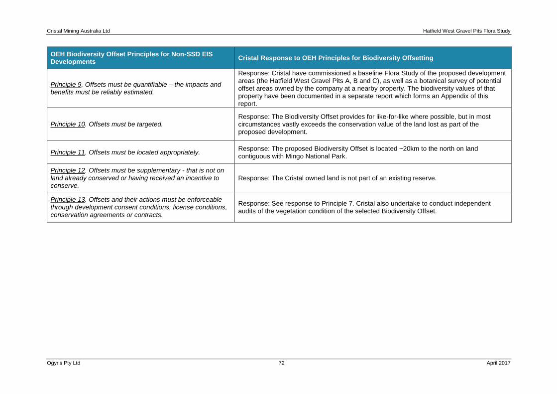
Cristal Mining Australia Ltd Hatfield West Gravel Pits Flora Study
Ogyris Pty Ltd 72 April 2017
OEH Biodiversity Offset Principles for Non-SSD EIS Developments
Cristal Response to OEH Principles for Biodiversity Offsetting
Principle 9. Offsets must be quantifiable – the impacts and benefits must be reliably estimated.
Response: Cristal have commissioned a baseline Flora Study of the proposed development areas (the Hatfield West Gravel Pits A, B and C), as well as a botanical survey of potential offset areas owned by the company at a nearby property. The biodiversity values of that property have been documented in a separate report which forms an Appendix of this report.
Principle 10. Offsets must be targeted. Response: The Biodiversity Offset provides for like-for-like where possible, but in most circumstances vastly exceeds the conservation value of the land lost as part of the proposed development.
Principle 11. Offsets must be located appropriately. Response: The proposed Biodiversity Offset is located ~20km to the north on land contiguous with Mingo National Park.
Principle 12. Offsets must be supplementary - that is not on land already conserved or having received an incentive to conserve.
Response: The Cristal owned land is not part of an existing reserve.
Principle 13. Offsets and their actions must be enforceable through development consent conditions, license conditions, conservation agreements or contracts.
Response: See response to Principle 7. Cristal also undertake to conduct independent audits of the vegetation condition of the selected Biodiversity Offset.

Cristal Mining Australia Ltd Hatfield West Gravel Pits Flora Study
Ogyris Pty Ltd 73 April 2017
7.3 Quantifying the Offset Required
Chapter 5 of this report assessed the impacts of the Hatfield West Gravel Pit Project on biodiversity values of the area. Direct impacts will result in the loss of 108.78 Ha of remnant vegetation which incorporates habitat for one threatened flora species and two endangered ecological plant communities. As such the offset strategy must quantify the required offset for the Hatfield West Gravel Pit Project in accordance with the TSC Act. Cristal have chosen to not pursue the BioBanking method for provision of offsets, but instead to offer as compensation, land owned by the company which is in vastly superior ecological condition when compared to the proposed development sites. With no prescribed ‘multiplier’ provided by the regulatory authority for offsetting land, we have looked to similar recent precedent within the region to provide guidance on what the conservation offset multiplier might be for the plant communities proposed for clearance at the Hatfield West Gravel Pit Subject Site. In a recent EIS investigation for Iluka Resources Ltd. for the Balranald Mineral Sands Project, NEH (2016) devised offset multipliers for four of the six plant communities that occur within the Hatfield West Subject Site, using the NSW/OEH Ecosystem Credit Converter. The plant communities and their offset multiplier include Belah-Rosewood Woodland (7.7:1), Chenopod Sandplain Mallee (6.5:1), Pearl Bluebush Shrubland (4.8:1) as well Open Grasslands-Degraded Shrublands (3.5:1). Table 7-02 outlines the plant communities that would be lost as part of the Hatfield West Gravel Pit development as well as their proposed offset multiplier and eventual offset area in hectares.
The Cristal response has been to increase the multiplier in all circumstances for the four plant communities shared between the Iluka Balranald Project as well as the Hatfield West Gravel Pit Project. Cristal have proposed a multiplier of 15:1 for the two threatened plant communities occurring within the Hatfield West Subject Site which it is argued is generous considering the extremely degraded nature of both threatened EEC’s at the Hatfield West Subject Site, combined with the fact that enhancement areas for these EEC’s are also proposed. The total Biodiversity Offset package proposed by Cristal is a minimum of 716.2 Ha. This Biodiversity Offset should contain the majority area as Belah-Rosewood Woodland, along with a sizable area of Sandhill Pine Woodland as well, if this can be found. The basic requirements outlined in Table 7-02 can be accommodated at Cristal’s property at Boree Plains, ~10 km north of the Hatfield West Gravel Pit Project area. At that location, large areas of Belah-Rosewood Woodland, Sandhill Pine Woodland, Chenopod Sandplain Mallee and Spinifex-Mallee are present, the latter community containing a NSW endangered species in Bitter Quandong (Santalum acuminatum). In addition, the Belah-Rosewood plant community present contains an as yet undescribed (Neville Walsh personal communication) Greenhood orchid species (Pterostylis sp. aff. biseta) known only from the Boree Plains property.

Cristal Mining Australia Ltd Hatfield West Gravel Pits Flora Study
Ogyris Pty Ltd 74 April 2017
Table 7-02: Estimated vegetation offset requirements for the Hatfield West Gravel Pit Project.
Vegetation Formation (Keith
2004)
Vegetation Class (Keith 2004)
BioMetric Vegetation Type (OEH 2011)
Benson et. al.
(2006) ID No.
Vegetation Community (abbreviated name in this
study)
Disturbance Area (Ha)
Indicative Offset Ratio
Target Area of Offset Proposed
(Ha)
Semi-arid Woodlands (shrubby sub-formation)
Semi-arid Sand Plain Woodlands
LM108 Black Oak - Western Rosewood open woodland on deep sandy loams of the Murray-Darling Depression and Riverina Bioregions.
58 Belah-Rosewood Woodland (Belah-Rosewood sub-community)
53.93 8:1 431.4
Riverine Sandhill Woodlands LM159 White Cypress Pine open woodland of sandplains, prior streams and dunes of the semi-arid (warm) climate zone.
28 Sandhill Pine Woodland 4.89 15:1 73.4
Semi-arid Woodlands (shrubby sub-formation)
Sandplain Mallee Woodlands
LM116 Chenopod sandplain mallee woodland/shrubland of the arid and semi-arid (warm) zones.
170 Chenopod Sandplain Mallee 1.02 7:1 7.1
Arid Shrublands Not specifically recognized by Keith (2004)
LM160 Yarran shrubland of the semi-arid (warm) and arid zones.
23 Yarran Shrubland 0.53 15:1 8.0
Arid Shrublands (Chenopod sub-formation)
Aeolian Chenopod Shrublands
LM138 Pearl Bluebush low Open Shrubland of the arid and semi-arid plains.
154 Pearl Bluebush Shrubland 2.70 5:1 13.5
Arid Shrublands (Chenopod sub-formation)
Aeolian Chenopod Shrublands
LMW122 Derived corkscrew grass grassland/forbland on sandplains and plains in the semi-arid (warm) climatic zone.
165 Bluebush-Grassland Mosaic 45.71 4:1 182.8
TOTAL
108.78
716.2

Cristal Mining Australia Ltd Hatfield West Gravel Pits Flora Study
Ogyris Pty Ltd 75 April 2017
CHAPTER 8 CONCLUSIONS
Cristal Mining Australia Ltd. require approximately 800,000 tonnes of calcrete for road base in order to maintain the Atlas-Campaspe MCTR for up to 30 years which is the stated ‘life-of-mine’ for the Atlas-Campaspe Mines. The MCTR lies within the Hatfield West area of southwest NSW, in the LGA jurisdiction of Balranald Shire Council. The NSW OEH have requested an EIS investigation of proposed gravel pit sites, with the study to be assessed by the Balranald SC. This report forms part of the broader EIS and describes the flora baseline of the Hatfield West Gravel Pit Project Area and addresses the potential impacts to flora associated with the proposed development.
Where possible, attempts have been made to avoid disturbance to important vegetation types, however after consideration of the lack of the target calcrete resource in the Hatfield West Locality, disturbance to remnant vegetation nearby to the Atlas-Campaspe MCTR will be unavoidable. The Hatfield West Gravel Pit Project would directly impact 113.41 Ha of land of which 108.78 can be considered remnant vegetation. Six NSW BioMetric Vegetation Types were recognized as being present within the proposed disturbance area, two of which, Sandhill Pine Woodland and Yarran Shrubland are Endangered Ecological Communities listed under the TSC Act. The Hatfield West Gravel Pit Project Area would also impact the EPBC Act and TSC Act listed Mossgiel Daisy (Brachycome papillosa) which occurs as single plants at nine locations across the Subject Site. A significant impact to Mossgiel Daisy will not occur as the plants existing within the Hatfield West Gravel Pit Project Area are considered to be outlier occurrences in sub-optimal habitat in an exceptional year for observation of this species. The core habitat for this species is Bladder Saltbush Shrubland and Black Bluebush Shrubland present either side of the Atlas-Campaspe MCTR, approximately 10 km to the east on the Magenta-Langleydale Road where an estimated meta population of greater than 200,000 plants occurs.
No other EPBC Act or TSC Act listed plant taxa or communities are present within the Hatfield West Gravel Pit Project Area and no critical habitat listed under the TSC Act or EPBC Act will be impacted. A suite of mitigation measures enshrined in Management Plans have been proposed to offset indirect impacts associated with the proposed development. In addition, a Biodiversity Offset Package has been proposed which would see a minimum of 716 Ha of land at a Cristal owned property approximately 10 km to the north of the Hatfield West Gravel Pit Project Area conserved in perpetuity. The proposed Biodiversity Offset occurs adjacent to an existing Private Conservation Reserve as well as with Mungo National Park and the Willandra Lakes World Heritage Area Property.
Through the implementation of avoidance measures, mitigation measures and the Biodiversity Offset Strategy, biodiversity values in the surrounding region and the viability of threatened species and communities that are impacted by the Hatfield West Gravel Pit Project will be maintained or improved over the medium to long term.

Cristal Mining Australia Ltd Hatfield West Gravel Pits Flora Study
Ogyris Pty Ltd 76 April 2017
REFERENCES
AMBS (2012). Atlas-Campaspe Mineral Sands Project – Flora Assessment. Report prepared
for Cristal Mining Australia Limited, Australian Museum Business Services.
Benson, J.S., Allen, C.B., Togher, C. & Lemmon, J., 2006. NSW Vegetation Classification and
Assessment: Part 1 Plant Communities of the NSW Western Plains. Cunninghamia 9: 383-
450.
Briggs, J. D. & Leigh, J. H., 1996. Rare or Threatened Australian Plants. CSIRO Publications.
Churchill, 2008. Australian Bats. Reed New Holland, Sydney.
Clayton, M., Wombey, J.C., Mason, I.J., Chesser, R.T. & Wells, A., 2008. CSIRO List of
Australian Vertebrates: A reference with conservation status (Second Edition). CSIRO
Publishing, Collingwood, Victoria.
Department of Environment http://www.environment.gov.au/cgi-
bin/sprat/public/publicspecies.pl?taxon_id=66633 Access February 2015
DEC 2004. Threatened Biodiversity Survey and Assessment: Guidelines for Developments and
Activities. Working Draft. NSW Department of Environment and Conservation.
DEC (2006a) Mungo National Park Plan of Management NSW Department of Environment and
Climate Change
DECC 2007. Threatened Species assessment guidelines – the assessment of significance.
NSW Department of Environment and Climate Change.
Department of the Environment 2008a. Approved Conservation Advice Brachyscome papillosa,
Australian Government
Department of Sustainability Environment Water Population and Communities, 2011. Species
lists for the Lower Murray Darling. Commonwealth Department of the Sustainability
Environment, Water, Population and Communities Database on website.
Ecotone Ecological Consultants Pty Ltd, 2012a, Flora and Fauna Baseline Studies For The
Nepean Deposit, Balranald NSW
Fox, M.D. 1991. The natural vegetation of the Ana Branch - Mildura 1:250 000 map sheet (New
South Wales). Cunninghamia 2: 443-494
Environment Australia 2000. Revision of the Interim Biogeographic Regionalisation for Australia
(IBRA) and development of Version 5.1 - Summary Report. Environment Australia, Canberra.

Cristal Mining Australia Ltd Hatfield West Gravel Pits Flora Study
Ogyris Pty Ltd 77 April 2017
Famer 1993. The effects of dust on vegetation--a review. Environmental Pollution1993;79(1):63-75.
Harden, G.J. (ed) 1990. Flora of New South Wales Volume 1. Royal Botanic Gardens and New
South Wales University, Sydney
Harden, G.J. (ed) 1992. Flora of New South Wales Volume 3. Royal Botanic Gardens and New
South Wales University, Sydney
Harden, G.J. (ed) 1993. Flora of New South Wales. Volume 4. Royal Botanic Gardens and New
South Wales University, Sydney.
Harden, G.J. (ed) 2002. Flora of New South Wales. Volume 2. Revised Edition. Royal Botanic Gardens and New South Wales University, Sydney.
NSW Scientific Committee 2008.Final Determination to list Acacia melvillei Shrubland in the
Riverina and Murray-Darling Depression bioregions as an Endangered Ecological Community.
NSW Department of Environment, Climate Change and Water.
BioMetric Vegetation Types Database.
http://www.environment.nsw.gov.au/resources/nature/BioMetric_Vegetation_Type_CMA.xls
OEH (2011b) Murray Darling Depression Bioregion information
http://www.environment.nsw.gov.au/bioregions/MurrayDarlingDepressionBioregion.htm
OEH 2014c. Saving Our Species – Mossgiel Daisy,
http://www.environment.nsw.gov.au/savingourspeciesapp/project.aspx?ProfileID=10106
OEH 2014e. Threatened Species Profile, Bitter Quandong,
http://www.environment.nsw.gov.au/threatenedspeciesapp/profile.aspx?id=10742
OEH 2015 Letter from the OEH Chief Executive to the Director of Planning, Land and Community – NSW Mining dated 19 December 2014 regarding the application of the NSW Biodiversity Offsets Policy for Major
Ogyris 2007. A Part 5A Assessment of Significance under the Environmental Planning and
Assessment Act 1979 of Iluka Resources Ltd’s Proposed Drilling Program at the Nepean
Mineral Sands Prospect, Northwest Balranald. Report prepared by Ogyris Ecological Research
P/L, Merebin and Wildlife Profiles P/L, Hurstbridge, Victoria.
Porteners, M.F. 1993. The natural vegetation of the Hay Plain: Booligal-Hay and Deniliquin-
Bendigo 1:250 000 maps. Cunninghamia 3: 1-122
Scott, J.A., 1992. The natural vegetation of the Balranald – Swan Hill area. Cunninghamia 2: 597-652

Cristal Mining Australia Ltd Hatfield West Gravel Pits Flora Study
Ogyris Pty Ltd 78 April 2017
SMRP 2000. “Southern Mallee Regional Guidelines for the Development of Land Use
Agreements” – to address clearing, cultivation, nature conservation and cultural heritage
issues. Prepared by the Southern Mallee Regional Planning Committee, June 2000.
Thackway R and Cresswell I 1995, An Interim Biogeographic Regionalisation for Australia: a
framework for setting priorities in the National Reserves System Cooperative Program Version
4, Australian Nature Conservation Agency, Canberra.
Val, J., Oliver, D., Pennay, M., McLaughlin, J., Ewin, P. and Forster, E. 2012. The reptile, bird
and small mammal fauna of Dune Mallee Woodlands in south-western New South Wales.
Australian Zoologist 36(1) 29-48
Westbrooke ME, Miller JD, Kerr MKC (1998) The vegetation of the Scotia 1: 100 000 map sheet, western New South Wales. Cunninghamia 5, 665-684.

Cristal Mining Australia Ltd Hatfield West Gravel Pits Flora Study
Ogyris Pty Ltd 79 April 2017
Appendix 1 Combined Plant Taxon List From a Search of OEH Plant Records for the Bidura, Paika, Hatfield and Turlee 1: 100,000 Map Sheet Areas.
Scientific Name Exotic Common Name NSW
status Comm. status
Abutilon fraseri
Dwarf Lantern-flower
Abutilon otocarpum Desert Lantern Abutilon spp. * Lantern-bush
Acacia aneura Mulga Acacia brachybotrya
Grey Mulga
Acacia colletioides Wait-a-while Acacia homalophylla
Yarran
Acacia ligulata Sandhill Wattle Acacia lineata
Streaked Wattle
Acacia loderi Nealie Acacia melvillei
Yarran
Acacia montana Mallee Wattle Acacia oswaldii
Miljee
Acacia rigens Needle Wattle Acacia salicina
Cooba
Acacia sclerophylla var. sclerophylla Hard-leaved Wattle Acacia spp.
Wattle
Acacia stenophylla River Cooba Acacia terminalis subsp. angustifolia
Acacia victoriae Acacia victoriae subsp. victoriae
Elegant Wattle
Acacia wilhelmiana Wilhelm's Wattle Actinobole uliginosum
Flannel Cudweed
Adriana tomentosa var. hookeri Mallee Bitterbush Ailanthus altissima * Tree of Heaven
Ajuga australis Austral Bugle Alectryon oleifolius
Western Rosewood
Alectryon oleifolius subsp. canescens Alopecurus geniculatus * Marsh Foxtail
Alternanthera denticulata Lesser Joyweed Alternanthera nodiflora
Common Joyweed
Alternanthera sp. A Alternanthera spp.
Joyweed
Alyssum linifolium * Flax-leaf Alyssum Amaranthus viridis * Green Amaranth
Amphibromus macrorhinus Long-nosed Swamp Wallaby-grass Amphibromus nervosus
Swamp Wallaby Grass
Amphibromus spp. Amphipogon caricinus var. caricinus
Long Greybeard Grass
Amsinckia calycina * hairy Fiddleneck Amsinckia intermedia * Common Fiddleneck
Amyema linophyllum subsp. orientale Amyema miquelii
Box Mistletoe
Amyema miraculosum subsp. boormanii Amyema pendula
Amyema preissii Amyema quandang var. quandang
Grey Mistletoe
Amyema spp. Mistletoe Angianthus brachypappus
Spreading Cup-flower
Apophyllum anomalum Warrior Bush Arabidella nasturtium
Arabidella trisecta Arctotheca calendula * Capeweed
Argemone spp. * Aristida contorta
Bunched Kerosene Grass
Aristida nitidula Aristida spp.
A Wiregrass
Arthropodium spp. Asperula conferta
Common Woodruff
Asperula gemella Twin-leaved Bedstraw Asphodelus fistulosus * Onion Weed
Aster subulatus * Wild Aster Atriplex acutibractea subsp. acutibractea
Atriplex angulata Fan Saltbush Atriplex conduplicata
Atriplex eardleyae Small Saltbush Atriplex holocarpa
Pop Saltbush
Atriplex leptocarpa Slender-fruit Saltbush Atriplex limbata
Atriplex lindleyi Eastern Flat-top Saltbush
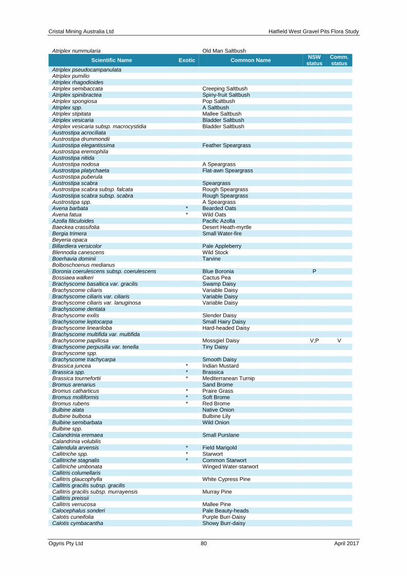
Cristal Mining Australia Ltd Hatfield West Gravel Pits Flora Study
Ogyris Pty Ltd 80 April 2017
Atriplex nummularia
Old Man Saltbush
Scientific Name Exotic Common Name NSW
status Comm. status
Atriplex pseudocampanulata Atriplex pumilio
Atriplex rhagodioides Atriplex semibaccata
Creeping Saltbush
Atriplex spinibractea Spiny-fruit Saltbush Atriplex spongiosa
Pop Saltbush
Atriplex spp. A Saltbush Atriplex stipitata
Mallee Saltbush
Atriplex vesicaria Bladder Saltbush Atriplex vesicaria subsp. macrocystidia
Bladder Saltbush
Austrostipa acrociliata Austrostipa drummondii
Austrostipa elegantissima Feather Speargrass Austrostipa eremophila
Austrostipa nitida Austrostipa nodosa
A Speargrass
Austrostipa platychaeta Flat-awn Speargrass Austrostipa puberula
Austrostipa scabra Speargrass Austrostipa scabra subsp. falcata
Rough Speargrass
Austrostipa scabra subsp. scabra Rough Speargrass Austrostipa spp.
A Speargrass
Avena barbata * Bearded Oats Avena fatua * Wild Oats
Azolla filiculoides Pacific Azolla Baeckea crassifolia
Desert Heath-myrtle
Bergia trimera Small Water-fire Beyeria opaca
Billardiera versicolor Pale Appleberry Blennodia canescens
Wild Stock
Boerhavia dominii Tarvine Bolboschoenus medianus
Boronia coerulescens subsp. coerulescens Blue Boronia P Bossiaea walkeri
Cactus Pea
Brachyscome basaltica var. gracilis Swamp Daisy Brachyscome ciliaris
Variable Daisy
Brachyscome ciliaris var. ciliaris Variable Daisy Brachyscome ciliaris var. lanuginosa
Variable Daisy
Brachyscome dentata Brachyscome exilis
Slender Daisy
Brachyscome leptocarpa Small Hairy Daisy Brachyscome lineariloba
Hard-headed Daisy
Brachyscome multifida var. multifida Brachyscome papillosa
Mossgiel Daisy V,P V
Brachyscome perpusilla var. tenella Tiny Daisy Brachyscome spp.
Brachyscome trachycarpa Smooth Daisy Brassica juncea * Indian Mustard
Brassica spp. * Brassica Brassica tournefortii * Mediterranean Turnip
Bromus arenarius Sand Brome Bromus catharticus * Praire Grass
Bromus molliformis * Soft Brome Bromus rubens * Red Brome
Bulbine alata Native Onion Bulbine bulbosa
Bulbine Lily
Bulbine semibarbata Wild Onion Bulbine spp.
Calandrinia eremaea Small Purslane Calandrinia volubilis
Calendula arvensis * Field Marigold Callitriche spp. * Starwort
Callitriche stagnalis * Common Starwort Callitriche umbonata
Winged Water-starwort
Callitris columellaris Callitris glaucophylla
White Cypress Pine
Callitris gracilis subsp. gracilis Callitris gracilis subsp. murrayensis
Murray Pine
Callitris preissii Callitris verrucosa
Mallee Pine
Calocephalus sonderi Pale Beauty-heads Calotis cuneifolia
Purple Burr-Daisy
Calotis cymbacantha Showy Burr-daisy
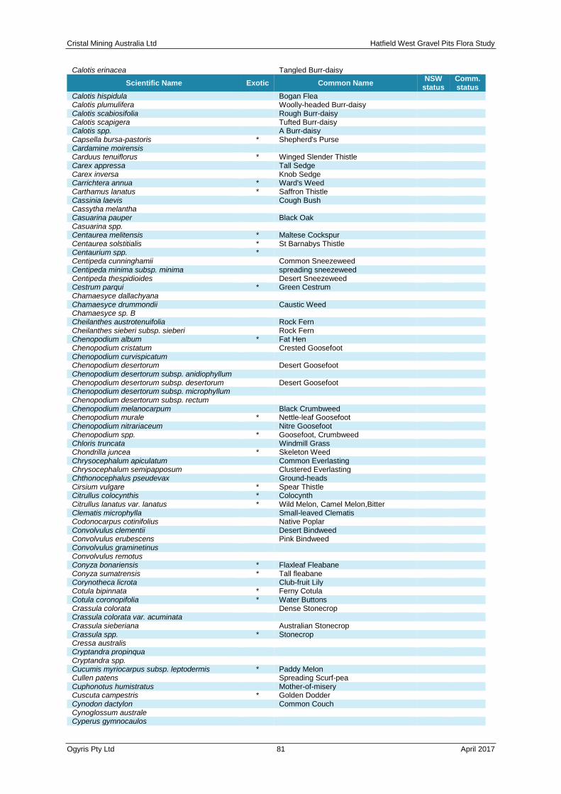
Cristal Mining Australia Ltd Hatfield West Gravel Pits Flora Study
Ogyris Pty Ltd 81 April 2017
Calotis erinacea
Tangled Burr-daisy
Scientific Name Exotic Common Name NSW
status Comm. status
Calotis hispidula Bogan Flea Calotis plumulifera
Woolly-headed Burr-daisy
Calotis scabiosifolia Rough Burr-daisy Calotis scapigera
Tufted Burr-daisy
Calotis spp. A Burr-daisy Capsella bursa-pastoris * Shepherd's Purse
Cardamine moirensis Carduus tenuiflorus * Winged Slender Thistle
Carex appressa Tall Sedge Carex inversa
Knob Sedge
Carrichtera annua * Ward's Weed Carthamus lanatus * Saffron Thistle
Cassinia laevis Cough Bush Cassytha melantha
Casuarina pauper Black Oak Casuarina spp.
Centaurea melitensis * Maltese Cockspur Centaurea solstitialis * St Barnabys Thistle
Centaurium spp. * Centipeda cunninghamii
Common Sneezeweed
Centipeda minima subsp. minima spreading sneezeweed Centipeda thespidioides
Desert Sneezeweed
Cestrum parqui * Green Cestrum Chamaesyce dallachyana
Chamaesyce drummondii Caustic Weed Chamaesyce sp. B
Cheilanthes austrotenuifolia Rock Fern Cheilanthes sieberi subsp. sieberi
Rock Fern
Chenopodium album * Fat Hen Chenopodium cristatum
Crested Goosefoot
Chenopodium curvispicatum Chenopodium desertorum
Desert Goosefoot
Chenopodium desertorum subsp. anidiophyllum Chenopodium desertorum subsp. desertorum
Desert Goosefoot
Chenopodium desertorum subsp. microphyllum Chenopodium desertorum subsp. rectum
Chenopodium melanocarpum Black Crumbweed Chenopodium murale * Nettle-leaf Goosefoot
Chenopodium nitrariaceum Nitre Goosefoot Chenopodium spp. * Goosefoot, Crumbweed
Chloris truncata Windmill Grass Chondrilla juncea * Skeleton Weed
Chrysocephalum apiculatum Common Everlasting Chrysocephalum semipapposum
Clustered Everlasting
Chthonocephalus pseudevax Ground-heads Cirsium vulgare * Spear Thistle
Citrullus colocynthis * Colocynth Citrullus lanatus var. lanatus * Wild Melon, Camel Melon,Bitter
Clematis microphylla Small-leaved Clematis Codonocarpus cotinifolius
Native Poplar
Convolvulus clementii Desert Bindweed Convolvulus erubescens
Pink Bindweed
Convolvulus graminetinus Convolvulus remotus
Conyza bonariensis * Flaxleaf Fleabane Conyza sumatrensis * Tall fleabane
Corynotheca licrota Club-fruit Lily Cotula bipinnata * Ferny Cotula
Cotula coronopifolia * Water Buttons Crassula colorata
Dense Stonecrop
Crassula colorata var. acuminata Crassula sieberiana
Australian Stonecrop
Crassula spp. * Stonecrop Cressa australis
Cryptandra propinqua Cryptandra spp.
Cucumis myriocarpus subsp. leptodermis * Paddy Melon Cullen patens
Spreading Scurf-pea
Cuphonotus humistratus Mother-of-misery Cuscuta campestris * Golden Dodder
Cynodon dactylon Common Couch Cynoglossum australe
Cyperus gymnocaulos
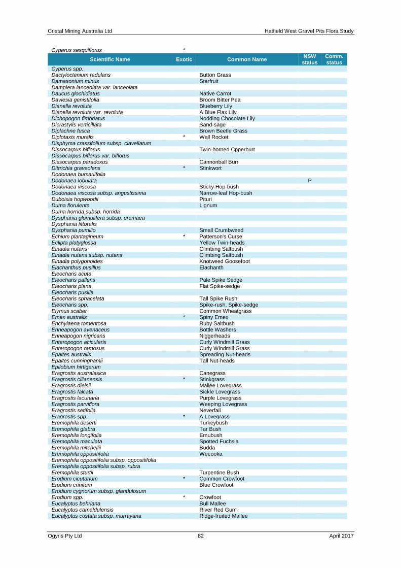
Cristal Mining Australia Ltd Hatfield West Gravel Pits Flora Study
Ogyris Pty Ltd 82 April 2017
Cyperus sesquiflorus *
Scientific Name Exotic Common Name NSW
status Comm. status
Cyperus spp. Dactyloctenium radulans
Button Grass
Damasonium minus Starfruit Dampiera lanceolata var. lanceolata
Daucus glochidiatus Native Carrot Daviesia genistifolia
Broom Bitter Pea
Dianella revoluta Blueberry Lily Dianella revoluta var. revoluta
A Blue Flax Lily
Dichopogon fimbriatus Nodding Chocolate Lily Dicrastylis verticillata
Sand-sage
Diplachne fusca Brown Beetle Grass Diplotaxis muralis * Wall Rocket
Disphyma crassifolium subsp. clavellatum Dissocarpus biflorus
Twin-horned Cpperburr
Dissocarpus biflorus var. biflorus Dissocarpus paradoxus
Cannonball Burr
Dittrichia graveolens * Stinkwort Dodonaea bursariifolia
Dodonaea lobulata P Dodonaea viscosa
Sticky Hop-bush
Dodonaea viscosa subsp. angustissima Narrow-leaf Hop-bush Duboisia hopwoodii
Pituri
Duma florulenta Lignum Duma horrida subsp. horrida
Dysphania glomulifera subsp. eremaea Dysphania littoralis
Dysphania pumilio Small Crumbweed Echium plantagineum * Patterson's Curse
Eclipta platyglossa Yellow Twin-heads Einadia nutans
Climbing Saltbush
Einadia nutans subsp. nutans Climbing Saltbush Einadia polygonoides
Knotweed Goosefoot
Elachanthus pusillus Elachanth Eleocharis acuta
Eleocharis pallens Pale Spike Sedge Eleocharis plana
Flat Spike-sedge
Eleocharis pusilla Eleocharis sphacelata
Tall Spike Rush
Eleocharis spp. Spike-rush, Spike-sedge Elymus scaber
Common Wheatgrass
Emex australis * Spiny Emex Enchylaena tomentosa
Ruby Saltbush
Enneapogon avenaceus Bottle Washers Enneapogon nigricans
Niggerheads
Enteropogon acicularis Curly Windmill Grass Enteropogon ramosus
Curly Windmill Grass
Epaltes australis Spreading Nut-heads Epaltes cunninghamii
Tall Nut-heads
Epilobium hirtigerum Eragrostis australasica
Canegrass
Eragrostis cilianensis * Stinkgrass Eragrostis dielsii
Mallee Lovegrass
Eragrostis falcata Sickle Lovegrass Eragrostis lacunaria
Purple Lovegrass
Eragrostis parviflora Weeping Lovegrass Eragrostis setifolia
Neverfail
Eragrostis spp. * A Lovegrass Eremophila deserti
Turkeybush
Eremophila glabra Tar Bush Eremophila longifolia
Emubush
Eremophila maculata Spotted Fuchsia Eremophila mitchellii
Budda
Eremophila oppositifolia Weeooka Eremophila oppositifolia subsp. oppositifolia
Eremophila oppositifolia subsp. rubra Eremophila sturtii
Turpentine Bush
Erodium cicutarium * Common Crowfoot Erodium crinitum
Blue Crowfoot
Erodium cygnorum subsp. glandulosum Erodium spp. * Crowfoot
Eucalyptus behriana Bull Mallee Eucalyptus camaldulensis
River Red Gum
Eucalyptus costata subsp. murrayana Ridge-fruited Mallee
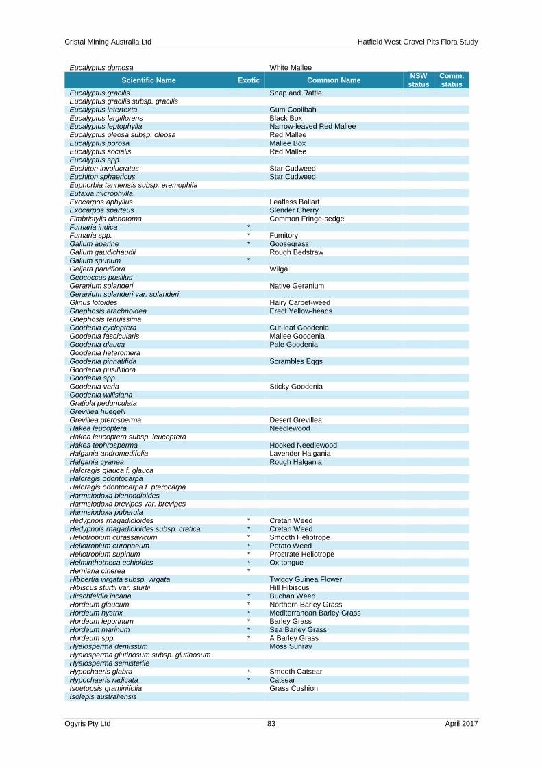
Cristal Mining Australia Ltd Hatfield West Gravel Pits Flora Study
Ogyris Pty Ltd 83 April 2017
Eucalyptus dumosa
White Mallee
Scientific Name Exotic Common Name NSW
status Comm. status
Eucalyptus gracilis Snap and Rattle Eucalyptus gracilis subsp. gracilis
Eucalyptus intertexta Gum Coolibah Eucalyptus largiflorens
Black Box
Eucalyptus leptophylla Narrow-leaved Red Mallee Eucalyptus oleosa subsp. oleosa
Red Mallee
Eucalyptus porosa Mallee Box Eucalyptus socialis
Red Mallee
Eucalyptus spp. Euchiton involucratus
Star Cudweed
Euchiton sphaericus Star Cudweed Euphorbia tannensis subsp. eremophila
Eutaxia microphylla Exocarpos aphyllus
Leafless Ballart
Exocarpos sparteus Slender Cherry Fimbristylis dichotoma
Common Fringe-sedge
Fumaria indica * Fumaria spp. * Fumitory
Galium aparine * Goosegrass Galium gaudichaudii
Rough Bedstraw
Galium spurium * Geijera parviflora
Wilga
Geococcus pusillus Geranium solanderi
Native Geranium
Geranium solanderi var. solanderi Glinus lotoides
Hairy Carpet-weed
Gnephosis arachnoidea Erect Yellow-heads Gnephosis tenuissima
Goodenia cycloptera Cut-leaf Goodenia Goodenia fascicularis
Mallee Goodenia
Goodenia glauca Pale Goodenia Goodenia heteromera
Goodenia pinnatifida Scrambles Eggs Goodenia pusilliflora
Goodenia spp. Goodenia varia
Sticky Goodenia
Goodenia willisiana Gratiola pedunculata
Grevillea huegelii Grevillea pterosperma
Desert Grevillea
Hakea leucoptera Needlewood Hakea leucoptera subsp. leucoptera
Hakea tephrosperma Hooked Needlewood Halgania andromedifolia
Lavender Halgania
Halgania cyanea Rough Halgania Haloragis glauca f. glauca
Haloragis odontocarpa Haloragis odontocarpa f. pterocarpa
Harmsiodoxa blennodioides Harmsiodoxa brevipes var. brevipes
Harmsiodoxa puberula Hedypnois rhagadioloides * Cretan Weed
Hedypnois rhagadioloides subsp. cretica * Cretan Weed Heliotropium curassavicum * Smooth Heliotrope
Heliotropium europaeum * Potato Weed Heliotropium supinum * Prostrate Heliotrope
Helminthotheca echioides * Ox-tongue Herniaria cinerea *
Hibbertia virgata subsp. virgata Twiggy Guinea Flower Hibiscus sturtii var. sturtii
Hill Hibiscus
Hirschfeldia incana * Buchan Weed Hordeum glaucum * Northern Barley Grass
Hordeum hystrix * Mediterranean Barley Grass Hordeum leporinum * Barley Grass
Hordeum marinum * Sea Barley Grass Hordeum spp. * A Barley Grass
Hyalosperma demissum Moss Sunray Hyalosperma glutinosum subsp. glutinosum
Hyalosperma semisterile Hypochaeris glabra * Smooth Catsear
Hypochaeris radicata * Catsear Isoetopsis graminifolia
Grass Cushion
Isolepis australiensis

Cristal Mining Australia Ltd Hatfield West Gravel Pits Flora Study
Ogyris Pty Ltd 84 April 2017
Isolepis spp.
Club-rush
Scientific Name Exotic Common Name NSW
status Comm. status
Jasminum lineare Desert Jasmine Juncus amabilis
Juncus aridicola Tussock Rush Juncus articulatus * A Rush
Juncus bufonius * Toad Rush Juncus flavidus
Juncus spp. A Rush Lachnagrostis filiformis
Lactuca saligna * Willow-leaved Lettuce Lactuca serriola * Prickly Lettuce
Lactuca serriola f. serriola * Lamarckia aurea * Goldentop
Lawrencia glomerata Lawrencia squamata
Leiocarpa leptolepis Pale Plover-daisy Leiocarpa panaetioides
Wooly Buttons
Leiocarpa semicalva subsp. semicalva Leiocarpa websteri
Lemna disperma Lemooria burkittii
Wires-a-wool
Leontodon taraxacoides subsp. taraxacoides * Lesser Hawkbit Lepidium fasciculatum
Bundled Peppercress
Lepidium leptopetalum Lepidium monoplocoides
Winged Peppercress E1,P E
Lepidium papillosum Warty Peppercress Lepidium phlebopetalum
Veined Peppercress
Lepidium pseudohyssopifolium Peppercress Leptorhynchos baileyi
Woolly Buttons
Leptospermum coriaceum Green Tea-tree Leucochrysum albicans var. tricolor
Hoary Sunray P E
Leucochrysum molle Hoary Sunray Limonium lobatum * Winged Sea Lavender
Limosella australis Australian Mudwort Limosella curdieana
Large Mudwort
Lolium loliaceum * Stiff Ryegrass Lolium perenne * Perennial Ryegrass
Lolium rigidum * Wimmera Ryegrass Lomandra collina
Lomandra effusa Scented Mat-rush Lomandra leucocephala
Woolly Mat-rush
Lomandra leucocephala subsp. leucocephala Woolly Mat-rush Lomandra leucocephala subsp. robusta
Lomandra spp. Mat-rush Lotus cruentus
Red-flowered Lotus
Ludwigia peploides subsp. montevidensis Water Primrose Lycium australe
Australian Boxthorn
Lycium ferocissimum * African Boxthorn Lysiana exocarpi
Lysiana exocarpi subsp. exocarpi Lysiana exocarpi subsp. tenuis
Lysimachia arvensis * Scarlet Pimpernel Lythrum hyssopifolia
Hyssop Loosestrife
Lythrum wilsonii Maireana aphylla
Cotton Bush
Maireana appressa Maireana brevifolia
Maireana coronata Crown Fissure-weed Maireana decalvans
Black Cotton Bush
Maireana erioclada Maireana georgei
Slit-wing Bluebush
Maireana ovata Maireana pentagona
Hairy Bluebush, Slender Fissure-weed
Maireana pentatropis Maireana pyramidata
Black Bluebush
Maireana radiata Maireana schistocarpa
Maireana sclerolaenoides Maireana sedifolia
Pearl Bluebush
Maireana spp. Cotton Bush, Bluebush, Fissure-weed Maireana trichoptera
Maireana triptera Three-wing Bluebush Maireana turbinata
Maireana villosa Silky Bluebush

Cristal Mining Australia Ltd Hatfield West Gravel Pits Flora Study
Ogyris Pty Ltd 85 April 2017
Malacocera tricornis
Soft Horns
Scientific Name Exotic Common Name NSW
status Comm. status
Malva parviflora * Small-flowered Mallow Malva preissiana
Native Hollyhock
Malva spp. * Mallow Malvastrum americanum * Spiked Malvastrum
Marrubium vulgare * White Horehound Marsdenia australis
Doubah
Marsilea costulifera Marsilea drummondii
Common Nardoo
Marsilea hirsuta Short-fruited Nardoo Medicago arabica * Spotted Burr Medic
Medicago laciniata * Cut-leaved Medic Medicago minima * Woolly Burr Medic
Medicago polymorpha * Burr Medic Medicago praecox * Small-leaved Burr Medic
Medicago spp. * A Medic Medicago truncatula * Barrel Medic
Melaleuca lanceolata Moonah Melilotus indicus * Hexham Scent
Mentha australis River Mint Mesembryanthemum crystallinum * Common Ice Plant
Microseris lanceolata Yam Daisy Millotia greevesii subsp. greevesii
Millotia macrocarpa Millotia perpusilla
Tiny Bow-flower
Millotia tenuifolia var. tenuifolia Mimulus gracilis
Slender Monkey-flower
Mimulus prostratus Small Monkey-flower Minuria cunninghamii
Bush Minuria
Minuria integerrima Smooth Minuria Minuria leptophylla
Monoculus monstrosus * Myoporum montanum
Western Boobialla
Myoporum platycarpum Sugarwood Myoporum platycarpum subsp. platycarpum
Myosurus australis Mousetail Myriophyllum caput-medusae
Cat-tail
Myriophyllum papillosum Myriophyllum propinquum
Myriophyllum simulans Myriophyllum spp.
Myriophyllum verrucosum Red Water-milfoil Najas marina subsp. armata
Neatostema apulum * Hairy Sheepweed Nicotiana glauca * Tree Tobacco
Nicotiana goodspeedii Nicotiana suaveolens
Native Tobacco
Nicotiana velutina Nitraria billardierei
Dillon Bush
Nymphoides crenata Wavy Marshwort Olearia lepidophylla
Club-moss Daisy-bush
Olearia magniflora Olearia muelleri
Mueller's Daisy Bush
Olearia pimeleoides Olearia rudis
Daisy-bush
Olearia sp. aff. teretifolia Olearia subspicata
Omphalolappula concava Burr Stickseed Onopordum acanthium subsp. acanthium * Scotch Thistle
Onopordum acaulon * Stemless Thistle Opercularia turpis
Twiggy Stinkweed
Osteocarpum acropterum Water Weed Osteocarpum acropterum var. acropterum
Osteocarpum acropterum var. deminuta Bonefruit Osteocarpum spp.
Ottelia ovalifolia subsp. ovalifolia Swamp Lily Oxalis chnoodes
Oxalis corniculata * Creeping Oxalis Oxalis exilis
Oxalis perennans Oxalis pes-caprae * Soursob
Oxalis spp. Pachymitus cardaminoides
Panicum effusum Hairy Panic

Cristal Mining Australia Ltd Hatfield West Gravel Pits Flora Study
Ogyris Pty Ltd 86 April 2017
Papaver hybridum * Rough Poppy
Scientific Name Exotic Common Name NSW
status Comm. status
Papaver somniferum subsp. setigerum * Parapholis incurva * Coast Barb Grass
Parietaria cardiostegia Mallee Pellitory Parietaria debilis
Native Pellitory
Parsonsia eucalyptophylla Gargaloo Paspalidium constrictum
Knottybutt Grass
Paspalidium distans Paspalidium jubiflorum
Warrego Grass
Paspalum dilatatum * Paspalum Paspalum distichum
Water Couch
Pelargonium australe Native Storksbill Pentaschistis airoides * False Hairgrass
Persicaria decipiens Slender Knotweed Persicaria lapathifolia
Pale Knotweed
Persicaria orientalis Princes Feathers Persicaria prostrata
Creeping Knotweed
Persicaria spp. * Knotweed Phalaris minor * Lesser Canary Grass
Phalaris paradoxa * Paradoxa Grass Phlegmatospermum cochlearinum
Oval-podded Cress
Phlegmatospermum eremaeum Phleum pratense * Timothy
Phragmites australis Common Reed Phyla canescens * Lippia
Phyla nodiflora * Carpet Weed Phyllanthus lacunellus
Picris angustifolia subsp. angustifolia Picris spp.
Pimelea microcephala subsp. microcephala Shrubby Rice-flower Pimelea simplex
Desert Rice-flower
Pimelea simplex subsp. simplex Pimelea spp.
Pimelea trichostachya Pittosporum angustifolium
Butterbush
Pittosporum spp. * Plagiobothrys plurisepaleus
Plantago cunninghamii Sago-weed Plantago drummondii
Dark Sago-weed
Plantago turrifera Small Sago-weed Plantago varia
Poa annua * Winter Grass Poa fax
Scaly Poa
Poa fordeana Sweet Swamp-grass Podolepis canescens
Large Copper-wire Daisy
Podolepis capillaris Invisible Plant Podolepis jaceoides
Showy Copper-wire Daisy
Podolepis muelleri Small Copper-wire Daisy Podotheca angustifolia
Sticky-heads
Pogonolepis muelleriana Polycalymma stuartii
Poached Eggs
Polygonum aviculare * Wireweed Polygonum plebeium
Small Knotweed
Polypogon monspeliensis * Annual Beardgrass Poranthera microphylla
Small Poranthera
Portulaca oleracea Pigweed Potamogeton crispus
Curly Pondweed
Potamogeton sulcatus Potamogeton tricarinatus
Floating Pondweed
Pratia concolor Poison Pratia Prostanthera aspalathoides
Scarlet Mint-bush
Pseudognaphalium luteoalbum Jersey Cudweed Pseudoraphis spinescens
Spiny Mudgrass
Psilocaulon tenue * Wiry Noon-flower Pterostylis biseta
Rustyhood P
^^Pterostylis cobarensis Greenhood Orchid V,P,2 Pterostylis rufa
Rusty Hood P
Ptilotus exaltatus var. exaltatus Tall Mulla Mulla P Ptilotus gaudichaudii
Ptilotus leucocomus Small Purple Foxtail Ptilotus nobilis
Yellowtails
Ptilotus obovatus Smoke Bush P Ptilotus obovatus var. obovatus
Silver Tails P
Ptilotus polystachyus var. polystachyus Long Tails
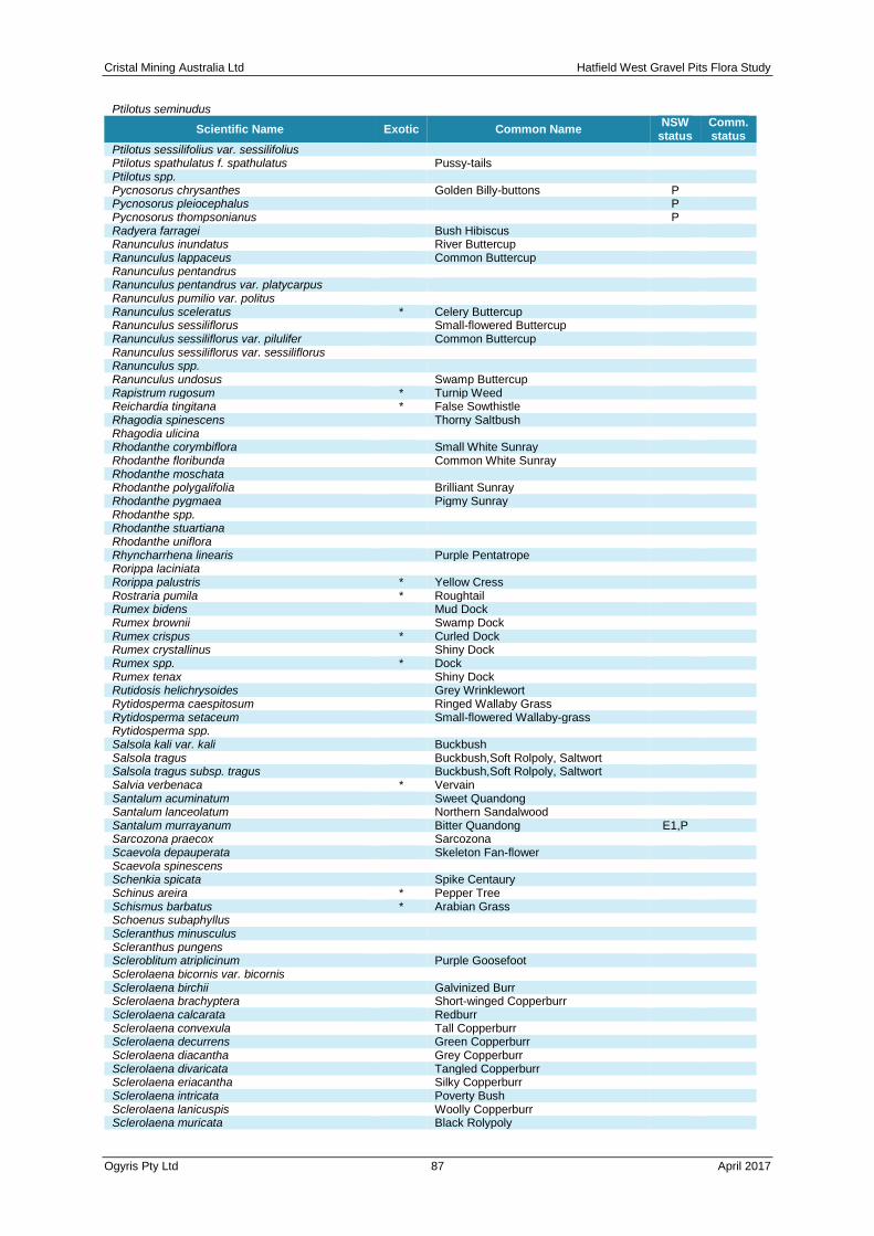
Cristal Mining Australia Ltd Hatfield West Gravel Pits Flora Study
Ogyris Pty Ltd 87 April 2017
Ptilotus seminudus
Scientific Name Exotic Common Name NSW
status Comm. status
Ptilotus sessilifolius var. sessilifolius Ptilotus spathulatus f. spathulatus
Pussy-tails
Ptilotus spp. Pycnosorus chrysanthes
Golden Billy-buttons P
Pycnosorus pleiocephalus P Pycnosorus thompsonianus
P
Radyera farragei Bush Hibiscus Ranunculus inundatus
River Buttercup
Ranunculus lappaceus Common Buttercup Ranunculus pentandrus
Ranunculus pentandrus var. platycarpus Ranunculus pumilio var. politus
Ranunculus sceleratus * Celery Buttercup Ranunculus sessiliflorus
Small-flowered Buttercup
Ranunculus sessiliflorus var. pilulifer Common Buttercup Ranunculus sessiliflorus var. sessiliflorus
Ranunculus spp. Ranunculus undosus
Swamp Buttercup
Rapistrum rugosum * Turnip Weed Reichardia tingitana * False Sowthistle
Rhagodia spinescens Thorny Saltbush Rhagodia ulicina
Rhodanthe corymbiflora Small White Sunray Rhodanthe floribunda
Common White Sunray
Rhodanthe moschata Rhodanthe polygalifolia
Brilliant Sunray
Rhodanthe pygmaea Pigmy Sunray Rhodanthe spp.
Rhodanthe stuartiana Rhodanthe uniflora
Rhyncharrhena linearis Purple Pentatrope Rorippa laciniata
Rorippa palustris * Yellow Cress Rostraria pumila * Roughtail
Rumex bidens Mud Dock Rumex brownii
Swamp Dock
Rumex crispus * Curled Dock Rumex crystallinus
Shiny Dock
Rumex spp. * Dock Rumex tenax
Shiny Dock
Rutidosis helichrysoides Grey Wrinklewort Rytidosperma caespitosum
Ringed Wallaby Grass
Rytidosperma setaceum Small-flowered Wallaby-grass Rytidosperma spp.
Salsola kali var. kali Buckbush Salsola tragus
Buckbush,Soft Rolpoly, Saltwort
Salsola tragus subsp. tragus Buckbush,Soft Rolpoly, Saltwort Salvia verbenaca * Vervain
Santalum acuminatum Sweet Quandong Santalum lanceolatum
Northern Sandalwood
Santalum murrayanum Bitter Quandong E1,P Sarcozona praecox
Sarcozona
Scaevola depauperata Skeleton Fan-flower Scaevola spinescens
Schenkia spicata Spike Centaury Schinus areira * Pepper Tree
Schismus barbatus * Arabian Grass Schoenus subaphyllus
Scleranthus minusculus Scleranthus pungens
Scleroblitum atriplicinum Purple Goosefoot Sclerolaena bicornis var. bicornis
Sclerolaena birchii Galvinized Burr Sclerolaena brachyptera
Short-winged Copperburr
Sclerolaena calcarata Redburr Sclerolaena convexula
Tall Copperburr
Sclerolaena decurrens Green Copperburr Sclerolaena diacantha
Grey Copperburr
Sclerolaena divaricata Tangled Copperburr Sclerolaena eriacantha
Silky Copperburr
Sclerolaena intricata Poverty Bush Sclerolaena lanicuspis
Woolly Copperburr
Sclerolaena muricata Black Rolypoly
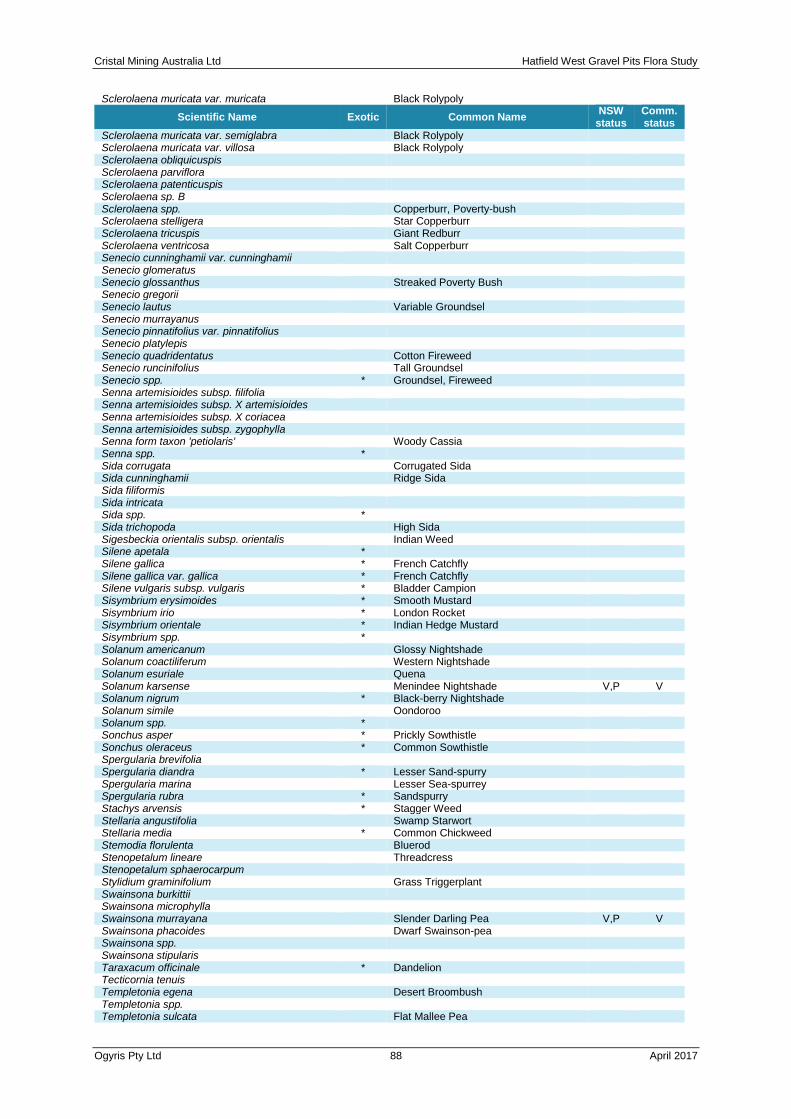
Cristal Mining Australia Ltd Hatfield West Gravel Pits Flora Study
Ogyris Pty Ltd 88 April 2017
Sclerolaena muricata var. muricata
Black Rolypoly
Scientific Name Exotic Common Name NSW
status Comm. status
Sclerolaena muricata var. semiglabra Black Rolypoly Sclerolaena muricata var. villosa
Black Rolypoly
Sclerolaena obliquicuspis Sclerolaena parviflora
Sclerolaena patenticuspis Sclerolaena sp. B
Sclerolaena spp. Copperburr, Poverty-bush Sclerolaena stelligera
Star Copperburr
Sclerolaena tricuspis Giant Redburr Sclerolaena ventricosa
Salt Copperburr
Senecio cunninghamii var. cunninghamii Senecio glomeratus
Senecio glossanthus Streaked Poverty Bush Senecio gregorii
Senecio lautus Variable Groundsel Senecio murrayanus
Senecio pinnatifolius var. pinnatifolius Senecio platylepis
Senecio quadridentatus Cotton Fireweed Senecio runcinifolius
Tall Groundsel
Senecio spp. * Groundsel, Fireweed Senna artemisioides subsp. filifolia
Senna artemisioides subsp. X artemisioides Senna artemisioides subsp. X coriacea
Senna artemisioides subsp. zygophylla Senna form taxon 'petiolaris'
Woody Cassia
Senna spp. * Sida corrugata
Corrugated Sida
Sida cunninghamii Ridge Sida Sida filiformis
Sida intricata Sida spp. *
Sida trichopoda High Sida Sigesbeckia orientalis subsp. orientalis
Indian Weed
Silene apetala * Silene gallica * French Catchfly
Silene gallica var. gallica * French Catchfly Silene vulgaris subsp. vulgaris * Bladder Campion
Sisymbrium erysimoides * Smooth Mustard Sisymbrium irio * London Rocket
Sisymbrium orientale * Indian Hedge Mustard Sisymbrium spp. *
Solanum americanum Glossy Nightshade Solanum coactiliferum
Western Nightshade
Solanum esuriale Quena Solanum karsense
Menindee Nightshade V,P V
Solanum nigrum * Black-berry Nightshade Solanum simile
Oondoroo
Solanum spp. * Sonchus asper * Prickly Sowthistle
Sonchus oleraceus * Common Sowthistle Spergularia brevifolia
Spergularia diandra * Lesser Sand-spurry Spergularia marina
Lesser Sea-spurrey
Spergularia rubra * Sandspurry Stachys arvensis * Stagger Weed
Stellaria angustifolia Swamp Starwort Stellaria media * Common Chickweed
Stemodia florulenta Bluerod Stenopetalum lineare
Threadcress
Stenopetalum sphaerocarpum Stylidium graminifolium
Grass Triggerplant
Swainsona burkittii Swainsona microphylla
Swainsona murrayana Slender Darling Pea V,P V Swainsona phacoides
Dwarf Swainson-pea
Swainsona spp. Swainsona stipularis
Taraxacum officinale * Dandelion Tecticornia tenuis
Templetonia egena Desert Broombush Templetonia spp.
Templetonia sulcata Flat Mallee Pea
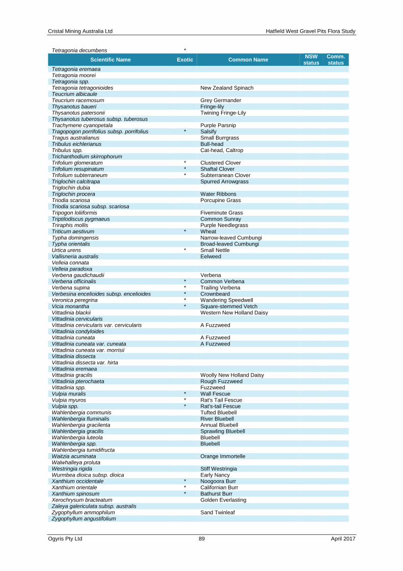
Cristal Mining Australia Ltd Hatfield West Gravel Pits Flora Study
Ogyris Pty Ltd 89 April 2017
Tetragonia decumbens *
Scientific Name Exotic Common Name NSW
status Comm. status
Tetragonia eremaea Tetragonia moorei
Tetragonia spp. Tetragonia tetragonioides
New Zealand Spinach
Teucrium albicaule Teucrium racemosum
Grey Germander
Thysanotus baueri Fringe-lily Thysanotus patersonii
Twining Fringe-Lily
Thysanotus tuberosus subsp. tuberosus Trachymene cyanopetala
Purple Parsnip
Tragopogon porrifolius subsp. porrifolius * Salsify Tragus australianus
Small Burrgrass
Tribulus eichlerianus Bull-head Tribulus spp.
Cat-head, Caltrop
Trichanthodium skirrophorum Trifolium glomeratum * Clustered Clover
Trifolium resupinatum * Shaftal Clover Trifolium subterraneum * Subterranean Clover
Triglochin calcitrapa Spurred Arrowgrass Triglochin dubia
Triglochin procera Water Ribbons Triodia scariosa
Porcupine Grass
Triodia scariosa subsp. scariosa Tripogon loliiformis
Fiveminute Grass
Triptilodiscus pygmaeus Common Sunray Triraphis mollis
Purple Needlegrass
Triticum aestivum * Wheat Typha domingensis
Narrow-leaved Cumbungi
Typha orientalis Broad-leaved Cumbungi Urtica urens * Small Nettle
Vallisneria australis Eelweed Velleia connata
Velleia paradoxa Verbena gaudichaudii
Verbena
Verbena officinalis * Common Verbena Verbena supina * Trailing Verbena
Verbesina encelioides subsp. encelioides * Crownbeard Veronica peregrina * Wandering Speedwell
Vicia monantha * Square-stemmed Vetch Vittadinia blackii
Western New Holland Daisy
Vittadinia cervicularis Vittadinia cervicularis var. cervicularis
A Fuzzweed
Vittadinia condyloides Vittadinia cuneata
A Fuzzweed
Vittadinia cuneata var. cuneata A Fuzzweed Vittadinia cuneata var. morrisii
Vittadinia dissecta Vittadinia dissecta var. hirta
Vittadinia eremaea Vittadinia gracilis
Woolly New Holland Daisy
Vittadinia pterochaeta Rough Fuzzweed Vittadinia spp.
Fuzzweed
Vulpia muralis * Wall Fescue Vulpia myuros * Rat's Tail Fescue
Vulpia spp. * Rat's-tail Fescue Wahlenbergia communis
Tufted Bluebell
Wahlenbergia fluminalis River Bluebell Wahlenbergia gracilenta
Annual Bluebell
Wahlenbergia gracilis Sprawling Bluebell Wahlenbergia luteola
Bluebell
Wahlenbergia spp. Bluebell Wahlenbergia tumidifructa
Waitzia acuminata Orange Immortelle Walwhalleya proluta
Westringia rigida Stiff Westringia Wurmbea dioica subsp. dioica
Early Nancy
Xanthium occidentale * Noogoora Burr Xanthium orientale * Californian Burr
Xanthium spinosum * Bathurst Burr Xerochrysum bracteatum
Golden Everlasting
Zaleya galericulata subsp. australis Zygophyllum ammophilum
Sand Twinleaf
Zygophyllum angustifolium

Cristal Mining Australia Ltd Hatfield West Gravel Pits Flora Study
Ogyris Pty Ltd 90 April 2017
Zygophyllum apiculatum
Common Twinleaf
Scientific Name Exotic Common Name NSW
status Comm. status
Zygophyllum aurantiacum Shrubby Twinleaf Zygophyllum confluens
Zygophyllum crenatum Lobed Twinleaf Zygophyllum eremaeum
Climbing Twinleaf
Zygophyllum glaucum Pale Twinleaf Zygophyllum iodocarpum
Violet Twinleaf
Zygophyllum ovatum Dwarf Twinleaf Zygophyllum simile
Zygophyllum spp.
Cristal Mining Australia Ltd Hatfield West Gravel Pits Flora Study
Ogyris Pty Ltd 91 April 2017
Appendix 2: Assessments of Significance for Impacts on Threatened Flora Species under EP&A Act (Seven Part Tests)
Brachyscome papillosa (Mossgiel Daisy)
Brachyscome papillosa (Mossgiel Daisy) is a multi-stemmed perennial herb which grows to 40cm high. Between June and December, solitary flowers occur on a peduncle up to 25 cm long. Flowers are white or mauve in colour with a yellow centre. Leaves are sessile and up to 7cm long (DoE 2008).
Brachyscome papillosa is endemic to NSW, and primarily found within the Riverina Bioregion. The species is distributed between Mossgiel in the north, Yanga National Park to the south west and Urana to the south east.
Brachyscome papillosa is vulnerable listed species under the TSC Act and the Commonwealth’s EPBC Act.
Assessment of Significance
a) In the case of a threatened species, whether the action proposed is likely to have an adverse effect on the life cycle of the species such that a viable local population of the species is likely to be placed at risk of extinction.
B. papillosa is known to occur mainly from Mossgiel to Urana, in south-western NSW with sites around Jerilderie, Hay Plain, Willandra Lakes, and north to Ivanhoe. A north-western outlier is at Byrnedale Station, north of Menindee. The only known site on the South Western Slopes is at Ganmain Reserve (DECC, 2005). The species is found primarily recorded in clay soils on Bladder Saltbush (Atriplex vesicaria) and Leafless Bluebush (Maireana aphylla) plains, but also in grassland and in Inland Grey Box (Eucalyptus microcarpa) - Cypress Pine (Callitris spp.) woodland.
A large population estimated at several thousand plants was recorded at a nearby location on both sides of a 1.5 km stretch of the Langleydale-Magenta Road in Black Bluebush (Maireana pyramidata) and Bladder Saltbush (Atriplex vesicaria) Shrubland habitat, approximately 3 km north-north-east of Pit B and 10 km east-north-east of Pits A and C (AMBS 2013). C ( A M B S 2 0 1 3 ) . This location was surveyed again in October 2016 as part of this study with the population estimated at greater than 200,000 plants. The timing of the first survey of this study in late summer (January-February 2016) would have meant the chances of finding B. papillosa would have been low. A second survey in October 2016 recorded Mossgiel Daisy as single plants at 13 locations at and around Pits A and C. No plants were found at Pit B. The plants at Pits A and C are considered to be outlier locations of the meta-population occurring along the MCTR at the L a n g l e y d a l e - Magenta Road location.
Consequently, the Hatfield West Gravel Pit Project is unlikely to have an adverse impact on B. papillosa such that a viable population is likely to be placed at risk of extinction due to the following:
• the Hatfield West Gravel Pit Project will impact upon 9 individuals of B. papillosa only;
• the Hatfield West Gravel Pit Project is unlikely to result in the loss of any known pollinators of the species;
• the Hatfield West Gravel Pit Project is unlikely to change the fire regime associated with the species;
• the nearest known viable meta-population is 10 kms to the east-north-east will not be impacted by the project due to provisions enshrined within the Atlas-Campaspe EIS
b) In the case of an endangered population, whether the action proposed is likely to have an adverse effect on the life cycle of the species that constitutes the endangered population such that a viable local population of the species is

Cristal Mining Australia Ltd Hatfield West Gravel Pits Flora Study
Ogyris Pty Ltd 92 April 2017
likely to be placed at risk of extinction.
Not applicable.
c) In the case of an endangered ecological community or critically endangered ecological community, whether the action proposed:
(i) is likely to have an adverse effect on the extent of the ecological community such that its local occurrence is likely to be placed at risk of extinction, or
(ii) is likely to substantially and adversely modify the composition of the ecological community such that its local occurrence is likely to be placed at risk of extinction.
Not applicable.
d) In relation to the habitat of a threatened species, population or ecological community:
(i) the extent to which habitat is likely to be removed or modified as a result of the action proposed, and
(ii) whether an area of habitat is likely to become fragmented or isolated from other areas of habitat as a result of the proposed action, and
(iii) the importance of the habitat to be removed, modified, fragmented or isolated to the long-term survival of the species, population or ecological community in the locality.
The habitat at Pits A and C where Mossgiel Daisy was found is primarily Belah Woodland which is considered to be marginal habitat for this species. Black Bluebush Shrubland and Pearl Bluebush does occur, but no plants were found in this plant community despite extensive targeted searches. No Bladder Saltbush habitat similar to that occurring on the Atlas-Campaspe MCTR at the Langleydale-Magenta Road exists within the Project Area.
e) Whether the action proposed is likely to have an adverse effect on critical habitat (either directly or indirectly).
Critical Habitat, as defined by the TSC Act, has not been declared for B. papillosa. There is no critical habitat listed on the NSW Critical Habitat register OEH (2011b) in the project area or surrounds.
f) Whether the action proposed is consistent with the objectives or actions of a recovery plan or threat abatement plan.
There is no adopted recovery plan for this species.
g) Whether the action proposed constitutes or is part of a key threatening process or is likely to result in the operation of, or increase the impact of, a key threatening process.
The relevant listed key threatening processes to this species is “Clearing of native vegetation”. The Hatfield West Gravel Pit Project would result in the removal of approximately 108.78 Ha of remnant vegetation which is considered to be sub-optimal habitat for Brachysome papillosa.
Conclusion
The Hatfield West Gravel Pit Project is unlikely to have a significant impact on Brachyscome papillosa due to the following:
• Only sub-optimal habitat for Brachyscome papillosa would be removed;
• Only 9 individuals which form part of an outlier of the main meta-population occurring 10km the east-north-east will be directly impacted; and
• fragmentation of the known main population of this species will not occur.

Ogyris Pty Ltd 93 April 2017
Pterostylis cobarensis (Rusty Greenhood)
Pterostylis cobarensis is a terrestrial orchid with seven to eleven narrow elliptic leaves forming a basal rosette. Stems are up to 40cm, producing between three and eight flowers per stem. Flowers are transparent with brown and green coloration. The species is deciduous with die back occurring after seed-set. Plants persist as the large, underground tubers. New rosettes form following rain in autumn and winter. The species is extremely drought tolerant, with a range of strategies to combat dry conditions. This includes large tubers which store moisture, rosettes with overlapping leaves which trap moisture and direct it to the root zone, and the tendency to grow in sites of litter accumulation and near rocks where run-off is concentrated.
In New South Wales, the species has a widespread distribution, but in the western part of the state, Nyngan-Cobar-Bourke is the core area of occurrence with minor outliers at Mootwingee NP (northeast of Broken Hill) and in the Hatfield West area (Atlas-Campaspe Mineral Sands Project area. Outside New South Wales, the species occurs near Olary in eastern South Australia (west of Broken Hill), and in southeast Queensland near Chinchilla-Brigalow. Porteners and Robertson (2003) suggest that Pterostylis cobarensis is potentially threatened by habitat disturbance including grazing, heavy Feral Goat browsing and clearing, but possibly also by competition.
The specific habitat for Pterostylis cobarensis in the Atlas-Campaspe Mine footprint at Hatfield West was not outlined by AMBS (2013), but was broadly referred to as ‘mallee’ in the Seven Part Test done for the species.
Assessment of Significance
a) In the case of a threatened species, whether the action proposed is likely to have an adverse effect on the life cycle of the species such that a viable local population of the species is likely to be placed at risk of extinction.
This species was not recorded within the Project Area during the field surveys, but is known from ‘mallee’ habitat 4 km to the north-north-east. Potential habitat for the species within the project area would include Chenopod Sandplain/Swale Mallee Woodland (LM116) which occurs over just 1.02 Ha of the proposed gravel pit sites.
The Hatfield West Gravel Pit Project is unlikely to have an adverse impact such that a viable population is likely to be placed at risk of extinction due to the following:
• no known habitat Pterostylis cobarensis would be removed as a result of the project;
• no known individuals or populations will be directly or indirectly impacted by the project;
• the reduction of potential mallee habitat is just 1.02 Ha which is insignificant when balanced against the broad distribution of mallee shrublands in the Balranald North area;
• fragmentation of known populations or individuals will not occur; and
• an ‘important population’ that is necessary for a species’ long-term survival and recovery was not recorded in the project area.
b) In the case of an endangered population, whether the action proposed is likely to have an adverse effect on the life cycle of the species that constitutes the endangered population such that a viable local population of the species is likely to be placed at risk of extinction.
Not applicable.
c) In the case of an endangered ecological community or critically endangered ecological community, whether the action proposed:

Ogyris Pty Ltd 94 April 2017
(i) is likely to have an adverse effect on the extent of the ecological community such that its local occurrence is likely to be placed at risk of extinction, or
(ii) is likely to substantially and adversely modify the composition of the ecological community such that its local occurrence is likely to be placed at risk of extinction.
Not applicable.
d) In relation to the habitat of a threatened species, population or ecological community:
(i) the extent to which habitat is likely to be removed or modified as a result of the action proposed, and
(ii) whether an area of habitat is likely to become fragmented or isolated from other areas of habitat as a result of the proposed action, and
(iii) the importance of the habitat to be removed, modified, fragmented or isolated to the long-term survival of the species, population or ecological community in the locality.
Extent of Habitat
The extent of mallee habitat is just 1.02 Ha.
Fragmentation
The Hatfield West Gravel Pit Project will only fragment a very small amount of potential habitat, and no known habitat for this species. No individuals or populations would be impacted.
Importance of Habitat
Habitat for this species within the project area is contiguous with habitat outside of the project area. There is approximately 200,000 Ha of vegetation comprising similar habitat for this species within the Locality. Given the abundance of habitat outside the project area, the habitat within the project area is not considered to be of high importance to the long-term survival of the species within the locality.
e) Whether the action proposed is likely to have an adverse effect on critical habitat (either directly or indirectly).
Critical Habitat, as defined by the TSC Act, has not been declared for Pterostylis cobarensis. There is no critical habitat listed on the NSW Critical Habitat register OEH (2011b) in the project area or surrounds.
f) Whether the action proposed is consistent with the objectives or actions of a recovery plan or threat abatement plan.
There is no adopted recovery plan for this species.
g) Whether the action proposed constitutes or is part of a key threatening process or is likely to result in the operation of, or increase the impact of, a key threatening process.
The relevant listed key threatening processes to this species is “Clearing of native vegetation”. The Hatfield West Gravel Pit Project would result in the removal of approximately 108.78 Ha of remnant vegetation, of which only 1.02 Ha is considered potential habitat for P. cobarensis.

Ogyris Pty Ltd 95 April 2017
Conclusion
The Hatfield West Gravel Pit Project is unlikely to have a significant impact on the P. cobarensis due to the following:
• no known habitat for P. cobarensis would be removed;
• no known individuals or populations will be directly or indirectly impacted; and
• fragmentation of known populations will not occur
• an ‘important population’ that is necessary for a species’ long-term survival and recovery was not recorded in the Project Area

Ogyris Pty Ltd 96 April 2017