appendix a directly affected properties - home - roads … · appendix a directly affected...
TRANSCRIPT

Working paper - Land use and property assessment
Appendix A Directly affected properties

PACIFIC HIGHWAY
RED RO
CK
ROA
D
SHER
WOOD
CREEK ROAD
TASMAN STREET
CORAL STREET
CORINDIBEACH
ARRAWARRA
ARRAWARRA CREEK
ARRAWARRA
GULLY
CORI
ND
I RIV
E R
BLACKADD
ER G
ULLY
WEDDING BELLSSTATE FOREST
10002
10010
10046
10048
10049
10050 10051
10052
10149
10148
10001
10134
90021
90050
90015
10179
90093
10006
10007
10008
10027
10047
10147
10180
90020
10150
90016
9000190002
90053
10011
GARBYNature Reserve
COFFS COASTRegional Park
0
3500
3000
4000
500
2000
1000
2500
4500
1500

PACIFIC HIGHWAY
CASSON
S CR EEK
REDBAN
K CREEK
CORI
ND
I RIV
ER
DIRTY CREEK
CORIN
DI RIVE
R
NEWFOUNDLANDSTATE FOREST
10017
10026 10032
10033
10035
10038
10043
10044
10046
10055
10072
9007990007
90010
10132
90013
10134
90021
101369002790012
90015
10027
10042
90011
90020
10138
90034
90033
90016
90032
10078
6500
4000
8500
9000
5500
4500
7500
7000
6000
5000
8000

PACIFIC HIGHWAY
HALFWAY
CREEK
DU
ND
OO
CREEK
DIR
TY CR
EEK
WOOLI W
OOLI RIVER
NEWFOUNDLANDSTATE FOREST
20943
20953
20962
20964
20966
20978
20999
2103321043
21044
21060
21095
21099
21124
21138
21148
21159
21160
21472
21473
21474
21479
21480
21481
21482
21484
21492
10028
10032
10033
10055
10123
10136
90027
90039
90040
90043
90044
10141
20991
21012
21028
21408
10138
9003490033
9004290037
90032
10078
11500
12000
10500
9000
9500
12500
11000
10000 14000
13000
13500

PACIFIC HIGHWAY
HALFW
AY CREEK
PIGEON GU
LLY
NEWFOUNDLANDSTATE FOREST
20953
20956
20957
20970
20998
20999
21015
21039
21044
21065
21066
21095
21099
21139
21194
21473
21474
20967
20991
21056
21061
21062
21072
21073
2114621161
2119521197
21203
21380
21408
YURAYGIRState Conservation Area
18500
16000
15500
17000
16500
15000
14000
17500
18000
19000
14500
SEC 2
SEC 1

KUNGALA ROAD
PACIFIC HIGHWAY
PIGEON GULLY
HALFW
AY CREEK
NEWFOUNDLANDSTATE FOREST
20956
20957
20983
20992
20996
20998
21005
21039
21082 21084
21098
21103
21105
21191
21373
21374
21376
20958
21000
21001
21018
21019
21055
21071
21072
21076
21147
YURAYGIRState Conservation Area
19000
23000
2050020000
19500
18500
22500
21000
22000
21500
23500

PACIFIC HIGHWAY
GLENUGIE CREEK
GLENUGIESTATE FOREST
NEWFOUNDLANDSTATE FOREST
21108
21128
21133
21183
21184
21357
21376
20958
21018
21019
21147
21182
YURAYGIRState Conservation Area
SEC 2
24500
27500
28000
28500
24000 25500
27000
26500
26000
23500
25000

PACIFIC HIGHWAY
GLENUGIE CREEK
GLENUGIESTATE FOREST
NEWFOUNDLANDSTATE FOREST
21108
21128
21133
21183
21184
21357
21376
20958
21018
21019
21147
21182
YURAYGIRState Conservation Area
SEC 2
24500
27500
28000
28500
24000 25500
27000
26500
26000
23500
25000

PACIFIC HIGHWAY
GLENUGIE CREEK
PHEASANT CREEK
SAWPIT CREEK
SAWPIT CREEK
GLENUGIESTATE FOREST
21183
21184
21190
21090
21121
21182
21188
SEC 2
30000
33000
32000
33500
30500
32500
2900028500
29500
31000
31500
SEC 3

PACIFIC HIGHWAY
GLENUGIE CREEK
PHEASANT CREEK
SAWPIT CREEK
SAWPIT CREEK
GLENUGIESTATE FOREST
21183
21184
21190
21090
21121
21182
21188
SEC 2
30000
33000
32000
33500
30500
32500
2900028500
29500
31000
31500
SEC 3

EIGH
T M
ILE LANE
PACIFIC HIGHWAY
PHEASANT CREEK
PICANINNY CREEK
GLENUGIESTATE FOREST
21184
21186
21190
21212
21413
20968
21090
21121
21162
37500
33500
36000
34000
38000
34500
36500
35000
37000
38500
35500
SEC 3

EIGH
T M
ILE LANE
PACIFIC HIGHWAY
PHEASANT CREEK
PICANINNY CREEK
GLENUGIESTATE FOREST
21184
21186
21190
21212
21413
20968
21090
21121
21162
37500
33500
36000
34000
38000
34500
36500
35000
37000
38500
35500
SEC 3

AVEN
UE ROAD
COLD
STRE
AM RI
VER
20945
20952
20994
20995
21136
21141
21143
21144
21170
2117121207
21212
21413
21483
21094
21125
21149
21162
37500
43000
42000
38000
40500
43500
42500
38500
39000
41500
39500
41000
40000

AVEN
UE ROAD
COLD
STRE
AM RI
VER
20945
20952
20994
20995
21136
21141
21143
21144
21170
2117121207
21212
21413
21483
21094
21125
21149
21162
37500
43000
42000
38000
40500
43500
42500
38500
39000
41500
39500
41000
40000

EIGHT MILE LANE
WO
OLI ROAD
COLD
STREAM RIV ER
PILL
AR VA
LLEY
CRE
EK
BLACK SN
AKE CREEK
20952
20959
20960
20988
20993
21040
21041
21051
21097
21106
21144
21156
21165
21360
21361
21362
21364
21366
21367
21483
48000
44500
47500
45500
43500
47000
44000
46000
48500
46500
45000

EIGHT MILE LANE
WO
OLI ROAD
COLD
STREAM RIV ER
PILL
AR VA
LLEY
CRE
EK
BLACK SN
AKE CREEK
20952
20959
20960
20988
20993
21040
21041
21051
21097
21106
21144
21156
21165
21360
21361
21362
21364
21366
21367
21483
48000
44500
47500
45500
43500
47000
44000
46000
48500
46500
45000

WOOLI ROAD
PILLA
R VALLE
Y CREEK
CHAF
FIN
CREE
K
20950
20954
20960
20981
20988
20993
21002
2102021038
21040
21050
21086
21097
21118
2116648500
49500
48000
50000
49000
51500 53000
52500
52000
50500
51000

WOOLI ROAD
PILLA
R VALLE
Y CREEK
CHAF
FIN
CREE
K
20950
20954
20960
20981
20988
20993
21002
2102021038
21040
21050
21086
21097
21118
2116648500
49500
48000
50000
49000
51500 53000
52500
52000
50500
51000

TUCABIA-TYNDALE ROAD
WOOLI ROAD
CHAMPIONS CREEK
CHAFFIN CREEK
PINE BRUSHSTATE FOREST
20981
21007
21008
21021
21024
21025
21029
21030
21078
21086
21154
21468
90054
9005590056
9005790058
21034
21211
56000
5650055000
55500
54000
57000
53500
53000
57500
54500

TUCABIA-TYNDALE ROAD
WOOLI ROAD
CHAMPIONS CREEK
CHAFFIN CREEK
PINE BRUSHSTATE FOREST
20981
21007
21008
21021
21024
21025
21029
21030
21078
21086
21154
21468
90054
9005590056
9005790058
21034
21211
56000
5650055000
55500
54000
57000
53500
53000
57500
54500

TUCABIA-TYNDALE ROAD
COLDSTREAM ROAD
BEAN BALL LANE
CHAMPIONS CREEK
COLDSTREAM RIVER
PINE BRUSHSTATE FOREST
20532
20600
20668
20969
20984
20986
20990
21029
21030
21163
21368
60000
61000
58000
59000
57500
58500
59500
62500
61500
62000
60500

TUCABIA-TYNDALE ROAD
COLDSTREAM ROAD
BEAN BALL LANE
CHAMPIONS CREEK
COLDSTREAM RIVER
PINE BRUSHSTATE FOREST
20532
20600
20668
20969
20984
20986
20990
21029
21030
21163
21368
60000
61000
58000
59000
57500
58500
59500
62500
61500
62000
60500

PAC
IFIC HIGHW
AY
COLDSTREAM ROAD
COLDSTREAM RIVER
SANDY CREEK
SOUTH ARM
PINE BRUSHSTATE FOREST
20511
20512
20525
20527
20528
20532 20542
20586
20600
20615
20668
20708
21216
21224
21225
21369
21370
90078
20812
21222
21223
2121564500
63000
66500 67000
63500
66000
64000
62500
67500
65000
65500

PAC
IFIC HIGHW
AY
COLDSTREAM ROAD
COLDSTREAM RIVER
SANDY CREEK
SOUTH ARM
PINE BRUSHSTATE FOREST
20511
20512
20525
20527
20528
20532 20542
20586
20600
20615
20668
20708
21216
21224
21225
21369
21370
90078
20812
21222
21223
2121564500
63000
66500 67000
63500
66000
64000
62500
67500
65000
65500

SOUTH ARM SCHOOL ROAD
SOUTH ARM ROAD
PACIFIC HIGHWAY
ELBOW CREEK
SOUTH
ARM
SHARK
CREEK
20494
20495
20503
20504
20505
20506
20507
20508
20509
20512
20514
20515
20516
20517
20534
20542
20586
20613
20708
20730
20758
20789
20819
20820
20821
20822
20823
20824
20825
20829
20866
21216
21224
21438
90078
20496
2051820519
20584
20585
20731
20812
20814
2081620817
20818
21223
21510
21215
72500
67500
69500
70000
72000
71000
71500
68500
68000
69000
70500
SEC 4
SEC 3

20486
20496
20533
20606
20729
2073720836
20478
20482
20488
20489
20490
20494
20495
20588 20589
20604
20605
20610
20660
20726
2072720728
20755
20756
20758
207632076420765
2076620767
20768 20769
20770
20771
20820
20822
20823
20824
20825
20829
20830
20832
20835
20837
20839
20867
20868
20869
208702087420875
20876
20913
20940
2118121202
90059
90060PACIFIC HIGHWAY
SOUTH ARM ROAD
SHAR
K CREEK
RUNNING CREEK
SOUTH ARM
72500
74000
72000
75500
73500
77000
76500
74500
73000
76000
75000

20159
20172
20179
20181
20194
20209
20443
20472
206062073720836
20852
21291
21414
21440
21464
20009
20010 20011
20012
20052
20065
2016520166
20173
20174
20175
20180
20187
20188
20189
20190
2019520198
20290
20292
20334
20335
20336
2033820339
20369
20375
20376
2043520438 20440 20444
20604
20605
20627
20628
20629
20637
20638 2063920640
20641
20642
20658
20660 20709
20723
20751
20786
20787
2083520837
20839
20848
20851
21305
21411
2141521419
21441
21462
21465
90000
JUBILEE
STREET
LAWRENCE ROAD
BROOMS HEAD RO
AD
RIVER STREET
PACIFIC HIGHWAY
SOUTH ARM ROAD
CAMERON STREET
DIA
MO
ND
STRE
ET
MACLEAN
SOUTH ARM
CAMP CREEK
YAEGLNature Reserve
80500
79500
81000
82000
81500
77000
7900078000
7850077500
80000
SEC 5
SEC 4

20131
PACIFIC HIGHWAY
YAMBA ROAD
HARWOOD
NYRAN
G CREEK
JAMES CREEK
CLARENCE RIVER
20020
20021
20022
20053
20054
20056
2006320064
2009720099
20144
20145
20148
2019520198
20442
20620
20627
20666
20751
2075220753
20760
20849
20851
2093621411
21441
9008020016
20026
20112
20136
20138
20142
20159
20665
20754
20852
20862
21291
21420
21440
YAEGLNature Reserve
83000
84000
83500
82500
82000
87000
8600085000
84500
85500
86500
SEC 5
SEC 4

20131
20112
20136
2013820142
20434
20712
20754
20775
20776
20779
2078020804
20806
20807
2084120842
20857
20862
20028
20029
20030
2003220033
2003420045
20097
20099
20144 2014520148
20621
20622
206462064720648
20654
20655
20713
20752
20753
20777
2077820781
20782
20783
20784
20785
20788
20803
20805
20808
20844
20845
20918
20919
20936
21463
WA
TTS
LAN
E
PACIFIC HIGHWAY
HARWOOD
NYR
A NG
CR E
EK
SERPENTINE CHANNEL
NARHO CREEK
CLARENCE
RIVER
NORTH ARM
90000
87500
87000
88500
91500
89500
91000
90500
89000
88000
! [
0 500
Metres
I:\EN
VR
\Pro
ject
s\EN
0282
9\Te
chni
cal\S
patia
l\Spa
tial
_Dir
ecto
ry\A
rcG
IS\S
peci
alis
t_R
epor
ts\P
hase
2\La
nd_U
se_a
nd_P
rope
rty\
EN02
829_
GIS
_LU
_F00
7_r2
v1.m
xd
The project
Upgrade completed to dual carriageway
Upgrade under construction
Existing RMS properties
Impact type (showing property ID)
Directly affected property
Directly adjacent property
National park / reserve / conservation area
State forest
Upgrading the Pacific Highway - Woolgoolga to Ballina Upgrade
Land use and property assessment Land use and property assessment
Upgrading the Pacific Highway - Woolgoolga to Ballina Upgrade
BALLINA
WOODBURNEVANS HEAD
YAMBAMACLEAN
GRAFTONTUCABIA
WOOLGOOLGA1
2
3
4
56
789
1011
1:15,000
SHEET 19 of 34
Figure A- Directly affected properties19

ILUKA
ROA
D
PACIFIC HIGHWAY
GAR
RETS
GU
LLY
MO
RORO
CREEK
BACK CH
ANN
EL
NO
RTH ARM
20045
20661
20773
20797
20798
20799
20800
20802
2080321229
21230
21231
21232
21234
21235
21236
212602126621267
2126821269
212702127121272
21273
21276 21285
21286
90061
20046
20047
20775
20776
20801
20804
20857
2125121252
21255
2126121262
21265
MORORO CREEKNature Reserve
BUNDJALUNGNational Park
96000
94500
97000
93000
92500 95500
92000
94000
95000
96500
93500
SEC 6
SEC 5
! [
0 500
Metres
I:\EN
VR
\Pro
ject
s\EN
0282
9\Te
chni
cal\S
patia
l\Spa
tial
_Dir
ecto
ry\A
rcG
IS\S
peci
alis
t_R
epor
ts\P
hase
2\La
nd_U
se_a
nd_P
rope
rty\
EN02
829_
GIS
_LU
_F00
7_r2
v1.m
xd
The project
Upgrade completed to dual carriageway
Upgrade under construction
Existing RMS properties
Impact type (showing property ID)
Directly affected property
Directly adjacent property
National park / reserve / conservation area
State forest
Upgrading the Pacific Highway - Woolgoolga to Ballina Upgrade
Land use and property assessment Land use and property assessment
Upgrading the Pacific Highway - Woolgoolga to Ballina Upgrade
BALLINA
WOODBURNEVANS HEAD
YAMBAMACLEAN
GRAFTONTUCABIA
WOOLGOOLGA1
2
3
4
56
789
1011
1:15,000
SHEET 20 of 34
Figure A- Directly affected properties20

PACIFIC HIGHWAY
MORORO CREEK
TABBIMOBLE
CREEK
MOROROSTATE FOREST
20792
20794
2079520796
2085820915
2122921230
21236 2123721238
21241
21245
2124621247 21256
20793
20914
20916
21240
21242
21244
21248
21249
21250
21251
21252
BUNDJALUNGNational Park
100000
99000
97500
101500
101000
100500
97000
99500
98500
98000

TULLYMORGAN-JACKYBULBIN ROAD
PACIFIC HIGHWAY
TABBIMOBLE CREEK
DEVILS PULPITSTATE FOREST
20792
20794
20795
20796
20915
2117321174
21175
21177
21178
21199
21243
21470
21471
21507
21508
21509
20793
20914
20916
21179
21198
21209
21240
BUNDJALUNGState Conservation Area
BUNDJALUNGNational Park
SEC 6
105500
105000102500
106500
101000
104000
102000
104500
101500
106000
103000
103500

TULLYMORGAN-JACKYBULBIN ROAD
PACIFIC HIGHWAY
TABBIMOBLE CREEK
DEVILS PULPITSTATE FOREST
20792
20794
20795
20796
20915
2117321174
21175
21177
21178
21199
21243
21470
21471
21507
21508
21509
20793
20914
20916
21179
21198
21209
21240
BUNDJALUNGState Conservation Area
BUNDJALUNGNational Park
SEC 6
105500
105000102500
106500
101000104000
102000
104500101500
106000
103000
103500

PACIFIC HIGHWAY
TABBIMOBLESTATE FOREST
DEVILS PULPITSTATE FOREST
21243
21507
21508
21511
30002
3000530006
30008
30059
9007790073
90076
30020
21198
30001
30004
30007
30060
30061
BUNDJALUNGNational Park
111000
106500
107500
108500
109000
108000
109500
110000
107000
110500
111500
SEC 7

PACIFIC HIGHWAY
TABBIMOBLESTATE FOREST
DEVILS PULPITSTATE FOREST
21243
21507
21508
21511
30002
3000530006
30008
30059
9007790073
90076
30020
21198
30001
30004
30007
30060
30061
BUNDJALUNGNational Park
111000
106500
107500
108500
109000
108000
109500
110000
107000
110500
111500
SEC 7

PACIFIC HIGHWAY
TABBIMOBLESTATE FOREST DOUBLEDUKE
STATE FOREST
3000830011
30012
30019
30049 30050
30051
3005630057
9007390074
30020
90075
30021
30047
3004830053
30058
30060
TABBIMOBLE SWAMPNature Reserve
116000
115500
114000
113500
113000
114500
115000
112000
112500
111500

PACIFIC HIGHWAY
TABBIMOBLESTATE FOREST DOUBLEDUKE
STATE FOREST
3000830011
30012
30019
30049 30050
30051
3005630057
9007390074
30020
90075
30021
30047
3004830053
30058
30060
TABBIMOBLE SWAMPNature Reserve
116000
115500
114000
113500
113000
114500
115000
112000
112500
111500

PACIFIC HIGHWAY
DOUBLEDUKESTATE FOREST
30011
30019
30022
30024
3002530026
30027
30029
30030
30036
30044
30046
30050
3005430055
30296
30366
30013
30021
30023
30028
30047
30048
30052
30053 30297
30365
90088
TABBIMOBLE SWAMPNature Reserve
116500
121000
117000
116000
118000 119000
118500
120000
117500
119500
120500

PACIFIC HIGHWAY
NO
RTO
NS
GULL
Y
OA
KY C R
E EK
30010
3001430015 30016
30018
30022
30025
30030
30036
30038
30040
30041
30042
30043
30044
30046
30099
30206
30207
30281
30306
30327
30331
30344
30347
3036030361
30362
30366
30017
30023
30028
30035
30365
90088
125000
123000
122500
121500
125500
122000
126000
124000
124500
123500
121000

THE
GA
P RO
AD
PACIFIC HIGHWAY
TUCK
OM
BIL
CAN
AL
EVANS
RIVER
SAWPIT CREEK
ROCKY MOUTH CREEK
30067
30083
30098
3009930100
30101
30102
30131
30136
30193
3019730204
30206 3020730212
30246
30259
30260
30281
302863028730288
30289
30290
30299
30306
30331
30065
30084
30205
30208
30247
30275
30280
30295
30307
30309
30310
130000
129500129000
127500
127000
126500
126000
128000
131000
128500
130500
SEC 8
SEC 7

RIVER STREET
ALF
RED
STRE
ET
URALB
A ST
RE
ETW
OO
DBU
RN-EVA
NS
HEA
D RO
AD
WAGNER STREET
PACIFIC HIGHWAY
KILGIN ROAD
WOODBURN
MCD
ONALDS CREEK
RICHMOND RIVER
30086 30087
30091
30103
3013130132
30136
30141
30143
30144
3014730197
30211
30212
30251
30258
30279
3031530341
30370
30371
3037230373
30085
30133
30252
30254
30363
30364
30367
30368
30369
BROADWATERNational Park
134000131500
132000
133500 135500
133000132500
134500
130500
135000
131000

RIVER STREET
ALF
RED
STRE
ET
URALB
A ST
RE
ET
WO
OD
BURN
-EVAN
S H
EAD
ROA
D
WAGNER STREET
PACIFIC HIGHWAY
KILGIN ROAD
WOODBURN
MCD
ONALDS CREEK
RICHMOND RIVER
30086 30087
30091
30103
3013130132
30136
30141
30143
30144
3014730197
30211
30212
30251
30258
30279
3031530341
30370
30371
3037230373
30085
30133
30252
30254
30363
30364
30367
30368
30369
BROADWATERNational Park
134000131500
132000
133500 135500
133000132500
134500
130500
135000
131000

PACIFIC HIGHWAY
MCDONALDS CREEK
RICHMOND RIVER
30073
30086
30087
30091
30104
30138
30140
30143
30144
30147
30266
3026730268
30274
30277
30279
30284
30311
30085
30097
30139
30149
BROADWATERNational Park
140500
137000
138000
135500
136000
139500
136500
137500
139000
138500
140000
SEC 9
SEC 8

PACIFIC HIGHWAY
MCDONALDS CREEK
RICHMOND RIVER
30073
30086
30087
30091
30104
30138
30140
30143
30144
30147
30266
3026730268
30274
30277
30279
30284
30311
30085
30097
30139
30149
BROADWATERNational Park
140500
137000
138000
135500
136000
139500
136500
137500
139000
138500
140000
SEC 9
SEC 8

PACIFIC HIGHWAY
BROADWATER ROAD
BROADWATER-EVANS HEAD ROAD
BROADWATER
TUCKEAN BROADW
ATER
RATTLE G
ULLY
MONTIS GULLY
EVERSONS CREEK
RICHMOND RIVER
30063
30104
30105
30113
30137
30151
30152
30154
30158
30238
30274
30277
30284
30325
30328
30334
30337
30342
30343
30345
30349
30350
30352
3035330354
30355
3035630357
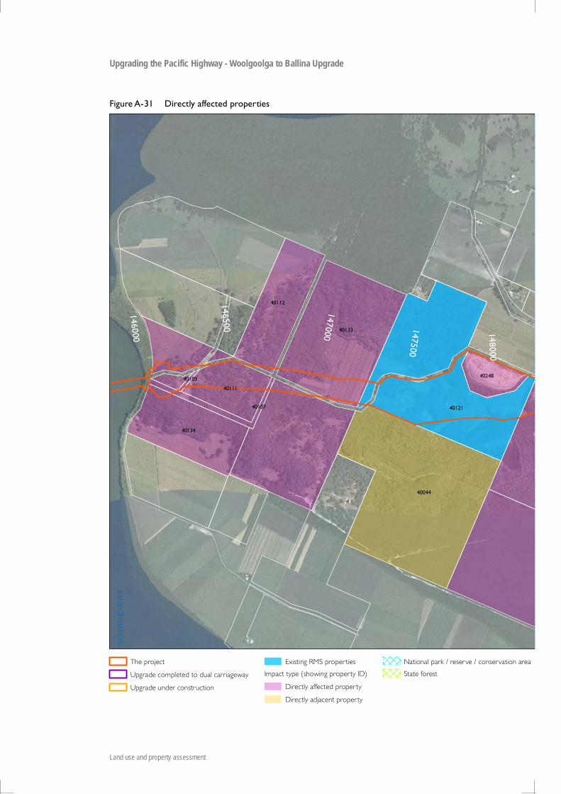
401034010740111
40133
40134
30097
30272
30326
30348
30351
30375
BROADWATERNational Park
144500
141500
141000
143500
142000
140500
144000
143000
142500
145500
145000
146000
SEC 10SEC 9

PACIFIC HIGHWAY
BROADWATER ROAD
BROADWATER-EVANS HEAD ROAD
BROADWATER
TUCKEAN BROADW
ATER
RATTLE G
ULLY
MONTIS GULLY
EVERSONS CREEK
RICHMOND RIVER
30063
30104
30105
30113
30137
30151
30152
30154
30158
30238
30274
30277
30284
30325
30328
30334
30337
30342
30343
30345
30349
30350
30352
3035330354
30355
3035630357
401034010740111
40133
40134
30097
30272
30326
30348
30351
30375
BROADWATERNational Park
144500
141500
141000
143500
142000
140500
144000
143000
142500
145500
145000
146000
SEC 10SEC 9
RICH
MO
ND
RIVE
R
BING
AL CREEK
40013
40039
40047
40103
40107
40111
40112
40121
40133
40134
40146
40165
40239
40248
40315
90062 90063
90064
90065
90067
40043
40044
40051
40212
40213
40214
4021540216
147500
148500
148000
149500
147000
150500
151000
149000
150000
146000
146500

RICH
MO
ND
RIVE
R
BING
AL CREEK
40013
40039
40047
40103
40107
40111
40112
40121
40133
40134
40146
40165
40239
40248
40315
90062 90063
90064
90065
90067
40043
40044
40051
40212
40213
40214
4021540216
147500
148500
148000
149500
147000
150500
151000
149000
150000
146000
146500

WAR
DEL
L ROAD
WARDELL
BINGAL CREEK
40022
40047
40123
40146
40165
40180
40181
40182
4019640199
40229
40239
40268
40272
40277
40279
4028040281
40282
402834028440285
40286
40287
40290
90062
90063
90064
90065
90067
90068
90069
90070
40051
40064
40084
40095
40113
40145
40149
40176
40212
40213
40214
40215
40216
4021840246
40269
40291
153500
151000
153000
151500
150000
150500
154000
154500
156000
152500152000
155500
155000

PIMLIC
O R
IVER
BANK ROAD
PIMLICO ROADPACIFIC HIGHWAY
SALTWATER CREEK
RAND
LES C REE K
40081
40088
40096
40123
40182
40188
40202
40203
40204
4022740255
40259
40272
40273
4027540276
40277
40278
40279
40280
90071
90072
40020
40087
40090
40122
40145
40149
4015340172
40191
40193
40200
4021140243
40247
40260
URALBANature Reserve
157500
159000157000
156000
159500156500
155000
160000
158500
160500
155500
158000
SEC 11
SEC 10

URALBA ROAD
BRUXNER HIGHWAY
PIMLICO ROAD
PACIFIC HIGHWAY
HERM
ANS LAN
E
DU
C K C
RE EK
EMIGRANT CREEK
40057
40062
40065
40068
40088
4016240202
40203
40227
40254
40255
40071
40313
40066
40067
40069
40090
40173
URALBANature Reserve
165000
165500
162000
162500
161000
164500
163500
161500
163000
166000
160500
164000

Upgrading the Pacific Highway – Woolgoolga to Ballina Upgrade
Working paper - Land use and property
Appendix B Directly affected property assessment

Section Property_Id Lot / DP LGA
Total property area (ha)
Area of impact
(ha)
% of property affected
Current land use (NSW major) for majority of the affected property area
Current land use (NSW detail) for the majority of the affected property area Description of impacts Proposed mitigation measures
1
10033 Lot2 DP710318 Coffs Harbour 12.7 8.5 67% Tree & Shrub Cover Native forest Materially affected due to a dwelling requiring demolition and percentage of property requiring acquisition.
Total acquisition with compensation paid.
110043 Lot1102 DP803773 Coffs Harbour 7.5 2.8 38% Grazing Volunteer, naturalised, native or
improved pasturesMaterially affected due to a dwelling requiring demolition.
Total acquisition with compensation paid.
121065 Lot33 DP878969 Clarence Valley 5.8 1.5 26% Tree & Shrub Cover Native forest Materially affected due to a dwelling requiring
demolition.Total property to be acquired with compensation paid.
1
10026 Lot1 DP379009 Coffs Harbour 5.3 2.7 51% Grazing Volunteer, naturalised, native or improved pastures
Materially affected due to percentage of property affected. Also a portion of the site to the south is severed from the main lot.
Affected land to be acquired with compensation paid. New access road proposed adjacent to severed portion provides an opportunity for access.
110049 Lot3 DP806515 Coffs Harbour 2.5 1.0 40% Grazing Volunteer, naturalised, native or
improved pasturesMaterially affected due to percentage of property required.
Affected land to be acquired with compensation paid.
1
90007 Lot86 DP752820 Coffs Harbour 16.3 9.3 57% Tree & Shrub Cover Native forest Materially affected due to percentage of property required.
This property is native vegetation and part of a larger holding. The design includes allowance for a public access way under the new highway linking both sides of this property. Affected land to be acquired with compensation paid.
1
90012 Lot11 DP1110135 Coffs Harbour 59.5 12.2 21% Grazing Volunteer, naturalised, native or improved pastures
Materially affected due to severing. This property is part of a larger holding. The design includes allowance for a public access way under the new highway linking both sides of property under the same ownership. Affected land to be acquired with compensation paid.
1
10051 Lot51 DP851056 Coffs Harbour 12.0 4.1 34% Grazing Volunteer, naturalised, native or improved pastures
Materially affected including a dwelling and farm buildings. The property is also severed.
Total acquisition with compensation paid.
110050 Lot4 DP806515 Coffs Harbour 39.9 4.6 12% Grazing Volunteer, naturalised, native or
improved pasturesMaterially impacted due to dwelling requiring demolition.
Affected land to be acquired with compensation paid.
1
21015 Lot15 DP879175 Clarence Valley 3.8 0.5 13% Tree & Shrub Cover Native forest Partially affected including access. New access road to be created. Affected land to be acquired with compensation paid.
1
20962 Lot1 DP731249 Clarence Valley 30.7 4.6 15% Grazing Volunteer, naturalised, native or improved pastures
Partially affected including access. Affected land to be acquired with compensation paid. New access road provided.
1
20964 Lot1 DP833063 Clarence Valley 30.5 3.0 10% Tree & Shrub Cover Native forest Partially affected including access. Affected land to be acquired with compensation paid. New access road provided.
1
21044 Lot2 DP833063 Clarence Valley 7.8 0.5 6% Grazing Volunteer, naturalised, native or improved pastures
Partially affected including access. Affected land to be acquired with compensation paid. New access road to be created as part of the project. However a new driveway connection will need to be incorporated in the works.
1
21095 Lot50 DP878970 Clarence Valley 441.2 2.2 0% Tree & Shrub Cover Native forest Partially affected including access. Affected land to be acquired with compensation paid. New access road to be created as part of the project.
1
21099 Lot51 DP878970 Clarence Valley 3.0 1.1 36% Grazing Volunteer, naturalised, native or improved pastures
Partially affected including access. Affected land to be acquired with compensation paid. New access road to be created as part of the project.
1
21139 Lot7 DP713824 Clarence Valley 4.0 0.3 8% Power Generation Energy corridor Partially affected including access. Affected land to be acquired with compensation paid. New access road to be created as part of the project.
1
21159 Lot9 DP705682 Clarence Valley 39.7 1.3 3% Grazing Volunteer, naturalised, native or improved pastures
Partially affected including access. Affected land to be acquired with compensation paid. New access road to be created as part of the project.

Section Property_Id Lot / DP LGA
Total property area (ha)
Area of impact
(ha)
% of property affected
Current land use (NSW major) for majority of the affected property area
Current land use (NSW detail) for the majority of the affected property area Description of impacts Proposed mitigation measures
1
90021 Lot54 DP752820 Coffs Harbour 19.6 1.8 9% Grazing Volunteer, naturalised, native or improved pastures
Partially affected including minor severing. Affected land to be acquired with compensation paid. An adjacent parcel under the same ownership has a bridge on it allowing access underneath the new highway linking the severed portions of the larger holding.
1
10055 Lot24 DP705683 Coffs Harbour 76.3 19.0 25% Tree & Shrub Cover Native forest Partially affected including some severing. Affected land to be acquired with compensation paid. A proposed access road provides access opportunities for the severed land to the south.
1
10134 Lot12 DP632158 Coffs Harbour 41.9 8.3 20% Grazing Volunteer, naturalised, native or improved pastures
Partially affected including some severing. Affected land to be acquired with compensation paid. Access is available to both sides of the property under a bridge proposed on this property.
110132 Lot1 DP205145 Coffs Harbour 1.1 0.0 1% Grazing Volunteer, naturalised, native or
improved pasturesPartially affected. Affected land to be acquired with
compensation paid.
110141 Lot122 DP714475 Coffs Harbour 26.0 1.6 6% Tree & Shrub Cover Native forest Partially affected. Affected land to be acquired with
compensation paid.1 10148 Lot100 DP752853 Coffs Harbour 111.5 4.9 4% Conservation Area State forest Partially affected. NSW Government owned.
1 10149 Lot83 DP752820 Coffs Harbour 133.0 1.1 1% Conservation Area State forest Partially affected. NSW Government owned.
110179 Lot11 DP1152234 Coffs Harbour 21.5 7.6 35% Grazing Volunteer, naturalised, native or
improved pasturesPartially affected. RMS owned.
110032 Lot1 DP710318 Coffs Harbour 28.6 5.7 20% Tree & Shrub Cover Native forest Partially affected. Affected land to be acquired with
compensation paid.
110044 Lot1103 DP803773 Coffs Harbour 7.8 0.3 3% Grazing Volunteer, naturalised, native or
improved pasturesPartially affected. Affected land to be acquired with
compensation paid.
110046 Lot120 DP752820 Coffs Harbour 131.4 0.4 0% Grazing Volunteer, naturalised, native or
improved pasturesPartially affected. Affected land to be acquired with
compensation paid.
110047 Lot1 DP806515 Coffs Harbour 2.0 0.2 11% Grazing Volunteer, naturalised, native or
improved pasturesPartially affected. Affected land to be acquired with
compensation paid.
110048 Lot2 DP806515 Coffs Harbour 2.2 0.6 29% Grazing Volunteer, naturalised, native or
improved pasturesPartially affected. Affected land to be acquired with
compensation paid.
110052 Lot6 DP806515 Coffs Harbour 0.1 0.0 12% Grazing Volunteer, naturalised, native or
improved pasturesPartially affected. Affected land to be acquired with
compensation paid.
110136 Lot2 DP746387 Coffs Harbour 19.7 5.9 30% Tree & Shrub Cover Native forest Partially affected. Affected land to be acquired with
compensation paid.
120978 Lot11 DP705682 Clarence Valley 18.6 0.2 1% Tree & Shrub Cover Native forest Partially affected. Affected land to be acquired with
compensation paid.
121043 Lot2 DP731249 Clarence Valley 6.4 0.8 13% Tree & Shrub Cover Native forest Partially affected. Affected land to be acquired with
compensation paid.
121060 Lot3 DP833063 Clarence Valley 7.5 0.6 9% Grazing Volunteer, naturalised, native or
improved pasturesPartially affected. Affected land to be acquired with
compensation paid.
121138 Lot7 DP707325 Clarence Valley 15.2 1.4 9% Tree & Shrub Cover Native forest Partially affected. Affected land to be acquired with
compensation paid.
121148 Lot8 DP707325 Clarence Valley 45.5 3.9 9% Tree & Shrub Cover Native forest Partially affected. Affected land to be acquired with
compensation paid.1 21472 Lot11 DP751368 Clarence Valley 15.5 1.5 10% Conservation Area State forest Partially affected. NSW Government owned.
1 21473 Lot23 DP751368 Clarence Valley 14.3 1.2 8% Conservation Area State forest Partially affected. NSW Government owned.
1 21474 Lot26 DP751368 Clarence Valley 26.8 1.5 6% Conservation Area State forest Partially affected. NSW Government owned.
190010 Lot100 DP752820 Coffs Harbour 26.0 0.9 3% Tree & Shrub Cover Native forest Partially affected. Affected land to be acquired with
compensation paid.
190013 Lot3 DP623588 Coffs Harbour 30.4 3.8 13% Tree & Shrub Cover Native forest Partially affected. Affected land to be acquired with
compensation paid.
190015 Lot11 DP752820 Coffs Harbour 5.7 0.1 2% Tree & Shrub Cover Native forest Partially affected. Affected land to be acquired with
compensation paid.

Section Property_Id Lot / DP LGA
Total property area (ha)
Area of impact
(ha)
% of property affected
Current land use (NSW major) for majority of the affected property area
Current land use (NSW detail) for the majority of the affected property area Description of impacts Proposed mitigation measures
190039 Lot2 DP820074 Coffs Harbour 0.3 0.1 21% Grazing Volunteer, naturalised, native or
improved pasturesPartially affected. Affected land to be acquired with
compensation paid.
1
10038 Lot3 DP629984 Coffs Harbour 42.3 7.3 17% Tree & Shrub Cover Native forest Partially affected. A portion of the site is also severed.
Affected land to be acquired with compensation paid. New access road proposed adjacent to severed portion provides an opportunity for access.
1
10017 Lot4 DP815051 Coffs Harbour 17.0 3.7 21% Grazing Volunteer, naturalised, native or improved pastures
Partially affected. A portion of the site on the south west is severed from the main.
Affected land to be acquired with compensation paid. New access road proposed adjacent to severed portion provides an opportunity for access.
110001 Lot351 DP703698 Coffs Harbour 43.3 0.3 1% Urban Caravan park or mobile home village Partially affected. Business signage may need
to be relocated.Affected land to be acquired with compensation paid.
110010 Lot34 DP600591 Coffs Harbour 11.5 0.1 1% Urban Caravan park or mobile home village Partially affected. Business signage may need
to be relocated.Affected land to be acquired with compensation paid.
1
21160 Lot9 DP707325 Clarence Valley 96.6 5.7 6% Tree & Shrub Cover Native forest Partially affected. Dwelling will require a new access track.
Access track will need to be created and affected land to be acquired with compensation paid.
1
10028 Lot121 DP714475 Coffs Harbour 11.3 1.4 12% Tree & Shrub Cover Native forest Partially affected. Part of a dam is affected. Affected land to be acquired with compensation paid. Dam may need to be modified or reconstructed.
1
10035 Lot103 DP752820 Coffs Harbour 19.8 0.3 2% Grazing Volunteer, naturalised, native or improved pastures
Partially affected. Two dams are in the affected area.
Affected land to be acquired with compensation paid. Dams will need to be modified or reconstructed.
120953 Lot1 DP396968 Clarence Valley 0.1 0.1 100% Transport & Other Corridors Road or road reserve Totally affected including a dwelling and
outbuildings.Total property to be acquired with compensation paid.
121066 Lot34 DP878969 Clarence Valley 2.2 2.2 100% Grazing Volunteer, naturalised, native or
improved pasturesTotally affected including a dwelling and outbuildings.
Total property to be acquired with compensation paid.
190027 Lot23 DP705683 Coffs Harbour 0.7 0.7 100% Horticulture Orchard - tree fruits - irrigated Totally affected including a structure. Total property to be acquired with
compensation paid.
110002 Lot24 DP259761 Coffs Harbour 0.3 0.3 100% Urban Caravan park or mobile home village Totally affected. RMS owned.
110072 Lot74 DP731384 Coffs Harbour 1.1 1.1 100% Tree & Shrub Cover Native forest Totally affected. Total property to be acquired with
compensation paid.1 10123 Lot3 DP710318 Coffs Harbour 0.2 0.2 100% Tree & Shrub Cover Native forest Totally affected. RMS owned.
120943 Lot1 DP121275 Clarence Valley 0.2 0.2 100% Tree & Shrub Cover Native forest Totally affected. Total property to be acquired with
compensation paid.
120966 Lot10 DP707325 Clarence Valley 1.0 1.0 100% Tree & Shrub Cover Native forest Totally affected. Total property to be acquired with
compensation paid.
120999 Lot130 DP820653 Clarence Valley 0.0 0.0 100% Transport & Other Corridors Road or road reserve Totally affected. Total property to be acquired with
compensation paid.
121033 Lot2 DP121275 Clarence Valley 0.1 0.1 100% Tree & Shrub Cover Native forest Totally affected. Total property to be acquired with
compensation paid.
121124 Lot6 DP707325 Clarence Valley 0.2 0.2 100% Tree & Shrub Cover Native forest Totally affected. Total property to be acquired with
compensation paid.
121479 Lot12 DP707324 Clarence Valley 1.3 1.3 100% Transport & Other Corridors Road or road reserve Totally affected. RMS owned.
121480 Lot13 DP707324 Clarence Valley 0.6 0.6 100% Transport & Other Corridors Road or road reserve Totally affected. RMS owned.
121481 Lot14 DP705682 Clarence Valley 0.0 0.0 100% Grazing Volunteer, naturalised, native or
improved pasturesTotally affected. RMS owned.
121482 Lot14 DP707324 Clarence Valley 0.2 0.2 100% Grazing Volunteer, naturalised, native or
improved pasturesTotally affected. RMS owned.
121484 Lot16 DP705682 Clarence Valley 0.1 0.1 100% Grazing Volunteer, naturalised, native or
improved pasturesTotally affected. RMS owned.
121492 Lot3 DP707324 Clarence Valley 0.4 0.4 100% Grazing Volunteer, naturalised, native or
improved pasturesTotally affected. NSW Government owned.
190040 Lot3 DP820074 Coffs Harbour 0.3 0.3 100% Tree & Shrub Cover Native forest Totally affected. Total property to be acquired with
compensation paid.

Section Property_Id Lot / DP LGA
Total property area (ha)
Area of impact
(ha)
% of property affected
Current land use (NSW major) for majority of the affected property area
Current land use (NSW detail) for the majority of the affected property area Description of impacts Proposed mitigation measures
190043 Lot13 DP705682 Coffs Harbour 0.6 0.6 100% Tree & Shrub Cover Native forest Totally affected. Total property to be acquired with
compensation paid.
190044 Lot17 DP705682 Coffs Harbour 0.4 0.4 100% Tree & Shrub Cover Native forest Totally affected. Total property to be acquired with
compensation paid.
190050 Lot21 DP259761 Coffs Harbour 0.2 0.2 100% Urban Caravan park or mobile home village Totally affected. Total property to be acquired with
compensation paid.1 90079 LOT102 DP1150718 Coffs Harbour 4.0 4.0 100% Tree & Shrub Cover Native forest Totally affected. RMS owned.
2
21103 Lot52 DP801481 Clarence Valley 10.4 6.9 66% Tree & Shrub Cover Native forest Materially affected due to a dwelling requiring demolition and high percentage of the property affected.
Total property to be acquired with compensation paid.
220983 Lot119 DP751368 Clarence Valley 7.1 0.8 12% Tree & Shrub Cover Native forest Materially affected due to access issues. Total property acquisition with compensation
paid.
2
21098 Lot51 DP801481 Clarence Valley 4.2 1.9 46% Horticulture Vegetables Materially affected due to percentage of property required and access issues.
Affected land to be acquired with compensation paid. New access road to be created as part of the project including new driveway connection.
221191 Lot7300 DP1144709 Clarence Valley 8.3 5.7 69% Tree & Shrub Cover Native forest Materially affected due to percentage of
property requiring acquisition.NSW Government owned.
2
20956 Lot1 DP558503 Clarence Valley 24.3 2.2 9% Grazing Volunteer, naturalised, native or improved pastures
Partially affected including access. Affected land to be acquired with compensation paid. New access road provided.
2
20957 Lot1 DP567129 Clarence Valley 26.8 2.0 7% Grazing Volunteer, naturalised, native or improved pastures
Partially affected including access. Affected land to be acquired with compensation paid. New access road provided.
2
20970 Lot10 DP879175 Clarence Valley 10.1 1.2 12% Grazing Volunteer, naturalised, native or improved pastures
Partially affected including access. Affected land to be acquired with compensation paid. New access road provided.
2
20992 Lot126 DP751368 Clarence Valley 21.0 0.7 4% Tree & Shrub Cover Native forest Partially affected including access. Affected land to be acquired with compensation paid. New access road provided.
2
20996 Lot128 DP751368 Clarence Valley 21.0 0.7 3% Tree & Shrub Cover Native forest Partially affected including access. Affected land to be acquired with compensation paid. New access road provided.
2
20998 Lot13 DP879175 Clarence Valley 275.3 21.0 8% Tree & Shrub Cover Native forest Partially affected including access. Affected land to be acquired with compensation paid. New access road provided.
2
21039 Lot2 DP558503 Clarence Valley 19.0 1.6 8% Grazing Volunteer, naturalised, native or improved pastures
Partially affected including access. Affected land to be acquired with compensation paid. New access road provided.
2
21082 Lot411 DP883976 Clarence Valley 1.4 0.0 0% Transport & Other Corridors Road or road reserve Partially affected, including access. Affected land to be acquired with compensation paid and a new access road to be built as part of the project.
2 21357 Lot20 DP1123940 Clarence Valley 29.2 10.9 37% Conservation Area State forest Partially affected. NSW Government owned.
221005 Lot14 DP787246 Clarence Valley 8.7 0.3 3% Grazing Volunteer, naturalised, native or
improved pasturesPartially affected. Affected land to be acquired with
compensation paid.
221084 Lot42 DP602517 Clarence Valley 0.4 0.0 0% Transport & Other Corridors Road or road reserve Partially affected. Affected land to be acquired with
compensation paid.
221105 Lot53 DP801481 Clarence Valley 89.8 0.1 0% Tree & Shrub Cover Native forest - regeneration Partially affected. Affected land to be acquired with
compensation paid.2 21108 Lot55 DP751358 Clarence Valley 177.4 4.5 3% Conservation Area State forest Partially affected. NSW Government owned.
2 21128 Lot62 DP751358 Clarence Valley 104.1 3.0 3% Conservation Area State forest Partially affected. NSW Government owned.
2 21133 Lot63 DP751368 Clarence Valley 19.9 1.0 5% Conservation Area State forest Partially affected. NSW Government owned.

Section Property_Id Lot / DP LGA
Total property area (ha)
Area of impact
(ha)
% of property affected
Current land use (NSW major) for majority of the affected property area
Current land use (NSW detail) for the majority of the affected property area Description of impacts Proposed mitigation measures
2
21374 Lot7005 DP1058539 Clarence Valley 21.8 1.1 5% Crown land managed under community trusteeship i.e. Reserve 140086 for Community Purposes, Environmental Protection & Public Recreation at Halfway Creek
Community hall, public recreation & environmental protection (native vegetation)
Partially affected. NSW Government owned.
2 21376 Lot111 DP751368 Clarence Valley 531.3 40.1 8% Conservation Area State forest Partially affected. NSW Government owned.
2
21373 Lot7004 DP1058539 Clarence Valley 2.9 0.4 14% Crown land managed under community trusteeship i.e. Reserve 140086 for Community Purposes, Environmental Protection & Public Recreation
Roadside Partially affected. A bus stop is affected. NSW Government owned.
221194 Lot14 DP879175 Clarence Valley 0.2 0.2 100% Tree & Shrub Cover Native forest Totally affected. Total property acquisition with compensation
paid.
3
21224 Lot3 DP793682 Clarence Valley 4.0 2.0 51% Grazing Volunteer, naturalised, native or improved pastures
Materially affected due to a dwelling requiring demolition and percentage of property required.
Total property to be acquired with compensation paid.
321225 Lot34 DP751389 Clarence Valley 17.9 6.8 38% Grazing Volunteer, naturalised, native or
improved pasturesMaterially affected due to a dwelling requiring demolition.
Total property to be acquired with compensation paid.
3
20542 Lot1 DP572678 Clarence Valley 16.4 2.2 14% Grazing Volunteer, naturalised, native or improved pastures
Materially affected due to a dwelling requiring demolition. A new dwelling could be reconstructed elsewhere on this lot.
Total property to be acquired with compensation paid.
3
21216 Lot22 DP1119114 Clarence Valley 83.9 15.7 19% Tree & Shrub Cover Native forest Materially affected due to access issues. Affected land to be acquired with compensation paid. Access arrangements will need to be made or total acquisition may be required.
390078 Lot2 DP1163451 Clarence Valley 12.2 6.7 55% Tree & Shrub Cover Native forest Materially affected due to percentage of
property required and severing.RMS owned.
3
20819 Lot1 DP931412 Clarence Valley 9.2 3.8 42% Tree & Shrub Cover Native forest Materially affected due to percentage of property required. Access is also affected.
Despite the large area affected this property is native forest and the residual land should still be capable of similar use/development post project. A new access road is also proposed. Accordingly affected land to be acquired with compensation paid.
320613 Lot14 DP112731 Clarence Valley 0.9 0.4 47% Tree & Shrub Cover Native forest Materially affected due to percentage of
property requiring acquisition.Total property to be acquired with compensation paid.
3
20950 Lot1 DP254500 Clarence Valley 2.1 1.5 73% Grazing Volunteer, naturalised, native or improved pastures
Materially affected due to percentage of property requiring acquisition.
This small lot is part of a larger holding and the overall effect of the project is relatively minor. Affected land to be acquired with compensation paid.
3
20981 Lot115 DP751365 Clarence Valley 46.9 14.4 31% Grazing Volunteer, naturalised, native or improved pastures
Materially affected due to serving. Access to an adjacent parcel (Lot 116 DP751365) may also be affected).
Acquisition of the affected land. Plus discussions about the implications of the severing on the usability of the parcels. A total acquisition may be necessary.
3 21156 Lot84 DP751376 Clarence Valley 16.2 2.8 17% Tree & Shrub Cover Native forest - regeneration Materially affected due to severing RMS owned.
3
90054 Lot108 DP751365 Clarence Valley 64.8 19.4 30% Grazing Volunteer, naturalised, native or improved pastures
Materially affected due to severing and access issues. Also affects a structure.
RMS owned.
3 20708 Lot7001 DP92573 Clarence Valley 217.1 11.1 5% Tree & Shrub Cover Native forest Materially affected due to severing. NSW Government owned.

Section Property_Id Lot / DP LGA
Total property area (ha)
Area of impact
(ha)
% of property affected
Current land use (NSW major) for majority of the affected property area
Current land use (NSW detail) for the majority of the affected property area Description of impacts Proposed mitigation measures
3
20952 Lot1 DP393766 Clarence Valley 34.3 3.5 10% Grazing Volunteer, naturalised, native or improved pastures
Materially affected due to severing. The severed portions are able to be accessed under the proposed highway. Affected land to be acquired with compensation paid.
3
20984 Lot120 DP751365 Clarence Valley 20.2 3.7 18% Tree & Shrub Cover Native forest Materially affected due to severing. Affected land to be acquired with compensation paid. Underpass and road to be constructed under highway to ameliorate severing.
3
20990 Lot124 DP751365 Clarence Valley 40.9 8.1 20% Tree & Shrub Cover Native forest Materially affected due to severing. The proposed road design includes an underpass to link both sides of the property. Affected land to be acquired with compensation paid.
3
21021 Lot169 DP751365 Clarence Valley 8.2 0.9 11% Grazing Volunteer, naturalised, native or improved pastures
Materially affected due to severing. Affected land to be acquired with compensation paid. Bridge across the proposed highway allows access underneath linking both sides of the property.
3
20959 Lot1 DP606007 Clarence Valley 20.9 4.9 23% Grazing Volunteer, naturalised, native or improved pastures
Materially affected due to severing. Discussions to be held with landowner regarding a the viability of this lot and whether a partial or total acquisition is required.
3
20960 Lot1 DP622795 Clarence Valley 89.1 5.9 7% Tree & Shrub Cover Native forest Materially affected due to severing. Despite severing, access to both halves of the property is available off Wooli Road. Affected land to be acquired with compensation paid.
320988 Lot121 DP751378 Clarence Valley 54.6 2.0 4% Tree & Shrub Cover Native forest Materially affected due to severing. Affected land to be acquired with
compensation paid.
3
20993 Lot127 DP751378 Clarence Valley 56.5 9.6 17% Tree & Shrub Cover Native forest Materially affected due to severing. Adjacent road will be realigned to pass under the highway and will provide road access to both sides of the severed parcel. Affected land to be acquired with compensation paid.
3
21008 Lot142 DP751365 Clarence Valley 124.7 9.1 7% Tree & Shrub Cover Native forest Materially affected due to severing. Affected land to be acquired with compensation paid. Adjacent road will pass over the highway and will provide road access to both sides of the severed parcel.
3
21163 Lot9 DP822853 Clarence Valley 32.6 3.3 10% Tree & Shrub Cover Native forest Materially affected due to severing. Affected land to be acquired with compensation paid. Severing is addressed by an underpass planned to be constructed on the lot to the south that is under the same ownership.
3 21165 Lot90 DP751376 Clarence Valley 16.2 2.3 14% Tree & Shrub Cover Native forest - regeneration Materially affected due to severing. RMS owned.
3
21024 Lot170 DP751365 Clarence Valley 8.6 0.9 10% Grazing Volunteer, naturalised, native or improved pastures
Materially affected due to severing. Affected land to be acquired with compensation paid. Bridge across the proposed highway, on an adjacent lot under the same ownership, allows access underneath linking both sides of the property.
320511 Lot130 DP751389 Clarence Valley 40.7 6.3 15% Tree & Shrub Cover Native forest Materially affected. Road severs property and
isolates eastern portion.NSW Government owned
3
20586 Lot4 DP793682 Clarence Valley 3.7 2.8 75% Grazing Volunteer, naturalised, native or improved pastures
Materially affected. The affected area includes a dwelling and a high percentage of the property is required for acquisition.
Total property to be acquired with compensation paid.

Section Property_Id Lot / DP LGA
Total property area (ha)
Area of impact
(ha)
% of property affected
Current land use (NSW major) for majority of the affected property area
Current land use (NSW detail) for the majority of the affected property area Description of impacts Proposed mitigation measures
3
20512 Lot5 DP793682 Clarence Valley 40.0 3.7 9% Cropping Cropping - continuous or rotation Partially affected including access. Affected land to be acquired with compensation paid. New access road proposed will provide an opportunity for access.
3
20516 Lot12 DP805843 Clarence Valley 14.3 5.5 39% Tree & Shrub Cover Native forest Partially affected including access. Affected land to be acquired with compensation paid. New access road proposed will provide an opportunity for access.
3
20995 Lot1272 DP807751 Clarence Valley 121.6 10.0 8% Grazing Volunteer, naturalised, native or improved pastures
Partially affected including access. Affected land to be acquired with compensation paid. New access road provided.
3
21038 Lot2 DP400850 Clarence Valley 14.4 2.4 17% Grazing Volunteer, naturalised, native or improved pastures
Partially affected including access. Affected land to be acquired with compensation paid. New access road provided.
3
21186 CAD ID100356305 Clarence Valley 62.0 12.1 20% Conservation Area State forest Partially affected including access. NSW Government owned. New access road to be created as part of the project.
3
21207 Lot2 DP1076481 Clarence Valley 61.0 12.0 20% Grazing Volunteer, naturalised, native or improved pastures
Partially affected including access. Affected land to be acquired with compensation paid. New access road to be created as part of the project.
321029 Lot183 DP751365 Clarence Valley 492.7 26.2 5% Tree & Shrub Cover Native forest Partially affected including some severing Affected land to be acquired with
compensation paid.
321051 Lot3 DP16409 Clarence Valley 28.3 2.7 10% Tree & Shrub Cover Native forest - regeneration Partially affected including some severing RMS owned.
3
20969 Lot10 DP822853 Clarence Valley 50.2 6.5 13% Tree & Shrub Cover Native forest Partially affected including some severing in the north east.
Affected land and severed area to the north east to be acquired with compensation paid.
3
21040 Lot2 DP622795 Clarence Valley 89.2 5.3 6% Grazing Volunteer, naturalised, native or improved pastures
Partially affected including some severing. Affected land to be acquired with compensation paid. An underpass has been allowed for in the design to link both sides of the property.
3
21041 Lot2 DP658571 Clarence Valley 29.5 3.3 11% Tree & Shrub Cover Native forest - regeneration Partially affected including some severing. RMS owned. The two sides of the property are accessible from Wooli Road which will pass underneath the new road.
3
21050 Lot27 DP751378 Clarence Valley 40.5 7.8 19% Grazing Volunteer, naturalised, native or improved pastures
Partially affected including some severing. Affected land to be acquired with compensation paid. An underpass has been allowed for in the design to link both sides of this property.
3
21097 Lot51 DP751378 Clarence Valley 106.9 3.5 3% Tree & Shrub Cover Native forest Partially affected including some severing. Affected land to be acquired with compensation paid. An underpass has been allowed for in the design to link both sides via another lot under the same ownership.
3
21118 Lot584 DP626719 Clarence Valley 278.4 10.9 4% Grazing Volunteer, naturalised, native or improved pastures
Partially affected including some severing. Affected land to be acquired with compensation paid. An underpass has been allowed for in the design to link both sides via another lot under the same ownership.
3
21136 Lot68 DP751376 Clarence Valley 49.0 12.5 26% Grazing Volunteer, naturalised, native or improved pastures
Partially affected including some severing. Affected land to be acquired with compensation paid. An underpass has been allowed for in the design to link both sides via another lot under the same ownership.
321141 Lot7 DP793765 Clarence Valley 40.3 14.3 35% Grazing Volunteer, naturalised, native or
improved pasturesPartially affected including some severing. RMS owned.
321144 Lot72 DP751376 Clarence Valley 83.3 9.8 12% Tree & Shrub Cover Native forest Partially affected including some severing. RMS owned.

Section Property_Id Lot / DP LGA
Total property area (ha)
Area of impact
(ha)
% of property affected
Current land use (NSW major) for majority of the affected property area
Current land use (NSW detail) for the majority of the affected property area Description of impacts Proposed mitigation measures
3
21212 Lot10 DP1123632 Clarence Valley 394.1 25.5 6% Tree & Shrub Cover Native forest Partially affected including some severing. Affected land to be acquired with compensation paid. An underpass to the south links both sides of the property.
3
21360 Lot92 DP751378 Clarence Valley 29.8 4.7 16% Grazing Volunteer, naturalised, native or improved pastures
Partially affected including some severing. Affected land to be acquired with compensation paid. An underpass has been allowed for in the design to link both sides of the property.
3
21362 Lot15 DP751378 Clarence Valley 16.2 6.2 38% Grazing Volunteer, naturalised, native or improved pastures
Partially affected including some severing. Affected land to be acquired with compensation paid. An underpass has been allowed for in the design to link both sides of the property.
3
21364 Lot1 DP751378 Clarence Valley 40.4 4.8 12% Grazing Volunteer, naturalised, native or improved pastures
Partially affected including some severing. Affected land to be acquired with compensation paid. An underpass has been allowed for in the design to link both sides of the property.
321468 Lot101 DP1132126 Clarence Valley 4.0 0.5 13% Tree & Shrub Cover Native forest Partially affected including some severing. RMS owned.
320525 Lot17 DP820685 Clarence Valley 16.7 0.8 5% Grazing Volunteer, naturalised, native or
improved pasturesPartially affected. Affected land to be acquired with
compensation paid.
320527 Lot137 DP751389 Clarence Valley 40.8 9.5 23% Tree & Shrub Cover Native forest Partially affected. Affected land to be acquired with
compensation paid.
320528 Lot138 DP751389 Clarence Valley 121.9 6.9 6% Tree & Shrub Cover Native forest Partially affected. Affected land to be acquired with
compensation paid.
320532 Lot16 DP820685 Clarence Valley 15.8 1.2 7% Grazing Volunteer, naturalised, native or
improved pasturesPartially affected. Affected land to be acquired with
compensation paid.
320600 Lot14 DP820685 Clarence Valley 42.2 2.0 5% Tree & Shrub Cover Native forest Partially affected. Affected land to be acquired with
compensation paid.3 20615 Lot7002 DP92575 Clarence Valley 3.5 0.4 11% Tree & Shrub Cover Native forest Partially affected. NSW Government owned.
3 20668 Lot SF661 Clarence Valley 1832.1 16.3 1% Conservation Area State forest Partially affected. NSW Government owned.
320954 Lot1 DP400850 Clarence Valley 2.0 0.8 39% Urban Landfill (garbage) Partially affected. Affected land to be acquired with
compensation paid.
320508 Lot11 DP805843 Clarence Valley 16.2 5.5 34% Tree & Shrub Cover Native forest Partially affected. Affected land to be acquired with
compensation paid.
320986 Lot121 DP751365 Clarence Valley 16.2 3.5 22% Tree & Shrub Cover Native forest Partially affected. Affected land to be acquired with
compensation paid.
320994 Lot1271 DP807751 Clarence Valley 121.6 0.1 0% Grazing Volunteer, naturalised, native or
improved pasturesPartially affected. Affected land to be acquired with
compensation paid.
321002 Lot133 DP751365 Clarence Valley 16.2 1.9 12% Grazing Volunteer, naturalised, native or
improved pasturesPartially affected. Affected land to be acquired with
compensation paid.
321007 Lot141 DP751365 Clarence Valley 88.2 0.1 0% Tree & Shrub Cover Native forest Partially affected. Affected land to be acquired with
compensation paid.
321025 Lot173 DP751365 Clarence Valley 25.8 0.2 1% Grazing Volunteer, naturalised, native or
improved pasturesPartially affected. Affected land to be acquired with
compensation paid.
321030 Lot19 DP751365 Clarence Valley 31.3 4.3 14% Tree & Shrub Cover Native forest Partially affected. Affected land to be acquired with
compensation paid.
321078 Lot40 DP751365 Clarence Valley 24.6 9.6 39% Grazing Volunteer, naturalised, native or
improved pasturesPartially affected. Affected land to be acquired with
compensation paid.
321086 Lot44 DP751365 Clarence Valley 129.4 5.2 4% Grazing Volunteer, naturalised, native or
improved pasturesPartially affected. Affected land to be acquired with
compensation paid.
321143 Lot71 DP751376 Clarence Valley 40.5 3.7 9% Grazing Volunteer, naturalised, native or
improved pasturesPartially affected. Affected land to be acquired with
compensation paid.
321154 Lot83 DP751365 Clarence Valley 32.4 7.1 22% Tree & Shrub Cover Native forest Partially affected. Affected land to be acquired with
compensation paid.
321166 Lot98 DP751365 Clarence Valley 16.2 1.4 9% Grazing Volunteer, naturalised, native or
improved pasturesPartially affected. Affected land to be acquired with
compensation paid.
321170 Lot116 DP751376 Clarence Valley 20.2 2.7 13% Grazing Volunteer, naturalised, native or
improved pasturesPartially affected. Affected land to be acquired with
compensation paid.

Section Property_Id Lot / DP LGA
Total property area (ha)
Area of impact
(ha)
% of property affected
Current land use (NSW major) for majority of the affected property area
Current land use (NSW detail) for the majority of the affected property area Description of impacts Proposed mitigation measures
321171 Lot126 DP751376 Clarence Valley 80.6 14.2 18% Grazing Volunteer, naturalised, native or
improved pasturesPartially affected. Affected land to be acquired with
compensation paid.
321361 Lot16 DP751378 Clarence Valley 16.2 0.4 3% Grazing Volunteer, naturalised, native or
improved pasturesPartially affected. Affected land to be acquired with
compensation paid.
321366 Lot93 DP751378 Clarence Valley 32.4 2.4 7% Grazing Volunteer, naturalised, native or
improved pasturesPartially affected. Affected land to be acquired with
compensation paid.
321367 Lot94 DP751378 Clarence Valley 32.3 0.0 0% Grazing Volunteer, naturalised, native or
improved pasturesPartially affected. Affected land to be acquired with
compensation paid.
321369 Lot391 DP1117617 Clarence Valley 39.9 6.9 17% Tree & Shrub Cover Native forest Partially affected. Affected land to be acquired with
compensation paid.
321370 Lot381 DP1117618 Clarence Valley 44.4 1.0 2% Tree & Shrub Cover Native forest Partially affected. Affected land to be acquired with
compensation paid.
3
21413 Lot1 DP567753 Clarence Valley 119.6 8.9 7% Grazing Volunteer, naturalised, native or improved pastures
Partially affected. Local Government owned. Affected land to be acquired with compensation paid.
321438 Lot11 DP1143319 Clarence Valley 3.6 0.5 13% Tree & Shrub Cover Native forest Partially affected. Affected land to be acquired with
compensation paid.
321483 Lot140 DP725857 Clarence Valley 21.6 0.1 0% Grazing Volunteer, naturalised, native or
improved pasturesPartially affected. NSW Government owned.
3
21106 Lot54 DP703282 Clarence Valley 41.6 1.5 4% Grazing Volunteer, naturalised, native or improved pastures
Partially affected. A portion of the north western portion of the lot is severed.
RMS owned.
3
21020 Lot168 DP751365 Clarence Valley 22.3 2.3 10% Grazing Volunteer, naturalised, native or improved pastures
Partially affected. Northern portion of the existing driveway is cut off by the project.
Affected land to be acquired with compensation paid. New driveway will need to be constructed linking the property and the new access road allowed for in the design.
3 90058 LOT7002 DP1128077 Clarence Valley 1.1 1.1 100% Urban Rural residential Totally affected including a structure. RMS owned.
320945 Lot1 DP127086 Clarence Valley 2.2 2.2 100% Grazing Volunteer, naturalised, native or
improved pasturesTotally affected. Total property to be acquired with
compensation paid.3 90055 LOT1 DP127112 Clarence Valley 0.2 0.2 100% Urban Rural residential Totally affected. RMS owned.
390056 LOT7004 DP1128077 Clarence Valley 1.8 1.8 100% Grazing Volunteer, naturalised, native or
improved pasturesTotally affected. RMS owned.
3 90057 LOT7003 DP1128077 Clarence Valley 0.2 0.2 100% Tree & Shrub Cover Native forest Totally affected. RMS owned.
4
20835 Lot52 DP1014027 Clarence Valley 30.0 2.3 8% Cropping Cropping - continuous or rotation Materially affected due dwelling impact. An outbuilding is also directly affected.
Discussions will need to be held with landowner about the impact of losing the dwelling. Most likely a total property acquisition with compensation paid.
4
20605 Lot3 DP787985 Clarence Valley 2.0 0.4 20% Cropping Cropping - continuous or rotation Materially affected due to a dwelling and farm buildings requiring demolition. The property is also severed.
Total property to be acquired with compensation paid.
4
20180 Lot6 DP230180 Clarence Valley 2.5 1.4 55% Urban Residential Materially affected due to a dwelling and outbuildings requiring demolition.
Total property to be acquired with compensation paid
420629 Lot1 DP800757 Clarence Valley 0.1 0.0 20% Urban Residential Materially affected due to a dwelling requiring
demolition.Total property to be acquired with compensation paid.
420638 Lot3 DP800757 Clarence Valley 0.1 0.0 33% Urban Residential Materially affected due to a dwelling requiring
demolition.RMS owned.
420639 Lot2 DP800757 Clarence Valley 0.1 0.0 23% Urban Residential Materially affected due to a dwelling requiring
demolition.Total property to be acquired with compensation paid.
421305 Lot12 DP230180 Clarence Valley 1.7 0.4 24% Tree & Shrub Cover Native forest Materially affected due to access issues. RMS owned.
4
20730 Lot14 DP805843 Clarence Valley 22.9 4.4 19% Grazing Volunteer, naturalised, native or improved pastures
Materially affected due to impacts upon dwelling and farm buildings.
Affected land acquired with compensation paid. Discussions with landowner about merit of total versus partial acquisition.

Section Property_Id Lot / DP LGA
Total property area (ha)
Area of impact
(ha)
% of property affected
Current land use (NSW major) for majority of the affected property area
Current land use (NSW detail) for the majority of the affected property area Description of impacts Proposed mitigation measures
4
20728 Lot1 DP751372 Clarence Valley 16.7 6.6 39% Grazing Volunteer, naturalised, native or improved pastures
Materially affected due to percentage of lot required, severing and loss of a farm building.
Total property to be acquired with compensation paid.
4
20786 Lot4 DP230180 Clarence Valley 6.0 4.6 76% Cropping Cropping - continuous or rotation Materially affected due to percentage of property required, severing and access issues.
Total property to be acquired.
420839 Lot1 DP327815 Clarence Valley 36.6 15.0 41% Grazing Volunteer, naturalised, native or
improved pasturesMaterially affected due to percentage of property required.
Affected land to be acquired with compensation paid.
490000 LOT2 DP1149634 Clarence Valley 8.0 3.6 44% Cropping Cropping - continuous or rotation Materially affected due to percentage of
property required.Affected land to be acquired with compensation paid.
420165 Lot14 DP230180 Clarence Valley 0.1 0.1 64% Urban Residential Materially affected due to percentage of
property requiring acquisition.RMS owned.
4
20188 Lot1 DP230180 Clarence Valley 7.5 4.6 61% Cropping Cropping - continuous or rotation Materially affected due to percentage of property requiring acquisition.
Affected land acquired with compensation paid. Discussions with landowner about viability of crop farming the reduced area.
4
20189 Lot1 DP798830 Clarence Valley 6.5 5.0 77% Cropping Cropping - continuous or rotation Materially affected due to percentage of property requiring acquisition.
Affected land acquired with compensation paid. Discussions with landowner about viability of crop farming the reduced area.
420198 Lot18 DP230180 Clarence Valley 0.5 0.3 66% Tree & Shrub Cover Native forest Materially affected due to percentage of
property requiring acquisition.RMS owned.
420505 Lot13 DP805843 Clarence Valley 14.7 11.4 78% Grazing Volunteer, naturalised, native or
improved pasturesMaterially affected due to percentage of property requiring acquisition.
RMS owned.
4
20504 Lot3 DP751389 Clarence Valley 15.4 8.2 54% Cropping Cropping - continuous or rotation Materially affected due to severing and percentage of property required for project.
Affected land to be acquired with compensation paid. New access road proposed adjacent to severed portion provides access to the dwelling.
4
20913 Lot1 DP1059272 Clarence Valley 12.7 1.8 14% Cropping Cropping - continuous or rotation Materially affected due to severing from farm enterprise to the east, and no road access.
Discussions to be held with landowner regarding access options for the eastern portion of the site. RMS appears to own land that could be used to give this parcel access to the current Pacific Hwy. A total property acquisition with compensation may be required.
4
20823 Lot1 DP1012111 Clarence Valley 23.3 4.4 19% Cropping Cropping - continuous or rotation Materially affected due to severing of the parcel.
Affected land to be acquired with compensation paid. Despite the severing both parcels are accessible via the adjacent Byrons Lane which will pass across the new highway.
4
20837 Lot6 DP835402 Clarence Valley 42.6 5.8 14% Cropping Cropping - continuous or rotation Materially affected due to severing. Affected land to be acquired with compensation paid. The severed portions are indirectly accessible by a proposed new public access road.
4
21419 Lot171 DP1134269 Clarence Valley 43.5 5.1 12% Cropping Cropping - continuous or rotation Materially affected due to severing. Affected land to be acquired with compensation paid. Discussions are needed with landowner regarding viability of farming operation due to severing.
420709 Lot22 DP794013 Clarence Valley 34.7 6.8 20% Cropping Cropping - continuous or rotation Partially affected including a farm building. Affected land to be acquired with
compensation paid.
4
20848 Lot1 DP501255 Clarence Valley 0.2 0.1 26% Urban Residential Partially affected including a shed/garage on the north western corner
Affected land to be acquired with compensation paid.
4
20866 Lot50 DP1040235 Clarence Valley 7.1 2.2 31% Cropping Cropping - continuous or rotation Partially affected including access. Affected land to be acquired with compensation paid. New access road being constructed as part of project.

Section Property_Id Lot / DP LGA
Total property area (ha)
Area of impact
(ha)
% of property affected
Current land use (NSW major) for majority of the affected property area
Current land use (NSW detail) for the majority of the affected property area Description of impacts Proposed mitigation measures
420494 Lot87 DP751389 Clarence Valley 16.5 5.4 32% Grazing Volunteer, naturalised, native or
improved pasturesPartially affected including some severing. Part of a larger holding.
Affected land to be acquired with compensation paid.
4
20495 Lot89 DP751389 Clarence Valley 24.6 9.0 36% Cropping Cropping - continuous or rotation Partially affected including some severing. Part of a larger holding. A small cropping area on the east will probably have a change of land use from cropping to grazing.
Affected land to be acquired with compensation paid.
4
20869 Lot24 DP1007618 Clarence Valley 54.7 7.1 13% Cropping Cropping - continuous or rotation Partially affected, including a severed portion on the east.
Affected land and severed eastern portion to be acquired with compensation paid.
4
20723 Lot112 DP842062 Clarence Valley 38.1 7.5 20% Cropping Cropping - continuous or rotation Partially affected, including some severing and separation of the eastern side from the river. Despite the property being severed both sides will be accessible from public roads.
Affected land to be acquired with compensation paid. New access road proposed adjacent to severed portion to the east provides an opportunity for access. Allowance for drainage lines under the new road will need to be made to ensure this cropping land has access to water.
4
20489 Lot113 DP751389 Clarence Valley 18.7 5.3 28% Grazing Volunteer, naturalised, native or improved pastures
Partially affected, including some severing. The severed area to the east will probably have a change of land use from cropping to grazing.
Affected land and severed land to the east to be acquired with compensation paid.
420012 Lot2 DP610919 Clarence Valley 15.8 3.7 24% Cropping Cropping - continuous or rotation Partially affected. Affected land to be acquired with
compensation paid.
420065 Lot1 DP534051 Clarence Valley 24.7 3.2 13% Wetland Swamp Partially affected. Affected land to be acquired with
compensation paid.
420166 Lot15 DP230180 Clarence Valley 0.7 0.2 36% Grazing Volunteer, naturalised, native or
improved pasturesPartially affected. RMS owned.
420174 Lot1 DP116105 Clarence Valley 0.6 0.2 35% Cropping Cropping - continuous or rotation Partially affected. Affected land to be acquired with
compensation paid.
420190 Lot10 DP837655 Clarence Valley 4.6 1.8 40% Cropping Cropping - continuous or rotation Partially affected. RMS owned.
4 20195 Lot20 DP230180 Clarence Valley 2.7 0.7 25% Tree & Shrub Cover Native forest Partially affected. RMS owned.
4 20290 Lot7 DP230180 Clarence Valley 2.2 0.0 1% Tree & Shrub Cover Native forest Partially affected. RMS owned.
4 20292 Lot8 DP230180 Clarence Valley 1.1 0.4 38% Tree & Shrub Cover Native forest Partially affected. RMS owned.
420478 Lot8 DP751372 Clarence Valley 19.9 0.8 4% Grazing Volunteer, naturalised, native or
improved pasturesPartially affected. Affected land to be acquired with
compensation paid.
420482 Lot54 DP751372 Clarence Valley 15.9 2.7 17% Tree & Shrub Cover Native forest Partially affected. Affected land to be acquired with
compensation paid.
420490 Lot57 DP751389 Clarence Valley 22.8 0.3 1% Cropping Cropping - continuous or rotation Partially affected. Affected land to be acquired with
compensation paid.
420503 Lot8 DP751389 Clarence Valley 15.3 1.6 11% Cropping Cropping - continuous or rotation Partially affected. Affected land to be acquired with
compensation paid.
420507 Lot10 DP751389 Clarence Valley 17.8 0.1 1% Cropping Cropping - continuous or rotation Partially affected. Affected land to be acquired with
compensation paid.
420515 Lot2 DP751389 Clarence Valley 21.5 0.8 4% Cropping Cropping - continuous or rotation Partially affected. Affected land to be acquired with
compensation paid.
420534 Lot6 DP744526 Clarence Valley 20.1 1.1 6% Cropping Cropping - continuous or rotation Partially affected. Affected land to be acquired with
compensation paid.
420627 Lot2 DP807072 Clarence Valley 2.9 0.4 15% Grazing Volunteer, naturalised, native or
improved pasturesPartially affected. NSW Government owned.
420658 Lot22 DP806035 Clarence Valley 13.4 0.4 3% Cropping Cropping - continuous or rotation Partially affected. Affected land to be acquired with
compensation paid.
420660 Lot10 DP849374 Clarence Valley 24.6 3.8 15% Cropping Cropping - continuous or rotation Partially affected. Affected land to be acquired with
compensation paid.
420726 Lot42 DP708568 Clarence Valley 20.0 2.9 14% Grazing Volunteer, naturalised, native or
improved pasturesPartially affected. Affected land to be acquired with
compensation paid.
420751 Lot442 DP1000009 Clarence Valley 9.2 0.5 5% Tree & Shrub Cover Native forest Partially affected. Affected land to be acquired with
compensation paid.

Section Property_Id Lot / DP LGA
Total property area (ha)
Area of impact
(ha)
% of property affected
Current land use (NSW major) for majority of the affected property area
Current land use (NSW detail) for the majority of the affected property area Description of impacts Proposed mitigation measures
420770 Lot18 DP1007618 Clarence Valley 23.5 2.9 12% Cropping Cropping - continuous or rotation Partially affected. Affected land to be acquired with
compensation paid.
420771 Lot14 DP1007618 Clarence Valley 36.3 4.2 11% Cropping Cropping - continuous or rotation Partially affected. Affected land to be acquired with
compensation paid.
420506 Lot4 DP751389 Clarence Valley 16.1 0.5 3% Cropping Cropping - continuous or rotation Partially affected. Affected land to be acquired with
compensation paid.
420820 Lot3 DP603497 Clarence Valley 46.6 7.5 16% Cropping Cropping - continuous or rotation Partially affected. Affected land to be acquired with
compensation paid.
421202 Lot2 DP210874 Clarence Valley 23.0 0.7 3% Cropping Cropping - continuous or rotation Partially affected. Affected land to be acquired with
compensation paid.
421465 Lot5 DP1154045 Clarence Valley 2.2 0.1 5% Grazing Volunteer, naturalised, native or
improved pasturesPartially affected. Affected land to be acquired with
compensation paid.
4
20830 Lot15 DP1007618 Clarence Valley 18.1 2.0 11% Cropping Cropping - continuous or rotation Partially affected. A small portion to east will be severed.
The severed portion is part of a larger farm and should be usable despite the separation. Affected land to be acquired with compensation paid.
4
20052 Lot123 DP751372 Clarence Valley 12.2 1.2 10% Cropping Cropping - continuous or rotation Partially affected. New road severs larger farm.
Affected land to be acquired with compensation paid. New access road proposed adjacent to severed portion provides an opportunity for access.
4
20010 Lot16 DP751372 Clarence Valley 16.8 1.0 6% Cropping Cropping - continuous or rotation Partially affected. New road severs property. Affected land to be acquired with compensation paid. New access road proposed adjacent to severed portion provides an opportunity for access.
4
20011 Lot42 DP751372 Clarence Valley 16.1 0.9 5% Cropping Cropping - continuous or rotation Partially affected. New road severs property. Affected land to be acquired with compensation paid. New access road proposed adjacent to severed portion provides an opportunity for access.
4
20727 Lot2 DP751372 Clarence Valley 17.9 3.4 19% Tree & Shrub Cover Native forest Partially affected. Small portion severed on the western side.
Affected land and served land to the east to be acquired with compensation paid.
420628 Lot8 DP800757 Clarence Valley 0.8 0.8 100% Wetland Swamp Totally affected including a dwelling. Total property to be acquired with
compensation paid.4 20637 Lot4 DP800757 Clarence Valley 0.1 0.1 100% Urban Residential Totally affected including a dwelling. RMS owned.
420640 Lot5 DP800757 Clarence Valley 0.1 0.1 100% Urban Residential Totally affected including a dwelling. Total property to be acquired with
compensation paid.4 20641 Lot6 DP800757 Clarence Valley 0.1 0.1 100% Urban Residential Totally affected including a dwelling. RMS owned.
420642 Lot7 DP800757 Clarence Valley 0.1 0.1 100% Urban Residential Totally affected including a dwelling. Total property to be acquired with
compensation paid.
420173 Lot1 DP526567 Clarence Valley 0.2 0.2 100% Urban Residential Totally affected. Total property to be acquired with
compensation paid
420175 Lot16 DP230180 Clarence Valley 0.1 0.1 100% Cropping Cropping - continuous or rotation Totally affected. Total property to be acquired with
compensation paid
420187 Lot376 DP751388 Clarence Valley 1.6 1.6 100% Cropping Cropping - continuous or rotation Totally affected. Total property to be acquired with
compensation paid.
420336 Lot2 DP798830 Clarence Valley 0.9 0.9 100% Cropping Cropping - continuous or rotation Totally affected. RMS owned.
4 20369 Lot13 DP230180 Clarence Valley 0.2 0.2 100% Tree & Shrub Cover Native forest Totally affected. RMS owned.
4 20375 Lot9 DP230180 Clarence Valley 0.2 0.2 100% Tree & Shrub Cover Native forest Totally affected. RMS owned.
420376 LOT420 DP751388 Clarence Valley 0.2 0.2 100% Grazing Volunteer, naturalised, native or
improved pasturesTotally affected. RMS owned.
420604 Lot1 DP584573 Clarence Valley 0.1 0.1 100% Cropping Cropping - continuous or rotation Totally affected. Total property to be acquired with
compensation paid.
420787 Lot443 DP1000009 Clarence Valley 0.0 0.0 100% Grazing Volunteer, naturalised, native or
improved pasturesTotally affected. Total property to be acquired with
compensation paid.4 21415 Lot7001 DP1134029 Clarence Valley 0.3 0.3 100% Urban Residential Totally affected. RMS owned.
421441 Lot192 DP1145226 Clarence Valley 0.3 0.3 100% Grazing Volunteer, naturalised, native or
improved pasturesTotally affected. RMS owned.

Section Property_Id Lot / DP LGA
Total property area (ha)
Area of impact
(ha)
% of property affected
Current land use (NSW major) for majority of the affected property area
Current land use (NSW detail) for the majority of the affected property area Description of impacts Proposed mitigation measures
421462 Lot1 DP1154585 Clarence Valley 0.4 0.4 100% Cropping Cropping - continuous or rotation Totally affected. Total property acquisition with compensation
paid.
5
20622 Lot2 DP527320 Clarence Valley 14.9 0.5 4% Cropping Cropping - continuous or rotation Materially affected due to a dwelling needing demolition and access issues. A new dwelling could be reconstructed elsewhere on this lot.
Affected land to be acquired with compensation paid. Although a dwelling is affected the total land take is relatively small and this lot is part of a larger farming enterprise and it is likely that the owner will seek to retain the unaffected land. The proposed design also allows for construction of a new access road.
5
20845 Lot10 DP247999 Clarence Valley 0.7 0.1 12% Urban Rural residential Materially affected due to a dwelling requiring demolition and access issues.
RMS owned.
5
20033 Lot2 DP617303 Clarence Valley 6.9 0.7 10% Cropping Cropping - continuous or rotation Materially affected due to a dwelling requiring demolition.
Affected land to be acquired with compensation paid. Despite the loss of a dwelling this is part of a larger cropping farm which should remain viable. Whether this is an actual or partial acquisition will be dependant upon the outcome of discussions between RMS and the landowner.
521269 Lot10 DP777988 Clarence Valley 0.5 0.4 80% Grazing Volunteer, naturalised, native or
improved pasturesMaterially affected due to a dwelling requiring demolition.
RMS owned.
520053 Lot1 DP230182 Clarence Valley 5.8 0.3 5% Urban Rural residential Materially affected due to access issues. RMS owned.
5
20803 Lot4 DP243980 Clarence Valley 4.6 2.1 45% Cropping Cropping - continuous or rotation Materially affected due to percentage of property required and access issues.
Affected land to be acquired with compensation paid. This parcel is part of a larger farm and losing the affected area should not affect its availability for farming use or accessibility from the farm.
5
20849 Lot23 DP230180 Clarence Valley 1.5 1.3 82% Tree & Shrub Cover Native forest Materially affected due to percentage of property required and access issues.
RMS owned.
520020 Lot17 DP230182 Clarence Valley 14.4 7.4 51% Wetland Swamp Materially affected due to percentage of
property required and severing.Affected land to be acquired with compensation paid.
520064 Lot5 DP230182 Clarence Valley 1.0 0.7 73% Grazing Volunteer, naturalised, native or
improved pasturesMaterially affected due to percentage of property requiring acquisition.
RMS owned.
5
20099 Lot11 DP715303 Clarence Valley 20.2 9.3 46% Cropping Cropping - continuous or rotation Materially affected due to percentage of property requiring acquisition.
Affected land acquired with compensation paid. Discussions with landowner about viability of crop farming the reduced lot area.
5
20760 Lot211 DP751388 Clarence Valley 13.4 9.6 72% Wetland Swamp Materially affected due to percentage of property requiring acquisition.
This lot is part of a larger holding that appears viable. Affected land to be acquired with compensation paid.
5
20798 Lot3 DP243978 Clarence Valley 6.8 4.2 61% Cropping Cropping - continuous or rotation Materially affected due to percentage of property requiring acquisition.
This parcel is part of a larger farm and losing the affected area should not affect its viability for farming use. Affected land to be acquired with compensation paid.
5
21267 Lot11 DP1118364 Clarence Valley 17.9 8.2 46% Cropping Cropping - continuous or rotation Materially affected due to percentage of property requiring acquisition.
Affected land to be acquired with compensation paid. Discussions to be held with owner about viability of the parcel for ongoing agricultural use. A total acquisition may be required.

Section Property_Id Lot / DP LGA
Total property area (ha)
Area of impact
(ha)
% of property affected
Current land use (NSW major) for majority of the affected property area
Current land use (NSW detail) for the majority of the affected property area Description of impacts Proposed mitigation measures
5
21272 Lot102 DP852313 Clarence Valley 2.1 1.2 55% Grazing Volunteer, naturalised, native or improved pastures
Materially affected due to percentage of property requiring acquisition.
Affected land to be acquired with compensation paid. Despite the high land take this property appears viable for ongoing residential use with the reduced area.
590061 LOT111 DP1121323 Clarence Valley 0.2 0.1 56% Grazing Volunteer, naturalised, native or
improved pasturesMaterially affected due to percentage of property requiring acquisition.
RMS owned.
5
20788 Lot2 DP247999 Clarence Valley 20.4 5.1 25% Cropping Cropping - continuous or rotation Materially affected due to two dwellings and a farm building requiring demolition, and access issues.
Despite high impact, a partial acquisition with compensation may be justified as this parcel is part of a larger farming enterprise. Alternative access available from Watts Lane.
5
20646 Lot1 DP517094 Clarence Valley 0.1 0.1 89% Urban Rural residential Materially affected including part of a service station building and a high percentage of land requiring acquisition.
Total property to be acquired with compensation paid.
5
20647 Lot2 DP517094 Clarence Valley 0.3 0.1 45% Urban Rural residential Materially affected including part of a service station building and a high percentage of land requiring acquisition.
Total property to be acquired with compensation paid.
5
20800 Lot2 DP243978 Clarence Valley 1.9 1.5 77% Cropping Cropping - continuous or rotation Materially affected. Only accessible from highway or adjacent land under the same ownership. However this parcel is part of a larger farm and losing the affected area should not affect its availability for farming use.
Affected land to be acquired with compensation paid.
5
20648 Lot1 DP527320 Clarence Valley 0.4 0.0 3% Urban Rural residential Partially affected including access. Affected land to be acquired with compensation paid. New access road provided.
5
21270 Lot101 DP852313 Clarence Valley 1.0 0.1 6% Grazing Volunteer, naturalised, native or improved pastures
Partially affected including access. Affected land to be acquired with compensation paid. New access road to be created and allowance will need to be made for connection of the existing driveway to this new road.
5
21271 Lot3 DP20954 Clarence Valley 0.1 0.0 5% Grazing Volunteer, naturalised, native or improved pastures
Partially affected including access. Affected land to be acquired with compensation paid. New access road to be created and allowance will need to be made for connection of the existing driveway to this new road.
521232 Lot27 DP819012 Clarence Valley 4.5 0.7 16% Cropping Cropping - continuous or rotation Partially affected including multiple
advertising signs.Affected land to be acquired with compensation paid.
520022 Lot1 DP230131 Clarence Valley 3.4 1.0 29% Wetland Swamp Partially affected. Affected land to be acquired with
compensation paid.
520028 Lot183 DP751373 Clarence Valley 9.7 0.6 6% Cropping Cropping - continuous or rotation Partially affected. Affected land to be acquired with
compensation paid.
520029 Lot192 DP751373 Clarence Valley 2.4 0.5 20% Cropping Cropping - continuous or rotation Partially affected. Affected land to be acquired with
compensation paid.
520030 Lot1 DP247999 Clarence Valley 19.1 1.5 8% Cropping Cropping - continuous or rotation Partially affected. Affected land to be acquired with
compensation paid.
520032 Lot8 DP247999 Clarence Valley 7.0 1.0 14% Cropping Cropping - continuous or rotation Partially affected. Affected land to be acquired with
compensation paid.
520045 Lot5 DP243980 Clarence Valley 7.9 1.5 19% Cropping Cropping - continuous or rotation Partially affected. Affected land to be acquired with
compensation paid.
520054 Lot501 DP777505 Clarence Valley 71.4 6.3 9% Cropping Cropping - continuous or rotation Partially affected. Affected land to be acquired with
compensation paid.
520056 Lot3 DP507184 Clarence Valley 5.6 0.0 1% Wetland Swamp Partially affected. Affected land to be acquired with
compensation paid.
520144 Lot1 DP255019 Clarence Valley 0.2 0.0 4% Grazing Volunteer, naturalised, native or
improved pasturesPartially affected. Affected land to be acquired with
compensation paid.

Section Property_Id Lot / DP LGA
Total property area (ha)
Area of impact
(ha)
% of property affected
Current land use (NSW major) for majority of the affected property area
Current land use (NSW detail) for the majority of the affected property area Description of impacts Proposed mitigation measures
520145 Lot7 DP255019 Clarence Valley 1.2 0.1 11% Grazing Volunteer, naturalised, native or
improved pasturesPartially affected. Affected land to be acquired with
compensation paid.
520148 Lot2 DP255019 Clarence Valley 0.3 0.0 3% Grazing Volunteer, naturalised, native or
improved pasturesPartially affected. Affected land to be acquired with
compensation paid.
520661 Lot60 DP751373 Clarence Valley 16.8 0.1 1% Cropping Cropping - continuous or rotation Partially affected. Affected land to be acquired with
compensation paid.
520713 Lot4 DP789692 Clarence Valley 36.9 4.3 12% Cropping Cropping - continuous or rotation Partially affected. Affected land to be acquired with
compensation paid.
520773 Lot8 DP1013578 Clarence Valley 16.6 0.1 1% Cropping Cropping - continuous or rotation Partially affected. Affected land to be acquired with
compensation paid.
520777 Lot8 DP247998 Clarence Valley 41.7 7.3 18% Cropping Cropping - continuous or rotation Partially affected. Affected land to be acquired with
compensation paid.
520781 Lot5 DP247998 Clarence Valley 21.6 0.4 2% Cropping Cropping - continuous or rotation Partially affected. Affected land to be acquired with
compensation paid.
520797 Lot63 DP751373 Clarence Valley 23.3 1.4 6% Cropping Cropping - continuous or rotation Partially affected. Affected land to be acquired with
compensation paid.
520799 Lot4 DP243978 Clarence Valley 10.8 0.5 5% Cropping Cropping - continuous or rotation Partially affected. Affected land to be acquired with
compensation paid.
5
20805 Lot51 DP825927 Clarence Valley 24.9 6.3 25% Cropping Cropping - continuous or rotation Partially affected. Affected land to be acquired with compensation paid. Consideration may need to be given to acquiring northern portion of this parcel as it is narrow and may not be able to be economically farmed by this owner. It could however be farmed economically be adjacent farmland to the west which is under different ownership.
520808 Lot54 DP825927 Clarence Valley 5.0 1.4 28% Cropping Cropping - continuous or rotation Partially affected. Affected land to be acquired with
compensation paid.
520844 Lot11 DP870682 Clarence Valley 20.0 0.1 0% Cropping Cropping - continuous or rotation Partially affected. Affected land to be acquired with
compensation paid.5 20851 Lot2 DP871186 Clarence Valley 312.4 1.7 1% Conservation Area National park Partially affected. NSW Government owned.
520918 Lot101 DP1049507 Clarence Valley 40.4 2.4 6% Cropping Cropping - continuous or rotation Partially affected. Affected land to be acquired with
compensation paid.
520919 Lot100 DP1049507 Clarence Valley 0.4 0.0 10% Urban Rural residential Partially affected. Affected land to be acquired with
compensation paid.
521231 Lot26 DP819012 Clarence Valley 21.1 0.0 0% Cropping Cropping - continuous or rotation Partially affected. Affected land to be acquired with
compensation paid.
521234 Lot8 DP777988 Clarence Valley 19.6 2.6 13% Grazing Volunteer, naturalised, native or
improved pasturesPartially affected. Affected land to be acquired with
compensation paid.
521235 Lot11 DP777988 Clarence Valley 25.2 6.2 25% Grazing Volunteer, naturalised, native or
improved pasturesPartially affected. Affected land to be acquired with
compensation paid.
521260 Lot1 DP363994 Clarence Valley 0.8 0.1 17% Grazing Volunteer, naturalised, native or
improved pasturesPartially affected. Affected land to be acquired with
compensation paid.
521268 Lot10 DP1118364 Clarence Valley 0.9 0.0 3% Transport & Other Corridors Road or road reserve Partially affected. Affected land to be acquired with
compensation paid.
521273 Lot6 DP777988 Clarence Valley 24.0 1.3 6% Grazing Volunteer, naturalised, native or
improved pasturesPartially affected. Affected land to be acquired with
compensation paid.
521276 Lot8 DP751394 Clarence Valley 16.8 0.2 1% Cropping Cropping - continuous or rotation Partially affected. Affected land to be acquired with
compensation paid.
521285 Lot5 DP263404 Clarence Valley 15.5 0.0 0% Tree & Shrub Cover Native forest Partially affected. Affected land to be acquired with
compensation paid.
521286 Lot151 DP1122843 Clarence Valley 75.9 3.6 5% Cropping Cropping - continuous or rotation Partially affected. Affected land to be acquired with
compensation paid.5 21411 Lot7040 DP1115009 Clarence Valley 14.0 1.0 7% Tree & Shrub Cover Native forest Partially affected. NSW Government owned.
521463 Lot132 DP1151708 Clarence Valley 39.5 0.2 1% Cropping Cropping - continuous or rotation Partially affected. Affected land to be acquired with
compensation paid.

Section Property_Id Lot / DP LGA
Total property area (ha)
Area of impact
(ha)
% of property affected
Current land use (NSW major) for majority of the affected property area
Current land use (NSW detail) for the majority of the affected property area Description of impacts Proposed mitigation measures
5
20654 Lot6 DP735501 Clarence Valley 14.5 1.4 10% Cropping Cropping - continuous or rotation Partially affected. However a dwelling in an adjacent lot under the same ownership is totally affected.
Affected land to be acquired with compensation paid and discussions held with owner about implications of adjacent dwelling acquisition.
5
20655 Lot7 DP735501 Clarence Valley 0.3 0.3 100% Cropping Cropping - continuous or rotation Totally affected including a dwelling Total property to be acquired with compensation paid. May be a need to acquire additional land that is associated with this dwelling/farm.
520778 Lot3 DP564009 Clarence Valley 0.1 0.1 100% Cropping Cropping - continuous or rotation Totally affected including a dwelling RMS owned.
5 20936 Lot1 DP230181 Clarence Valley 0.2 0.2 100% Urban Residential Totally affected including a dwelling. RMS owned.
5 20021 Lot16 DP230182 Clarence Valley 0.1 0.1 100% Wetland Swamp Totally affected. RMS owned.
520063 Lot4 DP230182 Clarence Valley 0.1 0.1 100% Grazing Volunteer, naturalised, native or
improved pasturesTotally affected. RMS owned.
520097 Lot1 DP539563 Clarence Valley 0.2 0.2 100% Cropping Cropping - continuous or rotation Totally affected. Total property to be acquired with
compensation paid
520620 Lot2 DP230182 Clarence Valley 0.1 0.1 100% Grazing Volunteer, naturalised, native or
improved pasturesTotally affected. RMS owned.
520621 Lot1 DP522689 Clarence Valley 0.1 0.1 100% Cropping Cropping - continuous or rotation Totally affected. Total property to be acquired with
compensation paid.
520752 LOT18 DP230181 Clarence Valley 0.0 0.0 100% Urban Residential Totally affected. Total property to be acquired with
compensation paid
520753 LOT19 DP230181 Clarence Valley 0.0 0.0 100% Urban Residential Totally affected. Total property to be acquired with
compensation paid
520782 Lot4 DP247998 Clarence Valley 0.3 0.3 100% Cropping Cropping - continuous or rotation Totally affected. RMS owned.
520783 Lot2 DP247998 Clarence Valley 0.1 0.1 100% Transport & Other Corridors Road or road reserve Totally affected. RMS owned.
520784 Lot3 DP247998 Clarence Valley 0.4 0.4 100% Transport & Other Corridors Road or road reserve Totally affected. RMS owned.
520785 Lot1 DP247998 Clarence Valley 0.2 0.2 100% Transport & Other Corridors Road or road reserve Totally affected. RMS owned.
520802 Lot6 DP243980 Clarence Valley 0.3 0.3 100% Cropping Cropping - continuous or rotation Totally affected. Total property to be acquired with
compensation paid.
521266 Lot9 DP777988 Clarence Valley 0.2 0.2 100% Grazing Volunteer, naturalised, native or
improved pasturesTotally affected. RMS owned.
590080 Lot7001 DP1136321 Clarence Valley 0.2 0.2 100% Grazing Volunteer, naturalised, native or
improved pasturesTotally affected. RMS owned.
5
20034 Lot1 DP617303 Clarence Valley 0.8 0.8 100% Urban Industrial.commercial Totally affected. Transport/haulage depot. Total property to be acquired with compensation paid
6
21177 Lot50 DP700711 Clarence Valley 1.9 0.6 29% Grazing Volunteer, naturalised, native or improved pastures
Partially affected due to impacts upon a couple of buildings on site and access issues.
Affected land to be acquired with compensation paid. New access road to be created as part of the project.
6
20792 Lot19 DP836263 Clarence Valley 162.2 1.5 1% Tree & Shrub Cover Native forest Partially affected including access. Affected land to be acquired with compensation paid. New access road provided.
6
21229 Lot4 DP836262 Clarence Valley 19.9 0.5 3% Cropping Cropping - continuous or rotation Partially affected including access. Affected land to be acquired with compensation paid. New access road to be created when motorway standard road is constructed.
6
21230 Lot13 DP836263 Clarence Valley 24.0 1.3 6% Cropping Cropping - continuous or rotation Partially affected including access. Affected land to be acquired with compensation paid. New access road to be created when motorway standard road is constructed.
6
21236 Lot3 DP836262 Clarence Valley 36.8 1.0 3% Cropping Cropping - continuous or rotation Partially affected including access. Affected land to be acquired with compensation paid. New access road to be created when motorway standard road is constructed.

Section Property_Id Lot / DP LGA
Total property area (ha)
Area of impact
(ha)
% of property affected
Current land use (NSW major) for majority of the affected property area
Current land use (NSW detail) for the majority of the affected property area Description of impacts Proposed mitigation measures
620915 Lot10 DP700712 Clarence Valley 21.1 0.4 2% Grazing Volunteer, naturalised, native or
improved pasturesPartially affected. Affected land to be acquired with
compensation paid.
621175 Lot30 DP716639 Clarence Valley 78.6 1.1 1% Tree & Shrub Cover Native forest Partially affected. Affected land to be acquired with
compensation paid.
621199 Lot32 DP716639 Clarence Valley 41.5 0.5 1% Grazing Volunteer, naturalised, native or
improved pasturesPartially affected. Affected land to be acquired with
compensation paid.
621237 Lot14 DP836263 Clarence Valley 38.9 0.4 1% Grazing Volunteer, naturalised, native or
improved pasturesPartially affected. Affected land to be acquired with
compensation paid.
621238 Lot17 DP836263 Clarence Valley 14.0 0.4 3% Cropping Cropping - continuous or rotation Partially affected. Affected land to be acquired with
compensation paid.6 21241 Lot18 DP836263 Clarence Valley 372.4 1.8 0% Conservation Area State forest Partially affected. NSW Government owned.
621245 Lot25 DP836263 Clarence Valley 0.7 0.0 5% Grazing Volunteer, naturalised, native or
improved pasturesPartially affected. Affected land to be acquired with
compensation paid.
621471 LOT52 DP700711 Clarence Valley 30.0 1.4 5% Grazing Volunteer, naturalised, native or
improved pasturesPartially affected. Affected land to be acquired with
compensation paid.
6
21178 Lot51 DP700711 Clarence Valley 92.2 1.9 2% Grazing Volunteer, naturalised, native or improved pastures
Partially affected. Road access affected when motorway standard road constructed.
Affected land to be acquired with compensation paid. New access road to be created.
6 20794 Lot17 DP700712 Clarence Valley 1.3 1.3 100% Tree & Shrub Cover Native forest Totally affected. RMS owned.
6 20795 Lot16 DP700712 Clarence Valley 0.2 0.2 100% Tree & Shrub Cover Native forest Totally affected. RMS owned.
6 20796 Lot18 DP700712 Clarence Valley 1.7 1.7 100% Tree & Shrub Cover Native forest Totally affected. RMS owned.
6 20858 Lot24 DP836263 Clarence Valley 0.9 0.9 100% Tree & Shrub Cover Native forest Totally affected. RMS owned.
621246 Lot21 DP836263 Clarence Valley 0.1 0.1 100% Grazing Volunteer, naturalised, native or
improved pasturesTotally affected. RMS owned.
621247 Lot20 DP836263 Clarence Valley 0.4 0.4 100% Grazing Volunteer, naturalised, native or
improved pasturesTotally affected. NSW Government owned.
621256 Lot22 DP836263 Clarence Valley 0.0 0.0 100% Grazing Volunteer, naturalised, native or
improved pasturesTotally affected. RMS owned.
621470 LOT50/DP715674 Clarence Valley 0.1 0.1 100% Grazing Volunteer, naturalised, native or
improved pasturesTotally affected. Total property acquisition with compensation
paid.
621509 Lot55 DP700711 Clarence Valley 0.1 0.1 100% Grazing Volunteer, naturalised, native or
improved pasturesTotally affected. RMS owned.
7
30331 Lot10 DP1108270 Richmond Valley 156.1 0.7 0% Grazing Volunteer, naturalised, native or improved pastures
Materially affected because of impacts on a dwelling and access.
Affected land to be acquired with compensation paid. A new driveway access point will need to be allowed for the in design. Discussions with landowner needed regarding the impacts of demolition of this dwelling on the total property as the land affected is quite small and a new dwelling could easily be accommodated on the property.
730327 Lot1 DP1091827 Richmond Valley 35.9 1.0 3% Tree & Shrub Cover Native forest Materially affected due to access. Total property acquisition with compensation
paid.
7
30051 Lot1 DP755610 Richmond Valley 13.6 2.3 17% Tree & Shrub Cover Native forest Materially affected due to dwelling impact and road access.
Total acquisition with compensation paid, unless access can be established to second dwelling on the property then a partial acquisition may be considered.
790073 Lot14 DP1166109 Richmond Valley 8.4 8.4 99% Tree & Shrub Cover Native forest Materially affected due to percentage of
property affected by the project.RMS owned.
7
30026 Lot66 DP755609 Richmond Valley 16.2 0.5 3% Urban Rural residential Partially affected including access. Affected land to be acquired with compensation paid. New driveway connection to be made for the A class road and a new access road to be created when motorway standard road is constructed.

Section Property_Id Lot / DP LGA
Total property area (ha)
Area of impact
(ha)
% of property affected
Current land use (NSW major) for majority of the affected property area
Current land use (NSW detail) for the majority of the affected property area Description of impacts Proposed mitigation measures
7
30027 Lot97 DP755609 Richmond Valley 16.2 1.1 7% Urban Small to medium forested or wilderness blocks with isolated residential buildings. (Rural residential but the forested or wilderness feature of the block is worth noting.)
Partially affected including access. Affected land to be acquired with compensation paid. New driveway connection to be made for the A class road and a new access road to be created when motorway standard road is constructed.
7
30030 Lot8 DP262921 Richmond Valley 6.0 0.1 2% Urban Small to medium forested or wilderness blocks with isolated residential buildings. (Rural residential but the forested or wilderness feature of the block is worth noting.)
Partially affected including access. Affected land to be acquired with compensation paid. New driveway connection to be made for road access.
7
30036 Lot45 DP755609 Richmond Valley 16.1 0.1 1% Urban Small to medium forested or wilderness blocks with isolated residential buildings. (Rural residential but the forested or wilderness feature of the block is worth noting.)
Partially affected including access. Affected land to be acquired with compensation paid. New access road allowed for in the design.
7
30046 Lot5 DP755614 Richmond Valley 20.1 0.3 2% Urban Small to medium forested or wilderness blocks with isolated residential buildings. (Rural residential but the forested or wilderness feature of the block is worth noting.)
Partially affected including access. Affected land to be acquired with compensation paid. New driveway access will need to be allowed for in the design.
730056 Lot14 DP755610 Richmond Valley 200.0 0.7 0% Conservation Area State forest Partially affected including an internal access
track.NSW Government owned.
730057 Lot11 DP755610 Richmond Valley 128.9 0.3 0% Conservation Area State forest Partially affected including an internal access
track.NSW Government owned.
7
30022 Lot1 DP207390 Richmond Valley 0.1 0.0 31% Urban Rural residential Partially affected including an obelisk. Affected land to be acquired with compensation paid. The obelisk will need to be relocated.
7
30206 LotA DP369894 Richmond Valley 1.5 0.1 7% Urban Rural residential Partially affected including driveway. Affected land to be acquired with compensation paid. A new access road is proposed when the motorway standard road is constructed.
7
30281 Lot1 DP590482 Richmond Valley 6.4 0.3 4% Urban Rural residential Partially affected including road access. Affected land to be acquired with compensation paid. New driveway connection needs to be made for the A class road and a new access road is proposed when the motorway standard road is constructed.
7
30306 Lot10 DP872527 Richmond Valley 55.7 1.0 2% Urban Rural residential Partially affected including road access. Affected land to be acquired with compensation paid. New driveway connection needs to be made for the A class road and a new access road is proposed when the motorway class road is constructed.
7 30008 CAD Id 104709538 Richmond Valley 1735.4 3.6 0% Conservation Area State forest Partially affected. NSW Government owned.
730010 Lot7 DP262921 Richmond Valley 43.1 2.9 7% Tree & Shrub Cover Native forest Partially affected. Affected land to be acquired with
compensation paid.7 30011 Lot19 DP755610 Richmond Valley 129.6 6.9 5% Conservation Area State forest Partially affected. NSW Government owned.
7
30015 Lot1 DP113832 Richmond Valley 21.9 1.8 8% Urban Small to medium forested or wilderness blocks with isolated residential buildings. (Rural residential but the forested or wilderness feature of the block is worth noting.)
Partially affected. Affected land to be acquired with compensation paid.

Section Property_Id Lot / DP LGA
Total property area (ha)
Area of impact
(ha)
% of property affected
Current land use (NSW major) for majority of the affected property area
Current land use (NSW detail) for the majority of the affected property area Description of impacts Proposed mitigation measures
7
30016 Lot57 DP658014 Richmond Valley 20.0 1.3 7% Urban Small to medium forested or wilderness blocks with isolated residential buildings. (Rural residential but the forested or wilderness feature of the block is worth noting.)
Partially affected. Affected land to be acquired with compensation paid.
7
30018 Lot2 DP623937 Richmond Valley 23.3 0.0 0% Urban Small to medium forested or wilderness blocks with isolated residential buildings. (Rural residential but the forested or wilderness feature of the block is worth noting.)
Partially affected. Affected land to be acquired with compensation paid.
730020 Lot10 DP1166109 Richmond Valley 759.2 0.1 0% Tree & Shrub Cover Native forest Partially affected. Affected land to be acquired with
compensation paid.
730024 Lot16 DP755610 Richmond Valley 16.1 0.7 4% Tree & Shrub Cover Native forest Partially affected. Affected land to be acquired with
compensation paid.
7
30025 Lot1 DP828347 Richmond Valley 46.8 0.9 2% Urban Small to medium forested or wilderness blocks with isolated residential buildings. (Rural residential but the forested or wilderness feature of the block is worth noting.)
Partially affected. Affected land to be acquired with compensation paid.
7
30029 Lot115 DP755609 Richmond Valley 8.9 1.4 16% Urban Small to medium forested or wilderness blocks with isolated residential buildings. (Rural residential but the forested or wilderness feature of the block is worth noting.)
Partially affected. Affected land to be acquired with compensation paid.
7
30038 Lot1 DP623937 Richmond Valley 23.2 0.1 1% Urban Small to medium forested or wilderness blocks with isolated residential buildings. (Rural residential but the forested or wilderness feature of the block is worth noting.)
Partially affected. Affected land to be acquired with compensation paid.
7
30040 Lot64 DP755614 Richmond Valley 46.1 0.2 0% Urban Small to medium forested or wilderness blocks with isolated residential buildings. (Rural residential but the forested or wilderness feature of the block is worth noting.)
Partially affected. Affected land to be acquired with compensation paid.
730041 Lot41 DP755614 Richmond Valley 32.4 0.2 1% Transport & Other Corridors Road or road reserve Partially affected. Affected land to be acquired with
compensation paid.
7
30042 Lot65 DP755614 Richmond Valley 40.4 0.1 0% Urban Small to medium forested or wilderness blocks with isolated residential buildings. (Rural residential but the forested or wilderness feature of the block is worth noting.)
Partially affected. Affected land to be acquired with compensation paid.
7
30043 Lot47 DP755614 Richmond Valley 32.2 0.2 1% Urban Small to medium forested or wilderness blocks with isolated residential buildings. (Rural residential but the forested or wilderness feature of the block is worth noting.)
Partially affected. Affected land to be acquired with compensation paid.

Section Property_Id Lot / DP LGA
Total property area (ha)
Area of impact
(ha)
% of property affected
Current land use (NSW major) for majority of the affected property area
Current land use (NSW detail) for the majority of the affected property area Description of impacts Proposed mitigation measures
7
30044 Lot6 DP755614 Richmond Valley 18.0 0.7 4% Urban Small to medium forested or wilderness blocks with isolated residential buildings. (Rural residential but the forested or wilderness feature of the block is worth noting.)
Partially affected. Affected land to be acquired with compensation paid.
7 30050 Lot3 DP247562 Richmond Valley 1.9 0.6 34% Conservation Area State forest Partially affected. NSW Government owned.
7 30054 Lot25 DP755610 Richmond Valley 325.8 4.8 1% Conservation Area State forest Partially affected. NSW Government owned.
7 30055 Lot20 DP755610 Richmond Valley 351.6 11.5 3% Conservation Area State forest Partially affected. NSW Government owned.
7
30296 Lot152 DP1010941 Richmond Valley 23.5 0.7 3% Urban Small to medium forested or wilderness blocks with isolated residential buildings. (Rural residential but the forested or wilderness feature of the block is worth noting.)
Partially affected. Affected land to be acquired with compensation paid.
7 90075 Lot12 DP1166109 Richmond Valley 16.2 0.5 3% Tree & Shrub Cover Native forest Partially affected. RMS owned.
7
30014 Lot2 DP631303 Richmond Valley 70.3 5.1 7% Grazing Volunteer, naturalised, native or improved pastures
Partially affected. Including a cattle yard which will need to be modified or relocated and an internal access road which will need relocation.
Affected land to be acquired with compensation paid. A new external access road, which provides access to the property, is allowed for in the design.
7
30002 Lot1 DP241283 Richmond Valley 2.8 2.8 100% Urban Small to medium forested or wilderness blocks with isolated residential buildings. (Rural residential but the forested or wilderness feature of the block is worth noting.)
Totally affected. Total property acquisition with compensation paid.
7 30012 Lot5 DP247562 Richmond Valley 7.8 7.8 100% Tree & Shrub Cover Native forest Totally affected. RMS owned.
7 30019 Lot4 DP247562 Richmond Valley 8.7 8.7 100% Conservation Area State forest Totally affected. NSW Government owned.
7 30049 Lot2 DP247562 Richmond Valley 0.0 0.0 100% Conservation Area State forest Totally affected. NSW Government owned.
7 30059 Lot1 DP241314 Richmond Valley 1.1 1.1 100% Tree & Shrub Cover Native forest Totally affected. RMS owned.
7 30344 Lot11 DP850023 Richmond Valley 0.1 0.1 100% Urban Rural residential Totally affected. RMS owned.
7 30347 Lot11 DP872527 Richmond Valley 0.2 0.2 100% Urban Rural residential Totally affected. RMS owned.
7
30360 Lot102 DP1138614 Richmond Valley 0.2 0.2 100% Urban Small to medium forested or wilderness blocks with isolated residential buildings. (Rural residential but the forested or wilderness feature of the block is worth noting.)
Totally affected. RMS owned.
7
30361 Lot103 DP1138614 Richmond Valley 3.3 3.3 100% Urban Small to medium forested or wilderness blocks with isolated residential buildings. (Rural residential but the forested or wilderness feature of the block is worth noting.)
Totally affected. RMS owned.
7 30362 Lot104 DP1138614 Richmond Valley 1.4 1.4 100% Urban Rural residential Totally affected. RMS owned.
7
30366 Lot11 DP1146649 Richmond Valley 4.9 4.9 100% Urban Small to medium forested or wilderness blocks with isolated residential buildings. (Rural residential but the forested or wilderness feature of the block is worth noting.)
Totally affected. RMS owned.
7 90074 Lot15 DP1166109 Richmond Valley 0.1 0.1 100% Tree & Shrub Cover Native forest Totally affected. RMS owned.

Section Property_Id Lot / DP LGA
Total property area (ha)
Area of impact
(ha)
% of property affected
Current land use (NSW major) for majority of the affected property area
Current land use (NSW detail) for the majority of the affected property area Description of impacts Proposed mitigation measures
7
90076 Lot11 DP1166109 Richmond Valley 0.1 0.1 100% Urban Small to medium forested or wilderness blocks with isolated residential buildings. (Rural residential but the forested or wilderness feature of the block is worth noting.)
Totally affected. RMS owned.
7 90077 Lot13 DP1166109 Richmond Valley 0.8 0.8 100% Tree & Shrub Cover Native forest Totally affected. RMS owned.
8
30204 Lot1 DP502409 Richmond Valley 0.4 0.0 6% Urban Rural residential Materially affected as dwelling has no setback from the proposed front boundary and will need to be demolished.
Discussions with landowner needed and total acquisition likely.
830287 Lot16 DP864108 Richmond Valley 0.9 0.3 28% Grazing Volunteer, naturalised, native or
improved pasturesMaterially affected due to access issues RMS owned.
830288 Lot17 DP864108 Richmond Valley 0.9 0.3 39% Grazing Volunteer, naturalised, native or
improved pasturesMaterially affected due to access issues RMS owned.
830372 Lot5 DP1151619 Richmond Valley 23.0 8.8 38% Cropping Sugar cane Materially affected due to access issues. RMS owned.
830289 Lot19 DP864108 Richmond Valley 2.5 2.0 79% Grazing Volunteer, naturalised, native or
improved pasturesMaterially affected due to percentage of lot required and access issues
RMS owned.
830144 Lot64 DP755624 Richmond Valley 16.2 11.1 69% Grazing Volunteer, naturalised, native or
improved pasturesMaterially affected due to percentage of property required.
RMS owned.
8
30140 Lot133 DP839607 Richmond Valley 40.0 7.8 19% Grazing Volunteer, naturalised, native or improved pastures - with more than 30% of ground area having native shrub regeneration
Materially affected due to severing and a dwelling requiring demolition.
Discussions with landowner needed and total acquisition likely.
830083 Lot18 DP864108 Richmond Valley 2.9 1.4 49% Grazing Volunteer, naturalised, native or
improved pasturesMaterially affected due to severing and percentage of property required.
RMS owned.
830087 Lot6 DP755624 Richmond Valley 15.7 5.5 35% Grazing Volunteer, naturalised, native or
improved pasturesMaterially affected due to severing. RMS owned.
8
30091 Lot212 DP851963 Richmond Valley 141.0 6.6 5% Grazing Volunteer, naturalised, native or improved pastures
Materially affected due to severing. Affected land to be acquired with compensation paid. If access to the eastern portion of this lot is unable to be created consideration should be given to RMS also acquiring this land and paying compensation.
830132 Lot1 DP834562 Richmond Valley 10.7 2.8 26% Grazing Volunteer, naturalised, native or
improved pasturesMaterially affected due to severing. RMS owned.
8 30143 Lot104 DP755624 Richmond Valley 24.1 4.9 20% Cropping Sugar cane Materially affected due to severing. RMS owned.
8
30147 Lot206 DP755624 Richmond Valley 16.2 5.2 32% Cropping Sugar cane Materially affected due to severing. Affected land to be acquired with compensation paid. Consideration should also be given to acquisition of the severed portion to the east.
8
30197 Lot2 DP541041 Richmond Valley 41.9 7.1 17% Cropping Sugar cane Materially affected due to severing. Affected land to be acquired with compensation paid. Consideration should also be given to acquisition of the severed portion to the south or creation of a track in the road reserve that links the two sides under a proposed highway bridge.
8
30311 Lot1 DP1033046 Richmond Valley 1.5 0.2 17% Conservation Area Tree lot Materially affected due to severing. A building is also affected.
Part of a larger holding that is Materially affected. Discussions with landowner needed and total acquisition likely.

Section Property_Id Lot / DP LGA
Total property area (ha)
Area of impact
(ha)
% of property affected
Current land use (NSW major) for majority of the affected property area
Current land use (NSW detail) for the majority of the affected property area Description of impacts Proposed mitigation measures
8
30103 Lot121 DP1016479 Richmond Valley 45.6 1.4 3% Cropping Sugar cane Partially affected including a minor severing issue. An internal property track is also affected.
Affected land to be acquired with compensation paid. Consideration may given to acquiring the small severed portion in the south east corner of the property. Project design includes provision for construction of a new access track.
8
30193 Lot8 DP749341 Richmond Valley 86.1 0.4 0% Urban Rural residential Partially affected including access. Affected land to be acquired with compensation paid. New driveway access will be required.
8
30211 Lot3 DP705502 Richmond Valley 1.4 0.1 5% Urban Rural residential Partially affected including driveway. Affected land to be acquired with compensation paid. New driveway access incorporated into design.
8
30315 Lot15 DP1053580 Richmond Valley 41.2 1.6 4% Tree & Shrub Cover Native forest Partially affected including minor severing of a north western portion.
Affected land to be acquired with compensation paid. Consideration given to the acquisition of the severed portion.
830141 Lot140 DP755624 Richmond Valley 16.2 1.8 11% Tree & Shrub Cover Native forest Partially affected including minor severing. RMS owned.
8
30102 Lot42 DP864069 Richmond Valley 1.9 0.0 2% Urban Rural residential Partially affected including road access. Affected land to be acquired with compensation paid. New driveway connection to be made for the A class road and a new access road to be created when motorway standard road is constructed.
8
30259 Lot7 DP749341 Richmond Valley 2.0 0.0 1% Urban Rural residential Partially affected including road access. Affected land to be acquired with compensation paid. New driveway connection needs to be made for the A class road and a new access road is proposed when the motorway standard road is constructed.
8
30260 Lot6 DP749341 Richmond Valley 2.0 0.2 9% Urban Rural residential Partially affected including road access. Affected land to be acquired with compensation paid. New driveway connection needs to be made for the A class road and a new access road is proposed when the motorway standard road is constructed.
8
30067 Lot13 DP864108 Richmond Valley 14.8 2.5 17% Grazing Volunteer, naturalised, native or improved pastures
Partially affected including some severing. Affected land to be acquired with compensation paid. Access is available, adjacent to the canal, linking both sides of the property.
8
30131 Lot12 DP864108 Richmond Valley 68.3 7.8 11% Grazing Volunteer, naturalised, native or improved pastures
Partially affected including some severing. Affected land to be acquired with compensation paid. Access is available, adjacent to the canal, linking both sides of the property.
8
30136 Lot14 DP801910 Richmond Valley 31.8 5.2 16% Grazing Volunteer, naturalised, native or improved pastures
Partially affected including some severing. Affected land to be acquired with compensation paid. Project design includes allowance for a track linking both sides of the property to be constructed under a nearby bridge.
8 30251 Lot2 DP631993 Richmond Valley 3.0 0.6 20% Urban Rural residential Partially affected. RMS owned.
8 30258 Lot1 DP705502 Richmond Valley 2.0 0.8 39% Urban Rural residential Partially affected. RMS owned.
830286 Lot15 DP864108 Richmond Valley 2.2 0.1 6% Grazing Volunteer, naturalised, native or
improved pasturesPartially affected. RMS owned.
830290 Lot20 DP864108 Richmond Valley 0.9 0.1 13% Grazing Volunteer, naturalised, native or
improved pasturesPartially affected. RMS owned.
830100 Lot48 DP864069 Richmond Valley 75.1 8.8 12% Tree & Shrub Cover Native forest Partially affected. Affected land to be acquired with
compensation paid.

Section Property_Id Lot / DP LGA
Total property area (ha)
Area of impact
(ha)
% of property affected
Current land use (NSW major) for majority of the affected property area
Current land use (NSW detail) for the majority of the affected property area Description of impacts Proposed mitigation measures
830101 Lot45 DP864069 Richmond Valley 91.5 3.1 3% Tree & Shrub Cover Native forest Partially affected. Affected land to be acquired with
compensation paid.
830212 Lot280 DP755624 Richmond Valley 5.2 0.6 11% Grazing Volunteer, naturalised, native or
improved pasturesPartially affected. Affected land to be acquired with
compensation paid.
830246 Lot351 DP755624 Richmond Valley 29.4 0.3 1% Transport & Other Corridors Road or road reserve Partially affected. Affected land to be acquired with
compensation paid.
830299 Lot1 DP1006289 Richmond Valley 15.1 2.0 13% River & Drainage System Tuckombil Canal Partially affected. NSW Government owned, vested in Minister
for Public Works
8
30098 Lot43 DP864069 Richmond Valley 5.4 0.4 7% Grazing Volunteer, naturalised, native or improved pastures
Partially affected. A dam is partially affected by the proposal.
Affected land to be acquired with compensation paid. The affected dam will need to be modified or relocated.
830086 Lot51 DP868042 Richmond Valley 15.8 0.6 4% Grazing Volunteer, naturalised, native or
improved pasturesPartially affected. Cattle yards are directly affected.
RMS owned.
8 30341 Lot101 DP1121862 Richmond Valley 0.4 0.4 100% Urban Rural residential Totally affected. RMS owned.
8 30370 Lot3 DP1151619 Richmond Valley 6.5 6.5 100% Cropping Sugar cane Totally affected. RMS owned.
8 30371 Lot4 DP1151619 Richmond Valley 0.2 0.2 100% Cropping Sugar cane Totally affected. RMS owned.
8 30373 Lot6 DP1151619 Richmond Valley 0.2 0.2 100% Cropping Sugar cane Totally affected. RMS owned.
9
30268 Lot1 DP608704 Richmond Valley 2.0 1.0 53% Grazing Volunteer, naturalised, native or improved pastures
Materially affected due to a dwelling requiring demolition and percentage of property required.
RMS owned.
9
30267 Lot2 DP608704 Richmond Valley 10.0 2.2 22% Horticulture Nursery Materially affected due to a dwelling requiring demolition. Part of a dam is also impacted.
Discussions with landowner needed and total acquisition likely.
9
30354 Lot10 DP1142669 Richmond Valley 2.6 2.6 100% Grazing Volunteer, naturalised, native or improved pastures
Materially affected due to percentage of property affected by the project and a structure requiring demolition.
RMS owned.
930353 Lot9 DP1142669 Richmond Valley 3.2 3.2 98% Grazing Volunteer, naturalised, native or
improved pasturesMaterially affected due to percentage of property affected by the project.
RMS owned.
930355 Lot11 DP1142669 Richmond Valley 0.2 0.2 96% Grazing Volunteer, naturalised, native or
improved pasturesMaterially affected due to percentage of property affected by the project.
RMS owned.
930356 Lot12 DP1142669 Richmond Valley 2.0 1.9 96% Grazing Volunteer, naturalised, native or
improved pasturesMaterially affected due to percentage of property affected by the project.
RMS owned.
930274 Lot7011 DP1051693 Richmond Valley 0.5 0.2 46% Urban Landfill (garbage) Materially affected due to percentage of
property required.NSW Government owned.
930158 Lot367 DP755624 Richmond Valley 4.3 2.7 63% Grazing Volunteer, naturalised, native or
improved pasturesMaterially affected due to percentage of property requiring acquisition.
Total property acquisition with compensation paid.
930238 Lot4 DP253906 Richmond Valley 24.3 5.5 23% Grazing Volunteer, naturalised, native or
improved pasturesMaterially affected due to severing and impact upon quarry.
Discussions with landowner needed and total acquisition likely.
9
30151 Lot3 DP229433 Richmond Valley 22.4 6.0 27% Grazing Volunteer, naturalised, native or improved pastures
Materially affected due to severing. Affected land to be acquired with compensation paid. Consideration should also be given to acquisition of the severed portion to the south.
9
30152 Lot1 DP123848 Richmond Valley 12.5 1.3 11% Grazing Volunteer, naturalised, native or improved pastures
Materially affected due to severing. Affected land to be acquired with compensation paid. Consideration should also be given to acquisition of the severed portion to the south.
9
30154 Lot2 DP614650 Richmond Valley 14.7 1.4 10% Grazing Volunteer, naturalised, native or improved pastures
Materially affected due to severing. Affected land to be acquired with compensation paid. Consideration should also be given to acquisition of the severed portion to the south.
930113 Lot2 DP818940 Richmond Valley 15.3 5.1 34% Tree & Shrub Cover Native forest Materially affected due to severing. Farm
building also affected.RMS owned.
9
30105 Lot3 DP818940 Richmond Valley 15.3 2.3 15% Urban Rural residential Materially affected, due to dwelling and out buildings requiring demolition.
Likely to require a total acquisition with compensation paid.
930104 Lot10 DP868045 Richmond Valley 1.9 0.7 37% Urban Landfill (garbage) Partially affected including access. NSW Government owned. New road access
point allowed for in the design.

Section Property_Id Lot / DP LGA
Total property area (ha)
Area of impact
(ha)
% of property affected
Current land use (NSW major) for majority of the affected property area
Current land use (NSW detail) for the majority of the affected property area Description of impacts Proposed mitigation measures
9
30337 Lot224 DP1116373 Richmond Valley 28.8 2.6 9% Grazing Volunteer, naturalised, native or improved pastures
Partially affected including some severing. Affected land to be acquired with compensation paid. This property is part of a larger farm and the impacts of the new road would need to be discussed with the owner.
9 30277 Lot/DP Unknown Richmond Valley 166.1 3.2 2% Conservation Area National park Partially affected. NSW Government owned.
9 30279 Lot/DP Unknown Richmond Valley 1358.3 0.1 0% Conservation Area National park Partially affected. NSW Government owned.
9 30284 Lot/DP Unknown Richmond Valley 229.6 12.7 6% Conservation Area National park Partially affected. NSW Government owned.
9 30343 Lot101 DP1131455 Richmond Valley 14.5 3.2 22% Tree & Shrub Cover Native forest Partially affected. RMS owned.
9 30073 Lot420 DP755624 Richmond Valley 3.3 0.1 4% Tree & Shrub Cover Native forest Partially affected. NSW Government owned.
930334 Lot101 DP1107939 Richmond Valley 53.6 0.1 0% Grazing Volunteer, naturalised, native or
improved pasturesPartially affected. Affected land to be acquired with
compensation paid.
930342 Lot100 DP1131455 Richmond Valley 0.8 0.1 13% Tree & Shrub Cover Native forest Partially affected. Affected land to be acquired with
compensation paid.
9
30325 Lot1 DP1085758 Richmond Valley 40.7 3.0 7% Grazing Volunteer, naturalised, native or improved pastures
Partially affected. Potential conveyor issue. Affected land to be acquired with compensation paid. Conveyor to pass over the new highway.
9
30328 Lot2 DP1096808 Richmond Valley 24.0 1.5 6% Grazing Volunteer, naturalised, native or improved pastures
Partially affected. Small severing and access issues.
Affected land to be acquired with compensation paid. New access track allowed for in the project design. Small severed portion to the south east may need to be acquired.
9
30063 Lot7008 DP92609 Richmond Valley 0.8 0.0 5% Grazing Volunteer, naturalised, native or improved pastures
Partially affected. This parcel has been identified as land reserved for a cemetery. It is likely that no burials have occurred as no grave markers are apparent.
NSW Government owned. Further research is required, at the acquisition stage, to determine the status of the cemetery and existence of burials.
930352 Lot8 DP1142669 Richmond Valley 3.5 3.5 100% Grazing Volunteer, naturalised, native or
improved pasturesTotally affected. RMS owned.
930357 Lot13 DP1142669 Richmond Valley 0.7 0.7 100% Grazing Volunteer, naturalised, native or
improved pasturesTotally affected. RMS owned.
10
40121 Lot6 DP843369 Ballina 46.7 18.2 39% Grazing Volunteer, naturalised, native or improved pastures - with more than 30% of ground area having regeneration of native tree species
Materially affected due to a dwelling and outbuilding requiring demolition.
RMS owned.
10
40275 Lot1 DP1074389 Ballina 3.1 2.0 63% Urban Rural residential Materially affected due to a dwelling requiring demolition and percentage of property required.
RMS owned.
10
40276 Lot4 DP877097 Ballina 3.5 2.8 81% Urban Rural residential Materially affected due to a dwelling requiring demolition and percentage of property required.
RMS owned.
10
40103 Lot3 DP127944 Ballina 0.3 0.3 87% Urban Rural residential Materially affected due to a dwelling requiring demolition in the same holding.
Affected land to be acquired with compensation paid. Discussions with the owner are needed to determine whether a total or partial acquisition is warranted.
10
40107 Lot2 DP127944 Ballina 2.5 0.6 24% Tree & Shrub Cover Native forest Materially affected due to a dwelling requiring demolition in the same holding.
Affected land to be acquired with compensation paid. May be a total acquisition depending on the outcome of future research and discussions with the owner.
10
40112 Lot24 DP755691 Ballina 17.5 0.2 1% Tree & Shrub Cover Native forest Materially affected due to a dwelling requiring demolition in the same holding.
Affected land to be acquired with compensation paid. May be a total acquisition depending on the outcome of future research and discussions with the owner.

Section Property_Id Lot / DP LGA
Total property area (ha)
Area of impact
(ha)
% of property affected
Current land use (NSW major) for majority of the affected property area
Current land use (NSW detail) for the majority of the affected property area Description of impacts Proposed mitigation measures
10
40123 Lot2 DP543525 Ballina 81.9 8.6 10% Cropping Sugar cane Materially affected due to a dwelling requiring demolition. This is part of a larger farm. Access also affected.
Affected land to be acquired with compensation paid. Discussions with the owner will need to be held to determine whether a total or partial acquisition is the best outcome. New access provided for in the design.
10
40111 Lot22 DP755691 Ballina 18.6 6.7 36% Grazing Volunteer, naturalised, native or improved pastures
Materially affected due to a dwelling requiring demolition. This is part of a larger holding.
Affected land to be acquired with compensation paid. Discussion with the owner will need to be held to determine whether a total or partial acquisition is warranted.
10
40273 Lot62 DP1088684 Ballina 4.6 1.3 29% Grazing Volunteer, naturalised, native or improved pastures
Materially affected due to a dwelling, outbuilding and horse facilities requiring demolition.
Total acquisition with compensation paid.
1040281 Lot2 DP1113572 Ballina 12.9 1.3 10% Urban Rural residential Materially affected due to access issues. RMS owned.
1040286 Lot4 DP249649 Ballina 0.4 0.1 33% Grazing Volunteer, naturalised, native or
improved pasturesMaterially affected due to access issues. RMS owned. Will need a new driveway
constructed prior to disposal.
1090069 LOT2 DP1123846 Ballina 14.0 1.4 10% Urban Rural residential Materially affected due to access issues. RMS owned.
1090070 LOT1 DP1123846 Ballina 12.3 1.4 12% Urban Rural residential Materially affected due to access issues. RMS owned.
10
40180 Lot154 DP755731 Ballina 16.7 2.6 16% Cropping Sugar cane Materially affected due to severing and access issues.
Affected land to be acquired with compensation paid. Severed land accessible via a proposed road.
1040259 Lot61 DP1088684 Ballina 41.9 12.4 30% Grazing Volunteer, naturalised, native or
improved pasturesMaterially affected due to severing and an affected dwelling.
Total acquisition with compensation paid.
10
40199 Lot2 DP614714 Ballina 39.5 26.6 67% Urban Rural residential Materially affected due to severing and percentage of property required.
Total acquisition likely unless its owner would prefer to retain farming land.
10
40239 Lot2 DP787102 Ballina 46.4 6.0 13% Cropping Sugar cane Materially affected due to severing of the eastern portion.
Affected land to be acquired with compensation paid. Acquisition may include severed eastern portion, depending on the outcome of future research and discussions with the owner.
10
40081 Lot2 DP1074389 Ballina 2.7 1.5 56% Grazing Volunteer, naturalised, native or improved pastures
Materially affected due to severing, access issues and percentage of property required.
RMS owned.
10
40133 Lot232 DP755691 Ballina 64.0 5.3 8% Cropping Sugar cane Materially affected due to severing. Affected land to be acquired with compensation paid. Discussions with the owner will need to be held to determine whether a total acquisition can be justified.
10
40146 Lot172 DP755691 Ballina 32.5 8.8 27% Cropping Sugar cane Materially affected due to severing. Affected land to be acquired with compensation paid. Severed portions are accessible via a proposed road.
1040279 Lot1 DP215247 Ballina 0.4 0.1 25% Urban Rural residential Materially affected including dwelling and
outbuilding.RMS owned.
10
40315 Lot1 DP787102 Ballina 8.5 1.7 21% Mining & Quarrying Quarry Partially affected including access to the quarry.
Affected land to be acquired with compensation paid. A new access road is proposed adjacent to the property but no driveway connection is currently shown. Provision for a new driveway connection needs to be made.
10
40196 Lot1 DP707736 Ballina 3.8 0.0 0% Transport & Other Corridors Road or road reserve Partially affected including driveway. Affected land to be acquired with compensation paid. A new driveway has been incorporated into the design.

Section Property_Id Lot / DP LGA
Total property area (ha)
Area of impact
(ha)
% of property affected
Current land use (NSW major) for majority of the affected property area
Current land use (NSW detail) for the majority of the affected property area Description of impacts Proposed mitigation measures
10
40165 LotA DP417587 Ballina 14.0 2.4 17% Grazing Volunteer, naturalised, native or improved pastures
Partially affected including road access. Affected land to be acquired with compensation paid. Project design provides for a new access road.
10
40039 Lot2 DP585377 Ballina 6.9 1.8 26% Grazing Volunteer, naturalised, native or improved pastures
Partially affected including some minor severing.
Affected land to be acquired with compensation paid. Consideration should be given to acquisition of the small severed portion.
10
40013 Lot5 DP843369 Ballina 50.5 6.2 12% Grazing Volunteer, naturalised, native or improved pastures
Partially affected including some severing. Affected land to be acquired with compensation paid. New linkages to both sides allowed for in the design.
10
40181 Lot174 DP755731 Ballina 40.2 3.1 8% Cropping Sugar cane Partially affected including some severing. Affected land to be acquired with compensation paid. Severed land accessible via a proposed road.
10 30345 Lot105 DP870410 Richmond Valley 0.2 0.0 17% Cropping Sugar cane Partially affected. RMS owned.
1040022 Lot246 DP755720 Ballina 16.6 0.1 1% Transport & Other Corridors Road or road reserve Partially affected. Affected land to be acquired with
compensation paid.
1040047 Lot268 DP727428 Ballina 439.1 0.1 0% Tree & Shrub Cover Native forest Partially affected. Affected land to be acquired with
compensation paid.
1040134 Lot21 DP755691 Ballina 18.5 0.4 2% Tree & Shrub Cover Native forest Partially affected. Affected land to be acquired with
compensation paid.
1040182 Lot1 DP128005 Ballina 1.3 0.1 11% Cropping Sugar cane Partially affected. Affected land to be acquired with
compensation paid.
1040229 Lot4 DP608244 Ballina 17.4 0.0 0% Transport & Other Corridors Road or road reserve Partially affected. Affected land to be acquired with
compensation paid.
1040272 Lot1 DP733934 Ballina 20.0 1.1 5% Grazing Volunteer, naturalised, native or
improved pasturesPartially affected. Affected land to be acquired with
compensation paid.
1040277 Lot51 DP1120710 Ballina 23.1 7.2 31% Grazing Volunteer, naturalised, native or
improved pasturesPartially affected. RMS owned.
1040280 Lot2 DP733934 Ballina 12.3 2.5 20% Grazing Volunteer, naturalised, native or
improved pasturesPartially affected. RMS owned.
1040290 Lot7 DP866508 Ballina 61.8 9.4 15% Grazing Volunteer, naturalised, native or
improved pasturesPartially affected. RMS owned.
10
90062 LOT109 DP1137975 Ballina 18.4 6.0 32% Grazing Volunteer, naturalised, native or improved pastures - with more than 30% of ground area having native shrub regeneration
Partially affected. RMS owned.
1090063 LOT108 DP1137975 Ballina 22.4 5.1 23% Grazing Volunteer, naturalised, native or
improved pasturesPartially affected. RMS owned.
1040283 Lot1 DP249649 Ballina 0.4 0.4 100% Urban Rural residential Totally affected including a dwelling and
outbuilding.RMS owned.
1040284 LotA DP412818 Ballina 0.2 0.2 100% Urban Rural residential Totally affected including a dwelling and
outbuilding.RMS owned.
1040285 Lot1 DP218659 Ballina 0.3 0.3 100% Urban Rural residential Totally affected including a dwelling and
outbuilding.RMS owned.
1040287 Lot158 DP755731 Ballina 16.5 16.5 100% Grazing Volunteer, naturalised, native or
improved pasturesTotally affected including a dwelling. RMS owned.
1040248 Lot3 DP619233 Ballina 5.9 5.9 100% Tree & Shrub Cover Native forest Totally affected. Total acquisition with compensation paid.
1040268 Lot2 DP1105544 Ballina 0.0 0.0 100% Grazing Volunteer, naturalised, native or
improved pasturesTotally affected. RMS owned.
1040278 Lot52 DP1120710 Ballina 0.2 0.2 100% Grazing Volunteer, naturalised, native or
improved pasturesTotally affected. RMS owned.
10 40282 Lot2 DP249649 Ballina 0.4 0.4 100% Urban Rural residential Totally affected. RMS owned.
1090064 LOT107 DP1137975 Ballina 0.2 0.2 100% Grazing Volunteer, naturalised, native or
improved pasturesTotally affected. RMS owned.
1090065 LOT106 DP1137975 Ballina 0.7 0.7 100% Grazing Volunteer, naturalised, native or
improved pasturesTotally affected. RMS owned.
1090067 LOT105 DP1137975 Ballina 0.1 0.1 100% Grazing Volunteer, naturalised, native or
improved pasturesTotally affected. RMS owned.

Section Property_Id Lot / DP LGA
Total property area (ha)
Area of impact
(ha)
% of property affected
Current land use (NSW major) for majority of the affected property area
Current land use (NSW detail) for the majority of the affected property area Description of impacts Proposed mitigation measures
10
90068 LOT21 DP1122934 Ballina 0.5 0.5 100% Urban Small to medium forested or wilderness blocks with isolated residential buildings. (Rural residential but the forested or wilderness feature of the block is worth noting.)
Totally affected. RMS owned.
11
40188 Lot5 DP223267 Ballina 15.3 2.4 16% Cropping Sugar cane Materially affected because a dwelling and outbuildings will require demolition.
Total acquisition likely unless owner would prefer to retain farming land.
11
40066 Lot1 DP1131590 Ballina 20.2 1.6 8% Cropping Sugar cane Materially affected due to access issues. Affected land to be acquired with compensation paid. If new access arrangements can not be made for the north western portion it may need to be acquired.
11
40068 Lot3 DP1131590 Ballina 15.8 0.1 1% Tree & Shrub Cover Native forest Materially affected due to access issues. Affected land to be acquired with compensation paid. If new access arrangements can not be made for the northern portion it may need to be acquired.
11
40254 Lot14 DP223267 Ballina 0.0 0.0 59% Cropping Sugar cane Materially affected due to percentage of property requiring acquisition.
This lot is part of a larger farm. Affected land to be acquired with compensation paid.
11
40096 Lot3 DP814504 Ballina 4.3 1.9 44% Tree & Shrub Cover Native forest Materially affected due to percentage of the property required. An outbuilding and property access are also affected.
Affected land to be acquired with compensation paid. A new driveway connection will need to be incorporated into the project. Discussions with the owner are needed to determine whether a total or partial acquisition is warranted.
11
40204 Lot141 DP755731 Ballina 1.0 0.6 62% Special Category Farm Infrastructure - house, machinery & storage sheds and garden areas
Materially affected due to two dwellings requiring demolition and percentage of property required.
Discussions with the owner are needed to determine the merits of a partial versus total acquisition given the total area affected is small and viable farmland still exists.
11
40203 Lot187 DP755731 Ballina 42.6 0.1 0% Cropping Sugar cane Materially affected due to two dwellings requiring demolition on an adjacent property under the same ownership.
Discussions with the owner are needed to determine the merits of a partial versus total acquisition given the affected dwellings on the adjacent land.
1140057 Lot1 DP501685 Ballina 23.1 0.7 3% Tree & Shrub Cover Native forest Partially affected. Affected land to be acquired with
compensation paid.
1140062 Lot7 DP748529 Ballina 99.6 1.6 2% Cropping Sugar cane Partially affected. Affected land to be acquired with
compensation paid.
1140065 Lot2 DP501685 Ballina 22.9 0.4 2% Cropping Sugar cane Partially affected. Affected land to be acquired with
compensation paid.
1140088 Lot13 DP223267 Ballina 0.7 0.3 39% Cropping Sugar cane Partially affected. Affected land to be acquired with
compensation paid.
1140162 Lot3 DP572345 Ballina 13.3 0.0 0% Grazing Volunteer, naturalised, native or
improved pasturesPartially affected. Affected land to be acquired with
compensation paid.
1140202 Lot1 DP870715 Ballina 40.3 1.5 4% Transport & Other Corridors Road or road reserve Partially affected. Affected land to be acquired with
compensation paid.
1140227 Lot4 DP811816 Ballina 41.7 0.8 2% Cropping Sugar cane Partially affected. Affected land to be acquired with
compensation paid.
1140255 Lot8 DP223267 Ballina 1.6 0.0 1% Cropping Sugar cane Partially affected. Affected land to be acquired with
compensation paid.
1140313 Lot1 DP1023283 Ballina 3.5 0.1 3% Urban Urban recreation Partially affected. Affected land to be acquired with
compensation paid.11 90072 LOT11 DP1137966 Ballina 1.4 1.4 100% Cropping Sugar cane Totally affected. RMS owned.

Section Property_Id Lot / DP LGA
Total property area (ha)
Area of impact
(ha)
% of property affected
Current land use (NSW major) for majority of the affected property area
Current land use (NSW detail) for the majority of the affected property area Description of impacts Proposed mitigation measures
10/1190071 LOT10 DP1126162 Ballina 3.0 3.0 100% Grazing Volunteer, naturalised, native or
improved pasturesTotally affected. RMS owned.
2/Gu 21183 Lot74 DP751380 Clarence Valley 250.0 23.1 9% Conservation Area State forest Partially affected. NSW Government owned.
3/Gu21190 CAD ID104672361 Clarence Valley 1391.0 53.3 4% Conservation Area State forest Partially affected including some severing. NSW Government owned. Both portions
retain road frontage.
6/DPu
21174 Lot11 DP716638 Clarence Valley 197.2 2.5 1% Tree & Shrub Cover Native forest Partially affected including access. Affected land to be acquired with compensation paid. New access point off highway proposed as part of the project.
7/8
30099 Lot41 DP864069 Richmond Valley 78.8 0.5 1% Grazing Volunteer, naturalised, native or improved pastures
Partially affected including road access. Affected land to be acquired with compensation paid. New driveway connection to be made for the A class road and a new access road to be created when motorway standard road is constructed.
7/8
30207 Lot1 DP935463 Richmond Valley 31.7 3.1 10% Tree & Shrub Cover Native forest Partially affected including road access. Affected land to be acquired with compensation paid. A new access road is proposed when the motorway standard road is constructed.
8/930266 Lot1 DP618666 Richmond Valley 13.1 0.9 7% Grazing Volunteer, naturalised, native or
improved pasturesMaterially affected due to access issues RMS owned.
8/930138 Lot4 DP624145 Richmond Valley 18.8 0.8 4% Tree & Shrub Cover Native forest Partially affected. Affected land to be acquired with
compensation paid.
9/10
30137 Lot6 DP1043232 Richmond Valley 67.5 17.9 26% Cropping Sugar cane Partially affected including some severing. Affected land to be acquired with compensation paid. Project design includes allowance for a number of bridge structures which will allow passage of farm vehicles underneath.
General CommentsDespite total or partial acquisitions being noted above, that actual outcome will be negotiated between RMS acquisition officers and affected property owners. Where there is a dispute the affected landowner has a right of appeal in the NSW Land and Environment Court.RMS acquisitions are ongoing and it is likely that additional property has been acquired since the date of this working paper.Temporary construction sed. basins and depots are not included in this data.