appendix a - acgov.org · off-site, or contribution to a wetland mitigation bank. mitigation ratios...
TRANSCRIPT

APPENDIX A

January 15, 2004
Mr. Jitender Makkar Edge Concepts, Inc. 38833 Bell Street, Apt. 210 Fremont, CA 94536
Dear Mr. Makkar,
Natural Resources Management
This letter report addresses biological resources identified at the 2492 D Street proposed project site in the unincorporated Fairview area of Alameda County. The intent of this report is to provide additional information to support the County of Alameda's Negative Declaration that applies to the proposed project. In our meeting on December 8th 2003 with members of the Alameda County Planning staff we agreed that this document would be submitted in the format of a Negative Declaration biological resources section. Therefore, the text that follows includes a description of the existing conditions at the site and the potential impacts to biological resources, in addition to mitigation measures to off-set potential impacts.
The project description used for the analysis below is included in the existing Negative Declaration and based on site plans obtained from GL&A Civil Engineers.
EXISTING CONDITIONS
Currently the proposed 3.4-acre project site is undeveloped with the exception of a single abandoned residence. The portion of the proposed project area that includes an occupied residence was not included in this evaluation of the biological resources. The site is bordered by D street to the south, and residential development to the north, east and portions of the western site perimeter adjacent to D Street. However, the area adjacent to the west of the project site is not developed. The air photo included in Figure 1 shows the adjacent land uses in more detail. The primary vegetation cover type in the study area is ruderal (weedy) vegetation that has been previously disturbed. The vegetation is primarily non-native, exotic species.
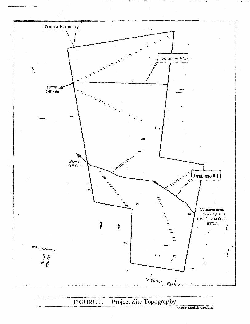
Two drainage features occur on the project site, as shown in Figure 2. Drainage #1 flows onto the site out of the existing storm drain system and traverses the site to the west where it flows off-site. Drainage feature #1 is crossed by an existing driveway that runs north to south on the project site. East of the driveway the drainage is characterized as a grassy swale that flows into a culvert beneath the driveway. West of the driveway the swale takes on the configuration of a channel with dense trees along the slopes providing nearly complete canopy cover, and a channel that is about 1 foot wide, on average. The tree species include redwoods, live oaks, and eucalyptus.
A second drainage feature, identified as Drainage #2 in Figure 1, is a swale located in the northern portion of the site. It also flows east-to-west and enters the site from a storm
737 Spruce Street Berkeley, CA 94707 'tf Phone: (510) 508-7554 Fax: (510) 525-5190

Natural Resources Management
drain culvert located in landscaped common areas of the adjacent housing development. The swale is densely vegetated with non-native vegetation such as Himalyan black berry, and with emergent vegetation typical of seasonal and perennial wetlands including cattails (Typha sp.) watercress (Rorippa nasturtium-aquaticum). Flows from this drainage enter the site from adjacent storm drains and re-enter storm drains after leaving the site.
SPECIES OF SPECIAL CONCERN
Although the project area is located within an area developed primarily for residential uses, special status species have the potential to occur. Special status species are those species listed as Threatened or Endangered by the Federal or State Endangered Species Acts. In addition, the California Environmental Quality Act (CEQA) requires that impacts to "locally rare" species also be addressed. For the purposes of this analysis, species of special concern with the potential to occur in the project area were determined based on the following:
California Natural Diversity Database US Fish and Wildlife Service Database
In addition, the Biological Resources Constraints Analysis developed by Jones & Stokes Associates was used for reference. The following species were identified as having the potential to occur at the project site:
California Red-legged frog (Rana aurora draytonii).
The California red-legged frog is federally listed as threatened, and is a state species of concern. This species requires permanent or semi-permanent riparian and upland habitat. Adults prefer dense, shrubby or emergent vegetation closely associated with deep (depths greater than 2 feet) still or slow moving water. The largest densities of California red-legged frogs are associated with deep water pools with dense stands of overhanging willows and an intermixed fringe of cattails. California red-legged frogs have been found to disperse up to 3 miles from water sources during warm rainy nights. Where water sources dry during the summer months, California redlegged frog may use upland areas that contain small mammal burrows and moist leaf litter for aestivation or refuge.
There are records of this species within 5 miles ofthe project area. Most occurrences are located north ofi 580, the closest is approximately 2.25 miles northwest of the project site in Hollis Canyon (CNDDB 2003). There are two more records ofthis species east of Palomares Road in the Sunol Ridge.
A Habitat Assessment was developed for the project site according to U.S. Fish and Wildlife Service guidelines. The conclusion of the assessment was that the project site drainages do not support high quality habitat for the California red-legged frog and the species would not occur (Monk 2003.)
Impact Statement: The project would not impact California red-legged frogs.
737 Spruce Street Berkeley, CA 94707 ~ Phone: (510) 508-7554 Fax: (510) 525-5190
---------------~~~---
Natural Resources Management
Western Burrowing Owl (Athene cunicular).
The western burrowing owl is a state species of special concern. Although it does not carry the designation of threatened or endangered under the state or federal endangered species act, the burrowing owl is locally rare. Formerly widely distributed over the Bay Area, including the East Bay area where the project is located, this species has been displaced by development. The local population ofburrowing owls is a small faction of its former size, therefore impacts to this species must be assessed according to CEQA guidelines (CEQA Guidelines 15685.)
Western burrowing owls use burrows created by other animals, usually ground squirrels. They also depend on ground squirrels to graze the surrounding vegetation to short grass or dirt, which is the burrowing owl preferred habitat type. There are several records of this species occurring within the region, but the project area does not contain any ground squirrel burrows or suitable habitat for western burrowing owl. During surveys for burrowing owls conducted by qualified biologists, there were no observations of ground squirrel activity or suitable habitat for the Western burrowing owl at the project site. In addition, numerous domesticated cats were observed at the project site. Domestic cats may prey upon burrowing owls and their presence may result in the lack of occupation of the site by burrowing owls. However, the burrowing owl survey conducted for this report was completed during the winter (non-breeding season.) Therefore, it may be possible for the owls to colonize the site during the breeding season. Disturbance to nesting owls or displacement of nesting owls as a result of the project would be considered an impact under CEQA.
Impact Statement: The project has the potential to impact western burrowing owls if the species colonizes the site prior to initiation of construction.
Mitigation Measure: A burrowing owl survey will be conducted 30 days prior to initiation of project construction. If active owl nests are found, buffer zones will be established around each active nest. Buffer zones, or Ecologically Sensitive Areas, will be consistent with CDFG guidelines including 160-foot buffers during the non-breeding period and 25 0-foot buffers during the breeding season. Any effort to relocate the owls would be conducted under the auspices of the local CDFG warden.
ADDITIONAL SPECIES
Additional species that may occur in the project area include raptors, or birds of prey, which are protected under the Migratory Bird Treaty Act. Species which may occur include, but are not limited to: American kestral, Cooper's hawk, red-tailed hawk, redshouldered hawk. During surveys of the trees in the project area there were no observations of raptors. However, the survey was completed during the non-breeding period for these birds. Raptor species may colonize the project area prior to initiation of
737 Spruce Street Berkeley, CA 94707 ';;;1 Phone: (510) 508-7554 Fax: (510) 525-5190
Natural Resources Management
project construction. These birds may construct and occupy nests in the large eucalyptus trees located adjacent to Drainage # 1. Disturbance to an occupied raptor nest as a result of the proposed project would be considered an impact under CEQA and would be inconsistent with the federal Migratory Bird Treaty Act.
Impact Statement: The proposed project has the potential to impact raptor species that may occur in the project area. If large trees are removed during the rapt or breeding season(February through August) as a result of the proposed project, impacts to raptors may occur.
Mitigation Measure: If tree removal activities are proposed to occur between February and August, a qualified wildlife biologist will conduct a survey to determine the presence or absence of nesting raptors. If occupied nests are observed, the tree removal activity will not proceed until the biologist has confirmed that the nest is no longer in use and the young have fledged. In addition, tree removal or other activities would be prohibited within a 500-foot buffer zone around the nest tree.
WETLANDS
The Corps defines wetlands as areas that are inundated or saturated by surface water or groundwater at a frequency and duration sufficient to support, and that under normal circumstances do support, a prevalence of vegetation typically adapted for life in saturated soil conditions. For a wetland to qualify as a jurisdictional aquatic site and be, therefore, subject to regulation under Section 404 of the Clean Water Act, the site must support a prevalence ofhydrophytic vegetation, hydric soils, and wetland hydrology (Environmental Laboratory 1987).
Wetlands at the project site were delineated in January 2004 according to the standards of the U.S. Army Corps of Engineers. The results ofthe delineation are included in the attached wetland delineation report prepared by Jones & Stokes. A total of .25 acres of jurisdictional wetlands are present at the site including the two drainage features and small, associated wetlands. Impacts to wetlands that would occur as a result of a proposed project must be disclosed in a project's CEQA documentation.
The proposed project includes plans to confine the northern most drainage (Drainage #2) to a culvert as part of the development of the existing parcel. In addition, a very small amount of wetland would be impacted within Drainage #1 as a result of improvements to the existing culvert and driveway as necessary to widen the driveway.
Impact Statement: The proposed project would impact approximately .19 acres of wetlands. Impacts would occur when Drainage # 2 is confined to a culvert, and the driveway over Drainage #1 is widened.
Mitigation Measure: The impacts to wetlands that occur as a result of the proposed project will be mitigated according to the US. Army Corps of Engineers guidelines and
737 Spruce Street Berkeley, CA 94707 '2:1 Phone: (510) 508-7554 Fax: (510) 525-5190

Natural Resources Management
will also be subject to approval by the SF Bay Regional Water Quality Control Board. Mitigation may include enhancement of existing wetlands on-site, creation of wetlands off-site, or contribution to a wetland mitigation bank. Mitigation ratios are based on the quality of the impacted wetland and typically are at a 1:1 ratio or better and are determined during in coordination with state and federal agencies as part of the permitting phase of a proposed project.
CONCLUSION
The results of this biological resources report are consistent with the Negative Declaration for the proposed project to be located at 2492 D Street in the unicorporated Fairview Area in Alameda County. No impacts to biological resources are likely to occur if the mitigation measures described above are implemented.
Please feel free to contact me if you have any questions or comments about the information presented in this letter report.
Sincerely,
Patricia Berryhill Principal Natural Resources Management
737 Spruce Street Berkeley, CA 94707 2:1 Phone: (510) 508-7554 Fax: (510) 525-5190

\ \
-
BAsiS OF Bt:•~··~Gs
..., ""' ...
~~ ..., ..., ... ...... ........
..., ...
.., ... ...,
...... ...... ... .,. ...... I'__. .......
!!.
f!
FIGURE2.
......... ...
h ;; !
... ""
....
.... l i
I (
...
l (CQu
Project Site Topography
--·
---
Common area: Creek daylights
out of storm drain system.
1 l
!
J
Source: Monk & Associates

FIGURE 1. Aerial Photograph of2492 D Street Proposed Project Site · Source: Monk & Associates 2004


- ------------~~~ - ----------~~-~
APPENDIXB

I~ MONK & ASSOOATES Environmental Consultants
January 8, 2004
U.S. Fish and Wildlife Service Sacramento Field Office 2800 Cottage Way, W -2605 Sacramento, CA 95825
Attn: Mr. Dan Buford, Chief, Coast/Bay/Delta Branch
RE: Site Assessment for the California Red-Legged Frog 2492 D Street, Hayward, Alameda County
Dear Mr. Buford:
1. INTRODUCTION
Monk & Associates, Inc. (M&A) completed an assessment for California red-legged frog (Rana aurora draytonii) (CRLF) on December 30, 2003 for the 2492 "D" Street project site located in Hayward, California (Figure 1). This 3.4-acre project site supports two drainage features that traverse the site. This assessment was conducted according to the U.S. Fish and Wildlife Service (USFWS) guidelines1 for conducting site assessments for CRLF. These guidelines outline two procedures to accurately assess the status of CRLFs in the vicinity of a project site: (1) an assessment of CRL~ locality records and potential CRLF habitat in and around the project area; and (2) focused field surveys of aquatic habitats to determfue whether CRLFs are present According to the guidelines, it may be necessary to incorporate both procedures to determine the potential effects of projects on CRLFs, unless field surveys are determined to be unnecessary based on the fmdings of the initial site assessment
Based on the results of the site assessment, M&A does not believe that there is suitable habitat for CRLF along either drainage feature on this property. Consequently, M&A does not believe that protocol-level surveys ·of this site are necessary to determine if CRLF are present In the following sections, we provide details of the project site, the legal status and habitat requirements. ofCRLF, the site assessment methods, results, summary and conclusions.
2. PROJECT SITE DESCRIPTION
The project site is located on ''D" Street, in Hayward, California (Figures 1, 2, 3). A vacant single family home and a small shed occur on the project site. The project site is characterized as" a disturbed lot, with rubble and trash piles near the abandoned home. The surrounding grounds and yard have reverted to a mostly ruderal (weedy) condition. Ruderal vegetation is adapted to high levels of disturbance, and persists almost indefinitely in areas with continuous disturbance.
1 USFWS (U.S. Fish and Wildlife Service). 1997. Guidance on Site Assessment and Field Surveys for California RedLegged Frogs. February 18, 1997. 6 pps.
1136 Saranap Ave., Suite Q + Walnut Creek + California + 94595
MONK & ASSOCIATES
Vegetation found on the site consists mostly ofexotic species that are introduced from the Mediterranean region ofEurope and northern Africa. Examples ofruderal species found on the project site include black mustard (Bras sica nigra), jointed wild radish (Raphanus raphanistrum ), slender wild oat (Avena barbata ), Italian rye grass (Lolium multijlorum ), spring vetch (Vicia sativa), prickly ox-tongue (Picris echioides), milk thistle (Silybum marianum), dove-foot geranium (Geranium molle), and Bermuda buttercup (Oxalis pes-caprae). In addition, a few native coast live oaks (Quercus agrifolia) and coyote bushes (Baccharis pilularis) occur on
·the project site. Large eucalyptus trees (Eucalyptus sp.) occur on the eastern slope of the project site. Two unnamed drainage features bisect the property, flowi;ng from east to west. These drainage features are described in further detail below.
3. SURROUNDING LAND USES
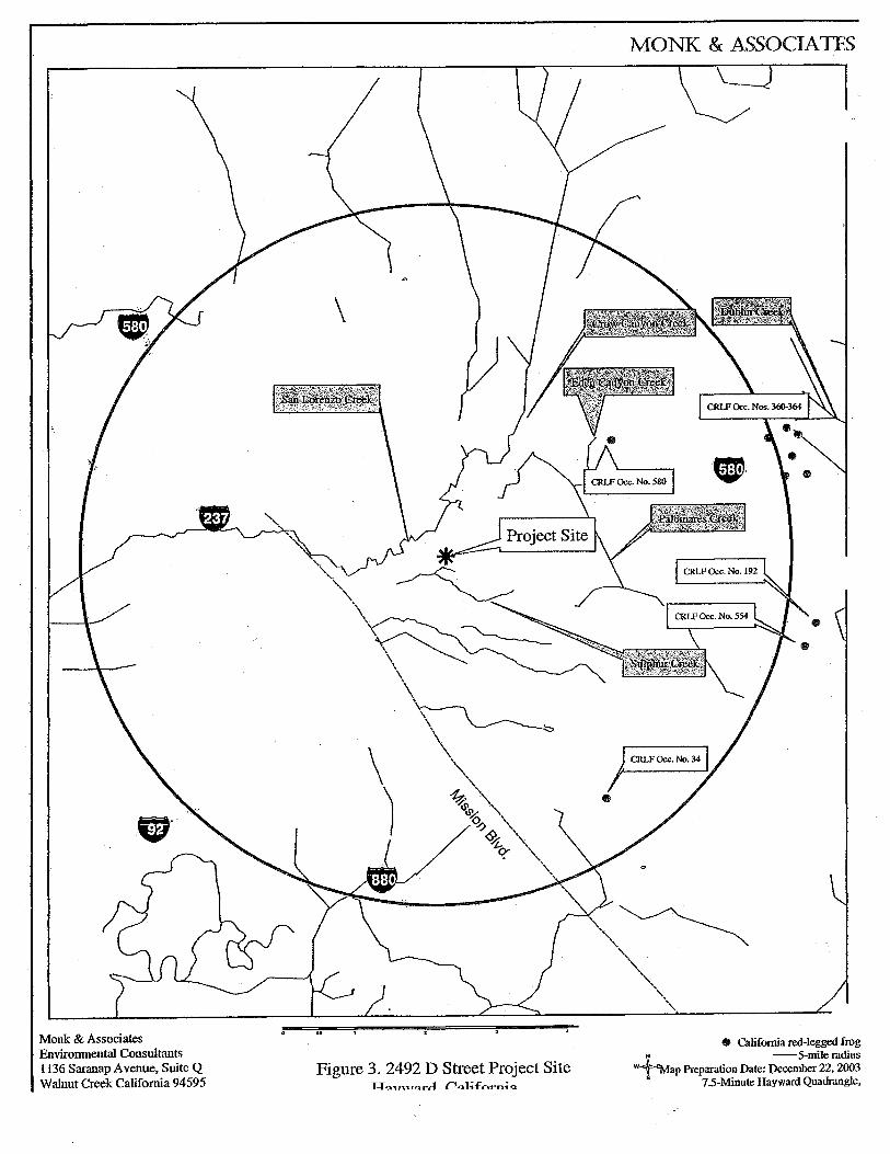
The project site is surrounded by residential development, as shown on the aerial photograph of the project area (Figure 4). Figure 5 also illustrates that the drainage features on the project site have no hydrologic connectivity to natural waterways. The drainage features daylight from an offsite storm drain syste~ and flow back into the storm drain system off the project site. This storm drain system discharges into San Lorenzo Creek, approximately Yz mile from the project site. The closest natural creek system is Sulphur Creek, which is located 1/4 mile south of the project site (Figures 2, 3,4, and 5). Figure 6 indicates the location ofthe project site on the 7.5-Minute Hayward Quadrangle topographic map.
4. LEGAL STATUS AND HABITAT REQUIREMENTS OF THE CALIFORNIA RED-LEGGED FROG
The California red-legged frog is a federal listed threatened species and a state "species of special concern." The California red-legged frog is typically found in ponds, slow-flowing portions of perennial streams, and in intermittent streams that maintain water in the summer months. This frog is also found in hillside seeps that maintain pool environments or saturated soils throughout the summer months (M&A personal observations). Populations probably cannot be maintained if all surface water disappears (i.e., no available surface water for egg laying and larval development habitati. Larval California red-legged frogs require 11-20 weeks of permanent water to reach metamorphosis (i.e., to change from a tadpole into a frog) ( op. cit.). Riparian vegetation such as willows and emergent vegetation such as cattails are preferred redlegged frog habitats, though not necessary for this species to be present. Populations of California red-legged frog will be reduced in size or eliminated from ponds supporting nonnative species such as bullfrog (Rana catesbeiana), Centrarchid fish species (such as sunfish, blue gill, or large mouth bass), and signal and red swamp crayfish (Pacifastacus leniusculus and Procambarus clarkii, respectively), all of which are known California red-legged frog predators. However, the presence ofthese non-native species does not preclude the presence ofthe California red-legged frog.
2 Jennings, M.R., and M.P. Hayes. 1994. Amphibian and reptile species of special concern in California. Final report submitted to the California department of fish and game, inland fisheries division, Rancho Cordova, CA 255pp.

------------~~~~-
MONK & ASSOCIATES
5. SITE ASSESSMENT METHODS
On December 30,2003, and January 7, 2004, M&A biologist, Ms. Hope Kingma, conducted surveys of the project site to evaluate the suitability ofhabitats for CRLF. During this assessment, all aquatic habitats that could be used by CRLF were evaluated. The site assessment was conducted after the Hayward area had received above-average rainfall. Notes were made on each aquatic habitat's hydrology, vegetative cover, and apparent wildlife use. Photographs were taken of each aquatic habitat and the surrounding landscape. These photographs are included as an attachment to this report.
In addition, M&A searched the California Department ofFish and Game's most current version of the Natural Diversity Database (CNDDB) for records of CRLF within five miles of the project site. The CNDDB search resulted in three occurrences ofCRLF within five miles ofthe project site (see Figure 3). The nearest occurrence (Occurrence No. 580) is located 2.8 miles northeast from the project location, north ofl-580 (Figure 3). This frog sighting was in a creek system that is not hydrologically connected to the project area. Additionally, there are several occurrences outside the five-mile radius of the site (Figure 3), however none of these sightings are associated with the project site watershed.
6. SITE ASSESSMENT RESULTS
6.1 Drainage Feature# 1
Drainage feature# 1 flows east to west across the project site. It flows from under the eastern fence boundary across a grassy slope and through a culvert under the driveway. This drainage feature then flows down into a moderately incised canyon offthe project site (see Photo 1), and eventually flows into a storm drain system. The eastern section ofthe drainage feature, east of the driveway, is characterized as a shallow drainage swale that is dominated by Himalayan blackberry (Rubus discolor), curly dock (Rumex crispus), umbrella sedge (Cyperus eragrostis), Dallis grass (Paspalum dilatatum), and rescue brome (Bromus catharticus), and tall fescue (Festuca arundinacea) (see :Photo 2). A large ash tree (Fraxinus sp.) grows near the culvert, where the drainage feature flows under the driveway roadbed. Downstream of the driveway (to the west), the drainage feature becomes narrower and slightly incised, averaging one-foot wide. This portion of the drainage feature is overgrown with eucaiyptus trees, Himalayan blackberry, and vegetation debris, such as downed branches and eucalyptus bark (see Photo 3).
Drainage feature# 1 was flowing during the site inspections in December and January, with 2-3 inches of flowing surface water in some places. This drainage appears to be subject to high flows, particularly following heavy rain events, as evidenced by flow patterns, vegetation caught on branches, and matted vegetation along the main channel. Drainage feature # 1 is a shallow channel that does not support any plunge pools or significant areas of open standing water, largely due to the east to west sloping grade across the site, as shown on the site topography map (Figure 7). The topography ofDrainage feature #1 is also shown in photographs 1, 2, and 3.
6.2 Drainage Feature# 2
Drainage feature # 2 is also a shallow drainage swale that flows east to west across the project site from under the eastern fence boundary (see Photos 4 and 5). This drainage is densely vegetated with Himalayan blackberry, cattails (Typha sp.), watercress (Rorippa nasturtium-
MONK & ASSOCIATES
aquaticum), umbrella sedge, prickly ox-tongue, and curly dock(see Photos 6 and 7). Drainage feature# 2 was also flowing on December 30 and January 7, with 2-3 inches of surface water, however, this drainage is too shallow and nai:row to support any plunge pools or significant areas of open standing water.
Both drainage features enter the project site from storm drain culverts located in landscaped common areas in the adjacent housing development (see Photos 8, 9, and 10). Both drainages eventually reenter the storm drain system after leaving the site (Figure 5).
6.3 Wildlife Observations
Wildlife observed, or sign (i.e., scat or prints), on the project site were those species commonly found in urban settings, including western scrub-jay (Aphelocoma califomica), northern mockingbird (Mimus polyglottos), house finch (Carpodacus mexicana), house sparrow (Passer domesticus); song sparrow (Melospiza melodia), California towhee (Pipilo crissalis), bushtits (Psaltriparus minimus), black phoebe (Sayomis nigricans), raccoon (Procyon lotor), black-tailed deer ( Odocoileus hemionus columbianus), and a house cat (Felis catus). The large eucalyptus trees provide roost habitat for turkey vultures ( Cathartes aura), and potential nest sites for raptors, such as red-tailed hawk (Buteo jamaicensis ), red-shouldered hawk (Buteo lineatus ), and great horned owls (Bubo virginianus). In addition, several chickens were observed on the project site. No amphibians, including the ubiquitous tree frog (Hyla regilla), were observed on the project site, due to lack of suitable aquatic habitats on the site. ·
7. SUMMARY AND CONCLUSION
Based on the results of this field assessment, M&A does not believe that either drainage feature on the project site provides suitable habitat for CRLF. These drainage features daylight from an offsite storm drain system, and eventually flow back into the storm drain system once offsite. Consequently, only isolated remnant branches of a creek system are onsite. These remnant drainages have no hydrologic connectivity to natural waterways. It is unlikely that CRLF use these drainage features during migration, since these features are connected to storm drain systems and have no connectivity to other habitats. In addition, these drainage features lack plunge pools, or areas of open standing water. These drainages are subject to unpredictable flows following storm events due to urban runoff contributions upstream. Finally, these narrow drainages have high amounts of eucalyptus leaflitter in the lower sections which is unsuitable for CRLF and most other amphibians. These factors make the drainage features on the project site largely unsuitable as CRL:F habitat. Furthermore, the project site is surrounded by residential development, which makes the site unsuitable for CRLF. Consequently, M&A does not believe that CRLF are likely to occur on the project site, and does not believe that conducting protocollevel surveys on the property is necessary. M&A requests USFWS' concurrence with these findings.
MONK & ASSOCIATFS
If you have any questions or require additional information please contact Geoff Monk:, or me, at (925) 947-4867.
Hope Kingma Project Biologist
Attachments: Figures 1, 2, 3, 4, 5, 6, and 7 Photographs of the project site (1-10)
cc: Ms. Patricia Berryhill, Natural Resources Management
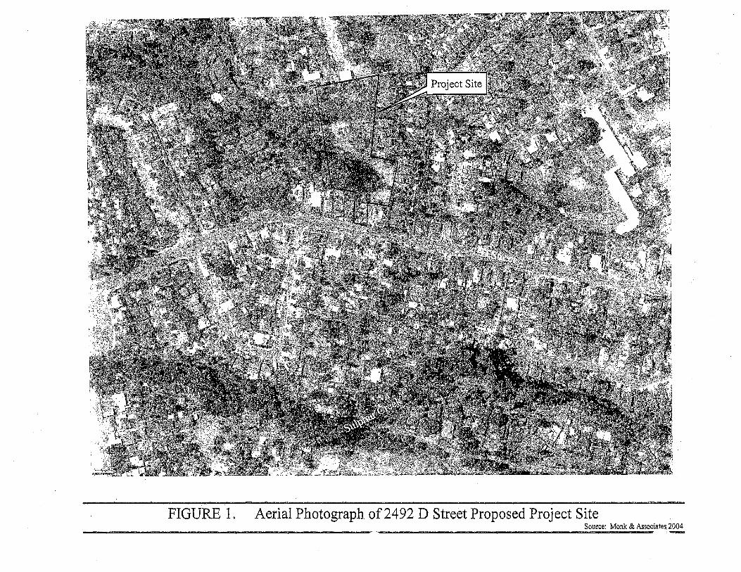
FIGURE 1. Aerial Photograph of2492 D Street Proposed Project Site Source: Monk & Associates 2004
,.., .., . ., ... .., ..... ..., ..., ....
\ ...... ......
i .., ... .... ...
...... ...... ....... ... .,.
I'"".,. ...........
.... .,.. ~ .... - ... ...
l i
il ...
I [
FIGURE2. Project Site Topography
-~·
-·-
Common area: Creek daylights
out of storm drain system.
J 1
r
I
Source: Monk & Associates
Monk & Associates Environmental Consultants 1136 Saranap A venue, Suite Q Walnut Creek California 94595
Figure 3. 2492 D Street Project Site -.:.:T f:l'\IU.I'='r..-1 rt.ol;.fArn; (l
MONK & ASSOCIATES
0 California red-legged frog N -5-mile radius
w~ap Preparation Date: Pecember 22, 2003 s 7.5-Minute Hayward Quadrangle,

lrainage
'ransportation
'opography
• WaterBody
Contour -Western County
:adastre
!l Parcel - San Leandro
D Parcel - Unincorporated
loundaries
nagery
SCALE .1 : 1 ,942
f"l F"3 F1 I 100 0 100
FEET
I m d
N
A I I 200 300

RIM00028.JPG (1280x960x16M jpeg)
RIM00031.JPG (1280x960x16M jpeg}
RIM00034.JPG (1280x960x16M jpeg}
RIM00027.JPG (1280x960x16M jpeg)
RIM00026.JPG (1280x960x16M jpeg)

APPENDIXC

-- ------------~-~--~
Preliminary Delineation of Waters of the United States, Including Wetlands, for the
Agarwal Parcel, Alameda County, California
Prepared for:
Natural Resources Management 737 Spruce Street
Berkeley, CA 94707 Contact: Patricia Berryhill
510/508-7554
Prepared by:
Jones & Stokes 268 Grand Ave
Oakland, CA 94610 Contact: Joel Gerwein
510/433-8962
January 2004
Jones & Stokes. 2004. Preliminary delineation of waters of the United States, including wetlands, for the Agarwal parcel, Alameda County, California. Draft. January. (J&S 03618.03) Oakland, CA. Prepared for Natural Resources Management, Berkeley, CA

-------------~~---~
Contents
Summary ·······················································································'····· 1 Description of General Site Conditions ................................................ 1
Setting ............................................................................................ 1 General Site Conditions ................................................................. 2 Hydrology ................... · .................................................................... 2 Soil .............................................................•................................... 2
Terminology ......................................................................................... 2 Delineation Methods ............................................................................ 4
Review of Existing Information ....................................................... 4 Survey Methods ............................................................................. 4
Results ................................................................................................. 6 Intermittent drainages .................................................................... 6 Persistent emergent wetland ......................................................... 7 Developed/ruderal non-native grassland ....................................... 7 Riparian scrub and forest.. ............................................................. 7
Printed References .............................................................................. 7 Personal Communications ................................................................... 8
Appendix A Routine Wetland Delineation Data Forms

Figures
Figure Follows Page
1 Project Vicinity and Location Map .............................................................. 1
2 Soils map·······································'··························································· 2
3 Preliminary delineation of waters of the U.S., including wetlands, for the Agarwal property ............................................................ 8
4 Photographs of intermittent drainage DR-01 ............................................. 6
" 5 Photographs of intermittent drainage DR-02 and associated emergent wetlands .................................................................. 6
ii

Preliminary Delineation of Waters of the United States, Including Wetlands,
for the Agarwal property, Alameda County, California
Summary This report presents the results of a delineation of waters of the United States, including wetlands, conducted for Vijay Agarwal for a property in unincorporated Alameda County, California. Jones & Stokes botanist/wetland ecologists Kate Carpenter and Joel Gerwein delineated waters of the United States to determine the location and extent of areas that would likely be subject to regulation under Section 404 ofthe Clean Water Act(CWA). A total of0.24 acres of waters of the United States were delineated in the project area; these waters are comprised of the open water habitat (other waters) of two unnamed drainages (0 .12 acres), and associated persistent emergent wetlands (0.12 acres). The jurisdictional areas discussed in this report should be considered preliminary pending verification by the U.S. Army Corps of Engineers (USACE) San Francisco District.
Description of General Site Conditions
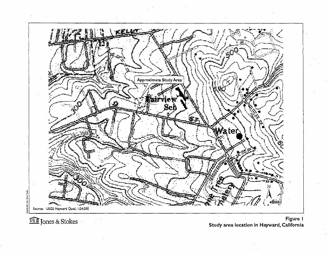
Setting
The delineation area is located in the City of Hayward in the unincorporated Fairview area of Alameda County (Figure 1). The delineation arell. is located in the San Lorenzo (Castro) land-grant, on the U.S. Geological Survey Hayward 7 .5-minute quadrangle at an approximate elevation range of 280-340 feet. The delineation area for this report encompassed the entire 3.66-acre parcel located at 2492 "D" Street. Fenced residential.yards adjacent to the delineation area were not surveyed as part of this study.
Preliminary Delineation of Waters of the January 2004
J&S 03618.03 United States, Including Wetlands, for the Agarwal Property, Alameda County, California
~
~-.• ., .•
. .. ·~. ;\~~~"-·==:--- ::---.. .~~~ .. ·:~ ~j:·~ ...... JJ: - /1' q { .. !ilisrS ~ .~1.1.~~~~-~:--.::.~~-e'IL. ~.r-.c- ~/1./t • " ..,,
Source: USGS Hayward Quad, I :24,000
m Jones & Stokes Figure I Study area location in Hayward, California
Mr. Agarwal has proposed to build 15 houses within 3 acres on the approximately 4-acre parcel. Alameda County (County) certified an initial study/mitigated negative declaration (IS/MND) for the proposed project in 2001. A notice of determination was issued on September 17, 200 L
General Site Conditions
The site is located in the California Floristic Province in the San Francisco Bay Area (Hickman 1993). The mean annual precipitation is approximately 20 inches, and the mean annual air temperature is approximately 57°F (yV elch 1981 ). Most of the delineation area is highly disturbed as a result of human activities. The site is surrounded by residences and housing developments to the west, north, and east and a heavily used 2-lane roadway (D Street) to the south. Habitat types found in the delineation area include developed/ruderal non-native grassland, riparian scrub and forest, and aquatic and freshwater marsh. There are two seasonal drainages in the delineation area.
Hydrology
Soil
The main hydrologic features within the project area are two intermittent drainages, referred to in this report as DR-01 and DR-02, both of which flow west across the project area. DR-01 passes under the access road in a culvert. While these drainages are not indicated on the USGS topographic map for the project vicinity, their location and appearance suggests that they flow into either: 1) San Lorenzo Creek, which is located approximately 0.6 miles downslope to the northwest of the delineation area, or 2) an unnamed drainage located approximately 0.2 miles south ofthe delineation area.
According to the Soil Survey of Alameda County, Western Part (Welch 1981), the delineation area contains one soil map unit: (158) Xerorthents-Los Osos complex, with 30-50% slopes. This map unit comprises land composed of cutand-fill, and silty clay loam soils weathered from sedimentary rock. Neither Xerorthents nor Los Osos Complex is on the hydric soils list prepared for the soil survey area (Soil Conservation Service 1992). Figure 2 is the soil map of the delineation area.
Preliminary Delineation of Waters of the January 2004 United States, Including Wetlands, for the Agarwal property, Alameda County, California
2 J&S 03618.03

Soil map unit 158 = Xerorthents-los Osos complex. See text for description of this map unit.
m Jones & Stokes Figure 2.
Soils map for the Agarwal property in Alameda County, CA Adapted from Welch 1981
Terminology
This section presents definitions of terms specific to delineations of waters of the United States.
Waters of the United States are: (1) all waters which are currently used, or were used in the past, or may be susceptible to use in interstate or foreign commerce, including all waters which are subject to the ebb and flow of the tide; (2) all interstate waters including interstate wetlands; (3) all other waters such as intrastate lakes, rivers, streams (including intermittent streams), mudflats, sandflats, wetlands, sloughs, prairie potholes, wet meadows, playa lakes, or natural ponds, the use, degradation, or destruction of which could affect interstate or foreign commerce including any such waters ... ; ( 4) all impoundments of waters otherwise defmed as waters of the United States under the definition; (5) tributaries of waters identified in paragraphs (a)(l)-(4) of this section; (6) the territorial seas; and (7) wetlands adjacent to waters (other than waters that are themselves wetlands) identified in paragraphs (a)(l)-(6) of this section. (33 Code ofFederal Regulations [CFR] § 328.3.)
Waters of the United States are areas subject to federal jurisdiction pursuant to Section 404 of the CW A. For the purpose of this delineation report, waters of the United States are divided into wetlands and other waters of the United States.
Wetlands are "areas that are inundated or saturated by surface or groundwater at a frequency and duration sufficient to support, and that under normal circumstances do support, a prevalence of vegetation typically adapted for life in saturated soil conditions" (33 CFR § 328.3[b], 40 CFR § 230.3). To be considered subject to federal jurisdiction, a wetland must normally support hydrophytic vegetation, hydric soils, and wetland hydrology (Environmental Laboratory 1987).
Other waters of the United States are seasonal or perennial water bodies, including lakes, stream channels, drainages, ponds, and other surface water features, that exhibit an ordinary high water mark but lack positive indicators for ~he three wetland parameters (33 CFR 328.4).
Ordinary high water mark (OHWM) means that line on the shore established by. the fluctuations of water and indicated by physical characteristics such as clear, natural line impressed on the bank, shelving, changes in the character of soil, destruction of terrestrial vegetation, the presence of litter and debris, or other appropriate means that consider the characteristics of the surrounding area (33 CFR 328.3§ [e)).
Long duration is defined by the Natural Resources Conservation Service (NRCS) as inundation in a single event ranging froin 7 days to 1 month. The presence of water for a week or more during the growing season typically creates anaerobic conditions in the soil; these conditions affect the types of plants that can grow and the types of soils that develop (Wetland Training Institute 1995).
Preliminary Delineation of Waters of the United States, Including Wetlands, for the Agarwal property, Alameda County, California
3 January 2004
J&S 03618.03
Wetland indicator status denotes the probability that a particular plant species will occur in habitats qualifying as wetlands. Indicator status categories were originally developed and defined by the U.S. Fish and Wildlife Service National Wetlands Inventory and subsequently modified by the National Plant List Panel (Environmental Labomtory 1987; Reed 1988).
Wetland indicator status categories are defined by the following characteristics:
• obligate (OBL)- almost always occurs in wetlands (99% probability);
• facultative wetland (FACW)- usually occurs in wetlands (67-99% probability);
• facultative (FA C) - equally likely to occur in wetlands or nonwetlands (34-66% probability ofoccurrence in wetlands);
• facultative upland (F ACU) -usually occurs in non wetlands, but occasionally occurs in wetlands (1-33% probability);
• obligate upland (UPL) - almost never occurs in wetlands (1% probability); and
• no indicator (NI) - no indicator status assigned because information is lacking.
Delineation Methods
Review of Existing Information
The following information was reviewed before conducting the field delineation.
• USGS 7.5-minute topogmphic map.
• Aerial photogmphs of the project area.
• Alameda County soil survey information (Figure 2).
Survey Methods
Jones & Stokes botanist/wetland ecologists Kate Carpenter and Joel Gerwein conducted a formal delineation of waters of the United States, including wetlands, on January 8, 2004, using procedures detailed in the Corps of Engineers Wetlands Delineation Manual (1987 Manual) (Environniental Labomtory 1987). The 1987 Manual provides technical guidelines arid methods for using a three-parameter approach to determine whether areas supporting positive indicators ofhydrophytic vegetation, hydric soils, and wetland hydrology are jurisdictional wetlands. In addition, the 1987 Manual provides
Preliminary Delineation of Waters of the United States, Including Wetlands, for the Agarwal property, Alameda County, California
4 January 2004
J&S 03618.03
guidelines for determining the OHWM. The OHWM is determined by observing field indicators that correspond to an approximately 2-year flow event, including water marks, drift lines, sediment deposits, recent scour (i.e., bank erosion), type and abundance of vegetation, and changes in the physical and morphological characteristics of the soil. The delineation area was surveyed on foot and data were collected at four representative sample plots in the delineation area (Appendix A).
Determination of Hydrophytic Vegetation
The presence ofhydrophytic vegetation was determined using the methods outlined in Federal Manual for IdentifYing and Delineating Jurisdictional Wetlands (Federal Interagency Committee for Wetland Delineation 1989); these methods are approved by USACE for use in conjunction with the 1987 Manual. Under these methods, areas are considered to have positive indicators of hydrophytic vegetation if more than 50% of the dominant plant species (dominant species are detmed as plants that comprise 20% or more of the cover value observed at a site) comprise FAC, FACW, or OBL species (Reed 1988).
Determination of Wetland Hydrology
Wetland hydrology was determined to be present if a site exhibited one or more of the following characteristics, which may be present during the dry season:
1111 landscape position and surface topography that would support wetland habitat (e.g., position of the site relative to an upslope water source, location within a distinct wetland drainage pattern, concave surface topography);
1111 inundation or saturation for a long duration (either inferred on the basis of field indicators or observed during field surveys); and
1111 residual evidence ofponding or flooding (e.g., scour marks, sediment deposits, algal matting, drift lines).
As additional guidance to determine the period of inundation or saturation required to meet the wetland hydrology criterion, the 1987 Manual modified a hydrologic classification system for nontidal areas based on periods of inundation or soil saturation.. According to this classification system, areas that are inundated less than 5% (15-16 days in the Hayward area) of the growing season are not wetlands. Areas that are regularly inundated or saturated between 5% (15-16 days) and 12.5% (38-40 days) of the growing season may be wetlands. The estimates ofthe growing season (300-320"days) are based on Welch (1981).
Preliminary Delineation of Waters of the United States, Including Wetlands, for the Agarwal property, Alameda County, California
5 January 2004
J&S 03618.03

Results
Determination of Hydric Soils
If the sample site supported a prevalence ofhydrophytic vegetation, a shallow pit was dug and the soils were evaluated using a Munsell soil color chart, hand texturing, and assessment of diagnostic soil features (e.g., oxidized root channels, amount of organic matter in the soil profile).
Jurisdictional Boundary Determinations, Wetland Mapping, and Acreage Calculations
The boundaries of the intermittent drainages were determined by locating the OHWM. The boundary of wetlands associated with DR-02 was determined by the presence or absence ofhydrophytic vegetation, wetlands hydrology and hydric soils. Data were collected at points in the wetland and the adjacent upland.
After wetland and drainage boundaries were determined, the features were recorded on a 1: 534 scale site map with 2' topographic contours. Acreages were then calculated using ArcGIS software.
Based on the survey methodology described above, the delineation area contains 0.24 acre of waters of the United States, including wetlands, that are potentially subject to jurisdiction under Section404 of the CWA (Figure 3) (0.06 in DR-01 and 0.18 in and adjacent to DR-02). These waters consist of two intermittent drainages and the associated persistent emergent wetlands that contain aquatic and freshwater marsh habitat.
The remaining habitats within the delineation area consist of uplands (nonwetlands), including developed!ruderal non-native grassland dominated by soft l_Jrome (Bromus hordeaceus) and riparian scrub and forest habitat, dominated by Himalayan blackberry (Rubus discolor),Bnglish ivy (Hedera helix) and bluegum eucalyptus (Eucalyptus globulus).
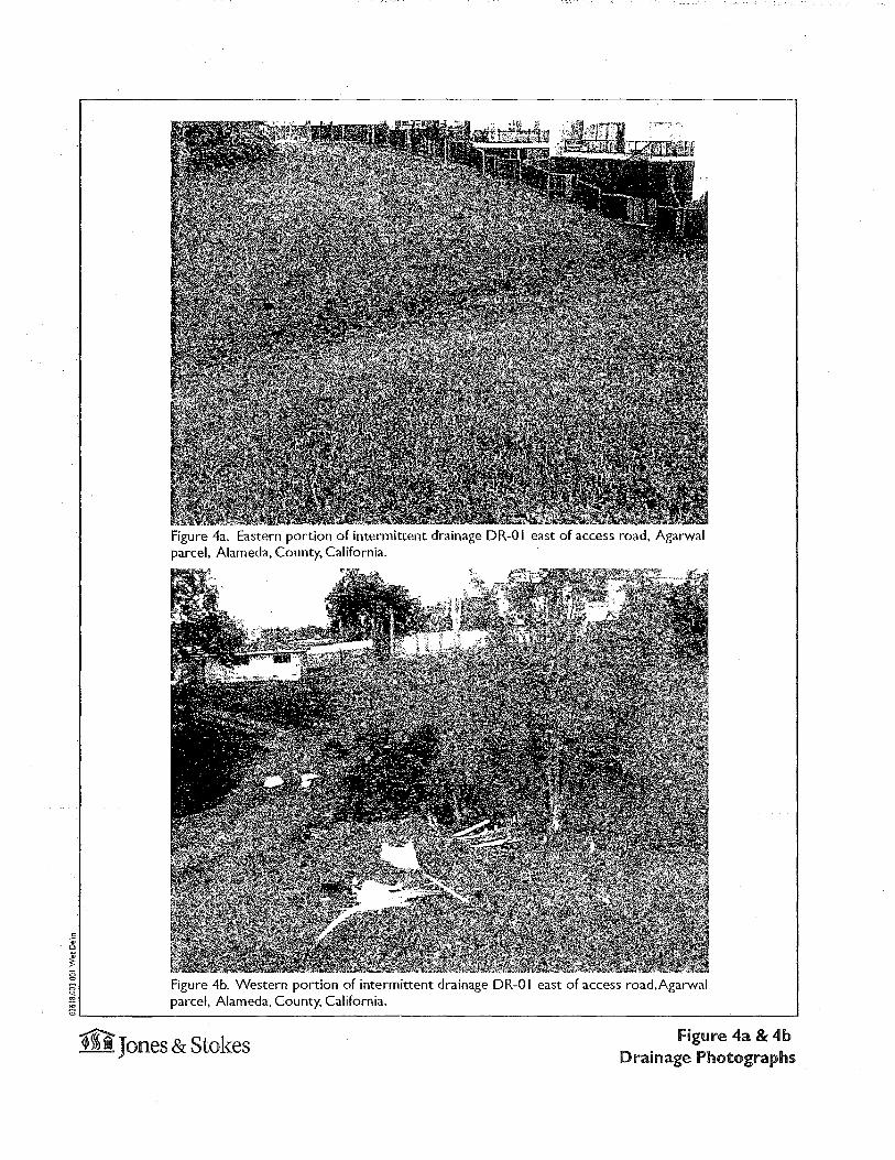
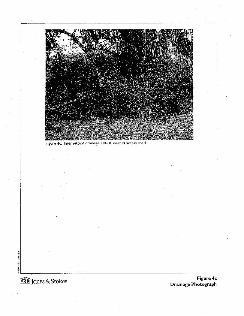
Intermittent drainages
Two intermittent drainages (other waters) totaling 0.12 acre were mapped in the delineation arei' (DR-01 and DR-02) (Figures 4-5). This habitat type qualifies as jurisdictional based on the presence of a well-established bed and bank with an OHWM, and vegetation and soils indicative of water flow and saturation for greater than 40 days/year. DR-01 has a wide, braided form in part of its area east of the access road (Figure 4). The soil appears to have been disturbed in this . area, and a neighbor confirmed that some excavation had occurred in this area
Preliminary Delineation of Waters of the United States, Including Wetlands, for the Agarwal property, Alameda County, Californ.ia
January 2004
6 J&S 03618.03
0
Figure 4a. Eastern portion of intermittent drainage DR-0 I east of access road, Agarwal parcel, Alameda, County, California.
8 Figure 4b. Western portion of intermittent drainage DR-0 I east of access road, Agarwal ~ parcel, Alameda, County, California. 8~--------------------------------------------------------------------------~------~
~Jones & Stokes Figure 4a & 4b Drainage Photographs
0 0
0
Figure 4c. Intermittent drainage DR-0 I west of access road.
; ~L_------------------------~--~~
figure 4c m Jones & Stokes Drainage Photograph
0 0
0
~
Figure Sa. Intermittent drainage DR-02, with associated emergent wetlands EW-0 I and EW-02,Agarwal parcei,Aiameda County, CA.
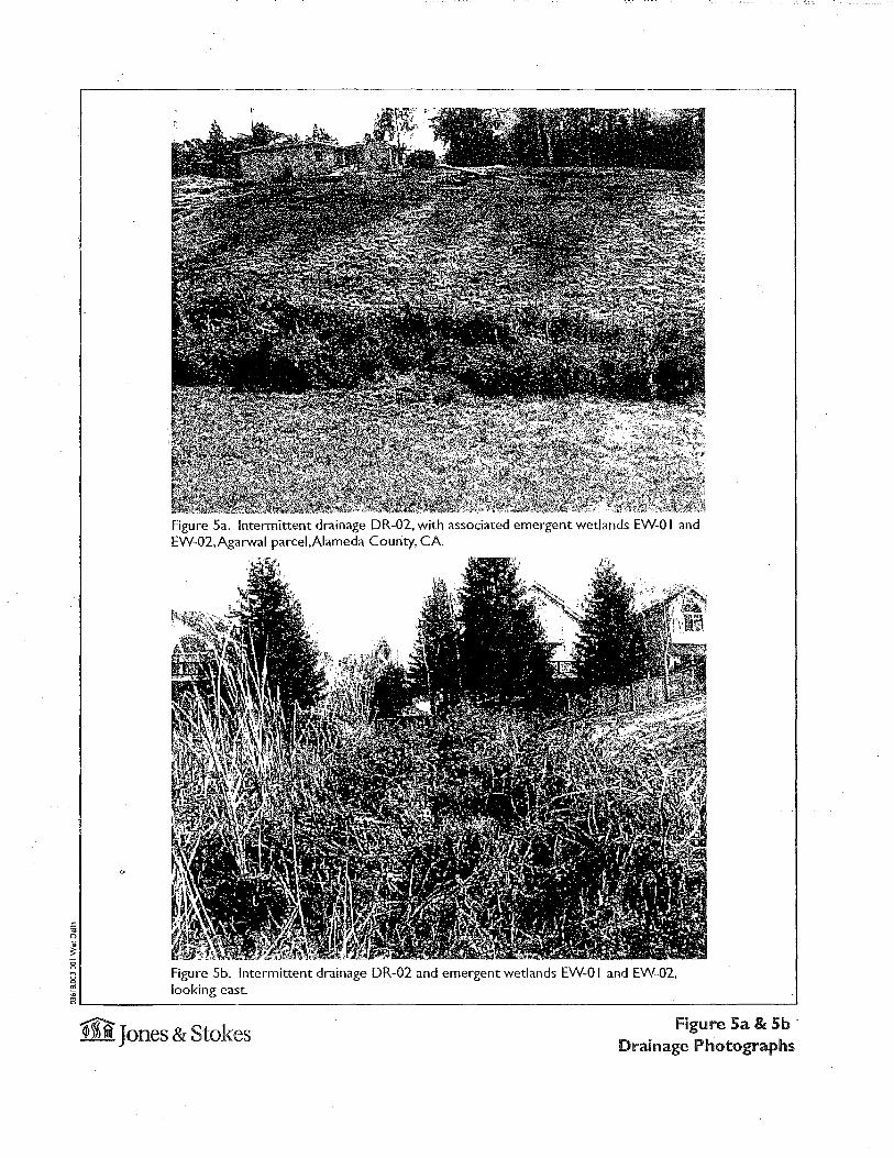
Figure Sb. Intermittent drainage DR-02 and emergent wetlands EW-0 I and EW-02, looking east.
~ ~
OL_------------------------------------------------------------------------------~
m Jones & Stokes Figure Sa & Sb · Drainage Photographs

several years ago (H.Balthazor, personal communication). The drainage is wider in this disturbed area (approximately 18' feet), visible on Figure 3 as a bulge in the drainage. Elsewhere, the drainage is approximately 5' wide.
DR-02 is approximately 10' wide throughout its course in the delineation area (Figure 5).
Persistent Emergent Wetland
Persistent emergent wetlands (wetlands) totaling 0.12 acre were mapped in the delineation area adjacent to DR-02 (EW-01 and EW-02) (Figure 5). This habitat type qualifies as jurisdictional based on its adjacency to the intermittent drainage, and its hydrophytic vegetation, hydrology, and soil with an aquic moisture regime.
Developed/ruderal non-native grassland
Nonnative grassland habitat is present in most of the delineation area. The dominant plants are soft brome (Bromus hordeaceus) (UPL), bull thistle (Cirsium vulgare), bristly ox-tongue (Picris echioides) (FAC) and sourgrass (Oxalis pescaprae) (NI).
Soil in the non-native grassland habitat in the delineation area was found to be nonhydric. The soil had a color of 10YR 3/2 and lacked redoximorphic features.
No wetland hydrology indicators were observed in the nonnative grassland habitat.
Riparian Scrub and Forest
Riparian scrub and forest in the delineation area was located adjacent to the portion ofDR-01 west of the access road that bisects the parcel. The dominant plant species in the riparian habitat in the delineation area were Himalayan blackberry (Rubus discolor) (F ACW), English ivy (Hedera helix) (NI), coast live oak (Quercus agrifolia) (UPL), and bluegum eucalyptus (Eucalyptus globulus) (Nl). .
The riparian scrub and forest was located on a hillside sloping steeply into DR-0 1, and no wetland hydrology indicators were observed within this area.
Preliminary Delineation of Waters of the United States. Including Wetlands, for the Agarwal property, Alameda County, California
January 2004
7 J&S 03618.03

Printed References
Environmental Laboratory. 1987. Corps of Engineers wetlands delineation manual. (Technical Report Y-87-1.) Vicksburg, MS: Waterways Experiment Station.
Federal Interagency Committee for Wetland Delineation. 1989. Federal manual for identifYing and delineating jurisdictional wetlands. (Cooperative Technical Publication.) U.S. Army Corps of Engineers, U.S. Environmental Protection Agency, U.S. Fish and Wildlife Service, and U.S. Soil Conservation Service. Washington, DC.
Hickman, J. C. (ed.). 1993. The Jepson manual: higher plants of California. Berkeley, CA: University of California Press.
Reed, P. B., Jr. 1988. National list of plant species that occur in wetlands: California (Region 0). (Biological Report 88 [26.10].) U.S. Fish and Wildlife Service Research and Development. Washington, DC. Prepared for National Wetlands Inventory, U.S. Fish and Wildlife Service, Washington, DC.
Soil Conservarion Service. 1992. Hydric soils list for Alameda County, Western Part. USDA Soil Conservation Service, Davis, CA. March 1992.
Welch, L.E. 1981. Soil survey of Alameda County, Califor.nia, Western Part. United States Department of Agriculture, in cooperation with University of California Agricultural Experiment Station.
Wetland Training Institute. 1995. Field guide for wetland delineation: 1987 Corps of Engineers manual. (WTI 95-3.) Poolsville, MD.
Personal Communications
Balthazor, Hal. Resident, D Street, Hayward, California. January 8, 2004-Conversation with Joel Gerwein.
Preliminary Delineation of Waters of the United States. Including Wetlands, for the Agarwal property, Alameda County, California
January 2004
8 J&S 03618.03
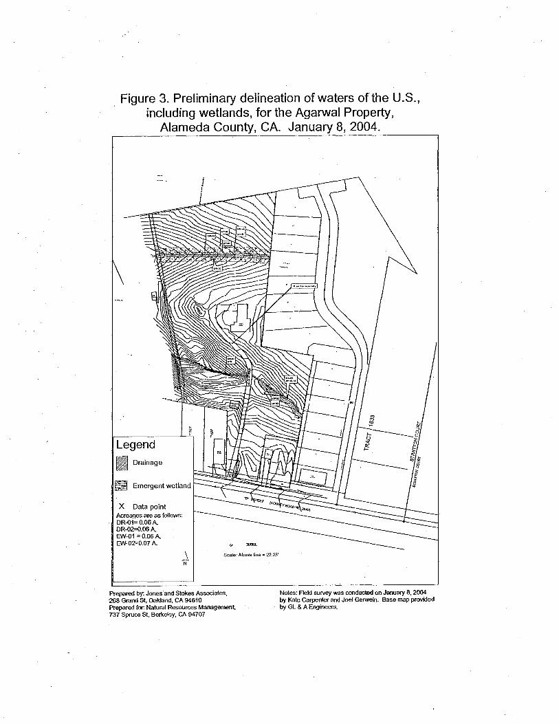
Figure 3. Preliminary delineation of waters of the U.S., including wetlands, for the Agarwal Property,
Alameda County, CA. January 8, 2004.
Legend ~~ Drainage
X Data point Acreages are as follows: DR-{)1= 0.06 A, DR-{)2=0.06 A, EW-{)1 = 0.06 A, EW.{)2=0.D7 A.
_l Scale: Above line = 2225'
N
Prepared by: Jones and Stokes Associates, 268 Grand St, Oakland, CA 94610 Prepared for: Natural Resources Management, 737 SpruceSt, Berkeley, CA 94707
Notes: Field survey was conducted on January 8, 2004 by Kate Carpenter and Joel Gerwein. Base map provided by GL & A Engineers.

Appendix A
Wetland delineation forms
~ Jones & Stokes
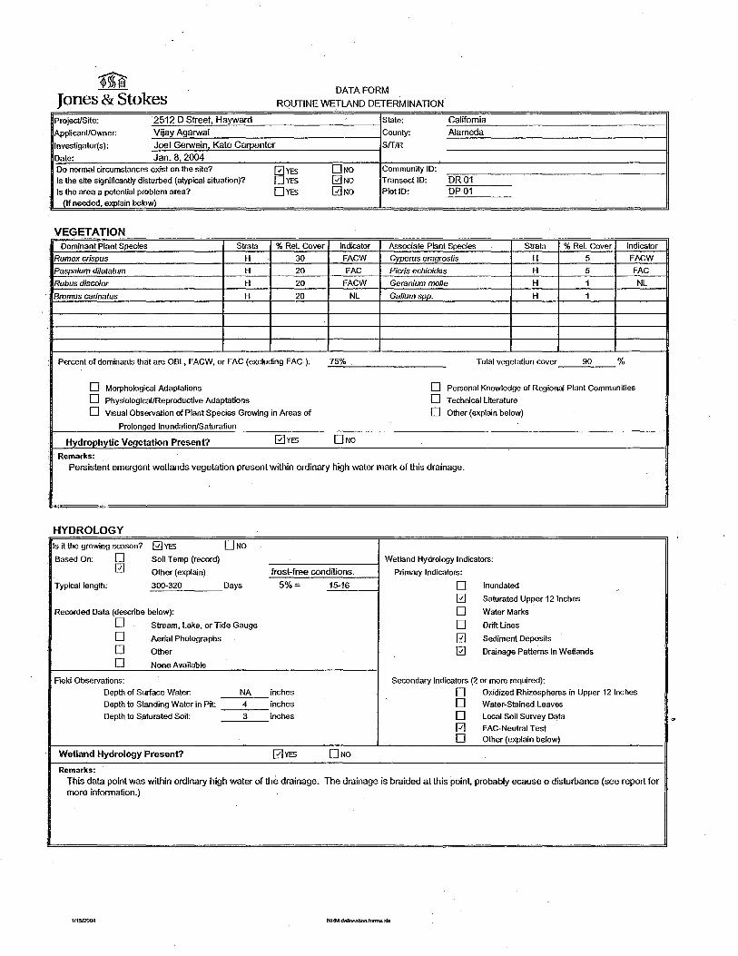
DATA FORM
ROUTINE WETLAND DETERMINATION
Project/Site: 2512 D Street, Hayward State: California
ApplicanUOwner: Vijay Agarwal County: Alameda
lnvestigator(s): Joel Gerwein, Kate Carpenter Sff/R
Date: Jan.8,2004 Do normal circumstances exist on the site? 0YES DNo Community ID:
Is the site significantly disturbed (atypical situation)? DYES 0No Transect ID: DR01 Is the area a potential problem area? DYES 0No PlotiD: DP01
(If needed, explain below)
VEGETATION Dominant Plant Species Strata %Ref. Cover Indicator Associate Plant Species Strata %Rei. Cover Indicator
Rumex crispus H 30 FACW Cyperus eragrostis H 5 FACW
Paspa/um di/atatum H 20 FAC Picris echioides H 5 FAC
Rubus discolor H 20 FACW Geranium mol/e H 1 NL
Bromus carinatus H 20 NL Ga/iumspp. H 1
Percent of dominants that are OBL, FACW, or FAC (excluding FAC-): 75% Total vegetation cover 90 %
D Morphological Adaptations D Personal Knowledge of Regional Plant Communities
D Physiological/Reproductive Adaptations D Technical Literature
D Visual Observation of Plant Species Growing in Areas of D Other (explain below)
Prolonged Inundation/Saturation
Hydrophytic Vegetation Present? 0YES 0No Remarks:
Persistent emergent wetlands vegetation present within ordinary high water mark of this drainage.
HYDROLOGY Is it the growing season? 0YES DNo Based On: D Soil Temp (record) Wetland Hydrology Indicators:
0 Other (explain) frost-free conditions. Primary Indicators:
Typical length: 300-320 Days 5%= 15-16 D Inundated
0 Saturated Upper 12 Inches
Recorded Data {describe below): 0 WaterMarks
D Stream, Lake, or Tide Gauge D Drift Lines
0 Aerial Photographs 0 Sediment Deposits
0 Other 0 Drainage Patterns in Wetlands
D None Available
Field Observations: Secondary Indicators (2 or more required):
Depth of Surface Water: NA inches 0 Oxidized Rhizospheres in Upper 12 Inches
Depth to Standing Water in Pit: 4 inches 0 Water-Stained Leaves
Depth to S.aturated Soil: 3 inches 0 Local Soil Survey Data
0 FAG-Neutral Test 0 other (explain below)
Wetland Hydrology Present? 0YES DNo Remarks:
This data point was within ordinary high water of the drainage. The drainage is braided at this point, probably ecause o disturbance (see report for more information.)
1/1512004 NRM deinea6on fmns..>ds
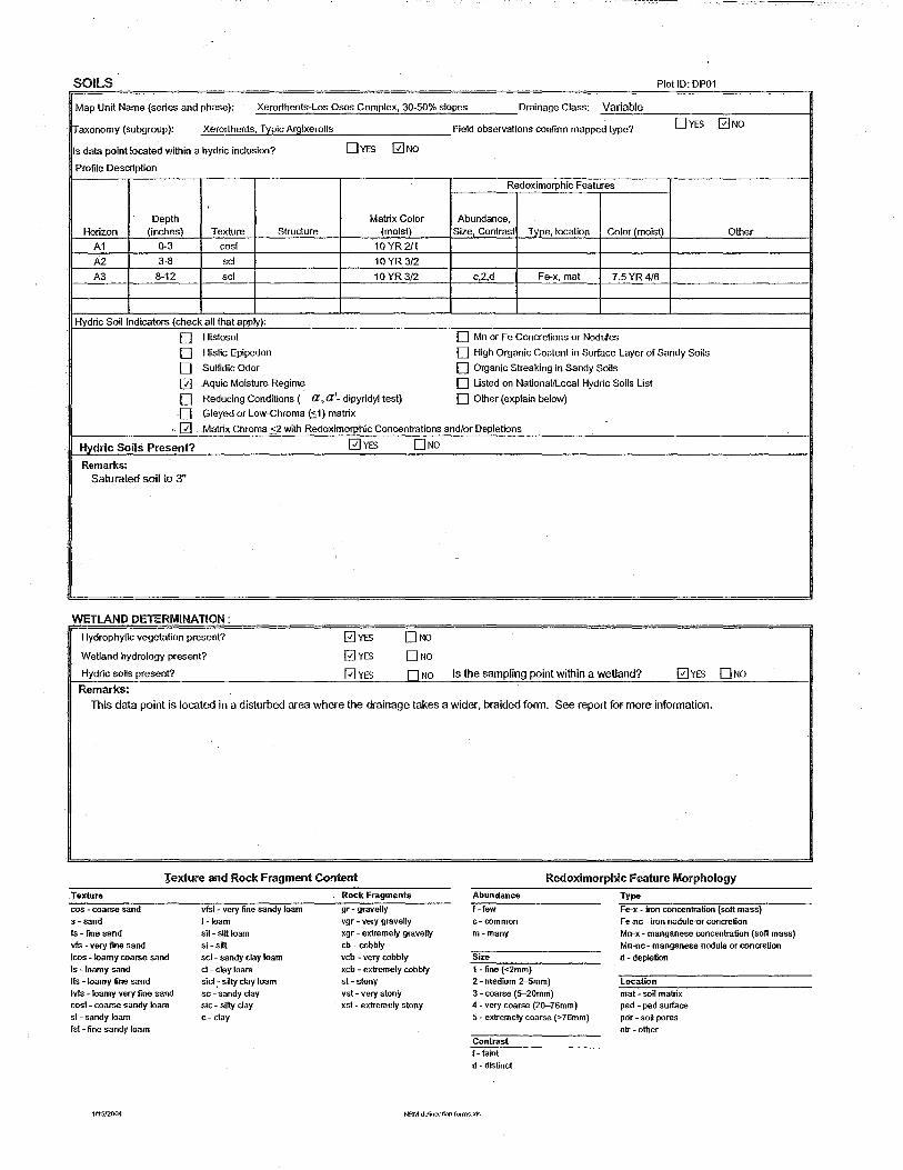
SOilS PlotiD· DP01
Map Unit Name (series and phase): Xerorthents-Los Osos Complex, 30-50% slopes Drainage Class: Variable
rraxonomy (subgroup): Xerorthents, Typic Argixerolls Field observations confinn mapped type? DYES 0No
Is data point located within a hydric inclusion? DYES 0No Profile Description
Redoximorphic Features
Depth Matrix Color Abundance. Horizon (inches) Texture Structure (moist) Size, Contrast Type, location Color (moist) Other
A1 0-3 cost 10 YR 2/1
A2 3-8 sci 10YR3/2
A3 8-12 sci 10YR3/2 c,2,d Fe-x, mat 7.5YR4/6
Hydric Soil Indicators (check all that apply):
D Histosol 0 Mn or Fe Concretions or Nodules
D Histic Epipedon 0 High Organic Content in Surface Layer of Sandy Soils
D Sulfidic Odor 0 Organic Streaking in Sandy Soils
0 Aquic Moisture Regime D Usted on National/Local Hydric Soils Ust
D Reducing Conditions ( a, a'- dipyridyl test) 0 Other (explain below)
D Gleyed or Low-Chroma ~1) matrix
0 Matrix Chroma <2 with Redoximorphic Concentrations and/or Depletions
Hydric Soils Present?
Remarks:
Saturated soil to 3"
WETLAND DETERMINATION:
Hydrophytic vegetation present?
Wetland hydrology present?
Hydric soils present?
Remarks:
0YES
0YES 0YES 0YES
DNO
DNa DNO DNO Is the sampling point within a wetland? 0YES DNO
This data point is located in a disturbed area where the drainage takes a wider, braided form. See report for more information.
Texture and Rock Fragment Content
Texture cos - coai-se sand s- sand fs- fine sand vfs -very fine sand
Ieos - loamy coarse sand Is - loamy sand lfs - loamy fine sand lvfs -loamy very fine sand cos!- coarse sandy loam sl - sandy loam fsl - fine sandy loam
vfsl - very fine sandy loam 1-loam sil- sitt loam si -silt sci- sandy clay loam
d-clayloam sicl - silty clay loam sc -'sandy clay sic-silty clay
c- clay
Rock Fragments
gr- graveny vgr - very gravelly xgr - extremely gravelly cb- cobbly vcb - very cobbly xcb - extremely cobbly st- stony vst - very stony xst- extremely stony
Redoximorphic Feature Morphology
Abundance
f-few c- common m -many
Size
1 -fine (<2mm) 2- medium 2-5mm)
3 - coarse (5-20mm) 4- very coarse (20-76mm) 5- extremely coarse (>76mm)
Contrast f- faint d- distinct
Type
Fe-x- iron concentration {soft mass) Fe-nc - iron nodule 'Or concretion Mn-x- manganese concentration (soft mass) Mn-nc- manganese nodule or conaetion d - depletion
Location
mat- soil matrix ped - ped surface por - soil pores otr- other
1115!2004 NRM delineation forms..xls

~ Jones & Stokes
DATA FORM
ROUTINE WETLAND DETERMINATION
Project/Site: 2512 D Street, Hayward State: California
Applicant/Owner: VijayAgarwal County: Alameda
lnvestigator(s): Joel Gerwein, Kate Carpenter SIT/R
Date: Jan.8,2004 Do normal circumstances exist on the site? (2]YES 0No Community ID: Is the site sigr)ificantly disturbed (atypical situation)? DYES 0No Transect ID: DR01 Is the area a potential problem area? DYES 0No PlotiD: DP02
(If needed, explain below)
VEGETATION Dominant Plant Species Strata %Rei. Cover Indicator Associate Plant Species Strata %Rei. Cover Indicator
Bromus hordeaceus H 80 UPL Picris echioides H 10 FAG
Rubus discolor H 5 FACW
Cirsium vulgare H 1 FACU
Rumex crispus H 1 FACW
Cynodon daclylon H 5 FAC
Oxafis pes-caprae H 5 Nl
Percent of dominants that are OBL, FACW, or FAG (excluding FAG-): 0 Total vegetation cover 100 %
0 Morphological Adaptations 0 Personal Knowledge of Regional Plant Communities
0 Physiological/Reproductive Adaptations 0 Technical Literature
0 Visual Observation of Plant Species Growing in Areas of 0 Other (explain below)
Prolonged Inundation/Saturation
Hydrophytic Vegetation Present? DYES 0No Remarks:
HYDROLOGY Is it the growing season? 0YES ONO '
Based On: 0 Soil Temp (record) Wetland Hydrology Indicators: 0 Other (explain) frost-free conditions. Primary Indicators:
Typical length: 300-320 Days 5%= 15-16 D Inundated
D Saturated Upper 121nches
Recorded Data (describe below): D WaierMarks
0 Stream, Lake, or Tide Gauge 0 Drift Lines
0 Aerial Photographs 0 Sediment Deposits
0 Other 0 Drainage Patterns in Wetlands
0 None Available
Field Observations: Secondary Indicators (2 or more required):
Depth of Surface Water: NONE inches 0 Oxidized Rhizospheres in Upper 12 Inches
Depth to Standing Water in Pit: >17 inches 0 Water-Stained Leaves
Depth to Saturated Soil: >17 inches 0 Local Soil Survey Data
0 FAG-Neutral Test 0 Other (explain below)
Wetland Hydrology Present? DYES 0No Remarks:
Data point is on toe slope of hill adjacent to drainage (DR-01).
1/1512004 NRMde!ineationforms..xls

SOILS Plot ID· DP02
Map Unit Name (series and phase): Xerorthents-Los Osos Complex, 30-50% slopes Drainage Class: Variable
!Taxonomy (subgroup): Xerorthents, Typic Argixerolls Field observations confirm mapped type? DYES 0No
Is data point located within a hydric inclusion? DYES 0No
Profile Description
Redoximorphic Features
Depth Matrix Color Abundance, Horizon (inches) Texture Structure (moist) Size, Contrast Type, location Color (moist) Other
A1 Q-4 CL 10 YR3/2
A2 4-17 CL 10 YR 3/2
Hydric Soil Indicators (check all that apply):
D Histosol D Mn or Fe Concretions or Nodules
D Histic Epipedon D High Organic Content in Surface Layer of Sandy Soils
D Sulfidic Odor D Organic Streaking in Sandy Soils
D Aquic Moisture Regime D Listed on National/Local Hydric Soils List
D Reducing Conditions ( a ,a'- dipyridyl test) D Other (explain below)
0 Gleyed or Low-Chroma (:<:1) matrix
0 Matrix Chroma <2 with Redoximorphic Concentrations andlor Depletions
Hydric Soils Present?
Remarks: Sandstone parent material inclusions in A2 horizon.
WETLAND DETERMINATION :
Om 0No
0No
0No
Hydrophytic vegetation present?
Wetland hydrology present?
Hydric soils present? fJl NO Is the sampling point witl1in a wetland? DYES 0No Remarks:
Texture and Rock Fragment Content
Texture
cos -coarse sand s -sand fs- fine sand vfs- very fine sand Ieos - loamy coarse sand Is- loamy sand lfs -loamy fine sand Ms -loamy very fine sand cos!- coarse sandy loam sl - sandy loam fsl- fine sandy loam
1/15120{).4
vfsl- very fine sandy loam !-loam sll- silt loam si-sitt sci- sandy clay loam ct- clay loam sic! - silly clay loam sc -sandy clay sic - silly clay c- clay
Roe!< Fragments
gr- gravelly vgr- very gravelly xgr- extremely gravelly cb-cobbly vcb - very cobbly xcb - extremely cobbly st-stony vst- very stony xst- extremely stony
Redoximorphic Feature Morphology
Abundance
f-few c-common m-many
Size 1- fine (<2mm) 2-medium 2-5mm) 3- coarse (5-20mm) 4 - very coarse (2~76mm) 5- extremely coarse (>76mm)
Contrast f- faint d- distinct p - prominent
Type
Fe-<t- iron concentration (soft mass) Fe-nc- iron nodule or concretion Mn-x- manganese concentration (soft mass) Mn-nc- manganese nodule or concretion d-depletion
Location mat - soil matrix ped - ped surface por- soil pores otr -other
~ Jones & Stokes
DATA FORM
ROUTINE WETLAND DETERMINATION
ProjecUSite: 2512 D Street, Hayward State: California
Applicant/Owner: Vijay Agarwal County: Alameda
lnvestigator(s): Joel Gerwein, Kate Carpenter SfT/R
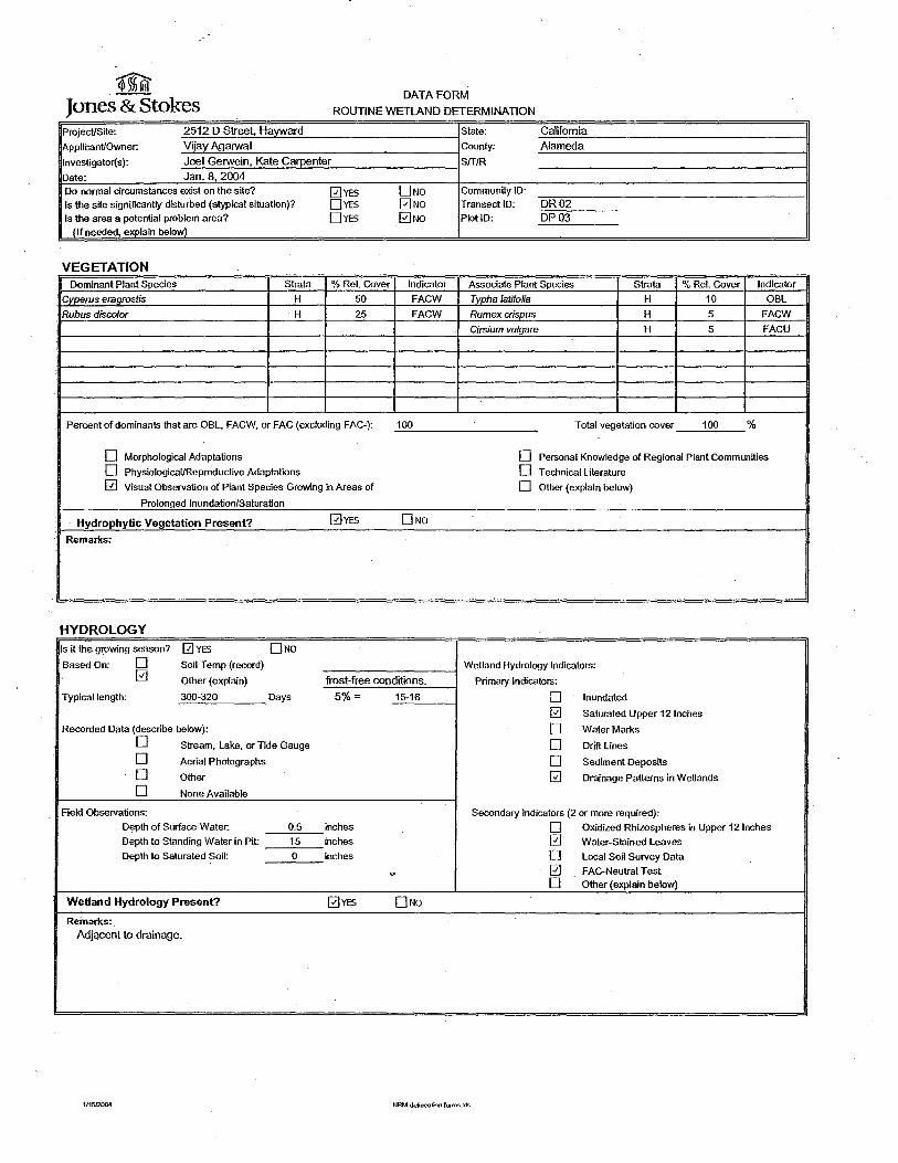
Date: Jan.8,2004 Do normal circumstances exist on the site? 0YES DNo Community ID: Is the site significantly disturbed (atypical situation)? DYES 0No Transect ID: DR02 Is the area a potential problem area? DYES 0No PlotiD: DP03
(If needed, explain below)
VEGETATION Dominant Plant Species Strata %Rei. Cover Indicator Associate Plant Species Strata %Rei. Cover IndicatOr
Cyperus era9rostis H 50 FACW Typha latifolia H 10 OBL
Rubus discolor H 25 FAGW Rumex crispus H 5 FAGW
Cirsium vulgare H 5 FAGU
Percent of dominants that are OBL, FAGW, or FAG (excluding FAG-): 100 Total vegetation cover 100 %
D Morphological Adaptations D Personal Knowledge of Regional Plant Communities
D Physiological/Reproductive Adaptations D Technical Literature
0 Visual Observation of Plant Species Growing in Areas of D other (explain below)
Prolonged Inundation/Saturation
· Hydrophytic Vegetation Present? 0YES 0No Remarks:
HYDROLOGY Is it the growing season? 0YES DNo Based On: D Soil Temp (record) Wetland Hydrology Indicators:
0 Other (explain) frost-free conditions. Primary Indicators:
Typical length: 300-320 Days 5%= 15-16 D Inundated
0 Saturated Upper 12 Inches
Recorded Data (describe below): D WaterMarks
D Stream, Lake, or Tide Gauge D Drift Lines
D Aerial Photographs D Sediment Deposits
D Other 0 Drainage Patterns in WeOands
D None Available
Field Observations: Secondary Indicators (2 or more required):
Depth of Surface Water: 0.5 inches D Oxidized Rhizospheres in Upper 121nches
Depth to Standing Water in Pit 15 inches 0 Water-Stained Leaves
Depth to Saturated Soil: 0 inches D Local Soil Survey Data
" 0 FAG-Neutral Test D Other (explain below)
Wetland Hydrology Present? 0YES DNo Re'marks:
Adjacent to drainage.
1/1512004 NRM delineation lonns.:xls

SOILS Plot 10· DP03
Map Unit Name (series and phase): Xerorthents-Los Osos Complex, 30-50% slopes Drainage Class: Variable
axonomy (subgroup): Xerorthents, T~pic Argixerolls Field observations confirm mapped type? DYES 0No
Is data point located within a hydric inclusion? DYES 0NO Profile Description
Redoximorphic Features
Depth Matrix Color Abundance, Horizon _(inches) Texture Structure (moist) Size, Contrast Type, location Color (moist) Other
A1 0-5 sd 10YR3/2
A2 5-17 sd 10YR 3/2
Hydric Soil Indicators (check all that apply):
D Histosol D Mn or Fe Concretions or Nodules
D Histic Epipedon D High Organic Content in Surface Layer of Sandy Soils
D Sulfidic Odor D Organic Streaking in Sandy Srnls
0 Aquic Moisture Regime D Listed on National/Local Hydric Soils List
D Reducing Conditions ( a, a'- dipyridyl test) D Other (explain below)
D Gleyed or Low-Chroma (.::_1) matrix
D Matrix Chroma <2 with Redoximorphic Concentrations and/or Depletions
Hydric Soils Present? 0YES 0No Remarks:
Sandstone parent material inclusions in A1 and A2 horizons. Aquic moisture regime.
WETLAND DETERMINATION;
DNa 0No
Hydrophytic vegetation present?
Wetland hydrology present?
Hydric soils present? O NO ls the sampling point within a wetland? 0YES DNO Remarks:
Texture and Rock Fragment Content
Texture
cos - coarse sand s-sand fs - fine sand vfs- very fine sand Ieos- loamy coarse sand Is -loamy sand lfs -loamy fine sand lvfs -loamy very fine sand cosl - coarse sandy loam sl- sandy loam fsl -fine sandy loam
111512004
vfsl- very fine sandy loam 1-loam sil-siltloam si-sitt sci- sandy clay loam cl- clay loam sicl- silly clay loam sc -sandy clay sic- silty clay c-clay
Rock Fragments
gr- gravelly vgr- very gravelly xgr- extremely gravelly cb-robbly vcb - very robbly xcb - extremely cobbly st- stony vst -very stony xst- extremely stony
Redoximorphic Feature Morphology
Abundance
f-few c-common m-many
Size 1-fine (<2mm) 2- medium 2--5mm) 3- coarse (5--20mm) 4- very coarse (2(}-76mm) 5- extremely coarse (> 76mm)
Contrast f- faint d- distinct p - prominent
Type
Fe-x- iron concentration (soft mass) Fe-nc- iron nodule or concretion Mn-x- manganese concentration (soft mass) Mn-nc- manganese nodule or concretion d - depletion
Location mat-soil matrix ped - ped surface por- soil pores otr-other
~ Jones & Stokes
DATA FORM
ROUTINE WETLAND DETERMINATION
ProjecUSite: 2512 D Street, Hayward State: California
ApplicanUOwner: Vijay Agarwal County: Alameda
lnvestigator(s): Joel Gerwein, Kate Carpenter Sff/R
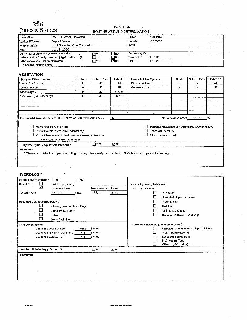
Date: Jan.8,2004 Do normal circumstances exist on the site? 0YES DNa Community ID:
Is the site significantly disturbed (atypical situation)? DYES 0No Transect ID: DR02 Is the area a potential problem area? DYES 0No PlotiD: DP04
(If needed, explain below)
VEGETATION Dominant Plant Species Strata %Rei. Cover Indicator Associate Plant Species Strata %Rei. Cover Indicator
Bromus hordeaceus H 40 UPL Picris echioides H 5 FAC
Cirsium vulgare H 40 UPL Geranium molle H 3 Nl
Rubus discolor H 20 FACW
• Unidentified grass seed/illQs H 30 UPL*
Percent of dominants that are OBL, FACW, or FAC (excluding FAC-): 25 Total vegetation cover 100+ %
D Morphological Adaptations D Personal Knowledge of Regional Plant Communities
D Physiological/Reproductive Adaptations D Technical Literature
D Visual Observation of Plant Species Growing in Areas of D Other (explain below)
Prolonged Inundation/Saturation
Hydrophytic Vegetation Present? DYES 0No Remarks:
*Observed unidentified grass seedling growing abundantly on dry slope. Not observed adjacent to drainage.
HYDROLOGY Is it the growing season? 0YES DNo Based On: D Soil Temp (record) Wetland Hydrology Indicators:
0 Other (explain) frost-free conditions. Primary Indicators:
Typical length: 300-320 Days 5%= 15-16 D Inundated
D Saturated Upper 121nches
Recorded Data (describe below): D WaterMarks
D Stream, Lake, or Tide Gauge D Drift Lines
D Aerial Photographs D Sediment Deposits
D Other D Drainage Patterns in WeHands
D None Available
Field Observations: Secondary Indicators (2 or more required):
Depth of Surface Water: None inches D Oxidized Rhizospheres in Upper 12 Inches
Depth to Standing Water in Pit: >11 inches D Water-Stained Leaves
Depth to Saturated Soil: >11 inches D Local Soil Survey Data
D FAG-Neutral Test D Other (explain below)
Wetland Hydrology Present? DYES 0No Remarks:
1/1512004 NRM delineation fonns.»s

SOILS Plot JD· DP04
Map Unit Name (series and phase): Xerorthents-Los Osos Complex, 30-50% slopes Drainage Class: Variable
~axonomy (subgroup): Xerorthents, T~ic Argixerolls Field observations confirm mapped type? DYES 0No
Is data point located within a hydric inclusion? DYES 0No
Profile Description
Redoximorphic Features
Depth Matrix Color Abundance, Horizon (inches) Texture Structure (moist) Size, Contrast Type, location Color (moist) Other
A 0-11 sci 10YR3/2
c 11+ Sandstone parent material
Hydric Soil Indicators (check all \llat apply):
D Histosol D Mn or Fe Concretions or Nodules
D Histic Epipedon D High Organic Content in Surface Layer of Sandy Soils
D Sulfidic Odor D Organic Streaking in Sandy Soils
D Aquic Moisture Regime D Listed on Nationai!Local Hydric Soils List
D Reducing Conditions ( a,a'- dipyridyl test) D Other (explain below)
D Gley~ or Low-Chroma (::;1) matrix
D Matrix Chroma <2 with Redoximorphic Concentrations and/or Depletions
H_~ric Soils Present?
Remarks: Sandstone parent material inclusions in A horizon.
WETLAND DETERMINATION:
Hydrophytic vegetation present?
Wetland hydrology present?
Hydric soils present?
Remarks:
DYES
DYEs DYES DYES
0No
0No
0No
0NO Is the sampling point within a wetland? DYES 0No
Texture and Rock Fragment Content Redoximorphic Feature Morphology
Texture
cos - coarse sand s-sand fs- fine sand vfs- very fine sand "Ieos -loamy coarse sand Is -loamy sand lfs -loamy fine sand
·1vfs -loamy very fine sand cos!- coarse sandy loam sl- sandy loam fsl -fine sandy loam
1115!2004
vfsl·- very fine sandy loam !-loam sll-sillloam si- selt sci- sandy clay loam cl- clay loam sicl - silty clay loam = -sandy clay sic - Silty clay c- clay
Ro<;k Fragmenb
gr- gravelly vgr - very gravelly xgr- extremely gravelly cb-cobbly vcb - very cobbly xcb - extremely cobbly st- stony vst- very stony xst- extremely stony
Abundance
f-fuw c-common m-many
Size 1 -fine (<2mm) 2- medium 2-Smm) 3- coarse (5-20mm) 4 - very coarse (2a-76mm) 5 -extremely coarse (> 76mm)
Contrast
f- faint d- distinct p - prominent
NRM def100ation forms.:ds
Type
Fe-x- iron concentration (soft mass) Fe-nc - iron nodule or concretion Mn-x- manganese concentration (soft mass) Mn-nc- manganese nodule or concretion d- depletion
Location mat -soil matrix ped - ped surface por- soil pores otT~ other


- ----------~~~~
APPENDIXD


July 16, 2004
Patricia Berryhill Natural Resources Management 737 Spruce Street Berkeley, CA 94 707
Subject: Potential Impacts to Special-status Bird Species on the D Street (Hayward) Project, Hayward, Alameda County, California
Dear Ms. Berryhill:
This letter report addresses the potential impacts of the 2492 D Street (Hayward) project on 13 specialstatus bird species, including 12 species that have recently been raised as potential issues for other projects in the Hayward hills and one additional species, the western burrowing owl. This information is provided for use in the Draft Initial Study/Mitigated Negative Declaration (ISIMND) currently being prepared for the D Street site by Lamphier-Gregory. Special-status bird species are defined (for the purposes of this report) as species officially listed or proposed for listing under the State and/or Federal Endangered Species Acts and "species of special concern" designated by the California Department of Fish and Game (CDFG). (One species discussed below, the rufous hummingbird, does not meet this definition, but is included in the report because it was raised as an issue on another Hayward hills project.)
The 3.66-acre D Street project site is located is located at 2492 D Street in the unincorporated Fairview area of Alameda County, just east of the City of Hayward. The site is situated on the lower slopes of the Hayward hills, and the elevation on the site ranges from approximately 280 to 340 feet above mean sea level. The surrounding landscape consists of urban residential housing and parks with substantial plantings of ornamental trees and shrubs. There is little undeveloped habitat in the vicinity of the project site (within 0.5 to 1.0 mile).
METHODS AND RESULTS
The key question addressed below is whether the proposed D Street project would have potentially significant impacts (including direct, indirect, or cumulative impacts) on special-status bird species under the California Environmental Quality Act (CEQA), given the mitigation measures specified in the ISIMND. This assessment is based, in part, on bird surveys conducted by LSA biologists Eric Lichtwardt (on July 12, 2004) and Steve Granholm (on July 14, 2004). These surveys were conducted between 07:00 and 08:45a.m. and 08:15 and 09:30a.m., respectively. Both Mr. Lichtwardt and Dr. Granholm have extensive field experience with Bay Area birds and with impact assessments under CEQA. Our evaluation of the impacts of the D Street project was based on our personal experience and the ornithological literature. The following discussion uses standard common names for birds (as designated by the American Ornithologists' Union Checklist of North American Birds, 7th Edition, including supplements through 2004), making scientific names unnecessary for this document.
(5/19/04 C:\Documents and Settings\stb\Local Settings\Temporary Internet Files\OLKBC\Special Status Bird Letter.doc) 1
The results of our bird surveys are presented in Table 1. We observed a total of 24 bird species on or adjacent to the project site (i.e. within 300 feet), or flying over the site. None of the special-status bird species discussed below were found on the project site.
BACKGROUND
The 2004 CEQA Guidelines (Appendix G, Sections IV and XVII) state that a project would have a potentially significant impact if it would have "a substantial adverse effect, either directly or through habitat modifications, on any species identified as a candidate, sensitive, or special status species", or ifit would have an impact that is "individually limited, but cumulatively considerable." The determination regarding whether an adverse effect is "substantial" is left to the lead agency. The Guidelines state that "cumulatively considerable" means that the incremental effects of a project are considerable when viewed in connection with the effects of other past, current, and probable future projects.
The project site supports degraded open land surrounded by urban development. A dilapidated, but currently occupied, house is present near the center of the site at the end of the access road. The site is traversed by two drainages, one in the south-central portion of the site, crossed by the access road, and the other in the northern portion of the site.· The southern drainage appeared to be dry during the LSA site visits. The northern drainage contained surface water, apparently due to runoff from the landscaped housing complex to the east.
The most extensive habitat on the site is weedy non-native grassland dominated by ripgut brome (Bromus diandrus) and wild oat (Avena fatua). Weedy plants species such as prickly lettuce (Lactuca serriola) and sweet fennel.(Foeniculum vulgare) are scattered among the grasses, and large clumps of an unidentified thistle are also present. Coyote bush (Baccharis pilularis), a native shrub, is also scattered through the non-native grassland in the northern portion of the project site.
Thickets of Himalayan blackberry (Rubus discolor) interspersed with clumps of cattails (Typha sp.) and sedges (Carex sp.) dominate the northern drainage. Himalayan blackberry is also present along the southern drainage, along with various non-native tree species including several large blue gum (Eucalyptus globulus). Several small coast live oaks (Quercus agrifolia) are also scattered along this drainage.
The proposed project involves subdividing the site into 16 single-family lots, retaining the one existing home, and constructing 15 new single-family homes, a new private street, and related infrastructure. The roadwork will include improving and extending the existing access road, improving the existing crossing of the southern drainage, and constructing a new crossing over the northern drainage. In addition 9 to 12 of the large blue gums growing in the southern drainage will be removed. The site will be re-landscaped using primarily native trees and shrubs, including coast redwood (Sequoia sempervirens ).
DISCUSSION
Based on LSA's bird surveys and habitat assessment at the project site, and our professional experience with birds in the Bay Area, we conclude that the 13 bird species addressed in this letter are
7/21/2004(C:\Documents and Settings\stb\Local Settings\Temporary Internet Files\OLKBC\Special Status Bird Letter.doc) 2
either: (1) unlikely to occur on the project site on more than an incidental basis; or (2) may occur more regularly on the site, but are unlikely to be significantly affected by the proposed project. To support these conclusions we provide additional discussion of the 13 bird species, below. The objective is to assess whether any of these species could potentially nest or forage on the project site during the breeding season and, if so, whether the species would be subject to a significant adverse effect from the project (including direct and indirect impacts). Subsequent sections discuss potential impacts during the non-breeding season and potential cumulative impacts on the 13 species.
Cooper's Hawk
The CDFG has designated the Cooper's hawk as a species of special concern at its nest sites. Cooper's hawks occur in wooded landscapes throughout California (Zeiner et a/. 1990) and they breed in urban settings with adequate tree cover (Rosenfield et al. 1991, Pericoli and Fish 2002, 2004). This species appears to be relatively tolerant of habitat fragmentation and human disturbance in some portions of its breeding range (Rosenfield et al. 1991, Wheeler 2003). Both nesting and foraging often occur near riparian habitat and streams, and nests are generally built in dense stands of deciduous trees with moderate crown depths (Zeiner et al. 1990). These hawks also occupy stands of moderately old coniferous or mixed coniferous/deciduous trees; and adjacent semi-open areas and a quiet water source appear to be important habitat features (Wheeler 2003 ).
It is well documented that Cooper's hawks forage and nest successfully in urban settings in the East Bay (Pericoli and Fish 2002, 2004; and Allen Fish, pers. comm.) and in other areas in the western U. S. (Wheeler 2003). This species typically hunts in broken woodlands and along habitat edges (Zeiner eta/. 1990), and urban landscapes that support mature trees and shrubs provide a habitat that is similar in structure to the natural habitats favored by Cooper's hawks. In addition, urban settings in the East Bay often support abundant populations of the bird species that Cooper's hawk feed on, such as mourning doves, European starlings, American robins, and house finches (Pericoli and Fish 2004).
The species of trees on the project site are similar to those in the surrounding urban landscape, and wooded stream courses are present within 1 mile, both north and south of the project site. This extensive mosaic of urban development, with tree plantings and wooded stream courses, appears to provide a large area of suitable nesting habitat for Cooper's hawks. LSA biologists have observed this species during the 2004 breeding season (i.e. spring and early summer) in the Hayward hills, but we did not observe the Cooper's hawk on or adjacent to the project site. No raptor nests were found in the. trees on or adjacent to the project site, but it is possible that this species could nest in the vicinity and occasionally forage on the project site.
The project site currently does not support any special nesting or foraging habitat features that would make the site "more attractive to Cooper's hawks than much of the surrounding landscape. In addition, as noted earlier, the development plans call for re-landscaping with native trees and shrubs that would provide potential urban foraging habitat for Cooper's hawks in the near future. We conclude that it is highly unlikely that the proposed project (with proposed mitigation) would result in a significant adverse effect on Cooper's hawks.
7/21/2004(C:\Documents and Settings\stb\Local Settings\ Temporary Internet Files\OLKBC\Special Status Bird Letter.doc) 3

Sharp-shinned Hawk
The CDFG has designated the sharp-shinned hawk as a species of special concern at its nest sites. Sharp-shinned hawks nest in dense forests, especially riparian woodlands and mixed coniferous/ deciduous woodlands, but also in other deciduous and coniferous forest types (Zeiner eta/. 1990, Wheeler 2003). There are records of sharp-shinned hawks nesting in coniferous trees in urban areas, but they generally avoid nesting in developed areas (Wheeler 2003). They often feed in adjacent openings, as well as within forests. This species is much less common than the Cooper's hawk as a nesting species in the Bay Area. Like Cooper's hawks, sharp-shinned hawks are known to forage in residential areas but in the Bay Area the sharp-shinned hawk is not known to nest in urban settings. There is, however, a record of sharp-shinned hawks nesting in the hills above the University of California at Berkeley in 2003 (Pericoli and Fish 2004). The sharp-shinned hawk may occasionally occur on the project site as a migrant or winter visitor but is not expected to nest on the site or in the adjacent urban areas. It is highly unlikely that the proposed project would result in a significant adverse effect on the sharp-shinned hawk.
White-tailed Kite
The CDFG has designated the white-tailed kite as a fully protected species. White-tailed kites inhabit open grasslands and savannah-like habitats (Dunk 1995, Wheeler 2003). For nesting, they require dense-topped trees and shrubs (e.g., oaks and willows) located near an open foraging area (Dixon et a/.1957). Primary foraging habitat consists of undisturbed, open grasslands, farmland, meadows, and emergent wetlands (Zeiner et al. 1990). White-tailed kites forage over an area as large as 1.9 square miles (1,216 acres) (Warner and Rudd 1975), but seldom hunt farther than 0.5 mile from a nest site (equivalent to a circular area of 502 acres) when breeding (Hawbecker 1942).
The small area of grassland on the project site is too small in area and too isolated from areas of more extensive grassland to provide foraging habitat for the white-tailed kite. As noted earlier, no raptor nests were discovered in the trees on the site and the white-tailed kite would not be expected to nest on the site because of its urban setting and isolation from suitable foraging habitat. Therefore, the development of the project site would not result in a significant adverse impact on the white-tailed kite.
Northern Harrier
The CDFG has designated the northern harrier as a species of special concern at its nest sites. Northern harriers primarily occur in large, extensive open areas supporting coastal and/or freshwater marshes, lightly grazed rangeland, large pastures, prairies etc. (Wheeler 2003). They are almost never found in wooded areas (Zeiner et al. 1990) and are rarely seen in urban settings. Breeding home ranges documented for this species have varied from 98 to 243 acres (Zeiner et al. 1990). Because the project site is surrounded by an urban landscape and the open areas on the site are so small, it is highly unlikely that this species would nest or forage on or adjacent to the project site. Therefore, the project would not result in a significant adverse impact on the northern harrier.
7/21/2004(C:\Documents and Settings\stb\Local Settings\Temporary Internet Files\OLKBC\Special Status Bird Letter.doc) 4
Prairie Falcon
The CDFG has designated the prairie falcon as a species of special concern at its nest sites. This species is an uncommon permanent resident in California and is associated primarily with wild landscapes. These falcons occupy arid, very open habitats such as grasslands, savannah, rangeland, and desert valleys (Wheeler 2003). During winter they sometimes occur in sparsely inhabited agricultural landscapes. Prairie falcons are rarely seen in urban settings, even during migration and winter, when they are more widely distributed than during the breeding season. Typical breeding habitat consists of open terrain with canyons, cliffs, escarpments, and rock outcrops; and sheltered ledges on cliffs or steep bluffs are required for nesting (Zeiner et al. 1990). There is no suitable nesting habitat for the prairie falcon on or in the vicinity of the project site, and the small area of grassland on the site is much too small and isolated by urban development to be used by this species during migration or winter. For example, Craighead and Craighead (1956) estimated the home range of a breeding pair in Wyoming to be 10 square miles. Thus, although prairie falcons could occur as a rare visitor over the project site during the non-breeding season or during migration, it is highly unlikely that they would forage over or in the vicinity of the project site. Therefore, the proposed development would not result in a significant impact to prairie falcons.
Long-eared Owl
The CDFG has designated the long-eared owl as a species of special concern at its nest sites. Longeared owls frequent dense riparian and live oak thickets near meadow edges and nearby woodland and forest habitats (Zeiner et al. 1990). This species is rarely found in urban settings. Foraging usually occurs in open habitats and occasionally in forested areas (Zeiner et al. 1990). The amount of open foraging habitat available on the project site (less than 3.4 acres) is much smaller than the minimum home range size of 83 acres documented by Craighead and Craighead (1956). In addition, Bloom (1994) noted that he has never found an active long-eared owl nest within 1 km (0.66 mile) of development in southern California. Thus, due to the low probability that this species would nest or forage in the project vicinity, the proposed development would not result in a significant impact to long-eared owls.
Western Burrowing Owl
The CDFG has designated the western burrowing owl as a species of special concern at its nest and burrow sites. Western burrowing owls occur in arid and semi-arid, relatively flat open habitats, including grasslands, prairie country, rangelands, and deserts (Grinnell and Miller 1944, Haug et al. 1993). They also inhabit open human-modified landscapes such as agricultural lands, fallow fields, airports, and levees. Suitable open habitat for western burrowing owls is typically quite barren or supports sparse, low vegetation. An important habitat component for these owls is the presence of mammal burrows or alternative cavities such as in rock piles. In cismontane California, burrowing owls are often associated with the California ground squirrel (Spermophilus beecheyi), and in the Bay Area these owls use California ground squirrel burrows as nest-sites as well as retreats during the winter. The burrowing owl was historically common throughout the arid and semi-arid lowlands of California (Grinnell and Miller 1944) but has greatly declined in many areas, including the Bay Area, due to urban development (Center for Biological Diversity et al. 2003). Ground squirrel eradication programs have probably contributed to the decline of these owls in California.
7/21/2004(C:\Documents and Settings\stb\Local Settings\ Temporary Internet Files\OLKBC\Special Status Bird Letter.doc) 5
California ground squirrels appear to be absent from the project site. These mammals were not observed d,uring field visits by LSA and other biologists, and no evidence of California ground squirrels (e.g., burrows, tracks, or scat) was observed on the project site. In addition, no suitable burrows or retreats for burrowing owls were found on the site. The small size of the project site, lack of suitable burrows (or other suitable cavities), presence of potential predators (e.g. domestic cats), extensive area of surrounding urban development, and proximity of tall dense vegetation (e.g. blue gum grove) combine to render the project site unsuitable for burrowing owls. This species is not expected to nest or forage in the project vicinity, and the proposed development would not result in a significant impact to burrowing owls.
Purple Martin
The CDFG has designated the purple martin as a species of special concern at its nest sites. This species was once considered a "fairly common" species in California (Grinnell and Miller 1944) but recently has been considered rare to very uncommon in the state (Zeiner et a/.1990, Williams 1998). With the exception of Sacramento, no urban areas in California are currently known to support nesting martins (Williams 1998). In non-urban habitats, purple martins frequent multi-layered open forest and woodland with snags (for nest cavities) and forage over riparian forest, woodland, and open habitats (Zeiner et al. 1990). Suitable nesting cavities for purple martins were not observed in any of the trees on the project site and it is highly unlikely that this species would occur there, other than as a rare vagrant during migration.
Loggerhead Shrike
The CDFG has designated the loggerhead shrike as a species of special concern at its nest sites. Loggerhead shrikes occur in open habitats with scattered trees, shrubs, fence posts, utility lines, or other perches (Zeiner et al. 1990). Shrikes are often found in open cropland, but occur only rarely in urban landscapes (Zeiner et al. 1990). Nests are constructed in a dense tree or shrub and are generally well-concealed (Zeiner et al. 1990). Foraging microhabitat consists of open landscapes characterized by well-spaced, often spiny, shrubs and low trees, usually interspersed with short grasses, forbs, and bare ground. Fence lines and utility lines and poles are favored for perching (Yosef 1996). Territory size of shrikes is larger than that of other insectivorous passerines of similar body size, probably a function of specialized foraging behavior (Y osef 1996). Ten territories in open shrub land in Contra Costa and Kern Counties averaged 18.7 acres in size and ranged from 11 to 40 acres (Miller 1931). This species is rarely encountered in urban areas.
The project site is too small in area and too isolated fr6Il1 extensive open habitat to be suitable as a nesting area for loggerhead shrikes. Furthermore, the site is located in an urban area and nest predators (e.g., domestic cats) are present, decreasing the likelihood that shrikes would nest there. In conclusion, given the limited amount of open habitat available in the project vicinity, it is unlikely that this species would nest on or adjacent to the project site, and it is unlikely to occur on the project site even as a transient. It is highly unlikely that the project would result in a significant adverse effect on the loggerhead shrike.
7/21/2004(C:\Documents and Settings\stb\Local Settings\ Temporary Internet Files\OLKBC\Special Status Bird Letter.doc) 6

Yellow Warbler
The CDFG has designated the yellow warbler as a species of special concern at its nest sites. Yellow warblers nest in open, deciduous riparian woodlands (typically willows and cottonwoods) with a dense brushy understory (Zeiner et a/.1990). fu the Sacramento River and Squaw Creek watersheds, nests are most commonly built in willows, alders, and blackberry from 3 to 50 feet above the ground (Heath 1998). Foraging consists of gleaning insects and spiders from the upper canopy of deciduous trees and shrubs (Zeiner et a/.1990). During migration, this species occurs in a variety of sparse to dense woodland and forest habitats but is not frequently seen in urban settings in California.
The lack of suitable riparian woodland on the site would preclude the possibility of this species nesting there. There is a possibility of the species occurring as a rare visitor during migration but even this is unlikely because of the lack of good foraging habitat (e.g. willow and/or cottonwood woodland). The proposed project would not result in a significant impact to yellow warbler.
Yellow-breasted Chat
The CDFG has designated the yellow-breasted chat as a species of special concern at its nest sites. Breeding habitat for yellow-breasted chats is similar to that of yellow warblers (deciduous riparian woodlands). However, the presence of dense thickets and tangles, used for both nesting and foraging (Zeiner et a/.1990, Dunn and Garrett 1997), is much more critical for chats than it is for yellow warblers. Plant species typically used for nesting include blackberry, wild grape, and wild rose. During migration, chats also tend to occur in heavy, dense cover, and are not often detected (Dunn and Garrett 1997). Although there is a remote possibility that chats could occur incidentally as migrants in the blackberry thickets on the project site, it is highly unlikely that they would nest in this habitat, because of the lack of a suitable overstory (e.g. mature willows, cottonwood etc.), small size of the project site, and its isolation within an extensive urban landscape. The proposed project would not result in a significant impact to yellow-breasted chats.
Rufous Hummingbird
The rufous hummingbird has been designated by the California Natural Diversity Database as a "special animal" at its nest sites. Rufous hummingbirds are fairly common spring migrants in the coastal lowlands of California, but their breeding range is limited to montane areas in the extreme northern portion of the State (Zeiner et a/.1990, Howell2002). fu the fall this species migrates south through mountainous areas where various plants are still in bloom and thus provide a nectar source for the birds (Howell2002). Rufous hummingbirds feed on nectar from many species of flowering plants in riparian habitats, woodlands, chaparral, meadows, orchards, and gardens. The project site is outside of the known breeding range for this species, but it could occur on the site during spring migration. Since they feed on flowering plants in gardens and urban areas, migrating individuals would probably continue to forage within the project footprint after the site has been developed and landscaped. Therefore, the proposed project would not have a significant impact on rufous hummingbirds.
7/21/2004(C:\Documents and Settings\stb\Local Settings\ Temporary Internet Files\OLKBC\Special Status Bird Letter.doc) 7
California Horned Lark
The CDFG has designated the California homed lark as a species of special concern at its nest sites. California horned larks occur in a variety of open habitats, generally favoring extensive barren areas and/or habitats supporting only low, sparse vegetation, where trees and large shrubs are absent (Zeiner et al.1990). Homed larks nest and forage on the ground, and they prefer bare ground to grasses taller than a few centimeters (Wiens et a/.1987). Similar habitats are used throughout the year, although some studies have shown increased use of beaches and sand dunes during migration and winter (Beason 1995). The grassland habitat on the project site is characterized by relatively tall growth (2: 6 inches) of non-native grasses (e.g. wild oats and ripgut brome ). Homed larks do not typically occur in such habitats, even during the non-breeding season. Moreover, the small size of the project site, surrounding urban landscape, and proximity of tall trees decreases the likelihood that homed larks would occur on the project site. The proposed project would not result in a significant impact to the California homed lark.
Impacts on Foraging during the Non-Breeding Season
During the non-breeding ("wintering") season, birds require suitable cover and foraging habitat, but do not require nesting habitat. As a result, most bird species are less restricted in their habitat requirements than during the breeding season. In addition, because individual birds are not tied to a specific nest location, they are free to move around in response to environmental changes, such as a lack of sufficient food.
Seven of the special-status bird species discussed above (white-tailed kite, northern harrier, prairie falcon, long-eared owl, burrowing owl, loggerhead shrike, and California homed lark) forage most of the time in open habitats. However, given the limited amount of open habitat available on the project site and the surrounding urban landscape it is unlikely that these species would forage on or adjacent to the project site, except perhaps rarely on an incidental basis. Rather, these species would seek out larger areas of open habitat. Thus, the loss of a small area (less than 3.66 acres) of grassland habitat on the site would not have a significant adverse impact on these species. In addition (as noted above), none of these species are likely to occur in the project vicinity except perhaps rarely on an incidental basis.
Four other species (Cooper's hawk, sharp-shinned hawk, purple martin, and rufous hummingbird) forage part of the time in open habitats, but also forage among or over urban plantings. Thus, the loss of grassland foraging habitat on the site would not have a significant adverse impact on these species. In addition (as noted above) the purple martin is unlikely to occur in the project vicinity except perhaps rarely on an incidental basis.
The other two species (yellow warbler and yellow-breasted chat) typically forage within riparian woodlands. Thus, the loss of grassland foraging habitat on the site would not have a significant adverse impact on these species. In addition (as noted above) these species are unlikely to occur in the project vicinity except perhaps rarely during migration. The two drainages present on the project site do not support suitable habitat for the yellow warbler or yellow-breasted chat and thus, any impacts to these areas (which would be minimal according to the development plan) would have no negative effect on these species.
7/21/2004(C:\Documents and Settings\stb\Local Settings\ Temporary Internet Files\OLKBC\Special Status Bird Letter.doc) 8

Cumulative Impacts
As noted above, the CEQA Guidelines state that a project would have a potentially significant impact if it would have an impact that is "individually limited, but cumulatively considerable." According to the Guidelines, "cumulatively considerable" means that the incremental effects of a project are considerable when viewed in connection with the effects of other past, current, and probable future projects.
Based on the discussion above, the project would not result in a significant cumulative impact on any of the 13 special-status bird species addressed in this letter, because the incremental effect of the proposed development (if any) would be so minor. In other words, the incremental effect of the proposed project would not be "considerable" when viewed in connection with the effects of other past, current, and probable future projects.
CONCLUSIONS
Because the project would remove a minimal amount of the riparian habitat on the site, and due to the small size (less than 3.66 acres) and isolation of the grassland habitat to be removed, we conclude that the project would not result in a significant impact to any of the 13 bird species discussed above (inclucijng direct, indirect, and cumulative impacts). Although several of these 13 bird species nest in open habitats, and could perhaps occur rarely on the project site, it is highly unlikely that these species would nest on this small (3.66-acre) site, due to the limited area of open habitat available and the extensive urban landscape surrounding the site. We also conclude that the project would not have a significant impact on foraging habitat for the 13 special-status bird species, for the following reasons:
" Due to the small amount of open habitat at the project site and vicinity (less than 3.66 acres), the seven species that forage primarily in open habitats are unlikely to forage on the project site, except rarely on an incidental basis.
" Four of the other species forage part of the time in open habitats, but also forage in residential subdivisions, and thus would not be significantly affected by the project.
" The other two species typically forage within riparian woodlands and thus would not be significantly affected by loss of open habitat.
In addition, based on LSA's experience, prior CEQA documents prepared for the County of Alameda have generally concluded that a significant impact on a bird species of special concern, or a fully protected species, would not occur unless the project would have a potential impact on nesting of such species. As mitigation for impacts on bird species of special concern or fully protected bird species, the County's CEQA documents have typically required pre-construction surveys and protection of any nests (along with an appropriate buffer) until nesting has been completed. Such mitigation has typically been considered adequate to reduce impacts on special-status bird species to below a level of significance.
Additional mitigation measures are often required for threatened and endangered species (listed by the . state or federal governments), and for other special-status species (such as the burrowing owl) for which the state has issued specific mitigation guidelines. However, 12 of the special-status bird
7/21/2004(C:\Documents and Settings\stb\Local Settings\Temporary Internet Files\OLKBC\Special Status Bird Letter.doc) 9
species at issue for the D Street project do not fall into either of those categories and, as discussed earlier, the thirteenth species, western burrowing owl, is not expected to occur on the site.
Thus, we believe that the ISIMND is consistent with the County's prior interpretations of CEQA and has correctly concluded that the proposed project (including implementation of the mitigation measures specified in the ISIMND) would not have potentially significant impacts on special-status bird species.
RECOMMENDATIONS
Based on LSA's site visits and the discussion above, we recommend the following modifications to the biological impacts and mitigation measures in the draft ISIMND for the D Street project:
• Potential Impact 3-4: Western Burrowing Owl. Due to the lack of suitable nesting or wintering habitat for the western burrowing owl on the project site, and the very low likelihood that this species would occur there even as a transient, we conclude that the project would have no impact on the western burrowing owl. Thus, no additional surveys and no mitigation measures would be necessary.
• Mitigation Measure 3-5: Rap tor Survey and Buffer Zones. If an occupied raptor nest is discovered during a pre-construction raptor survey, we believe that a 200-foot-radius buffer zone, measured :from the drip-line of the occupied tree, would be adequate. We recommend that this mitigation measure be revised accordingly.
Please call Steve Granholm or Eric Lichtwardt at (510) 236-6810 if you have any questions or require any further information related to this report.
Sincerely,
LSA ASSOCIATES, INC.
Steve Granholm, Ph.D. Principal
Eric Lichtwardt Wildlife Biologist
Attachments: 1. References 2. Table 1 -Bird Species Observed on and Adjacent to the D Street (Hayward)
Project Site
7/21/2004(C:\Documents and Settings\stb\Local Settings\Temporary Internet Files\OLKBC\Special Status Bird Letter.doc) 10

REFERENCES
Beason, R.C. 1995. Homed Lark (Eremophila alpestris). In The Birds ofNorth America, No. 195 (A. Poole and F. Gill, eds.). The Academy ofNatural Sciences, Philadelphia, and the American Ornithologists' Union, Washington, D.C.
Bloom, P.H. 1994. The biology and current status of the long-eared owl in coastal southern California. Bull. Southern California Academy of Sciences 93: 1-12.
Center for Biological Diversity, Defenders of Wildlife, California State Park Rangers Association, Santa Clara Valley Audubon Society, San Bernardino Valley Audubon Society, and TriCounty Conservation League. 2003. Petition to the State of California Fish and Game Commission and Supporting Information for Listing the California Population of the Western Burrowing Owl (Athene cunicularia hypugaea) as an Endangered or Threatened Species under the California Endangered Species Act.
Craighead, J.J., and F.C. Craighead, Jr. 1956. Hawks, owls, and wildlife. Stackpole Books, Harrisburg, P A.
Dixon, J.B., R.E. Dixon, and J.E. Dixon. 1957. Natural history of the White-tailed Kite in San Diego County, California. Condor 59:156-165.
Dunk, J.R. 1995. White-tailed Kite (Elanus leucurus). In The Birds ofNorth America, No. 178 (A. Poole and F. Gill, eds.). The Academy ofNatural Sciences, Philadelphia, and the American Ornithologists' Union, Washington, D.C.
Dunn, J.L., and K.L. Garrett. 1997. A field guide to warblers ofNorth America. Houghton Mifflin Co., New York, NY.
Grinnell, J., and A.H. Miller. 1944. The distribution of the birds of California. Pac. Coast Avifauna 27.
Hawbecker, A. C. 1942. A life history study of the white-tailed kite. Condor 44:267-276.
Heath, S. 1998. Yellow Warbler (Dendroica petechia). In The Riparian Bird Conservation Plan: a strategy for reversing the decline of riparian-associated birds in California. California Partners in Flight. http:/ /www.prbo.org/calpif/htmldocs/riparian.html.
Howell, S. N. G. 2002. Hummingbirds of North America. Academic Press. San Diego, California.
Haug, E. A., B. A. Millsap, and M.S. Martell. 1993. Burrowing Owl (Speotyto cunicularia). In The Birds ofNorth America, No. 61 (A. Poole and F. Gill, eds.). The Academy ofNatural Sciences. Philadelphia, and The American Ornithologists' Union, Washington, D. C.
Miller, A.H. 1931. Systematic revision and natural history ofthe American shrikes (Lanius). Univ. Calif. Publ. Zool. 38:11-242.
Pericoli, R.V., and A.M. Fish. 2002. East Bay Cooper's Hawk Intensive Nesting Study-- 2002. Unpublished report, Golden Gate Raptor Observatory, Sausalito, CA. October 2002.
7/21/2004(C:\Documents and Setti11gs\stb\Local Settings\ Temporary Internet Files\OLKBC\Special Status Bird Letter.doc) 11
Pericoli, R.V., and A.M. Fish. 2004. East Bay Cooper's Hawk Intensive Nesting Survey-- 2003. Unpublished report, Golden Gate Raptor Observatory, Sausalito, CA. May 2004.
Rosenfield, R.N., J. Bielefeldt, R.K. Anderson. and J.M. Papp. 1991. Status reports: accipiters. Pp. 42-49 in Proc. Midwest Raptor Management Symposium and Workshop. National Wildlife Federation, Washington, D.C.
Warner, J.S., and R.L. Rudd. 1975. Hunting by the white-tailed kite (Elanus leucurus). Condor 77:226-230.
Wheeler, B. K. 2003. Raptors of Western North America Princeton University Press. Princeton, New Jersey.
Wiens, J.A., J.T. Rotenberry, and B. van Home. 1987. Habitat occupancy patterns ofNorth American shrubsteppe birds: the effects of spatial scale. Oikos 48:132-147.
Williams, B.D.C. 1998. Distribution, habitat associations, and conservation of Purple Martins breeding in California. M.S. Thesis, Calif. State Univ., Sacramento.
Yosef, R. 1996. Loggerhead Shrike (Lanius ludovicianus). In The Birds ofNorth America, No. 231 (A. Poole and F. Gill, eds.). The Academy of Natural Sciences, Philadelphia, and the American Ornithologists' Union, Washington, D.C.
Zeiner, D.C., W.F. Laudenslayer, Jr., K.E. Mayer, and M. White, eds. 1990. California's Wildlife. Volume II: Birds. Wildlife Habitat Relationships System, California Department ofFish and Game, Sacramento.
7/21/2004(C:\Documents and Settings\stb\Local Settings\ Temporary Internet Files\OLKBC\Special Status Bird Letter. doc) 12

Table 1: Bird Species Observed by LSA on or Adjacent1 to the D Street (Hayward) Project Site, July 2004. Observers were Eric Lichtwardt (July 12) and Steve Granholm (July 14).
SPECIES JULY12 JULY 14 Turkey_ vulture X X
Red-shouldered hawk X X
American kestrel X
Mourning dove X X
Rock (feral) pigeon X
Anna's hummingbird X X
Nuttall's woodpecker X X
Pacific-slope flycatcher X X
Black phoebe X
Steller's jay X
Western scrub-jay X X
American crow X X
Oak titmouse X
Bewick's wren X X
American robin X X
Northern mockingbird X X
European starling X
Spotted towhee X X
California towhee X X
Brown-headed cowbird X X
Hooded oriole X
House finch X X
Lesser goldfinch X
American goldfinch X X
1 "Adjacent" is defined here as "within 300 feet."
5/19/04(P:\P AH031 \BirdSpeciesTable.doc)

APPENDIXE

Botanical Reconnaissance And
Single Season Focused Botanical Survey
For the
Agarwal Property Alameda County, California
Prepared for: Natural Resources Management
737 Spruce Street Berkeley, CA 94707
Prepared by:
e
Bear Republic Ecological Consulting 112 Gilbert Court
Martinez, CA 94553

Botanical Reconnaissance and Single Season Focused Survey for the Agarwal Property Alameda County, California July 15,2004
Table of Contents
Table of Contents ...................................................................................................................... i
1.0 Introduction ...................................................................................................................... 1
2.0 Methods and Limitations ................................................................................................ 1
3.0 Existing Conditions ......................................................................................................... 1
3.1 Setting ....................................................................................................................... 1 3.2 Vegetation Communities .......................................................................................... 1
4.0 Special-Status Plants ....................................................................................................... 1
5.0 Sensitive Natural Communities ...................................................................................... 1
6.0 Results and Recommendations ....................................................................................... 1
7. 0 References ..................................................................................................................... 14
List of Tables
Table 1. Potentially Occurring Special-Status Plant Species ..................................................... 6
Appendix
Appendix A Plant species detected at the Agarwal Property, Alameda County, California ... 15
Bear Republic Ecological Consulting
Botanical Reconnaissance and Single Season Focused Survey for the Agarwal Property Alameda County, California July 15,2004
1.0 Introduction
At the request of Natural Resources Management, Bear Republic Ecological Consulting (Bear Republic) conducted a botanical reconnaissance and single-season focused botanical survey of the 3.66 acre Agarwal property located at 2492 D Street in the unincorporated Fairview area of Alameda County, California. The property lies within the Central Coast Subregion of the California Floristic Province. The objective of these studies was to evaluate the potential for occurrence of special-status plant species and perform a single-season focused rare plant survey of the subject property. This report presents the results ofthese studies.
2.0 Methods and Limitations
In order to initially assess the potential for Rare, Threatened, or Endangered plant species to occur on site, background research was performed by examination of the Inventory of Rare and Endangered Plants of California Sixth Edition (CNPS, 2001), California Natural Diversity Database (CNDDB) (CDFG 2003a), California Department ofFish and Game's Special Vascular Plants, Bryophytes, and Lichens List (CDFG 2004a), State and Federally Listed Endangered, Threatened, and Rare Plants of California (CDFG 2004b ), the U.S. Fish and Wildlife Service's Endangered and Threatened Wildlifo and Plants (1999) and Plant Species of Concern (2004).
Subsequent to background research, a single-season focused survey was performed by Bear Republic botanist Heath Bartosh on July 2, 2004. The survey was conducted by walking the entire project area. All distinct vegetation communities were visited and described, and all blooming plant species observed were identified to a level necessary to determine their regulatory status. The botanical survey was conducted in accordance with the California Department ofFish and Game's Guidelines for Assessing the Effects of Proposed Developments on Rare and Endangered Plants and Plant Communities (CDFG 2000), and the U.S. Fish and Wildlife Service's Guidelines for Conducting and Reporting Botanical Inventories for Federally Listed, Proposed and Candidate Plants (USFWS 1996).
Botanical taxonomy and nomenclature within this document conforms to The Jepson Manual (Hickman, 1993), except for changes in circumscriptions within the subtribe Madiinae in the family Asteraceae (Baldwin 1999). Vegetation communities described in this report follow Holland (1986) and Sawyer and Keeler-Wolf(1995) where applicable; wetland community names conforming to Cowardin, eta!. (1979) are also given where appropriate. Nomenclature for special-status plant species conforms to CDFG (2004a) and CNPS (2{)01). ·
Given that only a single season focused botanical survey was performed, all of the potential target species cannot be entirely ruled out. However, based on the single summer (July) survey, species with corresponding blooming periods have been determined not to be present based on the fact that they would have been detectable within the property and/or absence of suitable habitat and are not expected to occur on site.
These studies are not to be considered floristic in nature. In order to fully assess the presence or absence of potentially-occurring plant species, focused surveys should be conducted during all
Bear Republic Ecological Consulting 1
- ----------------~---~
Botanical Reconnaissance and Single Season Focused Survey for the Agarwal Property Alameda County, California July 15,2004
appropriate blooming periods. Additionally, certain plant species, especially annuals, may be absent in some years due to annual variations in temperature and rainfall, which influence plant phenology. Colonization of new populations within an area from year to year may also occur.
3.0 Existing Conditions
3.1 Setting
The approximately 3.66-acre property lies within the unincorporated Fairview area of Hayward in western Alameda County, California. The site is located on the Hayward 7.5' USGS topographic quadrangle. The location is approximately three-quarters of a mile south of Interstate 580 and approximately one mile north of California State University Hayward. The property is accessible from D Street. Suburban residential development surrounds the site.
Topography on site is gently to moderately sloping, and ranges in elevation between 284 and332 feet above mean sea level. The site is within the San Lorenzo Creek watershed and supports two drainages which flow in a westerly direction. The southernmost drainage (drainage #1) flows onto the site from the east out of the existing storm drain system and traverses the site to the west where it flows off-site and then re-enters the storm drain system. Drainage #1 is crossed by an existing driveway that runs north to south. The northern most drainage (drainage #2). also flows east-to-west and enters the site from a storm drain culvert located on the eastern boundary in landscaped common areas ofthe adjacent housing development. Two single-family residences are present on site, one fronts "D" Street and the other is located approximately in the middle of the property.
3.2 Vegetation Communities
Non-native annual grassland is the dominant vegetation community on site. Other vegetation communities within the property include freshwater marsh, and eucalyptus woodland. In scattered locations, tree species such as Peruvian pepper tree (Schinus molle), coast live oak (Quercus agrifolia), English walnut (Juglans regia), and various ornamental species are present. Vegetation communities are described in more detail below. A list of plant species observed within the property during the present survey is provided in Appendix A.
Non-Native Annual Grassland
Non-native annual grassland is generally found in valleys and foothills throughout California, except for the north coastal and desert regions. This community usually occurs below 3,000 feet, but reaches 4,000 feet in the Tehachapi Mountains and interior San Diego County, and intergrades with coastal prairie along the Central Coast (Holland 1986). It typically occurs on soils consisting of fine-textured loams or clays that are somewhat poorly drained. This vegetation type is dominated by a sparse to dense cover of non-native annual grasses and weedy annual and perennial forbs, primarily ofMediterranean origin, that have replaced native perennial grasslands as a result of human disturbance. However, where not completely out-competed by weedy nonnative plant species, scattered native wildflower species considered remnants ofthe original vegetation may also be common.
Bear Republic Ecological Consulting 2
Botanical Reconnaissance and Single Season Focused Survey for the Agarwal Property Alameda County, California July 15,2004
Onsite, non-native annual grassland intergrades with ruderal (weedy) habitat which establishes areas following disturbance related to roadsides and occupied dwellings. Non-native grass species typical ofthis community and ofruderal areas on site include wild oats (Avenafatua), hare barley (Hordeum murinum ssp. leporinum ), Italian rye grass (Latium multiflorum ), and ripgut brome (Bromus diandrus), amid others. Common non-native herbs include wild radish (Raphanus sativus), sweet fennel (Foeniculum vulgare), bull thistle (Cirsium vulgare), black mustard (Brassica nigra), prickly lettuce (Lactuca serriola), field bindweed (Convolvulus arvensis), English plantain (Plantago lanceolata), and milk thistle (Silybum marianum), amid others. Common native species present within this community include creeping wildrye (Leymus triticoides), California poppy (Eschscholzia californica), and coyote brush (Baccharis pilularis).
Non-native annual grassland follows the California annual grassland series, as described in Sawyer and Keeler-Wolf (1995) ·and would be classified as an upland, following Cowardin, et al. (1979).
Freshwater Marsh
Freshwater marsh and spring typically occur along the coast and in coastal valleys near river mouths and around margins of lakes, stock ponds, and springs throughout California, although now much reduced in range. This community is most extensive in the upper portion of the Sacramento-San Joaquin River Delta. Freshwater marsh and spring consist of areas with permanent or prolonged saturation of soils that can lack measurable surface flows. The community supports few to several perennial and annual herbaceous hydrophytic plant species.
Hydrologic characteristics adequate to support this vegetation community are usually found where the water table is at or near the surface, or where subsurface seepage percolates and collects near the surface, such as along the edge of stream banks, on the lower portions of steep slopes, along fault lines or geological contacts, or at the upper portion of small swales. This vegetation community characteristically forms a dense vegetative cover dominated by perennial, emergent monocots 1-15 feet high that reproduce by underground rhizomes.
Within the site, typical freshwater marsh vegetation is present along the bottom of the eastern portion of drainage #1 and the entirety of drainage# 2. Species characteristic of this community on site include narrow-leaved cattail (Typha angustifolia), watercress (Rorippa nasturtiumaquaticum), Dallis grass (Paspalum dilatatum), curly dock (Rumex crispus), Himalayan blackberry (Rubus discolor), umbrella sedge (Cyperus eragrostis), and rabbitfoot grass (Polypogon monspeliensis), among others.
On site, portions ofthis vegetation community follow the bulrush-cattail series as described by Sawyer and Keeler-Wolf (1995). It would be classified as a palustrine seasonally or permanently flooded wetland following Cowardin, et al. (1979).
Eucalyptus Woodland
Eucalyptus trees have become naturalized in California following their arrival in the 1880s. hnportation of this genus to California was undertaken for the potential they held as a marketable hardwood due to their accelerated maturation time and the similarity of the California climate to that of eucalyptus' native Australia. This favorable climate supported the persistence and
Bear Republic Ecological Consulting 3

Botanical Reconnaissance and Single Season Focused Survey for the Agarwal Property Alameda County, California July 15, 2004
radiation of eucalyptus species throughout the state. Tasmanian blue gum (Eucalyptus globulus) is the most common and widely distributed species in California. Due to the physiology and chemical makeup of eucalyptus trees along with the large amount of bark and leaflitter they deposit on the ground, a paucity of shrub and herbaceous species are able to persist in the understory.
Within the site, eucalyptus woodland is present along the western portion of drainage #1. Tasmanian blue gum is the dominant overstory species. The presence of plant species within the understory is sparse, however it is characterized by species such as English ivy (Hedera helix), German ivy (Senecio mikanioides), smilo grass (Piptatherum miliaceum), hedge parsley (Torilis arvensis), Torrey melic (Melica torreyana), and ripgut brome, amid others. On the outer edges of the canopy, species such as blue elderberry (Sambucus mexicanus), Himalayan blackberry, pampas grass and California bay (Umbellularia californica) are also present.
Eucalyptus woodland is not a native plant community and is not described in Sawyer and KeelerWolf (1995); it would be classified as an upland following Cowardin, et al. (1979).
4.0 Special-Status Plants
Plant species that gamer regulatory protection are given elevated status based on their rarity and endangerment through all or portions of their range. Such plant species are referred to as specialstatus plants or "target species:: Special-status plant species include those listed by the U.S. Fish and Wildlife Service as Candidates for listing, Rare, Threatened, or Endangered (USFWS 1999), CDFG (2004a), and the CNPS (2001 ). The California Native Plant Society (CNPS) has developed a list of rare and endangered plants of California. This listing is endorsed by the CDFG and effectively serves as their list of"candidate" plant species. CNPS List IB and List 2 species are considered eligible for state listing as Endangered or Threatened under CDFG Code. Such species should be fully considered during preparation of environmental documents subject to the California Environmental Quality Act (CEQA). CNPS List 3 and List 4 species are considered to be either plants about which more information is needed or uncommon enough that their status should be regularly monitored. Such plants may be eligible or may become eligible for state listing, and CNPS and CDFG recommend that these species be evaluated for consideration during the preparation ofCEQA documents (CNPS 2001). In addition, CEQA requires that impacts to "locally rare" species also be addressed.
Based on a review of special-status plant species literature and databases, and familiarity with the regional flora, a total of 43 target species were determined to have at least some potential to occur within the region of the property. A summary of the status, habitat affinities, flowering phenology, and potential for occurrence on site for each of the target plant species is presented in Table 1.
No federally or state listed Endangered or Threatened plant species were detected during the July 2 survey of the project site. Likewise, no plant species listed by CNPS were detected.
Of the 43 potentially-occurring special-status plant species, 39 can be ruled out because 1) they would have been detectable during the July focused survey, 2) they are likely to be out of range; and/or 3) suitable habitat is not present. Additionally, alteration ofthe site may have reduced the
Bear Republic Ecological Consulting 4
Botanical Reconnaissance and Single Season Focused Survey for the Agarwal Property Alameda County, California July 15, 2004
potential for occurrence of special-status plant species. Onsite alterations include habitat fragmentation, invasive exotic weed infestation, conversion of vegetation communities to eucalyptus woodland, and previous disturbances related to home and road building on-site and in the project area.
Four outstanding potentially-occurring target species could not be ruled out due to the timing of the single-season focused survey, and the presence of marginally suitable habitat at the project site. These species are bent-flowered fiddleneck (Amsinckia lunaris, CNPS List 1B), roundleaved filaree (Erodium macrophyllum, CNPS List 1B), fragrant fritillary (Fritillaria liliacea, CNPS List 1B), and Mt. Diablo cottonweed (Micropus amphibolus, CNPS List 3)
5.0 Sensitive Natural Communities
Sensitive natural communities are characterized as plant assemblages that are unique in constituent components, restricted in distribution, considered locally rare, potentially support special-status plant or wildlife species, and/or receive regulatory protection from municipal, county, state, and/or federal entities. Regulatory protection of sensitive natural communities originates from sources such as city or county codes, §404 of the Clean Water Act, and/or §1600 et seq. of the California Fish and Game Code. Administration and enforcement of these regulations includes entities such as the U.S. Army Corps of Engineers, California Department of Fish and Game, the California Regional Water Quality Control Board, and/or Alameda County. The CNDDB has assigned a number of communities as rare; these communities are given the highest inventory priority (Holland 1986; CDFG 2003b ).
The project site supports a single sensitive natural community. Freshwater marsh is a wetland that provides important ecological functions such as water filtration, temperature regulation of streams, and nursery habitat to aquatic species. Freshwater marsh may be considered a sensitive natural community as it may fall under the jurisdiction of the Regional Water Quality Control Board and/or U.S. Army Corps of Engineers as a wetland or waters ofthe United States.
6.0 Results and Recommendations
Federally-Listed Species
No federally-listed plant species were observed during the July 2, 2004 focused botanical survey and none are expected.
State-L'isted Species
No state listed plant species were observed during the July 2, 2004 focused botanical survey and none are expected.
California Native Plant Society-Listed Plants
No CNPS listed plant species were observed during the July 2, 2004 focused botanical survey. However, there is still potential for CNPS-listed species to occur within the project area due to the fact that marginally suitable habitat is present. Determination ofthe presence or absence of
Bear Republic Ecological Consulting 5
Botanical Reconnaissance and Single Season Focused Survey for the Agarwal Property Alameda County, California July 15,2004
additional special-status plant species can be identified during the appropriate blooming period. Species that retain the potential to occur on site include bent-flowered fiddleneck (Amsinclda lunaris. CNPS List lB), round-leaved filaree (Erodium macrophyllum, CNPS List lB), fragrant fritillary (Fritillaria liliacea, CNPS List lB), and Mt. Diablo cottonweed (Micropus amphibolus, CNPS List 3).
Sensitive Natural Communities
Freshwater marsh, a sensitive natural vegetation community, was identified on site. The U.S. Army Corps of Engineers has taken jurisdiction over the areas identified as freshwater marsh, therefore designating it as a special-status natural community. Additionally, Freshwater marsh may fall under the jurisdiction of the CDFG and the state RWQCB as wetlands, waters, or riparian habitats as defined under their respective regulations, codes, and policies, and therefore receive regulatory protection under applicable state or federal laws.
Additional Surveys
It should be noted that a single season study does not conform to the guidelines set forth by California Department of Fish and Game (2000) which state that "rare, threatened, or endangered plant surveys should be conducted in the field at the proper time of year when rare, threatened, or endangered species are both evident and identifiable". In addition, "a sufficient number of visits spaced throughout the growing season are necessary to accurately determine what plants exist on the site. In order to properly characterize the site and document the completeness of the survey, a complete list of plants observed on the site should be included in every botanical survey report". A single-season - botanical survey for the Agarwal property would therefore be considered incomplete. There remains a potential for 4 special-status plant species to occur within the project area.
Bear Republic recommends that two additional focused surveys be conducted to capture the blooming periods of the remaining potentially-occurring target species. These focused surveys should be conducted in early-spring (March) and mid-spring.
Bear Republic Ecological Consulting 6

Table 1. Potentially Occurring Special-Status Plant Species
Flowering Potential for Species Name Federal, State, and Habitat Affinities and Range Information Phenology/ Occurrence Within Common Name CNPS Status
Life Form the Project Site
Federal SLC Open woods, coastal bluff scrub, valley/foothill
Amsinckia lunaris State
grasslands. Reported from the vicinity of the San Mar-June Low: marginally bent-flowered fiddleneck
none Francisco Bay to Lake, Shasta and Siskiyou Annual herb suitable habitat CNPS 1B:2-2-3 counties.
Arctostaphylos auriculata Federal none Chaparral, in canyons and on slopes, on sandstone. Jan-March None: would have been
Mt. Diablo manzanita State CEQA Known only from Mt. Diablo area in Contra Costa Evergreen detectable during July CNPS 1B:3-1-3 County. Restricted to Contra Costa County. shrub survey
Arctostaphylos manzanita Federal none Chaparral, on rocky slopes between 500 and 1100 Jan-Feb None: would have been ssp. laevigata State CEQA meters in elevation. Restricted to Contra Costa Evergreen detectable during July Contra Costa manzanita CNPS 1B:3-2-3 County. shrub survey
Broadleaved upland forest, closed cone coniferous
Arctostaphylos pallida Federal FT forest, cismontane woodland, chaparral and Dec-Mar. None: would have
pallid manzanita State CE coastal scrub, on siliceous shale, sandy and Evergreen been detectable during CNPS 1B:3-3-3 gravelly soils on uplifted marine terraces. shrub July survey
Restricted to Alameda and Contra Costa counties. Playas, Valley/foothill grasslands, on adobe clay
Astragalus tener var. tener Federal sc and alkaline vernal pools. Extant in Merced,
March-June None: no suitable alkali milk-vetch
State CEQA Solano, Napa and Yolo counties. Extirpated Annual herb habitat present
CNPS 1B:3-2-3 throughout the Bay Area and San Joaquin Valley Recentl~ rediscovered in Alameda County. Chenopod scrub, playas, Valley/foothill grassland
Federal sc and alkali meadows and seeps. Occurs from A triplex joaquiniana
State CEQA Monterey, Napa, San Benito, and Solano counties April-Oct. None: no suitable
San Joaquin spearscale CNPS 1B:2-2-3
and throughout the Sacramento and San Joaquin Annual herb habitat present valleys. Presumed extirpated in Santa Clara, San Joaquin and Tulare counties.
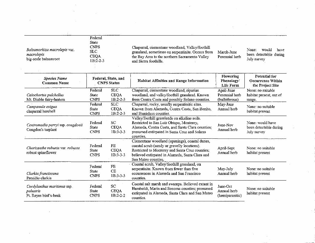
Balsamorhiza macrolepis var. macrolepis big-scale balsamroot
Species Name Common Name
Calochortus pulchellus Mt. Diablo fairy-lantern
Campanula exigua chaparral harebell
Centromadia parryi ssp. congdonii Congdon's tarplant
Chorizanthe robusta var. robusta robust spineflower
Clarkia franciscana Presidio clarkia
Cordylanthus maritimus ssp. palustris Pt. Reyes bird's-beak
Federal State CNPS SLC CEQA 1B:2-2-3
Federal, State, and CNPS Status
Federal SLC State CEQA CNPS 1B:2-2-3 Federal SLC State CEQA CNPS 1B:2-2-3
Federal sc State CEQA CNPS 1B:3-3-3
Federal FE State CEQA CNPS 1B:3-3-3
Federal FE State CE CNPS 1B:3-3-3
Federal sc State CEQA CNPS 1B:2-2-2
Chaparra~ cismontane woodland, Valley/foothill grassland, sometimes on serpentinite. Occurs from March-June the Bay Area to the northern Sacramento Valley Perennial herb and Sierra foothills.
Flowering Habitat Affinities and Range Information Phenology/
Life Form Chaparral, cismontane woodland, riparian April-June woodland, and valley/foothill grassland. Known Perennial herb from Contra Costa and Eossibl~ Solano counties. (bulbiferous) Chaparral, rocky, usually serpentinitic sites. May-June Known from Alameda, Contra Costa, San Benito, Annual herb and Stanislaus counties. Valley/foothill grasslands on alkaline soils. Restricte4 to San Luis Obispo, Monterey,
June-Nov Alameda, Contra Costa, and Santa Clara counties;
Annual herb presumed extirpated in Santa Cruz and Solano counties. Cismontane woodland (openings), coastal dunes, coastal scrub (sandy or gravelly locations).
April-Sept Restricted to Monterey and Santa Cruz counties;
Annual herb believed extirpated in Alameda, Santa Clara and San Mateo counties. Coastal scrub, Valley/foothill grassland, on serpentinite. Known from fewer than five May-July occurrences in Alameda and San Francisco Annual herb counties.
Coastal salt marsh and swamps. Believed extant in June-Oct Humboldt, Marin and Sonoma counties; presumed
extirpated in Alameda, Santa Clara and San Mateo Annual herb
counties. (hemiparasitic)
None: would have been detectable during July survey
Potential for Occurrence Within
the Project Site None: no suitable habitat present, out of ran~ e.
None: no suitable habitat present
None: would have been detectable during July survey
None: no suitable habitat present
None: no suitable habitat present
None: no suitable habitat present
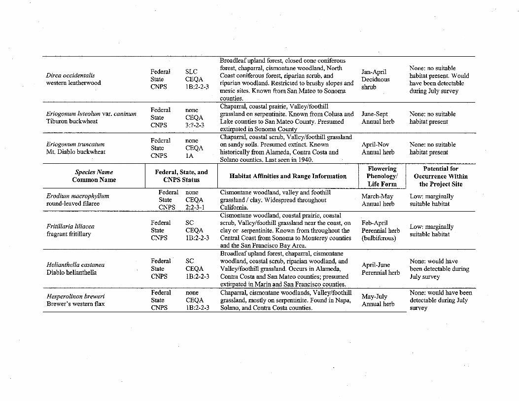
Broadleaf upland forest, closed cone coniferous
Federal SLC forest, chaparral, cismontane woodland, North
Jan-April None: no suitable
Dirca occidentalis Coast coniferous forest, riparian scrub, and habitat present. Would western Ieatherwood
State CEQA riparian woodland. Restricted to brushy slopes and
Deciduous have been detectable
CNPS 1B:2-2-3 mesic sites. Known from San Mateo to Sonoma
shrub during July survey
counties.
Federal none Chaparral, coastal prairie, Valley/foothill
Eriogonum luteolum var. caninum State CEQA
grassland on serpentinite. Known from Colusa and June-Sept None: no suitable Tiburon buckwheat
CNPS 3:?-2-3 Lake counties to San Mateo County. Presumed Annual herb habitat present extirpated in Sonoma County
Federal none Chaparral, coastal scrub, Valley/foothill grassland
Eriogonum truncatum State CEQA
on sandy soils. Presumed extinct. Known April-Nov None: no suitable Mt. Diablo buckwheat
CNPS lA historically from Alameda, Contra Costa and Annual herb habitat present Solano counties. Last seen in 1940
Flowering Potential for Species Name Federal, State, and
Habitat Affinities and Range Information Phenology/ Occurrence Within Common Name CNPS Status Life Form the Project Site
Erodium macrophyllum Federal none Cismontane woodland, valley and foothill
March-May Low: marginally round-leaved filaree
State CEQA grassland I clay. Widespread throughout Annual herb suitable habitat
CNPS 2:2-3-1 California. Cismontane woodland, coastal prairie, coastal
Fritillaria liliacea Federal sc scrub, Valley/foothill grassland near the coast, on Feb-April
Low: marginally fragrant fritillary State CEQA clay or serpentinite. Known from throughout the Perennial herb
suitable habitat CNPS 1B:2-2-3 Central Coast from Sonoma to Monterey counties (bulbiferous)
and the San Francisco Ba~ Area. Broadleaf upland forest, chaparral, cismontane
Helianthella castanea Federal sc woodland, coastal scrub, riparian woodland, and
April-June None: would have
Diablo helianthella State CEQA Valley/foothill grassland. Occurs in Alameda,
Perennial herb been detectable during
CNPS 1B:2-2-3 Contra Costa and San Mateo counties; presumed July survey extirpated in Marin and San Francisco counties.
Hesperolinon breweri Federal none Chaparral, cismontane woodlands, Valley/foothill
May-July None: would have been
Brewer's western flax State CEQA grassland, mostly on serpentinite. Found in Napa,
Annual herb detectable during July
CNPS 1B:2-2-3 Solano, and Contra Costa counties. survey
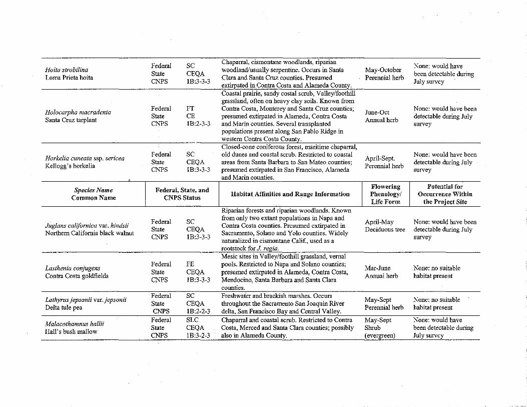
Federal sc Chaparral, cismontane woodlands, riparian None: would have
Hoita strobilina State CEQA
woodland/usually serpentine. Occurs in Santa May-October been detectable during
Lorna Prieta hoita Clara and Santa Cruz counties. Presumed Perennial herb CNPS 1B:3-3-3
extirpated in Contra Costa and Alameda County. July survey
Coastal prairie, sandy costal scrub, Valley/foothill grassland, often on heavy clay soils. Known from
Holocarpha macradenia Federal FT Contra Costa, Monterey and Santa Cruz counties;
June-Oct None: would have been
Santa Cruz tarplant State CE presumed extirpated in Alameda, Contra Costa
Annual herb detectable during July
CNPS 1B:2-3-3 and Marin counties. Several transplanted survey populations present along San Pablo Ridge in western Contra Costa County. Closed-cone coniferous forest, :rrui.ritime chaparral,
Horkelia cuneata ssp. sericea Federal sc old dunes and coastal scrub. Restricted to coastal
April-Sept. None: would have been
Kellogg's horkelia State CEQA areas from Santa Barbara to San Mateo counties;
Perennial herb detectable during July
CNPS 1B:3-3-3 presumed extirpated in San Francisco, Alameda survey and Marin counties
Flowering Potential for Species Name Federal, State, and Habitat Affinities and Range Information Phenology/ Occurrence Within Common Name CNPS Status
Life Form the Project Site Riparian forests and riparian woodlands. Known
Federal sc from only two extant populations in Napa and April-May None: would have been
Juglans californica var. hindsii Contra Costa counties. Presumed extirpated in Northern California black walnut
State CEQA Sacramento, Solano and Yolo counties. Widely
Deciduous tree detectable during July CNPS 1B:3-3-3
naturalized in cismontane Calif., used as a survey
rootstock for J. reg_ia. Mesic sites in Valley/foothill grassland, vernal
Lasthenia conjugens Federal FE pools. Restricted to Napa and Solano counties;
Mar-June None: no suitable Contra Costa goldfields
State CEQA presumed extirpated in Alameda, Contra Costa, Annual herb habitat present
CNPS 1B:3-3-3 Mendocino, Santa Barbara and Santa Clara counties.
Lathyrus jepsonii var. jepsonii Federal sc Freshwater and brackish marshes. Occurs
May-Sept None: no suitable State CEQA throughout the Sacramento San Joaquin River
Delta tule pea CNPS 1B:2-2-3 delta, San Francisco Bay and Central Valley.
Perennial herb habitat present
Malacothamnus hallii Federal SLC Chaparral and coastal scrub. Restricted to Contra May-Sept None: would have
Hall's bush mallow State CEQA Costa, Merced and Santa Clara counties; possibly Shrub been detectable during CNPS 1B:3-2-3 also in Alameda County. (evergreen) July survey

Meconella oregana Federal sc State CEQA
Oregon meconella CNPS 1B:3-3-2
Federal none Micropus amphibolus
State CEQA Mt. Diablo cottonweed
CNPS 3:?-2-3
Federal none Monardella antonina ssp. antonina
State CEQA San Antonio Hills monardella
CNPS 3:?-?-3
Federal none Monardella villosa ssp. globosa
State CEQA robust monardella
CNPS 1B:3-2-3
Phacelia phacelioides Federal sc
Mt. Diablo phacelia State CEQA CNPS 1B:3-2-3
Species Name Federal, State, and Common Name CNPS Status
Plagiobothrys chorisianus var. Federal SLC chorisianus State CEQA Choris 's popcorn-flower CNPS 1B:3-2-3
Federal none Plagiobothrys diffusus
State CE San Francisco popcorn-flower
CNPS 1B:3-3-3
Federal sc Plagiobothrys glaber
State CEQA hairless popcorn-flower
CNPS lA
Federal none Potamogeton zosteriformis
State CEQA eel-grass pondweed
CNPS 2:2-2-1
Coastal prairie and coastal scrub. Present in Contra Costa, Santa Clara, Oregon, Washington, and elsewhere .. Broadleafupland forest, chaparral, cismontane woodland, Valley/foothill grassland. Known from Lake to Santa Cruz counties, San Francisco Bay Area. Chaparral and cismontane woodland. Recorded from Monterey County; possible also in Alameda, Contra Costa, San Benito and Santa Clara counties. Broadleaved upland forest, cismontane woodland, coastal scrub, and openings in chaparral, cismontane woodland. Occurs from the San Francisco Bay Area to Humboldt County. Chaparral and cismontane woodland on rocky sites. Recorded from Contra Costa, San Benito, Santa Clara and Stanislaus counties
Habitat Affinities and Range Information
Moist, grassy sites in coastal scrub, coastal prame and chaparral. Occurs in Santa Cruz, San Francisco and San Mateo counties. Presumed extirpated in Alameda County.
March-April Annual herb
March-May Annual herb
Jun-Aug Perennial herb (rhizomatous)
June-July Perennial herb (rhizomatous)
April-May Annual herb
Flowering Phenology/ Life Form
March-June Annual herb
Moist, grassy sites in coastal scrub, coastal prairie A .1
J . pn- une
and chaparral. Occurs m Santa Cruz, San A 1 h b Francisco and San Mateo counties. nnua er Alkaline meadows and vernal coastal salt marshes. Presumed extinct. Once occurred in Alameda, Merced, Marin, San Benito, and Santa Clara counties.
March-May Annual herb
Assorted freshwater marshes and swamps. Known June-July from Contra Costa, Lake counties, Modoc, Lassen, Annual herb and Shasta counties and Washington and Oregon. (aquatic)
None: no suitable habitat present
Low: marginally suitable habitat
None: would have been detectable during July survey
None: would have been detectable during July survey
None: no suitable habitat present
Potential for Occurrence Within
the Project Site
None: no suitable habitat present
None: no suitable habitat present
None: no suitable habitat present
None: no suitable habitat present

Sanicula saxatilis rock sanicle
Streptanthus albidus ssp. peramoenus most beautiful jewel-flower
Streptanthus hispidus Mt. Diablo jewel-flower
Suaeda californica California seablite
Trifolium depauperatum var. hydrophilum saline clover
Triquetrella californica
Species Name Common Name
Viburnum ellipticum
Federal sc State CR CNPS 1B:3-2-3
Federal sc State CEQA CNPS 1B:2-2-3
Federal sc State CEQA CNPS 1B:3-1-3
Federal FE State CEQA CNPS: 1B:3-3-3
Federal sc State CEQA CNPS 1B:3-3-3
Federal SLC State CEQA CNPS 1B:3-2-3
Federal, State, and CNPS Status
Federal State CNPS
None CEQA 2:2-1-1
Broadleafupland forests, chaparral, Valley/foothill grassland, on bedrock outcrops and talus slopes. Restricted to Contra Costa and Santa Clara counties. Chaparral, cismontane woodland and
April-May Perennial herb
Valley/foothill grasslands on serpentinite. Known April-June from Alameda, Santa Clara and Contra Costa Annual herb counties.
None: no suitable habitat presentOut of range.
None: no suitable habitat present
Chaparral and Valley/foothill grassland on M J None: no suitable · k R · d C ar- une h b' f serpentme roc outcrops. estncte to ontra A 1 h b a 1tat present, out o nnua er
Costa County. known range Coastal salt marshes. Extirpated from San J 1 _0 t Francisco, Alameda, Santa Clara counties. S~b c Restricted to Morro Bay, San Luis Obispo County. ( ) Believed extirpated in Alameda and Santa Clara evergreen Counties. Marshes and swamps, valley and foothill grassland (mesic and alkaline), and vernal pools. Known from Alameda, Monterey, Napa, San Benito, April-June Santa Clara, San Luis Obispo, San Mateo, Solano, Annual herb and Sonoma counties, and possibly Colusa County. Coastal bluff scrub, and coastal scrub on soil. Known in California from fewer than ten small coastal occurrences and in Oregon from only one occurrence.
Habitat Affinities and Range Information
Chaparral, cismontane woodland, and lower montane coniferous forest. Recorded from Contra Costa, Fresno, El Dorado, Glenn, Humboldt, Mendocino, Napa, Shasta, Sonoma counties; Oregon and Washington.
Moss
Flowering Phenology/ Life Form
May-June Shrub (deciduous)
None: no suitable habitat present
None: no suitable habitat present
None: no suitable habitat present
Potential for Occurrence Within the Project Site
None: would have been detectable during July survey
Botanical Reconnaissance and Single Season Focused Survey for the Agarwal Property Alameda County, California July 15,2004
7.0 References
Baldwin, B.G. 1999. New Combinations and New Genera in the North American Tarweeds (Compositae-Madiinae). Novon 9: 462-471.
California Department of Fish and Game (CDFG). 2000. Guidelines for Assessing the Effects of Proposed Developments on Rare and Endangered Plants and Plant Communities. The Resources Agency, Sacramento. Revised August 15.
California Department ofFish and Game (CDFG). 2004a. Special Vascular Plants, Bryophytes, and Lichens List. Natural Diversity Data Base. April.
California Department ofFish and Game (CDFG). 2004b. State and Federally Listed Endangered, Threatened, and Rare Plants of California. Natural Diversity Data Base. April.
California Native Plant Society (CNPS). 2001. Inventory of Rare and Endangered Plants of California (sixth edition). Rare Plant Scientific Advisory Committee, David P. Tibor, Convening Editor. Sacramento, California. 388 pp.
California Department ofFish and Game (CDFG). 2003a. California Natural Diversity Data Base (CNDDB). Database Query for the Hayward and surrounding 7.5-minute topographic quadrangles. December.
California Department ofFish and Game (CDFG). 2003b. List of California Terrestrial Natural Communities Recognized by the Natural Diversity Database. Natural Heritage Division. The Resources Agency. September.
Cowardin, L.M., V. Carter, F.C. Golet, and E.T. LaRoe. 1979. Classification of Wetlands and Deepwater Habitats of the United States. U.S. Department of the Interior, Fish and Wildlife Service, Washington, D.C. 131 pp.
Hickman, J.C. 1993. The Jepson Manual: Higher Plants of California. University of California Press, Berkeley, California. 1400 pp.
Holland, R. 1986. Preliminary Descriptions of the Terrestrial Natural Communities of California. California Department ofFish and Game, The Resources Agency. 156 pp.
Sawyer, J.O. and T. Keeler-Wolf. 1995. A Manual of California Vegetation. California Native Plant Society, Sacramento. 471 pp.
Skinner, M.W. and B.M. Pavlik. 1999. Electronic Inventory of Rare and Endangered Vascular Plants of California. Fifth ed. update. California Native Plant Society, Sacramento, California. January 1.
U.S. Fish and Wildlife Service (USFWS). 1996. Guidelines for Conducting and Reporting Botanical Inventories for Federally Listed, Proposed and Candidate Plants. September 23.
U.S. Fish and Wildlife Service (USFWS). 1999. Endangered and Threatened Wildlife and Plants . .50 CFR 17.11 & 17.12. December 31.
U.S. Fish and Wildlife Service (USFWS). 2004. Plant Species of Concern, Sacramento Fish & Wildlife Office ..
Bear Republic Ecological Consulting 12

Botanical Reconnaissance and Single Season Focused Survey for the Agarwal Property Alameda County, California
APPENDIX A
Plant Species Detected On July 2, 2004 at the Agarwal Property, Alameda County, California
CLASS Family
Scientific Name
DICOTYLEDONAE Anacardiaceae - Sumac Family
Schinus molle* Apiaceae- Parsley Family
Conium maculatum* Foeniculum vulgare* Torilis arvensis *
Araliaceae- Aralia Family Hedera helix*
Asteraceae - Sunflower Family Baccharis pilularis Carduus pycnocephalus* Cirsium vulgare* Conyza canadensis* Senecio mikanioides* Gnaphalium luteo-album* Hypochaeris radicata * Lactuca serriola* Picris echioides* Tragopogon sp.
Brassicaceae - Mustard Family Brassica nigra* Raphanus raphinastrum * Raphanus sativus* Rorippa 11;asturtium-aquaticum *
Caprifoliaceae - Honeysuckle Family Sambucus mexicana
Chenopodiaceae- Goosefoot Family Chenopodium album*
Convolvulaceae - Morning-glory Family Convolvulus arvensis*
Fabaceae - Pea Family Lotus corniculatus* Medicago polymorpha* Vicia sativa ssp. sativa*
Fagaceae - Oak Family
Bear Republic Ecological Consulting
Common Name
Peruvian pepper-tree
poison hemlock sweet fennel hedge-parsley
English ivy
coyote brush Italian thistle bull thistle horseweed Cape ivy cud weed rough cat's-ear prickly lettuce bristly ox-tongue salisfy
black mustard jointed charlock wild radish water cress
blue elderberry
lamb's quarters
field bindweed
bird foot trefoil bur-clover common vetch
July 15, 2004
13

Botanical Reconnaissance and Single Season Focused Survey for the Agarwal Property Alameda County, California July 15, 2004
Quercus agrifolia coast live oak Juglandaceae- Walnut Family
Juglans regia* English walnut Lauraceae - Laurel Family
Umbellularia californica California bay Myrtaceae - Myrtle Family
Eucalyptus globulus* Tasmanian blue gum Papaveraceae - Poppy Family
Eschscholzia californica California poppy Plantaginaceae - Plantain Family
Plantago lanceolata * English plantain Plantago major* broadleaf plantain
Polygonaceae - Buckwheat Family Polygonum arenastrum * common knotweed Rumex acetosella* sheep sorrel Rumex crispus* curly dock Rumex pulcher* fiddle dock
Rosaceae- Rose Family Eriobotrya japonica* loquat Prunus sp.* ornamental plum Pyracantha angustifolia* common firethom Rubus discolor* Himalayan blackberry Rubus ursinus California blackberry
Urticaceae -Nettle Family Urtica dioica ssp. holosericea hoary nettle
MONOCOTYLEDONAE Cyperaceae- Sedge Family
Cyperus eragrostis umbrella sedge lridaceae- Iris Family
Crocosmia crocosmiiflora* crocosmm Poaceae - Grass Family
Avena barbata* slender wild oat Agrostis viridis* water bent grass Avena fatua* wild oat Bromus catharticus* rescue grass Bromus diandrus* ripgut brome Cortaderia jubata* pampas grass Cynodon dactylon* Bermuda grass Hordeum murinum ssp. leporinum * hare barley Leymus triticoides creepmg ryegrass Lolium multiflorum* Italian rye grass Melica torreyana Torrey melic Paspalum dilatatum* Dallis grass
Bear Republic Ecological Consulting 14
Botanical Reconnaissance and Single Season Focused Survey for the Agarwal Property Alameda County, California
Piptatherum miliaceum * Polypogon monspeliensis*
Typhaceae - Cattail Family Typha angustifolia
* denotes nonnative species or species not naturally occurring onsite ? indicates uncertain identification due to condition of plant material 1 indicates sensitive taxon
Bear Republic Ecological Consulting
smilo grass rabbitfoot grass
narrow-leaved cattail
July 15,2004
15


APPENDIXF
Patricia Berryhill Natural Resources Management 737 Spruce Street Berkeley, CA 94707
July 15, 2004
RE: Draft Stream Enhancement Plan for Agarwal Project at 2492 D Street Alameda County, California
Dear Patricia
This letter is intended to outline a stream enhancement plan for impacts to Regional Water Quality Control Board (RWQCB) regulated wetlands and waters resulting from the proposed residential development located at 2492 D Street Alameda County, California.
Site Conditions, Impacts, and Mitigation
The applicant proposes to subdivide two parcels totaling 3.66-acres (APN 0416-0200-019-02 & 022-01) into a total of 16 lots. The new homes would be constructed on stepped building pads so that the existing topography on each lot would generally be preserved. Two westerly flowing drainages traverse the property. Currently, the southernmost drainage (drainage #1) is routed through a culvert where the existing temporary road crosses overhead. The Project would expand this culvert by approximately 100 feet, to accommodate the proposed private street as well as the middle turnaround area. The Project would place part of the northernmost drainage (drainage #2), where it crosses under the proposed private street, into a culvert. This culvert would be approximately 70 feet long. Aside from the presence of pampas grass (Cortaderiajubata), the structure and diversity of vegetation along drainage #2 is of good quality. However, drainage #1 structure and diversity is low and needs improvement.
Jones & Stokes conducted a formal wetland delineation, according to the standards of the U.S. Army Corps of Engineers, ofthe project area in January 2004 (Jones & Stokes 2004).
As mitigation for impacts to 0.03 acre (approximately 1,307 square feet) of intermittent drainage and 0.03 acre (approximately 1,307 square feet) ofwetlands, both state and federally jurisdictional, the applicant is proposing to enhance habitat conditions of the two drainages on site. This stream enhancement plan proposes to enhance drainage #1, east of the culvert, and drainage # 2, up and downstream of the proposed culvert. This proposed mitigation would establish plant species indigenous to the region, increase vegetation community diversity and structure, establish a high quality upland buffer from the proposed development, as well as provide wildlife habitat and cover.
Stream Enhancement and Monitoring Plan

Stream enhancement will be accomplished through the removal ofpampas grass present in drainage #2, and by planting native trees within the channel along drainage # 2 and on the eastern portion of drainage # 1. The western portion of drainage # 1 may not have sufficient hydrology to support wetland mitigation consisting ofhydrophytic plant species. Distribution of a small amount of native seeds on slopes exposed during the culvert and outfall construction will also be a component ofthis plan (Table 1 ).
Scientific Name
Artemisia douglasiana
Eschscholzia californica
Lupinus bicolor
Nassella pulchra
Scrophularia californica
Vulpia microstachys
Table 1 Seed Mix for the Agarwal Project*
Percentage Pure Common Name Live Seed (PLS)
mugwort 5
California poppy 71
pigmy-leaflupine 77
purple needlegrass 42
figwort 45
three-weeks fescue 68
Total
Pounds Per Acre
4
1
4
2
2
2
15 * Seed mix to be applied to all bare soil areas after culvert and outfall construction.
Native species to be planted along the east side of drainage #1 and the up and downstream portions of drainage #2, outside of the proposed culvert, include red willow (Salix laevigata) and replacement seeding of narrow-leaved cattail (Typha angustifolia) where the pampas grass is to be removed. Drainages #1 & 2 will each be planted with twenty red willow pole cuttings, which will be located within the channel. Once established, the enhancement planting is expected to be self-sustaining and require no maintenance. In addition to the red willow plantings, native seed mixes will be used to reseed bare soil areas following construction. Care has been taken to ensure that the proposed enhancements will not compromise the ability of the drainage to convey periodic storm flows. During construction, the restoration biologist will be on site to provide direction and ensure protection of sensitive resources. The restoration biologist will ensure that the creek areas are clearly marked with flagging and/or construction fencing and that contractors and their equipment are prohibited from entry into this sensitive area.
The restoration biologist will supervise the implementation of this plan. In addition, the restoration biologist will conduct the horticultural and habitat monitoring, as outlined below, and prepare annual reports.
A monitoring program will be implemented following planting. Monitoring of the red willow plantings will be performed for three years following planting. Monitoring will consist of enhancement monitoring.
The objective of enhancement monitoring is to provide the baseline data for evaluating whether or not the success criteria have been met. Monitoring will be performed during the spring and early fall of the first year, and in summer or early fall the following two years. Upon completion of planting, as-built plans will be prepared showing the location and species of tree plantings.
Monitoring will consist of the collection ofbasic quantitative and qualitative data regarding the survival and vigor of all tree plantings. Heights shall be measured for all trees planted. The viability and vigor of all trees in the enhancement phases will be assigned vigor ratings based on the following parameters:
1. Excellent: plant is vigorously growing and healthy, with no sign of disease or injury; 2. Good: plant is healthy and moderately vigorous; may have limited signs disease or injury; 3. Adequate: plant is surviving but lacks signs of vigorous growth; may have more
extensive signs of disease or injury; 4. Poor: plant exhibits low vitality, or main stem dead but basal sprouts emerging; survival
is uncertain; 5. Dead: plant shows no signs oflife and is not expected to recover.
Photos illustrating vigor ratings will be taken during each year for each species of plant. Photographs showing an overall view of the mitigation site will be taken at permanent photo points annually. Qualitative descriptions of the development ofhabitat (i.e., natural establishment, areas of significant die-off, diseases, etc.) will 'also be prepared during the spring.
These methods are intended to provide usable data with which the regulatory agencies can adequately evaluate compliance, while representing a reasonable investment in terms of field effort.
Observation results from the enhancement monitoring will be presented in annual reports. Reports will be prepared annually during the three-year monitoring period. Vigor, height, and spread data will be summarized, providing the mean values for all trees planted. The reports will describe problems that developed and remedial measures recommended and implemented: The reports will include photographs of representatives of each planted species. The reports will be submitted to the RWQCB by December 31 of each year. Each annual report will include results of all monitoring visits.
The mitigation plan will be considered successful if, at the endofthe three-year monitoring period, the mitigation trees are self-sustaining, and plant survivorship and vigor are adequate to assure the creation of viable, high quality upland buffer zone.
Should you have any questions regarding this Stream Enhancement Plan for the Agarwal Project don't hesitate to call me at (925) 957-0069.
Sincerely,
Heath Bartosh Botanist, Wetland and GIS Specialist Bear Republic Ecological Consulting


APPENDIXG


GEOTECHNICAL INVESTIGATION
TRACT NO. 5965
2492 D STREET
ALAMEDA COUNTY, CALIFORNIA
CLEARY CONSULTANTS, INC. Geotechnical Engineers and Geologists

CLEARY CONSULTANTS, INC» Geotechnical Engineers and Geologists
Mr. Lubomir Peichev 106 West 43rd A venue San Mateo, California 94403
RE: GEOTECHNICAL INVESTIGATION TRACT NO. 5965 2492 D STREET ALAMEDA COUNTY, CALIFORNIA
Dear Mr. Peichev:
July 7, 1989 Project No. 219.1A Ser. 3930
In accordance with your request, we have performed a geotechnical investigation for the proposed Tract 5965 at 2492 D Street in Alameda County, California. The accompanying report presents the results of our field investigation, laboratory testing, and engineering analyses. The site and subsurface conditions are discussed and recommendations for the soil and foundation engineering aspects of the project are presented. This report is contingent upon our review of the grading and foundation plans for the project and observation/testing of the earthwork and foundation installation phases of the project.
We refer you to the text of the report for detailed findings and recommendations. If you have any questions concerning our findings, please call.
Yours very truly,
CLEARY CONSULTANTS, INC.
~ere J~~-v-Rick Swanson
~il Engineer ~88:1_
\j~ii(AJLA-~u~ J. Michael Cleary 0 Engineering Geologist 35 2 Geotechnical Engineer 222
RS/JMC:ms Copies: Addressee (2)
Marvin E. Smitherman, Jr., Consulting Engineer (2) Arkady Faktorovich (1) Gene St. Onge (1)
900 N. SAN ANTONIO ROAD, LOS ALTOS, CALIFORNIA 94022 (415) 948-0574

TABLE OF CONTENTS
Letter of Transmittal
INTRODUC'f I ON'. • • • • • • • • • • • • • • • • • • • • • • • • • • • • • • • • • • • • • ••••
smPE .......................................... "" ....... .
METHOD OF INVESTIGATIOO ..•.....•....•.........•••..•..
GEOLOOY AN1J SE I SMI CITY . .................•.......•.....
SITE A. B. c.
CONDITIONS. Surface ... Subsurface. Groundwater.
CONCLUSIONS AND RE~ATIONS .. A.
B. c. D. E.
Earthwork ... 1. 2. 3 • 4. 5·. 6. 7. 8 •
Site Preparation. of Surface Soils.
Clearing and Recompaction Placement of Fill on Slopes .. Slope Gradients ...••..••....... F i 11 P 1 acemen t and Compaction. Trench Backfill .. Drainage ..•..... Construction Observation ..
Foundations .... Slabs-on-Grade. Retaining Walls. Flexible Pavement.
~ . . . .
PLAN REVIEW AND CONSTRUCTION OBSERVATION ............. .
BIBLIOORAPHY
SITE VICINITY MAP ... SITE PLAN .........•.
FILL SECTION. ENGINEERED KEY TO BORING LOGS ....•.
DRAWINGS
SUMMARY OF FIELD SAMPLING PROCEDURES. LABORATORY TESTING PROCEDURES. LOGS OF BORINGS 1-12 .. PLASTICITY CHART .... R-VALUE DETERMINATION ..
CLEARY CONSULTANTS, INC.
Page No.
1
2
3
4
5 5 5 6
6 7 7 7 8 9 9 9
10 10 11 12 13 14
14
Drawing No.
1 2 3 4 5 6
7-18 19 20
1 ,. \
INTRODUCTION
This report presents the results of our geotechnical investigation for the proposed
Tract 5965 at 2492 D Street in Alameda County, California. The property is lo
cated on the north side of D Street about 300 feet west of Stratton Court as
shown on Drawing 1 - Site Vicinity Map. The purpose of this investigation was to
determine the prevailing soil and bedrock conditions within the areas to be
developed and provide soil and foundation engineering recommendations for the
project design:
As shown on the Preliminary Grading and Tentative Map by Marvin Smitherman, the
project will consist of twelve new single family lots at the 2.8 acre parcel. The
project will also include construction of a new cul-de-sac street as shown on Draw
ing 2 - Site Plan.
Construction will consist of single family homes built close to existing grades. The
homes will be one and two story, split level structures. It is anticipated that the
homes will have raised wood floors in living areas and concrete slab-on-grade
garage floors. Cuts and fills up to eight feet may be required for the street.
Grading details for the building pads are not available at this time. Trench ex-
. cavations 10 to 12 feet deep may be required for the planned gravity sewer.
We previously performed a geotechnical investigation of the site to provide soil and
foundation engineering recommendations for a condominium project that was not
built; the results of this study were presented in our report dated October 31,
1979. In addition to this report, we prepared a November 23, 1988, geotechnical
feasibility update letter which concluded the presently proposed tract development
is feasible from a geotechnical standpoint.
1
CLEARY CONSULTANTS, INC.

. SCOPE
A~ presented in our proposal dated June 2:, 1989, the scope of services for this in
vestigation included:
1. A site reconnaissance and review of available geologic information for this
area.
2. Subsurface exploration consisting of six borings drilled under the guidance
of our engineering geologist.
3. Laboratory testing of samples obtained from the borings.
4. Soil and foundation engineering analyses using the field and laboratory data
and preparation of a geotechnical investigation report. The report was to
present findings and recommendations for:
a) Suitability of the proposed building sites from a geotechnical
standpoint.
b) Site preparation and grading.
c) Building foundation type, minimum depth, and allowable skin friction
values.
d) Treatment of expansive soils.
e) Surface and subsurface drainage.
f) Earth pressure criteria for retaining wall design.
g) Excavation conditions and utility trench backfilling.
2
CLEARY CONSULTANTS, INC.

h) Flexible pavement sections for roadways and driveways.
i) Any other unusual design or construction conditions encountered during
this study.
This report has been prepared for the specific use of Mr. Lubomir Peichev and his
consultants in accordance with generally accepted soil and foundation engineering
principles and practices. No other warra.11ty, either expressed or implied, is made.
In the event that any substantial changes in the nature, design, or location of the
improvements are planned, the conclusions and recommendations of this report shall
not be considered valid unless such changes are reviewed and the conclusions of
this report modified or verified in writing.
METHOD OF INV:ESTIGA TION
A site reconnaissance was performed by our engineering geologist on June 20, 1989.
The subsurface exploration was also performed on June 20, 1989, using track
mounted, continuous flight auger drilling equipment. A total of six borings were
drilled to a maximum depth of 16.5 feet at the locations shown on Drawing 2. A
key describing the soil classification system and soil consistency terms used in this
report is presented on Drawing 4 and the soil sampling procedures are described in
Drawing 5. Logs of the borings are presented on Drawings 13 through 18. (Logs
of the previous borings drilled for our 1979 study are included in this report as
Drawings 7 through 12).
The borings were located in the field by pacing and interpolation of the features
shown on the drawings provided us. These locations should be considered accurate
only to the degree implied by the method used.
Samples of the soil materials from the borings were returned to our laboratory for
classification and testing. The results of moisture content, dry density, percent
finer than No. 200 sieve, unconfined compression, free swell, R-Value and plasticity
3
CLEARY CONSULTANTS, INC.
index tests are shown on the boring logs. Drawing 19 presents additional informa
tion on the plasticity tests and Drawing 20 presents the results of an R-Value test.
The laboratory test procedures followed during this investigation are summarized on
Drawing 6.
A bibliography of references consulted during this investigation is included at the
end of the text.
GEOLOGY AND SElSMICITY
The site is underlain by highly weathered siltstone and sandstone of the Panache
Formation (Dibblee, 1980) with occasional shale and claystone interbeds. Bedrock is
exposed in cuts for the existing dwelling and access road at the site.
No active or inactive faults are known to pass through the site. The property,
however, is located approximately 1 1/2 miles northeast of the Hayward fault, 20
miles northeast of the San Andreas fault and 7 miles southwest of the Calaveras
fault, all of which are historically active. Therefore, as with the rest of the San
Francisco Bay Area, the property is in a region of high seismic activity.
Although research on earthquake prediction has greatly increased in recent years,
seismologists have not yet reached the point where they can accurately predict
when and where an earthquake will occur. Nevertheless, on the basis of current
technology, it is reasonable to assume that the proposed residences will be sub
jected to at least one moderate to severe earthquake during their design life.
During such an earthquake, the danger from fault offset through the site is remote,
but strong shaking is likely to occur.
4
CLEARY CONSULTANTS, INC.
SITE CONDITIONS
A; Surface
The property consists of a broad central ridge flanked by a sharply incised winter
drainage to the south and a shallow minor swale to the north. The central ridge
slopes westward at 7 to 14 percent and has 20 to 30 percent sideslopes on the
north and 24 to 50 percent sideslopes on the south. (The slopes steepen near the
bottom of the creek). Elevations vary from about 329 feet at the east central
boundary to 282 feet in the northwest corner in the swale.
At the time of our investigation, there was a. home near the center of the parcel
and several small sheds in the north swale. Access to the property was provided
by an asphalt paved driveway which is ·underlain ·by fill where it crosses the
southern drainage. Vegetation consisted of a few trees in the northern swale and
several large trees, shrubs, brushy debris, and weeds are in the southern portion of
the parcel.
B. Subsurface
The borings encountered 0.5 to 4.5 feet of natural soil overlying bedrock. The
natural soil consisted of very stiff to hard silty clay, sandy clay, and sandy silt and
loose to medium dense silty sand and clayey sand. The bedrock consisted of highly
weathered and fractured sandstone and siltstone of the Panache Formation that ex
tended to the maximum depth explored at the site (20.5 feet in Boring 5). Minor
sandy claystone bedrock was encountered in Boring 10 from 4.0 to 6.0 feet deep.
The bedrock became progressively stronger and more resistant with depth {drilling
refusal was encountered in Borings 6, 9, 11, and 12 at depths of 10.5 to 15 feet in
the hard sandstone bedrock).
5
CLEARY CONSULTANTS, INC.

The. soil and bedrock materials have variable plasticity characteristics and have low
to high expansion potentials (plasticity index = 8 to 3 0). The results of six Atter
berg Limits tests are shown on the boring logs and on Drawing 19.
The attached boring logs and related information depict subsurface conditions only
at the specific locations shown on Drawing 2 and on the particular dates designated
on the logs. Soil and rock conditions at other locations may differ from conditions
occurring at these boring locations. Also, the passage of time may result in a
change of conditions at these boring locations due to environmental changes. .
C. Groundwater
No free groundwater was encountered in the borings at the time of drilling. It
should be noted, however, that fluctuations in the groundwater level may occur be
cause of variations in rainfall, temperature, runoff, irrigation and other factors not
evident at the time our measurements were made and reported herein.
CONCLUSIONS AND RECOMMENDATIONS
From a soil and foundation engineering standpoint, it is our opinion that the site is
suitable for the proposed tract development provided the recommendations contained
in this report are incorporated into the design and construction of the project. The
gently to moderately inclined, rolling site is underlain by expansive soils to variable
depths, consequently, we recommend that all residences and retaining walls be sup
ported on well reinforced drilled pier and grade beam foundation systems. The
drilled piers should be designed to obtain skin friction support in the bedrock
materials that underlie the site. All concrete slabs should be underlain by a layer
of non-expansive fill to minimize potential soil heave and shrinkage movements.
It is anticipated that conventional grading equipment can be used to grade the
planned street and building pads. However, difficult drilling of the drilled pier
6
CLEARY CONSULTANTS, INC.

holes may be encountered locally and we recommend that heavy duty drilling equip
ment in good working condition be used for the pier drilling. In addition, heavy
duty trenching equipment and jackhammers may be required to excavate deep
utility trenches in the planned street, such as the planned sewer trench.
(Excavation contractors should review the boring logs and observe the bedrock out
crops at the site to evaluate the excavation characteristics of the bedrock).
Detailed recommendations for use in design and construction of the project are
presented in the remainder of this report. These recommendations are contingent
on our review of the earthwork and foundation plans for the project and our obser
vation of the earthwork and foundation installation phases of construction.
A. Earthwork
L Clearing and Site Preparation
Initially the site should be cleared of the residence, sheds, designated trees,
brushy debris, and any other debris or underground obstructions encountered at
this time. Any holes resulting from the removal of underground obstructions
that extend below the planned finished grade should be cleared and backfilled
with suitable material compacted to the requirements given .·below for en
gineered fill.
2. Recompaction of Surface Soils
After the site has been cleared and any underground obstructions removed and
backfilled, the surface soils in areaS to be filled should be recompacted. The
recompaction should consist of ripping the upper eight inches, moisture con
ditioning the soils to approximately two percent above optimum and compacting
them to at least 90 percent relative compaction as determined by ASTM Test
7
ClEARY CONSULTANTS, INC.

l l i
I Designation D1557-78(C). Compaction should be performed using heavy compac
tion equipment such as a sheepsfoot roller or self-propelled compactor.
3. Placement of Fill on Slopes
Any fill placed for the road or buildings on slopes steeper than 6:1 (horizontal
to vertical) should be keyed into firm undisturbed materials with a minimum
key depth of three feet. As the fill is brought up, it should be benched into
firm soil or rock with a series of two foot wide benches. The actual extent of
keying and benching should be determined in the field by the soil engineer.
A subdrain should be placed at the back of the keyway in the planned fills
across the swales as shown on Drawing 2. Details of the recommended keyway,
subdrain, and bench installations are shown on Drawing 3 - Engineered Fill Sec
tion.
The outboard portion of the existing roadfill across the southern swale should
be reworked in conjunction with the keying and benching operations for the new
road. The inboard portion of the existing· fill, although expected to be suitable
in its present condition for support of the new road, should be tested during
construction. The existing fill should have a minimum compaction of at least
90 percent relative compaction as determined by ASTM Test Designation
D1557-78(C). If the fill does not meet 90 percent relative compaction, then
the fill should be recompacted to at least 90 percent. The soil should be
moisture-conditioned to about two percent above optimum and compacted in ac
cordance with the recommendations presented below under Item AS, "Fill Place
ment and Compactionn.
8
CLEARY CONSULTANTS, INC •.
Slope Gradients
Permanent cut and fill slopes should be no steeper than 2:1 (horizontal to
vertical). Cut and fill slopes should be planted to minimize erosion. Surface
runoff should be diverted away from the top of slopes and carried to a suitable
drainage collection system.
5. Fill Placement and Compaction
On-site soils having an organic content of less than three percent by volume
can be used as fill. Fill material should not, however, contain rocks or lumps
greater than six inches in greatest dimension with not more than 15 percent
larger than 2.5 inches. All imported fill required at the site should be
predominantly granular with a plasticity index of 12 or less.
Engineered fills should be compacted to at least 90 percent relative compaction
as determined by ASTM Test Designation D1557-78(C). Fill material should be
spread and compacted in lifts not exceeding eight inches in uncompacted thick
ness. The moisture content of the soils utilized as fill should be adjusted to
about two percent above their optimum moisture content.
Pavement subgrade and aggregate baserock in street and parking areas should
be compacted to at least 95 percent relative compaction.
6. Trench Back!lll
Pipeline trenches should be backfilled with engineered fill placed in lifts not
exceeding eight inches in uncompacted thickness, except thicker lifts may be
used with the approval of the soil engineer provided satisfactory compaction is
achieved. If on-site soil is used, the material should be compacted to at least
85 percent relative compaction by mechanical means only. Imported sand can
9
CLEARY CONSULTANTS, iNC.
also be used for backfilling trenches provided it is compacted to at least 90
percent relative compaction. In pavement areas, the upper three feet of trench
backfill should be compacted to at least 90 percent relative compaction for
on-site soils, and 95 percent where imported sand backfill is used. In addition,
the upper six inches of all trench backfill in pavement areas should be com
pacted to at least 95 percent relative compaction.
Crushed rock (3/4 inch maximum) can be used as trench backfill, particularly in
the deeper portions of trenches, and as pipe bedding materials •
. 7a Drainage
Positive surface gradients of at least two percent should be maintained away
from the structures so that water does not collect on slopes or in the vicinity
of the building foundations. Water from roof downspouts, pavements, and slabs
should be directed into drains and/or closed pipes and carried to suitable
drainage facilities.
8. Construction Observation
The grading operations should be monitored and the earthwork should be tested
by our representative for conformance with the project plans/specifications and
our recommendations. This work includes site preparation, selection of satisfac
tory fill materials, and placement and compaction of the subgrade, baserock,
and non-expansive fills. Sufficient notification prior to commencement of
earthwork operations is essential to make certain" that the work will be properly
observed and tested.
10
CLEARY CONSULTANTS, INC.
B., Foundations
Drilled piers should be used to support the planned residences and retaining walls
(except for certain low retaining walls as described below under Item D). The
drilled pier foundations should consist of cast-in-place, straight shaft friction piers
tied together with perimeter grade beams. Grade beams should be designed to span
between drilled piers. Upslope-downslope tie beams spaced not more than 15 feet
apart should be use·d to tie interior piers together. All piers should extend at least
eight feet into the underlying bedrock. Piers should be spaced no closer than three
diameters center to center and no further apart than eight to ten feet. The
drilled piers should have a minimum diameter of 16 inches.
The portion of the drilled piers within bedrock may be designed on the basis of 500
psf skin friction with a 50 percent increase for wind and seismic conditions. Point
bearing resistance should be neglected. For resistance to lateral loads, a passive
equivalent fluid pressure of 350 pcf can be assumed to act over 1.5 times the
projected area of the individual pier shaft. The passive pressure may be assumed
to start at a depth where there is at least seven feet of horizontal confinement
between the face of the pier and the edge of the nearest slope.
Because of the expansion potential of the on-site soils, we recommend that the
grade beams be designed to withstand an uplift pressure of 1000 psf. Grade beams
should be reinforced with at least 2 - #4 bars (top and bottom) reinforcement and
as required to resist uplift pressure from the expansive subgrade materials.
The bottom of the pier excavations should be dry and relatively free of loose soil
or fail-in prior to installing reinforcing steel and placing concrete. Since actual
lengths of the piers may depend on the subsurface conditions encountered in the
field, the excavation of piers should be performed under the observation of the soil
engineer.
11
CLEARY CONSULTANTS, INC.
Reinforcement of the piers should be provided for their full length. Minimum pier
reinforcement should consist of 4 - #5 bars tied in a cage. Greater reinforcement
may be required as determined by the structural designerts analysis.
Hard drilling may be required to achieve the recommended pier hole depths. If
drilling refusal is encountered, we should be consulted regarding possible alternate
types of foundation support.
Settlements under building loads are expected to be within tolerable limits for the
proposed construction.
C. Slabs-on-Grade
Slab-on-grade construction will be used for the planned garages and exterior slabs.
We recommend that all slabs be supported on a minimum of nine inches of non
expansive fill consisting of granular soil with a plasticity index of twelve or less
and no more than ten percent finer than 1200 sieve. Reinforcement of slabs
should be provided in accordance with their anticipated use and loading, but as a
minimum, slabs should be reinforced with a 6x6 - 10/10 woven-wire mesh or num
ber three bars at 18 inches on center, both ways.
Prior to final construction of slabs, the subgrade surface should be proofrolled to
provide a smooth, firm support for the slab. In any areas where floor wetness
would be undesirable, four inches of free draining gravel should be placed beneath
the floor slab to serve as a capillary moisture break between the subgrade soil and
the slab. In order to minimize vapor transmission, an impervious membrane should
be placed over the gravel. The membrane should be covered with two inches of
sand to, protect it during construction. The sand should be lightly moistened just
prior to placing the concrete. The sand, membrane and gravel can be used in lieu
of six inches of the non-expansive fill required beneath slabs.
12
CLEARY CONSULTANTS, INC.
Dv Retaining Walls
All retaining walls required for the project must be designed to resist lateral earth
pressures and any additional lateral loads caused by surcharge loading. In general,
walls should be supported on drilled pier foundations designed in accordance with
our previous recommendations (Item B). However, any detached walls on level
ground and less than three feet high may be supported on footings bearing in en
gineered fill, firm natural soil, or bedrock. The footings should have a minimum
depth of 18 inches and width of 24 inches. The footings can be designed on the
basis of 2000 psf allowable bearing pressure.
We recommend that unrestrained walls with level or sloping backfill no steeper than
4:1 be designe·d to resist an equivalent fluid pressure of 45 pcf. Walls with backfill
sloping steeper than 4:1 should be designed to resist an equivalent fluid pressure of
60 pcf. Wherever walls will be subjected to areal surcharge loads, they should be
designed for an additional lateral pressure equal to one-third the anticipated sur
charge load.
Below grade retaining walls should be thoroughly waterproofed using two coats of
hot mop asphalt or tar, or equivalent protection.
The preceding pressures assume that sufficient drainage is provided the retaining
walls to prevent the build-up of hydrostatic pressures from surface or subsurface
water infiltration. Adequate drainage may be provided by means of 3/4 inch drain
rock material enclosed in a filter fabric, such as Mirafi 140, and a four inch
diameter, perforated pipe placed at the base of the wall. The perforated pipe
should be Schedule 40 PVC or equivalent and should be situated below interior
finished floor grade, where applicable. The perforated pipe should be tied into a
closed pipe and carried to a suitable"discharge facility. Weepholes with drain rock
material may be used instead of perforated pipe subdrains in detached walls.
13
CLEARY CONSULTANTS, INC.
Backfill placed behind retaining walls should be non-expansive and compacted to at
least 90 percent relative compaction using light compaction equipment. If heavy
compaction equipment is used, the walls should be appropriately temporarily braced.
E. Flexible Pavement
A sample of the surface soil along the planned street alignment was found to have
an R-Value of 37 based on laboratory testing. Using an R-Value of 30 (reduced to
account for variations in soil conditions), a Traffic Index of 4.5 for the street and
parking areas as provided on the Preliminary Grading and Tentative Map, and Pro
cedure 301-F of the California Department of ,Transportation, we recommend that
the pavement section consist of two and one half (2 1/2) inches asphaltic concrete
over six (6) inches Class 2 Aggregate Base.
The upper six inches of soil subgrade should be compacted to at least 95 percent
within areas to be paved. Any fill required below the upper six inches of subgrade
should be compacted to at least 90 percent.
Class 2 Aggregate Base should have an R-Value of at least 78 and conform to the
requirements of Section 26, State of California neal Trans" Standard Specifications,
latest edition. The aggregate base material should be placed in thin lifts in a
manner to prevent segregation, and should be uniformly moisture conditioned and
compacted to at least 95 percent relative compaction to provide a smooth, unyield
ing surface.
PLAN REVIEW AND CONSTRUCTION OBSERVATION
We recommend that we review the foundation and grading plans and specifications
for the project. We should also be retained to provide monitoring and testing serv
ices during the grading and foundation installation phases of the project. This will
provide the opportunity for correlation of the soil and rock conditions found in the
14
CLEARY CONSULTANTS, INC.

t: -; ~ !:. -
investigation with those actually encountered in the field, and thus permit any
necessary modifications in our recommendations resulting from changes in an
ti<;ipated conditions.
15
CLEARY CONSULTANTS, INC.
l . .-[_·_·
BIBLIOGRAPHY
Cleary Consultants, Inc., 1988, Geotechnical Feasibility Update Report, Tract No. 5965, 2492 D Street, Alameda County, California.
Dibblee, T.W., Jr., 1980, Preliminary Geologic Map of the Hayward Quadrangle, Alameda and Contra Costa Counties, California; U.S. Geological Survey OpenFile Report 80-540.
J. Michael Cleary and Associates, 1979, Geotechnical Investigation, Condominium Project, 2492 "D 11 Street, Alameda County, California.
Jennings, C. W ., 1975, Fault Map of California with Locations of Volcanoes, Thermal Springs and Thermal Wells, CDMG, Scale 1:750.000.
State of California, 1982, Special Studies Zones - Hayward Quadrangle.
CLEARY CO-NSULTANTS, INC.