annual report - nasa...welcome to the nasa applied sciences program’s 2009 annual report. each...
TRANSCRIPT

09 NASA Earth Science DivisionApplied Sciences Program
Annual Report
National Aeronautics and Space Administration
Science Serving Society
Table of Contents
Letter from the Director....................................................................................................1
Applied Sciences Program Overview............................................................................2
Applications Areas............................................................................................................ 4Agriculture....................................................................................................................4Air.Quality.....................................................................................................................6Climate.........................................................................................................................8Ecological.Forecasting................................................................................................10Natural.Disasters........................................................................................................12Public.Health..............................................................................................................14Water.Resources........................................................................................................16Weather......................................................................................................................18
Capacity Building Activities.......................................................................................... 20DEVELOP................................................................................................................... 20SERVIR.......................................................................................................................21Gulf.of.Mexico.Initiative..............................................................................................22Training.Activities.......................................................................................................23
Group on Earth Observations.........................................................................................24
Centers............................................................................................................................... 25Ames.Research.Center...............................................................................................25Goddard.Space.Flight.Center......................................................................................25Jet.Propulsion.Laboratory...........................................................................................25Langley.Research.Center............................................................................................26Marshall.Space.Flight.Center......................................................................................26Stennis.Space.Center.................................................................................................26
Future Directions............................................................................................................. 27
Acronyms........................................................................................................................... 28
NASA Earth Science Division Applied.Sciences.Program

Letter from the DirectorLawrence Friedl, Director (Acting), Applied Sciences Program
Welcome to the NASA Applied Sciences Program’s 2009 Annual Report. Each year we help public and private organizations use Earth satellite observations and new scientific knowledge in their decision-making activities to increase their productivity, enhance our quality of life and strengthen the economy. In 2009, we made great strides toward aiding these efforts.
We completed numerous projects and delivered results that aided end-user communities in improving their decision-making efforts. Examples include:
ÔÔ The U.S. Forest Service is now using data from NASA’s Terra satellite to enhance smoke predictions, allowing more pre-scribed fires while reducing downwind exposure to children and elderly people.ÔÔ The International Red Cross is using NASA satellite-based model predictions to monitor flooding and landslide conditions
globally and plan mitigation and response activities. ÔÔ The Department of Defense is applying data from NASA’s Aqua, Terra and Tropical Rainfall Measuring Mission (TRMM)
satellites to enhance accuracy of malaria risk forecasts and help with cost-effective malaria control.
The Program focuses on eight Applications areas in which we conduct projects to enhance decision making through the use of Earth science, as well as four capacity building activities. In 2009, we added 101 projects, raising the Program’s total portfolio to 229 competitively-selected projects conducted by scores of principal investigators. We delivered a new program plan for 2010–2015, articulating new goals and implementation methods. We formed an Applied Sciences Advisory Group, and we initiated an Applied Sciences Team. We continued to lead and initiate activities within the international Group on Earth Observations (GEO). The SERVIR Project launched a new node in East Africa, we conducted nine training workshops, and DEVELOP sponsored 203 college students to work on applications with state and local governments.
We want to thank our partners for their commitment to applying Earth science for societal benefit. Their dedication to innovative ways to enhance their decision making is laudable, and our continued partnership with them helps us increase our effectiveness.
We also want to thank Teresa Fryberger, who served as Program Director from 2006–2009 and introduced new approaches in the program.
In 2010, we plan to harvest results from existing projects and initiate new projects. We will increase efforts on involving end-users in satellite mission planning. We will conduct impact analyses on some projects, and we will enhance the Program’s performance measures and project tracking.
On behalf of the Program and all its investigators, I want to thank the American people and our stakeholders for the opportunity to pursue projects that apply Earth science in ways that help our nation and the world.
As we enter a new decade, society will increasingly rely on Earth observations to understand and predict changes in the land, oceans and atmosphere. We will continue to promote and enable the use of Earth science to serve society. To learn more, please visit: http://AppliedSciences.NASA.gov.
012009.Annual.Report
NASA Earth Science Division Applied.Sciences.Program

Science continues to play an integral role in helping humans understand the Earth and its universe. With each Earth-observing satellite in orbit and scientific advancement, NASA helps humanity take another step toward understanding how and why things happen on our planet and applying that information for societal benefits.
The Applied Sciences Program supports efforts to imagine, discover and demonstrate innovative and practical uses of NASA Earth science and satellite observations. The Program funds applied science research and applications projects to enable near-term uses of Earth science, transition applied knowledge to public and private organizations and integrate Earth science in organizations’ decision making and services. The Applied Sciences Program has three primary goals:
ÔÔ Enhance Applications Research: Identify priority needs, conduct applied research to generate innovative
applications and support projects that demonstrate uses of NASA Earth science.ÔÔ Increase Collaboration: Pursue partnerships to share
costs and risks and extend the Program’s reach and impact.ÔÔ Accelerate Applications: Enable identification of
applications early in the satellite mission life cycle and facilitate effective ways to integrate end-user needs into satellite mission planning.
The Program is organized around eight Applications areas—Agriculture, Air Quality, Climate, Ecological Forecasting, Natural Disasters, Public Health, Water Resources and Weather. The Program works in partnership with public and private organizations, especially those with established networks of constituents and customers, so the applications benefits can be extended efficiently to society. For example, the Program works with the U.S. Environmental Protection Agency (EPA), Western Governors’ Association, World Bank and American Water Resources Association.
Applied Sciences Program Overview
Science,.technology.and.innovation.proceed.more.rapidly.and.more..cost-effectively.when.insights,.costs.and.risks.are.shared;.and.so.many..of.the.challenges.that.science.and.technology.will.help.us.meet.[in.the..future].are.global.in.character..
President.of.the.United.States.Barack.H..ObamaBefore.the.National.Academy.of.Sciences
.April.27,.2009
Agriculture Air.Quality Climate Ecological.Forecasting
Natural.Disasters Public.Health Water.Resources Weather
02 2009.Annual.Report
NASA Earth Science Division Applied.Sciences.Program
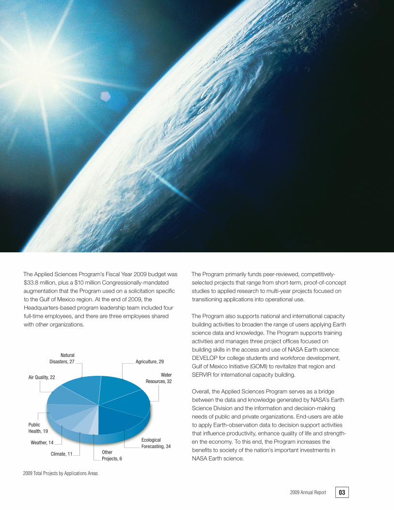
The Applied Sciences Program’s Fiscal Year 2009 budget was $33.8 million, plus a $10 million Congressionally-mandated augmentation that the Program used on a solicitation specific to the Gulf of Mexico region. At the end of 2009, the Headquarters-based program leadership team included four full-time employees, and there are three employees shared with other organizations.
The Program primarily funds peer-reviewed, competitively-selected projects that range from short-term, proof-of-concept studies to applied research to multi-year projects focused on transitioning applications into operational use.
The Program also supports national and international capacity building activities to broaden the range of users applying Earth science data and knowledge. The Program supports training activities and manages three project offices focused on building skills in the access and use of NASA Earth science: DEVELOP for college students and workforce development, Gulf of Mexico Initiative (GOMI) to revitalize that region and SERVIR for international capacity building.
Overall, the Applied Sciences Program serves as a bridge between the data and knowledge generated by NASA’s Earth Science Division and the information and decision-making needs of public and private organizations. End-users are able to apply Earth-observation data to decision support activities that influence productivity, enhance quality of life and strength-en the economy. To this end, the Program increases the benefits to society of the nation’s important investments in NASA Earth science.
Agriculture, 29
Air Quality, 22
Climate, 11
EcologicalForecasting, 34
NaturalDisasters, 27
PublicHealth, 19
WaterResources, 32
Weather, 14
OtherProjects, 6
2009.Total.Projects.by.Applications.Areas
032009.Annual.Report

In 2009, the Agriculture area made substantial progress in applying research and data to support enhanced crop produc-tion information. NASA satellite and modeling products are applied to support agriculture issues across a range of organiza-tions and groups, including the U.S. Department of Agriculture (USDA), National Oceanic and Atmospheric Administration (NOAA), U.S. Agency for International Development (USAID), and California Department of Food and Agriculture (CDFA). The area added 10 projects to its portfolio in 2009 and made major achievements and progress.
Accomplishments and MilestonesNASA.Lake.and.Reservoir.Products.Enable.USDA..to.Boost.Potential.Targets.to.More.Than.600.In 2009, an Agriculture area project reached an important milestone when Jason-2/Ocean Surface Topography Mission (OSTM) products went online, expanding the global lake and reservoir height products continuity and potential targets. The project, co-funded by the USDA, expanded Jason-2/OSTM application from current data sources to new international sensors that increase potential targets from 75 to more than 600.
The project integrated NASA Earth science products with historical data and the new sensors to produce enhanced data for the end-user community. The TOPography EXperiment (TOPEX) /Jason-2 lake and reservoir height products were developed, tested and operationalized; there is no other current data source for this information that meets the operational users’ needs.
Product users expanded in 2009 to include the intelligence community, ecology and natural resource information providers (e.g., Lakenet), water resource managers (e.g., Lake Victoria) and NASA missions for the validation of science products such as the Gravity Recovery and Climate Experiment (GRACE).
This project continues to be a world leader in decision support products with a primary focus on global food security. The variability observed within the lake level products also addresses elements of water management and disaster (flood and drought) monitoring, and all three applications are of national and global priority. Tests and plans are being developed for NASA’s Ice, Cloud and land Elevation Satellite (ICESat-2); Surface Water Ocean Topography (SWOT); and Deformation, Ecosystem Structure and Dynamics of Ice (DESDynl) missions. In addition, tests and plans are being developed for the European Space Agency (ESA) Sentinel, Centre National d’Études Spatiales (CNES) Jason-3 and Indian Space Research Organisation (ISRO) SARAL/ALtiKa projects.
APPLICATIONS
Agriculture
The.Agriculture.Applications.area.promotes.the.use.of.NASA.Earth.science.products.to.enhance.agriculture.management.and.policy.making.activities.that.help.decision.makers.manage.and.adapt.to.extreme.events,.such.as.droughts.and.floods,.and.adapt.to.the.environmental.impacts.of.climate.change.on.agriculture..The.Applications.area.focuses.on.agricultural.risk.assessment.and.forecasting,.water.management.and.disaster.monitoring,.and.global.food.security..
Real-time.soil.moisture.forecasts.are.used.as.indicators.for.agricultural.drought;.this.is.an.example.of.information.sent.to.NOAA.National.Centers.for.Environmental.Prediction.(NCEP).
2009 Portfolio Review
Applications Area Manager Bradley Doorn
Total Projects 29
NewProjectsStartedin2009 10
Key Partners USDA, USAID, NOAA
04 2009.Annual.Report
NASA Earth Science Division Applied.Sciences.Program
Earth.Science.Data.Greatly.Enhances..USDA.Foreign.Agricultural.Decision.Making.In 2009, the Global Agricultural Monitoring (GLAM) project successfully transitioned NASA Moderate Resolution Imaging Spectroradiometer (MODIS) data and products into an existing International Production Assessment Division (IPAD) Foreign Agricultural Service (FAS) decision support system (DSS). The project is nearing completion and reached a significant milestone to enhance agricultural monitoring and crop production forecast-ing capabilities using moderate resolution satellite data.
The joint NASA/USDA GLAM project establishes a data processing system that seamlessly integrates NASA Earth observation data, derived science products and analysis tools into the FAS DSS. GLAM began implementing a user-friendly system for integrating and analyzing MODIS data products in IPAD’s DSS, which is used to assess and predict sustainable agriculture. The project provides daily crop production information to more than 100 nations as well as responding to worldwide emergencies and disasters.
The USDA and other end-user communities have access to daily MODIS information that provides global assessments of food supplies as a result of project accomplishments to date.
NASA.Terrestrial.Observation.and.Prediction.System.Progress.Poised.to.Enhance.InsuranceVision.ForecastingAn Agricultural area project reached a milestone to integrate leading indicators of seasonal conditions affecting crop yields from the NASA Terrestrial Observation and Prediction System (TOPS) that enhance the InsuranceVision yield forecasting toolset.
In 2009, the USDA Risk Management Agency developed InsuranceVision in an effort to expand crop and livestock insurance programs. The InsuranceVision effort also provided training to inform producers of the potential insurance product benefits and other non-insurance methods for risk manage-ment. The project expects to complete in 2010, and information will be used to further enhance crop forecasting assessments
of insurance rates and to provide more accurate assessments of food supplies to support sustainable agriculture.
NASA coordinated with the USDA; MacDonald, Dettwiler, and Associates (MDA) Federal, Inc.; and AgriLogic to produce and composite all input data layers from TOPS and continued development of enhanced yield models using the Classification and Regression Trees analysis tools. In addition, MDA Federal extended InsuranceVision to include summary map displays of environmental changes.
Program ActivitiesThe Agriculture Applications area attended numerous meet-ings, committees and conferences across the country. Most prominently, the GLAM project was highlighted in a separate exhibition at the GEO Plenary and at an agriculture summit in Beijing. Other activities included the keynote address at an agriculture seminar in Canada.
Looking Ahead to 2010The Agriculture Applications area will continue applying sound global agriculture monitoring scientific data to agriculture risk assessment by including enhanced yield models for major food crops: winter wheat, corn and soybeans. The Agriculture Applications area will continue to apply data to global reservoir height monitoring by developing tests and plans for NASA’s ICESat-2, SWOT and DESDynl missions, as well as for the ESA Sentinel, CNES Jason-3 and ISRO SARAL/ALtiKA projects. In addition, the Applications area will integrate a Hedging and Mapping Tool into the InsuranceVision Online toolset and beta test the integrated framework.
The Agriculture Applications area will examine future Landsat Data Continuity Mission and Soil Moisture Active and Passive (SMAP) missions as major priorities in 2010. Furthermore, the integration of Land Surface Models to support global and domestic drought early warning will be advanced.
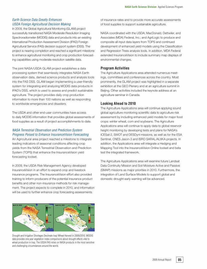
Drought.and.Irrigation.Shortages.Decimate.Iraqi.Wheat.Harvest.in.2009/2010..MODIS.data.provides.one.year.vegetation.index.comparisons.about.drought.effects.vital.to.wheat.production.in.Iraq..The.USDA.FAS.relies.on.NASA.products.in.the.most.sensitive.and.challenging.circumstances.around.the.world.
052009.Annual.Report
NASA Earth Science Division Applied.Sciences.Program

NASA’s Air Quality Applications area made substantial progress in 2009 to support the use of NASA Earth science in air quality management and policy making. Two projects completed final benchmark reports on the use of Earth observations for air quality planning and smoke emissions forecasting, and the program continued to be active within the air quality manage-ment community. The Air Quality area added 11 projects to its portfolio in 2009, doubling its total portfolio to 22 projects.
Accomplishments and MilestonesNASA.Data.Techniques.Incorporated.into.EPA.and..States’.Air.Quality.Systems.Improve.AccuracyAn Air Quality area project that completed in 2009 incorporated satellite data into models to enhance the simulation of the physical atmosphere in State Implementation Plan modeling processes. Benchmark runs under this project showed that incorporating the satellite data enhanced the model photolysis (molecule decomposition by light energy) rates and changed ozone levels in the model by up to 70 parts per billion (ppb). The prediction of criteria pollutants is significantly more accurate as a result of changes to the model.
Photochemical models are used to calculate pollutant concen-trations and assess outcomes of air quality policy. Techniques developed in this project for using satellite data to specify photolysis rates in photochemical models were incorporated into the EPA’s Community Multi-scale Air Quality (CMAQ) System and made part of the EPA’s official December 2008 release of the CMAQ System, version 4.7, to the air quality
community. In addition, the State of Texas incorporated the technique into its Comprehensive Air-quality Model.
BlueSky.Emissions.Assessment.and.Air.Quality.Prediction.System.Model.Enhancements.Save.MoneyCompleted in 2009, this Air Quality area project enhanced information about fires and their associated air quality impact routinely used by smoke and fire managers and air quality agencies across the United States. The project team en-hanced and expanded the pre-existing BlueSky Framework, previously used by a limited group of smoke and fire manag-ers in the Pacific Northwest. The BlueSky Framework is a model-management system that promotes ease and flexibility in running independent models to simulate the cumulative impact of multiple fires.
The project markedly enhanced system reliability, provided major reductions in costs associated with preparing national-scale emission inventories and rapidly expanded the user community. The EPA effectively used the BlueSky Framework
APPLICATIONS
Air Quality
The.Air.Quality.Applications.area.promotes.innovative.uses.of.NASA.Earth.science.to.enhance.air.quality.management.and.policy.activities,.particularly.issues.associated.with.the.implementation.of.air.quality.standards,.policy.and.regulations.for.environmental,.economic.and.human.welfare..The.area.is.organized.around.themes.of.Air.Quality.planning,.forecasting,.compliance.and.emissions.inventories..
2009 Portfolio Review
Applications Area Manager Doreen Neil (Acting)
Total Projects 22
NewProjectsStartedin2009 11
Key Partners EPA, NOAA, NPS, USFS
Maximum.difference.in.ozone.concentration.between.two.model.runs.with.and.without.satellite.derived.photolysis.fields.show.significant.changes..Changes.are.due.to.better.specification.of.clouds.that.affect.photolysis.rates.and,.thereby,.ozone.production.
06 2009.Annual.Report
NASA Earth Science Division Applied.Sciences.Program

to prepare emission inventories for prescribed and wildland fires during the 2003–2008 National Emission Inventories (NEIs) and announced plans to continue using these systems in future NEIs. EPA’s 2002 NEI, with results comparable to those generated by the BlueSky systems, relied solely on ground-based fire reports and manual processing without satellite data and cost approximately $1 million. However, the 2003–2006 emission inventories were prepared using the BlueSky systems for less than $50,000, generating a cost savings of more than $950,000. These savings were repeated in the preparation of the 2006–2008 emission inventories.
Program ActivitiesThe Air Quality Applications area introduced a class of short-term feasibility studies to its portfolio in 2009. At year’s end, it pioneered the creation of an applied sciences team for air quality. In addition, the area built capacity and awareness of NASA Earth observations data within the air quality community. In 2009, the area completed 16 training modules on remote sensing, NASA Earth observations, atmospheric and air quality science, and uses in decision making. The area conducted another nine training sessions, including trainings at the American Meteorological Society (AMS), the EPA National Air Quality Conference, SERVIR-Central America and The World Bank.
Air Quality investigators gave the technical keynote address at the Air and Waste Management Association (A&WMA) annual meeting in 2009. The Air Quality area organized and wrote a paper in A&WMA’s special issue of EM Magazine on Monitoring and Modeling Needs of the 21st Century (October 2009). Air Quality Applications area leadership served on the Steering Committee for this issue. Doreen Neil was the primary author of “Satellite Observations for Detecting and Tracking Changes in Atmospheric Composition.”
The area continued its support of the international Task Force on Hemispheric Transport of Air Pollution under the auspices of the United Nations. In September 2009, the U.S. National Academy of Sciences published the report Global Sources of Local Pollution that highlighted recent advances in air pollution monitoring and modeling. The NASA Applied Sciences Program, EPA, NOAA and National Science Foundation (NSF) programs contributed to the report.
In 2009, the Air Quality Applications area and SERVIR reached a one-year milestone for the operation of the Mesoamerican Smog Blog, which provides timely information about air pollution and its sources in the region. The Mesoamerican Smog Blog issues daily reports based on satellite observations to help private organizations, governments and health officials monitor air quality and mitigate health impacts. Local professionals operate the Smog Blog, which enhances technical capacity building on ways to apply Earth observations.
Air Quality Applications area leadership and key project investiga-tors helped form a new international Air Quality Community of Practice (CoP) under the GEO. Following organized discussions at conferences in May and July and numerous online discussions, attendees held an organizing workshop at the GEO Plenary VI in November to become the formal GEO Air Quality CoP. The Air Quality Applications area and its partners were instrumental in laying the groundwork for this new CoP.
Looking Ahead to 2010The major initiative of the Air Quality Applications area for 2010 is the selection and formation of the new Air Quality Applied Sciences Team. The team will address specific applied research topics facing the air quality community and deliver near-term applications to support urgent air quality policy and management issues. In 2010, the Air Quality Applications area will hold interactive on-site and online training sessions that cover the basics of air quality remote sensing with an emphasis on how to use case studies and access, visualize and interpret satellite products.
The Air Quality Applications area will continue to engage air quality managers at their conferences to learn their major policy and management issues and to introduce them to NASA’s Earth science. The area also will exhibit and host sessions at A&WMA’s next annual meeting, and it may sponsor an exhibit at the 2010 World Clean Air Congress.
Finally, three projects are expected to complete in 2010. Beyond delivering their benchmarking final reports, project researchers will give demonstrations of their applications and how they are used within the user community, displaying the benefits of NASA’s Earth observations in air quality decision making.
The.trajectory.forecast.animation.plots.latest.available.daily.MODIS.aerosol.optical.depth.(in.color.spectrum),.daily.MODIS.cloud.optical.thickness.(in.gray.contours),.animated.48-hour.air.parcel.trajectory.forecast.(in.magenta-white.colors),.and.3-hr.accumulated.precipitation.(in.yellow)..This.product.is.popular.with.the.air.quality.forecast.community.because.there.are.few.tools.for.forecasting.particulate.matter.(PM).2.5.
072009.Annual.Report
NASA Earth Science Division Applied.Sciences.Program

The Climate Applications area added significant breadth and substance in 2009, tripling the size of the portfolio by adding eight projects. Several maturing projects reached important milestones. Applied Sciences began a new climate adapta-tion effort for NASA Centers and initiated a new Climate Policy Speakers Series at NASA Headquarters.
Accomplishments and MilestonesNASA.Earth-Sun.Systems.Data.and.Modeling.Results.Enhance.Renewable.Energy.Planning.and.AssessmentIn 2009, the Solar and Wind Energy Resource Assessment (SWERA) project added global climate data and wind power assessments for 11 countries, solar power assessments for three countries and small hydropower assessments for two countries to the SWERA database. The interactive Renewable energy Resource EXplorer (RREX) continued to evolve through the release of the hydropower prototype, Web data and mapping services and Google-compatible Keyhole Markup Language files. This effort complements the distribu-tion of the geographic information system (GIS) data and maps from the SWERA database.
The SWERA decision support system composed of the RREX interactive viewer, Web services and SWERA database, now serves the needs of renewable energy users with all levels of technical expertise.
NASA.Earth.Science.Products.Enhance.Accuracy..of.Natural.Gas.Load.ForecastsIn 2009, a Climate applications project enhanced the accuracy of next day natural gas load forecasts on a monthly basis by up to 4.3 percent. Utility companies use load forecasts to plan the purchase of gas and electricity, as well as gas storage. Utility companies rely on load forecast models so they can anticipate demand for energy in order to dispatch natural gas and to balance load on the electric grid. Better load forecasts allow natural gas utilities to plan more precisely in the short term (one to 10 days). This project is demonstrating possible enhance-ments in short-term utility load forecast by adding NASA weather parameters to existing load forecast tools and implementing operational testing at selected utilities compa-nies (gas and electric). Area researchers are working with utilities companies in four states (Gas—New York, Washington and Electric—Maryland, Arizona).
Model.estimates.of.monthly.average.daily.total.radiation.using.inputs.derived.from.satellite.and.surface.observations.of.cloud.cover,.aerosol.optical.depth,.precipitable.water.vapor,.albedo,.atmospheric.pressure.and.ozone.sampled.at.a.40.km.resolution..Reduced.error.relates.to.improved.accuracy.of.forecasts.
APPLICATIONS
Climate
The.Climate.Applications.area.promotes.the.use.of.NASA.Earth.science.to.support.assessments,.policy.analyses.and.implementation.approaches.the.nation.will.consider.in.its.planning.and.response.to.climate.and.global.environmental.change..The.Climate.Applications.area.primarily.focuses.on.climate.policy,.adaptation.and.mitigation,.carbon.management.and.energy.management,.to.include.forecasting,.planning.and.assessments.
2009 Portfolio Review
Applications Area Manager Richard Eckman (Acting)
Total Projects 11
NewProjectsStartedin2009 8
Key Partners EPA, USGS, UNEP, DoE, ASHRAE, private sector companies
08 2009.Annual.Report
NASA Earth Science Division Applied.Sciences.Program

During the next two years, this project will transition NASA resources for sustained use in a variety of utility load forecast-ing tools nationwide.
Program ActivitiesThe Climate Applications area conducted additional activities that support overall awareness and use of Earth science for climate policy and adaptation. In July 2009, the Climate Applications area, NASA Earth Science Division (ESD) and the NASA Office of Infrastructure conducted a workshop to address climate impacts and adaptation issues for NASA Centers, addressing geographic and functional topics for NASA facilities. As 2009 closed, ESD finalized an internal NASA solicitation to form a climate adaptation science and applications team. This team will provide information and support operational managers at NASA Centers with their long-term planning.
In 2009, the Climate area initiated a new Climate Speaker Series at NASA Headquarters. This series is designed to help the NASA Headquarters community learn about issues involving climate and global changes, especially perspectives from policy, economic, national security and industry leaders. Dr. Molly Macauley of Resources for the Future gave the inaugural address on carbon offsets and their role in climate policy.
The Climate area supported a special town hall session on energy management topics at the American Geophysical Union’s Fall Meeting. This session featured speakers from the Department of Energy (DoE), NOAA, NASA and Iberdrola, a wind-energy company.
Looking Ahead to 2010The Climate Applications area has several activities planned for 2010 and significant potential to promote the use of NASA Earth science. The Climate area is supporting an ESD-wide solicitation on ecological forecasting, climate and land-man-agement strategies.
The Climate area anticipates adding projects from the Research Opportunities in Space and Earth Science (ROSES)-09 Gulf of Mexico solicitation to its portfolio. There also will be climate adaptation applications from the internal solicitation to form the basis for a NASA Climate Change Adaptation Science Team.
The area plans to increase involvement in interagency commit-tees and activities regarding climate adaptation, including national and regional assessments. The area will continue the Climate Speaker Series, hosting more speakers from a variety of perspectives on climate policy.
Finally, the SWERA project is due to complete its work in 2010 and document the use, transition and benefits that it has enabled.
Inclusion.of.NASA.weather.forecasts.(1ºx1º.daily.avg..temp.and.wind.speed).in.gas..utility.load.forecast.models.increased.load.forecast.accuracy.and.reduced.Mean.Absolute.Percent.Error.for.service.areas.in.(a).New.York.(b).Pennsylvania.
092009.Annual.Report
NASA Earth Science Division Applied.Sciences.Program

In 2009, the Ecological Forecasting Applications area made substantial progress in applying research data products and models to a variety of projects that predict species locations and, in some cases, how many individuals there are. Observations and models are typically used together to generate products decision makers use in a variety of fields. End-users with USAID, U.S. National Park Service (NPS), U.S. Forest Service (USFS), U.S. Fish and Wildlife Service (FWS), NOAA, U.S. Geological Survey (USGS), U.N. Food and Agriculture Organization (FAO), USDA, non-governmental organizations and private organizations apply these results. The Ecological Forecasting area added five projects to its portfolio this year.
Accomplishments and MilestonesNASA.Satellite.Data.Beneficial.for.Fishery.Management.This nearly completed, multi-year Ecological Forecasting project uses NASA remote sensing, modeling and data integration to enhance management of the Peruvian anchoveta fishery, the world’s largest fishery. In 2009, the project reached a milestone by enhancing decision support system monitoring and tracking of the Peruvian anchoveta fish populations, leading to better forecasts to guide management. End-users now have better tools to forecast fish biomass and distribution during El Niño events.
Based on Peruvian fishery managers’ requests, project partners established a website to provide monthly summaries
of regional satellite-derived parameters. In addition, using model simulations developed for use in the decision support system, fishery managers are able to forecast population fluctuations nine months out so as not to overfish populations.
NASA Earth observation data is affecting the behavior of Peruvian anchevota fishing in positive ways to maintain fishing populations and sustain the economy.
NASA.Science.Used.to.Enhance.National.Park..Service.Resource.ManagementThis multi-year Ecological Forecasting project uses NASA scientific data to assess and monitor the impact of climate change on U.S. National Park ecosystems. In 2009, the project reached a milestone in integrating NASA climate change modeling information and other data sources into the NPS decision-making system. NASA worked with park
APPLICATIONS
Ecological Forecasting
The.Ecological.Forecasting.Applications.area.promotes.the.use.of.NASA.Earth.science.to.predict.the.impacts.of.environmental.change.on.ecosystems.and.their.components.to.aid.in.decision.making..The.Ecological.Forecasting.Applications.area.primarily.focuses.on.the.themes.of.conservation.biology,.natural.resource.management.and.sustainable.international.development.
2009 Portfolio Review
Applications Area Manager Woody Turner
Total Projects 34
NewProjectsStartedin2009 5
Key Partners USAID, NPS, USFS, FWS, NOAA, USGS, U.N. FAO, USDA, conservation organizations
The.NASA.TOPS.is.a.modeling.framework.that.integrates.satellite.and.surface.observations.with.climate.and.ecosystem.models.to.monitor.and.forecast..ecosystem.conditions..
10 2009.Annual.Report
NASA Earth Science Division Applied.Sciences.Program

managers to identify approximately 20 park health indicators derived from NASA and related data and models.
The NPS uses these products to evaluate and forecast the conditions of U.S. National Park ecosystems, thereby enhancing natural resource management within and surrounding the parks. Throughout the next several years, with continued observed changes and land practices, it is likely land use will also change. NASA data and models are being used to ensure parks are staying healthy and to protect the environment.
NASA.Satellite.Imagery.Used.to.Help.Fight..Wildfires.in.117.CountriesThe NASA Fire Information for Resource Management System (FIRMS) project provides a wide range of users near real-time MODIS satellite imagery information on wildfires in easy-to-use formats. In 2009, the project reached a milestone with approximately 3,800 subscriptions from users in 117 countries using FIRMS to track fires. The project also made significant progress on the final transition to FAO.
NASA tracks information for managers and makes it available through online devices. Conservation managers and fire fighters around the world use the FIRMS database to respond to fires, and information is also accessible to the general public. Information is distributed to “subscribed” users via email and mobile phone text messages, and a variety of related informa-tion is available on the FIRMS website.
Program ActivitiesThe Ecological Forecasting area is a major supporter and co-lead for the Group on Earth Observations Biodiversity Observation Network (GEO BON), a global “network of networks” focused on increasing coordination among existing biodiversity observation networks. The Applications area
presented on GEO BON at the NSF’s NEON Federal Agency Meeting, participated on the interim Steering Committee for the Department of Interior’s National Climate Change and Wildlife Science Center, and participated in GEO BON’s initial Steering Committee meetings.
The area also participated in the Biodiversity and Ecological Forecasting Team Meeting, participated in the Congo Basin Forest Partnership Roundtable on Capitol Hill, and participated in two Hyperspectral Infrared Imager Science Workshops.
Looking Ahead to 2010In 2010, the Ecological Forecasting Application area is partnering with USGS, FWS, NPS, the Smithsonian Institution and NASA Earth Science Division’s Research and Analysis Program in a joint solicitation that will include applications activities under the topic of Climate and Biological Response. Funded projects will combine airborne and satellite remote sensing observations with in-situ observations and climate and ecological models. The purpose is to understand the impacts of climate variability and change on 1) species distribution and abundance and 2) ecosystem integrity and connectivity in support of natural resource and land manage-ment. Under this solicitation, partner agency representatives’ participation is required for organizations hosting projects that apply forecasting tools. Agency representatives are also required to submit their plans and a schedule for the transi-tion of forecasting tools to the host agency.
The.FIRMS.notifies.resource.managers.of.fires.in.their.area-of-interest.and.provides.maps.of.fire.locations..This.image.shows.a.weekly.fire.email.alert.for.southeast.Austra-lia.for.March.22–28,.2010..
112009.Annual.Report
NASA Earth Science Division Applied.Sciences.Program

In 2009, the Natural Disasters Applications area made important achievements and progress toward detection and monitoring of global large-scale landslides and floods, hazardous waste sites, levees management, and subsidence monitoring, as well as improving visualizations and enhanced decision making during emergencies. Natural Disasters applications specialists continued to collaborate with the Department of Homeland Security (DHS)/Federal Emergency Management Agency (FEMA), EPA, NOAA, USAID, USFS, USGS, the International Red Cross and other national and international disaster response organizations.
In 2009, the Natural Disasters Applications area added six new projects to its portfolio with topics addressing earth-quake detection, hurricane landfall probabilities, wildland fires and levee stability. Four projects are in continuation, and they include natural and technological hazards decision support systems, global landslide and flood monitoring, plume dispersion modeling and tsunami warning.
Accomplishments and MilestonesNASA’s.Global.Flood.and.Landslide.Monitoring.and.Prediction.System.Enhances.End-User.ForecastingThe Global Flood and Landslide Monitoring and Prediction System project, which is closely tied to the SERVIR project, uses satellite observations and models to better understand, monitor and forecast flood and landslide events.
In 2009, this project reached a milestone in providing real-time flood and landslide models routinely used by the International Red Cross and other national and international organizations to monitor global hazard events and plan mitigation strategies.
The goal is to develop a detection and prediction system that can be transferred to USAID and the Pacific Disaster Center for their operational use. Floods and the associated rainfall-driven landslides account for the largest number of natural disasters and affect more people annually than any other type of disaster. This project uses enhanced higher resolution flood model implementation, along with an enhanced landslide model under development, to generate better flood and landslide assessments.
APPLICATIONS
Natural Disasters
The.Natural.Disasters.Applications.area.promotes.the.use.of.NASA.Earth.science.to.enhance.awareness,.knowledge.and.adoption.of.disaster.reduction.and.management.practices.using.remote.sensing.observations,.higher.level.derived.data.products.and.modeling.and.analysis..The.Applications.area.focuses.on.forecasting,.mitigation.and.response.to.natural.disasters.
Areas.of.flooding.are.identified.using.TRMM.satellite.precipitation.data,.other.satellite.information.and.global.hydrological.models..Global.flood.and.landslide.models.implemented.using.real-time.detections.are.routinely.available..This.is.the.first.such.system.in.existence.that.has.allowed.near.instantaneous.information.on.event.locations,.severity,.and.more,.by.user.organizations.
2009 Portfolio Review
Applications Area Manager Michael Goodman
Total Projects 27
NewProjectsStartedin2009 6
Key Partners DHS/FEMA, EPA, DoE, International Red Cross, NOAA, USFS, USGS
12 2009.Annual.Report
NASA Earth Science Division Applied.Sciences.Program

NASA.and.Partners.Transfer.Capabilities.to..Support.Wildfire.ResponseThe Wildfire Research and Applications Partnership (WRAP) project participants are actively transferring real-time data, telemetry, sensor systems and the procurement of new manned aircraft asset capabilities matured under the project to opera-tions, further supporting the nation with disaster response.
Nearing completion in 2009, the WRAP project transferred NASA sensor data-communications and telemetry technol-ogy onto two National Infrared Operations aircraft the USFS operationalized. In addition, WRAP operationalized the NASA-developed Collaborative Decision Environment, real-time, decision support tool used in the National Incident Command Center and on the USFS Active Fire Maps website. The team deployed the USFS leading small Unmanned Aircraft System (UAS) wildfire imaging standards. They also developed UAS as a radio repeater to support remote firefighter communications.
The project goal is to enhance existing capabilities and models employed by the National Interagency Command Center and the Incident Command Structure, who are responsible for day-to-day wildfire management and suppression.
The WRAP project is a collaborative effort between NASA, the USFS/National Interagency Fire Center and California Department of Forestry and Fire Detection to explore, develop, mature, demonstrate and operationalize NASA data, models and technologies to enhance wildfire observations and management practices in the U.S.
The WRAP project enhances those response capabilities by using technologies that are more temporally, spatially and spectrally responsive to the real-time needs of disaster managers. The capabilities have cross-cutting applications to other disaster events.
Decision.Support.Tool.Increases.Access.to.Systems.Supporting.Natural.Disaster.ResponseUnder a Natural Disasters applications project, the EPA uses NASA products to monitor interactions between populations and hazardous waste sites. In the event of an emergency, managers need to determine the availability of assets for acquiring and analyzing remotely sensed imagery. NASA satellite imaging is used to rapidly collect information over broad areas. NASA has numerous assets providing useful data in the event of a disaster if the disaster lies within the asset’s field of view.
In 2009, this project reached a milestone in developing a three-pronged, hazard-related spatial decision support system that uses remote sensing and GIS data. The project developed
and delivered a beta system to FEMA for use in identifying available spaceborne assets in hazard response.
The system includes Remote Sensing Hazard Guidance that identifies spaceborne remote sensing assets available prior to and/or during a natural or technological disaster; a Spatial Modeling of Human Risk and Vulnerability to provide guidance on appropriate methodologies for conducting all-hazards vulnerability assessments; and a Remote Sensing-assisted Hazardous Waste Site Decision Support System for monitoring hundreds of hazardous waste sites in the U.S. and worldwide.
Program ActivitiesThe Natural Disasters Applications area continued supporting interagency cooperation and communication. The Applications area continued as a member of the Office of Science and Technology Policy’s Subcommittee on Disaster Reduction and as a member of the National Academy of Sciences Disaster Roundtable. The Applications area also participated in a workshop on “Cascading Disasters: How Disasters Unfold” (February 2009) and the Disaster Roundtable Retreat (October 2009). The two venues pro-vided opportunities for dialogue between NASA and other federal, state and local agencies; academia; and the busi-ness community.
Looking Ahead to 2010The Natural Disasters Applications area is developing a NASA Natural Disasters Plan that will identify NASA satellites, aircraft and surface instruments and models and decision support systems that can be deployed to monitor and assess a disaster as it unfolds. NASA cooperates with the Department of Defense (DoD), DHS, FEMA, USGS, NOAA, DoE, USFS, EPA, U.N. and other foreign national agencies and non-governmental organiza-tions, depending upon the scope and location of the event. A full suite of disaster types will be addressed, including wildland fires, earthquakes, tsunamis, volcanoes, floods, landslide and debris flows, hurricanes, coastal inundation, severe storms, winter storms, technological disasters, human health and other events.
132009.Annual.Report
NASA Earth Science Division Applied.Sciences.Program
In 2009, the Public Health Applications area made significant progress in supporting the Centers for Disease Control and Prevention (CDC)’s use of Earth observation data. Observations gathered by researchers are being applied across a myriad of organizations, including but not limited to, USAID, USDA, the World Health Organization (WHO), the U.S. Coast Guard (USCG) and DoD. The Public Health area added 10 projects to its portfolio this year.
The CDC launched its Environmental Public Health Tracking Network (EPHTN) on July 6, 2009. The EPHTN identified the NASA Public Health applications team as a primary partner, and the team has provided remotely-sensed observations and products as part of the information being distributed to the public.
Accomplishments and MilestonesNASA.Data.Enhances.CDC..Network.for.Public.Health.Tracking.In 2009, a Public Health project added raster and tabular data to ingest modeled Earth observation outputs into New Mexico’s EPHTN (part of the broader CDC EPHTN). The area also developed a monthly inventory of changing dust source patterns using 16-day Normalized Difference Vegetation Index (NDVI) products derived from MODIS. The system enhance-ments provide epidemiologists with Web-enabled statistical and analytical tools for tracking human exposures to contami-nants and air quality episodes and for assessing health outcomes on a daily, monthly, annual or longer timeframe.
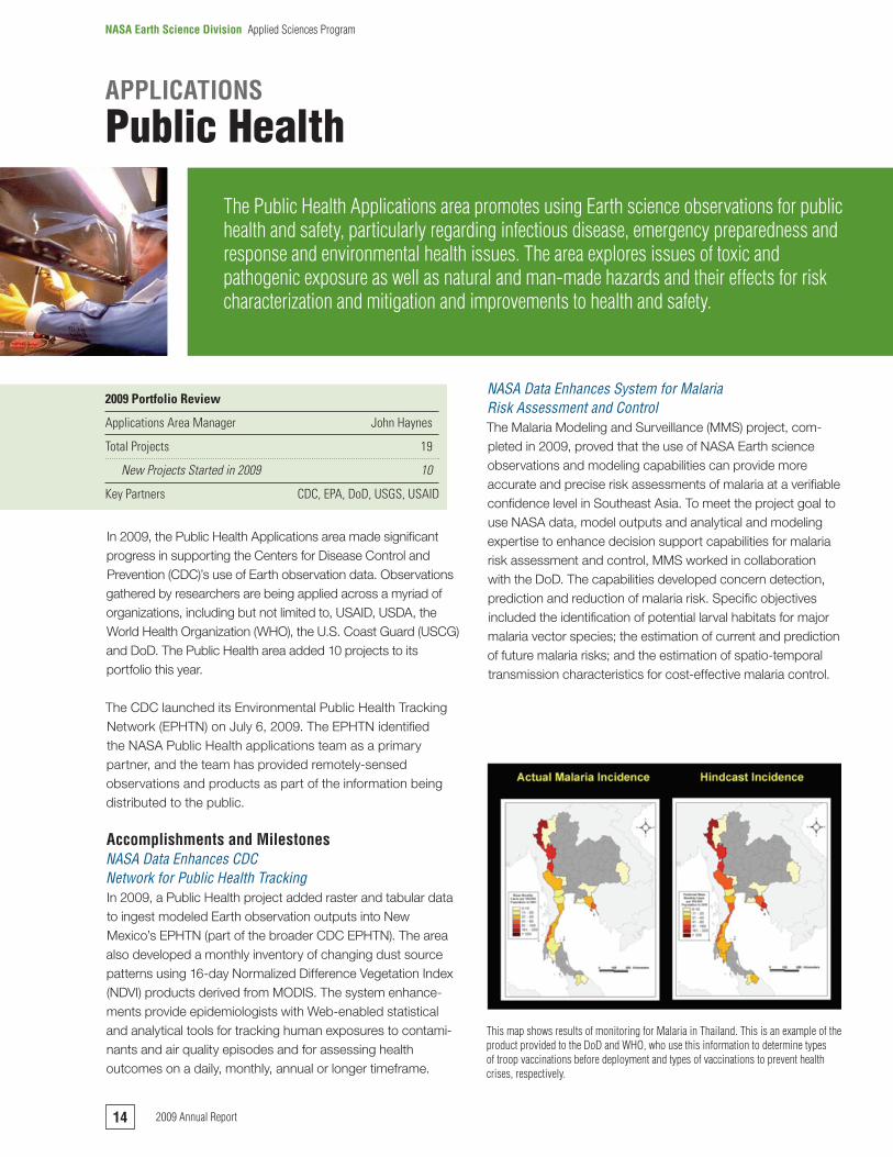
NASA.Data.Enhances.System.for.Malaria..Risk.Assessment.and.Control.The Malaria Modeling and Surveillance (MMS) project, com-pleted in 2009, proved that the use of NASA Earth science observations and modeling capabilities can provide more accurate and precise risk assessments of malaria at a verifiable confidence level in Southeast Asia. To meet the project goal to use NASA data, model outputs and analytical and modeling expertise to enhance decision support capabilities for malaria risk assessment and control, MMS worked in collaboration with the DoD. The capabilities developed concern detection, prediction and reduction of malaria risk. Specific objectives included the identification of potential larval habitats for major malaria vector species; the estimation of current and prediction of future malaria risks; and the estimation of spatio-temporal transmission characteristics for cost-effective malaria control.
APPLICATIONS
Public Health
The.Public.Health.Applications.area.promotes.using.Earth.science.observations.for.public.health.and.safety,.particularly.regarding.infectious.disease,.emergency.preparedness.and.response.and.environmental.health.issues..The.area.explores.issues.of.toxic.and.pathogenic.exposure.as.well.as.natural.and.man-made.hazards.and.their.effects.for.risk.characterization.and.mitigation.and.improvements.to.health.and.safety.
2009 Portfolio Review
Applications Area Manager John Haynes
Total Projects 19
NewProjectsStartedin2009 10
Key Partners CDC, EPA, DoD, USGS, USAID
This.map.shows.results.of.monitoring.for.Malaria.in.Thailand..This.is.an.example.of.the.product.provided.to.the.DoD.and.WHO,.who.use.this.information.to.determine.types.of.troop.vaccinations.before.deployment.and.types.of.vaccinations.to.prevent.health.crises,.respectively.
14 2009.Annual.Report
NASA Earth Science Division Applied.Sciences.Program

Earth.Science.Research.Enhances..Air.Quality.Health.Warnings.The Public Health Applications in Remote Sensing project, which concluded in 2009, enhanced performance of the Dust REgional Atmospheric Model (DREAM) system by assimilating data from NASA’s MODIS and the Shuttle Radar Topography Mission. DREAM forecasts dust patterns and concentrations by being nested within, and driven by, a National Weather Service (NWS) operational numerical weather forecast model. The investigators worked closely with state public health, environment and air quality offices which monitor air quality for public health conditions in the southwest United States.
Enhancements to DREAM from NASA Earth science research indicated that while there are lags in the model’s timing and dust concentration averaging, there are promising results from enhanced model runs, which indicate that NASA data replacements enhance dust episode forecasting in two out of three cases. A computer-based decision support system integrated NASA dust storm predictions for use by public health officials. Ultimately, the enhanced system could allow health officials to issue early warnings to populations at risk for dust-related health complications.
Program ActivitiesThe Public Health Applications area hosted the 2009 NASA Public Health Applications Annual Review in Savannah, Ga., which had more than 20 papers presented from past and present public health partners and principal investigators. The Applications area also presented papers/posters at the American Public Health Association, American Society of Tropical Medicine and Hygiene, American Thoracic Society and other public health events.
Looking Ahead to 2010Looking ahead to 2010, the Public Health Applications area will continue to collaborate with organizations to define the impact of climate change on public health and integrate NASA research into Public Health Information/Tracking Networks. The collaborative efforts will continue to enhance disease outbreak and environmental risk predictions, ultimately increasing the public’s warning time. These efforts include continued work with the CDC on a climate change module to the EPHTN.
The Applications area also is exploring the issuance of joint solicitations with other organizations such as CDC, National Institutes of Health and NOAA. The Applications area expects major results from its work on enhancing the decision support capabilities concerning avian influenza risks and pandemic early warning at the DoD. Additionally, the program expects to receive findings from its feasibility study with Columbia University and the WHO on meningitis risks in the African Sahel. This study supports a key GEO Health task.
Daily.48-hour.dust.forecasts.are.available.on.a.website.(http://nmtracking.unm.edu).linked.with.the.New.Mexico.Department.of.Health.Environmental.Public.Health.Tracking.web.portal..Data.is.then.made.available.to.the.national.EPHTN..Experimental.dust.advisories.are.being.issued.at.the.request.of.the.Albuquerque.Public.Schools.and..the.NM.Department.of.Health.
152009.Annual.Report
NASA Earth Science Division Applied.Sciences.Program
In 2009, the Water Resources Applications area made substantial progress in applying NASA Earth observation satellite and modeling products to support issues across a range of agencies and groups including USDA, EPA, NOAA, USAID, Bureau of Reclamation and California Department of Water Resources (DWR). The Water Resources area added 11 projects to its portfolio in 2009.
Accomplishments and MilestonesNASA.Data.Incorporated.in.Hybrid.Drought..Indicator.Development.The U.S. Geological Survey Earth Resources and Observation Science Center, in collaboration with the National Drought Mitigation Center, reached a milestone in developing a hybrid drought indicator for the U.S. Drought Monitor. Known as the Vegetation Drought Response Index, this approach rapidly incorporates NASA satellite observations (primarily MODIS vegetation index data), climate data and biophysical indicators, meeting finer resolution and regional scale needs of the National Integrated Drought Information System.
NASA Goddard Space Flight Center (GSFC) provided pro-cessed and enhanced seasonal weather forecasts, as characterized by soil moisture deficits, from the NASA Global Modeling and Assimilation Office (GMAO) system. NASA data products and models are used in concert with USGS and NOAA operational observations for drought outlook. In addition, the University of Illinois continued enhancing GMAO
seasonal forecasts through innovative downscaling techniques, providing management data in useful formats.
The information allows end-users to have more spatially accurate drought monitoring resolution images to make conservation and agriculture assessments.
NASA.Land.Information.System.Replaces..Agricultural.Meteorological.ModelIn 2009, the Air Force Weather Agency adopted NASA’s Land Information System (LIS) software as their next generation, hydro-meteorological analysis system for operational use, replacing Agriculture Meteorology. This enhancement further builds on various groups, such as NOAA’s NCEP, earlier implementation of LIS for enhanced weather predictions.
The system’s successful implementation has created a need from other groups seeking to leverage the products and capabilities. Currently, the Water Resources area is supporting
APPLICATIONS
Water Resources
The.Water.Resources.Applications.area.promotes.the.routine.integration.of.NASA.Earth.science.into.water.resource.management.for.sustainable.use.of.water..The.Water.Resources.Applications.area.primarily.focuses.on.streamflow.and.flood.forecasting,.water.supply.and.irrigation,.drought,.water.quality.and.climate.impacts.on.water.resources.
2009 Portfolio Review
Applications Area Manager Bradley Doorn
Total Projects 32
NewProjectsStartedin2009 11
Key Partners USDA, DoI, USACE, DoD, USAID, DoS
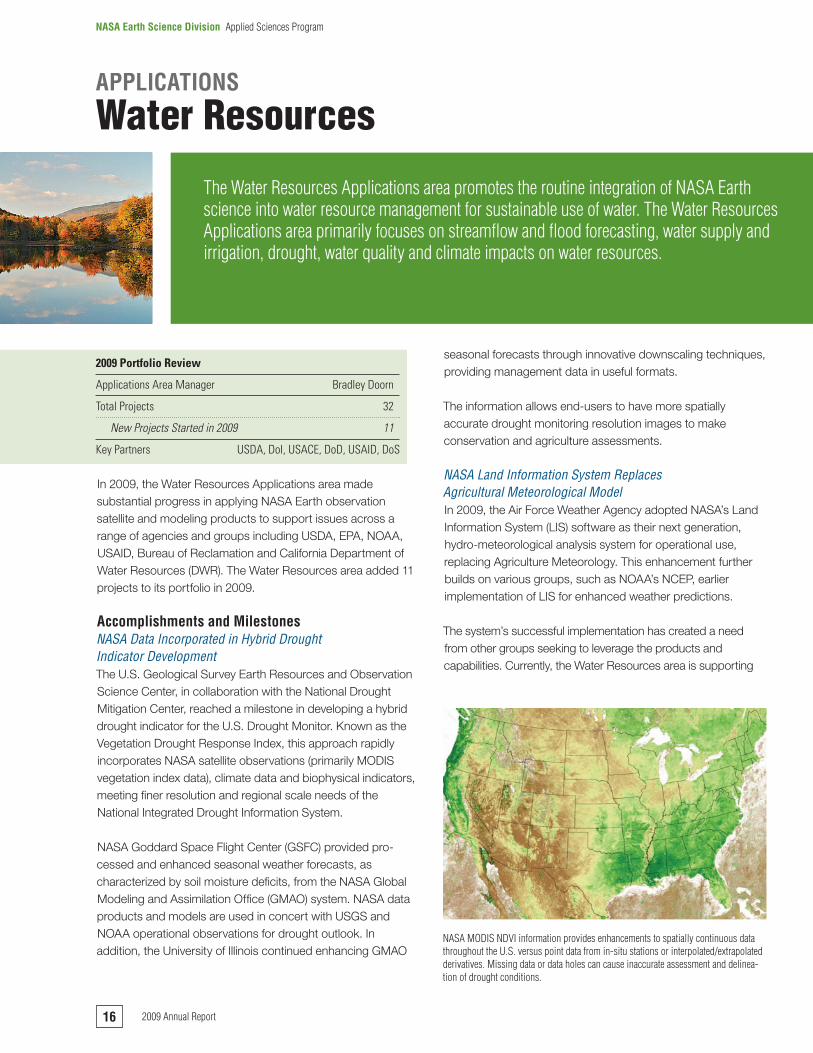
NASA.MODIS.NDVI.information.provides.enhancements.to.spatially.continuous.data.throughout.the.U.S..versus.point.data.from.in-situ.stations.or.interpolated/extrapolated.derivatives..Missing.data.or.data.holes.can.cause.inaccurate.assessment.and.delinea-tion.of.drought.conditions..
16 2009.Annual.Report
NASA Earth Science Division Applied.Sciences.Program

numerous projects building on LIS and related NASA research products, such as:
ÔÔ NOAA NWS National Operational Hydrologic Remote Sensing Center for North American distributed water and snowpack to 1 kilometer ÔÔ USAID Famine Early Warning System extending
from predominantly sub-Saharan Africa to many developing countriesÔÔ USAID-supported Middle East and North African water
data platform for regional water balance, along with regional aquifer and agriculture monitoringÔÔ USAID and DoS supported hydrological information
for the Nile BasinÔÔ NOAA NWS Office of Hydrology Development for
enhanced flash flood predictions and warnings using initialized snowpack and soil moisture.
The SMAP mission science definition team also is using the LIS to generate 1 kilometer land surface background conditions.
Program ActivitiesThe Water Resources Applications area supported NASA science and technology implementation to the U.S. DoS Water for the Poor Act. The application held USAID- and DoS-related workshops and projects using NASA science and technology to address water issues in the Middle East. The application also transferred NASA capabilities through GEO and USAID to be used for the Americas, and transferred the U.S. water activities to the U.N. Educational, Scientific and Cultural Organization (UNESCO) International Hydrology Programme Hydrology for Environment, Life and Policy.
The Water Resources Applications area also actively sup-ports numerous water working groups including the DoS Water Interagency Working Group; the U.S. interagency Advisory Committee on Water Information—Subcommittee on Hydrology; the Western Federal Agency Support Team;
and the Western States Water Council. The Water Resources Applications area, NOAA, UNESCO, GEO, CONIDA (Peruvian space agency) and Environment Canada held a successful Remote Sensing Tools for Water Management Workshop for the Americas and the Caribbean in Lima, Peru.
Looking Ahead to 20102010 will be an active year for the Water Resources applica-tions with five projects completing activities. The Water Resources Area is emphasizing both domestic and interna-tional water issues working with U.S. federal agencies including NOAA, USAID, Department of State, USDA, Bureau of Reclamation and EPA and state agencies, such as the California DWR. A key challenge is infusing NASA satellite products into decision support systems using advanced data sharing and distribution technologies. The approach will emphasize creative partnerships and technologies, such as emerging data assimilation and data integration techniques, to help solve and adapt to the myriad of water availability and quality issues facing our nation.
GRACE.terrestrial.water.storage.anomalies.are.assimilated.into.a.land.surface.model,.enabling.spatial,.temporal.and.vertical.decomposition..From.these.results.the.Applications.area.computes.GRACE-based.Drought.Indicators.expressed.in.percentiles.relative.to.their.historical.frequency.of.occurrence.
172009.Annual.Report
NASA Earth Science Division Applied.Sciences.Program
In 2009, the Weather Applications area made important achievements and progress toward transitioning NASA Earth science research to operations that enhance the safety and efficiency of the National Airspace System. The Weather Applications area actively participated in the NOAA Office of the Federal Coordinator for Meteorology Volcanic Ash and Space Weather Working Groups. The Applications area also conducted its annual joint weather program review with NOAA and the Federal Aviation Administration (FAA), and it added five projects to its portfolio this year.
Accomplishments and MilestonesNASA.Transitions.Cloud.Property.Applications..Data.to.Enhance.Air.Travel.EfficiencyNOAA NCEP operations accepted a NASA real-time cloud property project’s data for transition. The transitioning data is derived from MODIS, simulated Geostationary Operational Environmental Satellite-R and the Advanced Very High Resolution Radiometer (AVHRR), and is validated using Cloud-Aerosol Lidar and Infrared Pathfinder Satellite Observation (CALIPSO) and CloudSat data. This transition followed the successful completion of the NASA Langley Research Center (LaRC) and NOAA Earth Systems Research Laboratory joint project entitled, “Enhancement of Operational Aircraft Icing Forecasts and Diagnoses by Assimilation of Satellite Cloud/Surface Properties in the Rapid Update Cycle (RUC) and Weather Research and Forecasting High Resolution Rapid Refresh (HRRR) Models.”
The study showed the addition of the NASA data reduced moisture field errors in the operational models by as much as 80 percent and ceiling height errors by as much as 40 percent. Many small aircraft fatalities are attributed to in-flight icing and low visibility conditions. Each year the FAA attributes more than 70 percent of the delays in air traffic to adverse weather. The assimilation of NASA cloud property data into the NOAA NCEP RUC and HRRR models will save lives and directly enhance the efficiency of daily aircraft operations.
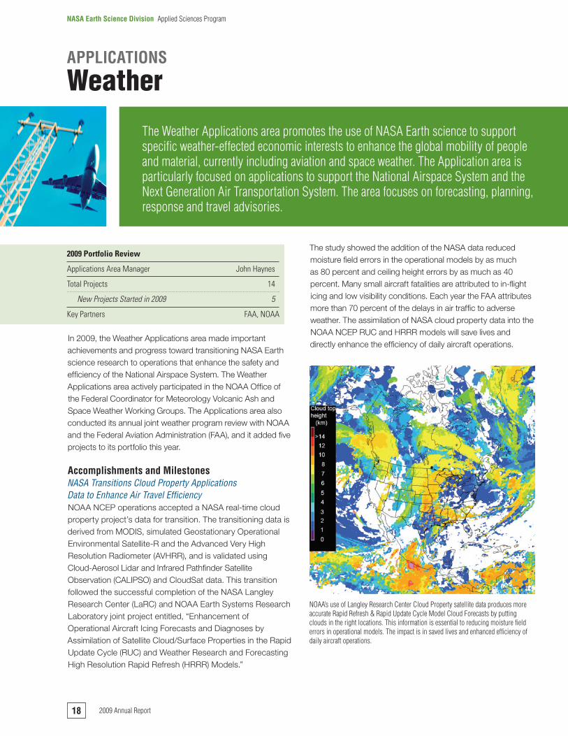
NOAA’s.use.of.Langley.Research.Center.Cloud.Property.satellite.data.produces.more.accurate.Rapid.Refresh.&.Rapid.Update.Cycle.Model.Cloud.Forecasts.by.putting.clouds.in.the.right.locations..This.information.is.essential.to.reducing.moisture.field.errors.in.operational.models..The.impact.is.in.saved.lives.and.enhanced.efficiency.of.daily.aircraft.operations.
APPLICATIONS
Weather
The.Weather.Applications.area.promotes.the.use.of.NASA.Earth.science.to.support.specific.weather-effected.economic.interests.to.enhance.the.global.mobility.of.people.and.material,.currently.including.aviation.and.space.weather..The.Application.area.is.particularly.focused.on.applications.to.support.the.National.Airspace.System.and.the.Next.Generation.Air.Transportation.System..The.area.focuses.on.forecasting,.planning,.response.and.travel.advisories.
2009 Portfolio Review
Applications Area Manager John Haynes
Total Projects 14
NewProjectsStartedin2009 5
Key Partners FAA, NOAA
18 2009.Annual.Report
NASA Earth Science Division Applied.Sciences.Program

NASA.Research.Sheds.Light.on.Air.France.Flight.447.Crash.In 2009, results from joint NASA and National Center for Atmospheric Research projects shed light on the loss of Air France Flight 447. Integrated results of four recent and active projects focused on the forecasting of oceanic convective weather and turbulence and demonstrated that these issues played a role in the loss of the aircraft. This information provides valuable insight on how to more safely route oceanic air traffic. National television and BBC radio highlighted the story. The four projects used satellite data to identify convec-tive clouds and forecast convective initiation, characterize oceanic storms, develop a global turbulence DSS for aviation and integrate the convective weather information needed to support NextGen.
Research.Validates.Data.that.Produces..More.Accurate.Volcanic.Ash.AdvisoryUnder a joint University of Maryland, Baltimore County and NASA GSFC project, researchers validated data that produced more accurate volcanic ash advisories during the March 23–24, 2009 eruption of Mount Redoubt, Alaska. The research results enhanced warnings that assisted the FAA in effectively restricting airspace around the volcano. NOAA’s Alaska Volcanic Ash Observatory used NASA Ozone Monitoring Instrument retrievals and validated volcanic ash tracers with CALIPSO data. The presence of ash in the atmosphere can cause damage to aircraft, windscreens and engines, making it necessary to reroute or delay flights to protect the aircraft and the safety of its passengers. This eruption had a major impact on airways in the Northwestern United States and Southwestern Canada. On the basis of the enhanced adviso-ries, 295 commercial flights were cancelled and more than 20,000 passengers were displaced, but there were no adverse encounters with the ash cloud.
Program ActivitiesThe Applications area hosted the NASA Weather Applications Annual Review in partnership with the FAA and NOAA in Boulder, Colo., which had more than 25 papers presented from past and present weather projects and principal investigators. The area also presented papers and posters at the AMS Annual Conference, American Geophysical Union, American Institute of Aeronautics and Astronautics and other weather and aviation events.
Looking Ahead to 2010As so many weather projects are transitioning their operations or nearing successful completion, the Weather area looks forward to awarding several additional weather projects during 2010. The Weather Applications area will continue to work with the FAA and NOAA on the realization of the NextGen Net-Enabled Weather System with significant NASA contribu-tions, particularly in regard to upcoming missions, including the National Polar-Orbiting Operational Environmental Satellite System Preparatory Project. The application will continue collaboration with other agencies to define the impact of aviation on climate change, including potential joint solicitations. The application will also explore expanding the area to other economic sectors as appropriate.
NASA.data.is.incorporated.into.volcanic.ash.advisories.which.improve.warning.systems.that.assist.the.FAA.to.effectively.restrict.air.space.during.eruptions.
192009.Annual.Report
NASA Earth Science Division Applied.Sciences.Program
In 2009, DEVELOP awarded more than 200 student intern-ships to support 45 projects. The following results are a few examples of how these projects benefited communities.
ÔÔ Great Lakes: A water resources analysis team used NASA Ocean Color Data Products to identify chlorophyll content. A coalition of U.S. and Canadian mayors and other officials applied research results to support the Great Lakes Water Resources Compact policy formulation process.ÔÔ Virginia: A climate change project team focused on
potential sea level rise to assist local government and real estate assessors to determine risk.ÔÔ Alabama: A public health project team identified likely Lyme
disease host habitats and disease symptoms that state government officials used for a health awareness campaign.ÔÔ California: An ecological forecasting project team
created a bark beetle infestation prediction map. The Western Ecological Research Center and the USGS used the maps in planning field campaigns.ÔÔ Maryland: An ecological forecasting project team
enhanced the Chesapeake Bay Program’s Hydrological Simulation Program Fortran Model that increased scientific accuracy.ÔÔ Alabama: A water resources project team produced a
nonpoint source pollution risk map for a regional water and sewer system organization.
In 2009, DEVELOP students presented outcomes of 24 projects at the American Society of Photogrammetry and Remote Sensing, American Geophysical Union, AMS, International Lyme and Associated Diseases Society, Southern Growth Policies Board and Council of State Governments conferences.
The June 2009 Photogrammetric Engineering and Remote Sensing (PE&RS) journal featured DEVELOP in an article titled “NASA Applied Sciences’ DEVELOP Program Fosters the Next Generation of Earth Remote Sensing Scientists.” The cover featured a Stennis Space Center DEVELOP team research project titled “Florida Water Resource Management: Monitoring Invasive Aquatic Vegetation in Lake Okeechobee, Florida using NDVI Derived from the MODIS Data Project.”
Looking Ahead to 2010In 2010, DEVELOP will expand to include NASA’s Wallops Flight Facility. DEVELOP will award 205 internships, and students will continue to present projects at scientific and local and regional government forums. Planned for 2010, a North Carolina Coastline Change project will analyze coastline change and assess NASA’s Earth satellite capabili-ties for measuring estuary shoreline change, vegetation succession and salt water inundation. Project partners will include the North Carolina Division of Coastal Management, United States Army Corps of Engineers and Virginia Institute of Marine Science.
More information on DEVELOP can be found at http://develop.larc.nasa.gov.
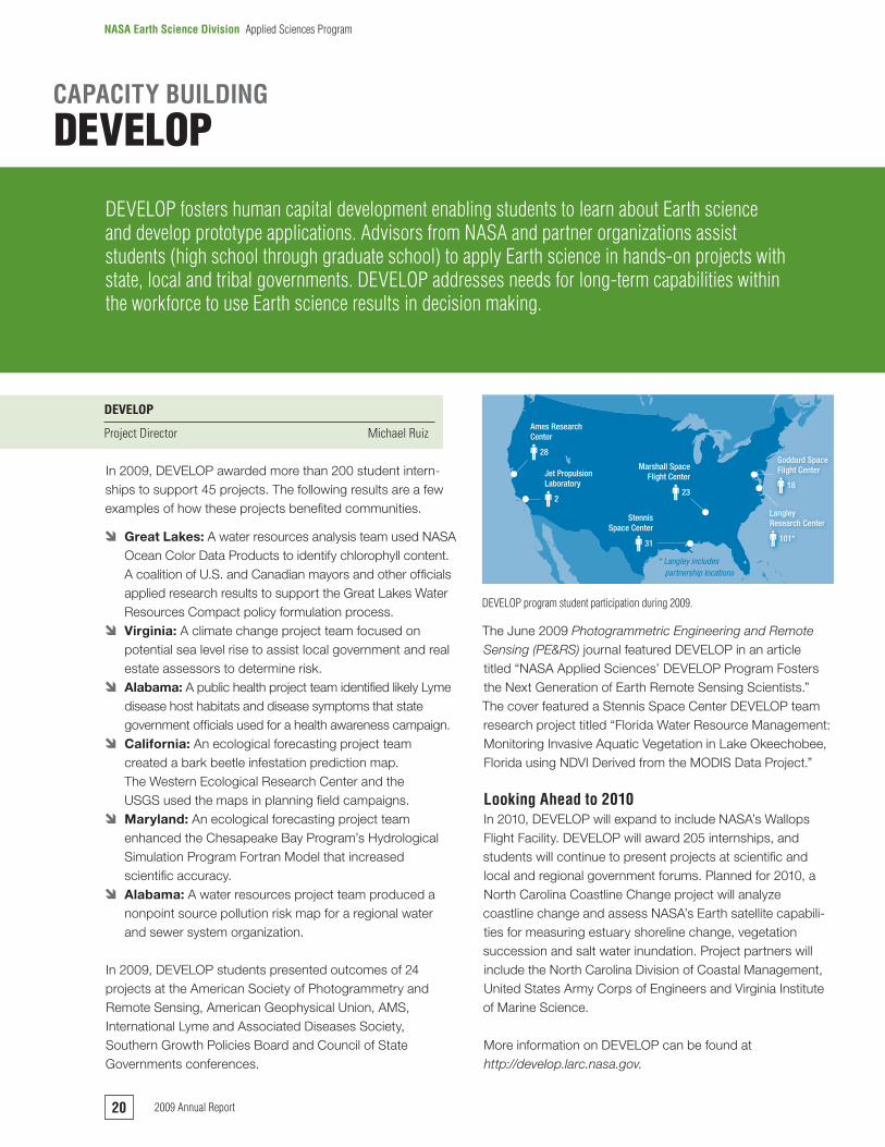
DEVELOP.program.student.participation.during.2009.
31
StennisSpace Center
23
Marshall SpaceFlight Center
18
Goddard SpaceFlight Center
28
Ames ResearchCenter
2
Jet PropulsionLaboratory
101*
LangleyResearch Center
* Langley includespartnership locations
CAPACITY BUILDING
DEVELOP
DEVELOP.fosters.human.capital.development.enabling.students.to.learn.about.Earth.science.and.develop.prototype.applications..Advisors.from.NASA.and.partner.organizations.assist.students.(high.school.through.graduate.school).to.apply.Earth.science.in.hands-on.projects.with.state,.local.and.tribal.governments..DEVELOP.addresses.needs.for.long-term.capabilities.within.the.workforce.to.use.Earth.science.results.in.decision.making..
DEVELOP
Project Director Michael Ruiz
20 2009.Annual.Report
NASA Earth Science Division Applied.Sciences.Program
In 2009, decision makers in Central America heavily used SERVIR products to allow for enhanced monitoring of air quality, biodiversity, changes in land cover and water quality to respond to extreme events. The project led the satellite data integration and mapping effort to address more than 10 natural disasters including wildfires, earthquakes, floods and landslides. In addition, the SERVIR technical team held a multi-country, regional air quality training workshop that integrated NASA and other datasets, as well as forecast models, to address air pollution and public health needs in Central America and the Caribbean.
In 2009, the SERVIR project expanded services to Africa with the opening of a facility at the Regional Center for Mapping of Resources for Development (RCMRD) in Kenya. SERVIR-East Africa’s initial focus is to establish a geospatial portal to provide searchable and viewable Earth observation data for the RCMRD’s 15 member nations in East Africa. To address key societal needs in the region, flood potential and flood forecasting models that integrate data from multiple NASA missions and sensors are being implemented in collaboration with NASA GSFC scientists.
Working with the MODIS Rapid Response team and the Dartmouth Flood Observatory, SERVIR applied algorithms to discriminate standing water from dry land and existing water bodies, thus developing an automated near real-time flood mapping product.
Both regional SERVIR facilities—at the Water Center for the Humid Tropics of Latin America and the Caribbean in Panama and RCMRD—have robust training programs to
build the capacity of people from each region to use the decision support tools and data sets the system offers. SERVIR scientists trained more than 300 people from 15 countries. The SERVIR project is closely aligned with the efforts of the GEO Capacity Building Committee.
Looking Ahead to 2010Plans are underway to assess expanding SERVIR to the Hindu Kush-Himalayan region in Asia to address key needs such as air quality and the impact of climate change on the glaciers in that region. In 2010, SERVIR also plans to increase attention toward climate impacts.
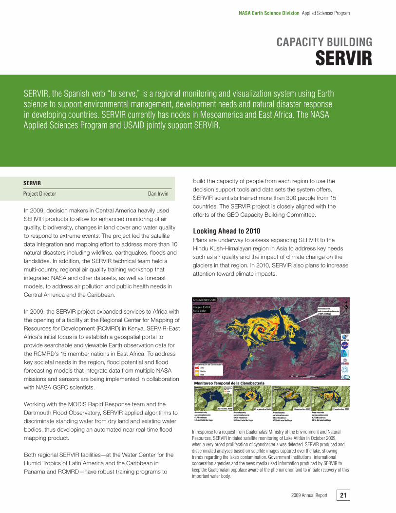
In.response.to.a.request.from.Guatemala’s.Ministry.of.the.Environment.and.Natural.Resources,.SERVIR.initiated.satellite.monitoring.of.Lake.Atitlán.in.October.2009,.when.a.very.broad.proliferation.of.cyanobacteria.was.detected..SERVIR.produced.and.disseminated.analyses.based.on.satellite.images.captured.over.the.lake,.showing.trends.regarding.the.lake’s.contamination..Government.institutions,.international.cooperation.agencies.and.the.news.media.used.information.produced.by.SERVIR.to.keep.the.Guatemalan.populace.aware.of.the.phenomenon.and.to.initiate.recovery.of.this.important.water.body.
CAPACITY BUILDING
SERVIR
SERVIR,.the.Spanish.verb.“to.serve,”.is.a.regional.monitoring.and.visualization.system.using.Earth.science.to.support.environmental.management,.development.needs.and.natural.disaster.response.in.developing.countries..SERVIR.currently.has.nodes.in.Mesoamerica.and.East.Africa..The.NASA.Applied.Sciences.Program.and.USAID.jointly.support.SERVIR.
SERVIR
Project Director Dan Irwin
212009.Annual.Report
NASA Earth Science Division Applied.Sciences.Program
The Applied Sciences Program’s Applied Science and Technology Project Office (ASTPO) manages the GOMI program, with the Stennis Space Center responsible for day-to-day project operations. The GOMI program develops practical applications of NASA Earth science observations and research through demonstration projects carried out in partnership with the Gulf of Mexico Alliance (GOMA).
In 2009, GOMI representatives helped create the GOMA Action Plan II. The five-year plan expands on partnerships developed under the first plan and establishes actions to enhance the health of coastal ecosystems and economies of the Gulf in ways that a single entity could not achieve.
Under the Action Plan, NASA and the Gulf Initiative developed an EcoWatch data catalog of Gulf of Mexico environmental and economic data, a sea level rise (SLR) decision support tool that dynamically calculates and visualizes SLR, a Comprehensive Gulf of Mexico Mapping Plan and a Gulf Regional Sediment Master Management Plan.
In May 2009, the Applied Sciences Program received 69 proposals and selected 35 for awards, totaling approximately $13 million in applications and applied science funding over the two-year life of projects. The projects are designed to aid the Gulf of Mexico region’s ability to recover from the devas-tating hurricanes of 2005 and to plan for a sustainable and prosperous future through the use of NASA Earth science observations and research.
In December 2009, the first NASA Applied Sciences Gulf Workshop was held in New Orleans. Approximately 75 attendees gathered to discuss priority issues facing the Gulf of Mexico, meet with NASA program sponsors, learn about Applied Sciences Program initiatives, hear from GOMA representatives and network with other Gulf of Mexico project leads. Participants discussed the use and application of NASA resources to monitor the Gulf region’s resiliency, habitats, water quality and ecosystems and nutrients in several breakout sessions. Conference planners learned from participants how to provide better support to enhance end-user communication and coordination, expand collabora-tion and data sharing efforts, provide more focus on local issues specific to the Gulf locations and enhance logistical issues associated with supporting the end-users community.
The December 2009 edition of the PE&RS journal featured a cover story and an article on the ASTPO and the GOMI.
Looking Ahead to 2010In 2010, the GOMI will continue executing the 35 ROSES projects already underway. The Applied Sciences Program will select and initiate an additional $5 million in projects focusing on climate, air quality, public health and agriculture issues in the Gulf region. The program also will host the second NASA Applied Sciences Gulf Workshop to expand on the themes and initiatives from 2009.
CAPACITY BUILDING
Gulf of Mexico Initiative
The.Gulf.of.Mexico.Initiative.organizes.NASA’s.efforts.to.support.the.five-state.Gulf.of.Mexico.Alliance,.which.is.increasing.regional.collaboration.to.enhance.the.ecological.and.economic.health.of.the.Gulf.of.Mexico.region..NASA’s.Gulf.of.Mexico.Initiative.promotes.efforts.to.build.skills.and.capabilities.in.the.region.to.use.NASA.Earth.science.to.support.Gulf.of.Mexico.Alliance.goals.
Gulf of Mexico Initiative
Project Director Anne Peek
22 2009.Annual.Report
NASA Earth Science Division Applied.Sciences.Program
In 2009, the Applied Sciences Program funded and sup-ported nine worldwide training activities. The Program reached 235 new and existing end-users of Earth science observation data in several countries, including applied science professionals, policy makers, researchers and air quality modelers and managers.
Training activities focused on providing quality instruction using adult learning techniques and unique approaches to educate decision makers around the world. The Program offered several blended-learning programs, such as face-to-face instruction with computer-mediated instruction, to enhance the end-user community’s access and application of Earth science observation tools. Training activities provided students with interactive, hands-on activities and case study analysis to deliver both online and classroom instruction.
Case studies analysis is applied during training sessions so attendees can learn about NASA data characteristics and interpretation and their application in decision making.
Training activities also included instructional modules to support Earth Science and Air Quality application activities. The 16 core modules and additional modules developed for the 2009 workshops are freely available to individuals and institutions wishing to learn about satellite remote sensing applications to decision making. Access the training modules and materials online at http://arset.gsfc.nasa.gov.
In 2009, some examples of training activities included:
ÔÔ A one-day Air Quality Remote Sensing training session held at the EPA’s 2009 National Air Quality Conference in
Dallas to increase end-users’ understanding of how to use NASA remote sensing tools to assist with air quality analysis and forecasting.ÔÔ A three-and-a-half day international, interdisciplinary Seven
South East Asian Studies Mission training session to study the interactions of air pollution with regional meteorology, particularly with clouds in South East Asia.ÔÔ An Air Quality Analysis in Central America training
course—conducted in Spanish—designed to increase knowledge and application of satellite information for air quality analysis.ÔÔ A one-day training session for World Bank employees
supporting or managing projects in Asia, Africa and Latin America.
At the completion of each workshop, end-user feedback reflected training activities increased participants’ level of understanding NASA data. Follow-up interactions with work-shop attendees also indicated an increased use of NASA observations as a result of workshop capacity building activities. The end-user community expressed interest in receiving additional training in using other Earth science observation tools.
Looking Ahead to 2010In 2010, the Applied Sciences Program is poised to host more decision-maker training workshops. The Program is working to expand the curriculum to allow participants to work closer with project scientists, explore options to provide weeklong training activities that focus on applying critical thinking to other specific Applications areas, develop interactive website case studies, and develop training modules for land products in coordination with Integrated Geospatial Education and Technology Training. The Program’s training activities continue to reach out and further enhance the end-user community’s knowledge and applica-tion of Earth science observation data.
CAPACITY BUILDING
Training Activities
The.Applied.Sciences.Program.conducts.professional-level.training.to.allow.users.to.better.understand.and.apply.Earth.science.to.their.topics.of.interest.and.regions.of.concern..The.Program.develops.training.modules.on.the.acquisition,.visualization,.analysis,.use.and.application.of.NASA.Earth.science..Current.efforts.have.focused.on.air.quality,.and.the.Program.plans.to.expand.to.other.Applications.areas..
Training Activities
Coordinators Ana Prados, Richard Kleidman
232009.Annual.Report
NASA Earth Science Division Applied.Sciences.Program
The Applied Sciences Program continued to be active in the GEO in 2009, participating in committees, tasks, initiatives and communities of practice. The Program’s staff is leading five of GEO’s 114 tasks for the 2009–2011 Workplan and supporting other tasks. Program staff led efforts to coordinate agricultural monitoring (Task AG-07-03a), identify user observation needs (Task US-09-01a), develop communities of practice (Task US-09-01b), determine socioeconomic benefits of Earth observations (US-09-02a) and formulate a GEO BON (Task BI-07-01a).
In 2009, the Program participated in the GEO User Interface Committee (UIC), which is one of four GEO Committees. The UIC engages a continuum of users in identifying observation needs and promoting uses of Earth observations by decision makers on national, regional and global scales. For the UIC, Program staff delivered an analysis of the user engagement component for each of the 114 GEO tasks. Program staff also initiated a unique Call for Proposals within GEO to identify projects in developing countries that could apply and benefit from the use of Earth observations. GEO received 136 proposals in 2009 in response; project selections will occur in 2010.
The Program continued to provide support and leadership for the GEO task addressing timely and accurate agricultural monitoring and assessment, especially to ensure world food security. The Program helped enable timely mobilization of international response in food aid through enhanced coordi-nated monitoring support, accurate forecasting of crop production shortfalls and development of early warning systems for famine. In 2009, this task delivered a draft version of the Production Area Yield Database and Web Apps System for data collection and testing.
The Program helped form two new GEO CoPs in 2009. These CoPs are self-organizing groups of people from broad
backgrounds and common interests for the provision, access and use of Earth observations. In 2009, Program staff helped organize a new Health CoP, which has a strong focus on infectious disease issues. This Health CoP held an organizing meeting in July and a workshop in November. Program staff helped form a new Air Quality CoP, holding special sessions at conferences in May and an organizing meeting at GEO Plenary VI in November. Many of the Program’s Air Quality project teams helped lay the groundwork for this new CoP.
For more information about GEO, visit: http://www.earthobservations.org.
Group on Earth Observations
The.Applied.Sciences.Program.contributes.to.the.international,.intergovernmental.GEO.organization.working.to.enhance.the.availability,.access.and.use.of.Earth.observations.to.benefit.society..Each.of.the.Program’s.Applications.area.projects.and.Capacity.Building.initiatives.are.applied.to.the.Global.Earth.Observation.System.of.Systems.to.provide.new.analytical.tools.and.access.to.timely.data.to.forecast.emerging.threats.
The.Applied.Sciences.Program’s.Ecological.Forecasting.Applications.area.is.a.major.supporter.and.leader.of.GEO.BON,.a.global.“network.of.networks”.designed.to.integrate.information.from.multiple.sources.to.support.biodiversity.tracking,.analysis.and.conservation..GEO.BON.will.enhance.the.ability.of.decision.makers.to.manage.biological.resources,.strengthen.the.capacity.of.scientists.to.monitor.and.analyze.biodiversity.and.observe.how.biodiversity.is.changing.over.time..
Activities.in.2009.focused.on.concept.development,.and.the.GEO.BON.team.met.major.milestones..Upon.formation.of.the.GEO.BON.Steering.Committee,.GEO.BON.leadership.decided.to.organize.around.eight.topical.themes..GEO.BON.will.also.be.composed.of.a.suite.of.regional.BONs..In.2010,.the.GEO.BON.Steering.Committee.plans.to.release.its.Implementation.Plan.on.Global.Biodiversity.Day,.May.22..
The.Applied.Sciences.Program.has.been.a.major.funder,.sponsor.and.organizer.of.GEO.BON..The.Program’s.Ecological.Forecast-ing.Applications.area.is.engaged.with.many.of.the.regional.BONs,.especially.the.Asia-Pacific.BON.which.is.the.largest.BON.
24 2009.Annual.Report
NASA Earth Science Division Applied.Sciences.Program

Ames Research Center (ARC)NASA ARC supports the Applied Sciences Program through the integration of Earth system modeling and tools, airborne science and systems engineering in operational decision making processes. ARC primarily supports the Ecological Forecasting and Natural Disasters Applications areas.
In 2009, ARC-based projects included support to the North American Carbon Program; ecological modeling applied to enhance understanding and forecasting conditions in the Appalachian National Scenic Trail region; stream temperature predictions; models to aid U.S. FWS; and support on decision making with regards to crop insurance.
In addition, an Ames project on wildfires initiated a feasibility study (in cooperation with the Airborne Science Program) to forge new and enhanced response support systems using NASA technology.
Goddard Space Flight Center (GSFC)NASA GSFC studies the Earth as an integrated system and provides data and products for public use. GSFC supported numerous projects across seven Applications areas, primarily supporting the Natural Disasters, Agriculture, Air Quality and Public Health Applications areas.
In 2009, GSFC-based agriculture projects used observations and land data assimilation techniques to detect drought in certain areas around the world. These results were used in USAID decision support systems to respond to famine early warning. Agriculture crop models assisted the USDA in commodity forecasting and sustainability studies throughout the world, and data was integrated with decision support activities to make better decisions about drought and crop predictions in the U.S. and West Africa.
Air quality projects monitored the effects of emissions and aerosol in the atmosphere and applied the results in EPA decision support systems. Similar information was monitored and applied to public health applications to allow the CDC to make better decisions about the effects of air quality on public health. GSFC also made strong contributions in developing vector-borne disease predictive tools for the South East Asia region.
Disaster management activities included application of satellite imagery and data products in national and interna-tional emergencies due to earthquakes, fires and floods.
Jet Propulsion Laboratory (JPL)NASA JPL contributions to the Applied Sciences Program leverages its science and data analysis efforts related to 10 JPL-led Earth science satellite missions and instruments as well as a number of related suborbital instruments (e.g., Uninhabited Aerial Vehicle Synthetic Aperture Radar (UAVSAR). JPL primarily supports air quality, natural disasters and weather projects.
In 2009, JPL researchers were involved in 13 specific applied science projects and helped organize three applications events. These events included a workshop for the NASA SMAP mission; a “California as Seen from Space: Delivering Actionable Science” symposium at Caltech’s Keck Institute for Space Studies; and a workshop on California Water Resources co-hosted by JPL, ARC and Marshall Space Flight Center (MSFC).
Key 2009 achievements include the development of Quick Scatterometer (QuikSCAT)-derived products for drought and flood monitoring that were delivered to NOAA’s National Drought Monitor Center and Advanced Hydrologic Prediction Service; the generation of a Multi-angle Imaging SpectroRadiometer (MISR)-derived, five-year smoke plume
Centers
NASA.has.10.field.Centers.located.across.the.country.that.support.all.NASA.space,.technology.and.sciences.missions..Located.at.each.Center.is.a.skilled,.diverse.group.of.scientists,.engineers,.managers.and.support.personnel.who.work.to.ensure.that.NASA.missions.are.executed.successfully..Several.of.the.Centers.play.an.active.role.in.the.day-to-day.support.of.the.Applied.Sciences.Program.and.applications.projects.
252009.Annual.Report
NASA Earth Science Division Applied.Sciences.Program

injection height climatology along with the ability to map MISR aerosol optical depths on the EPA CMAQ grid for use in air quality applications; and the start of a monitoring record for the Sacramento-San Joaquin Delta levees using the new UAVSAR radar.
Langley Research Center (LaRC)NASA LaRC primary supports of the Air Quality, Aviation and Climate Applications areas and manages DEVELOP. In 2009, LaRC’s CALIPSO mission developed a near real-time aerosol product continuously used in air quality forecasting by EPA and the Naval Research Lab. Langley researchers continued developing a human exposure model for radiation exposure in aircraft. FAA and NOAA have selected an operational status pathway to deliver this capability for airline crews and passengers. In addition, LaRC hosted the Prediction of Worldwide Energy Resource (POWER) project, funded under the Climate Applications area. This project takes data from a suite of satellites to evaluate the viability of renewable energy resources. LaRC launched the POWER program version 6.0 data designed to provide higher data resolution for planning renewable energy products.
In 2009, the DEVELOP training and mentoring program, managed out of LaRC, celebrated its 10 year anniversary. LaRC also continued its support of education and outreach activities at NASA’s 2009 Earth Day exhibit on the National Mall in Washington, D.C.
Also in 2009, LaRC continued to host an EPA liaison to support air quality activities. The Langley Distributed Active Archive Center implemented initial subsetting capabilities for the delivery of NASA data through the EPA Remote Sensing Information Gateway for use by EPA air quality decision makers and analysts. In addition, the Virginia Department of Environmental Quality co-located their Hampton Virginia air quality monitoring site with Langley’s Chemistry and Physics of the Atmospheric Boundary Layer Experiment to explore the relationship between satellite observations of air pollutants and surface observations.
Marshall Space Flight Center (MSFC)NASA MSFC primarily supports the Air Quality, Public Health and Weather Applications areas and manages SERVIR. In 2009, MSFC initiated a project on the use of Lightning Mapping Array to improve development of a realistic lightning NOx emission inventory for CMAQ model runs. Another project enhanced predictability of the timing, location and growth rate of convective initiation to enhance FAA tactical forecasts. Another project worked with state health officials to address integration of dust prediction systems and vegetation phenology to track pollen for asthma alerts.
In 2009, MSFC also supported a GOMA project by enhanc-ing a prototype decision support tool to enhance collabora-tion and decision making along the Gulf Coast. MSFC had key achievements with enhancing environmental public health tracking with satellite-driven particle exposure modeling and epidemiology; developing and implementing a climate change module for environmental public health tracking using remote sensing data; and linking NASA environmental data with a National Public Health Cohort Study to enhance public health decision making.
Stennis Space Center (SSC)NASA SSC manages the GOMI and supports the Agriculture, Water Resources and Ecological Forecasting Applications areas. The SSC Applied Science & Technology Project Office conducts projects that demonstrate ways NASA Earth science assets can assist local, state and federal decision makers. As of the NASA representative in GOMA, SSC participates in both managerial and technical working groups addressing key issues in the Gulf region.
In 2009, SSC conducted four pilot projects that addressed GOMA priority issues. SSC demonstrated how the Gulf States can use remote sensing to monitor water quality on a regional scale and better understand the impacts of urbanization and agricultural practices on the Gulf of Mexico. Two projects used satellite data to identify and monitor the health of high-priority ecosystems, such as Louisiana coastal marshes and forests dominated by live oak and bald cypress. State and federal partners use this information to study ecosystem dynamics, identify areas for focused conservation efforts and evaluate the effectiveness of conservation and restoration projects. SSC also used land-use/land-cover classification and change detection to identify the impacts of urbanization around Mobile Bay. The Mobile Bay National Estuary Program staff in Mobile and Baldwin Counties use this information to restore vital aquatic ecosystems and plan future development to minimize the impact on the environment.
In 2009, SSC released version 2.0 of the Coastal Online Assessment and Synthesis Tool open-source 3-D geobrowser and presented project results in seven conference papers at international conferences. In addition, the October 2009 issue of the PE&RS journal featured a cover story on a SSC-Forest Service collaboration to monitor all forests in the continental U.S.
26 2009.Annual.Report
NASA Earth Science Division Applied.Sciences.Program

Building on the progress made in 2009, we are enthusiastic for 2010 and beyond. In 2010, dozens of projects that began in 2005–2007 will conclude, providing additional examples of the value of Earth observations in decision making. We will focus on the transition process to increase the likelihood of sustained use by our partners after project funding ceases, which is a key challenge in applications-oriented, demonstration projects.
In 2010, we will evaluate and move toward revamping the Program’s performance measures and project tracking. For projects, we plan to use Web-based applications to support project team reporting and ease program-wide portfolio analysis. We will initiate development of meaningful metrics to assess the success of individual projects, portfolios and overall program performance. With attention toward outcomes, we will increase efforts to emphasize and substantiate quantifiable benefits from completed projects and the value of Earth observations. To support the community in building skills to compute benefits, we will conduct project impact analyses and host a workshop on techniques to quantify socioeconomic benefits for Earth science applications.
In our collaborations with partners, we will increase attention on jointly assessing key needs, sharing risks and addressing transitions of successful applications. We plan to emphasize more cost sharing of projects with partners, especially federal agency partners. For example, we will issue a joint solicitation with four federal agencies on the use of Earth science to craft practical land and resource management strategies in light of climate change impacts. In fact, we plan to focus greater attention on climate-related issues and applications across all parts of the Program.
We will increase efforts to involve the applications community in Earth science mission activities. We will support efforts to enable identification of applications early in mission life cycles and integrate end-user needs into future mission planning. Together with the Earth Science Division’s Flight Program, we will host an Earth Observing Missions applications workshop in 2010 to assess challenges and devise methods to engage the applications community better in mission planning.
In the coming years, we will continue to support applications projects as a primary approach. In 2010, we will begin soliciting proposals separately by individual Applications areas rather than one program-wide solicitation. We will sponsor applications specialists on mission science teams, such as the National Polar-Orbiting Operational Environmental Satellite System Preparatory Project and Aura Science Teams. The new Applied Sciences Team for Air Quality will develop a dynamic, team-based approach to address core applied research topics and deliver timely, near-term applications. We expect to form more teams for other Applications areas in the near future.
Today, many of the current operating satellite missions are beyond their original design life. While many are operating well, we may face a significant challenge to encourage users to incorporate observations from the older satellites into their decision-mak-ing activities. In 2010, we will continue efforts with space agencies and international organizations, such as GEO, to promote access to Earth science data. These efforts should help domestic users continue to use some satellite observations and smooth transitions to future NASA missions.
Finally, we will put greater emphasis on communicating with the applications community about potential opportunities and with our stakeholders and the public on our progress and accomplishments. We want to enhance our efforts to articulate project results and provide substantive examples of applications to enhance our support to the community and to communicate results.
We welcome you to learn more about what the Applied Sciences Program is doing by visiting our redesigned website at http://AppliedSciences.NASA.gov.
Future Directions
272009.Annual.Report
NASA Earth Science Division Applied.Sciences.Program

AMS American Meteorological Society
ARC Ames Research Center
ASHRAE American Society of Heating, Refrigerating and Air-Conditioning Engineers
ASTPO Applied Science and Technology Project Office
AVHRR Advanced Very High Resolution Radiometer
A&WMA Air and Waste Management Association
BBC British Broadcasting Corporation
CALIPSO Cloud-Aerosol Lidar and Infrared Pathfinder Satellite Observation
CDC Centers for Disease Control and Prevention
CDFA California Department of Food and Agriculture
CMAQ Community Multi-scale Air Quality
CNES Centre National d’Études Spatiales
CONIDA Peruvian space agency
CoP Community of Practice
DESDynl Deformation, Ecosystem Structure and Dynamics of Ice
DHS Department of Homeland Security
DoD Department of Defense
DoE Department of Energy
DoI Department of Interior
DoS Department of State
DREAM Dust REgional Atmospheric Model
DSS decision support system
DWR Department of Water Resources
EPA Environmental Protection Agency
EPHTN Environmental Public Health Tracking Network
ESA European Space Agency
ESD Earth Science Division
FAA Federal Aviation Administration
FAO United Nations Food and Agriculture Organization
FAS Foreign Agricultural Service
FEMA Federal Emergency Management Agency
FIRMS Fire Information for Resource Management System
FWS U.S. Fish and Wildlife Service
GEO Group on Earth Observations
GEO BON Group on Earth Observations Biodiversity Observation Network
GIS geographic information system
GLAM Global Agricultural Monitoring
GMAO Global Modeling and Assimilation Office
GOMA Gulf of Mexico Alliance
GOMI Gulf of Mexico Initiative
GRACE Gravity Recovery and Climate Experiment
GSFC Goddard Space Flight Center
HRRR High Resolution Rapid Refresh
ICESat Ice, Cloud and land Elevation Satellite
IPAD International Production Assessment Division
ISRO Indian Space Research Organisation
JPL Jet Propulsion Laboratory
LaRC Langley Research Center
LIS Land Information System
MDA MacDonald, Dettwiler, and Associates
MISR Multi-angle Imaging SpectroRadiometer
MMS Malaria Modeling and Surveillance
MODIS Moderate Resolution Imaging Spectroradiometer
MSFC Marshall Space Flight Center
NASA National Aeronautics and Space Administration
NCEP National Centers for Environmental Prediction
NDVI Normalized Difference Vegetation Index
NEI National Emission Inventory
NOAA National Oceanic and Atmospheric Administration
NPS National Park Service
NSF National Science Foundation
NWS National Weather Service
OSTM Ocean Surface Topography Mission
PE&RS Photogrammetric Engineering and Remote Sensing
PM particulate matter
POWER Prediction of Worldwide Energy Resource
ppb parts per billion
QuikSCAT Quick Scatterometer
RCMRD Regional Center for Mapping of Resources for Development
ROSES Research Opportunities in Space and Earth Science
RREX Renewable energy Resource EXplorer
RUC Rapid Update Cycle
SLR sea level rise
SMAP Soil Moisture Active and Passive
SSC Stennis Space Center
SWERA Solar and Wind Energy Resource Assessment
SWOT Surface Water Ocean Topography
TOPEX TOPography EXperiment
TOPS Terrestrial Observation and Prediction System
TRMM Tropical Rainfall Measuring Mission
UAS Unmanned Aircraft System
UAV Uninhabited Aerial Vehicle
UAVSAR Uninhabited Aerial Vehicle Synthetic Aperture Radar
UIC User Interface Committee
UNESCO United Nations Educational, Scientific, and Cultural Organization
UNEP United Nations Environment Programme
USAID United States Agency for International Development
USCG United States Coast Guard
USDA United States Department of Agriculture
USFS United States Forest Service
USGS United States Geological Survey
WHO World Health Organization
WRAP Wildfire Research and Applications Partnership
Acronyms
28 2009.Annual.Report
NASA Earth Science Division Applied.Sciences.Program

Acronyms

National Aeronautics and Space Administration
NASA Headquarters
300 E Street Southwest
Washington, DC 20024–3210
www.hq.nasa.gov
www.nasa.gov
NP-2010-02-641-HQ