annual report 2012 - lake resources€¦ · annual report 2012 2012 lake ... volcanics on the...
TRANSCRIPT
ANNUAL REPORT 2012
2012
Lake Resources N.L.
ANNUAL REPORT
ANNUAL REPORT
Lake Resources N.L.
3-7 Maud StreetNewstead QLD 4006GPO Box 1239Brisbane 4001 Australia
Telephone: +61 7 3252 0255Facsimile: +61 7 3257 2122Email: [email protected]
I
www.lakeresources.com.au

ANNUAL REPORT 2012
Lake Resources' mission has always been to develop a profitable
minerals discovery business, concentrating on the effective use of
the geosciences and leveraging these skills to make strategic
investments. To this end, our focus is on:
! Exploration in the most prospective areas for world-class
deposits that will attract major mining companies as joint
venture partners at an appropriate stage.
! Use of the most cost-effective practices and technologies
including multispectral satellite images, reprocessing and
reinterpretation of existing databases and application of
appropriate deposit models.
! Formation of alliances with major mining companies for
exploration and development of the Company's discoveries.
! Development of a revenue stream comprising net smelter
royalties and net profits interests when mining companies
develop deposits discovered by us.
! Seed capital investments in other emerging resources sector
companies.
The board considers that the corporate culture required for successful
mineral exploration is significantly different from the culture of the
downstream businesses of mining and smelting.
Accordingly, Lake Resources does not place a high priority on
becoming a miner, preferring instead, to retain royalty and net profits
interests in its discoveries and to remain focussed on its core
business of mineral exploration.
Lake Resources N.L.A.B.N. 49 079 471 980
Ross Johnston
Peter J Gilchrist
James G Clavarino
Chairman
Managing Director
Exploration Director
3-7 Maud StreetNewstead QLD 4006GPO Box 1239Brisbane 4001 Australia
Company Directory
Directors
Registered Office
Auditors
Corporate Strategy
Hayes Knight Audit (Qld) Pty LtdLevel 19, 127 Creek StreetBrisbane 4000, Australia
Link Market Services LimitedLevel 15, 324 Queen StreetBrisbane 4000, Australia
Bankers
LKE
Telephone: +61 7 3257 1111 +61 7 3252 0255Facsimile: +61 7 3257 2122Email: [email protected]: www.lakeresources.com.au
Contacts
Australia and New Zealand Banking Group Limited102 Brisbane StreetIpswich 4305, Australia
Share Registry
ASX Code
Lake Resources N.L.
1
Chairman’s Report
Dear Shareholder
During the year under review, the company's activities focussed on exploration activities at the Chagai project in Balochistan, Pakistan, following a successful fund-raising through a non-renounceable rights issue to existing shareholders that was completed early in 2011. This project is situated in the Tethyan magmatic arc, which extends from Turkey, through Iran into Pakistan and hosts a number of copper gold deposits including the Saindak copper-gold mine and the giant Reko Diq copper-gold deposit of Tethyan Copper Company limited (TCC) (see below). The Company has been exploring the region since 1998 and currently holds three Exploration Licences (ELs) that were granted in 2009, replacing earlier ELs that had expired.
At Koh-i-Sultan, we are exploring for world-class copper and gold deposits associated with an extensive system of intensely altered breccia and volcanics on the margin of an extinct volcanic caldera. During the year under review, a 17-hole, reverse circulation (RC), percussion drilling program totalling 2,070 m was undertaken. Geologically significant gold and trace elements were intersected in a number of holes. These results support the accumulating evidence of potential for economic porphyry copper-gold deposits.
The Dasht-i-Gauran area is situated to the west of copper mineralisation reported by TCC from drilling at its Sor Baroot Prospect at the Reko Diq Project, and covers a number of possible alteration zones identified from interpretation of satellite images.
The Amalaf area adjoins the northern boundary of the Saindak copper-gold mine. Our exploration target is large tonnage - low grade copper amenable to low-cost open-pit mining and trucking to the adjacent Saindak mine. A planned RC drilling program scheduled for the second quarter of 2012 was postponed as a result of a new Government of Pakistan policy requiring security clearances for expatriate personnel engaged in exploration activities in the region. Application for these clearances is in progress.
Approximately 70 km west of Lake's Koh-i-Sultan project is the giant Reko Diq copper-gold deposit (see Figure 1). Barrick Gold Corporation and Antofagasta Plc each hold a 50% interest in Tethyan Copper Company Limited (TCC/Tethyan), whose principal asset is a 75% interest in the Reko Diq project, with the Government of Balochistan holding 25% . According to Antofagasta “The mineral resource at Reko Diq is estimated at 5.9 billion tonnes with an average copper grade of 0.41% and average gold grade of 0.22g/tonne at a cut-off grade of 0.2% copper equivalent…” (Antofagasta website, antofagasta.co.uk/interior/operations/f_explora.html)
Following the submission of a feasibility study to Government of Balochistan in August 2010, for development of the project, Tethyan submitted an application for a mining lease in accordance with the Balochistan Mineral Rules in February 2011.
In the financial report for the six months ended 30 June 2012, Antofagasta stated that “On 15 November 2011, Tethyan was notified by the Government of Balochistan that the Government had rejected the application. Tethyan is pursuing two international arbitrations in order to protect its legal rights: one against the Government of Balochistan with the International Centre for Settlement of Investment Disputes (“ICSID”) asserting breaches of the Bilateral Investment Treaty between Australia (where Tethyan is incorporated) and Pakistan, and the other against the Government of Balochistan with the International Chamber of Commerce (:ICC”), asserting breaches of the CHEJVA ( Chagai Hills Joint Venture Agreement). Constitution of the ICC and ICSID arbitration panels is in progress. Tethyan strongly believes that it has complied with the requirements of the Balochistan mining Rules and the CHEJVA and is entitled to the grant of the mining lease.”
On the world scene, volatility of world economies and commodity demand and prices continue to dominate the outlook. However, the minerals business requires a long term-view and our company will remain focussed on its objectives and continue to position itself to take advantage of exploration and investment opportunities as they arise.
I wish to thank my fellow directors, management and contractors for their contribution to the operation of the company. Thanks also to you, our shareholders, for your ongoing support. We look forward to your continuing association with Lake Resources.
Ross JohnstonChairman

Exploration Projects
Pakistan
AUSTRALIA
PAKISTAN
ANNUAL REPORT 2012
2
Mineral exploration is an inherently risky undertaking. Typically, for every one thousand mineral occurrences investigated, only one hundred warrant drilling and of these, only one ultimately proves to be economically mineable.
With a population of about 190 million (July 2012 estimate), the Islamic Republic of Pakistan is bordered by Iran, Afghanistan, China and India, and has a land area of 771 000 square kilometres, about one tenth of the area of Australia.
The Republic is made up of four provinces - Sindh (capital, Karachi), Punjab (Lahore), Khyber Pakhtunkhwa (formerly North-West Frontier (Peshawar)) and Baluchistan (Quetta) and seven areas ('agencies') on the border with Afghanistan known as the federally-administered tribal areas (FATA). Pakistan also administers part of the former princely state of Jammu and Kashmir – Gilgit-Baltistan also known as Northern Areas. Islamabad is a special 'Federal Capital Territory'.
Pakistan has a federal system of government with a bicameral legislature comprising the National Assembly, and an upper house, the Senate. All four provinces have their own elected provincial assemblies and each provincial government is headed by a chief minister who presides over the provincial cabinet. Provincial governors are appointed by the president. Local or district governments are headed by elected nazims.
Pakistan held National Assembly and provincial parliamentary elections in February 2008. Pakistan's Government is led by Prime Minister Raja Pervais Ashraf (since 22 June 2012). The next National Assembly election is due in 2013. An election for 54 of the 100 seats in the Senate was held in March 2012. Following the resignation of President Musharraf in August 2008, Asif Zardari, widower of the political leader, Benazir Bhutto, who was assassinated in late 2007, was elected President in September 2008.
Australia established diplomatic relations with Pakistan after partition and has had a resident mission in the country since 1948. Bilateral relations between Australia and Pakistan include agreements on promotion and protection of investments, defence, agriculture and development assistance.
Following a major earthquake in Pakistan in October 2005, Australia contributed more than $80 million in emergency assistance. In 2010 Australia's program grew in response to the devastating floods which swept through Pakistan in July of that year, providing $75 million in humanitarian and early recovery assistance. Australia's total official development assistance to Pakistan for 2011-2012 is estimated at A$93 million.
Commercial links between Australia and Pakistan include BHP Billiton's investment in Pakistan's Zamzama gas field valued at US$100 million. Total two-way trade in 2010 was A$703 million. Major participants in the minerals exploration sector include Antofagasta PLC, a large Chilean copper miner and Barrick Gold Corporation, the world's largest gold producer, at the Reko Diq copper-gold project in Balochistan. There is a growing Pakistani community in Australia of approximately 17 000 Pakistan-born people and, in 2010, there were close to 5 000 Pakistani students studying in Australia.
Factors that influence investment decisions for scarce exploration funds include geological prospectivity, availability of geological, geophysical and exploration data, access to land, sovereign risk, government policies, infrastructure and competitive advantages.
From its inception in 1997, Lake concentrated its early efforts in Pakistan and Sweden. In 2004, the Company wound down exploration in Sweden and shifted its focus to a promising new exploration play in Argentina, whilst continuing exploration in Pakistan. Following the encouraging results of the company's first drilling program in Pakistan in late 2005, work in Argentina was placed on hold to concentrate on the company's more advanced copper and gold targets in Pakistan.
ARGENTINA

Lake Resources N.L.
3
CHAGAI PROJECT Lake Resources is exploring for epithermal gold and porphyry copper-gold deposits in the Chagai region in western Balochistan.
Regional Setting
The first systematic geological mapping of the region, at a scale of 1 inch to 4 miles (1:253 440), was undertaken in 1952-56 under a Canada-Pakistan Colombo Plan project. In 1956-70, mapping and appraisal of geological resources in Pakistan was undertaken under a cooperative program between geological Survey of Pakistan (GSP) and the U.S. Geological Survey which resulted in the discovery of the copper-mineralised quartz-diorite stocks at Saindak.
Further exploration at Saindak during the 1970's resulted in the discovery of porphyry copper, gold and molybdenum in three deposits totalling 440 million tonnes @ 0.41% copper and 0.5g/t gold,
During 1991-93, under a turnkey contract, Metallurgical Construction Corporation of China (MCC) constructed a metallurgical plant and open pit mine based on the South Orebody (78 Mt averaging 0.43% Cu and 0.5 g/t Au). The project was handed over to Saindak Metals Limited in January 1996 after a successful trial operation which produced 1 550 tonnes of blister copper. Due to a shortage of working capital, the mine was placed on a 'care and maintenance' basis until 2003 when it was re-commissioned under the management of MCC, who continue to operate mining and smelting operations at Saindak.
In the early 1990s, BHP (subsequently BHP Billiton (BHPB)) commenced exploration of the Chagai region, discovering a cluster of porphyry copper-gold deposits at Reko Diq. Tethyan Copper Company Ltd (TCC) continued exploration under an agreement with BHPB until early 2006 when TCC was taken over by Antofagasta PLC. Following the takeover, the TCC mineral interests have been managed and operated by a 50:50 joint venture between Antofagasta and Barrick Gold Corporation. Government of Balochistan has a 25% interest in the project.
The current mineral resource at Reko Diq is estimated at 5.9 billion tonnes with an average copper grade of 0.41% and average gold grade of 0.22g/tonne at a cut-off grade of 0,2% copper equivalent (Antofagasta PLC, Annual Report 2009). Feasibility, environmental and social impact studies were finalised and submitted to Government of Balochistan in August 2010 and applications for mining leases were submitted in February 2011. On 15 November 2011, Tethyan was notified by the Government of Balochistan that the Government had rejected the application. Tethyan is pursuing international arbitrations in order to protect its legal rights.
Koh-i-Sultan
Dasht-i-Gauran
Amalaf
A F G H A N I S T A N
I R A N
P A K I S T A N
Nok Kundi
RailTaftan
Zahidan
SaindakCopper-GoldMine
andsealed Hwy
Quetta
Karachi
ChagaiProject I N D I A
IRAN
AFGHANISTAN
N A T S I K A P
TCC Reko DiqProject
Lake resources Licence
4
ANNUAL REPORT 2012
Note 1. Clause 12 of the Licence documents provides that the grantee “…will also sign an agreement with the Government of Balochistan within a period of two months regarding participation/entry of the Government of Balochistan in the said licence/project with 12.5% share on 100% discount i.e. without any investment or 25% share with investment in accordance with the Latest Policy of the Government”. Government of Balochistan advised in a letter dated 15th May 2010 that preparation of a draft agreement is in progress.
Tenement EL Number Area (sq km) Lake Interest Date of Grant Date of Expiry
Amalaf (71)/5468-78 46.9 (see Note 1) 10/09/2009 9/09/2015
Dasht-i-Gauran (72)/5492-5503 29.12 (see Note 1) 10/09/2009 9/09/2015
Koh-i-Sultan (73)/5479-91 85.1 (see Note 1) 10/09/2009 9/09/2015
Balochistan Tenements
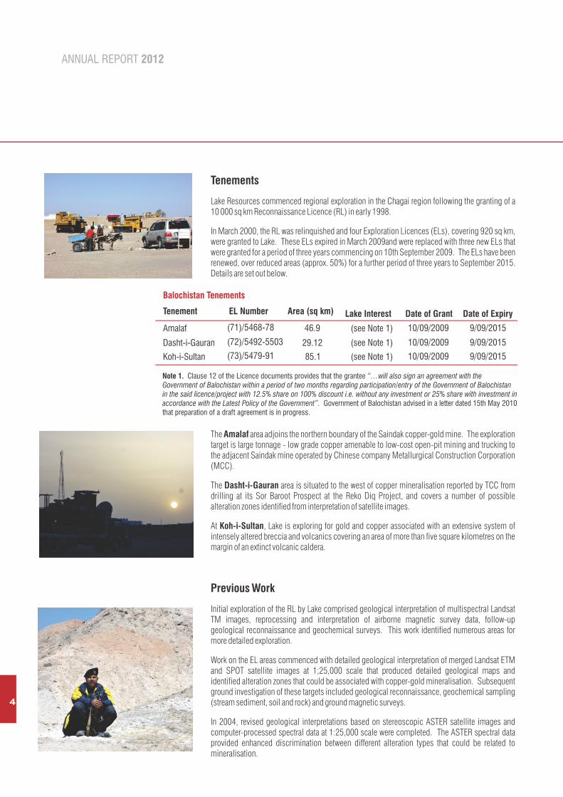
Tenements
Lake Resources commenced regional exploration in the Chagai region following the granting of a 10 000 sq km Reconnaissance Licence (RL) in early 1998.
In March 2000, the RL was relinquished and four Exploration Licences (ELs), covering 920 sq km, were granted to Lake. These ELs expired in March 2009and were replaced with three new ELs that were granted for a period of three years commencing on 10th September 2009. The ELs have been renewed, over reduced areas (approx. 50%) for a further period of three years to September 2015. Details are set out below.
The Amalaf area adjoins the northern boundary of the Saindak copper-gold mine. The exploration target is large tonnage - low grade copper amenable to low-cost open-pit mining and trucking to the adjacent Saindak mine operated by Chinese company Metallurgical Construction Corporation (MCC).
The Dasht-i-Gauran area is situated to the west of copper mineralisation reported by TCC from drilling at its Sor Baroot Prospect at the Reko Diq Project, and covers a number of possible alteration zones identified from interpretation of satellite images.
At Koh-i-Sultan, Lake is exploring for gold and copper associated with an extensive system of intensely altered breccia and volcanics covering an area of more than five square kilometres on the margin of an extinct volcanic caldera.
Previous Work
Initial exploration of the RL by Lake comprised geological interpretation of multispectral Landsat TM images, reprocessing and interpretation of airborne magnetic survey data, follow-up geological reconnaissance and geochemical surveys. This work identified numerous areas for more detailed exploration.
Work on the EL areas commenced with detailed geological interpretation of merged Landsat ETM and SPOT satellite images at 1;25,000 scale that produced detailed geological maps and identified alteration zones that could be associated with copper-gold mineralisation. Subsequent ground investigation of these targets included geological reconnaissance, geochemical sampling (stream sediment, soil and rock) and ground magnetic surveys.
In 2004, revised geological interpretations based on stereoscopic ASTER satellite images and computer-processed spectral data at 1:25,000 scale were completed. The ASTER spectral data provided enhanced discrimination between different alteration types that could be related to mineralisation.

Lake Resources N.L.
In 2005, Lake undertook a 6-hole reverse circulation percussion drilling program — two holes on each of the Company's three Exploration Licence areas—with encouraging results.
At Amalaf one of two holes drilled by Lake intersected low-grade copper-molybdenum over the length of the hole (drillhole LRJJ-02, 12 -120 m, 108 m @ 0.17%Cu & 94 ppm Mo).
At Koh-i-Sultan, drillhole LRM-01, the first hole ever drilled to test this system, intersected copper and gold mineralisation on the western margin of the system:
! 3 ! 12 ! 18 ! 129
The hole terminated at a depth of 140 m in continuing gold mineralisation.
In 2006, rock geochemical grid sampling (309 samples) at Koh-i-Sultan identified anomalous gold, tellurium, bismuth and arsenic in a cohesive pattern over an area of about five sq km covering the main Miri alteration system and associated zones to the west and south of the Nawah Caldera.
In early 2007, high resolution (2.5 m) stereoscopic satellite imagery from the Advanced Land Observation Satellite (ALOS) was utilised to produce a new photogeological interpretation and a digital elevation model (DEM) and 10 m topographic contour map.
In the latter part of 2007, preparations were made for a 3 000 m diamond drilling (coring) program to test a zone of breccia and alteration centred on an interpreted north-south-trending fault zone, near the western rim of Nawah Caldera at Koh-i-Sultan. A logistics base was established at the village of Nok Kundi, approximately 35 km south of the drill sites, on the main highway linking the Chagai region with the provincial capital of Quetta and 2.8 km of access track to proposed drill sites were constructed.
In 2008, Lake undertook a 5-hole, 2 284 m diamond drilling (coring) program to test a zone of breccia and alteration centred on an interpreted north-south-trending fault zone, near the western rim of Nawah Caldera at Koh-i-Sultan. Details of the drillholes are set out in the table below.
1
i
5
1112 m, 18 m,
87 m, 140 m,
119 m @ 0.29 g/t Au & 1.63% Cu;6 m @ 1.14 g/t Au & 0.25% Cu;
69 m @ 0.55 g/t Au & 0.03% Cu (includes 36-60 m, 24m @ 1.05 g/t Au);11 m @ 0.60 g/t Au & 0.02% Cu.
3 -12 -18 -
129 -
Hole No. North (m)
East (m)
R.L. (m)
Azimuth (degrees)
Angle (degrees)
Total Depth(m)
LRMDDH - 001 3 222 046 480 621 2 049 090.7° -62° 507.2 LRMDDH - 002 3 222 046 480 616 2 049 272.7° -62° 538.4LRMDDH - 003 3 222 471 480 706 2 073 086.7° -60° 550.6 LRMDDH - 004 3 222 469 480 704 2 073 263.7° -61° 392.2LRMDDH - 005 3 222 422 480 449 2 063 268.7° -61.5° 296.4
Location measured by GPS estimated accuracy ± 5 m horizontal, ± 20m vertical.Co-ordinates are UTM, WGS84. Azimuth is related to True North (magnetic variation 1.265° East)
Notes:
The diamond drilling program resulted in two significant discoveries:
! porphyry-type copper-gold mineralisation in drillhole LRMDDH-002 (392 – 520 m, 128 m @ 0.14% Cu and 0.19 ppm Au) and
! a very large, variably-altered and mineralised breccia complex, intersected in all five drillholes, over a width of more than 700 m and a north-south extent of more than 400 m. Geologically significant gold values were intersected in the breccia in four of the five drillholes.
ANNUAL REPORT 2012
6
LRMDDH001 LRMDDH002
LRMDDH005LRMDDH003 LRMDDH004
LRMDDH001 LRMDDH002
LRMDDH005LRMDDH003 LRMDDH004
250m (approx.)
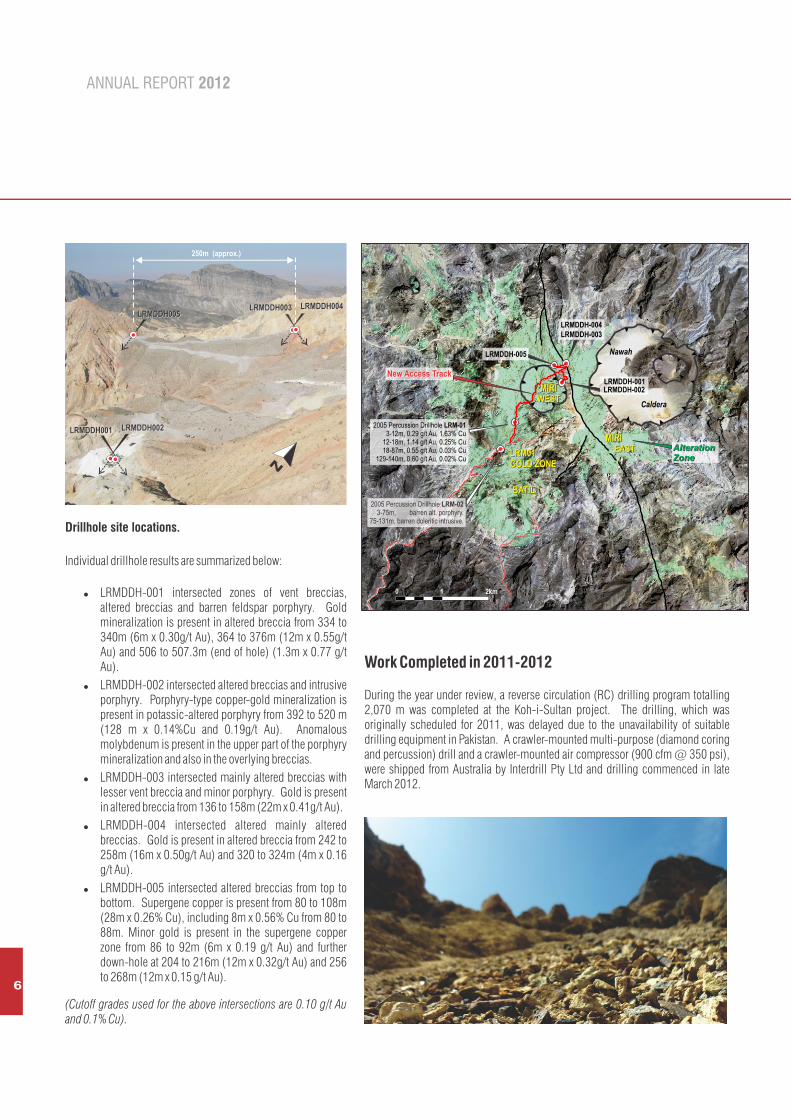
Drillhole site locations.
N
Individual drillhole results are summarized below:
! LRMDDH-001 intersected zones of vent breccias, altered breccias and barren feldspar porphyry. Gold mineralization is present in altered breccia from 334 to 340m (6m x 0.30g/t Au), 364 to 376m (12m x 0.55g/t Au) and 506 to 507.3m (end of hole) (1.3m x 0.77 g/t Au).
! LRMDDH-002 intersected altered breccias and intrusive porphyry. Porphyry-type copper-gold mineralization is present in potassic-altered porphyry from 392 to 520 m (128 m x 0.14%Cu and 0.19g/t Au). Anomalous molybdenum is present in the upper part of the porphyry mineralization and also in the overlying breccias.
! LRMDDH-003 intersected mainly altered breccias with lesser vent breccia and minor porphyry. Gold is present in altered breccia from 136 to 158m (22m x 0.41g/t Au).
! LRMDDH-004 intersected altered mainly altered breccias. Gold is present in altered breccia from 242 to 258m (16m x 0.50g/t Au) and 320 to 324m (4m x 0.16 g/t Au).
! LRMDDH-005 intersected altered breccias from top to bottom. Supergene copper is present from 80 to 108m (28m x 0.26% Cu), including 8m x 0.56% Cu from 80 to 88m. Minor gold is present in the supergene copper zone from 86 to 92m (6m x 0.19 g/t Au) and further down-hole at 204 to 216m (12m x 0.32g/t Au) and 256 to 268m (12m x 0.15 g/t Au).
(Cutoff grades used for the above intersections are 0.10 g/t Au and 0.1% Cu).
Drillhole site locations.
MIRI WEST
MIRI EASTLRM01
GOLD ZONE
BATIL
MIRI WEST
MIRI EASTLRM01
GOLD ZONE
BATIL
2km10
LRMDDH-002LRMDDH-001
LRMDDH-003
LRMDDH-005
LRMDDH-004
2005 Percussion Drillhole LRM-02 3-75m, barren alt. porphyry.
75-131m, barren doleritic intrusive.
2005 Percussion Drillhole LRM-01 3-12m, 0.29 g/t Au, 1.63% Cu 12-18m, 1.14 g/t Au, 0.25% Cu 18-87m, 0.55 g/t Au, 0.03% Cu
129-140m, 0.60 g/t Au, 0.02% Cu
Nawah
New Access TrackNew Access Track
AlterationZoneAlterationZone
Caldera
Work Completed in 2011-2012
During the year under review, a reverse circulation (RC) drilling program totalling 2,070 m was completed at the Koh-i-Sultan project. The drilling, which was originally scheduled for 2011, was delayed due to the unavailability of suitable drilling equipment in Pakistan. A crawler-mounted multi-purpose (diamond coring and percussion) drill and a crawler-mounted air compressor (900 cfm @ 350 psi), were shipped from Australia by Interdrill Pty Ltd and drilling commenced in late March 2012.
7
Lake Resources N.L.
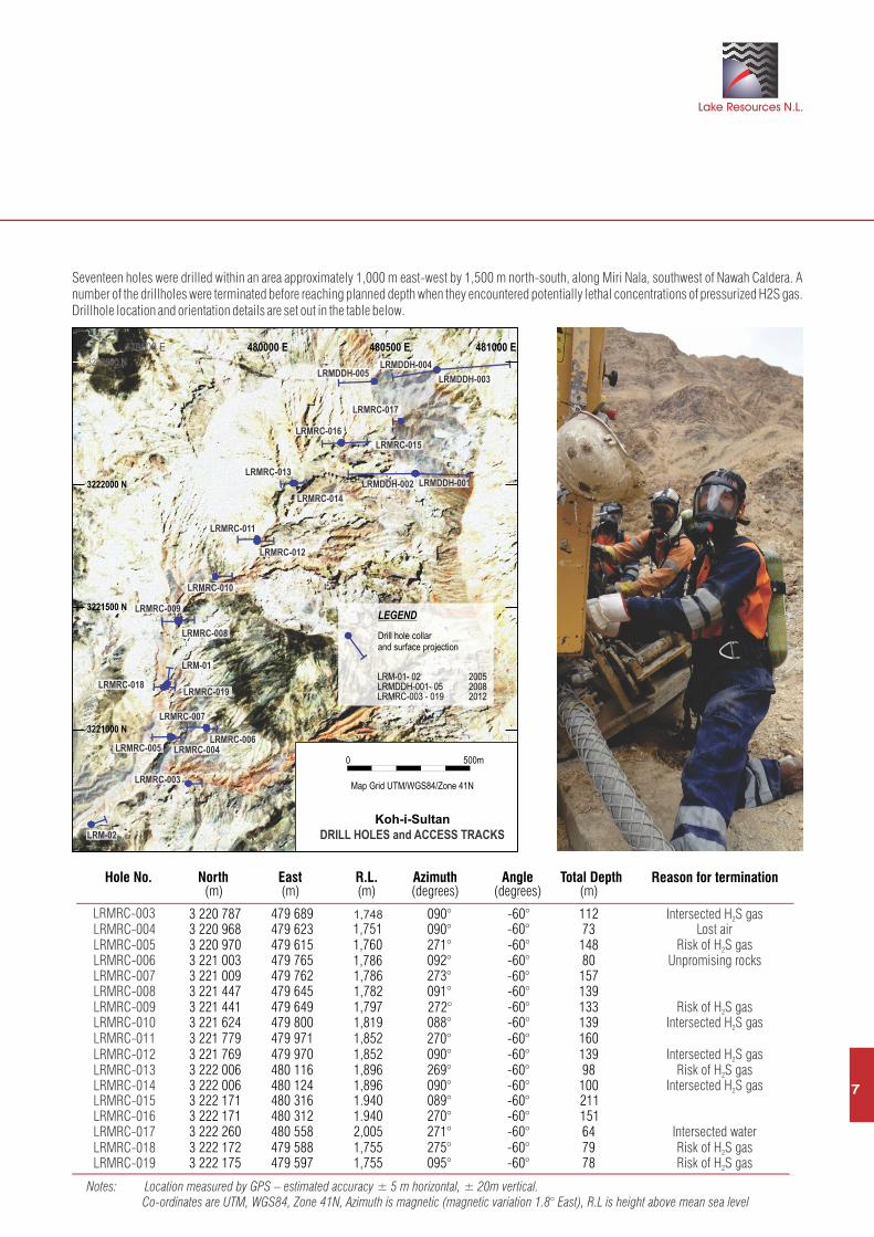
Seventeen holes were drilled within an area approximately 1,000 m east-west by 1,500 m north-south, along Miri Nala, southwest of Nawah Caldera. number of the drillholes were terminated before reaching planned depth when they encountered potentially lethal concentrations of pressurized H2S gas. Drillhole location and orientation details are set out in the table below.
A
LRMDDH-004
LRMDDH-001LRMDDH-002
LRMRC-017
LRMDDH-005
LRMRC-014
LRMRC-013
LRMDDH-003
LRMRC-010
LRMRC-012
LRMRC-003
LRMRC-008
LRMRC-006
LRMRC-011
LRMRC-005
LRM-02
LRMRC-007
LRMRC-004
LRM-01
LRMRC-019
LRMRC-009
LRMRC-018
LRMRC-015
LRMRC-016
200520082012
LRM-01- 02 LRMDDH-001- 05 LRMRC-003 - 019
Drill hole collar and surface projection
LEGEND3221500 N
3221000 N
3222500 N
3222000 N
480500 E479500 E 480000 E 481000 E
DRILL HOLES and ACCESS TRACKS
500m
Koh-i-Sultan
Map Grid UTM/WGS84/Zone 41N
0
Hole No. North (m)
East (m)
R.L. (m)
Azimuth (degrees)
Angle (degrees)
Total Depth
LRMRC-003 3 220 787 479 689 1,748 090° -60° 112 LRMRC-004 3 220 968 479 623 1,751 090° -60° 73LRMRC-005 3 220 970 479 615 1,760 271° -60° 148 LRMRC-006 3 221 003 479 765 1,786 092° -60° 80LRMRC-007 3 221 009 479 762 1,786 273° -60° 157 LRMRC-008 3 221 447 479 645 1,782 091° -60° 139LRMRC-009 3 221 441 479 649 1,797 272° -60° 133 LRMRC-010 3 221 624 479 800 1,819 088° -60° 139LRMRC-011 3 221 779 479 971 1,852 270° -60° 160 LRMRC-012LRMRC-013LRMRC-014LRMRC-015LRMRC-016LRMRC-017LRMRC-018LRMRC-019
3 221 769 479 970 1,852 090° -60° 139
3 222 006 480 116 1,896 269° -60° 98
3 222 006 480 124 1,896 090° -60° 100
3 222 171 480 316 1.940 089° -60° 211
3 222 171 480 312 1.940 270° -60° 151
3 222 260 480 558 2,005 271° -60° 64
3 222 172 479 588 1,755 275° -60° 79
3 222 175 479 597 1,755 095° -60° 78
(m)
Intersected H S gas2
Lost airRisk of H S gas2
Unpromising rocks
Risk of H S gas2
Intersected H S gas2
Intersected H S gas2
Risk of H S gas2
Intersected H S gas2
Intersected waterRisk of H S gas2
Risk of H S gas2
Reason for termination
Notes: Location measured by GPS – estimated accuracy ± 5 m horizontal, ± 20m vertical. Co-ordinates are UTM, WGS84, Zone 41N, Azimuth is magnetic (magnetic variation 1.8° East), R.L is height above mean sea level
ANNUAL REPORT 2012
8
Drillhole chip samples were collected continuously via a cyclone splitter for 2 m intervals – two sample splits of approximately 1-2 kg in cloth bags and the remaining bulk in large UV-resistant plastic bags. One set of the 1 kg samples was packed in sealed plastic drums and air-freighted to ALS Laboratories in Brisbane for geochemical analysis. The duplicate 1-2 kg samples have been stored at the Nok Kundi exploration base for future reference. The bulk samples in plastic bags were retained at the drill sites.
Sample analyses were undertaken in two stages – initially, alternate samples (i.e. every second sample) from all drillholes were subjected to multi-element analysis - 49 elements including silver base metals and a range or rare earths and trace elements by ICPAES and ICMP analysis, and gold by fire assay with AAS finish. Following preliminary evaluation of the initial analyses, the remaining alternate samples from selected zones in some drillholes were analysed for the same suite of elements to provide continuous geochemical data for geochemically anomalous zones.
At the southern end of the area, in the vicinity of the gold intersection in 2005 drillhole LRM-01, seven holes were drilled in variably altered volcanics and breccia. Five of these holes (LRMRC 005, 006, 007 &009) were essentially barren except for patchy elevated levels of manganese.
However, significant gold was intersected in four drillholes, with associated copper in two of these holes, similar to drillhole LRM-01.
! LRMRC-003: from 64 to 68 m (4 m @ 0.17 g/t Au) and 74 to 90 m (16 m @ 0.14 g/t Au).! LRMRC-005: from 90 to 92 m (2 m @ 0.11 g/t Au), 96 to 100 m (4 m @ 0.29 g/t Au), 106 to 112 m (6 m @ 0.13 g/t Au) and 124 to 134 m
(10 m @ 0.43 g/t Au).! LRMRC-018: from 2 to 16 m (14 m @ 2.20 g/t Au & 0.32% Cu, including 2 to 12 m (10 m @ 2.96 g/t Au & 0.44% Cu) and 68 to 72 m (4 m
@ 0.19 g/t Au).! LRMRC-019: from 2 to 78 m, anomalous gold over the complete hole (average 1.47 g/t Au) with copper in the top 18 m, including 2 to 22 m
(20 m @ 2.23 g/t Au & 0.18% Cu), 22 to 58 m (36 m @ 0.27 g/t Au), 58 to 70 m (12 m @ 4.53 g/t Au) and 70 to 78 m (8 m @ 0.39 g/t Au).
These results are interpreted to support potential for a significant gold target, with possible supergene copper in the LRM001 – LRMRC003/005/018/019 area. The copper-gold association could indicate potential for porphyry copper-gold mineralization beneath this area.
To the north, drillholes LRMRC 010 – 017 intersected zones of geochemically anomalous molybdenum (>5 ppm up to 130 ppm) and copper (>300 ppm up to 1675 ppm). Minor gold was intersected in some of these drillholes:
! LRMRC-010: from 28 to 42 m (14 m @ 0.16 g/t Au), 56 to 70 m (14 m @ 0.34 g/t Au) and 134 to 139 m (5 m @ 0.13 g/t Au).! LRMRC-013: from 46 to 48 m (2 m @ 0.31 g/t Au).! LRMRC-014: from 78 to 84 m (6 m @ 0.20 g/t Au).! LRMRC-015: from 74 to 76 m (2 m @ 0.38 g/t Au).! LRMRC-016: from 86 to 92 m (6 m @ 0.13 g/t Au), 110 to 120 m (10 m @ 0.13 g/t Au) and 150 to 151 m (1 m @ 0.21 g/t Au).! LRMRC-017: from 06 to 08 m (2 m @ 0.11 g/t Au), 12 to 14 m (2 m @ 0.11 g/t Au) and 16 to 20 m (4 m @ 0.11 g/t Au).
These results are interpreted to support potential for a large porphyry copper-gold target associated with the porphyry copper-gold intersection in 2008 drillhole LRMDDH-002.
A substantial program of deep diamond drilling (500 – 600m) is required to test these targets below the levels achievable with RC drilling.
A planned RC drilling program at the Amalaf Exploration Licence area that was scheduled for the second quarter 2012, was postponed as a result of a new Government of Pakistan policy requiring security clearances for expatriate personnel engaged in exploration activities in this region. Application for these clearances is in progress.
(Cutoff grade used for the above intersections is 0.10 g/t Au)
The information in this report that relates to Exploration Results, is based on information compiled by Jim Clavarino who is a Member of The Australasian Institute of Mining and Metallurgy. Mr. Clavarino is Exploration Director of Lake Resources NL and is employed by Argent Resources Pty Ltd. Mr. Clavarino has sufficient experience which is relevant to the style of mineralisation and type of deposit under consideration and to the activity which he is undertaking to qualify as a Competent Person as defined in the 2004 Edition of the 'Australasian Code for Reporting of Exploration Results, Mineral Resources and Ore Reserves'. Mr. Clavarino consents to the inclusion in the report of the matters based on his information in the form and context in which it appears.
AUSTRALIA
PAKISTAN
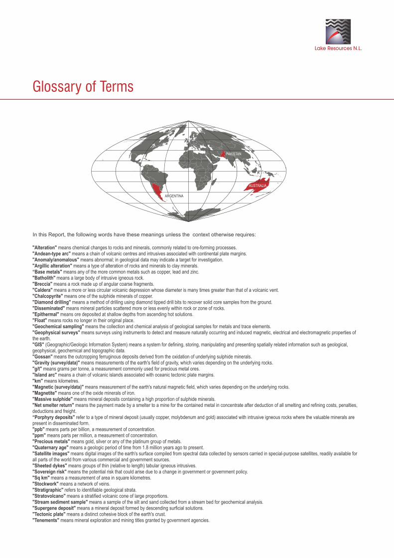
In this Report, the following words have these meanings unless the context otherwise requires:
"Alteration" means chemical changes to rocks and minerals, commonly related to ore-forming processes."Andean-type arc" means a chain of volcanic centres and intrusives associated with continental plate margins."Anomaly/anomalous" means abnormal; in geological data may indicate a target for investigation."Argillic alteration" means a type of alteration of rocks and minerals to clay minerals.“Base metals" means any of the more common metals such as copper, lead and zinc."Batholith" means a large body of intrusive igneous rock."Breccia" means a rock made up of angular coarse fragments."Caldera" means a more or less circular volcanic depression whose diameter is many times greater than that of a volcanic vent."Chalcopyrite" means one of the sulphide minerals of copper."Diamond drilling" means a method of drilling using diamond tipped drill bits to recover solid core samples from the ground."Disseminated" means mineral particles scattered more or less evenly within rock or zone of rocks."Epithermal" means ore deposited at shallow depths from ascending hot solutions."Float" means rocks no longer in their original place."Geochemical sampling" means the collection and chemical analysis of geological samples for metals and trace elements."Geophysical surveys" means surveys using instruments to detect and measure naturally occurring and induced magnetic, electrical and electromagnetic properties of the earth."GIS" (Geographic/Geologic Information System) means a system for defining, storing, manipulating and presenting spatially related information such as geological, geophysical, geochemical and topographic data."Gossan" means the outcropping ferruginous deposits derived from the oxidation of underlying sulphide minerals."Gravity (survey/data)" means measurements of the earth's field of gravity, which varies depending on the underlying rocks."g/t" means grams per tonne, a measurement commonly used for precious metal ores."Island arc" means a chain of volcanic islands associated with oceanic tectonic plate margins."km" means kilometres."Magnetic (survey/data)" means measurement of the earth's natural magnetic field, which varies depending on the underlying rocks."Magnetite" means one of the oxide minerals of iron."Massive sulphide" means mineral deposits containing a high proportion of sulphide minerals."Net smelter return" means the payment made by a smelter to a mine for the contained metal in concentrate after deduction of all smelting and refining costs, penalties, deductions and freight.“Porphyry deposits" refer to a type of mineral deposit (usually copper, molybdenum and gold) associated with intrusive igneous rocks where the valuable minerals are present in disseminated form."ppb" means parts per billion, a measurement of concentration."ppm" means parts per million, a measurement of concentration."Precious metals" means gold, silver or any of the platinum group of metals."Quaternary age" means a geologic period of time from 1.8 million years ago to present."Satellite images" means digital images of the earth's surface compiled from spectral data collected by sensors carried in special-purpose satellites, readily available for all parts of the world from various commercial and government sources."Sheeted dykes" means groups of thin (relative to length) tabular igneous intrusives."Sovereign risk" means the potential risk that could arise due to a change in government or government policy."Sq km" means a measurement of area in square kilometres."Stockwork" means a network of veins."Stratigraphic" refers to identifiable geological strata."Stratovolcano" means a stratified volcanic cone of large proportions."Stream sediment sample" means a sample of the silt and sand collected from a stream bed for geochemical analysis."Supergene deposit" means a mineral deposit formed by descending surficial solutions."Tectonic plate" means a distinct cohesive block of the earth's crust."Tenements" means mineral exploration and mining titles granted by government agencies.
Glossary of Terms
Lake Resources N.L.
ARGENTINA

ANNUAL REPORT 2012
2012
Lake Resources N.L.
ANNUAL REPORT
ANNUAL REPORT
Lake Resources N.L.
3-7 Maud StreetNewstead QLD 4006GPO Box 1239Brisbane 4001 Australia
Telephone: +61 7 3252 0255Facsimile: +61 7 3257 2122Email: [email protected]
I
www.lakeresources.com.au