annotated bibliography of bull trout information from the
TRANSCRIPT

I
Annotated Bibliography of Bull Trout Information From the Jarbidge River Basin
Peter Lawson Fish Biologist
Bob Pfeifer Senior Fish Biologist
Parametrix, Inc. Suite 200
5808 Lake Washington Blvd. NE Kirkland, Washington 98033-7350
February, 2002
Jarbidge River Fisheries 553-4190-002/01 (04) Annotated Bibliography Februnry 2002

I
PREFACE
The following annotated bibliography was prepared on behalf of the Humboldt-Toiyabe National Forest. The purpose of the review was to annotate all readily-available information on bull trout (Salve linus confluentus) from the Jarbidge River basin under one cover. Both published and unpublished materials were requested from agencies that have conducted fisheries work in the Jarbidge River basin. While the focus of the compilation was on bull trout, information on other fish species was also obtained and indexed.
Information obtained on bull trout from the Jarbidge River spans the period 1934 (Ref. 12) to 2001. Information was reviewed from previous field work performed by the State of Nevada, the State of Idaho, the United States Forest Service, the U.S. Fish and Wildlife Service, the Bureau of Land Management, academic researchers, and the Southwest Basin Native Fish Watershed Advisory Group.
Although an effort was made to obtain the most recent version of all reports, some' documents reviewed in this annotated bibliography were draft documents, and as such may contain information and/or conclusions that have subsequently been changed or modified. Any scientific data reviewed in this report has not been reviewed as to its scientific accuracy, and no claims are made as to the veracity of the data and/or conclusions of any document reviewed in this report.
Primary effort was spent in obtaining file data and reports from the following offices and individuals. An Internet search was also made for published materials that were not identified in our visits with the agencies. No publications were found that contained new information specific to bull trout in the Jarbidge River. Anecdotal and non-professional materials or information from several Internet websites were not included in this
Idaho Department of Fish and Game, Jerome, ill Doug Megargle
US Bureau of Land Management, Twin Falls, ill Jim Klott
US Forest Service, Elko, NY Kelly Amy
US Fish and Wildlife Service, Reno, NY Selena Werdon
Nevada Division of Wildlife Gary Johnson
Jarbidge River Fisheries 553-4190-002/01 (04) Annotated Bibliography February 2002
Annotated Bibliography of Bull Trout Information From the Jarbidge River Basin
Source Key: I = Bureau of Land Management, Twin Falls, Idaho 2 = Idaho Department of Fish and Game, Jerome Idaho 3 = Nevada Department of Wildlife, Elko, Nevada 4 = United States Fish and Wildlife Service, Reno, Nevada 5 = United States Forest Service, Humboldt-Toiyabe National Forest, Elko, Nevada
1. Bureau of Land Management (BLM) and United States Fish and Wildlife Service (USFWS). 1995. Unpublished field notes and summary from bull trout survey in the Jarbidge Resource Area. Idaho Bureau of Land Management, Twin Falls, Idaho and USFWS Boise, Idaho. August 9, i995. 9pp. KEYWORDS: DISTRIBUTION, REDBAND, STREAM HABITAT, TEMPERATURE. Source: 1
These notes are from an August 7 and 8, 1995 bull trout inventory on selected reaches in the West Fork and East Fork of the Jarbidge River, Jack Creek, and Deer Creek. Snorkeling was used as the sampling method. Redband were found at all sites, while bull trout were found only in Jack Creek. The data for Jack and Deer Creeks is presented in Table I under the entry for Zoellick et al. (1996).
2. Burton, T., J. Klott, and B. Zoelick. 2001. Field investigation of Dave Creek, tributary of EF Jarbidge River (September 11-13,2001): Draft Report. Idaho Department of Fish and Game, Boise, Idaho. 7pp. Appendices. KEYWORDS: DISTRIBUTION, DISTURBANCE, LIVESTOCK, REDDS, SEDIMENT, STREAM HABITAT, SUBSTRATE. Source: 2.
This preliminary draft report presents the results of investigations of potential sediment effects to bull trout habitat resulting from the cattle crossing on Dave Creek and cattle trailing disturbances on the Little Island Tributary of Dave Creek. Methods included measurement of percent fines and substrate embeddedness based on the methods of Shepard, Platt, and Graham (1984). The resultant substrate score was then used to describe rearing habitat potential for bull trout. Findings showed that high levels of fine sediment were present both upstream and downstream of the Little Island Tributary, and that these elevated sediment levels likely originate from erosion of the degradM channel. Substrate samples taken upstream of the National Forest boundary showed a significant decrease of both fines and embeddedness. A stream "walk through" spawning habitat survey was also conducted on Dave Creek. Bull trout were observed actively spawning in Dave Creek from the National Forest Boundary to a point about 2 miles downstream. The authors estimate if Dave Creek substrates were to be restored, the estimated rearing capacity of the stream would increase nearly four-fold, the rearing space in Dave Creek would increase six-fold, and early lifestage survival would double in the upper 4 miles of the stream. Data presented includes habitat data, substrate score summaries, and predicted bull trout survival rates and population potentials for Dave Creek.
Jarbidge River Fisheries 1 553-4190-002/01 (04) Annotated Bibliography February 2002

3. Bntler, C. 1997. Hydrology specialist's report for proposal to reconstruct the Jarbidge Canyon Road form Pine Creek Campground to Snowslide Trailhead. US Forest Service, Ruby Mountains and Jarbidge Ranger Districts, Humboldt-Toiyabe National Forest. November 1996. 9pp. 5 Appendices. KEYWORDS: HYDROLOGY, ROADS, SEDIMENT, SUBSTRATE. Source: 5
This report consists of a hydrologic summary of the West Fork Jarbidge River, specifically in the reaches where the US Forest Service proposed to reconstruct the South Canyon Road from Pine Creek Campground upstream to Snowslide Trailhead. Historic hydrologic conditions were assessed, as well as possible impacts from reconstruction. Specifically. hydrologic flow paths, channel morphology, meander belts/valley bottom types, water quality, and cumulative effects are discussed. The report includes copies of field notes for flow and discharge calculations, valley bottom cross-sectional graphs, and pebble count information.
4. Cavender, T.M. 1978. Taxonomy and distribution of the bull trout, Sa/velinus rna/rna (Suckley). from the American Northwest. California Fish and Game 64(3):139-174. KEYWORDS: DISTRIBUTION, TAXONOMY. Source: 6
Morphological and distributional evidence is presented favoring the specific distinction of the bull trout. A diagnosis and description is given for the bull trout along with a history of its early taxonomy. The past and present distribution limits of the bull trout are listed, which includes the Jarbidge River system. Specific mention is made of bull trout collected in the West Fork Jarbidge River and in Dave Creek, a tributary of the East Fork Jarbidge River.
5. Coffin, P.O. 1987. Nevada's native trout: Status, distribution, and management. Nevada Division of Wildlife. Carson City, Nevada. KEYWORDS: DISTRIBUTION. Source:3
This report includes a very brief one-page description of the historic distribution of bull trout in North America and several non-referenced, anecdotal pieces of information on bull trout distribution in the Jarbidge River system.
6. Frederick, J.A. 1996. Specialist's report on the reconstruction of the Jarbidge Canyon Road. US Forest Service, Ruby Mountains and Jarbidge Ranger Districts, Humboldt-Toiyabe National Forest. November, 1996. 17pp. 4 Appendices. KEYWORDS: MINING. PASSAGE, ROADS, SEDlMENT, STREAM HABITAT, TEMPERATURE. Source: 5
This report addresses the US Forest Service proposal to reconstruct the South Canyon Road from Pine Creek Campground upstream to Snowslide Trailhead. The report includes an analysis of Jarbidge River fisheries and distribution of bull trout in the West Fork Jarbidge River. Several habitat elements are addressed with respect to both existing conditions, and possible future conditions if the project were completed. These elements include habitat connectivity, width/depth ratio, water temperature, large wood, and pool quantity and quality. Other considerations addressed in the report include migration/passage issues, sediment influx, and current Fox Creek Bridges. Cumulative effects that the project may contribute to were examined. Specifically these include channelization, large wood and vegetation removal, road maintenance, historic mining operations, and the Jarbidge Land Fill. The report concludes that the project may impact bull trout habitat in the short and long term, particularly by increasing summer stream temperature and modifying habitat through reductions of large wood and pools and changes in channel morphology. The report includes Appendices of 1996 LWD and pool survey data.
Jarbidge River Fisheries 2 (04) AnnoL'lted Bibliography February 2002

7. Frederick, J.A. and J. Klott. 1999. Biological Assessment of ongoing activities and proposed actions in the Jarbidge River Watershed. US Forest Service, Northwest Nevada Ecounit, HumboldtToiyabe National Forest, Elko Nevada, and Bureau of Land Management, Jarbidge Resource Area, Boise District, Idaho. June 24, 1999. KEYWORDS: BIOLOGICAL ASSESSMENT, DISTRIBUTION, ENVIRONMENT, IDAHO, LIVESTOCK, MAINSTEM JARBIDGE RIVER, MANAGEMENT, MINING, POPULATION DENSITY, RECREATION, ROADS, STREAM HABITAT, WATER QUALITY. Source: 5
The stated purposes of the biological assessment are to identify land management activities that currently are or have the potential to adversely affect threatened, endangered, proposed, or candidate species on land administered by the BLM or USFS, and to evaluate the adequacy of the Humboldt National Forest Land and Resource Management Plan (LRMP) in protecting and enhancing aquatic habitat, specifically bull trout habitat. A description of the physical setting and vegetation of the Jarbidge River watershed is presented. Descriptions of the mainstem and East and West Forks of the Jarbidge River are included, with all named tributaries described. A discussion of listed or candidate species found in the Jarbidge River system, including bull trout, is presented with bull trout focal habitat listed. A description of agricultural-related activities and a biological assessment of these activities are given. Individual biological assessment sections are found on the topics of mineral exploration and reclamation, hazardous waste, urban development. recreation, existing roads, and road construction and maintenance, and the Humboldt National Forest LRMP. The biological assessment for bull trout was "may effect, likely to adversely affect" for the following activities: livestock grazing in the Wilkens Island grazing area; the current configuration of the Jarbidge Canyon Road and associated bridges; historic and current road construction and maintenance practices on Jarbidge Canyon Road; and road construction and maintenance as occurring under the Humboldt LRMP, as amended. All other activities resulted in a "no effect" or "may affect, not likely to adversely affect" finding. The Appendices include 1997 water quality data at various locations in the Jarbidge River watershed, and a table of the streams and fish use of the Jarbidge River system.
8. Johnson, G.L. 1990. Bull trout species management plan. Nevada Department of Conservation and Natural Resources. Division of Wildlife, Reno, Nevada. 18pp. KEYWORDS: ANGLING, CATCH STATISTICS, CREEL CENSUS. DISTRIBUTION, LENGTHS, MANAGEMENT, POPULATION DENSITY, REDBAND, STOCKING, STREAM HABITAT. Source: 3
The stated purpose of the document is to provide the basis for decision-making regarding the bull trout through evaluation of management alternatives to achieve department objectives, as well as the identification of projects needing evaluation in future surveys. Bull trout taxonomy, a description of the species, and some background life history information is presented, including a short analysis of bull trout interrelationships with other species. Current angler harvest trends are noted. A status summary of the management program is presented with several management alternatives. Several areas are recommended for future study, including population delineation studies, life history studies, investigation of stocking prohibitions, and investigation of species eradications and/or reintroductions. Historical data presented include a composite information summary of bull trout in Jarbidge River tributaries in Nevada, and a summary of West and East Fork Jarbidge river electrofishing surveys. A table of potential bull trout inhabited stream reaches without current inventories is also included, with predicted bull trout status for these unsurveyed reaches. A map of the Jarbidge system is included, with estimated bull trout populations from previous surveys noted.
Jarbidge River Fisheries 3 553-4190-002101 (04) Annotated Bibliography February 2002

9. Johnson, G.L. and D.E. Weller. 1994. The status of bull trout in Nevada. Nevada Department of Conservation and Natural Resources. Division of Wildlife, Reno, Nevada. September, 1994. 14pp. KEYWORDS: ANGLING, CATCH STATISTICS, DACE, DISTRIBUTION, GEOLOGY, LENGTHS, MOUNTAIN WHITEFISH, POPULATION DENSITY, REDBAND, SCULPIN, STREAM HABITAT, SUBSTRATE. Source: 3
The purpose of this report is to clarify the status of bull trout in the Jarbidge River drainage, Nevada. Historical data from 1958-1979 are reviewed and summarized, as they pertain to bull trout abundance and distribution. Historic data on angler use trends and angler harvest are summarized. Population estimates from these data vary widely, from 0 to 929. More current population estimates were examined for the years 1985 (West Fork Jarbidge) and 1993 (East Fork Jarbidge) with respect to multiple species. The estimates given are a population of 292 bull trout and 15,156 rainbow trout in the West Fork Jarbidge and 314 bull trout and 4,123 rainbow trout in the East Fork Jarbidge. Population estimates for some of the tributaries are also given. A comparison of stream bottom substrate composition is given for both forks of the Jarbidge River, based on recent stream habitat survey data. The West Fork Jarbidge shows a higher percentage of sand/silt substrate than does the East Fork Jarbidge (7 percent compared to 4 percent), although it also shows a lesser percent embeddedness (12.5 percent compared to 16.0 percent). A comparison of the East Fork and West Fork Habitat Condition Index and stream discharge information is also given. General tributary stream conditions are discussed, including temperature regimes. Bull trout habitat conditions are listed and focal habitat areas are given. The streams of the Jarbidge River system are classified into four categories, Focal Habitat, Nodal Habitat, Critical Conditioning Areas, and Adjunct Habitat. The report concludes with a statement that due to present habitat condition of focal habitats, current land management practices, and other factors, bull trout are expected to persist in the system.
10. Johnson, G.L. 1999. The status of bull trout in Nevada. Nevada Department of Conservation and Natural Resources. Division of Wildlife, Reno, Nevada. March 30, 1999. 23pp. KEYWORDS: DACE, DISTRIBUTION, LENGTHS, POPULATION DENSITY, REDBAND, SCULPIN, STREAM HAI3ITAT, TEMPERATURE. Source: 3
This report summarizes an intense survey of bull trout in the Jarbidge River system in late summer and fall 1998. The information collected was meant to supplement earlier population status studies (Johnson et al. 1993). A combination of snorkeling and electrofishing was used at a variety of sites on the West Fork Jarbidge River, Jack Creek, Jenny Creek, Pine Creek, Sawmill Creek, Dave Creek, Fall Creek, Slide Creek the East Fork Jarbidge River. Thermographs were also set up at several of these sites. Bull trout were captured in numerous locations, including the upper West Fork Jarbidge, Pine Creek, Sawmill Creek, upper East Fork Jarbidge. Dave Creek, Slide Creek, Fall Creek. and Cougar Creek. Results include minimum population estimates of bull trout, redband. and several other species for both the West and East Forks of the Jarbidge River. The appendices include a summary of all captured bull trout lengths, and a comparison of bull trout trend data incorporating this survey with historical survey efforts dating back to 1954. Maps are included showing the current known distribution limits of bull trout. and any known or likely fish migration barriers.
Jarbidge River Fisheries 4 553-4190-002101 (04) Annotated Bibliography February 2002
11. McNeill, M.E., J. Frederick, B. Whalen. 1997. Jarbidge River Watershed Analysis. US Forest Service. Jarbidge Ranger District, Humboldt-Toiyabe National Forest, Elko Nevada. 43pp. KEYWORDS: BEAVER, DISTURBANCE, GEOLOGY, LIVESTOCK, MINING, ROADS, SOILS, STREAM HABITAT, SUBSTRATE. TEMPERATURE, VEGETATION. Source: 5
This document has several stated purposes. These include the documentation of existing conditions within the Jarbidge River watershed, the identification of any weaknesses in the data, and in providing an overview of ongoing activities within its boundaries. The physical setting of the watershed is discussed, including the Slope, geology, soils, disturbance history, and existing land use. The Jarbidge River is then assessed with respect to stream order, hydraulic regime, valley bottom morphology, channel morphology, substrate, width/depth ratio, pools, and large wood. Water quality is examined, including a discussion of pH, temperatures, and presence of heavy metals. Upland and riparian vegetation are also typed and described. Color maps are included as key parts of these analyses. Specific reference conditions assessed include both biological processes, such as the history of beaver in the river system, and human influences, such as extensive livestock grazing and mining activity in the basin. Specific effects of mining noted include direct effects on water quality, stream temperature, and riparian and upland vegetation as well as indirect effects such as increased road building and changes in channel morphology. The report interprets the historical and current watershed conditions and identifies key concerns in improving watershed conditions. It asserts that habitat modification and mining practices may have drastically reduced bull trout numbers from 1885 to 1945. The report concludes with a list of recommendations for management efforts and restoration of natural dynamics and suggestions for data collection to bridge the current shortcomings. These suggestions include conducting a limiting factors analysis, long term stream temperature studies, further stream flow characterization, and further surveys to characterize riparian vegetation.
12. Miller, and W.M. Morton. 1952. First record of the Dolly Varden, Sa/velinus rna/rna from Nevada. Copeia, 3:207-208. KEYWORDS: DISTRIBUTION, LENGTH. Source: 4
This article documents the collection of the first documented record of bull trout (Dolly Varden) in Nevada. During an August 27, 1934 survey for the U.S. Department of Fisheries, S.D. Durrant identified two bull trout (105 and 169mm in length) that were collected in Dave Creek, 4 miles above its confluence with the East Fork Jarbidge River. Two universities morphologically identified these specimens as bull trout (Dolly Varden). In 1951, an additional three bull trout (168-193mrn in length) were collected in the East Fork River.
13. Nevada Division of Wildlife (NDOW). 1954. Unpublished field data and report from West Fork Jarbidge River field survey, June and August 1954. KEYWORDS: BROOK TROUT, CUTTHROAT TROUT, DISTRIBUTION, ENVIRONMENT, REDBAND, STREAM HABITAT, TEMPERATURE. Source: 5
This report discusses a 1954 field survey on the West Fork of the Jarbidge River between Bourne Gulch and Sawmill Creek. Six stations were electrofished and some habitat and temperature data were gathered at some of the stations. The fish sampled included two bull trout, both shocked at a site located between Sawmill Creek and Dry Gulch. Rainbow trout were reported as the most abundant species. Limitations in electroshocking success were noted. A general description of the geography and physical characteristics of the river are given, and plants, animals, and insects in the area were noted. Historic mine pollution is also discussed. A graph of valley gradient is included.
Jarbidge River Fisheries 5 553-4190-002101 (04) Annotated Bibliography February 2002

14. Nevada Division of Wildlife (NDOW). 1961. Unpublished field data and report from West Fork Jarbidge River field survey, October 1961. KEYWORDS: ANGLING, BROOK TROUT, CUTTHROAT TROUT, DISTRIBUTION, LENGTH, REDBAND, SCULPIN. Source: 5
This report discusses a 1961 limited population study on the West Fork Jarbidge River between the Nevada State line and Sawmill Creek. The report summarizes the results of 22 spot creel checks during the year and compares it with similar, although limited data from 1956-1960. Based on the surveys, estimated angler pressure for 1961 was 500 to 1000 days, with twenty percent of rainbow trout being of hatchery origin. Seven stations were electrofished in early October 1961, and some habitat and temperature data were gathered at some of the stations. Rainbow trout were reported as the most abundant species with approximately 10 percent being of hatchery origin. No eastern brook trout or cutthroat were observed although 5000 pounds of eastern brook trout have been stocked since 1954. This indicates the species inability to survive or reproduce in the West Fork Jarbidge. Three bull trout were captured just above the mouth of Sawmill Creek.
15. Nevada Division of Wildlife (NDOW). 1962. Unpublished angler survey data and report from West Fork Jarbidge River field survey, 1962. KEYWORDS: ANGLING, BROOK TROUT, CATCH STATISTICS, CREEL CENSUS, LENGTHS, MOUNTAIN WHITEFISH, REDBAND. Source: 5
This report summarizes the 1962 creel census activity on the West Fork Jarbidge River. Specific locations of the surveys were not given. Rainbow trout were reported as the most abundant species with approximately 25 percent being of hatchery origin. Only four eastern brook trout and no cutthroat were observed. A total of nine bull trout, averaging 192mm, were caught.
16. Nevada Division of Wildlife (NDOW). 1972. Unpublished field data from West Fork Jarbidge River field survey, August 1972. KEYWORDS: DISTRIBUTION, LENGTHS, REDBAND, STREAM HABITAT. Source: 5
This data is from an August 1972 field survey on the West Fork of the Jarbidge River between the National Forest Boundary and Snowslide Creek. Four stations were electrofished in this reach. Rainbow trout were reported as the most abundant species averaging between 45-100 percent of catch by site. One 162-mm bull trout was captured at the confluence of Jack Creek. Stream game fish habitat surveys were also conducted at the four stations.
17. Nevada Division of Wildlife (NDOW). 1974. Unpublished field data from West Fork Jarbidge River field survey, November 1974. KEYWORDS: DISTRIBUTION, LENGTHS, MOUNTAIN WHITEFISH, REDBAND, SCULPIN. Source: 5
These data are from a November 1974 field survey on the West Fork Jarbidge River between the State line and Snowslide Creek. Six stations were electrofished in this reach. Rainbow trout were reported as the most abundant species and were present at every station. No bull trout were captured.
Jnrbidge River Fisheries 6 553-4190-002101 (04) Annotated Bibliography February 2002

18. Nevada Division of Wildlife (NDOW). 1975. Unpublished field data and summary from West Fork Jarbidge River field survey. September 1975. KEYWORDS: ANGLING, CATCH STATISTICS, DISTRIBUTION, CREEL CENSUS, LENGTHS, REDBAND. Source: 5
These data are from a September 1975 field survey on the West Fork Jarbidge River between the State line and Snowslide Creek. Seven stations were electrofished in this reach. Rainbow trout were reported as the most abundant species and were present at every station. No bull trout were captured. An angler survey of7 anglers showed an average success of 2.71 fish per angler day. Annual angler pressure was estimated at 3,830 angler days for 1975. The capture of "several" Dolly Varden by anglers were noted to have occurred in 1975, including a specimen of 425mm.
19. Nevada Division of Wildlife (NDOW). 1979. Unpublished field data and summary from West Fork Jarbidge River field survey, October 1979. KEYWORDS: ANGLING, DISTURBANCE, LENGTHS, POPULATION DENSITY, REDBAND, ROADS. SEDIMENT, STREAM HABITAT, SUBSTRATE. Source: 5
The purpose of this report is to compare fish use and habitat quality in unchannelized reaches and reaches channelized by the USFS in 1979. The habitat survey was conducted using the GAWS method, with variable reach lengths and spacing. The electrofishing data is from an October 1979 field survey on the West Fork Jarbidge River between the Mahoney Ranger Station and Pine Creek Campground. Ten sites (5 channelized, 5 unchannelized) were electrofished in this reach. Two bull trout were captured just above and below the town of Jarbidge. The rainbow population in the channelized reaches was only 7% of the levels in the natural channels. A stream habitat survey was also conducted at the electrofishing sites. The summary notes the channelized sections were narrower, shallower, and faster with less sedimentation and a higher velocity than the natural channel. Also, spawning gravels in the natural reaches were of significantly better quality and quantity. The summary concludes that the West Fork Jarbidge River shows a significant impact to fish and their habitat from the 1979 channelization of 3,104 feet of the stream and recommendations are made regarding the channelization.
20. Nevada Division of Wildlife (NDOW). 1980. Unpublished field data and summary from West Fork Jarbidge River field survey, October 1980. KEYWORDS: DISTURBANCE, LENGTH, POPULATION DENSITY, REDBAND, ROADS, SEDIMENT, STREAM HABITAT, SUBSTRATE. Source: 5
The purpose of this report is to compare fish use and habitat quality in unchannelized reaches and reaches channelized by the USFS in 1979 to results from the previous years study (NDOW 1979). The electrofishing data is from an October 1980 field survey on the West Fork of the Jarbidge River between the Mahoney Ranger Station and Pine Creek Campground. Six sites (3 channelized, 3 unchannelized) were electrofished in this reach. Bull trout were captured at two sites, one channelized and one natural. Data on numbers of bull trout captured and length data are lacking. A stream habitat survey was also conducted at the electrofishing sites. The summary notes substantial differences in bank cover and stream environment with the natural reaches receiving much higher ratings. Spawning gravel quantity was higher in the natural reaches, but had decreased by half from the 1979 surveys.
Jarbidge River Fisheries 7 553-4190-002/01 (04) Annotated Bibliography February 2002

21. Nevada Division of Wildlife (NDOW). 1985. Unpublished field data from West Fork Jarbidge River field survey, September-October, 1985, KEYWORDS: DISTRIBUTION, IDAHO, LENGTHS, REDBAND, STREAM HABITAT, SUBSTRATE, Source: 5
These data are from a 1985 field survey on the West Fork Jarbidge River of 17 selected reaches from State line to near Sawmill Creek. GAWS survey protocol was used with 1 mile spacing between surveyed reaches, Each surveyed reach consisted of five transects spaced 138 feet apart, for a total of 690 feet of stream sampled. All 17 stations were electrofished, and a total of 13 bull trout were captured. 12 of the 13 bull trout captured were in the upper West Fork Jarbidge, from Snowslide Gulch to Sawmill Creek. A stream habitat survey was also conducted at each of the stations.
.
22. Nevada Division of Wildlife (NDOW). 2000. Unpublished Section 6 Annual Project Report (1999) for Recovery action for bull trout in Jarbidge River Drainage system. Period covered- January 1, 1999 to December 31, 1999. KEYWORDS: AGE, DISTRIBUTION, REDBAND, STREAM HABITAT, TEMPERATURE. Source: 3
This report documents and summarizes bull trout studies carried out by NDOW in 1999 to delineate the population status and upstream distribution of bull trout in selected streams. Jack Creek, Pine Creek, and the East Fork Jarbidge River were all electrofished. Bull trout were found in all three surveys, representing several age classes. Jack Creek had 14 Age II and adult bull trout, which was the first time bull tout had been found in the stream since the replacement of the culvert at the mouth in 1997. Several of the bull trout captured in Pine Creek were of a size (up to 296mm) that may represent fluvial migrants. The original goal of electrofishing the Right Headwaters Fork of the East Fork Jarbidge River could not be achieved due to no suitable flows (mostly dry) in that reach, Thermographs were deployed in Pine, Robinson, Fall, Dave, Jack and Cougar Creeks as well as the Upper East Fork Jarbidge River. The period of record was from roughly early to mid-July to early to mid-October. From the 1998-99 temperature records it was found that the three focal bull trout areas (upper West Fork Jarbidge River, upper East Fork Jarbidge River, and upper Dave Creek) are the coldest fish bearing stream reaches in the Jarbidge River. A discussion of which particular temperature metric is most important in determining bull trout occupancy is also given.
23. Nevada Division of Wildlife (NDOW). 2001. Unpublished Annual Project Report (2000) for Eastern Region Native Fisheries Management: Bull trout. Period covered- January 1,2000 to December 31. 2000. KEYWORDS: DISTRIBUTION. TEMPERATURE, REDBAND, STREAM HABITAT. Source: 3
This report documents and summarizes bull trout studies carried out by NDOW in 2000. Portions of the West Fork Jarbidge River from Jack Creek to Pine Creek were snorkeled, as was Jack Creek. Bull trout were found in both surveys. The full length of Robinson Creek was intensively surveyed with electrofishing, and no bull trout were found. Intensive spot-shocking resulted in no bull trout in Lower Fox Creek, while it resulted in one 220-mrn bull trout in Deer Creek, found in a 70° F pool. Thermographs were deployed in Bear Creek, Upper Deer Creek tributary, and Fox Creek to assess these streams as bull trout habitat. The temperature records for both Upper Deer Creek tributary and Bear Creek were deemed unsuitable for bull trout juvenile rearing habitat, while Fox Creek may be considered marginally suitable bull trout juvenile rearing habitat.
Jarbidge River Fisheries 8 553-4190·002/01 (04) Annotated Bibliography February 2002

24. Parrish, D. 1998. Jarbidge Key Watershed Bull Trout Problem Assessment. South West Basin Native Fish Watershed Advisory Group. December 1988. 24pp. 4 Appendices. KEYWORDS: DISTRIBUTION, GEOLOGY, IDAHO, LAND USE, LIFE HISTORY, LIVESTOCK, MAINSTEM JARBIDGE RIVER, MINING, ROADS, SUBSTRATE, TEMPERATURE. Source: I
The document was prepared according to the State of Idaho Bull Trout Conservation Plan as a problem assessment for bull trout in the Jarbidge River System. Recommendations are focused on the geographical area of the East and West Forks of the Jarbidge River from the Idaho-Nevada boundary to their confluence. A brief physical description of the area includes information on climate, hydrology, and geology/landform. Historic and current bull trout distribution and abundance is briefly examined. Habitat conditions and trends with respect to parameters such as channel and hydrologic stability, substrate size and compositions, cover complexity, migration barriers, and temperature are also addressed. Watershed characteristics influencing bull trout are listed as geologic processes, stream flow regime, and land use practices. The land use practices addressed include roads, mining, forestry, agriculture/livestock. fire, urban encroachment, and recreation. Additional limiting factors listed include habitat degradation, harvest or Dverutilization, exotic species. and predation. Several conservation actions are recommended. The appendices include summary tables of Warren and Partridge (1993) habitat data, and temperature data from 1994 and 1997 (Partridge, 1998).
25. Partridge, F.E. and C.D. Warren. 1998. Monitoring of migrating bull trout in the Jarbidge River. Idaho Bureau of Land Management. Boise, Idaho. Technical Bulletin No. 98-9. June 1998. 15pp. KEYWORDS: DACE, DISTRIBUTION, IDAHO, LENGTHS-WEIGHT, MIGRATION, MOUNTAIN WHITEFISH, REDBAND, SCULPJN, SUCKER, TEMPERATURE, WEIR TRAPS. Source: I
The report presents data from the placement of temporary fish weirs and trapboxes in the East and West Forks of the Jarbidge River near their confluence in Idaho. The weirs were constructed to trap downstream migrants. The trap boxes were checked daily from late August to mid-October 1997. Total length measurements were taken on all trout captured. Continuous temperature data were also recorded at the weir sites using thermographs placed at both sites. The purpose of the project was to count bull trout migrating downstream after spawning, to develop an index of the population of the migratory bull trout population in the two forks, and to obtain information on other migratory native fish in the basin. Data presented includes tables of length frequencies and average weights of some of the fish sampled, and daily mean temperature, as well as graphs plotting daily temperature and fish presence by species over the study period. A single bull trout was sampled on the West Fork Jarbidge River. Over four times as many rainbow trout were sampled in the East Fork Jarbidge River as the West Fork, and all species except bull trout and shorthead sculpin were found in greater numbers in the East Fork.
Jarbidge River Fisheries 9 553-4190-002/01 (04) Annotated Bibliography February 2002

26. Partridge, F.E. and C.D. Warren. 2000. Monitoring of migrating bull trout in the Jarbidge River, 1999. Idaho Bureau of Land Management. Boise, Idaho. Technical Bulletin No. 00-1. November 2000. 19pp. KEYWORDS: DACE, DISTRIBUTION, IDAHO, LENGTHS-WEIGHT, MIGRATION, MOUNTAIN WHITEFISH, REDBAND, SCULPIN, SUCKER, TEMPERATURE, WEIR TRAPS. Source: I
This report summarizes data from the second year of a 2-year study begun with Partridge and Warren 1998, presenting data from the placement of temporary fish weirs and trapboxes in the East and West Forks of the Jarbidge River near their confluence in Idaho. The placement of the East Fork Jarbidge trap box was identical to the 1997 study, while the West Fork Jarbidge River trap box was moved downstream, approximately 1.7 Ian closer to the confluence. The weirs were constructed to trap downstream migrants. The trap boxes were checked daily from September 8 to August 30, 1999. Total length measurements were taken on all trout. Continuous temperature data were also recorded at the weir sites using thermographs placed at both sites. The purpose of the project was to count bull trout migrating downstream after spawning, to develop an index of the population of the migratory bull trout population in the two forks. and to obtain information on other migratory native fish in the basin. Similar to the 1997 study. data presented includes tables of length frequencies. average weights of some of the fish sampled, daily mean temperature, as well as graphs plotting daily temperature and fish presence by species over the study period. A table is also included indicating number of fish (by species) sampled by date for both 1887 and 1999 data. A total of five bull trout were captured between the two sites, ranging in size from 250 to 355mm.
27. Ramsey, K.J. 1997a. Biological evaluation for bull trout (Salvelinus confluentus), written for the Jarbidge Road Reconstruction Environmental Assessment. US Forest Service, Northwest Nevada Ecounit, Humboldt-Toiyabe National Forest, Elko Nevada. March 21, 1997. 81pp. 5 Appendices. KEYWORDS: BIOLOGICAL ASSESSMENT, DISTRIBUTION, FOOD, HYDROLOGY, PASSAGE, POPULATION DENSITY, REARING, REDBAND, ROADS, SEDIMENT, STREAM HABITAT, TEMPERATURE, WATER QUALITY. Source: 5
This biological evaluation assesses the effects on bull trout of a proposed action of reconstructing a road in the Jarbidge Canyon that was obliterated andlor damaged by the June, 1995 flood. The purpose of this proposed action is recovery of 1.5 miles of vehicle access along Forest Service Road #64 from Pine Creek Campground to the Snowslide Trailhead. The proposed action would require the relocation of 700ft of stream channel. The proposed action was analyzed, along with an alternative (trail construction) and the no action alternative (existing conditions). The report assesses current conditions in the project area, including habitat conditions on the West Fork Jarbidge River. Large woody debris, pool frequency, wetted width:depth ratio, and temperature conditions are discussed relative to current and historical conditions. It is noted that there is a notable lack of large wood in the project area, as compared to above the Wilderness boundary, and that pool frequencies are less than expected for most channel types. The results of a 1996 habitat and LWD survey, conducted by the USFS, are presented in the Appendices. These surveys were conducted on the West Fork Jarbidge River from Pine Creek to Dry Gulch, and they encompass the area where work on the proposed action would occur. Bull trout population distribution and status is evaluated in the report, with note of metapopulation and migratory life history. The author concurs with Johnson and Wellers' (1994) assessment that the Jarbidge River bull trout population is low, but persistent.
Jarbidge River Fisheries 10 553-4190-002101 (04) AnnOk'lted Bibliography February 2002

A summary of bull trout population information for the Jarbidge River system is included. Effects of the project alternatives on bull trout for the following parameters are discussed: large wood, pools, width:depth ratio, water temperature, water quality, bull trout prey base, channel dynamics, fish passage, sediment, and spawning and rearing habitat. The risk determination was that all of the alternatives "may impact individuals or habitat, but will not likely cause a loss of viability to the population or species". The no-action alternative and trail alternative were said to result in a trend toward Desired Future Condition, while the road alternative was said to result in a trend away from Desired Future Condition. Recommendations were made to reduce the risk of negative outcomes of project implementation, and for maintaining and recovering viable populations of bull trout throughout the West Fork watershed. Appendices include historic data summaries of temperature data, width:depth ratio data, and bull trout presence in the West Fork Jarbidge and tributaries, as well as a literature and data review of bull trout life history and habitat requirements in the West Fork Jarbidge. A summary of a stream walk conducted in October 1992 notes several bull trout observed in the upper reaches of the West Fork Jarbidge.
28. Ramsey, K.J. 1997b. Unpublished memo on field trip to West and East Fork Jarbidge River field survey, US Forest Service, Humboldt-Toiyabe National Forest, Elko Nevada. October 15, 1997. KEYWORDS: REDDS, STREAM HABITAT, SUBSTRATE. Source:3
The memo discusses a field trip to the West and East Forks of the Jarbidge River that took place October 6-8, 1997. In the East Fork Jarbidge River the purpose was to take visual observations of fish, redds, and spawning gravels. The investigation in the East Fork was from the National Forest Boundary to about .25 mile inside the Wilderness boundary, a total distance of about 2.0 miles. Multiple age classes of redband were observed, but no bull trout or bull trout redds were observed. It was noted that spawning sized gravels accumulated predominantly at the channel margins. The mid-channel substrate was predominantly cobble, and appeared to be relatively stable. Pool frequency and large wood were measured, and found to be substantially less than expected (per Overton et al. 1995). The investigation of the West Fork Jarbidge River was from the Pine Creek confluence to 50 yards below Sawmill Creek. The purpose was to search for bull trout, spawning materials, and redds. Numerous redband were observed, as well as three mature bull trout. Two "probable redds" were found above Dry Gulch, one in a pool tail area and one in a riffle. They were estimated to be at least 2 weeks old. It was noted that spawning gravel-sized material was more prominent in the wilderness. as compared to downstream, and that gravels did not accumulate readily in ideal spawning locations, such as pool tailouts. Cobble substrate did not appear as stable as in the East Fork.
29. Stowell, R., S. Wolterling, L. Brown, and D. Mason. 1998. Biological Assessment: Effects to bull trout, shortnose sucker, and Warner sucker of land and resource management plans and associated federal actions on National Forests and Bureau of Land Management Resource Areas in the Columbia River, Klamath River, and Jarbidge River Basins. US Forest Service, Northern Region. Missoula. Montana. June 15, 1998. 55pp., 2 Appendices. KEYWORDS: BIOLOGICAL ASSESMENT, MANAGEMENT. Source: 5
This biological assessment of the effects of implementing all BLM and USFS planning and decision documents bull trout, shortnose sucker, and Warner Sucker in the Columbia River, Klamath River, and Jarbidge River basins. The Jarbidge River sub-basin is examined for Land and Resource Management Plans (LRMOs) specific to INFISH implementation. Possible positive and negative effects on these listed species is examined, and a determination of 'may effect and are likely to adversely effect' is found for the Jarbidge River bull trout DPS.
Jarbidge River Fisheries 11 553-4190-002101 (04) Annotated Bibliography February 2002

30. United States Department of the Interior (USDI). 1999. Endangered and threatened wildlife and plants: Determination of threatened status for the Jarbidge River population of bull trout. Federal Register 64:17110-17125. KEYWORDS: DJSTRIBUTION, DJSTURBANCE, GENETICS, LIFE HISTORY, LIVESTOCK, MANAGEMENT, METAPOPULATION, MJNING, OVERFISHING, POPULATION DENSITY, PREDATION, ROADS. Source:4
This Federal Register Final Rule covers the determination of threatened status for the Jarbidge River distinct population segment of bull trout from the Jarbidge River system in northern Nevada and southern Idaho. The listing includes general background information on bull trout life history, habitat requirements, and the applicability of biological metapopulation concepts to bull trout distribution. Bull trout status and distribution in the Jarbidge River system is discussed. The lack of data to determine population trends, and the apparent current and historic low numbers of bull trout in the system are noted as contributing factors for the listing. The results of recent preliminary data from genetic analysis of Jarbidge River bull trout indicates the potential presence of multiple, tributary-resident bull trout subpopulations, with limited gene flow among them, although the information was currently insufficient to divide the Jarbidge River DPS into more than one subpopulation. The five factors that apply to the listing of a species are discussed along with their application to the Jarbidge River population segment of bull trout. These include land management activities, road construction, livestock grazing, mining, overutilization by angling, introduction of non-native fish species, and high gradient stream channel, among others. The listing recommends conservation methods and gives responses to public comments on the listing.
31. United States Fish and Wildlife Service (USFWS). 1998. Biological Opinion on stabilization of the West Fork Jarbidge River, Elko County, Nevada. U.S. Fish and Wildlife, Nevada Fish and Wildlife Office, Reno, Nevada. Nov 5, 1998. 3lpp. KEYWORDS: BIOLOGICAL OPINION, DJSTRIBUTION, DJSTURBANCE, LIFE HISTORY, POPULATION DENSITY, ROADS. Source: 4
This document represents the Fish and Wildlife Service's Biological Opinion of the effects of the US Forest Service's proposed action for stabilization of the West Fork Jarbidge River, and its effect on bull trout. Status of bull trout and bull trout critical habitat is discussed in general, and with respect to the Jarbidge River population. Environmental baseline conditions are discussed including historic and ongoing threats to the Jarbidge River bull trout population. Effects of the proposed action on bull trout are analyzed for direct, indirect, and cumulative effects. The Service concluded that the proposed action is not likely to jeopardize the continued existence of bull trout in the Jarbidge River DPS. Reasonable and prudent measures, terms, and conditions are defined for this action, and conservation recommendations are made.
Jarbidge River Fisheries 12 553-4190-002101 (04) Annotated Bibliography February 2002

32. United States Fish and Wildlife Service (USFWS). 2000. Draft Biological Opinion on effects to bull trout from continued implementation of the U.S. Forest Service Humboldt National Forest Land and Resource Management Plan. as amended by INFISH. U.S. Fish and Wildlife, Nevada Fish and Wildlife Office, Reno, Nevada. 88pp. KEYWORDS: BIOLOGICAL OPINION, DISTRIBUTION, DISTURBANCE, LIFE HISTORY, LIVESTOCK, MANAGEMENT, MINING, RECREATION, ROADS, STREAM HABITAT. Source: 4
This document represents the Fish and Wildlife Service's Biological Opinion of the effects of continued implementation of the Humboldt NF Land and Resource Management Plan, as amended by INFISH, on listed bull trout in the Jarbidge River Distinct Population Segment (DPS). Environmental baseline conditions are discussed, including the status of bull trout in the Jarbidge River DPS. General threats to the Jarbidge River bull trout population that are discussed include forest land management, livestock grazing, dams, fire management, and mining. Effects of specific management activities-, including management of roads, grazing, recreation, minerals, fire/fuels, and general riparian area are assessed, as are watershed, fisheries, and wildlife restoration efforts. The Service concluded that the proposed action is not likely to jeopardize the continued existence of bull trout in the Jarbidge River DPS. Reasonable and prudent measures, terms, and conditions are defined for this action, and conservation recommendations are made.
33. United States Fish and Wildlife Service (USFWS). 2001. Biological Opinion on effects to bull trout from continued implementation of the Bureau of Land Management Jarbidge Resource Area and Resource Management Plan, as amended INFISH. U.S. Fish and Wildlife, Nevada Fish and Wildlife Office, Reno, Nevada. April 27, 2001. 90pp. KEYWORDS: BIOLOGICAL OPINION, DISTRIBUTION, DISTURBANCE, GENETICS, LIFE HISTORY, LIVESTOCK, LOGGING, MANAGEMENT, MINING, ROADS, SEDIMENT, WATER QUALITY. Source: 4
This document represents the Fish and Wildlife Service's Biological Opinion of the effects of continued implementation of the Jarbidge Resource Area and Resource Management Plan, as amended, on listed bull trout in the Jarbidge River Distinct Population Segment (DPS). A summary of the status of bull trout in the Iarbidge River DPS is included, listing historic and current distribution, life history characteristics, and habitat requirements. Environmental baseline conditions are discussed, including the status of bull trout in the action area. General threats to the Jarbidge River bull trout population are discussed, and include forest land management, livestock grazing, dams, urban development, fire management, and mining. Other factors considered in the environmental baseline include INFISH implementation, forest practices, water quality standards, and fisheries management by the states of Idaho and Nevada. Effects of specific management activities, including management of roads, grazing, recreation, minerals, fire/fuels, and general riparian area are assessed, as are watershed, fisheries and wildlife restoration efforts. Reasonable and prudent measures, terms, and conditions are defined for this action, and conservation recommendations are made.
34. United States Forest Service (USFS). 1971. Unpublished field data from West Fork Jarbidge River field survey, August 1971. KEYWORDS: STREAM HABITAT, SUBSTRATE. Source: 5
These data are from a habitat survey conducted on the West Fork Jarbidge in August, 1971. The downstream survey limit was the National Forest Boundary and the upstream limit was near Snowslide Gulch. The survey used the GAWS method with reaches 500 feet in length, located 0.33 miles apart. Five transects were taken for each reach.
Jarbidge River Fisheries 13 553-4190-002101 (04)
Annotated Bibliography February 2002

35. United States Forest Service (USFS). 1992. Unpublished field data from Pine Creek field survey, August 1992. KEYWORDS: STREAM HABITAT, SUBSTRATE. Source: 5
These data are from a GAWS habitat survey conducted on Pine Creek in August, 1992. The downstream survey limit was the confluence with the West Fork of the Jarbidge River and the upstream limit was at elevation 8159 feet. The survey used the GAWS method.
36. United States Forest Service (USFS) and Nevada Division of Wildlife (NDOW). 1993. Unpublished field data and summary from East Fork Jarbidge River field survey, June-October, 1993. KEYWORDS: DISTRIBUTION, REDBAND, STREAM HABITAT, SUBSTRATE. Source: 5
The objectives of the study were to conduct intensive habitat and fish population surveys on about 65 miles of the stream within the East Fork Jarbidge River Drainage. The habitat data are from a joint Level 3 GAWS analysis conducted in conjunction with electrofishing surveys. The downstream survey limit on the East Fork Jarbidge was the National Forest Boundary and the upstream limit was near the headwater forks. Tributaries surveyed included Cougar, Dave, Fall, Gods Pocket, Jim Bob, Robinson, and Slide Creeks. Bull trout were found in the Upper East Fork Jarbidge River and in Dave, Fall, and Robinson Creeks.
37. United States Forest Service (USFS). 1997a. Environmental assessment; Proposal to Reconstruct the Jarbidge Canyon Road from Pine Creek Campground to Snowslide Trailhead. US Forest Service. Humboldt-Toiyabe National Forest, Elko Nevada. KEYWORDS: BIOLOGICAL ASSESSMENT, MANAGEMENT, ROADS, STREAM HABITAT. Source: 5
This document assesses the proposed action of reconstructing a road in the Jarbidge Canyon that was obliterated and/or damaged by the June, 1995 flood, for the purpose of recovering 1.5 miles of vehicle access along Forest Service Road #64 form Pine Creek Campground to the Snowslide Trailhead. The proposed action would require the relocation of 700-ft of stream channel. The proposed action was analyzed, along with an alternative (trail construction) and the no action alternative (existing conditions) for their effect on relevant watershed and hydrological indicators such as hyrdrologic flowpaths, soil compaction and disturbance. Fish habitat relevant indicators assessed included large woody debris, number of pools. bankfull width/depth ratio. and water temperature. Cumulative impacts of the alternatives were also addressed. Possible impacts of the project on National Forest recreation and possible impacts on local economy were also analyzed for each alternative. Twenty-two letters from the public response period, and the USFS responses to the letters, are also included in the environmental assessment.
38. United States Forest Service (USFS). 1997b. Unpublished field data from West Fork Jarbidge River field survey, October 1997.
These data are from RIIR4 protocol surveys conducted in October 1997. The data cover the area of the West Fork Jarbidge from Pine Creek to Snowslide Gulch, and consist of original data forms and hand written summaries. KEYWORDS: STREAM HABITAT, SUBSTRATE. Source: 5
39. United States Forest Service (USFS). 1998. Unpublished field data from West Fork Jarbidge River field survey, July 1998.
These data are from RIIR4 protocol surveys conducted in July 1998. The survey covers the area of the West Fork Jarbidge from Pine Creek to Fox Creek, which was previously surveyed for habitat in 1997 (USFS 1997b). KEYWORDS: STREAM HABITAT, SUBSTRATE Source: 5
Jarbidge River Fisheries 14 553A190-002/01 (04) Annotated Bibliography February 2002

40. Warren,c.n. and F.E. Partridge. 1993. Evaluation of the status of bull trout in the Jarbidge River drainage, Idaho. Idaho Bureau of Land Management. Boise, Idaho. Technical Bulletin No. 93-1. February 1993. 20pp. KEYWORDS: DACE. DISTRIBUTION, IDAHO, LENGTHS, MAINSTEM JARBIDGE RIVER, MOUNTAIN WHITEFISH, POPULATION DENSITY, REDBAND, SCULPIN, STREAM HABITAT, SUCKER. Source: 1
The objectives of this study were to determine the current distribution of bull trout in the Jarbidge River drainage in Idaho, to collect biological data from the bull trout population help determine population status, and to determine habitat usage of bull trout in the Jarbidge River. In addition to bull trout, information on redband/rainbow trout and other fish species was collected. A total of 19 sites were surveyed for fish and habitat. Of these, I I on the mainstem were snorkeled, while five sites on the East Fork Jarbidge and three sites on the West Fork Jarbidge were electrofished. Snorkelers measured fish visually with comparison to a ruler. Habitat was assessed using Idaho Fish and Game standardized stream survey procedures (based on Platts et al. (1983) and Rosgen (1985)). Data reported includes rainbow trout population estimates by sampling site, and counts of other fish species. Length frequency information for rainbow trout and mountain whitefish are also included. No bull trout were sampled which was attributed to excessive water temperatures and low flow conditions at the time of sampling. Habitat of the Jarbidge River system in Idaho was judged as diverse, with high quality substrate present and little evidence of human caused habitat degradation noted.
41. Werdon, S.]. 2000a. Jarbidge River watershed stream temperature monitoring 1999. U.S. Fish and Wildlife Service, Nevada Fish and Wildlife Service. Reno, Nevada. Preliminary Draft December 1, 2000. I2pp plus Appendices. KEYWORDS: DISTRIBUTION, LENGTHS, TEMPERATURE. Source: 4
This study examined water temperature data and limited bull trout population data in three selected sites in the Jarbidge River system known to be occupied by bull trout. The sites were the West Fork Jarbidge River, Slide Creek, Dave Creek, and one site on Pine Creek. A total of 31 water temperature loggers (10 on each creek) were installed at the known limit of bull trout distribution, as well as at 600m intervals upstream and downstream. Air temperature loggers were also installed. Temperature data was gathered from June 30 to October 5-6, 1999. In conjunction with the temperature study, survey crews conducted snorkeling surveys up- and downstream of the temperature loggers. Snorkeling activity was ceased when a bull trout was seen. The purpose of this report was to increase the general knowledge of habitat suitability and use by bull trout in selected streams within the Jarbidge River system. No attempt was made to count individual fish or estimate the bull trout population. The data were presented in table form as daily high and low temperature maxima and minima. The appendices included air and water temperature graphs over all stations for each creek.
Jarbidge River Fisheries 15 553-4190-002/01 (04) Annotated Bibliography Febmary 2002

42. Werdon, S.J., 2000b. Unpublished summary field trip report on South Canyon Road-Shovel Brigade impacts and associated habitat survey data. U.S. Fish and Wildlife Service, Nevada Fish and Wildlife Service. Reno, Nevada. July 14.2000. 4pp (Summary). KEYWORDS: DISTURBANCE, ROADS, SEDIMENT, STREAM HABITAT, SUBSTRATE, WATER QUALITY. Source: 4
This field trip report documented the June 20-22, 2000 efforts to assess and document baseline habitat conditions prior to proposed activities by the Shovel Brigade to reopen the South Canyon Road on July 3-4, 2000. The survey reaches on the West Fork Jarbidge were located from upstream of Snowslide Trailhead to downstream of Pine Creek Campground, and were chosen to reflect areas that may experience direct or indirect effects of the road reopening, as well as upstream control reaches. Multiple cross-sectional transects for data measurements were taken for each reach. Information gathered included water quality data for temperature, conductivity, pH, and dissolved oxygen as well as water depth and velocity measurements, percent substrate composition, and substrate embeddedness. Streambank cover was also assessed, and LWD and large exposed boulders in the channel were counted and classified. In addition to the initial survey, several reaches of the West Fork Jarbidge River impacted by the Shovel Brigades activities were resurveyed on July 5-6, 2000. Stream channel and bank modifications occurring during the road reopening were noted and analyzed. In conjunction with the first habitat surveys, limited and site specific electrofishing and snorkeling occurred in the area of the road reopening, several road washouts, and upstream of Lower Fox Creek Bridge. In the course of these efforts, a total of seven bull trout were seen, although none were present in the immediate area of the road reopening.
43. Zoellick, B. W., R. Armstrong, and J. Klott. 1996. Status of migratory bull trout population in the Jarbidge River drainage. Idaho Bureau of Land Management. Boise, Idaho. Technical Bulletin No. 96-5. April 1996. 2lpp. KEYWORDS: DACE, DISTRIBUTION, MIGRATION, MOUNTAIN WHITEFISH, POPULATION DENSITY, REDBAND, SCULPIN, STREAM HABITAT, SUCKER, TEMPERATURE. Source: I
The objectives of this study were to resurvey stream segments previously sampled by Warren and Partridge (1993) during a time when water temperatures were favorable for migratory bull trout, and to determine if migratory bull trout populations were still present in the Jarbidge River drainage. Secondary objectives were the collection of baseline data on pool size and stream depth in possible migratory corridors, and the collection of data on other fish species present. The surveys were conducted during March and July 1994 and August 1995. Methods used include three-pass electrofishing in lOO-meter long reaches, and snorkel surveys. A total of five sites on the Jarbidge River were electrofished, two on the West Fork, and three on the East Fork. Snorkeling involved 56 pools and 1158 meters of stream in the mainstem, East Fork, and West Fork of the Jarbidge River, and tributary streams Dave Creek and lack Creek. In addition, 12 sites totaling 102 m were sampled in Deer Creek, a tributary of the East Fork. All study areas were downstream of the National Forest Boundary. This report includes population estimates of migratory bull trout and redband trout in the East and West Forks of the Jarbidge, as well as for the other fish species detected. Bull trout were observed in the West Fork Iarbidge in 1994, and at the mouth of Jack Creek in 1994 and 1995. The physical stream measurements indicated the West and East Forks Jarbidge River provided suitable bull trout migratory habitat. The lack of bull trout in the East Fork Jarbidge was attributed to survey timing, and hypothesized migratory bull trout movement upstream to an area of more suitable temperature.
Jarbidge River Fisheries 16 553-4190-002101 (04) Annotated Bibliography February 2002

Age 22NDOW 2000
Angling 8 Johnson 1990 9 Johnson and Weller 1994 14 NDOW 1961 15 NDOW 1962 18NDOW 1975 19NDOW 1979
Beaver II McNeill et al. 1997
BiologicallEnvironmental Assessment 7 Frederick and Klott 1999 27 Ramsey 1997a 29 Stowell et al. 1998 37 USFS 1997a
Biological Opinion 31 USFWS 1998 32 USFWS 2000 33 USFWS 2001
Brook trout 13 NDOW 1954 14NDOW 1961 15 NDOW 1962
Catch statistics 8 Johnson 1990 9 Johnson and 1994 15 NDOW 1962 18 NDOW 1975
Creel Censns 8 Johnson 1990 15 NDOW 1962 18NDOW 1975
Cutthroat trout 13 NDOW 1954 14NDOW 1961
Dace 9 Johnson and Weller 1994 10 Johnson 1999 25 Partridge and. Warren 1998 26 Partridge and Warren 2000 40 Warren and Partridge 1993 43 Zoellick et al. 1996
Jarbidge River Fisheries Annotated Bibliography
Index by Subject
Distribution IBLM and USFWS 1995 2 Burton et al. 2001 4 Cavender 1978 5 Coffin 1987 7 Frederick and Klott 1999 8 Johnson 1990 9 Johnson and Weller 1994 10 Johnson 1999 12 Miller and Morton 1952 13 NDOW 1954 14NDOW 1961 16 NDOW 1972 17 NDOW 1974 18 NDOW 1975 21 NDOW 1985 22 NDOW 2000 23 NDOW2001 24 Parrish 1998 25 Partridge and. Warren 1998 26 Partridge and Warren 2000 27 Ramsey 1997a 30 USDl1999 31 USFWS 1998 32 USFWS 2000 33 USFWS 2001 36 USFS and NDOW 1993 40 Warren and Partridge 1993 41 Werdon 2000a 43 Zoellick et al. 1996
Disturbance 2 Burton et al. 200I II McNeill et al. 1997a 19 NDOW 1979 20NDOW 1980 30 USDl1999 31 USFWS 1998 32 USFWS 2000 33 USFWS 2001 42 Werdon 2000b
Environment 7 Frederick and Klott 1999 13 NDOW 1954
Food 27 Ramsey 1997a
17
Genetics 30 USDl1999 33 USFWS 2001
Geology II McNeill et al. 1997
Hydrology 3 Butler 1997 9 Johnson and Weller 1994 24 Parrish 1998 27 Ramsey 1997a
Idaho 7 Frederick and Klott 1999 21 NDOW 1985 24 Parrish 1998 25 Partridge and. Warren 1998 26 Partridge and Warren 2000 40 Warren and Partridge 1993
Land Use 24 Parrish 1998
Lengths 8 Johnson 1990 9 Johnson and Weller 1994 10 Johnson 1999 12 Miller and Morton 1952 14NDOW 1961 15 NDOW 1962 16 NDOW 1972 17 NDOW 1974 18NDOW 1975 19 NDOW 1979 20NDOW 1980 21 NDOW 1985 40 Warren and Partridge 1993 41 Werdon 2oo0a
Lengths-Weight 25 Partridge and. Warren 1998 26 Partridge and Warren 2000
Life history 24 Parrish 1998 30 USDl1999 31 USFWS 1998 32 USFWS 2000 33 USFWS 2001
553-4190-002101 (04) February 2002

Livestock /Grazing Passage Redds 2 Burton et al. 2001 6 Frederick 1996 2 Burton et al. 2001 7 Frederick and Klott 1999 27 Ramsey 1997a 28 Ramsey 1997b 11 McNeill et al. 1997 24 Parrish 1998 Population Density Reproduction 30 USDl1999 7 Frederick and Klott 1999 8 Johnson 1990 32 USFWS 2000 8 Johnson 1990 33 USFWS 2001 9 Johnson and Weller 1994 Roads
10 Johnson 1999 3 Butler 1997 Logging 19 NDOW 1979 6 Frederick 1996 33 USFWS 2001 20NDOW 1980 7 Frederick and Klott 1999
27 Ramsey 1997a 11 McNeill et al. 1997 Mainstem Jarbidge River 30 USDl1999 19NDOW 1979 7 Frederick and Klott 1999 31 USFWS 1998 20NDOW 1980 24 Parrish 1998 40 Warren and Partridge 24 Parrish 1998 40 Warren and Partridge 1993 1993 27 Ramsey 1997a
43 Zoellick et al. 1996 30 USDl1999 Management 31 USFWS 1998 7 Frederick and KJott 1999 Predation 32 USFWS 2000 8 Johnson 1990 30 USDl1999 33 USFWS 2001 29 Stowell et al. 1998 37 USFS 1997a 30 USDl1999 Rearing 42 Werdon 2000b 32 USFWS 2000 27 Ramsey 1997a 33 USFWS 2001 Sculpin 37 USFS 1997a Recreation 9 Johnson and Weller 1994
7 Frederick and Klott 1999 10 Johnson 1999 Metapopu1atlon 32 USFWS 2000 14NDOW 1961 30 USDl1999 17NDOW 1974
Redband 25 Partridge and. Warren 1998 Migration 1BLM and USFWS 1995 26 Partridge and Warren 2000 25 Partridge and Warren 1998 9 Johnson and Weller 1994 40 Warren and Partridge 1993 26 Partridge and Warren 2000 10 Johnson 1999 43 Zoellick et al. 1996 43 Zoellick et al. 1996 13 NDOW 1954
14NDOW 1961 Sediment Mining 15 NDOW 1962 2 Burton et al. 2001 6 Frederick 1996 16 NDOW 1972 3 Butler 1997 7 Frederick and Klott 1999 17 NDOW 1974 6 Frederick 1996 11 McNeill et al. 1997 18 NDOW 1975 19 NDOW 1979 24 Parrish 1998 19 NDOW 1979 20NDOW 1980 30 USDl1999 20NDOW 1980 27 Ramsey 1997a 32 USFWS 2000 21 NDOW 1985 33 USFWS 2001 33 USFWS 2001 22NDOW2oo0 42 Werdon 2oo0b
23NDOW2ooi Mountain whitefish 25 Partridge and. Warren Soils 9 Johnson and Weller 1994 1998 11 McNeill et al. 1997 15 NDOW 1962 26 Partridge and Warren 17 NDOW 1974 2000 Stocking 25 Partridge and. Warren 1998 27 Ramsey 1997a 8 Johnson 1990 26 Partridge and Warren 2000 36 USFS and NDOW 1993 40 Warren and Partridge 1993 40 Warren and Partridge Stream habitat 43 Zoellick et al. 1996 1993 1BLM and USFWS 1995
43 Zoellick et al. 1996 2 Burton et al. 2001 Overfishing 6 Frederick 1996 30 USDl1999 7 Frederick and Klott 1999
8 Johnson 1990
Jarbidge River Fisheries 18 553-4190-002/0t (04) Annotated Bibliography February 2002

Stream habitat (continued) 9 Johnson and Weller 1994 10 Johnson 1999 11 McNeill et al. 1997 13 NDOW 1954 16 NDOW 1972 19 NDOW 1979 20NDOW 1980 21 NDOW 1985 22NDOW2oo0 23 NDOW 2001 27 Ramsey 1997a 28 Ramsey 1997b 32 USFWS 2000 34 USFS 1971 35 USFS 1992 36 USFS and NDOW 1993 37 USFS 1997a 38 USFS 1997b 39 USFS 1998 40 Warren and Partridge 1993 42 Werdon 2oo0b 43 Zoellick et al. 1996
Substrate 2 Burton et al. 2001 3 Butler 1997 9 Johnson and Weller 1994 11 McNeill et al. 1997 19 NDOW 1979 20NDOW 1980 21 NDOW 1985 24 Parrish 1998 28 Ramsey 1997b 34 USFS 1971 35 USFS 1992 36 USFS 1993 38 USFS 1997b 39 USFS 1998 42 Werdon 2000b
Sucker 25 Partridge and. Warren 1998 26 Partridge and Warren 2000 40 Warren and Partridge 1993 43 Zoellick et al. 1996
Taxonomy 4 Cavender 1978
Temperature 1BLM and USFWS 1995 6 Frederick 1996 10 Johnson 1999 11 McNeill et al. 1997
Jarbidge River Fisheries Annotated Bibliography
13 NDOW 1954 22 NDOW 2000 23 NDOW2001 24 Parrish 1998 25 Partridge and. Warren 1998 26 Partridge and Warren 2000 27 Ramsey 1997a 41 Werdon 2oo0a 43 Zoellick et al. 1996
Vegetation 11 McNeill et al. 1997
Water Quality 7 Frederick and K10tt 1999 27 Ramsey 1997a 33 USFWS 2001 42 Werdon 2oo0b
Weir Traps 25 Partridge and. Warren 1998 26 Partridge and Warren 2000
19 553-4190-002101 (04) February 2002

= ===
= == =
= == =
"
Table 1. Fish surveys and fish observations in the Jarbidge River system.
BT Bull trout RB = Redband I rainbow trout MW Mountain whitefish SCP Sculpin spp. DA Dace spp. SU Sucker spp. EB Eastern Brook trout CT Cutthroat trout
A Investigation of migratory BT population B Determination of current BT popuiation distribution C Collection of data on other fish species D Collection of data on instream habitat and BT habitat usage E Collection of BT spawning data
WF West Fork EF East Fork
Reference Number Authority Objectives
Dates of Investigation Methods Stream Name
Upstream! Downstream Limits
Species Investigated
Species Present
Number of char
Range of Char (mm) Comments
13 NDOW 1954 C
C
June and August 1954
June and August 1954
Electrofishing
Electrofishing
WF Jarbidge
Sawmill Creek
5 seiected stations from 6250 to 7268fl. At elevation 7500
All Present
All Present
BT, RB, MW, EB,CT RB
2 125-175 BT found only at site furthest upstream, elevation 7268.
14 NDOW 1961 C October 3-4, 1961
Electrofishing WF Jarbidge Selected reaches from State line to just upstream of Sawmill Creek
All Present BT, RB, MW, SCP
3 75-150 BT found only at site furthest upstream, just above Sawmill Creek.
16 NDOW 1972 B,C,D August 24, 1972
Electrofishing WF Jarbidge 4 selected reaches from National Forest boundary to Snowslide Gulch
All Present BT, RB, MW, SCP
162 BT found at confluence of Jack Creek.
17 NDOW 1974 B,C,D November 1718, 1974
Eiectroflshing WF Jarbidge 6 selected reaches from State line to Snowslide Gulch
All Present RB, MW, SCP
0
18 NDOW 1975 B,C September 24, 1975
Electrofishing WF Jarbidge 7 selected reaches from State line to Snowslide Gulch
All Present RB, MW, SCP
0
19 NDOW 1979 B,C,D •
October 22-26, 1979
Electrofishing WF Jarbidge 10 selected reaches from Mahoney Ranger Station to Pine Creek Campground
All Present BT, RB, MW, SCP
2 150·175 This study evaluated the effects of USFS channelization of the WF Jarbidge. 10 reaches (5 channelized, 5 unchannelized) were electrofished. BT were found near bridge just above town of Jarbidge (unchannelized) and bridge just below town (channelized).
20 NDOW 1980 B,C,D October 22-28, 1980
Electrofishing WF Jarbidge 6 selected reaches from Mahoney Ranger Station to Pine Creek Campground
All Present BT, RB, MW, SCP
2 or more Unknown This study evaluated the effects of USFS channelization of the WF Jarbidge. 6 reaches (3 channelized, 3 unchannelized were electrofished. BT were found in one unchannelized and one channelized reach.
21 NDOW 1985 B,C,D September-October 1985
Electrofishing WF Jarbidge 17 selected reac hes from State line to near Sawmill Creek
All Present BT, RB, MW, SCP
13 51-255 12 of 13 BT captured in upper WF, from Snowslide Gulch to Sawmill Creek.

""
Table 1. Fish surveys and fish observations in the Jarbidge River system.
Reference Number Authority Objectives
Dates of Investigation Methods Stream Name
Upstreaml Downstream Limits
Species Investigated
Species Present
Number of char
Range of Char (mm) Comments
36 USFS/NDOW 1993 B,C,D June· September
1993
Electrofishing EF Jarbidge 13 stations from NF boundary to headwater forks
All Present BT, RB, SC, DA
4 103-203 BT captured at elevations of 7280 and 7550.
B,C,D June· September
1994
Electrofishing Cougar Creek 5 stations in lowest 3.9 miles of stream
All Present RB 0
B,C,D June· September
1995
Electrofishing Dave Creek and 4 stations in lowest 2.75 Dave Creek Trib miles of Dave Creek, 1
station in trib
All Present BT, RB Data Missing
BT captured in Dave Creek, no BT found in Tributary.
B,C,D June· September
1996
Electrofishing Fall Creek and 2 Lowest 3.75 miles of Fall Tribs Creek, lowest 1.7 miles of
tribs
All Present BT, RB Data Missing
BT captured in Fall Creek, no BT found in Tributaries.
B,C,D June· September
1997
Electrofishing God's Pocket Creek
5 stations in lowest 3.6 miles of stream
All Present RB 0
B,C,D June-September
1998
Electrofishing Jim Bob Creek 3 stations in lowest 2.3 mlies of stream
All Present RB 0
B,C,D June-September
1999
Electrofishing Robinson Creek 8 stations in iowest 6.2 miles of stream
All Present BT, RB, SC Data Missing
B,C,D June-September
2000
Electrofishing Slide Creek and 2 Tribs
Lowest 504 miles of Slide Creek, lowest 1.2-1.5 miles of tribs
All Present BT,RB,SC Data Missing
BT present in Slide Creek and both Tributaries.
40 Warren and Partridge 1993
B,C,D
B,C,D
B,C,D
August and September
1992 July 1992
July and August 1992
Snorkel
Electrofish•
Electrofish
Mainstem Jarbidge River
WF Jarbidge
EF Jarbidge
RM 1 - 25
RM 0.6, 1.7,304
RM 0.1-4.1
All Present
All Present
All Present
RB,MW, SCP, DA, SU, RS,SO RB,MW, SCP, DA, SU RB,MW, SCP, DA, SU, RS
0
0
0
1 BLM and USFW 1995
B,C,D August 8, 1995 Snorkel WF Jarbidge OAmi below Jack Creek and 004 DIS of mouth of Buck Creek.
All Present RB,MW, SCP, DA, RS
0 5 sites below Jack Creek (Nevada) and one in Idaho.
August 8, 1995 Snorkel EF Jarbidge Confluence of West Fork, 0.3mi DIS and 0.4mi upstream of Murphy Hot Springs
All Present RB,MW, SCP, DA, SU, RS
0

Table 1. Fish surveys and fish observations in the Jarbidge River system.
Reference Dates of Upstreaml Downstream Species Species Number Range of Number Authority Objectives Investigation Methods Stream Name Limits Investigated Present of char Char (mm) Comments
43 Zoellick et al. 1996 A,C,D July 1994 Snorkel Mainstem From 1.3 miles DIS of forks All Present RB,MW, 0 Jarbidge River to RM 25 SCP, DA, SU
A,C,D March 1994 Electrofish WF Jarbidge RM 0.6 & 3.4 All Present RB,MW, 0 SCP, DA, SU
A,C,D 1994 Snorkel WF Jarbidge From RM 0.6 to USFS All Present BT, RB, MW, 175 Observed BT at 1591 m elevation. No BT seen at Boundary SCP, DA, SU wilderness boundary (elev. 2030-2057m) or near mouth
of Pine Creek. A,C,D August 1995 Snorkel Deer Creek From RM 0.0 to USFS All Present RB 0
Boundary A,C,D July 1994, Snorkel Jack Creek Sampled at Mouth of Jack All Present BT, RB, MW 6 175-225 Sample at plunge pool below culvert barrier. Observed
August 1995 Creek 5 BT in 1994, 1 in 1995. A,C,D March 1994 Electrofish EF Jarbidge RM 0.6 &3.5 All Present RB, SCP, DA, 0
A,C,D July 1994 Snorkel EF Jarbidge From RM 0.85 to USFS All Present RB,MW, 0 Boundary SCP, DA, SU,
RS A,C,D July 1994 Snorkel Dave Creek From Wilkens Island to All Present RT 0
2.45 miles U/S of border
27 Ramsey, 1997a B,C,D October 1, Walk through WF Jarbidge From Pine Creek to BT BT 4 175-300 BT were visual observations seen at approximate 1996 headwaters elevations of 7400-7600 feet (Dry Gulch to above
Sawmill Creek)
28 Ramsey, 1997b B,C,D,E October 6-8, Walk through WF Jarbidge From Pine Creek RB RB 0 1997 confluence to 50 yards
below Sawmill Creek.
B,C,D,E October 6-8, Walk through EF Jarbidge From the NF Boundary to BT, RB BT, RB 3 175-225 BT were observed in beaver dam pool, above Dry 1997 about .25 miles inside the Gulch. Two "probable redds" were found above Dry
Wilderness area Gulch.
25 Partridge and A,C Aug 28-0ct 17 Downstream WF Jarbidge Weir installed 1.7 km All Present BT, RB, MW, 1 141 BT captured on August 28. Warren 1998 1997 fish weir I trap upstream from EF SCP, DA, SU,
boxes confluence RS A,C Aug 27-Oct 17 Downstream EF Jarbidge Weir installed 100m All Present RB, MW, DA, 0
1997 fish weir I trap upstream from WF SU,RS boxes confluence
10 Johnson 1999 B,C August 5, 1998 Electrofish and WF Jarbidge From Idaho/Nevada border All Present BT, RB, MW, 23 96-200 20 of the. 23 BT collected were in the headwaters, Snorkel to headwaters forks SCP, DA, SU located in the wilderness area (elevation> 7000ft).
B,C August 5, Electroflsh Jack Creek From confluence with WF All Present RB, SCP 0 One site was in Jenny Creek. 1998; Mid to aprox. 7000ft elevation September

Table 1. Fish surveys and fish observations in the Jarbidge River system.
Reference Dates of Upstream! Downstream Species Species Number Range of Number Authority Objectives Investigation Methods Stream Name Limits Investigated Present of char Char (mm) Comments
B,C August 5, 1998 Electrofish Pine Creek From confluence with WF All Present BT, RB, SCP 1 110 BT captured at 7650ft elevation. to near headwater forks
B,C Mid- Electrofish Fox Creek From confluence with WF All Present RB 0 RB found only at two iower sites. September to near headwaters
1999 B,C August 5, 1998 Electrofish Sawmill Creek Lower 100m of stream All Present BT 1 120
sampled B,C August 12, Electrofish EF Jarbidge From confluence of All Present BT,RB, 8 97-262 BT found just below headwater forks (elevation>
1998 Robinson Creek to SCP,DA 7600ft). headwaters fork
B,C August 5, 1998 Electrofish Dave Creek From 7000ft elevation to All Present BT,RB 13 147-213 Elevation of sites with BT ranged from 7280ft to 7600ft elevation >7540ft.
B,C August 5, 1998 Electrofish Slide Creek From confluence with EF to All Present BT, RB, SCP 2 BT found atapproximately 7150 elevation near headwaters and major tribs
B,C August 5, 1998 Electrofish Fall Creek Lower reaches of All Present BT, RB, SCP 5 98-155 Elevation of sites with BT ranged from 6640ft to 6840ft. mainstem and two major tribs
B,C August 25, Electrofish Cougar Creek From confiuence with EF to All Present BT, RB, SCP 3 45-170 Two YOY BT captured at 6960 elevation. 1998 approximately 7000ft
elevation
22 NDOW 2000 B,C August 16, 17, Electrofishing Jack Creek From elevation 5960 to BT,RB BT, RB 14 95-200 BT were found at elevations 6600-6840ft. and 19,1999 6840 feet
B,C August 31- Electrofishing Pine Creek From elevation 7015 to BT,RB BT, RB 14 106-296 BT were found at elevations 7280-7675ft. 296 mm BT September 2, 7675 feet largest e-fished in Jarbidge drainage.
1999 B,C,D September 28- Electrofishing EF Jarbidge At elevation 7360 and just BT,RB BT,RB 7 55-195 BT represented four age classes.
29, 1999 upstream
26 Partridge and Warren 2000
A,C September 9-November 30
Downstream fish weir / trap
WF Jarbidge, Weir installed 10m upstream from EF
All Present BT, RB, MW, SCP,DA,SU
3 250-355 BT captured on September 29, 30 and Nov 17.
1999 boxes confluence A,C September 8- EF Jarbidge Weir installed 100m All Present BT, RB, MW, 2 280-315 BT captured on October 24 and 31.
November 30 q
upstream from WF confluence
SCP, DA, SU
41 Werdon 2000a D June 30 and Snorkel WF Jarbidge From mouth of Pine Creek BT, RB BT,RB 8 127-305 BT seen at elevations of 7134-7370fl. August 24, (elevation 6733ft) upstream
1999 to elevation 7370ft
D June 30, Snorkel Slide Creek From elevation 6736- BT,RB BT,RB 14 89-200 BT seen at elevations of 6736-757211. August 24, & 7786ft and major trib October 15,
1999 D June 30, 1999 Snorkel God's Pocket Lower 50 m surveyed BT, RB RB 0
Creek

Table 1. Fish surveys and fish observations in the Jarbidge River system.
Reference Dates of Upstream! Downstream Species Species Number Range of Number Authority Objectives Investigation Methods Stream Name Limits Investigated Present of char Char (mm) Comments
June 30 and Snorkel Dave Creek From elevation 6245- BT,RB BT, RB 5 Adult BT seen at elevations of 6623-683fl. August 24, 6906ft
1999
42 Werdon 2000b D June 19-22, Electroflsh and WF Jarbidge Selected reaches from BT, RB, SCP BT, RB, SCP 7 Adult BT seen at Gorge Gulch, Snowslide Gulch, and 2000 Snorkel Pine Creek confluence to Jarbidge Wilderness Area.
wilderness area
2 Burton et al. 2001 D,E September 12, Walk through Dave Creek Reach between elevation BT BT Multiple 200·350 Actively spawning BT observed thoughout reach 2001 spawning of 6280- 71201t
survey
23 NDOW 2001 A,B,C June 27-29, Snorkeling WF Jarbidge Selected reaches from All Present BT, RB, 16 175-350 2 BT adults near Jack Creek confluence, 2BT 2000 Jack Creek to Pine Creek MW,SCP juveniles near cemetery bridge, 12 BT from 1st
(3.8 miles total) Jarbidge bridge to Pine Creek. A,B,C June 27-29, Snorkeling Jack Creek From WF Jarbidge All Present BT, RB, 2 250·300
2000 confluence to 0.5 miles MW,DA upstream
B,C,D July 24-26, Electrofishing Robinson Creek Over entire lower 4.9 miles All Present RB 0 Lower Jim Bob Creek was also sampled. 2000 of stream
B,C July 19 and 27, Electrofishing Deer Creek Upstream of National All Present RB 1 220 Excessive stream temperatures noted, limiting any 2000 Forest boundary juvenile BT production.
B,C July 19·20, Electrofishing Fox Creek Lower 0.3 miles of stream All Present RB 0 2000

Table 2. Stream habitat and temperature data in the Jarbidge River system.
KEY A Habitat Survey B Stream Temperature Study C Channel Morphologyl Hydrology Survey
Reference Number Authority Type of Study
34 USFS 1971 A July 1971 WF Jarbidge Upstream from Forest Service boundary to near Sawmill Creek
Map not included in notes. Survey used GAWS method with reaches 500 feet long located 0.33 miles apart.
16 NDOW 1972 A August 1972 WF Jarbidge 4 selected reaches from National Forest boundary to Snowslide
Creek
Habitat surveys conducted in reaches that were electrofishad.
18 NDOW 1975 A September 1975 WF Jarbidge 7 selected reaches from State line to Snowslide Gulch
Habitat surveys conducted in reaches that were electrofished.
19 NDOW 1979 A October 1979 WF Jarbidge 10 selected reaches from Mahoney Ranger Station to Pine
Creek Campground
This study evaluated the effects of USFS channelization of WF Jarbidge. 10 reaches (5 channelized, 5 unchannelized) were surveyed using GAWS method with variable reach lengths.
20 NDOW 1980 A October 1980 WF Jarbidge 6 selected reaches from Mahoney Ranger Station to Pine
Creek Campground
This study re-evaluated the effects of USFS channelization ,of the WF Jarbidge. 6 reaches (3 channelized, 3 unchannelized) were surveyed.
21 NDOW 1985 A Sep-Oct. 1995 WF Jarbidge 17 selected reaches from State line to near Sawmill Creek
Habitat surveys conducted in reaches that were electrofished. GAWS protocol used with 1 mile spacing between surveyed reaches.
35 USFS 1992 A August 1992 Pine Creek From elevation 6601-8159 feet Survey used GAWS method.
36 USFS/NDOW 1993
A June-Sep 1993 EF Jarbidge and Tribs
EF Jarbidge from NF boundary to headwater forks and
A total of 49.5 mi stream surveyed using GAWS method. Tribs included Cougar, Dave, Fall, God's Pocket, Jim Bob, Robinson, and Slide Creeks.
40 Warren and Partridge 1993
A July - August 1992 Mainstem, EF, and WF Jarbidge
'See Table 1 Habitat surveys conducted in conjunction with fish population studies.
1 BLM and USFW 1995
A,B August 8, 1995 WF Jarbidge, EF Jarbidge, Jack
Creek, Deer Creek
See Table 1 Habitat surveys done at Deer Creek only. Water and air temperatures taken at all sites.
43 Zoellick et al. 1996
A 1994-95 Mainstem, EF, and WF Jarbidge. Deer,
Jack, and Dave Creeks
See Table 1 Habitat surveys conducted in conjunction with fish population studies.
3 Butler 1997 C 1995-1997 WF Jarbidge Upstream from NF boundary Limited temperature data also discussed.
WF West Fork EF East Fork
Dates of Investigation Stream Name Upstream! Downstream Limits Comments

Table 2. Stream habitat and temperature data in the Jarbidge River system.
Reference Number Authority
27 Ramsey, 1997a
28 Ramsey, 1997b
38 USFS 1997b
25 Partridge and Warren 1998
39 USFS 1998
10 Johnson 1999
22 NDOW 2000
26 Partridge and Warren 2000
2 Burton 2001
23 NDOW 2001
41 Werdon 2000a
42 Werdon 2000b
Type of Study
A
A
A
B
A
B
B
B
A
B
B
A,B
Dates of Investigation
April 30 and October 1, 1996
October 6-8, 1997
October 1997
Aug 28-0ct 17 1997
,July 1998
July - October 1998
Juiy - October 1999
Sep 8-Nov 30 2000
September 2001
2000
JUly-October 1999
June 2000
Stream Name
WF Jarbidge
WF Jarbidge
WF Jarbidge
WF and EF Jarbidge
WF Jarbidge
WF Jarbidge, Jack Creek, Slide
Creek, Trlb B of Slide Creek
EF Jarbidge, Jack, Pine, Robinson, Fall, Dave and Cougar Creeks
WF and EF Jarbidge
Dave Creek
Bear Creek, Deer Creek, Fox Creek
WF Jarbidge, Slide Creek, Dave Creek
WF Jarbidge
Upstreaml Downstream Limits
From confluence with Pine Creek to between the Fox Creek Bridges (Habitat) and Dry Gulch
(LWD)
From Pine Creek confluence to 50 yards below Sawmill Creek.
From Pine Creek to Snowslide Gulch
See Table 1
From Pine Creek to Fox Creek
See Table 1
See Table 1
See Table 1
Reach between elevation of 6280-7120ft
See Table 1
See Table 1
Selected reaches from Pine Creek confluence to wilderness
area
Comments
Survey was after 1995 flood. LWD survey classified wood into size classes in vehicle accessible/non-accessible reaches.
"Walk through" to search for spawning habitat.
R1/R4 protocol used for stream surveys.
Thermographs set up in conjunction with fish weirs.
R1/R4 protocol used for stream surveys. Previously surveyed in 1998
Thermographs set up in conjunction with electrofishing sites.
Thermographs set up in conjunction with electrofishing sites.
Thermographs set up in conjunction with fish weirs.
Study focused on substrate and sediment.
Thermographs set up in conjunction with electrofishing sites.
Air and water temperature loggers set up in conjunction with snorkeling surveys.
Stream habitat data and limited temperature data taken to document baseline habitat conditions in disturbed reach.
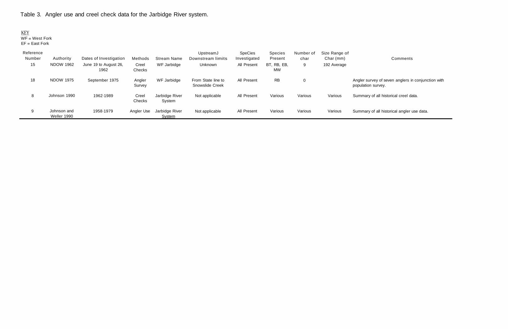
Table 3. Angler use and creel check data for the Jarbidge River system.
KEY WF West Fork EF East Fork
Reference Number
15
Authority
NDOW 1962
Dates of Investigation
June 19 to August 26, 1962
Methods
Creel Checks
Stream Name
WF Jarbidge
UpstreamJ Downstream limits
Unknown
SpeCies Investigated
All Present
Species Present
BT, RB, EB, MW
Number of char
9
Size Range of Char (mm)
192 Average
Comments
18 NDOW 1975 September 1975 Angler Survey
WF Jarbidge From State line to Snowslide Creek
All Present RB 0 Angler survey of seven anglers in conjunction with population survey.
8 Johnson 1990 1962·1989 Creel Checks
Jarbidge River System
Not applicable All Present Various Various Various Summary of all historical creel data.
9 Johnson and Weller 1990
1958·1979 Angler Use Jarbidge River System
Not applicable All Present Various Various Various Summary of all historical angler use data.