annex 1 glossary - circabc - welcome€¦ · · 2015-03-25annex 1 glossary country abbreviations:...
TRANSCRIPT

[The report title goes here. It needs entering for both odd and even pages] 1
Annex 1 Glossary
Country abbreviations:
Abbreviation Country name
AT Austria
BE (Fl) Belgium (Flanders)
BE (W) Belgium (Wallonia)
BG Bulgaria
CY Cyprus
CZ Czech Republic
DE Germany
DK Denmark
EE Estonia
ES Spain
FI Finland
FR France
EL Greece
HR Croatia
HU Hungary
IE Ireland
IT Italy
LT Lithuania
LU Luxembourg
LV Latvia
NL Netherlands
NO Norway
PL Poland
PT Portugal
RO Romania
SE Sweden
SK Slovakia
SI Slovenia
UK United Kingdom
2 [The report title goes here. It needs entering for both odd and even pages]
ETC-ICM European Topic Centre for Inland, Coastal and Marine Waters
GIS Geographic Information System
HMWB and AWBs Heavily modified and Artificial Water Bodies
RBMPs River Basin Management Plans
WFD-CIS WG Ecostat Water Framework Directive – Common Implementation
Strategy – Working Group Ecostat
[The report title goes here. It needs entering for both odd and even pages] 3
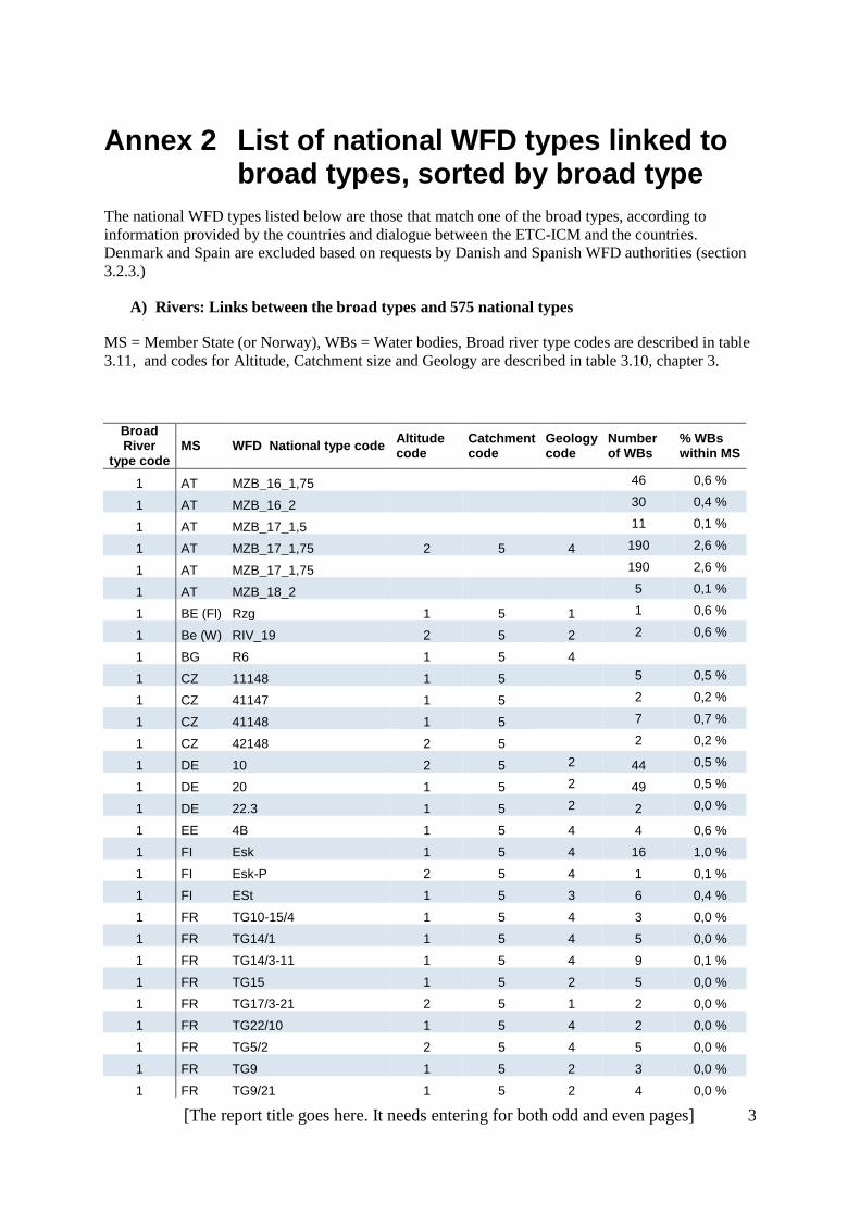
Annex 2 List of national WFD types linked to broad types, sorted by broad type
The national WFD types listed below are those that match one of the broad types, according to
information provided by the countries and dialogue between the ETC-ICM and the countries.
Denmark and Spain are excluded based on requests by Danish and Spanish WFD authorities (section
3.2.3.)
A) Rivers: Links between the broad types and 575 national types
MS = Member State (or Norway), WBs = Water bodies, Broad river type codes are described in table
3.11, and codes for Altitude, Catchment size and Geology are described in table 3.10, chapter 3.
Broad River
type code MS WFD National type code
Altitude code
Catchment code
Geology code
Number of WBs
% WBs within MS
1 AT MZB_16_1,75 46 0,6 %
1 AT MZB_16_2
30 0,4 %
1 AT MZB_17_1,5
11 0,1 %
1 AT MZB_17_1,75 2 5 4 190 2,6 %
1 AT MZB_17_1,75
190 2,6 %
1 AT MZB_18_2
5 0,1 %
1 BE (Fl) Rzg 1 5 1 1 0,6 %
1 Be (W) RIV_19 2 5 2 2 0,6 %
1 BG R6 1 5 4
1 CZ 11148 1 5
5 0,5 %
1 CZ 41147 1 5
2 0,2 %
1 CZ 41148 1 5
7 0,7 %
1 CZ 42148 2 5
2 0,2 %
1 DE 10 2 5 2 44 0,5 %
1 DE 20 1 5 2 49 0,5 %
1 DE 22.3 1 5 2 2 0,0 %
1 EE 4B 1 5 4 4 0,6 %
1 FI Esk 1 5 4 16 1,0 %
1 FI Esk-P 2 5 4 1 0,1 %
1 FI ESt 1 5 3 6 0,4 %
1 FR TG10-15/4 1 5 4 3 0,0 %
1 FR TG14/1 1 5 4 5 0,0 %
1 FR TG14/3-11 1 5 4 9 0,1 %
1 FR TG15 1 5 2 5 0,0 %
1 FR TG17/3-21 2 5 1 2 0,0 %
1 FR TG22/10 1 5 4 2 0,0 %
1 FR TG5/2 2 5 4 5 0,0 %
1 FR TG9 1 5 2 3 0,0 %
1 FR TG9/21 1 5 2 4 0,0 %

4 [The report title goes here. It needs entering for both odd and even pages]
Broad River
type code MS WFD National type code
Altitude code
Catchment code
Geology code
Number of WBs
% WBs within MS
1 FR TTGA 2 5 4 27 0,2 %
1 FR TTGL 1 5 4 9 0,1 %
1 HR HR-R_5A 1 5 4 2 0,2 %
1 HR HR-R_5B 1 5 4 4 0,4 %
1 HR HR-R_5C 1 5 1 2 0,2 %
1 HR HR-R_5D 1 5 1 1 0,1 %
1 HU 14R 1 5 2 3 0,3 %
1 HU 20R 1 5 2 12 1,4 %
1 HU 23R 1 5 2 1 0,1 %
1 HU 24R 1 5 2 2 0,2 %
1 HU 25R 1 5 2 1 0,1 %
1 HU 7R 1 5 2 2 0,2 %
1 NL R7
5
11 4,3 %
1 PL 21 1 5 2 75 1,6 %
1 PT R_GRC 1 5 4 3 0,2 %
1 PT R_GRN 1 5 4 1 0,1 %
1 PT R_GRS 1 5 4 4 0,2 %
1 RO RO12 1 5 2 2 0,1 %
1 RO RO13 1 5 1 1 0,0 %
1 RO RO14 1 5 1 1 0,0 %
1 RO RO15 1 5 4 3 0,1 %
1 SI 11VA
5 2 2 1,6 %
1 SI 11VS
5 1 2 1,6 %
1 SK D1(P1V) 1 5 4 4 0,2 %
1 SK D2(P1V) 1 5 4 1 0,1 %
2 BE (Fl) Rg 1 3-4 1 48 28,2 %
2 BE (Fl) Rk 1 3 1 12 7,1 %
2 BG R12 1 5 1 8
2 CZ 11124 1 3
6 0,6 %
2 CZ 11125 1 3
5 0,5 %
2 CZ 11126 1 3
1 0,1 %
2 CZ 21124 1 3
1 0,1 %
2 CZ 21125 1 3
3 0,3 %
2 CZ 21126 1 3
1 0,1 %
2 CZ 31125 1 3
1 0,1 %
2 CZ 41124 1 3
9 0,8 %
2 CZ 41125 1 3
12 1,1 %
2 FI Kk 1 3 1 275 17,2 %
2 FR G12 1 4 1 11 0,1 %
2 FR G18/4 1 4 1 7 0,1 %
2 FR GM20 1 4 1 9 0,1 %
2 FR P12-A 1 3 1 125 1,2 %
2 FR P12-B 1 3 1 107 1,0 %

[The report title goes here. It needs entering for both odd and even pages] 5
Broad River type code
MS WFD National type code Altitude code
Catchment code
Geology code
Number of WBs
% WBs within MS
2 SE V3LNN 1 3, 4, 5 1 291 1,9 %
2 SE V4LNN 1 3, 4, 5 1 42 0,3 %
2 SE V5LNN 1 3, 4, 5 1 1 0,0 %
2 SE V6LNN 1 3, 4, 5 1 59 0,4 %
2 UK 4 1 3 1 99 1,2 %
2 UK 7 1 4 1 6 0,1 %
3 BE (Fl) Bg 1 2-3 1 62 36,5 %
3 BE (Fl) BgK 1 2-3 1 29 17,1 %
3 CZ 11114 1 2
3 0,3 %
3 CZ 21114 1 2
2 0,2 %
3 CZ 21115 1 2
1 0,1 %
3 CZ 31114 1 2
3 0,3 %
3 CZ 41114 1 2
11 1,0 %
3 FI Pk 1 2 1 151 9,4 %
3 FR TP12-A 1 2 1 405 3,7 %
3 FR TP12-B 1 2 1 183 1,7 %
3 FR TP13 1 2 1 180 1,7 %
3 HR HR-R_3A 1 2 1 6 0,5 %
3 IE 11 1 2 1 279 6,1 %
3 IE 12 1 2 1 801 17,5 %
3 IE 13 1 2 1 361 7,9 %
3 IE 14 1 2 1 374 8,2 %
3 NO 1 1
1
3 NO 2 1
1
3 NO 4 1
1
3 NO 5 1
1
3 NO 7 1
1
3 PL 17 1 2 1 1792 39,1 %
3 PL 18 1 2 1 299 6,5 %
3 SE V3SNN 1 1, 2 1 610 3,9 %
3 SE V4SNN 1 1, 2 1 141 0,9 %
3 SE V5SNN 1 1, 2 1 3 0,0 %
3 SE V5SYY 1 1, 2 1, 2 17 0,1 %
3 SE V6SNN 1 1, 2 1 104 0,7 %
3 UK 1 1 2 1 1053 12,6 %
3 UK 37 1 1 1 432 5,2 %
4 AT MZB_13_2
25 0,3 %
4 Be (W) RIV_21 1 3 4 1 0,3 %
4 Be (W) RIV_22 1 3 4 14 4,0 %
4 Be (W) RIV_23 1 4 4 3 0,9 %
4 BG R10 1 4 1, 2 4
4 BG R11 1 3 1, 2 69
4 BG R13 1 3 1, 2
4 BG R7 1 4 4

6 [The report title goes here. It needs entering for both odd and even pages]
Broad River type code
MS WFD National type code Altitude code
Catchment code
Geology code
Number of WBs
% WBs within MS
4 BG R8 1 3 4
4 CZ 11224 1 3
3 0,3 %
4 CZ 11225 1 3
1 0,1 %
4 CZ 11226 1 3
2 0,2 %
4 CZ 21224 1 3
1 0,1 %
4 CZ 21226 1 3
1 0,1 %
4 CZ 41224 1 3
6 0,6 %
4 CZ 41225 1 3
2 0,2 %
4 CZ 41226 1 3
1 0,1 %
4 DE 15 1 3 4 284 3,1 %
4 DE 17 1 3 4 93 1,0 %
4 DE 15_G 1 4 2 16 0,2 %
4 EE 2A 1 3 4 22 3,4 %
4 EE 2B 1 3 4 88 13,6 %
4 EE 3A 1 4 4 2 0,3 %
4 EE 3B 1 4 4 15 2,3 %
4 FR G11/3-21 1 4 4 4 0,0 %
4 FR G14/3 1 4 4 3 0,0 %
4 FR G9 1 4 2 30 0,3 %
4 FR G9-10/21 1 4 2 2 0,0 %
4 FR GM14 1 4 4 13 0,1 %
4 FR GM20/9 1 4 4 3 0,0 %
4 FR P14 1 3 4 224 2,1 %
4 FR P9 1 3 2 300 2,8 %
4 FR TG11/3-21 1 4 4 1 0,0 %
4 HR HR-R_4 1 3, 4 4 66 6,0 %
4 HR HR-R_8 1 3, 4 4 4 0,4 %
4 HU 13R 1 4 2 8 0,9 %
4 HU 18R 1 3 2 91 10,5 %
4 IT IT06SS3F 1 3 4 64 0,8 %
4 LT RWT2 1 3 2 93 11,2 %
4 LT RWT3 1 3 2 112 13,5 %
4 LT RWT4 1 4 2 14 1,7 %
4 LT RWT5 1 4 2 24 2,9 %
4 LU 5 1 3
9 8,3 %
4 LU 6 1 4
4 3,7 %
4 LV R3 1 3 2 79 38,7 %
4 LV R4 1 3 2 65 31,9 %
4 LV R5 1 4 2 10 4,9 %
4 LV R6 1 4 2 46 22,7 %
4 PL 19 1 4 2 271 5,9 %
4 RO RO07 1 4 4 19 0,6 %
4 RO RO08 1 4 4 4 0,1 %
4 RO RO09 1 4 4 1 0,0 %

[The report title goes here. It needs entering for both odd and even pages] 7
Broad River type code
MS WFD National type code Altitude code
Catchment code
Geology code
Number of WBs
% WBs within MS
4 RO RO10 1 4 4 6 0,2 %
4 RO RO10* 1 4 4 40 1,2 %
4 RO RO11 1 4 4 10 0,3 %
4 RO RO11* 1 4 4 5 0,2 %
4 SE V3LNY 1 3, 4, 5 2 4 0,0 %
4 SE V4LNY 1 3, 4, 5 2 21 0,1 %
4 SE V5LNY 1 3, 4, 5 2 30 0,2 %
4 SK B1(P1V) 1 4 4 7 0,4 %
4 SK I1(P1V) 1 4 4 1 0,1 %
4 SK M1(P1V) 1 4 4 2 0,1 %
4 SK P1S 1 3 4 28 1,6 %
4 SK R2(P1V) 1 4 4 1 0,1 %
4 SK V3(P1V) 1 4 4 8 0,5 %
4 UK 5 1 3 2 429 5,1 %
4 UK 8 1 4 2 63 0,8 %
5 Be (W) RIV_20 1 2 4 66 18,7 %
5 CZ 11214 1 2
6 0,6 %
5 CZ 21214 1 2
7 0,7 %
5 CZ 41214 1 2
7 0,7 %
5 DE 14 1 2 4 1302 14,3 %
5 DE 16 1 2 4 872 9,6 %
5 DE 18 1 2 2 298 3,3 %
5 EE 1A 1 2 4 128 19,8 %
5 EE 1B 1 2 2 385 59,7 %
5 FR TP14 1 2 4 752 6,9 %
5 FR TP15 1 2 2 184 1,7 %
5 FR TP9 1 2 2 1329 12,3 %
5 HR HR-R_2A 1 2 4 399 36,4 %
5 HR HR-R_2B 1 2 4 196 17,9 %
5 HU 11R
7 0,8 %
5 HU 15R 1 2, 3 2 46 5,3 %
5 HU 16R 1 2, 3 2 29 3,3 %
5 HU 17R 1 2, 3 2 53 6,1 %
5 IE 21
4 155 3,4 %
5 IE 22
4 272 6,0 %
5 IE 23
4 87 1,9 %
5 IE 24
4 58 1,3 %
5 IE 31 1 2 2 1299 28,4 %
5 IE 32 1 2 2 670 14,7 %
5 IE 33
2 109 2,4 %
5 IE 34
2 58 1,3 %
5 IT IT06AS2T 1 2 4 34 0,4 %
5 IT IT06AS6T 1 1 4 129 1,7 %
5 IT IT06SR6T 1 1 4 30 0,4 %

8 [The report title goes here. It needs entering for both odd and even pages]
Broad River type code
MS WFD National type code Altitude code
Catchment code
Geology code
Number of WBs
% WBs within MS
5 IT IT06SS1T 1 2 4 74 1,0 %
5 LT RWT1 1 2 2 589 70,8 %
5 LU 4 1 2
47 43,5 %
5 LV R1 1 2 2 3 1,5 %
5 LV R2 1 2 2 1 0,5 %
5 NL R4 1 1 2 47 18,5 %
5 NL R5 1 2 2 133 52,4 %
5 NL R6 1 2 2 30 11,8 %
5 NO 9 1
2
5 PL 16 1 2 2 295 6,4 %
5 RO RO06 1 2, 3 4 156 4,8 %
5 SE V3SNY 1 1, 2 2 15 0,1 %
5 SE V4SNY 1 1, 2 2 46 0,3 %
5 SE V5SNY 1 1, 2 2 42 0,3 %
5 SE V6SNY 1 1, 2 2 3 0,0 %
5 SK P1M 1 2 4 259 15,0 %
5 UK 2 1 2 2 3088 37,0 %
5 UK 40 1 1 2 342 4,1 %
6 FI Kt 1 3 3 532 33,2 %
6 FI Pt 1 2 3 281 17,5 %
6 NO 3 1
1, 3
6 NO 6 1
1, 3
6 NO 8 1
1, 3
6 PL 23 1 2 3 314 6,8 %
6 SE V3LYN 1 3, 4, 5 1, 3 946 6,1 %
6 SE V3SYN 1 1, 2 1, 3 2287 14,7 %
6 SE V4LYN 1 3, 4, 5 1, 3 218 1,4 %
6 SE V4SYN 1 1, 2 1, 3 577 3,7 %
6 SE V5LYN 1 3, 4, 5 1, 3 40 0,3 %
6 SE V5SYN 1 1, 2 1, 3 67 0,4 %
6 SE V6LYN 1 3, 4, 5 1, 3 292 1,9 %
6 SE V6SYN 1 1, 2 1, 3 493 3,2 %
6 UK 3 1 2 3 136 1,6 %
6 UK 6 1 3 3 2 0,0 %
6 UK 9 1 4 3 7 0,1 %
6 UK 43 1 1 3 1 0,0 %
7 NO 10 1
2
7 NO 11 1
3, 4
7 SE V3LYY 1 3, 4, 5 2, 3 3 0,0 %
7 SE V3SYY 1 1, 2 2, 3 14 0,1 %
7 SE V4LYY 1 3, 4, 5 2, 3 67 0,4 %
7 SE V4SYY 1 1, 2 2, 3 168 1,1 %
7 SE V5LYY 1 3, 4, 5 2, 3 20 0,1 %
7 SE V6LYY 1 3, 4, 5 2, 3 32 0,2 %

[The report title goes here. It needs entering for both odd and even pages] 9
Broad River type code
MS WFD National type code Altitude code
Catchment code
Geology code
Number of WBs
% WBs within MS
7 SE V6SYY 1 1, 2 2, 3 32 0,2 %
8 AT MZB_1_1,25
164 2,2 %
8 AT MZB_12_1,75 2 3 1 243 3,3 %
8 AT MZB_3_1,25
5 0,1 %
8 AT MZB_4_1,25
12 0,2 %
8 Be (W) RIV_06 2 3 1 11 3,1 %
8 Be (W) RIV_07 2 3 1 4 1,1 %
8 Be (W) RIV_08 2 4 1 1 0,3 %
8 BG R5 2 3 1
8 CZ 22124 2 3
1 0,1 %
8 CZ 22125 2 3
1 0,1 %
8 CZ 22137 2 4
1 0,1 %
8 CZ 32124 2 3
6 0,6 %
8 CZ 32125 2 3
10 0,9 %
8 CZ 32126 2 3
2 0,2 %
8 CZ 32136 2 4
3 0,3 %
8 CZ 32137 2 4
1 0,1 %
8 CZ 42124 2 3
100 9,4 %
8 CZ 42125 2 3
91 8,5 %
8 CZ 42126 2 3
28 2,6 %
8 CZ 42135 2 4
2 0,2 %
8 CZ 42136 2 4
23 2,2 %
8 CZ 42137 2 4
11 1,0 %
8 CZ 43124 2 3
11 1,0 %
8 CZ 43125 2 3
7 0,7 %
8 CZ 43126 2 3
2 0,2 %
8 CZ 43136 2 4
1 0,1 %
8 DE 9 2 3 1 240 2,6 %
8 FR G17/3-21 2 4 1 6 0,1 %
8 FR G21 2 4 1 9 0,1 %
8 FR G3 2 4 1 10 0,1 %
8 FR GM22 2 4 1 3 0,0 %
8 FR GM8 2 4 1 23 0,2 %
8 FR P21 2 3 1 120 1,1 %
8 FR P3 2 3 1 183 1,7 %
8 IT IT03SS3N 2 3 1 32 0,4 %
8 LU 3 2 3
11 10,2 %
8 PL 8 2 3 1 35 0,8 %
8 SE V2LNN 2 3, 4, 5 1 1364 8,8 %
8 SE V7LNN 2 3, 4, 5 1 3 0,0 %
8 UK 13 2 3 1 246 3,0 %
8 UK 16 2 4 1 25 0,3 %
9 AT MZB_12_1,5 2 2 1 448 6,1 %
9 Be (W) RIV_04 2 2 1 9 2,5 %

10 [The report title goes here. It needs entering for both odd and even pages]
Broad River type code
MS WFD National type code Altitude code
Catchment code
Geology code
Number of WBs
% WBs within MS
9 Be (W) RIV_05 2 2 1 80 22,6 %
9 BG R4 2 2 1
9 CZ 12114 2 2
2 0,2 %
9 CZ 22114 2 2
9 0,8 %
9 CZ 22115 2 2
1 0,1 %
9 CZ 32113 2 2
2 0,2 %
9 CZ 32114 2 2
22 2,1 %
9 CZ 32115 2 2
1 0,1 %
9 CZ 42113 2 2
2 0,2 %
9 CZ 42114 2 2
298 27,9 %
9 CZ 42115 2 2
9 0,8 %
9 CZ 43114 2 2
81 7,6 %
9 CZ 43115 2 2
8 0,7 %
9 DE 5 2 2 1 1322 14,6 %
9 DE 5.1 2 2 1 294 3,2 %
9 FR TP21 2 2 1 357 3,3 %
9 FR TP4 2 2 1 133 1,2 %
9 HU 1R 2
28 3,2 %
9 IT IT03GH6N 2 1 1 56 0,7 %
9 IT IT03SR6N 2 1 1 97 1,3 %
9 IT IT03SS1N 2 2 1 256 3,3 %
9 IT IT03SS2N 2 2 1 162 2,1 %
9 LU 1 2 2
28 25,9 %
9 LU 2 2 2
8 7,4 %
9 NO 12 2
1
9 NO 13 2
1
9 NO 15 2
1
9 NO 16 2
1
9 NO 18 2
1
9 PL 4 2 2 1 117 2,6 %
9 PL 5 2 2 1 33 0,7 %
9 PL 12 2 2 1 274 6,0 %
9 SE V2SNN 2 1, 2 1 3047 19,6 %
9 SE V7SNN 2 1, 2 1 17 0,1 %
9 UK 10 2 2 1 1426 17,1 %
10 AT MZB_11_1,75 2 3 4 465 6,3 %
10 AT MZB_13_1,5 2 3 4 198 2,7 %
10 AT MZB_15_1,75
38 0,5 %
10 AT MZB_5_1,75
101 1,4 %
10 AT MZB_7_1,5
33 0,4 %
10 AT MZB_8_1,5
8 0,1 %
10 AT MZB_9_1,75
9 0,1 %
10 Be (W) RIV_03 2 3 2 4 1,1 %
10 Be (W) RIV_11 2 3 2 3 0,9 %

[The report title goes here. It needs entering for both odd and even pages] 11
Broad River type code
MS WFD National type code Altitude code
Catchment code
Geology code
Number of WBs
% WBs within MS
10 Be (W) RIV_12 2 4 2 2 0,6 %
10 Be (W) RIV_15 2 3 2 9 2,5 %
10 Be (W) RIV_16 2 3 2 1 0,3 %
10 Be (W) RIV_17 2 4 2 2 0,6 %
10 Be (W) RIV_18 2 4 2 3 0,9 %
10 CZ 12225 2 3
1 0,1 %
10 CZ 22225 2 3
11 1,0 %
10 CZ 22226 2 3
4 0,4 %
10 CZ 22237 2 4
1 0,1 %
10 CZ 32224 2 3
1 0,1 %
10 CZ 32225 2 3
2 0,2 %
10 CZ 42224 2 3
8 0,7 %
10 CZ 42225 2 3
9 0,8 %
10 CZ 42226 2 3
4 0,4 %
10 CZ 42236 2 4
5 0,5 %
10 DE 3.2 2 3 2 3 0,0 %
10 DE 4 2 4 2 29 0,3 %
10 DE 9.1 2 3 2 104 1,1 %
10 DE 9.2 2 4 2 99 1,1 %
10 DE 9.1_K 2 3 2 23 0,3 %
10 FI Sk-Po 2 4 4 9 0,6 %
10 FR G10 2 4 2 9 0,1 %
10 FR G10/4 2 4 4 10 0,1 %
10 FR G3/19-8 2 4 2 5 0,0 %
10 FR G5 2 4 2 7 0,1 %
10 FR GM19/8 2 4 4 7 0,1 %
10 FR GM5/2 2 4 4 4 0,0 %
10 HR HR-R_10B 2 3 2 2 0,2 %
10 HR HR-R_7 2 3, 4 4 12 1,1 %
10 HR HR-R_9 2 3 2 8 0,7 %
10 HU 10R 1, 2 4 2 4 0,5 %
10 HU 5R 1, 2 3 2 40 4,6 %
10 HU 6R 1, 2 4 2 9 1,0 %
10 HU 9R 1, 2 3 2 94 10,8 %
10 PL 9 2 3 2 46 1,0 %
10 RO RO02 2, 3 4 4 11 0,3 %
10 RO RO05 2 4 4 47 1,4 %
10 SE V2LNY 2 3, 4, 5 2 104 0,7 %
10 SE V6LNY 2 3, 4, 5 2 1 0,0 %
10 SK H1(K2V) 2 4 4 2 0,1 %
10 SK H2(K2V) 2 4 4 1 0,1 %
10 SK K2S 2 3 4 48 2,8 %
10 SK K3S 2 3 4 11 0,6 %
10 SK P1(K3V) 2 4 4 1 0,1 %

12 [The report title goes here. It needs entering for both odd and even pages]
Broad River type code
MS WFD National type code Altitude code
Catchment code
Geology code
Number of WBs
% WBs within MS
10 SK P2(K3V) 2 4 4 1 0,1 %
10 SK P2S 2 3 4 4 0,2 %
10 SK R1(K2V) 2 4 4 1 0,1 %
10 SK S(K2V) 2 4 4 2 0,1 %
10 SK V1(K3V) 2 4 4 3 0,2 %
10 SK V2(K2V) 2 4 4 2 0,1 %
10 UK 14 2 3 2 91 1,1 %
10 UK 17 2 4 2 21 0,3 %
11 AT MZB_10_1,75
20 0,3 %
11 AT MZB_11_1,5 2 1 4 221 3,0 %
11 AT MZB_13_1,75 2 2 4 547 7,5 %
11 AT MZB_15_1,5 2 2 4 224 3,1 %
11 AT MZB_5_1,5 2 2 2 442 6,0 %
11 Be (W) RIV_01 2 2 2 6 1,6 %
11 Be (W) RIV_02 2 2 2 9 2,5 %
11 Be (W) RIV_09 2 2 2 15 4,2 %
11 Be (W) RIV_10 2 2 2 13 3,7 %
11 Be (W) RIV_13 2 2 2 15 4,3 %
11 Be (W) RIV_14 2 2 2 46 13,0 %
11 CZ 22214 2 2
70 6,5 %
11 CZ 22215 2 2
7 0,7 %
11 CZ 23214 2 2
11 1,0 %
11 CZ 23215 2 2
1 0,1 %
11 CZ 32214 2 2
4 0,4 %
11 CZ 42214 2 2
40 3,7 %
11 CZ 42215 2 2
2 0,2 %
11 CZ 43213 2 2
1 0,1 %
11 CZ 43214 2 2
4 0,4 %
11 DE 3.1 2 2 2 53 0,6 %
11 DE 6 2 2 2 431 4,7 %
11 DE 7 2 2 2 304 3,4 %
11 DE 6_K 2 2 2 75 0,8 %
11 FR TP10 2 2 2 599 5,5 %
11 FR TP11 2 2 2 130 1,2 %
11 HR HR-R_1 2 2 4 69 6,3 %
11 HR HR-R_10A 2 2 2 62 5,7 %
11 HR HR-R_6 2 2 4 36 3,3 %
11 HU 4R 2 2, 3 2 71 8,2 %
11 HU 8R 1, 2 2, 3 2 138 15,9 %
11 IT IT02SR6N 2 1 2 55 0,7 %
11 IT IT02SR6T 2 1 2 93 1,2 %
11 IT IT02SS1N 2 2 2 48 0,6 %
11 IT IT02SS1T 2 2 2 229 3,0 %
11 IT IT02SS2N 2 2 2 34 0,4 %

[The report title goes here. It needs entering for both odd and even pages] 13
Broad River type code
MS WFD National type code Altitude code
Catchment code
Geology code
Number of WBs
% WBs within MS
11 IT IT02SS2T 2 2 2 115 1,5 %
11 IT IT06SS2T 2 2 4 172 2,3 %
11 IT IT10SS1N 2 2 2 93 1,2 %
11 IT IT10SS2N 2 2 2 182 2,4 %
11 PL 6 2 2 2 323 7,0 %
11 PL 7 2 2 2 53 1,2 %
11 RO RO01 2, 3 2, 3 4 900 27,6 %
11 RO RO04 2 2, 3 4 359 11,0 %
11 SE V2SNY 2 1, 2 2 77 0,5 %
11 SK K2M 2 2 2 592 34,3 %
11 SK P2M 2 2 4 60 3,5 %
11 UK 11 2 2 2 612 7,3 %
12 Be (W) RIV_24 2 2 3 8 2,3 %
12 NO 14 2
1, 3
12 NO 17 2
1, 3
12 NO 19 2
1, 3
12 SE V2LYN 2 3, 4, 5 1, 3 738 4,7 %
12 SE V2SYN 2 1, 2 1, 3 2363 15,2 %
12 SE V7LYN 2 3, 4, 5 1, 3 36 0,2 %
12 SE V7SYN 2 1, 2 1, 3 145 0,9 %
13 FI St-Po 2 4 3 1 0,1 %
13 PL 24 2 4 3 98 2,1 %
13 SE V2LYY 2 3, 4, 5 2, 3 28 0,2 %
13 SE V2SYY 2 1, 2 2, 3 20 0,1 %
13 SE V7LYY 2 3, 4, 5 2, 3 2 0,0 %
13 SE V7SYY 2 1, 2 2, 3 5 0,0 %
14 BG R2 3 2 1
14 BG R3 3 2 1
14 CZ 44114 3 2
7 0,7 %
14 CZ 44115 3 2
2 0,2 %
14 FR TP3 3 2 1 577 5,3 %
14 IT IT03GH1N 3 2 1 29 0,4 %
14 NO 20 3
1
14 NO 21 3
1
14 NO 22 3
1, 3
14 NO 23 3
1
14 NO 24 3
1
14 NO 25 3
1, 3
14 PL 1 3 2 1 4 0,1 %
14 SE V1LNN 3 3, 4, 5 1 123 0,8 %
14 SE V1SNN 3 1, 2 1 778 5,0 %
14 UK 18 3 2 1 5 0,1 %
15 AT MZB_5_1,25 3 1 2 267 3,6 %
15 AT MZB_6_1
112 1,5 %

14 [The report title goes here. It needs entering for both odd and even pages]
Broad River type code
MS WFD National type code Altitude code
Catchment code
Geology code
Number of WBs
% WBs within MS
15 AT MZB_6_1,25
183 2,5 %
15 AT MZB_7_1
71 1,0 %
15 AT MZB_7_1,25 3 2 2 198 2,7 %
15 AT MZB_8_1,25
32 0,4 %
15 BG R1 3 2 4
15 CY R2
17 7,9 %
15 DE 1.1 3 2 2 40 0,4 %
15 DE 1.2 3 3 2 31 0,3 %
15 FR TP5 3 2 2 361 3,3 %
15 FR TP7 3 2 2 215 2,0 %
15 PL 2 3 2 2 2 0,0 %
15 SE V1LNY 3 3, 4, 5 2 4 0,0 %
15 SE V1SNY 3 1, 2 2 7 0,0 %
15 SK K3M 3 2 4 492 28,5 %
15 SK K4M 3 2 4 195 11,3 %
16 AT MZB_2_1,25 3 3 1 603 8,2 %
16 AT MZB_2_1,5 2 3 1 929 12,7 %
16 AT MZB_3_1,5 3 3 1 716 9,8 %
16 FR G1 2 4 4 3 0,0 %
16 FR G14/1 2 4 4 16 0,1 %
16 FR G2 2 4 4 10 0,1 %
16 FR GM7/2 2 4 4 5 0,0 %
16 FR M1 3 3 4 19 0,2 %
16 FR P1
88 0,8 %
16 FR TP1 3 2 4 255 2,4 %
16 FR TP2 3 2 1 277 2,6 %
16 IT IT01GH1N 3 2 1 45 0,6 %
16 IT IT01GH2N 2 2 1 45 0,6 %
16 IT IT01SS1N 2 2 1 105 1,4 %
16 IT IT01SS2N 2 2 1 77 1,0 %
16 IT IT04SS2N 2 2 1 58 0,8 %
17 EL LOW-L-C 1 4 2 93 9,0 %
17 EL LOW-L-S 1 4 1 135 13,1 %
17 EL LOW-M-C 1 3 2 98 9,5 %
17 EL LOW-M-S 1 3 1 107 10,4 %
17 FR G16 1 4 1 4 0,0 %
17 FR G6 1 4 2 6 0,1 %
17 FR GM6/1 1 4 4 6 0,1 %
17 HR HR-R_13 1 3, 4 2 4 0,4 %
17 HR HR-R_13A 1 4 2 2 0,2 %
17 HR HR-R_18 1 3 4 5 0,5 %
17 IT IT06SS3T 1 3 4 48 0,6 %
17 IT IT06SS4D 1 3 4 46 0,6 %
17 IT IT06SS4F 1 3 4 28 0,4 %

[The report title goes here. It needs entering for both odd and even pages] 15
Broad River type code
MS WFD National type code Altitude code
Catchment code
Geology code
Number of WBs
% WBs within MS
17 PT R_L 1 2, 3, 4 4 92 5,7 %
17 PT R_S1G 1 3, 4 1 92 5,7 %
17 PT R_S3 1 2, 3, 4 1, 2 175 10,9 %
18 EL MID-L-C 2 4 2 84 8,1 %
18 EL MID-L-S 2 4 1 114 11,0 %
18 EL MID-M-C 2 3 2 72 7,0 %
18 EL MID-M-S 2 3 1 95 9,2 %
18 FR GM6/2-7 2 4 4 16 0,1 %
18 FR GM6/8 2 4 4 21 0,2 %
18 FR GMP7 2 4 2 32 0,3 %
18 FR TG6/1-8 2 4 4 2 0,0 %
18 HR HR-R_12 2 3, 4 2 8 0,7 %
18 IT IT10SS3N 2 3 2 71 0,9 %
18 IT IT13AS3N 2 3 2 34 0,4 %
18 IT IT19SS3N 2 3 1 34 0,4 %
18 IT IT21SS3T 2 3 1 32 0,4 %
19 EL LOW-S-C 1 2 2 53 5,1 %
19 FR PTP16-A 2 2 1 166 1,5 %
19 FR PTP8 2 2 1 164 1,5 %
19 FR TP6 1 2 4 510 4,7 %
19 HR HR-R_11 1, 2 2 4 10 0,9 %
19 HR HR-R_16B 1 2 4 62 5,7 %
19 HR HR-R_17 1, 2 2 4 15 1,4 %
19 HR HR-R_19 1 2, 3 4 20 1,8 %
19 IT IT09SS2T 2 2 2 37 0,5 %
19 IT IT10SS2T 2 2 2 61 0,8 %
19 IT IT11SS2N 2 2 4 51 0,7 %
19 IT IT11SS2T 2 2 4 28 0,4 %
19 IT IT13SR2T 2 2 2 47 0,6 %
19 IT IT14SS2T 1 2 1 29 0,4 %
19 IT IT19SR1N 2 2 1 30 0,4 %
19 IT IT19SR2N 2 2 1 34 0,4 %
19 IT IT19SS1N 2 2 1 39 0,5 %
19 IT IT19SS2N 2 2 1 48 0,6 %
19 IT IT21SS2T 2 2 1 32 0,4 %
19 PT R_N1P 2 2 1 397 24,6 %
19 PT R_N3 2 2 1 109 6,8 %
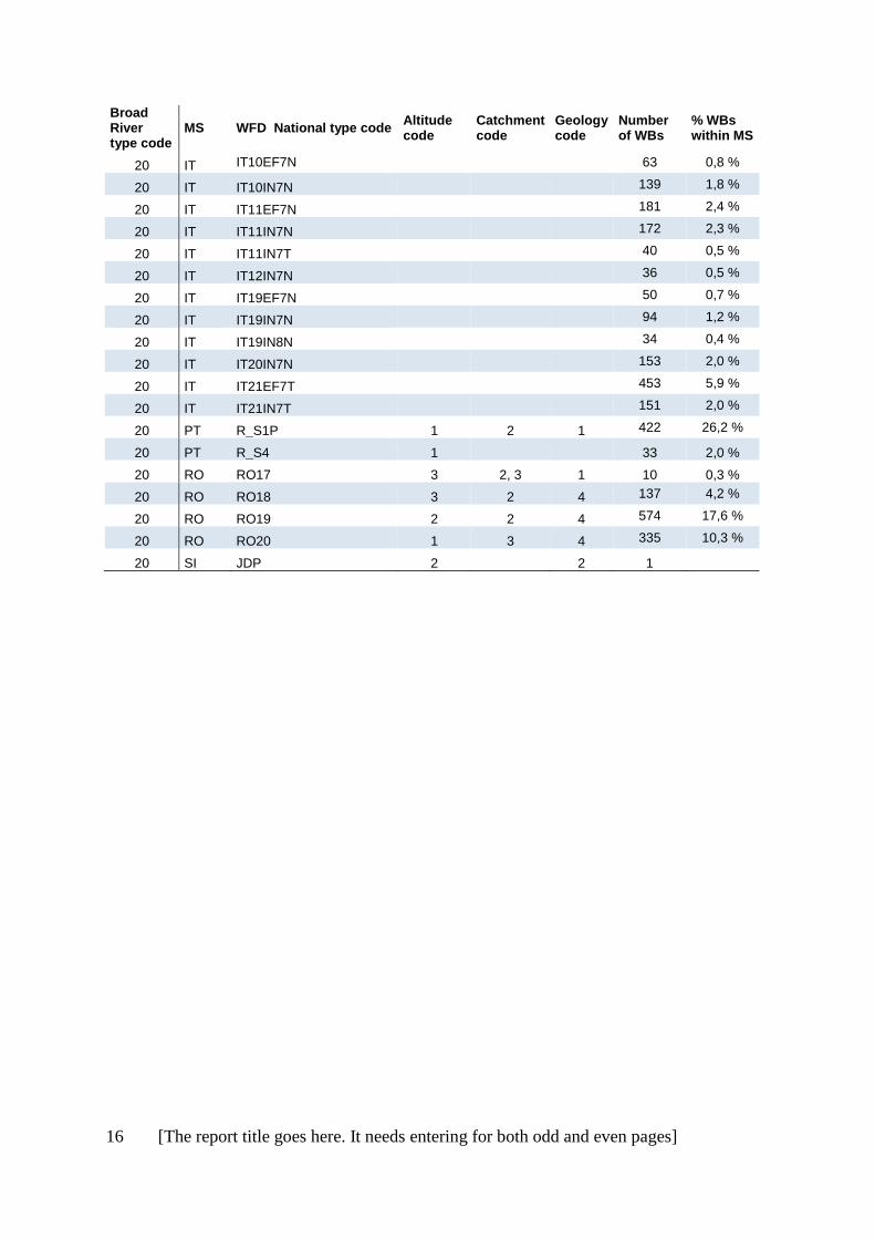
20 BG R14 2 3 4
20 CY R1
4 40 18,5 %
20 CY R3
4 159 73,6 %
20 IT IT02IN7N
34 0,4 %
20 IT IT02IN7T
88 1,2 %
20 IT IT06IN7D
66 0,9 %
20 IT IT06IN7N
84 1,1 %
16 [The report title goes here. It needs entering for both odd and even pages]
Broad River type code
MS WFD National type code Altitude code
Catchment code
Geology code
Number of WBs
% WBs within MS
20 IT IT10EF7N
63 0,8 %
20 IT IT10IN7N
139 1,8 %
20 IT IT11EF7N
181 2,4 %
20 IT IT11IN7N
172 2,3 %
20 IT IT11IN7T
40 0,5 %
20 IT IT12IN7N
36 0,5 %
20 IT IT19EF7N
50 0,7 %
20 IT IT19IN7N
94 1,2 %
20 IT IT19IN8N
34 0,4 %
20 IT IT20IN7N
153 2,0 %
20 IT IT21EF7T
453 5,9 %
20 IT IT21IN7T
151 2,0 %
20 PT R_S1P 1 2 1 422 26,2 %
20 PT R_S4 1
33 2,0 %
20 RO RO17 3 2, 3 1 10 0,3 %
20 RO RO18 3 2 4 137 4,2 %
20 RO RO19 2 2 4 574 17,6 %
20 RO RO20 1 3 4 335 10,3 %
20 SI JDP 2 2 1

[The report title goes here. It needs entering for both odd and even pages] 17
B) Lakes: Links between the broad types and 290 national types
MS = Member State (or Norway), WBs = Water bodies, Broad lake type codes are described in table
3.13, and codes for Altitude, Catchment size and Geology are described in table 3.10, chapter 3.
Broad Lake types code
MS WFD National type code
Altitude code
Surface Area code
Geology code
Mean depth code
Number of WBs
% WBs within MS
1 AT B1 2 5 4 3 1 1.6 %
1 BG L11
5
3
1 FI Sh 1 5 3 2 44 1.0 %
1 FI SVh 1 5 1 2 68 1.6 %
1 FR A52 1 5
3 1 0.2 %
1 IT ITAL-3 2 5 2 3 12 4.0 %
2 CZ 311322 1 4 1 2 1 1.4 %
2 EE 5 1 3 2 1 1 1.1 %
2 FI Vh 1 4 1 2 618 14.5 %
2 IE 1
1
14 5.9 %
2 IE 2 1 2 1 1 23 9.7 %
2 IE 3
1
9 3.8 %
2 IE 4 1 2 1 2 42 17.6 %
2 NO 1 1
1 2
2 NO 2 1
1 2
2 NO 4 1
1 2
2 NO 5 1
1 2
2 NO 6 1
1 3
2 NO 8 1
1, 4 2
2 SE S3DLNN 1 4, 5
2, 3 34 0.5 %
2 SE S3DSNN 1 1, 2, 3
2, 3 282 3.9 %
2 SE S4DLNN 1 4, 5
2, 3 22 0.3 %
2 SE S4DSNN 1 1, 2, 3
2, 3 132 1.8 %
2 SE S5DLNN 1 4, 5
2, 3 1 0.0 %
2 SE S5DSNN 1 1, 2, 3
2, 3 7 0.1 %
2 SE S6DLNN 1 4, 5
2, 3 32 0.4 %
2 SE S6DSNN 1 1, 2, 3
2, 3 131 1.8 %
2 UK 11 1
1
4 0.4 %
2 UK LAD
1 3 18 1.6 %
2 UK LAS
3 1 2 179 16.0 %
2 UK Lowland Low alkalinity Large Deep 1 4 1 3 76 6.8 %
2 UK Lowland Medium alkalinity Large Deep 1 4 4 3 82 7.3 %
2 UK MAD
4 3 5 0.4 %
2 UK MAS
4 2 85 7.6 %
3 BE (Fl) Awe 1 2, 3 2
7 38.9 %
3 BE (Fl) Awom 1 2, 3 2
1 5.6 %
3 BG L14 1 4 4 2

18 [The report title goes here. It needs entering for both odd and even pages]
Broad Lake types code
MS WFD National type code
Altitude code
Surface Area code
Geology code
Mean depth code
Number of WBs
% WBs within MS
3 BG L15 1 4 4 2
3 BG L16 1 3 4 2
3 BG L17 1 3 4 2
3 DE 10 1 4 2 2 155 21.8 %
3 DE 13 1 2 2 2 93 13.1 %
3 EE 1 1 1 2 3 1 1.1 %
3 EE 3 1 1, 2, 3 2 2 22 24.7 %
3 EE 6 1 5 4 2 1 1.1 %
3 EE 7 1 5 4 2 2 2.2 %
3 FR A16 1 3 2 2 25 5.7 %
3 FR A6b 1 3 4 2 54 12.3 %
3 HU 13L 1 3 2 2 30 14.1 %
3 HU 15L 1 4 2 2 6 2.8 %
3 IE 7
1
13 5.5 %
3 IE 8 1 2 2 2 22 9.2 %
3 IE 11
1
3 1.3 %
3 IE 12 1 2 2 2 24 10.1 %
3 IT ITAL-5 2 3 4 2 26 8.7 %
3 LT LWT2 1
2 2 172 49.9 %
3 LT LWT3 1
2 2 43 12.4 %
3 LV L5 1 2,3 2 2 159 61.4 %
3 LV L7 1 2,3 2 2 2 0.8 %
3 NL M20 1 3 2 2 29 6.4 %
3 NL M21 1 5 4 2 2 0.4 %
3 NO 10 1
2 1, 2
3 PL 2a 1 3 2 2 111 10.6 %
3 PL 3a 1 3 2 2 254 24.3 %
3 PL 6a 1 3 2 2 133 12.7 %
3 RO ROLN14T 1 3 4 2 5 3.8 %
3 SE S3DSNY 1 1, 2, 3
2, 3 4 0.1 %
3 SE S4DLNY 1 4, 5
2, 3 4 0.1 %
3 SE S4DSNY 1 1, 2, 3
2, 3 39 0.5 %
3 SE S5DLNY 1 4, 5
2, 3 3 0.0 %
3 SE S5DSNY 1 1, 2, 3
2, 3 3 0.0 %
3 UK HAS
3 2 2 166 14.8 %
3 UK Lowland High alkalinity Large Deep 1 4 2 3 20 1.8 %
3 UK MarlS
2 10 0.9 %
4 AT A1 1 5
1 1 1.6 %
4 BE (Fl) Ai 1 2 2
1 5.6 %
4 BE (Fl) Ami 1 2 2
5 27.8 %
4 BG L4 1 1 4 1
4 CZ 311211 1 3 1 1 1 1.4 %

[The report title goes here. It needs entering for both odd and even pages] 19
Broad Lake types code
MS WFD National type code
Altitude code
Surface Area code
Geology code
Mean depth code
Number of WBs
% WBs within MS
4 CZ 311212 1 3 1 1 1 1.4 %
4 CZ 411112 1 2 1 1 1 1.4 %
4 EE 2 1 3 2 1 33 37.0 %
4 HU 16L 1 5 2 1 1 0.5 %
4 IE 5 1 1 2 1 16 6.7 %
4 IE 6 1 2 2 1 32 13.4 %
4 IE 9
1
11 4.6 %
4 IE 10 1 2 2 1 27 11.3 %
4 IT ITAL-4
12 4.0 %
4 LT LWT1 1
2 1 130 37.7 %
4 LV L1 1 2,3 2 1 37 14.3 %
4 LV L2 1 2,3 2 1 23 8.9 %
4 NL M14 1 3 2 1 51 11.3 %
4 PL 3b 1 2 2 1 296 28.4 %
4 RO ROLN01 1 2 1 1 18 13.7 %
4 RO ROLN02 1 3 1 1 18 13.7 %
4 RO ROLN05 1 4 2 1 6 4.6 %
4 RO ROLN06 1 5 2 1 1 0.8 %
4 SE S3SLNN 1 4, 5
1 3 0.0 %
4 SE S3SSNN 1 1, 2, 3
1 195 2.7 %
4 SE S3SSNY 1 1, 2, 3
1 3 0.0 %
4 SE S4SLNN 1 4, 5
1 2 0.0 %
4 SE S4SLNY 1 4, 5
1 1 0.0 %
4 SE S4SSNN 1 1, 2, 3
1 41 0.6 %
4 SE S4SSNY 1 1, 2, 3
1 18 0.2 %
4 SE S5SLNY 1 4, 5
1 1 0.0 %
4 SE S5SSNN 1 1, 2, 3
1 5 0.1 %
4 SE S5SSNY 1 1, 2, 3
1 7 0.1 %
4 SE S6SLNN 1 4, 5
1 2 0.0 %
4 SE S6SSNN 1 1, 2, 3
1 15 0.2 %
4 UK 5 1
2
14 1.3 %
4 UK HAVS
2 2 1 212 18.9 %
4 UK
Lowland High alkalinity Large Shallow 1 4 2 1 19 1.7 %
4 UK MarlVS
1 11 1.0 %
5 FI Ph 1 3 3 2 578 13.5 %
5 LV L4 1 2,3 3 1 7 2.7 %
5 LV L8 1 2,3 1 2 4 1.5 %
5 NO 3 1
1, 3 2
5 NO 7 1
1, 3 2
5 NO 9 1
1, 3 2
5 SE S3DLYN 1 4, 5
2, 3 32 0.4 %
5 SE S3DSYN 1 1, 2,3
2, 3 442 6.1 %

20 [The report title goes here. It needs entering for both odd and even pages]
Broad Lake types code
MS WFD National type code
Altitude code
Surface Area code
Geology code
Mean depth code
Number of WBs
% WBs within MS
5 SE S3SLYN 1 4, 5
1 3 0.0 %
5 SE S3SSYN 1 1, 2, 3
1 679 9.4 %
5 SE S4DLYN 1 4, 5
2, 3 31 0.4 %
5 SE S4DSYN 1 1, 2, 3
2, 3 168 2.3 %
5 SE S4SSYN 1 1, 2, 3
1 136 1.9 %
5 SE S5DLYN 1 4, 5
2, 3 1 0.0 %
5 SE S5DSYN 1 1, 2, 3
2, 3 5 0.1 %
5 SE S5SLYN 1 4, 5
1 2 0.0 %
5 SE S5SSYN 1 1, 2, 3
1 7 0.1 %
5 SE S6DLYN 1 4, 5
2, 3 10 0.1 %
5 SE S6DSYN 1 1, 2, 3
2, 3 150 2.1 %
5 SE S6SLYN 1 4, 5
1 3 0.0 %
5 SE S6SSYN 1 1, 2, 3
1 77 1.1 %
5 UK 12 1
3
2 0.2 %
5 UK Lowland Peat Large Deep 1 4 3 3 11 1.0 %
5 UK Lowland Peat Large Shallow 1 4 3 1 4 0.4 %
6 EE 4 1 1, 2, 3 4 1 6 6.7 %
6 HU 1L 1
3
1 0.5 %
6 HU 2L 1
3 2 5 2.3 %
6 HU 3L 1 2 3 1 2 0.9 %
6 LV L6 1 2,3 2 2 13 5.0 %
6 NL M27 1 3 3 2 25 5.6 %
6 NO 11 1
2, 3 1, 2
6 RO ROLN07 1 2 3 1 10 7.6 %
6 RO ROLN08 1 3 3 1 34 26.0 %
6 RO ROLN09 1 4 3 1 8 6.1 %
6 SE S3SSYY 1 1, 2, 3
1 4 0.1 %
6 SE S4DLYY 1 4, 5
2, 3 4 0.1 %
6 SE S4DSYY 1 1, 2, 3
2, 3 15 0.2 %
6 SE S4SLYY 1 4, 5
1 1 0.0 %
6 SE S4SSYY 1 1, 2, 3
1 24 0.3 %
6 SE S5SSYY 1 1, 2, 3
1 1 0.0 %
6 SE S6DSYY 1 1, 2, 3
2, 3 7 0.1 %
6 SE S6SLYY 1 4, 5
1 1 0.0 %
6 SE S6SSYY 1 1, 2, 3
1 4 0.1 %
7 AT D3
2 3.2 %
7 CZ 221122 2 2 1 2 1 1.4 %
7 CZ 221223 2 3 1 2 1 1.4 %
7 CZ 321222 2 3 1 2 1 1.4 %
7 CZ 421112 2 2 1 1 5 7.0 %
7 CZ 421121 2 2 1 2 1 1.4 %
7 CZ 421122 2 2 1 2 6 8.5 %

[The report title goes here. It needs entering for both odd and even pages] 21
Broad Lake types code
MS WFD National type code
Altitude code
Surface Area code
Geology code
Mean depth code
Number of WBs
% WBs within MS
7 CZ 421123 2 2 1 2 1 1.4 %
7 CZ 421132 2 2 1 3 1 1.4 %
7 CZ 421133 2 2 1 3 1 1.4 %
7 CZ 421211 2 3 1 1 2 2.8 %
7 CZ 421212 2 3 1 1 7 9.9 %
7 CZ 421221 2 3 1 2 1 1.4 %
7 CZ 421222 2 3 1 2 6 8.5 %
7 CZ 421231 2 3 1 3 1 1.4 %
7 CZ 421232 2 3 1 3 3 4.2 %
7 CZ 421332 2 4 1 3 5 7.0 %
7 CZ 421333 2 4 1 3 1 1.4 %
7 CZ 431111 2 2 1 1 1 1.4 %
7 CZ 431122 2 2 1 2 6 8.5 %
7 CZ 431222 2 3 1 2 3 4.2 %
7 CZ 431223 2 3 1 2 1 1.4 %
7 CZ 431232 2 3 1 3 4 5.6 %
7 CZ 431233 2 3 1 3 2 2.8 %
7 CZ 431322 2 4 1 2 1 1.4 %
7 DE 8
4
3 17 2.4 %
7 FR A4 2 2 1 2 14 3.2 %
7 IE 13
2 0.8 %
7 IT ITAL-8 2
1
4 1.3 %
7 NO 12 2
1 2 7 NO 13 2
1 2
7 NO 15 2
1 2 7 NO 16 2
1 2
7 NO 18 2
1, 4 2 7 PT B-L-M/MI/S/PP
1
13 10.7 %
7 PT B-L-M/MI-MP/S/P
1
11 9.0 %
7 SE S2DLNN 2 4, 5
2, 3 159 2.2 %
7 SE S2DLNY 2 4, 5
2, 3 1 0.0 %
7 SE S2DSNN 2 1, 2, 3
2, 3 1658 22.9 %
7 SE S2DSNY 2 1, 2, 3
2, 3 33 0.5 %
7 SE S2SLNN 2 4, 5
1 3 0.0 %
7 SE S2SSNN 2 1, 2, 3
1 615 8.5 %
7 SE S2SSNY 2 1, 2, 3
1 35 0.5 %
7 SE S7DLNN 2 4, 5
2, 3 4 0.1 %
7 SE S7DSNN 2 1, 2, 3
2, 3 38 0.5 %
7 SE S7SSNN 2 1, 2, 3
1 3 0.0 %
7 UK Mid-altitude Low alkalinity Large Deep 2 4 1 3 61 5.5 %
7 UK Mid-altitude Medium alkalinity Large Deep 2 4 4 3 31 2.8 %
8 AT B2 2 3 4 2 5 8.1 %
8 AT C1a 2
2 3 3 4.8 %
8 AT C1b 2 3 4 2 4 6.5 %
8 AT D1 2 4 2 3 6 9.7 %
8 AT D2a 2 2 2 3 3 4.8 %
8 AT D2b 2 2 2 2 3 4.8 %
8 BG L12 2 3 4 3

22 [The report title goes here. It needs entering for both odd and even pages]
Broad Lake types code
MS WFD National type code
Altitude code
Surface Area code
Geology code
Mean depth code
Number of WBs
% WBs within MS
8 BG L13 2 3 4 3 8 CZ 222122 2 2 2 2 1 1.4 %
8 CZ 222222 2 3 2 2 1 1.4 %
8 CZ 232122 2 2 2 2 1 1.4 %
8 CZ 232232 2 3 2 3 1 1.4 %
8 CZ 422223 2 3 2 2 1 1.4 %
8 DE 6
4
2 17 2.4 %
8 FR A13a 2 3 4 1 30 6.8 %
8 FR A5 2 3 4 2 73 16.6 %
8 FR A7a 2 3 2 1 20 4.6 %
8 FR A7b 2 3 4 2 15 3.4 %
8 FR N4 2 4 2 3 20 4.6 %
8 HR HR-J_1A 2 2 2 3 1 8 HR HR-J_1B 2 2 2 2 1 8 SI A1 2 3 2 3 1 7.1 %
8 SI A2 2 3 2 3 1 7.1 %
8 UK Mid-altitude High alkalinity Large Deep 2 4 2 3 4 0.4 %
9 NO 14 2
1, 3 2 9 NO 17 2
1, 3 2
9 NO 19 2
1, 3 2 9 SE S2DLYN 2 4, 5
2, 3 30 0.4 %
9 SE S2DSYN 2 1, 2, 3
2, 3 703 9.7 %
9 SE S2SSYN 2 1, 2, 3
1 572 7.9 %
9 SE S7DLYN 2 4, 5
2, 3 2 0.0 %
9 SE S7DSYN 2 1, 2, 3
2, 3 48 0.7 %
9 SE S7SSYN 2 1, 2, 3
1 24 0.3 %
9 UK 18 2
3
1 0.1 %
9 UK Mid-altitude Peat Large Deep 2 4 3 3 1 0.1 %
10 SE S2DSYY 2 1, 2, 3
2, 3 13 0.2 %
10 SE S2SSYY 2 1, 2, 3
1 8 0.1 %
10 SE S7DSYY 2 1, 2, 3
2, 3 2 0.0 %
10 UK 23 2
2,3
1 0.1 %
11 BG L1 3 1 4 2-3 11 BG L2 3 1 1, 4 2 11 BG L3 3 1 1, 4 2 11 FR A1 3 3 1 3 20 4.6 %
11 IT ITAL-10 3 3 1 3 29 9.7 %
11 IT ITAL-2 3 2 1 3 19 6.3 %
11 NO 20 3
1 2 11 NO 21 3
1 2
11 NO 22 3
1, 3 2 11 NO 23 3
1 2
11 NO 24 3
1 2 11 NO 25 3
1, 3 2
11 SE S1DLNN 3 4, 5
2, 3 14 0.2 %
11 SE S1DSNN 3 1, 2, 3
2, 3 405 5.6 %
11 SE S1SSNN 3 1, 2, 3
1 52 0.7 %
12 AT E1 3 3 2 3 10 16.1 %
12 AT E2
1 1.6 %
12 EL HIGH-D-L-C 3 4 2 3 1 3.4 %
12 EL HIGH-D-S-C 3 3 2 3 1 3.4 %
12 EL HIGH-D-XL-C 3 5 2 3 1 3.4 %

[The report title goes here. It needs entering for both odd and even pages] 23
Broad Lake types code
MS WFD National type code
Altitude code
Surface Area code
Geology code
Mean depth code
Number of WBs
% WBs within MS
12 IT ITAL-1
4 1.3 %
12 IT ITAL-7 2
2
9 3.0 %
12 IT ITAL-9 2
2
8 2.7 %
12 SE S1DSNY 3 1, 2, 3
2, 3 12 0.2 %
12 SE S1SSNY 3 1, 2, 3
1 1 0.0 %
13 EL LOW-D-L-S 1 4 1 3 3 10.3 %
13 EL LOW-S-L-S 1 4 1 1 4 13.8 %
13 EL LOW-S-M-S 1 4 1 1 1 3.4 %
13 EL LOW-S-S-S 1 2 1 1 1 3.4 %
13 EL MID-D-L-S 2 4 1 3 1 3.4 %
13 IT ITME-3
8 2.7 %
13 IT ITME-5
4 1.3 %
13 PT L_N 1 2, 3, 4 1
37 30.3 %
13 PT L_S 1 2, 3, 4 1
46 37.7 %
14 CY L4
11 61.1 %
14 EL LOW-D-L-C 1 4 2 3 1 3.4 %
14 EL LOW-D-M-C 1 4 2 3 1 3.4 %
14 EL LOW-S-L-C 1 4 2 1 3 10.3 %
14 FR A3 2 3 2 3 14 3.2 %
14 HR HR-J_2 1 3 2 3 1 14 HR HR-J_3 1 2 2 2 1 14 HR HR-J_4 1 4 2 1 1 14 HR HR-J_5 1 3 2 2 1 14 IT ITME-1 2 4 4 1 21 7.0 %
14 IT ITME-2
2
38 12.7 %
14 IT ITME-4 2 3 2 3 27 9.0 %
14 IT ITME-6 1 0.3 %

24 [The report title goes here. It needs entering for both odd and even pages]
Annex 3 List of national WFD types linked to broad types, sorted by country
The national WFD types listed below are those that match one of the broad types, according to
information provided by the countries and dialogue between the ETC-ICM and the countries.
Denmark and Spain are excluded based on requests by Danish and Spanish WFD authorities (section
3.2.3).
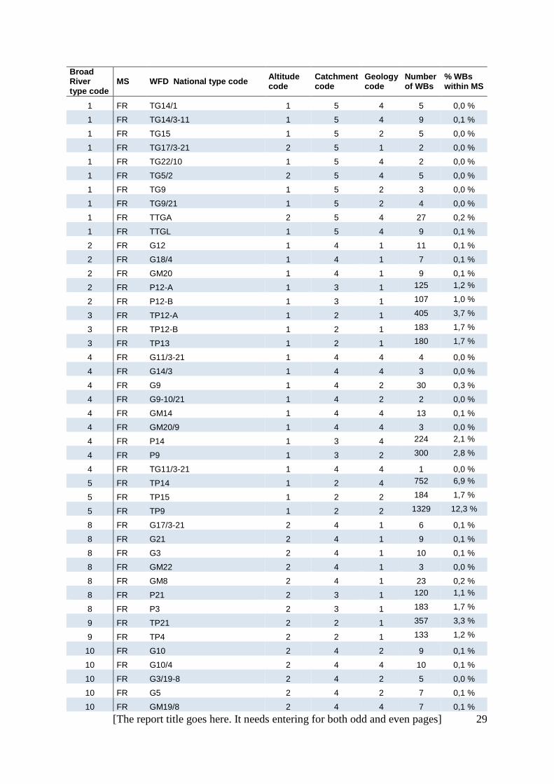
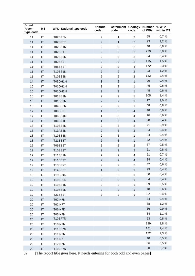
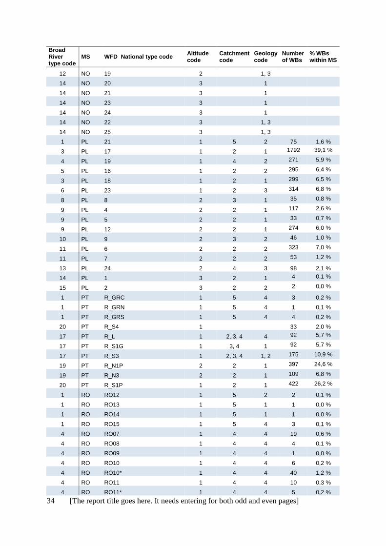
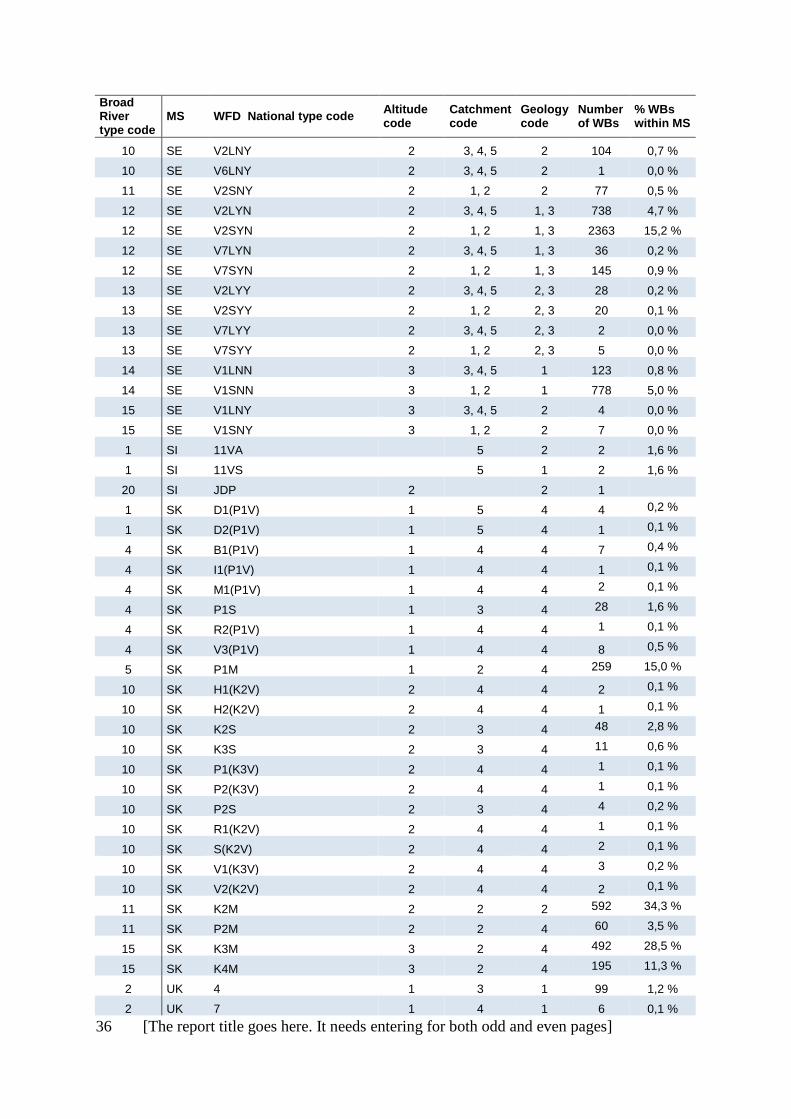
A) Rivers: Links between the broad types and 575 national types
MS = Member State (or Norway), WBs = Water bodies, Broad river type codes are described in table
3.11, and codes for Altitude, Catchment size and Geology are described in table 3.10, chapter 3.
Broad River type code
MS WFD National type code Altitude code
Catchment code
Geology code
Number of WBs
% WBs within MS
1 AT MZB_16_1,75 46 0,6 %
1 AT MZB_16_2
30 0,4 %
1 AT MZB_17_1,5
11 0,1 %
1 AT MZB_17_1,75 2 5 4 190 2,6 %
1 AT MZB_17_1,75
190 2,6 %
1 AT MZB_18_2
5 0,1 %
4 AT MZB_13_2
25 0,3 %
8 AT MZB_1_1,25
164 2,2 %
8 AT MZB_12_1,75 2 3 1 243 3,3 %
8 AT MZB_3_1,25
5 0,1 %
8 AT MZB_4_1,25
12 0,2 %
9 AT MZB_12_1,5 2 2 1 448 6,1 %
10 AT MZB_11_1,75 2 3 4 465 6,3 %
10 AT MZB_13_1,5 2 3 4 198 2,7 %
10 AT MZB_15_1,75
38 0,5 %
10 AT MZB_5_1,75
101 1,4 %
10 AT MZB_7_1,5
33 0,4 %
10 AT MZB_8_1,5
8 0,1 %
10 AT MZB_9_1,75
9 0,1 %
11 AT MZB_10_1,75
20 0,3 %
11 AT MZB_11_1,5 2 1 4 221 3,0 %
11 AT MZB_13_1,75 2 2 4 547 7,5 %
11 AT MZB_15_1,5 2 2 4 224 3,1 %
11 AT MZB_5_1,5 2 2 2 442 6,0 %
15 AT MZB_5_1,25 3 1 2 267 3,6 %
15 AT MZB_6_1
112 1,5 %
15 AT MZB_6_1,25
183 2,5 %
15 AT MZB_7_1
71 1,0 %
15 AT MZB_7_1,25 3 2 2 198 2,7 %
15 AT MZB_8_1,25
32 0,4 %

[The report title goes here. It needs entering for both odd and even pages] 25
Broad River type code
MS WFD National type code Altitude code
Catchment code
Geology code
Number of WBs
% WBs within MS
16 AT MZB_2_1,25 3 3 1 603 8,2 %
16 AT MZB_2_1,5 2 3 1 929 12,7 %
16 AT MZB_3_1,5 3 3 1 716 9,8 %
1 BE (Fl) Rzg 1 5 1 1 0,6 %
2 BE (Fl) Rg 1 3-4 1 48 28,2 %
2 BE (Fl) Rk 1 3 1 12 7,1 %
3 BE (Fl) Bg 1 2-3 1 62 36,5 %
3 BE (Fl) BgK 1 2-3 1 29 17,1 %
1 Be (W) RIV_19 2 5 2 2 0,6 %
4 Be (W) RIV_21 1 3 4 1 0,3 %
4 Be (W) RIV_22 1 3 4 14 4,0 %
4 Be (W) RIV_23 1 4 4 3 0,9 %
5 Be (W) RIV_20 1 2 4 66 18,7 %
8 Be (W) RIV_06 2 3 1 11 3,1 %
8 Be (W) RIV_07 2 3 1 4 1,1 %
8 Be (W) RIV_08 2 4 1 1 0,3 %
9 Be (W) RIV_04 2 2 1 9 2,5 %
9 Be (W) RIV_05 2 2 1 80 22,6 %
10 Be (W) RIV_03 2 3 2 4 1,1 %
10 Be (W) RIV_11 2 3 2 3 0,9 %
10 Be (W) RIV_12 2 4 2 2 0,6 %
10 Be (W) RIV_15 2 3 2 9 2,5 %
10 Be (W) RIV_16 2 3 2 1 0,3 %
10 Be (W) RIV_17 2 4 2 2 0,6 %
10 Be (W) RIV_18 2 4 2 3 0,9 %
11 Be (W) RIV_01 2 2 2 6 1,6 %
11 Be (W) RIV_02 2 2 2 9 2,5 %
11 Be (W) RIV_09 2 2 2 15 4,2 %
11 Be (W) RIV_10 2 2 2 13 3,7 %
11 Be (W) RIV_13 2 2 2 15 4,3 %
11 Be (W) RIV_14 2 2 2 46 13,0 %
12 Be (W) RIV_24 2 2 3 8 2,3 %
2 BG R12 1 5 1 8
1 BG R6 1 5 4
4 BG R10 1 4 1, 2 4
4 BG R11 1 3 1, 2 69
4 BG R13 1 3 1, 2
4 BG R7 1 4 4
4 BG R8 1 3 4
8 BG R5 2 3 1
9 BG R4 2 2 1
14 BG R2 3 2 1
14 BG R3 3 2 1
15 BG R1 3 2 4

26 [The report title goes here. It needs entering for both odd and even pages]
Broad River type code
MS WFD National type code Altitude code
Catchment code
Geology code
Number of WBs
% WBs within MS
20 BG R14 2 3 4
15 CY R2
17 7,9 %
20 CY R1
4 40 18,5 %
20 CY R3
4 159 73,6 %
1 CZ 11148 1 5
5 0,5 %
1 CZ 41147 1 5
2 0,2 %
1 CZ 41148 1 5
7 0,7 %
1 CZ 42148 2 5
2 0,2 %
2 CZ 11124 1 3
6 0,6 %
2 CZ 11125 1 3
5 0,5 %
2 CZ 11126 1 3
1 0,1 %
2 CZ 21124 1 3
1 0,1 %
2 CZ 21125 1 3
3 0,3 %
2 CZ 21126 1 3
1 0,1 %
2 CZ 31125 1 3
1 0,1 %
2 CZ 41124 1 3
9 0,8 %
2 CZ 41125 1 3
12 1,1 %
3 CZ 11114 1 2
3 0,3 %
3 CZ 21114 1 2
2 0,2 %
3 CZ 21115 1 2
1 0,1 %
3 CZ 31114 1 2
3 0,3 %
3 CZ 41114 1 2
11 1,0 %
4 CZ 11224 1 3
3 0,3 %
4 CZ 11225 1 3
1 0,1 %
4 CZ 11226 1 3
2 0,2 %
4 CZ 21224 1 3
1 0,1 %
4 CZ 21226 1 3
1 0,1 %
4 CZ 41224 1 3
6 0,6 %
4 CZ 41225 1 3
2 0,2 %
4 CZ 41226 1 3
1 0,1 %
5 CZ 11214 1 2
6 0,6 %
5 CZ 21214 1 2
7 0,7 %
5 CZ 41214 1 2
7 0,7 %
8 CZ 22124 2 3
1 0,1 %
8 CZ 22125 2 3
1 0,1 %
8 CZ 22137 2 4
1 0,1 %
8 CZ 32124 2 3
6 0,6 %
8 CZ 32125 2 3
10 0,9 %
8 CZ 32126 2 3
2 0,2 %
8 CZ 32136 2 4
3 0,3 %
8 CZ 32137 2 4
1 0,1 %
8 CZ 42124 2 3
100 9,4 %
8 CZ 42125 2 3
91 8,5 %
8 CZ 42126 2 3
28 2,6 %

[The report title goes here. It needs entering for both odd and even pages] 27
Broad River type code
MS WFD National type code Altitude code
Catchment code
Geology code
Number of WBs
% WBs within MS
8 CZ 42135 2 4
2 0,2 %
8 CZ 42136 2 4
23 2,2 %
8 CZ 42137 2 4
11 1,0 %
8 CZ 43124 2 3
11 1,0 %
8 CZ 43125 2 3
7 0,7 %
8 CZ 43126 2 3
2 0,2 %
8 CZ 43136 2 4
1 0,1 %
9 CZ 12114 2 2
2 0,2 %
9 CZ 22114 2 2
9 0,8 %
9 CZ 22115 2 2
1 0,1 %
9 CZ 32113 2 2
2 0,2 %
9 CZ 32114 2 2
22 2,1 %
9 CZ 32115 2 2
1 0,1 %
9 CZ 42113 2 2
2 0,2 %
9 CZ 42114 2 2
298 27,9 %
9 CZ 42115 2 2
9 0,8 %
9 CZ 43114 2 2
81 7,6 %
9 CZ 43115 2 2
8 0,7 %
10 CZ 12225 2 3
1 0,1 %
10 CZ 22225 2 3
11 1,0 %
10 CZ 22226 2 3
4 0,4 %
10 CZ 22237 2 4
1 0,1 %
10 CZ 32224 2 3
1 0,1 %
10 CZ 32225 2 3
2 0,2 %
10 CZ 42224 2 3
8 0,7 %
10 CZ 42225 2 3
9 0,8 %
10 CZ 42226 2 3
4 0,4 %
10 CZ 42236 2 4
5 0,5 %
11 CZ 22214 2 2
70 6,5 %
11 CZ 22215 2 2
7 0,7 %
11 CZ 23214 2 2
11 1,0 %
11 CZ 23215 2 2
1 0,1 %
11 CZ 32214 2 2
4 0,4 %
11 CZ 42214 2 2
40 3,7 %
11 CZ 42215 2 2
2 0,2 %
11 CZ 43213 2 2
1 0,1 %
11 CZ 43214 2 2
4 0,4 %
14 CZ 44114 3 2
7 0,7 %
14 CZ 44115 3 2
2 0,2 %
1 DE 10 2 5 2 44 0,5 %
1 DE 20 1 5 2 49 0,5 %
1 DE 22.3 1 5 2 2 0,0 %
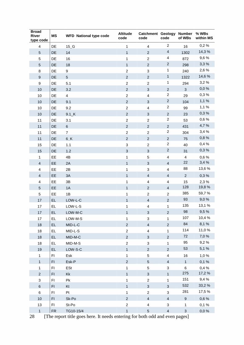
4 DE 15 1 3 4 284 3,1 %
4 DE 17 1 3 4 93 1,0 %
28 [The report title goes here. It needs entering for both odd and even pages]
Broad River type code
MS WFD National type code Altitude code
Catchment code
Geology code
Number of WBs
% WBs within MS
4 DE 15_G 1 4 2 16 0,2 %
5 DE 14 1 2 4 1302 14,3 %
5 DE 16 1 2 4 872 9,6 %
5 DE 18 1 2 2 298 3,3 %
8 DE 9 2 3 1 240 2,6 %
9 DE 5 2 2 1 1322 14,6 %
9 DE 5.1 2 2 1 294 3,2 %
10 DE 3.2 2 3 2 3 0,0 %
10 DE 4 2 4 2 29 0,3 %
10 DE 9.1 2 3 2 104 1,1 %
10 DE 9.2 2 4 2 99 1,1 %
10 DE 9.1_K 2 3 2 23 0,3 %
11 DE 3.1 2 2 2 53 0,6 %
11 DE 6 2 2 2 431 4,7 %
11 DE 7 2 2 2 304 3,4 %
11 DE 6_K 2 2 2 75 0,8 %
15 DE 1.1 3 2 2 40 0,4 %
15 DE 1.2 3 3 2 31 0,3 %
1 EE 4B 1 5 4 4 0,6 %
4 EE 2A 1 3 4 22 3,4 %
4 EE 2B 1 3 4 88 13,6 %
4 EE 3A 1 4 4 2 0,3 %
4 EE 3B 1 4 4 15 2,3 %
5 EE 1A 1 2 4 128 19,8 %
5 EE 1B 1 2 2 385 59,7 %
17 EL LOW-L-C 1 4 2 93 9,0 %
17 EL LOW-L-S 1 4 1 135 13,1 %
17 EL LOW-M-C 1 3 2 98 9,5 %
17 EL LOW-M-S 1 3 1 107 10,4 %
18 EL MID-L-C 2 4 2 84 8,1 %
18 EL MID-L-S 2 4 1 114 11,0 %
18 EL MID-M-C 2 3 2 72 7,0 %
18 EL MID-M-S 2 3 1 95 9,2 %
19 EL LOW-S-C 1 2 2 53 5,1 %
1 FI Esk 1 5 4 16 1,0 %
1 FI Esk-P 2 5 4 1 0,1 %
1 FI ESt 1 5 3 6 0,4 %
2 FI Kk 1 3 1 275 17,2 %
3 FI Pk 1 2 1 151 9,4 %
6 FI Kt 1 3 3 532 33,2 %
6 FI Pt 1 2 3 281 17,5 %
10 FI Sk-Po 2 4 4 9 0,6 %
13 FI St-Po 2 4 3 1 0,1 %
1 FR TG10-15/4 1 5 4 3 0,0 %
[The report title goes here. It needs entering for both odd and even pages] 29
Broad River type code
MS WFD National type code Altitude code
Catchment code
Geology code
Number of WBs
% WBs within MS
1 FR TG14/1 1 5 4 5 0,0 %
1 FR TG14/3-11 1 5 4 9 0,1 %
1 FR TG15 1 5 2 5 0,0 %
1 FR TG17/3-21 2 5 1 2 0,0 %
1 FR TG22/10 1 5 4 2 0,0 %
1 FR TG5/2 2 5 4 5 0,0 %
1 FR TG9 1 5 2 3 0,0 %
1 FR TG9/21 1 5 2 4 0,0 %
1 FR TTGA 2 5 4 27 0,2 %
1 FR TTGL 1 5 4 9 0,1 %
2 FR G12 1 4 1 11 0,1 %
2 FR G18/4 1 4 1 7 0,1 %
2 FR GM20 1 4 1 9 0,1 %
2 FR P12-A 1 3 1 125 1,2 %
2 FR P12-B 1 3 1 107 1,0 %
3 FR TP12-A 1 2 1 405 3,7 %
3 FR TP12-B 1 2 1 183 1,7 %
3 FR TP13 1 2 1 180 1,7 %
4 FR G11/3-21 1 4 4 4 0,0 %
4 FR G14/3 1 4 4 3 0,0 %
4 FR G9 1 4 2 30 0,3 %
4 FR G9-10/21 1 4 2 2 0,0 %
4 FR GM14 1 4 4 13 0,1 %
4 FR GM20/9 1 4 4 3 0,0 %
4 FR P14 1 3 4 224 2,1 %
4 FR P9 1 3 2 300 2,8 %
4 FR TG11/3-21 1 4 4 1 0,0 %
5 FR TP14 1 2 4 752 6,9 %
5 FR TP15 1 2 2 184 1,7 %
5 FR TP9 1 2 2 1329 12,3 %
8 FR G17/3-21 2 4 1 6 0,1 %
8 FR G21 2 4 1 9 0,1 %
8 FR G3 2 4 1 10 0,1 %
8 FR GM22 2 4 1 3 0,0 %
8 FR GM8 2 4 1 23 0,2 %
8 FR P21 2 3 1 120 1,1 %
8 FR P3 2 3 1 183 1,7 %
9 FR TP21 2 2 1 357 3,3 %
9 FR TP4 2 2 1 133 1,2 %
10 FR G10 2 4 2 9 0,1 %
10 FR G10/4 2 4 4 10 0,1 %
10 FR G3/19-8 2 4 2 5 0,0 %
10 FR G5 2 4 2 7 0,1 %
10 FR GM19/8 2 4 4 7 0,1 %

30 [The report title goes here. It needs entering for both odd and even pages]
Broad River type code
MS WFD National type code Altitude code
Catchment code
Geology code
Number of WBs
% WBs within MS
10 FR GM5/2 2 4 4 4 0,0 %
11 FR TP10 2 2 2 599 5,5 %
11 FR TP11 2 2 2 130 1,2 %
14 FR TP3 3 2 1 577 5,3 %
15 FR TP5 3 2 2 361 3,3 %
15 FR TP7 3 2 2 215 2,0 %
16 FR G1 2 4 4 3 0,0 %
16 FR G14/1 2 4 4 16 0,1 %
16 FR G2 2 4 4 10 0,1 %
16 FR GM7/2 2 4 4 5 0,0 %
16 FR M1 3 3 4 19 0,2 %
16 FR P1
88 0,8 %
16 FR TP1 3 2 4 255 2,4 %
16 FR TP2 3 2 1 277 2,6 %
17 FR G16 1 4 1 4 0,0 %
17 FR G6 1 4 2 6 0,1 %
17 FR GM6/1 1 4 4 6 0,1 %
18 FR GM6/2-7 2 4 4 16 0,1 %
18 FR GM6/8 2 4 4 21 0,2 %
18 FR GMP7 2 4 2 32 0,3 %
18 FR TG6/1-8 2 4 4 2 0,0 %
19 FR PTP16-A 2 2 1 166 1,5 %
19 FR PTP8 2 2 1 164 1,5 %
19 FR TP6 1 2 4 510 4,7 %
1 HR HR-R_5A 1 5 4 2 0,2 %
1 HR HR-R_5B 1 5 4 4 0,4 %
1 HR HR-R_5C 1 5 1 2 0,2 %
1 HR HR-R_5D 1 5 1 1 0,1 %
3 HR HR-R_3A 1 2 1 6 0,5 %
4 HR HR-R_4 1 3, 4 4 66 6,0 %
4 HR HR-R_8 1 3, 4 4 4 0,4 %
5 HR HR-R_2A 1 2 4 399 36,4 %
5 HR HR-R_2B 1 2 4 196 17,9 %
10 HR HR-R_10B 2 3 2 2 0,2 %
10 HR HR-R_7 2 3, 4 4 12 1,1 %
10 HR HR-R_9 2 3 2 8 0,7 %
11 HR HR-R_1 2 2 4 69 6,3 %
11 HR HR-R_10A 2 2 2 62 5,7 %
11 HR HR-R_6 2 2 4 36 3,3 %
17 HR HR-R_13 1 3, 4 2 4 0,4 %
17 HR HR-R_13A 1 4 2 2 0,2 %
17 HR HR-R_18 1 3 4 5 0,5 %
18 HR HR-R_12 2 3, 4 2 8 0,7 %
19 HR HR-R_11 1, 2 2 4 10 0,9 %

[The report title goes here. It needs entering for both odd and even pages] 31
Broad River type code
MS WFD National type code Altitude code
Catchment code
Geology code
Number of WBs
% WBs within MS
19 HR HR-R_16B 1 2 4 62 5,7 %
19 HR HR-R_17 1, 2 2 4 15 1,4 %
19 HR HR-R_19 1 2, 3 4 20 1,8 %
1 HU 14R 1 5 2 3 0,3 %
1 HU 20R 1 5 2 12 1,4 %
1 HU 23R 1 5 2 1 0,1 %
1 HU 24R 1 5 2 2 0,2 %
1 HU 25R 1 5 2 1 0,1 %
1 HU 7R 1 5 2 2 0,2 %
4 HU 13R 1 4 2 8 0,9 %
4 HU 18R 1 3 2 91 10,5 %
5 HU 11R
7 0,8 %
5 HU 15R 1 2, 3 2 46 5,3 %
5 HU 16R 1 2, 3 2 29 3,3 %
5 HU 17R 1 2, 3 2 53 6,1 %
9 HU 1R 2
28 3,2 %
10 HU 10R 1, 2 4 2 4 0,5 %
10 HU 5R 1, 2 3 2 40 4,6 %
10 HU 6R 1, 2 4 2 9 1,0 %
10 HU 9R 1, 2 3 2 94 10,8 %
11 HU 4R 2 2, 3 2 71 8,2 %
11 HU 8R 1, 2 2, 3 2 138 15,9 %
3 IE 11 1 2 1 279 6,1 %
3 IE 12 1 2 1 801 17,5 %
3 IE 13 1 2 1 361 7,9 %
3 IE 14 1 2 1 374 8,2 %
5 IE 21
4 155 3,4 %
5 IE 22
4 272 6,0 %
5 IE 23
4 87 1,9 %
5 IE 24
4 58 1,3 %
5 IE 31 1 2 2 1299 28,4 %
5 IE 32 1 2 2 670 14,7 %
5 IE 33
2 109 2,4 %
5 IE 34
2 58 1,3 %
4 IT IT06SS3F 1 3 4 64 0,8 %
5 IT IT06AS2T 1 2 4 34 0,4 %
5 IT IT06AS6T 1 1 4 129 1,7 %
5 IT IT06SR6T 1 1 4 30 0,4 %
5 IT IT06SS1T 1 2 4 74 1,0 %
8 IT IT03SS3N 2 3 1 32 0,4 %
9 IT IT03GH6N 2 1 1 56 0,7 %
9 IT IT03SR6N 2 1 1 97 1,3 %
9 IT IT03SS1N 2 2 1 256 3,3 %
9 IT IT03SS2N 2 2 1 162 2,1 %
32 [The report title goes here. It needs entering for both odd and even pages]
Broad River type code
MS WFD National type code Altitude code
Catchment code
Geology code
Number of WBs
% WBs within MS
11 IT IT02SR6N 2 1 2 55 0,7 %
11 IT IT02SR6T 2 1 2 93 1,2 %
11 IT IT02SS1N 2 2 2 48 0,6 %
11 IT IT02SS1T 2 2 2 229 3,0 %
11 IT IT02SS2N 2 2 2 34 0,4 %
11 IT IT02SS2T 2 2 2 115 1,5 %
11 IT IT06SS2T 2 2 4 172 2,3 %
11 IT IT10SS1N 2 2 2 93 1,2 %
11 IT IT10SS2N 2 2 2 182 2,4 %
14 IT IT03GH1N 3 2 1 29 0,4 %
16 IT IT01GH1N 3 2 1 45 0,6 %
16 IT IT01GH2N 2 2 1 45 0,6 %
16 IT IT01SS1N 2 2 1 105 1,4 %
16 IT IT01SS2N 2 2 1 77 1,0 %
16 IT IT04SS2N 2 2 1 58 0,8 %
17 IT IT06SS3T 1 3 4 48 0,6 %
17 IT IT06SS4D 1 3 4 46 0,6 %
17 IT IT06SS4F 1 3 4 28 0,4 %
18 IT IT10SS3N 2 3 2 71 0,9 %
18 IT IT13AS3N 2 3 2 34 0,4 %
18 IT IT19SS3N 2 3 1 34 0,4 %
18 IT IT21SS3T 2 3 1 32 0,4 %
19 IT IT09SS2T 2 2 2 37 0,5 %
19 IT IT10SS2T 2 2 2 61 0,8 %
19 IT IT11SS2N 2 2 4 51 0,7 %
19 IT IT11SS2T 2 2 4 28 0,4 %
19 IT IT13SR2T 2 2 2 47 0,6 %
19 IT IT14SS2T 1 2 1 29 0,4 %
19 IT IT19SR1N 2 2 1 30 0,4 %
19 IT IT19SR2N 2 2 1 34 0,4 %
19 IT IT19SS1N 2 2 1 39 0,5 %
19 IT IT19SS2N 2 2 1 48 0,6 %
19 IT IT21SS2T 2 2 1 32 0,4 %
20 IT IT02IN7N
34 0,4 %
20 IT IT02IN7T
88 1,2 %
20 IT IT06IN7D
66 0,9 %
20 IT IT06IN7N
84 1,1 %
20 IT IT10EF7N
63 0,8 %
20 IT IT10IN7N
139 1,8 %
20 IT IT11EF7N
181 2,4 %
20 IT IT11IN7N
172 2,3 %
20 IT IT11IN7T
40 0,5 %
20 IT IT12IN7N
36 0,5 %
20 IT IT19EF7N
50 0,7 %

[The report title goes here. It needs entering for both odd and even pages] 33
Broad River type code
MS WFD National type code Altitude code
Catchment code
Geology code
Number of WBs
% WBs within MS
20 IT IT19IN7N
94 1,2 %
20 IT IT19IN8N
34 0,4 %
20 IT IT20IN7N
153 2,0 %
20 IT IT21EF7T
453 5,9 %
20 IT IT21IN7T
151 2,0 %
4 LT RWT2 1 3 2 93 11,2 %
4 LT RWT3 1 3 2 112 13,5 %
4 LT RWT4 1 4 2 14 1,7 %
4 LT RWT5 1 4 2 24 2,9 %
5 LT RWT1 1 2 2 589 70,8 %
4 LU 5 1 3
9 8,3 %
4 LU 6 1 4
4 3,7 %
5 LU 4 1 2
47 43,5 %
8 LU 3 2 3
11 10,2 %
9 LU 1 2 2
28 25,9 %
9 LU 2 2 2
8 7,4 %
4 LV R3 1 3 2 79 38,7 %
4 LV R4 1 3 2 65 31,9 %
4 LV R5 1 4 2 10 4,9 %
4 LV R6 1 4 2 46 22,7 %
5 LV R1 1 2 2 3 1,5 %
5 LV R2 1 2 2 1 0,5 %
1 NL R7
5
11 4,3 %
5 NL R4 1 1 2 47 18,5 %
5 NL R5 1 2 2 133 52,4 %
5 NL R6 1 2 2 30 11,8 %
3 NO 1 1
1
3 NO 2 1
1
3 NO 4 1
1
3 NO 5 1
1
3 NO 7 1
1
5 NO 9 1
2
6 NO 3 1
1, 3
6 NO 6 1
1, 3
6 NO 8 1
1, 3
7 NO 10 1
2
7 NO 11 1
3, 4
9 NO 12 2
1
9 NO 13 2
1
9 NO 15 2
1
9 NO 16 2
1
9 NO 18 2
1
12 NO 14 2
1, 3
12 NO 17 2
1, 3
34 [The report title goes here. It needs entering for both odd and even pages]
Broad River type code
MS WFD National type code Altitude code
Catchment code
Geology code
Number of WBs
% WBs within MS
12 NO 19 2
1, 3
14 NO 20 3
1
14 NO 21 3
1
14 NO 23 3
1
14 NO 24 3
1
14 NO 22 3
1, 3
14 NO 25 3
1, 3
1 PL 21 1 5 2 75 1,6 %
3 PL 17 1 2 1 1792 39,1 %
4 PL 19 1 4 2 271 5,9 %
5 PL 16 1 2 2 295 6,4 %
3 PL 18 1 2 1 299 6,5 %
6 PL 23 1 2 3 314 6,8 %
8 PL 8 2 3 1 35 0,8 %
9 PL 4 2 2 1 117 2,6 %
9 PL 5 2 2 1 33 0,7 %
9 PL 12 2 2 1 274 6,0 %
10 PL 9 2 3 2 46 1,0 %
11 PL 6 2 2 2 323 7,0 %
11 PL 7 2 2 2 53 1,2 %
13 PL 24 2 4 3 98 2,1 %
14 PL 1 3 2 1 4 0,1 %
15 PL 2 3 2 2 2 0,0 %
1 PT R_GRC 1 5 4 3 0,2 %
1 PT R_GRN 1 5 4 1 0,1 %
1 PT R_GRS 1 5 4 4 0,2 %
20 PT R_S4 1
33 2,0 %
17 PT R_L 1 2, 3, 4 4 92 5,7 %
17 PT R_S1G 1 3, 4 1 92 5,7 %
17 PT R_S3 1 2, 3, 4 1, 2 175 10,9 %
19 PT R_N1P 2 2 1 397 24,6 %
19 PT R_N3 2 2 1 109 6,8 %
20 PT R_S1P 1 2 1 422 26,2 %
1 RO RO12 1 5 2 2 0,1 %
1 RO RO13 1 5 1 1 0,0 %
1 RO RO14 1 5 1 1 0,0 %
1 RO RO15 1 5 4 3 0,1 %
4 RO RO07 1 4 4 19 0,6 %
4 RO RO08 1 4 4 4 0,1 %
4 RO RO09 1 4 4 1 0,0 %
4 RO RO10 1 4 4 6 0,2 %
4 RO RO10* 1 4 4 40 1,2 %
4 RO RO11 1 4 4 10 0,3 %
4 RO RO11* 1 4 4 5 0,2 %

[The report title goes here. It needs entering for both odd and even pages] 35
Broad River type code
MS WFD National type code Altitude code
Catchment code
Geology code
Number of WBs
% WBs within MS
5 RO RO06 1 2, 3 4 156 4,8 %
10 RO RO02 2, 3 4 4 11 0,3 %
10 RO RO05 2 4 4 47 1,4 %
11 RO RO01 2, 3 2, 3 4 900 27,6 %
11 RO RO04 2 2, 3 4 359 11,0 %
20 RO RO17 3 2, 3 1 10 0,3 %
20 RO RO18 3 2 4 137 4,2 %
20 RO RO19 2 2 4 574 17,6 %
20 RO RO20 1 3 4 335 10,3 %
2 SE V3LNN 1 3, 4, 5 1 291 1,9 %
2 SE V4LNN 1 3, 4, 5 1 42 0,3 %
2 SE V5LNN 1 3, 4, 5 1 1 0,0 %
2 SE V6LNN 1 3, 4, 5 1 59 0,4 %
3 SE V3SNN 1 1, 2 1 610 3,9 %
3 SE V4SNN 1 1, 2 1 141 0,9 %
3 SE V5SNN 1 1, 2 1 3 0,0 %
3 SE V5SYY 1 1, 2 1, 2 17 0,1 %
3 SE V6SNN 1 1, 2 1 104 0,7 %
4 SE V3LNY 1 3, 4, 5 2 4 0,0 %
4 SE V4LNY 1 3, 4, 5 2 21 0,1 %
4 SE V5LNY 1 3, 4, 5 2 30 0,2 %
5 SE V3SNY 1 1, 2 2 15 0,1 %
5 SE V4SNY 1 1, 2 2 46 0,3 %
5 SE V5SNY 1 1, 2 2 42 0,3 %
5 SE V6SNY 1 1, 2 2 3 0,0 %
6 SE V3LYN 1 3, 4, 5 1, 3 946 6,1 %
6 SE V3SYN 1 1, 2 1, 3 2287 14,7 %
6 SE V4LYN 1 3, 4, 5 1, 3 218 1,4 %
6 SE V4SYN 1 1, 2 1, 3 577 3,7 %
6 SE V5LYN 1 3, 4, 5 1, 3 40 0,3 %
6 SE V5SYN 1 1, 2 1, 3 67 0,4 %
6 SE V6LYN 1 3, 4, 5 1, 3 292 1,9 %
6 SE V6SYN 1 1, 2 1, 3 493 3,2 %
7 SE V3LYY 1 3, 4, 5 2, 3 3 0,0 %
7 SE V3SYY 1 1, 2 2, 3 14 0,1 %
7 SE V4LYY 1 3, 4, 5 2, 3 67 0,4 %
7 SE V4SYY 1 1, 2 2, 3 168 1,1 %
7 SE V5LYY 1 3, 4, 5 2, 3 20 0,1 %
7 SE V6LYY 1 3, 4, 5 2, 3 32 0,2 %
7 SE V6SYY 1 1, 2 2, 3 32 0,2 %
8 SE V2LNN 2 3, 4, 5 1 1364 8,8 %
8 SE V7LNN 2 3, 4, 5 1 3 0,0 %
9 SE V2SNN 2 1, 2 1 3047 19,6 %
9 SE V7SNN 2 1, 2 1 17 0,1 %
36 [The report title goes here. It needs entering for both odd and even pages]
Broad River type code
MS WFD National type code Altitude code
Catchment code
Geology code
Number of WBs
% WBs within MS
10 SE V2LNY 2 3, 4, 5 2 104 0,7 %
10 SE V6LNY 2 3, 4, 5 2 1 0,0 %
11 SE V2SNY 2 1, 2 2 77 0,5 %
12 SE V2LYN 2 3, 4, 5 1, 3 738 4,7 %
12 SE V2SYN 2 1, 2 1, 3 2363 15,2 %
12 SE V7LYN 2 3, 4, 5 1, 3 36 0,2 %
12 SE V7SYN 2 1, 2 1, 3 145 0,9 %
13 SE V2LYY 2 3, 4, 5 2, 3 28 0,2 %
13 SE V2SYY 2 1, 2 2, 3 20 0,1 %
13 SE V7LYY 2 3, 4, 5 2, 3 2 0,0 %
13 SE V7SYY 2 1, 2 2, 3 5 0,0 %
14 SE V1LNN 3 3, 4, 5 1 123 0,8 %
14 SE V1SNN 3 1, 2 1 778 5,0 %
15 SE V1LNY 3 3, 4, 5 2 4 0,0 %
15 SE V1SNY 3 1, 2 2 7 0,0 %
1 SI 11VA
5 2 2 1,6 %
1 SI 11VS
5 1 2 1,6 %
20 SI JDP 2
2 1
1 SK D1(P1V) 1 5 4 4 0,2 %
1 SK D2(P1V) 1 5 4 1 0,1 %
4 SK B1(P1V) 1 4 4 7 0,4 %
4 SK I1(P1V) 1 4 4 1 0,1 %
4 SK M1(P1V) 1 4 4 2 0,1 %
4 SK P1S 1 3 4 28 1,6 %
4 SK R2(P1V) 1 4 4 1 0,1 %
4 SK V3(P1V) 1 4 4 8 0,5 %
5 SK P1M 1 2 4 259 15,0 %
10 SK H1(K2V) 2 4 4 2 0,1 %
10 SK H2(K2V) 2 4 4 1 0,1 %
10 SK K2S 2 3 4 48 2,8 %
10 SK K3S 2 3 4 11 0,6 %
10 SK P1(K3V) 2 4 4 1 0,1 %
10 SK P2(K3V) 2 4 4 1 0,1 %
10 SK P2S 2 3 4 4 0,2 %
10 SK R1(K2V) 2 4 4 1 0,1 %
10 SK S(K2V) 2 4 4 2 0,1 %
10 SK V1(K3V) 2 4 4 3 0,2 %
10 SK V2(K2V) 2 4 4 2 0,1 %
11 SK K2M 2 2 2 592 34,3 %
11 SK P2M 2 2 4 60 3,5 %
15 SK K3M 3 2 4 492 28,5 %
15 SK K4M 3 2 4 195 11,3 %
2 UK 4 1 3 1 99 1,2 %
2 UK 7 1 4 1 6 0,1 %

[The report title goes here. It needs entering for both odd and even pages] 37
Broad River type code
MS WFD National type code Altitude code
Catchment code
Geology code
Number of WBs
% WBs within MS
3 UK 1 1 2 1 1053 12,6 %
3 UK 37 1 1 1 432 5,2 %
4 UK 5 1 3 2 429 5,1 %
4 UK 8 1 4 2 63 0,8 %
5 UK 2 1 2 2 3088 37,0 %
5 UK 40 1 1 2 342 4,1 %
6 UK 3 1 2 3 136 1,6 %
6 UK 6 1 3 3 2 0,0 %
6 UK 9 1 4 3 7 0,1 %
6 UK 43 1 1 3 1 0,0 %
8 UK 13 2 3 1 246 3,0 %
8 UK 16 2 4 1 25 0,3 %
9 UK 10 2 2 1 1426 17,1 %
10 UK 14 2 3 2 91 1,1 %
10 UK 17 2 4 2 21 0,3 %
11 UK 11 2 2 2 612 7,3 %
14 UK 18 3 2 1 5 0,1 %
Notes for specific countries concerning national river types and links to broad types:
Country Comment
LU-Rivers New national typology, so no status and pressures info is available. Links between old and new national typology received after mid-September, which was too late to include in the analysis.
SI-Rivers Altitude is not used in national river typology, so no link to broad types possible for any of the Slovenian national types, except the very large rivers.
UK-Rivers Number of river water bodies corrected per type. National types 12 (Mid-altitude, organic small) and 15 (Mid-altitude, organic medium) are not linked to any broad type, because there is no info on alkalinity, and no suggestion for any broad type done by the contact person. National river type 3 (Lowland, Organic, small rivers), 6 (Lowland, organic, medium rivers) and 43 ((Lowland, Organic, very small rivers) are all allocated to broad type 6 (Lowland, organic and siliceous), because the UK contact person suggested that these rivers are siliceous/organic. When the UK agencies next report their lake typology they will use a new set of more uniform codes for the national typology, as the codes used in the past were not consistent and result in duplicate codes for the same lake type. The typology will not change but these new codes would need to be matched to the Broad types.
NO-Rivers Catchment size is not used as a typology factor in the Norwegian river typology, causing several national types to overlap 2 broad types (e.g. Mid-altitude, siliceous rivers national types 12,13,15,16 fit with broad types 8 and 9). Assuming that most water bodies in those national types have <100km2 catchment, the ETC has allocated these national types to the broad type with catchment < 100km2 (e.g. broad type 9 Mid-altitude, siliceous, very small-small).
RO-Rivers The links between the broad types and the national river types RO01, 02, 04, 06 are reasonable for most of the water bodies, but may not fit for all the water bodies of the type, as the national types overlap several of the altitude, size, and/or geology categories of the broad types.
IT-Rivers The links between national Italian river types and broad types is an approximation elaborated by the ETC and is not reflecting a formal position of the Member State. Caution should be taken when applying these links in future reports. More specific comments may be sent in 2015.

38 [The report title goes here. It needs entering for both odd and even pages]
B) Lakes: Links between the broad types and 290 national types
MS = Member State (or Norway), WBs = Water bodies, Broad lake type codes are described in table
3.13, and codes for Altitude, Catchment size and Geology are described in table 3.10, chapter 3.
Broad Lake type code
MS WFD National type code
Altitude code
Surface Area code
Geology code
Mean depth code
Number of WBs
% WBs within MS
1 AT B1 2 5 4 3 1 1.6 %
4 AT A1 1 5
1 1 1.6 %
7 AT D3
2 3.2 %
8 AT B2 2 3 4 2 5 8.1 %
8 AT C1a 2
2 3 3 4.8 %
8 AT C1b 2 3 4 2 4 6.5 %
8 AT D1 2 4 2 3 6 9.7 %
8 AT D2a 2 2 2 3 3 4.8 %
8 AT D2b 2 2 2 2 3 4.8 %
12 AT E1 3 3 2 3 10 16.1 %
12 AT E2
1 1.6 %
3 BE (Fl) Awe 1 2, 3 2
7 38.9 %
3 BE (Fl) Awom 1 2, 3 2
1 5.6 %
4 BE (Fl) Ai 1 2 2
1 5.6 %
4 BE (Fl) Ami 1 2 2
5 27.8 %
1 BG L11
5
3
3 BG L14 1 4 4 2
3 BG L15 1 4 4 2
3 BG L16 1 3 4 2
3 BG L17 1 3 4 2
4 BG L4 1 1 4 1
8 BG L12 2 3 4 3
8 BG L13 2 3 4 3 11 BG L1 3 1 4 2-3 11 BG L2 3 1 1, 4 2 11 BG L3 3 1 1, 4 2 14 CY L4
11 61.1 %
2 CZ 311322 1 4 1 2 1 1.4 %
4 CZ 311211 1 3 1 1 1 1.4 %
4 CZ 311212 1 3 1 1 1 1.4 %
4 CZ 411112 1 2 1 1 1 1.4 %
7 CZ 221122 2 2 1 2 1 1.4 %
7 CZ 221223 2 3 1 2 1 1.4 %
7 CZ 321222 2 3 1 2 1 1.4 %
7 CZ 421112 2 2 1 1 5 7.0 %
7 CZ 421121 2 2 1 2 1 1.4 %
7 CZ 421122 2 2 1 2 6 8.5 %
7 CZ 421123 2 2 1 2 1 1.4 %
7 CZ 421132 2 2 1 3 1 1.4 %
7 CZ 421133 2 2 1 3 1 1.4 %
7 CZ 421211 2 3 1 1 2 2.8 %
7 CZ 421212 2 3 1 1 7 9.9 %

[The report title goes here. It needs entering for both odd and even pages] 39
Broad Lake type code
MS WFD National type code
Altitude code
Surface Area code
Geology code
Mean depth code
Number of WBs
% WBs within MS
7 CZ 421221 2 3 1 2 1 1.4 %
7 CZ 421222 2 3 1 2 6 8.5 %
7 CZ 421231 2 3 1 3 1 1.4 %
7 CZ 421232 2 3 1 3 3 4.2 %
7 CZ 421332 2 4 1 3 5 7.0 %
7 CZ 421333 2 4 1 3 1 1.4 %
7 CZ 431111 2 2 1 1 1 1.4 %
7 CZ 431122 2 2 1 2 6 8.5 %
7 CZ 431222 2 3 1 2 3 4.2 %
7 CZ 431223 2 3 1 2 1 1.4 %
7 CZ 431232 2 3 1 3 4 5.6 %
7 CZ 431233 2 3 1 3 2 2.8 %
7 CZ 431322 2 4 1 2 1 1.4 %
8 CZ 222122 2 2 2 2 1 1.4 %
8 CZ 222222 2 3 2 2 1 1.4 %
8 CZ 232122 2 2 2 2 1 1.4 %
8 CZ 232232 2 3 2 3 1 1.4 %
8 CZ 422223 2 3 2 2 1 1.4 %
3 DE 10 1 4 2 2 155 21.8 %
3 DE 13 1 2 2 2 93 13.1 %
7 DE 8
4
3 17 2.4 %
8 DE 6
4
2 17 2.4 %
2 EE 5 1 3 2 1 1 1.1 %
3 EE 1 1 1 2 3 1 1.1 %
3 EE 3 1 1, 2, 3 2 2 22 24.7 %
3 EE 6 1 5 4 2 1 1.1 %
3 EE 7 1 5 4 2 2 2.2 %
4 EE 2 1 3 2 1 33 37.0 %
6 EE 4 1 1, 2, 3 4 1 6 6.7 %
12 EL HIGH-D-L-C 3 4 2 3 1 3.4 %
12 EL HIGH-D-S-C 3 3 2 3 1 3.4 %
12 EL HIGH-D-XL-C 3 5 2 3 1 3.4 %
13 EL LOW-D-L-S 1 4 1 3 3 10.3 %
13 EL LOW-S-L-S 1 4 1 1 4 13.8 %
13 EL LOW-S-M-S 1 4 1 1 1 3.4 %
13 EL LOW-S-S-S 1 2 1 1 1 3.4 %
13 EL MID-D-L-S 2 4 1 3 1 3.4 %
14 EL LOW-D-L-C 1 4 2 3 1 3.4 %
14 EL LOW-D-M-C 1 4 2 3 1 3.4 %
14 EL LOW-S-L-C 1 4 2 1 3 10.3 %
1 FI Sh 1 5 3 2 44 1.0 %
1 FI SVh 1 5 1 2 68 1.6 %
2 FI Vh 1 4 1 2 618 14.5 %
5 FI Ph 1 3 3 2 578 13.5 %
1 FR A52 1 5
3 1 0.2 %
3 FR A16 1 3 2 2 25 5.7 %
3 FR A6b 1 3 4 2 54 12.3 %
7 FR A4 2 2 1 2 14 3.2 %

40 [The report title goes here. It needs entering for both odd and even pages]
Broad Lake type code
MS WFD National type code
Altitude code
Surface Area code
Geology code
Mean depth code
Number of WBs
% WBs within MS
8 FR A13a 2 3 4 1 30 6.8 %
8 FR A5 2 3 4 2 73 16.6 %
8 FR A7a 2 3 2 1 20 4.6 %
8 FR A7b 2 3 4 2 15 3.4 %
8 FR N4 2 4 2 3 20 4.6 %
11 FR A1 3 3 1 3 20 4.6 %
14 FR A3 2 3 2 3 14 3.2 %
8 HR HR-J_1A 2 2 2 3 1 8 HR HR-J_1B 2 2 2 2 1 14 HR HR-J_2 1 3 2 3 1 14 HR HR-J_3 1 2 2 2 1 14 HR HR-J_4 1 4 2 1 1 14 HR HR-J_5 1 3 2 2 1 3 HU 13L 1 3 2 2 30 14.1 %
3 HU 15L 1 4 2 2 6 2.8 %
4 HU 16L 1 5 2 1 1 0.5 %
6 HU 1L 1
3
1 0.5 %
6 HU 2L 1
3 2 5 2.3 %
6 HU 3L 1 2 3 1 2 0.9 %
2 IE 1
1
14 5.9 %
2 IE 2 1 2 1 1 23 9.7 %
2 IE 3
1
9 3.8 %
2 IE 4 1 2 1 2 42 17.6 %
3 IE 7
1
13 5.5 %
3 IE 8 1 2 2 2 22 9.2 %
3 IE 11
1
3 1.3 %
3 IE 12 1 2 2 2 24 10.1 %
4 IE 5 1 1 2 1 16 6.7 %
4 IE 6 1 2 2 1 32 13.4 %
4 IE 9
1
11 4.6 %
4 IE 10 1 2 2 1 27 11.3 %
7 IE 13
2 0.8 %
1 IT ITAL-3 2 5 2 3 12 4.0 %
3 IT ITAL-5 2 3 4 2 26 8.7 %
4 IT ITAL-4
12 4.0 %
7 IT ITAL-8 2
1
4 1.3 %
11 IT ITAL-10 3 3 1 3 29 9.7 %
11 IT ITAL-2 3 2 1 3 19 6.3 %
12 IT ITAL-1
4 1.3 %
12 IT ITAL-7 2
2
9 3.0 %
12 IT ITAL-9 2
2
8 2.7 %
13 IT ITME-3
8 2.7 %
13 IT ITME-5
4 1.3 %
14 IT ITME-1 2 4 4 1 21 7.0 %
14 IT ITME-2
2
38 12.7 %
14 IT ITME-4 2 3 2 3 27 9.0 %
14 IT ITME-6
1 0.3 %
3 LT LWT2 1
2 2 172 49.9 %

[The report title goes here. It needs entering for both odd and even pages] 41
Broad Lake type code
MS WFD National type code
Altitude code
Surface Area code
Geology code
Mean depth code
Number of WBs
% WBs within MS
3 LT LWT3 1
2 2 43 12.4 %
4 LT LWT1 1
2 1 130 37.7 %
3 LV L5 1 2,3 2 2 159 61.4 %
3 LV L7 1 2,3 2 2 2 0.8 %
4 LV L1 1 2,3 2 1 37 14.3 %
4 LV L2 1 2,3 2 1 23 8.9 %
5 LV L4 1 2,3 3 1 7 2.7 %
5 LV L8 1 2,3 1 2 4 1.5 %
6 LV L6 1 2,3 2 2 13 5.0 %
3 NL M20 1 3 2 2 29 6.4 %
3 NL M21 1 5 4 2 2 0.4 %
4 NL M14 1 3 2 1 51 11.3 %
6 NL M27 1 3 3 2 25 5.6 %
2 NO 1 1
1 2
2 NO 2 1
1 2
2 NO 4 1
1 2
2 NO 5 1
1 2
2 NO 6 1
1 3
2 NO 8 1
1, 4 2
3 NO 10 1
2 1, 2
5 NO 3 1
1, 3 2
5 NO 7 1
1, 3 2
5 NO 9 1
1, 3 2
6 NO 11 1
2, 3 1, 2
7 NO 12 2
1 2
7 NO 13 2
1 2
7 NO 15 2
1 2
7 NO 16 2
1 2
7 NO 18 2
1, 4 2 9 NO 14 2
1, 3 2
9 NO 17 2
1, 3 2 9 NO 19 2
1, 3 2
11 NO 20 3
1 2 11 NO 21 3
1 2
11 NO 22 3
1, 3 2 11 NO 23 3
1 2
11 NO 24 3
1 2 11 NO 25 3
1, 3 2
3 PL 2a 1 3 2 2 111 10.6 %
3 PL 3a 1 3 2 2 254 24.3 %
3 PL 6a 1 3 2 2 133 12.7 %
4 PL 3b 1 2 2 1 296 28.4 %
7 PT B-L-M/MI/S/PP
1
13 10.7 %
7 PT B-L-M/MI-MP/S/P
1
11 9.0 %
13 PT L_N 1 2, 3, 4 1
37 30.3 %
13 PT L_S 1 2, 3, 4 1
46 37.7 %

42 [The report title goes here. It needs entering for both odd and even pages]
Broad Lake type code
MS WFD National type code
Altitude code
Surface Area code
Geology code
Mean depth code
Number of WBs
% WBs within MS
3 RO ROLN14T 1 3 4 2 5 3.8 %
4 RO ROLN01 1 2 1 1 18 13.7 %
4 RO ROLN02 1 3 1 1 18 13.7 %
4 RO ROLN05 1 4 2 1 6 4.6 %
4 RO ROLN06 1 5 2 1 1 0.8 %
6 RO ROLN07 1 2 3 1 10 7.6 %
6 RO ROLN08 1 3 3 1 34 26.0 %
6 RO ROLN09 1 4 3 1 8 6.1 %
2 SE S3DLNN 1 4, 5
2, 3 34 0.5 %
2 SE S3DSNN 1 1, 2, 3
2, 3 282 3.9 %
2 SE S4DLNN 1 4, 5
2, 3 22 0.3 %
2 SE S4DSNN 1 1, 2, 3
2, 3 132 1.8 %
2 SE S5DLNN 1 4, 5
2, 3 1 0.0 %
2 SE S5DSNN 1 1, 2, 3
2, 3 7 0.1 %
2 SE S6DLNN 1 4, 5
2, 3 32 0.4 %
2 SE S6DSNN 1 1, 2, 3
2, 3 131 1.8 %
3 SE S3DSNY 1 1, 2, 3
2, 3 4 0.1 %
3 SE S4DLNY 1 4, 5
2, 3 4 0.1 %
3 SE S4DSNY 1 1, 2, 3
2, 3 39 0.5 %
3 SE S5DLNY 1 4, 5
2, 3 3 0.0 %
3 SE S5DSNY 1 1, 2, 3
2, 3 3 0.0 %
4 SE S3SLNN 1 4, 5
1 3 0.0 %
4 SE S3SSNN 1 1, 2, 3
1 195 2.7 %
4 SE S3SSNY 1 1, 2, 3
1 3 0.0 %
4 SE S4SLNN 1 4, 5
1 2 0.0 %
4 SE S4SLNY 1 4, 5
1 1 0.0 %
4 SE S4SSNN 1 1, 2, 3
1 41 0.6 %
4 SE S4SSNY 1 1, 2, 3
1 18 0.2 %
4 SE S5SLNY 1 4, 5
1 1 0.0 %
4 SE S5SSNN 1 1, 2, 3
1 5 0.1 %
4 SE S5SSNY 1 1, 2, 3
1 7 0.1 %
4 SE S6SLNN 1 4, 5
1 2 0.0 %
4 SE S6SSNN 1 1, 2, 3
1 15 0.2 %
5 SE S3DLYN 1 4, 5
2, 3 32 0.4 %
5 SE S3DSYN 1 1, 2, 3
2, 3 442 6.1 %
5 SE S3SLYN 1 4, 5
1 3 0.0 %
5 SE S3SSYN 1 1, 2, 3
1 679 9.4 %
5 SE S4DLYN 1 4, 5
2, 3 31 0.4 %
5 SE S4DSYN 1 1, 2, 3
2, 3 168 2.3 %
5 SE S4SSYN 1 1, 2, 3
1 136 1.9 %
5 SE S5DLYN 1 4, 5
2, 3 1 0.0 %
5 SE S5DSYN 1 1, 2, 3
2, 3 5 0.1 %
5 SE S5SLYN 1 4, 5
1 2 0.0 %

[The report title goes here. It needs entering for both odd and even pages] 43
Broad Lake type code
MS WFD National type code
Altitude code
Surface Area code
Geology code
Mean depth code
Number of WBs
% WBs within MS
5 SE S5SSYN 1 1, 2, 3
1 7 0.1 %
5 SE S6DLYN 1 4, 5
2, 3 10 0.1 %
5 SE S6DSYN 1 1, 2, 3
2, 3 150 2.1 %
5 SE S6SLYN 1 4, 5
1 3 0.0 %
5 SE S6SSYN 1 1, 2, 3
1 77 1.1 %
6 SE S3SSYY 1 1, 2, 3
1 4 0.1 %
6 SE S4DLYY 1 4, 5
2, 3 4 0.1 %
6 SE S4DSYY 1 1, 2, 3
2, 3 15 0.2 %
6 SE S4SLYY 1 4, 5
1 1 0.0 %
6 SE S4SSYY 1 1, 2, 3
1 24 0.3 %
6 SE S5SSYY 1 1, 2, 3
1 1 0.0 %
6 SE S6DSYY 1 1, 2, 3
2, 3 7 0.1 %
6 SE S6SLYY 1 4, 5
1 1 0.0 %
6 SE S6SSYY 1 1, 2, 3
1 4 0.1 %
7 SE S2DLNN 2 4, 5
2, 3 159 2.2 %
7 SE S2DLNY 2 4, 5
2, 3 1 0.0 %
7 SE S2DSNN 2 1, 2, 3
2, 3 1658 22.9 %
7 SE S2DSNY 2 1, 2, 3
2, 3 33 0.5 %
7 SE S2SLNN 2 4, 5
1 3 0.0 %
7 SE S2SSNN 2 1, 2, 3
1 615 8.5 %
7 SE S2SSNY 2 1, 2, 3
1 35 0.5 %
7 SE S7DLNN 2 4, 5
2, 3 4 0.1 %
7 SE S7DSNN 2 1, 2, 3
2, 3 38 0.5 %
7 SE S7SSNN 2 1, 2, 3
1 3 0.0 %
9 SE S2DLYN 2 4, 5
2, 3 30 0.4 %
9 SE S2DSYN 2 1, 2, 3
2, 3 703 9.7 %
9 SE S2SSYN 2 1, 2, 3
1 572 7.9 %
9 SE S7DLYN 2 4, 5
2, 3 2 0.0 %
9 SE S7DSYN 2 1, 2, 3
2, 3 48 0.7 %
9 SE S7SSYN 2 1, 2, 3
1 24 0.3 %
10 SE S2DSYY 2 1, 2, 3
2, 3 13 0.2 %
10 SE S2SSYY 2 1, 2, 3
1 8 0.1 %
10 SE S7DSYY 2 1, 2, 3
2, 3 2 0.0 %
11 SE S1DLNN 3 4, 5
2, 3 14 0.2 %
11 SE S1DSNN 3 1, 2, 3
2, 3 405 5.6 %
11 SE S1SSNN 3 1, 2, 3
1 52 0.7 %
12 SE S1DSNY 3 1, 2, 3
2, 3 12 0.2 %
12 SE S1SSNY 3 1, 2, 3
1 1 0.0 %
8 SI A1 2 3 2 3 1 7.1 %
8 SI A2 2 3 2 3 1 7.1 %
2 UK 11 1
1
4 0.4 %
2 UK LAD
1 3 18 1.6 %
2 UK LAS
3 1 2 179 16.0 %
2 UK Lowland Low alkalinity Large Deep 1 4 1 3 76 6.8 %
2 UK Lowland Medium alkalinity Large Deep 1 4 4 3 82 7.3 %
2 UK MAD
4 3 5 0.4 %

44 [The report title goes here. It needs entering for both odd and even pages]
Broad Lake type code
MS WFD National type code Altitude code
Surface Area code
Geology code
Mean depth code
Number of WBs
% WBs within MS
2 UK MAS
4 2 85 7.6 %
3 UK HAS
3 2 2 166 14.8 %
3 UK Lowland High alkalinity Large Deep 1 4 2 3 20 1.8 %
3 UK MarlS
2 10 0.9 %
4 UK 5 1
2
14 1.3 %
4 UK HAVS
2 2 1 212 18.9 %
4 UK Lowland High alkalinity Large Shallow 1 4 2 1 19 1.7 %
4 UK MarlVS
1 11 1.0 %
5 UK 12 1
3
2 0.2 %
5 UK Lowland Peat Large Deep 1 4 3 3 11 1.0 %
5 UK Lowland Peat Large Shallow 1 4 3 1 4 0.4 %
7 UK Mid-altitude Low alkalinity Large Deep 2 4 1 3 61 5.5 %
7 UK Mid-altitude Medium alkalinity Large Deep 2 4 4 3 31 2.8 %
8 UK Mid-altitude High alkalinity Large Deep 2 4 2 3 4 0.4 %
9 UK 18 2
3
1 0.1 %
9 UK Mid-altitude Peat Large Deep 2 4 3 3 1 0.1 %
10 UK 23 2 2,3 1 0.1 %
[The report title goes here. It needs entering for both odd and even pages] 45
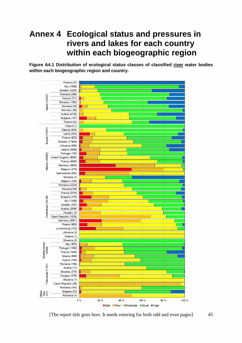
Annex 4 Ecological status and pressures in rivers and lakes for each country within each biogeographic region
Figure A4.1 Distribution of ecological status classes of classified river water bodies
within each biogeographic region and country.

46 [The report title goes here. It needs entering for both odd and even pages]
Figure A4.2 Distribution of ecological status classes of classified lake water bodies within each biogeographic region and country.

[The report title goes here. It needs entering for both odd and even pages] 47
Figure A4.3 Proportion of water bodies with (red) and without (blue) pressures in classified river water bodies within each biogeographic region and country.

48 [The report title goes here. It needs entering for both odd and even pages]
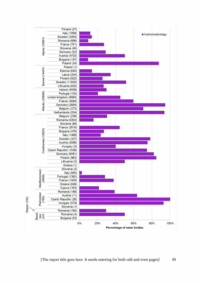
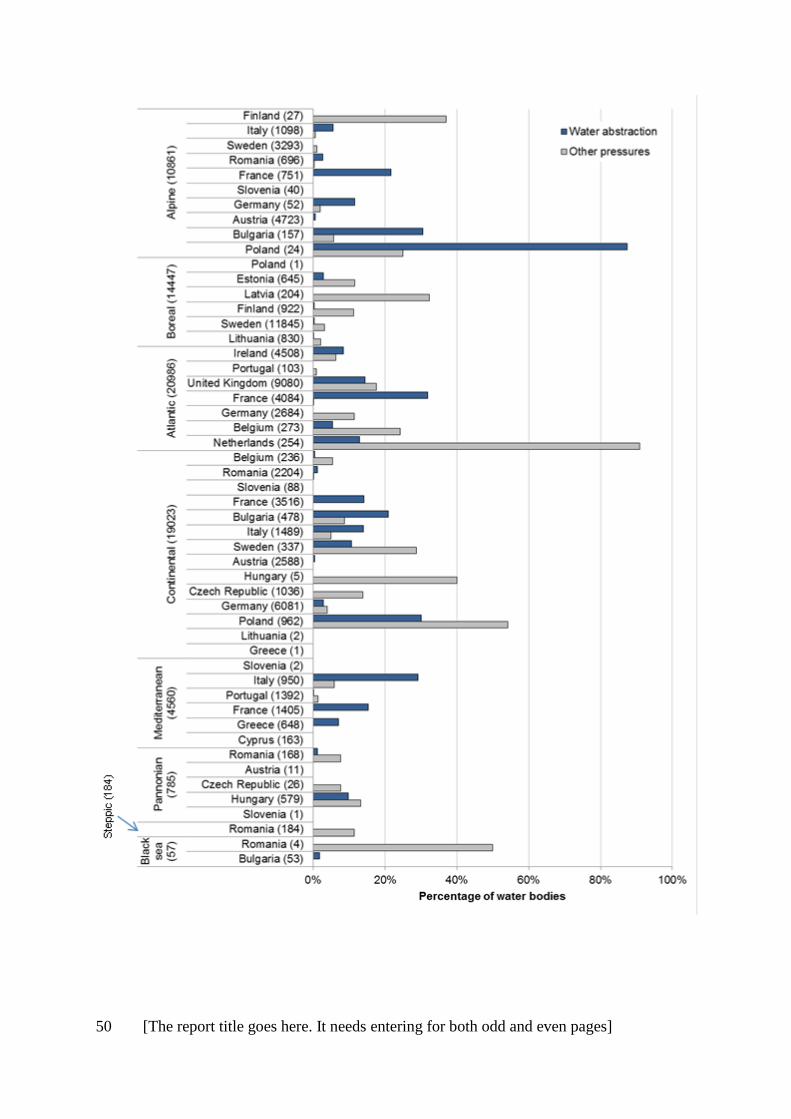
Figure A4.3 Proportion of water bodies with specific pressures in classified river water bodies within each biogeographic region and country.
[The report title goes here. It needs entering for both odd and even pages] 49
50 [The report title goes here. It needs entering for both odd and even pages]

[The report title goes here. It needs entering for both odd and even pages] 51
Figure A4.4. Proportion of water bodies with (red) and without (blue) pressures in classified lake water bodies within each biogeographic region and country.

52 [The report title goes here. It needs entering for both odd and even pages]
Figure A4.3 Proportion of water bodies with specific pressures in classified lake water bodies within each biogeographic region and country.

[The report title goes here. It needs entering for both odd and even pages] 53

54 [The report title goes here. It needs entering for both odd and even pages]

[The report title goes here. It needs entering for both odd and even pages] 55
Annex 5 WFD-HD comparison of pressures
WFD WISE Pressures Reporting for Surface Water
Habitats Directive Pressures / Threats
List of surface water pressures Level 1
Level 2 Codes/Description Level 1
Level 2 Level 3
1 Point Source 1_1 Point - UWWT_General
E Urbanisation, residential and commercial development
E03 Discharges E03.01 disposal of household / recreational facility waste
E Urbanisation, residential and commercial development
E03 Discharges E03.02 disposal of industrial waste
E Urbanisation, residential and commercial development
E03 Discharges E03.03 disposal of inert materials
1 Point Source 1_2 Point - Storm Overflows
H Pollution H01 Pollution to surface waters (limnic, terrestrial, marine & brackish)
H01.02 pollution to surface waters by storm overflows
1 Point Source 1_3 Point - IPPC plants (EPRTR)
H Pollution H01 Pollution to surface waters (limnic, terrestrial, marine & brackish)
H01.01 pollution to surface waters by industrial plants
1 Point Source 1_4 Point - Non IPPC
1 Point Source 1_5 Point - Other H Pollution H01 Pollution to surface waters (limnic, terrestrial, marine & brackish)
H01.03 other point source pollution to surface water
2 Diffuse Source 2_1 Diffuse - Urban run off
H Pollution H01 Pollution to surface waters (limnic, terrestrial, marine & brackish)
H01.04 diffuse pollution to surface waters via storm overlows or urban run-off
2 Diffuse Source 2_2 Diffuse - Agricultural
H Pollution H01 Pollution to surface waters (limnic, terrestrial, marine & brackish)
H01.05 diffuse pollution to surface waters due to agricultural and forestry activities
2 Diffuse Source 2_3 Diffuse - Transport and infrastructure
H Pollution H01 Pollution to surface waters (limnic, terrestrial, marine & brackish)
H01.06 diffuse pollution to surface waters due to transport and infrastructure without connection to canalization/sweepers
2 Diffuse Source 2_4 Diffuse - Abandoned industrial sites
H Pollution H01 Pollution to surface waters (limnic, terrestrial, marine & brackish)
H01.07 diffuse pollution to surface waters due to abandoned industrial sites

56 [The report title goes here. It needs entering for both odd and even pages]
WFD WISE Pressures Reporting for Surface Water
Habitats Directive Pressures / Threats
List of surface water pressures Level 1
Level 2 Codes/Description Level 1
Level 2 Level 3
2 Diffuse Source
2_5 Diffuse - Releases from facilities not connected to sewerage
H Pollution H01 Pollution to surface waters (limnic, terrestrial, marine & brackish)
H01.08 diffuse pollution to surface waters due to household sewage and waste waters
2 Diffuse Source 2_6 Diffuse - Other H Pollution H01 Pollution to surface waters (limnic, terrestrial, marine & brackish)
H01.09 diffuse pollution to surface waters due to other sources not listed
H Pollution H04 Air pollution, air-borne pollutants H04.01 Acid rain
H Pollution H06 excess energy H06.03 Thermal heating of water bodies
3 Water Abstraction 3_1 Abstraction - Agriculture
J Natural System Modifications J02.06 Water abstractions from surface waters
J02.06.01 surface water abstractions for agriculture
3 Water Abstraction 3_2 Abstraction - Public Water Supply
J Natural System Modifications J02.06 Water abstractions from surface waters
J02.06.02 surface water abstractions for public water supply
3 Water Abstraction 3_3 Abstraction - Manufacturing
J Natural System Modifications J02.06 Water abstractions from surface waters
J02.06.03 surface water abstractions by manufacturing industry
3 Water Abstraction 3_4 Abstraction - Electricity cooling
J Natural System Modifications J02.06 Water abstractions from surface waters
J02.06.04 surface water abstractions for the production of electricity (cooling)
3 Water Abstraction 3_5 Abstraction - Fish farms
J Natural System Modifications J02.06 Water abstractions from surface waters
J02.06.05 surface water abstractions by fish farms
3 Water Abstraction 3_6 Abstraction - Hydro-energy not cooling
J Natural System Modifications J02.06 Water abstractions from surface waters
J02.06.06 surface water abstractions by hydro-energy
3 Water Abstraction 3_7 Abstraction - Quarries
J Natural System Modifications J02.06 Water abstractions from surface waters
J02.06.07 surface water abstractions by quarries/ open cast (coal) sites
3 Water Abstraction 3_9 Abstraction - Water transfer
J Natural System Modifications J02.06 Water abstractions from surface waters
J02.06.09 surface water abstractions for water transfer

[The report title goes here. It needs entering for both odd and even pages] 57
WFD WISE Pressures Reporting for Surface Water
Habitats Directive Pressures / Threats
List of surface water pressures Level 1
Level 2 Codes/Description Level 1
Level 2 Level 3
J02.06 Water abstractions from surface waters
J02.06.08 surface water abstractions for navigation
3 Water Abstraction 3_10 Abstraction - Other
J Natural System Modifications J02.06 Water abstractions from surface waters
J02.06.10 other major surface water abstractions
4 Water flow regulations and morphological alterations of surface waters
4_2 FlowMorph - Hydroelectric dam
J Natural System Modifications J02.05 Modification of hydrographic functioning, general
J02.05.05 small hydropower projects, weirs
4 Water flow regulations and morphological alterations of surface waters
4_3 FlowMorph - Water supply reservoir
J Natural System Modifications J02.05 Modification of hydrographic functioning, general
J02.05.04 reservoirs
4 Water flow regulations and morphological alterations of surface waters
4_4 FlowMorph - Flood defence dams
J Natural System Modifications J02.04 Flooding modifications J02.04.01 flooding
J Natural System Modifications J02.04 Flooding modifications J02.04.02 lack of flooding
J Natural System Modifications
J02.12 Dykes, embankments, artificial beaches, general
J02.12.02 dykes and flooding defense in inland water systems
4 Water flow regulations and morphological alterations of surface waters
4_5 FlowMorph - Water Flow Regulation
J Natural System Modifications J02.05 Modification of hydrographic functioning, general
J02.05.01 modification of water flow (tidal & marine currents)
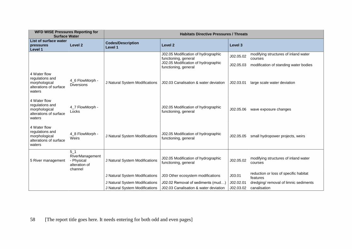
58 [The report title goes here. It needs entering for both odd and even pages]
WFD WISE Pressures Reporting for Surface Water
Habitats Directive Pressures / Threats
List of surface water pressures Level 1
Level 2 Codes/Description Level 1
Level 2 Level 3
J02.05 Modification of hydrographic functioning, general
J02.05.02 modifying structures of inland water courses
J02.05 Modification of hydrographic functioning, general
J02.05.03 modification of standing water bodies
4 Water flow regulations and morphological alterations of surface waters
4_6 FlowMorph - Diversions
J Natural System Modifications J02.03 Canalisation & water deviation J02.03.01 large scale water deviation
4 Water flow regulations and morphological alterations of surface waters
4_7 FlowMorph - Locks
J02.05 Modification of hydrographic functioning, general
J02.05.06 wave exposure changes
4 Water flow regulations and morphological alterations of surface waters
4_8 FlowMorph - Weirs
J Natural System Modifications J02.05 Modification of hydrographic functioning, general
J02.05.05 small hydropower projects, weirs
5 River management
5_1 RiverManagement - Physical alteration of channel
J Natural System Modifications J02.05 Modification of hydrographic functioning, general
J02.05.02 modifying structures of inland water courses
J Natural System Modifications J03 Other ecosystem modifications J03.01
reduction or loss of specific habitat features
J Natural System Modifications J02.02 Removal of sediments (mud…) J02.02.01 dredging/ removal of limnic sediments
J Natural System Modifications J02.03 Canalisation & water deviation J02.03.02 canalisation

[The report title goes here. It needs entering for both odd and even pages] 59
WFD WISE Pressures Reporting for Surface Water
Habitats Directive Pressures / Threats
List of surface water pressures Level 1
Level 2 Codes/Description Level 1
Level 2 Level 3
5 River management
5_2 RiverManagement - Engineering activities
J Natural System Modifications J02.05 Modification of hydrographic functioning, general
J02.05.02 modifying structures of inland water courses
J Natural System Modifications J02.03 Canalisation & water deviation J02.03.02 canalisation
5 River management
5_3 RiverManagement - Agricultural enhancement
J Natural System Modifications J02 human induced changes in hydraulic conditions
J02.10 management of aquatic and bank vegetation for drainage purposes
J Natural System Modifications
J02.11 Siltation rate changes, dumping, depositing of dredged deposits
J02.11.01 Dumping, depositing of dredged deposits
J Natural System Modifications
J02.11 Siltation rate changes, dumping, depositing of dredged deposits
J02.11.02 Other siltation rate changes
5 River management
5_5 RiverManagement - Land infrastructure
D Transportation and service corridors
D01 Roads, paths and railroads D01.01 paths, tracks, cycling tracks
D01 Roads, paths and railroads D01.02 roads, motorways
D01 Roads, paths and railroads D01.03 car parks and parking areas
D01 Roads, paths and railroads D01.04 railway lines, TGV
D01 Roads, paths and railroads D01.05 bridge, viaduct
D01 Roads, paths and railroads D01.06 tunnel
6 Transitional and coastal water management
6_1 TRACManagement - Estuarine/coastal dredging
J Natural System Modifications J02.02 Removal of sediments (mud…) J02.02.02 estuarine and coastal dredging

60 [The report title goes here. It needs entering for both odd and even pages]
WFD WISE Pressures Reporting for Surface Water
Habitats Directive Pressures / Threats
List of surface water pressures Level 1
Level 2 Codes/Description Level 1
Level 2 Level 3
6 Transitional and coastal water management
6_2 TRACManagement - Marine constructions
D Transportation and service corridors
D03.01 port areas D03.01.01 slipways
D Transportation and service corridors
D03.01 port areas D03.01.02 piers / tourist harbours or recreational piers
D Transportation and service corridors
D03.01 port areas D03.01.03 fishing harbours
D Transportation and service corridors
D03.01 port areas D03.01.04 industrial ports
D Transportation and service corridors
D03.02 Shipping lanes D03.02.01 cargo lanes
D Transportation and service corridors
D03.02 Shipping lanes D03.02.02 passenger ferry lanes (high speed)
6 Transitional and coastal water management
6_3 TRACManagement - Land reclamation
J Natural System Modifications J02.01 Landfill, land reclamation and drying out, general
J02.01.02 reclamation of land from sea, estuary or marsh
7 Other morphological alterations
7_1 OtherMorph - Barriers
J Natural System Modifications J03.02 anthropogenic reduction of habitat connectivity
J03.02.01 reduction in migration/ migration barriers
J Natural System Modifications
J03.02 anthropogenic reduction of habitat connectivity
J03.02.02 reduction in dispersal
J Natural System Modifications J03 Other ecosystem modifications J03.03 reduction, lack or prevention of erosion
J Natural System Modifications
J02 human induced changes in hydraulic conditions
J02.15 Other human induced changes in hydraulic conditions
8 Other Pressures 8_1 OtherPressures - Litter/fly tipping
H Pollution H05 Soil pollution and solid waste (excluding discharges)
H05.01 garbadge and solid waste

[The report title goes here. It needs entering for both odd and even pages] 61
WFD WISE Pressures Reporting for Surface Water
Habitats Directive Pressures / Threats
List of surface water pressures Level 1
Level 2 Codes/Description Level 1
Level 2 Level 3
8 Other Pressures 8_4 OtherPressures - Recreation
G Human intrusions and disturbances
G01 'Outdoor sports and leisure activities, recreational activities
8 Other Pressures 8_5 OtherPressures - Fishing
F Biological resource use other than agriculture & forestry
F01 Marine and Freshwater Aquaculture
F01.01 intensive fish farming, intensification
F Biological resource use other than agriculture & forestry
F01 Marine and Freshwater Aquaculture
F01.02 suspension culture
F Biological resource use other than agriculture & forestry
F02 Fishing and harvesting aquatic resources
F02.01 Professional passive fishing
F Biological resource use other than agriculture & forestry
F02 Fishing and harvesting aquatic resources
F02.02 Professional active fishing
F Biological resource use other than agriculture & forestry
F02 Fishing and harvesting aquatic resources
F02.03 Leisure fishing
8 Other Pressures 8_6 OtherPressures - Introduced species
I Invasive, other problematic species and genes
I01 invasive non-native species
I Invasive, other problematic species and genes
I02 problematic native species
I Invasive, other problematic species and genes
I03 introduced genetic material, GMO I03.01 genetic pollution (animals)
8 Other Pressures 8_7 OtherPressures - Introduced disease
K Natural biotic and abiotic processes (without catastrophes)
K03 'Interspecific faunal relations K03.03 'introduction of disease (microbial pathogens)
8 Other Pressures 8_8 OtherPressures - Climate change
M Climate change M01 Changes in abiotic conditions M01.01
temperature changes (e.g. rise of temperature & extremes)
M Climate change M01 Changes in abiotic conditions M01.02 droughts and less precipitations
M Climate change M01 Changes in abiotic conditions M01.03 flooding and rising precipitations
M Climate change M01 Changes in abiotic conditions M01.04 pH-changes

62 [The report title goes here. It needs entering for both odd and even pages]
WFD WISE Pressures Reporting for Surface Water
Habitats Directive Pressures / Threats
List of surface water pressures Level 1
Level 2 Codes/Description Level 1
Level 2 Level 3
M Climate change M01 Changes in abiotic conditions
M01.05 water flow changes (limnic, tidal and oceanic)
M Climate change M02 Changes in biotic conditions M02.01 habitat shifting and alteration
M Climate change M02 Changes in biotic conditions M02.02 desynchronisation of processes
M Climate change M02 Changes in biotic conditions M02.03 decline or extinction of species
M Climate change M02 Changes in biotic conditions M02.04 migration of species (natural newcomers)
8 Other Pressures 8_9 OtherPressures - Land drainage
J Natural System Modifications J02.01 Landfill, land reclamation and drying out, general
J02.01.01 polderisation
J Natural System Modifications
J02.01 Landfill, land reclamation and drying out, general
J02.01.03 infilling of ditches, dykes, ponds, pools, marshes or pits
J Natural System Modifications
J02.01 Landfill, land reclamation and drying out, general
J02.01.04 recultivation of mining areas
8 Other Pressures 8_10 OtherPressures- Other
C Mining, extraction of materials and energy production
C01.03 Peat extraction C01.03.01 hand cutting of peat
C Mining, extraction of materials and energy production
C01.03 Peat extraction C01.03.02 mechanical removal of peat
J Natural System Modifications
J02 human induced changes in hydraulic conditions
J02.15 Abandonment of management of water bodies

[The report title goes here. It needs entering for both odd and even pages] 63
Annex 6 National WFD national types sorted into broad altitude types and size for Germany, Ireland, Sweden and Hungary
Table A6.1. Germany
Country
Water Category Code
Broad Altitude Type Size TYPE_CODE TYPE_NAME
DE RW Lowland Rivers 15_G Große sand- und lehmgeprägte Tieflandflüsse
DE RW Mid-altitude Rivers 4 Große Flüsse des Alpenvorlandes
DE RW Mid-altitude Rivers 9.2 Große Flüsse des Mittelgebirges
DE RW Mid-altitude N/A 2 Fließgewässer des Alpenvorlandes
DE RW Lowland N/A 22 Marschengewässer
DE RW Lowland N/A 22.1 Gewässer der Marschen
DE RW Mid-altitude N/A 3 Fließgewässer der Jungmoräne des Alpenvorlandes
DE RW N/A Rivers 12 Organisch geprägte Flüsse
DE RW Lowland Rivers 15 Sand- und lehmgeprägte Tieflandflüsse
DE RW Mid-altitude Rivers 2.2 Kleine Flüsse des Alpenvorlandes
DE RW N/A Rivers 21 Seeausflussgeprägte Fließgewässer
DE RW Mid-altitude Rivers 21_S Seeausflussgeprägte Fließgewässer des Alpenvorlandes (Süd)
DE RW Lowland Rivers 22.2 Flüsse der Marschen
DE RW Lowland Rivers 23 Rückstau- bzw. brackwasserbeeinflusste Ostseezuflüsse
DE RW Mid-altitude Rivers 3.2 Kleine Flüsse der Jungmoräne des Alpenvorlandes
DE RW Mid-altitude Rivers 9 Silikatische, fein- bis grobmaterialreiche Mittelgebirgsflüsse
DE RW Mid-altitude Rivers 9.1 Karbonatische, fein- bis grobmaterialreiche Mittelgebirgsflüsse
DE RW Mid-altitude Rivers 9.1_K Karbonatische, fein- bis grobmaterialreiche Mittelgebirgsflüsse des Keupers
DE RW Alpine Streams 1.1 Bäche der Kalkalpen
DE RW Alpine Streams 1.2 Kleine Flüsse der Kalkalpen

64 [The report title goes here. It needs entering for both odd and even pages]
Country
Water Category Code
Broad Altitude Type Size TYPE_CODE TYPE_NAME
DE RW N/A Streams 11 Organisch geprägte Bäche
DE RW Lowland Streams 14 Sandgeprägte Tieflandbäche
DE RW Lowland Streams 16 Kiesgeprägte Tieflandbäche
DE RW Lowland Streams 17 Kiesgeprägte Tieflandflüsse
DE RW Lowland Streams 18 Löss-lehmgeprägte Tieflandbäche
DE RW N/A Streams 19 Kleine Niederungsfließgewässer in Fluss- und Stromtälern
DE RW Mid-altitude Streams 2.1 Bäche des Alpenvorlandes
DE RW Mid-altitude Streams 3.1 Bäche der Jungmoräne des Alpenvorlandes
DE RW Mid-altitude Streams 5 Grobmaterialreiche, silikatische Mittelgebirgsbäche
DE RW Mid-altitude Streams 5.1 Feinmaterialreiche, silikatische Mittelgebirgsbäche
DE RW Mid-altitude Streams 6 Feinmaterialreiche, karbonatische Mittelgebirgsbäche
DE RW Mid-altitude Streams 6_K Feinmaterialreiche, karbonatische Mittelgebirgsbäche des Keupers
DE RW Mid-altitude Streams 7 Grobmaterialreiche, karbonatische Mittelgebirgsbäche
DE RW Mid-altitude Very large 10 Kiesgeprägte Ströme
DE RW Lowland Very large 20 Sandgeprägte Ströme
DE RW Lowland Very large 22.3 Ströme der Marschen
DE RW N/A N/A 99
DE RW N/A N/A Null Keine Information verfügbar
DE LW Alpine N/A 1 Kalkreicher*, ungeschichteter Voralpensee mit relativ großem Einzugsgebiet**
DE LW Lowland N/A 10 Kalkreicher, geschichteter Flachlandsee mit relativ großem Einzugsgebiet
DE LW Lowland N/A 11 Kalkreicher, ungeschichteter Flachlandsee mit relativ großem Einzugsgebiet und einer Verweilzeit >30d
DE LW Lowland N/A 12 Kalkreicher, ungeschichteter Flachlandsee mit relativ großem Einzugsgebiet und einer Verweilzeit > 3d und < 30d
DE LW Lowland N/A 13 Kalkreicher, geschichteter Flachlandsee mit relativ kleinem Einzugsgebiet
DE LW Lowland N/A 14 Kalkreicher, ungeschichteter Flachlandsee mit relativ kleinem Einzugsgebiet
DE LW Alpine N/A 2 Kalkreicher, geschichteter*** Voralpensee mit relativ großem Einzugsgebiet

[The report title goes here. It needs entering for both odd and even pages] 65
Country
Water Category Code
Broad Altitude Type Size TYPE_CODE TYPE_NAME
DE LW Alpine N/A 3 Kalkreicher, geschichteter Voralpensee mit relativ kleinem Einzugsgebiet
DE LW Alpine N/A 4 Kalkreicher, geschichteter Alpensee mit relativ kleinem oder großem Einzugsgebiet
DE LW Mid-altitude N/A 5 Kalkreicher, geschichteter Mittelgebirgssee mit relativ großem Einzugsgebiet
DE LW Mid-altitude N/A 6 Kalkreicher, ungeschichteter Mittelgebirgssee mit relativ großem Einzugsgebiet
DE LW Mid-altitude N/A 7 Kalkreicher, geschichteter Mittelgebirgssee mit relativ kleinem Einzugsgebiet
DE LW Mid-altitude N/A 8 Kalkarmer, geschichteter Mittelgebirgssee mit relativ großem Einzugsgebiet
DE LW N/A N/A 88 Sondertyp natürlicher Seen (Moorsee, Strandsee u.s.w.)
DE LW Mid-altitude N/A 9 Kalkarmer, geschichteter Mittelgebirgssee mit relativ kleinem Einzugsgebiet
DE LW N/A N/A 99 Sondertyp künstlicher Seen (z.B. Abgrabungsseen)
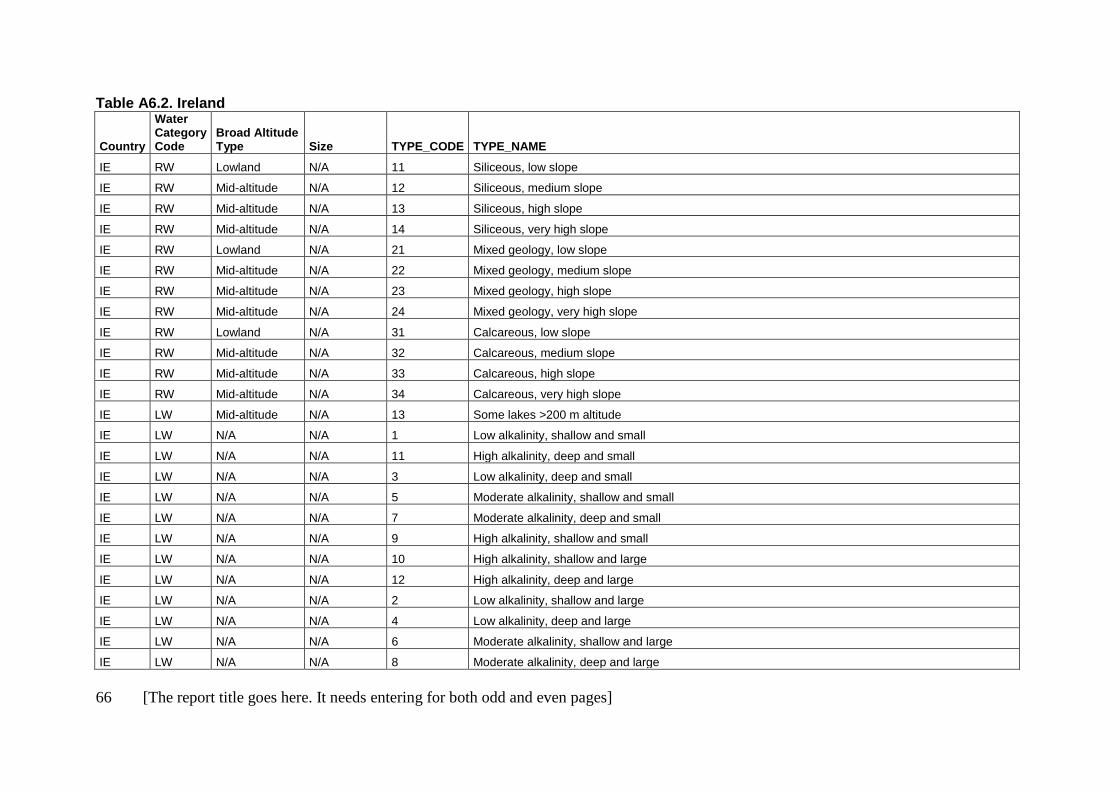
66 [The report title goes here. It needs entering for both odd and even pages]
Table A6.2. Ireland
Country
Water Category Code
Broad Altitude Type Size TYPE_CODE TYPE_NAME
IE RW Lowland N/A 11 Siliceous, low slope
IE RW Mid-altitude N/A 12 Siliceous, medium slope
IE RW Mid-altitude N/A 13 Siliceous, high slope
IE RW Mid-altitude N/A 14 Siliceous, very high slope
IE RW Lowland N/A 21 Mixed geology, low slope
IE RW Mid-altitude N/A 22 Mixed geology, medium slope
IE RW Mid-altitude N/A 23 Mixed geology, high slope
IE RW Mid-altitude N/A 24 Mixed geology, very high slope
IE RW Lowland N/A 31 Calcareous, low slope
IE RW Mid-altitude N/A 32 Calcareous, medium slope
IE RW Mid-altitude N/A 33 Calcareous, high slope
IE RW Mid-altitude N/A 34 Calcareous, very high slope
IE LW Mid-altitude N/A 13 Some lakes >200 m altitude
IE LW N/A N/A 1 Low alkalinity, shallow and small
IE LW N/A N/A 11 High alkalinity, deep and small
IE LW N/A N/A 3 Low alkalinity, deep and small
IE LW N/A N/A 5 Moderate alkalinity, shallow and small
IE LW N/A N/A 7 Moderate alkalinity, deep and small
IE LW N/A N/A 9 High alkalinity, shallow and small
IE LW N/A N/A 10 High alkalinity, shallow and large
IE LW N/A N/A 12 High alkalinity, deep and large
IE LW N/A N/A 2 Low alkalinity, shallow and large
IE LW N/A N/A 4 Low alkalinity, deep and large
IE LW N/A N/A 6 Moderate alkalinity, shallow and large
IE LW N/A N/A 8 Moderate alkalinity, deep and large
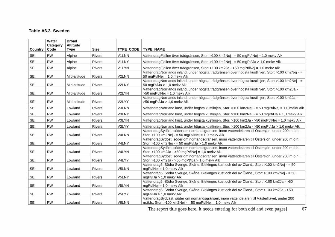
[The report title goes here. It needs entering for both odd and even pages] 67
Table A6.3. Sweden
Country
Water Category Code
Broad Altitude Type Size TYPE_CODE TYPE_NAME
SE RW Alpine Rivers V1LNN VattendragFjällen över trädgränsen, Stor: >100 km2Nej - = 50 mgPt/lNej = 1,0 mekv Alk
SE RW Alpine Rivers V1LNY VattendragFjällen över trädgränsen, Stor: >100 km2Nej - = 50 mgPt/lJa > 1,0 mekv Alk
SE RW Alpine Rivers V1LYN VattendragFjällen över trädgränsen, Stor: >100 km2Ja - >50 mgPt/lNej = 1,0 mekv Alk
SE RW Mid-altitude Rivers V2LNN VattendragNorrlands inland, under högsta trädgränsen över högsta kustlinjen, Stor: >100 km2Nej - = 50 mgPt/lNej = 1,0 mekv Alk
SE RW Mid-altitude Rivers V2LNY VattendragNorrlands inland, under högsta trädgränsen över högsta kustlinjen, Stor: >100 km2Nej - = 50 mgPt/lJa > 1,0 mekv Alk
SE RW Mid-altitude Rivers V2LYN VattendragNorrlands inland, under högsta trädgränsen över högsta kustlinjen, Stor: >100 km2Ja - >50 mgPt/lNej = 1,0 mekv Alk
SE RW Mid-altitude Rivers V2LYY VattendragNorrlands inland, under högsta trädgränsen över högsta kustlinjen, Stor: >100 km2Ja - >50 mgPt/lJa > 1,0 mekv Alk
SE RW Lowland Rivers V3LNN VattendragNorrland kust, under högsta kustlinjen, Stor: >100 km2Nej - = 50 mgPt/lNej = 1,0 mekv Alk
SE RW Lowland Rivers V3LNY VattendragNorrland kust, under högsta kustlinjen, Stor: >100 km2Nej - = 50 mgPt/lJa > 1,0 mekv Alk
SE RW Lowland Rivers V3LYN VattendragNorrland kust, under högsta kustlinjen, Stor: >100 km2Ja - >50 mgPt/lNej = 1,0 mekv Alk
SE RW Lowland Rivers V3LYY VattendragNorrland kust, under högsta kustlinjen, Stor: >100 km2Ja - >50 mgPt/lJa > 1,0 mekv Alk
SE RW Lowland Rivers V4LNN VattendragSydöst, söder om norrlandsgränsen, inom vattendelaren till Östersjön, under 200 m.ö.h., Stor: >100 km2Nej - = 50 mgPt/lNej = 1,0 mekv Alk
SE RW Lowland Rivers V4LNY VattendragSydöst, söder om norrlandsgränsen, inom vattendelaren till Östersjön, under 200 m.ö.h., Stor: >100 km2Nej - = 50 mgPt/lJa > 1,0 mekv Alk
SE RW Lowland Rivers V4LYN VattendragSydöst, söder om norrlandsgränsen, inom vattendelaren till Östersjön, under 200 m.ö.h., Stor: >100 km2Ja - >50 mgPt/lNej = 1,0 mekv Alk
SE RW Lowland Rivers V4LYY VattendragSydöst, söder om norrlandsgränsen, inom vattendelaren till Östersjön, under 200 m.ö.h., Stor: >100 km2Ja - >50 mgPt/lJa > 1,0 mekv Alk
SE RW Lowland Rivers V5LNN Vattendrag5. Södra Sverige, Skåne, Blekinges kust och del av Öland., Stor: >100 km2Nej - = 50 mgPt/lNej = 1,0 mekv Alk
SE RW Lowland Rivers V5LNY Vattendrag5. Södra Sverige, Skåne, Blekinges kust och del av Öland., Stor: >100 km2Nej - = 50 mgPt/lJa > 1,0 mekv Alk
SE RW Lowland Rivers V5LYN Vattendrag5. Södra Sverige, Skåne, Blekinges kust och del av Öland., Stor: >100 km2Ja - >50 mgPt/lNej = 1,0 mekv Alk
SE RW Lowland Rivers V5LYY Vattendrag5. Södra Sverige, Skåne, Blekinges kust och del av Öland., Stor: >100 km2Ja - >50 mgPt/lJa > 1,0 mekv Alk
SE RW Lowland Rivers V6LNN VattendragSydväst, söder om norrlandsgränsen, inom vattendelaren till Västerhavet, under 200 m.ö.h., Stor: >100 km2Nej - = 50 mgPt/lNej = 1,0 mekv Alk

68 [The report title goes here. It needs entering for both odd and even pages]
Country
Water Category Code
Broad Altitude Type Size TYPE_CODE TYPE_NAME
SE RW Lowland Rivers V6LNY VattendragSydväst, söder om norrlandsgränsen, inom vattendelaren till Västerhavet, under 200 m.ö.h., Stor: >100 km2Nej - = 50 mgPt/lJa > 1,0 mekv Alk
SE RW Lowland Rivers V6LYN VattendragSydväst, söder om norrlandsgränsen, inom vattendelaren till Västerhavet, under 200 m.ö.h., Stor: >100 km2Ja - >50 mgPt/lNej = 1,0 mekv Alk
SE RW Lowland Rivers V6LYY VattendragSydväst, söder om norrlandsgränsen, inom vattendelaren till Västerhavet, under 200 m.ö.h., Stor: >100 km2Ja - >50 mgPt/lJa > 1,0 mekv Alk
SE RW Mid-altitude Rivers V7LNN VattendragSydsvenska höglandet, söder om norrlandsgränsen, över 200 m.ö.h., Stor: >100 km2Nej - = 50 mgPt/lNej = 1,0 mekv Alk
SE RW Mid-altitude Rivers V7LYN VattendragSydsvenska höglandet, söder om norrlandsgränsen, över 200 m.ö.h., Stor: >100 km2Ja - >50 mgPt/lNej = 1,0 mekv Alk
SE RW Mid-altitude Rivers V7LYY VattendragSydsvenska höglandet, söder om norrlandsgränsen, över 200 m.ö.h., Stor: >100 km2Ja - >50 mgPt/lJa > 1,0 mekv Alk
SE RW N/A Rivers V-LYN Vattendrag-, Stor: >100 km2Ja - >50 mgPt/lNej = 1,0 mekv Alk
SE RW Alpine Streams V1SNN VattendragFjällen över trädgränsen, Liten: = 100 km²Nej - = 50 mgPt/lNej = 1,0 mekv Alk
SE RW Alpine Streams V1SNY VattendragFjällen över trädgränsen, Liten: = 100 km²Nej - = 50 mgPt/lJa > 1,0 mekv Alk
SE RW Alpine Streams V1SYN VattendragFjällen över trädgränsen, Liten: = 100 km²Ja - >50 mgPt/lNej = 1,0 mekv Alk
SE RW Mid-altitude Streams V2SNN VattendragNorrlands inland, under högsta trädgränsen över högsta kustlinjen, Liten: = 100 km²Nej - = 50 mgPt/lNej = 1,0 mekv Alk
SE RW Mid-altitude Streams V2SNY VattendragNorrlands inland, under högsta trädgränsen över högsta kustlinjen, Liten: = 100 km²Nej - = 50 mgPt/lJa > 1,0 mekv Alk
SE RW Mid-altitude Streams V2SYN VattendragNorrlands inland, under högsta trädgränsen över högsta kustlinjen, Liten: = 100 km²Ja - >50 mgPt/lNej = 1,0 mekv Alk
SE RW Mid-altitude Streams V2SYY VattendragNorrlands inland, under högsta trädgränsen över högsta kustlinjen, Liten: = 100 km²Ja - >50 mgPt/lJa > 1,0 mekv Alk
SE RW Lowland Streams V3SNN VattendragNorrland kust, under högsta kustlinjen, Liten: = 100 km²Nej - = 50 mgPt/lNej = 1,0 mekv Alk
SE RW Lowland Streams V3SNY VattendragNorrland kust, under högsta kustlinjen, Liten: = 100 km²Nej - = 50 mgPt/lJa > 1,0 mekv Alk
SE RW Lowland Streams V3SYN VattendragNorrland kust, under högsta kustlinjen, Liten: = 100 km²Ja - >50 mgPt/lNej = 1,0 mekv Alk
SE RW Lowland Streams V3SYY VattendragNorrland kust, under högsta kustlinjen, Liten: = 100 km²Ja - >50 mgPt/lJa > 1,0 mekv Alk
SE RW Lowland Streams V4SNN VattendragSydöst, söder om norrlandsgränsen, inom vattendelaren till Östersjön, under 200 m.ö.h., Liten: = 100 km²Nej - = 50 mgPt/lNej = 1,0 mekv Alk
SE RW Lowland Streams V4SNY VattendragSydöst, söder om norrlandsgränsen, inom vattendelaren till Östersjön, under 200 m.ö.h., Liten: = 100 km²Nej - = 50 mgPt/lJa > 1,0 mekv Alk
SE RW Lowland Streams V4SYN VattendragSydöst, söder om norrlandsgränsen, inom vattendelaren till Östersjön, under 200 m.ö.h., Liten: = 100 km²Ja - >50 mgPt/lNej = 1,0 mekv Alk

[The report title goes here. It needs entering for both odd and even pages] 69
Country
Water Category Code
Broad Altitude Type Size TYPE_CODE TYPE_NAME
SE RW Lowland Streams V4SYY VattendragSydöst, söder om norrlandsgränsen, inom vattendelaren till Östersjön, under 200 m.ö.h., Liten: = 100 km²Ja - >50 mgPt/lJa > 1,0 mekv Alk
SE RW Lowland Streams V5SNN Vattendrag5. Södra Sverige, Skåne, Blekinges kust och del av Öland., Liten: = 100 km²Nej - = 50 mgPt/lNej = 1,0 mekv Alk
SE RW Lowland Streams V5SNY Vattendrag5. Södra Sverige, Skåne, Blekinges kust och del av Öland., Liten: = 100 km²Nej - = 50 mgPt/lJa > 1,0 mekv Alk
SE RW Lowland Streams V5SYN Vattendrag5. Södra Sverige, Skåne, Blekinges kust och del av Öland., Liten: = 100 km²Ja - >50 mgPt/lNej = 1,0 mekv Alk
SE RW Lowland Streams V5SYY Vattendrag5. Södra Sverige, Skåne, Blekinges kust och del av Öland., Liten: = 100 km²Ja - >50 mgPt/lJa > 1,0 mekv Alk
SE RW Lowland Streams V6SNN VattendragSydväst, söder om norrlandsgränsen, inom vattendelaren till Västerhavet, under 200 m.ö.h., Liten: = 100 km²Nej - = 50 mgPt/lNej = 1,0 mekv Alk
SE RW Lowland Streams V6SNY VattendragSydväst, söder om norrlandsgränsen, inom vattendelaren till Västerhavet, under 200 m.ö.h., Liten: = 100 km²Nej - = 50 mgPt/lJa > 1,0 mekv Alk
SE RW Lowland Streams V6SYN VattendragSydväst, söder om norrlandsgränsen, inom vattendelaren till Västerhavet, under 200 m.ö.h., Liten: = 100 km²Ja - >50 mgPt/lNej = 1,0 mekv Alk
SE RW Lowland Streams V6SYY VattendragSydväst, söder om norrlandsgränsen, inom vattendelaren till Västerhavet, under 200 m.ö.h., Liten: = 100 km²Ja - >50 mgPt/lJa > 1,0 mekv Alk
SE RW Mid-altitude Streams V7SNN VattendragSydsvenska höglandet, söder om norrlandsgränsen, över 200 m.ö.h., Liten: = 100 km²Nej - = 50 mgPt/lNej = 1,0 mekv Alk
SE RW Mid-altitude Streams V7SYN VattendragSydsvenska höglandet, söder om norrlandsgränsen, över 200 m.ö.h., Liten: = 100 km²Ja - >50 mgPt/lNej = 1,0 mekv Alk
SE RW Mid-altitude Streams V7SYY VattendragSydsvenska höglandet, söder om norrlandsgränsen, över 200 m.ö.h.Liten: = 100 km²Ja - >50 mgPt/lJa > 1,0 mekv Alk
SE LW Lowland N/A S3---- SjöNorrland kust, under högsta kustlinjen----
SE LW Alpine N/A S1DLNN SjöFjällen över trädgränsen, Djup: Max, Djup >5m/ Medel, Djup >4m, Stor: >10km²Nej - = 50 mgPt/lNej = 1,0 mekv Alk
SE LW Mid-altitude N/A S2DLNN SjöNorrlands inland, under högsta trädgränsen över högsta kustlinjen, Djup: Max, Djup >5m/ Medel, Djup >4m, Stor: >10km²Nej - = 50 mgPt/lNej = 1,0 mekv Alk
SE LW Mid-altitude N/A S2DLNY SjöNorrlands inland, under högsta trädgränsen över högsta kustlinjen, Djup: Max, Djup >5m/ Medel, Djup >4m, Stor: >10km²Nej - = 50 mgPt/lJa > 1,0 mekv Alk
SE LW Mid-altitude N/A S2DLYN SjöNorrlands inland, under högsta trädgränsen över högsta kustlinjen, Djup: Max, Djup >5m/ Medel, Djup >4m, Stor: >10km²Ja - >50 mgPt/lNej = 1,0 mekv Alk
SE LW Mid-altitude N/A S2SLNN SjöNorrlands inland, under högsta trädgränsen över högsta kustlinjen, Grund: Max, Djup = 5 m/ Medel, Djup = 4m, Stor: >10km²Nej - = 50 mgPt/lNej = 1,0 mekv Alk
SE LW Lowland
N/A S3DLNN SjöNorrland kust, under högsta kustlinjen, Djup: Max, Djup >5m/ Medel, Djup >4m, Stor: >10km²Nej - = 50 mgPt/lNej = 1,0 mekv Alk
SE LW Lowland N/A S3DLYN SjöNorrland kust, under högsta kustlinjen, Djup: Max, Djup >5m/ Medel, Djup >4m, Stor: >10km²Ja -

70 [The report title goes here. It needs entering for both odd and even pages]
Country
Water Category Code
Broad Altitude Type Size TYPE_CODE TYPE_NAME
>50 mgPt/lNej = 1,0 mekv Alk
SE LW Lowland
N/A S3SLNN SjöNorrland kust, under högsta kustlinjen, Grund: Max, Djup = 5 m/ Medel, Djup = 4m, Stor: >10km²Nej - = 50 mgPt/lNej = 1,0 mekv Alk
SE LW Lowland
N/A S3SLYN SjöNorrland kust, under högsta kustlinjen, Grund: Max, Djup = 5 m/ Medel, Djup = 4m, Stor: >10km²Ja - >50 mgPt/lNej = 1,0 mekv Alk
SE LW Mid-altitude N/A S4DLNN SjöSydöst, söder om norrlandsgränsen, inom vattendelaren till Östersjön, under 200 m.ö.h., Djup: Max, Djup >5m/ Medel, Djup >4m, Stor: >10km²Nej - = 50 mgPt/lNej = 1,0 mekv Alk
SE LW Mid-altitude N/A S4DLNY SjöSydöst, söder om norrlandsgränsen, inom vattendelaren till Östersjön, under 200 m.ö.h., Djup: Max, Djup >5m/ Medel, Djup >4m, Stor: >10km²Nej - = 50 mgPt/lJa > 1,0 mekv Alk
SE LW Mid-altitude N/A S4DLYN SjöSydöst, söder om norrlandsgränsen, inom vattendelaren till Östersjön, under 200 m.ö.h., Djup: Max, Djup >5m/ Medel, Djup >4m, Stor: >10km²Ja - >50 mgPt/lNej = 1,0 mekv Alk
SE LW Mid-altitude N/A S4DLYY SjöSydöst, söder om norrlandsgränsen, inom vattendelaren till Östersjön, under 200 m.ö.h., Djup: Max, Djup >5m/ Medel, Djup >4m, Stor: >10km²Ja - >50 mgPt/lJa > 1,0 mekv Alk
SE LW Mid-altitude N/A S4SLNN SjöSydöst, söder om norrlandsgränsen, inom vattendelaren till Östersjön, under 200 m.ö.h., Grund: Max, Djup = 5 m/ Medel, Djup = 4m, Stor: >10km²Nej - = 50 mgPt/lNej = 1,0 mekv Alk
SE LW Mid-altitude N/A S4SLNY SjöSydöst, söder om norrlandsgränsen, inom vattendelaren till Östersjön, under 200 m.ö.h., Grund: Max, Djup = 5 m/ Medel, Djup = 4m, Stor: >10km²Nej - = 50 mgPt/lJa > 1,0 mekv Alk
SE LW Mid-altitude N/A S4SLYY SjöSydöst, söder om norrlandsgränsen, inom vattendelaren till Östersjön, under 200 m.ö.h., Grund: Max, Djup = 5 m/ Medel, Djup = 4m, Stor: >10km²Ja - >50 mgPt/lJa > 1,0 mekv Alk
SE LW Lowland N/A S5DLNN Sjö5. Södra Sverige, Skåne, Blekinges kust och del av Öland., Djup: Max, Djup >5m/ Medel, Djup >4m, Stor: >10km²Nej - = 50 mgPt/lNej = 1,0 mekv Alk
SE LW Lowland N/A S5DLNY Sjö5. Södra Sverige, Skåne, Blekinges kust och del av Öland., Djup: Max, Djup >5m/ Medel, Djup >4m, Stor: >10km²Nej - = 50 mgPt/lJa > 1,0 mekv Alk
SE LW Lowland N/A S5DLYN Sjö5. Södra Sverige, Skåne, Blekinges kust och del av Öland., Djup: Max, Djup >5m/ Medel, Djup >4m, Stor: >10km²Ja - >50 mgPt/lNej = 1,0 mekv Alk
SE LW Lowland N/A S5SLNY Sjö5. Södra Sverige, Skåne, Blekinges kust och del av Öland., Grund: Max, Djup = 5 m/ Medel, Djup = 4m, Stor: >10km²Nej - = 50 mgPt/lJa > 1,0 mekv Alk
SE LW Lowland N/A S5SLYN Sjö5. Södra Sverige, Skåne, Blekinges kust och del av Öland., Grund: Max, Djup = 5 m/ Medel, Djup = 4m, Stor: >10km²Ja - >50 mgPt/lNej = 1,0 mekv Alk
SE LW Lowland N/A S6DLNN SjöSydväst, söder om norrlandsgränsen, inom vattendelaren till Västerhavet, under 200 m.ö.h., Djup: Max, Djup >5m/ Medel, Djup >4m, Stor: >10km²Nej - = 50 mgPt/lNej = 1,0 mekv Alk
SE LW Lowland N/A S6DLYN SjöSydväst, söder om norrlandsgränsen, inom vattendelaren till Västerhavet, under 200 m.ö.h., Djup: Max, Djup >5m/ Medel, Djup >4m, Stor: >10km²Ja - >50 mgPt/lNej = 1,0 mekv Alk
SE LW Lowland N/A S6SLNN SjöSydväst, söder om norrlandsgränsen, inom vattendelaren till Västerhavet, under 200 m.ö.h., Grund: Max, Djup = 5 m/ Medel, Djup = 4m, Stor: >10km²Nej - = 50 mgPt/lNej = 1,0 mekv Alk
SE LW Lowland N/A S6SLYN SjöSydväst, söder om norrlandsgränsen, inom vattendelaren till Västerhavet, under 200 m.ö.h., Grund: Max, Djup = 5 m/ Medel, Djup = 4m, Stor: >10km²Ja - >50 mgPt/lNej = 1,0 mekv Alk
SE LW Lowland N/A S6SLYY SjöSydväst, söder om norrlandsgränsen, inom vattendelaren till Västerhavet, under 200 m.ö.h.,

[The report title goes here. It needs entering for both odd and even pages] 71
Country
Water Category Code
Broad Altitude Type Size TYPE_CODE TYPE_NAME
Grund: Max, Djup = 5 m/ Medel, Djup = 4m, Stor: >10km²Ja - >50 mgPt/lJa > 1,0 mekv Alk
SE LW Mid-altitude N/A S7DLNN SjöSydsvenska höglandet, söder om norrlandsgränsen, över 200 m.ö.h., Djup: Max, Djup >5m/ Medel, Djup >4m, Stor: >10km²Nej - = 50 mgPt/lNej = 1,0 mekv Alk
SE LW Mid-altitude N/A S7DLYN SjöSydsvenska höglandet, söder om norrlandsgränsen, över 200 m.ö.h., Djup: Max, Djup >5m/ Medel, Djup >4m, Stor: >10km²Ja - >50 mgPt/lNej = 1,0 mekv Alk
SE LW Alpine N/A S1DSNN SjöFjällen över trädgränsen, Djup: Max, Djup >5m/ Medel, Djup >4m, Liten: = 10km²Nej - = 50 mgPt/lNej = 1,0 mekv Alk
SE LW Alpine N/A S1DSNY SjöFjällen över trädgränsen, Djup: Max, Djup >5m/ Medel, Djup >4m, Liten: = 10km²Nej - = 50 mgPt/lJa > 1,0 mekv Alk
SE LW Alpine N/A S1DSYN SjöFjällen över trädgränsen, Djup: Max, Djup >5m/ Medel, Djup >4m, Liten: = 10km²Ja - >50 mgPt/lNej = 1,0 mekv Alk
SE LW Alpine N/A S1SSNN SjöFjällen över trädgränsen, Grund: Max, Djup = 5 m/ Medel, Djup = 4m, Liten: = 10km²Nej - = 50 mgPt/lNej = 1,0 mekv Alk
SE LW Alpine N/A S1SSNY SjöFjällen över trädgränsen, Grund: Max, Djup = 5 m/ Medel, Djup = 4m, Liten: = 10km²Nej - = 50 mgPt/lJa > 1,0 mekv Alk
SE LW Alpine N/A S1SSYN SjöFjällen över trädgränsen, Grund: Max, Djup = 5 m/ Medel, Djup = 4m, Liten: = 10km²Ja - >50 mgPt/lNej = 1,0 mekv Alk
SE LW Mid-altitude N/A S2DSNN SjöNorrlands inland, under högsta trädgränsen över högsta kustlinjen, Djup: Max, Djup >5m/ Medel, Djup >4m, Liten: = 10km²Nej - = 50 mgPt/lNej = 1,0 mekv Alk
SE LW Mid-altitude N/A S2DSNY SjöNorrlands inland, under högsta trädgränsen över högsta kustlinjen, Djup: Max, Djup >5m/ Medel, Djup >4m, Liten: = 10km²Nej - = 50 mgPt/lJa > 1,0 mekv Alk
SE LW Mid-altitude N/A S2DSYN SjöNorrlands inland, under högsta trädgränsen över högsta kustlinjen, Djup: Max, Djup >5m/ Medel, Djup >4m, Liten: = 10km²Ja - >50 mgPt/lNej = 1,0 mekv Alk
SE LW Mid-altitude N/A S2DSYY SjöNorrlands inland, under högsta trädgränsen över högsta kustlinjen, Djup: Max, Djup >5m/ Medel, Djup >4m, Liten: = 10km²Ja - >50 mgPt/lJa > 1,0 mekv Alk
SE LW Mid-altitude N/A S2SSNN SjöNorrlands inland, under högsta trädgränsen över högsta kustlinjen, Grund: Max, Djup = 5 m/ Medel, Djup = 4m, Liten: = 10km²Nej - = 50 mgPt/lNej = 1,0 mekv Alk
SE LW Mid-altitude N/A S2SSNY SjöNorrlands inland, under högsta trädgränsen över högsta kustlinjen, Grund: Max, Djup = 5 m/ Medel, Djup = 4m, Liten: = 10km²Nej - = 50 mgPt/lJa > 1,0 mekv Alk
SE LW Mid-altitude N/A S2SSYN SjöNorrlands inland, under högsta trädgränsen över högsta kustlinjen, Grund: Max, Djup = 5 m/ Medel, Djup = 4m, Liten: = 10km²Ja - >50 mgPt/lNej = 1,0 mekv Alk
SE LW Mid-altitude N/A S2SSYY SjöNorrlands inland, under högsta trädgränsen över högsta kustlinjen, Grund: Max, Djup = 5 m/ Medel, Djup = 4m, Liten: = 10km²Ja - >50 mgPt/lJa > 1,0 mekv Alk
SE LW Lowland N/A S3DSNN SjöNorrland kust, under högsta kustlinjen, Djup: Max, Djup >5m/ Medel, Djup >4m, Liten: = 10km²Nej - = 50 mgPt/lNej = 1,0 mekv Alk
SE LW Lowland N/A S3DSNY SjöNorrland kust, under högsta kustlinjen, Djup: Max, Djup >5m/ Medel, Djup >4m, Liten: = 10km²Nej - = 50 mgPt/lJa > 1,0 mekv Alk
SE LW Lowland N/A S3DSYN SjöNorrland kust, under högsta kustlinjen, Djup: Max, Djup >5m/ Medel, Djup >4m, Liten: = 10km²Ja -
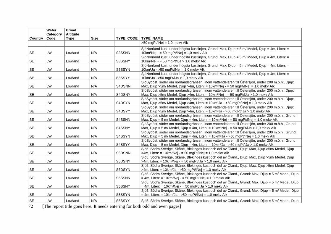
72 [The report title goes here. It needs entering for both odd and even pages]
Country
Water Category Code
Broad Altitude Type Size TYPE_CODE TYPE_NAME
>50 mgPt/lNej = 1,0 mekv Alk
SE LW Lowland N/A S3SSNN SjöNorrland kust, under högsta kustlinjen, Grund: Max, Djup = 5 m/ Medel, Djup = 4m, Liten: = 10km²Nej - = 50 mgPt/lNej = 1,0 mekv Alk
SE LW Lowland N/A S3SSNY SjöNorrland kust, under högsta kustlinjen, Grund: Max, Djup = 5 m/ Medel, Djup = 4m, Liten: = 10km²Nej - = 50 mgPt/lJa > 1,0 mekv Alk
SE LW Lowland N/A S3SSYN SjöNorrland kust, under högsta kustlinjen, Grund: Max, Djup = 5 m/ Medel, Djup = 4m, Liten: = 10km²Ja - >50 mgPt/lNej = 1,0 mekv Alk
SE LW Lowland N/A S3SSYY SjöNorrland kust, under högsta kustlinjen, Grund: Max, Djup = 5 m/ Medel, Djup = 4m, Liten: = 10km²Ja - >50 mgPt/lJa > 1,0 mekv Alk
SE LW Lowland N/A S4DSNN SjöSydöst, söder om norrlandsgränsen, inom vattendelaren till Östersjön, under 200 m.ö.h., Djup: Max, Djup >5m/ Medel, Djup >4m, Liten: = 10km²Nej - = 50 mgPt/lNej = 1,0 mekv Alk
SE LW Lowland N/A S4DSNY SjöSydöst, söder om norrlandsgränsen, inom vattendelaren till Östersjön, under 200 m.ö.h., Djup: Max, Djup >5m/ Medel, Djup >4m, Liten: = 10km²Nej - = 50 mgPt/lJa > 1,0 mekv Alk
SE LW Lowland N/A S4DSYN SjöSydöst, söder om norrlandsgränsen, inom vattendelaren till Östersjön, under 200 m.ö.h., Djup: Max, Djup >5m/ Medel, Djup >4m, Liten: = 10km²Ja - >50 mgPt/lNej = 1,0 mekv Alk
SE LW Lowland N/A S4DSYY SjöSydöst, söder om norrlandsgränsen, inom vattendelaren till Östersjön, under 200 m.ö.h., Djup: Max, Djup >5m/ Medel, Djup >4m, Liten: = 10km²Ja - >50 mgPt/lJa > 1,0 mekv Alk
SE LW Lowland N/A S4SSNN SjöSydöst, söder om norrlandsgränsen, inom vattendelaren till Östersjön, under 200 m.ö.h., Grund: Max, Djup = 5 m/ Medel, Djup = 4m, Liten: = 10km²Nej - = 50 mgPt/lNej = 1,0 mekv Alk
SE LW Lowland N/A S4SSNY SjöSydöst, söder om norrlandsgränsen, inom vattendelaren till Östersjön, under 200 m.ö.h., Grund: Max, Djup = 5 m/ Medel, Djup = 4m, Liten: = 10km²Nej - = 50 mgPt/lJa > 1,0 mekv Alk
SE LW Lowland N/A S4SSYN SjöSydöst, söder om norrlandsgränsen, inom vattendelaren till Östersjön, under 200 m.ö.h., Grund: Max, Djup = 5 m/ Medel, Djup = 4m, Liten: = 10km²Ja - >50 mgPt/lNej = 1,0 mekv Alk
SE LW Lowland N/A S4SSYY SjöSydöst, söder om norrlandsgränsen, inom vattendelaren till Östersjön, under 200 m.ö.h., Grund: Max, Djup = 5 m/ Medel, Djup = 4m, Liten: = 10km²Ja - >50 mgPt/lJa > 1,0 mekv Alk
SE LW Lowland N/A S5DSNN Sjö5. Södra Sverige, Skåne, Blekinges kust och del av Öland., Djup: Max, Djup >5m/ Medel, Djup >4m, Liten: = 10km²Nej - = 50 mgPt/lNej = 1,0 mekv Alk
SE LW Lowland N/A S5DSNY Sjö5. Södra Sverige, Skåne, Blekinges kust och del av Öland., Djup: Max, Djup >5m/ Medel, Djup >4m, Liten: = 10km²Nej - = 50 mgPt/lJa > 1,0 mekv Alk
SE LW Lowland N/A S5DSYN Sjö5. Södra Sverige, Skåne, Blekinges kust och del av Öland., Djup: Max, Djup >5m/ Medel, Djup >4m, Liten: = 10km²Ja - >50 mgPt/lNej = 1,0 mekv Alk
SE LW Lowland N/A S5SSNN Sjö5. Södra Sverige, Skåne, Blekinges kust och del av Öland., Grund: Max, Djup = 5 m/ Medel, Djup = 4m, Liten: = 10km²Nej - = 50 mgPt/lNej = 1,0 mekv Alk
SE LW Lowland N/A S5SSNY Sjö5. Södra Sverige, Skåne, Blekinges kust och del av Öland., Grund: Max, Djup = 5 m/ Medel, Djup = 4m, Liten: = 10km²Nej - = 50 mgPt/lJa > 1,0 mekv Alk
SE LW Lowland N/A S5SSYN Sjö5. Södra Sverige, Skåne, Blekinges kust och del av Öland., Grund: Max, Djup = 5 m/ Medel, Djup = 4m, Liten: = 10km²Ja - >50 mgPt/lNej = 1,0 mekv Alk
SE LW Lowland N/A S5SSYY Sjö5. Södra Sverige, Skåne, Blekinges kust och del av Öland., Grund: Max, Djup = 5 m/ Medel, Djup

[The report title goes here. It needs entering for both odd and even pages] 73
Country
Water Category Code
Broad Altitude Type Size TYPE_CODE TYPE_NAME
= 4m, Liten: = 10km²Ja - >50 mgPt/lJa > 1,0 mekv Alk
SE LW Lowland N/A S6DSNN SjöSydväst, söder om norrlandsgränsen, inom vattendelaren till Västerhavet, under 200 m.ö.h., Djup: Max, Djup >5m/ Medel, Djup >4m, Liten: = 10km²Nej - = 50 mgPt/lNej = 1,0 mekv Alk
SE LW Lowland N/A S6DSYN SjöSydväst, söder om norrlandsgränsen, inom vattendelaren till Västerhavet, under 200 m.ö.h., Djup: Max, Djup >5m/ Medel, Djup >4m, Liten: = 10km²Ja - >50 mgPt/lNej = 1,0 mekv Alk
SE LW Lowland N/A S6DSYY SjöSydväst, söder om norrlandsgränsen, inom vattendelaren till Västerhavet, under 200 m.ö.h., Djup: Max, Djup >5m/ Medel, Djup >4m, Liten: = 10km²Ja - >50 mgPt/lJa > 1,0 mekv Alk
SE LW Lowland N/A S6SSNN SjöSydväst, söder om norrlandsgränsen, inom vattendelaren till Västerhavet, under 200 m.ö.h., Grund: Max, Djup = 5 m/ Medel, Djup = 4m, Liten: = 10km²Nej - = 50 mgPt/lNej = 1,0 mekv Alk
SE LW Lowland N/A S6SSYN SjöSydväst, söder om norrlandsgränsen, inom vattendelaren till Västerhavet, under 200 m.ö.h., Grund: Max, Djup = 5 m/ Medel, Djup = 4m, Liten: = 10km²Ja - >50 mgPt/lNej = 1,0 mekv Alk
SE LW Lowland N/A S6SSYY SjöSydväst, söder om norrlandsgränsen, inom vattendelaren till Västerhavet, under 200 m.ö.h., Grund: Max, Djup = 5 m/ Medel, Djup = 4m, Liten: = 10km²Ja - >50 mgPt/lJa > 1,0 mekv Alk
SE LW Mid-altitude N/A S7DSNN SjöSydsvenska höglandet, söder om norrlandsgränsen, över 200 m.ö.h., Djup: Max, Djup >5m/ Medel, Djup >4m, Liten: = 10km²Nej - = 50 mgPt/lNej = 1,0 mekv Alk
SE LW Mid-altitude N/A S7DSYN SjöSydsvenska höglandet, söder om norrlandsgränsen, över 200 m.ö.h., Djup: Max, Djup >5m/ Medel, Djup >4m, Liten: = 10km²Ja - >50 mgPt/lNej = 1,0 mekv Alk
SE LW Mid-altitude N/A S7DSYY SjöSydsvenska höglandet, söder om norrlandsgränsen, över 200 m.ö.h., Djup: Max, Djup >5m/ Medel, Djup >4m, Liten: = 10km²Ja - >50 mgPt/lJa > 1,0 mekv Alk
SE LW Mid-altitude N/A S7SSNN SjöSydsvenska höglandet, söder om norrlandsgränsen, över 200 m.ö.h., Grund: Max, Djup = 5 m/ Medel, Djup = 4m, Liten: = 10km²Nej - = 50 mgPt/lNej = 1,0 mekv Alk
SE LW Mid-altitude N/A S7SSYN SjöSydsvenska höglandet, söder om norrlandsgränsen, över 200 m.ö.h., Grund: Max, Djup = 5 m/ Medel, Djup = 4m, Liten: = 10km²Ja - >50 mgPt/lNej = 1,0 mekv Alk
Table A6.4. Hungary

74 [The report title goes here. It needs entering for both odd and even pages]
Country
Water Category Code
Broad Altitude Type Size TYPE_CODE TYPE_NAME
HU LW N/A Small 10L meszes – kis területű – sekély – benőtt vízfelületű – időszakos
HU LW N/A Small 11L meszes – kis területű – sekély – nyílt vízfelületű – időszakos
HU LW N/A Small 12L meszes – kis területű – sekély – benőtt vízfelületű – állandó
HU LW N/A Small 13L meszes – kis területű – sekély – nyílt vízfelületű – állandó
HU LW N/A Small 14L meszes – kis területű – közepes mélységű – nyílt vízfelületű – állandó
HU LW N/A Medium 15L meszes – közepes területű – sekély – nyílt vízfelületű – állandó
HU LW N/A Large 16L meszes – nagy területű – közepes mélységű – nyílt vízfelületű – állandó
HU LW N/A Small 1L szerves – kis területű – sekély – benőtt vízfelületű – időszakos
HU LW N/A Small 2L szerves – kis területű – sekély – benőtt vízfelületű – állandó
HU LW N/A Small 3L szerves – kis területű – sekély – nyílt vízfelületű – állandó
HU LW N/A Small 4L szikes – kis területű – sekély – benőtt vízfelületű – időszakos
HU LW N/A Small 5L szikes – kis területű – sekély – nyílt vízfelületű – időszakos
HU LW N/A Small 6L szikes – kis területű – sekély – benőtt vízfelületű – állandó
HU LW N/A Small 7L szikes – kis területű – sekély – nyílt vízfelületű – állandó
HU LW N/A Medium 8L szikes – közepes területű – sekély – nyílt vízfelületű – állandó
HU LW N/A N/A 99L mesterséges
HU LW N/A Large 9L szikes – nagy területű – sekély – nyílt vízfelületű – állandó
HU RW Mid-altitude Large 10R dombvidéki – meszes – közepes-finom – nagy vízgyűjtő
HU RW Lowland Small 11R síkvidéki – meszes – durva – kicsi vízgyűjtő
HU RW Lowland Medium 12R síkvidéki – meszes – durva – közepes vízgyűjtő
HU RW Lowland Large 13R síkvidéki – meszes – durva – nagy vízgyűjtő
HU RW Lowland Very large 14R síkvidéki – meszes – durva – nagyon nagy vízgyűjtő
HU RW Lowland Small 15R síkvidéki – meszes – közepes-finom – kicsi vízgyűjtő
HU RW Lowland Small 16R síkvidéki – meszes – közepes-finom – kicsi és kis esésű vízgyűjtő
HU RW Lowland Medium 17R síkvidéki – meszes – közepes-finom – közepes és kis esésű vízgyűjtő
HU RW Lowland Medium 18R síkvidéki – meszes – közepes-finom – közepes vízgyűjtő
HU RW Lowland Large 19R síkvidéki – meszes – közepes-finom – nagy vízgyűjtő
HU RW Highland Small 1R hegyvidéki – szilikátos – durva – kicsi vízgyűjtő
HU RW Lowland Very large 20R síkvidéki – meszes – közepes-finom – nagyon nagy vízgyűjtő
HU RW Lowland Small 21R síkvidéki – szerves – kicsi vízgyűjtő
HU RW Lowland Medium 22R síkvidéki – szerves – közepes vízgyűjtő

[The report title goes here. It needs entering for both odd and even pages] 75
Country
Water Category Code
Broad Altitude Type Size TYPE_CODE TYPE_NAME
HU RW N/A N/A 23R Duna Gönyű felett
HU RW N/A N/A 24R Duna Gönyű és Baja között
HU RW N/A N/A 25R Duna Baja alatt
HU RW Highland Small 2R hegyvidéki – meszes – durva – kicsi vízgyűjtő
HU RW Highland Medium 3R hegyvidéki – meszes – durva – közepes vízgyűjtő
HU RW Mid-altitude Small 4R dombvidéki – meszes – durva – kicsi vízgyűjtő
HU RW Mid-altitude Medium 5R dombvidéki – meszes – durva – közepes vízgyűjtő
HU RW Mid-altitude Large 6R dombvidéki – meszes – durva – nagy vízgyűjtő
HU RW Mid-altitude Very large 7R dombvidéki – meszes – durva – nagyon nagy vízgyűjtő
HU RW Mid-altitude Small 8R dombvidéki – meszes – közepes-finom – kicsi vízgyűjtő
HU RW N/A N/A 99R mesterséges
HU RW Mid-altitude Medium 9R dombvidéki – meszes – közepes-finom – közepes vízgyűjtő

76 [The report title goes here. It needs entering for both odd and even pages]
Annex 7 Links between pressure types and freshwater habitats in Hungary
Habitat code Pressure
code Pressure type
3130 100 Cultivation
3130 110 Use of pesticides
3130 162 Artificial planting
3130 300 Sand and gravel extraction
3130 800 Landfill, land reclamation and drying out, general
3130 810 Drainage
3130 820 Removal of sediments (mud...)
3130 954 Invasion by a species
3150 400 Urbanised areas, human habitation
3150 701 Water pollution
3150 820 Removal of sediments (mud...)
3150 870 Dykes, embankments, artificial beaches, general
3150 954 Invasion by a species
3160 300 Sand and gravel extraction
3160 310 Peat extraction
3160 701 Water pollution
3160 800 Landfill, land reclamation and drying out, general
3160 820 Removal of sediments (mud...)
3160 951 Drying out / accumulation of organic material
3160 952 Eutrophication
3160 976 Damage by game species
3260 164 Forestry clearance
3260 190 Agriculture and forestry activities not referred to above
3260 701 Water pollution
3260 820 Removal of sediments (mud...)
3260 870 Dykes, embankments, artificial beaches, general
3270 300 Sand and gravel extraction
3270 520 Shipping
3270 811 Management of aquatic and bank vegetation for drainage purposes
3270 820 Removal of sediments (mud...)
3270 853 Management of water levels
3270 860 Dumping, depositing of dredged deposits
3270 870 Dykes, embankments, artificial beaches, general
3270 954 Invasion by a species

[The report title goes here. It needs entering for both odd and even pages] 77