angelina & neches iver uthority - texas a&m...
TRANSCRIPT

AngelinA & neches RiveR AuthoRity
2014 Basin Highlights Report For the Upper Portion of the Neches River Basin
Angelina & Neches River AuthorityP.O. Box 387 • Lufkin, TX 75902936-632-7795 • 800-282-5634
www.anra.org • [email protected]
IntroductionThe agency began using the logo in 1993 when the agency was formed as the Texas Natural Resource Conservation Commission. “TNRCC” was replaced by “TCEQ” in the logo in 2002 when the legislature changed the agency’s name to the Texas Commission on Environmental Quality.
Permission to Use the TCEQ LogoThe TCEQ has intellectual property rights in the TCEQ logo. No one may use the TCEQ logo without first gaining permission from the TCEQ’s Agency Communications Division. We only grant permission to individuals or organizations that are involved in a non-regulatory relationship with the TCEQ, such as:
n Co-hosting a symposium or another eventn Contracting, such as a Superfund site cleanup or scientific study
We do not grant permission outside this context (a non-regulatory relationship) because of the potential for confusion about the TCEQ’s relationship with the organiza-tion or the possibility that the logo may appear to be an endorsement by the TCEQ. Requests to use the TCEQ logo should be directed to the publishing manager in the TCEQ’s Agency Communications Division at 512-239-0010 or by e-mail at <[email protected]>. Please be prepared to supply the name of the agency program contact with whom you are working.
Information About Web Site LinkingWe do not grant permission to an entity in a non-regulatory relationship to use the logo as a graphic to link to the agency’s Web site. However, we do encourage linking without the graphic, provided there is no fee for accessing the material and the link is displayed in the proper context. Webmasters should be aware that the Texas Department of Information Resources has certain requirements for a Web site linking to a state-agency Web site, such as the TCEQ’s. These policies reflect state law (1 Texas Administrative Code 206.54) and may be found at <www.dir.state.tx.us/standards/link_policy.htm>.
Once You Have Permission to Use the TCEQ Logo: Follow These Usage GuidelinesThe TCEQ logo is a combination of text and art. The font is a custom creation. Never recreate the logo.
n Use the logo only in its entirety and without modification.n Do not obscure any part of the logo by placing type, photographs, or other
elements on top of it.
Official Logo Color Configurations (Example A)The logo is either three-color, two-color, solid black, or a single solid color when used in a piece that is not four-color process (for example: if the piece uses blue and black inks, the logo can be in solid blue or solid black). When using the three-color and two-color versions of the logo, consistency is essential. Official logo colors are PMS 287 blue, PMS 3288 green, and black. These specific colors should not be compromised for any reason when using the two- and three-color logo.
PANTONE® 287C: R:M: G:Y: B:K:
PANTONE 3288C: R:M: G:Y: B:K:
PANTONE® 3288C: 100 M: 3 Y: 58 K: 16R: 0 G: 133 B: 102
PANTONE® 287C: 100 M: 72 Y: 2 K: 12R: 0 G: 51 B: 141
Two Color Logo(100% #287 and #3288)
Correct: in 100% color
Incorrect: with a tint
One Color Usage For demonstration, shown in PMS #314 (teal).
A. Official Logo Color Configurations
Black Logo
December 2008
TCEQ Logo Public Use Style Guide
Page 1
Three Color Logo

This Page Intentionally Blank

Table of Contents
Introduction ........................................................................................................................... 1
About The Basin Highlights Report ........................................................................................... 1
About The Clean Rivers Program ............................................................................................... 1
About The Angelina & Neches River Authority ................................................................ 2
Map of the Neches Basin (including the proposed Lake Columbia) ............................ 3
Upper Neches Basin Highlights .......................................................................................... 6
New Monitoring Stations for FY 2014 ....................................................................................... 6
Cedar Creek at Ellis Avenue (Monitoring Station 21434) ...................................................... 7
Cedar Creek at South Loop 287 (Monitoring Station 10479) .............................................. 7
Hurricane Creek downstream of Kiwanis Park Drive (Monitoring Station 21433) ......... 8
Hurricane Creek at South Loop 287 (Monitoring Station 10487) ....................................... 8
Jack Creek at FM 3150 (Monitoring Station 10494) .............................................................. 9
Jack Creek at SH 94 (Monitoring Station 10493) .................................................................... 9
Bayou Carrizo at SH 21 (Monitoring Station 21432) ...........................................................10
Ayish Bayou at West Columbia Street (Monitoring Station 21431) .................................10
Bowles Creek at Cherokee CR 4608/Rusk CR 4194 (Monitoring Station 21429) ...........11
Johnson Creek at Rusk CR 476 (Monitoring Station 21430) ..............................................11
Lake Striker Near Dam (Monitoring Station 17824) ............................................................12
Lake Striker Upper Lake (Monitoring Station 17822) ..........................................................12
Naconiche Lake Near Dam (Monitoring Station 21435) ....................................................13
West Creek at FM 2913 (Monitoring Station 20845) ............................................................13
Fish Consumption Advisory .............................................................................................. 14
Water Quality Monitoring and Laboratory Analysis ..................................................... 16
Water Quality Monitoring in the Upper Portion of the Neches Basin..............................16
ANRA Environmental Laboratory ..................................................................................... 19
New Laboratory Methods .................................................................................................. 20
Texas Water Quality Standards ......................................................................................... 22
Texas Water Quality Standards - Designated Uses ........................................................ 23
The Texas Integrated Report ............................................................................................. 24
Water Quality Impairments and Concerns in the Upper Neches Basin ..................... 25
Watershed Action Planning ............................................................................................... 26
Tools to Address Water Quality Issues ............................................................................. 27
Segments in the Upper Neches Basin .............................................................................. 29
Neches River Below Lake Palestine (Segment 0604) ............................................................30
Lake Palestine (Segment 0605) .................................................................................................32
Neches River Above Lake Palestine (Segment 0606) ...........................................................34
Sam Rayburn Reservoir (Segment 0610) ................................................................................35
Angelina River Above Sam Rayburn (Segment 0611) .........................................................37
Attoyac Bayou (Segment 0612) ................................................................................................39
Lake Tyler/Lake Tyler East (Segment 0613) ............................................................................41
Lake Jacksonville (Segment 0614) ...........................................................................................41
Map of Monitoring Stations in the Neches River Basin for FY 2014 ......................... 43
Special Projects .................................................................................................................... 46
Development of a Watershed Protection Plan for Attoyac Bayou ...................................46
Recreational Use Attainability Analysis of Prairie Creek, Mud Creek, West Mud Creek, and Neches River Above Lake Palestine..................................................................................47
Lake Sam Rayburn On-Site Sewage Facility (OSSF) Program Support and Attoyac Bayou OSSF Remediation ..........................................................................................................47
Stakeholder Participation & Public Outreach ................................................................ 48
Public Information .......................................................................................................................48
Basin Steering Committee .........................................................................................................48
Texas Stream Team ......................................................................................................................48
References and Links to Further Information ................................................................ 48
Additional Information and Resources ...................................................................................48
ANRA Website ...............................................................................................................................48
Contact Information ...................................................................................................................48

This Page Intentionally Blank

Page 1
Introduction
About The Basin Highlights Report
This 2014 Basin Highlights Report is intended to provide a brief overview of the previous year’s events and ongoing programs in the upper and middle portions of the Neches River Basin that are relevant to the Clean Rivers Program (CRP).
For a more comprehensive look at the basin, please refer to the 2010 Basin Summary Report.
The 2014 Basin Highlights Report was prepared by the Angelina & Neches River Authority (ANRA) in cooperation with the Texas Commission on Environmental Quality (TCEQ) under the authorization of the Texas Clean Rivers Act.
About The Clean Rivers Program
The Texas Clean Rivers Act, enacted in 1991 by the Texas legislature, requires that each Texas River Basin conduct ongoing water quality assessments, integrating water quality issues using a watershed management approach. The Clean Rivers Program (CRP) implements the Clean Rivers Act through water quality monitoring, assessment, and public outreach. Currently, monitoring in the state of Texas includes over 1800 sites and regional water quality assessments within the 23 major river and coastal basins and their sub-watersheds.
The mission of the CRP is to maintain and improve the quality of water within each river basin in Texas through an ongo-ing partnership involving the Texas Commission on Environmental Quality, river authorities, other agencies, regional entities, local governments, industry, and citizens. The program’s watershed management approach will identify and evaluate water quality issues, establish priorities for corrective action, work to implement those actions, and adapt to changing priorities.

Page 2
About The Angelina & Neches River Authority
The Angelina & Neches River Authority was created in 1935 by the Texas legislature as a conservation and reclamation district. ANRA’s office is located in Lufkin, Texas. ANRA’s territorial jurisdiction consists of 8,500 square miles that lie wholly or in part of the following counties: Van Zandt, Smith, Henderson, Newton, Cherokee, Anderson, Rusk, Houston, Nacogdoches, San Augustine, Shelby, Angelina, Trinity, Sabine, Polk, Jasper, and Orange.
The Angelina & Neches River Authority (ANRA) has the responsibility for monitoring, protecting, and enhancing water resources in the Neches River Basin.
ANRA’s functions in the basin include: water quality monitoring, drinking water and wastewater analysis, on-site sewage facility permitting, water and wastewater utilities, water resources development, regional wastewater/composting facilities and other regional planning efforts.

TOLEDO BEND RESERVOIR
Neches River
§̈¦10
§̈¦45
§̈¦20
§̈¦610
§̈¦49
§̈¦220§̈¦220
§̈¦45
§̈¦45
§̈¦10
§̈¦10
§̈¦45
§̈¦10
§̈¦20
§̈¦45
§̈¦10
§̈¦49
£¤69
£¤287
£¤79
£¤96
£¤84
£¤90
£¤259
£¤271
£¤190
£¤175
£¤59
£¤75
£¤80
£¤171
£¤71
£¤290
£¤30
£¤90
£¤79
£¤79
£¤190
£¤90
£¤59
£¤69£¤90
£¤59
£¤90
£¤80£¤79
£¤71
£¤69
£¤59
£¤290
£¤259
£¤90
£¤287
£¤287
£¤259
£¤59
£¤290
£¤290
£¤69
£¤59
£¤80
£¤90
£¤96
£¤84
£¤84
£¤171
£¤79
£¤69
£¤59
£¤79£¤84
£¤90
£¤59
£¤96
£¤84
£¤69
Lake Columbia
Neches R
iver
LAKE NACONICHE
Sabine Lake
Mud Creek
North Angelina County Regional Wastewater Treatment Plant
Holmwood Utilities
Neches Compost Facility
Angelina & Neches River Authority Main Office
Angelina County Fresh Water Supply District #1
Ange lina River
N e c h e sN e c h e s
T r i n i t yT r i n i t y
S a b i n eS a b i n e
S a n J a c i n t oS a n J a c i n t o
B r a z o sB r a z o s
N e c h e s - T r i n i t yN e c h e s - T r i n i t y
C y p r e s sC y p r e s s
HoustonBaytown
Texas City
Tyler
Port Arthur
Beaumont
Pearland
Conroe
Pasadena
Longview
Lufkin
League City
Huntsville
Marshall
Katy
La Porte
Athens
Kilgore
Palestine
Orange
Sugar LandMissouri City
Vidor
Alvin
Nacogdoches
Rosenberg Friendswood
Deer Park
Humble
Jacksonville
Henderson
Dickinson
Stafford
Port Neches
GrovesNederland
Bellaire
Richmond
Galena Park
South Houston
Jacinto City
West University Place
Liberty
Manvel
Dayton
Seabrook
Jasper
Tomball
Rusk
Crockett
Silsbee
Gladewater
Center
Pine Island
Webster
Van
Tatum
Poynor
Sealy
Mont Belvieu
Carthage
Lumberton
Newton
White Oak
Diboll
Livingston
San Felipe
Thompsons
Canton
Lindale
Fulshear
Overton
ClevelandNavasota
Prairie View
Mineola
Shepherd
Hudson
Buffalo
Gallatin
Arp
Willis
Gilmer
Ames
Bridge City
Tenaha
Hempstead
Onalaska
New London
Whitehouse
Kountze
Alto
Trinity
Beach City
Clarksville City
Hardin
Edom
Gary
Troup
Pattison
Wills Point
Wells
Plum Grove
Pleak
Chandler
Madisonville
Burke
San Augustine
Brookshire
Easton
New Summerfield
Leona
Joaquin
Timpson
Arcola
Malakoff
Hemphill
Kirbyville
Iowa Colony
Groveton
Zavalla
Devers
Woodville
Hawkins
Trinidad
Huntington
Hallsville Waskom
Jersey Village
Bullard
China
Nesbitt
Browndell
Reklaw
Appleby
West Orange
Berryville
Kenefick
Chireno
Cuney
Corrigan
Splendora
Hideaway
Magnolia
Anahuac
Cove
Waller
Pine Forest
Wallis
Frankston
Simonton
Cut and Shoot
Riverside
Kemah
Noonday
Montgomery
Rose City
Bevil Oaks
Pinehurst
Elkhart
Grapeland
Nassau Bay
Point Blank
Daisetta
Coldspring
Winona
Pineland
Huxley
Colmesneil
New Waverly
Lakeport
Sour Lake
Midway
Big Sandy
Murchison
Fruitvale
Cushing
Kennard
Chester
Todd Mission
Warren City
Grand Saline
Beckville
Garrison
Shenandoah
Brownsboro
Brazos Country
Patton Village
Beasley
Lovelady
Nome
Coffee City
Brookside Village
Seven Oaks
Piney Point Village
New Chapel Hill
Centerville
Edgewood
North Cleveland
Scottsville
Morgan's Point
Roman Forest
Oakwood
Spring Valley
Shoreacres
Latexo
Moore Station
El Lago
Stagecoach
Woodbranch Village
Normangee
Hunters Creek Village
Uncertain
Dayton Lakes
Bunker Hill Village
Oak Ridge North
Old River-Winfree
Goodrich
Taylor Lake Village
Panorama Village
East Mountain
Mount Enterprise
Fairchilds
Meadows Place
Union Grove
Eustace
Anderson
Broaddus
Clear Lake Shores
Santa Fe
Rose Hill Acres
Gun Barrel City
Southside Place
Payne Springs
Woodloch
Kendleton
LAKE LIVINGSTON
SAM RAYBURN RESERVOIR
LAKE PALESTINE
LAKE CONROE
WALLISVILLE LAKE
CADDO LAKE
ADDICKS RESERVOIR
BARKER RESERVOIR
LAKE HOUSTON
B A STEINHAGEN LAKE
MARTIN LAKE
LAKE ANAHUAC
LAKE MURVAUL
LAKE CHEROKEE
CEDAR CREEK RESERVOIR
LAKE TYLER
SMITHERS LAKE
FAIRFIELD LAKE
LAKE TYLER EAST
LAKE STRIKER
LAKE ATHENS
LAKE NACOGDOCHES
GIBBONS CREEK RESERVOIR
CEDAR BAYOU GENERATING POND
LAKE JACKSONVILLE
HOUSTON COUNTY LAKE
LAKE HAWKINS
SHELDON RESERVOIR
LAKE HOLBROOK
LEWIS CREEK RESERVOIR
BRANDY BRANCH COOLING POND
LAKE GLADEWATER
GALVESTON COUNTY WATER RESERVOIR
PINKSTON RESERVOIR
FOREST GROVE RESERVOIR
LYNCHBURG RESERVOIR
LAKE O' THE PINES
Harris
Polk
Tyler
Rusk
Liberty
Smith
Leon Houston
Jasper
Hardin
Shelby
Panola
Walker
Newton
Trinity
Cherokee
Anderson
Grimes
Jefferson
Harrison
De Soto
Caddo
Angelina
Montgomery
Sabine
Waller
Van Zandt
Nacogdoches
Henderson
Fort Bend
Chambers
Wood
San Jacinto
Orange
Madison
Gregg
Bossier
Upshur
San Augustine
Freestone
Austin
Cameron
Brazoria
Galveston
Calcasieu
Wharton
Rains Marion
Beauregard
Brazos
Washington
Red River
Navarro
Colorado
This map was generated by the Information Systems Division of the Angelina & Neches River Authority.No claims are made to the accuracy or completeness of the data or to its suitability for a particular use.For more information concerning this map, contact the Information Systems Division at (936) 632-7795.
Sources: The river basins, and portions of the river authority jurisdictions are derived from the NationalHydrography Dataset 12 Digit Hydrologic Unit Codes. The rivers themselves are derived from NationalHydrography Dataset Flowlines. The city and county boundaries are from the Texas StratMap political boundariesdataset and the ESRI world data 2006 respectively.
Map created October 2010 by the Angelina & Neches River Authority.
LegendANRA FacilitiesLake ColumbiaExisting ReservoirsRiversCitiesAngelina & Neches River AuthorityUpper Neches River MWALower Neches Valley AuthorityCountiesRiver Basins
0 10 20 305
Miles
I
Neches River Basin
Location Overview
Map of the Neches Basin (including the proposed Lake Columbia)

This Page Intentionally Blank

Page 5

Page 6
Upper Neches Basin Highlights
New Monitoring Stations for FY 2014
Beginning in FY 2014, the Angelina & Neches River Authority Clean Rivers Program was able to add an additional 14 monitoring stations. This was possible due to the addition of automated equipment in the laboratory, as well as time and labor donated by other departments within ANRA to perform sample collection duties.
These additional monitoring stations, including the rationale behind these sites being chosen, are listed in the table below.
Site Description Station ID Waterbody ID
County Historically Monitored
(Y/N?)
Impaired (Y/N?)
Comments / Rationale for Addition
CEDAR CREEK AT ELLIS AVE IN LUFKIN 21434 0604A Angelina N Y Additional monitoring to address 303d listing. This monitoring station is located with within the Lufkin city limits, inside the loop.
CEDAR CREEK AT ST LOOP 287 IN LUFKIN 10479 0604A Angelina Y Y Additional monitoring to address 303d listing. This monitoring station is located with within the Lufkin city limits.
HURRICANE CREEK DOWNSTREAM OF KIWANIS PARK DRIVE
21433 0604B Angelina N Y Additional monitoring to address 303d listing. This monitoring station is located with within the Lufkin city limits, inside the loop.
HURRICANE CREEK AT ST LOOP 287 IN SOUTH LUFKIN
10487 0604B Angelina Y Y Additional monitoring to address 303d listing. This monitoring station is located with within the Lufkin city limits.
JACK CREEK AT FM 3150 10494 0604C Angelina Y Y This station provides a monitoring location between the monitoring stations at Jack Creek at SH 94 and Jack Creek at SH 103.
JACK CREEK AT SH 94 10493 0604C Angelina Y Y This site has been monitored previously, but not since 2000.
BAYOU CARRIZO AT SH 21 21432 610 Nacogdoches N N Major tributary to Sam Rayburn - Never Monitored
AYISH BAYOU AT WEST COLUMBIA STREET IN CITY OF SAN AUGUSTINE
21431 0610A San Augustine N Y This monitoring station was added due to a lack of monitoring in assessment unit AU_02. This station provided easier access than Ayish at SH 147.
BOWLES CREEK AT CHEROKEE CR 4608/RUSK CR 4194
21429 0611R Cherokee N N Tributary to Striker Lake. Waterbody has been flagged for low pH in the past by TPWD during fish kill investigations. It is hoped that quarterly monitoring can help determine whether the low pH is intermittent and its source.
JOHNSON CREEK AT RUSK CR 476 21430 0611R Rusk N N Tributary to Striker Lake. Waterbody has been flagged for low pH in the past by TPWD during fish kill investigations. It is hoped that quarterly monitoring can help determine whether the low pH is intermittent and its source.
LAKE STRIKER NEAR DAM 17824 0611R Rusk Y N This site has been previously monitored by both ANRA and TCEQ. Monitoring of Striker Lake and Johnson and Bowles Creek is being done to determine potential causes of low pH issues. ANRA is taking over monitoring at this station to allow TCEQ to perform additional monitoring near the City of Tyler.
LAKE STRIKER UPPER LAKE 17822 0611R Cherokee Y N This site has been previously monitored by both ANRA and TCEQ. Monitoring of Striker Lake and Johnson and Bowles Creek is being done to determine potential causes of low pH issues. ANRA is taking over monitoring at this station to allow TCEQ to perform additional monitoring near the City of Tyler.
NACONICHE LAKE NEAR DAM 21435 612 Nacogdoches N N Naconiche Lake has swim areas. Naconiche Creek is a tributary to Attoyac Bayou
WEST CREEK AT FM 2913 20845 0612F Shelby Y Y This station was previously monitored as part of the Attoyac Bayou WPP project.

Page 7
Cedar Creek at Ellis Avenue (Monitoring Station 21434) Cedar Creek at South Loop 287 (Monitoring Station 10479)
New Monitoring Stations for FY 2014

Page 8
Hurricane Creek downstream of Kiwanis Park Drive (Monitoring Station 21433) Hurricane Creek at South Loop 287 (Monitoring Station 10487)
New Monitoring Stations for FY 2014

Page 9
Jack Creek at FM 3150 (Monitoring Station 10494) Jack Creek at SH 94 (Monitoring Station 10493)
New Monitoring Stations for FY 2014

Page 10
Bayou Carrizo at SH 21 (Monitoring Station 21432)
Ayish Bayou at West Columbia Street (Monitoring Station 21431)
New Monitoring Stations for FY 2014

Page 11
Bowles Creek at Cherokee CR 4608/Rusk CR 4194 (Monitoring Station 21429) Johnson Creek at Rusk CR 476 (Monitoring Station 21430)
New Monitoring Stations for FY 2014

Page 12
Lake Striker Near Dam (Monitoring Station 17824) Lake Striker Upper Lake (Monitoring Station 17822)
New Monitoring Stations for FY 2014

Page 13
Naconiche Lake Near Dam (Monitoring Station 21435) West Creek at FM 2913 (Monitoring Station 20845)
New Monitoring Stations for FY 2014

Page 14
Fish Consumption Advisory
DSHS Issues Fish Consumption Advisory for Neches River
On January 27, 2014, the Texas Department of State Health Services (DSHS) issued a fish consumption advisory for portions of the Neches River Basin, including Sam Rayburn Reservoir and B.A. Steinhagen Reservoir. The advisory covers six species of fish caught between the State Highway 7 bridge west of Lufkin downstream to the U.S. Highway 96 bridge near Evadale, as well as both reservoirs. This advisory was issued after laboratory testing of fish tissue samples found elevated levels of mercury and dioxins.
DSHS recommends people limit or avoid consumption of these species as outlined in the table below because eating contaminated fish can be a health hazard.
Species AffectedWomen of Childbearing Age and Children < 12
Women Past Childbearing Age and Adult Men
Blue catfish > 30 inches DO NOT EAT Two 8 oz. meals/month
Flathead catfish DO NOT EAT One 8 oz. meal/month
Gar (all species) DO NOT EAT One 8oz. meal/month
Largemouth bass > 16 inches DO NOT EAT Two 8 oz. meals/month
Smallmouth buffalo DO NOT EAT DO NOT EAT
Spotted bass > 16 inches DO NOT EAT Two 8 oz. meals/month
DSHS recommends children under 12 and women who are nursing, pregnant or who may become pregnant avoid eating the affected species because the nervous systems of unborn and young children are particularly susceptible to the health effects of toxins. Previous advisories for the Neches River area based on high mercury levels had recom-mended children limit consumption of particular fish. Recent testing prompted DSHS to recommend children under 12 not eat the affected fish at all.
Elevated levels of mercury and dioxins in fish do not pose a health risk for people swim-ming or participating in other water recreation activities.
Affected Counties: Angelina, Hardin, Houston, Jasper, Polk, Sabine, San Augustine, Trinity, and Tyler
H a r d i nH a r d i n
O r a n g eO r a n g e
J a s p e rJ a s p e r
J e f f e r s o nJ e f f e r s o n
Lufkin
Jasper
Conroe
Silsbee
Lumberton
Livingston
Newton
Diboll
Shepherd
Hudson
Kountze
Onalaska
Cleveland
Ivanhoe
Burke
Trinity
Beaumont Orange
Wells
Woodville
Zavalla
Groveton
Kirbyville
Hemphill
Huntington
Plum Grove
Corrigan
Browndell
Pine Forest
Riverside
Splendora
Cut and Shoot
Point Blank
Coldspring
Colmesneil
Pineland
Kennard
Chester
Seven Oaks
North Cleveland
Chireno
Goodrich
Broaddus
Vidor
6587
65105
657
6594
65146
6563
65103
65326
6521
65156
65147
6562
65184
6512
6519
65321
65103
6594
6587
6563
652165147
('96
('59('69
('190
P o l kP o l k T y l e rT y l e r
J a s p e rJ a s p e r
H a r d i nH a r d i n
T r i n i t yT r i n i t y
A n g e l i n aA n g e l i n a
N e w t o nN e w t o n
S a b i n eS a b i n e
L i b e r t yL i b e r t y
H o u s t o nH o u s t o n
S a n J a c i n t oS a n J a c i n t o
S a n A u g u s t i n eS a n A u g u s t i n e
O r a n g eO r a n g e
N a c o g d o c h e sN a c o g d o c h e s
W a l k e rW a l k e r
C h e r o k e eC h e r o k e e
Neches River K
0 4 8 12 162Miles
Advisory Area:The Neches River and all contiguous waters from the State Highway 7 Bridgewest of Lufkin downstream to the U.S. Highway 96 Bridge near EvadaleContaminants of Concern:Dioxins and Mercury (Hg)
Angelina, Hardin, Houston, Jasper, Polk, Trinity, and Tyler CountiesADV-51 Issued January 24, 2014, Rescinding ADV-41
Sam Rayburn Reservoir
B.A. Steinhagen Reservoir
Lake Livingston
Neches River
Evadale
Species AffectedWomen of Childbearing Age
and Children < 12Women Past Childbearing
Age and Adult Men1
Blue catfish > 30 inches DO NOT EAT 2 meals/month
Flathead catfish DO NOT EAT 1 meal/month
Gar (all species) DO NOT EAT 1 meal/month
Largemouth bass > 16 inches DO NOT EAT 2 meals/month
Smallmouth buffalo DO NOT EAT DO NOT EAT
Spotted bass > 16 inches DO NOT EAT 2 meals/month1 A meal is eight ounces of fish.
The fish consumption advisory (ADV-51) can be found online at the following website:
http://www.dshs.state.tx.us/WorkArea/linkit.aspx?LinkIdentifier=id&ItemID=8589985023

Page 15

Page 16
Water Quality Monitoring and Laboratory Analysis
Water Quality Monitoring in the Upper Portion of the Neches Basin
In FY 2014, the Angelina & Neches River Authority monitors 40 sites quarterly for field, conventional parameters and bacteria, with an additional site being monitored bimonthly for bacteria. The Texas Commission on Environmental Quality (TCEQ) also has a robust sampling program in the basin, with monitoring being conducted by both Region 5 (Tyler) and Region 10 (Beaumont) staff. The Lower Neches Valley Authority (LNVA), which monitors primarily in the lower portion of the basin, also monitors 6 stations in the upper portion.
ANRA monitoring personnel collect both field and conventional parameters at monitoring stations, with stations being monitored on a quarterly basis. The following table lists the parameters that ANRA collects and monitors.
Number of Monitoring Stations in the Upper Neches Basin
Sampling Entity Field Conventional Bacteria FlowMetals in
WaterMetals in Sediment
ANRA 40 40 41 31 0 0
TCEQ 36 36 36 13 1 6
LNVA 6 6 6 1 0 0
Parameters for Quarterly MonitoringField Parameters Conventional Parameters Bacterial Parameters
Dissolved OxygenDays Since Last Significant RainfallFlow SeverityInstantaneous Stream FlowpHPresent WeatherSecchi TransparencySpecific ConductanceTotal Water DepthWater Temperature
Ammonia-NChlorideChlorophyll-aPheophytin-aSulfateTotal Dissolved Solids (TDS)Total Nitrate+NitriteTotal PhosphorusTotal Suspended Solids (TSS)
E. coli
Collection of a bucket grab sample from the bridge at Ayish Bayou at SH 103
(Monitoring Station 15361)

Page 17
Field Parameters
Parameter Potential Impacts Possible Sources/Causes
pH pH is a measure of the acidity or basicity of an aqueous solution. Most aquatic organisms are adapted to live within a specific pH range. pH can also affect the toxicity of many substances, which generally increase in solubility as pH decreases. The ability of water to resist changes in pH (its buffering capacity) is essential to aquatic life.
pH can be affected by industrial and wastewater discharges, runoff, and accidental spills. Natural variation in seasons may also affect pH.
Dissolved Oxygen (DO) DO is a measure of the amount of dissolved oxygen that is available in the water. DO is vital for aquatic organisms to live. Where DO is too low, aquatic organisms may have insufficient oxygen to live.
DO is temperature-dependent, with water being able to hold more dissolved oxygen at lower temperatures due to the solubility of gases increasing as the temperature decreases. The amount of oxygen present usually decreases with depth, rising temperatures, and with the oxidation of organic matter and pollutants. Bacteria and algal blooms may cause DO to decrease as decomposition of organic matter consumes oxygen in the water, resulting in hypoxic (low oxygen) areas.
Specific Conductance Specific Conductance is the measure of the water’s capacity to carry an electrical current and is indicative of the amounts of dissolved solids present in a water body.
Dissolved salt-forming substances such as sulfate, chloride, and sodium increase the conductivity of the water.
Temperature Water temperature affects the oxygen content of the water (dissolved oxygen). Temperature also has an impact on cold-blooded animals.
Water temperature may be affected by alterations to the riparian zone, changes in ambient temperature, and discharges.
Flow Flow is a measurement of the velocity of the water, measured in cubic feet per second (CFS). Flow combined with other parameters can be a good indicator of water quality.
Flow can be affected by both natural and man-made sources.
Field measurements are collected on-site by direct monitoring in the water body.
Calibration of the multiprobeFlow measurement at La Nana Creek at East Main Street (Monitoring Station 20792)

Page 18
Conventional parameters are also evaluated as part of the monitoring plan. During routine monitoring events, water samples are collected for laboratory analysis of conven-tional parameters. Conventional parameters include nutrients, minerals, and particulates. For routine monitoring stations, ANRA collects and analyzes samples for the following conventional parameters:
Conventional Parameters
Parameter Potential Impacts Possible Sources/Causes
Ammonia-Nitrogen Ammonia, which is produced from the breakdown of nitrogen-containing com-pounds, is found naturally in waters. In excess, algal blooms may occur. Elevated ammonia levels are indicative of organic pollution. These elevated levels can cause stress on aquatic organisms, as well as damage to tissue and gills.
Ammonia enters into a body of water via excretion of nitrogenous wastes, decomposition of plants and animals, and runoff. Ammonia is an ingredient in many fertilizers. It is also present in sewage, wastewater discharges, and storm water runoff.
Chloride Chloride is one of the major inorganic ions in water and wastewater. It is an es-sential element for maintaining normal physiological functions in all organisms. Elevated chloride concentrations can adversely affect survival, growth, and/or reproduction of aquatic organisms.
An elevated chloride concentration can be indicative of natural or man-made pollution. Natural sources of chloride include the weathering and leaching of sedimentary rocks, soils, and salt deposits. Other possible sources include oil exploration and storage, sewage and industrial discharges, and landfill runoff.
Chlorophyll-a Chlorophyll-a is an indicator of algal biomass in a water body. Increased concen-trations indicate potential eutrophication or nutrient loading. Diurnal shifts in DO and pH resulting from increased photosynthesis and respiration can cause stress to aquatic organisms.
Chlorophyll-a is a photosynthetic pigment that plays a vital role in photosynthesis. It is found in most plants, cyanobacteria, and algae. When chlorophyll-a levels are consistently high or variable, this may be indicative of algal blooms.
Escherichia coli (E. coli) E. coli is an indicator of fecal contamination. Fecal contamination is a health concern to the general public, and its presence indicates a risk for contact rec-reation. The presence of E. coli in the water indicates that pathogenic organisms may be present.
E. coli is abundant in the gastro-intestinal tract of warm-blooded animals. Elevated bacterial levels are indicative of a potential pollution problem. Reasons for the presence of fecal coliforms such as E. coli include failing septic systems, animal wastes, and inadequately treated sewage.
Nitrate + Nitrite-Nitrogen Elevated levels of nitrite and nitrate can produce nitrite toxicity in fish (“brown blood disease”) and methemoglobinemia (“blue baby syndrome”) in infants by reducing the oxygen-carrying capacity of blood. In surface water, high levels of nitrates can lead to excessive growth of aquatic plants. High levels of nitrates are also indicative of human-caused pollution.
As part of the nitrogen cycle, nitrogenous compounds are converted from ammonia to nitrite and then to nitrate by bacterial and chemical processes. Potential sources include effluent discharges from wastewater treatment plants, fertilizers, and agricultural runoff.
Total Phosphorus Phosphorus is essential to the growth of organisms, and is considered a growth-limiting nutrient. Elevated levels in water may stimulate the growth of pho-tosynthetic aquatic macro- and microorganisms. Elevated phosphorus levels contribute to eutrophication and may cause algal blooms.
Phosphorus is commonly known as a man-made pollutant. It is present in industrial and domestic wastewater discharges, as well as agricultural and storm water runoff. It is a an ingredient in soaps and detergents, and is used extensively in the treatment of boiler waters. Phosphates are also used by some water supplies during treatment.
Total Dissolved Solids (TDS) TDS, reported in mg/L, is a measure of the total dissolved particles in water. Typically, it is comprised of chlorides, sulfates, and other salt-forming anions. TDS is an important measure of drinking water quality.
TDS can occur naturally from dissolution of carbonate and salt deposits in rocks and soils. Other sources include agricultural and storm water runoff, effluent discharges from industrial and domestic wastewater treatment plants, and oil exploration.
Total Suspended Solids (TSS) TSS, reported in mg/L, is a measure of the total suspended particles in water. High levels of TSS increase the turbidity of the water, reducing light penetration which subsequently decreases oxygen production by plants.
Elevated TSS can result from multiple point and non-point sources. Soil erosion and runoff are two primary sources.
Sulfate Sulfate is essential for plant growth, and low levels (under 0.5 mg/L) can be detrimental to algal growth. Excessive levels of sulfate can form strong acids and change the pH of the water. Excessively high levels may be toxic to cattle and other animals. Sulfate can also affect drinking water quality.
Sulfate occurs in almost all natural waters due to an abundance of elemental and organic sulfur in the environment. It usually enters into water bodies by water passing over rock or soil containing miner-als like gypsum, as well as runoff from agricultural lands, industrial discharges, and sewage treatment plant discharges. Sulfate can also enter water bodies from atmospheric deposition from such sources as burning fossil fuels.

Page 19
ANRA Environmental Laboratory
For water samples collected by ANRA, analysis of conventional parameters is performed by the ANRA Environmental Laboratory. The ANRA Environmental Laboratory is certified by the National Environmental Laboratory Accreditation Program (NELAP) for the chemi-cal and microbiological analysis of potable and non-potable water. The laboratory performs analysis of drinking water, wastewater, and surface water samples for numerous entities and private individuals in the basin, including the Clean Rivers Program. For more information regarding analytical testing services and ANRA, please visit http://www.anra.org/divisions/water_quality/lab/
Preparation of samples for Total Phosphorus digestion Analysis of Total Suspended Solids (TSS) Analysis of E. coli by IDEXX Colilert-18
Analysis of Chloride by titration

Page 20
New Laboratory Methods
SEAL AutoAnalyzer 3 for nutrient analysis
Metrohm Ion Chromatograph for Anion analysis
Beginning in FY 2014, The ANRA Environmental Laboratory began performing analyses for Total Phosphorus using an autoanalyzer. This equip-ment allows the laboratory to report data to a much lower limit of quantitation (currently 0.02 mg/L as P). Efficiencies gained by moving away from manual methods to automated equipment has allowed for a much higher throughput of sam-ples. The addition of this equipment is one of the primary reasons that ANRA was able to increase the number of monitoring stations beginning this year.
The ANRA Environmental Laboratory is current-ly NELAP-accredited for Total Phosphorus and Nitrate+Nitrite-N using this equipment. Additional methods will be added in the future as needed.
This equipment was partially funded by a grant from the TCEQ Clean Rivers Program.
As part of a Federal Clean Water Act Section 319 grant, the ANRA Environmental Laboratory was able to purchase an ion chromatograph for anion analysis. The equipment is to be used for analysis of water samples from an extensive monitoring program in the Attoyac Bayou watershed. The equipment will also be used to analyze samples collected under the Clean Rivers Program.
The ANRA Environmental Laboratory is currently in the process of preparing an amended NELAP application to add Nitrate-N, Nitrite-N, Chloride, Sulfate, and Orthophosphorus-P by EPA Method 300.0 to our scope of accreditation. It is anticipat-ed that the accreditation process will be complete in time to begin analysis of these parameters using this method by the start of FY 2015.

Page 21

Page 22
Texas Water Quality Standards
Texas Surface Water Quality Standards (TSWQS) are state rules adopted by the Texas Commission on Environmental Quality (TCEQ) that are designed to establish numeri-cal and narrative goals for water quality throughout the state. TSWQS are developed to maintain the quality of surface waters in Texas so that they support public health and enjoyment, and protect aquatic life, consistent with the sustainable economic develop-ment of the state. TSWQS describe the physical, chemical, and biological conditions to be attained in waters in the state, as well as identifying uses and criteria associated with those uses. TSWQS also provide a basis on which the TCEQ regulatory programs [such as Permitting, Total Maximum Daily Load (TMDL), Non-Point Source (NPS), and Monitor-ing/Assessment] can establish reasonable methods to implement and attain the state’s goals for water quality.
Section 304(a)(1) of the Federal Clean Water Act (CWA) requires development of criteria for water quality that accurately reflects the latest scientific knowledge. Criteria are based
solely on data and scientific judgments on pollutant concentrations and environmental or human health effects. Section 304(a) also provides guidance to states and tribes in adopting water quality standards. Criteria are developed for the protection of aquatic life as well as for human health. Criteria are numerical numbers representing a specific use for the water body. For example, for high aquatic life use, the dissolved oxygen 24-hour minimum criteria is 3.0 mg/L. Impairments occur when water quality conditions do not meet assigned uses/criteria as defined in the TSWQS.
As defined in the TSWQS, a water body can be assigned specific uses including aquatic life, public water supply, and contact recreation use. Other uses, such as oyster waters, do not apply in the Upper Neches Basin. Designated uses typically have corresponding numerical criteria. There are general criteria that cover the entire state, but if sufficient information is available for a given water body, then site-specific standards may be devel-oped and assigned to that water body.
Lake Nacogdoches (main pool)

Page 23
Aquatic Life Use (ALU) has corresponding 24-hour dissolved oxygen criteria. Water bodies have assigned/presumed ALU. ALU categories are exceptional, high, intermediate, limited, and minimal.
General Use criteria are used to protect overall water quality rather than a single specific use. Parameters used to gauge support for this use include chloride, sulfate, total dissolved solids (TDS), pH, and tem-perature. A water body is classified as Fully Supporting for general use if it meets all of these criteria. Parameters such as ammonia, nitrates, phosphorus, and chlorophyll-a are used in the assessment to screen for nutrient concerns.
Public water supply use includes criteria for chlorides, sulfates, and TDS in drinking water. Criteria for these parameters are set so that public water supplies are capable of treating and delivering water of accept-able quality.
Contact recreation use is assessed using criteria for bacteria indicators such as E. coli (for freshwater). Contact recreation use refers to the abil-ity of the water body to support activities that involve physical contact with the water, such as swimming and wading. There are both primary and secondary contact recreation uses.
Primary contact recreation activities, such as swimming, are presumed to involve a significant risk of ingestion of water.
Secondary contact recreation activities, such as fishing, are presumed to involve a less significant risk of water ingestion than primary contact recreation due to limited body contact incidental to shoreline activity. The difference between secondary contact 1 and 2 are the frequency that the secondary contact recreation activities occur due to physical characteristics of the water body or limited public access.
Many of our state’s water resources cannot currently meet their existing, designated, presumed, and attainable uses because of pollution problems from a combination of point sources, such as sewage treatment plants and industrial dischargers, and nonpoint sources, such as pollutants carried by rainfall runoff from forests, agriculture lands, abandoned mine lands, etc.
Through the Clean Rivers Program, the TCEQ and its partners continu-ally help monitor and evaluate the quality of water bodies throughout the state by measuring parameters such as dissolved oxygen, temperature, pH, dissolved minerals, toxic substances, and bacteria.
Boat ramp on Sam Rayburn Reservoir at Shirley Creek
Texas Water Quality Standards - Designated Uses

Page 24
The 303(d) list is a listing of impaired water bodies. The state must identify all water bodies where required pollution controls are not sufficient to attain or maintain applicable surface water quality standards. In Texas, this list is compiled by the TCEQ and is a part of the Texas Integrated Report for Clean Water Act Sections 305(b) and 303(d), also known more simply as the Texas Integrated Report. This report is prepared by TCEQ and submitted to the US Environmental Protection Agency (EPA) every two years in even numbered years.
The Texas Integrated Report describes the condition of all surface water bodies that were evaluated for the assessment period. For the 2012 assessment, the TCEQ included data collected during a seven-year period (December 1, 2003 – November 30, 2010). The timeframe was extended to ten years, if needed, to attain the minimum number of data points needed for the assessment.
If the measured values for a water body are found to be consistently exceeding the criteria for its use, then that water body must be listed as impaired, which simply means that the water body is not supporting its use. When a water body is determined to be impaired, several things must happen:
• The water body must be listed on the 303(d) list.
• An evaluation must be undertaken to discover what is preventing the water body from supporting its use(s) or if the use(s) are inappropriate for the water body.
• Steps must then be taken to either remedy the problem, collect ad-ditional data or information, or to evaluate which uses are appropriate for the water body in question. These steps can include:
o additional monitoring
o development of a Total Maximum Daily Load (TMDL)
o preparation of a Watershed Protection Plan (WPP)
o a review of the water quality standards
The most recent version of the Texas Integrated Report, as well as draft reports and reports from previous years, can be found at the following website:
http://www.tceq.texas.gov/waterquality/assessment/305_303.html
The Texas Integrated Report
Algae growth, Jack Creek at FM 2497 (Monitoring Station 10492)

Page 25
Impairments and Concerns in the Upper Neches Basin (As listed in the 2012 Texas Integrated Report)
Segment ID Segment Name Impairment(s) Concern(s)
0604 Neches River Below Lake Palestine Mercury in Edible Tissue Ammonia, Chlorophyll-A, Mercury in Edible Tissue
0604A Cedar Creek Bacteria Ammonia, Nitrate, Orthophosphorus, Total Phosphorus
0604B Hurricane Creek Bacteria Ammonia, Depressed Dissolved Oxygen
0604C Jack Creek Bacteria Ammonia, Depressed Dissolved Oxygen, Nitrate, Orthophos-phorus, Total Phosphorus
0604D Piney Creek Depressed Dissolved Oxygen Ammonia, Depressed Dissolved Oxygen
0604M Biloxi Creek Bacteria, Depressed Dissolved Oxygen Ammonia, Total Phosphorus
0604N Buck Creek No Impairments Ammonia
0604T Lake Ratcliff Mercury In Edible Tissue No Concerns
0605 Lake Palestine pH Chlorophyll-A, Depressed Dissolved Oxygen, pH, Manganese in Sediment
0605A Kickapoo Creek in Henderson County Bacteria, Depressed Dissolved Oxygen Ammonia, Chlorophyll-A, Depressed Dissolved Oxygen, Bac-teria
0606 Neches River Above Lake Palestine Bacteria, Depressed Dissolved Oxygen, pH Nitrate, Orthophosphorus, Total Phosphorus, Depressed Dis-solved Oxygen
0606A Prairie Creek Bacteria Ammonia
0606D Black Fork Creek Bacteria Ammonia
0610 Sam Rayburn Reservoir Mercury in Edible Tissue Ammonia, Arsenic in Sediment, Iron in Sediment, Manganese in Sediment
0610A Ayish Bayou Bacteria Ammonia, Depressed Dissolved Oxygen
0611 Angelina River Above Sam Rayburn Reservoir Bacteria Ammonia, Bacteria, Depressed Dissolved Oxygen
0611A East Fork Angelina River Bacteria Bacteria
0611B La Nana Bayou Bacteria Ammonia, Bacteria, Depressed Dissolved Oxygen, Nitrate, Or-thophosphorus, Total Phosphorus
0611C Mud Creek Bacteria Ammonia, Bacteria, Depressed Dissolved Oxygen
0611D West Mud Creek Bacteria Ammonia, Nitrate
0611Q Lake Nacogdoches No Impairments Ammonia
0611R Lake Striker No Impairments Ammonia
0612 Attoyac Bayou Bacteria Ammonia, Depressed Dissolved Oxygen
0615 Angelina River/Sam Rayburn Reservoir Depressed Dissolved Oxygen, Impaired Fish Com-munity, Mercury in Edible Tissue
Depressed Dissolved Oxygen, Orthophosphorus, Total Phos-phorus
0615A Paper Mill Creek Bacteria Depressed Dissolved Oxygen
Water Quality Impairments and Concerns in the Upper Neches Basin

Page 26
Watershed Action Planning
The Watershed Action Planning (WAP) process, established in 2011, is the state’s co-ordinated approach to develop, coordinate, and track action to address water quality issues. The WAP process coordinates planning and activities among numerous agencies and interested parties, including the TCEQ, the Texas State Soil and Water Conservation Board (TSSWCB), the Texas Clean Rivers Program (CRP) partners, and stakeholders from the watershed. The WAP process is a flexible approach that utilizes a range of strategy options for addressing impaired water bodies on the 303(d) List and other water quality issues and provides a framework that each program area, partner agency, and stake-holder can use for planning, budgeting, and implementing activities to address water quality issues. The WAP process can also be used to address potential water quality issues before they develop to the level of an impairment.
A major product of the WAP process, the Watershed Action Planning Strategy Table, is a comprehensive strategy for protecting and improving the quality of water bodies. This table lists:
• impaired and special interest water bodies
• the recommended strategies to improve water quality in impaired segments to protect water bodies of special interest
• the status of each strategy
• the lead agency and program for tracking each strategy
The Watershed Action Planning Strategy Table can be downloaded at the fol-lowing location:
http://www.tceq.texas.gov/assets/public/implementation/water/wap/wap_allbasins.pdf
A critical aspect of the WAP process in input from stakeholders. The type of data and information to be gathered through local watershed discussions include:
• Watershed Evaluation – Develop and prepare watershed maps, land use classifications, and models, and identify data gaps and data ac-quisition projects.
• Pollution Sources - Identify potential point and non-point sources of pollution, evaluate pollution sources, identify pollution control prac-tices, identify data gaps and data acquisition projects.
• Water Quality Monitoring - Identify water quality monitoring sites, identify water quality indicators, identify data gaps and data acquisi-tion projects.
• Watershed Stakeholders - Identify key stakeholders, characterize stakeholder support, and identify issues of concern and watershed goals.
• Public – Characterize public support and identify issues of concern and watershed goals.
• Watershed Planning Strategy – Identify what option(s) (e.g. Use At-tainability Analysis, Total Maximum Daily Load, Watershed Protection Plan, etc.) the public and local stakeholders recommend be considered to address each water quality issue.
Attoyac Bayou at SH 7 (Monitoring Station 15253)

Page 27
Multiple tools are available to address water quality issues. Use Attainability Analysis (UAA), Best Management Practices (BMPs), Watershed Protection Plans (WPPs) and Total Maximum Daily Loads (TMDLs) are some of these tools.
• A Use Attainability Analysis (UAA) is a structured scientific assessment of the characteristics (physical, chemical, or biological) of a water body. If there is a general consensus among stakeholders and resource agencies that a presumed or designated use may not be appropriate, then a UAA may be conducted to evaluate the appropriate use(s) for that water body. UAAs can also be used to develop site-specific uses. In Texas, there are two types of UAAs that are available tools to assess the appropriateness of a water body’s presumed or designated use. These types of UAAs are Aquatic Life Use UAAs (ALU UAA) and Recreational UAAs (RUAA).
• Best Management Practices (BMPs) are structural or non-structural prac-tices which are intended to minimize the impacts of development on water bodies. Nonpoint Source BMPs are used to reduce or control impacts to water bodies from nonpoint sources, most commonly by reducing pollut-ant loading. There are many types of BMPs to address specific needs and site characteristics. Categories of BMPs include:
o Preventative Practices
o Cleanup Practices
o Erosion Control Practices
o Sediment Control Practices
o Runoff Control Practices
o Channel Protection Practices
o Habitat Restoration Practices
o In-Stream Remediation Practices
o Other BMPs (such as public education)
• Watershed Protection Plans (WPPs) are a voluntary, proactive approach to integrating activities and prioritizing implementation of BMPs. They ad-dress complex water quality problems that cross multiple jurisdictions with the goal of improving, restoring or maintaining water quality within a par-ticular watershed. Through the WPP process, the State of Texas encourages stakeholders and local landowners to holistically address all of the sources and causes of impairments and threats to resources within a watershed. Developed and implemented through diverse, well integrated partnerships, a WPP helps assure the long-term health of a watershed with strategies for protecting unimpaired waters and for restoring impaired waters.
• A Total Maximum Daily Load (TMDL) is a calculation of the maximum amount of a pollutant that a water body can receive and still meet water quality standards. It is the sum of the allowable loads of a single pollutant from all contributing point and nonpoint sources. The calculation must include a margin of safety to ensure that the water body can be used for the purposes the State has designated. The calculation must also account for seasonal variation in water quality. Once a TMDL and TMDL Implementa-tion Plan (I-Plan) has been developed, the TMDL will be put into action and pollutant loads will be reduced through regulatory and voluntary activities. For example, discharge permits for any point sources associated with the water body may need to be modified to include more strict limitations on their output in order to reduce the amount of pollution in their discharge.
These and other tools, along with public education and the diligent work of stakehold-ers, resource agencies, and volunteers can and do make a difference. The quality of a water body can be improved to a point where it is capable of supporting its use(s), and the water body can then be removed from the 303(d) list of impaired water bodies.
Illegal trash dump site, Angelina River at SH 204
Tools to Address Water Quality Issues

Page 28

Page 29
Segments in the Upper Neches Basin
Classified & Unclassified SegmentsFor the purpose of managing Water Qual-ity Standards, water bodies in the state are divided into classified and unclassified segments. A classified segment is a water body or portion of a water body that is indi-vidually defined in the Texas Surface Water Quality Standards. A segment is intended to have relatively homogeneous chemical, physical, and hydrological characteristics. A segment provides a basic unit for assign-ing site-specific standards and for applying water quality management programs of the agency. Classified segments may include streams, rivers, bays, estuaries, wetlands, lakes, or reservoirs. The classified segments are assigned four-digit numbers. The first two digits correspond to the major basin in which they are located. The last two digits distinguish individual segments within the particular basin.
Because of the great extent of waters of the state, not all bodies of water are classified in the standards. For example, when managing a classified segment of the Neches River, it may be necessary to examine water qual-ity in the tributaries that flow into that seg-ment. Some of these tributaries may not be part of the classified segment system. When that happens, for management purposes, the tributary is assigned a unique tracking number that is referred to as an unclassified segment. This unclassified tributary will be designated with the number of the classified segment in whose watershed it is located, along with a letter; for instance, tributaries of Segment 0604 would be 0604A, 0604B, and so on. The same numbering system ap-plies to unclassified lakes. In management activities, both classified and unclassified segments are referred to generically as wa-ter bodies. Angelina River at SH 204 (Monitoring Station 10633)

Page 30
Neches River Below Lake Palestine (Segment 0604)
This 231 miles-long freshwater stream extends from a point immediately upstream of the confluence of Hopson Mill Creek in Jasper/Tyler County to Blackburn Crossing Dam in Anderson/Cherokee County. Contact recreation, public water supply, general, and high aquatic life use are the designated uses for this segment. Segment 0604 was previ-ously listed on the 303 (d) list for lead in water, but was delisted in 2010. On the 2012 303 (d) list, the segment is listed for mercury in edible tissue for all three assessment units.
Neches River at US 69 (Monitoring Station 10585)

Page 31
287
96
84
175
75
171
287
59
259
259
69
287
79
190
79
2143417339
160981609613529
10585
10499
10478
10479
10487
10492
10493
10494
13528
16097
21433
LAKE NACONICHE
17067
10586
14794
13627
Palestine
Nacogdoches
Jacksonville
AthensHenderson
SAM RAYBURN RESERVOIR
LAKE LIVINGSTON
LAKE PALESTINE
B A STEINHAGEN LAKE
LAKE MURVAUL
LAKE STRIKER
LAKE NACOGDOCHES
TOLEDO BEND RESERVOIR
LAKE KURTH
LAKE JACKSONVILLE
HOUSTON COUNTY LAKE
PINKSTON RESERVOIR
SAN AUGUSTINE CITY LAKE
Houston County
Cherokee County
Anderson County
Angelina County
Trinity County
Shelby County
Polk County
Nacogdoches County
Rusk County
Tyler County
Leon County
San Augustine C
ounty
Panola County
Jasper County
Walker County
Madison County
Henderson County Smith County
Sabi
ne C
ount
y
CRP Monitoring Sites FY2014Segment 0604
0 5.5 112.75 Miles
ANRA Monitoring Stations
TCEQ Monitoring Stations
River Basins
Counties
Cities
Site Description Station ID Waterbody ID Agency Field Conv Bacteria FlowNECHES RIVER AT SH 294 14794 0604 TCEQ 4 4 4 4NECHES RIVER AT SH 7 17067 0604 TCEQ 4 4 4NECHES RIVER AT US 59 10586 0604 TCEQ 4 4 4 4NECHES RIVER AT US 69 10585 0604 ANRA 4 4 4 4NECHES RIVER DOWNSTREAM LAKE PALESTINE 13627 0604 TCEQ 4 4 4 4CEDAR CREEK AT ELLIS AVE IN LUFKIN 21434 0604A ANRA 4 4 4 4CEDAR CREEK AT FM 1336 13528 0604A ANRA 4 4 4 4CEDAR CREEK AT FM 2497 10478 0604A ANRA 4 4 4 4CEDAR CREEK AT ST LOOP 287 IN LUFKIN 10479 0604A ANRA 4 4 4 4HURRICANE CREEK DOWNSTREAM OF KIWANIS PARK DRIVE 21433 0604B ANRA 4 4 4 4HURRICANE CREEK AT FM 324 13529 0604B ANRA 4 4 4 4HURRICANE CREEK AT ST LOOP 287 IN SOUTH LUFKIN 10487 0604B ANRA 4 4 4 4JACK CREEK AT FM 2497 10492 0604C ANRA 4 4 4 4JACK CREEK AT FM 3150 10494 0604C ANRA 4 4 4 4JACK CREEK AT SH 94 10493 0604C ANRA 4 4 4 4PINEY CREEK AT FM 358 16096 0604D ANRA 4 4 4 4BILOXI CREEK AT ANGELINA CR216 10499 0604M ANRA 6 6BILOXI CREEK AT FM 1818 16097 0604M ANRA 4 4 4 4BUCK CREEK AT FM 1818 16098 0604N ANRA 4 4 4 4LAKE RATCLIFF WHERE NORTHWEST ARM OF LAKE JOINS MAIN BODY 17339 0604T ANRA 4 4 4
Cedar Creek at FM 2497 (Monitoring Station 10478)

Page 32
Lake Palestine (Segment 0605)
Lake Palestine is a 23,500-acre reservoir from the Blackburn Crossing Dam in Anderson/Cherokee County to a point 6.7 km (4.2 miles) downstream of FM 279 in Henderson/Smith County, up to normal pool elevation of 345 feet (impounds Neches River). It was impounded in 1962. Designated uses for this segment are general, public water supply, contact recreation, fish consumption, and high aquatic life use.
Lake Palestine is a popular angler site and houses several largemouth bass tourna-ments annually. Predominate fish species located within the lake include largemouth bass, spotted bass, white and hybrid striped bass, crappie, flathead and channel cat-fish, and sunfish. Vegetation within the reservoir is moderate in upper end and creek
Lake Palestine at SH 315 bridge
arms, especially near Kickapoo Creek. The upper lake is shallow and has heavy aquatic vegetation. Vegetation may include emergent, floating plants, and native submergent plants (TPWD, 2009).
There are several areas in Lake Palestine listed on the 2012 303 (d) due to nonsupport of general and public water supply use for pH levels. The first year listed was 2006. Areas of concern for pH levels are mid-lake near Tyler public water supply intake, flat creek arm, and the upper lake. Based upon the 2012 Integrated Report, there are Chlorophyll-a concerns throughout the lake, as well as pH impairments.

Page 33
17575
16797
16346
16159
Tyler
Athens
Jacksonville
Van
Poynor
Lindale
Canton
Whitehouse
Edom
Chandler
Bullard
Berryville
Hideaway
Frankston
Noonday
Winona
Murchison
Brownsboro
Coffee City
Moore Station
New Chapel Hill
MalakoffLAKE PALESTINE
LAKE ATHENS
LAKE TYLER / LAKE TYLER EAST
FOREST GROVE RESERVOIR
CEDAR CREEK RESERVOIR (HENDERSON)
175
271
69
317
59
314
16
2661
858
773
279
315
344607
2709
125517 1253
2015
3441 2064
607
773
858314
315
16
773
279
314
16
315
344
64
31
110
19
198
155
243
135
323
147147
19
155
Smith County
Henderson County
Van Zandt County
Cherokee CountyAnderson County
20319
20318
18643
1855715288
CRP Monitoring Sites FY2014Segment 0605
0 2.5 51.25 Miles
TCEQ Monitoring Stations
River Basins
Counties
Cities
Site Description Station ID Waterbody ID Agency Field Conv Bacteria FlowLAKE PALESTINE BETWEEN FLAT BAY AND SH 155 20319 0605 TCEQ 4 4 4LAKE PALESTINE WEST OF EAGLES BLUFF COUNTRY CLUB 20318 0605 TCEQ 4 4 4LAKE PALESTINE AT DAM 16159 0605 TCEQ 4 4 4LAKE PALESTINE AT THE CITY OF TYLER RAW WATER INTAKE STRUCTURE 16346 0605 TCEQ 4 4 4LAKE PALESTINE IN FLAT BAY 18557 0605 TCEQ 4 4 4LAKE PALESTINE UPPER LAKE EAST SHORE 18643 0605 TCEQ 4 4 4KICKAPOO CREEK AT FM 773 16797 0605A TCEQ 4 4 4 4LAKE ATHENS DOWNSTREAM OF WATER TREATMENT PLANT INFLOW 15288 0605F TCEQ 4 4 4LAKE ATHENS NEAR NORTHEAST END 17575 0605F TCEQ 4 4 4
Boat dock on Lake Palestine

Page 34
Neches River Above Lake Palestine (Segment 0606)
This freshwater stream includes 27 miles from a point 6.7 km (4.2 miles) downstream of FM 279 in Henderson/Smith County to Rhines Lake Dam in Van Zandt County. Aquatic life, general, contact recreation, and public water supply are the designated uses for this segment. There are several listings within this segment on the 303(d) list of impaired water bodies.
20282
18301
10597 10596
10522
Tyler
VanLindale
Edom
Chandler
Hideaway
Noonday
Murchison
Brownsboro
LAKE PALESTINE
69
271
80
16773
314
279
858
12551253
317
607
315
849
2015
2010
16
314
16
773
314
279
1255
773
858
315
64
31
110
155
323
147147
64
31 155
Smith County
Van Zandt County
Henderson County
Wood County
CRP Monitoring Sites FY2014Segment 0606
0 2.5 51.25 Miles
TCEQ Monitoring Stations
River Basins
Counties
Cities
Site Description Station ID Waterbody ID Agency Field Conv Bacteria Flow Metal Water Metal SedNECHES RIVER AT FM 279 10596 0606 TCEQ 4 4 4 4NECHES RIVER AT SH 64 10597 0606 TCEQ 4 4 4 4 5PRAIRIE CREEK AT SH 110 18301 0606A TCEQ 4 4 4 4BLACK FORK CREEK AT SMITH CR 46 10522 0606D TCEQ 4 4 4 4
Image capture: Oct 2013 © 2014 Google
NEW! Street View - Oct 2013
16606-16936 Texas 31
Tyler, TX 75709 -- approximate address
Neches River above Lake Palesine at SH 31Image capture: Oct 2013 © 2014 Google
NEW! Street View - Oct 2013
16606-16936 Texas 31
Tyler, TX 75709 -- approximate address

Page 35
Sam Rayburn Reservoir (Segment 0610)
Sam Rayburn Reservoir includes 106,666 acres from Sam Rayburn Dam in Jasper County to a point 5.6 kilometers (3.5 miles) upstream of Marion’s Ferry on the Angelina River Arm in Angelina/Nacogdoches County and to a point 3.9 km (2.4 miles) downstream of Curry Creek on the Attoyac Bayou Arm in Nacogdoches. Designated uses are general use, high aquatic life use, public water supply use, contact recreation, and fish consumption. Located around Sam Rayburn are various contact recreational areas including trails, campgrounds, boating ramps, marinas, designated swimming areas, and group areas. Multiple locations within Sam Rayburn Reservoir are listed on the 303 (d) list due to mercury (Hg) presence in edible fish tissue. All areas were first listed on the 303(d) list in 1996 and are currently under a 5c classification.
Sam Rayburn Reservoir near dam Bald Eagle at Sam Rayburn Reservoir

Page 36
21432 21431
21100
15524
15523
15361
LAKE NACONICHE
1567515674
1567315671
15670
14907
14906
1061410613
10612
Lufkin
Nacogdoches
Rusk
Center
Diboll
Hudson
Gallatin
Tenaha
Alto
Wells
Burke
San Augustine
New Summerfield
Joaquin
Timpson
Hemphill
Zavalla
Huntington
Browndell
Reklaw
Appleby
Chireno
Gary
Pineland
HuxleyCushingGarrison
Kennard
Mount Enterprise
BroaddusSAM RAYBURN RESERVOIR
TOLEDO BEND RESERVOIR
LAKE STRIKER
LAKE NACOGDOCHES
LAKE MURVAUL
PINKSTON RESERVOIR
96
69
259
84
59
79
287
79
Shelby County
Angelina County
Nacogdoches County
Cherokee County
Rusk County
San Augustine County
Sabine County
Trinity County
Houston County
Jasper County
De Soto CountyPanola County
Polk County
New
ton County
0 5 102.5 Miles
Upstream continueson segment 0611
CRP Monitoring Sites FY2014Segment 0610
ANRA Monitoring Stations
TCEQ Monitoring Stations
LNVA Monitoring Stations
River Basins
Counties
Cities
Site Description Station ID Waterbody ID Agency Field Conv Bacteria Flow Metal Water Metal SedBAYOU CARRIZO AT SH 21 21432 0610 ANRA 4 4 4 4SAM RAYBURN RESERVOIR SHIRLEY CREEK 15524 0610 ANRA 4 4 4SAM RAYBURN RESERVOIR ALLIGATOR COVE 15523 0610 ANRA 4 4 4SAM RAYBURN RESERVOIR AT FM 83 14907 0610 TCEQ 4 4 4SAM RAYBURN RESERVOIR AT MAIN POOL 14906 0610 TCEQ 4 4 4 4SAM RAYBURN RESERVOIR AT SH 103 10613 0610 TCEQ 4 4 4SAM RAYBURN RESERVOIR AT SH 147 10612 0610 TCEQ 4 4 4 4SAM RAYBURN RESERVOIR MARIONS FERRY 21100 0610 ANRA 4 4 4SAM RAYBURN RESERVOIR USGS SITE AC 15673 0610 LNVA 4 4 4SAM RAYBURN RESERVOIR USGS SITE FC 15671 0610 LNVA 4 4 4SAM RAYBURN RESERVOIR USGS SITE GC 15670 0610 LNVA 4 4 4SAM RAYBURN RESERVOIR USGS SITE LC 15674 0610 LNVA 4 4 4SAM RAYBURN RESERVOIR USGS SITE MC 15675 0610 LNVA 4 4 4SAM RAYBURN RESERVOIR AT SH 103 10614 0610 TCEQ 4 4 4AYISH BAYOU AT SH 103 15361 0610A ANRA 4 4 4 4AYISH BAYOU AT WEST COLUMBIA STREET 21431 0610A ANRA 4 4 4 4
Ayish Bayou at SH 103 (Monitoring Station 15361)
Sample collection and preservation at Sam Rayburn Reservoir

Page 37
Angelina River Above Sam Rayburn (Segment 0611)
This freshwater stream encompasses a length of 104 miles and extends from the Upper Angelina sub-basin to the Lower Angelina sub-basin. Segment 0611 originates from the aqueduct crossing 0.6 miles upstream of the confluence of the Paper Mill Creek in Angelina/Nacogdoches County to the confluence of Barnhardt Creek and Mill Creek at FM 225 in Rusk County. The designated uses for this segment include contact recreation,
Angelina River at SH 21 (Monitoring Station 10630)
high aquatic life use, fish consumption use, public water supply use, and general use. This segment has two areas that are currently listed on the 303(d) list due to bacteria. The listings were placed on the 303(d) list in the year 2000 and are currently categorized as 5a (2008), indicating a total maximum daily load (TMDL) is underway or scheduled.

Page 38
84
79
69
287
287
79
59
84
79
259
21430
21021
20792
17824
16301
1447710635
10633
10630
10532
10474
21429
17822
15801
LAKE NACONICHE
10627
18302
1378810552
10542
Tyler
Nacogdoches
Jacksonville
Henderson
Palestine
MARTIN LAKE
LAKE MURVAUL
LAKE TYLER
SAM RAYBURN RESERVOIR
LAKE TYLER EAST
LAKE STRIKER
LAKE NACOGDOCHES
LAKE JACKSONVILLE
LAKE CHEROKEE
PINKSTON RESERVOIR
Rusk County
Cherokee County
Nacogdoches County
Smith CountyPanola County
Anderson County
Houston County
Shelby County
Hen
ders
on C
ount
y
Angelina County0 5.5 112.75 Miles
CRP Monitoring Sites FY2014Segment 0611
ANRA Monitoring Stations
TCEQ Monitoring Stations
Neches River Basin
Counties
Cities
Bridge crossing, Mud Creek at US 84 (Monitoring Station 10532)
Water moccasin, West Mud Creek (Monitoring Station 10542)
Site Description Station ID Waterbody ID Agency Field Conv Bacteria FlowANGELINA RIVER UPSTREAM OF SH 204 10633 0611 ANRA 4 4 4 4ANGELINA RIVER AT SH 21 10630 0611 ANRA 4 4 4 4ANGELINA RIVER AT US 59 10627 0611 TCEQ 4 4 4 4ANGELINA RIVER AT FM 1798 10635 0611 ANRA 4 4 4 4EAST FORK ANGELINA RIVER AT RUSK CR 3218 13788 0611A TCEQ 4 4 4 5EAST FORK ANGELINA RIVER AT FM 225 10552 0611A TCEQ 4 4 4 4LA NANA BAYOU AT LOOP 224 NORTH 16301 0611B ANRA 4 4 4 4LA NANA BAYOU AT NACOGDOCHES CR 526 10474 0611B ANRA 4 4 4 4LA NANA BAYOU AT EAST MAIN STREET 20792 0611B ANRA 4 4 4 4MUD CREEK AT US 79 14477 0611C ANRA 4 4 4 4MUD CREEK AT US 84 10532 0611C ANRA 4 4 4 4WEST MUD CREEK AT US 69 18302 0611D TCEQ 4 4 4 4WEST MUD CREEK UPSTREAM FROM TYLER SOUTHSIDE WWTP OUTFALL 10542 0611D TCEQ 4 4 4 4LAKE NACOGDOCHES IN MAIN POOL NEAR DAM 15801 0611Q ANRA 4 4 4LAKE NACOGDOCHES UPPER LAKE 21021 0611Q ANRA 4 4 4BOWLES CREEK AT CHEROKEE CR 4608/RUSK CR 4194 21429 0611R ANRA 4 4 4 4JOHNSON CREEK AT RUSK CR 476 21430 0611R ANRA 4 4 4 4LAKE STRIKER NEAR DAM 17824 0611R ANRA 4 4 4LAKE STRIKER UPPER LAKE 17822 0611R ANRA 4 4 4

Page 39
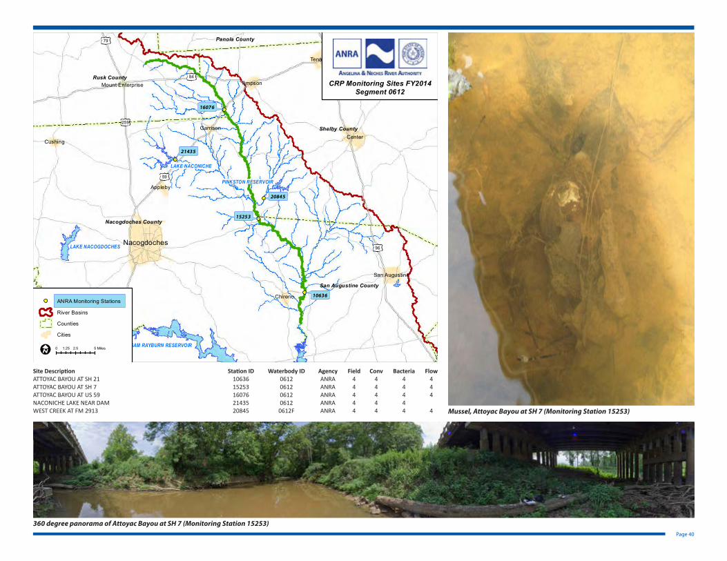
Attoyac Bayou (Segment 0612)
A freshwater stream measuring 81.7 miles in length from a point 3.9 km (2.4 miles) downstream of Curry Creek in Nacogdoches/San Augustine County to FM 95 in Rusk County. The designated uses for this segment include the following: high aquatic life, general, contact recreation, and public water supply. The area surrounding the watershed is managed for agricultural (cattle and poultry), silvicultural, recreational, and wildlife uses. The watershed contains many rural residents. This segment has three areas that are listed on the 303(d) list due to bacteria.
Attoyac Bayou at US 59 (Monitoring Station 16076) Cattle in field adjacent to Attoyac Bayou at US 59
Attoyac Bayou at SH 7 (Monitoring Station 15253)
Page 40
21435
20845
16076
15253
10636
LAKE NACONICHE
Nacogdoches
Center
Tenaha
San Augustine
Joaquin
Timpson
Appleby
Chireno
Cushing
Garrison
Mount Enterprise
SAM RAYBURN RESERVOIR
LAKE NACOGDOCHES
PINKSTON RESERVOIR
TOLEDO BEND RESERVOIR
96
259
59
84
69
79
Shelby County
Nacogdoches County
Rusk County
San Augustine County
Angelina County
Panola County
0 2.5 51.25 Miles
CRP Monitoring Sites FY2014Segment 0612
ANRA Monitoring Stations
River Basins
Counties
Cities
Site Description Station ID Waterbody ID Agency Field Conv Bacteria FlowATTOYAC BAYOU AT SH 21 10636 0612 ANRA 4 4 4 4ATTOYAC BAYOU AT SH 7 15253 0612 ANRA 4 4 4 4ATTOYAC BAYOU AT US 59 16076 0612 ANRA 4 4 4 4NACONICHE LAKE NEAR DAM 21435 0612 ANRA 4 4 4WEST CREEK AT FM 2913 20845 0612F ANRA 4 4 4 4 Mussel, Attoyac Bayou at SH 7 (Monitoring Station 15253)
360 degree panorama of Attoyac Bayou at SH 7 (Monitoring Station 15253)

Page 41
Lake Tyler/Lake Tyler East (Segment 0613)
Segment 0613 extends from Whitehouse Dam and Mud Creek Dam in Smith County up to the normal pool elevation of 375.38 feet. The reservoir impounds both Prairie Creek and Mud Creek. Lake Tyler West and East include a total of 4,880 acres. This segment is designated for high aquatic life use, general use, fish consumption use, public water supply use, and recreation use. Lake Tyler West and East were impounded in 1949 and 1966, respectively. The reservoir serves as a major source for water supply and recreational use. There are several park areas adjacent to the lakes. The lakes have a storage capacity of 15 billion gallons of water within the watershed. The maximum depth is forty feet.
Riverine Portion of Sam Rayburn Reservoir (Segment 0615)
The riverine portion of Sam Rayburn Reservoir extends from a point 5.6 kilometers (3.5 miles) upstream of Marion’s Ferry to a point 2.75 kilometers (1.71 miles) upstream of the confluence of Paper Mill Creek. The segment includes 5,068 acres. The designated uses for this segment include intermediate aquatic life use, contact recreation, general use, and public water supply.
Lake Jacksonville (Segment 0614)
Segment 0614 is designated as a classified reservoir, Lake Jacksonville. The description of this lake includes from an area from Buckner Dam in Cherokee county up to a normal pool elevation of 422 feet (impounds Gum Creek). The reservoir is classified for public water supply use, high aquatic life use, general use, and contact recreation use.
Site Description Station ID Waterbody ID Agency Field Conv Bacteria Flow Metal Water Metal SedLAKE TYLER AT LANGLEY ISLAND 15210 0613 TCEQ 4 4 4 1LAKE TYLER EAST AT DAM 10638 0613 TCEQ 4 4 4 1LAKE TYLER EAST UPPER LAKE 17929 0613 TCEQ 4 4 4 1LAKE TYLER MIDLAKE AT DAM 10637 0613 TCEQ 4 4 4 1
Site Description Station ID Waterbody ID Agency Field Conv Bacteria FlowLAKE JACKSONVILLE UPPER LAKE 16535 0614 TCEQ 4 4 4LAKE JACKSONVILLE SOUTHWEST CORNER 10639 0614 TCEQ 4 4 4
Site Description Station ID Waterbody ID Agency Field Conv Bacteria FlowSAM RAYBURN RESERVOIR AT CONFLUENCE OF ANGELINA RIVER 10623 0615 TCEQ 4 4 4SAM RAYBURN RESERVOIR DOWNSTREAM OF CONFLUENCE WITH PAPER MILL CREEK
10621 0615 TCEQ 4 4 4
PAPER MILL CREEK UPPER BIFURCATION CHANNEL 10502 0615A TCEQ 4 4 4
10623
10621
10502
Lufkin
Nacogdoches
Hudson
SAM RAYBURN RESERVOIR
LAKE NACOGDOCHES
LAKE KURTH
59
69
59
69
226
225
1669
95
2782
1411
226103
7
21
224
287
495
94266
495
103
103
21
Nacogdoches County
Angelina County
CRP Monitoring Sites FY2014Segment 0615
0 2 41 Miles
TCEQ Monitoring Stations
River Basins
Counties
Cities
Upstream continueson segment 0611

This Page Intentionally Blank

Map of Monitoring Stations in the Neches River Basin for FY 2014
Gul fo f
M e x i co
10474
10478
10479
10487
10492
10493
10494
10499
10532
10585
10630
10633
10635
10636
1352813529
14477
15253
15361
1552315524
15801
16076
1609616097
16098
16301
17339
17822
17824
20792
20845
21021
21100
2142921430
21431
21432
2143321434
21435
10522
10542
10552
1059610597
10637 10638
10639
1362713788
14794
15210
15288
16159
16346
16535
16797
17575
17929
18301
1830218557
18643
20282
20318
20319
10485
10502
1056310566
1057010575
10580
10582
10586
10609
10612
10613
10614
1062110623
10627
14906
14907
16127
17067
10484
10581
1059910602
10607
10610
13625
15343
15344
15345
15346
15349
15350
15352
15354
15355
15356
15367
15670
15671 15673
15674
15675
20316
20774
CADDOLAKE
LAKEHOUSTON
LEWIS CREEKRESERVOIR
LAKE O'THE PINES
LAKEPALESTINE
LAKEGILMER
LAKEHAWKINS
LAKECHEROKEE
LAKEHOLBROOK
TOLEDO BENDRESERVOIR
LAKEQUITMAN
LAKEMURVAUL
BRANDY BRANCHCOOLING POND
MARTINLAKE
SAM RAYBURNRESERVOIR
LAKETYLEREAST
LAKESTRIKER
LAKENACOGDOCHES
LAKEATHENS
CEDAR BAYOUGENERATINGPOND
PINKSTONRESERVOIR
B ASTEINHAGENLAKE
RICHLAND-CHAMBERSRESERVOIR
GALVESTONCOUNTY WATERRESERVOIR
LAKEANAHUAC
FORESTGROVE
RESERVOIR
HOUSTONCOUNTYLAKE
FAIRFIELDLAKE
LAKEJACKSONVILLE
LYNCHBURGRESERVOIR
CEDAR CREEKRESERVOIR
LAKECONROE
LAKEGLADEWATER
SHELDONRESERVOIR
GIBBONSCREEKRESERVOIR
SMITHERSLAKE
LAKELIVINGSTON
ADDICKSRESERVOIR
BARKERRESERVOIR
WALLISVILLELAKE
LAKETYLER
Bossier
Caddo
De Soto
Sabine
Anderson
Angelina
Chambers
Cherokee
FortBend
Gregg
Grimes
Hardin
Harris
Harrison
Henderson
Houston
Jasper
Jefferson
Leon
Liberty
Madison
Marion
Montgomery
Nacogdoches
Newton
Orange
Panola
Polk
Rains
Rusk
SanAugustine
SanJacinto
Shelby
Smith
Trinity
Tyler
Upshur
VanZandt
Walker
Waller
Wood
£¤90
£¤84
£¤287
£¤259
£¤96
£¤290
£¤190
£¤90
£¤69
£¤59
£¤90
£¤80
£¤80
£¤59
£¤90
£¤69
£¤69
£¤79
£¤69
£¤80
£¤90
£¤69 £¤80
£¤69
£¤84
£¤290
£¤96
£¤290
£¤59
£¤96
£¤90
£¤59£¤80
£¤69
£¤80
£¤190
£¤259
£¤84
£¤271
£¤69
£¤71
£¤59
£¤69
£¤59
£¤259
£¤59
£¤171
£¤59
£¤79
£¤96£¤287
£¤190
£¤175
£¤175
£¤190
£¤59
£¤79
£¤90
£¤75
£¤79
£¤171
£¤71
£¤59
£¤59
£¤84
£¤59
£¤80
£¤90
£¤96
£¤84
£¤84
£¤69
£¤287
£¤190
£¤84
£¤75
£¤69
£¤59
£¤96
£¤175
£¤190
£¤79
£¤271
£¤259
£¤90
£¤287
£¤287
£¤84
£¤287
£¤79
£¤96
£¤79
£¤69
§̈¦10
§̈¦10
§̈¦49
§̈¦45
§̈¦10
§̈¦45
§̈¦10
§̈¦20§̈¦20
§̈¦20
§̈¦45
§̈¦20
§̈¦10
§̈¦49
§̈¦220
§̈¦45
§̈¦10
§̈¦20
§̈¦610
§̈¦45
§̈¦20
§̈¦45
§̈¦10
LAKE NACONICHE
SabineLake
UpperNeches
MiddleNeches
LowerNeches
UpperAngelina
LowerAngelina
Village
PineIslandBayou
0 10 20 30 405
Miles
I
LegendANRA Monitoring Stations
TCEQ Monitoring Stations
LNVA Monitoring Stations
SubBasins
Reservoirs
River Basins
Upper Neches River MWA
Cities
Angelina & Neches River Authority
Lower Neches Valley Authority

This Page Intentionally Blank

Page 45

Page 46
Development of a Watershed Protection Plan for Attoyac Bayou
Special Projects
The Development of a Watershed Protection Plan for Attoyac Bayou project collected ad-ditional water quality and stream flow data to help develop a better understanding of E. coli loadings in the water body. Local stakeholder input helped facilitate the accurate identification of E. coli sources in the watershed. The project is currently in the process of developing an effective watershed protection plan to restore water quality.
In July 2010, Stephen F. Austin State University (SFASU) field personnel began collecting surface water samples and submitting them to the ANRA Environmental Laboratory for analysis of nutrients and bacteria.
A subset of samples was sent to Texas A&M University for bacterial source tracking analy-sis. Sampling was performed biweekly at 10 routine stations, quarterly at 4 wastewater treatment facilities, and at 2 sites, additional stormwater sampling occurs in response to rainfall events. Sampling was occasionally sporadic due to prolonged drought con-ditions. Laboratory and field data from the study was submitted to the TSSWCB for inclusion in the TCEQ’s Surface Water Quality Monitoring Information System (SWQMIS).
As part of this project, a RUAA was conducted in 2012. Because very few signs of contact recreation were observed, it is possible that the segment may need to be reclassified from primary contact recreation to secondary contact recreation. If the segment is re-classified, the bacteria geometric means are below the current criterion for secondary contact recreation (630 MPN/100 mL). Following a reclassification, the segment should no longer be considered impaired for bacteria and would therefore be removed from the 303(d) list.
The Watershed Protection Plan is in the process of being developed and is currently in draft form.
PROJECT PARTNERS
The Development of a Watershed Protection Plan for Attoyac Bayou project is a collaborative effort by several partner agencies. Funding for the project is provided by the Texas State Soil and Water Conservation Board (TSSWCB) through a Clean Water Act, Section 319(h) grant from the U.S. Environmental Protection Agency (EPA).
Partner agencies for the project include the Texas Water Resources Institute (TWRI), AgriLife Research & Extension, Stephen F. Austin State University (SFASU), the Angelina & Neches River Authority, and Castilaw Environmental Services, LLC.
Project Goals and Objectives
• To assess the current water quality conditions and impairments in the Attoyac Bayou watershed through targeted water quality sampling and analysis
• To conduct a watershed source survey and develop a comprehensive GIS inventory
• To analyze water quality data using Load Duration Curves and spatially explicit modeling
• To conduct bacterial source tracking and evaluate the sources of E. coli present in the watershed that are actually contributing to the Bayou’s bacteria load
• To conduct a Recreational Use Attainability Analysis to determine the most appropriate water quality standard for the Attoyac Bayou
• To establish and provide direction for a stakeholder group that will serve as a decision making body in the assessment of the Attoyac Bayou and facilitate the development of a Watershed Protection Plan (WPP).
The project website includes links to download project documents, including the RUAA document and draft Watershed Protection Plan. For more information on the project, please visit the project website at http://attoyac.tamu.edu or contact:
Anthony Castilaw Watershed Coordinator Castilaw Environmental Services, LLC 936-559-9991 [email protected]

Page 47
Recreational Use Attainability Analysis of Prairie Creek, Mud Creek, West Mud Creek, and Neches River Above Lake Palestine
Prairie Creek, Mud Creek, West Mud Creek, and the Neches River Above Lake Palestine are currently listed on the Texas 303(d) List due to elevated levels of E. coli bacteria. These creek have a presumed designated use of primary contact recreation. Based upon revisions to the TSWQS adopted by TCEQ in 2010, water bodies listed as impaired for bacteria are eligible for a standards review to determine if primary contact recreation is appropriate, or if a revision to the recreation use category is warranted.
Primary contact recreation is presumed for unclassified segments, and it is not known with certainty that recreational use is occurring in these waterbodies. The findings from an RUAA will provide information regarding the level of recreational use actually
occurring in the waterbodies.
Through this project, which is funded through a Clean Water Act Section 319(h) Grant, the Texas State Soil and Water Conservation Board (TSSWCB) and the Texas Institute for Applied Environmental Research (TIAER) will work with local stakeholders for the data collection components of an RUAA, such as site selection and historical use surveys. At the end of this project, they will have adequate data that either supports the existing designated use (primary contact recreation) or supports a change in designated use (e.g., secondary contact recreation) for these segments.
Lake Sam Rayburn On-Site Sewage Facility (OSSF) Program Support and Attoyac Bayou OSSF RemediationThrough this project, ANRA will develop a database of On-Site Sewage Facilities (OSSFs) in the Control Zone Rayburn (CZR), the 2000-ft buffer zone around Sam Rayburn Reser-voir, as well as the unincorporated portion of San Augustine County. The database will be used to track and map all permitted systems in the area immediately surrounding Sam Rayburn Reservoir, as well as the unincorporated portion of San Augustine County. This portion of the county includes a portion of the Attoyac Bayou watershed, a 303(d) listed waterbody impaired for bacteria.
Failing or non-existent OSSFs in the area will be identified through a combination of database tracking of complaints and violations, field reconnaissance and inspections, and consultation with local officials. Funds from the project will be used to replace (in the case of failing systems) or install (in the case of non-existent systems) OSSFs in the portion of the Attoyac Bayou watershed located in San Augustine and Nacogdoches Counties. Replacement or installation of OSSFs will reduce potential sources of non-point source (NPS) pollution that may be contributing to the bacteria impairments in the watershed.
The database tracking and GIS mapping of permitted OSSFs in the watershed will pro-vide a framework that ANRA can use in identifying candidates for future OSSF replace-ment or installation in additional or subsequent projects.
Surface water quality monitoring in the Attoyac Bayou watershed will be used to iden-tify improvements in water quality following the replacement of failed or non-existent OSSFs, as well as monitoring effectiveness of BMPs established by the Attoyac Bayou Watershed Protection Plan. Water quality monitoring conducted under this project will test not only for bacteria but for nutrients as well, including parameters for which Attoyac Bayou and Sam Rayburn Reservoir have nutrient concerns.
Water quality data collected under this project will be routinely shared with the Attoyac Bayou Watershed Partnership, the group of stakeholders guiding the development of the Attoyac Bayou WPP. The data will also be collected under a TCEQ-approved QAPP, allowing the data to be uploaded to the TCEQ Surface Water Quality Monitoring Infor-mation System (SWQMIS), and thus making the data available to TCEQ for consideration in future water quality assessments.
The mapping and database components of this project began in FY 2014. OSSF replace-ment and surface water quality monitoring will be performed during FY 2015 and FY 2016.
Funding for the project is provided by the Texas Commission on Environmental Quality through a Clean Water Act, Section 319(h) grant from the U.S. Environmental Protection Agency (EPA).
Sam Rayburn Reservoir
Toledo Bend Reservoir
Murvaul Lake
Toledo Bend Reservoir
Shelby County
Nacogdoches County
Rusk County
San Augustine County
OSSF Project Area
2000-Ft Buffer CZR
Attoyac Watershed
This map was generated by the Information Systems Division of theAngelina & Neches River Authority. No claims are made to theaccuracy or completeness of the data or to its suitability for aparticular use. For more information concerning this map, contact theInformation Systems Division at (936) 632-7795.
Map created January 2013 by the Angelina & Neches River Authority.
0 8 164
Miles

Page 48
Stakeholder Participation & Public Outreach
Public Information
The Angelina & Neches River Authority provides the public with information concern-ing water quality issues on our website (www.anra.org), which is updated frequently. The ANRA website provides public access to information on the Clean Rivers Program, current and historical Basin Summary and Basin Highlights reports, meeting agendas and minutes, maps, and water quality data. Numerous pamphlets, brochures, and other educational and informational literature on such topics as water quality, conservation, and on-site septic facilities are available to the public at ANRA’s offices. ANRA supports the TPWD invasive species awareness campaign “Hello Giant Salvinia, Goodbye Texas Lakes” by making informational pamphlets available to the public.
Basin Steering Committee
The steering committee’s role is advisory in nature and involves assistance with the review of local issues and creation of priorities for the Upper Neches river basin. Com-mittee members assist with the review and development of work plans, reports, basin monitoring plans, allocation of resources, and basin action plans. CRP steering commit-tee meetings are held annually each Spring. The committee is made up from a diverse group of stakeholders. One of the objectives of the CRP Long-Term Plan is to engage and inform stakeholders. The Steering Committee process gives stakeholders an op-portunity to contribute their ideas and concerns through steering committee meetings, public meetings, and other forums. The process also allows for the communication of issues related to water quality so that priorities may be set which consider local, regional, state, and federal needs. The Steering Committee aids in increasing opportunities for citizens to identify pressing issues and concerns, contribute ideas to the CRP process, and functions to expand the public’s role in water quality management issues.
Texas Stream Team
ANRA serves as the Texas Stream Team (formerly known as Texas Watch) regional part-ner for the Upper Neches Basin and provides training, monitoring kits, and replace-ment reagents to the volunteer monitors in the basin. ANRA supports a number of water quality monitors in the basin. The largest and most active group is comprised of members of the Greater Lake Palestine Council (GLPC). GLPC consists of a group of representatives from each Property Owner’s Association surrounding Lake Palestine. The GLPC is concerned about protecting water quality in Lake Palestine and making other improvements in the area.
For more information on Texas Stream Team, please visit their website at
txstreamteam.rivers.txstate.edu
References and Links to Further Information
Additional Information and ResourcesThe Texas Clean Rivers Program
www.texascleanrivers.org
Coordinated Monitoring Schedule
cms.lcra.org
EPA’s Surf Your Watershed
cfpub.epa.gov/surf/locate/index.cfm
USGS The National Map Streamer
nationalmap.gov/streamer
Attoyac Bayou Watershed Protection Plan Project
attoyac.tamu.edu
TIAER RUAA for Ten Creeks in the Red River and Neches River Basins
tiaer.tarleton.edu/ruaa/
Texas Stream Team
txstreamteam.rivers.txstate.edu
The Surface Water Quality Monitor
www.tceq.texas.gov/compliance/monitoring/water/newsletter.html
ANRA Website
The Angelina & Neches River Authority web page contains additional information on the activities of the river authority, including the Clean Rivers Program, the Environmental Laboratory, On-Site Sewage Facilities program, and water/wastewater utilities. ANRA’s web site can be found at www.anra.org.
Contact Information
For more information on ANRA’s Clean Rivers Program, please contact:Brian SimsEnvironmental Division ManagerAngelina & Neches River Authority210 Lufkin AveLufkin, TX 75901Phone: 936-633-7527Fax: 936-632-2564Email: [email protected]
Jeremiah PolingInformation Systems CoordinatorAngelina & Neches River Authority210 Lufkin AveLufkin, TX 75901Phone: 936-633-7551Fax: 936-632-2564Email: [email protected]

This Page Intentionally Blank

2014 Upper Neches Basin Highlights Report
The 2014 Basin Highlights Report was prepared by the Angelina & Neches River Authority
in cooperation with the Texas Commission on Environmental Quality (TCEQ)
under the authorization of the Texas Clean Rivers Act.