and piedmont - chesapeake bay
TRANSCRIPT

A Landscape History
of the Chesapeake Heartland
from 1.3 Billion Years Ago to 2000
The Chesapeake Bay Heritage Context Project
September 2000
Bay
Piedmont
and
Plain


BAY, PLAIN, AND PIEDMONTA LANDSCAPE HISTORY OF THE CHESAPEAKE HEARTLAND
FROM 1.3 BILLION YEARS AGO TO 2000
The Chesapeake Bay Heritage Context Project
Robert S. Grumet, Writer
Lloyd N. Chapman, Project Coordinator
Robert D. Campbell, National Park Service Chesapeake Bay Program Coordinator
National Park ServiceProject Development Personnel
Michele Batcheller
M. Scott Doyle
Shaun Eyring
James Farrell
Carolyn Pitts
Catherine E. Turton
Richard D. Waldbauer
Gene Woock
Project Advisors
Grace Brush, Johns Hopkins University
Nick Carter, Maryland Department of Natural Resources
Richard J. Dent, Jr., American University
David K. Hazzard, Virginia Department of Historic Resources
Nancy J. Kassner, District of Columbia Historic Preservation Division
Genevieve P. Keller, Land and Community Associates, Inc.
J. Timothy Keller, Iowa State University
Susan B. M. Langley, Maryland Historical Trust
Henry M. Miller, Historic Saint Mary’s City
Kent Mountford, Chesapeake Bay Program
William J. Pencek, Jr., Maryland Historical Trust
John E. Selby, College of William and Mary

ii
The National Park Service is dedicated to conserving the nation’s valued natural andcultural resources for the enjoyment, education and inspiration of this and futuregenerations. The mission is advanced beyond park boundaries through collaborativepartnerships with governments at all levels, organizations and citizens. As a partner of the
Chesapeake Bay Program, the Service participates in efforts supporting restoration andprotection goals for the Bay and its watershed through natural and cultural resource
interpretation, access for all Americans and citizen-based conservation action.
The Chesapeake Bay Program is a unique regional partnership leading and directingrestoration of the Chesapeake Bay since 1983. The Chesapeake Bay Program partnersinclude the states of Maryland, Pennsylvania, and Virginia; the District of Columbia;the Chesapeake Bay Commission, a tri-state legislative body; the U.S. Environ-
mental Protection Agency (EPA), which represents the federal government; andparticipating citizen advisory groups. Since its inception, the Chesapeake Bay Program’s highest priorityhas been the restoration of the Bay’s living resources—its finfish, shellfish, Bay grasses, and other aquaticlife and wildlife. Improvements include fisheries and habitat restoration, recovery of Bay grasses, nutrientreductions, and significant advances in estuarine science.
Grumet, Robert S., writer. 2000. Bay, Plain, and Piedmont: A Landscape History of the ChesapeakeHeartland from 1.3 Billion Years Ago to 2000. (The Chesapeake Bay Heritage Context Project, 183 p.)Annapolis, MD: U.S. Department of the Interior, National Park Service.
Published by the National Park Service, Chesapeake Bay Program, 410 Severn Avenue, Suite 109,Annapolis, Maryland 21403, February 2000.
Publication design and copy preparation by Graphic Works, Atlanta, Georgia.
The National Park Service and U.S. Environmental Protection Agency are equal opportunity agencies and offer all persons thebenefits of participating in every program and competing in all areas of employment regardless of race, color, religion, sex, nationalorigin, age, handicap, marital status, sexual orientation or other non-merit factors.

iii
TABLE OF CONTENTS
List of Figures .....................................................................................................................................................................................iv
List of Maps......................................................................................................................................................................................viii
List of Sidebars ..................................................................................................................................................................................ix
Acknowledgments.............................................................................................................................................................................x
Introduction: Chesapeake Bay Heritage Contexts: A Framework for Understanding Past and Present Landscapes...........1
Chapter One: The Deep Past, 1.3 Billion to 18,000 Years Ago....................................................................................................11
Chapter Two: Paleoindian Life in the Chesapeake Region, 18,000 to 9,900 Years Ago ..........................................................19
Chapter Three: Hunting and Gathering Lifeways in the Chesapeake Region, 10, 000 to 1,000 Years Ago ..........................27
Chapter Four: The Rise of Townlife, 1,100 to 500 Years Ago.......................................................................................................39
Chapter Five: Contact and Colonization, A.D. 1500 to 1775.......................................................................................................51
Chapter Six: The Early Republic, 1775 to 1820.............................................................................................................................77
Chapter Seven: Sectional Strife, 1820 to 1880 ..............................................................................................................................95
Chapter Eight: Urbanization, 1880 to 1930 .................................................................................................................................119
Chapter Nine: Chesapeake Metropolis, 1930 to 2000................................................................................................................139
Appendix One: Chesapeake Region Timeline...........................................................................................................................163
Appendix Two: Common and Scientific Names of Major Plants and Animals in the Chesapeake Region ......................166
Appendix Three: National Natural Landmarks in the Chesapeake Region...........................................................................169
Appendix Four: National Historic Landmarks in the Chesapeake Region ............................................................................170
Appendix Five: National Parks in the Chesapeake Region ......................................................................................................173
Sources............................................................................................................................................................................................174

LIST OF FIGURES
Figure 1: Bay Landscape: Shad fishing on Chesapeake Bay by moonlight and kerosene lamp, 1884...................................3
Figure 2: Coastal Plain Landscape: Dyke Marsh Wildlife Preserve, Fairfax County, Virginia ..................................................3
Figure 3: Piedmont Landscape: A view of the Blue Ridge Mountains from Culpeper, Virginia..............................................4
Figure 4: Coastal Plain Wetland Landscape: Great Dismal Swamp, ca. 1906 ............................................................................5
Figure 5: Piedmont Monadnock: Sugar Loaf Mountain National Natural Landmark, Frederick County, Maryland ..........13
Figure 6: Ancient Landscapes Revealed: Rocky Point from the Southeast, October 7, 1987,in Calvert Cliffs State Park, Maryland .......................................................................................................................................15
Figure 7: Paleoindian Fluted Points ...............................................................................................................................................21
Figure 8: Transportation Landscape: The pass at Harper’s Ferry Water Gap by moonlight, 1874 .........................................25
Figure 9: Points along the Early Archaic Landscape ...................................................................................................................30
Figure 10: Points along the Middle Archaic Landscape..............................................................................................................30
Figure 11: Points along the Late Archaic Landscape ..................................................................................................................31
Figure 12: Points along the Woodland Archaic Landscape........................................................................................................32
Figure 13: Piedmont Forest Landscape: Ferncliff Wildflower and Wildlife Preserve National Natural Landmark .............42
Figure 14: A Preserved Late Woodland Cultural Landscape: Ground plan of archeological deposits associatedwith the ca. 1550 town site at Accokeek Creek, Maryland....................................................................................................43
Figure 15A: Excavations at the Rosenstock Village site during the Archeological Society of Maryland’s Annual FieldSession in Maryland Archeology, May 1992. These excavation units are near the site’s central plaza area...................46
Figure 15B: Excavation of the lower strata of a section of a large trash-filled pit at the Rosenstock Village siteduring the Archeological Society of Maryland’s Annual Field Session in Maryland Archeology, June 1990. ...............46
Figure 15A: Excavations at the Rosenstock Village site during the Archeological Society: Revealing aPost-Mold Pattern: One of two semi-subterranean “keyhole” structures uncovered in May 1992at the Rosenstock site in Frederick County, Maryland ...........................................................................................................46
Figure 15C: Exposed and partially excavated view of one of the two “keyhole” structures found at theRosenstock Village site during the Archeological Society of Maryland’s Annual Field Session in MarylandArcheology, May 1992.................................................................................................................................................................46
Figure 16: Cultural Expressions on the Late Woodland Landscape: Archeologist Donald Cadzowinspecting petroglyphs near the Safe Harbor Dam, Lancaster County, Pennsylvania, ca. 1930.......................................48
Figure 17: Filling in a Post-Mold Pattern: Reconstructed long house at the Strickler archeological site,Lancaster County, Pennsylvania, 1969......................................................................................................................................53
Figure 18: Imagining a Colonial Landscape: 1660 Jamestown street scene based on written records,museum artifacts, and archeological research.......................................................................................................................56
Figure 19: Moving Goods by Water along the Coastal Plain Landscape: Reconstruction of a Chesapeakelanding during colonial times...................................................................................................................................................57
Figure 20: Moving Goods Overland Across the Coastal Plain Landscape: Reconstruction of an ox-drawnhogshead roll wagon used to convey tobacco on rolling roads ..........................................................................................57
Figure 21: Agricultural Landscape: Maryland tobacco field and barns...................................................................................58
Figure 22: Urban Landscape Preserved: Colonial Annapolis Historic District, 1995..............................................................60
Figure 23: Preserving a Landscape of Servitude: Slave cabin at Sotterley Plantation, 1998 ..................................................61
iv

Figure 24: Nature’s Hand on the Landscape: A wind-blown sand dune advances on a Coastal Plain Forest, Cape Henry, Virginia, ca. 1905 ......................................................................................................................................63
Figure 25: Memorial Landscape: Family grave plot at Wye House, Maryland, 1998...............................................................69
Figure 26: Fragment of an Industrial Landscape: The smelting stack at Principio Iron Furnace,Havre de Grace, Maryland, in 1997 ..........................................................................................................................................80
Figure 27: Early National Capital Landscape: Capitol Hill, Washington, D.C. in 1832 ............................................................81
Figure 28: Capital Landscape Afire: The Washington waterfront burns, 1814 .........................................................................81
Figure 29: War on Water: Action in Saint Leonard’s Creek, 1814...............................................................................................81
Figure 30: Forest Landing Plantation, ca. 1930.............................................................................................................................82
Figure 31: Wye House, ca. 1930 .....................................................................................................................................................82
Figure 32: Presqu’isle, ca. 1930.......................................................................................................................................................82
Figure 33: Lighting the Way: Cape Henry Lighthouses, ca. 1905 ...............................................................................................83
Figure 34: A 1798 Latrobe sketch of the Cape Henry, Virginia lighthouse................................................................................83
Figure 35: Upper Marlboro Mill, Maryland, 1827.........................................................................................................................83
Figure 36: Piedmont Farm Landscape: George Stoner’s farm, near Conestoga, 1801 ............................................................84
Figure 37: Bay Environment: The busy seaport of Norfolk, Virginia .........................................................................................84
Figure 38: Coastal Plain Landscape: Rockett’s Landing on the James near the head of tidewater, 1796 ............................84
Figure 39: Formal Georgian Gardenscape Restored: Kenmore Colonial Revival Garden, 1924,Landscape Architect Charles Gillette.......................................................................................................................................86
Figure 40: Stratford Hall Colonial Revival Garden Plan, 1932, Landscape Architect Morley J. Williams.............................86
Figure 41: Vision of an Urban Landscape: Pierre Charles L’Enfant’s 1791 plan for the city of Washington.........................87
Figure 42: River Landscape: Alexandria, Virginia from the Maryland shore, May, 1861.........................................................88
Figure 43: A Piedmont Townscape Preserved: Waterford, Virginia from the air, 1989............................................................88
Figure 44: Millscape: Quarle’s Mill, North Anna River, Virginia, May, 1865...............................................................................89
Figure 45: New Passages across the Landscape: The chain bridge over the Potomac River near Georgetown,as it appeared between 1810 and 1840....................................................................................................................................89
Figure 46: Georgetown Ideal: A pastoral vision of Georgetown, 1855......................................................................................90
Figure 47: Georgetown Real: A gritty view of Georgetown and its Aqueduct Bridge at the end of the Civil War, 1865.....90
Figure 48: A Military Landscape: Fort McHenry, 1998.................................................................................................................91
Figure 49: Dismal Swamp Canal ....................................................................................................................................................98
Figure 50: Building the Chesapeake and Ohio Canal .................................................................................................................98
Figure 51: The completed Chesapeake and Ohio Canal Water System ...................................................................................98
Figure 52: Present-day Aerial View of Carrollton Viaduct, Built by the Baltimore and Ohio RailroadOver Gwynn’s Falls Near Carroll Park, Baltimore....................................................................................................................98
Figure 53: Present-day Ground Level View of Baltimore and Ohio Railroad’s Thomas Viaduct,Looking North, Spanning the Patapsco River at Elkridge, Maryland...................................................................................98
Figure 54: Way Station on the Landscape of Servitude: Photograph of the offices and slave penof Price, Birch and Company, slave merchants, in Alexandria, Virginia .............................................................................99
Figure 55: The Clipper Saint David, ca. 1900-1906.......................................................................................................................99
v

Figure 56: Harper’s Ferry, July, 1865..............................................................................................................................................100
Figure 57: Landscape of Reconciliation and Remembrance: Appomattox Court House, Virginia....................................100
Figure 58: Postcard View of the National Cemetery at Gettysburg..........................................................................................101
Figure 59: The Union Line on Cemetery Ridge, 1989................................................................................................................101
Figure 60: Nineteenth Century Postcard View of Devil’s Den ..................................................................................................101
Figure 61: The Crest of Little Round Top, 1992...........................................................................................................................101
Figure 62: Fort Monroe, Old Point Comfort, Virginia, 1862.......................................................................................................102
Figure 63: C.S.S. Virginia sinks the U.S.S. Cumberland, March 8, 1862 ...................................................................................102
Figure 64: Tredegar Iron Works, April, 1865................................................................................................................................104
Figure 65: Tredegar Iron Works, 1990 ..........................................................................................................................................104
Figure 66: Working Water Landscape: The Great Falls of the Potomac, June, 1906 ..............................................................104
Figure 67: The Dalecarlia Reservoir in Georgetown, April, 1973.............................................................................................104
Figure 68: Working an Oyster Bed off Rock Point, Maryland, 1936.........................................................................................105
Figure 69: Oyster Tongers off Rock Point, Maryland, 1941 .......................................................................................................105
Figure 70: Oyster House and Shuck Pile, Rock Point, Maryland, 1941 ...................................................................................105
Figure 71: Oyster Bed Watch House ............................................................................................................................................105
Figure 72: Catching Blue Crabs with a Trotline ..........................................................................................................................105
Figure 73: Camden Plantation Great House, 1986.....................................................................................................................107
Figure 74: Soldier’s Home, Washington, ca. 1868 ......................................................................................................................108
Figure 75: Aerial View of Mount Vernon: April, 1973 ............................................................................................................... 109
Figure 76: Washington Navy Yard, 1861 ......................................................................................................................................110
Figure 77: Centreville, Virginia, March, 1862 ..............................................................................................................................111
Figure 78: Hulk of the Governor Robert M. Lane. Flagship of the Oyster Navy, 1884-1932 laid up in Baltimore Harbor near the Baltimore Museum of Industry, 1997 ..................................................................................112
Figure 79: Steamboat Potomac on the Patuxent River at Lower Marlboro, ca. 1900.............................................................113
Figure 80: Baltimore City, 1862. Panoramic view looking south beyond the Washington Monument...............................113
Figure 81: Dutch Gap Canal, on the James River, Eight Miles from Richmond March, 1865...............................................114
Figure 82: Sixth Street Wharf, 1863, Washington, D.C................................................................................................................114
Figure 83: Washington Navy Yard, 1861. Shad fishermen draw in a net in the foreground.Originally published in Harper’s Weekly, April 20, 1861. .....................................................................................................114
Figure 84: Two-Sail Bateau Skipjack, the E.C. Collier and the Hooper Strait screwpile-styleLight Station is in the background..........................................................................................................................................122
Figure 85: Newport News Shipyard, Virginia, ca. 1905..............................................................................................................122
Figure 86: The Great Dry Dock, Newport News, Virginia, ca. 1905 .........................................................................................122
Figure 87: Detail of Chesapeake and Delaware Canal survey map.........................................................................................123
Figure 88: Downtown Easton, Maryland, ca. 1920 ....................................................................................................................123
Figure 89: H. L. Mencken Row House, 1524 Hollins Street, Baltimore, Maryland.................................................................124
Figure 90: Impoverished workers led by Jacob Coxey are escorted from the Capitol .........................................................125
vi

Figure 91: The Ku Klux Klan Marches Down Pennsylvania Avenue, September 13, 1926 ...................................................126
Figure 92: Maggie L. Walker Streetscape, Jackson Ward, Richmond Virginia........................................................................126
Figure 93: Suffragettes March for the Vote on Pennsylvania Avenue, March 3, 1913 ............................................................127
Figure 94: Carting Shingles ...........................................................................................................................................................129
Figure 95: Baltimore’s Mount Vernon District.............................................................................................................................130
Figure 96: Aerial View of Ellicott Mills Looking North Toward Ellicott City, Maryland.........................................................133
Figure 97: Baltimore Row Houses, 1981: The 500 block of South Chapel Street in the Fells Point neighborhood..........133
Figure 98: Oyster Fleet in Baltimore Harbor, ca. 1885...............................................................................................................133
Figure 99: Shopping Center in suburban Roland Park, designed by the Olmsted firm between 1891 and 1910.............135
Figure 100: The Standard Oil Fleet in Mothballs during the Great Depression .....................................................................141
Figure 101: Bonus March Shacks Afire, Anacostia Flat, Washington, 1932 ............................................................................141
Figure 102: Aerial View, Greenbelt, Maryland............................................................................................................................142
Figure 103: Interned German Liners Moored off Point Patience, Maryland Await Disposition, ca. 1940 ..........................143
Figure 104: Aerial View of the Pentagon, Arlington, Virginia, 1973........................................................................................144
Figure 105: Aerial View of the Dwight David Eisenhower National Historic Site, Gettysburg, Pennsylvania ....................145
Figure 106: Colonial Parkway Vista at the Jamestown Island Isthmus, Virginia, 1996 ..........................................................146
Figure 107: Traffic at the Junction of Interstate 295 and the Anacostia Bridge, Washington, 1973.....................................147
Figure 108: Chesapeake Bay Bridges, June, 1973 ......................................................................................................................147
Figure 109: Civil Rights March on Washington, August 28, 1963 .............................................................................................147
Figure 110: Slum Alley Behind the Capitol, 1935.......................................................................................................................148
Figure 111: Conowingo Dam Across the Susquehanna, ca. 1920-1950 ..................................................................................150
Figure 112: Shore Erosion at Governor’s Land on the Chickahominy River, Virginia, 1990.................................................151
Figure 113: A Hazy Day at the Bethlehem Steel Plant, Sparrow’s Point, Maryland, June, 1973...........................................151
Figure 114: Water Filtration Plant, Occoquan, Virginia, April, 1973 ........................................................................................152
Figure 115: Baltimore Folk Art: Painted screen depicting the nearby Lazaretto Lighthouse on the door of an ElliottStreet row house in Baltimore’s Canton neighborhood, 1990 ............................................................................................155
Figure 116: Union Station Looking South Toward the Capitol, the Potomac, and the National Airport, 1973..................157
Figure 117: Aerial View of Saint Mary’s City ...............................................................................................................................157
Figure 118: Landscape Toward the Future: The Lunar Landing Research Facility, Langley Research Center,Hampton Virginia .....................................................................................................................................................................158
Figure 119: Landscape of Memory: The wreck of the U-1105 ..................................................................................................159
vii

LIST OF MAPS
Map1: The Chesapeake Bay Heartland...........................................................................................................................................2
Map 2: The Deep Past, 1.3 Billion to 18,000 Years Ago ...............................................................................................................12
Map 3: Paleoindian Life in the Chesapeake Region, 18,000 to 9,900 Years Ago......................................................................20
Map 4: Hunting and Gathering Lifeways in the Chesapeake Region, 10, 000 to 1,000 Years Ago.........................................28
Map 5: The Rise of Townlife, 1,100 to 500 Years Ago...................................................................................................................40
Map 6: Tribal Locations and Contact Archeological Sites..........................................................................................................52
Map 7: Contact and Colonization, A.D. 1500 to 1775..................................................................................................................54
Map 8: The Early Republic, 1775 to 1820 ......................................................................................................................................78
Map 9: Sectional Strife, 1820 to 1880 .............................................................................................................................................96
Map 10: Urbanization, 1880 to 1930 ............................................................................................................................................120
Map 11: Chesapeake Metropolis, 1930 to 2000 ..........................................................................................................................140
Note: In accordance with the provisions of the Historic Preservation Act of 1966 and the Archaeological ResourceProtection Act of 1979, which restrict disclosure of site locations and other information that may endanger culturalresources significant in the culture and history of the United States, all maps depict relative distributions rather thanactual locations of archeological sites. This is done to respect the privacy of property owners and to maintain the con-fidentiality of locations of potentially threatened cultural resources.
viii

LIST OF SIDEBARS
Calvert Cliffs......................................................................................................................................................................................15
Late Woodland Environments Preserved: National Natural Landmarks in the Chesapeake Heartland..............................42
Accokeek Creek National Historic Landmark .............................................................................................................................43
The Rosenstock Site: A 15th Century Village in Maryland .........................................................................................................46
Colonial Annapolis Historic District..............................................................................................................................................60
Sotterly Plantation............................................................................................................................................................................61
Maryland’s War of 1812 Initiative ...................................................................................................................................................81
Georgian Federal Landscapes Preserved: A Talbot County Portfolio .......................................................................................82
Portfolio: Benjamin Latrobe’s Chesapeake...................................................................................................................................84
Alexandria Historic District ............................................................................................................................................................88
Landscapes Real and Ideal: Georgetown in the District of Columbia .....................................................................................90
Portfolio: Views of the Early Industrial Chesapeake Transportation Landscape .....................................................................98
Landscape of Memory: Gettysburg National Military Park.......................................................................................................101
Tredegar Iron Works ......................................................................................................................................................................104
Portfolio: The Chesapeake Bay Shellfish Industry .....................................................................................................................105
Jackson Ward Historic District .....................................................................................................................................................126
Greenbelt Historic District ............................................................................................................................................................142
Colonial National Historical Park ................................................................................................................................................146
Landscape toward the Future: The Lunar Landing Research Facility ....................................................................................158
ix

ACKNOWLEDGEMENTS
Many individuals and organizations have contributed much time and substantial resources to this project over thecourse of the past two years. Working together as partners, Environmental Protection Agency Chesapeake BayProgram Director William Matuszeski and Director of the National Park Service’s Northeast Region Marie Rust haveprovided programmatic guidance, arranged for developmental funding and other support, and made available numer-ous specialists from their staffs to work on the project.
National Park Service Chesapeake Bay Program Coordinator Robert D. Campbell developed the project’s scope ofwork, obtained project support, and worked hard to keep the project on course. Project Manager Lloyd N. Chapman,National Park Service Philadelphia Support Office Archeologist, recruited project personnel, helped determine theproject’s scope of work, set deadlines, arranged for meetings and conference calls, provided technical assistance, andotherwise oversaw all phases of project development. Philadelphia Support Office, Stewardship and PartnershipsTeam Leader Joseph DiBello and Cultural Resources Group Manager Bonnie Halda supervised all aspects of projectcoordination and secured the participation of several National Park Service Philadelphia and National Center forCultural Resources Stewardship and Partnerships staff members.
Philadelphia Support Office Archeologist Robert S. Grumet developed the report framework, coordinated projectresearch, and wrote the report text. Historical Landscape Architect Shaun Eyring provided technical assistance on allmatters pertaining to cultural landscapes. Natural Resource Specialists Michelle Batcheller and Gene Woock providednatural resource information and reviewed product drafts. Philadelphia Support Office staff member Catherine E.Turton and Washington Office National Historic Landmark Program Architectural Historian Carolyn Pitts (on detail tothe Philadelphia Support Office) helped identify and classify places and properties described in the volume’s side-bars. Washington National Center for Cultural Resource Stewardship and Partnerships, Archeology and EthnographyProgram Archeologist Richard D. Waldbauer prepared early drafts of the chapters dealing with the post-colonial peri-ods and participated in development meetings while on detail in the Northeast Region during 1998. WashingtonNational Center for Cultural Resource Stewardship and Partnerships, National Register, History, and EducationProgram Computer Specialist John P. Byrne answered several database queries. Philadelphia Support Office HistoricalArchitect William D. Brookover and Architectural Historian Dennis Montagna provided images and information.Philadelphia Support Office Administrative Assistant Mary Morrison provided key administrative and logistical support,G.I.S. Specialist James Farrell prepared the regional base map, and fellow staff member M. Scott Doyle refined the orig-inal projection and prepared overlays depicting resources and conditions for each chapter.
Much of the Historic Context documentation serving as source material for this report was provided by District ofColumbia Historic Preservation Division Archaeologist Nancy J. Kassner, Elizabeth Hughes of the Maryland HistoricalTrust, Pennsylvania Deputy State Historic Preservation Officer Brenda Barrett, and Beth Acuff and Suzanne Dunbar ofthe Virginia Department of Historic Resources. Among other State Historic Preservation Office staffers providing help-ful information and technical assistance were Susan B. M. Langley, Tyler Bastian, Elaine Eff, and Richard Hughes of theMaryland Historical Trust; David K. Hazzard and E. Randolph Turner, III of the Virginia Department of HistoricResources; and Andrew Wyatt of the Pennsylvania Bureau of Historic Preservation. Information used in the Rosenstocksite sidebar was provided by Maryland Historical Trust archaeologists Dennis C. Curry and Maureen Kavanagh.
Assistance in obtaining illustrations and reproduction permission was extended by the staffs of the Prints andPhotographs Division of the Library of Congress and the Still Pictures Branch of the National Archives in College Park,Maryland. Maryland Historical Trust Underwater Archaeologist Susan B. M. Langley made many illustrations available,identified key institutional contact persons, and provided much useful advice. Assistance was also given by VickyWells of the University of North Carolina Press; National Historic Landmarks Program Historian Robie Lange; YoavGonen of Harper Collins, Publishers; Joan Hoage, Director of the Talbot County Historical Society; Teresa Vazquez deVado of the National Park Service Harper’s Ferry Center Graphics Research Office; John J. Frye of the GeorgeWashington Birthplace National Monument; Melissa Kahn and Ann S. Brazinski of the National Park Service’s GeorgeWashington Memorial Parkway; Charlotte Kurst of Tidewater Publishers; Diane Reed of the Pennsylvania Historical andMuseum Commission; Lydia A. Wood of the Saint Clements Island–Potomac River Museum; Sally Horvath of theUniversity of Michigan Museum of Anthropology; Peter A. Kumble of Land Ethics, Inc.; Kenneth A. Schwarz, Chief of
x

the Maryland Geological Survey’s Earth Science Information Center; and staff members of the Lancaster CountyConservancy.
Project advisors Professor Grace Brush of Johns Hopkins University’s Department of Geography and EnvironmentalEngineering; Maryland Department of Natural Resources Biologist Nick Carter; Professor Richard J. Dent, Jr., chair ofAmerican University’s Department of Anthropology; David K. Hazzard, Archaeologist on the staff of the VirginiaDepartment of Historic Resources’ Portsmouth Regional Office; District of Columbia Historic Preservation DivisionArchaeologist Nancy J. Kassner; Genevieve P. Keller of Land and Community Associates, Inc.; Professor J. TimothyKeller of Iowa State University’s Department of Landscape Architecture; Maryland Historical Trust UnderwaterArchaeologist Susan B. M. Langley; Dr. Henry M. Miller of Historic Saint Mary’s City; Chesapeake Bay Program SeniorScientist Kent Mountford; Maryland Deputy State Historic Preservation Officer William J. Pencek, Jr.; and ProfessorJohn E. Selby of the College of William and Mary’s Omohundro Institute of Early American History and Culture pro-vided substantial comments and constructive criticism of the initial report draft at a two-day meeting held at theChesapeake Bay Program Office in Annapolis on June 17-18, 1998. Susan B. M. Langley and John E. Selby made addi-tional comments on the subsequent revised draft. Scott Chapin, Maria Fell, Nathaniel Johnson, and Kathy Mitchellread draft chapters. Genevieve P. Keller and J. Timothy Keller conducted final content review. The final manuscript wasedited by Janet Benton, president and director of Benton Editorial, in Philadelphia.
xi

WHERE, WHAT, ANDWHENThis book explores the cultural and nat-ural heritages of the Chesapeake Bayheartland, a region that extends throughparts of south-central Pennsylvania, east-ern Maryland and Virginia, and all of theDistrict of Columbia (see Map 1). Thearea forms a large portion of the mid-Atlantic region of the United States.Today, one of America’s densest concen-trations of people lives there, side by sidewith thousands of plant and animalspecies. This study focuses on theunique relationships between people,plants, animals, and place that haveemerged at various times in the region’shistory.
The book moves from the earliestgeological evidence of life in theChesapeake Bay heartland–evidencethat is at least 1.3 billion years old–to2000. Over time, this region has beenhome to a fascinating diversity of naturaland cultural landscapes. High mountainchains have risen over Chesapeake landsat least twice during the past billionyears. Ocean waters and sluicing floodsfrom melting glaciers have periodicallyflowed across the area. Hunting andgathering people first came to the regionby 12,000 years ago. Native Americansbegan cultivating crops and settling intowns throughout the area around athousand years ago. First arriving lessthan five hundred years ago, Europeans,and Africans first forcibly brought bythem to the region in 1619, struggled totransform forests to farm fields duringthe colonial era between 1524 and 1775.
Since then, social, political, economic,and technological developments in met-allurgy, steam power, internal combus-tion engines, chemical engineering, and,most recently, in electronics, haveenabled people to transform regionalenvironments in dramatic ways.
The heartland ofthis region stretchesacross the south-ernmost half of the64,000-square-mileC h e s a p e a k edrainage, a vastarea bounded onthe north by theheadwaters of theSusquehanna Riverin south-centralNew York, on thewest by the Appa-lachian Mountainchain crests thatcut across centralPennsylvania andWest Virginia, andon the south by theupper tributaries of the James and otherrivers that flow into the lowermostreaches of Chesapeake Bay.
The Chesapeake Bay heartland itself isbordered on the west by the Blue RidgeMountains in Virginia and SouthMountain in Maryland and Pennsylvania.A broken line of low hills running paral-lel to Pennsylvania’s Kittatiny Mountainsforms its northernmost border, and theelevated uplands separating theDelaware and Susquehanna Riverdrainages forms its eastern border. Theheartland’s southern borders are in
Where, What, and When 1
IntroductionChesapeake Bay Heritage Contexts:
A Framework for Understanding
Past and Present Landscapes
Chesapeake BayRegion
heartland
watershed

2 INTRODUCTION
Potomac River
S usquehannaRiver
Mon
ocac
yR
iver
Cho
ptan
kR
iv
er
Rapi da n Ri ve r
Pat a psco Riv er
Chester Rive
r
Potomac River
James River
Mattaponi RiverPamunkey River
App
omat
tox
Riv
er
Rappahannock River
Patuxent R
iver
Shen
ando
ah R
iver
Poco
mok
e Riv
er
Nan
tico
ke R
iver
Chesapeake B
ay
CapeHenry
CapeCharles
Rappahannock
River
York Riv e r
James River
KentIsland
SmithIsland
TangierIsland
Cat
octin
Rid
ge
Sou
th M
ount
ain
Harper's Ferry Gap
Manassas Gap
Bul
l Run
Mou
ntai
n
ThorofareGap
Thornton Gap
Blu
e R
idge
Mou
ntai
ns
Rockfish Gap
Blue
Rid
ge M
ount
ains
James River Gap
Map 1: The Chesapeake Bay Heartland
0 5 10 25 50 miles
kilometers0 5 10 40 80 North
LEGENDBayPlainPiedmont
Chesapeake BayRegion
heartland
watershed

southeastern Virginia, marked by theheadwaters of rivers and streams thatflow north and east into the Bay’s lower-most reaches.
This region contains three distinct, occa-sionally overlapping environmental areasoften called physiographic provinces orecosystems by specialists. These are theBay itself, the Coastal Plain, and the Pied-mont. Each is a unique and complexenvironment that both supports and isinfluenced by living things. The Bay envi-ronment consists of deep and shallowopen salt waters and the brackish watersof the lower tidal portions of rivers (seeFigure 1). Chesapeake waters flow intothe Atlantic Ocean at Hampton Roads atthe Bay’s southeastern end. The Coastal
Plain bordering on the Bay consists ofbeaches, marshes, forests, and grass-lands growing on generally sandy orgravelly soils. This area is often called thetidewater region, since the waters cours-ing along its shores rise and fall with thetide (see Figure 2). Coastal Plain sectionson the Bay’s eastern and southern shoresgenerally tend to be flat and are drainedby salty or brackish waters. Bluffs andlow rolling hills drained by brackish orfreshwater streams are located on thewestern shore and in more interior partsof this region.
The Piedmont (literally “foot hills”) is aregion of mixed hardwood forests andsoftwood barren lands bordering onswift running freshwater rivers andstreams. Mountain laurel, ferns, andgrasses flourish on Piedmont forestfloors. Poison ivy, Virginia creeper, andother epiphytic clinging vines wind theirways around tree trunks that push theirroots deep into the Piedmont’s clayeysoils. Low mountain chains and isolatedhills of hard rock resistant to the erodingpower of these waters rise above broadvalleys covered by these soft clayey soils.A low-lying ridge chain, known as the fallline, runs through the region fromConowingo Falls on the Susquehanna toBaltimore, Washington, and Richmond.
Where, What, and When 3
Figure 1: Bay Landscape: Shad fishing onChesapeake Bay by moonlight andkerosene lamp, 1884.(Used by permission of Tidewater Publishers ©1990)
Figure 2: Coastal Plain Landscape: Dyke Marsh Wildlife Preserve, located in FairfaxCounty, Virginia, a unit of George Washington Memorial Parkway. (Photograph courtesy of the
National Park Service)

The fall line separates the Piedmontuplands from the tidal lowlands of theCoastal Plain (see Figure 3). Rapids flow-ing over this ridge line mark the upper-most limits of navigation for shipssailing up the region’s rivers. These dis-tances vary from less than five miles onthe Susquehanna to well over a hundredmiles on the James.
The Susquehanna and James are onlytwo of the more than fifty major riversflowing through this region. Together,these rivers pour 2.5 million cubic feet offreshwater and huge amounts of sedi-ments, minerals, and nutrients intoChesapeake Bay each year. Five of theserivers, the Susquehanna, Potomac,Rappahannock, York, and James, pro-vide 90 percent of the Bay’s freshwatervolume. The largest of these, theSusquehanna, accounts for fully half ofthe freshwater discharged into Chesa-peake Bay. The huge volume of fresh-water that flows into the Bay makes thesewaters 10 percent less salty than those inthe nearby open ocean.
The Bay itself is an estuary–a placewhere fresh river water mixes with saltyocean currents. It is the largest estuary inthe United States and one of the largestin the world. The Bay was formed at theend of the last Ice-Age, when meltingglaciers caused sea levels to rise world-wide. This generally slender, shallowsliver of bay water stretches two hundred
miles from its northern border at themouth of the Elk River in Maryland, to itssouthern outlet between Cape Henryand Cape Charles. Its deepest portionstrace what in ancient times was the pathof the Susquehanna River; its shallowerparts were formed when land wasflooded by rising ocean waters. As muchas forty miles across at its widest point,Chesapeake Bay follows a generally nar-row channel with an average width ofbetween five and ten miles. Bay waterstoday cover a surface area of 2,500square miles at an average water depthof twenty-one feet. They support anamazing variety of life. Deeper waters arehome to many species of fish, shellfish,and, on occasion, visiting ocean fish andaquatic mammals. Vast meadows of sub-merged aquatic vegetation, great banksof clams and oysters, sizable populationsof blue crabs, young fish not ready forthe open water, migratory waterfowl,clouds of diatoms, dinoflagellates, andother plankton, and numerous species offish, mammals, and birds make theirhomes in shallower Bay waters.
The Coastal Plain consists of beaches,saltwater and brackish marshes, freshwa-ter swamps, and forests. The region strad-dles an environmental borderlandmarking the southernmost extent ofmany northern species and the mostnortherly limits of many southern plantsand animals. Tidewater beaches supportdistinct communities of shellfish, insects,and migratory birds. Plants that are resis-tant to salt spray, including salt grass, saltmeadow cordgrass, and American hollyprovide food and shelter to a wide vari-ety of insects, mammals, and birds andstabilize dunes and bluffs above the hightide mark, keeping them from erodingquickly into the Bay. Areas closest to theBay are also home to low-lying saltmarshes, which are flooded twice dailyby tides. Plant communities dominatedby salt marsh cordgrass and otherspecies able to withstand extended peri-ods of immersion live in these areas. Incontrast, areas of salt marsh that only getcovered by water at high tide are domi-nated by salt meadow cordgrass andother less water tolerant species. Just
4 INTRODUCTION
Figure 3: Piedmont Landscape: A view of the Blue Ridge Mountains fromCulpeper, Virginia.(Photograph courtesy of the National Park Service and the Library of Congress)

inland, common reeds, white perch,common snapping turtles, northernwater snakes, great blue herons andother waterfowl, rice rats, and raccoonsare among the many plants and animalsmaking their homes in tidewater swampsand other brackish water wetlands.
Moving inland, we find freshwatermarshes and swamps in places such asVirginia’s Great Dismal Swamp (seeFigure 4) that are homes to bald cypress,red maple, green ash, sweet gum,loblolly pine, poison ivy, giant waterbugs, north black racers, bullfrogs, east-ern mud turtles, barred owls, woodducks, marsh rabbits, Virginia opossums,muskrats, river otters, beavers, and manyother species. Farther in, Coastal Plainuplands are populated by diverse mixedhardwood and softwood forests. Eachcommunity reflects variations in localweather, water, and soil conditions.
The Chesapeake Piedmont is also atransition zone where species most com-monly found in southern softwoodforests blend in with plants that flourishin more northerly mixed softwood-hardwood forests. Three types of envi-ronment may be found in this area. Well-drained mesosere zones located onlevel and mildly sloping terrain cover 85percent of all Piedmont lands. Dryxerosere eroded and hilltop environ-ments comprise 19 percent of the landarea. The remaining 5 percent ofPiedmont land is made up of wet bot-tomland hydrosere habitats.
White oaks, beeches, hickories, tuliptrees, and, until decimated by blight,chestnuts, dominate mature mesosereforest communities. Red oaks prosperin more northerly parts of the region;black oaks tend to be more common insouthern sections. American hornbeam,flowering dogwood, blueberries, shad-bush, and maple leaf viburnum live inlower forest canopies. A wide variety ofinsects, amphibians, reptiles, birds, andmammals also make their homes inthese forests.
Chestnut oak, red oak, flowering dog-wood, dwarf chinquapin oak, andVirginia pine are the dominant trees indry xerosere forests. Blackjack oak and,more rarely, arborvitae, are found inextremely dry Piedmont barren lands.Blueberries, mountain laurel, and a vari-ety of shrubs and grass grow in uplandxeric habitats. A relatively small numberof animal species adapted to drier andharsher conditions make their homes inthis zone.
Silver maple, sycamore, bitternut hickory,swamp white oak, hornbeam, box elder,hackberry, sweet gum, green ash, riverbirch, and, formerly, the American elm,dominate forests growing along thebanks of Piedmont swamps and streams.Paw paw, poison ivy, wild grape, wild aza-lea, witch hazel, and spicebush thrive onthe forest floors in this zone. In contrastto its other habitats, Piedmont wetlandssupport some of the largest communitiesof insects, crustaceans, mollusks, fish,amphibians, reptiles, birds, and mam-mals in the Chesapeake region.
WHYThe main purpose of this book is to givereaders accurate, up-to-date, and easy tounderstand information on the naturaland cultural heritages of the ChesapeakeBay heartland. Although the ChesapeakeBay is one of the most intensively studiedregions in the United States, basic infor-mation about the area is still hard to find.
Where, What, and When 5
Figure 4: Coastal Plain Wetland Landscape: Great DismalSwamp, ca. 1906. (Photograph courtesy of the Library of Congress)

Many thousands of specialized publica-tions touch on just about every conceiv-able aspect of the Bay heartland’s naturaland cultural resources, and thousands ofother reports–many unpublished andmost hard to find–contain technical find-ings from studies commissioned by pri-vate corporations, public interest groups,government agencies, and other organi-zations. Add to this the ever increasingnumbers of web sites that offer informa-tion on everything from water pollutionlevels to deep surface geology. Yet muchof this material is presented in dense,technical terms, and readers may find itdifficult to tell which findings aredependable and which are controversialor out of date. And no one source pre-sents information on the region’s culturaland natural resources in a systematicframework.
For more than two years, an innovativepartnership has worked together to fillthis gap. This partnership combines theknowledge, skills, and resources of fed-eral and state agencies, academic institu-tions, public and private organizations,and interested individuals. In creatingthis book, project partners have workedto achieve three goals:
▫ to offer accurate, up-to-date informa-tion on the natural and culturalresources of the Chesapeake Bayheartland,
▫ to present this information in non-technical language,
▫ to organize this information in waysthat reveal how a complex, ever-chang-ing web of relationships connects all ofthe region’s natural and culturalresources.
Culture is simply the way people live,and nature is what we need to thrive andsurvive. Cultural and natural heritage iseveryone’s concern. By investigating ourcultural and natural landscapes, we cansee how our lives depend on an ever-changing kaleidoscope of links connect-ing the past to the present. When weunderstand these connections betweenculture and nature, past and present, wecan make better decisions about
whether to change things or to keepthem as they are.
By providing the latest, most accurateinformation in plain language, this bookaims to provide a sound basis for suchdecisions. It is meant to assist anyoneliving in or concerned about the Chesa-peake Bay region. General readers seek-ing basic information and specialistslooking for succinct summaries can finduseful data and suggested sources inthese pages. Developers seeking for waysto avoid past mistakes and enhancepotential project values can find usefulinformation here. And State HistoricPreservation Office employees usingstate historic contexts can use this studyto place information about properties instate borders within a more comparativebroader regional perspective. As this is agovernment report funded by tax dollars,its text may be freely used or adaptedfor brochures, newsletters, and otherpublications.
HOWThis study combines two National ParkService organizational frameworks, theHistoric Context and the NationalHistoric Landmark Thematic Framework,to help readers find information. The his-toric context is a method that federal,state, and local agencies use to organizeand assess the information they need toidentify, evaluate, designate, and managecultural resources such as buildings,sites, and structures that are associatedwith particular aspects of American his-tory and culture. The National HistoricLandmark thematic framework is asystem used nationwide to gather andorganize information on America’s mostsignificant historic sites.
Both systems have been modified andcombined to create the Heritage Contextframework developed especially for thisproject. Chesapeake Bay heritage con-texts document relationships betweencultural and natural resources duringparticular periods. Each heritage con-text–one of which comprises each chap-ter of this book–summarizes basicinformation for the period. You will see
6 INTRODUCTION

boxed insets that highlight places chosento represent natural and cultural land-scapes of particular periods. Also ineach chapter you will find reliable lists ofsources (with locations) for further infor-mation.
Using adaptations of historic contextframeworks employed by State HistoricPreservation Offices of Delaware,Maryland, Pennsylvania, Virginia, andthe District of Columbia, this studydivides information on the ChesapeakeBay region into these chronological her-itage contexts:
▫ The Deep Past, 1.3 Billion to 18,000Years Ago (Chapter One, pages 11-17)
▫ Paleoindian Life in the ChesapeakeRegion, 18,000 to 9,900 Years Ago(Chapter Two, pages 19-26)
▫ Hunting and Gathering Lifeways in theChesapeake Region, 10,000 to 1,000Years Ago (Chapter Three, pages 27-37)
▫ The Rise of Townlife, 1,100 to 500 YearsAgo (Chapter Four, pages 39-50)
▫ Contact and Colonization, 1500 to1775 (Chapter Five, pages 51-76)
▫ The Early Republic, 1775 to 1820(Chapter Six, pages 77-94)
▫ Sectional Strife, 1820 to 1880 (ChapterSeven, pages 95-118)
▫ Urbanization, 1880 to 1930 (ChapterEight, pages 119-138)
▫ Chesapeake Metropolis, 1930 to 2000(Chapter Nine, pages 139-162)
Each heritage context–each chapter inthis book–begins with outlines of theperiod’s major developments and events.These are followed by overviews of rela-tionships between people and place dur-ing the period, An Ecology of Peopleand Place. The first chapter, “The DeepPast,” focuses on the 1.3 billion years ofhistory preceding the initial human entryinto the region sometime between18,000 and 11,500 years ago. Place pre-cedes people in the next three chapters,highlighting what an enormous influ-ence environmental conditions had onpeople’s actions in the region from thetime of their first arrival until about fivehundred years ago. This order is
reversed, with people coming beforeplace, in the final five chapters, reflectingthe rise of attitudes and capabilities thatallowed and encouraged many peopleto dominate and exploit Chesapeake Bayenvironments.
Each discussion of Place begins with ageneral description of conditions in eachof the Chesapeake Bay region’s threemajor environmental areas. It continuesby assessing the status of major compo-nents of each region’s environment.These include its rocks, minerals, soils,and other geological features, its salt andfresh waters, and its climate, weather,plants, and animals.
Each discussion of People begins with ageneral look at cultural developments inthe particular period. It places eventsagainst the broader backdrop of nationaland international developments. And itcharts, evaluates, and explains key cul-tural factors of each period, includingchanges in the number and location ofhuman inhabitants; its social, political,and economic life; and its technologicaland intellectual developments
These discussions are followed by moredetailed looks at key aspects of theperiod’s Cultural Landscape. Slightlymodified for this study, the NationalHistoric Landmark thematic frameworkis used to present specific informationrelating to these eight key aspects for allbut the first period:
▫ Peopling Places
▫ Creation of Social Institutions
▫ Expressing Cultural Values
▫ Shaping the Political Landscape
▫ Developing the ChesapeakeEconomy
▫ Expanding Science andTechnology
▫ Transforming the Environment
▫ Changing Role of the Chesapeakein the World Community
In this study, the word ecology is used torefer to the relationships of living thingswith one another and with their environ-ments. The phrase natural landscape
Where, What, and When 7

refers to ecologies independent ofhuman interference or influence. Theterm cultural landscape refers here tothe combination of cultural and naturalfactors that forms unique ecologies ofpeople and place. This definitionacknowledges the role that culture playsin linking human and natural worlds.
Cultural landscapes can be as large asriver valleys and as small as gardens. Butwhether situated in a single locale orspread over a wide area, each reflectsunique relationships between naturalconditions and cultural activities. Culturallandscapes are transformed over time,with only fragments of earlier culturallandscapes surviving in later periods.These fragments become componentsof later ecologies, whether as relics orreusable resources. Well-preserved frag-ments of cultural landscapes of thepast–usually linked with significant peo-ple or events–may gain importance farbeyond their specific cultural landscape.
Natural resources, too, survive as rem-nants of past landscapes. This studyemploys the terms geology, water, cli-mate, plants, and animals to describethese natural resources. Geologyincludes rocks, minerals, and soils. Waterincludes both salt and fresh waters.Climate includes the atmosphere andweather. Plants includes water and landplants and relatives such as fungi andmicroscopic phytoplankton. And finally,animals includes microscopic zooplank-ton; larger invertebrates, such as worms,shellfish, mollusks, and crustaceans;insects; fishes; reptiles and amphibians;birds; and mammals.
Each chapter examines all of these fac-tors–history, habitats, natural and culturallandscapes, and natural resources–insections on the eight key aspects listedabove. Peopling Places assesses howchanges and continuities in populationpatterns affect each period’s natural andcultural landscapes. It focuses on naturaland cultural features associated withmigration, health status, culture, ethnic-ity, gender, and other aspects of identity.Such features can include archeological
sites containing artifacts, settlement pat-terns associated with particular cultures,and specific combinations of architec-tural styles and land use patterns thatreveal the immigration or emigration ofspecific ethnic groups.
Creation of Social Institutions andMovements charts how public and pri-vate associations expressed themselvesin the region’s landscape. Sites such asball fields and memorials; buildings suchas clubhouses, churches, and schools;and districts such as Colonial Williams-burg, can provide examples of socialaspects of a period’s cultural and naturallandscape.
Expressing Cultural Values examinesthe ways beliefs and values areexpressed when a culture interacts withits natural landscape. These expressionscan include sites of high culture, such astemples, museums, formal parks, andplaces associated with prominent figuresin arts and letters, as well as sites of pop-ular culture, such as amusement parks,music halls, and the homes of primitivepainters.
Shaping the Political Landscapeexamines the particular impressions thatgovernment makes on a period’s land-scape. Political properties range fromcouncil rings, city halls, and politicalclubhouses to military fortifications,battlefields, and places associated withimportant political figures and move-ments.
Developing the Chesapeake Econ-omy examines the impact of work onthe landscape. Places associated withthis include quarries, factories, and otherlocales for resource extraction and pro-duction; paths, turnpikes, railroads,canals, and other transportation facili-ties; warehouses, stores, and other placesof distribution; banks, stock exchanges,and other financial institutions; andunion halls and other properties associ-ated with American labor.
Expanding Science and Technologyassesses the impacts of innovation uponthe land. Places associated with this
8 INTRODUCTION

include buildings used in technologicaldevelopment, such as workshops, labora-tories, and institutes of higher learning;sites associated with first, final, or exem-plary examples of major industries; andships, aircraft, and other objects exempli-fying scientific and technologicaladvances.
Transforming the Environment con-siders natural and cultural aspects of thelandscape that influence environmentalchange during a particular period.Places where these forces come togetherinclude locales where the environmentis exploited, degraded, maintained, orrestored.
Finally, Changing Role of theChesapeake in the World Com-munity considers the roles of ports, cus-toms facilities, and similar points ofcontact with the wider world, as well asthe impacts of products and ideas origi-nating beyond the borders of the land-scape under discussion.
Each chapter also contains lists of KeyLocales that preserve significant aspectsof the cultural and natural landscapes ofthe period. Many of the Key Locales arehighlighted by a marginal symbol. Earlierchapters list important archeologicalsites. Later chapters list National HistoricLandmarks in the region. These, ofcourse, are not the only places of signifi-cance to American history and culture inthe Chesapeake area. Hundreds of sitesof local and state significance in theregion, for example, are listed in theNational Register of Historic Places.National Historic Landmarks, by con-trast, are nationally significant placesdesignated by the Secretary of theInterior after completion of rigorousmulti-year nation-wide evaluation stud-ies. Dates in brackets after the names ofthese places indicate their dates of con-struction or periods of major historical,architectural, or cultural significance. Inaddition, each chapter contains achronological listing of SignificantEvents which occurred during theapplicable time period. Each chapterthen ends with a section listing widelyavailable books, Further Information.
Full citations for these books can befound in the Source section at the endof the volume.
Appendices at the end of the volumecontain a regional time line (AppendixOne, pages 163-165), a list of commonand scientific names of major plants andanimals in the region (Appendix Two,pages 166-168), and listings of regionalNational Natural Landmarks—places sys-tematically studied and formally desig-nated by the Secretary of the Interior thatpreserve unique nationally significantnatural resources (Appendix Three,page169), National Historic Landmarks(Appendix Four, pages 170-172), andNational Parks (Appendix Five, page 173). These are followed by a Sourcessection, which presents a selection of rel-atively widely available useful books,some of the many pertinent historic con-text reports on file in State HistoricPreservation Offices in the region, andrepresentative lists of useful films, videos,and Web sites.
SOME BASIC SOURCESThe following books are only a few ofthe many sources that either surveyaspects of the Chesapeake Bay region’snatural and cultural heritage or placethem within broader regional or nationalperspectives :
Useful general information on theregion’s natural resource heritageinclude:
E. Lucy Braun, Deciduous Forests ofEastern North America (1950).
Richard Gerstell, American Shad in theSusquehanna River Basin: A Three-Hundred-Year History (1998).
Michael A. Godfrey, Field Guide to thePiedmont (1997).
K. Bruce Jones, et al., An EcologicalAssessment of the United States Mid-Atlantic Region (1997).
Christopher P. White, Chesapeake Bay: AField Guide (1989).
David A. Zegers, ed., At the Crossroads: ANatural History of SouthcentralPennsylvania (1994).
Where, What, and When 9
Marginal Symbolfor Key Locales

Guidebooks to the region include:
Federal Writers’ Program, Maryland: AGuide to the Old Line State (1940a).
——-, Virginia: A Guide to the OldDominion (1940b).
Edward C. Papenfuse, et al., Maryland: ANew Guide to the Old Line State(1979).
Particularly helpful culturallandscape studies include:
Donald W. Meinig, The Shaping ofAmerica.Volume 1: Atlantic America,1492-1800 (1986).
——-, The Shaping of America.Volume 2:Continental America, 1800-1867(1993).
——-, The Shaping of America.Volume 3:Transcontinental America, 1850-1915(1999).
Timothy Silver, A New Face on theCountryside (1990).
John R. Stilgoe, Common Landscape ofAmerica,1580 to 1845 (1982).
The following sources are among themany useful studies surveyingarcheology in the region:
Jay F. Custer, Prehistoric Cultures ofEastern Pennsylvania (1996).
Richard J. Dent, Jr., ChesapeakePrehistory (1995).
Robert S. Grumet, Historic Contact(1995).
Ivor Noël Hume, Here Lies Virginia(1994a).
Paul A. Shackel and Barbara J. Little,Historical Archaeology of theChesapeake,1784-1994 (1994).
Among the many useful textbookssurveying the history of the region:
Paul S. Boyer, et al., The Enduring Vision:A History of the American People(1990).
Suzanne Chapelle, et al., Maryland: AHistory of Its People (1986).
Many studies look at colonial life inthe region. The following source,soon to be updated, provides anexcellent bibliography for theperiod:
David L. Ammerman and Philip D.Morgan, eds., Books about EarlyAmerica (1989).
Other volumes surveyingChesapeake colonial life include:
Jacob Cooke, ed., Encyclopedia of theNorth American Colonies (3 vols.,1993).
John J. McCusker and Russell R. Menard,The Economy of British America(1991).
Slavery was one of the principalissues confronting people in theregion for more than 250 years.Particularly useful sources on thesubject include:
Ira Berlin, Many Thousands Gone (1998).
Edmund S. Morgan, American Slavery,American Freedom (1975).
Housing, fishing, and other keyaspects of regional architecture andtechnology are surveyed in:
Larry S. Chowning, Harvesting theChesapeake (1990).
Henry Glassie, Pattern in the Material FolkCulture of the United States (1968).
Brooke O. Hindle, ed., America’s WoodenAge (1975).
Virginia and Lee McAlester, A Field Guideto American Houses (1986).
Dell Upton, ed., America’s ArchitecturalRoots (1986a).
——-, ed., Holy Things and Profane(1986b).
——-, and John Michael Vlach, eds.,Common Places (1986).
A useful selection of writings on theregion appears in:
Richard Harwood, ed., Talking Tidewater(1996).
10 INTRODUCTION

AN ECOLOGY OF CHANGEBoth Chesapeake Bay and the communi-ties of plants and animals living in andaround it may appear ageless, but theBay environment we see today onlybegan to emerge 12,000 years ago (seeMap 2). Going further back in time, theregion has been a place of tropical rain-forests, arid grasslands, teeming swamps,dense pine lands, and bleak arctic tun-dra. Over time, a restless earth hasshifted Chesapeake lands across portionsof the face of the earth, moving themthrough polar, temperate, and equatoriallatitudes. Deep ocean waters, vast lakes,glacial ice-sheets, layers of sand, andstreams of molten lava covered theselands in their season. Colliding conti-nents, earthquakes, volcanoes, and per-haps even an ancient meteor strike haveraised, lowered, and fractured the part ofthe earth’s crust that undergirds theregion today. Chesapeake lands havesunk under the weight of rock, water,and ice, only to rise–at least twice duringthe past billion years–into mountainsrivaling the Himalayas, when the massiveforces released by colliding continentspushed huge blocks of land many thou-sands of feet into the air.
These changes occurred at different ratesover vast stretches of time. Sometimesthey occurred very quickly, even by theimmense expanses of time used to mea-
sure geological change. Catastrophicevents–such as the meteor strikebelieved to have gouged a crater aslarge as the state of Rhode Island andas deep as the Grand Canyon intowhat is now the lower tip of theDelmarva Peninsula near CapeCharles during Eocene times 35 mil-lion years ago–could transform theentire landscape in an instant. Otherchanges took time. Over the courseof millennia, wind, water, and ice cutthrough the mountains, wore awayrocks, and ground stone into gravels,silts, clays, and sands. Continentsdrifted apart and slammed togetheralong fault-lines running through theregion, triggering earthquakes andsometimes causing deeply buriedrock melted by the heat of these colli-sions to ooze from great cracks andcraters to bury the land beneath lay-ers of magma, lava, and ash. Today,the routes of many Chesapeakewaterways mark these faults whereearthquakes cracked and shifted vastwedges of the earth’s crust.
This history is written, too, in theregion’s rocks, soils, and sediments.For instance, we can see the sands,sediments, and gravels laid down byancient oceans, bays, and rivers intoday’s limestones, dolomites, sand-stones and other sedimentary rocks.Deposits of these rocks can now be
An Ecology of Change 11
Chapter One The Deep Past, 1.3 Billion
to 18,000 Years Ago
3.5 to 1 billion 600 to 230 million 230 to 65 million 65 million years agoyears before present years before present years before present to the present
| | | |Precambrian Paleozoic Mesozoic Cenozoic
Era Era Era Era
SIGNIFICANT EVENTS▫ 3.5 to 1 billion years before
present–one-celled organ-isms evolve (Precambrian)
▫ 1.3 to 1 billion years beforepresent–Grenville Orogenymountain-building
▫ 1 billion to 500 million yearsbefore present–IapetusOcean covers the region
▫ 500 million years beforepresent–Pangaean supercontinent forms
▫ 600 to 230 million yearsbefore present–plants,insects, mollusks, fishes,and amphibians emerge(Paleozoic)
▫ 350 to 250 million yearsbefore present–AppalachianOrogeny mountain-building
▫ 230 to 65 million yearsbefore present–dinosaurs,birds, and the first mammalsappear (Mesozoic)
▫ 200 million years beforepresent–North Americagoes with Laurasia whenPangaea splits up
▫ 200 million to 12,000 yearsbefore present–parts of theregion periodically floodedby Atlantic Ocean waters
▫ 65 million years beforepresent–mammals emergeas dominant land animals
▫ 50 million years before pres-ent–North America beginsto split off from Laurasia.
▫ 2 million years before pres-ent–most recent series ofPleistocene Ice-Ages begins
▫ 18,000 years before present–most recent glacial ice-sheets retreat

Potomac River
S usquehannaRiver
Mon
ocac
yR
iver
Cho
ptan
kR
iv
er
Rapi da n Ri ve r
Pat a psco Riv er
Chester Rive
r
Potomac River
James River
Mattaponi RiverPamunkey River
App
omat
tox
Riv
er
Rappahannock River
Patuxent R
iver
Shen
ando
ah R
iver
Poco
mok
e Riv
er
Nan
tico
ke R
iver
Chesapeake B
ay
Rappahannock
River
York Riv e r
James River
KentIsland
SmithIsland
TangierIsland
CapeHenry
CapeCharles
Cat
octin
Rid
ge
Sou
th M
ount
ain
Harper's Ferry Gap
Manassas Gap
Bul
l Run
Mou
ntai
n
ThorofareGap
Thornton Gap
Blu
e R
idge
Mou
ntai
ns
Rockfish Gap
Blue
Rid
ge M
ount
ains
James River Gap
SeashoreNatural Area
Charles C. SteirlyNatural Area
Great DismalSwamp
Battle CreekCypress Swamp
Belt Woods
CaledonState Park
Montpelier Forest
Sugar LoafMountain
Long Green Creekand Sweathouse Branch
Natural Area
Gilpin's Falls
Ferncliff Wildlife andWildflower Preserve
VirginiaCoast
Reserve
James RiverArborvitae Bluff
Tye RiverHemlock-Beech
Slope
Codorous IronFurnaceZion's View
Dinosaur Site
Bootlegger'sSink
Hopeland Coal Deposit
Gap Nickel Mine
Pilot SerpentineBarren Preserve
Wood's Chrome Works
Pequea Silver Mine
Otter Creek Gorge andUrey Overlook
Delta SlateQuarries
Soldier's DelightSerpentine Barren
Preserve
CalvertCliffs Preserve
12 CHAPTER ONE: THE DEEP PAST
Map 2: The Deep Past, 1.3 Billion to 18,000 Years Ago
LEGEND© National Natural Landmark■ Natural or Cultural Feature
BayPlainPiedmont
KEY LOCALES
NATIONAL NATURALLANDMARKS
MarylandBattle Creek Cypress
SwampBelt WoodsLong Green Creek and
Sweathouse BranchSugar Loaf Mountain
PennsylvaniaFerncliff Wildflower and
Wildlife Preserve
VirginiaCaledon State ParkGreat Dismal SwampCharles C. Steirly
Natural AreaMontpelier ForestSeashore Natural AreaVirginia Coast Reserve
0 5 10 25 50 miles
kilometers0 5 10 40 80 North
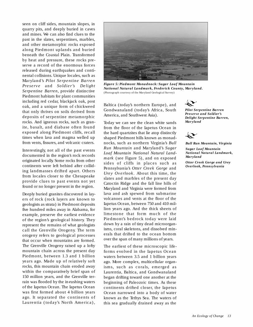
seen on cliff sides, mountain slopes, inquarry pits, and deeply buried in cavesand mines. We can also find clues to thepast in the slates, serpentines, marbles,and other metamorphic rocks exposedalong Piedmont uplands and buriedbeneath the Coastal Plain. Transformedby heat and pressure, these rocks pre-serve a record of the enormous forcesreleased during earthquakes and conti-nental collisions. Unique locales, such asMaryland’s Pilot Serpentine BarrenPreserve and Soldier’s DelightSerpentine Barren, provide distinctivePiedmont habitats for plant communitiesincluding red cedar, blackjack oak, postoak, and a unique form of chickweedthat only thrives on soils derived fromdeposits of serpentine metamorphicrocks. And igneous rocks, such as gran-ite, basalt, and diabase often foundexposed along Piedmont cliffs, recalltimes when lava and magma welled upfrom vents, fissures, and volcanic craters.
Interestingly, not all of the past eventsdocumented in the region’s rock recordsoriginated locally. Some rocks from othercontinents were left behind after collid-ing landmasses drifted apart. Othersfrom locales closer to the Chesapeakeprovide clues to past events not yetfound or no longer present in the region.
Deeply buried granites discovered in lay-ers of rock (rock layers are known togeologists as strata) in Piedmont depositsfive hundred miles away in Alabama, forexample, preserve the earliest evidenceof the region’s geological history. Theyrepresent the remains of what geologistscall the Grenville Orogeny. The termorogeny refers to geological processesthat occur when mountains are formed.The Grenville Orogeny raised up a loftymountain chain across the present dayPiedmont, between 1.3 and 1 billionyears ago. Made up of relatively softrocks, this mountain chain eroded awaywithin the comparatively brief span of150 million years, and the Grenville ter-rain was flooded by the in-rushing watersof the Iapetus Ocean. The Iapetus Oceanwas first formed about 4 billion yearsago. It separated the continents ofLaurentia (today’s North America),
Baltica (today’s northern Europe), andGondwanaland (today’s Africa, SouthAmerica, and Southwest Asia).
Today we can see the clean white sandsfrom the floor of the Iapetus Ocean inthe hard quartzites that lie atop distinctlyshaped Piedmont hills known as monad-nocks, such as northern Virginia’s BullRun Mountain and Maryland’s SugarLoaf Mountain National Natural Land-mark (see Figure 5), and on exposedsides of cliffs in places such asPennsylvania’s Otter Creek Gorge andUrey Overlook. About this time, theslates and marbles of the present dayCatoctin Ridge and the fall line hills ofMaryland and Virginia were formed fromlava and ash spewed from submarinevolcanoes and vents at the floor of theIapetus Ocean, between 750 and 410 mil-lion years ago. And the thick sheets oflimestone that form much of thePiedmont’s bedrock today were laiddown by a rain of tiny dead microorgan-isms, coral skeletons, and dissolved min-erals that drifted to the ocean bottomover the span of many millions of years.
The earliest of these microscopic life-forms evolved in the Iapetus Oceanwaters between 3.5 and 1 billion yearsago. More complex, multicellular organ-isms, such as corals, emerged asLaurentia, Baltica, and Gondwanalandbegan drifting toward one another at thebeginning of Paleozoic times. As thesecontinents drifted closer, the IapetusOcean narrowed into a body of waterknown as the Tethys Sea. The waters ofthis sea gradually drained away as the
An Ecology of Change 13
Figure 5: Piedmont Monadnock: Sugar Loaf MountainNational Natural Landmark, Frederick County, Maryland.(Photograph courtesy of the Maryland Geological Survey)
Pilot Serpentine BarrenPreserve and Soldier’sDelight Serpentine Barren,Maryland
Bull Run Mountain, Virginia
Sugar Loaf MountainNational Natural Landmark,Maryland
Otter Creek Gorge and UreyOverlook, Pennsylvania

continents collided to form Pangaea, asingle super continent, around 500 mil-lion years ago. The force of this collisionpushed together vast chunks of theearth’s crust, and the heat it generatedcaused rocks to melt into magma. Thismagma issued then from great volca-noes, fissures, and vents and flowedacross the land. Many of the gneisses,marbles, schists, granites, and slatescomprising the Chesapeake region’sbedrock were forged in this under-ground furnace. And most of theasbestos, mica, iron, nickel, gold, silver,and other minerals extracted from thehistoric mines and quarries of the regioncame from rocks pressed and heated bythese events. In Pennsylvania, Piedmontsites that preserve historic mines includethe Delta Slate Quarries, the CodorusIron Furnace, the Gap Nickel Mine,Wood’s Chrome Works, and the PequeaSilver Mine.
Pressures built up as masses of ancientsediments and younger volcanic rockspiled into one another. These pressuresproduced the Appalachian Orogeny, thesecond great mountain building episodein the region, between 450 and 250 mil-lion years ago. The highest peaks of thechain that this orogeny created soaredmore than four miles into Late Paleozoicskies. Today’s Appalachian uplands arethe much eroded remnant of this ancientmountain chain.
When the vast Pangaean land massexisted, this mountain chain lay at itscenter, near the earth’s equator. All butthe westernmost portions of the presentday Chesapeake region sat astride thisrange. Little is known about the region’senvironment at the time. Rocks tellingthis story have either eroded away, beenburied deeply, or transformed beyondrecognition by heat and pressurebeneath younger sediments.
Evidence of the earliest plant life existsin rocks found in sediments lying withintoday’s western Piedmont uplands.These preserve a record of great swampsof seed-ferns, club-mosses, and otherprimitive plants – some as tall as moderntrees–that thrived in the warm, wet climate
of the Late Paleozoic era. Horsetailsflourishing in soils far too poor for otherplants are a living representative of theseearly species in this region. LatePaleozoic swamps lined the shores of along, narrow sea that jutted into the cen-ter of Pangaea. Dead plants–preserved inacidic, stagnant swamp waters–formedthick peat sediments. These sedimentsgradually hardened into the vast coalseams that extend today in a broad arcacross the Appalachian uplands fromPennsylvania to Alabama. Mollusks,insects, bony fishes, and, eventually,amphibians swam in these ancientswamps and rivers, beneath the wings ofsix-inch dragonflies and four-inch cock-roaches. Pennsylvania’s Hopeland CoalDeposit is one of the few locales in theChesapeake region that preserves geo-logical evidence from this era.
Excavators working at places such asZion’s View Dinosaur Site in thePennsylvania Piedmont have given usglimpses of the kinds of animals thatlived in the region during the Mesozoicera between 230 and 65 million yearsago. Intriguing evidence unearthed bymodern technology further fills out ourpicture of the world at this time.Crystalline rocks brought up from deepin the earth by drilling rigs indicate thatthe rocks now underlying theChesapeake Coastal Plain originated inthe part of Gondwanaland that today isEast Africa. These rocks were left behindwhen Pangaea split apart during Triassictimes, around 200 million years ago.Consisting of the present continents ofAfrica, South America, Australia, andAntarctica, Gondwanaland broke awayand drifted south. The remaining part ofPangaea containing North America,Europe, and Asia become a new conti-nent known as Laurasia.
Chesapeake lands lay at the edge of thisnew continent and were again sub-merged by in-rushing ocean waters.Sand, mud, and other sediments flowedinto this ocean from Laurasian rivers.These sediments gradually formed a con-tinental shelf consisting of new layers oflimestone, sandstone, and shale beneaththe shallow waters of the Laurasian coast.
14 CHAPTER ONE: THE DEEP PAST
Delta Slate Quarries,Codorus Iron Furnace,
Gap Nickel Mine,Wood’s Chrome Works,
and Pequea Silver Mine,Pennsylvania
Hopeland Coal Deposit,and Zion’s View
Dinosaur Site,Pennsylvania

In these shallow, warm waters, succeed-ing generations of plankton, submergedaquatic vegetation, invertebrates, fish,and, lastly, aquatic dinosaurs made theirhomes.
Following the mass extinction ofdinosaurs and many other forms of lifearound 65 million years ago, global sealevels dropped, and the portion of conti-nental shelf containing modern dayChesapeake lands began rising abovethe waves. Discoveries of fossils of tropi-cal rainforest plants, birds, and mam-mals indicate that this region was dryland when North America split fromEurope and Asia by 50 million years ago.During the next 25 million years, theregion’s rainforests were graduallyreplaced by brushy grasslands as theearth evidently shifted somewhat on itsaxis at the same time the NorthAmerican continent drifted farther northtoward cooler latitudes. Because ofchanges in world sea level during theseyears, lands along what is now theAtlantic seaboard were periodicallyflooded and exposed.
The most complete known evidenceshowing how living things adapted tochanges in the Chesapeake region inMiocene times between 10 and 20 mil-lion years ago comes from fossils found inthe Pennsylvania Piedmont Bootlegger’sSink and the Maryland Coastal Plain’sCalvert Cliffs Preserve. The Chesapeakewas a place of grasslands and warm,shallow coastal waters during Miocenetimes. This world gradually gave way todense spruce forests and marshy tundrabordering on deep and frigid oceanwaters as the much colder Pleistoceneperiod began 2 million years ago. At leastfour major glacial advances, known asIce-Ages, occurred during this period.Each lasted more than 100,000 years. Sealevels rose and fell as glacial ice-sheetsadvanced and retreated. At their maxi-mum, the region’s Coastal Plainextended eastward as far as a hundredmiles beyond the present shoreline, asfrozen ocean waters locked into glacialice caused world sea levels to drop asmuch as three hundred feet below cur-rent elevations. Whenever warmer condi-tions melted ice-sheets, rising oceanwaters flooded continental shelf lands.
An Ecology of Change 15
CALVERT CLIFFS. The Calvert Cliffs are a line of one hundred-foot-highbluffs stretching along a thirty-mile-long expanse of Maryland’s WesternShore between Chesapeake Beach and Drum Point (see Figure 6). Stratabelonging to three Miocene-age geological formations may be viewed alongexposed portions of the cliffs.The oldest, known as the Calvert Formation, iscomposed of dry sandy clays and marls.This is overlain by the yellow sandsand green clays and marls of the Choptank Formation.The bluish clays andfine sandstones of the Saint Mary’s Formation lie at the uppermost levels ofthe cliffs.
These strata preserve evidence of the flat grasslands and shallow coastalwaters that once covered this ancient Chesapeake world. Fossils belongingto 624 species also have been found in Calvert Cliff deposits.The majority ofthese species, 408 to be exact, are mollusks.The bones of nearly two dozen
kinds of whales, porpoises, seals, and sea cows have been identified in Calvert Cliffs deposits. Such now-extinctspecies as mastodons, along with primitive types of horses, camels, rhinoceros, tapirs, deer, wolves, bears, beavers,dogs,cats,crocodiles,snakes,and turtles lived on the coastal plains.Aquatic birds,such as gannets,auks, loons,andshearwaters flew in Chesapeake skies.Various types of shark; a wide range of bony fish, including bluefish, weak-fish,ocean catfish,sturgeon,black drum,cod,sailfish,and ocean sunfish; and dense colonies of corals,crabs,clams,oysters,and scallops made their homes in the waters that periodically covered Coastal Plain lands.
Most of these animals are now long extinct or only live in warmer or wetter parts of the world.Together, theypreserve evidence of a climate that was much drier and somewhat cooler than it is today.
Figure 6: Ancient LandscapesRevealed: Rocky Point from theSoutheast, October 7, 1987, inCalvert Cliffs State Park, Maryland.(Photograph courtesy of the Maryland GeologicalSurvey)
Bootlegger’s Sink,Pennsylvania
Calvert CliffsPreserve, Maryland

Also during Pleistocene times, vastsheets of glacial ice scraped their waysacross the northern hemisphere. Duringwarmer intervals, torrents of water rush-ing from melting glaciers deposited vastsheets of sand, silt, gravel, and clayacross the Coastal Plain. Althoughcauses for these episodes remainunknown, plant pollen recovered fromcores drilled into Pleistocene agedeposits reveal something of environ-mental conditions during these times.Pollen from aquatic plants indicates thatocean temperatures averaged from 3.5 to5.5 degrees Fahrenheit cooler than thoseat present, and analysis of land plantpollen suggests that continental air tem-peratures averaged almost 10 degreesFahrenheit cooler than today. As for tem-peratures during periods when glacierswere in retreat, discoveries of pollenfrom plants adapted to warmer condi-tions in core levels dating to these peri-ods suggest prevailing temperatures thatwere on average as much as 15 to 25degrees Fahrenheit warmer than thosemeasured today.
These new sediments sluiced throughand buried earlier Coastal Plain deposits.Newly deposited glacial sediments grad-ually weathered into deep layers of gen-erally acidic, sandy or silty soils of lightto medium texture. Today, miners quarryiron ores, mineral earth pigments, green-sand marl, diatomite, clay, sand, andgravel from these sediments. DuringPleistocene times, cold-adapted spruceand pine forests grew on these newlydeposited soils. Easily penetrated by rain,river, and sea water, these soils filteredwater into vast underground aquifers offresh and brackish water. This water waslocked within layers of sand and gravel,which lay atop deeply buried imperme-able bedrock strata. Today, freshwater isgenerally found in aquifers that lie fromseveral hundred to more than one thou-sand feet deep along the western andupper eastern shores of Chesapeake Bay.Brackish waters, which percolate down-ward into the earth from saltwatersources, lie from two hundred to threehundred feet below the surface in thelower Eastern Shore and are as deep as
2,500 feet near the present mouth of theBay.
Farther inland during the Pleistoceneperiod, windswept tundra marshlands(similar to those in northern sections ofpresent day Siberia, Canada, andAlaska) covered all but the southern-most reaches of the Piedmont uplands.We can see evidence of this in severalstretches of coniferous forest in thesouthern Virginian Piedmont that aredominated by Canadian hemlock, whitepine, and in one locale, arborvitae. Asthese plant communities are commonlyfound today only in far more northerlylatitudes, the Virginia forests are believedto be remnants of late Pleistocene wood-lands. Foremost among these are the TyeRiver Hemlock-Beech Slopes and theJames River Arborvitae Bluff. Other evi-dence of the Pleistocene environment ispreserved in places like Pennsylvania’sFalmouth Potholes, where the power ofglacial meltwaters is dramatically exhib-ited in the forms of perfectly round holescut into rocks scoured smooth bycareening cascades of rocks and gravelscarried by rushing waters. Sedimentsscoured from rocks by glacial meltwaterscollected as medium textured, easilytilled, and highly fertile clayey soils inbroad Piedmont valleys. Enriched byorganic deposits laid down by successivegenerations of plant and animal life,some of these soils are now as much as ahundred feet thick. Rains and rivers pro-vide most water in the Piedmont; thepresence of bedrock close to the surfaceprevents the formation of extensiveunderground aquifers.
Bones, teeth, and horns found inPiedmont and Coastal Plain soils datingto Pleistocene times indicate that presentday Chesapeake region residents, suchas white-tailed deer, beaver, and blackbear, lived side by side with now extinctspecies such as the mammoth,mastodon, giant beaver, and easternshort-faced bear. Other finds dredgedfrom beneath the modern continentalshelf show that walruses, seals, and othersea mammals that are now found only inmore northerly latitudes thrived in the
16 CHAPTER ONE: THE DEEP PAST
Tye River Hemlock-BeechSlopes and James River
Arborvitae Bluff, Virginia
Falmouth Potholes,Pennsylvania

waters that periodically covered theCoastal Plain when melting glaciersretreated northward.
The earliest identifiable geological evi-dence of the Susquehanna, James, andother rivers that now flow intoChesapeake Bay dates to Pleistocenetimes. Melting glacial waters, coursingdown the rivers of the ancestralChesapeake region, cut new channelsacross the mid-Atlantic Coastal Plain atleast four times during periods of majorglaciation. Drilling core evidence indi-cates that all but the most recent of thesechannels now lie buried beneath layersof sand, silt, and gravel deposited by suc-cessive glacial waters.
The modern day Chesapeake regiondrainage was first formed during themost recent glacial episode. During whatis known as the Wisconsin glaciation,ice-sheets up to a mile thick coverednorthern Pennsylvania by the time theyadvanced to their maximum extentabout 18,000 years ago. Today’sChesapeake region was then a widelybranching network of narrow uplandriver channels wending their way acrossgently rolling terrain. Rising more thanthree hundred feet above present sealevel, these streams joined in a singletidal river somewhere along a now sub-merged section of the continental shelf.This river snaked its way across the level,continental shelf lowlands to its mouth,nearly a hundred miles east of the pre-sent day shoreline.
FURTHER INFORMATIONUseful sources containinginformation needed to more fullyunderstand the deep past in theChesapeake region include:
Robert L. Bates, Geology of the IndustrialRocks and Minerals (1969).
Richard J. Dent, Jr., ChesapeakePrehistory (1995:69-95).
Nevin M. Fenneman, Physiography of theEastern United States (1938).
Michael A. Godfrey, Field Guide to thePiedmont (1997).
K. Bruce Jones, et al., An EcologicalAssessment of the United States Mid-Atlantic Region (1997).
Roger Osborne and Donald Tarling, TheHistoric Atlas of the Earth (1996).
Christopher P. White, Chesapeake Bay: AField Guide (1989).
David A. Zegers, ed., At the Crossroads: ANatural History of SouthcentralPennsylvania (1994).
Further Information 17


AN ECOLOGY OF PLACEAND PEOPLE
M PLACE
People first came to the region at the endof the most recent Ice-Age sometimebetween 18,000 and 11,500 years ago(see Map 3). Several types of geologicalevidence affirm that the Chesapeakeregion looked much different then thanit does today. As in earlier times, ourguesses about how it looked come inpart from rocks, sands, gravels, and soils,which preserve records of late Ple-istocene land surfaces and waterways.Carbon 14 tests and other radiometricdating techniques reveal the ages ofcharcoal, bone, and other organic matterpreserved in buried soil layers. Much ofthis material has been brought to the sur-face in cores drilled into ancient Ice-Agelake beds and swamps, such as Virginia’sGreat Dismal Swamp. Analyses ofbones, charred wood and plants, andpollen found in pits, shell heaps, andother Paleoindian archeological depositselsewhere in North America also furnishevidence of what the Chesapeake envi-ronment might have been when peoplefirst came to the region.
This evidence suggests that Paleoindiansarrived during a colder and wetter time,
when the ice-sheets of the most recentglacial advance (known among special-ists as the Wisconsin glaciation) wereretreating northward. Chesapeake landsthemselves were never covered byWisconsin ice-sheets. Instead, they layover a hundred miles and more belowthe long ridges of gravel rubble known asmoraines. These moraines marked thesouthernmost point reached by the ice-sheets. While it was spared the devasta-tion caused by glacial ice itself, theregion experienced that power indirectly.Vast volumes of cold, muddy glacialmeltwaters from the ice’s margin surgeddown the region’s streams and rivers,and Ice-Age ancestors of today’sSusquehanna, Potomac, and Jamesrivers–laden with stone rubble and sedi-ment scraped up by the glaciers–gouged wide valleys through softPiedmont limestones. Evidence of thepower of these waters can be glimpsedin places such as Pennsylvania’sFalmouth Potholes. Unlike that soft rock,harder rocks such as quartzite and gran-ite resisted the force of meltwaters.Today, these rocks rise up over Piedmontvalleys as majestically isolated hills,ranges, and monadnocks. Farther east,those same ancestral Chesapeake riversdeposited vast layers of sand, soil, andgravel across a now-flooded coastal plainextending out as much as ninety miles
An Ecology of Place and People 19
Chapter Chapter TwoPaleoindian Life in the
Chesapeake Region,
18,000 to 9,900 Years Ago
SIGNIFICANTEVENTS
▫ 18,000 years beforepresent–most recentglacial ice-sheetsretreat
▫ 18,000 years beforepresent–possiblepre-Clovis occupationof the region begins
▫ 11,500 years beforepresent–Paleoindianpeople using Clovispoints first come toChesapeake
▫ 10,400 years beforepresent–Clovis pointsreplaced by smallerstemmed andnotched points
▫ 10,000 years beforepresent–Pleistocenemegafauna such asAmerican mammothand giant beaverbecome extinct atend of Ice-Age
▫ 9,900 years beforepresent–modernmixed hardwoodforests begin todominate the region
▫ 9,900 years beforepresent–risingtemperatures meltglacial ice formingoutline of modernChesapeake Bay
11,500 to 10,400 10,800 to 10,200 10,400 to 9,900Years before Present Years before Present Years before Present
| | |Early Paleoindian Middle Paleoindian Late Paleoindian
Phase Phase Phase
PRE-CLOVIS18,000 to 11,500
Years before Present
PossibleOccupation Sites
PALEOINDIAN PERIOD
11,500 to 9,900 Years before Present

S usquehannaRiver
Mon
ocac
yR
iver
Cho
ptan
kR
iv
er
Rapi da n Ri ve r
Pat a psco Riv er
Chester Rive
r
Ja me s Rive r
Po tomac River
Potomac River
James River
Mattaponi RiverPamunkey River
App
omat
tox
Riv
er
Rappahannock River
Patuxent R
iver
Shen
ando
ah R
iver
Poco
mok
e Riv
er
Nan
tico
ke R
iver
Chesapeake B
ay
Rappahannock
River
York Riv e r
James River
Cat
octin
Rid
ge
Sou
th M
ount
ain
Harper's Ferry Gap
Manassas Gap
Bul
l Run
Mou
ntai
n
ThorofareGap
Thornton Gap
Blu
e R
idge
Mou
ntai
ns
Rockfish Gap
Blue
Rid
ge M
ount
ains
James River Gap
SeashoreNatural Area
Charles C.Steirly
Natural Area
Great DismalSwamp
Battle CreekCypress Swamp
Belt Woods
CaledonState Park
Montpelier Forest
Sugar LoafMountain
Long Green Creekand Sweathouse Branch
Natural Area
Gilpin's Falls
Ferncliff Wildlife andWildflower Preserve
VirginiaCoast
Reserve
James RiverArborvitae Bluff
Tye RiverHemlock-Beech
Slope
CalvertCliffs Preserve
FalmouthPotholes
Washington Boro
Safe Harbor Petroglyphs
Conestoga ValleyComplex
Iron Hill/DelawareChalcedony Complex
Paw Paw CoveComplex
Higgins
CatoctinCreek
Pierpont
Dime
Isle-of-Wight
Quail Springs
Carpenter
Cactus Hill
Williamson
Point-of-Rocks
Richmond
HenricoSprings
Marine Spring Branch
ThunderbirdNHL
CapeHenry
CapeCharles
KentIsland
SmithIsland
TangierIsland
20 CHAPTER TWO: PALEOINDIAN LIFE
Map 3: Paleoindian Life in the Chesapeake Region,18,000 to 9,900 Years Ago
KEY LOCALES
ARCHEOLOGICALSITES
DelawareDelaware Chalcedony
Complex AreaIron Hill
MarylandHigginsPaw Paw CovePierpont
PennsylvaniaConestoga Valley ComplexWashington Boro
VirginiaCarpenterCatoctin CreekDimeHenrico SpringsIsle-of-WightMarine Spring BranchPoint-of-RocksQuail SpringsRichmond
LEGENDArcheological Site© National Natural Landmark
■ Natural or Cultural FeatureNational Historic LandmarkBayPlainPiedmont
0 5 10 25 50 miles
kilometers0 5 10 40 80 North

beyond the present shoreline, into anocean that had been lowered 160 feetbecause so much water was locked inglacial ice.
The Bay as we know it did not exist dur-ing Ice-Age times. Instead, it was a part ofthe wide, flat Coastal Plain. The oftenshifting channels of the ancestral Susque-hanna, Potomac, Rappahannock, andJames Rivers wended their ways throughits sand and gravel surface. Initiallygravel-choked and barren, the CoastalPlain became a place of shallow swamps,lagoons, and grasslands as the glaciersretreated and shrank, lowering the vol-ume and velocity of the region’s rivers.
Stands of spruce, pine, hemlock, birch,and alder trees began to establish them-selves as conditions grew warmer andwetter 12,000 years ago. Examples ofthese types of forests survive in small, iso-lated parts of the southern VirginianPiedmont at the Tye River Hemlock-Beech Slopes and the James RiverArborvitae Bluff. Forests such as thesesheltered and supported a vast array oflate Ice-Age plants and animals. Some,such as the American mammoth andmastodon, the eastern short-faced bear,and the giant beaver, are now extinct.Others, such as caribou, elk, and bison,no longer live in the region. But manyanimals alive at that time were speciesfamiliar to us, such as the white-taileddeer, black bear, beaver, and wild turkeythat flourish in Chesapeake habitatstoday. A wide variety of saltwater andfreshwater fish, birds, reptiles, amphibians,and invertebrates also lived in the region.
Environmental conditions grew moremoderate throughout the period. Waterfrom glaciers, melted by warmer weather,flooded into the oceans and raised sealevels worldwide. In the Chesapeakearea, rivers began finding their presentcourses as rising ocean waters graduallyflooded low lying continental shelf lands.By the end of the late Pleistocene period,oak, hickory, and maple forests weregrowing along shorelines. The bound-aries of these shorelines were beginningto resemble those that present Chesa-peake region residents would recognize.
M PEOPLE
The origins of the first people to settle inthis region remain a mystery. Neither sci-entists nor Native American traditional-ists have yet conclusively discovered theidentity of the region’s earliest inhabi-tants. Most generally agree that NativeAmericans were the first, and–for all butthe most recent five of at least 120 cen-turies–the only people living in theChesapeake region. Traditions of presentday Native American residents such asthe Piscataways, Nanticokes, andPowhatans affirm that their ancestorshave always been here. Scientists intenton reconstructing past Indian culturaltraditions struggle to decipher the mean-ings of scattered fragments of stone,bone, clay, ash, and stained soil. Theseare the only surviving identifiable physi-cal evidence of early human occupationin the region.
Nor do we know for certain when peoplefirst arrived. Some Indians believe theyare descended from people who livedalong Chesapeake shores when theworld began. Others believe their ances-tors came from elsewhere. Archeologistsalso hold differing views. Some thinkPaleoindians first arrived from some-where farther south or west sometimebetween 12,000 and 11,500 years ago.Their appearance is marked by distinc-tive, carefully crafted,lance-shaped three to six-inch-long projectilepoints made of chippedstone. Known as Clovispoints (after the NewMexico locale where theywere first identified),these graceful, sharptipped weapons weredulled along their loweredges so they would notcut the sinew or cordbindings that fastenedthem to spear shafts orhandles. All were inten-tionally made thinner bythe flaking off of long,slender fluted channels ofstone from their sides(see Figure 7).
An Ecology of Place and People 21
Figure 7: Paleoindian Fluted Points.(Diagram from Prehistoric Cultures of Eastern Pennsylvaniaused by permission of the Pennsylvania Museum andHistorical Commission ©1996)
Tye River Hemlock-BeechSlopes, Falmouth Potholes,Pan Great Dismal Swamp,and James River ArborvitaeBluff, Virginia

A small but growing group of archeolo-gists think that people using less special-ized tools of chipped stone may havearrived several thousand years earlier.They point to evidence found in placessuch as the Cactus Hill site, just south ofthe Chesapeake in Virginia’s NottowayRiver Valley. Although archeologistsdebate entry dates and immigrationroutes, all agree that the Chesapeake’searliest people are descendants of thefirst humans, who originated in Africamillions of years ago.
Most archeologists today divide theperiod when the Paleoindians occupiedthe Chesapeake into three overlappingphases. Each is marked by distinctivetypes of stone projectile points. The EarlyPaleoindian phase, from 11,500 to 10,400years ago, is marked by the Clovis pointsdescribed above. Sites associated withthe Middle Paleoindian phase, between10,800 and 10,200 years ago, tend to con-tain both Clovis and other forms of flutedand unfluted, lance-like points. The pres-ence of Dalton points, which are small,fluted and unfluted, side notched pointswith deeply curved concave bases, isconsidered a key diagnostic marker forthe Late Paleoindian phase, from 10,400to 9,900 years ago.
Most other things made and used by theregion’s past inhabitants were perishableand have long since decayed. The pres-ence of durable objects such as stonetools, bone, shell, and wood at archeo-logical sites affirms that these peoplerelied on tools and weapons made fromnaturally available materials to survive intheir late Ice-Age environment. Theygathered smoothed river cobblestonesfor quartz and mined a hard, flint-like,glassy-surfaced stone called chert fromquarries at places such as the Higginssite in Maryland. Other kinds of rocksand minerals came from elsewhere.Hard, brownish-red jasper and milkywhite rhyolite were quarried from nearbyAppalachian Mountain formations. Blackand dark green Onondaga cherts camefrom upstate New York. Colorful FlintRidge cherts with brown, red, and yellowbands were imported from as far away asthe Ohio Valley.
Like all people, Native American toolmakers tended to favor certain types ofraw materials and manufacturing stylesat certain times. Paleoindians particu-larly relied on high quality cherts thatwere strong, easily worked, and able toretain sharp edges for long periods oftime. They made projectile points,knives, scrapers, and other stone toolsout of cherts, then affixed them to wood,bone, or horn shafts and handles.Discoveries of far more numerouschipped stone scrapers, knives and thesharp-edged cracked stone flakes pro-duced during tool making show that pro-jectile points were only a small part ofthe light, portable, and reusablePaleoindian toolkit. Such tools wereessential for people who had to travel far,fast, and often. They generally traveledon foot, carrying as little as possible, totake advantage of frequently distant andwidely scattered resources only availablein certain places or at certain times.
Preserved caribou bones, turtle and fishskeletons, bird eggs, and charred nutshells found with Paleoindian tools inother sites in eastern North America indi-cate some of the plants and animalshunted and gathered by ChesapeakePaleoindians. Discoveries of sharp boneand horn needles, and stone scrapersused to remove flesh from animal hides,show that Paleoindians made and woreclothing made of skins. And discoveriesof layers of ash and charcoal, which weidentify as former hearths and fireplaces, affirm that these people used firefor cooking, warmth, and light.
Little is known about Paleoindian hous-ing and settlement patterns. What is leftat most of the known sites are small scat-terings of cracked rocks and artifacts–theremains of temporary camps left byhunting and gathering people every-where. Many sites of Paleoindian occu-pation are found in flat, open areas thatoffer commanding views of the sur-rounding terrain. At one such site, theThunderbird National Historic Land-mark which lies just west of the region inthe Shenandoah Valley near Front Royal,Virginia, archeologists have uncovered acircular ring of post-molds–small, cone
22 CHAPTER TWO: PALEOINDIAN LIFE
Cactus Hill site, Virginia
Higgins site,Maryland
Thunderbird NationalHistoric Landmark,
Virginia

shaped soil stains that are believed to bethe remains of the sharpened tips of sup-port posts and poles used to hold upshelters. This post-mold pattern is aunique find–one of the earliest knownexamples of the type of small saplingframed houses made of bark, grass, orskin that were erected at such sites.Discoveries of Paleoindian artifactsbeneath rock overhangs in places suchas Pennsylvania’s Meadowcroft site, westof Pittsburgh, suggest that ChesapeakePaleoindians also lodged in rock sheltersat the bottoms of Coastal Plain cliffs andPiedmont hillsides.
The majority of Paleoindian sites arenear reliable sources of both water androck that can be worked into tools andweapons. More than a few lie near rivers,passes, and other key transportationroutes. These sites are far apart, and theremaining deposits indicate that theywere of modest size–individual activityareas are rarely larger than a hundredsquare feet. Together, these factors sug-gest that the Chesapeake’s first peoplelived in small, mobile bands made up ofseveral related families and friends.
THE PALEOINDIANCULTURAL LANDSCAPE
M PEOPLING PLACES
Very little is presently known about pop-ulation, health, and other matters ofdemographic interest affecting thePaleoindian cultural landscape in theregion. Few intact sites and no clearlyidentifiable human remains dating to theperiod have thus far been found in eitherthe Coastal Plain or the Piedmont. Thecomplete absence of human remainssuggests that Paleoindian people eithercremated their dead or exposed them tothe elements in a manner similar to thatpracticed by other more recently docu-mented traditional societies. To interpretthe demographic significance of the fewclearly diagnostic stone tools from theperiod found in Chesapeake locales, wemust depend on data from more intactdeposits in nearby areas. Such informa-tion exists at the Shoop site above
Harrisburg, Pennsylvania, the earliermentioned Thunderbird NationalHistoric Landmark in Front Royal,Virginia, and the Cactus Hill andWilliamson sites in southeastern Virginia.
The date of arrival, demographic compo-sition, and settlement patterns of the firsthumans in the region are presentlyunknown. But from the relatively smallsize of their tools, their wide distribution,and the diverse source materials used tomake them, we can surmise thatChesapeake Paleoindians were nomads.They probably organized themselves intosmall, mobile bands of ten to fifty peopleranging across territories of up to severalthousand square miles. While theseare tiny groups by modern standards,such numbers closely match populationfigures documented in more recenttimes among the Canadian Arctic Inuit,the San people of southern Africa’sKalahari Desert, and other hunting andgathering societies living in challengingenvironments.
Physical evidence of Paleoindian culturallandscapes survives in layers of intact,buried soil at places such as the PawPaw Cove site complex in Maryland’sCoastal Plain. We find other informationby analyzing stone sources, use patterns,and style differences among Paleoindianprojectile points and other tools.Analyzable assemblages of such toolshave been found in various sites through-out the region, dredged up from thefloors of its rivers and bay waters, andscattered on the surface of its lands.
M CREATION OF SOCIALINSTITUTIONS
Recognizable physical evidence of theimprint of Paleoindian social life on theregion’s cultural landscape is also hardto find. As mentioned, known sites aresmall and scattered, a pattern which sug-gests that Paleoindians depended onsmall, flexible, and highly mobile socialgroups to make use of natural resourcesthat were often far apart and only period-ically available. Discoveries of stones inthe region that came from as far awayas New York, Ohio, and the Carolinas
The Paleoindian Cultural Landscape 23
Meadowcroft site,Pennsylvania
Thunderbird NationalHistoric Landmark,Virginia
Cactus Hill andWilliamson sites, Virginia
Paw Paw Cove site complex,Maryland
Shoop site,Pennsylvania

suggest that people belonging to thesesocieties moved across large areas andoccupied varied environments.
Anthropologists working with societiessuch as the San and the Inuit have foundthat hunting and gathering people tendto organize themselves into small bandsbound together by ties of kinship andagreement. What these ties were andhow they operated in Paleoindian soci-ety are presently unknown, though wecan surmise that these groups had to beflexible socially, because they wouldhave needed to gather together or breakinto smaller groups to meet challengesand exploit opportunities posed by theirenvironment.
As with other aspects of ChesapeakePaleoindian life, we hope to find furtherphysical evidence of these people’ssocial impact on the region’s culturallandscape in layers of intact buried soil.By analyzing stone sources, tool use,wear, and style differences, we may gainnew insights into Paleoindian family lifeand other social institutions.
M EXPRESSING CULTURALVALUES
No objects or locales clearly symbolizingPaleoindian cultural values or beliefs arepresently known in the region. Somescholars believe that distinctive projectilepoint styles or toolkits represent particu-lar cultural traditions. Such objects occurwidely across entire regions of the conti-nent. Their differences may simply moreclosely express stylistic preferences ortechnological needs than unique cul-tural values.
Some images painted on or pecked withstone hammers into rocks, boulders, andcliffs–known to specialists as pictographsor petroglyphs–have been found atplaces such as Safe Harbor (on theSusquehanna River in the PennsylvaniaPiedmont) and other locales. Some ofthese may one day be found to date toPaleoindian times. There may also bebone, horn, or shell objects, sculptedinto animal or abstract forms or deco-rated with symbolic images, waiting tobe found. These could possibly represent
cultural identity, values, or beliefs–as evi-dently those found in Upper Paleolithicsites throughout western and centralEurope do. We might also be able to seePaleoindian cultural values reflected inthe locations and distributions of placescontaining such findings.
M SHAPING THE POLITICALLANDSCAPE
As mentioned earlier, archeological evi-dence indicates that Chesapeake Paleo-indians lived in small, mobile groupsoccupying large territories. Such groupsoften depend on political decision mak-ing systems that are cooperative and flex-ible. These qualities are essential topeople who depend on the natural envi-ronment and must rely on one anotherfor survival. As seen in similar societieselsewhere and remembered in presentday Native American oral traditions,these types of political organization usu-ally require close kinship ties, widespreadsocial networks, and the abilities of lead-ers to lead by the power of persuasionrather than the persuasion of power.
We may find evidence of decision mak-ing–group movement choices, huntinggroup coordination, and ways of preserv-ing, storing, and distributing food–in thusfar undiscovered intact kill sites, storagecaches, and other deposits containingancient remains of butchered game ani-mals in the region. Future discoveries ofobjects symbolizing group political lifeand organization also may provide newinsights into political aspects of thePaleoindian cultural landscape.
M DEVELOPING THECHESAPEAKE ECONOMY
More is known about the way the econ-omy shaped Paleoindian life during thisperiod. Discoveries of stone cobbles,cores, flakes, and tools, and, more rarely,charred bits of wood, nut shells, andother plant remains preserve a record ofthe types of tools and raw materials usedby Paleoindian people in various parts ofeastern North America. Most materialsused were locally available, suggestingthat people practiced domestic forms of
24 CHAPTER TWO: PALEOINDIAN LIFE
Safe Harbor,Pennsylvania

production. Discoveries of materials, arti-fact types, and decorative styles fromelsewhere further suggest that somegoods were taken from or exchangedwith people living far beyond theregion’s borders.
Many archeologists believe that thePaleoindian’s need for high qualitystones to make the best possible toolsand weapons compelled them to centertheir settlement patterns around quarriesat stone outcrops and other sources. Thecontents of Paleoindian toolkits, domi-nated as they are by piercing, cutting,and scraping implements, are alsorevealing. They suggest the economicimportance of animal flesh and fur. Andthe widespread distribution of small sitesaffirms that Paleoindians had to traveloften to particular places to useresources available for limited periods oftime, and that they had to move on whenthose resources disappeared, were usedup, or (as with animals) wandered away.
M EXPANDING SCIENCE ANDTECHNOLOGY
Like all people, Paleoindians relied ontested techniques and searched for newsolutions to meet the demands of theirworld. They had to continually expandtheir frontiers of science and technologyto adapt to their unfamiliar, changing,and challenging environment. Forinstance, Paleoindian hunters used newthinning techniques invented elsewherein North America to produce lighter andlonger projectile points with sharper andmore extensive cutting edges. Tool-mak-ers thinned these points by removinglong flakes from their sides, allowing thepoints to be more securely inserted intothe notched ends of knife handles andspear shafts. Secure within their socketsand handles, slender points possessinggreat piercing power were less likely tobreak or shatter under stress. Evidencefound elsewhere in North America sug-gests that Chesapeake Paleoindians alsobred domesticated dogs. They probablyused these dogs for companionship, forcamp sanitation (eating refuse andkilling vermin), to carry or drag lightloads and help with hunting, and proba-
bly as food. Future discoveries of suchthings as water craft, storage containers,evidence of preservation techniques,and medicinal plant remains will pro-vide new insights into the ways Paleo-indians used science and technology.
M TRANSFORMING THEENVIRONMENT
The evidence shows that massive cli-matic changes transformed Chesapeakeenvironments during Paleoindian times.We see this both in the transition frommostly softwood to mixed hardwoodforests and in the final disappearances ofmammoths, mastodons, caribou, wal-ruses, and other species now extinct orliving elsewhere. The roles people playedin these transformations are the subjectof considerable debate. Discoveries ofthin coatings of ash on ancient tree ringsand soil strata suggest that the earliestAmericans may have practiced the kindsof forest and field burning that Europeansettlers saw Indians use during colonialtimes. But no recognizable evidenceshows that Paleoindian burning played asignificant role in regional forest transfor-mations at the end of the last Ice-Age.The impact of hunting on the disappear-ance of many animal species at this timeis less clear. Many scientists believe thatclimate changes were responsible; othersthink that the arrival of hunters into newenvironments drove some species awayand pushed others that were alreadystressed by climatic change to extinction.
Little clearly identifi-able evidence sur-vives to show howPaleoindian peoplemade their waythrough Chesapeakelands. Although theyalmost certainlyused passes suchas the Manassas,Thornton, Rockfish,and Harper’s Ferrygaps in Virginia(see Figure 8) tocross high mountainranges, we find no
The Paleoindian Cultural Landscape 25
Figure 8: Transportation Landscape: The pass atHarper’s Ferry Water Gap by moonlight, 1874.(Photograph courtesy of the Library of Congress)
Manassas, Thornton,Rockfish, and Harper’s Ferrygaps, Virginia

lingering traces of paths they might haveused there or elsewhere. We know thatrivers, streams, and bay waters alsoserved as transportation routes, but wedo not know if they used simple rafts ormore sophisticated dugout canoes orskin boats.
We may find new insights into thehuman role in transforming ChesapeakeIce-Age environments in future recover-ies of water craft and other transporta-tion artifacts; discoveries of plant,animal, and tool samples large enoughto support generalizations; and develop-ment of new techniques to more clearlylink people to their environments.
CHANGING ROLE OF THECHESAPEAKE IN THE WORLDCOMMUNITY
The coming of people to the Chesapeakelinked the region with worldwide eventsaffecting the entire human family. Boththe first people moving into the regionand those who followed brought tools,skills, and beliefs originally developed toconfront challenges posed by otherplaces and times. Archeological evi-dence indicates that Chesapeake peoplecontinually refined their tools and tech-niques and adopted new technologiesand ideas coming from as far away asEast Asia and from as near as theTennessee and Ohio River Valleys. Thefact that most Chesapeake Paleoindiansprimarily used locally available rawmaterials indicates that the region’sinhabitants rarely ventured very far fromtheir home territories. Yet the presenceof imported stone in regional sitedeposits, along with the appearancethere of new technologies such as thespear thrower and notched projectilepoints (first used by people living farthersouth and west), shows that ideas andmaterials sometimes came from else-where. One thing we know for certain isthat the Chesapeake cultural landscapechanged dramatically during the finalphase of the Paleoindian period.
FURTHER INFORMATIONUp-to-date information on the periodmay be found in:
Jay F. Custer, Prehistoric Cultures ofEastern Pennsylvania (1996:91-131).
Richard J. Dent, Jr., ChesapeakePrehistory (1995:69-145).
Theodore R. Reinhart and Mary Ellen N.Hodges, eds., Early and Middle ArchaicResearch in Virginia (1990).
Mark J. Wittkofski and Theodore R.Reinhart, eds., Paleoindian Research inVirginia (1989).
26 CHAPTER TWO: PALEOINDIAN LIFE

AN ECOLOGY OF PLACEAND PEOPLE
M PLACE
Beginning about 10,000 years ago, atwhat scientists call the dawn ofHolocene times, climatic conditionsgrew increasingly warm and dry.Because of this, oak and hickory forestsgradually replaced Ice-Age timberlandsthroughout most of the region. Rising sealevels progressively flooded the conti-nental shelf, causing Chesapeake riversto widen considerably by 8,000 yearsago. As glaciers continued to melt farthernorth, ever growing volumes of oceanwater poured into this widening basin. Inparts closest to the ocean, the region’srivers were transformed into tidal estuar-ies. Between 5,000 and 3,000 years ago,as the climate continued to moderate,these estuaries gradually widened. Theyjoined gradually to form what we nowknow as the Chesapeake Bay (see Map 4).
Archeological evidence affirms that peo-ple quickly began using this new bayand its tributaries for transportation andcommunication. Shells from Bay watershave been found in sites as far north asOntario and as far south as the Gulf ofMexico; these were almost certainlycarried by people traversing waterways
linking these regions. Discoveries of simi-lar types of pottery, tools, and housingstyles in sites around the Bay also indi-cate that people–probably floating onrafts or paddling dugout canoes–begancarrying objects and ideas acrossChesapeake waters at this time.
The Chesapeake Coastal Plain still ex-tended many miles beyond its presentshoreline at the beginning of this period.Gradually, however, its lowest lying portionswere flooded by ocean and Bay waters.Farther inland, a belt of inner CoastalPlain uplands rose more than 160 feetabove the mostly flooded outer CoastalPlain.
Rainwater, trickling through sand, silt,gravel, and clay sediments, mixed withglacial meltwater to form vast under-ground aquifers deep beneath theCoastal Plain. In lower lying areas, salt-water and brackish water wetlands grewor expanded as periodic rises in sea level(known as marine transgressions) raisedaquifer water levels to the surface.
Within the region’s waters, constantchanges in salinity, water temperature,oxygen levels, and amounts of sedimenteroding into them created an unstableand frequently harsh environment forunderwater life. So aquatic vegetation,important partly because it providesessential food and habitat for other
An Ecology of Place and People 27
Chapter ThreeHunting and Gathering Lifeways
in the Chesapeake Region,
10,000 to 1,000 Years Ago
SIGNIFICANTEVENTS
▫ 6,000 and 3,000 yearsbefore present–contemporary Bayshoreline andenvironment emerge
▫ 5,000 years beforepresent–people beginencouraging thegrowth of desirableplants
▫ 3,000 years beforepresent–regionalappearance ofpottery begins thecontainer revolution
▫ 2,500 to 1,900 yearsbefore present–distinctive copper,clay, shell, and stoneartifacts associatedwith the Ohio ValleyAdena culturaltradition appear inregional archeo-logical sites
▫ 1,500 and 1,000 yearsbefore present–squash, beans, andtobacco first culti-vated in the region
10,000-7,000 8,200-5,000 5,000-3,000 3,300-2,000 2,300-1,000years before present years before present years before present years before present years before present
| | | | |Early Archaic Middle Archaic Late Archaic/ Early Woodland Middle Woodland
Phase Phase Transitional Phase Phase Phase

Potomac River
S usquehannaRiver
Mon
ocac
yR
iver
Cho
ptan
kR
iv
er
Rapi da n Ri ve r
Pat a psco Riv er
Chester Rive
r
Potomac River
James River
Mattaponi RiverPamunkey River
App
omat
tox
Riv
er
Rappahannock River
Patuxent R
iver
Shen
ando
ah R
iver
Poco
mok
e Riv
er
Nan
tico
ke R
iver
Chesapeake B
ay
Rappahannock
River
York Riv e r
James RiverCapeHenry
CapeCharles
KentIsland
SmithIsland
TangierIsland
Cat
octin
Rid
ge
Sou
th M
ount
ain
Harper's Ferry Gap
Manassas Gap
Bul
l Run
Mou
ntai
n
ThorofareGap
Thornton Gap
Blu
e R
idge
Mou
ntai
ns
Rockfish Gap
Blue
Rid
ge M
ount
ains
James River Gap
SeashoreNatural Area
CharlesC.Steirly
Natural Area
GreatDismalSwamp
Battle CreekCypress Swamp
Belt Woods
CaledonState Park
Montpelier Forest
Sugar LoafMountain
Long Green Creekand Sweathouse Branch
Natural Area
Gilpin'sFalls
Ferncliff Wildlife andWildflower Preserve
VirginiaCoast
Reserve
CalvertCliffs Preserve
Erb Rockshelter
Chickies Rockshelter
Muddy Run Rockshelter
Duncan's Island
Higgins
WestRiver
Oxford
Sandy Hill
CranePoint
Indian Creek
AccokeekCreek NHL
Pope's Creek
Nassawango Creek
Boathouse PondPlum Nelly
White OakPoint
Rowe
Riverton
Bare Island
Piney Island
Conowingo
28 CHAPTER THREE: HUNTING AND GATHERING LIFEWAYS
Map 4: Hunting and Gathering Lifeways in the Chesapeake Region,10,000 to 1,000 Years Ago
KEY LOCALES
MarylandAccokeek CreekConowingoCrane PointHigginsIndian CreekNassawango CreekOxfordPopes CreekRivertonRoweSandy HillWest River
PennsylvaniaBare IslandChickies RockshelterDuncans IslandErb RockshelterMuddy Run RockshelterPiney Island
VirginiaBoathouse PondPlum NellyWhite Oak Point
0 5 10 25 50 miles
kilometers0 5 10 40 80 North
LEGENDArcheological Site© National Natural Landmark
■ Natural or Cultural FeatureNational Historic LandmarkBayPlainPiedmont

species, could only haltingly colonizelands submerged by the growingChesapeake Bay estuary. Nevertheless,meadows of eelgrass and widgeon grassdid begin to grow in salty waters, and amore diverse range of plants began toappear in brackish and freshwaterreaches of the Bay. Archeological discov-eries affirm that small populations of oys-ters and clams began to colonize Baywaters at this time. They were joined byanadromous fish such as shad and stur-geon, which spawn in fresh water andlive in the ocean, and a wide variety ofshore birds and migratory waterfowl.
Investigators have found the pollen ofplants that survive only under less harshenvironmental conditions in soil coresamples from Virginia’s Great DismalSwamp and other places along theCoastal Plain. These findings provide fur-ther indications that the climate did con-tinue to moderate at this time. Pollendata provide an excellent record of land-scape change. Ten-thousand-year-oldcore levels are dominated by spruce andpine pollen, affirming that Ice-Age forestsstill covered the Coastal Plain during theearliest part of the Holocene period.Increasing percentages of oak andmaple pollen in core samples of morerecent vintage reflect gradually warmerand drier conditions. These conditionsnot only encouraged the growth of themixed hardwood forests, but they alsoallowed freshwater wetlands and highand low salt marshes to come to domi-nate Coastal Plain shorelines.
We have comparatively little evidence ofPiedmont landscapes during this period.Areas above the present fall line (the lineof rapids and waterfalls separatingPiedmont waterways from navigabletidal Coastal Plain rivers running fromTrenton, New Jersey to Washington, D.C.,Richmond, Petersburg, and points south)were somewhat drier and rose muchhigher above the Coastal Plain. Drainedthen as now by free ranging, often fastmoving rivers and smaller tributarystreams only occasionally blocked bybeaver dams, tree trunks, and otherobstacles, these waterways created fewlong-lasting wetlands and lake beds.
Because of this, extensive pollen recordslike those preserved in Coastal Plain sed-iments were rarely preserved in thePiedmont. So in order to reconstructPiedmont landscapes during this period,we must rely on data from nearby areasor similar environments. Such recordssuggest that the period began with an Ice-Age landscape dominated by densespruce and pine forests, and that this grad-ually transformed into mixed oak-maplewoodlands, similar to those found alongupland parts of the inner Coastal Plain.
Throughout the Chesapeake, fire anddrought were responsible for the emer-gence of expansive, park-like woodlandsand stretches of open grassland duringthis period. Spells of drier weather andfires–whether set off naturally, by acci-dent, or by hunters driving game orclearing underbrush–created areas forthese new forests and grasslands.Openings cleared in forests allowedenough sunlight to enter to allow grasses,herbs, bushes, and other plants to grow.The seeds of berries and other desirableplants–sowed by wind, water, and thedroppings of birds and other animals–were able to germinate and prosper. Inturn, these plants attracted animals andthe people who hunted them.
M PEOPLEThese significant changes altered peo-ple’s lives in the region. New types oftools, new site locations and composi-tions, and changes in settlement andsubsistence patterns signaled that newways were emerging–ways better suitedto life in the new mixed hardwoodforests. Archeologists call this period ofcultural adjustment the Archaic period.
Preserved remains of game animals, fish,and wild plants found in sites dating tothe period’s earliest millennia show thatChesapeake people continued to maketheir living by hunting and gathering.These sites are small and widely scat-tered, showing that the people inhabitingthem were still nomadic–obliged totravel in search of needed resources.
This way of life gradually changedbetween 5,000 and 2,000 years ago. Thetransitional period marked the end of the
An Ecology of Place and People 29
Great Dismal Swamp,Virginia

Late Archaic and the beginning of theEarly Woodland phases of culturaldevelopment. Archeologists have dis-covered seeds, pollen, and charred bitsof amaranth, chenopodium, wild mus-tard, sumpweed (also called marshelder), and other seed-bearing plants inhearths, pits, and layers of debris calledmiddens. These remains indicate thatChesapeake people began encouragingthe growth of economically usefulspecies–the beginnings of food produc-tion that would later blossom into agri-culture–around 5,000 years ago. Thenumber and size of sites also increasedduring this period, suggesting that some-what larger, denser populations beganmore intensively occupying territoriesmeasuring hundreds (rather than thou-sands) of square miles.
As the timeline at the start of this chap-ter shows, archeologists divide theArchaic and Woodland periods into sev-eral phases of cultural development.
Each reflects significant changes in theregion’s environment. Each is alsomarked by the emergence and disap-pearance of distinctive artifacts, settle-ment systems, and subsistence patterns.
Distinctive chipped stone projectilepoints appear in Early Archaic phasesites dating between 10,000 and 7,000years ago (see Figure 9). Many havesmall notches chipped into their sides orcorners to tie them more firmly to han-dles, sockets, or shafts. Findings ofcharred wood, bone, and antler also pre-served in these sites suggest that EarlyArchaic people began using smallernotched points as spear heads and lancepoints to hunt white-tailed deer, blackbear, and other animals. Many archeolo-gists believe that the relatively small num-ber of Early Archaic sites in the regionreveals how hard it was for Chesapeakepeople to adapt to the new dense forestsof the early Holocene era. Others thinkmost sites dating to the Early Archaicphase have not been found yet.
New forms of small-stemmed chippedstone points dominate tool kits foundin the more numerous Middle Archaicphase sites, which date from 8,200 to5,000 years ago (see Figure 10).
30 CHAPTER THREE: HUNTING AND GATHERING LIFEWAYS
Figure 9: Points along the Early Archaic Landscape.(Diagram from Prehistoric Cultures of Eastern Pennsylvania used by permis-sion of the Pennsylvania Museum and Historical Commission ©1996)
Figure 10: Points along the Middle Archaic Landscape.(Diagram from Prehistoric Cultures of Eastern Pennsylvania used by permission of the PennsylvaniaMuseum and Historical Commission ©1996)

Discoveries of the earliest known groundslate banner stones (named for theirresemblance to small flags or banners)suggest that Chesapeake people beganusing this artifact as a counterweight onspear throwers. The added weight pro-vided by this object increased velocityand striking power of smaller stemmeddart points cast with the spear thrower.Wide, thick, and stubby, these pointswere also structurally strong tools ideallysuited for cutting and scraping.
Archeologists have also found larger andheavier stone tools, such as axes, adzes,grinding stones, and net-sinkers thatwere chipped, ground, and pecked fromlarger rocks at these sites. The growingsize and specialization of this toolkit tes-tifies to increasingly complex tasks suchas woodworking, plant processing, andlarge scale fishing. People took up thesetasks to survive in the region’s forests.
Appearances of narrower stemmedchipped stone points that would havebeen more suitable for piercing than forcutting or scraping mark the advent ofthe Late Archaic phase. In contrast,broad bladed points–considered charac-teristic artifacts of the Susquehanna,Perkiomen, and Savannah River culturaltraditions–come to dominate toolkitsassociated with the phase’s final millen-nium (see Figure 11). Scientists knowthat the earlier narrow stemmed projec-tile points tended to be crafted fromlocally available stones. In contrast,many of the stone tools found in broadblade sites in northern parts of theregion were made from jaspers andother stones from quarries in the uplandsalong the present borders of Maryland,Delaware, and Pennsylvania.
Many Late Archaic sites, which datebetween 5,000 and 3,000 years ago, con-tain much larger numbers of tools thando earlier deposits. And Late Archaicpeople evidently continued to use thesame types of small, easily erected tents,shelters, and lodges used by earlierinhabitants. The region’s earliest knownsemi-subterranean houses–with floorssunk a foot or two into the ground–dateto this time–but such structures did not
come into wider use in and around theupper parts of the region until latertimes. Storage pits, soapstone bowlscarved from soft steatite rocks (whichwere quarried from outcrops beyond thefall line), and large stone mortars–all ofwhich were required to store or processthe greater amounts of food needed by alarger, less mobile population–also appearfor the first time in Late Archaic sites.
Sites dating to the first 2,000 years of theLate Archaic phase tend to consist ofsmall scatters of discarded artifacts andgarbage, similar to those left behind byearlier people. By contrast, sites dating to
the final millennium of the phase reveala dramatic increase in food processingactivities. The evidence takes the form ofstorage pits; garbage pits filled with thebones of white-tailed deer, black bear,and other game animals; shell heaps;and large hearths of fire-cracked rock.
An Ecology of Place and People 31
Figure 11: Points along the Late Archaic Landscape.(Diagram from Prehistoric Cultures of Eastern Pennsylvania used by permission of thePennsylvania Museum and Historical Commission ©1996)

These hearths were used to roast, steam,or bake American oysters, hard clams,soft clams, American shad, and Atlanticsturgeon, which began to flourish in theregion as the lower reaches of theSusquehanna, Potomac, and James riversfinally joined into the broad, shallowestuary that is today’s Chesapeake Bay.
The appearance of new sorts of artifactsmarks the beginning of the third andfinal period when Indians were the soleoccupants of the Chesapeake region.Archeologists find smaller forms of stoneprojectile points, diamond shaped ornarrowly stemmed at their base (seeFigure 12), and fired clay pots in sites of
this period. Named the Woodlandperiod, it is also divided into Early,Middle, and Late phases. The first EarlyWoodland ceramic pots were coarse,thick bodied, and flat bottomed, like the
earlier soapstone bowls. If more recentsocieties are any guide, most if not all ofthese potters were women. Potters usedlocally available clays dug from thebanks of rivers and streams. Theyincreased the strength and durability oftheir wares by mixing tempering agents,including crushed steatite, grit, and,unlikely as it sounds, plant fiber, into wetclay before firing pots in hearths. Inmany known sites from this time, thewide range of cone and bag-shaped potsmade with a variety of tempering agentsand construction techniques suggeststhat Early Woodland potters were highlyexperimental.
The Early Woodland was also a timewhen influential new technologies cameto the region from points farther north,south, and west. New grit-tempered,cone-shaped pots decorated with impres-sions of cords wrapped around theirexteriors resembled wares produced bypotters living far to the north. These andother new types of pottery began toappear in sites along upper parts of theBay by the end of the Early Woodland,between 2,700 and 2,300 years ago.Other objects new to the region includedunsmelted, cold-hammered, round andtubular copper beads from the LakeSuperior region; chert blades and dis-tinctive stemmed and notched projectilepoints crafted from stones quarried inOhio and Indiana; ground slate tubularpipes for smoking mixtures of driedground bark and aromatic herbs; anddecorated perforated rectangular tabletsknown as gorgets. These resemble arti-facts made or used by people belongingto the Early Woodland Adena culture.Best known as the first mound buildingpeople, Adena people lived hundreds ofmiles farther west in the Ohio RiverValley.
No earthen mounds of the type erectedby Adena people throughout the OhioValley are known in the region. Arche-ologists have found Adena artifacts insome Chesapeake region burials and liv-ing areas, including the West River sitenear Annapolis and the Sandy Hill andNassawango Creek sites on the EasternShore. Deposits found at these locales
32 CHAPTER THREE: HUNTING AND GATHERING LIFEWAYS
Figure 12: Points along the Woodland Landscape.(Diagram from Prehistoric Cultures of Eastern Pennsylvania, used by permission of thePennsylvania Museum and Historical Commission ©1996)
West River, Sandy Hill,and Nassawango Creek
sites, Maryland

date from 2,500 to 1,900 years ago.Although some scholars suggest that arti-facts found in these sites were brought tothe Chesapeake by Adena immigrants,most investigators currently think thatthey were probably imported items trea-sured by Chesapeake Bay people.
The number of different types of diag-nostic stone tools and pottery styles usedby people in the region fell significantlyduring Middle Woodland times, between2,300 and 1,000 years ago. Thick bodied,capacious, sand-tempered pots are com-monly found in sites dating to this phase.These sorts of pots would be useful to amore settled people who did not have tomove as far or as often as did their prede-cessors. Stronger, lighter, and more port-able wares–tempered with shell ratherthan sand–gradually came into wide-spread use throughout the region duringthe later part of the Middle Woodlandphase. Many of these wares had carefullysmoothed exteriors or were decoratedwith geometric designs pressed or cutinto the wet clay before firing.
New forms of stemmed and notchedchipped stone points also appeared.Most tool-makers still continued to uselocally available, hard, crystalline stonessuch as quartz and chert. But as theMiddle Woodland phase wore on,imported softer sedimentary stones, suchas rhyolites from the upper PotomacValley and argillites from Pennsylvania,grew more popular in north and eastparts of the region. Another group ofnew imports–squash, beans, tobacco,and, finally, corn–would profoundlychange life in the region during thefollowing and final phase of theWoodland period.
THE CHESAPEAKEHUNTING ANDGATHERING CULTURALLANDSCAPE
M PEOPLING PLACES
Very little is known about the Archaicperiod’s demographic aspects. Sitedistributions and contents suggest that
human beings continued to populate theregion thinly at this time. No presentlyidentifiable human remains fromArchaic times have been found in thearea. Little is known, therefore, aboutArchaic period human populationdistributions, densities, or health. Asmentioned above, the complete absenceof human remains suggests that, liketheir Paleoindian predecessors, peopleliving during Archaic times eithercremated their dead or exposed them tothe elements.
Archeologists have found cremated anduncremated human remains with EarlyWoodland Adena artifacts in single andgroup graves, and they have identified amass of intermingled human bonesthought to be a charnel house used toshelter honored dead in several Adenasites in the Chesapeake Coastal Plain.Those buried in these sites generallyresembled Native American populationselsewhere at the time. Although mostarcheologists tend to agree that thesepeople were local residents, it is notknown whether they were native to theChesapeake Bay or Ohio Valley immi-grants. It is clear, however, that Adenasites have been found only at CoastalPlain locales in and around theChesapeake region. For reasons still notunderstood, similar sites have not beenfound in Piedmont valleys. And noAdena earthen mounds have yet beenfound anywhere in the region.
During Middle Woodland times, assem-blages of ceramics and stone tools fromthe Coastal Plain and the Piedmontbecome quite distinct. This suggests thatinterior Piedmont and tidewater CoastalPlain populations may have becomedistinct as well. Although much remainsunknown on this subject, differences inpopulation composition and densityalmost surely influenced the differentcultures that developed in the region,during both Middle Woodland and latertimes.
The Chesapeake Hunting and Gathering Cultural Landscape 33

M CREATION OF SOCIALINSTITUTIONS
Light, versatile, and highly portable toolassemblages have been discovered insmall sites scattered widely across theregion. These indicate that Archaic peo-ple, like Paleoindians before them,belonged to small, highly mobile bandsbound together by friendship bonds andfamily ties. And over time, the diversityand stylistic uniqueness of artifactassemblages increased, with many ofthese styles and tool types limited to par-ticular river drainages or valleys through-out the region. This may reflect theemergence of social organizations in par-ticular territories. Encompassing severalhabitats, each territory could produceenough resources to support a more set-tled type of society able to allow largernumbers of people to remain in particu-lar locales for longer periods of time.These organizations had influence overhundreds rather than thousands ofsquare miles. People living in such soci-eties had to be socially flexible enoughto cooperate and remain together longerthan their Paleoindian predecessors.
The growth in the size and number ofarcheological sites, along with increasesin the range and sophistication of toolsand technologies found within them,suggest that social life grew more com-plex during Woodland times. Chesa-peake people organized themselves intosocieties that could coordinate theefforts of even larger populations livingin increasingly smaller territories as theyadapted and adopted new tools andideas. Eventually, they even began culti-vating crops such as squash, beans, andtobacco. These were imported fromdistant places, including the Ohio andTennessee River Valleys. Although directevidence is lacking, sexual roles andattitudes, too, were almost surely trans-formed, as the new technologies of pot-tery and food production were adopted.These technologies have historicallybeen the domains of women.
Social aspects of the Middle WoodlandChesapeake cultural landscape reflectthe emergence of more formally orga-
nized types of society. Documented byanthropologists in similar societies else-where in the world, such forms of rela-tionship linked people tracing commonancestry living in different–and oftenwidely separated–locales. Successfulleaders had to be able to draw and main-tain loyal followings. The obligationrequiring family members to avengekillers of relatives prevented such leadersfrom using force to prevent followersfrom leaving their group or moving else-where. In order to keep followers, theyhad to be successful in diplomacy andwar, generous in sharing goods garneredthrough hunting, gathering, trading, andraiding, and skillful in finding ways tobest meet the needs and expectations oftheir people.
Gradually, these leaders achieved theability to pass power and influence on tosuccessors. This did not mean one’s off-spring would take on one’s leadershipposition. Instead, it meant leaders couldchose a successor, giving that personopportunities to establish authority. Manyarcheologists think these changes inMiddle Woodland social life are mostgraphically reflected in the variedappearances and diversity of potteryover time and from area to area.
M EXPRESSING CULTURALVALUES
Archeologists cannot identify for certainany expressions of cultural values inArchaic period settlement patterns,archeological deposits, or the artifactsfound in them. Some specialists dobelieve distinctive point styles or uniqueassemblages of tools represent particularcultural traditions. But, as noted in thepreceding chapter, widespread appear-ances of such objects across entireregions of North America may merelyshow that certain styles were more popu-lar and certain tools more useful.
It is easier to identify material expres-sions of cultural values in Early andMiddle Woodland artifacts and deposits.People throughout the region beganusing locally abundant clays to makefired ceramic pots and jars of different
34 CHAPTER THREE: HUNTING AND GATHERING LIFEWAYS

types and with distinctive decorations.Uniquely decorated herb, bark, andtobacco smoking pipes made of clayand stone also appeared by the end ofMiddle Woodland times. Unlike hardsubstances such as stone, bone, or horn,potters could mold wet clay into a vari-ety of forms. These forms were easilydecorated with design motifs that mayhave represented spiritual power or otheraspects of cultural belief and identity.
People living on the Coastal Plain influ-enced by cultural developments occur-ring farther south, north, and west alsoimported new raw materials to expresscultural identity at this time. Archeol-ogists have found copper from the GreatLakes and shells from the Gulf of Mexicoalong with Adena artifacts in burials andoccupation sites at various locales of theEastern Shore. In the SusquehannaValley, people buried in caches largenumbers of wide, blade-like chippedstone points from Meadowood culturesin upstate New York. During late MiddleWoodland times, Piedmont peoplebegan burying their dead in low earthenmounds similar to those made by Hope-well communities in the Ohio Valley.Although such things clearly meantsomething to the people who madethem, their exact symbolic cultural mean-ings remain mysteries to archeologists.
M SHAPING THE POLITICALLANDSCAPE
Most archeologists think that the patternof generally small and scattered archeo-logical sites of the Archaic periodreflects the existence of egalitarian politi-cal groupings characterized by close kin-ship ties, widespread social networks,and leaders possessing the ability toform coalitions. And many believe thatdiminishing rates of stylistic variabilitybetween pottery and projectile pointstyles used within smaller areas suggestheightened political boundaries andnew concentrations of authority. Newcustoms relating to the handling of thedead–including those placing rare,imported, or exotic artifacts with hon-ored ancestors–also suggests that new
status differences had emerged by Earlyand Middle Woodland times.
M DEVELOPING THECHESAPEAKE ECONOMY
We know a good deal more about tech-nological aspects of this era’s culturallandscape. Archeologists have foundlarge numbers of stone cobbles, unusedcenters of worked stone cobbles knownas cores, flakes struck from cores, andfinished tools in sites from these periods.Discoveries of unsmelted cold ham-mered copper objects, carved, cut, andburnished pieces of shell, clay, horn, andbone, and charred bits of wood, nutshells, and other plant remains also havebeen found preserved in pits, hearths,and the floors of living spaces. Takentogether, these materials provide arecord of the types of tools andresources significant in the region’seconomies. The use of materials primar-ily drawn from regional sources indicatesthat these people created most of whatthey needed locally. And the presence ofmaterials, artifact types, and decorativestyles that originated elsewhere showsthat networks for economic exchangeextended beyond regional borders.
Archeologists believe that changes intool types and raw material choicesreflect changes in the regional economy.During Early Archaic times, toolkitsshifted from inventories consistingalmost entirely of chipped stone imple-ments to assemblages incorporatingground stone axes, adzes, and grindingstones. This suggests increased relianceon trees and other plants growing in theregion’s new forests and fields, as thesetools would have been useful in produc-ing food, shelter, and other needed itemsin a forested environment. In sites datingfrom 6,000 to 3,000 years ago, we notethe appearance of shell heaps, groundstone net-sinkers, and hooks, barbs,lances, and harpoons made of sharp-ened shell and bone. The presence ofsuch sites and artifacts indicates a grow-ing dependence on resources taken fromthe waters of the newly formedChesapeake Bay.
The Chesapeake Hunting and Gathering Cultural Landscape 35
As noted earlier, the earliest known firedclay pots appear in regional sites about3,000 years ago. Archeologists considerthis to mark the beginning of what theycall a container revolution. We have onlyto consider the qualities of pottery torealize why its appearance would beconsidered revolutionary. Pottery waswatertight, light, and relatively easy tomake, repair, and replace. Pots permittedthe cooking, carrying, and storage offood, allowing people to remain in par-ticular places for longer periods ratherthan having to chase after new foodsources after a day or two. The possibili-ties opened by technologies such as pot-tery would significantly transformeconomic aspects of the regional cul-tural landscape.
Less is known about how people distrib-uted resources among themselves andtheir neighbors. As with the earlierperiod, nothing remains of the trails andfootpaths that people used in this era.But unlike the preceding period, pre-served wooden dugout canoes revealone of the technologies people used tomove on the region’s waters. Althoughtheir discovery tells us how they traveled,they neither directly disclose whichrivers were used, nor reveal when or howthey were used.
Indirect evidence is abundant. InArchaic times, the appearance of similarartifacts throughout the region and theapparent absence of artifact concentra-tions (such as those that might indicate aspecialized service or industry) withinparticular houses, sites, or regions sug-gests that goods and services moved withpeople across considerable areas. Theappearance of exotic or unique goods inburials or hoards, for their part, indicatesthat economically influential individuals,families, or political groups existed in theEarly and Middle Woodland phases.
M EXPANDING SCIENCE ANDTECHNOLOGY
Relying on tested techniques and search-ing for new solutions, Chesapeake peo-ple continually expanded the frontiers ofscience and technology as they strug-
gled to adapt to changing conditions.Several key developments occurred dur-ing this era. For example, craftsmen andcraftswomen patiently pecked andsanded slate into uniquely shaped andperforated banner stones that could beaffixed to the wooden handles of spearthrowers. The banner stone’s weight mag-nified the thrower’s strength. This and thehandle’s artificial extension of the lengthof the thrower’s arm increased both therange and striking power of lances anddarts. Chesapeake hunters and warriorsalso used new, smaller projectile pointsof chipped stone, attaching them to thetips of darts and lances. They relied onthese weapons until the appearance ofeven smaller, triangular projectile pointsat the beginning of Late Woodland times.These smaller, triangular points signaledthe adoption of bow and arrow technol-ogy, which was to prove to be vastlymore powerful and efficient.
As mentioned earlier, pottery wasanother area of great technological inno-vation during the Woodland period. Theperiod’s potters experimented with newshapes, production techniques, and tem-pering agents aiming to increase thestrength and carrying capacity of cook-ing pots and storage wares and to lightentheir weight. They sometimes decoratedthe wet clay by pressing fabrics intothem, an innovation that preserves evi-dence of advances in many fiber tech-nologies, including net construction,cord manufacture, and basket weaving.
Chesapeake people also continued theirefforts to domesticate plants and animalsduring this era. Already breeding domes-ticated dogs for companionship, campsanitation, hunting assistance, light haul-ing, and food, they also may have raisedturkeys and cared for bear cubs andother baby animals. Gardeners beganseeking fertile, well-watered soils as theyencouraged the growth of seed-bearingplants, including amaranth and wildmustard. And highly significant changesin the region’s science and technologybegan when Chesapeake Bay womenfirst planted imported squash and otherseeds during Early and Middle Wood-land times.
36 CHAPTER THREE: HUNTING AND GATHERING LIFEWAYS

M TRANSFORMING THEENVIRONMENT
Fire was the primary tool used to trans-form Chesapeake Bay environments dur-ing this era. Although direct datashowing how the region’s inhabitantsused fire in this era is lacking, evidencefrom elsewhere during the same periodstrongly suggests that Chesapeake Baypeople used fire to both drive game incertain directions and clear underbrushduring autumn and spring months.
Fires set by a growing and increasinglyconcentrated population must haveplayed a part in altering the region’s for-est and field ecosystems. Fire was usedto clear the first garden plots, which werehacked from forest floors with groundstone axes during Early and MiddleWoodland times. This early use of fireanticipated the greater impacts thatwould occur when the adoption of corn,beans, and squash required even biggerareas of cleared land at the beginning ofthe following Late Woodland phase.
M CHANGING ROLE OF THECHESAPEAKE IN THEWORLD COMMUNITY
Numerous discoveries of technologiesintroduced from outside the region attestthat the people of this time were in con-tact with the wider world. For example,both pottery and banner stones were evi-dently borrowed from people living far-ther to the south and west. The presencein the region of Adena artifacts from theOhio Valley, as well as food plants firstdomesticated in Mexico, further affirmsconnections with the world community.
Paths, rivers, and finally the fully formedChesapeake Bay became channels mov-ing ideas, implements, seeds, and peo-ple into, out of, and through the region.Although people experimented a greatdeal during these years, most relied ontried and tested tools and techniques.Only skill and efficiency could make thedifference between starvation and sur-vival, and a scant margin often separatedthe two options. It is understandable,then, that Chesapeake people were care-
ful about making use of new concepts,materials, and technologies, which camefrom people coping with different condi-tions living farther south, west, and, to alimited extent, north. We do not yet haveclear evidence that those living in theChesapeake Bay region contributed todevelopments in those places or else-where.
FURTHER INFORMATIONUseful surveys on Archaic and Earlyto Middle Woodland life in theregion include:
Jay F. Custer, Prehistoric Cultures ofEastern Pennsylvania (1996:133-261).
Richard J. Dent, Jr., ChesapeakePrehistory (1995:147-242).
Theodore R. Reinhart and Mary Ellen N.Hodges, eds., Early and Middle ArchaicResearch in Virginia (1990).
——, eds., Late Archaic and EarlyWoodland Research in Virginia (1991).
——, eds., Middle and Late WoodlandResearch in Virginia (1992).
Further Information 37


AN ECOLOGY OF PLACEAND PEOPLE
M PLACE
By the beginning of what archeologistscall Late Woodland times, by 1,100 yearsago, diverse ecosystems had developedin the Chesapeake region (see Map 5). Atthe region’s center stood the Bay, whichby then was filled out into its presentform. Its waters were wide, shallow, calm,and clear. The Bay supported a vast andcomplex food chain. Just as it does now,the base of this food chain consisted offloating microscopic aquatic plantscalled phytoplankton and tiny animalscalled zooplankton. All plankton arehighly sensitive to seasonal changes inlight, temperature, and water quality. Onedrop of water can contain thousands ofplankton. They can live either alone or ingroups. Under certain conditions, forexample, masses of phytoplankton cangather to form large mats that float onthe surface of Bay waters.
The Bay’s zooplankon range in size fromtiny single-celled protozoa to largergroups of cooperative, specialized cells.Life forms such as sea nettles and otherjellyfish are actually communities ofinterdependent zooplankton cells. Tinyimmature organisms–such as larvae of
blue crabs, bay barnacles, and freshwa-ter grass shrimps–are also consideredzooplankton. Plankton provide food forother Bay creatures such as bottomdwelling common clam worms andAmerican oysters. These and other inver-tebrates spend most of their lives in thedeeper benthic waters of the Bay. Fishsuch as Atlantic menhaden feed onthese and other organisms. In turn, thosefish become food for larger fish, such asspot, American shad, and striped bass.
More than two hundred different fishspecies are believed to have lived in Baywaters during Late Woodland times.Each species favored particular Bay envi-ronments and conditions at varioustimes of its life. Only thirty-two of thesespecies lived their entire lives in Baywaters. Most others were migratory fish,spending part of their lives in freshwaterand part in saltwater. Anadromousspecies, such as American shad,appeared each spring to spawn in fresh-water reaches of Bay tributaries.Catadromous species, such as Americaneels, migrated down freshwater rivers tobreed in the open ocean. The remains ofthese fish and all others that died in theBay were eaten by scavengers, such asblue crab and horseshoe crab.
As for plants, meadows of salt marshcordgrass and other salt tolerant plants
An Ecology of Place and People 39
Chapter FourThe Rise of Townlife,
1,100 to 500 Years Ago
SIGNIFICANTEVENTS
▫ 1,000 years beforepresent–corn, squash,beans, and tobaccobecome importantcultivated crops in theregion and bow andarrow introduced
▫ 1300 AD–people beginbuilding settled townsand Potomac Creekculture, ancestors ofthe Piscataways, moveinto lower PotomacValley
▫ 1492 and 1497– Euro-peans first discover theCaribbean and Canada,respectively
1,100 to 500 1,000 yearsyears before present before present A.D. 1300 A.D. 1492
| | | |Late Woodland Crop cultivation Settled towns European
Phase in Chesapeake in Chesapeake contactregion region

Potomac River
S usquehannaRiver
Mon
ocac
yR
iver
Cho
ptan
kR
iv
er
Rapi da n Ri ve r
Pat a psco Riv er
Chester Rive
r
Potomac River
James River
Mattaponi RiverPamunkey River
App
omat
tox
Riv
er
Rappahannock River
Patuxent R
iver
Shen
ando
ah R
iver
Poco
mok
e Riv
er
Nan
tico
ke R
iver
Chesapeake B
ay
Rappahannock
River
York Riv e r
James River
Cat
octin
Rid
ge
Sou
th M
ount
ain
Harper's Ferry Gap
Manassas Gap
Bul
l Run
Mou
ntai
n
ThorofareGap
Thornton Gap
Blu
e R
idge
Mou
ntai
ns
Rockfish Gap
Blue
Rid
ge M
ount
ains
James River Gap
SeashoreNatural AreaCharles
C. SteirlyNatural Area
GreatDismalSwamp
Battle CreekCypress Swamp
Belt Woods
CaledonState Park
Montpelier Forest
Sugar LoafMountain
Long Green Creekand Sweathouse Branch
Natural Area
Gilpin'sFalls
Ferncliff Wildlife andWildflower Preserve
VirginiaCoast
Reserve
Calvert Cliffs Preserve
Upper Bare Island Rockshelter
Blue Rock/Nace
Schultz-FunkMurry
Rosenstock
Slackwater
Shepard
WinslowHughes
WavelandFarm
Thomas
Locust Neck
Cumberland
Solomons
Nacochtank
AccokeekCreek NHL
Taft
Little MarshCreek
Posey/Indian Head
Potomac CreekJuhle
DeShazo
White OakPoint
Camden NHLBoathouse Pond
Bluefish Beach
Bull Hill Run Hatch
Jordan'sPoint
Governor'sLand
Great Neck
FlowerdewHundred
Stearns
Duck'sRun
Wessel
Lankford
Chicone
Shenks Ferry
Conowingo
CapeHenry
CapeCharles
KentIsland
SmithIsland
TangierIsland
40 CHAPTER FOUR: THE RISE OF TOWNLIFE
Map 5: The Rise of Townlife, 1,100 to 500 Years Ago
District of ColumbiaNacochtank
MarylandAccokeek CreekChiconeConowingoCumberlandDuck’s RunHughesJuhleLankfordLocust NeckPosey/Indian HeadRitterRosenstockShepardSolomonsStearnsThomasWaveland FarmWesselWinslow
PennsylvaniaBlue Rock/NaceMurrySchultz-FunkShenks FerrySlackwaterUpper Bare Island
Rockshelter
VirginiaBluefish BeachBoathouse PondBull Hill RunCamdenDeShazoFlowerdew HundredGovernor’s LandGreat NeckHatchJordan’s PointLittle Marsh CreekPotomac CreekTaftWhite Oak Point
KEY LOCALES
0 5 10 25 50 miles
kilometers0 5 10 40 80 North
LEGENDArcheological Site© National Natural Landmark
■ Natural or Cultural FeatureNational Historic LandmarkBayPlainPiedmont

flourished in tidal marshes borderingChesapeake Bay waters. Nourished byrich sediments, these few species grewabundantly, molested by few naturalpredators, and provided shelter and sus-tenance for many of the region’s animals.
Birds too flourished in the Bay. Baymarshes were important feeding andbreeding areas for waterfowl. Severalspecies of ducks, geese, and swansfeasted on aquatic vegetation and over-wintered on the Bay. Sea ducks andother birds that lived mainly on openwaters fed on clams, blue crabs, mudcrabs, crayfish, fin-fish, insects, andaquatic plants.
The Bay saw a lot of bird traffic, as itstood at the center of what is now calledthe Atlantic Flyway. On their fall flightssouth, large flocks of waterfowl stoppedin the Bay to rest. Surface-feeding or dab-bling ducks, such as American coots andlesser scaups, began arriving in August.Migratory flocks of black ducks, brants,canvasbacks, mallards, wood ducks, andother larger dabblers first began arrivingin early September and crowded intoBay waters between early October andthe middle of November. Snow andCanada geese, diving ducks such as dou-ble-crested cormorants and hooded mer-gansers, and a variety of other waterfowlalso arrived during these months. Somestayed for many weeks; others continuedon after only a brief stop in the Bay.
Few migratory birds of any type could befound on Chesapeake Bay waterwaysbetween late February and April. In thespring, the birds came back in the sameorder and on the same routes, migratingnorth to breeding grounds that for mostwere in Canada.
Bottomland and flood plain forests inboth the Coastal Plain and the Piedmontalso became key habitats for many birdspecies, and forested uplands and wet-lands provided nesting and resting spotsfor neotropical migratory birds that bredin North America and wintered inCentral or South America. Because theregion had such large populations ofspecies that birds could eat, predatoryand scavenger birds, such as red-shoul-
dered hawks, turkey vultures, baldeagles, barred owls, and others–livedthere too. Bald eagles, for example,avidly hunted waterfowl and fish in theBay and its tributaries. Turkey vultures, incontrast, feasted on the corpses of alldead animals.
Passenger pigeons, other dove-like birds,and a wide variety of songbirds andother seed, berry, or insect-eating speciesalso made their homes in Coastal Plainand Piedmont forests. Current estimatessuggest that over three hundred distinctspecies and subspecies of birds, includ-ing over thirty-seven species of water-fowl, lived in or passed across theChesapeake region during this period.
Birds were not the only animals fillingChesapeake Bay skies. Clouds of saltmarsh mosquitoes and salt marsh green-head flies rose over tidal marshes duringwarmer months. Farther inland, manykinds of worms, beetles, and otherinsects fed on plants, carrion, and livingflesh. Fleas, lice, deer flies, midges, mos-quitoes, and other small biting insectsmade meals of animal blood. Bees, but-terflies, and flies pollinated floweringplants. And in the mixed oak, maple,and pine forests that bordered CoastalPlain marshes and Piedmont hydroserewetlands, insects were the most numer-ous of the many animals that made theirhomes there.
A variety of southern mixed hardwoodforests grew within the Coastal Plain.Most were mature forests of old adulttrees dominated by ancient giants hun-dreds of years old and hundreds of feethigh. Assessing the effects of more thanfour hundred years of logging, scientistscurrently estimate that the mature forestsof the Late Woodland era stood as muchas fifty feet higher than those living in theregion today. The tops of these treestended to grow together into vastcanopies, which prevented the sunlightfrom reaching and sustaining otherplants below. The oldest of these treeshad thick trunks many feet in diameter.
On higher ground, oaks and hickoriestended to dominate mature forests.Communities of red maples, black gum,
An Ecology of Place and People 41

Atlantic white cedars, and baldcypresses grew in swampy lowlands.Loblolly pines and other softwood treesthrived on sandy soils along shorelinesand across broad expanses of the south-eastern Virginia coast.
Farther inland, in Piedmont forests,American chestnuts, a variety of oaks,poplars, American beeches, slipperyelms, and several species of ashes, gums,and hickories were abundant. Shrubs,berry bushes, sedges, and grasses grewalong the edges of forests, as well as insunny clearings such as meadows, cliffsides, and swamps. Changes in the cli-mate, periods of drier weather, and firesset off by lightning, accident, andhunters driving game or clearing under-brush, created patches of new forestgrowth and cleared openings for grasses,herbs, bushes, and other plants.
The Piedmont and Coastal Plain regionswere also home to a huge array of othercreatures. These included green frogs,bullfrogs, and at least twenty-six otherspecies of amphibians; common snap-ping turtles, eastern mud turtles, north-ern water snakes, and thirty-four otherreptile species; and more than 120species of mammals. The opossum,which carries and suckles its young in
pouches, was the only surviving marsu-pial living in the Bay region–or anywhereelse in North America–by Late Wood-land times.
All other mammals in the region wereplacental species. Open ocean aquaticmammals such as porpoises, seals, andwhales periodically visited Bay waters.Bats flew through the skies, and otters,muskrats, and beavers swam in the riversand streams. Mice, voles, and other smallrodents made their homes in marshes,grasslands, and forest floors, and a vastnumber of larger mammals lived in theregion’s forests and fields. Some weresolitary animals, including plant-eatingwoodland American bisons, omnivorousblack bears, and predatory cougars,lynxes, and bobcats. Others, such aswhite-tailed deer, raccoons, and porcu-pines, gathered together to mate or feedat various times. Still others, such as graywolves and beavers, were highly socialanimals living together in families orpacks.
M PEOPLEDuring the Late Woodland period, theregion’s human population grew, andthese people began to live in largergroups. Archeologists see evidence of
42 CHAPTER FOUR: THE RISE OF TOWNLIFE
LATE WOODLAND ENVIRONMENTS PRESERVED: NATIONALNATURAL LANDMARKS IN THE CHESAPEAKE HEARTLAND.
The National Park Service’s National Natural Landmark Program recog-nizes unique environments of national significance to the American peo-ple. Only 12 places in the Chesapeake Bay region’s heartland have thusfar been found to meet the rigorous requirements for such designation(see Appendix Three). Each is believed to preserve the kinds of environ-ments that flourished in the region during Late Woodland and early colo-nial times. Virginia’s Charles C. Steirley Natural Area and the GreatDismal Swamp tract preserve remnants of the cypress, tupelo, and whitecedar swamps that once lined the shores of waterways throughout theregion’s Coastal Plain. The 43,200-acre area of the Great Dismal Swamptract, for example, preserves a fragment of a vast wetland that extendedover 2,200 square miles of southeastern Virginia and northwestern NorthCarolina three hundred years ago. The mixed-forest community domi-nated by exceptionally tall beeches, hemlocks, tulip trees, ashes, and redoaks with wide trunks that covers the slopes of the deep ravine inLancaster County’s Ferncliff Wildflower and Wildlife Preserve (see Figure13), for its part, is regarded as one of the very few stands of untouchedvirgin forest in the Pennsylvania Piedmont.
Figure 13: Piedmont ForestLandscape: Ferncliff Wildflowerand Wildlife Preserve NationalNatural Landmark(Photograph courtesy of the LancasterCounty Conservancy)

this in the increased number of camp-sites, shell heaps, garbage dumps, and,most dramatically, in the first appear-ances of large towns occupied for longperiods of time. Such Late Woodland cul-tural developments as the farming ofcorn, bean, squash, and tobacco; theuse of the bow and arrow for huntingand war; and the rise of political systemsof unprecedented complexity, known aschiefdoms, changed ways of life in theregion considerably.
People throughout the region began tocongregate in bigger and more thicklypopulated towns where they lived forgreater parts of the year. The first clearlyidentifiable, year-round, permanent vil-lages in the region date to this period.Most were situated near reliable watersources on the fertile soil necessary forgrowing crops, which the people plantedin garden plots they hacked and burnedfrom surrounding forests. Nearby, peoplebuilt groups of sapling framed houses
An Ecology of Place and People 43
ACCOKEEK CREEK NATIONAL HISTORIC LANDMARK. The Accokeek Creek site is located on a lowsandy Coastal Plain river terrace in the lower Potomac Valley in Prince George’s County, Maryland. Thesite is situated on a major transportation and communications route on well-drained soils near reliablesources of fresh water. It is low enough to provide easy access to the water, and high enough to avoidfloods and insect pests. The site is located close to several habitats. Fish and shellfish were taken from theopen waters and tidal mud flats of adjacent rivers and streams. Plants growing in nearby fresh andbrackish water marshes furnished the raw materials of mats and roofing. Arrow arum (also known astuckahoe), cattail, and other roots and tubers found in wetlands were ground into flour for soups, cakes,and porridges. Swamp lands also provided habitats for birds and other animals avidly sought by huntersand places of refuge when raiders forced people to flee from their village.
These and other considerations have drawn people to the site at one time or another for the past 6,000years. It appears, however, to have been most intensively occupied during Late Woodland times, when thefertility of the area’s soils would have particularly appealed to farming people. Archeologists have founddense clusters of storage pits, hearths, thick layers of household refuse, and three ossuaries in and aroundpost-mold patterns of houses. Other post-mold patterns indicate that community members fortified theirtown with a stockade wall.Analysis of the thousands of pro-jectile points and broken piecesof pottery found in these depositssuggest that people erectedvillages at least twice at the siteduring Late Woodland times.The first of these, built sometimearound seven hundred years ago,was protected by a circular wall.A second, larger town, built atopthe shoreline and protected fromthe landward side by a semi-circular stockade, was evidentlyabandoned by 1550 (see Figure14). Archeologists have not yetconclusively found traces ofeither the Indian town of Moyoane,mapped by John Smith near thelocale in 1612 and burned in1630, or the Susquehannock fortknown to have been located atthe place in 1675.
Figure 14: A Preserved Late Woodland Cultural Landscape: Ground plan ofarcheological deposits associated with the ca. 1550 town site at AccokeekCreek, Maryland. (Diagram from The Accokeek Creek Site used by permission of the Museum ofAnthropology, University of Michigan ©1963)

covered in sheathings of bark, thatchedgrass, or woven cattail mats. These com-munities were moved to new localesevery ten or twenty years, after townsfolkhad depleted the nutrients in nearbysoils and used up all of the easily acces-sible firewood.
In the Coastal Plain, most towns consist-ed of collections of structures that seemnow to have been haphazardly placed,perhaps more for convenience and near-ness to friends and kin than for smoothtraffic flow or beauty of arrangement.Many Piedmont towns, by contrast, wereplanned communities of houses in a cir-cle around open plazas. They were simi-lar in plan to the larger towns of theMississippian mound builders and theother complex societies then flourishingfarther south and west, in mid-America.
Fence walls of log stakes surroundedsome of these towns. Most archeologistsidentify these palisade lines as fortifica-tions and believe that they reveal the riseof political competition and warfare inthe region. Many of these fences, how-ever, were very flimsy and may have justserved to keep out stray animals, keepwandering children in, and discouragesmall raiding parties. They also may havebeen symbolic boundaries, reflectingand reinforcing more abstract conceptsof authority and community identity.
Before this time, bodies of the dead wereexposed to the elements, cremated, orburied in individual graves or in smallcemeteries. But by Late Woodland times,the dead were increasingly buried inlarge groups. When people living inCoastal Plain communities moved to anew location, for example, they oftendug up the bones of dead relatives andburied them together in communalgraves called ossuaries near their oldhome. In contrast, people living inPiedmont valleys at this time buried theirhonored dead in low cone-shaped oroblong earthen mounds, as did peopleliving farther south and west.
The coming of Late Woodland times alsobrought dramatic changes in food pro-duction, weapons technology, tool type,and pottery style, along with other cul-
tural developments. Discoveries of pre-served pollen and carbonized remains ofseeds and other parts of domesticatedcorn, bean, squash, gourd, and tobacco–plants brought by or obtained frompeople living farther south and west–affirm that food production assumedhigh importance in many Chesapeakecommunities at this time. In placeswhere forests grew on fertile, well-drained soils near reliable sources ofwater, men and women cut and burnedthe vegetation to make planting grounds.Charred tree stumps were allowed toremain after undergrowth and brushwere burned off, and crops were sownbetween these stumps. The peopleplanted seeds and cared for seedlingswith digging sticks and with bone, horn,and stone hoes fastened onto woodenhandles. Cultivated plants were grown onraised mounds of soil, a method thatoffered some protection from frost andeased the tasks of tilling, weeding, andremoving insect pests.
Late Woodland planters allowed leafyplants such as berry bushes and succu-lent greens to grow between cultivatedmounds. These plants helped hold soilin place, reduce erosion, and divertinsect and bird pests. They also attractedwhite-tailed deer and other game ani-mals into easy range of hunters’ bowsand lances. The planters did not usemanures as fertilizer; instead, theyburned fields in the fall and spring, apractice that returned some nutrients tofield soils. However, most plots lost fertil-ity within two or three years and wereabandoned. Later colonists called theseold fields. Such plots made ideal housesites, activity areas, and gathering placesfor berries, medicinal plants, ediblegreens, and strong supple young saplingsused for house frames and tool handles.
Men and women gathered a wide varietyof plants and animals for food. Womenfilled twined fiber baskets and barkbuckets with greens, tubers, berries, andnuts. Bird and turtle nests were raidedfor eggs, and beehives plundered forhoney. Grubs and larvae–similar in tasteand texture to shrimp or shellfish–wereconsidered delicacies. Clams were
44 CHAPTER FOUR: THE RISE OF TOWNLIFE

collected on beaches and dug from mudflats. The flesh of snakes, frogs, and turtleswas prized as a tasty and desirable food.
Archeological discoveries of small, finelycrafted triangular projectile points ofchipped stone show that newly importedand more powerful bows and arrowsbecame common. Although spears orlances were still used, the bow andarrow probably replaced the spearthrower as the weapon of choice. Thenew arrow points were widely used. Theprojectile point varieties used duringMiddle Woodland times almost com-pletely disappeared, and the bannerstones of those times vanished from thearcheological record. Superior in range,accuracy, and hitting power, the bow andarrow was a major technologicaladvance for Late Woodland people.
The much expanded Late Woodlandtoolkit included other stone implements,such as knives, scrapers, and drills ofchipped stone; and axes, adzes, net-sinkers, pendants, mortars, gouges, andgrinding stones made from groundbasalt, limestone, and other rocks. LateWoodland craftspeople also used a varietyof other implements, including carvedbone needles, awls, fish hooks, andscrapers; beads of bone, shell, and copper;horn arrow points and hammers; andfired clay pots, jars, and tobacco pipes.
Stone, wood, skin, bone, and fiberserved as the raw materials for manytools. Men swung heavy axes–made ofcarefully shaped and sharpened groundstones snugly fastened onto strong wood-en handles–against tree trunks to breakbark and splinter inner wood. Then theyused firebrands to char the splinters, andin turn hacked those away. Theyrepeated this process until the tree fell.Shorn of bark and planed with groundstone adzes, many trunks became sup-port posts for houses and platforms. Theinsides of others, most often tulippoplars, were hollowed out with groundstone gouges and fire. Carefullysmoothed and shaped on the outsidewith stone adzes, those trunks becamedugout canoes, which were essential for
transport and travel on the waters of theBay and its tributaries.
Men used sharp chipped stone scrapers,planers, and knives to fashion thinnerlimbs of strong, supple trees such asalder, elm, and cedar into handles,frames, and shafts. Women used thesame kinds of tools to scrape the fleshfrom skins and cut them into clothingpattern pieces. Using twined hemp, milk-weed, and other plant fiber or animalsinews as thread, and needles made ofbone or horn, they sewed these piecestogether into skirts, shirts, leggings, loin-clothes, and other clothing. Tanned skinsof snakes were crafted into belts, girdles,and decorative sashes. Shells of commonsnapping turtles and box turtles werefixed to wooden handles, filled with peb-bles, and shaken as rattles by dancersand shamans. Women carried loadedbaskets, bundles of fire wood, and otherburdens on their backs. They stretchedtightly woven, light, and strong fur, hair,or fiber straps–known as tump lines–across their foreheads to help secure theloads.
White-tailed deer, elk, black bear, and awide range of other animals were soughtfor their fur, flesh, fat, sinew, and bone.Trappers used string and sinew snaresand dead falls of heavy logs to trapbeavers, porcupines, and other animals.Woven milkweed and hemp fiber netsoften were used to take small game suchas rabbits. For larger prey, hunters hurledstone-tipped lances and used bows ofalder or elm strung with sinew strings tofire stone and bone-tipped arrows,fletched with turkey and other bird feath-ers to generate a spinning motion thatimproved accuracy. People huntedalone, in small teams, or large groups.Groups often used fire and noise to drivepanicked animals off the edges of cliffsor stampede them into bogs, rivers, orspecially constructed brush and logenclosures, where hunters could slaugh-ter them.
Late Woodland people also used a vari-ety of tools to catch waterfowl and fishon the open waters of the Bay. Theydesigned nets made of twined fiber, hair,
An Ecology of Place and People 45

46 CHAPTER FOUR: THE RISE OF TOWNLIFE
THE ROSENSTOCK SITE: A 15TH CENTURY VILLAGE IN MARYLAND. The Rosenstock site is locatedon the Monocacy River, a major tributary of the Potomac, in the Piedmont province of Frederick County,Maryland. The site was first reported by avocational archeologists at the turn of the century when it wasunder cultivation; the site was laid fallow in the 1920s, and eventually became heavily overgrown, as itremains today. Rosenstock was briefly tested by Maryland state archeologists in 1979, and was thensubjected to three intensive 11-day field sessions held in cooperation with the Archeological Society ofMaryland, Inc., in 1990-92.
Excavations revealed a circular village pattern marked by the occurrence of large trash-filled pits at theouter edges of the village. Inside this circle of pits are a number of post-molds marking the locations ofhouses (although no distinct house patterns have yet been deciphered) and a central “plaza” area whichappears to have been largely empty. Remains from the trash pits indicate a diverse diet for the villageinhabitants. Faunal remains include deer, elk, bear, cougar, beaver, turtle, raccoon, and a variety of birds;the bones from these species were often recycled into ornaments and functional tools. The size of fishfound in the middens runs the gamut, likely indicating that nets or seines were used in the Monocacy, inaddition to line fishing as evidenced by the presence of bone fishhooks. Floral remains include a variety ofwild plants collected from throughout the rich environmental setting encompassing the site, and at leasttwo cultigens – corn and beans – have been identified. The latter were likely planted on the low Monocacyfloodplain opposite from Rosenstock’s thirty-foot-high bluff.
Artifacts from the site are typical of the “Montgomery Complex” of the middle Potomac drainage, andinclude triangular arrowpoints, cord-marked, collared ceramics known as Shepard ware, tobacco pipes,and tools such as awls, beamers, chisels, and needles. Many of the artifacts and features of this site showinfluences from the north at a time (circa A.D. 1450) when northern groups appear to have been shiftingtheir settlement locations, perhaps in response to climactic fluctuations associated with the “Little Ice Age.”These northern influences include similarities in Shepard ware to Owasco-like pottery from New York state,a small carved face stone pendant similar to those common among the Munsee, and the occurrence of“keyhole” structures (believed to be sweatlodges) just outside the village proper. The latter resemble
examples from Monongahela sites, and the two examplesfrom Rosenstock have their entryway axes at 90 degree anglesto each other, as is found at sites in western Pennsylvania.
The role played by the Rosenstock village in the MontgomeryComplex of the Potomac-Monocacy-Shenandoah region,remains the focus of continued study. Among the questionsyet to be resolved – aside from the site’s relationship to sitesfound north of Maryland – is how Rosenstock and its peoplecorrelate to 16th-century sites in the Coastal Plain commonlyassociated with historically known groups such as thePiscataway. (Text courtesy of Dennis C. Curry and Maureen Kavanagh)
Figure 15A (above left): Excavations at theRosenstock Village site during theArcheological Society of Maryland’s AnnualField Session in Maryland Archeology, May1992. These excavation units are near thesite’s central plaza area.
Figure 15B (above right): Excavation of thelower strata of a section of a large trash-filled pit at the Rosenstock Village site dur-ing the Archeological Society of Maryland’sAnnual Field Session in MarylandArcheology, June 1990. This pit containednearly 12 cubic meters of fill; several largerim and body portions of pottery vessels, aswell as deer bone, are evident.
Figure 15C: Exposedand partially excavatedview of one of the two“keyhole” structuresfound at the Rosen-stock Village site dur-ing the ArcheologicalSociety of Maryland’sAnnual Field Session inMaryland Archeology,May 1992. This semi-sub-
terranean feature, presumably a sweatlodge, contained a brokenpottery vessel and a deposit of fire-cracked rock in its entryway (top).
(All photographs courtesy of the Maryland Historical Trust)

and sinew for particular conditions, tar-gets, and tasks, entangling flocks of birdsand trapping fish. In the water, carvedwooden floats kept these nets on the sur-face of water, and stone net-sinkers andweights helped them sink and securedthem to river beds and the Bay floor. Tocatch fish in open waters, fishermenused long, sharp arrows; bone fish hooksand barbed spears; and scoop nets fixedto hoop handles made from saplings.They also impounded fish behind traps–known as weirs–which were long fencesmade of plaited saplings stretched acrossriver narrows or along shallow tidal flats.Crabs, lobsters, and shrimp were taken innets, caught by hand, and lured into spe-cially constructed traps. Blunt arrowsbrought down birds without damagingskins or feathers, which were used forornament and decoration.
New kinds of pottery appeared at variousplaces in the region. The shell-temperedTownsend ceramics frequently found inlower Delaware Valley sites came to bethe most common Coastal Plain pottery.By A.D. 1300, grit-tempered PotomacCreek wares, which were first developedin Piedmont communities, became thefavorite type of pottery among people liv-ing in lower portions of the PotomacValley as well. And people living in theJames River Valley increasingly used gritand shell-tempered wares that resembledpots used by people farther south.
These appearances and disappearancesof pottery styles in particular communi-ties or cultures probably reflect politicalupheavals resulting from changing waysof life. Many archeologists, for example,think that the gradual appearance ofPiedmont Potomac Creek wares in sitesalong the lower Potomac is evidence ofthe movement of historically chronicledPiscataway people from the interior tothe coast. Small numbers of PotomacCreek wares also appeared in sites alongthe lower James River and in the EasternShore communities that used mostlyTownsend series pots; this probablyshows that the communities had contactwith the new immigrants.
Farther north, between A.D. 1550 and1575, the shell-tempered Schultz waresthat were common in the upperSusquehanna Valley gradually replacedgrit-tempered Shenks Ferry pots in lowerSusquehanna Valley Piedmont sites.Because the disappearance of Schultzpots in the upper valley coincides withthe disappearance of Shenks Ferry potsin its lower reaches, archeologists thinkthat the Iroquoian speaking Susquehan-nock people probably moved south intothe Chesapeake Piedmont at this time.
The appearance of planned villages inthe Piedmont and the erection of promi-nent buildings, larger than most othertown houses, in Coastal Plain communi-ties suggests that the region’s politicalorganizations became chiefdoms.Chiefdoms are dynamic, aggressiveforms of political organization. They areheaded by powerful leaders and influen-tial families that have influence overlarge populations and substantialresources. One of these chiefdoms, thePowhatan Confederacy, was led by aman named Wahunsunacock. This chief-dom held sway over most Coastal Plaincommunities between the James andYork Rivers in southeastern Virginia by1607, when English colonists establishedtheir Jamestown colony in the midst ofhis domain. The story of Wahunsuna-cock and the contact between his peo-ple and European colonists is told in thenext chapter.
THE LATE WOODLANDCULTURAL LANDSCAPE
M PEOPLING PLACES
The earliest appearances of cemeteriesand ossuaries in and around sites thatcontain stylistically distinctive potterystyles limited to specific areas provideevidence that denser, more settled popu-lations occupied smaller territories dur-ing Late Woodland times. And twopieces of scientific evidence show thatmany Chesapeake people relied heavilyon corn and other starchy plants at thistime. The teeth and jaws of many buriedindividuals exhibit cavities, abscesses,
The Late Woodland Cultural Landscape 47

and other indications of poor dentalhealth caused by the decay of fragmentsof starchy food stuck between teeth. Andstable Carbon 4 isotopes indicating thepresence of corn in diets have beenidentified in the bones of manyChesapeake Bay people.
As far as the total Late Woodland popula-tion and the size of its communities areconcerned, the existing archeologicalevidence is so scattered and fragmentarythat it is impossible to estimate accu-rately. Relying on their traditions, somepresent day Native Americans claim thatLate Woodland populations may havenumbered into the hundreds of thou-sands. But because there is no evidenceof the tools, technologies, and infrastruc-ture–sewage systems, roads, and watersupply systems–necessary to supportsuch populations in the forest environ-ments of the period, most archeologiststhink that Late Woodland communitiesprobably ranged in size from a few fami-lies to several thousand people. Thosenumbers closely match population fig-ures that have been recorded morerecently among similar societies withsimilar technologies in comparable envi-ronments elsewhere in the Americas,Africa, Asia, and Oceania.
M CREATION OF SOCIALINSTITUTIONS
The significant increases in the size,number, and complexity of archeologi-cal sites and tool technologies dating toLate Woodland times points to increasesin social complexity. As they took onnew tools, crops, and ideas importedfrom cultures farther south and west andadapted them to the local social environ-ment, Chesapeake people evidentlyformed increasingly complex societiescapable of handling the needs of largerpopulations in smaller areas. The bandsof former times had probably relied oninformal bonds, but Late Woodland peo-ple probably started to keep track ofmore formally organized family lines,which linked people of common ances-try even though they lived in different,often widely separated places. Suc-cessful leaders of family lines who couldattract and keep loyal followers graduallybecame able to grant power and influ-ence to successors. Although it is notknown exactly when chiefdoms such asthe Powhatans began, influential heredi-tary leaders were exerting control overconsiderable areas of the region by theend of Late Woodland times.
M EXPRESSING CULTURALVALUES
Many apparent expressions of culturalvalues appear during this time.Cemeteries, ossuaries, shell and copperbeads and pendants, rock art in theforms of pecked petroglyphs or paintedpictographs (see Figure 16), and greateruse of locally distinctive designs on claypots and smoking pipes appear in andaround Late Woodland archeologicalsites throughout the region. Yet no physi-cal evidence tells for certain what theseand other Late Woodland culturalexpressions meant. Relying on oral tradi-tions, many present day Indian peopleregard particular archeological sites,objects, and natural features as sacred.Drawing on accounts written by colonialobservers and pointing to examples fromsimilar types of societies elsewhere inthe world, scholars suggest a range of
48 CHAPTER FOUR: THE RISE OF TOWNLIFE
Figure 16: Cultural Expressions on the Late WoodlandLandscape: Archeologist Donald Cadzow inspectingpetroglyphs near the Safe Harbor Dam, LancasterCounty, Pennsylvania, ca. 1930.(Photograph courtesy of the Pennsylvania Museum and HistoricalCommission)

possible explanations for their uses andmeanings. At the Shenks Ferry site inthe Pennsylvania Piedmont, for example,structures and burials are aligned towardthe east. This is seen as evidence that thepeople used the rising solstice sun totime the planting and harvesting ofcrops. Places and objects themselves,however, cannot speak. Unless we findsome more direct form of evidence, wecan only guess at the roles, functions,and meanings of Late Woodland culturalexpressions.
M SHAPING THE POLITICALLANDSCAPE
The more authoritarian chiefdomschronicled by colonial observers firstemerged during this period. Archeol-ogists base their understanding of politi-cal organization of this time in part onthe period’s larger, occasionally plannedcommunities, sometimes surrounded byfortified log palisades, which were moreconcentrated and located in morewidely separated portions of the region.More than one scholar has characterizedthis pattern as a series of small isolatedislands of people surrounded by vastseas of forest. Unlike leaders in earlierpolitical systems, who had served theirfollowers as firsts among equals, leadersof chiefdoms became hereditary rulersof more stratified societies. These chiefshad more political control over followersthan their predecessors did, partlybecause they were supported by priests,warriors, and others also claiming higherranks than those held by other membersof the community. This is the kind ofpolitical organization that could havecommanded the labor and energy thatleaves the type of evidence preserved inthe Late Woodland archeological recordin the Chesapeake region.
M DEVELOPING THECHESAPEAKE ECONOMY
This archeological evidence suggeststhat economic productivity increaseddramatically during Late Woodlandtimes. Such increases both provided newopportunities and posed previously
unknown challenges. New domesticatedcrops, including corn, beans, squash,and tobacco, offered possibilities ofhigher and more reliable plant foodyields. This increased dependence oncrops that promised better nutritionwhen harvests were good. But it alsobrought the possibility of famine whendrought, disease, and other disasters low-ered production.
Bows and arrows increased the rangeand striking power of weapons availableto hunters and warriors. This technologi-cal advance meant more meat in thediet, more furs for clothing, and greaterefficiency in warfare. The bow and arrowalso enhanced the prospects ofincreased productivity and peril.Promising protection and prosperity,leaders commanding warriors andhunters armed with such weapons wereable to increase control over producersand production. Those chiefs who wereskillful at using economic power byredistributing surpluses and overseeingtrade gained political control of societiesalmost everywhere in the region by theend of Late Woodland times.
M EXPANDING SCIENCE ANDTECHNOLOGY
As all of these changes and advancesworked in tandem, changes in technol-ogy affected cultural, social, and politi-cal conditions. Potters who wanted toincrease the strength and carryingcapacity of cooking pots and storagewares, for example, experimented withnew shapes, production techniques, andtempering agents such as sand, crushedshells, or ground stone mixed into wetclays to strengthen vessel walls andlighten pot weight. These better potsimproved cooking; more effectively pro-tected stored corn and other productsfrom rot, insects, and spoilage; andenabled people to transport largeramounts of goods and products faster,further, and more safely in dugoutcanoes.
As in the earlier Woodland phases,advances in net construction, cordagemanufacturing, basket weaving, and
The Late Woodland Cultural Landscape 49
Shenks Ferry site,Pennsylvania

other fiber technologies are shown inthe impressions of fabrics pressed intowet clay as decorations. Corn cobs werealso used to decorate wet clay, providingfurther evidence of the presence ofdomesticated corn, another major sci-entific and technological achievementof the period. Genetic analyses of thetypes of corn grown by Late Woodlandpeople show that Native American culti-vators chose and planted particulartypes of seed to develop strains that wereincreasingly resistant to disease, drought,and frost.
The larger and wealthier chiefdoms aris-ing in the region required larger andmore efficient forms of transportation toeffectively navigate regional waterways,so dugout canoes crafted from treetrunks grew in size and importance. Andstone drills and grinding stones con-verted shells gathered from Bay shoresinto gorgets, beads, and other kinds ofspiritually meaningful signs of wealthand status that are vital to powerfulchiefs and their communities.
M TRANSFORMING THEENVIRONMENT
The growing populations living in larger,more centralized food producing com-munities almost certainly affectedregional biological communities. Someof the activities that probably had animpact are intensified hunting, gather-ing, land clearing, and waste disposal.People helped to maintain environmen-tal conditions by ritually limiting harvestsof desirable plants and animals and byaccidentally or deliberately setting firesto clear underbrush, return nutrients tothe soil, and drive game during grouphunts. And the absence of sites inborderlands between historically docu-mented chiefdoms allowed dense under-growth to flourish; these areas were likelyto have been used by people as gamepreserves and defensive frontiers.
M CHANGING ROLE OF THECHESAPEAKE IN THEWORLD COMMUNITY
Virtually all known developments in LateWoodland Chesapeake Bay life and cul-ture can be traced to sources outside theregion. New ideas and materials traveledon the widespread river systems and trailnetworks that linked the region to otherparts of the continent, and from therethey moved eventually to the rest of theworld. As in earlier periods, then, theLate Woodland people in theChesapeake Bay region were largely thebeneficiaries of developments comingfrom elsewhere. This situation changeddramatically with the arrival of strangersfrom Europe on Chesapeake Bay shores,an event that signaled the end of LateWoodland times.
FURTHER INFORMATIONStudies reviewing what is knownand unknown about Late Woodlandpeople and places include thefollowing:
Dennis C. Curry, Feast of the Dead:Aboriginal Ossuaries in Maryland(1999).
Jay F. Custer, Prehistoric Cultures ofEastern Pennsylvania (1996:263-300).
Richard J. Dent, Jr., ChesapeakePrehistory (1995:243-60).
Barry C. Kent, Susquehanna’s Indians(1984).
Stephen R. Potter, Commoners, Tribute,and Chiefs: The Development ofAlgonquian Culture in the PotomacValley (1993).
Theodore R. Reinhart and Mary Ellen N.Hodges, eds., Middle and LateWoodland Research in Virginia (1992).
Helen C. Rountree, The PowhatanIndians of Virginia (1988).
——, and Thomas A. Davidson, EasternShore Indians of Virginia and Maryland(1997).
50 CHAPTER FOUR: THE RISE OF TOWNLIFE

AN ECOLOGY OFPEOPLE AND PLACE
M PEOPLE
As it had been for more than 12,000years, the Chesapeake was an exclu-sively Indian world when Europeannavigators began making their first ten-tative landings on North Americanshores in the early 1500s (see Map 6,page 52). Unlike their ancestors, wholived at the mercy of the climate andthe seasons, Late Woodland peopleused their abilities to produce food,develop ever more sophisticated toolsand weapons, and organize larger,more efficient social and political or-ganizations to free themselves fromcomplete dependence on their envi-ronment. They built their communitiesin clearings, surrounded by denseforests and bordering fresh and saltwater wetlands. The larger of thesetowns were fortified communities of asmany as a hundred roundhouses andlong houses. These houses consisted ofbark or grass covered sapling frames(see Figure 17, page 53).
All Late Woodland towns were locatedon or close to well-drained, fertile soils.Such soils were required by farmersgrowing corn, beans, squash, andtobacco. As in earlier Woodland times,their small fields had been slashed and
An Ecology of People and Place 51
Chapter FiveContact and Colonization,
A.D. 1500 to 1775
SIGNIFICANTEVENTS
▫ 1524–Giovanni daVerrazano pens theearliest written record ofcontact in the region
▫ 1550 to 1575–Susquehan-nock immigrants from theupper Susquehanna Riversupplant Shenks Ferryculture people in thelower PennsylvaniaPiedmont
▫ 1571 to 1585–earlySpanish and Englishcolonization attempts fail
▫ 1600–Powhatan chiefdomdevelops along the JamesRiver Coastal Plain
▫ 1607–first successfulEnglish colonyestablished atJamestown, Virginia
▫ 1612–Demand for Virginiatobacco grows in Europe
▫ 1619–enslaved Africansfirst brought to the region
▫ 1634–Maryland foundedat Saint Mary’s City
▫ 1638–Virginian traderWilliam Claiborne forciblyejected from Maryland
▫ 1642 to 1649–PuritanParliamentarians andCrown fight the EnglishCivil War; Charles I isexecuted and Englandis declared a Common-wealth in 1649
▫ 1645–Protestant Parlia-mentarians led by RichardIngles seize and plunderMaryland during EnglishCivil War.
▫ 1649–Maryland’s Actof Toleration protectsCatholic, Protestant,and Quaker worship;Act repealed in1654
▫ 1650–war and diseasereduce regional Indianpopulation to 2,400, one-tenth of pre-contact size;Colonial population risesfrom zero to 13,000during the same years
▫ 1665–Charles II restoresroyal prerogativesthroughout his domain
▫ 1675 to 1676–Susquehan-nocks dispersed andJamestown burned duringBacon’s Rebellion
▫ 1677–Treaty of MiddlePlantation (now Williams-burg) reduces Virginia’sNative American popula-tion to tributary status
▫ 1681–William Penngranted charter forPennsylvania
▫ 1688–authority ofCommonwealth’sparliamentary systemaffirmed after James IIdeposed during theGlorious Revolution
▫ 1690 to 1720–Georgianarchitecture firstbecomes model for high-style housing
▫ 1693–College of Williamand Mary founded inWilliamsburg
▫ 1695–Maryland movescapital to Annapolis
▫ 1699–Virginia’s capitalmoved from Jamestown toWilliamsburg
▫ 1700–African Americanscomprise half the region’sworkforce and fortypercent of its population
▫ 1707–Act of Union joinsScotland with England,Wales and Ireland asUnited Kingdom of GreatBritain
▫ 1717–America’s first thea-ter opens in Williamsburg
▫ 1729–Baltimore,Maryland founded
▫ 1730–Lancaster, Pennsyl-vania established
▫ 1738 to 1745–Great Awak-ening religious revivalsweeps region
▫ 1742–Richmond, Virginiais founded
▫ 1748–Petersburg, Virginiafounded
▫ 1749–Alexandria, Virginiaestablished
▫ 1750–colonial populationrises to 380,000 (AfricanAmericans comprise morethan one-third ofpopulation); Cooler andwetter climatic regime,known as Little Ice-Age,begins around this time
▫ 1762–Charlottesville,Virginia founded
▫ 1764–first tax levies,collectively known asIntolerable Acts, arousediscontent throughoutregion
▫ 1767–survey completedon Mason-Dixon Linebetween Maryland andPennsylvania
▫ 1775–regional populationreaches 700,000
1524 1571-1585 1607 1634 1750 1775| | | | | |
Earliest written Initial attempts Jamestown, Saint Mary’s Colonial Colonialrecord of at colonization Virginia City, Maryland population populationcontact established established reaches 380,000 reaches 700,000
Initial European Contacts A.D. 1492 to 1607 Colonial Period 1607 to 1775

Potomac River
Susque hanna
Ri ver
Mon
ocac
yR
iver
Cho
ptan
kR
iv
er
Rapi da n Ri ve r
Pat a psco Riv er Chester Ri v
er
Potomac River
James River
Mattaponi RiverPamunkey River
App
omat
tox
Riv
er
Rappahannock River
Patuxent R
iver
Shen
ando
ah R
iver
Poco
mok
e Riv
er
Nan
tico
ke R
iver
Chesapeake B
ay
Rappahannock
River
York Riv e r
James River
KentIsland
SmithIsland
TangierIsland
CapeHenry
CapeCharles
Cat
octin
Rid
ge
Sou
th M
ount
ain
Harper's Ferry Gap
Manassas Gap
Bul
l Run
Mou
ntai
n
ThorofareGap
Thornton Gap
Blu
e R
idge
Mou
ntai
ns
Rockfish Gap
Blue
Rid
ge M
ount
ains
James River Gap
SeashoreNatural Area
CharlesC. Steirly
Natural Area
GreatDismalSwamp
Battle CreekCypress Swamp
Belt Woods
CaledonState Park
Montpelier Forest
Sugar LoafMountain
Long Green Creekand Sweathouse
BranchNatural Area
VirginiaCoast
Reserve
PasbeheghGovernor's Land
Calvert Cliffs Preserve
Middletown "Up"
Bashore Island
Conoy TownBrand
Billmyer
WrightsvilleWashingtonBoro Complex
Frey-Haverstrick
Lancaster County Park
All Saints Cemetery
Oscar LeibhartByrd Leibhart
Schultz-FunkConestoga
RobertsShenksFerry
Strickler
ArrowheadFarm
Thomas
Burle
Broadneck
Heater'sIsland
Locust Neck
Chicone
Nottingham
PiscatawayComplex NHL
TaftLazy Point
Little Marsh Creek
Germanna
Posey/IndianHead Complex
PortTobacco
DeShazoPotomac Creek
Yoacomaco-St. Mary’sCity NHL
ComptonCumberland
Jefferson-Patterson
White OakPoint
CamdenNHL Mt. Airy
Chicacoan Complex
Downing
Owings
Indian Town Farm
WoodburyFarm
Pamunkey IndianReservation
ChickahominyComplex
FlowerdewHundredHatch
Maycock'sPoint
Jordan'sJourney
Kiser
Fort Christanna
Wright Powhatan/Tree Hill Farm
Nacochtank
SHENK FERRY CULTURE (1300-1550's)SUSQUEHANNOCKS (1550-1670's)
CONOYS (1670-1750's)
TOCKWOGHS
WIC
OMISSES
CHOPTANKS
NANTICOKES
POCOMOKESW
ICOMIC
OS
ACCOMACS
POWHATAN CHIEFDOMMONACANS
RAPPAHANNOCKS
POTOMAC CHIEFDOMMANAHOACS
PISCATAWAYS
NACOCHTANKS
ACCOHANOCS
PAMUNKEYS
52 CHAPTER FIVE: CONTACT AND COLONIZATION
Map 6: Tribal Locations and Contact Archeological Sites
0 5 10 25 50 miles
kilometers0 5 10 40 80 North
LEGENDArcheological Site© National Natural Landmark
■ Natural or Cultural FeatureNational Historic LandmarkBayPlainPiedmont

burned from the forest floor. Groups offamilies and friends from these townsmoved periodically to smaller camps tofish, hunt game, and gather shellfish andwild plants in season. And entire com-munities relocated every ten or twentyyears to new lands, when they had usedup the resources at their former site.Concentrated within strictly definedareas and surrounded by vast, uninhab-ited borderlands, these Native Americanheartlands were widely separated islandsof settlement in the otherwise unbrokenexpanses of the northeastern woodlands.
Along the coast, many of these settle-ments were linked into political unitsheld together by powerful chiefs. Amongthe more influential of these units werethe Powhatan chiefdom along the James
and York Rivers and the Potomac chief-dom in the Rappahannock and PotomacValleys. Supported by priests and war-riors, these chiefdoms held sway over ter-ritories measuring many hundreds ofsquare miles. Farther west in thePiedmont, Iroquoian speaking Susque-hannock people moved south from theupper Susquehanna River. By the late1500s, they occupied the lands of anation known to archeologists as ShenksFerry people. To the south of these lands,Monacans, Manahoacs, and otherPiedmont people found themselvesincreasingly at war with expandingCoastal Plain chiefdoms and the newlyarrived Susquehannocks. These warscame about when coastal chiefdom andSusquehannock warriors and hunterspressed into upland Piedmont forests insearch of white-tailed deer, black bears,and other game animals far less numer-ous in their own homelands farther east.
This wholly Indian world changed for-ever with the coming of Europeans (seeMap 7, page 54). The open waters ofChesapeake Bay became the stage forthe earliest direct contacts betweenthese peoples in the region. The earliestwritten record of contact in the region isa chronicle of the 1524 voyage ofGiovanni da Verrazano, an Italian cap-tain sailing in the service of King FrancisI of France. Other early impressions wererecorded by Spanish priests from Florida,who tried to establish a mission at whatthey called Ajacán on the James River in1570, and English Roanoke colonists,
An Ecology of People and Place 53
CONTACTARCHEOLOGICAL SITESDistrict of Columbia
Nacochtank
MarylandArrowhead FarmBroadneckBurleChiconeComptonCumberlandFergusonHeater’s IslandJefferson-PattersonLocust Neck
NottinghamPiscataway ComplexPort TobaccoPosey/Indian Head ComplexSt. Mary’s CityThomas
PennsylvaniaBillmyerBrandByrd LeibhartConestogaConoy Town complexFrey-HaverstickLancaster County ParkOscar Leibhart
RobertsSchultz-FunkShenks FerryStricklerWashington Boro complexWrightsville
VirginiaChicacoan complexChickahominy complexDeShazoDowningFlowerdew HundredHatchIndian PointIndian Town Farm
Jordan’s JourneyKiserLazy PointLeedstown Bead CacheLittle Marsh CreekMaycock’s PointMount AiryOwingsPamunkey Indian ReservationPasbehegh/Governor’s LandPotomac CreekTaftPowhatan/Tree Hill FarmWhite Oak PointWoodbury FarmWright
KEY LOCALES (MAP 6)
Figure 17: Filling in a Post-Mold Pattern:Reconstructed long house at the Stricklerarcheological site, Lancaster County,Pennsylvania, 1969. (Photograph from Susque-hanna’s Indians used by permission of the PennsylvaniaMuseum and Historical Commission, ©1984.)
Ajacán, Virginia

Potomac River
Mon
ocac
yR
iver
Cho
ptan
kR
iv
er
Rapi da n Ri ve r
Pat a psco Riv er
Chester Rive
r
S usquehannaRiver
Potomac River
James
Riv
er
Mattaponi RiverPamunkey River
App
omat
tox
Riv
er
Rappahannock River
Patuxent R
iver
Shen
ando
ah R
iver
Poco
mok
e Riv
er
Nan
tico
ke R
iver
Chesapeake B
ay
CapeCharles
Rappaha nnock
River
YorkRiver
James River
CapeHenry
KentIsland
SmithIsland
TangierIsland
Cat
octin
Rid
ge
Sou
th M
ount
ain
Harper's Ferry Gap
Manassas Gap
Bul
l Run
Mou
ntai
n
ThorofareGap
Thornton Gap
Blu
e R
idge
Mou
ntai
ns
Rockfish Gap
Blue
Rid
ge M
ount
ains
James River Gap
SeashoreNatural Area
CharlesC. Steirly
Natural Area
GreatDismalSwamp
Battle CreekCypress Swamp
Belt Woods
CaledonState Park
Montpelier Forest
Sugar LoafMountain
Long Green Creekand Sweathouse
Branch Natural Area
VirginiaCoast
Reserve
Gilpin’s Falls
Ferncliff Wildlifeand Wildflower
Preserve
Calvert Cliffs Preserve
Lancaster
York
Elkton
Bohemia Manor
Bladensburg
Mason-Dixon Line
Chestertown
Joppa Town
BaltimoreFrederick
Waterford
MountVernon
Sussquehannock Fort 1675
GunstonHall
KingsmillPlantation
BelmontPort Tobacco
Montpelier
Fredericksburg
Germanna-Tubal Furnace
Charlottesville
Monticello
ChristChurch
St. Mary's City
YecomicoChurch
StratfordHall
GeorgeWashington's Birthplace
Clift'sPlantation
Camden
Scotchtown
Green Springs
TuckahoeHanover County
Courthouse
Richmond
Petersburg
FlowerdewHundred
Governor'sLand
Norfolk
St. Luke'sChurch
Bacon'sCastle
BerkeleyPlantation
ShirleyPlantation
Westover
Martin's Hundred(Carter's Grove)
JamestownWilliamsburg
SusquehannaFlats
Harper’s Ferry
Mason D
ixon Line
Cambridge
Accokeek Creek
Habre-de-Venture
AquiaChurch
His Lordship'sKindness
Tulip Hill
Brandon
Elsing Green
MountAiry
Sabine Hall
Menokin
AdamThoroughgood
House
Lynchburg
Bomberger'sDistillery
EphrataCloister
Robert Fulton Birthplace
Montpelier
LondontownPublik House
AnnapolisDoughoregan
Manor
Hampton
Georgetown
Alexandria
●
●
●
●
●
●
●
●
●
●
●
●
●
●
●
●
●
●
54 CHAPTER FIVE: CONTACT AND COLONIZATION
Map 7: Contact and Colonization, A.D. 1500 to 1775
0 5 10 25 50 miles
kilometers0 5 10 40 80 North
LEGENDArcheological Site© National Natural Landmark
■ Natural or Cultural FeatureNational Historic Landmark
• City or TownBay Earliest ColonizationPlain Colonization to 1700Piedmont Expansions to 1750

who attempted to settle along the nearbyNorth Carolina coast in 1585. TheEuropeans marveled at what they con-sidered the strangeness of the inhabi-tants’ customs, the temperate nature ofthe climate, and the lushness of the land.
The native subjects of these observationspaddled their log dugout canoes into theBay to visit the ships anchored off theirshores and watched the strangers scrib-ble on pieces of paper. Attracted first bythe calm waters of the sheltered bay,European mariners soon charted thedeepest channels, where oceangoingsailing ships could drop anchor withincoves and inlets.
Trade and commerce dominated initialcontacts on these waters. The localinhabitants exchanged furs, food, andfacts for metal tools, glass beads, andother European items brought by thegrowing and diversifying group of visi-tors. Most of these were men of differentnationalities and faiths who only stayedfor a few days or weeks. Others tried toremain longer, but they were inexperi-enced and poorly supplied. Initial colo-nial efforts, such as the Ajacán missionon the James and Roanoke, collapsedquickly. But the English learned frompast mistakes, and their Virginia Companymanaged to establish the first permanent
Where, What, and When 55
Ajacán mission,Virginia
NATIONAL HISTORICLANDMARKS
District of ColumbiaGeorgetown Historic District
[18th-19th centuries]
MarylandAccokeek Creek Site [A.D.
1000-1675], Prince George’sCounty
Chestertown Historic District[18th-19th centuries], KentCounty
Doughoregan Manor [ca.1727], Howard County
Habre-de-Venture [1771],Charles County
His Lordship’s Kindness [ca.1735], Prince George’sCounty
London Town Publik House [ca.1750], Anne Arundel County
Montpelier [ca. 1745], PrinceGeorge’s County
Mount Clare [ca. 1763],Baltimore City
Tulip Hill [1756, 1790], AnneArundel County
Annapolis Landmarks
Brice House [1773]
Chase-Lloyd House [1774]
Colonial Annapolis HistoricDistrict [17th-18th centuries]
Hammond-Harwood House [ca.1774]
Maryland State House[ca. 1772]
William Paca House [1765]
Peggy Stewart House [1764]
Whitehall [ca. 1765]
St. Mary’s City Landmarks
Resurrection Manor [ca. 1660],Saint Mary’s County
Saint Mary’s City HistoricDistrict [1634-1695], SaintMary’s County
West Saint Mary’s Manor [18thcentury], Saint Mary’s County
PennsylvaniaBomberger’s Distillery [1753,
1840], Lebanon County
Ephrata Cloister [1746],Lancaster County
Robert Fulton Birthplace [ca.1765], Lancaster County
Stiegel-Coleman House [1758],Lancaster County
VirginiaAquia Church [1757], Stafford
County
Bacon’s Castle [ca. 1655],Surry County
Belmont [1761], StaffordCounty
Berkeley Plantation[1726],Charles City County
Brandon [ca. 1720], PrinceGeorge County
Camden [17th-19th centuries],Caroline County
Christ Church [1732],Lancaster County
Elsing Green [1758], KingWilliam County
Green Springs Historic District[18th-19th centuries], LouisaCounty
Greenway Court [1762], ClarkeCounty
Gunston Hall [1758], FairfaxCounty
Hanover County Courthouse[1735], Hanover County
Martin’s Hundred Carter’sGrove [17th-18th centuries],James City County
Menokin [ca. 1769], RichmondCounty
Monticello [1770-1789],Albemarle County
Montpelier [ca. 1760], OrangeCounty
Mount Airy [1762], RichmondCounty
Mount Vernon [1743, 1792-1799], Fairfax County
Sabine Hall [ca. 1730],Richmond County
Saint John’s Episcopal Church[1741], Richmond County
Saint Luke’s Church [1682],Isle of Wight County
Scotchtown [1719], HanoverCounty
Shirley Plantation [1770],Charles City County
Stratford Hall [1730],Westmoreland County
Adam Thoroughgood House[ca. 1640], Virginia Beach
Tuckahoe [ca. 1712],Goochland County
Waterford Historic District[18th-19th centuries],Loudon County
Westover [1734], Charles CityCounty
Yecomico Church [ca. 1706],Westmoreland County
Alexandria City Landmarks
Alexandria Historic District[18th-19th centuries]
Christ Church [1768]
Gadsby’s Tavern [1752, 1792]
Fredericksburg CityLandmarks
Kenmore [1752]
James Monroe Law Office[1758, 1786-1789]
Rising Sun Tavern [1760]
Williamsburg CityLandmarks
Bruton Parish Church [1715]
Peyton Randolph House [1715]
James Semple House [ca.1770]
Williamsburg Historic District[1633-1779]
Wren Building, College ofWilliam and Mary [1702]
Wythe House [ca. 1755]
KEY LOCALES (MAP 7)

European settlement at Jamestown in1607 (see Figure 18). Colonists led bycaptains John Smith and ChristopherNewport soon fanned out along theCoastal Plain. They were searching forgold, fur, potent ginseng roots, and a hal-lucinogenic plant they called Jimson(Jamestown) weed. No gold was found,the fur trade proved unreliable, the gin-seng roots were not potent enough to sat-isfy consumers, and Jimson weed nevercaught on. Two other plants, growing notwild in forests but cultivated in Indianfields and gardens, would become theeconomic mainstays of English coloniza-tion along the Chesapeake. One of these,sweet or Indian corn, would ultimatelyfeed much of the world. The other,tobacco, would soon become theregion’s wildly popular and uniquelyirresistible export.
Word of the riches to be had in theChesapeake soon attracted settlers.Thousands began sailing to the regionfrom southern English ports. Malaria, yel-low fever, and dysentery killed many ofthese men and women during their firstyears of seasoning, as the process ofacclimatization was known in the region.
In fact, far more people died from thesediseases than in the seemingly endlesswars fought with the region’s nativeinhabitants between 1610 and 1675. Butneither the threats of disease nor thedangers of attack discouraged settlerssearching for trade, wealth, and deeds topieces of the region’s land.
A continual stream of English immigrantsreplenished the numbers Jamestown lostto disease and war. First brought to theChesapeake in 1619, a small, slowlygrowing number of enslaved Africansadded to the region’s population. Otherpeople attracted to the Chesapeake’sbounty settled at various places in theregion. For example, the Eries and otherGreat Lakes native people driven fromtheir homelands by Iroquois warriorsduring the second quarter of the seven-teenth century tried to settle in thePiedmont. And traders traveled southfrom the Dutch New Netherland colonyalong the Hudson and Delaware Riversin search of pelts and plunder. One ofthem, a central European namedAugustine Hermann, established a settle-ment, christened Bohemia Manor inhonor of his homeland, at the northeastend of the Bay in 1662.
Virginian claims to the region did not gounchallenged. Powhatan leaders resistedJamestown colonists until their finaldefeat in 1646. Susquehannocks foughttoo, armed with muskets obtained fromDutch traders and Swedish colonists,who were settling their own colony onthe banks of the Delaware River between1638 and 1655. The Susquehannockschallenged anyone asserting authorityover their upper Bay domain. And theSpanish authorities issued protests fromtheir capital at Saint Augustine, continuallythreatening to drive Virginians away froma region they considered part of Florida.
English Catholics established the proprie-tary colony of Maryland in 1634, led by afavorite of the king named Leonard Cal-vert, or Lord Baltimore. This marked themost significant challenge to Virginia’sauthority in the region. Maryland colon-ists–traveling on transports named theArk and the Dove–established their first
56 CHAPTER FIVE: CONTACT AND COLONIZATION
Figure 18: Imagining a Colonial Landscape: 1660 Jamestown street scenebased on written records, museum artifacts, and archeological research.(Illustration by Keith Rocco, courtesy of the National Park Service)
Jamestown, Virginia
Bohemia Manor,Maryland

settlement on the banks of a deepPotomac River bay at a place they chris-tened Saint Mary’s City. The new settlerspurchased land there from the localYeocomico people, but they soon foundthemselves embroiled in disputes withboth Susquehannock warriors andVirginian colonists, who resented theirpresence and claimed their land.
These disputes periodically broke outinto open warfare. In 1635, for example,the Calverts confronted a Virginian set-tler named William Claiborne. In 1631,Claiborne had set up a trading post atthe southern tip of Kent Island, near pre-sent-day Annapolis, to dominate tradewith Susquehannocks controlling accessto fur sources from the interior. He wasdefeated by Marylander’s in a noisy butrelatively bloodless naval skirmish on thePocomoke River in 1635, but he continuedthe fight to remain on Kent Island. Thoughdriven from Maryland in 1638, Claibornecarried on the contest from Virginia.
Over-hunting and warfare caused the col-lapse of the fur trade by mid-century.Plantations such as Martin’s Hundred,Clift’s Plantation, and Governor’s Landreplaced trading posts as the most impor-tant settlements on the Bay. Planters firsterected hastily constructed, earthfaststructures whose wooden support postswere sunk directly into the ground ratherthan in stone, brick, or cement founda-tions. Although earthfast construction al-lowed settlers to build houses quickly andcheaply, such foundations rotted swiftlyin the wet soils of the region. More substan-tial structures, known as great or manorhouses, only began appearing in largenumbers later in the seventeenth cen-tury. Most of these buildings were frameand brick edifices resting on stone or
masonry foundations and constructed inthe high-styles then popular in England.
Whatever their size or level of style,houses and surrounding plantationswere situated on rich, black soils alongnavigable stretches of waterways cours-ing through the Coastal Plain. Plantersliving along shallower stretches had longwooden wharfs built out into deeperwaters to accommodate ocean-goingships (See Figure 19). Colonists quicklyrevealed a preference for home sites,fields, and other tracts already clearedby Indians as they moved onto landspurchased or seized from their originalowners. These colonists depended onCoastal Plain waterways to link their -scattered sites–plantations, farms, fac-tories, tobacco storehouses (also knownas rollhouses, a reference to rollwagons(see Figure 20), large, barrel-like hogs-head casks drawn by horses, mules, oroxen, used to store and convey tobaccofrom farms to docks), shops, churches,courthouses, taverns, and inns (calledordinaries)–with the few small citiesestablished during the first century ofcolonization. These included James-town, Williamsburg, and Saint Mary’sCity.
Settlers milled lumber cut from localforests to build small shallow drafted oneor two masted sailing ships, known asshallops, and other small craft. Thesewere used to ply the shallower tidewaterbays and inlets, where English colonistslocated most of their settlements. Slowly,the Bay grew into an important commer-cial artery. Oceangoing sailing ships car-rying settlers, slaves, and imports fromEurope, Africa, and the Caribbean laidup alongside various docks to take on
An Ecology of People and Place 57
Figure 19: Moving Goods by Water alongthe Coastal Plain Landscape: Reconstruc-tion of a Chesapeake landing duringcolonial times. (Sketch by Edwin Tunis, used bypermission of HarperCollins Publishers ©)
Figure 20: Moving Goods Overland Acrossthe Coastal Plain Landscape: Reconstruc-tion of an ox-drawn hogshead roll wagonused to convey tobacco on rolling roads.(Sketch by Edwin Tunis, used by permission ofHarperCollins Publishers ©)
Saint Mary’s City,Maryland
Jamestown andWilliamsburg, Virginia
Saint Mary’s City,Maryland
Martin’s Hundred,Clift’s Plantation,and Governor’s Land,Virginia

cargoes of lumber, grain, tobacco, andother Chesapeake products. On shore,small fishing communities grew upalongside major port towns. Tidal waterand wind powered mills and pumpsbegan draining more accessible wet-lands for fresh groundwater.
European settlers faced challenges theycould not have predicted. For example,the tidewater soils–well watered andhighly organic–were initially too rich forEuropean crops. Wheat planted in newfields grew extravagantly abundant fol-iage, but produced little grain. Tobacco,however, thrived in such soils (see Figure21). But tobacco was a demanding crop,requiring constant care and exhaustingeven the richest ground after three orfour years. Large amounts of cow, horse,pig, and chicken manure spread onthese spent fields could restore thedegree of fertility needed for wheat,corn, flax, and other crops, but manur-ing was time consuming and expensive.Instead, because the expanses of land inthe tidewater seemed limitless, mostplanters abandoned their old fields andtemporary support structures and movedon. Such practices soon produced thetidewater landscape that colonialobservers decried–one of broken downfarms and weed-strewn, exhausted fields.
Demand for labor increased as cultiva-tion consumed ever-larger expanses ofnew lands. Plantation owners usedindentured servants, free laborers, and,increasingly, enslaved Africans to growtobacco for export and to raise corn,cotton, flax, cattle, and pigs for local
consumption. African Americans madeup fully half the region’s workforce by1700. Not all Africans coming to Chesa-peake Bay labored as slaves. And, mostof the region’s first laborers were impov-erished Europeans who agreed to workfor a stipulated number of years forlandowners willing to pay their passage.African servants of frontier traders occa-sionally played important roles, establish-ing close relationships with Indianclients. By learning Indian languagesand becoming familiar with their cus-toms, several became significant culturebrokers, go-betweens possessing skillsessential to conduct business and diplo-macy among people belonging to vastlydifferent cultures.
As conflict continued to plague theregion, diplomatic skills became increas-ingly important. Intercolonial strugglesand wars with Indians devastated com-munities everywhere. Conflicts betweenrich and poor and between those favoringlocal control and those defending royalprivilege sometimes broke out into openwarfare. And a combination of economiccompetition, border disputes, and religiousdisagreements kept Virginia, Maryland,and their provincial neighbors to thenorth and south in constant conflict.
Old World struggles, too, spilled acrossthe ocean to ensnare Chesapeake peo-ple. These included the English Civil Warof 1642-1649, the Glorious Revolution of1688, and the four European imperialwars fought in the Americas by Britain,France, and Spain between 1689 and1760. The first shots of this last war,known as the Seven Year’s or French andIndian War, were fired in 1754 by troopsled by a young Virginian militiamannamed George Washington. Sent beyondthe Blue Ridge by Virginia’s royal gov-ernor, Robert Dinwiddie, Washingtonand his troops were contesting Frenchexpansion into western lands claimed byhis province.
Other disputes dragged on for years. Theprotracted boundary dispute betweenPennsylvania and Maryland, which hadbegun when Pennsylvania received itscharter in 1681, was only settled with the
58 CHAPTER FIVE: CONTACT AND COLONIZATION
Figure 21: Agricultural Landscape: Maryland tobacco field and barns.(Photograph courtesy of the Maryland Historical Trust)

completion of the Mason-Dixon surveyline in 1767. Protestants periodicallytried to drive away Catholic colonists, aswhen Puritans supported Parliamentarypartisan Richard Ingle’s seizure ofMaryland from the Catholic Calverts in1645, during the English Civil War. Atother times, Maryland Catholics tried tosuppress Protestant denominations. AndProtestants also fought among them-selves in these years. Anglicans support-ing the king periodically clashed withmilitant Puritans; Maryland Catholicsallied themselves with one Protestantfaction or another when political strug-gles swept through the region. Finally, butnot in an eager or an organized manner,contending provinces and factions hadto band together to resist both Indianattacks and the threatened invasions ofrival European powers.
Native and new diseases continued toravage communities without regard totheir politics, religion, or race. Indiannations, unable to replenish populationsdevastated by war and new diseasessuch as smallpox, were forced to submitto English rule. The English were able toreplace losses with a seemingly endlessflow of new immigrants and supplies fromthe mother country and other colonies.Drawing on their vast support network,which stretched across the NorthAtlantic world, the English finally man-aged to consolidate political control overChesapeake Bay’s Coastal Plain by 1700.
The English employed a variety of frame-works to govern their colonies. Virginiabegan as a charter colony under the con-trol of the Virginia Company. The Crowngranted charters to boards of corporatestockholders extending rights to colonizeand govern often vaguely demarcatedareas not yet reduced to royal control. In1624, Virginia also became the firstEnglish province to become a royalcolony under the direct control of theCrown. Maryland and Pennsylvania, bycontrast, were organized as proprietarycolonies under the control of influentialproprietors granted authority over partic-ular areas by the English crown. ThePenn family was given control of the gov-ernment and all lands within Penn-
sylvania; the Calvert family, whose suc-cessive heads held the title Lord Balti-more, had the same rights in Maryland.Both families held monopolies on thesale and rental of all provincial landswithin their proprietary bounds, andboth zealously maintained these rightsup to the time of the Revolution.
The English organized their colonies intopolitical units, each with its own bound-aries, rights, and responsibilities. Theycalled these units provinces, counties,parishes, townships, municipalities, andhundreds. The origin and meaning ofhundreds–and the exact amount of landthey included–are only vaguely under-stood today. We do know that hundredswere judicial districts, larger thanparishes and smaller than counties. Anarea could be considered a hundred if iteither contained a hundred eligible vot-ers or could mobilize a like number ofmilitiamen.
Social boundaries, too, became morepronounced, as profits from free andslave labor concentrated wealth in thehands of influential families and,depending on the type of colony, propri-etary authorities, corporate directors, orplacemen appointed to positions ofpower and influence by the Crown.Governors-general, appointed by theCrown and responsible for both the gov-ernance and defense of their colonies,consulted with provincial councils andassemblies made up of these new elites.By 1700, these groups had establishednew state capitals at Annapolis inMaryland (1695) and at Williamsburg inVirginia (1699). Several Chesapeakecities were laid out in accordance withcarefully designed ground plans. Othersdeveloped in a somewhat more haphaz-ardly spontaneous manner. Many popu-lation centers grew up around countycourts, community churches, river fords,and important crossroads. The legal andreligious needs of isolated communitieswere served by judges and ministersmaking regularly scheduled circuitsthrough thinly populated districts.
Numbers and densities of English andAfrican populations increased dramati-
An Ecology of People and Place 59
Mason-Dixon surveyline, Maryland andPennsylvania
Annapolis, Maryland
Williamsburg, Virginia

cally in most parts of the Coastal Plain inthe 1700s. Population expansion and theclosing of established harbors, such asPort Tobacco after it filled with silteroded from cleared fields and forests,required construction of new cities andtowns. Many, such as Baltimore (estab-lished in 1729), were built alongsidewide harbors providing sheltered deepwater anchorages for large numbers ofoceangoing vessels. Others were con-structed on mostly level plots of landnear rapids. Such plots were highly val-ued, as they could both accommodatewarehouses and be near the fall of waterneeded to power mill wheels. The largerof these towns were built at the heads ofnavigation of rivers (the uppermost limitsof oceangoing boating) in fall linelocales such as Richmond on the James(founded at the site of Shoccoe’sWarehouse in 1742), Petersburg on theAppomattox (established in 1748), andAlexandria on the Potomac (founded atthe Hunting Creek Warehouse in 1749).
Although swamps and pine barrens werehard to penetrate, farms grew on clear
cut, arable land throughout the CoastalPlain as more enslaved Africans werebrought into the provinces of Marylandand Virginia. Larger farms relying on thelabor of large numbers of slaves grewinto opulent plantations. Slaves cut tim-ber into fence rails to enclose ever largerfields, to demarcate their master’s prop-erty, and to protect crops from free rang-ing livestock. Much more than fencescame to separate people living side byside as slaves and freemen. These socialdivisions created a new world in tidewa-ter areas, a world marked by increasingextremes of wealth and poverty.
As the most favorable Coastal Plainlocales were taken up, tidewater specula-tors began staking claims to lands abovethe fall line in the Maryland and VirginiaPiedmont. Although European explorerstraveled up the rivers coursing throughthe Piedmont by the 1650s, no perma-nent English settlements had yet beenbuilt in the interior. This situationchanged dramatically after Bacon’sRebellion broke out in 1675. Namedafter its leader, Virginian Nathaniel
60 CHAPTER FIVE: CONTACT AND COLONIZATION
COLONIAL ANNAPOLIS HISTORIC DISTRICT. Designation as an historic district preserves thedistinctive street plan and buildings constructed after Annapolis was made Maryland’s capital in 1695(see Figure 22) Unlike the earlier capital at Saint Mary’s City, which was built alongside a relatively small,shallow harbor that was close to the mouth of the Bay and vulnerable to sudden attacks from the sea,Annapolis was located in a more secure position farther up the Bay on the banks of a well-sheltereddeepwater harbor. Easier to reach by its citizens, it was also much farther from Virginian rivals.
Provincial governor Francis Nicholson planned the city. Naming it for his sovereign, Queen Anne, he usedthe Baroque layout of the French court at Versailles and adapted by architects Christopher Wren and JohnEvelyn during the rebuilding of London after the Great Fire of 1666. The provincial State House and thestate-supported Anglican church were located in circles on high ground dominating the town and the har-bor. Narrow streets stretched from these circles like the spokes of a wheel. Although the plan was designedto provide clear vistas of city’s twin centers of authority, lack of exper-tise resulted in misalignment of several streets.
Construction of the current State House began in 1772 and was com-pleted twelve years later. The Continental Congress met in session inthe building from 1783 to 1784. During that time, Congress ratified theTreaty of Paris ending the Revolutionary War and acceptedWashington’s resignation of his commission as commander in chief ofthe Continental Army. The city’s oldest standing building, the OldTreasury (built between 1735 and 1737) stands near the State House.Although some streets have been widened and others renamed, themodern-day street plan is little altered from the original design.
Figure 22: Urban LandscapePreserved: Colonial AnnapolisHistoric District, 1995. (Photographcourtesy of the Historic Annapolis Foundation)
Port Tobacco andBaltimore, Maryland
Richmond, Shoccoe’sWarehouse, Petersburg,
Alexandria, andHunting Creek
Warehouse, Virginia

Bacon, this revolt broke out when poorersettlers, resenting the government’s fail-ure to protect them from Indian attack(among other grievances), rebelledagainst royal authority. Fighting startedafter colonists attacked Susquehannocks,who had been ordered by Marylandauthorities to settle on the Potomac toprotect provincial frontiers from attacksby other Indians. Retaliating Susque-hannock war parties soon devastatedfarms along the Blue Ridge frontier.Unable to avenge themselves on theSusquehannocks and resenting the pre-rogatives of powerful, well placedlandowners whose privileges came inpart from royal favor, angered colonistsransacked the homes of wealthy plantersand captured and burned the city ofJamestown, After gaining control overmuch of the colony, Nathaniel Bacondied suddenly (probably of dysentery),and the revolt was quickly suppressed.Taking advantage of the situation,Virginian authorities reduced all remain-ing Indians in the province to tributarystatus at the 1677 Treaty of MiddlePlantation (present-day Williamsburg)regardless of whether or not they hadsupported the Susquehannocks in thefighting. Wealthy tidewater families soonclaimed the lands of the Susque-hannocks and those of other Indiannations driven out by the fighting.
Tidewater residents and new immigrantsfrom Europe purchased the firstPiedmont lands and established farm-steads near the banks of the James andother major rivers. They dammed fastrunning streams flowing into these riversand erected mills to grind grain, sawwood, run bellows, and crush iron andother ores extracted from nearby minesand quarries. An influx of Scots-Irish andGerman refugees, forced from their ownhomelands, quickened the pace andscope of penetration in the early 1700s.These immigrants began moving south-west from Pennsylvania’s Delaware Valleyinto unsettled portions of the Piedmont.
They and other settlers encountered aPiedmont landscape dominated bydense, tangled forests. These had notexisted before warfare, disease, and dis-location virtually ended Indian burningpractices that cleared undergrowth fromlarge areas of woodland. Armed withsteel axes and using water driven sawmills, colonists soon began clearingtimber from the richest, best drainedsoils. They used whole trees, sawnplanks, and split shingles to build logcabins and frame houses and barns.And, using river cobbles, quarried stone,and bricks fired from riverbank clay, theybuilt homes, churches, and other struc-tures. They fashioned split wooden rails
An Ecology of People and Place 61
SOTTERLEY PLANTATION. The plantation was built in1710 on a bluff providing a commanding view of thePatuxent River in Maryland’s Saint Mary’s County. Likemost other tobacco plantation houses of the period,Sotterley’s manor house was originally constructed as avernacular wood-frame earthfast/false plate structure.Later modifications transformed the building into anopulent Georgian show place, complete with a majesticwinding Chinese Chippendale staircase and a wood-paneled drawing room and parlor.
Further modified in more recent years into a ColonialRevival country seat, this building today stands within aninety-acre farming tract. Planting fields, a formal gar-den, a brick necessary and stable, a river wharf, therolling road running from the wharf to the plantation’s tobacco barns, and one of the few slave cabins(built around 1840) surviving to the present day (see Figure 23), are preserved on the property.
Figure 23: Preserving a Landscape of Servitude:Slave cabin at Sotterley Plantation, 1998.(Photograph courtesy of the National Park Service)
Williamsburg, Virginia
Jamestown, Virginia

and piled fieldstones into fences sur-rounding fields and pens. Earthen damsimpounded ponds that watered their freeranging livestock and provided power todrive mill wheels. Laboring on their ownholdings, Piedmont settlers created apatchwork of miniature environmentsthat increasingly transformed the region’slandscape. Level, graded sunken roadsbordered Piedmont fields, forests, andmillponds. Hard packed dirt paths soongrew into a network linking communitiesthroughout the area. Before long, towncenters began growing in places such asLancaster, Pennsylvania (1730);Frederick, Maryland (built as a countyseat in 1748); and Charlottesville,Virginia (made a county seat in 1762).
Almost the entire Chesapeake Bay regionwas intensively settled by the mid-1700s.In the Coastal Plain, a small number ofestablished families and the newly richacquired more and more slaves anderected ever larger and more lavish plan-tation houses. Most Coastal Plainlandowners lived more modestly, insmall frame or brick houses on holdingsrarely over two hundred acres. Fartherinland, the few larger estates of powerfulfamilies (such as Monticello, begun byThomas Jefferson at Charlottesville in1769) were surrounded by the moremodest homesteads of newcomers fromthe tidewater and those of even newerimmigrants from England, Scotland,Ireland, and the German states. Seekingnew lands and new profits, tidewaternatives and Piedmont pioneers soonbegan staking claims to Indian territorybeyond the Blue Ridge Mountains.
Social tensions proliferated between richand poor, male and female, slave andfree, old settler and newcomer. Theseprovided fertile ground for the GreatAwakening, a religious revival movementthat swept through the British Americanprovinces between 1738 and 1745.Promoting social and racial equality inthe eyes of God, its leading lights –including Presbyterian minister SamuelDavies, New England immigrant Baptistpreacher Shubal Stearns, and AfricanAmerican missionary John Marrant–encouraged a more personal, emotional
form of worship that freed participantsfrom the restraints of more controlledchurch hierarchies. Also on the religiousfront, forerunners of today’s Plain Sectcommunities and members of otherpious orders persecuted in Europe estab-lished settlements in the Piedmont coun-try, drawn by promises of religioustolerance. These immigrants were metic-ulous craftspeople, and their experi-ments with existing technologiesresulted in the development of suchimprovements as the Conestoga wagonand the Pennsylvania long rifle.
Although they were growing more andmore able to produce life’s necessitiesthemselves, Chesapeake Bay colonistsrelied on trade for products that werelocally unavailable for luxury items, andfor new ideas and fashions. The Britishattempted to limit provincial develop-ment and raise their colonial income byregulating this trade and imposing newtaxes. These tactics caused increasingunrest throughout the region in the thirdquarter of the eighteenth century. By1775–the end of the period covered bythis chapter–a rebellion had broken outin British America. Feeling threatened bythe extension of imperial authority, pow-erful families such as the Washingtons,Lees, and Jeffersons led large numbersof Chesapeake Bay colonists in revolt.
M PLACE
As in all earlier periods, geologicalresearch supplies much of the availableinformation about the environment inthe Chesapeake Bay region between1500 and 1775. Like archeologists, geolo-gists use radiometric techniques to datebits of organic matter in naturally buriedsoil strata recovered from core samples,drilling at sites throughout the region.But such techniques must be used withcare. Single assays sometimes renderdate ranges extending over several hun-dred years. The broadness of such dateranges requires the testing of multiplesamples from deposits less than fivehundred years old.
Archeologists, too, continue to uncoverfloors of living spaces as well as pits,
62 CHAPTER FIVE: CONTACT AND COLONIZATION
Lancaster, Pennsylvania
Frederick, Maryland
Charlottesville, Virginia
Monticello, Virginia

shell heaps, and other deposits contain-ing bones, charred wood and plants,pollen, and other indicators of past envi-ronments. All plants and animals requirespecific environmental conditions.Comparative analyses of remains of bio-logical communities in a single localecan reveal the range of climate condi-tions at a particular time.
Written records first begin to supplementgeological and archeological evidenceas sources of environmental informationduring this period. Ships’ logs, settlers’diaries, more detailed observations bycontemporary naturalists such as JohnBanister and John Clayton, and othermanuscripts produced by Europeancolonists preserve the earliest writtenrecords of the region’s plants, animals,geology, weather, and climate. Andseveral English herbarium collectionspreserve to this day the plant specimensgathered by botanists such as HughJones and William Vernon. Lacking pre-cise instruments, these observers ofnature were generally limited to impres-sionistic statements regarding soils,winds, waves, or weather. Although theirwritings document an environment gen-erally resembling current conditions,scholars continue to assess the ecologi-cal impact of deforestation, intensive cul-tivation, and other environmentallytransforming colonial practices.
According to both archeological evi-dence and colonial observations, theregion’s climate in the 1500s was some-what wetter and cooler than it is today.Weather moderated between 1650 and1750. Then, from 1750 to 1800, tempera-tures cooled into what is often called aLittle Ice-Age. But the form and contentof Chesapeake Bay itself largely resem-bled its current condition. Very little isknown about plant life in the Bay’s openwaters during this period. But archeolog-ical evidence affirms written accountsnoting that oysters and many species offish, mammals, shellfish, and planktonlived in these waters. Sea grasses, juve-nile fish, crabs, and migratory waterfowlmade their homes in shallower portionsof the Bay.
Then as now, sandy and gravelly beacheslined Bay shores. Beaches covered bytidewaters supported communities ofshellfish, insects, and migratory birds.Salt marsh and salt meadow cordgrasses,American holly, saltgrass, and otherplants resistant to salt spray supported awide variety of insects, mammals, andbirds; these plants also stabilized dunesand bluffs above the high tide mark (seeFigure 24). Preserved pollen samplesaffirm colonial accounts of extensivesalt, brackish, and freshwater marshesand swamp lands alongside the region’swatercourses. An abundance of speciessuch as wild celery, coontail, commonwaterweed, eelgrass, southern naiad,and curly pondweed (an early introduc-tion from Europe) were noted by con-temporary observers.
Neither Indians nor colonists spent muchtime in Chesapeake swamp lands, asidefrom using them as places for refuge dur-ing conflict or for brief hunting, fishing,and gathering excursions. Mosquitoes,flies, and other pests deterred visitors inwarmer months. Early colonial activitiesaltered wetland habitats–small landfillsundergirded docks and wharves in shel-tered harbors, and dikes enclosed saltmarsh grasses serving as cattle pasture–but did not have an extensive impact onwater plants or their environments. Thissituation changed when deposits of ironnodules were discovered in bogs duringthe 1730s and 1740s. This discovery stim-ulated the development of iron furnacesand mills at Coastal Plain locales tosmelt bog ore into pig iron ingots and
An Ecology of People and Place 63
Figure 24: Nature’s Hand on the Landscape:A wind-blown sand dune advances on aCoastal Plain forest, Cape Henry, Virginia,ca. 1905. (Photograph courtesy of the DetroitPublishing Company and the Library of Congress)

cast iron stove plates, fire backs, andother wares. And soils eroding from for-est lands cleared to fuel these furnaceswashed ever greater amounts of soil sedi-ment into Bay waters, decreasing theamount of light reaching submergedplants. Although direct evidence is lack-ing, such changes almost surely dam-aged plants not adapted to lower lightlevels.
Mature, old growth forests covered asmuch as 95 percent of the region in 1500.Southern mixed hardwood forests grewthroughout the Coastal Plain. Oaks andhickories dominated higher ground,while red maples, gums, Atlantic whitecedars, and bald cypresses grew inswampy lowlands. Loblolly and otherpines occupied poor or sandy soils.Farther inland in the Piedmont,American chestnuts and a variety ofoaks, poplars, and hickories dominatedthe forests. Shrubs, berry bushes, sedges,and grasses grew on forest margins,meadows, swamps, and other sunnyclearings opened by flooding, windfalls,or fires. Some of these fires occurred nat-urally or by accident; others were delib-erately set to clear underbrush and drivegame during group hunts.
By 1775, colonists had cut and burned asmuch as 30 percent of the Coastal Plainforests. Tidewater bog iron furnaces alsoconsumed increasing quantities ofwood. Farther inland, Piedmont forestsalso began falling to the axes of settlersclearing lands for farms, firewood, fenc-ing, and charcoal to fuel their new ironworks at Virginia’s Tubal Furnace andother locales. Ironically, slaves forced toclear-cut old-growth trees to fuel theTubal Furnace created the huge tangledexpanse of snarled undergrowth south ofthe Rapidan River that later entangledcontending Union and Confederatearmies at the battles of Chancellorsville(fought in early May, 1863) and theWilderness (fought in the same placeone year later).
Because of the rapid loss of open spaceand the sixty or so species of exotic OldWorld plants brought in by settlers, somenative species declined in number. Manyof the new species were deliberately
introduced. Some were cultivated plantssuch as wheat, apple trees, and grapevines. Johnny jump-up (the ancestor ofthe modern pansy), mallows, and oxeyedaisy were among the many Europeanplants imported for their medicinalvalue. Ornamental plants, such as lilacs(first brought to England from Persia dur-ing the 1500s) were carried to Virginia byearly settlers and fostered in gardenbeds. Dandelion leaves were prized assalad greens and brewed to make diu-retic teas. Other plants, such as QueenAnne’s Lace, were weeds spread fromseeds accidentally brought into thecountry in bales of fodder, seed bags,livestock hides, or manure. Newly intro-duced tropical plants, such as oranges,only flourished in the artificial environ-ments of greenhouses.
Both natives and newcomers took careto protect desirable plants. Indian peoplepracticed rituals respecting plant spirits;colonists used laws to protect white oaksand other economically valuable treesfrom overcutting. Other native plantswere cultivated in colonial gardens, suchas poison ivy, which was prized for itsshiny leaves. But the most significantimpact on regional vegetation patternswere the new uses for established cropssuch as tobacco and the introduction ofexotic, Old World field crops. We still donot fully understand the ecologicaleffects of field agriculture. But, as men-tioned earlier, tobacco cultivation quick-ly used up soil fertility, requiring frequentmoves to new and ever-larger expansesof land. Abandoned farmsteads andfields created a messy, depleted physicallandscape that encouraged the growth ofweeds and pests. And contemporarydescriptions remark on the increasingmurkiness of many regional rivers andstreams, affirming that ground-clearingcaused growing amounts of sediment topour into regional rivers.
As for diet, Indian people ate shellfish andcrafted their shells into beads and otherornaments. The first European colonistsalso depended on shellfish for subsis-tence. At first, they even adopted shellbeads (known as wampum, peake, orroanoke) as their currency, until enough
64 CHAPTER FIVE: CONTACT AND COLONIZATION
Tubal Furnace, Virginia

of their own coinage was available. Shellheaps and other archeological evidenceconfirm what the earliest colonial writtenrecords document: the presence of ex-tensive oyster beds in Chesapeake Baywaters. Crabs, shrimp, hard and softclams, and other shellfish were alsoabundant. At first, people collected mostshellfish from shallow waters. Later, theyused metal tongs mounted on longwooden poles, which enabled them toexploit oyster beds in deeper waters. Butdespite these harvesting activities, nei-ther group had the technology nor thedesire to exhaust the riches of Chesa-peake Bay shellfish communities duringthis period of contact and colonization.
Those trying to exploit the ChesapeakeBay region’s natural environment facedsignificant challenges. Early Europeanchroniclers wrote of the clouds of mos-quitoes and flies that rose over Bayshores in warmer months, and theychronicled the struggles of farmers withthe many kinds of worms, beetles, andother insects that preyed on their gardenplants and field crops. These writers alsocomplained of the fleas, lice, and othersmall insects that infested their homes,clothes, and bodies. Early attempts to putinsects to economic uses met with mixedsuccess. Beekeepers successfully extract-ed honey from hives, but attempts toraise silkworms on mulberry trees failed.
Indians and settlers used nets, traps,spears, and hooked lines to catch numer-ous types of fish–deepwater fish such asstriped bass, shad, and herring; smallersaltwater fish such as smelts and eels;and freshwater fish such as trout, bass,and pickerel. Both peoples also valuedthe large runs of shad and other fish thatspawned in freshwater streams in thespring. Many settlers converted dugoutlog canoes into fishing vessels with sails.Many Indians, for their part, adopted theshallow draft sailing ships with plankhulls and the metal ship furnishingsintroduced by colonials. As with theshellfish, neither natives nor newcomershad the technology or the desire to dev-astate Bay fish stocks during this period.Even so, by 1680, Virginian legislators feltcompelled to enact a law preventing
wasteful harvests of fish stocks in theRappahannock River. By the 1700s,seafood became more of a supplementthan a staple in the colonists’ diet, asdomestic animals were their chief foodsource. Still, commercial fishing for herringand shad began in the 1760s and 1770s.
Colonial chroniclers noted the variousspecies of snakes, frogs, toads, salaman-ders, lizards, and turtles residing in theregion today. Observers were mostimpressed by venomous reptiles, such asthe eastern rattlesnakes and copper-heads in the Piedmont and the easterncottonmouths along the Coastal Plain.Indians regarded these reptiles withrespect. Colonists treated them as eco-nomically useless pests and killed themwhen they ventured into settled areas.Turtles, such as freshwater commonsnapping turtles and saltwater northerndiamondback terrapins, were hunted fortheir flesh, shells, and eggs. Free rangingpigs and other animals introduced bycolonists were avid hunters of snakes.Still, contemporary evidence suggeststhat most populations of snakes and othercold blooded animals were not signifi-cantly disturbed by people in these years.
Both archeological evidence and colo-nial writings affirm the presence of greatflocks of herons, ducks, geese, and othermigratory waterfowl in Chesapeake Baywaters. Least sandpipers, common terns,and other shorebirds flourished on Baybeaches. In the forests and fields of theCoastal Plain and Piedmont, pigeons,songbirds, birds of prey, scavengers, andmany other kinds of birds made theirhomes. Colonists seeking meat for theirtables and feathers for their beds usednets, traps, and muzzle loading shotgunsto take large numbers of waterfowl.Farther inland, Piedmont farmers huntedpartridges, wild turkeys, and other gamebirds. Grain from farm fields and themany fruit and nut-bearing trees plantedby colonists may have helped increasethe numbers of passenger pigeons,which lived in vast flocks in the region.
Many large and small mammals lived inthe region during this period of contactand colonization. Porpoises and othersea mammals swam regularly into
An Ecology of People and Place 65

Chesapeake Bay. Indians and colonistshunted and trapped beavers, muskrats,otters, and other furry mammals. Fartherinland, both peoples frequently useddogs to help them hunt the white-taileddeer, black bear, raccoon, elk, wildcat,woodland American bison, and otheranimals for flesh and fur. Powhatan andother Coastal Plain people regarded rab-bits as a holy animal and refrained fromhunting them, but colonists had no suchreservations.
Settlers introduced horses, sheep, cattle,pigs, and other domestic animals to theregion. Although some were penned,many ranged freely on unfenced lands.Free ranging animals tended to feed onacorns, nuts, and other forest productsthat colonists called mast. These animalsalso broke into unfenced or untendedgardens and fields. The bobcats,cougars, and wolves that preyed onthese animals were viewed as pests.Colonial governments sponsored exter-mination campaigns and offered boun-ties for animals killed, resulting in thevirtual extinction of these creatures insettled portions of the tidewater area by1750. Game also began to grow scarce aspopulation grew and forests shrank.Alarmed, provincial legislators begandeclaring certain seasons off limits forhunting. Farther inland, hunters had allbut eradicated woodland Americanbison from Piedmont forests by 1775.
Overall, the archeological, geological,and archival evidence suggests thatnative species, having adapted to localconditions over several thousand years,continued to live in the region’s waters,wetlands, and forests. Indians only intro-duced exotic domesticated plants suchas corn, beans, squash, and tobacco insmall clearings that had been slashedand burned out of the forest. Until drivenaway or restricted to small reservations,they also continued to deliberately burnother portions of woodland during sea-sonal game drives to create the clear,open park-like forest floors recorded byimpressed colonial chroniclers. Thecolonists cut, burned, plowed, andfenced ever larger tracts of land as theyintroduced new species of wild and
domesticated plants and animals to theregion and deliberately tried to extermi-nate wolves, panthers, and other nativeanimals considered dangerous or both-ersome. Although few native speciescompletely disappeared from the regionin this period, those that remainedshared a vastly transformed environ-ment, one containing new land formsand uses as well as imported life forms.
THE CULTURALLANDSCAPES OFCONTACT ANDCOLONIZATION
M PEOPLING PLACES
The population of the region changed asnever before in the period of contactand colonization. The territories ofCoastal Plain chiefdoms rose, grew, andshrank with their leaders’ changing for-tunes. Further inland, war and diseasecaused entire Piedmont native commu-nities to disappear or move elsewhere.European invasion significantly quick-ened the pace of demographic change.New diseases such as smallpox ravagedIndian communities. Warriors armedwith guns fought with their Indian andEuropean enemies in wars, sufferingheavy losses in lives and lands. Indianpopulation throughout the region mayhave declined by as much as 90 percentbetween 1500 and 1650, from an esti-mated peak of 24,000 in 1500 to less than2,400 by 1650.
By contrast, the combined population ofEnglish colonists and enslaved Africansrose from zero to nearly 13,000 in thesame period. Beginning in 1607, colonialpopulation in the region doubled everytwenty years. It rose to 380,000 in 1750.Total colonial population in theChesapeake Bay area reached 700,000 in1775. More than a third of this numberwere Africans, mostly enslaved. AlthoughEnglish settlers still made up the majorityof the region’s population in this period,the number of Scots-Irish and Germanimmigrants grew significantly in thedecades after 1775.
66 CHAPTER FIVE: CONTACT AND COLONIZATION

Indians of several nations were theregion’s sole inhabitants in 1500. This sit-uation had changed dramatically by1775. By 1650, the Coastal Plain nationshad lost many people to war and disease.Those who remained were restricted tosmall tracts around their traditional corecommunities. Farther inland, most abo-riginal Piedmont populations wereforced to move away, or were scatteredor destroyed during these same years. Tothe north, Susquehannock immigrantserected their towns on the banks of thelower Susquehanna River, in and aroundpresent day Lancaster County, Penn-sylvania. Farther south and east, Englishcolonists and enslaved Africans quicklymoved outward from colonial centerssuch as Jamestown. By the mid-1600s,many lived on farmsteads on easily culti-vated stretches of riverbank in theCoastal Plain. As mentioned above,much of the English population andnearly all Africans remained in theCoastal Plain throughout the period. Inthe later decades of the period, tens ofthousands of German and Scots-Irishimmigrants settled in the Piedmont area.
M CREATION OF SOCIALINSTITUTIONS
Although archeologists and scholars dis-agree about their identity and socialdevelopment, most agree that the Indiancultures of the region were already expe-riencing dramatic cultural change by1607, nearly a century after the firstEuropeans traveled into Chesapeake Bay.As mentioned earlier, Susquehannocksfleeing Iroquois enemies and seekingnew lands near rich resources movedsouth onto the Piedmont lands of theShenks Ferry people by 1575. Farthersouth, members of what archeologistscall the Potomac Creek culture evidentlypressed eastwards, for reasons stillunknown, down the Potomac and Rap-pahannock Rivers onto the Coastal Plain,where they became known as Potomacs,Rappahannocks, and Nanticokes. Andeverywhere, Indian communities cametogether in new combinations and devel-oped new cultural identities.
Many Chesapeake Bay native people,then, were driven into exile. But thosewho were not had to adopt new culturalpractices to better resist European inva-sion and, eventually, adjust to life onsmall reservations surrounded by new-comers from Europe and Africa. Thesenewcomers also adopted new culturalpatterns, adjusting old customs andbeliefs to fit new realities. This nearnessto foreign cultures affected everyone.Native people struggling to survive oftencreated new identities that set themapart from neighbors and newcomers.Formerly independent nations on thePotomac and Eastern Shores, for exam-ple, merged together during the 1600s toform more unified communities todayknown as the Piscataways and theNanticokes. And both they and otherIndians in the region integratedEuropean dress, technology, religions,and other foreign introductions into theircultures.
Indians, Europeans, and Africans alsocame more and more to consider them-selves and each other as distinct races.Free, enslaved, and indentured peopledistinguished themselves from oneanother, while rich merchants and farm-ers claimed the privileges and respectaccorded nobility in their mother coun-tries. In the Piedmont region, manyimmigrants from Scotland and Irelandestablished what scholars refer to as abackwoods cultural identity, which wasclosely tied to an emerging frontierethos. In contrast, the tidewater societywas dominated by the same kinds ofEnglishmen as those ruling the homecountry. And whatever their race, class,or caste, people in particular provincesbegan to form provincial identities.Eventually, all became Americans.
The social lives of all Chesapeake Baypeople centered on the family. Indianfamilies tended to be large groups of kintracing relations back many generations.These were linked to other families andcommunities by bonds of marriage andalliance. By contrast, colonial familiesgenerally consisted of a single set ofspouses, their children, and a few otherrelatives, all living in a single household.
The Cultural Landscapes of Contact and Colonization 67

Both natives and newcomers hoped formany children. Children shared house-hold chores, and a large number assuredthat the family would continue, as manyof those born did not live to reach maturity.
Both Indians and colonists divided laboralong gender lines. Although particularlytalented women could rise to leadershippositions in both societies, men usuallydominated public life. Women took careof domestic responsibilities and playedprominent roles in religious life, foodprocessing, and marketing. Men’s firstresponsibility was to protect the commu-nity from harm, but they also huntedgame and performed heavy labor. Bothcolonial men and women did farmwork,but only women cultivated plantingfields in native communities. Althoughcolonial women could and did ownproperty, customs limiting their right tovote resulted in legal codes favoringmen. Indian law focused on matters ofconcern to families and communities,and it allowed both men and women tovoice their concerns and interests.
M EXPRESSING CULTURALVALUES
All Chesapeake Bay Indian societiesbelieved in a Great Spirit, in the presenceof a spiritual essence in all matter, and inan afterlife. Each honored these beliefswith their own rituals, ceremonies, andtraditions. Organized priesthoods drewmembers from influential families. Thesepriests ran religious ceremonies inCoastal Plain chiefdoms. Piedmont peo-ple, in contrast, followed the guidance ofindividual medicine men and womenblessed by visions. Indian families over-saw the education of their young and theassimilation of adopted war captives, for-eign spouses, and other outsiders.
Protestant ministers and Catholic priestsurged Indian people to convert toChristianity. Although most native peoplewho chose to remain in their homelandsdid convert, many also continued topractice their traditional religions. Exiledfrom home and isolated from their coun-tryfolk, enslaved and free Africans alsodid what they could to maintain their
traditional beliefs. Indians and Africanswere not the only people whose spiritualtraditions were challenged by change inthis period; members of differentChristian denominations found them-selves at odds with one another as well.Political changes in the home countryresulted in struggles pitting Catholic,Anglican, and Puritan colonists againstone another. And the Great Awakeningchallenged the authority of establishedProtestant denominations. This religiousrevival, as mentioned, swept across theregion in the mid- to late 1700s. Ministerspreached what became known as NewLight doctrines, promoting social equal-ity in the eyes of God. This reflected andstimulated desires for freedom thatfound expression when the War forIndependence broke out in 1775.
As with the Indians, European andAfrican families saw to the education ofyounger children. For further study,churches or church societies operatedschools of higher learning, such as theCollege of William and Mary, whichwas opened in Williamsburg, Virginia in1693. These schools educated the chil-dren of colonial elites and small num-bers of Indian converts.
Indian people in the region made manyobjects to represent the spiritual powersunderlying their beliefs. These includedmasks and regalia, carved posts, charms,tobacco pipes, and line drawings cutinto or painted on rocks, cliffs, and boul-ders. Coastal Plain priests managed tem-ples, shrines, dancing grounds, andgroup burial sites. Piedmont people wor-shiped on town dance grounds, in thehouses of chiefs, and at hidden, sacredplaces at rapids, caves, and other loca-tions they regarded as passages to thespirit world. Piedmont families buriedtheir dead individually or in cemeteryenclosures. They marked graves withwooden posts, offerings, and mementos.
Colonists also left cultural imprints onthe landscape of this period. Protestantand Catholic settlers marked many oftheir settlements with the spires of frame,brick, or stone churches. Most were nar-row structures containing rows of pews
68 CHAPTER FIVE: CONTACT AND COLONIZATION
College of William andMary, Virginia

divided by a central aisle. Ministers andpriests ran the services from altars andspeaking platforms at the end of thisaisle; baptismal fonts were generally onthe side of the building. The steeples atthe tops of the buildings held crosses,and these steeples housed bells rung tocall congregations to worship. Those liv-ing in or near settlements buried theirdead in graveyards next to places of wor-ship. Plantation and farm families inremote locations tended to bury familymembers and slaves in separate grave-yards on their property (see Figure 25).Today, we can see the beliefs, values, andtraditions of the colonists of this periodmost visibly in their churches, graves,and college campuses.
Chesapeake colonists also supportedmore secular cultural institutions as timewent on. Many settlers expressed them-selves through what we now call folkpainting and carving. Theater first cameto the colonies when Scottish merchantWilliam Levingston opened the first play-house in Williamsburg in 1717. Limitedby the region’s lack of suitably trainedactors, Levingston solved the problem byoffering indentures to actors andactresses willing to bring British theaterskills to the colonies.
M SHAPING THE POLITICALLANDSCAPE
Coastal Plain Indian societies were ruledby chiefs born to leadership. Fartherinland, Piedmont communities chosechiefs according to their abilities andmerit. Whatever system was used, allChesapeake Bay Indian people relied onconsensus to make decisions throughoutthis period. Community membersresponded cooperatively to problemsand opportunities, working collectivelywhenever possible to shape their politi-cal landscape. But the shape of this polit-ical landscape changed dramaticallythrough contact with Europeans.Europeans used a complex political sys-tem that balanced inherited leadershippositions with leaders appointed for theirabilities to lead. Effectively using this sys-tem combining prerogative and skill,
Europeans managed to seize control ofthe region by the third quarter of the sev-enteenth century.
Provincial governors and their lieu-tenants were appointed or approved bythe Crown. They were advised by coun-cils made up of influential colonists.Each province had a legislature, whosemembers were periodically elected byproperty owning freemen who repre-sented voting districts such as countiesand parishes. This legislature was respon-sible for enacting laws and raising rev-enues to pay the governor’s salary andcover other costs of government. Duringthis period, provincial legislators–allmen–did not extend voting rights toIndians, Africans, Jews, indentured ser-vants, or their wives and most other colo-nial women. Some people supported theconcept of autocratic rule by hereditarynobilities. Others favored opening gov-ernment to all people of proven abilityregardless of background. People werefurther divided by differences in class,religion, locality, ethnicity, and opinion.Tensions between such groups flared upoften, but open violence of the typebriefly acted out in Bacon’s Rebelliondid not become widespread until theRevolutionary War broke out in 1775.
The Cultural Landscapes of Contact and Colonization 69
Figure 25: Memorial Landscape: Family grave plot at Wye House,Maryland, 1998. (Photograph courtesy of the National Park Service)

M DEVELOPING THECHESAPEAKE ECONOMY
Indian economies centered on hunting,fishing, foraging, and cultivating gardensat the beginning of this period. Deer,bear, and other animals provided meatand fat for food, bone and sinew fortools, and skin for clothing and shelter.Fish, shellfish, wildfowl, wild berries andnuts, corn, beans, and squash appearedon menus in season. Since they depend-ed mostly on resources available at cer-tain times and locations, Indian peopleperiodically moved from place to placeto harvest economically important min-erals, plants, and animals. Althoughsome long distance trade occurred, mostChesapeake Bay people depended onlocal systems of production andexchange.
In early contacts with Europeans, Indiansbegan participating in an exchangeeconomy in which they traded furs,food, and information for metal tools,glass beads, cloth and woolen textiles,and other manufactured goods. Pressingever westward to new markets and sup-plies, the fur trade played a significantrole in the changing economic fortunesof Indians and those doing business withthem. It continued to do so in later years,as we will see in the next chapter.Indians in the Chesapeake Bay regiongrew dependent on trade withEuropeans in this period, but they lostneither the ability nor the desire to feed,clothe, and shelter themselves.
The English settlers also valued self suffi-ciency. To attain it, they quickly devel-oped agricultural economies able tosustain their new colonies. At first theyadopted Indian crops. Then they usedtheir growing numbers of slaves to clearenough land to grow wheat and otherOld World grains. Their imported, freeranging pigs and cattle provided meatand leather and ravaged unfencedIndian gardens. Horses and oxen drewplows and pulled wagons on new dirtroads. Dammed Piedmont streams andCoastal Plain winds and tidal waterspowered grinding stones, pumps, press-es, and hammers in the region’s mills.
The colonists also grew and processedtobacco in increasing quantities.Tobacco became the export item thatmoved the colonial economy beyondbasic subsistence. Used as a medium ofexchange in the cash-starved region,tobacco was shipped overseas, and itsvalue was returned in the forms of manu-factured goods, slaves, and otherimports. Many Coastal Plain planterssoon started buying and selling goods,thus becoming merchants. Merchantstraded imported items for the timberbeing cut and milled in the Piedmont.They soon began building ships, docks,and warehouses in ports along navigablestretches of Chesapeake Bay waterways.This trade became so important to theregion’s economy that the Crown’s effortsto regulate it played a major role in con-vincing many Chesapeake Bay coloniststo resist extension of royal authority inthe region.
M EXPANDING SCIENCE ANDTECHNOLOGY
Chesapeake Bay Indian technology con-sisted primarily of stone, bone, shell,horn, wood, clay, fiber, and unsmeltedcopper implements at the beginning ofthis period. They fashioned clay intocooking and storage pots and tobaccopipes. They spun milkweed and hempinto cordage and knitted it into basketsand bags. They quarried stone from out-crops or gathered cobbles in streams,then chipped or ground them to fashionhatchets, knives, scrapers, spearheads,and other tools that they tied, glued, orinserted into handles of wood, bone, orhorn. Chipped stone projectile pointsalso tipped arrow shafts, while groundstone hatchets cut down trees andchipped charred wood from the heartsof logs hollowed out to fashion canoes.
Europeans brought other forms of tech-nology to the region, ones based onsmelted metal, glass, and spun fabric.Unlike Indians, who relied mostly on fireand their own muscles for power,colonists also harnessed the energies ofwind, water, and domesticated animals.Indians adopted those aspects of
70 CHAPTER FIVE: CONTACT AND COLONIZATION

European technology that fit their needsand tastes. Far from destroying their cul-tures, this gradual adoption of aspects ofEuropean technology helped native peo-ple adapt to the stresses of contact in thisperiod.
Potters and other colonial artisans alongthe Coastal Plain kept abreast of techno-logical developments in Europe, andgreat changes also came from Europe tothe interior. German and Scandinavianimmigrants built log houses in thePiedmont that resembled those commonin their home countries. Piedmont immi-grants tended charcoal fired furnaces tosmelt iron ore quarried from nearbymines. And, as noted, these immigrantseven improved on existing technologies.Immigrant artisans developed glassworksnear exposed outcrops of sand, trans-formed smoothbore musket technologyinto the highly accurate long rangedPennsylvania long rifle, built sturdyConestoga wagons from the region’sabundant wood and iron resources,crafted cast iron plows, and producedother implements using local materialsto create tools adapted to cope withAmerican conditions.
M TRANSFORMING THEENVIRONMENT
Most scholars agree that the first cen-turies of contact between Indians,Europeans, and Africans resulted in thegreatest environmental change in theregion since the last Ice-Age. As men-tioned earlier, ecological relationships inforest communities had long been main-tained by periodic burning, but thisstopped when Indians were forced fromentire areas. Leaving unused woodlandsunmanaged, Europeans cut all of thetrees from increasingly vast areas to cre-ate planting grounds, mill lumber, andproduce charcoal.
The colonists’ actions resulted in theexposure of formerly forest-covered soilsand in new bodies of standing waterimpounded behind mill dams.Conditions in these new miniature envi-ronments differed from those surround-ing them. They were characterized by
changed temperature, humidity, andgroundwater levels, as well as byincreased erosion. River-borne sedimentsand nutrients rose as the overall volumesof dammed rivers fell. And nutrient-rich,slow moving or still water provided idealbreeding grounds for mosquitoes andother insects. These insects carriedmalaria, yellow fever, and other diseasesaffecting people and other animals. Andwhen these altered waters flowed intoChesapeake Bay, they changed condi-tions in spawning grounds, hatcheries,shellfish beds, and other habitats.
Further inland, sediments washing intowaterways from deforested lands gradu-ally made smaller rivers unnavigable.Early port towns, such as Bladensburg,on the Anacostia River across from pre-sent-day Washington, D.C., Joppa Townon the Gunpowder River above present-day Baltimore, and, most notably, PortTobacco at the mouth of the lowerPotomac tributary of the same name, fellinto decline after silt filled their water-ways and closed them to commerce.
Contact also resulted in the introductionof many new species and the reductionor disappearance of others. Mostlybecause Europeans valued the furs ofcertain animals highly and Indianstrapped these animals to sell them, thepopulations of these animals fell drasti-cally. And because Old World domesti-cated animals such as pigs, cattle, andhorses were allowed to forage freely inforests and salt meadows, they alteredenvironments and competed with nativeanimals for food and shelter. As men-tioned earlier, settlers in the region allbut eradicated wolves, panthers, andother predators because they preyed onthese domestic animals. Accidents alsoinfluenced the environment; uninten-tionally introduced plants and animalssuch as honeysuckle vines, blue grasses,Norway rats, and domestic cats alsotransformed regional ecologies. And, asmentioned, some scholars believe thatthe large amounts of fruit hanging onnewly planted orchard trees in this peri-od may have helped raise the populationof passenger pigeons to unstable levels.Passing flocks of these birds were said to
The Cultural Landscapes of Contact and Colonization 71
Bladensburg ,Joppa Town andPort Tobacco,Maryland

blot out the sun for hours at a time, untilhunters slaughtered them to extinction acentury later.
Larger environmental shifts, such as theLittle Ice-Age that lowered temperaturesthroughout the world in the second halfof the 1700s, also affected ecologicalrelationships in ways that are still notclearly understood. Although greaterchanges would occur in subsequentyears, the beginnings of many transfor-mations in the regional environment canbe traced to this period.
M CHANGING ROLE OF THECHESAPEAKE IN THEWORLD COMMUNITY
Contact between Indians, Europeans,and Africans in the Chesapeake Bayregion opened a wider world than any ofthese groups had ever known. Each dis-covered people, practices, and possibili-ties never imagined. And, forced to livetogether, all were transformed. Becausethey needed to bend somewhat to sur-vive in this new social setting, newbeliefs, customs, and identities emerged.In the Chesapeake, these accommoda-tions created several new sorts of society.One, centered on the Coastal Plain, wasa slave-based economy of large andsmall tidewater plantations, rationalizedby a new ideology of race. Another wasa new Piedmont backwoods culture thatvalued self reliance, innovation, anddominance over Indians, who wereforced into isolated reservations inremote, barren lands and swamps.
At first the Chesapeake Coastal Plain wasa frontier on the borders of Indian,European, and African worlds. Gradually,it combined elements of these worlds tocreate a unique cultural identity. Tide-water people built, sailed, and erectedharbor facilities for oceangoing vesselscapable of making an Atlantic crossingin as little as six weeks. Such vessels per-mitted the importing and exporting ofgoods and ideas quickly and with rela-tive ease. Farther west, the Piedmontbecame a frontier to this cosmopolitantidewater culture. When war broke out in
1775, then, locally born Chesapeake resi-dents and new immigrants fought thewar as people who had grown apartfrom their mother countries and trans-formed themselves into a new society.
FURTHER INFORMATIONRepresentative examples of the vastliterature surveying Chesapeake Baylife, culture, and history during thisperiod include the following:
David L. Ammerman and Philip D.Morgan, eds., Books about EarlyAmerica (1989).
Jacob Cooke, ed., Encyclopedia of theNorth American Colonies (3 vols.,1993).
Wesley Frank Craven, The SouthernColonies in the Seventeenth Century(1970).
Paul Metcalf, ed., Waters of Potowmack(1982).
James Henretta and Gregory Nobles,Evolution and Revolution (1987).
W. Stitt Robinson, The Southern ColonialFrontier,1607-1763 (1979).
Ian K. Steele, The English Atlantic, 1675-1740 (1986).
Key sources for Chesapeake Baycultural geography include theseworks:
Lester J. Cappon, ed., Atlas of EarlyAmerican History (1976).
David J. Cuff, et al., eds., The Atlas ofPennsylvania (1989).
James E. DiLisio, Maryland, A Geography(1983).
Donald W. Meinig, The Shaping ofAmerica.Volume 1: Atlantic America,1492-1800 (1986).
Edward C. Papenfuse and Joseph M.Coale, eds., The Hammond-HarwoodHouse Atlas of Historical Maps ofMaryland,1608-1908 (1982).
John R. Stilgoe, Common Landscape ofAmerica,1580 to 1845 (1982).
Helen Hornbeck Tanner, ed., The Settlingof North America (1995).
72 CHAPTER FIVE: CONTACT AND COLONIZATION

Derek Thompson, et al., Atlas ofMaryland (1977).
These are among the majorecological surveys:
Timothy Silver, A New Face on theCountryside (1990).
James P. Thomas, ed., Chesapeake(1986).
David A. Zegers, ed., At the Crossroads: ANatural History of SouthcentralPennsylvania (1994).
Useful cultural landscape studiesinclude the following:
Michael Conzen, ed., The Making of theAmerican Landscape (1990).
Carville V. Earle, The Evolution of aTidewater Settlement System (1975).
Jack Temple Kirby, Poquosson (1995).
Jerome H. Wood, Jr., ConestogaCrossroads (1979).
These works are among the manyhistories of particular colonies:
Carol Ashe, Four Hundred Years ofVirginia, 1584-1984: An Anthology(1985).
Warren M. Billings, et al., ColonialVirginia (1986).
Carl Bode, Maryland: A BicentennialHistory (1978).
Robert J. Brugger, Maryland: A MiddleTemperament,1634-1980 (1988).
Suzanne Chapelle, et al., Maryland: AHistory of Its People (1986).
Aubrey C. Land, Colonial Maryland: AHistory (1981).
David B. Quinn, ed., Early Maryland in aWider World (1982).
Richard L. Morton, Colonial Virginia (2vols., 1960).
Edward C. Papenfuse, et al., Maryland: ANew Guide to the Old Line State(1979).
Morris L. Radoff, The Old Line State: AHistory of Maryland (1971).
Emily J. Salmon, ed., A Hornbook ofVirginia History (1983).
General overviews of Indian life inthe region may be found here:
Bruce G. Trigger, ed., Northeast (Vol. 15,Handbook of North American Indians,(1978).
Wilcomb E. Washburn, ed., History ofIndian-White Relations (Vol. 4, Hand-book of North American Indians, 1988).
More detailed information onChesapeake Bay Native Americansappears in these sources:
Dennis C. Curry, Feast of the Dead (1999).
Frederic A. Gleach, Powhatan’s Worldand Colonial Virginia (1997).
Helen C. Rountree, The PowhatanIndians of Virginia (1989).
——-, Pocahontas’s People (1990).
——-, ed., Powhatan Foreign Relations,1500-1722 (1993).
——-, and Thomas E. Davidson, EasternShore Indians of Virginia and Maryland(1998).
These are among the archeologicalstudies surveying the record ofcontact in the region:
Jay Custer, Prehistoric Cultures of EasternPennsylvania (1996:301-18).
Richard J. Dent, Jr., Chesapeake Pre-history (1995:259-85).
Robert S. Grumet, Historic Contact(1995).
Barry C. Kent, Susquehanna’s Indians(1984).
Stephen R. Potter, Commoners, Tribute,and Chiefs (1993).
These are among the substantialnumber of sources chronicling thearcheology of colonial life:
John L. Cotter, Archeological Excavationsat Jamestown,Virginia (1994).
James Deetz, Flowerdew Hundred(1984).
Thomas Davidson, Free Blacks on theLower Eastern Shore of Maryland(1991).
Ivor Noël Hume, Martin’s Hundred(1982).
Further Information 73

——-, Here Lies Virginia (1994a).
——-, The Virginia Adventure (1994b).
William M. Kelso, Kingsmill Plantation,1619-1800 (1984).
Dennis Pogue, King’s Reach and 17th-Century Plantation Life (1990).
Theodore R. Reinhart and Dennis J.Pogue, eds., The Archaeology of Seven-teenth-Century Virginia (1993).
Paul A. Shackel, et al., eds., AnnapolisPasts (1998).
David G. Shomette, Tidewater TimeCapsule (1995).
C. Malcolm Watkins and Ivor NoëlHume, The “Poor Potter” of Yorktown(1967).
Writings of early observers may beconsulted here:
Philip L. Barbour, ed., The CompleteWorks of Captain John Smith (3 vols.,1986).
Robert Beverly, The History and PresentState of Virginia (1947).
Warren M. Billings, ed., The OldDominion in the Seventeenth Century(1975).
Melvin L. Brown, et al. Comments on theVegetation of Colonial Maryland(1987).
Joseph and Nesta Ewan, eds., JohnBannister and His Natural History ofVirginia,1678-1692 (1970).
Wayne Franklin, Discoverers, Explorers,Settlers (1979).
Clayton Colman Hall, ed., Narratives ofEarly Maryland,1633-1684 (1910).
Thomas Jefferson, Notes on the State ofVirginia (1964).
Karen O. Kupperman, ed., Captain JohnSmith (1988).
Lyon Gardiner Tyler, ed., Narratives ofEarly Virginia,1607-1625 (1907).
Major issues confronting colonialsociety in the Chesapeake areaddressed in these books:
T. H. Breen, Tobacco Culture (1985).
Kathleen Brown, Good Wives, NastyWenches, and Anxious Patriarchs(1996).
Lois Green Carr, et al., eds., ColonialChesapeake Society (1988).
Dieter Cunz, The Maryland Germans(1948).
Isaac M. Fein, The Making of anAmerican Jewish Community (1971) .
Jack P. Greene and J. R. Pole, eds.,Colonial British America (1984).
James Horn, Adapting to a New World(1994).
Rhys Isaac, The Transformation ofVirginia: 1740-1790 (1982) .
Terry G. Jordan and Matti Kaups, TheAmerican Backwoods Frontier (1989).
Suzanne Lebsock, Virginia Women, 1600-1945 (1987).
Roland C. McConnell, Three Hundredand Fifty Years (1985).
Edmund S. Morgan, American Slavery,American Freedom (1975).
James R. Perry, The Formation of a Societyon Virginia’s Eastern Shore, 1615-1655(1990).
Vera F. Rollo, The Black Experience inMaryland (1980).
Darrett B. and Anita H. Rutman, A Placein Time (2 vols., 1984).
Donald G. Shomette, Pirates on theChesapeake (1985).
Daniel Blake Smith, Inside the GreatHouse (1980).
James Morton Smith, ed., Seventeenth-Century America (1959).
Thad W. Tate and David L. Ammerman,eds., The Chesapeake in the Seven-teenth Century (1979).
Race relations and the impact ofslavery are examined here:
Ira Berlin, Many Thousands Gone (1998).
——-, and Philip D. Morgan, eds., TheSlave’s Economy (1991).
——-, eds., Cultivation and Culture(1993)
74 CHAPTER FIVE: CONTACT AND COLONIZATION

T. H. Breen and Stephen Innes, “MyneOwne Ground” (1980).
Wesley Frank Craven, White, Red, andBlack (1971).
Ronald L. Lewis, Coal, Iron, and Slaves(1979).
Edmund S. Morgan, American Slavery,American Freedom (1975).
Philip D. Morgan, Slave Counterpoint(1997).
Albert J. Raboteau, Slave Religion(1978).
Mechal Sobel, The World They MadeTogether (1987).
Alden T. Vaughan, ed., Roots of AmericanRacism (1995).
William H. Williams, Slavery andFreedom in Delaware, 1639-1865(1996).
Gilbert L. Wilson, An Introduction into theHistory of Slavery in Prince George’sCounty (1991).
These works offer summaries ofcultural developments in the region:
Richard Beale Davis, Intellectual Life inthe Colonial South, 1585-1763 (3 vols.,1978).
Helen Chappell, Chesapeake Book of theDead (1999).
William H. Williams, The Garden ofAmerican Methodism (1984).
Works of historical fiction providinginsights available nowhere elseinclude these:
John Barth, The Sot-Weed Factor (1960).
Ebenezer Cooke, The Sot-Weed Factor(1708).
Richard Harwood, ed., Talking Tidewater(1996).
James A. Michener, Chesapeake (1978).
Thomas Pynchon, Mason and Dixon(1997).
Useful analyses of key aspects ofcolonial political life can be found inthese volumes:
Jack P. Greene, The Quest for Power(1963).
Robert B. Harmon, Government andPolitics in Maryland (1990).
David William Jordan, Foundations ofRepresentative Government in Mary-land,1632-1715 (1987).
John Kukla, Political Institutions inVirginia,1619-1660 (1989).
Aubry C. Land, et al., eds., Law, Society,and Politics in Early Maryland (1977).
Charles S. Syndor, Gentlemen Freeholders(1952).
Among the many studies addressingthe causes of Revolution in the Chesa-peake region are the following:
Charles Albro Barker, The Background ofRevolution in Maryland (1940).
Joseph Albert Ernst, Money and Politicsin America,1755-1775 (1973).
Alice Hanson Jones, Wealth of a Nationto Be (1980).
Edmund and Helen Morgan, The StampAct Crisis (1963).
Exemplary accounts of political livesinclude these:
Philip L. Barbour, The Three Worlds ofCaptain John Smith (1964).
——-, Pocahontas and Her World (1969).
Robert S. Tilton, Pocahontas: The Evo-lution of an American Narrative (1994).
Alden T. Vaughan, American Genesis:Captain John Smith and the Foundingof Virginia (1975).
Wilcomb E. Washburn, The Governorand the Rebel (1957).
Basic information on economic lifeduring the period may be foundhere:
John J. McCusker and Russell R. Menard,The Economy of British America(1991).
Allan Kulikoff, Tobacco and Slaves(1986).
Other key economic sources includethese:
Percy W. Bidwell and John I. Falconer,History of Agriculture in the NorthernUnited States 1620-1860 (1925).
Further Information 75

Lois Green Carr, et al., Robert Cole’sWorld (1991).
Paul G. E. Clemens, The Atlantic Economyand Colonial Maryland’s Eastern Shore(1980).
Avery O. Craven, Soil Exhaustion as aFactor in the Agricultural History ofVirginia and Maryland, 1606-1860(1925).
James G. Gibb, The Archaeology of Wealth(1996).
Lewis C. Gray, History of Agriculture in theSouthern United States to 1860 (1932).
Allan Kulikoff, Agrarian Origins ofAmerican Capitalism (1992).
Sally McGrath and Patricia McGuire, eds.,The Money Crop (1992).
Gloria L. Main, Tobacco Colony (1983).
Arthur Pierce Middleton, Tobacco Coast(1984).
Edward C. Papenfuse, In Pursuit of Profit(1975).
Glenn Porter, ed., Regional EconomicHistory of the Mid-Atlantic Area Since1700 (1976).
Jacob M. Price, Capital and Credit inBritish Overseas Trade (1980).
John C. Rainbolt, From Prescription toPersuasion (1974).
James H. Soltow, The Economic Role ofWilliamsburg (1965).
Gregory A. Stiverson, Poverty in a Land ofPlenty (1977).
These are among the useful sourceson colonial technology:
Henry Glassie, Pattern in the Material FolkCulture of the United States (1968).
Brooke O. Hindle, ed., America’s WoodenAge (1975).
Ross F. Holland, Jr., Maryland Lighthousesof the Chesapeake Bay: An IllustratedHistory (1997).
Terry G. Jordan, American Log Buildings(1985).
David G. Shomette, Shipwrecks on theChesapeake (1982).
These are among the many sourceson colonial architecture andbuildings:
Pamela James Blumgart, At the Head ofthe Bay: A Cultural and ArchitecturalHistory of Cecil County, Maryland(1995).
Michael Bourne, Historic Houses of KentCounty (1998).
——-, et al., Architecture and Change inthe Chesapeake (1998).
Bernard L. Herman, Architecture andRural Life in Central Delaware, 1700-1900 (1987).
Gabrielle M. Lanier and Bernard L.Herman, Everyday Architecture of theMid-Atlantic (1997).
Calder Loth, Virginia Landmarks of BlackHistory (1995).
George W. McDaniel, Hearth and Home(1982).
Marcia Miller and Orlando Ridout V, eds.,Architecture in Annapolis (1998).
Susan G. Pearl, Prince George’s CountyAfrican-American Heritage Survey(1996).
Dell Upton, ed., America’s ArchitecturalRoots (1986a).
——-, ed., Holy Things andProfane(1986b).
——-, and John Michael Vlach, eds.,Common Places (1986).
Donna Ware, Ann Arundel’s Legacy: TheHistoric Properties of Ann ArundelCounty (1990).
Christopher Weeks, ed., Where Land andWater Intertwine: An ArchitecturalHistory of Talbot County, Maryland(1984a).
——-, ed., Between the Nanticoke andthe Choptank (1984b).
76 CHAPTER FIVE: CONTACT AND COLONIZATION

An Ecology of People and Place 77
▫ 1775–total populationreaches 700,000
▫ 1775 to 1783-Revolutionary War
▫ 1776-United Statesdeclares indepen-dence
▫ 1781–Cornwallissurrenders army toGeneral GeorgeWashington and theComte de Rocham-beau at Yorktown,Virginia,to endfighting in NorthAmerica
▫ 1789–U. S. Consti-tution is ratified
▫ 1790–Bank ofMaryland established
▫ 1791–Maryland andVirginia provide landand funds for newnational capital
▫ 1792–nation’s capitalmoved to newlyestablished District ofColumbia (laterWashington, D.C.)
▫ 1792–Cape HenryLighthouse built
▫ 1793–constructionbegins on the UnitedStates Capitol
▫ 1793 to 1794–yellowfever ravages region
▫ 1800–regionalpopulation reaches1 million
▫ 1800–nation’s firstmodern highwaycompleted;Philadelphia-Lancaster turnpike
▫ 1804–work begins onChesapeake andDelaware Canal
▫ 1808–federal govern-ment abolishesimportation of slaves
▫ 1812 to 1814–Warof 1812 renewshostilities with GreatBritain
▫ 1813–first commer-cial steamboat onChesapeake Baywaters begins service
▫ 1814–British troopsburn Washington andbesiege Baltimore
▫ 1816–University ofVirginia established
▫ 1817–nation’s firstgas utility chartered;Baltimore GasLighting Company
▫ 1819–constructionbegins on FortMonroe
SIGNIFICANT EVENTS
AN ECOLOGY OF PEOPLEAND PLACE
M PEOPLE
The outbreak of war between Great Britain and its NorthAmerican colonies in 1775 significantly altered people’slives throughout the Chesapeake Bay region (see Map8). As the War for Independence intensified, CoastalPlain and Piedmont communities increasingly took on awartime footing. They prepared defenses, mobilizedcommunities, and dedicated resources to maintainingthe war effort.
The first years of the war were marked by confusion andhardship. Although opinions about the war weredivided, all Chesapeake Bay people suffered from short-ages caused by the British blockade begun in 1776.Conditions improved when the British were forced to liftthe blockade following France’s entrance into the waron the American side in 1779. And some ChesapeakeBay merchants even benefitted from the war. Sailingfrom ports throughout the region, they took advantageof new opportunities for plunder and the opening ofmarkets of rival powers formerly officially closed tothem. Loyalist skippers–employed by established firmsbased in larger ports such as Baltimore, Annapolis, andNorfolk–plied a burgeoning trade with New York andother British held ports. Entrepreneurial captains ofrebel vessels sailing from smaller ports carried cargoesto Philadelphia, Boston, and other American held har-bors. Many of these men made fortunes as privateers(sailors on armed, private ships licensed by their gov-ernment to attack enemy ships). Roaming the waters of
Chapter SixThe Early Republic,
1775 to 1820
1775 1775-1783 1789 1800 1812-1814 1817| | | | | |
Colonial Revolutionary Constitution Population War Baltimore Gaspopulation War ratified reaches of Lighting Company
reaches 1 million 1812 nation’s first700,000 gas utility
Revolutionary War and Early National Period1775 to 1789
Federal Period1789 to 1820

Poto
mac
Riv
er
SusquehannaRi ver
Mon
ocac
yR
iver
Cho
ptan
kR
iv
er
Rapi da n Ri ve r
Pat a psco Riv er
Chester Rive
r
Ja m e s Rive r
Potomac River
VIR
GIN
IA
Jam
es R
iver
Mattaponi RiverPamunkey River
App
omat
tox
Riv
er
Rappahannock River
Patuxent R
iver
Shen
ando
ah R
iver
Poco
mok
e Riv
er
Nan
tico
ke R
iver
Chesapeake B
ay
Rappahannock
River
York Riv e r
James River
CapeHenry
CapeCharles
KentIsland
SmithIsland
TangierIsland
Cat
octin
Rid
ge
Sou
th M
ount
ain
Harper's Ferry Gap
Manassas Gap
Bul
l Run
Mou
ntai
n
Thorofare Gap
Thornton Gap
Blu
e R
idge
Mou
ntai
ns
Rockfish Gap
Blue
Rid
ge M
ount
ains
James River Gap
SeashoreNatural Area
CharlesC.Steirly
Natural Area
GreatDismalSwamp
Battle CreekCypress Swamp
Belt Woods
CaledonState Park
Montpelier Forest
Sugar LoafMountain
Long Green Creekand Sweathouse Branch
Natural Area
Gilpin'sFalls
Ferncliff Wildlife andWildflower Preserve
VirginiaCoast
Reserve
Lancaster
York
Elkton
FrederickBaltimore
Chestertown
Fort McHenry
ColonialAnnapolis
Tulip Hill
Wye House
ChoptankIndianReservation
Cambridge
WaterfordLeesburg
Oatlands
MountVernonWarrenton
BladensburgWashington DCPatowmack
Canal
Fredericksburg
Culpeper
Charlottesville
Monticello
Green Springs
Richmond
Petersburg
Williamsburg
Norfolk
Cape HenryLighthouse
Fort Monroe
Yorktown
Camden
StratfordHall
Spence's Point
Mattaponi IndianReservation
PamunkeyIndian
Reservation
Salisbury
Bremo
PoplarForest
John Tyler House
Sion Hill
Oak HillRiversdale
PrincipioFurnace
Lynchburg
Alexandria
Portsmouth
Bannecker
CalvertCliffs Preserve
●
●
●
●
●
●
●
●
●
●
●
●
●
●●
●
●●
PENNSYLVANIA
MARYLAND
MA
RY
LAN
D
DE
LAW
AR
E
VIRGINIAMARYLAND
MARYLAND
78 CHAPTER SIX: THE EARLY REPUBLIC
Map 8: The Early Republic, 1775 to 1820
0 5 10 25 50 miles
kilometers0 5 10 40 80 North
LEGENDNational Historic Landmark© National Natural Landmark
• City or Town■ Natural or Cultural Feature
CanalBayPlainPiedmont

An Ecology of People and Place 79
KEY LOCALES
NATIONAL HISTORICLANDMARKS
District of ColumbiaLandmarks
Cleveland Abbe House [1805]Newton D. Baker House
[1794]Decatur House [1819]Georgetown Historic District
[18th-19th centuries]Hiram W. Johnson House [ca.
1810]Lafayette Square Historic
District [18th-20thcenturies]
Octagon House [1800]Sewall-Belmont House [1820,
1929]Tudor Place [ca. 1815]United States Capitol [1793-
1865]United States Marine Corps
Commandant’s House[1803]
Washington Navy Yard [1800-1910]
White House [1792, 1815]
MarylandChestertown Historic District
[18th-19th centuries], KentCounty
Colonial Annapolis HistoricDistrict [17th-18thcenturies], Annapolis,Anne Arundel County
Riversdale [early 19thcentury], Prince George’sCounty
Sion Hill [19th-20thcenturies], Harford County
Tulip Hill [1756, 1790],AnneArundel County
Wye House [1784, 1799],Talbot County
Baltimore City LandmarksFirst Unitarian Church [1818]Homewood [1803]Minor Basilica of the
Assumption of the BlessedVirgin Mary [1806-1863]
Peale’s Baltimore Museum[1814]
Saint Mary’s Seminary Chapel[1808]
Star-Spangled Banner House[ca. 1793]
VirginiaBenjamin Banneker SW-9
Intermediate BoundaryStone [1792], ArlingtonCounty
Bremo Historic District [early19th century], FluvannaCounty
Cape Henry Lighthouse[1792], Virginia Beach
Fort Monroe [1819-1834],Hampton City
Green Springs Historic District[18th-19th centuries],Louisa County
James Monroe Law Office[1786-1789], FredericksburgCity
Monticello [1770-1789],Albemarle County
Mount Vernon [1792-1799],Fairfax County
Oak Hill, James Monroe House[1820-1823], Loudon County
Oatlands [1800], LoudonCounty
Poplar Forest [1808-1819],Bedford County
Patowmack Canal HistoricDistrict [1786-1830], FairfaxCounty
Spence’s Point [1806],Westmoreland County
John Tyler House [1780,1842], Charles City County
University of Virginia HistoricDistrict[19th-20th centuries],Charlottesville City
Waterford Historic District[18th-19th centuries],Loudon County
Williamsburg Historic District[1633-1779], WilliamsburgCity
Alexandria City LandmarksAlexandria Historic District
[18th-19th centuries]Gadsby’s Tavern [1752, 1792],
Alexandria CityWoodlawn [1803-1805]
Richmond City LandmarksDr. John Brockenbrough
House [1818]Virginia State Capitol
[1785-1792]John Marshall House [1790]Monumental Church [1814]Virginia Governor’s Mansion
[1811-1813]Virginia State Capitol
[1785-1792]Wickham-Valentine House
[1812]

the Bay and ranging far out into openocean waters, Chesapeake privateerspreyed on the ships of Great Britain andher allies.
Fighting on the land also ravaged theregion throughout the war. Virginia’sroyal governor, John Murray Dunmore,conducted a series of raids on rebel posi-tions throughout Hampton Roads duringthe war’s first years. In 1777, a largeBritish army commanded by MajorGeneral Sir William Howe moved upChesapeake Bay on its way toPhiladelphia. The British made threeother incursions into the region between1779 and 1781 before the combinedAmerican and French armies under thejoint command of George Washingtonand the Comte de Rochambeau com-pelled Lord Charles Cornwallis to surren-der his army at Yorktown on October 19,1781. This effectively ended the fightingin North America.
The conclusion of the War for Inde-pendence also provided the last act inthe war for the inland empire of the OhioValley. This conflict had begun in themid-1750s, when Virginia tidewater landspeculators anxious to assert claims tolands west of the Blue Ridge played acentral role in starting the global conflictknown as the Seven Years’ War. By 1790,many of these speculators had grownrich, not on Ohio lands (which wereacquired by Pennsylvania or formed intonew states like Kentucky), but on a form
of commercial agriculture based onplantations staffed by craftsmen, com-mission agents, and middle managerssuch as overseers and stewards. EnslavedAfricans were the principal laborers foralmost every aspect of this economy.Reaching beyond plantation boundaries,slaves furnished the skilled and unskilledlabor essential for constructing buildingsand roads, working fisheries, buildingships, and toiling in the region’s mills andembryonic iron industry (see Figure 26).
The Chesapeake Bay economy wasclosely integrated into the emergingpolitical order of the new nation.Established landowners and powerfulfamilies competed with entrepreneurs ina widening network of internationaltrade. These were only two factions in anew nation struggling to cope with agrowing and diverse population. Socialferment generated by competitionbetween contending classes, castes, andinterests shaped the particular sense ofidentity and purpose developing in theregion as the new nation took its place inthe world community. Creation of anational identity became a consciousand compelling concern as citizenssearched for ways to express, celebrate,and strengthen the bonds linking themtogether.
Although most communities in theregion maintained a rural way of life,population growth spurred developmenteverywhere. New roads connectedPiedmont communities, and countyseats along overland transportationroutes–such as the Virginian villages ofCharlottesville, Warrenton, and Lees-burg – grew into town centers. Thesecounty seats were centrally situated–ideally within a day’s ride of any localein the county (districts of English shireswere known as ridings)–and providedcourthouses, warehouses, inns, shops,churches, and other institutions servingthe needs of county residents.
Farther east, counties on both shores ofthe Bay grew more urban. Populationgrowth was greatest in older cities suchas Baltimore and Richmond; newercities grew slowly, including the new
80 CHAPTER SIX: THE EARLY REPUBLIC
Figure 26: Fragment of an Industrial Landscape: The smeltingstack at Principio Iron Furnace, Havre de Grace, Maryland, in1997. (Photograph courtesy of the National Park Service)
Hampton Roads,Virginia
Yorktown, Virginia
Charlottesville,Warrenton, and
Leesburg, Virginia
Baltimore, Maryland
Richmond, Virginia

national capital of Washington, D.C.(See Figure 27), established across theAnacostia River from the formerlybustling port city of Bladensburg in 1791.New construction abounded in city cen-ters. Demographically, these regionaltowns resembled the nation’s otherdeveloping urban centers, such as NewYork and Philadelphia. They containedan even balance of men and women, aswell as significant numbers of children.
In the decades following the Revolution,economic growth in the region wasslowed by external forces. Although thewar was over, the British continued toprey on American ships, seizing cargoand forcing American sailors into servicein the Royal Navy as seamen. In addition,
blockades maintained by warring pow-ers in Europe resulted in the confiscationof many American cargoes and the clos-ing of ports to American commerce. Inresponse, the United States Congresspassed the Embargo Act of 1807, whichprohibited exports to Europe and limitedimports from Great Britain.
Differences with Great Britain finallyerupted into open war in 1812. The Warof 1812 brought new devastation toChesapeake Bay country. Maryland wasparticularly hard hit in 1814, when Britishtroops and naval units attacked severalBay towns, defeated an American armyat Bladensburg, burned Washington’spublic buildings (see Figure 28), andbesieged Baltimore. Today, an entire
An Ecology of People and Place 81
Figure 28: Capital Landscape Afire:The Washington waterfront burns, 1814.Watercolor by William Thornton.(Painting courtesy of the Library of Congress)
Figure 27: Early National CapitalLandscape: Capitol Hill, Washington, D.C.in 1832. (Painting courtesy of the Library of Congress)
MARYLAND’S WAR OF 1812 INITIATIVE. Funded by aNational Park Service American Battlefields ProtectionProgram grant, the Maryland Historical Trust and theMaryland Tourism Development Board are working togetheras partners with the Defense Department and the NationalPark Service to study, preserve, and interpret twenty-one Warof 1812 military sites in Maryland for the benefit of thepublic. Unlike past studies that have focused exclusively onthe sites of land battles, this initiative includes shipwrecksand other submerged resources.
Underwater archeologists using written records and theresults of sonar, electro-magnetic, and other remote sensingsurvey techniques have found and begun tests on two ofCommodore Joshua’s Barney’s gunboats scuttled in the Patuxent River between the first and second battlesof St. Leonard’s Creek in 1814 (see Figure 29). Current plans call for similar surveys at Cedar Point, TobaccoStick, the Upper Patuxent, Frenchtown, and other sites of naval actions. On land, archeological field crewswill use survey and testing techniques to better understand evidence surviving in the ground at several Warof 1812 battlefields. Later studies will examine written, architectural, and archeological evidence associatedwith 159 contemporary non-military sites to form a fuller picture of life in Maryland during this era.
Figure 29: War on Water: Action in SaintLeonard’s Creek, 1814. (Painting attributed to Charles T.Warren. Courtesy of the Calvert Marine Museum)
Washington, D.C.
Bladensburg, Maryland

flotilla of American vessels scuttled toavoid capture lies beneath the waters ofthe upper reaches of the Patuxent River.
The pace of development quickened fol-lowing the end of the war in 1814.Baltimore, for example, rose from a smalltown to a major port. By 1820 it hadbecome the nation’s third largest city,with a population of more than 62,000.Eclipsing rival ports, Baltimore became aprincipal shipping point for grain,tobacco, and manufactured goods fromVirginia, Maryland, and the Susque-hanna Valley.
M PLACE
Two wars and the rapid expansion of thepopulation left their mark onChesapeake lands and waters during thisperiod. The shortages and destructioncaused by war stimulated peacetimedevelopment. Although agriculture con-tinued to dominate the region, emphasisshifted from farming tobacco to raising
livestock and producing bulk foods suchas wheat and corn. Still representing themajority of landholdings, small CoastalPlain farms continued to be worked bysmall numbers of slaves. Larger tidewaterplantations remained vast enterprises,often employing the labor of large num-bers of slaves. Slavery did not play amajor role in many Piedmont locales.Many of the farms in the region wereowned by new Scots-Irish and Germanimmigrants. Unwilling or unable tounderwrite the expense of slaves, most ofthese people instead relied on their largefamilies for farm labor.
Increases in agricultural production stim-ulated the growth of population centersthroughout the region. Piedmont townsin particular became centers of com-merce. Sustained by local agriculture,located near valuable timber, water, andmineral resources, and situated alongroads and rivers linking the coast withthe western interior, many had growninto sizable communities by 1820. In
82 CHAPTER SIX: THE EARLY REPUBLIC
GEORGIAN FEDERAL LANDSCAPES PRESERVED: A TALBOT COUNTY PORTFOLIO. Talbot County,on Maryland’s Eastern Shore, possesses a wealth of exceptionally well-preserved cultural landscapesdating to the late colonial and early federal periods. The plantations shown here (see Figures 30-32) areamong the many photographed by pioneering camera manH. Robbin Hollyday during the 1930s. A substantial amount ofHollyday’s photographic archive is preserved by the TalbotCounty Historical Society, in the town of Easton, Maryland.
Figure 31: Wye House, ca. 1930 (Photo-graph courtesy of the Talbot County Historical Society)
Figure 32: Presqu’isle, ca. 1930. (Photo-graph courtesy of the Talbot County Historical Society)
Figure 30: Forest Landing Plantation, ca. 1930.(Photograph courtesy of the Talbot County Historical Society)

addition, fishing, shipbuilding, and tradingports along the coast grew into mercantiletowns and cities. The orderly grids ofmany of these towns contrasted with theirregular boundaries of farmlands.
Tidewater geography was a major advan-tage for the region, too, as it favored thegrowth of commerce. Islands and estuar-ies provided ready access to fishinggrounds and shellfish beds. Althoughthey were shallow, most Coastal Plainwaterways were calm, sheltered fromstorms, and easily navigated. Ports andplantation landings were built alongnavigable stretches of rivers up to the fallline. Perhaps not surprisingly, one of thefirst public programs undertaken by thenew national government was the con-struction of a lighthouse system. The firstof these was Virginia’s Cape Henry Light-house, a ninety-foot-high, stone shaftconstructed at the mouth of ChesapeakeBay in 1792 (see Figures 33 and 34). Thelight provided by the oil lamps lit at thetop of this and similar structures bothimproved safety and provided a swiftsignaling network giving warning ofapproaching storms or enemies.
The new government also devoted pub-lic monies to canal, road, and turnpikeconstruction. This improved access toundeveloped lands throughout theregion, and helped transform most of theremaining tidewater forests into agricul-tural fields. Farther inland, ferries,bridges, roads, and slack water routesaround the fall lines blocking major river,such as the James River Canal and thePatowmack Canal, opened morePiedmont forest to the woodsman’s axe.Large scale deforestation accompaniednew settlements in Pennsylvania’s lowerSusquehanna Valley and the Marylandand Virginian Piedmont.
Timber throughout the region was cut byaxe and metal saws. It was then proc-essed in water-powered sawmills at millseats alongside dammed falls and rapids(see Figure 35). Sawn, cut, and milledlumber was used to fence farms, fabricatetools and conveyances, and build, fur-nish, and heat homes. Because of thishigh demand for lumber and theabsence of a program to replenish sup-
plies of valuable trees, youngpines and a profusion ofmarsh grass, crabgrass, wire-grass, and bluegrasses tookover when mature oaks, hick-ories, and other highly marketable treeswere cut. The demands of the local pop-ulation and a growing export market forlumber increased the pace of timber cut-ting throughout the region.
Axes and saws were not the only enginesof change operating in Chesapeakeforests. Individually requiring fromtwenty to thirty acres of browsing landper year, free foraging cattle, horses, andhogs fed voraciously on mast, grasses,woody plants, young hardwood saplings,and unfenced crops. Overgrazing wasclearly a major problem in many areas ofthe region by 1820.
In addition, the destruction of forestcanopies when trees were cut downexposed ground surfaces to the sun,warming shallow waters, increasing
An Ecology of People and Place 83
Figure 33: Lighting the Way: CapeHenry Lighthouses, ca. 1905. The1792 lighthouse is on the right.(Photograph from the Detroit PublishingCompany courtesy of the Library of Congress)
Figure 34: A 1798 Latrobe sketch of theCape Henry Lighthouse, Virginia.(Sketch courtesy of the Maryland Historical Society)
Figure 35: Upper Marlboro Mill, Maryland, 1827.(Painting courtesy of the Calvert Marine Museum)
Cape Henry Lighthouse,Virginia
James River Canal andPatowmack Canal, Virginia

evaporation, and creating drier condi-tions. The erosion of soils from forestfloors and planting fields into regionalrivers increased the amount of sedimentflowing into Bay waters. Sediment dark-ened waters and changed the chemicalcomposition of many rivers and streams,affecting fish and other animals.Sediment also covered the eggs ofspawning fish, amphibians, and reptiles,reducing populations in several areas.Mill dams began blocking the spawningruns of migrating fish in upland streams,and log jams–caused when timber fellinto streams or broke from log rafts thatrivermen floated to downstream mar-
kets–occasionally blocked upstreamreaches of free flowing rivers.
Land animals were affected by the in-trusive presence of people as well.Increased hunting reduced animal popu-lations that were already stressed fromhabitat changes brought on by intensifyingdevelopment. Several species disap-peared during this period. Hunters signifi-cantly reduced populations of white-tailed deer and virtually caused theextinction of black bears and beavers inthe region, as tanners and furriers strug-gled to meet high market demands forskins and pelts. To address this problem,
84 CHAPTER SIX: THE EARLY REPUBLIC
PORTFOLIO: BENJAMIN LATROBE’SCHESAPEAKE. Benjamin H. Latrobewas the young nation’s first academic-ally trained architect. Today, he is bestremembered for his innovative civilengineering achievements and as thedesigner of many of the most hand-some high-style federal and classicalrevival buildings and structures erectedin the mid-Atlantic region. His commit-ment to high-style, however, did notprevent him from accurately depictingthe region’s landscape as he traveledthrough it executing commissions. Thesketches published here (see Figures36-38), and others preserved in thecollections of the Maryland HistoricalSociety, represent a rare record ofmore humble landscapes rarelydepicted by other architects of the era.
Figure 36: Piedmont Farm Landscape: George Stoner’s farm, nearConestoga, 1801. (Sketch courtesy of the Maryland Historical Society)
Figure 37: Bay Environment: The busy seaport of Norfolk,Virginia. (Sketch courtesy of the Maryland Historical Society)
Figure 38: Coastal Plain Landscape: Rockett’sLanding on the James River near the head oftidewater, 1796. (Sketch courtesy of the Maryland
Historical Society)

states began prohibiting commercialhunting of these and other threatenedanimal populations. But seeminglyunthreatened species, such as thecanvasback ducks that were plentiful atthe Susquehanna Flats, were still avidlyhunted. Because they were rarely huntedand were considered economicallyunimportant, opportunistic species suchas opossums, gray squirrels, raccoons,and Norway rats prospered.
THE CULTURALLANDSCAPE OF THEEARLY REPUBLIC
M PEOPLING PLACES
The early years of the Republic sawdemographic upheavals throughout theregion. Fighting during the Revolutionand the War of 1812 forced many peoplefrom their homes. Many Loyalists, freeblacks, and escaped slaves left the regionfollowing the Revolution. After word ofthe Treaty of Ghent ending the War of1812 reached the region in early 1815, asecond wave of African Americans left.Many moved to Nova Scotia at the invita-tion of British authorities opposed toslavery and eager to weaken the rivalAmerican economy. Thousands of otherChesapeake Bay people joined the west-ward movement into Kentucky and OhioValley lands. Hundreds more were killedby periodic outbreaks of contagion, suchas the yellow fever epidemic that ravagedthe region between 1793 and 1794.Yellow fever came to the region via mos-quitoes that arrived on a ship carryingFrench refugees fleeing revolution inHaiti.
Yet despite these setbacks, the region’spopulation grew from 700,000 in 1775 tomore than 1.3 million by 1820. Familysizes were large in both rural and urbanareas. Growing numbers of rural familymembers, unable to acquire lands oftheir own near home and unwilling toemigrate, congregated in ChesapeakeBay towns and cities. Commercial seaporttowns such as Annapolis, Baltimore,Norfolk, and Chestertown prospered asnever before, with the latter soon becom-
ing the largest wheat and tobacco ship-ping port on Maryland’s Eastern Shore.River communities such as Alexandria,Petersburg, and Richmond attractedincreasing numbers of French citizens,West Indians, and other immigrants flee-ing revolution and war in Europe.
Free and enslaved African Americansmade up a large percentage of the popu-lation of the Chesapeake Bay region’scities. Baltimore was home to the sec-ond largest population of free blacks inthe new nation (New Orleans had thelargest), and more free blacks lived inMaryland than in any other state.Vigorous African American communitiesof oystermen, sailors, skilled tradespeo-ple, and farmers grew along the EasternShore. Farther south in Virginia, blackpeople comprised the largest percentageof the state’s total population.
In contrast, Native American populations,mostly limited to tiny rural enclaves inunwanted swamp lands and pine bar-rens and beset by poverty and disease,continued to decline. Trespassers cuttingtimber and poaching game on their landwent unpunished. Maryland sold off allof the remaining Indian lands under itssupervision on the Eastern Shore, puttingmoney obtained in sales of ChoptankReservation land towards its state’s shareof $72,000 raised for the construction ofpublic buildings in the new capital inWashington in 1790. Fewer than five hun-dred Native American people probablyremained in the region by 1820.
M CREATION OF SOCIALINSTITUTIONS
Although the family remained at the cen-ter of social life in the region, the settingfor family events shifted increasinglyfrom the home to public places. Fewnew social institutions were publiclyfunded, however. The Institute for theInsane, built in Williamsburg in 1773,was the only permanent, publicly fundedhospital of any type in the region duringthis period. Many field hospitals andinfirmaries opened in the region to carefor casualties during the Revolution andthe War of 1812. Mostly set up in church
The Cultural Landscape of the Early Republic 85
Alexandria, Petersburg,and Richmond, Virginia
Baltimore, Maryland
Choptank IndianReservation, Maryland
Annapolis, Baltimore, andChestertown, Maryland
Norfolk, Virginia
The Institute for theInsane, Virginia

buildings, schoolhouses, and otherstanding structures, these facilities werehastily improvised and soon closed afterpeace was restored.
Public primary and secondary educa-tion languished around Chesapeake Bay.Unwilling to support public schools,regional legislatures tolerated illiteracyrates averaging 20 percent among thewhite population of the region through-out the period. And education wasbanned for slaves and actively sup-pressed for free blacks. Upper class fami-lies tended to hire private tutors toeducate younger children. In Maryland,some private academies opened withstate assistance by 1820. A classical cur-riculum was offered on the formallydesigned and carefully landscaped cam-pus of the College of William and Maryand, after 1816, on the equally mani-cured Piedmont grounds of theUniversity of Virginia in Charlottesville.Young people of lesser means soughttraining in skilled occupations throughapprenticeships.
Churches, inns, stores, and courthousesremained centers of public social lifeduring this period. Cities, towns, and vil-lages soon grew around these buildings.Expanding commerce necessitated moretravel and increased demands for goodsand services. Growing enthusiasm forveterans’ organizations such as the Orderof the Cincinnati and secret societiessuch as the Masonic Order stimulatedconstruction of new meeting halls. Andnew church construction was fosteredby the temporary disestablishment of theAnglican church, widely associated withthe tyranny of the Crown during theRevolution, and the growth of otherProtestant denominations. On theEastern Shore, Richard Allen, AbsalomJones, and other black ministers playeda major role in forming AfricanAmerican congregations.
M EXPRESSING CULTURALVALUES
Although the new nation continued tolook to Great Britain as its primary modelfor cultural values, Americans wereincreasingly influenced by the works of
French philosophers and German scien-tists. But not all Chesapeake peopleopenly embraced scientific develop-ment. In 1800, for example, a mob scan-dalized by anatomy lectures demolishedBaltimore’s newly erected AnatomicalHall. Undeterred, instructors continuedthe lectures at the County Alms House.
English remained the nation’s languagein speech and print. Newspapers such asAnnapolis’s Maryland Gazette andBaltimore’s Maryland Journal playedmajor roles in setting style and formingopinion in the region. In addition toschools and universities, other centers oflearning, such as the Library Companyof Baltimore (organized in 1795),opened.
The arts flourished in the Chesapeakearea during this period. Baltimorebecame a center of high-style painting,silverwork, and furniture manufacture. In1814, Rembrandt Peale established theregion’s first museum, the Gallery ofFine Arts in Baltimore, to showcase sixty-four of his paintings portraying eminent
86 CHAPTER SIX: THE EARLY REPUBLIC
Figure 40: Stratford Hall Colonial RevivalGarden Plan, 1932, Landscape ArchitectMorley J. Williams.(Landscape plan courtesy of the Garden Club of Virginia)
College of William andMary and the University
of Virginia, Virginia
Anatomical Hall,Maryland
Library Companyof Baltimore, Maryland
Gallery of Fine Arts,Maryland
Figure 39: Formal Georgian GardenscapeRestored: Kenmore Colonial Revival Garden,1924, Landscape Architect Charles Gillette.(Photograph courtesy of the Garden Club of Virginia)

men of the Revolution. Few peoplecould afford training in European acade-mies and salons, and the resources werealso lacking to sustain a school of thearts in the region. Undaunted, people ofevery class and caste, intent on express-ing themselves, crafted untutored worksof art and beauty that today we call folk,primitive, or naive art.
The Georgian and Federal architecturalstyles popular during the period closelyfollowed British fashion. Formally land-scaped gardens, naturalistic English gar-dens, and street plans also followedEuropean models (see Figures 39-40).Agrarian life was idealized by suchthinkers as Thomas Jefferson as the mostnatural state, even as the new urbancenters began expanding into thecountryside.
Although the leading intellectuals of thenew nation championed philosophiesthat emphasized the natural rights ofman, liberty and equality continued tobe denied to African American slaves.Federal law prohibited the importationof new slaves in 1808, but the institutionof slavery persisted in Maryland,Delaware, and Virginia.
M SHAPING THE POLITICALLANDSCAPE
State governments began replacing colo-nial provincial administrations soon afterthe Revolutionary War broke out in 1775.Chesapeake politicians played importantroles in the new nation’s government.The author of the Declaration of Inde-pendence, Thomas Jefferson, and manyof its most notable signers came from theregion. A Marylander named JohnHanson became the first “President ofthe United States in Congress Assembled”in 1781. Prominent residents served asrepresentatives to the ContinentalCongress during the war, and to theConstitutional Convention that convenedin Philadelphia in 1787. One of these, anoutspoken Virginian opponent of slaverynamed George Mason, penned the Bill ofRights. Four of the first six presidents,George Washington, Thomas Jefferson,James Madison, and James Monroe, alsocame from the region.
New political parties arose as states inthe Chesapeake Bay region held consti-tutional conventions in assembly halls inWilliamsburg, Annapolis, and nearbyPhiladelphia. Municipal and countypoliticians throughout the region rushedto build government buildings of theirown. Imposing Federal style assemblyhalls, courthouses, jails, and otheradministrative structures, patterned afterstate buildings such as the Virginia StateCapitol (begun in 1785), soon rose inmany Chesapeake Bay county seats andmunicipal centers.
The new federal government, establishedby the Constitutional Convention andsupported by a much-increased tax base,soon began a series of public construc-tion programs. A network of all-weatherturnpikes funded by government agen-cies and private companies began tomore effectively connect the region withthe rest of the country. The first of theselinked the town of Lancaster with theCity of Philadelphia. Completed in 1800,it was carefully graded, paved with cob-bles and crushed stone, and carried traf-fic over the Conestoga and other riverscrossing its route on stone arch bridges.Stone edifices were also erected, includ-ing the already mentioned Cape HenryLighthouse, Baltimore’s Fort McHenry(begun in 1794), and Virginia’s FortMonroe (begun in 1819).
Most significantly, a new capital city roseon lands donated by Virginia andMaryland at the fall line of the PotomacRiver. Based on an elaborate plan devel-oped by the architect Pierre L’Enfant(see Figure 41), and surveyed by African
The Cultural Landscape of the Early Republic 87
Figure 41:Visionof an UrbanLandscape:PierreCharlesL’Enfant’s1791 plan forthe city ofWashington.(Plan courtesy ofthe NationalCapital PlanningCommission)
Williamsburg, Virginia
Annapolis, Maryland
Virginia State Capitol,Richmond
Lancaster,Pennsylvania
Cape Henry Lighthouse,Virginia
Fort McHenry, Maryland
Fort Monroe, Virginia

American mathematician BenjaminBannecker, the city was christenedthe District of Columbia. RenamedWashington after the first president’sdeath in 1799, the new city grewslowly at first. But after its publicbuildings were burned by a Britisharmy in 1814, the city was quicklyrebuilt and expanded.
M DEVELOPING THECHESAPEAKE ECONOMY
Agriculture and commerce contin-ued to dominate the regional econ-omy during this period. Languishingduring wartime, maritime com-merce grew as merchants struggled
to expand trade networks and developnew markets. Expanded harbor, wharf,and warehouse facilities rose up inChesapeake Bay ports such as Baltimoreand Norfolk. Maneuverable flat bot-tomed sailing ships and barges capable
of navigating shallow winding waters car-ried cargoes through Coastal Plain water-ways. Farther inland, commoditiescontinued to be hauled in wagons drawnby horses and oxen.
Both soil exhaustion and increasinglocal demand for fresh farm produceconvinced many tidewater farmers toswitch from cultivating tobacco inten-sively to producing a wider variety ofagricultural products. Richmond,Alexandria, and other market townsnear the heads of navigation of theregion’s rivers provided places wherefarmers could market their produce andpurchase merchandise shipped in fromelsewhere. Farther inland, the uplandPiedmont economy centered on smallscale farming, dairying, quarrying, andmanufacturing in small rural villages likeWaterford and other crossroads commu-nities (see Figure 43). Water-powered fac-tories and workshops along regional
88 CHAPTER SIX: THE EARLY REPUBLIC
ALEXANDRIA HISTORIC DISTRICT. Located on the Virginia side of the Potomac River near itsuppermost limit of navigation, Alexandria was first established in 1749 as a market town to serve theneeds of Fairfax County corn and wheat farmers. Alexandria grew quickly following construction of dockscapable of handling ocean-going vessels on lands reclaimed from the town’s marshy riverfront after theRevolution. Formally designated as a Port of Entry–a place administered by customs officials whereforeign ships could land, unload, and take on cargoes–the town became one of the new nation’s ten mostimportant ports. Skilled artisans and tradesmen of all sorts rented rooms, apartments, and business spacein the many brick and frame rowhouses and free-standing buildings that soon lined Alexandria’s streets.Many African Americans, both enslaved and free, made their homes in riverfront districts known as “theBottoms” and “Hayti.”
Alexandria became part of the newly created District of Columbia in 1789 (it would be returned to Virginiaby the Act of Retrocession in 1846). Although Alexandria prospered as the capital’s port, it was graduallysurpassed in importance by Baltimore by the 1820s. The coming of the railroad and a sharp rise in thedemand for slave labor by cotton farmers farther south stimulated the growth of Alexandria into a majorslave trading center by mid-century.Captured by Federal troops at thebeginning of the Civil War, the citymade it through the conflict largelyunscathed. Today, Alexandria boastsa large and well-preserved assemblageof buildings dating to the early na-tional period. Set in an urban land-scape largely unchanged for twocenturies, Alexandria’s buildings andstreets continue to convey theambiance of an early nineteenth-century Chesapeake port town.
Figure 42: River Landscape: Alexandria, Virginia from the Marylandshore, May, 1861. Many of the landscape elements depicted in thisvista were in place by the first decades of the nineteenth century.(Sketch by Alfred Waud courtesy of the Library of Congress)
Figure 43: A PiedmontTownscape Preserved:Waterford, Virginiafrom the air, 1989.(Aerial photograph courtesy of
Land Ethics, Inc.)

rivers and streams transformed locallyfarmed crops, milled wood, and smeltedmetal into tools, implements, house-wares, furniture, textiles, and other prod-ucts (see Figure 44).
Periodically cut off from European mar-kets, the new nation struggled to attaineconomic self sufficiency. No centralagency regulated commerce in the newnation. Instead, local corporations andmunicipalities issued currency of theirown and funded industry, commerce,and internal improvements. The Bank ofthe Maryland was established in 1790, forexample, and a Baltimore branch of theBank of the United States was openedthree years later. Beset by difficulties,entrepreneurs and managers intent ondeveloping the regional economy strug-gled against shortages caused by war,production fluctuations, and the vagariesof the decentralized fiscal system.
M EXPANDING SCIENCE ANDTECHNOLOGY
Most of the region’s factories and work-shops during this era were powered bywater. Low head mills, built to allow tidewaters to pass over their water wheels onthe Coastal Plain, harnessed the powerof the ocean. Farther inland, Piedmontwatermills harnessed the power of fastflowing, highland streams, using it togrind grain, cut wood, process textiles,and work iron into marketable tools.Inventors in the region made significantadvances in waterpower technology toincrease production speed and efficiency.
Shipbuilders in Baltimore used timbercut and worked in nearby sawmills tobuild the ever swifter schooners neededto compete successfully in the fast grow-ing coastal and transatlantic trade.Artisans in Chesapeake Bay workshopsused precisely calibrated machine toolsmade and powered with water energy topainstakingly craft accurate navigationalinstruments and other implements essen-tial to maritime commerce.
Developments in transportation technol-ogy established the groundwork for sig-nificant advances to come. One of thefirst iron-chain suspension bridges builtin America was completed across thePotomac at Georgetown by 1810 (seeFigure 45). Stone masons and engineersinstalled modern lock and water controlsystems in the earlier mentioned JamesRiver and Patowmack canals. Opening in1790, the seven-mile-long James RiverCanal bypassing the rapids blocking theriver at Richmond was the nation’s firstsuccessful artificial waterway. Shortlythereafter, another company completedthe Patowmack Canal allowing passagearound the falls of the Potomac River.
Advances were also made in agrariantechnology. Thomas Jefferson invented alight and strong moldboard plow thatwas capable of breaking up hard,densely packed soils. In 1784, VirginianJohn Binns found that mixture of locally
The Cultural Landscape of the Early Republic 89
Figure 44: Millscape: Quarle’s Mill, NorthAnna River, Virginia, May, 1865. (Alexander
Gardner photograph courtesy of the Library of Congress)
Figure 45: New Passages across the Landscape: The chain bridge over thePotomac River near Georgetown, as it appeared between 1810 and 1840.(Sketch courtesy of the Library of Congress)
Baltimore, Maryland
Georgetown andWashington, D.C.
James River Canal andPatowmack Canal, Virginia
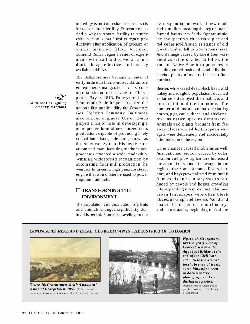
mined gypsum into exhausted field soilsincreased their fertility. Determined tofind a way to restore fertility to utterlyexhausted soils that failed to regain pro-ductivity after application of gypsum oranimal manures, fellow VirginianEdmund Ruffin began a series of experi-ments with marl to discover an abun-dant, cheap, effective, and locallyavailable additive.
The Baltimore area became a center ofearly industrial innovation. Baltimoreentrepreneurs inaugurated the first com-mercial steamboat service on Chesa-peake Bay in 1813. Four years later,Rembrandt Peale helped organize thenation’s first public utility, the BaltimoreGas Lighting Company. Baltimoremechanical engineer Oliver Evansplayed a major role in developing amore precise form of mechanized massproduction, capable of producing finelycrafted interchangeable parts, known asthe American System. His treatises onautomated manufacturing methods andprocesses attracted a wide readership.Winning widespread recognition byautomating flour mill production, hewent on to invent a high pressure steamengine that would later be used to powerships and railroads.
M TRANSFORMING THEENVIRONMENT
The population and distribution of plantsand animals changed significantly dur-ing this period. Pioneers, traveling on the
ever expanding network of new roadsand turnpikes threading the region, trans-formed forests into fields. Opportunistic,invasive species such as white pine andred cedar proliferated as stands of oldgrowth timber fell to woodsmen’s axes.And damage caused by forest fires wors-ened as settlers failed to follow theancient Native American practices ofclearing underbrush and dead falls, thusleaving plenty of material to keep firesburning.
Beaver, white-tailed deer, black bear, wildturkey, and songbird populations declinedas farmers destroyed their habitats andhunters thinned their numbers. Thenumber of domestic animals–includinghorses, pigs, cattle, sheep, and chickens–rose as native species diminished.Animals and plants brought from far-away places visited by European voy-agers were deliberately and accidentallyintroduced into the region.
Other changes caused problems as well.As mentioned, erosion caused by defor-estation and plow agriculture increasedthe amount of sediment flowing into theregion’s rivers and streams. Rivers, har-bors, and bays grew polluted from runofffrom roads and sanitary wastes pro-duced by people and horses crowdinginto expanding urban centers. The newurban landscapes were often bleakplaces, unkempt and treeless. Wood andcharcoal soot poured from chimneysand smokestacks, beginning to foul the
90 CHAPTER SIX: THE EARLY REPUBLIC
Figure 46: Georgetown Ideal: A pastoralvision of Georgetown, 1855. (E. Sachse andCompany Lithograph courtesy of the Library of Congress)
Figure 47: GeorgetownReal: A gritty view ofGeorgetown and itsAqueduct Bridge at theend of the Civil War,1865. Note the almosttotal absence of trees,something often seenin documentaryphotographs takenduring the period.(William Morris Smith photo-graph courtesy of the Libraryof Congress)
LANDSCAPES REAL AND IDEAL: GEORGETOWN IN THE DISTRICT OF COLUMBIA
Baltimore Gas LightingCompany, Maryland
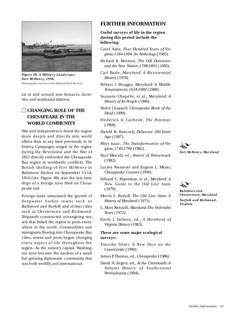
air in and around iron furnaces, facto-ries, and residential districts.
M CHANGING ROLE OF THECHESAPEAKE IN THEWORLD COMMUNITY
War and independence thrust the regionmore deeply and directly into worldaffairs than at any time previously in itshistory. Campaigns waged in the regionduring the Revolution and the War of1812 directly embroiled the ChesapeakeBay region in worldwide conflicts. TheBritish shelling of Fort McHenry inBaltimore Harbor on September 13-14,1814 (see Figure 48) was the last timeships of a foreign navy fired on Chesa-peake soil.
Foreign trade stimulated the growth ofdeepwater harbor towns such asBaltimore and Norfolk and of river citiessuch as Chestertown and Richmond.Shipyards constructed oceangoing ves-sels that linked the region to ports every-where in the world. Commodities andimmigrants flowing into Chesapeake Baycities, towns and ports began changingevery aspect of life throughout theregion. As the nation’s capital, Washing-ton soon became the nucleus of a smallbut growing diplomatic community thatwas both worldly and international.
FURTHER INFORMATIONUseful surveys of life in the regionduring this period include thefollowing:
Carol Ashe, Four Hundred Years of Vir-ginia,1584-1984:An Anthology (1985).
Richard R. Beeman, The Old Dominionand the New Nation,1788-1801 (1985).
Carl Bode, Maryland: A BicentennialHistory (1978).
Robert J. Brugger, Maryland: A MiddleTemperament,1634-1980 (1988).
Suzanne Chapelle, et al., Maryland: AHistory of Its People (1986).
Helen Chappell, Chesapeake Book of theDead (1999).
Frederick A. Gutheim, The Potomac(1968).
Harold B. Hancock, Delaware 200 YearsAgo (1987).
Rhys Isaac, The Transformation of Vir-ginia,1740-1790 (1982).
Paul Metcalf, ed., Waters of Potowmack(1982).
Lucien Niemeyer and Eugene L. Meyer,Chesapeake Country (1990).
Edward C. Papenfuse, et al., Maryland: ANew Guide to the Old Line State(1979).
Morris L. Radoff, The Old Line State: AHistory of Maryland (1971).
L. Marx Renzulli, Maryland:The FederalistYears (1972).
Emily J. Salmon, ed., A Hornbook ofVirginia History (1983).
These are some major ecologicalsurveys:
Timothy Silver, A New Face on theCountryside (1990).
James P. Thomas, ed., Chesapeake (1986).
David A. Zegers, ed., At the Crossroads: ANatural History of SouthcentralPennsylvania (1994).
Further Information 91
Figure 48: A Military Landscape:Fort McHenry, 1998.(Photograph courtesy of the National Park Service)
Fort McHenry, Maryland
Baltimore andChestertown, Maryland
Norfolk and Richmond,Virginia

Atlases and geographic surveysdepicting large scale patterns in thedevelopment of Chesapeake Baycultural landscapes during theperiod include the following:
Lester J. Cappon, ed., Atlas of EarlyAmerican History (1976).
Michael Conzen, ed., The Making of theAmerican Landscape (1990).
David J. Cuff, et al., eds., The Atlas ofPennsylvania (1989).
James E. DiLisio, Maryland: A Geography(1983).
Donald W. Meinig, The Shaping ofAmerica: Volume 1: Atlantic America,1492-1800 (1986).
Donald W. Meinig, The Shaping ofAmerica. Volume 2: ContinentalAmerica,1800-1867 (1993).
Edward C. Papenfuse, and Joseph M.Coale, eds., The Hammond-HarwoodHouse Atlas of Historical Maps ofMaryland,1608-1908 (1982).
John R. Stilgoe, Common Landscape ofAmerica,1580 to 1845 (1982).
Helen Hornbeck Tanner, ed.,The Settlingof North America (1995).
Derek Thompson, et al., Atlas of Mary-land (1977).
Kent T. Zachary, Cultural Landscapes ofthe Potomac (1995).
These are among the studies ofindividual, small-scale communities:
Carville V. Earle, The Evolution of aTidewater Settlement System (1975).
Jack Temple Kirby, Poquosson (1986).
Jerome H. Wood, Jr., ConestogaCrossroads (1975).
Biographical accounts providinginsights into individual lives includethe following:
Silvio A. Bedini, The Life of BenjaminBannecker (1999).
Frank A. Cassell, Merchant Congressmanin the Young Republic (1971).
Eugene S. Ferguson, Oliver Evans, TheInventive Genius of the AmericanIndustrial Revolution (1980).
Charles A. Miller, Jefferson and Nature(1988).
Gregory A. Stiverson and Phebe R.Jacobson, William Paca: A Biography(1976).
Among the many studies surveyingkey aspects of the period’s social lifeare the following:
Herbert Aptheker, American Negro SlaveRevolts (1943).
Kathleen Brown, Good Wives, NastyWenches, and Anxious Patriarchs(1996).
Dieter Cunz, The Maryland Germans(1948).
James Henretta and Gregory Nobles,Evolution and Revolution (1987).
Terry G. Jordan and Matti Kaups, TheAmerican Backwoods Frontier (1989).
Suzanne Lebsock, Virginia Women, 1600-1945 (1987).
Roland C. McConnell, Three Hundredand Fifty Years (1985).
Vera F. Rollo, The Black Experience inMaryland (1980).
Helen C. Rountree, Pocahontas’s People(1990).
Donald G. Shomette, Pirates on theChesapeake (1985).
Bruce G. Trigger, ed., Northeast (Vol. 15,Handbook of North American Indians,1978).
Wilcomb E. Washburn, ed., History ofIndian-White Relations (Vol. 4,Handbook of North American Indians,1988).
James M. Wright, The Free Negro inMaryland,1634-1860 (1921).
Significant examples of the largenumber of recent scholarly studiesof slavery in the Chesapeake Bayregion during this period include thefollowing:
Ira Berlin, Many Thousands Gone (1998).
——-, and Philip D. Morgan, eds., TheSlave’s Economy (1991).
92 CHAPTER SIX: THE EARLY REPUBLIC

——-, and Philip D. Morgan, eds.,Cultivation and Culture (1993).
Douglas R. Egerton, Gabriel’s Rebellion(1993).
Barbara J. Fields, Slavery and Freedomon the Middle Ground (1985).
Ronald Lewis, Coal, Iron, and Slaves(1979).
Philip D. Morgan, Slave Counterpoint(1997).
Michael Tadman, Speculators and Slaves(1989).
T. Stephen Whitman, The Price ofFreedom (1997).
William H. Williams, Slavery andFreedom in Delaware, 1639-1865(1996).
Carol Wilson, Freedom at Risk (1994).
Gilbert L. Wilson, An Introduction into theHistory of Slavery in Prince George’sCounty (1991).
These works are among the numer-ous studies addressing the develop-ment of religion during this period:
Donald G. Mathews, Slavery andMethodism (1965).
Albert J. Raboteau, Slave Religion(1978).
William H. Williams, The Garden ofAmerican Methodism (1984).
Useful insights into period politicallife may be found in these books:
Whitman H. Ridgway, CommunityLeadership in Maryland, 1790-1840(1979).
Norman K. Risjord, Chesapeake Politics:1781-1800 (1978).
Malcolm J. Rohrbaugh, The Land OfficeBusiness (1968).
Among the many studies focusing onthe Revolution and the War of 1812in Chesapeake Bay are the following:
Philip A. Crowl, Maryland During andAfter the Revolution (1943).
Ronald Hoffman, A Spirit of Dissension(1973).
Walter Lord, The Dawn’s Early Light(1972).
Key economic studies include thefollowing:
Percy W. Bidwell and John I. Falconer,History of Agriculture in the NorthernUnited States,1620-1860 (1925).
Avery O. Craven, Soil Exhaustion as aFactor in the Agricultural History ofVirginia and Maryland, 1606-1860(1925).
Lewis C. Gray, History of Agriculture in theSouthern United States to 1860 (1932).
Harold B. Hancock, Delaware 200 YearsAgo: 1780-1820 (1987).
Paula Johnson, ed., Working the Water(1988).
James T. Lemon, The Best Poor Man’sCountry (1972).
Allan Kulikoff, Tobacco and Slaves(1986).
——-, Agrarian Origins of AmericanCapitalism (1992).
Sally McGrath and Patricia McGuire, eds.,The Money Crop (1992).
Arthur Pierce Middleton, Tobacco Coast(1984).
Edward C. Papenfuse, In Pursuit of Profit(1975).
Glenn Porter, ed., Regional EconomicHistory of the Mid-Atlantic Area Since1700 (1976).
Analyses of regional scientific andtechnological developments duringthe period may be found in thefollowing:
David G. Shomette, Shipwrecks on theChesapeake (1982).
Brook Hindle, ed., America’s Wooden Age(1975).
David A. Hounshell, From the AmericanSystem to Mass Production, 1800-1932(1984).
Further Information 93

Surveys examining the region’sbuildings and architecture includethe following:
Pamela James Blumgart, At the Head ofthe Bay: A Cultural and ArchitecturalHistory of Cecil County, Maryland(1995).
Michael Bourne, Historic Houses of KentCounty (1998).
——-, et al., Architecture and Change inthe Chesapeake (1998).
J. Ritchie Garrison, et al., eds., AfterRatification (1988).
Henry Glassie, Pattern in the Material FolkCulture of the Eastern United States(1968).
——-, Folk Housing in Middle Virginia(1975).
Bernard L. Herman, Architecture andRural Life in Central Delaware, 1700-1900 (1987).
Terry G. Jordan, American Log Buildings(1985).
Gabrielle M. Lanier and Bernard L.Herman, Everyday Architecture of theMid-Atlantic (1997).
Marilynn Larew, Bel Air: An Architecturaland Cultural History,1782-1945 (1995).
Calder Loth, Virginia Landmarks of BlackHistory (1995).
George W. McDaniel, Hearth and Home(1982).
John Reps, Tidewater Towns (1972).
Barbara Wells Sarudy, Gardens andGardening in the Chesapeake, 1700-1805 (1998).
Paul Touart, Somerset: An ArchitecturalHistory (1990).
Dell Upton, ed., America’s ArchitecturalRoots (1986a).
——-, ed., Holy Things and Profane(1986b).
——-, and John Michael Vlach, eds.,Common Places (1986).
Donna Ware, Ann Arundel’s Legacy: TheHistoric Properties of Ann ArundelCounty (1990).
Christopher Weeks, ed., Where Land andWater Intertwine: An Architectural
History of Talbot County, Maryland(1984a).
——-, ed., Between the Nanticoke andthe Choptank (1984).
Archeological studies include thefollowing:
James Deetz, Flowerdew Hundred(1984).
William M. Kelso, Kingsmill Plantation,1619-1800 (1984).
——-, and R. Most, eds., Earth Patterns(1990).
Paul A. Shackel and Barbara J. Little,Historical Archaeology of theChesapeake,1784-1994 (1994).
——-, et al., eds., Annapolis Pasts (1998).
David G. Shomette, Tidewater TimeCapsule (1995).
Theresa A. Singleton, ed., TheArchaeology of Slavery and PlantationLife (1985).
Among the many studies focusing onthe development of urban life inWashington, D.C., are the following:
Bob Arnebeck, Through a Fiery Trial(1991).
Constance M. Green, Washington: AHistory of the Capital, 1800-1878(1961).
Frederick A. Gutheim, Worthy of theNation (1977).
The emergence of Baltimore as theregion’s largest city is traced in thefollowing works:
Toni Ahrens: Design Makes a Difference:Shipbuilding in Baltimore, 1795-1835(1998).
Gary Browne, Baltimore in the Nation,1789-1861 (1980).
Isaac M. Fein, The Making of an AmericanJewish Community (1971).
Leroy Graham, Baltimore:The Nineteenth-Century Black Capital (1982).
James W. Livingood, The Philadelphia-Baltimore Trade Rivalry, 1780-1830(1947).
Charles G. Steffen, The Mechanics ofBaltimore (1984).
94 CHAPTER SIX: THE EARLY REPUBLIC

An Ecology of People and Place 95
AN ECOLOGY OF PEOPLEAND PLACE
M PEOPLE
The mid-nineteenth century broughtunprecedented transformations to allaspects of life in the region (see Map 9).Coal, steel, and steam fueled industrialexpansion, binding the Chesapeakeregion more firmly with the rest of thenation and the world. Scientificadvances and religious revivals chal-lenged people’s views. New crops wereintroduced, and old plants were farmedin new ways.
Sectional differences divided Northernand Southern parts of the nation and theregion during this period. In theChesapeake Bay region, North-South ten-sions eclipsed earlier differencesbetween the Coastal Plain and Pied-mont. Made more efficient by technolog-ical advances, slavery became vital tothe economies of Southern states. Thesesame technological advances allowedNortherners, strengthened by industrialgrowth, to ideologically and materiallychallenge Southern attempts to extendand expand the slave system. The strug-gle over slavery and states’ rights wasfueled by more than differing economicsystems. In a broader sense, it became acontest over contending concepts of race,class, work, and ethnicity that divided
Chapter SevenSectional Strife,
1820 to 1880
SIGNIFICANTEVENTS▫ 1820’s–canal, railroad,
and coal industrialdevelopment revolu-tionizes technology
▫ 1826–Marylandassembly extendssuffrage to Jewish men
▫ 1827–Charles Carroll ofCarrollton, Marylandorganizes the Baltimoreand Ohio Railroad; firstpassenger and freightrailway in United States
▫ 1828–work begins onBaltimore and OhioRailroad and the Chesa-peake and Ohio Canal
▫ 1829–Chesapeake andDelaware Canal opens
▫ 1830–Peter Cooper’ssteam engine, the TomThumb, makes first tripfrom Baltimore toEllicott’s Mills
▫ 1831–Maryland StateColonization Societyestablished to relocatefreed slaves
▫ 1831–Nat Turner leadsunsuccessful slaverevolt in SouthamptonCounty, Virginia
▫ 1832–Edmund Ruffin’spublication of influen-tial scientific reportregarding use of marlas fertilizer increasesefficiency of plantationagriculture
▫ 1832–worldwide choleraepidemic strikes region
▫ 1837–Chesapeake andOhio Canal completed
▫ 1837–Great Panic of1837 throws nation’seconomy into depression
▫ 1839–nation’s first iron-hulled ship, theDeRosset, built inBaltimore
▫ 1840–Pennsylvaniafarmers begin growingcigar wrapper tobacco
▫ 1841–Tredegar IronWorks opens inRichmond
▫ 1844–nation’s firsttelegraph line erectedbetween Baltimore andWashington
▫ 1844–anti-immigrantKnow-Nothing partyformed
▫ 1845–United StatesNaval Academy opens inAnnapolis
▫ 1848–Irish, German,and Polish immigrantsbegin arriving in largenumbers
▫ 1850–regional popula-tion exceeds 1.8 million
▫ 1853 to 1863–Washington Aqueductconstructed
▫ 1855–Republican partyformed
▫ 1858–first steam-powered fire engineplaced into service inBaltimore
▫ 1859–Abolitionist JohnBrown leads unsuccess-ful raid on Harper’s Ferryto spark slave revolt
▫ 1861–Virginia secedesfrom Union and joinsConfederacy
▫ 1861 to 1865–Civil Warfought between Unionand Confederacy
▫ 1862–northwesternVirginia counties secedeto form new federalstate of West Virginia
▫ 1862–Battle of Antietamfought in Maryland’sGreat Valley; bloodiestsingle day of Civil War
▫ 1863–pivotal Battle ofGettysburg fought
▫ 1865–Robert E. Lee sur-renders Army of North-ern Virginia to GeneralGrant at AppomattoxCourthouse; otherConfederate surrendersend the Civil War
▫ 1865–ThirteenthAmendment to Consti-tution abolishes slavery
▫ 1865 to 1877–Era ofReconstruction
▫ 1866–Gallaudet College,first institution ofhigher learning for deaf,opens in Washington
▫ 1867–Howard University,nation’s first AfricanAmerican college,opens in Washington
▫ 1868–Hampton Normaland AgriculturalInstitute opened inHampton, Virginia
▫ 1873–Economic Crash▫ 1876–Johns Hopkins
University opens inBaltimore
▫ 1877–striking railroadworkers violentlysuppressed by Marylandmilitia
1820-29 1832 1840 1850 1861 1865 1866 1867 1876| | | | | | | | |
Canal, Fertilizer Pennsylvania Region Virginia Surrender at Gallaudet Howard Johnsrailroad improves grows population secedes Appomattox; College University Hopkinsand coal plantation tobacco exceeds from the slavery founded founded University
development agriculture 1.8 million Union abolished founded
Antebellum Period1820 to 1861
Civil War1861 to 1865
Reconstruction and Industrial Expansion1865 to 1880

SusquehannaRiver
Mon
ocac
yR
iver
Cho
ptan
kR
iv
er
Rapidan River
Pat ap sc o R iver
Cheste
r Rive
r
Potomac River
James River
Mattaponi RiverPamunkey River
Appo
mat
tox
Rappahannock River
Patuxent R
iver
Shen
ando
ah R
iver
Poco
mok
e Riv
er
Nan
tico
ke R
iver
Chesapeake B
ay
Rap
pahan nock River
York Riv e r
James River
CapeHenry
CapeCharles
Tangier Sound
River
Poto
mac
Riv
er
KentIsland
SmithIsland
TangierIsland
Loudon
& Hampshire RR
Cat
octin
Rid
ge
Sou
th M
ount
ain
Harper's Ferry Gap
Manassas Gap
Bul
l Run
Mou
ntai
n
ThorofareGap
Thornton Gap
Blu
e R
idge
Mou
ntai
ns
Rockfish Gap
Blue R
idge
Mou
ntain
s
James River Gap
Hampton Roads
SeashoreNatural Area
CharlesC.Steirly
Natural Area
GreatDismalSwamp
Battle CreekCypress Swamp
Belt Woods
CaledonState Park
Montpelier Forest
Sugar LoafMountain
Long GreenCreek andSweathouseBranch NaturalArea
Gilpin'sFalls
Ferncliff Wildlifeand Wildflower
Preserve
VirginiaCoast
Reserve
CalvertCliffs Preserve
Fort Monroe
Camden
Wheatland
Susquehanna and Tidewater Canal
Chesapeake and
Delaware Canal
Chestertown
U.S. NavalAcademy
PotomacCanal
WaterfordChesapeakeand Ohio Canal
MountVernon
Green Springs
Marlbourne
John Tyler HouseHamptonInstitute
AppomattoxCourthouse
Five ForksSaylor's Creek
SpotsylvaniaThe Wilderness
Cold Harbor
Manassas
Gettysburg
Monocacy
OakHill
Bomberger'sDistillery
Union Canal Tunnel
SionHill
Thomas PointShoal Light Station
Riversdale
ThomasViaduct
Ellicott CityStation
CarrolltonViaduct
WashingtonAqueduct
JamesRiverCanal
AntietamBattlefield
Baltimore and Ohio Railroad
Manassas Gap RR
Orang
e & A
lexan
dria
RR
Cent
ral R
ailro
ad
Columbia Railroad
Rich
mon
d, F
rede
rick,
and
Poto
mac
RR
Virginia Central Railroad
Virginia
& Tennes
see R
ailro
ad
MetropolitanRailroad
Philadelphia, Wilmingtonand Baltimore Railroad
Norfolk & Petersburg Railroad
Richmond & York River
Petersburg & Weldon Railroad
Southside Railroad
Petersburg &City Point Railroad
Southside Railroad
Philadelphia &
Richmond &
Danville Railr
oad
Railroad
North
Baltimore
Salisbury
Cambridge
ChesapeakeCity
Elkton
Lancaster
York
Frederick
AlexandriaWashington DC
Warrenton
Leesburg
Ball'sBluff
FredericksburgCulpeper
Charlottesville
Mattaponi IndianReservation
PamunkeyIndian
Reservation
HarpersFerry
Chancellorsville
Norfolk
Portsmouth
Richmond
Petersburg
Appomattox
Lynchburg
Centreville
FredericksburgBattlefield
RichmondBattlefields
PetersburgBattlefields
●
●
●
●
●
●
●
●
●
●
●
●
●
●
●
●
●
●
●
●
●
●
●
96 CHAPTER SEVEN: SECTIONAL STRIFE
Map 9: Sectional Strife, 1820 to 1880
0 5 10 25 50 miles
kilometers0 5 10 40 80 North
LEGENDNational Historic LandmarkCivil War Battlefields
• City or Town© National Natural Landmark■ Natural or Cultural Feature
RailroadCanalBayPlainPiedmont

An Ecology of People and Place 97
KEY LOCALES
NATIONAL HISTORICLANDMARKS
District of ColumbiaLandmarks
American Peace Society[1860s]
Anderson House [mid-19th century]
Army Medical Museumand Library [1867]
Ashburton House [ca.1836]
Blair-Lee House [1827]
Blanche K. Bruce House[1865]
Carnegie Endowment forInternational Peace[1860]
City Hall [1820-1849]
Franklin School [1862-1875]
Gallaudet College [1866]
General Post Office[1839-1866]
Georgetown HistoricDistrict [18th-19thcenturies]
Charlotte Forten GrimkeHouse [1880]
Healy Hall [1877-1879]
General Oliver OtisHoward House [1869]
Lafayette Square HistoricDistrict [18th-20thcenturies]
Old Naval Observatory[1844]
Old Patent Office [1840]
Renwick Gallery [1860]
Zalmon Richards House[mid-19th century]
Saint Elizabeth’s Hospital[1852]
Saint Luke’s EpiscopalChurch [1879]
Smithsonian InstitutionBuilding [1855]
State, War, and NavyBuilding (Old ExecutiveOffice Building) [1871-1888]
Oscar W. UnderwoodHouse [19th century]
United States Capitol[1793-1865]
United States Departmentof the Treasury [1836-1862]
United States SoldiersHome [1851]
Washington Aqueduct[1853-1863]
Washington Navy Yard[1800-1910]
MarylandChestertown Historic
District [18th-19thcenturies], Kent County
Ellicott City Station[1831], Howard County
Monocacy Battlefield[1864], FrederickCounty
Old Lock Pump House,Chesapeake andDelaware Canal [1837],Cecil County
Riversdale [early 19thcentury], PrinceGeorge’s County
Sion Hill [19th-20thcenturies], HarfordCounty
Thomas Point Shoal LightStation [1875], AnnArundel County
United States NavalAcademy [1845],Annapolis
Washington Aqueduct[1853-1863],Montgomery County
Baltimore CityLandmarks
Baltimore and OhioTransportation Museumand Mount ClareStation [1830]
Carrolltown Viaduct[1829]
College of Medicine ofMaryland [19th-20thcenturies]
Constellation (Sloop ofWar) [1854]
Minor Basilica of theAssumption of theBlessed Virgin Mary[1806-1863]
Mount Vernon PlaceHistoric District [19thcentury]
Phoenix Shot Tower[1828]
Edgar Allen Poe House[1833-1835]
Sheppard and Enoch PrattHospital and GateHouse [1862-1891]
Thomas Viaduct,Baltimore and OhioRailroad [1835]
PennsylvaniaBomberger’s Distillery
[1753, 1840], LebanonCounty
Fulton Opera House[1852], LancasterCounty
Union Canal Tunnel[1825-1827], LebanonCounty
Wheatland, JamesBuchanan House[1828], LancasterCounty
VirginiaAlexandria Historic
District [18th-19thcenturies], AlexandriaCity
Ball’s Bluff Battlefield andNational Cemetery[1861 and 1865],Loudon County
Camden [17th-19thcenturies], CarolineCounty
Drydock No. 1 [1827-1834], Portsmouth City
The Exchange [1841],Petersburg City
Five Forks Battlefield[1865], DinwiddieCounty
Fort Monroe [1819-1834],Hampton City
Franklin and ArmfieldOffice [1828-1836],Alexandria City
Green Springs HistoricDistrict [18th-19thcenturies], LouisaCounty
Hampton Institute[1868], Hampton City
Marlbourne, EdmundRuffin Plantation[1843], HanoverCounty
General William “Billy”Mitchell House [1826,1925], Loudon andFauquier counties
Oak Hill, James MonroeHouse [1820-1823],Loudon County
Patowmack CanalHistoric District [1786-1830], Fairfax County
Sayler’s Creek Battlefield[1865], Amelia andPrince Edward counties
John Tyler House [1780,1842], Charles CityCounty
University of VirginiaHistoric District [19th-20th centuries],Charlottesville City
University of VirginiaRotunda [1822-1826,1898], CharlottesvilleCity
Waterford HistoricDistrict [18th-19thcenturies], LoudonCounty
Richmond CityLandmarks
Egyptian Building [1845]
Ellen Glasgow House[1841]
Jackson Ward HistoricDistrict [19th-20thcenturies]
James Monroe Tomb[1859]
Tredegar Iron Works[1841]
White House of theConfederacy, Dr. JohnBrockenbrough House[1818, 1861-1865]

people both across and within sec-tional lines. First emerging duringcolonial times, it became a constitu-tional crisis over the issue ofrights–both of states and of individu-als–that increased in rancor andintensity until it erupted into civilwar and on into reconstruction.
The Chesapeake region stoodastride the invisible line that split thenation into North and South at thebeginning of this era. Yet differencesbetween the sections never becameeither total or completely clear cut.The nation’s Northern and Southernsections spoke the same language,followed the same forms of worship,relied on the same technologies,and looked back on similar culturalheritages and histories. To an out-sider, their differences must haveseemed more like variations of stylethan differences that could only beresolved by violence.
These complex, subtle differenceswere reflected in the lack of definiteboundaries between the sections.Although slavery only existed southof the Mason-Dixon line–the bound-ary line separating Pennsylvania andMaryland–neither this line nor thePotomac River boundary betweenMaryland and Virginia put a stop torelations between the states. Theindustrial life dominating the banksof Baltimore Bay and the fall linetowns along the lower Susquehannaand Potomac Rivers began develop-ing in the region’s more southerlyparts, such as Richmond, Peters-burg, and Norfolk. And tobacco, tra-ditionally associated with the South,became a major cash crop alongthe lower Susquehanna in York andLancaster counties, Pennsylvania.So when civil war finally came, theregion did not simply split alongstate boundaries. For example, in1862, counties in northwesternVirginia seceded from Virginia andjoined the Union, becoming thenew state of West Virginia. Andthough many who lived in Mary-land’s southernmost counties fought
98 CHAPTER SEVEN: SECTIONAL STRIFE
PORTFOLIO: VIEWS OFTHE EARLY INDUSTRIALCHESAPEAKETRANSPORTATIONLANDSCAPE.
Figure 49: Dismal Swamp Canal.(From The Transformation of Virginia, 1740-1790 by Rhys Isaac; used by permission of theUniversity of North Carolina Press ©1982)
Figure 53 (left):Present-day GroundLevel View of theBaltimore and OhioRailroad’s ThomasViaduct, LookingNorth, Spanning thePatapsco River atElkridge, Maryland.(Photograph courtesy of theNational Park Service)
Figure 52 (right): Present-dayAerial View of Carrollton
Viaduct, Built by the Baltimoreand Ohio Railroad Over
Gwynn’s Falls Near CarrollPark, Baltimore. (Photograph
courtesy of the National Park Service)
Figure 50(above):Building theChesapeakeand OhioCanal.(Illustrationcourtesy of theNational ParkService)
Figure 51: The completed Chesapeake and Ohio Canal WaterSystem. (Illustration courtesy of the National Park Service)

for the Confederate cause, slave stateMaryland stayed in the Union through-out the war.
Of course tension existed between thosewishing to secede from the Union andthose in favor of staying put. This tensionaffected every aspect of life in theChesapeake. Interestingly, an explosionof federal, state, and privately fundedconstruction was creating new turnpike,canal, and railroad networks linking thenation’s regions closer together than everbefore. The Dismal Swamp Canal link-ing Chesapeake Bay with NorthCarolina’s Albemarle Sound, theChesapeake and Ohio Canal stretchingalong the Maryland side of the PotomacRiver from Georgetown to Cumberland,the Baltimore and Ohio Railroad, andother transportation systems critical tothe nation’s development were first builtduring the early decades of this period.
But these improvements also strength-ened sectional solidarity. Trains capableof carrying produce and minerals to mar-ket, for example, brought wealth to freelabor employers in the Union andincreased the profitability of Southernplantations, mines, and furnaces, all ofwhich used slave labor. Prosperity en-couraged people to anticipate peacefulresolutions of sectional differences. Freelabor advocates hoped that the successesof industrial development would showSoutherners that slavery was not econom-ically efficient and should be abandoned.Slave owners, for their part, used profits
reaped in the fields to purchase goodsand open manufacturing enterprises oftheir own. Prohibited from importingslaves from overseas, slave markets suchas Alexandria, Virginia’s Price, Birch andCompany, prospered by auctioningslaves from plantations in the region tobuyers from newly opened cotton landsfarther south in Alabama, Mississippi,and Louisiana (see Figure 54).
New immigrants also had to choosesides. Many Irish, German, and otherimmigrants–fleeing famine and unrest inEurope–landed in Chesapeake Bay portssuch as Baltimore and Norfolk duringthe 1840s and 1850s. Their first challengewas to assimilate into an American soci-ety increasingly hostile to them. Thesefeelings crystallized in the formation ofthe anti-immigrant Know-Nothing partyin 1844. Despite such opposition, immi-grants managed to settle quietly through-out the region, where most eventuallyadopted the sectional sympathies oftheir new neighbors or communities.
The ships bringing new immigrantsmade up only a small part of the Bay’squickly growing passenger and cargotraffic. Improvements in ship design in-creased the speed and range of wooden-hulled Baltimore clippers, schooners,and other sailing vessels (see Figure 55).Boats began using steam driven paddlewheels, first in addition to sails, and theninstead of them. Metal ship hulls andscrew propellers, linked to steam boilersby strong metal drive shafts, came intouse more and more during the middledecades of the period. Wooden wharves,docks, and warehouses along ChesapeakeBay waterfronts expanded to handlegrowing coastal and international trade.
An Ecology of People and Place 99
Figure 54: Way Station on the Landscapeof Servitude: Photograph of the officesand slave pen (the low wall to the rightof the office building) of Price, Birch andCompany, slave merchants, in Alexandria,Virginia. (Alexander Gardner photograph courtesy of
the National Archives)
Figure 55: The Clipper Saint David,ca. 1900-1906.(Photograph courtesy of the Library of Congress)
Price, Birch and Company,Virginia
Dismal Swamp Canal,Virginia
Chesapeake and Ohio Canaland Baltimore and OhioRailroad, Maryland
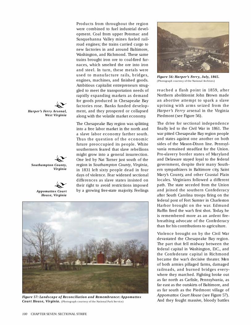
Products from throughout the regionwere combined to fuel industrial devel-opment. Coal from upper Potomac andSusquehanna Valley mines fueled rail-road engines; the trains carried cargo tonew factories in and around Baltimore,Washington, and Richmond. These sametrains brought iron ore to coal-fired fur-naces, which smelted the ore into ironand steel. In turn, these metals wereused to manufacture rails, bridges,engines, machines, and finished goods.Ambitious capitalist entrepreneurs strug-gled to meet the transportation needs ofrapidly expanding markets as demandfor goods produced in Chesapeake Bayfactories rose. Banks funded develop-ment, and they prospered or collapsedalong with the volatile market economy.
The Chesapeake Bay region was splittinginto a free labor market in the north anda slave labor economy farther south.Thus the question of the economicfuture preoccupied its people. Whitesoutherners feared that slave rebellionsmight grow into a general insurrection.One led by Nat Turner just south of theregion in Southampton County, Virginia,in 1831 left sixty people dead in fourdays of violence. Fear widened sectionaldifferences as slave states insisted ontheir right to avoid restrictions imposedby a growing free-state majority. Feelings
reached a flash point in 1859, afterNorthern abolitionist John Brown madean abortive attempt to spark a slaveuprising with arms seized from theHarper’s Ferry arsenal in the VirginiaPiedmont (see Figure 56).
The drive for sectional independencefinally led to the Civil War in 1861. Thewar pitted Chesapeake Bay region peopleand states against one another on bothsides of the Mason-Dixon line. Pennsyl-vania remained steadfast for the Union.Pro-slavery border states of Marylandand Delaware stayed loyal to the federalgovernment, despite their many South-ern sympathizers in Baltimore city, SaintMary’s County, and other Coastal Plainlocales. Virginians followed a differentpath. The state seceded from the Unionand joined the southern Confederacyafter South Carolina troops firing on thefederal post of Fort Sumter in CharlestonHarbor brought on the war. EdmundRuffin fired the war’s first shot. Today, heis remembered more as an ardent fire-breathing advocate of the Confederacythan for his contributions to agriculture.
Violence brought on by the Civil Wardevastated the Chesapeake Bay region.The part that fell midway between thefederal capital in Washington, D.C., andthe Confederate capital in Richmondbecame the war’s decisive theater. Menof both armies pillaged farms, damagedrailroads, and burned bridges every-where they marched. Fighting broke outas far north as Carlisle, Pennsylvania, asfar east as the outskirts of Baltimore, andas far south as the Piedmont village ofAppomattox Court House (see Figure 57).And they fought massive, bloody battles
100 CHAPTER SEVEN: SECTIONAL STRIFE
Figure 57: Landscape of Reconciliation and Remembrance: AppomattoxCourt House, Virginia. (Photograph courtesy of the National Park Service)
Figure 56: Harper’s Ferry, July, 1865.(Photograph courtesy of the National Archives)
Harper’s Ferry Arsenal,West Virginia
Southampton County,Virginia
Appomattox CourtHouse, Virginia

An Ecology of People and Place 101
LANDSCAPE OF MEMORY:GETTYSBURG NATIONAL MILITARYPARK. This 6,000 acre National Parkpreserves the place where one of themost pivotal battles in American historywas fought. On July 1, 1863, units of theConfederate army advancing north intoPennsylvania in an offensive aimed atending the war, collided with Uniontroops at the crossroads town ofGettysburg. During the next two days, the75,000-man Confederate Army of North-ern Virginia under the command ofRobert E. Lee struggled to break throughUnion defenses along a line of hills andridges to the west and north of the townheld by the 95,000 men of the UnionArmy of the Potomac led by George C. Meade. By the time the battle ended on July 3, more than 51,000soldiers, nearly a third of all the men engaged, were either dead, wounded, captured, or missing. Stoppedby the Union army and suffering losses in excess of 20,000 men, the Confederate army retreated backto Virginia.
This site of singular struggle and sacrifice soon became anational shrine. Lincoln’s Gettysburg Address, deliveredsome months later at the dedication of the NationalCemetery where more than 7,000 of the Union troops(1,668 of them unidentified) killed in the battle wereinterred, captured the essence and meaning of the war forthe Union in the few paragraphs that are still memorizedby children throughout thenation. States and veteranserected monuments atDevil’s Den, Little RoundTop, Cemetery Ridge, andother places where thefighting was heaviest.Established by Congress asa National Military Park onFebruary 11, 1895, theNational Park Service todaypreserves the locale’spastoral landscape, themilitary landscape of thebattle itself, and thecommemorative landscapesubsequently created tomemorialize the struggle(see Figures 58-61).
Figure 60: Nineteenth Century Postcard View ofDevil’s Den. The scene of heavy fighting duringthe second day of the battle.(Photograph courtesy of the Dennis Montagna Collection)
Figure 61: The Crest of LittleRound Top, 1992. The monu-ment commemorates the standof the 20th Maine, who held theUnion left flank againstrepeated Confederate attacksduring the second day of thebattle. (Photograph courtesy of the
National Park Service)
Figure 59: The Union Line on Cemetery Ridge,1989. Where Union troops stopped Pickett’sCharge on the third and last day of the battle.(Photograph courtesy of the National Park Service)
Figure 58: Postcard View of the National Cemetery at Gettysburg.Where Lincoln delivered the famous “Gettysburg Address,” andwhere more than 7,000 Union soldiers killed during the battle areinterred. (Photograph courtesy of the Dennis Montagna Collection)

at Coastal Plain locales such asFredericksburg, the Peninsula, and ColdHarbor. Farther inland in the Piedmont,armies periodically occupied Harper’sFerry and engaged in equally costlystruggles at Manassas, Chancellorsville,Spotsylvania, battled decisively atGettysburg in Pennsylvania, and foughtin battles around Richmond andPetersburg in Virginia that finallydecided the outcome of the war. Hugechains of forts surrounded Washington,D.C. Many of these forts can still be seentoday, as can the great moat-encircledstone stronghold of Fort Monroe (seeFigure 62) and the lines of earthworktrenches and bastions dug during siegesat Williamsburg, Richmond, and Peters-burg. Ships sank while fighting to controlthe strategically vital Chesapeake water-way. The C.S.S. Virginia, the U.S.S.Cumberland, and many other ships stilllie in muddy graves beneath Bay waterstoday (see Figure 63).
It took four years of bloody fighting toreunite the nation politically, if not inother ways. The war proved disastrousfor the South in many ways. TheNorthern blockade cut the South offfrom the rest of the world and graduallystrangled production. Short of raw mate-rials, in need of machine tools, andunpaid by fiscally strapped Confederateand state governments unable to paytheir bills, Southern commerce declinedcatastrophically. By 1865, famine threat-ened people living in many sections ofthe South.
The situation was much different in theNorth. Northern losses on the battlefieldswere horrible. On the home front, how-ever, the war stimulated a new peak ofindustrial expansion. Lucrative federalgovernment contracts funded new trans-portation routes, improved harbor facil-ities, and stoked the furnaces of factoriesand finance. Even greater industrialgrowth in the North after the war helpedrestore many ravaged communities andhelped bind the region’s states, andthe rest of the country, into a firmerfederal union.
At first, recovery was slow in Virginia.Small farmers and large landownersstruggled to make livings on the land.Public debt to pay for the war consumeda disproportionate share of governmentdollars. Embezzlement and misappropri-ation of public school funds cripplededucational development. By 1880,railroad expansions, infusions of capital,and new production techniques helpedVirginia’s industry and agriculture startto recover.
Baltimore and Washington were alreadymajor cities before the war, and theygrew dramatically afterward. Many peo-ple from the countryside moved there,joining the growing ranks of Europeanimmigrants seeking work in factories andbusinesses as much American agricul-ture shifted west into the prairies andplains. Throughout the region, a mix ofnationalities, races, religions, and ethnic-ities lived beside one another, not alwayshappily. Immigrants struggled to find
102 CHAPTER SEVEN: SECTIONAL STRIFE
Figure 62: Fort Monroe, Old Point Comfort, Virginia, 1862.(E. Sachse and Company lithograph courtesy of the Library of Congress)
Fredericksburg,Peninsula, Cold Harbor,
Manassas,Chancellorsville,
Spotsylvania, Richmond,Petersburg, Fort Monroe,Williamsburg, Richmondand Petersburg, Virginia
C.S.S. Virginia andU.S.S. Cumberland
Gettysburg, Pennsylvania
Harper’s Ferry,West Virginia
Figure 63: C.S.S. Virginia sinks the U.S.S.Cumberland, March 8, 1862.(Painting courtesy of the Library of Congress)

their places in Chesapeake society,dealing with both the intolerance ofnative born Americans and difficulties ofcutting ties to the old country–andupholding its traditions.
African Americans, recently freed fromslavery worked with freeborn blacks,other people of color, and sympatheticwhites to secure voting rights, find work,fight discrimination, and establishschools. In 1867, a federal agency knownas the Freedman’s Bureau openedHoward University (named after theBureau’s white commander, GeneralOliver Otis Howard) in Washington, D.C.to train African American teachers,lawyers, and business leaders. One yearlater, Virginia’s Hampton Institute(today’s Hampton University) opened.But anti-black prejudice reasserted itselfby the mid-1870s, after being suppressedby federal military authority during theera of Reconstruction. White votersenacted Black Codes, laws that severelyrestricted African American rights. Newlaws made it almost impossible for themto vote. Black people were barred frompublic life and forced to conform tostrict segregation laws.
For the poor, finding work and a place tolive were major challenges. In the coun-tryside, poor people of all races workedfields for portions of the harvest assharecroppers or rented them as tenantfarmers. Black people employed asservants to middle and upper classfamilies were often given quarters in thehouses where they worked. AfricanAmericans and new immigrants movingto smaller cities often took up lodgingsin well kept, established neighborhoods,but those moving to larger cities oftenhad to live in rundown ghettoes andaccept unskilled work. Though theystruggled against discrimination, AfricanAmericans and new immigrants estab-lished churches, benevolent societies,and educational institutions to improveconditions for their people throughoutthe region.
M PLACE
The period’s profound changes radicallytransformed Chesapeake Bay environ-ments. Most of the region’s remainingold-growth forests were cut down.Farmers cleared from 40 to 50 percent ofthe land for planting fields. Wheat beganto supplant corn and tobacco as the majorcash crop. In the Susquehanna Piedmontin the 1840s, growers began naturalizinga variety of tobacco from Cuba thatcould tolerate the cold. RechristenedPennsylvania seedleaf tobacco, itbecame the favored outer wrapping forAmerican cigars by the 1850s.
Wood remained the region’s primarysource of heat, light, and building mater-ial until the 1860s. Growing cities andrural towns required huge amounts ofmilled timber for building constructionand maintenance. Innumerable cords offirewood were needed for heat as theLittle Ice-Age winds made winters bittercold. Farther inland, charcoal fueledPiedmont furnaces, foundries, and facto-ries. Since it took 20,000 to 30,000 acresof woodland to produce enough char-coal to smelt 1,000 tons of iron, charcoalproducers consumed entire forests.Woodlots on land that could not be usedfor farming provided wood for all ofthese domestic and industrial purposes.
Landscapes in and around ChesapeakeBay cities were transformed as neverbefore. Complexes of stores and munici-pal buildings rose in city centers.Residential and industrial districtsemerged in outlying areas. Brick, stone,iron, and steel replaced wood as thefavored building material in city andtown centers. Horses drew carriages,wagons, and streetcars on city roads andrail lines. Great terminals were built toserve the steam railroads linking citieswith the countryside. Coal fueled the rail-roads and began supplanting charcoalas the fuel of choice in city buildings andin factories. Production rose higher thanever in many established factories, suchas the arsenal complex in Harper’s Ferryfirst built in 1803. New rail constructionlinking Virginia with the rest of the
An Ecology of People and Place 103
Howard University,Washington, D.C.
Hampton Institute,Virginia
Harper’s Ferry, Virginia

nation stimulated the erection of theTredegar Iron Works in Richmond in1841. Initially built to produce rails,engines, and rolling stock, the Tredegarworks became one of the South’s fewmunitions plants during the Civil War.
Baltimore and Washington city fatherswere intent on securing adequate sup-plies of fresh water. So they created reser-voirs by damming nearby Piedmontrivers and streams. The most ambitiousof these water supply projects, theWashington Aqueduct (constructedbetween 1853 and 1863), carriedPotomac water stored in a dam built justabove the river’s Great Falls to holdingreservoirs in Georgetown and Wash-ington City (see Figures 66-67). Locallyobtained brick, stone, wood, and metalwere used to construct the pipelines and
104 CHAPTER SEVEN: SECTIONAL STRIFE
TREDEGAR IRON WORKS. The Tredegar Iron Works was built in Richmond Virginia between the northbank of James River and the southern berm of the James River and Kanawha Canal in 1841. Worked byhighly skilled slave laborers, Tredegar’s coal-fired forge and furnace smelted iron that was then cast toproduce cannon barrels and ammunition, machined into parts for steam engines, or rolled into sheetmetal and steel rails. Continually expanding, the works grew into the nation’s third largest ironworks bythe time the Civil War broke out in 1861.
Tredegar became the South’s largest and most important munitionsplant during the war. Served by as many as 2,500 workers, mostlyslaves, convicts, paroled Union prisoners, and Confederate soldiersdetached from their units, the Tredegar works turned out 1,099 can-non of all calibers, hundreds of tons of shot and shell, and the platearmor mounted on the sides of the Confederate ironclad ram C.S.S.Virginia. Experimental prototypes of the submarine, the torpedo,and the machine gunwere also produced atTredegar during the war.
Blown up by retreatingConfederate troopswhen Richmond fell
to Union forces on April 3, 1865, the Tredegar Works werequickly repaired and placed back into production. The workscontinued to produce munitions, locomotives, and sheet metalup the end of World War I. Several restored buildings (seeFigures 64-65) and the archeological remains of others aretoday preserved on the twenty-two acre Tredegar tract.
Figure 64: Tredegar Iron Works,April, 1865. Photograph by AlexanderGardner. (Alexander Gardner photographcourtesy of the Library of Congress)
Figure 65: Tredegar Iron Works, 1990. Northand east facades of the Spike Factory.(Photograph courtesy of the National Park Service)
Figure 66: Working Water Landscape: The Great Falls of the Potomac,June, 1906. (F. Lamson Scribner photograph courtesy of the Library of Congress)
Figure 67: The Dalecarlia Reservoir inGeorgetown, April, 1973. (Environmental Protec-
tion Agency photograph courtesy of the National Archives)
Tredegar Iron Works,Virginia
Washington Aqueduct,Washington, D.C.

aqueducts of this and subsequent watersupply systems that carried reservoirwater to city water mains. The samematerials were also used in new sewersdug under city streets. These sewerspouring wastes and runoff into riversflowing into Chesapeake Bay.
Expanded agricultural, residential, andindustrial development meant more soilerosion. In the interior, tailings of wasterock, cinders, and other residues frommines, quarries, and furnaces–mixedwith soils eroded from logged-overlands–flowed into Piedmont rivers andstreams. Soils eroded from agriculturalfields washed millions of additional tonsof topsoil into regional waterways acrossthe Coastal Plain. Untreated sewage andother city wastes–pumped directly intoharbor waters by coastal cities–furtherfouled Bay waters.
The region’s plant and animal communi-ties began to show signs of the affects ofpollution and sedimentation. Offshoreoyster beds, for example, were once sodense that they were regarded as naviga-tional hazards. But they were decimatedafter better transportation networksopened new markets for fresh, pickled,and spiced oysters in the 1830s.Searching for new supplies in deeperwaters, Chesapeake Bay oystermendredged up the huge quantities of oys-ters discovered in Tangier Sound in 1840.By 1845, coastal canneries had beenbuilt, and oystermen were hauling theircatches there. Oysters were steamed inhuge kettles, then packed into sealedbottles and cans that could preserve per-ishable contents. They were then sent inwooden crates by ship and rail through-out the region and the nation.
The oyster industry became big business.Baltimore canneries alone processed 1.6million bushels (a bushel represents therough equivalent of eight gallons) in1857, 4 million bushels in 1865, and 10million bushels in 1868. Overall,Maryland oystermen took approximately400 million bushels of oysters fromChesapeake Bay waters between 1836and 1890. Oystermen ripped up theseabed with metal rakes and dredges,taking all oysters, regardless of age and
condition. But oysters were not in end-less supply. Sickened by pollution anddevastated by crude harvesting tech-niques, Chesapeake Bay oyster breedingstocks were severely threatened by 1880.
The Bay’s blue crab communities beganto be exploited as well, after rail lineexpansion and the invention of therefrigerator car in the 1870s made it pos-sible to ship blue crabs to cities. Marketdemand for hard shelled crabs caught bytrotlines, long lengths of line baited withchunks of eel and other bait sunk inopen Bay waters, emerged soon after(see Figure 72).
An Ecology of People and Place 105
PORTFOLIO: THECHESAPEAKE BAYSHELLFISH INDUSTRY
Figure 71: Oyster Bed Watch House.Typical of the types of houses usedto shelter watchmen looking out forpoachers raiding oyster groundsthroughout the Chesapeake drainage.(From Harvesting the Chesapeake: Tools andTraditions, by Larry S. Chowning, courtesy ofTidewater Publishers ©1990)
Figure 72: Catching BlueCrabs with a Trotline.
(Sketch courtesy of the VirginiaInstitute of Marine Sciences, th
College of William and Mary)
Figure 68: Working an OysterBed off Rock Point, Maryland,1936. (Arthur Rothstein photographcourtesy of the Library of Congress)
Figure 70: Oyster House andShuck Pile, Rock Point,Maryland, 1941.(Reginald Hotchkiss photographcourtesy of the Library of Congress)
Figure 69: Oyster Tongers off RockPoint, Maryland, 1941. (Reginald Hotchkissphotograph courtesy of the Library of Congress)

Market demand also drastically reducedwaterfowl populations. One commercialhunter reported that he had shot 7,000canvasback ducks during the 1846-1847hunting season. Market gunners com-monly reported daily hauls of more thana hundred canvasbacks. Canvasbackducks were most frequently huntedalong the west side of the upper bay,between the mouths of the Susquehannaand Patapsco Rivers. Market hunters fre-quently used large, cannon-like, smoothbored shotguns, which they mounted onswivels fixed to the rail sidings of shallowdraft vessels, such as sneakboats–lowboats barely visible above the waves.Volleys of shot fired by a battery of suchguns could kill thousands of birds at atime. Sport hunters often used the lifelikewooden decoys carved by ChesapeakeBay craftsmen to lure flights of ducks,geese, and other waterfowl into range.Farther inland, hunters shot huge num-bers of passenger pigeons and othermigratory birds. Hunters developed aspecial breed of dog, the Chesapeake BayRetriever, to be particularly adept at bring-ing in birds under all weather conditions.
Accurate records of Chesapeake fish har-vests were first kept during this period.The Maryland Fish Commission’s com-prehensive survey, List of Fish of Mary-land, catalogued 202 different species inChesapeake Bay in 1876. Only five ofthese were full time residents; the restwere migrants of one sort or another. TheBay was noted as the northernmost limitfor twenty-seven species that were morecommonly found farther south. Andtwelve northern species reached thesouthern limits of their ranges in the Bayregion. Anadromous species spawningin freshwater, such as American shad,alewives, and striped bass, were heavilyfished by Chesapeake Bay watermen.Farther inland, sport fishing grew popular.
On land as well, hunting had an evergreater impact on animal populations.Drastic declines occurred in the numberof game animals such as white-taileddeer and black bear. In repeatedattempts to protect the remaining popu-lations, local governments defined andredefined legal bag limits and limitedhunting seasons.
THE CULTURALLANDSCAPE OFSECTIONAL STRIFE
M PEOPLING PLACES
Immigration, relocation from rural areasto Chesapeake Bay cities, and the greatwestward migration changed the region’sdemography dramatically between 1820and 1880. Successive waves of Europeanimmigrants arrived at ports such asBaltimore, Washington, and Norfolk.Even more came on trains from northerncities such as Boston, New York, andPhiladelphia. Many Swedes settled at thenorthern end of the Eastern Shore in theearly 1840s. Germans, Czechs, andPoles–fleeing failed revolutions–came toBaltimore after 1848. And numerous Irishimmigrants also arrived at this time, dri-ven from their homes by poverty, repres-sion, and famine.
Many new immigrants fought in botharmies during the Civil War. And growingnumbers of Italians, Russians, Greeks,Ukrainians, Jews, and Scandinavianscame to the region in the decades afterthe war. They were joined by impover-ished Southerners of all races seekingopportunities farther north. Many new-comers settled together in city neighbor-hoods with names like Little Italy.
Small numbers of Nanticoke, Powhatan,Mattaponi, and other Native Americanscontinued to live in scattered rural reser-vations and other enclaves. They wereoften unable to find spouses in their owncommunities because the communitieshad shrunk so much. As a result, manymarried non-Indians. Children born tothese families often moved from their im-poverished communities to the region’scities in search of employment in mills,shops, and factories. Many other ruralinhabitants did the same. Most of thesenewcomers were poor and had to live inracially and ethnically segregated neigh-borhoods. Each of these neighborhoodsdeveloped its own places of worship,markets, clubs, and other institutions.
106 CHAPTER SEVEN: SECTIONAL STRIFE

City services, already sparse in thisperiod, were rarely available in neighbor-hoods occupied by new immigrants ornative born African Americans. Blind tosocial distinctions, diseases such asmalaria and yellow fever were spread bymosquitoes thriving in the warm, stillwaters of the Bay estuary. And ships fromforeign ports carried lethal illnesses suchas cholera. An epidemic of cholera origi-nating in India in 1826 slowly spreadaround the world, reaching theChesapeake by 1832. Together, epi-demics and contagious illnesses sick-ened and killed tens of thousands.Although city authorities did what theycould to improve sanitation and provideclean water, their efforts did little to haltthe spread of contagious diseases formuch of the nineteenth century.
M CREATION OF SOCIALINSTITUTIONS
Social life in the region expanded farbeyond home and hearth between 1820and 1880. Churches, taverns, shops, andinns remained centers of social interac-tion in rural communities. Publiclyfunded primary schools began openingin communities in Pennsylvania andMaryland in the late 1820s. Virginiancommunities started their own publicschool systems in the years after the CivilWar. Much of the region’s current educa-tional infrastructure was in place by1880. These schools came to be staffedby teachers who had attended colleges(then known as normal schools)designed to train educators.
Higher education also expanded dra-matically. The United States NavalAcademy, for example, was founded inAnnapolis in 1845. Federally funded landgrant colleges–intended to stimulategrowth in agriculture, industry, and engi-neering – opened in Maryland andVirginia in the 1860s and 1870s. Severalprivate colleges were also established inand around Washington. One of these,Gallaudet College, which opened in1866, was the nation’s first institution ofhigher learning dedicated to educatingdeaf people. African American commu-nities also opened schools of their own
when almost all established institutionsclosed their doors to black students.These included the previously men-tioned Howard University and HamptonInstitute.
Other social services were expanded,and new facilities were built throughoutthe region. These included hospitalssuch as Baltimore’s Pratt Hospital, watertreatment facilities such as the earliermentioned Washington Aqueduct, andhomes for retired soldiers and seamensuch as the United States Soldier’sHome, built in Washington. Many werein rural locales, far from settlements.Others were built in or near city centersand county seats. At first, many of theseinstitutions were housed in structures–wood-framed or masonry, in the GreekRevival style–that were believed to repre-sent and foster democratic values. TheUnited States Naval Hospital inPortsmouth is one of the best knownexamples in the region. Another archi-tectural style, an imposing one known asEgyptian Revival, was used to emphasizethe solemn, scientific purpose of Rich-mond’s Medical College of Virginia, thefirst institution of its kind in the South.Wood, brick, and stone masonry hauledfrom nearby quarries were also used tobuild both ornate Victorian GothicRevival buildings, such as the JamesMonroe Tomb in Richmond (built in1859), and Italianate structures, such asthe Camden Plantation House in PortRoyal, Virginia (see Figure 73).
The Cultural Landscape of Industrial Development 107
Figure 73: Camden Plantation Great House, 1986(Photograph courtesy of the Virginia Department of Historic Resources)
United States NavalAcademy and Pratt Hospital,Maryland
Gallaudet College, HowardUniversity, WashingtonAqueduct, and United StatesSoldier’s Home, Washington,D.C.
Hampton Institute, UnitedStates Naval Hospital,Medical College of Virginia,James Monroe Tomb,Camden Plantation House,Virginia

The huge numbers of Civil War soldiersmaimed by incapacitating wounds hadmade large scale institutional healthcare necessary, and it also led to muchsubsequent construction in the region.Crippled or aged soldiers were cared forin veterans’ homes (see Figure 74).Orphanages, homes for widows, andpoor farms opened to care for other vic-tims of the war. Cities and counties builtfacilities to care for growing numbers ofprison inmates, impoverished citizens,and mental patients. Sanitariums wereopened to care for tuberculosis victims,whose numbers began to grow alarm-ingly towards the end of the period. Thisincrease occurred as crowded urbanslums became breeding grounds for thedisease. Libraries, museums, and histori-cal societies sponsored by influentialfamilies began to open in larger citiesand county seats. In the cities, new immi-grants began benevolent societies andother support services. Reactionarygroups intent on restricting the rights ofimmigrants and people of color alsoorganized secretly throughout the regionduring this period.
Foremost among these groups was theKu Klux Klan. Initially a social club, itquickly grew into a secret army that usedterror and violence to intimidate its vic-tims; authorities administering Recon-struction in the South and black peopleexercising newly won rights. Some tradi-tions hold that the Klan’s name originallyreferred to a legendary Indian demonthought to prey on willful black people.Its founders, a group of lawyers who had
served in the Confederate armies, pat-terned their organization’s name and cer-emonies after the Greek three-letterfraternities of their college days. Meetingin Pulaski, Kentucky in 1866, they estab-lished a highly ritualized secret fraternalorder whose name derived from kucklos,a Greek word for circle, and clan, aGaelic word for family. In less than a year,this small club grew into a far-flungsecret army. This army waged a covertwar on Reconstruction and used tacticsemployed by vigilantes and militia guardsto hunt escaped slaves in Southern statesbefore the Civil War. Disbanding soonafter the federal government officiallysuppressed their organization in 1871,the Ku Klux Klan nevertheless played amajor role in the enactment of discrimi-natory Black Codes in Maryland,Virginia, and other Southern states.
M EXPRESSING CULTURALVALUES
Like other areas of the nation,Chesapeake Bay struggled to form a cul-tural identity between 1820 and 1880.New journals appeared, includingRichmond’s Southern Literary Mes-senger, providing places for culturalexchange. One of its editors, Edgar AllenPoe (1800-1849), spent much of his lifemoving between Richmond andBaltimore. Poe explored the darkerdepths of the romantic sentimentalitythat dominated the nation’s popular cul-ture of the period.
Sentimental minstrel performances alsobecame popular at this time. They show-cased banjo music played by whiteactors who had blackened their faces.Their minstrel shows presented a roman-tic view of Southern plantation life–aview of that world as it never was.Although the minstrel shows were madeto appear as if they were drawn fromAfrican American life, their middle classsensibilities, polka-style beat, and homelylyrics were mostly the inventions ofNorthern songwriters such as StephenFoster.
Other forms expressed the region’s manycultures more accurately. These forms
108 CHAPTER SEVEN: SECTIONAL STRIFE
Figure 74: Soldier’s Home, Washington, ca. 1868.(Lithograph by Charles Magnus courtesy of the Library of Congress)

included starkly simple choral singing(the tune of one such song, “AmazingGrace,” is still widely known), camp-meeting revival songs, call-and-responseblack spirituals, and European-style mili-tary marches.
People became more aware during thesedecades that historic sites could be usedto support cultural messages. For exam-ple, a group of Know-Nothings callingthemselves the American Party tried tobuild a monument to George Washing-ton in the capital. This was clearly anattempt to use the first president as asymbol to support their anti-immigrantprogram. The Know-Nothings were notthe only group to appreciate GeorgeWashington’s symbolic significance. In abustle of patriotic zeal, the citizens of theSouth Mountain town of Boonsboro,Maryland erected the nation’s first monu-ment to Washington, a stone mound, inone day on July 4, 1827. Rebuilt by theCivilian Conservation Corps in 1936, it isnow the centerpiece of a state park. And,in the late 1850s, a national group ofwomen calling themselves the MountVernon Ladies’ Association, formed toaddress the growing North-South ten-sions tearing at their country. They pur-chased Mount Vernon, Washington’shome on the Potomac, preserving it andmaking it a monument to America’s com-mon heritage (see Figure 75). Inspiredby their example, patriotic citizensbegan erecting replicas of the buildingelsewhere in the nation in the decadesfollowing the end of the Civil War.
Enthusiasm for classical Greek andRoman culture swept the region and thecountry in this period. This classical
revival influenced architecture, the arts,and the names of new towns and cities(such as Arcadia, Maryland, andPalmyra, Virginia). Classically land-scaped parks and cemeteries featuringcurvilinear paths, ornamental and com-memorative monuments, sculptures, andfountains, mown lawns, and gardens andgroves emulating layouts of ancientdesigned landscapes unearthed duringthe nineteenth century at Pompeii andother Roman and Greek archeologicalsites, began to appear in regional cities.This use of Greco-Roman style had sym-bolic value, as the Greek and Romanempires were founded on democraticideals that the United States intended touphold. The movement also emphasizedthe European origins of American cul-ture, ignoring or denigrating the culturalcontributions of Africans and NativeAmericans. Such an emphasis wasstrengthened by a so-called scientificview that emerged in this period. Basedon evolutionary theory as it was thenunderstood, this view held that peoplesconsidered by white Europeans andAmericans to be more primitive–such asAfricans and Native Americans–werealso biologically and culturally inferior.
Before the Civil War, Quakers, abolition-ists, feminists, and other Northern socialreformers struggled to put forward moreegalitarian cultural agendas in theregion. Criticizing social inequality andinjustice, reformers supported the aboli-tion of slavery, fought to extend votingrights to all adult citizens, struggledagainst religious intolerance and anti-immigrant Know-Nothingism, and cham-pioned other causes. Although therhetoric often ran hot, public supportwas lukewarm at best, as John Brown dis-covered to his sorrow at Harper’s Ferry in1859.
The dramatic postwar development inthe North appeared to signal victories forthe reformers, but it did not radicallytransform cultural values. ManySoutherners in the Chesapeake and else-where rejected what was called the radi-cal agenda. Laws supporting this agenda,which called for, among other things, fulland immediate representation of African
The Cultural Landscape of Industrial Development 109
Figure 75: Aerial View of Mount Vernon:April, 1973. (Photograph by the EnvironmentalProtection Agency courtesy of the National Archives)
Arcadia, Maryland
Palmyra, Virginia
Boonsboro, Maryland
Mount Vernon, Virginia

American voters in federal, state, andlocal governments, were proposed andenacted by politicians known as theRadical Republicans. And those inpower both north and south of thePotomac refused to give women the vote.Most native born Americans, also contin-ued to look with disdain on AfricanAmericans, Native Americans, and thelatest waves of immigrants from EasternEuropean and Mediterranean countries.
M SHAPING THE POLITICALLANDSCAPE
Chesapeake Bay people struggled to bal-ance state rights with federal authoritythroughout this period. They agreed thatthe national government should see tothe nation’s defense, but they debatedwhether or not to create national postal,banking, and transportation systems. Thequestion of slavery brought these stateversus federal issues to a head when theCivil War erupted in 1861. That upheavalchanged the region’s entire politicallandscape, as every level of governmentmobilized every possible resource tosupport military operations. The Federaland Confederate governments built forti-fications, expanded and modernizednavy yards (see Figure 76), raised armies,and established elaborate networks tosupport the logistics of war. Trains, ships,canal boats, and other essential utilitieswere pressed into war service. Militarypriorities determined what products fac-tories and farms produced. And foragingsoldiers seized livestock, confiscatedfood supplies, and burned fence rails forfuel wherever their armies marched.
The Federal government funded recon-struction after the war, and it placeddefeated Southern states under militarylaw. Wartime forts and camps were main-tained to train troops in the North and tohouse occupation forces in the South.Massive stone administration buildingsrose up in Washington. Some, such asthe General Post Office (completed in1866), were built in the restrained neo-classical style. Others, such as the State,War, and Navy Building (built between1871 and 1888 and today known as theOld Executive Building), were con-structed in the ornate French SecondEmpire style, reflecting the triumph ofthe Federal government. The impulse tobuild impressive edifices extended tocity and county administrations, whichalso funded the construction of hugeand elaborate administrative buildings,courthouses, halls of records, and prisons.
M DEVELOPING THECHESAPEAKE ECONOMY
New coal-driven technologies began torevolutionize the region’s economic lifein the 1820s and beyond. Marylandentrepreneurs, first excited by discoveriesof hard coal seams to their north, foundcloser deposits in western parts of thestate. Often supported by the federal andstate governments, they organized corpo-rations to take advantage of new devel-opments such as railroads, steamships,and other coal-powered technologies.Many of these corporations raised theirdevelopment funds by selling stock andsponsoring lotteries. Larger enterpriseswere actually allowed to open banks andprint their own currency.
Some corporations got both public andprivate funds. These included theChesapeake and Ohio Canal Companyand the Baltimore and Ohio Railroad,which extracted and conveyed coal, tim-ber, and other raw materials to new fac-tories, foundries, and furnaces in CoastalPlain cities and Piedmont mill towns.Other improvements, such as theChesapeake and Delaware Canal,forged closer links with coastal portsnorth and south of the region. Fueled by
110 CHAPTER SEVEN: SECTIONAL STRIFE
Figure 76: Washington Navy Yard, 1861.(Sketch by Alfred R. Waud courtesy of the Library ofCongress)
General Post Officeand State, War, andNavy Buildings (OldExecutive Building),
Washington, D.C.
Chesapeake and OhioCanal Company,
Baltimore and OhioRailroad, and
Chesapeake andDelaware Canal,
Maryland

coal, growing numbers of corporationsbegan turning local sand, clay, and ironore into glass, ceramics, bricks, iron, andsteel. New houses and structures roseeverywhere as a building boom grippedthe region following the recovery fromthe Great Panic of 1837 (see below).Entrepreneurs organized new construc-tion companies to meet demands fromnew industries and their ever growingnumbers of workers. Mills in coastalcities and Piedmont villages–such asHarper’s Ferry, Lancaster, and Peters-burg–worked glass, metal, and wood intofinished tools, implements, and furnish-ings. Whatever could not be producedwas imported into the region by tradingcompanies operating in Baltimore,Norfolk, and other port cities.
New roads, canals, and rail lines carriedgoods to cities, towns, and villagesthroughout the region. Railroads made itpossible to develop small Piedmonttowns such as Centreville, Virginia (seeFigure 77)–towns that lacked access toadequate roads or river routes. Estab-lished industries employed once inde-pendent artisans to train and superviseworkforces of new immigrants and ruralcountryfolk. These included ship build-ing facilities and factories that mass pro-duced precision goods, such as steamengine parts and rifled muskets. Thosewho stayed in the countryside raisedfarm production with new and more effi-cient plows, harrows, and other tools.
Most farmers stayed largely self sufficientin the first decades of this period. Allcontinued to depend on horses, mules,and oxen to pull their plows and drawtheir wagons, but steam railroads helpedget their growing amounts of produce tomarkets. Advances in transportation alsostimulated development of the Pennsyl-vania tobacco industry and encouragedthe growth of large commercial orchardsin Adams County, Pennsylvania, and otherChesapeake Piedmont communities,since tobacco and fruit producers couldsend their products to far off markets.
Both farms and factories grew depen-dent on industrial developments. Their
owners borrowed money from regionalbanks to meet the growing costs of pro-duction and transportation. Private andpublic banks competed to offer thesefunds, and their dispute soon spilledover into divisive political conflict on thefloors of statehouses throughout theregion. As the fortunes of individualsand corporations rose and fell, the econ-omy became more volatile. Periods ofprosperity were followed by depressions.These falls were often sparked by fiscaldisasters such as the Great Panic of 1837,which was set off when the Bank ofMaryland and other financial institutionsin and around the region failed.
Economic changes brought on by theCivil War started an era of unprece-dented industrial expansion. Northernindustries and financial institutions hadbeen enriched by military contracts andtook full advantage of the new purchas-ing power of workers in the boominglabor market. But they grew even moreprosperous, as the spending power ofNorthern consumers and western mar-kets grew after the war. For their part,Southerners wishing to end their depen-dence on Northern manufacturersstarted up their own industries and finan-cial institutions as they worked to rebuildeconomies shattered by the war. In tide-water areas, tobacco gave way to a morediverse agricultural economy. Many oldplantations were broken up into smallerholdings. These were increasinglyfarmed by tenant farming renters andsharecroppers who gave up parts of theirharvests to more prosperous largerlandowners.
The Cultural Landscape of Industrial Development 111
Figure 77: Centreville, Virginia, March,1862. (Photograph by George N. Barnard and James F.Gibson courtesy of the National Archives)

Large corporations also made their pres-ence visible in the landscape during thisperiod. Powerful companies built impos-ing, ornate structures that rivaled federal,state, and local government buildings.Corporate employers dominated life insmaller mining and mill towns, often run-ning community banks, stores, andschools. Corporations needing skilledlabor began encouraging educationalimprovements required to create a morecompetent, literate workforce. Literacyalso fueled development. Printingpresses turned out growing numbers ofbooks and newspapers to meet thedemands of newly literate consumers.
Toward the end of the period, industrialphilanthropists also began funding theconstruction of libraries and museums inmajor cities and towns. Corporationspurchased huge amounts of locally pro-duced brick, stone, glass, timber, andcast iron to build stately office buildingsin city centers and factory warehousecomplexes near rail heads, terminals,and harbor wharves. Impressed by thesegrand structures, people flocked to workin them. Many found contentmentwithin their walls. Others, influenced bythe writings of progressive American andEuropean social theorists, dreamed ofbetter wages and working conditions.
But even so, Northern organizers whocame to the region to form unions hadlittle success in most Chesapeake
locales. They found a workforce afraid ofunemployment; a group of established,powerful families more interested in get-ting richer than in distributing corporatewealth; and civil authorities who wantedthings to stay as they were. Now and thena business crisis threatened to spark astorm in labor relations; one of these wasthe Economic Crash of 1873. Caused bya catastrophic drop in stock prices onthe Vienna and New York markets, thiscrash set off a five-year period of eco-nomic depression. But even so, the dis-content and anger of workers in theregion’s factories and fields mostly stayedhidden–or was forced into hiding–between 1820 and 1880.
But worker unrest flared into violence onthe open waters of the Bay when oyster-men began fighting state authorities andeach other for the shellfish they had tosell to survive. In struggles known asOyster Wars, oystermen using tongsfought those using the far more destruc-tive dredges, which had been outlawedin Maryland and Virginia. Dredges indis-criminately scraped up vast quantities ofoysters regardless of age or condition inlarge scoops dragged from boats acrosswide swaths of Bay bottom. These con-frontations erupted into gunfire. To endthe violence, Maryland created whatbecame known as the Oyster Navy in1868. Patrolling Chesapeake waters inswift, highly maneuverable vessels, theOyster Navy worked to enforce anti-dredging laws and restore order (seeFigure 78). Although the Oyster Navyended the fighting, it could do little tostop the over-harvesting and pollutionthat were quickly depleting the Bay’soyster beds.
M EXPANDING SCIENCE ANDTECHNOLOGY
Major developments in science and tech-nology fueled industrial expansion in theChesapeake Bay region between 1820and 1880. Native born mechanics andskilled European technicians adaptedEuropean innovations in metallurgy,steam technology, and textile manufac-turing to fit local needs. Mechanics
112 CHAPTER SEVEN: SECTIONAL STRIFE
Figure 78: Hulk of the Governor Robert M. Lane. Flagship ofthe Oyster Navy, 1884-1932 laid up in Baltimore Harbor nearthe Baltimore Museum of Industry, 1997.(Photograph by Susan B. M. Langley courtesy of the Maryland Historical Trust)
Oyster Navy,Maryland

improved engine efficiency, increasedthe production capacities of industries,and used new transportation develop-ments to create better vehicles. As notedabove, faster and more efficient woodensailing vessels were developed, andthese were replaced eventually by wheeland propeller-driven steamships withmetal hulls (see Figure 79). Engineerssuch as Charles Reeder, inventor of thecrosshead engine, improved steam en-gines for ships dramatically. Locomotiveswere made larger and more powerful.Safer and more efficient metal railroadcars replaced their wooden predecessors.Lighter, stronger, and more malleablemetals also transformed the buildingtrades, enabling architects to designtaller, larger, and more ornate structures.
New information moved quickly throughthe region in technical articles, guide-books, and other publications. Baltimorebecame a major information center, as itwas strategically located on the banks ofthe region’s roomiest deepwater harborand at the heart of a web of major trans-portation networks (see Figure 80).Publications produced by its regionalpresses were gathered together inlibraries, technological institutes, andcolleges such as the Johns HopkinsUniversity, a research center focusing onpostgraduate education. College gradu-ates and self-trained technicians openedor worked in the many laboratories andworkshops created in and around the city.
Technological advances also increasedagricultural production. By 1832,
Virginian Edmund Ruffin showed howmarl (a crumbly dirt rich in calcium car-bonate) could provide a cheap, easilyobtainable fertilizer for fields that hadbeen depleted by intensive tobacco,corn, and wheat cultivation. Farmers alsobegan using new genetic theories tobreed more productive and disease resis-tant plants and animals. Graduates ofland grant colleges introduced other use-ful techniques, including crop rotationmethods and tilling techniques thatguarded against erosion. The results–greater farm yields of higher quality–were carried to regional towns and citiesalong rail lines. And new refrigerationand canning techniques encouragedexports of farm products to otherAmerican and foreign markets.
M TRANSFORMING THEENVIRONMENT
The many factors described above –industrialization, urban growth, shifts inagricultural production, and transporta-tion improvements – radically trans-formed Chesapeake Bay environments inthis period. Marching armies of the CivilWar did affect the environment nega-tively, polluting local water supplies, cut-ting trees, and, on occasion, reroutingwaterways with makeshift ditches like the
Where, What, and When 113
Figure 79: Steamboat Potomac on thePatuxent River at Lower Marlboro,Maryland, ca. 1900. (Photograph courtesy of the
Calvert Marine
Figure 80: Baltimore City, 1862. Panoramic view from the Mount VernonPlace Historic District looking south beyond the Washington Monument.(Lithograph by E. Sachse and Company courtesy of the Library of Congress)
Johns HopkinsUniversity

Dutch Gap Canal (see Figure 81), builtby Union troops in 1864 to bypassstrongly fortified Confederate positionsoutside Richmond. Such environmentaldisturbances tended to be temporaryand of a highly localized nature. Riversediments quickly filled the Dutch Gapditch, and most other envi-ronmental dislocations werecorrected by concerned citi-zens and local communitieswithin a few years of the endof the war. But postwar devel-opment posed more seriousproblems. Eroded soil sedi-ments, human and animalwastes, and industrial wastespolluted Chesapeake Baywaterways as never before.And vast clouds of wood andcoal smoke billowed fromfactory smokestacks and thechimneys of residences and office build-ings. This pollution blotted the skiesabove Chesapeake Bay towns and cities.Intensive use of particular resourcescaused the clear cutting of old growthforests, the killing of entire species, andthe altering of ecosystems. As men-tioned, hunting and harvesting even
threatened the future of the Bay’s duckand oyster populations.
M CHANGING ROLE OF THECHESAPEAKE IN THEWORLD COMMUNITY
During this period, wharves, warehouses,and immigrant communities rose alongthe shores of Norfolk, Alexandria,Baltimore, and other Chesapeake Bayports (see Figure 82). This growth tookthe region from an isolated agriculturalenclave to a cosmopolitan center ofindustry and trade. Propellers replacedsails, and schooners, clipper ships, andsteam transports brought in imports fromEurope and Asia. The Washington NavyYard (see Figure 83) and other Chesa-
peake Bay shipyards also produced moreand more warships that could projectAmerican power far from the nation’sshores. American determination to turnback potential foreign invaders alsomotivated the placement of cannon bar-rels in the walls of stone fortresses on theregion’s shores.
Washington and Baltimore grew intointernational cities as new immigrantsand foreign diplomatic and trade delega-tions moved in. More and more immi-grants gathered in ethnic neighborhoodswith distinctive churches, shops, signage,and eateries offering inexpensive OldWorld meals to unmarried male new-comers. Farther inland, new immigrantsfound work in Piedmont mills, mines,and factories.
114 CHAPTER SEVEN: SECTIONAL STRIFE
Figure 82: Sixth Street Wharf, 1863, Washington, D.C.(Lithograph by Charles Magnus courtesy of the Library of Congress)
Figure 81: Dutch Gap Canal, on the JamesRiver, Eight Miles from Richmond March,1865. (Photograph by John Reekiecourtesy of the National Archives)
Figure 83: Washington Navy Yard, 1861. Shad fishermendraw in a net in the foreground. (Harper’s Weekly sketch
courtesy of the Library of Congress)
Dutch Gap Canal,Virginia
Washington Navy Yard,Washington, D.C.

FURTHER INFORMATIONThese works are foremost among themany sources containing usefulinformation surveying this period inChesapeake Bay history:
Carol Ashe, Four Hundred Years ofVirginia, 1584-1984: An Anthology(1985).
Carl Bode, Maryland: A BicentennialHistory (1978).
Daniel J. Boorstin, The Americans (1973).
Robert J. Brugger, Maryland: A MiddleTemperament,1634-1980 (1988).
Suzanne Chapelle, et al., Maryland: AHistory of Its People (1986).
Federal Writers’ Program, Maryland: AGuide to the Old Line State (1940a).
——-, Virginia: A Guide to the OldDominion (1940b).
Frederick A. Gutheim, The Potomac(1968).
Alice Jane Lippson, The Chesapeake Bayin Maryland (1973).
Paul Metcalf, ed., Waters of Potowmack(1982).
Lucien Niemeyer and Eugene L. Meyer,Chesapeake Country (1990).
Edward C. Papenfuse, et al., Maryland: ANew Guide to the Old Line State(1979).
Morris L. Radoff, The Old Line State: AHistory of Maryland (1971).
Emily J. Salmon, ed., A Hornbook ofVirginia History (1983).
Mame and Marion E. Warren, Maryland:Time Exposures,1840-1940 (1984).
John R. Wennersten, Maryland’s EasternShore: A Journey in Time and Place(1992).
Major environmental studies includethe following:
William C. Schroeder and Samuel F.Hillebrand, Fishes of Chesapeake Bay(1972).
James P. Thomas, ed., Chesapeake(1986).
P. R. Uhler and Otto Lugger, List of Fish ofMaryland (1876).
David A. Zegers, ed., At the Crossroads: ANatural History of SouthcentralPennsylvania (1994).
These useful atlases and geographicsurveys graphically depict largescale patterns of development in theChesapeake Bay’s cultural landscapein the period:
Michael Conzen, ed., The Making of theAmerican Landscape (1990).
David J. Cuff, et al., eds., The Atlas ofPennsylvania (1989).
James E. DiLisio, Maryland, a Geography(1983).
Donald W. Meinig, The Shaping ofAmerica. Volume 2: ContinentalAmerica,1800-1867 (1993).
Donald W. Meinig, The Shaping ofAmerica.Volume 3: TranscontinentalAmerica,1850-1915 (1999).
Edward C. Papenfuse and Joseph M.Coale, eds., The Hammond-HarwoodHouse Atlas of Historical Maps ofMaryland,1608-1908 (1982).
John R. Stilgoe, Common Landscape ofAmerica,1580 to 1845 (1982).
Helen Hornbeck Tanner, ed., The Settlingof North America (1995).
Derek Thompson, et al., Atlas ofMaryland (1977).
Kent T. Zachary, Cultural Landscapes ofthe Potomac (1995).
Small-scale community studiesinclude this one:
Jack Temple Kirby, Poquosson (1986).
Biographical accounts providinginsights into individual lives includethe following:
Frank A. Cassell, Merchant Congressmanin the Young Republic: Samuel Smith ofMaryland,1752-1839 ( 1971).
Frederick Douglass, Life and Times ofFrederick Douglass (1962).
Further Information 115

Eugene S. Ferguson, Oliver Evans, TheInventive Genius of the AmericanIndustrial Revolution (1980).
Richard H. Hunt, Enoch Pratt:The Story ofa Plain Man (1935).
Dickson J. Preston, Young FrederickDouglass:The Maryland Years (1980).
Helen Hopkins Thom, Johns Hopkins: ASilhouette (1929).
Aspects of the cultural life of theperiod is examined in these works:
Helen Chappell, Chesapeake Book of theDead (1999).
Hugh D. Hawkins, Pioneer: A History ofthe Johns Hopkins University, 1874-1889 (1960).
Esther Wanning, Maryland: Art of theState (1998).
The many studies surveying keyaspects of social life of the periodinclude these:
Herbert Aptheker, American Negro SlaveRevolts (1943).
Kathleen Brown, Good Wives, NastyWenches, and Anxious Patriarchs(1996).
Dieter Cunz, The Maryland Germans(1948).
Bianca P. Floyd, Records and Reflections:Early Black History in Prince George’sCounty,Maryland (1989).
Eric Foner, Reconstruction: America’sUnfinished Business,1863-1877 (1988).
Mary Forsht-Tucker, et al., Associationand Community Histories of PrinceGeorge’s County (1996).
Kenneth T. Jackson, Crabgrass Frontier:The Suburbanization of the UnitedStates (1985).
Terry G. Jordan and Matti Kaups, TheAmerican Backwoods Frontier (1989).
Suzanne Lebsock, Virginia Women, 1600-1945 (1987).
Roland C. McConnell, Three Hundredand Fifty Years (1985).
Edmund S. Morgan, American Slavery,American Freedom (1975).
Stephen B. Oates, The Fires of Jubilee: NatTurner’s Fierce Rebellion (1990).
Vera F. Rollo, The Black Experience inMaryland (1980).
Helen C. Rountree, Pocahontas’s People(1990).
Allen W. Trelease, White Terror: The KuKlux Klan Conspiracy and SouthernReconstruction (1971).
Bruce G. Trigger, ed., Northeast (Vol. 15,Handbook of North American Indians,1978).
Edward C. Papenfuse, et al., Maryland: ANew Guide to the Old Line State(1979).
Wilcomb E. Washburn, ed., History ofIndian-White Relations (Vol. 4,Handbook of North American Indians,1988).
Charles Lewis Wagandt, The MightyRevolution: Negro Emancipation inMaryland,1862-1864 (1964).
James M. Wright, The Free Negro inMaryland,1634-1860 (1921).
Significant examples of the manyrecent scholarly studies of slavery inthe region in this period include thefollowing:
Ira Berlin, Many Thousands Gone (1998).
——-, and Philip D. Morgan, eds., TheSlave’s Economy (1991).
——-, and Philip D. Morgan, eds.,Cultivation and Culture (1993).
Barbara J. Fields, Slavery and Freedomon the Middle Ground (1985).
Ronald Lewis, Coal, Iron, and Slaves(1979).
Philip D. Morgan, Slave Counterpoint(1997).
Michael Tadman, Speculators and Slaves(1989).
T. Stephen Whitman, The Price ofFreedom (1997).
William H. Williams, Slavery andFreedom in Delaware, 1639-1865(1996).
Carol Wilson, Freedom at Risk (1994).
116 CHAPTER SEVEN: SECTIONAL STRIFE

Gilbert L. Wilson, An Introduction into theHistory of Slavery in Prince George’sCounty (1991).
These are among the many studiesaddressing the development ofreligion in this period:
Donald G. Mathews, Slavery andMethodism (1965).
Albert J. Raboteau, Slave Religion(1978).
Useful insights into period politicallife may be found in the following:
Jean H. Baker, The Politics of Continuity(1973).
——-, Ambivalent Americans: The KnowNothing Party in Maryland (1977).
Richard O. Curry, ed., Radicalism,Reconstruction, and Party Realignment(1969).
William A. Evitts, A Matter of Allegiances:Maryland from 1850 to 1861 (1974).
Robert B. Harmon, Government andPolitics in Maryland (1990).
Whitman H. Ridgway, CommunityLeadership in Maryland, 1790-1840(1979).
Malcolm J. Rohrbaugh, The Land OfficeBusiness (1968).
Among the huge number of studieson the Civil War in the ChesapeakeBay region is this work:
Eric Mills, Chesapeake Bay in the CivilWar (1996).
Key economic studies include thefollowing:
Percy W. Bidwell and John I. Falconer,History of Agriculture in the NorthernUnited States,1620-1860 (1925).
Avery O. Craven, Soil Exhaustion as aFactor in the Agricultural History ofVirginia and Maryland, 1606-1860(1925).
Lewis C. Gray, History of Agriculture in theSouthern United States to 1860 (1932).
Luther Porter Jackson, Free Negro Laborand Property Holding in Virginia, 1830-1860 (1969).
Paula Johnson, ed., Working the Water(1988).
Joanne Passmore, History of theDelaware State Grange and the State’sAgriculture,1875-1975 (1975).
Glenn Porter, ed., Regional EconomicHistory of the Mid-Atlantic Area Since1700 (1976).
John R. Wennersten, The Oyster Wars ofChesapeake Bay (1981).
Useful analyses of regional scientificand technological developments inthe period may be found in theseworks:
Albert Lowther Demaree, The AmericanAgricultural Press,1819-1860 (1941).
James D. Dilts, The Great Road: TheBuilding of the Baltimore and OhioRailroad (1993).
Geoffrey M. Fostner, Tidewater Triumph(1998).
Thomas F. Hahn, The Chesapeake andOhio Canal (1984).
Brook Hindle, ed., America’s Wooden Age(1975).
David C. Holly, Chesapeake Steamboats(1994).
David A. Hounshell, From the AmericanSystem to Mass Production, 1800-1932(1984).
Walter S. Sanderlin, The Great NationalProject: A History of the Chesapeakeand Ohio Canal (1946).
David G. Shomette, Shipwrecks on theChesapeake (1982).
Fred A. Shannon, The Farmer’s LastFrontier:Agriculture,1860-1897 (1945).
George Rogers Taylor, The TransportationRevolution,1815-1860 (1951).
Surveys examining the region’sarchitecture and buildings includethe following:
Pamela James Blumgart, At the Head ofthe Bay: A Cultural and ArchitecturalHistory of Cecil County, Maryland(1995).
Further Information 117

Michael Bourne, Historic Houses of KentCounty (1998).
——-, et al., Architecture and Change inthe Chesapeake (1998).
J. Ritchie Garrison, et al., eds., AfterRatification (1988).
Henry Glassie, Pattern in the Material FolkCulture of the Eastern United States(1968).
——-, Folk Housing in Middle Virginia(1975).
Bernard L. Herman, Architecture andRural Life in Central Delaware, 1700-1900 (1987).
Terry G. Jordan, American Log Buildings(1985).
Gabrielle M. Lanier and Bernard L.Herman, Everyday Architecture of theMid-Atlantic (1997).
Marilynn Larew, Bel Air: An Architecturaland Cultural History,1782-1945 (1995).
Calder Loth, Virginia Landmarks of BlackHistory (1995).
George W. McDaniel, Hearth and Home(1982).
Susan G. Pearl, Prince George’s CountyAfrican-American Heritage Survey(1996).
Paul Touart, Somerset: An ArchitecturalHistory (1990).
Dell Upton, ed., America’s ArchitecturalRoots (1986a).
——-, ed., Holy Things and Profane(1986b).
——-, and John Michael Vlach, eds.,Common Places (1986).
Donna Ware, Ann Arundel’s Legacy: TheHistoric Properties of Ann ArundelCounty (1990).
Christopher Weeks, ed., Where Land andWater Intertwine: An ArchitecturalHistory of Talbot County, Maryland(1984a).
——-, ed., Between the Nanticoke andthe Choptank (1984).
Archeological studies include these:
James Deetz, Flowerdew Hundred(1984).
William M. Kelso and R. Most, eds., EarthPatterns (1990).
Paul A. Shackel and Barbara J. Little,Historical Archaeology of the Chesa-peake,1784-1994 (1994).
——, et al., eds., Annapolis Pasts (1998).
David G. Shomette, Tidewater TimeCapsule (1995).
Theresa A. Singleton, ed., The Archae-ology of Slavery and Plantation Life(1985).
The following are among the manystudies of the development of urbanand suburban life in and aroundWashington, D.C.:
Constance M. Green, Washington: AHistory of the Capital, 1800-1878(1961).
Frederick A. Gutheim, Worthy of theNation (1977).
Elizabeth Jo Lampl and KimberlyWilliams, Chevy Chase (1998).
Fredric M. Miller and Howard Gillette, Jr.,Washington Seen: A PhotographicHistory,1875- 1965 (1995).
These works trace the emergence ofBaltimore as the region’s largest city:
Toni Ahrens: Design Makes a Difference:Shipbuilding in Baltimore, 1795-1835(1998).
Gary Browne, Baltimore in the Nation,1789-1861 (1980).
Isaac M. Fein, The Making of an AmericanJewish Community (1971).
Leroy Graham, Baltimore:The Nineteenth-Century Black Capital (1982).
James W. Livingood, The Philadelphia-Baltimore Trade Rivalry, 1780-1830(1947).
118 CHAPTER SEVEN: SECTIONAL STRIFE

AN ECOLOGY OF PEOPLEAND PLACE
M PEOPLE
Extraordinary changes swept across theUnited States and the world between1880 and 1930 (see Map 10). Thesechanges continued to alter ChesapeakeBay life, from the countryside to the city.The region’s population doubled, from2.5 million in 1880 to 5 million by 1930.Many of these people settled in estab-lished rapidly expanding urban centerssuch as Baltimore, Washington,Richmond, and Norfolk. Washington’snumbers grew at an incredible pace, ris-ing from about 75,000 in 1880 to 1.4 mil-lion by 1920. Many people also moved tonewer urban centers such as NewportNews, a sleepy port town that grewquickly after the president of theChesapeake and Ohio Railroad, Collis P.Huntington, chose it as a key terminaland shipyard in the 1890s. In sharp con-trast, the rural population either stayedsteady or began to drop.
Most people living in the region werenative born Americans. Although whiteAmericans outnumbered AfricanAmericans by four or five to one, blackpeople were the majority in many ruralcommunities. While 25 million European
An Ecology of People and Place 119
Chapter EightUrbanization,
1880 to 1930
▫ 1880’s–woodenskipjack sailingvessels speciallyadapted toChesapeake watersfirst produced
▫ 1882–VirginiaAssembly approvesfunding to establishNormal andCollegiate Institutefor Negroes andCentral Hospital formentally ill African-Americans inPetersburg
▫ 1886–adoption ofstandard gauge linksall railroads in regionand nation
▫ 1888–America’s firstelectrified trolley lineopens in Richmond
▫ 1889–nation’s firststate historicpreservationorganization,Association for thePreservation ofVirginia Antiquities,organized inRichmond
▫ 1893–Economic Panicof 1893 plungesnation into five-yeardepression
▫ 1894–protestors,known as Coxey’sArmy, march onWashingtondemanding economicreform
▫ 1898 to 1899–Spanish-AmericanWar fought withSpain
▫ 1900–regionpopulation reaches3 million
▫ 1900 to 1910–internal combustionengines power firstcommerciallysuccessful wheeledvehicles andairplanes
▫ 1904–GreatBaltimore Firedestroys city center
▫ 1914–passengerpigeons becomeextinct in wild
▫ 1914 to 1918–WorldWar I embroilsEuropean powers
▫ 1917–America entersWorld War I on Alliedside
▫ 1918–Allies defeatCentral powers
▫ 1918–worldwideSpanish influenzaepidemic strikesregion
▫ 1918–Migratory BirdTreaty Act outlawskilling of whistlingswans, establisheshunting seasons, andsets bag limits oninternationalmigratory waterfowl
▫ 1920–regionalpopulation exceeds4.5 million
▫ 1921–capturedGerman battleshipOstfriesland(renamed the SanMarco) sunk off CapeHenry in testdemonstrating abilityof aircraft to sinkcapital surface ships
▫ 1926–Robert H.Goddard launchesfirst successful liquidfuel rocket inMaryland
▫ 1929–New York stockmarket crash beginsGreat Depression
SIGNIFICANT EVENTS
1880’s 1888 1900 1900-1910 1914-1918 1920 1929| | | | | | |
Skipjack America’s Region Internal World Region Stocksailboats first electrified population combustion War I population Market
first trolley line, reaches engines exceeds Crashproduced Richmond 3 million 4.5 million
Industrial Expansion and the Gilded Age1880 to 1900
Progressive Era1900 to 1920
The Roaring Twenties1920 to 1929

SusquehannaRiver
Mon
ocac
yR
iver
Cho
ptan
kR
iv
er
Rapidan River
Pat ap sc o R iver
Cheste
r Rive
r
Potomac River
James River
Mattaponi RiverPamunkey River
Appo
mat
tox
Rappahannock River
Patuxent R
iver
Shen
ando
ah R
iver
Poco
mok
e Riv
er
Nan
tico
ke R
iver
Chesapeake B
ay
Rap
pahan nock River
York River
James River
CapeHenry
CapeCharles
Tangier Sound
River
Poto
mac
Riv
er
KentIsland
SmithIsland
TangierIsland
Chesapeake& Ohio Railroad
Cat
octin
Rid
ge
Sou
th M
ount
ain
Harper's Ferry Gap
Manassas Gap
Bul
l Run
Mou
ntai
n
ThorofareGap
Thornton Gap
Blu
e R
idge
Mou
ntai
ns
Rockfish Gap
Blue
Ridge
Mou
ntai
ns
James River Gap
SeashoreNatural Area
CharlesC.SteirlyNatural
Area
GreatDismalSwamp
Battle CreekCypress Swamp
Belt Woods
CaledonState Park
Montpelier Forest
Sugar LoafMountain
Long GreenCreek andSweathouseBranch NaturalArea
Gilpin'sFalls
Ferncliff Wildlifeand Wildflower
Preserve
VirginiaCoast
Reserve
CalvertCliffs Preserve
PineyPoint
PamunkeyIndian
Reservation Mattaponi IndianReservation
Chesapeake and
Delaware Canal
WaterfordHistoricDistrict
MountVernon
SionHill
DismalSwamp Canal
Green SpringsHistoric District
Baltimore and Ohio Railroad
Norfolk SouthernRailroad
Rich
mon
d, F
rede
rick,
and
Poto
mac
RR
and Ohio Railroad
Chesa
peak
e and
Ohi
o Rail
road
Baltimore andOhio Railroad
Chesapeake andOhio Railroad
Norfolk Southern RailroadNorfolk Southern Railro
ad
Norfolk Southern Railro
adNorfolk Southern
Railroad
Chesapeake
Baltimore
Salisbury
Cambridge
Chesapeake City
Elkton
Lancaster
York
Frederick
Washington DC
Warrenton
Fredericksburg
Culpeper
Charlottesville
Harpers Ferry
Norfolk
Portsmouth
Richmond
Petersburg
Lynchburg
Newport News
Annapolis
Chesapeake Beach
Jamestown
Williamsburg
Langley Field
Hampton
●
●
●
●
●
●
●
●
●
●
●
●
●
●
●
●
●
●
●
●
●
●
●
●
●
Gen. William “Billy” Mitchell House
Gen. George C. Marshall HouseClara BartonHouse
Gaithersburg LatitudeObservatory
Fort MyerHistoricDistrict
AlexandriaHistoric District
ChestertownHistoricDistrict
Camp Hoover
120 CHAPTER EIGHT: URBANIZATION
Map 10: Urbanization, 1880 to 1930
0 5 10 25 50 miles
kilometers0 5 10 40 80 North
LEGENDNational Historic Landmark© National Natural Landmark
• City or Town■ Natural or Cultural Feature
Railroad
CanalBayPlainPiedmont

An Ecology of People and Place 121
KEY LOCALES
NATIONAL HISTORICLANDMARKS
District of ColumbiaAdministration Building,
Carnegie Institution ofWashington [1910]
American Federation ofLabor Building [1916]
American National RedCross Building [1915-1917]
Arts and SciencesBuilding, SmithsonianInstitution [1881]
William E. BorahApartment, WindsorLodge [ca. 1913]
Mary Ann Shadd CaryHouse [1881-1885]
Constitution Hall [1924-1930]
Corcoran Gallery andSchool of Art [1893]
Elliott Coues House[1880s]
General Federation ofWomen’s ClubHeadquarters [1922]
Georgetown HistoricDistrict [18th-19thcenturies]
Samuel Gompers House[1902-1917]
Charlotte Forten GrimkeHouse [ca. 1880]
Charles Evans HughesHouse [1907]
Lafayette Square HistoricDistrict [18th-20thcenturies]
Library of Congress[1886-1897]
Andrew Mellon Building[1916]
Memorial ContinentalHall [1902]
Meridian Hill Park[1900-1925]
National Training Schoolfor Women and Girls[1909]
National War College[1907]
Pension Building(National BuildingMuseum) [1885]
Zalmon Richards House[1882]
Saint John’s Church[1883]
Sewall-Belmont House[1820, 1929]
State, War, and NavyBuilding (Old ExecutiveOffice Building)[1871-1888]
Mary Church TerrellHouse [1907]
Twelfth Street YMCABuilding [1908-1912]
Oscar W. UnderwoodHouse [19th century]
United States MarineCorps Barracks [1906]
Volta Bureau [1893]
Washington Navy Yard[1800-1910]
David White House[1890s]
Woodrow Wilson House[1915]
Carter G. Woodson House[ca. 1890]
Robert SimpsonWoodward House [ca.1880s-1890s]
MarylandClara Barton House [ca.
1890], MontgomeryCounty
Chestertown HistoricDistrict [18th-19thcenturies], Kent County
Gaithersburg LatitudeObservatory [1899],Montgomery County
Nellie Crockett (Deadrisebuy-boat) [1926], KentCounty
Sion Hill [19th-20thcenturies], HarfordCounty
United States NavalAcademy Guard House[1881], Annapolis
William B. Tennison(Bug-eye buy-boat)[1899], Calvert County
Baltimore CityLandmarks
Baltimore (Tug) [1906]
Baltimore and OhioRailroad Roundhouseand Annex, [1884,1891]
Chesapeake (LightshipNo. 116) [1930]
College of Medicine ofMaryland [19th-20thcenturies]
Elmer V. McCollum House[ca. 1920]
H. L. Mencken House[early 1880s]
Mount Royal Station andTrainshed [1896]
Mount Vernon PlaceHistoric District [19thcentury]
Ira Remsen House[1880s]
Henry August RowlandHouse [1880s]
Sheppard and Enoch PrattHospital and GateHouse [1862-1891]
U.S.C.G.C. Taney (CoastGuard Cutter WHEC-37)[1925]
William Henry WelchHouse [1880s]
Talbot CountyLandmarks
Edna E. Lockwood(Log bug-eye) [1889]
Hilda M. Willing(Skipjack) [1905]
Kathryn (Skipjack)[1901]
VirginiaAlexandria Historic
District [18th-19thcenturies], AlexandriaCity
Camp Hoover[1929-1932],Madison County
Green Springs HistoricDistrict [18th-19thcenturies], LouisaCounty
General George C.Marshall House [1925-1949], Loudon County
Gari Melchers Home[1916-1932], StaffordCounty
General William “Billy”Mitchell House [1826,1925], Loudon andFauquier counties
Portsmouth (LightshipNo. 101) [1900-1949],Portsmouth
Variable Density Tunnel[1921-1940], Hampton
Waterford HistoricDistrict [18th-19thcenturies], LoudonCounty
Arlington CountyLandmarks
Charles Richard DrewHouse [1920-1939]
Fort Myer HistoricDistrict [1900s]
Quarters 1 [1899]
CharlottesvilleLandmarks
Shack Mountain[1916-1955]
University of VirginiaRotunda [1822-1826,1898]
University of VirginiaHistoric District[19th-20th centuries]
Richmond CityLandmarks
Jackson Ward HistoricDistrict [19th-20thcenturies]
Main Street Station andTrainshed [1901]
Monument AvenueHistoric District [1887]
Old City Hall [1887-1894]
Maggie Lena WalkerHouse [ca. 1909]

immigrants came to the United Statesbetween 1880 and 1930, only a few tensof thousands settled in the Chesapeakearea; the rest stayed farther north. Mostof the region’s new immigrants moved tobig cities, where many African Ameri-cans were also moving. Once the UnitedStates had entered World War I in 1917,even greater numbers of AfricanAmericans and immigrants were drawnto these cities by the prospect of work inthe many war industries there.
Important technological innovationsfueled this massive rise in population.First, innovators increased the efficiencyof earlier technologies based on wind,water, wood, and coal. Invention of aningenious lubricating system eliminatingthe need to climb high towers fueled abrief boom in metal windmills duringthe first quarter of the twentieth century.Gas engines and electric motorsreplaced wind and other traditionalpower sources by the 1930s. Powered bysteam boilers at the beginning of theperiod, ships, tractors, and a host ofother contraptions and conveyanceswere propelled by internal combustionengines running on gasoline and dieselfuel at its end.
Steel produced in mills using the newBessemer process gave shipwrights,bridge builders, and manufacturers alighter, stronger, and cheaper material.New gas and oil fueled limelight bea-cons shone from the many lighthouses
built to mark headlands, shallows, rockoutcrops, and other navigational hazardsalong the Bay’s busy shipping lanes.Skipjacks–swift, stable, and low draftboats able to navigate the shallow watersof the Bay–were first produced in theearly 1880s (see Figure 84); they repre-sented the technological peak forwooden sailing ships in the region.Evidently named both for the vessel’sability to skip above the waves and for itsskipper-like command of the water, theword skipjack combines the Dutch wordfor ship, schip, with jack, an old Englishword for sailor (as in jack tar). Larger,propeller driven warships, powered bysteam and made of riveted steel plates,slid down the ways in shipyards inWashington, Baltimore, Norfolk, andNewport News (see Figures 85-86).
Slow, limited in their carrying capacity,and (in the north) forced to close whenwater froze during the colder months,most canals lost importance during thisperiod. The Chesapeake and Ohio andother canals that required gated locks tocarry boats across their routes wereclosed. Finding the relatively level grades
122 CHAPTER EIGHT: URBANIZATION
Figure 84: Two-Sail Bateau Skipjack, the E. C. Collier, and theHooper Strait screwpile-style Light Station in the background.(Photograph courtesy of the National Park Service and the Library of Congress)
Figure 86: The Great Dry Dock, NewportNews, Virginia, ca. 1905.(Photograph from the Detroit Publishing Companycourtesy of the Library of Congress)
The Chesapeakeand Ohio Canal,
Maryland
Figure 85: Newport News Shipyard,Virginia, ca. 1905. (Photograph from the DetroitPublishing Company courtesy of the Library of Congress)

of canal routes ideal for their trains,railroad owners purchased the assets offailing or bankrupt canal companies andlaid track along what had been their towpaths and berm banks.
Not all canals closed during this era,however. Slack water routes like theChesapeake and Delaware crossing flatlow lying stretches of land separatingmajor waterways significantly shortenedtravel distances, cut travel times, andallowed ships to avoid often dangerousopen ocean waters. Work began duringthe early 1900s to integrate suitablecanals into the network of rivers, bays,coves, and other sheltered coastal watersextending from Maine to Texas todayknown as the Intracoastal Waterway. TheChesapeake and Delaware Canalrequired particularly extensive recon-struction to deepen and widen it suffi-ciently to allow clear passage for modernships (see Figure 87). Unable or unwill-ing to bear the huge costs of renovation,the canal company sold their holdings tothe Federal government in 1919. Ex-pending over $10 million dollars, govern-ment engineers lowered and widened itinto an open water crossing linking theChesapeake and Delaware Bays by 1927.
Steam railroads also reached the peak oftheir development as newly inventedautomobiles, trucks, and airplanesbegan to challenge their predominanceduring the 1910s and 1920s. Turnpikes,roads, and highways began to be pavedwith concrete and asphalt. Soon pavedroads crisscrossed the region, makingdriving cars much more comfortable.Grass covered landing fields for airplanesappeared on military bases, city lots,filled marshlands, and farm meadows.And in 1926, Robert H. Goddardlaunched the first successful liquid fuelrocket on a Maryland beach. Unlike solidfuel gunpowder propelled rockets, whichhad been in use since medieval times,liquid fuel rockets represented a quan-tum leap in power, possessing the poten-tial to carry payloads over vast distanceswith supersonic swiftness.
In the cities, electrified trolley linesreplaced horse drawn street cars and
carriages. The nation’s first electrifiedtrolley line began operating on Rich-mond’s streets in 1888. City road ways inthe Washington, Baltimore, Richmond,and Norfolk metropolitan areas–formerlyshell-covered, filled with bricks, or stone-cobbles–began to be paved to aid ridersof the just invented and very popularbicycle. By the turn of the century, theseand other routes were graded andwidened to accommodate automobiles,buses, and trucks (see Figure 88). Soonafter, electrified light rail lines startedproviding high speed links betweenChesapeake Bay cities and towns.
An Ecology of People and Place 123
Figure 87: Detail of Chesapeake and Delaware Canal survey map.(Sketch by Benjamin H. Latrobe courtesy of the Library of Congress)
Figure 88: Downtown Easton, Maryland, ca. 1920.(Photograph by H. Robbin Hollyday courtesy of the Talbot CountyHistorical Society)
Chesapeake andDelaware Canal,Maryland

Advances in medical knowledge and vig-orous public health policies also hadmajor effects between 1880 and 1930.Researchers were able to subdue ancientplagues such as cholera, smallpox, andyellow fever. Health standards improved,and people lived longer. Many publichealth facilities were built. Sanitariumsand rest homes sheltered those sufferingfrom persistent ailments such as tubercu-losis and mental illness. Preventoriumswere rural institutions built to house citypeople at high risk of contracting infec-tious diseases. Public agencies and privateorganizations established communityhospitals and opened clinics in all butthe region’s most rural parts. Municipali-ties took on more responsibilities, work-ing to improve sewage systems, buildand maintain roads, erect water treat-ment plants, and dam rivers to createnew reservoirs. Advances in naval, aero-nautical, and civil engineering were pio-neered and put into use in militarybases. The Variable Density Tunnel,built in 1921 in Virginia’s Langley Field,was an experimental facility used to testand develop new aircraft designs. Otheradvances in ordinance and logisticaldevelopment occurred in the manyinstallations around Washington, D.C.that were built or expanded to supportAmerican involvement in the Spanish-American War (1898-1899) and WorldWar I (1917-1918).
The arts and sciences flourished in theregion’s many colleges, museums, andconservatories. Chesapeake Bay artists,musicians, journalists, and writers, suchas Baltimore’s wittily acerbic H. L.Mencken, whose row house today is aNational Historic Landmark (see Figure89), contributed greatly to the nation’scultural life. But no amount of skill,sophistication, or scholarship could endsocial problems such as race prejudiceor halt epidemics such as the deadlyworldwide Spanish influenza outbreakthat struck the region in 1918, killingthousands in the Chesapeake region.
Electric current came into widespreaduse as a power source during this era aswell. First treated as a curiosity, it soon litup homes, workplaces, and streets, not
to mention power for phonographs,radios, and movie projectors. It also car-ried messages through and from theregion to the rest of the United States andthe world on telephones developed dur-ing the 1880s and wireless radios thatwere first introduced during the followingdecade. Radio waves, broadcast fromhigh steel towers, brought ChesapeakeBay people into closer contact with theworld than ever before. And steel beganto change the face of towns and cities aswell. As wooden downtown buildingsfell to the wrecker’s ball or burned in cat-astrophic fires (like the blaze that devas-tated Baltimore’s business district in1904), new steel towers rose in theirplace. The newly invented elevatorallowed builders to erect skyscrapers forpowerful corporations on pricey down-town real estate. Washington remainedthe only city in the region to limit theheight of its buildings. It did so to upholda tradition requiring that no buildingshould stand taller than the capitol, a tra-dition that Thomas Jefferson had started;this was formalized into a law in 1899.
The period between 1880 and 1930 isremembered today as a more selfassured, serene, and hopeful time. Wecall its earlier decades the Gilded Age,and its later years the Progressive Era andthe Roaring Twenties. Yet this period was
124 CHAPTER EIGHT: URBANIZATION
Figure 89: H. L. Mencken Row Houselocated at 1524 Hollins Street, Baltimore,Maryland. (Photograph by Ronald L. Andrewscourtesy of the Maryland Historical Trust)
Variable DensityTunnel, Virginia
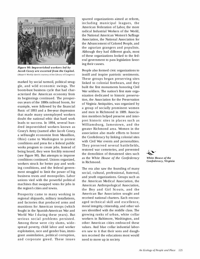
marked by social turmoil, political strug-gle, and wild economic swings. Theboom-bust business cycle that had char-acterized the American economy fromits beginnings continued. The prosper-ous years of the 1880s railroad boom, forexample, were followed by the financialPanic of 1893 and a five-year depressionthat made many unemployed workersdoubt the national ethic that hard workleads to success. In 1894, several hun-dred impoverished workers known asCoxey’s Army (named after Jacob Coxey,a self-taught economist from Massillion,Ohio) came to Washington to protestconditions and press for a federal publicworks program to create jobs. Instead ofbeing heard, they were forcibly removed(see Figure 90). But attempts to improveconditions continued. Unions organized,workers struck for better pay and work-ing conditions, and the federal govern-ment struggled to limit the power of bigbusiness trusts and monopolies. Laborunions vied with the powerful politicalmachines that swapped votes for jobs inthe region’s cities and towns.
Prosperity came to many working inregional shipyards, military installations,and factories that produced arms andmunitions for American troops (whichfought in the Spanish-American War andWorld War I during these years). Butserious social problems persisted.Among these were city slums, wide-spread poverty, child labor and workerexploitation, race and gender bias, immi-grant assimilation, political corruption,and corporate greed. These issues
spurred organizations aimed at reform,including municipal leagues, theAmerican Federation of Labor, the moreradical Industrial Workers of the World,the National American Women’s SuffrageAssociation, the National Association forthe Advancement of Colored People, andthe agrarian grangers and populists.Although they had different goals, mostof these organizations looked to the fed-eral government to pass legislation favor-ing their causes.
People also formed civic organizations toinstill and inspire patriotic sentiments.These groups began preserving siteslinked to colonial forebears, and theybuilt the first monuments honoring CivilWar soldiers. The nation’s first state orga-nization dedicated to historic preserva-tion, the Association for the Preservationof Virginia Antiquities, was organized bya group of socially prominent womenand men in Richmond in 1889. Associa-tion members helped preserve and inter-pret historic sites in places such asWilliamsburg, Jamestown, and thegreater Richmond area. Women in theassociation also made efforts to honorthe Confederacy by linking colonial siteswith Civil War events and personalities.They preserved several battlefields,restored war cemeteries, and preventedthe demolition of threatened sites suchas the White House of the Confederacyin Richmond.
The era also saw the founding of manysocial, cultural, professional, fraternal,and youth organizations. Groups such asthe American Medical Association, theAmerican Anthropological Association,the Boy and Girl Scouts, and theAmerican Bar Association sought andreceived national charters. Each encour-aged technical skill and excellence,moral integrity, citizenship, and other val-ues identified with the middle class. Thegrowing ranks of urban, white collarworkers in Baltimore, Washington, andother American cities embraced thesevalues. And blue collar industrial labor-ers saw to it that their sons and daugh-ters received the educations most wouldneed to move up in society.
An Ecology of People and Place 125
Figure 90: Impoverished workers led byJacob Coxey are escorted from the Capitol.(Harper’s Weekly sketch courtesy of the Library of Congress)
White House of theConfederacy, Virginia

More reactionary movements also grewstronger in the early decades of the twen-tieth century. Anti-immigrant and whitesupremacist organizations such as the KuKlux Klan grew increasingly influential.Reinventing itself in 1915 as an organiza-tion that was committed to 100 percentAmericanism and opposed to blacks,Jews, Catholics, and immigrants, the KuKlux Klan quickly grew into the nation’slargest fraternal organization of theperiod. Claiming some 4 million mem-bers, the Klan displayed its power in
September 13, 1926 in one of the largestmarches yet seen in Washington, D.C.(see Figure 91). The organizationdeclined as rapidly as it rose. Rocked byscandals exposing the corruption andhypocrisy of several of its key leaders, its’numbers dropped to less than a few hun-dred thousand members by 1929.Although it again rose to national atten-tion as a reactionary group opposingcivil rights during the 1960s, it did notplay a significant role in Chesapeakeregion life during the remainder of thecentury.
Groups pursuing specific social, politi-cal, and economic agendas sometimesmade strange alliances that highlight theera’s complexities. For example, newimmigrants–who competed with AfricanAmericans for jobs as unskilled labor-ers–sometimes found themselves agree-ing with racists who were otherwise farfrom friendly to their interests.
The years between 1880 and 1930 wereparticularly difficult for AfricanAmericans. Although clever marketeers,such as Margaret L. “Maggie” Walker ofRichmond’s Jackson Ward, made sizablefortunes, nearly all African Americanssuffered from poverty and intense dis-crimination. Gains were made in thedecades just after the war–as when theVirginia assembly established theNormal and Collegiate Institute for
126 CHAPTER EIGHT: URBANIZATION
Figure 91: The Ku Klux Klan Marches DownPennsylvania Avenue, September 13, 1926.(Photograph courtesy of the Library of Congress)
JACKSON WARD HISTORIC DISTRICT. One ofseveral Richmond city districts named forpresidents, Jackson Ward was a center of AfricanAmerican life and culture in Virginia from 1871to 1905. Today, the district covers a thirty-eightblock area of free-standing and attached two andthree story town houses. Significant figures inAfrican American arts, commerce, andcommunity life, such as John Mitchell, W.W.Browne, Giles B. Jackson, and Margaret L.“Maggie” Walker (see Figure 92), lived in GreekRevival, Italianate, or vernacular homes alongthe ward’s tree-lined streets. The more elaborateof these homes featured spacious yards borderedby ornamental cast iron fences. Today, well-preserved Doric columns, Italianate ironwork, and Eastlake-style Victorian wooden fretwork continue to adorn many town house porches in the district.
Figure 92: Maggie L. Walker Streetscape, Jackson Ward,Richmond, Virginia.(Photograph courtesy of the National Park Service)
Normal and CollegiateInstitute for Negroes,
Virginia

Negroes and the Central Hospital formentally ill African Americans–but thesewere lost when Virginia joined othersouthern states by passing voting lawsthat took the vote from AfricanAmericans in the final years of the nine-teenth century. Other Jim Crow laws for-mally defined people of mixed ancestryas colored or negroes, strictly segregatedthe races, and otherwise treated AfricanAmericans as second-class citizens.
Hopes for African American equalitywere suppressed by terror as well as law.The Black Codes required absolute sub-ordination and subservience, and menbelieved to have violated them were kid-naped, tortured, and hanged by racistvigilantes. Lynchings became distress-ingly common during the depressionyears of the mid-1890s, when racistwhites vented their frustrations on blackneighbors. Hundreds of thousands ofAfrican Americans moved north to citiessuch as Washington, D.C., and Baltimoreto escape lynch law and find work andsecurity. Denied all but the mostunskilled labor, most were forced tomove into neglected tenements in themost rundown parts of town. Municipalagencies and local assistance organiza-tions would not serve them adequately,so they formed banks, churches, and selfhelp associations of their own.
When the nation mobilized for WorldWar I, government authority grew inways not seen since the Civil War. Thefederal government nationalized rail-roads, rationed food and fuel, andworked with states to establish war indus-try boards requiring industries to givefirst priority to military production. Oldinstallations were reactivated and newcamps and stations constructed through-out the region. Hundreds of warshipsand merchant vessels were built in ship-yards in Washington, Baltimore, andNewport News. Uniforms and otherequipment were manufactured inRichmond, Baltimore, and mill townsthroughout the region. Thousands ofChesapeake Bay men, both black andwhite, were drafted. Many of themserved in France. Because they wereserving in a segregated army, most
African American troops were relegatedto digging trenches, carrying supplies,and other manual labor performed bywork battalions. Women, who previouslyhad largely been barred from mostfactory work, took jobs in industriesneeding replacements for departingservicemen. Other women sold warbonds, collected scrap metal for the wareffort, and served as nurses in camps athome and abroad.
The war effort fueled a prosperity thatcarried into the 1920s. Products fromAmerica’s farms and factories foundready markets at home and abroad, andstock speculation heated an already hotmarket. Some items on the progressiveagenda, such as women’s suffrage (seeFigure 93) and prohibition, were enactedinto law. Congress also passed reac-tionary legislation, such as the 1924Immigration Act, which drasticallyslashed immigration quotas and barredfurther immigration from Asia. Othercauses, such as the struggle againstracial discrimination, had to wait forlater times and legislatures.
During this decade, the people of theUnited States looked inward and soughtentertainment in amusement parks,resorts such as Maryland’s ChesapeakeBeach and Piney Point, movie houses,and, for many, speakeasies that cateredto those with tastes for alcohol, gam-bling, and other outlawed vices.
An Ecology of People and Place 127
Figure 93: Suffragettes March for the Vote on Pennsylvania Avenue,March 3, 1913. (Photograph courtesy of the Library of Congress)
Chesapeake Beach andPiney Point, Maryland
Central Hospital,Virginia

Baseball, football, and other sportsbecame increasingly popular. Nearlyevery social and business group or insti-tution organized ball clubs. Ball fieldssprang up nearly everywhere. Wood andsteel stands with commanding views ofcarefully tended clay base paths andmown grass playing fields became fix-tures in community landscapes. Playerseverywhere competed on sand lots, citystreets, school yards, and park lawns.Well funded and highly organized profes-sional and college teams played tocrowds of thousands in vast stadiums.Celebrated sports figures, such asBaltimore’s favorite son, George Herman“Babe” Ruth, became popular cultureicons. Ruth’s flamboyant personality andlavish life style came to symbolize theliveliness, prosperity, and excesses of theRoaring Twenties. But the era ended sud-denly on October 29, 1929. On a dayknown as Black Tuesday, an enormousdrop in stock prices plunged theChesapeake region and the rest of theUnited States and the world into a devas-tatingly sudden economic decline. Thisgrim time is now remembered as theGreat Depression.
M PLACE
Between 1880 and 1930, unprecedentedchanges in technology and societyallowed people to transform ChesapeakeBay lands, waters, and skies. Theyaltered the region in ways no one hadthought possible or even desired. Valuableinnovations often affected the environ-ment, sometimes in unexpected ways.For example, after 1886, all railroad com-panies began using a 4 foot, 8.5 inch-wide standard track gauge, making theirlines compatible. This meant that trainscould run freely throughout the region.Thus steam engines of the Baltimore andOhio, Chesapeake and Ohio, and NorfolkSouthern lines could more efficientlybring in western livestock, mid-westerngrain, Pittsburgh steel, Northern manu-factures, and Southern mill products.These imports enriched life in Chesa-peake Bay cities, towns, and farms.
As desirable as these imports were, thetrains carrying them hauled and burned
highly polluting coal. The coal camefrom mines farther inland along theupper reaches of the Potomac andSusquehanna river valleys. Tailings andother wastes from the mines wereflushed into nearby rivers, where theymixed with sediments washed fromdeforested uplands. Farther down river,these waters were further sullied by soilseroded from farm fields, factory wastes,and, finally municipal sewage. Noxiousmicrobes flourished as fish, shellfish,plants, and other aquatic life sickenedand died in the increasingly toxic murkywaters of the Bay estuary.
Each new form of energy took its toll.When natural energy sources such aswood and wind were replaced with coal,oil, and gas, non-biodegradable wasteproducts polluted the region. The burn-ing of coal to fuel furnaces, heat boilers,or turn steam turbines may have gottenrid of the problems caused by earliersources of power– the smoke from woodfires and manure runoff wastes fromhorses, mules, and other draft animals–but coal also created serious problems.Coal burned in engines, plants, andbuildings poured smoke into the region’sskies. Highly acidic coal mining wasteswere released into Chesapeake drainagerivers. Coal miners and stokers breathedever growing quantities of lethal coaldust into their lungs, paying their ownsteep price for progress. Other costs wereharder to measure. While we do knowthat average temperatures worldwidegenerally have been rising since the1880s, no direct evidence has yet provedthat burning coal and other fossil fuelshelped create this trend.
In the late nineteenth century, sport fish-ermen and government scientists pub-lished reports speculating that increasedwater pollution was threatening the eel-grass in Chesapeake Bay waters. Otherreports showed that water chestnut andEurasian watermilfoil–invasive waterplants accidentally introduced into Baywaters by passing ships–began takingspace, light, and nutrients away from eel-grasses and other native water plantssometime between 1880 and 1900. Moreand more aware of how important
128 CHAPTER EIGHT: URBANIZATION

submerged aquatic plants are to Bayecology, the region’s scientists and con-servationists began to study the lifecycles and habitat needs of these andother invasive species at this time.
Forests also suffered from populationand industrial expansion. By 1900, lessthan 30 percent of the Chesapeake Baywatershed’s original forests remained.Woodsmen could no longer find stand-ing trees large enough to supply the shin-gles and shakes widely used for roofsand siding (see Figure 94). Looking fornew sources of supply, they began tomine the ancient bald cypress andAtlantic white cedar trunks buried inbogs on the Pocomoke River and else-where. Most of the cleared lands in theCoastal Plain and Piedmont valleys wereturned to agricultural or livestock uses.People also drained wetlands to createmore farmlands and to destroy thebreeding grounds of mosquitoes andother insect pests. Such activities alsochanged the composition of tidewaterforests. Farther inland, clear cuttingincreased erosion and altered the chemi-cal composition of soils by exposingthem to sun, wind, and rain. Thesechanges made it harder for young treesto reclaim logged tracts, especially insteep, hilly areas. And foreign tree dis-eases–chestnut blight and Dutch elm dis-ease–all but exterminated chestnut andelm trees in the region.
Pollution and intensified use also hadserious impacts on Chesapeake Bay fish
and shellfish populations in this period.We find evidence of this in Virginia’s andMaryland’s state game records, first keptin the 1880s. These show that Americanshad, Atlantic menhaden, alewife her-ring, American croaker, and other fin-fishsupported a large commercial fishery. By1920, more than 60 million pounds offish were reported to have been takenfrom Bay waters. Of this amount, 12 mil-lion pounds, then valued at $850,000,were caught in Maryland. The remaining48 million pounds, worth $2.4 million atthe time, came from Virginia waters.About 90 percent of the entire catch con-sisted of alewives, croakers, shad, andAmerican menhaden.
We do not have statistics showing exactlyhow far fish populations had declined.But the situation concerned fish andwildlife officials enough to cause themto begin opening fish hatcheries by thelate 1870s. They were concerned notonly by over-fishing, but also by the con-struction of dams that blocked spawningstreams, keeping fish from swimmingupriver to lay their eggs and deprivingtheir young of a safe habitat. Hatcheries,artificial oyster beds, cages, and artificialponds holding large numbers of dia-mondback terrapins sold to marketsbecame increasingly common by theturn of the century. Bag limits were en-acted to limit over-harvesting of econom-ically important species, but poachinggrew into a major problem as fishermenignored these limits. Oystermen couldnot make a living by working clam banksin the open water, because these bankshad been depleted. Guarding their owngrounds from small watch houses stand-ing on tall support timbers pounded intotidal mud, many continued to raid eachother’s beds and nurseries.
Birds were affected by environmentalchanges as well. In the early 1900s, con-cerned bird enthusiasts–members of thenewly founded Audubon Society–beganconducting bird counts on the Bay everyChristmas. Their activities, along withthose of state fish and game agents,became important tools for estimatingbird population sizes, varieties, and dis-tributions. Observations made by
An Ecology of People and Place 129
Figure 94: Carting Shingles. (From The Trans-formation of Virginia, 1740-1790 by Rhys Isaac; used by per-mission of the University of North Carolina Press ©1982)

ornithologists helped show how otherchanges in the environment affectedbirds. They noted that drought anddecreases in eelgrass and other under-water plants threatened populations ofcanvasback ducks and other waterfowl.
Unrestricted market and sport shooting,too, had devastating effects on some birdpopulations. Finally, Congress passed theMigratory Bird Treaty Act in 1918. The actoutlawed the killing of rare whistlingswans, established limited hunting sea-sons, and set bag limits for waterfowlmigrating across international boundaries.But no legislation could protect devastatedpopulations of Carolina parakeets andthe once-common passenger pigeon.The last representatives of these speciesdied in zoos during the 1920s, markingtheir final extinction and alarming con-cerned people everywhere.
THE CULTURAL LAND-SCAPE OF URBANIZATION
M PEOPLING PLACES
As noted, revolutionary industrial devel-opments and population changes helpedpeople make indelible marks on theregion’s cultural landscape between 1880and 1930. Many of these marks are stillvisible today. Chesapeake Bay cities be-gan to assume their modern appearancesas skyscrapers, government buildings,commercial establishments, apartment
houses, tenements, row houses, andmany other structures rose over streetspaved with Belgian block cobbles, con-crete slabs, and poured asphalt. Initially,self-propelled bicycles competed forspace on these streets with horse andmule drawn carts, wagons, and street-cars. Trolleys, trucks, buses, and automo-biles dominated the region’s roads andbyways by the end of the period.
In the region’s cities, new immigrants set-tled into urban ethnic neighborhoodswith signs in both English and theirnative languages. They added oniondomes and other familiar architecturaltouches from their home countries to themany churches, shops, and halls erectedin popular styles–first in the ornateVictorian, classical, romantic modes,then in the traditional colonial revivalstyle, and finally in the streamlined artmoderne and art deco styles.
Wealthier citizens usually lived on fash-ionable avenues in or near city centers(see Figure 95). Yet many of the moreaffluent classes began moving out of citycenters to new suburbs constructed inthe nearby countryside along trolley andrail lines. Often they moved to escapethe clutter and noise of crowded urbanlife. In the suburbs, they engaged the ser-vices of shopkeepers and skilled, whitecollar workers. Often, these workersreturned to rented apartments or roomsin the city after work. Wealthier residentsof cities and suburbs hired live-in ser-vants who slept in separate quarters inthe main house or in small buildings onhouse grounds.
Rural county seats became smaller repli-cas of major cities. Market, mill, and can-nery towns also grew larger and morecomplex. But most smaller towns and vil-lages in more remote areas–places suchas the Maryland Coastal Plain fishing vil-lage of Crisfield and other locales in theextreme southern, western, and easternparts of the region–did not change muchbetween 1880 and 1930. Although mech-anization made farming more efficient,and improvements such as refrigeratorcars hurried perishable foods to marketmore quickly, rural farms mostly remained
130 CHAPTER EIGHT: URBANIZATION
Figure 95: Baltimore’s Mount Vernon District.(Photograph courtesy of the Dennis Montagna Collection)

as they were, maintaining earlier dimen-sions and staying in the same locations.
People continued to live in greater num-bers north of the Potomac River. TheEastern Shore and southeastern Virginiacontinued to be sparsely populated.Mass migrations of rural AfricanAmericans and poor whites occurredduring and after World War I. Mostly,these people moved to Washington orBaltimore, but many also took up resi-dence in Richmond and Newport News.Their migration sent overall rural popula-tions into a decline that has yet to end.
M CREATION OF SOCIALINSTITUTIONS
The focus of the region’s social life shiftedeven further away from the family domes-tic sphere to more community centeredorganizations. This shift was reflected inthe many new meeting halls, churches,campgrounds, resorts, and other facilitiesbuilt between 1880 and 1930. Commu-nities also arranged for the constructionof many new courthouses, office build-ings, primary and secondary schools,university campuses, and teacher’s col-leges both in cities and in rural locales.Most of these structures were built usinglocally available wood, stone, brick, andglass construction materials. Railroadsand ships brought in metal structural ele-ments and fixtures. Architectural flour-ishes were crafted in Chesapeake Bayworkshops or imported from elsewhere.Terra cotta tiles, stained glass, cut crystalwindows, and intricately sawn timberfretwork were among the many em-bellishments popular during the period.
Domestic and community buildings,decor, and ground plans were generallytidy and ornate. Their well ordered stylecelebrated middle class values of com-fort and respectability, which were thesocial ideal at the time for most peoplein the region. Wealthy women belongingto the Garden Club of Virginia, for exam-ple, began sponsoring the restoration ofgardens and grounds of historic planta-tions, homes, churches, and mills duringthe 1920s. They and like-minded people
thought that such projects both beauti-fied the landscape and provided exam-ples that helped instill immigrants andthe poor with so-called American values.By adopting these values, the theorywent, impoverished people would risefrom poverty and immigrants wouldcompletely assimilate into Americansociety. Not surprisingly, then, this middleclass design sense also showed up in thehostels, soup kitchens, and settlementhouses of relief organizations such as theSalvation Army; in facilities run by theYoung Men’s and Women’s Christian andHebrew Associations and similar com-munity support groups; in social clubscatering to particular classes, profes-sions, or ethnic groups; and in publicinstitutions such as sanitariums, poorhouses, hospitals, and penitentiaries.
M EXPRESSING CULTURALVALUES
The middle class ethos also showed upin the architectural designs of the manybuildings erected to house cultural insti-tutions between 1880 and 1930. Statelymonuments and imposing stone andbrick museums and libraries, oftenendowed by wealthy philanthropists,shot up in the region’s cities and in manyof its larger county seats and towns. Bigcities such as Baltimore, Washington,and Richmond supported conservatories,opera houses, art institutes, science organi-zations, zoological parks, and botanicalgardens. Schools, colleges, and universi-ties also mushroomed. The more suc-cessful of these soon moved from centercity office buildings to suburban cam-puses on the edges of towns. The mostelaborate campuses boasted suites ofbuildings in the same architectural style.These were often located on tastefullywinding tree lined roads in park-like set-tings. As these suburban campuses drewbusinesses to their areas, many soon gotswallowed up in just the sort of urbanexpansion they had tried to escape.
Popular culture also flourished in thesedecades. Saloons; dance, music, andvaudeville halls; gyms; ballfields; and
The Cultural Landscape of Urbanization 131

amusement parks went up everywhere.These were mostly housed in brick orwooden-framed structures, with stylesranging from utilitarian sturdiness togaudily colorful flashiness. Burlesquehalls, bordellos, and–during prohibition–speakeasies, catered to tastes that couldnot be openly acknowledged elsewhere.
Modernist movements emerged in artisticcommunities in Washington and othercities during the turn of the century.Their creators strove to break with pastcultural traditions. They shared a rebel-lious spirit, wishing to undermine thehigh culture they associated with elitistclass distinctions and Old World snob-bery. Modernists tried to create a new,native born cultural vocabulary that allAmericans could understand and appre-ciate. Their sense of design replacedostentation, literalness, and Victorianclutter with simplicity, abstraction, andstreamlined sleekness. Modernist cul-tural values found expression in art mod-erne and art deco skyscraper andcommercial design; in streamlined loco-motives, airplanes, and automobiles; inliterature; and in the decorative arts.
Rural areas, by contrast, largely main-tained more traditional cultural values.This was especially the case in southeast-ern Virginia and the Eastern Shore,where many homes continued to bebuilt in traditional local styles, includingthe central-hall dogtrot layout and themodest bungalow format. Some of themore well-to-do rural families chose tolive in standardized, prefabricatedhomes sold through mail order catalogsby new companies such as Sears andRoebuck. Manufacturing plants shippedthese in pieces by rail, delivering them toconstruction sites. Commercial and pub-lic buildings in rural areas also tended toreflect more conventional cultural view-points and tastes.
M SHAPING THE POLITICALLANDSCAPE
Political struggles between rich and poor,labor and management, white andblack, progressives and reactionaries,and native and foreign born Americans
shaped political aspects of the region’scultural landscape. People gathered inhalls, town squares, fields, stadiums, andother public spaces to debate the issuesof the day. Lawmakers voted for moreand more funds for larger and moreornate halls of government. Courthouses,records halls, and prisons grew in sizeand grandeur as more and more policeofficers, lawyers, jurists, and clerksenforced laws enacted by federal, state,and local legislators. Today consideredquaint and charming, the fortress-likeappearance of many of these structuresactually reflects the need at the time toprotect law enforcement personnel fromlynch mobs and possible attacks of anar-chists and other political radicals.
Federal office buildings, courthouses,and other facilities rose in all cities andmost county seats as people looked tothe central government for solutions topolitical problems. Imposing castle-likearmories surrounded by brick or stonewalls were built to store munitions andtrain troops. They were also intended toserve as fortresses in the event of civilrevolt. Wilderness lands and historicallysignificant sites were set aside fornational forests, wildlife refuges, parks,and monuments. Created in 1915, theUnited States Coast Guard maintainedChesapeake Bay lighthouses and policedthe region’s shipping lanes and fishinggrounds. Also, for the first time in thenation’s history, the government contin-ued to maintain and build military bases,testing grounds, and munitions depots ata time when no war was in progress.Many of these facilities had been builtduring World War I, and most were con-sidered necessary to maintain nationalsecurity in an increasingly dangerousworld.
M DEVELOPING THECHESAPEAKE ECONOMY
Industrial mass production came todominate most of the region’s economyduring this period. Manufacturingprocesses were usually centralized inlarge factory complexes near rail lines,waterways, or sources of raw materials
132 CHAPTER EIGHT: URBANIZATION

(see Figure 96). Workers and machinerywere often housed in stout brick plantcomplexes. These were frequently sur-rounded by fences or walls of brick orstone. Massive smokestacks belchedsmoke into the air, and raw factory wastesflowed into the nearest rivers and streams.
Working long hours at low wages, factoryworkers tended to live in row houses,tenements, or small one or two familyhouses near work (see Figure 97). Super-
visors and managerslived in larger middleclass homes, usually onlands affording com-manding views of fac-tory complexes. Mostfactory owners favoredhigh-style mansions onlarge, landscaped lots,for both their maindwellings and theircountry homes. Manyof their main dwellingswere built in more fash-ionable parts of townor in suburbs–far fromthe grime and filthpouring from theirplants. Others had theirgreat houses built close
to their factories. In northern parts of theregion, many officers of corporationsowning factories and other companiescompeted with one another to buildever-taller and more ornate skyscrapersin city business districts.
Banks, brokerages, insurance compa-nies, specialty shops, professional officecomplexes, and department stores lineddowntown boulevards. Vast rail andstockyards occupied expanses of openground behind city terminals, whileforests of ship’s masts filled the skiesalong long lines of piers, shed-coveredwharves, and warehouses stretchedacross urban waterfronts (see Figure 98).Ships and trains brought unprocessedbulk products such as wheat, sugar cane,corn, cattle, and petroleum to concreteand steel mills, refineries, and storagetanks on the outskirts of Chesapeake Baycities. Short haul rail lines and trucks car-ried fresh farm produce to nearby citiesand towns. Commercial fishermen andoystermen brought their catches to Baycanneries or local marketplaces.
Tourism and the entertainment indus-tries boomed as large numbers of moreaffluent people looked for enjoyableways to fill their leisure time. Commu-nities and businesses throughout theregion began using outdoor billboards,newspaper ads, and other new advertisingtechniques to draw cash carrying visitors
The Cultural Landscape of Urbanization 133
Figure 97: Baltimore Row Houses, 1981:The 500 block of South Chapel Street inthe Fells Point neighborhood.(Photograph by Elaine Eff courtesy of the Painted ScreenSociety of Baltimore, inc.)
Figure 98: Oyster Fleet inBaltimore Harbor, ca. 1885.(Photograph courtesy of the NationalArchives)
Figure 96: Aerial View of Ellicott Mills Looking North TowardEllicott City, Maryland.(Photograph courtesy of the National Park Service and the Library of Congress)

to local attractions. These includedbeaches, hotels, health resorts, spas,campgrounds, amusement parks, andrecreation grounds.
M EXPANDING SCIENCE ANDTECHNOLOGY
As noted, scientific and technologicaldevelopments of this period made animprint that continues to dominate theregion’s cultural landscape to the presentday. In this era, technologies basedmostly on muscle power, wood, sail,steam, coal, and iron gave way to a moremodern set centered on petrochemicals,steel, and electromagnetic energy. Theera also saw a shift from a wide range oflocally available natural resources thatcould be used pretty much as they wereto a much narrower range of importedsubstances that could be modified intoa multitude of refined and syntheticproducts.
Scientists working in research centerssuch as Baltimore’s Johns HopkinsUniversity and the campuses of theUniversity of Maryland made majoradvances in medicine, chemistry, andengineering. Scientists at the agriculturalextension stations of regional land grantcolleges developed new ways of farmingthat improved yields and conserved soiland water. The first steam powered trac-tors appeared, along with new, moredurable, and increasingly efficient typesof metal corn cribs, barbed wire andchain link fences, and other agriculturalinnovations. Samuel Langley and otherscientists in the region’s many armycamps and naval facilities made majorcontributions to aeronautical, nautical,and military engineering.
Regional artisans and mechanics alsocontinued to refine their crafts and skills.Fishermen and shipwrights used the newmaterials and manufacturing techniquesto improve vessel design and developnew types of tackle and gear. The grow-ing popularity of sport fishing createdmarkets that allowed Chesapeake Baycarvers to bring wooden decoy art tonew heights. And because cheap, massproduced furnishings were easy avail-
able, more people came to appreciatethe value of finely handcrafted items.Those who could afford them sought outhandmade decorative merchandise,increasing demand and raising produc-tion levels.
M TRANSFORMING THEENVIRONMENT
The new technologies emerging in thisera gave people the ability to transformthe region’s environment in ways notthought possible by their ancestors. Newmachines and energy sources allowedpeople to move and manipulateunheard of volumes of goods and materi-als. Pumps and dredges drained wet-lands to destroy habitats of mosquitoesand other disease carrying pests.Swamps and marshes also turned intomunicipal waste dumps or were filled tocreate new land for development. Eventhe earth gave way as men blasted rockwith dynamite and moved it with steamshovels, bulldozers, barges, and trucks.
Monumental buildings supported bysteel frames and clad in stone and brickmasonry were constructed in denseurban cores along avenues whosedimensions had not been changed sincecity founders had first laid out their origi-nal street plans. These included cityhalls, office buildings, churches, rail ter-minals, train sheds, and departmentstores. Powerful Washington politicianMayor Alexander Shepard, motivated vot-ers to approve expenditures aimed atclearing up some of the congestion clog-ging the city. He wanted to turnWashington into a place that reflectedboth the nation’s power and the highcost of its real estate. Shepard narrowedand paved the city’s wide boulevards,planted ornamental shade trees, clearedshanties and makeshift market stalls, andordered railroads to meet city specifiedgrade levels at street crossings. The citywas also beautified by new elegantlylandscaped parks, cemeteries, hospitalgrounds, and college campuses. Many ofthese were designed by such prominentdesigners as Calvert Vaux and FrederickLaw Olmsted, Jr.
134 CHAPTER EIGHT: URBANIZATION
Johns HopkinsUniversity and
University ofMaryland

Other efforts to streamline urban devel-opment in the region soon followed.Congress passed the Highway Act of1893, providing funds to begin linkingcities and suburbs throughout the regionwith landscaped parkways. AndWashington’s central mall, park system,and monuments–along with the BeauxArts architectural style of many of theedifices built in the early twentieth cen-tury–can be traced to the recommenda-tions of the 1902 MacMillan Commission.Made up of a blue ribbon board thatincluded Olmsted, architects CharlesMcKim and Daniel Burnham, and sculp-tor Augustus Saint-Gaudens, the commis-sion’s findings soon became a modeladopted by other American cities,including Richmond and Baltimore.
A vast network of new roads, interurbanrail lines, and, later, flying fields linkedChesapeake Bay cities with the country-side. Planned suburban developments,such as Roland Park, began to appearalong the margins of developed urbanareas (see Figure 99). Roland Park is alarge-lot wooded residential preservebuilt by the Olmsted firm on the outskirtsof Baltimore between 1891 and 1910. Anelegant, upper middle class communityof homes built in several popular styles,Roland Park gradually changed from afreestanding suburban community to aresidential city neighborhood as Balti-more expanded around it in the 1920s.
In rural areas, farmers using new reapers,tractors, fertilizers, and insecticideschanged their products. Many turnedfrom large scale cultivation of tobacco,wheat, or corn to production of the moreperishable fruits, vegetables, poultry, anddairy products demanded by urban andsuburban consumers. Automobiles andtrucks dominated the region’s hinterland.Farmers drove produce to markets, fairs,and railheads; suburbanites navigatedfrom home to work or school; and cityfolk took drives in the country.Continually improved, many of theseroads have since become U.S. Routesand State Highways.
M CHANGING ROLE OF THECHESAPEAKE IN THEWORLD COMMUNITY
Urban growth, technological change,and national involvement in world affairscreated demands for imports and fastercommunications. In meeting thesedemands, the Chesapeake Bay regiongrew more firmly linked with the worldcommunity. As in earlier periods,wharves, warehouses, and the manyhulks of maritime vessels that sank or set-tled to the bottom of Chesapeake Baybetween 1880 and 1930 testify to itsactive maritime trade. This trade stimu-lated the development of deepwater har-bors at Baltimore, Norfolk, and NewportNews. Surviving skipjacks recall theProhibition years at the end of this peri-od, when ships smuggled contrabandalcohol through those ports. Ever denserconcentrations of army camps, navalfacilities, and munitions plants in andaround Washington, D.C. bear witness tothe United States’s growing ability to pro-ject power beyond its borders in foreignconflicts, such as the Spanish-AmericanWar and World War I. These military sitesinclude the Washington Navy Yard, theUnited States Marine Corps Barracks,and Alexandria’s Torpedo Factory, Thehulk of the battleship Ostfriesland,surrendered by Germany following the
The Cultural Landscape of Urbanization 135
Figure 99: Shopping Center in suburban Roland Park, designed bythe Olmsted firm between 1891 and 1910.(Photograph courtesy of the Library of Congress)
Washington Navy Yard,Washington, D.C.
United States MarineCorps Barracks andTorpedo Factory,Virginia
Roland Park, Maryland
end of World War I and renamed the SanMarco, further testifies to the rise ofAmerica as a global power. Resting at thebottom off Cape Henry, she was sunk byarmy bombers on July 21, 1922 underthe command of air war pioneer ColonelWilliam “Billy” Mitchell in a demonstra-tion that conclusively showed that capitalships could be sunk by bombs droppedby airplanes.
FURTHER INFORMATIONForemost among the many sourcescontaining useful informationsurveying this period in ChesapeakeBay history are these works:
Carol Ashe, Four Hundred Years ofVirginia, 1584-1984: An Anthology(1985).
Carl Bode, Maryland: A BicentennialHistory (1978).
Daniel J. Boorstin, The Americans (1973).
Robert J. Brugger, Maryland: A MiddleTemperament,1634-1980 (1988).
Suzanne Chapelle, et al., Maryland: AHistory of Its People (1986).
Frances W. Dize, Smith Island,Chesapeake Bay (1990).
Federal Writers’ Program, Maryland: AGuide to the Old Line State (1940a).
——-, Virginia: A Guide to the OldDominion (1940b).
Frederick A. Gutheim, The Potomac(1968).
Alice Jane Lippson, The Chesapeake Bayin Maryland (1973).
Paul Metcalf, ed., Waters of Potowmack(1982).
Allen Morger, Virginia Bourbonism toByrd,1870-1925 (1968).
Lucien Niemeyer and Eugene L. Meyer,Chesapeake Country (1990).
Edward C. Papenfuse, et al., Maryland: ANew Guide to the Old Line State(1979).
Morris L. Radoff, The Old Line State: AHistory of Maryland (1971).
Emily J. Salmon, ed., A Hornbook ofVirginia History (1983).
Mame and Marion E. Warren, Maryland:Time Exposures,1840-1940 (1984).
John R. Wennersten, Maryland’s EasternShore: A Journey in Time and Place(1992).
Major environmental studies includethe following:
William C. Schroeder and Samuel F.Hillebrand, Fishes of Chesapeake Bay(1972).
James P. Thomas, ed., Chesapeake(1986).
P. R. Uhler and Otto Lugger, List of Fish ofMaryland (1876).
David A. Zegers, ed., At the Crossroads: ANatural History of SouthcentralPennsylvania (1994).
These useful atlases and geographicsurveys graphically depict large-scale development patterns inChesapeake Bay cultural landscapesof the period:
Michael Conzen, ed., The Making of theAmerican Landscape (1990).
David J. Cuff, et al., eds., The Atlas ofPennsylvania (1989).
James E. DiLisio, Maryland, A Geography(1983).
Donald W. Meinig, The Shaping ofAmerica.Volume 3: TranscontinentalAmerica,1850-1915 (1999).
Edward C. Papenfuse and Joseph M.Coale, eds., The Hammond-HarwoodHouse Atlas of Historical Maps ofMaryland,1608-1908 (1982).
Helen Hornbeck Tanner, ed., The Settlingof North America (1995).
Derek Thompson, et al., Atlas ofMaryland (1977).
Kent T. Zachary, Cultural Landscapes ofthe Potomac (1995).
136 CHAPTER EIGHT: URBANIZATION

Studies of individual, small-scalecommunities include this work:
Jack Temple Kirby, Poquosson (1986).
Biographical accounts providinginsights into individual lives includethe following:
Carl Bode, Mencken (1969).
John Sherwood, Maryland’s VanishingLives (1994).
William W. Warner, Beautiful Swimmers:Watermen, Crabs, and the ChesapeakeBay (1976).
Cultural life of the period isexamined in these texts:
Helen Chappell, Chesapeake Book of theDead (1999).
James M. Lindgren, Preserving the OldDominion: Historic Preservation andVirginia Traditionalism (1993).
Esther Wanning, Maryland: Art of theState (1998).
Dorothy Hunt Williams, Historic VirginiaGardens (1975).
Examples of the many studiessurveying key aspects of social life ofthe period include the following:
Dieter Cunz, The Maryland Germans(1948).
Bianca P. Floyd, Records and Reflections:Early Black History in Prince George’sCounty,Maryland (1989).
Mary Forsht-Tucker, et al., Associationand Community Histories of PrinceGeorge’s County (1996).
Kenneth T. Jackson, The Ku Klux Klan inthe City,1915-1930 (1967).
——-, Crabgrass Frontier: TheSuburbanization of the United States(1985).
Terry G. Jordan and Matti Kaups, TheAmerican Backwoods Frontier (1989).
Suzanne Lebsock, Virginia Women, 1600-1945 (1987).
Roland C. McConnell, Three Hundredand Fifty Years (1985).
Vera F. Rollo, The Black Experience inMaryland (1980).
Helen C. Rountree, Pocahontas’s People(1990).
Bruce G. Trigger, ed., Northeast (Vol. 15,Handbook of North American Indians,(1978).
Edward C. Papenfuse, et al., Maryland: ANew Guide to the Old Line State(1979).
Wilcomb E. Washburn, ed., History ofIndian-White Relations (Vol. 4,Handbook of North American Indians,1988).
Works containing useful insights intoperiod political life include:
James B. Crooks, Politics and Progress:The Rise of Urban Progressivism inBaltimore,1895 to 1911 (1968).
Robert B. Harmon, Government andPolitics in Maryland (1990).
Key economic studies include thefollowing:
Paula Johnson, ed., Working the Water(1988).
Joanne Passmore, History of theDelaware State Grange and the State’sAgriculture,1875-1975 (1975).
Glenn Porter, ed., Regional EconomicHistory of the Mid-Atlantic Area Since1700 (1976).
John R. Wennersten, The Oyster Wars ofChesapeake Bay (1981).
Useful analyses of the region’sscientific and technologicaldevelopments during the period maybe found in these texts:
Geoffrey M. Fostner, Tidewater Triumph(1998).
Thomas F. Hahn, The Chesapeake andOhio Canal (1984).
David C. Holly, Chesapeake Steamboats(1994).
David A. Hounshell, From the AmericanSystem to Mass Production, 1800-1932(1984).
Further Information 137

Walter S. Sanderlin, The Great NationalProject: A History of the Chesapeakeand Ohio Canal (1946).
David G. Shomette, Tidewater TimeCapsule (1995).
——, Shipwrecks on the Chesapeake(1982).
Fred A. Shannon, The Farmer’s LastFrontier:Agriculture,1860-1897 (1945).
Surveys examining the region’s builtenvironment include the following:
Pamela James Blumgart, At the Head ofthe Bay: A Cultural and ArchitecturalHistory of Cecil County, Maryland(1995).
Michael Bourne, et al., Architecture andChange in the Chesapeake (1998).
Henry Glassie, Pattern in the Material FolkCulture of the Eastern United States(1968).
——-, Folk Housing in Middle Virginia(1975).
Bernard L. Herman, Architecture andRural Life in Central Delaware, 1700-1900 (1987).
Terry G. Jordan, American Log Buildings(1985).
Gabrielle M. Lanier and Bernard L.Herman, Everyday Architecture of theMid-Atlantic (1997).
Marilynn Larew, Bel Air: An Architecturaland Cultural History,1782-1945 (1995).
Calder Loth, Virginia Landmarks of BlackHistory (1995).
Susan G. Pearl, Prince George’s CountyAfrican-American Heritage Survey(1996).
Paul Touart, Somerset: An ArchitecturalHistory (1990).
Dell Upton, ed., America’s ArchitecturalRoots (1986a).
——-, ed., Holy Things and Profane(1986b).
——-, and John Michael Vlach, eds.,Common Places (1986).
Donna Ware, Ann Arundel’s Legacy: TheHistoric Properties of Ann ArundelCounty (1990).
Christopher Weeks, ed., Where Land andWater Intertwine: An ArchitecturalHistory of Talbot County, Maryland(1984a).
——-, ed., Between the Nanticoke andthe Choptank (1984).
Archeological studies include these:
William M. Kelso and R. Most, eds., EarthPatterns (1990).
Paul A. Shackel and Barbara J. Little,Historical Archaeology of the Chesa-peake,1784-1994 (1994).
Paul A. Shackel, et al., eds., AnnapolisPasts (1998).
These are among the many studiesfocusing on the development ofWashington D.C. as a cosmopolitancenter:
Constance M. Green, Washington: AHistory of the Capital, 1879-1950(1962).
Frederick A. Gutheim, Worthy of theNation (1977).
Elizabeth Jo Lampl and KimberlyWilliams, Chevy Chase (1998).
Fredric M. Miller and Howard Gillette, Jr.,Washington Seen: A PhotographicHistory,1875- 1965 (1995).
The evolution of Baltimore as theregion’s most important urbancenter is traced in these works:
Alan D. Anderson, The Origin andResolution of an Urban Crisis:Baltimore,1890-1930 (1977).
Isaac M. Fein, The Making of an AmericanJewish Community (1971).
Leroy Graham, Baltimore:The Nineteenth-Century Black Capital (1982).
138 CHAPTER EIGHT: URBANIZATION

AN ECOLOGY OF PEOPLEAND PLACE
M PEOPLE
The 5 million inhabitants of the Chesa-peake Bay region faced a terrible para-dox in 1930 (see Map 11). On the surface,nothing seemed to have changed.Although population pressure hadclearly left a mark on the region, fish stillteemed in Bay waters, and farm fieldsstill swelled with produce ready for mar-ket. The impressive technologicaladvances that many believed wouldassure unending progress and prosperityhad not disappeared. Yet for a secondtime in less than forty years, financialdealings and market forces beyond theaverage person’s understanding hadplunged Chesapeake Bay and the rest ofthe nation into a devastating economicdownturn. This downturn is still knowntoday as the Great Depression.
This depression was even worse than theone in 1893. Foreign markets collapsedas the American crash triggered a world-wide panic. Money and credit suddenlybecame hard to get. Factories, shops,and businesses closed, unable to raise
An Ecology of People and Place 139
1950- 1965-1930 1933 1939 1940 1941 1945 1947 1953 1952 1973 1973 1983 1989 1990 2000
| | | | | | | | | | | | | | |Regional | WWII | America WWII | Korean | Vietnam | U.S. EPA | Regional |population | begins in | enters ends | War | War | establishes | population |reaches | Europe | WW II | | | Chesapeake | reaches |
5.0 million | | Cold War Chesapeake | Bay Program | 10.5million |Franklin | begins Bay Bridge | | |Delano Regional opens Chesapeake Soviet Union Regional
Roosevelt population Bay Bridge- collapses populationfirst elected nears Tunnel ending reaches
president 5.5 million opens Cold War 12.0 million
▫ 1930–regionalpopulation reaches5 million
▫ 1932–Federal troopsdisperse bonusmarchers inWashington
▫ 1933–FranklinDelano Rooseveltelected to first termas president
▫ 1935–Social SecurityAct passed byCongress
▫ 1939–World War IIbegins in Europe
▫ 1940–regionalpopulation nears 5.5million
▫ 1941–Americaenters World War IIon Allied side
▫ 1942–Pentagonopens in Arlington,Virginia
▫ 1945–Harry S.Truman becomespresident followingRoosevelt’s death
▫ 1945–World War IIends
▫ 1947–Cold Warbegins as ExecutiveOrder 9835 author-izes loyalty checks
▫ 1948 to 1950–AlgerHiss spy case
▫ 1950–postwarmigration combinedwith baby boomincrease regionalpopulation to7 million
▫ 1950 to 1953–Korean War foughtbetween U. S.–ledUnited Nationstroops andCommunist NorthKorean and Chineseforces
▫ 1952–ChesapeakeBay Bridge opens
▫ 1956–FederalInterstate HighwayAct passed byCongress
▫ 1958–National De-fense Education Actpassed by Congress
▫ 1964–EconomicOpportunity Actpassed by Congress
▫ 1965 to 1973–American militaryinvolvement inVietnam
▫ 1966–HistoricPreservation Actpassed by Congress
▫ 1968–riots inWashington,Baltimore, and otherChesapeake cities
▫ 1970–Amtrakestablished
▫ 1972–HurricaneAgnes devastatesregion
▫ 1973–ChesapeakeBay Bridge–Tunnelopens
▫ 1973–OPEC oilembargo createsfuel shortagesthroughout region
▫ 1983–EnvironmentalProtection AgencyestablishesChesapeake BayProgram
▫ 1989–Cold War endsas Soviet Unioncollapses
▫ 1990–regionalpopulation reaches10.5 million
▫ 2000–regionalpopulation reaches12 million
SIGNIFICANT EVENTS
Depression Era1930 to 1939
World War II1939 to 1945
Cold War1947 to 1989
New WorldEconomic Order
1989 to 2000
Chapter NineChesapeake Metropolis,
1930 to 2000

Susquehanna River
Mon
ocac
yR
iver
Cho
ptan
kR
iv
er
Rapidan River
Pat ap sc o R iver
Cheste
r Rive
rPotomac River
James River
Mattaponi RiverPamunkey River
App
omat
tox
Rive
r
Rappahannock River
Patuxent R
iver
Shen
ando
ah R
iver
Poco
mok
e Riv
er
Nan
tico
ke R
iver
Chesapeake B
ay
Rapp
a hannockRiver
York River
James River Cape
Henry
CapeCharles
Tangier Sound
Poto
mac
Riv
er
Chesapeake and
Delaware Canal
DismalSwamp Canal
KentIsland
SmithIsland
TangierIsland
81
50
301
3
64
50
70
70
76
95
81
95
83 40
13
95
13
50
301
95
301
95
64
460
85
81
460
64
13
1
1
1
1
1
76
95
Cat
octin
Rid
ge
Sou
th M
ount
ain
Harper's Ferry Gap
Manassas Gap
Bul
l Run
Mtn
.
ThorofareGap
Thornton Gap
Blu
e R
idge
Mou
ntai
ns
Rockfish Gap
Blue
Ridge
Mou
ntai
ns
James River Gap
SeashoreNatural AreaCharles C.Steirly
Natural Area
GreatDismalSwamp
Battle CreekCypress Swamp
Belt Woods
CaledonState Park
Montpelier Forest
Sugar LoafMountain
Long GreenCreek andSweathouseBranchNatural Area
Gilpin'sFalls
Ferncliff Wildlifeand Wildflower
Preserve
VirginiaCoast
Reserve
CalvertCliffs Preserve
PamunkeyIndian
Reservation Mattaponi IndianReservation
SionHill
Baltimore and Ohio Railroad
Norfolk & Southern RailroadNorfolk & Southern
Railroad
Norfo
lk & So
uthe
rn R
ailro
ad
Norfolk SouthernRailroad
Chesapeake andOhio Railroad (CSX)
Baltimore
Salisbury
Cambridge
Chesapeake City
Elkton
Lancaster
York
Frederick
Washington DC
Warrenton
Fredericksburg
Culpeper
Charlottesville
Harpers Ferry
Norfolk
Portsmouth
Richmond
Lynchburg
NewportNews
Annapolis
Fort Langley
Hampton
Hampto
n Roa
ds
●
●
●
●
●
●
●
●
●
●
●
●
●
●
●
●
●
●
●
●
●
●
●
●
Gen. GeorgeC. Marshall House
ChestertownHistoricDistrict
Camp Hoover
Conowingo Dam
Aberdeen ProvingGround
ChesapeakeBay Bridge
BWIAirport
Bethesda
C&O CanalNHP
Nat. Agric.Res. Ctr.
DullesIAP
PatuxentNaval AirStation
ColonialWilliamsburg
ChesapeakeBay Bridge
Tunnel
Colonial NHP/Jamestown NHS/
Yorktown Battlefield
ThomasStone NM
HopewellFurnace
NHS
HamptonNHS
Fort McHenry NM& Historic Shrine
Gettysburg NMP
Eisenhower NHS
Fredericksburg &SpotsylvaniaCounty NMP
George WashingtonBirthplace NM
AssateagueIsland NS
RichmondNBP
Maggie L.Walker NHS
PetersburgNB
Appomattox CourtHouse NHP
Green Springs
ShenandoahNP
Greenbelt
Columbia
WhitakerChambers
Farm
Rachel Carson House
VirginiaRandolphCottage
GariMelchers
Home
Robert R. MotonHigh School
Robert R. MotonHouse
St. Mary's City
Spence'sPoint
Towson
RockvilleSilver
Spring
Arlington
Alexandria
Petersburg
AMTRAK
AM
TRA
K
Virginia & Maryland Railroad
OccoquanManassasNational
Battlefield
AM
TR
AK
140 CHAPTER NINE: CHESAPEAKE METROPOLIS
Map 11: Chesapeake Metropolis, 1930 to 2000
0 5 10 25 50 miles
kilometers0 5 10 40 80 North
National Historic Landmark© National Natural LandmarkNational Park Unit
• City or Town■ Natural or Cultural Feature
Metropolitan Region
HighwayRailroadCanalBayPlainPiedmont
LEGEND

capital or meet payrolls (see Figure 100).Workers were fired and lost life savings assome banks failed and others foreclosedon heavily mortgaged homes, farms, andequipment.
The Depression hit hard everywhere inthe Chesapeake Bay region. Tens of thou-sands of unemployed workers facedpoverty in the cities and towns. Poor peo-ple in city tenements confronted thetwin specters of homelessness andhunger. In the countryside, farmers andfishermen, making barely enough to live,struggled to hold on to their fields, boats,and implements. President HerbertHoover’s pleas for executives to hire backworkers and increase production wereignored by corporations unable to sellproducts on depressed world markets.
As they did to Coxey’s Army in 1894, fed-eral troops scattered and burned asprawling camp of 20,000 destitute veter-ans in 1932 (see Figure 101). These veter-ans had marched on Washington to getan advance on bonus money promisedfor their war service.
Where, What, and When 141
KEY LOCALES
NATIONAL HISTORICLANDMARKS
District of ColumbiaConstitution Hall
[1924-1930]
Francis Perkins House[1937-1940]
Sequoia (Presidentialyacht) [1931-1977]
Supreme Court Building[1935]
MarylandRachel Carson House
[1956-1964], PrinceGeorge’s County
Whittaker Chambers Farm[1948], Carroll County
Greenbelt Historic District[1935-1946], PrinceGeorge’s County
Sion Hill [19th-20thcenturies], HarfordCounty
Spacecraft Magnetic TestFacility [1966], PrinceGeorge’s County
Baltimore CityLandmarks
Chesapeake (LightshipNo. 116) [1930]
College of Medicine ofMaryland [19th-20thcenturies]
Elmer V. McCollum House[ca. 1920]
U.S.S. Torsk [1944]
PennsylvaniaDwight D. Eisenhower
Farmstead [1950s],Adams County
VirginiaCamp Hoover [1929-
1932], Madison County
Gerald R. Ford, Jr. House[1955], Alexandria City
Jackson Ward HistoricDistrict [19th-20thcenturies], Richmond
General George C.Marshall House [1925-1949], Loudon County
Gari Melchers Home[1916-1932],Stafford County
Robert R. Moton HighSchool [1950-1974],Prince Edward County
Robert R. Moton House[1935], GloucesterCounty
Portsmouth (LightshipNo. 101) [1900-1949],Portsmouth
Virginia Randolph Cottage[1937], Henrico County
Savannah (Nuclear ship)[1958], Newport News
Spence’s Point, John R.Dos Passos Farm[1806, 1940s],Westmoreland County
Arlington CountyLandmarks
Charles Richard DrewHouse [1920-1939]
Fort Myer Historic District[1900s]
The Pentagon [1942]
CharlottesvilleLandmarks
Shack Mountain[1916-1955]
University of VirginiaHistoric District[19th-20th centuries]
Hampton CityLandmarks
EightFoot High-SpeedTunnel [1936-1956]
Full Scale Tunnel [1931],Hampton
Hampton Institute[1868-present]
Lunar Landing ResearchFacility [1965-1972]
Rendevous DockingSimulator [1963-1972]
Variable Density Tunnel[1921-1940]
Figure 101: Bonus March Shacks Afire,Anacostia Flat, Washington, 1932.(Photograph courtesy of the National Archives)
Figure 100: The Standard Oil Fleet in Mothballs duringthe Great Depression.(Photograph courtesy of the Calvert Marine Museum Collection)
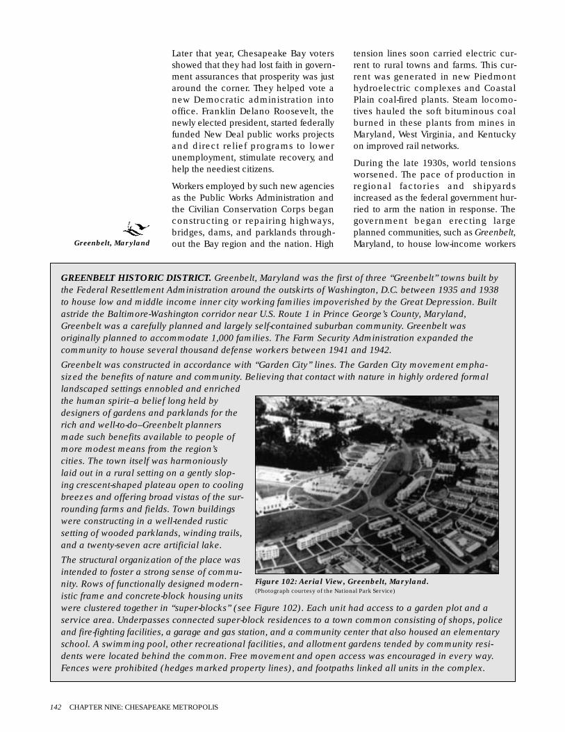
Later that year, Chesapeake Bay votersshowed that they had lost faith in govern-ment assurances that prosperity was justaround the corner. They helped vote anew Democratic administration intooffice. Franklin Delano Roosevelt, thenewly elected president, started federallyfunded New Deal public works projectsand direct relief programs to lowerunemployment, stimulate recovery, andhelp the neediest citizens.
Workers employed by such new agenciesas the Public Works Administration andthe Civilian Conservation Corps beganconstructing or repairing highways,bridges, dams, and parklands through-out the Bay region and the nation. High
tension lines soon carried electric cur-rent to rural towns and farms. This cur-rent was generated in new Piedmonthydroelectric complexes and CoastalPlain coal-fired plants. Steam locomo-tives hauled the soft bituminous coalburned in these plants from mines inMaryland, West Virginia, and Kentuckyon improved rail networks.
During the late 1930s, world tensionsworsened. The pace of production inregional factories and shipyardsincreased as the federal government hur-ried to arm the nation in response. Thegovernment began erecting largeplanned communities, such as Greenbelt,Maryland, to house low-income workers
142 CHAPTER NINE: CHESAPEAKE METROPOLIS
GREENBELT HISTORIC DISTRICT. Greenbelt, Maryland was the first of three “Greenbelt” towns built bythe Federal Resettlement Administration around the outskirts of Washington, D.C. between 1935 and 1938to house low and middle income inner city working families impoverished by the Great Depression. Builtastride the Baltimore-Washington corridor near U.S. Route 1 in Prince George’s County, Maryland,Greenbelt was a carefully planned and largely self-contained suburban community. Greenbelt wasoriginally planned to accommodate 1,000 families. The Farm Security Administration expanded thecommunity to house several thousand defense workers between 1941 and 1942.
Greenbelt was constructed in accordance with “Garden City” lines. The Garden City movement empha-sized the benefits of nature and community. Believing that contact with nature in highly ordered formallandscaped settings ennobled and enrichedthe human spirit–a belief long held bydesigners of gardens and parklands for therich and well-to-do–Greenbelt plannersmade such benefits available to people ofmore modest means from the region’scities. The town itself was harmoniouslylaid out in a rural setting on a gently slop-ing crescent-shaped plateau open to coolingbreezes and offering broad vistas of the sur-rounding farms and fields. Town buildingswere constructing in a well-tended rusticsetting of wooded parklands, winding trails,and a twenty-seven acre artificial lake.
The structural organization of the place wasintended to foster a strong sense of commu-nity. Rows of functionally designed modern-istic frame and concrete-block housing unitswere clustered together in “super-blocks” (see Figure 102). Each unit had access to a garden plot and aservice area. Underpasses connected super-block residences to a town common consisting of shops, policeand fire-fighting facilities, a garage and gas station, and a community center that also housed an elementaryschool. A swimming pool, other recreational facilities, and allotment gardens tended by community resi-dents were located behind the common. Free movement and open access was encouraged in every way.Fences were prohibited (hedges marked property lines), and footpaths linked all units in the complex.
Figure 102: Aerial View, Greenbelt, Maryland.(Photograph courtesy of the National Park Service)
Greenbelt, Maryland

employed in new suburban productionplants. Yet hard times were not over forall citizens. New Deal policies helpedrelieve the worst effects of economicstagnation, but they did not end theGreat Depression. Lingering unemploy-ment and worker unrest fueled fears ofleft wing communist and right wing fas-cist revolution. Unwilling to depend onthe promises of politicians and corporatemanagers, more and more workers inand around manufacturing centers inLancaster, York, Baltimore, and Wash-ington joined industrial unions. With thestrength of the unions behind them, theycould strike for jobs, higher wages, andbetter working conditions. But in moresoutherly parts of the region, workers didnot join unions in large numbers,because they felt threatened by job lossand discouraged by the violence thatauthorities used to suppress strikes inareas believed to be more liberal, suchas Pennsylvania’s steel country and theGreat Lakes industrial belt.
The outbreak of World War II in Europein 1939 changed life in the United Statesdramatically. Although the nationremained neutral, President Rooseveltpledged to convert America into an arse-nal of democracy. Programs such asLend-Lease, which exchanged Americanweapons for access to British bases inthe Western Hemisphere, stronglypushed military production. Higherwages, along with the draft defermentsgranted to workers in essential industriesafter the passage of the Selective ServiceAct in 1940, attracted men and womento war plants throughout the region.
Wartime mobilization in the UnitedStates followed the Japanese attack onPearl Harbor on December 7, 1941 (seeFigure 103). As far as the economy wasconcerned, this finally achieved whatstrikes and New Deal policies had failedto do. Although essential resources suchas meat and gasoline were strictlyrationed, economic conditions generallyimproved during the war years.Unemployment gradually disappearedwhen vast numbers of workers foundjobs in industries that were changing tomeet the military requirements of gov-
ernment contracts. Regional populationswelled as hundreds of thousands ofworkers moved to Baltimore and otherChesapeake Bay locales to work in warplants manufacturing huge amounts ofarms and munitions.
Massive steel aircraft carriers, fast cruis-ers, and hundreds of smaller ships of allsizes and descriptions came out of ship-yards in Newport News, Norfolk,Annapolis, Washington, and Baltimore.Textile mills along the fall line in placeslike Richmond and Petersburg wove fab-ric for uniforms and tents, and Virginia’sCoastal Plain paper mills produced vastquantities of paper for the millions ofdocuments and forms required to runthe war effort.
Mobilization opened new opportunitiesfor African Americans and women. Anew generation of African Americansfrom rural areas moved to ChesapeakeBay cities and towns to work in warindustries. And throughout the nation,huge numbers of women joined theworkforce as millions of men wereinducted into the armed forces.Thousands of women also volunteeredto serve in newly organized support unitssuch as the Women’s Army Corps.Existing military bases were expandedand new ones were erected throughoutthe region. Hundreds of thousands ofservice men and women from all overthe country trained in regional camps,airfields, and naval stations. Massive newadministrative complexes and housingprojects were constructed in and aroundWashington. The largest of the adminis-tration centers was the central militaryheadquarters known as the Pentagon. It
An Ecology of People and Place 143
Figure 103: Interned German Liners Moored off PointPatience, Maryland Await Disposition, ca. 1940.(Photograph courtesy of the Calvert Marine Museum collection)
Pentagon, Virginia

contained enough offices to accommo-date 35,000 military and civilian employ-ees. Officially opening its doors inArlington, Virginia, in 1942, it is still thelargest office building in the world (seeFigure 104).
Norfolk and Baltimore became majorports of departure for American forcesbound for Europe and the Pacific. Manyof the millions of men and women sentoverseas during the fighting also reen-tered the nation through these ports afterthe war ended in 1945. Hundreds ofthousands of American soldiers, sailors,and airmen had been killed and manymore wounded, but the United Stateswas the only major combatant whosehomeland had not been devastated dur-ing the war. America held a worldmonopoly on nuclear weapons and hada newly developed military-industrialcomplex operating at peak capacity. Inother words, the nation had grown into asuperpower.
As it had done at the end of earlier wars,the government quickly ended rationing,and women workers again were re-placed by returning servicemen. But thedawn of the nuclear age and the SovietUnion’s development as a rival super-power compelled the government tobreak with the past in other ways.Although it had been forced to ally withthe Communist nation during the war,the United States now feared theprospect of Soviet expansion abroad andCommunist subversion at home. A newAmerican administration, led by Harry S.Truman (the vice-president who becamepresident after Roosevelt died in office
on April 12, 1945), worked with Congressto keep a careful watch on Soviet activityand to spend generous amounts ondefense. Federal agencies grew in sizeand number, opening headquarters inand around Washington. The variousbureaus struggled to manage growingmilitary funding and to oversee the newhighway, airport, flood control, and otherpublic works projects demanded by citi-zens, who were tired of wartime scarcitiesand had money to spend.
Federal employees worked in a govern-ment system that only a few years beforehad been openly allied with the SovietUnion. Because some employees mightstill be sympathetic to that country, therewas concern about the possibility of acommunist conspiracy. President Trumanissued Executive Order 9835 in 1947,authorizing loyalty checks and establish-ing local loyalty review boards. Underthe new policies, hundreds of govern-ment workers suspected of subversiveleanings were fired from their jobs.
To expose those who were suspectedand to unite the nation in a crusadeagainst Communism, the governmentheld public hearings and show trials. Themost famous of these began in 1948,when a former Communist Party mem-ber, Whittaker Chambers, appearedbefore the House Un-American ActivitiesCommittee to accuse Alger Hiss, a for-mer State Department official and presi-dential advisor, of being a Soviet agent.The evidence included some sensitivepapers supposedly hidden at WhittakerChambers Farm, which is now aNational Historic Landmark. The Hisscase riveted the nation’s attention onWashington as East-West tensions finallyflared into what came to be called theCold War. In 1948, Soviet forces block-aded Berlin in an attempt to force with-drawal of American, British, and Frenchoccupation troops. One year later, theSoviet Union exploded its first nuclearbomb. The Soviet nuclear threat and theCommunist expansion in EasternEurope, China, and the Korean penin-sula created a great deal of fear in theUnited States. In Washington, politicianslike Wisconsin senator Joseph R.
144 CHAPTER NINE: CHESAPEAKE METROPOLIS
Figure 104: Aerial View of the Pentagon,Arlington, Virginia, 1973.(Photograph courtesy of the U.S. Environmental ProtectionAgency and the National Archives)
Whittaker ChambersFarm, Maryland

McCarthy whipped those fears into anti-communist hysteria.
Newspapers, newsreels, radio, and,increasingly, television, carried news ofthese and other developments intohomes throughout the Chesapeakeregion and the rest of the nation. Thosewho wanted to send a public message tothe government took advantage ofWashington’s position as the symbolicand communications center of thenation. The Capitol Mall, Lafayette Park,and other open spaces in the capitalbecame backdrops for mass marchessupporting or protesting various causesor policies.
With advances in mass media and airtravel and new construction of intracoastal waterways and interstate super-highways, the United States was develop-ing more of a national culture, and thegrowing Chesapeake Bay population wasa part of that. Wartime research and ColdWar defense budgets fueled advances inelectronics, synthetics, and jet and rocketpropulsion, which in turn boosted pro-duction and created new industries inthe region and across the country. Post-war economic expansion also benefittedfrom the absence of significant competi-tion from other nations, as well as fromthe easy availability of cheap importsand the eagerness of recovering, war-devastated foreign markets for Americanaid and exports.
The Chesapeake Bay regional popula-tion, which rose to nearly 5.5 million onthe eve of American involvement inWorld War II, continued to grow in thepostwar years. Some of the increasecame through workers drawn toChesapeake Bay war industries, whostayed in the area as the regional econ-omy shifted to peacetime production.Vigorous public health programs admin-istered vaccines, gradually eliminatingancient scourges such as polio, typhus,and diphtheria, which significantly low-ered child mortality rates and increasedoverall health. The postwar baby boomalso contributed to population growth. Anew generation of young, upwardlymobile veterans married and began rais-
ing families. They were supported by G.I.Bill education benefits, medical services,and low-interest loans for homes, busi-nesses, and farms. These families movedinto homes of their own in rural districts,rented apartments in city neighbor-hoods, and flooded into new suburbandevelopments in places like Bethesda,Towson, and Silver Spring.
Single story, ranch-style tract houses–mass produced and easily affordable byveterans taking advantage of governmentprograms providing mortgages at lowinterest rates–were built on small lots inclosed, landscaped developments. Theseclusters of homes began to transformlandscapes around Chesapeake Baycities and towns. Shopping centers con-taining stores, diners, restaurants, movietheaters, and other services began toappear along nearby roads, in commer-cial districts known as strips. Large,enclosed shopping malls surrounded byhuge parking lots first appeared in theregion during the late 1960s.
Suburban, white collar workers first rodeto city jobs in interurban light-rail cars,commuter trains, and buses. But theytook to their cars as affordable automo-biles, financed by low cost loans, pouredoff Detroit’s production lines. Existing air-fields, such as Washington’s NationalAirport, were expanded, and such enor-mous new facilities as Maryland’s Balti-more and Washington InternationalAirport and Virginia’s Dulles Airport
An Ecology of People and Place 145
Figure 105: Aerial View of the Dwight David Eisenhower National HistoricSite, Gettysburg, Pennsylvania, retirement home of the Commander-in-Chief of Allied Forces in Europe during World War II and a significantCold War American President. (Photograph courtesy of the National Park Service)
National Airport,Washington, D.C.
Baltimore and WashingtonInternational Airport,Maryland
Dulles Airport, Virginia
Capitol Mall and LafayettePark, Washington, D.C.
Bethesda, Towson, andSilver Spring, Maryland

were constructed. Because people choseto use roads and airlines more and moreoften, passenger rail lines throughout thenation began to fail in the 1950s and1960s.
In the cities, electrified trolley lines werereplaced by buses powered by electricity,gasoline, and diesel. Lighter, cheaper,and more efficient diesel engines alsoreplaced steam locomotives by 1960.Mostly, freight lines that served morenortherly stretches of the ChesapeakeBay region shrank as competition fromthe trucking industry grew and demandfor expensive hard anthracite coal col-lapsed. These included the Baltimoreand Ohio, the Reading, the Erie, and thePennsylvania railroads. Corporate merg-ers, diversification, and growing demandfor the cheaper soft coal from WestVirginia and Kentucky which was burnedin Coastal Plain generating plants helpedkeep alive lines such as the NorfolkSouthern and the Chesapeake and Ohio(now a subsidiary of a huge conglomer-ate, the CSX Corporation).
The growing numbers of cars and truckstraveled on existing, improved, or newlyconstructed highways. Some, likeColonial Parkway, were meticulouslylandscaped scenic routes passingthrough historic and nature preserves.Others, such as U.S. Routes, and later,limited-access freeways, were transporta-tion arteries. These roads dramaticallytransformed the regional landscape. Firstbuilt during the 1930s, U.S. Routes werethe nation’s first modern highway system.Most featured two or three lanes of all-weather, concrete-paved roadways. Eachran on heavily graded roadbeds that cutthrough hills and other elevations andthat crossed steel-frame and reinforcedconcrete bridges and causeways span-ning rivers, swamps, and valleys. Accessto these roads generally was open, andsigns and traffic lights controlled inter-sections and regulated pedestrian andautomobile traffic.
Commerce and industry developedalong stretches of U.S. Routes in and
146 CHAPTER NINE: CHESAPEAKE METROPOLIS
COLONIAL NATIONAL HISTORICAL PARK.Established by Congress in 1930, this historical park,located on the Virginia Peninsula between theJames and York Rivers, preserves buildings,structures, landscapes, and archeological sitesassociated with some of the major events inAmerican history. A twenty-three-mile long scenicparkway built and maintained by the National ParkService (see Figure 106) passes from Jamestown,the site of the first successful English colony inAmerica, past Williamsburg, Virginia’s colonialcapital, to Yorktown, the place where Cornwallissurrendered his army to Washington andRochambeau following the final climactic battle ofthe Revolution on October 19, 1781.
Today, the National Park Service and theAssociation for the Preservation of Virginia Antiquities each own portions of the original Jamestown settle-ment. Williamsburg is owned and operated by the private non-profit Colonial Williamsburg Foundationestablished during the 1920s. The National Park Service administers the Yorktown battlefield. ColonialNational Historical Park also encompasses four detached areas. Green Spring Plantation preserves thehome of Virginia provincial governor William Berkeley. The Cape Henry Memorial marks the first landfallof the Jamestown colonists. Swann’s Point preserves an unspoiled stretch of land near Jamestown. AndTindalls Point contains earthworks thrown up during the Civil War.
Figure 106: Colonial Parkway Vista at the JamestownIsland Isthmus, Virginia, 1996.(Photograph by LANDSCAPES courtesy of the National Park Service)
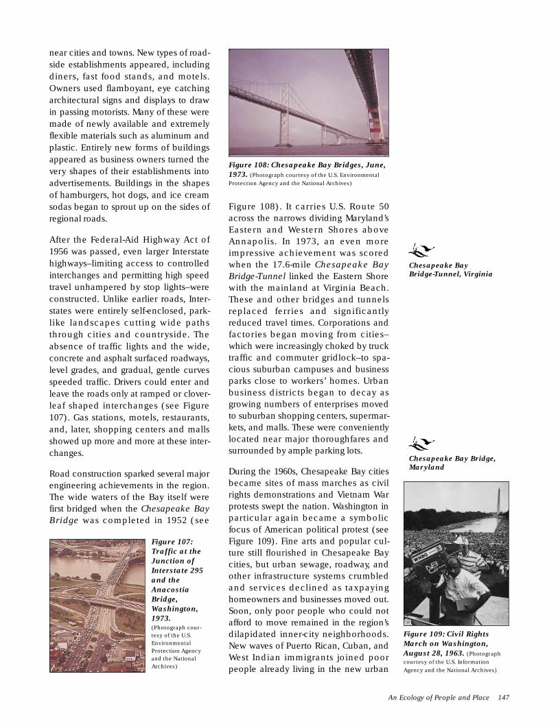
near cities and towns. New types of road-side establishments appeared, includingdiners, fast food stands, and motels.Owners used flamboyant, eye catchingarchitectural signs and displays to drawin passing motorists. Many of these weremade of newly available and extremelyflexible materials such as aluminum andplastic. Entirely new forms of buildingsappeared as business owners turned thevery shapes of their establishments intoadvertisements. Buildings in the shapesof hamburgers, hot dogs, and ice creamsodas began to sprout up on the sides ofregional roads.
After the Federal-Aid Highway Act of1956 was passed, even larger Interstatehighways–limiting access to controlledinterchanges and permitting high speedtravel unhampered by stop lights–wereconstructed. Unlike earlier roads, Inter-states were entirely self-enclosed, park-like landscapes cutting wide pathsthrough cities and countryside. Theabsence of traffic lights and the wide,concrete and asphalt surfaced roadways,level grades, and gradual, gentle curvesspeeded traffic. Drivers could enter andleave the roads only at ramped or clover-leaf shaped interchanges (see Figure107). Gas stations, motels, restaurants,and, later, shopping centers and mallsshowed up more and more at these inter-changes.
Road construction sparked several majorengineering achievements in the region.The wide waters of the Bay itself werefirst bridged when the Chesapeake BayBridge was completed in 1952 (see
Figure 108). It carries U.S. Route 50across the narrows dividing Maryland’sEastern and Western Shores aboveAnnapolis. In 1973, an even moreimpressive achievement was scoredwhen the 17.6-mile Chesapeake BayBridge-Tunnel linked the Eastern Shorewith the mainland at Virginia Beach.These and other bridges and tunnelsreplaced ferries and significantlyreduced travel times. Corporations andfactories began moving from cities–which were increasingly choked by trucktraffic and commuter gridlock–to spa-cious suburban campuses and businessparks close to workers’ homes. Urbanbusiness districts began to decay asgrowing numbers of enterprises movedto suburban shopping centers, supermar-kets, and malls. These were convenientlylocated near major thoroughfares andsurrounded by ample parking lots.
During the 1960s, Chesapeake Bay citiesbecame sites of mass marches as civilrights demonstrations and Vietnam Warprotests swept the nation. Washington inparticular again became a symbolicfocus of American political protest (seeFigure 109). Fine arts and popular cul-ture still flourished in Chesapeake Baycities, but urban sewage, roadway, andother infrastructure systems crumbledand services declined as taxpayinghomeowners and businesses moved out.Soon, only poor people who could notafford to move remained in the region’sdilapidated inner-city neighborhoods.New waves of Puerto Rican, Cuban, andWest Indian immigrants joined poorpeople already living in the new urban
An Ecology of People and Place 147
Figure 107:Traffic at theJunction ofInterstate 295and theAnacostiaBridge,Washington,1973.(Photograph cour-tesy of the U.S.EnvironmentalProtection Agencyand the NationalArchives)
Figure 108: Chesapeake Bay Bridges, June,1973. (Photograph courtesy of the U.S. EnvironmentalProtection Agency and the National Archives)
Figure 109: Civil RightsMarch on Washington,August 28, 1963. (Photographcourtesy of the U.S. InformationAgency and the National Archives)
Chesapeake BayBridge-Tunnel, Virginia
Chesapeake Bay Bridge,Maryland

ghettoes. Unemployment, illiteracy, alco-holism, drug addiction, and an enduringsense of hopeless despair grew. Alarmedby the seemingly simultaneous emer-gence of so many serious problems,some social scientists of the time beganfearing that this combination was creat-ing a persistent and self-perpetuating cul-ture of poverty.
Washington, D.C., presented the clearestexample of the chasm separating richand poor in America’s cities. The cityboasted the highest per capita incomelevels in the nation. At its center lay theglittering stone edifices and monumentsof the capital of the world’s foremostsuperpower. Yet more than 40 percent ofthe city’s population lived below thepoverty line in 1962, when MichaelHarrington’s influential book, The OtherAmerica, exposed the fact that 40 millionAmericans suffered from the effects ofhunger, joblessness, and substandardhousing, education, and medical care.Washington’s mostly African Americanpoor lived in vast squalid, rundown, andrat-infested ghettoes just beyond thegleaming city center (see Figure 110).
Like many other city governments in theregion and the nation, Washington offi-cials tried to address the problems ofurban decay by demolishing entiredistricts of rundown housing in urbanrenewal projects. Federal Great Societyassistance programs, such as federalwelfare, Medicaid, and food stamps,failed to eliminate poverty. Anger in poorcommunities grew as people of minoritygroups carried an unequal share of thefighting in what many considered acolonialist war in Vietnam. Then the
assassination of Martin Luther King, Jr.sparked riots during the summer of 1968.Rising up in frustration, inner city resi-dents in Washington, Baltimore, andother American cities burned homes andbusinesses in their own neighborhoods.
Richard M. Nixon’s election as presidentthat year failed to end the Vietnam War.The nation was already demoralized byurban turmoil and challenged bycounterculture criticism of traditionalvalues. It reeled when American forcesleft Vietnam after an inconclusive cease-fire agreement was signed in 1973. Oneyear later, Nixon became the first presi-dent in American history to resign fromoffice in disgrace. Then the first OPEC oilembargo, in 1973-1974, caused an oilshortage that signaled the end of the eraof cheap energy. Chesapeake Bay andthe rest of the nation began to experi-ence growing inflation, and economicrecession followed.
Decline in the quality of American-madegoods and rising demand for cheaperand better designed and engineeredJapanese and West German productsmeant that Americans bought moreimported goods than they sold asexports. This dramatically increasedAmerican trade deficits. In 1970, severalmajor ailing railroads turned their pas-senger service over to the federallyadministered National Rail PassengerSystem, commonly known as Amtrak.After drastically cutting service, Amtrakdevoted most of its resources in theregion to developing the moneymakingnortheastern corridor route, which linkscities between Washington and Boston.
Throughout the nation, corporationsshut down plants and closed offices asprofits declined. Inflation and soaringinterest rates devastated productivity andlowered consumption. The situationbecame much worse when OPEC minis-ters cut oil production and raised pricesmore than 300 percent in 1979. Longlines of cars blocked traffic as carsqueued up for suddenly scarce andexpensive fuel. People throughout theregion began to talk seriously about solarpower and other energy alternatives to
148 CHAPTER NINE: CHESAPEAKE METROPOLIS
Figure 110: Slum Alley Behind the Capitol,1935 (Photograph by Carl Mydans courtesy of theLibrary of Congress)
National Rail PassengerSystem (Amtrak)

end dependence on prohibitively expen-sive and increasingly unreliable foreignoil supplies. The public was already wor-ried about the dangers of nuclear tech-nology, and the 1979 Three Mile Islandreactor accident just north of theChesapeake Bay heartland ended hopesthat cheap atomic power would be theanswer to the energy crisis. Diplomaticsetbacks, such as the 444-day Iranhostage crisis, and widely unpopularpolitical acts, such as President JimmyCarter’s 1977 decision to sign the treatyreturning the Panama Canal to Pana-manian sovereignty, further eroded peo-ple’s confidence in their nation’s future.
Chesapeake Bay voters helped electRonald Reagan president in 1980. Theywere responding to his pledges to restoreAmerican pride and revive the nation’sdepressed economy by abolishingrestrictive government regulations,reducing taxes, ending deficit spending,and encouraging investment. Ironically,like Franklin Roosevelt before him,Reagan used federal funds to spend thenation out of recession. He began byrepudiating the policy of détente, begunby Nixon, that maintained an uneasycoexistence with the Soviet Union.Committing the nation to victory in theCold War, Reagan started an aggressiveprogram of spending to rebuild thenation’s military establishment. Ordersfor a modernized navy of 600 shipsrestored activity in Chesapeake Bay ship-yards. Newly manufactured interceptorsand bombers crowded onto the flightlines of Andrews Air Force Base andother facilities in and around Wash-ington. Laboratories in Maryland andVirginia received billions of research dol-lars to develop the Strategic DefenseInitiative. This space-based anti-missilesystem, popularly known as Star Wars,was to be capable of shielding the nationfrom ballistic missile attack.
Dramatic developments in electronicautomated technologies during the1980s further spurred productivity in theregion. The collapse of the Soviet Union,which had been bankrupted by the ColdWar arms race, opened formerly closedinternational markets and encouraged
increased production of goods fordomestic and foreign markets. The paceof recovery quickened as a result.Overall regional population also rosedramatically, increasing from 9 million tomore than 12 million people between1970 and 2000.
Revived by the national economic recov-ery, Chesapeake Bay corporationsworked with city governments and com-munity activists to redevelop rundowndowntown districts and restore povertyblighted neighborhoods. Baltimore’sInner Harbor development encouragedconstruction of new high-rise officebuildings, lured tourists to new attrac-tions such as the National Aquarium,and attracted young families to restoredtown houses in newly gentrified neigh-borhoods. In Washington, renovatedlandmarks, such as Union Station, andmassive new construction revived thecity center. Similar developments inother Chesapeake cities reflect theremarkable economic recovery that hasstimulated growth throughout the regionat the close of the twentieth century.
M PLACE
The dramatic changes outlined abovehave left a seemingly permanent markon Chesapeake Bay lands, waters, andskies. The overall number of people liv-ing in the Chesapeake Bay region morethan doubled in this period, from 5 mil-lion at its beginning to more than 12 mil-lion at its end. Much of this growth, andthe development accompanying it, hashappened in the major suburban com-plexes surrounding Baltimore andWashington, in the smaller Richmondand Hampton Roads metropolitan areas,and around freestanding towns such asLancaster and York, Pennsylvania.
Although Washington continues to limitthe height of its buildings, skyscraperstoday rise into the skies above most otherChesapeake Bay downtown districts.Glass clad towers also cluster together insuburban office parks and around Dulles,Baltimore-Washington International, andother regional airports and transporta-tion centers. Long ribbons of highwaylink suburban residential developments,
An Ecology of People and Place 149
Andrews Air ForceBase, Maryland
Three Mile Island,Pennsylvania
Inner Harbor andNational Aquarium,Maryland
Union Station,Washington, D.C.

commercial strips, and industrial parks thatsprawl across former wetlands and farmfields. Intensive development, spurred bypopulation growth and changing realestate values, has changed as much as 70percent of the total land area in regionalmetropolitan centers. Overall, agricul-tural, residential, and industrial develop-ment has affected more than 40 percentof all lands in the region.
The environmental effects of this devel-opment have been dramatic. Wetlands,which had long been thought of asbreeding grounds for disease and aswaste lands best used as garbage dumpsand landfill sites, have been particularlyhard hit. The 1.2 million acres of wet-lands remaining in the region today rep-resent only a fraction of former acreage.
Chesapeake Bay continues to be one ofthe nation’s busiest and most economi-cally important maritime corridors. Aworkforce of 17,000 men and womenworking on Bay waters annually catchand process one-quarter of all oystersand one-half of all clams consumed inAmerica. The yearly haul of 95 millionpounds of blue crabs is the largest suchharvest in the world. Bay waters supportan active sport fishery and provide recre-ation to millions of bathers and boaters.Bridges and boats allow penetration offormerly remote parts of the Bay, whichhas sparked tensions between fishingand tourism interests.
More than 10,000 oceangoing vesselscarry 100 million tons of cargo everyyear to port facilities at Baltimore,Hampton Roads, and smaller harbors.Sheltered anchorages at the mouth ofthe region’s rivers require constant dredg-ing, which is shown by the number offormer Bay ports that no longer exist.The Bay’s already shallow waters alsorequire periodic dredging to keep ship-ping lanes open. Although channel clear-ing has high costs in money and environ-mental impact, to many people the Bay’seconomic importance as a major tradecorridor justifies the expenses. Water-borne commerce accounts for one-fifthof all jobs in Maryland and 15 percent ofthe state’s gross national product. Farther
south, the Newport News Shipyard isVirginia’s largest employer.
The first half century of metropolitandevelopment created pollution, overex-ploitation, and environmental degrada-tion that had effects still felt today.Between 1930 and 1980, easterly windscarried airborne pollutants that billowedfrom chimneys of coal-fired generatingplants, steel mills, and other smokestackindustries in the nation’s heartland.These pollutants spread an uncontrolledpall of acid rain over the region’s landsand waters. During this same period,unregulated industries from as far northas central New York and as far west asWest Virginia poured untold quantities ofheavy metals, petrochemicals, hydrocar-bons, mining wastes, and other non-biodegradable pollutants into streamsflowing into Chesapeake Bay. So muchanthracite coal waste was dumped intothe Susquehanna River at Scranton, forexample, that it has become economi-cally feasible to dredge coal from sedi-ments trapped within the still watersimpounded by the Conowingo Dam(see Figure 111) and other barriersthrown across the lower river to storewater and generate hydro-electric energy.
Eroded soils and vast amounts of nitro-gen, phosphorus, and synthetic chemi-cals used in pesticides and fertilizerswashed from farm fields. Individualhomes and entire municipalitiespumped human waste, detergent phos-phates, and other sewage into regionalrivers. Passing ships discharged oil andother wastes into open Bay waters, intro-ducing foreign diseases and pests alongwith the pollution and posing a constant
150 CHAPTER NINE: CHESAPEAKE METROPOLIS
Figure 111: Conowingo Dam Across theSusquehanna, ca. 1920-1950. (Photograph byTheodor Horydezak courtesy of the Library of Congress)
Newport NewsShipyard, Virginia
Conowingo Dam,Pennsylvania

threat of catastrophic spills and leaks.Toxic chemicals, such as DDT and otherpesticides, also inadvertently killed offbald eagles in the region and devastatedother species. Some newly introducedspecies, such as nutria, brought into theregion to provide a new source of furand flesh, grew to such large populationsthat they threatened established animalcommunities. Over-hunting and industri-alized commercial harvesting threatenedthe survival of Bay shellfish, fin-fish, andwildfowl.
Environmental conditions in theChesapeake Bay region had deterioratedalarmingly by 1970. Vast areas seemedcovered by pavement and unsightlydevelopment. The region’s old-growthforests were gone–replaced by humanhabitations, highways, farm fields, orpines planted for quick harvest. Washingaway exposed topsoil, erosion also ate atthe region’s shorelines (see Figure 112).Industrial pollution fogged the air andpolluted waterways (see Figure 113).Smog choked city skies and acid rainthreatened to turn formerly thrivingregional lakes into lifeless lagoons. Waterpollution was so bad in major regionalwaterways that the Susquehanna,Potomac, and James Rivers seemed littlemore than open sewers. Numbers ofshad dropped dramatically after con-struction of dams across the lowerSusquehanna blocked their spawningruns. Bay wildlife lost essential habitat asincreasing amounts of wetlands weredrained and buried under dumpedgarbage, dredge spoil, and other landfill.
The open waters of the Bay also showedunmistakable signs of environmental
degradation. Over-harvesting threatenedmost economically important fish, shell-fish, and wildfowl. Oyster and softshellclam production plummeted whennewly introduced diseases ravaged shell-fish communities. Red tides, algae andplankton blooms, and noxious chemi-cals poisoned the Bay as murky waters,clogged with sediment, blocked life-giving sunlight. Recovering from devasta-tion caused by newly introduced foreignplant diseases during the early 1930s, eel-grasses and other water plants providing
food and shelter to numerous specieswere increasingly crowded out by sud-den expansions of hydrilla and Eurasianwatermilfoil. Abrupt increases in the saltlevels of Bay waters, for example,allowed watermilfoil to expand explo-sively, covering almost 50,000 acres ofBay bottom in 1960 and twice as muchacreage one year later. Although localenvironmental conditions hostile to theirgrowth caused watermilfoil plants to dieoff within a year of their appearance,their sudden and catastrophic expansionleft an enduring mark on Bay water plantlife. A survey conducted in 1978, forexample, found that only 40,000 acres ofBay bottom was covered by submergedaquatic vegetation of any type. This isonly a tiny percentage of the totalamount of acreage covered by aquaticplants in earlier times–specialists thinkthat vast meadows of underwater grassesand other submerged aquatic vegetationmay have covered as much as 600,000acres of Bay bottom at the time colonistsfirst set foot on Chesapeake shores.
An Ecology of People and Place 151
Figure 112: Shore Erosion at Governor’sLand on the Chickahominy River, Virginia,1990. (Photograph courtesy of the National Park Service)
Figure 113: A Hazy Day at the BethlehemSteel Plant, Sparrow’s Point, Maryland,1973. (Photograph by the U.S. Environmental ProtectionAgency courtesy of the National Archives)

Water plants starved for light in cloudyBay waters. Periodic catastrophes, suchas Hurricane Agnes, which hit the regionin 1972, also washed away entire com-munities of submerged aquatic vegeta-tion. Destruction of oxygen producingplants combined with the oxygen rob-bing process of decomposition to createa condition known as anoxia, a loweringof the volume of dissolved oxygen in thewater. Because oxygen is needed to sup-port aquatic life, the lack of it increasedthe loss of plants and animals.
Commercial catches of striped bassdropped from 15 million to 2 millionpounds per year in a single decade.Knowing that 90 percent of striped basson the east coast spawned, matured, andfed in the Bay, the alarmed Marylandauthorities banned all fishing of stripedbass in state waters. Virginia also movedto limit catches of threatened species.
Concerned about both the long-termdegradation of the regional environmentand the sudden and enormous devasta-tion caused by Hurricane Agnes, manyChesapeake Bay residents welcomedpassage of the Federal Clean Water Actin 1972. The act established uniformwater quality standards, placed limits ontypes and amounts of pollutants pouredinto rivers, and required construction ofnew sewage lines and water treatmentplants (see Figure 114). One year later,Senator Charles Mathias of Marylandbegan supporting studies to assess theimpacts of industry, municipal govern-ments, agriculture, development, and ris-ing population on the Chesapeake Bayenvironment.
The findings from these and other stud-ies led the United States EnvironmentalProtection Agency to establish theChesapeake Bay Program in 1983. Thisinnovative partnership coordinated theefforts of government agencies, preserva-tionists, and concerned citizens in the64,000-square-mile Chesapeake Baybasin. The program provides technicalassistance, research support, and aforum for airing issues relating to themaintenance and restoration of theregion’s environment. Program partnershave pledged to work together to reduceindustrial pollution, increase acreagecovered by wetlands and submergedaquatic grasses, restore plant and animalcommunities, and help farms andmunicipalities reduce the amount ofnutrients flowing into Bay waters by 40percent by the year 2000.
Several major successes have beenscored since 1983. Bald eagle popula-tions rebounded significantly between1989 and 2000. Releases of chemicalsfrom factories, sewage systems, and farmfields decreased more than 55 percentduring the same period. Careful manage-ment of fertilizers, insecticides, andsewage is producing significant declinesin harmful mineral and nutrient concen-trations in Bay sediments and waters.And acreage covered by submergedaquatic grasses has increased more than60 percent since 1984.
Federal, state, and municipal laws andordinances currently give varying levelsof protection to threatened cultural andnatural resources in the region. Theregion currently has seventy State Parksand Forests, fifty State Game Lands andWildlife Management Areas, forty-twoNational Parks, sixteen military installa-tions, ten National Wildlife Refuges, andtwo Department of Agriculture facili-ties–the George Washington NationalForest, in Virginia, and the NationalAgricultural Research Center, inMaryland. Web sites listing these facilitiesand providing other information aboutany of them may be found in the Sourcessection of this volume. The personnel atthese sites work vigorously to enforceprotective regulations on more than 1
152 CHAPTER NINE: CHESAPEAKE METROPOLIS
Figure 114: Water Filtration Plant,Occoquan, Virginia, 1973.(Photograph by the U.S. Environmental Protection Agencycourtesy of the National Archives)
George WashingtonNational Forest, Virginia
National AgriculturalResearch Center,
Maryland
Chesapeake Bay Program

million acres of public land in theChesapeake heartland. Public utilitiesand private organizations are increas-ingly forming partnerships with agenciesat all levels of government to restore theenvironment.
Although these and many otherimprovements provide good reasons tobe optimistic about the restoration ofthe environment, much remains to bedone. High nutrient levels in Bay waters,which are believed to be responsible forturning a usually harmless microscopicdinoflagellate named pfisteria into ahighly toxic killer of fish in 1997, must bereduced. Increases in development rateslead to corresponding decreases inforest acreage and waterfowl habitat,showing how humans can transform theenvironment. Because of this impact,people must care for their environmentas they work to build strong futures forthemselves, their families, and theircommunities.
EMERGENCE OF AMETROPOLITANCULTURAL LANDSCAPE
M PEOPLING PLACES
Population rise and redistribution havehad dramatic impacts on the regionalcultural landscape during this period. Aspeople were drawn to the region’s citiesin search of employment during theDepression, the growing populationprompted more expansion of concen-trated downtown administrative andbusiness districts. Growth required theconstruction of expanded public trans-portation systems and the massive devel-opment of city services and utilities.Although the economic slump ham-pered development, existing shoppingand entertainment districts wereenlarged. Private apartment blocks, townhouses, and residences also were con-structed or renovated. Urban power andwater authorities, struggling to meet theneeds of growing populations, con-structed dams, reservoirs, and generatingplants in rural parts of southeastern
Virginia’s Coastal Plain and the Marylandand Pennsylvania Piedmont.
Wartime development stimulated growthin the Washington metropolitan area andin other urban centers where war indus-tries were located. Although Washingtoncontinued to grow dramatically after thewar, urban development elsewhere inthe region began to slow during the1950s and 1960s. Population profiles incity centers began to change as busi-nesses and jobs moved out to the sub-urbs. City populations became poorer.Development in cities increasinglyshifted from construction of new busi-ness buildings to erection of publiclyfunded housing projects and other pro-grams providing affordable housing tolow income families.
The focus of private development shiftedto the rural areas surrounding regionalcities as rising regional populations relo-cated to new suburbs. Many older ruralvillages became suburban enclaves.Entirely new communities also rose upeverywhere in the region. Buying upavailable farmlands and filled wetlands,developers dropped clusters of mass-pro-duced residences onto landscapedtracts. Schools, gas stations, fire houses,diners, drive-in movies, and quickly con-structed shopping centers surroundedby paved parking lots soon appearednearby. Local governments, unwilling tolimit additions to their tax rolls, did littleto regulate suburban sprawl, and at firstit proceeded haphazardly.
Alarmed by the sprawling, unsightlylandscape resulting from unplanneddevelopment, communities quicklybegan to put zoning regulations in place.Ordinances soon set limits on housinglot sizes, determined where businessescould be operated, mandated that struc-tures be set back certain distances fromroadways, and required adequate parking.
New mini cities of steel-framed, glass-clad high-rises sprouted up at the coresof new suburban concentrations inplaces such as Arlington, Columbia,Bethesda, and Silver Spring during the1970s. Larger and more imposing sky-scrapers appeared in rehabilitated water-
Emergence of a Metropolitan Cultural Landscape 153
Arlington, Virginia
Columbia, Bethesda, andSilver Spring, Maryland

front downtown districts such asBaltimore’s Inner Harbor as the economybegan recovering during the 1980s.Drawn by the region’s healthier econ-omy, new generations of Asian, African,and Latin American immigrants estab-lished new communities in old residen-tial districts in Chesapeake Bay cities andtowns by the 1990s. Signs in their nativelanguages that marked churches, gather-ing places, and business establishmentsadded new diversity to the region’scultural landscape.
M CREATION OF SOCIALINSTITUTIONS
Massive social change and mobilitymarked the years of this period. As morepeople acquired cars, many establishedneighborhood communities were trans-formed and new ones created. Increasedprosperity in the years after the GreatDepression brought an era of socialmobility unlike any before. Substantialnumbers of working class people,employed in regional industries and sup-ported by programs such as the G.I. Bill,saw their children enter the ranks of themiddle class. Increased educationalopportunity and longer periods of edu-cation allowed people to train for new,highly skilled jobs. They also delayedsome workers’ entry into the workforce,which prevented flooding of the labormarket. As women fought for equal rightsand equal pay and groups who had suf-fered racial or ethnic bias fought againstlaws enforcing statutory segregation andracial discrimination, new opportunitiesopened for them.
Changing patterns of work and employ-ment transformed family dynamicseverywhere. The cost of living rose as liv-ing standards improved, and householdssoon required incomes from all adult res-idents. Divorce rates rose as economicopportunities and changing values madeit seem more plausible for some peopleto live alone. Residence sizes reflectedthis trend, generally becoming smaller assmaller nuclear, one-parent, and singlehouseholds replaced earlier multi-gener-ational families.
The movement of hundreds of thou-sands of migrants from other parts of thecountry and the world to a new regionwhere most were strangers increasedreliance on services provided bychurches, philanthropic societies, socialclubs, and other community institutions.Many old institutions closed or relo-cated. New and old ethnic, religious, andcultural associations renovated orerected new community centers, meet-ing halls, recreational facilities, hospitals,rest homes, and cemeteries throughoutthe region. Inspired by the civil rightsmovement and its Indian equivalent,then known as Red Power, NativeAmerican people throughout the regionbegan reasserting their cultural identities.
Government played a greater part insocial life during this period. Passage ofthe Social Security Act in 1935 createdthe nation’s first social welfare system.Taxes paid by employers and withheldfrom employee wages helped fund aplan that provided unemployment com-pensation, aid for the infirm and fordependent mothers and children, pen-sions, and payment to survivors’ families.Because it gave benefits to workers, theSocial Security system did not help anew generation of poor people whowere unable to find work during theprosperous postwar decades.
In 1964, President Lyndon BainesJohnson moved to address this new formof poverty by sponsoring passage of theEconomic Opportunity Act, whichextended medical services and financialrelief to the needy. Passed at a time whenthe nation found itself drifting towardwar in Vietnam, this centerpiece of John-son’s ambitious Great Society programhelped millions of people. But it did notend poverty. Congress was unwilling toraise taxes to the level needed to simulta-neously fight the war on poverty, theCold War, and the fighting in Vietnam. Soit failed to raise the funds needed toestablish long-term programs that mighthave wiped out need in American society.
But public monies did underwrite a mas-sive school building program throughoutthe 1960s. Colleges offering baccalaure-ate degrees and universities supporting
154 CHAPTER NINE: CHESAPEAKE METROPOLIS

graduate study programs were enlargedand expanded. Two-year community andjunior colleges were built in many coun-ties. New commuter campuses emergedin Chesapeake Bay cities. And publicand private funds also supported con-struction of new meeting halls, confer-ence centers, and other communitysocial facilities.
New community self-help programs werecreated to address social problems whenthe federal government moved to limit itsinvolvement in social welfare programsduring the 1980s. Workfare began toreplace welfare as the federal govern-ment turned over control of relief pro-grams to the states. Federal interventionin social life further diminished as agen-cies increasingly worked to create part-nerships, such as the Chesapeake BayProgram, to coordinate the voluntaryefforts of state governments, municipali-ties, service organizations, private corpo-rations, and individuals.
M EXPRESSING CULTURALVALUES
The Chesapeake Bay region became acenter of American cultural expressionin the decades following 1930. AlthoughNew York and Hollywood had becomecenters of American style, Washington’smonuments, meeting halls, and mall hadbecome stages on which policymakers,trend-setters, and demonstrators setmuch of the cultural tone of the nation.This tone has shifted continually, fromthe self-righteousness of the ProgressiveEra, the hardheaded practicality of theDepression and war years, the self-assuredness of the Cold War, the turbu-lent changes of the 1960s, and the rise ofidentity politics pressing agendas of par-ticular ethnic groups, religious view-points, and gender orientations, to thepresent struggle to find a place in theemerging world economic order.
Chesapeake region newspapers carriedthe latest news, as well as the views andopinions of influential writers such as ArtBuchwald. The Watergate scandal andthe popular film, All the President’s Men(1976) helped propel the Washington
Post into national prominence. Washing-ton also became the scene of countlessnovels and the backdrop of hundreds offilmed dramas, thrillers, mysteries, andcomedies.
Motion pictures have also helpedBaltimore emerge as a unique icon ofpopular imagination. Director BarryLevinson brought a wistfully nostalgicvision of the city to life in films such asDiner (1977) and Avalon (1990). Morerecently, Levinson has helped illuminatea grittier side of Baltimore life in the criti-cally acclaimed television dramaHomicide (1992-1999). On the less main-stream side, film maker John Waters hascreated an image of Baltimore as aweirdly sweet (and occasionally shock-ingly strange) working class paradise infilms such as Pink Flamingos (1972),Hairspray (1987), and Pecker (1998).
Popular culture also flourished in morerural areas of the region. Radio and therising recording industry helped countrymusic grow in popularity. Carved wood-en decoys grew from everyday tools intoa highly marketable art form. Collectorsand curators from Baltimore, Washing-ton, and other urban centers increas-ingly scoured the region’shinterlands in search ofantique or homemade fur-niture, furnishings, paint-ings, and other folk arts.The Waltons, a populartelevision show that airedfrom 1972 to 1981 broughtVirginia screenwriter EarlHamner Jr.’s vision of anidealized close-knit ruralfamily to American audi-ences at a time when politi-cal and cultural conflictthreatened to tear apart thenation’s social fabric.Popular culture also wasexpressed in sports stadi-ums; on playing fields;through folk art, furniturefacades, and paintedscreens on the front stoopsof urban neighborhoods(see Figure 115); and inurban mural painting.
Emergence of a Metropolitan Cultural Landscape 155
Figure 115: Baltimore Folk Art: Paintedscreen depicting the nearby LazarettoLighthouse on the door of an Elliott Streetrow house in Baltimore’s Cantonneighborhood, 1990. (Photograph by Elaine Effcourtesy of the Painted Screen Society of Baltimore, Inc.)

Museums, conservatories, theaters, audi-toriums, and schools supported the finearts in the region’s cities and universities.Regional architects, writers, and artistscreated structures, objects, and land-scapes reflecting a range of culturaltastes. Styles have ranged from thestreamlined lines of the art deco and artmoderne styles of the 1930s, through therealism of the war years, the abstractexpressionism of the postwar decades,and the futuristic simplicity of the mod-ernists during the 1960s and1970s, to themix of old and new favored by the post-modernist movement of the 1980s and1990s.
A yearning for simpler times and valueshas been reflected in the colonial revivaland historic preservation movements.During the 1930s, financier John D.Rockefeller poured millions of dollarsinto the restoration of Colonial Williams-burg. Places significant in American his-tory, such as Jamestown, Yorktown,Gettysburg, and the Chesapeake andOhio Canal, became national parks. TheHistoric Sites Act of 1935 established theNational Historic Landmark program.Since that time, more than 100 sites ofnational significance in the region havebeen designated as landmarks throughthe program. Passage of the HistoricPreservation Act of 1966 establishedState Historic Preservation Offices inevery state and created the NationalRegister of Historic Places to recognizesites of local and state significance. Todate, more than 1,000 places in theregion have been listed in the NationalRegister.
M SHAPING THE POLITICALLANDSCAPE
A growing centralization of authority wasrequired to regulate the vastly increasing,unprecedentedly mobile, consumption-oriented, and rapidly changing popula-tions. Stone masons working in regionalquarries cut marble, granite, and sand-stone to adorn the facades of theincreasing number of classical revivaloffice complexes and gleaming monu-ments that rose at the center ofWashington during the 1930s. Elsewhere
in the region, federal public works pro-jects funded road, dam, and park con-struction. Federal office buildingshousing employees administering theseand other programs rose in centrallylocated county seats.
During World War II, armies of framers,roofers, carpenters, plumbers, brickmasons, and sheet metal workers built ahuge number of barracks, warehouses,administrative complexes, and otherstructures in military bases and depotsthroughout the region. Constructed withinexpensive materials from standardizedplans, most of these buildings were builtfor a specific purpose and were slatedfor demolition following the end of hos-tilities. Most, however, were maintainedas growing tensions with the SovietUnion compelled the government tokeep its bases open after 1945. The gov-ernment increasingly used defenseneeds as justification for new publicworks and development projects. Newlimited-access superhighways fundedthrough the 1956 Interstate Highway Act,for example, were made part of whatcame to be called the National System ofInterstate and Defense Highways. UnitedStates Army Corps of Engineers contrac-tors undertook numerous flood controland waterfront stabilization projects toprotect American production centersand safeguard strategic resources.
Even education came to be regarded asa weapon in the Cold War. Citing theneed for larger numbers of techniciansand scientists to produce and operatesophisticated weapons systems, Con-gress passed the National DefenseEducation Act in 1958. Low interest stu-dent loans, research grants, and otherfunding provided by the act soon led togreat growth in college campus con-struction. Established campuses wereexpanded, and new ones opened every-where in the region.
Many new or larger colleges occupiedmilitary bases that had been turned overto state and local governments for reuse.Barracks and other structures were con-verted into classrooms, dormitories, andadministration buildings. In state capitals,county seats, and other administrative
156 CHAPTER NINE: CHESAPEAKE METROPOLIS
Colonial Williamsburg,Jamestown, and
Yorktown, Virginia
Chesapeake and OhioCanal, Maryland
Gettysburg, Pennsylvania

centers, new assembly halls, court-houses, office buildings, fire houses, andrecreational facilities rose as city popula-tions began spilling into growing suburbsthroughout the region. Federal moneyfunneled to local communities to fightwars on poverty, crime, and drugs builtnew health centers, police stations, pris-ons, and other facilities.
M DEVELOPING THECHESAPEAKE ECONOMY
Unprecedented demographic, social,cultural, and political transformationsled to revolutionary changes in the econ-omy of the region. Despite depressionand periodic economic downturns, pro-ducers and wholesalers brought everlarger amounts of goods to growing mar-kets in and beyond the region by usingmore efficient and productive extraction,processing, manufacturing, and distribu-tion systems. New rail, surface, water,and air transportation systems couldcarry larger cargoes to markets faster andmore efficiently (see Figure 116). Thatmade possible the import and export ofgreater amounts of durable goods. Newpreservation and storage techniquesallowed greater stockpiling and widerdistribution of perishable produce.Greater quantities of goods crowdedonto shelves of growing numbers of spe-cialty shops and ever larger and morecomplex department stores. Imposingglass and steel office buildings rose inurban and suburban centers as corpora-tions and financial institutions grew insize and influence.
Postwar prosperity, the shift from aneconomy based on producing goods toone increasingly focused on providingservices, the rise of the automobile, andthe growth of affordable air travel greatlyexpanded the economic value of tourismin the region. The natural charms of theBlue Ridge, Catoctin Mountain, andother scenic locales attracted visitors inever-growing numbers. Colonial Wil-liamsburg and other historic restorationsbecame national attractions. Well pre-served historic locales, such asMaryland’s Saint Mary’s City (see Figure117) and the Virginia towns of Fred-ericksburg and Waterford also benefit-ted from heritage tourism. Hunting andsport fishing grew in economic impor-tance. Outfitters throughout the regionsupplied rods, reels, and other gear tosport fishermen going after trout, pick-erel, and other game fish. During hunt-ing season, hunters sought out deer,duck, and turkey on public lands andprivate game preserves. Those whocould afford it hired boats and pilots atlocal ports to fish for striped bass in theBay or marlin, yellowtail, and other gamefish in the warm offshore gulf stream cur-rents coursing several miles out from theAtlantic’s shores.
M EXPANDING SCIENCE ANDTECHNOLOGY
The political economy of the period pro-vided support for extraordinary scientificand technological expansion. Financed
Emergence of a Metropolitan Cultural Landscape 157
Figure 116:Union StationLooking SouthToward theCapitol, thePotomac, andthe NationalAirport, 1973.(Photograph by theU.S. EnvironmentalProtection Agencycourtesy of theNational Archives)
Figure 117: Aerial View of Saint Mary’s City.(Photograph courtesy of the Saint Mary’s City Commission)
Blue Ridge Mountains,Virginia
Catoctin Mountain,Maryland
Saint Mary’s City, Maryland
Fredericksburg andWaterford, Virginia
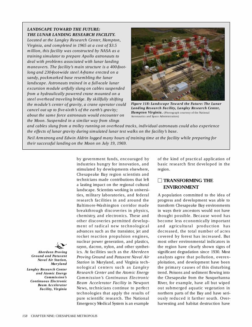
by government funds, encouraged byindustries hungry for innovation, andstimulated by developments elsewhere,Chesapeake Bay region scientists andtechnicians made contributions that lefta lasting impact on the regional culturallandscape. Scientists working in universi-ties, military laboratories, and federalresearch facilities in and around theBaltimore-Washington corridor madebreakthrough discoveries in physics,chemistry, and electronics. These andother discoveries permitted develop-ment of radical new technologicaladvances such as the transistor, jet androcket reaction propulsion engines,nuclear power generation, and plastics,rayon, dacron, nylon, and other synthet-ics. At facilities such as the AberdeenProving Ground and Patuxent Naval AirStation in Maryland, and Virginia tech-nological centers such as LangleyResearch Center and the Atomic EnergyCommission’s Continuous ElectronicBeam Accelerator Facility in NewportNews, technicians continue to perfecttechnologies that apply the results ofpure scientific research. The NationalEmergency Medical System is an example
of the kind of practical application ofbasic research first developed in theregion.
M TRANSFORMING THEENVIRONMENT
A population committed to the idea ofprogress and development was able totransform Chesapeake Bay environmentsin ways their ancestors would not havethought possible. Because wood hasbecome less economically importantand agricultural production hasdecreased, the total number of acrescovered by forest has increased. Butmost other environmental indicators inthe region have clearly shown signs ofsignificant degradation since 1930. Mostanalysts agree that pollution, overex-ploitation, and development have beenthe primary causes of this disturbingtrend. Poisons and sediment flowing intothe Chesapeake from the SusquehannaRiver, for example, have all but wipedout submerged aquatic vegetation innorthern parts of the Bay and have seri-ously reduced it farther south. Over-harvesting and habitat destruction have
158 CHAPTER NINE: CHESAPEAKE METROPOLIS
LANDSCAPE TOWARD THE FUTURE:THE LUNAR LANDING RESEARCH FACILITY.Located at the Langley Research Center, Hampton,Virginia, and completed in 1965 at a cost of $3.5million, this facility was constructed by NASA as atraining simulator to prepare Apollo astronauts todeal with problems associated with lunar landingmaneuvers. The facility’s main structure is a 400-foot-long and 230-foot-wide steel A-frame erected on asandy, pockmarked base resembling the lunarlandscape. Astronauts trained in a full-scale lunarexcursion module artfully slung on cables suspendedfrom a hydraulically powered crane mounted on asteel overhead traveling bridge. By skillfully shiftingthe module’s center of gravity, a crane operator couldcancel out up to five-sixth’s of the earth’s gravity;about the same force astronauts would encounter onthe Moon. Suspended in a similar way from slingsand cables slung from a trolley running on overhead tracks, individual astronauts could also experiencethe effects of lunar gravity during simulated lunar test walks on the facility’s base.
Neil Armstrong and Edwin Aldrin logged many hours of training time at the facility while preparing fortheir successful landing on the Moon on July 19, 1969.
Figure 118: Landscape Toward the Future: The LunarLanding Research Facility, Langley Research Center,Hampton Virginia. (Photograph courtesy of the NationalAeronautics and Space Administration)
Aberdeen ProvingGround and Patuxent
Naval Air Station,Maryland
Langley Research Centerand Atomic Energy
Commission’sContinuous Electronic
Beam AcceleratorFacility, Virginia

significantly reduced annual hauls ofoysters, clams, and fin-fish. Pesticidesand indiscriminate over-hunting havethreatened the survival of hawks, owls,eagles, waterfowl, and other birds. Num-bers of fur-bearing otters, beavers, andminks have shrunk catastrophically, andonly small numbers of bears, bobcats,and other wildlife survive in remote por-tions of the Great Dismal Swamp and iso-lated sections of the upland Piedmont.
Vast expanses of land in and aroundregional cities and suburbs have beenburied beneath landfill or covered withpavement. Enormous tracts of low lyingfertile bottomlands have been coveredby waters rising behind dams built bypower utilities and water companiesthroughout southeastern Virginia and theMaryland Piedmont. Toxic waste dumpspoison the land near many old industrialsites, and layers of heavy metals, chemi-cals, and nutrient runoff still leach intoBay waters from buried sediments. At thesame time, higher cancer rates than everbefore recorded have been reportedthroughout the region.
Since the 1970s, greater awareness of theimpact of these environmental transfor-mations has sparked efforts to reversetheir effects. Today, strict federal andstate environmental laws require that theimpact on the environment be consid-ered in all projects funded or regulatedby federal agencies. Other laws requirecities to lower smog-producing ozoneand hydrocarbon emissions and mandatetreatment of water prior to its dischargeinto waterways lands. And public-privatepartnerships such as the Chesapeake BayProgram coordinate efforts to lessen fur-ther the impact of non-biodegradablepollutants, restore damaged habitats,reintroduce bald eagles and otherspecies that have been wiped out, andpromote development in harmony withthe region’s environment.
M CHANGING ROLE OF THECHESAPEAKE IN THEWORLD COMMUNITY
Visible evidence of America’s changingrole in the world community has
become a key part of the region’s cul-tural landscape. Washington’s role as thecosmopolitan capital of the world’sstrongest superpower is shown in itsbuildings and in its monuments thatcommemorate great events and honorinfluential people. The capital district’sdifferences between rich and poor arereminders of similar contrasts betweendeveloped and undeveloped nations.
Army, Navy, Marine, and Air Force basesthroughout the region support forcesrequired to project military powerthroughout the world. The wreck of theGerman submarine U-1105 (see Figure119), a war prize sunk in 1949 off PineyPoint, Maryland during tests to deter-mine the effectiveness of new explosives,mutely attests both to America’s rise toworld power in World War II and thenation’s anxiety over maintaining its posi-tion in the Cold War that followed.
The Bay’s importance as a major mar-itime trade center is shown by its wellmarked and maintained shipping lanes,its massive port facilities, and survivingexamples of water craft constructed inthe region, such as the World War IIliberty ship John Brown – first builtin Baltimore and now preserved as a his-toric site commemorating the contribu-tions of the nation’s merchant marinersin its home port. Jet aircraft flying in andout of Baltimore-Washington, Dulles, andother international airports bring theregion within a few hours’ flying time ofthe rest of the world. Throughout theregion, microwave dishes mounted atopsteel towers and mobile vans link theregion into a global satellite communica-
Emergence of a Metropolitan Cultural Landscape 159
Figure 119: Landscape of Memory:The wreck of the U-1105.(Sketch courtesy of the Saint Clements Island–PotomacRiver Museum and Maryland Historical Trust)
Great Dismal Swamp,Virginia
World War II libertyship John Brown

tion network, putting people into instantcontact with one another everywhere onthe planet. Larger radio telescopes main-tained at civilian and military researchcenters reach ever farther into deepspace, searching for new discoveries thatpromise undreamed-of reconsiderationsof the nation’s, and the world’s, positionin the universe.
FURTHER INFORMATIONThese are foremost among the manysources containing useful informa-tion surveying this period inChesapeake Bay history:
Carol Ashe, Four Hundred Years of Vir-ginia,1584-1984:An Anthology (1985).
Carl Bode, Maryland: A BicentennialHistory (1978).
Daniel J. Boorstin, The Americans (1973).
John Bowen, Adventuring in the Chesa-peake Bay Area (1990).
Robert J. Brugger, Maryland: A MiddleTemperament,1634-1980 (1988).
Suzanne Chapelle, et al., Maryland: AHistory of Its People (1986).
Frances W. Dize, Smith Island, Chesa-peake Bay (1990).
Frederick A. Gutheim, The Potomac(1968).
Alice Jane Lippson, The Chesapeake Bayin Maryland (1973).
Paul Metcalf, ed., Waters of Potowmack(1982).
Lucien Niemeyer and Eugene L. Meyer,Chesapeake Country (1990).
Edward C. Papenfuse, et al., Maryland: ANew Guide to the Old Line State (1979).
Morris L. Radoff, The Old Line State: AHistory of Maryland (1971).
Emily J. Salmon, ed., A Hornbook ofVirginia History (1983).
Mame and Marion E. Warren, Maryland:Time Exposures,1840-1940 (1984).
John R. Wennersten, Maryland’s EasternShore: A Journey in Time and Place(1992).
Dan White, Crosscurrents in Quiet Water:Portraits of the Chesapeake (1987).
Useful environmental surveysinclude the following:
Michael A. Godfrey, Field Guide to thePiedmont (1997).
J. Kent Minichiello and Anthony W.White, eds., From Blue Ridge to BarrierIslands (1997).
William C. Schroeder and Samuel F.Hillebrand, Fishes of Chesapeake Bay(1972).
Christopher P. White, Chesapeake Bay: AField Guide (1989).
John Page Williams, Jr., ChesapeakeAlmanac (1993).
David A. Zegers, ed., At the Crossroads: ANatural History of Southcentral Penn-sylvania (1994).
The following sources representonly a tiny fraction of the manyplanning and technical reportsprepared since the Chesapeake BayProgram began in 1983:
Richard A. Batiuk, et al., Chesapeake BaySubmerged Aquatic Vegetation HabitatRequirements and Restoration Targets(1992).
Richard A. Cooksey and Albert H. Todd,Conserving the Forests of theChesapeake (1996a).
——-, Forest and Riparian Buffer Con-servation (1996b).
Steve Funderburk, et al., HabitatRequirements for Chesapeake BayLiving Resources(1991).
——-, Chesapeake Bay Habitat Restora-tion (1995).
Jack Greer and Dan Terlizzi, ChemicalContamination in the Chesapeake Bay(1997).
Interstate Commission on the PotomacRiver Basin, A Comprehensive List ofChesapeake Bay Basin Species, 1998(1998).
JMA/Watson, Lower SusquehannaHeritage Area Feasibility Study (finaldraft, 1998).
160 CHAPTER NINE: CHESAPEAKE METROPOLIS

K. Bruce Jones, et al., An EcologicalAssessment of the United States Mid-Atlantic Region (1997).
National Park Service, Chesapeake BayStudy (draft, 1993).
Robert J. Orth, et al., 1995 Distribution ofSubmerged Aquatic Vegetation in theChesapeake Bay (1996).
Kathryn Reshetiloff, ed., ChesapeakeBay: Introduction to an Ecosystem(1995).
James P. Thomas, ed., Chesapeake (1986).
Useful atlases and geographicsurveys graphically depicting largescale patterns of Chesapeake Baycultural landscape development ofthe period include these:
Michael Conzen, ed., The Making of theAmerican Landscape (1990).
David J. Cuff, et al., eds., The Atlas ofPennsylvania (1989).
James E. DiLisio, Maryland, A Geography(1983).
Helen Hornbeck Tanner, ed., The Settlingof North America (1995).
Derek Thompson, et al., Atlas ofMaryland (1977).
Kent T. Zachary, Cultural Landscapes ofthe Potomac (1995).
The politics of environmentalconservation are examined in:
Tom Horton and William M. Eichbaum,Turning the Tide (1991).
Kent Mountford, Charles D. Rafkind, andJohn Donahue, eds., The ChesapeakeBay Program: Science, Politics, andPolicy (1999).
Individual small scale communitystudies include:
Boyd Gibbons, Wye Island: Outsiders,Insiders, and Resistance to Change(1977).
Jack Temple Kirby, Poquosson (1986).
Biographical accounts providinginsights into individual lives include:
Lila Line, Waterwomen (1982).
Randall S. Peffer, Watermen (1979).
John Sherwood, Maryland’s VanishingLives (1994).
William W. Warner, Beautiful Swimmers:Watermen, Crabs, and the ChesapeakeBay (1976).
Aspects of cultural life of the periodis examined in:
Helen Chappell, Chesapeake Book of theDead (1999).
Esther Wanning, Maryland: Art of theState (1998).
Dorothy Williams, Historic VirginiaGardens (1975).
Examples of the many studiessurveying key aspects of social andpolitical life of the period include:
Jo Ann E. Argersinger, Toward a NewDeal: Citizen Participation, GovernmentPolicy, and the Great Depression inBaltimore (1988).
Joseph L. Arnold, The New Deal in theSuburbs: A History of the GreenbeltTown Program,1935-1954 (1971).
Dieter Cunz, The Maryland Germans(1948).
Mary Forsht-Tucker, et al., Associationand Community Histories of PrinceGeorge’s County (1996).
Ronald L. Heinemann, Depression andthe New Deal in Virginia (1983).
Suzanne Lebsock, Virginia Women, 1600-1945 (1987).
Roland C. McConnell, Three Hundredand Fifty Years (1985).
Eugene L. Meyer, Maryland Lost andFound: People and Places from Chesa-peake to Appalachia (1986).
Vera F. Rollo, The Black Experience inMaryland (1980).
Helen C. Rountree, Pocahontas’s People(1990).
Bruce G. Trigger, ed., Northeast (Vol. 15,Handbook of North American Indians,1978).
Edward C. Papenfuse, et al., Maryland: ANew Guide to the Old Line State (1979).
Further Information 161

Wilcomb E. Washburn, ed., History ofIndian-White Relations (Vol. 4, Hand-book of North American Indians,1988).
Key economic studies include:
George H. Calcott, Maryland andAmerica,1940-1980 (1985).
Paula Johnson, ed., Working the Water(1988).
Joanne Passmore, History of theDelaware State Grange and the State’sAgriculture,1875-1975 (1975).
Glenn Porter, ed., Regional EconomicHistory of the Mid-Atlantic Area Since1700 (1976).
John R. Wennersten, The Oyster Wars ofChesapeake Bay (1981).
Useful analyses of regional scientificand technological developmentsduring the period may be found in:
Larry S. Chowning, Harvesting theChesapeake (1990).
David A. Hounshell, From the AmericanSystem to Mass Production, 1800-1932(1984).
David G. Shomette, Shipwrecks on theChesapeake (1982).
Surveys examining architecture inthe region include:
Pamela James Blumgart, At the Head ofthe Bay: A Cultural and ArchitecturalHistory of Cecil County, Maryland(1995).
Michael Bourne, et al., Architecture andChange in the Chesapeake (1998).
Henry Glassie, Pattern in the Material FolkCulture of the Eastern United States(1968).
——, Folk Housing in Middle Virginia(1975).
Gabrielle M. Lanier and Bernard L.Herman, Everyday Architecture of theMid-Atlantic (1997).
Marilynn Larew, Bel Air: An Architecturaland Cultural History,1782-1945 (1995).
Calder Loth, Virginia Landmarks of BlackHistory (1995).
Susan G. Pearl, Prince George’s CountyAfrican-American Heritage Survey(1996).
Paul Touart, Somerset: An ArchitecturalHistory (1990).
Donna Ware, Ann Arundel’s Legacy: TheHistoric Properties of Ann ArundelCounty (1990).
Christopher Weeks, ed., Where Land andWater Intertwine: An ArchitecturalHistory of Talbot County, Maryland(1984a).
——-, ed., Between the Nanticoke andthe Choptank (1984).
Archeological studies include:
William M. Kelso and R. Most, eds., EarthPatterns (1990).
Paul A. Shackel and Barbara J. Little,Historical Archaeology of theChesapeake,1784-1994 (1994).
Paul A. Shackel, et al., eds., AnnapolisPasts (1998).
David G. Shomette, Tidewater TimeCapsule (1995).
Among the many studies focusing onthe development of Washington D.C.as a cosmopolitan internationalcenter are:
Constance M. Green, Washington: AHistory of the Capital, 1879-1950(1962).
Frederick A. Gutheim, Worthy of theNation (1977).
Elizabeth Jo Lampl and Kimberly Wil-liams, Chevy Chase (1998).
Fredric M. Miller and Howard Gillette Jr.,Washington Seen: A PhotographicHistory,1875-1965 (1995).
162 CHAPTER NINE: CHESAPEAKE METROPOLIS

MAJOR DEVELOPMENTS
CHAPTER ONE
▫ Precambrian era, 3.5 to 1 billion yearsago
▫ Paleozoic era, 600 to 230 million yearsago
▫ Mesozoic era, 230 to 65 million years ago▫ Cenozoic era, 65 million years ago to
the present
CHAPTER TWO
▫ Pre-Clovis possibilities, 18,000 to11,500 years ago
▫ Paleoindian period, 11,500 to 9,900years ago
▫ Early Paleoindian phase, 11,500 to10,400 years ago
▫ Middle Paleoindian phase, 10,800 to10,200 years ago
▫ Late Paleoindian phase, 10,400 to9,900 years ago
CHAPTER THREE
▫ Archaic period, 10,000 to 3,000 years ago▫ Early Archaic phase, 10,000 to 7,000
years ago▫ Middle Archaic phase, 8,200 to 5,000
years ago▫ Late Archaic/Transitional phase, 5,000
to 3,000 years ago▫ Woodland period, 3,300 to 500 years
ago▫ Early Woodland phase, 3,300 to 2,000
years ago▫ Middle Woodland phase, 2,300 to
1,000 years ago
CHAPTER FOUR
▫ Late Woodland phase begins, 1,100 to500 years ago
▫ Initial European contacts, A.D. 1492 to1607
CHAPTER FIVE
▫ Colonial period, 1607 to 1775
CHAPTER SIX
▫ The Revolutionary War and the EarlyNational period, 1775 to 1789
▫ Federal period, 1789 to 1820
CHAPTER SEVEN
▫ Antebellum period, 1820 to 1861▫ The Civil War, 1861 to 1865▫ Reconstruction and Industrial
Expansion, 1865 to 1880
CHAPTER EIGHT
▫ Industrial Expansion and the GildedAge, 1880-1900
▫ The Progressive era, 1900 to 1920▫ The Roaring Twenties, 1920 to 1929
CHAPTER NINE
▫ The Depression era, 1930 to 1939▫ World War II, 1939 to 1945▫ Cold War, 1945 to1989▫ New World Economic Order, 1989 to
2000
SIGNIFICANT EVENTS
CHAPTER ONE
▫ One-celled organisms evolve duringPrecambrian times, 3.5 to 1 billionyears ago.
▫ The Grenville Orogeny mountain-build-ing episode, 1.3 to 1 billion years ago.
▫ The Iapetus Ocean covers the region,1 billion to 500 million years ago.
▫ The Pangaean super continent forms,500 million years ago.
▫ Plants, insects, mollusks, fishes, andamphibians emerge during thePaleozoic era, 600 to 230 million yearsago.
▫ The Appalachian Orogeny mountain-building episode, 350 to 250 millionyears ago.
▫ Dinosaurs, birds, and the firstmammals appear during the Mesozoicera, 230 to 65 million years ago.
▫ North America goes with Laurasiawhen Pangaea splits up 200 millionyears ago.
▫ Lying on the shores of Laurasia, partsof the region are periodically floodedby Atlantic Ocean waters between 200million and 12,000 years ago.
▫ Mammals begin to emerge as dominantland animals, 65 million years ago.
▫ North America begins to split off fromLaurasia 50 million years ago.
▫ The most recent series of PleistoceneIce-Ages begin 2 million years ago.
▫ The most recent glacial ice-sheetsbegin to retreat 18,000 years ago.
CHAPTER TWO
▫ Possible pre-Clovis occupation of theregion beginning around 18,000 yearsago.
▫ Paleoindian people using Clovispoints first come to the Chesapeake by11,500 years ago.
▫ Clovis points are replaced by a varietyof smaller stemmed and notchedprojectile points, 10,400 years ago.
▫ Pleistocene megafauna such asAmerican mammoth and giant beaverbecome extinct as the most recent Ice-Age ends 10,000 years ago.
▫ Modern mixed hardwood forests beginto dominate the environment of mostareas of the region by 9,900 years ago.Rising temperatures melting glacial iceraise sea level worldwide–rising watersbegin to form the outline of themodern Chesapeake Bay by 9,900years ago.
CHAPTER THREE
▫ The modern day Bay shoreline andenvironment emerges between 6,000and 3,000 years ago.
▫ People begin encouraging the growthof desirable plants by 5,000 years ago.
▫ Appearance of pottery in the regionbegins the container revolution, 3,000years ago.
▫ Distinctive copper, clay, shell, andstone artifacts associated with theOhio Valley Adena cultural traditionappear in regional archeological sites,2,500 to 1,900 years ago.
▫ Squash, beans, and tobacco are firstcultivated in the region between 1,500and 1,000 years ago.
CHAPTER FOUR
▫ Corn, squash, beans, and tobaccobecome important cultivated crops inthe region by 1,000 years ago. The bowand arrow is introduced into theregion.
▫ People begin building settled towns inthe region. Potomac Creek cultureancestors of the Piscataways moveinto the lower Potomac valleysometime around A.D. 1300.
▫ Europeans first land on the shores ofthe Caribbean in 1492 and Canada in1497.
CHAPTER FIVE
▫ Giovanni da Verrazano pens theearliest written record of contact inthe region in 1524.
▫ Susquehannock immigrants from theupper Susquehanna River supplantShenks Ferry culture people in thelower Pennsylvania Piedmont between1550 and 1575.
▫ Early Spanish and English colonizationattempts fail between 1571 and 1585.
Appendix One: Chesapeake Region Timeline 163
APPENDIX ONE
Chesapeake Region Timeline
▫ The Powhatan chiefdom developsalong the James River Coastal Plain by1600.
▫ The first successful English colony,Virginia, is established at Jamestown,1607.
▫ Demand for Virginian tobacco growsin Europe after 1612.
▫ Enslaved Africans are first brought tothe region in 1619.
▫ Maryland is founded at Saint Mary’sCity, 1634.
▫ Virginian trader William Claiborne isforcibly ejected from Maryland, 1638.
▫ Puritan Parliamentarians and theCrown fight the English Civil War, 1642to 1649. Charles I is executed andEngland is declared a Common-wealth, 1649.
▫ Protestant Parliamentarians led byRichard Ingles seize and plunderMaryland in 1645 during the EnglishCivil War.
▫ Maryland’s 1649 Act of Toleration pro-tects Catholic, Protestant, and Quakerworship. The Act is repealed in 1654.
▫ War and disease reduce the regionalIndian population to 2,400, one-tenthof its pre-contact size, by 1650.Colonial population rises from zero to13,000 during the same years.
▫ Charles II restores royal prerogativesthroughout his realm, 1665.
▫ Susquehannocks are dispersed andJamestown is burned during Bacon’sRebellion, 1675 to 1676.
▫ The 1677 Treaty of Middle Plantation(now Williamsburg), reduces Virginia’sNative American population totributary status.
▫ William Penn is granted the charter forPennsylvania, 1681.
▫ The authority of the Commonwealth’sparliamentary system is affirmed afterJames II is deposed during theGlorious Revolution, 1688.
▫ Georgian architecture first becomesthe model for high-style housing in theregion between the1690s and the 1720s.
▫ The College of William and Mary isfounded in Williamsburg, 1693.
▫ Maryland moves its capital to Annapo-lis, 1695.
▫ Virginia’s capital is moved from James-town to Williamsburg,1699.
▫ African Americans make up half theregion’s workforce and forty percent ofits population by 1700.
▫ The Act of Union joins Scotland withEngland, Wales, and Ireland into theUnited Kingdom of Great Britain, 1707.
▫ The first theater in America opens inWilliamsburg, 1717.
▫ Baltimore, Maryland is founded, 1729.
▫ Lancaster, Pennsylvania is established,1730.
▫ The Great Awakening religious revivalsweeps the region between 1738 and1745.
▫ Richmond, Virginia is founded, 1742.
▫ Petersburg, Virginia is founded in 1748.Alexandria, Virginia is establishedduring the following year.
▫ Colonial population rises to 380,000 in1750. African Americans make upmore than one third of this popula-tion. A cooler and wetter climaticregime, known as the Little Ice-Age,begins around this time.
▫ Charlottesville, Virginia is founded,1762.
▫ The first tax levies, collectively knownas the Intolerable Acts, arouse dis-content throughout the region, 1764.
▫ Survey is completed on the Mason-Dixon Line between Maryland andPennsylvania, 1767.
▫ Total population in the region reaches700,000 by 1775.
CHAPTER SIX
▫ Revolutionary War, 1775 to 1783.
▫ The United States declares Indepen-dence, 1776.
▫ Cornwallis surrenders his army toGeneral George Washington and theComte de Rochambeau at Yorktown,Virginia, effectively ending the fightingin North America, October 19, 1781.
▫ The Constitution is ratified, 1789.
▫ The Bank of Maryland is established,1790.
▫ Maryland and Virginia provide landand funds for the new national capital,1791.
▫ The nation’s capital is moved to thenewly established District of Columbia(later Washington, D.C.), 1792. TheCape Henry Lighthouse is built thesame year.
▫ Construction begins on the UnitedStates Capitol, 1793.
▫ Yellow fever ravages the regionbetween 1793 and 1794.
▫ Regional population reaches 1 mil-lion, 1800. The nation’s first majorhighway, the Philadelphia-Lancasterturnpike, is completed the same year.
▫ Work begins on the Chesapeake andDelaware Canal, 1804.
▫ The federal government abolishesimportation of slaves, 1808.
▫ War of 1812 renews hostilities withGreat Britain between 1812 and 1814.
▫ The first commercial steamboat onChesapeake Bay waters begins service,1813.
▫ British troops burn Washington andbesiege Baltimore, 1814.
▫ The University of Virginia is established,1816.
▫ The nation’s first gas utility, the Balti-more Gas Lighting Company, is char-tered in 1817.
▫ Construction begins on Fort Monroe,Virginia, 1819.
CHAPTER SEVEN
▫ Canal, railroad, and coal industrialdevelopment revolutionizes technol-ogy during the 1820s.
▫ The Maryland assembly extends suf-frage to Jewish men, 1826.
▫ Charles Carroll of Carrollton, Marylandorganizes the Baltimore and Ohio Rail-road, the first passenger and freightrailway in the United States, in 1827.
▫ Work begins on the Baltimore andOhio Railroad and the Chesapeakeand Ohio Canal, 1828.
▫ The Chesapeake and Delaware Canalopens, 1829.
▫ Peter Cooper’s steam engine, the TomThumb, makes its first trip fromBaltimore to Ellicott’s Mills, 1830.
▫ The Maryland State ColonizationSociety to relocate freed slaves isformed, 1831. The same year, NatTurner leads an unsuccessful slaverevolt in southern Virginia.
▫ Edmund Ruffin’s publication of aninfluential scientific report on the useof marl as a fertilizer increases effi-ciency of plantation agriculture, 1832.The worldwide cholera epidemicstrikes the region the same year.
▫ The Chesapeake and Ohio Canal iscompleted, 1837. The Great Panic of1837 throws the nation’s economy intodepression.
▫ The nation’s first iron-hulled ship, theDeRosset built in Baltimore, is regis-tered, 1839.
164 Appendix One: Chesapeake Region Timeline
APPENDIX ONE

▫ Pennsylvania farmers begin growingcigar-wrapper tobacco, 1840.
▫ The Tredegar Iron Works opens inRichmond, 1841.
▫ The nation’s first telegraph line iserected between Baltimore andWashington, 1844. The anti-immigrantKnow-Nothing party is formed thesame year.
▫ The United States Naval Academyopens in Annapolis, 1845.
▫ Irish, German, and Polish immigrantsbegin to arrive in large numbers in 1848.
▫ Regional population exceeds 1.8million, 1850.
▫ The Washington Aqueduct is con-structed between 1853 and 1863.
▫ The Republican party is formed, 1855.
▫ The first steam-powered fire engine isplaced into service in Baltimore, 1858.
▫ Abolitionist John Brown leads anunsuccessful raid on Harper’s Ferry tospark a slave rising, 1859.
▫ Civil War is fought between the Unionand the Confederacy between 1861and 1865.
▫ Virginia secedes from the Union andjoins the Confederacy, 1861.
▫ Northwestern counties of Virginiasecede from the state to form the newfederal state of West Virginia, 1862.
▫ The Battle of Antietam is fought justwest of the region in Maryland’s GreatValley on September 17, 1862. It is thebloodiest single day of the war.
▫ The pivotal Battle of Gettysburg isfought, July 1-3, 1863.
▫ Robert E. Lee surrender’s the Army ofNorthern Virginia to U.S. Grant atAppomattox Courthouse on April 9,1865; other Confederate surrenderssoon end the Civil War. The ThirteenthAmendment abolishes slavery.
▫ Era of Reconstruction, 1865 to 1877.
▫ Gallaudet College, the nation’s firstinstitution of higher learning for thedeaf, opens in Washington, 1866.
▫ Howard University, the nation’s firstAfrican American college, opens inWashington, 1867.
▫ The Hampton Normal andAgricultural Institute is opened inHampton, Virginia, 1868.
▫ The Economic Crash of 1873.
▫ The Johns Hopkins University opens inBaltimore, 1876.
▫ Striking railroad workers are violentlysuppressed by Maryland militia, 1877.
CHAPTER EIGHT
▫ Wooden skipjack sailing vessels spe-cially adapted to Chesapeake watersare first produced during the early1880s.
▫ The Virginia assembly votes to allocatefunds to establish the Normal andCollegiate Institute for Negroes andthe Central Hospital for mentally illAfrican-Americans in Petersburg, 1882.
▫ Adoption of the standard gauge linksall railroads in the region and thenation, 1886.
▫ America’s first electrified trolley lineopens in Richmond, 1888.
▫ The nation’s first state historic preser-vation organization, the Associationfor the Preservation of Virginia Antiqui-ties, is organized in Richmond, 1889.
▫ The Economic Panic of 1893 plungesthe nation into a 5-year depression.
▫ A group of protestors demanding eco-nomic reform marches on Washingtonin 1894. Known as Coxey’s Army, theyare forcibly driven from the capital.
▫ Spanish-American War, fought withSpain between 1898 and 1899.
▫ Region population reaches 3 million1900.
▫ Internal combustion engines powerthe first commercially successfulwheeled vehicles and airplanesbetween 1900 and 1910.
▫ The Great Baltimore Fire destroys thecity center, 1904.
▫ Passenger pigeons become extinct inthe wild, 1914.
▫ World War I embroils the Europeanpowers between 1914 and 1918.
▫ America enters World War I on theside of the Allies in 1917.
▫ The Allies defeat the Central powers in1918. The worldwide Spanish influenzaepidemic strikes the region later thatyear. The Migratory Bird Treaty Act of1918 outlaws the killing of whistlingswans, establishes hunting seasons, andsets bag limits on waterfowl migratingacross international boundaries.
▫ Regional population exceeds 4.5 mil-lion, 1920.
▫ The German battleship Ostfriesland(renamed the San Marco) is sunk offCape Henry in a test demonstratingthe ability of aircraft to sink capital sur-face ships, 1921.
▫ Robert H. Goddard launches the firstsuccessful liquid fuel rocket inMaryland, 1926.
▫ The stock market crash begins theGreat Depression, 1929.
CHAPTER NINE
▫ Regional population reaches 5 mil-lion, 1930.
▫ Federal troops disperse the bonusmarchers in Washington, 1932.
▫ Franklin Delano Roosevelt elected tohis first term as president, 1933.
▫ The Social Security Act of 1935.▫ World War II begins in Europe, 1939.▫ Regional population nears the 5.5 mil-
lion mark, 1940.▫ America enters World War II on the
side of the Allies, 1941.▫ The Pentagon opens in Arlington,
Virginia, 1942.▫ Harry S. Truman becomes president
following Roosevelt’s death, 1945.World War II ends.
▫ The Cold War begins. Executive Order9835 authorizes loyalty checks, 1947.
▫ Alger Hiss spy case, 1948 to 1950.▫ Postwar migration and the baby boom
cause regional population to jump to7 million in 1950.
▫ The Korean War is fought betweenUnited States-led U.N. troops andCommunist North Korean and Chineseforces on the Korean peninsula, 1950to 1953.
▫ Chesapeake Bay Bridge opens, 1952.▫ Federal Interstate Highway Act of
1956.▫ National Defense Education Act of
1958.▫ The Economic Opportunity Act of
1964.▫ American military involvement in
Vietnam between 1965 and 1973.▫ The Historic Preservation Act of 1966.▫ Riots in Washington, Baltimore, and
other Chesapeake cities, 1968.▫ Amtrak established, 1970.▫ Hurricane Agnes devastates the
region, 1972.▫ The Chesapeake Bay Bridge-Tunnel
opens, 1973.▫ OPEC oil embargo creates fuel short-
ages throughout the region, 1973.▫ The Environmental Protection Agency
establishes the Chesapeake BayProgram, 1983.
▫ The Cold War ends as the Soviet Unioncollapses, 1989.
▫ Regional population reaches 10.5 mil-lion, 1990.
▫ Regional population hits the 12 mil-lion mark, 2000.
Appendix One: Chesapeake Region Timeline 165
APPENDIX ONE

Alders, Alnus spp.
Alewife herring, Alosa pseudoharengus
Amaranths, Amaranthus spp.
American beech, Fagus grandiflora
American bison, Bison bison
American black duck, Anas rubripes
American coot, Fulica americana
American crow, see Common crow
American eel, Anguilla rostrata
American elm, Ulmus americana
American holly, Ilex verticillata
American hornbeam, Carpinuscarolinensis
American ivy (see Virginia creeper)
American kestrel, Falco sparverius
American mammoth, Mammutamericana
American mastodon, Mammathusamericana
American oyster, Crassostrea virginica
American shad, Alosa sapidissima
Arbor vitae, Thuga occidentalis
Arrow arum (Tuckahoe), Peltandravirginica
Arrowheads (Wapato), Saggitaria spp.
Ashes, Fraxinus spp.
Atlantic croaker, Micropogoniasundulatus
Atlantic menhaden, Brevoortia tyrannus
Atlantic ribbed mussel, Geukensiademissa
Atlantic sturgeon, Acipenser oxyrynchus
Atlantic white cedar, Chamaecyparisthyoides
Bald cypress, Taxodium distichum
Bald eagle, Haliaeetus leucocephalus
Barn swallow, Hirundo rustica
Barred owl, Strix varia
Bay anchovy, Anchoa mitchilli
Bay barnacle, Balanus improvisus
Beans, Phaseolus spp.
Beaver, Castor canadensis
Bees, Hymenoptera spp.
Belted kingfisher, Megaceryle alcyon
Birches, Betula spp.
Bitternut hickory, Carya cordiformis
Black bear, Ursus americanus
Blackberries, Rubus spp.
Black gum (Sour gum or Tupelo), Nyssasylvatica
Blackjack oak, Quercus marilandica
Black oak, Quercus velutina
Black locust, Robina pseudoacacia
Black racer, Coluber constricta constricta
Black rat, Rattus rattus
Black rat snake, Elaphe obsoleta obsoleta
Black sea bass, Centropristis striata
Black walnut, Juglans nigra
Blueback herring, Alosa aestivalis
Blueberries, Vaccinium spp.
Blue crab, Callinectes sapidus
Bluefish, Pomatomus saltatrix
Bluegill, Lepomis macrochirus
Blue-green algaes, Cyanophyta spp.
Blue jay, Cyanocitia cristata
Blue mussel, Mytilus edulis
Boat-tailed grackle, Quiscalus major
Bobcat (wildcat), Lynx rufus
Bobwhite, (Quail) Colinus virginianus
Box elder, Acer negundo
Box turtle, Terrapene carolina
Brant, Branta bernicla
Briers, Smilax spp.
Broad-leaved cattail, Typha latifolia
Brown bullhead, Ictalurus nebulosus
Brown pelican, Pelecanus occidentalis
Brown rat Rattus norvegicus
Bullfrog, Rana catesbeiana
Bulrushes, Scirpus spp.
Butterflies, Lepidoptera spp.
Canada bluegrass (Wiregrass), Poacompressa
Canada goose, Branta canadensis
Canadian hemlock, Tsuga canadensis
Cane, Arundinaria gigantea
Canvasback, Aythya valisineria
Cardinal, Pyrrhuloxia cardinalis
Caribou, Rangifer tarandis
Carolina chickadee, Parus carolinensis
Carolina parakeet, Conuropsiscarolinensis
Caspian tern, Sterna caspia
Cat, Felis catus or Felis domesticus
Chain pickerel, Esox niger
Channel bass (Red drum), Sciaenopsocellatus
Channel catfish, Ictalurus punctatus
Channeled whelk, Busyconcanaliculatum
Chenopodium, Chenopodiumberlandieri
Chestnut, Castanea dentata
Chestnut oak, Quercus prinus
Chickweed, Cerastium arvense var.villossimum
Cockroaches, Orthoptera spp.
Copepods, Copepoda spp.
Common carp, Cyprinus carpio
Common clam worm, Nereis succinea
Common (American) crow, Corvusbrachyrhynchos
Common garter snake, Thamnophissirtalis
Common grackle, Quiscalus quiscula
Common grass shrimp, Palaemonetespugio
Common king snake, Lampropeltisgetulus
Common loon, Gavia immer
Common milkweed, Asclepias syriaca
Common mud turtle, see Eastern mudturtle
Common pigeon, see Rock Dove
Common reed, Phragmites australis
Common snapping turtle, Chelydraserpentina serpentina
Common strawberry, Fragaria virginiana
Common tern, Sterna hirundo
Common waterweed, Elodea canadensis
Coontail, Ceratophyllum demersum
Copperhead snake, Agkistrodoncontortrix
Cordgrasses, Spartina spp.
Corn snake, Elaphe guttata
Cougar (Mountain lion), Puma concolor
Cownose ray, Rhinoptera bonasus
Coyote, Canis latrans
Crabgrasses, Digitaria spp.
166 Appendix Two: Common and Scientific Names
APPENDIX TWO
Common and Scientific Names of Major Plants and Animalsin the Chesapeake Heartland

Crickets, Orthoptera spp.
Curly pondweed, Potamogeton crispus
Dandelion, Taraxacum officinale
Deerflies, Chrysops spp.
Diatoms, Bacillariophyceae andChrysophyta spp.
Dinoflagellates, Pyrrophyta spp.
Dog, Canis familiaris
Dolphin, see Harbor porpoise
Domestic chicken, Gallus gallus
Domestic goat, Capra hircus
Domestic pigeon, see Rock dove
Domestic sheep, Ovis aries
Domestic swine, Sus domesticus
Double-crested cormorant,Phalacrocorax auritus
Downy woodpecker, Picoides pubescens
Dragonflies, Anisoptera and Odonataspp.
Dwarf Chinquapin oak, Quercusprinoides
Eastern chipmunk, Tamias striatus
Eastern cottonmouth (Water moccasin),Agkistrodon piscivorus piscivorus
Eastern cottontail, Sylvilagus floridanus
Eastern garter snake, Thamnophis sirtalissirtalis
Eastern gray squirrel, Scirus carolinensis
Eastern mole, Scalopus aquaticus
Eastern (Common) mud turtle,Kinosternon subrubrum subrubrum
Eastern short-faced bear, Arctoduspristinus
Eelgrass, Zosterea marina
Elk, Cervas elaphis
Enteromorphas, Enteromorpha spp.
Eurasian watermilfoil, Myriophyllumspicatum
European cattle, Bos taurus
European starling, Sturnus vulgaris
Fish crow, Corvus ossifragus
Flax, Linum usitatissimum
Flowering dogwood, Cornus florida
Forster’s tern, Sterna forsteri
Freshwater grass shrimp, Palaemonetespaludosus
Freshwater mussels, Anodonta andLampsilis spp.
Giant beaver, Castoroides ohioensis
Giant waterbugs, Belostomatidae andHemiptera spp.
Ginseng, Panax quinquefolium
Gizzard shad, Dorosoma cepedianum
Grapes, Vitis spp.
Grasshoppers, Orthoptera spp.
Grass pickerel, see Redfin pickerel
Gray fox, Urocyon cinereoargenteus
Gray wolf, Canis lupus
Great black-backed gull, Larus marinus
Great blue heron, Ardea herodias
Great egret, Casmerodius albus
Greater yellowlegs, Tringa melanoleuca
Green algaes, Chlorophyta spp.
Green ash, Fraxinus pennsylvanica
Green-backed heron, Butorides striatus
Green frog, Rana clamitans melanota
Groundhog, see Woodchuck
Groundnut, Apios americana
Hackberry, Celtis lavaegata
Harbor Porpoise (Dolphin), Phocaenaphocaena
Hard clam (Quahog), Mercenariamercenaria
Herring gull, Larus argentatus
Hickories, Carya spp.
Hickory shad, Alosa mediocris
Hog, see Domestic swine
Hooded merganser, Lophodytescucullatus
Hornbeam (Ironwood), Carpinuscarolinensis
Horse, Equus caballus
Horseshoe crab, Limulus polyphemus
Horsetails, Equisetum spp.
House mouse, Mus musculus
House sparrow, Passer domesticus
Human beings, see People
Hydrilla, Hydrilla verticillata
Indian (Sweet) corn, Zea mays
Indian tobacco, Lobelia inflata
Ironwood, see Hornbeam
Jack pine, Pinus banksiana
Jimson weed (Wysoccan), Daturastramonium
Johnny Jump-up, Viola tricolor
Knobbed whelk, Busycon carica
Knotweeds, Polygonum spp.
Largemouth bass, Micropterus salmoides
Laughing gull, Larus atricilla
Least sandpiper, Calidris minutilla
Lesser scaup, Aythya affinis
Lined seahorse, Hippocampus erectus
Loblolly pine, Pinus taeda
Longnose gar, Lepisosteus osseus
Long-tailed weasel, Mustela frenata
Mallard, Anas platyrhynchos
Mallow, Althaea officinalis
Manninose, see Soft-shelled clam
Mapleleaf viburnum, Viburnumacerifolium
Marsh crab, Sesarma reticulatum
Marsh elder (Sumpweed), Iva annua
Marsh grass, see Salt meadow cordgrass
Marsh periwinkle, Littorina irrorata
Marsh rabbit, Sylvilagus palustris
Marsh wren, Cistothorus palustris
Meadow vole, Microtus pennsylvanicus
Midges, Chironomidae and Diptera spp.
Milk snake, Lampropellis triangulum
Mink, Mustela vison
Mountain laurel, Kalmia latifolia
Mountain lion, see Cougar
Mourning dove, Zenaidua macroura
Muskrat, Onodatra zibethica
Mute swan, Cygnus olor
Narrow-leaved cattail, Typha angustifolia
Northern diamondback terrapin,Malaclemys terrapin
Northern harrier, Circus cyaneus
Northern water snake, Nerodia sipedonsipedon
Norway rat, see Brown rat
Nutria, Myocastor coypus
Oats, Avena sativa
Oldsquaw, Clangula hyemalis
Osprey, Pandion haliaetus
Oxeye daisy, Leucanthemum vulgare
Partridge, see Ruffed Grouse
Passenger pigeon, Ectopistes migratorius
Paw paw, Asimina triloba
People (Human beings), Homo sapienssapiens
Persimmon, Diospyros virginiana
Phisteria, see Dinoflagellates
Pickerelweed, Pontederia cordata
Pig, see Domestic swine
Appendix Two: Common and Scientific Names 167
APPENDIX TWO

Pileated woodpecker, Dryocopus pileatus
Pine snake, Pituophis melanoleucas
Poison ivy, Toxicodendron radicans(formerly Rhus radicans)
Poison oak, Toxicodendron diversiloba(formerly Rhus toxicodendron)
Poison sumac, Toxicodendron vernix(formerly Rhus vernix)
Post oak, Quercus stellata
Prothonotary warbler, Protonotaria citrea
Pumpkinseed, Lepomis gibbous
Quahog, see Hard clam
Quail, see Bobwhite
Queen Anne’s Lace (Wild carrot),Daucus carota
Raccoon, Procyon lotor
Raspberries, Rubus spp.
Red-bellied woodpecker, Melanerpescarolinus
Red cedar, Juniperus virginiana
Red drum, see Channel bass
Red maple, Acer rubrum
Redfin(Grass) pickerel, Esox americanus
Red fox, Vulpes vulpes
Red-shouldered hawk, Buteo lineatus
Reed squirrel, Tamiasciurus hudsonicus
Redwing blackbird, Agelaius phoeniceus
Rice rat, Oryzomys palustris
Ringnecked pheasant, Phasianuscolchicus
River birch, Betula nigra
River otter, Lutra canadensis
River snail, Goniobasis virginiana
Robin, Turdus migratorius
Rock dove (Domestic or Commonpigeon), Columba livia
Rotifers, Rotifera spp.
Ruby-throated hummingbird,Archilochus colubris
Ruddy duck, Oxyura jamaicensis
Ruffed grouse (Partridge), Bonasaumbellus
Rye, Secale cereale
Salt grass, Distichlis spicata
Salt hay, see Salt meadow cordgrass
Salt marsh (Smooth) cordgrass, Spartinaalterniflora
Salt marsh greenhead fly, Tabanusnigrovittatus
Salt marsh mosquito, Aedes solicitans
Salt meadow cordgrass (Salt hay orMarsh grass), Spartina patens
Sandbar shark, Carcharhinus plumbeus
Sassafras, Sassafras albidum
Screech owl, Olus asio
Sea lettuce, Ulva lactuca
Sea nettle, Chrysaora quinquecirrha
Sedge grasses, Carex spp.
Shadbush, Amelanchier arborea
Sheep, see Domestic sheep
Shortnose sturgeon, Acipenserbrevirostrum
Silver maple, Acer saccharinum
Slippery elm, Ulmus rubra
Smallmouth bass, Micropterus dolomieui
Smooth cordgrass, see Salt marshcordgrass
Snow goose, Chen caerulescens
Snowy egret, Egretta thula
Soft-shelled clam (Manninose), Myaarenaria
Sour gum, see Black gum
Southern flying squirrel, Glaucomysvolans
Southern naiad, Najas guadalupensis
Spiders, Arachnid spp.
Spot, Leiostomus xanthurus
Spotted newt, Notophihalmusviridescens
Spotted sandpiper, Actitus macularia
Spotted seatrout, Cynoscion nebulosus
Spicebush, Lindera benzoin
Spring peeper, Hyla crucifer
Spruces, Picea spp.
Squashes and Pumpkins, Cucurbita spp.
Striped bass, Morone saxatalis
Striped mullet, Mugil cephalus
Striped skunk, Mephitis mephitis
Summer flounder, Paralichthys dentatus
Sumpweed, see Marsh elder
Sunflowers, Helianthus spp.
Sweet corn, see Indian corn
Sweet flag, Acorus calamus
Sweet gum, Liquidambar styraciflua
Sycamore, Platanus occidentalis
Timber rattlesnake, Crotalus horridus
Tuckahoe, see Arrow arum
Tulip tree (Yellow poplar), Liriodendrontulipifera
Tundra swan, Cygnus canadensis
Tupelo, see Black gum
Turkey vulture, Cathartes aura
Virginia creeper (American Ivy, Wood-bine), Parthenocissus quinquefolia
Virginia opossum, Didelphis virginiana
Virginia pine, Pinus virginiana
Walrus, Odobenus spp.
Wapato, see Arrowhead
Water chestnut, Trapa natans or Trapabicornis
Water fleas, Cladocera spp.
Water hemp, Amaranthus cannabinus
Water lily, Nymphaea odorata
Water mocassin, see Easterncottonmouth
Wheat, Triticum aestivum or Triticumvulgare
Whippoorwill, Caprimulgus vociferus
Whistling swan, Olor columbianus
White catfish, Ictalurus catus
White perch, Morone americana
White-tailed deer, Odocoileus virginiana
Wild azalea, Rhododendron nudiflorium
Wildcat, see Bobcat
Wild carrot, see Queen Anne’s Lace
Wild celery, Vallisneria americana
Wild cherry, Prunus serotina
White-footed mouse, Peromyscusleucopus
Wild mustards, Brassica spp.
Wild plums, Prunus americanus
Wild rice, Zizania aquatica
Wild turkey, Meleagris gallopavus
Winter flounder, Pseudoplueronectesamericanus
Wire grass, see Canada bluegrass
Witch hazel, Hamamelis virginiana
Woodbine (see Virginia creeper)
Woodchuck (Groundhog), Marmotamonax
Wood duck, Aux sponsa
Woodland vole, Microtus pinetorum
Wysoccan, see Jimson weed
Yellow perch, Perca flavescens
Yellow poplar, see Tulip tree
168 Appendix Two: Common and Scientific Names
APPENDIX TWO

Maryland▫ Battle Creek Cypress Swamp, Calvert
County▫ Belt Woods, Prince Georges County▫ Gilpin’s Falls, Cecil County▫ Long Green Creek and Sweathouse
Branch, Baltimore County▫ Sugar Loaf Mountain, Frederick
County
Pennsylvania▫ Ferncliff Wildflower and Wildlife
Preserve, Lancaster County
Virginia▫ Caledon State Park, King George
County▫ Great Dismal Swamp, Nansemond
County▫ Charles C. Steirly Natural Area, Sussex
County▫ Montpelier Forest, Orange County▫ Seashore Natural Area, Virginia Beach▫ Virginia Coast Reserve, Accomack and
Northampton Counties
Appendix Three: National Natural Landmarks 169
APPENDIX THREE
National Natural Landmarks

District of Columbia
▫ Cleveland Abbe House [1805]
▫ Administration Building, CarnegieInstitution of Washington [1910]
▫ American Federation of LaborBuilding [1916]
▫ American National Red Cross Building[1917]
▫ American Peace Society [1860s]
▫ Anderson House [mid-19th century]
▫ Army Medical Museum and Library[1867]
▫ Arts and Industries Building,Smithsonian Institution [1881]
▫ Ashburton House [ca. 1836]
▫ Newton D. Baker House [1794]
▫ Blair-Lee House [1827]
▫ William E. Borah Apartment, WindsorLodge [ca. 1913]
▫ Blanche K. Bruce House [1865]
▫ Carnegie Endowment for InternationalPeace [1860]
▫ Mary Ann Shadd Cary House [1881-1885]
▫ City Hall [1820-1849]
▫ Constitution Hall [1924-1930]
▫ Corcoran Gallery and School of Art[1893]
▫ Elliott Coues House [1880s]
▫ Decatur House [1819]
▫ Franklin School [1862-1875]
▫ Gallaudet College [1866]
▫ General Federation of Women’s ClubHeadquarters [1922]
▫ General Post Office [1839-1866]
▫ Georgetown Historic District [18th-19th centuries]
▫ Samuel Gompers House [1902-1917]
▫ Charlotte Forten Grimke House [1880]
▫ Healy Hall [1877-1879]
▫ General Oliver Otis Howard House[1867-1869]
▫ Charles Evans Hughes House [1907]
▫ Hiram W. Johnson House [ca. 1810]
▫ Lafayette Square Historic District[18th-20th centuries]
▫ Library of Congress [1886-1897]
▫ Andrew Mellon Building [1916]
▫ Memorial Continental Hall [1902]
▫ Meridian Hill Park [1900-1925]
▫ National Training School for Womenand Girls [1909]
▫ National War College [1907]
▫ Octagon House [1800]
▫ Old Naval Observatory [1844]
▫ Old Patent Office [1840]
▫ Pension Building (National BuildingMuseum) [1885]
▫ Francis Perkins House [1937-1940]
▫ Philadelphia (Gundelo) [1776]
▫ Renwick Gallery [1860]
▫ Zalmon Richards House [1882]
▫ Saint Elizabeth’s Hospital [1852]
▫ Saint John’s Church [1883]
▫ Saint Luke’s Episcopal Church [1879]
▫ Sequoia (Presidential Yacht) [1931-77]
▫ Sewall-Belmont House [1820, 1929]
▫ Smithsonian Institution Building[1855]
▫ State, War, and Navy Building (OldExecutive Office Building) [1871-1888]
▫ Supreme Court Building [1935]
▫ Mary Church Terrell House [1907]
▫ Tudor Place [ca. 1815]
▫ Twelfth Street YMCA Building [1908-1912]
▫ Oscar W. Underwood House [19thcentury]
▫ United States Capitol [1793-1865]
▫ United States Department of theTreasury [1836-1862]
▫ United States Marine Corps Barracks[1906]
▫ United States Marine CorpsCommandant’s House [1803]
▫ United States Soldiers Home [1851]
▫ Volta Bureau [1893]
▫ Washington Aqueduct [1853-1863]
▫ Washington Navy Yard [1800-1910]
▫ White House [1792, 1815]
▫ David White House [1890s]
▫ Woodrow Wilson House [1915]
▫ Carter G. Woodson House [ca. 1890]
▫ Robert Simpson Woodward House[ca. 1880s-1890s]
Maryland
▫ Accokeek Creek Site [A.D. 1000-1675],Prince George’s County
▫ Clara Barton House [ca. 1890],Montgomery County
▫ Rachel Carson House [1956-1964],Montgomery County
▫ Whittaker Chambers Farm [1948],Carroll County
▫ Chestertown Historic District [18th-19th centuries], Kent County
▫ Doughoregan Manor [ca. 1727],Howard County
▫ Edna E. Lockwood (Log bug-eye)[1889], Talbot County
▫ Ellicott City Station [1831], HowardCounty
▫ Gaithersburg Latitude Observatory[1899], Montgomery County
▫ Greenbelt Historic District [1935-1946], Prince George’s County
▫ Habre-de-Venture [1771], CharlesCounty
▫ Hilda M. Willing (Skipjack) [1905],Talbot County
▫ His Lordship’s Kindness [ca. 1735],Prince George’s County
▫ Kathryn (Skipjack) [1901], TalbotCounty
▫ London Town Publik House [ca.1750], Anne Arundel County
▫ Monocacy Battlefield [1864],Frederick County
▫ Montpelier [ca. 1745], Prince George’sCounty
▫ Nellie Crockett (Deadrise buy-boat)[1926], Kent County
▫ Old Lock Pump House, Chesapeakeand Delaware Canal [1837], CecilCounty
▫ Resurrection Manor [ca. 1660], SaintMary’s County
▫ Riversdale [early 19th century], PrinceGeorge’s County
▫ Saint Mary’s City Historic District[1634-1695], Saint Mary’s County
▫ Sion Hill [19th-20th centuries],Harford County
▫ Spacecraft Magnetic Test Facility[1966], Prince George’s County
▫ Thomas Point Shoal Light Station[1875], Anne Arundel County
▫ Tulip Hill [1756, 1790], Anne ArundelCounty
▫ Washington Aqueduct [1853-1863],Montgomery County
▫ West Saint Mary’s Manor [18th cen-tury], Saint Mary’s County
▫ William B. Tennison (Bug-eye buy-boat) [1899], Calvert County
170 Appendix Four: National Historic Landmarks
APPENDIX FOUR
National Historic Landmarks

▫ Wye House [1784, 1799], TalbotCounty
Annapolis Landmarks▫ Brice House [1773], Annapolis, Anne
Arundel County
▫ Chase-Lloyd House [1774], Annapolis,Anne Arundel County
▫ Colonial Annapolis Historic District[17th-18th centuries], Anne ArundelCounty
▫ Hammond-Harwood House [ca.1774], Annapolis, Anne ArundelCounty
▫ Maryland State House [ca. 1772],Annapolis, Anne Arundel County
▫ William Paca House [1765],Annapolis, Anne Arundel County
▫ Peggy Stewart House [1764],Annapolis, Anne Arundel County
▫ United States Naval Academy [1845],Annapolis, Anne Arundel County
▫ United States Naval Academy GuardHouse [1881], Annapolis, AnnArundel County
▫ Whitehall [ca. 1765], Annapolis, AnneArundel County
Baltimore City Landmarks ▫ Baltimore (Tug) [1906], Baltimore City
▫ Baltimore and Ohio RailroadRoundhouse and Annex, [1884, 1891],Baltimore City
▫ Baltimore and Ohio TransportationMuseum and Mount Clare Station[1830], Baltimore City
▫ Carrolltown Viaduct [1829], BaltimoreCity
▫ Chesapeake (Lightship No. 116)[1930], Baltimore City
▫ College of Medicine of Maryland[19th-20th centuries], Baltimore City
▫ Constellation (Sloop of War) [1854],Baltimore City
▫ First Unitarian Church [1818],Baltimore City
▫ Homewood [1803], Baltimore City
▫ Elmer V. McCollum House [ca. 1920],Baltimore City
▫ H. L. Mencken House [early 1880s],Baltimore City
▫ Minor Basilica of the Assumption ofthe Blessed Virgin Mary [1806-1863],Baltimore City
▫ Mount Clare [ca. 1763], Baltimore City
▫ Mount Royal Station and Trainshed[1896], Baltimore City
▫ Mount Vernon Place Historic District[19th century], Baltimore City
▫ Peale’s Baltimore Museum [1814],Baltimore City
▫ Phoenix Shot Tower [1828], BaltimoreCity
▫ Edgar Allen Poe House [1833-1835],Baltimore City
▫ Ira Remsen House [1880s], BaltimoreCity
▫ Henry August Rowland House[1880s], Baltimore City
▫ Saint Mary’s Seminary Chapel [1808],Baltimore City
▫ Sheppard and Enoch Pratt Hospitaland Gate House [1862-1891],Baltimore City
▫ Star-Spangled Banner House [ca.1793], Baltimore City
▫ Thomas Viaduct, Baltimore and OhioRailroad [1835], Baltimore City
▫ U.S.C.G.C. Taney (Coast Guard cutterWHEC-37) [1925], Baltimore City
▫ U.S.S. Torsk [1944], Baltimore City
▫ William Henry Welch House [1880s],Baltimore City
Pennsylvania
▫ Bomberger’s Distillery [1753, 1840],Lebanon County
▫ Dwight D. Eisenhower Farmstead[1950s], Adams County
▫ Ephrata Cloister [1746], LancasterCounty
▫ Fulton Opera House [1852], LancasterCounty
▫ Robert Fulton Birthplace [ca. 1765],Lancaster County
▫ Stiegel-Coleman House [1758],Lancaster County
▫ Union Canal Tunnel [1825-1827],Lebanon County
▫ Wheatland (James Buchanan House)[1828], Lancaster County
Virginia
▫ Alexandria Historic District [18th-19thcenturies], Alexandria City
▫ Aquia Church [1757], Stafford County
▫ Bacon’s Castle [ca. 1655], SurryCounty
▫ Ball’s Bluff Battlefield and NationalCemetery [1861 and 1865], LoudonCounty
▫ Benjamin Banneker SW-9 IntermediateBoundary Stone [1792], ArlingtonCounty
▫ Belmont [1761], Stafford County
▫ Berkeley [1726], Charles City County
▫ Brandon [ca. 1720], Prince GeorgeCounty
▫ Bremo Historic District [early 19thcentury], Fluvanna County
▫ Camden [17th-19th centuries],Caroline County
▫ Camp Hoover [1929-1932], MadisonCounty
▫ Cape Henry Lighthouse [1792],Virginia Beach
▫ Carter’s Grove [17th-18th centuries],James City County
▫ Christ Church [1732], LancasterCounty
▫ Christ Church [1768], Alexandria City
▫ Charles Richard Drew House[19201939], Arlington County
▫ Drydock No. 1 [1827-1834],Portsmouth City
▫ EightFoot High-Speed Tunnel[19361956], Hampton City
▫ Elsing Green [1758], King WilliamCounty
▫ The Exchange [1841], Petersburg City
▫ Five Forks Battlefield [1865],Dinwiddie County
▫ Gerald R. Ford, Jr. House [1955],Alexandria City
▫ Fort Monroe [1819-1834], HamptonCity
▫ Fort Myer Historic District [1900s],Arlington County
▫ Franklin and Armfield Office[1828-1836], Alexandria City
▫ FullScale Tunnel [1931], HamptonCity
▫ Gadsby’s Tavern [1752, 1792],Alexandria City
▫ Green Springs Historic District[18th-19th centuries], Louisa County
▫ Greenway Court [1762], Clarke County
▫ Gunston Hall [1758], Fairfax County
▫ Hampton Institute [1868], HamptonCity
▫ Hanover County Courthouse [1735],Hanover County
▫ Kenmore [1752], Fredericksburg City
▫ Lunar Landing Research Facility[19651972], Hampton City
▫ Marlbourne (Edmund RuffinPlantation) [1843], Hanover County
▫ General George C. Marshall House[1925-1949], Loudon County
▫ Gari Melchers Home [1916-1932],Stafford County
Appendix Four: National Historic Landmarks 171
APPENDIX FOUR

▫ Menokin [ca. 1769], RichmondCounty
▫ General William “Billy” Mitchell House[1826, 1925], Loudon and Fauquiercounties
▫ James Monroe Law Office [1758, 1786-1789], Fredericksburg City
▫ Monticello [1770-1789], AlbemarleCounty
▫ Montpelier [ca. 1760], Orange County
▫ Robert R. Moton High School [1950-1974], Prince Edward County
▫ Robert R. Moton House [1935],Gloucester County
▫ Mount Airy [1762], Richmond County
▫ Mount Vernon [1743, 1792-1799],Fairfax County
▫ Oak Hill, James Monroe House [1820-1823], Loudon County
▫ Oatlands [1800], Loudon County
▫ The Pentagon [1942], ArlingtonCounty
▫ Poplar Forest [1808-1819], BedfordCounty
▫ Portsmouth (Lightship No. 101) [20thcentury], Portsmouth City
▫ Patowmack Canal Historic District[1786-1830], Fairfax County
▫ Quarters 1 [1899], Arlington County
▫ Virginia Randolph Cottage [1937],Henrico County
▫ Rendevous Docking Simulator[19631972], Hampton City
▫ Rising Sun Tavern [1760],Fredericksburg City
▫ Sabine Hall [ca. 1730], RichmondCounty
▫ Saint John’s Episcopal Church [1741],Richmond County
▫ Saint Luke’s Church [1682], Isle ofWight County
▫ Savannah (Nuclear ship) [1958],Newport News City
▫ Sayler’s Creek Battlefield [1865],Amelia and Prince Edward counties
▫ Scotchtown [1719], Hanover County
▫ Shack Mountain [1916-1955],Charlottesville City
▫ Shirley [1770], Charles City County
▫ Spence’s Point, John R. Dos PassosFarm [1806, 1940s], WestmorelandCounty
▫ Stratford Hall [1730], WestmorelandCounty
▫ Adam Thoroughgood House [ca.1640], Virginia Beach
▫ Tuckahoe [ca. 1712], GoochlandCounty
▫ John Tyler House [1780, 1842],Charles City County
▫ University of Virginia Historic District[19th-20th centuries], CharlottesvilleCity
▫ University of Virginia Rotunda [1822-1826, 1898], Charlottesville City
▫ Variable Density Tunnel [1921-1940],Hampton City
▫ Waterford Historic District [18th-19thcenturies], Loudon County
▫ Westover [1734], Charles City County
▫ Woodlawn [1803-1805], Fairfax County
▫ Yecomico Church [ca. 1706],Westmoreland County
Richmond Landmarks▫ Dr. John Brockenbrough House
[1818], Richmond City
▫ Egyptian Building [1845], RichmondCity
▫ Ellen Glasgow House [1841],Richmond City
▫ Jackson Ward Historic District [19th-20th centuries], Richmond City
▫ Main Street Station and Trainshed[1901], Richmond City
▫ John Marshall House [1790],Richmond City
▫ James Monroe Tomb [1859],Richmond City
▫ Monument Avenue Historic District[1887], Richmond City
▫ Monumental Church [1814],Richmond City
▫ Old City Hall [1887-1894], RichmondCity
▫ Tredegar Iron Works [1841],Richmond City
▫ Virginia Governor’s Mansion [1811-1813], Richmond City
▫ Virginia State Capitol [1785-1792],Richmond City
▫ Maggie Lena Walker House [ca. 1909],Richmond City
▫ White House of the Confederacy, Dr.John Brockenbrough House [1818,1861-1865], Richmond City
▫ Wickham-Valentine House [1812],Richmond City
Williamsburg Landmarks▫ Bruton Parish Church [1715],
Williamsburg City
▫ Peyton Randolph House [1715],Williamsburg City
▫ James Semple House [ca. 1770],Williamsburg City
▫ Williamsburg Historic District [1633-1779], Williamsburg City
▫ Wren Building, College of William andMary [1702], Williamsburg City
▫ Wythe House [ca. 1755], WilliamsburgCity
172 Appendix Four: National Historic Landmarks
APPENDIX FOUR
District of Columbia▫ Anacostia Park▫ Capitol Hill Parks▫ Civil War Defenses of Washington (Fort
Circle)▫ Constitution Gardens▫ Ford’s Theater National Historic Site▫ Franklin Delano Roosevelt Memorial▫ Frederick Douglass National Historic
Site▫ Kenilworth Park and Aquatic Gardens▫ Korean War Veterans Memorial▫ Lincoln Memorial▫ National Capital Parks
• Memorials• Parks• Parkways• Public Buildings• Reservations
▫ Oxon Run Parkway▫ Pennsylvania Avenue▫ Presidents Park▫ National Mall▫ Rock Creek Park▫ Theodore Roosevelt Island▫ Thomas Jefferson Memorial and Tidal
Basin▫ Vietnam Veterans Memorial▫ Washington Monument▫ White House
Maryland▫ Appalachian National Scenic Trail▫ Baltimore-Washington Parkway▫ Catoctin Mountain Park▫ Chesapeake and Ohio Canal National
Historical Park▫ Clara Barton National Historic Site▫ Clara Barton Parkway▫ Fort McHenry National Monument
and Historic Shrine▫ Fort Washington Park▫ Greenbelt Park▫ Hampton National Historic Site▫ Harmony Hall▫ Monocacy National Battlefield▫ Oxon Cove Park▫ Piscataway Park▫ Suitland Parkway▫ Thomas Stone National Historic Site
Pennsylvania▫ Appalachian National Scenic Trail▫ Eisenhower National Historic Site▫ Gettysburg National Military Park
Virginia▫ Appalachian National Scenic Trail▫ Appomattox Court House National
Historical Park▫ Arlington House, the Robert E. Lee
Memorial▫ Blue Ridge Parkway▫ Colonial National Historical Park▫ Fredericksburg and Spotsylvania
County Battlefields Memorial NationalMilitary Park
▫ George Washington BirthplaceNational Memorial
▫ George Washington Memorial Park▫ George Washington Memorial Parkway▫ Great Falls Park▫ Maggie L. Walker National Historic Site▫ Manassas National Battlefield Park▫ Petersburg National Battlefield▫ Prince William Forest Park▫ Richmond National Battlefield▫ Shenandoah National Park▫ Wolf Trap Farm Park for the Performing
Arts
West Virginia▫ Harper’s Ferry National Historical Park
Appendix Five: National Parks 173
APPENDIX FIVE
National Parks

PRINT PUBLICATIONS
Ahrens, Toni1998, Design Makes a Difference:Shipbuilding in Baltimore,1795-1835.Bowie, Maryland: Heritage Books.
Ammerman, David L., and Philip D.Morgan, eds.1989, Books about Early America: 2001Titles. Williamsburg: Institute of EarlyAmerican History and Culture.
Anderson, Alan D.1977, The Origin and Resolution of anUrban Crisis: Baltimore,1890-1930.Baltimore: The Johns Hopkins UniversityPress.
Aptheker, Herbert1943, American Negro Slave Revolts.New York: Columbia University Press.
Argersinger, Jo Ann E.1988, Toward a New Deal: CitizenParticipation,Government Policy,and theGreat Depression in Baltimore. ChapelHill: University of North Carolina Press.
Arnebeck, Bob1991, Through a Fiery Trial: BuildingWashington,1790-1800. Lanham,Maryland: Madison.
Arnold, Joseph L.1971, The New Deal in the Suburbs:AHistory of the Greenbelt Town Program,1935- 1954. Columbus: Ohio StateUniversity Press.
Ashe, Carol1985, Four Hundred Years of Virginia,1584-1984:An Anthology. New York:University Press of America.
Baker, Jean H.1973, The Politics of Continuity: MarylandPolitical Parties from 1858 to 1870.Baltimore: The Johns Hopkins UniversityPress.1977, Ambivalent Americans:The KnowNothing Party in Maryland. Baltimore:The Johns Hopkins University Press.
Barbour, Philip L.1964, The Three Worlds of Captain JohnSmith. Boston: Houghton Mifflin.
1969, Pocahontas and Her World.Boston: Houghton Mifflin.
1986, ed., The Complete Works ofCaptain John Smith (1580-1631).3 vols.Chapel Hill: University of North CarolinaPress.
Barker, Charles Albro1940, The Background of the Revolutionin Maryland. New Haven: Yale UniversityPress.
Barth, John1960, The Sot-Weed Factor. Garden City,New York: Doubleday.
Bates, Robert L.1969, Geology of the Industrial Rocksand Minerals. New York: Dover.
Batiuk, Richard A., et al.1995, Chesapeake Bay SubmergedAquatic Vegetation Habitat Requirementsand Restoration Targets:A TechnicalSynthesis. Annapolis: Chesapeake BayProgram.
Bedini, Silvio A.1999, The Life of Benjamin Bannecker:The First African American Man ofScience. 2nd ed. Baltimore: TheMaryland Historical Society.
Beeman, Richard R.1985, The Old Dominion and the NewNation,1788-1801. Lexington: Universityof Kentucky Press.
Berlin, Ira1998, Many Thousands Gone:The FirstTwo Centuries of Slavery in NorthAmerica. Cambridge, Massachusetts:Harvard University Press.
——, and Philip D. Morgan, eds.1991, The Slave’s Economy: IndependentProduction by Slaves in America. ChapelHill: University of North Carolina Press.
1993, Cultivation and Culture: Labor andthe Shaping of Slave Life in America.Chapel Hill: University of North CarolinaPress.
Beverly, Robert1947, The History and Present State ofVirginia. Louis B. Wright, ed. Chapel Hill:University of North Carolina Press.
Bidwell, Percy W., and John I. Falconer1925, History of Agriculture in theNorthern United States,1620-1860.Publication No. 358, Carnegie Institutionof Washington. Washington, D.C.
Billings, Warren M., ed.1975, The Old Dominion in theSeventeenth Century:A DocumentaryHistory of Virginia,1606-1689. ChapelHill: University of North Carolina Press.
Billings, Warren M., John E. Selby, andThad W. Tate1986, Colonial Virginia:A History. WhitePlains, New York: KTO.
Blumgart, Pamela James1995, At the Head of the Bay:A Culturaland Architectural History of Cecil County,Maryland. Baltimore: The Johns HopkinsUniversity Press.
Bode, Carl1969, Mencken.Carbondale: SouthernIllinois University Press.1978, Maryland:A Bicentennial History.New York: W. W. Norton.
Boorstin, Daniel J.1973, The Americans:The NationalExperience. New York: Vintage.
Bourne, Michael1998, Historic Houses of Kent County:AnArchitectural History,1642-1860.Crownsville: Maryland Historical Trust.
Bourne, Michael, Orlando Ridout V.,Paul Touart, and Donna Ware1998, Architecture and Change in theChesapeake:A Field Tour on the Easternand Western Shores.Newark, Delawareand Crownsville, Maryland: TheVernacular Architecture Forum and theMaryland Historical Trust Press.
Bowen, John1990, Adventuring in the Chesapeake BayArea. San Francisco: Sierra Club Books.
Boyer, Paul S., et al.1990, The Enduring Vision:A History ofthe American People. Lexington, Massa-chusetts: D.C. Heath and Company.
Braun, E. Lucy1950, Deciduous Forests of Eastern NorthAmerica. Philadelphia: Blakiston.
Breen, T. H.1985, Tobacco Culture:The Mentality ofthe Great Tobacco Planters on the Eve ofthe Revolution. Princeton, New Jersey:Princeton University Press.
——, and Stephen Innes1980, “Myne Owne Ground”: Race andFreedom on Virginia’s Eastern Shore,1640- 1676. New York: Oxford UniversityPress.
Brown, Kathleen1996, Good Wives,Nasty Wenches,andAnxious Patriarchs: Gender,Race,andPower in Colonial Virginia. Chapel Hill:University of North Carolina Press.
Brown, Melvin L., James L. Reveal, C.Rose Broome. and George F. Frick1987, Comments on the Vegetation ofColonial Maryland. Huntia.
Browne, Gary1980, Baltimore in the Nation,1789-1861. Chapel Hill: University of NorthCarolina Press.
Brugger, Robert J.1989, Maryland:A Middle Temperament,1634-1980. Baltimore: The JohnsHopkins University Press.
174 Sources: Print Publications
SOURCES

Calcott, George H.1985, Maryland and America,1940-1980.Baltimore: The Johns Hopkins UniversityPress.
Cappon, Lester J., ed. 1976, Atlas of Early American History:TheRevolutionary Era,1760-1790. Princeton,New Jersey: Princeton University Press.
Carr, Lois Green, Russell R. Menard, andLorena S. Walsh1991, Robert Cole’s World:Agricultureand Society in Early Maryland. ChapelHill: University of North Carolina Press.
——, Philip D. Morgan, and Jean B.Russo, eds.1988, Colonial Chesapeake Society.Chapel Hill: University of North CarolinaPress.
Cassell, Frank A.1971, Merchant Congressman in theYoung Republic: Samuel Smith ofMaryland,1752- 1839. Madison:University of Wisconsin Press.
Chapelle, Suzanne, Ellery Greene, JeanH. Baker, Dean R. Esslinger, Whitman H.Ridgway, Jean B. Russo, Constance B.Schulz, and Gregory A. Stiverson1986, Maryland:A History of Its People.Baltimore: The Johns Hopkins UniversityPress.
Chappell, Helen1999, The Chesapeake Book of the Dead:Tombstones,Epitaphs,Histories,Reflections,and Oddments of the Region. Baltimore:The Johns Hopkins University Press.
Chowning, Larry S.1990, Harvesting the Chesapeake:Toolsand Traditions. Centreville, Maryland:Tidewater Publishers.
Clemens, Paul G. E.1980, The Atlantic Economy and ColonialMaryland’s Eastern Shore: From Tobaccoto Grain. Ithaca, New York: CornellUniversity Press.
Conzen, Michael, ed.1990, The Making of the AmericanLandscape. Boston: Unwin Hyman.
Cooke, Ebenezer1708, The Sot-Weed Factor. London.
Cooke, Jacob Ernest, ed.1993, Encyclopedia of the NorthAmerican Colonies.3 vols. New York:Charles Scribner’s Sons.
Cooksey, Richard A., and Albert H. Todd1996a, Conserving the Forests of theChesapeake:The Status,Trends,andImportance of Forests for the Bay’sSustainable Future. Annapolis: USDAForest Service, Northeastern Area.
1996b, Forest and Riparian BufferConservation: Local Case Studies fromthe Chesapeake Bay Program.Annapolis: USDA Forest Service,Northeastern Area.
Cotter, John L.1994, Archeological Excavations atJamestown,Virginia. 2nd ed. SpecialPublication No. 32 of the ArcheologicalSociety of Virginia. Courtland, Virginia[First published in 1958].
Craven, Avery O.1925, Soil Exhaustion as a Factor in theAgricultural History of Virginia andMaryland,1606-1860. Urbana: Universityof Illinois Press.
Craven, Wesley Frank1970, The Southern Colonies in theSeventeenth Century,1607-1689. Rev. ed.Baton Rouge: Louisiana State UniversityPress [First published in 1949].1971, White,Red,and Black:TheSeventeenth-Century Virginian. Char-lottesville: University Press of Virginia.
Crooks, James B.1968, Politics and Progress:The Rise ofUrban Progressivism in Baltimore,1895to 1911. Baton Rouge: Louisiana StateUniversity Press.
Crowl, Philip A.1943, Maryland During and After theRevolution. Baltimore: The JohnsHopkins University Press.
Cuff, David J., William J. Young, EdwardK. Muller, Wilbur Zelinsky, and Ronald F.Abler, eds.1989, The Atlas of Pennsylvania.Philadelphia: Temple University Press.
Cunz, Dieter1948, The Maryland Germans:A History.Princeton, New Jersey: PrincetonUniversity Press.
Curry, Dennis C.1999, Feast of the Dead:AboriginalOssuaries in Maryland. Crownsville:Maryland Historical Trust and theArchaeological Society of Maryland.
Curry, Richard O., ed.1969, Radicalism,Racism,and PartyRealignment:The Border States duringReconstruction. Baltimore: The JohnsHopkins University Press.
Custer, Jay F.1996, Prehistoric Cultures of EasternPennsylvania. Harrisburg: PennsylvaniaHistorical and Museum Commission.
Davidson, Thomas1991, Free Blacks on the Lower EasternShore of Maryland:The Colonial Period,1662-1775. 2nd ed. Crownsville:Maryland Historical Trust.
Davis, Richard Beale1978, Intellectual Life in the ColonialSouth,1585-1763. 3 vols. Knoxville:University of Tennessee Press.
Deetz, James1984, Flowerdew Hundred:TheArchaeology of a Virginia Plantation,1619-1865. Charlottesville: UniversityPress of Virginia.
Demaree, Albert Lowther1941, The American Agricultural Press,1819-1860. New York: ColumbiaUniversity Press.
Dent, Richard J., Jr.1995, Chesapeake Prehistory: OldDirections,New Traditions. New York:Plenum Press.
DiLisio, James E.1983, Maryland,a Geography. Boulder,Colorado: Westview Press.
Dilts, James D.1993, The Great Road:The Building of theBaltimore and Ohio,The Nation’s FirstRailroad,1828-1853. Stanford,California: Stanford University Press.
Dize, Frances W.1990, Smith Island,Chesapeake Bay.Centreville, Maryland: TidewaterPublishers.
Douglass, Frederick1962, Life and Times of FrederickDouglass. New York: Collier Books.
Duke, Maurice, ed.1995, Don’t Carry Me Back! Narrativesby Former Virginia Slaves. Richmond,Virginia: Dietz Press.
Earle, Carville V.1975, The Evolution of a TidewaterSettlement System:All Hallow’s Parish,Maryland,1650-1783.University ofChicago, Department of Geography,Research Paper No. 170. Chicago:University of Chicago Press.
Egerton, Douglas R.1993, Gabriel’s Rebellion:The VirginiaSlave Conspiracies of 1800 and 1802.Chapel Hill: University of North CarolinaPress.
Ernst, Joseph Albert1973, Money and Politics in America,1755-1775:A Study of the Currency Actof 1764 and the Political Economy ofRevolution. Chapel Hill: University ofNorth Carolina Press.
Evitts, William A.1974, A Matter of Allegiances: Marylandfrom 1850 to 1861. Baltimore: The JohnsHopkins University Press.
Sources: Print Publications 175
SOURCES

Ewan, Joseph, and Nesta Ewan, eds.1970, John Bannister and His NaturalHistory of Virginia,1678-1692. Urbana:University of Illinois Press.
Federal Writers’ Program1940a, Maryland:A Guide to the OldLine State. New York: Oxford UniversityPress.
1940b, Virginia:A Guide to the OldDominion. New York: Oxford UniversityPress.
Fein, Isaac M.1971, The Making of an American JewishCommunity:The History of BaltimoreJewry from 1773 to 1920.Philadelphia:Jewish Publication Society of America.
Fenneman, Nevin M.1938, Physiography of the Eastern UnitedStates. New York: McGraw-Hill.
Ferguson, Eugene S.1980, Oliver Evans,The Inventive Geniusof the American Industrial Revolution.Greenville, Delaware: Eleutherian Mills-Hagley Foundation.
Fields, Barbara J.1985, Slavery and Freedom on theMiddle Ground: Maryland during theNineteenth Century. New Haven,Connecticut: Yale University Press.
Floyd, Bianca P.1989, Records and Reflections: EarlyBlack History in Prince George’s County,Maryland. Derwood: Maryland-NationalCapital Parks and Planning Commission.
Foner, Eric1988, Reconstruction:America’sUnfinished Business,1863-1877. NewYork: Harper and Row.
Forsht-Tucker, Mary, Donna Schneider,Louise Gordon, and W.C. Dutton, Jr.1996, Association and CommunityHistories of Prince George’s County.Tricentennial Community AssociationsHistory Committee, Prince Georges’County, Maryland.
Fostner, Geoffrey M.1998, Tidewater Triumph:TheDevelopment and World-Wide Successof the Chesapeake Bay Pilot Schooner.Centreville, Maryland: TidewaterPublishers.
Franklin, Wayne1979, Discoverers,Explorers,Settlers:The Diligent Writers of Early America.Chicago: University of Chicago Press.
Funderburk, Steven L., Stephen J.Jordan, Joseph A. Mihursky, and DavidRiley1991, Habitat Requirements for Chesa-peake Bay Living Resources. 2nd ed.Annapolis: Chesapeake Bay Program.
——, et al.1995, Chesapeake Bay HabitatRestoration:A Framework for Action.Annapolis: Chesapeake Bay Program.
Garrison, J. Ritchie, Bernard L. Herman,and Barbara McLean Ward, eds.1988, After Ratification: Material Life inDelaware,1789-1820. Newark: Universityof Delaware Museum Studies Program.
Gerstell, Richard1998, American Shad in theSusquehanna River Basin:A Three-Hundred-Year History, Pennsylvania StateUniversity Press.
Gibbons, Boyd1977, Wye Island: Outsiders,Insiders,andResistance to Change. Baltimore: TheJohns Hopkins University Press.
Gibb, James G.1996, The Archaeology of Wealth:Consumer Behavior in English America.New York: Plenum.
Glassie, Henry 1968, Pattern in the Material Folk Cultureof the Eastern United States. Philadelphia:University of Pennsylvania Press.1975, Folk Housing in Middle Virginia.Knoxville: University of Tennessee Press.
Gleach, Frederic W.1997, Powhatan’s World and ColonialVirginia:A Conflict of Cultures. Lincoln:University of Nebraska Press.
Godfrey, Michael A.1997, Field Guide to the Piedmont.Chapel Hill: University of North CarolinaPress.
Goode, George Brown1884, The Fisheries and Fishery Industryof the United States. Washington, D.C.:Government Printing Office.
Graham, Leroy1982, Baltimore:The Nineteenth-CenturyBlack Capital.Washington, D.C.:University Press of America.
Gray, Lewis C.1932, History of Agriculture in theSouthern United States to 1860. 2 vols.Publication No. 430, Carnegie Institutionof Washington. Washington, D.C.
Green, Constance M.1961, Washington:A History of theCapital,1800-1878. Princeton, NewJersey: Princeton University Press.
1962, Washington:A History of theCapital,1879-1950. Princeton, NewJersey: Princeton University Press.
Greene, Jack P.1963, The Quest for Power:The LowerHouses of Assembly in the SouthernRoyal Colonies,1689-1776. Chapel Hill:University of North Carolina Press.
——, Philip Morgan, and Jean Russo,eds.1988, Colonial Chesapeake Society.Chapel Hill: University of North CarolinaPress.
——, and J. R. Pole, eds.1984, Colonial British America: Essays inthe New History of the Early Modern Era.Baltimore: The Johns Hopkins UniversityPress.
Greer, Jack, and Dan Terlizzi1997, Chemical Contamination in theChesapeake Bay:A Synthesis of Researchto Date and Future Research Directions.College Park: Sea Grant CollegePrograms of Maryland and Virginia.
Grumet, Robert S.1995, Historic Contact: Indian Peopleand Colonists in Today’s NortheasternUnited States in the Sixteenth ThroughEighteenth Centuries. Norman: Universityof Oklahoma Press.
Gutheim, Frederick A.1968, The Potomac. Rev. ed. IllustratedRivers of America series. New York:Grosset and Dunlap.1977, Worthy of the Nation:The Historyof Planning for the National Capital.Washington, D.C.: SmithsonianInstitution Press.
Hahn, Thomas F.1984, The Chesapeake and Ohio Canal:Pathway to the Nation’s Capital.Metuchen, New Jersey: Scarecrow Press.
Hall, Clayton Colman, ed.1910, Narratives of Early Maryland,1633-1684. New York: Charles Scribner’s Sons.
Hancock, Harold B.1987, Delaware 200 Years Ago: 1780-1820. Wilmington: Middle Atlantic Press.
Harmon, Robert B.1990, Government and Politics inMaryland. New York: VanceBibliographies.
Hart, Richard H.1935, Enoch Pratt:The Story of a PlainMan. Baltimore: Enoch Pratt FreeLibrary.
176 Sources: Print Publications
SOURCES

Harwood, Richard, ed.1996, Talking Tidewater:Writers on theChesapeake. Chestertown, Maryland:The Literary House Press.
Hawkins, Hugh D.1960, Pioneer:A History of the JohnsHopkins University,1874-1889. Ithaca,New York: Cornell University Press.
Heinemann, Ronald L.1983, Depression and the New Deal inVirginia:The Enduring Dominion.Charlottesville: University Press ofVirginia.
Henretta, James, and Gregory Nobles1987, Evolution and Revolution:American Society,1600-1820. ChapelHill: University of North Carolina Press.
Herman, Bernard L. 1987, Architecture and Rural Life inCentral Delaware,1700-1900. Knoxville:University of Tennessee Press.
Hindle, Brooke O., ed.1975, America’s Wooden Age:Aspects ofIts Early Technology. Tarrytown, NewYork: Sleepy Hollow Restorations Press.
Hoffman, Ronald1973, A Spirit of Dissension: Economics,Politics,and the Revolution in Maryland.Baltimore: The Johns Hopkins UniversityPress.
Holland, F. Ross, Jr.1997, Maryland Lighthouses of theChesapeake Bay:An Illustrated History.Crownsville: Maryland Historical Trust.
Holly, David C.1994, Chesapeake Steamboats:VanishedFleet. Centreville, Maryland: TidewaterPublishers.
Horn, James1994, Adapting to a New World: EnglishSociety in the Seventeenth-CenturyChesapeake. Chapel Hill: University ofNorth Carolina Press.
Horton, Tom1987, Bay Country. Baltimore: The JohnsHopkins University Press.1996, An Island Out of Time:A Memoir ofSmith Island in the Chesapeake. NewYork: W. W. Norton.
——, and William M. Eichbaum1991, Turning the Tide: Saving theChesapeake Bay,Chesapeake BayFoundation. Washington, D.C.: IslandPress.
Hounshell, David A.1984, From the American System to MassProduction,1800-1932:The Developmentof Manufacturing Technology in theUnited States. Baltimore: The JohnsHopkins University Press.
Hume, Ivor Noël1982, Martin’s Hundred. New York:Alfred A. Knopf.1994a, Here Lies Virginia:An Archaeolo-gist’s View of Colonial Life and History.New Edition. Charlottesville: UniversityPress of Virginia.1994b, The Virginia Adventure: Roanoketo James Towne,An Archaeological andHistorical Odyssey. New York: Alfred A.Knopf.
Hunt, Richard H.1935, Enoch Pratt: The Story of a PlainMan. Baltimore: The Johns HopkinsUniversity Press.
Interstate Commission on the PotomacRiver Basin1998, A Comprehensive List ofChesapeake Bay Basin Species,1998.Annapolis: Chesapeake Bay Program.
Isaac, Rhys1982, The Transformation of Virginia,1740-1790. Chapel Hill: University ofNorth Carolina Press.
Jackson, Kenneth T.1967, The Ku Klux Klan in the City,1915-1930. New York: Oxford University Press.1985, Crabgrass Frontier:TheSuburbanization of the United States.New York: Oxford University Press.
Jackson, Luther Porter1969, Free Negro Labor and PropertyHolding in Virginia,1830-1860. New York:Athenaeum.
Jefferson, Thomas1964, Notes on the State of Virginia.New York: Harper Torchbooks.
JMA/Watson1998, Lower Susquehanna Heritage AreaFeasibility Study (Final Draft). Preparedby JMA/Watson Associates for theLancaster County Board ofCommissioners and the York CountyBoard of Commissioners.
Johnson, Paula, ed.1988, Working the Water:TheCommercial Fisheries of Maryland’sPatuxent River. Crownsville: MarylandHistorical Trust.
Jones, Alice Hanson1980, Wealth of a Nation to Be:TheAmerican Colonies on the Eve ofRevolution.New York: ColumbiaUniversity Press.
Jones, K. Bruce, et al.1997, An Ecological Assessment of theUnited States Mid-Atlantic Region.Washington, D. C.: Office of Researchand Development, United StatesEnvironmental Protection Agency.
Jordan, David William1987, Foundations of RepresentativeGovernment in Maryland,1632-1715.New York: Cambridge University Press.
Jordan, Terry G.1985, American Log Buildings:An OldWorld Heritage. Chapel Hill: University ofNorth Carolina Press.
——, and Matti Kaups1989, The American BackwoodsFrontier:An Ethnic and EcologicalInterpretation. Baltimore: The JohnsHopkins University Press.
Kelso, William M.1984, Kingsmill Plantation,1619-1800:Archaeology of Country Life in ColonialVirginia. New York: Academic Press.
——, and R. Most, eds.1990, Earth Patterns: Essays inLandscape Archaeology. Charlottesville:University Press of Virginia.
Kent, Barry C.1984, Susquehanna’s Indians.Anthropological Series No. 6 Harrisburg:Pennsylvania Historical and MuseumCommission.
Kirby, Jack Temple1995, Poquosson:A Study of RuralLandscape and Society. Chapel Hill:University of North Carolina Press.
Kulikoff, Allan1986, Tobacco and Slaves:TheDevelopment of Southern Cultures in theChesapeake,1680-1800. Chapel Hill:University of North Carolina Press.1992, Agrarian Origins of AmericanCapitalism. Charlottesville: UniversityPress of Virginia.
Kupperman, Karen Ordahl, ed.1988, Captain John Smith:A SelectEdition of His Writings. Chapel Hill:University of North Carolina Press.
Lampl, Elizabeth Jo, and KimberlyWilliams1998, Chevy Chase:A Home Suburb forthe Nation’s Capital. Crownsville:Maryland Historical Trust.
Land, Aubrey C.1981, Colonial Maryland:A History.White Plains, New York: KTO Press.
Sources: Print Publications 177
SOURCES
——, Lois G. Carr, and Edward C.Papenfuse, eds.1977, Law,Society,and Politics in EarlyMaryland. Baltimore: The Johns HopkinsUniversity Press.
Lanier, Gabrielle M., and Bernard L.Herman1997, Everyday Architecture of theMid-Atlantic: Looking at Buildings andLandscapes. Baltimore: The JohnsHopkins University Press.
Larew, Marilynn1995, Bel Air:And Architectural andCultural History,1782-1945. Baltimore:The Johns Hopkins University Press.
Lebsock, Suzanne1987, Virginia Women,1600-1945:“AShare of Honour.”Richmond: PrivatelyPrinted.
Lemon, James T.1972, The Best Poor Man’s Country:AGeographical Study of SoutheasternPennsylvania. New York: W. W. Norton.
Lewis, Ronald L.1979, Coal,Iron,and Slaves: IndustrialSlavery in Maryland and Virginia,1715-1865. Westport, Connecticut:Greenwood.
Lindgren, James M.1993, Preserving the Old Dominion:Historic Preservation and VirginiaTraditionalism. Charlottesville: UniversityPress of Virginia.
Line, Lila1982, Waterwomen. Queenstown,Maryland: Queen Anne Press.
Lippson, Alice Jane1973, The Chesapeake Bay in Maryland.Baltimore: The Johns Hopkins UniversityPress.
Livingood, James W.1947, The Philadelphia-Baltimore TradeRivalry,1780-1830. Harrisburg:Pennsylvania Historical and MuseumCommission.
Lord, Walter1972, The Dawn’s Early Light. New York:W. W. Norton.
Loth, Calder1995, Virginia Landmarks of BlackHistory: Sites on the Virginia LandmarksRegister and the National Register ofHistoric Places. Charlottesville:University Press of Virginia.
Main, Gloria L.1983, Tobacco Colony: Life in EarlyMaryland,1650-1720. Princeton, NewJersey: Princeton University Press.
Maryland Bureau of Business andEconomic Research1954, Southern Maryland:A TobaccoEconomy. College Park: University ofMaryland Studies in Business andEconomics.
Mathews, Donald G.1965, Slavery and Methodism:A Chapterin American Morality,1780-1840.Princeton, New Jersey: PrincetonUniversity Press.
McAlester, Virginia, and Lee McAlester1986, A Field Guide to American Houses.New York: Alfred A. Knopf.
McConnell, Roland C.1985, Three Hundred and Fifty Years:Chronology of the Afro-American inMaryland,1634-1984. Annapolis:Commission on Afro-American Historyand Culture.
McCusker, John J., and Russell R.Menard1991, The Economy of British America:1607-1789. Rev. ed. Chapel Hill:University of North Carolina Press.
McGrath, Sally, and Patricia McGuire,eds.1992, The Money Crop:Tobacco Culturein Calvert County,Maryland. Crownsville:Maryland Historical Trust.
McDaniel, George W.1982, Hearth and Home: Preserving aPeople’s Culture,Tenant and SlaveHouses in Southern Maryland.Philadelphia: Temple University Press.
Meinig, Donald W.1986, The Shaping of America:AGeographical Perspective on FiveHundred Years of History.Volume 1:Atlantic America,1492-1800. New Haven:Yale University Press.1993, The Shaping of America:AGeographical Perspective on FiveHundred Years of History.Volume 2:Continental America,1800-1867. NewHaven: Yale University Press.1999, The Shaping of America:AGeographical Perspective on FiveHundred Years of History.Volume 3:Transcontinental America,1850-1915.New Haven: Yale University Press.
Metcalf, Paul, ed.1982, Waters of Potowmack.SanFrancisco: North Point Press.
Meyer, Eugene L. 1986, Maryland Lost and Found: Peopleand Places from Chesapeake toAppalachia. Baltimore: The JohnsHopkins University Press.
Middleton, Arthur Pierce1984, Tobacco Coast:A Maritime Historyof Chesapeake Bay in the Colonial Era.Baltimore: The Johns Hopkins UniversityPress [Originally published in 1953].
Miller, Charles A.1988, Jefferson and Nature:AnInterpretation. Baltimore: The JohnsHopkins University Press.
Miller, Fredric M. and Howard Gillette, Jr.1995, Washington Seen:A PhotographicHistory,1875-1965. Baltimore: The JohnsHopkins University Press.
Miller, Marcia, and Orlando Ridout V,eds.1998, Architecture in Annapolis:A FieldGuide. Crownsville: Maryland HistoricalTrust.
Mills, Eric1996, Chesapeake Bay in the Civil War.Centreville, Maryland: TidewaterPublishers.
Minichiello, J. Kent, and Anthony W.White, eds.1997, From Blue Ridge to Barrier Islands:An Audubon Naturalist Reader.Baltimore: The Johns Hopkins UniversityPress.
Mitchener, James A.1978, Chesapeake. New York: RandomHouse.
Morgan, Edmund S. 1975, American Slavery,AmericanFreedom:The Ordeal of Colonial Virginia.New York: W. W. Norton.
——, and Helen M. Morgan1963, The Stamp Act Crisis: Prologue toRevolution. Rev. ed. Chapel Hill:University of North Carolina Press [Firstpublished in 1953].
Morgan, Philip D.1997, Slave Counterpoint: Black Culturein the Eighteenth-Century Chesapeakeand Low Country. Chapel Hill: Universityof North Carolina Press.
Morger, Allen1968, Virginia Bourbonism to Byrd,1870-1925. Charlottesville: University Press ofVirginia.
Mountford, Kent, Charles D. Rafkind,and John Donahue, eds.1999, The Chesapeake Bay Program:Science, Politics, and Policy. The GeorgeWright Forum, Vol. 16, No. 1. Hancock,Michigan.
National Park Service1993, Chesapeake Bay Study (Draft).Philadelphia: Mid-Atlantic RegionalOffice and the Denver Service Center.
178 Sources: Print Publications
SOURCES

Niemeyer, Lucian and Eugene L. Meyer1990, Chesapeake Country. New York:Abbeville.
Oates, Stephen B.1990, The Fires of Jubilee: Nat Turner’sFierce Rebellion. New York: HarperPerennial.
Orth, Robert J., et al.,1996, 1995 Distribution of SubmergedAquatic Vegetation in the ChesapeakeBay. Report prepared for theChesapeake Bay Program, Annapolis, bythe College of William and Mary’sVirginia Institute of Marine Science,Gloucester Point, Maryland.
Osborne, Roger, and Donald Tarling,eds.1996, The Historical Atlas of the Earth.New York: Henry Holt and Company.
Papenfuse, Edward C.1975, In Pursuit of Profit;The AnnapolisMerchants of the Era of the AmericanRevolution,1763-1805. Baltimore: TheJohns Hopkins University Press.
—— and Joseph M. Coale, eds.1982, The Hammond-Harwood HouseAtlas of Historical Maps of Maryland,1608- 1908. Baltimore: The JohnsHopkins Press.
——, et al1979, Maryland:A New Guide to the OldLine State. Baltimore: The JohnsHopkins University Press.
Passmore, Joanne1975, History of the Delaware StateGrange and the State’s Agriculture,1875-1975. Wilmington: Delaware StateGrange.
Pearl, Susan G.1996, Prince George’s County African-American Heritage Survey. Crownsville:Maryland Historical Trust.
Peffer, Randall S.1979, Watermen. Baltimore: The JohnsHopkins University Press.
Perry, James R.1990, The Formation of a Society onVirginia’s Eastern Shore,1615-1655.Chapel Hill: University of North CarolinaPress.
Pogue, Dennis1990, King’s Reach and 17th-CenturyPlantation Life. Crownsville: MarylandHistorical Trust.
Porter, Glenn, ed.1976, Regional Economic History of theMid-Atlantic Area Since 1700. Greenville,Delaware: Eleutherian Mills-HagleyFoundation.
Potter, Stephen R.1993, Commoners,Tribute,and Chiefs:The Development of Algonquian Culturein the Potomac Valley. Charlottesville:University Press of Virginia.
Preston, Dickson J.1980, Young Frederick Douglass:TheMaryland Years. Baltimore: The JohnsHopkins University Press.
Price, Jacob M.1980, Capital and Credit in BritishOverseas Trade:The View from theChesapeake,1700-1776. Cambridge,Massachusetts: Harvard University Press.
Pynchon, Thomas1997, Mason and Dixon. New York:Henry Holt and Company.
Quinn, David B., ed.1982, Early Maryland in a Wider World.Detroit: Wayne State University Press
Raboteau, Albert J.1978, Slave Religion:The InvisibleInstitution in the Antebellum South. NewYork: Oxford University Press.
Radoff, Morris L.1971, The Old Line State:A History ofMaryland. Publication 16, Hall ofRecords Commission, State of Maryland,Annapolis.
Rainbolt, John C.1974, From Prescription to Persuasion:Manipulation of Eighteenth[Seventeenth] Century Virginia Economy.Port Washington, New York: Kennikat.
Reinhart, Theodore R., and Mary EllenN. Hodges, eds.1990, Early and Middle Archaic Researchin Virginia:A Synthesis. Richmond:Council of Virginia Archaeologists andthe Archeological Society of Virginia.1991, Late Archaic and Early WoodlandResearch in Virginia:A Synthesis.Richmond: Council of VirginiaArchaeologists and the ArcheologicalSociety of Virginia.1992, Middle and Late WoodlandResearch in Virginia:A Synthesis.Richmond: Council of VirginiaArchaeologists and the ArcheologicalSociety of Virginia.
——, and Dennis J. Pogue, eds.1993, The Archaeology of Seventeenth-Century Virginia. Richmond: Council ofVirginia Archaeologists and theArcheological Society of Virginia.
Renzulli, L. Marx1972, Maryland:The Federalist Years.Rutherford, New Jersey: FairleighDickinson University Press.
Reps, John W.1972, Tidewater Towns: City Planning inColonial Virginia and Maryland.Charlottesville: University Press ofVirginia.
Reshetiloff, Kathyrn, ed.1995, Chesapeake Bay: Introduction toan Ecosystem. Annapolis: ChesapeakeBay Program.
Ridgway, Whitman H.1979, Community Leadership inMaryland,1790-1840:A ComparativeAnalysis of Power in Society. Chapel Hill:University of North Carolina Press.
Risjord, Norman K.1978, Chesapeake Politics: 1781-1800.New York: Columbia University Press.
Robinson, W. Stitt 1979, The Southern Colonial Frontier,1607-1763. Albuquerque: University ofNew Mexico Press.
Rohrbaugh, Malcolm J.1968, The Land Office Business:TheSettlement and Administration ofAmerican Public Lands,1789-1837. NewYork: Oxford University Press.
Rollo, Vera F.1980, The Black Experience in Maryland.Lanham: Maryland Historical Press.
Rountree, Helen C.1989, The Powhatan Indians of Virginia:Their Traditional Culture. Norman:University of Oklahoma Press.1990, Pocahontas’s People:ThePowhatan Indians Through FourCenturies. Norman: University ofOklahoma Press.1993, ed., Powhatan Foreign Relations,1500-1722. Charlottesville: UniversityPress of Virginia.
——, and Thomas E. Davidson1998, Eastern Shore Indians of Virginiaand Maryland. Charlottesville: UniversityPress of Virginia.
Rutman, Darrett B., and Anita H.Rutman.1984, A Place in Time, I, MiddlesexCounty,Virginia,1650-1750, and II,Explicatus. New York: W. W. Norton
Salmon, Emily J. and Edward D. C.Campbell, Jr.1994, The Hornbook of Virginia History:A Ready Reference Guide to the OldDominion’s People,Places,and Past.4th ed. Richmond: Library of Virginia.
Sources: Print Publications 179
SOURCES
Sanderlin, Walter S.1946, The Great National Project:AHistory of the Chesapeake and OhioCanal. Baltimore: The Johns HopkinsUniversity Press.
Sarudy, Barbara Wells1998, Gardens and Gardening in theChesapeake,1700-1805. Baltimore:The Johns Hopkins University Press.
Schroeder, William C., and Samuel F.Hillebrand1972, Fishes of Chesapeake Bay.Baltimore.
Shackel, Paul A., and Barbara J. Little1994, Historical Archaeology of theChesapeake,1784-1994. Washington,D.C.: Smithsonian Institution Press.
——, Paul R. Mullins, and Mark S.Warner, eds.1998, Annapolis Pasts: HistoricalArchaeology in Annapolis,Maryland.Knoxville: University of Tennessee Press.
Shannon, Fred A.1945, The Farmer’s Last Frontier:Agriculture,1860-1897.New York: Farrarand Rinehart.
Sherwood, John1994, Maryland’s Vanishing Lives.Baltimore: The Johns Hopkins UniversityPress.
Shomette, Donald G.1982, Shipwrecks on the Chesapeake:Maritime Disasters on Chesapeake Bayand Its Tributaries,1608-1982.Centreville, Maryland: TidewaterPublishers.1985, Pirates on the Chesapeake: Being aTrue History of Pirates,Picaroons,andRaiders on Chesapeake Bay,1610-1807.Centreville, Maryland: TidewaterPublishers.1995, Tidewater Time Capsule: HistoryBeneath the Patuxent. Centreville,Maryland: Tidewater Publishers.
Silver, Timothy1990, A New Face on the Countryside:Indians,Colonists,and Slaves in SouthAtlantic Forests,1500-1800. New York:Cambridge University Press.
Singleton, Theresa A., ed.1985, The Archaeology of Slavery andPlantation Life.Orlando, Florida:Academic Press.
Smith, Bob1996, They Closed Their Schools: PrinceEdward County,Virginia,1951-1964.Farmville, Virginia: Martha E. Forrester,Council of Women.
Smith, Daniel Blake1980, Inside the Great House: PlanterFamily Life in Eighteenth-CenturyChesapeake Society. Ithaca, New York:Cornell University Press.
Smith, James Morton, ed.1959, Seventeenth-Century America:Essays in Colonial History. Chapel Hill:University of North Carolina Press.
Sobel, Mechal1987, The World They Made Together:Black and White Values in Eighteenth-Century Virginia. Princeton, New Jersey:Princeton University Press.
Soltow, James H.1965, The Economic Role ofWilliamsburg. Charlottesville: UniversityPress of Virginia.
Steele, Ian K.1986, The English Atlantic,1675-1740:AnExploration of Communication andCommunity. New York.
Steffen, Charles G.1984, The Mechanics of Baltimore:Workers and Politics in the Age ofRevolution,1763-1812. Urbana:University of Illinois Press.
Stephenson, Robert L., and Alice L. L.Ferguson1963, The Accokeek Creek Site:A MiddleAtlantic Seaboard Culture Sequence.University of Michigan Museum ofAnthropology, Anthropological PaperNo. 20. Ann Arbor.
Stilgoe, John R.1982, Common Landscape of America,1580 to 1845. New Haven: YaleUniversity Press.
Stiverson, Gregory A.1977, Poverty in a Land of Plenty:Tenancy in Eighteenth-Century Maryland.Baltimore: The Johns Hopkins UniversityPress.
——, and Phebe R. Jacobson1976, William Paca:A Biography.Baltimore: Maryland Historical Society.
Syndor, Charles S.1952, Gentlemen Freeholders: PoliticalPractices in Washington’s Virginia.ChapelHill: University of North Carolina Press.
Tadman, Michael1989, Speculators and Slaves: Masters,Traders,and Slaves in the Old South.Madison: University of Wisconsin Press.
Tanner, Helen Hornbeck, ed.1995, The Settling of North America:TheAtlas of the Great Migrations into NorthAmerica from the Ice Age to the Present.New York: MacMillan.
Tate, Thad W., and David L. Ammerman,eds.1979, The Chesapeake in theSeventeenth Century: Essays in Anglo-American Society. Chapel Hill: Universityof North Carolina Press.
Taylor, George Rogers 1951, The Transportation Revolution,1815-1860. New York: Harper and Row.
Thom, Helen Hopkins1929, Johns Hopkins:A Silhouette.Baltimore: The Johns Hopkins UniversityPress.
Thomas, James P., ed.1986, Chesapeake Bay: A Case Study ofEcological Change through History.Journal of the Washington Academy ofSciences, Vol. 76, No. 3. Washington, D.C.
Thompson, Derek, et al.1977, Atlas of Maryland. College Park:Department of Geography, University ofMaryland.
Tilton, Robert S.1994, Pocahontas:The Evolution of anAmerican Narrative. New York:Cambridge University Press.
Touart, Paul1990, Somerset:An Architectural History.Baltimore: The Johns Hopkins UniversityPress.
Trelease, Allen W.1971, White Terror:The Ku Klux KlanConspiracy and Southern Reconstruction.New York: Harper and Row..
Trigger, Bruce G., ed.1978, Northeast. Handbook of NorthAmerican Indians, Vol. 15. Washington,D.C.: Smithsonian Institution Press.
Tyler, Lyon Gardiner, ed.1907, Narratives of Early Virginia,1607-1625. New York: Charles Scribners andSons.
Uhler, P. R., and Otto Lugger1876, List of Fish of Maryland.Annapolis.
Upton, Dell, ed.1986a, America’s Architectural Roots:Ethnic Groups that Built America.Washington, D.C.: National Trust forHistoric Preservation.1986b, Holy Things and Profane:Anglican Parish Churches in ColonialVirginia. Cambridge, Massachusetts:Harvard University Press.
——, and John Michael Vlach, eds.1986, Common Places: Readings inAmerican Vernacular Architecture.Athens: University of Georgia Press.
180 Sources: Print Publications
SOURCES

Vaughan, Alden T.1975, American Genesis: Captain JohnSmith and the Founding of Virginia.Boston: Little, Brown, and Company.1995, Roots of American Racism: Essayson the Colonial Experience.New York:Oxford University Press.
Wagandt, Charles Lewis1964, The Mighty Revolution: NegroEmancipation in Maryland,1862-1864.Baltimore: The Johns Hopkins UniversityPress.
Wanning, Esther1998, Maryland:Art of the State. NewYork: Harry N. Abrams.
Ware, Donna1990, Anne Arundel’s Legacy:The HistoricProperties of Anne Arundel County,Maryland. Baltimore: The Johns HopkinsUniversity Press.
Warner, William W.1976, Beautiful Swimmers:Watermen,Crabs,and the Chesapeake Bay. NewYork: Little, Brown, and Company.
Warren, Mame and Marion E. Warren1984, Maryland:Time Exposures,1840-1940. Baltimore: The Johns HopkinsUniversity Press.
Washburn, Wilcomb E.1957, The Governor and the Rebel:A History of Bacon’s Rebellion inVirginia. Chapel Hill: University ofNorth Carolina Press.1988, ed., History of Indian-WhiteRelations.Handbook of North AmericanIndians, Vol. 4. Washington, D.C.:Smithsonian Institution Press.
Watkins, C. Malcolm, andIvor Noël Hume1967, The “Poor Potter ” of Yorktown.United States National Museum Bulletin249. Contributions from the Museum ofHistory and Technology,No. 54.Washington, D.C.: SmithsonianInstitution Press.
Weeks, Christopher, ed.1984a, Where Land and Water Intertwine:An Architectural History of Talbot County,Maryland. Baltimore: The Johns HopkinsUniversity Press.1984b, Between the Nanticoke and theChoptank:An Architectural History ofDorchester County,Maryland. Baltimore:The Johns Hopkins University Press.
Wennersten, John R.1981, The Oyster Wars of ChesapeakeBay. Centreville, Maryland: TidewaterPublishers.
1992, Maryland’s Eastern Shore:AJourney in Time and Place. Centreville,Maryland: Tidewater Publishers.
White, Christopher P.1989, Chesapeake Bay:A Field Guide.Centreville, Maryland: TidewaterPublishers.
White, Dan1987, Crosscurrents in Quiet Water:Portraits of the Chesapeake. Dallas,Texas: Taylor.
Whitman, T. Stephen1997, The Price of Freedom: Slavery andManumission in Baltimore and EarlyNational Maryland. Lexington: Universityof Kentucky Press.
Williams, Dorothy Hunt1975, Historic Virginia Gardens:Preservations by the Garden Club ofVirginia. Charlottesville: University Pressof Virginia.
Williams, John Page, Jr.1993, Chesapeake Almanac: Followingthe Bay Through the Seasons.Centreville, Maryland: TidewaterPublishers.
Williams, William H.1984, The Garden of AmericanMethodism:The Delmarva Peninsula,1769-1820. Wilmington, Delaware:Scholarly Resources.1996, Slavery and Freedom in Delaware,1639-1865. Wilmington, Delaware:Scholarly Resources.
Wilson, Carol1994, Freedom at Risk:The Kidnaping ofFree Blacks in America,1780-1865.Lexington: University of Kentucky Press.
Wilson, Gilbert L.1991, An Introduction into the History ofSlavery in Prince George’s County.Derwood: Maryland-National CapitalParks and Planning Commission.
Wood, Jerome H., Jr.1975, Conestoga Crossroads: Lancaster,Pennsylvania,1730-1790. Harrisburg:Pennsylvania Historical and MuseumCommission.
Wittkofski, J. Mark, and Theodore R.Reinhart, eds.1989, Paleoindian Research in Virginia:A Synthesis. Richmond: Council ofVirginia Archaeologists and theArcheological Society of Virginia.
Wright, James M.1921, The Free Negro in Maryland,1634-1860. New York: ColumbiaUniversity Press.
Zachary, Kent T.1995, Cultural Landscapes of thePotomac:An Overview. Accokeek,Maryland: The Accokeek Foundation.
Zegers, David A., ed.1994, At the Crossroads:A NaturalHistory of Southcentral Pennsylvania.Millersville: Millersville University.
Articles in the following journals,available in local libraries orthrough interlibrary loan, containinformation on Chesapeake Bayregion people and places:
Archaeology of Eastern North America
Bulletin of the Archaeological Society ofDelaware
Bulletin of the Archaeological Society ofVirginia
Journal of Middle Atlantic Archaeology
Maryland Archaeology:The Journal of theArchaeological Society of Maryland
Maryland Historical Magazine
North American Archaeologist
Pennsylvania Archaeologist
Pennsylvania History
Pennsylvania Magazine of History andBiography
Virginia Magazine of History andBiography
William and Mary Quarterly
Sources: Print Publications 181
SOURCES

RESOURCE MANAGEMENTREPORTSNote: In accordance with the terms of theHistoric Preservation Act of 1966 and theArchaeological Resource Protection Actof 1979,federal and state agencies maynot reveal locations of cultural resourcesmentioned in reports or listed in surveyinventories if such disclosure eitherthreatens site security or is expresslyprohibited by the landowner.
National Register MultipleProperty Documentation FormsRegional:
African American Historic Places in theNational Register
Civil War Era National Cemeteries
District of Columbia:
Apartment Buildings
Banks and Financial Institutions
Parkways of the National Capital Region
Warehouses and Railroad-RelatedIndustrial Buildings
Maryland:
Ann Arundel County: PrehistoricHuman Adaptation to the Coastal PlainEnvironment
Cast Iron Architecture of Baltimore,1850-1904
Chesapeake Bay Sailing Log CanoeFleet, 1882-1947
Chesapeake Bay Skipjack Fleet, 1891-1980
Emergency Conservation Work atCatoctin Mountain Park, FrederickCounty
Maryland National Guard Armories
Somerset County: Historical andArchaeological Resources
Virginia:
Prehistoric and Historic Resources ofMontgomery County
Historic Contexts
District of Columbia:
Historic Contexts for the District ofColumbia
Archaeological Survey of the SouthwestQuadrant
Downtown Office Building Survey
Early Transportation Systems Survey:Early Roads, Railroads, and Streetcars
Northern Shaw-Strivers CulturalResources Survey
Sixteenth Street Planning Context Report
Southwest Survey Phase III HistoricContext Narrative
Thematic Study of African AmericanArchitects and Builders
Maryland:
Preservation Vision 2000, The MarylandPlan
Aberdeen Proving Ground: AnArcheological Overview andManagement Plan
Eastern Neck National Wildlife Refuge:Cultural Resources and Impact AreaAssessment
Calvert County Historic Sites ContextStudy and National Register Evaluation
Calvert County Tobacco Culture Survey
Maryland’s Eastern Shore Watermen’sFacilities
Prince George’s County: Historic SitesSurvey
Piscataway Village Rural ConservationStudy
Survey of African-AmericanArchitectural and Historical Resourceson the Eastern Shore of Maryland
Survey of 19th-Century Black Families inSouthern Maryland
Talbot County African American CultureSurvey
Talbot County Thematic Context Study
Pennsylvania:
A Comprehensive State Plan for theConservation of ArchaeologicalResources
Lancaster County Historic FarmingResources
Lancaster County HistoricTransportation Cultural Resource Study
City of Lebanon: ComprehensiveHistoric Resource Study
Middletown Borough: ComprehensiveHistoric Resource Study
Virginia:
How to Use Historic Contexts in Virginia:A Guide for Survey, Registration,Protection, and Treatment Projects
Albemarle County: Prehistoric andHistoric Contexts
Arlington County: Potomac PalisadesArcheological and Architectural Survey
Buckingham County: ArchaeologySurvey
Caroline County ArchaeologicalResources Reconnaissance SurveySynthesis
Caroline County Historic ArchitecturalSurvey
City of Chesapeake: HistoricPreservation Plan
City of Falls Church: ArchitecturalSurvey and Assessment
Fluvanna County: Architectural HistoryIdentification and Assessment
Fort A.P. Hill ArchaeologicalInvestigations
Fort A.P. Hill Phase 1 Cultural ResourcesInventory
Fort Belvoir: An Overview of CulturalContexts
Fort Belvoir Cultural Resource Surveyand Evaluation
Forts Eustis and Story: Phase 1Archeological Survey
Fort Myer: Cultural ResourcesManagement Plan [draft]
Hanover County: Survey of HistoricResources
Langley Air Force Base: Phase 1 CulturalResources Reconnaissance Survey
Louisa County: Architectural HistoryIdentification and Assessment
Newport News: Reconnaissance Surveyof Historic Architecture
City of Norfolk: Historic ArchitecturalSurvey
Northampton County: HistoricArchitectural Survey: Settlements,Villages, and Towns
Quantico Marine Corps Base: AnArchaeological Assessment and Survey
Port Royal: Comprehensive Plan
Powhatan County: Historic ArchitecturalSurvey
Southwest Mountain Area NaturalResource and Historic PreservationStudy
City of Suffolk: Reconnaissance SurveyReport, Southern Section
Virginia Beach: Historic ResourcesManagement Plan
182 Sources: Resource Management Reports
SOURCES

FILM AND VIDEO
A Son of Africa:The Slave Narrative ofOlaudah Equiano. Directed by AbrickRiley. Distributed by Resolution,Inc./California Newsreel, San Francisco($195.00 plus $10.00 shipping, or $75.00rental per screening plus $10.00shipping).
They Live in Guinea. Produced byChandos Brown and Sharon Zuber.Distributed by Other Pictures, Inc., NewYork ($25.00 plus $5.00 shipping).
The Money Crop:Tobacco Culture inCalvert County,Maryland. Produced bythe Maryland Historical Trust,Crownsville ($10.00 plus shipping for thevideo; $15.00 for the video and book).
Where Ships Were Borne:The StephenSteward Shipyard. Produced by theMaryland Historical Trust, Crownsville.Running time 32 minutes ($10.00 plusshipping for the video).
Colonial Williamsburg VHS Video-cassettes, Department 023, P.O. Box 3532,Williamsburg, Virginia 23187-3532,1-800-446-9240. Videos are $19.95 eachplus shipping:
A Glorious System of Things [Colonialscience]. Running time 59 minutes.No. 22871.
The Colonial Naturalist [Scientist MarkCatesby at Williamsburg, 1712-1719].Running time 55 minutes. No. 22798.
Music of Williamsburg.Running time40 minutes. No. 26591.
Doorway to the Past [Historicalarcheology at Colonial Williamsburg].Running time 29 minutes. No. 102806.
Colonial Clothing. Running time17 minutes. No. 26872
Williamsburg–The Story of a Patriot [TheRevolution]. Running time 36 minutes.No. 25981.
Search for a Century [17th-centuryarcheology at Martin’s Hundred andWolstensholme Towne]. Running time59 minutes. No. 26344.
The Williamsburg File [Archeology atColonial Williamsburg]. Running time45 minutes. No. 22723.
Forged in Wood: Building Anderson’sBlacksmith Shop. Running time29 minutes. No. 176081.
Christmas at Colonial Williamsburg.Running time 29 minutes. No. 195792.
Where America Began [Jamestown].Running time 60 minutes. No. 175539.Colonial Crafts and Trades Series:
The Cooper’s Craft. Running time
39 minutes. No. 26021.
Gunsmith of Williamsburg. Running time59 minutes. No. 26260.
Hammerman in Williamsburg. Runningtime 37 minutes. No. 26419.
Basketmaking in Colonial Virginia.Running time 29 minutes. No. 102814.
Silversmith of Williamsburg. Runningtime 44 minutes. No. 26310.
The Musical Instrument Maker ofWilliamsburg. Running time 54 minutes.No. 22954.
USEFUL WEB SITESAcademy of Natural Sciences EstuarineResearch Center: www.anserc.org
Alliance for the Chesapeake Bay: acb-online.org
Chesapeake Bay Bolide:woodshole.er.usgs.gov/epubs/bolide/location_of_bay.html
Chesapeake Bay Commission:www2.ari.net/cbc/cbc.htm
Chesapeake Bay Foundation:[email protected]
Chesapeake Bay Maritime Museum:www.cbmm.org
Chesapeake Bay Program:Environmental Protection Agency (EPA)
chesapeakebay.net/bayprogram
chesapeakebay.net/bayprogram/data/infobase.htm
chesapeakebay.net/wshed
cimsnt1.chesapeakebay.net/water_quality
cimsnt1.chesapeakebay.net/point_source
cimsnt1.chesapeakebay.net/benthic
epa.gov/gisvis
epa.gov/r3chespk
Chesapeake Bay Trust:www2.ari.net/home/cbt
Chesapeake Bay Weather Network:aws.com/baynet
Fish and Wildlife Service, ChesapeakeBay Office: fws.gov/r5fws
Global Change Master Directory,Chesapeake Bay Site:
gcmd.gsfc.nasa.gov/stream_team/chesapeake_sites.html
Maryland Department of NaturalResources:
Chesapeake Bay Site:dnr.state.md.us/bay
Maryland Historical Trust:www.ari.net/mdshpo
Maryland Sea Grant Research:mdsg.umd.edu/mdsg/research/index.html
Maryland State Parks, Forests, andWildlife Management Areas:
nr.state.md.us/publiclands/allareas.html
National Estuary Research Reserve:inlet.geol.sc.edu/cbm/home.html
National Oceanographic andAtmospheric Administration (NOAA),
Chesapeake Bay Office:155.206.19.100/NCBOhome.html
National Technological InformationService Geographic Information System:ntis.gov/fcpc/cpn4250.htm
Occurrence and Distribution ofPesticides in Chesapeake Bay:www.agnic.org/cbp
Pennsylvania Department ofConservation and Natural Resources:dcnr.state.pa.us
Pennsylvania Department ofEnvironmental Protection:dep.state.pa.us
Sara Gottlieb’s “Complete” Links toChesapeake Bay Information Sources:gmu.edu/bios/bay/links.htm
Scientific and Technical AdvisoryCommittee (STAC) of the ChesapeakeBay Program–Chesapeake BayInformation Network:www.chesapeake.org
University of Maryland Center forEnvironmental Science: umces.edu
United States Army Corps of Engineers:nab.usace.army.mil/environmental/cbay.htm
United States Geological Survey:
Biological Resources Division:pwrc.usgs.gov/cbstuds.htm
Chesapeake Bay Initiative:chesapeake.usgs.gov/chesbay
Geographic Information Systems:aegis.er/usgs.govchesapeake.usgs.gov/chesbay/mapping/html
Virginia Department of Conservationand Recreation Heritage Home Page:dit1/state/va/us~dcr/vaher.html
Virginia Department of EnvironmentalQuality:deq.state.va.us/envprog/bay.html
Virginia Department of Game andInland Fisheries: dgif.state.va.us
Virginia Wildlife Management Areas:dgif.state.va.us/hunting/wma-guide.html
Sources: Film and Video/Useful Web Sites 183
SOURCES