and parish item application no. 8/13 week date proposal
TRANSCRIPT

West Berkshire Council Eastern Area Planning Committee 8th February 2017
Item No
Application No. and Parish
8/13 week date Proposal, Location and Applicant
(1) 16/01947/OUTMAJ
Tilehurst Parish Council
9th November 2016 Residential development of up to 15 (Extension of time dwellings, and the creation of a newUntil 13th February woodland belt on the northern2017). boundary.
Stonehams Farm, Long Lane, Tilehurst, Berkshire, RG31 5UG
Andrew Sears and family members.
To view the plans and drawings relating to this application click the following link:http://planning.westberks.gov.uk/rpp/index.asp?caseref=16/01947/OUTMAJ
Recommendation Summary: To DELEGATE to the Head of Planning & Countryside to GRANT PLANNING PERMISSION subject to the schedule of conditions (Section 9.1 of the report) and the completion of a Section 106 agreement.
ORIf the legal agreement is not completed by the 7th April 2017, to DELEGATE to the Head of Planning & Countryside to REFUSE PLANNING PERMISSION, for the reason set out in Section 9.2 of the report or to extend the period for completion if it is considered expedient to do so.
Ward Members: Councillor WebsterCouncillor LindenCouncillor Chadley
Reason for Committee determination:
58 letters of objection received.
Committee Site Visit: 1st February 2017.
Contact Officer DetailsName: Andy HeronJob Title: Senior Planning OfficerTel No: (01635) 519111Email: [email protected]

West Berkshire Council Eastern Area Planning Committee 8th February 2017
1. PLANNING HISTORY
3 previous applications of relevance;
- 06/00162/FUL – Part change of use from storage building for building materials, builders plant and machinery and vehicle spares to storage and repair of domestic garden machinery. Approved 15th March 2006.
- 16/01146/COMIND – Parking a commercial vehicle overnight on an existing hardstanding. Approved 28th July 2016.
- 16/01223/OUTMAJ - Outline application for up to 66 residential units with access from Long Lane. Matters to be considered: Access at land adjacent To Stonehams Farm, Dark Lane, Tilehurst, Berkshire. Approved 1st December 2016.
2. PUBLICITY
Site Notice Expired: 13th September 2016Neighbour Notification Expired: 9th September 2016
3. CONSULTATIONS AND REPRESENTATIONS
3.1 Consultations
Tilehurst Parish Council:
Tilehurst Parish Council strongly objects to the proposed development on the following grounds -
1) The proposal should be refused as the site is outside the parish's settlement boundary and located within the Area of Outstanding Natural Beauty.
2) Flooding in the surrounding area would be exacerbated.
3) An infrastructure policy is part of West Berkshire Council's Core Strategy (Core Policy 5, No 5.24). This Council therefore considers that the current infrastructure around this site does not meet the need of this proposed development.
4) The quality of life for new residents of the development would be unsatisfactory, as there are no proposals for new schools, doctors, dentists or libraries. Existing schools within West Berkshire, and doctors' surgeries in Reading are already full.
5) The proposed exit from the site would be onto a narrow country road, on a bend, with poor visibility and sight lines and no footpaths. This proposed exit would be adjacent to a 'passing point', which is not shown on the plans, and is considered inappropriate.
6) Should the application be permitted, the outline application suggests a number of flats are being proposed. This Council feels that flats would be inappropriate, as they would be out of keeping to the surrounding area.

West Berkshire Council Eastern Area Planning Committee 8th February 2017
7) Should the application be permitted, it is suggested that a tree preservation order should be in place for all of the trees on site.
8) We note an element of affordable housing being proposed. Will the one and two bedrooms flats be the affordable housing considered? If it is, this Council would object to this as the area is in need of affordable family accommodation, comprising of three or four bedroomed houses.
9) The exit to the proposed development is onto a road which is already used as a 'rat run' to access the M4. This is already problematic due to the number of vehicles using it and, if the existing hedgerows are not maintained, the entire lane is in danger of becoming single track.
10) This Council considers that this application has been submitted early in order to pre-empt the Inspectors report on West Berkshire Councils Development Plan Document.
Highways: No objection subject to condition.
Tree officer: I have no objection to the application a number of poor quality trees across the whole site will need to be removed, mostly due to their poor condition.
Royal Berkshire Fire and Rescue:
There are at present, no available public mains in this area to provide a suitable water supply in order to effectively fight a fire. This Authority would therefore request that part of any planning consent terms include the requirement for the applicant to provide suitable private fire hydrant(s), or other suitable emergency water supplies to meet Royal Berkshire Fire & Rescue Service requirements.
Housing: The National Planning Policy Framework strongly supports the delivery of affordable housing that meets a recognised housing need in the District. The Council's policy for affordable housing provision is set out in CS6 of the West Berkshire Local Plan 2006-2026. It enables the authority to seek affordable housing either on site or as a financial contribution in lieu of onsite provision on sites of 5 units or more. The contribution levels for affordable housing are as follows:
5 to 9 dwellings - 20% affordable housing10 to 14 dwellings - 30% affordable housing15 or more units or 0.5 ha or more - 30% affordable housing on brownfield sites or 40% on greenfield.
This contribution is rounded up or down to the nearest whole unit.
The Planning Obligations Supplementary Planning Document (SPD) was formally adopted by the Council on the 11th December 2014. This provides guidance to landowners, developers and West Berkshire residents about the use of developer contributions after the

West Berkshire Council Eastern Area Planning Committee 8th February 2017
implementation of the Community Infrastructure Levy (CIL). It sets out the Council's policy to securing affordable housing contributions and it states that affordable housing should be provided on site unless there are exceptional circumstances, or where alternatives, such as replacement provision on a separate site would better meet the Council's strategic objectives. The Planning Obligations SPD applies to planning applications or appeals determined on or after 1st April 2015.
Any request for a diversion from this policy should be accompanied by an open book viability assessment.
In accordance with the CIL Regulations 2010 (as amended), the element of any development which is deemed affordable (in accordance with the West Berkshire Core Strategy) will be eligible for relief from paying CIL, together with a proportional element of any communal areas forming the development.
The Government currently states that the provision of affordable housing will remain within the Section 106 regime. Requirements to deliver affordable housing will be determined during the planning application process and secured through a Section 106 legal agreement, to be completed prior to determination of the planning process. The full cost of providing affordable housing on site (in accordance with our policy) was taken into account of when setting our level of CIL.
Further details can be found within paragraphs 49 to 54 of the CIL Regulations 2010 (as amended).
There are currently 2391 households registered for affordable housing within West Berkshire, of which 1265 require one-bedroom accommodation, 786 require two-bedroom accommodation, 272 require three-bedroom accommodation and 57 require four-bedroom accommodation. 597 households have expressed a preference to live in Tilehurst, although the number of applicants who would be willing to consider this location will be higher as many applicants choose to state no preference.
The developers are proposing to deliver 13 dwellings on site. As 10-14 homes are being delivered, 30% of all dwellings on site are required for affordable housing provision, which equates to 4 units (rounded up). The Design & Access Statement indicates an intention to deliver 4 homes for affordable housing comprising 2 x 1-bedroom flats and 2 x 2-bedroom houses. The proposed mix and layout, as set out in the Design & Access Statement, would be acceptable in relation to the proposed affordable housing.
The SPD states the affordable housing should consist of 70% social rent and 30% intermediate housing options such as shared ownership. We therefore require 3 of the units for social rent and 1 of the units for shared ownership. The Planning Statement submitted

West Berkshire Council Eastern Area Planning Committee 8th February 2017
with the application indicates an intention to meet this mix. Preference would be for one of the 2-bedroom houses to be used for the shared ownership dwelling.
The SPD states that the Council will assess all affordable housing development proposals against the following minimum standards. This will ensure the dwelling sizes are suitable for future occupants.
Bed size Minimum Gross Internal Area Bed space1 bed flat 50 sq m 2 bed spaces2 bed flat 67 sq m 3 bed spaces2 bed house 85 sq m 4 bed spaces3 bed house 90 sq m 5 bed spaces4 bed house 100 sq m 6 bed spaces
5 beds should provide a minimum of 7 bed spaces, and 6 beds should provide a minimum of 8 bed spaces.
There is also a preference for houses as opposed to flats, but any mix in property type should be reflective of the whole development. Where possible the affordable housing units should be pepper-potted in blocks of no more than 5. In order to keep service charges to a minimum, it is preferable to have any affordable housing flats situated in a separate block, or where this is not possible, to be located in a part of the block with its own core and entrance. This is also preferable from a housing perspective.
All affordable housing units should be developed to Lifetime Home Standards and conform to the latest Design and Quality Standards published by the Homes and Communities Agency. The Council also encourages developers to consider sustainable features and methods of construction to reduce energy consumption and conserve resources.
Please note that the SPD requires all affordable housing on planning gain sites to be delivered with nil pub subsidy. Developers are expected to make full provision for nil grant affordable housing on all qualifying planning gain sites and pay due consideration when negotiating the land value of a site.
We work closely with a number of Registered Providers (Housing Associations) in West Berkshire and preference will be for the developer to discuss the delivery of the affordable provision with the following who is currently active in the District to deliver the affordable units:
- A2 Dominion Housing Group (Tim Giddy 07725 823629)- Sovereign Housing Group (Jenny Grote, 01635 277428)- Testway Housing Association (Amanda Donaldson 01380 720027)- Home Group (Debra Fitzgerald 0118 9777618)- Radian Group (Rob Cummins, 01753 777417)

West Berkshire Council Eastern Area Planning Committee 8th February 2017
Archaeology: No objection. I have reviewed the application using the approach set down in the National Planning Policy Framework and have checked the proposed development against the information we currently hold regarding the heritage assets and historic land uses in this area. The applicant has supplied an archaeological desk based assessment in support of this application: this is welcome. The assessment concludes that, while there is some general potential in the area there is no direct evidence of heritage assets within the development site.
The site does lie adjacent to a historic farmstead dating to the 18th century and within an area defined as being 'historic settlement core' by historic landscape characterisation. Map regression suggests that the site would have been agricultural fields (which may have resulted in good preservation of earlier archaeology), but the site has also been partially developed in the 20th century. As such, the evidence does not suggest that that there will be a major impact on any features of archaeological significance.
I do not, therefore, believe that any archaeological assessment or programme of investigation and recording will be necessary in relation to the current proposal.
Drainage:
Waste:
We have reviewed the above application and we have a few comments with regards to drainage and SuDS proposals. There are no construction details of the proposed SuDS. Dimensions and materials should be indicated on the SuDS/drainage layout or elsewhere. No pre-treatment methods have been suggested, therefore we would suggest silt trap before each cellular soakaway as a minimum.
We have noticed that part of the access is asphalt but there is no indication of where surface water runoff from that surface will be disposed of; surface water should be attenuated/drained on site reducing the risk of surface water flows onto the road.
Has the developer considered other SuDS options such as swales, rain gardens and wetlands for this development? Inclusion of these methods is preferred in order to provide improve public amenity, ecology and habitat.
No objections. Plans are requested at reserved matters that demonstrate that the refuse and recycling collection vehicles can safely access the proposed new road.
Individual houses with private amenity space and a curtilage on the public highway give no cause for concern with regard to the storage and collection of refuse and recycling. Where communal flats are to be provided with a bin store area however, plans will be requested that demonstrate that the bin store area is large enough for the necessary bins and within a suitable distance from the public highway.

West Berkshire Council Eastern Area Planning Committee 8th February 2017
Environmental Health:
Natural England:
Public Rights of Way:
No objection subject to condition. There is a residential property adjacent to the proposed site, therefore there is the likelihood that the occupants will be affected by noise from construction activities. There is the potential for contamination due to the current use of the site for industrial and agricultural purposes.
No objection. This application is in close proximity to Sulham and Tidmarsh Woods and Meadows Site of Special Scientific Interest (SSSI). Natural England is satisfied that the proposed development being carried out in strict accordance with the details of the application, as submitted, will not damage or destroy the interest features for which the site has been notified. We therefore advise your authority that this SSSI does not represent a constraint in determining this application. Should the details of this application change, Natural England draws your attention to Section 28(I) of the Wildlife and Countryside Act 1981 (as amended), requiring your authority to re-consult Natural England.
Objection. This application directly affects Tilehurst Footpath 6-2 and 5-2 together with their continuations onto the agricultural land beyond to the north and west. It also affects the Sulham Valley Recreational Route (which is one of West Berkshire's published circular walking routes) as well as informal recreation which takes place in Vicarage Woods and Vicarage Copse.
The public footpaths are predominately used by walkers, dog-walkers and joggers, and the wider wooded areas are also enjoyed by pedal cyclists and horse riders. Due to the proximity of a large number of homes and the high population in the immediate area, the rights of way network in this vicinity is very heavily used. Any development will have a huge impact on the users of the footpaths and countryside beyond. The development of agricultural land for housing will have a detrimental visual impact on the rural landscape which can be viewed and enjoyed from the local and wider footpath network. I would therefore be looking for the existing rights of way network to be protected and enhanced in line with planning policies.
I am pleased to note the provision of additional pedestrian routes within the site boundary, particularly a footpath that could link to the site of the adjacent proposed housing development.
Tilehurst Footpath 6-2, which forms part of the Sulham Valley published circular 'white' route, lies immediately adjacent to the south-western boundary of this site at the bottom of an embankment, separated by a band of vegetation including some mature trees. I am pleased to note that the importance of this boundary has been identified in the Design and Access Statement (paragraph 2.3 Trees) and the Landscape and Visual Impact Assessment. I welcome the proposed 5 metre wide 'landscape and ecology buffer' between the site and the footpath and the retention and enhancement of boundaries and tree belts to reduce the impact of the development on

West Berkshire Council Eastern Area Planning Committee 8th February 2017
Planning Policy:
the surrounding countryside. Since the footpath lies at the bottom of a small embankment it is imperative that a suitable drainage system is installed adjacent to the footpath so that its surface is not compromised.
Ground for objection
Of major concern is the additional traffic to be generated by both this development and the adjacent housing development, which taken together is for over 80 new homes. The Sulham Valley Recreational route follows the western section of Long Lane and also crosses the main Tilehurst-Sulham Road. This section of Long Lane immediately adjacent to Vicarage Wood has no pavements, is already heavily trafficked and in places there is only space for one vehicle to pass along, meaning vehicles regularly pull into the side of the road to let other vehicles pass. Any pedestrians walking along this section of road are put in potential danger and a percentage of the proposed additional traffic movements will only cause further hazard. I also have major concern about the southern end of this footpath where it meets Long Lane with a new vehicular access. This immediate area is already used at all times of the day and evening as informal parking for walkers, dog walkers etc using the public footpath. Many walkers also access the footpath from a pedestrian access into Blackthorn Close opposite the public footpath.
The design of the road and parking areas in this vicinity needs careful consideration to safeguard members of the public. I therefore object to the application on the grounds of the road safety of pedestrians using the Sulham Recreational Route along Long Lane due to the additional traffic which would be created by the development.
The site is in a sustainable location to the west of Tilehurst. While the site is outside the current settlement boundary, it has been allocated for approximately 15 dwellings in the Council's Housing site Allocations DPD, and therefore, is intended to be included within the revised settlement boundary following the adoption of the HSA DPD. The Housing Site Allocations DPD is well advanced with the completion of the examination hearings in July 2016.
The site is located within the AONB, but has been assessed by the Council's Landscape Capacity Assessment (LCA) as being suitable for development subject to certain mitigation measures as set out in the LCA. The requirements for development of the site are set out in policy HSA9 of the Housing Site Allocations DPD.
Policy Context
The National Planning Policy Framework (NPPF) makes clear that the starting point for all decision making is the development plan, and planning law requires that applications for planning permission must be determined in accordance with the development plan unless material considerations indicate otherwise. The current development

West Berkshire Council Eastern Area Planning Committee 8th February 2017
plan for West Berkshire comprises the adopted West Berkshire Core Strategy (July 2012) and the Saved Policies of the West Berkshire District Local Plan 1991 - 2006. The Housing Site Allocations DPD is at examination and therefore, carries significant weight in the decision making process.
The site has been allocated for development of approximately 15 dwellings in the Housing Site Allocations DPD, therefore, the principle of development on the site has been established.
CS1
Development of the site is in accordance with CS1, as the site has been allocated for development in the Housing Site Allocations DPD. This allocation will result in the settlement boundary being drawn around the site, meaning that the site will be included within the settlement boundary.
CS4 & CS6
The development proposed is in determinant as to dwelling types and sizes, but includes 30% affordable housing as required by policy CS6 of the Core Strategy for a development of this size.
CS16
The site is located in Flood Zone 1, but as it has been assessed as over 1ha in size by the applicant a Flood Risk Assessment (FRA) has been provided in accordance with CS16 of the core Strategy (and as required by proposed Policy HSA9 of the Proposed Submission Housing Site Allocation DPD). Sustainable Drainage Systems (SuDS) have been proposed on the site. The Council's drainage officer should be consulted on the location and detail of the SuDS proposed for the site. SuDs should be considered as part of the wider design of the site, and can provide additional biodiversity and amenity benefits as well as reducing flood risk on site.
Housing Site Allocations DPD
The site is allocated for approximately 15 dwellings in the Housing Site Allocations DPD. The application is for 13 dwellings.
Policy HSA9
Policy HSA9 of the HSA DPD sets out the policy for the development of this site.
The details of the policy will need to be considered at reserved matters stage, when the final layout plans are available. The policy requires landscaping mitigation to the north and west of the site. The indicative layout plan shows this will be provided.

West Berkshire Council Eastern Area Planning Committee 8th February 2017
Transport Policy:
An extended phase 1 habitat assessment is required for the site, but does not appear to have been provided as part of the planning application, although it is mentioned in the Design and Access Statement as having been done. This needs to be verified.
GS1
The policy requires that an integrated water supply and drainage strategy is provided, to ensure the provision of adequate and appropriate infrastructure for water supply and waste water. This has not been submitted. This was a specific request from Thames Water in relation to this site through the HSA DPD site assessment process. This is worth double checking bearing in mind Thames Water have responded with no objection.
Though not required by the policy for a development of this size, the applicant has provided a Transport Statement. A Travel Information Pack will be required in due course to encourage non-car transport modes.
A Landscape and Visual Impact Assessment has been provided. The Council's Landscape consultant has responded to the comments made during the Proposed Submission consultation regarding the restriction of development above the 90m AOD contour. The LCA recommends caution in developing above the 90m AOB, it does not restrict it. The top of the site is about 90m. From the plans provided, the development is at the lower end of the site.
P1
Parking on the site will need to be provided in line with the requirement of policy P1. It should be noted that garages are not included in the parking standards.
Conclusion
Development of the site for 13 dwellings is in accordance with policy HSA10 of the Housing Site Allocations DPD, which allocates the site for approximately 15 dwellings.
At reserved matters the proposed development of the site will need to accord with policy HSA10, GS1 and P1, as well as the other relevant policies of the Core Strategy.
No objection. The site is within walking distance to both local primary and secondary schools.
It is noted that local supermarkets are beyond what would be considered to be the 'preferred maximum' walking distance and that smaller local 'convenience' shops are around 1400m distant.
The Transport Statement recognises that employment opportunities

West Berkshire Council Eastern Area Planning Committee 8th February 2017
within the immediate vicinity of the site are limited. However, there are opportunities for sustainable travel to employment elsewhere in Reading and Oxford by passenger transport (as outlined below), plus the centre of Reading is within cycling distance.
The site is also reasonably well-connected to local cycle networks. The network of relatively lightly-trafficked residential streets in the vicinity of the site connect into the wider cycle networks in the Tilehurst area, providing connections further afield, including into central Reading
The site would also be within walking distance of the bus stops on Dark Lane which are some 390-470m distant. These stops are served by Reading Buses 'sky blue' service 16 operating between Central Reading and Purley, which provides a 15-minute daytime weekday frequency, a 20-minute Saturday frequency, and a 30-minute Sunday frequency. The service also runs early morning and late evening. There are also bus stops located on Pierces Hill approximately 1000m distant from the site on the Reading Buses route 33 operating between Turnhams Farm, Tilehurst and Central Reading.
The nearest railway station to the site is Tilehurst which is some 2100m distant from the site. Whilst this is likely to be too peripheral for walking journeys, the station would be within cycling distance. Secure cycle parking is available at the station. Tilehurst station is served by Thames Valley outer suburban services operating half-hourly between Oxford/Didcot - Reading and are operated by Great Western Railway Ltd.
I would like to see a commitment made by the applicant toward ensuring that sustainable travel options are promoted to new occupants so that they are aware of the range of travel choices and initiatives that are potentially available to them. Therefore I consider that it would be appropriate that the applicant should prepare a sustainable travel information pack to be supplied to each dwelling upon first occupation. This would be consistent with Policy P1 of the Housing Site Allocations DPD, which under point vii outlines that residential developments of 10 or more dwellings will be expected to provide new residents with a travel information pack.
The information contained in these packs will need to include maps outlining local walking and cycling routes (such as the Council's local walking maps and Reading Borough Council's 'Cycling in Reading' map covering the Reading area), plus timetable and fare information for local bus and rail services. In addition, given the site's relative peripherality to local supermarkets, information should also be provided on various supermarket home shopping and delivery services.
Parking

West Berkshire Council Eastern Area Planning Committee 8th February 2017
The proposed level of car parking by plot is indicated in Table 4.3 of the Transport Statement. This would appear to be consistent with the residential parking standards for the Eastern Urban Area zone set out in Policy P1 of the Council's Proposed Submission Housing Site Allocations Development Plan Document. However, I note that there is no mention regarding the provision of visitor car parking spaces.
Paragraph 4.10 of the Transport Statement outlines that cycle parking will be provided in accordance with the standards contained in the Council's 'Cycle and Motorcycle Advice and Standards for New Development' (November 2014). This commitment is welcomed. However, I will expect to see further details of this provided in due course, which will need to be agreed.
I would also like to see a commitment provided for the development to provide the necessary infrastructure to enable the easier retrofitting of charging points for plug-in vehicles and to help future-proof the development in readiness for the expected uptake in ultra low emission vehicles in forthcoming years. The provision of such infrastructure is supported by paragraph 35 of the NPPF, which seeks for development to incorporate facilities for charging plug-in and other ultra-low emission vehicles. Furthermore Policy P1 (Residential Parking for New Development) of the emerging Proposed Submission Housing Site Allocations DPD, paragraph ix, highlights the need for electric vehicle charging points to be installed for new developments.
3.2 Representations
58 letters of objection received, concerning;
- The application refers to ‘brownfield land’- Discrepancies in CIL form- Discrepancies in application form- Traffic implications- Flooding implications- Impact on the views enjoyed from within the AONB- Unsustainable location- Impact on the nearby public right of way- Impact on the character and appearance of the area- Impact on local wildlife- Impact on mature trees- Premature proposal – application submitted prior to outcome of HSA DPD- Loss in strategic gap between Tilehurst, Pangbourne, Tidmarsh and Purley- Too high density- Poor design- Overbearing impact- Impact on neighbouring amenity- Lack of landscaping to eastern boundary- Light pollution- Potential increase in crime

West Berkshire Council Eastern Area Planning Committee 8th February 2017
4. PLANNING POLICY
4.1 The statutory development plan comprises policies in the West Berkshire Core Strategy 2006 – 2026, July 2012 and those saved policies within the West Berkshire District Local Plan 1991-2006, Saved Policies 2007.
4.2 Other material considerations include government guidance, in particular: The National Planning Policy Framework (March 2012) (NPPF) The National Planning Policy Guidance (March 2014) (NPPG) By Design: urban design in the planning system: towards better practice
(DETR/CABE)
4.3 The following policies from the West Berkshire Core Strategy (WBCS) are relevant to this application: ADPP1: Spatial Strategy ADPP4: Eastern Area ADPP5 North Wessex Downs Area of Outstanding Natural Beauty CS1: Delivering New Homes and Retaining the Housing Stock CS4: Housing Type and Mix CS5: Infrastructure Requirements and Delivery CS6: Provision of Affordable Housing CS13: Transport CS14: Design Principles CS15: Sustainable Construction and Energy Efficiency CS16: Flooding CS17: Biodiversity and Geodiversity CS19: Historic Environment and Landscape Character
4.4 The following policies from the West Berkshire District Local Plan (WBDLP), Saved Policies 2007 are relevant to this application: OVS.5: Environmental Nuisance and Pollution Control OVS7/OVS8: Hazardous Substances HSG1: The Identification of Settlements for Planning Purposes HSG11: Affordable Housing for Local Needs TRANS1: Meeting the Transport Needs of New Development
4.5 The Draft West Berkshire Council Proposed Submission Housing Site Allocations Development Plan Document (November 2015) (HSA DPD) is a key material consideration. The following policies from the DPD are relevant to this application: GS1: General site policy HSA9: Stonehams Farm C1: Location of new housing in the countryside C3: Design of housing in the countryside P1: Residential parking for new development
4.6 In addition, the following external and locally adopted policy documents are relevant to this application: Supplementary Planning Document (SPD) Quality Design (June 2006)
o Part 1 Achieving Design Qualityo Part 2 Residential Developmento Part 4 Sustainable Design Techniques
West Berkshire Council Eastern Area Planning Committee 8th February 2017
Planning Obligations SPD West Berkshire Supplementary Planning Guidance: House Extensions. (July
2004) (SPG). North Wessex Downs AONB Management Plan (2014-2019)
4.7 Neighbourhood Development Plans (NDPs) are formal planning documents prepared by town and parish councils in consultation with their community. They allow local people to shape the future of the areas in which they live. They have to be in general conformity with national planning policies and the West Berkshire Local Plan. NDPs are subject to public examination and local referendum before they can be adopted as part of the Development Plan. The Tilehurst Neighbourhood Plan is still in the early stage of preparation (area designated May 2015).
5. ENVIRONMENTAL IMPACT ASSESSMENT (EIA)
5.1 The application has been considered under the provisions of the Town and Country Planning (Environmental Impact Assessment) Regulations 2011 (as amended). It has been determined that the proposed development is not EIA development and therefore EIA was not required.
6. DESCRIPTION OF DEVELOPMENT
6.1 The site is located outside the current Tilehurst settlement boundary which runs to the south-east. However, it has been allocated for approximately 15 dwellings in the Council's Housing Site Allocations DPD, and therefore, is intended to be included within the revised settlement boundary following the adoption of the HSA DPD. The site is predominantly in use as agricultural land with mixed livery, storage and grazing uses. Paddocks are located to the south-east, north-east and north-west. Small agricultural buildings constructed of breeze blocks and corrugated steel are situated at the centre of the site. The site has an area of 1.1 hectares, it rises gradually from the south-east (88 metres AOD) to the north-west (92 metres AOD). Vehicle access is via Long Lane to the south-west.
6.2 The site is situated within the North Wessex Downs Area of Outstanding Natural Beauty (AONB), and mature trees covered by a tree preservation order (TPO) are situated to the west. The site is also located within a biodiversity opportunity area. A public right of way (PROW) is adjacent to the west of the site with an ancient woodland to the west of the footpath. The PROW runs from Long Lane to the south, to the open countryside to the north. The land at the site rises by approximately 1 metre from the public footpath. Mature planting is situated at the west and south-eastern boundaries. To the north-east of the site is agricultural land that has recently been granted outline planning permission for up to 66 residential units. A detached cottage is situated to the east of the application site, whilst a residential estate is situated to the south-east of Long Lane with pedestrian access to the residential estate opposite the vehicular entrance to Stonehams Farm.
6.3 The surrounding character of the area has mixed rural and urban features. The site is situated on the Tilehurst urban/rural fringe. Open countryside is situated to the north, with high density housing situated to the south of Long Lane. The majority of these dwellings consist of detached two storey housing.

West Berkshire Council Eastern Area Planning Committee 8th February 2017
6.4 Outline planning consent is sought for residential development of up to 15 dwellings, and the creation of a new woodland belt on the northern boundary. All other matters (access, appearance, landscaping, layout, and scale) are intended to be dealt with in detail at the reserved matters stage should the application be approved.
7. APPRAISAL
The main issues for consideration in the determination of this application are:
Principle of the development Affordable housing The impact upon the character and appearance of the area and AONB Neighbouring amenity Flood risk Drainage Water / sewerage infrastructure capacity Design Highway implications Accessibility and inclusive design Trees Ecology Community Infrastructure Levy (CIL) The presumption in favour of sustainable development
7.1 Principle of the development
Decision taking context
7.1.1 To the extent that development plan policies (detailed in Section 4 of this report) are material to an application for planning permission the decision must be taken in accordance with the Development Plan unless there are material considerations that indicate otherwise (in accordance with Section 70(2) of the Town and Country Planning Act 1990 and Section 38(6) of the Planning and Compulsory Purchase Act 2004).
7.1.2 The NPPF stresses the importance of having a planning system that is genuinely plan-led. The NPPF has a presumption in favour of sustainable development which should be seen as a golden thread running through both plan-making and decision-taking. For decision making this means approving development proposals that accord with the development plan. The NPPF states that planning permission should be granted unless:
any adverse impacts in doing so would significantly and demonstrably outweigh the benefits, when assessed against the policies in the Framework taken as a whole; or
specific policies in the Framework indicate development should be restricted, including sites protected under the Birds and Habitats Directive, Sites of Special Scientific Interest, Local Green Space, AONB, designated heritage assets, and locations at risk of flooding.
West Berkshire Council Eastern Area Planning Committee 8th February 2017
Compliance with Development Plan
7.1.3 Policy CS1 of the WBCS attracts full weight as a development plan policy adopted post-NPPF. It states that new homes will be located in accordance with the district settlement hierarchy, and primarily developed on suitable previously developed land, and other suitable land, within settlement boundaries. In accordance with Policy ADPP1 of the WBCS, the Eastern Urban Area (Tilehurst, Calcot and Purley on Thames) is designated an urban area with a wide range of services and the focus for the majority of development. The application site is located outside of the existing settlement boundary and is therefore regarded as open countryside. The emerging HSA DPD will, however, redraw the settlement boundary to include the proposed residential development. Whilst Policy ADPP1 of the WBCS promotes the redevelopment of brownfield land, the Core Strategy acknowledges in Policy CS1 that undeveloped land will need to be allocated to maintain housing supply.
7.1.4 Policy HSG.1 of the WBDLP remains extant but will eventually be replaced by Policy C1 (location of new housing in the countryside) of the HSA DPD, which will provide a presumption in favour of development within the redrawn settlement boundary of Tilehurst. Policy C1 now attracts substantial weight.
7.1.5 According to the area delivery plan policies of the WBCS, allocations in the spatial areas will be made adjacent to existing settlement boundaries which will be re-drawn through the HSA DPD. Policies ADPP1 and ADPP5 provide the spatial strategy for the AONB within West Berkshire. Together with Policy CS1 they are guiding the allocation of housing sites across the district outside the existing settlement boundaries through the HSA DPD.
7.1.6 Overall, the proposed development complies with the housing supply policies of the Development Plan in the context of the emerging HSA DPD.
Compliance with emerging policies
7.1.7 The emerging HSA DPD is being prepared under the framework of the Core Strategy, to allocate the remainder of the minimum 10,500 housing requirement. In terms of the context to the Council’s approach, section 19 (2) (h) of the 2004 Planning and Compulsory Purchase Act provides that a local planning authority preparing a DPD must have regard to any other relevant Local Development Documents, so, in this case, the Council must have regard to the Core Strategy when preparing a subsequent DPD.
7.1.8 The selection and allocation of sites in the Housing Site Allocations DPD has been based on evidence, technical assessments, the SA/SEA and the outcomes of public consultation. The Proposed Submission HSA DPD is at a very advanced stage, and was submitted to the Secretary of State for examination on 6th April 2016 with the examination having now been held (21st June – 14 July 2016).
7.1.9 The role of the HSA DPD is to allocate a number of non-strategic sites across the district. The application is included within the proposed submission version of the HSA DPD. The objective of the DPD is to allocate the most sustainable non-strategic sites based on the technical evidence and the SA/SEA and in accordance with the housing distribution as set out in the spatial strategy of the Core Strategy.

West Berkshire Council Eastern Area Planning Committee 8th February 2017
7.1.10 The plan is now at a formal regulatory stage of the process having been submitted to the Secretary of State for Examination. This emerging plan is a material consideration; consideration must be given to the weight that can be attached to these emerging policies, and the compliance of the proposed development to the emerging plan.
7.1.11 Policy GS1 of the HSA DPD is a general site policy applicable to all allocations. It seeks to ensure comprehensive developments and several requirements which are generally applicable to all sites. The proposed development complies with this policy, or is capable of doing so by condition.
7.1.12 Policy HSA9 of the HSA DPD is the site specific policy for the application site. The full policy is set out below together with its associated plan:
The site will be delivered in accordance with the following parameters:
The provision of approximately 15 dwellings with an emphasis on family housing. The site will be accessed from Long Lane. The scheme will be informed by a Flood Risk Assessment (FRA) given that the
centre of the site is within a surface water flood risk area. The FRA will advise on appropriate mitigation measures.
The scheme will be supported by an extended phase 1 habitat survey together with further detailed surveys arising from that as necessary. Appropriate avoidance and mitigation measures will need to be implemented, to ensure any protected species are not adversely affected.
The site will be developed in accordance with the Landscape Capacity Assessment (2014) and will include:
o The creation of woodland on the northern most portion of the site linking to Vicarage Wood.
o The retention of boundary hedgerows and trees along Long Lane and the Berkshire Circular Route.
o New tree belt and hedgerow along the northern exposed boundary.
The scheme will comprise a development design and layout that will be further informed by a full detailed Landscape and Visual Impact Assessment (LVIA) and will include the following measures to conserve and enhance the AONB:
o Limiting the developable area of the site on the western side to ensure that there is no greater visual intrusion of the undeveloped AONB that at present.
o Provide a 15m buffer to ancient woodland.
West Berkshire Council Eastern Area Planning Committee 8th February 2017
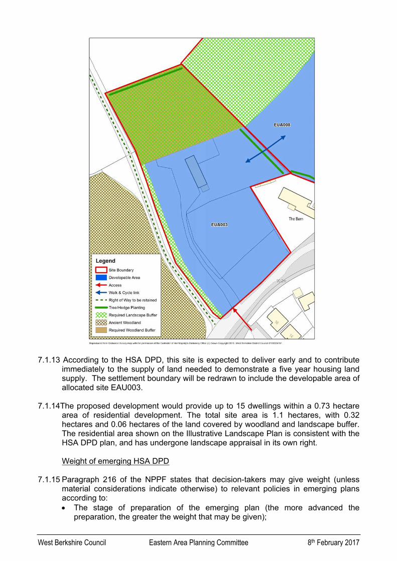
7.1.13 According to the HSA DPD, this site is expected to deliver early and to contribute immediately to the supply of land needed to demonstrate a five year housing land supply. The settlement boundary will be redrawn to include the developable area of allocated site EAU003.
7.1.14The proposed development would provide up to 15 dwellings within a 0.73 hectare area of residential development. The total site area is 1.1 hectares, with 0.32 hectares and 0.06 hectares of the land covered by woodland and landscape buffer. The residential area shown on the Illustrative Landscape Plan is consistent with the HSA DPD plan, and has undergone landscape appraisal in its own right.
Weight of emerging HSA DPD
7.1.15 Paragraph 216 of the NPPF states that decision-takers may give weight (unless material considerations indicate otherwise) to relevant policies in emerging plans according to: The stage of preparation of the emerging plan (the more advanced the
preparation, the greater the weight that may be given);

West Berkshire Council Eastern Area Planning Committee 8th February 2017
The extent to which there are unresolved objections to relevant policies (the less significant the unresolved objections, the greater the weight that may be given); and
The degree of consistency of the relevant policies in the emerging plan to the policies in the Framework (the closer the policies in the emerging plan to the policies in the Framework, the greater the weight that may be given).
7.1.16 The plan is now at a formal regulatory stage of the process, the proposed submission HSA DPD was submitted to the Secretary of State for examination on 6th April 2016 with the examination have now been held (21st June – 14 July 2016) and therefore, carries substantial weight in the decision making process.
7.1.17 Overall, taking into account the current stage of preparation, and that the proposed submission version is the plan which the Council considers sound, the emerging HSA DPD now attracts substantial weight.
Tilehurst Neighbourhood Plan
7.1.18 The Tilehurst Neighbourhood Development Plan is still in the very early stage of preparation, the area was designated May 2015 and initial events have been held this year, as such no weight is attached to the NDP at this time, any response will be reported in the update.
Prematurity
7.1.19 According to the Planning Practice Guidance, in the context of the NPPF and in particular the presumption in favour of sustainable development, arguments that an application is premature are unlikely to justify a refusal of planning permission other than where it is clear that the adverse impacts of granting permission would significantly and demonstrably outweigh the benefits, taking the policies in the NPPF and any other material considerations into account. Such circumstances are likely, but not exclusively, to be limited to situations where both:
a) the development proposed is so substantial, or its cumulative effect would be so significant, that to grant permission would undermine the plan-making process by predetermining decisions about the scale, location or phasing of new development that are central to an emerging Local Plan or Neighbourhood Planning; and
b) the emerging plan is at an advanced stage but is not yet formally part of the development plan for the area.
7.1.20 Refusal of planning permission on grounds of prematurity will seldom be justified where a draft Local Plan has yet to be submitted for examination. Where planning permission is refused on grounds of prematurity, the local planning authority will need to indicate clearly how the grant of permission for the development concerned would prejudice the outcome of the plan-making process.
7.1.21 Taking into account the foregoing assessment, the prematurity argument cannot be sustained in light of the current planning policy position.
Conclusion

West Berkshire Council Eastern Area Planning Committee 8th February 2017
7.1.23 The emerging HSA DPD now attracts substantial weight, so the proposed allocation of the site weighs heavily in favour of the proposed development. Having considered the above guidance on weight and prematurity in relation to the emerging HSA DPD, the principle of development is acceptable.
7.2 Affordable housing
7.2.1 Policy CS6 of the WBCS is concerned with the provision of affordable housing. In order to address the need for affordable housing in West Berkshire a proportion of affordable homes will be sought from residential development. The Council’s priority and starting expectation will be for affordable housing to be provided on-site in line with Government policy. The affordable units will be appropriately integrated within the development. The Council will expect units to remain affordable so as to meet the needs of both current and future occupiers.
7.2.2 The proposal will provide a total of 4 affordable housing units. This will comprise of three affordable rental units, and one shared ownership unit. The proposal therefore complies with Policy CS6 of the WBCS which requires 30% affordable housing provision on development sites of 10 - 14 dwellings or more on previously developed land. This provision must be secured through a planning obligation.
7.3 The impact upon the character and appearance of the area and AONB
7.3.1 Policies CS14, CS19, and ADPP5 of the WBCS are relevant in this instance. Policy CS14 states that new development must demonstrate high quality and sustainable design that respects and enhances the character and appearance of the area, and makes a positive contribution to the quality of life in West Berkshire. It further states that design and layout must be informed by the wider context, having regard not just to the immediate area, but to the wider locality.
7.3.2 The criteria contained within the policy state that development shall contribute positively to local distinctiveness and sense of place. This is achieved by making efficient use of land whilst respecting the density, and character of the area.
7.3.3 Policy CS19 of the WBCS seeks to conserve and enhance the functional components of the landscape character and environment. Particular regard will be given to the sensitivity of the area to change, and to ensuring that new development is appropriate in terms of location, scale and design in the context of the existing settlement form, pattern and character. Proposals for development should be informed by and respond to features identified in various settlement character studies including the Quality Design West Berkshire SPD, and community documents which have been adopted by the council such as Parish Plans and Town Design Statements. Paragraph 115 of the NPPF places great weight to conserving the landscape and scenic beauty in AONBs, which is also reiterated by Policy ADPP5 of the WBCS.
7.3.4 With respect to conserving and enhancing the natural environment, paragraph 116 of the NPPF states that planning permission should be refused for major developments in these designated areas except in exceptional circumstances and where it can be demonstrated that they are in the public interest. It is therefore
West Berkshire Council Eastern Area Planning Committee 8th February 2017
necessary to determine whether the proposal constitutes major development for the purposes of paragraph 116, and therefore whether this policy test should apply.
7.3.5 Case law establishes that the major development referred to in paragraph 116 is not necessarily the same as it is defined in the DMPO (10 or more dwellings or site area greater than 1 hectare). Determining factors are the size of development in absolute terms and its size relative to the size of the settlement. Site constraints have also been taken into account in case law (e.g. location, conservation areas).
7.3.6 Overall, taking into account the quantum of development, comparative to the size of the settlement, the location on the edge of the settlement, along with Tilehurst’s relationship with the Eastern Urban Area and Reading’s built up area, it is considered that the proposed development does not amount to major development in terms of paragraph 116 of the NPPF. Paragraph 116 is therefore not considered to apply to the proposed development.
7.3.7 The site is currently mixed use agricultural land with agricultural buildings centred around the service yard at the centre of the site. The surrounding character of the area has mixed rural and urban features. The site is situated on the Tilehurst urban/rural fringe. Open countryside is situated to the north, with high density housing situated to the south of Long Lane. The majority of these dwellings consist of detached two storey housing.
7.3.8 The proposed density of the residential development will be 11.8 dwellings per hectare. A Landscape and Visual Impact Assessment (LVIA) has been submitted and considered acceptable. Given the landscape work in relation to the HSA DPD, and noting the application is outline for principle only, the proposed development is considered to comply with policy CS19 of the WBCS, and the emerging site-specific policy HSA9 in terms of its landscape and visual impact upon the character and appearance of the surrounding area and AONB.
7.4 Neighbouring Amenity
7.4.1 Securing a good standard of amenity for all existing and future occupants of land and buildings is one of the core planning principles of the NPPF. Policy CS14 of the WBCS states that new development must make a positive contribution to the quality of life in West Berkshire. The West Berkshire Quality Design SPD and the West Berkshire House Extensions SPG provide guidance on the impacts of development on neighbouring living conditions.
7.4.2 The impact on neighbouring amenity is an issue that would need to be examined at the reserved matters stage. However, at outline stage it is considered that the illustrative layout does not raise any significant concerns in this respect, particularly because of the separation distances and from indicative buildings and neighbouring properties and the intervening landscaping along the boundaries of the site.
7.4.3 Given the existing residential context to the south and to the south-east, the proposal is not considered to a have a sufficient detrimental impact upon the residential amenity of existing neighbouring properties in terms of noise and disturbance to warrant refusal.

West Berkshire Council Eastern Area Planning Committee 8th February 2017
7.4.4 The boundary treatments and landscaping of the site are considerations for a subsequent reserved matters application for landscaping. Boundary treatments which are in keeping with the character of the area, and safeguard neighbouring amenity, will be sought at that stage.
7.5 Flood risk
7.5.1 The NPPF states that inappropriate development in areas at risk of flooding should be avoided by directing development away from areas at highest risk. Policy CS16 of the WBCS strictly applies a sequential approach across the district. The application site is located in the Environment Agency’s Flood Zone 1, which has the lowest probability of fluvial flooding. The site is therefore suitable for residential development in terms of flood risk. At the time of writing this report no response has been received from the Environment Agency, any comments received will be reported in the update.
7.6 Drainage
7.6.1 Policy CS16 of the WBCS states that on all development sites, surface water will be managed in a sustainable manner through the implementation of Sustainable Drainage Methods (SuDS). The National Planning Policy Guidance (NPPG) is more specific; it advises that whether a sustainable drainage system should be considered will depend on the proposed development and its location, for example whether there are concerns about flooding. Sustainable drainage systems may not be practicable for some forms of development. New development should only be considered appropriate in areas at risk of flooding if priority has been given to the use of sustainable drainage systems. Additionally, and more widely, when considering major development, sustainable drainage systems should be provided unless demonstrated to be inappropriate.
7.6.2 The decision on whether a sustainable drainage system would be inappropriate in relation to a particular development proposal is a matter of judgement for the local planning authority. In making this judgement the local planning authority will seek advice from the relevant flood risk management bodies, principally the lead local flood authority, including on what sort of sustainable drainage system they would consider being reasonably practicable. The judgement of what is reasonably practicable should be by reference to the technical standards published by DEFRA and take into account design and construction costs.
7.6.3 Sustainable drainage systems are considered necessary for this development. Generally, the aim should be to discharge surface run off as high up the following hierarchy of drainage options as reasonably practicable:
(a) into the ground (infiltration);(b) to a surface water body;(c) to a surface water sewer, highway drain, or another drainage system;(d) to a combined sewer.
7.6.4 The Authority’s preference for dealing with surface water run-off from the adoptable highway will be by way of roadside swales, as opposed to permeable block paving or a conventional surface water drainage system linked to soakaways. As layout and landscaping are to be considered at reserved matters stage this issue will be looked at in detail at the reserved matters stage. The Lead Local Flood Authority,

West Berkshire Council Eastern Area Planning Committee 8th February 2017
has raised concerns with regard to the indicative layouts, which the applicant should note when considering any reserved matters application.
7.7 Water / Sewerage infrastructure capacity
7.7.1 Thames Water is the statutory sewerage undertaker responsible for maintaining the water and waste water infrastructure in the local area. Thames Water has not raised any objections to the proposed development. It has requested studies of the existing water supply infrastructure to determine the magnitude of any new additional capacity required in the system and a suitable connection point.
7.7.2 Overall, there is considered to be no substantive reason to object to the proposed development on water or sewerage infrastructure grounds. Subject to determining the magnitude of any new additional capacity, the development complies with Policy CS5 of the WBCS, and Policy GS1 of the HSA DPD.
7.8 Design
7.8.1 The Government attaches great importance to the design of the built environment, and securing high quality design is one of the core planning principles of the NPPF. The NPPF advises that planning decisions should aim to ensure that developments will function well and add to the overall quality of the area, optimise the potential of the site to accommodate development, respond to local character and history, create safe and accessible environments, and are visually attractive.
7.8.2 Policy CS14 of the WBCS states that new development must demonstrate high quality and sustainable design that respects and enhances the character and appearance of the area. The Council has adopted a Supplementary Planning Document series entitled Quality Design (SPDQD). Part 1 of SPDQD provides design guidance including key urban design principles. Part 2 of SPDQD provides detailed design guidance on residential development. Part 3 of SPDQD provides a residential character framework for the prevailing residential developments in the district.
7.8.3 Policy CS4 of the WBCS states that development should make efficient use of land, with greater intensity of development at places with good public transport accessibility, it notes that in areas outside town centres, new residential development will predominantly consist of family sized housing which should achieve densities of between 30 and 50 dwellings per hectare.
7.8.4 Traditional two storey residential dwellings are situated to the south of the site. The majority of these dwellings are large detached properties providing family housing. To the south-east is a detached cottage known as The Barn.
7.8.5 The overall illustrative layout is well-conceived in that it responds to the size and shape of the site, and to the connections with surrounding areas, in terms of people’s movement. The internal road layout and provision of footpaths create a permeable environment through which there is ease of movement. The quality of the overall internal site layout appears to facilitate a scheme which, with appropriate attention to detail, could ensure a high quality public realm.

West Berkshire Council Eastern Area Planning Committee 8th February 2017
7.8.6 According to the Quality Design SPD, the Council considers it essential for the living conditions of future residents that suitable outdoor amenity space is provided in most new residential development. It is the quality of outdoor space that matters most, but the SPD provides minimum size guidelines. Given that the quality is of primary importance, this space should be an appropriate shape and be large enough to accommodate such features as a garden shed, washing lines and other domestic features, and should allow for opportunities for sitting outside in comfort and reasonable privacy and, in family dwellings, for children’s play. This is a matter that would need to be assessed at reserved matters stage; however, there is no indication at this outline stage that good quality outdoor amenity space could not be provided.
7.8.7 Cycle and refuse storage is expected with new development in accordance with the Quality Design SPD, and the Council’s highways and waste officer’s have provided comments and conditions in relation to the illustrative layout provided however, these are issues to be examined at the reserved matters stage and there is no indication at the outline stage that these matters could not be adequately addressed.
7.8.8 Major development of this size will be assessed against the Secured by Design initiative, developed by Thames Valley Police, at reserved matters stage. The ease of movement, structure, natural surveillance, and encouragement for a sense of ownership identified above would all be beneficial in terms of ensuring a safe and secure environment, although this would need to follow through into the detailed design. Royal Berkshire Fire and Rescue Service have requested provision of fire hydrants or other suitable emergency water supplies, this would need to follow through into the detailed design at reserved matters stage.
7.8.9 The West Berkshire Quality Design SPD seeks to ensure that developments on the edge of settlements ensure a soft transition to the open countryside beyond. This is particularly important within the AONB. The design of the northern edge would be subject to careful scrutiny at reserved matters stage to ensure that soft transition is achieved.
7.8.10 Overall, having regard to the urban design principles and other design guidance in the Quality Design SPD, it is considered that the proposed development can achieve a good standard of design.
7.9 Highway implications
7.9.1 It is important to note that all matters (including access) are intended to be considered at the reserved matters stage should outline consent be granted. Policy CS13 of the WBCS concerns transport. It emphasises that road safety in West Berkshire is a key consideration for all development. Particular focus should be given to the safety of pedestrians, cyclists, and other vulnerable road users.
7.9.2 Policy CS13 states that development generating a transport impact will be required to; reduce the need to travel, improve and promote opportunities for healthy and safe travel, mitigate the impact on the local transport network and the strategic road network, and prepare transport assessments to support planning proposals in accordance with national guidance.

West Berkshire Council Eastern Area Planning Committee 8th February 2017
7.9.3 Policy P1 of the emerging HSA DPD states the parking standards for new residential development. The layout and design of parking spaces should follow the parking design guidance from the Building for Life Partnership, 2012 and principles contained in the Manual for Streets in order that good quality homes and neighbourhoods are created. This site is in the EUA parking zone, the policy states that a minimum of 2 car parking spaces should be available for 2 bed dwellings, 2.5 spaces for 3 bed dwellings, and 3 spaces for 4 bed dwellings, and 1.5 spaces for 2 bed flats, plus 1 additional space per 5 flats. The total proposed spaces will be determined at the reserved matters stage.
7.9.4 Policy TRANS1 of the WBDLP Saved Policies 2007 states that the transportation needs of new development should be met through the provision of a range of facilities associated with different transport modes including public transport, walking, cycling and parking provision. The level of parking provision will depend on the availability of alternative modes, having regard to the maximum standards adopted by West Berkshire Council. Standards below the maximum level may be applied in more accessible locations. The local plan requires 1.5 car parking spaces per dwelling. This is clearly different from the requirements of Policy P1 of the emerging HSA DPD. Given that the HSA DPD is given substantial weight, and is at a very late stage of preparation, substantial weight must be given to its policies.
7.9.5 The NPPF recognises that transport policies have an important role to play in facilitating sustainable development. It states that transport assessments must; ensure safe and suitable access to the site can be achieved for all people, and improvements can be undertaken within the transport network that cost effectively limits the significant impacts of the development. It further states that, development should only be prevented or refused on transport grounds where the residual cumulative impacts of development are severe.
7.9.6 Plans should protect and exploit opportunities for the use of sustainable transport modes for the movement of goods or people. Therefore, development should be located and designed where practical to accommodate the efficient delivery of goods and supplies, and give priority to pedestrian and cycle movements. Proposed development must have access to high quality public transport facilities, create safe and secure layouts which minimise conflicts between traffic and cyclists or pedestrians, and avoid street clutter.
7.9.7 The Council’s Highways Service has reviewed the proposed plans raising no objections. Adequate access is available. This will be considered in further detail at the reserved matters stage as access will be a matter for consideration at that stage. It is considered that the proposed development will comply with the criteria contained within Policy CS13 of the WBCS, Policy P1 of the HSA DPD, and the NPPF.
7.10 Accessibility and inclusive design
7.10.1 Policy CS14 of the WBCS, in seeking high quality and sustainable design, expects development proposals to ensure environments are accessible to all and give priority to pedestrian and cycle access, providing linkages and integration with surrounding uses and open spaces.

West Berkshire Council Eastern Area Planning Committee 8th February 2017
7.10.2 The site is located within 2km of the local facilities within Tilehurst centre, approximately 400m from the nearest bus stop and 2.5km from Tilehurst Railway Station This application is adjacent to the east of a public right of way (TILE/6/2), and Vicarage Woods, an ancient woodland. Public footpath (TILE/5/2) is situated 116 metres to the east. The public footpaths are predominately used by walkers, dog-walkers and joggers, and the wider wooded area is also enjoyed by pedal cyclists and horse riders and is heavily used.
7.10.3 The illustrative plan shows several pedestrian links through and out of the site to the adjacent permitted site to the north-east and the dwellings to the south adjacent to Long Lane. Pedestrian access is a matter that would need to be assessed at reserved matters stage.
7.10.4 The Council’s public rights of way officer has raised concerns regarding the visual impact on the rural landscape which can be viewed and enjoyed from the local and wider footpath network, but welcomes the retention of existing trees and hedges forming a screen between the proposed site and Tilehurst Footpath 6/2 and the provision of additional pedestrian routes that could link to the site of the adjacent proposed housing development to the north-east.
7.10.5 Of major concern to both the public rights of way officer and objectors is the additional traffic to be generated by the development. The Sulham Valley Recreational route follows the western section of Long Lane and also crosses the main Tilehurst-Sulham Road. This section of Long Lane immediately adjacent to Vicarage Wood has no pavements, is already heavily trafficked and in places there is only space for one vehicle to pass along, and objection is raised to the application on the grounds of the road safety of pedestrians using the Sulham Recreational Route due to the additional traffic which would be created by the development.
7.10.6 The site has been considered previously (in 2014) by highways officers as part of the identified sites for residential development within Tilehurst. At that time the view was taken by highways that the carriageway would not require widening and a (northbound) footway would not be required on the west side of Long Lane. As such the highways officer has advised that the anticipated traffic distribution from the proposed development to the south along Long Lane is not considered of sufficient weight to allow for a recommendation for refusal, whether that be on the grounds of risk of conflicts involving oncoming/passing traffic or other users of the highway, within the context of the NPPF and specifically paragraph 32 which requires the residual cumulative impacts of a development to be “severe” before it can be refused.
7.10.7 While conditions have been recommended by the public rights of way officer. A condition cannot be imposed in order to remedy a pre-existing problem or any issue not created by the proposed development, given the highways officers comments it is considered that the recommended conditions are not justified and that the suggested public rights of way conditions would fail the six tests set out at paragraph 206 of the National Planning Policy Framework (necessary; relevant to planning; relevant to the development to be permitted; enforceable; precise and; reasonable in all other respects”).
7.11 Trees

West Berkshire Council Eastern Area Planning Committee 8th February 2017
7.11.1 Policy CS19 of the WBCS concerns the historic environment and landscape character. It seeks to ensure that the diversity and local distinctiveness of the landscape character of the district is conserved and enhanced. Particular regard is given to the conservation and, where appropriate enhancement of heritage assets and their settings.
7.11.2 The NPPF states that planning permission should be refused for development resulting in the loss of aged or veteran trees found outside ancient woodland, unless the need for, and benefits of, the development in that location clearly outweigh the loss.
7.11.3 The Council’s tree officer has been consulted raising no objections. It is therefore considered that the proposed development would conserve the trees covered by the TPO in compliance with the advice contained within the NPPF, and Policy CS19 of the WBCS.
7.12 Ecology
7.12.1Policy CS17 of the WBCS states that biodiversity and geodiversity assets across West Berkshire will be conserved and enhanced. Policy HSA 9 of the HSA DPD requires the submission of an extended phase 1 habitat survey. From this report the majority of the features of ecological importance will be retained although the proposal would result in the lost of some species rich hedgerow. The Council ecologist has not commented to date, any response that is received will be included in the update report. Natural England have not raised any objections. It is therefore considered that the proposed development would comply with Policy CS17 of the WBCS.
7.13 Community Infrastructure Levy (CIL)
7.13.1Planning Policy CS5 of the WBCS states that the Council will work with infrastructure providers and stakeholders to identify requirements for infrastructure provision and services for new development and will seek to co-ordinate infrastructure delivery. The Council has implemented its Community Infrastructure Levy (CIL) as from 1st April 2015. Planning applications which are decided after 1st April 2015 may be liable to pay the levy.
6.5.2 Under the Community Infrastructure Levy Charging Schedule adopted by West Berkshire Council and the government Community Infrastructure Levy Regulations a charge is not made until the reserved matters stage. A full assessment will be undertaken during consideration of the reserved matters applications.
7.14 Sustainable Development
7.14.1 When considering development proposals, the Council is required to take a positive approach that reflects the presumption in favour of sustainable development contained in the National Planning Policy Framework.
7.14.2 The National Planning Policy Framework places a strong emphasis on sustainable development. All planning applications must result in sustainable development with consideration being given to economic, social and environmental sustainability aspects of the proposal. Future residents would make a contribution to the local

West Berkshire Council Eastern Area Planning Committee 8th February 2017
economy, and the development would provide employment in construction for a short period. The environmental considerations have been assessed in terms of the impact on the character and appearance of the area and the AONB, and neighbouring amenity and for the reasons given above are considered acceptable. The development would bring social benefits in terms of providing housing required to meet the needs of present and future generations, including affordable housing. As these have been found acceptable the development is considered to constitute sustainable development.
8. Conclusion
8.1.1 Having taken account of all the relevant policy considerations and the other material considerations referred to above, it is considered that having regard to the clear reasons to support the development proposed is considered to be acceptable and a conditional approval is justifiable for the following reasons.
8.1.2 The proposal will not unduly harm the character and appearance of the surrounding area and the AONB, or neighbouring amenity, and there are no other material considerations that indicate planning permission should otherwise be refused. It is recommended that the application be approved.
8.1.3 This decision has been considered using the relevant policies related to the proposal. These are; ADPP1, ADPP4, ADPP5, CS1, CS4, CS5, CS6, CS13, CS14, CS15, CS16, CS17, and CS19 of The West Berkshire Core Strategy 2006 - 2026, Policy OVS5, OVS7, OVS8, HSG1, HSG11and TRANS1 of the West Berkshire District Local Plan 1991-2006 Saved Policies 2007, Policy GS1, HSA9, C1, C3, and P1 of the Draft West Berkshire Council Proposed Submission Housing Site Allocations Development Plan Document (November 2015) (DPD), and the National Planning Policy Framework.
9. FULL RECOMMENDATION
DELEGATE to the Head of Planning & Countryside to GRANT PLANNING PERMISSION subject to the completion of a legal agreement by 7th April 2017 and in accordance with the schedule of conditions (Section 9.1).
9.1 Schedule of conditions
1. Reserved Matters Details of the access, appearance, landscaping, layout and scale (hereinafter called 'the reserved matters') shall be submitted to and approved in writing by the Local Planning Authority no later than the expiration of three years beginning with the date of this permission, and no building or other operations shall start on site until the Reserved Matters have been approved in writing by the Local Planning Authority. Thereafter the development shall be carried out in strict accordance with the approved details and with the requirements of any conditions attached to any approved reserved matters application. This condition shall apply irrespective of any indications as to the reserved matters which have been given in the application hereby approved.

West Berkshire Council Eastern Area Planning Committee 8th February 2017
Reason: To comply with Section 92 of the Town and Country Planning Act 1990 (as amended by Section 51 of the Planning and Compulsory Purchase Act 2004). The application is not accompanied by sufficient details of the reserved matters to enable the Local Planning Authority to give proper consideration to those matters and such consideration is required to ensure that the development is in accordance with the development plan.
2. Time limitThe development to which this permission relates shall be begun before the expiration of five years from the date of this permission or before the expiration of two years from the date of approval of the last of the approved matters to be approved, whichever is the later.
Reason: To comply with Section 92 of the Town and Country Planning Act 1990 (as amended by Section 51 of the Planning and Compulsory Purchase Act 2004).
3. Plans approvedThe development hereby permitted shall be carried out in accordance with drawing number 15094S101, 15094P101, 15094P103A, 668/1/01, 668/2/01, and 668/1/02 received on 10th August 2016 and any plans and details approved under any subsequent approval of reserved matters applications and any conditions attached to such approvals.
Reason: To ensure that the development is carried out in accordance with the submitted details assessed against Policy CS14 and CS19 of the West Berkshire Core Strategy 2006-2026.
4. Hours of work (construction)Demolition or construction works shall not take place outside the following hours:7:30am to 6:00pm Mondays to Fridays;8:30am to 1:00pm Saturdays;nor at any time on Sundays or Bank Holidays.
Reason: To safeguard the living conditions of adjacent occupiers in accordance with Policy CS14 of the West Berkshire Core Strategy 2006-2026.
5. Unforseen contaminationShould any unforeseen contamination be encountered during the development, the developer shall inform the Local Planning Authority immediately in writing via a condition discharge application. Any subsequent investigation/remedial/protective works deemed necessary by the Local Planning Authority shall be carried out to agreed timescales and approved by the Local Planning Authority in writing via a condition discharge application. If no contamination is encountered during the development, a letter confirming this fact shall be submitted to the Local Planning Authority upon completion of the development via a condition discharge application.This is in accordance with the NPPF, and Policies CS14 and CS16 of the West Berkshire Core Strategy 2006 - 2026.

West Berkshire Council Eastern Area Planning Committee 8th February 2017
Informatives:
1. Reasons for approvalThe decision to grant planning permission has been taken because the development will preserve the character and appearance of the surrounding area and AONB, and the neighbouring amenity. This informative is only intended as a summary of the reason for the grant of planning permission. For further details on the decision please see the application report which is available from the Planning Service or the Council website.
2. Approval - Objections/Support receivedThis decision has been made in a positive way to foster the delivery of sustainable development having regard to Development Plan policies and available guidance to secure high quality appropriate development. In this application whilst there has been a need to balance conflicting considerations, the local planning authority has secured and accepted what is considered to be a development which improves the economic, social and environmental conditions of the area.
3. Legal agreementsThis Decision Notice must be read in conjunction with the terms of a Legal Agreement of the *. You are advised to ensure that you have all the necessary documents before development starts on site.
4. Emergency accessAny gates required for emergency access should provide a minimum 3.1 m clear opening.
5. Fire hydrantsThere are at present, no available public mains in this area to provide a suitable water supply in order to effectively fight a fire. The applicant is advised to provide suitable private fire hydrants, or other suitable emergency water supplies to meet Royal Berkshire Fire & Rescue Service requirements.
6. Thames WaterThames Water will aim to provide customers with a minimum pressure of 10m head (approx 1 bar) and a flow rate of 9 litres/minute at the point where it leaves Thames Waters pipes. The developer should take account of this minimum pressure in the design of the proposed development.
7. Surface water drainageIt is the responsibility of a developer to make proper provision for drainage to ground, water courses or a suitable sewer. In respect of surface water it is recommended that the applicant should ensure that storm flows are attenuated or regulated into the receiving public network through on or off site storage. When it is proposed to connect to a combined public sewer, the site drainage should be separate and combined at the final manhole nearest the boundary. Connections are not permitted for the removal of groundwater. Where the developer proposes to discharge to a public sewer, prior approval from Thames Water Developer Services will be required. They can be contacted on 0800 009

West Berkshire Council Eastern Area Planning Committee 8th February 2017
3921. Reason - to ensure that the surface water discharge from the site shall not be detrimental to the existing sewerage system.
8. Conditions – reserved mattersPlease be aware that several of the consultees, for example; highways and the Council's tree officer requested conditions during consideration of this outline planning application that have not been attached to this outline planning consent. The developer may wish to submit the requested information in support of a future reserved matters application to avoid additional conditions on any future reserved matters consent.
9.2 Or if the legal agreement is not completed by the 7th April 2017, to DELEGATE to the Head of Planning & Countryside to REFUSE PLANNING PERMISSION, or to extend the period for completion if it is considered expedient to do so.
The development fails to provide an appropriate scheme of works or off-site mitigation measures to accommodate the impact of the development on local infrastructure (affordable housing), or provide an appropriate mitigation measure such as a planning obligation. As such, the development fails to comply with the National Planning Policy Framework, the Planning Practice Guidance and Policy CS6 of the West Berkshire Core Strategy 2006-2026.