an overview of operations at the west gulf river forecast...
TRANSCRIPT
National Weather Service West Gulf River Forecast Center
NWSWestGulf @NWSWGRFC http://www.srh.noaa.gov/fwr
An Overview of Operations at the West Gulf River Forecast Center
Gregory Waller – Service Coordination Hydrologist NWS - West Gulf River Forecast Center

National Weather Service West Gulf River Forecast Center
NWSWestGulf @NWSWGRFC http://www.srh.noaa.gov/fwr
•Introduction to NWS Hydrologic Services •Overview of HAS Operations •Overview of Hydrologic Operations •Hydrologic Modeling and Forecasting •Advances in Science and Technology

Structure of the NWS
Department of Commerce
National Oceanic and Atmospheric Association
National Weather Service
WGRFC (13 RFC’s)
Weather Forecast Offices (120+)
http://www.srh.noaa.gov/fwr @NWSWGRFC
National Weather Service West Gulf River Forecast Center

National Weather Service West Gulf River Forecast Center
NWSWestGulf @NWSWGRFC http://www.srh.noaa.gov/fwr
•13 Offices (12 CONUS + 1 Alaska/Pacific)
•Hydro-geologic boundaries •Some modeling of headwaters in Canada/Mexico (no forecast services)
•Daily Operations •Data collection and quality control •Precipitation and Hydrologic Forecasts
•Research Activities •New technologies •New products

National Weather Service West Gulf River Forecast Center
NWSWestGulf @NWSWGRFC http://www.srh.noaa.gov/fwr
Snowpack Water supply
Rocky terrain Flash flood threats Rapid river responses
Prolonged river flooding Complex reservoir operations
Tropical threats Storm surges Coastal flooding
402,000 mi2 total area 87,000 mi2 in MX (Rio Grande tributaries) 320 forecast points, 15 major river systems

National Weather Service West Gulf River Forecast Center
NWSWestGulf @NWSWGRFC http://www.srh.noaa.gov/fwr
•Normal Hours •6:00 a.m. – 10:00 p.m.
•Routine Staffing •HAS (6:00 a.m. – 2:00 p.m.) •Hydro (7:30 a.m. – 3:30 p.m.) •Evening (2:00 p.m. – 10:00 p.m.)
• Hybrid of HAS and Hydro duties •Development Shift (8:00 a.m. – 4:30 p.m.)
• Assist in operations as needed •Additional Staffing Requirements
•Event driven and/or in coordination with WFOs and customers •Overnight Shift scheduled for prolonged rainfall/flooding events
WGRFC Hours of Operation

•HAS Operations – Rainfall Data & Forecasts
•Hydrologic Operations – River Data & Forecasts
Precipitation estimates and forecasts merged into continuous dataset
Precipitation dataset ingested into hydrologic model. Forecasters adjust model parameters in real time
River forecast issued to public
Forecast Process
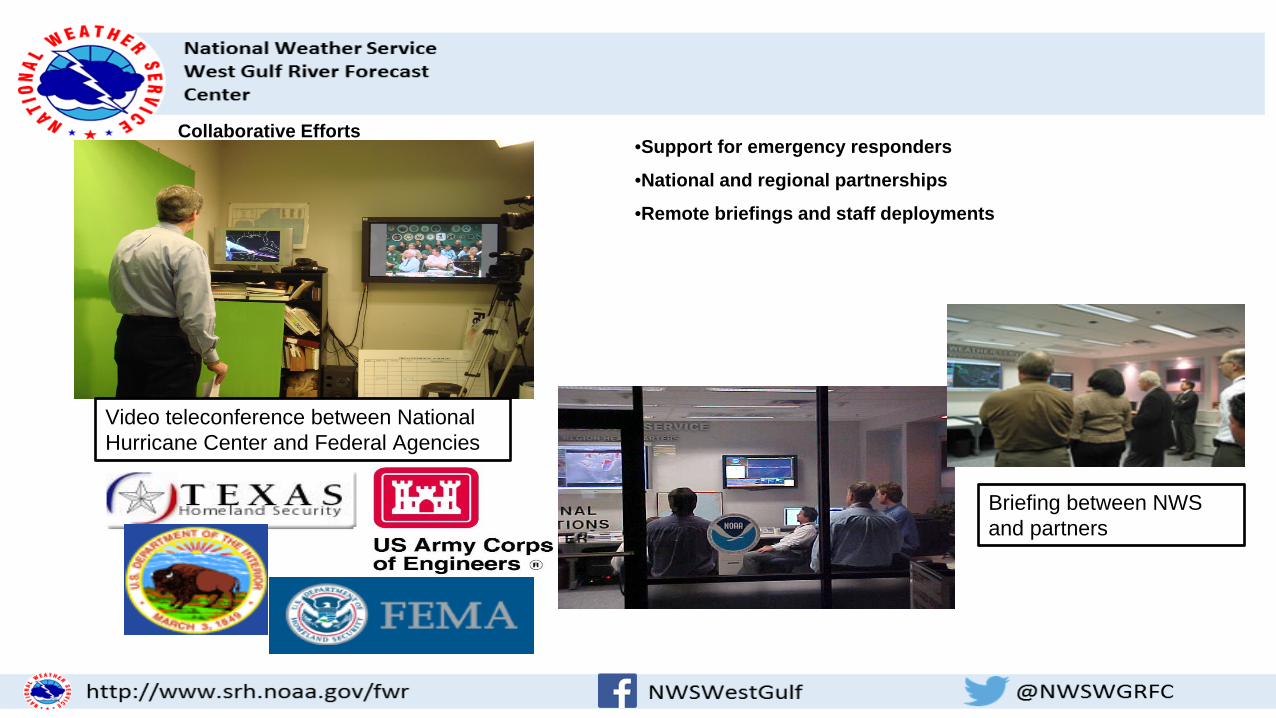
Collaborative Efforts •Support for emergency responders
•National and regional partnerships
•Remote briefings and staff deployments
Video teleconference between National Hurricane Center and Federal Agencies
Briefing between NWS and partners

HAS Operations
•“HAS” = Hydrometeorological Analysis and Support •3 forecasters at each River Forecast Center (RFC) •Create precipitation datasets
• “Best Estimate” of past precipitation (QPE) • Derived with MPE
• Forecast of future precipitation (QPF) •Create temperature datasets
• Temperature Data Sets not utilized at every RFC •Support activities
• Data Quality Control • Text and graphical information products • Coordination with NWS offices and public partners • Weather discussions and briefings

What is MPE? (produces QPE)
•Multi-sensor Precipitation Estimator •Inputs
• Radar • Gauges • Satellite
•Final multi-sensor precipitation product is better than any single sensor.
•Goals •Reduce spatial inaccuracies and bias errors in rainfall datasets •Produce a quality precipitation dataset for ingest into National Weather Service (NWS) hydrologic models

Precipitation Best Estimate •4km x 4km spatial resolution
•1 hour temporal resolution
•Human quality control of data inputs
Gauge
Radar
Satellite
Best Estimate (Multi-sensor Field)
Satellite

Precipitation Forecast/QPF
•4 km x 4 km spatial resolution
•6 hour temporal resolution
•72 hours (12 periods) processed •RFCs ingest 6-24 hours (1-4 periods) operationally in hydrologic models •Additional periods ingested based on confidence in forecast
Guidance forecast issued by National Center
Forecaster at RFC makes adjustments based on local expertise

Support Activities
•Public Products •Text and graphical
•Coordination and briefings •Internal and external partners
CO
MET
– In
tern
atio
nal H
ydro
Met

Hydrologic Operations
•9 to 14 Hydrologic Forecasters at each River Forecast Center (RFC) •Create River Forecasts
•Forecasters apply local expertise to adjust model output •Development work
•Calibrate hydrologic model •Model new basins and forecast points •Develop new operational techniques and procedures
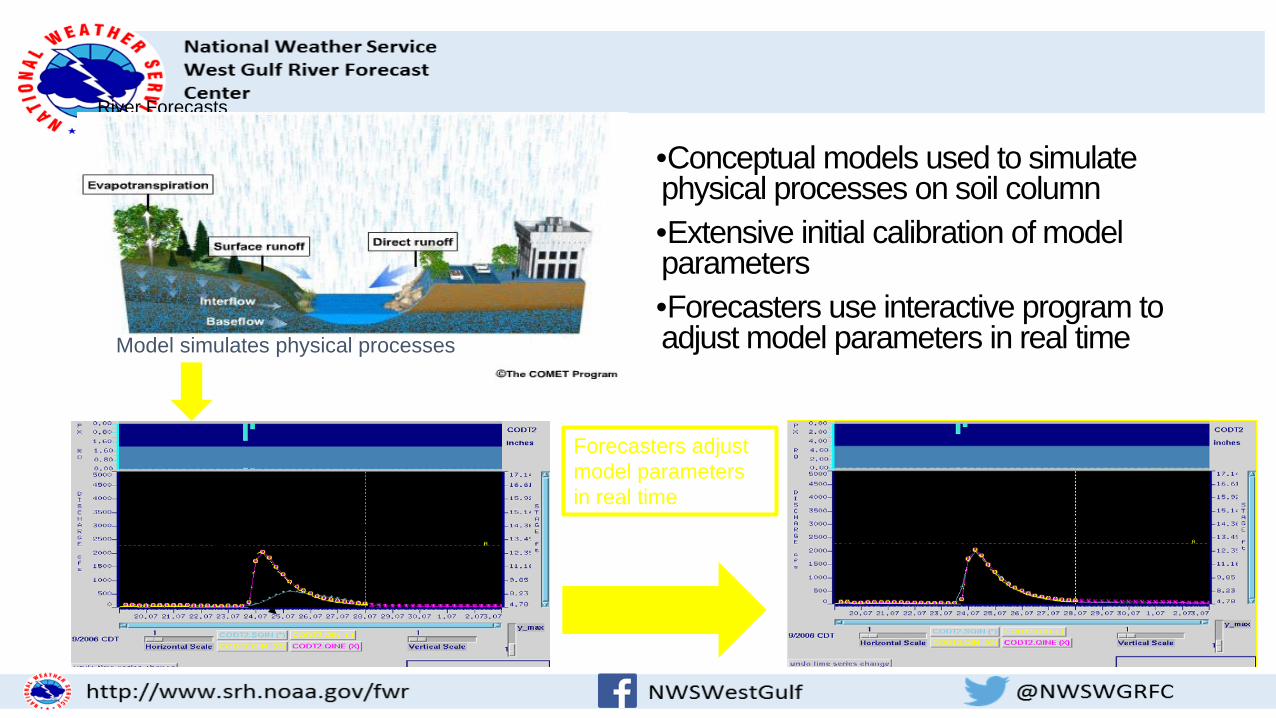
River Forecasts
•Conceptual models used to simulate physical processes on soil column •Extensive initial calibration of model parameters •Forecasters use interactive program to adjust model parameters in real time
Model simulates physical processes
Forecasters adjust model parameters in real time
Simulation Observed Simulation better predictor of
observed data

•Enhancements to existing model and techniques •Model Calibration •Adjustment of Model Parameters
•Research and Development projects
•New Modeling Techniques •Probabilistic Forecasting •Forecast Verification
•Collaboration with partners and customers
•Flood Briefings •Hydrologic Discussions •Web Products and Services

•Calibration • Improved model performance
•Distributed Modeling • Increased resolution of model parameters and precipitation inputs •Forecast possible at any grid location
•Hydraulic Modeling • Improved routing in complex environments • Integral in Flood Inundation Mapping
•Dam Break Modeling
•Research projects with internal and external partners
Interactive Calibration Program

Hydrologic Operations Duties •Duties
•River Forecasting (morning package) •Run models after precipitation input is available •Issue any criteria forecasts •Issue daily forecasts
•Monitor Rivers/Forecasts throughout shift •Update/Issue criteria forecasts as needed
•Hydrologic data quality control •Weekly recreation forecast •Development work to infuse new science and technological advances

Hydrologic Forecast Process
•A lot of estimates… •Estimate how much rain gets into the river
• Rainfall to Runoff •Estimate timing (how fast) of runoff to the river gage
• Unit Hydrograph •Estimate how fast any upstream water arrives at the gage
• Routing •Estimate water flow (we use) into water height (the public uses)
• Rating •We can modify any/all of the above

Rainfall and Runoff
Rainfall change – 6 Hour (Mean Areal) Runoff change – 6 hour


The Unit Hydrograph This UHG is for Sandy Creek near Cordele, part of the Lavaca/Navidad River system

Routing
Time
Gag
e H
eigh
t

The Result – Our Model

Rating Curve - Flow vs Height

Advanced Hydrologic Prediction Service
•National multi-year project •Smaller scale modeling for fast responding basins (cooperative project with local offices)
•Probabilistic Forecasts •Inundation Mapping

Flash Flood Guidance
•Flash Flood Guidance •New gridded methodology
• Increased resolution • Increased responsiveness
New methodology for Flash Flood Guidance

Ensemble Modeling
•Ensemble Models •Produces long-term probabilistic forecasts
• Utilizes historical precipitation inputs • Current soil moisture conditions • Creates simulations based on each year of historical precipitation (ensembles) • Performs statistical analysis
Ensemble Simulations
Probabilistic Forecasts

Flood Inundation
•Utilizes high resolution Digital Elevation Maps (DEM)
•Utilizes hydraulics modeling at numerous river cross sections
•Model output fed into Geographical Information System(GIS) for map display

Water Supply Modeling
•Input various real-time data •Snow Depth •Snow Water Equivalent
•Use of Regression Equations to determine seasonal volume forecasts
SNOTEL site Remote-sensed SWE

National Weather Service West Gulf River Forecast Center
NWSWestGulf @NWSWGRFC http://www.srh.noaa.gov/fwr
•Questions?
•Thank You
•Gregory Waller •Service Coordination Hydrologist •WGRFC •[email protected]