an ontology design pattern for cartographic map scalinggeog.ucsb.edu/~jano/scaling_pattern.pdf ·...
TRANSCRIPT

An Ontology Design Pattern forCartographic Map Scaling ?
David Carral1, Simon Scheider2, Krzysztof Janowicz3, Charles Vardeman4,Adila Krisnadhi1, and Pascal Hitzler1
1 Kno.e.sis Center, Wright State University, USA2 Institute for Geoinformatics, University of Munster, Munster, Germany
3 Department of Geography University of California, Santa Barbara, CA, USA4 Center for Research Computing, University of Notre Dame, Notre Dame, IN, USA
Abstract. The concepts of scale is at the core of cartographic abstractionand mapping. It defines which geographic phenomena should be displayed,which type of geometry and map symbol to use, which measures can betaken, as well as the degree to which features need to be exaggerated orspatially displaced. In this work, we present an ontology design pattern formap scaling using the Web Ontology Language (OWL) within a particularextension of the OWL RL profile. We explain how it can be used to describescaling applications, to reason over scale levels, and geometric representa-tions. We propose an axiomatization that allows us to impose meaningfulconstraints on the pattern, and, thus, to go beyond simple surface semantics.Interestingly, this includes several functional constraints currently not ex-pressible in any of the OWL profiles. We show that for this specific scenario,the addition of such constraints does not increase the reasoning complexitywhich remains tractable.
1 Introduction and Motivation
The notion of scale is at the very core of cartography and essential for the visu-alization of geo-information in maps [15]. However, scale also plays a key role forknowledge representation and measurement [8]. In its simplest form, scale can beexpressed as a representative fraction that specifies the relation between the dis-tance measured on a map to the corresponding distance in the physical world [17].For example, a large map scale of 1:25000 indicates that one unit of measure onthis map corresponds to 25000 units of the same measure on the ground. In turn, asmall scale map of 1:100000 covers a larger region.5
Dealing with scale-dependent representations of phenomena in maps in a seam-less manner is called map scaling. It involves a lot of specialized knowledge. Forinstance, highway symbols may have to be exaggerated and displaced before theycan be rendered on a small scale map. Thus, trying to read the street widths orpathway from a small scale map will yield meaningless results. Similarly, geographicfeatures such as creeks, lakes, and ponds will have to be fused, simplified, or omitted.Buildings may be represented as polygons or point-like features at some scale, butmay be fused to blocks and neighborhoods at a smaller scale. Generalizing furtherwill collapse these blocks into a representation of a whole city. Finally, on a globalmap, only major capitals will be left while all other cities may disappear.
? An extended technical report with the appendix can be found at http://knoesis.wright.edu/pascal/resources/publications/odp-carto-scaling-TR.pdf
5 The reason for this is that the terms small and large refer to the representative fraction,with 1/25000 being the larger fraction. Note that this usage of small and large differsfrom how other domains refer to scale, e.g., as in ’large scale study’.
Map scaling requires choosing a certain data representation as well as a modeof display for every geographic phenomenon type at each scale level inside a mapextent. Cartographic abstraction is, to a large degree, a sophisticated craft. It in-volves semantic as well as cartographic knowledge, including knowledge about theinvolved type of features, map generalization rules, and appropriate symbolism forlayout as well as symbol placings [15].
However, currently, the knowledge about scale dependency of digital representa-tions remains inaccessible. This makes the integration of digital information acrossscales and across applications challenging. While there is a rich body of work onhow to address scale in cartography, most of the knowledge involved is not specifiedformally or is hidden in application source code. This contradicts with one of themajor paradigm shifts underlying Semantic Web research, namely to enable thecreation of smarter data instead of smarter applications. Rather than engineeringincreasingly complex software, the so-called business logic should be transferred tothe level of (meta) data. The rationale behind this is that smarter data will enablemore usable and flexible applications, while smarter applications alone fail to im-prove data along the same dimensions. So far, the notion of scale has barely beengiven any attention in the Semantic Web, even though most digital resources havean intrinsic scale level. In particular, we do not know of any published ontologypatterns on scale.
In this paper, we propose a scale ontology design pattern (in the sense of [6])which can be used to document and publish knowledge about map scaling appli-cations on the web. It describes the scale dependent representation of geographicphenomena in such applications, and makes the underlying scaling decisions explicitand accessible on the Web. Hence, our work may be integrated with provenance on-tologies such as Prov-O6. With respect to (semantic) Web services, our pattern canbe used to link and track geo-features across scale levels. For example, one couldquery for a map service that serves base data in the scale required to visualize fea-tures from another service. Furthermore, the map scaling pattern allows to reasonon scaled geographic information. For example, one can check whether two phe-nomena can be displayed together at a single scale level across scaling applications.One may also gather information about a certain geographic phenomenon at a highlevel of geographic detail across the Web. And one can check scaling applicationsfor consistency of scaling and representation.
From the viewpoint of semantic technology, we will address two challenges forsuch a pattern: First, from a conceptual viewpoint, the pattern has to ensure thatgeographic features are traceable across scale levels, and that the basic logical con-straints inherent in (rendering) applications are formally captured in the pattern.Second, from a computational point of view, reasoning with the pattern needs to betractable. For this purpose, the application logic needs to captured in a tractablesubset of first order logic (FOL). However, as we will show later on, current OWLfragments are not flexible enough to capture the required functional constraints. Wewill show that these constraints can be captured by a certain logical fragment thatremains in polynomial order of complexity.
In the following, we will first discuss map scaling in order to motivate and helpunderstand our axiomatization. Then, we will discuss a formal axiomatization onthe level of a functional pattern as well as on the level of a DL fragment whichallows tractable reasoning. We will evaluate the pattern by showing its use in anexisting application that studies Malaria, before we discuss and conclude the paper.
6 http://www.w3.org/TR/prov-o/

2 Map Scaling in a Nutshell
Practical solutions of the map scaling problem draw on a number of core issuesin Geographic Information Science (GIScience) as well as Computer Cartography[15,14]. In this section, we will give a very brief overview of key concepts and relatedwork. We will also suggest a conceptual view on them, which helps put our ontologypattern into context.
2.1 Map Scale
With the notion scale we mean cartographic scale, which refers to the ratio of thedepicted size of a feature on a cartographic map relative to its actual size [17].There are other notions of scale. For example, the scale of analysis and the scale ofobservation are scales induced by analyzing or observing a phenomenon. The scaleof a phenomenon is the scale at which a phenomenon appears or can best be studied[21]. The latter kinds of scale are not explicitly addressed in this paper, however,they may decide about whether certain kinds of entities appear at certain scales ornot [17]. In this context it will be important to keep in mind that a unique mapscale exists only for a map image, i.e., a map displayed as an image, and not formap data, which may be displayed at several different scales. Furthermore, (digital)zooming should not be confused with scaling, as no new information is added orremoved while zooming. So far, we do not know of any published work addressingthe issue of scale in the Semantic Web context7. However, the topic is central forGIScience [5].
2.2 Geographic Phenomena
Geographic phenomena can be represented in a cartographic map. They come indifferent feature/object types, such as rivers, cities, roads, buildings, people, land-parcels, or the earth’s surface. They may also consist of conventionally establishedregions in a spatial reference system, such as the borders of Germany. Further-more, they may consist of qualities, such as temperature or windspeed or buildingheight. Geographic phenomena can be represented by geo-ontologies, ranging fromtop-level ontologies such as [2] to domain ontologies such as NASA’s Sweet8. Mostimportantly, however, geographic phenomena can be measured in terms of referencesystems. This means one can unambiguously observe their extent in at least somespatial reference system that allows to refer to geographic locations, such as WGS84.This makes them amenable to cartographic mapping. Externally, geo-ontologies canbe aligned with the phenomenon class of our pattern to differentiate among thesetypes of phenomena and subclass them further.
2.3 Map Data
Map data is any set of data which represents geographic phenomena and which canbe cartographically mapped (i.e., displayed in a map). For this purpose, it needs tocontain a spatial geometry, i.e., a type of data which specifies a subset of points insome spatial reference system. This subset may be a single point, a line, or someregion. A frequent data structure are geodata records used in Geographic Informa-tion Systems (GIS), i.e., records of a spatial geometry and non-spatial attributevalues. The latter can represent measurable qualities, e.g., temperature, as well ascartographic symbol types, e.g., a color symbol, which may be used to display the
7 Preliminary unpublished work is avaible here: http://vocamp.org/wiki/Scale-vocab.8 http://sweet.jpl.nasa.gov/2.2/sweetAll.owl.

map data at a certain scale level. Depending on the kind of geometry, one can dis-tinguish two kinds of map data: one is raster data, where the geometry forms aregular tessellation (a topological cover with regular polygons) of a subset of thereference space. An example is a satellite image. Another one is vector data, wheregeometries can be irregular and need not form a tesselation. Map data often comesin collections representing phenomena of similar type called layers. The differentkinds of map data form the context but are not part of our ontology pattern.
2.4 Resolution
Resolution is a central notion for map scaling, however, its semantic specificationis challenging [4]. In this section, we clarify our use of the term in an informal way,following ideas in [4]. Resolution can be regarded as a property of map data whichallows to measure its level of detail. Note that map data has a resolution but not amap scale in our sense, since it is not necessarily displayed, and not necessarily ata single scale level. There are different proxy-measures for resolution, depending onthe purpose. One proxy measure is based on grain size, i.e., the extent of an atomicmapping entity in a spatial reference system. An example is the instantaneaous fieldof view of a satellite, i.e., the area on the ground surface that corresponds to a singleremote detector element, or the minimal mapping unit [8]. Our pattern allows grainsize resolution levels of map images interchangeably with their map scale levels inorder to restrict potential display of map data to a scale level. However, we do notexplicitly model scale and resolution of map data, which may be done in the future.
2.5 Map Image
A map image is the result of displaying map data in a map display, i.e., a medium(e.g., paper) used to visualize the map, according to a map scale. Therefore, a mapimage has a grain size resolution as well as a map scale, the latter because it isprojected into a map display in which each pixel has a measurable size. A mapscale can be computed from the image resolution by multiplying the latter with thepixel size. In a map scaling application, a new map image is generated every timeone zooms in or out. Note that a map image file is a different beast. In contrast tothe former, the latter is a form of map data in raster format. While the latter hasa grain (pixel) size resolution, it does not have a map scale (since its pixels do nothave fixed display sizes).
2.6 Scaling and Map Generalization
Scaling [21] refers to the seamless transfer of information between different scalelevels. Even though a digital map display in principle allows zooming in and outregardless of map data or phenomena, a visually graspable image as well as a seman-tically adequate and computationally efficient data representation depends on theresolution as well as the design of the map data. For example, from a visual stand-point, representations can become congested, coalesced or imperceptible at inappro-priate scales [15]. There is web technology available which allows to specify and servescale dependent maps in the web9. The problem of map generalization has been ad-dressed by Computer Cartography with operations that modify map data geometryand symbolization accordingly. These include simplification, smoothing, aggrega-tion, amalgamation, merging, collapse, refinement, exaggeration, enhancement and
9 For example, the Feature Portrayal Service (FPS) and Styled Layer Descriptor (SLD)standards of the Open Geospatial Consortium (OGC) http://www.opengeospatial.org.
displacement [15]. Since existing algorithms are not able to automatize generaliza-tion to a degree which corresponds in quality to manual cartographic techniques[16], map generalization in practice is still done manually or semi-automatically[16].
Furthermore, generalization has an aspect of (semantic) modeling [16], whichrelates to observation and intrinsic phenomenon scales mentioned above [21]. As aconsequence of scaling, not only the visual representation of a phenomenon, but alsogeometry, semantic classes, properties and relations are affected. Furthermore, eventhe occurrence of individuals is not invariant across scales. Existing formalisms forscaling and generalization, such as stratified map spaces [20], simplify the problemto lifting or generalizing classes and spatial regions, not objects. However, as amatter of fact, individual geographic objects, such as cities and countries, appearat smaller scales, while streets, places and buildings only appear at larger scales.From an ontological viewpoint, generalization therefore affects the level of detail ofan ontology and thus may change an ontological theory. This can be treated as amereological problem on the side of phenomena, such as the problem to individuateroad junctions from a road segment network [18]. For our pattern, we will thereforeassume a generalization relation between map data sets, which reflects diverse waysof generalizing data sets on different scale levels.
3 Preliminaries
To define and implement the pattern in a tractable way, we introduce an extensionof the existing description logics fragment DLP [9], the logic fragment underlyingthe OWL RL profile. We denote the extension as DLP∃ and show that, undercertain appropriate syntactic restrictions, reasoning over this DL fragment remainstractable. Throughout the paper we will show how this extension allows us to expresssome useful constraints enhancing the usability of the map scaling design pattern.
We will make use of the DL notation along the paper, as we think it improvesreadability and understanding of the ideas presented. Furthermore, some of the newfeatures included in the extended fragment DLP∃ are not even part of the OWLlanguage, such as role conjunction, and therefore cannot be expressed in any of theexisting OWL syntaxes. DL syntax allows us to express these constructors withouthaving to introduce major changes in the existing notation. Henceforth, we onlyimplement the part of the pattern that can be done making use of the currentavailable constructors in OWL. If the reader is not familiar with the DL notationsee [13] for a quick introduction and [1] for a lengthier one.
The set C of allowed concepts in DLP∃ is the set of all concepts that can beconstructed making use of all constructors in Table 1. Like in other DL fragments,we can divide the axioms in a DLP∃ knowledge base into ABox A, TBox B, andRBox R statements.10
A DLP∃ TBox [RBox ] is a finite set of general concept inclusions (GCIs) [roleinclusion axioms (RIAs)] as described in Table 1. An ABox is a finite set of conceptand role assertions also as described in Table 1. Furthermore, DLP∃ restricts the at-most one cardinal restriction constructor (≤ 1R.C) to only appear in the right handside of GCIs. Note that DLP∃ allows for the use of unrestricted role conjunctions.
We do not impose any kind of role regularity restrictions in DLP∃ as definedfor SROIQ [10], which is the logic fragment underlying the OWL DL profile. Theregularity restrictions are applied to the tractable OWL profiles in order to defineOWL DL as a superset of these. Otherwise some of the tractable fragments wouldallow some expressivity not available in OWL DL.
10 Assertional, terminological, and role boxes respectively
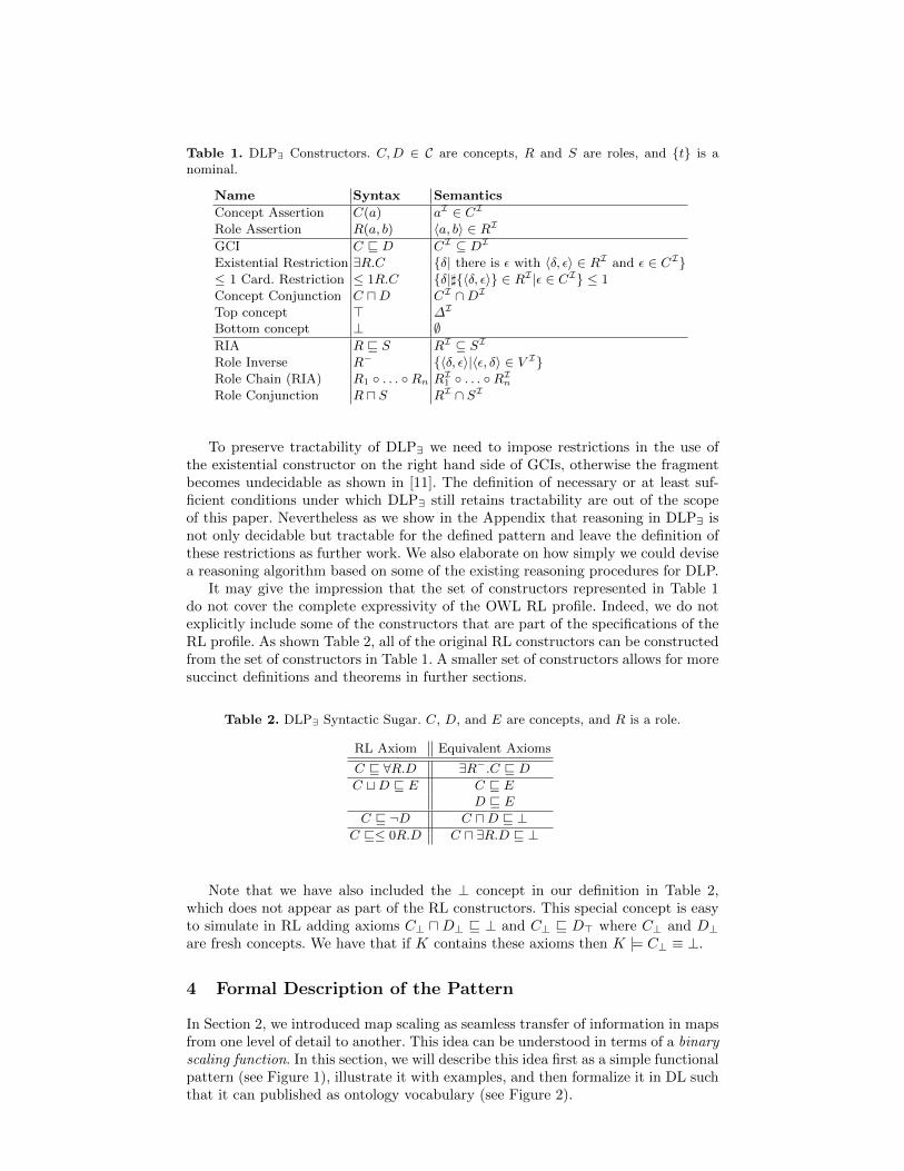
Table 1. DLP∃ Constructors. C,D ∈ C are concepts, R and S are roles, and {t} is anominal.
Name Syntax Semantics
Concept Assertion C(a) aI ∈ CIRole Assertion R(a, b) 〈a, b〉 ∈ RI
GCI C v D CI ⊆ DIExistential Restriction ∃R.C {δ| there is ε with 〈δ, ε〉 ∈ RI and ε ∈ CI}≤ 1 Card. Restriction ≤ 1R.C {δ|]{〈δ, ε〉} ∈ RI |ε ∈ CI} ≤ 1Concept Conjunction C uD CI ∩DITop concept > ∆I
Bottom concept ⊥ ∅RIA R v S RI ⊆ SIRole Inverse R− {〈δ, ε〉|〈ε, δ〉 ∈ V I}Role Chain (RIA) R1 ◦ . . . ◦Rn RI1 ◦ . . . ◦RInRole Conjunction R u S RI ∩ SI
To preserve tractability of DLP∃ we need to impose restrictions in the use ofthe existential constructor on the right hand side of GCIs, otherwise the fragmentbecomes undecidable as shown in [11]. The definition of necessary or at least suf-ficient conditions under which DLP∃ still retains tractability are out of the scopeof this paper. Nevertheless as we show in the Appendix that reasoning in DLP∃ isnot only decidable but tractable for the defined pattern and leave the definition ofthese restrictions as further work. We also elaborate on how simply we could devisea reasoning algorithm based on some of the existing reasoning procedures for DLP.
It may give the impression that the set of constructors represented in Table 1do not cover the complete expressivity of the OWL RL profile. Indeed, we do notexplicitly include some of the constructors that are part of the specifications of theRL profile. As shown Table 2, all of the original RL constructors can be constructedfrom the set of constructors in Table 1. A smaller set of constructors allows for moresuccinct definitions and theorems in further sections.
Table 2. DLP∃ Syntactic Sugar. C, D, and E are concepts, and R is a role.
RL Axiom Equivalent Axioms
C v ∀R.D ∃R−.C v DC tD v E C v E
D v EC v ¬D C uD v ⊥
C v≤ 0R.D C u ∃R.D v ⊥
Note that we have also included the ⊥ concept in our definition in Table 2,which does not appear as part of the RL constructors. This special concept is easyto simulate in RL adding axioms C⊥ uD⊥ v ⊥ and C⊥ v D> where C⊥ and D⊥are fresh concepts. We have that if K contains these axioms then K |= C⊥ ≡ ⊥.
4 Formal Description of the Pattern
In Section 2, we introduced map scaling as seamless transfer of information in mapsfrom one level of detail to another. This idea can be understood in terms of a binaryscaling function. In this section, we will describe this idea first as a simple functionalpattern (see Figure 1), illustrate it with examples, and then formalize it in DL suchthat it can published as ontology vocabulary (see Figure 2).
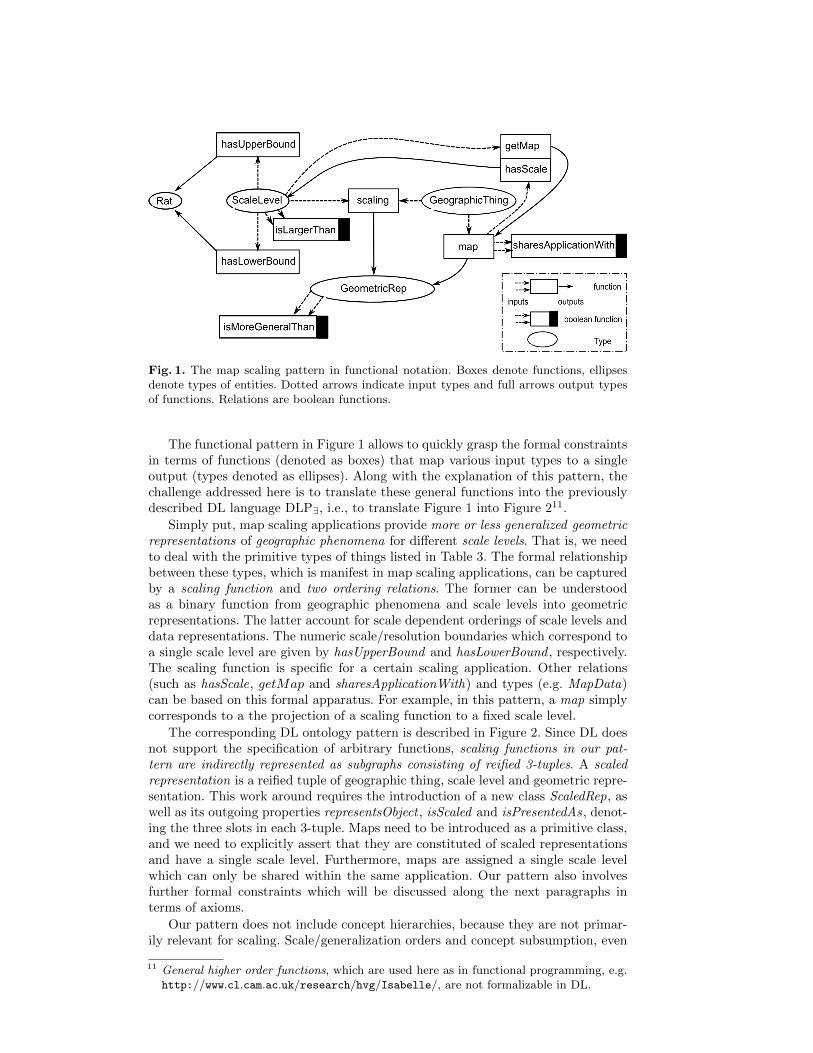
Fig. 1. The map scaling pattern in functional notation. Boxes denote functions, ellipsesdenote types of entities. Dotted arrows indicate input types and full arrows output typesof functions. Relations are boolean functions.
The functional pattern in Figure 1 allows to quickly grasp the formal constraintsin terms of functions (denoted as boxes) that map various input types to a singleoutput (types denoted as ellipses). Along with the explanation of this pattern, thechallenge addressed here is to translate these general functions into the previouslydescribed DL language DLP∃, i.e., to translate Figure 1 into Figure 211.
Simply put, map scaling applications provide more or less generalized geometricrepresentations of geographic phenomena for different scale levels. That is, we needto deal with the primitive types of things listed in Table 3. The formal relationshipbetween these types, which is manifest in map scaling applications, can be capturedby a scaling function and two ordering relations. The former can be understoodas a binary function from geographic phenomena and scale levels into geometricrepresentations. The latter account for scale dependent orderings of scale levels anddata representations. The numeric scale/resolution boundaries which correspond toa single scale level are given by hasUpperBound and hasLowerBound , respectively.The scaling function is specific for a certain scaling application. Other relations(such as hasScale, getMap and sharesApplicationWith) and types (e.g. MapData)can be based on this formal apparatus. For example, in this pattern, a map simplycorresponds to a the projection of a scaling function to a fixed scale level.
The corresponding DL ontology pattern is described in Figure 2. Since DL doesnot support the specification of arbitrary functions, scaling functions in our pat-tern are indirectly represented as subgraphs consisting of reified 3-tuples. A scaledrepresentation is a reified tuple of geographic thing, scale level and geometric repre-sentation. This work around requires the introduction of a new class ScaledRep, aswell as its outgoing properties representsObject , isScaled and isPresentedAs, denot-ing the three slots in each 3-tuple. Maps need to be introduced as a primitive class,and we need to explicitly assert that they are constituted of scaled representationsand have a single scale level. Furthermore, maps are assigned a single scale levelwhich can only be shared within the same application. Our pattern also involvesfurther formal constraints which will be discussed along the next paragraphs interms of axioms.
Our pattern does not include concept hierarchies, because they are not primar-ily relevant for scaling. Scale/generalization orders and concept subsumption, even
11 General higher order functions, which are used here as in functional programming, e.g.http://www.cl.cam.ac.uk/research/hvg/Isabelle/, are not formalizable in DL.
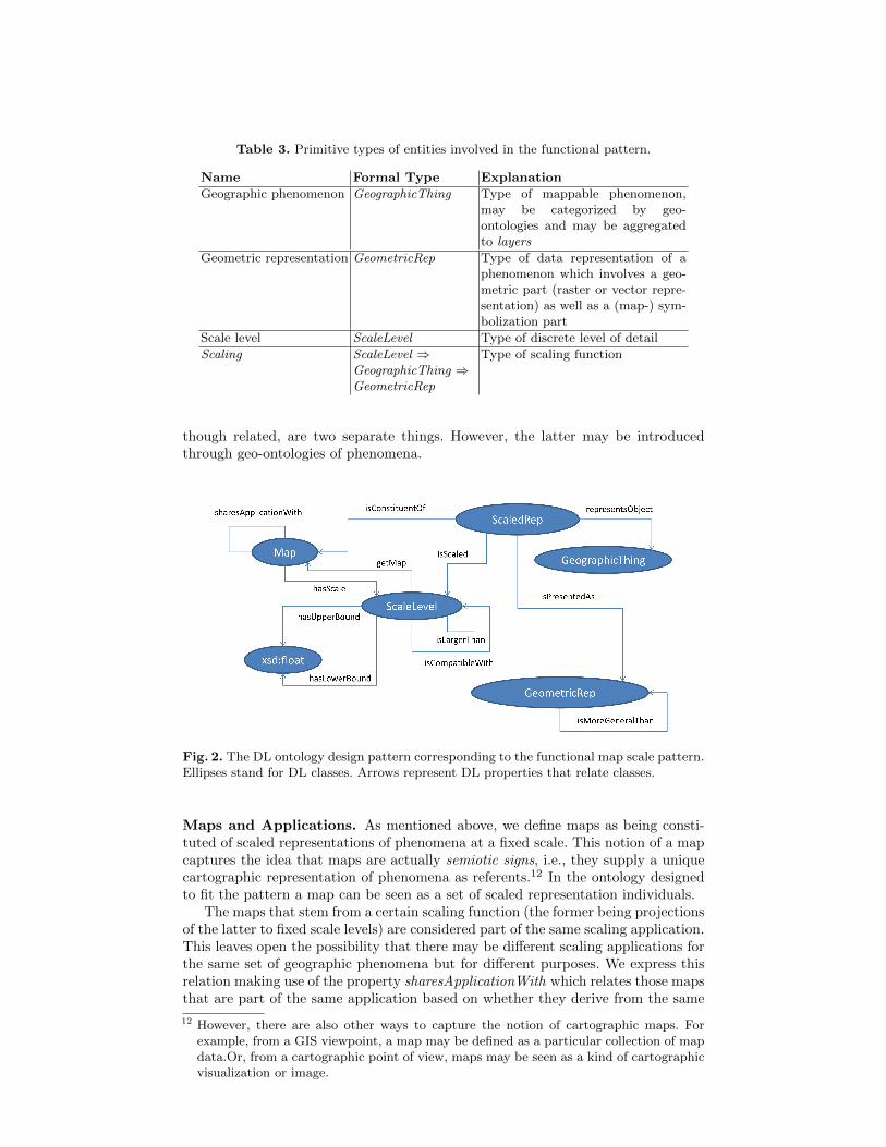
Table 3. Primitive types of entities involved in the functional pattern.
Name Formal Type Explanation
Geographic phenomenon GeographicThing Type of mappable phenomenon,may be categorized by geo-ontologies and may be aggregatedto layers
Geometric representation GeometricRep Type of data representation of aphenomenon which involves a geo-metric part (raster or vector repre-sentation) as well as a (map-) sym-bolization part
Scale level ScaleLevel Type of discrete level of detail
Scaling ScaleLevel ⇒GeographicThing ⇒GeometricRep
Type of scaling function
though related, are two separate things. However, the latter may be introducedthrough geo-ontologies of phenomena.
Fig. 2. The DL ontology design pattern corresponding to the functional map scale pattern.Ellipses stand for DL classes. Arrows represent DL properties that relate classes.
Maps and Applications. As mentioned above, we define maps as being consti-tuted of scaled representations of phenomena at a fixed scale. This notion of a mapcaptures the idea that maps are actually semiotic signs, i.e., they supply a uniquecartographic representation of phenomena as referents.12 In the ontology designedto fit the pattern a map can be seen as a set of scaled representation individuals.
The maps that stem from a certain scaling function (the former being projectionsof the latter to fixed scale levels) are considered part of the same scaling application.This leaves open the possibility that there may be different scaling applications forthe same set of geographic phenomena but for different purposes. We express thisrelation making use of the property sharesApplicationWith which relates those mapsthat are part of the same application based on whether they derive from the same
12 However, there are also other ways to capture the notion of cartographic maps. Forexample, from a GIS viewpoint, a map may be defined as a particular collection of mapdata.Or, from a cartographic point of view, maps may be seen as a kind of cartographicvisualization or image.

scaling function. Property sharesApplicationWith is declared to be transitive (1),symmetric (2), and reflexive (3) with respect of the individuals within the classMap:
sharesApplicationWith ◦ sharesApplicationWith v sharesApplicationWith (1)
sharesApplicationWith− v sharesApplicationWith (2)
Map v ∃sharesApplicationWith.Self(3)
We define property hasScale as the function which delivers the unique scalelevel of a given map. This property is defined to be functional, since every mapis associated with a single scale. We also define getMap as the inverse property ofhasScale which allows us to retrieve the map associated with a given scale. Theseconstraints are enforced using axioms (4) and (5).
> v≤ 1hasScale.> (4)
hasScale− v getMap (5)
We impose a less restrictive form of functionality over property getMap. We havethat this property is functional over the set of maps that belong to the same applica-tion, which defined in our pattern as the set of maps that are connected through thesharesApplicationWith. Note that this property is declared to be both symmetricand transitive. I.e. a given scale s1 cannot be shared by maps m1 and m2 if we havethat sharesApplicationWith(m1,m2) is entailed by the ontology. We enforce thisconstraint with axiom 6 which automatically collapses into one single individual allmaps associated to the same scale that are within the same application.
> v≤ 1(getMap ◦ sharesApplicationWith).> (6)
Due to these constraints we have that for a given application, there is only onemap at an specific scale level. The rationality behind this constraint is to eliminateall ambiguity at the time of representing map data at a given scale over the sameapplication.
We have defined our ontology to allow for an easy retrieval of all the infor-mation pertaining to a single map. We can make use of the property connexionisConstituentOf to retrieve and query about all the existing scaled representationsassociated with a given map. Property isScaled, which links every scaled represen-tation with the scale associated to the map this one belongs to, is automaticallygenerated due to axiom (7).
isConstituentOf ◦ hasScale v isScaled (7)
After imposing these restrictions over applications, maps and scales, we elaborateabout scale levels and geographic representations, which are ordered in a chain-likemanner.
Orders on Scale Levels and Geometric Representations. We enforce a strictpartial order over properties isLargerThan and isMoreGeneralThan which respec-tively connect (and order) individuals over the classes Scale and GeometricRep.
isLargerThan ◦ isLargerThan v isLargerThan (8)
∃(isLargerThan u isLargerThan−).> v ⊥ (9)
isMoreGeneralThan ◦ isMoreGeneralThan v isMoreGeneralThan (10)
∃(isMoreGeneralThan u isMoreGeneralThan−).> v ⊥ (11)
As usual, a strict partial order is a binary relation that is irreflexive and tran-sitive, and therefore antisymmetric. We enforce transitivity of properties isLarg-erThan and isMoreGeneralThan with axioms 8 and 10 respectively. Axioms 9 and11 enforce irreflexivity of both properties13 also enforcing antisymmetry.
Furthermore, we add a similarity relation among scale levels (i.e., one that issymmetric and reflexive), which allows us to connect compatible scales across differ-ent applications. Similarity among scale levels allows us to merge data from differentapplications, each having its separate scale level chain. Note that the computationof this similarity relation may be done in various ways based on their numericalscale boundaries, and we deliberately leave open in our pattern how this may bedone. The similarity relation is represented in the pattern by the isCompatibleWithrelation which is defined to be symmetric (12) and reflexive (13) connecting allindividuals in class ScaleLevel with themselves.
isCompatibleWith− v isCompatibleWith (12)
ScaleLevel v ∃isCompatibleWith.Self (13)
We assume that each scale level has one upper and lower bound in terms ofnumeric map scales or pixel resolutions. The latter are simply rational numbers.Every scale has at most one upper bound and one lower bound and therefore bothproperties hasLowerBound and hasUpperBound are declared functional. The definedconstraint is enforced with axioms:
ScaleLevel v ∃hasLowerBound.xsd:float (14)
ScaleLevel v ∃hasUpperBound.xsd:float (15)
> v≤ 1hasLowerBound.> (16)
> v≤ 1hasUpperBound.> (17)
We skip the constraint that their order needs to comply with (or even defines)the scale level order. To improve the understanding of the publication we havenot included datatypes within DLP∃, necessary to deal with algebraic operationsover the xsd:float class. Once done it would not be difficult to verify than theexisting isLargerThan relationships are valid, and to automatize the creation ofthis relationship between the existing scales.
Now we come to the most essential part of the pattern, namely representingthe scaling function, compare Table 3 and Figure 1. The scaling function allowsto switch to a new data representation for all phenomena by changing the scalelevel. This is done in a monotonic manner, i.e., such that the ordering of scale levelsis preserved in generalization levels. Put differently, scaling to a larger scale levelexcludes the possibility that representations become more general. We include thepossibility that a phenomenon is not represented at all at certain scale levels bycreating an empty GeometricRep individual, as well as the possibility that it maybe represented in a constant manner.
Monotonicity of Scaling. To enforce this constraint using OWL we make use ofthe class ScaledRep,and we add a logical equivalent to the following first order logic
13 We have that (> v ¬∃R1,Self) ≡ > v ∃(R1 uR−1 ).⊥ for any property R1.

rule to the ontology:
sharesApplicationWith(mx,my) ∧ hasScale(sy,my) ∧ hasScale(sx,mx)
∧ isLargerThan(sx, sy)∧isConstituentOf(mx, srx) ∧ isConstituentOf(my, sry)∧representsObject(srx, g) ∧ representsObject(sry, g)∧isPresentedAs(srx, grrx) ∧ isPresentedAs(sry, grry)∧isMoreGeneralThan(grrx, grry)→ ⊥(mx)
This rule enforces that the ontology becomes inconsistent if
– there exist maps m1 and m2 belonging to the same application with scales s1and s2,
– scale s1 is larger than scale s2,– maps m1 and m2 contain scaled representations sr1 and sr2 that represent the
same geographic thing g, and– the geographic representation record grr1 for sr1 is more general than the one
for sr2, namely grr2.
Although this rule may look quite complex it is indeed expressible in OWL. Anautomatized way of performing this transformation is presented in [3], as well as aprocedure to check if a given rule is indeed expressible in OWL. A possible set ofDL axioms equivalent to the previous rule is:
hasScale− ◦ sharesApplicationWith ◦ hasScale v R1
R1 u isLargerThan v R2
isScaled ◦R2 ◦ isScaled v R3
isPresentedAs ◦ isMoreGeneralThan− ◦ isPresentedAs− v R4
representsObject ◦ representsObject− v R5
R3 uR4 uR5 v R⊥∃R⊥.> v ⊥
where all Ri are freshly introduced roles that do not appear previously in the on-tology.
Functionality of Scaling. Next, we enforce functionality constraints on the sub-graph of scaled representations which denotes a scaling function, i.e., a singularscaling application.
First, we make use of simple OWL axioms to enforce functionality for the prop-erties isPresentedAs, isScaled, and representsObject, which respectively connect ascaled representation with the geometric representation, the scale, and the geo-graphic thing it is associated with.
> v≤ 1isPresentedAs.> (18)
> v≤ 1isScaled.> (19)
> v≤ 1representsObject.> (20)
Second, a scaled representation is enforced to have a geometric representation, ascale, and a geographic thing associated to it. This is enforced using OWL axioms:
ScaledRep v ∃isPresentedAs.GeometricRep (21)
ScaledRep v ∃isScaled.ScaleLevel (22)
ScaledRep v ∃representsObject.GeographicThing (23)
And third, since the relation expressed by scaled representations stands for ascaling function, it needs to be restricted to be functional with respect to a scale leveland a geographic phenomenon represented. Furthermore, since a scaling functioncorresponds to a particular scaling application, we need to restrict functionality toonly those scaled representations that are part of a single scaling application.
Since every scale is only associated to one map within the same applicationwe only need to verify that there only exists one scaled representation for eachgeographic phenomenon. This constraint is enforced with axioms (24) and (25).
isConstituentOf− ◦ representsObject ◦ representsObject− v Raux (24)
> v≤ 1(Raux u isConstituentOf−).> (25)
Due to axioms (24) and (25) we have that two different scaled representationsare collapsed into a single one if they are constituents of a given map and representthe same object. Therefore we are guaranteed that, within the same map there onlyexists one scaled representation representing the same geographic thing. Given thatfunctionality only needs to be enforced across the maps within the same application,and that by previous restrictions we have that there are no two maps with thesame scale within the same application we have that the mapping to a geometricrepresentation is functional depending on the specific geographic thin representedand the scale for any given scale representation.
We show a translation of the axioms presented in this section in Appendix, whichis part of the technical report of the paper. In the translation we also establish a setof domain and range restrictions based on the relations between properties and rolesin Figure 2. As further constraints, we also declare all classes defined in the patternto be disjoint in order to avoid possible mistakes in the declaration of individuals.
5 Application Scenario
When interpreting and comparing maps such as the global kernel density map(raster data)14 in Fig. 3, where the color ramp of each pixel represents the fractionof malaria transmitting mosquitos [7], it is crucial to take into account the effect ofscale. At its original resolution 15, each single pixel covers a width of approximately17 kilometers at the equator. Assuming that the malaria data is displayed at ascreen pixel size of 0,25 mm, the map image has an appropriate maximal scale of1:68000000. Thus, for instance, using such a map to determine whether a particularvillage (many of which could be contained in a single pixel) is affected to a higherdegree than others is difficult, since villages are represented on much larger scalelevels.
Similarly, as mosquitos require water for reproduction, one may be temptedto combine such a map with a river network layer. As in the case before, thisparticular map is too coarse to support a meaningful comparison, since river widthis a fraction of the size of a pixel. Instead, scholars have to go back to the sourcedata and generate raster data at a scale which is appropriate for the scale of rivernetworks. While this is a simple operation for Geographic Information Systems(GIS), and may be automatized in terms of a map scaling service, the scale increasecannot be chanced ad libitum but has also a lower bound. While the upper bound isconstrained by the process of cartographic abstraction mentioned before, the lowerbound is limited by the measurement procedure. In this specific case, data wascoded at the village level during the field study, and thus representing the data ata larger scale of, say, 1:2500, would create a misleading impression of accuracy.
14 c©2010 Malaria Atlas Project, available under the Creative Commons Attribution 3.0Unported License
15 Keeping in mind what we said about zooming and scale in digital images.
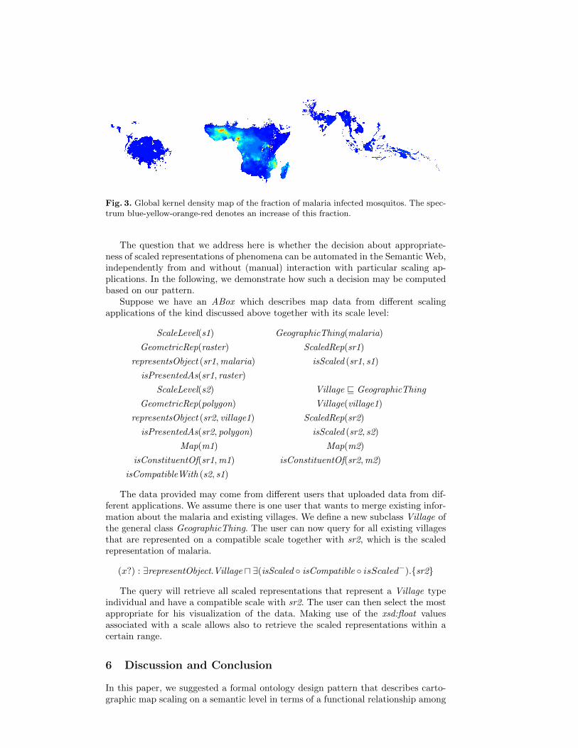
Fig. 3. Global kernel density map of the fraction of malaria infected mosquitos. The spec-trum blue-yellow-orange-red denotes an increase of this fraction.
The question that we address here is whether the decision about appropriate-ness of scaled representations of phenomena can be automated in the Semantic Web,independently from and without (manual) interaction with particular scaling ap-plications. In the following, we demonstrate how such a decision may be computedbased on our pattern.
Suppose we have an ABox which describes map data from different scalingapplications of the kind discussed above together with its scale level:
ScaleLevel(s1) GeographicThing(malaria)
GeometricRep(raster) ScaledRep(sr1)
representsObject (sr1,malaria) isScaled (sr1, s1)
isPresentedAs(sr1, raster)
ScaleLevel(s2) Village v GeographicThing
GeometricRep(polygon) Village(village1)
representsObject (sr2, village1) ScaledRep(sr2)
isPresentedAs(sr2, polygon) isScaled (sr2, s2)
Map(m1) Map(m2)
isConstituentOf(sr1,m1) isConstituentOf(sr2,m2)
isCompatibleWith (s2, s1)
The data provided may come from different users that uploaded data from dif-ferent applications. We assume there is one user that wants to merge existing infor-mation about the malaria and existing villages. We define a new subclass Village ofthe general class GeographicThing. The user can now query for all existing villagesthat are represented on a compatible scale together with sr2, which is the scaledrepresentation of malaria.
(x?) : ∃representObject.Village u ∃(isScaled ◦ isCompatible ◦ isScaled−).{sr2}
The query will retrieve all scaled representations that represent a Village typeindividual and have a compatible scale with sr2. The user can then select the mostappropriate for his visualization of the data. Making use of the xsd:float valuesassociated with a scale allows also to retrieve the scaled representations within acertain range.
6 Discussion and Conclusion
In this paper, we suggested a formal ontology design pattern that describes carto-graphic map scaling on a semantic level in terms of a functional relationship among

geometric representations, phenomena and scale levels. Map scaling applicationsare used on the web to represent and display phenomena at different scale levels.In the Semantic Web, the notions of scale and resolution have, to the best of ourknowledge, not been introduced so far, even though they are of central importanceto deal with information at different levels of granularity. Scale, granularity andresolution are central notions of cartography [15] and GIScience [14], however, for-mal approaches to describe map scaling are mostly focused on mathematical modelsof generalization and granularity change [20], not on making publicly available theapplication logic of actual scaling systems.
In the Web, granularity levels are needed to improve performance of querying,reasoning, as well as in order to display information meaningfully on a map. Thechallenge lies in preventing mashups of data at inappropriate resolutions, or visualclutter across scaling applications, as well as in enabling the tracing of geographicphenomena across different levels of detail and across different applications. Openingup existing scaling implementation logic for the Semantic Web not only allows cross-linking web map services based on geographic phenomena, it also has the potentialto make the Semantic Web itself scale across different levels of detail. This is becauseit adds the crucial information about whether certain information can be used oncertain scale levels or not. This information today seems to be missing from theSemantic Web. For example, the geographic reference of DBpedia or Linked Geodata[19] is a scale-free coordinate point.
In the paper, we proposed formal constraints to the pattern in a tractable frag-ment of DL, which can be used to compute inferences on ABox descriptions ofactual scaling applications. For example, we showed that it is possible to checkautomatically whether data representations from scaling applications are compat-ible with respect to their scale levels, and thus, can be meaningfully displayed ina single map. The constraints also allow to check consistency of a single scalingapplication, e.g., with respect to monotonicity and functionality of scaling. Futureresearch may enrich the axiomatization based on a full functional specification inHOL, which could only be sketched in Figure 1. It may also address scalable reason-ers for DLP∃, which would allow testing the pattern on a set of scaling applicationsdescribed by the pattern. Even without computational reasoning, the pattern canbe directly used to annotate and query existing scaling applications based on RDF.Furthermore, the pattern may be specialized by complementary patterns describinggeometric data formats as known in GIScience, different geographic ontologies, therelation of map displays and scale, as well as different notions of scale and resolution.
Acknowledgements. This work is a collaborative outcome of the GeoVoCam-pDayton201216. Some of the authors credit funding from European Commission(ICT-FP7-249120 ENVISION project), as well as the German Research Founda-tion (Research fellowship grant DFG SCHE 1796/1-1). Authors from Wright StateUniversity acknowledge funding from by the National Science Foundation underaward 1017225 III: Small: TROn – Tractable Reasoning with Ontologies.
References
1. Baader, F., Calvanese, D., McGuinness, D., Nardi, D., Patel-Schneider, P. (eds.): TheDescription Logic Handbook: Theory, Implementation, and Applications. CambridgeUniversity Press, second edn. (2007)
2. Bittner, T., Donnelly, M., Smith, B.: A spatio-temporal ontology for geographic infor-mation integration. Int. J. Geogr. Inf. Sci. 23(6), 765–798 (Jun 2009)
16 http://vocamp.org/wiki/GeoVoCampDayton2012
3. Carral-Martınez, D., Hitzler, P.: Extending description logic rules. In: Simperl, E.,Cimiano, P., Polleres, A., Corcho, O., Presutti, V. (eds.) ESWC. Lecture Notes inComputer Science, vol. 7295, pp. 345–359. Springer (2012)
4. Degbelo, A., Kuhn, W.: A Conceptual Analysis of Resolution. In: XIII GEOINFO,Brazilian Symposium on Geoinformatics, Campos do Jord ao. pp. 11–22. Sao Paolo,Brazil (2012)
5. Frank, A.: Scale is introduced in spatial datasets by observation processes. In: SpatialData Quality From Process to Decision(6th ISSDQ 2009). pp. 17–29. CRC Presss(2009)
6. Gangemi, A., Presutti, V.: Towards a pattern science for the semantic web. SemanticWeb 1(1-2), 61–68 (2010)
7. Gething, P., Patil, A., Smith, D., Guerra, C., Elyazar, I., Johnston, G., Tatem, A., Hay,S.: A new world malaria map: Plasmodium falciparum endemicity in 2010. MalariaJournal 10(1), 378 (2011)
8. Goodchild, M.F., Proctor, J.: Scale in a digital geographic world. Geographical andEnvironmental Modelling pp. 5–23 (1997)
9. Grosof, B., Horrocks, I., Volz, R., Decker, S.: Description logic programs: combininglogic programs with description logic. In: Proc. 12th Int. Conf. on World Wide Web(WWW’03). pp. 48–57. ACM (2003)
10. Horrocks, I., Kutz, O., Sattler, U.: The even more irresistible SROIQ. In: Proc. of the10th Int. Conf. on Principles of Knowledge Representation and Reasoning (KR 2006).pp. 57–67. AAAI Press (2006)
11. Kazakov, Y.: Saturation-Based Decision Procedures for Extensions of the GuardedFragment. Ph.D. thesis, Universitat des Saarlandes, Saarbrucken, Germany (March2006)
12. Krisnadhi, A., Maier, F., Hitzler, P.: OWL and rules. In: Polleres, A., d’Amato, C.,Arenas, M., Handschuh, S., Kroner, P., Ossowski, S., Patel-Schneider, P. (eds.) Rea-soning Web. Semantic Technologies for the Web of Data. 7th International SummerSchool 2011, Galway, Ireland, August 23-27, 2011, Tutorial Lectures. Lecture Notes inComputer Science, vol. 6848, pp. 382–415. Springer, Heidelberg (2011)
13. Krotzsch, M., Simancik, F., Horrocks, I.: A description logic primer. CoRRabs/1201.4089 (2012)
14. Kuhn, W.: Core Concepts of Spatial Information: A First Selection. In: XII GEOINFO,November 27-29, 2011, Campos do Jordao, Brazil. pp. 13–26 (2011)
15. Mcmaster, R.B., Shea, K.S.: Cartographic Generalization in a Digital Environment: aFramework for implementation in a GIS. In: GIS/LIS’88. pp. 240–249. San Antonio,Texas, USA (1988)
16. Mller, J., Lagrange, J., Weibel, R.: GIS and Generalization: Methodology and Practice.Taylor and Francis (1989)
17. Montello, D.: Scale in Geography. In: International Encyclopedia of the Social andBehavioral Sciences, pp. 13501–13504 (2001)
18. Scheider, S., Kuhn, W.: Affordance-based categorization of road network data using agrounded theory of channel networks. International Journal of Geographical Informa-tion Science 24(8), 1249–1267 (2010)
19. Stadler, C., Lehmann, J., Hoffner, K., Auer, S.: LinkedGeoData: A core for a web ofspatial open data. Semantic Web (2012)
20. Stell, J., Worboys, M.: Stratified map spaces: A formal basis for multi-resolution spa-tial databases. In: SDH’98 Proceedings 8th International Symposium on Spatial DataHandling. pp. 180–189 (1998)
21. Wu, J., Li, H.: Concepts of scale and scaling, pp. 3–15. Springer (2006)

A Ontology Pattern in Functional Syntax
SubObjectPropertyOf (
ObjectPropertyChain ( sharesApplicationWith sharesApplicationWith )
sharesApplicationWith) (26)
SubObjectPropertyOf (
ObjectPropertyChain ( isConstituentOf hasScale )
isScaled) (27)
SubObjectPropertyOf (ObjectInverseOf ( hasScale ) getMap ) (28)
SymmetricObjectProperty ( sharesApplicationWith ) (29)
SymmetricObjectProperty ( isCompatibleWith ) (30)
SubClassOf ( Map ObjectHasSelf ( sharesApplicationWith ) ) (31)
SubClassOf ( ScaledRep
ObjectSomeValuesFrom ( isPresentedAs GeographicRecord ) ) (32)
SubClassOf ( ScaledRep
ObjectSomeValuesFrom ( isScaled Scale ) ) (33)
SubClassOf ( ScaledRep
ObjectSomeValuesFrom ( representsObject GeographicThing )) (34)
SubClassOf ( Scale DataSomeValuesFrom ( hasLowerBound xsd:float ) ) (35)
SubClassOf ( Scale DataSomeValuesFrom ( hasUpperBound xsd:float ) ) (36)
FunctionalObjectProperty ( ObjectPropertyChain
(getMap sharesApplicationWith ) ) (37)
FunctionalObjectProperty ( hasScale ) (38)
FunctionalObjectProperty ( isPresentedAs ) (39)
FunctionalObjectProperty ( isScaled ) (40)
FunctionalObjectProperty ( representsObject ) (41)
FunctionalDataProperty ( hasUpperRatio ) (42)
FunctionalDataProperty ( hasLowerRatio ) (43)
TransitiveObjectProperty ( isScaled ) (44)
TransitiveObjectProperty ( isLargerThan ) (45)
TransitiveObjectProperty ( isMoreGeneralThan ) (46)
B Tractability of reasoning for the Scaling pattern
We consider atomic query problem as the basic reasoning task for the Scaling pat-tern. Let T0 be the TBox containing precisely all axioms for the Scaling pattern asdefined in Section 4. Furthermore, let K be a knowledge base where T0 ⊆ K. Wecall K an applied scaling pattern which contains not only the pattern, but also ad-ditional axioms added when the user uses the pattern for some application. These
additional axioms include data (i.e., ABox axioms) as well as schema knowledge(i.e., TBox axioms) obtained through introducing fresh class/property names as asubclass/subproperty of some class/property names from T0, as demonstrated inSection 5. Denote by Sig(K) the signature of K and Ind(K) the set of named in-dividuals occurring in K. Using T0 as pattern means that the class and propertynames occurring in T0 must not be redefined by the user. In addition, as men-tioned in Section 3, the use of existential restriction needs to be restricted to ensuretractability. Hence, the following restriction(*) is imposed on any applied scalingpattern K: for every class inclusion axiom α v β ∈ K \ T0 (i.e., those added by theuser of the pattern), Sig(α) ∩ ({>} ∪ Sig(T0)) = ∅ and β contains no existentialrestriction ∃R.C for any class C and property R.
An atomic query q over a knowledge base K is an expression of the form C(x)or R(x, y) where x, y are variables individuals and C (resp. R) is a class (resp.property) names from Sig(K). Denote by V ar(q) the set of variables occurring inq. Let µ : V ar(q) → Ind(K) be a total mapping and, by slight abuse of notation,µ(q) be an expression obtained from q by substituting every occurrence of variablesx ∈ V ar(q) with µ(x). An answer to q is such a mapping µ such that K entailsµ(q), written K |= µ(q), i.e., every model of K is a model of µ(q). The atomic queryproblem for the Scaling pattern is the problem of finding all answers to a givenquery q over K where K is an applied scaling pattern.
Let K be partitioned into Krl and K∃ where K∃ contains only the axioms below:
ScaleLevel v ∃hasLowerBound.xsd:float (47)
ScaleLevel v ∃hasUpperBound.xsd:float (48)
ScaledRep v ∃isPresentedAs.GeometricRep (49)
ScaledRep v ∃isScaled.ScaleLevel (50)
ScaledRep v ∃representsObject.GeographicThing (51)
Observe that, unlike K∃, Krl can be rewritten into a set of rules in a Dataloglanguage with equality where the Datalog language uses the class and propertynames as predicate symbols. The rewriting also applies to axioms which involve roleconjunction because any role conjunction R1uR2 can be rewritten as a conjunctionR1(x, y) ∧R2(x, y). (Examples of such a rewriting can be found in [9,12,3]).
Let P be a sound and complete decision procedure for query answering inDatalog with equality and q be an atomic query over K. If Sig(q) ∩ (Sig(K∃) \{ScaledRep}) = ∅, then an answer to q can be found by simply translating Krl andq into Datalog and then compute an answer to q in Datalog framework using P .Tractability of answering q for this case then follows from the (data-)tractability ofquery answering in Datalog.
For the case where Sig(q)∩(Sig(K∃)\{ScaledRep}) 6= ∅, using the step as in theearlier case is not complete since there can be additional answers that can be foundby also considering K∃. We then use the following observation(**) on K which caneasily be verified (and holds also due to restriction (*) given in the first paragraphof this section): there is no chain of existential restrictions A v ∃R1.A1, A1 v∃R2.A2, . . . , An v ∃Rn+1.A such that they are all entailed by K where A ∈ Sig(K∃)and all Ai, Ri ∈ Sig(K).This observation implies that the number of new individualsthat must be created because of implied existential restriction is finite. In particular,because the only axioms involving existential restriction are those in K∃, additionalanswers to q can be found using the procedure P by considering the following(assuming Ind(K) = {a1, . . . , an}):
(i) For each named individuals ai ∈ Ind(K), i = 1, . . . , n, create five fresh namedindividuals: li, ui, si, ri, ti.
(ii) Find answers to the query q = ScaledRep(z) for a fresh variable z. Then, K′is obtained from K by adding the following ABox axioms to K for every j such
that µj is an answer q with let aj = µj(x):
ScaleLevel(sj), GeometricRep(rj), GeometricThing(tj),
xsd:float(lj), xsd:float(uj),
hasLowerBound(sj , lj), hasUpperBound(sj , uj)
isScaled(aj , sj), isPresentedAs(aj , rj), representsObject(aj , tj)
Hence, answers to q over K are precisely answers to q over K′.The above steps ensure the soundness and completeness for solving the atomic queryproblem. Moreover, it is not hard to see that the complexity of reasoning still doesnot increase compared to the complexity of P due to the fixed-size blow up of theknowledge base, i.e., tractability of answering q for this case also follows from the(data-)tractability of query answering in Datalog. It is also important to note thatthe above steps can either be applied for a bottom-up version or a top-down versionof P .
Finally, for a complex query expression such as the one presented in Section 5,it suffices to add one additional step, namely rewriting the query expression intoa conjunctive query in Datalog, i.e., a conjunction of atomic query. The rewritingprocedure is the same as the rewriting for K. Complexity consideration is also thesame as for the atomic case.