an introduction to quaternary deposits and … · an introduction to quaternary deposits and...
TRANSCRIPT

AN INTRODUCTION TO QUATERNARY DEPOSITS AND SELECTED PROCESSES OCCURRING IN ENGLAND
This document provides users with an introduction to the key characteristics, and the processes that produced these characteristics, of the main sedimentary deposits formed in England during the Quaternary Period (1.81 million years ago – present). It is intended for amateur geologists or trained geologists with little or no knowledge of the Quaternary.
Our aim has been to produce briefly-written, illustrated outlines of the main types of Quaternary deposits that can be found throughout England. Exposures of these deposits constantly change – they may become weathered or vegetated, or are temporary during mineral extraction or engineering projects. The specific examples used are therefore not necessarily exposures available for study at the time of publication. Neither is there an attempt to include locations ranging across the full length and breadth of the country: the examples used are simply ones we believe to be good cases that help to illustrate each deposit. It should not be assumed that they are currently extant, or in the condition illustrated.
The descriptions do not attempt to include landforms that may have been associated with the deposits, although reference may be made to them. When studying Quaternary deposits, it is important to remember that they are recent; many are soft or unconsolidated and very susceptible to erosion. The landforms they may have possessed when first formed may have been long since removed. Similarly, the older the deposit, the greater the chance that it was laid down in a landscape that was very different from that seen today. Deposits laid down on a valley floor, for example, may now lie on a plateau top following changes of sea level and uplift of the earth’s crust.
The Quaternary deposits are described in eight major groupings: glacial, periglacial, aeolian, fluviatile, lacustrine, estuarine, marine, and karst. These groupings are based on the main range of environments that existed at different places and different times in England during the Quaternary, some of which continue during the present day. Each environment gave rise to a variety of deposits, the key characteristics of which we describe here. The materials (rocks, minerals, organics) these deposits were formed from varied from place to place, according to what was available at the time they formed; the essential characteristics developed in each environment are, however, the same regardless of these variations.
Finally, at the end of the eight major groupings mentioned above, a short section describes a few processes that move or alter the bedrock or superficial deposits to produce significant, identifiable features.
The description of each deposit is accompanied by a grid summarising its key sedimentary characteristics, the climate during deposition, the location in which is may be found in the landscape and where in England examples of the deposit may be seen.
We hope that users will be able to absorb the information provided, and apply it when examining and recording exposures of Quaternary deposits as and when they become available, in their own areas.

GLACIAL
Glaciers covered large parts of England repeatedly during the Quaternary. No evidence has been found, however, for glaciers south of a line shown on the map opposite. North of this line, extensive deposits remain today in many areas, particularly from the Anglian and Devensian Glaciations (480,000 – 430,000 years ago, and 130,000 – 10,000 years ago, respectively).
TILL
A generally non-stratified material deposited directly by glacial ice. Material may be carried in the glacier base and laid down under it (basal till) or carried within or on the glacier and melted out at the snout (ablation till), where meltwater may cause slumping. Till is often deposited as extensive ‘blankets’ across an area over which a glacier or ice sheet has travelled. The upper surface of these blankets is often shaped into ridges and mounds, collectively called ‘moraine’. The older the till is, the more eroded it will have become, and the less likely that any of the moraine landforms remain.
Characteristics:
Generally poorly sorted, variable clast sizes, clasts usually sub-rounded to sub-angular and often, but not always, including variable and erratic lithologies. Fines may be of any texture depending on source rock, but are commonly high in clays.
Palaeoclimate:
Cold stage
Location in modern landscape:
Anywhere in the landscape
Locations in England:
North of the line of glacial extent – see map
Thrussington Member till with clasts of various shapes and sizes. Ryton Pools, Warks. (Paul Akers)
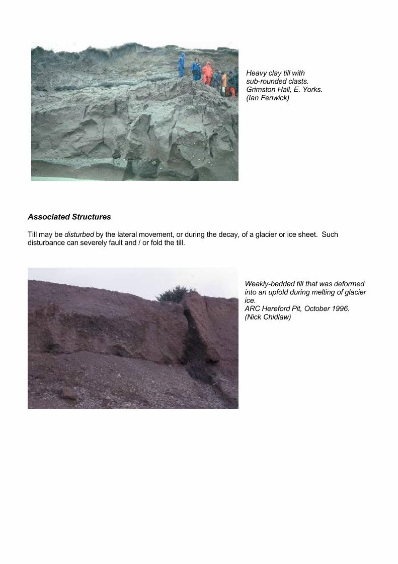
Heavy clay till with sub-rounded clasts. Grimston Hall, E. Yorks. (Ian Fenwick)
Associated Structures
Till may be disturbed by the lateral movement, or during the decay, of a glacier or ice sheet. Such disturbance can severely fault and / or fold the till.
Weakly-bedded till that was deformed into an upfold during melting of glacier ice. ARC Hereford Pit, October 1996. (Nick Chidlaw)

OUTWASH SAND & GRAVEL
As glaciers and ice sheets melt, some of the till that lies below, within and on top of the ice will be carried away with the meltwaters. These till materials will become deposited at some point downstream. The large volumes of water and detritus associated with the melting of a glacier mean that some sediment will be deposited very quickly and may include large boulders, especially if a flood of water is generated by the sudden release of a glacially dammed lake. The outwash deposits closest to the glacier will often be more poorly-sorted than those further away, and some boulders and pebbles in these closer deposits may be angular due to the short period of abrasion by the meltwaters.
Characteristics:
Close to glacier – very poorly sorted, very large range of clast sizes, from sand to boulders. Some clasts may be angular to sub-angular. Beds may be thick or massive, especially from high-magnitude events,or stratified and cross-bedded.Further from glacier – better, but not well sorted, bedded sands and gravels. Fewer angular clasts expected.
Palaeoclimate:
Cold stage
Location in modern landscape:
Anywhere in the landscape, but in uplands these deposits are generally found in valleys.
Locations in England:
North of the line of glacial extent – see map
Bedded blocky gravel with sand lenses: outwash deposit of glacier ice. ARC Hereford Pit, October 1996. (Nick Chidlaw)

PERIGLACIAL
Adjacent to glaciers and ice sheets occur environments where frost action is a key influence on the characteristics of sediments being deposited. These ‘periglacial’ environments are not localized, and may continue for many 100’s kilometres from the ice front. At depth below the surface of the land, the ground is frozen solid throughout the year (‘permafrost’), but nearer and at the surface, water present will be repeatedly frozen and thawed. During freezing, the water expands, and during thawing, it contracts. This process profoundly affects any rocks exposed at the surface or within the layer above the permafrost. It also affects sediments being laid down in the periglacial environment.
BLOCKFIELD or BOULDER STREAM
Rocks contain many natural breaks (bedding, joints, fissures, faults) and water entering into these that repeatedly freezes and thaws will gradually weaken the rocks, leading to disintegration. This is particularly effective when rocks are exposed at the surface. The disintegrated material will be carried downslope during thaws by gravitational force. Hard rocks will resist this process the most, often leaving a scattering of variably-rotated blocks of various sizes on the slopes below outcrops. Further from their source, the blocks may become grouped into ‘trains’ as they enter and descend valleys. Finer-grained material produced at the same time during this process forms ‘head’.
Characteristics:
Angular blocks, variably orientated and of variable size, scattered across hill slopes below the rock outcrop source. Further from the source rock, the blocks may form into ‘trains’ towards and within valley bottoms. Often, the blocks are partially submerged in underlying head deposits. The blocks can often be 1 – 2 m in size, but if the joints, bedding etc. in the source rock are spaced widely apart, very large blocks may be produced (e.g. the Suck Stone in Monmouthshire c. 16m long).
Palaeoclimate:
Cold stage
Location in modern landscape:
Generally on ridges and hill flanks, often related to tors; however, when coalescing as ‘trains’ they may be found in valley bottoms.
Locations in England:
Throughout England
Blockfield on the slopes below Stanage Edge, Peak District, Derbyshire. May 1967 (British Geological Survey, P006222). The blocks were a convenient source of gritstone from which millstones were once made on site.

Stone ‘train’, Clatford Bottom, near Marlborough, Wiltshire, July 1996 (Nick Chidlaw).
Blocks here are called ‘Sarsen Stones’ and were derived from a hard quartz sandstone ‘silcrete’ overlying the Chalk, but now completely disintegrated. Similar stones were used to build the circles of Stonehenge and Avebury.
HEAD
Prolonged disintegration by freeze/thaw of the bedrock on upper slopes will produce a mix of gravel and fine material called ‘head’, which as unfrozen material, will sludge downhill, covering the slopes. Larger blocks may be partially submerged within it, but only the head deposit may ultimately remain if the rock is not resistant enough to form a blockfield.
Characteristics:
Weakly bedded, or unbedded deposit with clasts mainly of a single lithology, reflecting that of the source rock. Coarse angular clasts from harder rocks; may be sub-rounded in softer rock such as chalk.Tendency to clast alignment or imbrication.
Palaeoclimate:
Cold stage.
Location in modern landscape:
On slopes or at the foot of slopes.
Locations in England:
Throughout England.
Head gravels and sands: blocky limestone gravel with an earthy / sandy matrix, locally cemented by lime; interbedded with lime sand lens. Sheepscombe, Cotswold Hills, Glos. May 1993. (Nick Chidlaw)

Angular clasts of limestone in fine calcareous matrix. Weston Park, Warks. (Brian Ellis)
Associated Structures
Alternate freezing and thawing of soft deposits will cause frost heaving, or ‘cryoturbation’, progressively distorting bedding that may once have been flat. Severe frosts may also lead to cracks forming in soft deposits, into which sediment may gradually collapse. Repetition of this process in the same crack will produce ‘ice wedge casts’. These are uncommon, but most frequently seen in fluvial sands and gravels (and are therefore described further in the ‘fluviatile’ section of this document).
Cryoturbated Sediments
Formed during severe periglacial conditions in the active layer above permafrost. Confined to horizontal locations, otherwise material would have flowed downslope under solifluction. The disturbed bedding forms involutions and the material is often poorly sorted.
Cryoturbation in soft sediments. Section from coastal plain at the foot of the South Downs, Sussex (Ian Fenwick)

FLUVIATILE
Rivers lay down distinct deposits within their channels and across their floodplains. Coarser-grained sediments will be deposited from flowing water mostly within the channels, and finer-grained sediments will be deposited from slowly-moving or standing water mostly on the floodplains. In low-lying country, a river’s course will change many times, leading to laterally-extensive deposits. Gravels may form roughly-bedded sheets and lenses. Sandy sediments will often form dunes and ripples characterized by sloping ‘cross bedding’ and ‘cross-lamination’. Finer-grained sediments, deposited in stagnant channels and on floodplains are often flat laminated.
During cold stages, much coarse-grained rock debris is produced by frost action and glacial erosion. Rivers tend to be braided, with marked seasonal contrasts in discharge. Thus coarse clasts can be transported at peak flow, but deposited at low flows. By contrast, under warmer climates, weathering is more dependent on chemical weathering processes giving rise to finer textured debris (soil), which finds its way into rivers which are commonly of a meandering habit. Very little gravel is moved and thus alluvial deposits are generally of sands or finer materials.
Organic remains are more abundant in the warmer climates and may be seen in river deposits. Sediments may contain the bones and teeth of vertebrates (e.g. Woolly Mammoth, hominids and their stone tools), the shells of freshwater invertebrates, trunks or branches from trees, peat, and microscopic plant and animal material.
With changing climates, and thus discharge regimes, streams may have more energy available for downcutting or, if there is less energy in the system, they may be forced to deposit part of their load. In this way, the river may incise and erode at a lower altitude or flood plain deposits may accrue. Thus a complex of ‘terraces’ (former flood plains) may be created. In time, these may be found as flat-topped hills well above the river’s current level.
Changes in sea level or crustal movements may also cause rivers to incise their courses, or build up deposits, as the elevation of the land relative to sea level is altered.
CHANNEL SANDS AND GRAVELS
Fluvial channel deposits during cold stages tend to be those laid down in gravelly braided rivers. Finer sands and even silt may be deposited in slower or shallower water as a channel moves laterally, abandoning its earlier course, but the majority of material from these rivers will be coarse grained.
Warm stage meandering rivers deposit mainly sands and silts, often in a fining upwards sequence. The base of a channel may contain some gravels and mud rip-up clasts, but the majority of material from these rivers will be finer grained.
Characteristics:
Stratified sand and gravel deposits. Moderately to well-sorted overall, but clast size can vary between beds. Coarser grained units may be more poorly sorted on close inspection than sandy beds. Gravels and cobbles are usually sub-rounded and sometimes aligned or imbricated. Cross-bedding and channel structures are common. Provenance may be implied by clast lithology and the orientation of cross bedding and clast alignment.
Palaeoclimate:
Warm or cold stage
Location in modern landscape:
On generally level sites at or above modern river level.
Locations in England: Throughout England.

Channel sands and gravels - cross-bedding in Bytham River sediments (c. 0.45Ma BP). Bubbenhall, Warks. (Ian Fenwick)
Associated Structures
Ice wedge casts
In periglacial climates or locations, alternate freezing and thawing may lead to cracks forming in soft deposits, into which sediment may gradually collapse. Repetition of this process in the same crack will produce an ice wedge cast. These are uncommon, but most frequently seen in fluvial sands and gravels.
Ice wedge cast developed within glacial sand and gravel. Stanway, Essex, January 1975. (British Geological Survey P211980)
Characteristics: a vertically-dominant ‘v-shaped’ feature with a pointed terminus. Defined by beds dipping into the cast.
Ice wedge in sands and gravels. Swinderby, Lincolnshire. (Ian Fenwick)
Locations in England: generally north of the M4 and south of the Humber – Mersey line.

FLOODPLAIN MUDS
Alluvial sediments laid down by meandering rivers and streams in floodplain position.When a river floods, fast moving water spills over the channel banks, spreads out and loses velocity very quickly. Sand and silt are rapidly deposited close to the channel. Mud remains in suspension and settles slowly over a wide area. Soils may form on floodplains between flood events.
Characteristics:
Well-sorted, thinly-bedded, fine sediments. Rarely cross-bedded (most likely in sandier near-channel deposits). Any larger clasts tend to be sub-rounded. May be inter-bedded with soil and include some organic matter. It is important to describe textural variations in detail.
Palaeoclimate:
Warm stage (mostly)
Location in modern landscape:
On generally level sites at or above modern floodplains.
Locations in England:
Throughout lowland England.
Blue-grey laminated muddy sediments of the present-day River Ouse floodplain. Linford Gravel Works, Thomas Roberts Ltd, Linford Wharf, East Sussex, January 1968. (British Geological Survey P210981)
Section in modern alluvium, R. Severn, Leighton (Ian Fenwick)

PEAT
Peat is an accumulation of plant material, partially decomposed under anaerobic conditions in stagnant water or water-logged ground.
Characteristics:
Purely organic material, usually with visible evidence of plant fragments.
Palaeoclimate:
Warm stage.
Location in modern landscape:
In lowland poorly draining sites or at altitude where precipitation is high.
Locations in England:
As above.
Interbedded peat (organic accumulation in back channels) and tufa (channel deposit). Thatcham Reed Beds near Kennet, Newbury, Berks. (Ian Fenwick) These are warm stage deposits and the interbedding indicates the lateral migration of a channel. Just above water level, gravels are visible. These mark the end of the previous cold stage (Devensian glaciation).
Peat ‘raft’ in gravels deposited during a glacial climate. Brown’s Pit, (Amey Gravel Ltd.), Stanton Harcourt, Oxon. January 1971 (British Geological Survey P211470). Peat deposits may become eroded, resulting in large ‘rafts’ being carried some way down stream before being re-deposited. The peat may have been part of a warm stage deposit or represent a warm interval in an otherwise cold sequence.
Interbedded warm and cold stage fluvial deposits Inter-bedded fluviatile deposits laid down under glacial and interglacial climates. Hoxne, Suffolk, January 1971. (British Geological Survey P211076). The dark-coloured deposits in the lower part of the exposure are interglacial laminated silts and clays; in the upper part are sands and poorly-sorted gravels deposited under a glacial climate.
Each of the three photographs shows the interplay or boundary between warm and cold stage fluvial deposits.

LACUSTRINE
Lakes are often a temporary feature of the natural landscape. They may be formed at the end of a glaciation when ice sheets melt away, remaining during the following warmer climatic episode. In time, they may become infilled with sediment from inflowing streams and rivers, and organic materials (including plants) growing along their margins. Lakes often form along the leading edges of glaciers and ice sheets where melting is occurring, and sometimes drain away catastrophically if restraining barriers (e.g. formed by till) are breached.
LAKE MUDS
Lacustrine sediments are often coarser-grained (e.g. sandy) around their margins, and finer-grained furthest from shore. Very fine muds may be deposited in the deepest water. They are often thinly flat-laminated, each lamination varying in grain size relating to the strength of water currents entering the lake (stronger = coarser; weaker = finer). Stronger currents can occur during times of seasonal floods. In shallow water, wave ripples may occur. Water level in a lake is variable and depends on the rates of input and evaporation. Changes in water level may result in a succession of shallower and deeper water deposits. In seasonal climates, a colour variation may also occur. An influx of sediment-laden water from a spring snow-melt may deposit pale, fine sands. In summer, when organic productivity is high, finer, darker, organic-rich muds are laid down. These annual couplets are known as ‘varves’.
Characteristics:
Fine-grained sediments, from mud to sand. Laterally continuous, thin flat-lamination. Laminations may alternate in grain size or colour. Occasional wave ripples may be seen in coarser beds.
Palaeoclimate:
Warm stage (may develop at the end of the preceding cold stage).
Location in modern landscape:
Mostly in enclosed basins.
Locations in England:
Throughout England.
Exposure of finely-laminated silty clay. Marks Tey, Essex, January 1971 (British Geological Survey, P212036).
Lacustrine deposit laid down during an interglacial.

AEOLIAN
Prevailing winds and storm-induced winds will desiccate loose sediment that has little or no vegetation on it, and carry it variable distances until it is deposited. Aeolian sediments consequently develop more extensively during cold climatic episodes. Sand–size sediment can produce dune deposits, and silt (dust) can produce structureless (unbedded, unlaminated), sheet-like deposits. During warm stage climates that support abundant vegetation inland, aeolian deposits are concentrated mostly along coastal areas.
BLOWN SAND
Wind-transported sands that have accumulated as dunes are known as ‘Blown Sand’ deposits. These sand dunes may become colonized by plants, producing organic-rich layers.
Characteristics:
Well-sorted, uncemented sands. Parallel or cross-bedded. Cross-bedding may be massive.
Palaeoclimate:
Warm or cold stage.
Location in modern landscape:
Coastal areas.
Locations in England:
Sandy coastal areas around England.
Alternations of blown sand and sand with vegetation and thin peaty layers exposed in beach dunes. North coast of Herm, Channels Islands, January 1976 (British Geological Survey P005306)

LOESS
Wind-transported silt (dust) deposits, known in England as ‘Brickearth’. Wind blowing across a glacial outwash plain can pick up fine sand and silt – the rock flour washed out from the glacier. It may be moved very long distances, even hundreds of kilometres. Sometime loess may be re-deposited by streams and rivers. In England deposits are only found a few metres thick, but in eastern Europe and parts of America and China they are tens to hundreds of metres thick.
Characteristics:
Extremely well-sorted, un-stratified, weakly-cohesive, silt-size, blanket deposit. May show signs of vertical fracturing. Often buff-coloured.
Palaeoclimate:
Cold stage.
Location in modern landscape:
Anywhere, but most often found on upper slopes and summits. Downwind from areas that are or were glaciated.
Locations in England:
As a visible deposit only found in Sussex, Kent, Essex and Suffolk.
Brickearth exposed in the uppermost 8ft (2.44 m) of cliff at Cliffsend, Pegwell Bay, near Ramsgate, Kent, 1963. (British Geological Survey P209880)

ESTUARINE
Estuarine deposits reflect the interface of fluviatile (freshwater) and marine (salt water) environments. Deposition and erosion patterns change rapidly, particularly in estuaries strongly affected by tides. As in fluviatile environments, coarser sediments (gravel bars, cross-bedded and rippled sands) are deposited in channels, and finer-grained, flat-laminated muddy sediments are laid down in areas with weak currents, such as tidal flats and salt marshes. Channels cut into the muddy sediments by tidal creeks are common, and many are subsequently infilled as the environment changes. Falls and rises of sea level have a profound effect on the type of deposits laid down: for example a rise in sea level will inundate former river floodplains that may have supported extensive woodland. ‘Submerged Forests’ can be a consequence of this sea level rise, with the remains of the trees (often still in growth positions) exposed at low tides. Submerged Forests also occur along former coastal plains now covered by the sea.
ESTUARINE MUDSCharacteristics:
Thinly-bedded, clay-rich deposits. Commonly cut by channels of coarser sediment.
Palaeoclimate:
Warm or cold stage.
Location in modern landscape:
Confined to major estuaries.
Locations in England:
All around England.
Thinly-bedded clay-rich sediments (mud flat deposits), overlain by laminated organic-rich clay/silt/sand with some shell lenses (saltmarsh deposits). Sunk Island, Humber Estuary, 1988. (British Geological Survey P213578).
Laminated estuarine muds, showing an infilled channel (left side of picture) probably marking a former tidal creek. Sunk Island, Humber Estuary. (British Geological Survey P213577)
Submerged Forest Boles and trunks of trees (many still in position of growth) exposed at low tide. ‘Submerged Forest’, near Bexhill, East Sussex, January 1964. (British Geological Survey P006793). This deposit forms part of an extensive peat bed along the south coast between Dover and the Chichester area.

MARINE
BEACH DEPOSITSCoastlines have changed many times during the Quaternary, as the result of the complex interplay of changing sea levels and movements of the earth’s crust. Many beaches have, by these means, been elevated above the present sea level, and form ‘raised beach’ deposits.
Characteristics:
Uncemented or weakly cemented sands, gravels or cobbles. Clasts are usually very well rounded and well sorted by constant wave action. Parallel beds, commonly dipping at a low angle offshore.
Palaeoclimate:
Warm or cold stage.
Location in modern landscape:
Near coast.
Locations in England:
All around England.
Raised beach. Poppit Sands, Pembrokeshire. (Ian Fenwick)
Raised Beach at Belcroute Bay, Jersey, Channel Islands. (British Geological Survey P005424). At waist-height of the figure occurs 0.75m of well-rounded cobbles and larger sub-angular boulders deposited on a former beach; above lies 2m of sand of probable aeolian origin, overlain by 3m of periglacial head; below the beach deposit is 1m of periglacial head.
Sand rock Raised Beach at Saunton, Bideford Bay, North Devon. (British Geological Survey P211268).Thick, well-bedded weakly-cemented beach sand (‘sand-rock’) forms cliff face; at present sea level lie pre-Quaternary shales, and above the sand-rock lies blown sand overlain by periglacial Head.
Sand-rock or beach-rock is usually formed on carbonate-rich coasts, where calcium carbonate precipitates and cements the beach sands and gravels to form fully lithified rock.

OFFSHORE DEPOSITSFully marine sediments of Quaternary age can be found onshore in the East of England. The Crags are a sequence of sandy, marine deposits laid down in gradually cooling climatic conditions. The Coralline Crag is the oldest layer, a Pliocene limestone which is only found in Suffolk. The shelly Red Crag is highly fossiliferous and early Pleistocene in age. The younger Norwich Crag is mostly unfossiliferous and finer grained. It was deposited in a shallowing marine basin between Britain and the Netherlands. Both the Red and Norwich Crags may include the remains of fossil mammals such as mastodon, sabre-tooth and whale.
Norwich Crag Formation. Bramerton Common near Norwich, January 1969. (British Geological Survey P210919) Cross-bedded sands containing flints, overlain by sands with thin clays
Norwich Crag Stone Bed Whitlingham Pit, near Norwich, January 1969. (British Geological Survey P210917).
The hammer shaft lies against a layer of large sub-angular flints with interstitial sand and clay: the ‘Norwich Crag Stone Bed, in which many mammal bones and flint ‘implements’ have been found. Above this unit are sands containing abundant marine shells, and below is an erosion surface in the pre-Quaternary Chalk bedrock.

KARST
Karst is a term used to describe a topography of both land-surface and underground features formed as a result of the dissolution, and sometimes re-deposition, of a soluble rock, usually limestone. Karst features develop best in rocks that are dense, highly jointed and thinly bedded as water can move more easily along joints and bedding planes than through the mass of the rock, even if it has a high porosity. Karst includes features such as caves, dry valleys, limestone pavement and pinnacles. This section describes two particular deposits that are associated with the dissolution and re-deposition of limestone.
TUFACEOUS LIMESTONE (TUFA)
This is formed mostly in warm stage climates in areas where lime-rich rocks are present. It is formed in rock cavities, caves, at springs, in river channels and in porous sediments, (e.g. gravels). Under a warmer interglacial climate active flow of surface and ground water is facilitated. However, the fate of any calcium carbonate dissolved by weak acids (chiefly carbonic acid, mostly derived from decaying plants and rainwater) is determined by ambient temperature and pressure. Lower temperatures and higher atmospheric pressures (e.g. below the land surface) cause greater solution; but warmer temperatures or a lowering of pressure (e.g. at springs, climatic variations) causes the dissolved calcium carbonate to be deposited, forming tufa.
Characteristics:
Often pale grey or buff, fine-grained and bedded, with a sponge-like structure within beds. Structure caused by deposition of the limestone around rock fragments, shelly invertebrates and plant material which may become removed in time. More structureless limestone formed in caves is called ‘dripstone’.
Palaeoclimate:
Warm stage
Location in modern landscape:
In the vicinity of calcareous rocks, either near springs or in floodplain sediments.
Locations in England:
As above, throughout England.
Laminated calcareous tufa deposit at Goredale Scar, near Malham, Yorkshire Dales, April 1981 (British Geological Survey P005597)
Specimen from extensive post-Devensian spring tufa deposits at Dursley, Gloucestershire. (Nick Chidlaw)

Tufa forming at a spring near Chedworth, Gloucestershire. (Julie Harrald)
CLAY-WITH-FLINTS sensu stricto
Formed by the dissolution of Late Cretaceous chalk during the interval between the end of the Cretaceous and the end of the Pleistocene. Overlies Late Cretaceous bedrock across a large part of southern England (including Oxfordshire and Berkshire): mostly Chalk, but also Greensands in Devon and Dorset.
Characteristics:
Reddish-orange coloured, very dense clays and silty sediments containing a variety of clasts, dominated by flint. Usually structureless, and variable in thickness: several centimetres up to a few metres. Forms a capping to the underlying bedrock, and where the latter is chalk, may infill solution hollows and pipes. The deposit is generally composed of clay with large unworn flints, suggesting direct dissolution of chalk in situ.
Palaeoclimate:
Warm stage
Location in modern landscape:
On and immediately below the crest of the Cretaceous chalk and Greensand.
Locations in England:
Confined to these Cretaceous outcrops and mainly to the south of the glacial limit.
N.B. It has often been suggested that deposits (up to 10m thick) widely found overlying this reddish-orange clay also be designated as Clay-with-Flints. These other deposits are more variable in colour, a little coarser-grained, and may contain quartz and sandstone pebbles and fractured flints. These upper parts are thought to be the heavily-weathered remnants of the mudrock-dominated Reading Formation (Palaeogene age) often affected by severe frost shattering. There is also evidence that wind-blown material may be incorporated in this m�lange.
The Clay with Flints deposits related to the Chalk and to the Reading Formation have different mineralogies and give rise to different soil series: respectively the Winchester Series (brown earth) and Berkhamsted Series (brown earth with gleying).

Reddish-orange accumulation of Clay-with-Flints overlying chalk, Lower Seine Valley, France (Ian Fenwick)

Finally, a few PROCESSES that move or alter the bedrock or superficial deposits to produce significant, identifiable features.
They are commonly seen at or overlying hard rock outcrops in many parts of the country.
In situ FROST SHATTERING
A process occurring under cold climates, as moisture freezes and expands in joints and pore spaces, fracturing and displacing the rock. Can occur in locations that freeze periodically but do not have permafrost.
Characteristics:
Beds may be recognizable but are severely fractured and may show ‘heaving’ of clasts out of general bedding alignment.
Palaeoclimate:
Cold stage, except at high altitude where there may be ‘warm stage’ occurrence.
Location in modern landscape:
Anywhere.
Locations in England:
Throughout England on any consolidated rock.
In situ frost shattering of Chipping Norton Limestone, Weston Park, Warks. (Brian Ellis)

SOIL CREEP
The very slow downhill movement of a mass of soil and loose rock under gravity as a result of freeze-thaw action or alternating wet and dry periods. A freeze lifts particles of soil and the thaw sets them back down, slightly downslope. Swelling of sediment by water, followed by drying, has a similar effect.
Characteristics:
Demonstrated by the downslope curvature of inclined solid rock strata. Surface structures such as fence posts may be out of alignment.
Palaeoclimate:
Warm or cold stage.
Location in modern landscape:
On slopes.
Locations in England:
Throughout England.
Terminal curvature on flaggy sandstones. Linton Hill, Hereford. (Nick Chidlaw)

SLOPE WASH
The erosion of soil material under a temperate climate. Often associated with the clearance of woodland.
Characteristics:
Generally fine textures, weak stratification, occasional stringers of larger clasts, often darkened with organic matter.
Palaeoclimate:
Warm stage.
Location in modern landscape:
On slopes or at the foot of slopes.
Locations in England:
As aprons at the foot of, and in front of slopes throughout England.
Fine slope wash over outcrop of Kenilworth Sandstone. (Ian Fenwick)
LANDSLIDESThis is a general term for the downslope movement of large masses of soil and rock material under gravity through a range of processes. The material may be distorted but does not break up significantly. Movement may be triggered by various means, including earth tremors, undercutting of the base of a slope or waterlogging of an unstable slope. Given the scale of these movements, the re-deposited material is
unlikely to be seen out of context with the resulting landform, therefore the nature of the deposits produced by various processes are not describe here.
Birdlip Viewpoint, Gloucestershire. (Julie Harrald) The Cotswolds scarp is one of the most extensive areas of landslides in Britain. All of the hummocky ground in the picture is landslip material. Soft mudstones overlain by water-bearing permeable limestones have insufficient strength to resist gravitational shear stress and slipping occurs.

Suggested Further Reading
For definitions (often illustrated):
Whitten with Brooks. 1974. A Dictionary of Geology. Penguin.
Kearey. 1996. The New Penguin Dictionary of Geology. Penguin.
Whittow. 2000. The Penguin Dictionary of Physical Geography. Penguin.
For a comprehensive and readable overview of the British Quaternary:
Hunter and Easterbrook. 2004. The Geological History of the British Isles. The Open University.(Chapter 11). Brenchley and Rawson (eds.). 2006. The Geology of England and Wales. Geological Society of London. (Chapter 17). For a comprehensive, in-depth global analysis:
Wilson et al. 2000. The Great Ice Age: climate change and life. Routledge.