an effort towards water security:gujarat experience_mahesh singh, gog_indovation 2015_23 january...
TRANSCRIPT
An Effort towards Water Security
Gujarat Experience
Mahesh Singh, IFS
Member Secretary (GWSSB) & Additional Secretary (Plan) Government
Of Gujarat

• Total 185 Rivers in Gujarat State out of Which only 8 are perennial located in
Southern Gujarat
• Drinking water scarcity felt in almost 2/3rd part of the State
Cum/Capita/Annum
India 2000
Gujarat <1000
South & Central Gujarat
1932
North Gujarat 342
Saurashtra 734
Kutch 875
Fresh Water Availability – India & Gujarat

Seasonal Scarcity
Salinity
Nitrate
Fluoride
As per Rajiv Gandhi National Drinking Water Mission Survey 2003-04
Problems of Drinking Water in Gujarat
• Long coastline (1600 Kms.) & Gulf–
Salinity ingress
• Hills and Low recharge
• Excessive exploitation of ground water
• Recurrent Droughts
• Drinking Water Reservations in all major
medium reservoirs

Quality ProblemsFluorosis
Problem
Areas
Problems of Drinking Water in Gujarat

Constraints in Developing Water Supply System
.. . . .. .
BOP
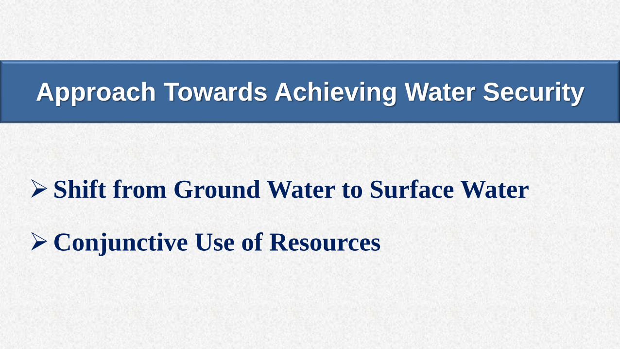
Shift from Ground Water to Surface Water
Conjunctive Use of Resources
Approach Towards Achieving Water Security
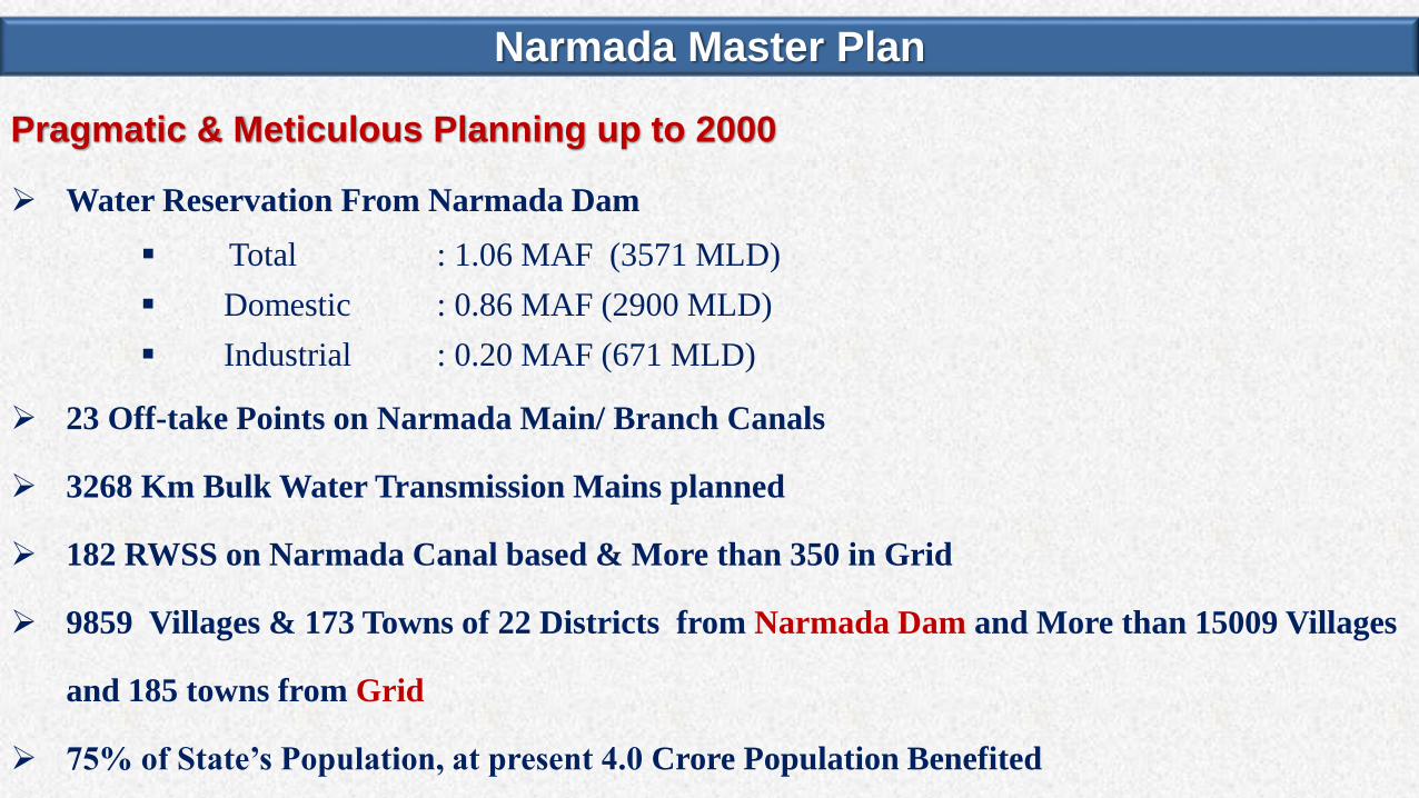
Pragmatic & Meticulous Planning up to 2000
Water Reservation From Narmada Dam
Total : 1.06 MAF (3571 MLD)
Domestic : 0.86 MAF (2900 MLD)
Industrial : 0.20 MAF (671 MLD)
23 Off-take Points on Narmada Main/ Branch Canals
3268 Km Bulk Water Transmission Mains planned
182 RWSS on Narmada Canal based & More than 350 in Grid
9859 Villages & 173 Towns of 22 Districts from Narmada Dam and More than 15009 Villages
and 185 towns from Grid
75% of State’s Population, at present 4.0 Crore Population Benefited
Narmada Master Plan
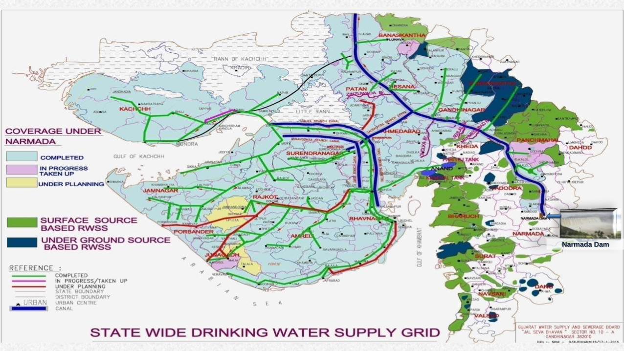
Narmada Dam

Water Supply Grid – Infrastructure & Coverage
2692 Km Bulk Water Transmission main
3 Layer Polyethylene Coating (3LP) coating on the outside and Food
Grade Epoxy Coating on the inside
120769 Km Distribution pipeline
2250 MLD liter Narmada water installed capacity of Grid.
Approx. 70% of State’s population i.e 4.0 Crore People are supplied about
3000 MLD water .
11571 Villages and 157 Towns are connected through Water Grid.
23693 Water Storage Reservoir
188 Water Treatment Plant of 3000 MLD Capacity.
Finally Drought proofing of system is nearly achieved

Water Security - A Multi Pronged Strategy
Distant Surface Source
At-least dual connectivity
Local Surface Source
Local Ground Source
Basin based Recharging
Long term source sustainability
Bore blasting & Hydro fracturing
Bore & Well Recharging
Roof top Rain Water Harvesting
Water Balance Plan
Water Auditing & Budgeting
Awareness
New Agricultural Practices
Village in-situ conservation

At-least Dual Connectivity
• State wide Water Supply Grid
• Distant Surface Water
• 7911 villages and 157 towns of Gujarat have been covered
• 2692 km of bulk pipe line
• 2900 MLD supply
• Local Surface Water• 2903 villages and 25 towns covered through 91 RWSS with combined output capacity of 950
MLD
• Ground Water• 882 villages and 8 towns covered through 86 RWSS with capacity 109 MLD

Inter linking of Basins
• Sujalam Suphalam Yojana
10 water scarce districts
Flood water transfer to water scarce regions – Sujalam Suphalam canal
Filling of dams from Narmada water – 14 pipelines for 10 dams
Filling of ponds by Narmada water
Inter linking of 27 rivers
NARMADA MAIN CANAL
SUJALAM SUPHALAM
SPREADING CANAL
SIPU DANTIWADA
WATRAK
KADANA
HATHMATI
DHAROI
MESWO
MAZAM
GUHAI
MUKTESWAR
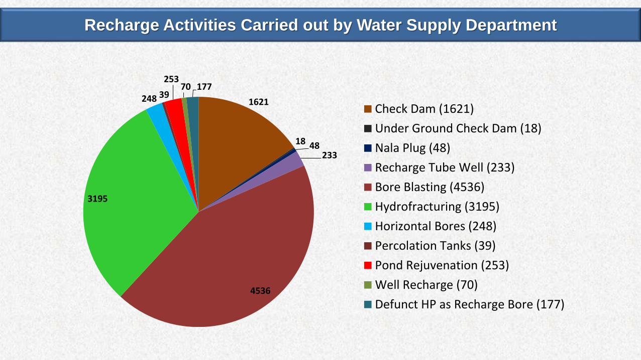
Recharge Activities Carried out by Water Supply Department
1621
18 48233
4536
3195
248 39
25370 177
Check Dam (1621)
Under Ground Check Dam (18)
Nala Plug (48)
Recharge Tube Well (233)
Bore Blasting (4536)
Hydrofracturing (3195)
Horizontal Bores (248)
Percolation Tanks (39)
Pond Rejuvenation (253)
Well Recharge (70)
Defunct HP as Recharge Bore (177)
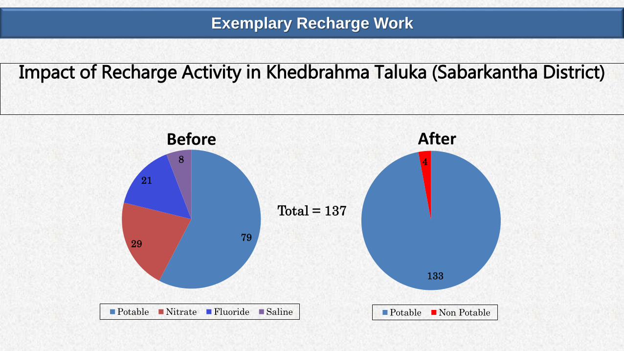
Exemplary Recharge Work
7929
21
8
Before
Potable Nitrate Fluoride Saline
133
4
After
Potable Non Potable
Impact of Recharge Activity in Khedbrahma Taluka (Sabarkantha District)
Total = 137
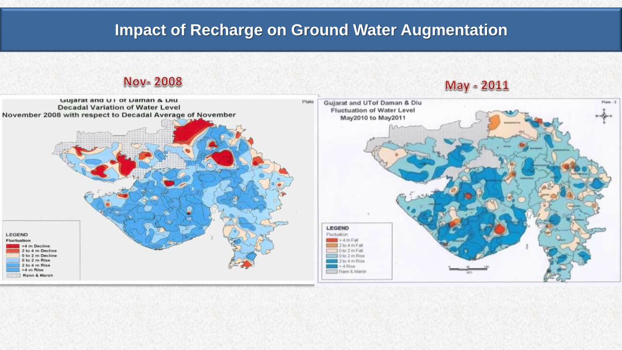
Impact of Recharge on Ground Water Augmentation
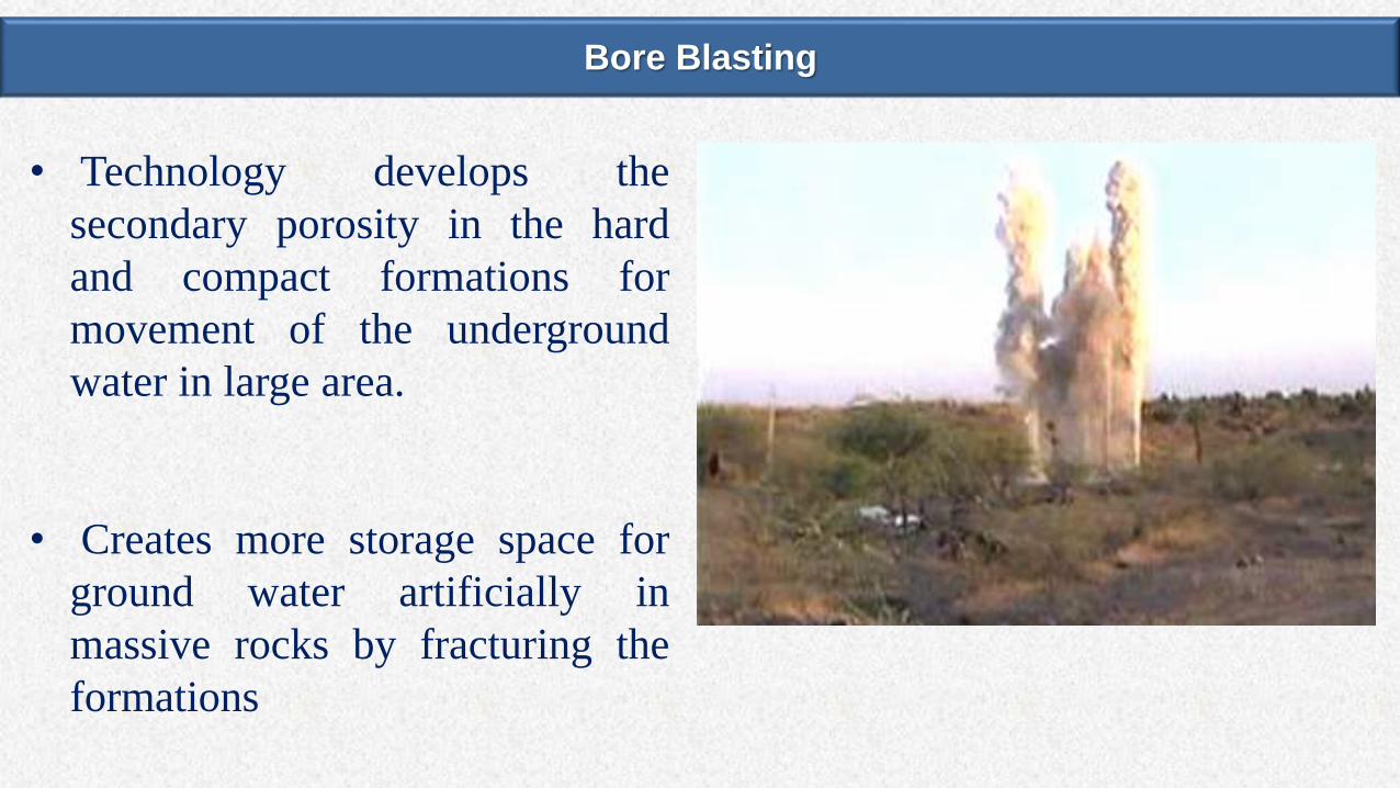
Bore Blasting
• Technology develops the
secondary porosity in the hard
and compact formations for
movement of the underground
water in large area.
• Creates more storage space for
ground water artificially in
massive rocks by fracturing the
formations

Dry Well Rejuvenated after Bore Blasting
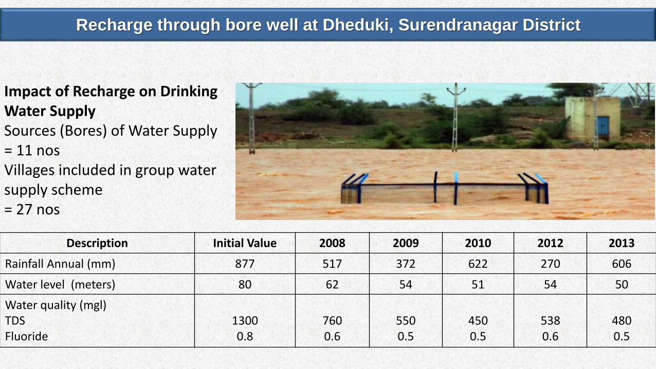
Recharge through bore well at Dheduki, Surendranagar District
Description Initial Value 2008 2009 2010 2012 2013
Rainfall Annual (mm) 877 517 372 622 270 606
Water level (meters) 80 62 54 51 54 50
Water quality (mgl) TDS Fluoride
13000.8
7600.6
5500.5
4500.5
5380.6
4800.5
Impact of Recharge on Drinking Water SupplySources (Bores) of Water Supply = 11 nosVillages included in group water supply scheme = 27 nos

Recharge through bore well at Dheduki, Surendranagar District
Farmers of the area are taking sugarcane crop also after 25 years due to sustainability of their sources
Irrigation Sources (Bores) 112 nos
Villages included in Survey 3 nos
Increase in irrigated area 20 - 25%
Increase in Production 30 - 35%
Impact of Recharge on Irrigation in Surrounding Area
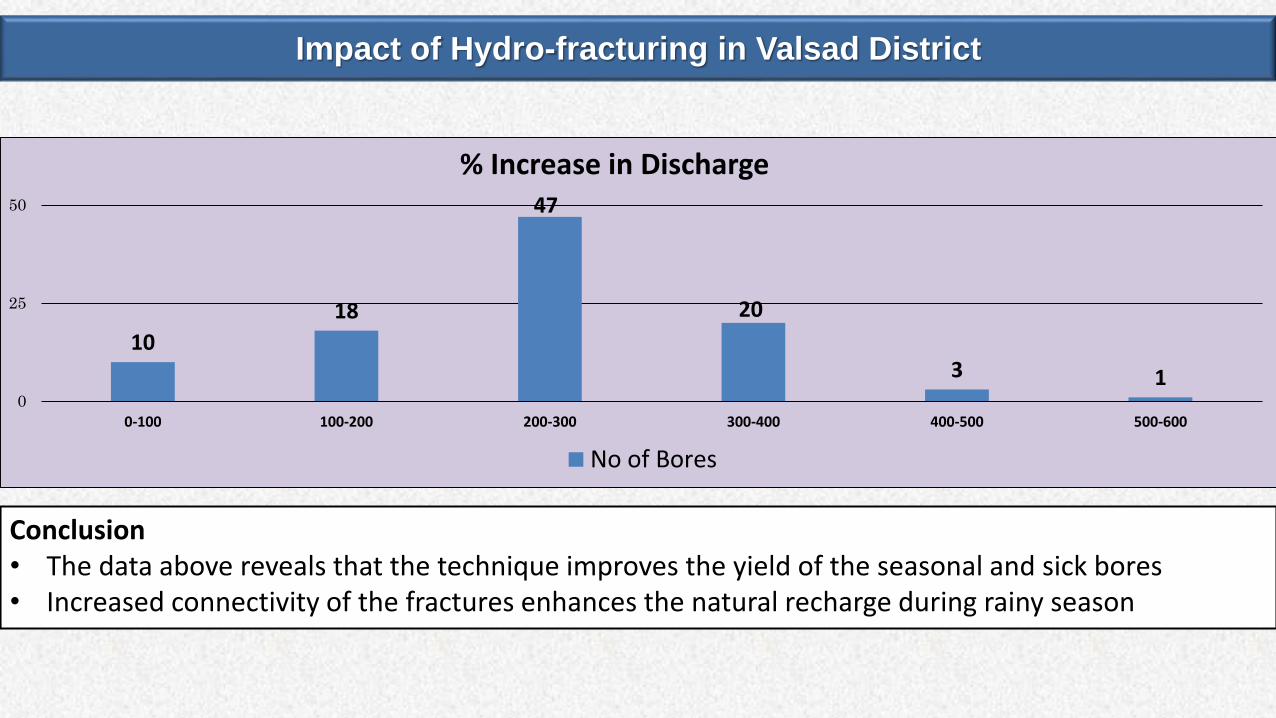
Impact of Hydro-fracturing in Valsad District
Conclusion• The data above reveals that the technique improves the yield of the seasonal and sick bores• Increased connectivity of the fractures enhances the natural recharge during rainy season
10
18
47
20
3 10
25
50
0-100 100-200 200-300 300-400 400-500 500-600
% Increase in Discharge
No of Bores
W a t e r S a t u r a t e d Z o n e
F l o w
D r y Z o n e
( I m p e r v i o u s )
S u b s u r f a c e D a m
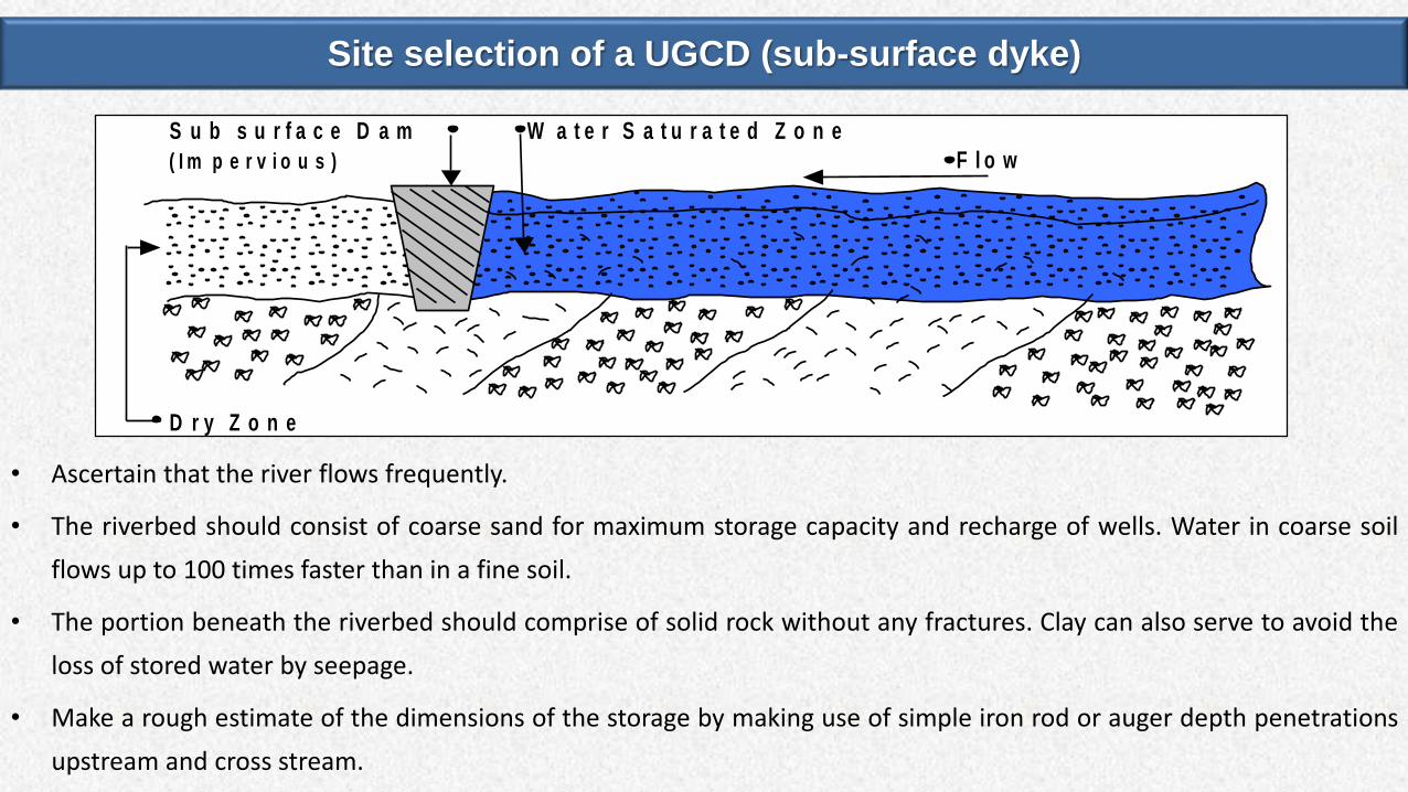
Site selection of a UGCD (sub-surface dyke)
• Ascertain that the river flows frequently.
• The riverbed should consist of coarse sand for maximum storage capacity and recharge of wells. Water in coarse soil
flows up to 100 times faster than in a fine soil.
• The portion beneath the riverbed should comprise of solid rock without any fractures. Clay can also serve to avoid the
loss of stored water by seepage.
• Make a rough estimate of the dimensions of the storage by making use of simple iron rod or auger depth penetrations
upstream and cross stream.
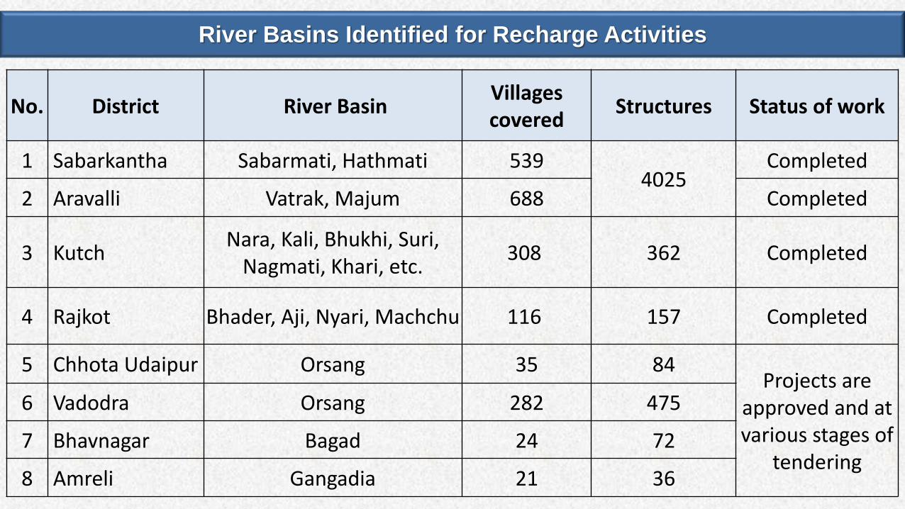
No. District River BasinVillages covered
Structures Status of work
1 Sabarkantha Sabarmati, Hathmati 5394025
Completed
2 Aravalli Vatrak, Majum 688 Completed
3 KutchNara, Kali, Bhukhi, Suri,
Nagmati, Khari, etc.308 362 Completed
4 Rajkot Bhader, Aji, Nyari, Machchu 116 157 Completed
5 Chhota Udaipur Orsang 35 84Projects are
approved and at various stages of
tendering
6 Vadodra Orsang 282 475
7 Bhavnagar Bagad 24 72
8 Amreli Gangadia 21 36
River Basins Identified for Recharge Activities
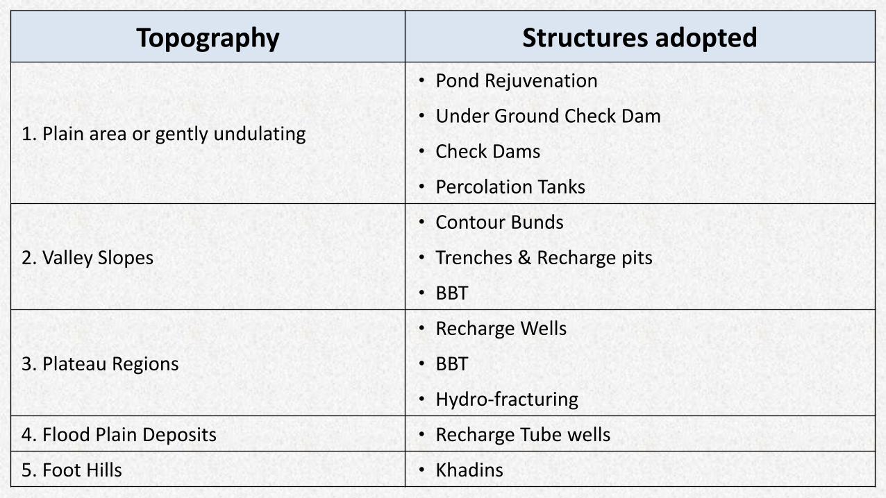
Topography Structures adopted
1. Plain area or gently undulating
• Pond Rejuvenation
• Under Ground Check Dam
• Check Dams
• Percolation Tanks
2. Valley Slopes
• Contour Bunds
• Trenches & Recharge pits
• BBT
3. Plateau Regions
• Recharge Wells
• BBT
• Hydro-fracturing
4. Flood Plain Deposits • Recharge Tube wells
5. Foot Hills • Khadins

Problems
Corrective Efforts
Result

Working towards drinking water security and habitat improvement by empowering communities to manage their local water
sources, drinking water supply and environmental sanitation
Philosophy Users are the best managers Building partnerships and working together
Water and Sanitation Management Organization (WASMO)

Status of Community managed In-village Scheme
• With consistent effort of WASMO, Pani Samitis have been formed in 18,185 villages of the
State.
• Action Plans approved for taking up in-village drinking Water Supply schemes in 14044
villages
• 10663 schemes have already been completed and now maintained and managed by Pani
Samitis

THANK YOU