an ecoregional conservation plan for the … · ecoregional conservation plan for the caucasus ......
TRANSCRIPT
AN ECOREGIONAL CONSERVATION PLAN FOR THE CAUCASUSAN
ECOREGIONAL CONSERVATION PLAN FORTHE CAUCASUS
May 2006
Second Edition

ISBN 99940-58-55-X
Design and printing Contour Ltd8, Kargareteli street, Tbilisi 0164, GeorgiaMay, 2006

1
Edited by L. Williams, Conservation Biologist,N. Zazanashvili, G. Sanadiradze and A. Kandaurov, WWF Caucasus Programme Office
Assisted by experts and contributors:
ARMENIAAGAMYAN, L.AGASYAN, A.AKOPYAN, S.AMBARTSUMYAN, A.ARZUMANYAN, G.BALYAN, L.DANYELYAN, T.DAVTYAN, R.GABRIELYAN, E.GLYCHIAN, D.GRIGORYAN, E.JENDEREDJIAN, K.KAZARYAN, H.KAZARYAN, M.KHASABYAN, M.KHOROZYAN, I.MANVELYAN, K. (Coordinator)MARKARYAN, N.MURADYAN, S.RUKHKYAN, L.SHASHIKYAN, S.TOVMASYAN, S.VANYAN, A.VARDANYAN, J.VOSKANOV, M.ZIROYAN, A.ZORANYAN, V.
AZERBAIJANABDULLAEV, N.AKHMEDOV, F.ALIEV, K.ASKEROV, E. (Coordinator)AYDYNOV, T.GULIYEV, S.GUSEINOVA, F.ISKANDEROV, T.ISMAILOV, H.JAFAROV, O.KANGARLI, T.LATIFOV, D.
MAMMEDOVA, S.MUKHTAROV, I.NAJAFOV, A.ORUJEV, Ad.ORUJEV, Al.RAKHMATULINA, I.RZAEV, R.SATTARZADE, R.SAFAROV, S.SHAMCHIYEV, T.SULEIMANOV, M.SULTANOV, E.TAGIEVA, E.
GEORGIAARABULI, A.ARABULI, G.BERUCHASHVILI, G.BERUCHASHVILI, N.BUKHNIKASHVILI, A.BUTKHUZI, L.CHEKURISHVILI, Z.DIDEBULIDZE, A.DZNELADZE, M.EGIASHVILI, D.GELASHVILI, A.GOGICHAISHVILI, L.GOKHELASHVILI, R.GURIELIDZE, Z.JAVAKHISHVILI, Z.JORJADZE, M.KANDAUROV, A. (Coordinator)KARTSIVADZE, S.KAVTIASHVILI, I.KOLBIN, G.KVELADZE, I.LABADZE, D.LEJAVA, V.LOBJANIDZE, B.LOLUA, G.LOMTADZE, ZLORTKIPANIDZE, B.MACHARASVILI, I.
NAKHUTSRISHVILI, G.NINUA, N.SERGEEVA, J.SIKHARULIDZE, Z.SOPADZE, G.TARKHNISHVILI, D.TOLORDAVA, K.
IRANAGHILI, A.EVERETT, J. (Coordinator)FARVAR, M.T.JAZEBIZADEH, K.KAVOUSI, K.MAHFOUZI, M.MANSURI, J.NAGHIZADEH, NNAJAFI, A.ZIYAEE, H.RAHMANIYAN, M.
RUSSIABIRYUKOV, N.BLAGOVIDOV, A.BRATKOV, V.BUKREEV, S.CHILIKIN, V.ERIZHEV, K.GALUSHIN, V.KHAKUNOV, B.KYATKOV, V.KOTLOBAY, A.KREVER, O.KREVER, V. (Coordinator)KROKHMAL, A.LUKAREVSKI, V.MAMBETOV, M.MEREMKULOV, M.MOSKVINA, M.POLITKO, A.POLITKO, I.POLIVANOVA, N.
POPOVICHEV, V.PTICHNIKOV, A.BELANOVSKAYA, E.SALPAGAROV, A.SHESTAKOV, ASKOROBOGACH, J.SPIRIDONOV, V.TAMOV, M.TUNIEV, B.VAISMAN, A.BELIK, V.
TURKEYALTINTAS, M.ATAY, SBIRSEL, A.CAN, E.CIFTCI, N.DOMAC, A.GURKAN, B.IPEK, A.KALEM, S.KUCUK, M.KURDOGLU, O.KURT, B.LISE, Y. (Coordinator)URAS, A.ZEYDANLI, U.
EXTERNALBAUER, G.EVERS, M.JUNGIUS, H.LANGHAMMER, P.MOERSCHEL, F.NAGY, S.SCHMIDT-KALLERT, E.SCHUERHOLZ, G.STALDER, H.STRAND, H.SYLVEN, M.WILSON, A.
Coordinated by:
In collaboration with:
With the technical support of:

2
CONTENTS
EXECUTIVE SUMMARY ....................................................................................................... 66666
PART I. BIOLOGICAL AND SOCIO-ECONOMIC ASSESSMENTS OF THECAUCASUS ECOREGION .................................................................................. 88888
1. Overview and Conclusions of the Biological Assessments ...................................................... 888881.1. Global Significance ................................................................................................................... 81.2. Physical and Biological Characteristics of the Caucasus Ecoregion ....................................... 8
1.2.1. Landscape Features ............................................................................................................... 81.2.2. Climate .................................................................................................................................. 101.2.3. Flora ...................................................................................................................................... 101.2.4. Fauna .....................................................................................................................................11
1.3. Major Ecosystems ................................................................................................................... 131.3.1. Forest Ecosystems ............................................................................................................... 131.3.2. Freshwater Ecosystems........................................................................................................ 141.3.3. Marine Ecosystems ............................................................................................................... 151.3.4. High Mountain Ecosystems .................................................................................................. 161.3.5. Dry Mountain Shrubland Ecosystems .................................................................................. 161.3.6. Steppe Ecosystems .............................................................................................................. 171.3.7. Semi-Desert Ecosystems...................................................................................................... 18
1.4. The Protected Areas System in the Caucasus Ecoregion ...................................................... 181.4.1. Types of Protected Areas ...................................................................................................... 181.4.2. Current Status of the Protected Areas System ..................................................................... 191.4.3. Gaps in the Protected Areas System .................................................................................... 20
1.5. Major Threats to Biodiversity in the Caucasus Ecoregion ...................................................... 211.5.1. Illegal Logging, Fuelwood Harvesting, and the Timber Trade ............................................. 211.5.2. Overgrazing .......................................................................................................................... 221.5.3. Poaching and the Illegal Wildlife Trade ............................................................................... 221.5.4. Overfishing ........................................................................................................................... 231.5.5. Infrastructure Development ................................................................................................. 231.5.6. Water Pollution ..................................................................................................................... 241.5.7. Root Causes ........................................................................................................................ 24
2. Overview and Conclusions of Socio-Economic Assessments ............................................... 25252525252.1. Institutional Framework ........................................................................................................... 252.2. Nature Conservation Legislation ............................................................................................. 262.3 Economic Situation .................................................................................................................. 262.4. Infrastructure and Regional Development .............................................................................. 272.5. Demography and Social Trends .............................................................................................. 282.6. Stakeholders in Biodiversity Conservation in the Caucasus
Ecoregion and Investment Overview ...................................................................................... 282.6.1. National Governments ......................................................................................................... 282.6.2. Bilateral and Multilateral Donors .......................................................................................... 292.6.3. International NGOs and Foundations .................................................................................. 302.6.4. Regional NGOs .................................................................................................................... 302.6.5. Scientific institutions ............................................................................................................ 302.6.6. Business Sector ................................................................................................................... 312.6.7. Investment Strategy of the Critical Ecosystem Partnership Fund (CEPF)
for the Caucasus Hotspot and Ecoregion Conservation Plan ............................................. 31
3. Conclusions of the Biological and Socio-Economic Assessments ....................................... 3232323232

3
PART 2. PRIORITY BIOMES, FOCAL SPECIES, AND A BIODIVERSITY VISION FOR THECAUCASUS ECOREGION ................................................................................. 3434343434
1. Priority Biomes ...............................................................................................................................34343434341.1. Forest Biome ..........................................................................................................................341.2. Freshwater Biome ..................................................................................................................351.3. Marine Biome ..........................................................................................................................351.4 High Mountain Biome .............................................................................................................36
2. Focal Species .................................................................................................................................36363636362.1. Leopard ....................................................................................................................................372.2. Striped Hyena ...........................................................................................................................372.3. Brown Bear ..............................................................................................................................382.4. West and East Caucasian Turs ..............................................................................................382.5. Caucasian Red Deer ..............................................................................................................382.6. Bezoar Goat .............................................................................................................................382.7. Gmelin’s Mouflon .....................................................................................................................392.8. Caucasian Chamois ...............................................................................................................392.9. Goitred Gazelle ........................................................................................................................392.10. Pygmy Cormorant ....................................................................................................................402.11. Imperial Eagle ..........................................................................................................................402.12. Cinereous vulture ....................................................................................................................402.13. Caucasian Black Grouse ........................................................................................................402.14. Marbled Duck ...........................................................................................................................412.15. White-headed Duck .................................................................................................................412.16. Caucasian Salamander ..........................................................................................................412.17. Syrian Spadefoot ......................................................................................................................422.18. Sturgeon ...................................................................................................................................42
3. Species of Special Concern ..........................................................................................................42424242423.1. Lynx ...........................................................................................................................................433.2. Otter ..........................................................................................................................................433.3. European mink ........................................................................................................................433.4. Bats ..........................................................................................................................................433.5. Caucasian snowcock ..............................................................................................................433.6. Caucasian viper .......................................................................................................................443.7. Persian brook salamander .....................................................................................................443.8. Endemic fish ............................................................................................................................44
4. Long-term Vision for Biodiversity Conservation in the Caucasus Ecoregion ..........................44444444444.1. Priority Conservation Areas .....................................................................................................444.2. Vision Statement ......................................................................................................................46
PART 3. ECOREGION CONSERVATION PLAN FOR THECAUCASUS ECOREGION ................................................................................... 4747474747
1. Developing an Institutional Framework and Building Capacity forBiodiversity Conservation in the Caucasus Ecoregion ........................................................... 4747474747
A. PLAN FOR INSTITUTIONAL DEVELOPMENT AND CAPACITY BUILDING IN THE CAUCASUSECOREGION....................................................................................................................................48
2. Conservation and Sustainable Use of Forest Ecosystems in theCaucasus Ecoregion .................................................................................................................... 5656565656

4
B. PLAN FOR CONSERVATION AND SUSTAINABLE USE OF FOREST ECOSYSTEMS IN THECAUCASUS ECOREGION ..............................................................................................................58
3. Conservation and Sustainable Use of Freshwater Ecosystems in theCaucasus Ecoregion ....................................................................................................................7171717171
C. PLAN FOR CONSERVATION AND SUSTAINABLE USE OF FRESHWATER ECOSYSTEMS IN THECAUCASUS ECOREGION...............................................................................................................73
4. Conservation and Sustainable Use of Coastal and Marine Ecosystems in the CaucasusEcoregion ........................................................................................................................................7979797979
D. PLAN FOR CONSERVATION AND SUSTAINABLE USE OF COASTAL AND MARINE ECOSYSTEMS IN THE CAUCASUS ECOREGION ................................................................................81
5. Conservation and Sustainable Use of High Mountain Ecosystems in theCaucasus Ecoregion ....................................................................................................................8888888888
E. PLAN FOR CONSERVATION AND SUSTAINABLE USE OF HIGH MOUNTAIN ECOSYSTEMSIN THE CAUCASUS ........................................................................................................................90
6. Conservation of Focal Species and Their Habitats in the Caucasus EcoregionPriority Conservation Corridors ...................................................................................................97
F. PLAN FOR CONSERVATION OF FOCAL SPECIES IN THE CAUCASUS ECOREGION ..............99
Attachments and Maps
Attachment 1 Brief description of Priority Conservation Areas and Corridors.................................117
Attachment 2 International Conventions and the ECP - a Framework for Action in the
Caucasus.................................................................................................180
Attachment 3 Compliance of ECP Long- and Medium-term Targets with CEPF
Strategic Directions and Investment Priorities..............................................189
Attachment 4 Overlap between ECP Priority Conservation Areas and Corridors and
CEPF Site Outcomes.................................................................................190
Map 1 Administrative Map of the Caucasus Ecoregion.............................................205
Map 2 Natural Landscapes of the Caucasus Ecoregion...........................................206
Map 3 Land Use/Land Cover.................................................................................211
Map 4 Protected Areas........................................................................................212
Map 5 Priority Conservation Areas and Corridors....................................................217
Map 6 Priority Conservation Areas, Corridors, and Protected Area............................220

5
Abbreviations Used in the Text
BMZ Bundesministerium für wirtschaftliche Zusammenarbeit (German Ministry for
Cooperation and Development)
CABS Center for Applied Biodiversity Science
CCA Community Conservation Areas
CEPF Critical Ecosystems Partnership Fund
CI Conservation International
CITES Convention on International Trade in Endangered Species of Wild Flora and Fauna
CR Wildlife Corridor
ECP Ecoregion Conservation Plan
EIA Environmental impact assessment
EU European Union
FFI Fauna & Flora International
FLR Forest Landscape Restoration
GEF Global Environmental Facility GEF’s Focal Points Contact person or organization for
Global Environmental Facility
HCVF High Conservation Value Forest
IBA Important Bird Area
ISAR Initiative for Social Action and Renewal in Eurasia
IUCN International Union for the Conservation of Nature and Natural
Resources, World Conservation Union
KfW KfW Bankengruppe (KfW banking group) - German Credit Bank for Reconstruction
(Kreditanstalt fûr Wiederaufbau)
MAB UNESCO’s Programme on Man and the Biosphere
NGO Non-governmental organization
NORAD Norwegian Agency for Development Cooperation
PCA Priority Conservation Area (Priority Area)
RAPPAM Rapid Assessment and Prioritization of Protected Area Management
TACIS Tacis Programme for grant-financed technical assistance to twelve countries of
Eastern Europe and Central Asia
TRACECA Transport Corridor Europe-Caucasus-Asia
UNDP United Nations Development Programme
UNESCO United Nations Educational, Scientific, and Cultural Organization
UNEP United Nations Environmental Programme
USAID United States Agency for International Development
WWF World Wide Fund for Nature
6
EXECUTIVE SUMMARY
The Caucasus Ecoregion covers a total area of 580,000 km2 and consists of six countries – Armenia, Azerbaijan,Georgia, the North Caucasus part of the Russian Federation, northeastern Turkey, and part of northwestern Iran. Oneof the most biologically rich regions on Earth, the Caucasus is ranked among the planet’s 25 most diverse andendangered hotspots. The Caucasus is one of WWF’s Global 200 vulnerable Ecoregions, identified as globallyoutstanding for biodiversity. The Caucasus has been named a large herbivore hotspot by WWF’s Large HerbivoreInitiative. The 2003 IUCN Red List identifies 50 species of globally threatened animals and one globally endangeredplant in the Caucasus. The Caucasus Mountains harbor a wealth of highly sought-after medicinal and decorativeplants, as well as unique relic and endemic plant communities. Yet biodiversity in the Caucasus is being lost at analarming rate due to unsustainable logging, overgrazing, poaching, infrastructure development, and pollution.Immediate actions and long-term Ecoregion-based conservation strategies are required to halt the destruction andguarantee protection of this globally important center of biodiversity.
The Biological and Socio-Economic Assessments, Biodiversity Vision, and Ecoregion Conservation Plan (ECP)herein are the outcomes of a series of stakeholder workshops held from 2000-2003, combined with backgroundreports and assessments coordinated by the WWF Caucasus Programme Office (WWF-Caucasus). More than 140experts from the six countries participated in preparation of the Ecoregion Conservation Plan representing a variety ofscientific, governmental, and non-governmental organizations. Existing conservation strategies and investmentportfolios, such as those prepared with support from the MacArthur Foundation, the German Bank for Reconstructionand Development (KfW), and the Critical Ecosystem Partnership Fund (CEPF), were incorporated into this EcoregionConservation Plan.
The purpose of the Ecoregion Conservation Plan is to create a roadmap for conserving the rich biodiversity of theCaucasus Ecoregion. Conservation groups working in the region will benefit from the ECP in order to better plan theiractivities, avoid duplication of efforts, and ensure long-term support for conservation programs. The ECP outlines avision and long-term goals for biodiversity conservation in the Caucasus Ecoregion, which will be achieved throughimplementation of a concrete set of short- and medium-term actions. Four priority biomes – forest, freshwater, marine,and high mountain – contain the bulk of the biodiversity in the Ecoregion and are subject to the greatest threats.Therefore, these biomes were selected as priorities for conservation. Within these biomes, 26 focal species and 56Priority Conservation Areas (PCAs) were determined to help further focus conservation efforts. Additionally, 60 importantcorridors were delineated to ensure connectivity of PCAs for migrating species.
There are three categories of actions within each biome: conservation, management, and restoration. A variety ofmechanisms will be used to achieve these goals, from creating networks of protected areas and linking corridors(Econets), to delineating High Conservation Value Forests (HCVF), to building public awareness and promotingsustainable ecotourism.
Nine stakeholder workshops were carried out to review the assessments and elaborate long-term goals for biodiversityconservation in the Caucasus Ecoregion.Drafts of the ECP were discussed and revised during the stakeholdermeeting (Tbilisi, Georgia, December 2003), at the first and second meetings of Ecoregional Council for BiodiversityConservation and Sustainable Use in the Caucasus (Tbilisi, May 2004; March 2005), and at WWF Ecoregional Teammeetings (Tbilisi, December 2003; Baku, Azerbaijan, May 2004; Tbilisi, October 2004). Representatives of governmentalorganizations, NGOs, scientists, and experts from the countries of the Ecoregion and abroad also reviewed the ECP.
Part 1 of the ECP provides an overview of the biological significance of the Caucasus Ecoregion, threats to biodiversity,and conclusions of recent biological and socio-economic surveys. Part 2 describes the methods used in determiningPriority Conservation Areas and summarizes the vision and long-term goals for conserving biodiversity in the Ecoregion.Part 3 outlines the short- and medium-term actions necessary to preserve priority ecosystems and focal species andachieve the long-term biodiversity vision.
Most of the six countries in the Caucasus Ecoregion have become, or are in the processes of becoming, signatoriesto international conventions related to the conservation of biodiversity. In doing so, they have signaled their commitmentto conserve biodiversity, use their natural resources wisely, control illegal wildlife trade, protect migratory species, anddesignate some of their most significant natural and cultural sites as a heritage for the world’s peoples.
With its ecosystem (biome)-based approach and its emphasis on capacity-building, stakeholder participation, benefitsharing and education, the ECP provides a tool for governments of the Caucasus region to effectively implement

7
international conventions, especially the Convention on Biological Diversity and its 2010 Biodiversity Target. Holistic,ecoregional measures will enhance existing national efforts and ensure their long-term sustainability, throughaddressing such issues as comprehensive representation of ecosystems within protected areas, harmonisinglegislation, promoting transboundary cooperation, and coordinating research and monitoring across the region.

8
PART I. BIOLOGICAL AND SOCIO-ECONOMIC ASSESSMENTS OF THECAUCASUS ECOREGION
1. Overview and Conclusions of the Biological Assessments
The Caucasus Ecoregion, historically interpreted as the isthmus between the Black and Caspian seas, covers atotal area of 580,000 km2, and spans six countries (Map 1 – Administrative Map of the Caucasus Ecoregion). TheGreater Caucasus Mountain Range with its lofty peaks forms a formidable barrier between the northern andsouthern parts of the Caucasus Ecoregion. The North Caucasus includes the Russian republics of Adygeya,Karachayevo-Cherkessiya, Kabardino-Balkariya, Northern Osetiya, Ingushetiya, Chechnya, and Dagestan, andparts of the Krasnodar and Stavropol provinces. The area to the south of the Greater Caucasus Range – known asthe South Caucasus – includes all of Armenia, Azerbaijan, Georgia, as well as northeastern Turkey and part ofnorthwestern Iran.
From 2000-2003, experts from the six countries of the Caucasus Ecoregion took part in a project funded by theMacArthur Foundation, KfW, and CEPF to assess the biological significance and state of biodiversity of the CaucasusEcoregion. Nine stakeholder workshops were carried out to review the assessments and elaborate long-termgoals for biodiversity conservation in the Caucasus Ecoregion. This overview is a summary of those assessments,drawing out the most important aspects, which provided a foundation for determining Priority Conservation Areas,focal species, and elaborating the Ecoregion Conservation Plan.
1.1. Global Significance
One of the most biologically rich regions on Earth, the Caucasus is ranked among the planet’s 25 most diverse andendangered hotspots by Conservation International (CI) and Critical Ecosystem Partnership Fund (CEPF). TheCaucasus is one of WWF’s Global 200 vulnerable Ecoregions, identified as globally outstanding for biodiversity.The Caucasus has been named a large herbivore hotspot by WWF’s Large Herbivore Initiative. Eleven species oflarge herbivores, as well as five large carnivores, are found over a relatively small area. The 2003 IUCN Red Listidentifies 50 species of globally threatened animals and one globally endangered plant in the Caucasus. TheCaucasus Mountains harbor a wealth of highly sought-after medicinal and decorative plants, as well as unique relicand endemic plant communities.
The Caucasus is a hotspot of plant and animal diversity and endemism. Located at a biological crossroads,species from Central and Northern Europe, Central Asia and the Middle East, and North Africa mingle with endemicsfound nowhere else. Over 6,500 species of vascular plants are found in the Caucasus. At least a quarter of theplants is found nowhere else on Earth – the highest level of endemism in the Temperate Zone of the NorthernHemisphere. One-third of the endemic plants in the Caucasus Ecoregion is thought to have originated in theGreater Caucasus Range. Seventeen endemic plant genera thrive in the Caucasus, nine of which are associatedwith high mountain communities. Plant associations from the Tertiary period have been preserved in the Colchicand Hyrcanic refugia – centers of plant endemism.
At least 153 mammals inhabit the Caucasus; one-fifth of these is endemic to the region. As many as 400 speciesof birds are found in the Caucasus, four of which are endemics. The coasts of the Black and Caspian seas areimportant stopover sites for millions of migrating birds, flying over the isthmus each spring and autumn betweentheir summer and winter homes. Twenty-two of the 77 reptiles in the Caucasus are endemic to the region. Fourteenspecies of amphibians are found here, of which four are endemics. More than 200 species of fish inhabit the riversand seas of the Caucasus, over a third of which are found nowhere else.
The Caucasus is also a globally significant center of cultural diversity, where a multitude of ethnic groups, languages,and religions intermingle over a relatively small area.
1.2. Physical and Biological Characteristics of the Caucasus Ecoregion
1.2.1. Landscape Features
Mountains cover approximately 65 percent of the Caucasus Ecoregion, while plains and lowlands cover theremaining 35 percent. The North Caucasus Plain occupies the isthmus of the North Caucasus. Caucasus mountaincountry lies to the south, which is broken up into the Greater Caucasus Mountain Range, the wide Transcaucasian

9
Depression, the Lesser Caucasus Mountain Chain, the Southern Highlands, and the Talish-Western AlborzMountains.
The North Caucasus Plain is bordered by the Kuma-Manych River Depression to the North, a channel that used toconnect the Azov and the Caspian seas. The Stavropol Plateau rises above the plains to a height of 50 to 800meters, along with a group of island-like mountains near the city of Mineralnye Vody, which reach 1,000 to 1,400meters above sea level (Beshtau, Mashuk, and others). The Caspian Sea borders the North Caucasus Plain to theEast, where the shoreline lies 28 meters below global sea level. The North Caucasus Plain is located entirelywithin the Russian Federation.
The Greater Caucasus Mountain Range extends across the Ecoregion from the northwest to the southeast fornearly 1,500 kilometers. The highest peaks in the region are located in this range. The Greater Caucasus Range isoften divided into three smaller segments: the Western, Central, and Eastern Greater Caucasus. Elbrus andKazbek Peaks are the major landmarks between these segments. The highest peaks (more than 5,000 metersabove sea level) are located in the Central Caucasus: Elbrus (5,642 m), DykhTau (5,203 m), Shkhara (5,068 m),and Kazbek (5,033 m). The tallest peak in the Western Caucasus is Dombay Ulgen (4,046 m); the peaks here areslightly lower than the highest peaks in Eastern Caucasus – Tebulosmta (4,493 m) and Bazar Dyuzi (4,466 m). TheGreater Caucasus Mountain Range extends across parts of Russia, Georgia, and Azerbaijan.
The Transcaucasian Depression is located between the Greater and Lesser Caucasus mountain chains. Lowridges separate the Kolkheti Lowland in the western portion of the Depression and the Kura River Valley in theeastern portion. The Transcaucasian Depression includes parts of Georgia and Azerbaijan.
The Lesser Caucasus Mountain Chain and the Dogu Karadeniz (Pontic) Mountains border the Southern Highlandsfrom the north, east, and west. The largest ridges of the Lesser Caucasus extend in a horseshoe formation,bending to the northeast. There is no single divide here, as in the Greater Caucasus Range, and absolute elevationsare significantly lower. The highest point in the Lesser Caucasus is Gyamysh Peak (3,724 m). Depressions ofvarying size lie between the ranges of the Lesser Caucasus. The Lesser Caucasus Mountain Chain extendsacross Georgia, Turkey, Armenia, Azerbaijan, and into Iran. The Dogu Karadeniz Mountains, with the highest pointbeing Kachkar Peak (3,932 m), are a continuation of the Lesser Caucasus into the coastal area of Turkey.
The Southern Highlands, made up of lava ridges and a broad volcanic plateau, extend to the south of the LesserCaucasus Mountain Chain. The northern part of the Highlands, located in Georgia, is called the Javakheti Highlands.Typical volcanic features of this system include lava plateaus, depressions, and individual ridges. The highest pointis Mount Agri or Ararat (5,165 m) in Turkey. In the southwest, the mountain ranges of southern Armenia are borderedby the Middle Araz (Araks) Basin, part of a system of low depressions of the Araz (Araks)1 River that stretchesthroughout the entire Caucasus Ecoregion. The Southern Highlands includes parts of Georgia, Armenia, Azerbaijan(Nakhchyvan), Turkey, and Iran.
The Talish-Western Alborz Mountains are located in the southeastern Caucasus, extending along the CaspianSea. The Mountains are separated from the Lesser Caucasus Mountain Chain by a depression carved out by theAraz (Araks) River. Kyumyurkyoy Peak (2,492 m) is the highest mountain in the Talish Range. Barir Peak (4,805 m)is located at the eastern border of the Ecoregion in the Alborz Range. Narrow lowlands separate the mountainsfrom the Caspian Sea. The Talish-Western Alborz Mountains and lowlands make up the western section of theHyrcanic Region, a refugium for plants during the Pleistocene epoch. The Talish-Western Alborz Mountains extendacross the border between Azerbaijan and Iran, along the Caspian Sea coast.There are a variety of soil types and variations in the Caucasus Region, from chestnut-type, dry semi-desert andsteppe soils, to cold and wet alpine meadow soils, to the red and yellow earth of the Colchic foothills and theLenkoran Region. The majority of the terrain of the Caucasus Ecoregion, however, is covered with forest brownsoils.
1 The Araz or Araks River has different names in different countries: Aras, Arax, Araxes, and Araz. Henceforth, we use Araz(Araks), according to the Times Atlas of the World (1975).
10
1.2.2. Climate
The Caucasus Ecoregion is situated on the boundary of temperate and moist-temperate climate belts. The variationin climate in the Caucasus is intensified by the Greater Caucasus Mountain Range, which blocks the north-southmovement of air masses. The difference in air temperatures north and south of the mountain range is especiallygreat. Near sea level, the average annual temperature in the north is about +10OC, while in the south the averagetemperature is +16OC. In wintertime, the average temperature in the North Caucasus Plain ranges from -2OC to -5OC, while in the southwest Caucasus temperatures are warmer – from 4.5OC to 6OC, and in the southeast Caucasusfrom 1OC to 3.3OC. At the same time, the Caucasus Region is influenced by both marine and continental weathersystems.
The elaborate mountain relief creates a diversity of climate zones in the Caucasus, resulting in large variationamong different regions. The moist temperate climate of the Colchic foothills and lowlands in the western portionof the Transcaucasian Depression, which receives 1,200 to 2,000 mm of precipitation per year, permits growth ofcitrus and tea plants. The arid climate of the Kura-Araz (Araks) Lowlands in the eastern portion of the Depression,on the other hand, where less than 250 mm of rain falls per year and sunshine is abundant in summer, is favorablefor growing cotton and other drought-resistant species.
Climatic conditions change with elevation as the mountains rise from the plain. The influence of the Atlantic Oceanand Mediterranean Sea increases with altitude, causing the air in alpine areas to be more humid. The highestamount of precipitation (as much as 2,500 to 4,500 mm per year) falls on the western parts of the Greater andLesser Caucasus mountains, facing the Black Sea. This region has the highest level of humidity in all of theCaucasus and western Eurasia.
The proximity of the Black Sea results in increased precipitation over the southwest Caucasus in winter and sunnyweather on the Black Sea Coast in summer. Thousands of tourists come to the coast in summertime to enjoy thepleasant weather and splendid nature, as well as to bathe in therapeutic mineral springs and relax on the beachesof the Black Sea.
More than 2,200 glaciers lie on the upper slopes of the Greater Caucasus Range, covering 1,430 km2 of the region.The largest glaciers (making up 70 percent of the total glacier area) are located on the northern edge of the GreaterCaucasus Range. More glaciers are found in the western and central parts of the range than in the eastern portion,where continental climate prevails. The largest glacial systems in the region are on Elbrus and Kazbek mountains.
1.2.3. Flora
More than 6,500 species of vascular plants are found in the Caucasus, and a quarter of these are found nowhereelse, the highest level of endemism in the temperate world. Outstanding features of vegetation include plants andplant associations that date back to the Tertiary period, including in the Colchic Region in the Black Sea basin andthe Hyrcanic Region in the southeastern portion of the Caucasus on the Caspian Sea coast. The abundance of relicand endemic plant species in the region is largely due to the fact that the Caucasus was spared glaciation duringthe last Iceage. The Colchic Refugium (Georgia, Russia, and Turkey) and the Hyrcanic Refugium (Azerbaijan andIran) harbor species found nowhere else: Imeretian and pontic oaks (Quercus imeretina, Q. pontica), Medwedew’sbirch (Betula medwedewii), Ungern’s and Smirow’s rhododendrons (Rhododendron ungernii, R. smirnowii), epigea(Epigaea gaultherioides), and many others. Chestnut-leaf oak (Quercus castaneifolia), Hyrcanic poplar (Populushyrcana), Danae (Danaë racemosa), and others are endemic relics of the Hyrcanic Region.
About 700 species of higher plants are listed in national Red Lists/Books of Rare and Endangered Species,including at least 20 kinds of bellflower and 18 kinds of iris. Five species of lichens and 11 species of fungi are alsolocally endangered. Tigran’s elder (Sambucus tigranii) is the only globally threatened plant included in the IUCNRed List.2 This vulnerable shrub is an endemic found sporadically in the Yerevan, Daralagyaz, Aparan, and Shirakfloristic regions of Armenia, generally in lower and middle mountain belts on dry rocky and clay soils. It is threatenedby habitat loss to development and overgrazing.
A variety of plant ecosystems are found over a relatively small area, due in part to sharp rises in elevation anddistinct changes in climate. In the lowlands of the North Caucasus Plain, the vegetation changes from steppe withfeathergrass (Stipa spp.) and fescue (Festuca valesiaca) in the west, to semi-deserts and then deserts made upprimarily of wormwood (Artemisia taurica) in the east. To the south, the Greater Caucasus Range is enveloped by

11
broadleaf and coniferous forests (with evergreen understory in the western Colchic section), topped by subalpineand alpine meadows, glaciers, and snowfields. In the Transcaucasian Depression, ecosystems range from swampforests of alder (Alnus barbata) and Caucasus wing-nut (Pterocarya pterocarpa) in the Kolkheti Lowlands in thewest, to steppes and arid woodlands, semi-deserts, and deserts in the east. Relic oaks (Quercus imeretina, Q.hartwissiana, Q. pendunculiflora) line floodplains and river terraces. The Lesser Caucasus Mountain Chain rises tothe south of the Transcaucasian Depression, with broadleaf and coniferous forests, and alpine meadows andshrublands. The Southern Highlands abut the Lesser Caucasus Mountains, characterized by mountain steppe andgrasslands. Mixed Eastern oak (Quercus macranthera) woodlands dominate the terrain, along with thorn-cushionsteppe vegetation such as golden milkvetch (Astragalus aureus), horned sainfoin (Onobrychis cornuta), and otherspecies. In the foothills of the western Lesser Caucasus and southwestern Greater Caucasus, Colchic mixedbroadleaf forests dominate the terrain up to about 600 m. Higher up, Colchic sweet chestnut (Castanea sativa) andoriental beech (Fagus orientalis) forests take over the landscape. Oriental spruce (Picea orientalis) and Caucasianfir (Abies nordmanniana) extend from 1,400 to 2,200 m above sea level. A dense evergreen understory is typical inColchic forests from sea level to sub-alpine elevations: pontic rhododendron (Rhododendron ponticum), cherry-laurel (Laurocerasus officinalis), and Colchic holly-tree (Ilex colchica) are the main evergreen dominants. Anotherspecies of alder (Alnus incana) grows in mountain gorges. The tall Caucasian berry (Vaccinium arctostaphylos) isalso a common deciduous shrub in the Colchic understory. Georgian oak (Quercus iberica) and oriental andCaucasian hornbeam (Carpinus orientalis, C. caucasica) mixed forests are common in the eastern Greater andLesser Caucasus Mountains along with oriental beech, Eastern oak, and Caucasian pine (Pinus kochiana). Endemicspecies of birch (Betula spp.) and shrub vegetation grow at higher elevations of the Greater Caucasus and northernLesser Caucasus from 1,800 to 2,500 m. Alpine areas, from 2,500 to 3,000 m, are covered with grasslands andthickets of relic and endemic Caucasian rhododendron (Rhododendron caucasicum). Endemic plant species arecommon above 3,000 m.
1.2.4. Fauna
The animal diversity of the Caucasus is unusually high for the Temperate Zone, resulting from the geographicpositioning of the region. The Caucasus Ecoregion lies at the junction of three distinct parts of the PalaearcticZoogeographic Region: the Euro-Siberian, Central Asian, and Mediterranean. Endemic species of animals arecommon in the western part of the Greater and Lesser Caucasus ranges, as well as in the Talish Mountains. Atleast 153 mammals inhabit the Caucasus Ecoregion; one-fifth of these is endemic. Newly-evolved species mixhere with relic species.
A number of flagship, indicator, and focal species are important for biodiversity conservation in the Caucasus.Among large carnivores, the North Persian leopard (Panthera pardus saxicolor) is protected under IUCN as anendangered species. The nearly extinct population of this species in the central part of the Greater Caucasuspossibly belongs to a distinct, narrow-ranged taxon described as the Caucasian leopard (P. p. ciscaucasica). Manyscientists fear that the leopard has now disappeared from the region altogethe, in spite of the fact that it waswidespread throughout the Caucasus half a century ago. However, recent surveys conducted within WWF projectshave shown that about 45-50 animals still inhabit the Talish Range, Zangezur Range, and northern Iran. Smallpopulations have also survived in the eastern Greater Caucasus Range and Iori-Mingechaur Priority ConservationArea. The leopard feeds on prey species like bezoar goat (Capra aegagrus), wild boar (Sus scrofa), roe deer(Capreolus capreolus), and other ungulates. By conserving leopard habitat and the animal’s food base, importantecosystems for a number of other species can be preserved simultaneously.
Another large carnivore, the striped hyena (Hyaena hyaena), is also on the verge of extinction in the Ecoregion.Striped hyenas live in lowland ecosystems, including arid habitats and floodplain forests. The scavenger used to bewidespread in the eastern Caucasus, but hyena numbers decreased drastically in the second half of the 20th
century due to their persecution by hunters and as a result of habitat loss to agriculture. In Georgia, from 1950 to1970, only one to two individuals were recorded each year, mostly in remote gorges of the Vashlovani Strict NatureReserve and in sanctuaries along the Iori River floodplain. Similarly, in Azerbaijan each year only a few individualsare registered across the entire country. Today it is believed that only a handful of hyenas remain within a very smallrange in the southeastern Caucasus plains (Azerbaijan and a small portion of Georgia). Exact data on the numberof hyenas left or the state of the population are not available.
2 Work on determining other threatened plant species for listing under IUCN is currently underway with assistance from theMissouri Botanical Garden, IUCN, the Global Trees Campaign, FFI, UNEP-WCMC and CEPF.

12
Several species of ungulates are threatened in the Caucasus Ecoregion. The highly endangered bezoar or wildgoat, the ancestor of the domestic goat, is found only in the eastern part of the Greater Caucasus Range and in thesouthern portion of the Lesser Caucasus Mountain Chain and Southern Highlands. The bezoar goat is endangereddue to poaching and habitat loss to pasturelands. Populations of the Gmelin’s or Armenian mouflon (Ovis ammongmelinii), a restricted-range subspecies of wild sheep, have dwindled to fewer than several hundred in southernArmenia and in the Nakhchyvan Autonomous Republic (Azerbaijan). The Caucasian chamois (Rupicapra rupicapracaucasica), a small mountain ungulate, is also declining in the region. Small, isolated populations have beenconserved only in parts of the Greater Caucasus Range and the Lesser Caucasus Mountain Chain. Goitredgazelles (Gazella subguturosa) number about 5,000, but nearly all these animals are located in the ShirvanNational Park in Azerbaijan, from where they are unable to disperse to a wider territory. The European bison (Bisonbonasus), which was reintroduced to the North Caucasus after disappearing from the wild in 1921, is once againunder threat. There are just over 150 bison (including hybrids of different subspecies) remaining in two naturereserves in the Russian Caucasus. The West Caucasian tur (Capra caucasica) and the East Caucasian tur (C.cylindricornis) live on western and eastern ends of the Greater Caucasus Range; the two species mix in the centralpart of the Caucasus Range. Tur populations have declined significantly in recent years, and the animal is nowincluded in the IUCN Red List. The Caucasian subspecies of red deer is one of the most endangered species ofwildlife in the South Caucasus, where fewer than 650 animals remain. Yet several thousand red deer are found onthe northern slopes of the Greater Caucasus Range in Russia, where the animals are still legally hunted.
Among small mammals, there are many endemic species, including the very narrow-ranged Dahl’s jird (Merionesdahli), Kazbegi birch mouse (Sicista kazbegica), Klukhori birch mouse (Sicista kluchorica), and Gudauri snow vole(Chionomys gud). Dahl’s jird is found in semi-desert habitats in the Araz (Araks) River Valley, while others live inisolated regions of the Greater Caucasus. The Ecoregion harbors several bat species included in the IUCN RedList and protected by international conventions. Several rodents and insectivores are endemics of western Caucasianmountain forests. The long-clawed mole-vole (Prometheomys schaposchnikovi), found only in the westernCaucasian uplands, is the sole representative of a monotypic genus which is endemic to the region.
Bird diversity is moderate in the Caucasus Ecoregion with about 400 species, four of which are endemics. Thecoasts of the Black and Caspian seas are important stopover sites for millions of migrating birds, flying over theisthmus each spring and autumn between their summer and winter homes. The four endemic bird species in theregion are the Caucasian black grouse (Tetrao mlokosiewiczi) – found in subalpine meadows and subalpineforests throughout the region; the Caspian snowcock (Tetraogallus caspius) – occurring in alpine areas throughoutthe region except the Greater Caucasus Range; the Caucasian snowcock (Tetraogallus caucasicus) – found only inthe Greater Caucasus Range; and the Armenian gull (Larus armenicus) – which nests only on Lake Sevan and LakeArpi in Armenia. Two species typical for the Himalayan Mountains – the great finch (Carpodacus rubicilla) andGueldenstaedt’s redstart (Phoenicurus erythrogaster) – have small and completely isolated populations in theCaucasus, separated from their “main” ranges by thousands of kilometers. Among predatory birds and vultures,lammergeyer (Gypaetus barbatus), golden eagle (Aquila chrysaetos), imperial eagle (A. heliaca), and Egyptianvulture (Neophron percnopterus) are endangered in the Caucasus Ecoregion. A subspecies of the peregrine falcon(Falco peregrinus caucasicus) is especially rare, with only 30 to 50 pairs left in the Ecoregion. Poaching and habitatloss are the main reasons for the bird’s decline.
Of the 77 species of reptiles in the Caucasus, more than 28 are endemic to the Ecoregion. The most interestingreptiles are endemic Caucasian vipers (Vipera spp.) and rock lizards (Darevskia spp.). Many of these speciesoccupy total ranges of only a few thousand square kilometers. The Darevskia genus from the Lacertidae family oflizards exhibits particular diversity. Of the 26 known species in the world, 25 occur in the Caucasus and 23 areendemics. Three endemic Caucasian mountain vipers are also included in the IUCN Red List. There are only 14amphibians in the Caucasus, four of which are endemic to the region. The Caucasian salamander (Mertensiellacaucasica), which has evolved independently for 15 million years, is found only in the western Caucasus of Georgiaand in Turkey, and is included in the IUCN Red List. The Caucasian mud-diver (Pelodytes caucasicus) and Caucasiantoad (Bufo verrucosissimus) live in mountain forests of the western Caucasus.
Over 200 species of fish are found in the rivers and seas of the region, including species that migrate from theCaspian and Black seas to spawn in freshwater rivers; of these a third are endemics. Six species of sturgeon(Acipenser spp.) and the beluga (Huso huso) are endangered by overfishing and habitat degradation in the Blackand Caspian seas. The Atlantic (Baltic) sturgeon (A. sturio), which spawns only in rivers in the Kolkheti Lowlands inGeorgia, is critically endangered.

13
1.3. Major Ecosystems
A wide array of ecosystems is concentrated into a relatively small area in the Caucasus Ecoregion, contributing tothe uniquely high level of biodiversity (Map 2 – Natural Landscapes). Major ecosystems include forest, freshwater,marine, high mountain, dry mountain shrublands, steppe, semi-desert, and wetland communities. The followingsection describes each of these ecosystems in brief.
1.3.1. Forest Ecosystems
Forests are the most important biome for biodiversity conservation in the Caucasus, covering nearly one-fifth of theEcoregion. Mountain forests make up the majority of the forest biome. Forests used to be widespread on mountainslopes and in valleys in the Caucasus before humans began to clear the land for agriculture and pasturelands.Forest cover is closely linked to precipitation and climate in the region, and the lower edge of woodlands variesconsiderably. Trees grow at sea level where average annual precipitation is high enough (in the Colchic andHyrcanic regions, for example). In the dry regions of the Araz (Araks) Basin, forests retreat almost to the subalpinebelt.
Broadleaf, coniferous, timberline, arid open woodland, and lowland forests are the main types of forests in theCaucasus, dispersed according to elevation, soil conditions, and climate. Broadleaf forests account for more thantwo-thirds of forests in the region. Broadleaf forests consist primarily of Oriental beech, oak, hornbeam (Carpinuscaucasica, C. orientalis, C. betulus), and chestnut. Beech forests play the leading role in the region’s timberindustry. Careless clearcutting of mountain beech stands has permanently damaged a significant portion of valuablebeech forests in the North Caucasus.
Oak forests used to be widespread throughout the Caucasus. Sessile oak (Quercus petraea), found on steepslopes, and English oak (Q. robur), which grows in valleys, are the dominant species of oak in the North Caucasus.Georgian oak is the main species in the lower and mid-elevation forest belts of the South Caucasus, while Easternoak makes up the majority of the trees in high elevation forests of the southeastern Caucasus. Fourteen of the 17oak species found in the Caucasus are endemic to the region. Chestnut forests are found on acidic soils in theColchic foothills and in the northwestern Caucasus, and are often mixed in with hornbeam and beech forests.
Coniferous forests are made up primarily of Oriental spruce, Caucasian fir, and Caucasian pine. Dark coniferousforests (spruce and fir) are found in the western part of the Lesser Caucasus Mountain Chain, and on both sides ofthe western and central Greater Caucasus Range. The rare and endemic Caucasian fir grows taller than any treein the Temperate Zone, reaching up to 70 meters skyward. Caucasian pine forests are prevalent in the NorthCaucasus and in the Kura River watershed in Georgia and Azerbaijan. Coniferous forests grow in wide bandsgenerally from 900 to 2,150 m, often on steep, rocky slopes, where they play an important role in protecting soil fromerosion. Conifers are logged for paper production and timber, which has resulted in a severe depletion of forestreserves. Poor forest health leads to fungal and bark beetle invasions, which can spread and destroy entirestretches of spruce forests.
Timberline forests, growing under high altitude conditions, consist of trees that grow in crooked, dwarfed, andsparse formations. These tree forms are found particularly in areas with snowy winters or dry continental weather.Birch (Betula spp.), mountain ash (Sorbus caucasigena), beech, Eastern oak, Trautvetter’s maple (Acer trautvetteri),and pine in places are generally common at or near timberline.
Arid open woodlands, consisting of juniper (Juniperus spp.) and pistachio (Phistacia mutica) species, form on dry,rocky slopes in the eastern and southern Caucasus. Willow-leaf pear (Pyrus salicifolia), Georgian maple (Aceribericum), esa (Celtis spp.), and Araxian oak (Quercus araxina) are interspersed with juniper and pistachio. Christ’sthorn (Paliurus spina-christi), cotoneaster (Cotoneaster spp.), dog rose (Rosa canina and others), and jasmine(Jasminum spp.) grow in the understory.
Lowland forests are found in floodplains and on low river terraces, generally growing on alluvial, swampy, or moistsoils. Very few such forests have been preserved to this day; some stands remain only in the Lenkoran and KolkhetiLowlands and in the Kura, Iori, Samur, and Alazani-Agrichay river valleys. Lowland forests are entangled in vines,which grow especially thick in clearings and along edges, roads, and rivers.

14
Most of the focal species of animals are, to various extents, associated with forest ecosystems. The majority of batspecies, brown bear (Ursus arctos), bezoar goat, chamois, Caucasian red deer, European bison, both endemicspecies of salamanders (Mertensiella caucasica and Batrachuperus persicus), and Caucasian leopard depend onthe presence and quality of forests. Roe deer (Capreolus capreolus) and wild boar feed on leaves, roots, and nutsin forests. Common otter (Lutra lutra) and European mink (Mustela lutreola) are associated with riparian forestecosystems. Moreover, species that live in the subalpine belt (both West and East Caucasian turs and Caucasianblack grouse) use mountain forests as alternate feeding and wintering habitats. As forests in the western Caucasusand the Talish Range are largely isolated from other large tracts of forests in Europe and Central Asia, they containmost of the narrow endemic species of the Caucasus Ecoregion. One notable group is endemic rock lizards(Darevskia genus), which includes some parthenogenetic forms. Additionally, the following species are associatedwith forest landscapes to varying degrees: the endemic Caucasian adder (Vipera kaznakovi), included in the IUCNRed List; the endemic Caucasian mud-diver and Caucasian toad, also rare according to IUCN; and several endemicrodents and insectivores, such as Robert’s snow vole (Chionomys roberti), Caucasian mouse (Apodemus ponticus),Caucasian mole (Talpa caucasica), and Shelkovnikov’s water shrew (Neomys schelkovnikovi). Many endemicinvertebrates, such as the Caucasian running beetle (Carabus caucasicus) and beech snail (Helix buchi), are alsoexclusively dependent on forest ecosystems. Caucasian populations of European wild cat (Felis silvestris) andpine marten (Martes martes) are relatively abundant in forests, and maintaining these populations is important forconservation of the species worldwide. Bird fauna in Caucasian forests is also reasonably rich, although thenumber of endemic or globally threatened species is relatively low. Owls, such as eagle owl (Bubo bubo), sevenspecies of woodpeckers, and various small passerines, including some whose European range is limited to theNear East like the red-fronted serin (Serinus pusillus), coexist in Caucasian forests with widespread species ofEuropean birds.
1.3.2. Freshwater Ecosystems
Wetlands and freshwater habitats cover 11.72 percent of the Caucasus Ecoregion, twelve wetland sites have beendeclared internationally important under the Ramsar Convention. Freshwater ecosystems include rivers, lakes,and swamps, each of which described in brief below.
Rivers in the Caucasus Ecoregion lie in the catchment areas of three different seas. The Kura, Araz (Araks), Terek,Kuma, and Samur rivers flow toward the Caspian Sea. The Rioni, Inguri, Kodori, Chorukh (Chorokhi), and Bzybrivers belong to the Black Sea Basin. The Kuban River and its tributaries are part of the Azov Sea Basin. Water levelsvary considerably, due to heavy rains and different rates of snowmelt. Many rivers in the eastern part of the NorthCaucasus Plain dry up as they traverse the water-starved semi-deserts of the Terek-Kuma Lowlands. Only theTerek and Sulak Rivers make it all the way to the Caspian Sea.
Lakes of differing origin are distributed throughout the Caucasus Ecoregion. The largest lake in the Ecoregion isLake Sevan in Armenia, with a surface area of 1,262 km2 and a maximum depth of 83 meters. The lake is situated1,900 m above sea level in the Armenian Highlands and has been declared a national park with Ramsar status.The Razdan River flows out of Lake Sevan. Downstream, water is used to generate power through a series ofhydroelectric stations, as well as to irrigate more than 100,000 hectares of agricultural land in the Ararat Valley. Thehigh mountains of the western and central parts of the Greater Caucasus are dotted with glacial and karst lakes (onlimestone ridges). Volcanic processes formed lakes in the Javakheti-Armenian Highlands (part of the SouthernHighlands).
Mires consist of two different kinds: low-lying swamps and marshes, and highland bogs (including peat-bogs).Swamp alder forests and unique lowland peat bogs are found in the lower reaches of the Rioni River in the KolkhetiLowlands around Paliastomi Lake. Large, low-lying mires are situated within the Kura-Araz (Araks) Valley alongmain rivers and irrigation channels. The most significant of these are reed- and cattail-covered swamps near AgGel (Aghgol) and Sarysu lakes in Azerbaijan. For generally arid regions, lowland wetlands play a very important rolein maintaining biodiversity. Highland bogs are also critical for a number of species, occurring only in these habitats.High mountain wetlands occupy large areas on the Javakheti Plateau and in the Southern Highlands (the southernpart of the Lesser Caucasus Mountain Chain). Sedge (Carex spp.) plants occupy much of mountain wetlands.
Wetlands and lakes are particularly important habitats for waterfowl, providing nesting, wintering, and stopoverareas during migration. Over 150 species of waterfowl nest on lakes in the Caucasus, including globally threatenedspecies such as corncrake (Crex crex), black-winged prantincole (Glareola nordmanni), pygmy cormorant(Phalacrocorax pygmaeus), and lesser white-fronted goose (Anser erythropus). Breeding populations of white-

15
winged scoter (Melanitta fusca) in southern Georgia are separated from the main Arctic range of this species bythousands of kilometers. Great and little egrets (Egretta alba, E. garzetta), night and gray herons (Nycticoraxnycticorax, Ardea cinerea), black stork (Ciconia nigra), various terns and stints, diving ducks, and divers are alsoquite common in wetlands. Cormorants, egrets, and herons mostly concentrate in lowland lakes and reservoirs,whereas ducks gather along the seashore, and cranes are found in uplands. Probably the most common speciesof waterfowl are the yellow-legged gull (Larus cachinnans) and the closely related Armenian gull. Three species ofharriers (Circus spp.) are found around wetlands as well. Dalmatian and Eastern white pelicans (Pelecanuscrispus, P. onocrotalus) and greater flamingo (Phoenicopterus ruber) are not rare at large lakes, but they generallyuse them as stopover sites rather than nesting areas.
The most common wetland mammals are water voles (Arvicola terrestris) and two large introduced rodents – themuskrat (Ondatra zibethicus) in uplands and nutria (Myocastor coypus) in lowlands. Large lakes and rivers providehabitat for common otter, considered here as a species of special concern. The most abundant amphibians andreptiles are lake frogs (Rana ridibunda), grass snakes (Natrix natrix, N. tessellata), European marsh turtle (Emysorbicularis), and Caspian terrapin (Mauremys caspica) – the latter is found only in lowlands. More than 70 fishspecies occur in lakes and rivers, and at least 14 are endemic to the Caucasus. Trout (Salmo fario) is the mostcommon fish in the mountains. An endemic form of salmon (S. ischchan) lives in Lake Sevan. Several species ofwhitefish (Coregonus spp.) have been introduced in high mountain lakes. Anadromous fish, primarily sturgeon andsalmon, migrate into freshwater rivers from the Caspian and Black seas to spawn. All species of sturgeon arethreatened by illegal fishing in spawning areas, pollution, and other anthropogenic impacts in freshwaterecosystems.
1.3.3. Marine Ecosystems
The Caucasus Ecoregion encompasses coastal areas of the Caspian, Black, and Azov seas. The coastal regionsof the Caspian and Black seas harbor habitats for numerous fish, waterfowl, and marine invertebrates. The Caspianis the largest inland sea in the world, with an area of about 422,000 km2 and 6,397 km of coastline. The averagewater temperature in the coastal region throughout the year ranges from 15.9oC to 17oC. The variation in watertemperatures from the coldest area in the north to the warmest area in the south is 4oC in winter and 16oC insummer. Over 120 species of fish inhabit the Caspian. The main species used commercially are sturgeons:beluga, Russian sturgeon (Acipenser gueldenstaedtii), Persian sturgeon (A. persicus), and star sturgeon (A.stellatus). These species produce caviar, a delicacy prized around the world. Other fish include sprat (Clupeonellacultriventris, C. engrauliformis, C. grimmi), mullet (Liza aurata, L. saliens), carp (Cyprinus carpio), bream (Abramisbrama), pike-perch (Stizostedion lucioperca), roach (Rutilus rutilus), and salmon (Salmo trutta caspius). There areno significant communities of aquatic plants along the Caucasian coast of the Caspian Sea.
The Caspian Sea coastline offers important habitat for migrating waterfowl. Waders, gulls, ducks and other waterfowlare abundant here during migration and breeding season. Lesser kestrel (Falco naumanni), sociable lapwing(Vanellus gregarious), marbled duck (Marmaronetta angustirostris), lesser white-fronted goose, red-breasted goose(Branta ruficollis), and white-headed duck (Oxyura leucocephala) are some of the globally threatened birds thatmigrate along the Caspian’s coastal regions. Among mammals, the Caspian seal (Phoca caspica) is found in theCaspian Sea. The greatest threats to marine ecosystems come from overfishing, pollution, and oil development. Allspecies of sturgeon and the beluga are endangered by overfishing and habitat degradation in marine and coastalecosystems.
The relatively deep Black Sea and shallow Azov Sea form a network of marine habitats for saltwater and anadromousfish on the western side of Caucasus Isthmus. The most significant bird habitats are located along the coast of theBlack Sea in the Kolkheti Lowlands and along the Azov seashore in the delta of the Kuban River and in brackishbodies of water. The most numerous nesting birds are gulls, sandpipers, and terns. The diversity of wintering birdsand those that use the Black Sea coast as a stopover area during migrations is much higher. Grebes, egrets,herons, swans, cormorants, and at least ten species of ducks and diving ducks congregate here. Migrating birds ofprey gather near Batumi in an important bottleneck. At least 27 species of raptors are found along the Black Seacoast.
There are three species of dolphins found in the Black Sea (Delphinus delphis, Tursiops truncatus, Phocoenaphocoena). Two subspecies of dolphins are endemic to the Azov and Black seas, and all three species areprotected under the Bonn Convention. Coastal areas of the Black Sea, especially near the mouth of the Rioni River,harbor important habitats for focal sturgeon (Acipenser stellatus, A. sturio, A. gueldenstaedti, A. nudiventris). Other
16
fish include sprat (Clupeonella cultriventris, C. engrauliformis), mullet, herring (Alosa spp.), and salmon (Salmotrutta labrax). A significant share of fish and invertebrates in the Black Sea are relics of the time (over ten millionyears ago) when the joined basins of the Black and Caspian seas were completely separated from the Mediterranean.Most of these species are adapted to low levels of salinity. Notably, the commercially valuable species of sturgeonbelong to this group. These Caspian-Black Sea relic species, as they are called, coexist today with widespreadMediterranean species, which penetrated into the Black Sea during a later period. As with the Caspian, there are nosignificant communities of aquatic plants along the Caucasian coast of the Black Sea.
1.3.4. High Mountain Ecosystems
High mountains are found throughout the Caucasus, occupying more than 17 percent of the Ecoregion. Highmountain ecosystems are principle pasturelands for livestock, sheep, and goats. Overgrazing for many decadeshas altered vegetation cover and species composition, causing a decline in productivity. The top layers of soil havebeen seriously damaged, resulting in soil erosion, avalanches, and mudslides. Many plants are collected for usein traditional medicine and for decoration. Mountain ecosystems are under pressure from ski resorts in someareas.
High mountain habitats include meadows, alpine mats, rhododendron thickets, and cliff and rock vegetation.Meadow vegetation, dominated by herbaceous species, is widespread in alpine ecosystems, usually from about2,500 to 3,000 m above sea level. The variety of grass species in subalpine meadows makes these areas particularlygood for grazing and haymaking, but overuse can result in severe degradation of this fragile ecosystem. Alpinemeadows are often composed of one or two dominant species such as sedge and fescue.
Alpine mats cover the terrain from 2,800 to 3,100 m in the Greater Caucasus Range and from 3,000 to 3,450 m inparts of the Lesser Caucasus Mountain Chain. Alpine carpets are formed by a dense layer (1.5 to 4 cm thick) of low-lying perennial plants. Although plant productivity is low in alpine mats, they are used intensively as summerpastures, particularly for sheep grazing.
Thickets of the endemic Caucasian rhododendron grow in alpine peat soils on moist slopes with northern exposurein the Greater Caucasus Range, as well as in the northern part of the Lesser Caucasus Mountain Chain. Openshrub communities with juniper are found on southern slopes. Both rhododendron and juniper help hold rockysoils together and reduce erosion.
Scree and rock vegetation is found throughout the high mountains of the Caucasus Ecoregion. Many of the endemicspecies in the Caucasus are found in these unique habitats; approximately 80 percent of the plant species in rockand scree communities on Colchic limestone ridges in the Greater Caucasus are endemic. Certain plants havedeveloped unique ways of surviving in harsh conditions – by branching out over rock surfaces, or shooting rootsdeep into the cracks of cliffs.
Upland (subalpine and alpine) ecosystems provide key habitats for focal animal species such as turs in theGreater Caucasus, Gmelin’s mouflon in the Lesser Caucasus, Caucasian black grouse, Caucasian snowcock,Darevsky’s and Dinnik’s vipers (Vipera darevskii, V. dinniki). Some species for which key habitats lie in the upperpart of the forest belt are also strongly associated with the subalpine zone, including bezoar goat, chamois, andpossibly leopard. Upland landscapes harbor habitats for common otter in wetlands and offer important feedinggrounds for brown bear and red deer. High mountain meadows host several endemic reptiles (including threespecies of adders and five or six endemic lizards of the Darevskia genus), the endemic long-clawed mole-vole,several species of endemic birch mice (Sicista spp.) and snow voles (Chionomys spp.). High mountains providekey habitats for large scavengers such as lammergeyer (Gypaetus barbatus), black vulture (Aegypius monachus),and griffon vulture (Gyps fulvus). Bird species not found in Europe, such as Eastern rock nuthatch (Sitta tephrnota),coexist here with widespread alpine species like alpine chough (Pyrrhocorax graculus). A number of spectacularinsects can be observed in uplands like the Apollo butterfly (Parnassius spp.), including both widespread andendemic species, and the alpine Capricorn beetle (Rosalia alpina).
1.3.5. Dry Mountain Shrubland Ecosystems
Shrublands are especially prevalent in the Araz (Araks) River watershed with its continental climate. These dryhabitats are found from 1,500 to 2,000 m and in places up to 2,500 m above sea level. Brush vegetation communities,consisting of thyme (Thymus spp.), germander (Teucrium spp.), woundwort (Stachys spp.), wormwood (Artemisiaspp.) and other plants, are generally quite diverse. Many of these plants have very narrow ranges. The Astragalus

17
genus is especially diverse with many local endemics. Shrub communities consisting of buckthorn (Rhamnuspallasii), cherry (Cerasus mahaleb), and evergreen jasmine (Jasminum fruticans) are also relatively common in drymountain areas or on deforested slopes. The main threats to this biome are infrastructure development andlandscape degradation from conversion of shrublands to pastures and irrigated arable lands – resulting in theincreased salinity of soils.
Shrublands in the Caucasus harbor a high diversity of animals, most of which are typical for all of southwestern Asiaand the Mediterranean. Shrublands provide key habitats for focal animal species such as striped hyena and goitredgazelle. Brown bear are also found in arid shrublands of the southern and southeastern Caucasus. Large carnivores,such as wolf (Canis lupus) and golden jackal (Canis aureus), and a variety of birds are also found in shrublands,including chukar partridge (Alectoris chukar), Egyptian and griffon vultures, wagtails (Oenanthe spp.), Europeanbee-eater (Merops apiaster), Eurasian roller (Coracias garrulus), and shrikes (Lanius spp.). Over 15 species ofsnakes inhabit shrublands; in areas near Tbilisi, as many as 12 snake species can be found in one area, includingfive racers (Coluber and Elaphe spp.), several dwarf racers (Eirenis spp.), grass snakes (Natrix spp.), lizard snake(Malpolon monspessulanus), cat snake (Telescopus fallax), sand boa (Eryx jaculus), and blend snake (Typhlopsvermicularis), as well as nearly a dozen lizards, including at least six true lizards (Lacerta genus), three species ofskinks (Eumeces and Ablepharus genera), European glass lizard (Pseudopus apodus), and one Caucasianagama (Laudakia caucasica). Other notable species are the venomous and dangerous Levantine viper (Viperalebetina) and the Mediterranean tortoise (Testudo graeca). The most common amphibians here are the Syrianspadefoot toad (Pelobates syriacus), which is declining throughout the region, and the Asia Minor tree frog (Hylasavignyi). Several species such as Radde’s viper (Vipera raddei) and Persian dwarf racer or black-headed groundsnake (Rhynchocalamus melanocephalus), are found only in areas along the Araz (Araks) Valley. Some endemicinsects are found in this habitat type, including the Caucasian zerinthia (Allancastra caucasica).
1.3.6. Steppe Ecosystems
Steppes used to be widespread on the Caucasus Isthmus, but today only fragments of steppe communities havesurvived, primarily on rocky slopes unsuitable for agriculture. Valley and foothill steppe communities, locatedmostly in the South Caucasus, are made up of tussocks of feathergrass (Stipa stenophylla, S. capillata, S.lessingiana), fescue, crested hair-grass (Koeleria gracilis), and other species. Plains blue-stem (Bothriochloaischaemum) steppe is located in the transitional area between fescue-feathergrass communities and wormwoodsemi-deserts. Steppe vegetation is intermixed in many areas with semi-desert, arid open woodlands, and thicketcommunities.
Diverse highland steppe communities are found primarily in dry regions, for example, on Mount Elbrus and inDagestan from 1,500 to 2,000 m. Highland steppe vegetation also covers volcanic highlands in southern Georgia(from 1,700 to 2,300 m), Armenia, Azerbaijan (Nakhchyvan), Turkey and Iran to 2,600 m above sea level. Highlandsteppe communities are generally situated on mountain plateaus with productive black earth soils, thus most ofthese areas have been plowed for farming. Highland steppe is also used for grazing and haymaking.
The composition of fauna significantly varies in steppes on the northern and the southern sides of the GreaterCaucasus Range. Saiga antelope (Saiga tatarica) and ground squirrel or souslik (Citellus suslikus), for example,are found only in the steppes (and semi-deserts) to the northeast of the Greater Caucasus Range, whereas therare marbled polecat (Vormela peregusna), Nehring’s mole rat (Nannospalax nehringi), and Brandt’s – or Turkish– hamster (Mesocricetus brandti) are found in mountain steppes of the southern Caucasus. Yet both lowland andhighland steppes on either side provide habitats for predators such as wolf, golden jackal, and fox (Vulpes vulpes).The most common mammal species throughout the entire steppe belt are common vole (Microtus arvalis) andsociable vole (M. socialis). Birds commonly observed in lowland steppes are larks (Melanocoripha and Galeridaspp.), little bustard (Tetrax tetrax), and various species of waterfowl congregating near lakes and wetlands in thesteppe zone. Birds of prey like lesser kestrel soar over the steppe in search of rodents and lizards. Sand lizard(Lacerta agilis), multi-oscillated racerunner (Eremias multiocellata), large whip snake (Coluber jugularis), andOrsini’s viper (Vipera ursinii) are some of the reptiles found in steppe ecosystems north of the Caucasus Range.Mountain steppes of the southern Caucasus (southern Georgia, Armenia, and eastern Turkey) harbor severalendemic reptiles – Darevsky’s viper, Valentine’s lizard (Darevskia valentine), and the parthenogenic Armenianlizard (D. armeniaca). Transcaucasian frog (Rana macrocnemis camerani) and green toad (Bufo viridis) are commonin high mountain steppes. The common spadefoot toad (Pelobates fuscus) can be observed in steppes of theNorth Caucasus. As a whole, the diversity of fauna in steppe landscapes is much less than in most other ecosystems.

18
1.3.7. Semi-Desert Ecosystems
Semi-deserts with elements of desert vegetation were until recently widespread in the lowlands and foothills of theeastern part of the Caucasus Isthmus. In the past few decades, agricultural development, irrigation, and wintergrazing practices have significantly altered the landscape in this region. The few semi-deserts that have beenpreserved are either predominately wormwood or salt semi-deserts.Wormwood semi-deserts are distributed in the plains in the eastern part of the Caucasus. Various species ofwormwood (Artemisia lerchiana, A. taurica, A. fragrans) carpet the dry soils. Feathergrass, licorice (Glycyrrhizaglabra), and camel’s thistle (Alhagi pseudoalhagi) grow in places. Different species of saltwort (Salsola dendroides,S. ericoides, S. nodulosa) live on saline soils intermixed with wormwood.
Salt semi-deserts are distributed over a large territory in certain areas of the plains. Tree-like saltwort (S. dendroides)grows on slightly saline soils used as pasturelands. As salinity increases, bluish saltwort (S. glauca) and small-leaved seablite (Suaeda microphylla) begin to take over the terrain, while on highly saline soils along the CaspianSea halophytic shrubs (Halostachys caspica, Kalidium caspicum, Halocnemum strobilaceum) form mounds andsalt tussocks.
Regions of rocky highland desert are found on gypsum deposits in foothills of the Araz (Araks) Valley in southernArmenia. A broad strip of this type of desert runs through the Sahara, southern Iran, and Afghanistan; its northern tipreaches into the Caucasus. Sparse, poor vegetation cover is typical for rocky deserts, but the plant speciescomposition is unique and there are few annual plants.
Animal diversity of semi-deserts in the eastern Caucasus is poor compared to most of the other ecosystems(excluding steppes). However, semi-deserts are key habitats for focal species such as goitred gazelle. Semi-deserts of the northwestern Caspian host saiga antelope and giant mole rat (Spalax giganteus). Jirds (Merionesspp.) and jerboas (Allactaga spp.) are other typical rodents in northern Caucasian semi-deserts. The same faunalgroups are found in the semi-deserts of the southern Caucasus, but the particular species vary. Among semi-desert birds, lesser kestrel, Eurasian roller, crested lark (Galerida cristata), and various buntings and wheaters(Emberiza and Oenanthe spp.) can be observed. Toad agamas (Phrynocephalus spp.) make up the most diversegroup of reptiles in the northwestern Caspian region, as well as in the Araz (Araks) Valley. Other typical semi-desertreptiles are racerunners (Eremias spp.), snake-eyed lizard (Ophisops elegans), long-legged skink (Eumecesschneideri), four-striped racer (Elaphe hohenackeri), and lizard snake. Interestingly, common representatives ofCentral Asian fauna (Eremias, Phrynocephalus, Allactaga, Saiga) coexist in Caucasian semi-deserts with MiddleEastern (Meriones) and Transmediterranean (Malpolon, Eumeces) species alike.
1.4. The Protected Areas System in the Caucasus Ecoregion
1.4.1. Types of Protected Areas
Protected areas have played an important role in biodiveristy conservation in the Caucasus for nearly a century.There are several different categories of protected areas in the region: strict nature reserves, national parks,sanctuaries, nature parks, and others.
Strict nature reserves correspond to category I of IUCN’s widely recognized protected area classification system.The first strict nature reserve in the region was created in 1912 in the Lagodekhi Gorge on the southeastern slopesof the Greater Caucasus Range in Georgia. In the last century, more than 60 strict nature reserves were created inthe former Soviet part of the Caucasus, yet many of these were abolished in the 1950s as part of Stalin’s plan tomobilize natural resources. Georgia, for example, had 22 strict nature reserves prior to 1951; yet by the end of theprotected area reform process, only one reserve remained. In time, some previously existing protected areas werere-established and new ones were created.
Today, there are 47 strict nature reserves in the Caucasus Ecoregion covering 2.23 percent of its area. Strict naturereserves have traditionally been afforded a high level of protection, generally enforced by an armed ranger service.Public access is not allowed to these areas, though scientific research and supervised educational activities arepermitted. In recent years, however, limited access to tourists and other visitors has been allowed in an effort tosupplement dwindling financial support from government sources, particularly in the former Soviet republics.
19
National park is the second highest category of protection in the region (IUCN II). National parks are generallycreated to preserve natural as well as aesthetic values, and permit recreation in specially designated zones.National parks offer opportunities for environmental education and working with the public. Many national parkshave a strictly protected core, where scientists study natural processes in unaltered habitats. Some national parksallow traditional natural resource use in designated areas. Though national parks are some of the most commontypes of protected areas in the world, they are relatively new to Russia and the former Soviet republics. SochinskyNational Park, created in 1983 in the Russian Caucasus, was the first national park in the Caucasus Ecoregion.The Borjomi-Kharagauli National Park, established in 1999, was the first to be established in the South Caucasusaccording to international standards of zoning and management planning. Today, there are 22 national parks in theCaucasus, covering 1.8 percent of the region.
Sanctuaries or wildlife refuges are a third category of protection with IUCN IV to VI status, depending on theestablished regime. Traditionally, many wildlife sanctuaries were created as hunting refuges, but today new formsof refuges are being established, such as landscape, botanical, and zoological sanctuaries. Sanctuaries areusually poorly protected and most lack an administrative body with rangers and scientific staff. Refuges are oftencreated to protect a certain threatened habitat or species. Protection regimes generally forbid logging, drainage ofwetlands, use of chemicals, and any other intensive forms of nature use, but often permit hunting, fishing, andcollection of non-timber forest resources such as mushrooms, berries, and medicinal plants. The first sanctuary –Garayazy-Agstafa – in the Caucasus Ecoregion was created in 1923 in Azerbaijan. Today, 164 sanctuaries, wildliferefuges, and other types of protected areas (nature parks, protected landscapes, etc.) cover approximately 5.5percent of the Caucasus Ecoregion. However, according to expert analysis, only 56 of these (covering 2.1 percentof the Ecoregion) correspond to IUCN category IV.
Thus protected areas with a status corresponding to IUCN I to IV cover 5.8 percent of the Caucasus Ecoregion.Protected areas of all types occupy 9.5 percent of the region.
1.4.2. Current Status of the Protected Areas System
The status of the protected areas systems in each of the six countries of the Caucasus Ecoregion as of February2005 is described in brief below (Map 4 – Protected Areas).
Armenia launched its protected areas system in 1958 with creation of three strict nature reserves and ninesanctuaries. Today, the country still has three strict nature reserves (39,615 ha), plus two national parks (174,100ha) and 23 sanctuaries – totaling 316,954 ha or 10.64 percent of the country (2.13 percent corresponds to IUCN I-II and 5.04 percent to IUCN IV). Nearly two-thirds of the plant and animal species found in Armenia are representedwithin protected areas; however there is a bias toward forest habitats. New protected areas need to be establishedin Armenia to connect existing reserves and represent other ecosystems. The Ministry of Nature Protection ofArmenia has elaborated a National Strategy and Action Plan on Developing Specially Protected Areas, which wasapproved in 2002. The purpose of the strategy is to improve the system of specially protected areas by ensuring thenetwork corresponds to international agreements, standards, and criteria. The plan calls for creating several newstrict nature reserves and national parks, including Arevik and Zangezur in southern Armenia, Arpi in the central partof the country, and Arpi Lake in northwestern Armenia (in PCAs 42, 43, 46, 51).
Azerbaijan’s system of strictly protected nature reserves dates back to 1925, when the Goygol (Gey-Gel) StrictNature Reserve was created in the Lesser Caucasus. Today, Azerbaijan has 13 strict nature reserves and sixnational parks (IUCN I-II) covering 318,817 ha or 3.68 percent of the country. Azerbaijan also has 19 wildlife refugesor sanctuaries (IUCN IV), with a combined area of 272,847 ha, protecting an additional 3.15 percent of the country.Other protected sites include geological and paleontological objects and endemic, valuable, and unique ecosystems,as well as more than 2,000 trees over a century old, each of which are granted individual protection. The NationalAcademy of Sciences of Azerbaijan elaborated a strategy for expansion of the country’s protected areas system by2010. The plan calls for creation of new strict nature reserves and national parks, adding more than 350,000 ha tothe current protected areas network. In recent years, Azerbaijan has established six national parks, two naturereserves, and one sanctuary toward that goal.Georgia founded the first strict nature reserve in the Caucasus Ecoregion – the Lagodekhi Strict Nature Reserve –in 1912. Georgia now has 18 strict nature reserves, covering an area of 171,903 ha, and four national parks with anarea of 210,843 ha. Together, nature reserves and national parks (IUCN I-II) cover 5.49 percent of the country.Additionally, Georgia has 11 sanctuaries, three of which have significantly large buffer zones, protecting an additional0.81 percent of the country (0.29 percent corresponding to IUCN IV). However, Georgia’s protected areas system is

20
not sufficient to protect a representative share of biodiversity of the country. Corridors between protected areas needto be established to allow animal migrations and certain threatened ecosystems need to be set aside. The GeorgianGovernment has made a commitment to set aside 15 percent of forests in protected areas (IUCN categories I-IV)by 2010.
Iran’s protected areas system covers five percent of its total land area or 7.44 percent in the Caucasus portion ofIran. Iran’s 11 national parks represent some of the most outstanding examples of the nation’s geological, ecological,and cultural history. One of these parks (3,250 ha) is in the Iranian Caucasus. Iran has 25 strict nature reserves, butnone fall within the Caucasus Ecoregion. Iran also has a number of multiple-use sanctuaries and biospherereserves, covering an additional 7.38 percent of the Iranian Caucasus (1.82 percent corresponding to IUCN IV).Iran’s Department of Environment intends to increase the area of protected areas to 10 percent of the country.
Russia’s system of strict nature reserves dates back to 1916 when Barguzinsky Strict Nature Reserve (Zapovednik)was created on the eastern shore of Lake Baikal. The first strict nature reserve in the Russian Caucasus (Kavkazsky)was established in 1924. Today, Russia has 100 strict nature reserves, of which six are in the North Caucasus.Three of Russia’s 35 national parks are located in the Caucasus Ecoregion. Together, strict nature reserves andnational parks cover 1,216,177 ha or 4.52 percent of the North Caucasus. Seventy-eight sanctuaries and natureparks add an additional 1.46 million ha (or 5.44 percent) to the area of protected lands in the North Caucasus.Hundreds of other sites with regional and local protected status are scattered throughout the North Caucasus.Despite the relatively high density of protected areas in the North Caucasus, the current network is insufficient toconserve a representative portion of the unique biodiversity of the Caucasus Ecoregion, much less save threatenedecosystems. Large gaps between the reserves do not allow animals to migrate naturally and without interferencefrom humans. Scientists are calling for creation a green corridor along the Greater Caucasus Range to link existingprotected areas.
Turkey founded its first national park in 1958. There are 34 strict nature reserves in Turkey – four are in the TurkishCaucasus, covering 2,387 ha. There are 36 parks in the country’s national park system, six of which are in theTurkish Caucasus (188,134 ha). National parks and strict nature reserves together protect 2.77 percent of theTurkish Caucasus. Three of Turkey’s nature parks and 15 protected areas, equivalent to sanctuaries, are alsolocated in the Caucasus Ecoregion, covering 305,558 ha or 4.44 percent of the area. In July 2005, a biospherereserve was designated in the Camili Region of Turkey’s Karchal Mountains, including the Efeler and Gorgit strictnature reserves with a buffer zone around them. Two national parks were recently established in the TurkishCaucasus – Agri Mountain and Sarikamis Allahuekber Mountains, covering more than 100,000 ha. Altogether in theCaucasus part of Turkey, 496,079 ha or 7.21 percent are offered protection. While the Turkish Caucasus has arelatively high number of protected areas in comparison to the rest of Turkey, ecosystems in the northern part of theTurkish Caucasus are more thoroughly represented than in the southern part.
1.4.3. Gaps in the Protected Areas System
Existing systems of strict nature reserve, national parks, sanctuaries, and other types of protected areas provide asignificant foundation for conservation of biodiversity in the Caucasus Ecoregion. The reserves – some decadesold – serve as a basis by which to assess the impacts on biodiversity in areas that are not protected. Yet there aremany deficiencies and gaps in the current system. First, of the 56 Priority Conservation Areas (see Part 2 of thisreport) identified by experts in the Caucasus, protected areas are completely absent in 20; only eight of the identified62 Priority Corridors have some portion in protected areas (Map 6 – Priority Conservation Areas, Corridors, andProtected Areas). At the same time, the existing protected areas system is not entirely representative of the full rangeof biodiversity in the Ecoregion: most mountain reserves, for example, end abruptly where subalpine and alpinemeadows begin – key grazing pastures that are difficult to withdraw from economic use. In the North Caucasus,most protected areas are situated in the middle and high mountain areas, while there are virtually no reserves withsufficient protection regimes between 800 and 1,200 meters, resulting in an under-representation of forest andforest-steppe habitats. Plains and lowlands are also poorly represented in the reserve network in the South Caucasus.If relatively intact portions of these habitats are not set aside now, a second chance may never come and theseareas will be fragmented or destroyed altogether.
Second, most strict nature reserves and national parks in the Ecoregion are too small to guarantee long-termbiodiversity conservation. Due to the high human population density in the region, historically few reserves werecreated over large territories. Instead, many small territories were set aside, often located in agricultural areas ornear villages, particularly in the South Caucasus. In many cases, the borders curve in and out of agricultural andpasture lands or have farms located directly on their territories.

21
Third, existing protected areas are distributed randomly around the Ecoregion and linking corridors are non-existent. Corridors would allow migration of wide-ranging species and ensure the resilience of plants and animalsto climate change and anthropogenic development. The large number of protected areas along the Greater CaucasusRange and the southern part of the Lesser Caucasus in Armenia and Azerbaijan could easily be transformed intoecological networks (Econets) of nature reserves and linking corridors with appropriate conservation regimes.
Fourth, management practices of existing protected areas and adjacent lands do not always guarantee effectiveconservation of biodiversity. In many cases, protected areas were created without considering the interests of localcommunities and administrations. As a result, conflicts abound and public support for protected areas is generallylacking. Several internationally renowned ski areas and tourist centers (for example, Krasnaya Polyana, Dombay,and Prielbrusiye in Russia) are located within or adjacent to strict nature reserves and national parks, yet cooperationbetween the protected areas and resorts is limited and the level of use is often incompatible with establishedprotection regimes. Local people are poorly informed about protected areas and, as a result of the economic crisisin the Caucasus, poaching, illegal forest cutting, and grazing in protected areas are on the rise. Buffer zones arevirtually non-existent, so consequences of resource use and human pressures outside reserves spill over theborders and impact protected ecosystems.
Finally, government support for the protected areas system is often insufficient. State funding for protected areasoperations and development is hardly enough to ensure that protected regimes are upheld. International cooperationon protected areas between governments is also lacking. Nearly two-thirds of the border between Russia andGeorgia runs through or near protected areas. This border region unites a variety of ecosystems of the GreaterCaucasus Range and is a center of endemism for many plants and animals. However, government cooperation ontransborder protected areas and exchanges between individual reserves across borders are virtually non-existent.
Saving the unique ecosystems and endangered species of the Caucasus Ecoregion requires creating new protectedareas where gaps exist and linking reserves in a network of corridors and stepping stones, while improvingmanagement, financing, and government and public support of protected area activities. Strategic networks (Econets)of protected areas require planning and multi-national cooperation at the Ecoregional level. Econets integratevarious land management tools and all types of protected areas into an integrated framework for biodiversityconservation and sustainable use of natural resources. Econets in the Caucasus could incorporate strict naturereserves, national parks, and other areas of high conservation value (IUCN I-II) as core areas or nodes, and usesanctuaries, protected forests, and other multiple-use areas (IUCN IV-VI) as stepping zones and corridors betweenthe nodes.
1.5. Major Threats to Biodiversity in the Caucasus Ecoregion
Biodiversity of the Caucasus is being lost at an alarming rate. On average, nearly half the lands in the Ecoregionhave been transformed by human activities. The plains, foothills, and subalpine belts have been the most heavilyimpacted. Native floodplain vegetation remains on only half of its original area in the North Caucasus, and only twoto three percent of original riparian forests remain in the South Caucasus. Most natural old growth forests havebeen fragmented into small sections, divided by areas of commercial forests or plantations, as well as agriculturaland developed lands. For the Caucasus as a whole, about a quarter of the region remains in reasonable condition,while less than 12 percent of the original vegetation, including forests, can be considered pristine.
Participants of the January 2003 stakeholder workshop, facilitated through funding from CEPF, determined proximatethreats and their root causes in the Caucasus Ecoregion. The major threats to biodiversity in the Ecoregion are:illegal logging, fuelwood harvesting, and the timber trade; overgrazing; poaching and the illegal wildlife trade;overfishing; infrastructure development; and pollution of rivers and wetlands. These threats lead to habitat degradation,decline of species populations, and disruption of ecological processes – all contributing to the overall loss ofbiodiversity. A brief description of each of the major threats is provided below.
1.5.1. Illegal Logging, Fuelwood Harvesting, and the Timber Trade
Illegal logging, fuelwood harvesting, and the timber trade threaten biodiversity in the region’s forests and lead tohabitat degradation. While officially-sanctioned logging has actually decreased in some areas in the past few years(in the North Caucasus, for example, only 30 to 50 percent of the originally planned area is being logged), illegallogging has increased. In Georgia experts believe that illegal logging (including fuelwood harvesting) accounts forthree times more than official quotas permit. In Armenia, as a result of the energy crisis, 27,000 ha of forests were
22
cut from 1992 to 1995, comprising eight percent of the entire forest area of the country. The amount of timber andfuelwood taken from forests in the Eastern Anatolian Province of Turkey is nine times higher than forest productivity.Fuelwood harvesting has increased nearly three times in some areas compared to a decade ago as a result ofenergy shortages and the economic crisis. Rural populations are largely dependent on fuelwood consumption forheating and cooking.
Illegal timber export is a serious problem, particularly for Georgia and Russia, but official estimates of exports arenot available. Illegal logging leads to decline in species composition, forest degradation, and overall habitat loss,impacting a number of plant and animal species. Fuelwood harvesting and consumption lead to forest degradationand disappearance of certain species, as well as contribute to forest fires and global warming. The regions mostimpacted by unsustainable logging and fuelwood harvesting are: the Greater Caucasus Mountain Range and theLesser Caucasus Mountain Chain (including the Dogu Karadeniz Mountains in northeastern Turkey, the Meskhetiand Trialeti ridges in Georgia, the Shakhdag, Sevan or Areguni, Pambak, Khalal, Ijevan, and Zangezur mountainranges in Armenia, and the southern Zangezur Range in the Nakhchyvan Autonomous Republic of Azerbaijan andTalish Mountains).
In order to halt illegal logging, independent assessments of the level of unsanctioned logging and timber exportsneed to be made. Possible measures to combat illegal logging and trade include increasing the capacity ofcustoms and forest inspection agencies to stop illegal trade and monitor logging in forestry enterprises. Informationexchange between importing and exporting countries, as well as transboundary cooperation and NGO participationin monitoring the timber trade would help curb illegal logging. Fines for violators could be increased, while increasingthe sale price of timber would mean that fewer trees would have to be cut to turn a profit. At the same time,processing wood in the region into construction materials, wood flooring, furniture, and other quality goods wouldfetch a higher price on regional and international markets, eventually leading to lower levels of timber extractionfrom forests. Measures to reduce unsustainable fuelwood harvesting include enforcing restrictions on fuelwoodharvesting near villages, and reducing dependence on fuelwood by providing alternative sources of energy such asnatural gas.
1.5.2. Overgrazing
Overgrazing and uncontrolled livestock grazing threaten steppe, subalpine, and alpine ecosystems. A third ofpasturelands in the region are subject to erosion. Sheep grazing in winter ranges and in steppes and semi-desertsof the eastern Caucasus has nearly tripled in the past decade. Intensive grazing has resulted in reduced speciesdiversity and habitat degradation. Secondary plant communities now occupy 80 percent of grasslands in thesubalpine belt. The alpine belt is slightly better preserved. Grazing of cattle in forested areas disturbs undergrowthand creates competition for wild ungulates. Overgrazing is causing environmental damage in much of the Ecoregion,particularly along the Kuma-Manych Depression, in the Greater Caucasus Mountain Range, river valleys of theTranscaucasian depression, the Javakheti Highlands, the Lesser Caucasus Mountain Chain, and the northern partof the northwestern Iranian mountains.
Measures to reduce the impacts of overgrazing include developing sustainable rangeland management plans,enforcing restrictions on grazing in protected areas, and prohibiting grazing in damaged fields near rivers and onsteep slopes. Furthermore, developing opportunities for alternative sources of income such as collection of usefulplants or promotion of ecotourism would reduce the need to keep large numbers of livestock in some ruralcommunities.
1.5.3. Poaching and the Illegal Wildlife Trade
Poaching and the illegal wildlife trade have increased significantly as a result of the economic crisis and theopening of borders in the former Soviet countries. Overhunting of legal game species and poaching of rare speciesis widespread in mountain regions in particular. Government agencies set quotas for game species withoutcarrying out appropriate research on game numbers and population dynamics. Thus, quotas are often too high toensure that viable populations of game animals (mostly ungulates) are maintained. Nature reserves are neitherequipped nor authorized to control poaching outside their boundaries.
Large herbivore numbers have dropped dramatically in the past century, largely due to poaching and overhunting.The European bison nearly went extinct in the North Caucasus. Red deer numbers have plummeted from 800 in theLagodekhi Nature Reserve of Georgia to fewer than 150 today. In Azerbaijan only 600 red deer remain, while fewer

23
than 3,000 animals are left in Russia. Saiga numbers in the North Caucasus Plain have dropped from severalhundred thousand in the middle of the 20th century to fewer than 20,000 today. Brown bear, bezoar goat, and turs arealso heavily poached in the Caucasus. Leopards have been driven to near extinction due to poaching.
Lynx, otter, martens, wild cat, fox, and jackal are killed for their furs. Rare species of falcons are captured and soldabroad. Reptiles and amphibians like Mediterranean tortoise, Caucasian agama, and Caucasian salamanderhave been collected for decades, both for laboratory use and the pet trade. Vipers have long been exploited for theirvenom.
Measures to reduce poaching include building capacity (training, equipment, transportation) of existing rangerservices, inspection agencies, and NGO groups to patrol areas where violations are prevalent. Anti-poaching unitswithin governmental inspection agencies and civil groups could be created to monitor territories outside protectedareas. Fines for poachers should be increased and prosecution of violators enforced. New opportunities for providingincome to local communities through ecotourism and sustainable resource use should be developed to reduce theneed for poaching to supplement incomes. Illegal export of animal derivatives should be halted by working withcustoms agencies across borders and through the TRAFFIC network to reduce demand on world markets.
1.5.4. Overfishing
Overfishing, mostly driven by poverty and international demand for black caviar, is widespread in the Caspian Seaand spawning rivers. Caviar from one beluga fetches as much as $30,000 on world markets. Illegal fishing couldcause some species of sturgeon to go extinct within the next few years. Sturgeon require nearly two decades toreach maturity, therefore overfishing has far-reaching impacts for populations of these fish. Overfishing is also aserious problem in the Black and Azov seas. A study in the Black Sea found that the annual catch value to the fishingindustry declined by $300 million from 1980 to the mid-1990s. Poachers may exceed the legal catch quota by tentimes. Fish inspection agencies are often powerless to halt overfishing – either they are corrupt and benefit from thebusiness or they lack the capacity to fight it. Overfishing and illegal fishing also impacts lakes and rivers.
Measures to halt overfishing include enacting and enforcing bans on threatened fish species and decreasingdemand for threatened species on international markets through public awareness campaigns. Fines for illegalfishing should be increased and violators prosecuted to the full extent of the law. Capacity (training, equipment,transportation) of marine and freshwater inspection agencies should be strengthened. Fishing quotas should beestablished based on independent scientific studies of reproductive capacity of fish populations. Alternative sourcesof income should be provided for fishermen.
1.5.5. Infrastructure Development
Infrastructure development, including roads, dams, channels, and pipelines, when inappropriately planned andmonitored, may fragment natural habitats and contribute to habitat loss. Draining wetlands and digging channelsfor agriculture and irrigation alters riparian ecosystems considerably and leads to habitat loss. Thus, activities suchas oil extraction in Baku Bay in the Caspian Sea and construction of the Baku-Ceyhan pipeline must be carefullymonitored so as to prevent pollution, habitat degradation, and other serious impacts on biodiversity.
The TRACECA (Transportation Corridor Europe-Caucasus-Asia) initiative was launched as a result of a conferencein Brussels in 1993. Within the initiative, five countries in Central Asia and four countries (Armenia, Azerbaijan,Georgia, and Turkey) in the Caucasus will implement a program funded by the European Union to develop atransportation corridor along a West-East axis from Europe, across the Black Sea to the Caucasus and the CaspianSea, and on to Central Asia. TRACECA will likely result in increased traffic, water and air pollution, habitatfragmentation due to new roads and railways, and a greater likelihood of oil spills. The transport corridor may limitpossibilities for acquiring new lands for protected areas and conservation corridors, but the full impacts of theproject on biodiversity is poorly understood. WWF-Caucasus is working on a study to assess these potentialimpacts.
Certain areas in the region have experienced population booms in the past ten years, leading to a growth inconstruction of residential housing, industrial complexes, and infrastructure. These activities have caused somedamage and alteration to natural ecosystems. Measures to mitigate impacts of infrastructure development includecarrying out environmental impact assessments and monitoring, bringing public attention to the environmental

24
consequences of development projects, and encouraging development companies to take measures to supportprotected areas and conservation of other important areas for biodiversity.
1.5.6. Water Pollution
Pollution of rivers and wetlands is generally a result of runoff from human settlements, factories, farmlands, andpastures. While the use of pesticides and fertilizers in commercial agriculture has declined significantly in theformer Soviet countries since 1990, use of chemicals on private plots is growing. Manure from livestock is oftendumped directly into rivers, altering nutrient balances and causing eutrophication of lakes. Waste materials fromtimber production are also thrown into rivers at logging and processing sites. Erosion from farmlands, pastures,and logged forests causes increased turbidity in many rivers.
Large-scale industrial production in the former Soviet states has decreased dramatically in the last decade as aresult of the economic crisis, leading to lower levels of pollution. However, smaller factories generally do not havethe means to install effective waste management mechanisms and equipment, and runoff water is highly polluted.Pollution of wetlands and rivers impacts fish and nesting birds. Pesticides and fertilizers kill large numbers ofinvertebrates and make their way up the food chain to birds and even humans. Pollution has impacted freshwatersystems in the Kuma-Manych Basin and the central part of the Transcaucasian Depression. Pollution from oilextraction, runoff, and other sources has compromised the integrity of marine ecosystems in the Caspian, Azov, andBlack seas. Ineffective water management is a serious problem for water conservation for Lake Sevan and forneighboring regions in northeastern and central Armenia. Water conservation is also important for a number ofrivers (Iori, Alazani, and Kura).
Measures to reduce pollution of rivers and wetlands include increasing fines for dumping polluted wastewater intorivers and prosecuting violators. NGOs and other groups should be involved in monitoring pollution levels in riversand lakes to determine sources. Dumping of manure and other waste into rivers should be prohibited. Independentgroups should closely monitor use of pesticides and other chemicals near waterways. Conversion of lands adjacentto rivers and lakes for agriculture should be prohibited. Mechanisms for changing zoning practices along riversshould be investigated, for example, to allow wider forest buffers to be protected.
1.5.7. Root Causes
A number of root causes are behind the proximate threats to biodiversity. Root causes can be broadly grouped intothree categories – socio-economic, political, and institutional. Poverty is perhaps the most significant of the socio-economic root causes, leading to poaching, fuelwood consumption, illegal logging, overgrazing, and other threats.Poverty forces people to be dependent on natural resources and use resources unsustainably to meet their basicneeds. The lack of public awareness and public involvement in nature conservation is another reason people aremore likely to turn to poaching, overfishing, and other violations. Economically, the public has little incentive toconserve firewood, water, or other resources. Poor land-use planning results in overgrazing, pollution of waterways,and inefficient infrastructure development.
Political root causes of biodiversity degradation stem from gaps and contradictions in legislation and the lack of aclear delineation of jurisdiction for enforcement agencies. Political and civil conflicts hinder cooperation on natureconservation, and military conflicts often result in increased forest fires, logging, poaching, and pollution. The lackof transboundary cooperation between countries hinders control of overfishing, illegal trade of timber and wildlife,and pollution of waterways.
Institutional root causes include ineffective administrative institutions and enforcement of legislation. Limitedcoordination among institutions and lack of communication result in duplication of efforts and misunderstandings.Insufficient knowledge of conservation issues among key stakeholders hinders environmental protection efforts.Gaps in protected area networks and poor management lead to poaching, illegal logging, overgrazing, and otherthreats. Insufficient research and monitoring mean that the extent of illegal logging, overfishing, and poaching isunknown, and long-term impacts on biodiversity are poorly understood.Assessment of proximate threats and root causes helps to determine the focus of conservation programs.Conservation strategies should aim to address the root causes in order to mitigate major threats to biodiversity.Improving management of protected areas and capabilities of state conservation agencies will be an importantdirection, as well as increasing transboundary coordination. Programs to create alternative incomes for localcommunities will be critical to reducing the public’s dependence on natural resource consumption. Strategies toincrease awareness among decision-makers and the public will promote involvement in and support of conservation

25
activities. Training and support of NGOs and key stakeholders will help them carry out important conservationprojects more efficiently and in coordination with existing government efforts, thereby maximizing effectiveness andsustainability. Monitoring and research activities will help to gain a better understanding of the extent of threats tobiodiversity and what measures are needed to halt biodiversity loss.
2. Overview and Conclusions of Socio-Economic Assessments
Humans have inhabited the Caucasus for many millennia. Legions of rulers and government regimes have vied forcontrol of the region and its rich natural and cultural resources. Humans have transformed nearly half the lands inthe Caucasus. Any strategy for conservation of the rich biodiversity of the region will have to take the human factorinto account – by seeking alternative ways to boost local economies through integrating sustainable practices ofnatural resource use and including local communities in conservation programs.Socio-economic assessments were carried out from 2001 to 2003 in each of the six countries of the CaucasusEcoregion with the aim of determining the main factors influencing biodiversity conservation in the region. Theresults of these analyses were used in elaborating the Ecoregion Conservation Plan, in particular where institutionalissues and socio-economic factors are concerned. A brief overview of the results of those assessments is presentedbelow.
2.1. Institutional Framework
After the breakup of the Soviet Union in 1990, Armenia, Azerbaijan, Georgia, and Russia faced the challenge ofbuilding new governmental structures. New state institutions dealing with natural resources were created whileothers were dismantled or reorganized. Today environmental ministries are the leading agencies in biodiversityconservation in Armenia (Ministry of Nature Protection), Azerbaijan (Ministry of Ecology and Natural Resources), andGeorgia (Ministry of Environmental Protection and Natural Resources), while the Ministry of Natural Resourcesabsorbed the functions of the environmental committee in Russia in 2000. Forestry, water resource management,agricultural, and other agencies also have jurisdiction over various aspects of natural resources. Ministries generallyhave regional divisions in each of the provinces within the countries. However, state conservation agencies oftenlack funding and capacity to implement their mandates or to enforce legislation and international obligations.Conflicting policies in legislation and overlapping jurisdictions in addition to a general lack of communicationamong governing bodies hinder effective management of environmental resources and create contradictions inregulation.
In Turkey the Ministry of Environment and Forestry deals with management of forests, forest conservation, as wellas with pollution, marine and wetland ecosystems, climate change, sustainable resource use, and other issues.The Ministry of Agriculture and Rural Affairs is charged with biodiversity conservation in coastal, marine, and steppeecosystems as well. Iran’s Department of the Environment is responsible for environmental protection in thatcountry.
Universities, scientific academies, and specialized institutes on forestry, soils, biology, and marine resources playan important role in research and inventory of biodiversity in the Caucasus Ecoregion. Scientists and studentsparticipate in fieldwork in protected areas and reserve planning.
The NGO movement has gained momentum over the past decade in each of the Caucasus countries. National andlocal NGOs speak out on environmental issues, impact public opinion, and conduct scientific studies onenvironmental and social issues. NGOs provide independent information on important topics, often filling in gapswhere scientific and governmental institutions fall short. NGOs play a crucial role in bringing a variety of stakeholderstogether, holding meetings among decision-makers, local communities, businesses, and internationalorganizations.
In Turkey 14 national NGOs, including WWF-Turkey, the Turkish Society for Conservation of Nature (DHKD), theTurkish Foundation for Combating Soil Erosion, the Nature Association (DD), Reforestation and Protection ofNatural Habitats (TEMA), and the Research Association for Rural Environment and Forestry (RAREF), as well asover eight local NGOs, such as the Black Sea Environmentalists, are active in the Turkish Caucasus. In Iran theCenter for Sustainable Development (CENESTA) is one of many environmental NGOs active in biodiversityconservation in that country. In Armenia some of the more notable of the over 20 NGOs are the Biodiversity andLandscape Conservation Union, the Khazer Ecological and Cultural NGO, and the Center for Environmental Rights.Azerbaijan has the Ornithological Society, the Biodiversity Centre, the Green Movement of Azerbaijan, and theEcolex, among 40 others. At least 50 environmental NGOs are active in Georgia, such as the Noah’s Ark Center for

26
Recovery of Endangered Species (NACRES), the Georgian Center for Conservation of Wildlife (GCCW), and theGreen Alternative. NGOs promoting conservation in the Russian Caucasus include the North Caucasus Associationof Protected Areas, the Socio-Ecological Union, and other regional divisions of Russian NGOs.
International NGOs such as WWF, Birdlife International, Wetlands International, Eurasia Foundation, MacArthurFoundation, Greenpeace, and Fauna and Flora International are important catalysts for biodiversity conservation inthe Caucasus.
2.2. Nature Conservation Legislation
Armenia, Azerbaijan, Georgia, and Russia began to adopt new environmental legislation after the demise of theSoviet Union in 1990. Legislation was enacted on environmental protection, protected areas, wildlife management,and forestry. Other laws on air pollution, water, land use, and environmental impact assessments were alsoenacted.
In Turkey articles in the 1982 Constitution guarantee the right to a clean environment and lay out principles forprotection of cultural and natural areas. A number of other laws on allocation of forests for protection, hunting andfishing, water use, tourism, coastal areas, export of animal species, and national parks have come into force in thepast two decades (for example, the National Parks Law of August 10, 1983).
Iran’s constitution proclaims the need to prevent pollution and environmental degradation. Laws governingmanagement of game, forest, and rangeland resources have been in effect since 1967. Laws and acts dealing withenvironmental protection, air pollution, and water use were put in place beginning in the 1970s and 1980s.Deficiencies in existing regulations are related to the lack of correct environmental data and lack of enforcement byenvironmental inspection agencies.
Gaps and contradictions in conservation legislation and overlapping jurisdictions plague each of the countries inthe Caucasus. Transboundary cooperation on environmental issues is limited, though a memorandum ofunderstanding is under consideration between Georgia and Turkey to promote cooperation on biodiversityconservation and sustainable resource use in the globally important Colchic Region. Bilateral agreements onenvironmental cooperation also exist between Georgia and Azerbaijan, between Georgia and Armenia and betweenGeorgia and Turkey, yet detailed work plans have to be elaborated.
All six countries have signed the majority of international conventions, including the Convention on BiologicalDiversity, the Convention on Wetlands of International Importance especially as Waterfowl Habitats (Ramsar), theConvention on International Trade in Endangered Species (CITES), and the Convention on World Cultural andNatural Heritage. Not all of the countries, however, have the capacity and finances to fulfill their internationalobligations. Some countries are implementing other multilateral strategies and programs such as the CaspianEnvironment Program and Regional Seas Project and the Asian Flyway initiative. The goal of the CaspianEnvironment Program is to foster environmentally sustainable development, including living resources and waterquality, so as to obtain long-term benefits for the region. The program was launched in 1995 with an agreementbetween all five Caspian states (Azerbaijan, Iran, Kazakhstan, Russia, and Turkmenistan) and numerous internationalagencies, including the World Bank, UNEP, UNDP, the EU/Tacis program, and others. The Regional Seas Project,launched in 1994, is a global scale program of the UNEP to address the accelerating degradation of the world’soceans and coastal areas through the sustainable management and use of the marine and coastal environment.The Black Sea is one of the 13 regional seas in the UNEP project.
The advantages to regional countries of an ecoregional approach to fulfilling their obligations under these conventionsare described in Attachment 2; the relevance of ECP Targets to the various international conventions is elaboratedin Table 2 of Attachment 2.
2.3 Economic Situation
The economies of Armenia, Azerbaijan, Georgia, and Russia continue to be in a state of transition since the fall ofthe Soviet Union. Economic development and indicators clearly differ between urban areas and rural communities.Since most of the biodiversity that has been preserved or that requires conservation is outside of urban areas, thefocus here is on economic activities in rural areas. Agricultural farming, livestock, forestry, and fishing make up bulkof the economy in rural regions in the Caucasus (Map 3 – Land Use/Land Cover).

27
Agriculture occupied the leading sector of the economy for Armenia, Azerbaijan, Georgia, and the Russian Caucasusduring Soviet times. Fertile soils and favorable climate conditions allowed a broad range of production. Goodsshipped to the USSR from the Caucasus included grapes, wine, tobacco, cotton, fruit, vegetables, tea, and citrusfruits. Since 1990 production and distribution patterns have been disrupted. In Armenia, Azerbaijan, and Georgiatotal production of previously exported crops such as citrus fruits and grapes is now only a third of pre-1990 levels.Today most of the rural population depends on subsistence farming, growing basic food crops for consumption.Livestock farming (cattle, sheep, and goats) is the primary source of income in mountain regions. Cattle and sheepprovide wool, meat, milk, leather, and other products.
Fishing in rivers, lakes, and seas has been an important part of regional economic development for centuries. Thedemand for caviar, sturgeon, and other fish products on global markets stimulates overfishing and poaching.Sturgeon is the most sought after fish, and the Caspian Sea holds 90 percent of the world’s sturgeon reserves.Overfishing in the Black and Caspian seas has brought about the demise of sturgeon and other fish – 13 speciesof fish in the Black Sea are endangered or nearly extinct. Fishing in freshwater rivers and lakes plays an importantrole in local economies and for supplementing low incomes in rural areas. Poaching in sturgeon spawning riversand streams is widespread.
Agriculture is also the leading industry in the Turkish Caucasus. Major crops include grains, vegetables, industrialcrops, fruit, and seeds for oil. All of the tea produced in Turkey comes from the Caucasus provinces. Livestock andbeekeeping are also important sources of income in rural areas. The bulk of fish production in the country comesfrom the Turkish Caucasus. Yet the economic situation in the Turkish Caucasus lags behind overall economicindicators for Turkey.
The Iranian Caucasus has grasslands favorable for livestock production and agriculture. Handicrafts and fruitorchards are important sources of income in rural areas. Dairy products from this region such as Leghvan cheeseare world-renowned.
The forestry and wood manufacturing industry in the Caucasus has felt the impacts of the economic crisis moreacutely than other areas of production, despite relatively large forest reserves, particularly in the North Caucasus.Wood processing plants produce boards for construction, furniture, parquet flooring, and other products. Forestsprovide fuelwood for heat and cooking in rural areas. Due to the chronic lack of energy resources in Georgia andArmenia, the public sector now consumes two to three times more fuelwood than in the 1980s. Illegal logging andtimber export put at risk some of the last remnants of forests in areas of the Caucasus Ecoregion.
A once flourishing tourism industry based on spas and mineral baths, beaches of the Black and Caspian seas, andmountain sports has diminished to next to nothing. Today many tourists prefer to travel to more exotic destinationswith higher standards, resulting in serious losses to local economies. Facilities to support tourists in the formerSoviet region of the Caucasus are decaying or lacking altogether, suggesting that either large investment would berequired to boost this sector of the economy or local people would need to become more active in providingservices to tourists (bed and breakfasts, restaurants, souvenirs) to reach a different market segment.
2.4. Infrastructure and Regional Development
Infrastructure is mainly concentrated in and around large cities, far from rural areas. Several dams for hydroelectricstations and reservoirs have altered natural river systems and flooded forests and steppes. Oil pipelines connectthe Caspian and Black seas and gas pipelines run from Russia to Armenia via Georgia. The Baku-Ceyhan pipelinewill connect the Caspian Sea with the Mediterranean, running through Azerbaijan, Georgia, and Turkey. If properplanning and mitigation practices are not in place, infrastructure projects may fragment natural habitats and disruptseasonal movements of wildlife.
The road network in the region is generally underdeveloped and poorly maintained due to the complicatedmountainous terrain and chronic lack of finances. Railroads follow the major roads and are connected by ferries toUkraine and Europe, offering potential for connection to the European railway network. Water transportation isaccessible from ports on the Black Sea, handling some freight and insignificant numbers of passengers. TheCaspian Sea is landlocked and connections between ports of adjacent countries are limited. The TRACECA(Transportation Corridor Europe-Caucasus-Asia) initiative, funded with technical assistance from the EuropeanUnion, aims to develop a transportation corridor across the Black Sea to the Caucasus and the Caspian Sea, andon to Central Asia.
28
Most of the Caucasus Region is electrified. The Metsamor Nuclear Power Plant, the only atomic power station in theCaucasus, produces the bulk of the energy in Armenia. In Azerbaijan thermal power plants produce 85 percent ofthe energy, while hydropower provides the rest. Most of the energy in Georgia is generated by hydropower.
Since infrastructure and regional development is mostly concentrated near urban centers, many of the outlyingregions of the countries have been left unscathed by large-scale infrastructure and development projects. Largeswaths of intact natural habitats generally remain along the border regions of the countries, which are usually themost distant from administrative centers. As a result, much of the biodiversity in the Caucasus has been preservedin these outlying areas and in border regions (Map 1 – Administrative Map of the Caucasus Ecoregion).
2.5. Demography and Social Trends
Approximately 35 million people live in the Caucasus Ecoregion, and about half in rural areas. The region has ahigh population density of 60 people per square kilometer. High migration rates are characteristic for the entireregion. Incentives for migration include better employment opportunities, higher income, and the attraction of urbanlife for rural youth. As a result of migration and falling birth rates, the overall population in the region has decreasedby about seven to 10 percent since 1990.
The majority of the population in rural areas of the former Soviet Union lives below the poverty level. Most have lowdisposable incomes, limited access to health care, poor housing, and shortages of fuel and electricity. Health careis more accessible in the Turkish Caucasus and some other areas. Many people in rural villages supplement theirincomes with food from vegetable gardens, livestock, fishing, and hunting.
The Caucasus is a mosaic of ethnic, religious, and cultural diversity. A multitude of languages can be heard in theregion. Christianity and Islam are practiced side by side, and while differences in religious beliefs are generallytolerated, historically religion has been the reason for many ethnic skirmishes.
Many people are aware of environmental issues due to the generally high level of education in the region (literacyis near 100 percent in most areas). Rural populations, however, are generally less informed, and competentenvironmental journalists in these areas are lacking. The desire to take action to improve the environmentalsituation is very low among the general public, since most people are preoccupied with meeting basic needs suchas food, drinking water, or employment.
2.6. Stakeholders in Biodiversity Conservation in the Caucasus Ecoregion and Investment Overview
Biodiversity in the Caucasus Ecoregion can be conserved only through addressing social, political, economic, andenvironmental issues in an integrated manner. In order to do so, various sectors of society from government tobusiness and from science to the general public must work together towards a common goal. There are six majorgroups of stakeholders in the Caucasus: government, multilateral and bilateral donors, non-governmentalorganizations (NGOs), scientific institutions, businesses, and the mass media. The key players in each of thesegroups are identified below, as well as their current level of support for biodiversity conservation in the CaucasusEcoregion.
2.6.1. National Governments
Each of the national governments in the Caucasus has developed or is in the process of developing a nationalstrategy and plan for conservation and sustainable use of biodiversity as part of international obligations under theConvention on Biodiversity. Environmental policies and legislation are in place in all the countries. Though regionalgovernments allocate funds for protected areas operations and environmental programs, funding for implementationof action plans and programs is scarce. Investments recommended in this Ecoregion Conservation Plan arecoherent with the national strategies envisioned by each of the countries in the Caucasus.
The Ministry of Nature Protection in Armenia carried out several projects with support of the Global EnvironmentalFund (GEF) and the United Nations Development Programme (UNDP) on combating desertification, climate change,and building capacity for implementing the Convention on Biodiversity. The Armenian Ministry has developed forestand biodiversity conservation strategies and an action plan for conserving Lake Sevan. The Government of Azerbaijancontributed $2 million to creating the Shakhdag National Park, and is in the process of developing programs forprotection and expansion of forests and for environmentally sustainable socio-economic development. In the
29
framework of the Caspian Environment Program, Azerbaijan is also elaborating the National Caspian Action Plan.The Georgian Government has made a commitment to preserve 15 percent of the country’s forests in protectedareas (IUCN I-IV) as part of WWF’s Gifts to the Earth initiative. The Russian Government spent over $13 million onnature conservation in the North Caucasus in 2002, four times more than in 2000. Russia also committed significantfunds to developing a strategy for sustainable development in the mountains of the Adygeya Republic. The Departmentof Environment in Iran carried out several biological assessment projects in the Caucasus, including in the Ghorigol(Gori Gol) wetlands, and funded studies of rare flora and fauna in the Caucasus region. The Iranian governmentfunded a study and management plan for the Sabalan Protected Area in 1995. The Turkish Government hassupported biodiversity and natural resource management in the Turkish Caucasus and carried out a number ofconservation projects.
2.6.2. Bilateral and Multilateral Donors
Among bilateral and multilateral donors in the Caucasus, GEF is one of the most active. GEF has invested substantialfunds in supporting protected areas and promoting environmental education and ecotourism in the North Caucasus,as well as expanding the protected areas system in Georgia. GEF funded species conservation projects on theEuropean bison, East Caucasian tur, and chamois. In Turkey GEF is building capacity for resource managementplanning, protected areas management, and conservation of threatened fauna species. GEF funded two UNDP-implemented projects worth over $2 million on improving environmental management in the Black Sea Region.GEF also funded UNDP-implemented capacity building activities in the Ministry of Environment in Georgia and inArmenia and on preventing transboundary pollution in the Kura-Araz (Araks) Basin.
In Turkey GEF is financing a project called “Biodiversity and Natural Resource Management.” The project wasprepared by the Ministry of Environment and Forestry in collaboration with the World Bank and put into effect in 2000for a period of six years. The total budget of the project is $11.5 million, of which $8.2 million is from a GEF grantcontribution and $3.2 million is a contribution from the Turkish Government. The project supports the establishmentof effective management capacity for biodiversity conservation and sustainable use in and around four priorityprotected areas. One of these areas is the Camili Forest Strict Nature Reserve and surrounding biosphere reservein the Turkish Caucasus.
The UNDP invested $1.6 million to build disaster management capabilities and $2.3 million on sustainable resourcemanagement in Georgia. UNDP is also funding a program on rural development in the Turkish Caucasus.
The European Union’s Technical Assistance for the Commonwealth of Independent States (EU-TACIS) supportedan environmental program on the Black Sea worth $5.5 million, as well as projects on improving nature conservationpolicy and environmental awareness in the region.
The World Bank provided a $15 million loan to Georgia for establishing sound forest management systems. TheWorld Bank also supported projects on: natural resource management and poverty reduction in Armenia; boostingsturgeon populations and creating a national park in Azerbaijan; and carrying out forest assessments on theTurkish-Georgian border. The World Bank/GEF is funding an $8.7 million protected areas development project inGeorgia, which aims to establish two new national parks and expand existing reserves, as well as provide assistanceto the State Department of Protected Areas. The World Bank/GEF is also supporting creation of a national park in theKolkheti Lowlands in Georgia with a grant of $2.5 million.
The German Ministry for Cooperation and Development (BMZ) has supported a project on erosion control in Turkey.The German Government funded development of a vision for biodiversity conservation in the Caucasus Ecoregionthat provided a foundation for an Ecosystem Profile developed for CEPF and for this Ecoregion Conservation Plan.The German Government also plans to support implementation of selected projects under the Caucasus Initiative.The KfW banking group - German Credit Bank for Reconstruction is investing over $15 million in a project in Georgiato create and maintain the Borjomi-Kharagauli National Park, and develop communal infrastructure within theSupport Zone of the Park.
The United States Agency for International Development (USAID) is actively helping to promote environmentalawareness in the Caucasus. In the Russian Caucasus, USAID funded projects on promoting environmentaleducation and ecotourism in nature reserves, the mass media, and children’s camps through the Institute for

30
Sustainable Communities. USAID invested over $6 million in improving water management in the South Caucasus.The Swiss Government, World Bank, EU, and UNDP also contributed funds for that project.
The Swiss Government, in partnership with the World Bank, is also financing the Tourism Initiative Project in theSouth Caucasus, as well as a WWF project on sustainable use of medicinal plants.The Norwegian Agency for Development Cooperation (NORAD) has recently agreed to support conservation of relicfloodplain forests in the Iori-Mingechaur Priority Conservation Area. NORAD committed $500,000 in the first one-year stage to promote transborder cooperation, sustainable river management, strengthening of existing protectedareas (Eldar Pine Reserve in Azerbaijan and Chachuna Sanctuary in Georgia), building management capacity, andimproving social infrastructure.
2.6.3. International NGOs and Foundations
A number of international NGOs and foundations are active in the Caucasus. The Initiative for Social Action andRenewal in Eurasia (ISAR) provides small grants for various environmental projects in the Russian Caucasus,including on promoting environmental awareness through the mass media and working with children, collectinginformation on impacts of military conflicts on the environment, and assessing the state of fish populations insouthern Russia. IUCN financed an assessment of biological and landscape diversity in the North Caucasus.Wetlands International is supporting a project on monitoring migratory waterfowl in the Kuma-Manych Depressionin the North Caucasus.
The Eurasia Foundation has contributed to rural development and poverty reduction projects in the region. TheMacArthur Foundation actively supports the development of civil society in the Caucasus. MacArthur supportedcreation of the Regional Council for Biodiversity Conservation and Sustainable Use in the Caucasus as a follow upto its project with WWF on elaborating a portfolio of initiatives for conserving the region’s biodiversity (CEPF andWWF continue support to the Council). MacArthur also financed a conference on threats to the Caspian, as well asefforts to understand issues related to the changing level of the Azov Sea.
WWF has been working in the Caucasus for 15 years through its WWF Georgia (now WWF-Caucasus), WWFTurkey, and WWF Russia offices. WWF’s projects are mainly related to creation of protected areas and improvingmanagement of existing reserves, developing ecotourism, promoting environmental education and environmentally-sound policies, and conserving endangered species. In all, WWF has invested approximately $10 million inbiodiversity conservation in the Caucasus Ecoregion.
2.6.4. Regional NGOs
Most of the regional NGOs rely on international donors to support their programs. NGO capacity is limited in ruralareas.
The Regional Environmental Centre for the Caucasus (REC Caucasus) operates with core support from the EUand funding from the US, Switzerland, and other countries. REC assists Armenia, Azerbaijan, and Georgia insolving environmental problems, supports building civil society, promotes public participation in the decision-making process, and helps develop the free exchange of information.
In Georgia the Noah’s Ark Center for Recovery of Endangered Species (NACRES) is one of the more active localNGOs. NACRES implements projects on research and monitoring of large carnivores and on protected areas. TheGeorgian Center for the Conservation of Wildlife (GCCW) carries out projects on environmental awareness andstudies of migratory birds and raptors, among others.
In Armenia the more active local NGOs – the Armenia Tree Project and Armenian Forests – were established andfunded by Armenian Diaspora and are focused on reforestation projects. Most projects run by NGOs are funded byinternational donors. The “Chevre” NGO promotes sustainable development in the northeastern Azerbaijan.
2.6.5. Scientific institutions
The former Soviet countries of Armenia, Azerbaijan, Georgia, and Russia have a large network of research institutions.The first group of institutions includes biological departments of state universities (in Tbilisi, Batumi, Yerevan,Baku, Nakhchyvan, Stavropol, Krasnodar, and in capitals of each of the Russian republics of the North Caucasus

31
and in some other cities of the Ecoregion). The second group includes academic institutions, belonging to thenational systems of the Academies of Sciences. There are academic research institutes on zoology, botany, geology,and geography in Tbilisi, Baku, and Yerevan. The third group includes national museums of natural history orcorresponding departments in museums. Most of these institutions carry out individual scientific projects on studyingbiodiversity of the Caucasus. In the Turkish Caucasus, the Black Sea Technical University in Trabzon and ForestryFaculty in Artvin carry out research projects on conservation and sustainable resource use. The Forest ResearchInstitute in Trabzon focuses on eastern Black Sea forests. There are two scientific institutes within the Ministry ofEcology and Natural Resources of Azerbaijan.
2.6.6. Business Sector
Investments in biodiversity conservation from the business sector are relatively rare, but precedents have beenmade. British Petroleum, for example, supports conservation activities along the Baku-Ceyhan pipeline throughspecial grant programs.
2.6.7. Investment Strategy of the Critical Ecosystem Partnership Fund (CEPF) for the CaucasusHotspot and Ecoregion Conservation Plan
The Critical Ecosystem Partnership Fund (CEPF) is designed to safeguard the world’s threatened biodiversityhotspots in developing countries. It is a joint initiative of CI, the Global Environment Facility (GEF), the Governmentof Japan, the MacArthur Foundation, and the World Bank. CEPF supports projects in hotspots – areas whichcombined harbor more than 60 percent of the Earth’s terrestrial species in just 1.4 percent of its land surface. TheCaucasus Hotspot, as it is termed by CEPF, with its unique assemblages of plant and animal communities andrare and endemic species, is globally important for conserving representative areas of the Earth’s biodiversity,making it worthy of international attention and CEPF funding. The boundaries of the Caucasus Ecoregion and theCaucasus Hotspot as defined by Caucasian scientists and experts of the ECP and CEPF Ecosystem Profile areidentical.
A fundamental purpose of the CEPF is to ensure that civil society is engaged in efforts to conserve biodiversity in thehotspots. An additional purpose is to ensure that those efforts complement existing strategies and frameworksestablished by local, regional, and national governments.
The CEPF Ecosystem Profile and five-year investment strategy for the Caucasus Region was developed in 2003based on stakeholder workshops and background reports coordinated by the WWF Caucasus Programme Office.Species, site, and corridor (large conservation landscape) outcomes for the Caucasus were defined in cooperationwith scientists at CI’s Center for Applied Biodiversity Science (CABS), in accordance with methodology developedby CABS.
Corridors and CEPF strategies for the Profile were determined taking into account the conservation vision of theECP, including identified priority areas. Fifty globally threatened species occurring in the Caucasus were identifiedas target species (species outcomes) for the CEPF Ecosystem Profile. Nine of these species are included in theECP as focal species. Site outcomes were defined for each target species, recognizing that most species are bestconserved through the protection of the sites in which they occur. Site outcomes are physically and/or socio-economically discrete areas of land that need to be protected to conserve the target species. For the EcosystemProfile, 205 site outcomes were identified for the Caucasus, covering 19 percent of the Ecoregion (or Hotspot).Attachment 4 depicts overlap between ECP Priority Conservation Areas and Corridors and CEPF site outcomes:only four of the 56 PCAs do not coincide with CEPF site outcomes. Fifty-two PCAs, most of which are larger thanCEPF sites, encompass 170 CEPF site outcomes. Additionally, nine of the ECP’s Priority Corridors coincide with11 CEPF sites. In total, about 90 percent of the CEPF sites overlap with the ECP’s Priority Conservation Areas andCorridors.
CEPF corridor outcomes are large-scale landscapes that need to be conserved in order to allow persistence ofbiodiversity. Ten conservation corridors were identified in the CEPF analysis for the Caucasus Hotspot as importantfor biodiversity conservation. Of these, five were determined to be priority (target) corridors to conserve globallythreatened species (species outcomes) and their major habitats (site outcomes). The geographical focus andpriorities of the ECP and CEPF Caucasus Ecosystem Profile are nearly identical. The Greater Caucasus Corridorcorresponds to the ECP’s Greater Caucasus Range/Econet (see Part 3, tables 1 and 4, and long-term targets B.1and E.1). The two West and East Lesser Caucasus Corridors correspond to the ECP’s Lesser Caucasus Range/
32
Econet (Part 3, tables 1 and 4, and targets B.2 and E.2). The Hirkan Corridor corresponds to the ECP’s Talish-Gilan(Guilan) Region/Econet (Part 3, table 1 and target B.3). The Caspian Corridor corresponds to the ECP’s CaspianSea Econet (Part 3, table 3 and target D.1).
Four strategic directions for the CEPF investment strategy were elaborated. Funding gaps and opportunities wereexplored to find ways that CEPF could complement existing efforts and increase the overall effectiveness of conser-vation activities. Priority investment areas were determined within each of the strategic directions (see the full text ofthe CEPF Ecosystem Profile for the Caucasus Hotspot at www.cepf.net). The compliance of the ECP’s long- andmedium-term targets with CEPF strategic directions and investment priorities are outlined in Attachment 3. Nineteenlong-term ECP targets and 44 medium-term targets correspond to CEPF Strategic Direction 1; 24 long-term targetsand 50 medium-term targets are addressed under CEPF Strategic Direction 2; CEPF Strategic Direction 3 comple-ments 14 long-term and 27 medium-term targets in the ECP; and Strategic Direction 4 corresponds to 18 long-termand 21 medium-term targets. Thematically, around 75 percent of long- and medium-term targets in the ECP can beaddressed according to the goals of the CEPF.
The CEPF Ecosystem Profile for the Caucasus Hotspot was approved by GEF’s Focal Points for all six countries inthe Ecoregion/Hotspot, after which the CEPF committed $8.5 million for a five-year program in the Caucasus.Implementation of this program, which is being coordinated by WWF, began in 2004. The importance of CEPF’sshort-term investment program, based on a shared long-term vision, provides a unique opportunity to beginEcoregion/Hotspot-wide activities to safeguard biodiversity of the Caucasus, which in turn will help work towardachieving the medium- and long-term targets of the ECP.
3. Conclusions of the Biological and Socio-Economic Assessments
Over 120 experts from the six countries took part in detailed assessments of biological and socio-economicfeatures of the Caucasus Ecoregion. The aim of this work was to evaluate the current state of biodiversity and theexisting institutional frameworks in order to assist in elaborating an achievable and effective Ecoregional ConservationPlan.
The Caucasus Ecoregion is a globally significant center of plant and animal diversity and endemism. However,biodiversity is currently being lost at an alarming rate. Threats to the region’s natural resources include unsustainablelogging, poaching, overfishing, infrastructure development, and water pollution. These threats stem from threecategories of root causes: socio-economic (including poverty, lack of public awareness); political (lack oftransboundary cooperation, contradictions in legislation, military conflicts); and institutional (lack of coordinationand communication among institutions, insufficient knowledge and research). Conservation strategies in theCaucasus Ecoregion will only be successful in the end if they aim to mediate these root causes and reduceoverarching threats to biodiversity.
The highest levels of biodiversity as well as the greatest threats are contained within four major biomes: forests,freshwater, marine, and high mountains. Twenty-six focal species are important indicators of biodiversity conservation,and in many cases serve as umbrella species for conserving habitats in certain biomes. The focal speciesdetermined as a result of the biological assessment are: Caucasian leopard, striped hyena, brown bear, East andWest Caucasian turs, Caucasian red deer, bezoar goat, Gmelin’s mouflon, Caucasian chamois, goitred gazelle,seven species of sturgeon, six species of birds and two amphibians. Thus, strategies in the ECP should focus onthe four priority biomes and the 26 focal species, where conservation of their habitats (in the four biomes) is notsufficient.
Clearly, a well-developed institutional framework exists for conservation in the Caucasus Ecoregion. NGOs, scientificinstitutes, universities, and other groups are established in the region, providing a basis for conservation action,though finances and capacity are limited. Governmental institutions are generally supportive of conservation and anumber of laws are in place, but agencies often lack financial and technical capabilities to enforce them. Cooperationon the environment between countries is limited but the potential exists, particularly where protected areas andmigrating species are concerned. Most of the countries in the region are experiencing economic difficulties, andrural populations are especially poor, relying largely on raw natural resources to meet their basic needs. Thegeneral public is largely uninformed on environmental issues and lacks incentive to participate in conservationprograms. Difficult social and economic conditions lead to overfishing, poaching, and illegal logging, while thelarge number of political divisions hinders efforts to halt the plundering of the region’s natural resources.

33
A number of local, national, and international conservation groups have taken important steps towards conservingthe rich biodiversity of the Caucasus Ecoregion. Governments have made commitments to setting aside protectedareas and protecting internationally threatened species. Bilateral and multilateral donors such as the World Bankand GEF, USAID, EU/TACIS, UNDP, and CEPF are supporting large-scale projects related to conservation in theregion. These initiatives are helping conservation groups in the region to achieve their long-term vision for biodiversityconservation, but much work still needs to be done to achieve the targets outlined in Part 3 of this ECP.
34
PART 2. PRIORITY BIOMES, FOCAL SPECIES, AND A BIODIVERSITY VISION FOR THECAUCASUS ECOREGION
The main directions for biodiversity conservation in the Caucasus Ecoregion were elaborated in the biological andsocio-economic assessments. Assessment of the major threats to biodiversity and root causes – poverty, lack ofpublic awareness, lack of transboundary cooperation, and others – helps determine the strategic areas of intervention.Four priority biomes – forest, freshwater, marine, and high mountains – will be the bio-geographical focus ofconservation efforts, as these contain the bulk of biodiversity with the most pressing threats. Twenty-six focalspecies will be targeted where habitat protection alone is not enough to guarantee survival of the species. Yet, evenby limiting conservation strategies to the priority biomes and focal species, we are left with an enormous area toconserve given the limited funds of the regional and international conservation community. Therefore, the goal ofthis ECP was to narrow the focus into a set of Priority Conservation Areas (PCAs), based on the need to preserve themost important areas for biodiversity in the Ecoregion, while representing the four priority biomes and 26 focalspecies. The process for selecting these geographical priorities is described in section 1.4.2. below.
1. Priority Biomes
As mentioned above, assessments of biodiversity in the Caucasus Ecoregion have shown that the bulk of plant andanimal biodiversity is concentrated in four biomes. These are forests, freshwater habitats, marine (and coastal)ecosystems, and high mountain habitats. Threats to biodiversity are also greatest in these four biomes. WWFInternational has identified three major biomes as WWF’s global priorities for conservation (forests, freshwaterhabitats, and marine and coastal ecosystems). Additionally, for the Caucasus Ecoregion, high mountain habitats,which make up nearly 18 percent of the Ecoregion, harbor high levels of biodiversity and endemism, making themequally important regional targets for conservation in the Caucasus. A brief overview of the main features in eachbiome follows.
1.1. Forest Biome
Forests are the most important biome for biodiversity conservation in the Caucasus Ecoregion. Forest ecosystemsharbor many endemic and relic species of woody plants and herbs, as well as important habitats for rare andendangered animals, including six focal species (brown bear, leopard, bezoar goat, red deer, European bison,Caucasian salamander) and eight species of special concern (Persian brook salamander, Western barbastelle,Geoffroy’s bat, Bechstein’s bat, Mediterranean, lesser, and Mehely’s horseshoe bats, common otter, Europeanmink). Mountain forests, which make up the greater part of the forest biome in the Caucasus Ecoregion, play acritical role in preventing soil erosion and regulating water flow. Yet intensive logging, illegal timber trade, andcollection of firewood for fuel are whittling away at forest ecosystems.
Agriculture development has resulted in a significant decrease in broadleaf forests in the region, which generallyoccupied land favorable for growing grapes, fruit trees, and other crops. Many forests were also felled to clear landfor grazing. The area of chestnut forests has significantly decreased as a result of intensive logging of this valuablespecies for centuries. In northeastern Turkey broadleaf forests are cleared for tea and hazelnut plantations. Innorthwestern Iran only 12 percent of Arasbaran broadleaf forests, noted for their high number of endemic species,remain.
Forest ecosystems cover 10,739,736 hectares or 18.52 percent of the Caucasus Ecoregion. Currently, only 13.78percent of forests are preserved in protected areas. The most significant forests for biodiversity conservation can begrouped into five primary geographical areas. These are the Greater Caucasus Range, the Lesser CaucasusMountain Chain, the Talish-Gilan (Guilan) Mountains, the Kura-Araz (Araks) and Iori Basin, and a small area ofswamp forests in the Kolkheti Lowlands (Colchic Lowlands). These should be the focus of forest conservationactivities in the ECP and can be targets for creating Econets. Currently, 16.3 percent of the forests in the GreaterCaucasus Range are afforded protection. In the Lesser Caucasus Mountains, 9.11 percent of forests are protected.Only 9.52 percent of forests in the Talish-Gilan (Guilan) Mountains are in nature reserves. About 13 percent offorests in the Kura-Araz (Araks) and Iori Basin are granted protection. In the long-term, an additional 10 percent ofthe forests in the Ecoregion should be granted protection (IUCN I-IV), bringing the area of protected forests to nearlya quarter of the Ecoregion’s forested area.

35
1.2. Freshwater Biome
Freshwater habitats are crucial for water conservation, spawning of fish, as well as bird nesting and migration.Freshwater ecosystems provide refuge to 10 focal species – white-headed duck, pygmy cormorant, marbled duck,Russian sturgeon, Persian sturgeon, bastard sturgeon (Acipenser nudiventris), starlet (A. ruthenus), star sturgeon,Baltic (Atlantic) sturgeon, beluga; and two species of special concern – common otter and European mink.
Freshwater habitats provide stopover sites during migration of globally-threatened birds like Dalmatian pelican,Siberian crane (Grus leucogeranus), corn crake, lesser white-fronted goose, ferruginous pochard (Aythya nyroca),red-breasted goose, black-winged pratincole (Glareola nordmanni), white-headed duck, white-tailed sea-eagle(Haliaeetus albicilla), slender-billed curlew (Numenius tenuirostris), sociable lapwing, as well as nesting habitatsfor some of the listed species. Two species of freshwater turtles (one IUCN Red List species), water snakes, andEuropean tree frog (Hyla arborea) depend on these habitats.
Freshwater habitats of the Caucasus host a number of endemic fish and invertebrate species. Most important inthis respect are the Chorukh (Chorokhi) River in the southwestern Caucasus, Lake Sevan in Armenia (with anendemic species of trout - Salmo ischchan), and some other lakes and rivers. Two species of crayfishes — Pyltsovcrayfish (Pontastacus pylzovi) and Colchic crayfish (Astacus colchicus) – are relics and local endemics.
Freshwater habitats cover 4,981,602 hectares or 8.5 percent of the Ecoregion. A total of 11.72 percent of freshwaterecosystems are currently preserved in protected areas. The largest concentration of freshwater ecosystems iswithin the Kura-Araz (Araks) Basin, with 1,020,198 ha of freshwater habitats. The basin includes a diversity ofmountain lakes and wetlands in the Javakheti-Lake Sevan region, encompassing 240,569 hectares of freshwaterecosystems considered highly important for biodiversity conservation. The second most valuable freshwater systemis in the Manych-Gudilo region in Russia, with 720,835 ha of freshwater habitats. Presently, a quarter of the freshwaterecosystems in the Javakheti-Lake Sevan region are protected, while only three percent of the freshwater habitats inthe Manych-Gudilo region are conserved. In the long-term, at least an additional five percent of the freshwaterhabitats in the Ecoregion should be granted protection (IUCN I-IV).
1.3. Marine Biome
Coastal and marine habitats in the Caucasus Ecoregion include the coastline and near-shore regions of the Azov,Black, and Caspian seas. Actual open areas of marine water are not included. Combined, there are 4,138.2kilometers of coastline in the Ecoregion, and all countries except Armenia have marine habitats. The Caspian andAzov seas are unique in the world in their diversity in species of sturgeon fish and contain important spawningareas and nurseries for many commercial fish, as well as rare and endemic species. Focal species in marineecosystems include seven species of sturgeon – Russian, Persian, bastard, star, and Atlantic sturgeons, starlet,and beluga. The coasts of the Caspian and Azov-Black seas provide important habitats for migrating waterfowl. Anumber of species of waterfowl and shorebirds are threatened by poaching and habitat loss. The three species ofdolphins in the Black and Azov seas are threatened, and the Caspian seal is endemic to the Caspian Sea.
Overfishing and uncontrolled poaching in the Caspian and Azov seas could lead to the disappearance of allsturgeon species found in these two seas. Additionally, oil development, construction of transportation infrastructure(ports and pipeline terminals), tourism and recreation, and pollution threaten marine ecosystems and fishpopulations, resulting in biodiversity loss and impacting local economies.Marine waters under the national jurisdiction of five countries within the Ecoregion cover approximately 6,837,865ha. Approximately 75,401 ha or 1.1 percent of this area are afforded some sort of protection. The area of marinehabitats protected in Georgia is 15,742 ha and in Russia 30,000 ha. In other countries some area of marine andcoastal habitats is included in different kinds of protected areas, but not designated separately.
There are 2,366 km of coastline on the Caspian Sea included in the Ecoregion, of which 18.42 percent are preservedin coastal protected areas. On the Black and Azov seas, 1,772.7 km of marine habitats are included in the Ecoregion,of which 14.78 percent are currently afforded protection. In total, 698 km of coastline or 16.86 percent of theEcoregion’s coastline falls under some sort of protection.
In the long-term, at least an additional five percent of the marine and coastal habitats in the Ecoregion should begranted protection (IUCN I-IV).

36
1.4 High Mountain Biome
High mountain ecosystems harbor significant levels of biodiversity and endemism, especially distinct subspecies.Nine endemic genera are associated with high mountain ecosystems, and the higher the mountains, the greaterthe number of endemics. About 1,000 vascular plant species are found in the Greater Caucasus high mountainsand half of these are endemics. Eight focal species use high mountain habitats (leopard, bezoar goat, WestCaucasian tur, East Caucasian tur, Gmelin’s mouflon, Caucasian chamois, Caucasian black grouse, imperialeagle), as well as two species of special concern (Caucasian snowcock, Darevsky’s viper).
Overgrazing particularly affects high mountain habitats, impacting plant species diversity and reducing the foodbase of mountain ungulates. Poaching puts significant pressure on large mammals and endemic birds in highmountain regions.
High mountain habitats cover 10,159,247 ha or 17.5 percent of the Ecoregion. Of these, 11.84 percent are affordedsome sort of protection. The most significant areas for conservation of high mountain habitats are the GreaterCaucasus Mountain Range and the Javakheti-Asia Minor Region, which includes parts of the Lesser CaucasusMountains and the Southern Highlands. There are 3,674,781 ha of high mountain habitats in the Greater CaucasusRange, of which nearly a quarter are in protected areas. Of the 6,473,673 ha of high mountains in the Javakheti-AsiaMinor Region, only 4.59 percent are currently protected. In the long-term, at least an additional eight percent of thehigh mountain habitats in the Ecoregion should be granted protection (IUCN I-IV).
The ECP for the Caucasus Ecoregion will focus on these four biomes. Other habitats will be targeted only wherethey are important for representation of critical or threatened habitats or for conservation of focal species.
2. Focal Species
The definition of focal species is still debated in conservation literature, because the term “focal” can be interpretedin a variety of ways – from biological, political, and socioeconomic perspectives. According to the most commonlyused definition, focal species are those which fall into in one or more of the following categories: keystone species,indicator species, umbrella species, flagship (charismatic) species, and vulnerable species.
A focal species approach to ecosystem monitoring is increasingly used in conservation practices. If a set of focalspecies is properly selected, this can greatly reduce resources needed for long-term monitoring. Taking intoaccount the great landscape and climatic diversity of the Caucasus, we suggest that different sets of focal speciesshould be selected for each of the four major biomes.3 Therefore the final list of candidates for focal species mayappear far too long, and the focal species-based approach needs to be continually refined within the framework ofa special commission.
3 While some overlap is inevitable, the selected focal species and species of special concern can be roughly grouped accordingto the following biomes: Forest (Caucasian leopard, brown bear, Caucasian red deer, European bison, Caucasian salamander,lynx, otter, European mink, western barbastelle, Geoffroy’s bat, Bechstein’s bat, Mediterranean, lesser, and Mehely’s horseshoebats, Caucasian and pontic vipers, and Persian brook salamander); High Mountain (leopard, West and East Caucasian turs,bezoar goat, Caucasian chamois, Gmelin’s mouflon, imperial eagle, cinereous vulture, Caucasian black grouse, Caucasiansnowcock, and Darevsky’s and Dinnik’s vipers); Freshwater (pygmy cormorant, marbled duck, white-headed duck, Syrianspadefoot, Russian, Persian, star, Atlantic, and bastard sturgeons, starlet, and beluga); Marine (Russian, Persian, bastard, star,and Atlantic sturgeons, starlet, and beluga); and Open landscapes (striped hyena, goitred gazelle, imperial eagle, cinereousvulture, Schaub’s bat, and Wagner’s viper).

37
Early in the process, experts in the Caucasus Ecoregion compiled a list of candidate focal species from the overall70 model species identified (see section 1.4.1. below for clarification). The resulting 26 focal (priority) speciesconsist of mammals (carnivores and ungulates), birds, amphibians, and fish:
MammalsCaucasian leopard (Panthera pardus)Striped hyena (Hyaena hyaena)Brown bear (Ursus arctos)East Caucasian tur (Capra cylindricornis)West Caucasian tur (Capra caucasica)Bezoar goat (Capra aegagrus)Caucasian red deer (Cervus elaphus)Caucasian chamois (Rupicapra rupicapra caucasica)Goitred gazelle (Gazella subgutturosa)Gmelin’s mouflon (Ovis ammon gmelinii)European bison (Bison bonasus)
AmphibiansSyrian spadefoot toad (Pelobates syriacus)Caucasian salamander (Mertensiella caucasica)
A brief description of each of these species follows. Fifteen additional species were determined to be species ofspecial concern (section 1.3 below). For Part 3 of the ECP, we outlined only conservation strategies for those focalspecies and species of special concern which are simultaneously under threat and require urgent measures forconservation.
2.1. Leopard
The leopard (Panthera pardus saxicolor) is the rarest species in the Ecoregion, celebrated in many local poems,fairytales, and songs. Widespread throughout the Caucasus a century ago, the big cat – last sighted in Dagestanand the Greater Caucasus in the 1980s – is now near extinction. Despite growing concern that the leopard hasdisappeared from the region altogether, recent investigations coordinated by WWF showed that about 35-40 animalsstill inhabit the Zangezur Range in Armenia and Azerbaijan (Nakhchyvan), the Talish Mountains, and northern Iran.A small population survives in the eastern part of the Greater Caucasus Range and Iori-Mingechaur PriorityConservation Area. The leopard is listed in the Red Data Books of Rare and Endangered Species (Red Book) in allthe countries in the Ecoregion. The subspecies is listed in the IUCN Red List as endangered (EN C2a). Nationallegislation warrants strict punishment for killing a leopard. The main threats to the leopard are poaching andoverhunting of ungulates (tur, bezoar goat, mouflon, wild boar, chamois, and roe deer) – the animal’s primary foodbase.
Scientists believe that over the long-term, a population of 100 leopards should be sustained in the Caucasus toensure long-term survival of the species in the Ecoregion. Currently, there are no interregional strategies forleopard conservation. Cooperation among the six countries is required to restore the leopard to its native range andconserve remaining leopard habitat. As an umbrella species, the leopard facilitates conservation of other speciesthat also depend on forest habitats in the leopard’s extended range.
2.2. Striped Hyena
The striped hyena (Hyaena hyaena) is on the verge of extinction in the Caucasus. The species is considered byIUCN as near threatened (NT), and listed in local Red Books. Striped hyenas live in plains ecosystems, includingarid habitats and floodplain forests. The scavenger used to be widespread in the eastern Caucasus up to Tbilisi,but hyena numbers decreased drastically in the second half of the 20th century due to persecution by hunters andhabitat loss to agriculture. In Georgia, from 1950 to 1970, only one to two individuals were recorded each year,mostly in remote gorges of the Vashlovani Strict Nature Reserve and in sanctuaries along the Iori River floodplain.People generally dislike hyenas due to their scavenger ways. Large bounties used to be offered for hyena skins.Hyenas often play dead when they are discovered, making them easy prey for humans. Now nearly extinct, only afew hyenas remain within a very small range in the southeastern Caucasus plains (in Azerbaijan and a small areaof Georgia). Exact data on the number of hyenas left or the state of the population have not been collected. Measures
BirdsPygmy cormorant (Phalacrocorax pygmeus)Imperial eagle (Aquila heliaca)Cinereous vulture (Aegypius monachus)Caucasian black grouse (Tetrao mlokosiewiczi)Marbled duck (Marmaronetta angustirostris)White-headed duck (Oxyura leucocephala)
FishRussian sturgeon (Acipenser gueldenstaedtii)Persian sturgeon (Acipenser persicus)Bastard sturgeon (Acipenser nudiventris)Sterlet (Acipenser ruthenus)Star sturgeon (Acipenser stellatus)Atlantic sturgeon (Acipenser sturio)Beluga (Huso huso)

38
need to be taken to involve local people in hyena conservation and strengthen regulations and fines for killinghyenas.
2.3. Brown Bear
The brown bear (Ursus arctos) is a keystone species and top predator in the food chain in most habitats in theCaucasus. The brown bear can serve as an indicator species, reflecting the state of ecosystems and biodiversityas a whole. Protecting brown bears provides an umbrella for many other animals and the forest biome. Generally,the brown bear occupies mountain forests, but it also occurs in high mountain meadows and open plains woodlands.National legislation regulates hunting, but poaching is the main threat along with habitat loss. The Caucasianpopulation of the brown bear has drastically declined in recent decades. In Georgia, for example, the populationhas decreased by a third in the past 10-15 years. While the brown bear is not included in the IUCN Red List, the totalnumber in the Caucasus Ecoregion does not exceed 3,000 individuals, warranting protection measures. Accordingto scientists, there are four subspecies of brown bear in the Ecoregion with complicated interrelations andoverlapping ranges. Among these, two subspecies (U. a. syriacus and U. a. lasistanicus) are endangered and inneed of immediate protection.
2.4. West and East Caucasian Turs
There are two distinct species of Turs in the Caucasus Ecoregion – the West (Capra caucasica) and East (C.cylindricornis) Caucasian turs. Turs are endemic to the Greater Caucasus Range and therefore to the Ecoregion,and historically have had a very narrow range – inhabiting only the slopes of the Greater Caucasus Range. Capracaucasica is listed in the IUCN Red List as endangered (EN A1d+2cde) and C. cylindricornis as vulnerable (VUA1d+2de, C1).
Both species of tur are relatively large, with sturdy torsos. The two species are differentiated by their variation in hornshape. Turs live in the high mountains from 2,000 to 4,000 m above sea level. The agile climbers can jump up tothree meters from a standing position and scramble down nearly vertical cliffs. Turs used to roam in herds ofseveral hundred in the beginning of the 20th century. Now it is rare to see more than 10 to 20 animals at once.Humans are the turs’ main predator. The tur is an important source of meat for shepherds and people living in themountains, and has recently become a popular trophy hunting species. Recent data suggests that there arearound 3,500 to 4,000 West Caucasian turs and about 25,000 East Caucasian turs remaining. Uncontrolledhunting practices in Azerbaijan, Georgia, and Russia could threaten the long-term sustainability of these turpopulations. Quota levels and licensing procedures differ in each country and need to be harmonized to improve turmanagement.
2.5. Caucasian Red Deer
The Caucasian subspecies of red deer (Cervus elaphus maral) is one of the most endangered species of wildlifein the South Caucasus. This subspecies is not listed in IUCN Red List. In Georgia two isolated populations of fewerthan 90 deer remain in the Borjomi-Kharagauli National Park in the Lesser Caucasus Mountain Chain and around150 deer are left in the Lagodekhi Strict Nature Reserve in the Greater Caucasus Range in eastern Georgia. Onceoutside of these reserves, protection of these locally rare animals cannot be ensured. Fewer than 600 red deer areleft in Azerbaijan in strict nature reserves of the Greater Caucasus Range. Turkey and Iran also harbor smallpopulations of this species. In Russia, several thousand red deer are found along the Greater Caucasus Range.Over the past few decades, deer populations have decreased, but the exact number of deer remaining is unknown.In Russia, red deer are legally hunted, while in the South Caucasus the species is legally protected. Throughout theCaucasus Ecoregion, poaching, habitat loss to pasturelands, and long-term isolation of red deer populations havecaused deer numbers to go down, resulting in inbreeding in some populations. Measures need to be taken toreduce poaching, monitor deer population dynamics, and connect the isolated groups. Efforts are required tocoordinate management practices for red deer in Azerbaijan, Georgia, and Russia.
2.6. Bezoar Goat
The bezoar goat (Capra aegagrus), or wild goat, is found only in the eastern part of the Greater Caucasus Rangeand in the southern portion of the Lesser Caucasus Mountain Chain. Bezoar goats roam in small herds of five to 10animals, staying near cliffs in the forest belt and alpine areas where they feed on grasses and can quickly climb tosafety from predators. Bezoar goats migrate to less snowy areas in winter. The bezoar goat is now endangered due

39
to poaching and habitat loss to agriculture. The animal is unwary of people and settlements, and is therefore easilyapproached and killed. While populations of the bezoar goat have been preserved in parts of the CaucasusEcoregion, the species has been driven to extinction in other areas of its former range. The bezoar goat hasdisappeared from the northern part of the Lesser Caucasus as a result of overhunting in the first part of the 20th
century. The bezoar goat is now listed in the IUCN Red List as vulnerable (VU A2cde) and in the Red Books ofGeorgia, Armenia, Azerbaijan, and Russia. Increased poaching due to the dire socio-economic situation in theregion has resulted in the species’ decline. Poachers sell the dense, sharply-pointed horns as trophies.
Today, there are several highly isolated populations of bezoar goats in different regions. Around 1,000 bezoar goatslive in Dagestan and about 3,000 in Armenia (Khosrov Strict Nature Reserve, southern Armenia) and the borderingpart of Nakhchyvan (Azerbaijan). Small populations live in Georgia (300 individuals) on the border with Russia’sDagestan. There are approximately 2,500 bezoar goats in the Turkish Caucasus and probably a comparablenumber of animals in northern Iran. Individual populations are separated by nearly 500 km. Steps need to be takento increase protection of the bezoar goat and allow the exchange of genes between the isolated populations toreduce chances of inbreeding. Local people need to be included in conservation activities, since poaching is themajor threat to the animal.
2.7. Gmelin’s Mouflon
The rare Gmelin’s – or Armenian – mouflon (Ovis ammon gmelinii) is an endemic subspecies of wild sheep, theancestral form of modern domestic sheep. The mouflon is agile at climbing steep mountain slopes. The animalsprefer dry, open slopes in the mountain steppe zone. Numbers of Gmelin’s mouflon decreased steadily throughoutthe 20th century as a result of habitat loss and poaching, the effects of which are intensified in areas of ethnicconflicts. Today there are no more than several hundred of the animals left in southern Armenia and in the NakhchyvanAutonomous Republic in Azerbaijan. This species is listed in the IUCN Red List as vulnerable (VU A2cde).
There are a few herds of mouflon on Mount Agri (Ararat) and in the Allahuekber Mountains in Turkey, as well as insome areas along the Turkish-Iranian border. Mouflons also remain in small numbers on the border between Iranand Azerbaijan (Nakhchyvan Republic) and in the Sabalan Mountains. Measures need to be taken to preservemouflon habitat and increase protection of the animal.
2.8. Caucasian Chamois
The Caucasian chamois (Rupicapra rupicapra caucasica) is one of the more remarkable mountain ungulates. Thissubspecies is listed in the IUCN Red List as vulnerable (VU C1). In the summer, chamois graze in forest and alpineareas, while in winter they remain in forests where there is less snow. More and more, the chamois has been forcedinto the alpine belt due to human development of lower mountain slopes. The range and population of the chamoisin the Caucasus has decreased drastically over the past century. Although data on chamois numbers are scarce, itis thought that approximately 3,500 chamois remain in the Kavkazsky Strict Nature Reserve in Russia, and a muchsmaller population resides in the Lesser Caucasus Mountain Chain within Georgia and Turkey. The greatest threatto survival of the chamois comes from poaching and habitat lost for pastures. The populations are highly isolateddue to habitat fragmentation, which could lead to inbreeding. The lack of research on the current status of theanimal hinders conservation efforts. Some of the Caucasus countries have listed the chamois in their national RedBooks, while others have not. Coordinated approaches to chamois conservation and synchronization of the species’protected status among countries are necessary to save the animal from disappearance.
2.9. Goitred Gazelle
The goitred gazelle (Gazella subgutturosa), or djeiran, is listed in the IUCN Red List as near threatened (NT) andin the Azerbaijan Red Book. The gazelle is found in steppe and semi-desert habitats and open juniper woodlands.Historically, the animal was found in the Araz (Araks) Valley in Armenia, and in the eastern part of the GreaterCaucasus Range. Today, the goitred gazelle remains only in the Kura Lowlands. A hundred years ago, 50-60,000gazelles roamed the steppe, but by the end of the 1940s, only 5,000 remained in Azerbaijan. Pressured by poachingand the loss of steppe and semi-desert habitat to agricultural development in the Kura-Araz (Araks) Lowlands, thegoitred gazelle population fell to catastrophic levels: in 1961, only 130 animals were left near the mouth of the KuraRiver. Conservation measures, including creation of the Byandovan Sanctuary in 1961 and the Shirvan Strict NatureReserve in 1969, helped save the population from extinction in the South Caucasus. Gazelle numbers in theShirvan protected areas (Shirvan National Park, Shirvan Strict nature Reserve and Byandovan Sanctuary) grew to

40
more than 4,500 by 2003. A small population of 300 gazelles lives in the Korchay Sanctuary. But the resettlement ofrefugees from regions plagued with ethnic conflict to lands around Shirvan National Park has once again put thegazelle population at risk. Oil development in the area threatens the integrity of gazelle habitat. Furthermore, thegazelle population cannot disperse outside the territory of the protected areas (65,535 ha), because the land in theKura-Araz (Araks) Lowlands has been completely altered by human development. Steps need to be taken toincrease protection of gazelles in reserves, and the possibility of connecting the populations via a protected corridorshould be explored.
2.10. Pygmy Cormorant
In the Caucasus the pygmy cormorant (Phalacrocorax pygmaeus) is a nesting, migratory, and wintering species,preferring lowland freshwater and brackish habitats. The bird chooses open water areas with sizable trees nearby,fresh or brackish marshes with thick reed beds, open or slow-flowing water, and flooded fields where fish are easilycaught. In the southern Transcaucasia, every lake or body of water covered with reeds has breeding populations ofthis species. Pygmy cormorants winter mainly in coastal lagoons, deltas, and riparian forests, but also in inlandwetlands. The cormorant nests in large mixed colonies often with herons, ibises, and other birds. This is a globallythreatened species, classified as near threatened (NT) by IUCN and by Birdlife International as vulnerable inEurope. The main threat is poaching, as local fishermen consider it to be competition to their fishing-basedeconomies. The other major threats are drainage and habitat degradation of breeding and wintering habitats,including disruption of hydrological regimes.
2.11. Imperial Eagle
The imperial eagle (Aquila heliaca) is predominantly a lowland species, but has been pushed to higher altitudes byhuman pressures. In the Caucasus, breeding habitat for the eagle consists of mountain forests, hills, and areasalong rivers up to 1,000 m above sea level, but also includes steppes, open landscapes, and agricultural areas.The eagle hunts in open areas and wetlands. The raptor builds nests in the tops of trees in deciduous or coniferousforests or in open landscapes. It has been documented that the birds will nest on specially-built artificial platforms.A variety of habitats are used during migration, while wetlands are the bird’s preferred habitat for winter. The eagleis found primarily in the southeastern part of the Ecoregion, in lowland forests along the Araz (Araks), Kura, Alazani,Iori, and Khrami rivers, and in lowlands and foothills westward to the eastern slopes of the Trialeti Ridge. Theimperial eagle is classified as vulnerable at the global level by IUCN (VU C1) and endangered at the European levelby BirdLife International. The total global population is estimated at 363 to 604 pairs. In Europe the eagle hassuffered a rapid decline in recent decades, and the species is now extremely rare or extinct in many areas. Themain threat to the imperial eagle is the disappearance of habitats due to deforestation of lowlands and foothills.Other major threats and limiting factors include poaching and human disturbance, nest robbing, illegal trade, andpoisoning.
2.12. Cinereous vulture
Cinereous vultures (Aegypius monachus), or Eurasian black vultures, feed on carrion and nest in loosely knitgroups. Distance between nests can be as little as 200-300 m, but in some clusters, pairs are more than threekilometers apart. Distance between nests within colonies can vary, and may be determined by the availability ofsuitable nest trees. Alternatively, high nesting density may cause productivity to decline. Cinereous vultures preferareas with pine, juniper, and oak. The cinereous vulture is classified by IUCN as near threatened (NT) globally. Itsdistribution extends from Spain in the west to Mongolia and Russia in the east, though the Spanish population isrelatively isolated. In the Caucasus the species is found mostly in Azerbaijan, in the Greater and Lesser Caucasus.Waste from the animal husbandry industry in this country provides abundant food for vultures. As with many othermountain species, the vulture occurs in lowlands in winter. In most places, the range and abundance of thecinereous vulture has declined, but the opposite trend has been observed in Spain. Where population declineshave been noted, these are linked to indirect persecution (for example, poisoning) and alteration of nesting habitat.
2.13. Caucasian Black Grouse
The Caucasian black grouse (Tetrao mlokosiewiczi) inhabits areas above timberline in the Greater and LesserCaucasus mountains, usually at an elevation from 1,500 to 3,300 m above sea level and more often from 2,200 to2,600 m. Presence of shrub vegetation to provide shelters for the bird is critical. In the Western Caucasus, the blackgrouse is usually found among Caucasian alpine rose (Rhododendron caucasicus) thickets, although if this type of

41
vegetation is not available, other shelters (mostly shrubs) can be used. The birds keep in groups, and especiallyhigh concentrations are observed in spring at display grounds. The distribution is continuous in the GreaterCaucasus, where the population numbers several tens of thousands, but distribution is more patchy in nature inthe Lesser Caucasus, where the number of birds is probably much lower (except in the Dogu Karadeniz or PonticMountains in northeastern Turkey). Habitat loss and fragmentation due to unsustainable land use are consideredthe most significant threat. Poaching and human disturbance among the smaller, isolated populations of blackgrouse also threaten the species. This species is listed by IUCN as a species for which data are deficient (DD).Protection measures may include creation of small-sized reserves in important habitats for the black grouse.
2.14. Marbled Duck
The marbled duck (Marmaronetta angustirostris) has a scattered distribution in the western Mediterranean (Spain,Morocco, Algeria, Tunisia, wintering in north and sub-Saharan west Africa), the eastern Mediterranean (Turkey,Israel, Jordan, Syria, wintering south to Egypt) and western and southern Asia (Azerbaijan, Armenia, Russia,Turkmenistan, Uzbekistan, Tajikistan, Kazakhstan, Iraq, Iran, Afghanistan, Pakistan, India and China, wintering inIran, Pakistan, and northwestern India). The species sporadically occurs in Georgia, but its status is not yet known.The marbled duck is more common in Armenia, Azerbaijan, and Iran on lowland lakes, and it is adapted to temporarywetlands.
The marbled duck population fluctuates partly in response to annual variations in rainfall. The marbled duck iscapable of widely dispersing in search of suitable habitat. It is less dependent on invertebrates and relies more onsmall seeds (especially Ruppia) than other ducks of the northern Temperate Zone. Marbled duck appears to havesuffered a rapid population decline, according to numbers in its core wintering range, largely a result of extensivehabitat destruction. Over 50 percent of the duck’s suitable habitat may have been destroyed during the 20th century.Other major threats are poaching and unsuitable water levels at wintering sites. Wetlands are drained for agricultureacross its range. The species qualifies as vulnerable (VU A2cd+3cd a) according to IUCN. However, data arescarce and some birds may have relocated to alternate wintering sites.
2.15. White-headed Duck
The white-headed duck (Oxyura leucocephala) has a wide range, occurring in Spain, Algeria, Tunisia, Russia,Kazakhstan, Turkey, Iran, Afghanistan, Uzbekistan, Pakistan, and Mongolia. In winter months, it passes through theeastern Mediterranean, the Middle East, Central Asia, and the Indian subcontinent. Within the Caucasus Ecoregion,significant populations of white-headed ducks breed primarily in Russia, Turkey, Iran, and Armenia. The duck’spreferred habitats include freshwater or brackish, alkaline, and eutrophic lakes, which are frequently temporary orsemi-permanent. Breeding ponds have dense vegetation around the fringes and are generally small or enclosedareas within a larger wetland system. A stable water level during the incubation period is vital for successfulbreeding. In the Caucasus, one of the most important wintering areas is in Azerbaijan. Wintering birds probablyarrive here from Kazakhstan. The white-headed duck is a globally threatened species classified as endangered(EN A2bcde) at the global level by IUCN and at the European level by BirdLife International. The species’ range andpopulation size have declined as a result of hunting and habitat degradation. Another major threat is the variation ofwater levels at wintering sites. Bird counts conducted in mid-winter have indicated that the population has undergonea very rapid decline of as much as 60 percent in the last decade.
2.16. Caucasian Salamander
The Caucasian salamander (Mertensiella caucasica) is an endemic of the western Lesser Caucasus MountainChain. Its range extends through the westernmost part of the Trialeti Mountain Range, Meskheti, and the GiresunMountains west to Giresun in northeastern Turkey. It is listed by IUCN as vulnerable (VU B2ab(iii)). Strongly dependenton mountain forests, where it finds shelter under fallen trees, the salamander occurs in the upper reaches ofmountain rivers and in small streams (from sea level to 2,000 m). The salamander is an extremely discrete animal,active exclusively at night. The species’ distribution is sporadic – 24 local populations are known across Georgia toTurkey. Based on the distribution of small mountain streams in the Georgian part of the species’ range, however,several dozen local populations are probably located in tributaries of the Kura, Chorukh (Chorokhi), and Kintrishirivers. One local population usually consists of several hundred individuals. Geographic populations from thewatershed of the Kura River (which belongs to the Caspian Sea Basin) and rivers in the Black Sea Basin show fixedgenetic differences, and are likely different species which have been isolated for more than five million years. Themost significant threat to the salamander is destruction of the animals’ refuges due to extensive timber harvesting.Effective protection measures would include creation of small-sized reserves encompassing the most importanthabitats.

42
2.17. Syrian Spadefoot
The Syrian spadefoot toad (Pelobates syriacus) lives in Asia Minor, the Middle East, the Balkans, and the Caucasus.The Syrian spadefoot is an amphibian living in the arid semi-desert and steppe landscapes of the southernCaucasus with a strictly sporadic distribution: there are six small isolated populations in Georgia, four in Armenia,eight in Azerbaijan, and one in Russia. Since the 1980s, the species’ distribution has significantly decreased forunknown reasons, probably due to fragmentation of its range. While the species has not been listed by IUCN,limited efforts to coordinate among the three countries of the South Caucasus could help stabilize the species’range and avoid further decline of the spadefoot toad.
2.18. Sturgeon
The Caspian and Azov seas are unique in the world in their diversity of species of sturgeon fish (Huso and Acipenserspp.). The seven species of sturgeon considered focal species for the ECP are: Russian sturgeon (A.gueldenstaedtii), Persian sturgeon (A. persicus), bastard sturgeon (A. nudiventris), sterlet (A. ruthenus), star sturgeon(A. stellatus), Atlantic (Baltic) sturgeon (A. sturio), and beluga (H. huso). Russian, Persian, bastard, and starsturgeon, as well as beluga are all listed as endangered by IUCN. Atlantic sturgeon is critically endangered (CRA2d), while starlet is vulnerable (VU A1c+2d). Today populations of all these species are threatened, yet they are stillcommercially fished. In the Azov Sea, the bastard and Atlantic sturgeon are on the verge of extinction. In the KubanRiver, the largest river in the Russian Caucasus which flows into the Azov Sea, the starlet and Azov Sea beluga (H.huso maeotica) have nearly disappeared. The Black Sea is the last global habitat for the Atlantic sturgeon, which isnearly extinct. The Rioni River in Georgia is the only spawning area for the European form of Atlantic sturgeon withinthe Caucasus. Overfishing and uncontrolled poaching in the Caspian and Azov seas threaten all species of sturgeonin the two seas. When sturgeons swim upstream to spawn, they are also poached or unable to reproduce in riversthat are dammed or polluted. Water levels in rivers are declining due to irrigation and unsustainable water use.Although fishing licenses are issued under specified regulations and quotas, fishing boats invariably take morethan their limit. Spawning grounds are protected on paper, but the laws are not enforced. Many of the enforcementagencies are corrupt. If measures are not taken to stop the pillaging of sturgeon in the Azov and Caspian seas,these species will soon disappear altogether.
3. Species of Special Concern
Fifteen additional species were determined to be species of special concern. Species of special concern are thosespecies that should be monitored carefully. Specific action should be taken if habitat conservation programs are notsufficient to save the species from decline. For the ECP, a species was given the status of “special concern” if aspecific conservation action is required to prevent decline. These may include indicator species – which reflect theoverall health of an ecosystem (for example, otter, mink, bats), and rare species which depend on certain habitatsor have narrow ranges (salamanders). Generally, these species are globally threatened and further evaluation isrequired to determine their status in the Caucasus. Some species of special concern are endangered only in partsof the Ecoregion and common in others, such as otter. Or some species of special concern are endangered, butnot protected by law. Each of the species of special concern is described in brief below. The species of specialconcern for the ECP are:
MammalsLynx (Lynx lynx)Otter (Lutra lutra)European mink (Mustela lutreola)Western barbastelle (Barbastella barbastellus)Geoffroy’s bat (Myotis emarginatus)Schaub’s bat (Myotis schaubi)Bechstein’s bat (Myotis bechsteini)Mediterranean horseshoe bat (Rhinolophus euryale)Lesser horseshoe bat (Rhinolophus hipposideros)Mehely’s horseshoe bat (Rhinolophus mehelyi)
BirdsCaucasian snowcock (Tetraogallus caucasicus)
ReptilesDarevsky’s viper (Vipera darevskii)Caucasian viper (Vipera kaznakovi)Dinnik’s viper (Vipera dinniki)Pontic viper (Vipera pontica)Wagner’s viper (Vipera wagneri)
AmphibiansPersian brook salamander(Batrachuperus persicus)
FishSevan trout (Salmo ischchan)Gokcha barbel (Barbus goktschaicus)
43
3.1. Lynx
Lynx (Lynx lynx) is listed as near threatened (NT) by IUCN. The species is widely distributed throughout forestecosystems in the Caucasus. However, due its secretive habits and the absence of special studies devoted to itsbiology in the Caucasus, the exact distribution of lynx is unknown and even a rough estimation of the population sizeis not possible. Trends in population dynamics are similarly unknown. Special studies are needed to estimate therange and the approximate density of the species.
3.2. Otter
Otter (Lutra lutra) is listed as near threatened (NT) by IUCN. This species lives in quiet parts of river currents,avoiding densely populated areas. It is found in all kinds of landscapes, from sea level to 2,000 m. It is vulnerableglobally. Trends in population dynamics are unknown. Mapping of the range is required in order to develop astrategy for maintaining connectivity between existing otter habitats. All individual habitats should be listed as areasof special concern.
3.3. European mink
European mink (Mustela lutreola) is listed by IUCN as endangered (EN A1ace). This is a small mustelid associatedwith water. The European mink lives in the plains forest belt of the Northern Caucasus. No appropriate dataconcerning numbers of this species or main threats are available. Mapping of the range is required in order todevelop a strategy for maintaining connectivity between existing mink habitats. All individual habitats should belisted as areas of special concern.
3.4. Bats
The following group of bats is considered as one species of special concern:
Western barbastelle (Barbastella barbastellus) Vulnerable (VU A2c) Geoffroy’s bat (Myotis emarginatus) Vulnerable (VU A2c) Schaub’s bat (Myotis schaubi) Endangered (EN B1+2c, C2a, D) Bechstein’s bat (Myotis bechsteini) Vulnerable (VU A2c) Mediterranean horseshoe bat (Rhinolophus euryale) Vulnerable (VU A2c) Lesser horseshoe bat (Rhinolophus hipposideros) Not listedMehely’s horseshoe bat (Rhinolophus mehelyi) Vulnerable (VU A2c)
Seven bat species’ (Rhinolophus mehelyi, Myotis bechsteini, M. emarginatus, Barbastella barbastellus, Rhinolophusferrumequinum, R. euryale, R. hipposideros) were listed by IUCN in 2002 as globally threatened. All known batspecies in the Caucasus, as well as in Europe, are protected by the European Bat Agreement and by the BonnConvention for the protection of migratory animals (CMS). These species are found sporadically in forest belts. Batsof the Rhinolophus genus concentrate in caves in the forest belt; others use various shelters like tree hollows, oldbuildings, etc. Bats congregate in caves and old trees, forming large nursing and wintering colonies, often consistingof different species. The destruction and disturbance of such roosts or colonies threatens the existence of severalspecies simultaneously. Data on the exact distribution of these bats throughout the Caucasus are scarce, althoughone can suppose that their ranges roughly coincide with forest distribution. The main threats include deforestationand associated destruction of bat shelters. Mini-reserves should be created in areas of large bat concentrations incaves and forests.
3.5. Caucasian snowcock
Caucasian snowcock (Tetraogallus caucasicus) is not listed as endangered by IUCN, but it is an important endemicspecies for the Caucasus Ecoregion. The species is found in alpine areas of the Greater Caucasus. Unlike theblack grouse, the snowcock prefers habitats in dry alpine landscapes (usually over 2,400 m), and is mostly foundwhere there are rocks in the subnival zone. No data about long-term trends in population dynamics are available.Necessary measures for conservation include mapping of the bird’s exact range (based on both published dataand special research) and possibly creation of mini-reserves in the subnival zone.
44
3.6. Caucasian viper
Five Caucasian vipers are treated as one species of special concern for this report:
Darevsky’s viper (Vipera darevskii) Critically endangered (CR C2b) Caucasian viper (Vipera kaznakovi) Endangered (EN A1cd+2)Dinnik’s viper (Vipera dinniki) Vulnerable (VU C1+2) Pontic viper (Vipera pontica) Critically endangered (CR C2ab, D)Wagner’s viper (Vipera wagneri) Endangered (EN A1d+2d)
Caucasian vipers are a group of species containing five narrow-ranged species included in the IUCN Red List:Caucasian viper, Dinnik’s viper, Pontic viper, Darevsky’s viper, and Wagner’s viper. Some other species are notincluded in the Red List despite their very limited distributions. Common threats for all vipers and the often poorlydocumented fact of geographic isolation between these species mandate a single conservation strategy. Caucasianand Pontic vipers are attributed to the forest belt, while the other species inhabit subalpine and alpine belts of boththe Greater and Lesser Caucasus. Potential threats include landscape degradation as a result of logging andovergrazing. Exact distribution, population sizes, and dynamics are unknown. The most effective protection measureswould include creation of mini-reserves within important habitats.
3.7. Persian brook salamander
Persian brook salamander (Batrachuperus persicus) is near threatened (NT) according to IUCN. This species is anendemic of the Alborz Mountains in northern Iran. It is associated with the mountain forest belt. It lives in the upperreaches of small mountain streams. The brook salamander is an extremely secretive nocturnal animal. Its distributionis sporadic: only a few locations are known. The most serious threat is destruction of shelters due to extensivetimber harvesting. Effective protection measures would include creation of mini-reserves in the most importanthabitats.
3.8. Endemic fish
Two fish species endemic to Lake Sevan are considered as one species of special concern – the Sevan trout(Salmo ischchan) and Gokcha barbel (Barbus goktschaicus). Found only in Lake Sevan, these two species have avery restricted range. Sevan trout occurs in the lake, while Gokcha barbel inhabits only tributaries of the lake. Whileboth species are intensely overfished and threatened by ongoing habitat degradation, neither are not listed in theIUCN Red List. Once there were four subspecies or races of Sevan trout. Now there is only one remaining in LakeSevan. The main threats are overfishing and poaching, as well as habitat loss due of changing water levels. Urgentefforts for stabilization of their populations are needed.
4. Long-term Vision for Biodiversity Conservation in the Caucasus Ecoregion
Once the priority biomes and focal species were agreed upon, Priority Conservation Areas (PCAs) were determinedto help to focus conservation measures in the places that are the most significant for biodiversity conservation in theEcoregion. Next, a biodiversity vision was elaborated – an image of what the Caucasus Ecoregion should be likein 50 years, and agreed upon by all stakeholders. The biodiversity vision statement serves as a touchstone for long-term conservation of the region’s unique biological features. The vision statement gives the ideological basis andstrategic directions for the ECP, while the PCAs provide the geographical basis for action. By agreeing on a far-reaching vision and the steps for achieving it, the conservation community can concentrate resources and efforts onthe priorities that are most important for conserving the region’s biodiversity. The biodiversity vision for the CaucasusEcoregion was agreed upon by representatives of all six countries at a November 2002 workshop.
4.1. Priority Conservation Areas
To identify PCAs, model species for important taxa (plants, mammals, birds, amphibians, reptiles, and fish) werefirst determined and key sites for their protection delineated. Then important areas for each taxon were determined.PCAs were next selected based on an analysis in which important taxon areas were overlaid and habitatrepresentation was evaluated. Important corridors were identified to ensure connectivity among the selected PCAs.Next, GIS tools were used to analyze the existing protected areas network and highlight important gaps in thesystem based on the important taxon areas and connecting corridors. Finally, the selected PCAs were ranked in

45
terms of urgency and opportunity of conservation action (Map 5 - Priority Conservation Areas and Corridors). Eachof these steps is described in greater detail below.
Identifying model species for important taxa: In order to maintain viable populations of species in their naturalcommunities, it is necessary to consider their specific area requirements. Due to limited resources, a subset ofspecies – or models – was used as the focus of the analysis. By ensuring their conservation needs, many otherspecies and their habitats would be accounted for. During the reconnaissance phase, 70 model species representingall major taxa (plants, mammals, birds, amphibians, reptiles, and fish) were selected to aid in identification ofPCAs. Among these, 51 species are listed as critically endangered, endangered, or vulnerable by IUCN, while 34species are endemic to the region. In addition, experts identified and delineated (on a 1:500,000 scale map) the keyranges of distribution for each selected species within each country. Of these 70 model species, experts thennominated 26 priority species as focal species for the Caucasus Ecoregion.
Selection of important taxon areas: Participants of the November 2002 workshop divided into five thematic groupsto design maps of important taxon areas taking into account distribution and ranges of model species selected foreach of the countries. In total 260 important areas were identified as priorities for conservation of focal species andmajor taxa as a whole (60 for plants, 29 for mammals, 121 for birds, 28 for amphibians and reptiles, 22 for fish).While identification of important taxon areas was the basis for selection of PCAs, it also provides a framework forconservation efforts at the species and/or taxon level.
Selection of Priority Conservation Areas: The important taxon areas were overlaid on a map and habitat representationevaluated. As a result of this analysis, 56 PCAs were selected as important for maintaining the unique biodiversityof Caucasus Ecoregion. The total area of identified PCAs equals 14 million hectares, covering about 24 percent ofthe Ecoregion’s entire territory. Most of the PCAs coincide with mountain ranges, for example, 11 priority areas arein the Greater Caucasus, 19 in the Lesser Caucasus and South Caucasus Highlands, and two in the Talish-AlborzRange (Attachment 1).
These large conservation areas were not delineated as blocks of natural habitats which need to be protected intheir entirety, but indicate important areas where urgent conservation measures are required. This may includedirect intervention: zoning for different forms of land-use (agriculture, industry, infrastructure development andbiodiversity conservation), planning of protected areas, identification of wildlife corridors, or definition of areas fornatural resource use, as well as implementation of activities such as institutional strengthening, law enforcement,and awareness building.
Gap analysis for protected areas: Next, PCAs were mapped with the existing protected area network to determinegaps in the system (Map 6 – Priority Conservation Areas, Corridors, and Protected Areas). In some cases, protectedareas are not strategically placed from a biodiversity point of view or the specific protection category doesn’tcorrespond to the actual conservation needs. This gap analysis aids in planning new protected areas in the region,as well as in determining where the protection category of existing sanctuaries needs to be increased.
Delineation of important corridors: Large mammals, as well as birds, fish, and other animals capable of migrationneed corridors for dispersal and to maintain viable populations by ensuring genetic exchange. Therefore, to guaranteethe connectivity of the selected PCAs, experts identified 60 corridors, keeping in mind the area requirements ofmigrating focal species, their population ecology, and the spatial distribution of the existing protected area system.The corridors, covering relatively large territories (a total of 5,873,539 ha), were then taken into consideration indefinition of priority measures and projects for the ECP.
Delineation of PCAs allows limited funding to be directed to the most important areas for biodiversity conservationin the Ecoregion. The strategies and plans for conserving priority biomes and focal species outlined in Part 3 willtarget these 56 PCAs, and in particular those that are not currently afforded sufficient protection in the protectedareas system. These efforts will in turn help to achieve the long-term biodiversity vision for the Caucasus Ecoregion.
46
4.2. Vision Statement
The biodiversity vision statement was formulated taking into account outcomes of the biodiversity and socio-economic assessments and considering long-term (50 year) objectives for conservation in the Caucasus Ecoregion.
The Caucasus Ecoregion represents one of the most biologically rich temperate regions on Earth. The regionincludes an incredible diversity of ecosystems including deserts, temperate rain forests, and alpine meadows. TheCaucasus is well known for its high number of endemic species and unique evolutionary phenomena.
Our vision for the Caucasus is of a region where healthy populations of native plants and animals flourish; habitats,landscapes and natural processes are preserved; and where vibrant and diverse peoples actively participate in theequitable and sustainable management and use of natural resources.
The vision should be achieved using the following strategies:
• Organize a well managed protected area network across the Ecoregion
• Encourage collaborative management through involvement of all stakeholders, from national
governments to NGOs and local communities
• Conserve and restore endangered species
• Promote transboundary cooperation
• Restore degraded ecosystems
• Harmonize legislative and policy frameworks
• Coordinate scientific research and monitoring across the Ecoregion, including on indigenous
knowledge and local communities
• Increase environmental education and raise public awareness on biodiversity conservation

A. PLAN FOR INSTITUTIONAL DEVELOPMENT AND CAPACITY BUILDING IN THE CAUCASUS ECOREGION
Long-Term Target by 2025
Medium-Term Target by 2015 Immediate Actions Country
Priority Conservation Area (PCA)/
Corridor (CR)
Cross-Reference
Development of an institutional framework and capacity building for organizations involved in biodiversity conservation in the Caucasus Ecoregion
1.1. Fulfillment of ECP targets is systematically monitored and ECP is updated every third year of implementation by Regional Council for Biodiversity Conservation and Sustainable Resource Use in the Caucasus
1.1.1. Establish and run Regional Council consisting of representatives of relevant governmental organizations and NGOs from six countries of the Ecoregion
Ecoregion All PCA and CR
1.2.1. Develop recommendations on how to harmonize conservation policies in the Ecoregion with participation of NGOs and other stakeholders
Ecoregion All PCA and CR
1.2.2. Perfect the system of fines for violations of environmental regulations
Ecoregion All PCA and CR
1.2. Effective and congruous conservation legislation is in place in the six countries in the Ecoregion
1.2.3. Take steps to harmonize legislation with related EU directives and improve institutional structures in Turkey
Turkey All PCA and CR
1.3.1. Finalize memorandum of understanding about cooperation in transboundary conservation and forest management between Turkey and Georgia
Georgia Turkey
PCA 54 1.3. Transboundary agreements on environmental conservation facilitate bilateral and multilateral initiatives in the Ecoregion
1.3.2. Prepare agreements on transboundary cooperation on conservation of focal species
Ecoregion All transboundary PCA and CR with focal species PCA 16, 19, 22, 51, 54
1. An effective institutional framework is established to support biodiversity conservation and sustainable resource use in the Caucasus Ecoregion
1.4. Staff of conservation agencies are qualified to carry out environmental policies and implement international conventions
1.4.1. Increase qualifications of natural resource managers in various agencies related to biodiversity conservation
Ecoregion All PCA and CR Biomes Focal species

Long-Term Target by 2025
Medium-Term Target by 2015 Immediate Actions Country
Priority Conservation Area (PCA)/
Corridor (CR)
Cross-Reference
1.4.2. Provide support to conservation agencies for implementing international conventions (CBD, CMS, CITES, Ramsar and Convention Concerning the Protection of the World Cultural and Natural Heritage)
Ecoregion All PCA and CR Biomes Focal species
1.5.1. Create a Traffic-Caucasus representative office
Ecoregion All PCA and CR Biomes Focal species
1.5.2. Carry out training programs for customs officials, forest rangers, enforcement agencies, and other authorities
Ecoregion All PCA and CR Biomes Focal species
1.5.3. Print and distribute informational materials to customs officials, decision-makers, and travelers
Ecoregion All PCA and CR Biomes Focal species
1.5.4. Ensure legal basis and capacity of anti-poaching brigades and environmental divisions in enforcement agencies
Ecoregion All PCA and CR Biomes Focal species
1.5. Build institutional capacity to halt poaching and illegal trade in wildlife and natural resources
1.5.5. Identify gaps and contradictions in legislation related to conservation of species and their habitats and make recommendations for improvement
Ecoregion All PCA and CR Biomes Focal species
1.6.1. Promote the use of adaptive management practices to perfect hunting and fishing regulations and determine quotas
Ecoregion Selected PCA and CR
Biomes Focal species
1.6.2. Assess possibility of creating a mechanism for allocating a share of income from licenses to local communities in model areas
Iran Selected PCA and CR
Biomes Focal species
1.6. Hunting and fishing regulations work to maintain healthy populations of wildlife
1.6.3. Support development of awareness building programs for hunters, hunting associations, and local communities
Ecoregion Selected PCA and CR
Biomes Focal species

Long-Term Target by 2025
Medium-Term Target by 2015 Immediate Actions Country
Priority Conservation Area (PCA)/
Corridor (CR)
Cross-Reference
2.1. NGOs and volunteer groups complement efforts of conservation agencies to halt illegal poaching
2.1.1. Ensure legal basis for volunteer patrol groups Georgia Russia
PCA 11, 16, 27 Biomes Focal species
2.2.1. Support the Green and Blue volunteer patrol groups in Russia
Russia Selected PCA and CR in Northern Caucasus
Freshwater Marine Focal species
2.2.2. Create public watch groups in two regions in Georgia
Georgia PCA 13, 14, 15, 16, 22, 23, 24, 25, 26, 27, 28, 51, 54, 55
Biomes Focal species
2.2.3. Involve university student groups in WWF Turkey’s Individual Support Network
Turkey All PCA and CR in Turkish Caucasus
2. NGOs play an integral role in providing objective information and formulating conservation policy in the Caucasus Ecoregion
2.2. NGOs have capacity to carry out effective conservation programs in the Ecoregion
2.2.4. Provide core support for environmental programs of at least five NGOs in each country
Ecoregion Selected PCA and CR
Institutional framework and capacity building for protected areas management and Econet development
3.1.1. Elaborate an Econet Plan for the entire Caucasus Ecoregion, incorporating forest, freshwater, high mountain, and coastal and marine Econets, based on the long-term vision for biodiversity conservation in the Caucasus Ecoregion and considering Important Plant Areas and important areas for animal taxons as defined by IUCN methodology
Ecoregion All PCA and CR in Econets
Biomes
3.1.2. National strategies for protected area development are elaborated in parallel with the Ecoregional Econet Plan
Ecoregion All PCA and CR in Econets
Biomes
3. Coordinated efforts for development of protected areas and monitoring biodiversity lead to effective management of Econets
3.1. A strategy and framework for developing an Ecoregional Econet is adopted and implemented by all six countries
3.1.3. Create legal framework for ecological corridors in the Econet(s)
Ecoregion All PCA and CR in Econets
Biomes

Long-Term Target by 2025
Medium-Term Target by 2015 Immediate Actions Country
Priority Conservation Area (PCA)/
Corridor (CR)
Cross-Reference
3.2. All countries of the Ecoregion will have carried out national protected area management effectiveness assessments
3.2.1. Assess management effectiveness of protected areas systems using RAPPAM methodology
Ecoregion Corresponding PCA and CR
3.3. Capacity for monitoring biodiversity in model protected areas throughout the Ecoregion is established
3.3.1. Set up a system for monitoring focal species in at least three nature reserves
Ecoregion Model reserves in PCA and CR
3.4. Create mechanisms for sustainable funding of protected areas
3.4.1. Establish trust fund for the South Caucasus protected areas
South Caucasus countries
Selected PCA and CR
4.1. Protected area stakeholders (including governments and local communities) have necessary skills for effective conservation of biodiversity and qualified trainers continue training programs regularly
4.1.1. Organize training system in each country for protected areas staff
Ecoregion All protected areas in PCA and CR
4.2.1. Elaborate criteria and guidelines for protected areas management and get approval by appropriate agencies in each country
Ecoregion At least 2 model reserves in all PCA and CR
Biomes 4.2. Management planning practices involving local communities are used in model nature reserves in the Ecoregion, helping reserves function more effectively
4.2.2. Elaborate participatory management plans for model reserves in each country
Ecoregion At least 2 model reserves in all PCA and CR
Biomes
4. Biodiversity and focal species are effectively conserved in well-managed protected areas and linking corridors (Econets)
4.2.3. Elaborate participatory management plans for model planned transboundary reserves
Ecoregion Selected PCA and CR
Biomes

Long-Term Target by 2025
Medium-Term Target by 2015 Immediate Actions Country
Priority Conservation Area (PCA)/
Corridor (CR)
Cross-Reference
5.1.1. Prepare proposals for at least three sites in the Ecoregion
Ecoregion PCA 11, 25, 26, 54
Biomes 5. World Heritage Sites have sufficient protected status and are effectively managed
5.1 Eight areas are declared World Heritage Sites and have sufficient protected status 5.1.2. Prepare three participatory management plans
for areas approved as World Heritage Sites Ecoregion PCA 11, 25, 26,
54 Biomes
Greater involvement of civil society in decision-making and management of biodiversity conservation
6.1.1. Assist NGOs and state agencies in developing communications strategies for promoting biodiversity conservation and provide core support for program implementation
Ecoregion All PCA and CR Biomes Focal species
6.1.2. Carry out at least one broad-scale campaign per year on biodiversity conservation, using focal species and threatened habitats
Ecoregion All PCA and CR Biomes Focal species
6.1.3. Regularly publish and distribute information bulletins and press releases from prominent NGOs and state conservation agencies
Ecoregion All PCA and CR Biomes Focal species
6.1. NGOs and state conservation agencies adopt and implement successful communications campaigns on promoting biodiversity conservation
6.1.4. Support publishing of brochures, posters, calendars, social advertising, and other promotional and informational materials on priority areas, focal species, and transboundary issues
Ecoregion All PCA and CR Biomes Focal species
6.2.1. Organize training for local journalists Ecoregion
6. NGOs, state conservation agencies, and the mass media regularly publicize important issues on biodiversity conservation
6.2. The mass media provides the public with quality information on biodiversity conservation and articles; programs are visible in the press on a regular basis
6.2.2. Support filming of documentaries, preparing TV/radio programs, etc. on biodiversity conservation
Ecoregion

Long-Term Target by 2025
Medium-Term Target by 2015 Immediate Actions Country
Priority Conservation Area (PCA)/
Corridor (CR)
Cross-Reference
7.1.1. Develop centers Ecoregion
7.1.2. Disseminate the results to the entire Ecoregion Ecoregion
7.1. Establish a network of pilot co-management learning centers
7.1.3. Support information and experience exchange among centers via workshops, etc.
Ecoregion
7.2.1. Build consensus among all stakeholders Ecoregion
7.2.2. Complete feasibility study for creating a regional public awareness center in the field of biodiversity conservation
Georgia Turkey
7.2. National natural history museums function as public awareness centers in the field of biodiversity conservation
7.2.3. Open an exposition in the former Caucasus Museum in Tbilisi for the greater public
Georgia
7.3.1. Design database and website Ecoregion Focal species 1.2.1
7.3.2. Create mechanism for updating information; make information accessible over the Internet
Ecoregion
7.3. The Caucasian regional biodiversity monitoring network and information database are in place
7.3.3. Begin to compile information for database from various sources
Ecoregion Focal species 1.2.1
7.4.1. Carry out needs assessment for training and existing capacity for development of training centers in each country
Ecoregion
7.4.2. Organize training system in each country for all stakeholders and the public
Ecoregion
7. Regional research, reference, and learning centers work to increase information and knowledge of biodiversity issues in the Ecoregion
7.4. The Caucasian regional training center on surveying and monitoring biodiversity is in place
7.4.3. Provide core support for developing regional training center in the field of biodiversity conservation with national branches in each country
Ecoregion
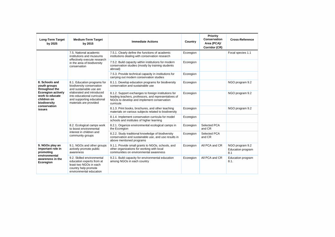
Long-Term Target by 2025
Medium-Term Target by 2015 Immediate Actions Country
Priority Conservation Area (PCA)/
Corridor (CR)
Cross-Reference
7.5.1. Clearly define the functions of academic institutions dealing with conservation research
Ecoregion Focal species 1.1
7.5.2. Build capacity within institutions for modern conservation studies (mostly by training students abroad)
Ecoregion
7.5. National academic institutions and museums effectively execute research in the area of biodiversity conservation
7.5.3. Provide technical capacity in institutions for carrying out modern conservation studies
Ecoregion
8.1.1. Develop education programs for biodiversity conservation and sustainable use
Ecoregion NGO program 9.2
8.1.2. Support exchanges to foreign institutions for leading teachers, professors, and representatives of NGOs to develop and implement conservation curricula
Ecoregion NGO program 9.2
8.1.3. Print books, brochures, and other teaching materials on various subjects related to biodiversity
Ecoregion NGO program 9.2
8.1. Education programs for biodiversity conservation and sustainable use are elaborated and introduced into educational curricula and supporting educational materials are provided
8.1.4. Implement conservation curricula for model schools and institutes of higher learning
Ecoregion
8.2.1. Organize environmental ecological camps in the Ecoregion
Ecoregion Selected PCA and CR
8. Schools and youth groups throughout the Ecoregion actively work to educate children on biodiversity conservation issues
8.2. Ecological camps work to boost environmental interest in children and community groups 8.2.2. Study traditional knowledge of biodiversity
conservation and sustainable use, and use results in above mentioned programs
Ecoregion Selected PCA and CR
9.1. NGOs and other groups actively promote public awareness
9.1.1. Provide small grants to NGOs, schools, and other organizations for working with local communities on environmental awareness
Ecoregion All PCA and CR NGO program 9.2 Education program 8.1
9. NGOs play an important role in promoting environmental awareness in the Ecoregion
9.2. Skilled environmental education experts from at least two NGOs in each country help promote environmental education
9.2.1. Build capacity for environmental education among NGOs in each country
Ecoregion All PCA and CR Education program 8.1.
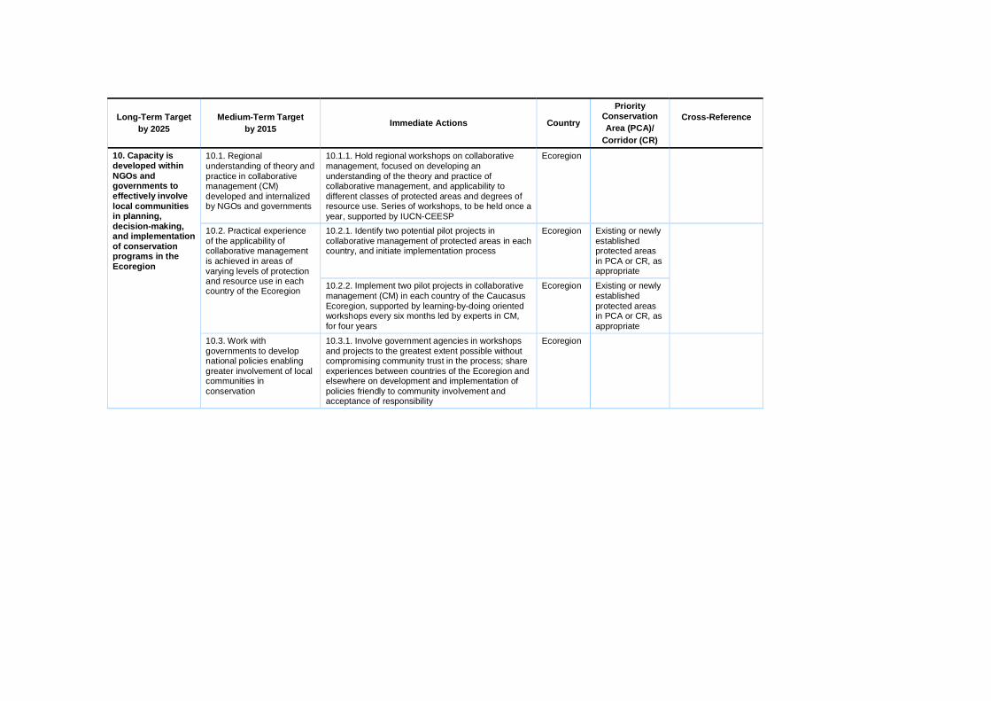
Long-Term Target by 2025
Medium-Term Target by 2015 Immediate Actions Country
Priority Conservation Area (PCA)/
Corridor (CR)
Cross-Reference
10.1. Regional understanding of theory and practice in collaborative management (CM) developed and internalized by NGOs and governments
10.1.1. Hold regional workshops on collaborative management, focused on developing an understanding of the theory and practice of collaborative management, and applicability to different classes of protected areas and degrees of resource use. Series of workshops, to be held once a year, supported by IUCN-CEESP
Ecoregion
10.2.1. Identify two potential pilot projects in collaborative management of protected areas in each country, and initiate implementation process
Ecoregion Existing or newly established protected areas in PCA or CR, as appropriate
10.2. Practical experience of the applicability of collaborative management is achieved in areas of varying levels of protection and resource use in each country of the Ecoregion 10.2.2. Implement two pilot projects in collaborative
management (CM) in each country of the Caucasus Ecoregion, supported by learning-by-doing oriented workshops every six months led by experts in CM, for four years
Ecoregion Existing or newly established protected areas in PCA or CR, as appropriate
10. Capacity is developed within NGOs and governments to effectively involve local communities in planning, decision-making, and implementation of conservation programs in the Ecoregion
10.3. Work with governments to develop national policies enabling greater involvement of local communities in conservation
10.3.1. Involve government agencies in workshops and projects to the greatest extent possible without compromising community trust in the process; share experiences between countries of the Ecoregion and elsewhere on development and implementation of policies friendly to community involvement and acceptance of responsibility
Ecoregion
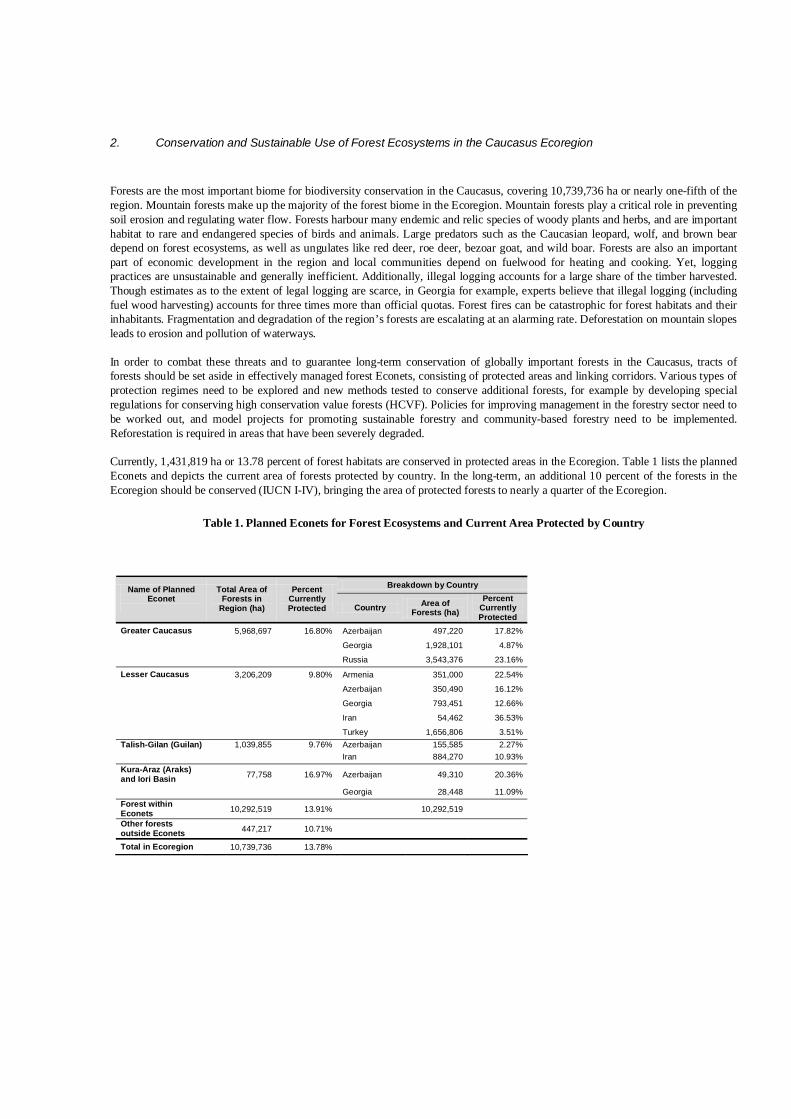
2. Conservation and Sustainable Use of Forest Ecosystems in the Caucasus Ecoregion
Forests are the most important biome for biodiversity conservation in the Caucasus, covering 10,739,736 ha or nearly one-fifth of the region. Mountain forests make up the majority of the forest biome in the Ecoregion. Mountain forests play a critical role in preventing soil erosion and regulating water flow. Forests harbour many endemic and relic species of woody plants and herbs, and are important habitat to rare and endangered species of birds and animals. Large predators such as the Caucasian leopard, wolf, and brown bear depend on forest ecosystems, as well as ungulates like red deer, roe deer, bezoar goat, and wild boar. Forests are also an important part of economic development in the region and local communities depend on fuelwood for heating and cooking. Yet, logging practices are unsustainable and generally inefficient. Additionally, illegal logging accounts for a large share of the timber harvested. Though estimates as to the extent of legal logging are scarce, in Georgia for example, experts believe that illegal logging (including fuel wood harvesting) accounts for three times more than official quotas. Forest fires can be catastrophic for forest habitats and their inhabitants. Fragmentation and degradation of the region’s forests are escalating at an alarming rate. Deforestation on mountain slopes leads to erosion and pollution of waterways. In order to combat these threats and to guarantee long-term conservation of globally important forests in the Caucasus, tracts of forests should be set aside in effectively managed forest Econets, consisting of protected areas and linking corridors. Various types of protection regimes need to be explored and new methods tested to conserve additional forests, for example by developing special regulations for conserving high conservation value forests (HCVF). Policies for improving management in the forestry sector need to be worked out, and model projects for promoting sustainable forestry and community-based forestry need to be implemented. Reforestation is required in areas that have been severely degraded. Currently, 1,431,819 ha or 13.78 percent of forest habitats are conserved in protected areas in the Ecoregion. Table 1 lists the planned Econets and depicts the current area of forests protected by country. In the long-term, an additional 10 percent of the forests in the Ecoregion should be conserved (IUCN I-IV), bringing the area of protected forests to nearly a quarter of the Ecoregion.
Table 1. Planned Econets for Forest Ecosystems and Current Area Protected by Country
Breakdown by Country Name of Planned Econet
Total Area of Forests in
Region (ha)
Percent Currently Protected Country Area of
Forests (ha) Percent
Currently Protected
Greater Caucasus 5,968,697 16.80% Azerbaijan 497,220 17.82%
Georgia 1,928,101 4.87%
Russia 3,543,376 23.16%
Lesser Caucasus 3,206,209 9.80% Armenia 351,000 22.54%
Azerbaijan 350,490 16.12%
Georgia 793,451 12.66%
Iran 54,462 36.53%
Turkey 1,656,806 3.51% Talish-Gilan (Guilan) 1,039,855 9.76% Azerbaijan 155,585 2.27% Iran 884,270 10.93% Kura-Araz (Araks) and Iori Basin 77,758 16.97% Azerbaijan 49,310 20.36%
Georgia 28,448 11.09% Forest within Econets 10,292,519 13.91% 10,292,519
Other forests outside Econets 447,217 10.71%
Total in Ecoregion 10,739,736 13.78%
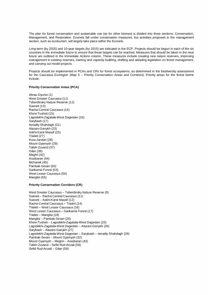
The plan for forest conservation and sustainable use (as for other biomes) is divided into three sections: Conservation, Management, and Restoration. Econets fall under conservation measures, but activities proposed in the management section, such as ecotourism, will largely take place within the Econets. Long-term (by 2025) and 10-year targets (by 2015) are indicated in the ECP. Projects should be begun in each of the six countries in the immediate future to ensure that these targets can be reached. Measures that should be taken in the near future are outlined in the Immediate Actions column. These measures include creating new nature reserves, improving management in existing reserves, training and capacity building, drafting and adopting legislation on forest management, and carrying out model projects. Projects should be implemented in PCAs and CRs for forest ecosystems, as determined in the biodiversity assessment for the Caucasus Ecoregion (Map 5 – Priority Conservation Areas and Corridors). Priority areas for the forest biome include: Priority Conservation Areas (PCA) Abrau-Dyurso (1) West Greater Caucasus (11) Teberdinsky Nature Reserve (12) Svaneti (13) Racha-Central Caucasus (14) Khevi-Tusheti (15) Lagodekhi-Zagatala-West Dagestan (16) Sarybash (17) Ismailly-Shahdagh (21) Alazani-Ganykh (23) Askhi-Karst Massif (25) Trialeti (27) Kura-Jandari (28) Mount Gyamysh (29) Talish-Zuvand (37) Gilan (39) Meghri (42) Arasbaran (44) Bichanek (45) Pambak-Sevan (50) Sarikamis Forest (53) West Lesser Caucasus (54) Manglisi (55) Priority Conservation Corridors (CR) West Greater Caucasus – Teberdinsky Nature Reserve (9) Svaneti – Racha-Central Caucasus (11) Svaneti – Askhi-Karst Massif (12) Racha-Central Caucasus – Trialeti (14) Trialeti – West Lesser Caucasus (16) West Lesser Caucasus – Sarikamis Forest (17) Trialeti – Manglisi (18) Manglisi – Pambak-Sevan (20) Khevi-Tusheti – Lagodekhi-Zagatala-West Dagestan (23) Lagodekhi-Zagatala-West Dagestan – Alazani-Ganykh (26) Sarybash – Alazani-Ganykh (27) Lagodekhi-Zagatala-West Dagestan – Sarybash – Ismailly-Shahdagh (29) Pambak-Sevan – Mount Gyamysh (32) Mount Gyamysh – Meghri – Arasbaran (43) Talish-Zuvand – Sefid Rud-Anzali (58) Sefid Rud-Anzali – Gilan (59)

Since many of the PCAs and CRs are found along mountain systems and in valleys, parts of this section overlap with the high mountain and freshwater conservation plans. Measures in the institutional development and capacity building plan also pertain to forest ecosystems. Cross-references are listed where appropriate in the last column of the table below.
B. PLAN FOR CONSERVATION AND SUSTAINABLE USE OF FOREST ECOSYSTEMS IN THE CAUCASUS ECOREGION
Long-Term Target by 2025
Medium-Term Target by 2015
Immediate Actions by 2010 Country
Priority Conservation Area (PCA)/
Corridor (CR)
Cross-Reference
Conservation
1.1.1. Identify representative forest types and carry out gap analysis of current protected areas system
Azerbaijan Georgia Russia
PCA 11, 12, 13, 14, 15, 16, 17, 18, 21 CR 11, 12, 14, 16, 23, 26, 27, 29
High mountain 1.1
1.1.2. Identify and assess current and potential threats to forest biodiversity
Azerbaijan Georgia Russia
The same PCA and CR
High mountain
1.1. Framework for Greater Caucasus Econet is established
1.1.3. Elaborate plan/guidelines for creation of the Greater Caucasus Econet
Azerbaijan Georgia Russia
The same PCA and CR
High mountain 1.1
1.2.1. Improve management of Zagatala, Ilisu, Pirgulu, Ismailly, and Turyanchay strict nature reserves
Azerbaijan PCA 17 Focal species 6.1.1, 8.2.1
1.2.2. Create Shahdagh National Park and Sheki Nature Park
Azerbaijan PCA 21 CR 29
High mountain 1.2.1
1.2.3. Create the Racha National Park Georgia PCA 14 High mountain 1.2.2 Focal species 6.1.2
1.2.4. Establish the Svaneti National Park Georgia PCA 13 High mountain 1.2.3 Focal species 6.1.2
1.2.5. Establish Khevsureti Sanctuary Georgia PCA 15 High mountain 1.2.4, 2.2.10 Focal species 6.1.2, 8.2.1
1.2.6. Create nature park in Krasnodar Region Russia PCA 11 High mountain 1.1
1. Representative forests and associated biodiversity of the Greater Caucasus Range are effectively preserved in a network of protected areas and linking corridors (Econet)
1.2. Half of Greater Caucasus Econet is created – an additional 150,000 ha of forests is conserved and management is improved on at least 100,000 ha of existing protected areas in the Greater Caucasus
1.2.7. Create nature park in Karachaevo-Cherkessiya
Russia PCA 11, 12 CR 9, 10
High mountain 1.1

Long-Term Target by 2025
Medium-Term Target by 2015 Immediate Actions Country
Priority Conservation Area (PCA)/
Corridor (CR)
Cross-Reference
1.2.8. Establish four new sanctuaries in Krasnodar Region
Russia PCA 11
1.2.9. Establish three sanctuaries in Dagestan Russia PCA 16, 19 High mountain Freshwater
1.2.10. Establish transregional park between Northern Osetiya and Kabardino-Balkariya
Russia PCA 14 High mountain 1.2.8
1.2.11. Upgrade status of Tlyaratinsky Sanctuary to strict nature reserve
Russia PCA 16 High mountain 1.2.9 Focal species 6.1.1, 7.2.5
1.2.12. Establish biosphere polygon for Teberdinsky Nature Reserve
Russia PCA 12 High mountain 1.2.7 Focal species 6.1.1
1.2.13. Create additional protected areas and connecting corridors as outlined by Econet Plan
Azerbaijan Georgia Russia
Selected PCA and CR
High mountain and Freshwater Econets
1.3.1. Establish the Northwestern Caucasus Transboundary Reserve
Georgia Russia
PCA 11 High mountain 1.3.1 1.3. At least two transboundary protected areas are established as part of the Greater Caucasus Econet
1.3.2. Create the Eastern Greater Caucasus Transboundary Reserve
Azerbaijan Georgia Russia
PCA 16 High mountain 1.3.2 Focal species 6.1.1
1.4.1. Work with local communities to build support for protected areas
Azerbaijan Georgia Russia
Selected regions of Greater Caucasus Econet
High mountain 1.4.1
1.4. Public support for the Greater Caucasus Econet is evidenced by a decrease in poaching and illegal logging 1.4.2. Publish informational materials to distribute in
local communities and to visitors Azerbaijan Georgia Russia
Selected regions of Greater Caucasus Econet
High mountain 1.4.2

Long-Term Target by 2025
Medium-Term Target by 2015 Immediate Actions Country
Priority Conservation Area (PCA)/
Corridor (CR)
Cross-Reference
2.1.1. Complete gap and threat analysis in the Lesser Caucasus
Armenia Azerbaijan Georgia Iran Turkey
PCA 27, 29, 42, 44, 50, 53, 54, 55 CR 14, 16, 17, 18, 20, 32, 43
Freshwater 1.2.9 High mountain 2.1
2.1. Framework for Lesser Caucasus Econet is established
2.1.2. Elaborate plan/guidelines for creation of the Lesser Caucasus Econet
Armenia Azerbaijan Georgia Iran Turkey
PCA 27, 29, 42, 44, 50, 53, 54, 55 CR 14, 16, 17, 18, 20, 32, 43
Freshwater 1.1 High mountain 2.1
2.2.1. Create new protected area in southern Armenia for protection of forests and focal species
Armenia PCA 42, 43 CR 42, 43
High mountain 2.1, 2.2.5 Focal species 3.2.1, 7.2.1, 11.2.3
2.2.2. Continue improving protection regime and management of Shikahogh and Khosrov strict nature reserves
Armenia PCA 42, 43, 49 High mountain 2.1 Focal species 3.2.1, 7.2.3, 11.2.2
2.2.3. Elaborate management plan for protected area complex in the Dsegh-Haghartsin-Pambak region with participation of local communities
Armenia PCA 50
2.2.4. Create a corridor between the Khosrov and Zangezur ranges in southern Armenia to allow animal migrations
Armenia CR 40, 41 High mountain 2.2.5
2.2.5. Create the Goygol (Gey-Gel) National Park based on Goygol (Gey-Gel) Strict Nature Reserve
Azerbaijan PCA 29
2.2.6. Strengthen management of Shahbuz Strict Nature Reserve
Azerbaijan PCA 45 High mountain 2.2.7
2. Representative forests and associated biodiversity of the Lesser Caucasus Range are effectively preserved in a network of protected areas and linking corridors (Econet)
2.2. Half of Lesser Caucasus Econet is created, an additional 100,000 ha of forests is conserved and management is improved on at least 100,000 ha of existing protected areas in the Lesser Caucasus
2.2.7. Improve protection of Kintrishi Strict Nature Reserve and Ajameti Strict Nature Reserve
Georgia PCA 54

Long-Term Target by 2025
Medium-Term Target by 2015 Immediate Actions Country
Priority Conservation Area (PCA)/
Corridor (CR)
Cross-Reference
2.2.8. Establish the Nedzvi and Tetrobi sanctuaries in the support zone of Borjomi-Kharagauli National Park
Georgia PCA 27
2.2.9. Create a protected area between Borjomi-Kharagauli National Park and Kintrishi Strict Nature Reserve
Georgia PCA 27, 54 CR 16
2.2.10. Create a protected area to conserve oak forests in the Tetritskaro Region
Georgia CR 20
2.2.11. Establish the Mtirala Regional Park in the Ajara Autonomous Republic
Georgia PCA 54
2.2.12. Plan a national park in the Erusheti Range Georgia PCA 54
2.2.13. Improve protection of the Arasbaran Nature Reserve (MAB) in Iran
Iran PCA 44
2.2.14. Improve management and increase size of protected areas in Camili (Gorgit and Efeler nature reserves)
Turkey PCA 54
2.2.15. Establish visitors centers in existing national parks in the Turkish Caucasus
Turkey PCA 54
2.2.16. Elaborate management plan for at least one existing national park and improve management practices
Turkey PCA 54
2.2.17. Create new protected area in the Sarikamis Forest PCA
Turkey PCA 53 CR 22
Focal species 5.1.4
2.2.18. Create new protected area in the Yalnizcam Mountains (Important Plant Area)
Turkey CR 17 Focal species 5.1.4
2.2.19. Establish ecological corridors linking existing protected areas in the Dogu Karadeniz Mountains
Turkey PCA 54 Focal species 5.1.4

Long-Term Target by 2025
Medium-Term Target by 2015 Immediate Actions Country
Priority Conservation Area (PCA)/
Corridor (CR)
Cross-Reference
2.2.20. Create additional protected areas and connecting corridors as outlined by Econet Plan
Armenia Azerbaijan Georgia Iran Turkey
Selected PCA and CR
High mountain 2.1
2.3. Create at least one transboundary reserve in the Lesser Caucasus Econet
2.3.1. Explore feasibility of creating a transboundary protected area on the border of Georgia/Turkey
Georgia Turkey
PCA 54
2.4.1. Work with local communities to build support for protected areas
Azerbaijan Armenia Georgia Iran Turkey
Selected PCA and CR in the Lesser Caucasus
Freshwater 1.4.1 High mountain 2.4.1 Focal species 3, 7, 11
2.4. Public support for the Lesser Caucasus Econet is evidenced by a decrease in poaching and illegal logging
2.4.2. Publish informational materials to distribute in local communities and to visitors
Azerbaijan Armenia Georgia Iran Turkey
Selected PCA and CR in the Lesser Caucasus
Freshwater 1.4.2 High mountain 2.4.2

Long-Term Target by 2025
Medium-Term Target by 2015 Immediate Actions Country
Priority Conservation Area (PCA)/
Corridor (CR)
Cross-Reference
3.1.1. Identify representative forest types and carry out gap analysis in current protected areas system in the Talish-Gilan (Guilan) Region
Azerbaijan Iran
PCA 37, 39 CR 58, 59
Focal species 3.1
3.1.2. Identify and assess current and potential threats to forest biodiversity
Azerbaijan Iran
PCA 37, 39 CR 58, 59
3.1. Framework for Talish-Gilan (Guilan) Econet is established
3.1.3. Elaborate plan/guidelines for creation of the Talish-Gilan (Guilan) Econet
Azerbaijan Iran
PCA 37, 39 CR 58, 59
Freshwater 4.1.1
3.2.1. Elaborate management plan and establish infrastructure of the Hirkan National Park
Azerbaijan PCA 37
Focal species 3.2.1, 8.3.1
3.2.2. Work with local communities to create at least one Community Conservation Area (CCA)
Iran PCA 37, 39, 56 CR 57, 58, 59, 60
3.2. Half of Talish-Gilan (Guilan) Econet is created, an additional 50,000 ha of forests is conserved and management is improved on at least 50,000 ha of existing protected areas in Talish-Gilan 3.2.3. Create additional protected areas and
connecting corridors as outlined by Econet Plan Azerbaijan Iran
Selected PCA and CR
Focal species 3.1
3.3.1. Create a transboundary protected area to conserve forests and important leopard habitat
Azerbaijan Iran
PCA 37, 41 Focal species 3.1.4 3.3. Transboundary initiatives for conservation of forests in the Talish-Gilan (Guilan) Econet are in place 3.3.2. Create additional protected areas and
connecting corridors between Azerbaijan and Iran as outlined by Econet Plan
Azerbaijan Iran
PCA 37, 39 CR 58, 59
Focal species 3.1.4, 3.1.5
3.4.1. Work with local communities to build support for protected areas
Azerbaijan Iran
PCA 37, 39 CR 58, 59
3. Representative forests and associated biodiversity of the Talish-Gilan (Guilan) (Western Alborz) Region are effectively preserved in a network of protected areas and linking corridors (Econet)
3.4. Public support for the Talish-Gilan (Guilan) Econet is evidenced by a decrease in poaching and illegal logging
3.4.2. Publish informational materials to distribute in local communities and to visitors
Azerbaijan Iran
PCA 37, 39 CR 58, 59

Long-Term Target by 2025
Medium-Term Target by 2015 Immediate Actions Country
Priority Conservation Area (PCA)/
Corridor (CR)
Cross-Reference
4.1.1. Improve management of Garayazy Strict Nature Reserve
Azerbaijan PCA 28 Freshwater 4.1.3
4.1.2. Develop management plan and infrastructure of Eldar Pine Strict Nature Reserve
Azerbaijan PCA 22 Freshwater 4.1.3
4.1.3. Improve conservation and management of four sanctuaries in floodplain forests of Eastern Georgia
Georgia PCA 22 Freshwater 4.1.3
4.1. An additional 5,000 ha of forests and open woodlands are protected in the Kura-Araz (Araks) Lowlands and Iori basin and conservation in 50,000 ha of existing reserves is improved
4.1.4. Create additional protected areas and connecting corridors as needed in coordination with freshwater conservation plan
Azerbaijan Georgia
Selected PCA and CR
Freshwater 4.1
4.2.1. Create a transboundary protected area in floodplain forests of the Kura River Valley (Gardabani Sanctuary in Georgia and Garayazy Nature Reserve and Garayazy-Agstafa Sanctuary in Azerbaijan)
Azerbaijan Georgia
PCA 28 Freshwater 4.1 4.2 Transboundary initiatives for conservation of forests in the Kura- Araz (Araks) Lowlands and Iori Basin are in place
4.2.2. Establish transboundary cooperation in Iori River Basin (Eldar Pine Strict Nature Reserve, Azerbaijan, and Chachuna Sanctuary, Georgia)
Azerbaijan Georgia
PCA 22 Freshwater 4.1.3 Focal species 4.1.4
4.3.1. Work with local communities to build support for protected areas
Azerbaijan Georgia
PCA 22, 28 Freshwater 1.4.1 High mountain 2.4.1
4. Representative forests in the Kura-Araz (Araks) Lowlands and Iori Basin are conserved in protected areas of various types
4.3. Public support for the Kura-Araz (Araks) Lowlands and Iori Basin is evidenced by a decrease in poaching and illegal logging
4.3.2. Publish informational materials to distribute in local communities and to visitors
Azerbaijan Georgia
PCA 22, 28 Freshwater

Long-Term Target by 2025
Medium-Term Target by 2015 Immediate Actions Country
Priority Conservation Area (PCA)/
Corridor (CR)
Cross-Reference
Management
5.1.1. Hold conference with decision-makers, managers of forestry enterprises, and other stakeholders on sustainable forestry and conservation in the Ecoregion
Ecoregion
All forest PCA and CR
5.1.2. Assess the current state of forests and forest management practices in the Ecoregion
Ecoregion
All forest PCA and CR
5.1. An Ecoregion-wide concept on conservation and sustainable use of forests is adopted and implemented
5.1.3. Elaborate Ecoregion-wide concept of sustainable forest management in a participatory manner and obtain approval of stakeholders in all six countries
Ecoregion
All forest PCA and CR
5.2.1. Develop and get approval for methodology to identify, inventory, classify, and designate HCVF in at least three countries of the Ecoregion
Ecoregion/ Selected countries
Selected PCA and CR
5.2.2. Draft guidelines on identification of forests according to HCVF criteria in at least three countries
Ecoregion/ Selected countries
Selected PCA and CR
5.2.3. Conduct training in delineation of HCVF for forest management agencies and enterprises in at least three countries
Ecoregion/ Selected countries
Selected PCA and CR
5.2. A normative framework for using HCVF as a means of good forest management practice is established
5.2.4. Identify HCVF in at least three countries and instate corresponding management practices
Ecoregion/ Selected countries
Selected PCA and CR
5. Forests are managed effectively, widespread illegal logging is eliminated and conservation of biodiversity is taken into account in forestry practices
5.3. Illegal logging and timber trade levels are cut by half in forest PCA and CR
5.3.1. Assess impacts and extent of illegal logging in at least three countries
Ecoregion/ Selected countries
Selected PCA and CR

Long-Term Target by 2025
Medium-Term Target by 2015 Immediate Actions Country
Priority Conservation Area (PCA)/
Corridor (CR)
Cross-Reference
5.3.2. Identify and disseminate information on best practices of forest management and law enforcement for prevention of illegal logging in at least three countries
Ecoregion/ Selected countries
Selected PCA and CR
5.3.3. Provide information on and options for improved policy and practice in timber-producing and/or timber-consuming countries, such as measures to address trade in illegally harvested timber and timber products in at least three countries
Ecoregion/ Selected countries
Selected PCA and CR
5.3.4. Promote development of effective independent monitoring system of illegal logging timber trade in at least three countries
Ecoregion/ Selected countries
Selected PCA and CR
5.3.5. Halt construction of additional roads and close some existing roads to stop illegal logging
Iran PCA 37, 39, 44
5.4.1. Launch public awareness campaign against illegal logging in the Ecoregion
Ecoregion
All forest PCA and CR
5.4.2. Ensure public access to information on state of forests and logging operations
Ecoregion
5.4.3. Rate timber companies according to their environmental records and distribute information to buyers
Georgia Iran Russia
Selected PCA and CR
5.4.4. Carry out independent inspections and publicize findings of operations in two of timber enterprises in each country
Ecoregion Selected PCA and CR
5.4. Openness of logging operations and accounting procedures is adopted in all timber enterprises
5.4.5. Launch international awareness campaign against illegal logging and trade in consumer markets
Russia and Europe
Selected PCA and CR

Long-Term Target by 2025
Medium-Term Target by 2015 Immediate Actions Country
Priority Conservation Area (PCA)/
Corridor (CR)
Cross-Reference
5.5.1. Obtain approval and commitment of at least two timber harvesting enterprises to adopt methods of sustainable forest management
Georgia Russia
Selected PCA and CR
5.5.2. Establish demonstration forest on a model site adjacent to the Borjomi-Kharagauli National Park
Georgia PCA 27
5.5.3. Establish two model forests in mountain regions of the North Caucasus
Russia PCA 11
5.5.4. Integrate biodiversity conservation into forest management in at least one forest management unit
Turkey PCA 54
5.5. Sustainable forestry is practiced in one-third of commercial forests in the Ecoregion
5.5.5. Develop and implement model project on sustainable forest management in at least one forest management unit in the Turkish Caucasus
Turkey PCA 53
5.6.1. Prepare framework for community-based forestry
Selected country or countries
PCA 27, 37, 39, 44
5.6. Successful models of community-based forestry are functioning in each country
5.6.2. Launch model projects on community-based forestry in specific countries
Selected country or countries
PCA 27, 37, 39, 44
6.1.1. Prepare feasibility study for implementing FSC certification in all countries, develop and submit follow-up project proposals to relevant donors
Ecoregion Forest PCA and CR
6. Forest certification is established and functioning in the Caucasus Ecoregion according to international standards
6.1. Capacity for voluntary forest certification is created in the Ecoregion
6.1.2. Lobby relevant agencies/stakeholders to implement FSC
Ecoregion Selected PCA and CR

Long-Term Target by 2025
Medium-Term Target by 2015 Immediate Actions Country
Priority Conservation Area (PCA)/
Corridor (CR)
Cross-Reference
7.1.1. Elaborate program for use of non-timber forest products in at least three model areas
Selected countries
Selected PCA and CR
High mountain 5.1
7.1.2. Begin implementation of five model projects on sustainably collecting and raising useful forest plants
Armenia Azerbaijan Georgia
Selected PCA and CR
High mountain 5.1
7.1. Non-timber forest products play a viable role in the economies of six model communities
7.1.3. Promote sustainable production of commercial species
Turkey PCA 52, 54 CR 17
7.2.1. Carry out model project on sustainable grazing in forests
Iran Turkey
Selected PCA and CR
High mountain 4.1.5, 4.1.6
7. Alternatives to timber production play a viable role in the economy of model forest communities
7.2. Community-based resource management relieves pressures on forests in six model areas 7.2.2. Provide small grants to at least one NGO in
each country to develop alternative livelihoods in forest communities in PCA and CR
Ecoregion Selected PCA and CR
High mountain
8.1.1. Elaborate participatory plans for developing ecotourism in two-three selected sites in each country
Ecoregion Selected PCA and CR
High mountain 6.1.1
8.1.2. Develop capacity for model projects on ecotourism
Ecoregion Selected PCA and CR
High mountain 6.1.2
8. Ecotourism is a viable source of income in model forest communities in each country
8.1. Framework and capacity for sustainable ecotourism in forest ecosystems are in place and integrated into reserve planning
8.1.3. Launch model projects in selected sites Ecoregion PCA 12, 27, 43, 37, 54
High mountain 6.2.1
Restoration
9.1.1. Develop FLR plans for one lowland/floodplain PCA and one CR
Selected countries
Selected PCA and CR
9. The area of forests is increased using native species in forest PCA and CR in the Ecoregion
9.1. Detailed Forest Landscape Restoration (FLR) plans with clear biodiversity and socio-economic goals are prepared for at least two model PCA and two CR
9.1.2. Develop FLR plans for one mountain PCA and one CR
Selected countries
Selected PCA and CR

Long-Term Target by 2025
Medium-Term Target by 2015 Immediate Actions Country
Priority Conservation Area (PCA)/
Corridor (CR)
Cross-Reference
9.2.1. Analyze existing forest restoration practices in the Ecoregion
Selected countries
Selected PCA and CR
9.2. Governments of at least two countries have implemented policies consistent with FLR 9.2.2. Organize regional seminar on FLR for
stakeholders and develop recommendations for elaborating governmental policies consistent with FLR
Ecoregion Ecoregion
9.3.1. Develop and begin implementation of at least one model project on FLR with participation of local communities
Armenia PCA 42, 43, 50 CR 20, 32, 42, 43
9.3.2. Launch campaign to reduce forest fires in Armenia
Armenia PCA 42, 43, 50 CR 20, 32, 42, 43
9.3.3. Elaborate and begin implementing model projects to reduce the area affected by forest pests and disease in Armenia
Armenia PCA 42, 43, 50 CR 20, 32, 42, 43
9.3. The area of planted forests is increased in Armenia by 4,000 ha
9.3.4. Develop and begin implementing measures for controlling invasive species
Armenia PCA 42, 43, 50 CR 20, 32, 42, 43
9.4.1. Develop a program for forest restoration taking into account climate change
Azerbaijan Selected PCA and CR
9.4.2. Begin to restore degraded forests in the Greater Caucasus, Talish, and Kura-Araz (Araks) Lowlands
Azerbaijan PCA 19, 23, 28, 37 CR 26, 27
9.4.3. Select and begin restoring model territory of subalpine forests
Azerbaijan Appropriate PCA and CR
9.4.4. Elaborate strategy for conservation and restoration of relic forests in the Samur-Devechi floodplain of Azerbaijan
Azerbaijan PCA 19 Marine 1.2.1, 1.3.1
9.4. Forest cover is increased in Azerbaijan by 75,000 ha
9.4.5. Begin afforestation projects to create contiguous forest cover in northern Gobustan
Azerbaijan PCA 31

Long-Term Target by 2025
Medium-Term Target by 2015 Immediate Actions Country
Priority Conservation Area (PCA)/
Corridor (CR)
Cross-Reference
9.4.6. Plant forests on the Caspian coast Azerbaijan Selected PCA
9.4.7. Begin at least one model project on FLR with participation of local communities
Azerbaijan Selected PCA and/or CR
9.5. At least two model projects on FLR are implemented in Georgia
9.5.1. Elaborate and begin implementation of model projects on FLR with participation of local communities
Georgia Selected PCA and/or CR
9.6. At least 100,000 ha of forests are restored in the Iranian Caucasus
9.6.1. Begin model project on forest restoration in the Abbas Abad Region
Iran PCA 37, 39, 44 CR 43, 58, 59
9.7.1. Encourage governmental institutions and NGOs to adopt FLR approach
Turkey All PCA and CR in the Turkish Caucasus
9.7.2. Carry out gap and threat analysis, identify and map target FLR sites
Turkey PCA 53, 54 CR 17
9.7.3. Develop socio-economic and ecological criteria and indicators for tracking progress with FLR
Turkey Selected PCA or CR
9.7. At least 10 percent of degraded forests are restored in the Turkish Caucasus through FLR projects
9.7.4. Initiate at least one FLR project in a PCA in the Turkish Caucasus
Turkey
9.8.1. Carry out gap and threat analysis, identify and map target FLR sites
Russia Selected PCA and CR
9.8.2. Develop regional socio-economic and ecological criteria and indicators for tracking progress of FLR
Russia Selected PCA and CR
9.8.3. Initiate at least one FLR project in a PCA in the Russian Caucasus
Russia Selected PCA and CR
9.8. At least 10 percent of degraded forests are restored in the Russian Caucasus through FLR projects
9.8.4. Initiate other forest restoration projects in the Caspian coastal zone
Russia Selected PCA and CR
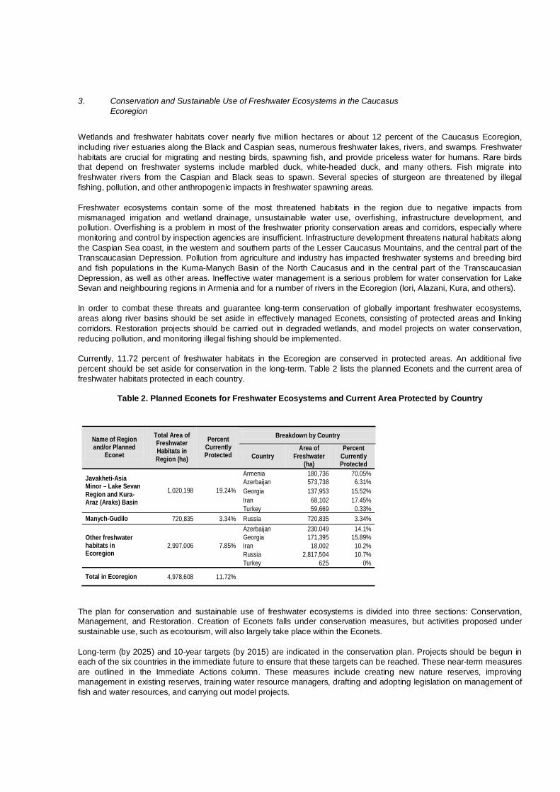
3. Conservation and Sustainable Use of Freshwater Ecosystems in the Caucasus Ecoregion
Wetlands and freshwater habitats cover nearly five million hectares or about 12 percent of the Caucasus Ecoregion, including river estuaries along the Black and Caspian seas, numerous freshwater lakes, rivers, and swamps. Freshwater habitats are crucial for migrating and nesting birds, spawning fish, and provide priceless water for humans. Rare birds that depend on freshwater systems include marbled duck, white-headed duck, and many others. Fish migrate into freshwater rivers from the Caspian and Black seas to spawn. Several species of sturgeon are threatened by illegal fishing, pollution, and other anthropogenic impacts in freshwater spawning areas. Freshwater ecosystems contain some of the most threatened habitats in the region due to negative impacts from mismanaged irrigation and wetland drainage, unsustainable water use, overfishing, infrastructure development, and pollution. Overfishing is a problem in most of the freshwater priority conservation areas and corridors, especially where monitoring and control by inspection agencies are insufficient. Infrastructure development threatens natural habitats along the Caspian Sea coast, in the western and southern parts of the Lesser Caucasus Mountains, and the central part of the Transcaucasian Depression. Pollution from agriculture and industry has impacted freshwater systems and breeding bird and fish populations in the Kuma-Manych Basin of the North Caucasus and in the central part of the Transcaucasian Depression, as well as other areas. Ineffective water management is a serious problem for water conservation for Lake Sevan and neighbouring regions in Armenia and for a number of rivers in the Ecoregion (Iori, Alazani, Kura, and others). In order to combat these threats and guarantee long-term conservation of globally important freshwater ecosystems, areas along river basins should be set aside in effectively managed Econets, consisting of protected areas and linking corridors. Restoration projects should be carried out in degraded wetlands, and model projects on water conservation, reducing pollution, and monitoring illegal fishing should be implemented. Currently, 11.72 percent of freshwater habitats in the Ecoregion are conserved in protected areas. An additional five percent should be set aside for conservation in the long-term. Table 2 lists the planned Econets and the current area of freshwater habitats protected in each country.
Table 2. Planned Econets for Freshwater Ecosystems and Current Area Protected by Country
Breakdown by Country Name of Region and/or Planned
Econet
Total Area of Freshwater Habitats in Region (ha)
Percent Currently Protected Country
Area of Freshwater
(ha)
Percent Currently Protected
Armenia 180,736 70.05% Azerbaijan 573,738 6.31% Georgia 137,953 15.52% Iran 68,102 17.45%
Javakheti-Asia Minor – Lake Sevan Region and Kura-Araz (Araks) Basin
1,020,198 19.24%
Turkey 59,669 0.33% Manych-Gudilo 720,835 3.34% Russia 720,835 3.34%
Azerbaijan 230,049 14.1% Georgia 171,395 15.89% Iran 18,002 10.2% Russia 2,817,504 10.7%
Other freshwater habitats in Ecoregion
2,997,006 7.85%
Turkey 625 0%
Total in Ecoregion 4,978,608 11.72%
The plan for conservation and sustainable use of freshwater ecosystems is divided into three sections: Conservation, Management, and Restoration. Creation of Econets falls under conservation measures, but activities proposed under sustainable use, such as ecotourism, will also largely take place within the Econets. Long-term (by 2025) and 10-year targets (by 2015) are indicated in the conservation plan. Projects should be begun in each of the six countries in the immediate future to ensure that these targets can be reached. These near-term measures are outlined in the Immediate Actions column. These measures include creating new nature reserves, improving management in existing reserves, training water resource managers, drafting and adopting legislation on management of fish and water resources, and carrying out model projects.

Projects should be implemented in PCAs and CRs for freshwater ecosystems, as determined in the biodiversity assessment for the Caucasus Ecoregion (Map 5 – Priority Conservation Areas and Corridors). Priority areas for the freshwater biome include: Priority Conservation Areas (PCA) Abrau-Dyurso (1) Kuban (2) Primorsko-Akhtarsk (3) Yeysk (4) Don Delta (5) Veselovskoye Reservoir (6) Manych-Gudilo (7) Dadynskoye Lake (8) Kizlyarsky Bay (9) Samur-Yalama (19) Aghzibir (Akzybir) Lake (20) Iori-Mingechevir (Mingechaur) (22) Alazani-Ganykh (23) Rioni (26) Kura-Jandari (28) Varvara-Barda (30) Gobustan-Hajigabul (31) Makhmud Chala (34) Gyzyl-Agach (Gyzylaghaj) (35) Kura-Araz (Araks) Valley (36) Araz (Araks) Valley (38) Agri Dagi and Armash (48) Pambak-Sevan (50) Javakheti (51) Igdir Plain and Armavir (52) Sefid Rud-Anzali (56) Priority Conservation Corridors (CR) Primorsko-Akhtarsk – Kuban (2) Don Delta – Veselovskoye Reservoir (5) Veselovskoye Reservoir – Manych-Gudilo (6) Manych-Gudilo – Dadynskoye Lake (7) Javakheti – Igdir Plain and Armavir (21) Freshwater Igdir Plain and Armavir – Agri Dagi (Ararat) and Armash (34) Varvara-Barda – Kura-Araz (Araks) Valley (44) Kura-Araz (Araks) Valley – Makhmud Chala (49) Kura-Araz (Araks) Valley – Araz (Araks) Valley (50) Makhmud Chala – Gyzyl-Agach (Gyzylaghaj) (51) Alazani-Ganykh – Iori-Mingechevir (Mingechaur) (28) Since many of the freshwater PCAs and CRs are found near coastal systems and in mountains and forested valleys, parts of this section overlap with the marine and forest conservation plans. Measures in the institutional development and capacity building plan will also impact freshwater ecosystems. Cross-references are listed where appropriate in the last column of the conservation plan.

C. PLAN FOR CONSERVATION AND SUSTAINABLE USE OF FRESHWATER ECOSYSTEMS IN THE CAUCASUS ECOREGION
Long-Term Target by 2025
Medium-Term Target by 2015
Immediate Actions by 2010
Country Priority Area
(PCA)/ Corridor (CR)
Cross-Reference
Conservation
1.1. Framework for protection of freshwater habitats in the Lesser Caucasus – Javakheti-Asia Minor Region is established
1.1.1. Elaborate plan/guidelines for creation of protected areas and corridors in the Lesser Caucasus and Javakheti-Asia Minor Regions
Armenia Azerbaijan Georgia Iran Turkey
PCA 22, 23, 28, 30, 34, 36, 38, 48, 50, 51, 52 CR 21, 28, 34, 44, 49, 50, 51
Forest 2.1 High mountain 2.1
1.2.1. Improve management of Sevan National Park Armenia PCA 50
1.2.2. Create Lake Arpi National Park and three sanctuaries in northwestern Armenia
Armenia PCA 51 Freshwater 4.1.5 High mountain 2.2.1
1.2.3. Create the Prikurinsky Strict Nature Reserve Azerbaijan PCA 33
1.2.4. Improve management of Ag-Gel (Aghgol) National Park
Azerbaijan PCA 36
1.2.5. Improve conservation of freshwater ecosystems and bird nesting areas in the Kura River Basin
Azerbaijan PCA 30, 34, 36
1.2.6. Create Javakheti National Park Georgia PCA 51 1.2.7. Create the Ktsia-Tabatskuri Sanctuary Georgia PCA 27 High mountain 2.2.9
1.2.8. Obtain legal status for potential freshwater protected areas in the Turkish Caucasus
Turkey
Selected PCA and CR
1. Representative freshwater habitats and associated biodiversity of the Javakheti-Asia Minor – Lake Sevan Region and Kura-Araz (Araks) Basin are effectively preserved in a network of protected areas and linking corridors (Econet)
1.2. New protected areas are created on at least 50,000 ha and management of existing protected areas is improved on at least 100,000 ha
1.2.9. Assess and create additional protected areas and connecting corridors as outlined by Econet Plan
Armenia Azerbaijan Georgia Iran Turkey
CR 21, 28, 34, 44, 49, 50, 51
Forest 2.1 High mountain 2.1

Long-Term Target by 2025
Medium-Term Target by 2015 Immediate Actions Country
Priority Conservation Area (PCA)/
Corridor (CR)
Cross-Reference
1.3. Establish pilot Community Conservation Areas (CCA) in each country
1.3.1. Establish at least two pilot CCAs Selected countries
Selected PCA and CR
1.4.1. Work with local communities to build support for protected areas
Armenia Azerbaijan Georgia Iran Turkey
Selected PCA and CR in Javakheti-Lake Sevan Region
Forest 2.4.1, 4.3.1 High mountain 2.4.1
1.4. Public support for conservation in the Javakheti-Asia Minor – Lake Sevan Region and Kura-Araz (Araks) Basin is evidenced by a decrease in poaching, illegal fishing, and other violations
1.4.2. Publish informational materials to distribute in local communities and to visitors
Armenia Azerbaijan Georgia Iran Turkey
Selected PCA and CR in Javakheti-Lake Sevan Region
High mountain 2.4.2
2.1. Framework for Manych-Gudilo Econet is established
2.1.1. Elaborate plan/guidelines for creation of the Manych-Gudilo Econet
Russia PCA 5, 6, 7, 8 CR 5, 6, 7
2.2.1. Establish two sanctuaries on Manych-Gudilo Reservoir
Russia PCA 7
2.2.2. Protect freshwater habitats and bird nesting areas in the Veselovskoye and Ust-Manych Reservoirs
Russia PCA 6 CR 6
2. Representative freshwater habitats and associated biodiversity of the Manych-Gudilo Region are effectively preserved in a network of protected areas and linking corridors (Econet)
2.2. New protected areas are created along the Manych-Gudilo Depression on at least 20,000 ha
2.2.3. Create additional protected areas and connecting corridors as outlined by Econet Plan
Russia PCA 5, 6, 7, 8 CR 5, 6, 7

Long-Term Target by 2025
Medium-Term Target by 2015 Immediate Actions Country
Priority Conservation Area (PCA)/
Corridor (CR)
Cross-Reference
2.3.1. Work with local communities to build support for protected areas
Russia PCA 5, 6, 7, 8 CR 5, 6, 7
2.3. Public support for the Manych-Gudilo Econet is evidenced by a decrease in poaching, illegal fishing, and other violations
2.3.2. Publish informational materials to distribute in local communities and to visitors
Russia PCA 5, 6, 7, 8 CR 5, 6, 7
3.1.1. Inventory important freshwater habitats and prepare recommendations for Ramsar sites in each country
Ecoregion PCA 2, 3, 4, 5, 6, 7, 8, 9, 19, 20, 22, 26, 28, 30, 31, 34, 35, 36, 38, 48, 50, 51, 52, 56
High mountain 3.1.1 – 3.1.7 Focal species 16, 17, 18
3.1.2. Begin to prepare documentation to nominate two sites in each country
Ecoregion The same PCAs See above
3.1. About 12 new sites in the Ecoregion are approved under the Ramsar Convention as Wetlands of International Importance
3.1.3. Obtain Ramsar status and begin to elaborate management plans for approved sites
Ecoregion The same PCAs See above
3.2.1. Complete IBA identification and delineation in freshwater ecosystems
Ecoregion The same PCAs High mountain 3.1.1 – 3.1.7 Focal species 16, 17, 18
3.2.2. Prepare and publish national IBA inventories Ecoregion The same PCAs See above
3.2.3. Develop IBA caretaker network and establish long-term monitoring in key freshwater habitats
Ecoregion The same PCAs See above
3.2.4. Promote the IBA concept at national and local levels
Ecoregion The same PCAs See above
3.2.5. Draft and adopt legislation granting status for IBAs
Ecoregion The same PCAs See above
3.2.6. Begin designation of IBAs as protected areas Ecoregion The same PCAs See above
3. All freshwater habitats of international importance (Ramsar sites and Important Bird Areas – IBAs) are granted protection (IUCN I-IV)
3.2. Legislative basis for conservation of Important Bird Areas (IBAs) in freshwater habitats is established and one-third of freshwater IBAs are protected
3.2.7. Integrate IBAs into other national and regional policies (EIAs, relevant legislation, environmental and development plans, strategies)
Ecoregion The same PCAs See above

Long-Term Target by 2025
Medium-Term Target by 2015 Immediate Actions Country
Priority Conservation Area (PCA)/
Corridor (CR)
Cross-Reference
4.1.1. Elaborate transboundary program to conserve rivers and streams in the Talish Mountain Range
Azerbaijan Iran
PCA 37 Forest 3.1.3
4.1.2. Develop transboundary program to conserve rivers and streams in the eastern Greater Caucasus and on the Caspian Sea coast
Azerbaijan Russia
PCA 19 Forest 1.2.13 Marine 2.1.1, 2.2.1, 2.2.2
4.1.3. Develop and begin implementation of program for conservation of transboundary rivers between Georgia and Azerbaijan
Azerbaijan Georgia
PCA 22, 23, 28 Forest 4.1, 4.2.2 Focal species 4.1.4
4.1.4. Develop and begin implementation of transboundary program to conserve Aktas (Kartsakhi) Lake
Turkey Georgia
PCA 51 High mountain 2.3.1
4. Transboundary cooperation leads to effective conservation of shared freshwater habitats
4.1. At least three transboundary initiatives for conservation of freshwater habitats are in place
4.1.5. Establish transborder cooperation between Lake Arpi and Javakheti national parks
Armenia Georgia
PCA 51 Freshwater 1.2.2 High mountain 2.2.1
Management
5.1.1. Assess conditions of threatened rivers and freshwater habitats
Ecoregion All freshwater PCA and CR
5.1.2. Carry out conference with decision-makers, managers of water resources, and other stakeholders on sustainable water management in the Ecoregion
Ecoregion All freshwater PCA and CR
5.1. Elaborate an Ecoregion-wide strategy and obtain approval of stakeholders in all six countries
5.1.3. Carry out training program for water resource managers
Ecoregion All freshwater PCA and CR
5.2.1. Launch pilot project on biodiversity conservation and sustainable management in the Iori River Basin
Georgia Azerbaijan
PCA 22
5. Model rivers and/or lake catchment areas in the Ecoregion are managed sustainably
5.2. Pilot projects on Integrated River Basin Management are in place in at least three freshwater systems 5.2.2. Elaborate and begin implementation of pilot
projects on sustainable watershed management in Armenia
Armenia PCA 48, 50, 51, 52
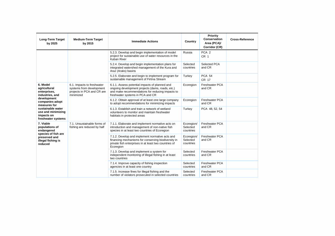
Long-Term Target by 2025
Medium-Term Target by 2015 Immediate Actions Country
Priority Conservation Area (PCA)/
Corridor (CR)
Cross-Reference
5.2.3. Develop and begin implementation of model project for sustainable use of water resources in the Kuban River
Russia PCA 2 CR 1
5.2.4. Develop and begin implementation plans for integrated watershed management of the Kura and Araz (Araks) basins
Selected countries
Selected PCA and CR
5.2.5. Elaborate and begin to implement program for sustainable management of Firtina Stream
Turkey PCA 54 CR 17
6.1.1. Assess potential impacts of planned and ongoing development projects (dams, roads, etc.) and make recommendations for reducing impacts to freshwater systems in PCA and CR
Ecoregion Freshwater PCA and CR
6.1.2. Obtain approval of at least one large company to adopt recommendations for minimizing impacts
Ecoregion Freshwater PCA and CR
6. Model agricultural enterprises, industries, and development companies adopt measures for sustainable water use and minimizing impacts on freshwater systems
6.1. Impacts to freshwater systems from development projects in PCA and CR are minimized
6.1.3. Establish and train a network of wetland volunteers to monitor and maintain freshwater habitats in protected areas
Turkey PCA 48, 52, 54
7.1.1. Elaborate and implement normative acts on introduction and management of non-native fish species in at least two countries of Ecoregion
Ecoregion/Selected countries
Freshwater PCA and CR
7.1.2. Develop and implement normative acts and financing mechanisms for conserving biodiversity in private fish enterprises in at least two countries of Ecoregion
Ecoregion/Selected countries
Freshwater PCA and CR
7.1.3. Develop and implement a system for independent monitoring of illegal fishing in at least two countries
Selected countries
Freshwater PCA and CR
7.1.4. Improve capacity of fishing inspection agencies in at least one country
Selected countries
Freshwater PCA and CR
7. Viable populations of endangered species of fish are preserved and illegal fishing is reduced
7.1. Unsustainable forms of fishing are reduced by half
7.1.5. Increase fines for illegal fishing and the number of violators prosecuted in selected countries
Selected countries
Freshwater PCA and CR
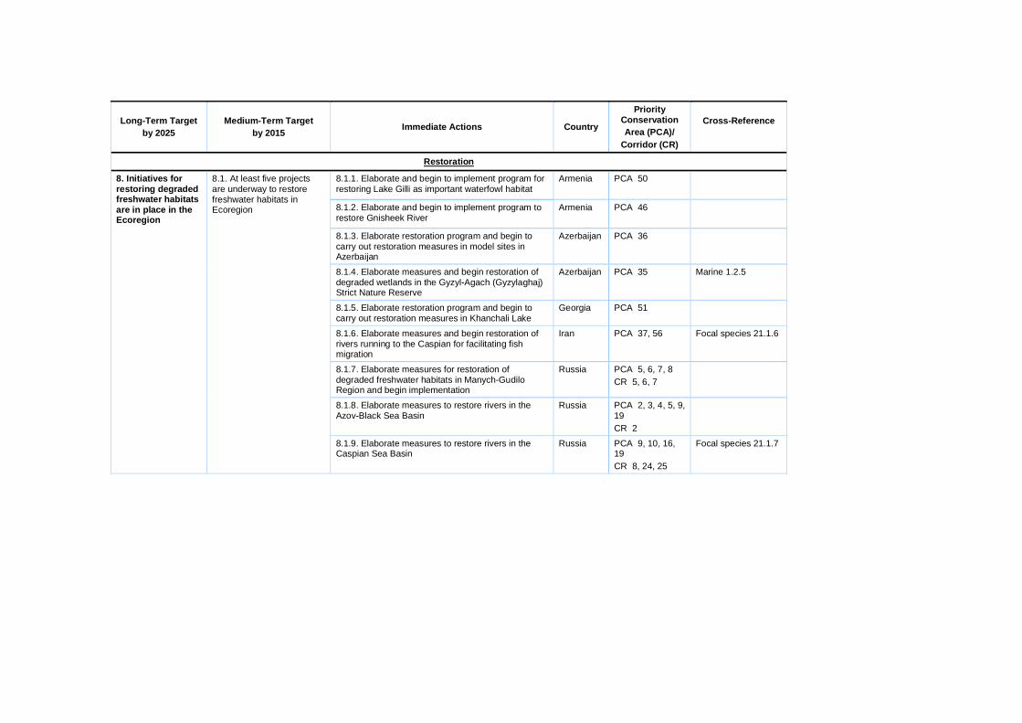
Long-Term Target by 2025
Medium-Term Target by 2015 Immediate Actions Country
Priority Conservation Area (PCA)/
Corridor (CR)
Cross-Reference
Restoration
8.1.1. Elaborate and begin to implement program for restoring Lake Gilli as important waterfowl habitat
Armenia PCA 50
8.1.2. Elaborate and begin to implement program to restore Gnisheek River
Armenia PCA 46
8.1.3. Elaborate restoration program and begin to carry out restoration measures in model sites in Azerbaijan
Azerbaijan PCA 36
8.1.4. Elaborate measures and begin restoration of degraded wetlands in the Gyzyl-Agach (Gyzylaghaj) Strict Nature Reserve
Azerbaijan PCA 35 Marine 1.2.5
8.1.5. Elaborate restoration program and begin to carry out restoration measures in Khanchali Lake
Georgia PCA 51
8.1.6. Elaborate measures and begin restoration of rivers running to the Caspian for facilitating fish migration
Iran PCA 37, 56 Focal species 21.1.6
8.1.7. Elaborate measures for restoration of degraded freshwater habitats in Manych-Gudilo Region and begin implementation
Russia PCA 5, 6, 7, 8 CR 5, 6, 7
8.1.8. Elaborate measures to restore rivers in the Azov-Black Sea Basin
Russia PCA 2, 3, 4, 5, 9, 19 CR 2
8. Initiatives for restoring degraded freshwater habitats are in place in the Ecoregion
8.1. At least five projects are underway to restore freshwater habitats in Ecoregion
8.1.9. Elaborate measures to restore rivers in the Caspian Sea Basin
Russia PCA 9, 10, 16, 19 CR 8, 24, 25
Focal species 21.1.7

4. Conservation and Sustainable Use of Coastal and Marine Ecosystems in the Caucasus Ecoregion Coastal and marine habitats in the Caucasus Ecoregion include the coastline of the Azov, Black, and Caspian seas. Combined, there are 4,139 kilometres of coastline in the Ecoregion. While the total area of the Caucasus Ecoregion includes only the terrestrial area, threatened marine habitats and species found in these seas are also included in the Marine Conservation Plan. All countries in the Ecoregion except Armenia have marine habitats. The Caspian and Azov seas are unique in the world in their diversity in sturgeon species. Six species of sturgeon and beluga are found here, and all are threatened with extinction. The Caspian and Azov-Black sea coasts harbor important habitats for migrating waterfowl, as well as nesting areas for raptors. There are three species of dolphins in the Black Sea, all of which are protected by the Bonn Convention. The main threats to coastal and marine ecosystems are overfishing, urban development, oil extraction, transportation infrastructure (ports and oil pipeline terminals), tourism and recreation, and pollution. Overfishing, mostly driven by poverty and the international demand for caviar and fish, is widespread in the Caspian and Azov seas and may lead to the disappearance of all sturgeon species found in these two seas in the near future. Pollution from oil extraction, run off, and other sources has compromised the integrity of marine ecosystems in the Caspian, Azov, and Black seas. Infrastructure development, such as highway construction, expansion of urban centers, and oil platforms, has resulted in irreversible impacts on marine and coastal ecosystems. In order to combat these threats and mitigate future threats, intact habitats along the Azov, Black, and Caspian seas should be set aside in effectively managed Econets, consisting of protected areas and linking corridors. Transboundary measures on saving endangered fish and bird populations should be implemented. Restoration projects should be carried out in degraded coastal areas, illegal fishing should be halted, and model projects on ecotourism and integrated resource management should be carried out. Currently, 698 kilometers or 16.86 percent of the Ecoregion’s coastline are conserved in protected areas, comprising 75,401 ha of marine and coastal habitats. In the long-term, an additional five percent of marine and coastal habitats should be granted protection. The following table lists the planned Econets and depicts the length of marine coastline protected in each country.
Table 3. Planned Econets for Coastal and Marine Ecosystems and Current Amount Protected by Country
The plan for conservation and sustainable use of coastal and marine ecosystems is divided into three sections: Conservation, Management, and Restoration. Econets fall under conservation measures, but many of the activities proposed in sustainable use will also take place within the Econets. Long-term (by 2025) and 10-year targets (by 2015) are indicated in the conservation plan. Projects should be begun in each of the five countries with coastal and marine habitats in the immediate future to ensure that these targets can be reached. These near-term measures are outlined in the Immediate Actions column. These measures include creating new nature reserves, improving management in existing reserves, drafting and adopting legislation on illegal fishing, and carrying out model projects. Projects should be implemented in PCAs and CRs for coastal and marine ecosystems, as determined in the biodiversity assessment for the Caucasus Ecoregion. Priority areas for the coastal and marine biome include:
Breakdown by Country Name of Region and/or Planned
Econet
Total Length of Coastline in
Ecoregion (km)
Percent Currently Protected Country
Length of Coastline
(km)
Percent Currently Protected
Georgia 318.16 8.02%
Russia 1,063.67 22.08%
Azov and Black Seas
1,772.66 14.78%
Turkey 390.82 0.39%
Azerbaijan 1,273.08 17.85%
Iran 357.08 7.25%
Caspian Sea 2,366 18.42%
Russia 735.83 24.83%
Total in Ecoregion 4,138.65 16.86%

Priority Conservation Areas (PCA) Azov-Black Sea Kuban (2) Primorsko-Akhtarsk (3) Yeysk (4) Don Delta (5) Rioni (26) Caspian Sea Agrakhansky Bay (10) Samur-Yalama (19) Kizlyarsky Bay (9) Aghzibir (Akzybir) Lake (20) Gobustan-Absheron (32) Shirvan (33) Gyzyl-Agach (Gyzylaghaj) (35) Talish-Zuvand (37) Sefid Rud-Anzali (56) Priority Conservation Corridors (CR) Azov-Black Sea Kuban – Rioni (1) Primorsko-Akhtarsk - Kuban (2) Yeysk – Primorsko-Akhtarsk (3) Don Delta – Yeysk (4) Rioni – West Lesser Caucasus (15) Caspian Sea Kizlyarsky Bay – Agrakhansky Bay (8) Agrakhansky Bay – Samur-Yalama (24) Samur-Yalama – Aghzibir (Akzybir) Lake (31) Aghzibir (Akzybir) Lake – Gobustan-Absheron (46) Gobustan-Absheron – Shirvan (48) Shirvan – Gyzyl-Agach (Gyzylaghaj) (52) Gyzyl-Agach (Gyzylaghaj) – Talish-Zuvand (55) Talish-Zuvand – Sefid Rud-Anzali (57) Marine Sefid Rud-Anzali – Gilan (60) Since many of the coastal and marine PCAs and CRs border river estuaries and coastal forests, parts of this section overlap with the freshwater and forest conservation plans. Measures in the institutional development and capacity building plan also apply to marine habitats, particularly where halting illegal fishing is concerned. Cross-references are listed where appropriate in the last column.

D. PLAN FOR CONSERVATION AND SUSTAINABLE USE OF COASTAL AND MARINE ECOSYSTEMS IN THE CAUCASUS ECOREGION
Long-Term Target by 2025
Medium-Term Target by 2015
Immediate Actions By 2010 Country
Priority Conservation Area (PCA)/
Corridor (CR)
Cross-Reference
Conservation
1.1. Framework for Caspian Sea Econet is established
1.1.1. Elaborate plan/guideline for creation of the Caspian Sea Econet
Azerbaijan Iran Russia
PCA 2, 3, 4, 5, 9, 10, 19, 20, 26, 32, 33, 35, 37, 56 CR 1, 2, 3, 4, 8, 15, 24, 31, 46, 48, 52, 55, 57, 60
Freshwater
1.2.1. Create the Samur-Yalama National Park Azerbaijan PCA 19 Forest 9.4.4 Freshwater
1.2.2. Establish protected areas and sanctuaries in the Kura River Delta and on islands in the Baku and Absheron archipelagos
Azerbaijan PCA 32, 33
1.2.3. Establish additional small sanctuaries on Absheron to preserve rare coastal plant communities
Azerbaijan PCA 32
1.2.4. Establish protected areas and sanctuaries in the Aghzibir (Akzybir) Lake (Devechinsky Liman) and on Yashma Island
Azerbaijan PCA 20 Marine 9.1.1
1.2.5. Improve protection of wetlands and coastal habitats in Gyzyl-Agach (Gyzylaghaj) Nature Reserve
Azerbaijan PCA 35 Freshwater 8.1.4
1.2.6. Improve management of Absheron National Park for protecting migratory birds and Caspian seal
Azerbaijan PCA 32
1.2.7. Create marine park and protected areas Iran PCA 56
1.2.8. Strengthen existing Bojagh Reserve Iran PCA 56
1. Representative coastal and marine habitats of the Caspian Sea and associated biodiversity are effectively preserved in a network of protected areas and linking corridors (Econet)
1.2. New protected areas are created in the Caspian Sea Econet on at least 50,000 ha and existing reserves are strengthened on at least 80,000 ha
1.2.9. Optimize the territory of Dagestan Strict Nature Reserve by adding a marine section
Russia PCA 9

Long-Term Target by 2025
Medium-Term Target by 2015 Immediate Actions Country
Priority Conservation Area (PCA)/
Corridor (CR)
Cross-Reference
1.3.1. Create the Samur transboundary protected area
Azerbaijan Russia
PCA 19 Forest 9.4.4 1.3. At least one transboundary protected area is created to preserve shared marine habitats of the Caspian Sea and other reserves are established in the Econet
1.3.2. Create additional protected areas and connecting corridors as outlined by Econet Plan
Azerbaijan Iran Russia
PCA 9, 10, 19, 20, 32, 33, 35, 37, 56 CR 8, 24, 31, 46, 48, 52, 55, 57, 60
1.4.1. Work with local communities to build support for protected areas and Econet
Azerbaijan Iran Russia
The same PCA and CR
1.4. Public support for the Caspian Sea Econet is evidenced by a decrease in poaching, illegal fishing, and other violations 1.4.2. Publish informational materials to distribute in
local communities and to visitors Azerbaijan Iran Russia
The same PCA and CR
2. Viable populations of endangered fish and waterfowl are preserved in the Caspian Sea Region
2.1. Transboundary cooperation leads to effective conservation of endangered fish species
2.1.1. Develop transboundary strategy for conserving rare species of sturgeon and other fish in the Caspian Sea
Azerbaijan Iran Russia
PCA 19, 37 CR 24, 31, 55
Freshwater 4.2.1 Focal species 21
2.2. Transboundary cooperation leads to effective conservation of endangered waterfowl and shorebirds
2.2.1. Develop transboundary strategy for conserving rare species of waterfowl and shorebirds along the Caspian Sea
Azerbaijan Iran Russia
PCA 9, 10, 19, 20, 32, 33, 35, 37, 56 CR 8, 24, 31, 46, 48, 52, 55, 57, 60
Freshwater 4.1.2 Focal species 16, 17, 18

Long-Term Target by 2025
Medium-Term Target by 2015 Immediate Actions Country
Priority Conservation Area (PCA)/
Corridor (CR)
Cross-Reference
3.1. Framework for Azov-Black Sea Econet is established
3.1.1. Elaborate plan/guidelines for creation of the Azov-Black Sea Econet
Georgia Russia Turkey
PCA 2, 3, 4, 5, 26 CR 1, 2, 3, 4, 15
Forest Freshwater
3.2.1. Strengthen management of Kolkheti National Park’s marine section
Georgia PCA 26 CR 1
3.2.2. Create two new marine sanctuaries in Krasnodar Province
Russia PCA 2, 3, 4, 5 CR 1, 2, 3, 4
3.2.3. Carry out gap analysis and identify potential sites for marine protected areas along the Turkish Black Sea coast
Turkey PCA 54
3.2. New protected areas are created in the Azov-Black Sea Econet on 30,000 ha and existing reserves are strengthened on at least 15,000 ha
3.2.4. Create additional protected areas and connecting corridors as outlined by Econet Plan
Georgia Russia Turkey
PCA 2, 3, 4, 5, 26 CR 1, 2, 3, 4, 15
3.3.1. Work with local communities to build support for protected areas and Econet
Georgia Russia Turkey
Selected PCA an CR
3. Representative coastal and marine habitats of the Azov-Black Sea and associated biodiversity are effectively preserved in a network of protected areas and linking corridors (Econet)
3.3. Public support for the Azov-Black Sea Econet is evidenced by a decrease in poaching, illegal fishing, and other violations 3.3.2. Publish informational materials to distribute in
local communities and to visitors Georgia Russia Turkey
Selected PCA an CR
4. Viable populations of economically impo-rtant and rare fish and waterfowl are preserved in the Azov-Black Sea Region
4.1. Transboundary cooperation leads to effective conservation of endangered sturgeon species
4.1.1. Develop and begin to implement transboundary strategy for conserving rare sturgeon and other fish in the Azov-Black Sea
Georgia Russia Turkey
PCA 2, 26 CR 1, 15
Focal species 21

Long-Term Target by 2025
Medium-Term Target by 2015 Immediate Actions Country
Priority Conservation Area (PCA)/
Corridor (CR)
Cross-Reference
4.2.1. Assess anchovy stocks in eastern Black Sea Turkey Georgia
PCA 2, 3, 4, 5, 26 CR 1, 2, 3, 4, 15
Institutional development 1.6.1
4.2.2. Lobby for legislative measures to prevent excessive fishing of anchovy
Turkey Georgia
The same PCA and CR
Institutional development 1.6.1
4.2. Populations of anchovy are viable in the eastern Black Sea
4.2.3. Establish no fishing zones for anchovy Turkey Georgia
The same PCA and CR
Institutional development 1.6.1
4.3. Transboundary cooperation leads to effective conservation of endangered waterfowl and shorebirds
4.3.1. Develop and begin to implement transboundary strategy for conserving rare species of waterfowl and shorebirds along the Azov-Black Sea
Georgia Russia Turkey
PCA 2, 3, 4, 5, 26 CR 1, 2, 3, 4, 15
Freshwater 3.1, 3.2
4.4. Introduction of invasive sea species in the seas of the Ecoregion is halted
4.4.1. Begin developing legislation on preventing introduction of non-native sea species
Ecoregion Caspian sea, Black sea, Azov sea
Management
5.1.1. Elaborate recommendations on strengthening fishing legislation and increasing penalties for violations
Ecoregion All marine and coastal PCA and CR
Institutional development 1.6.1 Freshwater 7.1.5
5. Illegal fishing is rare and endangered fish populations begin to stabilize
5.1. An effective basis for halting illegal fishing and overfishing is in place
5.1.2. Devise system for monitoring illegal fishing Ecoregion All marine and coastal PCA and CR
Freshwater 7.1.3

Long-Term Target by 2025
Medium-Term Target by 2015 Immediate Actions Country
Priority Conservation Area (PCA)/
Corridor (CR)
Cross-Reference
6.1.1. Elaborate international strategy for sustainable resource management and implementation guidelines for the Azov-Black Sea
Georgia Russia Turkey
Azov-Black Sea PCA and CR
6.1.2. Elaborate international strategy for sustainable resource management and implementation guidelines for the Caspian Sea
Azerbaijan Iran Russia
Caspian PCA and CR
6.1.3. Launch project on integrated resource management in model district on the Azov coast
Russia Selected PCA or CR
6.1.4. Launch model project on managing sanitary-protection zones in coastal regions and river deltas of the Black Sea
Georgia Selected PCA or CR
6. Sustainable management of coastal and marine resources leads to their effective conservation in PCA and CR
6.1. Three initiatives on sustainable management of coastal and marine resources are in place in PCA and CR
6.1.5. Launch model project on managing sanitary-protection zones in coastal regions and river deltas of the Caspian Sea
Azerbaijan Selected PCA or CR
7.1.1. Elaborate plans for developing ecotourism in model coastal areas
Azerbaijan Iran Russia Turkey
PCA 19, 33, 35, 56 CR 31, 48, 52, 57, 60
7.1.2. Develop capacity for model projects on ecotourism
7.1. Framework and capacity for model protects on sustainable ecotourism in coastal ecosystems are in place
7.1.3. Elaborate and implement regional legislation in model area on regulating recreational diving and underwater hunting
Russia Selected PCA or CR
7.2.1. Launch model project on diving and snorkeling in coastal regions on the Azov Sea
Russia PCA 2, 3, 4 CR 2, 3, 4
7. Ecotourism is a viable source of income in at least ten coastal communities
7.2. Ecotourism provides 20 percent of income to five model communities and nature reserves 7.2.2. Launch model project on ecotourism in coastal
protected areas along the Caspian Sea Azerbaijan PCA 19, 33, 35,
56 CR 31, 48, 52, 57, 60

Long-Term Target by 2025
Medium-Term Target by 2015 Immediate Actions Country
Priority Conservation Area (PCA)/
Corridor (CR)
Cross-Reference
8.1. Independent information on development projects is available and leads to reduced environmental impacts
8.1.1. Support civil society’s efforts to mitigate, monitor, and participate in development projects
Ecoregion
8.2.1. Prevent construction of new poultry farms in coastal areas of Iran and begin moving one-third of existing farms to other sites
Iran PCA 37, 56 CR 57, 60
8.2. Negative impacts of development in PCA and CR in the Caspian Sea are reduced by a third 8.2.2. Limit new real estate development in coastal
regions in Iran Iran PCA 37, 56
CR 57, 60
8.3.1. Implement mitigation measures during pipelines construction
Azerbaijan Georgia Turkey
PCA 27, 28, 30, 31, 32, 55 CR 17, 18, 20, 45
High mountain Forest Freshwater
8.3. The impact of fuel transportation pipelines is monitored on a permanent basis
8.3.2. Long-term monitoring projects implemented along the pipeline Baku-Tbilisi-Ceyhan
Azerbaijan Georgia Turkey
PCA 27, 28, 30, 31, 32, 55 CR 17, 18, 20, 45
High mountain Forest Freshwater
8. Impacts of development on biodiversity in coastal and marine PCA and CR are reduced to a minimum
8.4. Impacts of TRACECA on marine and coastal habitats in PCA and CR are minimized
8.4.1. Assess potential threats to PCA and CR and work out plan for preventing degradation to these areas
Selected countries
Corresponding PCA and CR
High mountain Forest Freshwater

Long-Term Target by 2025
Medium-Term Target by 2015 Immediate Actions Country
Priority Conservation Area (PCA)/
Corridor (CR)
Cross-Reference
Restoration
9.1.1. Elaborate strategy and begin measures to restore coastal ecosystems in Aghzibir (Akzybir) Lake (Devechinsky Liman)
Azerbaijan PCA 20 CR 31, 46
Marine 1.2.4
9.1.2. Remove artificial barriers in coastal waters sectioning off recreational areas in order to restore natural marine processes along the coast of the Caspian Sea
Iran PCA 37, 56 CR 57, 60
9.1. At least two projects are underway to restore marine and coastal habitats along the Caspian Sea
9.1.3. Restore natural migration routes of sturgeon in the mouth of Kura River
Azerbaijan PCA 33 CR 52
Focal species 21.1.3
9.2.1. Remove artificial barriers and restore natural migration routes of sturgeon in the Kuban and Don rivers
Russia PCA 2 Freshwater Focal species 21
9.2.2. Identify priority areas for restoring migration ways of key species in the Black Sea coastal area of Georgia
Georgia PCA 26 CR 15
Focal species 21.1.4
9. Initiatives for restoring degraded coastal or marine habitats are ongoing in PCA and CR
9.2. At least two projects are underway to restore marine and coastal habitats along the Black Sea
9.2.3. Identify priority areas for restoring migration ways of key species in Black Sea coastal area of Turkey to protect them from environment impacts of highway development
Turkey PCA 54 Focal species 21
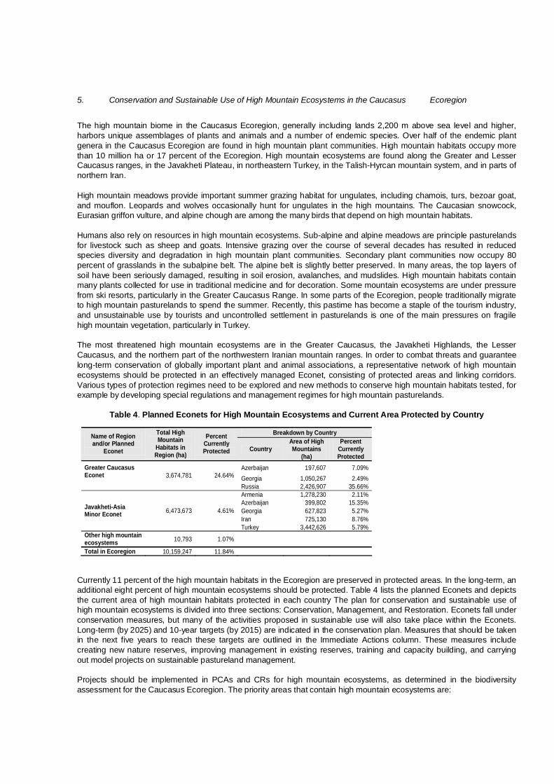
5. Conservation and Sustainable Use of High Mountain Ecosystems in the Caucasus Ecoregion
The high mountain biome in the Caucasus Ecoregion, generally including lands 2,200 m above sea level and higher, harbors unique assemblages of plants and animals and a number of endemic species. Over half of the endemic plant genera in the Caucasus Ecoregion are found in high mountain plant communities. High mountain habitats occupy more than 10 million ha or 17 percent of the Ecoregion. High mountain ecosystems are found along the Greater and Lesser Caucasus ranges, in the Javakheti Plateau, in northeastern Turkey, in the Talish-Hyrcan mountain system, and in parts of northern Iran. High mountain meadows provide important summer grazing habitat for ungulates, including chamois, turs, bezoar goat, and mouflon. Leopards and wolves occasionally hunt for ungulates in the high mountains. The Caucasian snowcock, Eurasian griffon vulture, and alpine chough are among the many birds that depend on high mountain habitats. Humans also rely on resources in high mountain ecosystems. Sub-alpine and alpine meadows are principle pasturelands for livestock such as sheep and goats. Intensive grazing over the course of several decades has resulted in reduced species diversity and degradation in high mountain plant communities. Secondary plant communities now occupy 80 percent of grasslands in the subalpine belt. The alpine belt is slightly better preserved. In many areas, the top layers of soil have been seriously damaged, resulting in soil erosion, avalanches, and mudslides. High mountain habitats contain many plants collected for use in traditional medicine and for decoration. Some mountain ecosystems are under pressure from ski resorts, particularly in the Greater Caucasus Range. In some parts of the Ecoregion, people traditionally migrate to high mountain pasturelands to spend the summer. Recently, this pastime has become a staple of the tourism industry, and unsustainable use by tourists and uncontrolled settlement in pasturelands is one of the main pressures on fragile high mountain vegetation, particularly in Turkey. The most threatened high mountain ecosystems are in the Greater Caucasus, the Javakheti Highlands, the Lesser Caucasus, and the northern part of the northwestern Iranian mountain ranges. In order to combat threats and guarantee long-term conservation of globally important plant and animal associations, a representative network of high mountain ecosystems should be protected in an effectively managed Econet, consisting of protected areas and linking corridors. Various types of protection regimes need to be explored and new methods to conserve high mountain habitats tested, for example by developing special regulations and management regimes for high mountain pasturelands.
Table 4. Planned Econets for High Mountain Ecosystems and Current Area Protected by Country
Currently 11 percent of the high mountain habitats in the Ecoregion are preserved in protected areas. In the long-term, an additional eight percent of high mountain ecosystems should be protected. Table 4 lists the planned Econets and depicts the current area of high mountain habitats protected in each country The plan for conservation and sustainable use of high mountain ecosystems is divided into three sections: Conservation, Management, and Restoration. Econets fall under conservation measures, but many of the activities proposed in sustainable use will also take place within the Econets. Long-term (by 2025) and 10-year targets (by 2015) are indicated in the conservation plan. Measures that should be taken in the next five years to reach these targets are outlined in the Immediate Actions column. These measures include creating new nature reserves, improving management in existing reserves, training and capacity building, and carrying out model projects on sustainable pastureland management. Projects should be implemented in PCAs and CRs for high mountain ecosystems, as determined in the biodiversity assessment for the Caucasus Ecoregion. The priority areas that contain high mountain ecosystems are:
Breakdown by Country Name of Region and/or Planned
Econet
Total High Mountain
Habitats in Region (ha)
Percent Currently Protected Country
Area of High Mountains
(ha)
Percent Currently Protected
Azerbaijan 197,607 7.09% Georgia 1,050,267 2.49%
Greater Caucasus Econet
3,674,781 24.64%
Russia 2,426,907 35.66% Armenia 1,278,230 2.11% Azerbaijan 399,802 15.35% Georgia 627,823 5.27% Iran 725,130 8.76%
Javakheti-Asia Minor Econet 6,473,673 4.61%
Turkey 3,442,626 5.79% Other high mountain ecosystems 10,793 1.07%
Total in Ecoregion 10,159,247 11.84%

Priority Conservation Areas West Greater Caucasus (11) Teberdinsky Nature Reserve (12) Svaneti (13) Racha-Central Caucasus (14) Khevi-Tusheti (15) Lagodekhi-Zagatala-West Dagestan (16) Sarybash (17) Laman-Kam (18) Ismailly-Shahdagh (21) Trialeti (27) Mount Gyamysh (34) Talish-Zuvand (37) Gilan (39) Sabalan (40) Marakan-Kiamaki (41) Meghri (42) Zangezur (43) Bichanek (45) Noravank (46) Maku and Western Iranian Border (47) Agri Dagi (Ararat) and Armash (48) Khosrov (49) Pambak-Sevan (50) Javakheti (51) Igdir Plain and Armavir (52) Sarikamis Forest (53) West Lesser Caucasus (54) Priority Conservation Corridors West Greater Caucasus – Teberdinsky Nature Reserve (9) Teberdinsky Nature Reserve – Svaneti (10) Svaneti – Racha-Central Caucasus (11) Svaneti – Askhi-Karst Massif (12) Racha-Central Caucasus – Khevi-Tusheti (13) Trialeti – West Lesser Caucasus (16) West Lesser Caucasus – Sarikamis Forest (17) Trialeti – Javakheti (19) Javakheti – Igdir Plain and Armavir (21) Sarikamis Forest – Igdir Plain and Armavir (22) Khevi-Tusheti – Lagodekhi-Zagatala-West Dagestan (23) Lagodekhi-Zagatala-West Dagestan – Laman-Kam Area (25) Lagodekhi-Zagatala-West Dagestan – Sarybash – Ismailly-Shahdagh (29) Laman-Kam Area – Ismailly-Shahdagh (30) Pambak-Sevan – Mount Gyamysh (32) Pambak-Sevan – Khosrov (33) Igdir Plain and Armavir – Agri Dagi (Ararat) and Armash (35) Igdir Plain and Armavir – Maku and Western Iranian Border (36) Agri Dagi (Ararat) and Armash – Maku and Western Iranian Border (37) Maku and Western Iranian Border – Marakan-Kiamaki (38) Noravank – Bichanek (39) Khosrov – Noravank (40) Khosrov – Bichanek (41) Bichanek – Zangezur (42) Marakan-Kiamaki – Sabalan (53) Araz (Araks) Valley – Sabalan (54) Sabalan – Talish-Zuvand (56)

Since many of the priority areas and corridors cover landscapes with marked vertical shifts or broad plateaus, parts of this section overlap with the forest and freshwater conservation plans. Focal species will also benefit from a number of the projects to protect high mountain habitats. Cross-references are listed where appropriate in the last column of the conservation plan.

E. PLAN FOR CONSERVATION AND SUSTAINABLE USE OF HIGH MOUNTAIN ECOSYSTEMS IN THE CAUCASUS
Long-Term Target by 2025
Medium-Term Target by 2015
Immediate Actions by 2010 Country
Priority Conservation Area (PCA)/
Corridor
Cross-Reference
Conservation
1.1. Framework for Greater Caucasus Econet is established
See appropriate section in Forest Conservation Plan Azerbaijan Georgia Russia
PCA 11 , 12, 13, 14, 15, 16, 17, 18, 21 CR 9, 10, 11, 12, 13, 23, 25, 29, 30
Forest 1.1.1-1.1.3, 1.2.6
1.2.1. Create Shahdagh National Park Azerbaijan PCA 21 Forest 1.2.2.
1.2.2. Create Racha National Park Georgia PCA 14 Forest 1.2.3 Focal species 6.1.2
1.2.3. Establish Svaneti National Park Georgia PCA 13 Forest 1.2.4 Focal species 6.1.2
1.2.4. Establish Khevsureti Sanctuary Georgia PCA 15 Forest 1.2.5 Focal species 6.1.2
1.2.5. Prepare management plan and develop infrastructure of Tusheti National Park
Georgia PCA 15 Focal species 3.1.2, 6.1.1
1.2.6. Provide core support for establishing protected regime and extension of Erzi Strict Nature Reserve in Ingushetiya
Russia PCA 15 Forest 1.2.13
1.2.7. Establish biosphere polygon for Teberdinsky Nature Reserve
Russia PCA 12 Forest 1.2.12 Focal species 6.1.1
1.2.8. Establish transregional park between Northern Osetiya and Kabardino-Balkariya
Russia PCA 14 Forest 1.2.10.
1. Representative high mountain habitats and associated biodiversity of the Greater Caucasus Range are effectively preserved in a network of protected areas and linking corridors (Econet)
1.2. New protected areas in high mountain habitats are created on 100,000 ha and existing reserves are strengthened on at least 80,000 ha
1.2.9. Upgrade Tlyaratinsky Sanctuary status to strict nature reserve
Russia PCA 18 Forest 1.2.11 Focal species 6.1.1, 7.2.5

Long-Term Target by 2025
Medium-Term Target by 2015 Immediate Actions Country
Priority Conservation Area (PCA)/
Corridor (CR)
Cross-Reference
1.2.10. Create additional protected areas and connecting corridors in high mountain habitats as outlined by Econet Plan
Azerbaijan Georgia Russia
PCA 14, 12, 15 CR 10, 13, 23, 25, 30
Forest 1.2.13 Focal species 3.2.4
1.3.1. Establish the Northwestern Caucasus Transboundary Reserve
Georgia Russia
PCA 11 Forest 1.3.1. 1.3. Two transboundary nature reserves are established as part of the Greater Caucasus Econet 1.3.2. Create transboundary reserve on the basis of
Lagodekhi, Zagatala, and Tlyaratinsky protected areas
Azerbaijan Georgia Russia
PCA 16 Forest 1.3.2. Focal species 6.1.1, 8.2.1
1.4.1. Work with local communities to build support for protected areas
Azerbaijan Georgia Russia
Selected regions of Greater Caucasus Econet
Forest 1.4.1 Freshwater 1.4.1
1.4. Public support for the Greater Caucasus Econet is evidenced by a decrease in poaching and other violations 1.4.2. Publish informational materials to distribute in
local communities and to visitors Azerbaijan Georgia Russia
Selected regions of Greater Caucasus Econet
Forest 1.4.2 Freshwater 1.4.2
2.1. Framework for Lesser Caucasus and Javakheti-Asia Minor Econet is established
See appropriate sections in Forest and Freshwater conservation plans
Armenia Georgia Iran Turkey
PCA 27, 34, 37, 39, 40, 41, 42, 43, 45, 46, 47, 48, 49, 50, 51, 52, 53, 54 CR 16, 17, 19, 21, 22, 32, 33, 35, 36, 37, 38, 39, 40, 41, 42, 53, 54, 56
Forest 2.1.1 -2.1.2, 2.2.20 Freshwater 1.1.1.
2.2.1. Create Lake Arpi National Park Armenia PCA 51 Freshwater 1.2.2, 4.1.5
2.2.2. Create Arpi National Park in Central Armenia Armenia PCA 46 Focal species 3.2.2, 7.2.2, 11.2.1
2. Representative high mountain habitats and associated biodiversity of the Lesser Caucasus and Javakheti-Asia Minor Regions are effectively preserved in a network of protected areas and linking corridors (Econet)
2.2. New protected areas in high mountain habitats are created over 100,000 ha and existing reserves are strengthened on at least 100,000 ha 2.2.3. Plan Djermuk National Park on the basis of
existing sanctuaries Armenia CR 41

Long-Term Target by 2025
Medium-Term Target by 2015 Immediate Actions Country
Priority Conservation Area (PCA)/
Corridor (CR)
Cross-Reference
2.2.4. Improve management of Sev Lich Sanctuary and carry out needs assessment to provide core support
Armenia PCA 46
2.2.5. Create a corridor between the Khosrov reserve and Zangezur ranges in southern Armenia to allow animal migrations
Armenia CR 40, 41 Forest 2.2.4 High mountain 2.2.4 Focal species 3.1.2
2.2.6. Improve management and develop infrastructure of Ordubad National Park
Azerbaijan PCA 43 Focal species 3.2.1, 7.2.4, 11.2.4
2.2.7. Improve management and develop infrastructure of Shahbuz Strict Nature Reserve
Azerbaijan PCA 45 Forest 2.2.6
2.2.8. Create Javakheti National Park Georgia PCA 51 Freshwater 1.2.4
2.2.9. Establish Ktsia-Tabatskuri Sanctuary Georgia PCA 27 Freshwater 1.2.5, 1.2.7
2.2.10. Establish Khevsureti Sanctuary Georgia PCA 15 Forest 1.2.5
2.2.11. Involve local community in management, monitoring, and protection of Marakan Nature Reserve
Iran PCA 41
2.2.12. Assess possibility of creating new protected areas and corridors
Iran PCA 41, 47, 48 CR 38
2.2.13. Establish new national park on Mt. Agri Dagi (Ararat) and create management plan and infrastructure
Turkey PCA 48
2.2.14. Assess feasibility of creating nature reserve on Mt.Tendurek (Important Plant Area)
Turkey PCA 36
2.2.15. Create corridors to connect existing protected areas
Turkey CR 17, 21, 22, 35, 36, 37

Long-Term Target by 2025
Medium-Term Target by 2015 Immediate Actions Country
Priority Conservation Area (PCA)/
Corridor (CR)
Cross-Reference
2.2.16. Create additional protected areas and connecting protected corridors in high mountain habitats as outlined by Econet Plan
Armenia Azerbaijan Georgia Iran Turkey
Selected PCA and CR
Forest Freshwater Focal species 3.1.5
2.3.1. Assess feasibility of creating transboundary nature reserve along the Armenian-Turkish-Georgian border
Armenia Georgia Turkey
PCA 51 Freshwater 4.1.4
2.3.2. Assess feasibility of creating transboundary protected area between Turkey and Georgia in the Karchal Mountains
Georgia Turkey
PCA 54
2.3. Transboundary initiatives for conservation of high mountain ecosystems in the Lesser Caucasus-Javakheti-Asia Minor are in place
2.3.3. Assess feasibility of creating transboundary nature reserve between Iran and Turkey
Iran Turkey
PCA 47, 48 CR 37
2.4.1. Work with local communities to build support for protected areas
Armenia Azerbaijan Georgia Iran Turkey
Selected PCA and CR in Econet
Freshwater 1.4.1
2.4. Public support for the Javakheti-Asia Minor is evidenced by a decrease in poaching and other violations
2.4.2. Publish informational materials to distribute in local communities and to visitors
Armenia Azerbaijan Georgia Iran Turkey
Selected PCA and CR in Econet
Freshwater 1.4.2
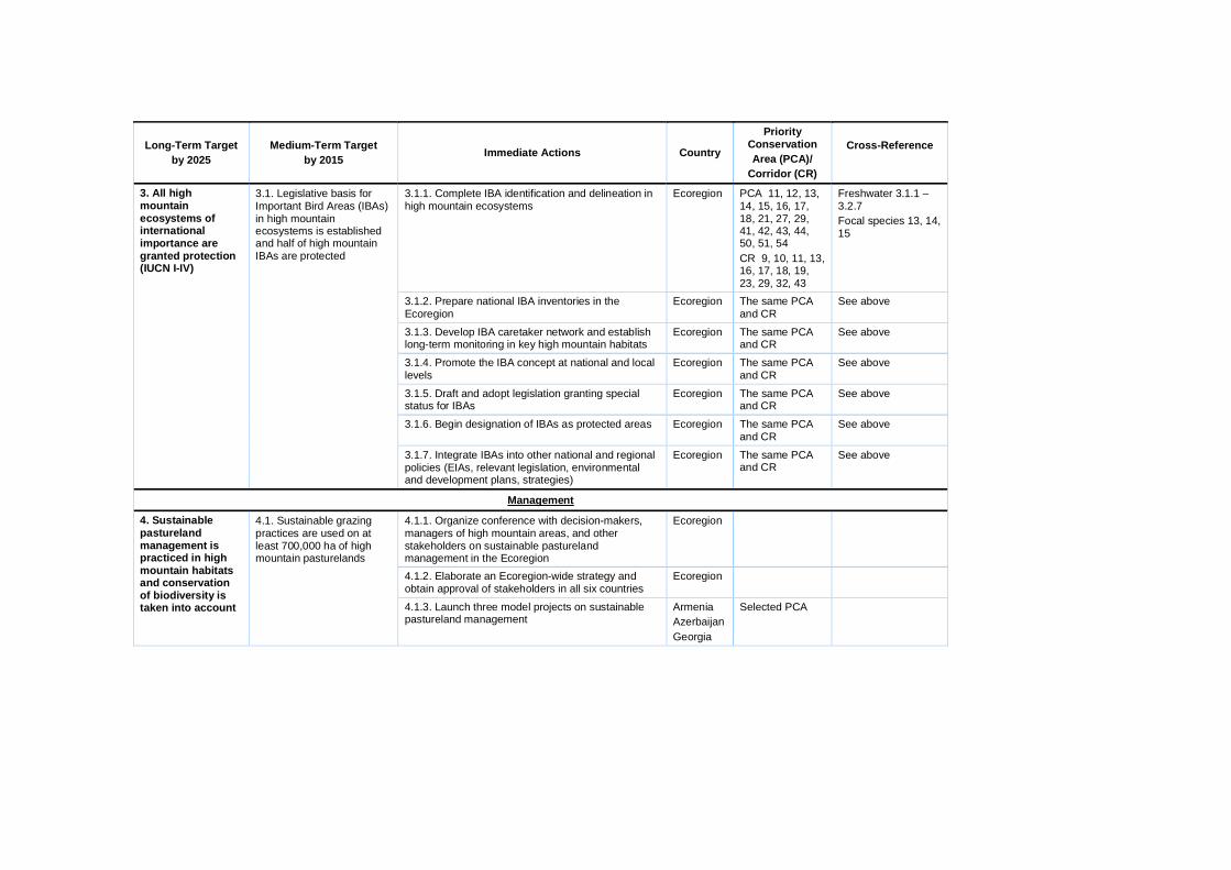
Long-Term Target by 2025
Medium-Term Target by 2015 Immediate Actions Country
Priority Conservation Area (PCA)/
Corridor (CR)
Cross-Reference
3.1.1. Complete IBA identification and delineation in high mountain ecosystems
Ecoregion PCA 11, 12, 13, 14, 15, 16, 17, 18, 21, 27, 29, 41, 42, 43, 44, 50, 51, 54 CR 9, 10, 11, 13, 16, 17, 18, 19, 23, 29, 32, 43
Freshwater 3.1.1 – 3.2.7 Focal species 13, 14, 15
3.1.2. Prepare national IBA inventories in the Ecoregion
Ecoregion The same PCA and CR
See above
3.1.3. Develop IBA caretaker network and establish long-term monitoring in key high mountain habitats
Ecoregion The same PCA and CR
See above
3.1.4. Promote the IBA concept at national and local levels
Ecoregion The same PCA and CR
See above
3.1.5. Draft and adopt legislation granting special status for IBAs
Ecoregion The same PCA and CR
See above
3.1.6. Begin designation of IBAs as protected areas Ecoregion The same PCA and CR
See above
3. All high mountain ecosystems of international importance are granted protection (IUCN I-IV)
3.1. Legislative basis for Important Bird Areas (IBAs) in high mountain ecosystems is established and half of high mountain IBAs are protected
3.1.7. Integrate IBAs into other national and regional policies (EIAs, relevant legislation, environmental and development plans, strategies)
Ecoregion The same PCA and CR
See above
Management
4.1.1. Organize conference with decision-makers, managers of high mountain areas, and other stakeholders on sustainable pastureland management in the Ecoregion
Ecoregion
4.1.2. Elaborate an Ecoregion-wide strategy and obtain approval of stakeholders in all six countries
Ecoregion
4. Sustainable pastureland management is practiced in high mountain habitats and conservation of biodiversity is taken into account
4.1. Sustainable grazing practices are used on at least 700,000 ha of high mountain pasturelands
4.1.3. Launch three model projects on sustainable pastureland management
Armenia Azerbaijan Georgia
Selected PCA
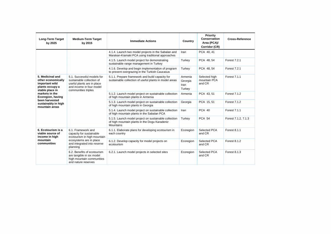
Long-Term Target by 2025
Medium-Term Target by 2015 Immediate Actions Country
Priority Conservation Area (PCA)/
Corridor (CR)
Cross-Reference
4.1.4. Launch two model projects in the Sabalan and Marakan-Kiamaki PCA using traditional approaches
Iran PCA 40, 41
4.1.5. Launch model project for demonstrating sustainable range management in Turkey
Turkey PCA 48, 54 Forest 7.2.1
4.1.6. Develop and begin implementation of program to prevent overgrazing in the Turkish Caucasus
Turkey PCA 48, 54 Forest 7.2.1
5.1.1. Prepare framework and build capacity for sustainable collection of useful plants in model areas
Armenia Georgia Iran Turkey
Selected high mountain PCA and CR
Forest 7.1.1
5.1.2. Launch model project on sustainable collection of high mountain plants in Armenia
Armenia PCA 43, 51 Forest 7.1.2
5.1.3. Launch model project on sustainable collection of high mountain plants in Georgia
Georgia PCA 15, 51 Forest 7.1.2
5.1.4. Launch model project on sustainable collection of high mountain plants in the Sabalan PCA
Iran PCA 40 Forest 7.1.1
5. Medicinal and other economically important wild plants occupy a stable place in markets in the Ecoregion, having been harvested sustainably in high mountain areas
5.1. Successful models for sustainable collection of useful plants are in place and income in four model communities triples
5.1.5. Launch model project on sustainable collection of high mountain plants in the Dogu Karadeniz Mountains
Turkey PCA 54 Forest 7.1.2, 7.1.3
6.1.1. Elaborate plans for developing ecotourism in each country
Ecoregion Selected PCA and CR
Forest 8.1.1 6.1. Framework and capacity for sustainable ecotourism in high mountain ecosystems are in place and integrated into reserve planning
6.1.2. Develop capacity for model projects on ecotourism
Ecoregion Selected PCA and CR
Forest 8.1.2
6. Ecotourism is a viable source of income in high mountain communities
6.2. Benefits of ecotourism are tangible in six model high mountain communities and nature reserves
6.2.1. Launch model projects in selected sites Ecoregion Selected PCA and CR
Forest 8.1.3

Long-Term Target by 2025
Medium-Term Target by 2015 Immediate Actions Country
Priority Conservation Area (PCA)/
Corridor (CR)
Cross-Reference
7.1. Exclude use of dangerous pollutants (such as DDT) in high mountain PCA and CR
7.1.1. Introduce a system of monitoring use of mineral fertilizers and pesticides and reducing impacts of livestock in three high mountain model areas
Armenia Georgia Iran
PCA 14, 15,16, 50
7. Impacts of development on biodiversity in high mountain priority areas and corridors are abated 7.2. Standards for reducing
impacts of industrial mining in high mountain areas are used by all large mining companies working in PCA and CR
7.2.1. Develop and implement measures to minimize impacts of mining in high mountain areas
Ecoregion PCA 14, 15,16, 50

6. Conservation of Focal Species and Their Habitats in the Caucasus Ecoregion
Twenty-six focal species requiring urgent measures for conservation were identified for the Caucasus Ecoregion, including three carnivores, eight ungulates, six birds, two amphibians, and seven species of fish. These are: Caucasian leopard, striped hyena, brown bear, East and West Caucasian turs, bezoar goat, Caucasian red deer, Caucasian chamois, goitred gazelle (djeiran), Gmelin’s (Armenian) mouflon, European bison, Caucasian black grouse, imperial eagle, cinereous vulture, marbled duck, white-headed duck, pygmy cormorant, Syrian spadefoot toad, Caucasian salamander, and the seven species of sturgeons threatened in the Black and Caspian seas.
The plan for conservation of focal species is divided into seven sections: the Ecoregional framework for conservation of focal species; leopard conservation; carnivore conservation (excluding the leopard); ungulate conservation; bird conservation; amphibian conservation; and fish conservation. Projects should be implemented in PCAs and CRs as determined in the biodiversity assessment for the Caucasus Ecoregion. There are 46 PCAs and 51 CRs that contain key populations of the focal species. Priority Conservation Areas Kuban (2) Primorsko-Akhtarsk (3) Yeysk (4) Don Delta (5) West Greater Caucasus (11) Teberdinsky Nature Reserve (12) Svaneti (13) Racha - Central Caucasus (14) Khevi-Tusheti (15) Lagodekhi-Zagatala-West Dagestan (16) Sarybash (17) Laman-Kam Area (18) Samur-Yalama (19) Aghzibir (Akzybir) Lake (20) Ismailly-Shahdagh (21) Iori-Iori-Mingechevir (Mingechaur) (22) Alazani-Ganykh (23) Askhi-Karst Massif (25) Rioni (26) Trialeti (27) Kura-Jandari (28) Mount Gyamysh (29) Gobustan-Hajigabul (31) Gobustan-Absheron (32) Shirvan (33) Gyzyl-Agach (Gyzylaghaj) (35) Talish-Zuvand (37) Araz (Araks) Valley (38) Gilan (39) Sabalan (40) Marakan-Kiamaki (41) Meghri (42) Zangezur (43) Arasbaran (44) Bichanek (45) Noravank (46) Maku and Western Iranian border (47) Agri Dagi (Ararat) and Armash (48) Khosrov (49) Pambak-Sevan (50) Javakheti (51) Igdir Plain and Armavir (52)

Sarikamis Forest (53) West Lesser Caucasus (54) Manglisi (55) Sefid Rud-Anzali (56) Priority Conservation Corridors Kuban – Rioni (1) Primorsko-Akhtarsk – Kuban (2) Yeysk – Primorsko-Akhtarsk (3) Don Delta – Yeysk (4) West Greater Caucasus – Teberdinsky Nature Reserve (9) Teberdinsky Nature Reserve – Svaneti (10) Svaneti – Racha-Central Caucasus (11) Svaneti – Askhi-Karst Massif (12) Racha – Central Caucasus – Khevi-Tusheti (13) Racha – Central Caucasus – Trialeti (14) Rioni – West Lesser Caucasus (15) Trialeti – West Lesser Caucasus (16) West Lesser Caucasus – Sarikamis Forest (17) Trialeti – Manglisi (18) Manglisi – Pambak-Sevan (20) Javakheti – Igdir Plain and Armavir (21) Sarikamis Forest – Igdir Plain and Armavir (22) Khevi-Tusheti – Lagodekhi-Zagatala-West Dagestan (23) Agrakhansky Bay – Samur-Yalama (24) Lagodekhi-Zagatala-West Dagestan – Laman-Kam Area (25) Lagodekhi-Zagatala-West Dagestan – Alazani-Ganykh (26) Sarybash – Alazani-Ganykh (27) Alazani-Ganykh – Iori-Iori-Mingechevir (Mingechaur) (28) Lagodekhi-Zagatala-West Dagestan – Sarybash – Ismailly-Shahdagh (29) Laman-Kam Area – Ismailly-Shahdagh (30) Samur-Yalama – Aghzibir (Akzybir) Lake (31) Pambak-Sevan – Mount Gyamysh (32) Pambak-Sevan – Khosrov (33) Freshwater Igdir Plain and Armavir – Agri Dagi (Ararat) and Armash (34) Igdir Plain and Armavir – Agri Dagi (Ararat) and Armash (35) Igdir Plain and Armavir – Maku and Western Iranian Border (36) Agri Dagi (Ararat) and Armash – Maku and Western Iranian Border (37) Maku and Western Iranian Border – Marakan-Kiamaki (38) Noravank – Bichanek (39) Khosrov – Noravank (40) Khosrov – Bichanek (41) Bichanek – Zangezur (42) Mount Gyamysh – Meghri – Marakan-Kiamaki (43) Iori-Iori-Mingechevir (Mingechaur) – Gobustan-Hajigabul (45) Aghzibir (Akzybir) Lake – Gobustan-Absheron (46) Gobustan-Hajigabul – Shirvan (47) Gobustan-Absheron – Shirvan (48) Shirvan – Gyzyl-Agach (Gyzylaghaj) (52) Marakan-Kiamaki – Sabalan (53) Araz (Araks) Valley – Sabalan (54) Gyzyl-Agach (Gyzylaghaj) – Talish-Zuvand (55) Marine Talish-Zuvand – Sefid Rud-Anzali (57) Talish-Zuvand – Sefid Rud-Anzali (58) Sefid Rud-Anzali – Gilan (59) Marine Sefid Rud-Anzali – Gilan (60) Because focal species rely on forest, freshwater, marine, and high mountain habitats for survival, the plan includes actions referenced in the respective biome conservation plans. Actions on halting illegal hunting and fishing should be

coordinated with efforts in the institutional development and capacity building plan. Appropriate cross-references are given in the last column.

F. PLAN FOR CONSERVATION OF FOCAL SPECIES IN THE CAUCASUS ECOREGION
Long-Term Target by 2025
Medium-Term Target by 2015
Immediate Actions by 2010
Country
Priority Conservation
Area (PCA)/Corridor
(CR)
Cross-Reference
Ecoregional framework for conservation of focal species
1.1.1. Establish regional Mammal Working Group and clarify focal species
Ecoregion All PCA and CR Institutional development 1.4.2, 7.5
1.1.2. Establish regional Bird Working Group and clarify focal species
Ecoregion All PCA and CR See above
1.1.3. Establish regional Amphibian and Reptile Working Group and clarify focal species
Ecoregion All PCA and CR See above
1.1.4. Establish regional Fish Working Group and clarify focal species
Ecoregion All PCA and CR See above
1.1.5. Establish regional Invertebrates Working Group and identify focal species
Ecoregion All PCA and CR See above
1.1.6. Establish regional Plant Working Group and identify focal species
Ecoregion All PCA and CR See above
1.1. Regional working groups on focal species are functioning
1.1.7. Support seminars for working groups on conservation of focal species and species of special concern
Ecoregion All PCA and CR See above
1.2. Databases on all focal species exist and are regularly updated
1.2.1. Framework for databases is created for all groups of focal species
Ecoregion All PCA and CR Institutional development 7.3.1, 7.3.3
1.3. Focal-species approach is applied to conserve a selected set of PCA and CR
1.3.1. Establish small grants program to support efforts to conserve globally threatened species, focal species, and species of special concern in PCA and CR
Ecoregion All PCA and CR Biomes
1. Populations of all identified focal species are stabilized and focal-species based approach is implemented in ecosystem conservation
1.4. Minimize illegal hunting and habitat degradation
1.4.1. Assess impacts of illegal hunting and habitat degradation on globally threatened species, focal species, and species of special concern
Ecoregion PCA and CR where endangered and focal species are found

Long-Term Target by 2025
Medium-Term Target by 2015 Immediate Actions Country
Priority Conservation Area (PCA)/
Corridor (CR)
Cross-Reference
2.1. The Caucasus section of the IUCN Red List is updated regularly and assists in determining international and regional conservation priorities
2.1.1. Revise the IUCN Red List for the Caucasus Ecoregion All PCA and CR where endangered and focal species are found
2.2.1. Update the Red List for Armenia and enact appropriate legislation
Armenia All PCA and CR in Armenia where endangered species are found
2.2.2. Update the Red List for Azerbaijan Azerbaijan All PCA and CR in Azerbaijan where endangered species are found
2.2.3. Update the Red List for Georgia Georgia All PCA and CR in Georgia where endangered species are found
2.2.4. Prepare/Update the Red List for Iran Iran All PCA and CR in Iran where endangered species are found
2.2.5. Update the Red List for Russia Russia All PCA and CR in Russia where endangered species are found
2. International and national Red Lists accurately reflect the status of endangered species in the Caucasus Ecoregion 2.2. National Red Lists are
updated regularly taking into account IUCN criteria and assist in determining regional and national conservation priorities
2.2.6. Prepare/Update the Red List for Turkey Turkey All PCA and CR in Turkey where endangered species are found

Long-Term Target by 2025
Medium-Term Target by 2015 Immediate Actions Country
Priority Conservation Area (PCA)/
Corridor (CR)
Cross-Reference
Plan for conservation of the endangered Leopard (Panthera pardus saxicolor)
3.1.1. Assess and analyze current range and population of the leopard, determine key areas and migratory routes for leopards, and elaborate Econet Plan
Ecoregion PCA 15, 16, 17, 22, 36, 37, 39, 40, 41, 42, 43, 44, 45, 46, 47, 48, 49, 52, 53 CR 23, 38, 39, 40, 41, 42, 43, 58, 59
Econets plans for biomes
3.1.2. Elaborate and implement measures for leopard conservation in Khosrov and Shikahogh nature reserves, (Armenia); Hirkan National Park and Zuvand Sanctuary, Ilisu Reserve (Akhar-Bakhar Range), Ordubad National Park and Sanctuary, Shahbuz Reserve (Azerbaijan); Tusheti National Park, Vashlovani Reserve and National Park (Georgia), Marakan, Kiamaky, Lavandvil, Lisar, Gasht-e-Rodkan and Siahmazgy, Siah Rud-e Rudbar, Sarv-e lat and Javaherdasht, Beles Kuh, Arasbaran Biosphere Reserve (Iran) and Turkey
Armenia Azerbaijan Georgia Iran Turkey
PCA 16, 22, 37, 39, 41, 42, 43, 44, 45, 48, 49, 52, 53 CR 38, 39, 40, 41, 42, 43, 58, 59
Forest High mountain
3.1.3. Organize training seminar for rangers in leopard reserves and increase coordination among reserves
Armenia Azerbaijan Georgia Iran
PCA 16, 22, 37, 39, 41, 42, 43, 44, 48, 49
Institutional development 1.5.2
3.1.4. Establish transboundary cooperation to conserve important leopard habitat
Ecoregion PCA 16, 22, 37, 41, 42, 43, 44, 48
Forest 3.3.1
3. An effectively managed leopard conservation landscape consisting of protected areas and connecting corridors is established and the leopard population increases by 50 percent
3.1. Econet is created to support a viable leopard population and improve leopard protection in nature reserves where the animal is thought to be found
3.1.5. Ensure protected status of key corridors for leopard migration
Armenia Azerbaijan Georgia Iran Russia
CR 23, 26, 38, 39, 40, 41, 42, 43, 53, 58, 59
Forest 3.2.3 High mountain 1.2.10, 2.2.16

Long-Term Target by 2025
Medium-Term Target by 2015 Immediate Actions Country
Priority Conservation Area (PCA)/
Corridor (CR)
Cross-Reference
3.2.1. Establish new protected areas in southern Armenia to conserve leopards and other focal species
Armenia PCA 42, 43 Forest 2.2.1 High mountain 2.2.5 Focal species 7.2.1, 11.2.4
3.2.2. Create Arpi National Park in Central Armenia Armenia PCA 46 High mountain 2.2.2 Focal species 7.2.2
3.2.3. Create Akhar-Bakhar Reserve in northwestern Azerbaijan
Azerbaijan PCA 22
3.2. Create new protected areas for leopard conservation
3.2.4. Create two sanctuaries for leopard conservation and restoration in North Caucasus
Russia Selected PCA and CR
High mountain 1.2.10
3.3.1. Enact ban on hunting ungulates in reproductive areas in leopard habitat or where ungulate numbers have declined
Armenia Azerbaijan Georgia Iran Russia
PCA 16, 22, 37, 39, 41, 42, 43, 44, 45, 48, 49, 52, 53 CR 38, 39, 40, 41, 42, 43, 58, 59
Institutional development 1.6 Focal species 6, 7, 11
3.3. Innovative measures for increasing prey populations are carried out in leopard habitat
3.3.2. Develop and implement new norms for game hunting in leopard habitat, including using adaptive management techniques, in cooperation with game managers and hunting societies
Armenia Azerbaijan Georgia Iran Russia
PCA 16, 22, 37, 39, 41, 42, 43, 44, 45, 48, 49, 52, 53 CR 38, 39, 40, 41, 42, 43, 58, 59
Institutional development 1.6 Focal species 6, 7, 11
3.4.1. Provide technical and methodological support to help reserves assess populations of leopard prey
Armenia Azerbaijan Georgia Iran
PCA 15, 16, 22, 37, 39, 40, 41, 42, 43, 44, 45, 46, 47, 49
3a. Increase leopard prey base (mouflon, bezoar goat, wild boar, roe deer)
3.4. Work with nature reserves and sanctuaries to ensure healthy populations of leopard prey
3.4.2. Create anti-poaching brigades to combat poaching of leopards and their prey
Armenia Azerbaijan Georgia Russia
PCA 16, 22, 37, 39, 42, 43, 49

Long-Term Target by 2025
Medium-Term Target by 2015 Immediate Actions Country
Priority Conservation Area (PCA)/
Corridor (CR)
Cross-Reference
3.5.1. Coordinate scientific research among experts from different countries and carry out seminar
Ecoregion
3.5.2. Carry out census of leopards in model areas Armenia Azerbaijan Georgia Iran Russia
PCA 16, 22, 37, 41, 42, 43, 44 CR 39, 40, 41, 42
3b. Monitoring and research lead to effective leopard conservation
3.5. Monitoring and research are carried out over the leopard’s entire range continuously
3.5.3. Study dynamics of the leopard’s range and identify possible areas for expansion
Ecoregion PCA 15, 16, 17, 22, 36, 37, 39, 40, 41, 42, 43, 44, 45, 46, 47, 48, 49, 52, 53 CR 23, 38, 39, 40, 41, 42, 43, 58, 59
3.6.1. Ecoregional strategy for leopard conservation is elaborated and agreed on at regional stakeholder workshop; National Action Plans are elaborated and approved by relevant governmental organizations
Ecoregion
3.6.2. Increase penalties for poaching leopards Ecoregion
3.6.3. Elaborate system for compensating people for livestock and other losses to leopards
Ecoregion PCA 16, 22, 37, 41, 42, 43, 44
3.6. An effective institutional and legislative basis for leopard conservation is in place
3.6.4. Ensure state support and official status of anti-poaching brigades
Armenia Azerbaijan Georgia Russia
PCA 16, 22, 37, 39, 42, 43, 49
Institutional development 1.5.4
3c. Legal and financial mechanisms for leopard conservation are enacted and enforced
3.7. Customs agencies effectively halt trade in leopard derivatives
See institutional development plan Ecoregion Institutional development 1.5.2, 1.5.3
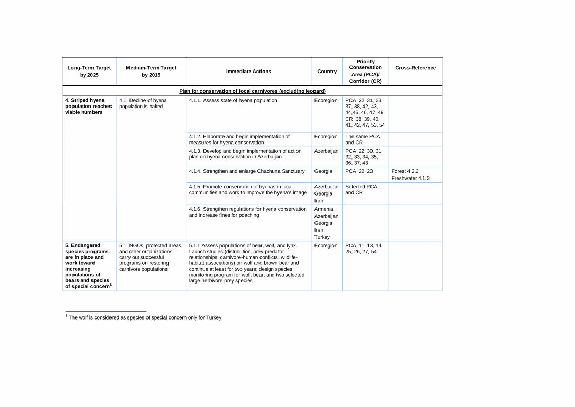
Long-Term Target by 2025
Medium-Term Target by 2015 Immediate Actions Country
Priority Conservation Area (PCA)/
Corridor (CR)
Cross-Reference
Plan for conservation of focal carnivores (excluding leopard)
4.1.1. Assess state of hyena population Ecoregion PCA 22, 31, 33, 37, 38, 42, 43, 44,45, 46, 47, 49 CR 38, 39, 40, 41, 42, 47, 53, 54
4.1.2. Elaborate and begin implementation of measures for hyena conservation
Ecoregion The same PCA and CR
4.1.3. Develop and begin implementation of action plan on hyena conservation in Azerbaijan
Azerbaijan PCA 22, 30, 31, 32, 33, 34, 35, 36, 37, 43
4.1.4. Strengthen and enlarge Chachuna Sanctuary Georgia PCA 22, 23 Forest 4.2.2 Freshwater 4.1.3
4.1.5. Promote conservation of hyenas in local communities and work to improve the hyena’s image
Azerbaijan Georgia Iran
Selected PCA and CR
4. Striped hyena population reaches viable numbers
4.1. Decline of hyena population is halted
4.1.6. Strengthen regulations for hyena conservation and increase fines for poaching
Armenia Azerbaijan Georgia Iran Turkey
5. Endangered species programs are in place and work toward increasing populations of bears and species of special concern1
5.1. NGOs, protected areas, and other organizations carry out successful programs on restoring carnivore populations
5.1.1 Assess populations of bear, wolf, and lynx. Launch studies (distribution, prey-predator relationships, carnivore-human conflicts, wildlife-habitat associations) on wolf and brown bear and continue at least for two years; design species monitoring program for wolf, bear, and two selected large herbivore prey species
Ecoregion PCA 11, 13, 14, 25, 26, 27, 54
1 The wolf is considered as species of special concern only for Turkey
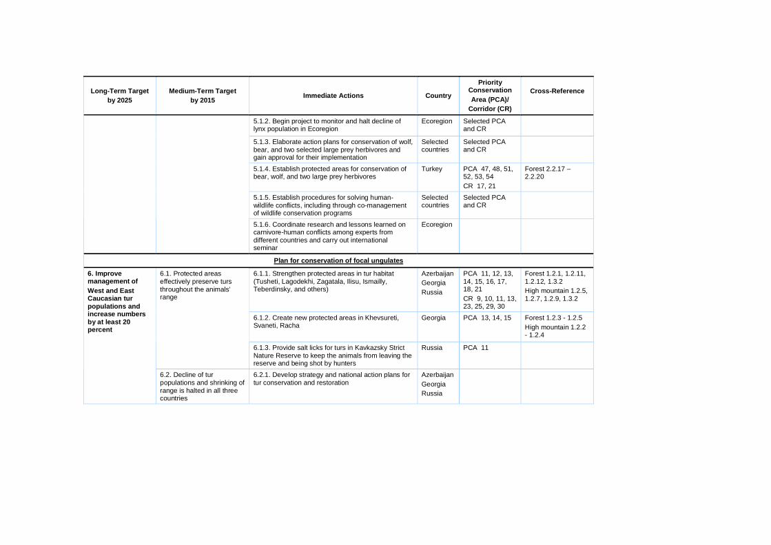
Long-Term Target by 2025
Medium-Term Target by 2015 Immediate Actions Country
Priority Conservation Area (PCA)/
Corridor (CR)
Cross-Reference
5.1.2. Begin project to monitor and halt decline of lynx population in Ecoregion
Ecoregion
Selected PCA and CR
5.1.3. Elaborate action plans for conservation of wolf, bear, and two selected large prey herbivores and gain approval for their implementation
Selected countries
Selected PCA and CR
5.1.4. Establish protected areas for conservation of bear, wolf, and two large prey herbivores
Turkey PCA 47, 48, 51, 52, 53, 54 CR 17, 21
Forest 2.2.17 – 2.2.20
5.1.5. Establish procedures for solving human-wildlife conflicts, including through co-management of wildlife conservation programs
Selected countries
Selected PCA and CR
5.1.6. Coordinate research and lessons learned on carnivore-human conflicts among experts from different countries and carry out international seminar
Ecoregion
Plan for conservation of focal ungulates
6.1.1. Strengthen protected areas in tur habitat (Tusheti, Lagodekhi, Zagatala, Ilisu, Ismailly, Teberdinsky, and others)
Azerbaijan Georgia Russia
PCA 11, 12, 13, 14, 15, 16, 17, 18, 21 CR 9, 10, 11, 13, 23, 25, 29, 30
Forest 1.2.1, 1.2.11, 1.2.12, 1.3.2 High mountain 1.2.5, 1.2.7, 1.2.9, 1.3.2
6.1.2. Create new protected areas in Khevsureti, Svaneti, Racha
Georgia PCA 13, 14, 15 Forest 1.2.3 - 1.2.5 High mountain 1.2.2 - 1.2.4
6.1. Protected areas effectively preserve turs throughout the animals’ range
6.1.3. Provide salt licks for turs in Kavkazsky Strict Nature Reserve to keep the animals from leaving the reserve and being shot by hunters
Russia PCA 11
6. Improve management of West and East Caucasian tur populations and increase numbers by at least 20 percent
6.2. Decline of tur populations and shrinking of range is halted in all three countries
6.2.1. Develop strategy and national action plans for tur conservation and restoration
Azerbaijan Georgia Russia
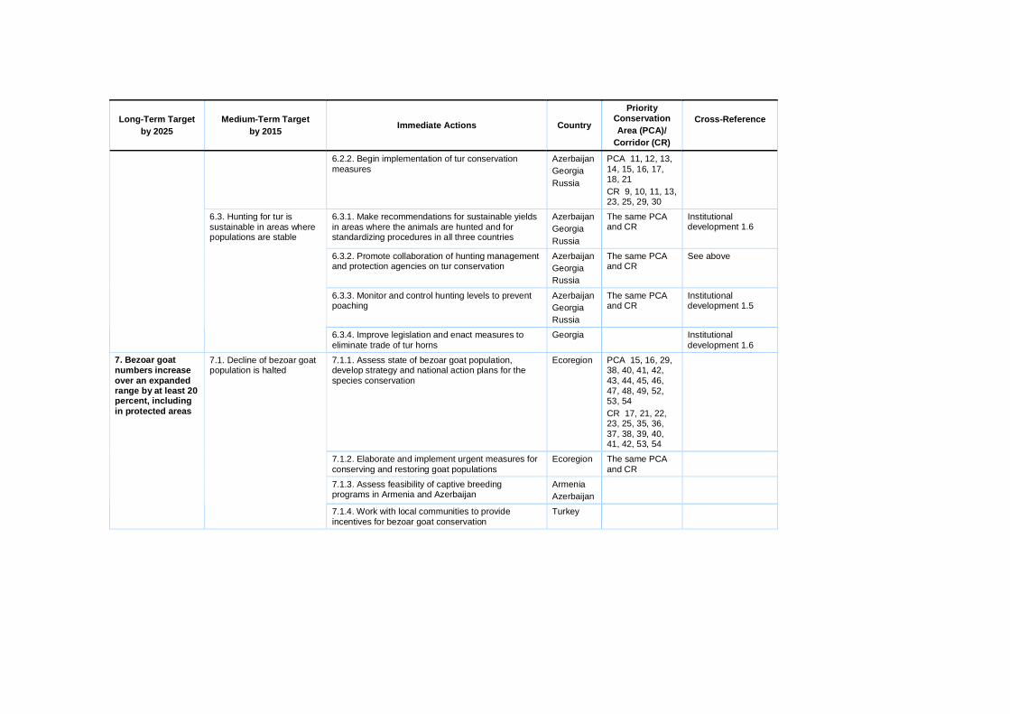
Long-Term Target by 2025
Medium-Term Target by 2015 Immediate Actions Country
Priority Conservation Area (PCA)/
Corridor (CR)
Cross-Reference
6.2.2. Begin implementation of tur conservation measures
Azerbaijan Georgia Russia
PCA 11, 12, 13, 14, 15, 16, 17, 18, 21 CR 9, 10, 11, 13, 23, 25, 29, 30
6.3.1. Make recommendations for sustainable yields in areas where the animals are hunted and for standardizing procedures in all three countries
Azerbaijan Georgia Russia
The same PCA and CR
Institutional development 1.6
6.3.2. Promote collaboration of hunting management and protection agencies on tur conservation
Azerbaijan Georgia Russia
The same PCA and CR
See above
6.3.3. Monitor and control hunting levels to prevent poaching
Azerbaijan Georgia Russia
The same PCA and CR
Institutional development 1.5
6.3. Hunting for tur is sustainable in areas where populations are stable
6.3.4. Improve legislation and enact measures to eliminate trade of tur horns
Georgia Institutional development 1.6
7.1.1. Assess state of bezoar goat population, develop strategy and national action plans for the species conservation
Ecoregion PCA 15, 16, 29, 38, 40, 41, 42, 43, 44, 45, 46, 47, 48, 49, 52, 53, 54 CR 17, 21, 22, 23, 25, 35, 36, 37, 38, 39, 40, 41, 42, 53, 54
7.1.2. Elaborate and implement urgent measures for conserving and restoring goat populations
Ecoregion The same PCA and CR
7.1.3. Assess feasibility of captive breeding programs in Armenia and Azerbaijan
Armenia Azerbaijan
7. Bezoar goat numbers increase over an expanded range by at least 20 percent, including in protected areas
7.1. Decline of bezoar goat population is halted
7.1.4. Work with local communities to provide incentives for bezoar goat conservation
Turkey

Long-Term Target by 2025
Medium-Term Target by 2015 Immediate Actions Country
Priority Conservation Area (PCA)/
Corridor (CR)
Cross-Reference
7.1.5. Elaborate program and begin establishing a founder population of 7-8 pairs of bezoar goats in the Borjomi-Kharagauli National Park
Armenia, Georgia
PCA 27
7.1.6. Elaborate and begin implementation of program for reintroduction of bezoar goat in Zuvand Sanctuary (Azerbaijan)
Azerbaijan PCA 37
7.2.1. Establish new protected areas in southern Armenia to conserve leopard, bezoar goat, and other focal species
Armenia PCA 42, 43 Focal species 3.2.1. Forest 2.2.1.
7.2.2. Create Arpi National Park (9,000 ha) in Central Armenia
Armenia PCA 46 High mountain 2.2.2 Focal Species 3.3.2, 7.2.2, 11.2.1
7.2.3. Develop management plan and improve infrastructure of Khosrov Strict Nature Reserve
Armenia PCA 49 Forest 2.2.2 Focal species 3.1.2
7.2.4. Develop management plan and infrastructure of Ordubad National Park in Nakhchyvan
Azerbaijan PCA 43 High mountain 2.2.6 Focal species 3.1.2
7.2. New protected areas are created and existing reserves strengthened for conservation of bezoar goat
7.2.5. Upgrade Tlyaratinsky Sanctuary status to strict nature reserve
Russia PCA 18 Forest 1.2.11 High mountain 1.2.9
7.3. An effective legislative basis for bezoar goat conservation is in place
7.3.1. Harmonize legislation on bezoar goat protected status among countries and increase penalties for poaching bezoar goats
Ecoregion
8.1.1. Survey red deer populations in each country and assess threats
Ecoregion PCA 11, 12, 16, 17, 21, 27, 28, 37, 39, 50 CR 9, 29, 32, 43, 58, 59
8. Sustainable management practices for Caucasian red deer are in place in the North Caucasus and red deer population in the South Caucasus doubles
8.1. Long-term strategy for red deer conservation is developed and implementation begun
8.1.2. Develop long-term strategy and coordination mechanisms for red deer conservation, and begin implementation
Ecoregion The same PCA and CR

Long-Term Target by 2025
Medium-Term Target by 2015 Immediate Actions Country
Priority Conservation Area (PCA)/
Corridor (CR)
Cross-Reference
8.2.1 Strengthen protection of Borjomi-Kharagauli National Park and Lagodekhi Strict Nature Reserve in Georgia, and Zagatala, Ilisu, and Ismailly strict nature reserves in Azerbaijan
Azerbaijan Georgia
PCA 16, 17, 21, 27 CR 29
Forest 1.2.1, 2.2.8 High mountain 1.3.2 Focal species 6.1.1
8.2. Strengthen existing reserves for red deer conservation and create linking corridors
8.2.2. Elaborate plan and begin creation of migration corridors to connect isolated red deer populations
Azerbaijan Georgia Russia
8.3.1. Elaborate and begin implementation of program for reintroduction of red deer in Hirkan National Park
Azerbaijan PCA 37
8.3.2. Elaborate and begin implementation of program for reintroduction of red deer in Dilijan National Park
Armenia PCA 50
8.3.3. Work out captive breeding programs and create reproductive herds in breeding centers
Azerbaijan Georgia Iran
PCA 16, 17, 21, 27, 28, 38
8.3. Program for reintroduction of red deer in the wild in its former range is launched
8.3.4. Identify protected areas and other sites where reintroduction is feasible and establish appropriate protected regime in sites
Ecoregion Selected PCA
8.4.1. Assess population of red deer in the North Caucasus and elaborate sustainable quotas and system for monitoring actual number taken
Russia PCA 11, 12, 14, 15, 16
Institutional development 1.5, 1.6, 2.2
8.4.2. Ensure coordination of game management and other hunting agencies across republic boundaries
Russia The same PCA and CR
See above
8.4.3. Support inspection agencies to effectively manage red deer hunting and poaching
Russia The same PCA and CR
See above
8.4. Sustainable hunting of red deer is practiced in the Russian Caucasus
8.4.4. Support NGO patrol groups for red deer conservation
Russia The same PCA and CR
Institutional development 2.1.1, 2.2.1
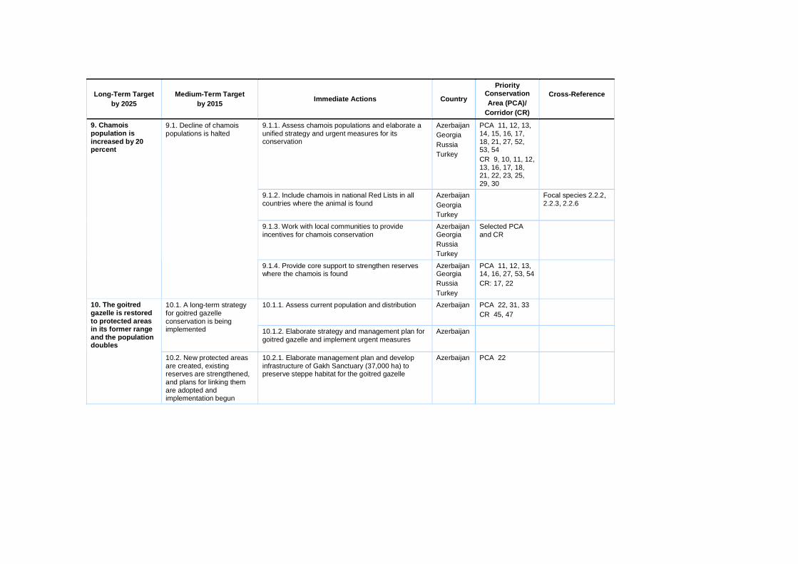
Long-Term Target by 2025
Medium-Term Target by 2015 Immediate Actions Country
Priority Conservation Area (PCA)/
Corridor (CR)
Cross-Reference
9.1.1. Assess chamois populations and elaborate a unified strategy and urgent measures for its conservation
Azerbaijan Georgia Russia Turkey
PCA 11, 12, 13, 14, 15, 16, 17, 18, 21, 27, 52, 53, 54 CR 9, 10, 11, 12, 13, 16, 17, 18, 21, 22, 23, 25, 29, 30
9.1.2. Include chamois in national Red Lists in all countries where the animal is found
Azerbaijan Georgia Turkey
Focal species 2.2.2, 2.2.3, 2.2.6
9.1.3. Work with local communities to provide incentives for chamois conservation
Azerbaijan Georgia Russia Turkey
Selected PCA and CR
9. Chamois population is increased by 20 percent
9.1. Decline of chamois populations is halted
9.1.4. Provide core support to strengthen reserves where the chamois is found
Azerbaijan Georgia Russia Turkey
PCA 11, 12, 13, 14, 16, 27, 53, 54 CR: 17, 22
10.1.1. Assess current population and distribution Azerbaijan PCA 22, 31, 33 CR 45, 47
10.1. A long-term strategy for goitred gazelle conservation is being implemented 10.1.2. Elaborate strategy and management plan for
goitred gazelle and implement urgent measures Azerbaijan
10. The goitred gazelle is restored to protected areas in its former range and the population doubles
10.2. New protected areas are created, existing reserves are strengthened, and plans for linking them are adopted and implementation begun
10.2.1. Elaborate management plan and develop infrastructure of Gakh Sanctuary (37,000 ha) to preserve steppe habitat for the goitred gazelle
Azerbaijan PCA 22

Long-Term Target by 2025
Medium-Term Target by 2015 Immediate Actions Country
Priority Conservation Area (PCA)/
Corridor (CR)
Cross-Reference
10.2.2. Elaborate management plan and develop infrastructure for Shirvan National Park
Azerbaijan PCA 33
10.2.3. Provide core support for Shirvan National Park and Korchay Sanctuary for protecting goitred gazelle
Azerbaijan PCA 22, 33
10.2.4. Upgrade Korchay Sanctuary status to strict nature reserve and provide necessary support for enforcing regime
Azerbaijan PCA 22
10.2.5. Assess feasibility of creating protected migration corridors between the two isolated populations and begin to implement measures
Azerbaijan PCA 31 CR 45, 47
10.3.1. Create breeding centers in Shirvan and Vashlovani national parks
Azerbaijan Georgia
PCA 22, 33
10.3.2. Determine potential sites for gazelle release and ensure their protection
Azerbaijan Georgia
PCA 22 CR 45 and other selected PCA and CR
10.3. Program for reintroduction of goitred gazelle is underway
10.3.3. Work with local communities to ensure support for release program
Azerbaijan Georgia
The same PCA and CR
11.1.1. Assess current population and distribution Armenia Azerbaijan Iran Turkey
PCA 42, 43, 45, 46, 48, 49, 52 CR 35, 39, 40, 41, 42
11. Population of Gmelin’s mouflon is increased by at least 50 percent
11.1. A long-term strategy for mouflon conservation is adopted and implementation begun
11.1.2. Elaborate strategy and action plans for mouflon and implement urgent measures
Armenia Azerbaijan Iran Turkey
The same PCA and CR

Long-Term Target by 2025
Medium-Term Target by 2015 Immediate Actions Country
Priority Conservation Area (PCA)/
Corridor (CR)
Cross-Reference
11.1.3. Assess feasibility of launching captive breeding and transboundary protection programs
Armenia Azerbaijan Iran Turkey
Selected PCA and CR
11.2.1. Create Arpi National Park in central Armenia for conservation of leopard and mouflon habitat
Armenia PCA 46 High mountain 2.2.2 Focal species 3.3.2, 7.2.2
11.2.2. Improve protection of mouflon in Khosrov Reserve and Urts Range of Armenia; increase protected status of Gorovan Sands Sanctuary
Armenia PCA 49 CR 40
Forest 2.2.2 Focal species 3.1.2
11.2.3. Establish new protected areas in southern Armenia to conserve mouflon, leopard, and other focal species
Armenia PCA 42, 43 Forest 2.2.1 Focal species 3.2.1
11.2. Mouflon are effectively conserved in protected areas
11.2.4. Elaborate management plan and develop infrastructure of Ordubad National Park in Nakhchyvan
Azerbaijan PCA 43 High mountain 2.2.6 Focal species 3.1.2, 7.2.4
11.3. Program is begun for reintroduction of mouflon to the wild in its former range
11.3.1. Elaborate captive breeding program and begin establishing founder population of 7-8 pairs of mouflons to allow gene flow between isolated populations
Armenia Azerbaijan
PCA 42, 43, 45, 46, 49
12.1.1. Increase protection of bison in the wild by providing support to protected areas where the animals are found
Russia PCA 11, 12
12.1.2. Work with local communities to provide incentives for conserving bison
Russia PCA 11, 12
12. A healthy population of European bison is managed sustainably
12.1. European bison are effectively conserved in protected areas
12.1.3. Support research and monitoring of bison in Kavkazsky and Teberdinsky strict nature reserves
Russia PCA 11, 12
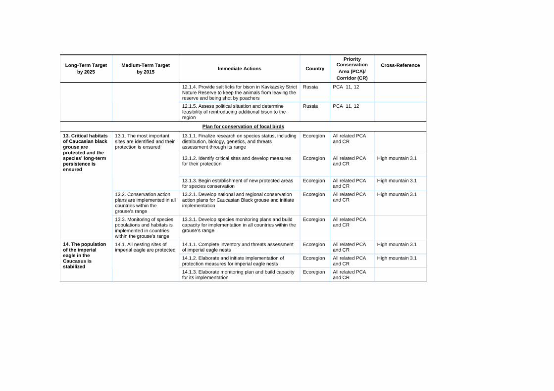
Long-Term Target by 2025
Medium-Term Target by 2015 Immediate Actions Country
Priority Conservation Area (PCA)/
Corridor (CR)
Cross-Reference
12.1.4. Provide salt licks for bison in Kavkazsky Strict Nature Reserve to keep the animals from leaving the reserve and being shot by poachers
Russia PCA 11, 12
12.1.5. Assess political situation and determine feasibility of reintroducing additional bison to the region
Russia PCA 11, 12
Plan for conservation of focal birds
13.1.1. Finalize research on species status, including distribution, biology, genetics, and threats assessment through its range
Ecoregion All related PCA and CR
13.1.2. Identify critical sites and develop measures for their protection
Ecoregion All related PCA and CR
High mountain 3.1
13.1. The most important sites are identified and their protection is ensured
13.1.3. Begin establishment of new protected areas for species conservation
Ecoregion All related PCA and CR
High mountain 3.1
13.2. Conservation action plans are implemented in all countries within the grouse’s range
13.2.1. Develop national and regional conservation action plans for Caucasian Black grouse and initiate implementation
Ecoregion All related PCA and CR
High mountain 3.1
13. Critical habitats of Caucasian black grouse are protected and the species’ long-term persistence is ensured
13.3. Monitoring of species populations and habitats is implemented in countries within the grouse’s range
13.3.1. Develop species monitoring plans and build capacity for implementation in all countries within the grouse’s range
Ecoregion All related PCA and CR
14.1.1. Complete inventory and threats assessment of imperial eagle nests
Ecoregion All related PCA and CR
High mountain 3.1
14.1.2. Elaborate and initiate implementation of protection measures for imperial eagle nests
Ecoregion All related PCA and CR
High mountain 3.1
14. The population of the imperial eagle in the Caucasus is stabilized
14.1. All nesting sites of imperial eagle are protected
14.1.3. Elaborate monitoring plan and build capacity for its implementation
Ecoregion All related PCA and CR

Long-Term Target by 2025
Medium-Term Target by 2015 Immediate Actions Country
Priority Conservation Area (PCA)/
Corridor (CR)
Cross-Reference
14.2.1. Identify new potential nesting sites based on species distribution and occurrence research
Ecoregion All related PCA and CR
High mountain 3.1 14.2. New potential nesting sites are identified and artificial nests are built 14.2.2. Design program and begin construction of
artificial nests Ecoregion All related PCA
and CR
15.1.1. Complete inventory and threats assessment of cinereous vulture nesting sites in the Caucasus
Ecoregion All related PCA and CR
High mountain 3.1
15.1.2. Develop measures to protect cinereous vulture nesting sites
Ecoregion All related PCA and CR
High mountain 3.1
15.1. All nesting sites of Cinereous vulture are identified and granted protection
15.1.3. Develop monitoring plan and build capacity for its implementation
Ecoregion All related PCA and CR
15. The population of cinereous vulture in the Caucasus is stabilized
15.2. Number of cinereous vulture pairs increases by 50 percent
15.2.1. Design and begin implementation of artificial feeding program
Ecoregion All related PCA and CR
High mountain 2.2.2
16.1.1. Inventory marbled duck nesting sites Ecoregion All related PCA and CR
Freshwater 3.1, 3.2 16.1. All nesting sites of marbled duck are identified and granted protection
16.1.2. Develop measures to protect marbled duck nesting sites
Ecoregion All related PCA and CR
Freshwater 3.1, 3.2
16. A viable breeding population of marbled duck is ensured in the Caucasus
16.2. Quality of marbled duck breeding habitat is improved
16.2.1. Develop habitat management measures and initiate implementation
Ecoregion All related PCA and CR
Freshwater 3.1, 3.2

Long-Term Target by 2025
Medium-Term Target by 2015 Immediate Actions Country
Priority Conservation Area (PCA)/
Corridor (CR)
Cross-Reference
17.1.1. Inventory important sites for white-headed duck in the Caucasus
Ecoregion All related PCA and CR
Freshwater 3.1, 3.2
17.1.2. Develop measures to protect white-headed duck habitats
Ecoregion All related PCA and CR
Freshwater 3.1, 3.2
17.1. All important sites for white-headed duck are identified and granted protection
17.1.3. Develop and build capacity for white-headed duck population monitoring program
Ecoregion All related PCA and CR
17. A viable population of white-headed duck is ensured in the Caucasus
17.2. Quality of white-headed duck breeding habitats is improved
17.2.1. Develop habitat management measures and begin implementation
Ecoregion All related PCA and CR
Freshwater 3.1, 3.2
18.1.1. Inventory pygmy cormorant breeding sites in the Caucasus
Ecoregion All related PCA and CR
Freshwater 3.1, 3.2
18.1.2. Elaborate measures to protect pygmy cormorant breeding sites
Ecoregion All related PCA and CR
Freshwater 3.1, 3.2
18. A viable population of pygmy cormorant is ensured in the Caucasus
18.1.All important breeding sites for pygmy cormorant are identified and ensured protection
18.1.3. Elaborate and build capacity for monitoring program on pygmy cormorant breeding population
Ecoregion All related PCA and CR
Plan for conservation of focal amphibians
19.1.1. Collect detailed information about the location of spadefoot populations throughout range
Ecoregion PCA 19, 22, 36, 41, 42, 43, 49, 52
19.1.2. Grant legal protection to at least eight populations of spadefoot in PCA
Ecoregion The same PCA
19.1. Ten large and stable populations of the spadefoot exist within the Ecoregion
19.1.3. Introduce spadefoot in large reservoirs created within the species’ range
Ecoregion The same PCA
19.2.1. Connect important habitats with corridors appropriate for spadefoot dispersal
Armenia Azerbaijan Georgia
PCA 46, 49
19. The number of local populations of Syrian spadefoot toad increases by 20 percent and the species’ range is stabilized
19.2. Gene flow between major regions is ensured through conservation corridor
19.2.2. Restock individual isolated habitats from key locations
Armenia Azerbaijan Georgia
PCA 46, 49

Long-Term Target by 2025
Medium-Term Target by 2015 Immediate Actions Country
Priority Conservation Area (PCA)/
Corridor (CR)
Cross-Reference
20.1. The exact area of distribution of salamanders is known
20.1.1. Clarify range of Caucasian salamander in Georgia and describe key limiting factors
Georgia PCA 27, 54 CR 16
Forest
20.2.1. Outline key habitats for salamanders Georgia Turkey
PCA 27, 54 CR 16, 17.
Forest
20. Over 50 locations of the Caucasian salamander are legally protected throughout the entire range and connected by corridors
20.2. Identified locations of Caucasian salamander are legally protected in PCAs connected by corridors 20.2.2. Grant legal protection to corridors for
dispersal of at least 10 populations of salamander Georgia Turkey
PCA 27, 54 CR 16, 17.
Forest
Plan for conservation of focal fish species
21.1.1. Identify all spawning grounds for sturgeons and assess threats
Azerbaijan Georgia Iran Russia Turkey
PCA 2, 3, 4, 5, 9, 10, 19, 20, 26, 32, 33, 35, 37, 56 CR 1, 2, 3, 4, 8, 15, 24, 31, 46, 48, 52, 55, 57, 60
Marine
21.1.2. Enact legislation against fishing in spawning areas
Azerbaijan Georgia Iran Russia
The same PCA and CR
Institutional development 1.6 Marine
21.1.3. Strengthen protection of spawning areas on the Caspian in Kura Delta and Samur, Yalama, and Talish rivers
Azerbaijan PCA 19, 20, 32, 33, 35, 37 CR 31, 46, 48, 52, 55
Marine 9.1.3
21.1.4. Restore strict protection in the aquatic section of Kolkheti National Park
Georgia PCA 26 Marine 9.2.2
21.1.5. Renew activities of the Geguti Fish Farm of releasing sturgeon young in the Rioni River
Georgia PCA 26
21. Recovering populations of sturgeon are conserved in the Black and Caspian seas
21.1. All spawning areas are strictly protected and decline of all sturgeon populations is halted
21.1.6. Secure habitat and restore migratory routes for sturgeon in all major rivers
Iran PCA 37, 56 Freshwater 8.1.6

Long-Term Target by 2025
Medium-Term Target by 2015 Immediate Actions Country
Priority Conservation Area (PCA)/
Corridor (CR)
Cross-Reference
21.1.7. Secure habitat and restore migratory routes for sturgeon in all spawning rivers
Russia PCA 2, 3, 4, 5, 9, 10, 19 CR 1, 2, 3, 4, 8, 24
Freshwater 8.1.9
21.1.8. Establish sanctuary on lower Rioni River Georgia PCA 26
21.2. National Action Plans are elaborated and state of sturgeon populations and threats in the Black and Azov seas are known
21.2.1. Status of sturgeon populations and threats are assessed in the Georgian section of the Black Sea, National Action Plan is elaborated and approved by relevant governmental organizations
Georgia PCA 26 CR 15
Marine
21.3. Research on taxonomy of sturgeon species is completed
21.3.1. Taxonomy of sturgeon species is revised Ecoregion All marine PCA and CR
21.4. Market assessment is completed and public awareness campaign initiated
21.4.1. Domestic markets in main sturgeon-consuming countries of the Ecoregion are assessed and public awareness campaign is facilitated
Russia Azerbaijan
21.5. Illegal sturgeon fishing is reduced by half in the Ecoregion
21.5.1. Take measures to control the illegal trade of sturgeon and caviar in Georgia
Georgia PCA 26 Institutional development 1.5, 1.6 Marine
22. Viable populations of Salmo ischchan and Barbus goktschaicus are established
22.1. Populations of Salmo ischchan and Barbus goktschaicus begin to recover
22.1.1. Restore habitats of Salmo ischchan and Barbus goktschaicus in Armenia
Armenia PCA 50, 51 Freshwater 1.2.1
117
PRIORITY CONSERVATION AREAS AND CORRIDORSIN THE CAUCASUS ECOREGION
Brief Description
A. Priority Conservation Areas
1. ABRAU-DYURSO
Location: West from the city of Novorossiysk, at the westernmost end of the GreaterCaucasus Range, bordering the Black SeaLongitude: 37o32’53’’ Latitude: 44o44’05’’
Area: 26,877 haEconet: Greater Caucasus ForestCountries: RussiaMain Biomes: ForestMain Habitats 5: Forests – 25,694 ha (95.60%): Crimea-Novorossiysk low-mountain oak and
pine forests and juniper open woodlandsLand Use/Land Cover 6: Urban areas – 421 ha (1.57%); farmlands – 3,429 ha (12.76%); Lake Abrau-
Dyurso – 120 ha (0.45%); actual forest cover – 22,907 ha (85.23%)Protected Areas: Two areas totaling 18,100 ha (67.34%): Abrausky Sanctuary – 11,500 ha
(42.79%) and Bolshoy Utrish Sanctuary – 6,600 ha (24.56%)Key Phenomena: Rare plant communities: Juniperus exselsa, J. foetidissima, Pistacia mutica,
and endemic species of reptiles and fish (Clupeonella abrau is endemic toLake Abrau Durso)
Focal Species: NoneSpecies of Special Concern: Rhinolophus mehelyi, R. hipposideros, R. euryale, Myotis emarginatus, M.
bechsteini, Barbastella barbastellusPopulation Density: ModerateResource Dependence: LowThreats: High recreation pressureCEPF Site Outcomes 7: None
2. KUBAN
Location: At the mouth of the Kuban River, in the Azov Sea coastal areaLongitude: 37o22’18’’ Latitude: 45o20’23’
Area: 85,484 ha (aquatic area – 16,077 ha, terrestrial area – 69,407 ha)Econet: Azov-Black Sea CoastCountries: RussiaMain Biomes: Freshwater, marineMain Habitats: Wetlands – 39,130 ha (56.38% of terrestrial area), including 33,826 ha of miresLand Use/Land Cover: Rural settlements – 847 ha (1.22% of terrestrial area); farmlands – 28,655 ha
(41.29% of terrestrial area), among them 2,185 ha (3.15%) vineyards; lakes
5 According to Map 2: Natural Landscapes of the Caucasus (sc. 1:500,000)6 According to Map 3: Land Use/Cover of the Caucasus (sc. 1:500,000)7 According to CEPF Profile for Caucasus Hotspot (www.cepf.net)
Attachment 1

118
(including ephemeral) – 24,808 ha (35.74% of terrestrial area); saline lands–296 ha (0.43%); reed and bulrush – 3,828 ha (5.52%); mires – 9,586 ha (13.81%);actual forest cover – 478 ha (0.69%); rivers – 908 ha (1.31%)
Protected Areas: NoneKey Phenomena: Spawning area for sturgeons (Focal Species), stopover and wintering grounds
for migratory birds, large congregations of migratory birdsFocal Species: Huso huso, Acipenser stellatus, A. gueldenstaedtiiSpecies of Special Concern: Mustela lutreola, Lutra lutraPopulation Density: ModerateResource Dependence: ModerateThreats: Poaching, water pollution, habitat degradationCEPF Site Outcomes: Kuban (2)
3. PRIMORSKO-AKHTARSK
Location: Middle part of the eastern coast of the Azov Sea from the saline BeysugskyLiman to the southern outskirts of the town of Primorsko-AkhtarskLongitude: 38o11’09’’ Latitude: 46o01’16’’
Area: 163,163 ha (aquatic area – 19,290 ha, terrestrial area –143,873 ha)Econet: Azov-Black Sea CoastCountries: RussiaMain Biomes: Freshwater, marineMain Habitats: Wetlands: freshwater ecosystems – 83,017 ha (57.70% of terrestrial area); delta,
floodplain swamp forests, grasslands, and salt marshes – 61,551 ha (42.78%of terrestrial area)
Land Use/Land Cover: Terrestrial area: urban areas and rural settlements – 1,850 ha (1.29% ofterrestrial area); farmlands – 59,006 ha (41.01% of terrestrial area); lakes(including ephemeral lakes and reservoirs) – 64,221 ha (44.64% of terrestrialarea); rivers – 190 ha (0.13%); mires — 9,948 ha (6.91%); reed and bulrush –8,657 ha (6.02%)
Protected Areas: NoneKey Phenomena: Sturgeon populations, habitats of waterfowl, large aggregations of migratory
birdsFocal Species: Oxyura leucocephala, Huso huso, Acipenser stellatus, A. gueldenstaedtiiSpecies of Special Concern: Mustela lutreola, Lutra lutraPopulation Density: ModerateResource Dependence: ModerateThreats: Water pollutionCEPF Site Outcomes: Azov Sea Eastern Coast (9), Primorsko-Akhtarsk Salt Lakes (11)
4. YEYSK
Location: Coastal area of Yeysky zaliv (Yeysky Bay), Azov SeaLongitude: 38o36’55’’ Latitude: 46o38’49’’
Area: 130,184 ha (aquatic area – 21,820 ha, terrestrial area – 108,364 ha)Econet: Azov-Black Sea CoastCountries: RussiaMain Biomes: Freshwater, marine

119
Main Habitats: Delta and floodplain landscapes with wetlands, swamp forests and grasslands,and salt marshes – 12,340 ha (11.39% of terrestrial area).
Land Use/Land Cover: Urban and rural settlements – 2,841 ha (2.62% of terrestrial area); farmlands –96,323 ha (88.89% of terrestrial area); lakes (including ephemeral lakes andreservoirs) – 486 ha (0.45% of terrestrial area); actual forest cover – 100 ha(0.09%), rivers – 241 ha (0.22%); mires – 8,373 ha (7.73%)
Protected Areas NoneKey Phenomena: Sturgeon populations, habitats of waterfowl, population of Otis tarda, large
aggregations of migratory birdsFocal Species: Huso huso, Acipenser stellatus, A. gueldenstaedtiiSpecies of Special Concern: Mustela lutreola, Lutra lutraPopulation Density: HighResource Dependence: HighThreats: Water pollution, illegal fishing, poachingCEPF Site Outcomes: None
5. DON DELTA
Location: Don River Delta at the northernmost point of the Azov SeaLongitude: 39o24’10’’ Latitude: 47o09’13’’
Area: 55,234 ha (aquatic area – 10,256 ha, terrestrial area – 44,948 ha).7,224 ha of PCA (13.03% of territory) is located within Ecoregion boundaries
Econet: Azov-Black Sea Coast, Manych-GudiloCountries: RussiaMain Biomes: Freshwater, marineMain Habitats: Delta and floodplain wetlands – 44,849 ha (99.71% of terrestrial area)Land Use/Land Cover: Within the Ecoregion: rural settlements - 53 ha (0.73%); farmlands (mainly arable
lands) – 2,052 ha (28.40%); lakes (including ephemeral lakes and reservoirs) –44 ha (0.61%); rivers – 1,888 ha (26.14%); mires – 334 ha (4.62%); reed andbulrush – 2772 ha (38.38%); actual forest cover– 81 ha (1.12%)
Protected Areas: NoneKey Phenomena: Sturgeon populations, aggregations of waterfowlFocal Species: Huso huso, Acipenser stellatus, A. gueldenstaedtiiSpecies of Special Concern: Mustela lutreola, Lutra lutraPopulation Density: HighResource Dependence: High (PCA borders the large city of Rostov-on-Don)Threats: Water pollution, illegal fishing, poachingCEPF Site Outcomes: Don Delta (5)
6. VESELOVSKOYE RESERVOIR
Location: Westernmost part of Kuma-Manych DepressionLongitude: 41o05’’13’’ Latitude: 47o05’09’’
Area: 86,140 ha23,722 ha of PCA (27.54% of territory) is located within Ecoregion boundaries
Econet: Manych-GudiloCountries: RussiaMain Biomes: FreshwaterMain Habitats: Delta and floodplain wetlands – 75,107 ha (87.19% of PCA’s total area)

120
Land Use/Land Cover: Within the Ecoregion: urban and rural settlements – 85 ha (0.36%); farmlands –13,137 ha (55.38%); reservoirs, ponds – 9,832 ha (41.45%); lakes (includingephemeral lakes) – 285 (1.2%); actual forest cover – 382 ha (1.61%).
Protected Areas: NoneKey Phenomena: Stopover site for migratory birds, large aggregations of migratory birdsFocal Species: NoneSpecies of Special Concern: Lutra lutraPopulation Density: Low, moderate in areasResource Dependence: HighThreats: Water pollution, illegal fishing, poachingCEPF Site Outcomes: Veselovskoye Reservoir (8)
7. MANYCH-GUDILO
Location: Central part of the Kuma-Manych Depression, at the westernmost end of Manych-Gudilo LakeLongitude: 42o22’23’’ Latitude: 46o28’36’’
Area: 97,261 ha54,309 ha (55.84% of territory) is located within Ecoregion boundaries
Econet: Manych-GudiloCountries: RussiaMain Biomes: FreshwaterMain Habitats: Delta and floodplain wetlands with swamp grasslands and salt marshes –
12,657 ha (13.01% of PCA’s total area), surrounded by 31,518 ha of mixed herb-grass steppes (32.41%) and 43,210 ha of halophytic semi-deserts with Artemisiaspp. and Salsola spp. (44.43%)
Land Use/Land Cover: Within the Ecoregion: urban areas and rural settlements – 1,006 ha (1.85%);farmlands – 42,402 ha (78.08%), reservoirs – 9,468 ha (17.43%); saline lands– 1,024 ha (1.89%); lakes (including ephemeral lakes) – 409 ha (0.75%)
Protected Areas: NoneKey Phenomena: Stopover for migratory birds, large aggregations of migratory birdsFocal Species: NoneSpecies of Special Concern: Lutra lutraPopulation Density: ModerateResource Dependence: HighThreats: Water pollution, illegal fishing, poachingCEPF Site Outcomes: Manych-Gudilo Lake (3)
8. DADYNSKOYE LAKE
Location: Eastern part of the Kuma-Manych Depression near the Dadynskoye saline lakeLongitude: 45o06’54’’ Latitude: 45o15’39’’
Area: 65,868 ha52,445 ha of PCA (79.62%) is located within Ecoregion boundaries
Econet: Manych-GudiloCountries: RussiaMain Biomes: FreshwaterMain Habitats: Delta and floodplain wetlands – 3,325 ha (5.05% of PCAs total area), surrounded
by 55,587 ha of halophytic semi-deserts with Artemisia and Salsola (84.39%)

121
Land Use/Land Cover: Within the Ecoregion: farmlands – 8,144 ha (15.53%); saline lands – 3,920 ha(7.48%); winter pastures – 34,855 ha (66.45%); lakes, mainly ephemeral –5,526 ha (10.54%)
Protected Areas: NoneKey Phenomena: Stopover for migratory birds, large aggregations of migratory birds; habitats for
Glareola nordmanni, Branta ruficollis, Anser erythropus, Otis tarda, Oxyuraleucocephala, Falco naumanni
Focal Species: Oxyura leucocephalaSpecies of Special Concern: NonePopulation Density: LowResource Dependence: ModerateThreats: Water pollution, illegal fishing, poachingCEPF Site Outcomes: Dadynskiye Lakes (1)
9. KIZLYARSKY BAY
Location: Caspian Sea coast, north from the mouth of Terek River, covering Kizlyarsky Bayand the northern section of Terek River DeltaLongitude: 46o51’24’’ Latitude: 44o21’14’’
Area: 201,483 ha, (aquatic area – 25,417 ha, terrestrial area – 176,066 ha).Econet: Caspian Sea coastCountries: RussiaMain Biomes: Freshwater, marineMain Habitats: Delta and floodplain wetlands, swamp grasslands, and salt marshes – 152,501
ha (86.62% of terrestrial area)Land Use/Land Cover: Rural settlements – 1,123 ha (0.64% of terrestrial area); winter pastures – 126,131
ha (71.68% of terrestrial area); lakes (including ephemeral lakes and reservoirs)– 8,209 ha (4.66% of terrestrial area); reed and bulrush – 32,699 ha (18.6% ofterrestrial area); mires – 5730 ha (3.26%); saline lands – 138 ha (0.08%); sands– 1,971 ha (1.12%); actual forest cover – 65 ha (0.04%)
Protected Areas: Two areas (IUCN categories I-II): Dagestansky Strict Nature Reserve – 46,690ha (26.52% of PCA’s terrestrial area). Other PAs: Tarumovsky Zakaznik(Sanctuary) – 55,495 ha (31.52% of PCA’s terrestrial area)
Key Phenomena: Stopover for migratory birds, large aggregations of migratory birds (waterfowland waders); habitats for Spalax giganteus, Saiga tatarica, Vipera ursinii, Testudograeca
Focal Species: NoneSpecies of Special Concern: Lutra lutraPopulation Density: LowResource Dependence: Moderate, high dependence in partsThreats: Water pollution, illegal fishing, poachingCEPF Site Outcomes: Dagestan NR and Kizlyar Bay (75), Tarumovsky Sanctuary, and Karakolsky Lakes
(76)
10. AGRAKHANSKY BAY
Location: Caspian Sea coast, south from the mouth of the Terek River, AgrakhanskyPeninsula and BayLongitude: 47o33’03’ Latitude: 43o42’22’’
Area: 81,218 ha (aquatic area – 30,644 ha, terrestrial area – 50,574 ha)
122
Econet: Caspian Sea coastCountries: RussiaMain Biomes: MarineMain Habitats: Delta and floodplain wetlands, swamp grasslands, and salt marshes – 15,065
ha (18.55% of PCA’s total area), surrounded by 35,398 ha of halophytic semi-deserts with Artemisia spp. and Salsola spp. (43.58%)
Land Use/Land Cover: Rural settlements – 346 ha (0.68% of terrestrial area); farmlands and winterpastures – 27,084 ha (53.55% of terrestrial area); lakes and mires – 8,463 ha(16.74% of terrestrial area); hilly sands – 14,681 ha (29.03% of terrestrial area)
Protected Areas: One area: Agrakhansky Zakaznik (Sanctuary) – 39,000 ha (77.11% of PCA’sterrestrial area)
Key Phenomena: Stopover for migratory birds, large aggregations of migratory birds, includingwaterfowl and waders
Focal Species: NoneSpecies of Special Concern: NonePopulation Density: LowResource Dependence: ModerateThreats: Water pollution, illegal fishing, poachingCEPF Site Outcomes: Agrakhansky Bay (78)
11. WEST GREATER CAUCASUS
Location: Western foothills of the Greater Caucasus Range on the Black Sea CoastLongitude: 40o00’10’’ Latitude: 43o43’01’’
Area: 874,535 haEconet: Greater CaucasusCountries: Georgia, RussiaMain Biomes: Forest, high mountainMain Habitats: Forest – 593,459 ha (67.86%) including: 102,972 ha of Colchic lowland swamp
alder forests and sphagnum bogs, 192,508 ha of Colchic middle-mountainbeech forests mainly with evergreen understory, and 221,650 ha of darkconiferous (spruce-fir) forests; total high mountain habitats – 165,622 ha(18.93%)4
Land Use/Land Cover: Urban areas and rural settlements – 13,878 ha (1.59%); farmlands – 69,882ha (7.99%); actual forest cover – 672,887 ha (76.94%); summer pastures –89,237 ha (10.20%); barren and rocky areas – 26,977 ha (3.08%); mires –321 ha (0.04%); lakes – 425 ha (0.05%); rivers – 923 ha (0.11%)
Protected Areas: 10 PAs totaling 649,671 ha (74.29%): Ritsa Strict Nature Reserve – 16,289 haand Pitsunda-Myussera Strict Nature Reserve – 3,761 ha (Georgia),Kavkazsky Strict Nature Reserve – 278,959 ha (IUCN I – 299,009 ha –34.19%) and Sochinsky National Park – 193,737 ha (22.15%) (Russia) (IUCNI+II – 492,746 ha – 56.34%); other PAs: Sochinsky Zakaznik (Sanctuary) –48,450 ha (5.54%), Tuapsinsky Zakaznik – 15,000 ha (1.72%), DakhovskyZakaznik – 23,000 ha (2.63%), Psebaisky Zakaznik – 37,400 ha (4.28%),Damkhurtssky Zakaznik – 30,000 ha (3.43%), Zakaznik Bolshoy Tkhach –3,075 ha (0.35%) (Russia); other PAs – 156,925 ha (17.95%)
Key Phenomena: Part of the Colchic refugium of humid Pliocene flora; high proportion ofendemic plants, invertebrates, amphibians and reptiles, mammals, importantpopulations of focal species
11 Including sub-alpine landscapes with crooked-stem forests and elfin woods
123
Focal Species: Ursus arctos, Capra caucasica, Rupicapra rupicapra, Cervus elaphus, Bisonbonasus, Tetrao mlokosiewiczi
Species of Special Concern: Rhinolophus ferrumequinum, R. mehelyi, R. hipposideros, Myotisemarginatus, M. bechsteini, Miniopterus schreibersii, Barbastellabarbastellus, Lutra lutra, Mustela lutreola, Lynx lynx, Tetraogallus caucasicus
Population Density: Low (except along coast)Resource Dependence: HighThreats: Illegal logging, illegal hunting, overgrazingCEPF Site Outcomes: Bichvinta-Miusera NR (21), Ritsa NR (22), Kavkazsky Biosphere Reserve (37),
Sochinsky NP (38), Sochinsky Sanctuary (43), Damkhurtssky Sanctuary (51)
12. TEBERDINSKY STRICT NATURE RESERVE
Location: North-western part of the Greater Caucasus RangeLongitude: 41o27’28’’ Latitude: 43o28’40’’
Area: 357,256 haEconet: Greater CaucasusCountries: Russia, GeorgiaMain Biomes: Forest, high mountainMain Habitats: Forests – 143,937 ha (40.29%), including 46,103 ha of Caucasian middle-
mountain beech and dark coniferous (spruce-fir) forests and 70,219 ha ofCaucasian upper-mountain birch and pine forests; total high mountain habitats– 210,836 ha (59.02%), including 80,870 ha of Caucasian alpine grasslandsand rhododendron thickets
Land Use/Land Cover: Urban areas and rural settlements – 1,229 ha (0.34%); farmlands – 27,044 ha(7.57%); summer pastures – 133,842 ha (37.46%); actual forest cover – 150,385ha (42.09%); barren and rocky areas – 44,429 ha (12.44%); lakes – 328 ha(0.09%).
Protected Areas: Seven PAs totaling 340,283 ha (95.25%); IUCN I-II: Teberdinsky Strict NatureReserve — 103,064 ha (28.85%), Pskhu-Gumista Strict Nature Reserve – 40,819ha (11.43%); total – 143,883 ha (40.27%); other PAs: Labinsky Zakaznik(Sanctuary) – 15,000 ha (4.2%), Cheremukhovsky Zakaznik – 36,500 ha (10.22%),Chiliksky Zakaznik – 35,000 ha (9.8%), Arkhyzsky Zakaznik – 35,000 ha (9.8%),Dautsky Zakaznik – 74,900 ha (20.96%); other PAs: 196,400 ha (57.98%), plusbuffer zones of the strict nature reserves – 435,715 ha
Key Phenomena: Part of the Colchic refugium of humid Pliocene flora; high proportion of endemicplants, invertebrates, amphibians and reptiles, small mammals
Focal Species: Ursus arctos, Capra caucasica, Rupicapra rupicapra, Cervus elaphus, Bisonbonasus, Aquila heliaca, Tetrao mlokosiewiczi
Species of Special Concern: Rhinolophus ferrumequinum, R. mehelyi, R. hipposideros, Myotis emarginatus,M. bechsteini, Miniopterus schreibersii, Lutra lutra, Lynx lynx, Tetraogalluscaucasicus
Population Density: LowResource Dependence: MediumThreats: Illegal logging, illegal hunting, overgrazingCEPF Site Outcomes: Sukhumi (23), Teberdinsky NR (36), Dautsky Sanctuary (50)
13. SVANETI
Location: South-western part of the Greater Caucasus RangeLongitude: 42o39’23’’ Latitude: 43o02’14’’
124
Area: 232,050 haEconet: Greater CaucasusCountries: GeorgiaMain Biomes: Forest, high mountainMain Habitats: Forest – 85,763 ha (36.96%), including 54,593 ha of Caucasian middle-mountain
beech and dark coniferous (spruce-fir) forests and 26,584 ha of Caucasianupper-mountain birch and pine forests; total high mountain habitats – 145,640ha (62.76%), including 62,210 ha of Caucasian alpine grasslands andrhododendron thickets and 33,746 ha of high-mountain plant micro-communitieswith mosses and lichens (sub-nival); glacial-nival forms of landscapes – 23,256ha (10.02%)
Land Use/Land Cover: Urban areas and rural settlements – 2,450 ha (1.06%); farmlands – 8,746 ha(3.77%); summer pastures – 64,387 ha (27.75%); forests – 97,873 ha (42.17%);barren and rocky areas – 57,954 ha (24.97%); lakes – 640 ha (0.28%)
Protected Areas NoneKey Phenomena: Part of the Colchic refugium of humid Pliocene flora; important habitats for focal
species, anticipated hybrid zone between the two species of tursFocal Species: Ursus arctos, Capra caucasica, C. cylindricornis, Rupicapra rupicapra, Tetrao
mlokosiewicziSpecies of Special Concern: Lynx lynx, Tetraogallus caucasicusPopulation Density: LowResource Dependence: HighThreats: Illegal logging, illegal hunting, overgrazingCEPF Site Outcomes: Svaneti-1 (24)
14. RACHA-CENTRAL CAUCASUS
Location: Western part of Central Greater CaucasusLongitude: 43o32’58’’ Latitude: 42o53’07’’
Area: 328,120 haEconet: Greater CaucasusCountries: Georgia, RussiaMain Biomes: Forest, high mountainMain Habitats: Forest – 82,661 ha (25.19%), including 54,581 ha of Caucasian upper-mountain
birch and pine forests; total high mountain habitats – 236,558 ha (72.1%),including 83,921 ha of Caucasian sub-alpine mixed meadows, tall-herbaceouscommunities, elfin woods, and thickets, and 90,255 ha of Caucasian alpinegrasslands and rhododendron thickets
Land Use/Land Cover: Rural settlements – 2,048 ha (0.62%); farmlands – 18,437 ha (5.62%); summerpastures – 140,936 ha (42.96%); barren and rocky area – 107,588 ha (32.79%);actual forest cover – 59,114 ha (18.01%)
Protected Areas: Six PAs totaling 232,937 ha (70.99%); IUCN I-II: Severo-Osetinsky Strict NatureReserve – 29,530 ha (9%), Kabardino-Balkarsky Strict Nature Reserve – 82,507(25.15%) ha; total IUCN I – 112,037 ha (34.15%); Alaniya National Park - 55,000ha (16.76%); IUCN I-II – 167,037 ha (50.91%); other PAs: Matsutinsky Zakaznik(Sanctuary) - 11,000 ha (3.35%), Ceysky Zakaznik – 29,900 ha (9.11%), andZaramagsky Zakaznik – 25,000 (7.62%); other PAs – 65,900 ha (20.08%); bufferzone of Severo-Osetinsky Strict Nature Reserve – 111,913 ha (34.11%)
Key Phenomena: Part of the Colchic refugium of humid Pliocene flora; high proportion of endemicplants, invertebrates, amphibians and reptiles, small mammals

125
Focal Species: Ursus arctos, Capra cylindricornis, C. caucasica, Rupicapra rupicapra, Tetraomlokosiewiczi
Species of Special Concern: Rhinolophus hipposideros, Barbastella barbastellus, Lynx lynx, Tetraogalluscaucasicus
Population Density: LowResource Dependence: HighThreats: Illegal logging, illegal hunting, overgrazingCEPF Site Outcomes: Racha (27), Severo-Osetinsky NR and sanctuaries (40), Kabardino-Balkarsky
NR (42), Alania NP (48)
15. KHEVI-TUSHETI
Location: Central part of the Greater Caucasus RangeLongitude: 45o00’14’’ Latitude: 42o34’08’’
Area: 531,553 haEconet: Greater CaucasusCountries: Georgia, RussiaMain Biomes: Forest, high mountainMain Habitats: Forest – 82,557 ha (15.53%), mainly Caucasian upper-mountain birch and pine
forests – 67,395 ha (12.68%); total high mountain habitats – 424,598 ha(79.88%), including 234,373 ha of Caucasian sub-alpine mixed meadows, tall-herbaceous communities, elfin woods, and thickets
Land Use/Land Cover: Urban areas and rural settlements – 2,935 ha (0.55%); farmlands – 62,731 ha(11.80%); summer pastures – 312,018 ha (58.70%); forest – 107,169 ha(20.16%); barren and rocky area – 46,406 ha (8.73%); lakes – 294 ha (0.06%)
Protected Areas: Five PAs totaling 188,000 ha (35.37%); IUCN I-II: Kazbegi Strict Nature Reserve– 8,707 ha (1.64%), Tusheti Strict Nature Reserve – 10,694 ha (2.01%), ErziStrict Nature Reserve – 48,536 ha (9.13%); total IUCN I – 76,644 ha (14.42%);Tusheti National Park – 83,453 ha (15.7%); IUCN I+II: 160,097 ha (30.12%);other PAs: Tusheti Protected Landscape – 27,903 ha (5.25%).
Key Phenomena: Important habitats for large game, particularly bezoar goatFocal Species: Panthera pardus, Ursus arctos, Capra aegagrus, C. cylindricornis, Rupicapra
rupicapra, Tetrao mlokosiewicziSpecies of Special Concern: Lynx lynx, Tetraogallus caucasicusPopulation Density: LowResource Dependence: HighThreats: Illegal logging, illegal hunting, overgrazingCEPF Site Outcomes: Khevi (29), Khevsureti (30), Tusheti (31), Erzi NR (46), Ingushsky Sanctuary (47)
16. LAGODEKHI-ZAGATALA-WEST DAGESTAN
Location: Central part of the eastern section of the Greater Caucasus RangeLongitude: 46o25’11’’ Latitude: 42o00’47’’
Area: 498,706 haEconet: Greater CaucasusCountries: Georgia, Azerbaijan, RussiaMain Biomes: Forest, high mountainMain Habitats: All forest types – 168,511 ha (33.79%), including 106,121 ha of Caucasian
upper-mountain birch and pine forests; high mountain landscapes – 330,153

126
ha (66.20%), including 180,117 ha of Caucasian sub-alpine mixed meadows,tall-herbaceous communities, elfin woods, and thickets
Land Use/Land Cover: Rural settlements – 2,367 ha (0.47%); farmlands – 38,118 ha (7.64%); summerpastures – 302,321 ha (60.62%); barren and rocky area – 16,623 ha (3.34%);actual forest cover –139,238 ha (27.92%); lakes – 39 ha (0.01%)
Protected Areas: Seven PAs totaling 324,300 ha (65.03%); IUCN I-II: Lagodekhi Strict NatureReserve – 22,358 ha (4.48%), Zagatala Strict Nature Reserve – 23,844 ha(4.78%); total IUCN I – 46,202 ha (9.26%); other PAs: Bezhtinsky Zakaznik(Sanctuary) – 41,300 ha (8.28%), Kosobsko-Kelebsky Zakaznik – 107,600 ha(21.58%), Tlyaratinsky Zakaznik – 83,500 ha (16.74%), and Charodinsky Zakaznik– 85,000 ha (17.04%) (all in Russia), Lagodekhi Sanctuary – 1,998 ha (0.4%)(Georgia); other PAs – 278,098 ha (55.76%)
Key Phenomena: High proportion of endemic plants, invertebrates, amphibians and reptiles,mammals; important habitats for large game and Caucasian black grouse
Focal Species: Panthera pardus, Ursus arctos, Cervus elaphus maral, Capra aegagrus, C.cylindricornis, Rupicapra rupicapra, Aquila heliaca, Tetrao mlokosiewiczi
Species of Special Concern: Rhinolophus hipposideros, R. mehelyi, Barbastella barbastellus, Myotisemarginatus, Lynx lynx, Tetraogallus caucasicus
Population Density: Low, south of PCA border is a densely populated areaResource Dependence: HighThreats: Poaching, overgrazingCEPF Site Outcomes: Zagatala NR (12), Eastern Caucasus (34), Lagodekhi (35), Tlyaratinsky Sanctuary
(39), Kosobsko-Kelebsky Sanctuary (44), Begtinsky (45)
17. SARYBASH
Location: Central part of south-eastern section of the Greater Caucasus RangeLongitude: 47o01’51’’ Latitude: 41o30’32’’
Area: 21,100 haEconet: Greater CaucasusCountries: AzerbaijanMain Biomes: Forest, high mountainMain Habitats: Forest – 17,707 ha (83.92%), including 8,205 ha of southeastern Caucasian
middle-mountain beech forests alternating with hornbeam-oak forests, and7,735 ha of Caucasian upper-mountain birch and pine forests; high mountainhabitats – 3,393 ha (16.08%)
Land Use/Land Cover: Rural settlements – 50 ha (0.24%); farmlands – 9 ha (0.04%); summer pastures– 9,969 ha (47.25%); rocks – 537 ha (2.55%); actual forest cover – 10,535 ha(49.92%)
Protected Areas: One PA, IUCN I: Ilisu Strict Nature Reserve – 12,359 ha (58.85%)Key Phenomena: Important habitats for large game and Caucasian black grouseFocal Species: Cervus elaphus maral, Capra cylindricornis, Rupicapra rupicapra, Ursus arctos,
Tetrao mlokosiewicziSpecies of Special Concern: Barbastella barbastellus, Lynx lynx, Lutra lutra, Tetraogallus caucasicusPopulation Density: LowResource Dependence: HighThreats: Illegal logging, illegal hunting, overgrazingCEPF Site Outcomes: Sarybash (14)

127
18. LAMAN-KAM AREA
Location: Eastern part of the Greater Caucasus RangeLongitude: 47o 54’09’’ Latitude: 41o29’25’’
Area: 14,759 haEconet: Greater CaucasusCountries: RussiaMain Biomes: High mountainMain Habitats: Caucasian sub-alpine mixed meadows, tall-herbaceous communities, elfin
woods, and thickets – 2,624 ha (17.78%), surrounded by northern Caucasianmiddle mountain meadows, steppes, meadow-steppes, dry shrublands(shibliak), and dwarf-shrub (phrygana) vegetation – 11,541 ha (78.19%)
Land Use/Land Cover: Rural settlements – 195 ha (1.32%); farmlands – 12,160 ha (82.39%); summerpastures – 2,186 ha (14.81%); rocks – 24 ha (0.16%); actual forest cover – 194ha (1.32%)
Protected Areas NoneKey Phenomena: Important habitat for eaglesFocal Species: Ursus arctos, Capra cylindricornis, Rupicapra rupicapra, Aquila heliaca, Tetrao
mlokosiewicziSpecies of Special Concern: Tetraogallus caucasicusPopulation Density: LowResource Dependence: HighThreats: Illegal hunting, overgrazingCEPF Site Outcomes: Laman-Kam Area (41)
19. SAMUR-YALAMA
Location: Caspian Sea coast, northeastern Azerbaijan, southeastern Dagestan/RussiaLongitude: 48o27’34’’ Latitude: 41o41’54’’
Area: 129,657 ha (aquatic area – 11,063 ha, terrestrial area – 118,549 ha)Econet: Caspian Sea coastCountries: Azerbaijan, RussiaMain Biomes: Freshwater, marine, forestMain Habitats: Delta and floodplain forests, wetlands and grasslands, and salt marshes –
61,013 ha (51.47% of terrestrial area); forests – 43,051 ha (36.32% of terrestrialarea), including 33,489 ha of northern Caucasian low-mountain and plain mixedbroad-leaf oak and hornbeam forests and 9,562 ha of northern Caucasian middle-mountain beech, partly beech-hornbeam and hornbeam-oak forests; grasslands– 14,420 ha (12.16% of terrestrial area)
Land Use/Land Cover: Rural settlements – 4,982 ha (4.20% of terrestrial area); farmlands – 71,465 ha(60.26% of terrestrial area); sands – 278 ha (0.23%); lakes – 91 ha (0.08%);rivers – 3,404 ha (2.87%); rocks – 4 ha (0.003%); actual forest cover – 38,370 ha(32.36%)
Protected Areas: Two PAs totaling 26,200 ha (22.10% of terrestrial area): Gusar Sanctuary –15,000 ha, Samursky Sanctuary – 11,200 ha
Key Phenomena: Spawning area for sturgeon (focal species) and stopover site for migratory birds,large congregations of migratory birds; congregations of Aquila heliaca, Falconaumanni, Aquila clanga, Anser erythropus; isolated population of Syrianspadefoot toad (Pelobates syriacus)
Focal Species: Aquila heliaca, Pelobates syriacus, Huso huso, Acipenser stellatus, A. ruthenus,A. persicus, A. nudiventris, A. gueldenstaedtii
Species of Special Concern: Barbastella barbastellus, Phoca caspica, Lutra lutra

128
Population Density: HighResource Dependence: MediumThreats: Illegal logging, poaching, recreation, habitat degradationCEPF Site Outcomes: Samur Delta (52), Yalama Rivers (53), Samur River (81), Berkubinsky Forest
(82)
20. AGHZIBIR (AKZYBIR) LAKE
Location: Caspian Sea coast in northern AzerbaijanLongitude: 49o10’58’’ Latitude: 41o08’17’’
Area: 76,552 ha (aquatic area – 30,234 ha, terrestrial area – 46,318 ha)Econet: Caspian Sea coastCountries: AzerbaijanMain Biomes: Freshwater, marineMain Habitats: Delta and floodplain wetlands, swamp grasslands and salt marshes – 7,351
ha (15.87% of terrestrial area), surrounded by eastern Caucasian lowland andfoothill landscapes with Artemisia and halophytic deserts and semi-deserts –38,594 ha (83.23% of terrestrial area); lakes – 373 ha (0.81% of terrestrial part)
Land Use/Land Cover: Rural settlements – 423 ha (0.91% of terrestrial area); farmlands – 39,715 ha(85.75% of terrestrial area); sands – 3,777 ha (8.15% of terrestrial area); mires– 1,998 ha (4.31%); lakes – 373 ha (0.81%); %); actual forest cover– 32 ha(0.07%).
Protected Areas: NoneKey Phenomena: Stopover site for migratory birds, large aggregations of migratory waterfowlFocal Species: Marmaronetta angustirostris, Huso huso, Acipenser stellatus, A. ruthenus, A.
persicus, A. nudiventris, A. gueldenstaedtiiSpecies of Special Concern: Phoca caspicaPopulation Density: ModerateResource Dependence: ModerateThreats: Water pollutionCEPF Site Outcomes: Yalama Rivers (53), Akzibir Lake (54)
21. ISMAILLY-SHAHDAGH
Location: Southeastern part of the Greater Caucasus RangeLongitude: 47o58’37’’ Latitude: 41o05’50’’
Area: 245,097 haEconet: Greater CaucasusCountries: AzerbaijanMain Biomes: Forest, high mountainMain Habitats: Forest – 91,357 ha (37.27%), including 73,928 ha of southeast Caucasian middle-
mountain beech forests mixed with hornbeam-oak communities, partly with pineforests and secondary grasslands; total high mountain habitats – 145,714 ha(59.45%), including 66,864 ha of Caucasian alpine grasslands andrhododendron thickets, and 70,805 ha of Caucasian sub-alpine meadows, tall-herbaceous communities, elfin woods, and thickets
Land Use/Land Cover: Rural settlements – 1,387 ha (0.57%); farmlands – 12,331 ha (5.03%); summerpastures – 155,801 ha (63.57%); barren and rocky areas – 5,611 ha (2.29%);lakes – 10 ha (0.004%); actual forest cover – 69,958 ha (28.54%)

129
Protected Areas: Three PAs totaling 79,922 ha (32.61%); IUCN I-II: Ismailly Strict Nature Reserve– 16,840 ha (6.87%). other PAs: Gabala – 39,700 ha (16.2%) and IsmaillySanctuaries – 23,382 ha (9.54%)
Key Phenomena: Habitats for large mammalsFocal Species: Ursus arctos, Cervus elaphus maral, Capra cylindricornis, Rupicapra rupicapra,
Aquila heliaca, Tetrao mlokosiewicziSpecies of Special Concern: Rhinolophus hipposideros, Myotis bechsteini, Barbastella barbastellus, Lynx
lynx, Tetraogallus caucasicusPopulation Density: Low (except along the southern border of PCA)Resource Dependence: HighThreats: Illegal logging, illegal hunting, overgrazingCEPF Site Outcomes: Gabala (13), Ismailly (15), Babadag Mountain (16), Shakhdag Mountain-1 (17),
Shakhdag Mountain-2 (18), Bazar-Duzu Mountain (19), Oguz (20)
22. IORI-MINGECHEVIR (MINGECHAUR)
Location: Middle Kura River, lower Iori and Alazani river valleys, Iori plateau, JeyrancholSteppe and Turyanchay area, along the Mingechevir Reservoir and Ajinohur(Adjinaur) LakeLongitude: 46o28’56’’ Latitude: 41o10’15’’
Area: 631,181 haEconet: Kura-Araz (Araks) BasinCountries: Georgia, AzerbaijanMain Biomes: FreshwaterMain Habitats: Floodplain wetlands, forest, and salt marshes – 44,926 ha (7.12%); lakes
(including ephemeral lakes and reservoirs) – 73,678 ha (11.67%), includingMingechevir Reservoir – 71,439 ha; dry grasslands, shrublands and woodlands– 481,222 ha (76.23%) including 187,140 ha of southeastern Caucasian low-mountain juniper woodlands, dry shrublands (shibliak), and dwarf-shrubvegetation (phrygana), and 156,731 ha of eastern Georgian hills with Botriochloaand Stipa steppes, dry shrub (shibliak), dwarf-shrub (phrygana) vegetation, andsemi-deserts
Land Use/Land Cover: Urban areas and rural settlements – 1,795 ha (0.28%); farmlands – 42,872 ha(6.79%); winter pastures – 362,439 ha (57.42%); barren and rocky areas – 2,885ha (0.46%); lakes – 73,678 ha (11.68%); rivers – 1,692 ha (0.27%); sands –2,536 ha (0.40%); saline lands – 13,128 ha (2.08%); shrublands – 78,173(12.39%); floodplain forests (Tugai type) – 21,222 ha (3.36%); other types offorests and woodlands – 30,761 ha (4.87%)
Protected Areas: 10 PAs totaling 133,075 ha (21.08%); IUCN I-II: strict nature reserves – EldarPine –1,686 ha (0.27%), Ilisu (branch) – 4,867 ha (0.77%), and Turyanchay –22,488 ha (3.56%) (Azerbaijan), Vashlovani (Georgia) – 8,480 ha (1.34%); totalIUCN I – 37,521 ha (5.94%); Vashlovani National Park – 25,114 ha (3.98%); totalIUCN I-II – 62,635 ha (9.92%); other PAs: sanctuaries – Korchay – 15,000 ha(2.38%), Gakh – 36,836 ha (5.84%), Shamkir – 10,000 ha (1.58%) (Azerbaijan),Korughi – 2,068 ha (0.33%), Iori – 1,336 ha (0.21%), Chachuna – 5,200 ha(0.82%) (Georgia); total other PAs: 70,440 ha (11.16%)
Key Phenomena: Stopover site for migratory birds, leopard habitat, isolated plots of Mediterraneanshrublands, high species diversity of reptiles, key populations of Mediterraneantortoise and Levantine viper, relic savannah-like habitats, important findings ofPliocene fossils
Focal Species: Panthera pardus, Hyaena hyaena, Ursus arctos, Gazella subguturosa, Aegypiusmonachus, Aquila heliaca, Phalacrocorax pygmeus, Pelobates syriacus
Species of Special Concern: Rhinolophus mehelyi, Myotis emarginatus, Lutra lutra, Lynx lynx

130
Population Density: LowResource Dependence: HighThreats: Illegal hunting, overgrazingCEPF Site Outcomes: Samukh (131), Korchai Sanctuary (132), Gekchai Bozdag Mountains (137),
Shamkhor (138), Ajinaur Lake (139), Iori Plateau (140)
23. ALAZANI-GANYKH
Location: Alazani River ValleyLongitude: 46o16’37’’ Latitude: 41o35’20’’
Area: 51,230 haEconet: Kura-Araz (Araks) BasinCountries: Azerbaijan, GeorgiaMain Biomes: Forest, freshwaterMain Habitats: Floodplain forests, wetlands, grasslands, and salt marshes – 28,160 ha
(54.97%), among them 5,162 ha of floodplain forests and meadows (Tugai type);eastern Transcaucasian plain oak and oak-Zelkova forest with secondarygrasslands – 23,058 ha (45.01%); total forest area – 19,284 ha
Land Use/Land Cover: Rural settlements – 76 ha (0.15%); farmlands – 31,857 ha (62.18%); lakes – 13ha (0.02%); shrublands – 628 ha (1.23%); floodplain forest (Tugai type) – 5,162ha (10.08%); actual area covered by other types of forest – 13,494 ha (26.34%)
Protected Areas: NoneKey Phenomena: Key Caucasian populations of pheasant, European marsh turtle, wild boarFocal Species: Ursus arctos, Aquila heliaca, Phalacrocorax pygmeusSpecies of Special Concern: Lutra lutraPopulation Density: ModerateResource Dependence: HighThreats: Illegal logging, poaching, overgrazingCEPF Site Outcomes: Alazani Valley (Az) (135), Alazani Valley (Geo) (142)
24. KVERNAKI
Location: Left bank of the middle Mtkvari (Kura) RiverLongitude: 44o26’04’’ Latitude: 41o56’30’’
Area: 12,672 haEconet: Outside EconetCountries: GeorgiaMain Biomes: Dry woodlands and shrublands, steppesMain Habitats: Southeastern Caucasian sub-Mediterranean foothills with remnants of hornbeam-
oak forests and woodlands and Botriochloa steppes – 11,395 ha (89.92%)Land Use/Land Cover: Rural settlements – 147 ha (1.16%); farmlands – 11,484 ha (90.63%); lakes – 81
ha (0.64%); rocks – 171 ha (1.35%); actual forest cover – 789 ha (6.22%)Protected Areas: NoneKey Phenomena: Isolated populations of Eremias velox and several other species of reptiles;
ancient architectural complex in original rocky landscapeFocal Species: Aquila heliacaSpecies of Special Concern: Rhinolophus hipposiderosPopulation Density: LowResource Dependence: HighThreats: Habitat degradation, overgrazingCEPF Site Outcomes: Kvernaki (191)

131
25. ASKHI-KARST MASSIF
Location: South-western part of the Greater Caucasus RangeLongitude: 42o26’51’’ Latitude: 42o38’26’’
Area: 43,723 haEconet: Greater CaucasusCountries: GeorgiaMain Biomes: ForestMain Habitats: Forest – 35,035 ha (80.13%), including 15,141 ha of Caucasian middle-mountain
beech and dark coniferous (spruce-fir) forests, partly with evergreen understory,and 15,120 ha of Colchic middle-mountain beech forests mainly with evergreenunderstory; high mountain habitats: Caucasian subalpine meadows, tall-herbaceous communities, elfin woods, and thickets – 8,688 ha (19.87%)
Land Use/Land Cover: Farmlands – 59 ha (0.13%); summer pastures – 5,971 ha (13.66%); rocks –3,330 ha (7.62%); actual forest cover – 34,363 (78.59%)
Protected Areas: NoneKey Phenomena: Large number of karst caves - shelters for batsFocal Species: Ursus arctosSpecies of Special Concern: Rhinolophus hipposideros, R. euryale, Myotis emarginatus, M. bechsteini,
Barbastella barbastellus, Lynx lynxPopulation Density: LowResource Dependence: HighThreats: Illegal logging, habitat degradation, poachingCEPF Site Outcomes: Askhi Massif (190)
26. RIONI
Location: Eastern coastal area of the Black Sea, Kolkheti LowlandsLongitude: 41o33’20’’ Latitude: 42o21’00’’
Area: 152,939 ha (aquatic area – 68,731 ha, terrestrial area – 84,208 ha)Econet: Black Sea coastCountries: GeorgiaMain Biomes: Forest, marine, freshwaterMain Habitats: Freshwater and forest ecosystems – 81,951 ha (97.32% of terrestrial area),
including 70,373 ha of Colchic lowland landscapes with swamp alder forestsand sphagnum bogs and foothill landscapes with hornbeam-oak forestsalternating with beech-chestnut, oak-Zelkova, and poly-dominant forests withevergreen understory, and 11,578 ha of lowland landscapes with wetlands; otherfreshwater habitats – 14,914 ha (17.71% of terrestrial area), including 2,257 haof lakes and 7,915 ha of rivers
Land Use/Land Cover: Urban areas and rural settlements – 1,977 ha (2.34% of terrestrial area), including1,031 ha of the town of Poti; farmlands – 32,174 ha (38.22% of terrestrial area);mires – 4,700 ha (5.58%); lakes – 2,299 ha (2.73%); rivers – 7,915 (9.40%);actual forest cover – 35,139 ha (41.73% of terrestrial area)
Protected Areas: Two PAs totaling 44,608 ha (29.17% of PCA’s entire area); IUCN II: KolkhetiNational Park: terrestrial part - 28,571 ha (33.93% of terrestrial part of PCA),marine – 15,742 ha (22.9% of marine part of PCA); other PAs: Katsoburi Sanctuary– 295 ha (0.35% of PCA’s terrestrial part)
Key Phenomena: Spawning area for sturgeons (focal species); key habitat for Atlantic sturgeon(Acipenser sturio); stopover site for migratory birds, large aggregations of

132
migratory birds; rare wetland and forest communities; endemic plants andinvertebrates
Focal Species: Oxyura leucocephala, Acipenser sturio, A. stellatus, A. persicus, A. nudiventris,A. gueldenstaedtii, Huso huso
Species of Special Concern: Lutra lutraPopulation Density: High in partsResource Dependence: HighThreats: Water pollution, illegal fishing, illegal logging, poachingCEPF Site Outcomes: Kolkheti (97), Rioni River (98), Kolkheti NP (Aquatory) (100), Enguri River (101)
27. TRIALETI
Location: Northern part of the Lesser Caucasus mountain chain, parts of Meskheti andTrialeti rangesLongitude: 43o09’18’’ Latitude: 41o46’48’’
Area: 276,118 haEconet: Lesser CaucasusCountries: GeorgiaMain Biomes: ForestMain Habitats: Forests – 191,300 ha (69.28%), including 60,447 ha of various deciduous forests
(among them Colchic middle-mountain beech forests mainly with evergreenunderstory – 28,431 ha), and 130,853 ha of mixed forest (Caucasian middle-mountain beech and dark coniferous (spruce-fir) forests, partly with evergreenunderstory – 110,702 ha); total high mountain habitats – 80,733 ha (29.24%),including 75,125 ha of Caucasian sub-alpine meadows, tall-herbaceouscommunities, elfin woods, and thickets
Land Use/Land Cover: Urban areas and rural settlements – 3,847 ha (1.39%); farmlands – 10,684 ha(3.87%); summer pastures – 58,516 ha (21.19%); lakes – 1,418 ha (0.51%);rocks – 276 ha (0.1%); shrublands – 669 ha (0.24%); actual forest cover – 200,708ha (72.70%)
Protected Areas: Five PAs totaling 112,211 ha (40.64%); IUCN I-II: Borjomi Strict Nature Reserve –17,948 ha (6.50%), Borjom-Kharagauli National Park – 57,963 ha (20.99%);IUCN I+II – 75,911 (27.49%); other PAs: sanctuaries – Ktsia-Tabatskuri – 22,000ha (7.98%), Nedzvi - 11,200 ha (4.06%), and Tetrobi - 3,100 ha (1.12%) – 36,300ha (13.15%)
Key Phenomena: Number of endemic plants, insects, snails, amphibians, reptiles, and smallmammals (for some groups endemism level exceeds 50%)
Focal Species: Ursus arctos, Cervus elaphus maral, Rupicapra rupicapra, Aquila heliaca, Tetraomlokosiewiczi, Mertensiella caucasica
Species of Special Concern: Rhinolophus hipposideros, Myotis emarginatus, M. bechsteini, Barbastellabarbastellus, Lutra lutra, Lynx lynx
Population Density: ModerateResource Dependence: HighThreats: Illegal logging, poaching, overgrazingCEPF Site Outcomes: Tetrobi Sanctuary (84), Ktsia-Tabatskuri Sanctuary (85), Trialeti Range (86), Nedzvi
Sanctuary (87), Borjomi-Kharagauli NP (88)

133
28. KURA-JANDARI
Location: Middle Kura River Valley from the town of Rustavi, Georgia to the town of Agstafa,Azerbaijan; includes Lake Jandari (Jandargol) with surrounding wetlands andirrigation channelsLongitude: 45o07’07’’ Latitude: 41o21’48’’
Area: 30,068 haEconet: Kura-Araz (Araks) Lowlands and Iori BasinCountries: Azerbaijan, GeorgiaMain Biomes: Forest, freshwaterMain Habitats: Hydromorphic landscapes including floodplain forests – 15,936 ha (53%),
forested area – 5,660 ha (18.82%); dry grasslands and shrub vegetation – 13,121ha (43.64%), including 9,598 ha of eastern Georgian hill and foothill steppeswith Botriochloa and Stipa, dry shrublands (shibliak), dwarf-shrub (phrygana)vegetation, and semi-deserts
Land Use/Land Cover: Rural settlements – 1,363 ha (4.53%); farmlands – 10,167 ha (33.82%); winterpastures – 8,141 ha (27.07%); lakes – 1,010 ha (3.36%); rivers – 3,728 ha(12.40%); floodplain forests (Tugai forests) – 2,129 ha (7.08%); actual forestcover – 3,530 ha (11.74%)
Protected Areas: Three PAs totaling 20,309 ha (67.54%); IUCN I-II: Garayazy Strict Nature Reserve– 9,800 ha (32.59%), other PAs: sanctuaries – Garayazy-Agstafa – 7,025 ha(23.36%) (Azerbaijan), and Gardabani (Georgia) – 3,484 ha (11.59%)
Key Phenomena: Rare plant communities: Tugai type forestsFocal Species: Cervus elaphus maral, Phalacrocorax pygmeus, Aquila heliaca, Pelobates
syriacusSpecies of Special Concern: Rhinolophus hipposideros, Lutra lutraPopulation Density: ModerateResource Dependence: HighThreats: Illegal logging, overgrazing, pollution, habitat fragmentationCEPF Site Outcomes: Garayazy-Agstafa Sanctuary (130), Garayazy NR (134), Jandar Lake (136),
Gardabani Sanctuary (141), Jandari Lake (143)
29. MOUNT GYAMYSH
Location: Northeastern part of the Lesser Caucasus mountain chain, east from lake Sevanand south from the town of Ganja, AzerbaijanLongitude: 46o03’13’’ Latitude: 40o24’45’’
Area: 107,666 haEconet: Lesser CaucasusCountries: AzerbaijanMain Biomes: ForestMain Habitats: Forests – 55,681 ha (51.72%), including southeastern Caucasian middle-
mountain beech forests alternating with hornbeam-oak, partly with pine forestsand secondary grasslands – 39,247 ha (36.45%) and 15,072 ha of Caucasianupper-mountain birch and pine forests; high mountain ecosystems – 51,846 ha(48.15%), including 22,323 ha of Caucasian alpine grasslands andrhododendron thickets and 28,373 ha of Caucasian sub-alpine meadows, tall-herbaceous communities, elfin woods, and thickets
Land Use/Land Cover: Urban areas and rural settlements – 438 ha (0.41%); farmlands – 2,424 ha(2.25%); summer pastures – 65,992 ha (61.28%); rocks – 201 ha (0.19%); lakes– 138 ha (0.13%); actual forest cover – 38,473 ha (35.47%)

134
Protected Areas: Two PAs totaling 11,874 ha (11.030%); IUCN I-II: Goygol (Geygel) Strict NatureReserve – 6,739 ha (6.26%); other PAs: Gyzylja Sanctuary – 5,135 ha (4.77%)
Key Phenomena: Important habitat for bezoar goatFocal Species: Ursus arctos, Capra aegagrus, Cervus elaphus maral, Tetrao mlokosiewicziSpecies of Special Concern: Barbastella barbastellus, Lynx lynx, Lutra lutra, Tetraogallus caspiusPopulation Density: Low (high at the northern border)Resource Dependence: Moderate, partially highThreats: Illegal logging, poaching, overgrazingCEPF Site Outcomes: Gizildja Sanctuary (181), Gey-Gel Lake (187), Mount Giamysh (189)
30. VARVARA-BARDA
Location: Middle Kura River Valley, close to the town of Evlakh, AzerbaijanLongitude: 47o13’49’’ Latitude: 40o32’30’’
Area: 29,195 haEconet: Kura-Araz (Araks) Lowlands and Iori BasinCountries: AzerbaijanMain Biomes: FreshwaterMain Habitats: Floodplain wetlands, forests, grasslands and salt marshes – 22,264 ha (76.26%),
surrounded by 5,716 ha (19.58%) of eastern Caucasian north subtropical lowlandand foothill landscapes with Artemisia, halophytic deserts and semi-deserts –5,522 ha
Land Use/Land Cover: Rural settlements – 718 ha (2.46%); farmlands – 10,171 ha (34.84%); winterpastures – 2,173 ha (7.44%); reservoirs – 1,214 ha (4.16%); rivers – 2,729 ha(9.35%); shrub communities – 400 ha (1.37%); floodplain forests (Tugai forest)– 5,193 ha (17.79%); actual area of other types of forests – 6,594 ha (22.59%)
Protected Areas: One PA totaling 7,500 ha (25.69%): Barda SanctuaryKey Phenomena: Rare plant communities: Tugai forestFocal Species: Aquila heliaca, Phalacrocorax pygmaeus, Marmaronetta angustirostris, Oxyura
leucocephalaSpecies of Special Concern: Lutra lutraPopulation Density: HighResource Dependence: HighThreats: Illegal logging, pouching, habitat degradationCEPF Site Outcomes: Barda Sanctuary (133)
31. GOBUSTAN-HAJIGABUL
Location: Southeastern slope of the Greater Caucasus RangeLongitude: 49o04’52’’ Latitude: 40o13’25’’
Area: 211,491 haEconet: Outside EconetCountries: AzerbaijanMain Biomes: Semi-deserts, steppe, freshwaterMain Habitats: Dry grasslands – 193,722 ha (91.60%), including 84,941 ha of eastern Caucasian
north subtropical lowland and foothill landscapes with Artemisia, halophyticdeserts, and semi-deserts and 71,832 ha of southeastern Caucasian low-mountain landscapes with juniper woodlands, dry shrublands (shibliak), and

135
dwarf-shrub vegetation (phrygana); delta and floodplain wetlands, forests andgrasslands, and salt marshes – 16,604 ha (7.85%)
Land Use/Land Cover: Urban areas and rural settlements – 957 ha (0.45%); farmlands – 28,074 ha(13.27%); winter pastures – 165,621 ha (78.32%); summer pastures – 14,703ha (6.95%); rocks – 181 ha (0.09%); lakes (including ephemeral lakes andreservoirs) – 1,165 ha (0.55%); mires – 789 ha (0.37%)
Protected Areas: NoneKey Phenomena: Important habitats for goitred gazelle and striped hyaenaFocal Species: Gazella subguturosa, Hyaena hyaena, Oxyura leucocephala, Marmaronetta
angustirostrisSpecies of Special Concern: Rhinolophus mehelyi, R. hipposideros, R. euryale, Myotis emarginatusPopulation Density: Low, except southern part (high)Resource Dependence: High (pasturelands)Threats: OvergrazingCEPF Site Outcomes: Kargabazar and Gush-Gaya Mountains (55), Hadjikabul Lake (72), Central Shirvan
(73)
32. GOBUSTAN-ABSHERON
Location: Caspian Sea coast and littoral in the central part of Azerbaijan, Absheron Peninsula;PCA includes small archipelagos and solitary islands near Absheron Peninsulaand in Alat-BayLongitude: 50o22’38’’ Latitude: 40o13’09’’
Area: 190,575 ha (aquatic area – 177,601 ha; terrestrial area - 12,987 – 7% of PCA’sarea)
Econet: Caspian Sea coastCountries: AzerbaijanMain Biomes: MarineMain Habitats: Littoral; main terrestrial habitat - eastern Caucasian north subtropical lowland
and foothill landscapes with Artemisia, halophytic deserts, and semi-deserts –12,110 ha (6.35% of entire area of PCA or 93.34% of terrestrial area)
Land Use/Land Cover: Terrestrial part: urban areas and rural settlements – mainly towns (suburbs ofcity) - 581 ha (4.48%); farmlands – 10,153 ha (78.23%); sands – 1,241 ha (9.56%);saline lands – 196 ha (1.5%); rocks – 65 ha (0.47%); freshwater lakes (includingephemeral lakes and reservoirs) – 751 ha (5.76%)
Protected Areas: Two PAs totaling 1,183 ha (0.62% of entire area of PCA); IUCN II: AbsheronNational Park – 783 ha (6.03% of terrestrial part of PCA); other: Sanctuary GilIsland 400 ha (0.2% of entire area of PCA)
Key Phenomena: Stopover site for migratory birds, large aggregations of migratory birds; key habitatfor Caspian seal (Phoca caspica) and important habitats for sturgeons
Focal Species: Oxyura leucocephala, Phalacrocorax pygmeus, Huso huso, Acipenser stellatus,A. ruthenus, A. persicus, A. nudiventris, A. gueldenstaedtii
Species of Special Concern: Rhinolophus hipposideros, Phoca caspicaPopulation Density: HighResource Dependence: ModerateThreats: Soil and water pollutionCEPF Site Outcomes: Absheron Archipelago (north) and Artem Bay (56), Absheron Sanctuary (57),
Krasnoye Lake and Absheron Waterbodies (58), Alat Bay-Baku Archipelago-2(60), Alat Bay-Baku Archipelago-4 (62), Alat Bay-Baku Archipelago-7 (65), FactoryShelf (188)
136
33. SHIRVAN
Location: Mouth of the Kura River, right bank, eastern border of Salyan-Baku motorway;south-eastern part of Shirvan Plain; Caspian Sea coast from Cape Byandovan tomouth of the Kura RiverLongitude: 49o14’30’’ Latitude: 39o32’00’’
Area: 132,313 ha (aquatic area – 26,527 ha, terrestrial area – 105,786 ha)Econet: Caspian Sea coastCountries: AzerbaijanMain Biomes: Marine, deserts, semi-desertsMain Habitats: Eastern Caucasian north subtropical lowland and foothill landscapes with
Artemisia, halophytic deserts, and semi-deserts – 94,180 ha (89.038% ofterrestrial area), and 10,301 ha (9.74% of terrestrial area) of delta and floodplainwetlands, forest and grasslands, and salt marshes
Land Use/Land Cover: Rural settlements – 122 ha (about 0.12%); farmlands – 20,724 ha (19.59%);summer pastures – 30,579 ha (28.91%); winter pastures – 44,926 ha (42.46%);saline lands – 5,080 ha (4.80%); sands – 69 ha (0.07%); freshwater lakes(including ephemeral lakes and reservoirs) – 1,219 ha (1.15%); rivers – 872 ha(0.82%); mires – 1,406 ha (1.33%); floodplain forests (Tugai forest) – 789 ha(0.75%)
Protected Areas: Three PAs totaling 65,535 ha (61.95% of terrestrial area); IUCN I-II: Shirvan StrictNature Reserve – 6,232 ha (5.89% of terrestrial area); Shirvan National Park –54,373 ha (51.40% of terrestrial area); other PAs: Byandovan Sanctuary – 4,930ha (4.66% of terrestrial area)
Key Phenomena: Key habitat for sturgeon; important habitat for goitred gazelleFocal Species: Gazella subgutturosa, Marmaronetta angustirostris, Aquila heliaca, Phalacrocorax
pygmeus, Pelobates syriacus, Huso huso, Acipenser stellatus, A. ruthenus, A.persicus, A. nudiventris, A. gueldenstaedtii
Species of Special Concern: Phoca caspicaPopulation Density: LowResource Dependence: High (pasturelands)Threats: Illegal hunting and fishing, overgrazingCEPF Site Outcomes: Shirvan Strict Nature Reserve/Shorghyol Lakes (67), Kura Delta (69)
34. MAKHMUD CHALA
Location: Salyan Plain between the towns of Bilasuvar (West) and Salyan (East)Longitude: 48o40’34’’ Latitude: 39o28’26’’
Area: 39,034 haEconet: Kura-Araz (Araks) Lowlands and Iori BasinCountries: AzerbaijanMain Biomes: Freshwater, deserts, semi-desertsMain Habitats: Delta and floodplain wetlands, forest and grasslands, and salt marshes – 5,892
ha (15.09%), surrounded by 33,076 ha (84.74%) of eastern Caucasian northsubtropical lowland and foothill landscapes with Artemisia, halophytic deserts,and semi-deserts
Land Use/Land Cover: Farmlands – 31,340 ha (80.3%); saline lands – 1,546 ha (3.96%); lakes (includingephemeral lakes) – 66 ha (0.16%); mires – 6,082 ha (15.58%)
Protected Areas: NoneKey Phenomena: Stopover site for migratory birds, large aggregations of migratory birds;
congregations of waterfowlFocal Species: Marmaronetta angustirostris
137
Species of Special Concern: NonePopulation Density: Medium, high in partsResource Dependence: High (pasturelands)Threats: Overgrazing, improper irrigation, habitat degradationCEPF Site Outcomes: Mahmud-Chala Lake (71)
35. GYZYL-AGACH (GYZYLAGHAJ)
Location: Caspian Sea coast in southern Azerbaijan, Gyzylaghaj Bay (Kirovskiy Zaliv)Area: 146,349 ha (aquatic area – 69,482 ha, terrestrial area – 78,867 ha, 52.52% of
PCA’s entire area)Longitude: 48o59’08 Latitude: 39o03’59’’
Econet: Caspian Sea coast, Kura-Araz (Araks) Lowlands and Iori BasinCountries: AzerbaijanMain Biomes: Marine, deserts, semi-deserts, freshwaterMain Habitats: Freshwater ecosystems (mires, reeds, lakes) – 24,098 ha (30.56% of terrestrial
area); surrounded by 54,769 ha (69.44% of terrestrial area) of eastern Caucasiannorth subtropical lowland and foothill landscapes with Artemisia, halophyticdeserts, semi-deserts
Land Use/Land Cover: Rural settlements – 686 ha (0.89% of terrestrial part); farmlands (mainly arablelands) – 6,015 ha (7.83%); winter pastures – 37,298 ha (48.52%); saline lands –6,515 ha (8.48%); freshwater lakes (including ephemeral lakes and reservoirs)– 747 ha (0.97%); mires – 23,350 ha (30.38%); shrub communities – 2,256 ha(2.93%)
Protected Areas: Two PAs totaling 99,060 ha (67.69% of entire area of PCA); IUCN I-II: Gyzylaghaj(Gyzyl-Agach) Strict Nature Reserve – 88,360 ha (60.38% of entire area of PCA);other PAs: Small Gyzyl-Agach Sanctuary – 10,700 ha (7.31% of entire area ofPCA)
Key Phenomena: Important habitat for sturgeon (focal species); wintering place and stopover sitefor migratory birds, large aggregations of migratory birds and waterfowl
Focal Species: Marmaronetta angustirostris, Huso huso, Acipenser stellatus, A. ruthenus, A.persicus, A. nudiventris, A. gueldenstaedtii
Species of Special Concern: Phoca caspicaPopulation Density: Low, except southern part (high)Resource Dependence: ModerateThreats: Illegal fishing and huntingCEPF Site Outcomes: Gizyl-Agach Bay (70)
36. KURA-ARAZ (ARAKS)9 VALLEY
Location: Between the Kura and Araz rivers, within the triangle of the towns of Agdjabegi(west), Sabirabad (east), and Birmay (south)Longitude: 47o54’33’’ Latitude: 39o54’27’’
Area: 158,091 haEconet: Kura-Araz (Araks) Lowlands and Iori BasinCountries: Azerbaijan
9 The Araz or Araks River has different names in different countries: Aras, Arax, Araxes, and Araz. Henceforth, we useAraz (Araks), according to the Times Atlas of the World (1975).

138
Main Biomes: Deserts, Semi-deserts, FreshwaterMain Habitats: Freshwater ecosystems – 14,318 ha (9.06%), including 6,584 ha of floodplain
wetlands, forest and grasslands, and salt marshes (6,042 ha of mires) and7,603 ha of seasonal lakes; surrounded by 143,904 ha (91.03%) of easternCaucasian north subtropical lowland and foothill landscapes with Artemisia,halophytic deserts, semi-deserts
Land Use/Land Cover: Urban areas and rural settlements – 1,291 ha (0.82%); farmlands – 56,241 ha(35.57%); winter pastures – 82,667 ha (52.29%); forest – 2,333 ha (1.48%);saline lands – 1,241 ha (0.78%); freshwater lakes (including ephemeral lakesand reservoirs) – 8,276 ha (5.24%); mires – 6,042 ha (3.82%)
Protected Areas: One PA of IUCN I-II: Aghgol (Ag-Gel) National Park – 17,924 ha (11.34%)Key Phenomena: Congregations of waterfowlFocal Species: Marmaronetta angustirostris, Oxyura leucocephalaSpecies of Special Concern: Rhinolophus euryalePopulation Density: ModerateResource Dependence: ModerateThreats: Habitat fragmentation and degradationCEPF Site Outcomes: Mil-Karabakh Steppe (74), Sarysu Lake (177), Ag-Gel Lake (178), Lake Boz-Koba
(180), Lachin Sanctuary (186)
37. TALISH-ZUVAND
Location: Eastern slopes of the Talish-Western Alborz Mountains from southeasternAzerbaijan to the Sefid Rud River in IranLongitude: 48o47’50’’ Latitude: 38o01’49’’
Area: 826,200 ha (aquatic area – 28,365 ha, terrestrial area – 797,835 ha)Econet: Talish-Gilan, Caspian Sea coastCountries: Azerbaijan, IranMain Biomes: Forest, marine, high mountainMain Habitats: All types of Hyrcanian forest – 540,532 ha (67,75% of terrestrial area), including
292,041 ha (36,60% of terrestrial area) of Hyrcanian low-mountain chestnut-oak,oak-Parrotia and hornbeam-oak forests and 238,352 ha (29.87% of terrestrialarea) of Hyrcanian middle-mountain beech forests; total high mountain habitats– 107,674 ha (13.50% of terrestrial area); grasslands – 76,193 ha (9.55% ofterrestrial area), mainly southern Caucasian middle-mountain landscapes withmeadows, meadow-steppes, and steppes, dry shrublands, and dwarf-shrubvegetation
Land Use/Land Cover: Urban areas and rural settlements (14,384 ha) – 16,709 ha (2.09% of terrestrialarea); farmlands – 160,885 ha (20.16%); pastures (mainly summer) – 91,139 ha(11.41%); rocks – 3,118 ha (0.39%); lakes (including reservoirs) – 615 ha (0.08%);shrub communities – 1,674 ha (0.24%); actual forest cover – 523,695 ha (65.63%)
Protected Areas: Five PAs totaling 111,360 ha (13.96 of terrestrial area); IUCN II: Hirkan NationalPark (Azerbaijan) – 21,434 ha (2.69% of terrestrial area); other PAs: Lavandvil(Iran) – 949 ha (0.12%), Zuvand (Azerbaijan) – 15,000 ha (1.88%); Lisar (Iran) –34,465 ha (4.32%) IUCN V Gasht-e Rudkhan and Siahmazgy (Iran) – 39,512 ha(4.95%); total other PAs – 89,926 ha (11,27%)
Key Phenomena: Humid Pliocene forest refugium; high proportion of endemic plants, invertebrates,amphibians and reptiles, mammals
Focal Species: Ursus arctos, Panthera pardus, Hyaena hyaena, Aquila heliaca, Marmaronettaangustirostris, Oxyura leucocephala, Pelobates syriacus, Huso huso, Acipenserstellatus, A. ruthenus, A. persicus, A. nudiventris, A. gueldenstaedtii

139
Species of Special Concern: Rhinolophus hipposideros, Myotis emarginatus, Barbastella barbastellus, Phocacaspica, Lynx lynx, Lutra lutra
Population Density: HighResource Dependence: HighThreats: Illegal logging, illegal huntingCEPF Site Outcomes: Hyrcan (165), Zuvand Sanctuary (166), Lisar NR (167), Lavandevil (169), Anzali
Lagoon (170), Gasht-e Rudkhan and Siahmazgy (171)
38. ARAZ (ARAKS) VALLEY
Location: Right bank of Araz (Araks) River in northern Iran, northernmost point is the townof Pirsabad; the Araz (Araks) River forms the northwestern border, the state borderbetween Azerbaijan and Iran forms the northeastern border, and the southernborder runs along the Khoroslu Dag Mountain RangeLongitude: 47o31’50’’ Latitude: 39o16’47’’
Area: 567,290 haEconet: Kura-Araz (Araks) Lowlands and Iori BasinCountries: IranMain Biomes: Steppes, semi-deserts, freshwaterMain Habitats: Floodplain wetlands, forests, grasslands, and salt marshes – 21,876 ha (3.86%),
surrounded by semi-arid landscapes – 545,200 ha (96.11%), including 351,800ha (62.01%) of hilly and foothill landscapes with Botriochloa and Stipa steppes,dry shrublands (shibliak), dwarf-shrub (phrygana) vegetation, and semi-deserts;163,191 ha (28.77%) of eastern Caucasian north subtropical lowland and foothilllandscapes with Artemisia, halophytic deserts, and semi-deserts
Land Use/Land Cover: Rural settlements – 4,664 ha (0.82%); farmlands (mainly vineyards) – 2,675 ha(0.47%); pastures (winter) – 554,609 ha (97.77%); rocks – 703 ha (0.12%);freshwater lakes (including ephemeral lakes and reservoirs) – 212 ha (0.04%);rivers – 2,828 ha (0.5%); open woodlands – 1,599 ha (0.28%)
Protected Areas: NoneKey Phenomena: Congregations of waterfowl; important habitat for bezoar goatFocal Species: Capra aegagrus, Aquila heliaca, Tetrao mlokosiewiczi, Oxyura leucocephala,
Marmaronetta angustirostrisSpecies of Special Concern: Rhinolophus mehelyi, R. hipposideros, Lutra lutra, Lynx lynxPopulation Density: ModerateResource Dependence: ModerateThreats: Habitat degradation, overgrazingCEPF Site Outcomes: Kaleibar and Arasbaran (160), Parsabad (161)
39. GILAN
Location: Northern slopes of Alborz Mountains, east from the Sefid Rud River to the ChalusRiver ValleyLongitude: 50o29’11’’ Latitude: 36o40’15’’
Area: 640,308 haEconet: Talish-GilanCountries: IranMain Biomes: Forest, high mountainMain Habitats: Forest – 338,511 ha (52.87%), including 168,556 ha (26.32%) of Hyrcanian
middle-mountain beech and oak forests and 92,165 ha (14.39%) of Hyrcanianlow-mountain chestnut-oak, oak-Parrotia, and hornbeam-oak forests; total high

140
mountain habitats – 226,586 ha (35.39%), including 216,711 ha of Caucasianalpine landscapes with grasslands and rhododendron thickets; mixed with middle-mountain, plateau and upland steppes, dry shrublands, and dwarf-shrub(phrygana) vegetation, partly alternating with stony deserts – 75,206 ha (11.75%)
Land Use/Land Cover: Rural settlements – 6,137 ha (0.96%); farmlands – 94,786 ha (14.80%); summerpastures – 187,716 ha (29.32%); shrub communities – 7,265 ha (1.13%); forestplantations – 4,774 ha (0.75%); glaciers – 170 ha (0.03%); actual forest cover -339,460 ha (53.01%)
Protected Areas: Three PAs, with IUCN status lower than category IV totaling 60,694 ha (9.48%):Siah Rud-e Rudbar – 28,136 ha (4.39%), Sarv-e lat and Javaherdasht – 21,254ha (3.32%), Beles kuh – 11,304 ha (1.77%)
Key Phenomena: Humid Pliocene forest refugium; high proportion of endemic plants, invertebrates,amphibians, reptiles, and mammals; wintering place and stopover site formigratory birds, large aggregations of migratory birds; spawning area for sturgeon(focal species)
Focal Species: Ursus arctos, Panthera pardus, Cervus elaphus maral, Marmaronettaangustirostris, Oxyura leucocephala, Aquila heliaca, Phalacrocorax pygmeus,Huso huso, Acipenser stellatus, A. ruthenus, A. persicus, A. nudiventris, A.gueldenstaedtii
Species of Special Concern: Rhinolophus hipposideros, Lynx lynx, Lutra lutraPopulation Density: ModerateResource Dependence: ModerateThreats: No information availableCEPF Site Outcomes: None
40. SABALAN
Location: Sabalan Mountain RangeLongitude: 47o23’49’’ Latitude: 38o15’38’’
Area: 188,347 haEconet: Javakheti-Asia MinorCountries: IranMain Biomes: High mountainMain Habitats: Total high mountain habitats – 93,561 ha (49.67%), including 63,744 ha of Near
East high-mountain meadow-steppes and fragments of sub-alpine meadows,and 29,816 ha of Caucasian alpine grasslands; surrounded by 76,488 ha(40.61%) of Iranian upper and middle plateau with steppes and semi-deserts
Land Use/Land Cover: Rural settlements – 1,318 ha (0.70%); farmlands – 56,203 ha (29.84%); summerpastures – 127,993 ha (67.95%); rocks – 1,541 ha (0.82%); forest – 1,292 ha(0.69%)
Protected Areas: NoneKey Phenomena: Important habitats for Ovis ammon and other focal speciesFocal Species: Capra aegagrus, Ovis ammon, Panthera pardus, Aquila heliacaSpecies of Special Concern: Myotis schaubiPopulation Density: LowResource Dependence: HighThreats: OvergrazingCEPF Site Outcomes: Mount Sahand and Sabalan (194)

141
41. MARAKAN-KIAMAKI
Location: Mountain ranges along the northern border of Iran with Nakhchyvan, AzerbaijanLongitude: 45o22’51’’ Latitude: 38o57’40’’
Area: 248,875 haEconet: Javakheti-Asia MinorCountries: IranMain Biomes: High mountain, deserts, semi-desertsMain Habitats: Total high mountain habitats – 152,858 ha (61.42%), including 125,580 ha (or
50.46% of area) mountain flat terrain landscapes with stony deserts, semi-deserts, and dry dwarf-shrub vegetation; only 14,801 ha of Caucasian alpinegrasslands; 82,540 ha (33.17%) of low- and middle-mountain semi-aridlandscapes, including 65,463 ha of Iranian foothill and Anatolian middle-mountaindeserts and semi-deserts
Land Use/Land Cover: Urban and rural settlements – 2,035 ha (0.81%); arable lands – 169,648 ha(68.17%); summer pastures – 31,922 ha (12.83%); winter pastures – 24,681 ha(9.92%); saline lands – 2,645 ha (1.06%); rocks – 11,530 ha (4.63%); rivers andreservoirs – 5,828 ha (2.34%); forests – 586 ha (0.24%)
Protected Areas: Two PAs totaling 177,115 ha: Kiamaki - 84,400 ha (33.91%); Marakan - 92,715ha (37.25%)
Key Phenomena: Important habitat for Ovis ammon, congregations of waterfowlFocal Species: Capra aegagrus, Ovis ammon, Panthera pardus, Marmaronetta angustirostris,
Oxyura leucocephala, Aquila heliacaSpecies of Special Concern: Rhinolophus mehelyi, R. hipposideros, Lutra lutraPopulation Density: LowResource Dependence: HighThreats: Habitat degradation, overgrazingCEPF Site Outcomes: Marakan (162), Kiamaky (163), Aras Dam Lake (164)
42. MEGHRI
Location: Southeastern part of the Lesser Caucasus mountain chain, Meghri MountainRange, left bank of Araz (Araks) RiverLongitude: 46o22’04’’ Latitude: 39o02’59’’
Area: 74,931 haEconet: Lesser CaucasusCountries: ArmeniaMain Biomes: Forest, high mountainMain Habitats: Forest – 38,718 ha (51.67%), including 24,447 ha of southeast Caucasian middle-
mountain beech forests alternating with hornbeam-oak forests and secondarygrasslands, and 14,272 ha of southeastern Caucasian low-mountain hornbeam-oak, oak forests, and secondary dry shrublands (open communities of juniper);total high mountain habitats – 22,346 ha (29.82%), including 16,667 ha (22.24%)of Caucasian sub-alpine meadows, tall-herbaceous communities, elfin woods,and thickets; 12,304 ha (16.42%) of grasslands, mainly mixed with Armenian-Iranian low-mountain semi-deserts and dwarf-shrub vegetation – 11,674 ha(15.58%)
Land Use/Land Cover: Urban areas and rural settlements – 587 ha (0.78%); farmlands – 27,135 ha(36.21%); summer pastures – 13,695 ha (18.28%); rivers – 550 ha (0.73%);shrublands - 20 ha (0.03%); actual forest cover - 32,944 ha (43.97% of PCA’sarea)

142
Protected Areas: Three PAs totaling 10,390 ha (13.87%); IUCN I-II: Shikahogh Strict Nature Reserve– 10,330 ha (13.78%); Plane-Grove Sanctuary – 60 ha (0.08%)
Key Phenomena: Habitat and migration route of large ungulates and carnivores (Panthera pardus)along the Lesser Caucasus; rare plant communities (Quercus araxina, Cercisgriffithii)
Focal Species: Ursus arctos, Panthera pardus, Capra aegagrus, Ovis ammon, Tetraomlokosiewiczi
Species of Special Concern: Rhinolophus mehelyi, R. hipposideros, Myotis emarginatus, M. bechsteini,Barbastella barbastellus; Lutra lutra, Lynx lynx.
Population Density: ModerateResource Dependence: ModerateThreats: Illegal logging, poaching, overgrazingCEPF Site Outcomes: Meghri (124)
43. ZANGEZUR
Location: Southeastern part of the Lesser Caucasus mountain chain, Zangezur RangeLongitude: 45o50’12’’ Latitude: 39o06’22’’
Area: 206,674 haEconet: Lesser CaucasusCountries: Armenia, Azerbaijan/Nakhchyvan AutonomyMain Biomes: High mountain, semi-desertsMain Habitats: Total high mountain habitats – 104,256 ha (50.44%), including 50,272 ha of
Caucasian sub-alpine meadows, tall-herbaceous communities, and thickets,and 34,637 ha of mountain plateau stony deserts, semi-deserts, and dry dwarf-shrub vegetation; rock vegetation – 9,320 ha (4.51%), surrounded by 84,982 ha(41.12%) of semi-arid landscapes, including 77,310 ha (37.41%) of low-mountainsemi-deserts and dwarf-shrub vegetation
Land Use/Land Cover: Urban areas and rural settlements – 2,100 ha (1.02%); farmlands (arable lands)– 95,205 ha (46.07%); pastures (mainly summer) – 86,843 ha (42.01%); rocks –9,320 ha (4.51%); rivers – 1,315 ha (0.64%); actual forest cover – 11,891 ha(5.75%)
Protected Areas: Three PAs totaling 42,728 ha (20.67%); IUCN II: Ordubad National Park – 12,131ha (5.87%) (Azerbaijan); other PAs: sanctuaries – Bokhaqar (Armenia) – 2,728ha (1.34%), Ordubad (Azerbaijan) – 27,869 ha (13.49%); total other PAs – 30,597ha (14.80%)
Key Phenomena: Habitat and migration corridor of large ungulates and carnivores (Pantherapardus) along the Lesser Caucasus
Focal Species: Panthera pardus, Ursus arctos, Capra aegagrus, Ovis ammon, Tetraomlokosiewiczi, Pelobates syriacus
Species of Special Concern: Rhinolophus mehelyi, R. euryale, Lutra lutraPopulation Density: LowResource Dependence: HighThreats: Poaching, overgrazingCEPF Site Outcomes: Meghri (124), Ordubad Sanctuary (126), Ordubad (128)
44. ARASBARAN
Location: Southeastern end of the Lesser Caucasus mountain chain, right bank of Araz(Araks) River

143
Longitude: 46o42’18’’ Latitude: 38o53’13’’Area: 148,196 haEconet: Lesser Caucasus ForestCountries: IranMain Biomes: High mountain, forestMain Habitats: Total high mountain habitats – 106,562 ha (71.91%), including 75,705 ha (51.08%)
of Iranian upper and middle plateau with steppes and semi-deserts and 30,857ha (20.82%) of Near East high-mountain landscapes with meadows-steppesand fragments of sub-alpine meadows; semi-arid landscapes – 29,744 ha(20.07%), including 16,638 ha of Armenian-Iranian low-mountain semi-deserts,dwarf-shrub vegetation, and partly shrublands; as well as Botriochloa and Stipasteppes, dry shrublands (shibliak), dwarf-shrub (phrygana) vegetation, and semi-desert – 6,012 ha, and southern Caucasian middle-mountain meadows,meadow-steppes, and steppes, dry shrublands, and dwarf-shrub vegetation –7,093 ha (4.79%)
Land Use/Land Cover: Rural settlements – 2,245 ha (1.51%); farmlands – 60,943 ha (41.12%); winterpastures – 12,286 ha (8.29%); summer pastures – 28,388 ha (19.16%); rocks –545 ha (0.37%); rivers – 1,247 ha (0.84%); actual forest cover – 42,542 ha (28.71%)
Protected Areas: One PA: Arasbaran (Biosphere Reserve) – 72,460 ha (48.89%)Key Phenomena: Rare plant community (Quercus araxina); important habitats for Capra aegagrus,
Ovis ammonFocal Species: Capra aegagrus, Ovis ammon, Ursus arctos, Panthera pardus, Aquila heliaca,
Marmaronetta angustirostris, Oxyura leucocephala, Tetrao mlokosiewicziSpecies of Special Concern: Rhinolophus mehelyi, R. hipposideros; Lutra lutra, Lynx lynxPopulation Density: ModerateResource Dependence: Moderate, high in partsThreats: Forest fragmentation, illegal logging, illegal hunting, overgrazingCEPF Site Outcomes: Karakose (160)
45. BICHANEK
Location: Southeastern part of the Lesser Caucasus mountain chainLongitude: 45o44’40’’ Latitude: 39o30’33’’
Area: 23,809 haEconet: Lesser CaucasusCountries: Azerbaijan, Nakhchyvan AutonomyMain Biomes: Forest, high mountainMain Habitats: Total high mountain habitats – 14,355 ha (60.29%), including 11,136 ha of
Caucasian sub-alpine meadows, tall-herbaceous communities, elfin woods,and thickets and 3,219 ha of Caucasian alpine grasslands; 9,454 ha (39.71%) ofsouthern Caucasian middle-mountain meadows, meadow-steppes, andsteppes, dry shrublands, and dwarf-shrub vegetation
Land Use/Land Cover: Rural settlements – 362 ha (1.52%); farmlands – 6,670 ha (28.01%); summerpastures – 14,942 ha (62.76%); actual forest cover – 1,835 ha (7.71%)
Protected Areas: One PA, IUCN I: Shakhbuz Strict Nature Reserve – 3,139 ha (21.30%)Key Phenomena: Important habitats for large gameFocal Species: Panthera pardus, Ursus arctos, Capra aegagrus, Ovis ammonSpecies of Special Concern: Rhinolophus mehelyi, R. hipposideros, R. euryale, Myotis emarginatus, M.
bechsteini, Barbastella barbastellus; Lynx lynxPopulation Density: LowResource Dependence: High

144
Threats: Overgrazing, illegal loggingCEPF Site Outcomes: Bichanek (127)
46. NORAVANK
Location: Middle part of eastern section of the Lesser Caucasus mountain chain, NoravankRiver ValleyLongitude: 45o18’48’’ Latitude: 39o38’06’’
Area: 24,430 haEconet: Lesser CaucasusCountries: ArmeniaMain Biomes: High mountainMain Habitats: Total high mountain habitats – 12,821 ha (52.48%), including mountain meadows,
high mountain steppes, and meadow-steppes – 9,051 ha (37.05%), andCaucasian alpine grasslands – 1,917 ha (7.85%); lower belts - 11,565 ha(47.34%) of semi arid ecosystems – Armenian-Iranian low-mountain semi-deserts and dwarf-shrub vegetation
Land Use/Land Cover: Rural settlements – 147 ha (0.60%); farmlands (mainly arable lands) – 13,522ha (55.36%); summer pastures – 10,023 ha (41.02%); rocks – 575 ha (2.35%);open juniper woodlands – 163 ha (0.67%)
Protected Areas: NoneKey Phenomena: Important habitats of large mammalsFocal Species: Panthera pardus, Ovis ammon, Capra aegagrusSpecies of Special Concern: Rhinolophus euryale, Lynx lynxPopulation Density: LowResource Dependence: HighThreats: Overgrazing, poachingCEPF Site Outcomes: Noravank (125)
47. MAKU AND WESTERN IRANIAN BORDER
Location: Mountains on the Iran-Turkey borderLongitude: 44o24’55’’ Latitude: 38o52’23’’
Area: 486,479 haEconet: Javakheti-Asia MinorCountries: Iran, TurkeyMain Biomes: High mountain, steppesMain Habitats: Total mountain landscapes – 115,816 ha (23.81%), including 49,022 ha of
Anatolian middle and upper mountain steppes and 37,886 ha of Caucasianalpine landscapes with grasslands and thickets; total semi-arid landscapes –310,948 ha (63.92%), including 262,806 ha of Iranian upper and middle plateauwith steppes and semi-deserts and 58,781 ha of Iranian upper-mountainmeadow-steppes and dry shrub vegetation
Land Use/Land Cover: Rural settlements – 4,668 ha (0.96%); farmlands – 358,258 ha (73.65%); summerpastures – 115,460 ha (23.72%); rocks – 7,033 ha (1.45%); lakes – 398 ha(0.08%); mires – 662 ha (0.14%)
Protected Areas: One PA: Van Özalp (Turkey) – 5,500 ha (1.13%)Key Phenomena: Congregations of waterfowl and birds of preyFocal Species: Capra aegagrus, Ovis ammon, Aquila heliaca, Marmaronetta angustirostris
145
Species of Special Concern: Rhinolophus euryale, R. mehelyi, R. hipposideros, Myotis schaubi, Lutra lutra,Lynx lynx
Population Density: ModerateResource Dependence: HighThreats: OvergrazingCEPF Site Outcomes: Maku and Iran West Border (148), Van Dogusu Mountains (156)
48. AGRI DAGI AND ARMASH
Location: Agri (Ararat) Mountain, the Araz (Araks) River Valley, between the town of Artashatin Armenia and Agh Gul Lake in Iran, forms the eastern border, the westernborder is the western slopes of Zor Dagi MountainLongitude: 44o21’48’’ Latitude: 39o41’28’’
Area: 271,669 haEconet: Javakheti-Asia Minor, Kura- Araz (Araks) Lowlands and Iori BasinCountries: Turkey, Armenia, Azerbaijan, IranMain Biomes: Mountain steppesMain Habitats: Total mountain landscapes – 256,975 ha (94.59%), including 31,011 ha of high
mountain landscapes (mainly Caucasian alpine grasslands – 21,793 ha) and225,964 ha (or 83.18% of PCA’s area) of middle mountain landscapes including90,163 ha of Anatolian middle and upper mountain steppes and 68,958 ha ofAgri Dagi (Ararat) mountain plateau stony deserts, semi-deserts, and dry dwarf-shrub vegetation
Land Use/Land Cover: Rural settlements – 944 ha (0.35%); farmlands – 152,798 ha (56.25%); pastures(summer – 33,516 ha and winter – 63,430 ha) – 96,946 ha (35.69%); barren androcky area – 6,416 ha (2.36%); mires - 8,365 ha (3.08%); lakes – 2,902 ha(1.06%), rivers – 2,500 ha (0.92%); forests – 797 ha (0.29%)
Protected Areas: One PA, IUCN II: Agri Mountain National Park – 80,908 ha (29.78%) (Turkey)Key Phenomena: Congregations of waterfowl, habitats of narrow-ranged snakes and mammalsFocal Species: Ursus arctos, Ovis ammon, Capra aegagrus, Marmaronetta angustirostris, Oxyura
leucocephala, Phalacrocorax pygmeusSpecies of Special Concern: Rhinolophus hipposideros, R. euryale, Myotis schaubi; Lutra lutraPopulation Density: LowResource Dependence: HighThreats: OvergrazingCEPF Site Outcomes: Armash (145), Armash Fish-Farm (147), Maku (149), Agh-Gel (150), Igdir Plain
(154), North-East Ararat (158), Ararat (159)
49. KHOSROV
Location: Southeastern from Yerevan city, Gegam Mountain Range in the southern part ofcentral ArmeniaLongitude: 44o56’27’’ Latitude: 40o06’15’’
Area: 201,590 haEconet: Javakheti-Asia MinorCountries: ArmeniaMain Biomes: High mountainMain Habitats: Total high mountain habitats – 147,026 ha (72.93%), including 59,001 ha of
mountain meadows, high mountain steppes, and meadow-steppes, 44,452 haof Caucasian alpine grasslands, and 31,278 ha of Armenian volcanic highlandswith steppes and meadow-steppes mixed with wetlands; freshwater ecosystems

146
(mainly mires – 1,047 ha); more than 25% – Armenian-Iranian low-mountainsemi-deserts and dwarf-shrub vegetation (25,646 ha) and dry grasslands, totaling– 51,232 ha
Land Use/Land Cover: Rural settlements – 538 ha (0.27%); farmlands – 11,418 ha (5.66%); pastures(winter) – 41,994 ha (20.83%); pastures (summer) – 123,415 ha (61.22%); rocks– 2,191 ha (1.09%); shrub communities – 17,654 ha (8.76%); lakes and reservoirs– 256 ha (0.13%); mires – 791 ha (0.39%); forests – 3,333 ha (1.65%)
Protected Areas: Two PAs totaling 29,396 ha (14.58%); IUCN I-II: Khosrov Forest Strict NatureReserve – 29,196 ha (14.48%); other PAs: Sands of Gorovan Sanctuary – 200 ha(0.10%)
Key Phenomena: Important site for migration of large mammals; juniper woodlands with rarerelict species
Focal Species: Panthera pardus, Ursus arctos, Ovis ammon, Capra aegagrus, Aegypiusmonachus, Pelobates syriacus.
Species of Special Concern: Rhinolophus mehelyi, R. hipposideros, Myotis schaubiPopulation Density: LowResource Dependence: ModerateThreats: Habitat fragmentation, poaching, overgrazingCEPF Site Outcomes: Khosrov NR (120), Gndasar (121), Armash (145), Goravan Sands Sanctuary
(146)
50. PAMBAK-SEVAN
Location: Northern section of the eastern part of Lesser Caucasus mountain chain, aroundLake Sevan, Pambak Range in central ArmeniaLongitude: 45o02’33’’ Latitude: 40o41’33’’
Area: 552,691 haEconet: Lesser Caucasus, Javakheti-Asia MinorCountries: ArmeniaMain Biomes: Forest, high mountain, freshwaterMain Habitats: Forest – 179,080 ha (32.40%), including 147,552 ha of southeastern Caucasian
middle-mountain beech forests alternating with hornbeam-oak, partly with pineforests and secondary grasslands; forested area – 195,618 ha (35.39%),including plantations; total high mountain habitats – 171,431 ha (31.02%),including 133,251 ha of Caucasian sub-alpine meadows and thickets; semi-arid landscapes – 75,436 ha (13.65%), including 36,847 ha of southern Caucasianmiddle-mountain meadows, meadow-steppes, and steppes, dry shrublands,and dwarf-shrub vegetation
Land Use/Land Cover: Urban areas and rural settlements – 8,439 ha (1.53%), including 6,392 ha ofrural settlements (villages); farmlands – 95,022 ha (17.19%); summer pastures– 123,809 ha (22.40%); winter pastures – 25 ha; rocks – 3,038 ha (0.55%); lakesand reservoirs – 126,741 ha (22.93%), including 125,759 ha of Lake Sevan;shrub communities – 1,825 ha (0.33%); forests – 193,792 ha (35.07%)
Protected Areas: 11 PAs totaling 236,891 ha; IUCN II: Dilijan National Park – 24,000 ha (4.34%);other PAs: Sevan National Park – 150,100 ha (27.16%); sanctuaries – Idjevan –7,800 ha (1.41%), Gandzakar – 6,800 ha (1.23%), Getik – 6,000 ha (1.09%),Juniper Forests – 3,312 ha (0.6%), Rose Bay Rhododendron – 10,000 ha (1.81%),Margaovit – 5,000 ha (0.9%), Hankavan – 9,350 ha (1.69%), Arzakan andMeghradzor – 14,500 ha (2.63%), Banx Pine – 4 ha, Akhnabat – 25 ha (both lessthan 0.001%); total other PAs – 212,891 ha (38.5%)
147
Key Phenomena: Rare plant communities (Sambucus tigranii, Quercus araxina); habitat of endemicSicista armenica
Focal Species: Ursus arctos, Capra aegagrus, Aquila heliaca, Tetrao mlokosiewicziSpecies of Special Concern: Rhinolophus hipposideros, R. mehelyi, Barbastella barbastellus; Lynx lynx, Lutra
lutraPopulation Density: Moderate, partly highResource Dependence: HighThreats: Illegal logging, illegal fishing, unsustainable water use and improper irrigation,
overgrazingCEPF Site Outcomes: Dsegh-Haghartsin-Pambak Chain and Dilijan NP (117), Lake Sevan (118),
Shakhdag Range (119), Ara Mount (173)
51. JAVAKHETI
Location: Javakheti Highland and Javakheti Mountains, between Childir, Kartsakhi(Hozapini) and Paravani lakesLongitude: 43o35’53’’ Latitude: 41o12’11’’
Area: 322,994 haEconet: Javakheti-Asia MinorCountries: Georgia, Armenia, TurkeyMain Biomes: High mountain, freshwaterMain Habitats: Total high mountain habitats – 287,574 ha (89.03%), including 169,322 ha
(52.42% of PCA’s area) of Caucasian sub-alpine meadows, tall-herbaceouscommunities, elfin woods, and thickets; other main habitats: Javakheti-Armenianplateau with steppe and meadow-steppe vegetation – 78,303 ha (24.24%) andCaucasian alpine grasslands and rhododendron thickets – 39,949 ha (12.37%);freshwater ecosystems – 25,447 ha (7.88%), including 23,760 ha of lakes
Land Use/Land Cover: Rural settlements – 5,096 ha (1.58%); arable lands – 83,456 ha (25.84%); summerpastures – 208,305 ha (64.5%); rocks – 690 ha (0.21%); lakes and reservoirs –23,760 ha (7.35%); mires – 1,688 ha (0.52%)
Protected Areas: NoneKey Phenomena: Stopover site for migratory birds, large aggregations of migratory birds; breeding
place of waterbirds, including large population of white stork (Ciconia ciconia)and an isolated breeding population of White-Winged Scoter (Melanitta fusca)
Focal Species: Capra aegagrus, Aquila heliaca.Species of Special Concern: Lutra lutraPopulation Density: LowResource Dependence: ModerateThreats: Improper irrigation, overgrazingCEPF Site Outcomes: Javakheti Range (Arm) (104), Amasia (106), Paravani Lake (107), Javakheti
Range (Geo) (108), Saghamo Lake (109), Madatapa Lake (110), BugdasheniLake (111), Khanchali Lake (112), Kartsakhi Lake (113), Aktas Lake (114), Erakatar(115), Childir Lake (116)
52. IGDIR PLAIN AND ARMAVIR
Location: Upper part of Araz (Araks) River valleyLongitude: 43o20’59’’ Latitude: 40o02’33’’
Area: 403,170 haEconet: Javakheti-Asia Minor, Kura- Araz (Araks) Lowlands and Iori Basin
148
Countries: Turkey, ArmeniaMain Biomes: High mountain, freshwaterMain Habitats: Total high mountain habitats – 370,328 ha (91.85%), including 226,787 ha
(56.25% of PCA’s area) of Anatolian middle- and upper-mountain steppes and118,791 ha (29.46%) of mountain plateau landscapes with stony deserts, semi-deserts, and dry dwarf-shrub vegetation; freshwater ecosystems – 27,296 ha(6.77%), mainly floodplains with wetlands, forests and grasslands, and saltmarshes – 24,232 ha (6.01%)
Land Use/Land Cover: Urban areas and rural settlements (mainly rural settlements) – 7,467 ha (1.85%);farmlands (mainly arable lands) – 224,504 ha (55.68%); pastures (winter) –102,762 ha (25.48%); pastures (summer) – 46,153 ha (11.45%); rocks – 12,766ha (3.17%); rivers – 3,940 ha (0.98%); lakes – 1,358 ha (0.34%); mires – 1,483ha (0.37%); forests – 2,737 ha (0.68%)
Protected Areas: Two PAs totaling 18,800 ha (4.66%): Vordan Karmir Sanctuary (Armenia) – 200ha (0.05%), Kaghizman (Turkey) – 18,600 ha (4.61%)
Key Phenomena: Rare plant communities (Sambucus tigranii, Zelkova carpinifolia)Focal Species: Ursus arctos, Capra aegagrus, Rupicapra rupicapra, Marmaronetta angustirostris,
Aegypius monachusSpecies of Special Concern: Myotis schaubi, Rhinolophus hipposideros, R. mehelyi, R. ferrumequinum; Lutra
lutraPopulation Density: Moderate, high in partsResource Dependence: HighThreats: OvergrazingCEPF Site Outcomes: Araks River (144), Igdir Plain (154), Karakose (157)
53. SARIKAMIS FOREST
Location: Eastern part of the Gullu Dag Mountain Range, western part of AllahuekberMountain Range between upper Kura River and upper Araz (Araks) River, northfrom the town of SarikamisLongitude: 42o23’36’’ Latitude: 40o29’51’’
Area: 173,872 haEconet: Javakheti-Asia MinorCountries: TurkeyMain Biomes: ForestMain Habitats: Anatolian upper-mountain pine forests and meadow-steppes, partly with dry
vegetation – 102,417 ha (58.90%); total high mountain habitats – 71,455 ha(41.10%), including 42,747 ha of Near East high-mountain meadow-steppesand fragments of sub-alpine meadows
Land Use/Land Cover: Urban and rural settlements – 582 ha (0.33%); arable lands – 26,454 ha(15.22%); summer pastures – 65,162 ha (37.48%); rocks – 2,530 ha (1.45%);actual forest cover – 79,144 ha (45.52% of PCA area)
Protected Areas: One PA – IUCN II: Sarikamis Allahuekber Mountains National Park – 23,500 ha(13.52%)
Key Phenomena: Rare plant communities (Zelkova carpinifolia); habitats of narrow-ranged Radde’sviper
Focal Species: Capra aegagrus, Aegypius monachus, Mertensiella caucasicaSpecies of Special Concern: Lynx lynxPopulation Density: LowResource Dependence: ModerateThreats: Forest fragmentation, overgrazing

149
CEPF Site Outcomes: Mt. Ziaret Forest (151), Sarakamish Forest (153)
54. WEST LESSER CAUCASUS
Location: Dogu Karadeniz Mountain Range, Turkey, catchment basin of Ajaristskali River,Georgia along the Black Sea coast from the town of Batumi to the town of Espie,TurkeyLongitude: 41o19’08’’ Latitude: 41o06’45’’
Area: 2,126,503 ha (aquatic area – 2,761 ha, terrestrial area – 2,123,742 ha)Econet: Lesser CaucasusCountries: Georgia, TurkeyMain Biomes: ForestMain Habitats: Forest – 1,410,202 ha (66.36% of terrestrial area), including 731,421 ha of
Caucasian middle-mountain beech and dark coniferous (spruce-fir) forests, partlywith evergreen understory; 181,909 ha of Caucasian upper-mountain birch andpine forests; 125,592 ha of Colchic lowland swamp alder forest and sphagnumbogs and foothills with hornbeam-oak forest alternating with beech-chestnut,oak-Zelkova and polydominant forest with evergreen understory; total highmountain habitats – 489,980 ha (23.06%), including 344,709 ha of Caucasiansub-alpine meadows, tall-herbaceous communities, elfin woods, and thickets;freshwater ecosystems – 2,899 ha (0.14%)
Land Use/Land Cover: Urban areas and rural settlements – 39,806 ha (1.87% of terrestrial area),including 35,149 ha of rural settlements; farmlands (including citrus and teaplantations) – 410,773 ha (19.34%), including 345,971 ha of arable lands;summer pastures – 478,302 ha (22.54%); rocks – 8,080 (0.38%); rivers - 2,848ha (0.13%); lakes – 50 ha; shrub communities – 1,143 ha (0.05%); actual forestcover– 1,182,740 ha (55.69%)
Protected Areas: 21 PAs totaling 322,249.5 ha (15.17% of terrestrial part of PCA); IUCN I-II: KintrishiStrict Nature Reserve – 13,893 ha (0.65%) (Georgia), Strict Nature Reserves —Camburnu – 180 ha (0.01%), Camili Gorgit – 490.5 ha (0.02%), Camili Efeler –1,453 ha (0.07%), Orumcek Forest – 263 ha (0.01%) (Turkey); total IUCN I –16,279.5 ha (0.77%); National Parks – Hatila Valley – 17,138 ha (0.81%), KackarMountains – 51,550 ha (2.43%), Altindere Valley (Turkey) – 4,800 ha (0.23%);total IUCN II – 73,488 ha (3.46%); total IUCN I+II – 89,767.5 ha (4.23%); other PAs– Uzungol Specially Protected Area – 14,900 ha (0.7%), Savsat-Balikli and Maden– 3,491 ha (0.16%), Uzungol – 1,625 ha (0.08%), and Artabel Lakes – 5,859 ha(0.28%), Camlihemsin-Kackar – 4,142 ha (0.2%), Yusufeli-Coruh Valley – 21,821ha (1.03%), Cat – 59,100 ha (2.78%), Pazaryolu – 20,236 ha (0.95%), Ispir VercenikMountain – 50,458 ha (2.38%), Duzkoy Kerem Kayalari – 235 ha (0.01%), Siran-Kuluca – 28,229 ha (1.33%), Kelkit – 22,000 ha (1.04%), Borcka-Karagol – 386ha (0.02%); total other PAs – 232,482 ha (10.95%)
Key Phenomena: Humid Pliocene flora refugium; high proportion of narrow-ranged (local endemic)plants (including two endemic rhododendrons and other evergreen shrubs andtrees), nearly one-fourth of fish, amphibians, lizards and small mammalsdistributed in the PCA are endemic species of the Ecoregion; endemic snails,beetles; well-known bottleneck for migrating birds (near Batumi)
Focal Species: Capra aegagrus, Rupicapra rupicapra, Ursus arctos, Aegypius monachus, Tetraomlokosiewiczi, Mertensiella caucasica, Acipenser stellatus, A. persicus, Husohuso
Species of Special Concern: Rhinolophus hipposideros, R. euryale, Myotis emarginatus, Barbastellabarbastellus, Lutra lutra, Lynx lynx

150
Population Density: HighResource Dependence: ModerateThreats: Illegal logging, illegal hunting, overgrazing, recreation, infrastructure developmentCEPF Site Outcomes: Goderdzi Pass (89), Shavsheti Range-1 (90), Shavsheti Range-2 (91), Chorukh
(92), Batumi (93), Mtirala (94), Kintrishi NR (95), Harsit Vadisi (102), DoguKaradeniz Mountains (103)
55. MANGLISI
Location: Northeastern part of the Lesser Caucasus, Trialeti Mountain RangeLongitude: 44o25’30’’ Latitude: 41o44’14’’
Area: 35,816 haEconet: Lesser CaucasusCountries: GeorgiaMain Biomes: ForestMain Habitats: Forest – 34,276 ha (95.70%), including 26,230 ha of southeastern Caucasian
middle-mountain beech forests alternating with hornbeam-oak, partly with pineforests and secondary grasslands, 5,182 ha of southeastern Caucasian low-mountain hornbeam-oak forests, oak forests, and secondary dry shrublands,and 2,864 ha of Caucasian middle-mountain beech-dark coniferous and darkconiferous (spruce-fir) forests; total high mountain habitats – 1,539 ha (4.30%)
Land Use/Land Cover: Rural settlements – 439 ha (1.23%); arable lands – 3,074 ha (8.58%); summerpastures – 3,930 ha (10.97%); actual forest cover - 28,373 ha (79.22%)
Protected Areas: One PA; IUCN I-II: Algeti Strict Nature Reserve – 6,822 ha (19.05%)Key Phenomena: Easternmost distribution of dark-coniferous forests in the CaucasusFocal Species: Ursus arctosSpecies of Special Concern: Rhinolophus mehelyi, R. hipposideros, R. euryale, Myotis emarginatus,
Barbastella barbastellus; Lynx lynxPopulation Density: ModerateResource Dependence: HighThreats: Illegal logging, illegal huntingCEPF Site Outcomes: None
56. SEFID RUD-ANZALI
Location: Southern coast of the Caspian Sea, Sefid Rud River Valley and Gilan LowlandsLongitude: 49o45’14’’ Latitude: 37o10’18’’
Area: 162,647 ha (aquatic area – 34,085 ha, terrestrial area – 128,562 ha)Econet: Caspian Sea coastCountries: IranMain Biomes: (Potentially forest), freshwater, marineMain Habitats: Terrestrial area – 128,562 ha (79.01% of the PCA’s area); forests - 122,000 ha
(94.90% of terrestrial area), mainly Hyrcanian plain grassland-shrublands andHyrcanian forests – 116,035 ha
Land Use/Land Cover: Rural settlements – 6,645 ha (5.17% of terrestrial area); farmlands – 81,086 ha(63.06% of terrestrial area), including 80,613 ha of orchards, vineyards, teaplantations, etc.; sands – 2,340 ha (1.82%); rivers – 3,122 ha (2.43%); lakes(including ephemeral lakes and reservoirs) – 4,418 ha (3.44%); mires – 11,065ha (8.61% of terrestrial area); shrub communities– 2,660 ha (2.07%); actualforest cover -–17,226 ha (13.40%)

151
Protected Areas: Five PAs totaling 7,778 ha (6.05% of terrestrial area of PCA); IUCN II: BojaghInternational Wetland – 800 ha (0.62); other PAs – Sorkhankol InternationalWetland – 448 ha (0.35%), Selkeh International Wetland – 360 ha (0.28%),Amirkalayeh International Wetland 1,230 ha (0.96%); Siah keshim InternationalWetland – 4,500 ha (3.5%); total other PAs – 6,978 ha (5.43%)
Key Phenomena: Congregations of waterfowl, habitat for sturgeonFocal Species: Marmaronetta angustirostris, Oxyura leucocephala, Aquila heliaca, Huso huso,
Acipenser stellatus, A. ruthenus, A. persicus, A. nudiventris, A. gueldenstaedtiiSpecies of Special Concern: Rhinolophus hipposideros, Phoca caspicaPopulation Density: HighResource Dependence: ModerateThreats: DevelopmentCEPF Site Outcomes: Sepirud River (168), Anzali Lagoon (170), Bojagh (172)

152
B. Priority Conservation Corridors
1. KUBAN – RIONI
Location: Between the Kuban and Rioni PCAs, along the Black and Azov sea coastsLongitude: 39o5’56’’ Latitude: 44o02’07’’
Area: 311,486 ha (aquatic area – 309,391 ha; terrestrial area – 2,093 ha)Countries: Georgia, RussiaMain Biomes: MarineMain Habitats: Northern Caucasian semi-humid lowlands and hilly plains with mixed herb-
grass steppes and meadow-steppes – 2,093 ha (100% of terrestrial area)Land Use/Land Cover: Rural settlements – 183 ha (8.74% of terrestrial area); vineyards – 573 ha
(27.37%); pastures and hayfields around villages – 1,337 ha (63.88%)Protected Areas: Two PAs totaling 32,733 – aquatic area (10.51% of Corridor): Tamano-
Zaporozhsky Sanctuary and Abraussky SanctuaryKey Phenomena: Globally significant migration corridor for waterfowlFocal Species: Acipenser sturio, A. stellatus, A. persicus, A. nudiventris, A. gueldenstaedtii, Huso
husoSpecies of Special Concern: Mustela lutreola, Lutra lutraThreats: Water pollution, illegal fishingCEPF Site Outcomes: None
2. PRIOMORSKO-AKHTARSK – KUBAN
Location: Between Primorsko-Akhtarsk and Kuban PCAs, Azov Sea coastLongitude: 37o42’51’’ Latitude: 45o35’01’’
Area: 122,057 ha (aquatic area – 16,732 ha; terrestrial area – 105,324 ha)Countries: RussiaMain Biomes: Marine, freshwaterMain Habitats: The entire corridor is covered with freshwater ecosystems, including – 90,458
ha (85.89% of terrestrial area) of delta and floodplain wetlands, swamp forestsand grasslands, and salt marshes; mires and reed thickets – 39,382 ha (37.39%);permanent or ephemeral water bodies with open surfaces – 16,017 ha (15.21%)
Land Use/Land Cover: Urban areas – 54 ha (0.05%); rural settlements – 923 ha (0.88%); farmlands –48,949 ha (46.47%)
Protected Areas: One PA, Priazovsky Sanctuary - 37,800 ha (35.89% of Corridor’s terrestrial area)Key Phenomena: Globally significant migration corridor for waterfowlFocal Species: Huso huso, Acipenser stellatus, A. gueldenstaedtiiSpecies of Special Concern: Mustela lutreola, Lutra lutraThreats: Water pollution, illegal fishingCEPF Site Outcomes: Kuban (2), Priazovsky Sanctuary (7), Primorsko-Akhtarsk Salt Lakes (11)
3. YEYSK – PRIMORSKO-AKHTARSK
Location: Between Yeysk and Primorsko-Akhtarsk PCAs, Azov Sea coastal areaLongitude: 38o10’31’’ Latitude: 46o30’10’’
Area: 204,547 ha (aquatic area – 43,011 ha; terrestrial area – 161,534 ha)

153
Countries: RussiaMain Biomes: Marine, steppesMain Habitats: Northern Caucasian lowlands and hilly plain with mixed herb-grass, semi-arid
steppes – 155,827 ha (96.47% of terrestrial area); total freshwater ecosystems– 1,574 (0.98%)
Land Use/Land Cover: Rural settlements – 5,182 ha (3.21%); farmlands – 144,484 ha (89.44%)Protected Areas: NoneKey Phenomena: Globally significant migration corridor for waterfowlFocal Species: Huso huso, Acipenser stellatus, A. gueldenstaedtiiSpecies of Special Concern: Mustela lutreola, Lutra lutra, Glareola nordmanni, Rutilus frisiiThreats: Water pollution, illegal fishingCEPF Site Outcomes: None
4. DON DELTA – YEYSK
Location: Between Don Delta and Yeysk PCAsLongitude: 38o57’43’’ Latitude: 46o56’21’’
Area: 134,297 ha (aquatic area – 23,941 ha; terrestrial area – 110,349 ha)Countries: RussiaMain Biomes: Marine, grasslandMain Habitats: Northern Caucasian lowlands and hilly plain with mixed herb-grass, semi-arid
steppes – 105,200 ha (95.33% of terrestrial part); delta and floodplain wetlandsand salt marshes – 4,092 ha (3.71%); total area of freshwater surfaces – 2,549(2.31%)
Land Use/Land Cover: Rural settlements – 5,255 ha (4.76%); farmlands – 98,869 ha (89.60%)Protected Areas: NoneKey Phenomena: Globally significant bird migration corridorFocal Species: Huso huso, Acipenser stellatus, A. gueldenstaedtiiSpecies of Special Concern: Mustela lutreola, Lutra lutra, Glareola nordmanni, Rutilus frisiiThreats: Water pollution, illegal fishingCEPF Site Outcomes: Don Delta (5)
5. DON DELTA – VESELOVSKOYE RESERVOIR
Location: Between Don Delta and Veselovskoye Reservoir PCAsLongitude: 40o06’53’’ Latitude: 47o10’17’’
Area: 87,940 ha, including 59,413 ha in Ecoregion and 28,527 ha outside EcoregionCountries: RussiaMain Biomes: FreshwaterMain Habitats: Delta and floodplain wetlands and salt marshes – 56,125 ha (94.47% of terrestrial
area within Ecoregion); total area of freshwater ecosystems – 10,723 ha (18.05%),including 4,634 ha (7.80%) of mires and reed thickets
Land Use/Land Cover: Rural settlements – 2,145 ha (3.61%); farmlands and orchards – 11,592 ha(19.51%); pastures and hayfields – 5,055 ha (8.51%); other arable lands – 28,589ha (48.12%); actual forest cover – 758 ha (1.28%)
Protected Areas: NoneKey Phenomena: Regionally important site for waterfowl migration and stopoverFocal Species: NoneSpecies of Special Concern: Lutra lutraThreats: Water pollution, poaching

154
CEPF Site Outcomes: Don Delta (5)
6. VESELOVSKOYE RESERVOIR – MANYCH-GUDILO
Location: Between Veselovskoye Reservoir and Manych-Gudilo PCAsLongitude: 41o34’49’’ Latitude: 46o44’27’’
Area: 89,745 ha, including 38,734 ha in Ecoregion and 51,011 ha outside EcoregionCountries: RussiaMain Biomes: FreshwaterMain Habitats: Delta and floodplain wetlands and salt marshes – 31,709 ha (81.86% of area
within Ecoregion); total area of freshwater surfaces – 6,693 ha (17.27%), including5,791 ha of reservoirs and ponds
Land Use/Land Cover: Rural settlements – 55 ha (0.14%); farmlands, pastures, and hayfields – 31,685(81.74%); actual forest cover – 329 ha (0.85%)
Protected Areas NoneKey Phenomena: Regionally important site for waterfowl migration and stopoverFocal Species: NoneSpecies of Special Concern: Lutra lutraThreats: Water pollution, poachingCEPF Site Outcomes: Manych-Gudilo Lake (3)
7. MANYCH-GUDILO – DADYNSKOYE LAKE
Location: Between Manych-Gudilo and Dadynskoye Lake PCAs .Longitude: 43o52’52’’ Latitude: 45o53’16’’
Area: 342,401 ha, including 251,487 ha inside the Ecoregion and 90,913 ha outsidethe Ecoregion
Countries: RussiaMain Biomes: FreshwaterMain Habitats: Northern Caucasian lowland and hilly plain with mixed herb-grass, semi-arid
steppes – 16,296 ha (6.48% of area within Ecoregion); Northern Caspian lowlandlandscapes with Artemisia, Salsola, and halophytic deserts and semi-deserts –189,175 ha (75.22%)
Land Use/Land Cover: Rural settlements – 493 ha (0.20%); farmlands, pastures, and hayfields – 197,663ha (78.60%); freshwater ecosystems – 53,332 ha (21.2%), including 31,334 ha(12.46%) of reservoirs and ponds
Protected Areas: NoneKey Phenomena: Regionally important site for waterfowl migration and stopoverFocal Species: NoneSpecies of Special Concern: Lutra lutraThreats: Water pollution, illegal fishing, illegal huntingCEPF Site Outcomes: None
8. KIZLYARSKY BAY – ARGAKHANSKY BAY
Location: Between Kizlyarsky Bay and Argakhansky Bay PCAs, Caspian Sea coastLongitude: 47o19’09’’ Latitude: 44o06’35’’
Area: 39,496 ha

155
Countries: RussiaMain Biomes: MarineMain Habitats: Littoral (100%)Use: Fishing, trawling, recreationProtected Areas: NoneKey Phenomena: Globally significant for waterfowl migration; feeding ground of endangered
sturgeonsFocal Species: Sturgeons: Huso huso, Acipenser stellatus, A. persicus, A. nudiventris, A.
gueldenstaedtiiSpecies of Special Concern: NoneThreats: Water pollution, poachingCEPF Site Outcomes: None
9. WESTERN GREATER CAUCASUS – TEBERDINSKY STRICT NATURE RESERVE
Location: Between Western Greater Caucasus and Teberdinsky Strict Nature ReservePCAs, western part of the Greater Caucasus RangeLongitude: 40o50’43’’ Latitude: 43o35’29’’
Area: 123,171 haCountries: Georgia, RussiaMain Biomes: Forest, high mountainMain Habitats: Caucasian middle-mountain mixed beech and dark coniferous (spruce-fir) forests
– 25,993 ha (21.10%); Caucasian upper-mountain birch and pine forests – 25,321ha (20.56%); Colchic middle-mountain landscapes with beech forests primarilywith evergreen understory – 17,692 ha (14.36%); actual forest cover – 65,681 ha(53.33%); Caucasian sub-alpine meadows, tall-herbaceous communities, elfinwoods, and thickets – 28,126 ha (22.83%); Caucasian alpine grasslands andRhododendron thickets – 19,425 ha (15.77%); glaciers – 356 ha (0.29%)
Land Use/Land Cover: Rural settlements – 757 ha (0.61%); farmlands with pastures and hayfields –16,977 ha (13.78%); summer pastures – 31,759 ha (25.78%); rock and screecommunities – 7,583 ha (6.16%)
Protected Areas: NoneKey Phenomena: Regionally important for seasonal movement of wildlife and gene flowFocal Species: Capra caucasica, Rupicapra rupicapra, Cervus elaphus maral, Bison bonasus,
Tetrao mlokosiewicziSpecies of Special Concern: Rhinolophus mehelyi, R. hipposideros, R. euryale, Myotis emarginatus, M.
bechsteini, Barbastella barbastellus, Lutra lutra, Lynx lynx, Tetraogalluscaucasicus
Threats: Illegal hunting, illegal logging, overgrazingCEPF Site Outcomes: None
10. TEBERDINSKY STRICT NATURE RESERVE – SVANETI
Location: Between Teberdinsky Strict Nature Reserve and Svaneti PCAs, western GreaterCaucasus RangeLongitude: 42o19’23’’ Latitude: 43o24’58’’
Area: 329,825 haCountries: Georgia, RussiaMain Biomes: High mountain

156
Main Habitats: Caucasian sub-alpine meadows, tall-herbaceous communities, elfin woods,and thickets – 79,140 ha (23.99%), Caucasian alpine landscapes with grasslandsand rhododendron thickets – 77,713 ha (23.56%); Caucasian upper-mountainlandscapes with birch and pine forests – 74,252 ha (22.51%); high-mountainplant micro-communities, mosses, and lichens – 56,674 ha (17.18%); actualforest cover, including elfin woods – 99,140 ha (30.06%)
Land Use/Land Cover: Urban areas – 326 ha (0.10%); rural settlements – 438 ha (0.13%); farmlands,pastures, and hayfields – 27,357 ha (8.29%); summer pastures – 119,813 ha(36.33%), rock and scree communities – 51,440 ha (15.6%); glaciers – 30,944ha (9.38%)
Protected Areas Two Pas totaling 118,400 ha (35.9%): Pryel’brusiye National Park (IUCN II) –100,400 ha (30.44%); Khasautsky Sanctuary – 18,000 ha (5.46%)
Key Phenomena: Regionally important for seasonal movement of wildlife and gene flow of focalspecies
Focal Species: Capra caucasica, Rupicapra rupicapraSpecies of Special Concern: Tetrao mlokosiewiczi, Tetraogallus caucasicusThreats: Illegal hunting, illegal logging, overgrazingCEPF Site Outcomes: Svaneti-2 (25), Abkhazia (26), Prielbrusiye (49)
11. SVANETI- RACHA – CENTRAL CAUCASUS
Location: Between Svaneti and Racha-Central Caucasus PCAs, southern slopes of theGreater Caucasus RangeLongitude: 43o08’44’’ Latitude: 42o54’12’’
Area: 21,946 haCountries: GeorgiaMain Biomes: Forest, high mountainMain Habitats: Caucasian middle-mountain beech and dark coniferous (spruce-fir) forests, with
evergreen understory – 3,076 ha (14.02%); Caucasian upper-mountain birchand pine forests – 2,266 ha (10.33%); actual forest cover, including elfin woods– 8,409 ha (38.32%); total high mountain habitat – 14,682 ha (66.90%), includingCaucasian alpine grasslands and rhododendron thickets
Land Use/Land Cover: Summer pastures – 10,103 ha (46.03%); rock and scree communities – 2,950ha (13.44%)
Protected Areas: NoneKey Phenomena: Regionally important for seasonal movement of wildlife and gene flow of focal
speciesFocal Species: Capra cylindricornis, Ursus arctos, Rupicapra rupicapraSpecies of Special Concern: Lynx lynx, Tetraogallus caucasicus, Tetrao mlokosiewicziThreats: Illegal hunting, illegal logging, overgrazingCEPF Site Outcomes: None
12. SVANETI-ASKHI – KARST MASSIF
Location: Between Svaneti and Askhi-Karst Massif PCAs, southern slopes of the GreaterCaucasus RangeLongitude: 42o27’21’’ Latitude: 42o46’43’’
Area: 80,987 haCountries: GeorgiaMain Biomes: Forest, high mountain

157
Main Habitats: Caucasian middle-mountain beech and dark coniferous forests with evergreenunderstory – 23,135 ha (28.57%); Caucasian upper-mountain birch and pineforests – 14,862 ha (18.35%); Caucasian sub-alpine landscapes with mixedmeadows, tall-herbaceous communities, elfin woods, and thickets – 26,666 ha(32.93%); Caucasian alpine landscapes with grasslands and rhododendronthickets – 10,694 ha (13.20%); actual forest cover, including elfin woods - 48,814ha (60.27%)
Land Use/Land Cover: Rural settlements – 417 ha (0.51%); farmlands – 571 ha (0.70%); summerpastures – 25,410 ha (31.38%), including 5,740 ha of rock and scree communities
Protected Areas: NoneKey Phenomena: Locally important for seasonal migration of wildlife and gene flowFocal Species: Ursus arctos, Rupicapra rupicapraSpecies of Special Concern: Rhinolophus mehelyi, R. hipposideros, R. euryale, Myotis emarginatus, M.
bechsteini, Barbastella barbastellus, Lynx lynx, Tetrao mlokosiewicziThreats: Illegal hunting, illegal logging, overgrazingCEPF Site Outcomes: Askhi Massif (190)
13. RACHA-CENTRAL CAUCASUS – KHEVI-TUSHETI
Location: Between Racha-Central Caucasus PCA and Khevi-Tusheti PCAs, northern slopesof the Greater Caucasus RangeLongitude: 44o17’11’’ Latitude: 42o47’48’’
Area: 99,367 haCountries: RussiaMain Biomes: High mountainMain Habitats: Caucasian upper-mountain birch and pine forests – 10,357 ha (10.42%); northern
Caucasian middle-mountain beech and areas of beech-hornbeam andhornbeam-oak forests – 3,447 ha (3.47%); Caucasian sub-alpine meadows,tall-herbaceous communities, elfin woods, and thickets – 37,495 ha (37.74%);Caucasian alpine grasslands and rhododendron thickets – 24,489 ha (24.65%);glacial-nival landscapes – 7,190 ha (7.24%) with 3,419 ha (3.44%) of glaciers;actual forest cover, including elfin woods – 16,697 ha (16.80%); northernCaucasian mountain depression steppes, dry shrublands, and dwarf-shrubvegetation – 15,846 ha (15.95%)
Land Use/Land Cover: Urban areas – 606 ha (0.61%); rural settlements – 982 ha (0.99%); farmlands,pastures, and hayfields – 32,032 ha (32.24%); summer pastures – 30,929 ha(31.13%), rock and scree communities – 14,697 ha (14.79%)
Protected Areas: Buffer zone (IUCN V-VI) of Severo-Osetinsky Strict Nature Reserve – 21,196 ha(21.33%)
Key Phenomena: Locally important for seasonal migrations of wildlife and gene flowFocal Species: Capra cylindricornis, Ursus arctos, Rupicapra rupicapraSpecies of Special Concern: Lynx lynx, Tetraogallus caucasicus, Tetrao mlokosiewicziThreats: Illegal hunting, illegal logging, overgrazingCEPF Site Outcomes: Severo-Osetinsky Strict Nature Reserve and Sanctuaries (40)
14. RACHA-CENTRAL CAUCASUS – TRIALETI
Location: Between Racha-Central Caucasus and Trialeti PCAs, Likhi Mountain ChainLongitude: 43o38’20’’ Latitude: 42o16’08’’
Area: 176,072 ha

158
Countries: GeorgiaMain Biomes: ForestMain Habitats: Colchic middle-mountain beech forests primarily with evergreen understory –
83,476 ha (47.41%); Caucasian middle-mountain beech and dark coniferous(spruce-fir) forests, with evergreen understory – 24,200 ha (13.74%); Caucasiansub-alpine meadows, tall-herbaceous communities, elfin woods, and thickets –28,110 ha (15.97%); Caucasian alpine landscapes with grasslands andrhododendron thickets – 11,781 ha (6.69%); rock and scree plant communities –3,758 ha (2.13%); glaciers – 355 ha; actual forest cover, including elfin woods –132,206 ha (75.09%)
Land Use/Land Cover: Rural settlements – 2,851 ha (1.62%); farmlands – 14.060 ha (7.99%); summerpastures – 22,808 ha (12.95%)
Protected Areas: NoneKey Phenomena: Regionally important for migration of wildlife and gene flowFocal Species: Ursus arctosSpecies of Special Concern: Rhinolophus mehelyi, R. hipposideros, R. euryale, Myotis emarginatus, M.
bechsteini, Barbastella barbastellus, Lutra lutraThreats: Illegal hunting, illegal loggingCEPF Site Outcomes: Racha (27), Borjomi-Kharagauli NP (88)
15. RIONI – WEST LESSER CAUCASUS
Location: Between Rioni and West Lesser Caucasus PCAs, Black Sea coastLongitude: 41o44’00’’ Latitude: 41o55’02’’
Area: 32,424 ha (aquatic area – 32, 424 ha)Countries: GeorgiaMain Biomes: MarineMain Habitats: Littoral (100%)Use: Fishing, recreationProtected Areas: NoneKey Phenomena: Globally important for waterfowl migrationFocal Species: Acipenser sturio, A. stellatus, A. persicus, A. nudiventris, A. gueldenstaedtii, Huso
husoSpecies of Special Concern: NoneThreats: Illegal hunting, illegal fishingCEPF Site Outcomes: None
16. TRIALETI – WEST LESSER CAUCASUS
Location: Between Trialeti and West Lesser Caucasus PCAs, Meskheti Mountain ChainLongitude: 42o31’23’’ Latitude: 41o45’21’’
Area: 80,475 haCountries: GeorgiaMain Biomes: ForestMain Habitats: Caucasian middle-mountain beech and dark coniferous (spruce-fir) forests, with
evergreen understory – 24,815 ha (30.84%); Colchic middle-mountain beechforests primarily with evergreen understory – 15,096 ha (18.76%); Caucasiansub-alpine meadows, tall-herbaceous communities, elfin woods, and thickets –26,434 ha (32.85%); actual forest cover, including elfin woods – 57,411 ha(71.34%)

159
Land Use/Land Cover: Rural settlements – 1,918 ha (2.38%); farmlands – 2,683 ha (3.33%); summerpastures – 18,463 ha (22.94%)
Protected Areas: NoneKey Phenomena: Regionally important for seasonal migrations of wildlife and gene flowFocal Species: Rupicapra rupicapra, Ursus arctos, Tetrao mlokosiewiczi, Mertensiella caucasicaSpecies of Special Concern: Rhinolophus mehelyi, R. hipposideros, R. euryale, Myotis emarginatus, M.
bechsteini, Barbastella barbastellus, Lutra lutra, Lynx lynxThreats: Illegal hunting, illegal logging, overgrazingCEPF Site Outcomes: Borjomi-Kharagauli NP (88), Shavsheti Range-1 (90)
17. WEST LESSER CAUCASUS – SARIKAMIS FOREST
Location: Between West Lesser Caucasus and Sarikamis Forest PCAs, valleys of theChorukh (Chorokhi) and Oltu rivers and Yalnizcam Mountain RangeLongitude: 42o06’54’’ Latitude: 41o02’11’’
Area: 324,454 haCountries: TurkeyMain Biomes: ForestMain Habitats: Caucasian middle-mountain beech and dark coniferous (spruce-fir) forests with
evergreen understory – 73,859 ha (22.76%); Colchic middle-mountain beechforests, primarily with evergreen understory – 30,923 ha (9.53%); Pontic low andmiddle mountain oak forest, combined with dry shrublands and Mediterraneanelements – 9,869 ha (3.04%); Caucasian sub-alpine meadows, tall-herbaceouscommunities, elfin woods, and thickets – 29,020 ha (8.94%); Near East high-mountain meadow-steppe and fragments of sub-alpine meadows – 28,113 ha(8.66%); eastern Black Sea Mountain middle-mountain steppes, dry shrublands,and dwarf-shrub (phrygana) vegetation – 79,547 ha (24.52%); Anatolian upper-mountain pine forests, meadow-steppe with areas of dry vegetation – 47,325 ha(14.59%); actual forest cover – 107,352 ha (33.09%)
Land Use/Land Cover: Urban – 337 ha (0.10%); rural settlements – 7,805 ha (2.41%); farmlands –86,584 ha (26.69%); summer pastures – 114,793 ha (35.38%), rock and screecommunities - 7,184 ha
Protected Areas: One PA: Karagol-Sahara National Park (IUCN I-II) - 3,766 ha (1.16%)Key Phenomena: Local migrations of wildlife and gene flowFocal Species: Capra aegagrus, Rupicapra rupicapra, Ursus arctosSpecies of Special Concern: Rhinolophus hipposideros, Myotis emarginatus, Barbastella barbastellus, Lutra
lutra, Lynx lynxThreats: Illegal hunting, overgrazingCEPF Site Outcomes: Dogu Karadeniz Mountains (103), Mt. Ziaret Forest (151), Yalnizcam Mountains
(203)
18. TRIALETI – MANGLISI
Location: Between Trialeti and Manglisi PCAs, central part of Trialeti Mountain ChainLongitude: 44o03’46’’ Latitude: 41o49’12’’
Area: 136,698 haCountries: GeorgiaMain Biomes: ForestMain Habitats: Southeastern Caucasian middle-mountain beech forests alternating with
hornbeam-oak and pine forests and secondary grasslands – 81,263 ha (59.45%);

160
southeastern Caucasian hornbeam-oak forests, oak forests, and secondary dryshrublands – 15,736 ha (11.51%); actual forest cover – 96,793 ha (70.81%),including high mountain elfin woods; Caucasian sub-alpine meadows, tall-herbaceous communities, elfin woods, and thickets – 18,769 ha (13.73%); rockand scree communities – 598 ha
Land Use/Land Cover: Rural settlements – 1,113 ha (0.81%), farmlands – 6,478 ha (4.74%) and summerpastures – 29,379 ha (21.49%)
Protected Areas: NoneKey Phenomena: Regionally important for seasonal migrations of wildlife and gene flowFocal Species: Rupicapra rupicapra, Ursus arctos, Tetrao mlokosiewicziSpecies of Special Concern: Rhinolophus hipposideros, Myotis emarginatus, Barbastella barbastellus, Lynx
lynxThreats: Illegal hunting, illegal logging, overgrazingCEPF Site Outcomes: None
19. TRIALETI – JAVAKHETI
Location: Between Trialeti and Javakheti PCAs, Abul-Samsar Mountain RangeLongitude: 43o47’04’’ Latitude: 41o28’32’’
Area: 52,931 haCountries: GeorgiaMain Biomes: High mountainMain Habitats: Caucasian sub-alpine meadows, tall-herbaceous communities, elfin woods,
and thickets – 29,918 ha (56.52%); Caucasian alpine landscapes with grasslandsand rhododendron thickets – 17,887 ha (33.79%); high mountain landscapeswith plant micro-communities, mosses, and lichens – 3,221 ha (6.09%)
Land Use/Land Cover: Rural settlements – 13 ha (0.02%); farmlands – 1,987 ha (3.75%); summerpastures – 50,437 ha (95.29%); lakes – 495 ha (0.93%)
Protected Areas: NoneKey Phenomena: Locally significant for supporting gene flow of wildlife; hybrid zones of vicariant
species of frogs and lizardsFocal Species: Tetrao mlokosiewicziSpecies of Special Concern: NoneThreats: Illegal hunting, illegal logging, overgrazingCEPF Site Outcomes: None
20. MANGLISI – PAMBAK-SEVAN
Location: Between Manglisi and Pambak-Sevan PCAs, Trialeti Mountain ChainLongitude: 44o16’18’’ Latitude: 41o26’12’’
Area: 124,359 haCountries: Georgia, ArmeniaMain Biomes: ForestMain Habitats: Southeastern Caucasian middle-mountain beech forests alternating with
hornbeam-oak, pine forests, and secondary grasslands – 97,923 ha (78.74%)and southeastern Caucasian low-mountain hornbeam-oak forests, oak forests,and secondary dry shrublands – 19,774 ha (15.9%); Javakheti-Armenian Plateausteppe and meadow-steppe vegetation – 2,627 ha (2.11%); actual forest cover –109,377 ha (87.95%)

161
Land Use/Land Cover: Urban areas – 401 ha (0.32%); rural settlements – 3,007 ha (2.42%); farmlands– 10,102 ha (8.12%), summer pastures – 1,129 ha (0.91%)
Protected Areas: NoneKey Phenomena: Locally significant for wildlife migrations and gene flowFocal Species: Ursus arctosSpecies of Special Concern: Rhinolophus hipposideros, Myotis emarginatus, Barbastella barbastellus, Lynx
lynxThreats: Illegal logging, overgrazingCEPF Site Outcomes: None
21. JAVAKHETI – IGDIR PLAIN AND ARMAVIR
Location: Between Javakheti and Igdir Plain and Armavir PCAs, Arpachay River Valley onthe border between Armenia and TurkeyLongitude: 43o34’53’’ Latitude: 40o35’24’’
Area: 221,531 haCountries: Turkey, ArmeniaMain Biomes: High mountain, freshwaterMain Habitats: Agri Dagi (Ararat) mountain plateau stony deserts, semi-deserts, and dry dwarf-
shrub vegetation – 81,348 ha (36.72%); Javakheti-Armenian Plateau steppe andmeadow-steppe vegetation – 73,674 ha (33.26%); Anatolian middle and uppermountain steppe – 34,050 ha (15.37%); freshwater habitats within the Armenianhighland volcanic plateau landscapes with steppes and meadow-steppes mixedwith wetlands – 13,216 ha (5.97%); reservoirs and ponds – 4,564 ha (2.06%)
Land Use/Land Cover: Rural settlements – 4,350 ha (1.96%); farmlands – 107,557 ha (48.55%);vineyards and orchards – 5,576 ha (2.52%); summer pastures – 12,905 ha(5.83%); winter pastures – 74,595 ha (33.67%); rock and scree communities –9,136 ha (4.12%)
Protected Areas: NoneKey Phenomena: Regionally significant wildlife migration and gene flow among populationsFocal Species: Capra aegagrus, Ursus arctosSpecies of Special Concern: Rhinolophus mehelyi, R. hipposideros, R. euryale, Myotis emarginatus, Lutra
lutraThreats: OvergrazingCEPF Site Outcomes: Amasia (106), Araks River (144), Ani (175)
22. SARIKAMIS FOREST – IGDIR PLAIN AND ARMAVIR
Location: Between Sarikamis Forest and Igdir Plain and Armavir PCAs, Aladag MountainLongitude: 42o48’09’’ Latitude: 40o11’23’’
Area: 57,770 haCountries: TurkeyMain Biomes: High mountainMain Habitats: Anatolian middle and upper mountain steppe – 55,982 ha (96.90%)Land Use/Land Cover: Rural settlements – 737 ha (1.28%); farmlands, pastures, and hayfields – 53,983
ha (93.44%); rock and scree communities – 2,474 ha (4.28%);Protected Areas: One PA: Sarikamis Kagizman Kuloglu Wildlife Reserve – 18,600 ha (32.2%)Key Phenomena: Locally significant wildlife migration and gene flow among populationsFocal Species: Capra aegagrus, Rupicapra rupicapra, Ursus arctosSpecies of Special Concern: Rhinolophus mehelyi, R. euryale, Myotis emarginatus, Lutra lutra

162
Threats: Illegal hunting, overgrazingCEPF Site Outcomes: Sarakamish Forest (153)
23. KHEVI-TUSHETI – LAGODEKHI-ZAGATALA
Location: Between Khevi-Tusheti and Lagodekhi-Zagatala PCAs, Greater Caucasus RangeLongitude: 45o47’11’’ Latitude: 42o19’43’’
Area: 124,022 haCountries: Georgia, RussiaMain Biomes: Forest, high mountainMain Habitats: Caucasian upper-mountain birch and pine forests – 22,552 ha (18.18%),
southeastern Caucasian middle-mountain beech forests alternating withhornbeam-oak and pine forests and secondary grasslands – 5,724 ha (4.62%);northern Caucasus oak forests, meadow steppe, steppes, dry shrublands(shibliak), and dwarf-shrub (phrygana) vegetation – 5,196 ha (4.19%); actualforest cover – 24,070 ha (19.41%); Caucasian sub-alpine meadows, combinedwith tall-herbaceous communities, elfin woods, and thickets – 61,314 ha (49.44%);Caucasian alpine grasslands and rhododendron thickets – 24,093 ha (19.43%)
Land Use/Land Cover: Rural settlements – 545 ha (0.44%); farmlands, pastures, and hayfields – 19,950ha (16.09%); summer pastures – 77,066 ha (62.14%); rock and screecommunities – 2,006 ha (1.62%); glaciers – 387 ha
Protected Areas: NoneKey Phenomena: Locally significant seasonal migration of wildlife and gene flow among populationsFocal Species: Barbastella barbastellus, Rhinolophus hipposideros, Capra aegagrus, C.
cylindricornis, Rupicapra rupicapra, Ursus arctos, Tetrao mlokosiewicziSpecies of Special Concern: Lynx lynx, Tetraogallus caucasicusThreats: Illegal hunting, illegal logging, overgrazingCEPF Site Outcomes: Eastern Caucasus (34)
24. ARGAKHANSKY BAY – SAMUR-YALAMA
Location: Between Argakhansky Bay and Samur-Yalama PCAs, Caspian Sea coastLongitude: 47o45’20’’ Latitude: 42o42’24’’
Area: 108,782 haCountries: RussiaMain Biomes: MarineMain Habitats: Littoral (100%)Use: Fishing, trawlingProtected Areas: NoneKey Phenomena: Globally significant migration of waterfowl, fish feeding grounds, seasonal
movements of Caspian seal (Phoca caspica)Focal Species: Huso huso, Acipenser stellatus, A. ruthenus, A. persicus, A. nudiventris, A.
gueldenstaedtiiSpecies of Special Concern: Phoca caspicaThreats: Water pollution, illegal fishingCEPF Site Outcomes: Sulak River (79)

163
25. LAGODEKHI-ZAGATALA – LAMAN-KAM AREA
Location: Between Lagodekhi-Zagatala and Laman-Kam Area PCAs, northern slopes ofthe Greater Caucasus RangeLongitude: 47o21’18’’ Latitude: 41o45’26’’
Area: 106,420 haCountries: RussiaMain Biomes: High mountainMain Habitats: Caucasian alpine grasslands and rhododendron thickets – 49,914 ha (46.90%);
Caucasian sub-alpine meadows, combined with tall-herbaceous communities,elfin woods, and thickets – 32,239 ha (30.29%); high-mountain plant micro-communities, mosses, and lichens – 15,736 ha (14.79%); northern Caucasianoak forests, meadow steppe, steppe, dry shrublands (shibliak), and dwarf-shrub(phrygana) vegetation – 6,113 ha (5.74%)
Land Use/Land Cover: Rural settlements – 83 ha (0.08%); farmlands, pastures, and hayfields – 4,638ha (4.36%); summer pastures – 95,075 ha (89.34%); rock and scree communities- 6,171 ha (5.80%); glaciers – 408 ha
Protected Areas: NoneKey Phenomena: Locally important seasonal migrations of wildlife and gene flow among
populationsFocal Species: Capra aegagrus, C. cylindricornis, Rupicapra rupicapra, Ursus arctos Tetrao
mlokosiewicziSpecies of Special Concern: Lynx lynx, Tetraogallus caucasicusThreats: Illegal hunting, overgrazingCEPF Site Outcomes: None
26. LAGODEKHI-ZAGATALA – ALAZANI-GANYKH
Location: Between Lagodekhi-Zagatala and Alazani-Ganykh PCAs, southern slopes of theGreater Caucasus RangeLongitude: 46o30’48’’ Latitude: 41o36’50’’
Area: 22,520 haCountries: AzerbaijanMain Biomes: ForestMain Habitats: East Transcaucasian plain oak and oak-Zelcova forests – 14,406 ha (63.97%);
southeastern Caucasian middle-mountain beech forests alternating withhornbeam-oak and pine forests and secondary grasslands – 4,765 ha (21.16%);actual forest cover – 16,863 ha (74.88%)
Land Use/Land Cover: Rural settlements – 597 ha (2.65%); farmlands with orchards – 5,060 ha (22.47%)Protected Areas: NoneKey Phenomena: Locally important for wildlife migration and gene flow among populationsFocal Species: Ursus arctosSpecies of Special Concern: Rhinolophus mehelyi, R. hipposideros, R. euryale, Myotis emarginatus,
Barbastella barbastellus, Lutra lutra, Lynx lynxThreats: Illegal hunting, illegal logging, overgrazingCEPF Site Outcomes: Alazani Valley (Az) (135)

164
27. SARYBASH – ALAZANI-GANYKH
Location: Between Sarybash and Alazani-Ganykh PCAs, southern slopes of the GreaterCaucasus RangeLongitude: 46o49’12’’ Latitude: 41o25’37’’
Area: 15,590 haCountries: AzerbaijanMain Biomes: ForestMain Habitats: Eastern Transcaucasian plain oak and oak-Zelcova forests – 13,499 ha (86.59%);
Eastern Georgian low-mountain hornbeam-oak alternating with chestnut forests– 1,285 ha (8.24%); actual forest cover – 7,412 ha (47.54%)
Land Use/Land Cover: Rural settlements – 1,085 ha (6.96%); farmlands, pastures, and hayfields –6,905 ha (44.29%); farmlands and orchards – 188 ha
Protected Areas: NoneKey Phenomena: Locally important for wildlife migration and gene flow among populationsFocal Species: Ursus arctosSpecies of Special Concern: Rhinolophus mehelyi, R. hipposideros, R. euryale, Barbastella barbastellus,
Lutra lutra, Lynx lynxThreats: Illegal hunting, illegal logging, overgrazingCEPF Site Outcomes: Sarybash (14), Alazani Valley (Az) (135)
28. ALAZANI-GANYKH – IORI-MINGECHEVIR (MINGECHAUR)
Location: Between Alazani-Ganykh and Iori-Mingechevir (Mingechaur) PCAs, Alazani RiverValleyLongitude: 46o43’04’’ Latitude: 41o18’08’’
Area: 7,105 haCountries: Georgia, AzerbaijanMain Biomes: Plains grasslands, forestMain Habitats: Delta and floodplain wetlands, swamp forests and grasslands, and salt marshes
– 3,642 ha (51.26%); eastern Transcaucasian plain oak and oak-Zelcova forests– 2,711 ha (38.15%); southeastern Caucasian sub-Mediterranean hornbeam-oak forests and woodlands and Botriochloa steppes on foothills – 746 ha; actualforest cover – 4,568 ha (64.28%), shrubs – 2,182 ha (30.71%), floodplain forest(tugai forests) and meadows – 2,020 ha (28.43%)
Land Use/Land Cover: Rural settlements – 19 ha (0.26%); farmlands – 2,515 ha (35.39%); winterpastures – 4 ha (0.05%)
Protected Areas: NoneKey Phenomena: Locally important for wildlife migration and gene flow among populationsFocal Species: Ursus arctosSpecies of Special Concern: Rhinolophus hipposideros, R. euryale, Myotis emarginatus, Barbastella
barbastellus; Lutra lutraThreats: Illegal hunting, overgrazingCEPF Site Outcomes: Alazani Valley (Az) (135), Iori Plateau (140), Alazani Valley (Geo) (142)
29. LAGODEKHI-ZAGATALA – SARYBASH- ISMAILLY-SHAHDAGH
Location: Between Lagodekhi-Zagatala and Ismailly-Shahdagh PCAs with Sarybash PCAin between, Greater Caucasus RangeLongitude: 47o21’04’’ Latitude: 41o28’06’’

165
Area: 227,547 haCountries: Azerbaijan, RussiaMain Biomes: Forest, high mountainMain Habitats: Southeastern Caucasian middle-mountain beech forests alternating with
hornbeam-oak and pine forests and secondary grasslands – 27,961 ha (12.29%);Caucasian upper-mountain birch and pine forests – 17,276 ha (7.59%); actualforest cover – 28,881 ha (12.69%); Caucasian alpine grasslands andrhododendron thickets – 93,706 ha (41.18%); Caucasian sub-alpine meadowswith combination of tall-herbaceous communities, elfin woods, and thickets –68,725 ha (30.20%); high-mountain landscapes with plant micro-communities,mosses, and lichens – 9,983 ha (4.39%); Northern Caucasus middle-mountainmeadow, steppe, meadow-steppe, dry shrublands (shibliak), and dwarf-shrub(phrygana) vegetation – 8,673 ha (3.81%), plus others to a lesser extent
Land Use/Land Cover: Rural settlements – 927 ha (0.41%); farmlands, pastures, and hayfields – 14,807(6.51%); summer pastures – 174,322 ha (76.61%); rock and scree communities- 8,490 ha (3.73%); glaciers – 120 ha
Protected Areas: NoneKey Phenomena: Locally important seasonal migrations of wildlife and gene flow among
populationsFocal Species: Cervus elaphus maral, Capra cylindricornis, Rupicapra rupicapra, Ursus arctos,
Tetrao mlokosiewicziSpecies of Special Concern: Lynx lynx, Tetraogallus caucasicusThreats: Illegal hunting, illegal logging, overgrazingCEPF Site Outcomes: Oguz (20)
30. LAMAN-KAM AREA – ISMAILLY-SHAHDAGH
Location: Between Laman-Kam Area and Ismailly-Shahdagh PCAs, Northern slopes ofthe Greater Caucasus RangeLongitude: 47o58’15’’ Latitude: 41o23’07’’
Area: 9,827 haCountries: Azerbaijan, RussiaMain Biomes: High mountainMain Habitats: Northern Caucasus middle-mountain meadow, steppe, meadow-steppe, dry
shrublands (shibliak), and dwarf-shrub (phrygana) vegetation – 5,982 ha(60.87%); Caucasian sub-alpine landscapes combined with meadows, tall-herbaceous communities, elfin woods, and thickets – 1,904 ha (19.37%);Caucasian alpine landscapes with grasslands and rhododendron thickets –1,793 ha (18.25%)
Land Use/Land Cover: Rural settlements – 105 ha (1.07%); farmlands, pastures, and hayfields – 3,765ha (38.31%); summer pastures – 4,920 ha (50.07%); rock and scree communities- 1,037 ha (10.55%)
Protected Areas: NoneKey Phenomena: Locally important for seasonal migrations of wildlife and gene flow among
populationsFocal Species: Capra cylindricornis, Rupicapra rupicapra, Ursus arctos, Tetrao mlokosiewicziSpecies of Special Concern: Tetraogallus caucasicusThreats: Illegal hunting, overgrazingCEPF Site Outcomes: Shakhdag Mountain-2 (18)
166
31. SAMUR-YALAMA – AGHZIBIR (AKZYBIR) LAKE
Location: Between Samur-Yalama and Aghzibir (Akzybir) Lake PCAs, Caspian Sea coastLongitude: 48o53’12’’ Latitude: 41o36’46’’
Area: 14,059 haCountries: AzerbaijanMain Biomes: MarineMain Habitats: Littoral (100%)Use: FishingProtected Areas: NoneKey Phenomena: Globally significant migrations of waterfowl, fish feeding grounds, seasonal
movements of Caspian seal (Phoca caspica)Focal Species: Huso huso, Acipenser stellatus, A. ruthenus, A. persicus, A. nudiventris, A.
gueldenstaedtiiSpecies of Special Concern: Phoca caspicaThreats: Water pollution, illegal fishingCEPF Site Outcomes: None
32. PAMBAK-SEVAN – MOUNT GYAMYSH
Location: Between Pambak-Sevan and Mount Gyamysh PCAs, on mountains along theArmenia-Azerbaijan borderLongitude: 45o29’09’’ Latitude: 40o39’06’’
Area: 120,500 haCountries: Armenia, AzerbaijanMain Biomes: ForestMain Habitats: Southeastern Caucasian middle-mountain beech forests alternating with
hornbeam-oak and pine forests and secondary grasslands – 63,790 ha (52.94%);southeastern Caucasian low-mountain hornbeam-oak and oak forests, andsecondary dry shrublands – 18,502 ha (15.35%); Caucasian upper-mountainbirch and pine forests – 17,313 ha (14.37%); Caucasian sub-alpine meadows,tall-herbaceous communities, elfin woods, and thickets – 15,457 ha (12.83%);actual forest cover – 68,381ha (56.75%)
Land Use/Land Cover: Rural settlements – 3,406 ha (2.83%); farmlands – 32,734 ha (27.17%); summerpastures – 15,978 ha (13.26%)
Protected Areas: NoneKey Phenomena: Locally important for wildlife migration and gene flow among populationsFocal Species: Ursus arctos, Tetrao mlokosiewicziSpecies of Special Concern: Rhinolophus mehelyi, R. hipposideros, R. euryale, Myotis emarginatus,
Barbastella barbastellus, Lynx lynx, Lutra lutraThreats: Illegal hunting, illegal logging, overgrazingCEPF Site Outcomes: None
33. PAMBAK-SEVAN – KHOSROV
Location: Between Pambak-Sevan and Khosrov PCAsLongitude: 44o52’16’’ Latitude: 40o28’53’’
Area: 38,897 haCountries: ArmeniaMain Biomes: High mountain
167
Main Habitats: Armenian high mountain steppe and meadow-steppe, transitional to mountainmeadows – 21,959 ha (56.45%); Armenian highland steppe and meadow-steppewith wetlands on volcanic plateau – 5,094 ha (13.1%); southern Caucasianmiddle-mountain steppes, dry shrublands, and dwarf-shrub vegetation withmountain semi-desert – 9,855 ha (25.34%)
Land Use/Land Cover: Cities – 614 ha (1.58%); rural settlements – 1,446 ha (3.72%); farmlands,pastures, and hayfields – 22,880 ha (58.82%); summer pastures – 13,809 ha(35.50%)
Protected Areas: One PA: Sevan National Park (IUCN I-II) – 529 ha (1.36%)Key Phenomena: Locally important for wildlife migration and gene flow among populationsFocal Species: Ursus arctos, Pelobates syriacusSpecies of Special Concern: Rhinolophus mehelyi, R. hipposideros, R. euryale, Myotis emarginatus,
Barbastella barbastellusThreats: Illegal hunting, illegal logging, overgrazingCEPF Site Outcomes: Dsegh-Haghartsin-Pambak Chain and Dilijan National Park (117)
34. IGDIR PLAIN AND ARMAVIR – AGRI DAGI AND ARMASH
Location: Between Igdir Plain and Armavir and Agri Dagi (Ararat) and Armash PCAs, theborder between Armenia and Turkey in the Araz (Araks) River ValleyLongitude: 44o30’27’’ Latitude: 39o55’45’’
Area: 14,661 haCountries: Turkey, ArmeniaMain Biomes: FreshwaterMain Habitats: Agri Dagi (Ararat) mountain plateau with stony deserts, semi-deserts, and dry
dwarf-shrub vegetation – 9,033 ha (61.61%); floodplain wetlands, grasslands,and salt marshes – 5,625 ha (38.37%)
Land Use/Land Cover: Rural settlements – 164 ha (1.12%); farmlands – 6,314 ha (43.07%); vineyards– 709 ha (4.84%); winter pastures – 6,803 ha (46.40%); rivers and mires – 671ha (4.57%)
Protected Areas: NoneKey Phenomena: Regionally important wildlife migration and gene flow among populationsFocal Species: NoneSpecies of Special Concern: Rhinolophus mehelyi, R. hipposideros, R. euryale, Myotis emarginatus, Lutra
lutraThreats: OvergrazingCEPF Site Outcomes: Armash (145), Igdir Plain (154), North-East Ararat (158)
35. IGDIR PLAIN AND ARMAVIR – AGRI DAGI AND ARMASH
Location: Between Igdir Plain and Armavir and Agri Dagi (Ararat) and Armash PCAs, westernpart of Igdir PlainLongitude: 43o41’04’’ Latitude: 39o48’05’’
Area: 46,607 haCountries: TurkeyMain Biomes: High mountainMain Habitats: Anatolian middle and upper mountain steppe – 25,667 ha (55.07%); Agri Dagi
(Ararat) mountain plateau with stony deserts, semi-deserts, and dry dwarf-shrubvegetation – 15,485 ha (33.22%); Iranian upper and middle plateau with steppeand semi-desert - 2,782 ha (5.97%); rock and scree communities – 846 ha (2%)

168
Land Use/Land Cover: Rural settlements – 546 ha (1.17%); farmlands, pastures, and hayfields – 40,701ha (87.33%); summer pastures – 2,634 ha (5.65%); winter pastures – 1,841 ha(3.95%)
Protected Areas: NoneKey Phenomena: Regionally important seasonal migration of wildlife and gene flow among
populationsFocal Species: Capra aegagrus, Ursus arctosSpecies of Special Concern: Rhinolophus mehelyi, R. hipposideros, R. euryale, Myotis emarginatusThreats: OvergrazingCEPF Site Outcomes: Igdir Plain (154), Karakose (157)
36. IGDIR PLAIN AND ARMAVIR – MAKU AND WESTERN IRANIAN BORDER
Location: Between Igdir Plain and Armavir and Maku and Western Iranian border PCAs,Aladag Mountain and Chakmak Mountain RangeLongitude: 43o43’03’’ Latitude: 39o35’47’’
Area: 43,441 haCountries: TurkeyMain Biomes: High mountainMain Habitats: Anatolian middle and upper mountain pine forests and secondary meadows –
14,083 ha (32.42%), Near East high-mountain meadow-steppe and fragmentsof sub-alpine meadows – 10,815 ha (24.9%); Anatolian middle and uppermountain steppe – 12,654 ha (29.13%); rock and scree communities – 605 ha(1.39%); Armenian-Iranian low-mountain semi-deserts, dwarf-shrub vegetation,and shrublands – 2,472 ha (5.69%)
Land Use/Land Cover: Rural settlements – 377 ha (0.87%); farmlands, pastures, and hayfields – 28,663ha (65.98%); summer pastures – 13,736 ha (31.62%)
Protected Areas: NoneKey Phenomena: Regionally important seasonal migration of wildlife and gene flow among
populationsFocal Species: Capra aegagrusSpecies of Special Concern: Rhinolophus mehelyi, R. hipposideros, R. euryale, Myotis emarginatus, M.
schaubi Threats: OvergrazingCEPF Site Outcomes: Tendurek Mountain (155), Karakose (157)
37. AGRI DAGI AND ARMASH – MAKU AND WESTERN IRANIAN BORDER
Location: Between Agri Dagi and Armash and Maku and Western Iranian Border PCAs,south from Agri (Ararat) MountainLongitude: 44o14’50’’ Latitude: 39o27’25’’
Area: 31,580 haCountries: TurkeyMain Biomes: High mountainMain Habitats: Agri Dagi (Ararat) mountain plateau with stony deserts, semi-deserts, and dry
dwarf-shrub vegetation – 20,047 ha (63.48%), Armenian-Iranian low-mountainsemi-deserts, dwarf-shrub vegetation, and shrublands – 11,474 ha (36.33%);rock and scree communities – 341 ha
Land Use/Land Cover: Rural settlements – 459 ha (1.45%); farmlands, pastures, and hayfields – 11,184ha (35.41%); summer pastures – 19,505 ha (61.76%)

169
Protected Areas: One PA (IUCN II) Agri Mountain National Park – 1,990 ha within the Corridor(6.3%)
Key Phenomena: Regionally important seasonal migration of wildlife and gene flow amongpopulations
Focal Species: Capra aegagrus, Ovis ammonSpecies of Special Concern: Rhinolophus mehelyi, R. hipposideros, R. euryale, Myotis emarginatus, M.
schaubi Threats: Overgrazing, illegal huntingCEPF Site Outcomes: Ararat (159)
38. MAKU AND WESTERN IRANIAN BORDER – MARAKAN-KIAMAKI
Location: Between Maku and Western Iranian Border and Marakan-Kiamaki PCAs, AghChay River ValleyLongitude: 44o56’18’’ Latitude: 38o51’26’’
Area: 171,739 haCountries: IranMain Biomes: High mountainMain Habitats: Iranian upper and middle plateau with steppe and semi-deserts – 54,173 ha
(31.54%), Agri Dagi (Ararat) mountain plateau with stony deserts, semi-deserts,and dry dwarf-shrub vegetation – 31,398 ha (18.28%); Anatolian middle-mountainplateau and upland with steppe, dry shrublands, and dwarf-shrub (phrygana)vegetation – 50,972 ha (29.68%); Near East low and Anatolian middle-mountaindesert and semi deserts – 30,203 (17.59%); rock and scree communities –2,224 ha (1.29%)
Land Use/Land Cover: Rural settlements – 1,936 ha (1.13%); farmlands – 162,508 ha (94.62%), including10,282 ha of farmlands with orchards; summer pastures – 4,810 ha (2.80%)
Protected Areas: NoneKey Phenomena: Regionally important seasonal migration of wildlife and gene flow among
populationsFocal Species: Capra aegagrus, Ovis ammon, Panthera pardusSpecies of Special Concern: Rhinolophus mehelyi, R. hipposideros, R. euryale, Myotis emarginatus, M.
schaubiiThreats: Illegal hunting, overgrazingCEPF Site Outcomes: Maku and Iran West Border (148)
39. NORAVANK – BICHANEK
Location: Between Noravank and Bichanek PCAs, on the border between Armenia andNakhchyvan (Azerbaijan)Longitude: 45o26’07’’ Latitude: 39o31’52’’
Area: 39,837 haCountries: Armenia, AzerbaijanMain Biomes: High mountainMain Habitats: Armenian highland volcanic plateau with steppe and meadow-steppe
interspersed with wetlands – 13,526 ha (33.95%); Caucasian sub-alpinemeadows, tall-herbaceous communities, elfin woods, and thickets –- 4,802 ha(12.05%); Armenian-Iranian low-mountain semi-deserts, dwarf-shrub vegetation,and shrublands in areas – 12,852 ha (32.26%); rock and scree communities –103 ha
170
Land Use/Land Cover: Rural settlements – 660 ha (1.66%); farmlands – 24,041ha (60.35%), including11,489 ha of farmlands with orchards; summer pastures – 14,450 ha (36.27%);dry open woodland – 583 ha (less than 2%)
Protected Areas: NoneKey Phenomena: Regionally important wildlife migration and gene flow among populationsFocal Species: Ovis ammon, Capra aegagrus, Panthera pardus, Ursus arctosSpecies of Special Concern: Lynx lynx, Rhinolophus mehelyi, R. hipposideros, R. euryale, Myotis emarginatusThreats: Illegal hunting, overgrazingCEPF Site Outcomes: None
40. KHOSROV – NORAVANK
Location: Between Khosrov and Noravank PCAs, on the border between Armenia andNakhchyvan (Azerbaijan)Longitude: 45o05’37’’ Latitude: 39o44’56’’
Area: 15,338 haCountries: Armenia, AzerbaijanMain Biomes: High mountainMain Habitats: Armenian-Iranian low-mountain semi-deserts, dwarf-shrub vegetation, and
shrublands in areas – 14,033 ha (91.49%); rock and scree communities – 902ha (5.88%)
Land Use/Land Cover: Rural settlements – 253 ha (1.65%); farmlands, pastures, and hayfields – 10,763ha (70.17%); orchards – 106 ha (0.69%); summer pastures – 999 ha (6.51%);winter pastures – 2,314 ha (15.08%)
Protected Areas: NoneKey Phenomena: Regionally important wildlife migration and gene flow among populationsFocal Species: Ovis ammon, Capra aegagrus, Panthera pardus.Species of Special Concern: Lynx lynx, Rhinolophus mehelyi, R. hipposideros, R. euryale, Myotis emarginatusThreats: Illegal hunting, overgrazingCEPF Site Outcomes: Noravank (125), Sardarak Caves (129)
41. KHOSROV – BICHANEK
Location: Between Khosrov and Bichanek PCAs, central ArmeniaLongitude: 45o30’49’’ Latitude: 39o47’09’’
Area: 92,171 haCountries: ArmeniaMain Biomes: High mountainMain Habitats: Armenian mountain meadow and high mountain steppe and meadow-steppe –
23,747 ha (25.76%); Caucasian sub-alpine landscapes with a combination ofmeadows, tall-herbaceous communities, elfin woods, and thickets – 15,602 ha(16.93%), Caucasian alpine landscapes with grasslands and rhododendronthickets – 14,815 ha (16.07%); southern Caucasian middle-mountain meadows,meadow-steppe and steppe, dry shrublands, and dwarf-shrub vegetation –19,259 ha (20.89%), Armenian-Iranian low-mountain landscapes with semi-deserts, dwarf-shrub vegetation, and shrublands in areas – 13,114 ha (14.23%);rock and scree communities – 459 ha (0.50%); actual forest cover – 3,960 ha(4.29%)
Land Use/Land Cover: Rural settlements – 1,050 ha (1.14%); farmlands, pastures, and hayfields –14,383 ha (15.60%); summer pastures – 72,296 ha (78.44%)

171
Protected Areas: Three Pas totaling 14,204 ha (15.41%): Eghegnadzor Sanctuary – 4,200 ha(4.56%), Djermuk Sanctuary – 3,865 ha (4.19%), and Herher Juniper ForestSanctuary – 6,139 ha (6.66%)
Key Phenomena: Regionally important seasonal migration of wildlife and gene flow amongpopulations
Focal Species: Ovis ammon, Capra aegagrus, Panthera pardus, Ursus arctosSpecies of Special Concern: Rhinolophus mehelyi, R. hipposideros, R. euryale, Myotis emarginatus Threats: Illegal hunting, overgrazingCEPF Site Outcomes: Djermuk (122)
42. BICHANEK – ZANGEZUR
Location: Between Bichanek and Zangezur PCAs on the Armenian-Nakhchyvan (Azerbaijan)borderLongitude: 45o55’53’’ Latitude: 39o22’34’’
Area: 22,277 haCountries: Armenia, AzerbaijanMain Biomes: High mountainMain Habitats: Caucasian sub-alpine meadows, tall-herbaceous communities, elfin woods,
and thickets – 13,195 ha (59.23%); Caucasian alpine landscapes with grasslandsand rhododendron thickets – 8,304 ha (37.28%); total high mountain habitats –21,499 ha (96.51%)
Land Use/Land Cover: Rural settlements – 96 ha (0.43%); farmlands, pastures, and hayfields – 664 ha(2.98%); summer pastures – 20,867 ha (93.67%)
Protected Areas: NoneKey Phenomena: Regionally important seasonal migration of wildlife and gene flow among
populationsFocal Species: Capra aegagrus, Ovis ammon, Panthera pardus, Ursus arctos, Tetrao
mlokosiewicziSpecies of Special Concern: Rhinolophus mehelyi, R. hipposideros, R. euryale, Myotis emarginatus, Lynx
lynxThreats: Illegal hunting, overgrazingCEPF Site Outcomes: None
43. MOUNT GYAMYSH – MEGHRI – ARASBARAN
Location: Between Mount Gyamysh, Meghri, and Arasbaran PCAs, eastern LesserCaucasusLongitude: 46o47’32’’ Latitude: 39o35’35’’
Area: 427,191 haCountries: Armenia, AzerbaijanMain Biomes: ForestMain Habitats: Southeastern Caucasian middle-mountain beech forests alternating with
hornbeam-oak, partly with pine forests and secondary grasslands – 229,984 ha(53.84%); southeastern Caucasian low-mountain hornbeam-oak forests, oakforests, and secondary dry shrublands – 60,914 ha (14.26%), southeasternCaucasian sub-Mediterranean foothill hornbeam-oak forests and woodlandsand Botriochloa steppes – 9,823 ha (2.3%); Caucasian upper-mountain birchand pine forests – 9,589 ha (2.24%); actual forest cover – 229,734 ha (53.78%);total high mountain habitats – 75,203 ha (17.60%), including 61,956 ha (14.50%)

172
ha of Caucasian sub-alpine meadows, tall-herbaceous communities, elfin woods,and thickets and 13,247 ha (3.1%) of Caucasian alpine grasslands andrhododendron thickets; rock and scree communities – 1,449 ha (0.34%); southernCaucasian middle-mountain meadows, meadow-steppes, and steppes, dryshrublands, and dwarf-shrub vegetation – 25,336 ha (5.93%)
Land Use/Land Cover: Rural settlements – 7,438 ha (1.74%); farmlands, pastures, and hayfields –92,508 ha (21.65%); orchards – 33,041 ha (7.73%); summer pastures – 62,247ha (14.57%)
Protected Areas: Five PAs totaling 83,393 ha (19.52%); IUCN I: Bastichay Strict Nature Reserve –2,703 ha; other PAs – 80,690 ha (18.89%): Lachyn, Dashalti, Gubadly, Arazboyusanctuaries
Key Phenomena: Regionally important seasonal migration of wildlife and gene flow amongpopulations
Focal Species: Cervus elaphus maral, Capra aegagrus, Ursus arctos, Panthera pardus, Tetraomlokosiewiczi
Species of Special Concern: Rhinolophus mehelyi, R. hipposideros, R. euryale, Myotis emarginatus, Lynxlynx, Lutra lutra
Threats: Illegal hunting, illegal logging, overgrazingCEPF Site Outcomes: Dashalti Strict Nature Reserve (179), Gubadly Sanctuary (182), Lapchin Sanctuary
(183), Mount Giamysh (189)
44. VARVARA-BARDA – KURA-ARAZ (ARAKS) VALLEY
Location: Between Varvara-Barda and Kura-Araz (Araks) Valley PCAs, Kura River ValleyLongitude: 47o42’23’’ Latitude: 40o12’24’’
Area: 15,026 haCountries: AzerbaijanMain Biomes: FreshwaterMain Habitats: Delta and floodplain wetlands, swamp forests and grasslands, and salt marshes
– 12,645 ha (84.15%); eastern Caucasian north subtropical lowland and foothilllandscapes with Artemisia, halophytic deserts, and semi-deserts – 2,156 ha(14.35%); lakes – 224 ha (1.49%); actual forest cover – 6,602 ha (43.94%)
Land Use/Land Cover: Rural settlements – 904 ha (6.02%), farmlands, pastures, and hayfields – 2,218ha (14.76%); summer pastures – 2,610 ha (17.37%); winter pastures – 4 ha(0.03%); rock and scree communities – 231 ha (1.54%)
Protected Areas: NoneKey Phenomena: Regionally important seasonal migration of wildlife and gene flow among
populationsFocal Species: NoneSpecies of Special Concern: Lutra lutraThreats: Illegal hunting, illegal logging, overgrazingCEPF Site Outcomes: None
45. IORI- MINGECHEVIR (MINGECHAUR) – GOBUSTAN-HAJIGABUL
Location: Between Iori-Mingechevir (Mingechaur) and Gobustan-Hajigabul PCAs, easternGreater Caucasus RangeLongitude: 48o31’34’’ Latitude: 40o26’37’’
Area: 166,207 haCountries: Azerbaijan

173
Main Biomes: Plains grasslandsMain Habitats: Southeast Caucasian low-mountain juniper woodlands, dry shrublands
(shibliak), and dwarf-shrub (phrygana) vegetation – 87,116 ha (52.41%); easternCaucasian north subtropical lowland and foothill landscapes with Artemisia,halophytic deserts and semi-deserts – 64,042 ha (38.53%); floodplain wetlands,swamp forests and grasslands, and salt marshes – 7,920 ha (4.76%); easternTranscaucasian plain landscapes with oak and oak-Zelcova forests – 4,945 ha(2.98%); actual forest cover – 8,124 ha (4.89%)
Land Use/Land Cover: Rural settlements – 4,590 ha (2.76%); farmlands, pastures, and hayfields –66,911 ha (40.26%); orchards and vineyards – 38,483 ha (23.15%); winterpastures – 47,283 ha (28.45%); rock and scree communities – 507 ha (0.31%);lakes and reservoirs – 311 ha (0.19%)
Protected Areas: NoneKey Phenomena: Regionally important seasonal migration of wildlife and gene flow among
populationsFocal Species: Gazella subguturosa, Hyaena hyaenaSpecies of Special Concern: Rhinolophus mehelyi, R. hipposideros, R. euryale, Myotis emarginatus, Lynx
lynx Threats: OvergrazingCEPF Site Outcomes: Central Shirvan (73), Gekchai Bozdag Mountains (137)
46. AGHZIBIR (AKZYBIR) LAKE – GOBUSTAN-ABSHERON
Location: Between Aghzibir (Akzybir) Lake and Gobustan-Absheron PCAs, Caspian SeacoastLongitude: 49o33’36’’ Latitude: 40o40’25’’
Area: 17,049 ha (aquatic area – 17,049 ha)Countries: AzerbaijanMain Biomes: MarineMain Habitats: Littoral (100%)Use: Fishing, trawling, recreationProtected areas: NoneKey Phenomena: Globally significant migration of waterfowl, fish feeding grounds, seasonal
movements of Caspian seal (Phoca caspica)Focal Species: Huso huso, Acipenser stellatus, A. ruthenus, A. persicus, A. nudiventris, A.
gueldenstaedtiiSpecies of Special Concern: Phoca caspicaThreats: Illegal fishing, illegal hunting, water pollutionCEPF Site Outcomes: None
47. GOBUSTAN-HAJIGABUL – SHIRVAN
Location: Between Gobustan-Hajigabul and Shirvan PCAs, southeastern plains ofAzerbaijanLongitude: 49o08’55’’ Latitude: 39o58’42’’
Area: 89,034 haCountries: AzerbaijanMain Biomes: Plains grasslandsMain Habitats: Eastern Caucasian north subtropical lowland and foothill landscapes with
Artemisia, halophytic deserts and semi-deserts – 64,951 ha (72.95%); eastern

174
Caucasian low-mountain semi-deserts and deserts – 11,027 ha (12.39%);southeastern Caucasian low-mountain juniper woodlands, dry shrublands(shibliak), and dwarf-shrub vegetation (phrygana) – 9,035 ha (10.15%)
Land Use/Land Cover: Urban areas and rural settlements – 1,039 ha (1.17%); farmlands – 35,804 ha(40.22%); winter pastures – 51,399 ha (57.73%)
Protected Areas: NoneKey Phenomena: Regionally important seasonal migration of wildlife and gene flow among
populationsFocal Species: Gazella subguturosaSpecies of Special Concern: Rhinolophus mehelyi, R. hipposideros, R. euryale, Myotis emarginatus.Threats: Overgrazing, improper irrigationCEPF Site Outcomes: None
48. GOBUSTAN-ABSHERON – SHIRVAN
Location: Between Gobustan-Absheron and Shirvan PCAs, Caspian Sea coastLongitude: 49o25’14’’ Latitude: 39o47’19’’
Area: 2,555 ha (aquatic area – 2,555 ha)Countries: AzerbaijanMain Biomes: MarineMain Habitats: Littoral (100%)Use: Fishing, trawling, recreationProtected areas: NoneKey Phenomena: Globally significant migration of waterfowl, fish feeding grounds, seasonal
movements of Caspian seal (Phoca caspica)Focal Species: Huso huso, Acipenser stellatus, A. ruthenus, A. persicus, A. nudiventris, A.
gueldenstaedtiiSpecies of Special Concern: Phoca caspicaThreats: Illegal fishing, illegal hunting, water pollutionCEPF Site Outcomes: None
49. KURA-ARAZ (ARAKS) VALLEY – MAKHMUD CHALA
Location: Between Kura-Araz (Araks) Valley and Makhmud Chala PCAs, Mugan SteppeLongitude: 48o23’30’’ Latitude: 39o44’45’’
Area: 118,171 haCountries: AzerbaijanMain Biomes: FreshwaterMain Habitats: Eastern Caucasian north subtropical lowland and foothill habitats with Artemisia,
halophytic deserts and semi-deserts – 107,418 ha (90.90%); floodplain wetlands,swamp forests and grasslands, and salt marshes – 9,777 ha (8.27%); actualforest cover – 3,087 ha (2.61%)
Land Use/Land Cover: Rural settlements – 1,639 ha (1.39%); farmlands – 53,516 ha (45.28%); winterpastures – 43,220 ha (36.57%); saline lands – 14,884 ha (12.60%)
Protected Areas: NoneKey Phenomena: Regionally significant migration route of waterfowl and other birdsFocal Species: NoneSpecies of Special Concern: NoneThreats: Overgrazing, improper irrigationCEPF Site Outcomes: Mil-Karabakh Steppe (74)

175
50. KURA-ARAZ (ARAKS) VALLEY – ARAZ (ARAKS) VALLEY
Location: Between Kura-Araz (Araks) Valley and Araz (Araks) Valley PCAs, left bank of theAraz (Araks) RiverLongitude: 47o49’55’’ Latitude: 39o43’54’’
Area: 32,219 haCountries: AzerbaijanMain Biomes: FreshwaterMain Habitats: Eastern Caucasian north subtropical lowland and foothill habitats with Artemisia,
halophytic deserts and semi-deserts – 23,514 ha (72.98%); floodplain wetlands,swamp forests and grasslands, and salt marshes – 8,705 ha (27.02%); actualforest cover – 1,504 ha (4.67%)
Land Use/Land Cover: Urban areas and rural settlements – 954 ha (2.96%); farmlands – 28,009 ha(86.93%); mires – 322 ha (1.0%)
Protected Areas: NoneKey Phenomena: Regionally significant migration route of waterfowl and other birdsFocal Species: NoneSpecies of Special Concern: Lutra lutraThreats: OvergrazingCEPF Site Outcomes: None
51. MAKHMUD CHALA – GYZYL-AGACH (GYZYLAGHAJ)
Location: Between Makhmud Chala and Gyzyl-Agach (Gyzylaghaj) PCAs, Salyan PlainLongitude: 48o41’47’’ Latitude: 39o17’41’’
Area: 13,236 haCountries: AzerbaijanMain Biomes: FreshwaterMain Habitats: Floodplain wetlands, swamp forests and grasslands, and salt marshes – 7,188
ha (54.31%); Hyrcanic plain grassland-shrublands and Hyrcanian forests – 1,844ha (13.93%); eastern Caucasian north subtropical lowland and foothill habitatswith Artemisia, halophytic deserts and semi-deserts – 4,204 ha (31.76%)
Land Use/Land Cover: Farmlands, pastures, and hayfields – 4,454 ha (33.65%); farmlands – 2,127 ha(16.07%); mires – 6,655 ha (about 50%)
Protected Areas: NoneKey Phenomena: Regionally significant migration route of waterfowl and other birdsFocal Species: NoneSpecies of Special Concern: NoneThreats: Overgrazing, improper irrigationCEPF Site Outcomes: None
52. SHIRVAN – GYZYL-AGACH (GYZYLAGHAJ)
Location: Between Shirvan and Gyzyl-Agach (Gyzylaghaj) PCAs, Caspian Sea coastLongitude: 49o15’54’’ Latitude: 39o12’39’’
Area: 11,773 ha (aquatic area – 11,773ha)Countries: AzerbaijanMain Biomes: MarineMain Habitats: Littoral (100%)Use: Fishing, trawling, recreation

176
Protected areas: NoneKey Phenomena: Globally significant migration of waterfowl, fish feeding grounds, seasonal
movements of Caspian seal (Phoca caspica)Focal Species: Huso huso, Acipenser stellatus, A. ruthenus, A. persicus, A. nudiventris, A.
gueldenstaedtiiSpecies of Special Concern: Phoca caspicaThreats: Illegal fishing, water pollutionCEPF Site Outcomes: Gizyl-Agach Bay (70)
53. MARAKAN-KIAMAKI – SABALAN
Location: Between Marakan-Kiamaki and Sabalan PCAs, Karadag Mountain RangeLongitude: 46o18’56’’ Latitude: 38o31’57’’
Area: 142,327 haCountries: IranMain Biomes: High mountainMain Habitats: Caucasian alpine landscapes with grasslands and rhododendron thickets –
35,091 ha (24.66%); Iranian upper, middle mountain, and plateau steppes andsemi-deserts – 14,217 ha (9.99%); Near-Asian middle mountain, plateau, andupland steppes, dry shrublands, and dwarf-shrub vegetation (phrygana), partlyalternating with stony deserts – 75,263 ha (52.88%); Near-Asian low-mountainand Anatolian middle-mountain deserts and semi-deserts – 17,755 ha (12.47%)
Land Use/Land Cover: Rural settlements – 1,159 ha (0.81%); farmlands, pastures, and hayfields –32,072 ha (22.53%); summer pastures – 108,809 ha (76.45%)
Protected Areas: NoneKey Phenomena: Regionally important seasonal migration of wildlife and gene flow among
populationsFocal Species: Capra aegagrus, Ovis ammonSpecies of Special Concern: Rhinolophus mehelyi, R. euryale, Myotis emarginatus, Lutra lutraThreats: Overgrazing, habitat fragmentationCEPF Site Outcomes: None
54. ARAZ (ARAKS) VALLEY – SABALAN
Location: Between Araz (Araks) Valley and Sabalan PCAs, Karasu RiverLongitude: 47o28’19’’ Latitude: 38o42’16’’
Area: 205,808 haCountries: IranMain Biomes: High mountainMain Habitats: Iranian plateau and upper mountain steppe, meadow-steppe, sometime brushes
and phrygana – 77,101 ha (37.46%); Iranian upper, middle, and plateau steppesand semi-deserts – 40,370 ha (19.62%); southern Caucasian middle-mountainmeadows, meadow-steppes and steppes, dry shrublands, and dwarf-shrubvegetation – 70,616 ha (34.31%); Near-Asian high-mountain meadow-steppesand fragments of sub-alpine meadows – 4,599 ha (2.23%); eastern Georgianhills and foothills covered with Botriochloa and Stipa steppes, dry shrublands(shibliak), dwarf-shrub (phrygana) vegetation, and semi-deserts – 11,349 ha(5.51%); actual forest cover – 1,027 ha (0.50%); rock and scree communities –1,886 ha (0.92%)

177
Land Use/Land Cover: Rural settlements – 1,836 ha (0.89%); summer pastures – 4,465 ha (2.17%);winter pastures – 78,357 ha (38.07%); farmlands, pastures, and hayfields –118,238 ha (57.45%)
Protected Areas: NoneKey Phenomena: Regionally important seasonal migration of wildlife and gene flow among
populationsFocal Species: Capra aegagrus, Ovis ammonSpecies of Special Concern: Rhinolophus mehelyi, R. euryale, Myotis emarginatusThreats: Illegal hunting, overgrazingCEPF Site Outcomes: Kaleibar and Arasbaran (160), Mount Sahand and Sabalan (194)
55. GYZYL-AGACH (GYZYLAGHAJ) – TALISH-ZUVAND
Location: Between Gyzyl-Agach (Gyzylaghaj) and Talish-Zuvand PCAs, Caspian Sea coastLongitude: 48o52’17’’ Latitude: 38o48’58’’
Area: 7,485 ha (aquatic area – 6,943 ha, terrestrial area – 542 ha or 7.24%)Countries: AzerbaijanMain Biomes: MarineMain Habitats: Littoral; eastern Caucasian north subtropical lowland and foothill grasslands
with Artemisia, halophytic deserts and semi-deserts – 383 ha (77.66% of terrestrialarea or 5.11% of entire area of the corridor); wetlands (mires) – 23 ha (4.24% ofterrestrial area)
Land Use/Land Cover: Urban areas and rural settlements – 137 ha (25.28% of terrestrial area); winterpastures – 372 ha (68.63% of terrestrial area); farmlands and orchards – 9 ha
Protected Areas: NoneKey Phenomena: Globally important seasonal migration of wildlife and gene flow among
populationsFocal Species: Huso huso, Acipenser stellatus, A. ruthenus, A. persicus, A. nudiventris, A.
gueldenstaedtiiSpecies of Special Concern: Phoca caspicaThreats: Water pollution, illegal poachingCEPF Site Outcomes: Gizyl-Agach Bay (70)
56. SABALAN – TALISH-ZUVAND
Location: Between Sabalan and Talish-Zuvand PCAsLongitude: 48o14’04’’ Latitude: 38o30’16’’
Area: 47,079 haCountries: IranMain Biomes: High mountainMain Habitats: Iranian upper, middle, and plateau steppes and semi-deserts – 19,398 ha
(41.20%); Caucasian sub-alpine meadows, tall-herbaceous communities, elfinwoods, and thickets – 10,907 ha (23.17%); southern Caucasian middle-mountainmeadows, meadow-steppes, and steppes, dry shrublands, and dwarf-shrubvegetation – 16,775 ha (35.63%); rock and scree communities – 662 ha (1.41%)
Land Use/Land Cover: Rural settlements – 765 ha (1.62%); farmlands – 16,840 ha (35.77%); summerpastures – 12,181 ha (25.87%); winter pastures – 16,621 ha (35.30%)
Protected Areas: NoneKey Phenomena: Regional important for seasonal movement of wildlife and gene flowFocal Species: None

178
Species of Special Concern: Rhinolophus mehelyi, R. hipposideros, R. euryale, Myotis emarginatusThreats: OvergrazingCEPF Site Outcomes: Mount Sahand and Sabalan (194)
57. MARINE TALISH-ZUVAND – SEFID RUD-ANZALI
Location: Between Marine Talish-Zuvand and Sefid Rud-Anzali PCAs, Caspian Sea coastLongitude: 49o01’26’’ Latitude: 37o45’13’’Area: 22,637 ha (aquatic area – 22,637 ha)Countries: IranMain Biomes: MarineMain Habitats: Littoral (100%)Use: Fishing, trawling, recreationProtected areas: NoneKey Phenomena: Globally significant migration of waterfowl, fish feeding grounds, seasonal
movements of Caspian seal (Phoca caspica)Focal Species: Huso huso, Acipenser stellatus, A. ruthenus, A. persicus, A. nudiventris, A.
gueldenstaedtiiSpecies of Special Concern: Phoca caspicaThreats: Water pollution, illegal fishingCEPF Site Outcomes: None
58. TALISH-ZUVAND – SEFID RUD-ANZALI
Location: Between Talish-Zuvand and Sefid Rud-Anzali PCAs, left bank of the SephirudRiverLongitude: 49o26’23’’ Latitude: 36o52’41’’
Area: 33,441 haCountries: IranMain Biomes: ForestMain Habitats: Alborz middle and upper mountain pine and oak forests and secondary meadows,
partly with dry shrublands – 7,662 ha (22.91%); Hyrcanic low-mountain chestnut-oak, oak-Parrotia, and hornbeam-oak forests – 7,277 ha (21.76%); Hyrcanicplain landscapes with grassland-shrublands and Hyrcanian forests – 5,293 ha(15.83%); actual forest cover – 13,560 ha (40.55%); Iranian plateau and uppermountain steppe, meadow-steppe, sometime brushes and phrygana – 7,980ha (23.86%)
Land Use/Land Cover: Urban areas and rural settlements – 889 ha (2.66%); orchards – 10,006 ha(29.92%); farmlands, pastures, and hayfields 8,205 ha (24.54%); total farmlands– 10,185 ha (30.46%)
Protected Areas: NoneKey Phenomena: Regionally important for seasonal movement of wildlife and gene flowFocal Species: Cervus elaphus maral, Ursus arctos, Panthera pardus, Hyaena hyaenaSpecies of Special Concern: Rhinolophus mehelyi, R. hipposideros, R. euryale, Myotis emarginatus Lynx
lynx, Lutra lutraThreats: Illegal hunting, overgrazingCEPF Site Outcomes: Sephirud River (168)

179
59. SEFID RUD-ANZALI – GILAN
Location: Between Sefid Rud-Anzali and Gilan PCAs, right bank of the Sefid Rud RiverLongitude: 49o33’19’’ Latitude: 36o53’21’’
Area: 27,295 haCountries: IranMain Biomes: ForestMain Habitats: Hyrcanic middle-mountain beech and oak forests – 15,075 ha (55.23%); Alborz
middle and upper mountain pine and oak forests and secondary meadows,partly with dry shrublands – 5,803 ha (21.26%); actual forest cover – 19,167 ha(70.22%); Caucasian alpine grasslands and thickets – 4,618 ha (16.92%)
Land Use/Land Cover: Rural settlements – 446 ha (1.63%); orchards – 5,018 ha (18.38%); farmlands,pastures, and hayfields – 244 ha (0.89%); summer pastures – 2,420 ha (8.87%)
Protected Areas: NoneKey Phenomena: Regionally important for seasonal movement of wildlife and gene flowFocal Species: Cervus elaphus maral, Ursus arctos, Panthera pardus, Hyaena hyaenaSpecies of Special Concern: Rhinolophus mehelyi, R. hipposideros, R. euryale, Myotis emarginatus, M.
bechsteini, Barbastella barbastellus, Lynx lynx, Lutra lutraThreats: Illegal hunting, illegal fishing, overgrazingCEPF Site Outcomes: None
60. MARINE SEFID RUD-ANZALI – GILAN
Location: Between Marine Sefid Rud-Anzali and Gilan PCAs, Caspian Sea coastLongitude: 50o29’18’’ Latitude: 37o04’54’’
Area: 28,112 ha (aquatic area – 28,112 ha)Countries: IranMain Biomes: MarineMain Habitats: Littoral (100%)Use: Fishing, trawling, recreationProtected areas: NoneKey Phenomena: Globally significant migration of waterfowl, fish feeding grounds, seasonal
movements of Caspian seal (Phoca caspica)Focal Species: Huso huso, Acipenser stellatus, A. ruthenus, A. persicus, A. nudiventris, A.
gueldenstaedtiiSpecies of Special Concern: Phoca caspicaThreats: Water pollution, illegal fishingCEPF Site Outcomes: None

180
INTERNATIONAL CONVENTIONS AND THE ECP - A FRAMEWORKFOR ACTION IN THE CAUCASUS
Most of the six countries in the Caucasus Ecoregion have become, or are in the processes of becoming, signatoriesto international conventions related to the conservation of biodiversity (Table 1). In doing so, they have signaled theircommitment to conserve biodiversity, use their wetlands wisely, control illegal wildlife trade, protect migratoryspecies, and designate some of their most significant natural and cultural sites as a heritage for the Earth’speoples.
Table 1: Signatory countries of the Caucasus Ecoregion to international biodiversity-related conventions,showing dates of: acp = acceptance; acs = accession; apr = approval; rtn = ratification; scn = notification ofsuccession.
CBD CITES CMS Ramsar WHCArmenia 1993 (acp) — — 1993 1993 (scn)Azerbaijan 2000 (apr) 1999 (MoU) 2001 1993 (rtn)Georgia 1994 (acs) 1996 2000 1997 1992 (scn)Iran 1996 (rtn) 1976 (MoUs) 1975 1975 (acp)Russia 1995 (rtn) 1992 (MoU) 1977 1988 (rtn)Turkey 1997 (rtn) 1996 — 1994 1983 (rtn)
As described in the Caucasus Ecoregional Conservation Plan (ECP), the countries of the Caucasus region alreadyhave a number of national initiatives targeted at fulfilling some of the objectives of the international conventions. Anholistic, ecoregional approach will enhance existing efforts and ensure their long-term sustainability, throughaddressing such issues as comprehensive representation of ecosystems within protected areas, harmonisinglegislation, promoting transboundary cooperation, and coordinating research and monitoring across the region.
How does an Ecoregional Approach help to implement the International Conventions?
An ecoregion is defined as ‘a relatively large unit of land or water containing a geographically distinct assemblageof natural communities that share a large majority of their species, dynamics and environmental conditions’. Thebiodiversity of the Caucasus Ecoregion is especially outstanding in its diversity of temperate ecosystems andendemic species.
Ecoregions are biogeographic entities, rather than political ones. An ecoregion is the product of thousands, or evenmillions, of years of climatic and geological change and biological evolution, while on a biological time-scalepolitical boundaries are recent and ephemeral. Ecoregion-based conservation recognizes the need to operate at ascale large enough to achieve results that are ecologically viable: primarily by conserving a network of key sites,migration corridors, and the ecological processes that maintain healthy ecosystems. Ecoregion-based conservationdoes not ignore societal realities, however, as it also recognizes and addresses broad social, economic, andpolitical factors that are among the root causes of biodiversity loss and that will determine long term success.Importantly, long-term conservation strategies developed under an ecoregional approach often lead to long-termfunding opportunities needed to achieve sustainable development.
Global conventions provide coherent objectives and common management frameworks for the conservation ofbiodiversity, and most of them recognise the need for regional approaches where ecosystems and species areshared resources between neighbouring countries. The CBD in particular is useful in providing a framework forregional cooperation, especially in minimizing negative transboundary ecosystem issues and in linking sharedecosystems within transboundary protected areas or by ecological corridors. Historically, most transnationalagreements have focused on management of specific resources – for example, fisheries, energy, or water. Suchagreements have rarely taken into account ecological functions or socio-economic differences between countries.Recently, however, a number of regional agreements have been achieved to manage some of the world’s riverbasins, seas, and mountain systems – the Mekong River Basin, the Mediterranean Sea, and the Alps being three
Attachment 2
181
cases in point. The countries of the Caucasus have already started to engage in regional cooperation to savebiodiversity – for example, through the Caspian Environment Program and the Asian Flyway Initiative (under theauspices of the CMS).
The International Biodiversity-related Conventions
A detailed description of the objectives, goals and strategies of the international biodiversity conventions arebeyond the scope of this Appendix. Instead, we will focus on how the approach taken by the Ecoregional ConservationPlan will help the governments of the region to implement the conventions they have signed up to, and, conversely,how the international conventions provide a framework for ecoregional action.
Briefly, the five most important biodiversity-related international conventions and the relevance of the ECP to themare:
The Ramsar Convention on Wetlands
The Ramsar Convention provides a framework for national action and international cooperation for the conservationand sustainable use of wetlands and their resources. The Convention’s programme focuses on the conservationand wise use of more than 1,380 wetlands designated for the Ramsar List of Wetlands of International Importance,and on national planning to maintain the biodiversity and values and functions of all wetlands. The Convention’sprogramme of work is described under the Ramsar Strategic Plan (RSP).
On accession to the Convention, Parties agree to designate at least one wetland on the Ramsar List. Currently, theCaucasus Ecoregion has twelve designated Ramsar Sites: Lake Arpi (Armenia); Lake Sevan (Armenia); Agh-Ghol(Azerbaijan), Ghizil-Agaj (Azerbaijan); Wetlands of Ispani II Marshes (Georgia/Ajara Autonomy); the Central Kohlketi(Georgia), Anzali Mordab (Talab) complex (Iran), Miankaleh Peninsula, Gorgan Bay and Lapoo-Zaghmarz Ab-bandan(Iran) and Veselovskoye Reservoir (Russia), Lake Manych-Gudilo (Russia), Kuban Delta: Group of limans betweenrivers Kuban and Protoka (Russia) and Kuban Delta: Akhtaro-Grivenskaya group of limans (Russia). There are noRamsar sites currently in the Turkish sector of the Caucasus Ecoregion, although there are a number of sites inthese countries outside the Ecoregion.
ECP Target C/3.1 calls for identifying about twelve new sites for listing under the Ramsar Convention by 2015 andimmediate actions include C/3.1.1, C/3.1.2 and C/3.1.3. The ECP also has a suite of actions for protecting otherwetlands and strengthening the management of existing wetland protected areas that are of relevance to theRamsar Strategic Plan (see Table 2).
The Convention on International Trade in Endangered Species of Wild Fauna and Flora (CITES)
The aim of CITES is to ensure that the international trade in wildlife does not threaten the survival of species beingtraded. The Convention establishes a worldwide system of controls on international trade in specified animals andplants (listed in its Appendices) as well as products thereof. Such trade has to be authorized by government-issuedpermits or certificates and restricted to ensure that it is not detrimental to the species. Over 30,000 speciesworldwide are covered by the Convention. CITES is legally binding on all Parties, but does not take the place ofnational laws – rather, it provides a framework within which each Party can adopt its domestic legislation to ensurethat CITES is implemented at the national level.
In the Caucasus Ecoregion all countries except Armenia have become signatories to CITES. Implementation of thisconvention in the region is hampered by lack of monitoring, lack of capacity and suitable training within customsagencies, and poor law enforcement. Developing an institutional framework to address these shortcomings iscovered by ECP Target A/1, with proposed actions A/1.4.2, A/1.5.1, A/1.5.2, A/1.5.3, A/1.5.4 and A/1.5.5. being ofparticular relevance. The ecoregional approach, which emphasises international collaboration, will be vital tosuccess of addressing trade issues.
182
The Convention on Migratory Species (CMS)
CMS is the only global (and UN-based) intergovernmental organization established exclusively for the conservationand management of migratory species. Migratory species threatened with extinction throughout all or a significantportion of their range are listed on Appendix I of the Convention, while species that would benefit from internationalcooperation (such as, for example, most sturgeon species) are listed in Appendix II. For this reason, the Conventionencourages the Range States of such species to conclude global or regional Agreements. The obligations of CMSare more direct than some other multilateral instruments, as it includes legally-binding provisions for harvestingendangered species, or populations thereof, within signatory countries.
In the Caucasus Ecoregion, only Georgia is a full Party to CMS, while Azerbaijan, Russia and Iran have signedMemoranda of Understanding with the Convention Secretariat regarding protection of populations of designatedspecies found within their borders. For example, Iran has three MoUs regarding the Siberian crane, the slenderbilled curlew and the Bukhara deer. Regional countries have recently come together to initiate an agreement for theconservation of migratory birds under CMS auspices (the so-called Asian Flyway). The ECP’s focal species includepopulations of migratory birds and fish species which could potentially be covered under a CMS Regional Agreement.
The World Heritage Convention (WHC)
The World Heritage Convention was instigated so that the world’s remaining places of outstanding universalsignificance could be protected for all time through international cooperation. Operating under the auspices of theUnited Nations Educational, Scientific and Cultural Organisation (UNESCO), the WHC currently lists 812 WorldHeritage Sites globally: 628 of cultural significance, 160 of natural significance and 24 mixed cultural/natural.
All six countries of the Caucasus Ecoregion are Parties to the WHC. However, although there are a number ofcultural WH Sites in the Ecoregion, thus far there is only one natural WH Site: Russia’s Western Caucasus WorldHeritage Site. Another site, the Hirkan Forest WH Site (Talysh Mountain, Hirkan National Park in south-easternAzerbaijan on the border with Iran) is currently submitted for nomination and proposals for two more sites (ColchicForest and Southern Armenia) are under development with support from NABU, Intercaucasus and WWF. ECPlong-term Target A/5 calls for identifying eight new natural WH Sites, ensuring that they have sufficient protectedstatus, and are effectively managed.
The Convention on Biodiversity (CBD)
Adopted at the Rio Summit in 1992, the objectives of the CBD focus on the conservation of biological diversity, thesustainable use of its components, and the fair and equitable sharing of the benefits arising from the use of geneticresources. All six countries in the Caucasus Ecoregion have signed up to this convention.
The CBD is a framework convention – unlike the other four conventions it is not prescriptive in the sense that it haslists of sites or species to be protected. However, although decisions on its implementation are left up to signatorystates, the Parties to the CBD do have certain obligations, for example, to develop national strategies, plans orprogrammes for the conservation of biodiversity and sustainable use of its components.
The Conference of the Parties (CoP) has initiated (decision VI/26) a Strategic Plan. In the Strategic Plan’s missionstatement, Parties committed themselves to a more effective, timely and coherent implementation of the Convention’sthree objectives, in particular ‘to achieve by 2010 a significant reduction of the current rate of biodiversity loss at theglobal, regional and national level as a contribution to poverty alleviation and to the benefit of all life on Earth.’ Thistarget, hereafter referred to as the 2010 Biodiversity Target, has obvious implications for the relevance and timelinessof the Caucasus Ecoregional Conservation Plan.
The CBD’s Strategic Plan’s framework includes seven focal areas, with goals and sub-targets and it identifiesindicators for assessing progress on achieving the 2010 Biodiversity Target. Of particular relevance here is that atleast 10% of each of the world’s ecological regions effectively conserved’ (CBD Strategic Plan Target 1.1.).
The CBD CoP has initiated programmes of work (PoW) on seven thematic work programmes including forest,inland waters, marine and coastal, and mountain biodiversity. The actions identified for the four focal biomes of theCaucasus ECP are thus directly relevant to CBD’s thematic work programmes. The CBD also has seventeen other
183
programmes of work on cross-cutting issues such as protected areas, the ecosystem approach, access to geneticresources and benefit-sharing, and traditional knowledge, innovations and practices. Again, measures to be takenidentified by the Caucasus ECP would enable regional agencies to participate actively in these programmes ofwork.
The ECP is particularly well placed to assist the countries of the region implement the CBD’s PoW on ProtectedAreas. The PoW includes four Programme Elements:
1. Direct actions for planning, establishing, strengthening and managing protected area systems and sites;2. Governance, participation, equity and benefit sharing;3. Enabling activities;4. Standards, assessments and monitoring.
Each Programme Element has a number of goals, with time-bound targets and a range of suggested activities forParties to undertake within a stated time period. Under Programme Element 1, Goal 1.1, for example, is “Toestablish and strengthen national and regional systems of protected areas integrated into a global network as acontribution to globally agreed goals” Suggested activities by Parties to meet the targets for this goal includeestablishing and expanding protected areas (as well as areas securing threatened species and marine and inlandwater ecosystems); promoting innovative types of protected area governance; and undertaking gap analysis. Goal1.2 inter alia requires integrating protected areas into broader land- and seascapes and sectors so as to maintainecological structure and function [by] applying the ecosystem approach and the concept of ecological networks,including ecological corridors linking protected areas. Activities under this goal include undertaking ecologicalrestoration where necessary. Goal 1.3 is “to establish and strengthen regional networks, transboundary protectedareas and collaboration between neighbouring protected areas across national boundaries”. Goal 1.4 requiresParties to substantially improve site-based protected area planning and management (including capacity building)and Goal 1.5 requires Parties to prevent and mitigate the negative impacts of key threats to protected areas(including alien invasive species and the wildlife trade). Goals under the other Programme Elements relate tobenefit and equity sharing, providing an enabling policy, institutional and socio-economic environment for protectedareas, capacity building, ensuring financial sustainability, communications and public awareness and monitoringand evaluation.
The relevance of the ECP targets to the full range of CBD Programmes of Work, with their Programme Elements,goals, and activities is indicated in Table 2.
The CBD has initiated the harmonization of reporting requirements under the biodiversity-related conventions(CITES, CMS, Ramsar and World Heritage Convention), and has developed joint work programmes. It has alsoinitiated links with the UN Framework Convention on Climate Change (UNFCCC) and other international instrumentsdealing with environmental issues.
The CBD CoP has adopted some principles to guide signatory States on implementation of the CBD. Of relevancehere is the ecosystem approach, (the so-called Malawi Principles) which was adopted at the 5th CoP in 2000. Theecosystem approach is now considered a framework for the implementation of the convention. The CBD definitionof the ecosystem approach is:
…a strategy for the integrated management of land, water and living resources that promotes conservation andsustainable use in an equitable way. Application of the ecosystem approach will help to reach a balance of the threeobjectives of the Convention. An ecosystem approach is based on the application of appropriate scientificmethodologies focused on levels of biological organisation, which encompasses the essential structures, processesfunctions and interactions among organisms and their environment. It recognises that humans, with their culturaldiversity, are an integral part of many ecosystems.
The CBD’s ecosystem approach and the ecoregional approach as exemplified by the ECP are thus strongly linkedand mutually reinforcing, as an ecoregion is another ‘level of biological organisation where natural processes,functions and interactions occur’.
Finally, it is of relevance here to note that the CBD’s CoP is actively seeking mechanisms for implementing theConvention at the regional level and the CBD Secretariat has been asked to compile information on regionalmechanisms for CoP VIII in 2006. The ECP gives the governments of the Caucasus region a unique opportunity todemonstrate the potential of regional cooperation as a mechanism for biodiversity conservation.

184
Relevance of the Caucasus ECP to Implementation of the Conventions
With its ecosystem (biome)-based approach, its focus on protected area networks, and its emphasis on capacity-building, stakeholder participation, benefit sharing and education, the ECP will enable governments of the Caucasusregion to implement the international conventions, and especially the CBD and its 2010 Biodiversity Target. TheECP calls for providing support to national conservation agencies to implement the international conventions(Target A/1.4) and provides a list of short-term actions needed.
The regional experts who compiled the Caucasus ECP have identified key sites and a wide range of medium termgoals and short-term actions needed to implement the conventions, actions which take into account the rootcauses of biodiversity loss such as poverty, ineffective legislation, and lack of public education. Table 2 illustrateshow the Targets and Actions of the ECP fit into the objectives and strategic work programmes of the variousconventions. The ECP also identifies key stakeholders – government agencies, non-governmental organisations,and members of wider civil society that will participate in its implementation.

185
Table 2
Abbreviations
CBD PoW1 – Programme of Work on Protected AreasCBD PoW2 – Programme of Work on Inland Water BiodiversityCBD PoW3 – Programme of Work on Marine and Coastal BiodiversityCBD PoW4 – Programme of Work on Forest BiodiversityCBD PoW5 – Programme of Work on Mountain BiodiversityCBD PoW6 – Programme of Work on Technology Transfer and Technological and Scientific CooperationRSP – Ramsar Strategic Plan for 2003-2008
1
2
3
4
5
6
7
8
9
10
A. PLAN FOR INSTITUTIONAL DEVELOPMENT AND CAPACITY BUILDING
1.1
1.2
1.3
1.4, 1.5
1.6
2.1, 2.2
3.1-3-4
4.1-4.3
5.1
6.1, 6.2
7.1-7.5
8.1, 8.2
9.1, 9.2
10.1-10.3
CBD PoW1, PE3, Goal 3.1, sugg.act. 3.1.10; 3.1.11.RSP, Gen. Obj.1, ResolutionVIII.12.CITES, art. IX of the Convention, Resolution conf.10.4.
CBD PoW1, PE1, G.1.3. act.1.3.1; 1.3.2; 1.3.3.RSP, G.O.4, Recommendation 5.5,5.6.CITES, Resolution conf.10.4.
CBD PoW1, PE1, G.1.3, act. 1.3.3.RSP, G.O. 1, Rec. IV 4.10CITES, Resolutionconf.10.4.
CBD PoW1, PE3, G.3.2, act.3.2.1; 3.2.3; 3.2.4; 3.2.5.CBD Decision VII/27 onCollaboration with CITES, Ramsar, CMS and World Heritage ConventionRSP, G.O.1, Res.VII.6CITES, Resolution conf.10.4
CBD PoW4, PE1, G.4, Obj.1, act. b,d, e. CBD PoW3, PE2, Op. obj. 2.1, act. c, g,h.CITES, Resolution conf.10.4
CBD PoW1, PE2, G. 2.1, act. 2.1.2; G.2.2. act. 2.2.2.RSP, G.O. 4, Rec. 5.6.
CBD PoW1, G.1.2, act. 1.2.3; 1.2.4; 1.3.1; 1.3.3; 1.3.4. PE 4, G.4.2, act. 4.2.1; 4.2.2.RSP, G.O. 1, Rec. 3.3.
CBD PoW1, PE1, G. 1.3, act. 1.3.5. G. 1.4, act. 1.4.1; 1.4.8; PE4, G. 4.2, act.4.2.1.RSP, G.O.1, Rec. 4.5; 6.5; Res. VIII.41 and VIII.14. CITES Decision 11.129.
CBD PoW1, G. 1.3. act. 1.3.5. CBD Decision VII/27 on Collaboration with CITES,Ramsar, CMS and World Heritage Convention
CBD PoW1, G. 2.2. act. 2.2.3.RSP, G.O. 4, Rec. 5.6.CITES art. XI, #7, a) of theconvention, Resolution conf.10.4
CBD PoW1, PE 4, G. 4.4, act. 4.4.1; 4.4.2; 4.4.3; 4,4,5.RSP, G.O. 4, Rec. 4.5; 6.5;Res. VIII.41
CBD PoW1, PE3, G.3.5, act. 3.5.1; 3.5.2; 3.5.8. RSP, G.O. 1, Res. VI.19, VIII.31
CBD PoW1, PE3, G. 3.5, act. 3.5.1; 3.5.3.RSP, G.O. 4, Rec. 5.6.CITES, art. XI, #7,a); Resolution conf.10.4
CBD PoW1, PE2, G. 2, act. 2.2.1; 2.2.2; 2.2.3; 2.2.4; 2.2.7.RSP, G.O. 4, Rec.5.6.CITES, art. XI, #7, a); Resolution conf.10.4
Long-termtarget (by 2025)
Medium-term target(by 2015)
Relevance to CBD, Ramsar, CITES and other International Conventions

186
1
2
3
4
5
6
7
8
9
1
2
3
4
5
6
7
8
1
B. PLAN FOR CONSERVATION AND SUSTAINABLE USE OF FOREST ECOSYSTEMS
1.1-1.4
2.1-2.4
3.1-3.4
4.1, 4.2
5.1-5.6
6.1
7.1
7.2
8.1
9.1-9.8
1.1-1.4
2.1-2.3
3.1, 3.2
4.1
5.1
5.2
6.1
7.1
8.1
1.1-1.4
CBD PoW1, PE 1, G. 1.1, act. 1.1.2; G.1.3, act. 1.3.3; G.1.4, act. 1.4.4; 1.4.6. PE2,G.2.2, act. 2.2.2.
CBD PoW1, PE1, G. 1.1, act. 1.1.2; G.1.3, act. 1.3.3; G.1.4, act. 1.4.4; 1.4.6. PE2,G.2.2, act. 2.2.2.
CBD PoW1, PE1,G. 1.1, act. 1.1.2; G.1.3, act. 1.3.3; G.1.4, act. 1.4.4; 1.4.6. PE2,G.2.2, act. 2.2.2.
CBD PoW1, PE1,G. 1.1, act. 1.1.2; G.1.3, act. 1.3.3; G.1.4, act. 1.4.4; 1.4.6. PE2,G.2.2, act. 2.2.2.
Ecosystem Approach, Principle 10,12, Sustainable Use Annex II, B.CBD PoW4, PE1, G.1, Obj.1;3, G.3, Obj.2, G.4, Obj. 1. PE 3, G.2, Obj.1.
CBD PoW4, PE2, G.1, Obj.4, act. e; G.3, Obj.1, act.b.
CBD PoW4, PE2, G.2, Obj.1, act. f.
CBD PoW4, PE1, G.4, Obj.3, act. c. CITES art. III,2, IV, 2 and V,2.
CBD PoW4, PE1, G.4, Obj.1, act. g.SBSTTA Rec. VIII/5 on Tourism
Ecosystem Approach, Principle2, Sustainable Use AnnexII,B.,CBD PoW4, PE1, G.3, Obj.1.RSP, G.O. 1, Res.VII.24 ‘
CBD PoW1, PE1, G.1.1, act 1.1.2; G.1.4, act. 1.4.4; PE2, G.2.2, act. 2.2.2.RSP,G.O. 1, Res. VIII.12
CBD PoW1, PE1, G.1.2, act 1.2.3; 1.2.4.RSP, G.O. 1, Res. VIII.12
CBD PoW2, PE1, G. 1.1, Obj. a,c, act. 1.1.1; 1.1.2; 1.1.4; 1.1.5.RSP, G.O. 1, Rec. 3.3
CBD PoW1, PE1, G. 1.3, act.1.3.1; 1.3.3.
CBD PoW2, PE1, G.1.1, Obj.a, act. 1.1.4RSP, G.O.1 Res. VII.18
CBD PoW1, PE1, G.1.3, act.1.3.1; G.1.4, act. 1.4.4; 1.4.6.RSP, G.O.1 Res. VII.18
CBD PoW1, PE1, G.1.5, act 1.5.1; 1.5.5.
CBD PoW2, PE3, G.3.3, Obj.a, act.3.3.1; 3.3.2.RSP, G.O. 1, Res. VII.18.CITES,Decision 11.64 and 11.129.
CBD PoW2, PE1, G.1.1., Obj.b, act. 1.1.4. act. 1.1.10 and 1.1.11 to be performedjointly with Ramsar Bureau. PE1, G.1.3, Obj.a, act. 1.3.1; 1.3.2;1.3.4+Ramsar.RSP, G.O. 1, Res.VIII.16.
CBD PoW1, PE1, G.1.4, act. 1.4.4; 1.4.6.
CBD PoW3, PE3, Op. Obj. 3.1, act. a.RSP, G.O.1, Rec. 4.10.
Long-termtarget (by 2025)
Medium-term target(by 2015)
Relevance to CBD, Ramsar, CITES and other International Conventions
C. PLAN FOR CONSERVATION AND SUSTAINABLE USE OF FRESHWATER ECOSYSTEMS
C. PLAN FOR CONSERVATION AND SUSTAINABLE USE OF FRESHWATER ECOSYSTEMS

187
2
3
4
5
6
7
8
9
1
2
3
4
5
6
7
1
2
3
4
2.1, 2.2
3.1-3.3
4.1-4.4
5.1
6.1
7.1, 7.2
8.1-8.3
9.1, 9.2
1.1-1.4
2.1-2.4
3.1
4.1
5.1
6.1, 6.2
7.1, 7.2
1.1-1.4
2.1, 2.2
3.1, 3.2
3.3, 3.4
3.5
3.6, 3.7
4.1
CBD PoW3, PE1, Op.Obj.1.1; act. a, Op.Obj.1.2, act. a.RSP, G.O.1, Rec.4.10.CITES Decision 11.129.
CBD PoW1, PE1, G.1.4, act. 1.4.4; 1.4.6.CBD PoW3, PE1, Op.Obj.1.2, act. a; Op.Obj. 1.3, act. c,d,e; PE2, Op. Obj. 2.1, act. e; PE3, Op. Obj. 3.1, act. a.RSP, G.O.1,Rec. 4.10.CITES Decision 11.129.
CBD PoW3, PE1, Op. Obj. 1.1, act. c,I; PE2, Op.Obj.2.1, act. f, g, h. PE5, Op.Obj.5.1, Op. Obj. 5.2 and Op. Obj.5.3.RSP, G.O.1, Rec. 4.10.CITES Decision 11.129.
CBD PoW3, PE3, Op.Obj.3.2, act.a; Op. Obj. 3.4; act. a.RSP, G.O.1, Res.VIII.8CITES, art. III,2, IV,2 and V,2. Resolution conf.10.4
CBD PoW3, PE2, Op.Obj.2.1, act. c; PE3, Op.Obj.3.4, act a.
CBD PoW3, PE3, Op.Obj.3.2, act.a, c.SBSTTA Rec.VIII/5 on TourismRSP, G.O. 1,Rec.3.3.
CBD PoW3, PE 1, Op. Obj.1.2, act. e; PE2, Op.Obj. 3.3, act.a.RSP, G.O.1, Rec.6.2.
CBD PoW2, PE1, G.1.3, Obj.a, act. 1.3.1CBD PoW3, PE1, Op.Obj.1.2, act.a.RSP,G.O.1, Rec.6.15.CITES, Resolution conf.10.4
CBD PoW5, PE1, G. 1.2, act. 1.2.2; 1.2.3.
CBD PoW5, PE1, G. 1.2, act. 1.2.2; 1.2.3.
CBD PoW5, PE2, G. 2.3, act. 2.3.1; 2.3.2.CBD PoW2, PE1, G. 1.2, Obj. a, act.1.2.1; 1.2.2+Ramsar. PE2, G. 2.1, Obj. a, act. 2.1.1
CBD PoW5, PE1, G.1.5, act. 1.5.1; G.1.3, act. 1.3.; 1.3.2. PE2, G.2.1, act. 2.1.2;2.1.3.
CBD PoW4, PE1. G.4 Obj.1, act b,h.CITES, art. III,2; IV,2 and V,2. Resolutionconf.10.4
CBD PoW5, PE1, G.1.3, act. 1.3.6; 1.3.7.SBSTTA Rec. VIII/5
CBD PoW5, PE1, G.1.1, act. 1.1.1; 1.1.2; 1.1.3.
CBD PoW1, PE1, G. 1.1, act. 1.1.2; 1.1.3. PE1, G.1.5,, act. 1.5.1; PE3, G.3.1, act.3.1.5CITES, art. III, 2; IV, 2 and V, 2. Resolution conf.10.4. Decision 11.166
CBD PoW1, PE4. G.4.3, act. 4.3.4; 4.3.6; 4.3.7
CBD PoW1, PE1, G. 1.1, act. 1.1.2; G.1.2, act. 1.2.3; 1.2.4; G. 1.4, act. 1.4.4;1.4.6.CITES, Resolution conf.10.4
CBD PoW1, G. 1.2, act. 1.2.3; 1.2.4.
CBD PoW1, PE4, G.4.3, act. 4.3.1.
CBD PoW1, PE1, G. 1.4, act. 1.4.4.
CBD PoW1, PE1, G. 1.2, act. 1.2.3; 1.2.4. PE4, G.4.4., act. 4.4.3.
Long-termtarget (by 2025)
Medium-term target(by 2015)
Relevance to CBD, Ramsar, CITES and other International Conventions
E. PLAN FOR CONSERVATION AND SUSTAINABLE USE OF HIGH MOUNTAIN ECOSYSTEMS
F. PLAN FOR CONSERVATION OF FOCAL SPECIES

188
5
6
7
8
9
10
11
12
13
14
15
16
17
18
19
20
21
22
5.1
6.1-6.4
7.1-7.3
8.1-8.4
9.1
10.1-10.3
11.1-11.3
12.1
13.1-13.3
14.1, 14.2
15.1, 15.2
16.1, 16.2
17.1, 17.2
18.1
19.1, 19.2
20.1, 20.2
21.1, 21.2
22.1
CBD PoW1, PE1, G.1.5, act. 1.5.3; 1.5.6. PE4, G.4.3, act. 4.3.1. G. 4.4, act.4.4.5.CBD PoW4, PE1, G.3, Obj.2, act. a, b.CITES, art. III,2; IV,2 and V,2.Resolution conf.10.4
CBD PoW1, PE1, G. 1.2, act. 1.2.2; 1.2.4. G.1.1, act. 1.1.7. G.1.5, act. 1.5.6.
CBD PoW1, PE1, G.1.1., act. 1.1.2; G. 1.4, act. 1.4.4; 1.4.6. G. 1.5, act. 1.5.3; PE3,G.3.1, act. 3.1.1
CBD PoW1, PE1, G. 1.2, act. 1.2.4; G.1.4, act. 1.4.4; 1.4.6. G.1.5, act. 1.5.3. PE3,G. 3.2, act. 3.2.4. PE4, G. 4.3, act. 4.3.1
CBD PoW1, PE1, G.1.5, act. 1.5.5
CBD PoW1, PE1, G.1.4, act. 1.4.4; PE4, G 4.3, act. 4.3.1
CBD PoW1, PE1, G.1.5, act 1.5.5.
CBD PoW1, PE1, G.1.5, act 1.5.5.
CBD PoW1, PE1, G.1.2, act. 1.2.5. CBD PoW5, PE1, G. 1.1., act. 1.1.9
CBD PoW4, PE1, G.3, Obj. 2, act. a,b. CITES, art. III, 2; IV, 2 and V, 2. Resolutionconf.10.4
CBD PoW4, PE1, G.3, Obj. 2, act. a,b. CITES, art. III,2; IV,2 and V,2. Resolutionconf.10.4
CBD PoW4, PE1, G.3, Obj. 2, act. a,b.
CBD PoW2, PE1, G. 1.2, act. 1.2.3. G.1.3, act. 1.3.2; 1.3.3.
CBD PoW2, PE1, G. 1.2, act. 1.2.3. G.1.3, act. 1.3.2; 1.3.3.
CBD PoW1, PE1, G. 1.5, act. 1.5.5
CBD PoW1, PE1, G. 1.5, act. 1.5.5
CBD PoW1, PE1, G. 1.1, act. 1.1.1; 1.1.2; 1.1.3. G.1.5, act. 1.5.5; 1.5.6.CITES, art.III, 2; IV, 2 and V, 2. Resolution conf.10.4
CBD PoW2, PE1, G. 1.3, act. 1.3.2; 1.3.3.
Long-termtarget (by 2025)
Medium-term target(by 2015)
Relevance to CBD, Ramsar, CITES and other InternationalConventions

189
A1, A3, A4, A7,A10, B1-B4, C1,C3, C4, D1-D4,E1-E3
A1, A2, A7, A10,C3, C7, C8, D2,D4-D6, D9, E3,F1, F2, F3, F6,F7, F11, F14,F16, F17, F20,F21
ECP long-termtargets
ECP medium-termtargets
CEPF Strategic Directions and Investment Priorities
COMPLIANCE OF ECP LONG- AND MEDIUM-TERM TARGETS WITHCEPF STRATEGIC DIRECTIONS AND INVESTMENT PRIORITIES
Attachment 3
A1, B5, B7, B8,B9, C1, C5, C6,D7, D8, E4-E7
A1.6, B5,2, B5.5,B5.6, B7.1, B7.2,B8.1, B9.1-B9.8,C1.3, C5.2, C6.1,D7.1, D7.2, D8.1-8.3, E4.1, E5.1, E6.1,E7.2
A1.1-A1.3, A3.1-3.4,A4.1, A4.2, A7.1,A7.4, A10.1, B1.1-B1.3, B2.1-B2.3,B3.1-B3.3, B4.1,B4.2, C1.1, C1.2,C3.1, C3.2, C4.1,D1.1-D1.3, D2.1,D2.2, D3.1, D3.2,D4.1, D4.3, E1.1-E1.3, E2.1-E2.3,E3.1
1. Support civil society efforts to promote transboundary cooperationand improve protected area systems in five target corridors1.1 Promote transboundary cooperation by carrying out joint initiatives andharmonizing existing projects to conserve border ecosystems and speciesand site outcomes1.2 Support existing efforts to create new protected areas and wildlifecorridors through planning processes and co-financing efforts1.3 Develop and implement management plans for model protected areaswith broad participation of stakeholders
A1.4-A1.6, A2.1, A2.2,A7.3, A7.5, A10.2,A10.3, C3.2, C.7.1,C8.1, D2.1, D2.2,D4.1, D4.3, D5.1,D6.1, D9.1, D9.2,E3.1, F1.1-F1.4,F2.1, F2.2, F3.3,F3.4, F6.1- F6.4,F7.1-F7.4, F11.1-F11.3, F14.1, F14.2,F16.1, F16.2, F17.1,F17.2, F20.1, F20.2,F21.1, F21.2
2. Strengthen mechanisms to conserve biodiversity of the CaucasusHotspot with emphasis on species, site, and corridor outcomes2.1 Provide funding for research and implementation of re-assessmentsof the Caucasus Red List, particularly for poorly represented taxa such asplants, invertebrates, reptiles, and fish2.2 Focus small grant efforts under one CEPF/Small Grant mechanismon supporting efforts to conserve 51 globally threatened species in theHotspot2.3 Provide support to conservation agencies specifically to improveimplementation of international conventions such as the Convention onBiological Diversity, the Convention on International Trade in EndangeredSpecies and the Ramsar Convention on Wetlands of InternationalImportance
3. Implement models demonstrating sustainable resource use in fivetarget corridors3.1 Evaluate and implement models for sustainable forestry, water use,and range management3.2 Focus small grant efforts under one CEPF/Small Grant mechanism tosupport existing NGOs in projects on developing alternative livelihoods,such as ecotourism, collection of non-timber forest products and sustainablehunting and fishing3.3 Support civil society efforts to mitigate, participate in, and monitordevelopment projects
4. Increase the awareness and commitment of decision-makers tobiodiversity conservation in five target corridors4.1 Develop local capacity to train environmental journalists and developincentives to write on environmental issues, targeting decision-makers inparticular4.2 Develop a communications campaign to increase environmentalawareness in the Caucasus Hotspot
A1.5, A1.6, A2.2,A3.3, A6.1, A6.2,A7.2, A9.1, B1.4,B2.4, B3.4, B4.3,B5.3, B5.4, C1.4,C6.1, D1.4, D3.3,D8.1, E1.4, E2.4
A1-A3, A6, A7,A9, B1-B5, C1,C6, D1, D3, D8,E1, E2

190
* G
loba
lly th
reat
ened
spe
cies
on
IUC
N R
ed L
ist
OVE
RLA
P B
ETW
EEN
EC
P PR
IOR
ITY
CO
NSE
RVAT
ION
AR
EAS
AN
DC
OR
RID
OR
S A
ND
CEP
F SI
TE O
UTC
OM
ES
Atta
chm
ent 4
#
ECP
PRIO
RIT
Y C
ON
SER
VATI
ON
AR
EAS
AND
CO
RR
IDO
RS
AREA
(h
a)
ECP
FOC
AL S
PEC
IES
#
CEP
F SI
TES
AREA
(h
a)
CEP
F PR
IOR
ITY
SPEC
IES
PR
IOR
ITY
AREA
S
1 Ab
rau-
Duy
rso
26
,877
Non
e
2
Kuba
n 85
,484
H
uso
huso
, A
cipe
nser
ste
llatu
s,
A.g
ueld
enst
aedt
ii
2
Kuba
n 90
,679
M
uste
la lu
treol
a, L
utra
lutra
, Hus
o hu
so, A
cipe
nser
ste
llatu
s, A
. gu
elde
nsta
edtii
9 Az
ov S
ea E
aste
rn
Coa
st
24,4
80
Non
e 3
Prim
orsk
o-Ak
htar
sk
163,
163
Oxy
ura
leuc
ocep
hala
, H
uso
huso
, A
cipe
nser
ste
llatu
s,
A.g
ueld
enst
aedt
ii
11
Prim
orsk
o-Ak
htar
sk
Salt
Lake
s 58
,900
N
one
4 Ye
ysk
130,
184
Hus
o hu
so,
Aci
pens
er s
tella
tus,
A
.gue
lden
stae
dtii
Non
e
5 D
on D
elta
55
,234
H
uso
huso
, A
cipe
nser
ste
llatu
s,
A. g
ueld
enst
aedt
ii
5
Don
Del
ta
54,7
04
Bra
nta
rufic
ollis
6 Ve
selo
vsko
ye R
eser
voir
86,1
40
8 Ve
selo
vsko
ye
Res
ervo
ir 74
,164
B
rant
a ru
ficol
lis
7 M
anyc
h-G
udilo
97
,261
3
Man
ych-
Gud
ilo L
ake
72,5
41
Bra
nta
rufic
ollis
, Ans
er e
ryth
ropu
s 8
Dad
ynsk
oye
Lake
65
,868
O
xyur
a le
ucoc
epha
la
1
Dad
ynsk
iye
Lake
s 39
,348
B
rant
a ru
ficol
lis, A
nser
ery
thro
pus,
O
tis ta
rda,
Oxy
ura
leuc
ocep
hala
, Fa
lco
naum
anni
75
Dag
esta
n N
R a
nd
Kizl
yar B
ay
64,1
48
Lutra
lutra
, Sai
ga ta
taric
a, S
pala
x gi
gant
eus,
Tes
tudo
gra
eca,
Vip
era
ursi
nii
9 Ki
zlya
rsky
Bay
20
1,50
8
76
Ta
rum
ovsk
y Sa
nctu
ary
and
Kara
kols
ky L
akes
49,9
81
Lutra
lutra
, Sai
ga ta
taric
a, S
pala
x gi
gant
eus
10
Agra
khan
sky
Bay
81,2
18
78
Agra
khan
sky
Bay
31,6
04
Non
e

191
#
ECP
PRIO
RIT
Y C
ON
SER
VATI
ON
AR
EAS
AND
CO
RR
IDO
RS
AREA
(h
a)
ECP
FOC
AL S
PEC
IES
#
CEP
F SI
TES
AREA
(h
a)
CEP
F PR
IOR
ITY
SPEC
IES
21
Bi
chvi
nta-
Miu
sera
N
R
4,01
8 no
ne
22
R
itsa
NR
16
,500
M
uste
la lu
treol
a, C
apra
cau
casi
ca,
Bar
bast
ella
bar
bast
ellu
s, V
iper
a ka
znak
ovi,
Pel
odyt
es c
auca
sicu
s,
Buf
o ve
rruc
osis
sim
us
37
Ka
vkaz
sky
Bios
pher
e R
eser
ve
236,
882
Bar
bast
ella
bar
bast
ellu
s, R
hino
loph
us
hipp
osid
eros
, R. e
urya
le, M
yotis
em
argi
natu
s, M
. bec
hste
ini,
Mus
tela
lu
treol
a, L
utra
lutra
, Cap
ra c
auca
sica
, C
rex
crex
, Tes
tudo
gra
eca,
Nat
rix
meg
aloc
epha
la, V
iper
a di
nnik
i, V
. ur
sini
i, Pe
lody
tes
cauc
asic
us, B
ufo
verr
ucos
issi
mus
, Vip
era
kazn
akov
i
38
Soch
insk
y N
P 19
3,69
5 R
hino
loph
us h
ippo
side
ros,
R. e
urya
le,
Lutra
lutra
, Tes
tudo
gra
eca,
Nat
rix
meg
aloc
epha
la, V
iper
a ka
znak
ovi,
Vip
era
dinn
iki
43
Ko
sobs
ko-K
eleb
sky
Sanc
tuar
y 71
,371
C
apra
aeg
agru
s
11
Wes
t Gre
ater
Cau
casu
s 87
4,53
5 U
rsus
arc
tos,
Cap
ra
cauc
asic
a, R
upic
apra
ru
pica
pra,
Cer
vus
elap
hus,
Bis
on
bona
sus,
Tet
rao
mlo
kosi
ewic
zi
51
D
amkh
urts
ky
Sanc
tuar
y 8,
592
Vip
era
dinn
iki
23
Su
khum
i 38
,743
M
yotis
em
argi
natu
s, M
uste
la lu
treol
a,
Cap
ra c
auca
sica
, Vip
era
kazn
akov
i, P
elod
ytes
cau
casi
cus,
Buf
o ve
rruc
osis
sim
us
36
Te
berd
inks
y N
R
121,
487
Bar
bast
ella
bar
bast
ellu
s, R
hino
loph
us
hipp
osid
eros
, R. e
urya
le, M
yotis
em
argi
natu
s, M
. bec
hste
ini,
Mus
tela
lu
treol
a, L
utra
lutra
, Cap
ra c
auca
sica
, A
quila
hel
iaca
, Tes
tudo
gra
eca,
Nat
rix
meg
aloc
epha
la, V
iper
a di
nnik
i, V
. ur
sini
i, Pe
lody
tes
cauc
asic
us, B
ufo
verr
ucos
issi
mus
12
Tebe
rdin
sky
Stric
t Nat
ure
Res
erve
35
7,25
6 C
apra
cau
casi
ca, U
rsus
ar
ctos
, Rup
icap
ra
rupi
capr
a, C
ervu
s el
aphu
s, B
ison
bo
nasu
s, A
quila
he
liaca
, Tet
rao
mlo
kosi
ewic
zi
50
D
auts
ky S
anct
uary
34
,728
V
iper
a di
nnik
i 13
Sv
anet
i 23
2,05
0 C
apra
cau
casi
ca,
C. c
ylin
dric
orni
s, U
rsus
ar
ctos
, Rup
icap
ra
rupi
capr
a, T
etra
o m
loko
siew
iczi
24
Sv
anet
i (1)
23
2,13
1 C
apra
cau
casi
ca, V
iper
a di
nnik
i

192
#
ECP
PRIO
RIT
Y C
ON
SER
VATI
ON
AR
EAS
AND
CO
RR
IDO
RS
AREA
(h
a)
ECP
FOC
AL S
PEC
IES
#
CEP
F SI
TES
AREA
(h
a)
CEP
F PR
IOR
ITY
SPEC
IES
27
R
acha
13
7,56
8 N
one
40
Se
vero
-Ose
tinsk
y N
R a
nd S
anct
uarie
s 11
0,00
8 C
apra
cyl
indr
icor
nis,
Vip
era
dinn
iki,
Vip
era
ursi
nii
42
Ka
bard
ino-
Balk
arsk
y N
R
75,7
36
Cap
ra c
auca
sica
, Vip
era
ursi
nii
14
Rac
ha-C
entra
l Cau
casu
s 32
8,12
0 U
rsus
arc
tos,
C
apra
cau
casi
ca,
C.c
ylin
dric
orni
s,
Rup
icap
ra ru
pica
pra,
Te
trao
mlo
kosi
ewic
zi
48
Al
ania
NP
56,8
55
Cap
ra c
ylin
dric
orni
s
29
Khev
i 10
1,95
7 C
apra
cyl
indr
icor
nis,
Cre
x cr
ex, V
iper
a di
nnik
i
30
Khev
sure
ti 84
,239
C
apra
cyl
indr
icor
nis
31
Tu
shet
i 11
2,14
2 C
apra
cyl
indr
icor
nis,
C. a
egag
rus,
V
iper
a di
nnik
i, P
elod
ytes
cau
casi
cus,
B
ufo
verr
ucos
issi
mus
46
Erzi
NR
16
,647
C
apra
cyl
indr
icor
nis
15
Khev
i-Tus
heti
531,
559
Urs
us a
rcto
s, P
anth
era
pard
us, C
apra
ae
gagr
us, C
. cy
lindr
icor
nis,
R
upic
apra
rupi
capr
a,
Tetra
o m
loko
siew
iczi
47
In
gush
sky
Sanc
tuar
y 48
,673
C
apra
cyl
indr
icor
nis
12
Za
kata
la N
R
26,5
52
Bar
bast
ella
bar
bast
ellu
s, R
hino
loph
us
hipp
osid
eros
, Myo
tis e
mar
gina
tus,
C
apra
cyl
indr
icor
nis,
Pel
odyt
es
cauc
asic
us, B
ufo
verr
ucos
issi
mus
34
East
ern
Cau
casu
s 35
,969
C
rex
crex
, Aqu
ila h
elia
ca
35
La
gode
khi
24,3
69
Bar
bast
ella
bar
bast
ellu
s, R
hino
loph
us
hipp
osid
eros
, Cap
ra c
ylin
dric
orni
s,
Pel
odyt
es c
auca
sicu
s, B
ufo
verr
ucos
issi
mus
39
Tlya
ratin
sky
Sanc
tuar
y 81
,722
C
apra
cyl
indr
icor
nis,
C.
aega
grus
, V
iper
a di
nnik
i
44
Koso
bsko
-Kel
ebsk
y Sa
nctu
ary
71,3
71
Cap
ra a
egag
rus
16
Lago
dekh
i-Zag
atal
a-W
est
Dag
esta
n 49
8,70
4 U
rsus
arc
tos,
Cer
vus
elap
hus,
Cap
ra
aega
grus
, C.
cylin
dric
orni
s,
Rup
icap
ra ru
pica
pra,
A
quila
hel
iaca
, Tet
rao
mlo
kosi
ewic
zi
45
Be
gtin
sky
47,0
75
Cap
ra a
egag
rus
17
Sary
bash
21
,100
U
rsus
arc
tos,
Cer
vus
elap
hus,
Cap
ra
cylin
dric
orni
s,
Rup
icap
ra ru
pica
pra,
Te
trao
mlo
kosi
ewic
zi
14
Sa
ryba
sh
19,8
94
Bar
bast
ella
bar
bast
ellu
s, C
apra
cy
lindr
icor
nis

193
#
ECP
PRIO
RIT
Y C
ON
SER
VATI
ON
AR
EAS
AND
CO
RR
IDO
RS
AREA
(h
a)
ECP
FOC
AL S
PEC
IES
#
CEP
F SI
TES
AREA
(h
a)
CEP
F PR
IOR
ITY
SPEC
IES
18
Lam
an-K
am A
rea
14,7
59
Urs
us a
rcto
s, C
apra
cy
lindr
icor
nis,
R
upic
apra
rupi
capr
a,
Aqu
ila h
elia
ca, T
etra
o m
loko
siew
iczi
41
La
man
-Kam
Are
a 18
,710
A
quila
cla
nga,
A. h
elia
ca
52
Sa
mur
Del
ta
19,6
53
Aqu
ila h
elia
ca, F
alco
nau
man
ni, H
uso
huso
, Aci
pens
er s
tella
tus,
A.
ruth
enus
, A. p
ersi
cus,
A. n
udiv
entri
s,
A. g
ueld
enst
aedt
ii
53
Ya
llam
a R
iver
s 16
0,35
3 Lu
tra lu
tra, A
cipe
nser
gue
lden
stae
dtii,
A
. pe
rsic
us, A
. nud
iven
tris,
A
.ste
llatu
s, A
. rut
henu
s, H
uso
huso
81
Sam
ur R
iver
10
,753
A
cipe
nser
gue
lden
stae
dtii,
A.p
ersi
cus,
A
. nud
iven
tris,
A. s
tella
tus,
A
.ruth
enus
, Hus
o hu
so
19
Sam
ur-Y
alam
a 12
9,66
1 A
quila
hel
iaca
, P
elob
ates
syr
iacu
s,
Hus
o hu
so, A
cipe
nser
st
ella
tus,
A. r
uthe
nus,
A
. per
sicu
s,
A.n
udiv
entri
s,
A.g
ueld
enst
aedt
ii
82
Be
rkub
insk
y Fo
rest
21
,370
A
nser
ery
thro
pus,
Aqu
ila h
elia
ca,
A. c
lang
a, A
cipe
nser
gue
lden
stae
dtii,
A
. per
sicu
s, A
. nud
iven
tris,
A.
stel
latu
s, A
. rut
henu
s, H
uso
huso
53
Yalla
ma
Riv
ers
160,
353
Lutra
lutra
, Aci
pens
er g
ueld
enst
aedt
ii,
A. p
ersi
cus,
A. n
udiv
entri
s, A
. st
ella
tus,
A. r
uthe
nus,
Hus
o hu
so
20
Agzi
bir (
Akzy
bir)
Lake
76
,553
M
arm
aron
etta
an
gust
irost
ris, H
uso
huso
, Aci
pens
er
stel
latu
s,
A. r
uthe
nus,
A.
pers
icus
, A. n
udiv
entri
s,
A. g
ueld
enst
aedt
ii
54
Ak
zibi
r Lak
e 6,
826
Bra
nta
rufic
ollis
, Mar
mar
onet
ta
angu
stiro
stris
, Fal
co n
aum
anni

194
#
ECP
PRIO
RIT
Y C
ON
SER
VATI
ON
AR
EAS
AND
CO
RR
IDO
RS
AREA
(h
a)
ECP
FOC
AL S
PEC
IES
#
CEP
F SI
TES
AREA
(h
a)
CEP
F PR
IOR
ITY
SPEC
IES
13
G
abal
a N
R
29,1
50
Bar
bast
ella
bar
bast
ellu
s, R
hino
loph
us
hipp
osid
eros
, Myo
tis e
mar
gina
tus,
M
. bec
hste
ini,
Test
udo
grae
ca
15
Is
mai
lly
40,1
46
Bar
bast
ella
bar
bast
ellu
s, C
apra
cy
lindr
icor
nis
16
Ba
bada
g M
ount
ain
7,55
1 C
apra
cyl
indr
icor
nis,
Aqu
ila h
elia
ca
17
Sh
akhd
ag M
ount
ain
(1)
90,0
33
Cap
ra c
ylin
dric
orni
s, A
quila
hel
iaca
18
Sh
akhd
ag M
ount
ain
(2)
10,4
50
Cap
ra c
ylin
dric
orni
s
19
Ba
zar-D
uzu
Mou
ntai
n 5,
762
Cap
ra c
ylin
dric
orni
s
21
Ism
ailly
-Sha
hdag
24
5,09
7 U
rsus
arc
tos,
Cer
vus
elap
hus,
Cap
ra
cylin
dric
orni
s,
Rup
icap
ra ru
pica
pra,
A
quila
hel
iaca
, Tet
rao
mlo
kosi
ewic
zi
20
O
guz
15,6
13
131
Sam
ukh
76,9
92
Ans
er e
ryth
ropu
s, A
quila
hel
iaca
, Fa
lco
naum
anni
132
Korc
hai S
anct
uary
32
,163
R
hino
loph
us m
ehel
yi, M
yotis
em
argi
natu
s, T
estu
do g
raec
a
137
Gek
chai
Boz
dag
Mou
ntai
ns
17,6
03
Aqu
ila h
elia
ca
13
8 Sh
amkh
or
12,4
81
Test
udo
grae
ca
13
9 Aj
inau
r Lak
e 1,
986
Non
e
22
Iori-
Min
gech
evir
(Min
gech
aur)
631,
181
Urs
us a
rcto
s, G
azel
la
subg
uttu
rosa
, Aeg
ypiu
s m
onac
hus,
Aqu
ila
helia
ca, P
hala
croc
orax
py
gmeu
s, P
elob
ates
sy
riacu
s
14
0 Io
ri Pl
atea
u 26
4,97
5 M
yotis
em
argi
natu
s, L
utra
lutra
, Ans
er
eryt
hrop
us, A
quila
hel
iaca
, Fal
co
naum
anni
, Tes
tudo
gra
eca
13
5 Al
azan
i Val
ley
(Az)
41
,104
Lu
tra lu
tra, A
quila
hel
iaca
23
Al
azan
i-Gan
ykh
51,2
30
Urs
us a
rcto
s, A
quila
he
liaca
, Pha
lacr
ocor
ax
pygm
eus
14
2 Al
azan
i Val
ley
(Geo
) 46
,119
Lu
tra lu
tra, A
quila
hel
iaca
, Ans
er
eryt
hrop
us
24
Kver
naki
12
,672
A
quila
hel
iaca
191
Kver
naki
12
,969
A
quila
hel
iaca
, Cre
x cr
ex, T
estu
do
grae
ca
25
Askh
i-Kar
st M
assi
f 43
,723
U
rsus
arc
tos
19
0 As
khi M
assi
f 40
,211
B
arba
stel
la b
arba
stel
lus,
Rhi
nolo
phus
m
ehel
yi, R
. eur
yale
, R. h
ippo
side
ros,
M
yotis
em
argi
natu
s, M
. bec
hste
ini,
Vip
era
kazn
akov
i, Pe
lody
tes
cauc
asic
us, B
ufo
verr
ucos
issi
mus
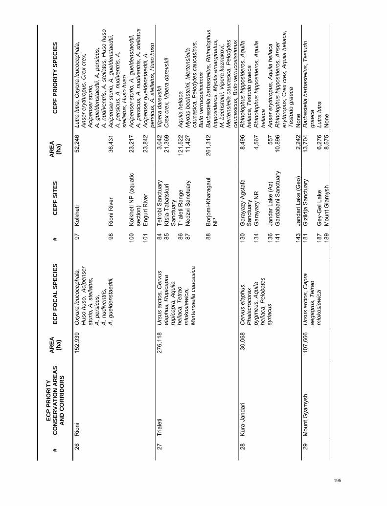
195
#
ECP
PRIO
RIT
Y C
ON
SER
VATI
ON
AR
EAS
AND
CO
RR
IDO
RS
AREA
(h
a)
ECP
FOC
AL S
PEC
IES
#
CEP
F SI
TES
AREA
(h
a)
CEP
F PR
IOR
ITY
SPEC
IES
97
Ko
lkhe
ti
52,2
46
Lutra
lutra
, Oxy
ura
leuc
ocep
hala
, A
nser
ery
thro
pus,
Cre
x cr
ex,
Aci
pens
er s
turio
, A
. gue
lden
stae
dtii,
A. p
ersi
cus,
A
. nud
iven
tris,
A. s
tella
tus,
Hus
o hu
so
98
R
ioni
Riv
er
36,4
31
Aci
pens
er s
turio
, A. g
ueld
enst
aedt
ii,
A. p
ersi
cus,
A. n
udiv
entri
s, A
. st
ella
tus,
Hus
o hu
so
10
0 Ko
lkhe
ti N
P (a
quat
ic
sect
ion)
23
,217
A
cipe
nser
stu
rio, A
. gue
lden
stae
dtii,
A
. per
sicu
s, A
. nud
iven
tris,
A. s
tella
tus
26
Rio
ni
152,
939
Oxy
ura
leuc
ocep
hala
, H
uso
huso
, A
cipe
nser
st
urio
, A. s
tella
tus,
A
. per
sicu
s,
A. n
udiv
entri
s,
A. g
ueld
enst
aedt
ii,
10
1 En
guri
Riv
er
23,8
42
Aci
pens
er g
ueld
enst
aedt
ii, A
. pe
rsic
us, A
. ste
llatu
s, H
uso
huso
84
Tetro
bi S
anct
uary
3,
042
Vip
era
dare
vski
i
85
Ktsi
a-Ta
bats
kuri
Sanc
tuar
y 21
,369
C
rex
crex
, Vip
era
dare
vski
i
86
Tr
iale
ti R
ange
12
1,52
2 A
quila
hel
iaca
87
Ned
zvi S
anct
uary
11
,427
M
yotis
bec
hste
ini,
Mer
tens
iella
ca
ucas
ica,
Pel
odyt
es c
auca
sicu
s,
Buf
o ve
rruc
osis
sim
us
27
Tria
leti
276,
118
Urs
us a
rcto
s, C
ervu
s el
aphu
s, R
upic
apra
ru
pica
pra,
Aqu
ila
helia
ca, T
etra
o m
loko
siew
iczi
, M
erte
nsie
lla c
auca
sica
88
Bo
rjom
i-Kha
raga
uli
NP
261,
312
Bar
bast
ella
bar
bast
ellu
s, R
hino
loph
us
hipp
osid
eros
, Myo
tis e
mar
gina
tus,
M
. bec
hste
ini,
Vipe
ra k
azna
kovi
, M
erte
nsie
lla c
auca
sica
, Pel
odyt
es
cauc
asic
us, B
ufo
verr
ucos
issi
mus
130
Gar
ayaz
y-Ag
staf
a Sa
nctu
ary
8,49
6 R
hino
loph
us h
ippo
side
ros,
Aqu
ila
helia
ca, T
estu
do g
raec
a
134
Gar
ayaz
y N
R
4,56
7 R
hino
loph
us h
ippo
side
ros,
Aqu
ila
helia
ca
13
6 Ja
ndar
Lak
e (A
z)
557
Ans
er e
ryth
ropu
s, A
quila
hel
iaca
141
Gar
daba
ni S
anct
uary
10
,896
R
hino
loph
us h
ippo
side
ros,
Ans
er
eryt
hrop
us, C
rex
crex
, Aqu
ila h
elia
ca,
Test
udo
grae
ca
28
Kura
-Jan
dari
30,0
68
Cer
vus
elap
hus,
P
hala
croc
orax
py
gmeu
s, A
quila
he
liaca
, Pel
obat
es
syria
cus
14
3 Ja
ndar
i Lak
e (G
eo)
2,24
2 N
one
18
1 G
izild
ja S
anct
uary
13
,704
B
arba
stel
la b
arba
stel
lus,
Tes
tudo
gr
aeca
187
Gey
-Gel
Lak
e 6,
276
Lutra
lutra
29
Mou
nt G
yam
ysh
107,
666
Urs
us a
rcto
s, C
apra
ae
gagr
us, T
etra
o m
loko
siew
iczi
189
Mou
nt G
iam
ysh
8,
575
Non
e

196
#
ECP
PRIO
RIT
Y C
ON
SER
VATI
ON
AR
EAS
AND
CO
RR
IDO
RS
AREA
(h
a)
ECP
FOC
AL S
PEC
IES
#
CEP
F SI
TES
AREA
(h
a)
CEP
F PR
IOR
ITY
SPEC
IES
30
Varv
ara-
Bard
a 29
,195
A
quila
hel
iaca
, P
hala
croc
orax
py
gmeu
s,
Mar
mar
onet
ta
angu
stiro
stris
, Oxy
ura
leuc
ocep
hala
13
3 Ba
rda
Sanc
tuar
y 29
,404
C
rex
crex
, Aqu
ila h
elia
ca, F
alco
na
uman
ni, T
estu
do g
raec
a
55
Ka
rgab
azar
and
G
ush-
Gay
a M
ount
ains
2,42
7 Fa
lco
naum
anni
72
H
adjik
abul
Lak
e 4,
201
Oxy
ura
leuc
ocep
hala
31
Gob
usta
n-H
ajig
abul
21
1,49
1 H
yaen
a hy
aena
, G
azel
la s
ubgu
tturo
sa,
Oxy
ura
leuc
ocep
hala
, M
arm
aron
etta
an
gust
irost
ris
73
C
entra
l Shi
rvan
Non
e
56
Absh
eron
Ar
chip
elag
o (n
orth
) an
d Ar
tem
Bay
1,84
3 R
hino
loph
us h
ippo
side
ros,
Pho
ca
casp
ica
57
Ab
sher
on S
anct
uary
1,
179
Pho
ca c
aspi
ca
58
Kr
asno
ye L
ake
and
Absh
eron
wet
land
s 39
4 O
xyur
a le
ucoc
epha
la, A
nser
er
ythr
opus
60
Alat
Bay
-Bak
u Ar
chip
elag
o (2
) 14
O
xyur
a le
ucoc
epha
la
62
Al
at B
ay-B
aku
Arch
ipel
ago
(4)
191
Oxy
ura
leuc
ocep
hala
65
Al
at B
ay-B
aku
Arch
ipel
ago
(7)
79
Oxy
ura
leuc
ocep
hala
32
Gob
usta
n-Ab
sher
on
190,
588
Oxy
ura
leuc
ocep
hala
, P
hala
croc
orax
py
gmeu
s, H
uso
huso
, A
cipe
nser
ste
llatu
s, A
. ru
then
us, A
. per
sicu
s,
A. n
udiv
entri
s,
A.g
ueld
enst
aedt
ii
18
8 Fa
ctor
y Sh
elf
3,41
8 N
one
67
Sh
irvan
NR
/Sho
rgel
La
kes
65,8
56
Mar
mar
onet
ta a
ngus
tiros
tris,
Aqu
ila
helia
ca, F
alco
nau
man
ni, T
estu
do
grae
ca
33
Shirv
an
132,
313
Gaz
ella
sub
guttu
rosa
, M
arm
aron
etta
an
gust
irost
ris, A
quila
he
liaca
, Pha
lacr
ocor
ax
pygm
eus,
Pel
obat
es
syria
cus,
Hus
o hu
so,
Aci
pens
er s
tella
tus,
A
.ruth
enus
, A. p
ersi
cus,
A
. nud
iven
tris,
A
.gue
lden
stae
dtii
69
Ku
ra D
elta
6,
487
Hus
o hu
so, A
cipe
nser
ste
llatu
s,
A. r
uthe
nus,
A. p
ersi
cus,
A.
nudi
vent
ris, A
. gue
lden
stae
dtii
34
Mak
hmud
Cha
la
39,0
34
Mar
mar
onet
ta
angu
stiro
stris
71
Mah
mud
-Cha
la L
ake
10,7
73
Mar
mar
onet
ta a
ngus
tiros
tris

197
#
ECP
PRIO
RIT
Y C
ON
SER
VATI
ON
AR
EAS
AND
CO
RR
IDO
RS
AREA
(h
a)
ECP
FOC
AL S
PEC
IES
#
CEP
F SI
TES
AREA
(h
a)
CEP
F PR
IOR
ITY
SPEC
IES
35
Gyz
yl-A
gach
(Gyz
ylag
haj)
146,
350
Mar
mar
onet
ta
angu
stiro
stris
, Hus
o hu
so, A
cipe
nser
st
ella
tus,
A. r
uthe
nus,
A
. per
sicu
s,
A. n
udiv
entri
s,
A. g
ueld
enst
aedt
ii
70
G
yzyl
-Aga
ch B
ay
131,
559
Pho
ca c
aspi
ca, M
arm
aron
etta
an
gust
irost
ris, B
rant
a ru
ficol
lis, A
nser
er
ythr
opus
, Gru
s le
ucog
eran
us, O
tis
tard
a, F
alco
nau
man
ni, T
estu
do
grae
ca, H
uso
huso
, Aci
pens
er
stel
latu
s, A
. rut
henu
s, A
. per
sicu
s,
A.n
udiv
entri
s, A
. gue
lden
stae
dtii
74
M
il-Ka
raba
kh S
tepp
e 56
,656
N
one
17
7 Sa
rysu
Lak
e 16
,555
A
nser
ery
thro
pus,
Mar
mar
onet
ta
angu
stiro
stris
, Oxy
ura
leuc
ocep
hala
, Fa
lco
naum
anni
178
Ag-G
el L
ake
15,6
76
Ans
er e
ryth
ropu
s, M
arm
aron
etta
an
gust
irost
ris, O
xyur
a le
ucoc
epha
la,
Falc
o na
uman
ni
18
0 La
ke B
oz-K
oba
14,5
77
Mar
mar
onet
ta a
ngus
tiros
tris,
Fal
co
naum
anni
36
Kura
-Ara
z (A
raks
) Val
ley
158,
091
Mar
mar
onet
ta
angu
stiro
stris
, Oxy
ura
leuc
ocep
hala
18
6 Ar
az-B
ehre
mte
pe
2,67
8 G
rus
leuc
oger
anus
165
Hyr
can
NR
3,
601
Bar
bast
ella
bar
bast
ellu
s, R
hino
loph
us
hipp
osid
eros
, Myo
tis e
mar
gina
tus,
Lu
tra lu
tra
16
6 Zu
vand
San
ctua
ry
14,9
44
Test
udo
grae
ca
16
7 Li
sar N
R
34,4
49
Rhi
nolo
phus
hip
posi
dero
s
169
Lava
ndev
il 44
,228
C
rex
crex
, Aqu
ila h
elia
ca, A
. cla
nga,
A
cipe
nser
gue
lden
stae
dtii,
A.
pers
icus
, A. n
udiv
entri
s, A
. ste
llatu
s,
Hus
o hu
so
17
0 An
zali
Lago
on
134,
151
Rhi
nolo
phus
hip
posi
dero
s, A
nser
er
ythr
opus
, Mar
mar
onet
ta
angu
stiro
stris
, Oxy
ura
leuc
ocep
hala
, V
anel
lus
greg
ariu
s, G
rus
leuc
oger
anus
, Cre
x cr
ex, A
quila
he
liaca
, A. c
lang
a, A
cipe
nser
gu
elde
nsta
edtii
, A. p
ersi
cus,
A
. nud
iven
tris,
A. s
tella
tus,
Hus
o hu
so
37
Talis
h-Zu
vand
82
6,16
4 U
rsus
arc
tos,
Pan
ther
a pa
rdus
, Hya
ena
hyae
na, A
quila
hel
iaca
, M
arm
aron
etta
an
gust
irost
ris, O
xyur
a le
ucoc
epha
la,
Pel
obat
es s
yria
cus,
H
uso
huso
, Aci
pens
er
stel
latu
s, A
. rut
henu
s,
A. p
ersi
cus,
A.
nudi
vent
ris,
A.g
ueld
enst
aedt
ii
17
1 G
asht
-e R
udkh
an
and
Siah
maz
gy
41,6
92
Rhi
nolo
phus
hip
posi
dero
s
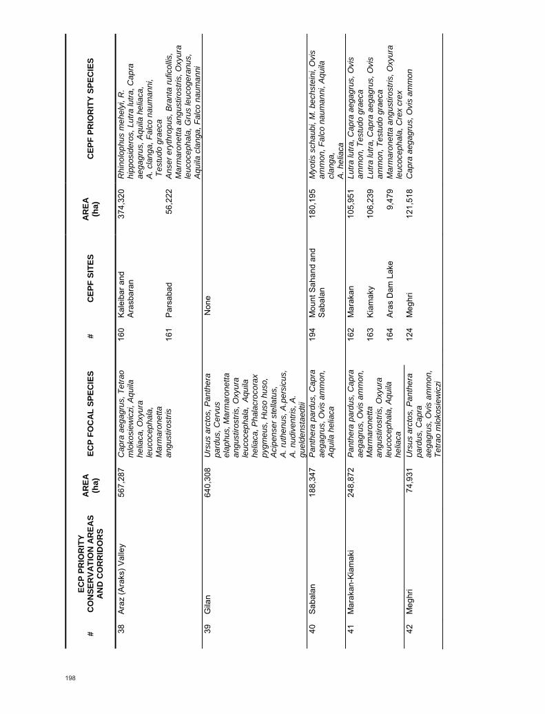
198
#
ECP
PRIO
RIT
Y C
ON
SER
VATI
ON
AR
EAS
AND
CO
RR
IDO
RS
AREA
(h
a)
ECP
FOC
AL S
PEC
IES
#
CEP
F SI
TES
AR
EA
(ha)
C
EPF
PRIO
RIT
Y SP
ECIE
S
16
0 Ka
leib
ar a
nd
Aras
bara
n 37
4,32
0 R
hino
loph
us m
ehel
yi, R
. hi
ppos
ider
os, L
utra
lutra
, Cap
ra
aega
grus
, Aqu
ila h
elia
ca,
A. c
lang
a, F
alco
nau
man
ni,
Tes
tudo
gra
eca
38
Araz
(Ara
ks) V
alle
y 56
7,28
7 C
apra
aeg
agru
s, T
etra
o m
loko
siew
iczi
, Aqu
ila
helia
ca, O
xyur
a le
ucoc
epha
la,
Mar
mar
onet
ta
angu
stiro
stris
161
Pars
abad
56
,222
A
nser
ery
thro
pus,
Bra
nta
rufic
ollis
, M
arm
aron
etta
ang
ustir
ostri
s, O
xyur
a le
ucoc
epha
la, G
rus
leuc
oger
anus
, A
quila
cla
nga,
Fal
co n
aum
anni
39
G
ilan
640,
308
Urs
us a
rcto
s, P
anth
era
pard
us, C
ervu
s el
aphu
s, M
arm
aron
etta
an
gust
irost
ris, O
xyur
a le
ucoc
epha
la,
Aqui
la
helia
ca, P
hala
croc
orax
py
gmeu
s, H
uso
huso
, A
cipe
nser
ste
llatu
s,
A. r
uthe
nus,
A.p
ersi
cus,
A
. nud
iven
tris,
A.
guel
dens
taed
tii
Non
e
40
Saba
lan
188,
347
Pan
ther
a pa
rdus
, Cap
ra
aega
grus
, Ovi
s am
mon
, A
quila
hel
iaca
19
4 M
ount
Sah
and
and
Saba
lan
180,
195
Myo
tis s
chau
bi, M
. bec
hste
ini,
Ovi
s am
mon
, Fal
co n
aum
anni
, Aqu
ila
clan
ga,
A. h
elia
ca
16
2 M
arak
an
105,
951
Lutra
lutra
, Cap
ra a
egag
rus,
Ovi
s am
mon
, Tes
tudo
gra
eca
16
3 Ki
amak
y 10
6,23
9 Lu
tra lu
tra, C
apra
aeg
agru
s, O
vis
amm
on, T
estu
do g
raec
a
41
Mar
akan
-Kia
mak
i 24
8,87
2 P
anth
era
pard
us, C
apra
ae
gagr
us, O
vis
amm
on,
Mar
mar
onet
ta
angu
stiro
stris
, Oxy
ura
leuc
ocep
hala
, Aqu
ila
helia
ca
16
4 Ar
as D
am L
ake
9,47
9 M
arm
aron
etta
ang
ustir
ostri
s, O
xyur
a le
ucoc
epha
la, C
rex
crex
42
M
eghr
i 74
,931
U
rsus
arc
tos,
Pan
ther
a pa
rdus
, Cap
ra
aega
grus
, Ovi
s am
mon
, Te
trao
mlo
kosi
ewic
zi
12
4 M
eghr
i 12
1,51
8 C
apra
aeg
agru
s, O
vis
amm
on

199
#
ECP
PRIO
RIT
Y C
ON
SER
VATI
ON
AR
EAS
AND
CO
RR
IDO
RS
AREA
(h
a)
ECP
FOC
AL S
PEC
IES
#
CEP
F SI
TES
AR
EA
(ha)
C
EPF
PRIO
RIT
Y SP
ECIE
S
12
4 M
eghr
i 12
1,51
8 C
apra
aeg
agru
s, O
vis
amm
on
12
6 O
rdub
ad S
anct
uary
27
,462
R
hino
loph
us m
ehel
yi, R
. eur
yale
, C
apra
aeg
agru
s, O
vis
amm
on
43
Zang
ezur
20
6,67
4 U
rsus
arc
tos,
Pan
ther
a pa
rdus
, Cap
ra
aega
grus
, Ovi
s am
mon
, Te
trao
mlo
kosi
ewic
zi,
Pel
obat
es s
yria
cus
12
8 O
rdub
ad
64,3
96
Ovi
s am
mon
, Tes
tudo
gra
eca
44
Aras
bara
n 14
8,19
6 U
rsus
arc
tos,
Pan
ther
a pa
rdus
, Cap
ra
aega
grus
, Ovi
s am
mon
, Te
trao
mlo
kosi
ewic
zi,
Mar
mar
onet
ta
angu
stiro
stris
, Oxy
ura
leuc
ocep
hala
, Aqu
ila
helia
ca
16
0 Ka
leib
ar a
nd
Aras
bara
n 37
4,32
0 R
hino
loph
us m
ehel
yi, R
. hi
ppos
ider
os, L
utra
lutra
, Cap
ra
aega
grus
, Aqu
ila h
elia
ca, A
. cla
nga,
Fa
lco
naum
anni
, Tes
tudo
gra
eca
45
Bich
enek
23
,809
C
apra
aeg
agru
s, O
vis
amm
on, P
anth
era
pard
us, U
rsus
arc
tos
12
7 Bi
chen
ek
9,70
7 C
apra
aeg
agru
s
46
Nor
avan
k 24
,430
O
vis
amm
on, C
apra
ae
gagr
us, P
anth
era
pard
us
12
5 N
orav
ank
14,4
63
Falc
o na
uman
ni
14
8 M
aku
and
Iran
Wes
t Bo
rder
33
6,90
2 R
hino
loph
us e
urya
le, M
yotis
sch
aubi
, M
. bec
hste
ini,
Aqui
la h
elia
ca, A
. cl
anga
, Fal
co n
aum
anni
47
Mak
u an
d W
este
rn Ir
ania
n
Bord
er
486,
480
Cap
ra a
egag
rus,
Ovi
s am
mon
, Pan
ther
a pa
rdus
, Aqu
ila h
elia
ca,
Mar
mar
onet
ta
angu
stiro
stris
156
Van
Dog
usu
Mou
ntai
ns
80,8
98
Ovi
s am
mon

200
#
ECP
PRIO
RIT
Y C
ON
SER
VATI
ON
AR
EAS
AND
CO
RR
IDO
RS
AREA
(h
a)
ECP
FOC
AL S
PEC
IES
#
CEP
F SI
TES
AR
EA
(ha)
C
EPF
PRIO
RIT
Y SP
ECIE
S
14
5 Ar
mas
h 16
,121
M
yotis
sch
aubi
, Mer
ione
s da
hlia
147
Arm
ash
Fish
-Far
m
5,15
4 M
arm
aron
etta
ang
ustir
ostri
s, O
xyur
a le
ucoc
epha
la
14
9 M
aku
84,4
37
Rhi
nolo
phus
eur
yale
, Myo
tis s
chau
bi,
M. B
echs
tein
i
150
Agh-
Gel
27
,524
R
hino
loph
us e
urya
le, M
yotis
sch
aubi
, M
. bec
hste
ini,
Anse
r ery
thro
pus,
B
rant
a ru
ficol
lis, M
arm
aron
etta
an
gust
irost
ris, O
xyur
a le
ucoc
epha
la,
Van
ellu
s gr
egar
ius,
Gru
s le
ucog
eran
us, O
tis ta
rda,
Cre
x cr
ex,
Aqu
ila c
lang
a
154
Igdi
r Pla
in
177,
767
Myo
tis s
chau
bi, M
arm
aron
etta
an
gust
irost
ris, T
estu
do g
raec
a, V
iper
a w
agne
ri
158
Nor
th-E
ast A
rara
t 41
,134
M
yotis
sch
aubi
, Mar
mar
onet
ta
angu
stiro
stris
48
Agri
Dag
i (Ar
arat
) and
Ar
mas
h 27
1,66
9 O
vis
amm
on, C
apra
ae
gagr
us, U
rsus
arc
tos,
M
arm
aron
etta
an
gust
irost
ris, O
xyur
a le
ucoc
epha
la,
Pha
lacr
ocor
ax
pygm
eus
15
9 Ar
arat
72
,829
C
apra
aeg
agru
s, O
vis
amm
on
12
0 Kh
osro
v N
R
120,
248
Rhi
nolo
phus
hip
posi
dero
s, R
. m
ehel
yi, T
estu
do g
raec
a
121
Gnd
asar
7,
041
Cre
x cr
ex, F
alco
nau
man
ni
14
5 Ar
mas
h 16
,121
M
yotis
sch
aubi
, Mer
ione
s da
hli
49
Khos
rov
201,
590
Urs
us a
rcto
s, P
anth
era
pard
us, O
vis
amm
on,
Cap
ra a
egag
rus,
A
egyp
ius
mon
achu
s,
Pel
obat
es s
yria
cus
14
6 G
orav
an S
ands
Sa
nctu
ary
3,55
8 M
yotis
sch
aubi
11
7 D
segh
-Hag
harts
in-
Pam
bak
Cha
in a
nd
Dili
jan
NP
188,
874
Bar
bast
ella
bar
bast
ellu
s, R
hino
loph
us
meh
elyi
, R. h
ippo
side
ros,
Sic
ista
ar
men
ica,
Aqu
ila h
elia
ca, C
rex
crex
, Te
stud
o gr
aeca
, Sa
mbu
cus
tigra
ni
11
8 La
ke S
evan
15
5,42
5 Lu
tra lu
tra, A
nser
ery
thro
pus
11
9 Sh
akhd
ag R
ange
28
,427
R
hino
loph
us e
urya
le
50
Pam
bak-
Seva
n 55
2,69
1 U
rsus
arc
tos,
Cap
ra
aega
grus
, Aqu
ila
helia
ca, T
etra
o m
loko
siew
iczi
17
3 M
ount
Ara
4,
443
Cre
x cr
ex

201
#
ECP
PRIO
RIT
Y C
ON
SER
VATI
ON
AR
EAS
AND
CO
RR
IDO
RS
AREA
(h
a)
ECP
FOC
AL S
PEC
IES
#
CEP
F SI
TES
AR
EA
(ha)
C
EPF
PRIO
RIT
Y SP
ECIE
S
10
4 Ja
vakh
eti R
ange
(A
rm)
27,7
05
Vip
era
dare
vski
i
10
6 Am
asia
30
,139
A
quila
hel
iaca
, Fal
co n
aum
anni
107
Para
vani
Lak
e 5,
830
Cre
x cr
ex
10
8 Ja
vakh
eti R
ange
(G
eo)
65,9
70
Vip
era
dare
vski
i
10
9 Sa
gham
o La
ke
857
Lutra
lutra
, Cre
x cr
ex
11
0 M
adat
apa
Lake
1,
978
Aqu
ila h
elia
ca, C
rex
crex
111
Bugd
ashe
ni L
ake
397
Lutra
lutra
, Cre
x cr
ex
11
2 Kh
anch
ali L
ake
2,58
0 C
rex
crex
113
Karts
akhi
Lak
e 3,
619
Lutra
lutra
, Cre
x cr
ex
11
4 Ak
tas
Lake
1,
262
Non
e
115
Erak
atar
14
,993
O
vis
amm
on
51
Java
khet
i 32
2,99
4 O
vis
amm
on, C
apra
ae
gagr
us, A
quila
he
liaca
, Tet
rao
mlo
kosi
ewic
zi
11
6 C
ildir
Lake
20
,051
N
one
14
4 Ar
aks
Riv
er
121,
386
Lutra
lutra
, Mar
mar
onet
ta
angu
stiro
stris
, Otis
tard
a, S
ambu
cus
tigra
nii
15
4 Ig
dir P
lain
17
7,76
7 M
yotis
sch
aubi
, Mar
mar
onet
ta
angu
stiro
stris
, Tes
tudo
gra
eca,
Vip
era
wag
neri
52
Igdi
r Pla
in a
nd A
rmav
ir 40
3,17
0 U
rsus
arc
tos,
Cap
ra
aega
grus
, Rup
icap
ra
rupi
capr
a,
Mar
mar
onet
ta
angu
stiro
stris
, Aeg
ypiu
s m
onac
hus
15
7 Ka
rako
se
113,
847
Mar
mar
onet
ta a
ngus
tiros
tris,
Tes
tudo
gr
aeca
, Vip
era
wag
neri
15
1 M
t. Zi
aret
For
est
55,9
14
Test
udo
grae
ca, V
iper
a w
agne
ri,
Mer
tens
iella
cau
casi
ca, P
elod
ytes
ca
ucas
icus
53
Sarik
amis
For
est
173,
872
Cap
ra a
egag
rus,
Ovi
s am
mon
, Rup
icap
ra
rupi
capr
a, A
egyp
ius
mon
achu
s, M
erte
nsie
lla
cauc
asic
a
153
Sara
kam
ish
Fore
st
73,7
06
Ovi
s am
mon
, Tes
tudo
gra
eca,
Vip
era
wag
neri,
Mer
tens
iella
cau
casi
ca,
Pel
odyt
es c
auca
sicu
s

202
#
ECP
PRIO
RIT
Y C
ON
SER
VATI
ON
AR
EAS
AND
CO
RR
IDO
RS
AREA
(h
a)
ECP
FOC
AL S
PEC
IES
#
CEP
F SI
TES
AREA
(h
a)
CEP
F PR
IOR
ITY
SPEC
IES
88
Bo
rjom
i-Kha
raga
uli
NP
261,
312
Bar
bast
ella
bar
bast
ellu
s, R
hino
loph
us
hipp
osid
eros
, Myo
tis e
mar
gina
tus,
M
.bec
hste
ini,
Vipe
ra k
azna
kovi
, M
erte
nsie
lla c
auca
sica
, Pel
odyt
es
cauc
asic
us, B
ufo
verr
ucos
issi
mus
89
God
erdz
i Pas
s 30
,564
M
erte
nsie
lla c
auca
sica
90
Shav
shet
i Ran
ge (1
) 59
,192
V
iper
a po
ntic
a, M
erte
nsie
lla
cauc
asic
a
91
Shav
shet
i Ran
ge (2
) 20
,690
V
iper
a po
ntic
a
92
Cho
rokh
i 23
,238
La
certa
cla
rkor
um, A
cipe
nser
pe
rsic
us, A
. ste
llatu
s, H
uso
huso
93
Batu
mi
39,9
59
Aqu
ila h
elia
ca, A
quila
cla
nga,
Fal
co
naum
anni
, Lac
erta
cla
rkor
um,
Aci
pens
er p
ersi
cus,
A. s
tella
tus,
Hus
o hu
so
94
M
tiral
a 15
,289
B
arba
stel
la b
arba
stel
lus,
Lac
erta
cl
arko
rum
, Vip
era
kazn
akov
i, M
erte
nsie
lla c
auca
sica
, Pel
odyt
es
cauc
asic
us, B
ufo
verru
cosi
ssim
us
95
Ki
ntris
hi N
R
13,3
15
Bar
bast
ella
bar
bast
ellu
s, R
hino
loph
us
meh
elyi
, R. e
urya
le, R
. hip
posi
dero
s,
Myo
tis e
mar
gina
tus,
Lac
erta
cl
arko
rum
, Vip
era
kazn
akov
i, M
erte
nsie
lla c
auca
sica
, Pel
odyt
es
cauc
asic
us, B
ufo
verr
ucos
issi
mus
102
Har
sit V
adis
i 18
6,07
4 Lu
tra lu
tra, T
estu
do g
raec
a, L
acer
ta
clar
koru
m, V
iper
a ur
sini
i
54
Wes
t Les
ser C
auca
sus
2,12
7,87
7U
rsus
arc
tos,
Cap
ra
aega
grus
, Rup
icap
ra
rupi
capr
a, O
vis
amm
on,
Aeg
ypiu
s m
onac
hus,
Te
trao
mlo
kosi
ewic
zi,
Mer
tens
iella
cau
casi
ca,
Aci
pens
er s
tella
tus,
A
. per
sicu
s, H
uso
huso
10
3 D
ogu
Kara
deni
z M
ount
ains
1,
260,
013
Bar
bast
ella
bar
bast
ellu
s, R
hino
loph
us
hipp
osid
eros
, Myo
tis b
echs
tein
i, O
vis
amm
on, F
alco
nau
man
ni, L
acer
ta
clar
koru
m, V
iper
a ka
znak
ovi,
V.
pont
ica,
V. u
rsin
ii, M
erte
nsie
lla
cauc
asic
a, P
elod
ytes
cau
casi
cus,
B
ufo
verr
ucos
issi
mus
, Aci
pens
er
pers
icus
, A. s
tella
tus,
Hus
o hu
so

203
#
ECP
PRIO
RIT
Y C
ON
SER
VATI
ON
AR
EAS
AND
CO
RR
IDO
RS
AREA
(h
a)
ECP
FOC
AL S
PEC
IES
#
CEP
F SI
TES
AREA
(h
a)
CEP
F PR
IOR
ITY
SPEC
IES
55
Man
glis
i 35
,816
U
rsus
arc
tos
Non
e
168
Sepi
rud
Riv
er
26,8
24
Aci
pens
er g
ueld
enst
aedt
ii, A
. pe
rsic
us, A
. nud
iven
tris,
A. s
tella
tus,
H
uso
huso
170
Anza
li La
goon
13
4,15
1 R
hino
loph
us h
ippo
side
ros,
Ans
er
eryt
hrop
us, M
arm
aron
etta
an
gust
irost
ris, O
xyur
a le
ucoc
epha
la,
Van
ellu
s gr
egar
ius,
Gru
s le
ucog
eran
us, C
rex
crex
, Aqu
ila
helia
ca, A
. cla
nga,
Aci
pens
er
guel
dens
taed
tii, A
. per
sicu
s,
A.n
udiv
entri
s, A
. ste
llatu
s, H
uso
huso
56
Sifid
Rud
-Anz
ali
162,
647
Mar
mar
onet
ta
angu
stiro
stris
, Oxy
ura
leuc
ocep
hala
, Aqu
ila
helia
ca, H
uso
huso
, A
cipe
nser
ste
llatu
s,
A. r
uthe
nus,
A.
pers
icus
, A. n
udiv
entri
s,
A. g
ueld
enst
aedt
ii
17
2 Bo
jagh
84
,919
A
nser
ery
thro
pus,
Oxy
ura
leuc
ocep
hala
, Aqu
ila h
elia
ca, A
. cl
anga
, Cre
x cr
ex

204
#
ECP
PRIO
RIT
Y C
ON
SER
VATI
ON
AR
EAS
AND
CO
RR
IDO
RS
AREA
(h
a)
ECP
FOC
AL S
PEC
IES
#
CEP
F SI
TES
AREA
(h
a)
CEP
F PR
IOR
ITY
SPEC
IES
C
OR
RID
ORS
2 Pr
iom
orsk
o-Ak
htar
sk –
Ku
ban
Cor
ridor
12
2,05
7 H
uso
huso
, Aci
pens
er
stel
latu
s,
A.g
ueld
enst
aedt
ii
7
Pria
zovs
ky S
anct
uary
32
,635
Lutra
lutra
25
Sv
anet
i (2)
30
,208
Cap
ra c
auca
sica
, Vip
era
dinn
iki
26
Ab
khaz
ia
35,0
58C
apra
cau
casi
ca
10 T
eber
dins
ky S
trict
Nat
ure
Res
erve
– S
vane
ti C
orrid
or
329,
825
Cap
ra c
auca
sica
, R
upic
apra
rupi
capr
a
49
Prie
lbru
siye
10
3,24
7C
apra
cyl
indr
icor
nis
21 J
avak
heti
– Ig
dir P
lain
and
Ar
mav
ir C
orrid
or
221,
531
Cap
ra a
egag
rus,
U
rsus
arc
tos
17
5 An
i 4,
756
Sam
bucu
s tig
rani
i
24 A
rgak
hans
kiy
Bay
– Sa
mur
-Ya
lam
a C
orrid
or
Hus
o hu
so, A
cipe
nser
st
ella
tus,
A. r
uthe
nus,
A
.per
sicu
s,
A.n
udiv
entri
s,
A.g
ueld
enst
aedt
ii
79
Su
lak
Riv
er
44,7
26A
cipe
nser
per
sicu
s, A
. nud
iven
tris
35 I
gdir
Plai
n an
d Ar
mav
ir –
Agri
Dag
i (Ar
arat
) and
Ar
mas
h C
orrid
or
14,6
61 C
apra
aeg
agru
s
155
Tend
urek
Mou
ntai
n 30
,617
Ovi
s am
mon
40 K
hosr
ov –
Nor
ovan
k C
orrid
or
15,3
38 O
vis
amm
on, C
apra
ae
gagr
us, P
anth
era
pard
us
12
9 Sa
rdar
ak C
aves
8,
546
Rhi
nolo
phus
meh
elyi
, R. e
urya
le
41 K
hosr
ov –
Bic
hene
k C
orrid
or
92,1
71 O
vis
amm
on, C
apra
ae
gagr
us, P
anth
era
pard
us, U
rsus
arc
tos
12
2 D
jerm
uk
3,07
0R
hino
loph
us m
ehel
yi, C
rex
crex
43 M
ount
Gya
mys
h –
Meg
hri –
Ar
asba
ran
Cor
ridor
42
7,19
1 C
ervu
s el
aphu
s m
aral
, C
apra
aeg
agru
s, U
rsus
ar
ctos
, Pan
ther
a pa
rdus
, Te
trao
mlo
kosi
ewic
zi
17
9 D
asha
lti N
R
1,31
2B
arba
stel
la b
arba
stel
lus,
Rhi
nolo
phus
m
ehel
yi, R
. eur
yale
49 K
ura-
Araz
(Ara
ks) V
alle
y –
Mak
hmud
Cha
la C
orrid
or
118,
171
Non
e
74
Mil-
Kara
bakh
Ste
ppe
56,6
56
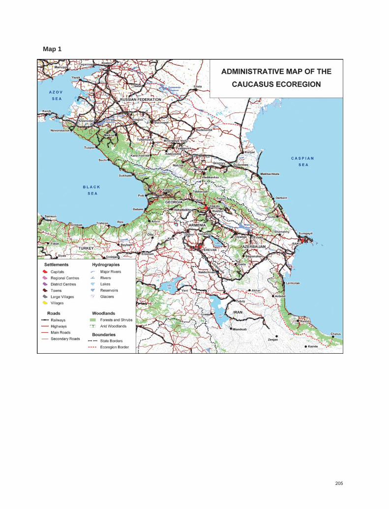
205
Map 1
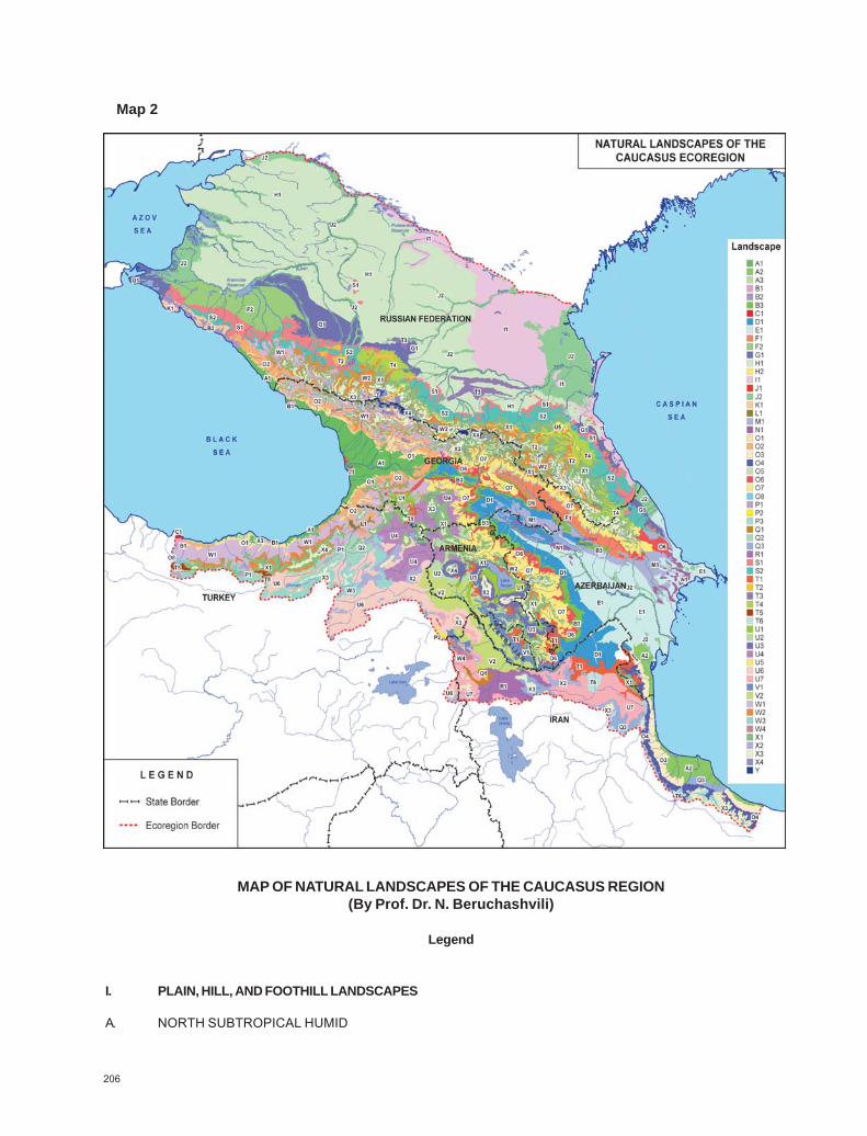
206
Map 2
MAP OF NATURAL LANDSCAPES OF THE CAUCASUS REGION(By Prof. Dr. N. Beruchashvili)
Legend
I. PLAIN, HILL, AND FOOTHILL LANDSCAPES
A. NORTH SUBTROPICAL HUMID

207
A1. Colchic Lowland landscapes with swamp alder forests and sphagnum bogs, and foothill landscapeswith hornbeam-oak forests alternating with beech-chestnut, oak-Zelkova and poly-dominant forestswith evergreen understory
A2. Hyrcanian plain landscapes with grasslands-shrublands and Hyrcanian forestsA3. Sub-Colchic plain and hilly forest landscapes with Mediterranean elements
B. SUB-MEDITERRANEAN SEMI-HUMID
B1. Pontic (transitional to Colchic) plain and foothill landscapes with Pitsunda pine, oak, and poly-dominantforests, and fragments of Mediterranean scrublands (maquis)
B2. Crimea-Novorossiysk foothill landscapes with oak, pine, and juniper forests and open woodlandsalternating with beech forests and fragments of Mediterranean scrublands (maquis)
B3. South-East Caucasian Sub-Mediterranean (transitional to moderate-thermophilous semi-humid) foothilllandscapes with hornbeam-oak forests and woodlands and Botriochloa steppes
C. MEDITERRANEAN
C1. Pontic foothill landscapes with Mediterranean scrublands (maquis), alternating with beech and oakforests
D. SUBTROPICAL SEMI-ARID PLAIN
D1. East Georgian hilly and foothill landscapes with Botriochloa and Stipa steppes, dry shrublands(shibliak), dwarf shrub (phrygana) vegetation, and semi-deserts
E. SUBTROPICAL ARID PLAIN AND HILLS
E1. East Caucasian North subtropical lowland and foothill landscapes with Artemisia, halophytic desertsand semi-deserts
F. THERMO-MODERATE SEMI-HUMID PLAIN
F1. East Transcaucasian plain landscapes with oak and oak-Zelkova forestsF2. Kuban hilly and plain landscapes with oak forests and forest-steppes
G. TEMPERATE SEMI-HUMID AND SEMI-ARID PLAIN
G1. North Caucasian lowland and hilly plain landscapes with mixed herb-grass steppes and semi-humidmeadow-steppes
H. TEMPERATE SEMI-ARID PLAIN
H1. North Caucasian hilly and plain landscapes with steppes and meadow-steppesH2. East European hilly and plain landscapes with steppes
I. TEMPERATE ARID PLAIN

208
I1. North Caspian lowlands with Artemisia, Salsola, and halophytic deserts and semi-deserts
J. HYDROMORPHIC AND SUB-HYDROMORPHIC
J1. Lowlands with wetlandsJ2. Delta and floodplain landscapes with wetlands, swamp forests and grasslands, and salt marshes
II. MOUNTAINOUS LANDSCAPES
K. NORTH SUB-MEDITERRANEAN SEMI-HUMID
K1. Crimea-Novorossiysk (transitional to Colchic and moderate thermophilous) low-mountain landscapeswith oak and pine forests and juniper open woodlands
L. MEDITERRANEAN
L1. Pontic low-mountain and plain landscapes with Mediterranean scrublands (Maquis and pseudo-maquis), oak and pine forests and open semi-shrub evergreen vegetation, dry scrublands, and dwarfshrub vegetation
M. SUBTROPICAL SEMI-ARID MOUNTAIN
M1. Southeast Caucasian low-mountain landscapes with juniper woodlands, dry shrublands (shibliak), anddwarf shrub vegetation (phrygana)
N. SUBTROPICAL ARID MOUNTAIN
N1. East Caucasus low-mountain landscapes with semi-deserts and deserts
O. THERMO-MODERATE HUMID MOUNTAIN
O1. Colchic low-mountain landscapes with hornbeam-oak and hornbeam-beech-chestnut forests mainlywith evergreen understory, partly alternating with oak-pine forests
O2. Colchic middle-mountain landscapes with beech forests mainly with evergreen understoryO3. Hyrcanian low-mountain landscapes with chestnut-oak, oak-Parrotia and hornbeam-oak forestsO4. Hyrcanian middle-mountain landscapes with beech and oak forestsO5. East Georgian low-mountain landscapes with hornbeam-oak partly alternating with
chestnut forestsO6. Southeast Caucasian (transitional to semi-humid) low-mountain landscapes with hornbeam-oak, oak
forests, and secondary dry scrublandsO7. Southeast Caucasian middle-mountain landscapes with beech forests alternating with
hornbeam-oak, partly with pine forests and secondary grasslandsO8. Pontic mountain landscapes with beech and oak forests partly with evergreen understory and
Mediterranean elements
P. THERMO-MODERATE SEMI-HUMID

209
P1. Pontic low- and middle-mountain landscapes with oak forests, partly in combination with dryshrublands and Mediterranean elements
P2. Anatolian middle- and upper-mountain landscapes with pine forests and secondary meadowsP3. Alborzian middle- and upper-mountain landscapes with pine and oak forests and secondary meadows,
partly with dry scrublands
Q. THERMO-MODERATE SEMI-ARID
Q1. Anatolian middle-mountain and upland/plateau landscapes with steppes, dry shrublands, and dwarfshrub (phrygana) vegetation
Q2. Pontic middle-mountain landscapes with steppes, dry shrublands, and dwarf shrub (phrygana)vegetation
Q3. Front-Asian middle-mountain and upland/plateau landscapes with steppes, dry shrublands, and dwarfshrub (phrygana) vegetation, partly alternating with stony deserts
R. THERMO-MODERATE-ARID
R1. Front-Asian low and Anatolian middle-mountain landscapes with desert and semi-desert elements
S. TEMPERATE HUMID MOUNTAIN
S1. North Caucasian low-mountain landscapes with oak and hornbeam-beech forestsS2. North Caucasian middle-mountain landscapes with beech, partly beech-hornbeam and
hornbeam-oak forests
T. TEMPERATE SEMI-HUMID MOUNTAIN
T1. South Caucasian middle-mountain landscapes with meadows, meadows-steppes, and steppes,dry shrublands and dwarf shrub vegetation
T2. North Caucasus transitional to thermo-temperate oak forests, meadow steppes, steppes,shibliak and phrygana
T3. North Caucasus low-mountain forests, shrublands, meadows, and steppesT4. North Caucasus middle-mountain meadows, steppes, meadow-steppes, shibliak, and phryganaT5. Anatolian middle- and upper-mountain steppes, meadow-steppes, in combination with pine forests in
placesT6. Iranian plateau and upper-mountain steppes, meadow-steppes, in combination with dry
shrublands and phrygana
U. TEMPERATE SEMI-ARID MOUNTAIN
U1. South Caucasian (transitional to moderate-thermophilous) middle-mountain landscapes with steppes,dry shrublands, and dwarf shrub vegetation, partly with mountain semi-deserts
U2. Armenian highland steppes, meadow-steppes, and dry shrublands in combination with wetlandsU3. Armenian, transitional to high mountains meadows, steppes, and meadow-steppesU4. Javakheti-Armenian volcanic plateau with steppes and meadow-steppes

210
U5. North Caucasian mountain-depression landscapes with steppes, dry shrublands, and dwarf shrubvegetation
U6. Anatolian middle- and upper-mountain landscapes with steppesU7. Iranian upper- and middle-mountain plateau with steppes and semi-deserts
V. TEMPERATE ARID MOUNTAIN
V1. Armenian-Iranian low-mountain landscapes with semi-deserts, dwarf shrub vegetation,partly with shrublands
V2. Mountain flat landscapes with stony deserts, semi-deserts, and dwarf shrub vegetation
W. COLD-MODERATE MOUNTAIN
W1. Caucasian middle-mountain landscapes with beech-dark coniferous and dark coniferous (spruce-fir)forests, partly with evergreen understory
W2. Caucasian upper-mountain landscapes with birch and pine forestsW3. Anatolian upper-mountain landscapes with pine forests, meadows-steppes, partly with
arid vegetationW4. Iranian upper-mountain landscapes with pine and oak forests, meadows-steppes and with
arid vegetation
X. HIGH-MOUNTAIN MEADOW
X1. Caucasian sub-alpine landscapes with combination of meadows, tall-herb communities,elfin woods and thickets
X2. Front Asian high-mountain landscapes with meadows-steppes and fragments ofsub-alpine meadows
X3. Caucasian alpine landscapes with grasslands and thicketsX4. High-mountain (sub-nival) landscapes with plant micro-communities, mosses, and lichens
Y. GLACIAL-NIVAL
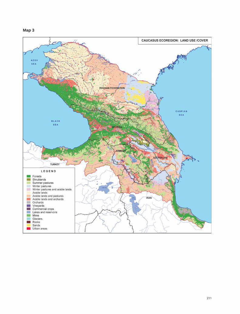
211
Map 3

212
Map 4
PROTECTED AREAS OF THE CAUCASUS ECOREGION
Legend
1 Tamano-Zaporozhsky Zoological sanctuary2 Bol’shoy Utrish Multi-purpose sanctuary3 Abraussky Landscape sanctuary

213
4 Krasnaya Gorka Multi-purpose sanctuary5 Krymsky Sanctuary6 Priazovsky Zoological sanctuary7 Novo-Berezansky Zoological sanctuary8 Goryache-Klyuchevskoy Zoological sanctuary9 Agriysky Landscape sanctuary10 Belorechensky Multi-purpose sanctuary11 Shovgenovsky Zoological sanctuary12 Kuzhorsky Zoological sanctuary13 Maykopsky Zoological sanctuary14 Tuapsinsky Multi-purpose sanctuary15 Sochinsky National park16 Sochinsky Zoological sanctuary17 Kavkazsky Biosphere reserve18 Dakhovsky Zoological sanctuary19 Bol’shoy Tkhach Landscape sanctuary20 Psebaysky Zoological sanctuary21 Belaya Skala Zoological sanctuary22 Novotroitsky Zoological sanctuary23 Krasnogvardeysky Zoological sanctuary24 Solenoe ozero Hydrological sanctuary25 Burukshunsky Zoological sanctuary26 Urochische Peski Botanical sanctuary27 Russky les Multi-purpose sanctuary28 Kravtsovo Ozero Botanical sanctuary29 Vishnevaya Polyana Botanical sanctuary30 Besputskaya Polyana Botanical sanctuary31 Udachny Botanical sanctuary32 Buchinskaya Polyana Botanical sanctuary33 Novomar’evskaya Polyana Botanical sanctuary34 Formika Zoological sanctuary35 Stavropolsky Chernozem Multi-purpose sanctuary36 Vshivoe Ozero Hydrological sanctuary37 Gora Budarka Geological sanctuary38 Urochische Budarka Multi-purpose sanctuary39 Stavropolets Zoological sanctuary40 Saldatskaya & Malaya Polyany Gory Strizhament Botanical sanctuary41 Damkhurtssky Zoological sanctuary42 Labinsky Zoological sanctuary43 Cheremukhovsky Zoological sanctuary44 Chiliksky Zoological sanctuary45 Arkhyzsky Zoological sanctuary46 Teberdinsky Strict nature reserve46 Teberdinsky (Arkhyzsky Branch) Strict nature reserve47 Dautsky Zoological sanctuary48 El’burgansky Zoological sanctuary49 Pryel’brusiye National park50 Khasautsky Zoological sanctuary51 Kavkazskye Mineral’nye Vody Specially protected ecological-
recreational region52 Burguntinsky Multi-purpose sanctuary53 Bol’shoy Essentuchok Multi-purpose sanctuary54 Malyy Essentuchok Multi-purpose sanctuary55 Kumagorsky Multi-purpose sanctuary56 Liman Zoological sanctuary57 Safonova Dacha Botanical sanctuary58 Solenoe Ozero Zoological sanctuary59 Blagodarnensky Botanical sanctuary

214
60 Dyuna Multi-purpose sanctuary61 Irgaklinsky Multi-purpose sanctuary62 Bazhigan Botanical sanctuary63 Stepan-Bugor Botanical sanctuary64 Galyugayevskiy Multi-purpose sanctuary65 Zmeysko-Nikolaevsky Zoological sanctuary66 Kabardino-Balkarsky Strict nature reserve67 Alaniya National park68 Matsutinsky Zoological sanctuary69 Turmansky Zoological sanctuary70 Severo-Osetinsky Strict nature reserve71 Ceysky Multi-purpose sanctuary72 Zaramagsky Zoological sanctuary73 Ingushsky Multi-purpose sanctuary74 Erzi Strict nature reserve75 Bezhtinsky Zoological sanctuary76 Kosobsko-Kelebsky Zoological sanctuary77 Tlyaratinsky Zoological sanctuary78 Charodinsky Zoological sanctuary79 Melishtinsky Zoological sanctuary80 Andreyaulsky Zoological sanctuary81 Yangiyurtovsky Zoological sanctuary82 Khamamatyurtovsky Zoological sanctuary83 Tarumovsky Zoological sanctuary84 Dagestansky Strict nature reserve85 Agrakhansky Zoological sanctuary86 Kayakentsky Zoological sanctuary87 Kasumkentsky Zoological sanctuary88 Samursky Zoological sanctuary89 Pitsunda-Myussera Strict nature reserve90 Ritsa Strict nature reserve91 Pskhu-Gumista Strict nature reserve92 Kolkheti National park92 Kolkheti National park93 Kobuleti Strict nature reserve94 Kobuleti Sanctuary95 Kintrishi Strict nature reserve96 Katsoburi Sanctuary97 Sataplia Strict nature reserve98 Ajameti Strict nature reserve99 Borjom-Kharagauli National park100 Borjomi Strict nature reserve101 Tetrobi Sanctuary102 Ktsia-Tabatskuri Sanctuary103 Nedzvi Sanctuary104 Algheti Strict nature reserve105 Liakhvi Strict nature reserve106 Kazbegi Strict nature reserve107 Saguramo Strict nature reserve108 Gardabani Sanctuary109 Ilto Sanctuary110 Batsara Strict nature reserve111 Mariamjvari Strict nature reserve112 Babaneuri Strict nature reserve113 Tusheti National park114 Tusheti Protected landscape115 Tusheti Strict nature reserve116 Lagodekhi Strict nature reserve
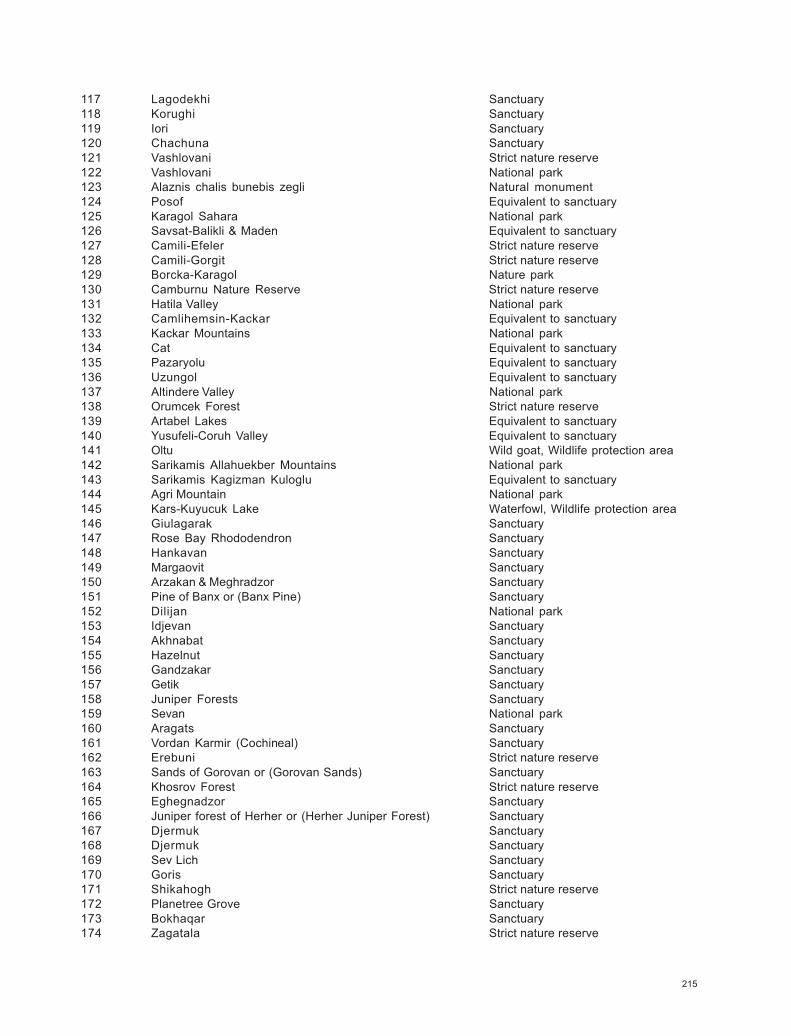
215
117 Lagodekhi Sanctuary118 Korughi Sanctuary119 Iori Sanctuary120 Chachuna Sanctuary121 Vashlovani Strict nature reserve122 Vashlovani National park123 Alaznis chalis bunebis zegli Natural monument124 Posof Equivalent to sanctuary125 Karagol Sahara National park126 Savsat-Balikli & Maden Equivalent to sanctuary127 Camili-Efeler Strict nature reserve128 Camili-Gorgit Strict nature reserve129 Borcka-Karagol Nature park130 Camburnu Nature Reserve Strict nature reserve131 Hatila Valley National park132 Camlihemsin-Kackar Equivalent to sanctuary133 Kackar Mountains National park134 Cat Equivalent to sanctuary135 Pazaryolu Equivalent to sanctuary136 Uzungol Equivalent to sanctuary137 Altindere Valley National park138 Orumcek Forest Strict nature reserve139 Artabel Lakes Equivalent to sanctuary140 Yusufeli-Coruh Valley Equivalent to sanctuary141 Oltu Wild goat, Wildlife protection area142 Sarikamis Allahuekber Mountains National park143 Sarikamis Kagizman Kuloglu Equivalent to sanctuary144 Agri Mountain National park145 Kars-Kuyucuk Lake Waterfowl, Wildlife protection area146 Giulagarak Sanctuary147 Rose Bay Rhododendron Sanctuary148 Hankavan Sanctuary149 Margaovit Sanctuary150 Arzakan & Meghradzor Sanctuary151 Pine of Banx or (Banx Pine) Sanctuary152 Dilijan National park153 Idjevan Sanctuary154 Akhnabat Sanctuary155 Hazelnut Sanctuary156 Gandzakar Sanctuary157 Getik Sanctuary158 Juniper Forests Sanctuary159 Sevan National park160 Aragats Sanctuary161 Vordan Karmir (Cochineal) Sanctuary162 Erebuni Strict nature reserve163 Sands of Gorovan or (Gorovan Sands) Sanctuary164 Khosrov Forest Strict nature reserve165 Eghegnadzor Sanctuary166 Juniper forest of Herher or (Herher Juniper Forest) Sanctuary167 Djermuk Sanctuary168 Djermuk Sanctuary169 Sev Lich Sanctuary170 Goris Sanctuary171 Shikahogh Strict nature reserve172 Planetree Grove Sanctuary173 Bokhaqar Sanctuary174 Zagatala Strict nature reserve

216
175 Ilisu Strict nature reserve176 Sheki Sanctuary177 Gabala Sanctuary178 Ismailly Strict nature reserve179 Pirgulu Strict nature reserve180 Gusar Sanctuary181 Altyagaj (Altyagach) National park182 Absheron National park183 Gil Island Sanctuary184 Gobustan Strict nature reserve185 Byandovan Sanctuary186 Shirvan National park187 Shirvan Strict nature reserve188 Gyzylaghaj (Gyzyl-Agach) Strict nature reserve189 Lesser Gyzylaghaj (Small Gyzyl-Agach) Sanctuary190 Hirkan National park191 Zuvand Sanctuary192 Ag-Gel National park193 Arazboyu Sanctuary194 Bastichay Strict nature reserve195 Gubadly Sanctuary196 Dashalti Sanctuary197 Garagiol Strict nature reserve198 Lachyn Sanctuary199 Barda Sanctuary200 Turyanchay Strict nature reserve201 Ilisu Branch Strict nature reserve202 Korchay Sanctuary203 Goygol (Gey-Gel) Strict nature reserve204 Gyzylja Sanctuary205 Shamkir Sanctuary206 Eldar Pine Strict nature reserve207 Garayazy Strict nature reserve208 Shahbuz Strict nature reserve209 Ordubad National park210 Ordubad Sanctuary211 Marakan Protected area212 Kiamaky Sanctuary213 Arasbaran (Biosphere reserve) Protected area214 Lavandvil Sanctuary215 Lisar Protected area216 Siah keshim International Wetland Protected area217 Sorkhankol International Wetland Sanctuary218 Selkeh International Wetland Sanctuary219 Bojagh International Wetland National park220 Amirkalayeh International Wetland Sanctuary221 Gasht-e Rudkhan & Siahmazgy Protected area222 Siah Rud-e Rudbar Protected area223 Sarv-e lat & Javaherdasht Protected area224 Beles kuh Protected area
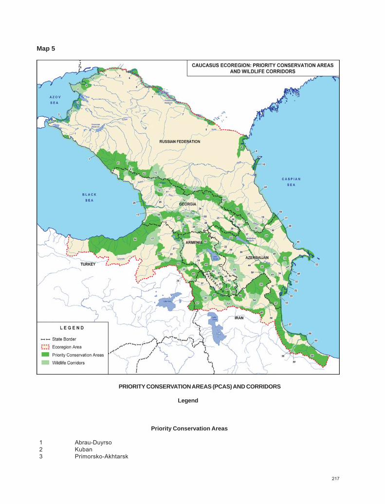
217
Map 5
PRIORITY CONSERVATION AREAS (PCAS) AND CORRIDORS
Legend
Priority Conservation Areas
1 Abrau-Duyrso2 Kuban3 Primorsko-Akhtarsk

218
4 Yeysk5 Don Delta6 Veselovskoye Reservoir7 Manych-Gudilo8 Dadynskoye Lake9 Kizlyarsky Bay10 Agrakhansky Bay11 West Greater Caucasus12 Teberdinsky Strict Nature Reserve13 Svaneti14 Racha-Central Caucasus15 Khevi-Tusheti16 Lagodekhi-Zagatala-West Dagestan17 Sarybash18 Laman-Kam Area19 Samur-Yalama20 Aghzibir (Akzybir) Lake21 Ismailly-Shahdagh22 Iori-Mingechevir (Mingechaur)23 Alazani-Ganykh24 Kvernaki25 Askhi-Karst Massif26 Rioni27 Trialeti28 Kura-Jandari29 Mount Gyamysh30 Varvara-Barda31 Gobustan-Hajigabul32 Gobustan-Absheron33 Shirvan34 Makhmud Chala35 Gyzyl-Agach (Gyzylaghaj)36 Kura- Araz (Araks) Valley37 Talish-Zuvand38 Araz (Araks) Valley39 Gilan40 Sabalan41 Marakan-Kiamaki42 Meghri43 Zangezur44 Arasbaran45 Bichanek46 Noravank47 Maku & Western Iranian Border48 Agri Dagi (Ararat) & Armash49 Khosrov50 Pambak-Sevan51 Javakheti52 Igdir Plain & Armavir53 Sarikamis Forest54 West Lesser Caucasus55 Manglisi56 Sefid Rud-Anzali
Corridors
1 Kuban – Rioni Corridor2 Priomorsko-Akhtarsk – Kuban Corridor
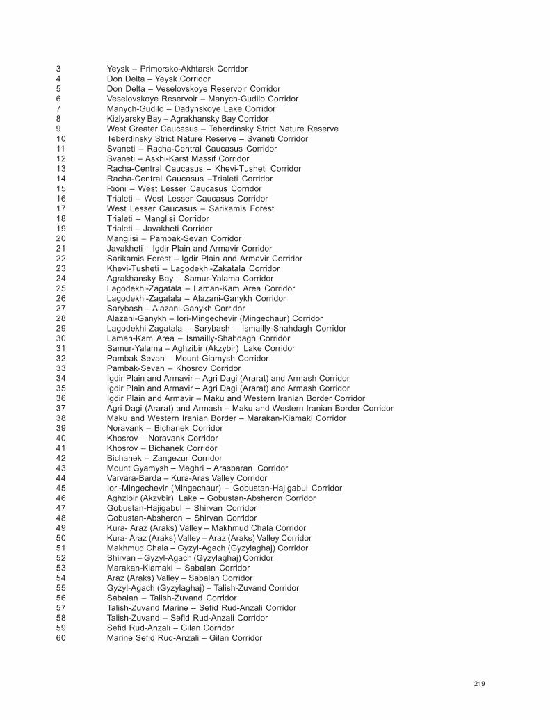
219
3 Yeysk – Primorsko-Akhtarsk Corridor4 Don Delta – Yeysk Corridor5 Don Delta – Veselovskoye Reservoir Corridor6 Veselovskoye Reservoir – Manych-Gudilo Corridor7 Manych-Gudilo – Dadynskoye Lake Corridor8 Kizlyarsky Bay – Agrakhansky Bay Corridor9 West Greater Caucasus – Teberdinsky Strict Nature Reserve10 Teberdinsky Strict Nature Reserve – Svaneti Corridor11 Svaneti – Racha-Central Caucasus Corridor12 Svaneti – Askhi-Karst Massif Corridor13 Racha-Central Caucasus – Khevi-Tusheti Corridor14 Racha-Central Caucasus –Trialeti Corridor15 Rioni – West Lesser Caucasus Corridor16 Trialeti – West Lesser Caucasus Corridor17 West Lesser Caucasus – Sarikamis Forest18 Trialeti – Manglisi Corridor19 Trialeti – Javakheti Corridor20 Manglisi – Pambak-Sevan Corridor21 Javakheti – Igdir Plain and Armavir Corridor22 Sarikamis Forest – Igdir Plain and Armavir Corridor23 Khevi-Tusheti – Lagodekhi-Zakatala Corridor24 Agrakhansky Bay – Samur-Yalama Corridor25 Lagodekhi-Zagatala – Laman-Kam Area Corridor26 Lagodekhi-Zagatala – Alazani-Ganykh Corridor27 Sarybash – Alazani-Ganykh Corridor28 Alazani-Ganykh – Iori-Mingechevir (Mingechaur) Corridor29 Lagodekhi-Zagatala – Sarybash – Ismailly-Shahdagh Corridor30 Laman-Kam Area – Ismailly-Shahdagh Corridor31 Samur-Yalama – Aghzibir (Akzybir) Lake Corridor32 Pambak-Sevan – Mount Giamysh Corridor33 Pambak-Sevan – Khosrov Corridor34 Igdir Plain and Armavir – Agri Dagi (Ararat) and Armash Corridor35 Igdir Plain and Armavir – Agri Dagi (Ararat) and Armash Corridor36 Igdir Plain and Armavir – Maku and Western Iranian Border Corridor37 Agri Dagi (Ararat) and Armash – Maku and Western Iranian Border Corridor38 Maku and Western Iranian Border – Marakan-Kiamaki Corridor39 Noravank – Bichanek Corridor40 Khosrov – Noravank Corridor41 Khosrov – Bichanek Corridor42 Bichanek – Zangezur Corridor43 Mount Gyamysh – Meghri – Arasbaran Corridor44 Varvara-Barda – Kura-Aras Valley Corridor45 Iori-Mingechevir (Mingechaur) – Gobustan-Hajigabul Corridor46 Aghzibir (Akzybir) Lake – Gobustan-Absheron Corridor47 Gobustan-Hajigabul – Shirvan Corridor48 Gobustan-Absheron – Shirvan Corridor49 Kura- Araz (Araks) Valley – Makhmud Chala Corridor50 Kura- Araz (Araks) Valley – Araz (Araks) Valley Corridor51 Makhmud Chala – Gyzyl-Agach (Gyzylaghaj) Corridor52 Shirvan – Gyzyl-Agach (Gyzylaghaj) Corridor53 Marakan-Kiamaki – Sabalan Corridor54 Araz (Araks) Valley – Sabalan Corridor55 Gyzyl-Agach (Gyzylaghaj) – Talish-Zuvand Corridor56 Sabalan – Talish-Zuvand Corridor57 Talish-Zuvand Marine – Sefid Rud-Anzali Corridor58 Talish-Zuvand – Sefid Rud-Anzali Corridor59 Sefid Rud-Anzali – Gilan Corridor60 Marine Sefid Rud-Anzali – Gilan Corridor
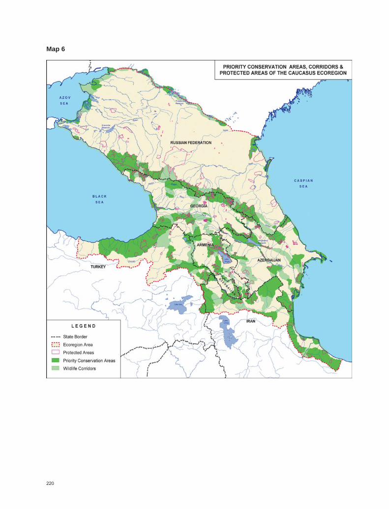
220
Map 6