an early warning system for early detection and …
TRANSCRIPT
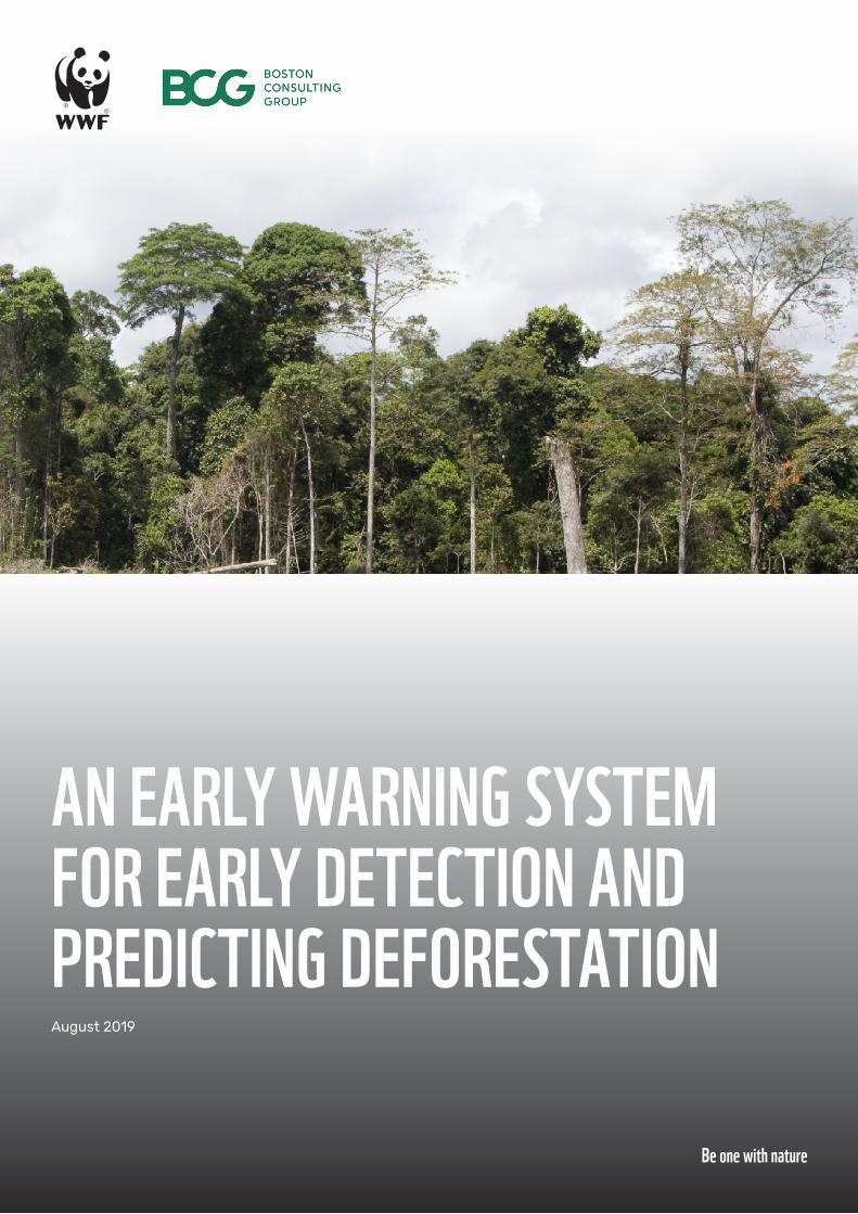
AN EARLY WARNING SYSTEM FOR EARLY DETECTION AND PREDICTING DEFORESTATION
Be one with nature
August 2019
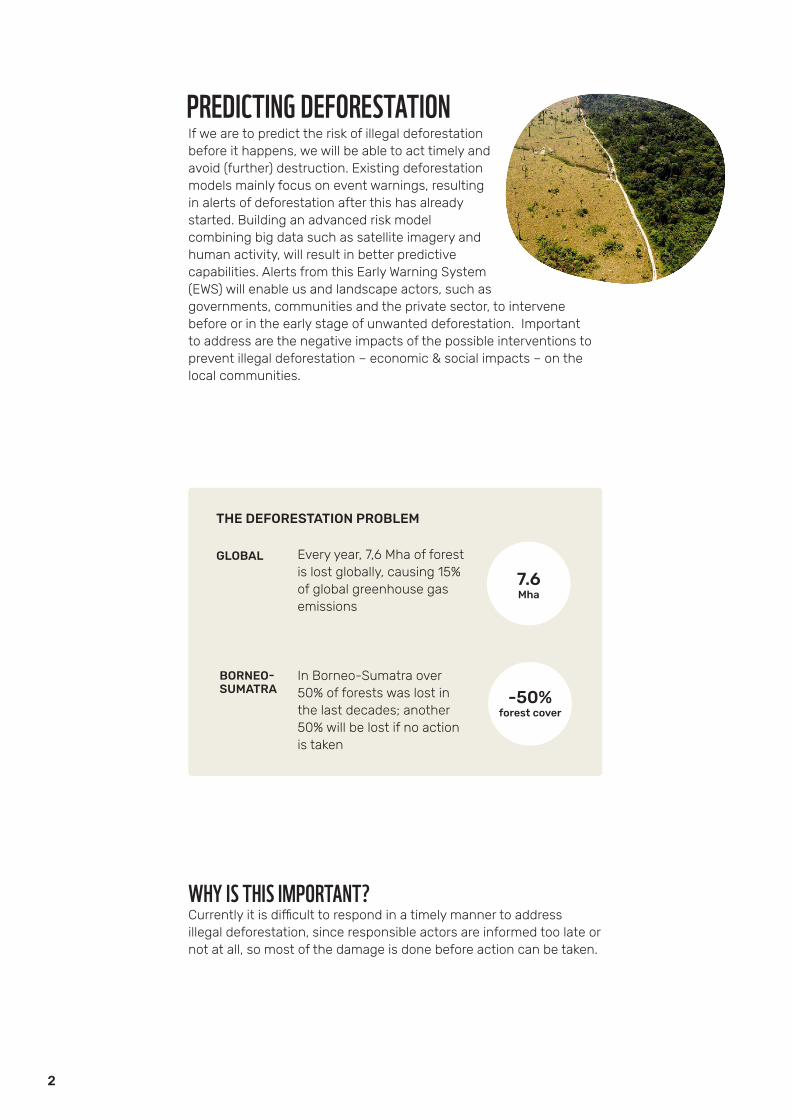
If we are to predict the risk of illegal deforestation before it happens, we will be able to act timely and avoid (further) destruction. Existing deforestation models mainly focus on event warnings, resulting in alerts of deforestation after this has already started. Building an advanced risk model combining big data such as satellite imagery and human activity, will result in better predictive capabilities. Alerts from this Early Warning System (EWS) will enable us and landscape actors, such as governments, communities and the private sector, to intervene before or in the early stage of unwanted deforestation. Important to address are the negative impacts of the possible interventions to prevent illegal deforestation – economic & social impacts – on the local communities.
THE DEFORESTATION PROBLEM
Every year, 7,6 Mha of forestis lost globally, causing 15% of global greenhouse gas emissions
In Borneo-Sumatra over 50% of forests was lost in the last decades; another 50% will be lost if no action is taken
GLOBAL
BORNEO-SUMATRA
7.6Mha
-50%forest cover
PREDICTING DEFORESTATION
WHY IS THIS IMPORTANT? Currently it is difficult to respond in a timely manner to address illegal deforestation, since responsible actors are informed too late or not at all, so most of the damage is done before action can be taken.
2
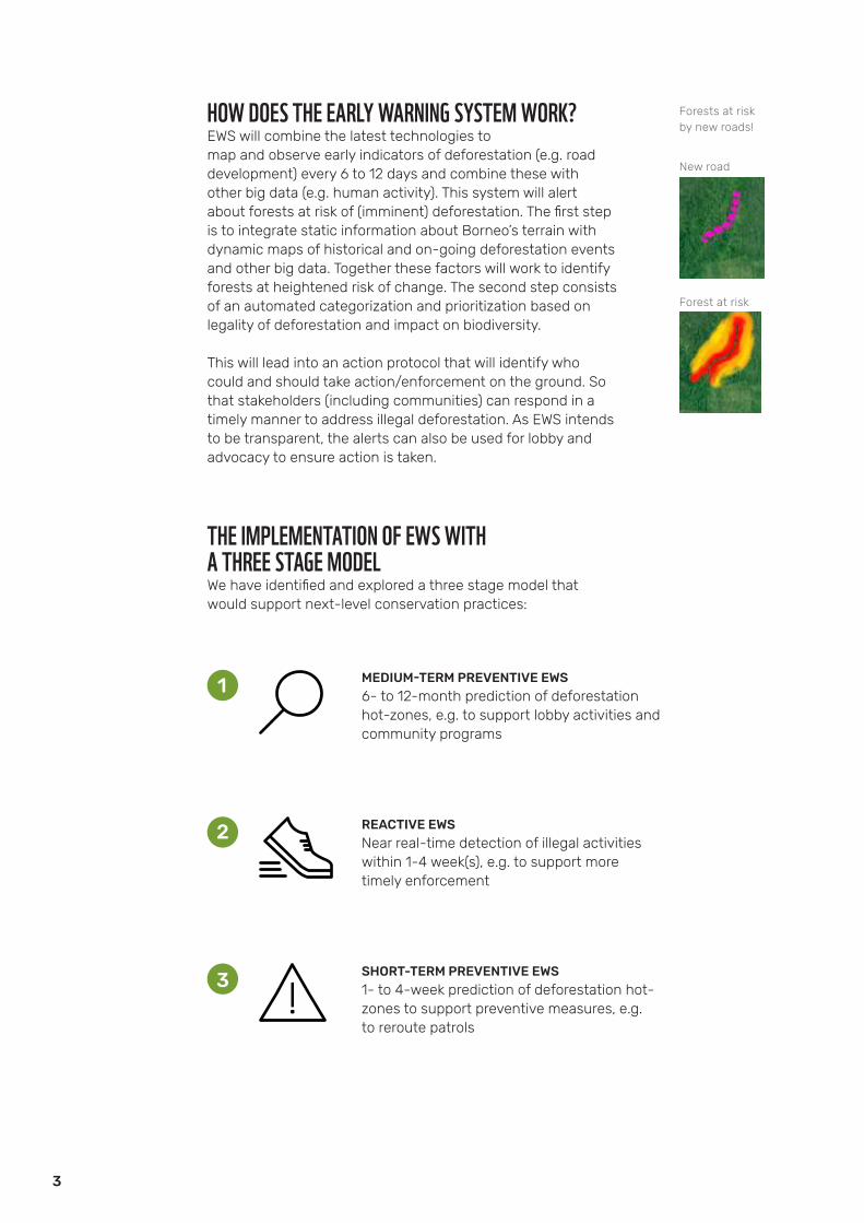
HOW DOES THE EARLY WARNING SYSTEM WORK? EWS will combine the latest technologies to map and observe early indicators of deforestation (e.g. road development) every 6 to 12 days and combine these with other big data (e.g. human activity). This system will alert about forests at risk of (imminent) deforestation. The first step is to integrate static information about Borneo’s terrain with dynamic maps of historical and on-going deforestation events and other big data. Together these factors will work to identify forests at heightened risk of change. The second step consists of an automated categorization and prioritization based on legality of deforestation and impact on biodiversity.
This will lead into an action protocol that will identify who could and should take action/enforcement on the ground. So that stakeholders (including communities) can respond in a timely manner to address illegal deforestation. As EWS intends to be transparent, the alerts can also be used for lobby and advocacy to ensure action is taken.
THE IMPLEMENTATION OF EWS WITHA THREE STAGE MODEL We have identified and explored a three stage model that would support next-level conservation practices:
MEDIUM-TERM PREVENTIVE EWS6- to 12-month prediction of deforestation hot-zones, e.g. to support lobby activities and community programs
REACTIVE EWSNear real-time detection of illegal activities within 1-4 week(s), e.g. to support more timely enforcement
SHORT-TERM PREVENTIVE EWS1- to 4-week prediction of deforestation hot- zones to support preventive measures, e.g. to reroute patrols
New road
Forests at risk by new roads!
Forest at risk
3

We successfully developed a design on the technical feasibility for the predictive modeling for both the short-term and the medium-term forecasting model. For both, we reached over 70% user’s accuracy in predicting deforestation in our pilot area (50 by 80 km) in Central Kalimantan, Indonesia. The process included engagement with local stakeholders (NGOs, governmental agencies) on the ground who would become the users of EWS. This engagement is important to create local ownership and thereby maximize buy-in and institutionalization of the model.
COMMUNITIES, RIGHTS AND BENEFITSLocal communities often depend on forests for their well-being and livelihoods and have been successfully and sustainably conserving them for generations. Thereby it is crucial that community engagement is strengthened through CBOs (Community Based Organizations) and in collaboration with NGOs, the private sector and governmental agencies to co-develop the action protocol when responding to alerts. Communities need to be engaged from the onset to help prevent illegal deforestation. They also need to have an informed dialogue with and support from involved stakeholders on the recognition of rights to the forest and equitable benefit-sharing schemes. EWS also supports the communities to monitor their surroundings better if they receive the alerts e.g. prevent illegal deforestation in their community forest or other forms of land under their management.
ENSURE OWNERSHIP BY THE LOCAL STAKEHOLDERSCreating local ownership is a key for success. The requirements of local stakeholders need to be built into this model. Hereby the local stakeholders, such as the communities, governmental agencies at different levels, the private sector and NGOs, have a leading role in the model development. The alerts generated by the model will inform the local stakeholders with the required information (defined by them) for action on the ground. It is important to create active engagement with these stakeholders by being present at a local level through established WWF offices.
POSSIBLE INTERVENTIONS
Wide variety of interventions from long-term policy influencing to short-term law enforcement support
4 types of interventions identified so far:• Supporting law enforcement• Community engagement• Company influencing• Policy influencing
4
5
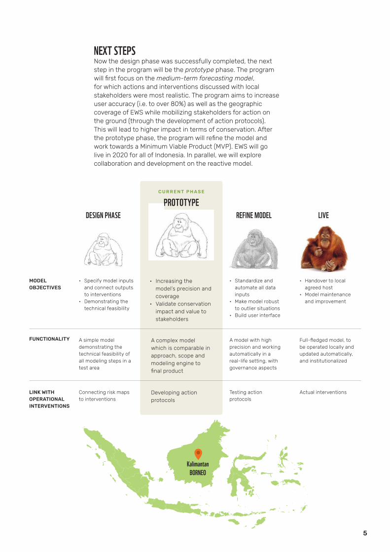
NEXT STEPSNow the design phase was successfully completed, the next step in the program will be the prototype phase. The program will first focus on the medium-term forecasting model, for which actions and interventions discussed with local stakeholders were most realistic. The program aims to increase user accuracy (i.e. to over 80%) as well as the geographic coverage of EWS while mobilizing stakeholders for action on the ground (through the development of action protocols). This will lead to higher impact in terms of conservation. After the prototype phase, the program will refine the model and work towards a Minimum Viable Product (MVP). EWS will go live in 2020 for all of Indonesia. In parallel, we will explore collaboration and development on the reactive model.
DESIGN PHASE REFINE MODEL LIVE
• Specify model inputs and connect outputs to interventions
• Demonstrating the technical feasibility
• Standardize and automate all data inputs
• Make model robust to outlier situations
• Build user interface
• Handover to local agreed host
• Model maintenance and improvement
A simple model demonstrating the technical feasibility of all modeling steps in a test area
A model with high precision and working automatically in a real-life setting, with governance aspects
Full-fledged model, to be operated locally and updated automatically, and institutionalized
Connecting risk maps to interventions
Testing action protocols
Actual interventions
MODELOBJECTIVES
LINK WITH OPERATIONAL INTERVENTIONS
FUNCTIONALITY
PROTOTYPE
• Increasing the model’s precision and coverage
• Validate conservation impact and value to stakeholders
A complex model which is comparable in approach, scope and modeling engine to final product
Developing action protocols
KalimantanBORNEO
C U R R E N T P H A S E
6
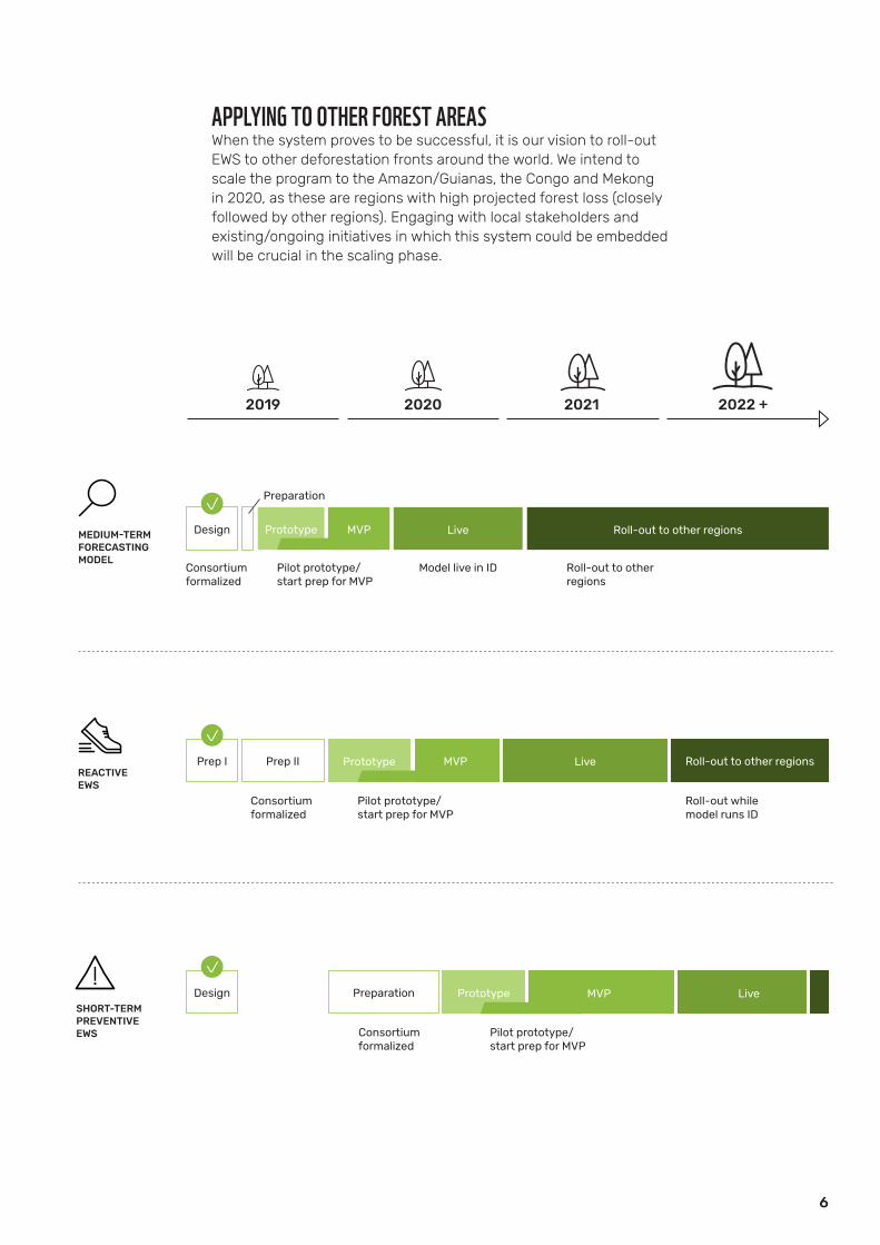
2019 2020 2021 2022 +
MEDIUM-TERMFORECASTING MODEL
Prototype MVP Live Roll-out to other regions
Preparation
Consortiumformalized
Pilot prototype/ start prep for MVP
Model live in ID Roll-out to other regions
Design
REACTIVE EWS
Prep II Prototype MVP Live Roll-out to other regions
Consortiumformalized
Pilot prototype/ start prep for MVP
Roll-out while model runs ID
Prep I
SHORT-TERM PREVENTIVEEWS
PrototypePreparation Live
Consortiumformalized
Pilot prototype/ start prep for MVP
Design MVP
APPLYING TO OTHER FOREST AREASWhen the system proves to be successful, it is our vision to roll-out EWS to other deforestation fronts around the world. We intend to scale the program to the Amazon/Guianas, the Congo and Mekong in 2020, as these are regions with high projected forest loss (closely followed by other regions). Engaging with local stakeholders and existing/ongoing initiatives in which this system could be embedded will be crucial in the scaling phase.

Preserving habitats of iconic species
150-500 thousand haforest loss avoided
30-100 million tCO2
avoided emissions
90-300 million $ worthin emission credits$
ACHIEVING IMPACTEWS aims to reduce the illegal conversion of forests on Borneo/Sumatra by 10-35% if stakeholders can respond in a timely manner. The design phase showed that we could reduce illegal deforestation by 22%! EWS can also prevent the release of CO2. This results in avoided emissions and preservation of habitats for our iconic species and thus biodiversity and eco-systems as a whole. At the same time, the system will serve the communities and other stakeholders with up-to-date monitoring, which allows for better protection and planning for the forest areas. EWS also allows for earlier engagement with communities where the system predicts risk of deforestation, where participatory approaches for alternatives to illegal activities could take place. Although the system will address illegal deforestation, it too will show other types of deforestation that can be used by the stakeholders as well in terms of monitoring, planning and implementation.
PARTNERSWWF is working together on this program with Boston Consulting Group as part of the global partnership. We are also talking with partners who have state-of-the-art technologies to provide the baseline and forest cover change of the model, using radar and satellite images as well as other big data.
Contact | [email protected]
7

PHOTOGRAPHYWWF / Simon Rawles, Jonne Seijdel / WWF-Netherlands
Why we are here.To stop the degradation of the world’s natural environment and to build a future in which humans live in harmony with nature.
wwf.nl