american society of civil engineers - asce's 2017 ... · american society of civil engineers....
TRANSCRIPT
American Society of Civil Engineers

Inland WaterWays
The average tow barge can carry the equiv-alent of 870 tractor trailer loads. Of the 257 locks still in use on the nation’s inland water-ways, 30 were built in the 1800s and another 92 are more than 60 years old. The average age of all federally owned or operated locks is nearly 60 years, well past their planned design life of 50 years. The cost to replace the present system of locks is estimated at more than $125 billion.
tranSPortation

A = ExceptionalB = GoodC = MediocreD = PoorF = Failing
AMERICA’SINFRASTRUCTURE G.P.A.
www.asce.org/reportcard
tranSPortation
83www.asce.org/reportcard
ESTIMATED 5-YEAR FUNDING REQUIREMENTS FOR inlanD waterways
Total investment needs $50 billion
Estimated spending$29.475 billion
Projected shortfall$20.5 billion
Establish a program to improve and maintain ports, harbors, and waterways;
crEatE a predictable and reliable source of maintenance funding with a dedicated source of revenue, such as a portion of U.S. Customs receipts;
DEEpEn and widen ship channels to accommodate the world fleet’s new, larger ships;
continuE maintenance dredging of ship channels for the efficient handling of maritime commerce;
limit erosion and sedimentation in ports, harbors, and waterways;
continuE the development of the navigation engineering specialty within the engineering profession.
Facts About INLAND WATERWAyS
D-inlAnD WAtERWAyS

84 2009 Report Card for America’s Infrastructure www.asce.org/reportcard
ConDitionS
Because of their ability to move large amounts of cargo, the nation’s inland waterways are a strategic economic and military resource. A recent analysis by the U.S. Army War College concluded that “the strategic contributions of these inland waterways are not well under-stood. The lack of adequate understanding impacts decisions contributing to effi-cient management, adequate funding, and effective integration with other modes of transportation at the national level. Rec-ommendations demonstrate that lever-aging the strategic value of U.S. inland waterways will contribute to building an effective and reliable national transporta-tion network for the 21st century.”1
Forty-one states, including all states east of the Mississippi River and 16 state capitals, are served by commercially navi-gable waterways. The U.S. inland water-way system consists of 12,000 miles of navigable waterways in four systems—the Mississippi River, the Ohio River Basin, the Gulf Intercoastal Waterway, and the Pacific Coast systems—that connect with most states in the U.S. The system com-prises 257 locks, which raise and lower
river traffic between stretches of water of different levels.
Three-quarters of the nation’s inland waterways, or approximately 9,000 miles, are within the Mississippi River system. The next largest segment is the Ohio River system with 2,800 miles. The Gulf Coast Intercoastal Waterway system comprises 1,109 miles and the Columbia River sys-tem, the shortest of the four major sys-tems, is only 596 miles long.
The nationwide network includes nearly 11,000 miles of waterways funded by federal user fees through an excise tax on fuel. Commercial waterway operators on these designated waterways pay a fuel tax of 20 cents per gallon, which is depos-ited in the Inland Waterways Trust Fund (IWTF). The IWTF, which was created in 1978, funds half the cost of new construc-tion and major rehabilitation of the inland waterway infrastructure.
Forty-seven percent of all locks main-tained by the U.S. Army Corps of Engi-neers were classified as functionally obsolete in 2006. Assuming that no new locks are built within the next 20 years, by 2020, another 93 existing locks will be obsolete—rendering more than 8 out of every 10 locks now in service outdated.2
Currently, the Corps has $180 million per year available for lock repairs—half comes from the IWTF revenues and half comes from congressional appropriations. With an average rehabilitation cost of $50 million per lock, the current level allows the Corps to fully fund only two or three lock projects each year.
There is no recognized engineering specialty to comprehensively address the
The U.S. inland waterway system consists of 12,000 miles of navigable waterways in four systems—the Mississippi River, the Ohio River Basin, the Gulf Intercoastal Waterway, and the Pacific Coast systems.
Facts About INLAND WATERWAyS 85www.asce.org/reportcard
current and future waterways systems challenges. In the past, systems were basi-cally designed and maintained by the Corps and therefore most of the engineer-ing knowledge and experience has been self-contained. Now much of that mission is contracted and other related functions are privatized. These factors and the loss of experienced engineers in and outside
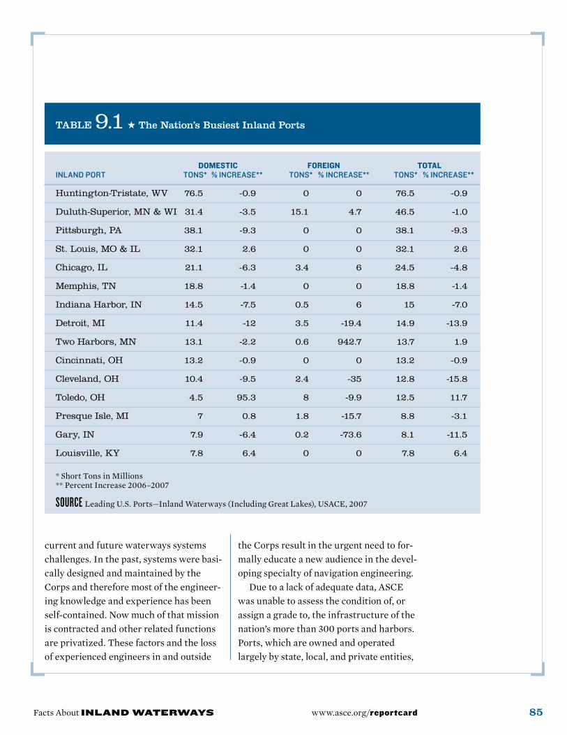
TABLE 9.1 ★ The Nation’s Busiest Inland Ports
domestic Foreign totalinlandport tons* %increase** tons* %increase** tons* %increase**
Huntington-Tristate, WV 76.5 -0.9 0 0 76.5 -0.9
Duluth-Superior, MN & WI 31.4 -3.5 15.1 4.7 46.5 -1.0
Pittsburgh, PA 38.1 -9.3 0 0 38.1 -9.3
St. Louis, MO & IL 32.1 2.6 0 0 32.1 2.6
Chicago, IL 21.1 -6.3 3.4 6 24.5 -4.8
Memphis, TN 18.8 -1.4 0 0 18.8 -1.4
Indiana Harbor, IN 14.5 -7.5 0.5 6 15 -7.0
Detroit, MI 11.4 -12 3.5 -19.4 14.9 -13.9
Two Harbors, MN 13.1 -2.2 0.6 942.7 13.7 1.9
Cincinnati, OH 13.2 -0.9 0 0 13.2 -0.9
Cleveland, OH 10.4 -9.5 2.4 -35 12.8 -15.8
Toledo, OH 4.5 95.3 8 -9.9 12.5 11.7
Presque Isle, MI 7 0.8 1.8 -15.7 8.8 -3.1
Gary, IN 7.9 -6.4 0.2 -73.6 8.1 -11.5
Louisville, KY 7.8 6.4 0 0 7.8 6.4
* Short Tons in Millions ** Percent Increase 2006–2007
SoURCE Leading U.S. Ports—Inland Waterways (Including Great Lakes), USACE, 2007
the Corps result in the urgent need to for-mally educate a new audience in the devel-oping specialty of navigation engineering.
Due to a lack of adequate data, ASCE was unable to assess the condition of, or assign a grade to, the infrastructure of the nation’s more than 300 ports and harbors. Ports, which are owned and operated largely by state, local, and private entities,
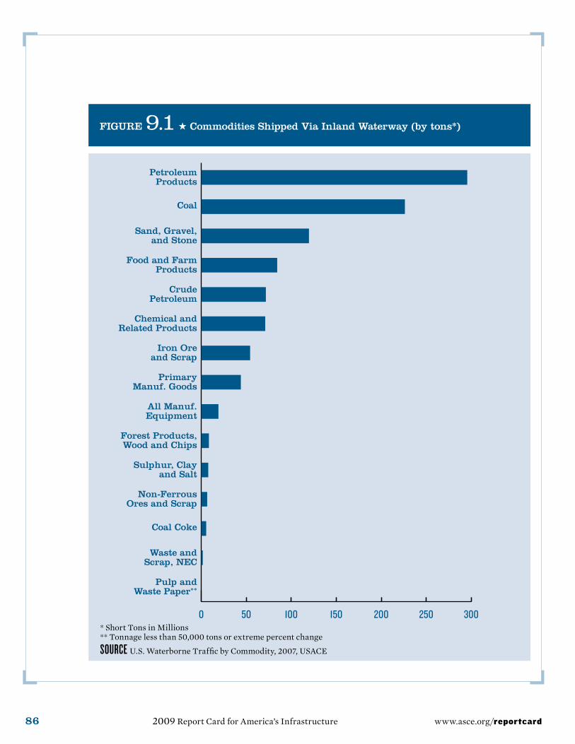
FIGURE 9.1 ★ commodities Shipped via Inland Waterway (by tons*)
* Short Tons in Millions ** Tonnage less than 50,000 tons or extreme percent change
SoURCE U.S. Waterborne Traffic by Commodity, 2007, USACE
2007
2006
2005
Pulp andWaste Paper**
Waste andScrap, NEC
Coal Coke
Non-FerrousOres and Scrap
Sulphur, Clayand Salt
Forest Products,Wood and Chips
All Manuf.Equipment
PrimaryManuf. Goods
Iron Ore and Scrap
Chemical andRelated Products
CrudePetroleum
Food and FarmProducts
Sand, Gravel,and Stone
Coal
PetroleumProducts
86 2009 Report Card for America’s Infrastructure www.asce.org/reportcard
Facts About INLAND WATERWAyS 87www.asce.org/reportcard
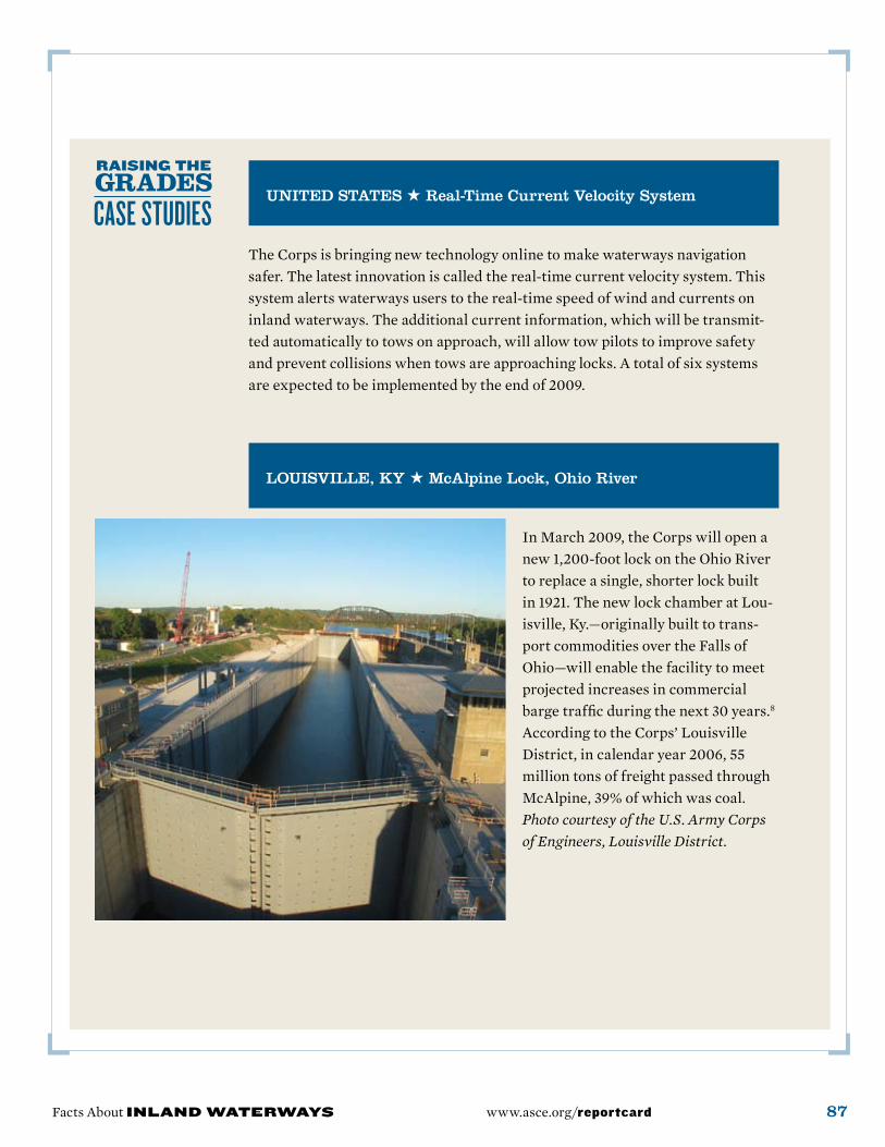
UNITED STATES ★ Real-Time current velocity System
The Corps is bringing new technology online to make waterways navigation safer. The latest innovation is called the real-time current velocity system. This system alerts waterways users to the real-time speed of wind and currents on inland waterways. The additional current information, which will be transmit-ted automatically to tows on approach, will allow tow pilots to improve safety and prevent collisions when tows are approaching locks. A total of six systems are expected to be implemented by the end of 2009.
LoUISvILLE, Ky ★ McAlpine Lock, ohio River
In March 2009, the Corps will open a new 1,200-foot lock on the Ohio River to replace a single, shorter lock built in 1921. The new lock chamber at Lou-isville, Ky.—originally built to trans-port commodities over the Falls of Ohio—will enable the facility to meet projected increases in commercial barge traffic during the next 30 years.8 According to the Corps’ Louisville District, in calendar year 2006, 55 million tons of freight passed through McAlpine, 39% of which was coal. Photo courtesy of the U.S. Army Corps of Engineers, Louisville District.
88 2009 Report Card for America’s Infrastructure www.asce.org/reportcard
are not required to report on the condi-tion of their infrastructure to the federal government. Nevertheless, U.S. ports con-nect to 1,000 federally maintained harbor channels and 12,000 miles of taxpayer-funded inland waterways, and their land-side port infrastructure facilities include terminals, wharves, rail yards, and road-ways within the harbor districts.6 In 2007, the American Association of Port Authori-ties (AAPA), which represents ports in the U.S., Canada and Mexico, reported that public ports in the U.S. must invest $1.7 billion annually to update and mod-ernize their facilities. The AAPA report contained no assessment of the physical condition of individual ports or of port infrastructure generally.4
RESiliEnCE
The current system of inland waterways lacks resilience. Waterway usage is increas-ing, but facilities are aging and many are well past their design life of 50 years. Recov-ery from any event of significance would be negatively impacted by the age and dete-riorating condition of the system, posing a direct threat to the American economy.
ConClUSion
Inland and intracoastal waterways directly serve 38 states including the states on the Atlantic seaboard, the Gulf Coast, and the Pacific Northwest. Ship-pers and consumers in these states depend on the inland waterways to move approxi-mately 630 million tons of cargo valued at more than $73 billion annually. States on
the Gulf Coast and throughout the Mid-west and Ohio Valley especially depend on the inland and intracoastal waterways. Texas and Louisiana each ship more than $10 billion worth of cargo annually, while Illinois, Pennsylvania, West Virginia, Ken-tucky, Mississippi, Alabama, and Wash-ington State each ship between $2 billion and $10 billion annually. Another 8 states ship at least $1 billion annually.
This system provides an average trans-portation savings of $10.67 per ton over the cost of shipping by alternative modes. This translates into more than $7 billion annually in transportation savings to the U.S. econ-omy. Future investment must focus on life-cycle maintenance, system interdepen-dencies, redundancy, security, and recovery from natural and man-made hazards. ★
SoURCES1 Donald E. Jackson Jr., Leveraging the Strategic Value of the U.S. Inland Waterway System, Army War College research paper, March 2007.
2 U.S. Army Corps of Engineers, The U.S. Waterway System—Transportation Facts, Decem-ber 2007.
3 U.S. Army Corps of Engineers, An Overview of the U.S. Inland Waterway System, November 2005.
4 American Association of Port Authorities, America’s Ports Today, 2007.
5 U.S. Maritime Administration, Annual Report to Congress, 2007.
6 U.S. Maritime Administration, U.S. Water Transportation Statistical Snapshot, 2008.
7 U.S. Army Corps of Engineers, Institute for Water Resources, at www.vtn.iwr.usace.army.mil/navigation/navrecentprojects.htm.
8 Hale, Tom. “McAlpine Lock Replacement Update,” Construction Digest, April 10, 2006.

Facts About INLAND WATERWAyS 89www.asce.org/reportcard
PHILADELPHIA, PA ★� Delaware River channel Deepening Project
In June 2008, an agreement was signed between the U.S. Army Corps of Engineers and the Philadelphia Regional Port Authority to begin a five-year, $379-million project to deepen the Delaware River’s shipping channel. The deeper channel, which is being increased from 40 to 45 feet, will allow ports on the Delaware River to compete more effectively for cargo, provide safe passage for vessels and increase jobs in the region. Approxi-mately 26 million cubic yards of dredg-ing material will be removed, 7.4 million cubic yards of which will be used for wetland creation and beach nourishment. Photos courtesy of the U.S. Army Corps of Engineers, Philadelphia District.
SAvERToN, Mo ★� Lock 22, Upper Mississippi River System
The U.S. Army Corps of Engineers’ new 1,200-foot Lock 22 will allow a tow with a full accompany of barges to move through the lock without having to break the tow’s load into two pieces. Keeping a tow’s load in one piece minimizes environmental impact, increases worker safety and reduces transit times. The lock’s design is largely transferable to four other lock sites, saving both time and money. The existing 600-foot lock will remain in place and will become an auxiliary lock serving primarily recre-ational traffic. Photo courtesy of the U.S. Army Corps of Engineers, Rock Island District.