amended comprehensive plan of the town of briny...
TRANSCRIPT

AMENDED COMPREHENSIVE PLAN OF THE TOWN OF BRINY BREEZES
BASED ON AN EVALUATION AND APPRAISAL PURSUANT TO SEC. 163.3191, F.S.
THIS AMENDED COMPREHENSIVE PLAN IS SUBJECT TO THE STATE COORDINATED REVIEW PROCESS OF
SECTION 163.3184(4), F.S.
PREPARED BY THE PLANNING AND ZONING BOARD/LOCAL PLANNING AGENCY
OF THE TOWN OF BRINY BREEZES DATED: FEBRUARY 14, 2013
Town of Briny Breezes 4802 North Ocean Boulevard Briny Breezes, Florida 33435 Telephone (561) 272-5495 Fax (561) 272-1988 [email protected] http:/townofbrinybreezes-fl.com

DIRECTIVE TO AMEND THE COMPREHENSIVE PLANIn 2008, the Briny Breezes Town Council directed the Town's Planning and Zoning Board,acting as the Town's Local Planning Agency (LPA), to take the necessary steps for amending theTown's current Comprehensive Plan which was adopted in January 1989. The LPA began itswork in April 2008 by preparing the Town's Evaluation and Appraisal Report (EAR) todetermine how well the 1989 Plan had served the Town. When completed in September 2010,the EAR offered recommendations and proposals for amending the Town's Comprehensive Planby redevelopment that would allow new types of residential units that would better serve thecommunity's housing needs. The EAR made projections for increases in the Town's population,analyzed whether there was need for changes in the Town's infrastructure to maintainsatisfactory levels-of-service to the public, and reviewed the Town's financial ability to fund anyfuture capital improvements that might be needed. The EAR was adopted by the Town Counciland approved by the Department of Community Affairs (DCA) in December 2010.
In January 2011, the LPA began a series of monthly public meetings for the preparation of the2011 Amended Comprehensive Plan, based on the recommendations and proposals contained inthe EAR. The hearings continued through December, 2012, when the LPA produced apreliminary draft of the Amended Plan, and scheduled subsequent meetings to finalize the Plan,hold a public hearing for its review and approval, and make its recommendations to the TownCouncil for adoption. The Town Council will then hold a publically noticed transmittal hearingand, upon its approval of the Plan, submit it to the Florida Department of Economic Opportunity(DEO) and the other state agencies for official review and comments.
It was intended that the Amended Plan would be presented in a form and content that would beread and readily understood by those persons most directly affected, namely, the residents ofBriny Breezes themselves. Many demographic changes have occurred in the state of Florida, inPalm Beach County, and in the Town of Briny Breezes since the adoption of the Town's 1989Plan. But those changes have not diminished the satisfying quality of life enjoyed by theresidents of the Briny Breezes community. In its work to present a new Plan for the Town'sfuture development, the LPA has endeavored throughout to preserve, protect, and continue thatsatisfying quality of life for the Town's residents.
Jerry Lower, ChairmanTown of Briny BreezesPlanning and Zoning Board/Local Planning Agency
3
TOWN OF BRINY BREEZES
AMENDED COMPREHENSIVE PLAN
PLANNING & ZONING BOARD/LOCAL PLANNING AGENCY
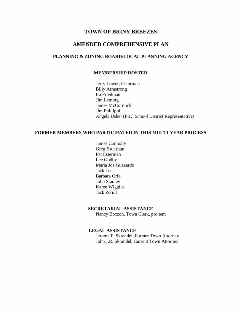
MEMBERSHIP ROSTER
Jerry Lower, Chairman Billy Armstrong Ira Friedman Jim Leming James McCormick Jim Phillippi Angela Usher (PBC School District Representative)
FORMER MEMBERS WHO PARTICIPATED IN THIS MULTI-YEAR PROCESS James Connolly Greg Esterman Pat Esterman Lee Godby Maria Joe Guzzardo Jack Lee Barbara Orfe John Stanley Karen Wiggins Jack Zerull
SECRETARIAL ASSISTANCE
Nancy Boczon, Town Clerk, pro tem
LEGAL ASSISTANCE
Jerome F. Skrandel, Former Town Attorney John J.R. Skrandel, Current Town Attorney

TABLE OF CONTENTS
ITEM PAGE 1. FUTURE LAND USE ELEMENT 1
Introduction 1 Public Participation in Preparing the Town’s Plan 1 Town’s Location 1 Town Maps 2 Figure 1 Regional Map 2 Figure 2 Local Map of Town’s Immediate Area 3 Land Ownership within the Town 4 History of the Briny Breezes Community 4
Figure 3 The 1926 Plat of the Briny Breezes Subdivision 5 in the Town of Boynton, Florida
Figure 4 Detailed Map Showing the Town’s Present Layout 8 Present Land Utilization Characteristics 9
Figure 5 Town’s 1989 Land Use Map 9 Existing Land Use - Single Family Limitation 10 The Town’s Future Development to Include Multi-Family Housing Units 10
Figure 6 Proposed Future Land Use Map of Town 11 Providing for Innovative Types of Single-Family Housing Units 12 Annexation 13 Sites for Future Development – Section 6 13
Figure 7 Section 6 Redevelopment Area 17 Seasonal Variations in The Town’s Population 18
Table 1 Snowbirds and the Census 19 Table 2 Population Estimate from Town’s 1989 Plan 20 Table 3 2000 U.S. Census Data for the Town 21
The Town’s Estimated Population and Population Projections 22 Table 4 Town’s Population for the Year 2011 24 The Town’s Population Projection for 2019 24 Table 5 Projected Peak Population for 2019 at End 24
of the 5-Year Planning Period The Town’s Population Projection for 2024 25
Table 6 Projected Population for 2024 at End of the 26 10-Year Planning Period
Requirement for Adequate Water Supply 27 Natural Resources 27 Historic Resources 28 Recreational Facilities 28
Figure 8 Recreation Facilities 28 Public Facilities and Services 29 The 10-Year Water Supply Facilities Work Plan Program 30 Flood Prone Areas 30 Goals, Objectives, and Policies 31

2. TRANSPORTATION ELEMENT 32
The Briny Breezes Road Network 32 Mapped Data 33 Jurisdiction for the Public Roads 33 Private Roads 35 Municipal Traffic Control Agreement 35
Figure 9 Town’s Road Network 36 Traffic Volume for A1A 36
Table 7 Daily Traffic Volumes on A1A through Town 36 Accident Data and Traffic Safety Concerns 37 Level of Service 38
Table 8 Standards for Levels of Service 38 Existing Transportation Needs 39 Future Needs 37
Table 9 Existing and Future Level of Service for A1A 40 Goals, Objectives, and Policies 40
3. HOUSING ELEMENT 42
Introduction 42 Housing Conditions 42 Housing Values 44 Housing Rentals 45 Rent-To-Income Ratios 45 Mortgage-To-Income Ratios 46 Previous Redevelopment Strategies 46 Present Redevelopment Strategies 46 Other Housing Data 47 Group Homes and Subsidized Housing 47 Affordable Housing 48 Housing Needs 48 Private Sector Delivery Process 48 Identification of Conservation, Rehabilitation, or Demolition Activities 49 Goals, Objectives, and Policies 49
4. INFRASTRUCTURE ELEMENT 50
Introduction 50 Wastewater Facilities Sub-Element - Collection System 50 Wastewater Facilities Sub-Element - Treatment System 51
Table 10 Sewage Flow Projections for the Town 53 Solid Waste Sub-Element - Collection System 53 Solid Waste Sub-Element - Needs Assessment 54
Table 11 Solid Waste Disposal 55 Potable Water Facility Sub-Element 56 Potable Water Supply 56 Water Distribution System 57

Needs Assessment 57 The 10-Year Water Supply Facilities Work Plan Program 58 Drainage Facilities Sub-Element 58 Rainfall 58 Terrain 59 Run-Off Quantities 59 Drainage Facilities 59 Needs Assessment 60 Natural Groundwater Aquifer Recharge Sub-Element 60 Needs Assessment 61 Goals, Objectives, and Policies 61
5. COASTAL MANAGEMENT ELEMENT 62
Introduction 62 Land Uses and Facilities Related to the Coastal Zone 62
Figure 10 Water-Dependent & Water-Related Uses 63 Table 12 Town’s Suitability for Listed Species 64
Protection of Endangered Species of Sea Turtles 65 Protection of the Endangered Florida Manatee 65 Coastal Construction Control Line 67
Figure 11 Location of CHHA and CCCL in Town of Briny Breezes 67 Public Beach Access 67 Private Beach Access 68 Private Access to the Intracoastal Waterway Shoreline 68 Conflicts Among Shoreline Uses 68 Public Access to the Intracoastal Waterway 69 Recreational Working Waterfront 69 Historic Resources 69 Hurricane Preparedness 70 Element Evaluation 70 Goals, Objectives, and Policies 71
6. CONSERVATION ELEMENT 74
Introduction - Relationship to Coastal Management Element 74 Environmental Setting 74 The Town’s Ecosystem 74 Geology 75 Coastal Ridge Vegetation 75 Conservation of Vegetative Cover 75 Natural Water Resources 76 Atlantic Ocean 76 Intracoastal Waterway 76 Air and Air Quality 77 Countywide Sources of Air Pollution 78 Soils and Soil Erosion 78 Floodplains 79

Table 13 Flood Insurance Classification Zones for 80 Briny Breezes
Flood Insurance Rate Maps 81 Table 14 Flood Insurance Rate Map 81
Minerals 81 Hazardous Waste 81 Potable Water Needs and Sources 82 Water Conservation 82
Table 15 Readings Taken on Town’s Water Consumption 84 Table 16 Town’s Water Consumption for month of August 85
in 2010 & 2011 Resource Protection Standards 85 Goals, Objectives, and Policies 86
7. RECREATION AND OPEN SPACE ELEMENT 87
Introduction 87 Existing Conditions 87 Open Space along Intracoastal Waterway 88 Public Park Facilities 88 Regional Public Park Facilities 89 Pedestrian Walkways and Trails 89 Needs Assessment 89 Goals, Objectives, and Policies 90
8. INTERGOVERNMENTAL COORDINATION ELEMENT 91
Introduction - Existing Conditions 91 Palm Beach County - Local Mitigation Strategy 91 The Palm Beach County Health Department – Public Health 92 City of Boynton Beach - Water Service 92 City of Boynton Beach - Fire Protection and Emergency Medical Services 92 City of Ocean Ridge – Police Protection Services 93 The Issues Forum Committee 93 The Palm Beach County League of Cities 93 The School District of Palm Beach County - Public Education 93
Figure 12 Concurrency Letter from the Palm Beach County 94 School District
The Florida Department of Transportation 95 The Florida League of Cities 95 The Florida Association of Municipal Clerks 95 The Treasure Coast Regional Planning Council 96 The South Central Regional Wastewater Authority 96 The Palm Beach County Solid Waste Authority – Urban Solid Waste Program 96 The Palm Beach County Solid Waste Authority – Hurricane Generated Debris 96 The South Florida Water Management District 97 Programs Affecting the Intracoastal Waterway 97 Cooperation with BBI 98
Coordinating the Town’s Intergovernmental Relationships 99 Goals, Objectives, and Policies 99
9. CAPITAL IMPROVEMENTS ELEMENT 100
Introduction 100 Private Assistance by BBI to Provide Capital Improvements 101 Inventory of Needs from the Other Elements 101 Transportation 101 The Town’s Water Utility System 102 New Land Development Regulations 103 Water Conservation Programs 103 Sanitary Sewer System 104 Solid Waste Removal and Disposal 105 Storm Drainage 105 Recreation 106 Financial Resources 106 Property or Ad Valorem Taxes 106 Miscellaneous Fees and Charges 107 Charges for Proprietary Services 107 Borrowing 107 Intergovernmental Revenue Sharing 107 Federal Funding 108 Town Policies and Practices 108 Fiscal Implications of Deficiencies and Cost Estimates 108 Public Education and Health Care Facility Implications 108 Land Use Plan Implications 108 Revenue Projections 109 Tax Base 109
Table 17 Financial Data for the Town 109 Debt Capacity 110 Implications from Town’s Fiscal Analysis 110 Implementation of 5-Year and 10-Year Schedule of Capital Improvements 110 Goals, Objectives, and Policies 111

ACRONYMS AND ABBREVIATIONS A1A State Road A-1-A AQI Air Quality Index BBI Briny Breezes, Inc. BEBR University of Florida Bureau of Economics and Business Research CCCL Coastal Construction Control Line CHHA Coastal High-Hazard Area CO Certificate of Occupancy CO-OP Residential Cooperative COUNCIL Town Council of the Town of Briny Breezes CQR U.S. Census Bureau’s 2010 Count DCA Department of Community Affairs DEO Department of Economic Opportunity E Endangered Species EAR Evaluation and Appraisal Report by the Town of Briny Breezes EMT Emergency Medical Technician EPA Environmental Protection Agency FDOT Florida Department of Transportation FEMA Federal Emergency management Agency FLUE Future Land Use Element F.S. Florida Statutes FWC Florida Fish and Wildlife Conservation Commission FWS U.S. Fish & Wildlife Service

GPD Gallons Per Day ICW Intracoastal Waterway LDR Land Development Regulations of the Town of Briny Breezes LMS Local Mitigation Strategy of Palm Beach County LOS Level of Service MGD Million Gallons Per Day LPA Local Planning Agency of the Town of Briny Breezes PLAN Amended Comprehensive Plan P&Z Planning and Zoning Board SFWMD South Florida Water Management District SSC Species of Special Concern SWA Solid Waste Authority T Threatened Species TCRPC Treasure Coast Regional Planning Council TOWN Town of Briny Breezes USACE U.S. Army Corp of Engineers USDA U.S. Department of Agriculture WMI Ward D. Miller, Inc.

1
1. FUTURE LAND USE ELEMENT
Introduction
The Future Land Use Element (FLUE) in the Amended Comprehensive Plan (Plan) makes a
major change to provide for the future growth and development of the Town of Briny Breezes
(Town). The Town’s Planning and Zoning Board, acting as the Town’s Local Planning Agency
(LPA), has presented a Plan to the Briny Breezes Town Council (Council) that departs from a
residential community that has thus far been expressly limited to mobile homes, to one that
allows all types and categories of residential buildings and structures. The Plan also up-grades
the types of retail businesses within the Town, and provides for residential, commercial, and
recreational uses to be combined in innovative mixed zoning categories to better serve the needs
of the Town’s residents.
Public Participation in Preparing the Town’s Plan
In preparing the Town’s Plan, the LPA and the Council have complied with the requirements for
giving proper notice of their public meetings by posting notices in public places within the Town
at least 3 days beforehand and by the publication of legal notices in the local newspaper when
required. The notices contain the date, time, and place for the meeting and a copy of the
meeting’s agenda. At each public hearing a roster of the names of the attendees was maintained,
and the public were encouraged to participate and offer their comments.
Town’s Location
The Town is an oceanfront, residential mobile home community comprised of 47.3 acres of land
in south Palm Beach County on a barrier island between the Atlantic Ocean and the ICW. The
Town is divided to its east and west by State Road A1A (A1A) which is the only north-south
through road that runs along the barrier island from the Palm Beach inlet on the north to the Palm
Beach-Broward County line on the south. To the immediate north of the Town lies the Town of
Ocean Ridge, a residential community with a mix of single family and multifamily dwellings.
The Town’s south boundary, on the east side of A1A, abuts an unincorporated area of
Palm Beach County. It is developed mostly for single-family residential use, with a small
mix of multifamily residential buildings and some retail business properties. To the south
of the Town’s boundary on the west side of A1A, there is a small enclave of commercial

2
property incorporated under the jurisdiction of the City of Boynton Beach, and further on
to the south lies the Town of Gulf Stream, an up-scale residential community.
Town Maps
Figure 1, below, shows the Town’s location with respect to the other communities in south Palm
Beach County. Figure 2 on the following page shows the Town in relation to the municipalities
and landmarks in the Town’s immediate area.
Figure 1 Regional Map (Not to Scale)

3
Figure 2 Local Map of Town’s Immediate Area (Not to Scale)
4
Land Ownership within the Town
The Town has unique characteristics as a municipality because of its small size, its
location, its housing types limited exclusively to mobile homes, and the proprietary
services provided to the residents by Briny Breezes, Inc. (BBI), which operates all the land
within the Town as a cooperative residential development under Chapter 719, F.S., the Florida
Cooperative Act. Residential cooperatives operate under a land management system similar to
that used by condominium associations, except that as a cooperative, the legal title to all of the
land within in the Town is owned by BBI in a fiduciary capacity for the use and benefit of the
resident members. Under BBI’s management of the cooperative, the resident members each own
the title to their individual mobile homes and they have a vested right through their
membership in the cooperative to the exclusive use and occupancy of their respective mobile
home sites. The residents are issued stock certificates for their shares of interest in the BBI
corporate entity, which operates as a business corporation through an elected board of
directors. The number of the voting shares issued to each member is based on the size and
location of their individual mobile home sites. BBI is responsible for maintenance of the
common areas and for providing services and amenities such as the internal street system,
the recreational facilities, the off-site parking areas, the hook-ups for utility service,
maintenance of the storm drainage system, and the solid waste removal program. BBI’s
operational costs are funded by annual maintenance assessments it issues to the mobile
home owners as resident members of the cooperative.
History of the Briny Breezes Community
In 1919, the land that now comprises the Town was unincorporated acreage in Palm Beach
County owned by Ward B. Miller. Mr. Miller formed a corporation called Ward D. Miller,
Inc. (WMI) to hold title to the property, which he operated as a farm. He also rented camping
spaces to mobile home tourists. In 1921 the Town of Boynton, Florida, was incorporated (1),
the boundaries of which included the acreage of the Miller farm. The Town of Boynton also
included other large tracts of nearby lands, portions of which are now areas included within the
boundaries of several local municipalities (2), including the City of Boynton Beach, the
____________________________________________________________________________ (1.) The Town of Boynton, Florida was created by Chapter 8918, Special Acts of Florida, 1921. (2.) See “The History of Ocean Ridge”, by Gail Adams Aaskov, 1995.

5
Town of Ocean Ridge, and the Town of Manalapan. On March 11, 1926, WMI platted the
Miller farm property as the “Briny Breezes Subdivision of the Town of Boynton”, which was
recorded in Plat Book 3, page 46 of the public records of Palm Beach County, a copy of which
is shown below as Figure 3.
Figure 3 The 1926 Plat of the Briny Breezes Subdivision in the Town of Boynton, Florida
In 1931, the Florida Legislature amended the charter of the Town of Boynton by substantially
reducing its boundaries into what is now the Town of Ocean Ridge, and used the deleted area to
create a new Town called Boynton Beach, which is now the City of Boynton Beach (3.). This
change was made to compel the officials of these two towns to resume making the principal and
interest payments due on certain municipal bonds issued by the Town of Boynton in 1924, which
the Town had allowed to fall into default (4.)
______________________________________________________________________________ (3.) The Town of Boynton Beach, Florida, was created by Chapter 15088, Special Acts of Florida, 1931. (4.) Humphreys, et al, v. State of Florida, et al, 145 So. 858 (Fla. 1933).

6
Over the next 20 years, WMI gradually changed its business from farming to that of leasing
camping sites to tourists traveling with mobile homes, until the property was solely operating
as a mobile home park. In 1955, WMI filed a legal petition with the Palm Beach County
Commission requesting the County to vacate the 1926 plat that created the subdivision of
Briny Breezes. On May 16, 1955, the County Commissioners granted the petition by adopting
a resolution vacating the plat of Briny Breezes and returning the property to acreage. The
resolution expressly preserved the platted rights-of-way for Briny Breezes Boulevard, State
Road A1A, and Old Ocean Boulevard that were contained within the plat. Also retained by
reference were portions of two groups of specifically numbered lots designated on the plat,
which areas are now the two enclaves of unincorporated land that lie within the Town’s
boundaries and are under the jurisdiction of Palm Beach County (5.).
After the subdivision plat was vacated, WMI continued to operate the property as a mobile
home park. Now that the division of the land into individual platted lots and designated
interior public streets no longer applied, the property was reformed into 550 spaces for mobile
homes. Specific corridors were laid out in a grid pattern for private streets that afforded
ingress and egress to the mobile home sites, without the legal formality of again creating a
platted subdivision. The status of the mobile home owners residing at the park gradually
changed from tourists and mobile travelers to a growing number of permanent residents who
eventually entertained the idea that they would like to operate the park as their own endeavor.
In 1958, WMI agreed to sell them the property. The residents organized a Florida not-for-
profit corporation named “The Briny Club” which purchased the property and managed it as a
cooperative residential mobile home community.
On March 1, 1960, the directors of the Briny Club revised their business arrangements and
with the approval of their resident members, they incorporated Briny Breezes, Inc. (BBI), as a
____________________________________________________________________________ (5.) Abandonment resolution adopted by the Board of County Commissioners of Palm Beach County, Florida, adopted May 16, 1955 and recorded in Deed Book 1094 at page 546, Public Records of Palm Beach County, Florida.

7
Florida business corporation for profit, to hold the title to the property (6.). On April 14, 1960,
the Briny Club deeded the property to BBI (7.) which has continued to operate the property as
a residential cooperative.
On March 19, 1963, the Town of Briny Breezes (Town) was created as a Florida municipal
corporation. The Town’s charter contains the details of its incorporation and the legal
description of the Town’s boundaries (8.) that differs only slightly from the description in the
Briny Club’s deed which conveyed the acreage to BBI in 1960. The first step in the Town's
organization occurred on February 15, 1963, with the posting of a public notice directed to the
170 “freeholders and registered voters” residing in the Briny Breezes Mobile Home Park,
requesting that they assemble in the Briny Breezes Auditorium at 10:00 a.m. on March 19, 1963,
for the purpose of organizing a municipal government pursuant to the provisions of Section
165.03, Florida Statutes, 1959. A group of 151 voters attended the meeting and they
unanimously approved the proposal to incorporate the area as the Town of Briny Breezes under
the above cited law. The assembly elected the persons to hold all of the Town's offices,
including Hugh David, who was elected as Mayor.
Mayor David proceeded to the Palm Beach County Courthouse in West Palm Beach and at 2:00
p.m., was officially sworn into office as the first Mayor of Briny Breezes by County Court Judge
Paul T. Douglas. Mayor David then returned to Briny Breezes and at 3:15 p.m. he convened the
first meeting of the Town Council of the Town of Briny Breezes. There was then no Town Hall
so the Mayor met the other newly elected Town officials at the Board of Director’s Room at the
offices of BBI to hold the first meeting of the Briny Breezes Town Council. The first order of
business was the new Mayor giving the oath of office to the other Council Members and Town
Officers that had been declared elected by the Town’s voters.
______________________________________________________________________________ (6.) Records of the Secretary of State for Briny Breezes, Inc., Charter Number 233879, filed 03/01/60. (7.) Warranty deed from Briny Breezes Club, a Florida non-profit corporation, to BBI dated April 14, 1960 and recorded April 21, 1960 in Official Records Book 498 at page 162, Public Records of Palm Beach County, Florida. (8.) The legal description of Town’s boundaries is contained in “Transcript of Proceedings, Meeting Creating
the Municipal Corporation of the Town” on March 19, 1963, recorded April 16, 1963 in Official Records Book 882 at page 513, Public Records of Palm Beach County, Florida.
8
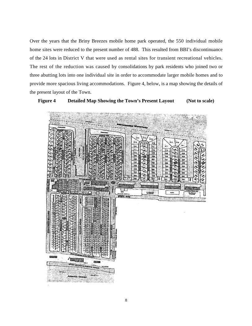
Over the years that the Briny Breezes mobile home park operated, the 550 individual mobile
home sites were reduced to the present number of 488. This resulted from BBI’s discontinuance
of the 24 lots in District V that were used as rental sites for transient recreational vehicles.
The rest of the reduction was caused by consolidations by park residents who joined two or
three abutting lots into one individual site in order to accommodate larger mobile homes and to
provide more spacious living accommodations. Figure 4, below, is a map showing the details of
the present layout of the Town.
Figure 4 Detailed Map Showing the Town’s Present Layout (Not to scale)

9
Present Land Utilization Characteristics
The land uses in Briny Breezes have remained essentially unchanged since the adoption of
the 1989 Plan. There is a small amount of commercial use and several semi-public buildings
owned by BBI that are located along the west side of AlA. Shared parking and landscaped
areas line a number of the local streets. The Briny Breezes Marina is situated at the Town’s
west boundary at the ICW. The land use for the remainder of the Town is for residential
and recreational purposes. The Town’s Land Use Map from the 1989 Plan is shown in Figure
5.
Figure 5 Town’s 1989 Land Use Map (Not to scale)

10
Existing Land Use - Single Family Limitation
Under the Town’s present 1989 Plan, all residential structures in the Town are required to be
single-family mobile homes. The definition of allowable types of mobile homes was later
expanded to allow modular homes, manufactured homes, and recreation vehicles. Most units
have been replaced since the development began, and all units are generally in sound condition.
The residents are continually encouraged to replace outdated units in favor of newer models
which afford more comfort.
The Town’s Future Development to Include Multi-Family Housing Units
In the aftermath of the destruction of southeast Florida by Hurricane Andrew in 1992, the
direction proposed for the Town’s future development began to change to an acceptance of
multi-family land use. In a departure from the rigidity of the 1989 Plan, the LPA has
recommended that the Town’s FLUE should provide for a broad mix of all types of residential
living units, allowing single and multi-story construction, single family and multi-family
occupancy, and the use of conventional and innovative building construction methods. This
accommodation would be in addition to the continued acceptance of all of the present allowable
types of mobile homes, manufactured homes, modular homes, and recreational vehicles. The
Town’s Zoning Code needs to be amended to allow these new housing types in all of the present
Mobile Home Zoning Districts. These changes will authorize BBI, if it chooses to do so, to
extend the opportunity to its members to have stronger, more stormworthy homes, and to allow
them to select their choice of the type of residential housing unit they wish to live in. The
Town's prime objective is to provide for the betterment of its citizens and residents by improving
their living conditions and lifestyle. To the extent that such a redevelopment program would be
successful, it has the potential of attracting new people to come to live in Briny Breezes, and
thereby lead to an increase in the Town’s population.
The Town’s Future Land Use Map is shown by Figure 6 on the following page.

11
Figure 6 2024 Future Land Use Map of Town (Not to scale)
The LPA also recommends revising the Town’s zoning code to up-grade the allowable types of
retail commercial land use to better serve the needs of the Town residents and the persons living
in the adjoining communities. Consideration was given to combining residential and commercial
uses into innovative mixed zoning categories. Any such new zoning districts would also have to
include provision for the continuation of the present recreational and service amenities which are
located in Section 6 of the Town, which is the prime area proposed for redevelopment.
To allow the time required for the adoption of an Amended Plan, for the revision of the Land
Development Regulations, and for amendments to the zoning code, the Plan estimates that the

12
start of this new construction, if BBI decides to authorize it, would not be completed until mid-
year 2019, and that the final units will not be fully occupied until the end of the 10-year planning
period in 2024.
Providing for Innovative Types of Single-Family Housing Units
The Plan will allow innovative types of single family and multi-family housing units to be
constructed within the Town for its future development. Residents should be allowed to replace
their existing mobile homes with single-family residential units constructed under an upgraded
building code making them stormworthy to the extent that they would meet the wind loading
requirements of most hurricane codes. This would include innovative manufactured homes that
are pre-constructed as modules and installed as a finished housing unit to the selected site, as
well as units created by conventional on-site construction methods.
The concept for storm hardened residential housing units began in the aftermath of the
destruction to the Mississippi/Louisiana Gulf Coast area caused by Hurricane Katrina in August,
2005. In post-disaster recovery efforts, renowned architects designed a variety of storm-
hardened one-story and two-story single-family housing units that can be quickly and
economically built to meet hurricane strength winds. Some of these structures can provide as
much as 1,200 square feet of living space, and many are designed to fit the same site that is
occupied by the contemporary mobile homes in Briny Breezes. The Plan foresees both
permanent and seasonal residents changing to one-story and two-story stormworthy units as a
major part of the Town’s future development. Since this type of upgrade uses the same footprint
as the mobile home unit that it replaces, there would be an even exchange of the types of
dwellings. Therefore, this transition would not be expected to increase the total number of
housing units for the Town, nor increase the Town’s projected population.
To allow the time required for the adoption of an Amended Plan, for the revision of the Land
Development Regulations, and for amendments to the zoning code, the time projected for these
storm hardened housing units to be constructed is at the end of the 5-year planning period in the
year 2019. The Plan anticipates that the public may be hesitant at first to choose the innovative
one-story or two-story units as replacements for traditional mobile homes and therefore it

13
conservatively estimates that only five percent (5%) of the Town’s present 484 mobile home
units will be replaced by storm hardened housing units at the end of the 5-year planning period in
2019, and only ten percent (10%) of the remainder will be replaced by storm hardened housing
units at the end of the 10-year planning period in 2024.
To implement the Town’s redevelopment, the Amended Plan will allow the use of all types of
housing units for residential buildings and structures, and provide for mixed uses for
combining commercial and recreational uses with the residential uses. After the Amended
Plan is approved and adopted, the Town’s Land Development Regulations will be amended to
include the new zoning districts and to state the land development criteria for each such type of
development. The application and review procedures for obtaining the development approvals
necessary for each project, the changes to the future land use map to include these future uses,
the adoption of the new zoning district ordinances, and the rezoning of the land areas involved
to allow for these changes, are all tasks that will require completion before the Town’s
redevelopment can begin.
Annexation
The two enclaves created by the County’s 1995 abandonment resolution are still within the
Town as a part of the unincorporated area of Palm Beach County. There is also a large parcel
of the County’s unincorporated area that abuts the Town’s southern boundary. The possibility
that the Town’s redevelopment plans could be enhanced by annexing some portion of either of
these unincorporated areas was discussed during the public hearings for the Town’s Amended
Plan, but the concept received little public support. Consequently, the Plan for Town’s
redevelopment will be based on using the land area encompassed within the Town’s present
boundaries.
Sites for Future Development – Section 6
There are no present development orders that affect the land within the Town. For the most
part, the Town is fully developed except for vacated District V, which is the only practical
site available for redevelopment in the Town’s vacant land inventory. There are other vacant
areas within the Town, but they are unsuited for individual development due to their small sizes,

14
or their odd configuration, or their unusual locations. For example, there are several very small
tracts of open land that abut the seawalls along the canals and the Intracoastal Waterway (ICW)
on the Town’s west boundary. There are open areas along BBI’s privately owned ocean front
beach on the Town’s eastern boundary. Collectively, these areas constitute natural resource
lands that have been reserved by BBI for passive recreational uses by the members of the
cooperative. These amenities make the Town of Briny Breezes a pleasant and enjoyable
community in which to live, and for the present time, these areas have their highest and best use
for passive recreational purposes.
The District V parcel is a 0.6 acre rectangular area which was used as rentable space for 24
transient recreational vehicles. In 2007, BBI discontinued its rental activity and
landscaped the area into open green space. Under the Town’s present zoning, District V
could be divided into eight mobile home lots. As an additional alternative, the Town’s Amended
Plan will allow BBI to incorporate District V into a new category designated as Section 6, which
provides a much greater potential for a successful development. Section 6 consists of the entire
corridor of land extending between the Town’s north and south boundary lines, lying between
A1A and Banyan Boulevard. The areas abutting District V include sites with low intensity
uses, such as non-residential buildings and structures which are nearing the end of their
useful life, some storage lots, and maintenance areas. By razing these structures and
clearing the sites, the combined area comprising Section 6 presents a feasible location
for a redevelopment project. Whether Section 6 would be redeveloped as a single project
or as two or more independent projects, or would ever be developed at all, would depend
upon the plans and decisions of BBI as the owner of the property.
The present array of the buildings and structures in Section 6 lends itself into a division,
at the property line of the enclave for the Texaco Station, into two parcels for
redevelopment purposes. The southerly part of the Section 6 corridor would run south,
from the south side of the Texaco enclave all the way to the Town’s south boundary at
the southerly edge of Cardinal Drive. This parcel consists of 2.59 acres, and if it were to
be utilized for a multi-family structure at a density of 18 dwelling units per acre, it could
produce 46 residential housing units. The northerly part of the Section 6 corridor

15
extends northerly from the same dividing point all the way to the Town’s north
boundary. After deducting the area for each of the two enclaves, this parcel contains
2.80 acres. If this site were to be utilized for a multi-family structure at a density of 18
dwelling units per acre, it could produce 50 residential housing units.
The development of the northerly part of the Section 6 corridor will be complicated due
to the presence of the two enclaves, and the need to devise an acceptable construction
design around them or to arrange to incorporate them within the scope of the project.
The logic of the situation would suggest that the southern part of Section 6 would be
developed first and completed by mid-2019. The work on the northerly part would be
deferred until the problems posed by the enclaves were resolved, and is estimated to be
completed by the end of the 10-year planning period in 2024. The goal to be realized
would be worthy of the undertaking if, together, these two sites could bring as many as
96 new multi-family housing units into the Town, and do so without requiring the
displacement or relocation of any of the present mobile home residents. BBI uses the
existing buildings and structures located within Section 6 to support its operation of the mobile
home community. Within this area are many of the major recreational facilities BBI provides for
the Town residents, including the arts and crafts building, the community center, the swimming
pool, the auditorium, the hobby shop, the billiards room, and the woodworking club. It also
includes commercial uses for a beauty shop, a drug store, the Town Hall, BBI’s business office,
and the storage sheds and maintenance yards. All of these uses are in conformity with the Future
Land Use Map and the current zoning classifications for these areas. While redevelopment of
the area will put the land to better, more productive use, it is of paramount importance that these
recreational and commercial facilities continue to be provided, either by incorporation into the
new development or by relocation to appropriate alternate sites. The redevelopment of the
Section 6 corridor should also up-grade the types of retail businesses that will be located there to
better serve the needs of the community. This can be implemented by revisions to the Town’s
zoning code. The Section 6 development area is shown as Figure 7 on the following page. This
5.39 acres includes portions of Mallard Drive, Banyan Boulevard, Marina Drive, Bamboo
Road, and Eagle Road, portions of which could be abandoned during redevelopment, but not
all.

16
While neither the Town of Briny Breezes Planning and Zoning Board or the Corporate Board of
Briny Breezes has a formal plan for the “Section 6 corridor”, in accordance with the response
from the Treasure Coast Regional Planning Council dated May 17, 2013, we anticipate:
a. A mixture of building types that would range from one to four stories in height with a maximum building height of 44 ft. These low-rise buildings would accommodate a mixed use of residential, commercial, and storage.
b. Since this re-development would occur where there are existing public facilities, like the
auditorium, town hall, and art league building, any new construction would incorporate the same functionality of public use buildings.
c. If the absolute maximum amount of space in Section 6 were to be developed, it would
represent a total of 5.39 build-able acres. If a maximum density limit of 18 units per acre were applied, these new structures might accommodate up to 96 additional residential units.
d. The maximum floor area ratio (FAR) for this new development would be in keeping with
other multi-use zoning in neighboring communities and would not exceed 40%. e. The new structures would accommodate any increase in parking demands and would be
designed to improve pedestrian and vehicle traffic flow in the community f. The architecture design style and the scale of the buildings in this multi-use district would
need to receive P&Z approval with the stated goal of maintaining harmony with the existing mobile homes in the single family residential portions of the community.
In order for such a mixed use project to be successful, the Future Land Use Element (FLUE)
should provide BBI, as the landowner, with as much flexibility in design and execution as
possible. Because the Plan allows mixed use categories that combine residential, recreational,
and commercial uses, however, it will be incumbent on BBI to present a refined development
proposal for Section 6 that results in a well ordered and harmonious community. This is also
applicable to the redevelopment of the rest of the Town, should BBI give permission for its
resident members to utilize the variety of single family or multi-family manufactured building,
modular building, factory-built building, mobile home, or manufactured home housing units that
the new zoning districts will allow.

17
Figure 7 Section 6 Redevelopment Area (Not to Scale)
NORTH
The Plan anticipates that the Town’s redevelopment of Section 6 as a multi-story, multi-use
corridor along A1A will breathe new life into the area where these outdated buildings are now
located. The leasing and/or sale of these new mixed-use structures would provide a new income
stream to benefit BBI and its shareholders. The enhanced security afforded by redevelopment
of the Town with larger and stronger construction offered by the condominium units and the
stormworthy replacements for conventional mobile homes may attract younger persons and
families with children to the Town. The Plan recognizes that these new types of residential

18
units are a major transition for BBI and the residents of the Town and that only if this initial
project proves to be successful would the process be repeated. The Plan allows time for these
new concepts to gain the public’s acceptance, and therefore estimates that the redevelopment of
the north part of Section 6 will not be completed until the end of the Town’s 10-year planning
period in 2024.
Seasonal Variations in The Town’s Population
Traditionally, most of the Town’s residents begin to come to Briny Breezes during the months
of October through January. The population continues to have a gradual increase and reaches
its peak level in mid-March, with an influx of those owners who, for either business or
personal reasons, chose to have a short stay of only a week or two in the Town, and complete
their departure by mid-April. Anecdotal information from long time Town residents claims that
the Town’s combined permanent and seasonal population has reached close to 1,000
persons for short periods around the Easter Holidays in past winter seasons, but no actual
head count has ever been made. By mid-April, the population sharply decreases and reaches
its lowest level during the summer months of July through September, when the Town has as
few as 200 residents.
The population information for the Town’s 1989 Plan included data from the 1980 Decennial
Census conducted by the U.S. Bureau of Census and also used the interpolated population
projections made by the University of Florida Bureau of Economics and Business Research
(BEBR). The Town’s 1989 Plan stated that there was an undercount for the population figures in
both the official Census report and the BEBR interpolations due to the criteria used, which
defines a community’s resident population to be only those persons who live there continuously
for at least six months of the year.
The problems that a transient population creates for a community trying to attaining accurate
population projections is the subject of a study by Stanley K Smith and Mark House, Bureau of
Economic and Business Research, University of Florida, Gainesville, entitled Snowbirds,
Sunbirds, and Stayers: Seasonal Migration of Elderly Adults in Florida, Copyright 2006 by the
Gerontological Society of America. Table 1 which follows is an excerpt from this article that

19
shows the impact temporary migrants have on communities such as the Town and why their
numbers are missed in the typical census count to determine a Town’s population.
Table 1 Snowbirds and the Census Florida is a major destination for elderly temporary migrants, but temporary migration of elderly adults is far from unique to Florida. Large seasonal inflows have been reported in Arizona (e.g., Happel & Hogan 2002), Massachusetts (e.g., Cuba, 1989), Texas (e.g., Martin, Hoppe, Larson, & Leon, 1987), Spain (e.g., Gustafson, 2002) and Mexico (e.g., Truly, 2002). Large seasonal outflows have been reported in Arizona (e.g., McHugh, Hogan & Happel, 1995), Minnesota (e.g., Hogan & Steinnes, 1996), and New York (e.g., Krout, 1983). Many other places undoubtedly have large numbers of elderly temporary migrants as well, but they go undocumented because of a lack of data. The numbers are likely to increase over the next few decades as incomes grow and the baby boom generation ages. The impact of elderly temporary migrants on areas of origin and destination can be substantial (e.g. Happel & Hogan 2002; Monahan & Greene, 1982; Rose & Kingman, 1989). Temporary migration affects traffic patterns, housing prices, retail sales, and the use of public transportation, medical services, recreational facilities, and a wide variety of other publicly and privately provided goods and services. Indeed, for many businesses and government agencies, effective budgeting, planning, and analysis cannot be accomplished without an accurate accounting for the number, timing, and duration of temporary moves. Unfortunately, there are no data sources capable of providing complete, consistent coverage of temporary migration in the United States, for elderly adults or any other demographic group. This severely limits researchers’ ability to analyze the determinants and consequences of temporary migration or even to determine the number and timing of temporary moves. Although investigators can cobble together estimates from a variety of administrative records, business statistics, and sample surveys, those data sources are often insufficient to provide complete, reliable estimates (e.g., Smith 1989). __________________________________________________________________
The Town has regularly experienced a repetitive cycle of having a low population in the summer and a high one during the winter months. The Town’s 1989 Plan recognized this trend and compensated for the Census count’s exclusion of the annual influx of the Town’s seasonal population by adding 531 seasonal residents to the Census’ count of 381 year-round residents and estimated the Town’s middle range average population for 1988 at 912 persons. The Town’s 1989 Plan used the data from the 1980 Decennial Census to formulate Table 1.5, which is reproduced below as and for Table 2 of this Plan.

20
Table 2 Population Estimate from Town’s 1989 Plan

21
The Plan recognizes that the recurring seasonal increase in the Town’s population must be added
to the official U.S. Census data for the Town’s planning purposes. The 2000 Decennial Census
states that the Town had 534 housing units, of which 266 were occupied by 411 persons, which
is an average household size of 1.55 persons per unit. The Census found 49.8% of the Town’s
housing units were occupied by permanent residents, 49.1% were for seasonable, recreational, or
occasional use, and 1.1% were vacant. The housing count made by BBI confirmed that for the
past several years, the Town has 484 housing units, not 534. BEBR's population projection
estimated the Town’s resident population as of 2013, at 420. (BEBR Letter dated 9/17/2013).
Table 3, below, is an excerpt from the 2000 U.S. Census for the Town that shows its number and
the types of its households.
Table 3 2000 U.S. Census Data for the Town
HOUSEHOLD BY TYPE
Total households 266 100.0 Family households (families) 129 48.5 With own children under 18 years 5 1.9 Married-couple family 119 44.7 With own children under 18 years 1.1 Female householder, no husband with own children under 18 years 7 2.6
Non-family households 137 51.5 Householder living alone 129 48.5 Householder 65 years and over 91 34.2 Households with individuals under 18 years 6 2.3
Households with individuals 65 years and over 194 72.9
Average household size 1.55 (X) Average family size 2.06 (X)
HOUSING OCCUPANCY
Total housing units 534 100.0 Occupied housing units 266 49.8
Vacant housing units 268 50.2
For seasonal, recreational, or occasional use 262 49.1
22
The Town’s Estimated Population and Population Projections
The Town’s Evaluation And Appraisal Report (EAR) was completed in September 2010 and
submitted to the Department of Community Affairs (DEA) and the other state agencies for
review. It received approval by the DCA in December 2010 and the Town’s LPA began holding
monthly meetings to prepare an Amended Comprehensive Plan that would incorporate the EAR
based amendments in January 2011. As a result, the Amended Comprehensive Plan uses the
year ending 2011 as its starting point for estimating the Town’s current peak seasonal
population, and designates the mandated 5-year planning period as extending to the end of year
2019, and that for the 10-year planning period as extending to the end of year 2024.
In deriving the estimates for the Town’s current and its projected peak permanent and seasonal
populations for the planning periods, the LPA has, for the most part, used the data from the 2000
Decennial Census, not the 2010 Decennial Census. The reason for this is that the 2010
Decennial Census conducted by the U.S. Bureau of Census for the Town was not done with
accuracy. The 2010 Census count stated that the Town has a total of 800 housing units, of which
372 are occupied and 428 are vacant, for a permanent resident population of 601 persons and
these figures are patently incorrect. The Town is contesting the Census results pursuant to the
Bureau’s 2010 Count Question Resolution (CQR) Program and the matter is still pending.
Because of the discrepancies in the data from the 2010 Census, the Town’s small size of 47.3
acres, its current stage of residential development limited to mobile homes, and the ownership
and operation of the land within the Town by BBI under the Florida Cooperative Act, the LPA
has used an alternative methodology for estimating the Town’s peak current and projected
population counts instead of using the data from the 2010 Census.
In connection with the work of the LPA in preparing the Amended Comprehensive Plan, the
Town staff made an onsite count throughout the Town in June 2011 and that found that there
were 488 mobile home sites, 4 of which were vacant with no improvements. Their investigation
confirmed that there had been no change in these numbers through the end of 2011. The Town
staff also reviewed the 2011 tax rolls maintained by the Property Appraiser of Palm Beach
County, which showed that 488 was the correct number of the mobile home sites or lots within
the Town in 2011, and that the tax rolls showed there were a total of 799 persons listed as the
23
co-op members who held the recorded deeds giving them the right to occupy these 488 lots.
There were 6 co-op members named as the owners of the 4 lots that were devoid of mobile
homes. The Town staff found no changes in these figures through the end of 2011. The Palm
Beach County Tax Rolls show, therefore, that through the end of 2011 there were 793
registered co-op members who were lawfully entitled to reside in their 484 housing units
located within the Town. Since ownership of property does not necessarily equate to actually
living and residing on the property, the 793 registered deed holders cannot be taken as the true
and correct number of persons for the Town's 2011 population. The result of this enumeration
can be used, however, as a rough estimate of the Town’s total permanent and seasonal
population for 2011. These figures also give the Town an average number of persons per
household of 1.64, which can be of use in determining population estimates and projections.
Since the co-op members are legally entitled to occupy their units at any time of their
choosing, they may come to stay at any time, to remain for whatever duration they wish, or
even not come at all. Dividing the Town’s total living units into either permanent or seasonal
residences cannot be done on the basis of defining a permanent unit as one that is continuously
occupied for at least six months. One method to determine a fair estimate for the number of
those who are permanent residents and those who are seasonal would be to work from the
number of the Town's total housing units, which is 484, rather than to work from the figure of
793 for the number of registered co-op members holding shares in the BBI corporation. The
2000 Decennial Census gives the percentages of the housing units which are classified as
permanent, seasonal, or vacant. Once the number of housing units is classified as permanent,
seasonal, or vacant, applying the figures for the average number of persons per household will
give the population numbers for those in each residential category, as either permanent or
seasonal. This is the methodology that the Amended Plan has followed.
Using the data of the 2000 Decennial Census as the latest official record, the Town was
estimated to have 534 total housing units, of which 266 units, or 49.8%, were occupied by
permanent residents, 262 units, or 49.1% were occupied by seasonal residents, and 6 units, or
1.1%, were vacant. The average number of persons per household estimated by the 2000 Census
was stated to be 1.55. Applying these percentages to the Town’s 484 housing units that were
counted and determined to be correct for the year 2011 results in the Town having 241

24
permanent housing units, 238 seasonal housing units, and 5 vacant units. Table 4 below shows
the estimate for the Town’s peak population for the year 2011.
_____________________________________________________________________________
Table 4 Town’s Population for the Year 2011
Applying the estimated household size of 1.64 persons per household derived from the enumeration of housing units and mobile home owners compiled by the Town staff results in the following high peak population estimate for 2011:
Permanent Residents 395 Seasonal Residents 390 Total Population 785
Applying the estimated household size of 1.55 persons per household provided by the 2000 Decennial Census results in the following low peak population estimate for 2011:
Permanent Residents 374 Seasonal Residents 369 Total Population 743
Averaging the results from both methods gives the following middle range peak population estimate for 2011:
Permanent Residents 386 Seasonal Residents 381 Total Population 767
Using the middle range estimate for this Plan, the Town’s Estimated Average Peak Population for 2011 for Planning Purposes is 767 permanent and seasonal residents. ______________________________________________________________________________
The Town’s Population Projection for 2019
Based on the above assumptions, Table 5 below shows the computation for the Town’s projected
peak projected population at end of the 5-year planning period by year 2019.
______________________________________________________________________________
Table 5 Projected Peak Population for 2019 at End of the 5-Year Planning Period
Applying the same percentages to the 38 new condominium units expected from the south part of Section 6 that were used for dividing the Town’s 484 housing units into permanent, seasonal, and vacant housing units for the peak population projected for the year 2011, results in the following:

25
38 New Units derived from the Multifamily Project on the South Portion of Section 6 49.8 % for permanent residential units = 19 Permanent Condominium Units 49.1 % for seasonal residential units = 18 Seasonal Condominium Units 1.10 % for vacant residential units = 1 Unoccupied Household Unit Total housing units are 522 Applying the estimated household size of 1.64 persons per household derived from the enumeration of housing units and mobile home owners compiled by the Town staff results in the following high estimate for a projected peak population and the categories:
Permanent Residents 31 Seasonal Residents 30 Total Population 61
Applying the estimated household size of 1.55 persons per household provided by the 2000 Census results in the following low estimate for a projected peak population and the categories:
Permanent Residents 29 Seasonal Residents 28 Total Population 57
Averaging the results from both methods gives the following middle range estimate for a projected peak population and the categories:
Permanent Residents 30 Seasonal Residents 29 Total Population 59
The above middle range estimates for a projected population increase during the first 5-year planning period will be used in this Plan and be added to the Town’s 2011 population figures to estimate the Town’s projected peak population by year 2019. It is also estimated that by year 2019 there will be 24 stormworthy housing units substituted for conventional mobile homes, but this is not expected to change the population projection. The number of conventional mobile homes will be reduced to approximately 460. The Town’s projected peak population for 2019 for planning purposes is 416 permanent residents and 410 seasonal residents, for a total projected peak population of 826. ______________________________________________________________________________
The Town’s Population Projection for 2024
Table 6 below shows the Plan’s computation for the Town’s projected peak population at end of
the 10-year planning period by year 2024.
_____________________________________________________________________________

26
Table 6 Projected Population for 2024 at End of the 10-Year Planning Period
Applying the same percentages to the 42 new condominium units expected from the north part of Section 6 that were used for dividing the Town’s 484 housing units into permanent, seasonal, and vacant housing units for the population estimate for the year 2011, results in the following: 42 New Units derived from the Multifamily Project on the North Portion of Section 6 49.8 % for permanent residential units = 21 Permanent Condominium Units 49.1 % for seasonal residential units = 20 Seasonal Condominium Units 1.10 % for vacant residential units = 1 Unoccupied Household Unit Total housing units are 564 Applying the estimated household size of 1.64 persons per household derived from the enumeration of housing units and mobile home owners compiled by the Town staff results in the following high estimate for a projected peak population and the categories:
Permanent Residents 34 Seasonal Residents 33 Total Population 67
Applying the estimated household size of 1.55 persons per household provided by the 2000 Census results in the following low estimate for a projected peak population and the categories: Permanent Residents 33
Seasonal Residents 33 Total Population 66
Averaging the results from both methods gives the following middle range estimate for a projected peak population increase:
Permanent Residents 34 Seasonal Residents 32 Total Population 66
The above middle range estimates for a projected peak population increase by the end of the 10-year planning period will be used in this Plan and be added to the Town’s 2019 population figures to estimate the Town’s projected peak population by year 2024. It is also estimated that by year 2024 there will be 46 more stormworthy housing units substituted for conventional mobile homes for a total of 70 of these units, but this is not expected to change the population projection. The number of conventional mobile homes will be reduced to approximately 414. The Town’s projected peak population for 2024 for planning purposes is 450 permanent residents and 442 seasonal residents, for a total projected population of 892. ______________________________________________________________________________

27
The success of concept of storm worthy housing units in the Town will depend on the
willingness of BBI to take advantage of the opportunity to authorize their use, and the extent to
which the residents are willing to accept such innovative types of housing units. Since there is
no way to predict the future success for either the condominium project or the substitution the
more stormworthy housing units for conventional mobile homes until after the transition process
has begun, the Plan has used the conservative estimate that only ten percent (10%) more of the
Town’s mobile home units will be replaced by storm hardened housing units by the end of the
10-year planning period in 2024.
The Plan recommends that the Town work closely with BBI to ensure that there will be no long-
term displacement of residents throughout the transition process. The exact areas selected for
changing from mobile homes to new types of housing units and the timing for such changes will
have to be closely controlled to avoid haphazard or inappropriate results.
Requirement for Adequate Water Supply
When the Town revises its Land Development Regulations (LDR) to provide for alternative
types of housing units, it will require that water supplies and facilities are on hand and
immediately available to serve the new development no later than the date on which the Town
anticipates issuing a certificate of occupancy (CO). The LDR changes will also provide that
prior to approving such building permits, the Town will consult with its potable water supplier to
determine whether adequate water supplies will be available to serve the development by the CO
date. Because the increases in the Town’s population projections are so small, the Town
anticipates continuing to receive an adequate supply of potable water to serve the needs of the
Town’s peak winter population of 826 persons by 2019, and of 892 persons by 2024, without a loss
in the present level of adequate service.
Natural Resources
The Town’s significant natural resources on its east boundary are the Atlantic Ocean, its beach,
dunes, and accompanying vegetation. On Town’s west boundary are the four finger canals that
give access to the ICW and its shoreline.

28
Historic Resources
The investigation by the Town staff has determined that the Town has no historic resources
located within its jurisdiction.
Recreational Facilities
Except for the Town Library, all of the recreation facilities and programs provided for the
community are operated by BBI. The location for the several recreational facilities is shown
on Figure 8 on the following page.
Figure 8 Recreation Facilities – (Not to scale)
Figure 8, above, shows the community’s four main recreation areas. The first is the oceanfront,
the second is located along the east side of AlA, the third is on the west side of AlA, and the
fourth lies along the ICW. The ocean-front facility contains a club house with banquet and

29
meeting facilities, a patio with chairs and benches, and a private beach with cabanas and
walkways. The facilities along the east side of AlA include BBI’s butterfly garden, the
shuffleboard courts, a clubroom, a card players’ room, and the Town’s library. On the west side
of A1A, and included in the area proposed for redevelopment, is the community center building,
the fine arts building, a large outdoor swimming pool, a cabana, an auditorium building, hobby
shops for arts and crafts, and a wood-working shop. As previously stated, any redevelopment in
this strip area fronting on A1A must insure the continuation of these recreational facilities, either
by incorporation into the new development plan or by relocation to an appropriate alternate site.
The fourth recreational area is located further to the west and fronts on the ICW. It consists of
two large and three small open parkways for picnicking and viewing the marine activity on the
waterway, and a yacht basin, which has an operating marina.
Public Facilities and Services
Since the adoption of the 1989 Plan, the Town has acquired ownership of the water and sewer
utility distribution system and is responsible for providing these services to the residents.
Since acquisition, the Town has made extensive improvements to the water lines, installed fire
hydrants, and provided upgrades to the sanitary sewer lines and lift stations. The Town has
contractual arrangements with an adjoining municipality to provide the potable water supply.
There are no well-fields within or near the Town boundaries.
The Town, as one of the original founding participants, receives services from the regional
sanitary sewage disposal facility operated jointly by the Cities of Boynton Beach and Delray
Beach. The Town also has contractual arrangements with adjoining municipalities for Police,
Fire, and Emergency Medical Technician Services.
BBI is responsible for the storm drainage facilities within the mobile home community and has
the primary responsibility for the pick-up and disposal of solid waste. As will be further
addressed in the Transportation Element, most of the local streets within the Town are privately
owned and maintained by BBI. The Town is responsible for maintenance of the two local public
streets, Briny Breezes Boulevard and Old Ocean Boulevard, and the Florida Department of
Transportation (FDOT) is responsible for maintenance of A1A.

30
The present levels of service (LOS) for all public facilities and roads within the Town are
sufficient. They have been more than adequate to meet the needs for Town’s 2011 peak
seasonal population of 767 persons. At the end of the 5-year planning period in 2019 when the
Town projects its peak seasonal population to be 826 persons and at the end of the 10-year
planning period in 2024 when the Town projects it to be 892 persons, the Town will still be
able to maintain adequate levels of service for all its public facilities.
The 10-Year Water Supply Facilities Work Plan Program
The Town is required to consider the applicable regional water supply plans prepared by the
South Florida Water Management District (SFWMD) when amending its Future Land Use,
Infrastructure, Conservation, Intergovernmental Coordination, and Capital Improvements
Elements. The Town is also required to participate in the SFWMD’s 10-Year Water Supply
Facilities Work Plan Program by adopting a 10-year plan that complies with the SFWMD’S
requirements. The Town’s 10-year plan is to be prepared and submitted as independent
document for SFWMD’s review and approval.
Flood Prone Areas
The Flood Insurance Rate Map or Flood Hazard Boundary Map of the Town is shown in the
discussion of the Conservation Element. The Flood Zone Map shows that much of the Town is
in the 100-year flood plain, and gives the designations that apply to the other flood zones that
are not within the 100-year flood hazard areas. Although storm drainage is BBI’s, responsibility,
the Town’s earlier attempt for a redevelopment strategy for multi-family, permanent
construction was a step to improve the drainage problems. The proposed development plan
will now achieve this goal. The Town’s Development Regulations require the sound anchoring
of mobile homes in conformance with State and Federal standards. These regulations together
with the Town’s adherence to the emergency evacuation plan outlined in the Coastal
Management Element shows the Town's continued support of sound flood damage prevention
strategies.

31
Goals, Objectives, and Policies Goal Provide for an orderly redevelopment of Town that will protect and enhance the
residential character and natural environment of the Town. Objective 1 Manage the Town’s future redevelopment by innovative Land Development
Regulations which implement this Plan. Policy 1.1 Revise the Land Development Regulations to provide for the residential category
consisting of residential living units including single and multi-story construction with single family and multi-family occupancy in addition to the continued acceptance of all of the present allowable types of mobile homes, manufactured homes, modular homes, and recreational vehicles. Residential units to be built or placed on single-sized mobile home lots existing as of January 1, 2014, would be limited to single family units. New multi-family units would require construction on multiple single-sized mobile home lots or larger areas with development limited to a maximum density of 18 dwelling units per acre.
Policy 1.2 Revise the Land Development Regulations to provide for the recreational
category consisting of outdoor areas (such as the beach, ocean, shuffleboard courts, swimming pool, and marina) and indoor areas (such as clubhouse meeting room, clubroom, card room, Town library, community center, fine arts building, auditorium, arts and crafts shop, and wood-working shop). The intensity existing as of January 1, 2014, is adopted as acceptable.
Policy 1.3 Revise the Land Development Regulations to provide for the residential,
commercial, and recreational mixed use category consisting of all uses listed under sections 1 (the residential category) and 2 (the recreational category), as well as small scale low impact commercial activities such as beauty shop, drug store, convenience store, gas stations, banks, small retail stores, small grocery stores, deli, small restaurants, boutique stores, antique stores, cafés, service stores, general store, small theatre, library, community center, gym, cardroom, storage sheds, maintenance yard, and business/professional/administrative offices. This list is offered as an example and is not intended to be exhaustive. Any use permitted herein is allowed either alone or in combination with any other such permitted use or uses. The maximum floor area ratio (FAR) for this new development would be in keeping with other multi-use zoning in neighboring communities and would not exceed 40%. The architecture design style and the scale of the buildings in this multi-use district would need to receive P&Z approval with the stated goal of maintaining harmony with the existing mobile homes in the single family residential portions of the community.
Policy 1.4 Revise the Land Development Regulations to provide for the residential category
consisting of parking for the cooperative and landscaping for conservation, aesthetic, and buffering purposes. Adequate parking shall be provided to meet the demands of the members of the cooperative, guests, and customers of

32
businesses and to facilitate the safe movement and utilization of vehicular, bicycle, and pedestrian transportation. The intensity existing as of January 1, 2014, is adopted is acceptable.
Policy 1.5 Revise the Land Development Regulations to allow owners to replace their
existing mobile homes with stormworthy single family or multi-family manufactured building, modular building, factory-built building, mobile home, or manufactured home housing units that meet upgraded building code standards for hurricane resistance.
Policy 1.6 Revise the Land Development Regulations to provide the new zoning districts
needed for the Town’s redevelopment, including the criteria for obtaining development approvals.
Policy 1.7 Revise the Land Development Regulations to require compliance with the
standards imposed by the Town’s 10-year Water Supply Facilities Work Plan in order to obtain approval of a redevelopment project.
Policy 1.8 In accordance with the Town’s Future Land Use Map, Section 6 is designated as
the location where the major redevelopment of the Town may occur including development of a multi-story, multi-use commercial/residential corridor along A1A, together with the continuation of the recreational facilities that are presently located there.
Policy 1.9 Develop policies that encourage BBI to replace any outdated or obsolete buildings
and structures within the Town with redevelopment projects. 2. TRANSPORTATION ELEMENT
The Briny Breezes Road Network
In 1926, the land which now comprises the Town of Briny Breezes was platted as a
subdivision of the Town of Boynton, Florida, and the rights-of-way shown on the plat were
dedicated as public streets and roads. A copy of this subdivision plat appears as Figure 3
hereof in the Future Land Use Element. In 1931, the Florida Legislature incorporated the
subdivision into the newly created Town of Boynton Beach, which is now the City of Boynton
Beach. In 1937, the subdivision was de-annexed and became part of the unincorporated area
of Palm Beach County. In 1955, the Palm Beach County Commission passed a resolution that
vacated the 1926 plat of the Briny Breezes subdivision and returned the property to acreage,
except for the rights-of-way shown on the plat for Briny Breezes Boulevard, A1A, and Old
Ocean Boulevard, which the County’s Resolution expressly preserved. By vacating the

33
subdivision plat, all of the interior public streets that were shown on the plat were also vacated
and deleted, as were all of the platted lots, except for those portions of certain named lots
which today form the Town’s two enclaves.
Thereafter, the property was apportioned into tie-down sites for 550 mobile homes and specific
right-of-way were laid out in a grid pattern as private streets for ingress and egress without the
legal formality of a platted subdivision and without being dedicated for public use. These
private streets continue to serve the Briny Breezes community as a part of the common
elements of the cooperative association which have been created for the use and benefit of its
resident corporate members. The road network serving Town, therefore, consists of the public
rights-of way for A1A, Old Ocean Boulevard, and Briny Breezes Boulevard as public roads in
public ownership, and the private rights-of-way for ingress and egress to the mobile home sites
as private streets owned by BBI.
Mapped Data
The data used for the inventory of the existing road system include current roadway functional
classifications and the most recent available traffic volume count of the average daily traffic.
The existing roadway functional types, the number of lanes, the locations of boat docking
facilities, and other water-related facilities have been mapped. Facilities for limited access
roadways, airports, and seaports are not present in the Town and therefore are omitted.
Jurisdiction for the Public Roads
The Town’s public roads are A1A, Old Ocean Boulevard, and Briny Breezes Boulevard. A1A,
also known as Ocean Boulevard, is an arterial two-lane highway maintained by the Florida
Department of Transportation (FDOT). It is the only north-south through road on the barrier
island. It extends without interruption from the Town of Palm Beach on the north, passes
through the center of the Town of Briny Breezes, continues south to the Palm Beach County line,
and on into Broward County. A1A is the Town’s main north-south access road, and by means
of its intersection with the bridge crossing over the ICW provided at Woolbright Road, one-half
mile north of the Town, it gives the Town’s resident’s access to the roadway system of Boynton
Beach, including direct access onto I-95. A1A also intersects with the bridge crossing over the
34
ICW provided at George Bush Boulevard, 3 miles south of the Town, which gives the Town
residents access to the roadway system of Delray Beach on the mainland to the west. The
portion of the traffic volume on A1A that is attributable to the Town will vary in direct
proportion to the seasonal changes in the Town’s population. For the year 2011, and for the
several previous years, the Town’s population has peaked in April to approximately 767
persons, after which it begins a decrease to a low of about 200 persons during the summer
months of July through September. A1A has always provided the residents of Briny Breezes
with an adequate level of service, even during the periods of the Town’s peak population.
Old Ocean Boulevard is a two-lane local road that runs along the Town’s oceanfront, parallel to
A1A, and is maintained by the Town. It is the Town’s most easterly local road and provides
access to the east-west private streets owned by BBI that forms a grid pattern for the internal
traffic circulation of the portion of the Town lying east of A1A. Old Ocean Boulevard is used by
Town residents primarily as a local street for travel within the Town, and not as a through route
to exit the Town. As its name implies, it is a segment of the former right-of-way of A1A when
the entire road was aligned close to the ocean. The Ft. Lauderdale Hurricane of 1947 caused
severe beach erosion to the south Palm Beach County oceanfront and washed away several large
portions of the road. The officials of the State Road Department decided that rebuilding the
highway in its close proximity to the oceanfront was not warranted and shortly thereafter, the
right-of way for A1A was moved westerly and the new roadway for A1A was constructed in its
present location. Several portions of the original A1A roadway remained serviceable, including
the part that lies within the Town, and these segments were officially renamed Old Ocean
Boulevard and their designation for use as public roads has continued. Besides providing
internal traffic circulation for the Town’s residents, Old Ocean Boulevard also carries a low
traffic volume as an alternate north-south right-of-way for motorists traveling through the Town.
The portion of Old Ocean Boulevard within the Town’s jurisdiction extends from the Town’s
southeast boundary with the unincorporated pocket of Palm Beach County at Briny Breezes
Boulevard, to the Town’s north boundary with the Town of Ocean Ridge.
Briny Breezes Boulevard is a two-lane local road maintained by the Town. It begins at its
intersection with Old Ocean Boulevard at the Town’s southeast corner and runs west to end at

35
its intersection with A1A. As the Town’s south boundary line, it provides vehicular access
to the Town residents on the north side of the road and to the County residents on the south.
There are no traffic counts for Breezes Boulevard and Old Ocean Boulevard because they are
local roads within the Town. Observation and daily usage by Town residents confirms that
traffic on both roads travel at acceptable levels of service. A1A is the only arterial roadway
within the Town, and it is the only road for which statistical information is presented.
Private Roads
With the abandonment of the plat of the Briny Breezes Subdivision of the Town of Boynton, all
of the local streets shown on the plat were erased. The Miller Corporation (WMI) and later the
Briny Club and BBI used the same street names and same general alignments for Ruthmary
Avenue, Cordova Avenue, Banyan Boulevard, and Marine Way as shown on the Briny Breezes
subdivision plat. As owners they added additional streets and gave them the names they
presently bear to complete vehicular access throughout the area. With the exception of A1A,
Old Ocean Boulevard, and Breezes Boulevard, all of these local internal streets are privately
owned and maintained by BBI
Municipal Traffic Control Agreement
Discussions by the LPA about ways to improve traffic safety on the private and public roadways
within the Town culminated in a traffic control agreement that was entered into between the
Town and BBI in April, 2009. Section 166.021, Florida Statutes, provides the authority for such
agreements that extend the jurisdiction of a municipality’s law enforcement agency so that it can
enforce the state traffic code on those residential developments within the Town that have private
streets. The Town’s traffic ordinances are also enforceable on the private streets to control one-
way street travel, establish stop signs, post speed limits, and regulate parking. Cooperation
between the Town and BBI to implement the Municipal Traffic Control Agreement will improve
the safety for both motor vehicle operators and pedestrians. Figure 9 on the following page
shows the Town’s present public and private road system.

36
Figure 9 Town’s Road Network
Traffic Volume for A1A
The Town does not have a substantial amount of through trips by vehicles on AlA because of the
low vehicle speeds and limited commercial opportunities caused by its frequent curves. Table 7
shows the average daily trips on A1A from George Bush Boulevard to Woolbright Road that
pass through the Town for the period 2003 to 2008.
Table 7 Daily Traffic Volumes on A1A through Town
Year 2003 2004 2005 2006 2007 2008
Volume 11,774 10,175 10,718 10,874 8,665 7,846
Source: Palm Beach County Traffic Division, Historic Traffic Growth Table, 2008

37
The last traffic volume data for A1A that was available to the LPA for its preparation of the Plan
was taken on March 10, 2008. It showed a reduction in traffic volume of 9.88 % over the
previous year. The a.m. peak hour traffic on that date for travel in both directions was 512
vehicles. The p.m. peak hour traffic on that date for travel in both directions was 651 vehicles.
This indicates that A1A was operating at an acceptable level of service during the peak of the
Town’s winter season in 2008 when the estimated peak seasonal population was approximately
767 persons, which is the same figure used for the Town’s estimated peak population for the
year 2011. As shown in Table 9, ahead, in the section under the heading “Future Needs”, A1A
is expected to continue to operate at an acceptable level of service when the Town’s population
increases to a peak seasonal population of 826 persons projected for the year 2019 and for the
892 persons projected for the year 2024.
Accident Data and Traffic Safety Concerns There is no traffic accident report information available for the Town for the period of 2003 to
2011. During the review process for amending the Plan, residents expressed their general concern
with traffic safety issues within the Town, especially the hazard created by motorists traveling both
north and south on A1A who frequently fail to stop when their line of traffic receives a red light
signal at A1A’s intersection with Cordova Avenue. Several residents recounted instances when
they were driving their automobiles on Cordova Avenue, they stopped at A1A to wait for their
green light before proceeding, and upon start-up had to break abruptly to avoid a collision from a
vehicle driven on A1A that ran its red light. Under the Town’s direction, this hazardous situation
was documented by occurrence reports prepared by several of the local residents involved. These
reports were sent to FDOT’s traffic safety section with a request for assistance. This matter is in
process of review by FDOT.
In addition to driving motor vehicles, Town residents frequently travel through the Town by golf
carts, bicycles, and on foot. Crossing A1A by this non-automobile traffic poses additional safety
hazards for the public. The LPA has expressed its concern over these safety issues and finds that
there is a need for the Town to adopt appropriate traffic regulations to address the situation.
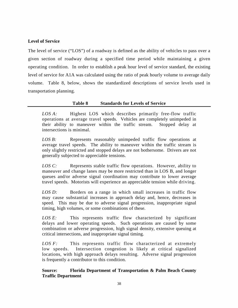
38
Level of Service
The level of service (“LOS”) of a roadway is defined as the ability of vehicles to pass over a
given section of roadway during a specified time period while maintaining a given
operating condition. In order to establish a peak hour level of service standard, the existing
level of service for A1A was calculated using the ratio of peak hourly volume to average daily
volume. Table 8, below, shows the standardized descriptions of service levels used in
transportation planning.
Table 8 Standards for Levels of Service
LOS A: Highest LOS which describes primarily free-flow traffic operations at average travel speeds. Vehicles are completely unimpeded in their ability to maneuver within the traffic stream. Stopped delay at intersections is minimal.
LOS B: Represents reasonably unimpeded traffic flow operations at average travel speeds. The ability to maneuver within the traffic stream is only slightly restricted and stopped delays are not bothersome. Drivers are not generally subjected to appreciable tensions.
LOS C: Represents stable traffic flow operations. However, ability to maneuver and change lanes may be more restricted than in LOS B, and longer queues and/or adverse signal coordination may contribute to lower average travel speeds. Motorists will experience an appreciable tension while driving.
LOS D: Borders on a range in which small increases in traffic flow may cause substantial increases in approach delay and, hence, decreases in speed. This may be due to adverse signal progression, inappropriate signal timing, high volumes, or some combinations of these.
LOS E: This represents traffic flow characterized by significant delays and lower operating speeds. Such operations are caused by some combination or adverse progression, high signal density, extensive queuing at critical intersections, and inappropriate signal timing.
LOS F: This represents traffic flow characterized at extremely low speeds. Intersection congestion is likely at critical signalized locations, with high approach delays resulting. Adverse signal progression is frequently a contributor to this condition. Source: Florida Department of Transportation & Palm Beach County Traffic Department

39
Existing Transportation Needs
Field observations indicate that no transportation deficiencies presently exist in the Town. All
public roadways currently operate at LOS C, or better, which is an acceptable level of
service.
In 2007, FDOT added three-foot shoulders to each side of A1A. Neither FDOT nor Palm Beach
County have any further plans for widening or otherwise improving A1A within Briny Breezes.
The Town has no plans to improve or widen Briny Breezes Boulevard and Old Ocean Boulevard.
There are no limited access roadways under consideration for this area of Palm Beach County
that affect the Town.
The Town has special concern regarding the preservation of AlA as a two-lane roadway with the
above mentioned improvements. Its present width for vehicular travel is in keeping with the
character of the community. Coordinating the Transportation system with the Town’s FLUE,
other local governments, and regional plans will continue to be a Town priority. A1A is the only
roadway within the Town for which levels of service have been applied. This information is
shown on Table 8 on the following page.
Future Needs
No significant needs to the Town’s transportation system are anticipated for the future planning
periods. The Plan does not anticipate that the traffic volume on AlA attributable to the Town
will increase significantly when the Town’s estimated projected population reaches 826 for year
2019, and increases to 892 persons projected for the peak seasonal population in 2024 because
these population increases are relatively small increments from the Town’s estimated peak
population of 767 permanent and seasonal residents. There has been no discernible change in the
Town’s peak seasonal population between the years 2008 and 2011, so for purposes of Table 9,
below, the traffic volume data for A1A shown for the year 2008 has been extended as a range for
the years 2008 to 2011 using the Town’s 2011 estimated peak seasonal population of 767 as a
reasonably close enough estimate appropriate for the range. The projected increase in the
Town’s peak population from 2011 through the end of 2019 is 8%, and 16% for the year ending
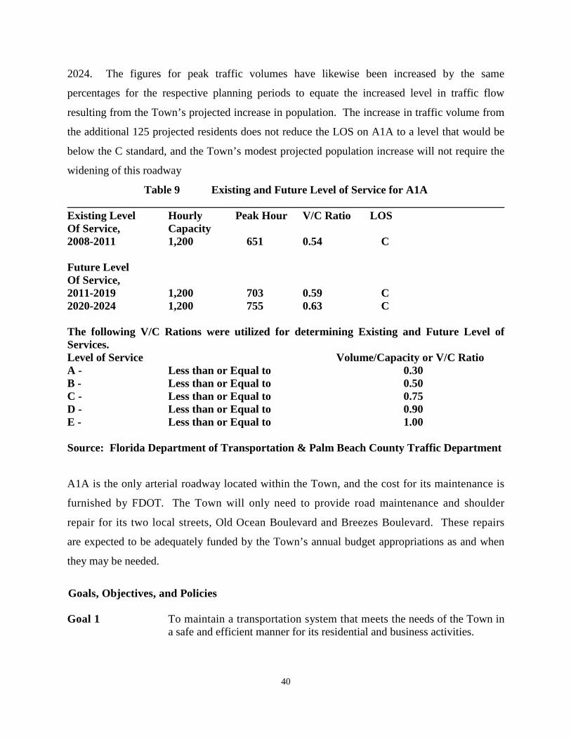
40
2024. The figures for peak traffic volumes have likewise been increased by the same
percentages for the respective planning periods to equate the increased level in traffic flow
resulting from the Town’s projected increase in population. The increase in traffic volume from
the additional 125 projected residents does not reduce the LOS on A1A to a level that would be
below the C standard, and the Town’s modest projected population increase will not require the
widening of this roadway
Table 9 Existing and Future Level of Service for A1A ______________________________________________________________________________ Existing Level Hourly Peak Hour V/C Ratio LOS Of Service, Capacity 2008-2011 1,200 651 0.54 C Future Level Of Service, 2011-2019 1,200 703 0.59 C 2020-2024 1,200 755 0.63 C The following V/C Rations were utilized for determining Existing and Future Level of Services. Level of Service Volume/Capacity or V/C Ratio A - Less than or Equal to 0.30 B - Less than or Equal to 0.50 C - Less than or Equal to 0.75 D - Less than or Equal to 0.90 E - Less than or Equal to 1.00 Source: Florida Department of Transportation & Palm Beach County Traffic Department
A1A is the only arterial roadway located within the Town, and the cost for its maintenance is
furnished by FDOT. The Town will only need to provide road maintenance and shoulder
repair for its two local streets, Old Ocean Boulevard and Breezes Boulevard. These repairs
are expected to be adequately funded by the Town’s annual budget appropriations as and when
they may be needed.
Goals, Objectives, and Policies Goal 1 To maintain a transportation system that meets the needs of the Town in
a safe and efficient manner for its residential and business activities.

41
Objective 1.1 Continue the Town’s present practice of requesting the assistance of the Florida Department of Transportation to investigate and solve traffic related problems that arise from motor vehicle travel through the Town on A1A.
Policy 1.1.1 The Town shall cooperate with Palm Beach County and the Florida
Department of Transportation to maintain and improve the function, safety, and appearance of A1A.
Policy 1.1.2 The Town should cooperate with Palm Beach County and the Florida
Department of Transportation in the adoption of appropriate traffic regulations to improve motor vehicle, golf cart, bicycle, and pedestrian safety along A1A.
Policy 1.1.3 The Town shall use intergovernmental coordination and participation with
the Palm Beach County Metropolitan Planning Organization to maintain A1A as a two-lane road.
Policy 1.14 The Town shall ensure that the planned redevelopment of the Town does
not result in a reduction in the level of service on A1A from peak hour Level of Service Standard D.
Policy 1.1.5 The Town shall amend its land development regulations to provide that
any developer application for a change in the Future Land use Map will not result in traffic demand that adversely affects the level of service of A1A.
Policy 1.1.6 The Town shall amend its land development regulations to require that all
planned redevelopment has safe and efficient access by way of a local road or driveway that connects to A1A.
Policy 1.1.7 The Town shall amend its land development regulations to require that all
redevelopment on land which has frontage on A1A shall include pathways suitable for pedestrians, bicycles and golf carts along the frontage.
Objective 1.2 Continue the Town’s road maintenance program for Briny Breezes
Boulevard and Old Ocean Boulevard which are the two local public roads serving the Town’s residents.
Policy 1.2.1 The Town shall amend its land development code to include a
development plan review process to control roadway access points and on-site traffic flow for new development.
Objective 1.3 The Town shall continue its cooperation with BBI to promote a street
maintenance program, a safety program, and a vehicle parking program for the local street system.

42
Policy 1.3.1 The Town and BBI should implement the Agreement for Municipal Traffic
Control to improve the vehicular and pedestrian safety for travel over the local street system.
Policy 1.3.2 The Town and BBI should cooperate in the adoption of appropriate traffic
regulations to improve motor vehicle, golf cart, bicycle, and pedestrian safety on the internal street system serving the Town residents.
3. HOUSING ELEMENT
Introduction
The 1989 Plan for Briny Breezes described the community as being “unique” in that the housing
stock is composed entirely of mobile homes. That categorization has remained the same in the
ensuing 22 plus years, as the Town has continued to be an all mobile home community. The
ownership arrangement further distinguishes the Town from its neighbors because BBI as a
Florida corporation is the sole owner of the entire land area comprising the Town limits of
Briny Breezes. Every resident becomes a member and shareholder in BBI when he/she
purchases a mobile home housing unit and becomes a Town resident. BBI operates the mobile
home community as a residential cooperative under the provisions of The Florida Cooperative
Act, Section 719, Florida Statutes. This business arrangement results in the efficient
maintenance of the cooperative’s common elements and encourages participation by the
residents in housing matters on both BBI’s cooperative level, and on the Town’s municipal
government’s level.
Housing Conditions
All the present housing units in Briny Breezes are one story, single-family mobile homes. By a
subsequent amendment to the Town’s Land Development Regulations, the definition for a
mobile home was expanded to include manufactured homes, modular homes and recreational
vehicles. The original units were placed on site during the late 1950’s and beginning 1960’s on a
variety of lot sizes. Most mobile homes have been replaced at least once since that time. The
1989 Plan envisioned that Briny Breezes Town would continue to function as a residential
cooperative devoted exclusively to mobile home type living units. The Amended
Comprehensive Plan gives BBI the opportunity to allow its resident members to expand their
choice of housing to include other types of residential living units in addition to the community’s

43
continuing use and replacement of its present types of mobile homes. The variety of allowable
types of housing units permissible under the Town’s Amended Comprehensive Plan now will
include, in addition to typical, conventional mobile homes as they are presently defined, two-
story mobile homes, one and two-story hardened, stormworthy single family or multi-family
manufactured building, modular building, factory-built building, mobile home, or manufactured
home housing units designed and constructed to meet hurricane wind loads, conventionally
constructed one and two-story single-family homes, and multi-family, multi-story,
condominium, cooperative, and apartment units.
In 1989, the majority of the housing stock was ten to fifteen years old. From then to the present,
the units have been well maintained and for the most part, and have been replaced when
necessary. Presently there are no more than one or two structurally substandard units.
Traditionally, when applied to the housing units in the Town, the term “substandard” means that
the unit is of an age or condition that necessitates its replacement. No units are overcrowded and
all units contain adequate plumbing, heating, and kitchen facilities.
In 2006, a significant change occurred in the attitude of the residents regarding the community’s
future. The managing directors of BBI submitted a referendum to its shareholders to sell the
corporation’s land holdings and make a distribution of the net proceeds to them, pro rata, upon
the transaction’s targeted completion date in 2009. The results of the shareholders’ votes were
tabulated in January, 2007. Eighty-two percent (82%) of the shareholders had voted to approve
the management’s proposal, and BBI entered into a formal contract of sale with a land
development company. Months later, in July, 2007, unsuccessful negotiations between the
parties over the developer’s request for an extension of the contract’s terms led to a cancellation
of the agreement and the termination of the sale.
The contract’s cancellation was a disappointment to the residents and it abruptly ended their
previous expectations for the benefits of the sale. As a result of their dampened enthusiasm,
some unit owners lost interest in the routine maintenance and upkeep of their homes. Beginning
in 2007 and continuing through 2008, the renovation and replacement of the existing units
slowed drastically. A lesser number of new units installed in Briny Breezes than usual, during

44
this period. Reductions in construction activity continued as long as the residents remained
uncertain regarding the future possibilities of new plans for the development of the property.
More recently, as time progressed without further activity to sell the corporate real estate
holdings, requests by the residents for Town building permits have increased. If this is indicative
of a change in the public’s expectations that the Town has a viable future, then construction and
repair activity should continue to increase to normal pre-sale contract levels.
Another effect of BBI’s proposed sale of its entire property in 2007 was a reduction in the
number of individual sales by the residents themselves. This trend continued into 2009. At
present, many knowledgeable buyers consider a mobile home in Briny Breezes to be worth
double the value of one in a more mundane inland site, due to the scenic amenities of the Town’s
location and the satisfying life style enjoyed by the residents.
Under the rules adopted by BBI as a cooperative residential entity, applications by the resident
members for the repair, renovation, and replacement of their mobile homes are only received for
processing during the winter months. BBI only allows construction activity to continue into the
summer months for applications approved during the winter season. The only exception to this
rule is to allow air conditioner repair and replacement. The reason underlying BBI’s restrictions
is to avoid the accumulation of loose building materials which could be blown about during the
summer months which is the major part of the hurricane season. While these rules may have had
merit for a community composed exclusively of mobile homes, the Amended Plan considers
them to be too restrictive if it allows the community to have alternate types of hardened,
stormworthy residential living units, including multi-story condominiums and conventionally
constructed single-family homes. Therefore the Plan recommends that the Town encourage BBI
to cancel its present restrictions on construction during the summer season in favor of a policy
allowing year-round construction activity.
Housing Values
In 1989 the average value of housing in Briny Breezes was below the County’s average. Briny
Breezes homes were then valued at $52,800 on an average, just 2.5 percent less than the average
Palm Beach County home value of $55,300. Because the Town’s housing type is limited to

45
mobile homes, Briny Breezes then had no high value units. The price range ran from the highest
valued unit, which listed at $65,000, to the lowest unit, at $32,500.
The proposal to sell BBI’s, land holdings in 2006 and 2007 caused the property values in Briny
Breezes to skyrocket. The average price for mobile home property rose in 2007 to figures in
excess of $250,000. The subsequent fallout from the weak real estate market nationwide has
affected the Town with mixed results. It has increased the number of properties on the market.
In 2009 there were seventeen properties listed for sale in the Town, and by 2010 there were
forty-six. It has effectively reduced the price of the low-end units, but has had the opposite
effect of increasing the price on the more prestigious ones. The sale prices asked in 2008-2009
ranged from $209,000 for the small units to $435,000 for the largest. As of April, 2010, the sale
price on some of the smaller units has declined to as low as $125,000, while the price for some
of the high-end units have risen to as high as $585,000. This escalation in sale prices has caused
considerable concern among long-term residents in the Town, who see the potential of greatly
increased taxes because of these high increases in the property values.
Housing Rentals
In 1989 the few rental units had a mean rental rate of $332 per month, which was higher than the
County mean monthly rental rate by almost $100. Through its managerial control over the
cooperative members, BBI does not allow unit owners to rent their units on a yearly basis. Only
seasonal rentals are permitted. From 2007 to 2009, rental prices rose in line with the price
increase in the proposals to sell, and the seasonal rentals in Briny Breezes ran from $1,100 to
$2,400 per month. The weak real estate market had the same effect on rental rates that it had on
sale prices. By April, 2010, the monthly seasonal rental rates for the low-end units declined to
$875, and for the most desirable ones, they have risen to $2,500. BBI maintains a list of
properties for which the owners have announced are available for sale and rental, which
presently consists of forty living units. The combination of favorable weather and the proximity
to the Atlantic Ocean account for the Town being a desirable location for seasonal renters.
Rent-To-Income Ratios
The rent-to-income ratio of the households in Briny Breezes is not comparable to those of a

46
typical community in which most renter households are retirees on fixed incomes and as a result
pay a great deal of their annual incomes for rent. There are very few renter households in the
Town, so the rental figures discussed above are not a reliable comparison to the cost of the
housing in the Town.
Mortgage-To-Income Ratios
The majority of owner-occupied units in Briny Breezes are not mortgaged. Of those that are,
most are financed at a cost that did not place an excessive burden on the participating
household’s income. Most households paid between 15 percent and 24 percent of their incomes
for mortgages. Only six percent of owner-occupied households paid more than 35 percent of
their incomes for mortgages. Most of the households were retirees with fixed incomes.
Previous Redevelopment Strategies
In 1989 it was thought that certain housing units would continue to reach an age where
replacement became necessary. At that time, 10 units were replaced. The Town and BBI
attempted to reduce densities by leasing vacant lots to abutting homeowners. Under the plan,
whenever a lot became vacant, the adjacent landowner on each side was encouraged to lease the
lot. These homeowners would then split the leased lot between them and incorporate the halves
into their existing holdings. The practice was not successful because the high cost of leasing the
additional land was usually beyond the financial means of the abutting owners. Also, more often
than not, when the departing resident left, he or she would sell the mobile home which was left in
place for the new owner who would then assume the land lease, thus continuing the status quo.
Present Redevelopment Strategies
The composition of the types of housing in the Town is expected to change in the coming 5-year
and 10-year planning periods. This is demonstrated in the FLUE with the ending of the
restrictions that limit the community’s allowable housing units to mobile homes only, and by
providing for the introduction of multi-story condominiums, conventionally constructed single
family homes, and one-story and two-story stormworthy units within the Town.

47
BBI has entertained the possibility of some further commercial and business development of its
property, in addition to residential redevelopment. From 1989 through 2007, BBI operated a
parcel of land dedicated to true mobile homes by allowing travel trailers as rental units. Persons
were allowed to park their towed travel trailers in the area called District V, for a monthly rental
fee. BBI first limited these travel trailer spaces to two-year periods, using the supposition that
persons interested in residing in the area could find suitable housing within two-year period and
then move out of the District V location. However, in 2007 BBI ceased the travel trailer space
rental business. Resident members of BBI have expressed their belief to the corporate directors
that the District V tract and other parcels of BBI’s non-residential property could be better used
for upgraded commercial and business uses.
The possibility of multi-story buildings in commonly owned areas would include structures with
parking and business space on ground floors, and locate the residential units within a limited
number of upper stories. This multiple housing approach would have an impact on the Town’s
population, which is expected to rise from its present peak seasonal high in 2011 of 767, to
projected highs of 826 at the end of the 5-year planning period in 2019, and to 892 at the end of
the 10-year planning period in 2024.
Other Housing Data
There are no subsidized units, group homes, or historic houses in the Town. Up until now,
housing construction has not been applicable in the Town. Currently, very few mobile homes
are being replaced. There are few vacant units in the Town and there are no abandoned units.
Group Homes and Subsidized Housing
Briny Breezes currently does not have subsidized housing facilities or group homes because it is
near to full build-out as a mobile home community. A large proportion of its residents are senior
citizens. District V is the only real tract of undeveloped land, and additional vacant land could
be added to it for a larger construction site, such as the project described as Section 6, by razing
obsolete buildings and structures that are presently being used for storage and have no residential
uses.
48
Affordable Housing
It is the intrinsic nature of a mobile home community that constitutes it as a specific type of
affordable housing, especially when compared to the cost of conventionally constructed single
family homes. This is true of Briny Breezes, even though the amenities offered by the Town’s
location fronting on both the Atlantic Ocean and the ICW undoubtedly increases the value of the
individual mobile home sites. It should be noted that Briny Breezes was developed during the
late 1950's and early 1960's and contains numerous replacement units. There are no significant
historical housing resources in the community.
Housing Needs
The proposed introduction of multi-family housing into the Town will encourage BBI to
consider undertaking or sponsoring the construction activity to create these new stormworthy
single family or multi-family manufactured building, modular building, factory-built building,
mobile home, or manufactured home housing units. The Amended Comprehensive Plan will
allow BBI the ability to do so, once the Town has revised its Land Development Regulations
(LDR) to create the necessary application and approval procedures, adopted the land
development criteria for the new zoning districts, and rezoned the areas where this construction
will occur. The Town’s housing needs applicable to the existing mobile home dwelling are
limited to avoiding neighborhood conflicts from divergent types of housing units and in
monitoring the condition of the mobile home units to forestall any structural deterioration caused
by age or storm damage. The location and character of the Town’s development are not
applicable to rural or farm-worker housing.
Private Sector Delivery Process
The right of occupancy of the housing in Briny Breezes is vested in each of the individual private
shareholders according to the ownership of their shares and the designation of their specific
housing unit afforded to them by BBI as the owner and operator of the mobile home community.
Under the management prerogatives of a residential cooperative, the proprietor maintains the
right of contract approval over the residents’ sale and rental of their individual units. These are
the only free market constraints BBI imposes for persons wishing to buy existing mobile homes
from present residents or purchasing new mobile homes from authorized dealers for delivery and

49
installation at predetermined sites. BBI will continue to exercise full discretion and decision
making powers over the construction of the proposed new multi-family residential units and/or
commercial structures. The Town’s role in the system is to create and oversee the permitting
process that allows the stated development activity. BBI will continue to provide services as set
forth in the homeowner agreements, as discussed in the FLUE.
Identification of Conservation, Rehabilitation, or Demolition Activities
Thus far, all such rehabilitation and demolition activity has been accomplished in the form of
mobile home replacements. As new types of mobile home models and manufactured housing
units become available, the older and obsolete units have been replaced. Most mobile home
units have been replaced two or three times so that the typical unit is less than ten years old.
Since there is no substandard housing, this issue is not applicable to the Town.
Goals, Objectives, and Policies Goal 1 To continue the Town as a viable community that provides sound,
stormworthy and affordable housing. Objective 1.1 Through the amendments of its Plan, the Town will allow BBI to
undertake, or sponsor, the necessary construction activity to create a new mix of hardened, stormworthy single family or multi-family manufactured building, modular building, factory-built building, mobile home, or manufactured home housing units composed of multi-story condominiums and conventionally constructed single-family homes within the Town, in addition to the continuing existence of the present mix of mobile homes.
Policy 1.1.1 The Town should cooperate with BBI in creating a master zoning plan and encourage BBI to manage it’s cooperative to ensure that when the new types of housing units are constructed they will be introduced into its land holdings and located so that they mix harmoniously with the existing mobile homes.
Policy 1.1.2 By February 1, 2015, the Town will complete the adoption of the enabling
amendments to the Town’s Land Development Regulations to create the application and approval procedures, the land development criteria, the several new zoning districts, and the re-zonings necessarily involved to fully implement the amended Plan.
Policy 1.1.3 The Town should continue to administer and enforce the provisions of the
Florida Building Code, the Florida Fire Prevention Code, and the Florida
50
Life Safety Code to ensure the safety of the new types of residential units, commercial buildings, and other structures that will now be allowed to be constructed within the Town.
Policy 1.1.4 The Town should encourage BBI to revise its present restrictions which
limit unit owners to the replacement, repair, and renovation of their existing units and/or the construction of new units to the winter months only, and to allow all such construction activity to be conducted on a year-round basis.
4. INFRASTRUCTURE ELEMENT
Introduction
The Infrastructure Element describes the Town’s system of public works. The Plan also contains
a Capital Improvements Element which analyzes the financial requirements necessary for the
Town to continue to maintain its public facilities at acceptable levels of service. The separate
treatment of these two subjects will continue except where it is necessary to analyze the Town’s
options for financing major public works improvement projects. The 10-year planning period for
the Town’s future infrastructure needs extends to the year 2024.
The infrastructure for sanitary sewer, solid waste, drainage, potable water facilities, and natural
groundwater aquifer recharge are presented in separate sub-elements. Each of the sub-elements
(except groundwater) includes an inventory of the current system, geographic service areas, facility
capacities, current demand, projected demand, and levels of service. Problems and needs are
identified and policies to provide for future system requirements are outlined. The evaluation of
facility needs has been based on the best available demographic and land use data and projections.
Wastewater Facilities Sub-Element - Collection System
Public sanitary sewers serve the entire Town in compliance with Chapter 10D-6, Florida
Administrative Code, for the operation and maintenance of a sanitary sewer collection system.
The main sewer lines lay buried underground near the centerlines of the several local roads and
private streets within the Town. The sewer mains and lift stations comprising the system are
now owned and maintained by the Town. Ownership and maintenance of this collection system
was transferred to from BBI to the Town in 1994. At that time, the entire water and sewer

51
system within the Town was in need of substantial expansion and repair. In preparation for the
acquisition, the Town issued a Request for Proposals and contracted for the services of Hutcheon
Engineers, a Division of Kimley-Horn and Associates, Inc., who were appointed and designated
as the Town Engineer. The first assignment for the Town Engineer was to evaluate the physical
condition of the entire water and sewer distribution system to determine the extent of its
shortcomings. An engineering report was promptly issued outlining a sequence of improvement
projects for both services. Based upon the Town Engineer’s report, the Town went forward to
validate a $2 Million Water Revenue Bond issue. One-half of the bonds were issued and sold
and the funds were used to defray the costs of several public works improvement projects to
upgrade the utility system. The remaining bonds were not issued, but held in reserve for any
possible future financing needs of the utility system.
The initial work consisted of replacing all of the collection lines west of A1A, which entailed the
displacement and repaving of the several local streets and roadways affected. Additional
construction projects followed and the Town replaced its lift stations over a period of the next four
years. The replacement program for lift stations was completed in October 1998. The Town owns
seven sewage lift stations each containing two pumps. The local service connection lines to the
individual mobile homes and corporation buildings, which input to the Town’s sewer collection
mains, are owned by BBI. Individual septic systems are not permitted. The main transmission line
for the Town’s wastewater system runs south along Banyan Boulevard to connect with a major lift
station to transmit the wastewater through a sub-aqueous line beneath the ICW to the regional
wastewater treatment plant on the mainland.
Wastewater Facilities Sub-Element - Treatment System
The original Briny Breezes sewage treatment facility was formally closed in October 1984 when the
Town entered into an Interlocal Agreement with the City of Boynton Beach providing for the
interconnection of the Town’s wastewater transmission line to the South Central Regional
Wastewater Treatment and Disposal Plant. At that time the Town and the Village of Golf were
original participants who joined with the two major operational cities, Delray Beach and Boynton
Beach, in the creation of a regional sewer system. The Town obtained a Step II/III Federal Grant
from the United States Environmental Protection Agency for improvements to the Town’s

52
wastewater system. Federal grants were also obtained by the South Central Regional Wastewater
Treatment and Disposal Board of Palm Beach County joined in the effort to create the regional
facility, and cooperated in making the necessary arrangements for the joint operation of the plant
by the cities of Boynton Beach and Delray Beach. In order to qualify for its Federal Grant, the
Town adopted a uniform Sewer System Utilization and Performance Ordinance in compliance with
the Federal Water Pollution Control Act of 1972, which currently remains in force and effect and
regulates the usage and operation of the Town’s sanitary sewer system.
The South Central Regional Plant is capable of treating a maximum amount of 24 million gallons
of wastewater per day and is currently treating 18.79 million gallons per day (GPD). This figure
escalates during the Town’s peak residential season. For 2011, the Town contributed about 0.226 %
of the daily volume of waste processed by the regional sewer system and it will only rise slightly to
0.243 % at the end of the 5-year planning period in 2019, and to 0.263 % at the end of the 10-year
planning period in 2024.
The amount of sewage from Briny Breezes is based upon the Town’s level of water usage at its
present rate of 106.2 GPD per person. Sewer utility company records indicate that fluids returned
to treatment facilities amount to about 2/3rds of the total amount of potable water consumed.
Based on this rule of thumb, the Town would be expected to generate wastewater at the rate of
70.8 GPD per person. For the Town’s 2011 peak seasonal population of 767 persons, this would
amount to 54,304 GPD. For the Town’s 2019 peak seasonal population of 826 persons, this would
amount to 58.481 GPD. For the Town’s projected peak seasonal population of 892 at the end of
the 10-year planning period in 2024, this would amount to 63,154 GPD. Table 10, below, shows
the Town’s peak sewage flow projections for the applicable planning periods.

53
TABLE 10 Sewage Flow Projections for the Town Town Population By Year
Town’s GPD Rate Per Person
Total Wastewater Generated by Town GPD)
Total Capacity of Waste Water Facility (GPD)
Amount of Facility’s Capacity Used to Treat the Town’s Waste water
2008-2011 70.8 54,304 24,000,000 0.226 % 767 2019 70.8 58,481 24,000,000 0.243 %
826
2024 70.8 63,154 24,000,000 0.263 %
892
Sources: South Central Regional Waste Treatment Authority, 2008. Solid Waste Sub-Element - Collection System
In Briny Breezes, the collection and disposal of residential and commercial solid waste operates
efficiently and provides Town residents with an excellent level of service that matches or exceeds
industry standards for smaller communities. The Town participates in the countywide solid waste
disposal program through an Interlocal Agreement with the Palm Beach County Solid Waste Authority
(SWA). This Interlocal Agreement allows the solid waste generated by the Town to be received for
disposal at the authorized and approved landfill sites operated by the SWA. Through cooperative
citizen participation, the solid waste materials generated within the Town are deposited at a central
collection site provided by BBI. This collection site is presently located within the boundaries of
Section 6, and if its area is given over to the proposed re-development there, a new collection site will
have to be provided elsewhere.
Under the present arrangements, material from the collection site is trucked by a private waste
hauler to a transfer station on Lantana Road where refuse is consolidated for mass transport for
disposal at the SWA’s landfill in northern Palm Beach County, off Jog Road, just west of the
Florida Turnpike.

54
In addition to the disposable solid waste program, the SWA also has a program for the collection
and processing of recyclable materials at the SWA Recyclable Facility located off 45th Street,
west of the Turnpike in West Palm Beach. The Town residents participate in a modified version
of the SWA’s curbside recycling program by bringing their recyclable materials to a central
collection site provided by BBI. A private waste hauler hired by BBI picks up the recyclables
and transports them to the SWA North County Resource Recovery Facility for processing.
BBI coordinates with the Town in participating in both programs by contracting for the pick-up
and transportation services with the private solid waste hauler for both residential and
commercial solid waste and the recyclable materials. BBI also contracts for tree trimming and
lawn maintenance service for the mobile home community with a commercial landscaping
company on a regular schedule and orders special collections as needed. The services include
collecting and transporting the lawn clippings and tree debris for disposal at a designated dump
site, as provided by the Town’s Interlocal Agreement with the SWA.
All countywide solid waste collections in Palm Beach County are eventually deposited at that the
SWA’s Jog Road landfill. This facility has adequate capacity to handle the entire volume of
county solid waste for the next several years. Current projections by SWA officials indicate the
Jog Road landfill will continue to provide disposal services for the entire county to the year
2024. Palm Beach County Commissioners have discussed the need for future landfill sites to
continue disposal service thereafter, but thus far, nothing has been approved.
Projections made when the use of the Jog Road landfill first began indicated a capacity of 200,000
tons a day or 400,000,000 pounds. However, SWA records show that the average daily dumpage
at the landfill is only 2,100 tons a day. The average annual dumpage has reached 761,000 tons.
Solid Waste Sub-Element - Needs Assessment
SWA officials estimate the average residential waste generation at 4.5 pounds per capita per day
countywide and a commercial rate at approximately 2.5 pounds per capita per day. Since there
are no industrial land users to generate industrial or hazardous waste in the Town, the 2.5 pounds

55
per capita estimate has no application. Based upon BBI’s payments to its private contractors for
waste haulage services, the total waste generated in the Town is projected to remain constant at
an average rate of less than 2 pounds per person per day. BBI’s records show that the residents
discard between 2.5 and 4.5 yards of compacted solid waste every 10 days in non-peak seasons,
and that the collection compactor becomes full in about 10 days.
The SWA tables indicate that a yard of compacted garbage weighs 402 pounds. The compacted
garbage in non-peak seasons runs between 1,005 and 1,809 pounds every 10 days. The peak
seasonal population of Briny Breezes produces between 8,000 and 9,900 pounds of waste every
10 days. This indicates that the residents of the Town produced about one ton of garbage every
collection day, i.e., every 10 days, during non-peak seasons and about four to five tons a
collection day in peak population periods. These figures indicate that each Briny Breezes
resident contributes less than 2 pounds a day, which rate is nearly one-half of the county average.
Table 11 on the following page shows that when the Town’s estimated projected population
increase reaches 826 for year 2019, and when it increases to 892 persons projected for the peak
seasonal population in 2024, it will not adversely affect the SWA’s total capacity for solid waste
disposal.
Table 11 Solid Waste Disposal (Note: The daily rate of discard in 1988 was listed at 6.5. The daily rate presently used by SWA is 4.5)
Peak Population by Year
Daily Consumption Per Person (lbs.)
Daily Waste Generated (lbs.)
Capacity of the SWA Facility
Briny Breezes Percentage of SWA Capacity
2011
767
4.5
3,452
400,000,000 pounds
0.0008 %
2019
828
4.5
3,726
400,000,000 pounds
0.0008 %
2024
892
4.5 4,014
400,000,000 pounds
0.0008 %
Source Palm beach County Solid Waste Authority ____________________________________________________________________________________________

56
Potable Water Facility Sub-Element
Potable Water Supply
Potable water for Briny Breezes is supplied by the City of Boynton Beach water treatment plant.
Based on 2012 data, the City of Boynton Beach has water treatment plants with permitted
capacities of 10.4 MGD, for the West Plant; and 19.24 MGD, for the East Plant. The maximum
daily flow from the two plants is 17.81 MGD. (Letter from City of Boynton Beach dated March
25, 2013).
Demand attributable to Briny Breezes in the 1989 Plan was estimated at 94,200 gallons based on
per capita water usage of 100 gallons daily. This rate was less than the 150 gallon per day
estimate for all residential users in the Boynton Beach system. As shown by Table 15 in the
Coastal Management Element, the LPA estimates that the Town’s present water consumption is
slightly higher at 106.2 GPD per person, and this should be the rate used for determining the
Town’s future water needs, subject to revision downward if substantial reduction in water usage
is realized from the Town’s water conservation efforts. At this rate of consumption, the Town’s
estimated peak population of 767 persons for 2011 would consume 81,455 GPD which would be
0.354 % of the normal 23 MGD capacity of the City of Boynton Beach Water Utility.
Prior strategy relied on the belief that small parcels of land and small mobile home type housing
units will continue to consume the same amount of water as before, but this has not been borne
out by present consumer consumption usage. The Town’s Amended Comprehensive Plan
projects that, if there is a future shift in the type of residential units from mobile homes to
conventional styled residences, the Town’s implementation of modern day water conservation
methods will serve to maintain this low level of water usage. The Town participates in the
countywide water conservation policies that are mandated by the South Florida Water
Management District.
The City of Boynton Beach’s water usage data show that the Town’s peak seasonal population
for 2011, it used about 0.354 % per day of that City’s normal waterworks capacity of 23 MGD.
The potential growth of Briny Breezes which is projected reach a peak 892 permanent and
seasonal residents at the end of year 2024, as outlined in the FLUE, is estimated to use about
57
0.412 % of the City’s normal waterworks capacity of 23 MGD.
Water Distribution System
The water distribution system in Briny Breezes is owned by the Town. The main water
transmission lines (those normally found beneath the streets of Briny) and the fire hydrant
system are owned and maintained by the Town. This system was transferred from BBI to the
Town in 1994. After the acquisition was completed, the Town replaced all the existing water
mains in the portion of the Town lying east of A1A, installed a new 8-inch water main along Old
Ocean Boulevard, and added five fire hydrants to the distribution system. In 2005, the Town
completed improvements to the water distribution system in the portion of the Town lying west
of A1A, where the Town installed a new 8-inch water main along Banyan Boulevard and added
five more fire hydrants.
The ownership of the Town’s system extends to the point of delivery of service to the mobile
homes and corporate buildings. BBI owns the feed lines from the point of service to the
individual consumers, and has initiated a program to improve any residential service feed
connections that have become outmoded. Since acquiring the water system in 1994, the Town
has made further upgrades and improvements to the system as required, and has continued to
operate the utility as a municipal enterprise.
Needs Assessment
The Amended Comprehensive Plan anticipates that there will be an increase in water usage when
the construction of multi-story buildings and the other new types of housing units begins to
replace portions of the present mobile homes. This will depend on the number of housing units
that are involved in the changeover and the timing, which cannot be predicted at this time. The
Town’s potable water supply needs will continue to be served by the City of Boynton Beach.
The Town will work closely with its service provider to assure that potable water needs continue
to be met satisfactorily and without lowering the present adequate level of service of 106.2 GPD
per person. For the Town’s 2011 peak seasonal population of 767 persons, this would amount to
81,455 GPD. For the Town’s 2019 peak seasonal population of 826 persons, this would amount
to 87,721 GPD. For the Town’s projected peak seasonal population of 892 at the end of the 10-

58
year planning period in 2024, this would amount to 94,730 GPD.
The 10-Year Water Supply Facilities Work Plan Program
In the Infrastructure Element, the Town is required to include a Water Supply Facilities Work
Plan that meets the requirements of the regional water supply plan of the South Florida Water
Management District (SFWMD). The City of Boynton Beach is responsible for providing potable
water in Briny Breezes. Details of the water supply capacity of the Boynton Beach municipal
water system and a description of the water distribution system owned and operated by the Town
are discussed in the review of the Capital Improvements Element of the Plan. The Town
anticipates no problems in reaching satisfactory arrangements with the City of Boynton Beach for
continued potable water supply service for the Town which will be adequate to serve the needs of
the Town’s peak seasonal population of 892 persons at the end of the 10-year planning period,
without a loss in the present level of adequate service.
Drainage Facilities Sub-Element
Rainfall
Average rainfall within the Town is about 60 inches per year. The Town’s total rainfall for
2006, which is the last annual figure available, was 60.54 inches. The annual level varies
substantially, but is usually between 40 inches and 80 inches annually. The lowest annual
rainfall reported was 38 inches in 1971 and the highest was 85 inches in 1947. The one-month
record for South Palm Beach County according to the reports of U.S. Weather Bureau was
September, 2004, when 29.40 inches of rain fall. The lowest monthly figure was .04 inches in
April 1967. More than 75 percent of the precipitation occurs during the rainy season, which
begins in May and ends in October, with an average of over 7.5 inches of rain in each of these
months. During the dry season, rainfall averages between 1.0 to 3.5 inches per month. For the
Town’s location, the 1-day, 10-year frequency storm produces about 9 inches of rainfall and the
1-day, 25-year storm produces about 10.5 inches of rainfall.
During the rainy season, the average rainfall causes temporary flooding conditions in some of the
low lying areas of Districts 3 and 4. Storm driven rain water can pond sufficiently to rise up to
the bottom edges of some of the mobile homes there, although the duration of such conditions

59
rarely lasts for more than 6 hours. The situation should be monitored to determine if it worsens
to the point that active corrective measures need to be taken. The final responsibility for
correcting these conditions lies with BBI rather than the Town.
Terrain
Briny Breezes is located on a barrier island characterized by gently sloping terrain rising from
near sea level at the Intracoastal and Atlantic Ocean sides to a high point of slightly more than
eight feet at the center of the island. With the exception of the low ground levels isolated in
Districts 3 and 4 mentioned above, the remainder of the Town is well served by drainage swales
which empty into areas composed of fine sand having rapid to very rapid percolation rates to the
groundwater channel.
Run-Off Quantities
According to the Palm Beach County Plan, an estimated 47 percent of the rainfall in the County
is discharged to the ICW or the Atlantic Ocean through natural drainage. Based upon the
average rainfall recorded for Palm Beach County, on those years that Briny Breezes receives an
annual rainfall 60 inches, the average daily drainage discharge of the storm water from the Town
would be approximately 35,000 gallons. The highly localized and seasonal characteristics of
rainfall in the form of summer thundershowers in Palm Beach County prohibit a more accurate
estimate of average daily flows.
Drainage Facilities
The drainage facilities in Briny Breezes are controlled by two governmental agencies and by the
private property interests of BBI as the owner and operator of the mobile home community. The
Florida Department of Transportation is responsible for maintaining the roadway drainage for
A1A which runs the length of the Town. The Army Corps of Engineers is responsible for
maintaining the ICW, which serves as the major drainage outfall for the entire metropolitan area
of southern Palm Beach County. BBI as the proprietor of the mobile home community is
responsible for maintaining the internal storm water drainage system serving the local streets,
mobile home sites, and open space areas. The location of the Town on a barrier island also
provides the natural terrain for surface water runoff to drain into the Atlantic Ocean.

60
In addition to swale areas, BBI’s drainage system uses what is referred to as French Drains.
These consist of perforated pipes filled with small stones buried underground that disburse storm
water runoff by seepage into the groundwater table. Storm water is also drained through two
storm water outfall lines sized between six and ten inches in diameter, located in the seawall
along the ICW.
One site in Briny Breezes was identified as having inadequate drainage facilities to handle heavy
rains of short duration. The Town experienced some minor flooding in the area bounded by
Dock Drive on the south, Banyan Boulevard on the east, Flamingo Drive on the north, and
Marine Way on the west. BBI made arrangements to alleviate the situation by constructing a
drainage system of inlets and culverts to direct runoff to a collection sump fitted with a 7.5
horsepower pump to discharge the stormwater into the ICW.
The other areas of the Town drain rapidly enough to prevent long-term street or yard flooding,
even during normal to moderately severe storm water events. Prolonged heavy rains in the area
can produce some degree of flooded streets and driveways, but the effects are only temporary.
Needs Assessment
The drainage facilities in Briny Breezes are located on the private property of BBI and are
maintained by it. The facilities are adequate to handle storm water runoff. Regular maintenance
of the drainage infrastructure by BBI and the replacement of facilities when needed will
minimize drainage problems.
Natural Groundwater Aquifer Recharge Sub-Element
The water table is only a few feet above sea level in Briny Breezes and has a slight grade toward
sea level at the Atlantic Ocean and the ICW. Although urbanization has increased the amount of
surface water runoff, the rate of infiltration remains high. The variation in hydraulic conditions
makes quantitative assessment of groundwater in the Town very difficult to determine with a
significant degree of accuracy. Areas of natural groundwater recharge and discharge constantly
change in relation to the intensity, distribution, and duration of rainfall.

61
Groundwater quantity conditions are affected by evaporation from plants since the water table is
so near the ground surface and penetrated by root systems. Rainfall penetrates the ground and
flows through the Pamlico sand and Anastasia limestone formations into the shallow aquifer.
Downward penetration is prevented by the confining beds of Tamiami formation. The
groundwater then flows laterally on a slight gradient toward the coast. Withdrawal of fresh
water near the coast can result in salt-water intrusion. Therefore, there are no wells in Briny
Breezes to withdraw groundwater.
Recharge of the shallow aquifer in Briny Breezes occurs from surface water infiltration and the
storm water drainage system. During the wet season, water seeps outward from the canals to the
water table. During the dry season, groundwater flows into the canals and is discharged into the
ICW. Recharge characteristics vary considerably from area to area in Palm Beach County;
significant recharge occurs in the western water conservation areas. Briny Breezes is not
identified as being in a prime aquifer recharge area.
Needs Assessment
Briny Breezes does not contain any prime aquifer recharge area or areas that are prone to
contamination or excessive groundwater withdrawals. The regulations and programs of Palm
Beach County and the South Florida Water Management District govern water withdrawal for
land use and development and are adequate to protect water recharge functions.
Goals, Objectives, and Policies Goal 1 The Town shall provide and maintain its public infrastructure so as to
ensure public health, safety, and quality of life. Objective 1.1 Achieve and maintain a municipal infrastructure system that provides an
acceptable level of service through the duration of the 5-year and 10-year planning periods.
Policy 1.1.1 The Town should continue its present policy of timely maintenance of the
sewer mains and lift stations comprising its wastewater collection system. Policy 1.1.2 The Town should continue its present policy of cooperating with the South
Central Regional Wastewater Treatment and Disposal Board of Palm

62
Beach County and the cities of Boynton Beach and Delray Beach for the adequate treatment and disposal of its wastewater discharge.
Policy 1.1.3 The Town should continue its present policy of participating in, and
encouraging the Town residents to participate in, the countywide water conservation regulations of the South Florida Water Management District for present and future development.
Policy 1.1.4 The Town should continue its present policy of cooperating with the City
of Boynton Beach, its service provider, to assure that the Town’s potable water needs continue to be satisfactorily met, including maintaining the present level of service of 106.2 gallons per person per day.
Policy 1.1.5 The Town should continue its present policy of timely maintenance of the
Town’s water distribution mains and fire hydrant system to provide adequate service for the needs of the Town’s residents.
Policy 1.1.6 The Town should cooperate with BBI to explore and implement the ways
and means to make those areas within Districts 3 and 4 of the Town, where periodic flooding occurs, less flood prone.
5. COASTAL MANAGEMENT ELEMENT
Introduction
Located entirely on a barrier island, the Town of Briny Breezes is wholly within the coastal area
of Palm Beach County. Thus, the coastal area boundaries of Briny Breezes are coterminous with
the municipal limits of the Town's jurisdiction. There are two coastal interfaces within the Town,
namely the beach frontage of the Atlantic Ocean on the Town’s east boundary, and the seawall
frontage facing the ICW on the west. Both areas are zoned R-1 Zoning District on the Town’s
Official Zoning Map, which is the Town’s Recreation Zone. This zoning classification imposes
significant restrictions upon the allowable uses for any future development of these areas.
Land Uses and Facilities Related to the Coastal Zone
Since the adoption of the Coastal Management Element of the 1989 Plan, the Town’s coastal
zone has remained essentially unchanged. At the beachfront of the Atlantic Ocean,
improvements were made in 1991 to modernize and improve BBI’s previous oceanfront
clubhouse and cabanas. This was accomplished without any increase in the original building’s
footprint or mass that otherwise would have lessened the excellent amenities of the natural
beauty of the oceanfront. In addition to complementing the bathing and swimming activities, the

63
location of the clubhouse on the beach affords the Town’s residents with a permanent structure
for use as a community center for indoor social events that provides an unobstructed ocean view
from its veranda.
Figure 10 Water-Dependent & Water-Related Uses (Not to scale)
At the Town’s western boundary, two open parkway areas are located at the foot of the ICW, and
provide residents with passive outdoor recreational opportunities of picnicking and fishing in a
setting with a waterway view. The Town’s coastal zone also includes a yacht basin which has
been improved as a marina, and three finger canals which are undeveloped. The frontage along
the ICW and the interior perimeters of the yacht basin and finger canals are all protected with
seawalls. By applying the recreational zoning restrictions on the beachfront and the parkways,

64
the Town has allowed these portions of the coastal zone to be used for low intensity, passive
recreational uses, while still preserving the environment and conserving the natural features
within those areas. The seawall enclosed area of the yacht basin does not provide the same
amenities as the beach and parkways or need the same protective measures, so it is a coastal area
more appropriately developed for marina use. There is no plan at present to further develop or
add improvements to the three finger canals.
The Town's natural resources, including vegetative cover and marine and estuarine wetlands
were fully addressed in the Coastal Management Element of the 1989 Plan. An on-site
environmental assessment was conducted by Environmental Services, Inc., of Jupiter, Florida, in
2007 and the technicians found no state or federal listed species in the Town. However, they did
identify the ocean beach front and the ICW as suitable habitat for several species as shown in
Table 12 below.
Table 12 Town’s Suitability for Listed Species Species__________________________________Status________ _Agency Johnson’s Seagrass (Halophila johnsonii) T USDA Florida Manatee (Trichechus manatus latirostrus) E FWS, FWC Brown Pelican (Pelecanus occidentalis) SSC FWC American Oystercatcher (Haematopus palliatus) SSC FWC Osprey (Pandion haliaetus) SSC FWC Least Tern (Sterna antillarum) T FWC Royal Tern (Sterna maxima) SSC FWC Little Blue Heron (Egretta caerulea) SSC FWC Tricolored Heron (Egretta tricolor) SSC FWC Loggerhead (Caretta caretta) T FWS, FWC Green Turtle (Chelonia mydas) E FWS, FWC Leatherback (Dermochelys coriacea) E FWS, FWC Hawksbill (Eretmochelys imbriacata) E FWS, FWC Kemp’s Ridley (Lepidochelys kempii) E FWS, FWC E = Endangered Species
FWC = Florida Fish and Wildlife Conservation Commission FWS = U.S. Fish & Wildlife Service
SSC = Species of Special Concern T = Threatened Species USDA = U.S. Department of Agriculture Source Environmental Assessment, Briny Breezes, prepared by Todd Mimnaugh, Environmental Services, Inc, Jupiter, Florida (March 2007).

65
A review of this Environmental Assessment was subsequently submitted to the LPA in
conjunction with the preparation of this Report by Paul Davis, the Environmental Manager of the
Palm Beach County Department of Environmental Resources Management. In his evaluation,
Mr. Davis stated, in part, that he was confident, based upon his familiarity with local conditions
in the Town and his 28 years of professional experience in listed species management in Palm
Beach County, that all of the species listed in the above Environmental Assessment, with the
possible exception of the American oystercatcher (Haematopus palliatus), have been observed
and can be found within or immediately adjacent to the Town.
Protection of Endangered Species of Sea Turtles
There are about 600 feet of ocean front beaches within the Town which serve as a nesting area
for Loggerhead, Leatherback, Hawksbill, Kemp’s Ridley, and Green sea turtles. Since
December 1987 the Town has had a sea turtle protection ordinance that encouraged oceanfront
property owners to restrict artificial lighting that would otherwise discourage turtle nesting and
disorient turtle hatchlings. In March, 2011, the Town was officially notified by the Federal
Emergency Management Agency (FEMA) that the Agency had reached an agreement with the
U.S. Fish and Wildlife Service (FWS) to determine the impacts that certain aspects of the
National Flood Insurance Program are having on the five above named species of sea turtles,
which the agency has listed as threatened and endangered species, and their habitat along the
Town’s beaches. As a cooperating local governmental agency, the Town has accepted
responsibility to ensure that its actions do not harass or harm the threatened and endangered sea
turtle species. The Town will also pursue a policy that prohibits the hunting, wounding, killing
and/or trapping sea turtles, or attempting to engage in any such conduct. Accordingly, the Town
will implement its long standing turtle protection ordinance by adopting further measures which
will more fully protect the five above named federally-listed threatened and endangered sea
turtles and their habitat.
Protection of the Endangered Florida Manatee
Because the State of Florida is declared to be a refuge and sanctuary for the Florida manatee or
sea cow, the “Florida state marine mammal”, protection of manatees and enforcement of

66
applicable rules and laws are an important consideration in the Town. Given the Town’s
location abutting the ICW, the Town deems implementation of manatee protection programs, as
well as the protection programs for all other Florida marine and wildlife species, to be an
important component in the Town’s planned redevelopment when the Town’s estimated
projected population reaches a projected peak of 826 residents for year 2019, and increases to
892 persons projected for the peak seasonal population in 2024.
Since the Town’s adoption of its 1989 Plan, the only redevelopment within the Coastal High-
Hazard Area has been the application by BBI to modernize and improve its oceanfront
clubhouse and cabanas, which was approved and constructed as planned in 1991. There have
been no other development applications for lands lying within the Town’s Coastal High-
Hazard Area that have sought to increase the Town’s existing density limitations. The Town has
not imposed a hindrance upon the development rights of BBI or those of the private mobile home
owners whose property is located within the Coastal High-Hazard Area.
The Amended Comprehensive Plan preserves the available open space at the beachfront and
parkways areas for the continued recreational uses presently enjoyed by the Town’s residents
and provides the opportunity for the natural habitats of desirable, non-endangered species of
wildlife, fish, or flora to flourish. These open areas also serve the residents as sites for observing
scenic beauty or vistas, which offers passive recreational enjoyment. Civic minded residents
have organized a garden club which creates and maintains attractive floral plantings to beatify
the Town. The Town will encourage the preservation of these passive recreational open space
areas in their present natural state, instead of locations for intense recreational uses. The future
development of these portions of the coastal zone should stress low density and low intensity of
use. Construction of new buildings in these areas should require the issuance of a special
exception by the Town prior to the issuance of a building permit for any work. Off road
vehicular traffic is prohibited in environmentally sensitive areas and, except for maintenance
vehicles, is restricted to a necessary minimum elsewhere in the coastal zone under the limitations
of the recreational zoning district.

67
Coastal Construction Control Line
The Coastal Construction Control Line ("CCCL") for the Town is generally located landward of
Old Ocean Boulevard. In addition to the restrictions imposed under the Town’s recreation
zoning district, all redevelopment within the Town’s CCCL will be required to comply with the
requirements of the Beach and Shoreline Preservation Act pursuant to Parts 1 and 2 of Chapter
161, Florida Statutes, and also comply with base elevation requirements established by FEMA.
Figure 11 shows the location of the Coastal High Hazard Area (CHHA) and the Coastal
Construction Control Line (CCCL) in the Town of Briny Breezes.
Figure 11 CHHA and CCCL locations (CCCL added by Jerry Lower BB P&Z)
Public Beach Access
Public beach and shoreline access is provided by four public parks in nearby locations. There are
three parks in the Town of Ocean Ridge to the north of the Town. These are the Palm Beach
County Dunes Hammock Park, the Palm Beach County Ocean Inlet Park, and the City of Boynton
Beach Public Park. In addition to these parks, public beach access is available at points where the
several public streets of Ocean Ridge terminate at the beach.
68
In addition to the ocean beach, the Palm Beach County Dunes Hammock Park provides public
parking and access ways leading from the public street. The Oceanside portion of the Ocean
Inlet Park, which is on the south side of the South Lake Worth-Boynton Beach Inlet, is served by
parking across A1A. The City of Boynton Beach Park is a fully developed beachfront recreation
park offering a picnic area, restrooms/bath houses, a concession stand, and 255 parking spaces.
A pavilion and walkovers provide scenic beach overlooks and access to the beach at a number of
points.
The fourth area park, the Gulfstream County Park, is located south of the Town on A1A in the
unincorporated area of Palm Beach County. The facility includes a picnic area, restroom/bath
houses, parking, and beach access.
Private Beach Access
The Town residents and their guests have access to the beach and shoreline by means of private
parklands and access points that are owned and maintained by BBI. The use of these
recreational facilities is open to all residents of the Town. Private beach access within the Town
is also available offered at points where private streets terminate at the beach front. The major
access to the beach is at the Atlantic Ocean Club which is located on the east side of Old Ocean
Boulevard at the terminus of Ruthmary Avenue. This facility has a clubhouse for indoor
recreation and landscaped picnic areas at the beach. There are other private beach access points
at the eastern terminus of Cordova Avenue and Briny Breezes Boulevard.
Private Access to the Intracoastal Waterway Shoreline
BBI owns and maintains the two parkways located on the shoreline of the ICW that are available
to all Briny Breezes residents. This is in addition to the access afforded the several mobile
homes that front on the water.
Conflicts Among Shoreline Uses
Except for the marina operation, all of the Intracoastal and ocean shoreline uses within the Town
are developed for residential use or are maintained as recreation areas. All shorelines uses are

69
compatible with each other in terms of land use and density or intensity of development. No
conflicts among shoreline uses have been identified.
Public Access to the Intracoastal Waterway
Limited public access to the ICW is provided by the marina owned and operated by BBI for both
Town residents and the general public. About 40 percent of the marina's customers are non-
residents of the Town. In the adjoining area to the north, additional public access to the ICW is
provided at the Palm Beach County Beach and Marina in the Town of Ocean Ridge. This marina
offers public boat dockage facilities on a day use basis, a picnic area, a concession stand, and
swimming and fishing areas. The park provides 150 parking spaces for visitors.
Recreational Working Waterfront
Limited public access to the ICW and the Lake Worth lagoon are provided by the Briny Breezes
Marina, which is owned by BBI. Facilities are provided for the dockage and fixed mooring of
vessels but not for boat launching. The marina has 68 slips which are available to both Town
residents and the general public. About 40 percent of the marina's customers are non-residents
of the Town.
BBI operates a marina facility located on the southerly most finger canal which provides
recreational boating access to and from the state’s navigable waters. The Marina’s canal opens
directly onto the ICW and provides dockage facilities for 68 recreational vessels. Boat slips are
available for dockage by both resident and non-resident boat owners. The Town supports the
Waterfronts Florida Program and its efforts to protect environmental and cultural resources, to
mitigate hazards, and to enhance the viable traditional economy. Except for the marina facility,
there is no further opportunity for commercial or industrial development of the Town’s
waterfront areas.
Historic Resources
No historic sites or resources within Briny Breezes have been listed on the National Register of
Historic Places or the Florida Master Site File. No areas within the Town have been designated
for historic preservation.

70
Hurricane Preparedness
Since the 1989 Plan, the Town adopted a Hurricane/Emergency Policy in July 1996 which
included a hurricane evacuation plan which has been updated annually to include changes in
data. In June 2008 the Town conducted a major review of its preparedness plan for hurricane
disaster and included a post-disaster redevelopment plan. It was formally adopted as the Town’s
Emergency Preparedness Manual, and is kept updated with current information as needed.
The Town is a participating member of the Palm Beach County Local Mitigation Strategy (LMS)
and has adopted the 2009 Revised Palm Beach County Unified Local Mitigation Strategy Plan in
its entirety. This Plan was revised by the LMS and is approved by the Palm Beach County
Board of County Commissioners, the Florida Division of Emergency Management, and the
Federal Emergency Management Agency. As a mobile home community that is located in the
Coastal High-Hazard Area and experienced with facing hurricane storms, the Town is well
versed in the importance of instituting preparedness and mitigation techniques that harden
structures before a storm, that promptly adheres to pre-planned evacuation routes from a storm,
that understands the proper responses during a storm, and participates in effective post-disaster
actions to recover after a storm. If the Town’s future development changes it from a mobile
home community to a residential community with different types of housing units, the Town will
adapt and make the appropriate changes to its hurricane disaster preparedness program that
would be needed to ensure the continued safety of the public.
Element Evaluation
The Coastal Management Element of the 1989 Plan has served the Town well. The nature,
extent and area of the Town’s coastal zone has remained essentially unchanged since the time of
the Plan’s adoption The Coastal Management Element fully addressed the numerous other
issues relating to the Town's natural resources, including vegetative cover and marine and
estuarine wetlands, and the waters and submerged lands of the ICW and the Atlantic Ocean. It
also adequately evaluated the living marine resources supported by the Town's wetlands, the
functioning of those portions of the coastal barrier island within the Town's municipal limits,
including the Atlantic beach and dune system. Except for the information presented by the

71
environmental assessment conducted by Environmental Services, Inc., in 2007, there has been
little change in these natural conditions since the Plan’s adoption and, therefore, these subjects
do not need to be further addressed for purposes of amending the Plan.
Repair and replacement of existing structures in the Coastal High Hazard Area with similar
structures will be allowed but the Town will not exacerbate the situation by increasing the
density and intensity of the use of the property without also adequately addressing protection of
those structures through the use of elevation and storm hardening of structures. Persons
rebuilding may be required to sign a waiver acknowledging the risk of rebuilding in the Coastal
High Hazard Area and that said risk is their’s alone, and not the responsibility of liability of the
Town.
The Town will encourage population growth away from the Coastal High Hazard Areas and seek
to control the expansion of the densities of the units located within the Coastal High Hazard
Area. The Town will encourage public participation in this process by the residents. The Town
will also work with its LMS partners to provide safe, efficient and timely evacuation procedures
as needed to protect the residents in an emergency.
Public expenditures within the coastal high hazard area should be limited to maintenance and
repair of existing improvements and facilities and for preserving, protecting, and promoting the
natural resources. Public expenditures should not be utilized for private development. The
Town should control development in accordance with the Future Land Use Map of this plan.
The Town shall consider relocating any of the existing infrastructure away from the Coastal High
Hazard Area as may be practical.
Goals, Objectives, and Policies
Goal 1 The Town shall conserve, protect and manage the natural and man-
made environmental resources within its coastal area. Objective 1.1 To retain the natural waterfront stretches that are presently available as
beach and open space along the Atlantic Ocean and the Intracoastal Waterway for conservation and passive recreational use.

72
Policy 1.1.1 The Town should continue its present policy of applying the recreational
zoning restrictions on the beachfront and the parkway areas for low intensity, passive recreational uses which preserve the environment and conserve the natural features within those areas.
Policy 1.1.2 In cooperation with BBI preserve and maintain the natural beach and dune
areas to further marine and wildlife habitat, including the protection of the five species of the federally-listed threatened and endangered sea turtles and their habitat.
Policy 1.1.3 Given the Town’s location on the Intracoastal Waterway, the Town should
adopt and implement the state and county manatee protection programs, as well as the governmental protection programs promulgated for all other threatened or endangered Florida marine and wildlife species.
Policy 1.1.4 The Town should continue its present policy of allowing the small areas of
open space at the beachfront and parkways to be used for passive recreational activities by the Town’s residents and allowing the natural habitats of desirable non-endangered species of wildlife, fish, and flora located thereon to flourish. These open areas are desirable as special locations unique within the Town which provide the residents with the opportunity to observe nature’s scenic beauty and vistas, and are not of appropriate size, configuration, or location to be developed for intense recreational uses.
Policy 1.1.5 The Town should continue its present policy that vehicular traffic shall be
specifically prohibited in environmentally sensitive areas and restricted to a necessary minimum elsewhere in the coastal hazard zone under the limitations contained in the recreational zoning district regulations.
Policy 1.1.6 The Town should continue its present policy of periodically updating its
Hurricane Emergency Policy and its Emergency Preparedness Manual to meet hurricane and natural disaster emergencies. The Town should also continue to update its post-disaster redevelopment plan in coordination with the Town’s future development plans.
Policy 1.1.7 The Town should discourage increases in the density or intensity of the
use of property in the Coastal High Hazard Area (CHHA) without sufficient mitigation of potential adverse impacts, including the protection of those structures located therein, through the implementation of the following multipart strategy:
a) Educate property owners of their risk building and rebuilding in
the CHHA; and,
73
b) Adopt by December 31, 2015, a comprehensive plan policy establishing criteria that the Town shall use to evaluate and determine whether to approve comprehensive plan amendments, zoning map and land development regulatory code amendments, and capital improvements that could lead to increased density or intensity of use of property in the CHHA.
The criteria used to determine whether to approve the proposed amendment or project shall include, but it is not limited to, the following considerations: 1) Protection of the public’s health, safety, and welfare; 2) The protection of private property, including property
rights; 3) The potential for adverse impact to the environment; and, 4) The potential economic consequences to the Town.
Policy 1.1.8 The Town should limit public expenditure within the CHHA to that
necessary for the maintenance and repair of existing infrastructure and public facilities, protection of the natural resources, and for the relocation of existing infrastructure.
Policy 1.1.9 The Town should not expend public funds for the purpose of private
development within the CHHA, except in the following limited instances:
1) Such development is necessary to accomplish: a) The maintenance or repair of existing infrastructure and
public facilities located within the CHHA; b) The protection of natural resources; c) The relocation of existing infrastructure from the CHHA;
or, d) An overall decrease in density or intensity of use within the
CHHA; and, 2) The expenditure does not result in an increase in density or
intensity of use within the CHHA; and,
3) The Town has evaluated the expenditure and determined it appropriate, based upon the criteria and process established pursuant to Policy 1.1.7.b.

74
6. CONSERVATION ELEMENT
Introduction - Relationship to Coastal Management Element
Because the Town is wholly located within the coastal building zone as defined in Chapter 161
of the Florida statutes and Rule 62B-33 of the Florida Administrative Code, the Conservation
Element is closely related to the Coastal Management Element. Both Elements address the
natural resources of the Town. The Conservation Element identifies the existing natural resource
systems, their uses, and pollution problems. It evaluates the potential for conserving, utilizing,
and/or protecting air quality, soils, minerals, floodplains, potable water sources, water needs, and
for handling hazardous wastes that are unrelated to the management of coastal resources. The
Coastal Management Element addresses the same natural resources but in a more detailed
treatment that is directly related to the Town’s development and use of its coastal resources.
When the amendment to the Comprehensive Plan is completed, the Coastal Management
Element will be combined with the Conservation Element and the combination renamed as the
Coastal Zone Management And Conservation Element.
Environmental Setting
The environmental setting of Briny Breezes is characterized by a sub-tropical marine climate,
as the relatively long summer season has warm temperatures and frequent rainfall. The
winters are distinguished by mild temperatures and infrequent precipitation. The topography
of the coastal ridge provides elevations reaching 9.5 feet above sea level at the highest point in
Briny Breezes just east of A1A.
The Town’s Ecosystem
Before urban development began in southern Palm Beach County, the barrier island setting gave
Briny Breezes a highly dynamic ecosystem with mangroves, sand pines, palmettos, and dune
formations. This ecosystem had changed decades prior to the adoption of the last
Comprehensive Plan in 1989 by the urbanization of the Town. This reduced the natural
environment as a habitat for wild life to its present two locations. These are the sandy beach of
the Atlantic Ocean on the Town’s easterly boundary, where stands of sea oats and sea grape still
flourish, and the strip of land on the Town’s westerly boundary which is maintained as grassed
over, open space that extends from the last tier of residential mobile home sites to the sea-walls

75
fronting the ICW. Neither the ocean front clubhouse, which was rebuilt on its original site in
1991, nor the 2 cabanas intruded into the limited space available for a wildlife habitat. In 2007,
the elimination of travel trailer rentals from Zoning District V gave the Town an additional 0.6
acres of open space. This area was cleared of surface improvements and then sodded with grass
so that it presently has no potential for exotic plant growth. With this one exception, there has
been no change in the nature or extent of the Town’s natural preservation area in the last 20
years.
Geology
Barrier islands are coastal ridges that are additionally separated from the mainland on their
landward sides. The geology is characterized by Pleistocene sand and Holocene sand deposits.
The typical beach dune is composed of quartz and calcareous sands with a high PH. Ancient
interior dunes and topsoil are composed of highly leached quartz sands with a low PH.
Coastal Ridge Vegetation
In its native form, coastal ridges contain sand pines, woody scrubs, palmettos, and sea-oats on
the actual dune formations. The dunes are composed of highly permeable sands which provide
shelter to scrub-jays, songbirds, gopher tortoises, rodents, and reptiles. Dunes can be subject to
invasion and dominance by Australian Pine trees. This invasion of exotics is accelerated when
natural dune vegetation is destroyed. The Town contains few native functioning coastal ridge
vegetative areas landward of the secondary dunes of the Atlantic Ocean.
Conservation of Vegetative Cover
It is the Town’s policy that every effort should be made to conserve the vegetative cover. This
vegetation moderates storm impacts and repels the dominance of exotic plants. This could include
retaining and promoting the native vegetation to preserve and expand the ocean dunes, installing
1-way valves in storm drains, and improving the system of bulkheads. Since Briny Breezes is
substantially developed as a mobile home community, no large changes in the amount of native
vegetation is anticipated from projected population increases which may result from changes in
the number and type of housing units.

76
Natural Water Resources
The two dominant water resource features of Briny Breezes are the Atlantic Ocean on the east
and the ICW on the west. The ICW on the Town’s western boundary directly connects to the
marina area and three finger canals which are owned and maintained by BBI. There are no
rivers, lakes, or ponds in Briny Breezes.
Atlantic Ocean
This area includes the sandy beach from the mean high-water mark landward to Old Ocean
Boulevard. The ocean is the dominant factor affecting life in Briny Breezes. Vegetation and
dunes along the ocean are critical to moderating the effects of large storms. Retention of all
remaining vegetation is essential. The beach and dune system is an integral part of the coastal
system and represents one of the most valuable natural resources in Florida, providing protection
to adjacent upland properties, recreational areas, and habitat for wildlife. The CCCL is intended
to define that portion of the beach and dune system which is subject to severe fluctuations caused
by a 100 year storm surge, storm waves, or other forces such as wind, wave, or water level
changes. These fluctuations are a necessary part of the natural functioning of the coastal system
and are essential to post-storm recovery, long term stability, and the preservation of the beach
and dune system. However, imprudent human activities can adversely interfere with these natural
processes and alter the integrity and functioning of the beach and dune system. The control line
and 50 foot setback call attention to the special hazards and impacts associated with the use of
such property, but do not preclude all development or alteration of coastal property seaward of
such lines.
Intracoastal Waterway
The U. S. Army Corps of Engineers (USACE) has responsibility over the ICW for maintenance
and improvements as part of its authority for a comprehensive Federal system of water
navigation. A 1939 act of Congress authorized the Corps to dredge and maintain a navigable
channel between the Florida mainland and the outer Florida barrier islands from Jacksonville to
Miami. For most of its length, it is maintained at a minimum depth of 12 feet. Due to reductions
in available funding for dredging projects, some parts of the waterway are assigned to having a
minimum depth of 9 feet and others to a minimum of only 7 feet. For dredging purposes, the

77
ICW in Palm Beach County is divided into four districts. Briny Breezes lies in District IV,
which extends from Hypoluxo Island on the north to the south county line in Boca Raton. The
dredging frequency for this segment of the waterway is presently set for every 11 years.
The Town’s westerly boundary has been improved with four finger canals which open onto the
ICW. The southerly most canal has been developed as the site for the Briny Breezes Marina.
The three other finger canals have not been further developed and only serve as amenities to
enhance the vistas and desirable settings for the abutting residential mobile home sites. The
entire length of this waterfront interface, including the sides and landward ends of the canals, has
been bulkheaded with concrete seawalls. Over the years, the wave action from the wakes of the
passing commercial and recreational boat traffic have caused erosion to these seawalls. This
problem has been called to the attention of USACE who has authority over waterway navigation,
but thus far there has been no authorization for relief, such as declaring a low-speed or a no-wake
zone for protection of the seawalls. The lack of a solution to this problem continues to be a
special concern to the Town and to BBI.
Air and Air Quality
The Environmental Protection Agency (EPA) and its partner agencies calculate the Air Quality
Index (AGI) and provide national air quality information. The AQI is a standards indicator that
reports the five major air pollutants regulated by the Federal Clean Air Act which are the
presence of ground-level ozone, particle pollution (also known as particulate matter), carbon
monoxide, sulfur dioxide, and nitrogen dioxide. For the protection of the public health, the EPA
has established standards that limit the presence of pollutants so that they do not exceed levels
that are unacceptable for safe and proper air quality.
The level of each pollutant is assigned a health rating based upon the National Ambient Air
Quality Standards. The standards for the Town are contained within the statistics for Palm
Beach County as a whole. For each of the five pollutants, the Town is presently rated in the
“good” category, which is the highest classification. In prior years the Pollutant Standard Index
for Palm Beach County showed that in the early morning hours, the low levels of pollutants were
rated in the "good" category for 97 percent of the time, and rated as "moderate" for the remaining

78
3 percent of the time. The afternoon levels of pollutants registered as "good" for 95 percent of
the time and as "moderate" for the remaining 5 percent of the time.
Countywide Sources of Air Pollution
The present Air Quality Reports for Palm Beach County indicate that transportation activities
produce 63 percent of the total pollutants in the county. In the areas of Palm Beach County
distant from the Town, air pollution arises from the annual burning of the sugar cane fields, open
air combustion, evaporation of mineral products, and the disposal of solid wastes and volatile
organic materials. The Town enjoys excellent air quality due to the presence of the ocean
breezes and absence of detrimental emission sources within and adjacent to the Town.
Soils and Soil Erosion
The soils that are located within the Town are sandy soils that have been altered for urban
development. According to the U.S. Soil Conservation Service, there are three soil types located
within the Town which it has identified as Beaches, Palm Beach Urban Land Complex, and
Urban Land.
The Beach Soils are located in the area east from Old Ocean Boulevard to the waters of the
Atlantic Ocean. Beaches consist of narrow strips of tide washed sand along the Atlantic coast
line that range in width from less than 100 feet to more than 500 feet. Most beaches are less than
200 feet wide. As much as half of the beach may be covered by water during the daily high
tides. Storm periods can cause the entire beach to be covered by water. Most beaches have no
vegetation, with the near inland edges sparsely covered by salt tolerant plants. Beaches generally
consist of pale brown to light gray sand grains of uncoated quartz, mixed to a varying degree
with multicolored shells and small shell fragments.
The Palm Beach Urban Land Complex Soil is located in a narrow strip immediately west of Old
Ocean Boulevard. This type of soil is found on urban land that is covered by development to the
extent of 30 to 50 percent of its area, with the balance being open space. The soil is usually
formed as a sloping, level area that is deep, well drained sand with a high amount of shell
fragments, with long ridges parallel to the oceanfront. The surface layer of pale brown sand and

79
shell fragments extends about three feet, followed by a six to seven foot layer of light yellow to
brown sand with shell fragments. The soil is highly permeable and the water table is generally
located within this second layer at about six feet from the surface level. The soil has little
organic material and a low level of fertility.
The Urban Land Soil extends westerly from the narrow strip of Palm Beach Urban Land
Complex Soil on the west side of Old Ocean Boulevard to the Town’s westerly boundary at the
ICW. This area is covered by buildings and structures to the extent of 60 to more than 75
percent. The balance of the less highly developed areas, such as lawns, parkways, and open
space have been altered to such an extent that the former soil types can no longer be identified.
There has been no change in the descriptive analysis of the soil classifications present within the
Town since the 1989 Comprehensive Plan. No significant water or wind induced soil erosion
has been observed in upland Briny Breezes.
Floodplains
The Town of Briny Breezes contains flood plain areas. FEMA insures buildings and personal
property located in flood plain areas against loss from flooding under the National Flood
Insurance Program. FEMA has defined specific kinds of flood zones in order to rate its risk, as an
insurer, against the potential for flood loss according to the flood zone in which the property is
located. Floodplains that are inundated during a 100 year rain-induced flood event are called A
Zones. Areas subject to coastal storm surge flooding are called V Zones. These flood
classification zones and the other flood zones for the Town that are not within the 100 year
floodplain are listed below on Table 13.

80
Table 13 Flood Insurance Classification Zones for Briny Breezes The following three zones are high risk areas: Zone V8 Coastal areas subject to the 100 year coastal flood with a 1% or greater chance of
flooding and an additional hazard associated with storm waves. These areas have a 26% chance of flooding over the life of a 30 year mortgage. Water can be expected to reach 10 feet above Mean Sea Level. In the calculation of this base flood elevation, wave velocity has been taken into consideration.
Zone A5 Areas that are subject to the 100 year flood with a 1% annual chance of flooding and a
26% chance of flooding over the life of a 30 year mortgage. Water can be expected to reach 7 feet above Mean Sea Level.
Zone AH Areas with a 1% annual chance of shallow flooding, usually in the form of a pond,
with an average depth ranging from 1 to 3 feet above ground level. These areas have a 26% chance of flooding over the life of a 30 year mortgage.
The following three zones are low risk areas: Zones B, C and X:
These areas lie outside the 1% annual chance flood plain, or are areas of 1% annual chance of sheet flow flooding where average depths are less than 1 foot, or are areas of 1% annual stream flooding where the contributing drainage area is less than 1 square mile, or are areas protected from the 1% annual chance flood by levees. No base flood elevations or depths are shown within these zones. Flood insurance purchase is not required in these zones. These are moderate to low risk areas.
Source Federal Emergency Management Agency (FEMA)
Flood Insurance Rate Maps
Under the Flood Insurance Program, FEMA has identified flood plain areas nationwide for each
city and town in the country, and has assigned flood insurance classification zones to specific
geographical areas in each municipality. These designated flood zones are shown on Flood
Insurance Rate Maps or Flood Hazard Boundary Maps. The Flood Insurance Rate Map applicable
to the Town is shown on Table 14 on the following page.

81
Table 14 2007 Flood Insurance Rate Map
As shown on the Flood Insurance Rate Map, the Town’s flood prone areas include Zone V8, which
is located along the Atlantic shoreline; Zone A5, which covers most of the Town lying west of
A1A; and Zone AH, which includes a circular area centering on the middle of Ruthmary Avenue.
Minerals
There are no known deposits of commercially valuable minerals in the Town.
Hazardous Waste
Hazardous waste, as defined in Florida's Administrative Code, is one of the primary threats to the
natural environment. Hazardous waste generators are classified by the Department of
Environmental Regulation (EPA) as either large or small quantity generators, and typically

82
include auto painting and body shops, truck or automobile repair shops, furniture refinishing
shops, and dry cleaning shops. There are no large or small hazardous waste generators in the
Town of Briny Breezes.
Potable Water Needs and Sources
The City of Boynton Beach presently provides the potable water for the Town of Briny Breezes.
The production capacity of the Boynton Beach water system and a description of the water
distribution system owned and operated by the Town of Briny Breezes are discussed in the
review of the Infrastructure Element of the Comprehensive Plan. There are no water wells in or
near the Town. The Town does not anticipate any problems in maintaining the present level of
adequate and satisfactory potable water service to meet the needs of the Town’s peak winter
population of 892 persons projected by the end of the 10 year planning period in 2024.
Water Conservation
A substantial reduction in the Town’s per person water rate can be achieved if the Town is
successful in instituting three conservation programs. The first factor is the Town’s enforcement
of the landscape irrigation water restrictions for Palm Beach County issued by the South Florida
Water Management District in 2008. These regulations limit landscape irrigation for two days a
week, using alternate days for odd and even property addresses, and limit daytime watering to
the hours of 12 a.m. to 10 a.m. and/or 4 p.m. to 11:59 p.m. No daily watering is allowed
between the hours 10 a.m. and 4 p.m.
Second, the Town with the cooperation of BBI can institute a comprehensive leak detection and
correction program which will stop the needless waste of water. According to the U.S.
Department of the Interior, a U.S. Geological Survey reports that a leak of one drip per minute
leak for two faucets in 100 homes wastes 19 gallons of potable water each day for a total of
6,943 gallons per year. The Town is aware that water leakage is a problem for some of its 484
mobile home customers. Because there are no individual residential meters, the problem has yet
to be corrected. There may also be leakage from defects in the Town’s underground water lines,
which can be corrected by extending the leak detection and correction program to include
inspection and maintenance of the Town’s water distribution system.

83
The third factor for an effective water conservation program can be achieved by improved
building code standards to apply to new construction in the Town’s redevelopment. The Town
can revise its plumbing code to require all new residential units to install the water saving
plumbing fixtures and kitchen appliances that are now commercially available. These can
replace the high water-usage models which are now commonly found throughout the Town.
The Town’s current water consumption is shown by Table 15. The figures were compiled by
Larry Bray, past President of the Town Council, who compared the Town’s water consumption
for the months of December, 2006, and March and April, 2007, with the usage for the same
months for the respective following years. The survey months used represent the peak times of
the Town’s seasonal population. The example uses the Town’s presently estimated population
for 2011 of 767 persons. The average consumption for these six months was 81,468 gallons per
day (GPD). By dividing the total GPD by 767 persons gives the Town an average water
consumption rate of 106.2 GPD per person. This is the rate that should be used for determining
the Town’s future water needs, subject to revision from reduction in water usage by the Town’s
water conservation efforts, and from the increases in water usage by residents of alternate types
of housing.
The Town has three water meters, each of which measures the number of gallons of treated water
it receives from the City of Boynton Beach. Table 15 shows the readings taken from each of the
three meters and added them to arrive at the Town’s total consumption for the each of the three
months sampled for the indicated years.

84
Table 15 Readings Taken on the Town’s Water Consumption
December 2006 December 2007
950,000 1,655,000 58,000 32,000 680,000 1,210,000 1,688,000 2,897,000 April 2007 April 2008 1,425,000 1,310,000 61,000 37,000 995,000 895,000 2,481,000 2,242,000 March 2007 March 2008 1,255,000 2,075,000 61,000 40,000 890,000 1,850.000 2,206,000 3,965,000 (31 day total) Average Daily Consumption for the Six Months Surveyed: 81,468 Gallons per Day Month with Highest Average Daily Consumption, March 2008: 127,903 Gallons per Day
If the Town’s consumption rate of 106.2 per person per day remains the same, it will increase by
6,479 GPD to 87,934 GPD for the Town’s 2019 peak seasonal population of 826 persons at the
end of the 5-year planning period. It will further increase by 6,796 GPD to 94,730 GPD for the
Town’s 2024 peak seasonal population of 892 persons at the end of the 10-year planning period.
Table 15 also shows the Town’s highest daily average water usage occurred in the month of
March 2008 with an average of 127,903 GPD. This indicates that there additional service
capacity in reserve, should it be needed, to meet random or unforeseen peaks in consumption.
For an example of periods when there are low levels for the Town’s water usage, Table 16 shows
the Town’s more recent water consumption for the month of August in years 2010 and 2011.

85
The lower amount of consumption indicates the Town’s typically reduced population in the
summer months.
Table 16 Town’s Water Consumption for month of August in 2010 & 2011
August, 2010 Per Day August , 2011 Per Day
690,000 for 28 days 24,643 545,000 for 28 days 19,464 79,000 for 29 days 2,724 58,000 for 29 days 2,000 390,000 for 28 days 13,929 365,000 for 28 days 13,036 1,159,000 41,296 968,000 34,500 Monthly Consumption for August, 2010: 41,296 Gallons per Month Average Daily Consumption for August, 2010: 41,296 Gallons per Day Monthly Consumption for August, 2011: 968,000 Gallons per Month Average Daily Consumption for August, 2011: 34,500 Gallons per Day
The Town’s future potable water supply is a manageable issue that can be resolved between the
Town and the City of Boynton Beach at the time the Town approves the construction of the new
types of residential units. The Town’s implementation of the three water conservation methods
of enforcement of the limited landscape irrigation restrictions, waste reduction through the leak
detection and correction program, and savings through a requirement for modern low water use
appliances for new construction, will reduce the Town’s water consumption needed for its
projected increased population.
Resource Protection Standards
In 1991, the Town adopted Ordinance 1-90 which contained twelve Articles comprising the Briny
Breezes Land Development Code. Article V of the these regulations contains provisions for tree
protection, the preservation of shrubs and vegetation, beach dune growth, and environmentally
sensitive lands, and the protection and conservation of potable water supplies. Article IX of these
regulations prohibited operations within the Town that created excessive noise, vibration, air
pollution, odor, fire, or explosive hazard, toxic liquid or solid waste hazards, electromagnetic
interference, and burdensome traffic congestion. The purpose and objective of these regulations
were to protect the citizens and residents of the Town from these adverse impacts and to promote the
public health and welfare.

86
Goals, Objectives, and Policies Goal 1 To preserve and enhance the Town’s natural features. Objective 1.1 Preserve all existing vegetative communities and wildlife habitat. Policy 1.1.1 Every effort should be made to increase the planting and use of native
vegetation to preserve and expand the ocean dunes, install 1-way valves in storm drains, and improve the system of bulkheads.
Policy 1.1.2 Continue the application of the provisions of Article V of the Town’s Land
Development Code for tree protection, the preservation of shrubs and vegetation, beach dune growth, the enhancement of environmentally sensitive lands, and the protection and conservation of potable water supplies to the new construction anticipated in the redevelopment of the Town.
Policy 1.1.3 Update the Town’s water supply agreement with the City of Boynton
Beach to provide an adequate supply of potable water for the Town based upon the expected future increase in the Town’s peak winter population within the next 10 year planning period without any reduction in the present level of service.
Policy 1.1.4 Implement the water conservation programs of restricted landscape
irrigation, leak detection and correction, and building code amendments that require low water consumption appliance in new construction anticipated in the redevelopment of the Town.
Policy 1.1.5 Apply the provisions of Article IX of the Town’s Land Development Code
that prohibit commercial operations that create excessive noise, vibration, air pollution, odor, fire or explosive hazards, toxic liquid or solid waste hazards, electromagnetic interference and burdensome traffic congestion to the new construction anticipated in the redevelopment of the Town.
Policy 1.1.6 Continue efforts to obtain a low-speed or a no-wake zone from the U. S.
Army Corps of Engineers (USACE) to protect the seawalls located on the Town’s interface with the Intracoastal Waterway from further erosion from the wakes of the passing commercial and recreational boat traffic.
Policy 1.1.7 Apply the provisions of the Town’s Land Development Code to the new
construction anticipated for the redevelopment of the Town to avoid adverse impacts of uncontrolled growth and development that would be detrimental to the health and welfare of the Town’s residents
Policy 1.1.8 Continue the Town’s support for the state’s boating restrictions for
manatee protection and for the beach light shielding program for the protection of sea turtles.

87
7. RECREATION AND OPEN SPACE ELEMENT
Introduction
The Recreation and Open Space Element identifies the types and locations of the recreational
facilities that are available to the residents of the Briny Breezes community, both within the
Town and in the adjoining areas. The Town’s location on the Atlantic Ocean and the ICW
affords the residents with abundant water related recreational amenities, including swimming,
water sports, beach games, boating, and fishing. There are a variety of organized recreational
activities located throughout the Town, including, arts and crafts, woodworking, painting,
reading, card playing, billiards, holiday gatherings, parties, dances, lectures, and movies. Several
open areas are available for outdoor activities such as hiking, picnicking, and lawn games. This
combination provides the residents with a variety of outdoor and indoor leisure-time activities
that adequately meet the community’s recreational needs.
Existing Conditions .
The location of the buildings and structures for the various recreational activities within the
Town have been shown above in Figure 8. All of the facilities are available to the members of
the Briny Breezes community and their guests. With the exception of the Town library, all of the
recreational facilities and programs are privately owned and maintained by BBI as part of its
operation of the Briny Breezes residential cooperative association.
BBI provides its members with private beach access at four sites near its Ocean Clubhouse
building, which is its most prominent amenity. The Clubhouse is a modern CBS type building,
complete with service facilities for accommodating a variety of social gatherings. Other
improvements at the beachfront area, which extends easterly from Old Ocean Boulevard to the
shoreline of the Atlantic Ocean, are two cabanas, paved pedestrian walkways, a landscaped park,
and tables and benches for picnics.
Most of the community’s recreational facilities are located in proximity to A1A. On the west
side of A1A at Ruthmary Avenue, there is a shuffleboard court, the library, and two club rooms
for card playing. Across the roadway to the west side of AlA, where Ruthmary Avenue becomes

88
Marina Drive, is the site of the Community Center recreation building. Further to the west of the
Community Center building, and fronting on Banyan Boulevard, is an outdoor swimming pool, a
cabana, and the auditorium building, all of which extends from Marina Drive, northerly to
Cordova Avenue. Across Cordova Avenue and further north along Banyan Boulevard, are the
hobby shop, the billiards room, and the woodworking shop. Going south along Banyan
Boulevard to Cardinal Drive, which is the Town’s south boundary line, is the Fine Arts Building.
Open Space along Intracoastal Waterway
The Town’s west boundary extends approximately 1,470 feet along the ICW. This frontage is
interspersed with four finger canals and four parkways areas, and affords additional recreational
opportunities for the Town’s residents. Two very small parks are located at the easterly ends of
the two north-most finger canals. The other two parks are located at the westerly ends of the two
south-most finger canals and front directly on the ICW. The parkway between Dock Drive and
Flamingo Drive is the largest of the four, and the other parkway, extending from Bay Drive to
the Town’s south boundary line, is the second largest. Of the four finger canals, the south-most
canal is designated as the Yacht Basin and is the site of the Briny Breezes Marina. The other
three finger canals have remained unimproved for the most part, with only a sparse number of
private docks that serve the residents of the abutting mobile homes.
Public Park Facilities
Swimming and water oriented sports are also available at four public parks which are
conveniently located to the Town. About a half mile north of the Town is the Ocean Ridge
Natural Area comprising 9.5 acres of restored wetland habitat along the ICW. It is reached by
watercraft and by a pedestrian walkway at the end of Corrine Street which connects with A1A.
Public use amenities include a 1,350-foot walking trail and boardwalk, a 2-story observation
platform, an educational kiosk, and nine slips for dockage for park visitors arriving by boat.
Approximately three-quarters of a mile north of the Town is the 8.5-acre Ocean Ridge Hammock
Park which is located on AlA just north of the Ocean Ridge Town Hall. It has beach frontage for
swimming and fishing, outdoor showers, and a parking lot.

89
Approximately two and one-half miles north of the Town is the 11.4-acre Ocean Inlet Park
which has a marina, picnic area, restrooms, bathhouses, a concession stand, and parking for more
than 250 vehicles. It is open to the public without charge except for the parking of autos and
boat trailers brought by the patrons using the marina slips. Law enforcement at the park is
provided by the County Sheriff and County Marine Patrol Officers who are stationed there.
To the south of the Town is the 6.8-acre Gulfstream County Park, which is approximately one-
half mile distant. This is a multi-use facility with beach access for swimming, fishing and
surfing, a picnic area with grills, restrooms, bathhouses, outdoor showers, a children’s
playground, and a parking area.
Regional Public Park Facilities
In addition to the local parks mentioned above, several regional county parks and other types of
recreational facilities are readily accessible to the Town residents. The Palm Beach County
regional parks located within a 10-mile radius of the Town include the 726-acre John Prince
Park, the 189-acre Lake Ida West Park, and the 64-acre Caloosa Park. Other types of facilities
located within this distance from the Town include the many public and private golf courses,
marinas, and boat ramps in the area.
Pedestrian Walkways and Trails
The Town constructed sidewalks along AlA, Old Ocean Boulevard, and Briny Breezes
Boulevard which provide an opportunity for pedestrian passage and exercise. The walkways are
well used by the Town residents and have been a safe and convenient amenity for both
pedestrians and bicyclists.
Needs Assessment
The total recreational facilities owned and maintained by BBI comprise about 3.5 acres. They
are designed for the specific demographic needs of the community, and are available to all Town
residents. Based on the Palm Beach County minimum criteria of 2.5 acres per 1,000 residents,
the current recreational facilities within the Town are sufficient to serve a population of 1,400
persons. This is more than adequate to meet the needs of the Town’s present peak seasonal
90
population of 767 persons and the Town’s projected population of 826 residents at the end of the
5-year planning period in 2019, and 892 residents at the end of the 10-year planning period in
2024.
The Town should continue its policy to cooperate with BBI to keep the present recreational
facilities properly maintained and available for the residents, and to encourage the Corporation to
increase the recreational space within the Town, if needed, to maintain the present level of
adequate service so that a wide variety of indoor and outdoor facilities are available for all the
Town’s residents to use and enjoy.
Goals, Objectives, and Policies
Goal 1 Ensure that a variety of desirable recreational facilities and programs are available to the residents of the community.
Objective 1.1 Retain the open space at the oceanfront and the small parkway areas that abut the Intracoastal Waterway that provide locations for water sport activities and other passive outdoor recreational pursuits enjoyed by the residents of the community.
Policy 1.1.1 Undertake cooperative efforts with BBI that encourage the Corporation to
retain those outdoor open space areas which the residents of the community presently enjoy for passive recreational activities.
Policy 1.1.2 Undertake cooperative efforts with BBI that encourage the Corporation to
retain those outdoor open space areas which the residents of the community presently enjoy for passive recreational activities.
Objective 2.1 Retain the recreational buildings, structures, and other improvements for the
residents of the community to enjoy leisure time programs Policy 2.1.1 Undertake cooperative efforts with BBI that encourage the Corporation to
continue the availability of those building and structures which it has provided for indoor recreational activities and the leisure time programs which the residents of the community presently enjoy.
Objective 3.1 Preserve the public and private open space areas and the buildings,
structures, and other improvements available for the recreational needs of the residents of the community during the program for the redevelopment of the Town.

91
Policy 3.1.1 Include provisions in the amended Plan that establish the basis for the Town’s Development Regulations to preserve the open space areas and recreational facilities available to the residents of the community during the program for the redevelopment of the Town.
Policy 3.1.2 Through the amended Plan, use the Town’s Development Regulations to
preserve the present 3.5 acres of recreational facilities available for the use of the Town residents.
Policy 3.1.3 Undertake cooperative efforts with BBI that encourage the Corporation to
expand the recreational facilities available for the use of the residents of the community that meet the minimum standard of 2.5 acres per 1,000 persons in the event an increase in the Town’s future peak seasonal population during the program for the redevelopment of the Town.
8. INTERGOVERNMENTAL COORDINATION ELEMENT Introduction - Existing Conditions
The Town has a long established policy of maintaining active and productive intergovernmental
relationships with its adjacent municipalities and the County of Palm Beach. Through Interlocal
Agreements with other governmental agencies and by its membership in government-oriented
associations, the Town has been able to obtain essential municipal services for its residents that it
could not otherwise provide as a small community with the limited resources it has available.
Examples of the Town’s intergovernmental coordination include its cooperation with the
government agencies, professional associations, and related business groups in the following list.
Palm Beach County - Local Mitigation Strategy
The Town’s location in the Coastal High-Hazard Area requires it to have a pre-planned
evacuation route from hurricane storms and an effective post-disaster recovery plan. The Town
meets these needs by participating as a member of the Unified Disaster Preparedness Partnership
with other Palm Beach County municipalities in the Local Mitigation Strategy Committee which
operates under the state’s Emergency Operations Program. Since 1996, the Town has
periodically updated its Hurricane Emergency Policy and its Emergency Preparedness Manual to
meet hurricane and natural disaster emergencies in conjunction with these programs. To reduce
the potential loss from storm damage, the town adopted the 2009 Revised Palm Beach County
Unified Local Mitigation Strategy Plan and applied its pre-disaster mitigation techniques to the
Town’s buildings and structures.

92
The Palm Beach County Health Department – Public Health
The Palm Beach County Health Department is a service organization responsible for the health
of over a million residents in Palm Beach County. For over 50 years, it has led the way in
serving the public’s health needs and has served as the model agency for the State of Florida and
many other States throughout the country. The Town does not provide public health services to
its residents and therefore relies upon the County’s health facilities, services, and benefits which
are available for the protection of the Town’s residents. The Health Department’s many and
varied core programs include disease prevention and control, environmental health and
engineering, free immunizations for children, parental education in child care, school health, and
health education. In addition, the Department shares responsibility for primary care of the
medically indigent population of the county with the private sector by providing millions of
services annually at its six health centers, of which the Delray Beach Health Center is nearest to
the Town. Other innovative programs that are a direct benefit to the Briny Breezes Community
are the Department’s monitoring of the land, air, and water conditions to determine compliance
with environmental safeguards and its investigative services which are available for the detection
of and protection against potential epidemics.
City of Boynton Beach - Water Service
There are no well fields or alternate sources of potable water located within the Town. In order
to supply the Town’s residents with drinking water, the Town has entered into an Interlocal
Agreement with the City of Boynton Beach to provide its needs. There are three water meters
which record the total volume of water which the city supplies to the Town Water Utility
System. Notwithstanding that the City of Boynton Beach provides the water service to the Town
as a municipality, the City bills the Town based on the number of 488 residential dwelling units
within the Town which are served by Town Utility System.
City of Boynton Beach - Fire Protection and Emergency Medical Services
There is no fire stations located within the Town and the Town lacks the capability to support its
own fire protection and emergency medical service. In order to provide this protection to the
Town’s residents, the Town has entered into an Interlocal Agreement with the City of Boynton

93
Beach. The Town pays the City of Boynton Beach a stipulated annual amount as the service
provider and the arrangement is working satisfactorily.
City of Ocean Ridge – Police Protection Services
There is no police station located within the Town and the Town lacks the capability to support
its own law enforcement services. In order to provide this protection to the Town’s residents, the
Town has entered into an Interlocal Agreement with the Town of Ocean Ridge. The Town pays
the Town of Ocean Ridge a stipulated annual amount as the service provider and the
arrangement is working satisfactorily.
The Issues Forum Committee
The Issues Forum Committee is composed of a group of local municipal governments that acts in
conjunction with the Palm Beach County Intergovernmental Coordination Program
Clearinghouse to review and comment on proposed amendments to the Plans of the member
municipalities. The Town has entered into an Interlocal Agreement to become a member of the
Issues Forum Committee with the other Palm Beach County municipal governments.
The Palm Beach County League of Cities
The Town is a member of the Palm Beach County League of Cities which is a non-partisan, non-
profit organization that represents all 38 municipalities of Palm Beach County. The Town
benefits from the League’s articulation, advocacy, and advancement of important government
issues that significantly impact the municipalities within Palm Beach County.
The School District of Palm Beach County - Public Education
The School District of Palm Beach County was established in 1909 as the Palm Beach County
Board of Public Instruction and acquired its present name in the mid-1980’s. For the 2010–2011
academic year, the District operated 187 schools with 21,495 employees for 171,692 students.
The Town has participated with the District in complying with the public school concurrency
requirements established by Section 163.3191(1)(k), F.S., and coordinates its Plan with existing
public schools and those identified in the District’s educational facilities plan. Because no public
schools are located within the Town, and less than a half-dozen school age children reside there,

94
the Town has an insignificant impact on the District’s school expansion program. Figure 12 is a
letter dated May 6, 2010, from the District establishing the Town’s past compliance with the
Concurrency Plan for Public Education. Under a change in the law, the Town must now apply to
the State for the continuation of this exemption. Since the Town continues to have a negligible
effect on the District’s educational facilities plan, the Town anticipates that its exempt status will
continue.
Figure 12 Concurrency Letter from the Palm Beach County School District

95
The Florida Department of Transportation
The Department annually prepares a 5-year road improvement schedule for the state’s roadways
and bridges. This would include improvements to A1A which is the main thoroughfare of the
Town. The Town is active in working with the Florida Department of Transportation to upgrade
the signalization devices the Department maintains in the Town and to improve the safety of
vehicular and pedestrian traffic on A1A. At the present time, there are no road improvement
plans by the Department that pertain to the Town’s segment of A1A.
The Florida League of Cities
The Town has joined the Florida League of Cities which represents the governmental interests of
Florida’s municipalities. The League represents more than 400 Florida cities, towns, and
villages and is governed by a Board of Directors composed of elected municipal officials. Its
goals are to serve the needs of Florida's cities and promote local self-government. The League
was founded in 1922 on the belief that local self-government, or home rule, is the keystone of
American democracy because it enables cities to administer the local affairs of the community
for the special benefit of the city’s residents. The benefits the Town receives as a member are
derived from sharing in the League’s activity to shape new legislation, the advantage of joining
in cooperative actions, and the opportunity to exchange ideas and experiences under the
League’s programs, products, and services for meeting municipal needs.
The Florida Association of Municipal Clerks
The Town maintains a membership in the Florida Association of City Clerks which is comprised
of more than 500 municipal clerks representing cities, towns, and villages throughout the State of
Florida. The Association was founded in 1972 as a professional organization offering Florida
clerks the highest quality of educational opportunities. The benefits the Town receives as a
member enable the Briny Breezes Town Clerk to share in the technical advice and guidance the
Association provides for handling municipal governmental matters with a high quality of service
the Town’s citizenry.

96
The Treasure Coast Regional Planning Council
The Treasure Coast Regional Planning Council has been designated as the agency responsible
for mediating disputes between local governments in Palm Beach County. The Town has
formalized procedures that enable it to utilize the services of the Treasure Coast Regional
Planning Council for this procedure.
The South Central Regional Wastewater Authority
The South Central Regional Wastewater Authority established a regional sanitary sewage system
that is located in the City of Boynton Beach. The Town was an active participant in the funding
program for the construction of this facility. When the sewage treatment plant was completed in
1984, the Town decommissioned its own wastewater treatment system and contracted to use this
new facility through an Interlocal Agreement with the City of Boynton Beach. This Interlocal
Agreement has been in effect since the facility’s inception, and provides the Town with
wastewater treatment and disposal services at stipulated rates and charges that are based on the
volume of sewage treated.
The Palm Beach County Solid Waste Authority – Urban Solid Waste Program
The Palm Beach County Solid Waste Authority (SWA) is the governmental agency responsible
for providing all of the municipalities and the county’s unincorporated areas with an economical
and environmentally conscious integrated solid waste management system. It was created by a
Special Act of the Florida Legislature in 1988 as a Dependent Special District that is governed
by the seven elected County Commissioners of Palm Beach County. With approximately 400
employees, the SWA provides solid waste disposal and recycling services and programs to the
County's 1.4 million residents and businesses. Through an Interlocal Agreement with Palm
Beach County, the SWA provides the Town with solid waste disposal services at stipulated rates
and charges at the SWA’s large land fill site in Northern Palm Beach County. This landfill has
adequate capacity to serve the Town’s disposal needs through the end of the 10-year planning
period in 2024.
The Palm Beach County Solid Waste Authority – Hurricane Generated Debris
As an additional feature to handling the disposal of urban generated solid waste, the SWA

97
routinely enters into an agreement with a disaster restoration contractor to provide removal,
reduction and disposal services for hurricane generated debris which periodically inundates the
county’s unincorporated areas. These agreements include provisions for the contractor to offer
agreements with the same terms and conditions as its contract with SWA, which are referred to
as “piggy-back” contracts, to municipal governments within the county. The Town has availed
itself of this opportunity and has entered into a “piggy-back” contract to secure like debris
removal and disposal services in the event of severe damages to the Town during the hurricane
season.
The South Florida Water Management District
SFWMD is a regional governmental agency that oversees the water resources in the southern
half of the state, covering 16 counties from Orlando to the Florida Keys and serving a population
of 7.7 million residents. It is the oldest and largest of the state’s five water management districts.
Created in 1949, the agency is responsible for managing and protecting water resources of South
Florida by balancing and improving water quality, flood control, natural water systems, and
water supply. The Town recognizes its responsibility to coordinate its plans for future
development to conform to SFWMD’s regional water supply plans, including its 10-Year Water
Supply Facilities Work Plan Program. The Town’s 10-year Plan is still in process of completion,
and when adopted, the Town will enter into an interlocal agreement with the District that meets
its requirements for compliance. The Town anticipates no problems in reaching satisfactory
arrangements with the City of Boynton Beach for the continued supply of potable water to serve the
needs of the Town’s projected peak winter population of 892 persons by 2024 at the end of the 10-
year planning period, without a loss in the present level of adequate service.
Programs Affecting the Intracoastal Waterway
In the past, the interrelation of the Town with the level of activity resulting from its proximity to
the ICW estuary was so minimal there had been no need to invoke any intergovernmental
coordination. Recreational and commercial boat traffic on the ICW has greatly increased since
the adoption of the Town’s 1989 Plan, and has prompted the Town to become involved in the
waterway issues that impact it. The number of vessels that pass by the Town’s frontage on the
ICW and the significant wakes caused by their speed has been the source of damage to the boats

98
and dockage at the Briny Breezes marina. The presence of manatees in the waters abutting the
Town’s location on the waterway have resulted in the Town’s present position which favors the
local adoption and implementation of the state and county protection programs for manatees and
other threatened or endangered Florida marine and wildlife species. The Town intends to
cooperate in following the Manatee Protection Rules adopted by the FWC and to continue its
efforts to persuade it and USACE to establish a No Wake Zone to protect the Briny Breezes
marina from the damage high speed wakes on the ICW cause to its boats and dockage.
Cooperation with BBI
In addition to the benefits realized from its intergovernmental relationships, the Town is aided in
providing for the needs of its residents by the cooperative participation of BBI. Although it is a
business corporation in the private sector and not a governmental agency, its assistance to the
Town through formal and informal agreements is essential to the continued success of the Briny
Breezes community. Under the Constitution and laws of the State of Florida, the Town has the
governmental and proprietary powers to perform its municipal functions and fulfill its civic
duties to provide for the welfare and safety of its citizens. Annually the Town enters into
contractual arrangements at significant expense for adequate and reliable police protection, fire
protection, emergency medical technician services, the distribution of potable water, the
collection and disposal of wastewater, the administration and enforcement building and zoning
codes, and matters of general governance. The Briny Breezes Corporation owns and operates the
Briny Breezes Mobile Home Park as an owners’ community association. Under the provisions
of Chapter 719, F.S., the Florida Cooperative Act, the Corporation has the contractual obligation
to provide its resident members with safe and secure common areas, to oversee that police
protection is available for security against crimes, that firefighting personnel and safety
equipment are available for protection against fires, that emergency medical services are
available upon need, and that the water and sewer utility service is available and functioning in
an adequate and reliable manner. Because the individuals comprising the Town’s citizens are
one and the same as the persons being served as the Corporation’s resident members, it is
inevitable that the Town and the Corporation must cooperate in sharing the annual expenses
incurred by the Town in securing the essential services needed by the Town’s inhabitants.

99
Coordinating the Town’s Intergovernmental Relationships
The Town Council is responsible for coordinating the Town’s intergovernmental relationships
and Interlocal Agreements with the corresponding governmental providers, professional
associations, and private sector businesses. All agreements and arrangements are presently
running smoothly and no problems are anticipated that would cause a change in the future.
Goals, Objectives, and Policies Goal 1 Establish and maintain processes for coordination with other
governmental agencies, professional associations, and private sector businesses that are necessary for the Town to fulfill its civic obligations to meet the public’s needs for adequate and reliable municipal services and facilities.
Objective 1.1 Coordinate the planning for municipal services and facilities that are
obtained through Interlocal Agreements and other cooperative arrangements with other governmental agencies, professional associations, and private sector businesses to ensure that the Town meets the existing and future needs of the public.
Policy 1.1.1 The Town shall continue its cooperation with all of the state and local
governmental agencies which it presently is associated with through the process of interlocal agreements so it can continue to fulfill its obligation to adequately meet the existing and future needs of the public.
Policy 1.1.2 The Town shall continue its membership in professional governmental associations and use the information and assistance they afford to enhance the quality of the municipal services the Town provides to meet the existing and future needs of the public.
Policy 1.1.3 The Town shall continue its cooperation with BBI through formal and informal agreements to ensure that the Town obtains all the essential municipal services that are needed by the Town’s inhabitants at reasonable cost and expense.
Policy 1.1.4 The Mayor and Council shall establish and oversee a procedure for coordinating the Town’s intergovernmental relationships and Interlocal Agreements with the corresponding governmental providers, professional associations, and private sector businesses.
Objective 1.2 Coordinate the impact of the new development made available to the Town through the amendment of its Plan by maintaining a formal dialogue with the local governmental agencies that would be affected.
Policy 1.2.1 The Town shall maintain communications with the governments of Palm Beach County, City of Boynton Beach, Town of Gulf Stream, Town of

100
Ocean Ridge, and the Issues Forum Committee relative to the Town’s amendment of its Plan.
Policy 1.2.2 The Town shall coordinate its plans for future development by amending its Land Development Regulations to conform to the applicable regional water supply plans of the South Florida Water Management District.
Policy 1.2.3 The Town shall maintain communications with Florida Fish and Wildlife Conservation Commission to support its programs for protection of manatees and other threatened or endangered Florida marine and wildlife species present in the estuary of the ICW.
Policy 1.2.4 The Town shall maintain communications with the Florida Fish and Wildlife Conservation Commission and U.S. Army Corps of Engineers in an effort to establish a No Wake Zone to protect the Briny Breezes marina from the damage high speed wakes on the ICW cause to its boats and dockage.
9. CAPITAL IMPROVEMENTS ELEMENT
Introduction
The Capital Improvements Element analyzes the need for additional public improvements to meet
the service demands arising from the implementation of the Town’s amended Plan, and examines
the adequacy of the Town’s financial ability to fund them. The element considers the need for and
the location of public facilities to obtain their efficient use. It is intended to set forth the Town’s
principles for the construction, extension, and increase in capacity of the public facilities and to
eliminate any existing deficiencies in the delivery process, according to the new levels of service
imposed by the amended Plan. The components are required to cover at least a 5-year period and
be reviewed and up-dated annually by the adoption of a Town ordinance. Unless the annual up-
date involves an amendment to the text of the Capital Improvements Element, the procedure is
not considered an amendment to the Town’s Plan. The Town’s Capital Improvements Element
will review the following four items:
a. Estimates for the cost of needed public facilities, when they will be needed, where they will be located, and the revenue sources to fund them.
b. Establishing standards to ensure the availability of needed public facilities and the
adequacy of their levels of service. c. Establishing standards to manage the debt incurred to fund needed public
facilities.

101
d. Maintaining a current schedule of publicly funded capital improvements and privately funded projects for which the Town is not fiscally responsible to ensure that facilities are available to provide the needed services to the Town’s residents at adequate levels of service.
Private Assistance by BBI to Provide Capital Improvements
The Town is assisted in providing the capital improvements needed by its residents by the
cooperative participation of BBI. As a business corporation in the private sector, BBI’s assistance
to the Town is provided by formal and informal agreements and is essential to the continued
success of the Briny Breezes community. BBI owns and operates the Briny Breezes Mobile
Home Park as a residential community cooperative, and is obligated to provide its resident
members with safe and secure common areas, to oversee that police protection is available for
security against crimes, that firefighting personnel and safety equipment are available for
protection against fires, that emergency medical services are available upon need, and that water
and sewer utility service is available and functioning in an adequate and reliable manner.
Because the individuals comprising the Town’s citizens are one and the same as the persons
being served as BBI’s resident members, it is inevitable that the Town and BBI need to
cooperate in providing the capital improvements needed by the residents. As a result, BBI
undertakes the maintenance and replacement of private infrastructure that would otherwise be the
responsibility of and funded by the Town. BBI’s prime source of revenue comes from the
assessments it charges its corporate shareholders who are also its resident members. Since the
Town’s incorporation, BBI and the Council have worked together to apportion the costs of the
facilities that provide the services needed by the town’s residents.
Inventory of Needs from the Other Elements
A review of the other elements of the Town’s Plan indicates that there are no specific municipal
capital projects estimated to be needed during the next 5-year and 10-year planning periods to
meet adequate levels of service to the Town’s residents.
Transportation
A1A is under the jurisdiction of FDOT and the road’s improvements are FDOT’s responsibility.

102
The Town has joined with its neighboring municipalities in opposing the widening this roadway
beyond its present two lanes of travel. At the present time there are no plans for improvements
to this road. The internal streets serving the Briny Breezes mobile home community are private
rights-of-way that are owned by BBI which maintains them at its own expense under a
systematic repaving program. The Town’s only transportation responsibility is limited to
maintaining Briny Breezes Boulevard and Old Ocean Boulevard. Since the Town’s
incorporation, it has funded the expense of routine maintenance from its annual budget
appropriations. At present these roads are not expected to require any significant improvements
within the next 5-year and 10-year planning periods.
The Town’s Water Utility System
There are no wells or water production facilities located within the Town. The potable water that
serves the Town’s residents has always been purchased from and supplied by the City of
Boynton Beach. In 1994, BBI was the owner of the water main system that distributed the
potable water to the Town’s residents. Due to obsolescence and leakage problems, the water
mains needed costly repairs which the corporation did not want to undertake. Instead, the
corporation “sold” the utility to the town for $1.00 and the Town committed itself to undertake
an improvement program to up-grade the water distribution system and operate it for profit as an
enterprise function of government that would supplement the Town’s revenue from taxes. To
obtain the funds required to up-grade the system, the Town authorized a $2 Million Dollar Water
& Sewer Revenue Bond issue. The Bond Validation Order approved the issuance of $1 Million
Dollars of Class A Bonds and $1 Million Dollars of Class B Bonds. The Town negotiated and
sold the Class A bonds and used the funds to replace the water lines on the east side of the Town
and to install fire hydrants on the west side. The Class A Revenue Bonds were paid off and
retired prior to their 10-year maturity date. The $1 Million Dollar Class B Bonds were not issued
and were held in reserve in the event that the town should decide it was necessary to undertake
additional improvements to the utility system.
As the owner and operator of the water distribution system, the Town is responsible for the
maintenance of its water mains up to the point of delivery of service at the customer’s property
line. The water system is in good condition and operating properly. Water meters are not

103
utilized in the distribution process. Although the Town anticipates that its redevelopment will
increase the number of its housing units and its population, it does not expect the increases will
be large enough to require the expansion of the water distribution system in the next 5-year and
10-year planning period. Whether a capital improvement project to upgrade the Town’s water
distribution system will be needed beyond the 10-year planning period will depend entirely on the
extent to which BBI decides to utilize the new types of residential and commercial units that will be
permitted under the amended Plan. The present estimate for the Town’s peak population for the
year 2011 is estimated in Table 4 at 484 housing units with a population of 767. The Town’s
transmission and distribution infrastructure is adequate to meet the public’s present potable water
requirements. Table 5 projects that Town will have 522 housing units and a population of 828
by the year 2019, and will have 564 housing units and a population of 892 by the year 2024. The
Town does not anticipate that there will be a significant increase in the commercial uses within
the Town that would place an additional demand on the water supply.
New Land Development Regulations
Before any construction for the Town’s redevelopment can begin, the amended Plan must be
implemented by the Town’s adoption of new LDR’s that create the new zoning districts for the
residential and commercial uses. New application procedures must be adopted for the Town to
approve land development orders. Since the timing and extent of any new development is
uncertain, the Town intends to include requirements in the adopted land development
ordinances that a developer must pay for all infrastructure improvements to Town’s water
distribution system that may be needed to guarantee that it will continue to adequately serve the
new construction. As part of the application and approval procedures for issuing such
development orders, the Town will determine whether new infrastructure for water utility
service is necessary for such projects and make the developer’s responsibility for paying the
cost thereof a condition for the approval of the development project.
Water Conservation Programs
To offset the expected increase in water usage from an increased population, the Town expects to
reduce the Town’s daily personal water consumption rate by the conservation methods which are
more fully discussed in the Conservation Element., namely, the enforcement of the countywide

104
restrictions on landscape irrigation, carrying out the Town’s water leak detection and correction
program, and adopting land development ordinances that require water saving type plumbing
fixtures and appliances in new construction. For these reasons, the Town concludes that no capital
improvements to the Town’s water system will be required in the next 5-year and 10-year planning
periods.
Sanitary Sewer System
Since BBI’s decision in 1994 to transfer ownership of the utilities to the Town, the Town has
owned and operated the sanitary sewage collection mains and lift station system within the Town
limits. Part of the funds derived from the $1 Million Dollar Class A Bond issue was used to
install new sewer lines and up-grade the lift stations. Since that time the Town has regularly paid
the cost of maintaining the lift station machinery and equipment from its annual budget
appropriations. The Town’s sanitary sewage collection mains and lift station system is in good
condition and operating properly. The Town expects that payment of the annual cost of
maintenance and up-keep of the system will be sufficient to continue its proper and efficient
operation without the need for a major overhaul for the next 5-year and 10-year planning periods.
Pursuant to an Interlocal Agreement, the Town sends its wastewater through a subaqueous
transmission line across the ICW to the regional sanitary sewage facility operated by the Cities
of Delray Beach and Boynton Beach for treatment and disposal. Each element of the
transmission and disposal system is working satisfactorily and has the capacity to serve the
Town’s anticipated increased population. No capital improvements will be required for the
Town’s part for the next 5-year and 10-year planning periods.
Based upon the Town’s level of potable water usage at its present rate of 106.2 GPD per person
with an average estimated fluid returned to treatment facilities equal to about 2/3rds of the total
amount of potable water consumed, the Town generates wastewater at the rate of 70.8 GPD per
person for residential areas. The Town’s 2019 peak seasonal population of 826 persons would
require a level of service in the amount of 58,481 GPD (0.243% of the daily volume processed
by the plant) and the Town’s projected peak seasonal population of 892 at the end of the 10-year
planning period in 2024 would require a level of service in the amount of 63,154 GPD. (0.263%

105
of the daily volume processed by the plant). The wastewater treatment facilities have the
capacity to provide these levels of service, and more, through the 10 year planning period.
Solid Waste Removal and Disposal
The Town has an Interlocal Agreement with SWA which provides for the disposal of the Town’s
solid waste materials at the SWA’s landfill site. The cost to the Town is covered by the annual
budget appropriation. BBI as a private and independent participant has a contract with a
commercial waste hauler for the pick-up and transportation of the solid waste materials from the
Corporation’s collection site to the SWA disposal site. Each element of the system is working
satisfactorily and has the capacity to serve the Town’s anticipated increased population. No
capital improvements will be required in the next 5-year and 10-year planning periods.
The Town participates in the countywide solid waste disposal program through an Interlocal
Agreement with the Palm Beach County Solid Waste Authority (SWA). The SWA estimates
that a yard of compacted garbage weighs 402 pounds. The compacted garbage for Briny Breezes
in non-peak seasons runs between 1,005 and 1,809 pounds every 10 days. The peak seasonal
population of Briny Breezes produces between 8,000 and 9,900 pounds of waste every 10 days.
The Town produces about one ton of garbage every collection day, i.e., every 10 days, during
non-peak seasons and about four to five tons a collection day in peak population periods. The
figures indicate that each Briny Breezes resident contributes less than 2 pounds a day, which rate
is nearly one-half of the county average. When the Town’s estimated projected population
increase reaches 826 persons for year 2019, and when it increases to 892 persons projected for
the peak seasonal population in 2024, the level of service will be at least five tons (10,000
pounds) per collection day, i.e., every 10 days.
Storm Drainage
The storm drainage needs for the Briny Breezes mobile home community are included in the
services to the residents provided by BBI which maintains the drainage facilities at its own
expense. BBI has adequately handled minor drainages problems in the past and will continue to
do so. The Town has no significant role in providing public storm drainage facilities.

106
The drainage facilities in Briny Breezes are controlled by two governmental agencies and by the
private property interests of BBI as the owner and operator of the mobile home community. The
Florida Department of Transportation is responsible for maintaining the roadway drainage for
A1A which runs the length of the Town. The Army Corps of Engineers is responsible for
maintaining the ICW, which serves as the major drainage outfall for the entire metropolitan area
of southern Palm Beach County. BBI as the proprietor of the mobile home community is
responsible for maintaining the internal storm water drainage system serving the local streets,
mobile home sites, and open space areas. The current level of service for drainage/stormwater
management is sufficient to handle storm water runoff both currently and for the projected 5 and
10 years periods to providing for drainage of the property within 48 hours after termination of
the rainfall.
Recreation
The full line of recreational facilities that are enjoyed by the Briny Breezes community are
provided by BBI as part of its services to the Town s residents, and are maintained by BBI at its
own expense. The level of services for the community’s recreational needs is adequate or the
present and projected population of the Town. No additional improvements for the next 5-year
and 10-year planning periods are recommended at this time. Any new planned recreational
amenities would be provided by BBI. The Town has no significant role in providing public
recreational facilities.
Financial Resources
The revenue sources available to a municipality include property or ad valorem taxes,
miscellaneous fees and charges, charges for proprietary services, commercial borrowing, bond
issues, intergovernmental revenue sharing, and federal funding. In the past at various times, the
Town has utilized all of these revenue sources.
Property or Ad Valorem Taxes
Assessed taxes produce a major portion of the operating fees for the Town. For its budget for
fiscal year 2008-09, the Town had a millage rate of $2.7608 per $1,000 on the valuation of
assessable real and personal property, and received $104,556 in ad valorem taxes. Due to

107
increases in the charges the Town had to pay under its contracts for potable water, sewage
disposal service, police protection service, fire protection, and Emergency Medical Technician
(EMT) services, the Town found it necessary to increase its millage rate to the maximum of
10.00 mills to fund its budget for fiscal year 2009-2010. The 10.000 mill rate produced
$389,436 in ad valorem tax revenue. The Town kept its millage rate at 10 mills to fund its
budget for the last four fiscal years.
Miscellaneous Fees and Charges
Fines, franchise taxes, interest and permit fees constitute the remaining five percent of the
Town’s budget.
Charges for Proprietary Services
Some of the major expenditures incurred by the Town are for obtaining the supply of the potable
water the Town distributes to the residents, for the cost of wastewater disposal the Town collects
and transmits for treatment, and for the Town’s cost in providing professional police protection,
fire department and emergency medical technician services which the Town obtains by its
Interlocal Agreements with other municipalities. The Town bills BBI for a significant portion of
these expenditures which are funded by BBI as a “pass through” by assessments to its members.
Borrowing
As stated in connection with the discussion of the Town’s water and sanitary sewer systems, the
Town has validated a $2 Million Dollar Water and Sewer Revenue Bond issue in 1994. The
Town negotiated and sold $1 Million Dollars’ worth of its Class A Bonds to finance
improvements to its water and sewer utility system. Those Bonds are now retired. It has another
$1 Million of validated but unissued Class B Water and Sewer Revenue Bonds in reserve for
possible future upgrades to the utility system in the event they are needed. No capital
improvements to the water and sewer systems are planned at present. The Town has no
outstanding bonded indebtedness at the present time and enjoys an excellent bond rating.
Intergovernmental Revenue Sharing
Currently, the Town receives about five percent (5%) of its annual tax revenues from

108
telecommunications tax, retail sales tax, gasoline tax, and utility service taxes.
Federal Funding
The Town received Federal funding grants in the past for various civic projects. No Federal grant
programs are presently underway for the Town. The Town intends to apply for future Federal
Grants if it can qualify for such assistance under the anticipated Green Incentives Program.
Town Policies and Practices
Since Briny Breezes is fully developed with most of the facilities necessary for services to the
residents provided by BBI other cities, or the County, the policies relative to municipal
improvements are geared solely to maintenance within the two existing Town street rights-of-
way rather than major new facilities. There is no need for additional road capacity. The Town
Clerk’s office coordinates the preparation of the Town’s annual budget by working directly with
the Town Council.
Fiscal Implications of Deficiencies and Cost Estimates
As indicated in the inventory section above, no municipal public facility deficiencies are cited in
the plan. Based upon the Land Use Plan goals, any future project planning will give first priority
to those projects that enhance the residential community.
Public Education and Health Care Facility Implications
For the next 5-year and 10-year planning periods, no public school construction or expansion is
planned and no public health care facilities are planned for the Town.
Land Use Plan Implications
The thrust of the 1989 Plan was to preserve the character of the Town as a fully developed
mobile home park. As noted in the discussion of the FLUE, some increase, but less than a
substantial increase, in commercial retail activity is expected to occur within the Town. The
FLUE predicts that there will be changes in the types of residential dwellings units as the
residents replace their present mobile homes. This plan was originally proposed as an alternative
to mobile homes in the event of a major disaster devastating the Town, but is now considered

109
one of the intended recommendations for the Town’s development within the next 5-year and 10-
year planning periods.
Revenue Projections
No specific projects have been suggested for the Town’s 5-year and 10-year planning periods.
However, unforeseen circumstances might arise that would cause this to change. Accordingly,
the following analysis provides a general framework to show the Town’s ability to underwrite
the cost of public improvements in the event they are needed. Table 17 below shows the
predicted progression of revenues/expenditures and property valuations for 1988 to 1994. The
Town’s 1989 Plan was correct in predicting that revenues, expenditures, and property valuations
would increase at a rate in excess of 10% during that period. That figure changed after the
millennium as revenues and property valuations rose even further. The Town currently receives
no Federal funds, has no impact fees, and does not anticipate any bond financing during the 5-
year and 10-year planning periods.
Tax Base
Table 17 also shows a rise in the Town's assessed valuation from 2005 to 2006, and then a
reduction to the present. This was due to the depressed state of the real estate market in Palm
Beach County, and in the nation generally. There was a little increase in the Town’s property
valuations from 2008 to 2009. It is noteworthy that the Town was the only municipality in Palm
Beach County that had an increase, albeit slight, in its property valuations for the year 2009.
Table 17 Financial Data for the Town
Year Revenues/ Assessed Expenditures Valuation 1988 $176,203 $14,616,336 1990 213,206 15,506,471 1992 257,979 16,450,315 1994 312,154 17,452,670 2005 653,350 34,551,988 2006 664,480 41,648,980 2007 640,433 40,888,824 2008 723,791 38,417,203 2009 1,205,992 38,943,696

110
Source Figures from 1988 to 1994 were projections taken from the 1989 Plan. The figures for 2005 to 2009 are actual figures obtained from the Palm Beach County Property Appraiser’s office. All Revenue/Expenditure figures from 2005 to 2009 are a combination of the General Fund and Enterprise Fund Budgets.
Debt Capacity
The Town’s charter has no legal constraints on its ability to sell a municipal bond issue. The
only limitations would be the conditions arising from the bond market and the extent of the
Town’s ability to repay. At present, no bond issue financing is anticipated during the 5-year and
10-year planning periods.
Implications from Town’s Fiscal Analysis
The Town's tax base should remain relatively stable during the next 5-year and 10-year planning
periods. The Town’s ad valorem tax income will continue to be supplemented by other sources,
such as the revenue received from the operation of the water and sewer utility system and the
financial assistance provided through its cooperative arrangements with BBI. Since most of the
income the Town receives is used to pay the cost for police and fire protection services, the
Town will need judicious financial planning to fund capital improvement projects through
revenues derived within its annual budgets for the ensuing fiscal years. Two methods the Town
could use for funding capital improvement projects are:
a. Rely upon the private sector, either by cooperation with BBI or through the initiative of private developers, to fund such improvement projects by mandating that they be required as amenities of the project as a condition for the Town’s approval of the proposed development; and,
b. Rely upon the Town’s borrowing capacity to finance capital improvement
projects by municipal bond issues.
Implementation of 5-Year and 10-Year Schedule of Capital Improvements
No municipal projects are presently planned for implementation during the 5-year planning period
ending in 2019 or for the 10-year planning period ending in 2024.

111
Goals, Objectives, and Policies Goal 1 The Town shall adopt, monitor, and evaluate a sound Capital
Improvements Program. Objective 1.1 The Town shall establish an annual program and budget planning process,
including project selection criteria, in conjunction with BBI.
Policy 1.1.1 The Town shall amend its Land Development Code to assure conformance to the “concurrency” requirements relative to development orders, levels of service and public facility timing.
Policy 1.1.2 The Town shall explore the use of selected impact fees as a source of revenue to fund such projects as water and sewer utility system improvements.
Policy 1.1.3 The Town shall explore the use of special assessments as a source of revenue to fund such projects as street and sidewalk improvements.
Policy 1.1.4 The Town shall explore the financial implications of a program of territorial annexation to expand its tax base.
Objective 2.1 The Town shall maintain the levels of services stated herein and establish
a policy for determining the adequacy of the levels of service for present public facilities and for any future improvements needed to serve an increase in the Town’s residents.
Policy 2.2.1 The Town shall use the Capital Improvement Element to assess
deficiencies in public service facilities and to plan for any needed corrections.
Policy 2.2.2 The Town shall continue to use annual budget appropriations for the
maintenance, repair, and replacement of the public service facilities. Policy 2.2.3 The Town shall establish a program with BBI for an annual review and
evaluation of the adequacy of the levels of service provided to the Town residents by the public service facilities.
Policy 2.2.4 The Town shall continue its present policy of cooperation with BBI to
assure continued maintenance of the consumer’s portion of the water and sewer service connections, the private street system, the recreational amenities, and the local storm drainage facilities for the Town residents.
Policy 2.2.5 Joint Town and Corporation studies shall be held to prepare an annual
review of the components of the Town’s 5-year Capital Improvements Element and coordinate improvements proposed by the Town with the capital improvements proposed by the Corporation.

112
Policy 2.2.6 The Town shall adopt the following priority for scheduling its capital
improvement projects: 1. Projects that address threats to public safety; 2. Projects that are needed to maintain an adequate level of service; 3. Projects that are not essential but would enhance the quality of life; 4. Projects that cannot be funded by annual budget appropriations. Policy 2.2.7 The Town shall pursue a prudent policy when it determines to finance a
capital improvement project that cannot be funded by annual budget appropriations and will require a bond issue to borrow the funds, or levy a special assessment, or adopt a program establishing impact fees.
Policy 2.2.8 The Town shall establish a policy of applying through state and Federal
grant programs to fund appropriate public improvement projects, including applying for Federal Grants under the Green Incentives Program.
Policy 2.2.9 The Town shall revise its Land Development Regulations to require
developers to provide the major infrastructure improvements their project will need to adequately serve the residents of the newly constructed dwelling units.
Policy 2.2.10 The Town’s Level of Service for sanitary waste for the 5-year planning
period (2019) will be at least 58,481 GPD (0.243% of the daily volume processed by the plant). The Town’s Level of Service for sanitary waste for the 10-year planning period (2024) will be 63,154 GPD. (0.263% of the daily volume processed by the plant).
Policy 2.2.11 The Town’s Level of Service for solid waste for the 5-year planning
period (2019) and the 10-year planning period (2024) will be at least five tons (10,000 pounds) per collection day, i.e., every 10 days.
Policy 2.2.12 The Town’s Level of Service for drainage/stormwater management for the
5-year planning period (2019) and the 10-year planning period (2024) will provide for substantial drainage of the property within 48 hours after termination of the rainfall.
______________________________________________________________________________