amatters of nirport and surrounds ational ...eisdocs.dsdip.qld.gov.au/sunshine coast airport...
TRANSCRIPT
CONTENTS
Introduction to this Chapter ......................................................409
SECTION 1: TERRESTRIAL FLORA
1.1 Methodology and assumptions .................................. 410 1.1.1 Information and data collection ..........................410 1.1.1.1 Desktop studies .........................................410 1.1.1.2 Field surveys ................................................410 1.1.1.3 Main survey ..................................................410 1.1.1.4 Supplementary spring surveys ...........413 1.1.1.5 Vegetation mapping .................................413 1.1.1.6 Assumptions and
technical limitations ..................................413
1.2 Policy context and legislative framework ............... 413 1.2.1 Environment Protection and Biodiversity
Conservation Act 1999 (Cth) ................................413 1.2.2 EPBC Act Environmental Offsets Policy .........414
1.3 Existing conditions ......................................................... 414 1.3.1 Landscape context ...................................................414 1.3.2 Matters of national
environmental significance ....................................416 1.3.2.1 Threatened ecological
communities ................................................416 1.3.2.2 Threatened flora species .......................416 1.3.3 Mount Emu She-oak ..............................................422 1.3.4 Declared pest plants ...............................................425
1.4 Description of significance criteria ...........................425
1.5 Impact assessment ........................................................425 1.5.1 Mitigation inherent in design ...............................425 1.5.2 Matters of national
environmental significance ...................................427 1.5.3 Indirect impacts .........................................................427 2.5.3.1 Fragmentation and edge effects .......427
1.6 Mitigation measures ......................................................433
1.7 Impact assessment summary ....................................435
1.8 Conclusion .........................................................................435
SECTION 2: TERRESTRIAL FAUNA
2.1 Introduction .......................................................................436
2.2 Nomenclature and terminology ..................................436
2.3 Methodology and assumptions ..................................436 2.3.1 Desktop assessment and
background sources ...............................................436 2.3.2 Field survey overview ..............................................439 2.3.3 Baseline terrestrial vertebrate survey ...............439 2.3.3.1 Site selection (stratification) .................439 2.3.3.2 Samping methods ...................................439 2.3.3.3 Evaluation of likelihood ..........................442 2.3.4 Acid frog surveys ......................................................442 2.3.5 Water Mouse surveys .............................................444 2.3.6 Survey conditions, assumptions
and limitations ...........................................................444 2.3.6.1 Survey conditions .....................................444 2.3.6.2 Limitations and assumptions ..............445
2.4 Policy context and legislative framework ...............447 2.4.1 Environment Protection and Biodiversity
Conservation Act 1999 ..........................................447
2.5 Existing conditions and values ...................................447 2.5.1 Desktop review ..........................................................447 2.5.2 Terrestrial fauna habitats and communities ..448 2.5.2.1 Habitats and fauna diversity ................448 2.5.3 Exotic pest species ..................................................455
2.6 Wallum sedgrefrog .........................................................456 2.6.1 Existing species knowledge .................................456 2.6.2 Extent of occurrence...............................................458 2.6.2.1 Regional and local context ..................458 2.6.2.2 Mapped essential habitat .....................458
E2-406 SUNSHINE COAST AIRPORT EXPANSION PROJECT
E2 AiRpoRT AnD SuRRounDS
Matters of NatIoNaL eNvIroNMeNtaL sIgNIfIcaNce
2.6.2.3 occurence within the study area ......458 2.6.3 Breeding (recruitment 2011/12) ...........................459 2.6.4 Relative abundance .................................................459 2.6.5 Potential movement/dispersal ............................464 2.6.6 Importance of SCA Wallum Sedgefrog
population ...................................................................464
2.7 Grey-headed flying fox ..................................................464 2.7.1 Existing species knowledge .................................464 2.7.2 Extent of occurence and regional context ....464 2.7.3 Potential movement ................................................464
2.8 Water mouse ....................................................................466 2.8.1 Existing species knowledge .................................466 2.8.2 Extent of occurrence and regional context ...469 2.8.3 Potential movement and dispersal along
the Maroochy River .................................................469
2.9 Eastern curlew ................................................................. 471
2.10 Koala .................................................................................472
2.11 Migratory species ...........................................................472 2.11.1 Migratory shorebirds...............................................472 2.11.2 Terrestrial migratory birds ..................................... 474 2.11.3 Non-tidal wetland migratory birds .................... 474 2.11.4 Other migratory birds ............................................. 474
2.12 Approach to impact assessment .............................. 474 2.12.1 Impact likelihood ......................................................477 2.12.2 Impact magnitude ....................................................477 2.12.3 Impact significance ..................................................477 2.12.4 Residual risk ...............................................................477
2.13 Impact assessment, mitigation and residual risks ....................................................................477
2.13.1 Inherent mitigation ...................................................477 2.13.2 Infrastructure modifications .................................477
2.14 Potential impacts ............................................................479 2.14.1 Water quality ..............................................................479 2.14.2 Altered hydrologic conditions .............................479 2.14.3 Weed invasion ...........................................................479 2.14.4 Invasive fauna species ...........................................479 2.14.5 Light pollution ............................................................480 2.14.6 Increased noise .........................................................482
2.15 Wallum Sedgefrog ..........................................................482 2.15.1 Habitat loss and associated mortality .............482 2.15.1.1 Habitat loss .................................................482 2.15.1.2 Mortality ........................................................484 2.15.2 Fragmentation ............................................................484 2.15.3 Slashing .......................................................................484 2.15.4 Noise .............................................................................484 2.15.4.1Construction noise...................................484 2.15.4.2 operational noise .......................................... 486 2.15.5 Lighting .........................................................................486
2.15.6 Weed invasion ...........................................................486 2.15.7 Altered water hydrology and auality.................488
2.16 Grey-headed Flying-fox ................................................488
2.16.1 Direct loss of foraging habitat ............................488 2.16.2 Altered water hydrology and quality ................488 2.16.3 Plane strike .................................................................489
2.17 Water Mouse ....................................................................489
2.18 Other EVNT species .......................................................489
2.19 EPBC Act migratory species ......................................491
2.20 Additional mitigation measures and residual impacts ..............................................................492
2.20.1 Acid Frog impact mitigation ...............................492 2.20.2 Grey-headed Flying-fox impact mitigation ....495 2.20.3 Reducing hydrologic impacts .............................495 2.20.4 Maintaining connectivity to southern
Mt Coolum National Park .....................................495 2.20.5 Management of heathland habitats
(including the WHMA) ............................................498 2.20.6 Reducing light spill ..................................................499 2.20.7 Environmental management plan .....................5002.21 Significance assessment ............................................500 2.21.1 Assessment against Federal
Impact guidelines .....................................................500 2.21.2 Migratory bird populations ...................................500 2.21.2 Assessment agains recovery plans ..................500 2.21.4 Impact assessment summary .............................500
SECTION 3: MARINE ECOLOGY – AIRPORT AND SURROUNDS
3.1 Introduction .......................................................................508 3.1.1 Methodology and assumptions .........................508 3.1.1.1 Methodology ...............................................508
3.2 Legislative framework ................................................... 510
3.3 Marine species of conservation significance ........ 510 3.3.1 Marine fish ...................................................................510 3.3.2 Marine mammals ......................................................511 3.3.3 Marine reptiles ............................................................512 3.3.4 Sea birds .......................................................................514
3.4 Description of significance criteria ........................... 514
3.5 Assessment of potential impacts and mitigation measures ...................................................... 516
3.5.1 Introduction ..................................................................516 3.5.2 Direct interactions with marine megafauna ...516 2.5.2.1 potential impacts .......................................516 2.5.2.2 Mitigation .......................................................518
3.6 Summary and conclusions .......................................... 519
E2-407environmental impact statement
SECTION 4: MARINE ECOLOGY – DREDGING AND DREDGE MOVEMENTS
4.1 Introduction .......................................................................520 4.1.1 Moreton Bay Ramsar site .....................................520
4.2 Marine species of national environmental significance .......................................................................521
4.3 Impacts on MNES from the dredge operations ...521 4.3.1 Direct interactions between dredger and
megafauna ..................................................................521 4.3.1.1 potential impacts ......................................521 4.3.1.2 Mitigation measures ................................524
References ......................................................................................526
FIGURES
SECTION 1: TERRESTRIAL FLORA1.1a: Study area and project area ...............................................4111.1b: Field survey locations ............................................................4121.3a protected areas ........................................................................4151.3b: Habitat suitability for EpBC Act listed flora
not detected in the project area ......................................4211.3c: Mount Emu She-oak population at
Finland Road (AEp1) .............................................................4231.3d: Mean Mount Emu She-oak density in the
three different habitat types ...............................................4241.5a: impacts to Mount Emu She-oak within the
project area ...............................................................................4281.5b: Vegetation communities proposed to be
cleared or trimmed ................................................................4321.6a: proposed area for transplant or planting ....................434
SECTION 2: TERRESTRIAL FAUNA2.2a: Landmarks within the study area ....................................4372.3a: Trapping and survey locations within study area ....4412.3b: Acid frog sampling locations.............................................4432.3c: Monthly rainfall totals from January 2009
to July 2012 ...............................................................................4452.3d: Water Mouse search traverses within
potential habitat .......................................................................4462.5a: Distribution of broad vegetation groups (fauna
habitats) within and surround the area of focus ......4492.5b: Extent and contribution of broad vegeation
groups (fauna habitats) to vertebrate diversity .........4502.5c: Malaleuca woodlands with dense understory ...........4512.5d: Dense heath dominated by Hakea actites to the
immediate west of the existing SCA .............................4522.5e: Dense wet heath dominated by Blechnum indicum
from within the Wallum Heath Management Area ..4522.5f: Locations where water persists for several weeks
are documented by erect sedge species including Baumea sp and Balloskion pallens .................................453
2.5g: Disturbed habitats adjacent Finland Road .................4532.5h: Habitats along artificial drains provide habitat for
waterfowl tolerant of disturbance ...................................454
2.5i: Coastal dune habitat between SCA and Marcoola Beach ......................................................................455
2.5j: Mangrove habitats to the north-west of SCA ...........4562.6a: Wallum Sedgefrog records compared to
Regional Ecosystem mapping ..........................................4602.6b: Blechnum and sedge habitats suitable for
Wallum Sedgefrog ..................................................................4612.6c: Sedge dominated Wallum Sedgefrog habitat
adjacent the SCA perimeter fence track .....................4612.6d: Wallum Sedgefrog breeding records and
Wallum Sedgefrog habitat ..................................................4622.6e: Relative abundance of Wallum Sedgefrogs
within the SCA .........................................................................4632.7a: Known flying-fox camps within 50 km of SCA .........4672.7b: Regional Ecosystems with potential foraging
resources and Grey-headed flying fox records within the study area .............................................................468
2.8a: Water Mouse records along the Maroochy River ....4702.8b: Water Mouse prey midden within Casuarina glauca
woodland near the mouth of the Marcoola drain ... 4712.10a: Koala records in the study area and
vegetation communities dominated by feed trees in the area of focus ....................................................473
2.14a: Current and predicted RpT flight frequency .............4812.15a: Areas of Wallum Sedgefrog breeding habitat within
the area of direct disturbance ..........................................4832.15b: Lost and modified acid frog Essential
Habitat (including Essential Habitat for the Wallum Sedgefrog) ................................................................485
2.15c: Minor short-term (<4 weeks) noise impacts ..............4872.20a: identified Acid Frog habitat ................................................4932.20b: A new wildlife corridor to reconnect the southern
section of the Mt Coolum national park .....................497
SECTION 3: MARINE ECOLOGY – AIRPORT AND SURROUNDS
3.1a: Marine ecology study area .................................................5093.3a: Sea turtle nesting sites recorded in the study
area over the last three nesting seasons ......................513
TABLES
SECTION 1: TERRESTRIAL FLORA1.3a: Threatened species presence likelihoods ....................4171.3b: Mount Emu She-oak population estimate ..................422
by habitat type .........................................................................4261.4a: impact significance criteria ................................................4261.4b: Duration of impact .................................................................4261.4c: Likelihood of impact ..............................................................4261.4d: Risk matrix .................................................................................4261.4e: Mount Emu She-oak impacts for each
habitat type ................................................................................4271.4f: The significance of impact for Mount Emu
She-oak under the EpBC Act ..........................................427
E2-408
Airport And SurroundS
Matters of NatIoNaL eNvIroNMeNtaL sIgNIfIcaNceE2
SunSHinE CoASt Airport EXpAnSion proJECt
1.6a: Summary of design stage and additional mitigation measures for terrestrial flora ........................433
1.7a: impact assessment summary table ...............................435
SECTION 2: TERRESTRIAL FAUNA2.2a: Relevant terminology and geographic
references used throughout this chapter ....................4382.3a: Database sources...................................................................4382.3b: Fauna survey timing and duration ..................................4392.3c: Likelihood of species occurrence ...................................4422.3d: Criteria for assessing the value of breeding
habitat for Wallum Sedgefrogs .........................................4442.5a: Relevant EVnT species considered in this study ....4482.5b: pest vertebrate species recorded
from the study area ...............................................................4572.6a: Mapped essential habitat for the
Wallum Sedgefrog within the study area .....................4582.7a: numbers of Grey-headed flying fox at roost
sites within 50 km of SCA ..................................................4652.7b: Flowering phenology of canopy trees from
SCA which attract Grey-headed flying fox .................4662.11a: Migratory wader species identified in
databases within 50 km of the study area ..................4752.11b: Terrestrial migratory birds occurring within
50 km of the study area ......................................................4762.11c: non-tidal wetland migratory birds known
from within 50 km of the study area..............................4762.12a: Definition of preliminary impact likelihood criteria ..4762.12b: Definition of impact duration .............................................4772,12c: Criteria for assessing the magniture of impacts ......4782.15a proposed construction works ..........................................4862.15b Salinity levels in surface water at known acid
frog breeding sites outside of the study area ............4882.15c Estimated extent of potential foraging habitat
(remnant vegetation only) within 15 km of the Maroochydore camp and comparative loss associated with proposed activities ...............................490
2.20a Estimated loss of acid frog habitat requiring offsetting .................................................................492
2.20b Recognised measures to reduce the impact of artificial light spill ...............................................................498
2.21a: Wallum Sedgefrog assessment .......................................4982.21b: Grey-headed Flying-Fox assessment............................4992.21c: Water Mouse assessment ..................................................5002.21d: EpBC impact assessment of migratory
shorebirds at the mouth of the Maroochy River ......5012.21e: EpBC impact assessment of Latham’s Snipe ..........5012.21f: Assessment against Wallum Sedgefrog and
Water Mouse recovery plan objectives ........................5022.21g: impact assessment summary table ................................503
SECTION 3: MARINE ECOLOGY – AIRPORT AND SURROUNDS
3.1a: Marine ecology components and assessment items ...................................................................508
3.3a: Marine fish of conservation significance potentially occurring in study area ..................................510
3.3b: Marine mammals of conservation significance potentially occurring in study area ..................................511
3.3c: Marine reptiles of conservation significance potentially occurring in study area .........................................................512
3.3d: Sea birds of conservation significance potentially occurring in study area .........................................................514
3.4a: impact significance critera used for marine ecology assessment ...............................................................515
3.4b: Categories used to define the duration of impacts ...................................................................................516
3.4c: Categories used to define the likelihood of impacts ...................................................................................516
3.4d: Risk matrix ..................................................................................5163.6a: impact assessment summary table ................................519
SECTION 4: MARINE ECOLOGY – DREDGING AND DREDGE MOVEMENTS
4.1a: Criteria listed by the EpBC Act 1999 for a ‘significant impact’ and the ‘likelihood’ of impact to the wetlands of international significance ...................520
4.2a Listed threatened and migratory marine species potentially occurring in the study area .........................522
4.3a: impact assessment summary table ...............................525
INTROdUCTION
Chapter E2 – Matters of national Environmental Significance has been prepared to address impacts of the project upon flora and fauna species of national environmental significance. The chapter is structured as follows:
Section 1: Terrestrial Flora
Section 2: Terrestrial Fauna
Section 3: Marine Ecology – Airport and Surrounds
Section 4: Marine Ecology – Dredging and Dredge Movements
it should be noted that there are no known aquatic species of national environmental significance existing within the project area.
The matters of national environmental significance are:
Section 1: Mount Emu She-oak
Section 2: Wallum Sedgefrog, Water Mouse, Grey headed Flying fox, Eastern Curlew, Koala, Migratory birds
Section 3: Marine reptiles (turtles), Sea birds
Section 4: Moreton Bay RAMSAR site, fish, mammal and reptile species including marine megafauna
in each section the existing conditions, impacts, mitigations and conclusions reached are provided.
For complete detail on matters of state and local significance the main body of the EiS should be consulted. See Chapters B7 – Terrestrial Flora, B8 – Terrestrial Fauna, B9 – Aquatic Ecology, B10 and C4 – Marine Ecology.
E2-409environmental impact statement
SECTION 1: TERRESTRIAL FLORA
1.1 METhOdOLOGy ANd ASSUMpTIONS
1.1.1 Information and data collection
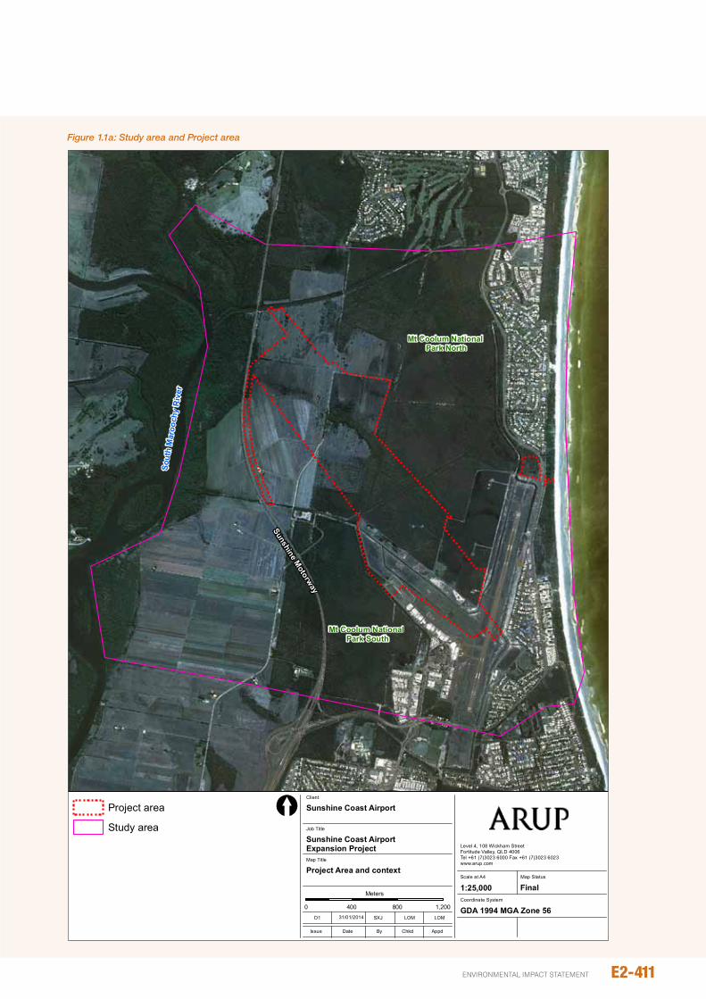
The information and data collected in this study consists of desktop sourced information and maps, as well as detailed field surveys of the study area (refer Figure 1.1a).
1.1.1.1 Desktop studies
The desktop study involved review of Geographic information Systems (GiS) maps and datasets as well as reports and literature relevant to flora values in the study area. This included the following sources:
y Directory of important Wetlands mapping (Australian Department of Environment and Heritage 2005)
y Environment Protection and Biodiversity Conservation Act 1999 (EpBC Act) protected Matters Search Tool for the study area (accessed 27 August 2012)
y CoRVEG and HERBRECS data for the study area (Queensland Herbarium 2012)
y DERM Wildlife online database search (accessed 29th August 2012)
y Atlas of Living Australia (accessed 28th August 2012)
y Aerial photography for several years between 1958 and September 2011 (DnRM 2011)
y other reports and literature, which are cited throughout this chapter.
1.1.1.2 Field surveys
The majority of the field surveys were undertaken in July and August 2012, as well as supplementary spring surveys undertaken in october 2012. The surveys were undertaken to enable:
y Description and mapping of vegetation communities
y Description of the floristic composition, health and structure of vegetation communities
y Detection, mapping and population estimates of threatened flora species, including species with seasonal flowering attributes
y identification of existing threatening processes, such as pest plant infestations, land management practices and hydrological interactions.
The field survey program was designed to collect information on the terrestrial vegetation communities and flora species and to allow mapping, assessment and analysis in accordance with the requirements of the ToR.
1.1.1.3 Main survey
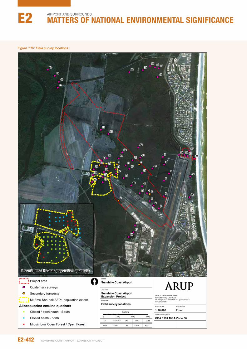
Field surveys were undertaken between 30 July and 3 August 2012, between 8 and 10 october 2012, and on 15 January 2013 for areas directly impacted by, and immediately surrounding, the project area. As part of this, four types of survey were undertaken within the project area. This included:
y Fifty-six quaternary surveys (neldner 2012)
y Seven secondary surveys (neldner 2012)
y Random meander traversing to establish the location and extent of the two known Allocasuarina emuina (Mount Emu She-oak) populations in the study area (see discussion below)
y Fifty-seven systematic density count quadrats undertaken to estimate the population of Mount Emu She-oak (Figure 1.1b).
The study area was traversed by foot to access all survey locations. During the traverse, general notes on the floristic composition, health and condition of the vegetation communities were also taken. Where desktop research revealed there had been previous sightings of threatened or near threatened plant species in the study area these locations were also traversed and thoroughly searched.
y The aim of the systematic quadrats was to sample the population of Mount Emu She-oak to obtain an estimate of total population within the study area. The locations of these quadrats are shown in Figure 1.1b. There are two known populations within the study area (Environmental protection Agency 2007; Lamont 2010). Mount Emu She-oak population Area 1 (AEp1) is west of Runway (RWY) 12/30 whilst Mount Emu She-oak population Area 2 (AEp2) is approximately 1 km north. population extents were determined through a review of literature as well as through survey itself to delineate the edges of the Mount Emu She-oak populations. As only 1 specimen of Mount Emu She-oak was found in AEp2 after it was traversed, no quadrats were undertaken in this area; thus, the 57 quadrats to estimate the population of Mount Emu She-oak were undertaken entirely within AEp1.
y it was observed that different population densities of Mount Emu She-oak occurred in different vegetation types and samples within AEp1 were split into vegetation types to allow comparison (Figure 1.1b). Vegetation communities sampled included:
y 21 quadrats in open to closed heath within the southern section of Lot 857CG4403 and the western section of Lot 699 Sp214349
y 11 quadrats in closed heath within the northern section Lot 857CG4403
y 15 quadrats in low open forest to open forest on Lot 101Cp883235 and the northern section Lot 857CG4403.
E2-410
Airport And SurroundS
Matters of NatIoNaL eNvIroNMeNtaL sIgNIfIcaNceE2
SunSHinE CoASt Airport EXpAnSion proJECt
E2-411environmental impact statement
Job No
225480-00
Coordinate System
Scale at A4
Level 4, 108 Wickham StreetFortitude Valley, QLD 4006Tel +61 (7)3023 6000 Fax +61 (7)3023 6023www.arup.com
© Arup
1:25,000
Map Title
Job Title
Sunshine Coast Airport Expansion Project
Project Area and context
Client
Sunshine Coast Airport
0 400 800 1,200
Meters
©Copyright Information
Issue Date By Appd
D1 SXJ LOM LOM
Chkd
[
Map Status
Final
J:\2
2500
0\22
5480
\Wor
k\R
epor
t\Fig
ures
and
App
endi
ces\
Figu
re_1
.1.1
_Pro
ject
_Are
a.m
xd
GDA 1994 MGA Zone 5631/01/2014
Project area
Study area
Mt Coolum National Park North
Mt Coolum National Park South
Sout
h M
aroo
chy
Riv
er
Sunshine Motorway
Figure No
1.1.1
Figure 1.1a: Study area and Project area
53 4
2
6
1
9
8
7
6
5
4
32
156
55
54
535251
50
49
3536
37 38 39
40
41
42
43
44
45
48
47
46
26
32
29
3128
30
33
34
27
25
22
2423
2120
19
18
17
16
15
14
13
12
1110
Job No
225480-00
Coordinate System
Scale at A4
Level 4, 108 Wickham StreetFortitude Valley, QLD 4006Tel +61 (7)3023 6000 Fax +61 (7)3023 6023www.arup.com
© Arup
1:20,000
Map Title
Job Title
Sunshine Coast Airport Expansion Project
Field survey locations
Client
Sunshine Coast Airport
0 300 600 900
Meters
©Copyright Information
Issue Date By Appd
D1 SXJ LOM LOM
Chkd
[
Map Status
Final
J:\2
2500
0\22
5480
\Wor
k\R
epor
t\Fig
ures
and
App
endi
ces\
Figu
re_1
.1.4
_Sur
veys
.mxd
GDA 1994 MGA Zone 5631/01/2014
Project area
Quaternary surveys
Secondary transects
Mt Emu She-oak AEP1 population extent
Allocasuarina emuina quadrats" Closed / open heath - South
" Closed heath - north
" M.quin Low Open Forest / Open ForestFigure No
1.1.4
" " " " "
" " " " " "
"
"
"
"
"
"
""
"
"
"""
" " "
"
"
"
" " "
"
"
"
"
" "
"
""
"
"
"
"
"
"
"
"
"
"
"
""
"
"
Mount Emu She-oak population quadrats
Figure 1.1b: Field survey locations
E2-412
Airport And SurroundS
Matters of NatIoNaL eNvIroNMeNtaL sIgNIfIcaNceE2
SunSHinE CoASt Airport EXpAnSion proJECt
E2-413environmental impact statement
Quadrats of 10 m x 10 m were equally spaced with the use of a 50 m x 50 m grid overlayed on aerial photography of the project area.
one quadrat was positioned within the centre of each grid square, except where areas could not be accessed due to dense ground cover or the existence other physical barriers such as drainage lines. in each quadrat, two ecologists counted the number of individual Mount Emu She-oak plants present. To allow efficient and effective field identification and detectability, surveys were undertaken during the time the species is known to be in flower.
Analysis was then carried out to estimate the population density of Mount Emu She-oak in each of the vegetation types and this was then used to estimate the population within AEp1. An analysis of variance (AnoVA) was also undertaken to confirm whether or not the mean population density was significantly different between vegetation types.
1.1.1.4 Supplementary spring surveys
Spring surveys were undertaken on 8 to 10 and 23 october 2012. These were undertaken in order to meet the requirements of the ToR survey guidelines as seasonal surveys are required to adequately account for vegetation growth patterns, life-cycles and detectability. Specifically, this survey is required to meet the ToR and relevant survey guidelines for Phaius australis (Lesser Swamp orchid) and Prasophyllum wallum (Swamp Leek) as this corresponds with the flowering period for these species. The ToR notes that ecological surveys following a wet season may be required to detect the full range of species and ecosystem conditions. The intention for seasonal surveys in the project area is to increase the chance of detection and identification for significant flora species during flowering periods. As these species flower during the spring months (September-november) the seasonal surveys were focused during this time of the year and not following the wet season (i.e. post-February). Due to the habitat requirements of these species, surveys were targeted in areas of paperbark forest/wetland and closed/wet heathland.
1.1.1.5 Vegetation mapping
Analysis of high resolution aerial photography, Queensland Government mapping, the secondary and quaternary survey data and the general notes undertaken throughout the study area were used to define and map vegetation communities within the study area. This was undertaken using GiS software to produce a thematic map displaying the different vegetation communities across the study area.
using a combination of quaternary and secondary surveys, the vegetation communities within the study area were mapped at a scale of 1:5,000 (63 samples within approximately 185 ha).
1.1.1.6 Assumptions and technical limitations
The Wildlife online database, HERBRECS data and EpBC Act protected Matters Search Tool (pMST) have been used to aid in the identification of flora in the study area.
A limitation of the Wildlife online and HERBRECS databases is that the search results show plant species that have been directly observed or collected. it does not show all plant species that exist within the search area. The databases are not based on predictive distribution modelling or habitat suitability of an area. For this reason, there is potential that significant species could exist within an area but have not been included within the databases.
The pMST utilises predictive modelling of the distribution of threatened species based on historical observations, and each species habitat requirements and known ranges. The tool does not rely on recent observation and may be subject to an amount of error due to the specific on-ground features at a site. The species within the results of the pMST may not actually exist within the search area.
Due to limitations associated with all field sampling there is potential for threatened species to exist within the study area that have not been identified within past or current surveys or other information used as part of this study. There is also potential that threatened flora species may establish between time of writing and construction commencement.
1.2 pOLICy CONTExT ANd LEGISLATIvE FRAMEwORk
1.2.1 Environment Protection and Biodiversity Conservation Act 1999
The Environment Protection and Biodiversity Conservation Act 1999 (EpBC Act) provides for the regulation of the environmental impacts of development at a Commonwealth level. The act regulates any proposed action that has, will have or is likely to have a significant impact on any matter of national environmental significance.
The project was referred to the Australian Government Department of Environment (DoE) on 31 January 2011. The Commonwealth Government subsequently designated the project a controlled action to be assessed via an EiS due to the potential impact of the project on wetlands of international importance (see this chapter Marine Ecology discussion), listed threatened species and communities, and listed migratory species (see this chapter Terrestrial Fauna discussion).
of these matters, only threatened flora species and ecological communities are relevant to this chapter. The impact to wetlands of international significance refers to the dredging of Moreton Bay, which will not affect terrestrial flora values. in addition, the impact upon migratory species refers to fauna species only and is also outside the scope of this section.
1.2.2 EpBC Act Environmental Offsets policy
This offsets policy must be addressed when proposing offsets to compensate for residual adverse impacts on matters of national environmental significance. The policy outlines when offsets are required, the minimum acceptable offset to achieve a conservation outcome, appropriate delivery mechanisms (direct or indirect) and require long-term protection.
under the EpBC Act Environmental offsets policy, it first must be demonstrated that impacts to matters of national environmental significance are avoided and mitigated as far as is practicable. Any residual significant impacts after all avoidance and mitigation measures have been applied, can be compensated with an offset. The offset must be a direct, land based requirement, providing for a long term and permanent net gain for the feature that is impacted. The policy requires over 90 per cent of the residual impact to be delivered in this way. Additional indirect measures, such as contribution to research, may be proposed to make up the gap if required.
To assist in determining the quantum of impact that an offset proposal covers, the Australian Government has compiled an offset Assessment Guide, which is a tool that includes an impact and offset calculator. This tool takes into account the quantum of impact, the proposed offset, the timeframe over which the offset is delivered and a level of confidence score. A detailed offset proposal must refer to the offset Assessment Guide, and provide detail on how the offset can adequately compensate and improve the feature that is impacted.
All offsets must also demonstrate how the offset area will be protected in perpetuity, such as changes in land tenure, application of conservation agreements or transfer into a State reserve system. A direct, land based offset will also require a maintenance and monitoring plan for a suitable length of time to ensure the offset is delivered and is self-sustaining.
Any offset that proposes the translocation of a threatened species must also consider the EpBC Act policy Statement - Translocation of Listed Threatened Species. Translocation for flora species or vegetation communities can include a variety of methods, including seed collection, propagation and revegetation or movement of whole plants or vegetation communities (Vallee et al 2004). The policy statement provides a formal position that must be adopted by both the proponent when proposing a translocation and assessed by DoE officers when making a decision or recommendation regarding a translocation proposal.
For a translocation proposal to mitigate or offset an impact there must be clear evidence that the approach will be successful, risk of failure must be considered as well as any other impacts or risks as a result of the translocation.
1.3 ExISTING CONdITIONS
This section describes the vegetation communities of the project area and outlines the value at a local, regional, state and national level. The significance of the vegetation communities for supporting rare flora species is presented, with a description of the vegetation assemblages that are likely or known to support these species. Where applicable, reference is made to previous studies and scientific literature that describes the ecology of the vegetation communities and flora species of the project area.
1.3.1 Landscape context
The project area is within the coastal zone of South East Queensland (SEQ), which is one of the most biologically diverse areas in Australia, but also one of the fastest developing zones for urban and peri-urban development. Throughout this region, existing pressures on flora have originated mainly from extensive land clearing in the region, with 65 per cent of the native vegetation being cleared or modified since European settlement (national Wildlife Corridors plan Advisory Group 2012). As part of this, over 90 per cent of coastal heath has been cleared, with the remaining areas outside of national parks highly threatened from development (Leiper et al 2008).
The dominant factors influencing flora within the SEQ coastal zone are geography, geology and soils. The project area sits predominantly on a large pleistocene coastal plain of sand and mud. To the south-west of the project area, there is also an area of Holocene tidal flats associated with the Maroochy River.
Within and adjacent to the project area vegetation clearing has occurred since European settlement to facilitate agriculture and urban development. Aerial photographs obtained for the period between 1958 and 2011 show the expansion of sugar cane cropping to the west of the project area, whilst urban development has established to the south and east of the project area. over time these land use changes have replaced areas of melaleuca wetland, mixed open forest, heathland and marine clay pan woodlands (DERM 2006). Large areas of contiguous remnant vegetation still exist along the Maroochy River as well as north and south of the airport.
A large part of this vegetation has been conserved within the Mount Coolum national park (Figure 1.3a). The Mount Coolum section of the national park was gazetted in 1990, with the two sections at Marcoola to the north and south of the project area added at a later date. The park provides for the conservation of cultural, recreational, educational and economic values associated with the plants and plant communities that are present. The park protects 50 per cent of vascular plant species recorded for the Sunshine Coast area and represents approximately 40 per cent of the fern species found globally (EpA, no date; Queensland Department of Environment 1998).
E2-414
Airport And SurroundS
Matters of NatIoNaL eNvIroNMeNtaL sIgNIfIcaNceE2
SunSHinE CoASt Airport EXpAnSion proJECt
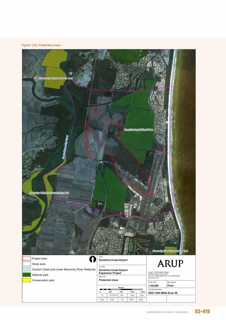
Mount Coolum National Park
Coolum Creek Conservation Park
Maroochy Wetlands Conservation Park
Maroochy River Conservation Park
Job No
225480-00
Coordinate System
Scale at A4
Level 4, 108 Wickham StreetFortitude Valley, QLD 4006Tel +61 (7)3023 6000 Fax +61 (7)3023 6023www.arup.com
© Arup
1:30,000
Map Title
Job Title
Sunshine Coast Airport Expansion Project
Protected areas
Client
Sunshine Coast Airport
0 350 700 1,050 1,400
Meters
©Copyright Information
Issue Date By Appd
D1 SXJ LOM LOM
Chkd
[
Map Status
Final
J:\2
2500
0\22
5480
\Wor
k\R
epor
t\Fig
ures
and
App
endi
ces\
Figu
re_2
.1b_
Pro
tect
ed A
reas
.mxd
GDA 1994 MGA Zone 5631/01/2014
Project area
Study area
Coolum Creek and Lower Maroochy River Wetlands
National park
Conservation park
Sout
h M
aroo
chy
Riv
er
Figure No
2.1b
Figure 1.3a: Protected areas
E2-415environmental impact statement
The park provides for the conservation of for several threatened flora species, including Allocasuarina thalassoscopia (Mt Coolum She oak), Mount Emu She-oak and Bertya sharpeana (Mt Coolum Bertya), amongst others (EpA, no date). Flora in the Marcoola sections includes paperbark open forest to woodland, Banksia aemula (Wallum Banksia) woodland and open heathland (DERM 2011).
The Marcoola sections of the national park also form part of Coolum Creek and Lower Maroochy River Wetlands, which are listed as nationally important wetlands. The wetlands are made up of several mapped areas (as shown as on Figure 1.3a), and includes low coastal marshes, swamps, estuary and sub-coastal tributaries approximately 32km in length and more than 15 km inland in the Eudlo Creek system (Department of Sustainability, Environment, Water, population and Communities (SEWpAC 2010)).
The wetlands are significant for their high value to wildlife and ecosystems, the provision of habitat for threatened flora as well as the very high cultural significance for education and recreational purposes (SEWpC 2010).
in the south and west of the study area, Maroochy River Conservation park and Maroochy Wetlands Conservation park also part of the Lower Maroochy River Wetlands. Maroochy River Conservation park is approximately covers 174 ha and includes areas of paper-bark tea tree swamp and tall open forest comprised of Corymbia intermedia (pink Bloodwood) and Lophostemon confertus (Brush Box). A mixture of dry heath and rainforest species are found throughout the understorey of both forest types (Queensland parks and Wildlife Service1999).
Maroochy Wetlands Conservation park covers 66 ha and comprises mainly saltpan vegetation, including grassland and herbland on marine clay plains (DERM 2011).
Coolum Creek Conservation park (342 ha) also exists in the north-east of the study area. Similar to Maroochy Wetlands Conservation park, the park comprises mainly saltpan vegetation.
Areas of native remnant vegetation in the project area are directly connected with both the northern and southern sections of the Marcoola precincts of Mount Coolum national park. Ecological connectivity to Coolum Creek Conservation park as well as Maroochy Wetlands Conservation park in the west is currently severed by the Sunshine Motorway and vast tracts of cropping land.
in the south, the Maroochy River Conservation park is also severed from intact vegetation communities in the project area by airport infrastructure and urban development. Due to the different dispersal methods of plants within the study area, the degree of severance across the study area will vary. Some plants that have wide dispersal methods (e.g. via birds, bats or insects that fly long distances) are able to disperse seeds over wide areas and across land barriers, whilst others do not cross large distances during a single dispersal event and will be generally limited by the waterways, channels and urban development across the study area.
1.3.2 Matters of national environmental significance
1.3.2.1 Threatened ecological communities
The EpBC Act protected Matters Search Tool (pMST) results also show that the critically endangered Lowland Rainforest of Subtropical Australia Threatened Ecological Community (TEC) may occur within the study area.
A review of the RE mapping and the results of the field survey indicate that this TEC is not present within the project area, or within the wider study area. no other TECs were been identified from desktop studies or from the field surveys.
1.3.2.2 Threatened flora species
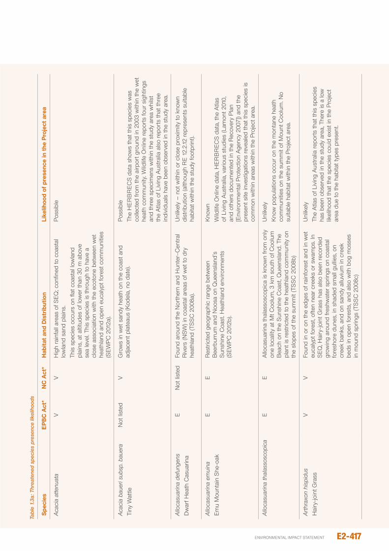
The pMST identified 19 EpBC Act listed threatened plant species that may exist within or adjacent to the project area. However, as the tool utilises predictive modelling, and does not rely on recent observations it may be subject to an amount of error due to the specific on-ground features at a site. Table 1.3a assesses the likelihood of each of these species being present in the project area and Figure 1.3b maps habitat suitability for EpBC Act threatened flora. This mapping has been prepared in accordance with the requirements of part C, Section 2.3 of the ToR.
The Wildlife online database and Queensland Herbarium HERBRECS data show four EpBC Act listed threatened flora species have been previously recorded within the study area. These are Mount Emu She-oak, Allocasuarina thalassoscopica (Mount Coolum She-oak), Phaius australis (Lesser Swamp-orchid) and Eucalyptus conglomerata (Swamp Stringybark).
During the targeted and systematic field surveys carried out across the project area, only a single threatened species – Mount Emu She-oak – was directly observed. Further detail on the Mount Emu She-oak population within the project area is provided in Section 1.3.3.
There are currently no known populations of other EpBC Act listed threatened flora species within the project area, however the presence of suitable habitat means that plants may establish or may be present at very low numbers to avoid detection. All other flora species identified in database and desktop searches are not considered likely to be able to establish within the project area due to an absence of required habitat characteristics.
E2-416
Airport And SurroundS
Matters of NatIoNaL eNvIroNMeNtaL sIgNIfIcaNceE2
SunSHinE CoASt Airport EXpAnSion proJECt
E2-417environmental impact statement
Tabl
e 1.
3a: T
hrea
tene
d sp
ecie
s pr
esen
ce li
kelih
oods
Spe
cies
Ep
BC
Act
*N
C A
ct*
hab
itat
and
dis
trib
utio
nLi
kelih
ood
of p
rese
nce
in t
he p
roje
ct a
rea
Aca
cia
atte
nuat
aV
VH
igh
rain
fall
area
s of
SE
Q; c
onfin
ed to
coa
stal
lo
wla
nd s
and
plai
ns.
This
spe
cies
occ
urs
on fl
at c
oast
al lo
wla
nd
plai
ns, a
t alti
tude
s of
low
er th
an 3
0 m
abo
ve
sea
leve
l. Th
is s
peci
es is
thro
ugh
to h
ave
a cl
ose
asso
ciat
ion
with
the
ecot
one
betw
een
wet
he
athl
and
and
open
euc
alyp
t for
est c
omm
uniti
es
(SE
Wp
C 2
012a
).
pos
sibl
e
Aca
cia
baue
ri su
bsp.
bau
era
Tiny
Wat
tlen
ot li
sted
VG
row
s in
wet
san
dy h
eath
on
the
coas
t and
ad
jace
nt p
late
aus
(Kod
ela,
no
date
).p
ossi
ble
The
HE
RB
RE
CS
dat
a sh
ows
that
this
spe
cies
was
co
llect
ed fr
om th
e ai
rpor
t gro
und
in 2
003
with
in th
e w
et
heat
h co
mm
unity
. Wild
life
onl
ine
repo
rts
four
sig
htin
gs
and
thre
e sp
ecim
ens
with
in th
e st
udy
area
whi
lst
the
Atla
s of
Liv
ing
Aus
tral
ia a
lso
repo
rts
that
thre
e in
divi
dual
s ha
ve b
een
obse
rved
in th
e st
udy
area
.
Allo
casu
arin
a de
fung
ens
Dw
arf H
eath
Cas
uarin
aE
not
list
edFo
und
arou
nd th
e n
orth
ern
and
Hun
ter−
Cen
tral
R
iver
s (n
SW
) in
coas
tal a
reas
of w
et to
dry
he
athl
and
(TS
SC
200
8a).
unl
ikel
y –
not
with
in o
r cl
ose
prox
imity
to k
now
n di
strib
utio
n (a
lthou
gh R
E 12
.2.12
rep
rese
nts
suita
ble
habi
tat w
ithin
the
stud
y fo
otpr
int).
Allo
casu
arin
a em
uina
Emu
Mou
ntai
n S
he-o
akE
ER
estr
icte
d ge
ogra
phic
ran
ge b
etw
een
Bee
rbur
rum
and
noo
sa o
n Q
ueen
slan
d's
Sun
shin
e C
oast
. Hea
thla
nd e
nviro
nmen
ts
(SE
Wp
C 2
012b
).
Kno
wn
Wild
life
onl
ine
data
, HE
RB
RE
CS
dat
a, th
e A
tlas
of L
ivin
g A
ustr
alia
, var
ious
stu
dies
(Lam
ont 2
010,
an
d ot
hers
doc
umen
ted
in th
e R
ecov
ery
pla
n [E
nviro
nmen
tal p
rote
ctio
n A
genc
y 20
07])
and
the
pres
ent s
ite in
vest
igat
ions
rev
eale
d th
at th
is s
peci
es is
co
mm
on w
ithin
are
as w
ithin
the
pro
ject
are
a.
Allo
casu
arin
a th
alas
sosc
opic
aE
EA
lloca
suar
ina
thal
asso
scop
ica
is k
now
n fro
m o
nly
one
loca
lity
at M
t Coo
lum
, 3 k
m s
outh
of C
oolu
m
Bea
ch o
n th
e S
unsh
ine
Coa
st, Q
ueen
slan
d. T
he
plan
t is
rest
ricte
d to
the
heat
hlan
d co
mm
unity
on
the
slop
es o
f the
sum
mit
(TS
SC
200
8b)
unl
ikel
yK
now
pop
ulat
ions
occ
ur o
n th
e m
onta
ne h
eath
co
mm
uniti
es o
n th
e su
mm
it of
Mou
nt C
oolu
m. n
o su
itabl
e ha
bita
t with
in th
e p
roje
ct a
rea.
Arth
raxo
n hi
spid
usH
airy
-join
t Gra
ssV
VFo
und
in o
r on
the
edge
s of
rai
nfor
est a
nd in
wet
eu
caly
pt fo
rest
, ofte
n ne
ar c
reek
s or
sw
amps
. in
SE
Q, H
airy
-join
t Gra
ss h
as a
lso
been
rec
orde
d gr
owin
g ar
ound
fres
hwat
er s
prin
gs o
n co
asta
l fo
resh
ore
dune
s, in
sha
ded
smal
l gul
lies,
on
cree
k ba
nks,
and
on
sand
y al
luvi
um in
cre
ek
beds
in o
pen
fore
sts,
and
als
o w
ith b
og m
osse
s in
mou
nd s
prin
gs (T
SS
C 2
008c
)
unl
ikel
yTh
e A
tlas
of L
ivin
g A
ustr
alia
rep
orts
that
this
spe
cies
ha
s be
en o
bser
ved
in th
e st
udy
area
, The
re is
a lo
w
likel
ihoo
d th
at th
e sp
ecie
s co
uld
exis
t in
the
pro
ject
ar
ea d
ue to
the
habi
tat t
ypes
pre
sent
.
Spe
cies
Ep
BC
Act
*N
C A
ct*
hab
itat
and
dis
trib
utio
nLi
kelih
ood
of p
rese
nce
in t
he p
roje
ct a
rea
Bal
oghi
a m
arm
orat
aM
arbl
ed B
alog
ia, J
oint
ed
Bal
oghi
a
VV
Mar
bled
Bal
ogia
has
a g
eogr
aphi
cally
dis
junc
t di
strib
utio
n co
nfine
d to
the
Lism
ore
dist
rict,
in
nort
h-ea
st n
SW
, and
the
Tam
borin
e M
ount
ains
an
d S
prin
gbro
ok, i
n S
EQ
. M
arbl
ed B
alog
ia is
foun
d in
sub
trop
ical
ra
info
rest
/ no
toph
yll v
ine
fore
st a
nd w
et
scle
roph
yll f
ores
t (br
ush
box
woo
dlan
d) w
ith
rain
fore
st u
nder
stor
ey b
etw
een
150
and
550
m
abov
e se
a le
vel (
TSS
C 2
008d
).
unl
ikel
y du
e to
geo
grap
hica
l ran
ge.
Ber
tya
shar
pean
aM
t Coo
lum
ber
tya
not
Lis
ted
nT
Foun
d on
the
stee
p cl
iffs
of M
t Coo
lum
. inh
abits
m
onta
ne h
eath
(Lei
per
et a
l 200
8).
unl
ikel
y K
now
pop
ulat
ions
occ
ur o
n th
e m
onta
ne h
eath
co
mm
uniti
es o
n th
e su
mm
it of
Mou
nt C
oolu
m. n
o su
itabl
e ha
bita
t with
in th
e p
roje
ct a
rea.
Bos
isto
a se
lwyn
iiH
eart
-leav
ed B
osis
toa
Bos
isto
a tra
nsve
rsa
Thre
e-le
aved
Bos
isto
a
Vn
ot li
sted
Thre
e-le
aved
Bos
isto
a is
kno
wn
from
the
Ric
hmon
d R
iver
, nS
W, t
o M
t Lar
com
nea
r G
lads
tone
, Que
ensl
and
Bos
isto
as g
row
in w
et
scle
roph
yll f
ores
t, dr
y sc
lero
phyl
l for
est a
nd
rain
fore
st u
p to
300
m in
alti
tude
(TS
SC
200
8e).
Thes
e sp
ecie
s ha
d be
en s
epar
ated
out
as
sepa
rate
spe
cies
, but
the
dist
inct
ion
betw
een
the
taxa
can
not b
e m
aint
aine
d (R
icha
rds,
no
date
).
unl
ikel
y n
o su
itabl
e ha
bita
t with
in th
e p
roje
ct a
rea
Bul
boph
yllu
m g
lobu
lifor
me
Min
iatu
re M
oss-
orch
idV
nT
Min
iatu
re M
oss-
orch
id o
ccur
s in
the
Mcp
hers
on
Ran
ge o
f nor
th-e
ast n
SW
and
SE
Q; i
n th
e M
alen
y an
d n
oosa
are
as o
f the
Wid
e B
ay d
istr
ict
of Q
ueen
slan
d an
d in
the
Cal
liope
Ran
ge in
land
fro
m G
lads
tone
, Que
ensl
and.
Th
e sp
ecie
s gr
ows
only
on
Hoo
p p
ines
(Ara
ucar
ia
cunn
ingh
amii)
, col
onis
ing
the
uppe
r br
anch
es o
f m
atur
e tr
ees
in u
plan
d ra
info
rest
(TS
SC
200
8f)
unl
ikel
y
Cry
ptoc
arya
foet
ida
Stin
king
Cry
ptoc
arya
, S
tinki
ng L
aure
l
VV
Stin
king
Cry
ptoc
arya
is k
now
n fro
m il
uka,
nS
W,
to F
rase
r is
land
and
eas
t of G
ympi
e, s
outh
ern
Que
ensl
and.
Stin
king
Cry
ptoc
arya
gro
ws
in li
ttora
l ra
info
rest
, usu
ally
on
sand
y so
ils, w
ith m
atur
e tr
ees
also
gro
win
g on
bas
alt s
oils
(TS
SC
200
8g).
unl
ikel
y n
o su
itabl
e ha
bita
t with
in th
e p
roje
ct a
rea.
Dur
ringt
onia
pal
udos
aD
urrin
gton
ian
ot li
sted
nT
Gro
ws
in c
lose
d se
dgel
and
com
mun
ities
in
coas
tal s
wam
ps a
nd w
et h
eath
(Jam
es, n
o da
te;
Leip
er e
t al 2
008)
.
pos
sibl
eS
uita
ble
habi
tat w
ithin
the
sedg
elan
d an
d w
et
heat
h ar
eas.
E2-418
Airport And SurroundS
Matters of NatIoNaL eNvIroNMeNtaL sIgNIfIcaNceE2
SunSHinE CoASt Airport EXpAnSion proJECt
E2-419environmental impact statement
Spe
cies
Ep
BC
Act
*N
C A
ct*
hab
itat
and
dis
trib
utio
nLi
kelih
ood
of p
rese
nce
in t
he p
roje
ct a
rea
Euca
lypt
us c
ongl
omer
ata
Sw
amp
Str
ingy
bark
EE
Sw
amp
Str
ingy
bark
is k
now
n fro
m 1
0 lo
catio
ns a
nd
22 p
opul
atio
ns b
etw
een
Kin
Kin
and
Bee
rwah
in
sout
hern
Que
ensl
and.
The
spec
ies
typi
cally
gro
ws
on th
e m
argi
n be
twee
n op
en fo
rest
and
hea
thla
nd, o
n de
ep s
andy
aci
dic
soils
(T
SS
C 2
008h
).
pos
sibl
eTh
is s
peci
es is
kno
wn
from
Wild
life
onl
ine,
HE
RB
RE
CS
da
ta a
nd th
e A
tlas
of L
ivin
g A
ustr
alia
. The
HE
RB
RE
CS
da
ta r
epor
ts th
at tw
o in
divi
dual
s w
ere
obse
rved
1 k
m
nort
h of
Mar
cool
a (o
utsi
de o
f pro
ject
are
a) in
199
0.
The
repo
rted
loca
tions
of t
hese
tree
s ar
e lie
with
in a
n ar
ea o
f res
iden
tial d
evel
opm
ent (
Sea
side
Bou
leva
rd)
built
in th
e m
id 1
990’
s, a
nd a
re th
eref
ore
unlik
ely
to s
till
be p
rese
nt.
Lept
ospe
rmum
ore
ophi
lum
Vn
ot li
sted
Foun
d on
roc
ky s
lope
s of
the
Gla
ss H
ouse
M
ount
ains
and
Mt C
oolu
m. i
nhab
its m
onta
ne
heat
h (L
eipe
r et
al 2
008)
.
unl
ikel
yTh
is s
peci
es w
as id
entifi
ed a
s pa
rt o
f the
Wild
life
onl
ine
sear
ch r
esul
ts. D
ue to
its
know
n di
strib
utio
n, it
’s li
kely
th
is w
as r
ecor
ded
on M
t Coo
lum
. it i
s un
likel
y to
be
with
in th
e p
roje
ct a
rea.
Mac
adam
ia te
rnifo
liaS
mal
l-fru
ited
Que
ensl
and
nut
, Gym
pie
nut
VV
Sm
all-f
ruite
d Q
ueen
slan
d n
ut is
end
emic
to
Que
ensl
and.
His
toric
ally
, thi
s sp
ecie
s oc
curr
ed fr
om
near
Gym
pie
to B
risba
ne, h
owev
er, t
he s
peci
es is
now
re
stric
ted
to a
n ar
ea b
etw
een
Mt p
inba
rren
sou
th to
M
ary
Cai
rncr
oss
par
k, n
ear
Mal
eny.
Sm
all-f
ruite
d Q
ueen
slan
d n
ut h
as a
spe
cial
ised
ha
bita
t req
uire
men
t, an
d th
e sp
ecie
s ge
nera
lly o
ccur
s in
fert
ile, b
asal
t-de
rived
soi
ls o
n st
eep
sout
hern
sl
opes
(TS
SC
, 200
8i)
unl
ikel
y.n
o su
itabl
e ha
bita
t with
in th
e p
roje
ct a
rea
Pha
ius
aust
ralis
Less
er S
wam
p-or
chid
EE
The
Less
er S
wam
p-or
chid
is e
ndem
ic to
Aus
tral
ia
and
occu
rs in
sou
ther
n Q
ueen
slan
d an
d no
rthe
rn
nS
W. T
he L
esse
r S
wam
p-or
chid
is c
omm
only
as
soci
ated
with
coa
stal
wet
hea
th/s
edge
land
w
etla
nds,
sw
ampy
gra
ssla
nd o
r sw
ampy
fore
st a
nd
ofte
n w
here
Bro
ad-le
aved
pap
erba
rk o
r S
wam
p M
ahog
any
are
foun
d (S
EW
pC
201
2c).
pos
sibl
eS
uita
ble
habi
tat w
ithin
wet
ter
area
s of
the
Bro
ad-le
aved
p
aper
bark
fore
st a
nd s
edge
land
with
a s
hade
d ca
nopy
ov
erst
orey
.
Phe
baliu
m d
ista
nsM
t Ber
rym
an p
heba
lium
CE
ETh
e M
t. B
erry
man
phe
baliu
m is
kno
wn
from
ten
popu
latio
ns in
SE
Q, w
here
it is
end
emic
. Fiv
e of
thes
e ar
e in
clo
se p
roxi
mity
to o
ne a
noth
er a
t Mt B
erry
man
(L
ocky
er V
alle
y R
egio
nal C
ounc
il). F
our
are
at M
t Jo
nes
pla
teau
, nea
r K
inga
roy
(Sou
th B
urne
tt R
egio
nal
Cou
ncil)
, and
the
tent
h at
Mt W
alla
, nea
r C
oals
toun
La
kes
(nor
th B
urne
tt R
egio
nal C
ounc
il). i
t is
alw
ays
foun
d in
sem
i-eve
rgre
en v
ine
thic
ket o
n re
d vo
lcan
ic
soils
or
com
mun
ities
adj
acen
t to
this
veg
etat
ion
type
(T
SS
C 2
008j
).
unl
ikel
yo
utsi
de o
f kno
wn
popu
latio
n ra
nge
and
no s
uita
ble
habi
tat p
rese
nt w
ithin
the
pro
ject
are
a.
Spe
cies
Ep
BC
Act
*N
C A
ct*
hab
itat
and
dis
trib
utio
nLi
kelih
ood
of p
rese
nce
in t
he p
roje
ct a
rea
Ple
ctra
nthu
s to
rren
ticol
aE
EP
lect
rant
hus
torr
entic
ola
is k
now
n fro
m e
ight
loca
tions
in
the
Sun
shin
e C
oast
hin
terla
nd o
f SE
Q, f
rom
the
Bla
ckal
l Ran
ge (s
outh
of n
ambo
ur) t
o K
in K
in (b
etw
een
Gym
pie
and
noo
sa.
The
plan
t gro
ws
in o
pen
heat
hlan
d on
roc
k ou
tcro
ps,
or in
dap
pled
sha
de u
nder
euc
alyp
t ope
n fo
rest
clo
se
to m
argi
ns o
f rai
nfor
est a
nd o
ften
alon
g cr
eek
lines
, at
altit
udes
of 2
50–
450
m (S
EW
pC
201
2d).
unl
ikel
yn
o su
itabl
e ha
bita
t with
in th
e p
roje
ct a
rea.
Pras
ophy
llum
wal
lum
VV
Pras
ophy
llum
wal
lum
occ
urs
in S
EQ
, in
wal
lum
co
mm
uniti
es a
nd a
djac
ent s
tabi
lised
dun
es a
nd c
oast
al
Mel
aleu
ca s
wam
p w
etla
nds.
The
pla
nt is
res
erve
d in
C
oolu
m E
nviro
nmen
tal p
ark
(TS
SC
200
8k).
pos
sibl
e S
uita
ble
habi
tat w
ithin
clo
sed
and/
or w
et
heat
hlan
d ha
bita
ts.
Sch
oenu
s sc
abrip
esn
ot li
sted
nT
Gro
ws
in w
et h
eath
in s
andy
soi
ls (W
ilson
200
5).
pos
sibl
eTh
e W
ildlif
e o
nlin
e an
d A
tlas
of L
ivin
g A
ustr
alia
n se
arch
re
sults
sho
w th
at th
is p
lant
has
bee
n re
cord
ed w
ithin
th
e st
udy
area
. The
HE
RB
RE
CS
dat
a sh
ows
that
th
e sp
ecie
s w
as r
ecor
ded
with
in th
e ai
rpor
t gro
unds
in
200
3. S
uita
ble
habi
tat w
ithin
sed
gela
nd a
nd w
et
heat
h ar
eas.
Stre
blus
pen
dulin
usS
iah’
s B
ackb
one,
Sia
’s
Bac
kbon
e, is
aac
Woo
d
En
ot li
sted
on
the
Aus
tral
ian
mai
nlan
d, S
iah’
s B
ackb
one
is fo
und
in w
arm
er r
ainf
ores
ts, c
hiefl
y al
ong
wat
erco
urse
s.
The
altit
udin
al r
ange
is fr
om n
ear
sea
leve
l to
800
m
abov
e se
a le
vel.
The
spec
ies
grow
s in
wel
l-dev
elop
ed
rain
fore
st, g
alle
ry fo
rest
and
drie
r, m
ore
seas
onal
ra
info
rest
(SE
Wp
C 2
012e
).
unl
ikel
y n
o su
itabl
e ha
bita
t pre
sent
with
in th
e p
roje
ct a
rea.
Taen
ioph
yllu
m m
uelle
riM
inut
e o
rchi
d, R
ibbo
n-ro
ot o
rchi
d
Vn
ot li
sted
Gro
ws
on o
uter
bra
nche
s an
d br
anch
lets
of r
ainf
ores
t tr
ees;
coa
st a
nd c
oast
al r
ange
s, fr
om s
ea le
vel t
o 25
0 m
alt
(Wes
ton,
no
date
).
unl
ikel
yn
o su
itabl
e ha
bita
t with
in th
e p
roje
ct a
rea.
Triu
nia
robu
sta
EE
Triu
nia
robu
sta
is r
estr
icte
d to
a s
mal
l are
a on
Q
ueen
slan
d’s
Sun
shin
e C
oast
, bet
wee
n p
omon
a an
d W
oom
bye,
mai
nly
in th
e M
aroo
chy
Riv
er c
atch
men
t ar
ea c
over
ing
a ra
nge
of a
ppro
xim
atel
y 40
km
.Th
e ph
ysic
al c
hara
cter
istic
s an
d ve
geta
tion
type
acr
oss
know
n si
tes
of T
riuni
a ro
bust
a va
ry s
ubst
antia
lly. T
he
mai
n ha
bita
t is
noto
phyl
l vin
e fo
rest
, or
mix
ed ta
ll op
en fo
rest
dev
elop
ing
a ra
info
rest
und
erst
orey
in th
e ab
senc
e of
fire
(TS
SC
200
8l).
unl
ikel
yTh
e A
tlas
of L
ivin
g A
ustr
alia
sho
w th
at th
is s
peci
es h
as
been
rec
orde
d in
the
stud
y ar
ea; h
owev
er, t
he a
ccur
acy
of th
e co
ordi
nate
poi
nt is
26
km, a
nd th
eref
ore
this
ob
serv
atio
n m
ay n
ot h
ave
been
in th
e st
udy
area
. it
may
exi
st w
ithin
the
smal
l rai
nfor
est p
atch
es in
stu
dy
area
and
is u
nlik
ely
to e
xist
in p
roje
ct a
rea.
*EP
BC
Act
: Rep
rese
nts
the
spec
ies
listin
g un
der
the
EPB
C A
ct. C
E =
Crit
ical
ly E
ndan
gere
d; E
= E
ndan
gere
d; V
= V
ulne
rabl
e;
±N
C A
ct: R
epre
sent
s th
e sp
ecie
s lis
ting
unde
r th
e N
C A
ct. E
= E
ndan
gere
d; V
= V
ulne
rabl
e; a
nd N
T =
Nea
r Th
reat
ened
.^
Like
lihoo
d of
occ
urre
nce:
Unl
ikel
y: n
o re
cent
obs
erva
tions
and
/or
no s
uita
ble
habi
tat p
rese
nt; P
ossi
ble:
rec
ent o
bser
vatio
ns a
nd/o
r su
itabl
e ha
bita
t pre
sent
; Kno
wn:
dire
ctly
obs
erve
d on
the
site
E2-420
Airport And SurroundS
Matters of NatIoNaL eNvIroNMeNtaL sIgNIfIcaNceE2
SunSHinE CoASt Airport EXpAnSion proJECt
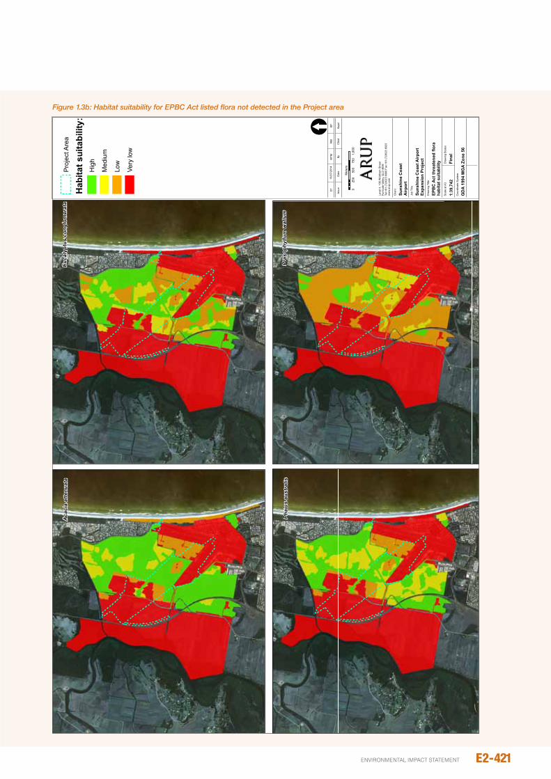
E2-421environmental impact statement
J:\225000\225480\Work\Report\Figures and Appendices\Figure_2.5.2_Flora_habitat_suitability.mxd
© A
rup
Leve
l 4, 1
08 W
ickh
am S
treet
Forti
tude
Val
ley,
QLD
400
6Te
l +61
(7)3
023
6000
Fax
+61
(7)3
023
6023
ww
w.ar
up.c
om
©C
opyr
ight
Info
rmat
ion
Job
No
2224
31-0
0Fi
gure
No
2.5.
2
Coo
rdin
ate
Sys
tem
GD
A 19
94 M
GA
Zone
56
Scal
e at
A3
Dra
win
g S
tatu
s
Fina
l
Dra
win
g Ti
tle
Job
Title
Suns
hine
Coa
st A
irpor
tEx
pans
ion
Proj
ect
EPB
C A
ct th
reat
ened
flor
aha
bita
t sui
tabi
lity
Clie
nt
Suns
hine
Coa
st
Airp
ort
Issu
eD
ate
ByAp
pd
D1
MTM
RM
EP
Chk
d
16/0
7/20
14
Aca
cia
atte
nuat
aEu
caly
ptus
con
glom
erat
a
Phai
us a
ustr
alis
Pras
ophy
llum
wal
lum
1:39
,742
[
025
050
075
01,
000
Met
ers
Proj
ect A
rea
Hab
itat s
uita
bilit
y:H
igh
Med
ium
Low
Very
low
Figure 1.3b: Habitat suitability for EPBC Act listed flora not detected in the Project area
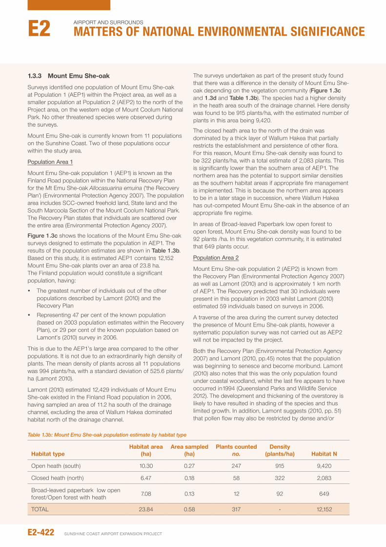
1.3.3 Mount Emu She-oak
Surveys identified one population of Mount Emu She-oak at population 1 (AEp1) within the project area, as well as a smaller population at population 2 (AEp2) to the north of the project area, on the western edge of Mount Coolum national park. no other threatened species were observed during the surveys.
Mount Emu She-oak is currently known from 11 populations on the Sunshine Coast. Two of these populations occur within the study area.
Population Area 1
Mount Emu She-oak population 1 (AEp1) is known as the Finland Road population within the national Recovery plan for the Mt Emu She-oak Allocasuarina emuina (‘the Recovery plan’) (Environmental protection Agency 2007). The population area includes SCC-owned freehold land, State land and the South Marcoola Section of the Mount Coolum national park. The Recovery plan states that individuals are scattered over the entire area (Environmental protection Agency 2007).
Figure 1.3c shows the locations of the Mount Emu She-oak surveys designed to estimate the population in AEp1. The results of the population estimates are shown in Table 1.3b. Based on this study, it is estimated AEp1 contains 12,152 Mount Emu She-oak plants over an area of 23.8 ha. The Finland population would constitute a significant population, having:
y The greatest number of individuals out of the other populations described by Lamont (2010) and the Recovery plan
y Representing 47 per cent of the known population (based on 2003 population estimates within the Recovery plan), or 29 per cent of the known population based on Lamont’s (2010) survey in 2006.
This is due to the AEp1’s large area compared to the other populations. it is not due to an extraordinarily high density of plants. The mean density of plants across all 11 populations was 994 plants/ha, with a standard deviation of 525.6 plants/ha (Lamont 2010).
Lamont (2010) estimated 12,429 individuals of Mount Emu She-oak existed in the Finland Road population in 2006, having sampled an area of 11.2 ha south of the drainage channel, excluding the area of Wallum Hakea dominated habitat north of the drainage channel.
The surveys undertaken as part of the present study found that there was a difference in the density of Mount Emu She-oak depending on the vegetation community (Figure 1.3c and 1.3d and Table 1.3b). The species had a higher density in the heath area south of the drainage channel. Here density was found to be 915 plants/ha, with the estimated number of plants in this area being 9,420.
The closed heath area to the north of the drain was dominated by a thick layer of Wallum Hakea that partially restricts the establishment and persistence of other flora. For this reason, Mount Emu She-oak density was found to be 322 plants/ha, with a total estimate of 2,083 plants. This is significantly lower than the southern area of AEp1. The northern area has the potential to support similar densities as the southern habitat areas if appropriate fire management is implemented. This is because the northern area appears to be in a later stage in succession, where Wallum Hakea has out-competed Mount Emu She-oak in the absence of an appropriate fire regime.
in areas of Broad-leaved paperbark low open forest to open forest, Mount Emu She-oak density was found to be 92 plants /ha. in this vegetation community, it is estimated that 649 plants occur.
Population Area 2
Mount Emu She-oak population 2 (AEp2) is known from the Recovery plan (Environmental protection Agency 2007) as well as Lamont (2010) and is approximately 1 km north of AEp1. The Recovery predicted that 30 individuals were present in this population in 2003 whilst Lamont (2010) estimated 59 individuals based on surveys in 2006.
A traverse of the area during the current survey detected the presence of Mount Emu She-oak plants, however a systematic population survey was not carried out as AEp2 will not be impacted by the project.
Both the Recovery plan (Environmental protection Agency 2007) and Lamont (2010, pp.45) notes that the population was beginning to senesce and become moribund. Lamont (2010) also notes that this was the only population found under coastal woodland, whilst the last fire appears to have occurred in1994 (Queensland parks and Wildlife Service 2012). The development and thickening of the overstorey is likely to have resulted in shading of the species and thus limited growth. in addition, Lamont suggests (2010, pp. 51) that pollen flow may also be restricted by dense and/or
Table 1.3b: Mount Emu She-oak population estimate by habitat type
habitat typehabitat area
(ha)Area sampled
(ha)plants counted
no.density
(plants/ha) habitat N
open heath (south) 10.30 0.27 247 915 9,420
Closed heath (north) 6.47 0.18 58 322 2,083
Broad-leaved paperbark low open forest/open forest with heath 7.08 0.13 12 92 649
ToTAL 23.84 0.58 317 - 12,152
E2-422
Airport And SurroundS
Matters of NatIoNaL eNvIroNMeNtaL sIgNIfIcaNceE2
SunSHinE CoASt Airport EXpAnSion proJECt
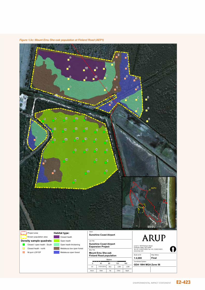
") ") ") ") ")
") ") ") ")") ")
")
")
")
")
")
")
")")
")
")
")")")
") ") ")
")
")
")
") ") ")
")
")
")
")
") ")
")
")")
")
")
")
")
")
")
")
")
")
")
")
")")
")
")1
0
3
0
0
0
8
1
5
3
0
1
1 0
0
02
1
0
0
0
016
0
3
3
05
2 7
0
0
0
9
1
0
0
01
144
12
22
19
10
14
34
18
19
21111911
2211
Job No
225480-00
Coordinate System
Scale at A4
Level 4, 108 Wickham StreetFortitude Valley, QLD 4006Tel +61 (7)3023 6000 Fax +61 (7)3023 6023www.arup.com
© Arup
1:4,000
Map Title
Job Title
Sunshine Coast Airport Expansion Project
Mount Emu She-oakFinland Road population
Client
Sunshine Coast Airport
0 40 80 120 160
Meters
©Copyright Information
Issue Date By Appd
D1 SXJ LOM LOM
Chkd
[Map Status
Final
J:\2
2500
0\22
5480
\Wor
k\R
epor
t\Fig
ures
and
App
endi
ces\
Figu
re_2
.5.3
a_em
u_po
p.m
xd
GDA 1994 MGA Zone 5631/01/2014
Project area
Known population area
Density sample quadrats:") Closed / open heath - South
") Closed heath - north
") M.quin LOF/OF
Habitat type:Closed heath
Open heath
Open heath thickening
Melaleuca low open forest
Melaleuca open forest
Figure No
2.5.3a
DAEP2
Figure 1.3c: Mount Emu She-oak population at Finland Road (AEP1)
E2-423environmental impact statement
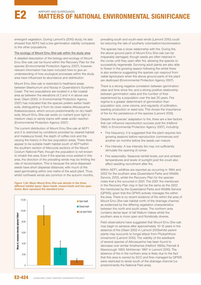
emergent vegetation. During Lamont’s (2010) study, he also showed that AEp2 had a low germination viability compared to the other populations.
The ecology of Mount Emu She-oak within the study area
A detailed description of the biology and ecology of Mount Emu She-oak can be found within the Recovery plan for the species (Environmental protection Agency 2007); however, relevant information has been included here to give an understanding of how ecological processes within the study area have influenced its abundance and distribution.
Mount Emu She-oak is restricted to heathland areas between Beerburrum and noosa in Queensland’s Sunshine Coast. The two populations are located in a flat coastal area as between the elevations of 2 and 4 m above sea level. olsen (2002, in Environmental protection Agency 2007) has indicated that the species prefers wetter heath soils, distinguishing it from its close relative Allocasuarina thalassoscopica, which occurs predominantly on dry heath soils. Mount Emu She-oak exists on nutrient poor light to medium clays or sandy loams with weak acidic reaction (Environmental protection Agency 2007).
The current distribution of Mount Emu She-oak at AEp1 and 2 is restricted by conditions provided by cleared habitat and melaleuca forest, the depth of coffee rock and the varying fire history in the two population areas. There does appear to be suitable heath habitat south of AEp1within the southern section of Marcoola sections of the Mount Coolum national park, though the population is not known to inhabit this area. Even if the species once existed in this area, the direction of the prevailing winds may be limiting the rate of recolonisation. This is because the wind-dispersed seeds have short dispersal distances, with much of the seed germinating within one metre of the adult plant. Thus, whilst northwest winds are common in the autumn months,
prevailing south and south-east winds (Lamont 2010) could be reducing the rate of southerly colonisation/recolonisation.
The species has a close relationship with fire. During fire, the above ground parts of Mount Emu She-oak can be irreparably damaged; though seeds are often retained in the cones until they open after fire, allowing the species to successfully regenerate. Surviving adult plants are also able to flower in the growing season following fire whilst there is also evidence suggesting the species can resprout from viable lignotubers when the above ground parts of the plant are destroyed (Environmental protection Agency 2007).
There is a strong negative correlation between germination rates and time since fire, and a strong positive relationship between germination rates and the number of fires experienced by a population over the last 20 years. Fire regime is a greater determinant of germination than population size, cone volume, and regularity of pollination, seeding production or seed size. This shows the importance of fire for the persistence of the species (Lamont 2010).
Despite the species’ adaptation to fire, there are a few factors that can influence reproduction success post fire (Halford 1993, in Environmental protection Agency 2007), including:
y Fire frequency: it is suggested that the plant requires two growing seasons before reproduction commences and another six months before the seeds can mature
y Fire intensity: A low intensity fire may not sufficiently stimulate the opening of cones
y Fire seasonality: Seasonal rainfall levels, soil and ambient temperatures and levels of sunlight post fire could also affect seedling recruitment after fire.
Within AEp1, wildfires are reported as occurring in 1994 and 2002 for the southern area (Queensland parks and Wildlife Service, 2012), whilst the Recovery plan for the species notes that a fire occurred in 2001. The 2001 fire mentioned in the Recovery plan may in fact be the same as the 2002 fire mentioned by the Queensland parks and Wildlife Service (QpWS), given that the QpWS actively manages fire within the area. There is no recent evidence of fire within the area of Mount Emu She-oak habitat north of the drainage channel, as evidenced by the differing vegetation characteristics between the north and south areas. The northern area contains dense layer of tall Wallum Hakea whilst the southern area is more open and floristically diverse.
Field observations have suggested that Mount Emu She-oak may begin to senesce after approximately 10-15 years in the absence of fire (olsen 2002 in Lamont 2010)whilst parent plants may succumb to fungal attack from Phytophthora cinnamomii (Lamont 2010). The viability of the seedbank of several species of Allocasuarina has been found to decrease over similar timeframes (Halford 1993a; pannell & Myerscough 1993; McKiernan 1997 in Lamont 2010). The absence of fire in the northern area is likely due to the fact that this area is owned by SCC and fires managed by QpWS were restricted to lands south of the drainage channel (i.e. predominantly the national park area).0
2.00
4.00
6.00
8.00
10.00
12.00
Mea
n A.
em
uian
a de
nsity
(pla
nts/
100m
2
Open heath
Closed heath
Low open forest
Figure 1.3d: Mean Mount Emu She-oak density in the three different habitat types: Open heath, closed heath and low open forest. Bars represent the standard error
E2-424
Airport And SurroundS
Matters of NatIoNaL eNvIroNMeNtaL sIgNIfIcaNceE2
SunSHinE CoASt Airport EXpAnSion proJECt
The Recovery plan notes that the AEp1 population exhibited germination after a fire in 2001 (pp. 9), potentially explaining why the population density of Mount Emu She-oak is much higher in the southern portion.
Across all known Mount Emu She-oak populations on the Sunshine Coast, Lamont (2010) found that the northern and southern population groups (separated by the Maroochy River) were genetically distinct. in the northern region, AEp1 and 2 were found to be genetically distinct from the other nine populations and displayed a high level of genetic similarity despite their current distance of over 1 km. Little exchange was detected with the populations that lie approximately 12 km to the north (Lamont, pp. 90). AEp1 and 2 were revealed to have a relatively low genetic diversity compared to the other populations.
1.3.4 declared pest plants
The areas of remnant vegetation traversed within the project area as part of the main survey were observed to be generally free of exotic plant species. Exotic plant species were observed to be common on the edges of areas of remnant RE, within the foredune area, and within areas of melaleuca/slash pine regrowth. Declared pest plants observed during the surveys include:
y Asparagus aethiopicus (Basket Asparagus Fern, a declared Class 2 pest plant)
y Baccharis halimifolia (Groundsel, a declared Class 2 pest plant)
y Lantana camara (Lantana, a declared Class 3 pest plant)
Groundsel was locally common and abundant within cleared areas of the former cane lands and Asparagus Fern occurred within regrowth areas of paperbark forest in the former cane lands. Lantana was observed at very low densities on the edges of remnant vegetation adjoining the former cane lands.
under the Land Protection (Pest and Stock Route Management) Act 2002 (Lp Act) Class 2 declared pest plants are established in Queensland and an have adverse economic, environmental and social impacts. Landholders must take reasonable steps to keep these plants off their land and control or remove any infestations.
Class 3 declared pest plants are already established in Queensland and landholders are only required to control these plants when they are adjacent to an environmentally significant area, such as a national park. SCC has a legislative responsibility to control these pest plants on the SCA site. impacts associated with weed spread during construction will be addressed in the Environmental Management plan (EMp) for the project (see Chapter E3), however ongoing weed management will be required by SCA to contain any existing weed infestations outside of the construction footprint for the project.
1.4 dESCRIpTION OF SIGNIFICANCE CRITERIA
The results of the impact assessment for this chapter are discussed in relation to three factors:
y the magnitude of impacts (significance / consequence) (Table 1.4a)
y the duration of impact (Table 1.4b)
y the likelihood of impact (Table 1.4c).
y These are considered together to determine the final level of impact, which is described in Table 1.4d.
1.5 IMpACT ASSESSMENT
in this section direct impacts are first described in the context of the project’s known impacts to environmental values such as vegetation communities and significant flora species. indirect impacts associated with edge effects, fragmentation hydrology and groundwater are also discussed.
1.5.1 Mitigation inherent in design
in the early stages of design development, the population of Mount Emu She-oak was identified as a significant constraint. The alignment of the Airport Drive extension, as the main access road, was designed to avoid the area of closed heath to the south of the drain. This area supports the highest density of Mt Emu She-oak plants in the Finland Road population area.
E2-425environmental impact statement

E2-426
Airport And SurroundS
Matters of NatIoNaL eNvIroNMeNtaL sIgNIfIcaNceE2
SunSHinE CoASt Airport EXpAnSion proJECt
Table 1.4b: Duration of impact
Relative duration of Environmental Effects
Temporary Days to months
Short Term up to 1 year
Medium Term 1 to 5 years
Long Term From 5 to 50 years
permanent / irreversible in excess of 50 years
Table 1.4c: Likelihood of impact
Likelihood of Impact
Highly unlikely
unlikely
possible
Likely
Almost certain
Table 1.4d: Risk matrix
Likelihood
Significance
Negligible Minor Moderate high very high
Highly unlikely/ Rare negligible negligible Low Medium High
unlikely negligible Low Low Medium High
possible negligible Low Medium Medium High
Likely negligible Medium Medium High Extreme
Almost Certain negligible/Low Medium High Extreme Extreme
Table 1.4a: Impact significance criteria
Impact Significance / Consequence description of magnitude
Very High Local extinction of populations of significant flora species listed under the EpBC Act and nC Act.Greater than 10 per cent remnant Threatened Ecological Communities cleared within the project area. Total collapse or replacement of adjacent remnant vegetation communities.
High Reduction in numbers of significant flora species listed under the EpBC Act and nC Act to an extent that population size is reduced in the long term and/or recruitment rates are reduced.5-10 per cent remnant Threatened Ecological Communities cleared within the project area.Greater than 50 per cent remnant Regional Ecosystems cleared within the project area.Measurable changes in the adjacent ecosystem components and/or floristic components outside the known environmental range of the existing ecosystem.
Moderate Short term reduction in population size of a significant flora species listed under the EpBC Act and nC Act or temporary reduction in recruitment rates.20-50 per cent remnant Regional Ecosystems cleared within the project area.Less than 5 per cent remnant Threatened Ecological Communities cleared within the project area.Measurable changes to adjacent ecosystem components, but functions and services (i.e. habitat provision, vegetation structure) are retained.
Minor no direct impact on significant flora, but potential indirect, short-term impacts that will reduce the health of individual plants.5-20 per cent remnant Regional Ecosystems cleared within the project area.important ecosystem components, functions and services shaping vegetation communities not affected, however some impact to specific plant species or communities.
negligible no impact to significant flora species.Less than 5 per cent remnant Regional Ecosystems cleared within the project area.potential changes to adjacent ecosystems, but within natural variation to maintain the existing vegetation community.
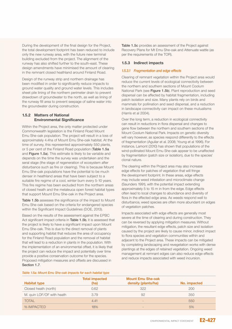
During the development of the final design for the project, the total development footprint has been reduced to include only the new runway area, with the future new terminal building excluded from the project. The alignment of the runway has also shifted further to the south-east. These design amendments have minimised the amount of clearing in the remnant closed heathland around Finland Road.
Design of the runway strip and northern drainage has been modified in order to significantly reduce impacts to ground water quality and ground water levels. This includes sheet pile lining of the northern perimeter drain to prevent drawdown of groundwater to the north, as well as lining of the runway fill area to prevent seepage of saline water into the groundwater during construction.
1.5.2 Matters of National Environmental Significance
Within the project area, the only matter protected under Commonwealth legislation is the Finland Road Mount Emu She-oak population. The project will result in a loss of approximately 4.4ha of Mount Emu She-oak habitat. At the time of survey, this represented approximately 550 plants, or 5 per cent of the Finland Road population (Table 1.5a and Figure 1.5a). This estimate is likely to be variable and depends on the time the survey was undertaken and the seral stage (the stage of regeneration of ecosystem after disturbance such as fire or clearing). This is because Mount Emu She-oak populations have the potential to be much denser in heathland areas that have been subject to a suitable fire regime of a cool, winter burn every 5-10 years. This fire regime has been excluded from the northern areas of closed heath and the melaleuca open forest habitat types that support Mount Emu She-oak in the project area.
Table 1.5b assesses the significance of the impact to Mount Emu She-oak based on the criteria for endangered species within the Significant impact Guidelines (DoE, 2013).
Based on the results of the assessment against the EpBC Act significant impact criteria in Table 1.5b, it is assessed that the project is likely to have a significant impact upon Mount Emu She-oak. This is due to the direct removal of plants and supporting habitat that reduces the area of occupancy for the Finland Road population and the removal of habitat that will lead to a reduction in plants in the population. With the implementation of an environmental offset, it is likely that the project can reduce the impact and potentially over time provide a positive conservation outcome for the species. proposed mitigation measures and offsets are discussed in Section 1.7.
Table 1.5c provides an assessment of the project against Recovery plans for Mt Emu She-oak and Attenuate wattle (as per the requirements of the ToR).
1.5.3 Indirect impacts
1.5.3.1 Fragmentation and edge effects
Clearing of remnant vegetation within the project area would reduce the current levels of ecological connectivity between the northern and southern sections of Mount Coolum national park (see Figure 1.5b). plant reproduction and seed dispersal can be affected by habitat fragmentation, including patch isolation and size. Many plants rely on birds and mammals for pollination and seed dispersal, and a reduction in landscape connectivity can impact on these mutualisms (Harris et al 2004).
over the long term, a reduction in ecological connectivity can result in reductions in flora dispersal and changes to gene flow between the northern and southern sections of the Mount Coolum national park. impacts on genetic diversity will vary however, as species respond differently to the effects of fragmentation (Aguilar et al. 2008; Young et al 1996). For instance, Lamont (2010) has shown that populations of the wind-pollinated Mount Emu She-oak appear to be unaffected by fragmentation (patch size or isolation), due to the species’ clonal nature.
The clearing within the project area may also increase edge effects for patches of vegetation that will fringe the development footprint. in these areas, edge effects may include weed infestation and microclimate change (Saunders 1991), with the potential impact extending approximately 5 to 15 m in from the edge. Edge effects often lead to local changes to abundance and diversity of flora in the effected edge area. As weeds respond well to disturbance, weed species are often more abundant on edges of vegetation patches.
impacts associated with edge effects are generally most severe at the time of clearing and during construction. They can be reversed by applying mitigation measures. Without mitigation, the resultant edge effects, patch size and isolation caused by the project are likely to cause minor, indirect impact to flora species and vegetation communities within and adjacent to the project area. These impacts can be mitigated by completing landscaping and revegetation works with dense plantings at the edges of retained vegetation. ongoing weed management at remnant edges can also reduce edge effects and reduce impacts associated with weed incursion.
Table 1.5a: Mount Emu She-oak impacts for each habitat type
habitat type Total impacted
(ha)Mount Emu She-oak density (plants/ha) No. impacted
Closed heath (north) 0.62 322 200
M. quin LoF/oF with heath 3.79 92 350
ToTAL 4.41 - 550
% iMpACTED 18% - 5%
E2-427environmental impact statement
Job No
225480-00Figure No
4.1
Coordinate System
Scale at A4
Level 4, 108 Wickham StreetFortitude Valley, QLD 4006Tel +61 (7)3023 6000 Fax +61 (7)3023 6023www.arup.com
© Arup
1:4,276
Map Title
Job Title
Sunshine Coast Airport Expansion Project
Mount Emu She-oakProject Area impact
Client
Sunshine Coast Council
0 50 100 150 200
Meters
©Copyright Information
Issue Date By Appd
D1 MJD SXJ LOM
Chkd
[
Map Status
Final
J:\2
2500
0\22
5480
\Wor
k\R
epor
t\Fig
ures
and
App
endi
ces\
Figu
re_4
.1_A
_em
u_im
pact
s.m
xd
GDA 1994 MGA Zone 5628/01/2014
Project Area
Known population area
Population area impact
Habitat type:Closed heath
Open heath
Open heath with Melaleuca thickening
Melaleuca low open forest
Melaleuca open forest
Figure 1.5a: Impacts to Mount Emu She-oak within the Project area
E2-428
Airport And SurroundS
Matters of NatIoNaL eNvIroNMeNtaL sIgNIfIcaNceE2
SunSHinE CoASt Airport EXpAnSion proJECt

Table 1.5b: The significance of impact for Mount Emu She-oak under the EPBC Act
Criteria under the Significant Impact Guidelines (dOE, 2013) Impact Assessment
An action is likely to have a significant impact on a critically endangered or endangered species if there is a real chance or possibility that it will:
Lead to a long-term decrease in the size of a population, or
The project will result in a loss of approximately 4.4 ha of habitat that supports Mount Emu She-oak. This reduction in population area will lead to a direct loss of 550 plants out of a population of 12,152, or 5 per cent of the total population which is 23.8 ha in size. The reduction in area of supporting habitat is likely to reduce the capacity of the project area to maintain the current population size. The project would result in a small long-term decrease in the size of the Finland Road population. A 5.7 ha section of the remaining population is located in the southern portion of the Mt Coolum national park and is protected in perpetuity.
Reduce the area of occupancy of the species, or
The area of suitable habitat for Mount Emu She-oak has been reduced within the project area. 4.4 ha of Mount Emu She-oak habitat or 5 per cent of the 23.8 ha Finland Road population.
Fragment an existing population into two or more populations, or
The project will not fragment the existing Finland Road population as the edge of the population is being affected.
Adversely affect habitat critical to the survival of a species, or
Mount Emu She-oak occurs in coastal heathland habitat on the Sunshine Coast and the species requires this vegetation community to persist. Each subpopulation is also considered important for conservation purposes. The majority (82 per cent) of the closed heath habitat within the project area that supports Mount Emu She-oak has been retained. Despite the reduction in this habitat area, the species is likely to persist within the project area.
Disrupt the breeding cycle of a population, or
The project is not likely to disrupt the breeding cycle of this species. Mount Emu She-oak relies on wind for pollination and dispersal and the project is unlikely to alter the dominant wind patterns and direction. Fire is also required to stimulate seed release and germination and the project is not likely to directly result in the removal of fire management from the population area.
Modify, destroy, remove, isolate or decrease the availability or quality of habitat to the extent that the species is likely to decline, or
The project will result in a loss of approximately 4.4 ha of Mount Emu She-oak habitat, which is 5 per cent of the 23.8 ha Finland Road population area. Therefore, the project is likely to decrease the availability of habitat to the extent that the Finland Road population may decline in numbers.
Result in invasive species that are harmful to a critically endangered or endangered species becoming established in the endangered or critically endangered species’ habitat
The project is not likely to result in the introduction of an invasive species that is harmful to Mount Emu She-oak. During the construction phase of the project, an EMp will be implemented that will include pest plant management procedures.
introduce disease that may cause the species to decline, or
The project is not likely to introduce a disease that may cause the population of Mount Emu She-oak to decline. During the construction phase of the project, an EMp will be implemented that will include soil hygiene and management procedures to mitigate against the import of any soil pathogens.
interfere with the recovery of the species.
The Recovery plan for Mount Emu She-oak notes the importance of the protection and management of each known population. Each population should be considered the important unit for the conservation and recovery of the species. By avoiding the majority of the population and habitat area within the project area, the Finland Road population will be retained. it is not likely that the project will interfere with the recovery of the species, or contradict the objectives of the Recovery plan.
E2-429environmental impact statement
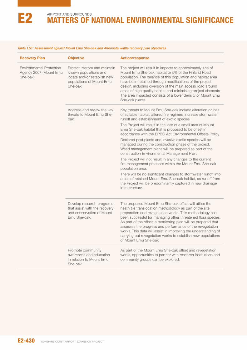
Recovery plan Objective Action/response
Environmental protection Agency 2007 (Mount Emu She-oak)
protect, restore and maintain known populations and locate and/or establish new populations of Mount Emu She-oak.
The project will result in impacts to approximately 4ha of Mount Emu She-oak habitat or 5% of the Finland Road population. The balance of this population and habitat area have been retained through modifications of the project design, including diversion of the main access road around areas of high quality habitat and minimising project elements. The area impacted consists of a lower density of Mount Emu She-oak plants.
Address and review the key threats to Mount Emu She-oak.
Key threats to Mount Emu She-oak include alteration or loss of suitable habitat, altered fire regimes, increase stormwater runoff and establishment of exotic species. The project will result in the loss of a small area of Mount Emu She-oak habitat that is proposed to be offset in accordance with the EpBC Act Environmental offsets policy. Declared pest plants and invasive exotic species will be managed during the construction phase of the project. Weed management plans will be prepared as part of the construction Environmental Management plan. The project will not result in any changes to the current fire management practices within the Mount Emu She-oak population area.There will be no significant changes to stormwater runoff into areas of retained Mount Emu She-oak habitat, as runoff from the project will be predominantly captured in new drainage infrastructure.
Develop research programs that assist with the recovery and conservation of Mount Emu She-oak.
The proposed Mount Emu She-oak offset will utilise the heath tile translocation methodology as part of the site preparation and revegetation works. This methodology has been successful for managing other threatened flora species. As part of the offset, a monitoring plan will be prepared that assesses the progress and performance of the revegetation works. This data will assist in improving the understanding of carrying out revegetation works to establish new populations of Mount Emu She-oak.
promote community awareness and education in relation to Mount Emu She-oak.
As part of the Mount Emu She-oak offset and revegetation works, opportunities to partner with research institutions and community groups can be explored.
Table 1.5c: Assessment against Mount Emu She-oak and Attenuate wattle recovery plan objectives
E2-430
Airport And SurroundS
Matters of NatIoNaL eNvIroNMeNtaL sIgNIfIcaNceE2
SunSHinE CoASt Airport EXpAnSion proJECt
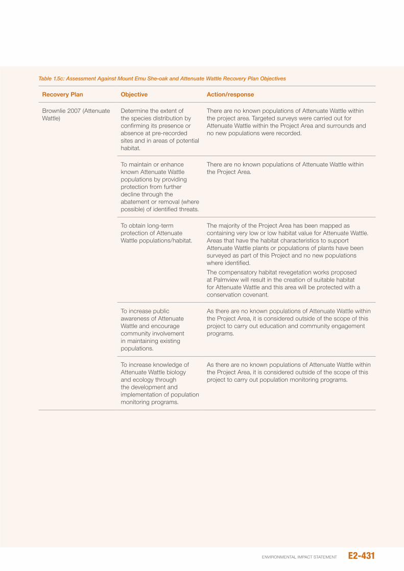
Recovery plan Objective Action/response
Brownlie 2007 (Attenuate Wattle)
Determine the extent of the species distribution by confirming its presence or absence at pre-recorded sites and in areas of potential habitat.
There are no known populations of Attenuate Wattle within the project area. Targeted surveys were carried out for Attenuate Wattle within the project Area and surrounds and no new populations were recorded.
To maintain or enhance known Attenuate Wattle populations by providing protection from further decline through the abatement or removal (where possible) of identified threats.
There are no known populations of Attenuate Wattle within the project Area.
To obtain long-term protection of Attenuate Wattle populations/habitat.
The majority of the project Area has been mapped as containing very low or low habitat value for Attenuate Wattle. Areas that have the habitat characteristics to support Attenuate Wattle plants or populations of plants have been surveyed as part of this project and no new populations where identified. The compensatory habitat revegetation works proposed at palmview will result in the creation of suitable habitat for Attenuate Wattle and this area will be protected with a conservation covenant.
To increase public awareness of Attenuate Wattle and encourage community involvement in maintaining existing populations.
As there are no known populations of Attenuate Wattle within the project Area, it is considered outside of the scope of this project to carry out education and community engagement programs.
To increase knowledge of Attenuate Wattle biology and ecology through the development and implementation of population monitoring programs.
As there are no known populations of Attenuate Wattle within the project Area, it is considered outside of the scope of this project to carry out population monitoring programs.
Table 1.5c: Assessment Against Mount Emu She-oak and Attenuate Wattle Recovery Plan Objectives
E2-431environmental impact statement
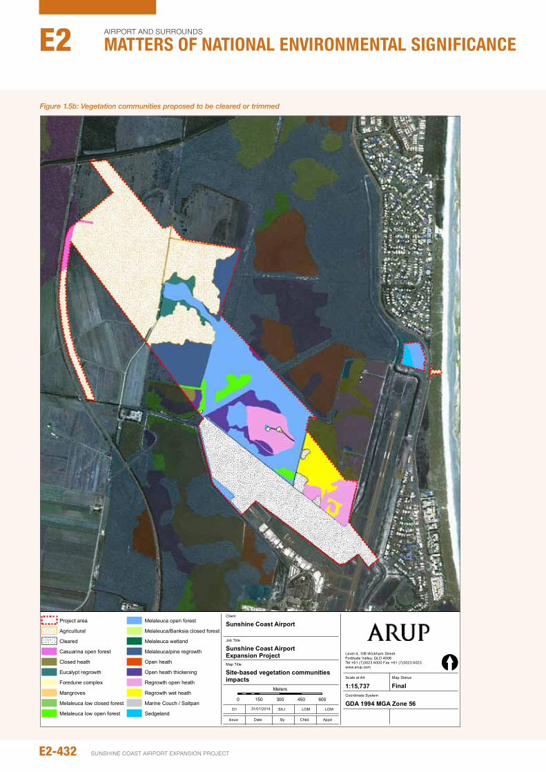
Job No
225480-00
Coordinate System
Scale at A4
Level 4, 108 Wickham StreetFortitude Valley, QLD 4006Tel +61 (7)3023 6000 Fax +61 (7)3023 6023www.arup.com
© Arup
1:15,737
Map Title
Job Title
Sunshine Coast Airport Expansion Project
Site-based vegetation communitiesimpacts
Client
Sunshine Coast Airport
0 150 300 450 600
Meters
©Copyright Information
Issue Date By Appd
D1 SXJ LOM LOM
Chkd
[Map Status
Final
J:\2
2500
0\22
5480
\Wor
k\R
epor
t\Fig
ures
and
App
endi
ces\
Figu
re_4
.4_V
eg_c
omm
s_im
pact
.mxd
GDA 1994 MGA Zone 5631/01/2014
Project area
Agricultural
Cleared
Casuarina open forest
Closed heath
Eucalypt regrowth
Foredune complex
Mangroves
Melaleuca low closed forest
Melaleuca low open forest
Melaleuca open forest
Melaleuca/Banksia closed forest
Melaleuca wetland
Melaleuca/pine regrowth
Open heath
Open heath thickening
Regrowth open heath
Regrowth wet heath
Marine Couch / Saltpan
Sedgeland Figure No
4.4
Figure 1.5b: Vegetation communities proposed to be cleared or trimmed
E2-432
Airport And SurroundS
Matters of NatIoNaL eNvIroNMeNtaL sIgNIfIcaNceE2
SunSHinE CoASt Airport EXpAnSion proJECt
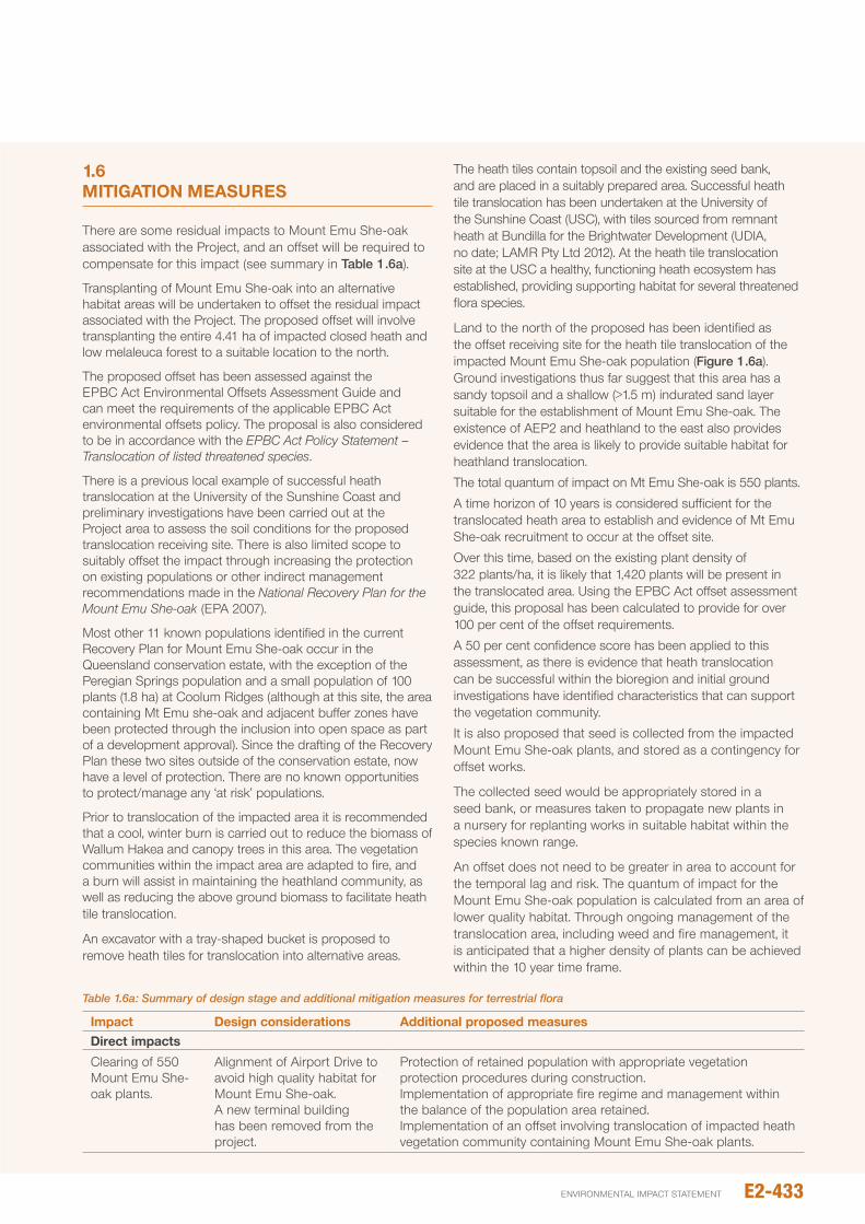
1.6 MITIGATION MEASURES There are some residual impacts to Mount Emu She-oak associated with the project, and an offset will be required to compensate for this impact (see summary in Table 1.6a).
Transplanting of Mount Emu She-oak into an alternative habitat areas will be undertaken to offset the residual impact associated with the project. The proposed offset will involve transplanting the entire 4.41 ha of impacted closed heath and low melaleuca forest to a suitable location to the north.
The proposed offset has been assessed against the EpBC Act Environmental offsets Assessment Guide and can meet the requirements of the applicable EpBC Act environmental offsets policy. The proposal is also considered to be in accordance with the EPBC Act Policy Statement – Translocation of listed threatened species.
There is a previous local example of successful heath translocation at the university of the Sunshine Coast and preliminary investigations have been carried out at the project area to assess the soil conditions for the proposed translocation receiving site. There is also limited scope to suitably offset the impact through increasing the protection on existing populations or other indirect management recommendations made in the National Recovery Plan for the Mount Emu She-oak (EpA 2007).
Most other 11 known populations identified in the current Recovery plan for Mount Emu She-oak occur in the Queensland conservation estate, with the exception of the peregian Springs population and a small population of 100 plants (1.8 ha) at Coolum Ridges (although at this site, the area containing Mt Emu she-oak and adjacent buffer zones have been protected through the inclusion into open space as part of a development approval). Since the drafting of the Recovery plan these two sites outside of the conservation estate, now have a level of protection. There are no known opportunities to protect/manage any ‘at risk’ populations.
prior to translocation of the impacted area it is recommended that a cool, winter burn is carried out to reduce the biomass of Wallum Hakea and canopy trees in this area. The vegetation communities within the impact area are adapted to fire, and a burn will assist in maintaining the heathland community, as well as reducing the above ground biomass to facilitate heath tile translocation.
An excavator with a tray-shaped bucket is proposed to remove heath tiles for translocation into alternative areas.
The heath tiles contain topsoil and the existing seed bank, and are placed in a suitably prepared area. Successful heath tile translocation has been undertaken at the university of the Sunshine Coast (uSC), with tiles sourced from remnant heath at Bundilla for the Brightwater Development (uDiA, no date; LAMR pty Ltd 2012). At the heath tile translocation site at the uSC a healthy, functioning heath ecosystem has established, providing supporting habitat for several threatened flora species.
Land to the north of the proposed has been identified as the offset receiving site for the heath tile translocation of the impacted Mount Emu She-oak population (Figure 1.6a). Ground investigations thus far suggest that this area has a sandy topsoil and a shallow (>1.5 m) indurated sand layer suitable for the establishment of Mount Emu She-oak. The existence of AEp2 and heathland to the east also provides evidence that the area is likely to provide suitable habitat for heathland translocation.
The total quantum of impact on Mt Emu She-oak is 550 plants.
A time horizon of 10 years is considered sufficient for the translocated heath area to establish and evidence of Mt Emu She-oak recruitment to occur at the offset site.
over this time, based on the existing plant density of 322 plants/ha, it is likely that 1,420 plants will be present in the translocated area. using the EpBC Act offset assessment guide, this proposal has been calculated to provide for over 100 per cent of the offset requirements.
A 50 per cent confidence score has been applied to this assessment, as there is evidence that heath translocation can be successful within the bioregion and initial ground investigations have identified characteristics that can support the vegetation community.
it is also proposed that seed is collected from the impacted Mount Emu She-oak plants, and stored as a contingency for offset works.
The collected seed would be appropriately stored in a seed bank, or measures taken to propagate new plants in a nursery for replanting works in suitable habitat within the species known range.
An offset does not need to be greater in area to account for the temporal lag and risk. The quantum of impact for the Mount Emu She-oak population is calculated from an area of lower quality habitat. Through ongoing management of the translocation area, including weed and fire management, it is anticipated that a higher density of plants can be achieved within the 10 year time frame.
Table 1.6a: Summary of design stage and additional mitigation measures for terrestrial flora
Impact design considerations Additional proposed measuresdirect impacts
Clearing of 550 Mount Emu She-oak plants.
Alignment of Airport Drive to avoid high quality habitat for Mount Emu She-oak.A new terminal building has been removed from the project.
protection of retained population with appropriate vegetation protection procedures during construction.implementation of appropriate fire regime and management within the balance of the population area retained.implementation of an offset involving translocation of impacted heath vegetation community containing Mount Emu She-oak plants.
E2-433environmental impact statement
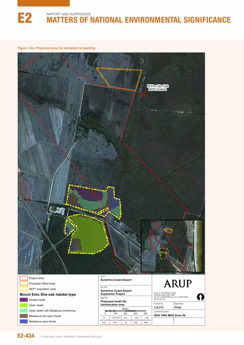
Job No
225480-00
Coordinate System
Scale at A4
Level 4, 108 Wickham StreetFortitude Valley, QLD 4006Tel +61 (7)3023 6000 Fax +61 (7)3023 6023www.arup.com
© Arup
1:9,773
Map Title
Job Title
Sunshine Coast Airport Expansion Project
Proposed heath tile translocation area
Client
Sunshine Coast Airport
0 100 200 300 400
Meters
©Copyright Information
Issue Date By Appd
D1 SXJ LOM LOM
Chkd
[Map Status
Final
J:\2
2500
0\22
5480
\Wor
k\R
epor
t\Fig
ures
and
App
endi
ces\
Figu
re_5
.2.2
a_H
eath
_tra
nslo
cat_
offs
et.m
xd
GDA 1994 MGA Zone 5631/01/2014
Project area
Proposed Offset Area
AEP1 population area
Mount Emu She-oak habitat typeClosed heath
Open heath
Open heath with Melaleuca thickening
Melaleuca low open forest
Melaleuca open forestFigure No
5.2.2a
D
Mt Emu She OakAEP2 location
Figure 1.6a: Proposed area for transplant or planting
E2-434
Airport And SurroundS
Matters of NatIoNaL eNvIroNMeNtaL sIgNIfIcaNceE2
SunSHinE CoASt Airport EXpAnSion proJECt

A detailed offset Management plan will be prepared as part of subsequent stages of the project which will outline all on-ground works required, management and monitoring regimes and details of how the land tenure of the offset area will be secured. The intent is that the site be protected in perpetuity through a mechanism such as a native Refuge declaration, conservation covenant or gazettal into the national park.
An offset does not need to be greater in area to account for the temporal lag and risk. The quantum of impact for the Mount Emu She-oak population is calculated from an area of lower quality habitat. Through ongoing management of the translocation area, including weed and fire management, it is anticipated that a higher density of plants can be achieved within the 10 year time frame.
1.7 IMpACT ASSESSMENT SUMMARy
Table 1.7a summarises the impacts, and mitigation measures for Mt Emu She-oak.
1.8 CONCLUSION
The project will result in the loss of approximately 4 ha of Mount Emu She-oak habitat, which is estimated to currently support approximately 550 Mount Emu She-oak plants, from a population of 12,152. The moderate residual risk to the species is proposed to be compensated by the provision of an offset, which will translocate the impacted plants to an area of suitable habitat within the study area.
Table 1.7a: Impact assessment summary table
primary Impacting process
Mitigation inherent in the design
Signifi-cance
of impact
Likeli-hood of impact Risk
Additional mitigation measures
Signifi-cance
of impact
Likeli-hood
of impact
Resi- dual risk
Reduction in the area and population size of Mount Emu She-oak
Additional infrastructure associated with the terminal has been removed from the project.Airport Drive extension has been designed to avoid the area of high quality Mount Emu She-oak habitat, where the highest plant densities occur.
High Almost certain
Extreme impacts offset through translocation of heath vegetation community with Mount Emu She-oakCollection of seed from the impacted Mount Emu She-oak plants for storage and ultimate propagation for use in replanting works.
Moderate possible Medium
Clearing of good quality habitat for threatened species listed under the EpBC Act that have not been detected within the project area.
Surveys carried out in accordance with the ToR did not identify any other populations of threatened flora.Airport Drive extension has been located outside areas of remnant vegetation.
Minor possible Low pre-clearing surveys and mitigation when additional threatened or near threatened plants are identified. if any threatened or near-threatened plants are found they will be translocated or offset.
negligible possible negligible
E2-435environmental impact statement
SECTION 2: TERRESTRIAL FAUNA
2.1 INTROdUCTION
This section specifically addresses fauna MnES including:
y Wallum sedgefrog
y Water mouse
y Grey headed flying fox
y Migratory birds
2.2 NOMENCLATURE ANd TERMINOLOGyThe study area in this section considered the potential geographic extent of both direct and indirect impacts. The ‘study area’ thereby refers to land within 5 km of the existing SCA (Figure 2.2a), which has been modified from Chapter A4 – project Description to reflect the reduced nature of impacts associated with fauna ecology.
Significant landmarks and important habitat areas are referred to throughout this report and are detailed in Table 2.2a and illustrated in Figure 2.2a.
2.3 METhOdOLOGy ANd ASSUMpTIONS
2.3.1 desktop assessment and background sources
prior to undertaking field investigations, a desktop review of ecological records, databases and literature relating to terrestrial vertebrate species occurring within a 25-50 km radius of the SCA (hitherto referred to as the Desktop Assessment study area) was undertaken in order to:
y Compile a local-area species list (i.e. a list for all terrestrial vertebrate species known from the Desktop Assessment study area), with particular focus on Endangered, Vulnerable or near Threatened (EVnT) species which may be later targeted during field investigations
y identify specific locations (i.e. geographical coordinates) for EVnT records (where possible)
y provide a regional perspective on fauna values identified during field investigations.
South East Queensland (SEQ) is well surveyed, and database searches yielded 91,705 point-specific locations within the Desktop Assessment study area. Enlarging the search area (beyond a 50 km radius) would lead to the inclusion of many irrelevant records (e.g. records of species for which there is no suitable habitat within or adjacent the study area) and adds little to our understanding of faunal values of the study area.
Each of the inspected databases (Table 2.3a) has inherent limitations that must be considered when interpreting the results of database searches.
in addition to providing a list of known EVnT species, database records may be used to assess the likelihood of EVnT species occurring within the study area, based on record frequency (i.e. the number of records of an EVnT species over a specified time frame). While useful, record frequency must be used cautiously as database records are biased towards conspicuous fauna such as birds. The likelihood of EVnT fauna occurring within the study area (particularly cryptic fauna such as herpetofauna and bat species) must therefore be assessed against other criteria as well (including the results of targeted field surveys).
it is also important to note that a species’ presence in a database does not mean that the species is regularly observed in the study area. Single, unusual records may represent transient or vagrant animals. Such records need to be carefully evaluated against the species’ current known distribution and habitat requirements.
Existing literature (including published and unpublished books, papers and reports) was reviewed to provide additional information and relevant EVnT species. Reports of particular relevance to this work included:
y White, D., White, D. and power, n. (2005). Targeted species surveys of the Sunshine Coast Airport, Marcoola, Maroochy Shire, Queensland. Report prepared for oTEK Australia pty Ltd
y EcoSmart Ecology and 3D Ecological Consulting. (2010). Sunshine Coast Airport Master plan implementation project. preliminary Review of Significant Environmental Factors
y BMT WBM. (2010). Sunshine Coast Airport preliminary Ecological Report (Final Report). Report prepared for ARup pty Ltd.
y Meyer, E. (2010). Results of frog surveys undertaken in costal reserves managed by the Sunshine Coast Regional Council: February – March 2010. Draft report prepared for Sunshine Coast Regional Council by Ed Meyer.
y ingram, G. and Agnew, L. (2010). Wallum Sedgefrog Litoria olongburensis Surveys and Habitat Assessments for the proposed Sunshine Motorway Duplication (Kawana Way to Mooloolah River interchange) and Multi-modal Transport Corridor (Main Drive to Maroochy Boulevard). prepared January 2010 for the Queensland Department of Transport and Main Roads
y GHD. (2011). Significant impact Assessment Report, Sippy Downs Trunk Sewer project. prepared for unitywater, June 2011.
These, and other sources, were extensively used to provide project background, develop EVnT species profiles and understand potential impacts. Any specific location details for EVnT species was added to the database containing records from sources identified (see Table 2.2a).
once compiled, EVnT records from the desktop assessment were plotted using ArcGiS in order to spatially represent known occurrences of EVnT species within the study area and broader Desktop Assessment study area.
E2-436
Airport And SurroundS
Matters of NatIoNaL eNvIroNMeNtaL sIgNIfIcaNceE2
SunSHinE CoASt Airport EXpAnSion proJECt
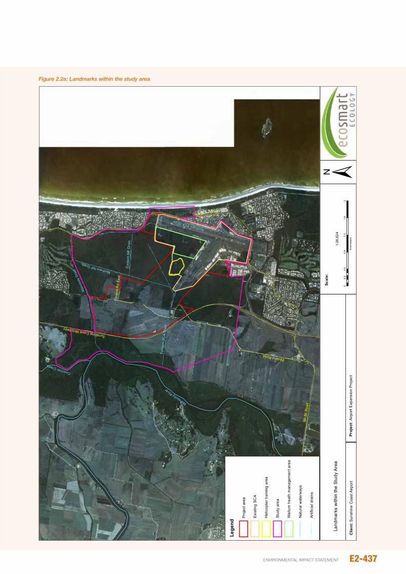
David Low WayFinland Road
Bli B
li R
oad
Sunshine Coast Motorway
Finl
and
Rd
East
Maroochy River
Coochiin Creek
Mar
cool
a D
rain
Northern SCA Drain
East
ern
SCA
Dra
in
Northern NP Drain
East
ern
NP
Dra
in
Clie
nt:
Proj
ect:
Suns
hine
Coa
st A
irpor
tAi
rpor
t Exp
ansi
on P
roje
ct
Land
mar
ks w
ithin
the
Stu
dy A
rea
00.
40.
81.
21.
62
0.2
Kilo
met
ers
1:26
,624
Scal
e:
Lege
nd
Exis
ting
SCA
Hel
icop
ter t
rain
ing
area
Stud
y ar
ea
Wal
lum
hea
th m
anag
emen
t are
a
Nat
ural
wat
erw
ays
Artif
icia
l dra
ins
Pro
ject
are
a
David Low WayFinland Road
Bli B
li R
oad
Sunshine Coast Motorway
Finl
and
Rd
East
Maroochy River
Coochiin Creek
Mar
cool
a D
rain
Northern SCA Drain
East
ern
SCA
Dra
in
Northern NP Drain
East
ern
NP
Dra
in
Clie
nt:
Proj
ect:
Suns
hine
Coa
st A
irpor
tAi
rpor
t Exp
ansi
on P
roje
ct
Figu
re 1
.1
Land
mar
ks w
ithin
the
Stu
dy A
rea
00.
40.
81.
21.
62
0.2
Kilo
met
ers
1:26
,624
Scal
e:
Lege
nd
Dev
elop
men
t are
a
Exis
ting
SCA
Hel
icop
ter t
rain
ing
area
Stud
y ar
ea
Wal
lum
hea
th m
anag
emen
t are
a
Nat
ural
wat
erw
ays
Artif
icia
l dra
ins
±
Figure 2.2a: Landmarks within the study area
E2-437environmental impact statement
Table 2.2a: Relevant terminology and geographic references used throughout this section
Feature Location/description
Study area The area within a 5 km radius of the SCA including the mouth of the Maroochy River.
Area of focus The area of direct impact (i.e. clearing zones) plus the immediately adjacent Wallum Heath Management Area
WHMA Wallum Heath Management Area
Finland Road Crosses the Eastern SCA drain and heads north through disused cane fields
Finland Road East Heads east of Finland Road toward the Mt Coolum national park
Helicopter training area A regularly slashed area to the west of the WHMA
Eastern SCA drain A large artificial drain running east-west along the southern boundary of the existing SCA and extending under Finland Road to the Maroochy River
northern SCA drain The existing artificial drain running north-south along the eastern boundary of the existing SCA; distinct from the ‘northern perimeter drain’ which will be created as part of the proposed runway development.
SCA The existing SCA precinct including the WHMA and helicopter training area
Development area The proposed SCA development area
Marcoola drain A large artificial drain running from the Mt Coolum Golf Course east to the Maroochy River
Eastern np Drain The east-west artificial drain located to the north of the existing SCA within the Mt. Coolum national park
northern np Drain The north-south artificial drain near the western boundary of the Mt. Coolum national park
Finland Road Swamp/Wetland
A wetland located off Finland Road, south of the study area (-26.6134, 153. 0679)
Finland Creek A small natural creekline crossing Finland Road
Mt Coolum national park
Refers to the aggregate of national park estate both north (northern section) and south (southern section) of the SCA. officially this is noosa national park, Mt Coolum section
‘do minimum’ scenario The ‘do minimum’ scenario assumes the existing runways and operating procedures, and a forecast of future aircraft movements at the airport
preliminary Design The proposed construction and operation of Runway 13/31 with standard mitigation measures
Table 2.3a: Database sources
Source Notes Abbreviation Survey Buffer
Queensland Museum collections database
Specimen-backed, so highly reliable. Geographic co-ordinates available. QM 25 km
Birds Australia AtlasTypically reliable with database entries vetted for obvious errors. Geographic co-ordinates available. only data collected from 1980 onwards was used.
BA 25 km
DERM Wildnet Moderately reliable observations. no geographic co-ordinates available. Wn 50 km
EpBC protected Matters search tool
predictive only. of limited use for vertebrates. Reflects the location of the search area in respect to the species known distribution rather than actual observations.
EpBC online 25 km
Atlas of Living AustraliaBased largely on museum collections and therefore reliable. However can include records without dates (which are often very old records).
ALA 50 km
EcoSmart Ecology database
observations only. Geographic co-ordinates available. Dataset compiled from EcoSmart Ecology field surveys and personnel observations.
ESE 50 km
E2-438
Airport And SurroundS
Matters of NatIoNaL eNvIroNMeNtaL sIgNIfIcaNceE2
SunSHinE CoASt Airport EXpAnSion proJECt
Aerial photography and spatial data available from the Queensland Department of Environment and Heritage protection (DEHp), including Essential Habitat maps, Biodiversity planning Assessment (SEQ v3.5) and the Back on Track Framework were also used to inform the current assessment of faunal values.
2.3.2 Field survey overview
A number of field surveys were used to gather data on terrestrial fauna values within the study area from october 2010 through to September 2012. Surveys undertaken during this period included baseline (general fauna) surveys as well as targeted surveys for Ground parrot, acid frog species (including Wallum Froglet, Wallum Rocketfrog and Wallum Sedgefrog) and Water Mouse. Timing and duration of these surveys are summarised in Table 2.3b. Details of each survey component are provided in the sections below.
Table 2.3b: Fauna survey timing and duration
Survey Component date(s) Season
duration (days)
Baseline 26 - 30 Sept 12 Spring 5
Acid Frogs 12 - 15 oct 10 Spring 3
17 - 19 Jan 12 Summer 3
01 - 02 Mar 12 Summer 2
Ground parrot 15 - 17 Sept 10 Spring 2
12 - 15 oct 10 Spring 2
01 - 2 nov 10 Spring 2
10 - 11 Dec 11 Summer 2
18 - 20 Jan 12 Summer 2
14 - 16 Feb 12 Summer 2
20 - 22 Mar 12 Autumn 2
26 - 28 Apr 12 Autumn 2
22 - 24 May 12 Autumn 2
20 - 22 Jun 12 Winter 2
19 - 21 Jul 12 Winter 2
08 - 10 Aug 12 Winter 2
12 - 14 Sept 12 Spring 2
Water Mouse 29 nov 12 Spring 1
2.3.3 Baseline terrestrial vertebrate survey
General fauna surveys documenting the diversity of terrestrial vertebrate species within the study area were undertaken from 26/09/2012-30/09/2012, inclusive. Surveys were undertaken under QpWS licence WiSp06137309 and Animal Ethics Licence CA 2012/07/624. Field survey methods are consistent with relevant guidelines for baseline and species-specific assessment of faunal values (e.g. Eyre et al., 2012;
DEWHA 2011). All ecologists participating in surveys of the SCA have the skills, qualifications and experience in fauna surveying to successfully undertake surveys.
2.3.3.1 Sites selection (stratification)
Extensive traverses were undertaken through the study area and adjoining Mt Coolum national park to properly assess the range and extent of habitat types present. During these investigations, five Broad Vegetation Groups (BVGs) were identified: forest woodland, heath, disturbed habitats (agricultural and developed land), foredunes and intertidal habitats. Fauna survey techniques were undertaken within each of these BVGs to ensure representative sampling from the range of habitat types present within and adjacent the study area.
Sites were not randomly located within each BVG but chosen in order to:
y Maximise the number of detected fauna species
y Maximise the likelihood of detecting priority (e.g. Biodiversity Assessment and Mapping Methodology (BAMM) or Back on Track (BoT taxa)) or EVnT species.
Survey sites were therefore generally placed in areas of higher quality habitat (e.g. areas of undisturbed or less disturbed habitat).
Although regularly visited and subjected to bird surveys, active searching and habitat assessment, no trapping was undertaken in disturbed habitat or coastal dunes. Active survey methods (e.g. active searching, spotlighting) were considered adequate to document faunal values of these BVGs. intertidal habitats, which included areas of Coastal She-oak and mangrove vegetation, are largely outside the direct impact zone for this project. Significant impacts on fauna in such habitats are therefore considered unlikely. Thus, while targeted searches for specific EVnT species were undertaken (e.g. Water Mouse), no trapping was undertaken in such habitats.
The location of trapping sites with respect to BVGs is provided in Figure 2.3a.
2.3.3.2 Sampling methods
Vertebrate communities were sampled using a variety of standard survey techniques including trapping (Elliot, pitfall, harp and funnel), direct observation (spotlighting, bird survey, and incidental observations), remote sensing (Anabat ultrasonic bat detection, bio-acoustic recording, camera trapping), and active search methods (rolling logs, rocks and other debris).
Trapping methods
A total of five trapping sites were established during the survey, with each site operational for four consecutive nights. Trapping sites were typically configured in a 100 x 100m plot, consistent with Eyre et al., (2012). Five pitfall buckets along a single drift fence with two funnel traps at each end were established within the centre of the plot. Around this, 20 Elliot traps are positioned in nearby vegetation, each
E2-439environmental impact statement

separated by approximately five to ten metres. All sites were visited twice daily, once in the morning and once in the late evening.
Microchiropteran bat species were captured using two dual bank harp traps. Harp traps were positioned in locations where bat activity is typically high, such as along tracks and roads, or over narrow watercourses. Harp trapping was undertaken over three nights during the baseline survey.
Observation methods
Bird surveys
A total of 20 bird surveys were undertaken throughout the study area encompassing all major habitats. Surveys were undertaken during autumn, spring and summer to account for seasonal variation in bird diversity and migratory patterns (Eyre et al., 2012). Surveys took place during the morning (e.g. typically before 9 am) when avian activity peaks, although additional surveys were also undertaken periodically throughout the day to increase the diversity of species detected. Survey length varied from 20-30 minutes depending on habitat complexity and bird activity.
During bird surveys, data was collected by sampling birds by sight and sound along either a 50 m transect (seven locations), while centred around a discrete point. Bird survey transects were surveyed at least twice (rarely three) to increase the likelihood of detecting species missed during previous surveys.
incidental observations of birds seen within and adjacent the study area during surveys were also recorded throughout the study period. These predominantly occurred as ‘fly-over’ records, or observations while undertaking other activities.
Spotlighting surveys
nocturnal surveys were undertaken by two observers walking through habitats searching for arboreal mammals, small and medium sized terrestrial mammals, frogs, geckoes, nocturnal snakes and birds. Animals were detected by eye shine, call or direct observation. Spotlighting surveys were undertaken at each trap site, as well as a number of other locations, and typically lasted a minimum of 30 minutes. Spotlighting surveys undertaken as part of the baseline assessment equated to approximately 14 person hours.
playback was used to increase the likelihood of detecting nocturnal birds (owls/nightjars) and arboreal mammals (possums/gliders/koalas).
opportunistic spotlighting throughout the study area was used regularly and across many seasons while undertaking targeted survey works.
Opportunistic observations
opportunistic observations of new or unusual fauna were recorded throughout the baseline assessment as well as during targeted surveys. Records included species heard and/or seen during surveys as well as species detected by other means (e.g. scats, tracks, scratch mark, nests, feeding signs, and remains).opportunistic observations of taxa in
proximity to the study area (e.g. Finland Road Swamp) were also recorded.
Remote sensors and cameras
Ultrasonic bat call detection
ultrasonic call detection and recording of microchiropteran bats was carried out using an Anabat device located in remnant and non-remnant vegetation around the SCA. The device was set to record from dusk until dawn and located in areas most likely to have high bat activity (e.g. tracks, roads, waterways). Whilst most habitat types were surveyed, bat detection focused on areas most likely to have high bat activity (e.g. woodlands with hollows or adjacent waterways). Anabat recording was undertaken on two or more nights in every month between June and September 2012 (inclusive) for a total of eight Anabat survey nights.
Bio-acoustic recorders
Bio-acoustic recorders (SongMeter, SM2, Wildlife Acoustics inc.) were used to target Ground parrots within the study area and adjacent to the airport within Mt Coolum national park. These recorders allow multiple audio-recordings to occur concurrently, detecting not only Ground parrots but other vocal vertebrates including amphibians and birds. The automated bio-acoustic recording, which occurred monthly between February and September 2012, was set up so as to record calls one hour either side of sunset. This period coincides with high bird and amphibian calling activity including the period of maximum calling activity for Ground parrots.
Remote sensor cameras
Remote Sensor Cameras (Reconyx HC600) were used to survey for medium-sized and larger terrestrial vertebrates. Remote Sensor Cameras were used in preference to hair or cage trapping as this non-invasive method allows for greater capture rates over extended periods whilst reducing stress on animals (de Bondi et al., 2010; Claridge et al., 2010; paull et al., 2012). Further, camera traps allow detection of a species that are difficult to detect using either cage or hair traps (Vine et al., 2009; Robley et al., 2010). Two camera traps were deployed for two days and nights between four locations during the September baseline survey.
Habitat searches and habitat assessment
Habitat searches
Active searching was undertaken at trapping sites and supplementary survey sites within each habitat type (see Figure 2.3a). Habitat searches involved two observers spending 30-60 minutes rolling rocks and logs, searching debris, inspecting trees for scratches and searching for scats/feeding remains.
Koalas and Glossy Black-Cockatoos were a particular focus during habitat searches as these EVnT species are known to occur within the local area and some marginal habitat is present within the study area. Eroticoscincus graciloides was searched for at one site where habitat appeared suitable (i.e. a small area of tall eucalypt forest adjacent Finland Road).
E2-440
Airport And SurroundS
Matters of NatIoNaL eNvIroNMeNtaL sIgNIfIcaNceE2
SunSHinE CoASt Airport EXpAnSion proJECt
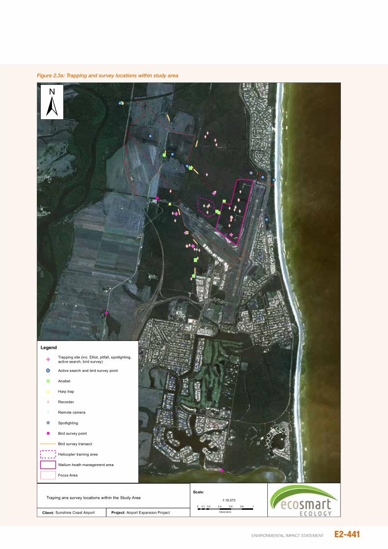
Project: Airport Expansion Project
"
"
"
!
!
!
5
5
5
^
^
^
^
X
X
XXXXX
XX X
XXXXXX X XXXX XXXX X
XXXX
XX
X
XX
XX
X
#
##
"
""
"
"""
"
"
"
"
G
GG
G
G
Client: Sunshine Coast Airport
Figure 1.2
Traping ans survey locations within the Study Area
Legend
GTrapping site (inc. Elliot, pitfall, spotlighting,active search, bird survey)
Active search and bird survey point
" Anabat
# Harp trap
X Recorder
^ Remote camera
!5 Spotlighting
" Bird survey point
Bird survey transect
Helicopter training area
Wallum heath management area
Focus Area
0 0.2 0.4 0.6 0.8 10.1
Kilometers
1:19,573
Scale:
±Figure 2.3a: Trapping and survey locations within study area
E2-441environmental impact statement
Feed tree species for Koala’s (e.g. Eucalyptus tereticornis and E. robusta) were inspected for scratches and scats, while ort (i.e. feeding remains) searches were undertaken under favoured Glossy Black-Cockatoo feed tree species (e.g. Casuarina and Allocasuarina spp.). Generally, food trees for both these species were localised to scarce.
Habitat assessment
Habitat assessment primarily focused on determining the suitability of habitat for EVnT species known to occur within the local area. Suitability was determined by comparing ecological requirements of individual EVnT species (e.g. the presence of known feed trees, prey availability, tree hollows, ground cover, habitat complexity, retreat sites, water availability etc.) to observed habitat characteristics.
2.3.3.3 Evaluation of likelihood
All species listed under the EpBC Act that have been recorded within 25-50km were assessed for their likelihood of occurring within the study area or immediate surrounds. Each species was assessed based on criteria listed in Table 2.3c.
2.3.4 Acid frog surveys
Acid frog surveys were undertaken along 50 m transects within areas of suitable habitat (i.e. areas of remnant and regrowth wet heath, sedgeland and Melaleuca woodland supporting surface water). A total of 27 transects were surveyed for frogs across the study area during the survey period. The location of transects is shown in Figure 2.3a. Federal survey guidelines (DEWHA 2010) indicate that surveys for acid frogs (and particularly the EpBC Act –listed
Wallum Sedgefrog) should include both call detection and visual searches. Accordingly, at each transect the following methods were employed.
Call detection
on arrival at the transect starting point (0 m), a five minute census of calling frogs within five metres was undertaken. This method was repeated at the completion of the 50 m transect. Additional call detection at defined points, not associated with transects, was also used on an opportunistic basis.
Transect searches
A visual encounter survey one metre either side of the 50 m long transect was undertaken by observers walking along the transect line, each using a head torch to scan vegetation. in order to detect as many frogs as possible, dense vegetation was parted or moved after an initial scan. The maximum survey effort equalled or exceed one person hour per transect, depending on the vegetation density and frog activity.
Opportunistic records and searches
opportunistic acid frog observations were recorded whilst undertaking other activities (e.g. Ground parrot surveys, general traverses) within the survey area.
on wet nights with heightened calling activity, surveys were also undertaken along various drains within the SCA. observers traversed the length of these drains from vehicle listening for frog calls, and stopping approximately every 50 m. Wet heath areas within the adjacent Mt Coolum national park, including areas mapped as RE 12.2.7 (sedge
Table 2.3c: Likelihood of species occurrence
Likelihood of Occurrence CriteriaKnown Recorded within and/or immediately adjacent study area
AnD Suitable habitat still present within and/or adjacent study area
Likely not recorded within and/or immediately adjacent study area; though suitable habitat within or adjacent study areaAnDnumerous recent records (< 20 years old)<10 km from study area from desktop assessment
possible not recorded within and/or immediately adjacent study areaAnDSuitable habitat within or adjacent study area and numerous records from Desktop Assessment study area, but records > 10 km away or > 20 years old oRMarginal habitat within or adjacent study area with few records, but recently (1990+) recorded within 10 km of study area
unlikely no suitable habitat within or immediately adjacent study area; AnD/oRFew records from desktop assessment and records > 10 km from study area only
Transient Habitat within/adjacent study area considered marginal for species and with few records from Desktop Assessment study area AnDSpecies highly mobile and known to occasionally appear in areas away from known population centres (usually birds). Species unlikely to permanently establish.
E2-442
Airport And SurroundS
Matters of NatIoNaL eNvIroNMeNtaL sIgNIfIcaNceE2
SunSHinE CoASt Airport EXpAnSion proJECt
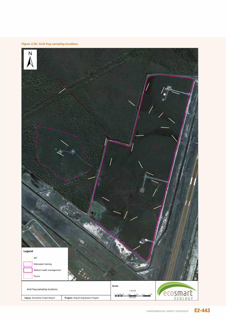
Project: Airport Expansion ProjectClient: Sunshine Coast Airport
Figure 1.3
Acid frog sampling locations
Legend
WF
Helicopter training
Wallum heath management
Focus
0 0.045 0.09 0.135 0.18 0.2250.0225
Kilometers
1:4,012
Scale:
±Figure 2.3b: Acid frog sampling locations
E2-443environmental impact statement
dominated wetlands), were visually assessed during the day for habitat suitability and revisited at night if found suitable.
Calling Wallum Sedgefrogs were also noted on bio-acoustic recorders established for the purpose of Ground parrot sampling.
Assessment and mapping of acid frog breeding habitat
in conjunction with aerial imagery of the study area, information from field studies was used to map areas of known and likely Wallum Sedgefrog breeding habitat within the area of focus. Water quality sampling (i.e. pH) and vegetation data assisted in habitat mapping. Criteria for assessing the value of breeding habitat for Wallum Sedgefrogs are outlined in Table 2.3d.
2.3.5 water Mouse surveys
Aerial photography and existing RE mapping was used to determine possible habitat for Water Mouse along the Maroochy River and Marcoola drain (refer Figure 2.3d). Areas of potential habitat (including areas of marine couch, Casuarina glauca woodland and mangrove vegetation at the mouth of the Marcoola drain) were subsequently searched for signs of Water Mouse including prey middens, nest mounds, mud plastering/plugging and slurry trails associated with nests in hollow trees and burrows in supralittoral banks.
Water Mouse searches were conducted on the 29/11/2012 by two ecologists experienced with the species and their habits. Searches were conducted to the north and south of the Marcoola drain along the banks of the Maroochy River. Searches undertaken south of the drain extended to the northern limit of QpWS surveys (Les Donald, pers. comm.).
2.3.6 Survey conditions, assumptions and limitations
2.3.6.1 Survey conditions
Rainfall from october 2011 through to March 2012 exceeded the summer average by as much as 60 per cent (1,579 mm in 2011/12 vs. an average of 987 mm). Above average summer rainfall was also experienced in 2010/11 when the SCA received 2119 mm (214 per cent of average summer rainfall). Consequently, rainfall over the 2010/11 and 2011/12 represent the two wettest years in the last decade. Above average summer rainfall has been the predominant pattern since the summer of 2008/09 (Figure 2.3c).
Surveys in May 2012 coincided with prolific flowering of Melaleuca quinquenervia. General bird surveys and spotlighting was undertaken in flowering Melaleuca habitats to search for taxa foraging for abundant nectar and pollen sources.
Baseline survey
The baseline survey was undertaken between the 26/9/12 – 30/9/12 (inclusive). Conditions during the surveying were suitable for detection of most resident fauna with calm, warm sunny days and balmy nights. Though there was no rain during surveys, light rainfall (five millimetres) was recorded just prior to surveys commencing on the 25/9/12. Temperatures ranged between 13.9°C and 29°C, providing suitable conditions for reptile and small mammal activity. Calm conditions provided excellent conditions for bird activity during each morning’s survey.
Table 2.3d: Criteria for assessing the value of breeding habitat for Wallum Sedgefrogs
value as breeding habitat Criteria
Known Known to support successful recruitment (based on the presence of juvenile animals [SVL<20 mm] during surveys)
Likely
Records of adult Wallum Sedgefrogs onlyAnDSurface water common after rain, but typically ephemeral (persisting for 4 or more weeks during the wet season)AnDSurface water acidic (pH<5.0) and clearly tannin-stained.upright sedges and/or Bungwall Fern also common and trees scarce or absent.
unlikely
no Wallum Sedgefrog recordsoRVery few Wallum Sedgefrog records during surveys (and no records of juvenile animals); AnDSurface water scarce, generally persisting for less than 2 weeks after rain; Tree cover dense;upright sedges and Bungwall Fern scarce; and/orWhere water present for extended periods, water pH>5.0 with little tannin-staining and Litoria fallax (a potential competitor) common
E2-444
Airport And SurroundS
Matters of NatIoNaL eNvIroNMeNtaL sIgNIfIcaNceE2
SunSHinE CoASt Airport EXpAnSion proJECt
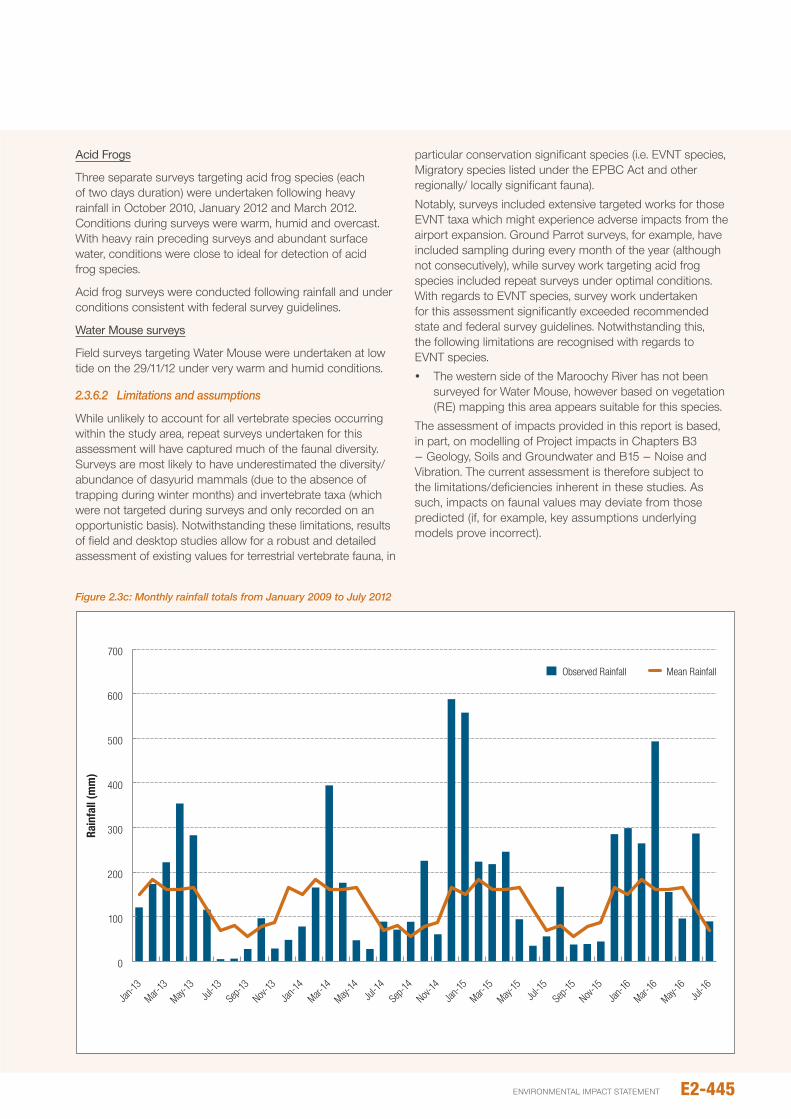
Acid Frogs
Three separate surveys targeting acid frog species (each of two days duration) were undertaken following heavy rainfall in october 2010, January 2012 and March 2012. Conditions during surveys were warm, humid and overcast. With heavy rain preceding surveys and abundant surface water, conditions were close to ideal for detection of acid frog species.
Acid frog surveys were conducted following rainfall and under conditions consistent with federal survey guidelines.
Water Mouse surveys
Field surveys targeting Water Mouse were undertaken at low tide on the 29/11/12 under very warm and humid conditions.
2.3.6.2 Limitations and assumptions
While unlikely to account for all vertebrate species occurring within the study area, repeat surveys undertaken for this assessment will have captured much of the faunal diversity. Surveys are most likely to have underestimated the diversity/abundance of dasyurid mammals (due to the absence of trapping during winter months) and invertebrate taxa (which were not targeted during surveys and only recorded on an opportunistic basis). notwithstanding these limitations, results of field and desktop studies allow for a robust and detailed assessment of existing values for terrestrial vertebrate fauna, in
particular conservation significant species (i.e. EVnT species, Migratory species listed under the EpBC Act and other regionally/ locally significant fauna).
notably, surveys included extensive targeted works for those EVnT taxa which might experience adverse impacts from the airport expansion. Ground parrot surveys, for example, have included sampling during every month of the year (although not consecutively), while survey work targeting acid frog species included repeat surveys under optimal conditions. With regards to EVnT species, survey work undertaken for this assessment significantly exceeded recommended state and federal survey guidelines. notwithstanding this, the following limitations are recognised with regards to EVnT species.
y The western side of the Maroochy River has not been surveyed for Water Mouse, however based on vegetation (RE) mapping this area appears suitable for this species.
The assessment of impacts provided in this report is based, in part, on modelling of project impacts in Chapters B3 – Geology, Soils and Groundwater and B15 – noise and Vibration. The current assessment is therefore subject to the limitations/deficiencies inherent in these studies. As such, impacts on faunal values may deviate from those predicted (if, for example, key assumptions underlying models prove incorrect).
0
100
200
300
400
500
600
700
Jan-13
Mar-13
May-13
Jul-13
Sep-1
3Nov-
13Jan
-14Mar-
14
May-14
Jul-14
Sep-1
4Nov-
14Jan
-15Mar-
15
May-15
Jul-15
Sep-1
5Nov-
15Jan
-16Mar-
16
May-16
Jul-16
Observed Rainfall
Rain
fall
(mm
)
Mean Rainfall
Figure 2.3c: Monthly rainfall totals from January 2009 to July 2012
E2-445environmental impact statement
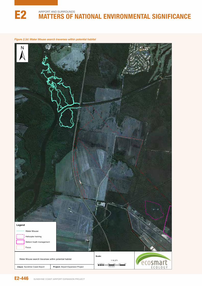
Project: Airport Expansion ProjectClient: Sunshine Coast Airport
Figure 1.6
Water Mouse search traverses within potential habitat
Legend
Water Mouse
Helicopter training
Wallum heath management
Focus
0 0.1 0.2 0.3 0.4 0.50.05
Kilometers
1:10,371
Scale:
±Figure 2.3d: Water Mouse search traverses within potential habitat
E2-446
Airport And SurroundS
Matters of NatIoNaL eNvIroNMeNtaL sIgNIfIcaNceE2
SunSHinE CoASt Airport EXpAnSion proJECt
2.4 pOLICy CONTExT ANd LEGISLATIvE FRAMEwORk
2.4.1 Environment Protection and Biodiversity Conservation Act 1999
The EpBC Act provides for:
y identification and listing of species and ecological communities as threatened
y Development of conservation advice and recovery plans for listed species and ecological communities
y Development of a register of critical habitat
y Recognition of key threatening processes.
The EpBC Act is administered by the federal Department of Environment (DoE). The legislation provides a legal framework for the protection and management of nationally and internationally important flora, fauna, ecological communities, and heritage places. These important values are considered Matters of national Environmental Significance (MnES) under the Act. MnES include species listed as ‘Vulnerable’, ‘Endangered’ or ‘Critically Endangered’ under the EpBC Act as well as migratory species listed under international treaties/agreements such as Japan-Australia Migratory Birds Agreement (JAMBA) and China-Australia Migratory Birds Agreement (CAMBA). Actions which will, or are likely, to have a ‘significant impact’ on MnES will require approval from the federal environmental minister.
An action is likely to have a significant impact on a vulnerable species if there is a real chance or possibility that it will (EpBC Act policy Statement 1.1):
y Lead to a long-term decrease in the size of an important population of a species
y Reduce the area of occupancy of an important population
y Fragment an existing important population into two or more populations
y Adversely affect habitat critical to the survival of a species
y Disrupt the breeding cycle of an important population
y Modify, destroy, remove or isolate or decrease the availability or quality of habitat to the extent that the species is likely to decline
y Result in invasive species that are harmful to a vulnerable species becoming established in the vulnerable species’ habitat
y introduce disease that may cause the species to decline
y interfere substantially with the recovery of the species.
An ‘important population’ is a population that is necessary for a species’ long-term survival and recovery. This may include populations identified as such in recovery plans, and/or are:
y Key source populations either for breeding or dispersal
y populations that are necessary for maintaining genetic diversity
y populations that are near the limit of the species range.
A number of policy documents and plans relevant to listed species have been published in support of the Act. Those relevant to listed species considered in this report include:
y A draft Wallum Sedgefrog referral guideline released in September 2011 (SEWpaC 2011). The guideline provides acceptable mitigation measures for a variety of potential impacts
y Recommended survey guidelines for Wallum Sedgefrogs (DEWHA 2010)
y A national Recovery plan for the Wallum Sedgefrog (Meyer et al., 2006)
y national recovery plan for the Water Mouse (false water rat) Xeromys myoides (DERM 2010)
y Draft national Recovery plan for the Grey-headed Flying-fox Pteropus poliocephalus (DECCW 2009).
2.5 ExISTING CONdITIONS ANd vALUES
Existing terrestrial vertebrate values within and surrounding the proposed activities are described in this section. While all faunal values within 5 km of the SCA are considered (i.e., the study area), values most likely to be affected (i.e. within the area of focus, defined as the direct impact zone plus the immediately adjacent WHMA; see Figure 2.2a) have prominence.
2.5.1 desktop review
Literature and database searches yielded a total of 91,705 vertebrate records within 50 km of the SCA including. This total includes records of 40 frog, 90 reptile, 401 bird and 78 mammal species. General fauna values, including fauna habitats, fauna communities and pest species are discussed in Section 2.5.2. Relevant species of local significance, including those at the limit of their range or priority species under planning tools (e.g. Biodiversity planning Assessment for SEQ, Back on Track [BoT] species), are also mentioned where relevant within Section 2.5.2.
The desktop review has recognised a large number of EVnT species (49), as occurring within 50 km of the study area. Most of these species are considered unlikely to occur at the SCA due largely to a lack of suitable habitat or highly mobile/ transient species seldom occurring on site (Appendix B8:A). impacts on these species will be negligible or non-detectable and, as such, they are no longer considered in this report. Endangered, Vulnerable or near Threatened species considered further in this report are indicated in Table 2.5a.
in addition to EVnT species, Migratory species protected under the EpBC Act are also known to occur within the local area. Migratory bird values are considered in Section 2.13.
E2-447environmental impact statement
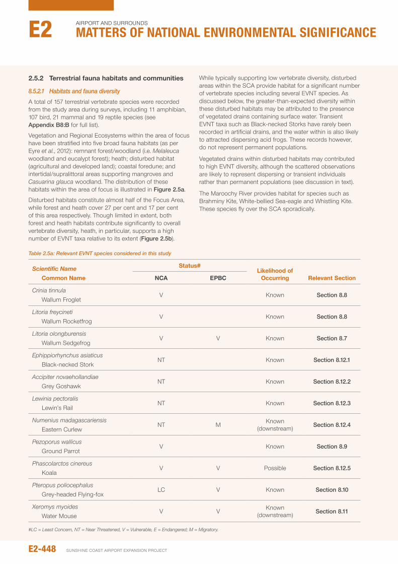
2.5.2 Terrestrial fauna habitats and communities
8.5.2.1 Habitats and fauna diversity
A total of 157 terrestrial vertebrate species were recorded from the study area during surveys, including 11 amphibian, 107 bird, 21 mammal and 19 reptile species (see Appendix B8:B for full list).
Vegetation and Regional Ecosystems within the area of focus have been stratified into five broad fauna habitats (as per Eyre et al., 2012): remnant forest/woodland (i.e. Melaleuca woodland and eucalypt forest); heath; disturbed habitat (agricultural and developed land); coastal foredune; and intertidal/supralittoral areas supporting mangroves and Casuarina glauca woodland. The distribution of these habitats within the area of focus is illustrated in Figure 2.5a.
Disturbed habitats constitute almost half of the Focus Area, while forest and heath cover 27 per cent and 17 per cent of this area respectively. Though limited in extent, both forest and heath habitats contribute significantly to overall vertebrate diversity, heath, in particular, supports a high number of EVnT taxa relative to its extent (Figure 2.5b).
While typically supporting low vertebrate diversity, disturbed areas within the SCA provide habitat for a significant number of vertebrate species including several EVnT species. As discussed below, the greater-than-expected diversity within these disturbed habitats may be attributed to the presence of vegetated drains containing surface water. Transient EVnT taxa such as Black-necked Storks have rarely been recorded in artificial drains, and the water within is also likely to attracted dispersing acid frogs. These records however, do not represent permanent populations.
Vegetated drains within disturbed habitats may contributed to high EVnT diversity, although the scattered observations are likely to represent dispersing or transient individuals rather than permanent populations (see discussion in text).
The Maroochy River provides habitat for species such as Brahminy Kite, White-bellied Sea-eagle and Whistling Kite. These species fly over the SCA sporadically.
Table 2.5a: Relevant EVNT species considered in this study
Scientific Name Common Name
Status#Likelihood of
Occurring Relevant SectionNCA EpBC
Crinia tinnula Wallum Froglet
V Known Section 8.8
Litoria freycineti Wallum Rocketfrog
V Known Section 8.8
Litoria olongburensis Wallum Sedgefrog
V V Known Section 8.7
Ephippiorhynchus asiaticus Black-necked Stork
nT Known Section 8.12.1
Accipiter novaehollandiae Grey Goshawk
nT Known Section 8.12.2
Lewinia pectoralis Lewin’s Rail
nT Known Section 8.12.3
Numenius madagascariensis Eastern Curlew
nT M Known (downstream) Section 8.12.4
Pezoporus wallicus Ground parrot
V Known Section 8.9
Phascolarctos cinereus Koala
V V possible Section 8.12.5
Pteropus poliocephalus Grey-headed Flying-fox
LC V Known Section 8.10
Xeromys myoides Water Mouse
V V Known (downstream) Section 8.11
#LC = Least Concern, NT = Near Threatened, V = Vulnerable, E = Endangered; M = Migratory.
E2-448
Airport And SurroundS
Matters of NatIoNaL eNvIroNMeNtaL sIgNIfIcaNceE2
SunSHinE CoASt Airport EXpAnSion proJECt
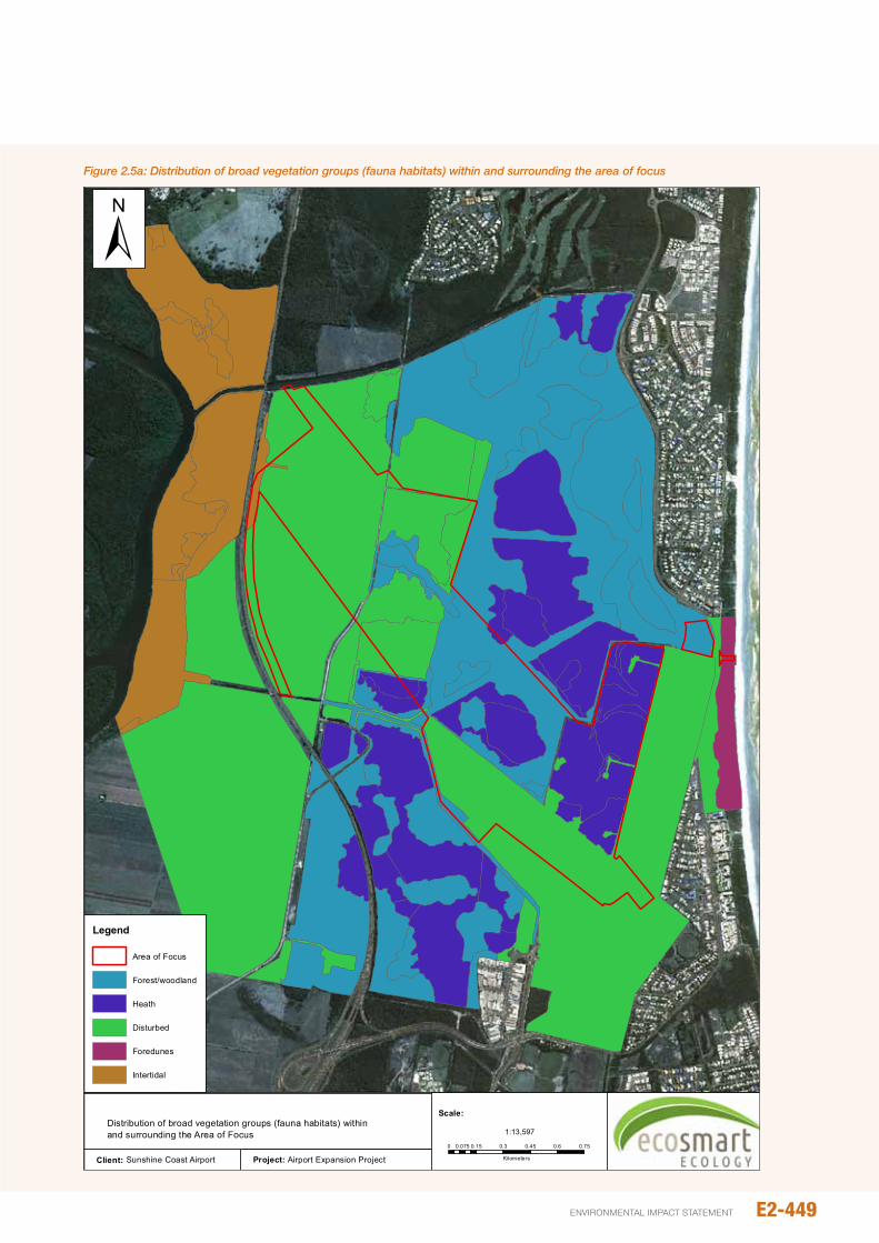
Project: Airport Expansion ProjectClient: Sunshine Coast Airport
Figure 2.1Distribution of broad vegetation groups (fauna habitats) within and surrounding the Area of Focus
Legend
Area of Focus
Forest/woodland
Heath
Disturbed
Foredunes
Intertidal
0 0.15 0.3 0.45 0.6 0.750.075
Kilometers
1:13,597
Scale:
±Figure 2.5a: Distribution of broad vegetation groups (fauna habitats) within and surrounding the area of focus
E2-449environmental impact statement
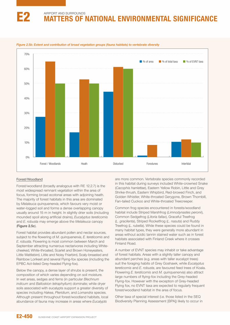
Forest/Woodland
Forest/woodland (broadly analogous with RE 12.2.7) is the most widespread remnant vegetation within the area of focus, forming broad ecotonal areas with adjoining heath. The majority of forest habitats in this area are dominated by Melaleuca quinquenervia, which favours very moist or water-logged soil and forms a dense overlapping canopy usually around 15 m in height. in slightly drier soils (including mounded spoil along artificial drains), Eucalyptus tereticornis and E. robusta may emerge above the Melaleuca canopy (Figure 2.5c).
Forest habitat provides abundant pollen and nectar sources, subject to the flowering of M. quinquenervia, E. tereticornis and E. robusta. Flowering is most common between March and September attracting numerous nectarivores including White-cheeked, White-throated, Scarlet and Brown Honeyeaters, Little Wattlebird, Little and noisy Friarbird, Scaly-breasted and Rainbow Lorikeet and several Flying-fox species (including the EpBC Act-listed Grey-headed Flying-fox).
Below the canopy, a dense layer of shrubs is present, the composition of which varies depending on soil moisture. in wet areas, sedges and ferns (in particular Blechnum indicum and Balloskion tetraphyllum) dominate; while dryer soils associated with eucalypts support a greater diversity of species including Hakea, Pteridium, and Lomandra species. Although present throughout forest/woodland habitats, local abundance of fauna may increase in areas where Eucalypts
are more common. Vertebrate species commonly recorded in this habitat during surveys included White-crowned Snake (Cacophis harriettae), Eastern Yellow Robin, Little and Grey Shrike-thrush, Eastern Whipbird, Red-browed Finch, and Golden Whistler, White-throated Gerygone, Brown Thornbill, Fan-tailed Cuckoo and White-throated Treecreeper.
Common frog species encountered in forests/woodland habitat include Striped Marshfrog (Limnodynastes peronii), Common Sedgefrog (Litoria fallax), Graceful Treefrog (L. gracilenta), Striped Rocketfrog (L. nasuta) and Ruddy Treefrog (L. rubella). While these species could be found in many habitat types, they were generally more abundant in areas without acidic tannin stained water such as in forest habitats associated with Finland Creek where it crosses Finland Road.
A number of EVnT species may inhabit or take advantage of forest habitats. Areas with a slightly taller canopy and abundant perches (e.g. areas with taller eucalypt trees) suit the foraging habits of Grey Goshawk, while Eucalyptus tereticornis and E. robusta, are favoured feed trees of Koala. Flowering E. tereticornis and M. quinquenervia) also attract large numbers of flying-fox including the Grey-headed Flying-fox. However with the exception of Grey-headed Flying fox, no EVnT taxa are expected to regularly frequent forest/woodland habitat in the area of focus.
other taxa of special interest (i.e. those listed in the SEQ Biodiversity planning Assessment [BpA]) likely to occur in
70%
60%
50%
40%
30%
20%
10%
0%
Forest / Woodlands Heath Disturbed Foredunes Intertidal
% of area % of EVNT taxa% of total taxa
Figure 2.5b: Extent and contribution of broad vegetation groups (fauna habitats) to vertebrate diversity
E2-450
Airport And SurroundS
Matters of NatIoNaL eNvIroNMeNtaL sIgNIfIcaNceE2
SunSHinE CoASt Airport EXpAnSion proJECt

Figure 2.5c: Melaleuca woodlands with dense understory
abundance within forest habitats included Little Wattlebird, Copper-backed Broodfrog (Pseudophryne Raveni), Little-red Flying-fox, Scotorepens sp. (parnaby) and Calyptotis scutirostrum. Known food plants (i.e. Gahnia spp) for two priority butterfly taxa (Hesperilla donnysa and Tisiphone abeona) occur in this habitat, however neither species is known to occur within the study area. The Delicate Mouse (Pseudomys delicatulus), which reaches its eastern limit on the Sunshine Coast, has been recorded within the local area (within nearby Maroochy River Conservation park) and though not recorded during these could possibly occur on site.
Migratory species such as Rufous Fantail and Black-faced Monarch are more likely to occur in forest/woodland than any other habitat within the SCA.
Heath
The structural and floristic composition of heath within the area of focus (including remnant and regrowth derived heath aithin the WHMA) varies significantly with soil moisture. in areas of dry soil, the heath can be dense and comparatively tall (up to ~ 2m in height), with a compact shrub layer of Hakea actites and Leptospermum sp. Where soils are subject to periodic inundation/water logging), species such as Blechnum indicum, Empodisma minus and Baloskion tetraphyllum can form a thick dense layer to ~1 m. Where surface water remains present for several weeks during the wet season, erect sedges including Baumea spp and
Balloskion pallens dominate. Within the context of the Focus Area, areas dominated by sedge (fitting the description of RE 12.2.15) are rare and generally restricted to lower-lying parts of the WHMA. Common to all heath within the study is the lack of taller emergent canopy species.
Vegetation within the WHMA is subject to slashing which would likely inhibit the growth of taller woody vegetation (including taller shrubs and Melaleuca quinquenervia). At the time of surveys, this area supported a mixture of sedgeland and low heath (see Figure 2.5d – Figure 2.5f).
Heath within the area of focus provides dense cover and foraging habitat for small passerines such as Red-backed Fairy-wren and Tawny Grassbirds, although these species can also be found in more open vegetation. Banksia robur and Xanthorea fulva are common in heath within the area of focus and, when flowering, attract large numbers of nectarivores including honeyeaters, lorikeets and flying foxes. Small insectivorous birds such as White-browed Scrubwren, Rainbow Bee-eater, and Grass Skinks (Lampropholis delicata), are also common in heath vegetation.
Heath, and areas of mixed heath-sedgeland, provide habitat for several EVnT species including Wallum Froglet, Wallum Rocketfrog, Wallum Sedgefrog, Lewin’s Rail and Ground parrot. Little Wattlebird and Pseudophryne raveni, both non-EVnT priority taxa (under the BpA), were also regularly recorded from heath habitats. Heath may also provide habitat for Scute-snouted Calyptotis (Calyptotis scutirostrum) and
E2-451environmental impact statement
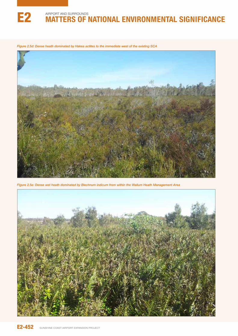
Figure 2.5d: Dense heath dominated by Hakea actites to the immediate west of the existing SCA
Figure 2.5e: Dense wet heath dominated by Blechnum indicum from within the Wallum Heath Management Area
E2-452
Airport And SurroundS
Matters of NatIoNaL eNvIroNMeNtaL sIgNIfIcaNceE2
SunSHinE CoASt Airport EXpAnSion proJECt
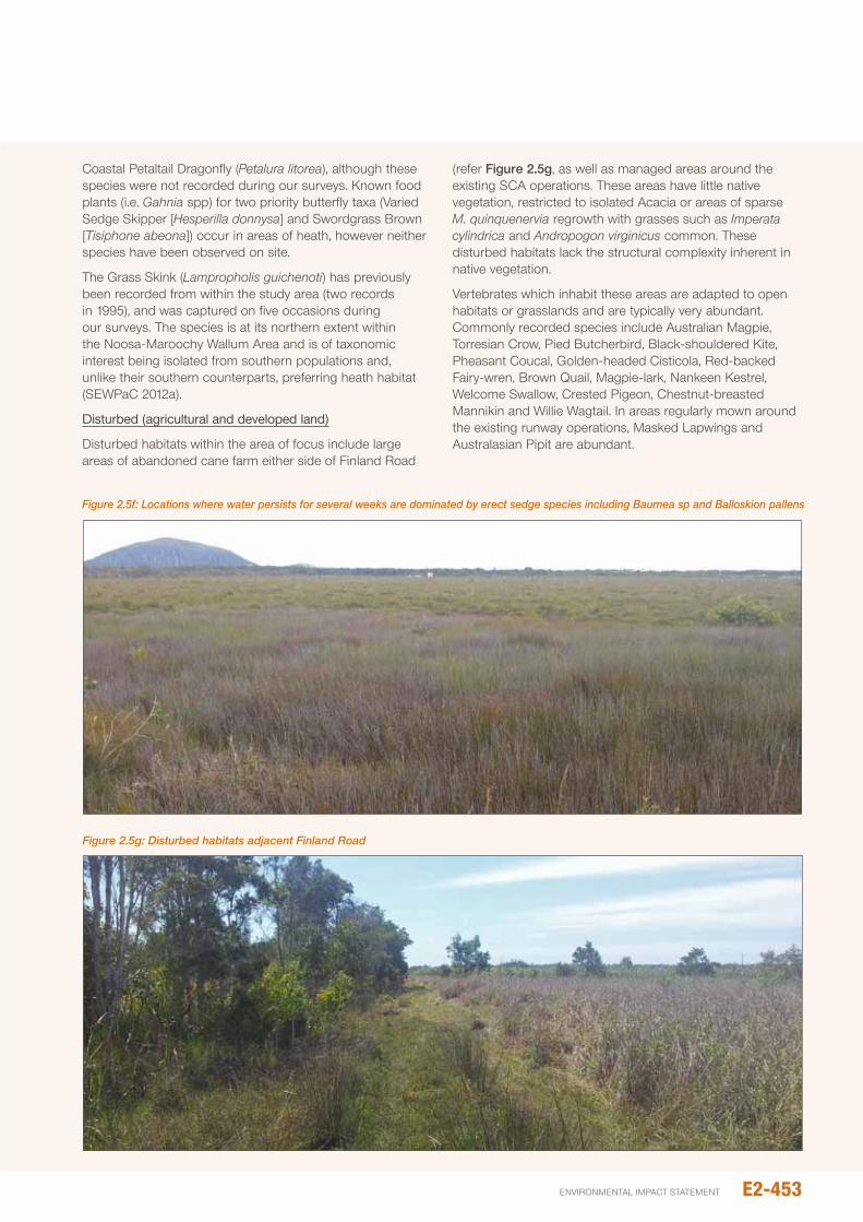
Coastal petaltail Dragonfly (Petalura litorea), although these species were not recorded during our surveys. Known food plants (i.e. Gahnia spp) for two priority butterfly taxa (Varied Sedge Skipper [Hesperilla donnysa] and Swordgrass Brown [Tisiphone abeona]) occur in areas of heath, however neither species have been observed on site.
The Grass Skink (Lampropholis guichenoti) has previously been recorded from within the study area (two records in 1995), and was captured on five occasions during our surveys. The species is at its northern extent within the noosa-Maroochy Wallum Area and is of taxonomic interest being isolated from southern populations and, unlike their southern counterparts, preferring heath habitat (SEWpaC 2012a).
Disturbed (agricultural and developed land)
Disturbed habitats within the area of focus include large areas of abandoned cane farm either side of Finland Road
(refer Figure 2.5g, as well as managed areas around the existing SCA operations. These areas have little native vegetation, restricted to isolated Acacia or areas of sparse M. quinquenervia regrowth with grasses such as Imperata cylindrica and Andropogon virginicus common. These disturbed habitats lack the structural complexity inherent in native vegetation.
Vertebrates which inhabit these areas are adapted to open habitats or grasslands and are typically very abundant. Commonly recorded species include Australian Magpie, Torresian Crow, pied Butcherbird, Black-shouldered Kite, pheasant Coucal, Golden-headed Cisticola, Red-backed Fairy-wren, Brown Quail, Magpie-lark, nankeen Kestrel, Welcome Swallow, Crested pigeon, Chestnut-breasted Mannikin and Willie Wagtail. in areas regularly mown around the existing runway operations, Masked Lapwings and Australasian pipit are abundant.
Figure 2.5f: Locations where water persists for several weeks are dominated by erect sedge species including Baumea sp and Balloskion pallens
Figure 2.5g: Disturbed habitats adjacent Finland Road
E2-453environmental impact statement
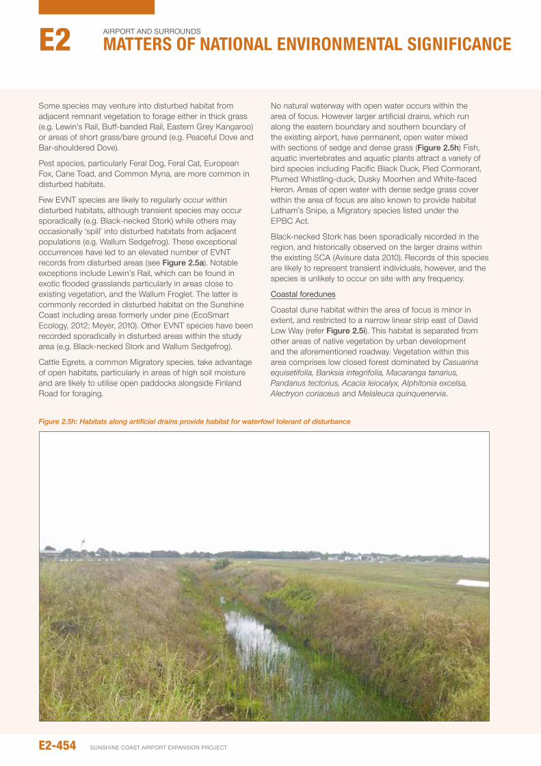
Some species may venture into disturbed habitat from adjacent remnant vegetation to forage either in thick grass (e.g. Lewin’s Rail, Buff-banded Rail, Eastern Grey Kangaroo) or areas of short grass/bare ground (e.g. peaceful Dove and Bar-shouldered Dove).
pest species, particularly Feral Dog, Feral Cat, European Fox, Cane Toad, and Common Myna, are more common in disturbed habitats.
Few EVnT species are likely to regularly occur within disturbed habitats, although transient species may occur sporadically (e.g. Black-necked Stork) while others may occasionally ‘spill’ into disturbed habitats from adjacent populations (e.g. Wallum Sedgefrog). These exceptional occurrences have led to an elevated number of EVnT records from disturbed areas (see Figure 2.5a). notable exceptions include Lewin’s Rail, which can be found in exotic flooded grasslands particularly in areas close to existing vegetation, and the Wallum Froglet. The latter is commonly recorded in disturbed habitat on the Sunshine Coast including areas formerly under pine (EcoSmart Ecology, 2012; Meyer, 2010). other EVnT species have been recorded sporadically in disturbed areas within the study area (e.g. Black-necked Stork and Wallum Sedgefrog).
Cattle Egrets, a common Migratory species, take advantage of open habitats, particularly in areas of high soil moisture and are likely to utilise open paddocks alongside Finland Road for foraging.
no natural waterway with open water occurs within the area of focus. However larger artificial drains, which run along the eastern boundary and southern boundary of the existing airport, have permanent, open water mixed with sections of sedge and dense grass (Figure 2.5h) Fish, aquatic invertebrates and aquatic plants attract a variety of bird species including pacific Black Duck, pied Cormorant, plumed Whistling-duck, Dusky Moorhen and White-faced Heron. Areas of open water with dense sedge grass cover within the area of focus are also known to provide habitat Latham’s Snipe, a Migratory species listed under the EpBC Act.
Black-necked Stork has been sporadically recorded in the region, and historically observed on the larger drains within the existing SCA (Avisure data 2010). Records of this species are likely to represent transient individuals, however, and the species is unlikely to occur on site with any frequency.
Coastal foredunes
Coastal dune habitat within the area of focus is minor in extent, and restricted to a narrow linear strip east of David Low Way (refer Figure 2.5i). This habitat is separated from other areas of native vegetation by urban development and the aforementioned roadway. Vegetation within this area comprises low closed forest dominated by Casuarina equisetifolia, Banksia integrifolia, Macaranga tanarius, Pandanus tectorius, Acacia leiocalyx, Alphitonia excelsa, Alectryon coriaceus and Melaleuca quinquenervia.
Figure 2.5h: Habitats along artificial drains provide habitat for waterfowl tolerant of disturbance
E2-454
Airport And SurroundS
Matters of NatIoNaL eNvIroNMeNtaL sIgNIfIcaNceE2
SunSHinE CoASt Airport EXpAnSion proJECt
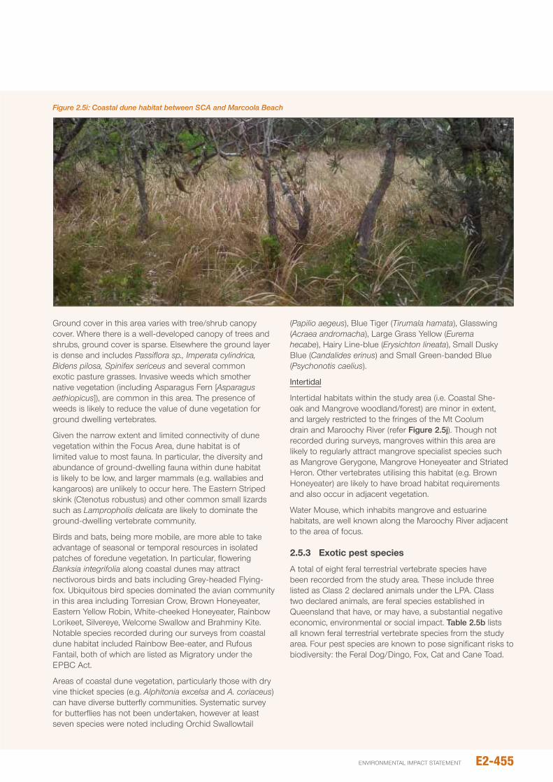
Ground cover in this area varies with tree/shrub canopy cover. Where there is a well-developed canopy of trees and shrubs, ground cover is sparse. Elsewhere the ground layer is dense and includes Passiflora sp., Imperata cylindrica, Bidens pilosa, Spinifex sericeus and several common exotic pasture grasses. invasive weeds which smother native vegetation (including Asparagus Fern [Asparagus aethiopicus]), are common in this area. The presence of weeds is likely to reduce the value of dune vegetation for ground dwelling vertebrates.
Given the narrow extent and limited connectivity of dune vegetation within the Focus Area, dune habitat is of limited value to most fauna. in particular, the diversity and abundance of ground-dwelling fauna within dune habitat is likely to be low, and larger mammals (e.g. wallabies and kangaroos) are unlikely to occur here. The Eastern Striped skink (Ctenotus robustus) and other common small lizards such as Lampropholis delicata are likely to dominate the ground-dwelling vertebrate community.
Birds and bats, being more mobile, are more able to take advantage of seasonal or temporal resources in isolated patches of foredune vegetation. in particular, flowering Banksia integrifolia along coastal dunes may attract nectivorous birds and bats including Grey-headed Flying-fox. ubiquitous bird species dominated the avian community in this area including Torresian Crow, Brown Honeyeater, Eastern Yellow Robin, White-cheeked Honeyeater, Rainbow Lorikeet, Silvereye, Welcome Swallow and Brahminy Kite. notable species recorded during our surveys from coastal dune habitat included Rainbow Bee-eater, and Rufous Fantail, both of which are listed as Migratory under the EpBC Act.
Areas of coastal dune vegetation, particularly those with dry vine thicket species (e.g. Alphitonia excelsa and A. coriaceus) can have diverse butterfly communities. Systematic survey for butterflies has not been undertaken, however at least seven species were noted including orchid Swallowtail
(Papilio aegeus), Blue Tiger (Tirumala hamata), Glasswing (Acraea andromacha), Large Grass Yellow (Eurema hecabe), Hairy Line-blue (Erysichton lineata), Small Dusky Blue (Candalides erinus) and Small Green-banded Blue (Psychonotis caelius).
Intertidal
intertidal habitats within the study area (i.e. Coastal She-oak and Mangrove woodland/forest) are minor in extent, and largely restricted to the fringes of the Mt Coolum drain and Maroochy River (refer Figure 2.5j). Though not recorded during surveys, mangroves within this area are likely to regularly attract mangrove specialist species such as Mangrove Gerygone, Mangrove Honeyeater and Striated Heron. other vertebrates utilising this habitat (e.g. Brown Honeyeater) are likely to have broad habitat requirements and also occur in adjacent vegetation.
Water Mouse, which inhabits mangrove and estuarine habitats, are well known along the Maroochy River adjacent to the area of focus.
2.5.3 Exotic pest species
A total of eight feral terrestrial vertebrate species have been recorded from the study area. These include three listed as Class 2 declared animals under the LpA. Class two declared animals, are feral species established in Queensland that have, or may have, a substantial negative economic, environmental or social impact. Table 2.5b lists all known feral terrestrial vertebrate species from the study area. Four pest species are known to pose significant risks to biodiversity: the Feral Dog/Dingo, Fox, Cat and Cane Toad.
Figure 2.5i: Coastal dune habitat between SCA and Marcoola Beach
E2-455environmental impact statement
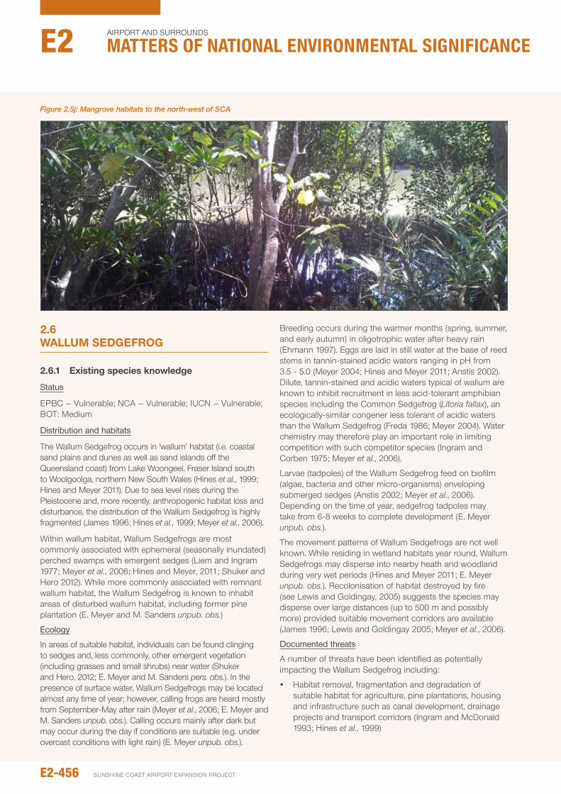
Figure 2.5j: Mangrove habitats to the north-west of SCA
2.6 wALLUM SEdGEFROG
2.6.1 Existing species knowledge
Status
EpBC – Vulnerable; nCA – Vulnerable; iuCn – Vulnerable; BoT: Medium
Distribution and habitats
The Wallum Sedgefrog occurs in ‘wallum’ habitat (i.e. coastal sand plains and dunes as well as sand islands off the Queensland coast) from Lake Woongeel, Fraser island south to Woolgoolga, northern new South Wales (Hines et al., 1999; Hines and Meyer 2011). Due to sea level rises during the pleistocene and, more recently, anthropogenic habitat loss and disturbance, the distribution of the Wallum Sedgefrog is highly fragmented (James 1996; Hines et al., 1999; Meyer et al., 2006).
Within wallum habitat, Wallum Sedgefrogs are most commonly associated with ephemeral (seasonally inundated) perched swamps with emergent sedges (Liem and ingram 1977; Meyer et al., 2006; Hines and Meyer, 2011; Shuker and Hero 2012). While more commonly associated with remnant wallum habitat, the Wallum Sedgefrog is known to inhabit areas of disturbed wallum habitat, including former pine plantation (E. Meyer and M. Sanders unpub. obs.)
Ecology
in areas of suitable habitat, individuals can be found clinging to sedges and, less commonly, other emergent vegetation (including grasses and small shrubs) near water (Shuker and Hero, 2012; E. Meyer and M. Sanders pers. obs.). in the presence of surface water, Wallum Sedgefrogs may be located almost any time of year; however, calling frogs are heard mostly from September-May after rain (Meyer et al., 2006; E. Meyer and M. Sanders unpub. obs.). Calling occurs mainly after dark but may occur during the day if conditions are suitable (e.g. under overcast conditions with light rain) (E. Meyer unpub. obs.).
Breeding occurs during the warmer months (spring, summer, and early autumn) in oligotrophic water after heavy rain (Ehmann 1997). Eggs are laid in still water at the base of reed stems in tannin-stained acidic waters ranging in pH from 3.5 - 5.0 (Meyer 2004; Hines and Meyer 2011; Anstis 2002). Dilute, tannin-stained and acidic waters typical of wallum are known to inhibit recruitment in less acid-tolerant amphibian species including the Common Sedgefrog (Litoria fallax), an ecologically-similar congener less tolerant of acidic waters than the Wallum Sedgefrog (Freda 1986; Meyer 2004). Water chemistry may therefore play an important role in limiting competition with such competitor species (ingram and Corben 1975; Meyer et al., 2006).
Larvae (tadpoles) of the Wallum Sedgefrog feed on biofilm (algae, bacteria and other micro-organisms) enveloping submerged sedges (Anstis 2002; Meyer et al., 2006). Depending on the time of year, sedgefrog tadpoles may take from 6-8 weeks to complete development (E. Meyer unpub. obs.).
The movement patterns of Wallum Sedgefrogs are not well known. While residing in wetland habitats year round, Wallum Sedgefrogs may disperse into nearby heath and woodland during very wet periods (Hines and Meyer 2011; E. Meyer unpub. obs.). Recolonisation of habitat destroyed by fire (see Lewis and Goldingay, 2005) suggests the species may disperse over large distances (up to 500 m and possibly more) provided suitable movement corridors are available (James 1996; Lewis and Goldingay 2005; Meyer et al., 2006).
Documented threats
A number of threats have been identified as potentially impacting the Wallum Sedgefrog including:
y Habitat removal, fragmentation and degradation of suitable habitat for agriculture, pine plantations, housing and infrastructure such as canal development, drainage projects and transport corridors (ingram and McDonald 1993; Hines et al., 1999)
E2-456
Airport And SurroundS
Matters of NatIoNaL eNvIroNMeNtaL sIgNIfIcaNceE2
SunSHinE CoASt Airport EXpAnSion proJECt
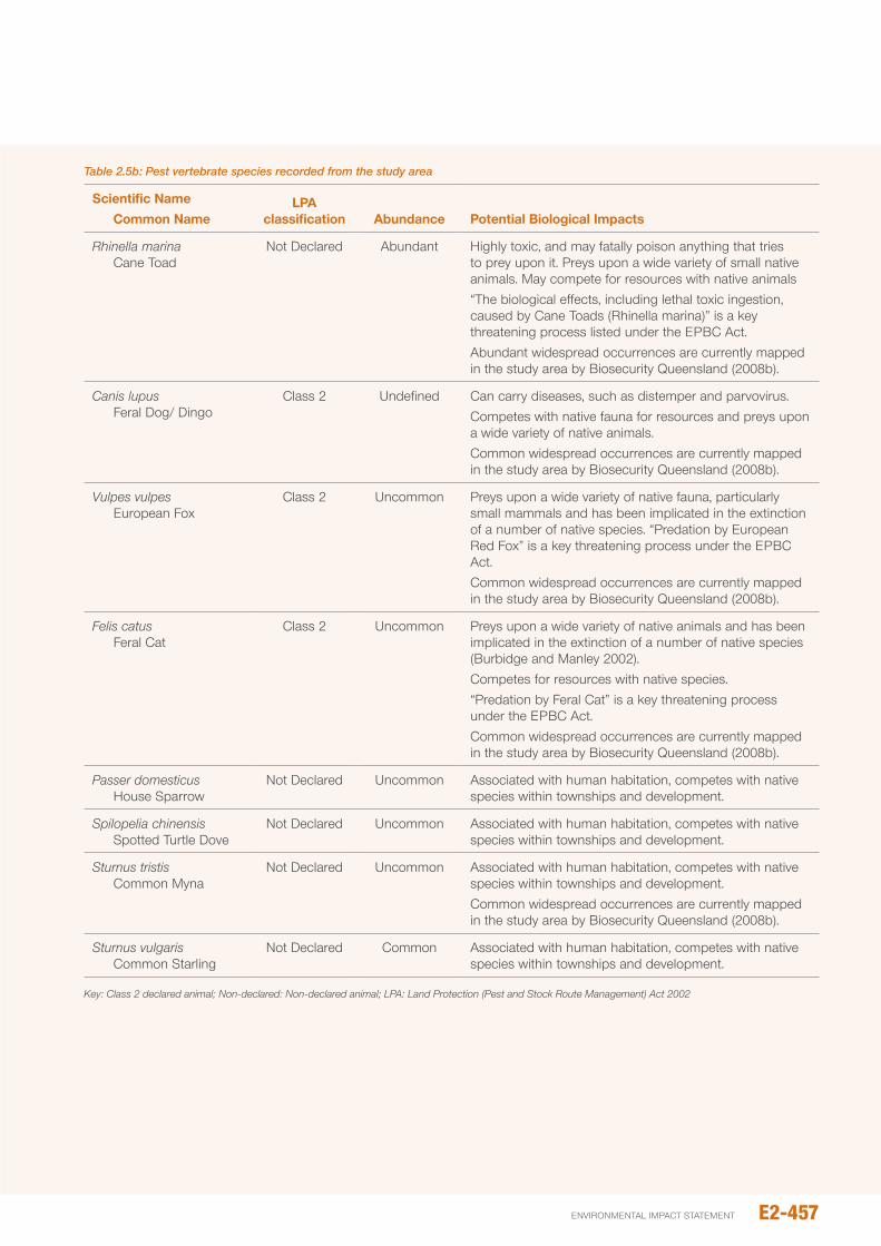
Table 2.5b: Pest vertebrate species recorded from the study area
Scientific Name Common Name
LpA classification Abundance potential Biological Impacts
Rhinella marina Cane Toad
not Declared Abundant Highly toxic, and may fatally poison anything that tries to prey upon it. preys upon a wide variety of small native animals. May compete for resources with native animals “The biological effects, including lethal toxic ingestion, caused by Cane Toads (Rhinella marina)” is a key threatening process listed under the EpBC Act. Abundant widespread occurrences are currently mapped in the study area by Biosecurity Queensland (2008b).
Canis lupus Feral Dog/ Dingo
Class 2 undefined Can carry diseases, such as distemper and parvovirus. Competes with native fauna for resources and preys upon a wide variety of native animals. Common widespread occurrences are currently mapped in the study area by Biosecurity Queensland (2008b).
Vulpes vulpes European Fox
Class 2 uncommon preys upon a wide variety of native fauna, particularly small mammals and has been implicated in the extinction of a number of native species. “predation by European Red Fox” is a key threatening process under the EpBC Act. Common widespread occurrences are currently mapped in the study area by Biosecurity Queensland (2008b).
Felis catus Feral Cat
Class 2 uncommon preys upon a wide variety of native animals and has been implicated in the extinction of a number of native species (Burbidge and Manley 2002). Competes for resources with native species. “predation by Feral Cat” is a key threatening process under the EpBC Act. Common widespread occurrences are currently mapped in the study area by Biosecurity Queensland (2008b).
Passer domesticus House Sparrow
not Declared uncommon Associated with human habitation, competes with native species within townships and development.
Spilopelia chinensis Spotted Turtle Dove
not Declared uncommon Associated with human habitation, competes with native species within townships and development.
Sturnus tristis Common Myna
not Declared uncommon Associated with human habitation, competes with native species within townships and development.Common widespread occurrences are currently mapped in the study area by Biosecurity Queensland (2008b).
Sturnus vulgaris Common Starling
not Declared Common Associated with human habitation, competes with native species within townships and development.
Key: Class 2 declared animal; Non-declared: Non-declared animal; LPA: Land Protection (Pest and Stock Route Management) Act 2002
E2-457environmental impact statement
y Changes in hydrological regimes, increased nutrients or sediments, altered water quality (salinity, acidity, nutrient levels and toxicity, dissolved oxygen, temperature and turbidity) due to landscape modification. This could include urban run-off from fertilisers, detergents, oils, etc. (Meyer et al., 2006)
y use of biocides for weed and mosquito control programs (Meyer et al., 2006)
y Construction of physical barriers which limit movement between water bodies
y Mortality on roads adjacent to populations (Goldingay and Taylor 2006)
y predation from introduced fish (i.e. Gambusia holbrooki) (Hines et al., 1999)
y Weed spread (Meyer et al., 2006)
y Feral pigs, Sus scrofa (Meyer et al., 2006)
y introduced pathogens (i.e. Batrachochytrium dendrobatidis) (Meyer et al., 2006)
y Competition from other frog species such as L. fallax, following habitat disturbance (Meyer et al., 2006)
y inappropriate fire management (Meyer et al., 2006).
2.6.2 Extent of occurrence
2.6.2.1 Regional and local context
in Queensland, the Wallum Sedgefrog occurs on offshore dune islands and adjacent coastal dunes and sand plains from Fraser island south to the Queensland – new South Wales border. on the Queensland coast, this species is largely confined to the Cooloola region (north of the noosa River) and Sunshine Coast (from the noosa River, south to Beerwah).
The only other mainland records of Wallum Sedgefrog south of the Sunshine Coast are from ningi, to the south-west of Bribie island (J. Richards, pers. comm.), Tallebudgera/Tugun on the Gold Coast and Woolgoolga, northern new South Wales (Hines et al., 1999). Thus, on the Queensland mainland, Wallum Sedgefrogs are largely restricted to a narrow coastal strip of approximately 150 km extending from Beerwah north to Cooloola. Within this region, the majority of known Wallum Sedgefrog habitat (60-70 per cent) occurs within protected estate.
Two large tidal river systems (the noosa and Maroochy River) extend inland from the coast forming a significant barrier to the dispersal of Wallum Sedgefrogs. populations separated by these rivers are likely to have been isolated
from one another for some time (i.e. many thousands of years) and may have diverged genetically from one another. While the level or significance of genetic divergence/structuring across the Maroochy and noosa Rivers is unknown, populations separated by these rivers are, for conservation management purposes, treated as distinct Management units (Mus) (sensu Moritz 1994) – (given likely divergence in allele frequencies across the Maroochy and noosa Rivers). Hence, in Queensland, the mainland distribution of the Wallum Sedgefrog (north of the Caboolture River) comprises three putative Mus: Cooloola, peregian and Caloundra (Sanders et al., 2012).
The Cooloola Mu lies north of the noosa River and includes large populations of the Wallum Sedgefrog associated with wet heath and sedgeland, east of the Como Scarp, mostly within national park.
The peregian unit, which extends south from the noosa River to the Maroochy River, includes populations near Lake Weyba and peregian, north of Yandina Coolum Road (M. Sanders and E. Meyer pers. obs.) as well as the SCA. Clearing and urban development within this unit has probably fragmented the peregian unit into two sub-units, one extending almost uninterrupted from noosa to the Yandina-Coolum Road (~15 km), and the second (including the SCA) from Mt Coolum south to the Maroochy River.
The Caloundra unit extends south from the Maroochy River to ningi and includes the Beerwah Scientific Reserve. Wetland habitat within this unit has been extensively modified resulting in significant loss and fragmentation of Wallum Sedgefrog habitat.
2.6.2.2 Mapped essential habitat
Essential Habitat for the Wallum Sedgefrog within the study area includes remnant vegetation mapped as REs 12.2.7, 12.2.12 and 12.2.15. The extent of Essential Habitat for this species is summarised in Table 2.6a.
2.6.2.3 Occurrence within the study area
During surveys in 2010/2011, Wallum Sedgefrogs were recorded from within SCA land at the helicopter training area and WHMA (see Figure 2.6a). individual frogs were also recorded along a drainage channel to the near south of the WHMA. outside of the SCA, Wallum Sedgefrogs were only recorded within the northern section of Mt Coolum np (i.e. to the near east of Finland Road East). numbers of Wallum Sedgefrog and the extent of suitable sedgefrog breeding habitat at this location were extremely limited.
Table 2.6a: Mapped essential habitat for the Wallum Sedgefrog within the study area
RE Brief description Extent in study area
12.2.7 Remnant Melaleuca quinquenervia open-forest to woodland 179.77 ha
12.2.12 Remnant closed/wet heath 215.40 ha
12.2.15 Swamps with Baumea spp., Juncus spp. And Lepironia articulate 35.80 ha
E2-458
Airport And SurroundS
Matters of NatIoNaL eNvIroNMeNtaL sIgNIfIcaNceE2
SunSHinE CoASt Airport EXpAnSion proJECt

Records of the Wallum Sedgefrog within the SCA are mostly from mapped remnant wet heath/ sedgeland and regrowth wet heath within the WHMA and helicopter training area (see Figure 2.6a). Within the WHMA and helicopter training area, Wallum Sedgefrogs were recorded mostly from areas of deeper water (≥10 cm) with upright sedges (e.g. Baumea spp., Baloskion pallens) and Bungwall Fern (Blechnum indicum) (Figure 2.6b). This includes areas of sedgeland adjacent raised access tracks (e.g. the perimeter fence track; see Figure 2.6c). Within the helicopter training area Wallum Sedgefrogs were found only in areas of deeper water (≥ 10 cm), immediately adjacent to helicopter landing pads (See Figure 2.6a). These areas appear to have been created by the excavation of soil used to create landing pads. Surface waters in areas of occupied habitat were low in pH (range: 4-4.6; n=6), and heavily tannin-stained (range: 26.9-45.7 mg/L tannic acid; n=5).
Within the northern section of Mt Coolum np, small numbers of Wallum Sedgefrog were recorded from an area of wet heath north of the SCA (to the near east of Finland Road East) with mostly sparse sedge cover and relatively little surface water. in this area, Wallum Sedgefrog habitat appears to be limited to small areas with deeper surface water (> 10 cm) and upright sedges. The extent of this habitat within the area surveyed appears limited (i.e. < 10 m x 5 m). Wallum Sedgefrogs were not recorded in the southern section of Mt Coolum national park where preferred habitat (i.e. seasonally inundated areas dominated by upright sedges and/or Bungwall Fern [Blechnum indicum]) is scarce and surface water too ephemeral to support recruitment. As such, habitat within this area is unlikely to support a significant breeding population. At wet times, wet heath in this area may provide habitat for small numbers of dispersing animals.
Despite the presence of deeper water and upright sedges (Baumea spp. and Lepironia articulata), Wallum Sedgefrogs were largely absent from drainage channels constructed adjacent the WHMA and north-south runway (RWY 18/31). This may be due in part to the presence of large numbers of Common Sedgefrog (Litoria fallax) – a potential competitor associated with disturbed wallum environs - and the presence of predatory fish (in particular Gambusia holbrooki). Water within these drainage channels is far less acidic (up to pH 6.5), less heavily tannin-stained (< 8.4 mg/L tannic acid) and, therefore, highly suitable for Common Sedgefrogs which commonly co-exist with Mosquitofish (E. Meyer, pers. obs.). Drainage channels to the north and west of the existing airport also appear largely unsuitable for Wallum Sedgefrog, but may at times provide habitat for dispersing animals.
Cleared land subject to cultivation to the north-west of the SCA does not appear to provide suitable habitat for the Wallum Sedgefrog. Drainage channels dissecting land in this area also appear unsuitable for the Wallum Sedgefrog. Swamp habitats directly adjacent (north) of the SCA does not provide suitable habitat for Wallum Sedgefrogs. This small area retains non acidic, clear water, for extensive periods. no Wallum Sedgefrogs have been recorded in this area despite searches.
2.6.3 Breeding (recruitment 2011/12)
During surveys in 2011/2012, recently-metamorphosed and sub-adult Wallum Sedgefrogs (SVL< 20 mm) were recorded at a number of locations within the WHMA indicating successful breeding/recruitment. Most breeding records from this area are from areas of deeper water (> 10 cm) dominated by sedges (e.g. Baumea spp. and Balloskion pallens) (Figure 2.6d). Despite the presence of apparently suitable breeding habitat, no juvenile frogs were recorded from the helicopter training area during surveys.
outside of the WHMA and helicopter training area, there appears to be little, if any, suitable breeding habitat for Wallum Sedgefrogs (i.e. areas of deeper water (>10 cm) supporting upright sedges). Areas of apparently suitable habitat along drainage lines within the SCA and broader study area are unlikely to support breeding by the Wallum Sedgefrog due to high densities of the Common Sedgefrog and/or predatory fish (in particular Gambusia holbrooki).
2.6.4 Relative abundance
The relative abundance of Wallum Sedgefrogs at survey sites during Summer 2011/2012 is shown in Figure 2.6e. numbers of Wallum Sedgefrog recorded on transects varied widely, with a maximum of 91 individuals recorded from sedge-land in the north-west of the WHMA (see Figure 2.6e). Counts of between 31-40 individuals were recorded at a number of other sites with deeper water (> 10 cm deep) and a cover of upright sedges. Most counts, however, were of less than 20 animals. Lower counts (< 10) were mostly associated with areas of wet heath with shallow surface water (< 5cm deep) and fewer sedges. numbers around the helicopter training area were also low, despite the presence of sedges and water to around 15 cm depth. Counts of 30 individuals and higher are not unexpected and compare favourably with transect-based counts elsewhere on the Sunshine Coast, (E. Meyer, K. Lowe and M. Sanders, unpub. obs.), as well as Bribie island and northern new South Wales (Lewis and Goldingay, 2005; Hines and Meyer, 2011).
Count data suggests the WHMA supports a sizeable population of Wallum Sedgefrogs, numbering several hundred animals. Though sizeable for such a small area, larger populations are likely to occur at Mooloolah River national park and Beerwah Scientific Area, where Wallum Sedgefrogs occur at similar densities (K. Lowe, unpub. data) but the extent of suitable habitat is far greater. While count data is lacking, the extent of suitable habitat within noosa national park (i.e. north of the Yandina-Coolum Road) suggests numbers of Wallum Sedgefrog may be similarly high elsewhere within the peregian Mu. This, however, requires confirmation.
E2-459environmental impact statement
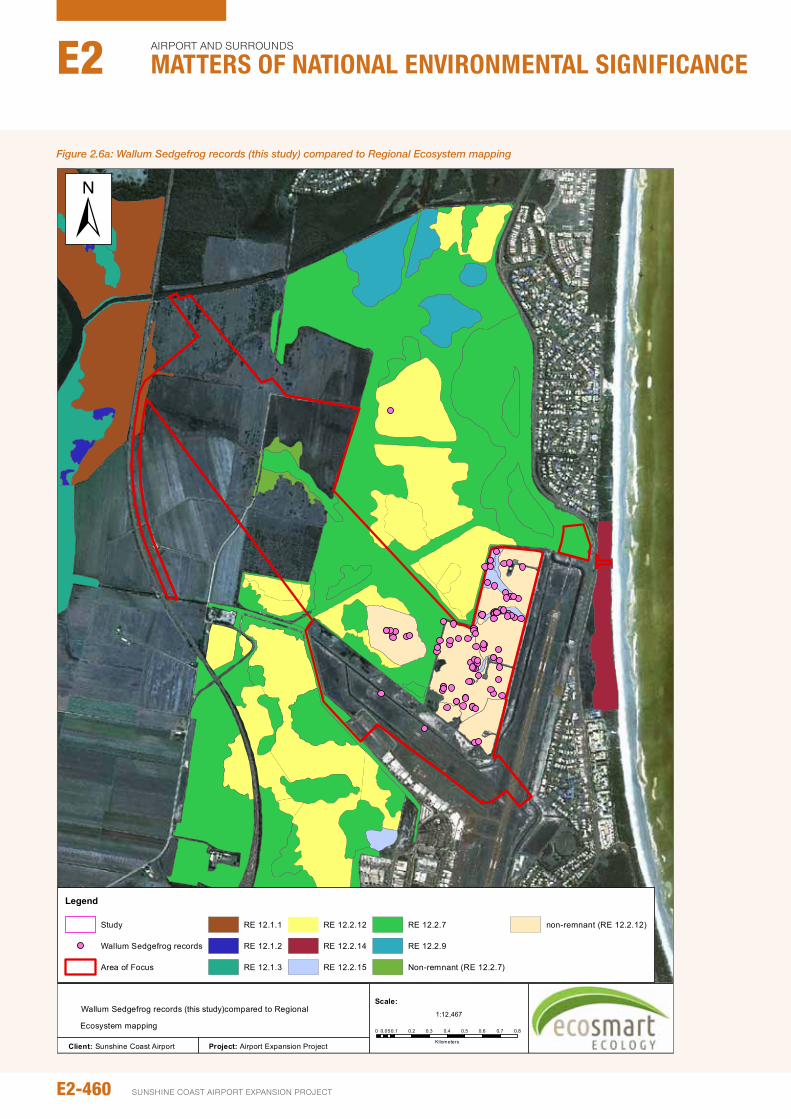
Figure 2.5
Wallum Sedgefrog records (this study)compared to Regional
Ecosystem mapping
Legend
Study
Wallum Sedgefrog records
Area of Focus
RE 12.1.1
RE 12.1.2
RE 12.1.3
RE 12.2.12
RE 12.2.14
RE 12.2.15
RE 12.2.7
RE 12.2.9
Non-remnant (RE 12.2.7)
non-remnant (RE 12.2.12)
±
Client: Sunshine Coast Airport Project: Airport Expansion Project
0 0.1 0.2 0.3 0.4 0.5 0.6 0.7 0.80.05
Kilometers
1:12,467
Scale:
Figure 2.6a: Wallum Sedgefrog records (this study) compared to Regional Ecosystem mapping
E2-460
Airport And SurroundS
Matters of NatIoNaL eNvIroNMeNtaL sIgNIfIcaNceE2
SunSHinE CoASt Airport EXpAnSion proJECt
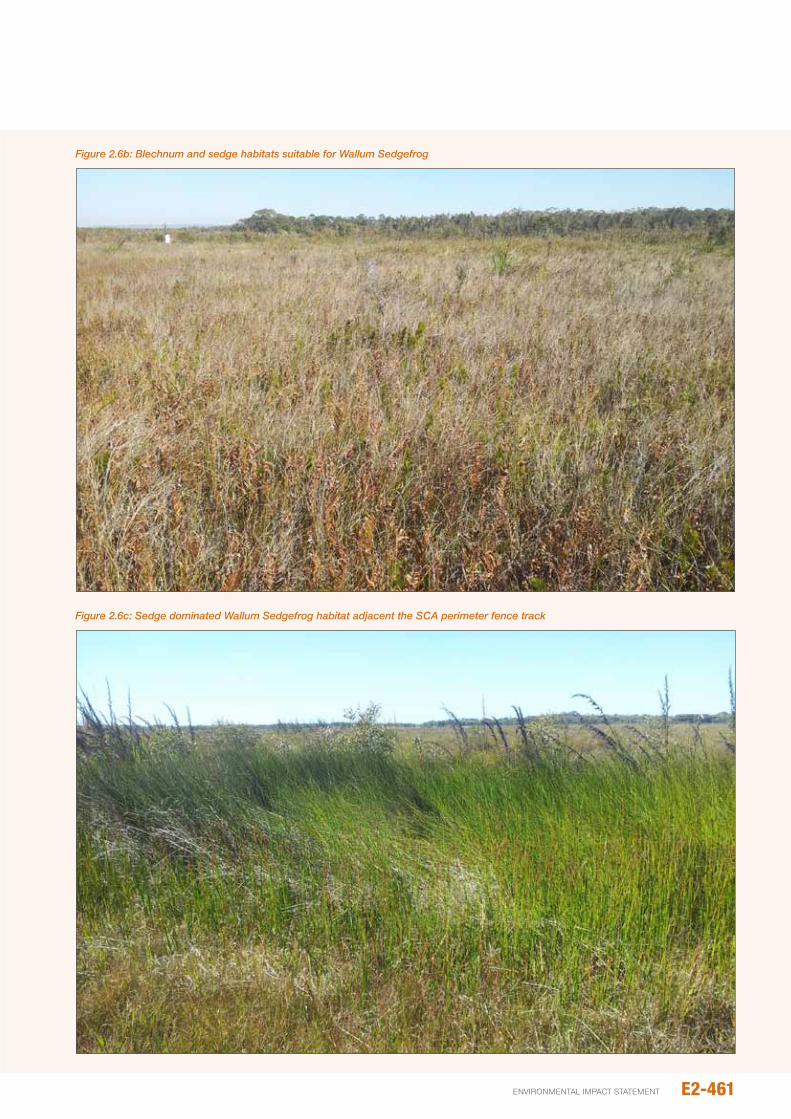
Figure 2.6b: Blechnum and sedge habitats suitable for Wallum Sedgefrog
Figure 2.6c: Sedge dominated Wallum Sedgefrog habitat adjacent the SCA perimeter fence track
E2-461environmental impact statement

Figure 2.6
Wallum Sedgefrog breeding records and Wallum Sedgefrog habitat
Legend
Confirmed breeding (subadult or metamorph)
Area of Focus
Wallum Sedgefrog
±
Client: Sunshine Coast Airport Project: Airport Expansion Project
0 0.1 0.2 0.3 0.40.05
Kilometers
1:6,886
Scale:
Figure 2.6d: Wallum Sedgefrog breeding records and Wallum Sedgefrog habitat
E2-462
Airport And SurroundS
Matters of NatIoNaL eNvIroNMeNtaL sIgNIfIcaNceE2
SunSHinE CoASt Airport EXpAnSion proJECt
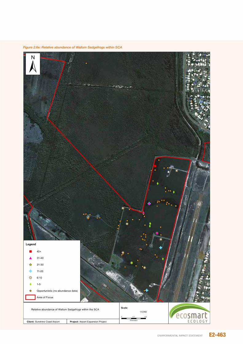
kj#
Xkj
X#
X
_̂
X
kj
""
G#
kj
kjX
kj
kj
kj
G
X
kj
G
X
_̂
X
Figure 2.7
Legend
" 40+
# 31-40
_̂ 21-30
G 11-20
kj 6-10
X 1-5
Opportunistic (no abundance data)
Area of Focus
±
Client: Sunshine Coast Airport Project: Airport Expansion Project
0 0.20.1
Kilometers
1:5,592
Scale:Relative abundance of Wallum Sedgefrogs within the SCA
Figure 2.6e: Relative abundance of Wallum Sedgefrogs within SCA
E2-463environmental impact statement
2.6.5 potential movement/dispersal
occupied habitat within the SCA is located 900 m from the nearest area of known (occupied) habitat within the northern section of Mt Coolum np. intervening habitat (wet heath and Melaleuca woodland) may support occasional movement/dispersal of animals between these areas, particularly during wet periods. opportunities for dispersal to areas of suitable habitat elsewhere appear limited due to:
y A paucity of suitable habitat in proximity to areas of known habitat, other than that north of the SCA
y The absence of suitable ground cover (i.e. near contiguous taller sedge, grass or shrub cover) for animals dispersing south and, to a lesser extent, east and west of occupied habitat
y The presence of housing and roads (including busy David Low Way) to the south and east of the SCA.
2.6.6 Importance of SCA wallum Sedgefrog population
The SCA Wallum Sedgefrog population is one of several populations within the peregian Mu (one of three discrete Mus on the Sunshine Coast [see Section 2.6.2.1]). Comparative data on Wallum Sedgefrog abundance from other occupied sites within the peregian Mu, however, are limited and, given the extent of suitable occupied habitat within noosa and Tewantin national parks (where the species is locally abundant [E. Meyer, unpub. obs.]), larger viable populations may occur elsewhere within the peregian Mu. Without data to confirm this, a precautionary approach has been adopted when assessing the importance of the SCA population.
As a sizeable source population, the SCA Wallum Sedgefrog population may contribute significantly to the long-term viability of the peregian Mu and, ergo, maintenance of genetic diversity within the species as a whole. As such, the SCA population may be considered an important population as defined in the Significant impact Guidelines for Matters of national Environmental Significance (DEH, 2006).
2.7 GREy-hEAdEd FLyING-FOx
2.7.1 Existing species knowledge
Status
nCA– Least Concern; EpBC– Vulnerable; BoT– Critical
Distribution and habitat
Though once abundant between Rockhampton Queensland and Mallacoota Victoria, the range of Grey-headed Flying-foxes has contracted considerably (Tidemann 1998). They are no longer present in the Rockhampton and Hervey Bay areas and have declined in numbers around Brisbane (Duncan et al., 1999).
As with other flying-fox species, the occurrence of Grey-headed Flying-foxes is heavily dependent on the availability of foraging resources and roost sites. As canopy-feeding frugivores and nectarivores, Grey-headed Flying-foxes frequent fruiting and flowering trees in rainforests, open eucalypt forests, woodlands, Melaleuca swamps and Banksia woodlands (Eby 1998; Duncan et al., 1999). individuals will also readily forage in fruit crops and introduced tree species within urban environments.
Roosts are commonly within dense vegetation close to water: primarily rainforest patches, stands of Melaleuca, mangroves or riparian vegetation (nelson 1965). Colonies frequently roost in native vegetation, but may also use exotic vegetation in urban areas as well (Birt et al., 1998).
Ecology
The ecology of Grey-headed Flying-foxes is heavily influenced by spatio-temporal changes in the abundance of foraging resources. individuals may move large distances (up to 40 km) during a night in search of food (nelson 1965; Spencer et al., 1991; parsons et al., 2006). Colonies of grey-headed Flying-fox may move greater distances (e.g. >1,000 km) in order to exploit seasonally-abundant abundant food sources (Eby 1991; Churchill 1998; Tidemann and nelson 2004; Roberts et al., 2012). Rivers, roads and other notable landmarks are thought to be used as navigation aids. When not breeding, Grey-headed Flying-foxes may move frequently between camps and, during periods of localised flowering, temporary camps may appear. Breeding animals, however, usually show some fidelity to maternity roosts (Eby 1998; Duncan et al., 1999). Breeding usually occurs at three years of age during spring when food resources are most plentiful (Martin 2000).
Documented threats
Grey-headed flying-foxes are subject to several threatening processes, the most significant being loss and fragmentation of habitat. Habitat loss and fragmentation in the 1800s and early 1900s is believed to have resulted in a 50 per cent decline in the national population by the 1930s (Duncan et al., 1999). The loss of habitat in coastal areas (particularly areas of winter foraging habitat) remains a serious threat to the species. Conflict with commercial fruit growers, for whom flying-foxes represent a pest, has resulted in direct culling of animals and disturbance of nearby camp/roost sites. other threatening processes include: accumulation of lethal levels of lead in urban areas (Hariono et al., 1993); electrocution on overhead powerlines (which kills disproportionately high numbers of lactating females) (Duncan et al., 1999); and conversion of old-growth forests and woodlands to young, even-aged stands due to too-frequent burning (npWS 2002). Competition with the ecologically similar Black Flying-fox (pteropus alecto) may also be affecting populations (Department of Environment [DE] 2013a).
2.7.2 Extent of occurrence and regional context
Field investigations confirmed the presence of Grey-headed Flying-foxes foraging within remnant vegetation adjacent the existing airport. Most individuals seen were foraging with
E2-464
Airport And SurroundS
Matters of NatIoNaL eNvIroNMeNtaL sIgNIfIcaNceE2
SunSHinE CoASt Airport EXpAnSion proJECt
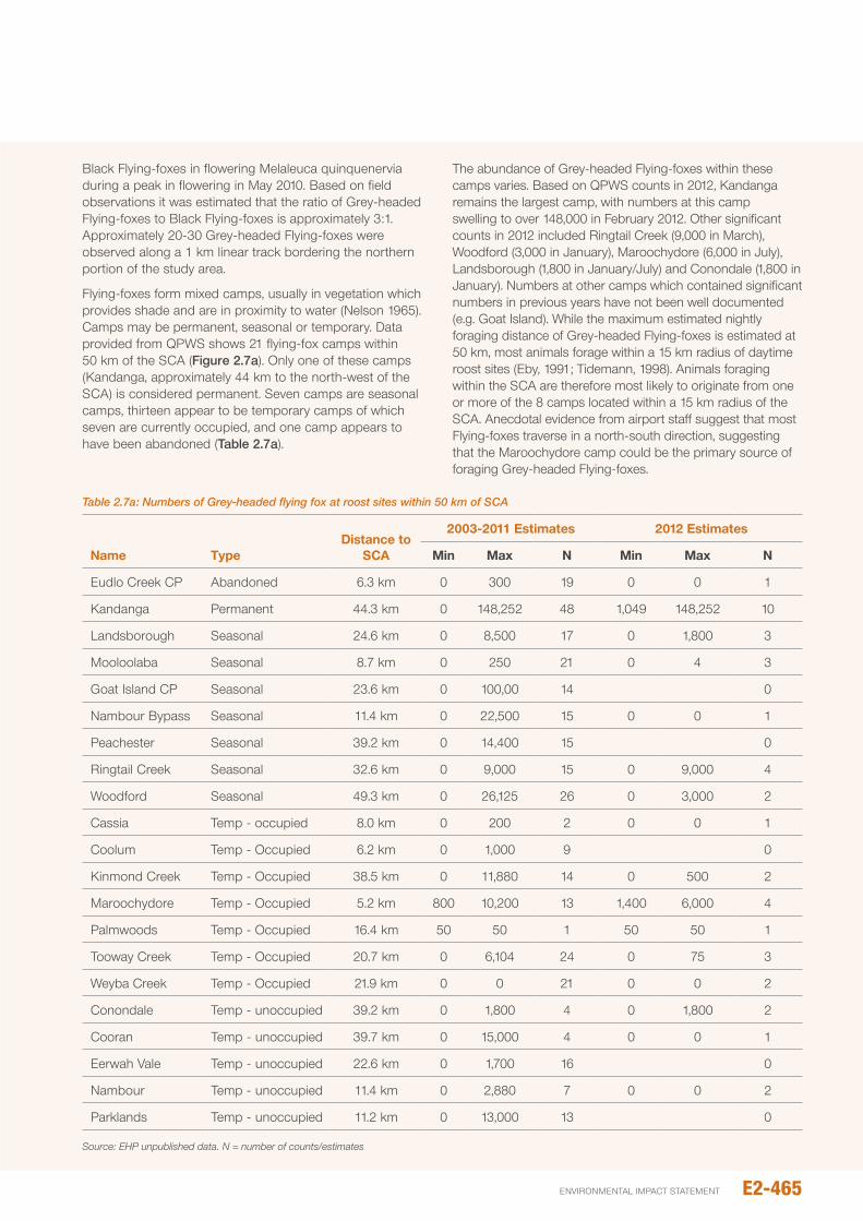
Table 2.7a: Numbers of Grey-headed flying fox at roost sites within 50 km of SCA
Name Typedistance to
SCA
2003-2011 Estimates 2012 Estimates
Min Max N Min Max N
Eudlo Creek Cp Abandoned 6.3 km 0 300 19 0 0 1
Kandanga permanent 44.3 km 0 148,252 48 1,049 148,252 10
Landsborough Seasonal 24.6 km 0 8,500 17 0 1,800 3
Mooloolaba Seasonal 8.7 km 0 250 21 0 4 3
Goat island Cp Seasonal 23.6 km 0 100,00 14 0
nambour Bypass Seasonal 11.4 km 0 22,500 15 0 0 1
peachester Seasonal 39.2 km 0 14,400 15 0
Ringtail Creek Seasonal 32.6 km 0 9,000 15 0 9,000 4
Woodford Seasonal 49.3 km 0 26,125 26 0 3,000 2
Cassia Temp - occupied 8.0 km 0 200 2 0 0 1
Coolum Temp - occupied 6.2 km 0 1,000 9 0
Kinmond Creek Temp - occupied 38.5 km 0 11,880 14 0 500 2
Maroochydore Temp - occupied 5.2 km 800 10,200 13 1,400 6,000 4
palmwoods Temp - occupied 16.4 km 50 50 1 50 50 1
Tooway Creek Temp - occupied 20.7 km 0 6,104 24 0 75 3
Weyba Creek Temp - occupied 21.9 km 0 0 21 0 0 2
Conondale Temp - unoccupied 39.2 km 0 1,800 4 0 1,800 2
Cooran Temp - unoccupied 39.7 km 0 15,000 4 0 0 1
Eerwah Vale Temp - unoccupied 22.6 km 0 1,700 16 0
nambour Temp - unoccupied 11.4 km 0 2,880 7 0 0 2
parklands Temp - unoccupied 11.2 km 0 13,000 13 0
Source: EHP unpublished data. N = number of counts/estimates
Black Flying-foxes in flowering Melaleuca quinquenervia during a peak in flowering in May 2010. Based on field observations it was estimated that the ratio of Grey-headed Flying-foxes to Black Flying-foxes is approximately 3:1. Approximately 20-30 Grey-headed Flying-foxes were observed along a 1 km linear track bordering the northern portion of the study area.
Flying-foxes form mixed camps, usually in vegetation which provides shade and are in proximity to water (nelson 1965). Camps may be permanent, seasonal or temporary. Data provided from QpWS shows 21 flying-fox camps within 50 km of the SCA (Figure 2.7a). only one of these camps (Kandanga, approximately 44 km to the north-west of the SCA) is considered permanent. Seven camps are seasonal camps, thirteen appear to be temporary camps of which seven are currently occupied, and one camp appears to have been abandoned (Table 2.7a).
The abundance of Grey-headed Flying-foxes within these camps varies. Based on QpWS counts in 2012, Kandanga remains the largest camp, with numbers at this camp swelling to over 148,000 in February 2012. other significant counts in 2012 included Ringtail Creek (9,000 in March), Woodford (3,000 in January), Maroochydore (6,000 in July), Landsborough (1,800 in January/July) and Conondale (1,800 in January). numbers at other camps which contained significant numbers in previous years have not been well documented (e.g. Goat island). While the maximum estimated nightly foraging distance of Grey-headed Flying-foxes is estimated at 50 km, most animals forage within a 15 km radius of daytime roost sites (Eby, 1991; Tidemann, 1998). Animals foraging within the SCA are therefore most likely to originate from one or more of the 8 camps located within a 15 km radius of the SCA. Anecdotal evidence from airport staff suggest that most Flying-foxes traverse in a north-south direction, suggesting that the Maroochydore camp could be the primary source of foraging Grey-headed Flying-foxes.
E2-465environmental impact statement
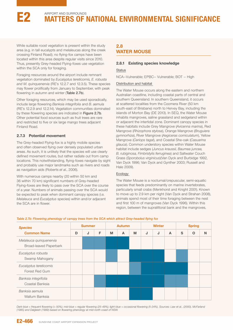
While suitable roost vegetation is present within the study area (e.g. in tall eucalypts and melaleucas along the creek crossing Finland Road); no flying-fox camps have been located within this area despite regular visits since 2010. Thus, presently Grey-headed Flying-foxes use vegetation within the SCA only for foraging.
Foraging resources around the airport include remnant vegetation dominated by Eucalyptus tereticornis, E. robusta and M. quinquenervia (RE’s 12.2.7 and 12.3.5). These species may flower prolifically from January to September, with peak flowering in autumn and winter (Table 2.7b).
other foraging resources, which may be used sporadically, include large flowering Banksia integrifolia and B. aemula (RE’s 12.2.9 and 12.2.14). Vegetation communities dominated by these flowering species are indicated in Figure 2.7b. other potential food sources such as fruit trees are rare and restricted to five or six large mango trees adjacent Finland Road.
2.7.3 potential movement
The Grey-headed Flying-fox is a highly mobile species and often observed flying over densely populated urban areas. As such, it is unlikely that the species will use clearly defined movement routes, but rather radiate out from camp locations. This notwithstanding, flying-foxes navigate by sight and probably use major landmarks such as rivers and roads as navigation aids (Roberts et al., 2006).
With numerous camps nearby (20 within 50 km and 36 within 70 km) significant numbers of Grey-headed Flying-foxes are likely to pass over the SCA over the course of a year. numbers of animals passing over the SCA would be expected to peak when dominant canopy species (i.e. Melaleuca and Eucalyptus species) within and/or adjacent the SCA are in flower.
2.8 wATER MOUSE
2.8.1 Existing species knowledge
Status
nCA–Vulnerable; EpBC– Vulnerable; BoT – High
Distribution and habitat
The Water Mouse occurs along the eastern and northern Australian coastline, including coastal parts of central and southern Queensland. in southern Queensland, it occurs at scattered localities from the Coomera River (50 km south-east of Brisbane) north to Hervey Bay, including the islands of Morton Bay (DE 2013). in SEQ, the Water Mouse inhabits mangroves, saline grassland and sedgeland within or adjacent the intertidal zone. Dominant canopy species in these habitats include Grey Mangrove (Avicenna marina), Red Mangrove (Rhizophora stylosa), orange Mangrove (Bruguiera gymnorhiza), River Mangrove (Aegiceras corniculatum), Yellow Mangrove (Ceriops tagal), and Coastal She-oak (Casuarina glauca). Common understory species within Water Mouse habitat include sedges (Juncus kraussii, Baumea juncea, B. rubiginosa, Fimbristylis ferruginea) and Saltwater Couch Grass (Sporobolus virginicus)(Van Dyck and Burbidge 1992, Van Dyck 1996; Van Dyck and Gynther 2003; Russell and Hale 2009).
Ecology
The Water Mouse is a nocturnal/crepuscular, semi-aquatic species that feeds predominantly on marine invertebrates, particularly small crabs (Menkhorst and Knight 2001). Known to move up to 2.9 km per night (Van Dyck and Strahan 2008), animals spend most of their time foraging between the nest and first 100 m of mangroves (Van Dyck 1996). Within this region, between the supralittoral bank and the mangroves,
Table 2.7b: Flowering phenology of canopy trees from the SCA which attract Grey-headed flying fox
Species Common Name
Summer Autumn winter Spring
d J F M A M J J A S O N
Melaleuca quinquenervia Broad-leaved paperbark
Eucalyptus robusta Swamp Mahogany
Eucalyptus tereticornis Forest Red Gum
Banksia integrifolia Coastal Banksia
Banksia aemula Wallum Banksia
Dark-blue = frequent flowering (> 50%); mid-blue = regular flowering (25-49%); light-blue = occasional flowering (5-24%). Sources: Law et al., (2000), McFarland (1985) and Dalgleish (1999) based on flowering phenology at mid-north coast of NSW.
E2-466
Airport And SurroundS
Matters of NatIoNaL eNvIroNMeNtaL sIgNIfIcaNceE2
SunSHinE CoASt Airport EXpAnSion proJECt
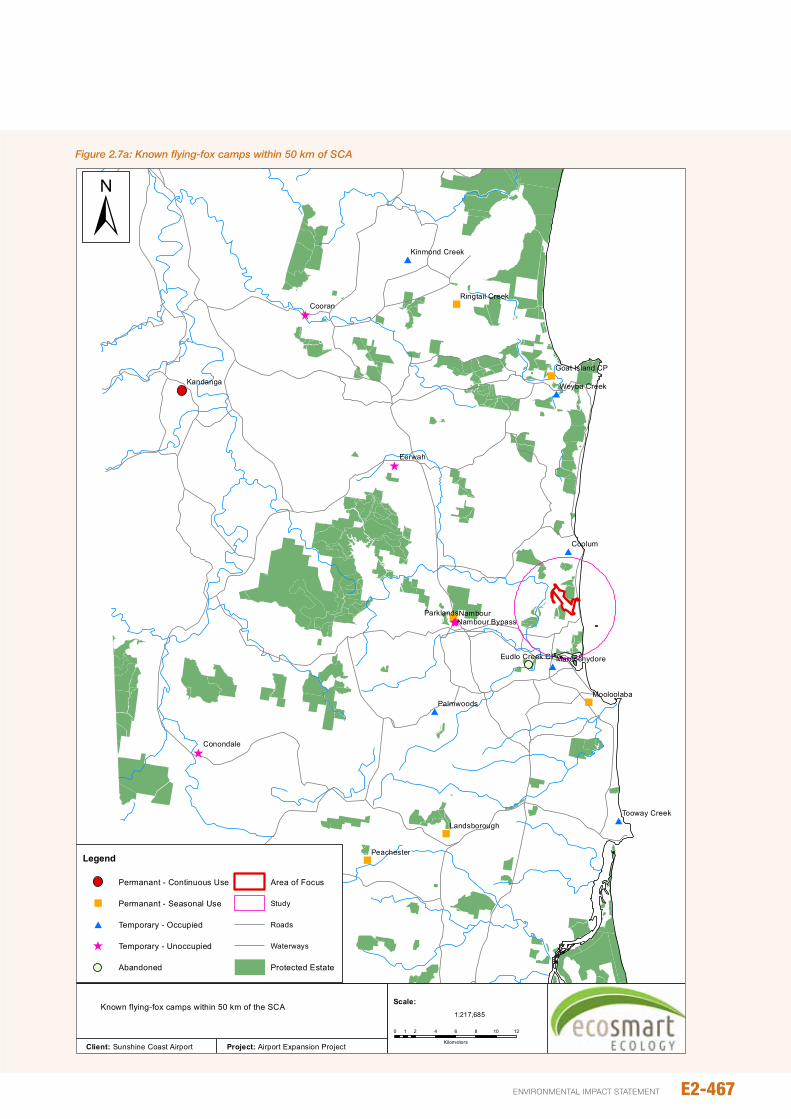
Figure 2.7a: Known flying-fox camps within 50 km of SCA
"
"
"
"
"
"
^
^
^
^̂
#
#
#
#
#
#
Coolum
Eerwah
Cooran
Nambour
Kandanga
Palmwoods
Parklands
Conondale
Peachester
Mooloolaba
Weyba Creek
Tooway Creek
Maroochydore
Landsborough
Kinmond Creek
Eudlo Creek CP
Ringtail Creek
Nambour Bypass
Goat Island CP
Figure 2.19
Legend
Permanant - Continuous Use
" Permanant - Seasonal Use
# Temporary - Occupied
^ Temporary - Unoccupied
Abandoned
Area of Focus
Study
Roads
Waterways
Protected Estate
±
Client: Sunshine Coast Airport Project: Airport Expansion Project
0 2 4 6 8 10 121
Kilometers
1:217,685
Scale:Known flying-fox camps within 50 km of the SCA
E2-467environmental impact statement
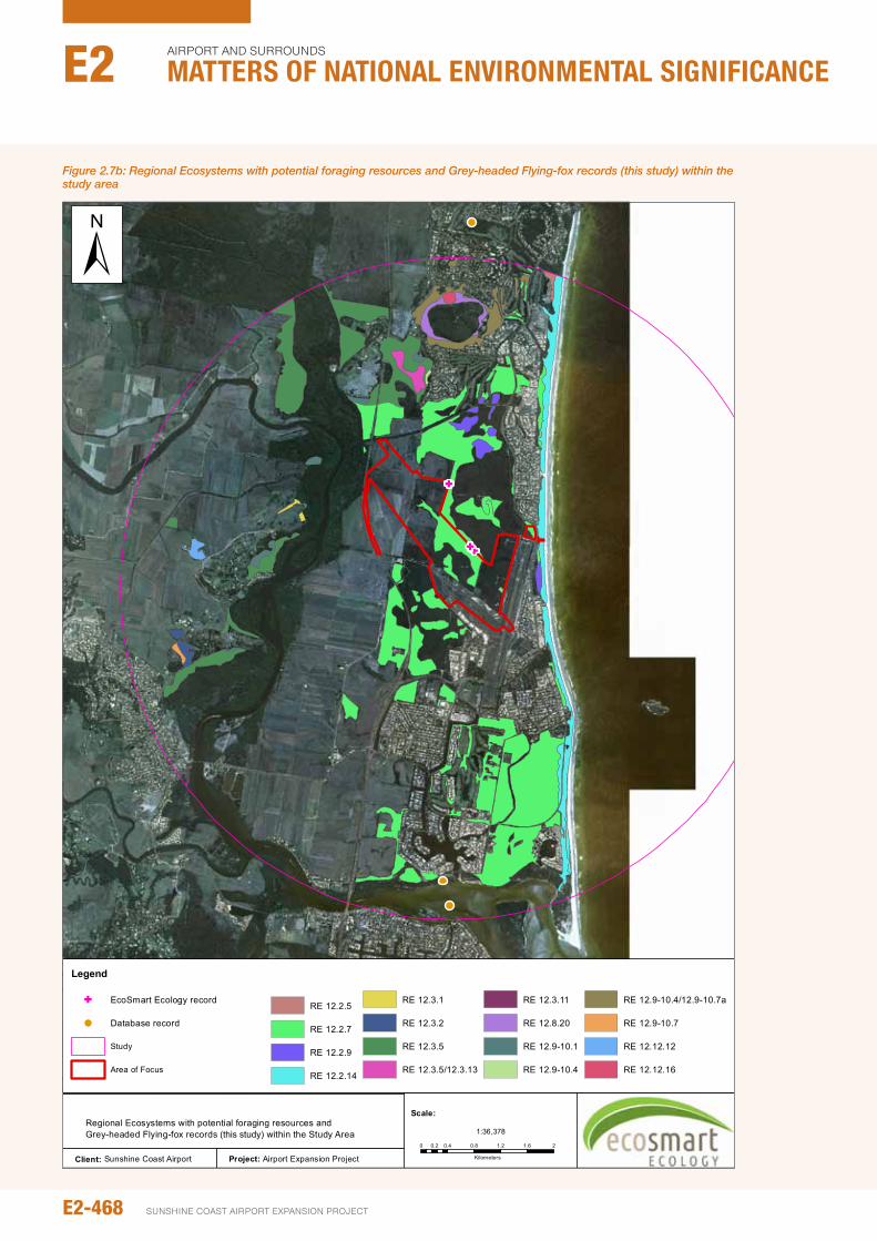
Figure 2.7b: Regional Ecosystems with potential foraging resources and Grey-headed Flying-fox records (this study) within the study area
Project: Airport Expansion Project
GG
G
Client: Sunshine Coast Airport
Figure 2.22Regional Ecosystems with potential foraging resources and Grey-headed Flying-fox records (this study) within the Study Area
Legend
G EcoSmart Ecology record (this
Database record
Study
Area of Focus
RE 12.2.5
RE 12.2.7
RE 12.2.9
RE 12.2.14
RE 12.3.1
RE 12.3.2
RE 12.3.5
RE 12.3.5/12.3.13
RE 12.3.11
RE 12.8.20
RE 12.9-10.1
RE 12.9-10.4
RE 12.9-10.4/12.9-10.7a
RE 12.9-10.7
RE 12.12.12
RE 12.12.16
0 0.4 0.8 1.2 1.6 20.2
Kilometers
1:36,378
Scale:
±
E2-468
Airport And SurroundS
Matters of NatIoNaL eNvIroNMeNtaL sIgNIfIcaNceE2
SunSHinE CoASt Airport EXpAnSion proJECt
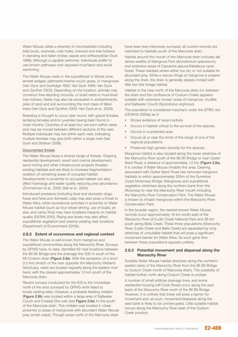
Water Mouse utilise a diversity of microhabitats including tidal pools, channels, crab holes, crevices and tree hollows in standing and fallen timber, leaves and driftwood(Van Dyck 1996). Although a capable swimmer, individuals prefer to use known pathways over exposed mud/sand and avoid swimming.
The Water Mouse nests in the supralittoral or littoral zone, amidst sedges, saltmarsh/marine couch grass, or mangroves (Van Dyck and Durbidge 1992; Van Dyck 1996; Van Dyck and Gynther 2003). Depending on the location, animals may construct free-standing mounds, or build nests in mud-lined tree hollows. nests may also be excavated in embankments, piles of spoil and soil surrounding the root mass of fallen trees (Van Dyck and Gynther 2003; Van Dyck et al., 2003).
Breeding is thought to occur year round, with gravid females, lactating females and/or juveniles having been found in most months. Clutches of at least four are born within nests and may be moved between different sections of the nest. Multiple individuals may live within each nest, indicating multiple females may give birth within a single nest (Van Dyck and Strahan 2008).
Documented threats
The Water Mouse faces a diverse range of threats. ongoing residential development, resort and marina development, sand mining and other infrastructure projects threaten existing habitats and are likely to increase fragmentation/isolation of remaining areas of occupied habitat. Developments in proximity to occupied habitat can also affect hydrology and water quality reducing prey abundance (Zimmerman et al., 2000; Ball et al., 2004).
introduced predators (including feral and domestic dogs, foxes and feral and domestic cats) may also pose a threat to Water Mice, while recreational activities in proximity to Water Mouse habitat (such as four-wheel driving, use of boats, jet skis, and camp fires) may have localised impacts on habitat quality (DERM 2010). Rising sea-levels may also affect supralittoral vegetation and swamp existing nest locations (Department of Environment 2013b).
2.8.2 Extent of occurrence and regional contextThe Water Mouse is well known from mangrove and supralittoral communities along the Maroochy River. Surveys by QpWS have, to date, identified 62 nest locations between the Bli Bli Bridge and the drainage line 200 m south of the Mt Coolum drain (Figure 2.8a). With the exception of a short (1.2 km) stretch of the river opposite the Maroochy Wetland Sanctuary, nests are located regularly along the eastern river bank, with the closest approximately 1.3 km south of the Marcoola drain.
Recent surveys conducted for the EiS to the immediate north of the area surveyed by QpWS work failed to locate nesting sites. However, a probable feeding midden (Figure 2.8b) was located within a large area of Saltwater Couch and Coastal She-oak (see Figure 2.8a) to the south of the Marcoola drain. This midden was located in close proximity to areas of mangroves with abundant Water Mouse prey (small crabs). Though areas north of the Marcoola drain
have been less intensively surveyed, all current records are restricted to habitats south of the Marcoola drain.
Habitat around the mouth of the Marcoola drain includes tall dense swaths of Mangrove Fern (Acrostichum speciosum), and extensive areas of Casuarina glauca/Melaleuca open forest. These habitats where either too dry or not suitable for abundant prey. While a narrow fringe of mangrove is present along the drain, the drain is generally steeply incised with little low tide forage habitat.
Habitat to the near north of the Marcoola drain (i.e. between the drain and the confluence of Coolum Creek) appears suitable with extensive mosaic areas of mangrove, mudflat and Saltwater Couch (Sporobolus virginicus).
The population is considered important under the EpBC Act (DEWHA 2009a) as it:
y Shows evidence of recent activity
y occurs in habitat critical to the survival of the species
y occurs in a protected area
y occurs at or near the limits of the range of one of the regional populations
y preserves high genetic diversity for the species.
Mangrove habitat is also located along the lower stretches of the Maroochy River south of the Bli Bli Bridge to near oyster Bank Road, a distance of approximately 1.2 km (Figure 2.8a). it is unclear if Water Mouse inhabits this area. Clearing associated with oyster Bank Road has removed mangrove habitats to within approximately 500m of the Sunshine Coast Motorway Bridge. Mangroves and supralittoral vegetation stretches along the northern bank from the Motorway to near the Maroochy River mouth including the Maroochy River Conservation park. The Water Mouse is known to inhabit mangroves within the Maroochy River Conservation park.
in the broader region, the nearest known Water Mouse records occur approximately 18 km south-east of the Maroochy River at Eudlo Creek national park and 28 km south along Bells Creek. These three populations (Maroochy River, Eudlo Creek and Bells Creek) are separated by long stretches of unsuitable habitat that will pose a significant movement barrier for Water Mice. As such gene flow between these populations appears unlikely.
2.8.3 potential movement and dispersal along the Maroochy River
Suitable Water Mouse habitat stretches along the northern/eastern bank of the Maroochy River from the Bli Bli Bridge to Coolum Creek (north of Marcoola drain). The suitability of habitat further north along Coolum Creek is unclear.
A number of small artificial drainage lines, and some residential housing (off Cook Road) occur along the east bank of the Maroochy River north of the Bli Bli Bridge. However, it is unlikely that these will pose a barrier for movement and, as such, movement/dispersal along the east bank is likely to be uninterrupted. Little suitable habitat occurs along the Maroochy River west of the Coolum Creek junction.
E2-469environmental impact statement
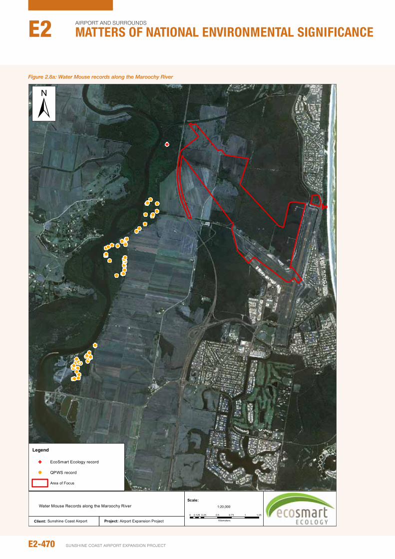
Figure 2.8a: Water Mouse records along the Maroochy River
Project: Airport Expansion Project
!!!!!
! !!!!!!
! !! !!!!!
!!
!!
! !!!!!!!! !!!!!!!
!!!!
!
!!
!
!!!!
!!
!!
!
!!!!
G
Client: Sunshine Coast Airport
Figure 2.22
Water Mouse Records along the Maroochy River
Legend
G EcoSmart Ecology record (this
! QPWS record
Area of Focus
0 0.25 0.5 0.75 1 1.250.125
Kilometers
1:20,000
Scale:
±
E2-470
Airport And SurroundS
Matters of NatIoNaL eNvIroNMeNtaL sIgNIfIcaNceE2
SunSHinE CoASt Airport EXpAnSion proJECt
The potential for movement of Water Mice to the south, over David Low Way and Muller park, is less clear. in this area, mangrove vegetation is replaced by rock-walled banks, open manicured lawns and walking paths which provide little opportunity for shelter/retreat. While this artificial habitat is limited in extent (stretching approximately 200m south of the Bli Bli Bridge), it could pose a significant barrier to Water Mice.
Similarly, the river bank has been modified further south, along oysterbay Road. While scattered mangroves and Casuarina glauca are present, most vegetation has been replaced by rock-wall, manicured lawns and a dual lane bitumen road. Areas of habitat more natural habitat suitable for movement of Water Mouse are separated by a distance of over 700 m. Movement of Water Mice through this area therefore seems unlikely.
Given the long-stretches of open surf beach to the north and south of the Maroochy River mouth, and the lack of coastal swamp behind the dunes in either direction, the Maroochy River population is likely to be isolated.
2.9 EASTERN CURLEw
Status
nCA – near Threatened; EpBC – Migratory; BoT – Low
Distribution, habitat and biology
The Eastern Curlew is a large migratory wader which inhabits intertidal mudflats, particularly those with exposed seagrass, where it forages for marine invertebrates, particularly crabs and small molluscs (Higgins and Davies 1996). Breeding does not occur in Australia; rather birds make an annual migration north to marshes and damp bogs in eastern and far south-eastern Siberia, northern Mongolia and northern Manchuria (Geering et al., 2007). Birds return from their breeding grounds in mid-September before spreading south along Australia’s coastline (Minton et al., 2011). While strictly coastal, the Eastern Curlew may venture some distance upstream along tidal creeks and rivers habitats (M. Sanders pers. obs).
While there is suitable habitat for this species in the far north-west of the study area, the extent of habitat in this area is limited and therefore unlikely to support large numbers of birds. More extensive areas of suitable habitat (mudflat and mangroves) are located along the Maroochy River and Eastern Curlews have been recorded as far upstream as Stoney Wharf Road. Two birds have been previously
Figure 2.8b: Water Mouse prey midden within Casuarina glauca woodland near the mouth of the Marcoola drain
E2-471environmental impact statement
recorded at this location, one in 1993 and one in 2003, although it is probable that Eastern Curlews regularly move up the river to areas of suitable habitat within the Maroochy Wetland Reserve.
During high-tide, when foraging areas are inundated by water, Eastern Curlews gather with other migratory waders at specific high-tide roosts. no high-tide roosts are located immediately adjacent the study area, with the nearest located ~8.5 km downstream of Stoney Wharf Road on the western side of Goat island.
2.10 kOALA
Status
EpBC – Vulnerable; nCA –Least Concern; BoT: Low
Distribution, habitat and biology
Endemic to eastern Australia, the Koala is a solitary species that is widespread across low altitude, coastal and inland areas from Cooktown, Queensland to the Mt. Lofty Ranges, South Australia (Munks et al., 1996; Menkhorst and Knight 2001). Koalas occur in eucalypt woodland and sclerophyll forests, on foothills, plains and in coastal areas (Martin and Handasyde 1999; Menkhorst and Knight 2001; Dyck and Stratham 2008).
Koala records in proximity to the SCA are sparse; only eight records occur within 5 km of the study area, all of which predate 2004. The two closest records, from 2003 and 1995 respectively, are less than 1 km from the SCA (see Figure 2.10a).
it is well known that Koalas feed on eucalypts, however not all eucalypts are of equal value as fodder. Rather, Koalas inhabit forests with a high proportion of preferred tree species (phillips et al., 2000; Rhodes et al., 2005; Matthews et al., 2007), often on fertile soils. in coastal southern Queensland preferred Eucalyptus species include Eucalyptus camaldulensis, Eucalyptus propinqua, Eucalyptus tereticornis and E. robusta (McAlpine et al., 2008). While two preferred tree species (Eucalyptus tereticornis and E. robusta) occur within the study area, neither of these is abundant. The highest density of preferred Koala trees occurs in a small area located on the creek near Finland Road (Figure 2.10a), however scattered E. robusta are located adjacent artificial drains crossing the northern section of Mt Coolum np. The paucity of these trees, and irregularity of Koala observations, suggest that the area is unlikely to support a resident Koala population. Rather, observations are likely to reflect dispersing or roaming individuals. Despite searches, no Koala evidence (scratches or scats) was located during our surveys within the study area.
Koala records are common 10-15 km west of the study area in parklands Forest Reserve, Ferntree national park and panorama Drive Koala park. Records in Bli Bli support the premise that Koala are probably able to move from these areas east toward the Maroochy River corridor. However,
Koala movement over the River seems unlikely. Higher value habitats are located to the north near Mt Coolum (mapped as ‘low value bushland’ habitat under the South East Queensland Koala State Planning Regulatory Provisions 2010 [SpRp 2010]), and as such, these areas are likely to be the source of Koala records near the SCA.
no vegetation within, or immediately adjacent, the area of focus is mapped as ‘Koala habitat’ or as ‘assessable Koala development area’ under the SpRp 2010, and no koalas have been seen during this or previous surveys. The closest area of mapped Koala value is located to the north in association with vegetation around the Coolum Golf Course.
2.11 MIGRATORy SpECIES
A total of 46 migratory bird species, as listed under the EpBC Act, have been recorded from the study area and local surrounds. These birds can be broadly categorised as follows:
y Marine birds, which includes species that ‘spend the majority of their life at sea’ and includes albatross, petrels and shearwaters (not addressed here, see Chapter B10 – Marine Ecology)
y Shorebirds (including waders), associated with tidal estuarine and mangrove environments (Section 2.11.1)
y Terrestrial species which are usually associated with heavily vegetated areas (Section 2.11.2)
y non-tidal wetland migratory species (Section 2.11.3)
y other migratory species (Section 2.11.4).
2.11.1 Migratory shorebirdsMigratory shorebirds or waders comprise of the suborder Charadriiform, which feed in shallow water along the edges of lakes, rivers and the ocean. Migratory species within this suborder include common coastal waders such as sandpipers, godwits, plovers and stilts (amongst others). Most migratory waders visiting Australia (including various sandpipers, godwit, and plover species) breed in the northern Hemisphere (e.g. Siberia, China, Alaska) and migrate across the globe through the East Asia-Australian Flyway to spend spring and summer feeding in Australia and new Zealand (Asia-pacific Migratory Wader Conservation Committee 2001; Geering et al., 2007; Bamford et al., 2008).
in Australia, significant habitats for waders include expanses of wet, open mud- and sand-flats, which may or may not include aquatic vegetation such as sea-grass. While these habitats are most commonly found along the Australian coastline in association with estuaries, they can also occur on inland lakes and rivers as well as artificial habitats such as sewage ponds.
Within these habitats, migratory waders feed on benthic invertebrates alongside or within shallow water. A wader’s daily routine is driven by the tide, with birds moving from to feeding grounds at low tide to aggregate as mixed flocks at high-tide roosts (Geering et al., 2007). Wader density on intertidal flats are shaped by a number of factors including prey density,
E2-472
Airport And SurroundS
Matters of NatIoNaL eNvIroNMeNtaL sIgNIfIcaNceE2
SunSHinE CoASt Airport EXpAnSion proJECt
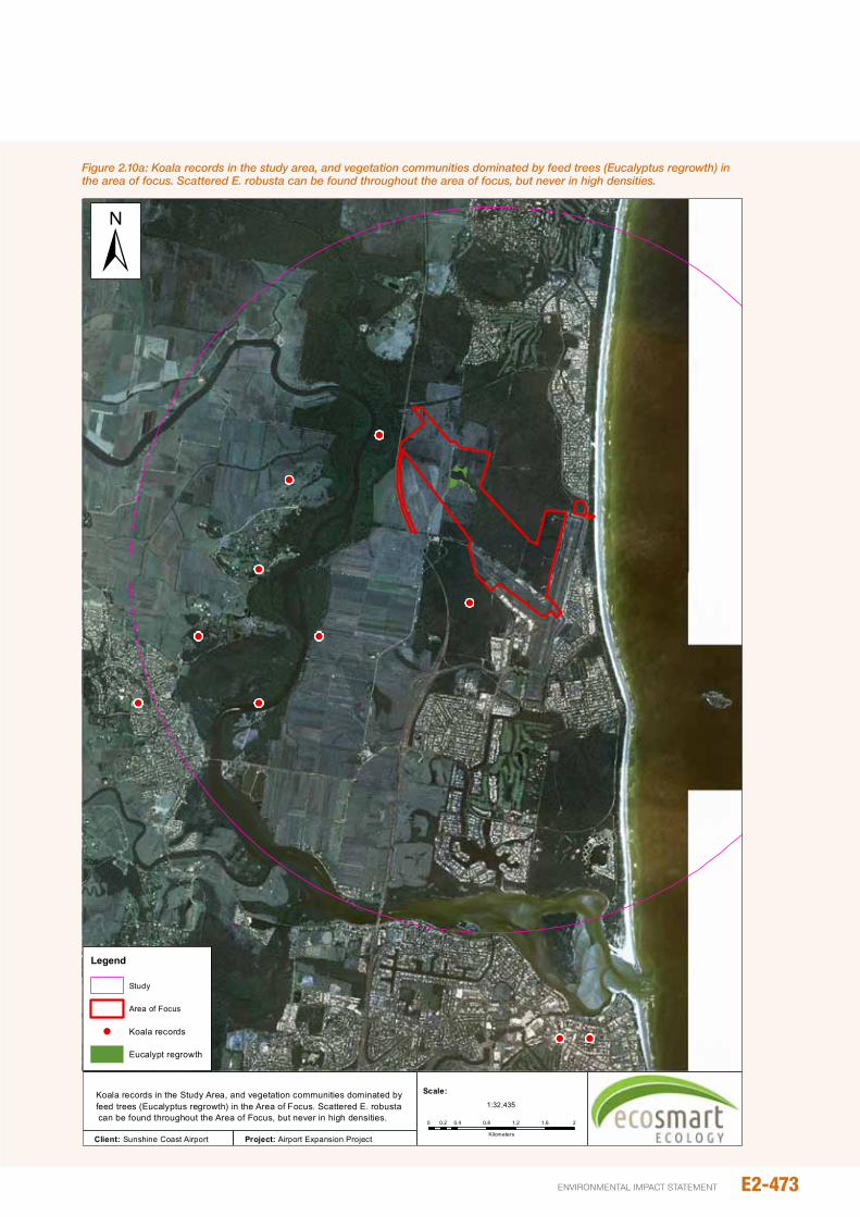
! !
! !
! !
!
!
!
!
Figure 2.23Koala records in the Study Area, and vegetation communities dominated by feed trees (Eucalyptus regrowth) in the Area of Focus. Scattered E. robusta can be found throughout the Area of Focus, but never in high densities.
Legend
Study
Area of Focus
! Koala records
Eucalypt regrowth
±
Client: Sunshine Coast Airport Project: Airport Expansion Project
0 0.4 0.8 1.2 1.6 20.2
Kilometers
1:32,435
Scale:
Figure 2.10a: Koala records in the study area, and vegetation communities dominated by feed trees (Eucalyptus regrowth) in the area of focus. Scattered E. robusta can be found throughout the area of focus, but never in high densities.
E2-473environmental impact statement
competition/density of other wader species, disturbance, prevailing climatic conditions and proximity to high-tide roosts (Geering et al., 2007).
Within the study area potential foraging habitats of mud- or sand-flat are largely limited to within ~2.5 km of the Maroochy River mouth. While boating and human activity within the river is high, the location is a well-known and a popular wader watching location. Four high tide roosts occur within the river mouth and regularly observed wader species include Bar-tailed Godwit, Whimbrel, Eastern Curlew, Double-banded plover, and Red-necked Stint. Less common species include Terek Sandpiper, Grey-tailed Tattler, Curlew Sandpiper, Great Knot, Lesser Sand plover, and Greater Sand plover (QWSG 2010).
Migratory waders known from within 50 km of the study area are documented in Table 2.11a; those known to occur along the Maroochy River are identified separately in this table.
2.11.2 Terrestrial migratory birdsTwo species of migratory bird associated with terrestrial habitats, Rufous Fantail and Rainbow Bee-eater, were recorded during EcoSmart Ecology surveys of the SCA. Rainbow Bee-eaters were common and regularly recorded throughout all areas of the Study Site. The Rufous Fantail was noted on five occasions, and almost always in association with thick mesic habitats (particularly forest dominated by eucalypts). Refer Table 2.11b.
Mesic forest habitats may also have some value as foraging and/or breeding habitat for Black-faced Monarch, which has been recorded nearby in the Maroochy Wetland Sanctuary. However, this species is uncommon in the local area (with only one record within 10 km) and the extent of suitable habitat within the SCA area is limited.
While both White-throated needletail and Fork-tailed Swift have been recorded within the local area, both species are aerial foragers and do not rely on any particular habitat type. These species will readily move quickly through the area and are transient in behaviour.
2.11.3 Non-tidal wetland migratory birdsSix migratory birds associated with non-tidal wetlands have been identified within 50 km of the study area (Table 2.11c). Cattle Egrets and Eastern Great Egrets are regularly observed within the study area, while White-bellied Sea-eagles are often observed along the Maroochy River with the odd animal occasionally seen flying over the SCA.
While Latham’s Snipe has been only sporadically recorded in the local area (one historic record from 1995), 20 individuals were observed in the south-east corner of the SCA during surveys. Sixteen of these birds were flushed from a relatively small area of modified heath to the east of the existing RWY 12/30 (i.e. to the immediate west of Keith Royal park). An additional two individuals were also observed in the central section of the WHMA, whilst two individuals were seen within Lot 101 adjacent to David Low Way (i.e. outside the SCA to the immediate north of RWY 18/36). To qualify as ‘important habitat’ under EpBC assessment guidelines, an area must be able to support at least eighteen individuals. Based
on habitat extent and quality, it is probable that the high abundance of Latham’s Snipe is atypical within the SCA and not reflective of normal abundance.
2.11.4 Other migratory birdsWith the exception of Little Tern, the remaining migratory birds identified in background searches are marine/pelagic species. Marine species, which are birds that spend the majority of the life at sea (e.g. albatross, shearwaters and petrels) are considered in Chapter B10 – Marine Ecology. The Little Tern is known from only the mouth of the Maroochy River and has not been recorded west of Goat island.
2.12 AppROACh TO IMpACT ASSESSMENT
Recognised impact assessment methodology establishes the context in which impacts will occur identifies potential impact pathways, and then evaluates the possible consequence of these pathways. A variety of impact pathways can affect vertebrate values in relation to the proposed activities including (but not limited to):
y Direct loss of habitat possibly leading to reduced extent of occurrence or isolation of habitats/populations
y Changes to groundwater conditions, including modification of groundwater level, groundwater fluctuation or groundwater quality
y increased light
y increased noise
y Changes to vegetation structure or composition (e.g. weed infestation).
The effect of these impact pathways, and any other relevant pathways (e.g. plane strike for flying vertebrates), will be evaluated by considering:
y impact Likelihood: the probability of an interaction between a potential threat and the sensitive receptor
y impact Magnitude: the consequence or severity of an impact.
Assessment of the likelihood and magnitude of impacts is then used to assess the significance of impacts with and without mitigation (residual impacts). Criteria for assessing the likelihood and magnitude of impacts are defined in Sections 2.12.1 and 2.12.2.
plane activity is expected to increase at the SCA irrespective of the current proposed development, and impacts will therefore deviate from current conditions (e.g. increased noise). To clarify the impact of this development on faunal values, two scenarios are considered (where relevant):
1. The ‘do minimum’ scenario, which retains the current airport configuration but allows for predicted future flight frequency
2. The ‘new runway’ scenario, which is the subject of this study.
Finally, while the potential impacts can be broken down into individual pathways, these pathways rarely act in
E2-474
Airport And SurroundS
Matters of NatIoNaL eNvIroNMeNtaL sIgNIfIcaNceE2
SunSHinE CoASt Airport EXpAnSion proJECt
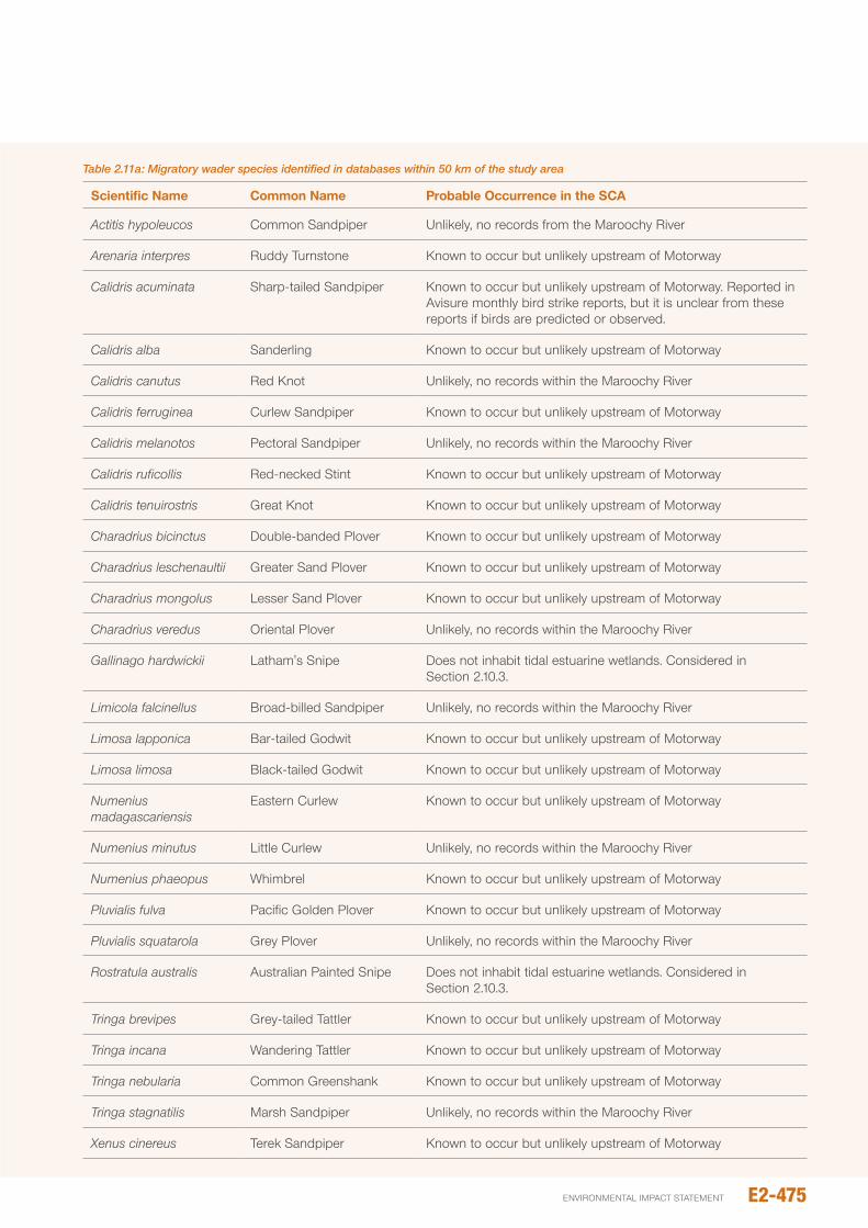
Table 2.11a: Migratory wader species identified in databases within 50 km of the study area
Scientific Name Common Name probable Occurrence in the SCA
Actitis hypoleucos Common Sandpiper unlikely, no records from the Maroochy River
Arenaria interpres Ruddy Turnstone Known to occur but unlikely upstream of Motorway
Calidris acuminata Sharp-tailed Sandpiper Known to occur but unlikely upstream of Motorway. Reported in Avisure monthly bird strike reports, but it is unclear from these reports if birds are predicted or observed.
Calidris alba Sanderling Known to occur but unlikely upstream of Motorway
Calidris canutus Red Knot unlikely, no records within the Maroochy River
Calidris ferruginea Curlew Sandpiper Known to occur but unlikely upstream of Motorway
Calidris melanotos pectoral Sandpiper unlikely, no records within the Maroochy River
Calidris ruficollis Red-necked Stint Known to occur but unlikely upstream of Motorway
Calidris tenuirostris Great Knot Known to occur but unlikely upstream of Motorway
Charadrius bicinctus Double-banded plover Known to occur but unlikely upstream of Motorway
Charadrius leschenaultii Greater Sand plover Known to occur but unlikely upstream of Motorway
Charadrius mongolus Lesser Sand plover Known to occur but unlikely upstream of Motorway
Charadrius veredus oriental plover unlikely, no records within the Maroochy River
Gallinago hardwickii Latham's Snipe Does not inhabit tidal estuarine wetlands. Considered in Section 2.10.3.
Limicola falcinellus Broad-billed Sandpiper unlikely, no records within the Maroochy River
Limosa lapponica Bar-tailed Godwit Known to occur but unlikely upstream of Motorway
Limosa limosa Black-tailed Godwit Known to occur but unlikely upstream of Motorway
Numenius madagascariensis
Eastern Curlew Known to occur but unlikely upstream of Motorway
Numenius minutus Little Curlew unlikely, no records within the Maroochy River
Numenius phaeopus Whimbrel Known to occur but unlikely upstream of Motorway
Pluvialis fulva pacific Golden plover Known to occur but unlikely upstream of Motorway
Pluvialis squatarola Grey plover unlikely, no records within the Maroochy River
Rostratula australis Australian painted Snipe Does not inhabit tidal estuarine wetlands. Considered in Section 2.10.3.
Tringa brevipes Grey-tailed Tattler Known to occur but unlikely upstream of Motorway
Tringa incana Wandering Tattler Known to occur but unlikely upstream of Motorway
Tringa nebularia Common Greenshank Known to occur but unlikely upstream of Motorway
Tringa stagnatilis Marsh Sandpiper unlikely, no records within the Maroochy River
Xenus cinereus Terek Sandpiper Known to occur but unlikely upstream of Motorway
E2-475environmental impact statement
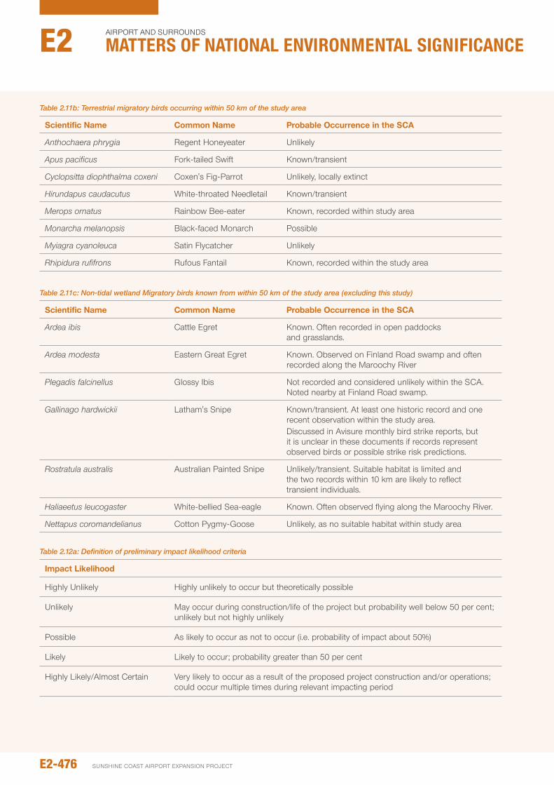
Table 2.11b: Terrestrial migratory birds occurring within 50 km of the study area
Scientific Name Common Name probable Occurrence in the SCA
Anthochaera phrygia Regent Honeyeater unlikely
Apus pacificus Fork-tailed Swift Known/transient
Cyclopsitta diophthalma coxeni Coxen's Fig-parrot unlikely, locally extinct
Hirundapus caudacutus White-throated needletail Known/transient
Merops ornatus Rainbow Bee-eater Known, recorded within study area
Monarcha melanopsis Black-faced Monarch possible
Myiagra cyanoleuca Satin Flycatcher unlikely
Rhipidura rufifrons Rufous Fantail Known, recorded within the study area
Table 2.11c: Non-tidal wetland Migratory birds known from within 50 km of the study area (excluding this study)
Scientific Name Common Name probable Occurrence in the SCA
Ardea ibis Cattle Egret Known. often recorded in open paddocks and grasslands.
Ardea modesta Eastern Great Egret Known. observed on Finland Road swamp and often recorded along the Maroochy River
Plegadis falcinellus Glossy ibis not recorded and considered unlikely within the SCA. noted nearby at Finland Road swamp.
Gallinago hardwickii Latham's Snipe Known/transient. At least one historic record and one recent observation within the study area. Discussed in Avisure monthly bird strike reports, but it is unclear in these documents if records represent observed birds or possible strike risk predictions.
Rostratula australis Australian painted Snipe unlikely/transient. Suitable habitat is limited and the two records within 10 km are likely to reflect transient individuals.
Haliaeetus leucogaster White-bellied Sea-eagle Known. often observed flying along the Maroochy River.
Nettapus coromandelianus Cotton pygmy-Goose unlikely, as no suitable habitat within study area
Table 2.12a: Definition of preliminary impact likelihood criteria
Impact Likelihood
Highly unlikely Highly unlikely to occur but theoretically possible
unlikely May occur during construction/life of the project but probability well below 50 per cent; unlikely but not highly unlikely
possible As likely to occur as not to occur (i.e. probability of impact about 50%)
Likely Likely to occur; probability greater than 50 per cent
Highly Likely/Almost Certain Very likely to occur as a result of the proposed project construction and/or operations; could occur multiple times during relevant impacting period
E2-476
Airport And SurroundS
Matters of NatIoNaL eNvIroNMeNtaL sIgNIfIcaNceE2
SunSHinE CoASt Airport EXpAnSion proJECt
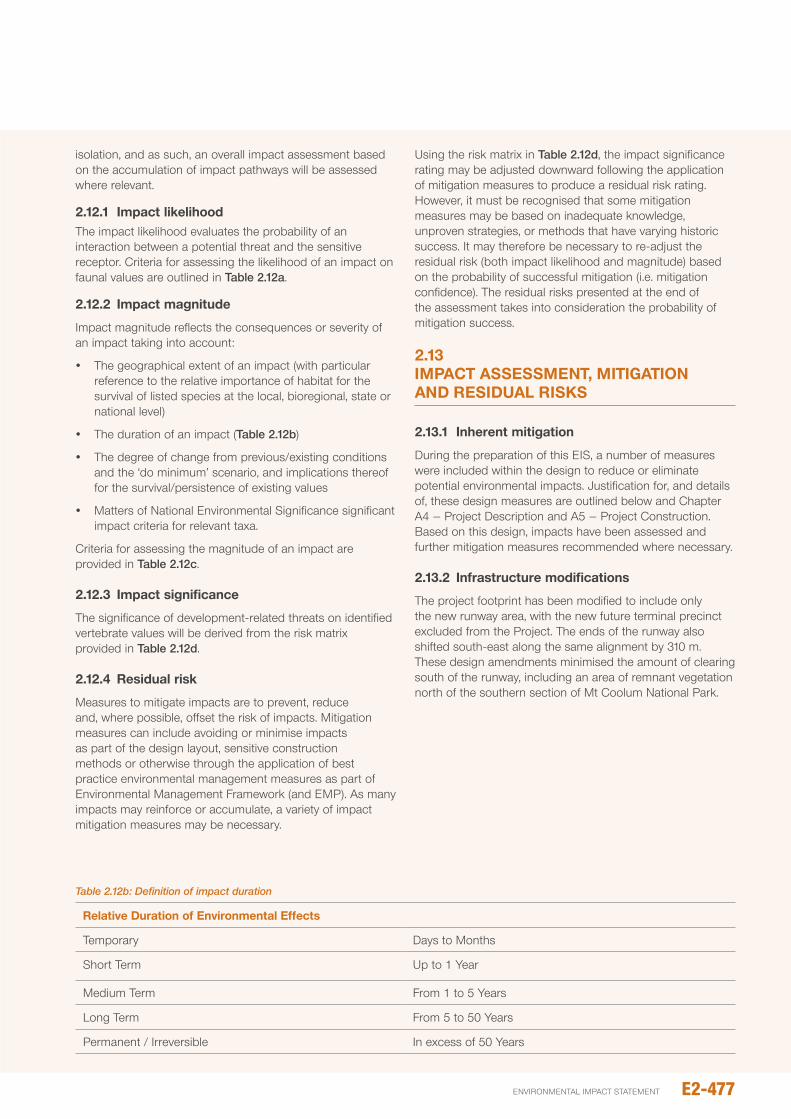
isolation, and as such, an overall impact assessment based on the accumulation of impact pathways will be assessed where relevant.
2.12.1 Impact likelihoodThe impact likelihood evaluates the probability of an interaction between a potential threat and the sensitive receptor. Criteria for assessing the likelihood of an impact on faunal values are outlined in Table 2.12a.
2.12.2 Impact magnitude
impact magnitude reflects the consequences or severity of an impact taking into account:
y The geographical extent of an impact (with particular reference to the relative importance of habitat for the survival of listed species at the local, bioregional, state or national level)
y The duration of an impact (Table 2.12b)
y The degree of change from previous/existing conditions and the ‘do minimum’ scenario, and implications thereof for the survival/persistence of existing values
y Matters of national Environmental Significance significant impact criteria for relevant taxa.
Criteria for assessing the magnitude of an impact are provided in Table 2.12c.
2.12.3 Impact significance
The significance of development-related threats on identified vertebrate values will be derived from the risk matrix provided in Table 2.12d.
2.12.4 Residual risk
Measures to mitigate impacts are to prevent, reduce and, where possible, offset the risk of impacts. Mitigation measures can include avoiding or minimise impacts as part of the design layout, sensitive construction methods or otherwise through the application of best practice environmental management measures as part of Environmental Management Framework (and EMp). As many impacts may reinforce or accumulate, a variety of impact mitigation measures may be necessary.
using the risk matrix in Table 2.12d, the impact significance rating may be adjusted downward following the application of mitigation measures to produce a residual risk rating. However, it must be recognised that some mitigation measures may be based on inadequate knowledge, unproven strategies, or methods that have varying historic success. it may therefore be necessary to re-adjust the residual risk (both impact likelihood and magnitude) based on the probability of successful mitigation (i.e. mitigation confidence). The residual risks presented at the end of the assessment takes into consideration the probability of mitigation success.
2.13 IMpACT ASSESSMENT, MITIGATION ANd RESIdUAL RISkS
2.13.1 Inherent mitigation
During the preparation of this EiS, a number of measures were included within the design to reduce or eliminate potential environmental impacts. Justification for, and details of, these design measures are outlined below and Chapter A4 – project Description and A5 – project Construction. Based on this design, impacts have been assessed and further mitigation measures recommended where necessary.
2.13.2 Infrastructure modifications
The project footprint has been modified to include only the new runway area, with the new future terminal precinct excluded from the project. The ends of the runway also shifted south-east along the same alignment by 310 m. These design amendments minimised the amount of clearing south of the runway, including an area of remnant vegetation north of the southern section of Mt Coolum national park.
Table 2.12b: Definition of impact duration
Relative duration of Environmental Effects
Temporary Days to Months
Short Term up to 1 Year
Medium Term From 1 to 5 Years
Long Term From 5 to 50 Years
permanent / irreversible in excess of 50 Years
E2-477environmental impact statement
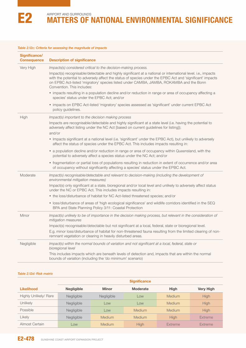
Table 2.12c: Criteria for assessing the magnitude of impacts
Significance/ Consequence description of significance
Very High Impacts(s) considered critical to the decision-making process.impact(s) recognisable/detectable and highly significant at a national or international level. i.e., impacts with the potential to adversely affect the status of species under the EpBC Act and ‘significant’ impacts on EpBC Act-listed ‘migratory’ species listed under CAMBA, JAMBA, RoKAMBA and the Bonn Convention. This includes:
y impacts resulting in a population decline and/or reduction in range or area of occupancy affecting a species’ status under the EpBC Act; and/or
y impacts on EpBC Act-listed ‘migratory’ species assessed as ‘significant’ under current EpBC Act policy guidelines.
High Impact(s) important to the decision making processimpacts are recognisable/detectable and highly significant at a state level (i.e. having the potential to adversely affect listing under the nC Act [based on current guidelines for listing]); and/or
y impacts significant at a national level (i.e. ‘significant’ under the EpBC Act), but unlikely to adversely affect the status of species under the EpBC Act. This includes impacts resulting in:
y a population decline and/or reduction in range or area of occupancy within Queensland, with the potential to adversely affect a species status under the nC Act; and/or
y fragmentation or partial loss of populations resulting in reduction in extent of occurrence and/or area of occupancy without significantly affecting a species’ status under the EpBC Act.
Moderate Impact(s) recognisable/detectable and relevant to decision-making (including the development of environmental mitigation measures)impact(s) only significant at a state, bioregional and/or local level and unlikely to adversely affect status under the nC or EpBC Act. This includes impacts resulting in:
y the loss/disturbance of habitat for nC Act-listed threatened species; and/or
y loss/disturbance of areas of ‘high ecological significance’ and wildlife corridors identified in the SEQ BpA and State planning policy 3/11: Coastal protection
Minor Impact(s) unlikely to be of importance in the decision making process, but relevant in the consideration of mitigation measures impact(s) recognisable/detectable but not significant at a local, federal, state or bioregional level.E.g. minor loss/disturbance of habitat for non-threatened fauna resulting from the limited clearing of non-remnant vegetation or clearing in heavily disturbed areas.
negligible Impact(s) within the normal bounds of variation and not significant at a local, federal, state or bioregional levelThis includes impacts which are beneath levels of detection and, impacts that are within the normal bounds of variation (including the ‘do minimum’ scenario)
Table 2.12d: Risk matrix
Likelihood
Significance
Negligible Minor Moderate high very high
Highly unlikely/ Rare negligible negligible Low Medium High
unlikely negligible Low Low Medium High
possible negligible Low Medium Medium High
Likely negligible Medium Medium High Extreme
Almost Certain Low Medium High Extreme Extreme
E2-478
Airport And SurroundS
Matters of NatIoNaL eNvIroNMeNtaL sIgNIfIcaNceE2
SunSHinE CoASt Airport EXpAnSion proJECt
2.14 pOTENTIAL IMpACTS
The removal of vegetation that could potentially affect fauna habitat values is discussed in Section 2.1 Flora of this chapter. other impacts upon fauna arising from this project are discussed below.
2.14.1 water quality impacts
2.14.1.1 Saline discharge into groundwater
increased salinity is known to affect vegetation composition, which in turn would affect fauna community composition. Salinity can also affect amphibians, with embryos and larvae unlikely to tolerate salinities greater than one to five per cent sea water (350 mg/L to 1,750 mg/L) (Shoemaker 1992; Gomez-Mestre et al., 2003; Chinathamby et al., 2006; Sanzo et al., 2006).
Recognising this risk, the project has included a number of inherent design measures to limit saline discharge (see Chapters B3 and B8 for more details). Modelling the success of these design measures on saline influence has indicated that salinity concentrations in the regional aquifer 50 m from the northern perimeter drain are likely exceed 1,000 mg/L 200 years after filling is complete, while concentrations 150 m from the northern perimeter drain are not expected to exceed 500 mg/L some 300 years after filling is complete.
While these concentrations are higher than existing surface water (which is typically <100 mg/L), mixing of the regional and perched aquifers will be limited by a layer of coffee rock. Based on the assessment provided in Chapter B3 – Geology, Soils and Groundwater, upward mixing of groundwater across the coffee rock layer is unlikely, and should it occur, saline impacts would be localised.
2.14.1.2 Uncontrolled discharge from pipeline
uncontrolled discharge of salt water from the sand delivery pipeline could also result in localised impacts on surface and groundwater quality (i.e. increased salinity). Should unexpected discharge occur, the placement of the pipeline to the east of an existing access road (along the eastern boundary of the WHMA) and south of the north perimeter drain is likely to limit impacts within the WHMA. Leakage from pipes could, however, impact upon areas of Ground parrot foraging habitat to the east of the WHMA (see below for discussion). To help mitigate this risk, the sand delivery pipeline along the eastern WHMA boundary will be checked regularly for leaks or signs of fatigue/damage (see Section 8.6.4).
2.14.1.3 Controlled discharge from the northern perimeter drain
The planned discharge of tailwater from the fill platform via the northern perimeter drain during construction could affect water quality (i.e. salinity and turbidity levels) along the lower (tidal) reaches of the Marcoola drain. The resulting impacts on water quality, however, are expected to be minor with median salinity levels increasing only slightly (by up to 26 ppt). Turbidity and TSS levels within the Marcoola drain are also likely to increase by 25 to 38 per cent
during the construction period. impacts on water quality further downstream along the Maroochy River are even less detectable and within the bounds of natural variation due to rapid mixing of discharge with tidal waters at the Marcoola drain entrance (see Chapter B6 – Surface Water and Hydrology). Any possible impacts on fauna (such as a reduction in the availability of benthic invertebrate prey due to reduced water quality) is expected to be largely negligible.
2.14.2 Altered hydrologic conditions
Groundwater studies have recognised that a layer of indurated sand (‘coffee rock’) plays an important role in impeding vertical water flow (see Chapter B3 – Geology, Soils and Groundwater), and therefore contributes to sub-surface and surface water ponding. The construction of the northern perimeter drain, which in places would approach coffee rock depth, could cause localised drawdown affecting surface water ponding (extent and duration) within the adjacent Mt Coolum national park and WHMA. if allowed, changes to water hydrology could result in modification to habitats, affecting fauna composition as well as reducing breeding opportunities for amphibian species.
Recognising this risk, the project has been modified to include a cut-off wall. By preventing lateral water movement, the cut-off wall will prevent water drawdown within adjacent sensitive values. Based on the assessment provided in Chapter B3 – Geology, Soils and Groundwater, no changes to existing sub-surface or surface water hydrology within the adjacent Mt Coolum national park or WHMA is expected.
2.14.3 weed Invasion
Weeds can significantly alter the structure and floristic composition of native vegetation both directly (by displacing/outcompeting native plant species) and indirectly (by modifying ambient conditions and the frequency and intensity of fire). While potentially benefitting some species, resulting changes in vegetation cover are more likely to impact negatively on resident fauna. Some weed species may also cause mortality of native fauna directly by trapping and/or poisoning native animals (eg, Silver-leaved Desmodium, Desmodium uncinatum)
While standard weed control measures are inherent in the project design (including the removal of a large area of exotic grass currently threatening acid frog and Ground parrot habitat in the south-western corner of the WHMA), additional measures will assist in reducing the risk of weed impacts (see Section 8.6.6).
2.14.4 Invasive fauna species (including feral predators)
Clearing of native vegetation may provide invasive animals with improved access to foraging resources within areas of remaining habitat to the detriment of native taxa. of particular concern in this regard are exotic mammalian predators such feral cats, dogs, foxes and pigs which can have a considerable impact on native fauna in areas of remnant habitat (Dickman 1996b; Bradshaw et al., 2007).
E2-479environmental impact statement
The SCA is located in an area subject to historical clearing and fragmentation of native vegetation, and as such, exotic species are already present within lands surrounding the SCA. Furthermore, the proposed actions are unlikely to increase food resources for predatory taxa (ie, cat, fox, dog and pig) and it is therefore unlikely that the proposed actions will lead to the introduction of new invasive fauna, or lead to a significant increase in the abundance of invasive species in surrounding native habitats.
under existing conditions, predators are excluded from sensitive fauna habitats within the SCA by the perimeter security fence. Construction of RWY 13/31 will require a new perimeter fence, following the decommissioning of the existing perimeter fence. Maintaining a continuous uninterrupted perimeter fence is a key security requirement, and as such, existing predator exclusion conditions will be maintained.
2.14.5 Light pollution
Changes in ambient light are known to affect the physiology and behaviour of fauna with important consequences for foraging success, reproduction, predator avoidance, changes to circadian rhythms, and navigation (Salmon 2003; Longcore and Rich 2004; Rich and Longcore 2006; navara and nelson 2007; perry et al., 2008). Light from anthropogenic sources (eg, street lighting) can therefore affect the distribution and abundance of fauna (perry et al., 2008). Though there are few studies on the impacts of artificial lighting on Australian fauna, research has shown behavioural changes in most faunal groups, for example sugar gliders, amphibians, sea turtles, and birds (ogden 1996; Longcore and Rich 2004).
Artificial lighting used during construction and operation of the new runway is likely to affect night light levels within habitat adjacent the development area. Sources of artificial light associated with the new runway include:
y Temporary lighting used during construction.
y Approach lighting on the new RWY 13/31 including Simple Approach Lighting System (SALS), High intensity Runway Lights (HiRL) and precision Approach path indicator (pApi).
y operational and security lighting associated with airport buildings and hangars.
The nature of these light sources, their impact on ambient light levels within the Study Area, and resulting impact on fauna are discussed in detail below.
Construction lighting
Twenty-four hour construction lighting would be required during dredging and reclamation works, over a three to six month period. Construction lighting associated with these activities is likely to include mobile light towers, typically consisting of two to four 1,000 w lights on 6 to 9 m extendable poles. While these lights are directional, limiting the extent of light spill to a confined area, some minor localised light spill is likely.
During construction, nocturnal lighting would only be required at the fill face during sand delivery, which would move north-west across the fill platform in a systematic manner. As such, areas of adjoining habitat would not be subject to light exposure for the entire reclamation period. Therefore, any light exposure is anticipated to be relatively short in duration.
Light penetration during sand placement would be influenced by vegetation characteristics: areas of dense vegetation (e.g. Melaleuca forest) would be least affected, while light spill in very open habitats (e.g. modified grasslands) would be more extensive. Most vertebrate species inhabiting these communities are widespread and abundant within the local region, and as such, impacts during construction on the broader vertebrate community are likely to be minor. impacts of lighting on threatened fauna species are considered individually elsewhere in this report.
Light spill during other stages of development is not expected to significantly exceed existing conditions.
Approach lighting
Approach lighting is used under poor light (i.e. at dusk and dawn, at night and with inclement weather) on plane approach and departure (HiRL only) and would be operational for a duration of approximately five minutes/flight. Regular passenger Transport (RpT) flights are only expected between the hours of 6.00am and 9.30pm, and therefore possible impacts from approach lighting would be restricted to a few hours following dusk (with less potential for impact during the longer summer days).
Currently four RpT flights land at the SCA after 5.00pm (when lighting is poor), with the last flight scheduled at 9.30pm. Based on predicted schedules, flight frequency would increase in both the ‘do minimum scenario’ (i.e. minimal development, the existing runway retained) as well as the ‘new runway’ scenario (Figure 2.14a). By 2040, RpT flights are expected to increase to 14 flights after 5.00pm in the ‘do minimum’ scenario, while 18 flights are expected under the ‘new runway’ scenario. no RpT flights under either scenario are expected after 10.00pm. The new runway would therefore result in only a small increase in predicted flight frequency.
Weekend flight schedule with slightly fewer flights, particularly early (6-7am) and later (9pm) in the day.
General Aviation (GA) flights, which include private aircraft and freight, occur sporadically at the current airport. Future GA flightpaths under the new runway scenario cannot be accurately predicted. However it is expected that GA movements would increase irrespective of the proposed RWY 13/31 development (see Chapter D3 – Aircraft noise).
Calculations based on omnidirectional lighting suggest that at a distance of 130 m from SALS and HiRL, light intensity would approximate 1.2 and 0.6 lux respectively. Considering highly directional lighting would be used, and retained habitats (i.e. Mt Coolum national park and the WHMA) are at least 150 m from these light sources, intense light spill is unlikely.
E2-480
Airport And SurroundS
Matters of NatIoNaL eNvIroNMeNtaL sIgNIfIcaNceE2
SunSHinE CoASt Airport EXpAnSion proJECt
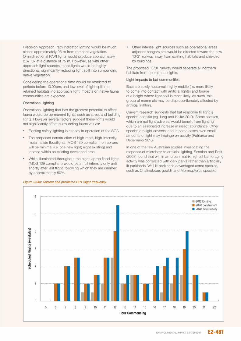
precision Approach path indicator lighting would be much closer, approximately 95 m from remnant vegetation. omnidirectional pApi lights would produce approximately 2.67 lux at a distance of 75 m. However, as with other approach light sources, these lights would be highly directional, significantly reducing light spill into surrounding native vegetation.
Considering the operational time would be restricted to periods before 10.00pm, and low level of light spill into retained habitats, no approach light impacts on native fauna communities are expected.
Operational lighting
operational lighting that has the greatest potential to affect fauna would be permanent lights, such as street and building lights. However several factors suggest these lights would not significantly affect surrounding fauna values:
y Existing safety lighting is already in operation at the SCA.
y The proposed construction of high-mast, high-intensity metal halide floodlights (MoS 139 compliant) on aprons will be minimal (i.e. one new light; eight existing) and located within an existing developed area.
y While illuminated throughout the night, apron flood lights (MoS 139 compliant) would be at full intensity only until shortly after last flight, following which they are dimmed by approximately 50%.
y other intense light sources such as operational areas adjacent hangars etc, would be directed toward the new 13/31 runway away from existing habitats and shielded by buildings.
The proposed 13/31 runway would separate all northern habitats from operational nights.
Light impacts to bat communities
Bats are solely nocturnal, highly mobile (i.e. more likely to come into contact with artificial lights) and forage at a height where light spill is most likely. As such, this group of mammals may be disproportionately affected by artificial lighting.
Current research suggests that bat response to light is species-specific (eg Jung and Kalko 2010). Some species, which are not light adverse, would benefit from lighting due to an associated increase in insect abundance. other species are light adverse, and in some cases even small amounts of light may impinge on activity (patriarca and Debernardi 2010).
in one of the few Australian studies investigating the response of microbats to artificial lighting, Scanlon and petit (2008) found that within an urban matrix highest bat foraging activity was correlated with dark parks rather than artificially lit parklands. Well lit parklands advantaged some species, such as Chalinolobus gouldii and Mormopterus species.
2
0
5 6 7 8 9 10 11 12 13
Hour Commencing
14 15 16 17 18 19 20 21 22
2012 Existing2040 Do Minimum2040 New Runway
4
6
8
10
12
Sche
dule
d Fl
ight
s (w
eekd
ay)
Figure 2.14a: Current and predicted RPT flight frequency
E2-481environmental impact statement
in contrast, Adams et al., (2005) found that more bat species were detected in lit areas and the number of foraging passes increased; although several species were identified less often in lit areas (eg nyctophilus spp., Chalinolobus morio). The difference in these studies probably underlines the species-specific response of bat species to lighting and the potential loss of light-sensitive bat species in urban areas.
While some species identified at the airport are likely to be light adverse, light spill is expected to be limited in extent and duration (as discussed above). As such, light impacts on bat communities or species would be low, possible undetectable.
Larger Flying-foxes are often observed moving over well-lit urban areas with significant light pollution. Light impacts from the proposed activities are therefore not expected to affect this group of mammals.
2.14.6 Increased noise
While sudden loud noise can initiate an immediate flight response in most wildlife, noise is most likely to affect fauna which communicate through sound. Fauna (in particular amphibian and bird species) may use sound to (1) attract and bond with mates, (2) defend territories, (3) maintain contact with social groups, (4) beg for food (birds), and/or (5) warn of approaching danger (parris and Schneider 2008). increased ambient noise from anthropogenic sources can reduce the distance over which acoustic signals can be detected, by interfering or masking call detection/efficacy. This can result in a variety of impacts on individual species or affect vertebrate community composition/structure (Reijnen and Foppen 1994; Reijnen et al., 1995; 1996; Forman et al., 2002; parris and Schneider 2008; Katti and Warren 2004; Sun and narrins, 2005; Bee and Swanson, 2007; Hoskin and Goosem, 2010; Eigenbrod et al., 2009).
Construction noise
Construction noise associated with the proposed activities is most likely to simulate the low-frequency constant noise associated with roadways, and as such, has the potential to affect bird communities. Amphibian communities are less likely to be affected, with construction works to be restricted to between 6.30am and 6.30pm in all phases except package 2, dredging and reclamation (see Chapter B15 –noise and Vibration for more details).
initial modelling of construction noise suggested noise levels within adjacent sensitive environmental areas (i.e. Mt Coolum national park and the WHMA) might be higher than desired. Mitigation measures were included within the project design, and subsequent modelling shows that noise levels are not expected to increase above existing background noise levels, except in very close proximity to construction. These impacts are relatively minor, localised, and temporary. While construction noise may disadvantage a small number of individuals close to the development for short periods, it is not expected to lead to long-term changes in vertebrate communities.
Aircraft/helicopter noise
The main source of existing aircraft noise, RWY 18/36, is approximately 100 m from sensitive habitats (ie, the WHMA), while the new RWY 13/31 centreline is approximately 400 m from retained habitats. noise modelling predicts that the increased distance, and advances in new aircraft design, will ensure that noise amplitude under the new runway conditions will not exceed existing levels.
While noise amplitude should not increase, flight activity on the new runway may increase the frequency of peak noise periods. predicted 2040 RpT flight schedules suggest flight frequency will increase, although flight frequency is expected to be similar under both ‘do minimum’ and ‘new runway’ scenarios (see Figure 2.14a). Average flights during daylight hours (6 am to 5 pm), when birds are active and calling, will increase from 1.3 movements per hour to 3.5 movements per hour under the ‘do minimum’ scenario and 4 movements under the ‘new runway’ scenario. peak flight frequency will coincide with the hour commencing at midday, with 8 predicted flights under the ‘do minimum’ scenario and 11 under the ‘new runway’ scenario. Far fewer flights (no more than 5 per hour) are expected under either scenario in the hours prior to 11am.
Assuming each flight produces elevated noise levels sufficient to mask bird calls for a duration of 2.5 minutes, large periods of the day will remain unaffected. This may cause minor temporal changes in calling behaviour (ie, individuals may cease calling during elevated noise), but on balance is not expected to affect vertebrate communities.
predicted increases in runway usage during the evening are also similar under both future scenarios. The last RpT flight is anticipated at 9.30 pm, leaving extended periods during the night for nocturnal fauna to avoid the effects of noise.
The proposed RWY 13/31 is not expected to increase the frequency of helicopter flights (Chapter D5 – Aircraft noise). over time it is anticipated that circuit training of all types would gradually decrease as demand for RWY 13/31 usage by arriving and departing aircraft increases.
While unlikely to significantly affect the amount of aircraft noise any more than the ‘do minimum’ scenario, operation of the new runway will shift the geographical location of noise sources, and therefore exposed new areas to aircraft noise while relieving others.
2.15 wALLUM SEdGEFROG
2.15.1 habitat loss (reduced area of occupancy) and associated mortality
2.15.1.1 Habitat loss
Construction of the new runway would necessitate the clearing and filling of known (occupied) Wallum Sedgefrog habitat within the SCA. This includes 1.67 ha of wet heath and sedgeland mapped as known or likely Wallum
E2-482
Airport And SurroundS
Matters of NatIoNaL eNvIroNMeNtaL sIgNIfIcaNceE2
SunSHinE CoASt Airport EXpAnSion proJECt
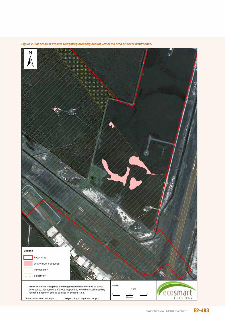
Figure 2.15a: Areas of Wallum Sedgefrog breeding habitat within the area of direct disturbance.
Figure 4.13Areas of Wallum Sedgefrog breeding habitat within the area of direct disturbance. Assessment of areas mapped as known or likely breeding habitat is based on criteria outlined in Section 1.3.4.
Legend
Focus Area
Lost Wallum Sedgefrog
Permanently
Selectively
±
Client: Sunshine Coast Airport Project: Airport Expansion Project
0 0.20.1
Kilometers
1:3,689
Scale:
E2-483environmental impact statement
Sedgefrog breeding habitat within the WHMA and adjoining helicopter training area (23.4% of total habitat; Figure 2.15a). intervening areas of remnant and non-remnant regrowth heath or Melaleuca forest, used infrequently by dispersing animals, will also be lost, though this is unlikely to affect movement between areas of retained habitat within and adjacent the SCA.
The loss of habitat surrounding breeding areas is also unlikely to limit foraging/shelter opportunities, for non-breeding animals as these needs are likely to be met within breeding habitat (as evidenced by the continued presence of Wallum Sedgefrogs in breeding areas during dry and wet periods [Lowe and Hero 2013; E. Meyer unpub. obs.]).
Clearing and development of wet heath and melaleuca woodland/forest would result in the permanent loss of 47.07 ha of Essential Habitat (see Figure 2.15b), though only a small proportion (<4%, mostly representing areas within the helicopter training area) of this is likely to support breeding by the Wallum Sedgefrog and/or provide foraging/shelter opportunities for non-breeding animals (other than animals dispersing between existing breeding areas). An additional 2.52 ha at the northern tip of the existing 18/36 runway will be temporarily cleared for pipe laydown during construction. once construction is completed, this area will be rehabilitated. Selective clearing north of the northern perimeter drain (ie, removal of tall woody vegetation through slashing to ensure vegetation does not exceed 1.5m) is unlikely to render habitats unsuitable for the Wallum Sedgefrog.
The loss of Wallum Sedgefrog habitat will be mitigated through the establishment of compensatory habitat within the SCA, and provided these measures are successful, no net-loss of habitat is anticipated.
2.15.1.2 Mortality
in addition to habitat loss, clearing and filling within the SCA is likely to result in mortality of Wallum Sedgefrogs. Abundance data from transects within the clearing zone suggest affected frogs are unlikely to exceed one or two hundred. This is a relatively small number compared with the total estimated population within the SCA (as inferred from count data elsewhere within the WHMA).
2.15.2 Fragmentation
in the case of the Wallum Sedgefrog, loss of non-breeding habitat is not expected to have any significant impacts on connectivity between areas of retained habitat as these are located north (and not south) of the proposed runway.
2.15.3 Slashing
in order to maintain runway visibility, vegetation to the immediate north of the northern perimeter drain and within the WHMA would need to be slashed repeatedly so that tree/shrub cover remains below 1.5 m (the maximum height allowable immediately adjacent the proposed runway). Slashing would occur within the existing WHMA (an area
subject to historic slashing regimes) and extend into areas of remnant vegetation to the immediate north of the northern perimeter drain. Slashing would affect 5.84 ha of remnant vegetation mapped as Essential Habitat, as well as known habitat (not mapped as Essential Habitat) within the retained portion of the WHMA (see Figure 2.15b).
Frequent, low slashing has the potential to remove both woody growth (ie, tree/shrub cover) as well as sedge cover resulting in fewer opportunities for foraging and shelter and, potentially, breeding as well. While the loss/reduction in sedge cover is likely to be short-lived (with sedges regrowing rapidly under wet conditions), slashing will result in a permanent reduction in tree/shrub cover. This reduction in tree/shrub cover is unlikely to impact negatively on the Wallum Sedgefrog which isn’t reliant on trees or shrub cover for survival. With an appropriate slashing regime, reduced sedge cover is also unlikely to have a significant long-term impact on Wallum Sedgefrog numbers, as evidenced by successful recruitment of Wallum Sedgefrogs in the slashed wet heath/sedgeland of the WHMA and chopper-rolled heath/sedgeland at Caloundra South. (pER 2012).
As well as the aforementioned impacts on habitat, slashing could result in direct mortality of Wallum Sedgefrogs. Though the number of frogs killed and/or injured as a result of slashing is difficult to estimate, habitats within the WHMA support significant numbers of Wallum Sedgefrog (possibly several hundred). The actual number likely to be killed or injured by slashing will most likely depend on when slashing occurs (ie, the timing and frequency of slashing) and the height at which vegetation is slashed. Slashing during wet periods, when frogs are generally more active above ground would appear to pose a greater threat than slashing in the ‘dry’, when Wallum Sedgefrogs may be sheltering at the base of grass/sedge clumps and tussocks. Similarly, slashing of vegetation at or very near ground level is more likely to result in mortality of animals than slashing at heights of >0.5 m. Mortality from slashing, can therefore be managed so as to avoid significant mortality of Wallum Sedgefrog.
Given the above, slashing of vegetation is unlikely to have an enduring impact on the Wallum Sedgefrog provided vegetation isn’t slashed too low and/or sufficient time is allowed for sedge cover and numbers of acid frog species to recover.
2.15.4 Noise
2.15.4.1 Construction noise
While the sensitivity of Wallum Sedgefrogs to noise pollution is unknown, studies on other frog species show high levels of background noise (eg, airplane flyby and traffic noise emanating from busy roads) can interfere with male calling behaviour and female detection of male calls (Sun and narrins, 2005; Bee and Swanson 2007). Excessive noise during the breeding season could therefore affect reproductive success, although negative noise impacts at other times, (ie, during periods of low rainfall such as winter and spring) is unlikely.
E2-484
Airport And SurroundS
Matters of NatIoNaL eNvIroNMeNtaL sIgNIfIcaNceE2
SunSHinE CoASt Airport EXpAnSion proJECt
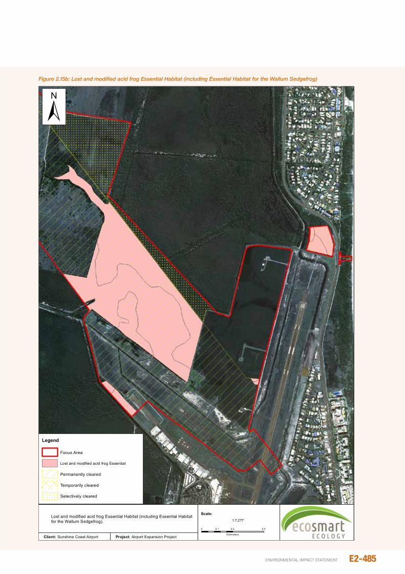
E2-485environmental impact statement
Figure 2.15b: Lost and modified acid frog Essential Habitat (including Essential Habitat for the Wallum Sedgefrog)
Figure 4.14
Legend
Focus Area
Lost and modified acid frog Essential
Permanently cleared
Temporarily cleared
Selectively cleared
±
Client: Sunshine Coast Airport Project: Airport Expansion Project
0 0.2 0.40.1
Kilometers
1:7,277
Scale:Lost and modified acid frog Essential Habitat (including Essential Habitat for the Wallum Sedgefrog).
Given the above, noise associated with package 1 and package 3 of construction is unlikely to significantly affect calling/breeding by the Wallum Sedgefrogs since:
y Construction activities during these phases are not expected to continue beyond 6:30pm (Table 2.15a), and
y Active earth-moving machinery is unlikely during, or immediately following, heavy rainfall due to constraints on the movement of machinery over sodden ground.
unlike package 1 and 3, noise associated with dredge and fill operations (ie, package 2) will occur for short periods during the day and night and, as such, has a greater potential to impact on calling behaviour. noise during this phase will primarily emanate from the dredge booster pump and associated mobile plant equipment (two dozers in the day and one at night, see Chapter B15 – noise and Vibration). However, mitigation measures inherent in the project design and will significantly reduce noise levels in adjacent wallum habitats. only a small portion of the WHMA will experience construction noise exceeding existing ambient noise levels (ie, LAeq >42 dBA; see), and then only for a relatively short duration (approximately 4 weeks depending on the area). These impacts are unlikely to affect retained Wallum Sedgefrog populations.
2.15.4.2 Operational noise
operation of the new runway would not see any significant increase in air traffic at night to/from the SCA beyond that expected under the ‘do minimum’ scenario (with aircraft continuing to land on the existing 18/36 runway). nor would noise produced by aircraft using the new runway exceed existing noise levels within the SCA (see Chapter D5 – Aircraft noise). As such, RWY 13/31 is unlikely to result in any increase in aircraft noise levels than would occur with ongoing use of the existing 18/36 RWY. The expected increase in aircraft noise, moreover, is unlikely to affect Wallum Sedgefrog calling/breeding behaviour to any great extent given few aircraft movements are expected after 10 pm (except in exceptional circumstances).
While unlikely to increase noise levels within the SCA, resulting changes in aircraft flight paths will, see an increase in engine noise in known habitat to the immediate north (ie, within the northern section of Mt Coolum np), as well as at mapped Essential Habitat (ie, remnant melaleuca wetland mapped as RE 12.2.7) within Maroochy River Conservation
park, south-east of the SCA. While this increase is noted, it is not expected to affect Wallum Sedgefrog for the reasons outlined above, and also the fact that noise levels of overflying aircraft will be lower than levels within the SCA itself.
2.15.5 Lighting
While the response of Wallum Sedgefrogs to increased night light is poorly understood, studies of other species show calling may be inhibited by high levels of ambient light (including moonlight) (Granda et al., 2009; Buchanan, 1993; Baker and Richardson 2006). Whether acid frogs are affected by artificial light spill in other ways is unknown. However, available evidence suggests increases in night light are unlikely to impact significantly on the Wallum Sedgefrog, which is known to call strongly on wet overcast days and also moon-lit nights (E. Meyer, pers. obs.; M. Sanders, pers. obs.). The persistence of a healthy breeding population of Wallum Sedgefrogs in similar proximity to existing runway lighting within the WHMA would also argue against a significant impact on this species.
2.15.6 weed invasion
native undisturbed wet heath and melaleuca habitats around the SCA are relatively resilient to weed infestation, and typically weeds only become dominant following disturbance. Soil disturbance and increased light penetration adjacent to retained native vegetation is inevitable, and as such, the establishment of weeds is likely. However due to the resilience of these habitats, widespread infestation is probably unlikely provided other factors such as nutrients are not adversely affected.
A particularly concerning weed infestation is located in the south-western corner of the WHMA where historic land-use has increased soil nutrients. This area is now dominated by a near monoculture of thick Megathyrsus maximus var maximus, Melinis repens and Sorghum halepense. Historic air photos suggest that this infestation is gradually spreading, albeit slowly, into adjacent wet heath habitats (ie, the WHMA). This area of weed infestation is within the development footprint and will be removed. Recommendations to ensure its spread have been included within the EMp (see Chapter E3).
Table 2.15a: Proposed construction works
package works proposed hours Commencement Completion
1 Civil 6 days per week, 6.30am-6.30pm 1st Quarter 2016 1st Quarter 2017
2 Dredging 6 days per week, 6.30am-6.30pm with dredging and placement occurring 7 days, 24 hours per day 3rd Quarter 2017 1st Quarter 2018
3 pavements 6 days per week, 6.30am-6.30pm 1st Quarter 2018 3rd Quarter 2019
4 Terminal upgrades 6 days per week, 6.30am-6.30pm 3rd Quarter 2017 3rd Quarter 2019
Source: Chapter B15 – Terrestrial Noise
E2-486
Airport And SurroundS
Matters of NatIoNaL eNvIroNMeNtaL sIgNIfIcaNceE2
SunSHinE CoASt Airport EXpAnSion proJECt
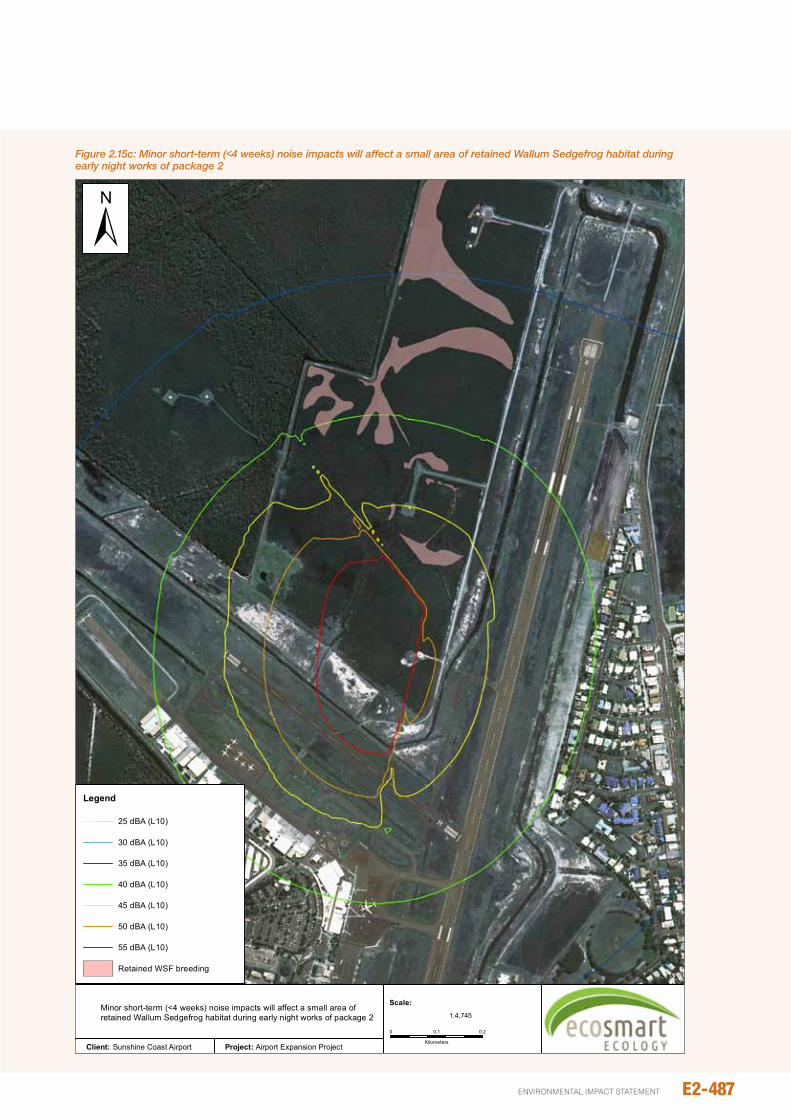
E2-487environmental impact statement
Figure 2.15c: Minor short-term (<4 weeks) noise impacts will affect a small area of retained Wallum Sedgefrog habitat during early night works of package 2
Figure 4.15
Legend
25 dBA (L10)
30 dBA (L10)
35 dBA (L10)
40 dBA (L10)
45 dBA (L10)
50 dBA (L10)
55 dBA (L10)
Retained WSF breeding
±
Client: Sunshine Coast Airport Project: Airport Expansion Project
0 0.20.1
Kilometers
1:4,745
Scale:Minor short-term (<4 weeks) noise impacts will affect a small area of retained Wallum Sedgefrog habitat during early night works of package 2

Standard and appropriate weed management procedures (see Chapter B7 – Terrestrial Flora) should be sufficient to reduce the risk of weed introduction or spread. However in consideration of the sensitive fauna habitats, particularly within wallum heath habitats (including the WHMA), additional weed monitoring will be undertaken.
2.15.7 Altered water hydrology and quality
2.15.7.1 Increased salinity
Systematic sampling of existing salinity concentrations in surface waters was not undertaken, however available evidence suggests that salinity is relatively low. Sampling of two drains within the adjacent Mt Coolum national park found salinity levels in surface water of 70 and 90 mg/L.
The tolerance of Wallum Sedgefrogs to elevated salinity is unknown, although water salinity in wallum habitats which they occupy are typically < 100 mg/L (Table 2.15b).
Modelling inherent design features of RWY 13/31 indicates that groundwater salinity concentrations 50 m north of the northern perimeter drain will peak at 1,000mg/L (approximately 200 years after filling is complete) and will not exceed 500 mg/L 150 m from the northern perimeter drain (see Section 8.4.3) (approximately 300 years after filling is complete). While these concentrations exceed the known salinity range of Wallum Sedgefrog habitats, groundwater salinity would be contained by a layer of coffee rock. Based on the information provided in Chapter B3, upward migration of saline groundwater from below the coffee rock is unlikely. Further, should upward salinity migration occur, impacts are anticipated to be localised and minor.
2.15.7.2 Alteration to groundwater hydrology
Surface water within the Mt Coolum national park and WHMA are seasonal, flooding during the wet season and drying during periods of low rainfall. These habitats, which prevent the establishment of exotic fish, are favoured by Wallum Sedgefrogs and changes to existing conditions may impact habitat suitability/breeding success.
As detailed in Chapter B3, the project includes the installation of a cut-off wall to the immediate north of the northern perimeter drain. This inherent design feature will prevent lateral sub-surface water flow. no drawdown is expected from the proposed northern perimeter drain. project related changes to existing hydrological conditions in the adjacent Mt Coolum national park and WHMA are therefore not expected.
2.16 GREy-hEAdEd FLyING-FOx
2.16.1 direct loss of foraging habitat
no historic or active Flying-fox camps occur within the SCA, and as such, disturbance to known roosts is not expected as a result of the project. However vegetation loss will reduce available foraging resources within the local area. The main resource for flying-foxes within the SCA is flowering Eucalypts and Melaleucas (RE’s 12.2.7 and 12.3.5). During peak flowering periods, vegetation dominated by these species can attract large numbers of Grey-headed Flying-fox, which, based on flight direction, are likely to originate from the Maroochydore camp. other minor resources include tall dense stands of Banksia integrifolia (within RE 12.2.14) and B. aemula (RE 12.2.9), as well as a small number of planted Mango trees.
The proposed airport expansion will result in the loss of 41.8 ha of Grey-headed Flying-fox foraging habitat (Table 2.15c), or approximately 3.94% of similar habitats within 15km of the Maroochydore camp. Flowering and fruiting resources will occur in a variety of other Regional Ecosystems throughout the area, as well as in non-remnant areas associated with parks and gardens (eg, cultivated mango trees, Callistemon spp etc). in the broader context (ie, within 15 km of the Maroochydore camp), clearing associated with the airport will result in only a minor loss of remnant foraging habitat (0.65%).
The provision of additional mitigation measures (habitat offsets) will reduce the long-term loss of foraging habitat for this species, and as such, impacts are not expected to be significant.
2.16.2 Altered water hydrology and quality
The Grey-headed Flying-fox cannot be directly affected by altered water hydrology or quality. However the species would be adversely affected should changes to water conditions influence vegetation composition, leading to a loss of foraging resources.
inherent design measures restrict potential impacts to groundwater. no adverse impacts on vegetation are expected (see Chapter B7), and therefore no adverse impacts are expected on Grey-headed Flying-fox resources.
Table 2.15b: Salinity levels in surface water at known acid frog breeding sites outside of the Study Area
Species Salinity range (mg/L) Information source
Wallum Sedgefrog 7.5-93.75 Simpkins et al., 2013; EcoSmart Ecology, unpub. data
Wallum Froglet 7.5-99.1 Simpkins et al., 2013; EcoSmart Ecology, unpub. data
Wallum Rocketfrog 7.5-37.5 EcoSmart Ecology, unpub. data
E2-488
Airport And SurroundS
Matters of NatIoNaL eNvIroNMeNtaL sIgNIfIcaNceE2
SunSHinE CoASt Airport EXpAnSion proJECt
2.16.3 plane strike
Flying-foxes are known to pose a threat to aeroplanes, causing significant damage on impact (Hall and Richards 2000). Data from flying-fox strikes within Australia show that most incidents occur below 300 m (96% of strike records), with almost 76% occurring at 150 m. For reasons unknown, more strikes occur on departure (74% of strikes) than landing (24.8% of strikes; parsons et al., 2009). As flying-foxes typically leave their day roosts to fly to foraging sites within 30 minutes of sunset (parry-Jones and Augee 1992; Welbergen 2006), strikes are most common between 1700 and 2000 hrs.
Current data for the SCA shows that only one flying-fox strike has been recorded, which on average equates to 0.023 strikes per 10,000 aircraft movements. Several factors suggest that the risk of flying-fox strike may increase under the project:
y observations of flying-fox movement around the SCA indicate that the bulk of individuals move in a north-south direction, parallel to existing plane take-offs and landings. The new runway, with its more east-west alignment, will take aircraft across this favoured flying-fox flight path.
y The new alignment would cross the Sunshine Coast motorway and the Maroochydore River/Coolum Creek, two significant linear topographical features within the local area. Flying-foxes are known to use linear topographical features as navigational aids, and therefore disproportionate numbers of individuals may stream over these areas.
y Finally, the approach height of aircraft is well below 150 m when crossing these linear landmarks, a height at which most flying-fox strikes occur.
under the proposed development, planes will land on a 3 degree flight path, taking them to below the 300 m flight-strike risk threshold at approximately 5,325 m from the runway threshold. Based on this information, the risk of flying-fox strike will be greatest between the Coolum Waste Landfill on Yandina-Coolum Road and the new runway.
The risk of flying-fox strike will vary according to local abundance and predominant flying-fox flight path direction. Both abundance and flight direction will be influenced by local flowering events, and as such, the risk of strike wouldbe more likely to occur between the hours of 1700 and 2000 during the months of February/March and August/September.
2.17 wATER MOUSE
The proposed activities will not result in the direct loss of mangrove/intertidal habitat, or create barriers to Water Mouse movement/dispersal. possible impacts are therefore restricted to altered prey (small crab and molluscs) abundance resulting from loss of water quality within downstream mangrove habitats.
Marine ecology studies (Chapter C4) suggest that impacts within the Marcoola drain could include increased turbidity (predicted to increase by 25%) and increased salinity (from 3.5ppt to 25 ppt). However these impacts will be spatially restricted to the lower reaches of the Marcoola drain (ie, below point of discharge), and temporally constrained to the phase 2 construction period (approximately 3-6 months for dredging). Long-term impacts are not expected and changes at the mouth of the drain (ie, confluence of the Maroochy River) will be within natural variation.
The Marcoola drain is fringed by a narrow strip of mangroves which will provide extremely limited foraging habitat. While temporary changes to crab and mollusc communities may occur along the drain during construction, much larger areas of habitat along the Maroochy River will be unaffected. importantly, downstream habitats with high Water Mouse densities will not be impacted.
no impacts are therefore expected from the proposed runway development, and no special mitigation measures are necessary.
2.18 OThER EvNT SpECIES
populations of EVnT species known to occur or regularly frequent the SCA area, and as such, are at the greatest risk of development impact. Five other species have not been recorded but may occur, have been historically recorded (Koala), or may occur sporadically (Black-necked Stork, Grey Goshawk, Lewin’s Rail). Due to the lack of high quality habitat and/or the transient nature of these six species, the risk of adverse impact on these species is greatly reduced. potential impacts specific to the six species are briefly discussed below.
Black-necked Stork
The Black-necked Stork has been recorded on at least one occasion along artificial drains within the SCA, but is a rare sporadic visitor to the SCA. no resident pairs are known from the region, and therefore the loss of habitats is unlikely to affect the species in the broader area.
no impacts on water quality within the Maroochy River, and therefore no reduction in potential prey, is expected as a result of the proposed activities (see Chapter C4 – Marine Ecology).
The risk of plain strike may increase slightly due to the realignment of aircraft approach/departure over the Maroochy River and Column Creek. However, the probability of plain strike remains very low.
no special mitigation measures are considered necessary for this species.
Grey Goshawk
Grey Goshawks have been irregularly recorded in the local area, including several records within, or in proximity to, the Study Area. Despite broadly traversing the SCA during regular visits, no evidence of nesting has been noted.
E2-489environmental impact statement
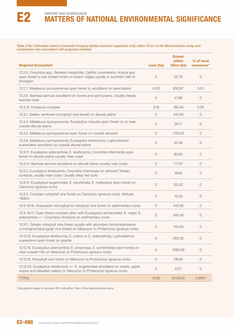
Table 2.15c: Estimated extent of potential foraging habitat (remnant vegetation only) within 15 km of the Maroochydore camp and comparative loss associated with proposed activities
Regional Ecosystem Loss (ha)
Extent within
15km (ha)% of local resources*
12.2.5. Corymbia spp., Banksia integrifolia, Callitris columellaris, Acacia spp. open forest to low closed forest on beach ridges usually in southern half of bioregion
0 25.78 0
12.2.7. Melaleuca quinquenervia open forest to woodland on sand plains 41.62 830.97 5.01
12.2.9. Banksia aemula woodland on dunes and sand plains. usually deeply leached soils 0 41.86 0
12.2.14. Foredune complex 0.18 185.45 0.09
12.3.1. Gallery rainforest (notophyll vine forest) on alluvial plains 0 410.49 0
12.3.4. Melaleuca quinquenervia, Eucalyptus robusta open forest on or near coastal alluvial plains 0 28.17 0
12.3.5. Melaleuca quinquenervia open forest on coastal alluvium 0 1700.25 0
12.3.6. Melaleuca quinquenervia, Eucalyptus tereticornis, Lophostemon suaveolens woodland on coastal alluvial plains 0 45.34 0
12.3.11. Eucalyptus siderophloia, E. tereticornis, Corymbia intermedia open forest on alluvial plains usually near coast 0 83.82 0
12.3.14. Banksia aemula woodland on alluvial plains usually near coast 0 117.97 0
12.5.2. Eucalyptus tereticornis, Corymbia intermedia on remnant Tertiary surfaces, usually near coast. usually deep red soils 0 18.62 0
12.8.14. Eucalyptus eugenioides, E. biturbinata, E. melliodora open forest on Cainozoic igneous rocks 0 52.32 0
12.8.3. Complex notophyll vine forest on Cainozoic igneous rocks. Altitude <600m 0 15.30 0
12.9-10.16. Araucarian microphyll to notophyll vine forest on sedimentary rocks 0 443.35 0
12.9-10.17. open forest complex often with Eucalyptus acmenoides, E. major, E. siderophloia +/- Corymbia citriodora on sedimentary rocks 0 495.56 0
12.12.1. Simple notophyll vine forest usually with abundant Archontophoenix cunninghamiana (gully vine forest) on Mesozoic to proterozoic igneous rocks 0 144.29 0
12.12.12. Eucalyptus tereticornis, E. crebra or E. siderophloia, Lophostemon suaveolens open forest on granite 0 283.32 0
12.12.15. Eucalyptus siderophloia, E. propinqua, E. acmenoides open forest on near coastal hills on Mesozoic to proterozoic igneous rocks 0 1082.66 0
12.12.16. notophyll vine forest on Mesozoic to proterozoic igneous rocks 0 136.81 0
12.12.23. Eucalyptus tereticornis +/- E. eugenioides woodland on crests, upper slopes and elevated valleys on Mesozoic to proterozoic igneous rocks 0 6.27 0
ToTAL 41.80 6,149.00 0.68%
*Calculations based on remnant RE’s (v8) within 15km of the Maroochydore camp
E2-490
Airport And SurroundS
Matters of NatIoNaL eNvIroNMeNtaL sIgNIfIcaNceE2
SunSHinE CoASt Airport EXpAnSion proJECt
The loss of woodland and heathland communities will result in a minor reduction in foraging habitat, although this loss is small (<1%) in the context of similar habitats available in the local area (see for example Table 2.15c; calculations based on habitats within 15 km of the SCA). ongoing incremental loss of habitat and its potential impact on Grey Goshawk in this area is unknown.
Being highly mobile, the proposed actions will not affect the dispersal or movements of Grey Goshawks.
Lewin’s Rail
Lewin’s Rail was recorded once from waterlogged exotic grassland adjacent remnant habitats on Finland Road, but could potentially occur in similar grasslands or in waterlogged heathlands. The species can be difficult to detect, but given the lack of records despite regular visits, it is probable that birds are sporadic or infrequent.
Known habitat will be lost to facilitate the development, though the exact quantity is difficult to calculate due to difficulty in mapping waterlogged exotic grassland. nevertheless, similar exotic grasslands are likely to be widely distributed in the local area, and the loss of these habitats for the SCA expansion is expected to represent a minor fraction of available habitat.
Lewin’s Rails are highly mobile and the proposed actions are unlikely to create barriers to movement or dispersal.
no special mitigation measures are considered necessary for this species.
Eastern Curlew
The proposed activities will not result in the direct loss of mangrove, mudflat or sandbank habitat for the Eastern Curlew. Birds are not expected to frequent Marcoola beachfront, or the Marcoola drain. Further, these birds are highly mobile and the creation of barriers that might affect movement will not occur.
no impacts on water quality within the Maroochy River are anticipated, and in particular, important sandflat and mudflat habitats at the mouth of the Maroochy River will not be affected (see Chapter C4).
Approach and departure flight paths under the new runway scenario is likely to reduce in-flight aircraft noise over foraging habitat at the mouth of the Maroochy River (see Chapter D3 Aircraft noise)
no special mitigation measures are considered necessary for this species.
Koala
Koalas have been recorded eight times within 5 km of the Study Area, with all observations predating 2004. Despite targeted surveys for Koala, the species was not detected within or adjacent the SCA. Habitat surrounding the SCA is marginal, and generally restricted to narrow or small timbered areas with tall Eucalyptus tereticornis, and E. robusta. The largest area with moderately dense cover of preferred feed trees is located along Finland Road and is a
mere 3.13 ha in extent. This area would be lost as a result of the proposed actions.
Due to infrequent use of the SCA and surrounds, the loss of these habitats is not expected to affect the species.
2.19 EpBC ACT MIGRATORy SpECIES
Migratory Shorebirds and Little Tern
impacts to shorebird habitats that require assessment include:
y The minor loss of habitat for the construction and operation of the sand delivery pipeline at Marcoola Beach.
y The minor loss of habitat (<10m2) for the construction of the northern perimeter drain on the southern bank of the Marcoola drain.
y increased human activity inhibiting foraging along Marcoola Beach during sand delivery pipeline assembly and decommissioning.
y Deterioration of water quality within the Marcoola drain and Maroochy River from sedimentation and increased salinity/acidity leading to the loss of downstream foraging habitats.
y noise associated with departing and arriving flights on habitats at the mouth of the Maroochy River.
Shorebirds are typically scarce along busy beachfronts, and are far more common along estuaries or on sandflats and mudflats. Since regular human activity along beaches such as Marcoola interrupts shorebird foraging, impacts from minor loss of habitat and increased human activity on beaches are therefore likely to have negligible impacts on local shorebird populations.
Little Terns forage over open water adjacent to the beach and are usually not usually influenced by beach front activities. The pump-out location is situated in deep water, approximately 600 to 1,000 m offshore from Marcoola Beach (see Chapter C2 Dredging and Reclamation), and as such, unlikely to affect Little Tern foraging patterns.
Shorebird foraging habitat along the Marcoola drain is limited in extent and unlikely to support large numbers of waders. no waders have been recorded at this location.
While suspended solids and salinity levels within the Marcoola drain are expected to increase, particularly during construction, these impacts are expected to be highly localised and temporary (see Chapter C4). impacts to water quality within the Maroochy River are expected to remain within the bounds of normal variation and large areas of Migratory Shorebird habitat at the mouth of the river will be unaffected.
Habitats of high value for migratory shorebirds (ie, at the mouth of the Maroochy River) are approximately 2km from the direct flight path under the new runway scenario. noise from approaching or departing planes using the new runway is not expected to increase above background noise levels. This is an improvement from existing conditions, which required
E2-491environmental impact statement
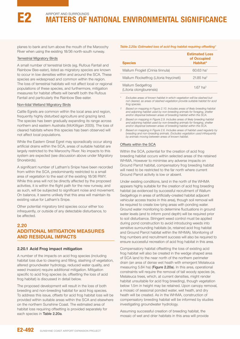
planes to bank and turn above the mouth of the Maroochy River when using the existing 18/36 north-south runway.
Terrestrial Migratory Birds
A small number of terrestrial birds (eg, Rufous Fantail and Rainbow Bee-eater), listed as migratory species are known to occur in low densities within and around the SCA. These species are widespread and common within the region. The loss of terrestrial habitats will not affect local or regional populations of these species, and furthermore, mitigation measures for habitat offsets will benefit both the Rufous Fantail and particularly the Rainbow Bee-eater.
Non-tidal Wetland Migratory Birds
Cattle Egrets are common within the local area and region, frequently highly disturbed agriculture and grazing land. The species has been gradually expanding its range across northern and eastern Australia (McKilligan 2005). The loss of cleared habitats where this species has been observed will not affect local populations.
While the Eastern Great Egret may sporadically occur along artificial drains within the SCA, areas of suitable habitat are largely restricted to the Maroochy River. no impacts to this system are expected (see discussion above under Migratory Shorebirds).
A significant number of Latham’s Snipe have been recorded from within the SCA, predominantly restricted to a small area of vegetation to the east of the existing 18/36 RWY. While this area will not be directly affected by the proposed activities, it is within the flight path for the new runway, and as such, will be subjected to significant noise and movement. on balance, it seems unlikely that this area will maintain its existing value for Latham’s Snipe.
other potential migratory bird species occur either too infrequently, or outside of any detectable disturbance, to be affected.
2.20 AddITIONAL MITIGATION MEASURES ANd RESIdUAL IMpACTS
2.20.1 Acid Frog impact mitigation
A number of the impacts on acid frog species (including habitat loss due to clearing and filling, slashing of vegetation, altered groundwater hydrology, reduced water quality, and weed invasion) require additional mitigation. Mitigation specific to acid frog species (ie, offsetting the loss of acid frog habitat) is discussed in detail below.
The proposed development will result in the loss of both breeding and non-breeding habitat for acid frog species. To address this issue, offsets for acid frog habitat loss will be provided within suitable areas within the SCA and elsewhere on the northern Sunshine Coast. The estimated area of habitat loss requiring offsetting is provided separately for each species in Table 2.20a.
Table 2.20a: Estimated loss of acid frog habitat requiring offsetting*
Species
Estimated Loss of Occupied
habitat*
Wallum Froglet (Crinia tinnula) 60.63 ha1
Wallum Rocketfrog (Litoria freycineti) 21.85 ha2
Wallum Sedgefrog (Litoria olongburensis) 1.67 ha3
* Excludes areas of known habitat in which vegetation will be slashed but not cleared, as areas of slashed vegetation provide suitable habitat for acid frog species.
1 Based on mapping in Figure 2.10. Includes areas of likely breeding habitat and adjoining habitat used by non-breeding animals for foraging, shelter and/or dispersal between areas of breeding habitat within the SCA.
2 Based on mapping in Figure 2.9. Includes areas of likely breeding habitat and adjoining habitat used by non-breeding animals for foraging, shelter and/or dispersal between areas of breeding habitat within the SCA.
3 Based on mapping in Figure 2.6. Includes areas of habitat used regularly by breeding and non-breeding animals. Excludes vegetation used infrequently by animals moving between areas of known habitat.
Offsets within the SCA
Within the SCA, potential for the creation of acid frog breeding habitat occurs within selected areas of the retained WHMA. However to minimise any adverse impacts on Ground parrot habitat, compensatory frog breeding habitat will need to be restricted to the far north where current Ground parrot activity is low or absent.
under existing conditions, land in the north of the WHMA appears highly suitable for the creation of acid frog breeding habitat (as evidenced by successful recruitment of Wallum Sedgefrogs in areas of artificially-created habitat adjacent vehicular access tracks in this area), though soil removal will be required to create low-lying areas with ponding water. Ground water monitoring to determine fluctuations in ground water levels (and to inform pond depth) will be required prior to soil disturbance. Stringent weed control must be applied during pond construction to avoid introducing weeds into sensitive surrounding habitats (ie, retained acid frog habitat and Ground parrot habitat within the WHMA). Monitoring of frog numbers and recruitment success will also be required to ensure successful recreation of acid frog habitat in this area.
Compensatory habitat offsetting the loss of existing acid frog habitat will also be created in the wedge shaped area of SCA land to the near north of the northern perimeter drain (an area of dense wet heath with emergent Melaleuca measuring 5.84 ha) (Figure 2.20a). in this area, operational constraints will require the removal of tall woody species (ie, Melaleuca trees, which, at current densities, might render habitat unsuitable for acid frog breeding), though vegetation below 1.5m in height may be retained. upon canopy removal, a mosaic of seasonal ponded water, wet heath, and dry heath will be created. As in the WHMA, construction of compensatory breeding habitat will be informed by studies investigating groundwater hydrology.
Assuming successful creation of breeding habitat, the mosaic of wet and drier habitats in this area will provide
E2-492
Airport And SurroundS
Matters of NatIoNaL eNvIroNMeNtaL sIgNIfIcaNceE2
SunSHinE CoASt Airport EXpAnSion proJECt
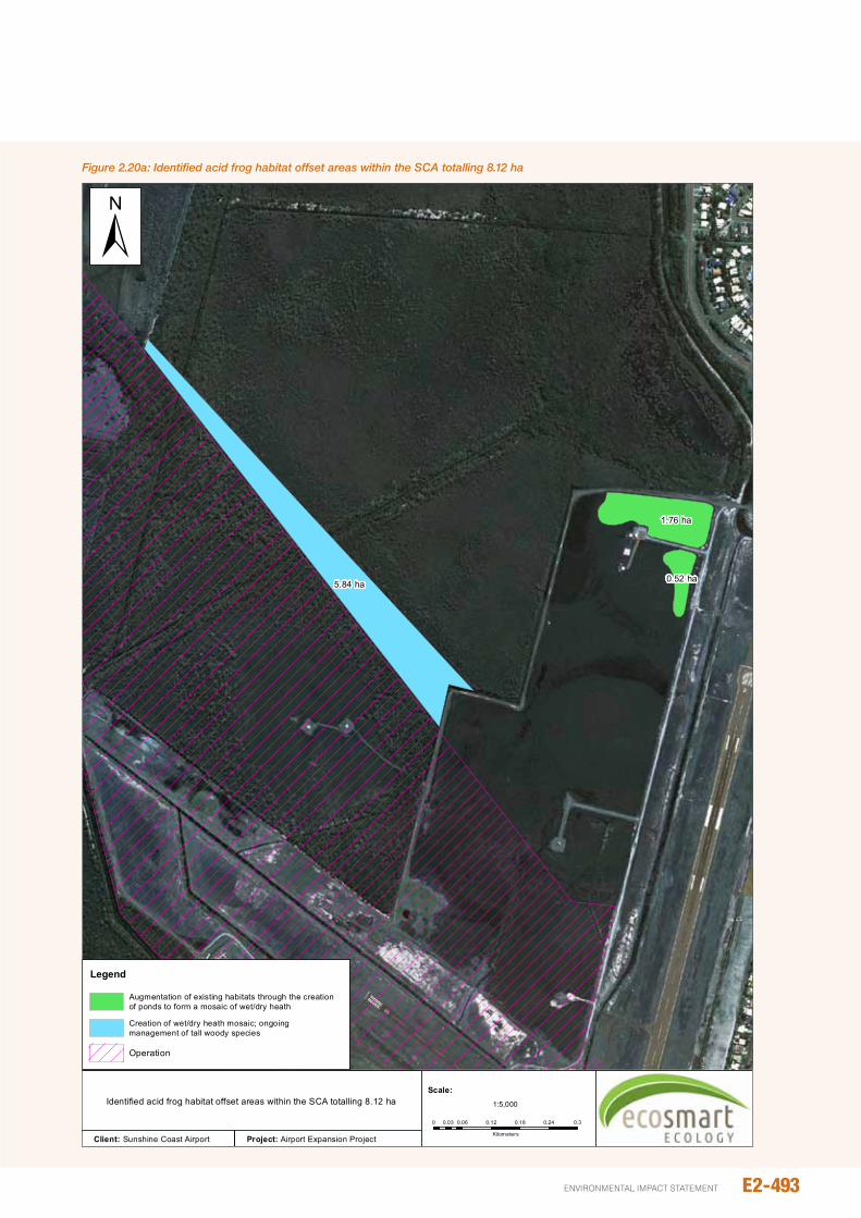
E2-493environmental impact statement
Figure 2.20a: Identified acid frog habitat offset areas within the SCA totalling 8.12 ha
5.84 ha
1.76 ha
0.52 ha
Figure 4.21
Identified acid frog habitat offset areas within the SCA totalling 8.12 ha
Legend
Augmentation of existing habitats through the creationof ponds to form a mosaic of wet/dry heath
Creation of wet/dry heath mosaic; ongoingmanagement of tall woody species
Operation
±
Client: Sunshine Coast Airport Project: Airport Expansion Project
0 0.06 0.12 0.18 0.24 0.30.03
Kilometers
1:5,000
Scale:
breeding and non-breeding habitat for acid frog species (and Ground parrot as well, provided ongoing maintenance regimes (ie, slashing) are suitable. As with habitat recreation in the WHMA, monitoring of frog numbers and recruitment success will be required to assess the efficacy of compensatory habitat.
Creation and monitoring of compensatory habitat will be guided by a formal management plan detailing construction methods, criteria for evaluating the success of compensatory habitat and guidelines for monitoring frog numbers and recruitment success.
Assuming the successful recreation of breeding habitat, most if not all Wallum Sedgefrog habitat lost to development (other than that used infrequently by dispersing animals) could be replaced through the construction of breeding ponds. Successful creation of breeding ponds for the Wallum Sedgefrog will also help offset the loss of Wallum Froglet and Wallum Rocketfrog habitat, though based on estimated losses, additional habitat would need to be created to fully offset habitat loss affecting these species. With limited opportunity for habitat creation elsewhere within the SCA, additional offset area will also need to be found outside the SCA (see below).
Offsets outside the SCA
Additional offsetting of Wallum Froglet and Wallum Rocketfrog habitat loss needs to occur outside of the SCA, preferably within the peregian Mu (ie, north of the Mooloolah River and south of the noosa River). The SCA and Sunshine Coast Council have identified palmview (also known as Lower Mooloolah River Environmental Reserve) as the preferred offset, a property located to the east of Claymore Road, palmview (Lots 37C3147, 1Rp27759 and 2Rp27760; see Chapter B7 for further details).
preliminary investigations of this property have identified 8.09 ha of regrowth sedgeland which appears highly suitable for wallum frog species. While detailed investigations on water quality, hydrology and other relevant factors have not been undertaken, previous works have identified all three Wallum frog species as present (Stringybark Consulting 2012).
An additional 114.24 hectares of the reserve is suitable for Melaleuca forest, and depending on localised hydrology, may provide additional habitat for Wallum Rocketfrog and Wallum Froglet. With ongoing management, some areas could also be revegetated to wet heath (see Chapter B7 for further details).
upon approval of the SCA expansion, onsite and offsite wallum frog management actions will documented within the wallum heath management plan and offset (palmview) management plan. Relevant wallum frog actions within these plans would include:
y performance criteria, responsibilities and timeframes.
y Monitoring of retained populations (abundance) within the SCA during construction to evaluate population trends. Monitoring should include at least two surveys each year following rainfall during summer months.
Monitoring should include collection of relevant water quality parameters to ensure construction does not indirectly affect habitats.
y Evaluation of existing wallum frog values at the proposed palmview offset site. This work should include at least two surveys during or shortly following summer rainfall to determine both abundance and reproductive success (i.e., the presence of advanced tadpoles/metamorphs).
y Vegetation/habitat criteria for rehabilitation/habitat restoration at palmview and the northern precinct of the WHMA.
y The creation of a ‘test’ pond in the northern precinct of the WHMA, to demonstrate success of the habitat creation concept.
y Annual monitoring of wallum frog values (abundance and breeding success) and habitat criteria for a period of at least 5 years post remedial at both palmview and northern precincts of the WHMA.
y Year reporting of monitoring results.
Wallum sedgefrog Management Actions
upon approval of the SCA expansion, onsite and offsite wallum frog management actions will documented within the wallum heath management plan and offset (palmview) management plan. Relevant wallum frog actions within these plans would include:
y performance criteria, responsibilities and timeframes.
y Monitoring of retained populations (abundance) within the SCA during construction to evaluate population trends. Monitoring should include at least two surveys each year following rainfall during summer months. Monitoring should include collection of relevant water quality parameters to ensure construction does not indirectly affect habitats.
y Evaluation of existing wallum frog values at the proposed palmview offset site. This work should include at least two surveys during or shortly following summer rainfall to determine both abundance and reproductive success (i.e., the presence of advanced tadpoles/metamorphs).
y Vegetation/habitat criteria for rehabilitation/habitat restoration at palmview and the northern precinct of the WHMA.
y The creation of a ‘test’ pond in the northern precinct of the WHMA, to demonstrate success of the habitat creation concept.
y Annual monitoring of wallum frog values (abundance and breeding success) and habitat criteria for a period of at least 5 years post remedial at both palmview and northern precincts of the WHMA.
y Year reporting of monitoring results.
Residual Impacts
With the successful creation of compensatory habitat on-site and off-site (and also the implementation of mitigation measures addressing altered groundwater hydrology, reduced water quality, slashing and weed invasion,
E2-494
Airport And SurroundS
Matters of NatIoNaL eNvIroNMeNtaL sIgNIfIcaNceE2
SunSHinE CoASt Airport EXpAnSion proJECt
construction of the new runway is unlikely to affect the long-term viability of acid frog populations within or adjoining the SCA. With no significant adverse impact on local or regional populations the overall significance of development related threats on acid frog species is considered low.
2.20.2 Grey-headed Flying-fox impact mitigation
The proposed actions will result in the loss of 41.8 ha of Grey-headed Flying-fox foraging habitat. The loss of foraging vegetation is minor in the context of regional values, though incremental impacts are noted. Habitat loss will be compensated, at least in part, by the provision of off-site acid frog habitats where those offsets are dominated by large stands of Melaleuca. Low-lying wet heath, which should be the focus of off-site offsets, would have less value for Grey-headed Flying-fox.
Residual Impacts
With extensive areas of suitable foraging habitat remaining, the loss of 0.65% of available foraging habitat is unlikely impact significantly on numbers of Grey-headed Flying-foxes within the Maroochy area. The value of habitat offsets for Grey-headed Flying-fox will be influenced not only be the extent of Melaleuca habitat created, but also the location of off-site habitats. While Flying-foxes may travel longer distances, foraging efficiency will be reduced for distances further than 15 km from the Maroochy roost due to increased traverse costs.
Bat strike is an ever present risk associated with airports located in proximity to flying-fox camps. Although the Sunshine Coast Airport currently has a very low bat strike rate, the proposed increased in air traffic and extended airport operation hours will allow planes to arrive and depart over an extended period compared with current flight times, as such an increase in strike rate may occur. ultimately strike rate will be influenced by the number of Flying-foxs within the local area. At the time of writing this assessment the nearest roost (Tepequar Drive), from which most animals crossing the proposed alignment originate, was vacant.
on balance, these residual impacts are not expected to significantly impact the local population.
2.20.3 Reducing hydrologic impacts
inherent mitigation measures have been included within the project design to minimise impacts to groundwater. Successful implementation of these measures is expected to alleviate potential impacts on sensitive environmental values. no additional measures are required.
Uncontrolled Tailwater Discharge
Although identified as a low-risk, uncontrolled discharge associated with delivery of sand along the pipeline to the fill platform has the potential to impact wet heath areas, and particularly Ground parrot/acid frog habitats within the WHMA. The final alignment, which follows the existing airport runway perimeter road along the western boundary of the WHMA, has been selected to avoid significant impacts to this area (see Chapter A5 – project Construction).
Minor spills or leaks along this alignment are expected to have only localised impacts, the bulk of spill water will run east into the existing perimeter drain, away from sensitive habitats. other features of the project that have been included to reduce the risk of uncontrolled discharge include (Chapter C2):
y Daily checking of the pipeline for any signs of water leak or stress. Repair and maintenance will occur immediately.
y Regular turning of the pipeline to avoid wall thinning.
y immediate stope of pump operation in the event of major pipe failure.
y Development of a response plan in the event of major leakage/failure.
Residual Impacts
Design measures have reduced the likely lateral movement of sub-surface groundwater (ie above coffee rock) between the development and adjacent environmental values (ie, Mt Coolum national park and the WHMA). increased drawdown affecting surface water ponding (extent and duration) is not expected. The potential for saline impacts will be influenced by upward migration through discontinuities in the coffee rock, the extent of which is not known. Based on the assessment provided in Chapter B3, salinity influence on adjacent environmental values is unlikely; should some upward migration of salts occur impacts are likely to be limited in extent and minor.
Salinity will not affect existing values where concentrations do not exceed < 100 mg/L.
2.20.4 Maintaining connectivity to southern Mt Coolum National park
Development of RWY 13/31 will result in the complete loss of remnant vegetation connecting northern and southern sections of Mt Coolum national park. To compensate and ensure the southern section of Mt Coolum national park is not completely isolated, a new corridor will be established around the western extent of the development (see Figure 4.23). The corridor will be approximately 100 m wide along most of its length, except for a small constriction near the corner of the RWY 13/31. Features and actions required to establish this corridor include:
y Revegetation works to establish endemic vegetation of sufficient density to allow passage by cover-dependant species. Along most of the corridor this vegetation will include canopy tree species, except at the northern end of RWY 13/31 where vegetation cannot exceed 1.5 m in height for safety and aircraft vision.
y Culverts over major drains, including the northern perimeter drain, the new western drain, and Eastern SCA drain, to promote dry passage (particularly for small terrestrial vertebrates),
y The use of the proposed western drain, which runs south from the northern end of RWY 13/51, as a deterrent to reduce animal access onto the Sunshine Coast Motorway, and
E2-495environmental impact statement
y A 200 m long fauna-proof chain wire fence running north along the Sunshine Coast Motorway to prevent animal access.
These features are illustrated in Figure 2.20b.
To guide the creation of this corridor, rehabilitation and management actions will be included within the wallum heath management plan (see Section 2.20.5). These should include:
y performance criteria, responsibility and timelines.
y planting zones, considering airport operational constraints (eg, areas of low heath for aircraft approach/visibility, bird/bat attractants and risk of plane strike).
y Rehabilitation species (endemic to local area), planting densities and planting methods.
y Location, specifications, and construction protocols for fauna crossings over the three drains.
y Location and specification for fauna-proof fencing along the Sunshine Coast motorway.
y Monitoring success (including provision for replacing lost individuals) and weed control. Monitoring during establishment should be frequent, but may be reduced with age. Monitoring should proceed until performance criteria have been met.
The wallum heath management plan will be developed upon approval of the EiS, and revegetation works will commence shortly thereafter (i.e., prior to commencement of construction). This will maximise vegetation growth prior to the loss of the existing corridor connection for the construction of the new runway. it is envisaged that reasonable cover could be established within 5 years, allowing movement of many small to medium-sized vertebrates.
Residual Impacts
provision of the new corridor would, on balance, reduce the impact of fragmentation on southern portions of the Mt Coolum national park. its use will be species-specific, with those animals able to find sufficient resources within the corridor to establish territories more likely to maintain flow than those requiring larger habitats. its success will also be influenced by rehabilitation efforts.
2.20.5 Management of heathland habitats (including the whMA)
This study has highlighted the importance of the WHMA for a number of taxa including three acid frogs (Wallum Froglet, Wallum Rocketfrog and Wallum Sedgefrog) and Ground parrot. Historic management of the WHMA has been guided by operational constraints resulting in relatively infrequent/irregular slashing. under this regime the WHMA has continued to support viable breeding populations of the aforementioned fauna and, as discussed below, may even have benefitted these species in the long run. nevertheless, management of this area could be further improved if also guided by ecological considerations.
Without slashing, large areas of the WHMA will return to Melaleuca dominated forest, to the detriment of Ground
parrots and acid frogs. Thickening of Melaleuca is already obvious in the south-west portion of the WHMA, and few Ground parrots were found inhabiting this zone. Appropriate slashing, is therefore, the most ecologically important management tool for the WHMA.
An appropriate slashing regime would ensure:
y General vegetation height does not exceeding 1.5 m.
y Emergent (ie, > 1.2 m) Melaleuca regrowth should not reach densities greater than one per 25 m2.
y Slashing does not interfere significantly with breeding of EVnT fauna, and as such, should only occur during the months of December, May, June or July.
y Vegetation isn’t slashed any lower than 0.5 m.
y The entire WHMA is not slashed at once (with slashing staged over seasons/years to ensure inhabitants can move to retained refugia).
y Slashing is restricted to areas within the WHMA that exceed maximum height, and as such, an inspection to delineate the active slash area from excluded vegetation may be required by a qualified ecologist prior to slashing.
Active short-term management (ie, cut and stump poison) may also be required to control Melaleuca regrowth, particularly in the south-west portion of the existing WHMA and the new WHMA extension. once melaleuca abundance has been reduced, slashing should maintain low Melaleuca abundance with minimal additional effort.
A number of exotic weed species are currently present within the southern portion of the WHMA. While the majority of infestations will be removed to facilitate the construction of the new runway, outbreaks of these, and any other potential weed species should be monitored and controlled. Weed control strategies that should be implemented within the management of the WHMA include:
y Stringent sanitation and inspection of all slashing equipment to prevent the introduction of new weed species.
y Mapping existing weed infestations with the intent to either document their eradication, or to ensure the infestation does not spread. This should include the control and mapping of non-declared exotic weeds such as grasses.
y Any weed control strategies should consider sensitive values within the WHMA (eg, acid frogs, Ground parrots), and as such, may need input from a qualified ecologist.
These management strategies should be coupled with ongoing fauna monitoring (particularly Ground parrot abundance) to ensure management strategies are improved or adapted as necessary. Management and monitoring of the area should be documented in a detailed wallum heath management plan, which will replace the existing plan (ie Hammermeister et al., no date). The scope of this plan will also need to be broadened to include areas of compensatory habitat adjacent the northern perimeter drain and operation of wet heath in the northern precinct of the WHMA.
E2-496
Airport And SurroundS
Matters of NatIoNaL eNvIroNMeNtaL sIgNIfIcaNceE2
SunSHinE CoASt Airport EXpAnSion proJECt
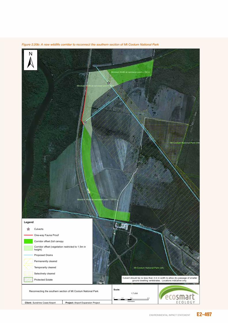
E2-497environmental impact statement
Figure 2.20b: A new wildlife corridor to reconnect the southern section of Mt Coolum National Park
Northern Perimeter Drain
Eastern SCA Drain
Western Perim
eter Drain
Minimum Width at narrowest point = 150 m
Minimum Width at narrowest point = 100 m
Minimum Width at narrowest point = 80 m
Mt Coolum National Park (sth)
Mt Coolum National Park (nth)
Culvert should be no less than 3 m in width to allow dry passage of smaller ground dwelling vertebrates. Locations indicative only.
Figure 4.24
Legend
_̂ Culverts
One-way Fauna Proof
Corridor offset (full canopy
Corridor offset (vegetation restricted to 1.5m inheight)
Proposed Drains
Permanently cleared
Temporarily cleared
Selectively cleared
Protected Estate
±
Client: Sunshine Coast Airport Project: Airport Expansion Project
0 0.2 0.40.1
Kilometers
1:7,404
Scale:Reconnecting the southern section of Mt Coolum National Park
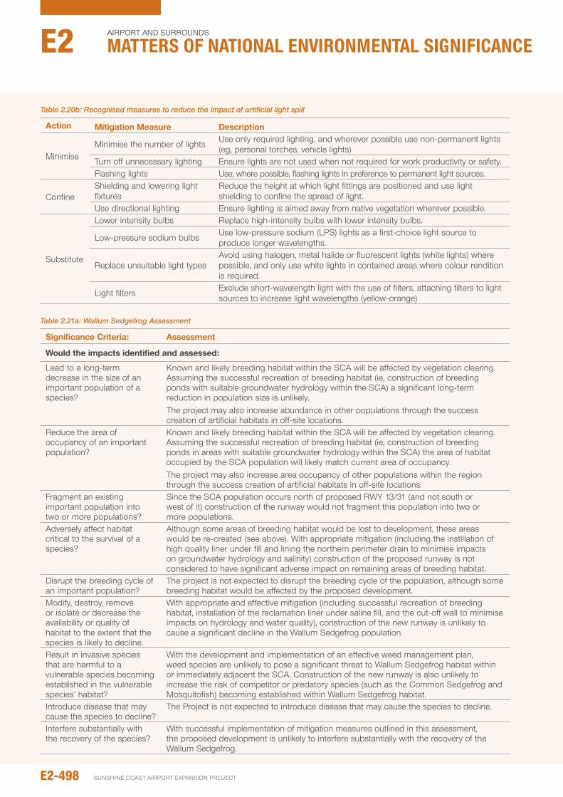
Table 2.20b: Recognised measures to reduce the impact of artificial light spill
Action Mitigation Measure description
MinimiseMinimise the number of lights use only required lighting, and wherever possible use non-permanent lights
(eg, personal torches, vehicle lights)Turn off unnecessary lighting Ensure lights are not used when not required for work productivity or safety.Flashing lights use, where possible, flashing lights in preference to permanent light sources.
ConfineShielding and lowering light fixtures
Reduce the height at which light fittings are positioned and use light shielding to confine the spread of light.
use directional lighting Ensure lighting is aimed away from native vegetation wherever possible.
Substitute
Lower intensity bulbs Replace high-intensity bulbs with lower intensity bulbs.
Low-pressure sodium bulbs use low-pressure sodium (LpS) lights as a first-choice light source to produce longer wavelengths.
Replace unsuitable light typesAvoid using halogen, metal halide or fluorescent lights (white lights) where possible, and only use white lights in contained areas where colour rendition is required.
Light filters Exclude short-wavelength light with the use of filters, attaching filters to light sources to increase light wavelengths (yellow-orange)
Table 2.21a: Wallum Sedgefrog Assessment
Significance Criteria: Assessment
would the impacts identified and assessed:
Lead to a long-term decrease in the size of an important population of a species?
Known and likely breeding habitat within the SCA will be affected by vegetation clearing. Assuming the successful recreation of breeding habitat (ie, construction of breeding ponds with suitable groundwater hydrology within the SCA) a significant long-term reduction in population size is unlikely.The project may also increase abundance in other populations through the success creation of artificial habitats in off-site locations.
Reduce the area of occupancy of an important population?
Known and likely breeding habitat within the SCA will be affected by vegetation clearing. Assuming the successful recreation of breeding habitat (ie, construction of breeding ponds in areas with suitable groundwater hydrology within the SCA) the area of habitat occupied by the SCA population will likely match current area of occupancy.The project may also increase area occupancy of other populations within the region through the success creation of artificial habitats in off-site locations.
Fragment an existing important population into two or more populations?
Since the SCA population occurs north of proposed RWY 13/31 (and not south or west of it) construction of the runway would not fragment this population into two or more populations.
Adversely affect habitat critical to the survival of a species?
Although some areas of breeding habitat would be lost to development, these areas would be re-created (see above). With appropriate mitigation (including the instillation of high quality liner under fill and lining the northern perimeter drain to minimise impacts on groundwater hydrology and salinity) construction of the proposed runway is not considered to have significant adverse impact on remaining areas of breeding habitat.
Disrupt the breeding cycle of an important population?
The project is not expected to disrupt the breeding cycle of the population, although some breeding habitat would be affected by the proposed development.
Modify, destroy, remove or isolate or decrease the availability or quality of habitat to the extent that the species is likely to decline.
With appropriate and effective mitigation (including successful recreation of breeding habitat, installation of the reclamation liner under saline fill, and the cut-off wall to minimise impacts on hydrology and water quality), construction of the new runway is unlikely to cause a significant decline in the Wallum Sedgefrog population.
Result in invasive species that are harmful to a vulnerable species becoming established in the vulnerable species’ habitat?
With the development and implementation of an effective weed management plan, weed species are unlikely to pose a significant threat to Wallum Sedgefrog habitat within or immediately adjacent the SCA. Construction of the new runway is also unlikely to increase the risk of competitor or predatory species (such as the Common Sedgefrog and Mosquitofish) becoming established within Wallum Sedgefrog habitat.
introduce disease that may cause the species to decline?
The project is not expected to introduce disease that may cause the species to decline.
interfere substantially with the recovery of the species?
With successful implementation of mitigation measures outlined in this assessment, the proposed development is unlikely to interfere substantially with the recovery of the Wallum Sedgefrog.
E2-498
Airport And SurroundS
Matters of NatIoNaL eNvIroNMeNtaL sIgNIfIcaNceE2
SunSHinE CoASt Airport EXpAnSion proJECt
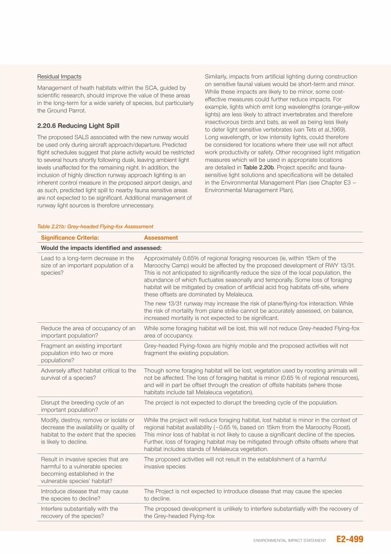
Residual Impacts
Management of heath habitats within the SCA, guided by scientific research, should improve the value of these areas in the long-term for a wide variety of species, but particularly the Ground parrot.
2.20.6 Reducing Light Spill
The proposed SALS associated with the new runway would be used only during aircraft approach/departure. predicted flight schedules suggest that plane activity would be restricted to several hours shortly following dusk, leaving ambient light levels unaffected for the remaining night. in addition, the inclusion of highly direction runway approach lighting is an inherent control measure in the proposed airport design, and as such, predicted light spill to nearby fauna sensitive areas are not expected to be significant. Additional management of runway light sources is therefore unnecessary.
Similarly, impacts from artificial lighting during construction on sensitive faunal values would be short-term and minor. While these impacts are likely to be minor, some cost-effective measures could further reduce impacts. For example, lights which emit long wavelengths (orange-yellow lights) are less likely to attract invertebrates and therefore insectivorous birds and bats, as well as being less likely to deter light sensitive vertebrates (van Tets et al.,1969). Long wavelength, or low intensity lights, could therefore be considered for locations where their use will not affect work productivity or safety. other recognised light mitigation measures which will be used in appropriate locations are detailed in Table 2.20b. project specific and fauna-sensitive light solutions and specifications will be detailed in the Environmental Management plan (see Chapter E3 – Environmental Management plan).
Table 2.21b: Grey-headed Flying-fox Assessment
Significance Criteria: Assessment
would the impacts identified and assessed:
Lead to a long-term decrease in the size of an important population of a species?
Approximately 0.65% of regional foraging resources (ie, within 15km of the Maroochy Camp) would be affected by the proposed development of RWY 13/31. This is not anticipated to significantly reduce the size of the local population, the abundance of which fluctuates seasonally and temporally. Some loss of foraging habitat will be mitigated by creation of artificial acid frog habitats off-site, where these offsets are dominated by Melaleuca.The new 13/31 runway may increase the risk of plane/flying-fox interaction. While the risk of mortality from plane strike cannot be accurately assessed, on balance, increased mortality is not expected to be significant.
Reduce the area of occupancy of an important population?
While some foraging habitat will be lost, this will not reduce Grey-headed Flying-fox area of occupancy.
Fragment an existing important population into two or more populations?
Grey-headed Flying-foxes are highly mobile and the proposed activities will not fragment the existing population.
Adversely affect habitat critical to the survival of a species?
Though some foraging habitat will be lost, vegetation used by roosting animals will not be affected. The loss of foraging habitat is minor (0.65 % of regional resources), and will in part be offset through the creation of offsite habitats (where those habitats include tall Melaleuca vegetation).
Disrupt the breeding cycle of an important population?
The project is not expected to disrupt the breeding cycle of the population.
Modify, destroy, remove or isolate or decrease the availability or quality of habitat to the extent that the species is likely to decline.
While the project will reduce foraging habitat, lost habitat is minor in the context of regional habitat availability (~0.65 %, based on 15km from the Maroochy Roost). This minor loss of habitat is not likely to cause a significant decline of the species. Further, loss of foraging habitat may be mitigated through offsite offsets where that habitat includes stands of Melaleuca vegetation.
Result in invasive species that are harmful to a vulnerable species becoming established in the vulnerable species’ habitat?
The proposed activities will not result in the establishment of a harmful invasive species
introduce disease that may cause the species to decline?
The project is not expected to introduce disease that may cause the species to decline.
interfere substantially with the recovery of the species?
The proposed development is unlikely to interfere substantially with the recovery of the Grey-headed Flying-fox
E2-499environmental impact statement
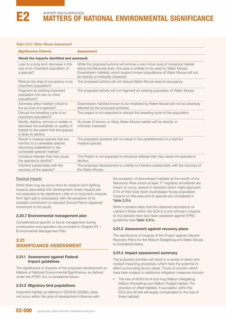
Residual Impacts
While there may be some short to medium-term lighting impacts associated with development, these impacts are not expected to be significant. Little or no long-term impacts from light spill is anticipated, with the exception of its possible contribution to reduced Ground parrot dispersal/movement to the south.
2.20.7 Environmental management plan
Considerations specific to fauna management during construction and operation are provided in Chapter E3 – Environmental Management plan.
2.21 SIGNIFICANCE ASSESSMENT
2.21.1 Assessment against Federal Impact guidelines
The significance of impacts of the proposed development on Matters of national Environmental Significance, as defined under the EpBC Act, is considered below.
2.21.2 Migratory bird populations
important habitat, as defined in DEWHA (2009b), does not occur within the area of development influence with
the exception of downstream habitats at the mouth of the Maroochy River where at least 17 migratory shorebirds are known to occur, several in densities which might approach 0.1% of their East Asian-Australasian flyway population. impacts on this area and its species are considered in Table 2.21d.
While it remains likely that the observed abundance of Latham’s Snipe within the SCA is a one-off event, impacts to this species have also been assessed against EpBC guidelines (see Table 2.21e).
2.21.3 Assessment against recovery plans
The significance of impacts of the project against relevant Recovery plans for the Wallum Sedgefrog and Water Mouse is considered below.
2.21.4 Impact assessment summary
The proposed activities will result in a variety of direct and indirect impacting processes, which have the potential to affect surrounding fauna values. Those of concern which have been subject to additional mitigation measures include:
y The loss of 60.63 ha of acid frog (Wallum Sedgefrog, Wallum Rocketfrog and Wallum Froglet) habitat. The provision of offset habitats, if successful, within the SCA and off-site will largely compensate for the loss of these habitats.
Table 2.21c: Water Mouse Assessment
Significance Criteria: Assessment
would the impacts identified and assessed:
Lead to a long-term decrease in the size of an important population of a species?
While the proposed actions will remove a very minor area of mangrove habitat along the Marcoola drain, this area is unlikely to be used by Water Mouse. Downstream habitats, which support known populations of Water Mouse will not be directly or indirectly impacted.
Reduce the area of occupancy of an important population?
The proposed actions will not reduce Water Mouse area of occupancy.
Fragment an existing important population into two or more populations?
The proposed activity will not fragment an existing population of Water Mouse.
Adversely affect habitat critical to the survival of a species?
Downstream habitats known to be inhabited by Water Mouse will not be adversely affected by the proposed activities.
Disrupt the breeding cycle of an important population?
The project is not expected to disrupt the breeding cycle of the population.
Modify, destroy, remove or isolate or decrease the availability or quality of habitat to the extent that the species is likely to decline.
no areas of known, or likely, Water Mouse habitat will be directly or indirectly impacted.
Result in invasive species that are harmful to a vulnerable species becoming established in the vulnerable species’ habitat?
The proposed activities will not result in the establishment of a harmful invasive species
introduce disease that may cause the species to decline?
The project is not expected to introduce disease that may cause the species to decline.
interfere substantially with the recovery of the species?
The proposed development is unlikely to interfere substantially with the recovery of the Water Mouse.
E2-500
Airport And SurroundS
Matters of NatIoNaL eNvIroNMeNtaL sIgNIfIcaNceE2
SunSHinE CoASt Airport EXpAnSion proJECt

y The loss of 7.78 ha of active Ground parrot habitat (based on 2011/12 studies). offset habitats will be created within the SCA, and considerable resources will be allocated to the management of the species across the region. increased management will aim to reduce existing threats, improve habitat value, and therefore increase Ground parrot abundance throughout the region, thereby reducing reliance on one-or-two source populations. Assuming offset habitats are successful, the project will result in a 4.1% increase (7.19 ha lost; 8.12 ha gained) in available Ground parrot habitat. However, habitat recreation for Ground parrots is largely untested and relies on a linear stretch of land which may not hold as much value as consolidated areas.
y Reduced connectivity between northern and southern sections of Mt Coolum np. Creation of a new corridor
around the western extent of the new runway, will assist in reducing habitat and population isolation. The value of this corridor will be influenced by species specific traits and rehabilitation success. Movement of Ground parrots into habitats within the southern section of Mt Coolum national park is uncertain, though on balance remains possible.
y increased saline infiltration into the groundwater table from the fill platform would be reduced by the instillation of high-quality liner. The lateral movement of saline tailwater not captured by the liner through sub-surface water (ie, above coffee rock) would be intercepted by a cut-off wall to the immediate north of the northern perimeter drain. These measures would restrict saline influence to upward migration of salts through the coffee rock from the regional aquifer. While extent of discontinuities in the coffee rock is not known, based on the assessment provided
Table 2.21d: EPBC Impact assessment of Migratory Shorebirds at the mouth of the Maroochy River
Element Affected Impact Criteria Comment
important Habitat
Loss of important habitat no loss of habitat will occur at the mouth of the Maroochy River
Degradation of important habitat leading to a substantial reduction in migratory shorebirds using the site
no impact on water quality, and therefore habitat quality, is expected along the Maroochy River
increased disturbance leading to a substantial reduction in migratory shorebirds using important habitat
Flight path modelling suggests the frequency of planes flying over the mouth of the Maroochy River is likely to be reduced. no other disturbance factor will be introduced as a result of the development.
Direct mortality of birds leading to a substantial reduction in migratory shorebirds using important habitat.
plane flight path under the new runway will largely avoid areas of high Migratory bird abundance (ie, at the mouth of the Maroochy River), and as such, an increase in direct mortality is not expected.
Table 2.21e: EPBC Impact assessment of Latham’s Snipe
Element Affected Impact Criteria Comment
important Habitat
Loss of important habitat Large areas of possible Latham’s Snipe habitat will be retained within the SCA, including locations with high (one-off?) abundance (ie, to the immediate west of Keith Royal park.Some minor loss of habitat from the WHMA will occur, though this will be offset through the creation of artificial habitats to the north of the northern perimeter drain.
Degradation of important habitat leading to a substantial reduction in migratory shorebirds using the site
provided that (1) weed management strategies are followed throughout construction and operation, and (2) impacts to groundwater are successfully mitigated (see Section 4.3.4), no degradation of habitats are expected.
increased disturbance leading to a substantial reduction in migratory shorebirds using important habitat
Flight paths under the new 13/31 RWY will increase noise and movement directly over habitats where numbers of Latham’s Snipe have been recorded (ie, the area to the immediate west of Keith Royal park). it remains unclear if Latham’s Snipe will continue to frequent this area due to the increased disturbance. However, this area is relatively small and it remains highly unlikely to support 18 or more birds on a regular basis. other areas of much larger habitat, particularly within the WHMA, will not be affected.
Direct mortality of birds leading to a substantial reduction in migratory shorebirds using important habitat.
While their remains a small increased risk of flight strike, Latham’s Snipe typically fly within 1-2 metres above vegetation when flushed. This is below expected flight heights. no substantial increase in Latham’s Snipe mortality is expected.
E2-501environmental impact statement
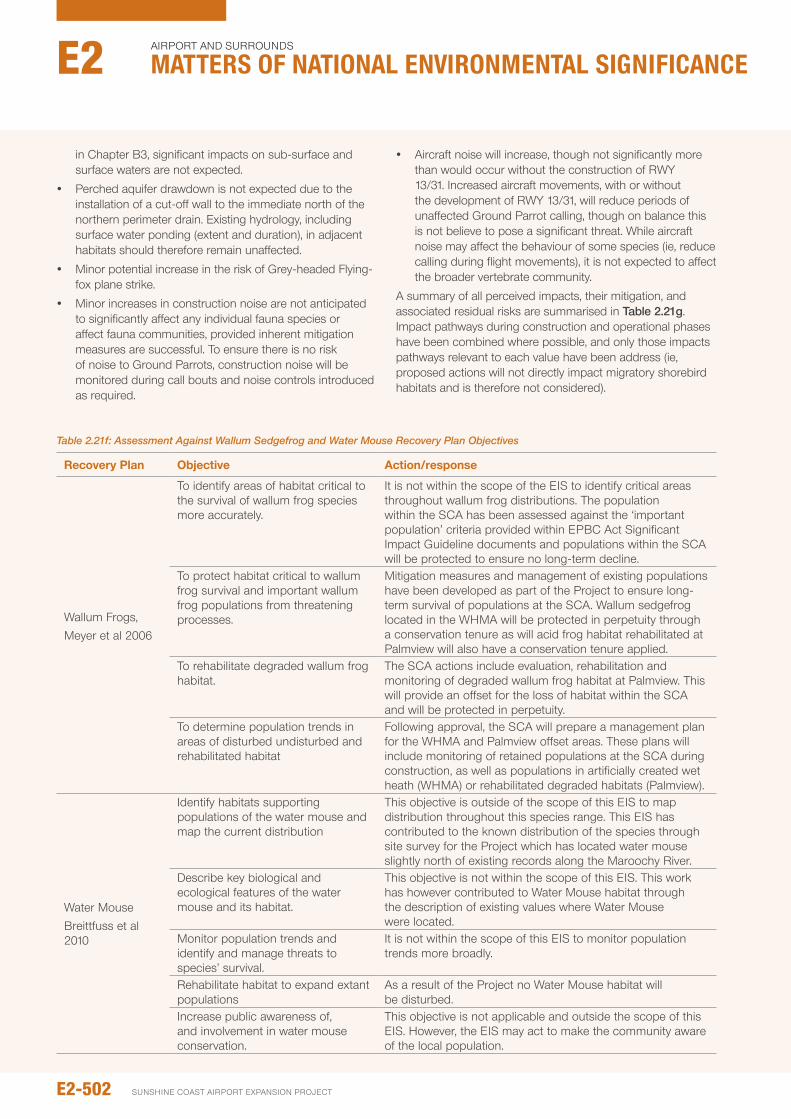
in Chapter B3, significant impacts on sub-surface and surface waters are not expected.
y perched aquifer drawdown is not expected due to the installation of a cut-off wall to the immediate north of the northern perimeter drain. Existing hydrology, including surface water ponding (extent and duration), in adjacent habitats should therefore remain unaffected.
y Minor potential increase in the risk of Grey-headed Flying-fox plane strike.
y Minor increases in construction noise are not anticipated to significantly affect any individual fauna species or affect fauna communities, provided inherent mitigation measures are successful. To ensure there is no risk of noise to Ground parrots, construction noise will be monitored during call bouts and noise controls introduced as required.
y Aircraft noise will increase, though not significantly more than would occur without the construction of RWY 13/31. increased aircraft movements, with or without the development of RWY 13/31, will reduce periods of unaffected Ground parrot calling, though on balance this is not believe to pose a significant threat. While aircraft noise may affect the behaviour of some species (ie, reduce calling during flight movements), it is not expected to affect the broader vertebrate community.
A summary of all perceived impacts, their mitigation, and associated residual risks are summarised in Table 2.21g. impact pathways during construction and operational phases have been combined where possible, and only those impacts pathways relevant to each value have been address (ie, proposed actions will not directly impact migratory shorebird habitats and is therefore not considered).
Table 2.21f: Assessment Against Wallum Sedgefrog and Water Mouse Recovery Plan Objectives
Recovery plan Objective Action/response
Wallum Frogs, Meyer et al 2006
To identify areas of habitat critical to the survival of wallum frog species more accurately.
it is not within the scope of the EiS to identify critical areas throughout wallum frog distributions. The population within the SCA has been assessed against the ‘important population’ criteria provided within EpBC Act Significant impact Guideline documents and populations within the SCA will be protected to ensure no long-term decline.
To protect habitat critical to wallum frog survival and important wallum frog populations from threatening processes.
Mitigation measures and management of existing populations have been developed as part of the project to ensure long-term survival of populations at the SCA. Wallum sedgefrog located in the WHMA will be protected in perpetuity through a conservation tenure as will acid frog habitat rehabilitated at palmview will also have a conservation tenure applied.
To rehabilitate degraded wallum frog habitat.
The SCA actions include evaluation, rehabilitation and monitoring of degraded wallum frog habitat at palmview. This will provide an offset for the loss of habitat within the SCA and will be protected in perpetuity.
To determine population trends in areas of disturbed undisturbed and rehabilitated habitat
Following approval, the SCA will prepare a management plan for the WHMA and palmview offset areas. These plans will include monitoring of retained populations at the SCA during construction, as well as populations in artificially created wet heath (WHMA) or rehabilitated degraded habitats (palmview).
Water MouseBreittfuss et al 2010
identify habitats supporting populations of the water mouse and map the current distribution
This objective is outside of the scope of this EiS to map distribution throughout this species range. This EiS has contributed to the known distribution of the species through site survey for the project which has located water mouse slightly north of existing records along the Maroochy River.
Describe key biological and ecological features of the water mouse and its habitat.
This objective is not within the scope of this EiS. This work has however contributed to Water Mouse habitat through the description of existing values where Water Mouse were located.
Monitor population trends and identify and manage threats to species’ survival.
it is not within the scope of this EiS to monitor population trends more broadly.
Rehabilitate habitat to expand extant populations
As a result of the project no Water Mouse habitat will be disturbed.
increase public awareness of, and involvement in water mouse conservation.
This objective is not applicable and outside the scope of this EiS. However, the EiS may act to make the community aware of the local population.
E2-502
Airport And SurroundS
Matters of NatIoNaL eNvIroNMeNtaL sIgNIfIcaNceE2
SunSHinE CoASt Airport EXpAnSion proJECt
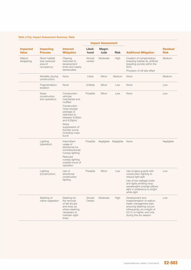
Table 2.21g: Impact Assessment Summary Table
Impacted value
Impacting process
Inherent Mitigation
Impact Assessment
Additional MitigationResidual Risk
Likeli- hood
Magni- tude Risk
Wallum Sedgefrog
Direct habitat loss (reduced area of occupancy)
Clearing restricted to development limits and clearly demarcated
Almost certain
Moderate High Creation of compensatory breeding habitat (ie, artificial breeding ponds) within the SCAprovision of off-site offset
Medium
Mortality (during construction)
none Likely Minor Medium none Medium
Fragmentation/isolation
none unlikely Minor Low none Low
noise (construction and operation)
Construction vehicles maintained and muffledConstruction noise (except package 2) restricted to between 6.30am and 6.30pm)noise suppression of booster pump including noise bund
possible Minor Low none Low
Lighting (operation)
intermittent usage of directional (vs. omnidirectional) runway lightingReduced runway lighting outside hours of operation
possible negligible negligible none negligible
Lighting (construction)
use of directional construction lighting
possible Minor Low use of glare guards with construction lighting to reduce light spilluse of low wattage bulbs and lights emitting long-wavelengths (orange-yellow) light in preference to bright white light
Low
Slashing of native vegetation
Slashing for the removal of tall shrubs and trees (ie, where slashing necessary to maintain sight lines)
Almost Certain
Moderate High Development and implementation of wallum heath management plan ensuring slashing occurs infrequently, at a height of 0.5 m or higher, and only during the dry season
Low
E2-503environmental impact statement
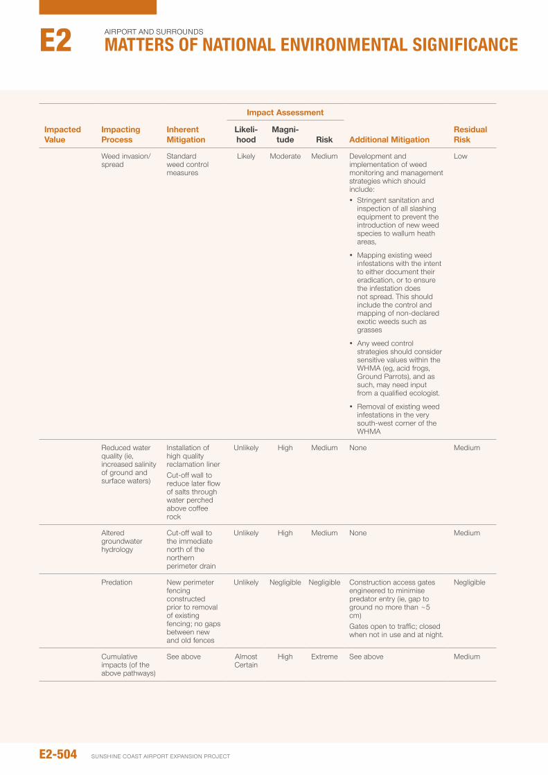
Impacted value
Impacting process
Inherent Mitigation
Impact Assessment
Additional MitigationResidual Risk
Likeli- hood
Magni- tude Risk
Weed invasion/ spread
Standard weed control measures
Likely Moderate Medium Development and implementation of weed monitoring and management strategies which should include: y Stringent sanitation and
inspection of all slashing equipment to prevent the introduction of new weed species to wallum heath areas,
y Mapping existing weed infestations with the intent to either document their eradication, or to ensure the infestation does not spread. This should include the control and mapping of non-declared exotic weeds such as grasses
y Any weed control strategies should consider sensitive values within the WHMA (eg, acid frogs, Ground parrots), and as such, may need input from a qualified ecologist.
y Removal of existing weed infestations in the very south-west corner of the WHMA
Low
Reduced water quality (ie, increased salinity of ground and surface waters)
installation of high quality reclamation linerCut-off wall to reduce later flow of salts through water perched above coffee rock
unlikely High Medium none Medium
Altered groundwater hydrology
Cut-off wall to the immediate north of the northern perimeter drain
unlikely High Medium none Medium
predation new perimeter fencing constructed prior to removal of existing fencing; no gaps between new and old fences
unlikely negligible negligible Construction access gates engineered to minimise predator entry (ie, gap to ground no more than ~5 cm)Gates open to traffic; closed when not in use and at night.
negligible
Cumulative impacts (of the above pathways)
See above Almost Certain
High Extreme See above Medium
E2-504
Airport And SurroundS
Matters of NatIoNaL eNvIroNMeNtaL sIgNIfIcaNceE2
SunSHinE CoASt Airport EXpAnSion proJECt
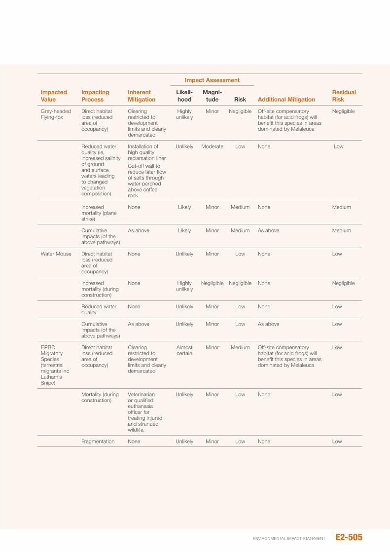
Impacted value
Impacting process
Inherent Mitigation
Impact Assessment
Additional MitigationResidual Risk
Likeli- hood
Magni- tude Risk
Grey-headed Flying-fox
Direct habitat loss (reduced area of occupancy)
Clearing restricted to development limits and clearly demarcated
Highly unlikely
Minor negligible off-site compensatory habitat (for acid frogs) will benefit this species in areas dominated by Melaleuca
negligible
Reduced water quality (ie, increased salinity of ground and surface waters leading to changed vegetation composition)
installation of high quality reclamation linerCut-off wall to reduce later flow of salts through water perched above coffee rock
unlikely Moderate Low none Low
increased mortality (plane strike)
none Likely Minor Medium none Medium
Cumulative impacts (of the above pathways)
As above Likely Minor Medium As above Medium
Water Mouse Direct habitat loss (reduced area of occupancy)
none unlikely Minor Low none Low
increased mortality (during construction)
none Highly unlikely
negligible negligible none negligible
Reduced water quality
none unlikely Minor Low none Low
Cumulative impacts (of the above pathways)
As above unlikely Minor Low As above Low
EpBC Migratory Species (terrestrial migrants inc Latham’s Snipe)
Direct habitat loss (reduced area of occupancy)
Clearing restricted to development limits and clearly demarcated
Almost certain
Minor Medium off-site compensatory habitat (for acid frogs) will benefit this species in areas dominated by Melaleuca
Low
Mortality (during construction)
Veterinarian or qualified euthanasia officer for treating injured and stranded wildlife.
unlikely Minor Low none Low
Fragmentation none unlikely Minor Low none Low
E2-505environmental impact statement
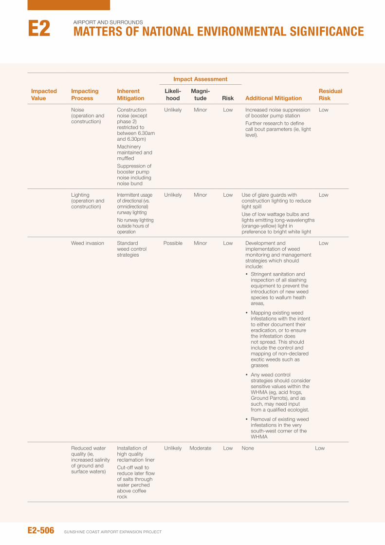
Impacted value
Impacting process
Inherent Mitigation
Impact Assessment
Additional MitigationResidual Risk
Likeli- hood
Magni- tude Risk
noise (operation and construction)
Construction noise (except phase 2) restricted to between 6.30am and 6.30pm)Machinery maintained and muffledSuppression of booster pump noise including noise bund
unlikely Minor Low increased noise suppression of booster pump stationFurther research to define call bout parameters (ie, light level).
Low
Lighting (operation and construction)
intermittent usage of directional (vs. omnidirectional) runway lightingno runway lighting outside hours of operation
unlikely Minor Low use of glare guards with construction lighting to reduce light spilluse of low wattage bulbs and lights emitting long-wavelengths (orange-yellow) light in preference to bright white light
Low
Weed invasion Standard weed control strategies
possible Minor Low Development and implementation of weed monitoring and management strategies which should include: y Stringent sanitation and
inspection of all slashing equipment to prevent the introduction of new weed species to wallum heath areas,
y Mapping existing weed infestations with the intent to either document their eradication, or to ensure the infestation does not spread. This should include the control and mapping of non-declared exotic weeds such as grasses
y Any weed control strategies should consider sensitive values within the WHMA (eg, acid frogs, Ground parrots), and as such, may need input from a qualified ecologist.
y Removal of existing weed infestations in the very south-west corner of the WHMA
Low
Reduced water quality (ie, increased salinity of ground and surface waters)
installation of high quality reclamation linerCut-off wall to reduce later flow of salts through water perched above coffee rock
unlikely Moderate Low none Low
E2-506
Airport And SurroundS
Matters of NatIoNaL eNvIroNMeNtaL sIgNIfIcaNceE2
SunSHinE CoASt Airport EXpAnSion proJECt
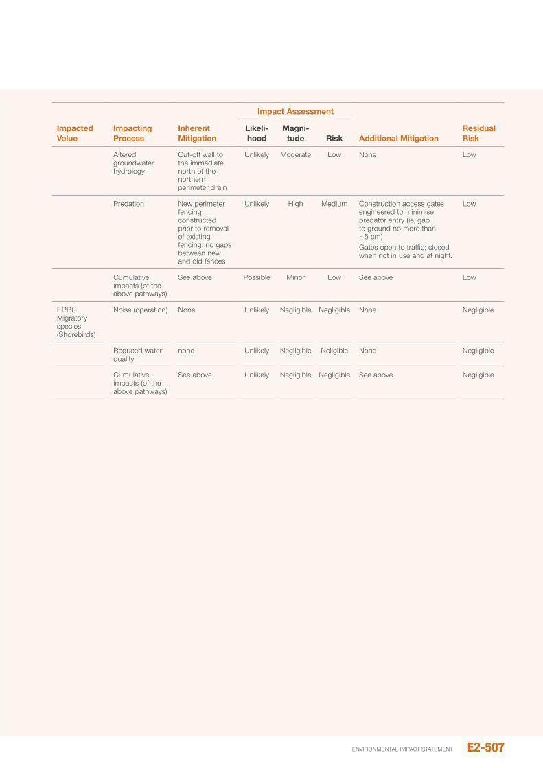
Impacted value
Impacting process
Inherent Mitigation
Impact Assessment
Additional MitigationResidual Risk
Likeli- hood
Magni- tude Risk
Altered groundwater hydrology
Cut-off wall to the immediate north of the northern perimeter drain
unlikely Moderate Low none Low
predation new perimeter fencing constructed prior to removal of existing fencing; no gaps between new and old fences
unlikely High Medium Construction access gates engineered to minimise predator entry (ie, gap to ground no more than ~5 cm)Gates open to traffic; closed when not in use and at night.
Low
Cumulative impacts (of the above pathways)
See above possible Minor Low See above Low
EpBC Migratory species (Shorebirds)
noise (operation) none unlikely negligible negligible none negligible
Reduced water quality
none unlikely negligible neligible none negligible
Cumulative impacts (of the above pathways)
See above unlikely negligible negligible See above negligible
E2-507environmental impact statement
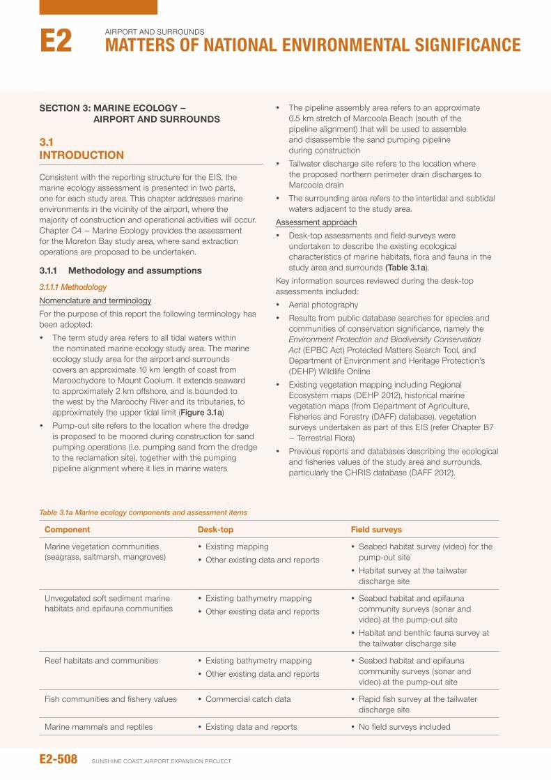
SECTION 3: MARINE ECOLOGy — AIRpORT ANd SURROUNdS
3.1 INTROdUCTION
Consistent with the reporting structure for the EiS, the marine ecology assessment is presented in two parts, one for each study area. This chapter addresses marine environments in the vicinity of the airport, where the majority of construction and operational activities will occur. Chapter C4 – Marine Ecology provides the assessment for the Moreton Bay study area, where sand extraction operations are proposed to be undertaken.
3.1.1 Methodology and assumptions
3.1.1.1 MethodologyNomenclature and terminology
For the purpose of this report the following terminology has been adopted:
y The term study area refers to all tidal waters within the nominated marine ecology study area. The marine ecology study area for the airport and surrounds covers an approximate 10 km length of coast from Maroochydore to Mount Coolum. it extends seaward to approximately 2 km offshore, and is bounded to the west by the Maroochy River and its tributaries, to approximately the upper tidal limit (Figure 3.1a)
y pump-out site refers to the location where the dredge is proposed to be moored during construction for sand pumping operations (i.e. pumping sand from the dredge to the reclamation site), together with the pumping pipeline alignment where it lies in marine waters
y The pipeline assembly area refers to an approximate 0.5 km stretch of Marcoola Beach (south of the pipeline alignment) that will be used to assemble and disassemble the sand pumping pipeline during construction
y Tailwater discharge site refers to the location where the proposed northern perimeter drain discharges to Marcoola drain
y The surrounding area refers to the intertidal and subtidal waters adjacent to the study area.
Assessment approach
y Desk-top assessments and field surveys were undertaken to describe the existing ecological characteristics of marine habitats, flora and fauna in the study area and surrounds (Table 3.1a).
Key information sources reviewed during the desk-top assessments included:
y Aerial photography
y Results from public database searches for species and communities of conservation significance, namely the Environment Protection and Biodiversity Conservation Act (EpBC Act) protected Matters Search Tool, and Department of Environment and Heritage protection’s (DEHp) Wildlife online
y Existing vegetation mapping including Regional Ecosystem maps (DEHp 2012), historical marine vegetation maps (from Department of Agriculture, Fisheries and Forestry (DAFF) database), vegetation surveys undertaken as part of this EiS (refer Chapter B7 – Terrestrial Flora)
y previous reports and databases describing the ecological and fisheries values of the study area and surrounds, particularly the CHRiS database (DAFF 2012).
Table 3.1a Marine ecology components and assessment items
Component desk-top Field surveys
Marine vegetation communities (seagrass, saltmarsh, mangroves)
y Existing mapping
y other existing data and reports
y Seabed habitat survey (video) for the pump-out site
y Habitat survey at the tailwater discharge site
unvegetated soft sediment marine habitats and epifauna communities
y Existing bathymetry mapping
y other existing data and reports
y Seabed habitat and epifauna community surveys (sonar and video) at the pump-out site
y Habitat and benthic fauna survey at the tailwater discharge site
Reef habitats and communities y Existing bathymetry mapping
y other existing data and reports
y Seabed habitat and epifauna community surveys (sonar and video) at the pump-out site
Fish communities and fishery values y Commercial catch data y Rapid fish survey at the tailwater discharge site
Marine mammals and reptiles y Existing data and reports y no field surveys included
E2-508
Airport And SurroundS
Matters of NatIoNaL eNvIroNMeNtaL sIgNIfIcaNceE2
SunSHinE CoASt Airport EXpAnSion proJECt

Figure 3.1a: Marine ecology study area
LEGEND
Study Area
Airport Study Footprint
Dredge Mooring Area
Pipe Assembly Area
Airport Drains
Tailwater Discharge Site
Sand Delivery Pipeline
1.5 3km
Approx. Scale
0
E2-509environmental impact statement
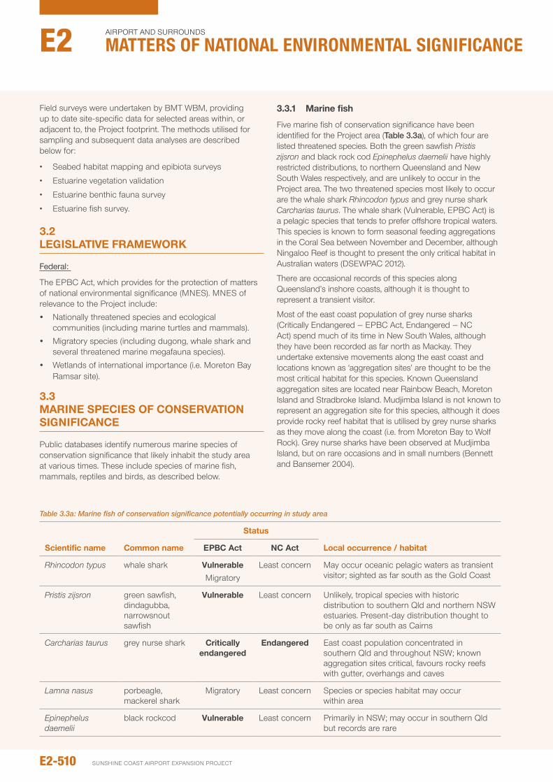
Field surveys were undertaken by BMT WBM, providing up to date site-specific data for selected areas within, or adjacent to, the project footprint. The methods utilised for sampling and subsequent data analyses are described below for:
• Seabedhabitatmappingandepibiotasurveys
• Estuarinevegetationvalidation
• Estuarinebenthicfaunasurvey
• Estuarinefishsurvey.
3.2 LEGISLATIvE FRAMEwORk
Federal:
The EpBC Act, which provides for the protection of matters of national environmental significance (MnES). MnES of relevance to the project include:
y nationally threatened species and ecological communities (including marine turtles and mammals).
y Migratory species (including dugong, whale shark and several threatened marine megafauna species).
y Wetlands of international importance (i.e. Moreton Bay Ramsar site).
3.3 MARINE SpECIES OF CONSERvATION SIGNIFICANCE
public databases identify numerous marine species of conservation significance that likely inhabit the study area at various times. These include species of marine fish, mammals, reptiles and birds, as described below.
3.3.1 Marine fish
Five marine fish of conservation significance have been identified for the project area (Table 3.3a), of which four are listed threatened species. Both the green sawfish Pristis zijsron and black rock cod Epinephelus daemelii have highly restricted distributions, to northern Queensland and new South Wales respectively, and are unlikely to occur in the project area. The two threatened species most likely to occur are the whale shark Rhincodon typus and grey nurse shark Carcharias taurus. The whale shark (Vulnerable, EpBC Act) is a pelagic species that tends to prefer offshore tropical waters. This species is known to form seasonal feeding aggregations in the Coral Sea between november and December, although ningaloo Reef is thought to present the only critical habitat in Australian waters (DSEWpAC 2012).
There are occasional records of this species along Queensland’s inshore coasts, although it is thought to represent a transient visitor.
Most of the east coast population of grey nurse sharks (Critically Endangered – EpBC Act, Endangered – nC Act) spend much of its time in new South Wales, although they have been recorded as far north as Mackay. They undertake extensive movements along the east coast and locations known as ‘aggregation sites’ are thought to be the most critical habitat for this species. Known Queensland aggregation sites are located near Rainbow Beach, Moreton island and Stradbroke island. Mudjimba island is not known to represent an aggregation site for this species, although it does provide rocky reef habitat that is utilised by grey nurse sharks as they move along the coast (i.e. from Moreton Bay to Wolf Rock). Grey nurse sharks have been observed at Mudjimba island, but on rare occasions and in small numbers (Bennett and Bansemer 2004).
Table 3.3a: Marine fish of conservation significance potentially occurring in study area
Scientific name Common name
Status
Local occurrence / habitatEpBC Act NC Act
Rhincodon typus whale shark vulnerableMigratory
Least concern May occur oceanic pelagic waters as transient visitor; sighted as far south as the Gold Coast
Pristis zijsron green sawfish, dindagubba, narrowsnout sawfish
vulnerable Least concern unlikely, tropical species with historic distribution to southern Qld and northern nSW estuaries. present-day distribution thought to be only as far south as Cairns
Carcharias taurus grey nurse shark Critically endangered
Endangered East coast population concentrated in southern Qld and throughout nSW; known aggregation sites critical, favours rocky reefs with gutter, overhangs and caves
Lamna nasus porbeagle, mackerel shark
Migratory Least concern Species or species habitat may occur within area
Epinephelus daemelii
black rockcod vulnerable Least concern primarily in nSW; may occur in southern Qld but records are rare
E2-510
Airport And SurroundS
Matters of NatIoNaL eNvIroNMeNtaL sIgNIfIcaNceE2
SunSHinE CoASt Airport EXpAnSion proJECt
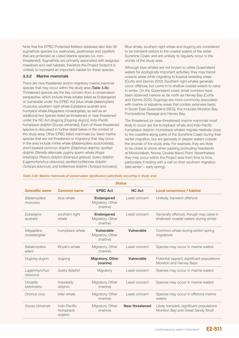
note that the EpBC protected Matters database also lists 36 sygnathids species (i.e. seahorses, pipehorses and pipefish) that are protected as Listed Marine species (i.e. non-threatened). Sygnathids are primarily associated with seagrass meadows and reef habitats, therefore the project footprint is unlikely to represent an important habitat for these species.
3.3.2 Marine mammals
There are nine threatened and/or migratory marine mammal species that may occur within the study area (Table 3.3b). Threatened species are the key concern from a conservation perspective, which include three whales listed as Endangered or Vulnerable under the EpBC Act (blue whale Balaenoptera musculus, southern right whale Eubalaena australis and humpack whale Megaptera novaeangliae), as well as an additional two species listed as threatened or near threatened under the nC Act (dugong [Dugong dugon], indo-pacific humpback dolphin [Sousa chinensis]). Each of these threatened species is discussed in further detail below in the context of the study area. other EpBC listed mammals (i.e. listed marine species that are not threatened or migratory) that may occur in the area include minke whale (Balaenoptera acutorostrata), short-beaked common dolphin (Delphinus delphis), spotted dolphin Stenella attenuate, pygmy sperm whale )Kogia breviceps), Risso’s dolphin (Grampus griseus), dusky dolphin (Lagenorhynchus obscurus), spotted bottlenose dolphin (Tursiops aduncus), and bottlenose dolphin (Tursiops truncatus).
Blue whale, southern right whale and dugong are considered to be transient visitors to the coastal waters of the wider Sunshine Coast, and are unlikely to regularly occur in the vicinity of the study area.
Although blue whales are not known to utilise Queensland waters for ecologically important activities, they may transit oceanic areas while migrating to tropical breeding areas (Curtis and Dennis 2012). Southern right whales generally occur offshore, but come in to shallow coastal waters to calve in winter. on the Queensland coast, small numbers have been observed inshore as far north as Hervey Bay (Curtis and Dennis 2012). Dugongs are more commonly associated with marine or estuarine areas that contain extensive beds; in South East Queensland (SEQ), this includes Moreton Bay, pumicestone passage and Hervey Bay.
The threatened (or near-threatened) marine mammals most likely to occur are the humpback whale and indo-pacific humpback dolphin. Humpback whales migrate relatively close to the coastline along parts of the Sunshine Coast during their winter migration, but are generally in deeper waters outside the bounds of the study area. For example, they are likely to be closer to shore when passing protruding headlands at Mooloolabah, noosa, Double island point. nevertheless, they may occur within the project area from time to time, particularly if resting with a calf on their southern migration (late winter – early spring).
Table 3.3b: Marine mammals of conservation significance potentially occurring in study area
Scientific name Common name
Status
Local occurrence / habitatEpBC Act NC Act
Balaenoptera musculus
blue whale Endangered Migratory, other
(marine)
Least concern unlikely, transient offshore
Eubalaena australis
southern right whale
Endangered Migratory, other
(marine)
Least concern Generally offshore, though may calve in shallower coastal waters during winter
Megaptera novaeangliae
humpback whale vulnerable Migratory, other
(marine)
vulnerable Common whale during winter-spring migrations
Balaenoptera edeni
Bryde’s whale Migratory, other (marine)
Least concern Species may occur in marine waters
Dugong dugon dugong Migratory, Other (marine)
vulnerable potential vagrant, significant populations Moreton and Hervey Bays
Lagenrhynchus obscurus
dusky dolphin Migratory Least concern Species may occur in marine waters
Orcaella brevirostris
irrawaddy dolphin
Migratory, other (marine)
Least concern Species may occur in marine waters
Orcinus orca killer whale Migratory, other (marine)
Least concern Species may occur in offshore marine waters
Sousa chinensis indo-pacific humpback dolphin
Migratory, other (marine)
Near threatened Likely transient, significant populations Moreton Bay and Great Sandy Strait
E2-511environmental impact statement
The near-threatened indo-pacific humpback dolphin is a tropical to sub-tropical species that extends as far south as the Queensland / new South Wales border, primarily inhabiting shallow coastal waters and estuaries. in SEQ known localities, and likely areas of highest numbers, occur south of the study area at Moreton Bay and Brisbane River, and to the north at Tin Can Bay and Great Sandy Straight. (DSEWpAC 2013).
Given its position between these localities, together with the recognised continuous nature of their distribution, it is likely that this species occurs in the study area from time to time.
3.3.3 Marine reptiles
Six species of sea turtles potentially utilise the study area, all of which are considered threatened under both the EpBC Act and nC Act as listed in Table 3.3c. Each of these species has been recorded in coastal nearshore waters of the wider Sunshine Coast area, and may forage in (especially in the vicinity of Mudjimba island), or transit through, the study area. However, the loggerhead turtle (Caretta caretta, Endangered) and green turtle (Chelonia mydas, Vulnerable) are of the greatest significance in the context of the project as they are relatively common and most likely to use coastal beaches within, or adjacent to, the study area as nesting habitat. note that green turtles may also occur in the Maroochy estuary from time to time, potentially feeding on the seagrass present as this provides a key food source for this species.
Loggerhead turtles nest annually on Sunshine Coast beaches, typically numbering in the tens of individuals, primarily at Caloundra (Limpus 2008a). Green turtle
nesting is rarer (Limpus 2008b). As it is estimated that approximately 500 female loggerheads nest along the full length of Australia’s east coast, the Sunshine Coast population represents a small but important contribution to this endangered species’ reproductive activity (Turtle Care 2012). nesting season typically extends from november to February, although hatchlings may emerge as late as March. Each year the number of turtles nesting within the study area varies. over the last three years a total of seven loggerhead turtle nests were recorded within the study area by local community monitoring volunteers. The locations of these nests are shown in Figure 3.3a.
of these, up to two nests were located in the stretch of Marcoola Beach that is proposed to be utilised for pipeline assembly works. During the same period, additional nests were also recorded north of the study area at Coolum.
Similar to loggerhead turtles, the nesting season for green turtles in southern Queensland typically extends from november to March, with peak activity in January (Limpus 2008b). no green turtle nests have been recorded in the study area in recent years. in terms of other aspects of their ecology potentially affected by the proposal, the diets of loggerhead and green turtles differ markedly. Loggerhead turtles feed mainly on molluscs and crabs, although their diet also includes a wide range of other invertebrates (Curtis and Dennis 2012). in contrast, green turtles primarily feed on seagrass and algae (Curtis and Dennis 2012).
note that the EpBC protected Matters database also lists an additional nine sea snake species that are protected as Listed Marine species (i.e. non-threatened).
Table 3.3c: Marine reptiles of conservation significance potentially occurring in study area
Scientific name Common name
Status
Local occurrence / habitatEpBC Act NC Act
Caretta caretta loggerhead turtle Endangered Migratory, other
(marine)
Endangered Frequents marine waters of study area, known to nest on Marcoola Beach, and adjacent beaches, in low numbers
Chelonia mydas green turtle vulnerable Migratory, other
(marine)
vulnerable Foraging, feeding or related behaviour known to occur within area; potentially nesting in the area
Dermochelys coriacea
leathery turtle, leatherback turtle
Endangered Migratory, other
(marine)
Endangered uncommon, may transit or forage in marine waters of study area
Eretmochelys imbricata
hawksbill turtle vulnerable Migratory, other
(marine)
vulnerable May transit or forage in marine waters of study area
Lepidochelys olivacea
olive Ridley turtle Endangered Migratory, other
(marine)
Endangered uncommon, may transit or forage in marine waters of study area
Natator depressus
flatback turtle vulnerable Migratory, other
(marine)
vulnerable uncommon, may transit or forage in marine waters of study area
E2-512
Airport And SurroundS
Matters of NatIoNaL eNvIroNMeNtaL sIgNIfIcaNceE2
SunSHinE CoASt Airport EXpAnSion proJECt
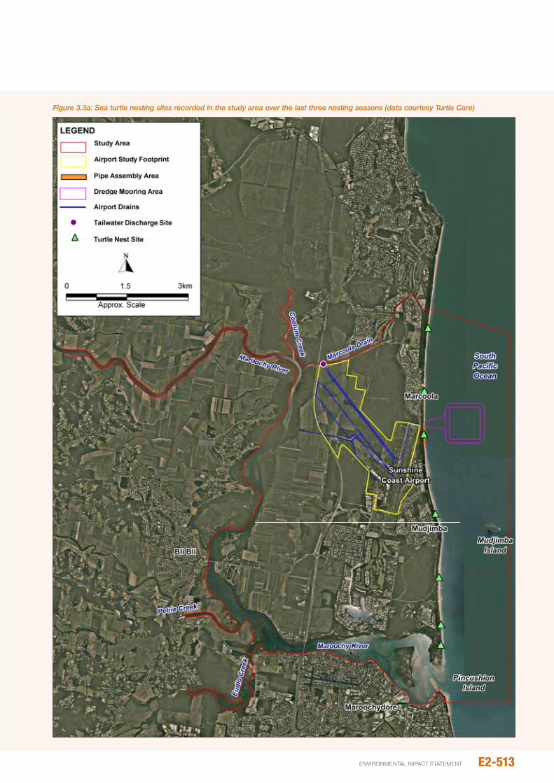
Figure 3.3a: Sea turtle nesting sites recorded in the study area over the last three nesting seasons (data courtesy Turtle Care)
E2-513environmental impact statement
Table 3.3d: Sea birds of conservation significance potentially occurring in study area
Scientific nameCommon name
Status
Local occurrence / habitatEpBC Act NC Act
Macronectes halli
northern giant-petrel
vulnerable, Migratory, other
(marine)
vulnerable Rare, potential vagrants in small numbers
Macronectes giganteus
southern giant-petrel
Endangered Endangered Rare, potential vagrants in small numbers
Pterodroma neglecta neglecta
Kermadec petrel
vulnerable Least concern Rare, potential vagrants in small numbers
Thalassarche melanophris impavida
Campbell albatross
vulnerable, Migratory, other
(marine)
Least concern Rare, potential vagrants in small numbers
Calonectris leucomelas
streaked shearwater
Migratory, other (marine)
Least concern Annual migration along coast
Diomedea exulans
wandering albatross
vulnerable vulnerable Rare, potential vagrants in small numbers
Diomedea exulans exulans (dabbenena)
Tristan albatross
Endangered Endangered Rare, potential vagrants in small numbers
Fregetta grallaria white-bellied storm-petrel
vulnerable Least concern Rare, potential vagrants in small numbers
Puffinus pacificus
wedge-tailed shearwater
Migratory, other (marine)
Least concern Annual migration along coast , significant colony nests on Mudjimba islands during breeding season
3.3.4 Sea birds
Most avifauna species of conservation significance are addressed elsewhere in this EiS (Chapter B8 – Terrestrial Fauna). This section applies only to sea birds, or marine birds, which in this EiS is defined as ‘birds species that spend the majority of their life at sea’ and includes species of albatross, petrels and shearwaters.
An estimated nine species of sea bird, which are listed as threatened and/or migratory species under the EpBC Act, may occur in the study area. These species are listed, along with their respective conservation status, in Table 3.3d. Four are also listed as threated species under the nC Act.
note that both the southern giant petrel (Macronectes giganteus) and the Tristan albatross (Diomedea exulans exulans) are assigned a higher conservation status, being listed as Endangered under both the EpBC Act and nC Act.
The albatross and petrel species are primarily Southern ocean species, but may visit Queensland waters in small numbers as rare visitors or vagrants in winter and spring (Curtis and Dennis 2012). As such, while the study area and surrounding waters do not represent a significant habitat for these species, it is possible that they may transit the area or, on a rare occasion, use the coastal waters to rest or forage.
Wedge-tailed shearwaters (Puffinus pacificus) are not threatened, but transit the coastal waters of the Sunshine coast during the annual migration and also nest on Mudjimba island in numbers. Dyer (2000) estimated approximately 2,700 burrows for the 1997/98 season with a breeding rate of approximately 37 per cent. He also states that Mudjimba island supports one of only two colonies occurring on Queensland’s mainland islands (note that breeding colonies also occur at offshore Queensland islands such a Heron and Lady Elliot islands, as well as in new South Wales).
3.4 dESCRIpTION OF SIGNIFICANCE CRITERIA
A risk-based approach was adopted for assessing impacts to marine ecology values. This is based on the identification of potential impacting processes and characterising the significance and likelihood of environmental effects. This risk-assessment process is detailed in full in Chapter A8 – Environmental impact Assessment process of this EiS. While the terminology used here for the levels of impact significance and likelihood are consistent with that used
E2-514
Airport And SurroundS
Matters of NatIoNaL eNvIroNMeNtaL sIgNIfIcaNceE2
SunSHinE CoASt Airport EXpAnSion proJECt
elsewhere in the EiS, for the purposes of this impact assessment these categories have distinct definitions specific to marine ecology. Discipline-specific definitions used in the marine ecology impact assessment are provided below in Tables 3.4a to 3.4c for:
y Impact Significance, which takes in account the overall degree of environmental effects in terms of intensity,
geographic extent, anticipated duration and sensitivity of environmental receptors. impact significance categories also take into account the legislative status of relevant matters of conservations concern, such as protected areas and threatened or migratory species.
y Duration of Impacts, which are incorporated into the impact significance.
Table 3.4a: Impact significance criteria used for marine ecology assessment
Impact Significance/ Consequence description of Significance
Very High This impact is considered critical to the decision making process as it would represent a major change to the ecological character of the marine environment of the study area. This level of impact would be indicated by: y Complete loss of any habitat type presently supported by the study area; or y Substantial effects on ecosystem structure or function, such that many species become locally extinct; or
y Major regional-scale changes to the ecological character of Moreton Bay Marine park, Moreton Bay Ramsar site, Fish Habitat Areas; or
y Major impacts to populations to commonwealth or state listed threatened species, such that their capacity to reproduce and recover is significantly affected; and
y Lead to impacts that are irreversible or otherwise long term (i.e. greater than decades).
High The impact is considered important to the decision making process as it would cause a detectable change to the values that underpin the ecological character of the study area. A high level of impact would be indicated by : y Measurable impacts to key ecosystem structure or functions, large changes in abundance of many species at spatial scales measured in 10’s of kilometres; or
y Mortality of a small number of individuals of internationally/ nationally threatened species, but no detectable change in population status and the capacity of populations to recover; or
y Measurable loss in fisheries production at the local spatial scale, but no impacts at regional scales; and y Lead to impacts that are medium term (measured in years) or longer.
Moderate While important at a state, regional or local scale, these impacts are not likely to be critical decision making issues. Moderate impact significance would be indicated by: y Measurable but small changes to supporting ecosystem components (i.e. habitat extent, water quality) and functions (i.e. fisheries production, fauna reproduction/recruitment) at scales measured in kilometres, but no impact at broader scales; or
y Small changes in abundance of many species, or large changes in some species, at scales measured in kilometres; or
y Loss of important life history functions of threatened species, or species of high fisheries or other significance, but no detectable change in their population status at a local spatial scale (i.e. capacity to recover); and
y impacts that are medium term (years) or shorter.
Minor impacts are recognisable/detectable but acceptable. These impacts are unlikely to be of importance in the decision making process. nevertheless, they are relevant in the consideration of standard mitigation measures. This would be indicated by: y Species of fisheries or conservation significance, or its habitat affected but no impact on local population status (i.e. stress or behavioural change to individuals);
y impacts tend to be short term or temporary and/or occur at local scale; y no effects to threatened species are expected, even at local spatial scales.
negligible Minimal change to the existing situation. This could include, for example, impacts at are below levels of detection, or impacts that are within the range of normal variation.
E2-515environmental impact statement
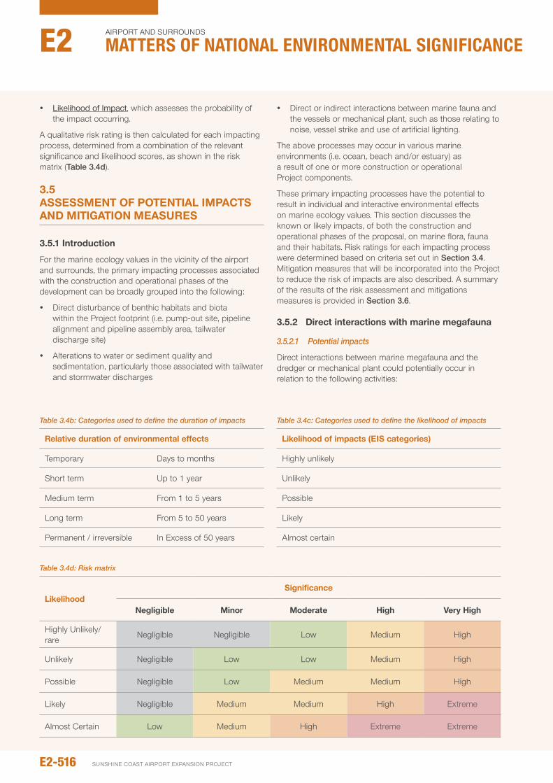
y Likelihood of Impact, which assesses the probability of the impact occurring.
A qualitative risk rating is then calculated for each impacting process, determined from a combination of the relevant significance and likelihood scores, as shown in the risk matrix (Table 3.4d).
3.5 ASSESSMENT OF pOTENTIAL IMpACTS ANd MITIGATION MEASURES
3.5.1 Introduction
For the marine ecology values in the vicinity of the airport and surrounds, the primary impacting processes associated with the construction and operational phases of the development can be broadly grouped into the following:
y Direct disturbance of benthic habitats and biota within the project footprint (i.e. pump-out site, pipeline alignment and pipeline assembly area, tailwater discharge site)
y Alterations to water or sediment quality and sedimentation, particularly those associated with tailwater and stormwater discharges
y Direct or indirect interactions between marine fauna and the vessels or mechanical plant, such as those relating to noise, vessel strike and use of artificial lighting.
The above processes may occur in various marine environments (i.e. ocean, beach and/or estuary) as a result of one or more construction or operational project components.
These primary impacting processes have the potential to result in individual and interactive environmental effects on marine ecology values. This section discusses the known or likely impacts, of both the construction and operational phases of the proposal, on marine flora, fauna and their habitats. Risk ratings for each impacting process were determined based on criteria set out in Section 3.4. Mitigation measures that will be incorporated into the project to reduce the risk of impacts are also described. A summary of the results of the risk assessment and mitigations measures is provided in Section 3.6.
3.5.2 direct interactions with marine megafauna
3.5.2.1 Potential impacts
Direct interactions between marine megafauna and the dredger or mechanical plant could potentially occur in relation to the following activities:
Table 3.4d: Risk matrix
LikelihoodSignificance
Negligible Minor Moderate high very high
Highly unlikely/ rare
negligible negligible Low Medium High
unlikely negligible Low Low Medium High
possible negligible Low Medium Medium High
Likely negligible Medium Medium High Extreme
Almost Certain Low Medium High Extreme Extreme
Table 3.4c: Categories used to define the likelihood of impacts
Likelihood of impacts (EIS categories)
Highly unlikely
unlikely
possible
Likely
Almost certain
Table 3.4b: Categories used to define the duration of impacts
Relative duration of environmental effects
Temporary Days to months
Short term up to 1 year
Medium term From 1 to 5 years
Long term From 5 to 50 years
permanent / irreversible in Excess of 50 years
E2-516
Airport And SurroundS
Matters of NatIoNaL eNvIroNMeNtaL sIgNIfIcaNceE2
SunSHinE CoASt Airport EXpAnSion proJECt
y Dredge mooring and pump-out
y pipeline construction and placement.
During these activities, marine fauna could be affected by one or more of the following mechanisms, which are described in further detail below:
y Direct contact or obstruction of fauna passage
y Emissions of artificial noise from the vessels and dredge pump
y Emissions of artificial light during night works, either on the beach or nearshore vessels.
Contact or obstruction
When operating any kind of vessel in marine waters, there is a potential risk of fauna vessel strike, primarily for mobile megafauna that swim near the surface and/or frequent the surface to breath, such as whales, dolphins, dugongs and turtles. interactions may also occur if the presence of a vessel obstructs fauna passage, which may occur if the presence of a vessel deters an animal from continuing along an intended path of passage, or is inclined to detour significantly around a vessel to reach an intended destination (i.e. avoidance behaviour – discussed further below with respect to potential noise effects).
Large vessels such as the dredger are slow-moving, which would provide marine fauna time to evade the approaching vessel. in this case, the dredger will be moving particularly slow as it will be approaching the mooring and/or manoeuvred by tug to maintain a relatively stationary position during pumping. The tug boat will be the vessel more commonly moving in and around the dredge mooring location. in addition to manoeuvring the dredger, it will be required to repeatedly tow the floating pipeline to the dredger for it to be coupled to the dredger’s discharge point, and possibly also enforce compliance with approach limits if other vessels attempt to come close to the dredge or mooring. An additional vessel will also be used to drag the steel pipeline seaward for ocean placement. The close proximity of the mooring area to shore (less than 1 km) reduces the risk of larger megafauna, namely whales, coming in close proximity to the works area. Therefore the fauna most likely to enter the pump-out site are fish, dolphins and turtles. overall, the likelihood of vessels striking or obstructing the passage of marine fauna is considered to be low.
Entrainment of fauna may potentially occur from the suction at the pump’s water intake. However, this risk is very low as the intake will be in surface waters where larger fauna are highly mobile and would actively avoid the area.
Beach works during construction of the sand pumping pipeline potentially pose a risk of direct physical interactions with nesting turtles, turtle nests and hatchlings on Marcoola Beach. This risk will be negligible during the construction phase of the project as all beach works will purposefully be timed to be undertaken outside of turtles nesting season.
Noise
The production and reception of particular sounds are important to many marine fauna species, particularly marine mammals. Both natural and anthropogenic sounds have the potential to interfere with various biological functions. During construction, sand pumping has the potential to adversely affect megafauna as it will form a source of underwater noise that will occur intermittently for the maximum ten month duration of sand pumping works. For example, depending on the size of the dredge, it is anticipated that it will discharge 2.0 to 3.5 times per day, with each discharge works taking approximately two hours at a time. Such noise may be generated by mechanical means (vessel engines, pumps, propellers and other machinery), or by water movements on vessel hulls. While vessel and pump generated noise is normally unlikely to occur at levels that could cause acute hearing damage to marine fauna, it may cause subtle but possibly more widespread increases to ambient noise levels. This may include for example, masking of biologically important sounds (i.e. vocalisations), interfere with dolphin sonar signals or alter fauna behaviour (i.e. noise avoidance).
Works on the beach, particularly pipe assembly, will also generate noise. This may not contribute significantly to underwater noise (and therefore megafauna effects), given the higher attenuation of noise in air. nonetheless, together with beach construction vibrations and physical disturbance, will contribute to excluding and/or deterring fauna (i.e. crabs) from the pipeline assembly area for the duration of works.
Specific knowledge on the relative contributions of various noise sources to ambient noise levels is extremely limited, as is information on the effects of noise on marine megafauna in an Australian context. Further, specific underwater noise modelling has not been undertaken for this project. Therefore, quantitative predictions about the extent of potential underwater noise impacts cannot be made.
The most likely impact of underwater noise from the pump and vessels will be the temporary avoidance of the pump-out site and immediate surrounds by mobile fauna. noise generated by sand pumping activities will likely deter nesting turtles from nesting near the pump-out site. nesting turtles will either nest at an alternative stretch of the beach, or possibly dispose of their eggs. Such impacts would be temporary, and given existing low intensity of nesting (expected to be no more than two individuals in close vicinity to the pump-out site), any such impacts are not expected to cause impacts to turtle populations.
it is also possible that underwater noise generated by the pump and vessels would deter whales and dolphins from using waters immediately adjacent to operational areas. Given that the waters directly adjacent to Marcoola Beach are not known to represent an important whale movement corridor or resting areas, major impacts to whale populations are not expected. Any such impacts to whales or dolphins (i.e. avoidance of area) are expected to be highly localised (measured in 100s of metres) and of a temporary nature.
E2-517environmental impact statement
As discussed below, mitigation measures will be implemented to further reduce the risk of underwater noise effects, as well as the risk of direct obstruction or contact with marine megafauna.
Light emissions
When vessels are operated at night in the pump-out site, they will utilise on-board lighting systems. it is anticipated that the dredge vessel would typically moor at this location for approximately two hours at a time, once or twice a night, during the maximum ten month duration of the sand pumping program. Buoys at the mooring and floating pipeline will be fitted with navigation lights. Lighting will also be used on Marcoola Beach when sand pumping occurs at night, and if security lighting required for the pipeline. Together, these sources will generate light emissions to the marine environment. Artificial lighting is not known to have a major effect on foraging or other behavioural patterns of dolphins, whales or sharks. Marine turtles are the marine megafauna species considered to be most vulnerable to artificial lighting effects as they may become disorientated during nesting and hatching (Witherington 1992). Throughout construction, no works will be undertaken on the beach during the local turtle nesting season (i.e. november to early March). parts of the sand pumping operations may (depending on ultimate duration of sand pumping works) coincide with local turtle nesting. For hatchlings, this is considered to present negligible risk in terms of light effects as the seaward position of the vessels will not guide new hatchlings landward. Beach-bound nesting adults could potentially be confused and disorientated by project-related lights when approaching shore during pumping operations: however, this is considered a low risk due to the more extensive road, residential and similar lighting on lands near Marcoola Beach; the low incidence of turtle nesting likely to occur; and the possibility that pumping noise emissions may already have deterred turtles form approaching this area.
Given the rare occurrence of threatened seabirds in the study area, the risk of artificial lighting affecting these fauna is considered negligible. While not specifically mentioned above, note that seabirds are not expected to be directly affected by other direct interactions, other than behavioural avoidance of the works area. Furthermore, direct interactions with the vessels, pump or beach plant are not expected to cause adverse impacts to the food resources for marine species of conservation significance.
overall, while megafauna interactions between the vessels, pumps and other machinery are typically unlikely (although noise-related avoidance behaviour is more likely), they are considered to represent a low risk, even with the implementation of the best practice mitigation below, since the fauna most likely to be affected are generally species of high conservation significance.
3.5.2.2 Mitigation
With respect to potential impacts to turtles on Marcoola Beach, all dredge pipeline construction works on Marcoola Beach will be undertaken during times that are outside turtle nesting season (i.e. november to March). prior to the commencement of beach construction works, it is recommended that staff confirm with local turtle nest monitoring personnel (i.e. through SCC or direct with community groups) that any turtle nests occurring in the works area during the most recent nesting season are no longer active. With these measures in place, beach construction works will avoid interactions with nesting turtles, turtle nests and hatchlings.
While the pump-out site is not known or likely to support large numbers of marine megafauna, management strategies will be implemented throughout mooring and sand pumping operations to minimise the risk of interactions with the dredger and tug vessels. These management strategies will be set out as part of the Dredge Management plan and will include:
y implementing a Marine Megafauna Management plan
y implementation of megafauna exclusion zones (i.e. maintaining a given buffer distance between vessels and megafauna) and associated reactive megafauna monitoring program (i.e. regular visual inspections of pump-out site)
y if visual monitoring for megafauna from either vessel detects megafauna within or headed towards exclusion zones, execute strategies to avoid interactions as required (i.e. stopping work if megafauna, especially whales, are within or near exclusion zones; halt vessel transit if potential to encroach on observed whales or their anticipated path)
y Where it does not conflict with security and safety requirements, lighting on the dredge vessel will aim for low wattage and/or directional light fixtures.
E2-518
Airport And SurroundS
Matters of NatIoNaL eNvIroNMeNtaL sIgNIfIcaNceE2
SunSHinE CoASt Airport EXpAnSion proJECt
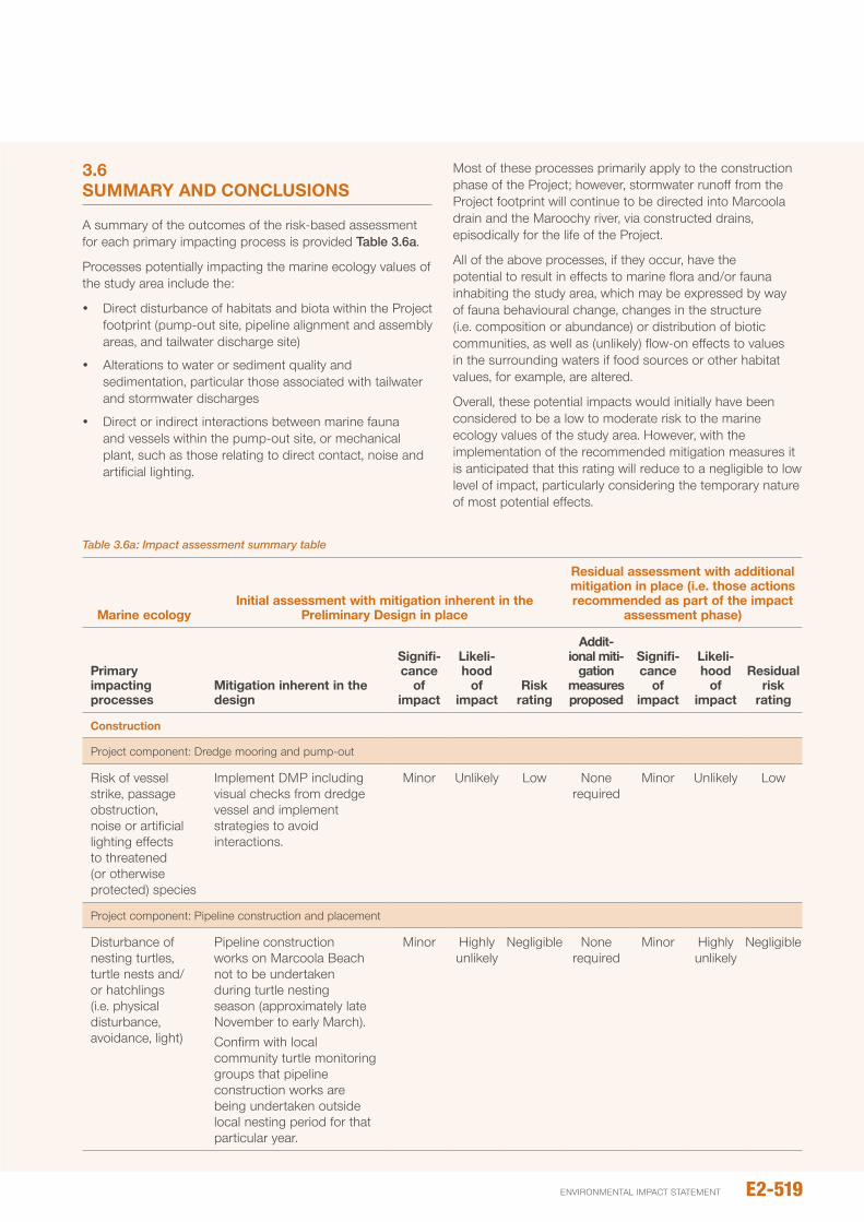
3.6 SUMMARy ANd CONCLUSIONS
A summary of the outcomes of the risk-based assessment for each primary impacting process is provided Table 3.6a.
processes potentially impacting the marine ecology values of the study area include the:
y Direct disturbance of habitats and biota within the project footprint (pump-out site, pipeline alignment and assembly areas, and tailwater discharge site)
y Alterations to water or sediment quality and sedimentation, particular those associated with tailwater and stormwater discharges
y Direct or indirect interactions between marine fauna and vessels within the pump-out site, or mechanical plant, such as those relating to direct contact, noise and artificial lighting.
Most of these processes primarily apply to the construction phase of the project; however, stormwater runoff from the project footprint will continue to be directed into Marcoola drain and the Maroochy river, via constructed drains, episodically for the life of the project.
All of the above processes, if they occur, have the potential to result in effects to marine flora and/or fauna inhabiting the study area, which may be expressed by way of fauna behavioural change, changes in the structure (i.e. composition or abundance) or distribution of biotic communities, as well as (unlikely) flow-on effects to values in the surrounding waters if food sources or other habitat values, for example, are altered.
overall, these potential impacts would initially have been considered to be a low to moderate risk to the marine ecology values of the study area. However, with the implementation of the recommended mitigation measures it is anticipated that this rating will reduce to a negligible to low level of impact, particularly considering the temporary nature of most potential effects.
Table 3.6a: Impact assessment summary table
Marine ecologyInitial assessment with mitigation inherent in the
preliminary design in place
Residual assessment with additional mitigation in place (i.e. those actions recommended as part of the impact
assessment phase)
primary impacting processes
Mitigation inherent in the design
Signifi- cance
of impact
Likeli- hood
of impact
Risk rating
Addit- ional miti-
gation measures proposed
Signifi- cance
of impact
Likeli- hood
of impact
Residual risk
rating
Construction
project component: Dredge mooring and pump-out
Risk of vessel strike, passage obstruction, noise or artificial lighting effects to threatened (or otherwise protected) species
implement DMp including visual checks from dredge vessel and implement strategies to avoid interactions.
Minor unlikely Low none required
Minor unlikely Low
project component: pipeline construction and placement
Disturbance of nesting turtles, turtle nests and/or hatchlings (i.e. physical disturbance, avoidance, light)
pipeline construction works on Marcoola Beach not to be undertaken during turtle nesting season (approximately late november to early March).Confirm with local community turtle monitoring groups that pipeline construction works are being undertaken outside local nesting period for that particular year.
Minor Highly unlikely
negligible none required
Minor Highly unlikely
negligible
E2-519environmental impact statement
SECTION 4: MARINE ECOLOGy — dREdGING ANd dREdGE MOvEMENTS
4.1 INTROdUCTION
4.1.1 Moreton Bay Ramsar site
Wetlands of international importance are listed as a MnES under Sections 16 and 17B of the EpBC Act. Such wetlands are commonly referred to as Ramsar wetlands. parts of Moreton Bay Ramsar site are within the study area, but are positioned primarily near intertidal shores and estuaries, namely marine waters along the coasts of Moreton and Bribie island, and waters in Deception Bay and pumicestone passage. At its closest points, Moreton Bay Ramsar site is located approximately 6 km to the east and west of the dredge footprint.
Key marine values justifying the inclusion of Moreton Bay as a Ramsar site include the following (EpA 1999):
y Moreton Bay is one of the largest estuarine bays in Australia.
y Moreton Bay supports appreciable numbers of the vulnerable green and hawksbill turtles, the endangered loggerhead turtle, and is ranked among the top ten dugong habitats in Queensland.
y Moreton Bay supports over 355 species of marine invertebrates, at least 43 species of shore birds, 55 species of algae associated with mangroves, seven species of mangroves and seven species of seagrass.
y it is a significant feeding ground for green turtles and is a feeding and breeding ground for dugong, the bay also has the most significant concentration of young and mature loggerhead turtles in Australia.
y in additional to these marine values, the bay is also recognised as a critical habitat for 43 shorebird species, including 30 migratory species (EpBC Act listed) (EpA 1999). Further details regarding the abovementioned marine flora and fauna are provided in Chapter C4 – Marine Ecology and in Chapter B8 – Terrestrial Fauna.
Given its proximity from the dredge footprint this Ramsar site will not be directly affected by the proposed works. Furthermore, numerical modelling predicts that turbid plumes generated by the proposed dredging would be unlikely to extend to the Ramsar site. Rather, they are predicted to extend immediately north and south of the dredge footprint, due to the dominant tidal current and wave activity. As outlined below, the project is highly unlikely to affect populations of marine fauna that inhabit the wider northern Moreton Bay area, which comprises part of the Ramsar site. it is therefore considered highly unlikely that the proposal will adversely affect Moreton Bay Ramsar site or its supporting values as assessed in Table 4.1a.
Table 4.1a: Criteria listed by the EPBC Act 1999 for a ‘significant impact’ and the ‘likelihood’ of impact to the wetlands of international signifcance
Significance Criteria Assessment
Areas of wetland being destroyed or substantially modified
The dredge footprint is located >6 km from the wetland. no direct impacts will therefore occur as a result of the project.
A substantial and measurable change in the hydrological regime of the wetland, for example, a substantial change to the volume, timing, duration and frequency of ground and surface water flows to and within the wetland
The project will not affect the controlling hydrodynamics of Moreton Bay. The project will have highly localised, small magnitude effects to hydrodynamics within the immediate vicinity of the dredge footprint, which will not alter hydrodynamics of the wetland.
The habitat or lifecycle of native species, including invertebrate fauna and fish species, dependent upon the wetland being seriously affected
The project may lead to modifications of benthic habitat in the vicinity of the dredge footprint as a result of dredging. This is expected to result in minor highly localised impacts (i.e. within the dredging footprint and immediate surrounds) to benthic assemblages. Major flow-on effects to marine fauna are not expected. Marine megafauna will be subject to dredge-related noise disturbance, which could lead to avoidance of the immediate dredging area. Such impacts will be temporary, highly localised and are not expected to result in broader scale impacts to the biodiversity values of Moreton Bay or the wetland.
A substantial and measurable change in the water quality of the wetland – for example, a substantial change in the level of salinity, pollutants, or nutrients in the wetland, or water temperature which may adversely impact on biodiversity, ecological integrity, social amenity or human health, or
The project will have localised, short term impacts to water quality within the vicinity of the dredge footprint and plume extent. This would not lead to water quality changes to the wetland.
An invasive species that is harmful to the ecological character of the wetland being established (or an existing invasive species being spread) in the wetland
The mitigation strategies will be put in place to minimise the risk of introducing marine pests into the marine environment including the inclusion of appropriate biosecurity protocols in the Dredge Management plan.
E2-520
Airport And SurroundS
Matters of NatIoNaL eNvIroNMeNtaL sIgNIfIcaNceE2
SunSHinE CoASt Airport EXpAnSion proJECt
4.2 MARINE SpECIES OF NATIONAL ENvIRONMENTAL SIGNIFICANCE
Moreton Bay and its surrounding offshore waters support important habitats for migratory or transient threatened or protected marine fauna, including dugongs, dolphins, fish and marine turtles. The dredge footprint site is not known to provide important resting, feeding or breeding areas, migratory pathways, or otherwise important areas for marine fauna species considered to be MnES. However, numerous marine species of conservation significance are known or likely to occur in the broader study area. These include species of threatened and/or migratory marine fish (6), mammals (9), reptiles (6) and sea birds (8), as listed below in Table 4.2a. The EpBC protected Matters database also lists 30 sygnathid species (ie seahorses, pipehorses and pipefish) and six sea snake species that are protected as Listed Marine species (ie non-threatened).
Marine megafauna species are considered to be especially vulnerable to anthropogenic impacts as they are long lived and slow growing, with a low rate of fecundity. The threatened marine mammals, sea turtles and sharks identified in the protected matters database search have different likelihoods of occurring in the study area.
Based on the available existing information, the species with the highest likelihood of occurring in the dredge area would be dolphins, green turtles, loggerhead turtles and dugongs. Hawksbill turtles could represent transient visitors to the study area from time to time, but are not known to favour the habitat types present. Dugongs are abundant in Moreton Bay, particularly in the dense seagrass around Moreton and Amity Banks. Dugongs are however likely to occur throughout Moreton Bay as they move between feeding sites (seagrass meadows) within the bay. The sparse, isolated patches of seagrass within and adjacent to the dredge footprint are not considered to be important feeding areas for dugongs. indo-pacific humpback dolphins are likely to commonly transit or forage in the study area.
The other threatened marine species identified are not known to favour habitats found in the study area, typically preferring offshore areas (eg whales, sharks) and/or occur rarely and in low abundances. note that there are numerous other migratory or other listed marine animals (ie non-threatened) that could occur within the study area. Further relevant details on the ecology of the marine species of nES is provided in Chapter C4 – Marine Ecology.
4.3 IMpACTS ON MNES FROM ThE dREdGE OpERATIONS
The potential effects of individual impacting processes to marine megafauna primarily relate to the potential for direct interactions between the dredge and fauna, including the risk of vessel strike or obstruction of passage, noise emissions,
fauna entrainment and artificial lighting. potential impacts associated with these processes are addressed below. indirect effects potentially resulting from other impacting processes are considered unlikely (eg loss of, or water quality affects to prey and habitat resources). Accordingly, appropriate mitigation measures are also outlined below and in the Dredge Management plan in Chapter D3.
4.3.1 direct interactions between dredger and megafauna
4.3.1.1 Potential impactsDirect interactions between the dredger and marine fauna may arise in Moreton Bay by way of one or more of the following mechanisms, each of which are described in further detail below:
y direct contact or obstruction of fauna passage
y emissions of artificial noise from the dredger
y entrainment of fauna at the dredge head
y emissions of artificial light during night dredging.
When operating any kind of vessel in marine waters, there is a potential risk of fauna vessel strike, primarily for mobile megafauna that swim near the surface and/or frequent the surface to breath, such as whales, dolphins, dugongs and turtles. interactions may also occur if the presence of a vessel obstructs fauna passage, which may occur if the presence of a vessel deters an animal from continuing along an intended path of passage, or is inclined to detour significantly around a vessel to reach an intended destination (i.e. avoidance behaviour – discussed further below with respect to potential noise effects).
During dredging, the dredger would be slow-moving, which would provide marine fauna time to evade the approaching vessel. Further, given the number of other large vessels that pass in the nearby shipping channel (e.g. in the order of one ship per hour), together with other regular smaller vessel movements (e.g. commercial charters, recreational), the dredger would represent a small proportion of the total number of boat movements expected to occur within the channels over the duration of dredging works. Together, this suggests that the likelihood of the dredger striking or obstructing the passage of marine fauna is low.
in the event such interactions occur, they would be restricted to areas within the sand extraction area, within the port’s shipping channels, and between the sand extraction area and the pump-out site, offshore from Marcoola.
The production and reception of particular sounds are important to many marine fauna species, particularly marine mammals. Both natural and anthropogenic sounds have the potential to interfere with various biological functions. noise generated by dredging has the potential to adversely affect megafauna as it would form a persistent source of underwater noise that would continue (intermittently) for the duration of dredging works. Such noise may be generated by mechanical means (vessels engines, dredge gear, propellers and other machinery), or by water movements on
E2-521environmental impact statement
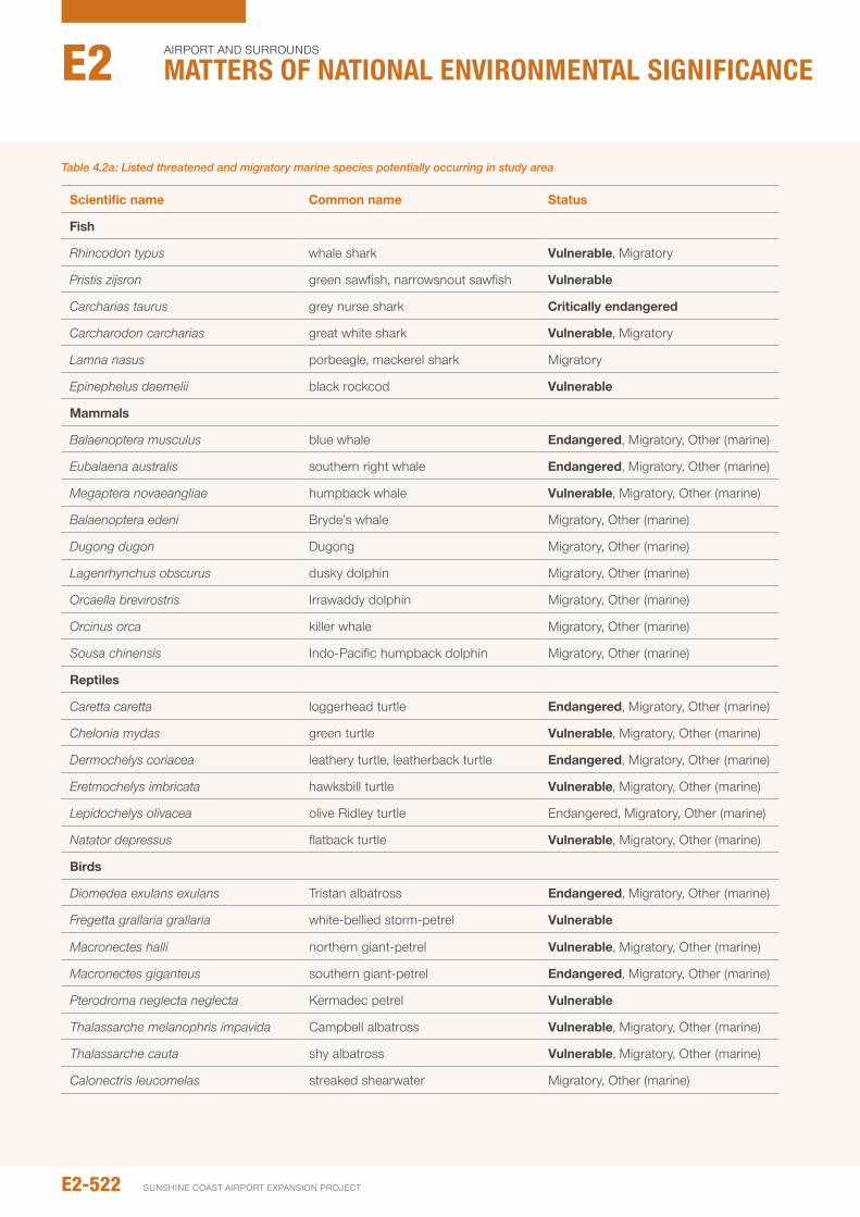
Table 4.2a: Listed threatened and migratory marine species potentially occurring in study area
Scientific name Common name Status
Fish
Rhincodon typus whale shark vulnerable, Migratory
Pristis zijsron green sawfish, narrowsnout sawfish vulnerable
Carcharias taurus grey nurse shark Critically endangered
Carcharodon carcharias great white shark vulnerable, Migratory
Lamna nasus porbeagle, mackerel shark Migratory
Epinephelus daemelii black rockcod vulnerable
Mammals
Balaenoptera musculus blue whale Endangered, Migratory, other (marine)
Eubalaena australis southern right whale Endangered, Migratory, other (marine)
Megaptera novaeangliae humpback whale vulnerable, Migratory, other (marine)
Balaenoptera edeni Bryde’s whale Migratory, other (marine)
Dugong dugon Dugong Migratory, other (marine)
Lagenrhynchus obscurus dusky dolphin Migratory, other (marine)
Orcaella brevirostris irrawaddy dolphin Migratory, other (marine)
Orcinus orca killer whale Migratory, other (marine)
Sousa chinensis indo-pacific humpback dolphin Migratory, other (marine)
Reptiles
Caretta caretta loggerhead turtle Endangered, Migratory, other (marine)
Chelonia mydas green turtle vulnerable, Migratory, other (marine)
Dermochelys coriacea leathery turtle, leatherback turtle Endangered, Migratory, other (marine)
Eretmochelys imbricata hawksbill turtle vulnerable, Migratory, other (marine)
Lepidochelys olivacea olive Ridley turtle Endangered, Migratory, other (marine)
Natator depressus flatback turtle vulnerable, Migratory, other (marine)
Birds
Diomedea exulans exulans Tristan albatross Endangered, Migratory, other (marine)
Fregetta grallaria grallaria white-bellied storm-petrel vulnerable
Macronectes halli northern giant-petrel vulnerable, Migratory, other (marine)
Macronectes giganteus southern giant-petrel Endangered, Migratory, other (marine)
Pterodroma neglecta neglecta Kermadec petrel vulnerable
Thalassarche melanophris impavida Campbell albatross vulnerable, Migratory, other (marine)
Thalassarche cauta shy albatross vulnerable, Migratory, other (marine)
Calonectris leucomelas streaked shearwater Migratory, other (marine)
E2-522
Airport And SurroundS
Matters of NatIoNaL eNvIroNMeNtaL sIgNIfIcaNceE2
SunSHinE CoASt Airport EXpAnSion proJECt
the vessel hull. While dredger-generated noise is normally unlikely to occur at levels that could cause acute hearing damage to marine fauna, it may cause subtle but possibly more widespread increases to ambient noise levels. This may include for example, masking of biologically important sounds (e.g. vocalisations), interfere with dolphin sonar signals or alter fauna behaviour (i.e. noise avoidance).
Specific knowledge on the relative contributions of various noise sources to ambient noise levels is extremely limited, as is information on the effects of noise on marine megafauna in an Australian context. The Brisbane Airport parallel Runway EiS (BAC 2007) notes that the physical structure of Moreton Bay does not promote conditions for extended noise propagation.
For example, it is thought that the shallow sand banks surrounding the sand extraction area would intervene and not facilitate underwater sound propagation. in this regard, unlike deep ocean basins where noise can travel long distances and add cumulatively to background levels, the shallow confined waters of Moreton Bay do not promote such extended propagation. For this reason, noise is likely to be limited to the near-field and therefore noise levels at a particular location would not persist or cause long-term changes to ambient levels.
in general, the most likely impact of underwater noise from the dredger for marine megafauna is the temporary avoidance of the dredger and immediate surrounds. The sand extraction area is not known to be an important feeding, calving area or migratory pathway for dolphins, whales, dugongs or other threatened and/or migratory species, such as humpback whale, great white shark and grey nurse shark. However, it is possible that waters near the sand extraction area may be used as a rest area by humpback whales, or the whales may transit the area to rest in other waters nearby. Given this, impacts to these species are not expected, other than behavioural avoidance.
if present in or near the sand extraction area during dredging, turtles are likely to exhibit a different response to noise than marine mammals. Turtles often remain stationary for long periods (feeding and resting), and based on observations of turtles exhibiting negligible response close to marine piling operations, GHD (2011) suggested that it cannot be assumed that turtles would voluntarily move away from dredging. As discussed below, mitigation measures would be implemented to further reduce the risk of dredging noise effects, as well as the risk of vessel strike by the dredger.
in terms of entrainment, it is possible for the suction at the dredge head to entrain fauna, potentially resulting in fauna injury or mortality. of the marine megafauna, turtles are the group most likely to be affected by this process. Generally, turtles are highly mobile and would tend to avoid the dredger, typically returning to the surface to breath every few minutes. However, they can remain underwater for as long as two hours without breathing when they are resting. Queensland’s foremost expert on sea turtles, Dr Col Limpus, suggests that sea turtles can use navigation channels
as resting or shelter areas, and that there are recorded incidences of turtles being injured by TSHD dredgers. GHD (2005), citing personal communication from Dr Limpus, suggest that the numbers of turtles captured during dredging across all Queensland ports is decreasing, with an average of 1.7 loggerhead turtles per year being captured across all ports. Furthermore, it was suggested that current research indicates that the impact of dredging on the overall viability of turtle populations is very low compared to the numbers killed by boat strikes, trawling, fishing, ingestion of marine debris and indigenous hunting.
Given the relatively low numbers of turtles impacted by dredgers compared to other activities, and the use of effective management and operational practices to reduce the potential for turtle capture, it is not considered that the proposed dredging would have a significant impact on turtle populations in the study area. Best practice dredging techniques would be used to further reduce risks to turtles (refer 4.3.1.2).
When the dredger is operated at night, its on-board lighting system will generate light emissions to the marine environment. Marine turtles are particularly sensitive to artificial lighting as they may become disorientated during nesting and hatching (Witherington 1992). However, no turtle nesting areas exist close to the dredging in Moreton Bay and there is a low incidence of turtle nesting elsewhere in the bay. Further, in the unlikely event that light from the dredger can be detected by emerging hatchlings (e.g. on the eastern coast of Bribie island), the offshore position of the dredger at all times does not pose a risk for guiding hatchlings landward.
Artificial light is not known to have a major effect on foraging patterns of turtles, dolphins or dugongs. Given the rare occurrence of threatened seabirds in the study area, the risk of artificial lighting affecting these fauna is considered negligible. Mitigation strategies would however be undertaken to further reduce potential impacts (refer Section 4.3.1.2).
Seabirds are not expected to be directly affected by other direct dredging interactions, other than behavioural avoidance of the works area. Furthermore, direct interactions with the dredger are not expected to cause adverse impacts to the food resources for marine species of conservation significance. overall, while interactions between the dredger and marine fauna are typically unlikely (although noise-related avoidance behaviour is more likely), they are considered to represent a minor impact, noting that the fauna most likely to be affected are generally species of high conservation significance. With the implementation of the best practice mitigation methods outlined below, it is expected that the likelihood of such interactions would be significantly reduced, resulting in low to negligible residual risk.
E2-523environmental impact statement
4.3.1.2 Mitigation measures
While the sand extraction area is not known to contain large numbers of marine megafauna, management strategies would be implemented throughout the course of the proposed dredging works in Moreton Bay to minimise the risk of interactions with the dredger. These management strategies are set out in Chapter E3 – Dredge Management plan, and would include:
y implementation of a Fauna Management plan
y implementation of megafauna exclusion zones (i.e. maintaining a given buffer distance between the dredger and megafauna) and associated reactive megafauna monitoring program (e.g. regular visual inspections of sand extraction area and dredge path)
y if visual monitoring for megafauna from the dredger detects megafauna within or headed towards exclusion zones, execute strategies to avoid interactions as required (e.g. stopping work in that area if megafauna, especially whales, are within or near exclusion zones; halt dredge vessel transit if potential to encroach on observed whales or their anticipated path)
y operational procedures to minimise the risk of capture of turtles lying on the seabed, especially utilising tickler chains on the dredge head as a fauna exclusion device to reduce fauna entrainment and prevent fauna injury and mortality
y Ensure dredge suction is ceased prior to lifting the dredge head from the seabed
y Where it does not conflict with security and safety requirements, lighting on the dredger would aim for low wattage and/or directional light fixtures.
Together, these mitigation strategies would reduce the likelihood of interactions between the dredger and marine megafauna, such that the overall residual risk of potential impacts to marine megafauna is low for all related mechanisms (i.e. vessel strike, noise, entrainment and light) (refer Table 4.3a).
Marine pests
While marine pests, if present, could be transported from the dredger to the marine environment, the project is not considered to pose a notable risk in terms of the potential of introducing marine pests to Moreton Bay. This is based on the following:
y The dredge vessel remaining in South East Queensland for the duration of the dredging campaign
y As part of the Dredge Management plan, appropriate measures would be in place during construction to reduce the potential for introducing marine pests from the dredger (e.g. compliance with antifouling, hull cleaning and ballast treatment requirements)
y The dredger would be operating in the vicinity of a shipping channel that accommodates numerous international vessels every day (i.e. contributes only a small proportion of local vessel traffic)
y Moreton Bay is not currently known to support populations of marine pests of concern that could be dispersed by the dredger to waters elsewhere.
E2-524
Airport And SurroundS
Matters of NatIoNaL eNvIroNMeNtaL sIgNIfIcaNceE2
SunSHinE CoASt Airport EXpAnSion proJECt
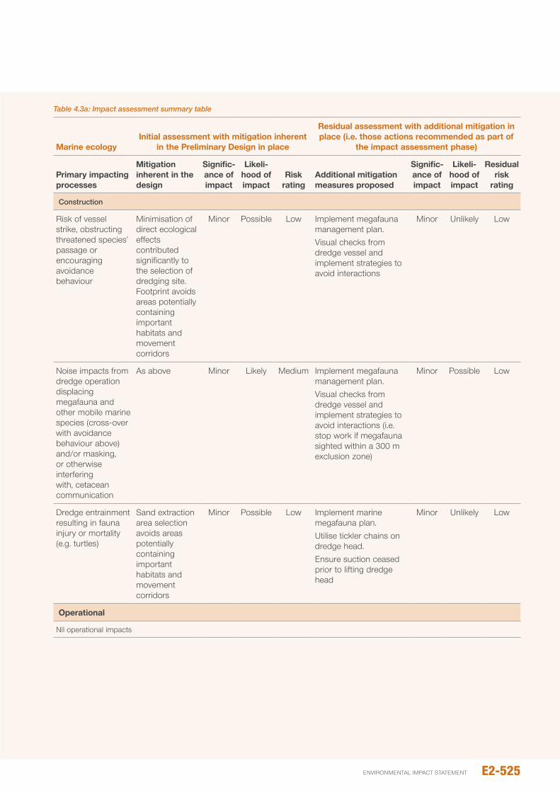
Table 4.3a: Impact assessment summary table
Marine ecologyInitial assessment with mitigation inherent
in the preliminary design in place
Residual assessment with additional mitigation in place (i.e. those actions recommended as part of
the impact assessment phase)
primary impacting processes
Mitigation inherent in the design
Signific-ance of impact
Likeli- hood of impact
Risk rating
Additional mitigation measures proposed
Signific- ance of impact
Likeli- hood of impact
Residual risk
rating
Construction
Risk of vessel strike, obstructing threatened species’ passage or encouraging avoidance behaviour
Minimisation of direct ecological effects contributed significantly to the selection of dredging site. Footprint avoids areas potentially containing important habitats and movement corridors
Minor possible Low implement megafauna management plan.Visual checks from dredge vessel and implement strategies to avoid interactions
Minor unlikely Low
noise impacts from dredge operation displacing megafauna and other mobile marine species (cross-over with avoidance behaviour above) and/or masking, or otherwise interfering with, cetacean communication
As above Minor Likely Medium implement megafauna management plan.Visual checks from dredge vessel and implement strategies to avoid interactions (i.e. stop work if megafauna sighted within a 300 m exclusion zone)
Minor possible Low
Dredge entrainment resulting in fauna injury or mortality (e.g. turtles)
Sand extraction area selection avoids areas potentially containing important habitats and movement corridors
Minor possible Low implement marine megafauna plan.utilise tickler chains on dredge head.Ensure suction ceased prior to lifting dredge head
Minor unlikely Low
Operational
nil operational impacts
E2-525environmental impact statement
SECTION 1 REFERENCES: TERRESTRIAL FLORA
Aguilar R, Quesada M, Ashworth L, Herrerias-Diego Y, Lobo J (2008), “Genetic consequences of habitat fragmentation in plant populations: susceptible signals in plant traits and methodological approaches”, Molecular Ecology 17, 5177-5188.
Barry, S (2005) Wetland Management Profile: Coast and sub-coastal wet heath swamps, Queensland Wetlands program, Queensland Government, Brisbane.
Bartareau, T and S. Skull (1994) “The effects of past fire regimes on the structural characteristics of coastal plain Melaleuca viridiflora Sol. Ex Gaert. Woodland and the distribution patterns of epiphytes (Dendrobium canaliculatum R. BR, Dischidia nummularia R. BR.) in northeastern Queenland” Biotropica, 26, pp. 118-123.
Bostock, p.D. & Holland, A.E. (eds) (2010). Census of the Queensland Flora 2010. Queensland Herbarium, Department of Environment and Resource Management, Brisbane.
Bryan 1973, ‘A review of research findings concerned with pastoral development on the wallum of south-eastern Queensland’, Tropical Grasslands, 7(2) 175-194
Department of Agriculture and Food (Western Australia) 2008, Tolerance of plants to salty water, Farm note no. 71/99. prepared by officers of Agriculture Western Australia and the Chemistry Centre of Western Australia.
Department of Environment and Heritage protection (2012) Regional Ecosystem Details for 12.1.2. Queensland Government, Brisbane. Viewed online 30 August 2012, available at http://www.ehp.qld.gov.au/ecosystems/biodiversity/regional-ecosystems/details.php?reid=12.1.2
Department of Environment and Heritage protection 2013, Coastal and subcoastal non-floodplain wet heath swamp – Geomorphology, viewed online 10th october, available at http://wetlandinfo.ehp.qld.gov.au/wetlands/ecology/aquatic-ecosystems-natural/palustrine/non-floodplain-heath/geomorphology.html
DERM (2006) VMA_PreClearing_Vegetation_2006b_SEQ, GiS data available through the Queensland Department of Environmental and Heritage protection. Queensland Government, Brisbane.
DERM (2011a) Caloundra 9544 – Historical aerial images over 1:100,000 map area from 1958-2008.
DERM (2011) Vegetation Management Act Regional Ecosystems Version 6.1 – SEQ, GiS data, Queensland Government, Brisbane
Dunn GM, Taylor DW, nester MR, and Beetson, TB (1994), “performance of twelve selected Australian tree species on a saline site in southeast Queensland”. Forest Ecology and Management 70:255-264
EcoSmart Ecology and 3D Environmental (2010) Sunshine Coast Airport Master Plan Implementation Project: Preliminary Review of Significant Environmental Factors, Report prepared for the Sunshine Coast Airport.
Environmental protection Agency (2007). National Recovery Plan for the Mt Emu she-oak Allocasuarina emuina. Report to Australian Government Department of the Environment and Water Resources. Queensland parks and Wildlife Service, Brisbane.
EpA (no date) Help plan the management of the Mount Coolum National Park, Queensland Government, Brisbane.
Griffith et al. 2003, ‘Wallum and related vegetation on the nSW north Coast: description and phytosociological analysis’, Cuninghamiana, 8(2) 202-252.
Halford, D. (1993) Allocasuarina emuina (Casuarinaceae): A conservation assessment. Australian nature Conservation Agency Endangered Species program, project no. 317. Queensland Hebarium, Queensland.
Hammermeister, G., Smith, i. and Henderson, B. (no date). Sunshine Coast Airport Wallum Heath Management plan, Sunshine Coast Airport.
Harris, F and Johnson S (2004), “The consequences of habitat fragmentation for plant-pollinator mutualisms”, international Journal of Tropical Insect Science, Vol. 24, iss. 1, pp. 29-43
House, S. Dr., nester, M., Taylor, D., King, J. Dr., and Hinchley, D. (1998) Selecting trees for the rehabilitation of saline sites in SEQ. Technical Paper 52, Department of primary industry Queensland.
James T. A. (no date) New South Wales Flora Online: Durringtonia paludosa R.J.F.Hend. & Guymer, national Herbarium of nSW, Royal Botanic Garden, Sydney. Viewed online 28 August 2012, available at http://plantnet.rbgsyd.nsw.gov.au/cgi-bin/nSWfl.pl?page=nswfl&lvl=sp&name=Durringtonia~paludosa
Kodela, p. G. (no date) New South Wales Flora Online: Acacia baueri Benth. subsp. baueri, national Herbarium of nSW, Royal Botanic Garden, Sydney. Viewed online 28 August 2012, available at http://plantnet.rbgsyd.nsw.gov.au/cgi-bin/nSWfl.pl?page=nswfl&lvl=in&name=Acacia~baueri+subsp.~baueri
Lamont, R (2010) Conservation genetics and ecology of the endangered heathland shrub, Allocasuarina emuina. Submitted in fulfilment of the degree of Doctor of philosophy, February 2010, university of the Sunshine Coast.
LAMR (Landscape Assessment, Management and Rehabilitation pty Ltd 2012, Review of Translocation Project of Heathland from Bundilla to the University of the Sunshine Coast, Report prepared for Stockland pty Ltd at the direction of the Bundilla Translocation Steering Group.
Leiper, G., Glazebriik, J., Cox D., Rathie, K. (2008) Mangroves to mountains: a field guide to the native plants of South-east Queensland. Logan River Branch, Society for Growing Australian plants (Qld Region), Browns plains, Qld.
Marcar n, Crawford D, Leppert p, Jovanovic T, Floyd R, Farrow R (2002) Trees for salt land; a guide to selecting native species for Australia. CSiRo press, Melbourne Victoria, Australia.
E2-526
Airport And SurroundS
Matters of NatIoNaL eNvIroNMeNtaL sIgNIfIcaNceE2
SunSHinE CoASt Airport EXpAnSion proJECt
McFarland (1998) “Fire and the Vegetation Composition and Structure of Subtropical Heathland in South-eastern Queensland”, Australian Journal of Botany, 36(5), pp. 533-546.
neldner, V.J., Wilson, B. A., Thompson, E.J. and Dillewaard, H.A. (2005) Methodology for Survey and Mapping of Regional Ecosystems and Vegetation Communities in Queensland. Version 3.1. updated September 2005. Queensland Herbarium, Environmental protection Agency, Brisbane. 128 pp.
neldner, V.J., Wilson, B.A., Thompson, E.J. and Dillewaard, H.A. (2012) Methodology for Survey and Mapping of Regional Ecosystems and Vegetation Communities in Queensland. Version 3.2. updated August 2012. Queensland Herbarium, Queensland Department of Science, information Technology, innovation and the Arts, Brisbane. 124 pp.
Queensland Department of Environment (1998) Mount Coolum National Park Management Plan, Queensland Government, Brisbane, available at http://www.nprsr.qld.gov.au/managing/plans-strategies/index.html
Queensland parks and Wildlife Service (1999) Maroochy River Conservation Park Management Plan, Queensland Government, Brisbane.
Richards, p. G. (no date) New South Wales Flora Online: Bosistoa transversa J.F. Bailey & C.T. White, national Herbarium of nSW, Royal Botanic Garden, Sydney. Viewed online 27 August 2012, available at http://plantnet.rbgsyd.nsw.gov.au/cgi-bin/nSWfl.pl?page=nswfl&lvl=sp&name=Bosistoa~transversa.
Saunders, A et al 1991, “Biological Consequences of Ecosystem Fragmentation: A Review”. Conservation Biology, Vol 5, no. 1, pp.18-32.
SEWpC (2010) Directory of Important Wetlands in Australia – Information Sheet: Coolum Creek and Lower Maroochy River. Accessed online 21 August 2012. Available at: http://www.environment.gov.au/cgi-bin/wetlands/report.pl?smode=DoiW;doiw_refcodelist=QLD185
SEWpC (2012a) Species Profile and Threats Database: Acacia attenuata, Department of Sustainability, Environment, Water, population and Communities, Canberra. Accessed online 27 August 2012 at http://www.environment.gov.au/cgi-bin/sprat/public/publicspecies.pl?taxon_id=10690
SEWpC (2012b) Species Profile and Threats Database: Allocasuarina emuina — Emu Mountain Sheoak, Department of Sustainability, Environment, Water, population and Communities, Canberra. Accessed online 27 August 2012 at http://www.environment.gov.au/cgi-bin/sprat/public/publicspecies.pl?taxon_id=21926
SEWpC (2012c) Species Profile and Threats Database: Phaius australis — Lesser Swamp-orchid, Department of Sustainability, Environment, Water, population and Communities, Canberra. Accessed online 27 August 2012 at http://www.environment.gov.au/cgi-bin/sprat/public/publicspecies.pl?taxon_id=5872
SEWpC (2012d) Species Profile and Threats Database: Plectranthus torrenticola, Department of Sustainability, Environment, Water, population and Communities, Canberra. Accessed online 27 August 2012 at http://www.environment.gov.au/cgi-bin/sprat/public/publicspecies.pl?taxon_id=55728
SEWpC (2012e) Species Profile and Threats Database: Streblus pendulinus — Siah’s Backbone, Sia’s Backbone, Isaac Wood, Department of Sustainability, Environment, Water, population and Communities, Canberra. Accessed online 27 August 2012 at http://www.environment.gov.au/cgi-bin/sprat/public/publicspecies.pl?taxon_id=21618
Specht R.L. (1970) Vegetation. in: The Australian Environment. 4th edition, ed. G.W. Leeper, pp. 44–67, CSiRo-Melbourne univ. press, Melbourne.
Stockland pty Ltd 2012, Draft Public Environment Report, Volume 2, prepared by Arup pty Ltd, Brisbane.
TSSC (2008a) Commonwealth Conservation Advice on Allocasuarina defungens (Dwarf Heath Casuarina), Threatened Species Scientific Committee, Department of Sustainability, Environment, Water, population and Communities, Canberra.
TSSC (2008b) Commonwealth Conservation Advice on A on Allocasuarina thalassoscopica, Threatened Species Scientific Committee, Department of Sustainability, Environment, Water, population and Communities, Canberra.
TSSC (2008c) Commonwealth Conservation Advice on Arthraxon hispidus — Hairy-joint Grass, Threatened Species Scientific Committee, Department of Sustainability, Environment, Water, population and Communities, Canberra.
TSSC (2008d) Commonwealth Conservation Advice on Baloghia marmorata (Marbled Balogia), Threatened Species Scientific Committee, Department of Sustainability, Environment, Water, population and Communities, Canberra.
TSSC (2008e) Commonwealth Conservation Advice on Bosistoa transversa s. lat. (Three-leaved Bosistoa), Threatened Species Scientific Committee, Department of Sustainability, Environment, Water, population and Communities, Canberra.
TSSC (2008f) Commonwealth Conservation Advice on Bulbophyllum globuliforme (Miniature Moss-orchid), Threatened Species Scientific Committee, Department of Sustainability, Environment, Water, population and Communities, Canberra.
TSSC (2008g) Commonwealth Conservation Advice on Cryptocarya foetida (Stinking Cryptocarya), Threatened Species Scientific Committee, Department of Sustainability, Environment, Water, population and Communities, Canberra.
TSSC (2008h) Commonwealth Conservation Advice on Eucalyptus conglomerata (Swamp Stringybark), Threatened Species Scientific Committee, Department of Sustainability, Environment, Water, population and Communities, Canberra.
TSSC (2008i) Commonwealth Conservation Advice on Macadamia ternifolia (Small-fruited Queensland Nut), Threatened Species Scientific Committee, Department of Sustainability, Environment, Water, population and Communities, Canberra.
E2-527environmental impact statement
TSSC (2008j) Commonwealth Conservation Advice on Phebalium distans (Mt. Berryman Phebalium), Threatened Species Scientific Committee, Department of Sustainability, Environment, Water, population and Communities, Canberra.
TSSC (2008k) Commonwealth Conservation Advice on Prasophyllum wallum (Mt. Berryman Phebalium), Threatened Species Scientific Committee, Department of Sustainability, Environment, Water, population and Communities, Canberra.
TSSC (2008l) Commonwealth Conservation Advice on Triunia robusta, Threatened Species Scientific Committee, Department of Sustainability, Environment, Water, population and Communities, Canberra.
TSSC (2011) Commonwealth Listing Advice on Lowland Rainforest of Subtropical Australia, Threatened Species Scientific Committee, Department of Sustainability, Environment, Water, population and Communities, Canberra.
uDiA (urban Development institute of Australia), no date, UDIA Sustainable Urban Development Matrix: Brightwater Heath Translocation, uDiA Sustainability Committee.
Vallee, L., Hogbin, T., Monks, L., Makinson, B., Matthes, M., and Rossetto, M. (2004) Guidelines for the translocation of threatened plants in Australia. Second Edition. Australian network for plant Conservation, Canberra.
Watson, p (2001) The role and use of fire for biodiversity conservation in Southeast Queensland: Fire management guidelines derived from ecological research. SEQ Fire and Biodiversity Consortium, Brisbane.
Weston, p. H. (no date) New South Wales Flora Online: Taeniophyllum muelleri Lindl. ex Benth., national Herbarium of nSW, Royal Botanic Garden, Sydney. Viewed online 28 August 2012, available at http://plantnet.rbgsyd.nsw.gov.au/cgi-bin/nSWfl.pl?page=nswfl&lvl=sp&name=Taeniophyllum~muelleri
Wilson, K. L. (2005) New South Wales Flora Online: Schoenus scabripes Benth., national Herbarium of nSW, Royal Botanic Garden, Sydney. Viewed online 28 August 2012, available at http://plantnet.rbgsyd.nsw.gov.au/cgi-bin/nSWfl.pl?page=nswfl&lvl=sp&name=Schoenus~scabripes
Young, A, Boyle, T and Brown, T (1996), “The population genetic consequences of habitat fragmentation for plants, Trends in Ecology and Evolution, Vol 1, iss 10, pp. 413-418.
SECTION 2 REFERENCES: TERRESTRIAL FAUNA
Anstis, M. (2002). Tadpoles of South-eastern Australia A guide with keys. Reed new Holland, Sydney.
Adams, M.D., Law, B.S., French, K.o. (2005). Effects of lights on activity levels of forest bats: increasing the efficiency of surveys and species identification, Wildlife Research, 32(2), pp 173-182.
Andreassen, H.p. Halle, S. ims, R.A. (1996). optimal Width of Movement Corridors for Root Voles: not Too narrow and not Too Wide. Journal of Applied Ecology, Vol. 33, no. 1, pp. 63-70.
Andrén, H. and Angelstam, p. (1988). Elevated predation rates as an edge effect in habitat islands: experimental evidence. Ecology 66: 1211-1214.
Andrews, K.M, Gibbons, J.W., Jochimsen, D.M. (2006). Literature synthesis of the effects of roads and vehicles on amphibians and reptiles. Federal Highway Administration (FWHA), u.S. Department of Transportation, Report no. FWHA-HEp-08-005. Washington, D.C. 151pp.
Annette T. Scanlon A, Sophie petit (2009) Effects of site, time, weather and light on urban bat activity and richness: considerations for survey effort. Wildlife Research, 35(8) 821–834
Asia-pacific Migratory Waterbird Conservation Committee (2001). Asia-pacific Migratory Waterbird Conservation Strategy: 2001-2005. Wetlands international - Asia pacific. Kuala Lumpur, Malaysia.
Baker, B.J., Richardson, J.M.L. (2006). The effect of light on male breeding-season behaviour in green frogs Rana clamitans melanota. Canadian Journal of Zoology, 84: 1528-1534
Baker, J., Whelan, R.J. (1994). Ground parrots and Fire at Barren Grounds, new South Wales: A Long-term Study and an Assessment of Management implications. EMu, 94, 300-304.
Baker, J., Whlean, R.J., Evans, L., Moore, S., norton, M. (2010). Managing the Ground parrot in its fiery habitat in south-eastern Australia. EMu, 110, 279-284.
Ball, D. (2004). Distribution and habitat of the false water rat, Xeromys myoides Thomas 1889 (Rodentia: Muridae) in intertidal areas of central eastern Queensland. Memoirs of the Queensland Museum.49 (2): 487-494.
Bamford M., Watkins, D., Bancroft, W., Tischler, G., Wahl, J. (2008). Migratory Shorebirds of the East Asian - Australasian Flyway: population estimates and internationally important sites. [online]. Canberra, ACT: Department of the Environment, Water, Heritage and the Arts, Wetlands international-oceania.
Barker, R. D. and Vestjens, W. J. M. (1980). The food of Australian Birds. i. non passerines’. CSiRo Division of Wildlife and Ecology, Canberra.
Bee, M. A., and Swanson, E. M. (2007). Auditory masking of anuran advertisement calls by road traffic noise. Animal Behaviour74:1765-1776.
Bennett, A. F. (1992). Restoring connectivity to fragmented landscapes: does roadside vegetation have a role? Victoria naturalist, 109. 105-110.
Biosecurity Queensland (2008b). Annual pest Distribution Mapping Database. Available at www.dpi.qld.gov.au.
Birt, p., Markus, n., Collins, L., Hall, L. (1998). urban Flying-foxes. nature Australia, 26: 54-59.
BMT WBM. (2010). Sunshine Coast Airport preliminary Ecological Report (Final Report). Report prepared for ARup pty Ltd.
E2-528
Airport And SurroundS
Matters of NatIoNaL eNvIroNMeNtaL sIgNIfIcaNceE2
SunSHinE CoASt Airport EXpAnSion proJECt
Bradshaw, C.J.A, Field, i.C., Bowman, D.M.J.S., Haynes, C., Brook, B.W. (2007). Current and future threats from non-indigenous animal species in northern Australia: a spotlight on World Heritage Area Kakadu national park. Wildlife Research, 34(6), 419-436.
Bryant, S. L. (1994). Habitat and potential diet of the Ground parrot in Tasmania. EMu, 94. 166-171.
Buchanan, B.W. (1993). Effects of enhanced lighting on the behaviour of nocturnal frogs. Animal Behaviour, 45, 893-899.
Burbidge, A. A. (1996). Essentials of a Good Recovery plan. in. Stephens, S. and Maxwell, S. Back From the Brink: Refining the Threatened Species Recovery process. Department of Environment, Canberra. Available at: www.environment.gov.au/resource/back-brink-refining-threatened-species-recovery-process.
Burbidge, A.A., Manley, B.F.J. (2002). Mammal extinctions on Australian islands: causes and conservation implications, Journal of Biogeography, 29(4), 465–473.
Burton, A. M., olsen, p. (2000). niche partitioning by two sympatric goshawks in the Australian Wet Tropics: ranging behaviour. EMu, 100, 216-226.
Catteral, C. p., Green, R. J., Jones, D. n. (1991). Habitat use by birds across a forest-suburb interface in Brisbane: implications for corridors. pp 247-258. in: nature Conservation 2: The Role of Corridors. Saunders, D. A. and Hobbs, R. J. (Eds). Surrey Beatty and Sons, Chipping norton.
Chan, K., Glover, D.R., Ramage, C.M., Harrison, D.K. (2008). Low Genetic Diversity in the Ground parrot (pezoporus wallicus) Revealed by randomly amplified DnA Fingerprinting. Annales Zoologici Fennici, 45(3):211-216.
Chinathamby K., Reina, R.D., Bailey, p.C.E., Lees, B.K. (2006). Effects of salinity on the survival, growth and development of tadpoles of the brown tree frog, Litoria ewingii. Australian Journal of Zoology, 54:97-105.
Chisholm, A.H. (1924). Seeking rare parrots. EMu, 24:25-32.
Churchill, S. (1998). Australian bats. Reed new Holland, Sydney.
Clancy, G.p., and Andren, M. (2010). The habitat distribution and population size of the Black-necked Stork Ephippiorhynchus asiaticus australis in new South Wales, Corella, 34(4): 81-91.
Claridge, A. W., Lindenmayer, D. B. (1994). The need for a more sophisticated approach toward wildlife corridor design in the multiple-use forests of south-eastern Australia: The case for mammals. pacific Conservation Biology, 1, 301-307.
Claridge, A. W., paull, D. J., Barry, S. (2010). Detection of medium-sized ground-dwelling mammals using infrared digital cameras: an alternative way forward? Australian Mammology, 32, 165-171.
Cogger, H, G. (1994). Reptiles and Amphibians of Australia. Reed Books, nSW.
Dalgleish, E. (1999). Effectiveness of invertebrate and Vertebrate pollinators and the influence of pollen Limitation in inflorescence position on Follicle production of Banksia aemula (Family proteaceae). Australian Journal of Botany, 47, 553-562.
Daly, M., Behrends, p.R., Wilson, M.i., Jacobs, L.F. (1992). Behavioural modulation of predation risk: moonlight avoidance and crepuscular compensation in a nocturnal desert rodent, Dipodomys merriami. Animal Behaviour, 44:1–9.
de Bondi, n., White, J. G., Stevens, M., Cooke, R. (2010). A comparison of the effectiveness of camera trapping and live trapping for sampling terrestrial small-mammal communities. Wildlife Research37, 456-465.
Debus, S. (1998). The birds of prey of Australia: a field guide to Australian raptors. oxford university press, Melbourne.
Department of Environment [DE] (2013). Sprat profile: Grey-headed Flying-fox. www.environment.gov.au/cgi-bin/sprat/public/publicspecies.pl?taxon_id=186. Accessed 29 Dec 2013.
Department of Environment [DE] 2013. Sprat profile: Water Mouse. www.environment.gov.au/cgi-bin/sprat/public/publicspecies.pl?taxon_id=66#threats. Accessed 29 Dec 2013.
Department of Environment and Heritage[DEH] (2006). Significant impact Guidelines for Matters of national Environmental Significance. Commonwealth of Australia.
Department of Environment and Resource Management [DERM] (2010). national recovery plan for the water mouse (false water rat) Xeromys myoides. Report to Department of Sustainability, Environment, Water, population and Communities, Canberra. Department of the Environment and Resource Management, Brisbane.
Department of Environment Heritage, Water and the Arts [DEWHA] (2009b). Significant impact guidelines for 36 migratory shorebird species. Commonwealth of Australia.
Department of Environment Heritage, Water and the Arts [DEWHA] (2009a). Significant impact guidelines for the Vulnerable Water Mouse Xeromys moides. nationally threatened species and ecological communities EpBC Act policy statement 3.20. Commonwealth of Australia.
Department of Environment Heritage, Water and the Arts (2010). Survey Guidelines for Australia’s threatened frogs.
Department of Environment Heritage, Water and the Arts (2011). Survey Guidelines for Australia’s threatened mammals.
Department of Environment, Climate Change and Water nSW (2009). Draft national Recovery plan for the Grey-headed Flying-fox pteropus poliocephalus. Department of Environment, Climate Change and Water nSW, Sydney.
Department of Environment, Climate Change and Water nSW (2009). Draft national Recovery plan for the Grey-headed Flying-fox pteropus poliocephalus. Department of Environment, Climate Change and Water nSW, Sydney.
E2-529environmental impact statement
Dickman, C. R. (1996a). Collaboration of Science and Management in Endangered Species Recovery. in. Stephens, S. and Maxwell, S. Back From the Brink: Refining the Threatened Species Recovery process. Department of Environment, Canberra. Available at: www.environment.gov.au/resource/back-brink-refining-threatened-species-recovery-process
Dickman, C.R. (1996b). impact of exotic generalist predators on the native fauna of Australia. Wildlife Biology, 2:185-195.
Dooling, R.J., and popper, A.n. (2007). The effects of highway noise on birds. The California Department of Transportation, Sacramento.
Dorfman, E. J., Lamont, A. Dickman, C. R. (2001). Foraging behaviour and success of Black-necked Storks (Ephippiorhynchus asiaticus) in Australia: implications for management. EMu, 101, 145-149.
Douglas, J. (2012). Structural differences in slashed heathland: Habitat enhancement of a threatened species. Research paper for the university of the Sunshine Coast.
Duncan, A., Baker, G.B., Montgomery, n. (1999). The Action plan for Australian Bats. national Heritage Trust and Environment Australia, Canberra.
Eby, p. (1991). Seasonal movements of Grey-headed Flying-foxes, pteropus poliocephalus (Chiroptera: pteropodidae), from two maternity camps in northern new South Wales. Wildlife Research, 18, 547-559.
Eby, p. (1998). An analysis of diet specialization in frugivorous pteropus poliocephalus (Megachiroptera) in Australian subtropical rainforest. Australian Journal of Ecology, 23, 443-456.
EcoSmart Ecology (2012). Caloundra South Wallum Sedgefrog Survey and impact Assessment Report. in Caloundra South Draft public Environmental Report, prepared by Stockland, november 2012.
EcoSmart Ecology and 3D Ecological Consulting. (2010). Sunshine Coast Airport Master plan implementation project. preliminary Review of Significant Environmental Factors.
Ehmann, H. (1997). Wallum Sedge Frog. pp 182-187 in Threatened Frogs of new South Wales: Habitats, Status and Conservation. Frog and Tadpole Study Group of new South Wales inc. Sydney, nSW.
Eigenbrod, F., Hecnar, S. J., Fahrig, L. (2009). Quantifying the road-effect zone: threshold effects of a motorway on anuran populations in ontario, Canada. Ecology and Society 14(1): 24. [online] uRL: www.ecologyandsociety.org/vol14/iss1/art24/.
Eyre, T.J., Ferguson, D.J., Hourigan, C.L., Smith, G.C., Mathieson, M.T., Kelly, A.L., Venz, M.F., Hogan, L.D. (2012). Terrestrial Vertebrate Fauna Survey Assessment Guidelines for Queensland. Department of Science, information Technology, innovation and the Arts, Queensland Government, Brisbane.
Forman, R. T. T., Reineking, B., Hersperger, A.M. (2002). Road traffic and nearby grassland bird patterns in a suburbanizing landscape. Environmental Management29:782-800.
Forman, R.T.T., and Alexander, L.E. (1998). Roads and their major ecological effects. Annual Review of Ecology and Systematics, Vol. 29, pp 207-231+C2.
Forshaw, J.M., Cooper, W.T. (2002). Australian parrots (3rd Ed.). Robina: Alexander Editions.
Franklin, i. R. (1980). Evolutionary change in small populations in M. E. Soule, and B. A. Wilcox, editors. Conservation Biology, An Evolutionary–Ecological perspective. Sinauer, Sunderland, MA.
Freda, J. (1986). The influence of acidic pond water on amphibian larvae: a review. Water, Air and Soil pollution, 33, 59-67.
Freda, J., Dunson, W. A. (1986). Effects of low pH and other chemical-variables on the local-distribution of amphibians. Copeia, 2, 454-466.
Garnett, S. T., Szabo, J. K., Dutson, G. (2010). The Action plan for Australian Birds 2010. CSiRo publishing, Canberra.
Geering, A., Agnew, L., Harding, S. (2007). Shorebirds of Australia. CSiRo publishing, Canberra.
GHD. (2011). Significant impact Assessment Report, Sippy Downs Trunk Sewer project. prepared for unitywater, June 2011.
Goldingay, R.L., Taylor B.D. (2006). How many frogs are killed on a road in north-east new South Wales? Australian zoologist, 33 (3).
Gomez-Mestre i., Tejedo, M. (2003). Local adaptation of an anuran amphibian to osmotically stressful environments. Evolution, 57:1889-1899.
Granda, J. R., pena, R.M., pierce, B.A. (2008). Effects of disturbance, position of observer and moonlight efficiency of anuran call surveys. Applied Herpetology, 5, 253-263.
Hall, L, S., Richards, G. (2000). Flying foxes fruit and blossom bats of Australia. unSW press, Sydney.
Hammermeister, G., Smith, i., Henderson, B. (no date). Sunshine Coast Wallum Heath Management plan. Report prepared for Sunshine Coast Airport.
Hariono, B., n., J., Sutton, R.H. (1993). ‘Lead concentrations in tissues of fruit bats (pteropus sp.) in urban and non-urban areas.’ Wildlife Research, 20, 315-320.
Higgins, p. J., Davies, S. J., J. F. (Eds) (1996). Handbook of Australian, new Zealand and Antarctic Birds. Volume 3: Snipe to pigeons. oxford university press.
Higgins, p.J. (1999). Handbook of Australian, new Zealand and Antarctic Birds. Volume 4: parrots to Dollarbirds. oxford university press.
E2-530
Airport And SurroundS
Matters of NatIoNaL eNvIroNMeNtaL sIgNIfIcaNceE2
SunSHinE CoASt Airport EXpAnSion proJECt
Hines, H., Mahony, M., McDonald, K. (1999). ‘’An assessment of frog declines in wet subtropical Australia.’’ Declines and Disappearances of Australian Frogs. A. Campbell, eds., Environment Australia, Canberra, 44-63.
Hines, H.B., Meyer, E.A. (2011). The frog fauna of Bribie island: an annotated list and comparison with other Queensland dune islands, proceedings of the Royal Society of Queensland.
Hobbs, R.J. (2001). Synergisms among habitat fragmentation, livestock grazing, and biotic invasions in south-western Australia. Conservation Biology15, 1522-1528.
Hoskin, C. and Goosem, M. (2010). Road impacts on abundance, call traits and body size of rainforest frogs in northeast Australia. Ecology and Society, 15, accessed online at www.ecologyandsociety.org/vol15/iss3/art15/
House, W. A., Jickells, T. D., Edwards, A. C., praska, K. E. and Denison, F. H. (1998). Reactions of phosphorus with sediments in fresh and marine waters. Soil use and Management, 14: 139–146.
ingram, G., Agnew, L. (2010). Wallum Sedgefrog Litoria olongburensis Surveys and Habitat Assessments for the proposed Sunshine Motorway Duplication (Kawana Way to Mooloolah River interchange) and Multi-modal Transport Corridor (Main Drive to Maroochy Boulevard). prepared January 2010 for the Queensland Department of Transport and Main Roads.
ingram, G.J., Corben, C.J. (1975). The Frog Fauna of north Stradbroke island, with Comment on the ‘Acid’ Frogs of the Wallum. proceedings of the Royal Society of Queensland, 86(9):49-54.
ingram, G.J., McDonald, K.R. (1993). An update on the decline of Queensland’s frogs. pp. 97-303 in Herpetology in Australia: a diverse discipline. (Eds) Lunney, D. and Ayers, D., Royal Zoological Society of new South Wales, Mosman.
James, C. (1996). Conservation genetics of island and mainland populations of the sedge frogs Litoria cooloolensis and Litoria olongburensis. unpublished report to Queensland Department of Environment and Heritage. Department of Zoology, Centre for Conservation Biology, university of Queensland.
Johnstone, R.E., Storr, G.M. (1998). Handbook of Western Australian Birds: Volume 2. passerines (Blue-winged pitta to Goldfinch). Western Australian Museum, perth.
Joseph, L., Toon, A., Schirtzinger, E.E., Wright, T.F. (2011). Molecular systematics of two enigmatic genera psittacella and pezoporus illuminate the ecological radiation of Australo-papuan parrots (Aves: psittaciformes). Molecular phylognetics and Evolution, 59, 675-684.
Jung, K. and Kalko, E. K. V. (2010). Where forest meets urbanization: foraging plasticity of aerial insectivorous bats in an anthropogenically altered environment. Journal of Mammology.91: 144-153
Katti, M., and p. S. Warren. (2004). Tits, noise, and urban bioacoustics. Trends in Ecology and Evolution19:109-110.
Khardi, S. (2008). An experimental analysis of frequency emission and noise diagnosis of commercial aircraft on approach. Journal of Acoustic Emissions, 26, pp. 290-310.
Lahti, D. C. (2001). The ‘edge effect on nest predation’ hypothesis after twenty years. Biological Conservation. 99: 365-374.
Law, B., Mackowski, C., Schoer, L., Tweedie, T. (2000). Flowering phenology of myrtaceous trees and their relation to climatic, environmental and disturbance variables in northern new South Wales. Austral Ecology, 25.160-178.
Leicester, M. (1960). Some notes on the Lewin Rail, EMu, 60, 20-24.
Lewis, B.D., Goldingay, R.L. (2005). population monitoring of the vulnerable Wallum Sedge Frog (Litoria olongburensis) in north-eastern new South Wales. Australian Journal of Zoology, 53, 185-194.
Liem, D.S., ingram, G.J. (1977). Two new species of frogs. Victorian naturalist, 94.255-264.
Lindenmayer, D. B. (2002). plantation Design and Biodiversity Conservation. A Report for the RiRDC/Land and Water Australia/FWpRDC Joint Venture Agroforestry program supported by the natural Heritage Trust. RiRDC publication no 02/019. Rural industries Research and Development Corporation, Barton, ACT.
Lindenmayer, D. B., Cunningham, R. B., Donnelly, C. F. (1994). The conservation of arboreal marsupials in the montane ash forests of the Central Highlands of Victoria, south-east Australia. Vi. Tests of the performance of models of nest tree and habitat requirements of arboreal marsupials. Biological Conservation, 70.143-147.
Lindenmayer, D. B., Fischer, J. (2006). Habitat Fragmentation and Landscape Change: An Ecological and Conservation Synthesis. CSiRo publishing, Canberra.
Lindenmayer, D., Burgman, M. (2005). practical Conservation Biology. CSiRo publishing, Canberra.
Longcore, T., and Rich, C. (2004). Ecological light pollution. Frontiers in Ecology and the Environment 2: 191-198.
Lowe, K., Castley, J.G., Hero, J-M. (2013). Acid frogs can stand the heat: amphibian resilience to wildfire in coastal wetlands of eastern Australia. international Journal of Wildland Fire, 22(7) 947-958.
Marchant, S., Higgins, p. J. (1990). Handbook of Australian, new Zealand and Antarctic Birds. Volume 1.Ratites to Ducks. oxford university press, Melbourne.
Marchant, S., Higgins, p. J. (Eds) (1993). Handbook of Australian, new Zealand and Antarctic birds, Vol 2, Raptors to lapwings. oxford university press, Melbourne. pp122-133.
E2-531environmental impact statement
Martin, L. (2000). Aspects of the Reproductive Biology of the Grey-headed Flying-foxes that explain documented population declines, and support a threatened status. in: proceedings of a Workshop to Assess the Status of the Grey-headed Flying-fox in new South Wales. unpublished report to the nSW Threatened Scientific Committee.
Martin, R., Handasyde, K. (1999). ‘The Koala: natural History, Conservation and Management.’ (university of new South Wales press: Sydney.
Matthews, A., Lunney, D., Gresser, S. Maitz, W. (2007). Tree use by Koalas phascolarctos cinereus after fire in remnant coastal forest. Wildlife Research, 34, 84-93.
McAlpine, C. A., Rhodes, J. R., Bowen, M. E., Lunney, D., Callaghan, J. G., Mitchell, D. L., possingham, H. p. (2008). Can multiscale models of species’ distribution be generalized from region to region? A case study of the koala. Journal of Applied Ecology, 45, 558-567.
McFarland, D. C. (1985). Flowering Biology and phenology of Banksia integrifolia and B. spinulosa (proteacea) in new England national park, n.S.W. Australian Journal of Botany, 33, 705-14.
McFarland, D. C. (1988). The composition, microhabitat use and response to fire of the avifauna of subtropical heathlands in Cooloola national park, Queensland. EMu, 88, 249-257.
McFarland, D. C. (1989). The Ground parrot pezoporus wallicus wallicus in Queensland: Habitat, Biology and Conservation. Report prepared for Division of Conservation, parks and Wildlife; Department of Environment and Conservation, Queensland.
McFarland, D. C. (1991a). The biology of the Ground parrot pezoporus wallicus in Queensland. i. Microhabitat use, activity cycle and diet. Wildlife Research, 18, 169-184.
McFarland, D. C. (1991b). The biology of the Ground parrot pezoporus wallicus, in Queensland. ii. Spacing, calling and breeding behaviour. Wildlife Research, 18, 185-197.
McFarland, D. C. (1991c). The biology of the Ground parrot pezoporus wallicus, in Queensland. iii. Distribution and Abundance. Wildlife Research, 18, 199-213.
McKilligan, n. (2005). Herons, Egrets and Bitterns. Their Biology and Conservation in Australia. CSiRo publishing, Canberra.
Menkhorst, p., Knight, F. (2001). A field Guide to Mammals of Australia, oxford university press.
Meredith, C. W., Gilmore, A. M., isles, A. C. (1984). The Ground parrot (pezoporus wallicus) in south-eastern Australia: a fire adapted species? Australian Journal of Ecology, 9, 367-380.
Merrit, B., Wallis, R. (2004). Are wide revegetated strips better for birds and frogs than narrow ones? The Victoria naturalist, 121, 288-292.
Meyer, E. (2010). Results of frog surveys undertaken in costal reserves managed by the Sunshine Coast Regional Council: February – March 2010. Draft report prepared for Sunshine Coast Regional Council by Ed Meyer.
Meyer, E. A. (2004). Acid adaptation and mechanisms for softwater acid tolerance in larvae of anuran species native to the ‘Wallum’ of east Australia. phD Thesis, university of Queensland.
Meyer, E., Hero, J-M., Shoo, L., Lewis, B. (2006). national recovery plan for the wallum sedgefrog and other wallum-dependent frog species. Report to Department of the Environment and Water Resources, Canberra. Queensland parks and Wildlife Service, Brisbane.
Minton, C., Rosalind, J., Collins, p., Standen, R. (2011). The migration of Eastern Curlew numenius madagascariensis to and from Australia. Stilt, 59, 6-16.
Moritz, C. (1994). Defining ‘Evolutionarily Significant units’ for conservation. Trends in Ecology and Evolution, 9:373-375.
Mougeot, F., Bretagnolle, V. (2000). predation risk and moonlight avoidance in nocturnal seabirds. Journal of Avian Biology, 31:376–386. 94.
Munks, S.A., Corkrey, R., Foley, W.J. (1996). Characteristics of arboreal marsupial habitat in the semi-arid woodlands of northern Queensland. Wildlife Research, 23:185-195.
Murphy S.A., Joseph, L., Burbidge, A.H., Austin, J. (2011). A cryptic and critically endangered species revealed by mitochondrial DnA analyses: the western ground parrot. Conservation Genetics, 12, 595–600.
navara, K.J., and nelson, R. (2007). The dark side of light at night: physiological, epidemiological, and ecological consequences. Journal of pineal Research, 43: 215-224.
nelson, J.E. (1965). Movements of Australian Flying Foxes (pteropodidae: Megachiroptera). Australian Journal of Zoology, 13: 53-73.
npWS (2002). Threatened species of the upper north coast of new South Wales: fauna. nSW parks and Wildlife Service, Coffs Harbour.
ogden, L.J.E. (1996). Collision course: the hazards of lighted structures and windows to migrating birds. Toronto, Canada: World Wildlife Fund Canada and Fatal Light Awareness program.
olsen, p. (1995).Australian birds of prey. (nSW university press: Sydney).
parris, K. M. and Schneider, A. (2008). impacts of traffic noise and traffic volume on birds of roadside habitats. Ecology and Society 14. 29 [online] uRL www.ecologyandsociety.org/vol14/iss1/art29/
parry-Jones, K. A., and Augee, M. L. (1992). Movements of Grey-headed flying foxes (pteropus poliocephalus) to and from a colony site on the central coast of new South Wales. Wildlife Research, 19.331–340.
E2-532
Airport And SurroundS
Matters of NatIoNaL eNvIroNMeNtaL sIgNIfIcaNceE2
SunSHinE CoASt Airport EXpAnSion proJECt
parsons, J. G. Cairns, A., Johnson, C., Robson, S. K. A., Shilton, L. A. and Westcott, D. A. (2006). Dietary variation in spectacled flying foxes (pteropus conspicillatus) of the Australian Wet Tropics. Australian Journal of Zoology, 54, 417–428.
parsons, J.G., Blair, D., Luly, J., Robson, S.K. (2009). Bat Strikes in the Australian Aviation industry, Management and Conservation note.
patriarca, E. and Debernardi (2010). Bats and Light pollution. Report prepared for Ministero dell’Ambiente e della Tutela del Territorio e del Mare of italy and Ministère de l’Écologie, de l’Énergie, du Développement durable et de la Mer of France.
paull, D.J., Claridge, A.W., Cunningham, R.B. (2012). Effective detection methods for medium-sized ground-dwelling mammals: a comparison between infrared digital cameras and hair tunnels. Wildlife Research, 39(6) 546-553.
perry, G., Buchanan, B.W., Fisher, R.n., Salmon, M., Wise, S.E. (2008). Effects of Artifical night Lighting on Amphibiasn and Reptiles in urban Environments. Chapter 16. Herpetological Conservation, 3:239-256.
phillips, S., Callaghan, J., Thompson, V. (2006). The tree species preferences of Koalas (phascolarctos cinereus) inhabiting forest and woodland communities on Quaternary deposits in the port Stephens area, new South Wales. Wildlife Research, 27, 1-10.
pizzey, G., Knight, F. (2007). The Field Guide to the Birds of Australia. (8th Ed). HarperCollinspublishers, Sydney.
Queensland Department of Main Roads (2000). Fauna Sensitive Road Design. Volume 1 - past and Existing practices. Queensland Department of Main Roads, Technology and Environment Division, Brisbane.
Queensland Wader Study Group (QWSG) (2010). Maroochy River Mouth. www.waders.org.au/watching-waders/sites-beyond-moreton-bay/maroochydore-river-mouth/. Accessed 27 Aug 2011.
Read, J. and Bowen, Z. (2001). population dynamics, diet and aspects of the biology of feral cats and foxes in South Australia, Wildlife Research, 28, 195–203
Recher, H. F., Shields, J., Kavanagh, R. p., Webb, G. (1987). Retaining remnant mature forest for nature conservation at Eden, new South Wales: a review of theory and practice. pp 177-94 in, Saunders, D. A., Arnold, G. W., Burbidge, A. A. and Hopkins, A. J. (eds) nature Conservation: The Role of Remnants of Vegetation. Surrey Beatty and Sons, Chipping norton.
Reijnen, R., and Foppen, R. (1994). The effects of car traffic on breeding bird populations in woodland. i. Evidence of reduced habitat quality for Willow Warblers (phylloscopus trochilus) breeding close to a highway. Journal of Applied Ecology 31:85-94.
Reijnen, R., Foppen, R., Meeuwsen, H. (1996). The effects of traffic on the density of breeding birds in Dutch agricultural grasslands. Biological Conservation 75:255-260.
Reijnen, R., Foppen, R., ter Braak, C., Thissen, J. (1995). The effects of car traffic on breeding bird populations in woodland. iii. Reduction of density in relation to the proximity of main roads. Journal of Applied Ecology32:187-202.
Renwick, J. (2006). population structure and genetic diversity of Southeast Queensland populations of the Wallum Froglet, Crinia Tinnula (Tschudi). phD thesis, Queensland university of Technology.
Rhodes, J. R., McAlpine, C. A., Lunney, D., possingham, H. p. (2005). A spatially explicit habitat selection model incorporating home range behaviour. Ecology, 86, 1199-1205.
Rich, C. and Longcore, T. (2006). Ecological Consequences of Artificial night Lighting. island press, Washington DC.
Roberts, B. J., Catterall, C. p., Eby, p., Kanowski, J. (2012). Long-distance and frequent movements of the Flying-fox pteropus poliocephalus: implications for Management. pLoS onE7 (8): e42532. doi:10.1371/journal. pone.0042532
Roberts, B., Kanowski, J., Catterall, C. (2006). Ecology and Management of Flying-fox Camps in an urban Region. issues in Tropical Forest Landscapes. www.rainforest-crc.jcu.edu.au/issues/iTFL_flyingfox.pdf.
Robley, A., Gormley, A., Woodford, M., Lindeman, Whitehead, B., Albert, R., Bowd, M., Smith, A. (2010). Evaluation of camera trap sampling designs used to determine change in occupancy rate and abundance of feral cats. Arthur Rylah institute for Environmental Research Technical Series no. 201. (Department of Sustainability and Environment: Heidelberg, Victoria).
Russell, T.L., Hale, p.T. (2009). Conservation of the false water rat (Xeromys myoides) depends on landscape complementation. Australian Mammology: 31, 81-87.
Salmon, M. (2003). Artificial night lighting and sea turtles. Biologist, 50 (4). pp 163-168
Sanzo, D., Hecnar, S.J. (2006). Effects of road de-icing salt (naCl) on larval wood frogs (Rana sylvatica). Environmental pollution 140:247-256.
SEWpaC (2012a). Register of national Estate (non-statutory archive): noosa-Maroochy Wallum Heath Area, David Low Way, noosaville, QLD, Australia. www.environment.gov.au/cgi-bin/ahdb/search.pl?mode=place_detail;place_id=18881. Accessed 17 Aug 2012.
Shoemaker, V.H. (1992). Exchange of water, ions and gases in terrestrial frogs. in: Environmental physiology of the amphibians. uni. Chicago press.
Shuker, J.D. and Hero, J-M (2012). perch substrate use by the threatened wallum sedgefrog (Litoria olongburensis) in wetland habitat of mainland eastern Australia. Australian Journal of Zoology, 60, pp 219-224.
Simpkins, C.A., Shuker, J.D., Lollbak, G.W., Castley, J.G., Hero, J-M. (2013). Environmental variables associated with the distribution and occupancy of habitat specialist tadpoles in naturally acidic, oligotrophic waterbodies. Austral Ecology, doi:10.1111/aec.12048
E2-533environmental impact statement
Slabbekoorn, H. and Ripmeester, E. A. p. (2008). Birdsong and anthropogenic noise: implications and applications for conservation. Molecular Ecology, 17: 72–83.
Spearritt, A., Krieger, G. (2007). A review of a long term monitoring program of the Ground parrot (pezoporus wallicus wallicus) population within national parks on the Sunshine Coast, south-east Queensland. QpWS parks Service.
Spencer, H. J., palmer, C., and parry-jones, K. (1991). Movements of fruit-bats in eastern Australia, determined by using radio-tracking. Wildlife Research, 18.463–468.
Straughan, i. (1966). An Analysis of Species Recognition and Species isolation in Certain Queensland Frogs. phD Thesis, university of Queensland.
Stringbark Consulting (2012). Vegetation Management plan (Revegetation and Rehabilitation). Lower Mooloolah River Environmental Reserve Lot 37C3147, 1Rp27759 and 2Rp27760. prepared by Stringybark Consulting for Sunshine Coast Council, July 2012.
Sun, J.W.C., and narins, p.M. (2005). Anthropogenic sounds differentially affect amphibian call rate. Biological Conservation, 121: 419-427.
Threlfall, C. G., Law, B. Banks, p. B. (2013). The urban matrix and artificial light restricts the nightly ranging behaviour of Gould’s long-eared bat (nyctophilus gouldi). Austral Ecology.doi:10.1111/aec.12034
Tidemann, C.R. (1998). Grey-headed Flying-fox, pteropus poliocephalus, Temminck, 1824. in: Strahan, R., Ed. The Mammals of Australia. Frenchs Forest: new Holland publishers pty Ltd.
Tidemann, C.R., nelson, J.E (2004). Long-distance movements of the grey-headed flying fox (pteropus poliocephalus). Journal of Zoology, 263(2), 141–146.
Traill, L. W., Bradshaw, C. J. A., Brook, B. W. (2007). Minimum viable population size: A meta-analysis of 30 years of published estimates. Biological Conservation, 139:159-166.
Van Dyck, S Gynther, i. (2003). nesting strategies of the Water Mouse Xeromys myoides in southeast Queensland. Memoirs of the Queensland Museum, 49(1): 453-479.
Van Dyck, S. (1996). Xeromys myoides, Thomas, 1889 (Rodentia: Muridae) in mangrove communities of north Stradbroke island, southeast Queensland. Memoirs of the Queensland Museum.42:337-366.
Van Dyck, S., and Durbidge, E. (1992). A nesting community of false water rats (Xeromys myoides on the Myora sedgelands, north Stradbroke island. Memoirs of the Queensland Museum, 32:374.
Van Dyck, S., Janetzki, S., and Gynther, i. (2003). ‘Artificial nesting Mounds for the Water Mouse, Xeromys myoides’. Memoirs of the Queensland Museum, 49(1):480.
Van Dyck, S., Stratham, R. (2008). The Mammals of Australia, third Ed. Reed new Holland. Sydney.
Van Tets, G.F., Vestjens, W.J.M., Slater, E. (1969). orange runway lighting as a method for reducing bird strike damage to aircraft. Wildlife Research, 14, 129-151.
Vetter, D., Rucker, G., Storch, i. (2013). A meta-analysis of tropical forest edge effects on bird nest predation risk: Edge effects in avian nest predation, Biological Conservation, 159, pp 382-395.
Vine, S. J., Crowther, M. S., Lapidge, S. J., Dickman, C. R., Mooney, n., piggott, M. p., English, A. W. (2009). Comparison of methods to detect rare and cryptic species: a case study using the red fox (Vulpes vulpes). Wildlife Research 36, 436-446.
Watson, p. (2001). The role and use of fire for biodiversity conservation in Southeast Queensland: Fire management guidelines derived from ecological research. SEQ Fire and Biodiversity Consortium, Brisbane.
Welbergen, J. A. (2006). Timing of the evening emergence from day roosts of the grey-headed flying-fox, pteropus poliocephalus: the effects of predation risk, foraging needs and social context. Behaviour Ecology and Sociobiology, 60,311–322.
White, D., White, D. and power, n. (2005). Targeted species surveys of the Sunshine Coast Airport, Marcoola, Maroochy Shire, Queensland. Report prepared for oTEK Australia pty Ltd.
Wilkinson Murray pTY Limited (2013). Sunshine Coast Airport Expansion Terrestrial noise Assessment, Report no. 00605-T Version A
Wilcove, D. S. (1985). nest predation in forest tracts and the decline of migratory songbirds. Ecology 66: 1211-1214
Wilson, S. Swan, G. (2010). A Complete guide to reptiles of Australia, 3rd Ed. new Holland publishers, Australia.
Zanette, L., Doyle, p., Tremont, S. M. (2000). Food shortage in small fragments: evidence from an area-sensitive passerine. Ecology, 81, 1654-1666.
Zimmerman, L., E. Thurman, & K. Bastian (2000). Detection of persistent organic pollutants in the Mississippi Delta using semi-permeable membrane devices. The Science of the Total Environment, 248, 169-179.
SECTION 3 REFERENCES: MARINE ECOLOGy — AIRpORT ANd SURROUNdS
Australian Fish Finder (2012) north Australian Fish Finder, 10th Edition. published by Matt Flynn, Tasmania.
Banks, S.A. and Harriott, V.J. (1995) Coral communities of the Gneering Shoals and Mudjimba island, south-eastern Queensland. Marine and Freshwater Research 46: 1137-44.
E2-534
Airport And SurroundS
Matters of NatIoNaL eNvIroNMeNtaL sIgNIfIcaNceE2
SunSHinE CoASt Airport EXpAnSion proJECt
Bennett, M. and Bansemer, C. (2004) investigations of Grey nurse Shark in Queensland to fulfil actions under the Recovery plan for Grey nurse Shark in Australia regarding diver impacts, establish photographic database, improve knowledge of migratory movements and estimations of bycatch. prepared by the university of Queensland School of Biomedical Sciences, for the Australian Department of Environment and Heritage, Canberra.
BMT WBM (2010) Freshwater Fish Assemblages of Sunshine Coast Airport – Final Report. prepared for ARup by BMT WBM pty Ltd, Brisbane.
Curtis, L.K. and Dennis, A.J. (2012) Queensland’s Threatened Animals. Edited by L. Curtis, A. Dennis, K. McDonald, p.Kyne and S. Debus. CSiRo publishing, Victoria.
BMT WBM (2010) Sunshine Coast Airport Expansion project: Cumulative Sand Extraction Draft – Draft Report. prepared for Sunshine Coast Airport by BMT WBM pty Ltd, Brisbane.
Butcher, A., Mayer, D., Smallwood, D., Johnston, M. (2005) A comparison of the relative efficiency of ring, fyke, fence nets and beam trawling for estimating key estuarine fishery populations. Fisheries Research, 73(3): 311-321.
DAFF (2012) Coastal Habitat Resource information System (CHRiS Database). Queensland Fisheries’ coastal habitat interactive mapping tool and fisheries database. Queensland Government Department of Agriculture, Forestry and Fisheries, Brisbane.
DERM (2007) Moreton Bay Marine park Draft Zoning plan, including regulatory impact statement and draft public benefit trust. Queensland Government Environment protection Agency.
DERM (2010) Environmental protection (Water) policy 2009: Maroochy River environmental values and water quality objectives, Basin no. 141, including all tributaries of the Maroochy River. The State Government of Queensland Department of Environmental and Resource Management.
Department of Environment and Heritage protection (DEHp) (2012) Regional Ecosystem and Remnant Vegetation mapping. Results of database mapping requests, Queensland Department of Environment and Heritage protection, Brisbane.
DnpRSR (2013) Declared Fish Habitat Areas: descriptions and mapped plans. The State of Queensland Department of national parks, Recreation, Sport and Racing, Brisbane.
DSEWpAC (2013) Sousa chiensis in Species profile and Threats Database, Department of Sustainability, Environment, Water, population and Communities, Canberra. Available at www.environment.gov.au/sprat. Accessed 29/01/13.
Dyer, p.K. (2000) Wedge-tailed shearwaters on Mudjimba island, Queensland: numbers and breeding success. Corella, 000, 24(1/2): 15-18.
EpA (unpub.) Moreton Bay Marine park Zoning plan review – Habitat information: Corals. www.nprsr.qld.gov.au/parks/moreton-bay/zoning/information-sheets/pdf/coral.pdf information brochure compiled by Environmental protection Agency, Brisbane.
EpA (1999) information Sheet on Ramsar Wetlands for Moreton Bay Queensland. Ramsar information Sheet compiled by Environmental protection Agency, Division of Environmental planning, Brisbane.
Hacking, n. (1997) Sandy beach macrofauna of eastern Australia: a geographical comparison. phD thesis, university of new England, Armidale.
Healthy Waterways (2012) Ecosystem Health Monitoring program: annual monitoring report card results. published by Healthy Waterways, Brisbane.
Hooked in paradise (2007) Queensland Hooked in paradise: Boating, Fishing and navigation. published by Dennis porter, Gold Coast.
Jones, A., Short, A. (1995) ‘Sandy Beaches’ in Coastal Marine Ecology of Temperate Australia (eds. A. underwood and M. Chapman), institute of Marine Ecology, university of new South Wales press, Sydney.
Limpus, C. (2008a) ‘1. Loggerhead Turtle Caretta caretta (Linnaeus)’ in A Biological Review of Australian Marine Turtles, Environmental protection Agency.
Limpus, C. (2008b) ‘2. Green Turtle Chelonia mydas (Linnaeus)’ in A Biological Review of Australian Marine Turtles, Environmental protection Agency.
Maroochy Waterwatch (2010) Mangrove monitoring results 2010. published online: www.maroochycatchmentcentre.org.au/catchment/?page_id=28 , Maroochy Waterwatch inc.
Maroochy Shire Council (2007) Maroochy Shire State of Waterways Report: 2005-2007. produced by Maroochy Shire Council, Maroochydore.
Stephens, A.W. (1978) The northern entrance to Moreton Bay. pap. Dep. Geol. univ. Qld, 8(2):25-43.,
ozcoasts (2012) ozCoasts – Australian online Coastal information: Estuary Search Database. Australian Government ozCoast (Geoscience Australia) online database., accessed 12/12/12. www.ozcoasts.gov.au/search_data/estuary_search.jsp
Reef Check Australia (2012) Reef Check Australia South East Queensland 2011-2012 Survey Season Summary and Site Data. (eds. A. Lea, J. Loder, C. Byrne), Reef Check Australia, Brisbane.
Rossi, F., Forster, R., Montserrat Trotsenburg, F., ponti. M., Terlizzi, A., Ysebaert, T., Middleburg, J. (2007) Human trampling as short-term disturbance on intertidal mudflats: effects on macrofauna biodiversity, microphytobenthos and population dynamics of bivalves. Maroine Biology, 151: 2077-2090.
E2-535environmental impact statement
Schlacher, T. A., Thompson, L.M., Walker, S.J. (2008) Mortalities caused by off-road vehicles (oRVs) to a key member of sandy beach assemblages, the surf clam Donax deltoides. Hydrobiologia, 610:345-350.
Schlacher, T. A., Richardson, D.L., and McLean, i. (2008b). impacts of off-road vehicles (oRVs) on macrobenthic assemblages on sandy beaches. Environ Manage, 41(6), 878-892.
Schlacher, T.A., Thompson, L.M., price, S. (2007) Vehicles versus conservation of invertebrates on sandy beaches: quantifying direct mortalities inflicted by off-road vehicles (oRVs) on ghost crabs. Marine Ecology, 28: 354-367.
Schlacher, T.A., Thompson, L.M. (2007) Exposure of fauna to off-road vehicle (oRVs) traffic on sandy beaches. Coastal Management, 35: 567-583.
Seuront, L., Leterme, C. (2006) Microscale patchiness in microphytobenthos distributions: evidence for a critical scale. in: Functioning of microphytobenthos in estuaries, Royal netherlands Academy of Arts and Sciences, pp167-185.
Teske, p.R., Wooldridge, T.H. (2003) What limits the distribution of subtidal macrobenthos in permanently open and temporarily open/closed South African estuaries? Salinity vs sediment particle size. Estuarine and Coastal Shelf Science. 57:225-238.
The Coordinator-General (2012) Sunshine Coast Airport Expansion project, Terms of Reference for an Environmental impact Statement. published by the Queensland Government (The Coordinator-General’s office), May 2012, Brisbane.
Turtle Care (2012) Turtle Care Sunshine Coast: online information sheets for Caretta caretta and Chelonia mydas. www.urtlecare.sunshinecoast.qld.gov.au/loggerhead-turtle.php
udy, J. and Levy, D. (2002) Deep seagrasses and coral habitats found in eastern Moreton Bay. www.marine.uq.edu.au/marbot/publications/pdffiles/deepseagrasspercent20.pdf Accessed online 15/12/12.
underwood, G.J.C. (2001) Microphytobenthos, university of Essex, Academic press. in: Encyclopaedia of ocean Sciences, accessed at www.elearning.zaou.ac.zm:8060/Science/oceanography/, 02/02/2013.
university of Queensland (2006) Moreton Bay Saltmarsh. Brochure produced by the Centre for Marine Studies marine Botany Group, university of Queensland, Brisbane.
WBM (2002) Moreton Bay Sand Extraction Study phase 1. prepared for Moreton Bay Sand Extraction Steering Committee, by WBM oceanics Australia, Brisbane.
WBM (2005a) Seagrass survey for proposed Spitfire sand extraction project. prepared for the port of Brisbane Corporation, by WBM oceanics Australia, Brisbane.
WBM (2005b) Moreton Bay Sand Extraction Study phase 2 – Benthic Fauna Assessments. March 2004. prepared for Moreton Bay Sand Extraction Steering Committee, by WBM oceanics Australia, Brisbane.
Webley, J., Taylor, S., Mayer, D., Dew, K., olyott, L. (2008) Survey of marine boat-based recreational fishing in south-eastern Queensland (2007-2008), Queensland primary industries and Fisheries.
SECTION 4 REFERENCES: MARINE ECOLOGy — dREdGING ANd dREdGE MOvEMENTS
Anderson, J.R. (1993) State of the Rivers: Maroochy River and Tributary Streams. prepared by J.R. Anderson (university of new England – northern Rivers) in conjunction with Maroochy Shire Council and the Queensland Department of primary industries.
Australian Fish Finder (2012) north Australian Fish Finder, 10th Edition. published by Matt Flynn, Tasmania.
BAC (2007) Brisbane Airport Corporation new parallel Runway project: Draft Environmental impact Statement and Major Development plan for public Comment, Volume C – Middle Banks, Moreton Bay. produced by Brisbane Airport Corporation, Brisbane.
BMT WBM (2010) Freshwater Fish Assemblages of Sunshine Coast Airport – Final Report. prepared for ARup by BMT WBM pty Ltd, Brisbane.
BMT WBM (2012) Sunshine Coast Airport Expansion project: Cumulative Sand Extraction Draft – Draft Report. prepared for Sunshine Coast Airport by BMT WBM pty Ltd, Brisbane.
BMT WBM (208) Turbidity monitoring of the ‘Volvox Asia’ at the Spitfire Realignment – 2008. prepared for the port of Brisbane Corporation by BMT WBM pty Ltd, Brisbane.
BMT WBM (2007) Brisbane Airport parallel new Runway EiS. Marine Ecology Chapter prepared by BMT WBM on behalf of Brisbane Airport Corporation, Brisbane.
Campbell, S.J., McKenzie, L.J. (2004) Flood-related loss and recovery of intertidal seagrass meadows in southern Queensland, Australia. Estuarine, Coastal and Shelf Science 60:477-490
Chartrand, K.M., Rasheed, M.A., Sankey, T.L. (2012) Deepwater seagrass dynamics in Hay point – measuring variability and monitoring impacts of capital dredging. Final report to the ports Corporation of Queensland.
Coles, R., McKenzie, L., Campbell, S., Mellors, J., Waycott, M., Goggin, L. (2004) Seagrasses in Queensland Waters – Current State of Knowledge, March 2004. CRC Reef Research centre publication, Townsville.
Curtis, L.K. and Dennis, A.J. (2012) Queensland’s Threatened Animals. Edited by L. Curtis, A. Dennis, K. McDonald, p.Kyne and S. Debus. CSiRo publishing, Victoria.
DAFF (2012) Coastal Habitat Resource information System (CHRiS Database). Queensland Fisheries’ coastal habitat interactive mapping tool and fisheries database. Queensland Government Department of Agriculture, Forestry and Fisheries, Brisbane.
E2-536
Airport And SurroundS
Matters of NatIoNaL eNvIroNMeNtaL sIgNIfIcaNceE2
SunSHinE CoASt Airport EXpAnSion proJECt
Davie, p., Hooper, J, (1998) patterns in biodiversity in marine invertebrate and fish communities of Moreton Bay. in: Tibbetts, i.R., Hal, n.J., Dennison, W.C. (eds) Moreton Bay and Catchment, School of Marine Science, university of Queensland, Brisbane.
DERM (2007) Moreton Bay Marine park Draft Zoning plan, including regulatory impact statement and draft public benefit trust. Queensland Government Environment protection Agency.
DERM (2010) Moreton Bay Marine park user Guide. Queensland Government Department of State Development and the Department of Environment and Resource Management.
Department of Environment and Heritage protection (DEHp) (2012) Regional Ecosystem and Remnant Vegetation mapping. Results of database mapping requests, Queensland Department of Environment and Heritage protection, Brisbane.
DnpRSR (2013) Declared Fish Habitat Areas: descriptions and mapped plans. The State of Queensland Department of national parks, Recreation, Sport and Racing, Brisbane.
DnpRSR (2012) Moreton Bay Marine park Zoning plan History – Dugong. The State of Queensland Department of national parks, Recreation, Sport and Racing, Brisbane. Accessed 12/12/12, www.nprsr.qld.gov.au/parks/moreton-bay/zoning/information-sheets/dugong.html
Duarte, C.M., Terrados, J., Agawin, n.S.R., Fortes, M.D., Bach, S., Kenworthy, W.J. (1997) Response of a mixed philippine seagrass meadow to experimental burial. Marine Ecology progress Series. 147:285-294.
DSEWpAC (2012) Rhincodon typus in Species profile and Threats Database, Department of Sustainability, Environment, Water, population and Communities, Canberra. Available at www.environment.gov.au/sprat. Accessed 12/12/12.
DSEWpAC (2012b) Carcharodon carcharias in Species profile and Threats Database, Department of Sustainability, Environment, Water, population and Communities, Canberra. Available at www.environment.gov.au/sprat. Accessed 12/12/12.
DSEWpAC (2012b) Caretta caretta in Species profile and Threats Database, Department of Sustainability, Environment, Water, population and Communities, Canberra. Accessed 12/12/12. at www.environment.gov.au/sprat.
DSEWpAC (2013) Sousa chiensis in Species profile and Threats Database, Department of Sustainability, Environment, Water, population and Communities, Canberra. Available at www.environment.gov.au/sprat. Accessed 29/01/13.
EpA (unpub.) Moreton Bay Marine park Zoning plan review – Habitat information: Corals. www.nprsr.qld.gov.au/parks/moreton-bay/zoning/information-sheets/pdf/coral.pdf information brochure compiled by Environmental protection Agency, Brisbane.
EpA (1999) information Sheet on Ramsar Wetlands for Moreton Bay Queensland. Ramsar information Sheet compiled by Environmental protection Agency, Division of Environmental planning, Brisbane.
GHD (2005) port of Hay point Apron Area and Departure path Capital Dredging Draft Environmental impact Statement. prepared for ports Corporation of Queensland.
Hacking, n. (1997) Sandy beach macrofauna of eastern Australia: a geographical comparison. phD thesis, university of new England, Armidale.
Hale, p., Long, S. and Tapsall, A. (1998) Distribution and conservation of delphinids in Moreton Bay. in: Tibbettss, i.R., Hall, n.J. and Dennison, W.C. (eds) Moreton Bay and Catchment, School of Marine Science, The university of Queensland, Brisbane. pp.365-394.
Healthy Waterways (2012) Ecosystem Health Monitoring program: annual monitoring report card results. published by Healthy Waterways, Brisbane.
Hooked in paradise (2007) Queensland Hooked in paradise: Boating, Fishing and navigation. published by Dennis porter, Gold Coast.
Hyland, S.J., Courtney, A.J. and Butler, C.T. (1989) Distribution of seagrass in the Moreton Region from Coolangatta to noosa. Queensland Department of primary industries (Fisheries Research Branch), Brisbane.
Jones, A., Short, A. (1995) ‘Sandy Beaches’ in Coastal Marine Ecology of Temperate Australia (eds. A. underwood and M. Chapman), institute of Marine Ecology, university of new South Wales press, Sydney.
Limpus, C. (2008a) ‘1. Loggerhead Turtle Caretta caretta (Linnaeus)’ in A Biological Review of Australian Marine Turtles, Environmental protection Agency.
Limpus, C. (2008b) ‘2. Green Turtle Chelonia mydas (Linnaeus)’ in A Biological Review of Australian Marine Turtles, Environmental protection Agency.
Limpus, C.J., Couper, p.J. and Read, M.A. (1994) The green turtle, Chelonia mydas, in Queensland: population structure in a warm temperate area. Memoirs of the Queensland Museum 35:139-154.
Longstaff, B.J., Longeran, n.R., o’Donahue, M.J. and Dennison, W.C. (1999) Effects of light deprivation on the survival and recovery of the seagrass Halophila ovalis (R.Br.) Hook. Journal of Experimental Marine Biology and Ecology 234:1-27.
Maroochy Waterwatch (2010) Mangrove monitoring results 2010. published online: ww.maroochycatchmentcentre.org.au/catchment/?page_id=28 , Maroochy Waterwatch inc.
Maroochy Shire Council (2007) Maroochy Shire State of Waterways Report: 2005-2007. produced by Maroochy Shire Council, Maroochydore.
Stephens, A.W. (1978) The northern entrance to Moreton Bay. pap. Dep. Geol. univ. Qld, 8(2):25-43.
E2-537environmental impact statement
orth, R.J., Harwell, M.C., inglis, G.J. (2006) Ecology of seagrass beds and seagrass dispersal processes. in Seagrass Ecology, Biology and Conservation (eds. A. Larkum, R. orth, C. Duarte), Springer, netherlands.
preen, A.R. (1992) interactions between dugongs and seagrasses in a subtropical environment. phD thesis, James Cook university.
Reef Check Australia (2012) Reef Check Australia South East Queensland 2011-2012 Survey Season Summary and Site Data. (eds. A. Lea, J. Loder, C. Byrne), Reef Check Australia, Brisbane.
Smith, S.D.A., Rule, M.J. (2001) The effects of dredge spoil dumping on a shallow water soft sediment community in the Solitary islands Marine park, nSW. Marine pollution Bulletin 42: 1040-1048.
The Coordinator-General (2012) Sunshine Coast Airport Expansion project, Terms of Reference for an Environmental impact Statement. published by the Queensland Government (The Coordinator-General’s office), May 2012, Brisbane.
Turtle Care (2012) Turtle Care Sunshine Coast: online information sheets for Caretta caretta and Chelonia mydas. www.turtlecare.sunshinecoast.qld.gov.au/loggerhead-turtle.php
udy, J. and Levy, D. (2002) Deep seagrasses and coral habitats found in eastern Moreton Bay. www.marine.uq.edu.au/marbot/publications/pdffiles/deepseagrass percent20.pdf Accessed online 15/12/12.
university of Queensland (2006) Moreton Bay Saltmarsh. Brochure produced by the Centre for Marine Studies marine Botany Group, university of Queensland, Brisbane.
WBM (2005) Seagrass survey for proposed Spitfire sand extraction project. prepared for the port of Brisbane Corporation, by WBM oceanics Australia, Brisbane.
WBM (2004) Moreton Bay Sand Extraction Study phase 2 – Benthic Fauna Assessments. March 2004. prepared for Moreton Bay Sand Extraction Steering Committee, by WBM oceanics Australia, Brisbane.
WBM (2002) Moreton Bay Sand Extraction Study phase 1. prepared for Moreton Bay Sand Extraction Steering Committee, by WBM oceanics Australia, Brisbane.
WBM (1995) Spitfire Channel Benthic Assessment program. Report prepared for port of Brisbane Corporation by WBM oceanics Australia, Brisbane.
Witherington, B.E. (1992) Behavioural responses of nesting sea turtles to artificial lighting. Herpetologica 48: 31-39.
E2-538
Airport And SurroundS
Matters of NatIoNaL eNvIroNMeNtaL sIgNIfIcaNceE2
SunSHinE CoASt Airport EXpAnSion proJECt

This page has been left blank intentionally
E2-539environmental impact statement