altimetry over ice · table of contents 1.0 2.0 preface introduction geo-referenced data base polar...
TRANSCRIPT

v?- = - -_ 2_=_
, - __:: _S_2 \
( - _ -- - • - _ L_:__ %2 -
2
Satellite Radar
Altimetry Over Ice
Volume 2--Users" Guide for
Greenland Elevation Data
From Seasat
H. Jay Zwally,
Judith A. Major,
Anita C. Brenner,
Robert A. Bindschadler,
and Thomas V. Martin
=
E
E
=
2
https://ntrs.nasa.gov/search.jsp?R=19900011247 2018-07-20T19:37:43+00:00Z


NASAReferencePublication1233, Vol.
1990
N/_ANational Aeronautics and
Space Administration
Office of Management
Scientific and TechnicalInformation Division
2
Satellite Radar
Altimetry Over Ice
Volume 2--Users" Guide forGreenland Elevation Data
From Seasat
H. Jay zwally
Goddard Space Flight Center
Greenbelt, Maryland
Judith A. Major and Anita C. Brenner
ST Systems Corporation
Lanham, Maryland
Robert A. Bindschadler
Goddard Space Flight Center
Greenbelt, Maryland
Thomas V. Martin
Van Martin Consulting, Inc.
Rockville, Maryland


TABLE OF CONTENTS
1.0
2.0
PREFACE
INTRODUCTION
GEO-REFERENCED DATA BASE
POLAR STEREOGRAPHIC ELEVATION GRID
GEOID GRID
TABLES
APPENDIX
REFERENCES
V
13
17
19
77
82
iii
.... INTEI_ONAEtTPRECEDING PAGE BLANK NOT FILMED

PREFACE
A gridded surface-elevation data set and a geo-referenced data base for the Seasat radar
altimeter data over Antarctica are described in this volume. It is intended to be a "user's guide"
to accompany the data provided to data centers and other users. The grid points are on a polar
stercographic projection with a nominal spacing of 20 km. The gridded elevations are derived
from the elevation data in the geo-referenced data base by a weighted fitting of a surface in the
neighborhood of each grid point. The gridded elevations are useful for the creating of large-scale
contour maps, and the gco-referenced data base is useful for regridding, creating smaller-scale
contour maps, and examtnating individual elevation measurements in specific geographic areas.
Tape formats are described, and a FORTRAN program for reading the data tape is listed and
provided on the tape. For more details of the data processing procedures and corrections that
were derived and applied to the data, see Volume 3 of this series.
_E [(/ _LE_,ILOW_,_LYBLAN_


SECTION 1.0
INTRODUCTION
This volume is the fourth in a series documenting the data-processing methods and ice
data products derived from satellite radar altimeter measurements over the ice sheets of
Greenland and Antarctica and surrounding sea ice. A gridded elevation data set and a
geo-referenced data base for the Seasat radar altimeter data over Antarctica are described in this
volume. It is intended to be a "user's guide" to accompany the data provided to data centers
and distributed to various users on a magnetic tape. The gridded elevations are useful for
creating large-scale contour maps, and the geo-referenced data base is useful for regridding,
creating smaller-scale contour maps, and examinating individual elevation measurements in
specific geographic areas. For more details of the data processing procedures and corrections
that were derived and applied to the data, see Volume 3 of this series.
The grldded elevations are on a polar stereographic projection with a nominal spacing
of 20 km between grid points. The gridded elevation value for each grid point is derived from
the geo-referenced data base by a weighted fitting of a biquadratle function (or a bllinear function)
to the elevation data that fall within a certain radius of the grid location. The geo-referenced
data base contains surface elevations ordered in geographic bins.
The input Seasat radar altimeter data, in the form of Geophysical Data Records (GDR's)
and Sensor Data Records (SDR's) produced by NASA's Seasat project at the Jet Propulsion
Laboratory, was obtained from the NOAA Environmental Satellite Data and Information Service
(EDIS) archive on about 1000 magnetic tapes. Development of the data processing methods, the
production of hlgher-level geophysical data products, and analysis and evaluation of the data have
been supported at the Goddard Space Flight Center by funding for research and data analysis,
provided primarily by NASA's Ocean Processes Program and by the Climate program. Computer
programming and technical assistance has been provided by the EG&G Washington Analytical
Services Center, Inc. through December 1988 and by ST Systems Corporation since January
1989. Numerous other individuals have provided valuable assistance.
Results have been reported in refereed scientific literature (e.g., Brenner et al., 1983;
Martin et al., 1983; Zwally et al., 1983; Thomas et al., 1983; and Gundestrup et al., 1986). In
addition, elevation data in various forms have been provided to other scientists and placed in the
National Snow and Ice Data Center (NSIDC) and the National Space Science Data Center (NSSDC).
The purpose of this series of reports is to document technical details and provide guidance to
users of the ice data products.

Whileall reasonablequality-controleffortshavebeenmadeto eliminateerroneousdata,somedataof questionablequality is likely to havepersisted,particularlyin the lower-leveldataproducts. Usersshouldapplynormalstandardsof scientificcaution in their use of the data.
The current list of reports is:
Satellite Radar Altimetry over Ice,Volume 1: Processing and Corrections of Seasat Data
over Greenland, July 1989. NASA Ref. Publ.
Satellite Radar Altimetry over Ice, Volume 2: User's Guide for Greenland Elevation Data
from Seasat, July 1989. NASA Ref. Publ.
Satellite Radar Altimetry over Ice, Volume 4: User's Guide for Antarctica Elevation Data
from Seasat, July 1989. This volume.
Volume 3 will be the Antarctic equivalent of Volume 1. Additional volumes will include
descriptions of the data sets being produced by NASA from the radar altimeter data acquired by
the U.S. Navy's GEOSAT, using methods similar to those for the Seas, at data.
The Seasat spacecraft (e.g., Lame and Born, 1982 and Lame et al., 1980) was launched
in late June 1978, and during its brief, 110-day lifetime, collected 90 days of nearly continuous
radar altimeter data from July 9 through October I0 between the latitudes of 72°S and 72°N.
Although designed only for measurements over water, the Seasat radar altimeter (MacArthur,
1978; Tapley et al., 1982; and Townsend, 1980), acquired more than 800,000 useful altimeter
range measurements over the continental Ice sheets of Greenland and Antarctica.
Over sloping and undulating surfaces, such as ice covered land, or surfaces with highly
variable reflecting characteristics, such as in regions of sea lee, the range to the surface and the
characteristics of the received radar pulse changed faster than the response capability of the
altimeter electronics. Consequently, it has been necessary to correct each range value for lags of
the altimeter range servo-tracking circuitry by a procedure called retracking (Martin et al., 1983).
The retracking correction typically had a mean value of + 1.4 m as applied to the surface
elevation, a standard deviation of 2.9 m, and maximum and minimum values of -+ 15 m. In
addition, the pulse-limited footprint (1.6 km minimum diameter), which was located near the
satellite nadir point over the relatively flat ocean, was in general located anywhere within the
beam-limited footprint (22 km in diameter) over sloping surfaces. The resulting slope-induced
error, which was nearly 80 m over slopes of 0.8 degree, can be partially corrected using the
procedures described in Brenner et al., 1983. Corrections are also made for errors in orbit
determination, atmospheric propagation path-length variations, and earth and ocean tides.

Elevationmeasurementswere obtained at 0.!-see intervals, corresponding to 662 m
intervals along the subsatellite ground track. The precision of the corrected range measurements
is about 1.6 m overall with a minimum of about 0.25 m in the smoothest regions of the ice sheets
(Zwally et al., 1983). The 5- to 10-cm precision over the ocean Is for l-see data averages. The
absolute accuracy of the elevations is primarily determined by the limitations on the correction
methods for the slope-induced errors and by uncertainties In the geoid reference level.
The principal ice data sets produced and retained are:
Level 4: Contour maps and gridded elevations with respect to earth ellipsoid and sea
level (e.g., this volume and Volume 4).
Level 3: Geo-referenced data base including all individual elevation measurements
(including time, latitude/longitude positions, and slope-correction estimates) accessible
by geographic cells (e.g., this volume and Volume 4).
Level 2: Ice Data Records (IDR's). Orbital-format data records including altimeter
parameters, corrected elevations, latitude/longitude positions, AGC, applied corrections,
retracking beta parameters, and estimates of along-track and cross-track slope corrections.
(See Volumes 1 and 3.)
Level I: Waveform Data Records (WDR's). Orbital-format data records including waveform
amplitudes by gate, ranges, AGC, and latitude/longitude positions. (See Volumes I and
3.)
Altimeter Sensor Data Records (SDR's)
The magnetic tape with the gridded elevation and geo-refereneed data base was generated
on an IBM 3081. The data sets are contained on several files of this unlabeled, 6250-bpi tape.
The geo-referenced data base is written on the first two files (see Tables 2 and 3). A FORTRAN
program, which can be used to unload and read the data base on files 1 and 2 on the IBM 3081
is written on file 3 in ASCII. A listing of this source may also be found in the Appendix. The
elevation grid over the Greenland ice sheet is written on files 4 and 5 (see Tables 4 and 5). It
is important to note that the elevations in the data base are relative to the ellipsoid, while the grid
elevations are relative to sea level. The Goddard Earth Model 10-B (GEM10-B) geoid grid which

wasusedto obtainelevationsrelativeto sealevelis written on files 6 and 7 (seeTables6 and
7). File8 containsdetailedinformationin ASCIIconcerning the location of various revs and the
number of points in the geo-referenced data base in order of geographical area. File 9 contains
a narrative description of the tape including the version number, dates of the data and specific
information on the sources used to reduce the raw data to surface measurements and grid values
(see Table 8). All files except files 3, 8 and 9 have been written in IBM binary integer format.
Blocksizes vary for each file and are given in the tables of file descriptions.
4

SECTION2.0GEO-REFERENCEDDATABASE
Thegeo-referenceddatabasecontainssurfaceheightmeasurementsderivedfrom Seasataltimeh3rdata,orderedby geographicareasor "bins". Thedistribution of the Seasatdata usedin the data base is shown in Figure I. Figure 2 shows the configuration of the 4,300 bins in the
vicinity of Greenland. Bin sizes vary in order to compensate for the higher data density near
Seasat's maximum extent in latitude. Each bin is assigned a number starting with 1 in the
southwestern-most corner. Bin numbers increment first from west to east and then from south
to north. The starting bin numbers for each row are indicated in the left margin of the map in
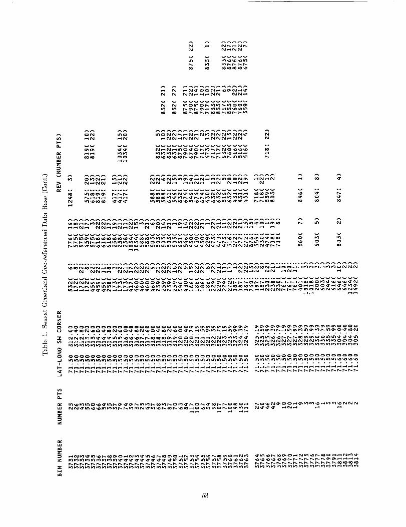
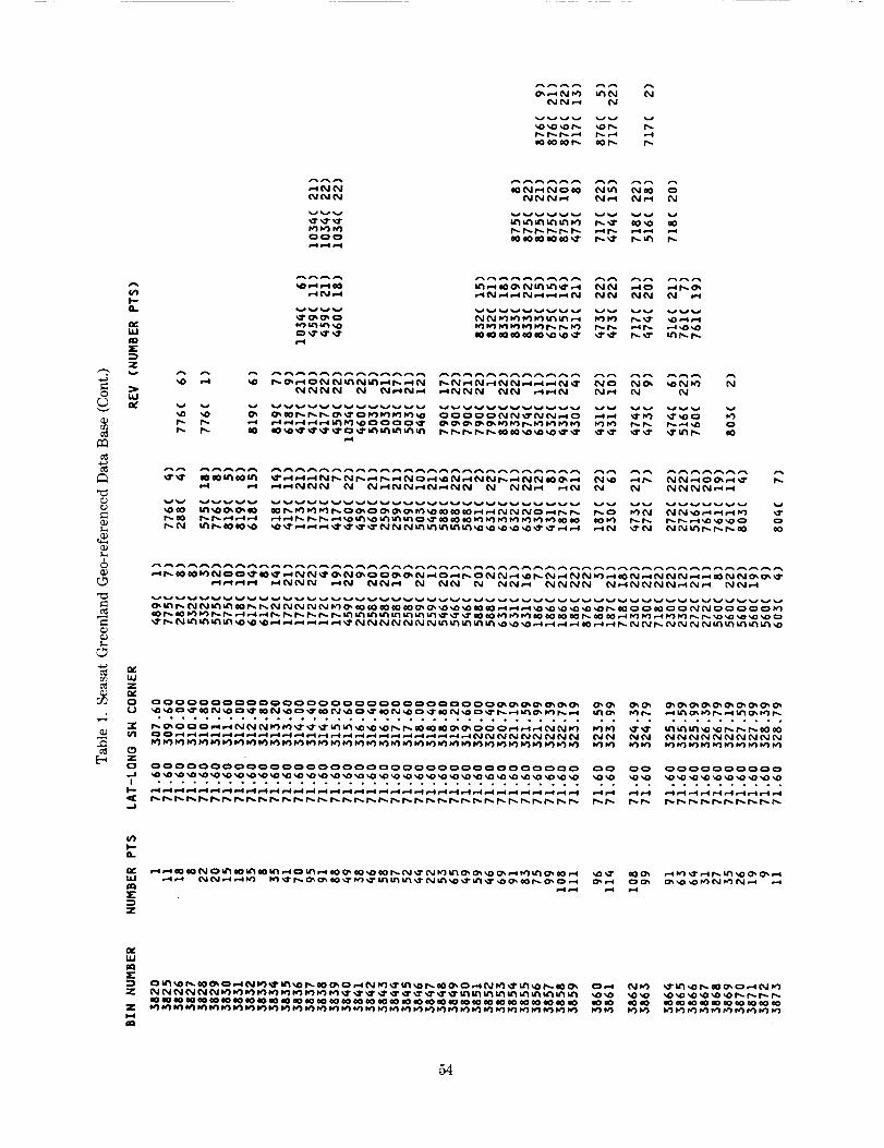
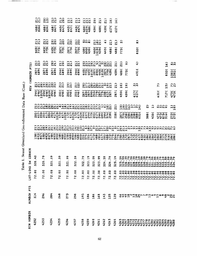
Figure 2, while the number of data points is printed within the appropriate bin. Table 1 is a
sample page of the information contained on file 8 of the tape and summarizes the number of
points and the rev numbers found in each bin, along with the geo-referenced coordinates of the
southwestern-most corner of the bin. Only bins which contain data are listed on file 8 of the
tape. The table is written as fixed block in ASCII with a record length of 132 bytes and blocksize
of 19,008 bytes.
The geo-referenced data base is structured such that the data are ordered first by bin
number and then by time within each bin. Each data point within each bin contains information
relating to the position, rev number, surface height relative to the ellipsoid, slope correction and
orbit adjustment. Corrections which have been applied to the surface elevations are indicated by
the altimetry data status word in the data base header record found on file I of the accompanying
tape. A detailed explanation of all the corrections may be found in Reference 5. The orbit
adjustment has been applied to the surface elevation when it was available. Records for which
the orbit adjustment is unavailable (as indicated by a value of-999999999 in bytes 21-24) have
the unadjusted surface elevation in bytes 9-12. The user should be aware that using all the
surface elevation values without checking if the orbit adjustment was valid or not will result in
an inconsistent data set. The slope correction values are supplied on each data record but have
not been applied to the surface elevation. The orbit adjustment will improve on the radial
accuracy of the orbit. The slope correction will compensate for the fact that the original altimeter
height is measured to the closest point within the radar beam, which is not necessarily the
subsatellite point. When the slope correction is unavailable a value of-999999999 is placed in
that field. In order to obtain a slope-corrected surface elevation relative to the ellipsoid the
following algorithm would be used:
AHco R = HDB - AHsLoP E (1)


ORIGINAL PAGE IS
OF POOR QUALITY
O
O
_ ,1'
PRECEDING PAGE BLANK NOT FILMED
\
_, '1, '\ \
\
\\\
_J
I-,
¢J
b..,

A
MJ
MJ
t_
0uua
uut_
_-°_
n-i-n-oZ b'_ q •
BIN
#I
. . . _ :!-]
.EA_ST LONG!TUDE (DEGREES)
X- :" 4: •
Figure 2. Greenland Data Base Configuration.
8
• iPO01

BIN #4300,
IJJ
i
I
2 313 _I_ 3t3 3!6. 317 318 319. 320 32_ 322 323 32_ 325. 326 327 32_ 329 ]30 3]l 332 333 ]3_ 335. ]_, 337 338. _39 34_
EAST LONGITUDE (DEGREES)
9
ORIGINAL P,_G_. iS
OF POOR QUALITY

where
AHco R
HDB
AHsLoPE
is the surface elevation with the slope correction applied
is the surface elevation in the data base
is the slope correction.
To remove the orbit adjustment, the following algorithm should be used:
AHuNAD J = HDB + AHoR B (2)
where
HUNADJ
HDB
AHoRB
is the surface elevation without the orbit adjustment
is the surface elevation in the data base
is the orbit adjustment.
The data base is designed to be used on a direct-access device, so that data from one or
several bins may be accessed without the need to read all the records prior to the location
desired. This is achieved by dividing the data base into three sections.
The first section of the data base, a header which may be found on file 1 of the
accompanying tape, gives a summary of its configuration: the locations of the corners of the data
base, the number of latitude rows, the width in degrees of each of these rows, and the number
of longitude divisions in each row. These pieces of information give the layout of the data base,
as depicted in Figure 2. Information pertaining to the size of the data base, the starting record
of the bin directory, and the corrections applied to the data are also contained in this header.
Following the header and contained on file 2 of the tape are the altimetry data ordered
by bin number and within each bin by time. The altimetry data are subdivided into two
subgroups for each bin which contains data. The first subgroup consists of one logical record
which indicates the number of data points contained in the bin. The second subgroup consists
of the actual altimetry data (position, rev number, surface height, orbit adjustment and slope
correction), with each record corresponding to a data point.
The final section, a bin directory also contained on file 2, starts at the logical record
indicated in the data base header. The directory contains an entry for each bin, and starting
with the first bin, indicates the record number in the data base at which the start of the data
from a particular bin may be found. Bins which contain no data have a zero entered in the
directory. Tables 2 and 3 summarize the structure of the data base header and data base in
greater detail.
I0

Thedatabase may be used to locate data within any desired area. The following example
demonstrates how this may be done. The limits of the desired area are used in conjunction with
the header information to determine exactly which bin numbers contain the data. Using the
southernmost latitude of the desired area along with the width of the latitude rows, establishes
the southernmost row which contains the data. Longitude limits of the desired area are then
checked in conjunction with the size and location of the longitude divisions in that row. When
the longitude limit of the desired area for that latitude group is exceeded, the process starts again
with the next latitude row to the north. These steps are repeated until the northernmost
boundary limit of the desired area is reached.
Equipped with the bin numbers which contain the data, the directory, which gives the
logical record on the dlrect-a_ disk at which each bin begins, is read. If the directory value
for the bin is non-zero, this logical record is then read to determine the number of records which
follow and are contained in the same bin. The subsequent data is then read for each bin.
Software has been developed for use on the IBM 3081 which reads the geo-refereneed
data base on the first two files. A program which reads and prints out the contents of every bin
given the southeastern and northwestern latitude-longitude limits of a desired area is listed in the
Appendix and may be found on file 3 of the accompanying tape. The file is in ASCII, is fixed-
blocked with a record length of 80 bytes, and is blocked at 3,200 bytes. Latitudes should be
input in degrees North and longitudes in positive degrees East. The subroutine RANDRD along
with its entry point RANDWR read and write one logical record of data, respectively, utilizing a
system supplied direct access FORTRAN I/O package which includes DREAD and DWRITE. The
entry points BLKRD and BLKWR read and write blocks of data at a time.
11


SECTION3.0POLARSTEREOGRAPHICELEVATIONGRID
A grid was generatedusing the corrected and adjusted surface elevations in the
geo-refereneed data base after applying the slope correction. Data for which either the orbit
adjustment or slope correction were unavailable were not used for the grid. Elevations in the grid
were obtained by taking data located in the vicinity of each grid point and fitting them to a
bilinear or biquadratlc surface to determine the surface height at the grid point. GEM 10-B geoid
values were subtracted from the elevations so that they are relative to sea level (see Section 4.0).
The accompanying grid was generated in a tangent polar stereographic projection where
the plane of projection is located at the geographic North Pole (the projection latitude) and is
normal to the earth's axis. Figure 3a depicts the concept behind this type of projection. A
straight line is drawn from the South Pole (pole of projection), through a point of the earth's
surface, Q, to the projection plane which Is tangential to the North Pole. The projection plane
is in turn divided into square grids from the pole to the Equator with the North Pole at the
center. Three projection parameters define the size of the plane and the orientation of the plane
and grid size:
S B a conversion factor from half-inch grids at the projection latitude to the desired
grid size;
_bp - the minimum latitude extent of the map perimeter for the projection latitude
located at the North Pole; the maximum latitude extent for the projection latitude
located at the South Pole;
G - the Greenwich orientation in degrees.
In the case of Greenland, where 20 km grid cells were decided as being optimum for the data
distribution, values of S= 1.65, _p = 50 °, and G=45 ° were chosen.
These three parameters are sufficient to define a grid of the northern hemisphere, from
the North Pole to 50 ° latitude where the number of grids of desired size from the pole to the
Equator may be represented by:
2R (3)D =Sx 106
PRECEDING PAGE BLANK NOT FIL_,_ED
13

where R is the radius of the earth measured in one half-inch grid cells and was chosen to be
consistent with polar stereographic projections described in other documents.
The integer number of grids of desired size from the pole to the map perimeter is:
N = D x tan 90 - [¢_p[ {4)2
The grid, defined by I and J axes, with the origin in the upper left corner (see Figure 3b),
represents the coordinates of the North Pole as:
Ip = N+l
Jp = N+ 1
(5)
Any point with latitude @ and longitude A which is located in the northern hemisphere
north of ¢_p is positioned at the following I, J coordinates:
where
I = INT[d x A x cos(X) + Ip + 0.5]
J = INT[d x sln(X) + Jp + 0.5]
90-d is D x tan
X isA+G
A is +1 if_p>0
A is -I if_bp < 0
2
(6)
The included grid was generated such that smoothed heights relative to the ellipsoid are
located at each of the I, J coordinates within Greenland. Grid locations outside Greenland and
any undefined points within Greenland are indicated by a -100000000. Figure 4 depicts a
topographic map obtained from this grid contoured at 100-m intervals.
File 4 of the accompanying tape contains a grid header which gives information defining
the polar stereographic projection used. File 5 contains the grid points which were obtained
using either a biquadratic or bilinear fit. Details concerning the gridding procedure may be found
in Reference 5. Data are stored on file 5 such that the information for ten grid points is
contained in one block of data. The order of grid points is first from decreasing to increasing I,
then from decreasing to increasing J. Tables 4 and 5 give detailed description of files 4 and 5.
14

(a)NorthPole
I
q_p_
-._ D=2R =i
/Proecon
SouthPole
(b)I
Longitude
Figure 3. Polar Stereographic Projection of Point Q with Latitude _b and Longitude X.
15

0
0
\o
0
0
cO
b0
0
cO
i
___jo0 0
6 _
=
o
.._ L
01
L
E
16

SECTION4.0GEOIDGRID
In order to obtain icesheetelevationsrelative to sea level, the geoid was subtracted from
each grid elevation. Geoid values were bllinearly interpolated from the lxl-degree GEMI0-B
(Goddard Earth Model IO--B) geold grid. Figure 5 shows a contour of this geoid in the vicinity
of Greenland. Files 6 and 7 of the accompanying tape contain the header information and GEM
10-B Ixl-degree grid. Tables 6 and 7 give detailed descriptions of these files. Any values of the
geoid not located on the map in Figure 4 are set equal to -100,00qO00 in the grid.
17

o
C
0
CO
18
\
/
!
/
--6--
oS co
0
d
WL.
=o
o
_D
L
@
@
8

TABLES
19

N _ N N _ _ _ N N
_°°°°°°_ oo o°00o_ o00_o00 O0 0_000 0
°°°o°°ooo° oo ,o°°°° •
Q
Z
O 00_00_0000 O0 0000_0 0
............... ooo o
_0000000 O0 00_
0 00000 000_00 0 0
d dg£_ _ d
_ 00000 0 0
• o o ° o ° •
°°°°_, N °= ° =°0000 O0 0 O0
• • . . 0 • ° • • o ,
00000 0 O0 0 O0
.......... •
_NNN N NN N NN
(/1
I--
ILl _ N _."t N _'1 N NO I_
E"-t
Z
E
Z
N
2O

vg vv vvvv
r-4 _1"
_ _ -- NN_N _ _ _N
AAA _ _A_A_A
Z
0 _
¢J
r_ LU
o_ Z
"¢ Q,--_ N
• o
vvv v_
¢_ NN_
_N __
A__A_AAAA_ _AA_
_¢_hNNN_ N_NNN
AAA_AAAAAAAAAAAA'AAAAAAAA_AAAA_A_AAAAAA_AAAAA_A_AAA_A
vvvvvvvv _v
0000 _ _ 0 0 O0 0000 0 000
0000 0 0 0 0 O0 0000 0 000• ....... • .....
0000 0 0 0 0 O0 0000 0 000
{_{ { N N N NN NNNN N _......... o .... • °o.
NNNN N _ _ _ _ _ _ _
00000000 O0 O0 O0......... -- ,. oo
00_00000 O0 O0 O0
........ oo oo o.
n
Z
N_N _ _ _ _
ILl
E
=) ,--_N
NN
Z
N NNNN N N N N NN NNNN N R_
21

7.
O
e0
N N '_r
0,,, Urt _ _,0 r,_ '_1" U"I
_r i,vl I% N P,- e0 u,,_e-i_l e..,i
vv
._1-o4 p,,.
r4 i-.I
AAAA
_N
u_
u_ P4_
I_. NN_-( r-I
_N _N _ AA
N _
I'_ p,I i,irt M
cO 1".-."4 N.-,i i-.,i
AAA_
_AAAAAA AA AAA AAAAAAA_A^AAAAA_AAA _ AAAAAAAAAAA_AA
A^^^AAAAAAAAAAAAAA^AAAAAAAAAAA_AAAAAAAAAAAAAAAAAA_AAA
U 000000 000 000 O0 OONO_¢NO_¢N o _NO{_¢NO{_¢ N 0_¢
0-.0,, 00. °0. o. =,° ....... =.. • °.._o.00..o, . °,..
z0 0oo000 o0_ oo0 O0 0o00000000000 0 _0_00_ _ _0
I 0o*0°,0-=.o*0 °=,--=,,--°= • *.o.
N_ _N_ _ N NH N_ NE
Z
22

AAAAA AA_A
_ N
I-n
Z_'_ v
_ I'1
v vv
(0 N _0 N N ,,,.1"_
_dd
A _AAAAAAAAAAA _ A AA_AAAAAA A
_A_
_ N
_N _
_N_N_ N N _¢_¢_
N _¢ NN _
AAAAA^AA A_AA_AA
AAAAAAAAAA_AAAAAAAAAAAA_A_AAAAAAAAAAA_AAAA_AA_AA_AA
_a__ _ _ _ _ _ _ _ N _N_N_N
v_vvvvvvvvvvv_v_v_v_vvv_vv_vvv_vv_v_vv_v__
0 0_000_00 0 000_0000_000 0 00000000_000000
0 NO_¢NO_ ¢ NO_¢ONO_¢NO_ _ CNO_¢NO_NO_¢NO°-0 .................. ,. 0 .o0.oo.0oo .... 0.
Q
z
...... 0 ............................. .,o.
0 000_
..... 0
O OOOOOO OOOO_
• o.00o
23

N N _ u'_ u'_ _ N I",.,. I','1
o0 I,_'1 N
A
_D '_0, Nf-I
AA
NN
z
CN_ NN_ _ ¢_
_._0N o_ _0 o o N _" N'_r
_NN_Nk_=_NN=
AAAA_AAAAAAAAAAAA_AAAAA_AAAAA_AAAAAAAAAA_AA^_AAAA_
NNNN_N__NN_NN____NNNN__NN_
Z
O OooO_OO_OOOO o ooOOOOOoo O_OoOOOO.OOO_OOOOO O O__
• ..... . ........... • ............. ,, ............. °
_d_NNOOOOOH_ H __H_H NNNNOOOOO_dH__ _ NNNNNN
Z
| 0o0-0,0 ........... 00o, .00o.,o0,,,o,,=oo0. 0 ,0.0.0
Z
24

I_IN
N I.")
r,,,4 r,,,i
NN
BN
A
E...,j
0
_ Z
N'_AA _A_ AAAAAA
N
_AAA _AAA_A A_AAAA A
N _ _ _ N
N
i,-,i
NOble _¢_ =eNN_N{N
¢:I ¢ N N o,_ IcI _ _ r-,-i",,-,-_ ,.-I ,--i.'I i'-.MI _II _ ,,,.I-_,_ ¢=,
_AAA A_AAA_A_AAAN_N_ _¢_N_¢¢_H
_NN_
N _
AAAAAAA_AAAAA_AAAA_AAAAAA_AAAAAAAAAA^A_AAAA_A_AAA^A__N¢_¢_NO¢_N{_NN¢O_N_{_¢_N__NN_{__NN
0 0000000o_00_0 o 00o__00000oo000ooooo00 0 o _ooo
................. , .... .,°., .....................
_ OOOOO_NNNH_H _ H_NNNNNNNOOOOOOHH_HH_HH_H H _ _
O
z
; ____ _ __NNNNNNNNNNNNNNNNNN N N NNNNI .................... • ......................... ,,
25

O
L_
.,d
=
_3
r4
W ¢0
E
Z
UJ
• -i NN I_IN
_N _ __N NN
N_N
dd _ NN N RR N O¢_
_ N oo _ Oo _ _N
(_0 ,o*,N
e0 '_1=e0 l,_11i-,,,. I.,"1
'_'N
,_1" 0',,
W'INl,.,.¢
_1 =,,-¢
r,,,,, r.,,.
e0 ¢o Ni.-i
_ _ _ N_h N _h _¢¢N
_AAAAA_AAAAAAAAAAA_AAAAAA_AAA_AAAAA_AAAA_^A^AAAA_AAA
_RNdN_NNN_d_¢_dhNdN__N_ONNd_NN_¢_NNNH=N_dd d dR _dRNNNN_dN N d d N
U.I
Z0¢
O(J
:E
(._
Z
O.JI
I'-
..I
0')
Z
O_O_OOOOOOOOO
oo,=o..o .....
NNNNNNNNNOOOO
OOO_O_OO_O
NNNNNNNNN_.... ooo°ooo.o
OOOOOOOOOOOOOO
ooooo.,ooooo.o
OO_OOOOOOOOOOO
...o. ........ •
O
O
OOOOOOOOOOOOOOOOOOOO
°..oo...,oo....o,oo.
__NNNNNNNNNOOOOO
OOO_OO_OO_OOOOOOOO
o.o°o ...............
_{¢R=_RNRNNN__
UJ
_r
Z
Z
26

0"3
I'-
0..
Ill
E
O I,U
¢J
6
I.U
r./2 O
_J
-¢c_ (//
zO
I
I--
I-
n
tlJ
Z
N O_ N'_lr NtiI i,-,I _ imh-_ =,-,I
_AAAAAAAAAAAAAA_AAAAAAAA_AAAAAAAAAAAAAAAAAAAA_AAAAAAA
O_OO_O_O_O_O
000000000000 0
o°°00o°o°°,o .
N
[,1
Z
Z
_NNNNNNNNN_R
0o0o0000_0_0
27

O
¢J
Q.
0¢
LU
]E
Z
UJ
AA AA
'_N N
AA AAAAAAAAAA_AAAAAA A A_AA A_AA AA A_AAAAAA_AAA
v_vvv_vuvv_v
AA_AAAA_AAAA_AAAA_AA_AAA_AAAA_AA_AAAAAAAAAAAA_A^A
U..IZ
0U
X
¢PI
L_
Z
0
I"-
.J
I--
E
Z
o ooooooooooooooooooo_oooooooooOoo O_oooooooooooooo
• 000,,.=,.0o0o°0.0==,.o=,===o.,°,°, .° .......... 0.o°
_hN_=O_d_O_d_d_¢_¢_N__N_NN¢_N _ _ _
N_RO_NR_¢¢_¢N¢N __N_
UJ
E
Z
28

©
QJr._
¢.J
Q..;
Q..;
N
N _ N N
P,I P,i P(
_ N NN _N
(Z3
I'--
,"v' r_
I,,u eo
E:3
zv A
LU
e_uJ
z
o o
"_ N(/1 N
(3
Z
..I ¢_I
I-- ¢0
._1
V1
I--O.
ILl I_
_AAAA_AAAA_A_AAAA_AAAAAAAAAA_AA^AAAA_AA_A_AA_A_A
_ N N NN_N_ _ __N NN N
vvvvvvvvvvvvv_vvvvvvvvvvvvvvvvvvvvvvvvvvvvvvvvvvvv vvv
0000_0_000_00
°°°.° ............
_0000000_000_000
__ONNNNNNNNNNo,_o_..oooo.°°.o
ooooo0o_o_o_ooo_o_o_ooo_ooo
_NNNdNdNddd_NNNNNNNNNNNNNO__
_0_000_000_00_0000000000000000000
NNNNNNNNNNNNNNNNNNNNNNNNNN_¢_¢¢¢.,o.ooo,o.oo°oooo..o.o°,o,.0o ....
N_{_{_N_N¢__NN _ NN_
LI.I
Z
I--I
_N__N__
N NNNNNNNNNNNNNNNNN NNNNNNNNNNNNNNNNNNNNNNNNNN_R__
29

C,
¢)
¢)¢J
L_
0,'11
I,--eL
e.,'
Ill
I="
..j,,
U.I
o
O N
(M Ni.-,I
_A AA AA A AA AA
_AAAA _AA AAAAA_AAAAAA_A _ AA AAAAAAA _A_AA_AAAAA
W N _ _ _ _N_ _ NN_ _NNN_
^AAAAAAAAAAA_AAAAAAAAAAAAAAAAA_AAAAAAAAAAAAAAAA_AAAA_
_HN_N_ _NN_ N R R _ N NR N_ _
0¢UJ
Z
0U
3_Oq
0
Z
C)
1'--
(/1
I-.
U.I
Z
....o.oo........o..o.o.o.o...o.o. ...... ..0..o. .......
_H_H__NNNNNNNNNNNNNNNOOO__d_d_ddd_dd_NN
oo.°o.ooo.._°oo°o°°o°.°.oo.°oooo°oo°o,o°°°oo°o.ooo°o°
Ill
E
Z
Z
3O

O
_2
¢J
6
E_
0.
r.,
UJ
E
Z
UJ
NN
NN ,-i ,,-I NN _I _,-._N N _I N N ,-i _.-.I_'I ..4
AAA_AAAAAAA_AAA^AAAAAA_AAAAAAAAAAA_AAAAAA_AA_A_AAA___O¢_N__O¢_N_O_NNH_N__¢¢_N_NCN_
n_Ill
Z
n_0
L)
¢3
N!
k-
I--
lg
Z
OOOOOOOOOOOOOOOOOOO
_N_R¢_=_O_N_OONNNNNNNNNNN_OOO_
O_OOOOOOOOOOOOOOOO
,ooo.o,,*.,,.o,o=o,
OOOO_OOOOOOOOOOO_OOOOOOOOOOOOO_OO
• ...... • ......... • ...............
OOOOO_O_OOOOO_OO_O_OOOOOOOOOO
.°°°o_°_°o,°°_.°°°,°°°°°°.° .... °°
_ _{N_¢_NRO_¢_ _ N
U.I
E=).
Z
ZI-I
OOOOOOOd_dd_ddddNNNNNNNNN_R_RRR_
31

0
_J
6
S.
)-
eL
r.,LU
X
LU
r_
AP_
F'q _')
_V
e0_00N
_ AAAA AA_NhN _
AAA _AAA AAAAAAA AAAA A AA
N _'3 N _,elN ,..4
u,-.I
AAAAAAAAAAAAA_AAAAAA_AA_AAAAAAAAAAA_AAAAAAAAAAh_AAAA
0
Z0
e,
Z
r.,
hi
E
Z
Z
H
32

_J
rj_ UJZ
0
X
(.:3Zo..J
II--
..3
I.-
E
Z
AP_A A AAAAA_AAAA_ A_A
AAA_AAA_AAAAAAAAA_AAAAAAAAAA_AA_AA_A_AAA_AAAAA_AA_AAA
dNd dH d _NHRNN_ d d
NNN_NNNNN¢¢¢NNNNNN__¢NN_N_NNN_¢¢_N_¢¢_NNN
00000000000000000_0_00000000000000000000000000000_000NNNNNNNNNNNNNNNNNNNNNNNNNNNNNNNNNNNNNNNN_¢¢¢¢¢¢_¢¢¢¢¢
ooo°o.o_o°o°oo..o,.oo°oo,o°o,,.,o,.oo_o..oo,ooo...oo,
==
Z
ZI,-I
33

=
_J
0.
W
E
Z
UJ
n_UJ
n_
OL)
O
_JI
.J
n_UJ
e0
ir
Z
AA
_V
NNr-t r-_
_A_A
_NN_
_NNh
NNN_
N
N
A_A_AA _ A_
N N NI'_I NI',_ I,_IN
............. _ g
_AAAAAAA _A _ ^AAA_ A AA A _A
AAAAAAAA_AAAAAA^AAAAA_AAA_AAA_AAAAAAAA_A_AAA_AAAAAA
__NN¢_N_NH¢_N_NCNN__NN__¢¢_
v_vvvvvvvvvvv_v_v_v_vv_v_vv_v_v_vvvvv_v_v_v
NNNNNNN_NN_{_N_N_NN_{O___NN_{_{_NN
ooooOoOoo_ooOooooooOOOooOOooo_oo_ooooOOo_O_°°_°
.o°...oo.o..°..°.o.o.00o.0o.0.o°°0,.o.°o,. ...... ,o.,o
E
Z
34

A
(,qI'"
U,J
J=lE
=:D-,j,.V
O U.I
¢JE:
Q,,,)
=
E:
L_
r_ i,IZ
(J
-.¢
w
zo
t,-
._,,i
I,.,-
D,.
u..i
E
z
A
N
?-.,
N
N
AAA_AAAAAAAAA_AAAAAAA_AAAAA_AAAA_AAA_AAAAAA_AAAAA_AAA
_vv_vvvvvvvvv_v_vvvvvvv__vvvvvvvvvvvvvuvvvvvvvvvvv
NO¢_N_o¢_N_O¢_R__R__NoCN_N¢_N_O¢{N_O.................. o0 ..... , ............... 0=.0,00,o0,.
H__H_NNNNNNNNNNNNNNNN__OOooooo___
O_la.I
E
ZH
.35

r.-I
I--,P.
U.I
I="
Z
ILl
,y
¢.J
Q,,)
r_ U.I
(J
E_ z0
I
I"-
-.I
(/1
I,'-D.
U.I
=E
Z
,-, ,_U"I
" 7oN oON
A_ _A A A _A_ A_ AA
_AAAAAAAAAAAAAAAAAAAAAAAAAA_AAAAAAAA_A_
_N_ N_ _N_N _ _
o.....°o ..... ..o..o.o..... .......... • ................
00_0000000_0000_0000000000000_0000_0_00000_0000_
• .,0,. .... °.°°_°o°°o°o°o°°°,°o°o°°°_° ..... °°°.°_oo°°°
D_1,1
Z
Zi.-i
==
_______NNNNNNNNNNNNNNNNNNNNNN
36

AA
NI'_
N
0000C000
',,0 '_D
©
L_
r_
¢J
L_
I-"O-
ILl
=E
Zv
I.LI
,v
I%=..=1 g-4
O
O_ N
cO o_4
_ N__N
_ N
N N d N_N_N
_N N N
vv_vvv_
A_AAAAAAAA_A_A_AA_A_AAAAAAAAAAAAAAA_AAAAAAA
vvvvv_vvvvvvv_v_vvvvvvvvvv_v_vvvvvvvvvv_v
m_m
Z
0
!
e_m,m
Z
OOOOOOOOOOOOOOOOOOOOOOOOOOOOOOOOOOOOOO_OOO_O_O_OOOOO
°.o0°o .... o°ooooo0°oo0ooo°°°°°° ....... °.,°-°_ ...... °°
UJ
Z NNNNNNNNNNNNNNNNNNNNNNNNNNNNNNNNNNNNNNNNNNNNNNNNNNNNN
3?

r_
_jQ
I,--
a..
n,,'U.I
Z
U.I
U,J
..).
,,,,.*O
(J
:E
(3
O
I
I--
,..I
(PI,
I,--Q.
iii
_E
Z
{",,,I ,-4N
(%1 ,1=,o __--,i r-,q
NN _N _N_ N _ _ N_NN _ _ _NNN
AAAAAAAAAAAAAAAAAA_A_AAAAAAAAA_AAAAAAAAAAAAAAAAAAAAAA
................................ ,.o.0 ...... 0.o...o..0
_OOO_N_N_{_{_N_¢_{{_O_NNN_¢¢_h{_{_OOON__NNNNNNNNNNNNNNNN__OO_H_H___H__NNNNNN
0_00_00000_00__000000000000000000000000000000
.................. ,.o.o ...................... . .......
o_
UJ
z
Z_NHNNHH____NNNNNNNNNNNNNNNNNNNNNNNNNNNNNNNNNNNNNNNNNNNNNNNNNNNNNNNNNNNNNNNNNNNNNNNNNNNNNNNNNN
38

O
_J¢J
_J
_3
_3
.%
(/1
I--
Q..
U.I
::)
Z
UJ
N
NN O
=,-,.I ¢_
I',.- N o0 0"_N
i-I r.-,I
_ _NN N N N_
_A_
_N_NN N_
^_AAAAAAAAAAAAAAA_AAAAAAAAAAAAAAAA_AAAAAAAAAAA
d _ _ _ H H _N N_NN _N_N
vvvvv_vvvvvvvvvvvvvv_vvvvvvvvvvvvvvvvv_vvvvvvvvv_v_v
_NNN_=_==N_{N_dHN{_NN¢==NNNNN¢¢_NNNN_NNN¢_¢NN_N_O_
n_i,i
Z
n..C)
(J
(/1
(._
ZO
...I
II'-
¢/1
I--
n_
14.1
::)
o0o=.00 ..... 0o.0. .... . ...... .°....00.0.°0..°° ........
NNNNNNNNNNNN_OOOO_____NNNNNNNNNNNNNNN
0_000000000_0_0_000_0000000_000000000000000
o,°°°ooooooo°_°o°°o°o°°,°,o°o°°o°°°°°,oo°.oo°°°o°o°.
_J
Z
{{{___NNNNNNN__¢¢¢¢¢¢¢¢={_==__NNNNNNNNNNNNNR_R_R_R_R_R_RRR__R_R_R_R
NNNNNNNNNNNNNNNNNNNNNNNNNNNNNNNNNNNNNNNNNNNNNNNNNNNNN
39

O
6
_J
_J
F-0.
n_
I,I
E
Z
tlt
r..
e-4
A A,',, ...S .... ;, _'" (,,, 2,,,,,.1" ,-4 ,,,.t N
,-4 i_ . _-I "_ _- _ _ _1" N N
H _HN_N_ NNN NNN_ N
_ _ _ N N_ N_N _N _ _N N_ NN
AAAAAAAA_AAAA_AAAAAAAAAAAAAAA_AAA_AAAAAAA_AAAAAAAAA_A
UJ
O
(J
OZ
O
I--
UJ
=E
Z
,.0,0°.0,°°o,°°**°°o.o°o°o°°°°o°°°°0°. .... °0°°.o°°°°0
NN _ NN _NNN_N _N_¢_¢_¢_¢¢_¢_N N_¢H
UJ
:3'
Z
Z NNNNNNNNNNNNNNNNNNNNNNNNNNNNNNNNNNNNNNNNNNNNNNNNNNNNN
40

L_
_J=
6
=
L_
rJ_
,.Q
t--G.
III
Z
==
o_ N00 ¢_
llo _lP¢N
Io Oi--t
0 O0 000 _-
N_N N_ N
........ g
AAAA AAAA_A AAA AAAAA _AAA AAA_A_A A _A_A A
_ N N_ N_ _ N_ NN_NNN _N_
u.IZ
0(J
.-¢
(3Zo.JI
_J
I,LI
E
..... .,.. .... ...., ....... , ,....... ....... .... ...... .
_OOddd_Ndddddddddddddddd _H_NNNNNNNNNNNNNNNNNNNNN_O
IvLU
Z
Z NNNNNNNNNNNNNNNNNNNNNNNNNN NNNNNNNNNNNNNNNNNNNNNNNNNN
41

_oO %1" I_.
Pl _ f--¢ N
_oo o r_ N
a.
UJ
E
Z
LU
UJZ
L)
x
E_ z0.J
I
t--
_J
Z
_N _N_ NN_ NN NN N_ NN N H
AAA_AAAAAAAAAAAAA_AAAAAAA_AA_AAAAA^AAAAA^_AAA_AAAAAA
................ • ...... o.°.°o°.......oo.o.o...o ......
HHHH_HHH_HdHd_H_HHH_HNNNNNNNNNNNNNNNNNNNNNNN_OO_
000_000000000_00_0000000_0_0_0_0_0000_000000
........... °oo°,0 ..... °o°°o,°°°0o°o°°°°°°°00°°°o°°°o°
U.I
E
Z
:Z:
H
NNNN__R¢¢¢¢¢¢¢¢¢_=_=_{=__t_ttt_NNNNNR
NNNNNNNNNNNNNNNNNNNNNNNNNNNNNNNNNNNNNNNNNNNNNNNNNNNNN
42

0
L)
¢..)
=
I--
1=-
Z
U.,In,,.
n,..
U.I
Zn,,
OO
-¢
O
ZO
I--
.-I
I.,,-
0-
r,,,14.1
E
Z
N
N _ ,.__,1 ¢,=d
AAAAAAAAAAAAAAAAAAAAAAAAAAAAAAAAAAAAAAAAAAAAAA_AAA_AA
N_NNN _NN _N NNNN N_ N_N_ _N
• ....................... oooo..oo.ooo.o.o .............
_____NNNNNNNNNNNNNNNNNNNNNRRRRO_d_
ill
Z
Z
=q
NNNNNNNNNNNNNNNNNNNNNNNNNNNNNNNNNNNNNNNNNNNNNNNNNNNNN
43

O
_3
_Q
c-_J
_3
LU aO
E
Z
UJ
OEUJ
Z
O
L)
XCP)
O
ZO
O_
k-
r.,W
Z
N
eO00
,-_ ,-( NOO O
N_ N N_ _ N_ N NHNN Nd H H NNN N
vv __ _vv_ vvv_v_v_ . v vvvvvv_vvv_v_
AA_A^A_AAAA_AAAAAAAAAAAAAAAAAAAAAA_AA_AAAAAAAAAAAAAA
d N_N_NN N_N N_N N N_N_NN NN NN_N
_¢NNN___OOO__RR_N¢_¢¢__NNN_
H
o_ooo_oo_oooooooooo____OOooo_oo_oooooooo
,o,o=,,...,=,o,°.oo.,oo., .... o=oo,=..,.°,=,..,,,,o...
__p___NN_NNNNNNNNNNNNNNN_____
UJ
]E
Z NNNNNNNNNNNNNNNNNNNNNNNNNNNNNNNNNNNNNNNNNNNNNNNNNNNNN
44

7--,N
r-!
I,,-
Q,.
t.U
E:::)
7
O
©
W,-7
DdC¢'2 O
(J
O
zC:)
I--
(Pl
I--Q,.
UJ
E
'7
_N
O i,-_ C_
NO_N
N_N_N_ N_N N _N_
,,-,= _,,q o,,,I e0 co =,,,,,,=t'_ I,,_ _3 ¢'_1 _ _,._ _"_ r-h...._ N N r._ _..-_ N
_N _NHHNNNNN NdNH Nd NH Nd dN
AAAAAA_AAAAAAAAAAAA_AAAAAAA_AAA_A^AAA_A_AAA_AAAA^_A
N_ NNN HN H NN _ N_ HH N NHNH_N N_ NN
,,°,.°.o......,..o ...... o ....... ,o.oo.oo,.°..°,.o_...
_d_HNNNNNNNNNNNNNNNNNN_RddHHH_d_H_dHdd_d_dd_HNN
LU
.r
=3:IE
Z NNNNNNNNNNNNNNNNNNNNNNNNNN____q___
45

C,
cj
r_
¢J
L_
=
..Q
I"-
a.
,'v'ill
.-j.
:=ill
i,-,i
00
=0
I_NI_
,-¢ N t'M
',_ e0 I0
_,¢ f,,,¢
AAAAAAA
AAAAAA_AA
N_NNNNd
AAAAAAAAA AA_
A
N
0
url o o,_, tor... No, lio ,,,,.¢
AAAA^AA
N__
_N_N_
N_
NN_tO_
I%1% N '_ _0_
_NNN
AA AAAA_ _AAA
_ _ _ _NN
AAAAAAAA_AAAAAAAA
W
Z
0
Irl
Z
0
I
I'-
Z
°.oo00......o.0....0......oo..0..0o.°oo.0..0...°.o0o°
O_NNR_R¢__OR_¢_OO_NN_¢¢¢___OOO_NNNNNNNNNNNNNNNNNNR_OO_d_HH_Hd_d_d_d_NNNNNNN
000000000000000000000000000_00000_0000000000_00000000
..... , .... oo .............. =o.,.o..oo....oo=oo..,.oo=o
00000000_0000000000000000000000000_000000000_00000000
{1¢,I
¢Q
Z
H
46

©
¢.J
A
(4I"
,,,.=
I.,U
E
Z
U.I
N
_") 1'_"3OO
r_r,H
AA
N "-'*N
r.,-_
r,.. r,.,,.
N _ _ N_N N
AA_
_N_ _ _N NN _N N
¢¢¢ _N_ ;N; g gg;
NN _N _ N N N NN
_N_ _ _ NN NNN NN
AA_AAAAA_AA_AAAAA _ _A_AAAAAAA_AA A_AAA_AA_AAAAAAAA
NN dN_ _N NN _Nd N
_NNNd_¢NNN
tU
Z
,,yO
(..)
2[
ZO
..JI
I'--"
...I
(/)
I--O..
UJ
=Q
Z
........ . ......................................... .°.
NNNNNNNNNNNNNNN_RROOO__H___NNNNNNNN
¢X;
=:1
Z
ZH
____NNNNN__R_¢¢¢¢¢¢¢¢¢¢__=_
__H___H_NNNNNNNNNNNNNNNNNNNNNNNNNNNNNNNNNN
47

O
_3
=:
L_
c_
E_
P,
14
I--Q.
111
Z
ILl
I,iZ
O
O
(_
ZO
I
(/1
I-.-
tl.I
=q
E
N _ _-I _1 d ,--IN N_I N N N HNNN
AAAAAA A_AA _ A AAAA_AAAAAAAAA _ _AAA_A_A
_N N _ N _ N _NN_ _N
_AAAAAAAAAAAAAA_AAAAAAAAAAAAAAA_AAAAAAAAAA^A_AAAA_A
N NN _ _ _ _NN HNNN NN_NHHNN NN
_v__v_vvvvv_vvvv_v_vvvv_vvv_v_v_vvvvvvvvvv
H
______000000000000000000o 0 o0oooooo
...................... o ............................
0_000000
N H__N __
E
z
Z
H
48

_. t-%
pI
3P_ N NN N
_0o0 I".,,,.
C;
r_
_J
:::::
j:
I.-
0.
IXUJ
E
==,
Ul,J
n,,'
_ _ _ N
A
AAAA _AA AA A AAAAAA A AAmAA_A_A_
_N_NCNNORN
N NN_NN
N _N__
_A _AAAAAAAAAA_AA
NN_NddNNd N
AAA_AA_AAAAAAAA_AAAAAAAAAAAAAAAAA_AAAAA_AAAAAA_mA_AAA
_N_N_O_¢O_N_t_NR_HN_¢HO_R_N_O_N_NO_R_NN NN NN_ _ H N_ N N_N_NN N_
_¢¢¢_NNN_NNNN_=N_¢_Nt_¢_¢N¢¢_N_==_N_
U.IZ
r_o
o
,-z.
i/3
oz
o
.J
E3
Z
°°°o0 ................................................
000000000000000000000000000_00000000000_000000000000_
___H____NNNNNNNNNNNNNNNNNNNNNNN°..°.o..o.0..0.°,..°o,..°,o,,...,o..-°.,0-,0..o,,.-,-
U.I
Z
H
49

O
_3
¢_)
QJ
_J
L_
c/;
_3
QJ
.%E_
It)
f-.
iv
i,I
=Q
Z
i,i
N
I."t
N
^AAAA AA AAA
N N_ _ N_ HN _ _ HNN_ N
AAAAAAA_AAAAAAAAAAAAAAA_^AAA_AA_AAAAA_A^_A_AA^A^AAAAA
NNNN N_NN NN N _N _ H H H HN _HNN NN_
_V_V_V_V__V_VVV_VV_V_V_V_VV_VV_VVV_
_NNN_NNNN__NNN_NN___N__NNNNNN__
UJ
Z
0
_J
0Z
0
..d!
UJ
_r
Z
°,°._,o°.°o,oo.,,0°o.ooo,°°,,..o.° o,o°°.,°.oo°.oo°o°
_O__NN___OO__ _NNN___HNNNNNNNNNNNNNNNNNNNNNN__OOOO_ __H_H_
0000000000000000000000000000000000 000000_00_0000000
.0°o..o.0o ...................... • .... °.°°°°_0 .......
LU
E
Z
Z
5O

AA
N
O00 00i-.I
NN N _N
0
=
c5
ne_
Z
_N N _ NNN_NN_ _ _ _NN
_ I_ _,_ ,-I N N I,'1N I1_ _'1 ,--I N N NNI_ ¢l/'l I_ N _1" _. O _1" _",.-I ,-INN N N,-_ ,.-I _-_ N N NN ,-.I _-I ,...I ,-I
_N_ RN_O_NN_NNN _¢NN_ ¢_ O_N
N_ N N NN _dNN_NNNN N N _ N
AAAhAAAAAAAAhAAAAAAAAAAAAAAAhAA_AAA_AAAAAAAAAAAA_AAA
_NNNN _ NN_NN N_ _N _ _ _ _ NN
O_
I,i
0U
(_Z
0
I
..J
G.
LU
Z
000
• ° °
r_
ooo
• , o
N 00 I,_
i,-I
• • .,o,.o,.oo.o.o,oooo ...... ,.o,o,ooooooo.,,o,..
N _NNNNNNNNNNNNNNNNNNNNNN__OO_O_HHH_H
UJ
E3
Z
Z
H
51

N
0
v
¢.J
6
I--
0,,,,
ivU,I
E
Z
U.I
0¢
_A_ _AAA_
NN_ RNN_
NN_ NNN
AAA AA_
N NN NNN_N
Ae'-_
P'I P'4 1'-4
O0
NN N_ N N
_AAAAAAA_ AA AAA AANN_hN_NNo_ _h O NR e_
NN dNN Ndd d NN
AAAAAAAAAAAAAAAAAA
_OdON_R_RNONNNN_dN NNNNNNMdN_MNN
.............. _;gg
NNNNN_NNN_,-IN N_--_ _NN NNP_-_ NN N NP_
R__NNN_d
AAAAAAAAAAAA_AAAAAAAAAAA_AAAAAAA_AAAAAAAAAAAAAA_AAAAA
NN NN NdN NN NNN NNN _NN NN H_ _
i,i
Zn_
O(J
:¢
(/1
Z
O
I
.J
{/1I--
D_hi
E
3Z
000000000_o00o000_
lllltlillllitlllli
__,D__O00
000000000000000000
..... °.0o°oo°0.,., ..... ,.°..00,°°°
NNNNNNNNNNNNNNNNNNNNN__OOOO_
0000000000000000000000000000000000
.............. • ...... • ............
_¢__¢ONN¢_N=N_N_d_d_O_
ILl
E
Z
52
• N_N_N N_NN
...SN N
N
_N_OON_N_
NN_NN NN_
©
....../
r_
%
0r_
c_
I.-
D.
iii
E,::3.
z
u.,i
w
z
o(J
:z
z
o
i-,-
,,_1
i.-,.
I.U
z
_-_N ,'_N
i-.4 i,-I
_ONN_N_N_NNN_NN¢
_NN_NNN _NNN_NN N
o_N_ _N NN_N_¢_N_ON_OaN_ HN_N
N_NN _NN NN N_ _N_ _N N_N_ N
_N_ NN_N_N_ N N_N _NNN NNHNNNH_ _
_N_NN_N_NNN_NNON_NN_NN_NN_N_N_NOO__ONNN
N NNN_ NN_NNN NNN_N _NN NN_ NN_N NN _NH H
O¢{N_¢_N_e_N_O¢{N_¢___ H___e¢_N...0°0.. ...... °°. ...................................
HHdHHHddddNHNHdHHHdHNNNNNNNNNNNNN NNNNNNNNNNN_OOOO
0000000000000000000_0000000000000 0000_0_00000000_000
................................ • ........ °°°*°o,°oo,
_o_N_O___NNN
D_U.I
E
Z
Z
I.-I
¢_{_N_O_N_¢
53
_N_ _NNN_ N
At"_A
"'G N W
NNN
w') lel w')OOO
AAAAAA AA AA Ao
NNN_ _ N_ N
I--
¢1..
ev'
Ir
Z
4-)
r_
_J
m W
_N_
AAAAAAAAA AA AA AAA
_N_N_N NN NN N
AAAAAAAAAAAAA AAAAAA_AA^AA AA AA AAA
_NNN N N_N_ _NNN _N _N N_ N N
AA AAAAA AAAAAAAAAAAAAAAAAAAAAAAAAA AA AA AAAAAAA A
_ _NNN N _NN_N_NN N NN_ _ N N NNNN_
_d_d _NNN _N NN_ N NN N NN_ NNNN NHNNNN_N_ NNH
o*,-,o.-,,o_,oo.oo°.oo...oo,_.o.._, oo ..... ooooo.°
_ OOdHdHNNHHHH_H_dHdddHdHHdNNNNNNNNN NN NN NNNNNNNNNN
z
I o,o.-,o.o*..o,..oo ......... o,,..o ........... o .....
Z
54

,.%N
"" U-..,
1'--O,.
D_Ill
E
:3Z
O I11
cP2
E:
Q,.)
Q2
r_
UJ
Z
0'3 00
Z
E- o
!
)=-
..J
k-O.
n_
UJ
Z
N_ _ NN
NN N NN NN
oO
I1"_ Itl ¢ _ _1 _ I¢1 N _1" N _-I _1 _ _-I I_1 I¢'IN _,-I _1_-I w N,-! _-I N _-I N N N_-I N N N NN
i-t
A_ AA^AAA_AAAAAAA_A_AAAAA_A_AAAA _A
_RN_N_dN{NNHNdd_ON¢_dNd_ N_dNNNdNd NNNNN_dN _NNNd NN
_A_AA_AAAAAAAAAAAAAAAAA^AAAAA_AA_AA_AAAA_AAA_A_AA
__N_N__N_N_N_N_H_N_N__N_HN_N_H _ N NNNN NHNNNH N_NNN_NN_ NNNN
.........,,..,..,.....,.°.o,o... ..................
n_
UJ
e_
Z
55

A A
,.,,.,,., _ _ ,., ,.,(_,1 =.-( ,-._ _ o I _- r__,.-,Ir-4 r-i ,-.4
N N N _ N _-= N
m,4 _-_ r,,¢
N N NN NN_ N
X
_ N _ _N N_
c-
UJ
_A_
N_NN NN N N_
_lr i,_ N =,,-¢ M'ii,-4 i,,-i r-,I
_ A_
W
" "" 7--, ; ""
--,,.,, _ ,.., ,.,,.,_¢¢N N NNCNNNN
AAAAAAA_AA_AA_AA_AAAAA_AA_AAAAAAAAAAAAAAAAAAAAAAAA_A
_d_d_NNN_¢¢¢_NNNN_¢_¢NN_NN_H_O_N_O_N_ONO
• . ° ,..,.,...o.o..=o,o.,..,o°,°°..oo°_,., .... •
_ N N N NNNNNNNNNNNNNNNNNNRR_RRRROOOOOOOOOd_ d _ HH
O
_ z
• ,oo ........ °°.°o,o°,°...°..,o°. ...........
56

N
I%
I%
N N N N_ _ N
o
A
VV
,-i _ N N N NNN
AAAA_A
NNN _N
Z
N_ NNN N N NN N HHNNN _ N
= ) Nd_NNNdNN_ NNNN N N NNNN NNd_NNd dQ
* ...................... NgN_NN_N_gNg_gNN ......
m _
_ z
_ ..0°°o,o°.0..o0 ............... 0.°o,,o° °°00°.0o.
_ z
I ............ ° .............. 0o.0°°0,°.o oo.° .....
_AAAAAAAAAAAAAA_AAAAAAAA_AAAAAAAAA_AAAAA_AAAAAAA_A_
_NNN_NNN NN_NNN _NNNNNNN_NNN N_N
57

A AA
_p U
'O _ _ ".1" O" I'100
¢O '_O eO "4 O0 (M'_D
N ,_ ,..4 _.l N N
,_., .o _ g ,_" N _ =" _ N ,,'," _ 7-. N
I%1%r,d N r,.l d ,,..,.I _ N =.,-I W NN N NN d
t"-.n.
*YLU
Zv
© i,i
rj
Or)
'3,)
r_
Nd N _NN NN_
A
W_
V
_A
NN_ d_N N NN N NdNNN W NN dN
AA /'_A
VV
AAAA _ A A AAAAAAAA AAA A_AAAAA AAAAAA^AAAAAA_
_ NN_ _N N _NNN NN_NNNNNN _NNN
_ _ _ _ _N_N_ N_N N_N_N_N N_N_N_N_N_N_
AAAAA_A_A_AAAAAA^A^AAAAAAA_AAAAAAAAAA_AAAAAAAAAAA_A
N _ N_ _ NNN_ NNNNN NNNNNNNNNNN
¢¢_NNNNN_=_{_O_O¢_{Nd_N_=NON_N_N_N_N_d___
o 0 0 o 0 _ _ 0 0 _ ¢_ ¢_ 0
0 ¢) 0 _ ¢_ 0 _ 0 0 0 0 o o
• • •
I_. I_ I_ I_- I_- I_ h- I_ f_
E
Z
PI 1"4 I_l III II( _-I PI _1 Pt Pi _=1 P'l _'1
Z {$_Mm_wNNNN N N N N NR RR
Z ___ _ _ _ _ _ _
58

N ,-4 ..,-( N N
_A
...,.-,.-, ,..,..,._,._,o._,._,_ .'-,,-- ,,.,N .-I N NNN ,-I NNNN
^ A A A_A AAAAAAA A
NN N N N N NNN H f'-i r-'l N NN,-I *'-I I-I
I"-
E
Z •
o _
_b
_ Z
,_ ,.q
o
N_NN _N N _NNNN _NN_N NNd_N N d
AAAAAAAA^AAAAAAAAAAA_A_AAAAAAAA_AA_AAAAAAAAAAAA_AA_AA
NNN NNNNNNN NNNNd_NNNN N N d _
.............. . ........ . ..................
_ _ _ _ _ _ _ N NNN N NNNNNNN N NNNN NNNNNNNN___O
z
I ° ° ° • oo° ° o..°° .... .o° o°°.=.°°_oo......°.°
59

N
u_ _v_o _ _o _
N_ H N NN_ NN N_ _
P_
_A AA A_AAAAA A_A AA _A AAAAAAAAA AAAAAA A_
_N_ _ _N NN N_NNN NN NN _ N
E
3Z
0 _
m
m
_ Z
_ mmmmmmm m
_ z
_ N_NNN_ N
AA AAAAA_AAA_ A_A^AAAAA _A_AAAAAA A_AA_A _AA
_ AA AAAAAAAAAAA_AAAA_A ^AAAAAAAA AAAAAA AAAA
_ d N _ H_ N_ _ N_NNNN NdNNH_ NdNN
AAAA _AAAAAAAAAA_AA^_A_AA_AAAAAAAAA_A AAAAAAAAAAA
_ _ _ H _N_N Nd _NNNNN Nd NN NN N
AAAA_AAAAAAA^A_AAAAAAAAA_AAA_AAAAAAAAAAA_AAAAAAAA
.................... X_gX_gX .......................
• . . -- ,
(/1
k-
I="
Z
E
Z _NNN NNNNNNNN N
N N N NN N I,'1 I¢) I_ I_ 14 1,1 ltl
N N N NN N N N N N N N N
_lr _ _I" _I" _.I" _r" _r %7" ',.1" _r "-,,1" _1"
6O

NNN NNN NNN NNN NNN NNN NNN _NN NNNNH NN N_ NN NN NN
NNN NN_ NNN NN NN_ N_N NNN NNN
AAAAAAA_AA_ _A AA AA
NNNdHNNNNNd N_ NN NN
0
Q,.)r_
L_
©
r_
I--'
UJ
=IE=3,
Z
LU
NNN NNN NNN N_N NNN NNN NNN NNN
N_ N_ N_ N_ N_ N_ N_ N_
AAAA_AAAA_AAA_AAAA AAA AAA AAA
_NNNNNNNNNNNNNNNNNN NNW NN_ N
NNNNNNNNNNNN_NNNN_N NNN NN_ NNN
_AAhAAAAAAAAAA
_NNNNNNNNNNNN NNNNNN
N_ON_O
_A_AAhA_AAAA_Ah_AAA_
NNNNHNNHNNNNdNNN NN_N
N_N_N_N_N_ON_N_
AA_AA_AAAAAA_AAAAAAA
NNNNNNNNNN_NNNNNNNNNN
N_N_N_N_N_N_N_
AAAAAAAA_AAAA_AA_AA_AAAAAhAAAAAAA_AAAAAAAA_A_AA_A_
NNNNNNNNNNd N NNNNNNNNNNNHNNNNNNNNdNNNN_NNNNNNNNNNN N
V1
D_
u.I
Z:
U.I
N N N N N N N N (%1 N N N N N N
61
NN N_ NN NN NN N_ NNN N N N _
_ A_ A_ _A _A AA _AA_AA_A A _ A
NN NN NN NN NN NN NNN_N N NNN N N
....................... N _ N
_ _ NNN_NNNN NN _N N_ N_NNNNNN _N N _ _
Z
O O
o_ z
0 0
I
N_ON_ON_ N_ N_ N_ N_NeN_N_N_N N ¢ ¢
,?.-.
IV')_
AA
=.-I
N =..'_ a,"q
_0 I_l,_
I-_ =..=.l
P'.-N
AA_AAAAAA_AAAAAAAAA_AA_A_AAAA _ AAAAAAAA
NNNN_NNNN mdN_mNNNNdNNN_N dN N dd_d
N_N_N_Od_O_Od_ON_N_N_N_N_N N N_NCNN_
NN
A_^AAAAAA_AA_AAAAAA_AAAAAAAAA_A_AAAAAAAAA_AAA_AAA_AA
NNNN_NN_NN_NN_N_N_N _ NN_N N _NN_ _
O
0 0 0
0 0 0
N N N N
• ° ° ° • ° • l°,,,°°,,_,°°_,°,°.°.
N N N N N N N N NNNNNNNNN___
I--D.
U,I ,..4
Z
_lr _o ur_o_ eo _
N N N N
I,LI
E
ZN N N N N N N N N N N N N NNNNNNNNNNNNNNNNNNNNN
62

PI
A
A
Z
N_N
N_N
W
Z
• o °
o0 000 o
I
{4
IX ,-i url N
U.I N
E
Z
U.I
NN N,,_ -_r ,,,,,11-
i,-i
63

FILE 1 :
1--4
5-8
9-12
13-16
17-20
21-244
245-468
469-472
473-476
477-480
Table 2. Seas, at Geo-referenced Data Base Header Description
GEO-REFERENCED DATA BASE HEADER RECORD
Record Format: One logical record corresponds to one physical recordBlocksize: 480 Bytes
FORTRANVariable
Type Description
1"4
1"4
1"4
1"4
1"4
1"4
Number of latitude rows in the data base (56)
Northwestern-most latitude of data base in degrees North (x lO 5)(7210000)
Northwestern-most longitude of data base in degrees East ix I05)(30000000)
Southeastern-most latitude of data base in degrees North (x I05)(5990000)
Southeastern-most longitude of data base in degrees East ix 105)(34000000)
Width of each latitude row in degrees (x 105), starting with thesouthernmost row. This is dimensioned by the number of latituderows in the data base.
1"4 The number of longitude divisions in each latitude row, startingwtth the southern-most row. This Is dlmenstonecl by the numberof latitude rows in the data base.
1"4
1"4
1"4
Logical record in data base at which directory starts.
Size of the data base, including the directory, in blocks.
Status word for altimetry data.
64

Table2. SeasatGeo-referencedDataBaseHeaderDescription(Cont.)
(477-480 cont.) Bit....__s Value
0-23 024 1
025 1
026 1
027 1
028 1
0
29 I0
3O I0
31 10
Description
Unused
Slope correction appliedSlope correction not appliedOrbit adjustment appliedOrbit adjustment not appliedSolid tides removedSolid tides not removed
Retracking correction appliedRetracking correction not appliedCenter of gravity bias appliedCenter of gravity bias not appliedTropospheric correction appliedTropospheric correction not appliedIonospheric correction appliedIonospheric correction not appliedTime bias appliedTime bias not applied
65

Table3. SeasatGeo-referencedDataBaseDescription
FILE2: GEO-REFERENCEDDATABASERecordFormat: 595 logicalrecordscorrespondto one physicalrecordBlocksize: 19040Bytes
Subgroup1:Onelogicalrecordfor eachbin contalnlng data
5--32
FORTRANVariable
Type
1"4
Description
Indicates the number of logical records which follow which arelocated in the bin
Unused
Subgroup 2: One logical record for each data point in the bin
FORTRANVariable
B_26_m Type
1-4 1"4
5-8 1"4
9-12 1"4
13-16 1"4
17-18 1"2
19-20 I*2
21-24 1"4
25-28 1"4
29-32 1"4
Description
North latitude of datum point in degrees (x 106)
East longitude of datum point in degrees (x 106)
Surface height relative to the ellipsoid in cm.
Height sigma, arbitrary value of 1.0 m used (x 105)
Rev number
Used for temporary flags when griddlng the data
Orbit adjustment in meters (x 105) (-999999999 if unavailable)
RMS of orbit adjustment in meters (x 105) (-999999999 ifunavailable)
Slope correction in meters (x 105) (-999999999 if unavailable)
NOTE: Subgroups 1 and 2 are repeated for as many bins with data.
66

Subgroup3:
1-4
5--8
9-12
13-16
17-20
21-24
25-28
29-32
NOTE:
Table3. SeasatGeo-referencedDataBaseDescription(Cont.)
Directory
FORTRANVariable
Type
1"4
1"4
1"4
1"4
1"4
1"4
1"4
1"4
Description
Record number at which data for bin I starts
Record number at which data for bin 2 starts
Record number at which data for bin 3 starts
Record number at which data for bin 4 starts
Record number at which data for bin 5 starts
Record number at which data for bin 6 starts
Record number at which data for bin 7 starts
Record number at which data for bin 8 starts
The directory contains as many 32-byte logical records as necessary to designatethe record locations of all bins.
67

Table4. ElevationGrid HeaderDescription
FILE 4: ELEVATION GRID HEADER RECORD
Record Format: One logical record corresponds to one physical recordBlocksize: 80 Bytes
5-8
9-12
13-16
17-20
21-24
25-28
FORTRANVariable
Type
1"4
1"4
1"4
1"4
1"4
1"4
1"4
Description
Number of latitude increments in the grid for a non-polar
stereographlc grid (140)
Number of longitude increments in the grid for a non-polarstereographic grid (152)
Starting north latitude of grid In degrees North (x 106) (this willbe approximate for a polar stereographlc grid) (50000000)
Starting east longitude of grid in degrees East (x 106) (this willbe approximate for a polar stereographic grid) (300000000)
Ending north latitude of grid in degrees North (x 106) (this willbe approximate for a polar stereographic grid) (73000000)
Ending east longitude of grid in degrees East (x 106) (this will beapproximate for a polar stereographie grid) (340000000)
Status word for data used to generate grid. A zero in any bitposition indicates that the correction is not applied.
I I0 31
Bits Value Description
0-2324 1
025 1
026 1
027 1
028 I
029 1
030 1
031 I
0
Unused
Slope correction appliedSlope correction not appliedOrbit adjustment appliedOrbit adjustment not appliedSolid tides removedSolid tides not removed
Retraeking correction appliedRetracking correction not appliedCenter of gravity bias appliedCenter of gravity bias not appliedTropospheric correction appliedTropospheric correction not appliedIonospheric correction appliedIonospheric correction not appliedTime bias appliedTime bias not applied
68

Table4. Elevation Grid Header Description (Cont.)
Bytes
29-32
33-36
37--40
41--44
45-48
49-52
53-56
57-60
61-64
65-68
69-72
73-76
77-80
FORTRANVariable
Type
1"4
1"4
1"4
1"4
1"4
1'4
1"4
1"4
1"4
1"4
1"4
1"4
1"4
Description
Polar stereographic grid size conversion and scaling factor fromhalf-inch grids on projection plane to the desired grid size (x 106)(16500OO)
The number of grids of desired size from the pole to the equatorbased on the grid size conversion and scaling factor (x 106)
(608754894)
Latitude of the map perimeter in degrees North (x 106)
(500OOOOOO)
Greenwich orientation in degrees (x 106) (450000000)
Polar stereographic switch (1)=0, grid has constant increment in latitude and longitude
= I, grid is in polar stereographlc projection
Number of I-axis divisions to the extent of the map perimeter
(445)
Number of J-axis divisions to the extent of the map perimeter
(445)
J coordinate of the projected pole (223)
I coordinate of the projected pole (223)
Minimum J index of the grid (166)
Maximum J index of the grid (317)
Minimum I index of the grid (305)
Maximum I index of the grid (444)
69

FILE5:
B_es
1-4
5-8
9-12
13-16
17-20
21-24
25-28
29-52
53-76
77-80
81-84
85-88
89-92
93-96
97-180
N OTE:
Table 5. Elevation Grid Description
ELEVATION GRID DATA RECORD
Record Format: l0 loglcal records correspond to one physical recordBlocksize: 1800 Bytes
FORTRANVariable
Type DescriDtion
1"4 Condition number of the matrix used in the least squares solutionto the function (x 10 a)
1"4
1"4
1"4
1"4
Capsize in degrees latitude - radius from grid location definingarea from which data was used to define grid (x 106)
North latitude of grid point in degrees (x 106)
East longitude of grid point in degrees (x 106)
Height values of the grid at location relative to sea level in meters(x I05)
1"4
1"4
Number of data values that were used to calculate grid value
Number of parameters used to define function, NPT, (equals 0,3, or 6)
1"4 Six gridding function coefficients. If NPT is < 6 then the rest ofthe coefficients are initialized to zero. (x I05)
1"4 Set of null coefficients associated with any negligible singularvalues (see SVD reference). If NPT is < 6 then rest of coemcientsare initialized to zero (x 106)
1"4
1"4
Distance in km from grid locations to closest data point (x 106)
North latitude of closest data point to grid location in degrees(x 106)
I°4 East longitude of closest data point to grid location in degrees(x 106)
1"4 Height associated with closest data point to grid location inmeters (x 105)
1"4 Standard deviation of the data with respect to the griddingfunction in meters (x 106)
1"4 Correlation matrix from solution. This Is a symmetrical 6 X 6matrix 80 only the upper triangular portion is stored. The orderof storage Is elements 1--6 are the first row elements, 7-11columns 2-6 of second row etc. (x 105)
Ten of the above-mentioned 180-byte logical records make up one block of data.
7O

Table6. GeotdGrid HeaderDescription
FILE6: GEOIDGRIDHEADERRECORDRecordFormat: Onelogicalrecordcorrespondsto onephysicalrecordBlocksize: 80Bytes
5-8
9-12
13-16
17-20
21-24
25-28
29-32
33-36
37-40
41-44
45-48
49-52
FORTRANVariable
TV_
1"4
1"4
I*4
1"4
1"4
1"4
1"4
1"4
1'4
1'4
1"4
1"4
1"4
Description
Number of latitude increments in the grid for a non-polar
stereographtc grid (24)
Number of longitude increments in the grid for a non-polar
stereographic grid (41)
Starting north latitude of grid in degrees ix 106) {this will beapproximate for a polar stereographic grid) i50000000)
Starting east longitude of grid in degrees ix 106) (this will beapproximate for a polar stereographic grid) i300000000)
Ending north latitude of grid in degrees North ix 106) Ithis willbe approximate for a polar stereographic grid) i73000000)
Ending east longitude of grid in degrees East (x 106) ithis will beapproximate for a polar stereographic grid) i340000000)
Unused
Polar stereographic grid size conversion and scaling factor fromhalf-inch grids on projection plane to the desired grid size ix 106)
The number of grids of desired size from the pole to the equatorbased on the grid size conversion and scaling factor ix 106)
Latitude of the map perimeter in degrees North ix 106 )
i50000000)
Greenwich orientation in degrees East ix 106) (450000000)
Polar stereographic switch (I)=0, grid has constant increment in latitude and longitude= I, grid is in polar stereographic projection
Number of I-axis divisions to the extent of the map perimeteri445)
71

Table6. GeoldGrid HeaderDescription(Cont.)
Bytes
53-56
57-6O
61-64
65-68
69-72
73-76
77-80
FORTRANVariable
Type
1"4
1"4
1"4
1"4
1"4
1"4
1"4
lpescrlvtlon
Number of J-axis divisions to the extent of the map perimeter
(445)
J coordinate of the projected pole (223)
I coordinate of the projected pole (223)
Minimum J index of the grid (166)
Maximum J index of the grid (317)
Minimum I index of the grid (305)
Maximum I index of the grid (444)
72

Table 7. Geold Grid Description
FILE 7: GEOID GRID RECORD
Record Format: 200 logical records correspond to one physical recordBlocksize: 2400 Bytes
Bytes
1-4 1"4
5-8 1"4
9-12 1"4
FORTRANVariable
Type Description
North latitude of grid point in degrees North (x 106)
East longitude of grid point in degrees East (x 106)
Value of geoid in meters (x I05)
NOTE: Two hundred of the above-mentioned 12-byte logical records make up one block ofdata.
73

Table8. NarrativeDescriptionof Tape
FILE 9:
Record 1:
1-8
9-11
12-17
18-80
Record 2:
Bytes
1-80
Record 3:
I-I0
11-20
21-40
41-60
61-80
NARRATIVE DESCRIPTION
Record Format: One logical record corresponds to one physical recordBlocksize: 80 Bytes
FORTRANVariable
Type
A*8
A*3
A*6
A'63
Description
Satellite name
Version number of this tape
Date of release of this data (YYMMDD)
Differences between this data release and previous versions
FORTRANVariable
Type
A*80
Description
Continuation of differences between this data release and previousversions
FORTRANVariable
Type
A*10
A*I0
A*20
A*20
A*20
Description
Orbit used to compute surface elevations
Geoid used to compute elevations relative to sea level
Source of ocean tides
Source of troposphere correction
Source of ionosphere correction
74

Table8. NarrativeDescriptionof Tape(Cont.)
Record4:
1-10
11-40
41-46
47-52
53-8O
FORTRANVariable
Type
A*I0
A*30
A*6
A*6
A'28
Description
Surface used for orbit adjustment
NASA publication number and title for documentation describingdata on tape
Beginning day of data (YYMMDD)
End day of data (YYMMDD)
Name of mission
75


APPENDIX
PRECEDING PAGE BLANK NOT FILMED
77
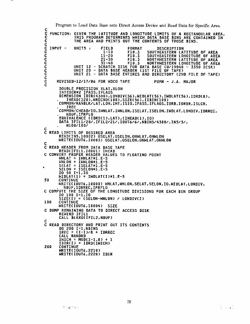
Program to Load Data Base onto Direct Access Device and Read Data mr Spec_c Area.CC FUNCTION= GIVEN THE LATITUDE AND LONGITUDE LIMITS OF A RECTANGULAR AREA,C THIS PROGRAM DETERMINES NHICH DATA BASE BINS ARE CONTAINED INC THE AREA AND PRINTS OUT THE CONTENTS OF THOSE BINS.CC INPUT - UNIT5 , FIELD FORMAT DESCRIPTIONC 1-10 F10.3 SOUTHEASTERN LATITUDE OF AREAC 11-20 F10.3 SOUTHEASTERN LONGITUDE OF AREAC 21-30 FlO.3 NORTHNESTERN LATITUDE OF AREAC 31-_0 F10.3 NORTHNESTERN LONGITUDE OF AREAC UNIT 12 - SCRATCH DISK FOR DATA BASE (U/190_0 - 3350 DISK)C UNIT 20 - DATA BASE HEADER (1ST FILE OF TAPE)C UNIT 21 - DATA BASE ENTIRES AND DIRECTORY (2ND FILE OF TAPE)CC REVISED-12/17/86 FOR NDCG TAPE PGMR - J.A. MAJORC
DOUBLE PRECISION XLAT,XLONINTEGER_2 IPASS,IFLAGSDIMENSION IDIR(_300),LONDIV(56),WIDLAT(56),INDLAT(56),IDRD(8),• IHEAD(12O),NRECNO(lOO),SIZE(56),IIBIN(100)COMMON/RANBLK/LAT,LON,IHT,ISIG,IPASS,IFLAGS,IORB,IORBR,ISLCR,
IRECCOMMON/CHEAD/IG, INNLAT,INNLON, ISELAT,ISELON,INDLAT,LONDIV,IDRREC,• NBUF, IPRFLGEQUIVALENCE (IDRD(1),LAT),(IHEAD(1),IG)DATA IFILI/ZO/,IFILZ/ZI/,IOUT6/6/,NBINS/_3OO/,IN5/5/,
NIO0/IO0/CC READ LIMITS OF DESIRED AREA
READ(IN5,10002) GSELAT,GSELON,GNNLAT,GNNLONNRITE(IOUT6,10003) GSELAT,GSELON,GNNLAT,GNNLDN
CC READ HEADER FROM DATA BASE TAPE
READ(IFILI,IO001) IHEADC CONVERT PROPER HEADER VALUES TO FLOATING POINT
NNLAT = IHNLATw1.E-5HNLON = IHNLON_I.E-5SELAT = ISELAT_I.E-5SELON = ISELONw1.E-5DO 50 I=I,IGNIDLAT(I) = INDLAT(I)_I.E-5
50 CONTINUENRITE(IOUT6,10000) NNLAT,NNLON,SELAT,SELON,IG,NIDLAT,LONDIV,
NBUF,IDRREC, IPRFLGC COMPUTE THE SIZE OF THE LONGITUDE DIVISIONS FOR EACH BIN GROUP
DO 100 I=I,IGSIZE(I) = (SELON-NNLON) / LONDIV(I)
100 CONTINUENRITE(IOUT6,1000_) SIZE
C DUMP REMAINING DATA TO DIRECT ACCESS DISKRENIND IFIL1CALL BLKRD(IFIL2,NBUF)
CC READ DIRECTORY AND PRINT OUT ITS CONTENTS
DO 200 I=I,NBINSIREC = (I-1)/8 + IDRRECCALL RANDRDINICH = MOD(I-1,8) + 1IDIR(I) = IDRD(INICH)
200 CONTINUENRITE(IOUT6,2210)HRITE(IOUT6,2220) IDIR
78

Program to Load Data Base onto Direct Access Device and Read Data for Specific Area.
CC DETERMINE BIN NUMBER LOCATED AT SOUTHNEST CORNER OF DESIRED AREAC AND STORE THE START RECORD OF THAT BIN
NBIN = 0IF(GNNLAT.LE.SELAT .OR. GSELAT.GE.NNLAT .OR. GNNLON.GE.SELON
.OR. GSELON.LE.NNLON) GO TO 900DIF = GSELAT - SELATADD = 0.0DO 320 IB=I,IGADD = ADD + NIDLAT(IB)IBGRP = IBIF(DIF .LT. ADD) GO TO 325
320 CONTINUEIBGRP = IG
325 CLAT = ADD - NIDLAT(IBGRP)CNNLAT = GNNLATIF(GNNLAT .GT. NNLAT) CNNLAT = NNLATCSELON = GSELONIF(GSELON .GT. SELON) CSELON = SELONCNNLON = GNNLONIF(GNNLON .LT. NNLON) CNNLON = NNLONDIF = CNNLON - NNLON
330 IBIN = 0IF(IBGRP .Eq. 1) GO TO 345IFIN = IBGRP - 1DO 340 J=I,IFIN
340 IBIN = IBIN + LONDIV(J)345 IBIN = IBIN + DIF/SIZE(IBGRP) + 1.0
IF(IBIN .GT. NBINS) GO TO 360NBIN = NBIN + 1IF(NBIN .GT. N100) GO TO 980IIBIN(NBIN) =IBINNRECNO(NBIN)=IDIR(IBIN)
C LOCATE ALL BINS NITHIN LATITUDE GROUP NHICH ARE CONTAINED IN DESIRED AREANLON = DIF/SIZE(IBGRP)CLON = NNLON + NLON_SIZE(IBGRP)
350 CLON = CLON + SIZE(IBGRP)IF(CLON .GT. CSELON) GO TO 360IF(CLON. EQ. SELON) GO TO 360IBIN = IBIN + 1IF(IBIN .GT. NBINS) GO TO 360NBIN = NBIN + 1TF(NBIN .GT. NIO0) GO TO 980IIBIN(NBIN) =IBIN
: NRECNO(NBIN)=IDIR(IBIN)GO TO 350""
C PROCEED TO NEXT BIN GROUP AND DETERMINE IF OUTSIDE DESIRED AREA360 CLAT = CLAT + NIDLAT(IBGRP)
TOTLAT = SELAT + CLAT + .0001IBGRP = IBGRP + 1IF(IBGRP .GT. IG) GO TO 390IF(TOTLAT .LT. CNNLAT) GO TO 330
390 CONTINUENRITE(IOUT6,30000) NBIN,(IIBIN(J),J=I,NBIN)
CC STORE RECORD NUMBER OF BIN TO BE READ; IF ZERO, THEN BIN CONTAINSC NO DAI'A...PROCEED TO NEXT BIN
DO 550 I=I,NBINIREC = NRECNO(I)IF(IREC .NE. O) GO TO 460NRITE(IOUT6,40000) IIBIN(I)GO TO 550
C FIRST RECORD OF BIN TELLS HON MANY RECORDS IN THE BIN460 CONTINUE
CALL RANDRDIEND = LATNRITE(IOUT6,2400) IIBIN(I),NRECNO(I)pLATNRITE(IOUT6,2100)
79

Program to Load Data Base onto Direct Access Device and Read Data _r Specific Area.
C PRINT OUT CONTENTS OF ONE ENTIRE BINDO 500 J=I,IENDIREC = IREC + 1CALL RANDROORBIT = IORBwI.E-5ORBITR = IORBRw1.E-5SLPCOR = ISLCRwI.E-5SIGH = ISIG_I.E-5XLAT = LAT_I.D-6XLON = LONWI.D-6
WRITE(IDUT6,2200) IREC,XLAT,XLON,IHT,IPASS,ORBIT,ORBITR,SLPCOR,SIGH
500 CONTINUE550 CONTINUE
STOP
REQUESTED OUTSIDE OF DATA BASE AREA
CC AREA900
C TOO980
C22002100
22102220
l
2300
2400
10000
WRITE(IOUT6,90000)STOP
MANY BINS FOR ARRAY WHICH STORES DIRECTORYWRITE(IOUT6,81000) NIO0STOP
FORMAT(IlO,2FlO.4,IlO,I8,2FlO.3,F10.3,F11.3)FORMAT(/4X, IIREC',SX, WLAT',9X,'LONG',7X, WHEIGHTW,3X, WREV #1,• 4X,'ORB ADJ',2X,'ORB RMS',ZX,'SLOPE CORR',4X,'SIGMA')FORMAT(///' DIRECTORY FOR DATA BASE (IDIR),'/)FORHAT(IOIIO)
FORMAT(///' DIRECTORY STARTS AT LOGICAL RECORD',IIO,• 3X,'NUMBER OF BUFFERS=',I6//)FORMAT(/' FOR BIN NUMBER',I6,2X,' LOGICAL RECORD STARTS AT',IIO,
• 2X,' | RECS IN BIN=',IIO)FORMAT(//' HEADER INFORMATION FROM DATA BASE TAPE'/
2X,'NW LATITUDE & LONGITUDE (NNLAT, HNLON)=',2FIO.Q/2X,'SE LATITDUE & LONGITUDE (SELAT, SELON)=',ZFIO.Q/2X,'LAT WIDTH OF EACH OF THE',I4,' BIN GROUPS=W/7(IX,BF9.3/)/2X,'LONGITUDE DIVISIONS IN EACH BIN GROUP',' (LONDIV)s'/7(IX,BI6/)/2X,'NUMBER OF BUFFERS,',I6,3X,'LOGICAL RECORD AT WHICH DIRECTORY STARTSz',IIO//
' ALTIMETRY DATA STATUS WORD',ZIO//)lO001"FORMAT(120A4)10002 FORMAT(4FIO.3)10003 FORMAT(//' SOUTHEASTERN CORNER OF DESIRED AREA (LAT,LDN)z',2FIO.3
• /' NORTHWESTERN CORNER OF DESIRED AREA (LAT,LON)=',2FIO.3/)10004 FORMAT(/' SIZE OF EACH BIN GROUP AS DETERMINED FROM HEADER='/
• 7(1X,BF9.3/)/)30000 FORMAT(//' THE FOLLOWING ',I6,' BINS CONTAIN DATA IN THE DESIRED'
• ,' AREA_'/IO(IOIIO/))QO000 FORMAT(/' BIN ',I6,' CONTAINS NO DATA')81000 FORMAT(//' _w NUMBER OF BINS CONTAINED IN AREA EXCEEDS',IS,
' INCREASE SIZE OF NRECNO ARRAY'/' PROGRAM TERMINATING')90000"FORMAT(///' AREA SELECTED IS OUTSIDE DATA BASE AREA'/
' PROGRAM TERMINATING')"END
8O

CCCC Program toLoad Data Baseonto Direct Access Device and Read Data for Specific Area.CC
SUBROUTINE RANDRDCC FUNCTION= THIS ROUTINE USES THE DIRECT ACCESS I/O PACKAGE (DAIO)C AND ENTRY POINTS TO ACHIEVE SEVERAL THINGS=C 1) RANDRD - READS THE IREC TH LOGICAL RECORD FROM DISKC 2) RANDNR - HRITES THE IREC TH LOGICAL RECORD TO DISKC 3) BLKRD - TRANSFERS THE DESIRED PHYSICAL RECORDSC OR BLOCKS FROM UNIT NIN TO DISKC 4) BLKHR - TRANSFERS THE DESIRED PHYSICAL RECORDSC OR BLOCKS FROM DISK TO UNIT NOUT
COMMON/FERMSG/IMES(26)REAL A,BUF(8,595),TBUF(8,595)INTEGER DISKCOMMON/RANBLK/A(B),IRECEQUIVALENCE (TBUF(1,1),BUF(1,1))DATA NREC/595/,NHORDS/8/,KBUF/1/,DISK/12/LOGICAL HSNTCHK=IGO TO 10ENTRY RANDHRNSHTCH=.TRUE.K=2
10 IBUF=(IREC-1)/NREC+IIF (IBUF.NE.KBUF) GO TO (50,90),K
20 JREC=IREC-(IBUF-I)wNRECGO TO (30,70),K
30 DO 40 I=I,NHORDS40 A(I)=BUF(I,JREC)
RETURN50 IF (HSHTCH) CALL DHRITE(DISK,KBUF,BUF)
KBUF=IBUFHSHTCH=.FALSE.CALL DREAD(DISK,KBUF, BUF,&60)GO TO 20
60 PRINT IO00,IMESSTOP
70 DO BO I=I,NHORDS80 BUF(I,JREC)=A(I)
RETURN90 CALL DHRITE(DISK,KBUF, BUF)
KBUF=IBUFGO TO 20
1000 FORMAT(IHO,ZB,I6,2OA_,4(1X,ZB))ENTRY BLKRD(NIN,NBUF)KBUF=NBUFDO 205 J=I,NBUFREAD(NIN,1200,END=20_) TBUF
205 CALL DHRITE(DISK,J,BUF)20_ HRITE(6,1100) J
1100 FORMAT( t NUMBER OF BUFFERS READ l,I5)1200 FORNAT(18(255A_),I70A_)
RETURNENTRY BLKHR(NOUT,NBUF)DO 200 J=I,NBUFCALL DREAD(DISK,J,BUF,&60)
200 NRITE(NOUT) BUFRETURNEND
81

REFERENCES
Io
2,
3.
4.
°
6.
7.
8.
9.
I0.
II.
12.
Blndschadler, R.A., H.J. Zwally, J.A. Major, A.C.Brenner, T.V. Martin, "Surface Topographyof the Greenland Ice Sheet from Seasat Radar Altimetry," NASA Special Publication inpreparation.
Brenner, A.C., R.A. Blndschadler, R.H. Thomas, H.J. Zwally, "Slope-Induced Errors inRadar Altimetry Over Continental Ice Sheets", Journal of Geophysical Research, Vol. 88,1617-1623, 1983.
Gundestrup, N.S., R.A. Blndschadler, H.J. Zwally, "Seasat Measurements Verified on a 3-D
Ice Sheet", Annals of Glactology 5, 1986.
Lame, D.B., G.H. Born, J.A. Dunne, A.J. Spear, C.A. Yamarone, "Seasat Performance
Evaluation: The First Two Steps", IEEE Journal of Oceanic Engineering, Vol. OE-5, No.2, 72-73, April 1980.
Lame, D.B., G.H. Born, "Seasat Measurement System Evaluation: Achievements andLimitations", Journal of Geophysical Research, Vol. 87, No. C5, 3175-3178, April 30, 1982.
MacArthur, J.L., "Seasat-A Radar Altimeter Design Description", The Johns HopkinsUniversity Applied Physics Laboratory, Doc. SDO-5232, Nov. 1978.
Martin, T.V., H.J. Zwally, A.C. Brenner, R.A. Bindschadler, "Analysis and Retracking ofContinental Ice Sheet Radar Altimeter Waveforms", Journal of Geophysical Research, Vol.88, 1608-1616, 1983.
Tapley, B.D., G.H. Born, M.E. Parke, "The Seasat Altimeter Data and Its AccuracyAssessment", Journal of Geophysical Research, Vol. 87, No. C5, 3179-3188, April 30, 1982.
Townsend, W.F., "An Initial Assessment of the Performance Achieved by the Seasat-1 RadarAltimeter", IEEE Journal of Oceanic Engineering, Vol. OE-5, No. 2, 80-92, April 1980.
Thomas, R.H., T.V. Martin, H.J. Zwally, "Mapping Ice-Sheet Margins from Radar AltimetryData", Annals of Glaciology 4, 283-288, 1983.
Zwally, H.J., R.A. Bindschadler, A.C. Brenner, T.V. Martin, R.H. Thomas, "Surface Elevation
Contours of Greenland and Antarctic Ice Sheets," Journal of Geophysical Research, Vol.88, 1589-1596, 1983.
Zwally, H.J., A.C. Brenner, J.A. Major, T.V. Martin, R.A. Bindschadler, "Satellite AltimetryData Over Ice: Vol. 1: Processing and Corrections of Seasat Data over Greenland," NASAReference Publication in preparation.
82


Report Documentation Page
1. Report No.
NASA RP-1233, Vot. 2
2. Government Accession No.
4. TitleandSubtitle
Satellite Radar Altimetry Over Ice
Volume 2 - Users' Guide for Greenland Elevation Data
From Seasat
7. Author(s)
H. Jay Zwally, Judith A. Major, Anita C. Brenner,
Robert A. Bindschadler, and Thomas V. Martin
9. Performing Organization NameandAddress
Goddard Space Flight Center
Greenbelt, Maryland 20771
T2. SponsodngAgencyNameandAddress
National Aeronautics and Space Administration
Washington, D.C. 20546-0001
3. Recipient's Catalog No.
5. Report Date
January 1990
6. Pedorming OrganizationCode
671.0
8. Pedorming Organization ReportNo.
89B00240
t0. Work Unit No.
11. Contract or Grant No.
13. Type of Report and Period Covered
Reference Publication
14. Sponsoring Agency Code
15. Supplementa_ Notes
H. Jay Zwally - Oceans and Ice Branch, NASA-GSFC, Greenbelt, MD;
Judith A. Major and Anita C. Brenner - ST Systems Corporation, 4400 Forbes
Blvd., Lanham, MD;
Robert A. Bindschadler - Oceans and Ice Branch, NASA-GSFC, Greenbelt, MD; and
Thomas V. Martin - Van Martin Consulting, Inc., P.O. Box 2203, Rockville, MD.
16. Ab_ract
A gridded surface elevation data set and a geo-referenced data base for the
Seasat radar altimeter data over Greenland are described in this volume. It is
intended to be a "user's guide" to accompany the data provided to data centers
and other users. The grid points are on a polar stereographic projection with
a nominal spacing of 20 km. The gridded elevations are derived from the
elevation data in the geo-referenced data base by a weighted fitting of a
surface in the neighborhood of each grid point. The gridded elevations are
useful for the creating of large-scale contour maps, and examining individual
elevation measurements in specific geographic areas. Tape formats are described,
and a FORTRAN program for reading the data tape is listed and provided on the
tape. For more details of the data processing procedures and corrections
that were derived and applied to the data, see Volume 1 of this series.
17. Key Words(SuggestedbyAuthor(s))
Radar Altimetry, Ice Sheets, Sea Ice,
Data Processing, Retracking Algorithm,
Seasat
18. DistributionStatement
Unclassified - Unlimited
Subject Category 46
19. SecurityClassif.(ofthisreport)
Unclassified
NASA FORM 1626 OCT 86
20. SecurityClassif.(ofthispage)
Unclassified
21. No. of pages
92
22. Price
A05
NASA-Langley, 1990


: =
= -If---"--Q-:"=-'-7 :
= ............
Li ; 171:71£!
7 ]_. -7G _ --IE7 -_- ]=
77Y _i;--= -_ i_
":E-!.II_] 5! :'
i-_2i Qs_T]_ ÷= *
'! _!¢.:Li'-):
:]117_- =(--:
i: . i -if

...... -_: ::7 :
N_j_ronautics and -_-::_::_::
Sp -:-- ....
=. ±
BULK RATE
POSTAGE & FEES PA_ONASA
Permit No. G-27
_ " ::-- _ .
....... - _? - _ _
_:=-: .........
=