alpine county groundwater management...
TRANSCRIPT

ALPINE COUNTY GROUNDWATER MANAGEMENT PLAN
February 1, 2007
Prepared for:
ALPINE COUNTY Post Office Box 387
Markleeville, California 96120
Prepared by:
BROWN AND CALDWELL 3264 Goni Road, Suite 153 Carson City, Nevada 89706

Alpine County Groundwater Management Plan
i
TABLE OF CONTENTS
Section Page LIST OF ABBREVIATIONS AND ACRONYMS ................................................................................1 SECTION 1.0 INTRODUCTION ....................................................................................................2
1.1 Plan Authority and Administration...........................................................................2 1.2 AB 3030 History.......................................................................................................3 1.3 Management Objectives ...........................................................................................3 1.4 Plan Area ..................................................................................................................5 1.5 Plan Development Process .......................................................................................6 1.6 Public Outreach and Education ................................................................................8 1.7 Technical Steering Committee................................................................................11
SECTION 2.0 CHARACTERIZATION OF GROUNDWATER RESOURCES .........................13
2.1 Introduction.............................................................................................................13 2.2 Physical Setting ......................................................................................................13
2.2.1 Topography ................................................................................................13 2.2.2 Climate .......................................................................................................14
2.3 Hydrology and Watersheds ....................................................................................18 2.3.1 Carson River Watershed ............................................................................18 2.3.2 American River Watershed ........................................................................20 2.3.3 Mokelumne River Watershed.....................................................................21 2.3.4 Stanislaus River Watershed........................................................................21 2.3.5 Truckee River Watershed...........................................................................21
2.4 Hydrogeologic Setting ............................................................................................21 2.4.1 Carson Valley Groundwater Basin ............................................................23 2.4.2 Bedrock Aquifers ......................................................................................24 2.4.3 Unconsolidated Aquifers............................................................................26 2.4.4 Groundwater Elevations and Flow.............................................................26 2.4.5 Recharge Areas ..........................................................................................28 2.4.6 Groundwater Quality..................................................................................29 2.4.7 Land Subsidence ........................................................................................30
2.5 Surface Water Quality ............................................................................................31 2.5.1 Upper Carson River Watershed Water Quality Monitoring Program........32 2.5.2 Alpine Watershed Group............................................................................32 2.5.3 Carson Water Subconservancy District .....................................................32 2.5.4 South Tahoe Public Utilities District .........................................................32
2.6 Well Infrastructure..................................................................................................33 2.6.1 Well Depth .................................................................................................33 2.6.2 Well Yields.................................................................................................34 2.6.3 Well Water Quality ....................................................................................34
2.7 Water Demand and Supply Sources .......................................................................37 2.7.1 Water Demand ...........................................................................................37 2.7.2 Water Supply Sources ................................................................................38

Alpine County Groundwater Management Plan
ii
TABLE OF CONTENTS -- Continued
Section Page SECTION 3.0 MANAGEMENT PLAN ELEMENTS ..................................................................40
3.1 Goal and Objectives................................................................................................40 3.2 Groundwater Monitoring ........................................................................................41 3.2.1 Groundwater Elevation Monitoring ...........................................................43 3.2.2 Groundwater Quality Monitoring ..............................................................44 3.2.3 Inelastic Land Subsidence Monitoring.......................................................44 3.2.4 Groundwater Monitoring Actions ..............................................................45 3.5 Groundwater Resource Protection..........................................................................45 3.5.1 Well Construction Policies.........................................................................46 3.5.2 Well Abandonment and Well Destruction Policies....................................46 3.5.3 Wellhead Protection Measures...................................................................47 3.5.4 Regulation of Migration of Contaminated Groundwater ...........................48 3.5.5 Groundwater Contamination Cleanup........................................................48 3.5.6 Control of Saline Water Intrusion ..............................................................50
3.6 Groundwater Supply...............................................................................................50 3.6.1 Overdraft Conditions..................................................................................50 3.6.2 Groundwater Conservation ........................................................................51 3.6.3 Conjunctive Management Activities ..........................................................51 3.6.4 Groundwater Supply Actions.....................................................................51 3.7 Stakeholder Involvement ........................................................................................51 3.7.1 Public Involvement ....................................................................................52 3.7.2 Interagency and District Cooperation ........................................................52 3.7.3 Technical Advisory Committees................................................................53 3.7.4 Stakeholder Involvement Actions ..............................................................54 3.8 Groundwater Management Plan Implementation, Reporting and Updating ..........54 3.8.1 Groundwater Management Plan Implementation ......................................54 3.8.2 Groundwater Management Plan Reporting................................................54 3.8.3 Groundwater Management Plan Updating.................................................55 SECTION 4.0 REFERENCES CITED ..........................................................................................57

Alpine County Groundwater Management Plan
iii
TABLE OF CONTENTS -- Continued
LIST OF FIGURES
Figure 1-1 Alpine County Groundwater Management Plan Area (in Figure Section) Figure 1-2 Location of the Carson Valley Groundwater Basin (In Figure Section) Figure 2-1 Average Monthly Precipitation (inches) at the Woodfords/Markleeville Station (embedded in text) Figure 2-2 Average Monthly Snowfall (inches) at the Woodfords/Markleeville Station (embedded in text) Figure 2-3 Annual Precipitation (inches) at the Woodfords/Markleeville Station (embedded in text) Figure 2-4 Annual Snowfall (inches) at the Woodfords/Markleevillee Station (embedded in text) Figure 2-5 Location of the Alpine County Watershed Areas (in Figure Section) Figure 2-6 Average Annual Streamflow at the East Fork Markleeville Gage (#10308200) (embedded in text) Figure 2-7 Average Annual Streamflow at the West Fork Woodfords Gage (#10310000) (embedded in text) Figure 2-8A Geologic Map of Alpine County (in Figure Section) Figure 2-8B Alpine County Geologic Explanation (in Figure Section) Figure 2-9 Precipitation Map for Alpine County (in Figure Section) Figure 2-10 Water Source, Carson Valley Region (in Figure Section) Figure 2-11 Depth Distribution and Cumulative Frequency of Domestic Wells in the Carson
Valley Groundwater Basin in Alpine County (embedded in text) Figure 2-12 Depth Distribution and Cumulative Frequency of Domestic Wells in the Hardrock Portion of Alpine County (embedded in text) Figure 2-13 Land Use within Alpine County (in Figure Section) Figure 3-1 Groundwater Monitoring Development Process (embedded in text)
LIST OF TABLES
Table 1-1 Mandatory, Voluntary and Suggested Components of an AB 3030 GWMP. Table 1-2 Local Agencies and their Established Agreement Status for Inclusion of the GWMP Table 2-1 Climate Record for Woodford’s California (049775) Table 2-2 Climate Record for Markleeville California (045356) Table 2-3 Climate Record for Echo Summit Ski (042671) Table 2-4 Summary of Alpine County Well Infrastructure Table 2-5 Summary of Well Yields in Alpine County Table 2-6 Normal Year Water Demand (in acre-feet) for Alpine County Table 2-7 Population of Alpine County from 1970 to 2005 Table 2-8 2001 Supply Sources to Meet Water Demands (in acre-feet) Table 3-1 Drinking Water Well Locations, Primary Water Source Type and the PCA Table 3-2 Plan Component Implementation

Alpine County Groundwater Management Plan
iv
TABLE OF CONTENTS -- Continued
LIST OF APPENDICES
Appendix A. Water Elements from the Alpine County General Plan, 2005. Appendix B. Alpine County Board of Supervisors Resolution of Intent to Prepare a Groundwater
Management Plan. Appendix C. Alpine County Ordinance No. 646-03: An Ordinance Regarding the Extraction and
Exportation of Groundwater from Alpine County. Appendix D. Standard Operating Procedures for Groundwater Monitoring Wells. Appendix E. Alpine County AC Code 8.36 Ord. 364 § 1, 1976 – Wells; Alpine County Ordinance
521-91, Chapter 13.08 Sewage Disposal System; and the Permit Conditions for Construction and Approval of a Domestic Water Well.
Alpine County Groundwater Management Plan
1
LIST OF ABBREVIATIONS AND ACRONYMS
AB Assembly Bill
AST aboveground storage tank
BLM Bureau of Land Management
BMOs Basin Management Objectives
cfs cubic feet per second
CWC California Water Code
CWSD Carson Water Subconservancy District
DHS Department of Health Services
DWR Department of Water Resources
DWSAP Drinking Water Source Assessment Program
gpm gallons per minute
GWMP Groundwater Management Plan
KMPUD Kirkwood Meadows Public Utility District
mgd million gallons per day
M & I municipal & industrial
PCA possible contaminating activity
RWQCB Regional Water Quality Control Board
SOPs Standard Operating Procedures
STPUD South Tahoe Public Utility District
SWRCB State Water Resources Control Board
TAC Technical Advisory Committee
TMDL total maximum daily load
TSC Technical Steering Committee
USGS United States Geological Survey
UST underground storage tank
WDID Waste Discharge Identification
WDR Waste Discharge Requirement
Alpine County Groundwater Management Plan
2
SECTION 1.0
INTRODUCTION
The Alpine County Planning and Administration Department (“Alpine County”) has developed
this Groundwater Management Plan (“GWMP”) to provide guidance in managing the
groundwater resources within the County. Projected development in the County has created a
need for resource planning and management to ensure a supply of high quality groundwater for
anticipated growth. This GWMP: 1) documents existing groundwater conditions, management
policies and procedures; 2) provides a framework for the County and other water users to
implement effective water resource management programs, including related surface water
resources; 3) presents a number of recommended actions that would result in achieving
sustainable groundwater supplies (the first action under the GWMP would be the development of
a groundwater monitoring program); and 4) is consistent with the water resource elements
provided in the County’s General Plan (Appendix A). This GWMP is the first comprehensive
water resource planning tool developed for Alpine County.
This GWMP is organized into four sections. Section 1.0 summarizes the regulatory
requirements and provides information on public outreach. Section 2.0 provides a description of
the physical conditions in Alpine County including climate, hydrology, geology, groundwater
levels and groundwater quality. Section 2.0 also provides water demand and supply, and well
infrastructure information. Section 3.0 describes management plan elements and the
implementation of selected GWMP components. References cited in this GWMP are listed in
Section 4.0. Figures are either embedded within the text or provided within the “Figures”
section of this GWMP, based on their content.
1.1 Plan Authority and Administration
On December 20, 2005, the Alpine County Board of Supervisors formally approved resolution
2005-75 directing the County to proceed with the development of a countywide AB 3030
GWMP (Appendix B). The County is an authorized groundwater management agency pursuant
to the California Water Code (“CWC”) § 10753 (a). This GWMP does not conflict with existing

Alpine County Groundwater Management Plan
3
ordinances or other groundwater management plans within the County, and is consistent with the
water resource elements of the County’s General Plan (Appendix A).
1.2 AB 3030 History
In 1992, the Legislature enacted the California Groundwater Management Act (AB 3030) to
encourage local public agencies to adopt plans to manage groundwater resources within their
jurisdictions. Provisions were created in CWC Sections 10750 et. seq. with the intent to manage
the safe production, quality, and proper storage of groundwater. AB 3030 codifies 12 voluntary
components of a GWMP. In 2002, SB 1938 was signed into law. SB 1938 amended the CWC
with seven required components of a GWMP for any public agency seeking State funds
administered through the Department of Water Resources (“DWR”) for groundwater projects. In
2003, DWR published Bulletin 118 – Update 2003, California’s Groundwater. Bulletin 118
contains seven recommended components of a GWMP. Under the CWC, a GWMP must include
the mandatory, voluntary and suggested components summarized in Table 1-1.
1.3 Management Objectives
Alpine County initially established management objectives on January 7, 2003 with the approval
of Groundwater Ordinance No. 646-03 (Appendix C), which addresses the potentially harmful
extraction of groundwater resources for use outside the County. This GWMP is consistent with
the findings and purposes of Groundwater Ordinance No. 646-03, which are summarized below:
The protection of the health, welfare and safety of the residents within Alpine County;
The protection and prevention of the harmful extraction and exportation of groundwater resources for use outside of Alpine County;
Recognition that the principle developed in the case law of California that water may be appropriated from a groundwater basin if the groundwater supply is in surplus and exceeds the reasonable and beneficial needs of overlying users;
Recognition that much of the farm production within Alpine County depends upon the use of water to produce field crops, which significantly contributes to the value of agricultural crops produced and;
Recognition that groundwater is an important part of the water supply for residential needs within Alpine County.

Alpine County Groundwater Management Plan
4
Table 1-1. Mandatory, Voluntary and Suggested Components of an AB 3030 GWMP AB 3030 GWMP Component Description GWMP Section CWC § 10750 et seq., Mandatory Components 1. Documentation of public involvement statement. 1.6 2. Establish Management Objectives. 1.3 and 3.2 3. Monitoring and management of groundwater elevations, groundwater quality, inelastic land surface subsidence, and changes in surface water flows and quality that directly affect groundwater levels or quality or are caused by pumping.
3.4
4. Plan to involve other agencies located within groundwater basin. 3.7.2 5. Adoption of monitoring protocols within groundwater basin. 3.4 6. Map of groundwater basin showing area of agency subject to GWMP, other local agency boundaries, and groundwater basin boundary as defined in DWR Bulletin 118.
Figure 1-2
7. For agencies not overlying groundwater basins, prepare GWMP using appropriate geologic and hydrogeologic principles. 2.0
CWC § 10750 et seq., Voluntary Components 1. Control of saline intrusion. 3.5.6 2. Identification and management of wellhead protection areas and recharge areas. 2.4.5 and 3.5.3 3. Regulation of the migration of contaminated groundwater. 3.5.4 4. Administration of well abandonment and well destruction program. 3.5.2 5. Mitigation of conditions of overdraft. 3.6.1 6. Replenishment of groundwater extracted by water producers. 3.6.2 7. Monitoring of groundwater levels and storage. 3.4.1 and 3.4.4 8. Evaluate conjunctive use operations. 3.6.4 9. Identification of well construction policies. 3.5.1 10. Construction and operation by local agency of groundwater contamination cleanup, recharge, storage, conservation, water recycling, and extraction projects. 3.5 and 3.6
11. Development of relationships with state and federal regulatory agencies. 3.7 12. Review of land use plans and coordination with land use planning agencies to assess activities that create reasonable risk of groundwater contamination. 3.7.2
DWR Bulletin 118 Suggested Components 1. Manage with Guidance of advisory committee. 3.7.3 2. Describe area to be managed under GWMP. 1.4 3. Create link between management objectives, goals and actions of GWMP. 3.0 4. Describe monitoring program. 3.4 5. Describe efforts to coordinate with land use, zoning, or water management planning agencies or activities. 3.7.2
6. Report on implementation of GWMP. 3.8.1 7. Evaluate GWMP periodically. 3.8.1 through 3.8.3
This GWMP supports the long-term maintenance of sustainable, high-quality groundwater
resources for the beneficial use of the residents of Alpine County. Beneficial uses include
domestic use, agricultural irrigation, municipal supply, and environmental needs. Management
objectives include:
Minimize the long-term drawdown of groundwater levels;
Alpine County Groundwater Management Plan
5
Protect groundwater quality;
Prevent inelastic land surface subsidence from occurring as a result of excessive groundwater pumping; and
Protect against undesirable interactions between groundwater and surface water.
To accomplish these management objectives, this GWMP incorporates a number of components,
which are divided into implementation strategies. The implementation strategies elaborate on or
expand upon existing activities conducted by Alpine County and others, and assess their
effectiveness. They also identify the need for additional activities when necessary.
1.4 Plan Area
The CWC restricts areas that may be included in a GWMP to areas outside the service area of
other local agencies, water corporations regulated by the Public Utilities Commission or mutual
water companies without the agreement of the local agency (CWC § 10750.7 (a)). Table 1-2
provides a list of the local agencies within Alpine County. Areas under an existing AB 3030
GWMP, and adjudicated areas also need agreement to be included in a GWMP (§ 10750 (b)).
There are no areas in Alpine County that are adjudicated, or are under an existing AB 3030
GWMP. Therefore, the GWMP includes the entire area of Alpine County.
Table 1-2. Local Agencies and their Established Agreement Status for Inclusion in the GWMP.
Local Agency Established Agreement Status
Markleeville Water Company No Lake Alpine Water Company Yes
Kirkwood Meadows Public Utility District Yes Woodfords Mutual Water Company No South Tahoe Public Utilities District Yes
The GMWP area within Alpine County is shown on Figure 1-1, covering an area of
approximately 475,520 acres. Approximately 2.3 percent of this area occurs within the County’s
only designated groundwater basin, the Carson Valley Groundwater Basin, which extends into
Nevada. Major areas of groundwater use in Alpine County include the Mesa Vista residential

Alpine County Groundwater Management Plan
6
area, Fredericksburg, Paynesville, Woodfords, Markleeville, Loope Canyon, Kirkwood, Bear
Valley and Hope Valley. Water utilities in the County include the Markleeville Mutual Water
Company, the Lake Alpine Water Company, the Kirkwood Meadows Public Utility District
(“KMPUD”) and the Woodfords Mutual Water Company.
The Carson Valley Groundwater Basin is the only DWR-recognized basin within Alpine County.
As illustrated in Figure 1-2, the majority of the Carson Valley Groundwater Basin is within
Nevada (approximately 273,300 acres). The southern section of the basin lies within Alpine
County, with approximately 10,700 acres (approximately 3.8 percent of the total basin acreage).
The Nevada portion of the basin includes the cities of Gardnerville and Minden, and the
communities within the Genoa, Johnson Lane, Indian Hills and Jacks Valley areas. The Alpine
County portion of the basin includes the headwaters of the Carson River, the major recharge
source to the basin.
The political boundary of Alpine County is bordered on the east by Douglas County, Nevada. In
California, the following counties share a common border with Alpine County, from north to
south: El Dorado, Amador, Calaveras, Tuolumne and Mono. State Highways 4 and 88 cross
Alpine County east to west, and State Highway 89 crosses the county from north to south.
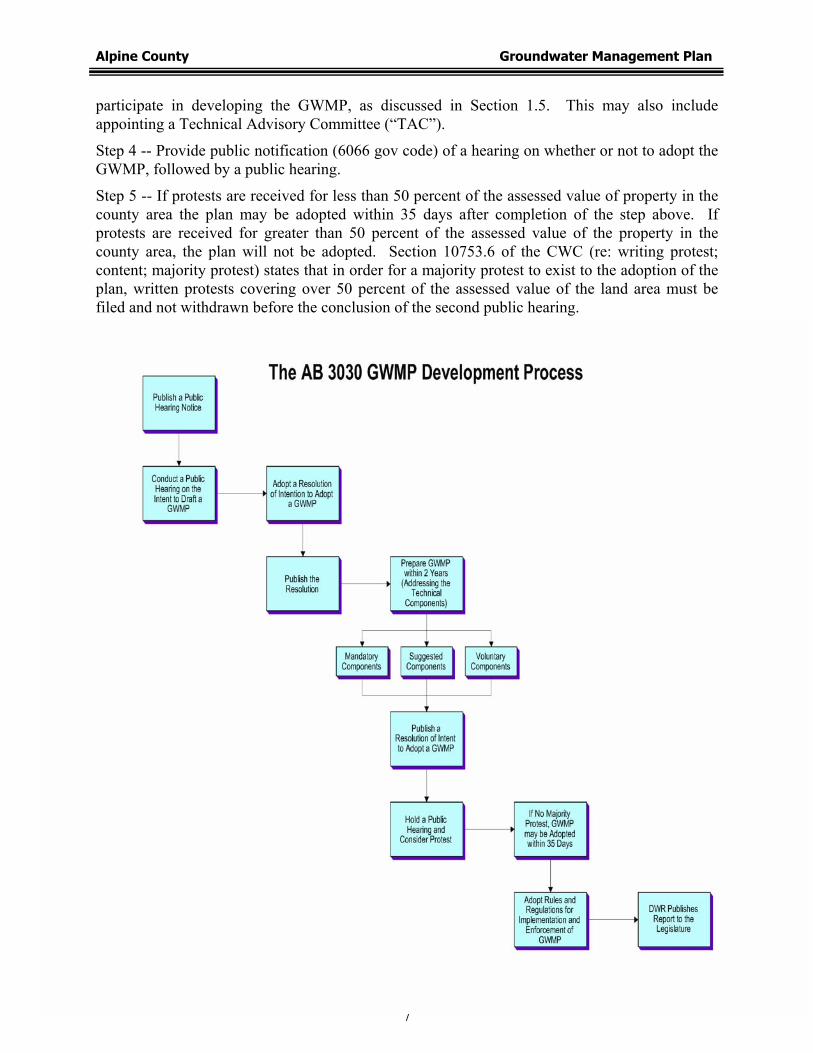
1.5 Plan Development Process
The five-step development process for a GWMP under AB 3030, as defined under CWC §
10753.2 through 10753.6, is summarized and illustrated below:
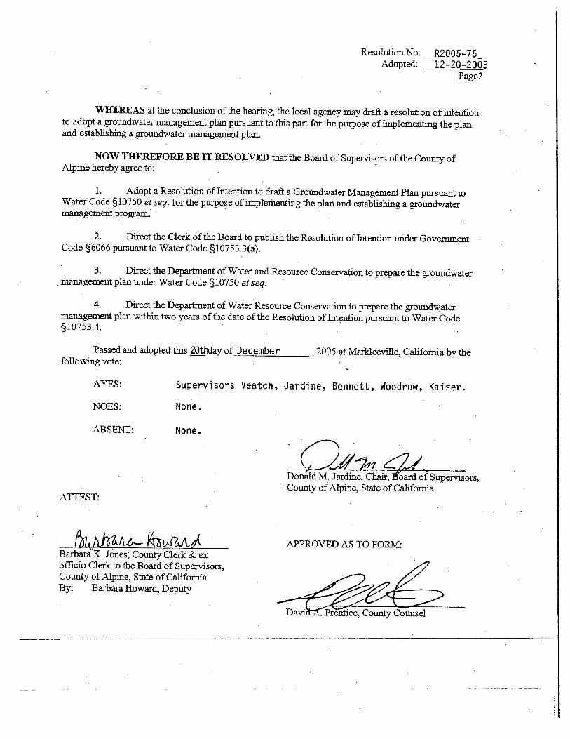
Step 1 -- Provide public notification of a hearing on whether or not to adopt a resolution of intention to draft a GWMP and subsequently complete a hearing on whether or not to adopt a resolution of intention to draft a GWMP. Following the hearing, draft a resolution of intent to draft a GWMP.
Step 2 -- Adopt a resolution of intention to draft a GWMP and publish the resolution of intention in accordance with public notification (6066 gov code; Appendix B). Upon written request, provide copy of resolution of intention to interested persons. The Alpine County Board of Supervisors adopted the resolution of intention to develop a GWMP on December 20, 2005.
Step 3 -- Prepare draft GWMP within two years of the adoption of the resolutions of intention. Provide to the public a written statement describing the manner in which interested parties may
Alpine County Groundwater Management Plan
7
participate in developing the GWMP, as discussed in Section 1.5. This may also include appointing a Technical Advisory Committee (“TAC”).
Step 4 -- Provide public notification (6066 gov code) of a hearing on whether or not to adopt the GWMP, followed by a public hearing.
Step 5 -- If protests are received for less than 50 percent of the assessed value of property in the county area the plan may be adopted within 35 days after completion of the step above. If protests are received for greater than 50 percent of the assessed value of the property in the county area, the plan will not be adopted. Section 10753.6 of the CWC (re: writing protest; content; majority protest) states that in order for a majority protest to exist to the adoption of the plan, written protests covering over 50 percent of the assessed value of the land area must be filed and not withdrawn before the conclusion of the second public hearing.

Alpine County Groundwater Management Plan
8
Alpine County has followed this five-step process by conducting the following activities:
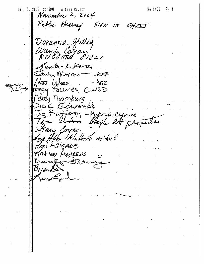
A public hearing notice was published on October 26, 2004.
A public hearing on the intention to adopt a GWMP was held on November 2, 2004.
The Alpine County Board of Supervisors adopted Resolution No. 2005-75 of the Intention to Draft a GWMP on December 20, 2005. The Board of Supervisors approved the Resolution with a unanimous vote.
Alpine County published Resolution No. 2005-75 on December 20, 2005 and the resolution to draft a GWMP was provided upon written request to interested persons.
The Draft GWMP was prepared within two years of the Resolution No. 2005-75 in accordance with CWC Section 10750 et.seq.
1.6 Public Outreach and Education
Public outreach and education efforts during the development of this GWMP, as required under
CWC § 10753.2 through 10753.6, have been performed using: 1) e-mail notifications; 2) flyer
distribution throughout the County inviting the public to attend the TAC meetings; 3) postings at
the Alpine County website (http://www.alpinecountyca.com); 4) updates published in the Alpine
Watershed Group Monthly Newsletter; and 5) frequent updates provided to the Alpine County
Board of Supervisors, with opportunities for the public to provide comment directly to the
members of this Board.
Alpine County has also reported on GWMP development during meetings with interested
stakeholders and the general public including watershed groups, water agencies, independent
groundwater users and other interest groups. Stakeholders represented at such meetings have
included: KMPUD, Markleeville Water Company, Lake Alpine Water Company, Woodfords
Mutual Water Company, the Washoe Tribe of California and Nevada, the Alpine Watershed
Group, the Carson Water Subconservancy District (“CWSD”), and various agricultural interests.
A chronological list of public outreach activities is provided below.
January 3, 2006
Letters were sent to the following stakeholders regarding the initial development of the GWMP,
and the inception of the TAC with the role of the members:

Alpine County Groundwater Management Plan
9
South Tahoe Public Utility District (“STPUD”);
Alpine Watershed Group;
Markleeville Water Company;
KMPUD;
Lake Alpine Water Company;
Clint and Jennifer Celio (local ranchers);
Chris H. Gansberg, Jr. (local rancher);
Marie Johnson and Kent Neddenriep (local ranchers);
Hubert Bruns (local rancher); and
The Washoe Tribe of Nevada and California.
STPUD, Alpine Watershed Group, KMPUD and Lake Alpine Water Company accepted the
County’s request to become members of the TAC.
April 3, 2006
The Alpine Watershed Group News Briefs Newsletter included an introduction to the GWMP,
and the purpose for its development. This was sent out by e-mail and is available at:
http://www.alpinecountyca.com/departments/board of supervisors/alpine_water_agency/watershed news.
May 1, 2006
The Alpine County Website provided an introduction to the TAC, and an invitation for the
public to attend the first TAC meeting scheduled on May 24, 2006.
May 2, 2006
TAC Meeting Flyers were posted throughout Alpine County for the May 24, 2006 TAC meeting
as an invitation to the public. Postings were at the following locations:
Human Health Services Building in Woodfords;
General Store in Markleeville;
Public Library in Markleeville;
Chamber of Commerce in Markleeville;
Turtle Rock Park Planning and Building Department in Woodfords;
Turtle Rock Park Bulletin Board;

Alpine County Groundwater Management Plan
10
Kirkwood Station on Highway 88 in Kirkwood; and
Alpine County Planning and Administration Building in Markleeville.
May 3, 2006
The Alpine Watershed Group News Briefs Newsletter included an introduction to the TAC and
an invitation for the public to attend the first TAC meeting scheduled on May, 24, 2006. This
was sent out by email and is available at: http://www.alpinecountyca.com/departments/board_of_supervisors/alpine_water_agency/watershed_news.
May 24, 2006
A TAC meeting was held with Alpine County stakeholders and the public.
June 8, 2006
The U.S. Bureau of Land Management (“BLM”) in Carson City was invited to serve on the
TAC, and was added to the TAC upon their acceptance.
June 12, 2006
The U.S. Forest Service (“USFS”) in Carson District was invited to serve on the TAC, and was
added to the TAC upon their acceptance.
June 13, 2006
The Alpine Watershed Group conducted a meeting and provided an update on the GWMP.
June 14, 2006
The Alpine Watershed Group News Briefs Newsletter included an update and summary of the
May 24, 2006 TAC meeting, and an invitation to the public to attend future TAC meetings. This
was sent out by email and is available at: http://www.alpinecountyca.com/departments/board_of_supervisors/alpine_water_agency/watershed_news.
June 21, 2006
A presentation to the CWSD Board of Directors provided an update on the GWMP.

Alpine County Groundwater Management Plan
11
July 10, 2006
The Alpine Watershed Group News Briefs Newsletter included an overview of the AB 3030
GWMP Process, and the current status of the draft GWMP.
August 15, 2006 A presentation to the Alpine County Board of Supervisors and the public provided a summary of
the GWMP.
Summer, 2006
The Carson Water Subconservancy District published an article in “The Flow” on the Alpine
County GWMP, titled Alpine County Protecting Groundwater Resources.
September 19, 2006
The Alpine County Board of Supervisors discussed the GWMP process in the context of the
County’s regional water planning efforts.
October 2, 2006
A report on the GWMP was provided to the South Tahoe Public Utility Contract Commission.
October 24, 2006
The GWMP process was discussed with the Lahontan Regional Water Quality Control Board.
December 6, 2006
A meeting was held with the TAC to present the final draft of the GWMP, and solicit comments
for the final version.
1.7 Technical Steering Committee
A technical steering committee (“TSC”) was formed during the GWMP’s inception in 2005.
Subsequently, quarterly meetings have been held to ensure that County staff and other interested
parties have had the chance to provide adequate input into the GWMP. This short-term
committee includes the following groups:

Alpine County Groundwater Management Plan
12
Alpine County (including members from the planning department, administration, the health department);
CWSD; and
Alpine Watershed Group.
Alpine County Groundwater Management Plan
13
SECTION 2.0
CHARACTERIZATION OF GROUNDWATER RESOURCES
2.1 Introduction
The characterization of groundwater resources within Alpine County includes: 1) the physical
setting (topography and climate); 2) a discussion of hydrology including five identified
watershed areas; 3) a description of surface water quality data; 4) an overview of the
hydrogeologic setting including a description of the Carson Valley Groundwater Basin (Figure
1-2) and non-designated areas pursuant to DWR Bulletin 118 (“non-designated areas”), and
summaries of groundwater elevation and flow data, and groundwater quality data; 5) a
description of well infrastructure including locations, depths and well yields; and 6) an overview
of water supplies and demands in the County. Alpine County’s major groundwater resource is
located within the Carson Valley Groundwater Basin, and within fractured bedrock and
unconsolidated aquifers in the non-designated areas.
2.2 Physical Setting
The topographic and climatic setting of Alpine County directly influences the County’s
groundwater and surface water resources. Topography significantly affects weather patterns,
which control the rate timing of surface water flows and the amount of groundwater recharged
into the alluvial and bedrock aquifers. Groundwater supplies and stream flows are replenished
by precipitation and snowmelt on a seasonal basis as a function of altitude.
2.2.1 Topography
Alpine County comprises 743 square miles of land situated along the crest of the Sierra Nevada
mountain range. Topographic features within the County include high-elevation peaks and
ridges, mountain meadows, deep canyons and numerous lakes and creeks (Figure 1-1).
Elevations within the County range from approximately 4,700 feet above mean sea level (amsl)
in the Carson Valley to above 11,000 feet amsl at along the crest of the Sierra Nevada mountain
range. The higher elevations occur in the headwaters areas of the East Fork of the Carson River.

Alpine County Groundwater Management Plan
14
2.2.2 Climate
Alpine County features a range of climatic conditions, ranging from high desert to high alpine
characteristics including cold, wet winters and variable summer temperatures in the summer
months with occasional convective thunder showers. The east portion of Alpine County falls
within the rainshadow of the Sierra Nevada’s. This is reflected in differences in climate between
the west slope and east slope portions of the County. However, temperature and precipitation
data was only available for the Woodfords and Markleeville weather stations (Number 049775
and 045356, respectively), which are provided below in Tables 2-1 and 2-2:
Table 2-1. Climate Record for Woodford’s California (049775) Period of Record: 7/ 1/1948 to 8/31/1990
Jan Feb Mar Apr May Jun Jul Aug Sep Oct Nov Dec Annual Average Max. Temperature (F) 43.3 47.3 51.2 58.7 66.9 77.0 85.0 83.3 76.1 65.5 52.2 45.2 62.6
Average Min. Temperature (F) 22.1 24.8 27.4 32.0 38.5 46.0 52.6 51.4 45.2 37.7 29.3 23.8 35.9
Average Total Precipitation (in.) 3.61 2.99 2.21 1.09 0.85 0.55 0.53 0.60 0.80 1.34 3.01 3.59 21.19
Average Total SnowFall (in.) 22.3 16.4 17.6 6.6 1.6 0.0 0.0 0.0 0.0 1.2 9.7 17.5 93.1
Average Snow Depth (in.) 4 3 1 0 0 0 0 0 0 0 1 2 1
Table 2-2. Climate Record for Markleeville California (045356) Period of Record: 7/ 1/1948 to 12/31/2005
Jan Feb Mar Apr May Jun Jul Aug Sep Oct Nov Dec Annual Average Max. Temperature (F) 45.5 46.6 53.0 56.6 66.3 75.3 84.2 83.9 76.6 66.6 52.7 43.9 62.6
Average Min. Temperature (F) 18.7 20.5 24.7 27.6 34.4 39.0 44.4 43.7 37.3 29.1 22.6 16.9 29.9
Average Total Precipitation (in.) 3.99 3.00 2.70 1.37 1.16 0.64 0.40 0.58 0.47 1.11 2.47 3.39 21.28
Average Total Snowfall (in.) 16.5 20.6 13.5 7.1 1.1 0.3 0.0 0.0 0.0 0.7 6.9 18.4 85.1
Average Snow Depth (in.) 5 5 3 0 0 0 0 0 0 0 1 3 1
Figures 2-1 through 2-4 illustrate some of these climate data in graphical formats:

Alpine County Groundwater Management Plan
15
Woodfords/Markleeville Gage Station 1948-2004
0
0.5
1
1.5
2
2.5
3
3.5
4
Jan Feb Mar Apr May Jun Jul Aug Sept Oct Nov Dec
Month
Ave
rage
Pre
cipi
tatio
n (in
ches
)
Figure 2-1. Average Monthly Precipitation (inches) at the Woodfords/Markleeville Station.
Woodfords/Markleeville Gage Station 1948-2003
0
5
10
15
20
25
Jan Feb Mar Apr May Jun Jul Aug Sept Oct Nov Dec
Month
Ave
rage
Sno
wfa
ll (in
ches
)
Figure 2-2. Average Monthly Snowfall (inches) at the Woodfords/Markleeville Station.

Alpine County Groundwater Management Plan
16
Woodfords/Markleeville Weather Station
0
5
10
15
20
25
30
35
40
45
1945 1955 1965 1975 1985 1995 2005
Year
Ann
ual
Pre
cipi
tatio
n (in
ches
)
Figure 2-3. Annual Precipitation (inches) at the Woodfords/Markleeville Station.
Woodfords/Markleeville Weather Station
0
50
100
150
200
250
1945 1955 1965 1975 1985 1995 2005
Year
Ave
rage
Ann
ual S
now
fall
(inch
es)
Figure 2-4. Annual Snowfall (inches) at the Woodfords/Markleeville Station.

Alpine County Groundwater Management Plan
17
The average monthly precipitation at this station during the winter varies between 2 and 4
inches, and the average monthly snowfall during the winter ranges from 16 to 22 inches. The
average annual precipitation for the period of record, from 1948 through 2004, was 21.2 inches
(Figure 2-3). Based on precipitation values less than half the annual average, drought years were
observed in 1947, 1976, 1990 and 2004. Figure 2-4 shows the average annual snowfall data over
the same period, which averaged 92.3 inches and does not correlate with drought periods.
The Markleeville/Woodfords weather stations are located at relatively low elevations, less than
5,650 feet amsl, and do not reflect climate conditions at higher elevations. A surrogate weather
station that would represent conditions at somewhat higher elevations in Alpine County is the
Echo Summit/Sierra Ski weather station (042671), located due north of Carson Pass in El
Dorado County at an elevation of 7,750 feet amsl. Table 2-3 presents the climate record for this
station.
Table 2-3. Climate Record for Echo Summit Ski (042671) Period of Record: 7/ 1/1948 to 3/31/1994
Jan Feb Mar Apr May Jun Jul Aug Sep Oct Nov Dec Annual Average Max. Temperature (F) 38.8 39.2 40.9 47.6 54.8 63.8 71.5 71.6 65.5 56.0 43.0 38.4 52.6
Average Min. Temperature (F) 21.9 21.6 23.2 26.9 32.8 41.1 47.3 47.7 42.6 35.2 26.2 22.3 32.4
Average Total Precipitation (in.) 7.25 8.28 8.07 3.68 1.91 1.56 0.70 0.71 2.02 3.50 6.77 6.27 50.73
Average Total Snow Fall (in.) 74.7 78.4 83.5 34.7 10.3 2.7 0.0 0.0 3.5 12.2 48.5 63.8 412.5
Average Snow Depth (in.) 53 71 74 58 26 3 0 0 0 1 9 33 27
Alpine County’s precipitation comes primarily from winter storms that originate in the Pacific
Ocean, up to the Gulf of Alaska. As these storms move eastward over the central Sierra Nevada,
they adiabatically expand, cool, condense, and precipitate their moisture as snow or rain. The
storms average about four days in duration, while warmer, clear weather typically prevails
between storms. Precipitation varies across the County depending on elevation and the

Alpine County Groundwater Management Plan
18
proximity to the Sierra Crest. Typically, 80 percent of the County’s average annual precipitation
is in the form of snowfall occurring from November to April.
2.3 Hydrology and Watersheds
Melting of the winter snowpack, principally from March through June, provides Alpine County
with significant surface water flows to several major watersheds including the Stanislaus,
Mokelumne and Carson Rivers. From a geographic perspective (i.e., total surface area of Alpine
County), less than half of the County drains westward to the San Joaquin Valley (Stanislaus and
Mokelumne watersheds). The majority of the area within the County occurs on the east slope of
the Sierra Nevada, and drains into the Carson River watershed.
Figure 2-5 includes many of the features shown in Figure 1-1, and illustrates the watershed areas
within the County. A number of tributary streams occur within the County including
Markleeville, Leviathan, Wolf and Indian Creeks. Important lakes and reservoirs shown in
Figure 2-5 include Caples Lake, Silver Lake, Bear Lake, Upper and Lower Blue Lakes, Utica
Reservoir, Union Reservoir, Red Lake, Lost Lake, Lake Alpine, Upper and Lower Kinney Lakes
and Highland Lake.
2.3.1 Carson River Watershed
The Carson River Watershed is located east of the crest of the Sierra Nevada, and encompasses
approximately 3,966 square miles in Alpine County, California and Douglas County, Carson
City, Lyon County, and Churchill County in Nevada. Of this total, approximately 46 percent of
the watershed is within Alpine County. The watershed consists of five hydrographic basins.
The southern portion of the Carson Valley hydrographic basin and the headwaters areas for the
Carson River are located in Alpine County. The approximate 184-mile length of the river starts
at the headwaters areas and continues to its terminus in the Carson Sink.
The headwaters areas of the Carson River include two independent tributaries, the East and West
Forks. The West Fork begins near Lost Lakes at an elevation of approximately 9,000 feet amsl.
The East Fork begins south of Ebbett's Pass, within the Carson-Iceberg Wilderness, at an

Alpine County Groundwater Management Plan
19
elevation of approximately 11,460 feet amsl. The two Forks merge about one mile southeast of
Genoa, Nevada, and form the main stem of the Carson River. The upper reach of the Carson
River continues from the confluent for 11 miles to Mexican Dam. The middle reach of the
Carson River starts at Mexican Dam and terminates at Lahontan Reservoir. The lower reach of
the Carson River starts at begins at the Lahontan Dam and terminates at the Carson Sink.
Average annual streamflow data in cubic feet per second (cfs) for the West Fork of the Carson
River at the Woodfords gaging station #10310000 (period of record, 1900-1907; 1938 to 2004)
and the East Fork of the Carson River at the Markleeville gaging station #10308200 (period of
record, 1960, 2004) are shown in Figures 2-6 and 2-7, respectively. Both gaging stations exhibit
peak flows during the spring months, with a rapid decline during the summer months.
Carson River East Fork
0
200
400
600
800
1000
1200
Jan Feb Mar Apr May Jun Jul Aug Sept Oct Nov Dec
Month
Dis
char
ge (c
fs)
Figure 2-6. Average Annual Streamflow at the East Fork Markleeville Gage (#10308200)

Alpine County Groundwater Management Plan
20
Carson River West Fork
0
50
100
150
200
250
300
350
400
Jan Feb Mar Apr May Jun Jul Aug Sept Oct Nov Dec
Month
Dis
char
ge (c
fs)
Figure 2-7. Average Annual Streamflow at the West Fork Woodfords Gage (#10310000)
2.3.2 American River Watershed
The American River Watershed encompasses approximately 2,100 square miles within Placer, El
Dorado, Alpine and Sacramento Counties, and includes the North, Middle, and South Forks of
the American River. The South Fork, the only major tributary in Alpine County (Figure 2-5),
drains approximately 804 square miles of watershed, and is approximately 55 miles in length,
with elevations ranging from 500 feet near Folsom Reservoir to 10,000 feet near the crest of the
Sierra Nevada.
Tributary creeks to the South Fork of the American River include Silver Fork, Alder Creek,
Weber Creek, Rock Creek and Kirkwood Creek, which drains to Kirkwood Meadow (a tributary
to the South Fork). Another tributary includes Caples Creek, which flows into Caples Lake
Reservoir. The reservoir is located approximately two miles from the Kirkwood Resort, and
serves as a drinking water source and recreational area. Streamflow data for the South Fork of
the American River is not available within Alpine County.

Alpine County Groundwater Management Plan
21
2.3.3 Mokelumne River Watershed
The Mokelumne River drains approximately 661 square miles and is one of the largest tributaries
to the San Francisco Bay-Delta areas. Headwaters areas for the North Fork of the Mokelumne
River include the area south of Ebbetts Pass and Upper and Lower Blue Lakes (Figure 2-5).
Flow data for the North Fork of the Mokelumne River is not available within Alpine County.
2.3.4 Stanislaus River Watershed
The Stanislaus River Watershed encompasses approximately 1,075 square miles, and the 65-mile
Stanislaus River is one of the largest tributaries to the San Joaquin River. Of the three forks of
the Stanislaus River, only the headwaters areas of the North Fork are located in Alpine County.
The North Fork of the Stanislaus River is fed by several creeks including Highland, Beaver and
Silver Creek before it joins the Stanislaus River at the New Melones Reservoir. Silver Creek
feeds Lake Alpine, which is a tributary to the North Fork of the Stanislaus River (Figure 2-5).
Streamflow data for the North Fork of the Stanislaus River is not available for Alpine County.
2.3.5 Truckee River Watershed
The Upper Truckee River Watershed is located almost entirely in El Dorado County, California,
with approximately three square miles of the watershed within Alpine County. The Upper
Truckee River begins one mile northwest of Red Lake Peak in Alpine County where it serves as
the headwaters for this watershed, north of Highway 88 (Figure 2-5). Streamflow data for the
Upper Truckee River is not available within Alpine County.
2.4 Hydrogeologic Setting
Alpine County lies in the Sierra Nevada physiographic province, between the Basin-and-Range
province to the east and the Central Valley province to the west. The geological history of the
Sierra Nevada can be traced to the Jurassic period, approximately 150 million years ago. At that
time, an island arc was created along the western margin of North America from the subduction
of the oceanic Pacific Plate beneath the continental crust of the North American Plate. Bodies of
magma, resulting from the melting of the subducting Pacific Plate, rose upward to form: 1)

Alpine County Groundwater Management Plan
22
volcanic rocks of the island arc environment; and 2) plutonic (i.e., granitic) rocks emplaced at
depth. Granitic rocks of the Sierra Nevada batholith generally formed between 150 million and
85 million years ago into overlying volcanic and sedimentary rocks, which were subjected to
intense heat and pressure. These conditions led to the formation of various types of
metamorphic rocks (i.e., metasedimentary and metavolcanic rock types) found in the Sierra
Nevada.
Erosion of the proto-Sierra Nevada down to a range of low mountains, only a few thousand feet
in elevation, occurred by the end of the Cretaceous Period (about 65 million years before
present). About 25 million years ago, the mountains started to rise, and tilt towards the west
along large fault systems on the eastern margin of the range. This uplift, which resulted from the
thinning and extension of the crust within the adjacent Basin-and-Range province to the east, has
continued until recent times. During this period, the earth’s climate went through several cycles
of heating and cooling. The cooling periods created large alpine glaciers along the crest of the
range, which carved out U-shaped valleys. The combination of glacial and river erosion: 1)
formed glacial till and outwash deposits, and fluvial deposits; and 2) created steep topography
and deep exposures of the granitic and metamorphic rocks that were formed during the
emplacement of the Sierra Nevada batholith.
Coincident with the extension and thinning of the earth’s crust due to extensional forces
resulting from the lateral movement of the Pacific Plate relative to the North American Plate, a
large volume of volcanic rocks erupted in the Sierra Nevada and Basin-and-Range provinces.
Within the area of Alpine County, volcanic rocks of Miocene and Pliocene age were deposited
on top of the older, eroded granitic rocks in the Sierra Nevada. Many of the volcanic eruptions
resulted in volcaniclastic rocks, which were deposited in topographically low areas as a mixture
of ash, mud and rock fragments. To the north, the Sierra Nevada range transitions into the
volcanic Cascade Range that includes active volcanoes.
The abbreviated geologic history of the Sierra Nevada mountain range presented above provides
the background for understanding the occurrences of granitic and volcanic bedrock, and variably
consolidated sedimentary deposits resulting from glacial and fluvial processes. In addition, the

Alpine County Groundwater Management Plan
23
Carson Valley Groundwater Basin, located at the northeastern margin of the County, occupies a
structural basin (i.e., graben) along the western margin of the Basin-and-Range province. This
basin is filled with alluvial deposits that form the only significant basin-fill aquifer in the
County.
A geologic map of Alpine County is provided as Figure 2-8A, and the map explanation is
provided as Figure 2-8B. This map shows the predominance of volcanic rocks (brown- and red-
colored units in Figure 8A) and granitic rocks (pink-colored units in Figure 8A) in the County.
Metamorphic rocks are depicted in blue and green colors, and alluvial deposits are shown in
yellow colors on the geologic map.
2.4.1 Carson Valley Groundwater Basin
The Carson Valley Groundwater Basin (Basin 6-6) extends from California northward into
Nevada. The small portion of the basin within Alpine County includes the Mesa Vista
residential area and the town of Woodfords, Paynesville and Fredericksburg (Figure 1-1).
Groundwater resources within the basin exist in both confined and unconfined basin-fill
sedimentary deposits. A shallow aquifer, underlying the western margin of valley floor at the
base of the Carson Range is less than 100 feet below ground surface (bgs). A second, deeper
aquifer that underlies most of the valley floor is generally deeper than 200 feet bgs. A U.S.
Geological Survey (“USGS”) study described unconfined groundwater levels within five feet of
the land surface underlying most of the valley floor, with depths to water increasing to over 100
feet near the margins of the valley (Maurer, 1986). The principal source of groundwater
recharge to the basin-fill aquifers is seepage from the West Fork of the Carson River.
The shallow aquifer is composed of basin-fill deposits, which have been sub-divided into two
units by the USGS: 1) unconsolidated valley fill deposits of Quaternary age along the western
side of the valley; and 2) Tertiary sedimentary deposits exposed on the eastern side of the valley
that likely extend at depth throughout the valley (Figures 2-8A and 2-8B). The valley fill
deposits are composed of generally fine-grained flood-plain deposits to coarse, boulder-rich
alluvial fan deposits. These depositional types are inter-bedded as a result of intermittent
faulting that occurred concurrently with annual cycles of runoff and sediment deposition

Alpine County Groundwater Management Plan
24
(Maurer, 1985). The alluvial fan deposits are mostly recharged from runoff within the valley
and, in turn, provide recharge to the overlying basin-fill deposits.
Basin-fill deposits also occur in the northwestern and Diamond Valley portions of the Carson
Valley Groundwater Basin (Jennings and Koenig, 1963). The alluvial aquifers are likely to be
locally confined due to discontinuous lenses of clay and fine-grained flood-plain deposits of
various thicknesses (Maurer 1986). Based on a geophysical study performed by the USGS, the
thickness of the basin-fill deposits decreases to the south, along the axis of the Carson Valley
Groundwater Basin, from approximately 1,000 feet at the Nevada-California line to
approximately 200 feet about 2.5 miles south of the state line (Maurer 1986). The Carson Valley
Groundwater Basin is bounded on the west by a steep fault scarp with 5,000 feet of relief from
the valley floor to the crest of the Carson Range, and is bounded on the east by more gently
sloping terrain. The basin terminates against bedrock south of Woodfords, California.
A poorly understood bedrock aquifer underlies, and occurs adjacent to, the basin-fill deposits
within the Carson Valley Groundwater Basin. Weathered horizons and fracture zones in the
upper few hundred feet of the bedrock aquifer: 1) provide secondary permeability and storage for
recharge from up-gradient portions of the mountain blocks; and 2) sustain perennial stream and
spring flows in the mountain block. Below this zone, the bedrock units are assumed to have very
low hydraulic conductivity values and, therefore, would not appear to be an important source of
groundwater in this portion of the Carson Valley Groundwater Basin (Maurer 1986).
2.4.2 Bedrock Aquifers
Given that the great majority of Alpine County is underlain by volcanic and granitic bedrock
(approximately 98 percent of the land surface, as shown in Figure 2-8A), bedrock aquifers
comprise the most widespread source of groundwater for beneficial use. Also, as discussed
below, the bedrock aquifers at high elevations also serve as the principal recharge areas in the
County. The bedrock geology within the drainage basin of the East Fork of the Carson River
consists of volcanic and volcaniclastic rocks, including lava flows, ash flow and ash fall tuffs,
mudflows, and volcanic breccias. The bedrock geology within the drainage basin of the West

Alpine County Groundwater Management Plan
25
Fork of the Carson River is similar, with larger areas of granite outcrops. At higher elevations in
the southern portion of the County, the majority of exposed bedrock is composed of granite.
USGS reports (Dillingham, 1980; Maurer 1986) describe confined hydraulic head conditions in
the bedrock aquifer near the town of Genoa in Douglas County, Nevada. These conditions,
which result from weathered or fractured zones in the bedrock at depth, may also be present
within Alpine County. However, large variations in bedrock aquifers should be expected due to
the variety of volcanic and granitic rock types, and complex structural features (i.e., the faults,
and fracture zones).
The following geologic characteristics of the bedrock aquifers control the storage, transmission
and yield of groundwater resources: lithology, porosity, degree of faulting and fracture or joint
development, and degree of connectivity to recharge sources. Bedrock aquifers are defined on
the basis of secondary permeability characteristics, and generally exhibit preferred flow
orientations along fractures that result in anisotropic flow conditions (primary permeability
characteristics of alluvial aquifers, on the other hand, are often generally described as isotropic).
In addition, bedrock aquifers can exhibit compartmentalization, where hydraulic communication
between blocks bounded by clay-filled faults or shear zones can be extremely limited.
Secondary permeability in the bedrock units that occur in Alpine County result from: 1) the
cooling of volcanic rocks as they are deposited on the land surface; and 2) the creation of joints,
faults and fracture zones in volcanic and granitic rocks resulting from tectonic forces in the
earth’s crust. Fractured bedrock aquifers near land surface are defined by DWR as having a
gross fracture porosity of two percent or less. Conceptually, fracture porosity tends to decrease
with depth (i.e., fractures get narrower and become more widely spaced). Fractured rocks
associated with fault zones, or the intersections of fault zones, make the best targets for water
resource development.
Water resource development within bedrock aquifers is typically more difficult to assess than in
unconsolidated alluvial aquifers because of the complexities associated with the characterization
of fracture zones and connection to recharge sources. One example of this complexity is that

Alpine County Groundwater Management Plan
26
clay-filled structural zones can impede groundwater flow. In addition, groundwater levels and
well yields can decline during dry summer months or extended drought periods due to limited
storage capacity within fractured bedrock. Typically, a successful groundwater resource
development program in bedrock aquifers requires a comprehensive analysis of geological and
geophysical data prior to drilling.
Three major fault zones (the East Carson Valley, the Genoa and the Antelope Valley Faults)
have been mapped within the north-northeastern portion of the County, in the Markleeville and
Woodfords areas (Figure 2-8A and 2-8B). The East Carson Valley Fault extends for 60 miles
along the east face of the Carson Range, from Reno, Nevada through Woodfords to an area west
of Highlands Peak, within the interior of Alpine County. The Genoa Fault, an active earthquake
fault in the area, forms the steep eastern slope of the Carson Range. The Antelope Valley Fault
extends along the northeastern boundaries of Alpine and Mono Counties. Most of the fault
zones within Alpine County are north trending and exhibit arcuate geometries, while subsidiary
faults are commonly oriented in an east-west direction (Wagner et. al., 1981 and Krenig, 1982).
2.4.3 Unconsolidated Aquifers
Outside of the Carson Valley Groundwater Basin, unconsolidated aquifers with the potential to
produce groundwater are limited to relatively small areas in the Hope, Diamond, Pleasant and
Bagley/Silver King Valleys. These areas may exhibit sufficient recharge conditions and storage
capacities to produce sustainable quantities of groundwater. The localized occurrences of
unconsolidated glacial and fluvial deposits of Quaternary age known to occur within Alpine
County may not be thick enough, or laterally extensive enough, to produce significant quantities
of groundwater.
2.4.4 Groundwater Elevations and Flow
Very limited groundwater elevation data have been collected in Alpine County to date. As part
of the STPUD water quality monitoring program in Diamond Valley, where reclaimed water is
applied, elevation measurements from the following STPUD monitoring wells have been
collected: ACMW-01AW, ACMW-01BE, ACMW-02N, ACMW-02S, ACMW-03, ACMW-
04W, ACMW-06N, and ACMW-06S. These shallow monitoring wells, constructed to less than

Alpine County Groundwater Management Plan
27
35 feet below ground surface in alluvial deposits, are used to evaluate water quality conditions in
relation to the STPUD effluent management program. Because of the artificially recharged
effluent, such localized groundwater elevation data from the STPUD monitor wells cannot be
used to assess regional groundwater elevation trends.
No other groundwater monitoring programs are currently active in Alpine County. Monitoring
of both groundwater elevations and water quality establishes a baseline for current conditions to
assess how groundwater conditions are affected by land use and related water resource
development. A comprehensive monitoring program can: 1) identify trends and emerging issues
such as overdraft or impairment of aquifers; 2) measure the effectiveness of programs and
policies designed to protect and manage the groundwater resource; and 3) provide the basis to
make long-term management decisions. Given that groundwater monitoring (elevations and
water quality) is an essential component in effective groundwater management, Alpine County
will need to implement site-specific programs where development or other changing patterns of
land use are anticipated.
Groundwater elevation measurements also provide the basis for understanding flow paths,
particularly in unconsolidated alluvial aquifers. Groundwater flow in such aquifers is generally
controlled by three factors: 1) the quantity and distribution of recharge to the system; 2) surface
topography; and 3) the hydraulic conductivity (permeability) of the aquifer materials.
Groundwater flow in bedrock aquifers may be more complicated, particularly where fault or
fracture zones strongly affect groundwater flow (e.g., preferential flow along fractures, limited
hydraulic communication between compartmentalized blocks bounded by fractures).
Generally, groundwater flow patterns of a regional nature are known in Alpine County based on
topography and the orientations of major watershed features. Groundwater flow within the
Carson River watershed flows from the margins of the basin towards the Carson River, and then
downward along the course of the river. In the area of the STPUD application of recycled water
for irrigation reuse, the groundwater flow pattern is toward Indian Creek and the West Fork of
the Carson River (California Regional Water Quality Control Board; 2004).

Alpine County Groundwater Management Plan
28
2.4.5 Recharge Areas
Precipitation (rain and snowfall) falling on the land surface is the ultimate source of recharge to
aquifers, either directly or indirectly. Precipitation may either be evaporated, intercepted by
plants and transpired back to the atmosphere, converted to overland flow, or saturate the soils
and eventually percolate to underlying aquifers. Overland flow itself often becomes a major
source of aquifer recharge as streams, rivers or unlined ditches and canals traverse permeable
areas where the groundwater level is at a lower elevation than the stream or river bed. I n areas
where groundwater levels are at, or above, the stream or river beds, groundwater may be
discharged back to the stream or river.
Conditions affecting the amount of recharge an aquifer may receive include the quantity,
seasonal timing, and type of precipitation (i.e., rain or snow), the nature of the surface the
precipitation falls on (i.e., permeable or impermeable surfaces), and the available pathways for
water to reach the aquifer. Precipitation falling as rain during summer months may all evaporate
or transpire, whereas precipitation falling as snow during colder months will melt slowly,
saturate the soil cover, and percolate to the underlying aquifer. Precipitation falling on
impermeable surfaces may be carried away as overland flow. Depending on the nature of the
channels carrying the overland flow, as described above, this water may or may not contribute to
aquifer recharge.
Recharge estimates are based on widely variable natural conditions described above and the
inability to directly observe or measure infiltration at a large scale. A commonly used method of
estimating recharge, known as the Maxey-Eakin (1949) method, relies on an empirical water
balance approach. The Maxey-Eakin method was developed by comparing the estimated annual
volume of precipitation in groundwater basins in the Great Basin physiographic province with
the estimated basin groundwater discharge, and the difference between the two is assumed to be
equal to evaporation plus transpiration. A relationship between annual precipitation and the
percentage of that precipitation that percolates to the underlying aquifer was then developed.
For example, if an area receives between 15 and 20 inches of precipitation per year, 15 percent
of the precipitation would be estimated as recharge. If an area receives greater than 20 inches
per year of precipitation, the recharge percentage is estimated to be 25 percent. Where

Alpine County Groundwater Management Plan
29
precipitation is less than eight inches per year, no recharge is estimated to occur in the Maxey-
Eakin method.
All of Alpine County receives at least 20 inches per year of precipitation, and some areas receive
greater than 60 inches per year (Figure 2-9), resulting in a high recharge potential
(approximately 2 to 15 inches per year) based on the elevation-precipitation relationships
described above. Bedrock aquifer systems, however, have complex flow paths and potentially
limited connectivity across large distances. This condition complicates generalized recharge
estimates from precipitation values, and emphasizes the need for a detailed understanding of
localized recharge areas related to groundwater pumping areas within the County. Protection of
the recharge areas would include limiting developments or land uses that would significantly
alter infiltration characteristics or increase the overland transport of precipitation away from the
recharge areas.
Groundwater recharge also results from irrigation practices (e.g., the conveyance of irrigation
tail water) and, based on site-specific groundwater elevation data, from the application of
STPUD reclaimed water. For example, when the reclaimed water is released from the reservoir
during the dry months, it feeds small intermittent streams and creeks that are normally dry during
that time period. Infiltration losses from these streams and creeks are a source of recharge to the
water table.
2.4.6 Groundwater Quality
Groundwater quality in Alpine County is generally good, resulting from the natural conditions
present in the unconsolidated and bedrock aquifers. Localized conditions of adverse
groundwater quality conditions typically result from anthropogenic factors. Natural conditions
that affect groundwater quality include the geochemistry and mineralogy of the geologic
materials through which groundwater flows, occurrences of clays or organic compounds, and the
generally low concentrations of dissolved ions present in rainfall and surface water runoff.
Groundwater wells that are used as a public drinking water source are required, under Title 22 of
the California Code of Regulations, to provide analytical results to the California Department of

Alpine County Groundwater Management Plan
30
Health Services (“DHS”). Anthropogenic (human-caused) factors that can affect groundwater
quality include, but may not be limited to:
Abandoned wells, which can serve as a conduit for contaminants into groundwater
when they are not properly closed and sealed.
Active or abandoned mines, which can contribute acid rock drainage (“ARD”), sedimentation and heavy metals to streamflows and, potentially to groundwater. There are 40 abandoned mines within Alpine County, including the Leviathan Mine, which has sourced ARD and metals to Bryant Creek, a tributary to the East Fork of the Carson River. Also, the Colorado Hill Mine, which is southwest of the Leviathan Mine, has been a source of ARD to Monitor Creek (USFS, 2006). The USFS completed remediation efforts to prevent ARD from reaching surface water.
Underground storage tanks (“USTs”) have the potential to source fuel, oil and/or solvents to groundwater if they are not properly drained, removed or abandoned. There are currently six open leaking underground fuel tank cases, and one open spill, leaks, investigation, and cleanup (“SLIC”) case in Alpine County according to the State Water Resources Control Board (“SWRCB”) Geotracker database.
Septic systems, which can source nitrates and total dissolved solids to groundwater.
Solid waste disposal sites, which can impact groundwater quality, if seepage from the disposal site migrates to groundwater. Solid waste disposal sites in Alpine County include the Turtle Rock site in Markleeville, and the closed Emigrant Trail site in Fredericksburg and the closed Grover Hot Springs site. These sites are under the jurisdiction of the Local Enforcement Agency, the Mono County Health Department, as identified in the California Integrated Waste Management Board’s Solid Waste Information System.
2.4.7 Land Subsidence
Land subsidence can result from extensive pumping of groundwater from unconsolidated
aquifers. As the water table declines, water pressure is lowered, causing the fine soil particles
holding water to compact. When soil compaction of the clay layers occurs, the land lowers
above the aquifer causing the permanent loss of groundwater storage capacity. Land subsidence
does not occur in bedrock aquifers. The only potential area that land subsidence would likely
occur within Alpine County would be the Carson Valley Groundwater Basin. To date,
monitoring of land subsidence in this area has not been implemented.
2.5 Surface Water Quality

Alpine County Groundwater Management Plan
31
Based on data for the following eight monitoring locations provided by the Alpine Watershed
Group (“Watershed Group”; 2004), the quality of surface water in the County is generally good:
Carson River West Fork at Woodfords;
Carson River West Fork at the Paynesville Bridge;
Carson River West Fork at Pickett’s Junction;
Carson River East Fork below Carson River Resort;
Carson River East Fork at County Bridge 31-13;
Hot Springs Creek;
Markleeville Creek at Library Bridge; and
Silver Creek at Highway 4 County Bridge 31-12.
Sampling of surface water at these eight locations within the upper Carson River watershed was
implemented by the Watershed Group in April 2004. Sampling for conductivity, turbidity,
dissolved oxygen, ortho-phosphorus, total phosphorus, nitrates, coliform, E. coli, temperature
and pH is also conducted on a seasonal basis, and after storm events. Typically, surface water
meets drinking water quality standards, with the exception of metals, pH and sulfate in
discharges from the Leviathan Mine (NDEP; 2002a) and from other smaller abandoned mines,
and concentrations of phosphorus from the Indian Creek Reservoir (CRWQCB, 2002). Because
areas of hydraulic connection between streams and underlying aquifers can source contaminants
to groundwater, impaired surface water quality can adversely impact groundwater quality.
Alpine County continues to develop programs and partnerships to monitor, collect and analyze
surface water quality data that will provide information on the health of the surface water bodies
within the County. Such programs provide the County with the opportunity to network, share
informational resources, and develop a multi-disciplinary approach to varied water resource and
management issues. These programs and partnering organizations are described below.
2.5.1 Upper Carson River Watershed Water Quality Monitoring Program

Alpine County Groundwater Management Plan
32
Alpine County, in cooperation with the CWSD, STPUD, Desert Research Institute (“DRI”), and
the Watershed Group, has received funding from the California SWRCB under the Clean Water
Act Section 205(j) Grant Program. The project provides data to guide prioritization for potential
future projects and total maximum daily load (“TMDL”) development in the upper Carson River
watershed. Parameters monitored as part of this program include water turbidity, algae, oily
sheen, foam or suds, air temperature, water temperature, dissolved oxygen, pH, electrical
conductivity, total nitrogen, ortho-phosphate, total phosphorus, sodium absorption ratio, percent
sodium, coliform and suspended solids.
2.5.2 Alpine Watershed Group
The Alpine Watershed Group, through the use of grants and an extensive network of volunteers,
assists Alpine County in assessing and monitoring the health of the upper Carson River
watershed by analyzing samples for the above parameters including E. Coli and Total Coliform.
The group has formed cooperative relationships with the SWRCB, CWSD, USFS, Central Sierra
Resource Conservation District and California Fish and Game.
2.5.3 Carson Water Subconservancy District
CWSD is a multi-county, bi-state agency dedicated to establishing a balance between the needs
of the communities within the Carson River Watershed and the function of the river system. A
13-member Board of Directors includes representatives from each of the five counties within the
watershed (Alpine County in California and Douglas County, Carson City, Lyon County and
Churchill County in Nevada), plus two representatives from the agricultural community.
CWSD’s mission is to work within existing governmental frameworks to improve watershed
conditions and strives to involve all counties and communities in these efforts.
2.5.4 South Tahoe Public Utility District
STPUD provides innovative and efficient drinking water, wastewater collection, treatment and
recycling services to the residents of South Lake Tahoe. STPUD is an important stakeholder in
Alpine County given the amount of reclaimed water the agency supplies for irrigation purposes
and its commitment to water management activities. These activities include: the management
of the Indian Creek Reservoir for recreational purposes; the management of the Harvey Place

Alpine County Groundwater Management Plan
33
Reservoir for the storage of the reclaimed water; and the commitment to soil, groundwater and
surface water quality through an extensive sampling program developed in the areas receiving
the reclaimed water. STPUD’s monitoring program: 1) requires the sampling and analysis of
groundwater from eight domestic wells in ranch areas that use the recycled water for irrigation;
and eight dedicated monitoring wells installed by STPUD (Figure 2-10); and 2) includes surface
water samples from the West Fork of the Carson River.
2.6 Well Infrastructure
Well completion reports on file with DWR, USGS, the Alpine County Health Department, the
Mono County Health Department and STPUD indicate that a total of 258 wells exist in Alpine
County. The wells are classified by use as follows: domestic (178), irrigation (8), municipal
(12), industrial (5), monitoring (11), public (24), and other (20). A database was established to
summarize the wells with completion reports on file. These data are summarized in Table 2-4
(average depths of wells given in feet bgs).
Table 2-4. Summary of Alpine County Well Infrastructure
Domestic Industrial Irrigation Municipal/Public Monitoring Other
Geologic Setting
# of wells
Average Depth
# of wells
Average Depth
# of wells
Average Depth
# of wells
Average Depth
# of wells
Average Depth
# of wells
Average Depth
Carson Valley Groundwater
Basin
126 253 3 205 3 333 10 265 11 49 2 102
Bedrock Areas 40 286 -- -- 5 241 20 223 0 0 14 121
2.6.1 Well Depths
Figures 2-11 and 2-12 illustrate the range of depths and frequency of occurrence of domestic
well depths in Alpine County for the Carson Valley Groundwater Basin and bedrock areas,
respectively. In general, the Carson Valley Groundwater Basin exhibits more domestic wells,
and a greater percentage of wells constructed at shallower depths compared to the bedrock areas.
2.6.2 Well Yields

Alpine County Groundwater Management Plan
34
Well yields may be limited by the type of demand placed on a well and/or the characteristics of
the aquifer. For example, domestic wells would not be required to pump as much water as a
municipal supply well or an irrigation well. Because of the hydraulic characteristics of the
basin-fill sedimentary deposits, the area with the highest potential well yields in Alpine County
is the Carson Valley Groundwater Basin. Table 2-5 summarizes well yield data reported in
driller’s logs, based on extraction rates observed during construction and, in some cases, testing
of the wells. Domestic wells in the Carson Valley Groundwater Basin produce an average yield
of 28 gallons per minute (gpm), while domestic wells in the bedrock areas of Alpine County
produce an average yield of 15 gpm. Municipal wells in the Carson Valley Groundwater Basin
produce between 50 to 500 gpm, and municipal wells in the bedrock aquifers generally yield 25
gpm.
Table 2-5. Summary of Well Yields in Alpine County Areas Well Type Number of Wells
with Yield Values Well Yield
Range (gpm) Well Yield
Average (gpm) Carson Valley Groundwater
Basin
Domestic Industrial Municipal
Public
93 2 2 5
2 to 500 20 to 40
50 to 500 15 to 100
28 30
27.5 40.5
Bedrock Domestic Irrigation
Public Municipal
Other
29 2
13 2
12
1 to 100 15
1 to 125 25 and 25 0.5 to 90
15 15
22.9 25 15
2.6.3 Well Water Quality
Insufficient water quality data for the wells summarized in Table 2-4 are available at the present
time to comprehensively evaluate water quality issues in these wells. As stated in Section 2.4.6,
groundwater quality conditions in Alpine County are good to excellent, with limited and
localized anthropogenic impacts. Such conditions would be reflected in the quality of
groundwater from wells summarized in Table 2-4.

3 4 5
106
47
5
11 11
2
107
11 12
1 02 2 3
1 0 0 0 10
10
20
30
40
50
60
70
80
90
100
0 50100
150200
250300
350400
450500
550600
Well Depth Range (25 ft interval)
Cum
ulat
ive
Freq
uenc
y (%
)
0
12
24
35
47
59
71
83
94
106
118
Num
ber o
f Wel
ls
Number ofWells CumulativeFrequency (%)
Figure 2-11. Depth Distribution and Cumulative Frequency of Domestic Wells in the Carson Valley Groundwater Basin in Alpine County
Alpin
e Cou
nty G
roundw
ater Man
agemen
t P
lan
35

0 01
2
4
23
1
4
2 21
6
12
0
21
2
0 0 01
01
0 0 01
01
01
0
10
20
30
40
50
60
70
80
90
100
0 50 100
150
200
250
300
350
400
450
500
550
600
650
700
750
800
Well Depth Range (25 ft interval)
Cum
ulat
ive
Freq
uenc
y (%
)
0
4
8
12
16
21
25
29
33
37
41
Num
ber o
f Wel
ls
Number ofWells CumulativeFrequency (%)
Figure 2-12. Depth Distribution and Cumulative Frequency of Domestic Wells in the Hardrock Portion of Alpine County
Alpin
e Cou
nty G
roundw
ater Man
agemen
t Plan
36

Alpine County Groundwater Management Plan
37
2.7 Water Demands and Supply Sources
Water demand and supply was calculated by DWR using the applied water method, which
calculates the measurable and managed component of the hydrologic cycle used for
environmental, agricultural, municipal and industrial purposes. The applied water calculation
creates a baseline understanding of existing water demand, which will provide the basis for the
County’s GWMP.
2.7.1 Water Demand
Table 2-6, derived from DWR (2001), summarizes estimated water demands by sector for a
normal year including agricultural, municipal and industrial (“M&I”), domestic and
environmental demands. The majority of water demand in 2001 in Alpine County was from the
agricultural sector, accounting for 97.3 percent of the total demand. The remaining demand (2.7
percent) was for M&I use including public water system supply wells and domestic wells in
more rural areas of the County. Environmental demands would include State and Federal
wildlife refuges, and publicly or privately managed wetland habitat. Although the environmental
demand is represented as zero in Table 2-6, it is known that the California Fish and Game owns
Red Lakes and Stillwater. Conveyance losses, also represented as zero in Table 2-6, represent
water lost during the conveyance of supplies to their destination, including evaporation, riparian
evapotranspiration, and percolation to groundwater, and spillage from the system.
Table 2-6. Normal Year Water Demand (in acre-feet) for Alpine County Agricultural
Demand M&I Demand Environmental
Demand Conveyance
Losses Total Applied
Water 18,200 500 0 0 18,700
The agricultural water demand in Alpine County is primarily used for irrigating pastureland.
Information from the DWR indicates that the irrigated crop area in Alpine County was
approximately 4,000 acres for the period from 1998 to 2001. Approximately 3,800 acres of the
4,000 irrigated acres were pasture and 200 acres were alfalfa (Figure 2-10 and 2-13). Based on
these data, the majority of STPUD reclaimed water was used for irrigation. No foreseeable

Alpine County Groundwater Management Plan
38
changes are expected for the agricultural land use pattern, primarily due to the limited amount of
suitable soils and the climate of the area.
Municipal and industrial demand in Alpine County is dependent on the County’s population.
According to the U.S. States Census Bureau, the population of Alpine County more than
doubled from 1970 to 2005. Table 2-7 summarizes population data for Alpine County from the
period from 1970 to 2005.
The majority of the population in Alpine County resides in the Mesa Vista residential area and
within or near the towns of Markleeville, Woodfords and Paynesville. The areas of Kirkwood
and Bear Valley are year-round destination resorts, experiencing water demand in summer and
winter months. As presented in Table 2-7, the population of Alpine County increased from 484
people to 1,159 people from the year 1970 to 2005. As population increases, demands for
groundwater and surface water resources also increase.
Table 2-7. Population of Alpine County (1970 to 2005) Year 1970 1980 1990 2005
Population 484 1,097 1,113 1,159
Information provided by the California State Department of Finance and the U.S. Census Bureau 2.7.2 Water Supply Sources
Based on DWR records from 2001, 18,700 acre-feet of water was used in Alpine County. Of
this total, about 72 percent of the water demands in the County (13,400 acre-feet) were derived
from surface water sources such as lakes, streams, rivers, springs, creeks and reservoirs.
Approximately 23 percent was derived from the STPUD reclaimed water program, and two
percent from groundwater sources (Table 2-8). This significant use of surface water to meet
demands is consistent with the County’s topography, climate and population base.
Table 2-8. 2001 Supply Sources to Meet Water Demands (in acre-feet)

Alpine County Groundwater Management Plan
39
Local Surface Water
STPUD Reclaimed Water WaterWater Groundwater Total Demand
13,400 4,344 300 18,700 Figures 2-10 and 2-13 show the water sources and land use within Alpine County, which
illustrate that surface water supplies are primarily used to irrigate pastureland and seed crops in
the Carson Valley Groundwater Basin. Surface water supplies are primarily diverted from the
East and West Fork of the Carson River, and Bear Lake in Bear Valley. STPUD provided an
average of 4,344 acre-feet per year of reclaimed water between 1997 and 2005 (STPUD, 2006).
STPUD provides treated wastewater from South Lake Tahoe to six ranches in the Carson Valley
Basin.

Alpine County Groundwater Management Plan
40
SECTION 3.0
MANAGEMENT PLAN ELEMENTS
The elements of Alpine County’s GWMP are described in this section including management
goals and objectives, and plan components that need to be implemented. A summary of GWMP
actions, and expected implementation dates, is presented in section 3.8.
3.1 Goal and Objectives
Alpine County’s goal of establishing and implementing groundwater management elements will:
1) create a sustainable water resource for agricultural, environmental, recreational and municipal
uses; 2) protect residents’ health, welfare, safety and quality of life; and 3) achieve the specific
groundwater basin management objectives (“BMOs”) adopted by the County under Ordinance
No. 646-03, which has the primary purpose of conserving groundwater. BMOs are a mandatory
component of an AB 3030 GWMP, and will provide the County with methodical procedures for
implementing this plan.
To accomplish the goals of the GWMP, and to support Groundwater Ordinance No. 646-03, the
following management objectives have been adopted:
Minimize the long-term drawdown of groundwater levels; Protect groundwater quality; Prevent inelastic land surface subsidence from occurring as a result of excessive
groundwater pumping; and Protect against undesirable interactions between groundwater and surface water.
As shown in Table 1-1, a number of mandatory, voluntary, and suggested components constitute
the GWMP, which are discussed under the following four headings:
Groundwater Monitoring; Groundwater Resource Protection; Groundwater Supply, and Stakeholder Involvement.
Alpine County Groundwater Management Plan
41
3.2 Groundwater Monitoring
Groundwater monitoring is an important part of any groundwater management plan, and is used
to document baseline conditions and to identify groundwater elevation and water quality trends
that may indicate potential overdraft conditions and adverse chemical effects, respectively (a
related monitoring activity would be associated with potential land subsidence effects).
Localized groundwater monitoring activities in Alpine County are currently conducted by
STPUD, as described in Section 2.0 of this GWMP, and by public water systems in accordance
with DHS drinking water regulations to protect municipal water supplies. These existing
monitoring programs are not designed to identify regional trends. An effective groundwater
monitoring program would: 1) complement these existing programs; 2) follow the progression
presented in Figure 3-1; and 3) include the following elements:
Cover the entire County, with priority areas where existing or potential overdraft or
water quality conditions have been identified;
Include water level, water quality, and subsidence components;
Select or install wells that are representative of area aquifers;
Monitor according to a regular schedule using a set of standard operating procedures (“SOPs”);
Be conducted by suitable and trained personnel (e.g., County staff, DWR staff or contractors) selected during the implementation phase of the GWMP; and
A well database that includes well location based on global positioning system and/or state or local survey coordinates, well depth, well construction and date of construction, well production, groundwater elevation and water quality data (e.g., bacteriological and chemical characteristics), and other appropriate information.
SOPs for monitoring groundwater conditions (elevations and water quality) in Alpine County are
provided in Appendix D of this GWMP. The SOPs are consistent with monitoring programs
conducted by other counties in California as part of their groundwater management programs,
and may be modified during the implementation phase of Alpine County’s GWMP, as necessary.
Additional related SOPs provided in Appendix D include field notes and documentation, monitor
well installation and development, instrument calibration, sample preservation, sample handling,
and borehole and well destruction.

Alpine County Groundwater Management Plan
42
Figure 3-1. Groundwater Monitoring Development Process
Alpine County Groundwater Management Plan
43
3.2.1 Groundwater Elevation Monitoring
A groundwater elevation monitoring program implemented by Alpine County should, wherever
possible, use existing groundwater wells and add new monitoring wells as needed. Groundwater
elevation monitoring using low-yield supply wells produce reliable data that, however, must be
understood in the context of the rates and frequency of pumping. Dedicated monitoring wells
provide much more reliable groundwater elevation information because the levels in the
monitoring wells are not affected by pumping. Installation of dedicated monitoring wells is
typically more expensive than monitoring of existing production wells. The groundwater
elevation monitoring program should include the following steps:
Input from Stakeholders should be obtained regarding the prioritization of areas to be monitored.
Identification of collaborating agencies if the monitoring is done as a partnership.
Identification of existing wells in specific areas that could be used to monitor groundwater elevations.
Formation of agreements with landowners to allow monitoring, and permission to identify the well as a monitoring well.
Collection of complete well construction records (e.g., well depth, screened interval, casing diameter).
If funding is available, survey the well to establish specific coordinates and top of casing or other measuring point on the well.
Identification of SOPs for water elevation monitoring.
Measurement of groundwater elevations in the monitoring wells a minimum of three times per year, during the spring, summer and fall.
Formalization of procedures for data management and input.
Reporting of groundwater elevation monitoring results on a bi-annual basis.
Evaluation of installation of non-pumping monitoring wells.
Alpine County’s monitoring program would benefit from working with DWR’s Central District,
with staff who perform water level monitoring in many counties in California, and with the
USGS’ current program in the Carson Valley Groundwater Basin.

Alpine County Groundwater Management Plan
44
3.2.2 Groundwater Quality Monitoring
Groundwater quality monitoring can be used to assess trends in water quality changes due to
changes in groundwater-related activities in the County including excessive groundwater
pumping, which may induce groundwater flow from deeper aquifers resulting in higher
concentrations of constituents. The water quality monitoring program should be implemented in
a collaborative effort with DWR Central District, the USGS, STPUD and/or the Alpine
Watershed Group. The following steps associated with the water quality monitoring program
would be similar to that of the groundwater elevation monitoring program and, wherever
possible, individual monitoring wells should be used for both programs:
Identification of collaborating agencies if the monitoring is done as a partnership.
Identification of potential water quality monitoring wells.
Formation of agreements with landowners to allow monitoring, and permission to mark the well as a monitoring well.
Collection of complete well construction records if available.
Identification of SOPs for water quality monitoring.
Collection of water quality parameters such as: pH, temperature, EC, and alkalinity.
Formalization of procedures for data management and input.
Reporting of groundwater level monitoring results on a bi-annual basis.
3.2.3 Inelastic Land Subsidence Monitoring
Inelastic land subsidence occurs from the irrecoverable compaction of the soil matrix when
water is removed, and generally occurs when groundwater elevations are lowered significantly.
Inelastic land subsidence typically occurs in aquifers composed of unconsolidated sediments.
Because the great majority of the land surface in Alpine County is composed of bedrock, land
subsidence due to groundwater pumping would not be an issue in these areas. However,
subsidence may occur in the Carson Valley Groundwater Basin if groundwater levels are
lowered significantly. The purpose of such monitoring would be to protect surface land features
from subsidence and surface structures from potential collapse.

Alpine County Groundwater Management Plan
45
Implementation of a land subsidence monitoring program would be based on groundwater
elevation data collected from the Carson Valley Groundwater Basin. If the elevation data were
to indicate a rapidly declining water table, the County and other potentially affected entities may
elect to initiate subsidence monitoring using one or more available methods to measure land
subsidence (e.g., extensometers and global positioning satellites). Extensometers use a pipe
inside a well casing to determine subsidence. The pipe inside the casing extends from land
surface to some depth through compressible sediments and is monitored to detect changes in the
elevation of the ground compared to the top of the pipe. Global positioning satellites are used to
conduct surveys that calculate the ground surface elevation.
3.2.4 Groundwater Monitoring Actions
Proposed actions to be taken by Alpine County and its partners in the groundwater monitoring
program during the implementation phase of the GWMP include:
Prioritize areas that are in the greatest need for groundwater elevation and water quality, programs based on changing land use patterns and/or identified data gaps.
Identify the appropriate monitoring methodology for each area based on existing wells.
As needed, rehabilitate old wells or construct new wells for specific areas, based on available funding.
Work with state and federal agencies to secure funding for expansion of the monitoring network.
Coordinate with DWR and local landowners to ensure that selected wells are maintained as part of a long-term monitoring program.
Develop a monitoring schedule.
Develop a reporting plan to share data with appropriate stakeholders.
3.5 Groundwater Resource Protection
This section of the GWMP describes policies, guidelines, and County ordinances that relate to
groundwater resource protection issues. As described in sections 3.5.1 through 3.5.6, Alpine
County has enacted several ordinances, plan elements, CWC requirements, and DWR
recommendations.

Alpine County Groundwater Management Plan
46
3.5.1 Well Construction Policies
The CWC (13700 through 13806) requires proper construction of wells, and minimum standards
for the construction of water supply and monitoring wells are specified in DWR Bulletins 74-81
and 74-90. DWR also requires well driller reports for all wells. The County Health Department
administers a well permitting and well construction program under AC Code 8.36 Ord. 364 § 1,
1976 – Wells (Appendix E), and requires that new wells, or existing permitted wells that need to
be deepened, are constructed in accordance with Bulletin 74. Enforcement is achieved through
permitting and inspections of new wells, including site visits to verify the existence of a sanitary
seal and concrete slab as part of new well construction. In support of DWR regulations, the
County will take the following actions associated with the construction of new wells:
Develop wellhead and recharge area protection programs including, but not limited to,
the identification of recharge areas and the development of site-specific protection programs.
Collect well driller’s reports for supply and monitor wells drilled in Alpine County.
Coordinate with the health department to make well standards available through the Alpine County Health Department website.
3.5.2 Well Abandonment and Well Destruction Policies
Unused, abandoned, or improperly destroyed wells can allow groundwater contamination by
establishing a preferential pathway for pollutants entering a well from the surface, or by allowing
communication between aquifers of varying quality. Improperly abandoned wells also pose a
serious physical hazard to humans and animals. The County conforms to DWR’s Well
Standards Bulletins 74-81 and 74-90 by requiring permits for the destruction, abandonment and
modification of wells under AC Code 8.36, Ord. 364 § 1, 1976– Wells (Appendix E). AC Code
8.36 addresses the deconstruction, abandonment and modifcation of wells and requires Health
Department approval and a permit prior to commencement of well destruction activities. The
County will take the following actions in regards to well destruction policies:
Coordinate with the Health Department to make AC Code 8.36, Ord. 364 § 1, 1976– Wells available through the Alpine County Health Department website.

Alpine County Groundwater Management Plan
47
Coordinate with the Health Department to provide information on how to properly abandon wells on the Alpine County Health Department Website or through mailed updates, flyers and newsletters to the public.
Discuss well abandonment, destruction and modification ideas and issues, at regularly scheduled meetings such as at the TAC meetings.
Alpine County does not have an inventory of abandoned wells. The County shall develop an inventory of abandoned wells by coordinating with the Health Department. Currently the Health Department has a permitting process for the abandonment, destruction and modification of wells within the County, but should create an electronic tracking method to inventory the wells.
3.5.3 Wellhead Protection Measures
A wellhead protection area is defined by the Safe Drinking Water Act (“SDWA”) as “the surface
and subsurface area through which contaminants are likely to pass before reaching a well or
group of wells used for public water systems.” The identification of wellhead protection areas
for public water systems is a component of the Drinking Water Source Assessment Program
(“DWSAP”) administered by DHS. The following three components are included in the
program: 1) a delineation of capture zones; 2) an inventory of potential contaminating activities
(“PCAs”); and 3) a vulnerability analysis.
A delineation of capture zones in Alpine County would include an estimate of groundwater
gradients and the surface area overlying the portion of an aquifer that contributes water to a well,
typically within 2-, 5- and 10-year time-of-travel periods. PCAs can include industrial,
commercial, agricultural and residential sites, infrastructure sources such as utilities and roads,
and other potential sources of pollution not yet identified. The PCAs are assigned a risk ranking,
ranging from “very high” for such sources as gas stations, dry cleaners and landfills, to “low” for
such sources as schools, lakes, and non-irrigated agricultural areas. A vulnerability analysis
would include determining the most significant threats to the quality of the drinking water supply
by evaluating PCAs in terms of risk rankings, proximity to wells, and Physical Barrier
Effectiveness (“PBE”). Information contained in the DWSAP is limited to public drinking water
wells within Alpine County.

Alpine County Groundwater Management Plan
48
In 2003, the DHS DWSAP lists 42 active public drinking water wells and 12 inactive public
drinking water wells within the county in Alpine County (Table 3-1). The County’s wellhead
protection program will include the following actions:
Coordinate with DHS to update and continue the DWSAP program.
Support DHS efforts to further wellhead protection.
Develop a wellhead protection program for domestic wells.
3.5.4 Regulation of the Migration of Contaminated Groundwater
Contaminated groundwater, if present, would be identified through groundwater quality
monitoring. Regulation of the migration of contaminated groundwater can only occur with
adequate monitoring. One of the uses of regional water elevation and quality monitoring is to
identify large-scale trends in groundwater. Given that there is no county-wide groundwater
elevation or quality monitoring program in place, Alpine County will take the following actions:
Work to develop a water elevation and quality monitoring program, as described in
section 3.4.4 of this GWMP.
Consider developing programs to identify trends in groundwater levels and water quality.
3.5.5 Groundwater Contamination Cleanup
The cleanup of groundwater contamination within Alpine County would be a coordinated effort
between the Health Department and the appropriate State or Federal agencies to address the issue
on a case by case basis. The County will take the following actions to assist groundwater
contamination cleanup activities:
Work to develop a water elevation and quality monitoring program, as described in
section 3.4.4 of this GWMP.
Assist in the coordination with appropriate agencies such as the SWRCB, the Lahontan Regional Water Quality Control Board, the Department of Toxic Substances Control, and the U.S. Environmental Protection Agency.

Alpine County Groundwater Management Plan
49
Table 3-1. Drinking Water Well Locations, Primary Water Source Type and the PCA*
Well(s) Location Primary Water Source Potential Contaminating Activity
Diamond Valley School Groundwater Septic Systems, Wells, Schools Woodfords Station Store Groundwater Not Identified Woodfords Mutual Water Company Groundwater Septic Systems, Housing, Transportation Corridor, Wells, Equipment
Storage Areas, Utility Stations Markleeville Water Company Surface Water Managed Forests, Sewer Collection Systems, Surface Water, Housing,
Wells Caples Lake Resort Groundwater Septic Systems Lake Alpine Improvement Assn. 1 Groundwater Not Identified Sorenson’s Resort Groundwater Septic Systems Shay Creek Summer Home Tract Groundwater Septic Systems Carson River Resort Groundwater Septic Systems Sorenson’s Subdivision HOA Groundwater Septic Systems Lake Alpine Rec. Area Groundwater Managed Forests, Recreational Area, Sewer Collection Systems, Turtle Rock County Park Groundwater Septic Systems Hope Valley Resort Groundwater Septic Systems, Sewer Collection Systems, Sierra Pines Mobile Home Park Groundwater Septic Systems, Sewer Collection Systems, Gas Stations, Housing, RV
Parks, ASTs, Transportation Corridors USFS-Stanislaus NF – Bloomfield DG Groundwater Not Identified USFS-Stanislaus NF – Highlands Lakes CG Groundwater Not Identified USFS-Stanislaus NF – Highlands Lakes CG #2 Groundwater Not Identified Hope Valley Campground Groundwater Not Identified Silver Creek Campground Groundwater Not Identified Snowshoe Springs Campground Groundwater Septic Systems Crystal Springs Campground Groundwater Septic Systems Woods Lake Rec. Area Groundwater Indian Creek Reservoir C G Groundwater Not Identified Caples Lake Campground Groundwater Not Identified Camp Llahona Groundwater Septic Systems Camp Peaceful Pines Groundwater Managed Forests, Septic Systems Mt. Reba Lodge Groundwater Gas Stations, Sewer Collection Systems Alpine County Social Services Bldg. Groundwater Gas Stations, Septic Systems Blue Lake Lower Creek Groundwater Not Identified Blue Lake Middle Camp Groundwater Septic Systems Blue Lake Upper Dam Groundwater Not Identified Sand Flat CG #1 Groundwater Not Identified Sand Flat CG #2 Groundwater Not Identified Sand Flat CG #3 Groundwater Not Identified Sand Flat CG #4 Groundwater Not Identified Sand Flat CG #5 Groundwater Not Identified Sand Flat CG #6 Groundwater Not Identified Mt. Sierra School Groundwater Septic Systems, Housing, Transportation Corridors, Wells, Schools,
Manage Forests Lake Alpine Water Company Surface Water Not Identified Kirkwood Meadows Public Utilities Groundwater WWTP, Sewer Collection Systems, Chemical Storage, Auto Repair
Shops, Fleet Terminals, Machine Shops, Utility Stations, ASTs, USTs, Grazing, Waste Transfer Facilities, Cement/Concrete Plants, WDR Permitted Discharges, Fire Stations, Food Processing, Wells
Caltrans-Woodfords Maintenance Station Groundwater Gas Station, Septic System Caltrans-Caples Lake Maintenance Station Groundwater Gas Station, Septic Systems CA State Parks – Grover Hot Springs Groundwater Transportation Corridors, Campgrounds, Surface Water.
Notes: * PCAs are current or historic human activities that have an actual or potential origin of contamination for a drinking water source.
Alpine County Groundwater Management Plan
50
3.5.6 Control of Saline Water Intrusion
Saline water intrusion has not been identified as an issue or potential issue in Alpine County.
The County will evaluate groundwater water data for evidence of increasing salinity as part of
the proposed groundwater quality monitoring program.
3.6 Groundwater Supply
As described above, based on DWR 2001 data (see Table 2-8, above), water use in Alpine
County primarily consists of surface water and STPUD reclaimed water (72 percent surface
water and 26 percent reclaimed water). Only two percent is currently derived from groundwater
sources. In order for Alpine County to effectively manage its groundwater resources, proposals
for planned future uses of groundwater must be made available to the County. The County
would then be able to evaluate the benefits and potential impacts of the actions in the context of
other projects or resource management activities occurring in the same area. Because
groundwater has not historically been a significant supply source, this issue has not come before
the County. However, if groundwater resources were to be subjected to increased use in the
future, the County has a number of alternatives for the protection of water resources, as
described in Sections 3.6.1 through 3.6.4 of this GWMP.
3.6.1 Overdraft Conditions
Overdraft conditions occur where groundwater is extracted faster than it can be replenished by
natural or artificial recharge. Given the amount of precipitation, and potential groundwater
recharge within the County, it is not likely that the high-elevation aquifers will experience an
overdraft condition in the foreseeable future. However, there is a potential for overdraft in
isolated areas within the County where lower natural recharge rates occur (e.g., portions of the
Carson Valley Groundwater Basin). Hydraulic characteristics of bedrock aquifers may also
result in localized overdraft conditions. Because historic and current groundwater use within
Alpine County has been limited, overdraft conditions in Alpine County have not yet been
documented.

Alpine County Groundwater Management Plan
51
3.6.2 Groundwater Conservation
Alpine County has a conservation element in the County’s General Plan, which emphasizes the
importance of the County’s surface and groundwater resources to County residents. The County
also passed Ordinance 646-03, which bars the extraction of groundwater for use outside of the
County without first obtaining a permit. Permits are also required for groundwater substitution
programs related to the transfer of surface water out of Alpine County.
3.6.3 Conjunctive Management Activities
Conjunctive management of water resources involves the coordinated measurement, storage and
use of surface and groundwater resources, including the following three components: 1)
reducing groundwater use and substituting with surface water (known as in-lieu recharge); 2)
storage of water in the ground, either by artificial recharge, or in-lieu recharge; and 3) pumping
the stored water for use at a later time, typically in the summer when surface water flows are
low. The STPUD reclaimed water program is an example of conjunctive management, which
provides irrigators with a water source that is not groundwater.
3.6.4 Groundwater Supply Actions
Alpine County will take the following actions related to groundwater supply issues:
Facilitate the update of the Water Resources Section of the County General Plan’s
Conservation Element (Appendix A of this GWMP).
Support continuation of Ordinance 646-03.
Support continuation of the STPUD reclaimed water program, and associated groundwater monitoring to ensure water quality standards are maintained.
Continue to pursue funding to facilitate the protection and conservation of the County’s groundwater resources.
3.7 Stakeholder Involvement
Stakeholder groups involved in the management of Alpine County’s groundwater resources have
participated in the development of this GWMP. Stakeholder activities have included public
involvement, interagency cooperation, and the creation of the TAC. The County has worked

Alpine County Groundwater Management Plan
52
with the public, other agencies and districts, and the TAC to incorporate their concerns and
interests into this GWMP. Alpine County will also continue to involve these stakeholders during
the implementation phase of this GWMP.
3.7.1 Public Involvement
Public outreach and education was included during development of the Alpine County GWMP.
The County encouraged public participation by making GWMP updates and draft documentation
available on their website at http://www.alpinecountyca.com. GWMP progress and updates
were also provided to the public via the Alpine County Watershed Group’s monthly newsletter
called Alpine Watershed Group News Briefs, which is distributed electronically to interested
parties. The public was invited to attend and actively participate in the TAC meetings.
3.7.2 Interagency and District Cooperation
Effective groundwater management will require and cooperation between numerous local, State
and Federal agencies. Alpine County has existing partnerships with the following agencies and
organizations pertaining to water resource management within the County:
Kirkwood Meadows Public Utilities District (“KMPUD”): KMPUD is a local water
district that provides drinking water sources to the Kirkwood area.
Lake Alpine Water Company: The Lake Alpine Water Company provides drinking water from Bear Lake to the residents of Bear Valley.
Markleeville Mutual Water Company: The Markleeville Mutual Water Company provides drinking water to the residents of Markleeville.
South Tahoe Public Utilities District: STPUD works directly with Alpine County in regards to the reclaimed water use and export program.
Carson Water Subconservancy District: CWSD works directly with Alpine County on resource and management issues pertaining to the Carson River watershed and the Carson Valley Groundwater Basin.
The California Department of Water Resources: DWR works with Alpine County to maintain programs that benefit local groundwater management efforts.
State Water Resources Control Board: SWRCB is the lead state water agency responsible for maintaining water quality standards and providing the framework for groundwater protection efforts. The County has a working relationship with the SWRCB, which currently funds a watershed coordination program within the County.
Alpine Watershed Group: The Alpine Watershed Group is a voluntary group that

Alpine County Groundwater Management Plan
53
works with Alpine County on issues pertaining to the Carson River Watershed.
United States Geological Survey: The USGS conducts streamflow, surface water and groundwater quality and groundwater elevation monitoring in Alpine County.
Bureau of Land Management: BLM manages public lands within Alpine County.
United States Forest Service: USFS manages national forest lands within Alpine County (Stanislaus National Forest, Eldorado National Forest, Humboldt-Toiyabe National Forest, Mokelumne Wilderness, Carson-Iceberg Wilderness).
3.7.3 Technical Advisory Committees
The TAC was created to provide expertise and guidance on groundwater issues in Alpine
County, and is comprised of representatives from various agencies, water districts, and interest
groups. Primary functions of the TAC include:
Bringing the stakeholders together to discuss and provide local knowledge and
expertise on the current conditions of Alpine County’s water resources;
Providing guidance during development and implementation of the GWMP;
Holding quarterly meetings; and
Periodically reviewing and updating the GWMP.
The TAC is comprised of representatives from the following agencies and groups (similar to the
stakeholder list provided above; descriptions are given for new entities not previously
described):
Alpine County Planning Department: plans for growth and land use changes, and
provides information and recommendations on land development, within the County.
Alpine County Administration Department: provides support services and information to the Board of Supervisors, the County’s governing authority, and assists with grant applications and administration.
Carson Water Subconservancy District.
South Tahoe Public Utilities District.
Kirkwood Meadows Public Utility District.
Alpine Watershed Group.
Alpine County Planning Commission: The Alpine County Planning Commission makes decisions and/or recommendations on the Alpine County General Plan, proposed subdivisions, rezoning, use permits and variances.

Alpine County Groundwater Management Plan
54
Lake Alpine Water Company.
Bureau of Land Management.
United States Forest Service.
3.7.4 Stakeholder Involvement Actions
The County will take the following actions in regards to stakeholder involvement:
Continue to provide information to the public through the County’s website and
through the Alpine Watershed Group News.
Continue to develop and foster interagency and inter district cooperation.
Continue to seek GWMP implementation guidance from the TAC.
3.8 Groundwater Management Plan Implementation, Reporting and Updating
This GWMP describes Alpine County’s groundwater management objectives, the physical
setting of Alpine County, and components of the GWMP. These sections fulfill AB3030
recommended components and SB 1938 required components for a GWMP, and some of the
recommended components from DWR’s Bulletin 119-2003, as indicated in Table 1-1. Sections
3.8.1 through 3.8.3 describe implementation, reporting, and updating of the GWMP.
3.8.1 Groundwater Management Plan Implementation
Plan implementation actions are identified at the end of each plan component section, and are
summarized in Table 3-2. Individual plan components and implementation actions are found in
sections 3.4 through 3.8. Plan implementation actions are identified at the conclusion of each
section.
3.8.2 Groundwater Management Plan Reporting
As a groundwater monitoring program is developed, Alpine County will issue annual progress
reports that will include a summary of physical conditions of groundwater and an assessment of
current management actions. Annual progress reports will provide an analysis of groundwater
trends, allowing for the dissemination of groundwater information to assist in planning activities.
The County will make the reports available to interested stakeholders, and will include:

Alpine County Groundwater Management Plan
55
Groundwater elevation and water quality monitoring results for the preceding year, along with historical trends, as available.
A summary of management actions taken during the period being reported.
A discussion of how management actions are progressing towards meeting objectives.
A summary of proposed management actions.
A summary of actions taken to coordinate with other agencies and departments.
3.8.3 Groundwater Management Plan Updating
This GWMP documents the current understanding of groundwater conditions and existing
management practices. As more information is gathered through monitoring, the County and
stakeholders will gain an increased understanding of the groundwater resources in Alpine
County. As a result of this increased knowledge, management objectives and measures will
likely need to be updated and this GWMP will be revised accordingly. The County will consider
improvements to the GWMP, and will seek TAC input and guidance for plan updates.
Table 3-2. Plan Component Implementation

Alpine County Groundwater Management Plan
56
Component Group Description of Action Implementation Schedule
Identify areas that may need groundwater level, groundwater quality, or subsidence monitoring based on identified data gaps. Identify the appropriate monitoring methodology for each area based on existing or new infrastructure. Prioritize the rehabilitation or construction of new wells based on the needs of each area and available funding.
Fall 2007
Work with state and federal agencies to secure funding for expansion of the monitoring network. Ongoing
Coordinate with DWR and local landowners to ensure that selected wells are maintained as part of a long-term monitoring program. Ongoing
Develop a monitoring schedule. Fall 2007
Groundwater Monitoring
Develop a reporting plan to share data with appropriate stakeholders. Fall 2007 Support environmental health’s efforts to further wellhead and recharge protection. Ongoing
Support DWR Central District efforts to collect water well driller’s reports for wells drilled in Alpine County. Ongoing
Coordinate with the Health Department to make well standards available through the Alpine County Health Department website. Fall 2007
Coordinate with the Health Department to make AC Code 8.36, Ord. 364 § 1, 1976– Wells available through the Alpine County Health Department
b itFall 2007
Coordinate with the Health Department to provide information on how to properly abandon wells on the Alpine County Health Department Website or through mailed updates, flyers and newsletters to the public.
Ongoing
Discuss well abandonment and destruction ideas and issues, at regularly scheduled meetings such as at the TAC meetings. Ongoing
Coordinate with DHS and The Alpine County Health Department to update and continue the DWSAP program. Ongoing
Groundwater Resource Protection
Support DHS and the Alpine County Health Department’s efforts to further wellhead protection. Ongoing
Consider support of a wellhead protection program for domestic wells in Alpine County. Fall 2007
Consider developing programs to identify trends in groundwater levels and quality that may be contamination. Fall 2007 Groundwater
Resource Protection - Continued Assist the Health Department in coordination with appropriate agencies such
as the SWRCB, the Lahontan Regional Water Quality Control Board, the Department of Toxic Substances Control, and the U.S. Environmental Protection Agency to identify potential contamination sources.
Ongoing
Facilitate the update of the Water Resources Section of the County General Plan’s Conservation Element;
Concurrent with General Plan Development
Support continuation of Ordinance 646-03. Ongoing Groundwater Supply
Support continuation of the STPUD reclaimed water program Ongoing Continue to provide information to the public through the County’s website and through the Alpine Watershed Group News. Ongoing
Continue to develop and foster interagency and inter district cooperation. Ongoing Stakeholder Involvement
Continue to seek GWMP implementation guidance from the TAC. Ongoing

Alpine County Groundwater Management Plan
57
SECTION 4.0
REFERENCES CITED
Alpine County General Plan, April 2005. Alpine Watershed Group Volunteer Monitoring Program, Quality Assurance Project Plan, 2005. Bevans, H.E., Lico, M.S., and Lawrence, S.J. Water Quality in the Las Vegas Valley Area and
the Carson And Truckee River Basins, Nevada and California, 1992-1996, U.S. Geological Survey Circular 1170, 1998.
Bird H., Land Applications Manager with South Tahoe Public Utilities District, Conversation,
May 3, 2006. California Department of Health Services, Drinking Water Source Assessment, 2002. California Department of Water Resources: California’s Groundwater, Bulletin 118 Update
2003, 2003. California Division of Water Resources, Planning and Local Assistance, California Land and
Water Use, http://www.landwateruse.water.ca.gov/annualdata/datalevels.cfm California Regional Water Quality Control Board, Lahontan Region, Total Maximum Daily Load
for Indian Creek Reservoir, Alpine County, California, 2001. California Regional Water Quality Control Board, Lahontan Region, Supplement to Technical
Staff Report for Draft Total Maximum Daily Load, Indian Creek Reservoir, Alpine County, 2002.
California Regional Water Quality Control Board, Lahontan Region, Adopted Amendments to the
Water Quality Control Plan for the Lahontan Region Concerning Total Maximum Daily Load and Implementation Plan for Indian Creek Reservoir, Alpine County, California, 2002.
California Regional Water Quality Control Board, Lahontan Region, Updated Waste Discharge
Requirements for South Tahoe Public Utility District Wastewater Recycling Plant, Board Order No. R6T-2004-0010, WDID No. 6A095900700, 2004.
California State Department of Finance. California Waste Management Board, Solid Waste Information System Database.

Alpine County Groundwater Management Plan
58
Department of Health and Human Services, Agency for Toxic Substances and Disease Registry, Evaluation of Leviathan Mine Site, Leviathan Mine, Markleeville, Alpine County, California, http://www.atsdr.cdc.gov/HAC/PHA/leviathanmine/lev_p1.html
Department of Water Resources, California Well Standards, Bulletin 74-90, June 1991. Department of Water Resources, Water Well Standards: State of California, Bulletin 74-81,
1981. Department of Water Resources, Bulletin 160 Update, Actual Annual Report, 2001. Environmental Protection Agency Safe Drinking Water Information System Query, March 6,
2006. Entrix, Inc. Draft Environmental Impact Report Markleeville Village / Mahalee Lodge Project,
February 2006. Jennings, O.P. and Koenig, J.B. Geologic Map of California: California Division of Mines and
Geology, Geologic Map Series Walker Lake Sheet, scale 1:250,000, 1963. MACTEC Engineering and Consulting, Swanson Hydrology & Geomorphology: Upper Carson
River Watershed Stream Corridor Condition Assessment, June 2004. Maurer, D.K.: Geohydrology and Simulated Response to Ground-Water Pumpage in Carson
Valley, A River-Dominated Basin in Douglas County, Nevada, and Alpine County, California. U.S. Geological Survey Water-Resources Investigations Report 86-4328, 109p. 1986.
Maurer, D.K., 1984, Gravity Survey and Depth to Bedrock in Carson Valley, Nevada-California:
U.S. Geological Survey Water-Resources Investigations Report 84-4202, 20 p. Maxey, G.B., and Eakin, T.E., 1949, Ground water in White River Valley, White Pine, Nye, and
Lincoln Counties, Nevada: Nevada State Engineer, Water Resources Bulletin 8, 59 p. National Watershed Network. Nevada Division of Environmental Protection, Bureau of Water Quality Planning, Bryant Creek
Total Maximum Daily Loads- Arsenic (total), Iron (total), Nickel (total), Turbidity, and Total Suspended Solids, November 28, 2003.
Nevada Division of Environmental Protection, Bureau of Water Quality Planning: Carson River
TMDL Status Report, 2002a. PSW Research Station, An Ecological Survey of the Snow Canyon Research Natural Area,
Eldorado National Forest, California, 2002.

Alpine County Groundwater Management Plan
59
Safe Drinking Water Act, 1986 South Tahoe Public Utility District, Correspondence with Ivo Bergsohn from the STPUD,
November 2006. State Water Resources Control Board, http://geotracker.swrcb.ca.gov/ Stephens, Bill: Alpine County Agricultural Commissioner, Conversation regarding perceived
changes in future agricultural land use within Alpine County, March 15, 2004. U.S. Census Bureau, Demographic Unit. U.S. Forest Service, Correspondence with Sally Champion from the USFS, December 1, 2006. U.S. Geological Survey, Estimated Use of Water in the United States County-Level Data for 2000. U.S. Geological Survey, Gravity Survey and Depth to Bedrock in Carson Valley, Nevada-
California, 1985.