alfred comprehensive plan
TRANSCRIPT

2019
Alfred, NY
Comprehensive
Plan

DRAFT with edits
1
Draft print was produced in the Allegany County Planning Department on November 4, 2019.
Fall landscape in Allegany County, Alfred, New York

DRAFT with edits
2
Table of Contents
Letter from the Town and Village of Alfred 3
Acknowledgements 4
Glossary 6
History 13
Plan Purpose & Intent 16
Comprehensive Planning Overview of Alfred 20
Resources 25
Infrastructure 35
Land Use 50
Concepts for Growth 55
Accomplishments 59
Roadmap 62
Statement of the Revision Process 72

DRAFT with edits
3
A Message from the Town and Village Of Alfred The preparation of a Comprehensive Plan involves a tremendous amount of time and atten-tion, which requires the participation of individuals who are both generous with their time and selfless in their nature. The Town and Village was fortunate to have a number of such individuals step forward, each of whom has contributed significantly to the compilation of information gathered herein.
We would like to acknowledge our fellow board members, who recognized the importance of completing a new Comprehensive Plan, a personal goal and pledge we made for the community as a whole. Together we appointed community members who agreed to serve on a Steering Committee.
The group worked tirelessly for more than 18 months, researching data, interviewing staff, surveying and talking with residents, reviewing maps, participating in planning exercises led by consultants MRB Group, D.P.C., and ultimately working together to consider and de-velop a vision of the future of our community – one that reflects our values, and will lead us toward that future of our own making.
On behalf of the Town and Village Boards, and the community, we wish to acknowledge the contributions of each member of the Steering Committee, listed on the subsequent page. Please take a moment and thank these individuals for their service to our community. Their investment of time and talent will undoubtedly prove to be invaluable to all of us, as time marches forward and the Town and Village of Alfred evolves in response to a changing world.
We feel privileged to have played a role of leadership in embarking on this critically im-portant process, and thank you for playing an equally important role as participant. This has truly been a community-wide effort. The results of our work will certainly outlive our tenure as Supervisor and Mayor, and may even endure each of us as residents of Alfred.
Together we have created a vision for a bright future. We look forward to living in it, to-gether, one proud, caring community as Alfred always was – and always will be.
With best regards,
Dan Acton, Town Supervisor
Justin Grigg, Village Mayor

DRAFT with edits
4
Alfred Town and Village Board Members
2015-2019
Town of Alfred, Town Board
Village of Alfred, Village Board
Dan Acton, Supervisor*
Justin Grigg, Mayor 2015-2017*
Fion MacCrea, Deputy Supervisor/Councilman*
Becky Prophet, Mayor
William Cleveland, Councilman*
Peter McClain, Deputy Mayor*
Jerry Snyder, Councilman
Drew McInnes, Former Trustee
Robert Ormsby, Former Councilman
Tom McDowell, Former Trustee
Mary Stearns, Former Councilwoman
James Ninos, Trustee*
Matthew Snyder, Councilman
Caitlin Brown, Trustee
Andrea Gill, Trustee
Town of Alfred, Planning Board
Village of Alfred, Planning Board
Sean Hyland
Herb Ehrig, Chair
Tim Cochran
Sherman Clarke*
Jason Whitwood
Liz Cronin
Chris Romanchock
Karrie Edwards*
Lou Greiff
Community Volunteers
Planning Staff
Elsie Cushing*
MRB Group
Casey Klingensmith*
Allegany County Planning Department
Alfred State College 7306 Urban Design Studio
An * indicates participation in the Comprehensive School classes.

DRAFT with edits
5
Page Left Blank Intentionally
DRAFT with edits
6
Glossary and Acronyms
This glossary is intended for general guidance only, as many of the terms may be technical in nature and uncommon to those that are not in the planning profession.
Its purpose is to help local officials and public understand terms that are commonly used in the planning process. Definitions are drawn from several sources including local and state planning documents, Office of Planning staff and consultants, this Comprehensive Plan, and zoning regulations that may have been set forth at the local level.
In the event that there is a conflict between these definitions and a legal defini-tion found established within zoning regulations or local laws, the legal definition shall prevail.

DRAFT with edits
7
A21CG – Alfred 21st Century Group. A21CG is a not-for-profit community service corpora-tion established to preserve and improve the built and natural environment of the Town and Village of Alfred.
AABA – Alfred Area Business Association. AABA is a community organization founded in 1975, helping the local economy and tourism to flourish by providing a unified voice and support to local businesses.
ACIDA - Allegany County Industrial Development Agency
ACDOH – Allegany County Department of Health
ACDP – Allegany County Department of Planning
Adopt – This directs a municipality to approve and follow a specific plan or regulation.
Asheries – A common factory of the 18th and 19th centuries that converted hardwood ashes into lye, potash, or pearlash when access wood was available from clearing land for farm-ing.
Buffalo Billion – A New York State government project led by Governor Andrew Cuomo with intent to spur economic development in the Buffalo area economy through a combina-tion of grants and business incentives.
Built Environment – Buildings, roads, parks, and all other improvements constructed by people that form the physical character of a community.
CA BOCES – Cattaraugus-Allegany Board of Cooperative Educational Services
CDBG – Community Development Block Grants
CFA – Consolidated Funding Application
Complete Streets – Streets designed to accommodate all modes of travel and enable safe access for all users. Pedestrians, bicyclists, motorists and bus riders of all ages and abilities are able to safely move along and across a complete street.
Comprehensive Plan – Community planning, according to the American Planning Associa-tion, is “a process that seeks to engage all members of the community to create a more prosperous, convenient, equitable, healthy, and attractive place for present and future gen-erations.” One of the fundamental responsibilities of local government is to plan for future growth and development of the community. The guidance document that results from this planning process is the comprehensive plan.

DRAFT with edits
8
Connectivity – The ease of travel between two points. The degree to which streets or areas are interconnected and easily accessible to one another by direct routes. An example of high connectivity would be a dense grid pattern in a downtown area.
Critical infrastructure – Systems that are essential for the functioning of society and the economy, including energy generation, transmission and distribution; telecommunications; water supply and wastewater; transportation systems; public health; and security and emergency response services.
DRI – The Downtown Revitalization Initiative is a program created by Governor Andrew Cuomo to transform downtown neighborhoods into vibrant communities. Participating communities are nominated by a REDC based on the downtown’s potential for transfor-mation.
EFC – Environmental Facilities Corporation
FAA – Federal Aviation Administration
GIS – Geographical Information Systems
GPS – Global Positioning System
Land Use – The type of activity that takes place on property, such as residential, office, re-tail, commercial, industrial, open space, and institutional.
Lyceums – A European term referring to a type of educational institution used for public events. These may also be referred to as lecture halls, a concert venue, entertainment com-plex, etc.
Manufactured Housing – Residential structures that are constructed entirely in a factory. These are regulated under the federal Manufactured Home Construction and Safety Stand-ards Act of 1974 by the U.S. Department of Housing and Urban Development.
Multimodal Transportation – Transportation of goods, services, or people, using more than one mode of transportation such as air, road, rail, bike, etc.
NYMS – New York Main Street Program is a grant opportunity funded through the Office of Community Renewal and provides funds to stimulate reinvestment in properties located within mixed use commercial districts.
NYSEG – New York State Electric and Gas Corporation
NYSERDA – New York State Energy Research and Development Authority

DRAFT with edits
9
Overlay – A land use or zoning designation on a zoning map that modifies the basic under-lying designation in some specific manner. For example, overlay zones are often used to deal with areas with special characteristics, like flood zones or historical areas. Develop-ment of land subject to an overlay must comply with the regulations of both zones.
PACE – Program of All-inclusive Care for the Elderly (also Property Assessed Clean Energy)
Placemaking – The collaborative act of identifying current or creating new, distinctive pub-lic environments or places to be experienced by people. These places build on existing assets that include physical, social, or natural characteristics.
Planning Board – An appointed government board charged with recommending to the local town or village appropriate regulations and best practices in development efforts.
Public Forum – An informational meeting opened by a government entity to provide infor-mation on a subject to the public, allowing the public to express opinion on the subject.
Public Hearing – A session conducted by local boards to gather information from the public, and to survey public opinion as part of a local law-making, rule-making, decision, or ap-peals process. Public hearings are required by statute for a variety of reasons, such as before a board of appeals may grant a variance or rule on an appeal or decide any other matter referred to it under the ordinance or local law; before a local law or ordinance may be adopted; or before a subdivision may be approved
REDC – Regional Economic Development Council. Allegany County is located within the Western New York chapter.
RGE – Rochester Gas and Electric
RFP – Request for Proposal
SEQR – State Environmental Quality Review Act passed in 1975, requires all state and local government agencies to consider environmental impacts equally with social and economic factors in decision-making.
Site Plan – A plan, to scale, showing uses and structures proposed for a parcel of land. It in-cludes lot lines, streets, building sites, public open space, buildings, major landscape features – both natural and man-made– and, depending on requirements, the locations of proposed utility lines.
Site Plan Review – The process whereby local officials, usually the planning commission and staff, review the site plans of a developer to assure that they meet the purposes and standards of the zone, provide for necessary public facilities like streets, parks, and schools, and protect adjacent properties through appropriate siting of structures and landscaping.

DRAFT with edits
10
Smart Growth – A broad concept that describes the change in community design from post-World War II development principles to development that better serves the economic, en-vironmental and social needs of communities. The U.S. Environmental Protection Agency identified the following ten principles of smart growth. (1) Mix land uses (2) Take ad-vantage of compact building design (3) Create a range of housing opportunities and choices (4) Create walkable neighborhoods (5) Foster distinctive, attractive communities with a strong sense of place (6) Preserve open space, farmland, natural beauty, and critical envi-ronmental areas (7) Strengthen and direct development toward existing communities (8) Provide a variety of transportation choices (9) Make development decisions predictable, fair, and cost effective (10) Encourage community and stakeholder collaboration in devel-opment decisions.
Steering Committee – An advisory body that is composed of senior stakeholders that pro-vide guidance on a project from start to completion. Members are appointed by a governing entity.
STW – Southern Tier West Regional Planning Board
Sustainable/Sustainability – Broadly, to keep up or keep going, to maintain an action or process. In the context of land use and environmental sustainability, there are many defini-tions and some debate about their merits. The U.S. National Environmental Policy Act of 1969 declared as its goal a national policy to “create and maintain conditions under which [humans] and nature can exist in productive harmony, and fulfill the social, economic and other requirements of present and future generations of Americans.”
Tiny Home/House – A residential structure under 400 square feet (37 m2) is generally con-sidered a tiny home.
Undeveloped Land - Land that is free of infrastructure and buildings; it can be associated with residential, commercial and industrial areas, including abandoned agricultural lands. Typically it is considered a virgin landscape, but may also be reclaimed by nature.
Walkable Community – Communities where goods (such as housing, offices, and retail) and services (such as transportation, schools, and libraries) that a community resident or em-ployee needs on a regular basis are located within an easy and safe walk. Walkable communities facilitate pedestrian activity, expand transportation options, and create a streetscape that better serves a range of users -- pedestrians, bicyclists, transit riders, and automobiles. To foster walkability, communities typically mix land uses and build compact-ly, to ensure safe and inviting pedestrian corridors.
Watercourse – Natural or once natural flowing water including perennial or intermittent rivers, streams, and creeks. This includes natural waterways that have been channelized,

DRAFT with edits
11
but does not include manmade channels, ditches, or underground drainage and sewage systems.
WNYREDC – Western New York Regional Economic Development Council
Zoning - A zoning ordinance, along with a zoning map, controls land use by providing regu-lations and standards relating to the nature and extent of uses of land and structures. The zoning ordinance should be consistent with the comprehensive plan.
Zoning Amendment – An amendment to make a change in the zoning ordinance or to the application of zoning to a particular parcel or area. Zoning amendments can take three forms: 1) a comprehensive revision or modification of the zoning text and map; 2) a text change in zoning requirements; and 3) a change in the zoning designation of a particular parcel or parcels of land.
Zoning District – A designated section of a city or county for which prescribed land use re-quirements and building and development standards are uniform.
Zoning Map – A legislative body may divide a county, a city, or portions thereof into zones of the number, shape, and area it deems best suited to carry out the purposes of the zoning ordinance.

DRAFT with edits
12

DRAFT with edits
13
History of Alfred Timeline
1806 – Allegany County was created from Genesee and Steuben County lands.
1807 – Seventh Day Baptists were the first settlers to move into the Alfred area, still part of Steuben County at that time.
1808 – Allegany County was reorganized from three towns into five by the State Legislature and included Angelica, Alfred, Caneadea, Nunda, and Ossian.
1815 – The first schools in Alfred were organized. Historic records indicate there were over 50 dif-ferent men and women who taught in the district schools that year.
1816 – The first Seventh Day Baptist Church of Alfred was organized with 25 members present. Church was held at an old school house in the Tinkertown area before the first church was built.
1824-1828 – The first church building was erected on Main Street, where the Palmer Block Company currently stands.
1831 – A second Seventh Day Baptist Church was organized in Alfred at the junction of East Valley and Railroad Valley approximately one mile south
The history of Alfred is presented as part of our comprehensive plan to pro-vide the background material for Community Planners to understand the importance of what has preceded them historically. It is hoped that this infor-mation will enable leaders to appreciate our heritage and preserve artifacts that still remain. It is our his-tory that defines us. A more detailed history can be found in Appendix A.
DRAFT with edits
14
of Alfred Station. The location was used for 25 years before the church moved to its current loca-tion in 1857.
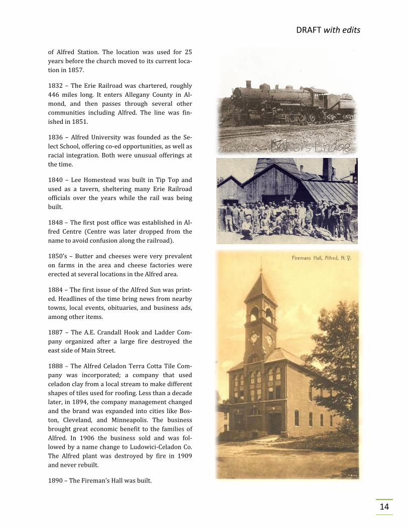
1832 – The Erie Railroad was chartered, roughly 446 miles long. It enters Allegany County in Al-mond, and then passes through several other communities including Alfred. The line was fin-ished in 1851.
1836 – Alfred University was founded as the Se-lect School, offering co-ed opportunities, as well as racial integration. Both were unusual offerings at the time.
1840 – Lee Homestead was built in Tip Top and used as a tavern, sheltering many Erie Railroad officials over the years while the rail was being built.
1848 – The first post office was established in Al-fred Centre (Centre was later dropped from the name to avoid confusion along the railroad).
1850’s – Butter and cheeses were very prevalent on farms in the area and cheese factories were erected at several locations in the Alfred area.
1884 – The first issue of the Alfred Sun was print-ed. Headlines of the time bring news from nearby towns, local events, obituaries, and business ads, among other items.
1887 – The A.E. Crandall Hook and Ladder Com-pany organized after a large fire destroyed the east side of Main Street.
1888 – The Alfred Celadon Terra Cotta Tile Com-pany was incorporated; a company that used celadon clay from a local stream to make different shapes of tiles used for roofing. Less than a decade later, in 1894, the company management changed and the brand was expanded into cities like Bos-ton, Cleveland, and Minneapolis. The business brought great economic benefit to the families of Alfred. In 1906 the business sold and was fol-lowed by a name change to Ludowici-Celadon Co. The Alfred plant was destroyed by fire in 1909 and never rebuilt.
1890 – The Fireman’s Hall was built.

DRAFT with edits
15
1900 – The New York State School of Clay-Working and Ceramics was established at Alfred University, now known as the New York State Col-lege of Ceramics.
1909 – Alfred State Agricultural and Technical Institute was established as part of Alfred Univer-sity with 68 students enrolled.
1916 – The Red Bus Line began operations as the first public motorized transportation from Alfred to Hornell.
1917 – Military drills were incorporated on cam-pus and the Alfred University New York State Mili-tary Corps was created. This was followed by the Student Training Corps, with a purpose to supply military branches with officers, engineers, doctors, and other specialists.
1927 – During post-war depression, the Alfred State Agricultural and Technical Institute was re-moved from Alfred University’s management and placed under the State of New York.
1960 – A zoning map was created showing resi-dential districts. While the definitions are different today, much of the area is still zoned as it was in the 1960’s.
1964 – First evidence of zoning printed in a book titled, “Ordinances of the Village of Alfred New York”.

DRAFT with edits
16
Plan Purpose and Intent A comprehensive plan is a written document that describes the community character, the current demographic and economic state of the municipality, and a future vision for growth and development. The community character serves as the basis for local zoning and land use regulations. New York statutes specify that all zoning must be in accordance with the comprehensive plan and all plans for capital projects must take into consideration the goals of the plan.
A comprehensive plan provides the context and a framework for local officials and citizens to make decisions about zoning, land use, road building, maintenance and other services such as police and fire protection, water supply and sewage treatment. A current compre-hensive plan is necessary for obtaining grants and loans for government and community organizations to finance needed projects.
According to New York Law (N.Y. Vil. LAW § 7-722 and N.Y. TWN. LAW § 272-a), a compre-hensive plan should reflect the ideas and needs of the entire community, thus the participation of all community members -residents, property owners, business owners, students - is critical to the development of a plan. A plan provides residents with a basis for accountability of decisions. Alfred’s Comprehensive Plan is a working document with a vision of 10-20 years.
PLANNING OUTLOOK The planning outlook can be defined by the stretch of time for which the plan is considered pertinent and symbolic of the community. It also enumerates the length of time necessary to implement a majority of the plan’s recommendations over the next decade. This joint planning effort for the Town and Village of Alfred will provide a comprehensive planning guide for making key decisions in the future.
It is recommended that information contained in this document be reviewed by the Town and Village on a continuous basis to ensure that it is applicable and useful. Furthermore, the joint comprehensive plan should be reviewed by the Comprehensive Plan Review Committee at a maximum of every five (5) years in its entirety, for changes in opportunities or risks within the Town and Village.
INTRODUCTION TO THE NEW PLAN Alfred is a college town in a rural setting. Considerable distance from metropolitan centers has been significant to planning and the future of the community. Alfred has maintained many of the essential qualities of what planners now call the "traditional small town," and

DRAFT with edits
17
these characteristics are frequently cited by residents as the key assets of both the Town and Village.
The close sense of community, the attractiveness of the architecture and landscape, and the assets of Alfred State College and Alfred University are desirable features to many Alfred residents. Both institutions generously share their cultural, educational and recreational programs with the community. Additionally, both institutions generously maintain their campuses as open, semi-public spaces, from which the community benefits on a daily basis in many ways.
Within the Village of Alfred and the hamlet of Alfred Station, open space is a natural fabric that winds through the "built" environment. Preservation of open spaces and the rehabili-tation of historic places is critical to the continued development of Alfred. Similarly, connecting existing and future open spaces to public recreational facilities such as ball fields, parks, and trail systems will increase utilization and familiarity of all these communi-ty assets.
The vitality of a cultural center within a rural setting produces an eclectic populace whose collective needs and desires must be judiciously balanced. Construction and restoration of a mix of housing types, while maintaining desirable neighborhood characteristics, is para-mount to ensuring suitable accommodations to all residents of Alfred. Additionally, maintaining and improving the visual appearance of buildings and properties buoys com-munity spirit and increases the attractiveness of the community.
When it comes to economic development, a strong partnership between the Town and Vil-lage of Alfred is essential. To succeed in the 21st century, all entities must join together and leverage existing resources in order to compete for economic development opportunities in western New York. There is no room for isolationist thinking if Alfred is to compete re-gionally - and economic development requires a regional, if not global, strategy.
Alfred is in a strong position to compete since it is the home to the economic engines of Al-fred University and SUNY Alfred as well as an impressive number of mature, successful businesses. This strength tends to produce myopia toward key components of any econom-ic development vision: jobs, visitors and high traffic counts. Furthermore, the Town and Village of Alfred are well-positioned to complement each other – while the Village has the infrastructure for economic development, it is also essentially built-out; while the Town does not have the entire suite of infrastructure in place, it has well-sited, available land.
Existing land use laws correctly place the spotlight for growth on the Main Street/State Route 244/State Route 21 corridor. The most promising aspect of this emphasis is that the corridor encompasses additional municipalities and therefore provides additional oppor-tunities to partner in the pursuit of economic development.

DRAFT with edits
18
Land use and zoning are still key. The Town and Village of Alfred are in very different posi-tions when it comes to land use. The Village has been close to 100% developed since the 20th century, while the Town has available land in all of its zoning districts. The goals for land use policies in the Village and Town therefore differ.
Both entities are very active in maintaining their respective Zoning Law. Examples of re-finements since the 2004 Comprehensive Plan include addressing natural gas extraction in the Town, as well as high-density ‘social’ housing within the Village. Despite efforts, the Vil-lage zoning needs a comprehensive update. Positioning the Village to undertake this update is one of the overarching goals of this comprehensive plan update.
Challenges facing the village that may be addressed through zoning include:
• The lowest level of owner-occupied housing in the village’s history; • A too-small business district; • The relationship of the educational zone and educational investment/ownership; • And a lack of incentives for multimodal/multi-use buildings.
Keep the relationship active. As Alfred State College and Alfred University have such con-siderable influence over the community direction, a cooperative working relationship between the municipalities and the institutions should be reinforced. The needs and de-sires of the 7,000 students and employees of both institutions should be considered alongside those of the 2,000 long-term residents of the Town and Village. The Town and Village together have a transient population three and a half times as large as the long-term population resulting in fiscal and logistical challenges to provide appropriate services.
Continue sharing community assets. Over the last 12 years, the Town and Village have iden-tified areas for service sharing which have resulted in a single Dog Control Office, a shared assessor, refined agreement of police protection, inter-municipal aid agreements for fire and ambulance service, and opportunities for shared street service assistance continue. To further reduce duplication of services among Alfred State, Alfred University, Town, Village, and County governments, biannual community meetings discussing issues pertaining to community development should be scheduled.
In order to avoid incompatible land use policies, information should be shared across polit-ical boundaries and ownership lines. This includes coordinating land use goals and objectives, where compatible, between the Town and Village. The findings of a 2015 Finan-cial Restructuring Board review of the Village offered the option of municipal dissolution previously considered in the 1999 Fiscal Impacts and Municipal Options report. A poten-tial future merge of the Town and Village highlights the importance of compatible land use policies throughout Alfred. This financial restructuring report is included as Appendix F.

DRAFT with edits
19
Additional utilization and revitalization of current Town and Village assets, such as the public recreational facilities near the Alfred Station Fire Hall and on Pine Hill Drive should be prioritized.
In September 2019, a plan titled “Village of Alfred Street Tree Guide, Management Recom-mendations and Inventory” was presented to the Village Board. The guide was produced by volunteer residents and includes policy recommendations on existing trees and new trees, as well as a business block redesign. Urban forestry in Alfred has become a very strong public interest item and the maintenance of such a public asset should be carefully man-aged. The plan is included as Appendix G in this plan and is also included on the Village of Alfred website.

DRAFT with edits
20
Comprehensive Planning Overview Comprehensive planning has roots in the City Beautiful movement, dating in large part to the Columbia Exposition in Chicago in 1892, as well as in the governmental reform move-ment of the early twentieth century. Planning for a sustainable future for the community as a whole is an essential governmental function. Community land use development patterns are facilitated by public policy that forms the basis for where and how we invest in capital improvement projects, economic development, civic initiatives, and protection of commu-nity resources like cultural, natural and historical features.
Community planning is a process that combines objective information about community resources and trends with community needs, goals, and aspirations into a road map for how the community will grow and evolve over time. This road map, or community com-prehensive plan, is then put into action through land development regulations, investments in public facilities and infrastructure, and government programs for things like smart growth initiatives, economic development, open space and recreational activities.
Change happens. We need to anticipate and plan for it!
The most essential feature of a comprehensive plan is its ability to reflect a community’s engagement in long-term planning. The State of New York now actively encourages such planning; not through any statutory requirement, but rather by giving preference to re-quests for funding by local governments and agencies whose projects support a local Comprehensive Plan. Since Comprehensive Plans typically support regional plans, the State of New York can gauge the compatibility of funding requests with those in a Regional Economic Development Council jurisdiction. As taxpayers, this ensures our investment in the State is put to better use. Locally, it means that having a Comprehensive Plan makes a community a stronger contender for grants and programs.
COMMUNITY PROFILE
LOCATION AND OVERVIEW The Town and Village of Alfred is a community in Allegany County that takes great pride in and assigns great value to its rural residential character, small-town atmosphere, high-quality agricultural and forestry land, and scenic natural resources.
Preservation of the Town’s irreplaceable scenic sites, air quality, water quality, and unique character is of significant value to the inhabitants of the Town and to the tourists who visit here.

DRAFT with edits
21
DRAFT with edits
22
The Town’s rich natural environment is a valuable asset that creates a sense of identity and well-being for residents of the area. Preserving and protecting the agricultural, scenic, rec-reational, and other natural resources of the Town is important for both a healthy environment and vibrant economy. Aesthetic issues are real and evoke strong reactions from people. They also deeply affect the way people feel about a place, and affect whether businesses will want to locate within, or people will want to live in, attend school in, and visit, a place.
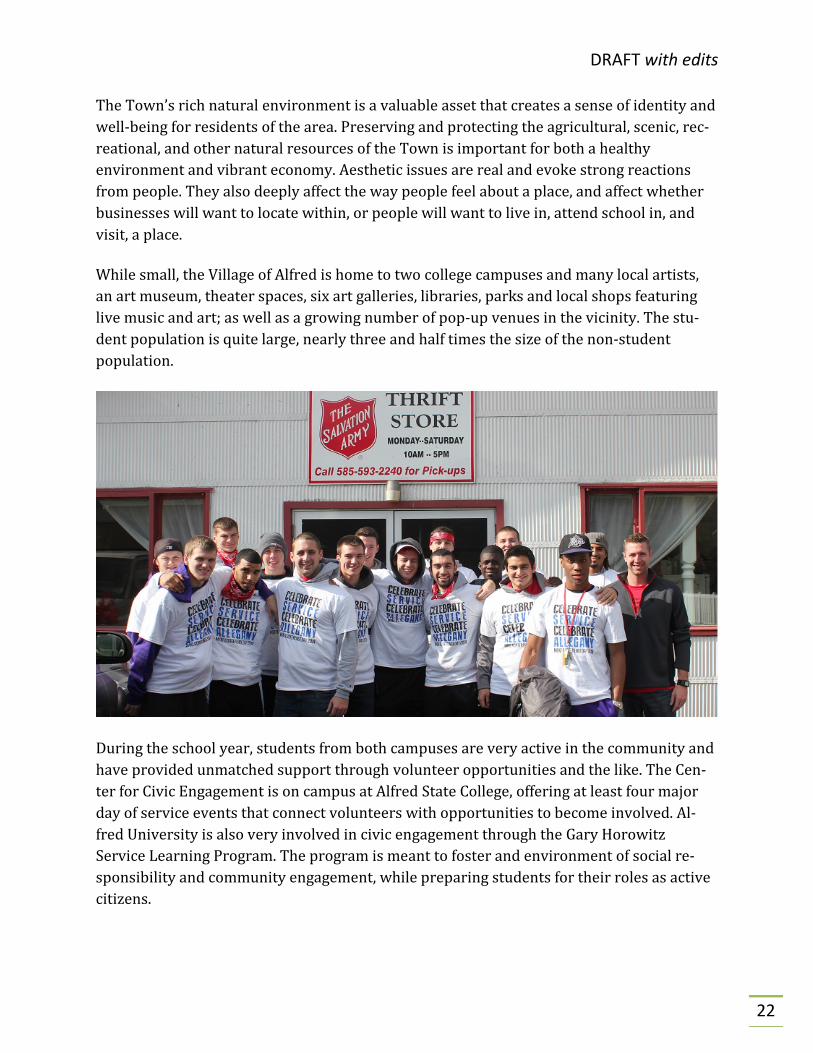
While small, the Village of Alfred is home to two college campuses and many local artists, an art museum, theater spaces, six art galleries, libraries, parks and local shops featuring live music and art; as well as a growing number of pop-up venues in the vicinity. The stu-dent population is quite large, nearly three and half times the size of the non-student population.
During the school year, students from both campuses are very active in the community and have provided unmatched support through volunteer opportunities and the like. The Cen-ter for Civic Engagement is on campus at Alfred State College, offering at least four major day of service events that connect volunteers with opportunities to become involved. Al-fred University is also very involved in civic engagement through the Gary Horowitz Service Learning Program. The program is meant to foster and environment of social re-sponsibility and community engagement, while preparing students for their roles as active citizens.

DRAFT with edits
23
Alfred University is a small, private institution, with a specialty for arts and engineering. Over 60 majors and concentrations are offered within its four colleges. They typically host between 1,500 and 2,000 undergraduates a year and another 300 postgraduates. The cam-pus is on the east side of the Village and currently spreads over 232 acres. The Performing Arts on the Alfred University campus have been historically accessible to the community; inviting all to participate in band, orchestra, chorus, dance and theater.
Alfred State College of Technology is one of eight State University of New York schools. Al-fred State hosts approximately 3,700 students a year, offering both two- and four-year degrees in over 70 majors and concentrations. The campus spreads over 260 acres on the west side of the Village with some additional agricultural space in the Town.
Demographics of Alfred
Demographics were collected from www.census.gov/acs/www/data/data-tables-and-tools/data-profiles/2017/. District enrollment and ranking collected from www.schooldigger.com. Icons were created by various authors from www.thenounproject.com.
5,237. Population at the 2010 Census
$39,375. Median Household Income
0.1 Sq. Mi. Total water area
31.5 Sq. Mi. Total Land Area
41.2 Miles. Town Roads
7.32 Miles. County Roads
600. Student enrollment average at AACS
1. Ranked the top school district in Allegany County

DRAFT with edits
24
According to schooldigger.com, the Alfred Almond School District is ranked as the top school in Allegany County. It is ranked as 13th out of 96 schools in the western New York region by the 2019 Buffalo Business First school publication. A merger was proposed with the Canaseraga and Arkport school districts in 2014 due to a declining enrollment in all three districts; however the merge was opposed by voters and all three districts are still in operation.
The nearest shopping centers to Alfred are in Hornell (Steuben County) and Wellsville, both at approximately the same distance from Alfred in different directions; however Hor-nell may be easier travel due to the topography of the area. Alfred offers a unique retail experience with various businesses in the area.
Shown in the top left picture is the Canacadea Country Store in the Town of Alfred, Hamlet of Alfred Station; the lower left picture is the SOS Liquor & Wine in the Village of Alfred; and to the right local products from Stearns Poultry Farm in the Town of Alfred.

DRAFT with edits
25
Plan Resources When considering this revision of the Comprehensive Plan, a number of important re-sources were utilized in order to gather as much data as possible during the planning process. The Town and Village intend to continue utilizing its previous plans and studies as resources for recommendations. Although the Plan is a tool of government policy, it should not exclude future decisions that may not align exactly with the state vision and policies. Without a doubt, the single most important resource was the Alfred community itself, with residents supplying detailed survey responses.
As part of the planning process, the Town and Village designated members of their Plan-ning Boards to act as the Steering Committee. Key members of each Committee are those who attended the Comprehensive Plan Training School with their knowledge of the plan-ning process and their willingness to be the conduit for increased communication. With the objective of gathering as much data and input as possible, the selected committee rep-resented several distinct perspectives including transportation, infrastructure, housing, economic development, education, health care, emergency services, recreation and tour-ism, land use, and local government services.
July 2014 – The NYSERDA grant was awarded to Allegany County
December 2014 – Allegany County solicited a RFP for the Comprehen-sive Plan Training School
April 2015 – Comprehensive Plan Training School began
May 2015 – Working groups met
September 2015 – A public forum was held in the Town of Alfred
October 2015 – A public forum was held in the Village of Alfred
June 2016 – MRB Group and Alfred complete the draft plan
Winter 2016/2017 – Town and Village Boards review the draft
Spring 2018 – Town and Village Boards review the final
Spring 2019 – Additional edits made
Summer 2019 – Town and Village Boards review
Fall 2019 – SEQR review process
Fall 2019 – Public hearing on adoption of the plan
Winter 2019 – Adoption of the final comprehensive plan
Draft
↓
Final
Concept
Training
SEQR
Public Hearing
Adoption
Grant Awarded

DRAFT with edits
26
Some of the local resources that were utilized in developing this plan were:
• The 1970 Town and Village Comprehensive Plan; • The 2004 Town and Village of Alfred Comprehensive Plan; • The 2013 Western New York Regional Sustainability Plan; • The Allegany County Comprehensive Plan; • The Alfred State College Comprehensive Plan (ASCCP) for the Town and Village of
Alfred, New York (2015 Draft Edition).
Information regarding the Town and Village’s population, housing, employment location, educational attainment, was obtained from the U.S. Census Bureau, utilizing Data Tools & Apps. Also gathered were previous demographic data for comparison and identification of trends. Relevant data which determined the focus of the Steering Committee are reflected in tables and maps throughout this document.
Finally, Geographical Information System (GIS) mapping was developed utilizing various data sources, such as the U.S. Geological Survey data and Allegany County Real Property Services assessment/tax data. GIS mapping provides a digital representation of data linked to a specific parcel or area within the Town and Village. All maps created for the Steering Committee are included in Appendix C and should be considered reference only.
PREVIOUS COMPREHENSIVE PLANS The 1970 Comprehensive Plan has relevance today, although the recommendations were somewhat obscured by a lengthy, three-volume text and a great amount of "boilerplate" material. The report groups its plan elements into five categories: Land Use, Circulation (Roads), Community Facilities, Financial, and Capital Improvement. Many of the goals, ob-jectives and strategies of the report are similar to those in the 2004 Comprehensive Plan.
The 2004 Comprehensive Plan focused on information sharing and cooperative planning and also incorporated assumptions about appropriate use of natural resources that were new ideas in 1970. It also referenced rural planning techniques that were developed in the last 30 years. The 2004 Alfred Comprehensive Plan Committee identified that periodic re-view of previous reports and the 1970 Comprehensive Plan is important to see what ideas still have currency. The Town and Village should continue with the idea of reviewing the previous Comprehensive Plans on a regular basis for relevancy.

DRAFT with edits
27
COMPREHENSIVE PLAN TRAINING SCHOOL Allegany County Planning and Econom-ic Development issued a Request for Proposal (RFP) on December 18, 2014 for a Comprehensive Plan Training School, which was funded through NYSERDA’s Cleaner Greener Communi-ties grant funding. The County took an innovative approach in providing planning and development services to its local municipal governments by launching the “Comprehensive Plan Training School”. The premise of the
School was to provide participating municipalities the training to prepare a draft Compre-hensive Plan or an update to their existing Comprehensive Plan.
The curriculum of the Planning School was based on the U.S. Building Council’s “Technical Guidance Manual for Sustainable Neighborhoods” and New York State Technical Series publications “Creating the Community You Want: Municipal Options for Land Use Control” and “Zoning and the Comprehensive Plan” as primary reference sources.
Representatives from the Town and Village of Alfred participated in 15 weekly classes, fa-cilitated by MRB Group, D.P.C., the firm retained by Allegany County to conduct the training.
Members of the Alfred Town and Village Boards, along with several concerned citizens at-tended the 2015 Allegany County Planning and Economic Development Comprehensive Plan Training School which began April 7, 2015. This series of classes was hosted by Alle-gany County Director of Planning-Kier Dirlam and was presented by staff from MRB Group, D.P.C.
Early in the planning process working groups consisting of community members met to develop concepts introduced during the Comprehensive Training School sessions. The first working group met on Friday, May 22, 2015 and produced recommendations on maps deemed useful for planning, a comprehensive infrastructure tool, and areas for possible in-vestment or expansion. The second working group met on Thursday, May 28 and Monday, June 1, 2015 producing the draft survey which was eventually distributed throughout Al-fred. A third working group met on Tuesday, August 4, 2015 and outlined planning recommendations for land use in both the Town and Village.
In order to bring community input to the process, the finalized comprehensive planning survey was mailed out to Village residents along with their monthly water bill, published

DRAFT with edits
28
for two consecutive weeks in the local paper, The Alfred Sun, posted at local businesses, and the Box of Books Library. It was also emailed to Alfred University and SUNY Alfred fac-ulty, staff and students. Additionally, two public forums were held, the first in the Town of Alfred Fire Station Hall on Tuesday, September 15, 2015 and the second in the Alfred Vil-lage Hall on Thursday, October 1, 2015.
Throughout the course of the training school, Town and Village representatives identified key objectives and strategies that they wanted to achieve in their communities after the completion of this Comprehensive Plan. By the end of the program, the Town and Village were working in a collective effort to prepare a new, up to date Comprehensive Plan that identified key objectives and strategies for both entities. MRB Group, D.P.C. assisted the Town and Village in finalizing this Comprehensive Plan produced in the training school.
COMMUNITY OUTREACH & PARTICIPATION In an effort to ensure that the Plan also addressed the desires and concerns of the public, opportunities were provided to engage Town and Village residents and stakeholders in the development of the Plan’s content. Public Forums were held after the completion of the Training School and marked the first phase of community outreach to solicit input from the general public.
Alfred Public Forum #1
On September 15, 2015 a public forum was held at the Alfred Station Fire Hall to which all community residents and stakeholders were invited. Nearly 40 residents attended the fo-rum to learn more about the comprehensive plan process. The purpose of this forum was to introduce the public to the planning process and to solicit input from the community for the future visions and goals of Alfred.
Attendees participated in a group brainstorming session to determine the community’s “most” and “least” important services. Each Group then developed a goal and objective based on key input from participants. A complete listing of responses from this forum is provided in Appendix D.

DRAFT with edits
29
Alfred Public Forum #2
The second public forum was held on Octo-ber 1, 2015 at the Village Hall as a follow up to the first. This workshop was presented by students in the Alfred State College (ASC) Urban Design Studio class*. The workshop was designed to share the Studio’s devel-oped ideas through renderings for the Town and Village establishing a healthy dialogue with the general public. The complete draft of the Alfred State College Comprehensive Plan (ASCCP) can be found in Appendix E.
*The Urban Design Studio focuses on design aspects of buildings and places in an urban setting with a concen-tration in support systems. One of the student projects is to design a concept Main Street area for the rural Towns or Villages of Allegany County. Students spend a significant amount of time reviewing existing com-prehensive plans and meeting with public officials to help determine design ideas. The projects are typically presented to the public during the initial phase and again at the end of the process. Students then travel to Washington, DC and present projects to the Appalachian Regional Commission as part of the Appalachian Teaching Project. Other completed projects include Village of Cuba Master Plan (2010-2011), Village of Wellsville Community Visualization Study (2016), Village of Canaseraga Community Visualization Study (2017), Village of Andover Community Visualization Study (2018), and the Village of Bolivar Community Vis-ualization Study (expected 2019).

DRAFT with edits
30
COMMUNITY SURVEY
During the early stages of the planning process, the Town and Village Steering Committee dis-tributed a community-wide survey to residents in order to engage them in the planning process. Surveys were sent out asking for the residents input in formulating this Comprehensive Plan. Residents of the Town and Village were initially asked to participate in the planning process by offering their thoughts and concerns about the community, in order to examine its current strengths, weaknesses, opportunities and threats.
From a variety of opinion-gathering venues, res-idential feedback afforded the Steering Committee to identify a common thread of local-ly perceived issues and opportunities present in the community. These included discussion of core values, community-wide surveys and out-reach strategies with focus on community values, future goals, land use, economic development, public services, and future recommendations.
One nearly universal perception of the communi-ty emerged as a central theme, resulting in the foundational benchmark for remaining discus-sions: that the small-town character, friendly atmosphere and strong sense of community are defining characteristics of the Town and Village of Alfred.
When asked, “What do you most value about Al-fred?” people listed the following characteristics:
Small Town Character Safe Community
Friendly Community Overall Quality of Life

DRAFT with edits
31
RESIDENTS VALUES AND PREFERENCES Of all the community-wide surveys distributed, there were 85 total surveys returned to the Steering Committee. This number reflected an estimated return of approximately 7% of identified households and known businesses in the community who received the survey by mail. Copies of the survey were also available at several public buildings and the Town Hall for community members to complete.
In considering the results of the survey, the Steering Committees recognized the potential for duplicate submissions, although careful examination of survey responses did not reveal any exact duplicates, nor was there evidence of attempts to influence survey results. While not scientific in process, much deliberation was given to the creation of survey language that would foster honest, candid responses.
Community members were also asked in the survey to rate the importance of services that are currently provided by the Town and Village of Alfred. A summary of the data is provid-ed on the following page. Complete survey results can be found in Appendix B.
0
10
20
30
40
50
60
70
80
Rate
Service
Town of Alfred
Very Important Important Not Important

DRAFT with edits
32
POPULATION TRENDS AND PROJECTIONS
0
10
20
30
40
50
60
70
80
Rate
Service
Village of Alfred
Very Important Important Not Important
Respondents were asked to rate Town and Village services as very important, important, or not important.
Fire and ambulance protection ranked #1 as Very Im-portant for Town and Village residents, followed by Police Protection.
Street Landscaping was ranked as least important in the Town; and Pedestrian and Bike Paths were ranked as least important in the Village.
Top three challenges listed (not shown in the graphs) were:
1) Taxes 2) Town/Gown 3) Municipal Services

DRAFT with edits
33
In 1950, the Village of Alfred had almost three times or 1,244 more residents than the peo-ple living outside the Village. Based on the historical data presented below, the Town has seen relatively steady increase since 1950, with minor decreases in 2000 and 2010. The Village has seen significant growth between 1950 and 1980, with decreases in population between 1990 and 2010. Based on the 2015 projections, both the Town and Village will see a decline in population. The population trend for the Town and Village are consistent with that of Allegany County. The Town of Alfred, including the Village as of 2010 had a population of 5,237 residents.
Current Town and Village Clerk estimates propose that the resident, non-student popula-tion of the Village is actually somewhat less than 1,000. The 1970 Comprehensive Plan has population projections for the 30-year period 1960-1990.
38000
40000
42000
44000
46000
48000
50000
52000
54000
1950 1960 1970 1980 1990 2000 2010 2017(est)
Popu
latio
n
Allegany County, NY Population Rates
0
1000
2000
3000
4000
5000
6000
7000
1950 1960 1970 1980 1990 2000 2010 2017(est)
Popu
latio
n
Alfred, NY Population Rates
Village Town

DRAFT with edits
34
The population of Allegany County peaked in 1980 while that of Steuben County peaked in 1970. The projections at the county level significantly exceeded actual increases during that 30-year period.
• Allegany County Projected Increase +18.84% Actual Increase +14.8%
• Steuben County Projected Increase +16.53% Actual Increase +1.4%
Demographics of Alfred
Demographics were collected from the Board of Elections for Allegany County; Alfred State College and Alfred University; and summary sheets on the Alfred-Almond School District from the website data.nysed.gov. Icons were created by various authors from thenounpro-ject.com
1,460. Registered voters in Alfred.
699 can vote in the Village.
6,046. 2018 total college student population.
632. Average enrollment at Alfred-Almond CS
65% of ASC students live on-campus.
73% of Alfred University students live on-campus.
13% of ASC employees live in Alfred.
36% of Alfred University employees live in Alfred.

DRAFT with edits
35
Infrastructure
WATER
Many residents are dependent upon aquifers and wells for life-sustaining water; maintain-ing the quality of water resources within the Town is critical to protecting the natural environment of the Town, the general health and welfare of Town residents, and the local economy.
The Village water supply system, which relies on two wells located within the Town's boundaries, services residences and businesses within the Village. It also services most of the Town residences and businesses along Rt. 244 from the Village line to the north end of Shaw Road.
The present design capacity of the wells is 1.3 million gallons per day. However, actual storage capacity is 850,000 gallons, held in three Village tanks and a fourth located on the ASC campus. The total demand when both ASC and AU are in session is approximately 500,000 gallons per day. The storage capacity is therefore less than two days demand.
View from the bottom of Alfred Station Road in Alfred Station.

DRAFT with edits
36
Water is pumped from the wells to the storage tanks by eight pumps: one at each wellhead and two at each of three booster stations. The pumps operate at an average total output of 500,000 gallons per day to keep the tanks full. In case of local or regional power loss there are generators at pump two and at one of the booster stations. An extended power outage coupled with a significant draw-down on storage could result in insufficient water for both customers and fire-fighting purposes.
Storage capacity should be reviewed for present and future demands, and consideration should be given to installing the minimum equipment necessary to provide for the commu-nity's safety in emergencies. Analysis of the aquifer and the overlying stratigraphy should be conducted to determine its susceptibility to contamination from potential hazards.
SANITARY SEWER The Village of Alfred has recently completed a major renovation of its wastewater treat-ment plant. This facility services residences and businesses within the Village boundaries, and it extends to the Sugar Hill Industrial Park, which is located wholly within the Town boundaries. A small number of Town residences located just over the Village line are also tied into the system.
The Village's decision to upgrade its treatment plant was based on analysis of the costs of participating in a new regional system. The plant capacity was not increased in the reno-
Water storage tank just above Pine Hill Play-ground on Nevins Drive in the Village of Alfred

DRAFT with edits
37
vation; however it is capable of handling significant increases in flows relating to future population growth or additional connections to Town properties. For purposes of com-munity planning, it is important that Town and Village officials know how many households, businesses and student residents can be accommodated by the extra capacity.
While repairs to an aging sewer system are listed as an on-going mitigation initiative in the Alfred Hazard Mitigation Plan, it is not specific to what repairs need to be completed. The most significant improvement remaining for the wastewater treatment system is the elimination of storm water infiltration into the old mains (underground pipes). Such infil-tration increases flows into the treatment plant and puts greater demands on the facility.
The origin of wastewater - residential, industrial or institutional - can determine the rela-tive costs of treatment. As future growth in the service area occurs, an examination of treatment costs per unit volume from different sources may reveal that sewer charges should be adjusted to reflect true burdens put on the treatment facility.
REGIONAL WATER & WASTEWATER SERVICE Long-term planning for extended water and wastewater service is desirable for both ac-commodating and encouraging economic development. The Canacadea Valley is the logical focus for improved municipal services: the valley bottom offers the best topogra-phy for transportation and the construction of infrastructure. Renewed planning can take advantage of recent studies.
An aerial view of the Wastewater Treatment Plant on Route 244

DRAFT with edits
38
TELECOMMUNICATIONS Both the Town and Village of Alfred are in need of updating in terms of telecommunica-tions. Having two upper level institutions, one of which being a school of technology, can provide aid to a dated system. A popular trend with commercial businesses is to install wireless internet in their spaces, which will appeal to the growing number of people ac-cessing the internet. Installing wireless internet has shown in other areas to increase traffic in businesses, while also increasing revenue. The two main companies that provide Internet services in the area are Spectrum and Frontier Communications.
Allegany County and New York State have been working on bringing wireless broadband to the more rural communities of the area for nearly a decade and have more work to do. Armstong LLC has been working in the area to install fiber optic cable and would serve are-as that are not currently served by Spectrum. Alfred is one of the communities with better internet capabilities, due to the needs of the educational institutions.
VILLAGE PARKING The adequacy of both on-street and off-street parking in the Village business district is a matter of concern to many residents, visitors, business owners and their employees. With approximately 100 legal parking spaces, the nature of the problem varies from season to season, business to business, and street to street. Further, the needs of ASC and AU for stu-dent and employee parking interrelate with Village issues.
Problems include:
• Insufficient number of on-street metered spaces during the Village's busiest hours • Insufficient number of off-street spaces for business owners and employees • Lack of signage for different meter hours • Inefficient locations and mix of 1-, 2-, 3-, and 10-hour meters • Inadequate short-term (15-minute) spaces • Delivery and construction vehicles' use of parking spaces for extended periods of
the day
The parking problems can also be an indicator of something good. The Village is thriving! The colleges are full. People are visiting downtown. Yes, the problems listed above are in-dicative that more spaces are needed; however there are a number of ways that this could be addressed.
• Do a parking study to help determine which businesses need more parking than others. Are the parking spaces in the Village utilized more by business employees, institutional faculty and staff, or more by visitors?

DRAFT with edits
39
• Most people are only at a business for a short amount of time. Does it make more sense for some of the meters to be changed out for short term parking spaces? Bet-ter regulation of parking space would help prevent long term parking in one area.
• Some of the businesses have parking in the rear of the building. Are there wayfind-ing signs clearly marked for rear parking?
• While the Village is at maximum land use, would it be feasible to purchase an empty lot or a vacant home and turn it into parking? Having to park a block or two away from their destination is not going to deter a visitor.
SIDEWALKS IN THE TOWN AND VILLAGE Safety of pedestrians and cyclers has been an issue for countless years, not just in Alfred but in communities everywhere. As walkability, place making, and reduction of motorized vehicle use become more and more popular, sidewalks are getting more and more use, re-quiring maintenance and handicap accessibility requirements that landowners can’t always afford. While this is understood, it is equally important to keep our students, neighbors, co-workers, and visitors safe.
Parking meters in the Village of Alfred

DRAFT with edits
40
INVENTORY The Village of Alfred has approximately 4.5 miles of sidewalk. The Town of Alfred has ap-proximately a half mile of sidewalk, in the hamlet of Alfred Station. Both Alfred University and Alfred State College have massive amounts of sidewalk as well; however those are maintained by the institutions.
Of those sidewalk miles a majority is either constructed using concrete materials or brick pavers, although asphalt, brick, and rubberized pavers are common sidewalk materials as well. Concrete sidewalks have a life span of 40 to 80 years (if maintained), brick pavers may have a much shorter life span but are typically used in downtown or historic districts, as they are in Alfred, to preserve the traditional appearance. Pavers do have advantages, but if not placed properly could end up costing more in the long run.
Paved shoulders can be an acceptable form of walking path for pedestrians and bicycles, but come with its own set of challenges. The lifespan of a road is currently five to ten years if preventative maintenance is completed. There is paved shoulder present on Route 244 for pedestrian use, allowing foot access to the convenience store, Dollar General and the hardware store. Route 21 in the Town of Alfred, on the outskirts of the village offers a soft shoulder only. Both have a high volume of through traffic making the walkability without a designated sidewalk quite dangerous.
COMMON PROBLEMS There are many types of infrastructure deficiencies that can plague sidewalks in a commu-nity. The compromised surfaces can be major or minor, but will ultimately be a safety hazard and affect the life of the sidewalk if left untreated.
Many Alfred Town and Village residents are concerned about the maintenance require-ments and liability issues they are faced with because repair is not only expensive, if deficiencies are not treated it then puts community members at risk for injuries.
Concrete sidewalks will often show disrepair like cracking, heaving, sagging or settlement. These are all structural and are a result of freeze and thaw actions or poor curing and low concrete quality. Pavers can show disrepair as well but often the causes include vegetation growth or paver displacement. Some examples of sidewalks in Alfred are shown on the fol-lowing page.

DRAFT with edits
41
Solution
The Town and Village of Alfred, as well as residents, would benefit from use of a standard sidewalk and road maintenance plan. This should include inspection and evaluation crite-ria, as well as a replacement plan to maintain them at State and Federal levels. Alfred, like many other communities, requires property owners with sidewalk frontage to be responsi-ble for some or the entire repair required. If a replacement plan were in place, the areas with the most damage could be replaced first and the burden on the residents would be much less. Taking over this responsibility would most likely be a large expense to govern-ment but other jurisdictions have created shared fee structures, or they have built the plans into their Complete Streets process, using federal monies and grants to complete such pro-jects. More information can be found on the U.S. Department of Transportation Federal Highway Administration website.
Damage shown from tree roots
Surface deterioration
Upheaval of sidewalk pavers

DRAFT with edits
42
A ground-up view from the sidewalk in Alfred

DRAFT with edits
43
OPEN SPACE AND NATURAL RESOURCES
We recognize that change is inevitable, well-guided change is desirable, and that Alfred can benefit by a larger population and economic growth. We also rec-ognize that the appeal of our hometown lays no less in our natural surroundings than in our community, insti-tutions and historic buildings. Open space is a natural fabric that winds through the built environment of Al-fred.
In Rural by Design: Maintaining Small Town Character, Randall Arendt explains:
Another favored aspect of traditional small towns, especially those located in rural areas, is the open space that often exists around the edges, and occasionally occurs also as scattered pieces of undeveloped land throughout the community. Although most people take these spaces for granted, hardly noticing them in any conscious
way as they go about their daily business, they are strongly affected when such land begins to sprout buildings and parking lots. Few things change the character of
small towns and rural communities more than the conversion of these natural areas to development. Whether appreciated for their aesthetic, recreational, or sporting
benefits, such areas often hold deep meaning for long-term residents.
The preservation of such open spaces and the reconnecting of separate pieces are critical to the development of our community. The Village center has spaces that are essentially pub-lic greens containing gardens, lawns, trees, a bandstand, public library, and playground. The University generously maintains its campus as an open, semi-public space, and the community benefits from this daily in many ways. A coherent, landscaped space recog-nizable as the community center remains to be established.
Open spaces are also available in the hamlet of Alfred Station as the ballfield area and the spaces along Canacadea Creek and State Route 21. Appropriate landscaping and welcoming

DRAFT with edits
44
signs, historic markers and park amenities can increase the scenic and recreational value of such areas, further improving the attractiveness of our home.
PARKS AND RECREATIONAL FACILITIES:
Pine Hill Playground Park
This is an older playground on Pine Hill near the Alfred University astronomical observatory. The site is grassed with picnic tables, trash bins, playground equipment, older basketball court and small hill for sledding. This recrea-tional asset is scheduled to receive some updates in 2020.
Mike Kenyon Park
Located on South Main Street just south of the Main Street business block and adjacent to the Montessori School, the park has been in existence since the early 1970’s with play-ground equipment for young children. It is handicapped accessible, has picnic tables and parking available in the lot at the school. This playground is in the wooden style that was popular in the 1980’s and 1990’s. It is one of the last of this style in Allegany County still in use. The Village should consider a major upgrade of this heavily used facility with new, safer and modern equipment.
Views from a farm in Alfred Station, NY

DRAFT with edits
45
Volunteer Firemen’s Park
This park is located in the hamlet of Alfred Station behind the Post Office/Fire Hall. There is a foot bridge across Can-acadea Creek to the little league size field, Pavilion, trash bins, picnic tables, and grills. In recent years this site has undergone some updating and would be appropriate for additional improvements and updates like parking im-provements or better handicap accessibility.
Blueways
Communities are paying new attention to the rivers and streams running within their borders. A century ago, devel-opment of watercourses was of little importance, but now river and stream corridors are seen as key assets with rec-reational, parkland, and scenic value. Alfred lies in two significant river basins: the Genesee River Watershed, draining to Lake Ontario, and the Susquehanna River Basin, part of the Chesapeake Bay Watershed.
Models of river-based greenway preservation exist just downstream of us and include the work of the Friends of the Genesee Valley Greenway, Genesee Headwaters Water-shed Association and the Chemung basin River Trail Partnership.
Canacadea Creek, shown in the pictures to the left, and its tributary at the foot of the ASC campus provide both the Town and Village with a scenic corridor of open space that can be developed through restoration and landscaping ef-forts into a major attraction for the area. A visit to Ithaca will show the importance waterways can play in an aca-demic campus.
The protection and restoration of watercourses and adja-cent lands bring added benefits to natural and economic resources at no additional cost: stream buffer zones im-prove water quality and wildlife habitat, and open floodplains reduce local and downstream flood damage.

DRAFT with edits
46
The Canacadea Valley is a link to downstream communities that reminds us that municipal boundaries are artificial.
Trails
Established trails in the vicinity include Pioneer Trail Sys-tem, Pine Hill Trail, the Finger Lakes Trail System and the NY State Department of Conservation's West Almond Trail System in Palmer's Pond, Phillips Creek, and Turnpike State Forests. Alfred has an athletic and energetic popula-tion that takes good advantage of our rural setting. While open space abounds, public access is limited. Our proximi-ty to other recreational areas affords us the opportunity to design and develop extensive footpath and bicycle trail connectors.
Alfred State College opened the Pioneer Trail System in 2016, offering 4.5 miles of trails and gorgeous views. The trail head begins behind the Orvis Activities Center with three trail options based on different fitness levels.
Pine Hill Trail is located on the Alfred University campus, running approximately 2 miles in a forested setting. It is good for all skill levels and used for hiking, trail running, and nature trips with two marked entrances to the trail.
College Owned Facilities
Alfred State College:
Pioneer Athletics Facilities include fields near the western edge of the Alfred State College campus for Soccer, Foot-ball, Softball, Baseball, Track and tennis.

DRAFT with edits
47
Lake Lodge: This site sits on 12 acres approximately 1.5 miles from the Alfred State Campus. The lodge can seat 200 for social events, meetings, recreation, and catered dinners. Onsite they have fishing and camping is allowed at the ad-jacent campground.
Alfred University:
Merrill Field and Nearby Facilities: The main grandstand for Alfred University athletics is at Merrill Field with a capacity of about 5000 spectators it is used for Soccer, Football, La-crosse. The field has a lighting, new field house and the site includes restrooms and concession stand. Adjacent to Merrill Field is a new Softball stadium and tennis courts.
Bromeley-Daggett Equestrian Center: This 400 acre site has a 200 x 80 foot indoor arena as well as two lighted outdoor arenas. Stables with stalls and a capacity of 54 horses are on-site. Approximately five miles of horse trails extend over the site, as well as 28 electric camper hookups availa-ble for trailer parking. Boarding services are also provided for a nominal fee and the learning opportunities are end-less.
Jericho Hill Fields: Soccer, Rugby, Football practice fields located on top of Jericho Hill about one mile south of the Village. It includes two large grass fields, one with an older lighting system, plenty of parking, plenty of parking along CR 12 and at back field. This was once planned as the main sporting facility location for Alfred University but transpor-tation was detrimental to its use.

DRAFT with edits
48
Foster Lake: A 25-acre property that Alfred University pur-chased in 2002, sitting at the top of Jericho Hill and approximately five minutes from campus. It is available for recreational use by the community through permitted ac-cess. Recreation at the lake includes swimming, fishing, birding, canoeing and small craft sailing.
Civic Engagement Day photo, college students helping cleaning up a cemetery in Alfred

DRAFT with edits
49
Equestrian activities at the Bromeley – Daggett Center on Lake Rd.
Play ball! A picture from the Alfred-Almond Little League Facebook page
Phillips Creek State Forest

DRAFT with edits
50
Land Use
This section of the Comprehensive Plan examines development trends and current land use patterns within the community. Land use refers to the physical arrangement of a commu-nity’s agricultural, residential, commercial, industrial and institutional development, along with undeveloped/developable land. Examining spatial development patterns, rates of change, and trends can provide insight into how Alfred evolved under varying social, eco-nomic and environmental conditions. Understanding land use change within a community is a key aspect of the overall Comprehensive Plan, and forms the basis for discussion re-garding the future direction of the Town and Village.
LAND USE CHARACTERISTICS OF EXISTING PARCELS Table 1 and 2 contains a breakdown of the various land uses within the Village and the Town of Alfred and the Existing Land Use Map delineates their location. The tables were developed using the land use codes from the Allegany County tax files. Land use codes were developed by the New York State Office of Real Property Services to create a uniform classification system to be used in the assessment of land.
Class of Use Parcels Acres % Total Acreage
Agriculture (100) 0 0 0%
Residential (200) 272 199.8 35.29%
Undeveloped Land (300) 36 89.0 15.71%
Commercial (400) 46 32.3 5.70%
Recreation and Entertainment (500) 0 0.0 0.00%
Community Services (600) 16 19.2 3.38%
Industrial (700) 0 0.0 0.00%
Public Services (800) 1 0.2 0.03%
Municipal Parks/Recreation Areas (900) 0 0.0 0.00%
No Property Classification Code 38 225.8 39.88%
Total Village 409 566 100% Source: Allegany County Real Property Office, 2018 Data

DRAFT with edits
51
Class of Use Parcels Acres % Total Acreage
Agriculture (100) 12 806.5 4.32%
Residential (200) 458 9743.3 52.19%
Undeveloped Land (300) 202 5472.7 29.31%
Commercial (400) 33 176.6 0.95%
Recreation and Entertainment (500) 4 203.6 1.09%
Community Services (600) 10 87.7 0.47%
Industrial (700) 10 391.1 2.09%
Public Services (800) 10 145.4 0.78%
Municipal Parks/Recreation Areas (900) 10 699.0 3.74%
No Property Classification Code 61 943.9 5.06%
Total Town 810 18,670 100% Source: Allegany County Real Property Office, 2018 Data
Nearly 52% or 9,743 acres of land within the Town are classified as residential property, while 35% or 199 acres of the Village’s total land is dedicated to residential land uses.
Of the 458 residential parcels within the Town, 275 are classified as single-family residen-tial, while the Village has 215 single-family residential homes. The Town has a vast majority of land that is classified as undeveloped at 29%. Undeveloped land can incorpo-rate land within residential, commercial and industrial areas, including abandoned agricultural land.
Agricultural lands (12 parcels) represent the fourth largest land use in the Town with ap-proximately 806 acres of land being used for various agricultural purposes. There are only 10 industrial properties consisting of 391 acres within the Town, while there are no prop-erties within the Village that are classified as industrial.
Of the 1,219 properties located within the Village and Town, only 1 property has been clas-sified as a fraternity or sorority. Although Alfred University does not allow fraternities or sororities, Alfred State College has five (5) fraternities and six (6) sororities.
After drawing comparisons with the property classifications within the Town and Village, the most alarming observation was that there were 61 properties consisting of 944 acres within the Town and 38 parcels or 40% total land within the Village that did not have as-signed property classifications. Properties with unassigned property classifications did have notes that they were included with other parcels for assessment purposes. Because of this, the property classification map is not representative of the data shown in the tables. Most of the properties with missing classifications were associated as college or university

DRAFT with edits
52
owned, primarily on the main campuses. There are also several properties off-campus des-ignated as residential that are college or university owned. These properties are assumed to be used for student off-campus housing.
The property classification codes are not used for zoning purposes, however, they are as-signed by the Assessor’s office for assessment purposes. While zoning and assessment should match, they don’t always. Therefore, the land use maps and the zoning maps may look similar but are likely to have a few differences.
ZONING Alfred regulates development through zoning, housing and environmental regulations. Of these regulatory tools, zoning is the most important, especially for historic small Villages like Alfred, due to their capacity to steer redevelopment and its capacity to guide develop-ment of vacant land.
The Village of Alfred Zoning Law was last revised and adopted by the Village Board in March 2019. In accordance with New York’s zoning enabling statutes (the state statutes, which gives Towns and Villages the power to enact local zoning laws) all require that zon-ing laws be adopted in accordance with a comprehensive plan and provide the backbone for local zoning law.

DRAFT with edits
53
The Village regulates all land use activities within the Village in ac-cordance to the Site Development Plan Review process as outlined within Article Six of the Village of Alfred Zoning Law. The Village’s zoning framework includes the fol-lowing zoning districts:
• One-Family Residence District (R-1) • Two-Family Residence District (R-
2) • Multi-Family Residence District (R-
3) • Central Business District (B-1) • Business District (B-2) • Research/ Development District • Educational District (E-1) • Overlay Zone
The Town’s Zoning Law was first adopted in 1970, with subsequent updates on an as needed basis, with the latest revisions adopted in May 2019. The Town’s zoning framework includes the following zoning dis-tricts:
• Residential 1 District • Business District • Light Industrial District • Industrial District
After adoption of this Comprehensive Plan a committee should be created to monitor and review the progress of the comprehensive plan in relation to adopted Zoning Laws for the Town and Village.
Maps are provided here for reference only and were produced by MRB Group. Full size maps can be found in the back of the document.
FUTURE LAND USE Future land use planning involves how a community should look and function if redevel-opment or new development were to occur. However, it also strives to preserve essential

DRAFT with edits
54
areas of the community, such as the Village center, agricultural land and residential neigh-borhoods. While land use planning plays a key role in determining the location of future development, it is not the only function it serves. It also helps to create a sense of place and a common vision for the community. The manner in which people perceive their environ-ment, organize their time, and determine local interaction is defined, in large part, by how the land uses are organized within their community. The sense of connectivity, the sense of a place and the overall success of a community is indelibly tied to land use.
One of the key roles of a comprehensive plan is to inform future land use decisions for local governments and provide a tool for accomplishing this is the Potential Future Land Use Recommendations, which is intended be generalized vision for a community’s land use over the future years.
Below are some of the Potential Future Land Use Recommendations that should be careful-ly examined and considered on behalf of the Town and Village of Alfred:
• Bring the zoning and assessments up to date in both the Town and the Village. They should be somewhat reflective of each other; however, it does not always match. For example, Sugar Hill is currently assessed as commercial, but is zoned as industrial.
• Complete a re-evaluation of the historic district in downtown Alfred. The historic district is quite large now, but according to historic documents, there are several buildings in the Village that are outside the district that may qualify.
• Residential zoning efforts in the Town seem to be incomplete. It would make sense to update residential zones to be more inclusive.
• Consider creating more land use laws to cover things that are not mentioned in the zoning code. An example would be to create a subdivision law or creation of a solar law that would designate rules and regulations a developer would have to follow.
• During review of zoning law, be more aware of the desire to promote conservation of agricultural lands, as well as green spaces for public use.
• A large percentage of the village is considered tax exempt due to the amount of not for profit owned or college owned properties. Implementation of modern best prac-tices may help to increase the local tax base, allowing some of those properties to be recommitted to tax rolls.
The Potential Future Land Use Recommendations should be utilized by Town and Village departments, boards and commissions, developers and design professionals and the gen-eral public to guide future zoning decisions, and other land use regulations, smart growth and sustainable planning practices over the next decade. Having laws and regulations al-ready in place can make a location more enticing for a developer to explore because they will know what to expect in the building process.

DRAFT with edits
55
Concepts For Growth Major planning achievements such as land use planning and zoning were the solutions to the public’s health problems caused by haphazard development of industries and residenc-es. While walking is one of the oldest forms of transportation it is a fairly new concept in the planning world. Walkability scoring, place making, and complete streets concepts aren’t new either – but now with the recent re-imagination of Main streets, pedestrian friendly communities, and smart growth, more than just urban areas are trying to keep up with the beat.
Understanding what walkability means and what pedestrian’s desire are key to knowing how to approach rural communities that want to encourage walking. An ideal walkable community includes housing, office, and retail, access to transportation, schools and librar-ies, as well as encouragement of multimodal transportation.
The concept of smart growth is based on urban development but it fits quite nicely into the Alfred communities. To start with, Allegany County faces many of the same challenges as other rural communities around the country: an aging population with increasing health problems, and a disinterest from the younger generation. In addition, the country’s local governments have widely varying levels of staff, technical capacity and policy coordination. About half of Allegany County municipalities have no comprehensive plan or planning boards and many have no zoning either.
According to walkscore.com, Alfred has a walk score of 40 and a bike score of 32. This pri-marily means that the community is “car-dependent” and “somewhat bikeable”. By utilizing a creative place making methodology and reconfiguring portions of State Route 244 to en-hance safety, mobility and access for all road users, Alfred’s walk score could be much higher. Strengthening the connection between people and the places they share, especially the hamlets of Alfred Station and Tinkertown with the Village, has been one of Alfred’s pri-orities for many years now.
As part of Alfred’s efforts to revitalize the community, we applied for the Downtown Revi-talization Initiative in 2017, a grant opportunity with up to a $10 million reward. In late 2018, we received the news of our selection to receive $2.5 million from the Smart Growth Community Funds, funding from the Buffalo Billion II initiative supporting projects that uti-lize existing infrastructure to support place making, walkable communities and sustainable development. Some of the projects included in the application were:
• Terra Cotta Roof Restoration: a plan will be developed to help property owners de-termine existing conditions of terra cotta roofing, repair and replacement needs,

DRAFT with edits
56
and investment options. Annual walking tours will be created to promote local tour-ism and highlight the related ceramic art galleries throughout the area.
• Enabling business expansion: Southern Tier Concrete Products, Inc. is considering expansion of its manufacturing and warehousing capacity. In order to gain access to additional property, a bridge which meets applicable design requirements for heavy trucks is needed. This project would also include construction of a second plant re-sulting in multiple job creation.
• Place Making: State Route 244 is frequently used for student athletic training pur-poses, as well as a pedestrian pathway to local business. Creating a multimodal friendly pathway would provide safety, access to trail systems and other open space areas, and a connection from the Town to the Village center. Improved signage along the corridor pointing out proximity to local destinations will encourage walkability and increase interactions in Alfred.
Planned Achievements
• A connection to free WiFi throughout the Village will be provided by Alfred University.
• Broadband expansion is expected to continue through Armstrong Wireless in the Town of Alfred.
• Restoration of Pine Hill Park and playground is planned. The current park and playground area is under utilized due to old or out of date amenities that have not had required maintenance over a long period of time.
• Sugar Hill is an industrial development park with one business currently on campus, however there is a large acreage footprint that allows for placement of several buildings with ample parking in the area. A portion of the land was recently purchased with intent to expand the park for research and development, utilizing an equipment sharing hub on site to help foster business growth.
• Pine Street Bridge is scheduled for replacement in 2020. • Plans to develop an Alfred Village health center are underway. • Grant funding will continue to be pursued to further historic preservation efforts in
the Town and Village that date back decades. • Expansion of the Alfred farmers market is anticipated in the near future. • Planning, design and construction of streetscape and placemaking enhancemants
that will improve the pedestrian experience and increase recreational amenities within the central business district. This will include reconstruction on portions of County Route 244, as well as street improvements at Main and University streets.
• Interpretive and wayfinding signage, as well as additional lighting and amenitities will be aded to promote walkability within the Village.

DRAFT with edits
57
• Funding for expansion of businesses into the Alfred area related to ceramics is expected.
• Enhance the community in general for private landowners and landlords. • Leverage private and public funds to enhance existing business structures, upgrade
exterior elements for small businesses, and preserve existing terra cotta features • Additional work in the renovation of Alfred Village Hall is planned. The building has
previously undergone a partial renovation in the 1990’s. Missing components that are still needed include insulation of the ceiling and floor, window replacements that are historically accurate, an electrical upgrade, second floor restrooms, forced air heating unit with an air conditioning component, and handicap accessibility.
• Although included in the Smart Growth grant application, the terra cotta roof restoration project will not take place with that grant. Instead, other grants will be pursued to complete the terra cotta roofs at a later date.
• The Village of Alfred is working with a developer to create modest housing facilities of around 1,000 square feet, targeting seniors possibly interested in downsizing, ad-junct faculty who are only visiting the campuses part time, and young families looking for their first home.
• Health professionals and lack of an urgent care facility in the area have been an on-going concern for the Village and Town. There is space available on Glen Street that is already designated as medical offices. It would be ideal to set up an urgent care at this location and would attract doctors to the area, where they are lacking.
• Expansion of the historical district in Alfred is expected. There are several buildings and homes that are of historic significance currently outside of the designated his-torical district. Alfred needs to refocus this effort and examine areas that should be included to preserve history.
• The Village of Alfred intends to explore potential alternate water sources in the are-as of Waterwells Road and Sugar Hill. All of the water currently comes from the same aquifer. In the event of an emergency or possible contamination, the Village will require use of a different source.
• The waste water treatment facility for the Village of Alfred is considering an expan-sion to provide services for the Town of Alfred, Village of Almond, and parts of the Town of Almond by working on this capital improvement project in phases with the Alfred-Almond Central School District.

DRAFT with edits
58
A village rendering

DRAFT with edits
59
Accomplishments In order to see where we want to go, one must compare that vision to where they’ve been. The Town and Village have both completed several goals and objectives identified in the 2004 comprehensive plan update. They have both created a list of planned achievements they hope to have completed by the next revision of this plan.
Note that neither list is all-inclusive as there may some things that were inadvertently left out. There are also several items that have been in the planning phase for some time and will be completed in the very near future.
Accomplishments
• The appearance of the Town and Village entrances were enhanced by installation of new welcome signs
• Additional summer programming was developed, allowing promotion of Alfred as a regional cultural center
• Additional recreational facilities have been identified (i.e. Tubing Hill) • The Town and Village have made the communities more pedestrian and bicycle
friendly, with additional plans to extend the sidewalk out to the Hamlet of Alfred Station from the Village
• Alfred State opened the Pioneer Trail System offering 4.5 miles of trails that chal-lenge all levels of fitness.
• The Village Zoning Code has been updated and reflects current planning practices, community needs and desires.
• Public and private water supplies have been protected by creating the aquifer zone • Necessary upgrades were made to the water and waste water treatment systems • New communication towers have been installed in the area allowing for better cellu-
lar service and additional fiber optics have also been installed to enhance the community internet service.
• The Alfred Art Walk was created in 2017 and typically has at least 20 venues with special events every month. The Walk was created by galleries in the Village, Alfred University and Alfred State College in an effort to foster dialogue within the local arts community.
• Since 2014, Alfred hosts the MostArts Festival during the second week of July and features the brilliance of timeless classical music performed by world class musi-cians, the Young Pianist Competition, daily chamber series, evening concert series and the vibrant world of Alfred art.
• Duplication of street services has been reduced through shared services.

DRAFT with edits
60
• Alfred participated in the County Wide Shared Services Ini-tiative Plan to explore potential savings with neighboring towns
• A financial restructuring board was created to conduct pe-riodic review of Town and Village consolidation possibilities. A report is provided in Appendix F.
• The Village of Alfred redesigned and updated their web-site in collaboration with the Alfred Area Business Association. This reduces duplication of efforts and presentation of business information in the area.
• The cultural and educational calendar has been length-ened to include summer programming and events
• The Village of Alfred has updated zoning to reflect positive changes to the community in several phases, including changes to the business and residential districts, and mod-ifying the law to allow use of Tiny Homes. The Town of Alfred has also updated zoning to reflect changes in the home office trend and allow more people to have alterna-tive businesses in the Town.
• A farmer's market was created, hosted on the AU Main Street grounds, promoting healthy and local foods. Every-thing is grown and produced within 30 miles of Alfred.
• Veterans recognition banners were hung throughout the Town and Village
• From the Earth was created as a one day event to cele-brate rural living, promoting connections to the land in several different ways. The event is typically held at the end of July.
• Bridge replacement was completed on the Hamilton Hill Extension in Alfred Station.
• The Allegany Artisans Together with Friends and Makers on Main Street was an event created in 2016, occurring on an annual basis during Alumni weekend, provides an op-portunity for makers to show off skills and sell artisan products.
• Several new businesses have opened up in the Alfred Sta-tion area and the Village of Alfred.
• Community Action Day is a program that both Alfred University and Alfred State College participate in, providing students with an opportunity to explore the local

DRAFT with edits
61
community, build relationships with other students, and make connections off cam-pus. The program affords meaningful volunteer services to local organizations who may not necessarily be able to complete tasks without them.
• The Village of Alfred was awarded a Smart Growth Capital Grant of up to $2,500,000 as part of the Buffalo Billion Economic Development Initiative by New York State Governor Andrew Cuomo.
• The Village of Alfred, in collaboration with Alfred University, and the Alfred Area Business Association, hosted its first annual makers fair in conjunction with the Al-fred University Reunion Weekend the first weekend in June, 2019. Makers on Main Street is a celebration of artists, crafters, growers, farmers, educators, tinkerers, hobbyists, engineers, authors, students, and entrepreneurs in the Alfred community.

DRAFT with edits
62
Roadmap to the Future An effective comprehensive plan builds upon a framework of policy areas and applied on several levels, addressing immediate, short-term and long-term needs of the community. Goals will guide community investment and decision making in the Village and Town over the next decade, often requiring a multi-faceted approach. Residents of the Town and Vil-lage of Alfred answered specific questions about what kind of future they imagined and desired. The Steering Committee examined those responses carefully in order to summa-rize and reflect the community’s consensus about the future of the Town and Village of Alfred.
In order to achieve this, the Roadmap is comprised of the following fundamental compo-nents:
Vision Statement – A universal statement about the long-term prosperity of the community; it is the end toward which all actions are aimed. The Town and Village’s universal Vision Statement is on the next page.
Goal – Similar to a vision in that it is an end toward which actions are aimed, policies are narrower in scope and tend to aim at a specific area or topic.
Objective – A statement of quantifiable activity to be accomplished in pursuit of the policy, which is reasonable attainable. Contemplate comprehensive actions or goals, such as “sus-tain”, “rehabilitate” or “develop.”
Strategy – A detailed proposal to do something that relates directly to accomplishing an ob-jective. The said objective can be a program, project or a plan.

DRAFT with edits
63
“We envision the Town and Village of Alfred as a positive living, work-ing and learning environment that promotes the success and achieve-ment of its residents, businesses, and educational institutions while maintaining its unique small town,
rural character.”

DRAFT with edits
64
The beautiful Saxon Inn, located on the Alfred University campus, is a 25 room hotel available to all visitors in the Alfred area.
Alumni events are all around us during the year keeping alumni connected to the campus and community.
A view from the store at one of Alfred’s certified organic farms, Sunny Cove.

DRAFT with edits
65
Policy Agenda
The Vision Statement sets the tone for this plan. In order to refine the meaning of the vi-sion, the statement was divided into five (5) policy statements and a series of related objectives that creates the foundation of the plan and the series of actionable strategies outlined in the Future Land Use section of the Comprehensive Plan.
1. Make the Town and Village of Alfred the preferable place to live.
2. Promote and facilitate economic development while promoting sustainable growth.
3. Promote and implement land use policies that protect Alfred’s community character.
4. Increase municipal efficiencies, ensure compatible community planning goals and increase the ability to implement those goals.
5. Foster the economic vitality of Alfred by providing crea-tive space in a thriving arts community.
To better assist the Town and Village the following Action Items have been identified as “Immediate”; “Short-term”’ suggesting 1-2 year implementation range, or Long-term” sug-gesting a 3-5 year range.
Partners to help achieve these goals, objectives and strategies include, but are not limited to:
• Alfred Area Business Association (AABA)
• Alfred Twenty-First Century Group (A21CG)
• Allegany County Chamber of Commerce
• Allegany County IDA • Allegany County Government • Alfred Housing Committee • Allegany County Historical Society • NYSDEC
• NYSERDA • Local planning, zoning, town, vil-
lage boards • Local business owners • Local area artisans • Alfred State College • Alfred University • Alfred Code Enforcement Officer • Local Public Works Departments
• Cornell Cooperative Extension

DRAFT with edits
66
GOAL #1 – ALFRED THE PREFERABLE PLACE TO LIVE… Make the Town and Village of Alfred the preferable place to live.
Objective: Improve the physical appearance and increase the pedestrian accessibility to residential and commercial areas
Strategy Time Frame Partners
1. Promote Alfred as a vital residential community and cultural center.
Immediate
Chamber of Commerce, Allegany County, Allegany County IDA, Planning Boards, A21CG
2. Promote exterior “housekeeping”. Immediate
Planning Boards, Code Enforcement Officers, Al-fred Housing Committee, Inc., A21CG
3. Within the Village encourage construction and rehabilitation of a mix of housing types and in the Town encourage cluster residential development.
Short-term Planning Boards, Allegany County
4. Promote historical preservation. Short-term
Town and Village Histori-ans, Allegany County Historical Society, Code Enforcement Officers
5. Promote more pedestrian and bicycle friendly walkways.
Short-term Code Enforcement, Plan-ning Boards, Allegany County
6. Encourage owner-occupancy of rental properties.
Short-term Town and Village Boards
7. Improve Town and Village approaches. Long-term Town and Village Boards

DRAFT with edits
67
GOAL #2 – SUSTAINABLE ECONOMIC DEVELOPMENT Promote and facilitate economic development while promoting sustainable growth.
Objective: Improve and extend utilities and infrastructure
Strategy Time Frame Partners
1. Improve broadband internet services. Pursue service providers who can meet our community needs.
Immediate Planning Boards, Allegany County
2. Promote private and municipal renewa-ble energy options.
Immediate Planning Boards, Allegany County, Allegany County IDA
3. Encourage businesses and institutions to coordinate their marketing strategies and broaden their markets.
Short-term Planning Boards, Allegany County, Allegany County IDA, AABA, A21CG
4. Encourage new businesses and an in-creased diversity of businesses.
Short-term Planning Boards, Allegany County, Allegany County IDA, AABA, A21CG
5. Improve drinking water protection and examine long-term water needs for Town and Village.
Long-term Planning Boards, DPW, NYSDEC
6. Improve sewage water treatment ser-vices and examine long-term needs for Town and Village.
Long-term DPW, NYSDEC, NYSERDA

DRAFT with edits
68
GOAL #3 – LAND USE POLICIES Promote and Implement land use policies that protect Alfred’s community character.
The Zoning Law in the Village of Alfred is built upon zoning practices dating back to the mid-20th century. While the village boards continue to review and update the law – ad-dressing natural gas extraction and social housing are recent examples – the village needs a zoning law written for the Alfred of today.
Objective #1: Align zoning with desired use
Strategy Time Frame Partners
1. Strictly enforce existing local laws and zoning ordinances.
Immediate Code Enforcement Officers
2. Bring all zoning ordinances, site plan re-visions and subdivision regulations up to date with both current planning prac-tices and community needs and desires.
Short-term Code Enforcement Officers, Planning Board
3. Conduct periodic review of the feasibil-ity and desirability of Town and Village consolidation or change in municipal status.
Short-term Town and Village Boards
4. Consider Town subdivision law and ad-dress variances versus special use permit.
Long-term Zoning Boards, Planning Boards, Town and Village Boards
5. Review land use policy and be more aware of conservation efforts while sub-dividing larger parcels
Long-term Zoning Boards, Planning Boards

DRAFT with edits
69
GOAL #3 – LAND USE POLICIES Objective #2: Preserve, protect and restore open space in the Town and the Village for sce-nic, recreational and natural resource benefits.
Strategy Time Frame Partners
1. Promote and encourage new greenways and trails.
Short-term Town and Village Boards, Chamber of Commerce, Alle-gany County
2. Protect agriculture land use and promote agri-tourism.
Short-term Cornell Cooperative Exten-sion, Local Farmers, Town and Village Boards
3. Develop Natural Resource Inventory. Long-term Planning Boards, Allegany County
4. Protect Canacadea watershed and pro-mote the Canacadea Creek as a scenic corridor.
Long-term Planning Boards, Allegany County

DRAFT with edits
70
GOAL #4 – MUNICIPAL EFFICIENCIES Increase municipal efficiencies, ensure compatible community planning goals and increase the ability to implement those goals.
Objective: Coordinate community planning and shared activities between Town, Village, Alfred University and SUNY ASC. Shared activities should also be explored with Allegany County and surrounding Towns and Villages.
Strategy Time Frame Partners
1. Produce a community calendar that highlights key events that include AU, ASC, Alfred - Almond and Allegany Coun-ty and includes the summer season.
Immediate Higher Educational Institu-tions, Town and Village Boards, AABA
2. Commit to biannual community meet-ings (Town, Village, AU, and ASC) to discuss pressing issues, economic growth and development, land use and making Alfred the preferable place to live.
Immediate Higher Educational Institu-tions, Town and Village Boards, AABA
3. Reduce duplication among County, Town and Village governments.
Short-term Allegany County, Town and Village Boards
4. Design a resource rich, user-friendly, community website (Town and Village) with an easily updated content man-agement system.
Short-term Town and Village Boards, Higher Educational Institu-tions
5. Promote shared public recreational facil-ities (examples: Alfred Station and Pine Hill ball fields, playgrounds).
Long-term Town and Village Boards
6. Consider consolidation of the Town and Village fire departments to make the services provided more cost effective and efficient.
Long-term
Town and Village Boards, Fire Departments, Allegany County Office of Emergency Services

DRAFT with edits
71
GOAL #5 – CREATE A CO-OP SPACE FOR ARTISTS Foster the economic vitality of Alfred by providing creative space in a thriving arts communi-ty.
The center will provide studio space and employment for those not yet ready to set up a studio on their own. Residents of the studio will have the opportunity to gain vital artist life experience through exhibition opportunity, online and retail sales, teaching, studio man-agement, production, and commission.
It will also offer opportunities for community members and visitors to experience and par-ticipate in Alfred’s world-renowned ceramics culture. Limited edition “Made in Alfred, NY” objects can be sold at regional locations and a gallery would provide access to the works of Alfred’s world famous artists.
Objective: Provide a creative space for young artists, recent graduates and entrepreneurial artists, as well as local residents, spouses of graduate students, and art students who are in need of an inspirational area.
Strategy Time Frame Partners
1. Research locations available in the Town or Village Immediate Village of Alfred, John Ninos
– Business owner 2. Enlist a student group to establish a
business plan Short-term Alfred University & Alfred State
3. Develop a cooperative agreement and structure to participate Short-term Group of interested recent
graduates and local artists 4. Rehabilitate the space and determine
need for materials; set up studios, gal-lery and manufacturing space
Short-term John Ninos, Caitlin Brown, interested artists
5. Establish a rental agreement with divi-sion of spaces into a tiered system for different types of maker space
Short-term Caitlin Brown, interested artists
6. Develop prototype pieces for “Made in Alfred” Short-term Artists
7. Manufacture objects Long-term Artists 8. Develop, advertise, hold classes for
community members Long-term Artists
9. Open the gallery and establish hours Long-term Artists 10. Create a schedule of workshops Long-term Artists 11. Develop a website for sale of items and a
logo Long-term Artists

DRAFT with edits
72
Statement of Review and the Revision Process The ongoing efforts of our current residents, business owners and community leaders will ensure Alfred’s quality of life and small town charm will continue for future generations to enjoy.
Four (4) years from the date of approval or sooner if needed, the Town and Village of Al-fred will appoint a Comprehensive Plan Review Committee to examine and update this Plan within one (1) year of that date.
In order to assist the Town and Village in better utilizing this Comprehensive Plan, com-munity leaders should frequently visit the Community Vision and Policy Agenda section of the Plan and review the Action Items that support the plan’s Vision Statement.

DRAFT with edits
73