alabama hills special recreation management area (srma) · outdoors with family and friends, a...
TRANSCRIPT
Alabama Hills Special Recreation Management Area (SRMA)
The Bishop Field Office Resource Management Plan (RMP 1993) designated the Alabama Hills a Special
Recreation Management Area (SRMA) because of its unique geological features, riparian habitat and
outstanding scenic values.
The Alabama Hills SRMA continues to be recognized as a nationally significant scenic, cultural, recreational,
geological, educational, biological and scientific area.
RMA/RECREATION MANAGEMENT ZONE (RMZ) OBJECTIVE(S) DECISIONS
Objective Statement: Designate this area as a Special Recreation Management Area (SRMA). Manage the
Alabama Hills SRMA to protect unique geologic features and scenic values and to provide compatible
recreational opportunities.
Activities: The Alabama Hills SRMA, with unparalleled scenic views, lends itself to recreational activities
such as camping, wildlife viewing, rock climbing, sightseeing, hunting, fishing, horseback riding, driving for
pleasure, picnicking, photography, wildflower viewing, hiking, mountain biking, jogging, running, walking,
stargazing, finding the many historic filming locations where motion pictures and television series were
shot, equestrian use, and simply enjoying the unique geology of the area.
Experiences: Visitors enjoying the Alabama Hills SRMA find solitude, tranquility, and enjoyment of the
outdoors with family and friends, a release from routine tensions from modern living, satisfaction in
exploring new areas, connection with nature, spiritual renewal and exercise.
Benefits: Visitors benefit from enhanced mental and physical health, ownership in America’s great
outdoors, opportunities for solitude and unconfined outdoor recreation. The community of Lone Pine and
the local region also benefit from recreational visitation and from commercial activities such as motion
picture filming, through visitors’ purchases of goods and services (see Commercial Uses under Other
Programs, below).
RECREATION SETTING CHARACTERISTICS (RSC) DESCRIPTIONS
Physical Components: Within 1 mile of four-wheel drive vehicle, ATV and motorcycle routes. Character of
the natural landscape retained. A few modifications contrast with character of the landscape. Maintained
and marked trails, simple trailhead developments, no toilets. Middle Country.
Social Components: Small areas of alteration. Surface vegetation showing wear with some bare soils.
Sounds of people occasionally heard. Middle Country and Back Country.
Operational Components: Types of travel include passenger cars, four-wheel drive vehicles, ATV,
occasional dirt bikes in addition to non-motorized, mechanized use. Visitor services and information
include area brochures and maps. Staff is seasonally present to provide on-site assistance. Some
regulatory and ethics signing. Moderate use restrictions. Middle Country designation.
MANAGEMENT ACTIONS & ALLOWABLE USES
Recreation and Visitor Services Program: There is a developed fee campground at Tuttle Creek. The
remainder of the Alabama Hills SRMA is open to dispersed camping. BLM may designate areas that are
closed to camping to protect scenic, cultural, and biological values or to resolve use conflicts. All vehicles
must stay on designated routes. No water available except in the Tuttle Creek campground. Interpretive
walks are given by BLM staff. A number of Special Recreation Permits are issued annually for activities
solely in the Alabama Hills SRMA.
Targeted resources are scenic values, geologic features and riparian habitats. No discretionary actions
which would adversely affect the target resources would be allowed. Existing uses and casual use would be
managed to prevent disturbance which would adversely affect the target resources. Manage all routes of
travel as open, limited or closed, as designated in the Local TTMP.
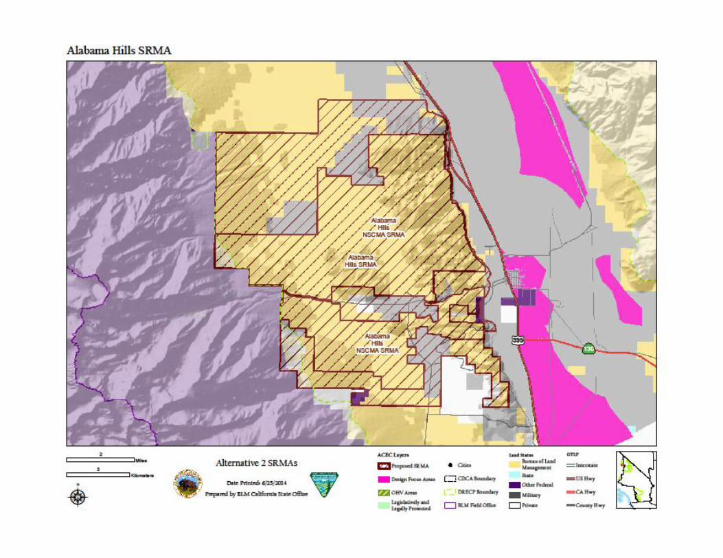
Acres by Alternative on BLM Lands:
No Action Preferred
Alternative 1 2 3 4
28,693 35,089 28,723 28,723 28,723 28,723
Other Programs: Scenic qualities will be emphasized when considering permitted activities. New
development will be minimized and will only be considered when it promotes scenic values.
Commercial uses conducted in the SRMA under permit from Bishop Field Office include filming of motion
pictures, television series and commercials, and documentaries; tours of historic film locations; search and
rescue exercises; college and university geology studies, and hot air balloon excursions. These uses are
compatible with the recreation experiences in the SRMA, provide economic benefits to the local
community, and are monitored to ensure they do not negatively affect recreation, visual, and other
resources. Alabama Hills SRMA is designated in the 1993 Bishop RMP as VRM Class II. Manage all routes of
travel as open, limited or closed, as designated in the Bishop RMP.
Renewable energy development is not an allowable use in SRMAs due to the incompatibility with the
values of the SRMA. Two exceptions to this management action are: 1) geothermal development is an
allowable use if a geothermal-only DFA overlays the SRMA designation and complies with a “no surface
occupancy” restriction; and, 2) in the Preferred Alternatives if a DRECP variance land designation overlays
the SRMA, renewable energy may be allowed on a case-by-case basis if the proposed project is found to be
compatible with the specific SRMA values. No DFA or solar variance lands overlay the Alabama Hills
National Scenic Cooperative Management Area, so these exceptions do not apply.
Implementation Decisions: Vehicle routes will be closed when they are redundant or resulting in damage
to sensitive scenic, cultural or biological resources.
An activity level plan may be developed to identify and designate current and future recreational
opportunities, appropriate facilities to provide for and manage the proposed uses, parameters for
streamlined Special Recreation Permitting of recreation events, staffing and funding needs, parameters for
facility and road/trail maintenance, partnerships, possible recreation fee considerations, and an
implementation schedule.
Mitigation:
1. Maintain through traffic motorized route network connectivity with roads and trails leading into
and through the Alabama Hills SRMA.
2. Manage renewable energy development on adjacent and nearby lands to avoid traffic conflicts
with visitors & permitted uses.


The information and maps shown on this system should be used for planning purposes only. It should not be the sole source for determining map boundary locations.